
Page 1
TABLE OF CONTENTS
AGENDA AND SUMMARY OF RECOMMENDATIONS
Rescission Motions
ITEMS PASSED BY EXCEPTION / CALL FOR SPEAKERS ON AGENDA ITEMS
GENERAL BUSINESS
General Manager's Division
Item 1 GM6/13 Contractual Conditions of Senior Staff............................................................... 1
Corporate Support Division
Item 2 CS57/13 Pecuniary Interest and Other Matters Returns - Disclosures by Councillors and Designated Persons...................................................................................................................... 4
Item 3 CS58/13 Outstanding Council Resolutions - Period Until 31 August 2013......................... 7
Item 4 CS59/13 Investments and Borrowings for 2013/14 - Status for Period Ending 31 October 2013 10
Environment and Human Services Division
Item 5 EH24/13 Catchments Remediation Rate (CRR) Annual Expenditure Report 2012/2013..... 13
Item 6 EH25/13 Tender No. T14/2013 - Stage Two Hornsby Mountain Bike Trail........................ 16
Item 7 EH26/13 Adoption of Amendments to Generic Plans of Management to Allow Biobanking 20
Planning Division
Item 8 PL96/13 Development Application - Dwelling-House - 30 Hanover Avenue, North Epping... 24
Item 9 PL118/13 Development Application - Five Storey Residential Flat Buildings Comprising 51 Units - 38 Edgeworth David Avenue and 42 and 44 Park Avenue, Waitara...................................... 42
Item 10 PL115/13 Development Application - Subdivision of One Allotment into Two Lots - 1549 Singleton Road, Singletons Mill .......................................................................................................... 83
Item 11 PL119/13 Development Application - Dwelling-House - 37 Millstream Grove, Dural........... 99
Item 12 PL120/13 Development Application - Alterations and Additions - Dwelling-House - 7 Britannia Street, Pennant Hills........................................................................................................... 119
Item 13 PL122/13 Deferred Development Application - Construction of Two, Five Storey Residential Flat Buildings - Nos. 25, 27 and 27A Wongala Crescent and No. 1A Chapman Avenue, Beecroft 137
Item 14 PL113/13 Report on Submissions - Vehicular Access to Properties in Nancy Place, Galston 165
Item 15 PL114/13 Planning Proposal - Rezoning of Property No. 99 New Line Road, Cherrybrook 172
Item 16 PL117/13 South Dural Planning Proposal .................................................................. 182
Item 17 PL116/13 Native Title Determination Application to the Federal Court - Awabakal and Guringai People.............................................................................................................................. 200
Infrastructure and Recreation Division
Item 18 IR26/13 Review of Policies and Codes - Infrastructure and Recreation Division............... 206
Item 19 IR33/13 Tender No. T22/2013: Electrical Services....................................................... 213
PUBLIC FORUM – NON AGENDA ITEMS
Questions of Which Notice Has Been Given
Mayor's Notes
Item 20 MN12/13 Mayor's Notes from 1 to 30 November 2013.................................................. 217
Mayoral Minutes
Notices of Motion
SUPPLEMENTARY AGENDA
MATTERS OF URGENCY
QUESTIONS WITHOUT NOTICE
Page 1
AGENDA AND SUMMARY OF RECOMMENDATIONS
PRESENT
NATIONAL ANTHEM
OPENING PRAYER/S
Reverend Glen Renton, from Thornleigh-Hillcrest Uniting Church, will open the meeting in prayer.
Acknowledgement of RELIGIOUS DIVERSITY
Statement by the Chairperson:
"We recognise our Shire's rich cultural and religious diversity and we acknowledge and pay respect to the beliefs of all members of our community, regardless of creed or faith."
ABORIGINAL RECOGNITION
Statement by the Chairperson:
"We acknowledge we are on the traditional lands of the Darug and Guringai Peoples. We pay our respects to elders past and present."
AUDIO RECORDING OF COUNCIL MEETING
Statement by the Chairperson:
"I advise all present that tonight's meeting is being audio recorded for the purposes of providing a record of public comment at the meeting, supporting the democratic process, broadening knowledge and participation in community affairs, and demonstrating Council’s commitment to openness and accountability. The recordings of the non-confidential parts of the meeting will be made available on Council’s website once the Minutes have been finalised. All speakers are requested to ensure their comments are relevant to the issue at hand and to refrain from making personal comments or criticisms."
APOLOGIES / LEAVE OF ABSENCE
political donations disclosure
Statement by the Chairperson:
“In accordance with Section 147 of the Environmental Planning and Assessment Act 1979, any person or organisation who has made a relevant planning application or a submission in respect of a relevant planning application which is on tonight’s agenda, and who has made a reportable political donation or gift to a Councillor or employee of the Council, must make a Political Donations Disclosure Statement.
If a Councillor or employee has received a reportable political donation or gift from a person or organisation who has made a relevant planning application or a submission in respect of a relevant planning application which is on tonight’s agenda, they must declare a non-pecuniary conflict of interests to the meeting, disclose the nature of the interest and manage the conflict of interests in accordance with Council’s Code of Conduct.”
declarations of interest
Clause 52 of Council’s Code of Meeting Practice (Section 451 of the Local Government Act, 1993) requires that a councillor or a member of a Council committee who has a pecuniary interest in a matter which is before the Council or committee and who is present at a meeting of the Council or committee at which the matter is being considered must disclose the nature of the interest to the meeting as soon as practicable. The disclosure is also to be submitted in writing (on the form titled “Declaration of Interest”).
The Councillor or member of a Council committee must not be present at, or in sight of, the meeting of the Council or committee:
(a) at any time during which the matter is being considered or discussed by the Council or committee.
(b) at any time during which the Council or committee is voting on any question in relation to the matter.
Clause 51A of Council’s Code of Meeting Practice provides that a Councillor, Council officer, or a member of a Council committee who has a non pecuniary interest in any matter with which the Council is concerned and who is present at a meeting of the Council or committee at which the matter is being considered must disclose the nature of the interest to the meeting as soon as practicable. The disclosure is also to be submitted in writing (on the form titled “Declaration of Interest”).
If the non-pecuniary interest is significant, the Councillor must:
a) remove the source of conflict, by relinquishing or divesting the interest that creates the conflict, or reallocating the conflicting duties to another Council official.
OR
b) have no involvement in the matter by absenting themself from and not taking part in any debate or voting on the issue as if the provisions of Section 451(2) of the Act apply.
If the non-pecuniary interest is less than significant, the Councillor must provide an explanation of why they consider that the interest does not require further action in the circumstances.
confirmation of minutes
THAT the Minutes of the General Meeting held on 20 November 2013 be confirmed; a copy having been distributed to all Councillors.
Petitions
presentations
Rescission Motions
ITEMS PASSED BY EXCEPTION / CALL FOR SPEAKERS ON AGENDA ITEMS
Note:
Persons wishing to address Council on matters which are on the Agenda are permitted to speak, prior to the item being discussed, and their names will be recorded in the Minutes in respect of that particular item.
Persons wishing to address Council on non agenda matters, are permitted to speak after all items on the agenda in respect of which there is a speaker from the public have been finalised by Council. Their names will be recorded in the Minutes under the heading "Public Forum for Non Agenda Items".
GENERAL BUSINESS
· Items for which there is a Public Forum Speaker
· Public Forum for non agenda items
· Balance of General Business items
General Manager's Division
Page Number 1
Item 1 GM6/13 Contractual Conditions of Senior Staff
RECOMMENDATION
THAT the contractual conditions of current Senior Staff (as set out in General Manager’s Report No. GM6/13) be noted.
Corporate Support Division
Page Number 4
Item 2 CS57/13 Pecuniary Interest and Other Matters Returns - Disclosures by Councillors and Designated Persons
RECOMMENDATION
THAT Council note the Disclosure of Pecuniary Interests and Other Matters Returns recently lodged with the General Manager have been tabled as required by the Local Government Act.
Page Number 7
Item 3 CS58/13 Outstanding Council Resolutions - Period Until 31 August 2013
RECOMMENDATION
THAT the contents of Deputy General Manager’s Report No. CS58/13 be received and noted.
Page Number 10
Item 4 CS59/13 Investments and Borrowings for 2013/14 - Status for Period Ending 31 October 2013
RECOMMENDATION
THAT the contents of Deputy General Manager’s Report No. CS59/13 be received and noted.
Environment and Human Services Division
Page Number 13
Item 5 EH24/13 Catchments Remediation Rate (CRR) Annual Expenditure Report 2012/2013
RECOMMENDATION
THAT the contents of Group Manager’s Report No. EH24/13 be received and noted.
Page Number 16
Item 6 EH25/13 Tender No. T14/2013 - Stage Two Hornsby Mountain Bike Trail
RECOMMENDATION
THAT Council accept the tender from Dirt Art Pty Ltd for Tender T14/2013 – Construction of Hornsby Mountain Bike Trail (Stage 2) in Old Mans Valley, Hornsby.
Page Number 20
Item 7 EH26/13 Adoption of Amendments to Generic Plans of Management to Allow Biobanking
RECOMMENDATION
THAT Council amend its generic Plans of Management for Community Land and Crown Reserves for Districts 1-9 to include the establishment of Biobank sites as a permitted use.
Planning Division
Page Number 24
Item 8 PL96/13 Development Application - Dwelling-House - 30 Hanover Avenue, North Epping
RECOMMENDATION
THAT Council assume the concurrence of the Director-General of the Department of Planning and Infrastructure pursuant to State Environmental Planning Policy No. 1 and approve Development Application No. DA/783/2013 for the erection of a 2 storey dwelling-house at Lot 37, DP 31170, No. 30 Hanover Avenue, North Epping subject to the conditions of consent detailed in Schedule 1 of Group Manager’s Report No. PL96/13.
Page Number 42
Item 9 PL118/13 Development Application - Five Storey Residential Flat Buildings Comprising 51 Units - 38 Edgeworth David Avenue and 42 and 44 Park Avenue, Waitara
RECOMMENDATION
THAT Development Application No. DA/689/2013 for demolition of existing structures and construction of two, five storey residential flat buildings comprising 51 units with basement car parking and strata title subdivision at Lot 7 DP 306280, Lot B DP 316727, Lot A DP 385852, Lot 1 DP 654815, No. 38 Edgeworth David Avenue and Nos. 42 and 44 Park Avenue, Waitara be approved subject to the conditions of consent detailed in Schedule 1 of Group Manager’s Report No. PL118/13.
Page Number 83
Item 10 PL115/13 Development Application - Subdivision of One Allotment into Two Lots - 1549 Singleton Road, Singletons Mill
RECOMMENDATION
THAT Development Application No. DA/272/2013 for subdivision of one allotment into two lots at Lot 4, DP 75209 No. 1549 Singleton Road, Singletons Mill be refused for the reasons detailed in Schedule 1 of Group Manager’s Report No. PL115/13.
Page Number 99
Item 11 PL119/13 Development Application - Dwelling-House - 37 Millstream Grove, Dural
RECOMMENDATION
THAT Council assume the concurrence of the Director-General of the Department of Planning and Infrastructure pursuant to State Environmental Planning Policy No. 1 and approve Development Application No. DA/1003/2013 for the erection of a 2 storey dwelling-house at Lot 6 DP 270704, No. 37 Millstream Grove, Dural subject to the conditions of consent detailed in Schedule 1 of Group Manager’s Report No. PL119/13.
Page Number 119
Item 12 PL120/13 Development Application - Alterations and Additions - Dwelling-House - 7 Britannia Street, Pennant Hills
RECOMMENDATION
THAT Council assume the concurrence of the Director-General of the Department of Planning and Infrastructure pursuant to State Environmental Planning Policy No. 1 and approve Development Application No. DA/712/2013 for alterations and additions to a dwelling-house at Lot 31, DP 13079, No. 7 Britannia Street, Pennant Hills, subject to the conditions of consent detailed in Schedule 1 of Group Manager’s Report No. PL120/13.
Page Number 137
Item 13 PL122/13 Deferred Development Application - Construction of Two, Five Storey Residential Flat Buildings - Nos. 25, 27 and 27A Wongala Crescent and No. 1A Chapman Avenue, Beecroft
RECOMMENDATION
THAT Development Application No. DA/38/2013 for demolition of existing buildings and construction of two, five storey residential flat buildings containing 36 dwellings and strata subdivision at Lot 2 DP 133462 and Lots 1, 2 and 3 DP 1008775, Nos. 25, 27 and 27A Wongala Crescent and No. 1A Chapman Avenue, Beecroft be approved subject to the conditions of consent detailed in Schedule 1 of Group Manager’s Report No. PL122/13.
Page Number 165
Item 14 PL113/13 Report on Submissions - Vehicular Access to Properties in Nancy Place, Galston
RECOMMENDATION
THAT:
1. The amendments to the Hornsby Development Control Plan 2013 attached to Group Manager’s Report No. PL113/13 to permit vehicle access to Arcadia Road be adopted.
2. All persons who made a submission be advised of Council’s decision.
Page Number 172
Item 15 PL114/13 Planning Proposal - Rezoning of Property No. 99 New Line Road, Cherrybrook
RECOMMENDATION
THAT:
1. Council forward the Planning Proposal attached to Group Manager’s Report No. PL114/13 to the Department of Planning and Infrastructure seeking endorsement for exhibition.
2. In accordance with the plan making powers delegated to Council, Council Exercise Authorisation to prepare and make the Planning Proposal following the receipt of Gateway Authorisation.
3. The General Manager be given delegated authority to endorse the exhibition material.
4. Following the exhibition, a report on submissions be presented to Council.
Page Number 182
Item 16 PL117/13 South Dural Planning Proposal
RECOMMENDATION
THAT:
1. Council forward the South Dural Planning Proposal attached to Group Manager’s Report No. PL117/13 to the Minister for Planning and Infrastructure seeking a conditional Gateway determination which:
a) requires the proponent to fund a Business Plan, to be commissioned by Council, to confirm the feasibility of the project being delivered with all necessary infrastructure at no net cost to government; and
b) subject to the Regional Director, Sydney West Region, being satisfied with the Business Plan, outlines the necessary studies to be prepared to justify the proposal.
2. Should a Gateway determination be issued, Council not proceed further with the Planning Proposal until such time as the proponent has entered into a binding agreement to fund the studies and Council resources for project management and a bank guarantee has been received by Council for same.
3. Submitters be advised of Council’s resolution.
Page Number 200
Item 17 PL116/13 Native Title Determination Application to the Federal Court - Awabakal and Guringai People
RECOMMENDATION
THAT Council:
1. Write to the Crown Lands Division of NSW Trade and Investment advising that Council would be willing to assist the Crown in defence of the Claim as the granting of any Claim should not restrict the availability of land under Council’s care, control and management for essential public purposes including recreation and bushland management and should not compromise Council’s autonomy in decision making for lands under its control.
2. Not apply to become a party to the application.
3. Write to the National Native Title Tribunal advising of its decision.
4. Notify other affected local government authorities of Council’s position.
Infrastructure and Recreation Division
Page Number 206
Item 18 IR26/13 Review of Policies and Codes - Infrastructure and Recreation Division
RECOMMENDATION
THAT Council adopt the recommendations contained in the table in Deputy General Manager’s Report No. IR26/13 in respect of each of the current policies and codes under the jurisdiction of the Infrastructure and Recreation Division.
Page Number 213
Item 19 IR33/13 Tender No. T22/2013: Electrical Services
RECOMMENDATION
THAT Council accept tenders for Tender No. T22/2013: Electrical Services as follows:
|
Work Area |
First Preference |
Second Preference |
|
Parks, Ovals and Gardens |
REES Electrical Pty Ltd. |
D & JF Scaife Electrical Contractors |
|
Buildings including Aquatic Centres |
D & JF Scaife Electrical Contractors |
REES Electrical Pty Ltd.
|
PUBLIC FORUM – NON AGENDA ITEMS
Questions of Which Notice Has Been Given
Mayor's Notes
Page Number 217
Item 20 MN12/13 Mayor's Notes from 1 to 30 November 2013
Mayoral Minutes
Notices of Motion
SUPPLEMENTARY AGENDA
MATTERS OF URGENCY
QUESTIONS WITHOUT NOTICE
General Manager's Report No. GM6/13
General Manager's Division
Date of Meeting: 18/12/2013
1 CONTRACTUAL CONDITIONS OF SENIOR STAFF
EXECUTIVE SUMMARY
· On 16 May 2012, Council resolved that the following Senior Staff Positions exist in the Organisation Structure - Deputy General Manager, Corporate Support Division; Deputy General Manager, Infrastructure and Recreation Division; Group Manager, Environment and Human Services Division; and Group Manager, Planning Division. The Senior Staff Positions have operated successfully since 4 June 2012 and no changes are considered necessary. It is noted that all current Senior Staff Contracts are in accordance with Standard Contracts issued by the Division of Local Government.
· It is recommended that the current contractual conditions in respect of the current Senior Staff Positions be noted.
|
THAT the contractual conditions of current Senior Staff (as set out in General Manager’s Report No. GM6/13) be noted. |
PURPOSE
The purpose of this Report is to allow Council to meet legislative requirements associated with its reporting on Senior Staff Positions.
BACKGROUND
Section 339 of the Local Government Act requires that the General Manager must at least annually report to Council on the contractual conditions of Senior Staff.
DISCUSSION
Organisation Structure
Following a review by independent consultants of Council’s Internal Services (in 2011) and External Services (in 2012), and the appointment of the current General Manager in 2011, the previous Council adopted a new Organisation Structure which became effective from 4 June 2012 (refer General Manager’s Report No. GM10/12 considered at the 14 March 2012 Workshop Meeting). The new Structure comprises the Office of the General Manager and four Divisions - Corporate Support; Infrastructure and Recreation; Environment and Human Services; and Planning.
In the period from 4 June 2012 until now, the Structure has operated successfully and no changes to the Structure are considered necessary.
Senior Staff Positions
At its Ordinary Meeting on 16 May 2012 (refer Mayoral Minute No. MM5/12) Council resolved that the following be determined as Senior Staff Positions in the Organisation Structure - Deputy General Manager, Corporate Support Division; Deputy General Manager, Infrastructure and Recreation Division; Group Manager, Environment and Human Services Division; and Group Manager, Planning Division. This structure was re-determined by Council at its General Meeting on 19 December 2012 (refer General Manager’s Report No. GM13/12).
In the period from 4 June 2012 until now, the Senior Staff Positions in the Structure have operated successfully and no changes are considered necessary. As a consequence, it is recommended that the existing Senior Staff Positions be re-determined by Council.
Contractual Conditions of Senior Staff
Appointments to Council’s current Senior Staff Positions took effect on the following dates for the periods shown:
Senior Staff Position Appointment Date Period
General Manager 26 August 2013 5 years
Deputy General Manager, Corporate Support 4 June 2012 5 years
Deputy General Manager, Infrastructure and Recreation 4 June 2012 5 years
Group Manager, Environment and Human Services 4 June 2012 5 years
Group Manager, Planning 4 June 2012 5 years
(NB. In accordance with Division of Local Government (DLG) requirements, all Senior Staff contracts are in accordance with Standard Contracts issued by the DLG).
It is recommended the above contractual conditions of Senior Staff be received and noted.
BUDGET
There are no budgetary implications associated with this Report.
POLICY
There are no policy implications associated with this Report.
CONCLUSION
Council’s consideration of this Report ensures that relevant legislative requirements have been met in respect of Senior Staff Positions.
RESPONSIBLE OFFICER
The officer responsible for the preparation of this Report is the Risk and Audit Manager – Scott Allen - who can be contacted on 9847-6609.
|
Scott Phillips General Manager General Manager's Division |
|
There are no attachments for this report.
File Reference: F2005/00481
Document Number: D02570245
Deputy General Manager's Report No. CS57/13
Corporate Support Division
Date of Meeting: 18/12/2013
2 PECUNIARY INTEREST AND OTHER MATTERS RETURNS - DISCLOSURES BY COUNCILLORS AND DESIGNATED PERSONS
EXECUTIVE SUMMARY
· Section 449 of the Local Government Act (the Act) details the statutory requirements in respect of the lodgement of Disclosure of Pecuniary Interests and Other Matters Return/s by Councillors and Designated Persons.
· Section 450A(2) of the Act requires that Returns lodged under Section 449 are to be tabled at the next available Council meeting.
· In line with Section 450A(2), this Report seeks to table the Return/s recently lodged with the General Manager.
|
THAT Council note the Disclosure of Pecuniary Interests and Other Matters Returns recently lodged with the General Manager have been tabled as required by the Local Government Act. |
PURPOSE
The purpose of this Report is to table the Disclosure of Pecuniary Interests and Other Matters Returns lodged by Councillors/Designated Persons who have left, commenced with, or internally transferred to a relevant position within Council.
BACKGROUND
Section 449(1) of the Act requires a Councillor or Designated Person to complete and lodge with the General Manager a Disclosure of Pecuniary Interests and Other Matters Return within three months after becoming a Councillor or a Designated Person. Section 449(3) requires a Councillor or Designated Person holding that position at 30 June in any year to complete and lodge with the General Manager a Return within three months after that date. Section 449(5) states that nothing prevents a Councillor or Designated Person from lodging more than one Return in any year.
Section 450A(2) of the Act requires that Returns lodged under Section 449 are to be tabled at a meeting of Council. Returns lodged under Sections 449(1) and 449(3) are to be tabled at the first meeting held after the last day for lodgement under those Sections; and Returns lodged for any other reason are to be tabled at the first meeting after their lodgement.
Council's procedures in respect of the disclosing of interests have been developed to cater for the election/appointment/employment/retirement/resignation/etc of Councillors or Designated Persons. These procedures:
· Require all Councillors and Designated Persons who hold that position at 30 June in any year to submit Returns to the General Manager by 30 September in that year (i.e. they are lodged under S449(3)). These Returns are tabled at the October General Meeting of Council in that year.
· Require newly elected Councillors or newly appointed Designated Persons to lodge Returns to the General Manager within three months of their election/appointment (i.e. they are lodged under S449(1)). These Returns are tabled at the next available General Meeting of Council.
· Require those Councillors or Designated Persons who are leaving Council (because of retirement, resignation, etc) to lodge Returns to the General Manager by their last day with Council. These Returns are tabled at the next available General Meeting of Council.
DISCUSSION
Returns Lodged in Accordance with Section 449(1) and/or 449(5) of the Local Government Act and Council's Procedures
Council last considered the tabling of Disclosure of Pecuniary Interests and Other Matters Returns under these Sections of the Act at the General Meeting held on 16 October 2013 (see Deputy General Manager’s Report No. CS32/13). Since that Report was prepared, two additional Returns have been lodged with the General Manager and are now tabled as required by the Act.
|
Date Lodged |
Councillor/Designated Person (Position) |
Reason for Lodgement |
|
30 October 2013 |
Traffic Ranger Coordinator |
New appointment |
|
31 October 2013 |
Development and Environmental Protection Officer |
New employee |
BUDGET
There are no budgetary implications associated with this Report.
POLICY
There are no policy implications associated with this Report.
CONCLUSION
In line with the requirements of the Act, it is necessary for the Returns lodged with the General Manager to be tabled at this General Meeting.
RESPONSIBLE OFFICER
The officer responsible for the preparation of this Report is the Manager, Governance and Customer Service – Ms Robyn Abicair - who can be contacted on 9847 6608.
|
Robyn Abicair Manager - Governance and Customer Service Corporate Support Division |
Gary Bensley Deputy General Manager Corporate Support Division |
There are no attachments for this report.
File Reference: F2013/00386
Document Number: D02625693
Deputy General Manager's Report No. CS58/13
Corporate Support Division
Date of Meeting: 18/12/2013
3 OUTSTANDING COUNCIL RESOLUTIONS - PERIOD UNTIL 31 AUGUST 2013
EXECUTIVE SUMMARY
· Council’s Policy dealing with Council Resolutions requires that a quarterly report be prepared detailing resolutions which have not been substantially implemented within two months of being adopted, and the reason/s why they are not finalised.
· In accordance with the Policy, each Division has carried out a review of any resolutions adopted by Council up until the end of August 2013 which have not been substantially implemented.
· Council should consider the comments provided in the attachment to this Report in respect of each of the outstanding resolutions and determine if any further action is required.
|
THAT the contents of Deputy General Manager’s Report No. CS58/13 be received and noted. |
PURPOSE
The purpose of this Report is to comply with the Council Resolutions Policy and provide details in respect of resolutions adopted by Council up until the end of August 2013 which have not been substantially implemented.
BACKGROUND
Council’s Policy dealing with Council Resolutions requires that a quarterly report be prepared for Council’s consideration detailing resolutions which have not been substantially implemented within two months of being adopted, and the reason/s why they are not finalised. The reports are generally submitted for Council’s consideration at the General Meetings in March, June, September and December each year.
DISCUSSION
In accordance with the Council Resolutions Policy, each Division has carried out a review of any resolutions adopted by Council up until the end of August 2013 which have not been substantially implemented. This has resulted in the attached spreadsheet being prepared which shows a list of outstanding resolutions per Division. Details are provided about the:
· Report Number and Name
· Outstanding Resolution
· Latest Status
· Comment
In preparing Outstanding Council Resolutions reports, Divisional Managers give special consideration to any long outstanding resolutions and, where such resolutions exist, provide comments about whether further action may be unlikely or impractical. In these cases, Council may wish to determine whether or not the item should be removed from further reporting in the Outstanding Council Resolutions report.
BUDGET
Any budgetary implications are included in the relevant report or in the “Latest Status” column of the attached spreadsheet.
POLICY
The preparation of this Report meets the requirements of the Council Resolutions Policy.
CONCLUSION
Council should consider the comments provided in the attachment in respect of each of the outstanding resolutions and, if necessary, determine if any further action is required.
RESPONSIBLE OFFICER
The officer responsible for the preparation of this Report is the Manager Governance and Customer Service – Robyn Abicair, who can be contacted on 9847 6608.
|
Robyn Abicair Manager - Governance and Customer Service Corporate Support Division |
Gary Bensley Deputy General Manager Corporate Support Division |
|
1.View |
Outstanding Council Resolutions - as at 31 August 2013 |
|
|
File Reference: F2005/00112
Document Number: D02625712
Deputy General Manager's Report No. CS59/13
Corporate Support Division
Date of Meeting: 18/12/2013
4 INVESTMENTS AND BORROWINGS FOR 2013/14 - STATUS FOR PERIOD ENDING 31 OCTOBER 2013
EXECUTIVE SUMMARY
· Council may invest funds that are not, for the time being, required for any other purpose. The investments must be in accordance with relevant legislative requirements and Council’s policies. The Chief Financial Officer must report monthly to Council on the details of funds invested.
· This Report provides details of Council’s investment performance for the period ending 31 October 2013. It indicates that for total investments, the annualised return for the month of October was 3.74% compared to the benchmark of 2.50%.
· All investments have been made in accordance with the Local Government Act, the Local Government (General) Regulation and Council's Investment of Surplus Funds Policy and Investment Strategy.
· In respect of Council borrowings, the weighted average interest rate payable on loans taken out from June 2004 to October 2013, based on the principal balances outstanding, is 6.04%.
· Council’s investment portfolio is unable to be applied to reducing current outstanding loan balances, due in part to the estimated cash-flow requirements associated with the Hornsby Aquatic Centre during 2013/14. Also, opportunities to renegotiate Council’s existing loans to attain a lower interest rate are negated by the break costs which would apply.
|
THAT the contents of Deputy General Manager’s Report No. CS59/13 be received and noted. |
PURPOSE
The purpose of this Report is to advise Council of funds invested in accordance with Section 625 of the Local Government Act; and to provide details as required by Clause 212(1) of the Local Government (General) Regulation and Council's Investment of Surplus Funds Policy.
BACKGROUND
A report is required to be submitted for Council’s consideration each month detailing Council's investments and borrowings and highlighting the monthly and year to date performance of the investments. Initial investments and reallocation of funds are made, where appropriate, after consultation with Council's financial investment adviser and fund managers.
DISCUSSION
Council may invest funds which are not, for the time being, required for any other purpose. Such investment must be in accordance with relevant legislative requirements and Council Policies, and the Chief Financial Officer must report monthly to Council on the details of the funds invested.
Council’s investment performance for the month ending 31 October 2013 is detailed in the attached documents and summarised below:
· The At-Call and Term Deposits achieved an annualised return of 3.90% for October 2013 compared to the benchmark of 2.50%.
· The Capital Guaranteed Notes achieved an annualised return of 0% for this period. No interest will be accrued for the remaining life of the securities.*
· For total investments, the annualised return for October 2013 was 3.74% compared to the benchmark of 2.50%. Year to date return was 3.81% compared to the benchmark of 2.57%.
(* At 30 September 2013, the fair value of the Capital Guaranteed Notes was $1,957,000, having increased from their 30 June 2013 value of $1,933,000. A review of the Notes is undertaken on a regular basis to determine if the yield to maturity on the Notes could be improved. Due to low interest rates on term deposits and the short time until maturity of the Notes, the latest review indicates it would not be financially prudent to take any action currently.)
In respect of Council borrowings, the weighted average interest rate payable on loans taken out from June 2004 to October 2013, based on the principal balances outstanding, is 6.04%. It is noted that the opportunity to renegotiate Council’s existing loans to attain a lower interest rate is negated by the break costs which would apply.
The investment portfolio balance of $49 million at 31 October 2013 is unable to be applied to reducing current outstanding loan balances due in part to the estimated cash-flow requirements associated with the Hornsby Aquatic Centre during 2013/14. The weighted average interest rate payable on loans indicates that Council’s cost of borrowing is low even when compared to present rates that could be obtained. The Borrowings Schedule as at 31 October 2013 is attached for Council’s information.
CONSULTATION
Appropriate consultation has occurred with Council's financial investment adviser and fund managers.
BUDGET
Budgeted investment income for 2013/14 was increased from $720,000 to $1,420,000 as part of the September 2013 Quarter Budget Review. Investment income for the period ending 31 October 2013 was $618,000, which compares favourably to the budgeted income for the same period of $520,000. Approximately 22% of the total investment income received by Council relates to externally restricted funds and is required to be allocated to those funds.
POLICY
All investments have been made in accordance with the Local Government Act, the Local Government (General) Regulation and Council's Investment of Surplus Funds Policy and Investment Strategy.
CONCLUSION
The investment of Council funds for the period ending 31 October 2013 is detailed in the documents attached to this Report. Council’s consideration of the Report and its attachments ensures that the relevant legislative requirements and Council protocols have been met in respect of those investments.
RESPONSIBLE OFFICER
The officer responsible for the preparation of this Report is the Chief Financial Officer – Glen Magus - who can be contacted on 9847 6635.
|
Glen Magus Chief Financial Officer - Financial Services Corporate Support Division |
Gary Bensley Deputy General Manager Corporate Support Division |
|
1.View |
HSC Investment Portfolio as at 31 October 2013 |
|
|
|
2.View |
HSC Borrowings Schedule as at 31 October 2013 |
|
|
File Reference: F2004/06987
Document Number: D02670649
Group Manager's Report No. EH24/13
Environment and Human Services Division
Date of Meeting: 18/12/2013
5 CATCHMENTS REMEDIATION RATE (CRR) ANNUAL EXPENDITURE REPORT 2012/2013
EXECUTIVE SUMMARY
· Revenue received for the Catchments Remediation Rate (CRR) in 2012/13 was $2,925,000 with the balance of funds at 30 June 2013 being $709,000. This was as a result of income generated, $2,925,000 plus $527,000 brought forward from 2011/12, less expenditure of $2,743,000.
· At the CRR Expenditure Review Panel (the Panel) meeting held on 22 October 2013, the Panel noted that it had sighted and discussed the financial details of CRR expenditure as of 30 June 2013 and considered all reports acceptable and reasonable.
· The Panel discussed the 2012-13 capital works program and differences in the actual versus estimated costs. It was noted that these variations were due to the scope of works changing during the construction phase. It was proposed that future projects with expenditure in excess of 10-15% of estimates should be reviewed and the reasons for differences reported.
· The proposition of the CRR solely funding stormwater harvesting projects was tabled. With consideration to the CRR charter the Panel agreed to consider future funding of these projects if detailed capital cost estimates and environmental cost benefit analysis were undertaken and submitted to the Panel for consideration.
|
THAT the contents of Group Manager’s Report No. EH24/13 be received and noted. |
PURPOSE
The purpose of this Report is to inform Council about the expenditure of CRR funds for the 2012/13 financial year and to table the comments of the external CRR Expenditure Review Panel.
DISCUSSION
Catchments Remediation Capital Works
Capital works projects undertaken across the Shire during 2012/13 included bioretention systems, stormwater harvesting, creek stabilisation and gross pollutant traps.
As of 30 June 2013, $925,000 was spent on capital works with six catchments remediation projects being completed. The projects involved the construction of:
· One combined bioretention/stormwater harvesting system, Thornleigh
· Three large end-of-pipe bioretention basin in Westleigh, Hornsby Heights, and Pennant Hills
· One creek stabilisation project, Hornsby
· Large trash racks in Cherrybrook (completion of project initiated in 2011/12)
In addition:
· Four projects on the 2013/14 works schedule had survey and design work done
Non-Capital Expenditure
Non-capital expenditure during 2012/2013 supported various Council operations that contributed to improving water quality Shire-wide including:
· Pro-active maintenance of all stormwater improvement assets
· Water quality monitoring and research
· Street sweeping
· Community project support, e.g. Bushcare, Streamwatch and various committees
· Implementation of a Geographic Information System (GIS)
· Emergency response to spills
· Riparian restoration works
· Salaries, wages, overheads and associated administrative costs for project management
CRR Expenditure Review Panel
Council’s CRR Expenditure Review Panel was initially established in 1997 to provide public accountability and transparency to CRR expenditure and it continues to perform this function.
On 22 October 2013, the CRR Expenditure Review Panel met to discuss expenditure for the 2012/13 financial year. The Panel noted that it had sighted and discussed the financial details of the CRR expenditure and considered all reports presented by council officers as acceptable and accountable.
The Panel discussed at length the 2012-13 capital works program and differences in the actual versus estimated costs (refer to Attachment 3). It was proposed that projects with expenditure in excess of 10-15% of estimates should be reviewed and the reasons for differences reported to the Panel.
The proposition of the CRR solely funding stormwater harvesting projects was tabled. The Panel agreed to consider possible future funding of stormwater harvesting works if detailed capital cost estimates and environmental cost benefit analysis were undertaken and submitted to the Panel for appropriate consideration.
The Panel’s report is included as Attachment 1.
BUDGET
The relevant budget and incurred expenditure for the CRR is shown in Attachments 2 and 3.
POLICY
There are no policy implications arising as a result of this Report.
CONCLUSION
$2,743,000 in CRR funds were spent throughout 2012/13 on a range of capital and non-capital projects designed to improve water quality across the Shire.
In line with its Charter, the CRR Expenditure Review Panel has sighted and discussed the financial details of CRR expenditure as of 30 June 2013, and considers all reports to be acceptable and reasonable.
RESPONSIBLE OFFICER
The officer responsible for the preparation of this Report is the Manager Natural Resources - Diane Campbell - who can be contacted on 9847 6903.
|
Diane Campbell Manager - Natural Resources Environment and Human Services Division |
Stephen Fedorow Group Manager Environment and Human Services Division |
|
1.View |
CRR Panel Report October 2013 |
|
|
|
2.View |
CRR Balance 2012-13 |
|
|
|
3.View |
CRR Summary Total Expenditure 2012-13 |
|
|
File Reference: F2005/00829-02
Document Number: D02689982
Group Manager's Report No. EH25/13
Environment and Human Services Division
Date of Meeting: 18/12/2013
6 TENDER NO. T14/2013 - STAGE TWO HORNSBY MOUNTAIN BIKE TRAIL
EXECUTIVE SUMMARY
· The proposed contract for Stage Two of the Hornsby Mountain Bike Trail is required to construct approximately 2.2 km of trail, this will complete the planned 5.5 km of trail that was endorsed by Council in 2012.
· Council does not have the expertise and resources to carry out this work and therefore open tenders have recently been called in accordance with the Local Government Act 1993.
· Four tender submissions were received for T14/2013 – Construction of Hornsby Mountain Bike Trail (Stage 2) in Old Mans Valley, Hornsby.
· Following assessment, the tender evaluation panel has recommended that Council accept the tender from Dirt Art Pty Ltd. The submission from Dirt Art Pty Ltd is considered the preferred option based on a combination of past performance, skills, experience, qualifications and cost.
· The proposed contract would be for a period of 12 months.
|
THAT Council accept the tender from Dirt Art Pty Ltd for Tender T14/2013 – Construction of Hornsby Mountain Bike Trail (Stage 2) in Old Mans Valley, Hornsby. |
PURPOSE
The purpose of this Report is to provide information to Council in respect of Tender T14/2013 - Construction of Hornsby Mountain Bike Trail (Stage 2) in Old Mans Valley, Hornsby and to recommend a preferred supplier for the service.
BACKGROUND
Stage One of the Hornsby Mountain Bike Trail has very high usage with over 42,000 laps recorded within the first 12 months. Development of Stage Two will add an additional 2.2km of trail to the facility.
DISCUSSION
Tender T14/2013 is a schedule of rates tender. A public tender notice was advertised in the Sydney Morning Herald, relevant local newspapers together with Tenderlink. The tender was issued in October with a closing date of 22 November 2013.
The scope of works required under this tender includes the construction of 2.2km of cross country mountain bike trail. Several design components related to some portions of the trail are also required.
These works known as Stage 2 will integrate with the existing 3.3km of mountain bike trail. Stage 2 trail will be built in the northern portion of Old Mans Valley and will provide experiences for less experienced riders to progress towards more difficult trails. The works will include easy and intermediate grade trails with some advanced trail features to cater for experienced riders.
A total of four (4) submissions were received for Tender T14/2013 – Construction of Hornsby Mountain Bike Trail (Stage 2) in Old Mans Valley, Hornsby.
The four Tenderers were:
1. Dirt Art Pty Ltd
2. 4-4 Civil Pty Ltd
3. Makin Trax Australia Pty Ltd
4. Synergy Trails Pty Ltd
Tender Evaluation
As part of the tender evaluation process, weighted non-price and price selection criteria were developed by the tender evaluation panel. Tenders were then assessed based on the returnable schedules submitted by each tenderer.
The assessment criteria included:
· Past performance and experience
· Skills, qualifications and experience
· Design, Proposed Methods and Innovation
· Construction Program
· Environmental Considerations
· Partnering with Volunteers
· Local Business and Industry
· Tender WHS Management Systems
· Quality Assurance Systems
· References
· Other Information
The tender evaluation panel carefully assessed all the tender submissions taking into consideration the overall expected cost and the non-price criteria as described above. The schedule of rates were also closely scrutinised to ensure the breakdown of costs reflected a realistic cost rate.
Detailed information on the tender evaluation criteria and the weightings of the criteria are contained in the confidential tender evaluation report. The confidential memo (Attachment 1) explains the findings of the evaluation report.
BUDGET
The works to be completed under T14/2013 have been estimated at $135,000 and include a provisional item to construct an additional section of trail on TAFE land. Sufficient funds are available within the budget to cover these costs.
POLICY
The tender process has been undertaken in accordance with Council’s tendering policy and Council’s Plan of Management for Hornsby Park and Old Mans Valley.
CONCLUSION
Council is seeking to develop Stage Two of the Hornsby Mountain Bike Facility and therefore called for tenders from external companies to conduct work on its behalf. The contract is for a one year term.
Following the evaluation, the tender panel have recommended that Dirt Art be appointed to RFT14/2013 as the preferred applicant based on past performance, skills, experience, qualifications and cost.
RESPONSIBLE OFFICER
The officer responsible for the preparation of this Report is the Manager Natural Resources – Diane Campbell - who can be contacted on 9847 6903.
|
Diane Campbell Manager - Natural Resources Environment and Human Services Division |
Stephen Fedorow Group Manager Environment and Human Services Division |
|
Evaluation Report T14/2013 - This attachment should be dealt with in confidential session, under Section 10A (2) (c) of the Local Government Act, 1993. This report contains information that would, if disclosed, confer a commercial advantage on a person with whom the council is conducting (or proposes to conduct) business. |
|
|
File Reference: F2013/00639
Document Number: D02700569
Group Manager's Report No. EH26/13
Environment and Human Services Division
Date of Meeting: 18/12/2013
7 ADOPTION OF AMENDMENTS TO GENERIC PLANS OF MANAGEMENT TO ALLOW BIOBANKING
EXECUTIVE SUMMARY
· Council publically exhibited a proposed amendment to its current generic Plans of Management to allow the establishment of Biobank sites on its bushland from 24 October to 4 December 2013.
· No submissions from the public were received during the exhibition period.
· Letters were received from the Office of Strategic Land (Department of Planning and Infrastructure) and Crown Lands (NSW Trade and Investment) that noted and raised no objection to Council’s intention to allow biobanking on its reserves and Crown land where Council is the land manager.
· It is recommended that Council adopt the amendment to its Plans of Management for Community Land and Crown Reserves to include the establishment of Biobank sites as a permitted use.
|
THAT Council amend its generic Plans of Management for Community Land and Crown Reserves for Districts 1-9 to include the establishment of Biobank sites as a permitted use. |
PURPOSE
The purpose of this Report is to inform Council of submissions received as a result of the public exhibition of the proposed amendment to its generic Plans of Management to enable Biobanking agreements to be made and to seek Council’s adoption of the proposed amendment.
BACKGROUND
At its General Meeting of 16 October 2013, Council considered Group Manager’s Report No. EH17/13 and resolved that:
1. Council amend its Plans of Management for Community Land and Crown Reserves to include the establishment of Biobank sites as a permitted use
2. Council publicly exhibit the amended Plans of Management for Community Land and Crown Reserves for public comment
3. Council advertise the proposed Biobank sites associated with the ‘Linking Landscapes’ grant, North West Rail Link, Epping to Thornleigh Third Track project and the M2 Upgrade project as shown in Attachments 1-6 of Group Manager’s Report No. EH17/13
4. A further Report be prepared for Council’s consideration once detailed investigations into the Biobank sites have been undertaken
The amendment was prepared and placed on public exhibition for the period from 24 October to 4 December 2013.
DISCUSSION
Council Plans of Management (PoMs) for Community Land and Crown Reserves classify bushland throughout the Hornsby Shire as Community Land and further categorise it as Natural Area.
In order to consider making Biobanking agreements on this land, the Plans must allow for this. Biobanking proposals currently being considered include Galston Park under a Linking Landscapes Grant and Upper Pyes Creek and New Farm Road Bushland as offsets for the North West Rail Link and Epping to Thornleigh Third Track Project. Biobanking agreements are consistent with Council’s intention to protect these areas, and provide funding for Council to manage the bushland.
In accordance with Group Manager’s Report EN17/13 Council placed the following amendment to the generic Plans of Management for Community Land and Crown Reserves for Districts 1-9 on public exhibition from 24 October to 4 December 2013:
‘This Plan allows Council to enter into a conservation agreement, including a Biobanking agreement under the Threatened Species Conservation Act 1995 with the Minister administering the National Parks and Wildlife Act 1974 and Threatened Species Conservation Act 1995 to provide for the maintenance of biodiversity values in perpetuity.’
During the public exhibition period a total of two submissions were received. One was from the Office of Strategic Lands (Department of Planning and Infrastructure) and the other from Crown Lands (Department of Trade and Investment). Both submissions noted and raised no objection to Council’s intention to allow biobanking on its reserves and Crown land where Council is the reserve trust manager or where management devolves to Council.
Council has recently been advised that it has been successful in receiving Linking Landscapes Grant funding to commence the process of investigating Galston Park as a biobanking site. Council has also commenced investigating Upper Pyes Creek and New Farm Road Bushland as a potential Biobank site with Transport for NSW.
CONSULTATION
The Local Government Act 1993 (‘the Act’) and regulations require that a draft PoM be placed on public exhibition for a period not less than 28 days, and include a minimum period for receiving public submissions of 42 days. As the proposed amendment did not seek to categorise or re-categorise community land, there was no requirement for an independently chaired public hearing.
Following Council’s decision in October 2013 the draft amendment to the PoMs was placed on public exhibition from 24 October to 20 November 2013 with a further 14 days for receipt of submissions, satisfying the requirements of the Act.
During this period advertisements were placed in the Hills News, Northern District Times, Hornsby Advocate and Maroota Living Heritage notifying of the exhibition periods and inviting submissions on the proposed amendment to the PoMs. A copy of the proposed amendment to the PoMs was placed on Council’s website and hardcopies were available at Council’s Administration Centre and Hornsby Library.
BUDGET
Whilst the PoMs do not present any budgetary implications for Council, they identify a range of management actions that may be undertaken in the short, medium or long-term.
Allowing for Biobank agreements to be made would result in the potential for Trust funds being established to provide ongoing funding to manage the bushland reserves. This would be paid to Council annually to undertake agreed bushland management actions to improve the conservation value of sites. In the case of the Linking Landscapes Grant for Galston Park, the total fund deposit would be in the order of $700,000.
POLICY
The proposed amendment to allow for establishment of Biobank sites are consistent with Council’s plans and policies including the core objectives for Natural Areas in its Plans of Management for Community Land and Crown Reserves and Hornsby Local Environmental Plan 2013.
CONCLUSION
Amending its Plans of Management for Community Land and Crown Reserves for Districts 1-9 to include the establishment of Biobank sites as a permitted use, would allow Council to investigate entering into Biobanking agreements to more effectively manage its bushland, endangered ecological communities and threatened species on its land and provide long term benefit to Council and the community.
RESPONSIBLE OFFICER
The officer responsible for the preparation of this Report is Diane Campbell, Manager Natural Resources who can be contacted on 9847 6903.
|
Diane Campbell Manager - Natural Resources Environment and Human Services Division |
Stephen Fedorow Group Manager Environment and Human Services Division |
|
1.View |
Exhibited Amendment to Generic Plans of Management |
|
|
File Reference: F2004/09595
Document Number: D02702827
Group Manager’s Report No. PL96/13
Planning Division
Date of Meeting: 18/12/2013
8 DEVELOPMENT APPLICATION - DWELLING-HOUSE - 30 HANOVER AVENUE, NORTH EPPING
EXECUTIVE SUMMARY
|
DA No: |
DA/783/2013 (Lodged 1 August 2013) |
|
Description: |
Erection of a two storey dwelling-house on a vacant allotment |
|
Property: |
Lot 37 DP 31170, 30 Hanover Avenue, North Epping |
|
Applicant: |
A & I Improvements |
|
Owners: |
Mr Matthew Ian Bull and Mrs Ping Ping Low |
|
Estimated Value: |
$520,000 |
|
Ward: |
C |
· The application proposes the erection of a two storey dwelling-house on a vacant allotment.
· The proposal does not comply with the Hornsby Shire Local Environmental Plan 1994 with regard to Clause 15 (Floor Space Ratio). The applicant has made a submission pursuant to State Environmental Planning Policy No. 1 (Development Standards) to vary the development standard. The submission is considered well-founded and is supported.
· No public submissions have been received in respect of the application.
· It is recommended that the application be approved.
|
THAT Council assume the concurrence of the Director-General of the Department of Planning and Infrastructure pursuant to State Environmental Planning Policy No. 1 and approve Development Application No. DA/783/2013 for the erection of a 2 storey dwelling-house at Lot 37, DP 31170, No. 30 Hanover Avenue, North Epping subject to the conditions of consent detailed in Schedule 1 of Group Manager’s Report No. PL96/13. |
BACKGROUND
On 27 March 2013, Council approved the demolition of the existing single storey dwelling-house, garage and carport on the subject site.
SITE
The corner site has an area of 727.2m2 and is located on northern corner of the intersection of Hanover Avenue and Woods Street, North Epping. The site is currently vacant.
The site experiences an average fall of 2% to the eastern boundary corner.
Surrounding properties include single dwelling-houses on suburban lots.
‘Ron Payne Reserve’ is located adjacent to the northern boundary of the site.
The site is located within a bushfire prone area.
The site is not a heritage listed item and is not in a heritage conservation area or in the vicinity of a heritage listed item.
The site is not burdened by any easements or restrictions
PROPOSAL
The application proposes the erection of a two storey dwelling-house. The ground floor would comprise of a double garage, kitchen, living room, dining room, foyer, study, laundry, powder room and a terrace.
The first floor would consist of a master bedroom with ensuite, three bedrooms, bathroom, rumpus room, and a terrace.
No trees would be removed as part of this proposal.
ASSESSMENT
The development application has been assessed having regard to the ‘Metropolitan Plan for Sydney 2031’, the ‘North Subregion (Draft) Subregional Strategy’ and the matters for consideration prescribed under Section 79C of the Environmental Planning and Assessment Act 1979 (the Act). The following issues have been identified for further consideration.
1. STRATEGIC CONTEXT
1.1 Metropolitan Plan for Sydney and (Draft) North Subregional Strategy
The (Draft) Metropolitan Strategy for Sydney 2031 is a broad framework to provide for Sydney’s growth to help plan for housing, employment, transport, infrastructure, the environment and open space. It outlines a vision for Sydney to 2036; the challenges faced, and the directions to follow to address these challenges and achieve the vision.
The North Subregion comprises Hornsby, Kuring-gai, Manly, Warringah and Pittwater Local Government Areas. The Draft North Subregional Strategy provided a framework for Council in its preparation of the HLEP 2013.
Within the North Subregion, the Draft Metropolitan Strategy proposes:
· Population growth of 81,000 from the current 2011 baseline of 529,000
· Housing growth of 37,000 from the current 2011 baseline of 204,000
· Employment growth of 39,000 from the current 2011 baseline of 186,000
The proposed development would be consistent with the Metropolitan Plan for Sydney 2031 by providing renewed housing in the locality to assist meeting the demands of an increasing population.
2. STATUTORY CONTROLS
Section 79C(1)(a) requires Council to consider “any relevant environmental planning instruments, draft environmental planning instruments, development control plans, planning agreements and regulations”.
2.1 Hornsby Shire Local Environmental Plan 1994
The subject land is zoned Residential A (Low Density) under the Hornsby Shire Local Environmental Plan 1994 (HSLEP). The objectives of the Residential A zone are:
(a) To provide for the housing needs of the population of the Hornsby area.
(b) To promote a variety of housing types and other land uses compatible with a low density residential environment.
(c) To provide for development that is within the environmental capacity of a low density residential environment.
The proposed development is defined as a ‘dwelling-house’ under the HSLEP and is permissible in the zone with Council’s consent.
Clause 15 of the HSLEP prescribes that the maximum floor space ratio (FSR) of development within the Residential A zone is 0.4:1. The proposed FSR of the dwelling-house is 0.45:1.
The applicant has submitted a State Environmental Planning Policy No. 1 (SEPP 1) objection to the development standard. Refer to Section 2.4 for consideration of the applicant’s objection to the standard.
2.2 Hornsby Local Environmental Plan 2013
The Hornsby Local Environmental Plan 2013 (HLEP) was made on 27 September 2013 and came into effect on 11 October 2013. The HLEP includes a savings provision stating that if a development application is made and not finally determined before the commencement of the HLEP 2013, the application must be determined as if the Plan had been exhibited but not commenced. The relevant provisions of the HLEP are addressed below.
2.2.1 Zoning
Under the HLEP, the subject land is zoned R2 (Low Density Residential). A “dwelling house” is a permissible use in the zone under the HLEP.
2.2.2 Height of Building
Clause 4.3 of the HLEP states that the height of a building on any land is not to exceed the maximum height shown for the land on the Height of Buildings Map. The maximum permissible height for the subject site within the R2 zone is 8.5 metres. The proposal complies with this provision.
2.3 Sydney Regional Environmental Plan (Sydney Harbour Catchment) 2005
The application has been assessed against the requirements of the Sydney REP which includes planning principles applicable to the site within the upper part of the catchment. The principles incorporate measures to protect water quality, to minimise urban runoff, conserve water and to ensure the catchment watercourses, wetlands, riparian lands and remnant vegetation are protected.
The proposed modification would not adversely impact on down stream water quality subject to appropriate design for stormwater management and implementation of sediment and erosion control measures.
2.4 State Environmental Planning Policy No. 1 - Development Standards
The proposed dwelling-house has a gross floor area of 325m2 resulting in a floor space ratio (FSR) of 0.45:1. The FSR exceeds the applicable 0.4:1 FSR development standard under the HSLEP 1994. To address the variation to the 0.4:1 development standard, the applicant has made a submission pursuant to State Environmental Planning Policy No. 1 – Development Standards (SEPP1).
The application has been assessed against the requirements of SEPP1. This Policy provides flexibility in the application of development standards in circumstances where strict compliance with those standards would, in any particular case, be unreasonable or unnecessary or tend to hinder the attainment of the objectives specified in section 5(a) (i) and (ii) of the Environmental Planning and Assessment Act which states:
‘The objectives of this Act are:
(a) to encourage:
(i) the proper management, development and conservation of natural and artificial resources, including agricultural land, natural areas, forests, minerals, water, cities, towns and villages for the purpose of promoting the social and economic welfare of the community and a better environment,
(ii) the promotion and co-ordination of the orderly and economic use and development of land,’
Where development could, but for any development standard, be carried out under the Act (either with or without the necessity for consent under the Act being obtained) the person intending to carry out that development may make a development, supported by a written objection that compliance with that development standard is unreasonable or unnecessary in the circumstances of the case, and specifying the grounds of that objection.
The Land and Environment Court has expressed the view that there are 5 different ways in which an objection pursuant to SEPP 1 may be well founded and that approval of the objection may be consistent with the aims of the policy as follows:
1. The objectives of the standard are achieved notwithstanding non-compliance with the standard;
2. The underlying objective or purpose of the standard is not relevant to the development and therefore compliance is unnecessary;
3. The underlying object or purpose would be defeated or thwarted if compliance was required and therefore compliance is unreasonable;
4. The development standard has been virtually abandoned or destroyed by the Council's own actions in granting consents departing from the standard and hence compliance with the standard is unnecessary and unreasonable;
5. The zoning of the particular land is unreasonable or inappropriate so that a development standard appropriate for that zoning is also unreasonable and unnecessary as it applies to the land and compliance with the standard would be unreasonable or unnecessary. That is, the particular parcel of land should not have been included in the particular zone.
In regard to whether the objection may be well founded, the applicant contends that:
1. Hornsby Local Environmental Plan 2013 has no floor space ratio applicable to R2 zoned land. The proposed development fully complies with the provisions of Hornsby Local Environmental Plan 2013. Further requiring compliance with older controls applying to the site are therefore considered to be onerous especially when the HLEP does not require such a control.
2. The scale of the intended development would not impact on the land’s environmental capacity. The proposed development would produce a sympathetic architectural outcome that would not result in any unreasonable impacts on the environment, surrounding character of the area or streetscape.
3. The proposed increase in floor space ratio would not produce any detrimental impact upon the adjoining properties or result in loss of privacy or views.
4. The proposed development is considered to be a site responsive development that has been architectural designed to compatible with the surrounding development, provide an acceptable mass and scale that would be compliant with the land’s environmental capacity and produce an acceptable visual outcome to the streetscape.
The matters listed above have been taken into consideration in assessing the merits of the SEPP 1 objection. The proposal takes into consideration the environmental and topographical constraints of the site. The additional floor space would not adversely impact on the environmental and amenity aspects of the site and the underlying objectives of the zone. The dwelling-house would provide accommodation that would not detract from the scale and variety of dwelling-houses in the low density areas of the Shire as the proposal is considered to meet the zone objectives outlined in the HLEP.
The proposed development would be of a similar bulk, scale and character of surrounding developments within Hanover Avenue and is considered acceptable with respect to the non-compliance with the FSR development standard.
The SEPP1 objection is considered well founded and acceptable in this instance.
2.5 State Environmental Planning Policy (Exempt and Complying Development Codes) 2008 – NSW Housing Code
The application has been assessed against the requirements of State Environmental Planning Policy (Exempt and Complying Development Codes) 2008 – NSW Housing Code. The Policy provides exempt and complying development codes that have State-wide application, identifying, in the General Exempt Development Code, types of development that are of minimal environmental impact that may be carried out without the need for development consent; and, in the General Housing Code, types of complying development that may be carried out in accordance with a complying development certificate as defined in the Environmental Planning and Assessment Act 1979.
The following table sets out the proposal’s compliance with the requirements of the NSW Housing Code.
|
NSW Housing Code |
|||
|
Control |
Proposal |
Requirement |
Compliance |
|
Site Coverage Lots 450m2 – 900m2 |
40% |
50% |
Yes |
|
Maximum Floor Area |
371m2 |
380m2 |
Yes |
|
Building Height |
8.1m |
8.5m |
Yes |
|
Front Setback |
6m |
Average of two adjoining properties 4.3m |
Yes |
|
Secondary Road Setback (south-east) |
3m |
3m |
Yes |
|
Side Setback (north-west) |
1.5m |
0.9m + 1/4 height above 4.5m 0.9m for the ground floor component, 1.25m for the first storey component |
Yes |
|
Rear Setback |
14.4m |
3m setback for up to 4.5m height, and 8m for 4.5m height and above |
Yes |
|
Landscaping |
62.7% |
20% |
Yes |
|
First Floor Balcony |
40.8m2 |
12m2 |
No |
As addressed above, the proposed dwelling complies with the requirements of the NSW Housing Code except for the size of the first floor balcony.
The NSW Housing Code provides that the maximum gross floor area for complying development within the low density residential zones of the Shire is 380m2, if the lot has an area of at least 600m2 but less than 900m2. Accordingly, if applicable, the development would satisfy the maximum floor area development standard under the Code.
2.6 State Environmental Planning Policy No. 55 – Remediation of Land
Clause 7 of State Environmental Planning Policy No. 55 – Remediation of Land (SEPP 55) requires Council to consider whether land is contaminated prior to granting consent to the carrying out of any development on that land.
Should the land be contaminated, Council must be satisfied that the land is suitable in a contaminated state for the proposed use. If the land requires remediation to be undertaken to make the land suitable for the proposed use, Council must be satisfied that the land will be remediated before the land is used for that purpose.
The site history and site inspection indicate a history of residential development and it is not likely that the site has experienced contamination. Accordingly, further assessment under SEPP 55 is not required.
2.7 State Environmental Planning Policy (Building Sustainability Index – BASIX) – 2004
The application has been assessed against the requirements of State Environmental Planning Policy (Building Sustainability Index: BASIX) 2004. The proposal includes BASIX Certificate No. 487299S for the proposed dwelling and is considered to be satisfactory with respect to SEPP BASIX.
2.8 Clause 74BA Environmental Planning and Assessment Act, 1979 - Purpose and Status of Development Control Plans
On 1 March 2013, the Environmental Planning and Assessment Act, 1979 was amended so that a DCP provision will have no effect if it has the practical effect of “preventing or unreasonably restricting development” that is otherwise permitted and complies with the development standards set out in relevant Local Environmental Plans and State Environmental Planning Policies.
The principal purpose of a development control plan is to provide guidance on the aims of any environmental planning instrument that applies to the development; facilitating development that is permissible under any such instrument; and achieving the objectives of land zones under any such instrument. The provisions of a development control plan made for that purpose are not statutory requirements.
2.9 Hornsby Development Control Plan 2013
The Hornsby Development Control Plan (HDCP) 2013 applies to all land within Hornsby Shire and will replace Council’s existing DCPs, providing development controls to complement the HLEP 2013. The HDCP came into effect on 11 October 2013.
The following sections of this report include a detailed assessment of the proposal against Council’s existing DCP controls. Although the HDCP was not in force at the date of lodgement of this application, the development proposal has been assessed against the Plan.
The HDCP is generally a transition of Council’s existing DCPs into a consolidated plan. When assessed against the HDCP, the proposed development would comply with all elements (including floor area) except for the first floor rumpus room.
The first floor rumpus room would not comply with the Privacy element of the HDCP which states that “living and entertaining areas of dwelling houses should be located on the ground floor and orientated towards the private open space of the dwelling house and not side boundaries”. Notwithstanding this, the rumpus room would be orientated towards Wood Street and would not impact on the privacy enjoyed by any adjoining neighbour.
The first floor terrace would be primarily orientated towards the rear boundary of the site and Ron Payne Reserve, however to minimise the potential for overlooking in to the private open space and living areas of No. 32 Hanover Avenue, North Epping, a 2100mm high privacy screen would be erected on the western elevation of the terrace.
The proposal meets the desired outcomes of the HDCP and is considered acceptable.
2.10 Dwelling-House Development Control Plan
The proposed development has been assessed having regard to the relevant performance and prescriptive requirements within Council’s Dwelling House Development Control Plan (Housing DCP). The following table sets out the proposal’s compliance with the prescriptive requirements of the Plan:
|
Dwelling House Development Control Plan |
|||
|
Control |
Proposal |
Requirement |
Complies |
|
Floor space ratio |
0.45:1 |
0.4:1 |
No |
|
Site cover |
40% |
40% |
Yes |
|
Setbacks Front (south-west) Side (north-west) Side (south-east) Rear (north-east) |
6m 2.5 3m 16.4m |
6m 1m 3m 3 m |
Yes Yes Yes Yes |
|
Height |
Two-storey |
Max. two storey |
Yes |
|
Unbroken Wall length |
14.54m |
10m |
No |
|
Building length |
17.15m |
24m |
Yes |
|
Cut and fill |
0m |
1m |
Yes |
|
Private Open Space |
151.9m2 |
120m² |
Yes |
|
Landscaped area |
62.7% |
45% |
Yes |
As detailed in the above table, the proposed development generally complies with the prescriptive requirements within Council’s Dwelling-House DCP except for floor space ratio and unbroken wall length. The matters of non-compliance are detailed below, as well as a brief discussion on compliance with relevant performance requirements.
2.10.1 Floor Space Ratio
The objective of the Scale element is to encourage “development of a scale compatible with the low density residential environment”.
The proposal does not comply with the 0.4:1 prescriptive measure of the Dwelling House DCP. However, the dwelling-house is not considered to be excessive in bulk and scale for the site and is in keeping with similar developments in the area. The matter has been discussed under Section 2.4 of this report.
The proposal meets the objective of the Scale element and is considered acceptable.
2.10.2 Design
The objective of the Design element is to encourage “building design that is consistent with and enhances the character and amenity of the local area, has regard for environmental characteristics and energy efficiency”.
The proposed 14.54m unbroken wall length of the western elevation does not comply with the prescriptive measures of the Design element which requires that walls not exceed 10m without a physical “break”. The western elevation of the dwelling-house would not be readily visible from the public domain, Hanover Avenue, Wood Street or Ron Payne Reserve, and would not have a detrimental impact on the established streetscape. A balance between solid walls and openings and variations in materials has been incorporated into the elevations to avoid a monotonous or symmetrical design.
Accordingly, the proposal would have negligible adverse visual or amenity impacts on adjoining properties, meets the objectives of the Design element and is considered acceptable.
2.10.3 Privacy
The objective of the Privacy element is to encourage “development that ensures reasonable privacy in the home and privacy open space for existing and future residents”.
The first floor of the proposal includes a rumpus room which does not comply with the prescriptive measures of the Privacy element which seeks to have living and entertaining areas located on the ground floor only. This room is served by a window in the eastern side elevation which overlooks Wood Street and has a sill height of 1.5 metres above floor level. As a consequence, the development would have negligible adverse privacy impacts and is considered acceptable.
The first floor also includes a terrace at the rear elevation of the dwelling-house. The terrace would be primarily orientated towards the ‘Ron Payne Reserve’ located to the north of the site. In order to protect the privacy of the adjoining property, No. 32 Hanover Avenue, North Epping, a 2.1 metre high privacy screen would be erected along the western elevation of the terrace.
The proposal meets the objective of the Privacy element and is considered acceptable.
2.10.4 Solar Access
The objective of the Solar Access element is to encourage “development that ensures reasonable solar access to living areas within dwellings and to open space around dwellings”.
The submitted shadow diagrams indicate that the shadows from the proposed dwelling-house would be cast over Hanover Avenue and Wood Street only and not impact on the solar access to any adjoining dwelling-house or private open space.
The proposal meets the objective of the Solar Access element and is considered acceptable.
3. ENVIRONMENTAL IMPACTS
Section 79C(1)(b) of the Act requires Council to consider “the likely impacts of that development, including environmental impacts on both the natural and built environments, and social and economic impacts in the locality”.
3.1 Natural Environment
No trees would be removed as part of this development.
3.2 Built Environment
The proposed dwelling-house would be similar to other dwelling-house developments on surrounding properties. The proposal would not cause a detrimental impact to the streetscape of Hanover Avenue.
3.3 Social and Economic Impacts
There are no anticipated adverse social or economic impacts resulting from the proposed development.
4. SITE SUITABILITY
Section 79C(1)(c) of the Act requires Council to consider “the suitability of the site for the development”.
4.1 Bushfire Risk
The land is identified as being subject to bushfire risk. The site is considered to be in Bushfire Attack Level-19 and appropriate conditions of consent have been recommended requiring sensitive construction methods.
5. PUBLIC PARTICIPATION
Section 79C(1)(d) of the Act requires Council to consider “any submissions made in accordance with this Act”.
5.1 Community Consultation
The proposed development was placed on public exhibition and was notified to adjoining and nearby landowners between 27 August 2013 and 10 September 2013 in accordance with Council’s Notification and Exhibition Development Control Plan. During this period, Council received no submissions. The map below illustrates the location of those nearby landowners that are in close proximity to the development site and were notified of the application.
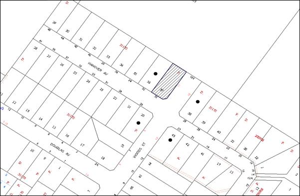
|
NOTIFICATION PLAN |
|
||
|
• PROPERTIES NOTIFIED
|
X SUBMISSIONS RECEIVED |
PROPERTY SUBJECT OF DEVELOPMENT |
|
6. THE PUBLIC INTEREST
Section 79C(1)(e) of the Act requires Council to consider “the public interest”.
The public interest is an overarching requirement, which includes the consideration of the matters discussed in this report. Implicit to the public interest is the achievement of future built outcomes adequately responding to and respecting the future desired outcomes expressed in environmental planning instruments and development control plans.
The application is considered to have addressed Council’s criteria under the Hornsby DCP and therefore, the development would be in the public interest.
CONCLUSION
The application proposes the erection of a two storey dwelling-house.
The application does not comply with the Hornsby Shire Council Local Environmental Plan 1994 in respect to Clause 15 ‘Floor Space Ratio’. The applicant has submitted a State Environmental Planning Policy No. 1 objection to vary the floor space ratio development standard. The objection is considered well founded with regard to the existing development and the principles established by the Land and Environment Court.
There were no submissions received in response to notification of the proposed development.
Having regard to the circumstances of the case and consideration of the SEPP 1 objection, approval of the application is recommended.
Note: At the time of the completion of this planning report, no persons have made a Political Donations Disclosure Statement pursuant to Section 147 of the Environmental Planning and Assessment Act, 1979 in respect of the subject planning application.
|
Rod Pickles Manager - Development Assessment Planning Division |
James Farrington Group Manager Planning Division |
|
1.View |
Locality Map |
|
|
|
2.View |
Floor Plans |
|
|
|
3.View |
Shadow Diagram |
|
|
File Reference: DA/783/2013
Document Number: D02459117
SCHEDULE 1
GENERAL CONDITIONS
The conditions of consent within this notice of determination have been applied to ensure that the use of the land and/or building is carried out in such a manner that is consistent with the aims and objectives of the relevant legislation, planning instruments and council policies affecting the land and does not disrupt the amenity of the neighbourhood or impact upon the environment.
Note: For the purpose of this consent, the term ‘applicant’ means any person who has the authority to act on or the benefit of the development consent.
Note: For the purpose of this consent, any reference to an Act, regulation, Australian standard or publication by a public authority shall be taken to mean the gazetted Act or regulation, or adopted Australian standard or publication as in force on the date that the application for a construction certificate is made.
1. Approved Plans and Supporting Documentation
The development must be carried out in accordance with the plans and documentation listed below and endorsed with Council’s stamp, except where amended by Council and/or other conditions of this consent:
|
Plan No. |
Plan Title |
Drawn by |
Dated |
|
Dwg No. A010 Project No. 1301 |
Site Analysis |
JL |
28 October 2013 |
|
Dwg No. A110, A120 Project No. 1301 |
Floor Plans |
JL |
28 October 2013 |
|
Dwg No. A210, A220 Project No. 1301 |
Elevations |
JL |
28 October 2013 |
|
Dwg No. A310 Project No. 1301 |
Sections |
JL |
28 October 2013 |
|
Document Title |
Drawn by |
Dated |
|
SEPP 1 Objection TRIM No. D02489676 |
GM Planning Services |
September 2013 |
|
Shadow Diagrams Dwg No. A401 Project No. 1301 TRIM No. D02489749 |
JL |
28 October 2013 |
|
Statement of Environmental Effects TRIM No. D02365168 |
A & I Improvements |
20 July 2013 |
|
BASIX Certificate Certificate No. 487499S |
Turbo Tumble Concepts |
30 July 2013 |
|
Bushfire Assessment Report Reference: 1307ATT.NEP.HAN1.0 |
Roger Fenwick |
July 2013 |
REQUIREMENTS PRIOR TO THE ISSUE OF A CONSTRUCTION CERTIFICATE
2. Building Code of Australia
All building work must be carried out in accordance with the relevant requirements of the Building Code of Australia.
3. Contract of Insurance (Residential Building Work)
In the case of residential building work for which the Home Building Act, 1989 requires there to be a contract of insurance in force in accordance with Part 6 of that Act, that such a contract of insurance is in force before any building work authorised to be carried out by the consent commences.
4. Notification of Home Building Act, 1989 Requirements
Residential building work within the meaning of the Home Building Act, 1989 must not be carried out unless the principal certifying authority for the development to which the work relates (not being Council) has given Council written notice of the following information:
a) In the case of work for which a principal contractor is required to be appointed:
i) The name and licence number of the principal contractor; and
ii) The name of the insurer by which the work is insured under Part 6 of that Act.
b) In the case of work to be done by an owner-builder:
i) The name of the owner-builder and;
ii) If the owner-builder is required to hold an owner-builder’s permit under that Act, the number of the owner-builder’s permit.
Note: If arrangements for doing the residential building work are changed while the work is in progress so that the information notified becomes out of date, further work must not be carried out unless the principal certifying authority for the development to which the work relates (not being Council) has given Council written notification of the updated information.
5. Sydney Water – Quick Check
This application must be submitted to a Sydney Water ‘Quick Check Agent’ or ‘Customer Centre’ for approval to determine whether the development would affect any Sydney Water infrastructure, and whether further requirements are to be met.
Note: Refer to www.sydneywater.com.au or telephone 13 20 92 for assistance.
6. Design and Construction - Bushfire Attack Category
New construction must comply with the current Australian Standard AS3959 ‘Construction of buildings in bush fire-prone’ and the following requirements:
a) Construction on the roof and rear and the eastern side of the dwelling-house must comply with Section 3 & 6 of AS3959-2009.
b) Construction on the front and western side of the dwelling-house must comply with Section 3 & 5 of AS3959-2009.
c) Timber deck construction must comply with Section 3 & 7 of AS3959-2009.
REQUIREMENTS PRIOR TO THE COMMENCEMENT OF ANY WORKS
7. Erection of Construction Sign
A sign must be erected in a prominent position on any site on which building work, subdivision work or demolition work is being carried out:
a) Showing the name, address and telephone number of the principal certifying authority for the work;
b) Showing the name of the principal contractor (if any) for any demolition or building work and a telephone number on which that person may be contacted outside working hours; and
c) Stating that unauthorised entry to the work site is prohibited.
Note: Any such sign is to be maintained while the building work, subdivision work or demolition work is being carried out, but must be removed when the work has been completed.
8. Protection of Adjoining Areas
A temporary hoarding, fence or awning must be erected between the work site and adjoining lands before the works begin and must be kept in place until after the completion of the works if the works:
a) Could cause a danger, obstruction or inconvenience to pedestrian or vehicular traffic.
b) Could cause damage to adjoining lands by falling objects.
c) Involve the enclosure of a public place or part of a public place.
Note: Notwithstanding the above, Council’s separate written approval is required prior to the erection of any structure or other obstruction on public land.
9. Toilet Facilities
Toilet facilities must be available or provided at the works site before works begin and must be maintained until the works are completed at a ratio of one toilet for every 20 persons employed at the site. Each toilet must:
a) be a standard flushing toilet connected to a public sewer; or
b) be a temporary chemical closet approved under the Local Government Act, 1993.
10. Erosion and Sediment Control
Erosion and sediment control measures must be provided and maintained throughout the construction period in accordance with the manual ‘Soils and Construction 2004 (Bluebook)’, the approved plans, Council specifications and to the satisfaction of the principal certifying authority. The erosion and sediment control devices must remain in place until the site has been stabilised and revegetated.
Note: On the spot penalties up to $1,500 may be issued for any non-compliance with this requirement without any further notification or warning.
REQUIREMENTS DURING CONSTRUCTION
11. Construction Work Hours
All work on site (including demolition and earth works) must only occur between 7am and 5pm Monday to Saturday. No work is to be undertaken on Sundays or public holidays.
12. Council Property
During construction works, no building materials, waste, machinery or related matter is to be stored on the road or footpath. The public reserve must be kept in a clean, tidy and safe condition at all times.
Note: This consent does not give right of access to the site via Council’s park or reserve. Should such access be required, separate written approval is to be obtained from Council.
13. Disturbance of Existing Site
During construction works, the existing ground levels of open space areas and natural landscape features, (including natural rock-outcrops, vegetation, soil and watercourses) must not be altered unless otherwise nominated on the approved plans.
14. Survey Report – Finished Floor Level
A report(s) must be prepared by a registered surveyor and submitted to the principal certifying authority prior to the pouring of concrete at each level of the building certifying that:
a) The building, retaining walls and the like have been correctly positioned on the site; and
b) The finished floor level(s) are in accordance with the approved plans.
REQUIREMENTS PRIOR TO THE ISSUE OF AN OCCUPATION CERTIFICATE
Note: For the purpose of this consent, a reference to ‘occupation certificate’ shall not be taken to mean an ‘interim occupation certificate’ unless otherwise stated.
15. Fulfilment of BASIX Commitments
The applicant must demonstrate the fulfilment of BASIX commitments pertaining to the development.
16. Sydney Water – s73 Certificate
An s73 Certificate must be obtained from Sydney Water.
17. Stormwater Drainage – Dwellings
The stormwater drainage system for the development must be designed and constructed for an average recurrence interval of 20 years, be gravity drained and connected directly to Council’s street drainage system.
18. Internal Driveway/Vehicular Areas
The driveway and parking areas on site must be designed in accordance with Australian Standards 2890.1, 2890.2, 3727.
19. Vehicular Crossing
A separate application under the Local Government Act, 1993 and the Roads Act, 1993 must be submitted to Council for the installation of a new vehicular crossing and the removal of the redundant crossing. The vehicular crossing must be constructed in accordance with Council’s Civil Works Design, 2005.
Note: An application for a vehicular crossing can only be made to one of Council’s Authorised Vehicular Crossing Contractors. You are advised to contact Council on 02 9847 6940 to obtain a list of contractors.
20. Damage to Council Assets
Any damage caused to Council’s assets as a result of the construction of the development must be rectified in accordance with Council’s written requirements and at the sole cost of the applicant.
21. Retaining Walls
All required retaining walls must be constructed as part of the development.
- END OF CONDITIONS -
ADVISORY NOTES
The following information is provided for your assistance to ensure compliance with the Environmental Planning and Assessment Act, 1979, Environmental Planning and Assessment Regulation 2000, other relevant legislation and Council’s policies and specifications. This information does not form part of the conditions of development consent pursuant to Section 80A of the Act.
Environmental Planning and Assessment Act, 1979 Requirements
The Environmental Planning and Assessment Act, 1979 requires:
· The issue of a construction certificate prior to the commencement of any works. Enquiries can be made to Council’s Customer Services Branch on 9847 6760.
· A principal certifying authority to be nominated and Council notified of that appointment prior to the commencement of any works.
· Council to be given at least two days written notice prior to the commencement of any works.
· Mandatory inspections of nominated stages of the construction inspected.
· An occupation certificate to be issued before occupying any building or commencing the use of the land.
Long Service Levy
In accordance with Section 34 of the Building and Construction Industry Long Service Payments Act 1986, a ‘Long Service Levy’ must be paid to the Long Service Payments Corporation or Hornsby Council.
Note: The rate of the Long Service Levy is 0.35% of the total cost of the work.
Note: Hornsby Council requires the payment of the Long Service Levy prior to the issue of a construction certificate.
Tree Preservation Order
To ensure the maintenance and protection of the existing natural environment, it is an offence to ringbark, cut down, top, lop, remove, wilfully injure or destroy a tree outside 3 metres of the approved building envelope without the prior written consent from Council.
Note: A tree is defined as a single or multi-trunked wood perennial plant having a height of not less than three (3) metres, and which develops many branches, usually from a distance of not less than one (1) metre from the ground, but excluding any plant which, in its particular location, is a noxious plant declared as such pursuant to the Noxious Weeds Act 1993. This definition of ‘tree’ includes any and all types of Palm trees.
All distances are determined under Australian Standard AS4970-2009 ”Protection of Trees on Development Sites”.
Fines may be imposed for non-compliance with Council’s Tree Preservation Order.
Dial Before You Dig
Prior to commencing any works, the applicant is encouraged to contact Dial Before You Dig on 1100 or www.dialbeforeyoudig.com.au for free information on potential underground pipes and cables within the vicinity of the development site.
Telecommunications Act 1997 (Commonwealth)
If you are aware of any works or proposed works which may affect or impact on Telstra’s assets in any way, you are required to contact: Telstra’s Network Integrity Team on Phone Number 1800810443.
Asbestos Warning
Should asbestos or asbestos products be encountered during demolition or construction works, you are advised to seek advice and information prior to disturbing this material. It is recommended that a contractor holding an asbestos-handling permit (issued by WorkCover NSW) be engaged to manage the proper handling of this material. Further information regarding the safe handling and removal of asbestos can be found at:
Alternatively, telephone the WorkCover Asbestos and Demolition Team on 8260 5885.
Group Manager’s Report No. PL118/13
Planning Division
Date of Meeting: 18/12/2013
9 DEVELOPMENT APPLICATION - FIVE STOREY RESIDENTIAL FLAT BUILDINGS COMPRISING 51 UNITS - 38 EDGEWORTH DAVID AVENUE AND 42 AND 44 PARK AVENUE, WAITARA
EXECUTIVE SUMMARY
|
DA No: |
DA/689/2013 (Lodged 5 July 2013) |
|
Description: |
Construction of two, five storey residential flat buildings comprising 51 units with basement car parking and strata title subdivision |
|
Property: |
Lot 7 DP 306280, Lot B DP 316727, Lot A DP 385852, Lot 1 DP 654815 No. 38 Edgeworth David Avenue and Nos. 42 and 44 Park Avenue, Waitara |
|
Applicant: |
Success In Faith Pty Ltd |
|
Owners: |
Ms S. R. Deng, Mr P. M. Woods, Mr C.W. Leu, Mr Y. F. Yu and Mr C.H. Y. Lee |
|
Estimated Value: |
$8,319,254 |
|
Ward: |
B |
· The application proposes the demolition of existing structures and construction of two, five storey residential flat buildings comprising 51 units with basement car parking and strata title subdivision.
· The proposal generally complies with the Hornsby Shire Local Environmental Plan 1994, Hornsby Local Environmental Plan 2013, State Environmental Planning Policy No. 65, Hornsby Shire Housing Strategy Development Control Plan and the Hornsby Development Control Plan 2013.
· One submission has been received in respect of the application.
· It is recommended that the application be approved.
|
THAT Development Application No. DA/689/2013 for demolition of existing structures and construction of two, five storey residential flat buildings comprising 51 units with basement car parking and strata title subdivision at Lot 7 DP 306280, Lot B DP 316727, Lot A DP 385852, Lot 1 DP 654815, No. 38 Edgeworth David Avenue and Nos. 42 and 44 Park Avenue, Waitara be approved subject to the conditions of consent detailed in Schedule 1 of Group Manager’s Report No. PL118/13. |
BACKGROUND
The subject land was rezoned from Residential A (Low Density) to Residential C (Medium-High Density) on 2 September 2011 as part of Council’s Housing Strategy.
SITE
The site comprises Nos. 38 Edgeworth David Avenue and Nos. 42 and 44 Park Avenue Waitara. The site has an area of 2,601 square metres and is located on the corner of Edgeworth David Avenue and Park Avenue, Waitara. The site is rectangular in shape, with a frontage 64.9m to Edgeworth David Avenue and a frontage of 37.4m to Park Avenue. The site has a moderate slope from the eastern boundary to Park Avenue.
Each allotment comprising the development contains a dwelling-house of brick and tile roof construction.
The site forms part of the Housing Strategy ‘Balmoral Street, Waitara precinct’ bounded by Balmoral Street, Alexandra Parade, Park Avenue and Edgeworth David Avenue.
The surrounding development within the rezoned precinct includes low density dwelling houses. To the west, the site adjoins Waitara Park and bowling greens.
The site is located approximately 600m north of Waitara Railway Station and approximately 700m from the Hornsby Town Centre. A neighbourhood shopping centre is located on the corner of Edgeworth David Avenue and Palmerston Road, approximately 100m north of the site.
PROPOSAL
The proposal is for the demolition of three existing dwelling-houses, construction of two, five storey residential flat buildings comprising 51 dwellings with basement car parking and strata title subdivision.
The unit configuration includes 9 x 1 bedroom units, 37 x 2 bedroom units and 5 x 3 bedroom units. The units include balconies fronting the street, rear and side setbacks.
The development would be accessed from Park Avenue via a driveway located adjacent to the southern boundary of the site. Pedestrian entry to each building is proposed to be provided from both Edgeworth David Avenue and Park Avenue. A total of 67 residential car parking spaces, including 11 visitor’s parking spaces are proposed in two basement levels.
ASSESSMENT
The development application has been assessed having regard to the ‘Metropolitan Plan for Sydney 2031’, the ‘North Subregion (Draft) Subregional Strategy’ and the matters for consideration prescribed under Section 79C of the Environmental Planning and Assessment Act 1979 (the Act). The following issues have been identified for further consideration.
1. STRATEGIC CONTEXT
1.1 Metropolitan Plan for Sydney and (Draft) North Subregional Strategy
The (Draft) Metropolitan Strategy for Sydney 2031 is a broad framework to provide for Sydney’s growth to help plan for housing, employment, transport, infrastructure, the environment and open space. It outlines a vision for Sydney to 2031; the challenges faced, and the directions to follow to address these challenges and achieve the vision.
The North Subregion comprises Hornsby, Kuring-gai, Manly, Warringah and Pittwater Local Government Areas. The Draft North Subregional Strategy provided a framework for Council in its preparation of the HLEP 2013.
Within the North Subregion, the Draft Metropolitan Strategy proposes:
· Population growth of 81,000 from the current 2011 baseline of 529,000
· Housing growth of 37,000 from the current 2011 baseline of 204,000
· Employment growth of 39,000 from the current 2011 baseline of 186,000
The proposed development would be consistent with the Metropolitan Plan for Sydney 2031 by providing 48 additional dwellings and would contribute to housing choice in the locality.
2. STATUTORY CONTROLS
Section 79C(1)(a) requires Council to consider “any relevant environmental planning instruments, draft environmental planning instruments, development control plans, planning agreements and regulations”.
2.1 Hornsby Shire Local Environmental Plan 1994
The subject land is zoned Residential C (Medium/High Density) under the Hornsby Shire Local Environmental Plan 1994 (HSLEP). The objectives of the zone are:
(a) to provide for the housing needs of the population of the Hornsby area.
(b) to promote a variety of housing types and other land uses compatible with a medium to high density residential environment.
(c) to provide for development that is within the environmental capacity of a medium to high density residential environment.
The proposed development is defined as ‘multi-unit housing’ under the HSLEP and is permissible in the zone with Council’s consent.
Clause 15 of the HSLEP prescribes the maximum floor space ratio (FSR) of development within the Residential C zone. Subclause (5) of clause 15 states that “This clause does not apply to land shown edged heavy black on diagrams 1-8 in Schedule BB.” The site is identified in Diagram 4 of Schedule BB of the HSLEP. Therefore, clause 15 does not apply to the subject site.
Clause 15A of the HSLEP prescribes that the maximum building height within the area detailed under Schedule BB is not to exceed 17.5 metres. The proposed building complies with this requirement.
Clause 18 of the HSLEP sets out heritage conservation provisions for Hornsby Shire. The site is located in the vicinity of properties No. 20X Waitara Avenue (Waitara Park) and Edgeworth David Avenue (street trees) which are listed as heritage items of local significance under Schedule D of the HSLEP. The proposed development would not have an impact on the heritage significance of the items.
2.2 Hornsby Local Environmental Plan 2013
The Hornsby Local Environmental Plan 2013 (HLEP) was gazetted by the Minister of Planning on 11 October 2013. The HLEP includes a savings provision stating that if a development application is made and not finally determined before the commencement of the HLEP, the application must be determined as if the Plan had been exhibited but not commenced. Notwithstanding, the HLEP essentially reiterates the current land use zoning and height control applicable to the site as outlined below:
2.2.1 Zoning
Under the HLEP, the subject land is zoned R4 (High Density Residential). The proposed development is defined as a ‘residential flat building’ and is permissible within the zone with Council’s consent.
2.2.2 Height of Building
Clause 4.3 of the HLEP provides that the height of a building on any land is not to exceed the maximum height shown for the land on the Height of Buildings Map. The maximum permissible height for the subject site is 17.5 metres. The proposal complies with this provision.
2.3 State Environmental Planning Policy No. 55 – Remediation of Land
State Environmental Planning Policy No. 55 (SEPP 55) requires that Council must not consent to the carrying out of any development on land unless it has considered whether the land is contaminated or requires remediation for the proposed use.
The site has been used for residential purposes and is unlikely to be contaminated. No further assessment is considered necessary in this regard. A condition is recommended should any contamination be found during construction.
2.4 State Environmental Planning Policy No. 65 – Design Quality of Residential Flat Development
The Policy provides for design principles to improve the design quality of residential flat development and for consistency in planning controls across the State.
The applicant has submitted a design verification statement prepared by a qualified designer stating how the proposed development achieves the design principles of SEPP 65. The design principles of SEPP 65 and the submitted design verification statement are addressed below.
2.4.1 Principle 1 - Context
Design Principle 1 is as follows:
Good design responds and contributes to its context. Context can be defined as the key natural and built features of an area.
Responding to context involves identifying the desirable elements of a location’s current character or, in the case of precincts undergoing a transition, the desired future character as stated in planning and design policies. New buildings will thereby contribute to the quality and identity of the area.
The subject site is located within a precinct zoned for five storey residential flat buildings in close proximity to Edgeworth David Avenue neighbourhood shopping centre and the Hornsby town centre. The desired future character of the area, as outlined in Council’s Housing Strategy Development Control Plan, is that of a high density residential precinct incorporating five storey developments in garden settings with parking in basements.
A ‘Design Verification Statement’ in response to SEPP 65 was submitted with this application that indicates the proposal responds to the desired future character of the precinct as envisaged by Council. Once the development of the precinct is completed, the proposal would integrate with the surrounding sites and would be in keeping with the desired urban form. It is considered that the proposed building would contribute to the identity and future character of the precinct.
2.4.2 Principle 2 - Scale
Design Principle 2 is as follows:
Good design provides an appropriate scale in terms of the bulk and height that suits the scale of the street and the surrounding buildings.
Establishing an appropriate scale requires a considered response to the scale of existing development. In precincts undergoing a transition, proposed bulk and height needs to achieve the scale identified for the desired future character of the area.
The scale of the development is in accordance with the required building height and setbacks for the precinct and provides an architectural composition that achieves the required pavilion built forms to minimize bulk and scale. The scale of the development is considered appropriate for the site and consistent with the desired future character of the precinct.
2.4.3 Principle 3 – Built Form
Design Principle 3 is as follows:
Good design achieves an appropriate built form for a site and the building’s purpose, in terms of building alignments, proportions, building type and the manipulation of building elements.
Appropriate built form defines the public domain, contributes to the character of streetscape and parks, including their views and vistas, and provides internal amenity and outlook.
The proposed buildings are appropriately articulated to minimise the perceived scale and to add to the visual interest of the development. The proposed development presents a distinct architectural design which would set an appropriate precedent for the locality and is considered acceptable in terms of built form.
2.4.4 Principle 4 – Density
Design Principle 4 is as follows:
Good design has a density appropriate for a site and its context, in terms of floor space yields (or number of units or residents).
Appropriate densities are sustainable and consistent with the existing density in an area or in precincts undergoing a transition, are consistent with the stated desired future density. Sustainable densities respond to the regional context, availability of infrastructure, public transport, community facilities and environmental quality.
The HSLEP does not incorporate floor space ratio requirements for the site. The density of the development is governed by the height of the building and the required setbacks. The proposed density is considered to be sustainable as it responds to the regional context, availability of infrastructure, public transport, community facilities and environmental quality and is considered acceptable in terms of density.
2.4.5 Principle 5 – Resource, Energy and Water Efficiency
Design Principle 5 is as follows:
Good design makes efficient use of natural resources, energy and water throughout its full life cycle, including construction.
Sustainability is integral to the design process. Aspects include demolition of existing structures, recycling of materials, selection of appropriate and sustainable materials, adaptability and reuse of buildings, layouts and built form, passive solar design principles, efficient appliances and mechanical services, soil zones for vegetation and reuse of water.
The applicant has submitted a BASIX Certificate for the proposed development. In achieving the required BASIX targets for sustainable water use, thermal comfort and energy efficiency, the proposed development achieves the design criteria and is considered acceptable in this regard.
2.4.6 Principle 6 – Landscape
Design Principle 6 is as follows:
Good design recognises that together landscape and buildings operate as an integral and sustainable system, resulting in greater aesthetic quality and amenity for both occupants and the adjoining public domain.
Landscape design builds on the existing site’s natural and cultural features in responsible and creative ways. It enhances the development’s natural environmental performance by co-ordinating water and soil management, solar access, micro-climate, tree canopy and habitat values. It contributes to the positive image and contextual fit of development through respect for streetscape and neighbourhood character, or desired future character.
Landscape design should optimise useability, privacy and social opportunity, equitable access and respect for neighbour’s amenity, and provide for practical establishment and long term management.
The application includes a landscape concept plan providing landscaping along the street frontage and side and rear boundaries. There is a row of large existing trees located along Edgeworth David Avenue and Park Avenue. In addition, large trees are proposed along both frontages which would soften the appearance of the development when viewed from both streets. Deep soil zones are provided around the building envelope which would enhance the development’s natural environmental performance and provide an appropriate landscaped setting.
2.4.7 Principle 7 – Amenity
Design Principle 7 is as follows:
Good design provides amenity through the physical, spatial and environmental quality of a development.
Optimising amenity requires appropriate room dimensions and shapes, access to sunlight, natural ventilation, visual and acoustic privacy, storage, indoor and outdoor space, efficient layouts and service areas, outlook and ease of access for all age groups and degrees of mobility.
The proposed units are designed to achieve natural ventilation, solar access and acoustic privacy. All units incorporate balconies accessible from living areas and privacy has been achieved through appropriate design. Appropriate storage areas have been provided within each units and within the basement levels. The proposal would provide convenient and safe access via a central lift located in each building connecting the basement and all other levels. The application is considered acceptable in this regard.
2.4.8 Principle 8 – Safety and Security
Design Principle 8 is as follows:
Good design optimises safety and security, both internal to the development and for the public domain.
This is achieved by maximising overlooking of public and communal spaces while maintaining internal privacy, avoiding dark and non-visible areas, maximising activity on streets, providing clear, safe access points, providing quality public spaces that cater for desired recreational uses, providing lighting appropriate to the location and desired activities, and clear definition between public and private spaces.
The design orientates the balconies and windows of individual apartments towards the street and rear boundary, providing passive surveillance of the public domain and communal open space areas. Entry points are secured and visibly prominent from the respective streets.
The RFDC requires the preparation of a formal Crime Assessment Report for development that comprises more than twenty residential units. The proposal includes a Crime Risk Assessment and conditions are recommended for lighting, territorial re-enforcement, environmental maintenance and access control. Subject to the imposition of conditions of consent addressing the above matters, the proposal is supported in respect of safety and security.
2.4.9 Principle 9 – Social Dimensions and Housing Affordability
Design Principle 9 is as follows:
Good design responds to the social context and needs of the local community in terms of lifestyles, affordability, and access to social facilities.
New development should optimise the provision of housing to suit the social mix and needs in the neighbourhood or, in the case of precincts undergoing transition, provide for the desired future community.
New development should address housing affordability by optimising the provision of economic housing choices and providing a mix of housing types to cater for different budgets and housing needs.
The site is located approximately 600m east of Waitara Railway Station and approximately 700m from the Hornsby town centre, which contains a Westfield Shopping Centre. A neighbourhood shopping centre is located on Edgeworth David Avenue, approximately 100m north of the site. The location of the site allows direct access to retail, educational, health and recreational facilities. The proposed development includes a mix of dwelling types and sizes which complies with the requirement within the RFDC to improve housing choice in the locality. In this regard, the development is considered acceptable in terms of social dimensions.
2.4.10 Principle 10 – Aesthetics
Design Principle 10 is as follows:
Quality aesthetics require the appropriate composition of building elements, textures, materials and colours and reflect the use, internal design and structure of the development. Aesthetics should respond to the environment and context, particularly to desirable elements of the existing streetscape or, in precincts undergoing transition, contribute to the desired future character of the area.
The architectural treatment of the building is general consistent with the design principles contained within the RFDC. It is considered that the aesthetic quality of the building would contribute to the desired future character of the precinct. The details of the assessment of the built form and the aesthetics of the development are contained in Section 2.12 of this report.
2.5 SEPP 65 - Residential Flat Design Code
SEPP 65 also requires consideration of the Residential Flat Design Code, NSW Planning Department 2002. The Code includes development controls and best practice benchmarks for achieving the design principles of SEPP 65. The following table sets out the proposal’s compliance with the Code:
|
Residential Flat Design Code |
|||
|
Control |
Proposal |
Requirement |
Compliance |
|
Deep Soil Zone |
30% |
25% |
Yes |
|
Communal Open Space |
27% |
25-30% |
Yes |
|
Ground Level Private Open Space |
10m2 + Min. dimension 2.5m |
25m2 Min. Dimension 4m |
No |
|
Minimum Dwelling Size |
1 br –50m2 2 br – 77m2 3 br –95m2 |
1 br – 50m2 2 br – 70m2 3 br – 95m2 |
Yes Yes Yes |
|
Maximum Kitchen Distance |
8.25m – 9.1m (Units G.03, G.04, G.09, G.10, 1.03, 1.09, 1.11, 1.12, 2.03, 2.09, 2.11, 2.12, 3.03, 3.09, 3.11, 3.12 and 4.03) |
8m |
No |
|
Minimum Balcony Depth |
>2.0m |
2.0m |
Yes |
|
Dual Aspect & Cross Ventilation |
69% |
60% |
Yes |
|
Adaptable Housing |
30% |
10% |
Yes |
|
Total Storage Areas |
1 br – 6.3 m3 2 br – 8 m3 3 br – 11.8m3 |
6m3 (Min) 8m3 (Min) 10 m3 (Min) |
Yes Yes Yes |
As detailed in the above table, the proposed development complies with the prescriptive measures within the Residential Flat Design Code (RFDC) other than ground floor open space and maximum kitchen distance for some units. Below is a brief discussion regarding the relevant development controls and best practice guidelines:
2.5.1 Ground Floor Apartments and Private Open Space
Of the 10 units located on the ground floor, 6 of the proposed units do not comply with the Code’s best practice for a 25m2 of courtyard space and the 4m minimum width dimension. However, the proposed ground floor open space areas are considered appropriate for the respective ground floor units in respect to dwelling size, aspect, unit configuration and amenity.
Notwithstanding the above, the private open space areas for all units generally comply with the minimum area requirements of Council’s Housing Strategy DCP. The proposed development includes sufficient landscaped communal open space areas to compensate for this non-compliance.
2.5.2 Apartment Layout
The layout of the proposed apartments includes a combination of single aspect units and dual aspect corner units. The unit layouts would provide for housing choice and a range of household types.
The RFDC requires that the back of a kitchen should be no greater than 8m from a window. Of the 51 units proposed, 17 units contain kitchens where the back wall is up to 9.5m from a window. These units offer an open layout with natural ventilation and accordingly, the minor non-compliance is acceptable with respect to residential amenity.
The proposed apartment layouts are functional and satisfy the RFDC requirements for internal privacy, access to sunlight, natural ventilation and acoustic privacy. It is considered that the apartment layout and mix achieves the intent of the best practice requirements of the RFDC and is acceptable in this regard.
2.5.3 Internal Circulation
The proposed development includes access to all floors via a lift in each building. The internal corridors meet the Code’s requirements for the number of units accessed (less than 8) and design for amenity. All unit entries are a relatively short distance from the lift.
The ground floor corridors of both buildings connect to the communal open space located centrally on the site. The proposal is acceptable with respect to the requirements of the RFDC requirements for internal circulation.
2.5.4 Acoustic Privacy
The internal layout of the residential units is designed such that noise generating areas would mainly adjoin each other. Storage or circulation zones would act as a buffer between units. Bedrooms and service areas such as kitchens, bathrooms and laundries would be grouped together wherever possible. The proposal is consistent with the RFDC for acoustic privacy.
2.5.5 Storage
The proposed building includes resident storage areas for all units within the building and storage areas would be located within the basement levels. A condition is recommended for the storage areas to be allocated in accordance with the size requirements of the Code for the respective units.
2.5.6 Building Separation
The proposed development is on a corner site with an area of 2,601 square metres and contains two buildings separated by a paved 6.7m to 8.5m wide central common open space area.
The majority of the living areas of both buildings would be setback at least 6m from the eastern and southern side boundaries increasing to 9m at the top level, facilitating a future building separation of 12 - 18m with future development on the adjoining sites in accordance with the RFDC. The principal balconies adjoining living areas would be setback 4m from the eastern and southern side boundary. The building separation and privacy matters are addressed in Section 2.12 of this report.
In summary, the proposed residential flat building has been designed in accordance with the design principles of SEPP 65 and generally complies in respect to the RFDC subject to the imposition of appropriate conditions of consent. It is considered the proposal would achieve good residential amenity and contribute to the desired future residential character of the Balmoral Street Precinct.
2.6 State Environmental Planning Policy (Building Sustainability Index – BASIX) - 2004
The application has been assessed against the requirements of State Environmental Planning Policy (Building Sustainability Index: BASIX) 2004. The proposal includes a BASIX Certificate for the proposed units and is considered to be satisfactory.
2.7 State Environmental Planning Policy No. 32 - Urban Consolidation (Redevelopment of Urban Land) (SEPP 32)
The application has been assessed against the requirements of SEPP 32, which requires Council to implement the aims and objectives of this Policy to the fullest extent practicable when considering development applications relating to redevelopment of urban land. The application complies with the objectives of the Policy as it would promote social and economic welfare of the locality and would result in the orderly and economic use of under utilised land within the Shire.
2.8 State Environmental Planning Policy (Infrastructure) 2007
The application has been assessed against the requirements of State Environmental Planning Policy (Infrastructure) 2007. This Policy contains State-wide planning controls for developments adjoining busy roads. The development is not classified as a Traffic Generating Development in accordance with Clause 104 and Schedule 3 of SEPP (Infrastructure). Therefore, referral of the application to the RMS is not required.
2.9 Sydney Regional Environmental Plan No. 20 – Hawkesbury-Nepean Rivers
The application has been assessed against the requirements of Sydney Regional Environmental Plan No. 20 – Hawkesbury-Nepean Rivers. The Policy provides general planning considerations and strategies to ensure Council considers the impacts of this proposal on water quality, scenic quality, aquaculture, recreation and tourism.
The proposal includes details of soil and water management during construction works. Council’s assessment of the proposal in this regard concludes that the development is satisfactory. A condition is recommended with respect to installation of sediment and erosion control measures prior to, and during, construction.
The proposed development would have minimal potential to impact on the Hawkesbury-Nepean Rivers Catchment subject to the implementation of recommended conditions.
2.10 Clause 74BA Environmental Planning and Assessment Act, 1979 - Purpose and Status of Development Control Plans
On 1 March 2013, the Environmental Planning and Assessment Act, 1979 was amended so that a DCP provision will have no effect if it has the practical effect of “preventing or unreasonably restricting development” that is otherwise permitted and complies with the development standards set out in relevant Local Environmental Plans and State Environmental Planning Policies.
The principal purpose of a development control plan is to provide guidance on the aims of any environmental planning instrument that applies to the development; facilitating development that is permissible under any such instrument; and achieving the objectives of land zones under any such instrument. The provisions of a development control plan made for that purpose are not statutory requirements.
2.11 Hornsby Development Control Plan 2013
The Hornsby Development Control Plan (HDCP) 2013 applies to all land within Hornsby Shire and replaces Council’s existing DCPs, providing development controls to complement the HLEP. The HDCP came into effect on 11 October 2013.
The following sections of this report include a detailed assessment of the proposal against Council’s existing DCP controls. The HDCP is generally a transition of Council’s existing DCPs, into a consolidation Plan. Notwithstanding, it is noted that the following controls are inconsistent with the existing DCP requirements and a brief discussion of the HDCP requirements is provided below:
2.11.1 Building Form and Separation
The eastern and southern boundaries of the site adjoins undeveloped sites resulting in the proposed development not complying with the HDCP requirement to provide half of the building separation required by the RFDC under SEPP 65 - Design Quality of Residential Flat Buildings.
The non-compliance with HDCP is considered acceptable in the circumstances given the merit of the design in achieving the desired outcome for built form and separation as discussed in Section 2.12.
2.11.2 Vehicle Access and Parking
The HDCP includes revised car parking requirements with regard to proximity to a railway station and a new provision for motor cycle parking. In this regard, the proposed car parking would exceed the required 53 spaces for residents, 8 visitor spaces and would require 2 motor cycle spaces. A condition is recommended for the provision of 2 motor cycle spaces in accordance with the revised controls for transport and parking under the HDCP.
2.12 Housing Strategy Development Control Plan
The proposed development has been assessed having regard to the relevant performance and prescriptive design requirements within Council’s Housing Strategy Development Control Plan (Housing Strategy DCP). The following table sets out the compliance of the proposal with the various elements of the Housing Strategy DCP:
|
Housing Strategy Development Control Plan |
|||
|
Control |
Proposal |
Requirement |
Compliance |
|
Site Width |
37.4m |
30m |
Yes |
|
Height |
5 storeys – 17.5m |
5 storeys – 17.5m |
Yes |
|
Lowest Residential Floor Above Ground |
<1.5m
|
Max - 1.5m
|
Yes
|
|
Maximum Floorplate Dimension |
27.8m (Eastern building) 26.4m (Western building)
|
25m |
No |
|
Front Setback (Park Avenue) |
10m 8m (for 4m length) 7m (balconies) |
10m 8m < 1/3 of frontage 7m (balconies) |
Yes
|
|
Northern Side Setback (Edgeworth David Avenue) |
Western corner building 6m 4m < 1/3 frontage
Eastern building 10m 8m < 1/3 of frontage
|
6m 4m < 1/3 frontage (For eastern corner building)
10m 8m < 1/3 of frontage (For western building)
|
Yes
Yes |
|
Eastern Side Setback |
6m 4m < 1/3 frontage |
6m 4m < 1/3 frontage |
Yes
|
|
Southern Side Setback |
6m 4m < 1/3 frontage |
6m 4m < 1/3 frontage |
Yes
|
|
Top Storey Setback From Ground Floor |
Western building Nil - 4m Eastern building Nil - 5.8m |
3m 3m
|
No No
|
|
Underground Parking Setback |
8m front 4m sides |
7m front 4m sides |
Yes Yes |
|
Balcony setback |
7m front 4m sides |
7m front 4m sides |
Yes Yes |
|
Basement Ramp Setback |
2m |
2m |
Yes |
|
Parking |
56 resident spaces 11 visitor spaces 19 bicycle racks |
53 resident spaces 11 visitor spaces 16 bicycle racks |
Yes Yes Yes |
|
Landscaped areas |
Front - 7m wide Sides – 4m wide |
7m wide 4m wide |
Yes Yes |
|
Deep Soil Landscaping |
Front - 7m Sides - 4m |
7m front 4m side |
Yes
|
|
Private Open Space with Min Width 2.5m |
1 br units - 10m2 2 br units - 12m2 3 br units - >16m² |
1 br units 10m2 (min) 2 br units 12m2 (min) 3 br units 16m2 (min) |
Yes Yes Yes |
|
Communal Open Space with minimum dimension 2.5m |
27% |
25% |
Yes |
|
Solar Access |
73% |
70% |
Yes |
|
Housing Choice |
1 br unit - 18% 2 br unit - 73% 3 br unit - 10% |
10% of each type (min) 10% of each type (min) 10% of each type (min) |
Yes Yes Yes |
|
Adaptable Units |
30% (16 units) |
30% |
Yes |
As detailed in the above table, the proposed development does not comply with a number of prescriptive measures within Council’s Housing Strategy DCP. The matters of non-compliance are detailed below, as well as a brief discussion regarding the desired outcomes and the prescriptive measures.
2.12.1 Desired Future Character
The proposed building is in accordance with required key principles for the future character of the precinct for well articulated five storey residential flat buildings in garden settings with basement car parking.
2.12.2 Design Quality – SEPP 65
The proposed development is designed in accordance with the design principles of SEPP 65. Refer to discussion in Section 2.5.
2.12.3 Site Requirements
The Housing Strategy DCP requires sites to have a minimum frontage of 30 metres. The subject site has a frontage of 37.4 m to Park Avenue and complies with this requirement. The proposal would not result in an isolated site.
2.12.4 Height
The height of the proposed building is in accordance with the Housing Strategy DCP maximum 17.5m building height. The proposed basement car park would not project more than 1.5m above finished ground level. Accordingly, the proposed development is satisfactory in respect to the five storey built form.
2.12.5 Setbacks
The proposed five storey buildings are well setback to Park Avenue and to the Edgeworth David Avenue frontages.
The proposed buildings comply with the prescriptive measures of setbacks under the Housing Strategy DCP. In this regard, a transitional setback is provided for the proposed buildings fronting Edgeworth David Avenue. The western building complies with the front setback requirement of 8m-10m to Park Avenue. Edgeworth David Avenue would be a secondary street frontage and is addressed as a side setback for the western building. The eastern building is setback 8m-10m from Edgeworth David Avenue. Side setbacks are proposed for the site’s eastern boundary and the southern boundary, which is considered appropriate with regard to the siting of future development on the adjoining sites.
Minor sections of both buildings do not incorporate the additional 3m setback on the top storey. The non-compliances relate to the western bedroom of unit 4.04 and the eastern bedrooms of unit 4.03. The bedrooms are setback 14m from Edgeworth David Avenue. Given that the sections of both buildings face the internal common open space area, are well setback from Edgeworth David Avenue and the bedroom window of unit 4.04 is a highlight window, the numerical non-compliance is acceptable.
In addition, the minor section of the top storey of eastern building has not been setback 3m from the indent. The front elevation eastern building incorporates a distinct top, middle and base when viewed from the streetscape and is not negatively impacted upon due to the top storey setback non-compliance. The overall intent of the setbacks provision is achieved given that the proposal includes a well articulated built form that is set back to achieve landscaping and common open space.
2.12.6 Landscaping
One submission raises concerns with respect to the insufficient landscaping provided for the proposed development.
The original proposal included an excessive number of ramps and stairs which resulted in limited landscaping being provided. The proposal also included a number of walls to the streetscape up to 1.8m in height and individual entrances from the street to each ground floor unit. The applicant submitted amended plans which included the following modifications:
· A reduction of the amount of paving and individual entries to the ground floor courtyards, resulting in an increase of the amount of landscaping along the setbacks fronting Park Avenue and Edgeworth David Avenue;
· The private open space of units G.01 and G.02 has been reduced to minimum areas to allow for additional landscaping along the Park Avenue frontage;
· An increase in the amount of trees and landscaping provided in the deep soil areas;
· Removal of the walls along Edgeworth David Avenue and Park Ave boundaries where not required; and
· Removal of the proposed barbeque from the open space area adjacent to sub-station and provision of additional trees in this area.
The landscaping provisions of the Housing Strategy DCP prescribes that a 7m wide landscaped area is to be provided at the front and a 4m wide landscaped area is provided along the side boundaries. The amended proposal provides a 7m wide landscaped area fronting Park Avenue. The front landscaped area includes turf and planting areas as well as hard stand areas. A nominated location for an electricity substation has been provided at the north eastern corner of the site. Additional landscape screening is proposed to be provided along the Edgeworth David Avenue frontage.
The extent of hard stand areas proposed is considered to be minimal, as reasonable provision has been made for deep soil areas to accommodate mature canopy trees and achieve a landscape setting. The amended landscape plan includes a range of tree species including Elaeocarpus reticulates (Blue Berry Ash), Corymbia masculata (Spotted Gum) and Pyrus calleryana ‘Chanticleer’ (Callery Pear).
An on-site detention (OSD) tank is proposed to be provided at the front of the site. The proposed OSD tank would be located outside of the deep soil areas.
Subject to conditions and on-going maintenance of the landscaped areas, the development would achieve a landscape setting and that is generally consistent with the desired future character of the precinct. The proposal is assessed as acceptable with respect to the landscaping.
2.12.7 Floorplates, Separation and Articulation
The proposed buildings have appropriate articulation in achieving the required pavilion built form, landscaping and common open space areas. The proposal complies with the design requirements of SEPP 65. It is considered that the proposed minor non-compliance with the maximum 25 metre floorplate dimension by 2.8m for eastern building and 1.5m for the western building would not detract from the desired pattern of development in the streetscape. The applicant has submitted amended plans to demonstrate that only a minor area of each building exceeds the maximum 25m building length.
The proposal is on a relatively large site and consists of two five storey buildings. A 6m separation is maintained between the two proposed buildings, as well as a 6m x 6m area of deep soil on the northern boundary, which complies with the requirements of the Housing Strategy DCP.
The proposal includes indentations on the front and side elevations of both buildings to create the appearance of separate building pavilions. The design includes balconies and a varied use of colours and materials to break up the built form.
Accordingly, the design of the floorplate, the proposed indentations and the articulation of the facades has been assessed as satisfactory.
2.12.8 Open Space
The proposed private open space and communal open space areas comply with the prescriptive area requirements and are designed for active living and to maximise useable space.
It is considered the proposed private and communal open space areas achieve the desired outcome for active recreation areas with privacy and access to sunlight.
2.12.9 Privacy
The primary living areas of the residential units have been positioned to face the front and the rear wherever possible. The ground floor balconies fronting the communal open spaces at the rear would be suitably screened by landscaping and privacy screens. Privacy louvers are proposed for balconies facing side boundaries which do not numerically achieve the separation requirements as per SEPP 65 or the Housing Strategy DCP.
Between the two buildings, there are no balconies facing each other. The internal windows are highlight and have been offset to minimise opportunity for overlooking between the two proposed buildings.
A submission was received raising concern with respect to overlooking of adjoining properties on the opposite side of Edgeworth David Avenue. The proposed buildings would be sited approximately 24m from existing properties located on the opposite side of Edgeworth David Avenue. The proposal complies with the privacy and setbacks requirements of the RFDC and Council’s Housing Strategy DCP.
The proposal has been assessed as satisfactory in this regard and would not compromise the privacy of future occupants or adjoining neighbours.
2.12.10 Sunlight and Ventilation
The applicant has submitted amended solar access diagrams demonstrating compliance of individual units with solar access requirements. As the site is located within a redevelopment precinct, the solar access analysis has taken into account the overshadowing impacts of indicative five storey developments on adjoining sites. The applicant submits that 73% of the units would receive a minimum 2 hours solar access between 9am and 3pm on June 21. Based on Council’s assessment, the proposal would comply with the sunlight access requirements for units under the Housing Strategy DCP and is acceptable in this regard.
The solar access diagrams submitted with the application demonstrate the overshadowing impacts of the development to adjoining properties at 9am, 12pm and 3pm on June 21. The proposed building would overshadow the adjoining property at No. 40 Edgeworth David Avenue between 2pm and 3pm. The development would overshadow the southern adjoining property, Nos. 40 and 42A Park Avenue, between 9am and 3pm. However, north facing windows on the western half of the site would maintain solar access between 1pm and 3pm. The potential five storey development on the southern side would be required to demonstrate compliance with the solar access and setbacks requirements for five storey developments governed by the RFDC and Council’s Housing Strategy DCP. This would be assessed in a future application.
2.12.11 Housing Choice
The proposed development includes a mix of one, two and three bedroom units and includes adaptable housing units (30%).
2.12.12 Vehicle Access and Parking
The proposed basement car park is over two levels and is accessed via a 6.1m wide driveway from Park Avenue. The proposed car parking has a total of 68 car parking spaces, including 56 resident spaces (inclusive of 6 spaces for people with a disability), 11 visitor car spaces and 1 car wash bay. The parking provision is in accordance with the minimum number of car spaces prescribed by the Housing Strategy DCP. The driveway width, ramp gradients and aisle widths are assessed as satisfactory. The basement level includes storage for residents and a bicycle parking area.
2.12.13 Balmoral Street, Waitara Precinct
The strategy for redevelopment of this precinct is to incorporate five storey residential flat buildings in garden settings with parking in basements.
A submission has raised concern that the Balmoral Street, Waitara precinct key principles diagram shows a large green space proposed through the centre of the precinct and that this development does not incorporate the green space. Under the Key Principles Diagram within the Balmoral Street, Waitara precinct, a public open space area is not required to be provided.
The Balmoral Street, Waitara precinct Key Principles Diagram identifies significant trees adjacent to the site. The Landscape Setting strategy for the precinct requires broad setbacks to be provided along street frontages to retain significant trees.
The development would provide for a landscaped setting and a built-form that is consistent with the desired future outcome for the Balmoral Street, Waitara precinct.
2.13 Access and Mobility Development Control Plan
The proposed development has been assessed having regard to the relevant performance and prescriptive design requirements within Council’s Access and Mobility Development Control Plan.
The development proposes continuous barrier free access to all floors via a lift and complies with the requirements of the Housing Strategy DCP with regard to the provision of adaptable and accessible units. The disabled car spaces within the basement levels are designed to comply with AS2890.6 -2009 Parking facilities – Off street parking for people with a disability.
The application is assessed as satisfactory with regard to the Access and Mobility Development Control Plan.
2.14 Waste Minimisation and Management Development Control Plan (WMMDCP)
The applicant has submitted a Waste Management Plan which is satisfactory in meeting criteria for recycling and reuse of materials in the proposed demolition of the three existing dwelling houses. The plan includes appropriate project management measures for waste minimisation in the construction of the building.
Each residential level has a waste facility including a garbage chute and a recycling bin. Each chute is fitted with volume handling equipment. Bins are 240 litres due to manual handling issues – the bins need to be transferred along a ramp from one bin room to the main bin room/collection point.
The site will require 12 of 240 L garbage bins serviced twice weekly plus 11 of 240 L recycling bins serviced weekly. It will not be necessary to have any green waste bins. The main bin room/collection point is of sufficient area to house all the bins awaiting collection, plus has aisle space to manoeuvre the bins.
The second bin room has sufficient area to store 10 of 240 L bins, which will be more convenient for the site caretaker than having all the bin storage in the main bin room.
An area of 8m2 has been provided next to the main bin room for residents to place unwanted bulky items awaiting removal.
A small rigid waste collection vehicle would be able to reverse onto the site and park on the driveway while servicing the bins and then leave the site in a forward direction.
Subject to recommended conditions, the proposed development is satisfactory in respect to the WMMDCP.
2.15 Car Parking Development Control Plan
The proposed development has been assessed having regard to the relevant performance and prescriptive design requirements contained within Council’s Car Parking Development Control Plan. The matter has been discussed in detail under Section 2.11.12 of this report.
2.16 Sustainable Water Development Control Plan
Subject to sediment and erosion control measures being implemented on site during construction, the proposal would comply with the requirements contained within the Sustainable Water Development Control Plan.
2.17 Section 94 Contributions Plans
Hornsby Shire Council Section 94 Development Contributions Plan 2012-2021 applies to the development as it would result in the addition of 48 residential units in lieu of the three existing residences. Accordingly, the requirement for a monetary Section 94 contribution has been recommended as a condition of development consent.
3. ENVIRONMENTAL IMPACTS
Section 79C(1)(b) of the Act requires Council to consider “the likely impacts of that development, including environmental impacts on both the natural and built environments, and social and economic impacts in the locality”.
3.1 Natural Environment
The proposed five storey residential flat buildings would necessitate the removal of two trees (Nos, 2 and 3). Council’s tree assessment raises no objection to the removal of these trees. The trees are located on the nature strip and are proposed to be removed to allow the construction of the driveway.
A landscape plan has been submitted with the application that includes a range of locally native plant species to achieve canopy trees, a shrub layer and ground covers. The landscaping of the site has been discussed in Section 2.12.6 of this report. Subject to conditions and on-going maintenance of the landscaped areas, the development would achieve a landscape setting and would be acceptable with respect to the natural environment.
3.2 Built Environment
3.2.1 Built Form
The buildings would be located within a precinct indentified with a future character of five storey residential flat buildings in landscaped setting with underground car parking. The built form of the proposal would be consistent with the desired future character of the precinct.
3.2.2 Traffic
A submission raises concern regarding the increase in traffic volumes and road safety in the area.
In the preparation of Council’s Housing Strategy transport modelling was undertaken to determine the traffic impact precincts to be rezoned as part of the Strategy. Traffic modelling and assessment for the Waitara Precinct established that additional traffic that would be generated in the Precinct would not have a significant impact on existing roadway conditions and intersection performance in the area.
The most significant traffic increase is envisaged to occur on arterial routes such as Edgeworth David Avenue. These increases are mainly attributed to anticipated growth and developments in other regions and to a greater extent to the re-distribution effect arising from the growth in through traffic.
Council has reviewed traffic and road safety issues for this precinct through the State Government Black Spot Funding program. Council has successfully received funding for the provision of traffic signals at the intersection of Balmoral Street and Edgeworth David Avenue and for a median at the intersection of Edgeworth David Avenue and Park Avenue. It is anticipated that the traffic improvement measures will be constructed in the current financial year.
In addition, Council is undertaking further traffic and dwelling yield modelling of the Balmoral Street, Waitara precinct to confirm the road and other improvements required to facilitate future development within the Precinct.
A Traffic and Parking Impact Assessment has been submitted with the proposal. The report concludes that the proposed development would generate 18 vehicle trips in peak hour traffic which is considered acceptable regarding the capacity of the road network. Council’s engineering assessment of the traffic impacts of the development concludes that the proposal is satisfactory.
3.2.3 Stormwater Management
The application proposes an above ground on-site detention (OSD) system to control the discharge of water from the site. The development proposes to connect to Council’s drainage system located in Park Avenue. Council’s engineering assessment concludes that the OSD system is satisfactory, subject to conditions.
3.3 Social Impacts
The residential development would improve housing choice in the locality by providing a range of household types. The location of the development is in close proximity to Waitara Railway Station, a neighbourhood shopping centre on the Edgeworth David Avenue and the Hornsby town centre, which contains Westfield Shopping Centre allowing direct access to retail, business, recreational, health and educational facilities for future residents.
3.4 Economic Impacts
The development would result in a positive economic impact on the locality via employment generation during construction and minor increase in demand for local services following completion of the development.
4. SITE SUITABILITY
Section 79C(1)(c) of the Act requires Council to consider “the suitability of the site for the development”.
There is no known hazard or risk associated with the site with respect to landslip, subsidence, flooding and bushfire that would preclude development of the site. For the reasons detailed in this report, it is considered that the site is suitable to accommodate the development.
5. PUBLIC PARTICIPATION
Section 79C(1)(d) of the Act requires Council to consider “any submissions made in accordance with this Act”.
5.1 Community Consultation
The proposed development was placed on public exhibition and was notified to adjoining and nearby landowners between 19 July 2013 and 7 August 2013 in accordance with Council’s Notification and Exhibition Development Control Plan. During this period, Council received one submission. The map below illustrates the location of the nearby landowner who made a submission.
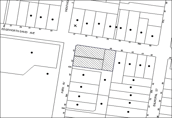
|
NOTIFICATION PLAN |
|
||
|
• PROPERTIES NOTIFIED
|
X SUBMISSIONS RECEIVED |
PROPERTY SUBJECT OF DEVELOPMENT |
|
One submission objects to the development, generally on the grounds that the development would result in:
· Exceeds the estimated dwelling yields for the Balmoral Precinct;
· Setback encroachments and lack of landscaping;
· Insufficient canopy trees provided on site;
· Traffic and road safety issues at the intersection of Park Avenue and Edgeworth David Avenue;
· Safety of pedestrians crossing Park Avenue;
· Park Avenue being used as a ‘rat run;’
· Loss of the traffic calming measure on Park Avenue;
· Increased volume of traffic in the area;
· Insufficient on-site car parking;
· Sufficient separation not provided between the two buildings;
· Isolation of adjoining properties;
· Lack of adequate services to facilitate the development;
· The proposal does not encompass sustainable development initiatives;
· Unacceptable overshadowing of adjoining properties;
· Overlooking of adjoining properties; and
· Lack of green space allocation.
Additionally, the submission makes the following observations:
· Inconsistencies between the Statement of Environmental Effects and Traffic Report with respect to car parking numbers; and
· Details of affordable housing not provided.
The merits of the matters raised in community submissions have been addressed in the body of the report with the exception of the following:
5.1.1 Exceed Estimated Dwelling Yields for the Balmoral Street, Waitara Precinct
The submission raises concern that the dwelling yield for the Balmoral Street, Waitara precinct may be greater than the estimates. The submission makes reference to dwelling yields that were provided by Council as estimates only and are not contained within the supporting documentation for the Housing Strategy DCP. However, these estimates are provided within Volume 2, prepared as part of the Housing Strategy Planning Proposal. Volume 2 identifies precincts which were proposed to be rezoned and contains an evaluation of the precincts, along with draft key principles diagrams, which were transferred to the Housing Strategy DCP.
The estimated dwelling yield applied for 5 storey development proposed as part of the Housing Strategy was 75 dwellings per hectare. This figure has been used to provide estimates for each 5 storey precinct, excluding existing dwellings. The figure is based on a number of factors, including an analysis of recent development outcomes observed within the Ku-ring-gai Local Government area and a review of historical yields and take up rates achieved through Council's previous Housing Strategies. Confirmation was sought from the Department of Planning and Infrastructure concerning the appropriateness of the dwelling yields to be relied upon under the Housing Strategy. The Department advised that it was satisfied that the yield assessment has been undertaken on a sound basis.
Recent development applications within the Balmoral Street, Waitara precinct have indicated that the actual dwelling yield capacity for the precinct may be greater than the estimates. However, this would have little impact in regards to built form as the building controls, such as height, setbacks, floorplates, separation, landscaping would remain unchanged.
Notwithstanding, Council’s Traffic Branch has reviewed the traffic issues for this precinct through the State Government Black Spot Funding program. Council has received funding for the provision of traffic signals at Balmoral Street and a median at Park Avenue. In addition, further traffic and dwelling yield modelling associated with the development of the precinct is currently being progressed by Council.
5.1.2 Clear Line of Sight for People Turning Left Out of Park Avenue Not Provided
The submission raises concern that the issue of the provision of clear line of sight for people turning left out of Park Avenue has not been addressed.
Neither the building envelope or the boundary fence impinges on sight lines for vehicles turning left from Park Avenue into Edgeworth David Avenue.
5.1.3 Removal of the Traffic Calming Device in Park Avenue
The submission raises concern with respect to the relocation of the existing traffic calming speed hump in Park Avenue. The device is to be removed and replaced with a pedestrian refuge island. The development has been conditioned to design and construct a pedestrian refuge island, in Park Avenue at the intersection with Edgeworth David Avenue. The design is to be provided to Council and approved by the Hornsby Local Traffic Committee. The design of the facilities must be in accordance with RMS guidelines, technical directions and Austroads guidelines.
5.1.4 Inconsistencies in the Car Parking Numbers
The submission raises concern with respect to inconsistencies in the applicant’s Statement of Environmental Effects and Traffic Report with respect to car parking numbers.
It is acknowledged that the Statement of Environmental Effects makes reference to 67 car parking spaces and the Traffic report refers to 68 spaces. According to Council’s assessment, the proposal provides a total of 68 car parking spaces, including 56 resident spaces (inclusive of 6 spaces for people with a disability), 11 visitor spaces and 1 car wash bay. The parking provision is in accordance with the minimum number of car spaces prescribed by the Housing Strategy DCP.
5.1.5 Inadequacy of Services and Infrastructure Such as Water and Sewer
The submission comments that existing services and infrastructure such as water and sewer are inadequate to cater for the development.
To address this, a condition of consent is recommended requiring the applicant to obtain written evidence of the service provider requirements from Ausgrid (formerly Energy Australia) and Sydney Water prior to a Construction Certificate being issued.
5.2 Public Agencies
The development application was not referred to any Public Agencies for comment.
6. THE PUBLIC INTEREST
Section 79C(1)(e) of the Act requires Council to consider “the public interest”.
The public interest is an overarching requirement, which includes the consideration of the matters discussed in this report. Implicit to the public interest is the achievement of future built outcomes adequately responding to and respecting the future desired outcomes expressed in environmental planning instruments and development control plans.
The application is considered to have satisfactorily addressed Council’s and relevant agencies’ criteria and would provide a development outcome that, on balance, would result in a positive impact for the community. Accordingly, it is considered that the approval of the proposed development would be in the public interest.
CONCLUSION
The application seeks approval for the demolition of existing structures and construction of two, five storey residential flat buildings comprising 51 units with basement car parking and strata title subdivision.
The proposed development is generally in accordance with the development controls for the ‘Balmoral Street, Waitara’ Precinct of the Housing Strategy DCP and would contribute to the future desired five storey residential character of the precinct. The minor non-compliance with prescriptive measures for floorplate and top storey setbacks are considered acceptable. The proposal complies with the design principles of SEPP 65 and the Residential Flat Design Code.
The proposal would result in a development that would be in keeping with the desired future character of the precinct.
Note: At the time of the completion of this planning report, no persons have made a Political Donations Disclosure Statement pursuant to Section 147 of the Environmental Planning and Assessment Act 1979 in respect of the subject planning application.
|
Rod Pickles Manager - Development Assessment Planning Division |
James Farrington Group Manager Planning Division |
|
1.View |
Locality Map |
|
|
|
2.View |
Floor Plans |
|
|
|
3.View |
Elevations and Sections |
|
|
|
4.View |
Shadow Diagrams |
|
|
|
5.View |
Landscape Plans |
|
|
|
6.View |
25mm Floor Plate Diagram |
|
|
File Reference: DA/689/2013
Document Number: D02670286
SCHEDULE 1
GENERAL CONDITIONS
The conditions of consent within this notice of determination have been applied to ensure that the use of the land and/or building is carried out in such a manner that is consistent with the aims and objectives of the relevant legislation, planning instruments and council policies affecting the land and does not disrupt the amenity of the neighbourhood or impact upon the environment.
Note: For the purpose of this consent, the term ‘applicant’ means any person who has the authority to act on or the benefit of the development consent.
Note: For the purpose of this consent, any reference to an Act, regulation, Australian standard or publication by a public authority shall be taken to mean the gazetted Act or regulation, or adopted Australian standard or publication as in force on the date that the application for a construction certificate is made.
1. Approved Plans and Supporting Documentation
The development must be carried out in accordance with the plans and documentation listed below and endorsed with Council’s stamp, except where amended by Council and/or other conditions of this consent:
Architectural Plans prepared by Marchese Partners Architects
|
Plan No. |
Issue No. |
Plan Title |
Dated |
|
A0.00 |
E |
Cover Sheet |
04.11.2013 |
|
A1.01 |
E |
Ground Floor Plan |
22.10.2013 |
|
A1.02 |
E |
Level 1 Floor Plan |
04.11.2013 |
|
A1.03 |
E |
Level 2 Floor Plan |
04.11.2013 |
|
A1.04 |
E |
Level 3 Floor Plan |
04.11.2013 |
|
A1.05 |
E |
Level 4 Floor Plan |
04.11.2013 |
|
A1.06 |
E |
Upper Basement Plan (B1 & B2) |
04.11.2013 |
|
A1.07 |
E |
Lower Basement Plan (B3 & B4) |
04.11.2013 |
|
A1.08 |
E |
Roof Plan |
04.11.2013 |
|
A1.09 |
E |
Accessible Units |
04.11.2013 |
|
A2.01 |
E |
North Elevation |
04.11.2013 |
|
A2.02 |
E |
South Elevation |
04.11.2013 |
|
A2.03 |
E |
East & West Elevations |
04.11.2013 |
|
A3.01 |
E |
Section AA |
04.11.2013 |
|
A3.02 |
E |
Section BB |
04.11.2013 |
|
A7.07 |
A |
Typical Fence Diagram to Courtyard |
22.10.2013 |
Landscape Plans prepared by Ray Fuggle & Associates Pty Ltd
|
Plan No. |
Issue No. |
Plan Title |
Dated |
|
L-01/2 |
D |
Landscape Plan |
07.11.2013 |
|
L-02/2 |
D |
Landscape Plan |
07.11.2013 |
Stormwater Management Plans prepared by HKMA Engineers
|
Plan No. |
Issue No. |
Plan Title |
Dated |
|
1548-DA- SW001 |
B |
Stormwater Drainage Layout Drawing Basement Level B3/B4 and Pump-Out Tank Plan and Section Details and Notes
|
20/11/2013 |
|
1548-DA- SW002 |
B |
Stormwater Drainage Layout Drawing Ground Level |
20/11/2013 |
|
1548-DA-SW0003 |
B |
OSD Tank Plan and Section Details and Various other Details |
20/11/2013 |
Supporting Documents
|
Document Title |
Document No. |
Prepared by |
Dated |
|
Plan Showing Details and Levels |
7989/13 |
H. Ramsay and Company Pty Ltd |
28.02.2013 |
|
Exterior Materials Finishes |
A4.01 Issue E |
Marchese Partners Architects |
04.11.2013 |
|
Shadow Diagrams Winter Solstice (21 June) |
A5.01 Issue E |
Marchese Partners Architects |
04.11.2013 |
|
Elevational Shadows Winter Solstice (21 June) |
A5.02 Issue E |
Marchese Partners Architects |
04.11.2013 |
|
Perspective Shadows Units G.05, 1.05, 2.05, 3.05 4.04 |
A5.03 Issue E |
Marchese Partners Architects |
04.11.2013 |
|
Perspective Shadows Units G.03, G.04, 1.03, 1.04, 2.03, 2.04, 3.03, 3.04, 4.03 |
A5.04 Issue E |
Marchese Partners Architects |
04.11.2013 |
|
Perspective Shadows Units G.01-02, 1.01-02, 1.12, 2.01-02, 2.12, 3.01-02, 3.12, 4.02 |
A5.05 Issue E |
Marchese Partners Architects |
04.11.2013 |
|
Perspective Shadows Units G.06-08, 1.06-08, 2.06-08, 3.06-08, 4.04, 4.05 |
A5.06 Issue E |
Marchese Partners Architects |
04.11.2013 |
|
25m Floor Plate Diagram |
A7.01 Issue E |
Marchese Partners Architects |
04.11.2013 |
|
Building Code of Australia 2013 Report |
13209R02 |
Metro Building Consultancy |
3 July 2013 |
|
Waste Management Plan |
Revision C |
Elephants Foot Waste Compactors Pty Ltd |
June 2013 |
|
BASIX Certificate |
491637M_02 |
Building Sustainability Assessments |
4 July 2013 |
|
Assessor Certificate (Thermal Performance) |
14910267 |
Building Sustainability Assessments |
4 July 2013 |
|
Arboricultural Impact Assessment |
8133 |
Redgum Horticultural |
26 June 2013 |
|
Design Verification Statement |
- |
Mr Steve Zappia of Marchese Partners Architects |
|
|
Traffic and Parking Impact Assessment |
2013/048 Issue A |
McLaren Traffic Engineering |
2 July 2013 |
2. Removal of Existing Trees
This development consent only permits the removal of trees numbered 2 & 3 as identified on Site Plan A – Survey of Subject Trees prepared by Redgum Horticultural dated 16 April 2013. The removal of any other trees located outside the subject properties requires separate approval under Council’s Tree Preservation Order.
3. Construction Certificate
A Construction Certificate is required to be approved by Council or a Private Certifying Authority prior to the commencement of any works under this consent.
REQUIREMENTS PRIOR TO THE ISSUE OF A CONSTRUCTION CERTIFICATE
4. Building Code of Australia
All building work must be carried out in accordance with the relevant requirements of the Building Code of Australia.
5. Contract of Insurance (Residential Building Work)
In the case of residential building work for which the Home Building Act, 1989 requires there to be a contract of insurance in force in accordance with Part 6 of that Act, that such a contract of insurance is in force before any building work authorised to be carried out by the consent commences.
6. Notification of Home Building Act, 1989 Requirements
Residential building work within the meaning of the Home Building Act, 1989 must not be carried out unless the principal certifying authority for the development to which the work relates (not being Council) has given Council written notice of the following information:
a) In the case of work for which a principal contractor is required to be appointed:
i) The name and licence number of the principal contractor; and
ii) The name of the insurer by which the work is insured under Part 6 of that Act.
b) In the case of work to be done by an owner-builder:
i) The name of the owner-builder; and
ii) If the owner-builder is required to hold an owner-builder’s permit under that Act, the number of the owner-builder’s permit.
Note: If arrangements for doing the residential building work are changed while the work is in progress so that the information notified becomes out of date, further work must not be carried out unless the principal certifying authority for the development to which the work relates (not being Council) has given Council written notification of the updated information.
7. Water/Electricity Utility Services
The applicant must submit written evidence of the following service provider requirements:
a) Ausgrid (formerly Energy Australia) – a letter of consent demonstrating that satisfactory arrangements have been made to service the proposed development.
b) Sydney Water – the submission of a ‘Notice of Requirements’ under s73 of the Sydney Water Act 1994.
Note: Sydney Water requires that s73 applications are to be made through an authorised Sydney Water Servicing Coordinator. Refer to www.sydneywater.com.au or telephone 13 20 92 for assistance.
8. Dilapidation Report
A ‘Dilapidation Report’ is to be prepared by a ‘chartered structural engineer’ detailing the structural condition of all adjoining properties.
9. Adaptable Units
The details of fit-outs of all accessible units and details of adaptable units must be provided with the Construction Certificate Plans.
10. Letter Boxes
The details of letter boxes must be provided with the Construction Certificate Plans. The letter boxes must be provided with a minimum setback of 2m from the front property boundary and not located within the overland flow path.
11. Car Parking and Deliveries
All car parking must be constructed and operated in accordance with Australian Standard AS 2890.1 – 2004 – Off Street Car Parking and Australian Standard 2890.2 - 2002 – Off Street Commercial and the following requirement:
a) All parking areas and driveways are to be sealed to an all weather standard, line marked and signposted.
b) Car parking, loading and manoeuvring areas to be used solely for nominated purposes.
c) Vehicles awaiting loading, unloading or servicing shall be parked on site and not on adjacent or nearby public roads.
d) All vehicular entry on to the site and egress from the site shall be made in a forward direction.
12. Bicycle Parking
All bicycle parking spaces are to be designed in accordance with Australian Standard 2890.3-1993 – Bicycle parking facilities, RTA (2005) NSW Bicycle Guidelines, Austroads (2008) Guide to Traffic management – Part 11: Parking and relevant RMS supplement and the following requirement:
a) The car parking spaces are to be re-configured to provide 11 bicycle parking spaces.
13. Motorcycle Parking
Two (2) motorcycle spaces are to be provided in the basement parking area and designed in accordance with AS2890.1-2004 Off Street Car Parking and the following requirements:
a) The car parking spaces are to be re-configured to provide 2 motorcycle parking spaces;
b) Each motorcycle parking space is to be designed and located so that parked motorcycles are not vulnerable to being struck by a manoeuvring vehicle.
14. Parking Spaces for People with Disabilities
All parking spaces for people with disabilities must be constructed and operated in accordance with Australian Standard AS/NZS 2890.6:2009 – Off-street parking for people with disabilities.
15. Waste Management Details
The following waste management requirements must be complied with:
a) A Waste Management Plan Section One – Demolition Stage and Section Three – Construction Stage, covering the scope of this project and including the following details, is required to be submitted to Council:
i) An estimate of the types and volumes of waste and recyclables to be generated;
ii) A site plan showing sorting and storage areas for demolition and construction waste and the vehicle access to these areas;
iii) How excavation, demolition and construction waste materials will be reused or recycled and where residual wastes will be disposed;
iv) The total percentage (by weight) of demolition and construction waste that will be reused or recycled.
16. Pedestrian Refuge Island
A detailed design for a pedestrian refuge island, in Park Avenue at the intersection with Edgeworth David Avenue must be provided to Council and approved by the Hornsby Local Traffic Committee. The design of the facilities must be in accordance with Roads and Maritime Service guidelines, technical directions and Austroads standards.
17. Headroom Clearance
Headroom clearance of 3.5m is to be maintained at change of grade to the basement level.
18. Sight Lines for Pedestrian Safety
Minimum sight lines for pedestrian safety are to be provided at the driveway.
19. Access Ramp Grade
Maximum grade of access ramp is to be in accordance with AS 2890.2-2002.
20. Road Works
All road works approved under this consent must be designed and constructed in accordance with Council’s Civil Works Design and Construction Specification, 2005 and the following requirements at the Applicant’s cost: -
a) Council’s standard 150 mm integral kerb and gutter across the Park Avenue frontage of the site between the southern boundary at least to the kerb return at the corner of Park Avenue and Edgeworth David Avenue, with a minimum 300 mm thick shoulder pavement width of 4.5 metres on this frontage to match with the Park Avenue centre carriageway seal.
b) A Council’s standard 1.2m wide 80 mm thick concrete footpath to be constructed on the Edgeworth David Avenue frontage of the site with crossfall graded at 2% up from the top of the Edgeworth David Avenue kerbline with the remaining footpath verge area turfed. Council’s standard perambulator ramp shall be constructed on the corner of Park Avenue and Edgeworth David Avenue.
c) A Council’s standard 1.2m wide 80 mm thick concrete footpath to be constructed on the Park Avenue frontage of the site with crossfall graded at 2% up from the top of the proposed kerb and matched to the adjacent footpath. The remaining footpath area shall be turfed.
d) Matching and relocation of all pits, poles, services, signage and other assets shall be undertaken at the applicant’s cost.
e) The submission of a compaction certificate from a geotechnical engineer for any fill within road reserves, and all road sub-grade and road pavement materials.
f) Pursuant to Section 138 Roads Act 1993, the Applicant shall apply for a Construction Certificate (SCC) from Hornsby Shire Council for the SCC construction approval and Compliance Inspections. The Applicant must pay the Council’s quoted Application fees with the SCC Application. The subsequent Hornsby Shire Council Compliance Certificate for those works shall be released by Council prior to the release of the final Occupation Certificate for Units.
21. Vehicular Crossing
A separate application under the Local Government Act, 1993 and the Roads Act, 1993 must be submitted to Council for the installation of a new vehicular crossing and the removal of the redundant crossing. The vehicular crossing must be constructed in accordance with Council’s Civil Works Design, 2005 and the following requirements:
a) Any redundant crossings must be replaced with integral kerb and gutter;
b) The footway area must be restored by turfing.
Note: An application for a vehicular crossing can only be made to one of Council’s Authorised Vehicular Crossing Contractors, or be the subject of a Construction Certificate Application to Council as Roads Authority. You are advised to contact Council on 02 9847 6940 to obtain a list of contractors.
22. Construction Management Plan
A Construction Management Plan detailing construction vehicle routes, number of trucks, hours of operation, access arrangements and traffic control should be submitted to Council prior to the issue of a Construction Certificate.
23. Traffic Control Plan
A Traffic Control Plan (TCP) must be prepared by a qualified traffic controller in accordance with the Roads & Traffic Authority’s Traffic Control at Worksites Manual 1998 and Australian Standard 1742.3 for all work on a public road and be submitted to Council. The TCP must detail the following:
a) Arrangements for public notification of the works.
b) Temporary construction signage.
c) Permanent post-construction signage.
d) Vehicle movement plans.
e) Traffic management plans.
f) Pedestrian and cyclist access/safety.
24. Stormwater Drainage
The stormwater drainage system for the development must be designed and constructed in accordance with Council’s Civil Works – Design and Construction Specification 2005 and the following requirements:
a) Connected directly to Council’s street drainage system.
25. On Site Stormwater Detention
An on-site stormwater detention system must be designed by a chartered civil engineer and constructed in accordance with the following requirements:
a) Have a capacity of not less than 42 cubic metres, and a maximum discharge (when full) of 40 litres per second.
b) Have a surcharge/inspection grate located directly above the outlet with stepirons installed wherever access points are more than 1.2m deep.
c) Discharge from the detention system to be controlled via 1 metre length of pipe, not less than 50 millimetres diameter or via a stainless plate with sharply drilled orifice bolted over the face of the outlet discharging into a larger diameter pipe capable of carrying the design flow to an approved Council system.
d) An emergency pipe overflow system sited above the top water level shall be designed and constructed between the tank and the receiving pit capable of draining the 20 year average recurrence interval stormflow from the site.
e) Tanks must be constructed from core-filled and reinforced concrete blocks with concrete one or two-way supported slab roofing, by design from a structural engineer.
26. Internal Driveway/Vehicular Areas
The driveway and parking areas on site must be designed in accordance with Australian Standards 2890.1, 2890.2, 3727 and the following requirements:
a) Design levels at the front boundary must be obtained from Council.
b) The driveway must be a rigid pavement.
REQUIREMENTS PRIOR TO THE COMMENCEMENT OF ANY WORKS
27. Erection of Construction Sign
A sign must be erected in a prominent position on any site on which building work, subdivision work or demolition work is being carried out:
a) Showing the name, address and telephone number of the principal certifying authority for the work;
b) Showing the name of the principal contractor (if any) for any demolition or building work and a telephone number on which that person may be contacted outside working hours; and
c) Stating that unauthorised entry to the work site is prohibited.
Note: Any such sign is to be maintained while the building work, subdivision work or demolition work is being carried out, but must be removed when the work has been completed.
28. Protection of Adjoining Areas
A temporary hoarding, fence or awning must be erected between the work site and adjoining lands before the works begin and must be kept in place until after the completion of the works if the works:
a) Could cause a danger, obstruction or inconvenience to pedestrian or vehicular traffic.
b) Could cause damage to adjoining lands by falling objects.
c) Involve the enclosure of a public place or part of a public place.
Note: Notwithstanding the above, Council’s separate written approval is required prior to the erection of any structure or other obstruction on public land.
29. Toilet Facilities
Toilet facilities must be available or provided at the works site before works begin and must be maintained until the works are completed at a ratio of one toilet for every 20 persons employed at the site. Each toilet must:
a) be a standard flushing toilet connected to a public sewer; or
b) be a temporary chemical closet approved under the Local Government Act, 1993; or
c) have an on-site effluent disposal system approved under the Local Government Act, 1993.
30. Erosion and Sediment Control
Erosion and sediment control measures must be provided and maintained throughout the construction period in accordance with the manual ‘Soils and Construction 2004 (Bluebook)’, the approved plans, Council specifications and to the satisfaction of the principal certifying authority. The erosion and sediment control devices must remain in place until the site has been stabilised and revegetated.
Note: On the spot penalties up to $1,500 may be issued for any non-compliance with this requirement without any further notification or warning.
31. Tree Protection Barriers
To avoid injury or damage, trees numbered 1 & 4 must have trunks protected by 2 metre lengths of 75mm x 25mm hardwood timbers spaced at 80mm secured with galvanised wire (not fixed or nailed to the tree in any way).
REQUIREMENTS DURING CONSTRUCTION
32. Construction Work Hours
All work on site (including demolition and earth works) must only occur between 7am and 5pm Monday to Saturday. No work is to be undertaken on Sundays or public holidays.
33. Demolition
All demolition work must be carried out in accordance with “Australian Standard 2601-2001 – The Demolition of Structures” and the following requirements:
a) Demolition material must be disposed of to an authorised recycling and/or waste disposal site and/or in accordance with an approved waste management plan;
b) Demolition works, where asbestos material is being removed, must be undertaken by a contractor that holds an appropriate licence issued by WorkCover NSW in accordance with Chapter 10 of the Occupational Health and Safety Regulation 2001 and Clause 29 of the Protection of the Environment Operations (Waste) Regulation 2005 ; and
c) On construction sites where buildings contain asbestos material, a standard commercially manufactured sign containing the words ‘DANGER ASBESTOS REMOVAL IN PROGRESS’ measuring not less than 400mm x 300mm must be erected in a prominent position visible from the street.
34. Environmental Management
The site must be managed in accordance with the publication ‘Managing Urban Stormwater – Landcom (March 2004) and the Protection of the Environment Operations Act 1997 by way of implementing appropriate measures to prevent sediment run-off, excessive dust, noise or odour emanating from the site during the construction of the development.
35. Street Sweeping
Street sweeping must be undertaken following sediment tracking from the site along Park Avenue and Edgeworth David Avenue during works and until the site is established.
36. Council Property
During construction works, no building materials, waste, machinery or related matter is to be stored on the road or footpath. The public reserve must be kept in a clean, tidy and safe condition at all times.
37. Disturbance of Existing Site
During construction works, the existing ground levels of open space areas and natural landscape features, (including natural rock-outcrops, vegetation, soil and watercourses) must not be altered unless otherwise nominated on the approved plans.
38. Landfill
Landfill must be constructed in accordance with Council’s ‘Construction Specification, 2005’ and the following requirements:
a) All fill material imported to the site is to wholly consist of Virgin Excavated Natural Material (VENM) as defined in Schedule 1 of the Protection of the Environment Operations Act 1997 or a material approved under the Department of Environment and Climate Change’s general resource recovery exemption.
b) A compaction certificate is to be obtained from a geotechnical engineer verifying that the specified compaction requirements have been met.
39. Excavated Material
All excavated material removed from the site must be classified in accordance with the Department of Environment, Climate Change and Water NSW Waste Classification Guidelines prior to disposal to an approved waste management facility and reported to the principal certifying authority.
40. Survey Report – Finished Floor Level
A report(s) must be prepared by a registered surveyor and submitted to the principal certifying authority prior to the pouring of concrete at each level of the building certifying that:
a) The building, retaining walls and the like have been correctly positioned on the site; and
b) The finished floor level(s) are in accordance with the approved plans.
41. Contamination During Construction Works
Should the presence of asbestos or soil contamination, not recognised during the application process be identified during demolition, the applicant must immediately notify the Principal Certifying Authority and Council.
42. Construction Noise Management
The construction works must be undertaken in accordance with the “Interim Construction Noise Guidelines – 2009” published by Department of Environment and Climate Change NSW.
43. Works Near Trees
All required tree protection measures are to be maintained in good condition for the duration of the construction period.
All works (including driveways and retaining walls) within 6 metres of any trees required to be retained (whether or not on the subject property, and pursuant to this consent or the Tree Preservation Order), must be carried out under the supervision of an ‘AQF Level 5 Arborist’ and a certificate submitted to the principal certifying authority detailing the method(s) used to preserve the tree(s).
Note: Except as provided above, the applicant is to ensure that no excavation, filling or stockpiling of building materials, parking of vehicles or plant, disposal of cement slurry, waste water or other contaminants is to occur within 4 metres of any tree to be retained.
REQUIREMENTS PRIOR TO THE ISSUE OF AN OCCUPATION CERTIFICATE
Note: For the purpose of this consent, a reference to ‘occupation certificate’ shall not be taken to mean an ‘interim occupation certificate’ unless otherwise stated.
44. Fulfilment of BASIX Commitments
The applicant must demonstrate the fulfilment of BASIX commitments pertaining to the development.
45. Sydney Water – s73 Certificate
An s73 Certificate must be obtained from Sydney Water.
46. Damage to Council Assets
Any damage caused to Council’s assets as a result of the construction of the development must be rectified in accordance with Council’s written requirements and at the sole cost of the applicant. The restoration of public assets shall be considered for approval with Hornsby Shire Council’s Compliance Certificate matters in the Condition titled Road Works.
47. Completion of Landscaping
A certificate must be provided by a practicing landscape architect, horticulturalist or person with similar qualifications and experience certifying that all required landscaping works have been satisfactorily completed in accordance with the approved landscape plans.
Note: Advice on suitable species for landscaping can be obtained from Council’s planting guide ‘Indigenous Plants for the Bushland Shire’, available at www.hornsby.nsw.gov.au.
48. Planter Boxes / On Slab planting
On slab planter boxes must include waterproofing, subsoil drainage (proprietary drainage cell, 50mm sand and filter fabric) automatic irrigation, minimum 500mm planting soil for shrubs and minimum 1000mm planting soil for trees and palms and 75mm mulch to ensure sustainable landscape is achieved.
49. Retaining Walls
All required retaining walls must be constructed as part of the development.
50. Boundary Fencing
Fencing must be erected along all property boundaries behind the front building alignment to a height of 1.8 metres.
Note: Alternative fencing may be erected subject to the written consent of the adjoining property owner(s).
51. External Lighting
All external lighting must be designed and installed in accordance with Australian Standard AS 4282 – Control of the Obtrusive Effects of Outdoor Lighting. Certification of compliance with the Standard must be obtained from a suitably qualified person.
52. Unit Numbering
The allocation of unit numbering must be authorised by Council prior to the numbering of each unit in the development.
53. Car Parking Allocation and Resident Storage
The basement resident storage areas are to be allocated in accordance with the size requirements of the Residential Flat Design Code for the respective units and proximity to the unit car parking space.
54. Garbage Collection Easement
For the purpose of waste collection, an easement entitling Council, its servants and agents and persons authorised by it to enter upon the subject land and to operate thereon, vehicles and other equipment for the purposes of garbage collection must be granted to Council by the owner of the land.
Note: The easement must be in a form prescribed by Council and must include covenants to the effect that parties will not be liable for any damage caused to the subject land or any part thereof or to any property located therein or thereon by reason of the operation thereon of any vehicle or other equipment used in connection with the collection of garbage and to the effect that the owner for the time being of the subject land shall indemnify the Council, its servants, agents and persons authorised by it to collect garbage against liability in respect of any such claims made by any person whomsoever.
55. Waste Management Details
The following waste management requirements must be complied with:
a) The bin storage room(s) at the basement level must include water or a hose for cleaning, graded floors with drainage to sewer, a robust door, sealed and impervious surface, adequate lighting and ventilation. The bin rooms at each residential level must include sealed and impervious surface, adequate lighting and ventilation.
b) A report must be prepared by an appropriately qualified person, certifying the following:
i) A comparison of the estimated quantities of each waste type against the actual quantities of each waste type.
Note: Explanations of any deviations to the approved Waste Management Plan is required to be included in this report.
ii) That at least 60% of the waste generated during the demolition and construction phase of the development was reused or recycled.
Note: If the 60% diversion from landfill cannot be achieved in the Construction Stage, the Report is to include the reasons why this occurred and certify that appropriate work practices were employed to implement the approved Waste Management Plan. The Report must be based on documentary evidence such as tipping dockets/receipts from recycling depots, transfer stations and landfills, audits of procedures etc. which are to be attached to the report.
iii) All waste was taken to site(s) that were lawfully permitted to accept that waste.
c) Each unit must be provided with an indoor waste/recycling cupboard for the interim storage of a minimum one day’s waste generation with separate containers for general waste and recyclable materials.
d) Space must be provided for either individual compost containers for each unit or a communal compost container.
Note: The location of the compost containers should have regard for potential amenity impacts.
e) The bin carting routes must be devoid of any steps.
Note: Ramps between different levels are acceptable.
f) The bin collection area next to the driveway must be smooth hard surface in order to safely and easily wheel the bins around. It need not be impervious.
Note: Porous concrete, for example, is acceptable but grass pavers, geocells, plastic grids reinforced turf or gravel, etc is not.
g) Access to the waste volume handling equipment by unauthorised persons (including residents and waste collectors) must be prevented.
h) A report(s) must be prepared by a registered surveyor and submitted to the principal certifying authority prior to the issue of the Subdivision/Occupation Certificate, certifying that:
i) The finished access way (including ramp, vehicle turning area, loading bay and site entry/exit) to be used by waste collection vehicles, complies with Australian Standard AS2890.2-2002 Parking Facilities Part 2: Off-street Commercial Vehicle Facilities for small rigid vehicles with minimum design vehicle dimensions of 6.4 metres overall length, width of 2.3 metres, and 3.5 metre clearance height; and
ii) The finished gradient(s), dimensions and geometry of the road/access way (including vehicle turning area) are in accordance with the approved plans.
i) The 3.5 metre clearance height within the truck travel path must not be reduced by ducting, pipes or anything else.
56. Construction for a Safe Environment
Prior to the issue of the Occupation Certificate, the site must include the following elements:
a) An intercom system be installed at gate locations to ensure screening of persons entering the units.
b) The entryway to the site be illuminated in high luminance at all times.
c) The communal open space areas are to be illuminated with high luminance by motion sensor lighting.
d) The service areas of the ground floor and the garbage room at the basement be illuminated with high luminance by motion sensor lighting.
e) The driveway and the basement car park is to be illuminated with low luminance at all times.
f) Robust materials which cannot be forced or breached with minimised maintenance requirements are to be used for construction work in the common areas.
g) The lamps and lighting levels must comply with Australian and New Zealand Lighting Standard 1158.1.
h) Effective signage be provided to guide visitors to the main areas and parking areas.
i) A street sign be prominently displayed in front of the site in accordance with Order No. 8, Section 124 Local Government Act 1993.
j) The communal area must include a clear sign to restrict access for non-residents.
k) Units’ numbers, entry and exit signs must be legible and clear.
l) Fire exit doors to be fitted with single cylinder locksets (Australia New Zealand Standard-Locksets).
m) The entry doors to the pedestrian foyer is to be constructed of safety rated glass to enable residents a clear line of site before entering or exiting the residential apartments.
n) Lighting is to be provided to pathways, building foyer entries, driveways and common external spaces.
o) Security deadlocks are to be provided to each apartment door.
p) Peep holes are to be provided to individual apartment doors to promote resident safety.
57. Pedestrian Refuge Island
A pedestrian refuge island with connecting footways and ramps is to be constructed in Park Avenue at the intersection with Edgeworth David Avenue.
58. Works as Executed Plan
A works-as-executed plan(s) must be prepared by a registered surveyor and submitted to Council for completed road pavements, assets, kerb & gutter, drainage systems and on-site detention system.
59. Creation of Easements
The following matter(s) must be nominated on the plan of subdivision under s88B of the Conveyancing Act 1919:
a) The creation of an appropriate "Positive Covenant" and "Restriction as to User" over the constructed on-site detention/retention systems and outlet works, within the lots in favour of Council in accordance with Council’s prescribed wording. The position of the on-site detention system is to be clearly indicated on the title.
b) To register the OSD easement, the restriction on the use of land “works-as-executed” details of the on-site-detention system must be submitted verifying that the required storage and discharge rates have been constructed in accordance with the design requirements. The details must show the invert levels of the on site system together with pipe sizes and grades. Any variations to the approved plans must be shown in red on the “works-as-executed” plan and supported by calculations.
Note: Council must be nominated as the authority to release, vary or modify any easement, restriction or covenant required by this condition.
60. Section 94 Development Contributions
In accordance with Section 80A(1) of the Environmental Planning and Assessment Act 1979 and the Hornsby Shire Council Section 94 Development Contributions Plan 2012-2021, the following monetary contributions shall be paid to Council to cater for the increased demand for community infrastructure resulting from the development:
|
Description |
Contribution (4) |
|
Roads |
$54,871.55 |
|
Open Space and Recreation |
$580,498.55 |
|
Community Facilities |
$81,365.95 |
|
Plan Preparation and Administration |
$2,387.65 |
|
TOTAL |
$719,123.70 |
being for 48 additional dwellings.
a) If the contributions are not paid within the financial quarter that this consent is granted, the contributions payable will be adjusted in accordance with the provisions of the Hornsby Shire Council Section 94 Development Contributions Plan and the amount payable will be calculated at the time of payment in the following manner:
$CPY = $CDC x CPIPY
CPIDC
Where:
$CPY is the amount of the contribution at the date of Payment.
$CDC is the amount of the contribution as set out in this Development Consent.
CPIPY is the latest release of the Consumer Price Index (Sydney – All Groups) at the date of Payment as published by the ABS.
CPIDC is the Consumer Price Index (Sydney – All Groups) for the financial quarter at the date of this Development Consent.
b) The monetary contributions shall be paid to Council:
i) prior to the issue of the Subdivision Certificate where the development is for subdivision; or
ii) prior to the issue of the first Construction Certificate where the development is for building work; or
iii) prior to issue of the Subdivision Certificate or first Construction Certificate, whichever occurs first, where the development involves both subdivision and building work; or
iv) prior to the works commencing where the development does not require a Construction Certificate or Subdivision Certificate.
It is the professional responsibility of the Principal Certifying Authority to ensure that the monetary contributions have been paid to Council in accordance with the above timeframes.
Council’s Development Contributions Plan may be viewed at www.hornsby.nsw.gov.au or a copy may be inspected at Council’s Administration Centre during normal business hours.
OPERATIONAL CONDITIONS
61. Visitor Access
Visitors are to have access to the parking area at all times. Visitors are to be able to access the basement car park by an audio/visual intercom system located at the top of the ramped driveway.
62. Waste Storage Area and Waste Management
The waste management on site must be in accordance with the following requirements:
a) A site caretaker must be employed and be responsible for moving bins where and when necessary, washing bins and maintaining waste storage areas, ensuring the chute system and related devices are maintained in effective and efficient working order, managing the communal composting area, managing the bulky item storage area, arranging the prompt removal of dumped rubbish, and ensuring all residents are informed of the use of the waste management system.
b) Site security measures implemented on the property, including electronic gates, must not prevent access to the bin room/collection point by waste removal services.
63. Landscape Establishment
The landscape works must be maintained into the future to ensure the establishment and successful growth of plant material to meet the intent of the landscape design. This must include but not be limited to watering, weeding, replacement of failed plant material and promoting the growth of plants through standard industry practices.
64. Noise
The level of total continuous noise emanating from operation of the premises including all the plant, including air conditioning units and processes in all buildings (LA10) (measured for at least 15 minutes) in or on the above premises, must not exceed the background level by more than 5dB(A) when measured at all property boundaries.
65. Fire Safety Statement - Annual
On at least one occasion in every 12 month period following the date of the first ‘Fire Safety Certificate’ issued for the property, the owner must provide Council with an annual ‘Fire Safety Certificate’ to each essential service installed in the building.
- END OF CONDITIONS -
ADVISORY NOTES
The following information is provided for your assistance to ensure compliance with the Environmental Planning and Assessment Act, 1979, Environmental Planning and Assessment Regulation 2000, other relevant legislation and Council’s policies and specifications. This information does not form part of the conditions of development consent pursuant to Section 80a of the Act.
Environmental Planning and Assessment Act, 1979 Requirements
The Environmental Planning and Assessment Act, 1979 requires:
· The issue of a construction certificate prior to the commencement of any works. Enquiries can be made to Council’s Customer Services Branch on 9847 6760.
· A principal certifying authority to be nominated and Council notified of that appointment prior to the commencement of any works.
· Council to be given at least two days written notice prior to the commencement of any works.
· Mandatory inspections of nominated stages of the construction inspected.
· An occupation certificate to be issued before occupying any building or commencing the use of the land.
Long Service Levy
In accordance with Section 34 of the Building and Construction Industry Long Service Payments Act 1986, a ‘Long Service Levy’ must be paid to the Long Service Payments Corporation or Hornsby Council.
Note: The rate of the Long Service Levy is 0.35% of the total cost of the work.
Note: Hornsby Council requires the payment of the Long Service Levy prior to the issue of a construction certificate.
Tree Preservation Order
To ensure the maintenance and protection of the existing natural environment, it is an offence to ringbark, cut down, top, lop, remove, wilfully injure or destroy a tree outside 3 metres of the approved building envelope without the prior written consent from Council.
Note: A tree is defined as a single or multi-trunked wood perennial plant having a height of not less than three (3) metres, and which develops many branches, usually from a distance of not less than one (1) metre from the ground, but excluding any plant which, in its particular location, is a noxious plant declared as such pursuant to the Noxious Weeds Act 1993. This definition of ‘tree’ includes any and all types of Palm trees.
All distances are determined under Australian Standard AS4970-2009 ”Protection of Trees on Development Sites”.
Fines may be imposed for non-compliance with Council’s Tree Preservation Order.
Disability Discrimination Act
The applicant’s attention is drawn to the existence of the Disability Discrimination Act. A construction certificate is required to be obtained for the proposed building/s, which will provide consideration under the Building Code of Australia, however, the development may not comply with the requirements of the Disability Discrimination Act. This is the sole responsibility of the applicant.
Covenants
The land upon which the subject building is to be constructed may be affected by restrictive covenants. Council issues this approval without enquiry as to whether any restrictive covenant affecting the land would be breached by the construction of the building, the subject of this consent. Applicants must rely on their own enquiries as to whether or not the building breaches any such covenant.
Dial Before You Dig
Prior to commencing any works, the applicant is encouraged to contact Dial Before You Dig on 1100 or www.dialbeforeyoudig.com.au for free information on potential underground pipes and cables within the vicinity of the development site.
Telecommunications Act 1997 (Commonwealth)
If you are aware of any works or proposed works which may affect or impact on Telstra’s assets in any way, you are required to contact: Telstra’s Network Integrity Team on Phone Number 1800 810 443.
Rain Water Tank
It is recommended that water collected within any rainwater tank as part of the development be limited to non-potable uses. NSW Health recommends that the use of rainwater tanks for drinking purposes not occur where a reticulated potable water supply is available.
Group Manager’s Report No. PL115/13
Planning Division
Date of Meeting: 18/12/2013
10 DEVELOPMENT APPLICATION - SUBDIVISION OF ONE ALLOTMENT INTO TWO LOTS - 1549 SINGLETON ROAD, SINGLETONS MILL
EXECUTIVE SUMMARY
|
DA No: |
DA/272/2013 (Lodged 22 March 2013) |
|
Description: |
Subdivision of one allotment into two lots |
|
Property: |
Lot 4 DP 75209, No. 1549 Singleton Road, Singletons Mill |
|
Applicant: |
Mr Bradley Kent De Burgh Thew |
|
Owner: |
Mr Bradley Kent De Burgh Thew |
|
Estimated Value: |
Nil |
|
Ward: |
A |
· The application proposes the Torrens title subdivision of one allotment into two lots.
· The proposal does not comply with the minimum rural lot size pursuant to Clause 14 of Hornsby Shire Local Environmental Plan. The applicant’s submission seeking to vary the minimum lot size development standard is not considered well founded with regard to State Environmental Planning Policy No. 1 – Development Standards.
· No submissions have been received in respect of the application.
· It is recommended that the application be refused.
|
THAT Development Application No. DA/272/2013 for subdivision of one allotment into two lots at Lot 4, DP 75209 No. 1549 Singleton Road, Singletons Mill be refused for the reasons detailed in Schedule 1 of Group Manager’s Report No. PL115/13. |
BACKGROUND
A weather board cottage has existed on the eastern side of the site since the late 1800’s.
On 28 September 1971, Building Application No. 2219/1971 for the erection of a dwelling on the western side of the site was approved by Council.
On 6 November 1989, DA/450/1989 for the subdivision of one allotment into four lots was refused by Council due to insufficient information.
On 7 July 1997, Building Application No. 289/1997 for alterations and additions to a dwelling was approved by Council. The approved development comprised a new roof and addition of a verandah. Conditions were applied to the consent requiring that a heritage evaluation be completed on the existing cottage on the site.
On 2 June 2011, DA/559/2011 was lodged for the subdivision of one allotment into two lots. A SEPP 1 objection was submitted seeking a variation to the minimum allotment size. Council advised that the proposal would not be supported. The application was subsequently withdrawn.
On 7 August 2012, DA/111/2012 for the use of the cottage as bed and breakfast accommodation was approved by Council.
On 22 March 2013, DA/272/2013 was lodged for the subdivision of one allotment into two lots. A SEPP 1 objection was submitted seeking a variation to the minimum allotment size. This application is the subject of this report.
SITE
The site has an area of 14.47 ha and is located approximately 5 kilometres east of Wisemans Ferry along Singleton Road. The site is located on part of a peninsula extending into the Hawkesbury River and bounded by Marramarra National Park to the south. Singleton Road loops through the southern part of the property. A Crown Road extends north through the centre of the property providing access to two other properties within the peninsula.
The site comprises a dwelling house constructed in the 1970s and a cottage constructed in the late 1800s. The cottage is a single storey weatherboard cottage with a large verandah located on the eastern side of the Crown Road and has been approved for use as bed and breakfast accommodation. The dwelling constructed in the 1970s is a two storey brick dwelling located on the western side of the Crown Road located amongst dense bushland.
The dwelling on the western side of the property is accessed via the Crown Road, approximately 10 metres north of Singleton Road. Access to the cottage is provided via the Crown Road and a driveway that diverts to the east. A parking area for four vehicles is provided adjacent to the cottage.
The site is densely vegetated and comprises significant bushland including Coastal Saltmarsh which is considered an Endangered Ecological Community protected under the Threatened Species Conservation Act 1995. An existing cleared area is located around the dwelling house.
The site is partially flood affected along the foreshore areas to the Hawkesbury River, however this does not extend to the buildings. The site contains colluvial and estuarine Acid Sulphate Soils.
The site is not a heritage item and is not within a heritage conservation area. The cottage on the eastern side of the site is a draft heritage item under the Planning Proposal adopted by Council to implement the recommendations of Heritage Review Stage 5.
PROPOSAL
The proposal is for the subdivision of one allotment into two lots.
Proposed Lot 1 has an area of 7.62 hectares, is located on the western side of the Crown Road Reserve and includes an existing dwelling house. Proposed lot one includes residual parcels of land on the southern side of Singleton Road.
Proposed Lot 2 has an area of 6.85 hectares, is located on the eastern side of the Crown Road and includes the existing cottage.
The existing buildings are located either side of a Crown Road reserve providing a logical partition of the property.
The dwelling house on proposed Lot 1 has driveway access from Singleton Road via the Crown Road. The driveway access for the cottage on proposed Lot 2 utilises a small section adjacent to Singleton Road. The eastern driveway serving the cottage meanders outside the road reservation near the cottage. It is proposed to recognise this extent in a right of way to ensure access to the properties to the north at the head of the peninsula.
ASSESSMENT
The development application has been assessed having regard to the ‘Metropolitan Plan for Sydney 2031’, the ‘North Subregion (Draft) Subregional Strategy’ and the matters for consideration prescribed under Section 79C of the Environmental Planning and Assessment Act 1979 (the Act). The following issues have been identified for further consideration.
1. STRATEGIC CONTEXT
1.1 Metropolitan Plan for Sydney and (Draft) North Subregional Strategy
The (Draft) Metropolitan Strategy for Sydney 2031 is a broad framework to provide for Sydney’s growth to help plan for housing, employment, transport, infrastructure, the environment and open space. It outlines a vision for Sydney to 2031; the challenges faced, and the directions to follow to address these challenges and achieve the vision.
The North Subregion comprises Hornsby, Kuring-gai, Manly, Warringah and Pittwater Local Government Areas. The Draft North Subregional Strategy provided a framework for Council in its preparation of the HLEP 2013. Within the North Subregion, the Draft Metropolitan Strategy proposes:
· Population growth of 81,000 from the current 2011 baseline of 529,000
· Housing growth of 37,000 from the current 2011 baseline of 204,000
· Employment growth of 39,000 from the current 2011 baseline of 186,000
The proposed development would be consistent with the Metropolitan Plan for Sydney 2031 by providing an additional allotment with a dwelling entitlement contributing to the achievement of Council’s dwelling target.
2. STATUTORY CONTROLS
Section 79C(1)(a) requires Council to consider “any relevant environmental planning instruments, draft environmental planning instruments, development control plans, planning agreements and regulations”.
2.1 Hornsby Shire Local Environmental Plan 1994
The subject land is zoned Part Environmental Protection A (Wetlands) zone and Part Environmental Protection B (River Catchment) zone under the Hornsby Local Environmental Plan 1994 (HSLEP).
The objectives of the Environmental Protection A (Wetlands) zone are:
(a) to protect the ecological value of wetland areas.
(b) to assist in the maintenance of acceptable water quality in the Hawkesbury River.
(c) to provide for development that is compatible with the ecology of wetland areas.
The objectives of the Environmental Protection B (River Catchment) zone are:
(a) to protect the natural environment of sensitive areas within the catchment of the Hawkesbury River.
(b) to protect the valleys and escarpments within the catchment of the Hawkesbury River and accommodate land uses, including housing, that recognise environmental sensitivity of the area.
(c) to protect the scenic quality of visually prominent areas and water quality within the catchment of the Hawkesbury River.
Under the HSLEP the proposed development is defined as ‘subdivision’ and is permissible in the zone with Council’s consent.
Clause 14 of the HSLEP prescribes that the minimum area per allotment within the Environmental Protection A zone and the Environmental Protection B zone is 40 hectares. The existing allotment and the proposed subdivision do not comply with the minimum lot area requirements. In this regard, the application is the subject of an objection pursuant to State Environmental Planning Policy No. 1 – Development Standards.
Clause 18 of the HSLEP sets out heritage conservation provisions for Hornsby Shire. The subject site is not an item of environmental heritage. However, the cottage (on proposed lot 2) is a draft heritage item for inclusion in Schedule D (Heritage Items) of the HLEP. This is further discussed under Section 2.8.4.
2.2 Hornsby Local Environmental Plan 2013
The Hornsby Local Environmental Plan 2013 (HLEP) was gazetted by the Minister of Planning on 11 October 2013. The HLEP includes a savings provision stating that if a development application is made and not finally determined before the commencement of the LEP, the application must be determined as if the Plan has been exhibited but not commenced. The HLEP essentially reiterates the current land use zoning control applicable to the site as outlined below:
2.2.1 Zoning
Under the HLEP, the subject land is zoned E2 (Environmental Conservation) and E3( Environmental Management). The proposed development is defined as ‘subdivision’ and is permissible with the consent of Council. However, the subdivision would not be permissible as the lot sizes are less than the minimum size shown on the Lot Size Map as prescribed under Part 4.1.
The Lot Size Map indicates that the minimum lot size for land zoned E2 (Environmental Conservation) and E3 (Environmental zone) is 40 hectares. The proposed 7.62 hectares (lot 1) and 6.85 hectares (lot 2) are undersized and do not comply with this requirement. Part 4.6(6) prescribes that development consent must not be granted under this clause for subdivision of land in the E2 or E3 zones if the subdivision will result in 2 or more lots of less than the minimum area specified for such lots by a development standard.
2.3 The Sydney Regional Environmental Plan No. 20 – Hawkesbury-Nepean River
The site is located within the catchment of the Hawkesbury-Nepean River. Part 2 of this Plan contains general planning considerations and strategies requiring Council to consider the impacts of development on water quality, aquaculture, recreation and tourism.
The application proposes the subdivision of one lot into two lots and does not involve any development works. As no building works are proposed, it is unlikely that the proposal would have any impact on the water quality of the catchment. The relevant matters of SREP 20 requiring further consideration are discussed below.
2.3.1 Environmentally Sensitive Areas
The Plan requires the quality of environmentally sensitive areas to be protected and adverse impacts on water quality to be minimised. The relevant strategies require minimising potential impacts on water quality, aquatic habits and riverine vegetation.
The site is identified as an environmentally sensitive area due to its location within the riverine corridor of the Hawkesbury River, riparian land, vegetation and habitats and scenic qualities. The proposal includes no building works as part of the application. The site contains significant vegetation and some areas have been disturbed by previous activities by the owners.
2.3.2 Cultural Heritage
Whilst the heritage listing of the cottage on proposed lot 2 is being progressed under the Planning Proposal to implement the recommendations of Heritage Review Stage 5, the site does not currently contain a heritage listed item under Clause Schedule D (Heritage Items) of the HSLEP. This has been discussed under Section 2.1 of this report. Additionally, there is no evidence to suggest that the site contains any Aboriginal relics of cultural significance. Accordingly, the proposal is assessed as acceptable with respect to ‘Cultural Heritage’.
2.3.3 Flora and Fauna
This matter is addressed under Section 3.1 of this report.
2.3.4 Riverine Scenic Quality
The Plan requires that the scenic quality of the revering corridor is protected by way of ensuring areas of extensive, prominent or significant vegetation is maintained.
The proposal does not involve any building works to the existing buildings on site and would not adversely impact on the riverine scenic quality.
2.4 State Environmental Planning Policy No. 44 – Koala Habitat Protection
The provisions of SEPP No. 44 apply as the site is greater than one (1) hectare in size. The site, however, does not represent a potential or core koala habitat and consequently no further consideration of the Policy is required.
2.5 State Environmental Planning Policy No.1 – Development Standards (SEPP 1)
The applicant has submitted an objection against Council’s adherence to the minimum 40 hectare lot size development standard under Clause 14 of the HSLEP. The existing lot area is 14.47 hectares. The two proposed lots are 7.62 hectares and 6.85 hectares respectively.
The application has been assessed against the requirements of SEPP 1. This Policy provides flexibility in the application of development standards in circumstances where strict compliance with those standards would, in any particular case, be unreasonable or unnecessary or tend to hinder the attainment of the objectives of the Act.
The Land and Environment Court has expressed the view that there are five different ways in which an objection may be well founded and that approval of the objection may be consistent with the aims of the Policy:
1. The objectives of the standard are achieved notwithstanding non-compliance with the standards;
2. The underlying objective or purpose of the standard is not relevant to the development and therefore compliance is unnecessary;
3. The underlying object of purpose would be defeated or thwarted if compliance was required and therefore compliance is unreasonable;
4. The development standard has been virtually abandoned or destroyed by the Council’s own actions in granting consents departing from the standard and hence compliance with the standard is unnecessary and unreasonable;
5. The zoning of the particular land is unreasonable or inappropriate so that a development standard appropriate for that zoning is also unreasonable and unnecessary as it applies to the land and compliance with the standard would be unreasonable or unnecessary. That is, the particular parcel of land should not have been included in the particular zone.
The applicant’s objection is made with regard to the above 5 point test and the objectives of the Environmental Protection A zone and the Environment Protection B zone.
In assessing whether the SEPP 1 objection is well founded, consideration is given to the questions raised in Winten Property Group Limited v North Sydney Council (2001) NSWLEC 46:
1. Is the Planning Control in Question a Development Standard?
The land to which the SEPP 1 applies is subject to the development standards within the HSLEP, which requires a minimum allotment size of 40 hectares. The current proposal seeks to subdivide the land into two allotments, with proposed lot 1 being 7.62 hectares and proposed lot 2 being 6.85 hectares. Consequently, the proposal does not comply with Clause 14 of the HSLEP with respect to the minimum allotment size development standard.
2. If So, What is the Underlying Objective of the Standard?
The objective of Clause 14 of the HSLEP is ‘to provide for the development of land at a density that is in accordance with the lands environmental capacity and zone objectives;
The objectives of the Environmental A (wetlands) zone are:
(a) to protect the ecological value of wetland areas.
(b) to assist in the maintenance of acceptable water quality in the Hawkesbury River.
(c) to provide for development that is compatible with the ecology of wetland areas.
The objectives of the Environmental Protection B (River Catchment) zone:
(a) to protect the natural environment of sensitive areas within the catchment of the Hawkesbury River.
(b) to protect the valleys and escarpments within the catchment of the Hawkesbury River and accommodate land uses, including housing, that recognise environmental sensitivity of the area.
(c) to protect the scenic quality of visually prominent areas and water quality within the catchment of the Hawkesbury River.
The proposal would not be consistent with the objectives of both zones.
3. Is compliance with the standard consistent with the aims and objectives of the policy and in particular, does compliance with the standard tend to hinder the attainment of the objectives specified in s 5(a)(i) and (ii) of the EP&A Act?
In relation to this test, the SEPP 1 objection states that:
‘The subdivision is required to remove the anomalous situation of 2 dwellings being located on the same land, which is understood to have hindered refinancing packages. The owner wants to remain in his dwelling but can’t afford to retain the lot on which the heritage cottage is located which requires continuous and ongoing funding to maintain the building and setting in its current state of repair and improvement. The proposal to permit the subdivision to enable the ongoing retention and management of the heritage dwelling and built works around the property is consistent with the objects of the Act. The subdivision will enable this to occur conserving and promoting the long-term maintenance of the heritage item and contributing to the social knowledge of the locality.’
It is recognised that two buildings exist on the one allotment, with the cottage on the east constructed over a century ago and the western dwelling approved in 1971. On 7 August 2012, DA/111/2012 for the use of the cottage as a bed and breakfast accommodation was approved by Council on the basis that the accommodation must be ancillary and subsumed by the dwelling-house approved under BA/2219/1971 and must not be capable of being occupied as a separate dwelling or as self contained accommodation. Only one dwelling-house has been approved for the subject site. The retention of these buildings is not dependent on an approval for subdivision.
It is not accepted that the conservation and maintenance of the cottage approved as bed and breakfast accommodation is dependant on the approval of the subdivision. The cottage is not currently listed as a heritage item under HSLEP. However, regardless of whether the cottage is listed as a heritage item, any building requires maintenance and the long term maintenance of the cottage is not a circumstance of the case which would justify the subdivision of the site below the minimum allotment standard. See Purves v The Hills Shire Council (2011) NSW LEC 1103 (4 May 2011) where it was determined that the maintenance of a heritage item does not justify variation to the minimum allotment size.
Refusal of the application would not hinder the attainment of the objectives specified in s 5 (a)(i) and (ii) of the Act, as refusal of the subdivision would not prevent the orderly and economic use of the land. It has not been demonstrated that compliance with the standard is unreasonable and unnecessary.
4. Is Compliance with the Development Standard Unreasonable or Unnecessary in the Circumstances of the Case?
The objection submits that compliance is unreasonable and unnecessary in the circumstances of the case given:
(a) ‘The subdivision is simply to recognise two existing dwellings on the land so will not intensify any development on the land.
(b) Council approved one of the dwellings on Proposed Lot 1 in 1971 and the other has existed on the Proposed Lot 2 for over a century. The older dwelling has been assessed as having heritage value including other earlier structures from the late 1800s.
(c) Custodians of heritage properties often give substantial financial and physical resources to their preservation and maintenance. Unfortunately after years of painstakingly undertaking works to ensure the heritage cottage is retained the owner can no longer give this commitment and in this respect the property is best sold to a person who can manage the heritage setting and dwelling.
(d) The proposed development is permissible in the zone and is a reasonable and appropriate development to address the existing situation while formalising access to the properties to the north. Strict application of the standard would hinder the economic use and development of land by not formalising an informal access through the property and threatening the long-term management of the heritage building and its setting.’
It is not accepted that a subdivision is necessary to address the existing situation where two buildings exist on one allotment. Only one dwelling-house and use of the cottage for bed and breakfast accommodation have been approved on the site. The existing situation does not provide justification for a subdivision of under sized allotments. Should the subdivision be supported, it would create an undesirable precedent for the subdivision of other properties in the rural and non-urban areas of the Shire where more than one building exists on an allotment. This includes lots that contain a dwelling and a rural workers dwelling, lots that contain a dwelling and heritage listed item, and lots that contain a dwelling and a secondary dwelling (granny flat).
It is acknowledged that the site is bisected by a Crown Road reserve that provides access to two properties within the peninsular. However, given that only two properties utilise this road for access, the use of this road is not intensive and does not provide justification for the subdivision.
The subdivision would result in further fragmentation of the site, particularly for proposed lot 1 where two residual portions of land would be located on the southern side of Singleton Road. There are a number of properties that are bisected by public or paper roads within the area. It is considered that the approval of the subdivision would set an undesirable precedent for the subdivision of other undersized allotments that are dissected by roads.
The application states that the driveway meanders outside the Crown road reservation near the cottage and it is proposed to recognise this in a right of carriageway to ensure access to the properties to the north. This matter could be resolved separate to an application to subdivide through the creation of easements for access.
5. Is the Objection Well Founded?
The SEPP 1 objection states that:
“The matters raised above and as outlined in the Statement of Environmental Effects demonstrate that the objection is well founded”.
Compliance with the development standard is reasonable and necessary in this instance and it follows and that the SEPP 1 objection is not well founded for the following reasons:
· The site is an environmentally sensitive area as it contains dense bushland (including an endangered ecological community), is bounded by the Hawkesbury River, is bushfire prone land, is partially flood affected and comprises acid sulphate soils. Although the application does not propose any building works, the subdivision would increase opportunities for more intensive use of the site that may not be within the environmental capacity of the site. For instance, two separate ownerships would legitimise the cottage as a separate dwelling house which may make it more likely that proposals would be lodged to extend each dwelling or propose additional sheds/ outbuilding or secondary dwellings, resulting in further site disturbance.
· The purpose of the standard is to provide for development of the land within the environmental capacity of the site and consistent with the zone objectives. The objectives of the Environmental Protection B (River Catchment) zone are to protect the natural environment of sensitive areas within the catchment of the Hawkesbury River, protect the valleys and escarpments within the catchment of the Hawkesbury River and accommodated land uses, including housing, that recognise environmental sensitivity of the area and protect the scenic quality of visually prominent areas and water quality within the catchment of the Hawkesbury River. The proposed subdivision to facilitate more intense use of the land is inconsistent with the zone objective.
· Since the commencement of the HSLEP, there have been no known subdivision approvals along the Singleton Road area that have resulted in undersized allotments except for a minor boundary adjustment for DA/370/2009 at 1070 and 1098 Singleton Road, Laughtondale. The application involved two existing allotments, did not create any additional allotments and rectified building encroachments.
Whilst consent has been granted for subdivisions where there has been a road bisecting a property in other areas of the Shire (such as DA/86/2012 34 Peebles Road Fiddletown), these have been within rural zones where surrounding subdivision for undersized allotments were approved under the Local Government Act. Notwithstanding, should Council be of the view to approve the development application, the approval of the Director-General of the Department of Planning and Infrastructure is required for the proposed rural subdivision in accordance with Planning Circular PS 08-003 concerning variation to development standards. In accordance with the Circular, approval of the Director-General is required as more than one allotment does not comply with the minimum allotment size and the variation sought is greater than 10%.
2.6 Clause 74BA Environmental Planning and Assessment Act, 1979 - Purpose and Status of Development Control Plans
On 1 March 2013, the Environmental Planning and Assessment Act, 1979 was amended so that a DCP provision will have no effect if it has the practical effect of “preventing or unreasonably restricting development” that is otherwise permitted and complies with the development standards set out in relevant Local Environmental Plans and State Environmental Planning Policies.
The principal purpose of a development control plan is to provide guidance on the aims of any environmental planning instrument that applies to the development; facilitating development that is permissible under any such instrument; and achieving the objectives of land zones under any such instrument.
2.7 Hornsby Development Control Plan 2013
The Hornsby Development Control Plan (HDCP) 2013 applies to all land within Hornsby Shire and replaces Council’s existing DCPs, providing development controls to complement the HLEP. The HDCP came into effect on 11 October 2013.
The HDCP is generally a transition of Council’s existing DCPs, into a consolidation Plan. Notwithstanding, it is noted that the following controls are inconsistent with the existing DCP requirements and a brief discussion of the HDCP requirements is provided below.
2.7.1 Rural Subdivision
Part 6.3.1 of the HDCP requires that the minimum allotment size for land within the rural areas of the Shire be in accordance with the HLEP Minimum Lot Size map. The Lot Size Map indicates that the minimum lot size within the E2 (Environmental Conservation) and E3 (Environmental Management) zones is 40 hectares. The proposal includes undersized allotments of 7.62 hectares (proposed lot 1) and 6.85 hectares (proposed lot 2) which does not comply with the requirement.
2.8 Rural Lands DCP
The proposed development has been assessed having regard to the relevant performance and prescriptive requirements within Council’s Rural Lands Development Control Plan (DCP). The following table sets out the proposal’s compliance with the prescriptive requirements of the Plan:
|
Rural Lands DCP |
|||
|
Control |
Proposal |
Requirement |
Complies |
|
Site area |
14.47 ha |
N/A |
|
|
Allotment size |
Lot 1 – 7.62 ha Lot 2 – 6.85 ha |
40 ha 40 ha |
No No |
|
Setbacks (Existing Dwelling on Proposed Lot 1) |
|||
|
North |
>15m |
15m |
Yes |
|
South |
>15m |
15m |
Yes |
|
East |
>15m |
15m |
Yes |
|
West (River) |
>15m |
15m |
Yes |
|
Setbacks (Existing Dwelling/B&B on Proposed Lot 2) |
|||
|
North |
>15m |
15m |
Yes |
|
South |
>15m |
15m |
Yes |
|
East (River) |
>15m |
15m |
Yes |
|
West |
>15m |
15m |
Yes |
The proposed development does not comply with the minimum lot area prescriptive standard within Council’s DCP. The matter of non-compliance is detailed below as well as a brief discussion on compliance with the relevant performance requirements.
2.8.1 Subdivision
The proposal is for the subdivision of one allotment into two lots. The proposed lots do not comply with the 40 hectare requirement under Council’s DCP.
The objective of the Subdivision land use control is to “control the density of development in order to limit population growth and maintain the rural character of the area and to promote lots of sufficient size to conduct agriculture and other rural pursuits”. One of the performance criteria is that “lot sizes and lot layouts should be consistent with the environmental constraints of the area (e.g. topography, bushland, water courses).”
Whilst the Statement of Environmental Effects argues that “the subdivision is required to simply remedy the existing anomalous situation where there are two existing dwellings…located (on) either side of Singleton Road on the one allotment”, the site is an environmentally constrained sensitive area as it contains dense bushland (including an endangered ecological community), is bounded by the Hawkesbury River, is bushfire prone land, is partially flood affected and comprises acid sulphate soils.
In this regard, the non-compliance with minimum lot sizes cannot be supported as the proposal does not comply with the objectives, performance criteria and prescriptive measure of the Subdivision land use control.
2.8.2 Environmental Strategy
The objective of the Environmental Strategy is to “provide for Ecologically Sustainable Development within the rural catchment of the Hawkesbury River including the protection and improvement of water quality, native flor and fauna, soil, air and other environmental values”. One performance criteria is that “development proposal should not proceed where they will have an adverse impact on water quality, native flora and fauna, soils, air and other environmental vales, or where the likely or potential impact cannot be scientifically and/or satisfactorily resolved.”
The proposed development does not include any physical works and the approval of the development would legitimise one dwelling on each proposed allotment.
2.8.3 Rural Strategy
The objective of the Rural Strategy is to “maintain the rural character of the area and promote the conservation and proper management of existing or potentially productive agricultural land”.
The proposed development does not comply with the environmental protection zones of the rural character of the area which requires the minimum allotment size of 40 hectares. Approval of the already undersized allotment to be further subdivided would not maintain the rural character of the area or promote the conservation and proper management of the existing environmental constraints of the site.
2.8.4 Heritage Development Control Plan
A Heritage Impact Assessment was submitted with the application.
Council’s Heritage assessment of the proposed development notes that the heritage significance of the item was assessed as part of Heritage Review Stage 5. Within the study, it was recommended that the proposed heritage listing to apply only to the riverfront portion of the property which includes the former farmed area and cottage.
The heritage inventory sheet for the item also identifies the heritage significance of the property to be the single-storey weatherboard cottage built pre 1884, historical association with the Singleton Family and evidence of early settlement along the Hawkesbury River.
Although the proposal reduces the current curtilage of the draft heritage item, subdivision along the established road alignment would assist the definition of the property for the intended heritage listing. The creation of a separate allotment containing the cottage and riverfront portion of the property would allow heritage listing of the identified cottage and surrounding area only.
Accordingly, no objections are raised on heritage grounds to the proposal.
3. ENVIRONMENTAL IMPACTS
Section 79C(1)(b) of the Act requires Council to consider “the likely impacts of that development, including environmental impacts on both the natural and built environments, and social and economic impacts in the locality”.
3.1 Natural Environment
The proposed subdivision does not involve any physical works on the site.
Council’s bushland assessment notes that the site contains Coastal Saltmarsh plant communities which are identified as endangered ecological communities protected under the Threatened Species Conservation Act. No works are proposed or required by the subdivision, nor are any future development or buildings proposed.
If consent was granted to the application, conditions requiring the following would be imposed: compensatory planting of locally native plant species (including canopy trees, groundcovers and shrubs within unauthorised cleared areas) and appropriate weed control removal, suppression works and bush regeneration methods in accordance with Appendix 4 of Recovering bushland on the Cumberland Plain: Best practice guidelines for the management and restoration of bushland prepared by the Department of Environment and Conservation (2005).
3.2 Built Environment
No built works are proposed as part of this application. The proposal seeks to retain the two existing buildings on the site.
3.3 Social Impacts
The proposed development would not have a significant social impact.
3.4 Economic Impacts
The proposed development would not have a significant economic impact.
4. SITE SUITABILITY
Section 79C(1)(c) of the Act requires Council to consider “the suitability of the site for the development”.
4.1 Flooding
As the site is located on part of a peninsula extending into the Hawkesbury River, part of the land within the subject development is identified as being below the 1:100 year flood level. The existing dwellings on the site are located above the 1 in 100 year flood level. Council’s engineering assessment concludes that there are no concerns raised with respect to flooding.
4.2 Bushfire Risk
The site is within a bushfire prone area. The development application for subdivision forms ‘integrated development’ and required referral to the NSW Rural Fire Service (RFS) for assessment in accordance with Planning For Bushfire Protection NSW 2006 guidelines. The proposed subdivision was assessed by the RFS and no objections were raised to the proposal, subject to conditions regarding Asset Protection Zones, access and design and construction.
5. PUBLIC PARTICIPATION
Section 79C(1)(d) of the Act requires Council to consider “any submissions made in accordance with this Act”.
5.1 Community Consultation
The proposed development was placed on public exhibition and was notified to adjoining and nearby landowners between 9 April 2013 and 30 April 2013 in accordance with Council’s Notification and Exhibition Development Control Plan. During this period, Council did not receive any submissions. The map below illustrates the location of those nearby landowners who were notified.
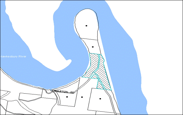
|
NOTIFICATION PLAN |
|
||
|
• PROPERTIES NOTIFIED
|
|
PROPERTY SUBJECT OF DEVELOPMENT |
|
5.2 Public Agencies
The development application is Integrated Development under the Act. Accordingly, the application was referred to the NSW RFS who provided general terms of approval for the application.
6. THE PUBLIC INTEREST
Section 79C(1)(e) of the Act requires Council to consider “the public interest”.
The public interest is an overarching requirement, which includes the consideration of the matters discussed in this report. Implicit to the public interest is the achievement of future built outcomes adequately responding to and respecting the future desired outcomes expressed in environmental planning instruments and development control plans.
The proposed subdivision of an existing undersized allotment would set an undesirable precedent for similar inappropriate subdivision of land that is severed by a formed or unformed road. Accordingly, it is considered that the approval of the proposed would not be in the public interest.
CONCLUSION
The application proposes the subdivision of one allotment into two.
The proposal does not comply with the minimum lot size pursuant to Clause 14 of Hornsby Shire Local Environmental Plan. The submitted objection to the minimum lot size development standard is not considered well founded with regard to State Environmental Planning Policy No. 1 – Development Standards.
Refusal of the application is recommended.
Note: At the time of the completion of this planning report, no persons have made a Political Donations Disclosure Statement pursuant to Section 147 of the Environmental Planning and Assessment Act 1979 in respect of the subject planning application.
|
Rod Pickles Manager - Development Assessment Planning Division |
James Farrington Group Manager Planning Division |
|
1.View |
Locality Map |
|
|
|
2.View |
Site Plan |
|
|
File Reference: DA/272/2013
Document Number: D02632791
SCHEDULE 1
- REASONS FOR REFUSAL -
1. Pursuant to the provisions of Section 79C(1)(a)(i) of the Environmental Planning and Assessment Act, 1979, the proposal does not comply with the prescriptive standard and objectives of Clause 14 Density of the Hornsby Shire Local Environmental Plan 1994.
2. Pursuant to the provisions of Section 79C(1)(a)(i) of the Environmental Planning and Assessment Act, 1979, the proposal does not demonstrate that compliance with the development standard under Clause 14 of the Hornsby Shire Local Environmental Plan 1994 is unnecessary or unreasonable in the circumstances of the case, pursuant to State Environmental Planning Policy No. 1 – Development Standards.
3. Pursuant to the provisions of Section 79C(1)(e) of the Environmental Planning and Assessment Act, 1979, the proposal would set an undesirable precedent for similar inappropriate development and is not considered to be in the public interest.
Group Manager’s Report No. PL119/13
Planning Division
Date of Meeting: 18/12/2013
11 DEVELOPMENT APPLICATION - DWELLING-HOUSE - 37 MILLSTREAM GROVE, DURAL
EXECUTIVE SUMMARY
|
DA No: |
DA/1003/2013 (Lodged 23 September 2013) |
|
Description: |
Erection of a two storey dwelling-house on a vacant allotment |
|
Property: |
Lot 6 DP 270704, No. 37 Millstream Grove, Dural |
|
Applicant: |
Mr Christian Nasr |
|
Owner: |
Mr Christian Nasr |
|
Estimated Value: |
$300,000 |
|
Ward: |
A |
· The application proposes the erection of a two storey dwelling-house on a vacant allotment.
· The proposal does not comply with the Hornsby Shire Local Environmental Plan 1994 with regard to Clause 15 (Floor Space Ratio). The applicant has made a submission pursuant to State Environmental Planning Policy No. 1 (Development Standards) to vary the development standard. The submission is considered well-founded and is supported.
· No public submissions have been received in respect of the application.
· It is recommended that the application be approved.
|
THAT Council assume the concurrence of the Director-General of the Department of Planning and Infrastructure pursuant to State Environmental Planning Policy No. 1 and approve Development Application No. DA/1003/2013 for the erection of a 2 storey dwelling-house at Lot 6 DP 270704, No. 37 Millstream Grove, Dural subject to the conditions of consent detailed in Schedule 1 of Group Manager’s Report No. PL119/13. |
BACKGROUND
On 13 October 2013, the NSW Land and Environment Court approved DA/1639/2006 for the subdivision of two lots into twelve lots at Nos. 216 to 220 New Line Road. Millstream Grove was created as part of the approved subdivision. The current application applies to Lot 6 of the subdivision.
The extension to Millstream Grove is primarily vacant lots. At the time of this assessment, in addition to No. 37 Millstream Grove, a further eight applications have been approved and another one is currently under assessment.
SITE
The site has an area of 600.1m2 and is located on the south-eastern side of Millstream Grove, Dural. The site is currently vacant.
The site experiences an average fall of 15% to the south-eastern corner.
The surrounding sites are predominantly vacant with one dwelling having been constructed at No. 35 Millstream Grove, Dural. Two dwelling-houses are also under construction on the opposite side of the street.
The site is located within a bushfire prone area.
The site does not contain a heritage listed item and is not within a heritage conservation area or in the vicinity of a heritage listed item.
The site is not burdened by any easements or restrictions.
PROPOSAL
The application proposes the erection of a two storey dwelling-house. The ground floor would comprise of a double carport, store rooms, laundry, bathroom, cinema room, games room, outdoor alfresco area and an in-ground swimming pool and spa.
The first floor would consist of four bedrooms, bathroom, living room with access to a balcony, meals room, kitchen, foyer and a study.
No trees would be removed as part of the proposal.
ASSESSMENT
The development application has been assessed having regard to the ‘Metropolitan Plan for Sydney 2031’, the ‘North Subregion (Draft) Subregional Strategy’ and the matters for consideration prescribed under Section 79C of the Environmental Planning and Assessment Act 1979 (the Act). The following issues have been identified for further consideration.
1. STRATEGIC CONTEXT
1.1 Metropolitan Plan for Sydney and (Draft) North Subregional Strategy
The (Draft) Metropolitan Strategy for Sydney 2031 is a broad framework to provide for Sydney’s growth to help plan for housing, employment, transport, infrastructure, the environment and open space. It outlines a vision for Sydney to 2031; the challenges faced, and the directions to follow to address these challenges and achieve the vision.
The North Subregion comprises Hornsby, Kuring-gai, Manly, Warringah and Pittwater Local Government Areas. The Draft North Subregional Strategy provided a framework for Council in its preparation of the HLEP 2013.
Within the North Subregion, the Draft Metropolitan Strategy proposes:
· Population growth of 81,000 from the current 2011 baseline of 529,000
· Housing growth of 37,000 from the current 2011 baseline of 204,000
· Employment growth of 39,000 from the current 2011 baseline of 186,000
The proposed development would be consistent with the Metropolitan Plan for Sydney 2031 by providing additional housing in the locality contributing to the achievement of the dwelling target for the Shire.
2. STATUTORY CONTROLS
Section 79C(1)(a) requires Council to consider “any relevant environmental planning instruments, draft environmental planning instruments, development control plans, planning agreements and regulations”.
2.1 Hornsby Shire Local Environmental Plan 1994
The subject land is zoned Residential A (Low Density) under the Hornsby Shire Local Environmental Plan 1994 (HSLEP). The objectives of the Residential A zone are:
(a) to provide for the housing needs of the population of the Hornsby area.
(b) to promote a variety of housing types and other land uses compatible with a low density residential environment.
(c) to provide for development that is within the environmental capacity of a low density residential environment.
The proposed development is defined as a ‘dwelling-house’ under the HSLEP and is permissible in the zone with Council’s consent.
Clause 15 of the HSLEP prescribes that the maximum floor space ratio (FSR) of development within the Residential A zone is 0.4:1. The proposal FSR of the dwelling-house is 0.63:1
The applicant has submitted a State Environmental Planning Policy No. 1 (SEPP 1) objection to the development standard. Refer to Section 2.4 for consideration of the applicant’s objection to the standard.
2.2 Hornsby Local Environmental Plan 2013
The Hornsby Local Environmental Plan 2013 (HLEP) was made on 27 September 2013 and came into effect on 11 October 2013. The HLEP includes a savings provision stating that if a development application is made and not finally determined before the commencement of the HLEP 2013, the application must be determined as if the Plan had been exhibited but not commenced. The relevant provisions of the HLEP are addressed below.
Under the HLEP, the subject land is zoned R2 (Low Density Residential) and a “dwelling-house” is permissible within the zone with Council’s consent. The HLEP also indicates a maximum building height control of 8.5m applicable to the site. The proposed dwelling-house would have a building height of 11.2 metres and does not comply with this standard.
2.3 State Environmental Planning Policy No. 1 - Development Standards
The proposed dwelling-house has a gross floor area of 378m2 resulting in a floor space ratio (FSR) of 0.63:1. The FSR exceeds the applicable 0.4:1 FSR development standard under the HSLEP 1994. To address the variation to the 0.4:1 development standard, the applicant has made a submission pursuant to State Environmental Planning Policy No. 1 – Development Standards (SEPP1).
The application has been assessed against the requirements of SEPP1. This Policy provides flexibility in the application of development standards in circumstances where strict compliance with those standards would, in any particular case, be unreasonable or unnecessary or tend to hinder the attainment of the objectives specified in section 5(a) (i) and (ii) of the Environmental Planning and Assessment Act which states:
‘The objectives of this Act are:
(a) to encourage:
(i) the proper management, development and conservation of natural and artificial resources, including agricultural land, natural areas, forests, minerals, water, cities, towns and villages for the purpose of promoting the social and economic welfare of the community and a better environment,
(ii) the promotion and co-ordination of the orderly and economic use and development of land,’
Where development could, but for any development standard, be carried out under the Act (either with or without the necessity for consent under the Act being obtained) the person intending to carry out that development may make a development application supported by a written objection that compliance with that development standard is unreasonable or unnecessary in the circumstances of the case, and specifying the grounds of that objection.
The Land and Environment Court has expressed the view that there are 5 different ways in which an objection pursuant to SEPP 1 may be well founded and that approval of the objection may be consistent with the aims of the policy as follows:
1. The objectives of the standard are achieved notwithstanding non-compliance with the standard;
2. The underlying objective or purpose of the standard is not relevant to the development and therefore compliance is unnecessary;
3. The underlying object or purpose would be defeated or thwarted if compliance was required and therefore compliance is unreasonable;
4. The development standard has been virtually abandoned or destroyed by the Council's own actions in granting consents departing from the standard and hence compliance with the standard is unnecessary and unreasonable;
5. The zoning of the particular land is unreasonable or inappropriate so that a development standard appropriate for that zoning is also unreasonable and unnecessary as it applies to the land and compliance with the standard would be unreasonable or unnecessary. That is, the particular parcel of land should not have been included in the particular zone.
In regard to whether the objection may be well founded, the applicant contends that:
1. Strict compliance with the FSR would not allow for the most effective and economic design solution given the constraints of the site.
2. Non-compliance with the FSR development standard does not add to the bulk and scale of the building nor will it set a precedent for future development in the area.
3. The Hornsby Local Environmental Plan 2013 has no floor space ratio control. The proposed dwelling is consistent with the NSW Housing Code and Hornsby DCP 2013.
The matters listed above have been taken into consideration in assessing the merits of the SEPP 1 objection. The proposal takes into consideration the environmental and topographical constraints of the site. The additional floor space would not adversely impact on the environmental and amenity aspects of the site and the underlying objectives of the zone. The dwelling-house would provide accommodation that would not detract from the scale and variety of dwelling-houses in the low density areas of the Shire as the proposal is considered to meet the zone objectives outlined in the HLEP.
In this instance, compliance with the FSR development standard would be considered unreasonable as Council has previously approved dwelling-houses in excess of 0.4:1 within the subdivision.
The proposed development would be of a similar bulk, scale and character of surrounding approved and constructed developments within Millstream Grove and is considered acceptable with respect to the non-compliance with the FSR development standard. Accordingly, the SEPP 1 submission is supported in this instance.
2.4 State Environmental Planning Policy (Exempt and Complying Development Codes) 2008 – NSW Housing Code
The application has been assessed against the requirements of State Environmental Planning Policy (Exempt and Complying Development Codes) 2008 – NSW Housing Code. The policy provides exempt and complying development codes that have State-wide application, identifying, in the General Exempt Development Code, types of development that are of minimal environmental impact that may be carried out without the need for development consent; and, in the General Housing Code, types of complying development that may be carried out in accordance with a complying development certificate as defined in the Environmental Planning and Assessment Act 1979.
The following table sets out the proposal’s compliance with the requirements of the NSW Housing Code.
|
NSW Housing Code |
|||
|
Control |
Proposal |
Requirement |
Compliance |
|
Frontage (Excl access) |
15.2m |
12m |
Yes |
|
Site Coverage Lots 450m2 – 900m2 |
49% |
50% |
Yes |
|
Maximum Floor Area |
378m2 |
380m2 |
Yes |
|
Maximum Building Height |
11.2m |
8.5m |
No |
|
Front Setback |
6m |
4.5m |
Yes |
|
Side Setback (north) |
1.25m |
0.9m for the ground floor component, 1.8m for the first storey component |
No |
|
Side Setback (south) |
1.2m |
0.9m for the ground floor component, 1.75m for the first storey component |
No |
|
Rear Setback |
8.8m |
3m setback for up to 4.5m height, and 8m for 4.5m height and above |
Yes |
|
Landscaping |
49.1% |
20% |
Yes |
As addressed above, the proposed dwelling complies with the requirements of the NSW Housing Code except for the building height and side setbacks.
Furthermore, the application generally complies with the Dwelling House DCP (as outlined in Section 2.10) and is acceptable in these respects.
2.5 State Environmental Planning Policy No. 55 – Remediation of Land
Clause 7 of State Environmental Planning Policy No. 55 – Remediation of Land (SEPP 55) requires Council to consider whether land is contaminated prior to granting consent to the carrying out of any development on that land.
Should the land be contaminated, Council must be satisfied that the land is suitable in a contaminated state for the proposed use. If the land requires remediation to be undertaken to make the land suitable for the proposed use, Council must be satisfied that the land will be remediated before the land is used for that purpose.
The site history indicates the area was previously densely vegetated with no history of residential use. It is not likely that the site has experienced contamination. Accordingly, further assessment under SEPP 55 is not required.
2.6 Sydney Regional Environmental Plan No. 20 - Hawkesbury-Nepean River (No. 2-1997)
The site is located within the catchment of the Hawkesbury-Nepean River. As such, the land is subject to the SREP 20. The aim of the Plan is to protect the environment of the Hawkesbury-Nepean River system by ensuring that the impacts of development are considered in the regional context. The Plan addresses matters related to water quality, significant vegetation habitats, extraction, environmental heritage and scenic quality, recreation and tourism, and agriculture.
Subject to recommended conditions requiring the installation of sediment and erosion control measures, the proposed development would not have a detrimental impact upon the water quality of the catchment.
2.7 State Environmental Planning Policy (Building Sustainability Index – BASIX) – 2004
The application has been assessed against the requirements of State Environmental Planning Policy (Building Sustainability Index: BASIX) 2004. The proposal includes BASIX Certificate No. 504135S for the proposed dwelling and is considered to be satisfactory with respect to SEPP BASIX.
2.8 Clause 74BA Environmental Planning and Assessment Act, 1979 - Purpose and Status of Development Control Plans
On 1 March 2013, the Environmental Planning and Assessment Act, 1979 was amended so that a DCP provision will have no effect if it has the practical effect of “preventing or unreasonably restricting development” that is otherwise permitted and complies with the development standards set out in relevant Local Environmental Plans and State Environmental Planning Policies.
The principal purpose of a development control plan is to provide guidance on the aims of any environmental planning instrument that applies to the development; facilitating development that is permissible under any such instrument; and achieving the objectives of land zones under any such instrument. The provisions of a development control plan made for that purpose are not statutory requirements.
2.9 Hornsby Development Control Plan 2013
The Hornsby Development Control Plan (HDCP) 2013 applies to all land within Hornsby Shire and will replace Council’s existing DCPs, providing development controls to complement the HLEP 2013. The HDCP came into effect on 11 October 2013.
The following sections of this report include a detailed assessment of the proposal against Council’s existing DCP controls. Although the HDCP was not in force at the date of lodgement of this application, the development proposal has been assessed against the Plan.
The HDCP is generally a translation of Council’s existing DCPs into a consolidated plan. When assessed against the HDCP, the proposed development would comply with all elements (including floor area) except for side setbacks and privacy.
The HDCP states that single storey elements of dwelling-houses should have a 900mm side boundary setback with two storey elements having a 1.5 metre side boundary setback. The proposed design includes a two storey element which protrudes from the side elevation towards the eastern boundary with a 1200mm side boundary setback, the balance of the dwelling would comply with the desired outcomes of the Setbacks element.
The first floor level meals and living rooms would not comply with the Privacy element of the HDCP which states that “living and entertaining areas of dwelling houses should be located on the ground floor and orientated towards the private open space of the dwelling house and not side boundaries”. Both rooms have windows on the northern elevation which have a sill height of 1.5 metres above floor level. As a consequence, the location and orientation of these rooms would have negligible adverse privacy impacts and are considered acceptable.
The first floor balcony would be primarily orientated towards the rear boundary of the site. However, to minimise the potential for overlooking into the private open space and living areas of No. 35 Millstream Grove, Dural, a 2100mm high privacy screen would be erected on the northern elevation of the terrace.
The proposal meets the desired outcomes of the HDCP and is considered acceptable.
2.10 Dwelling-House Development Control Plan
The proposed development has been assessed having regard to the relevant performance and prescriptive requirements within Council’s Dwelling House Development Control Plan (Housing DCP). The following table sets out the proposal’s compliance with the prescriptive requirements of the Plan:
|
Dwelling House Development Control Plan |
|||
|
Control |
Proposal |
Requirement |
Complies |
|
Floor space ratio |
0.63:1 |
0.4:1 |
No |
|
Site cover |
49% |
40% |
No |
|
Setbacks Front (western) Side (northern) Side (southern) Rear (eastern) |
6m 1.25m 1.2m 8.8m |
6m 1m 3m 3m |
Yes Yes Yes Yes |
|
Height |
11.2m |
9m |
No |
|
Unbroken Wall length |
11.5m |
10m |
No |
|
Building length |
25.1m |
24m |
No |
|
Cut and fill |
1.6m |
1m |
No |
|
Private Open Space |
273m2 |
120m² |
Yes |
|
Landscaped area |
49.1% |
45% |
Yes |
|
Carparking |
2 spaces |
2 spaces |
Yes |
As detailed in the above table, the proposal does not comply with a number of prescriptive measures within the Dwelling House DCP. The matters of non-compliance are detailed below, as well as a brief discussion on compliance with relevant performance requirements.
2.10.1 Floor Space Ratio
The objective of the Scale element is to encourage “development of a scale compatible with the low density residential environment”.
The proposal does not comply with the 0.4:1 prescriptive measure of the Dwelling House DCP. However, the dwelling-house is not considered to be excessive in bulk and scale for the site and is in keeping with similar approved developments in the subdivision. The matter has been discussed under Section 2.4 of this report.
The proposal meets the objective of the Scale element and is considered acceptable.
2.10.2 Height
The objective of the Height element is to encourage “building height consistent with residential development in the local area and that maximises privacy, solar access and views”.
The proposed dwelling-house would have a maximum ridge height of 11.2 metres above natural ground level. To minimise the non-compliance with the maximum building height, the dwelling-house incorporates a shallow pitched roof and six steps within the first floor to ‘step’ the building and lower the roof at the rear of the dwelling-house.
The dwelling as viewed from Millstream Grove would appear as a split-level dwelling-house with a height of 8.3 metres. The ridge height would be highest in the centre of the dwelling-house however, it would not create an unreasonable appearance of bulk and scale. The rear of the dwelling-house would have a maximum ridge height of 9.9 metres however, the rear elevation is open with a raised first floor with a pool, spa and alfresco area underneath. The rear of the dwelling-house is presented towards a densely vegetated area and would not be out of character with similarly approved dwelling-houses within the subdivision.
The proposal meets the objective of the Height element and is considered acceptable.
2.10.3 Design
The objective of the Design element is to encourage “building design that is consistent with and enhances the character and amenity of the local area, has regard for environmental characteristics and energy efficiency”.
The proposed dwelling-house would have an overall building length of 25.1 metres which does not comply with the 24 metre prescriptive measure of the Design element. Notwithstanding this, the non-compliance is minor and the design would be in keeping with the anticipated character of the surrounding area.
The proposed 11.6 metre unbroken wall length of the first floor of the north-eastern elevation does not comply with the prescriptive measures of the Design element which requires that walls not exceed 10m without a physical “break”. A balance between solid walls and openings and variations in materials and landscaping has been incorporated into the elevations to avoid a monotonous or symmetrical design.
The proposal would include a maximum fill of 1.5 metres on site. This does not comply with the prescriptive measure which seeks to limit cutting and filling of land to 1 metre from natural ground level. The gradient of the site would require a significant amount of cut and fill to accommodate any new dwelling.
The portion of the site with the greatest amount of proposed fill would be to the rear of the site situated adjoining the rear of No. 39 Millstream Grove, a vacant lot, where it is anticipated that the private open space of any new dwelling-house would be situated. Consideration is given to the topography of No. 37 and No. 39 Millstream Grove, and to accommodate a reasonable amount of useable private open space to the rear of any new dwelling, a significant amount of cut or fill would be required.
The proposal meets the objective of the Design element and is considered acceptable.
2.10.4 Privacy
The objective of the Privacy element is to encourage “development that ensures reasonable privacy in the home and privacy open space for existing and future residents”.
The first floor of the proposal would include a living room and a meals room which does not comply with the prescriptive measures of the Privacy element which seeks to have living and entertaining areas located on the ground floor only. These rooms are served by window in the northern side elevation only which has a sill height of 1.5 metres above floor level. As a consequence, the development would have negligible adverse privacy impacts and is considered acceptable.
The first floor also includes a terrace at the rear elevation of the dwelling-house. The terrace would be primarily orientated towards the rear of the site. To protect the privacy of the adjoining property, No. 35 Millstream Grove, a 2.1 metre high privacy screen would be erected along the northern elevation of the terrace.
The proposal meets the objective of the Privacy element and is considered acceptable.
2.10.5 Solar Access
The objective of the Solar Access element is to encourage “development that ensures reasonable solar access to living areas within dwellings and to open space around dwelling”.
The living areas for the proposed dwelling are orientated to the north to maximise daylight access to the primary living areas.
To reduce the impact of overshadowing over No. 39 Millstream Grove, the roof line at the rear of the proposed dwelling-house has been offset to allow for greater solar access to the anticipated private open space area and would allow for a minimum of 3 hours of solar access during the Winter Solstice.
The submitted shadow diagrams indicate that future dwelling-houses on adjacent allotments and private open space areas would be capable of receiving a minimum 3 hours of solar access during Winter Solstice. The application is assessed as satisfactory in this regard.
3. ENVIRONMENTAL IMPACTS
Section 79C(1)(b) of the Act requires Council to consider “the likely impacts of that development, including environmental impacts on both the natural and built environments, and social and economic impacts in the locality”.
3.1 Natural Environment
No trees would be removed as part of this proposal.
3.2 Built Environment
The surrounding lots are predominantly vacant with a number of dwelling-houses approved for development. The proposed dwelling-house would be consistent with the desired future character and streetscape of Millstream Grove.
3.3 Social and Economic Impacts
There are no anticipated adverse social or economic impacts resulting from the proposed development.
4. SITE SUITABILITY
Section 79C(1)(c) of the Act requires Council to consider “the suitability of the site for the development”.
4.1 Bushfire Risk
The land is identified as being subject to bushfire risk. The site is considered to be in Bushfire Attack Level 40 and Flame Zone and appropriate conditions of consent have been recommended requiring sensitive construction methods.
5. PUBLIC PARTICIPATION
Section 79C(1)(d) of the Act requires Council to consider “any submissions made in accordance with this Act”.
5.1 Community Consultation
The proposed development was placed on public exhibition and was notified to adjoining and nearby landowners between 25 September 2013 and 9 October 2013 in accordance with Council’s Notification and Exhibition Development Control Plan. During this period, Council received no submissions. The map below illustrates the location of those nearby landowners that are in close proximity to the development site and were notified of the application.
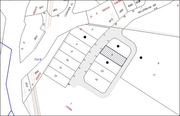
|
NOTIFICATION PLAN |
|
||
|
• PROPERTIES NOTIFIED
|
X SUBMISSIONS RECEIVED |
PROPERTY SUBJECT OF DEVELOPMENT |
|
6. THE PUBLIC INTEREST
Section 79C(1)(e) of the Act requires Council to consider “the public interest”.
The public interest is an overarching requirement, which includes the consideration of the matters discussed in this report. Implicit to the public interest is the achievement of future built outcomes adequately responding to and respecting the future desired outcomes expressed in environmental planning instruments and development control plans.
The application is considered to have addressed Council’s criteria under the Dwelling-House DCP and the Hornsby DCP and therefore, the development would be in the public interest.
CONCLUSION
The application proposes the erection of a two storey dwelling-house on a vacant allotment.
The application does not comply with the Hornsby Shire Council Local Environmental Plan 1994 in respect to Clause 15 ‘Floor Space Ratio’. The applicant has submitted a State Environmental Planning Policy No. 1 objection to vary the floor space ratio development standard. The objection is considered well-founded with regard to the existing development and the principles established by the Land and Environment Court.
There were no submissions received in response to notification of the proposed development.
Having regard to the circumstances of the case and consideration of the SEPP 1 objection, approval of the application is recommended.
Note: At the time of the completion of this planning report, no persons have made a Political Donations Disclosure Statement pursuant to Section 147 of the Environmental Planning and Assessment Act, 1979 in respect of the subject planning application.
|
Rod Pickles Manager - Development Assessment Planning Division |
James Farrington Group Manager Planning Division |
|
1.View |
Locality Plan |
|
|
|
2.View |
Floor Plans |
|
|
|
3.View |
Elevations |
|
|
|
4.View |
Shadow Plans |
|
|
File Reference: DA/1003/2013
Document Number: D02681618
SCHEDULE 1
GENERAL CONDITIONS
The conditions of consent within this notice of determination have been applied to ensure that the use of the land and/or building is carried out in such a manner that is consistent with the aims and objectives of the relevant legislation, planning instruments and council policies affecting the land and does not disrupt the amenity of the neighbourhood or impact upon the environment.
Note: For the purpose of this consent, the term ‘applicant’ means any person who has the authority to act on or the benefit of the development consent.
Note: For the purpose of this consent, any reference to an Act, regulation, Australian standard or publication by a public authority shall be taken to mean the gazetted Act or regulation, or adopted Australian standard or publication as in force on the date that the application for a construction certificate is made.
1. Approved Plans and Supporting Documentation
The development must be carried out in accordance with the plans and documentation listed below and endorsed with Council’s stamp, except where amended by Council and/or other conditions of this consent:
|
Plan No. |
Plan Title |
Drawn by |
Dated |
|
Dwg No. S112 Page 1 of 4 Issue E |
Site Plan and Driveway Profile |
SK |
19/11/2013 |
|
Dwg No. S112 Page 1 and 2 of 4 Issue E |
Ground Floor and First Floor Plans |
SK |
19/11/2013 |
|
Dwg No. S112 Page 3 and 4 of 4 Issue E |
Elevations, Sections and Shadow Diagrams |
SK |
19/11/2013 |
|
Document Title |
Prepared by |
Dated |
|
SEPP 1 Objection |
Samuel Kassis |
4 November 2013 |
|
Statement of Environmental Effects |
Christian Nasr |
19 September 2013 |
|
Basix Certificate Cert No. 504135S |
Evergreen Design and Energy Solutions |
17 September 2013 |
|
Waste Management Plan |
Christian Nasr |
No date |
REQUIREMENTS PRIOR TO THE ISSUE OF A CONSTRUCTION CERTIFICATE
2. Building Code of Australia
All building work must be carried out in accordance with the relevant requirements of the Building Code of Australia.
3. Contract of Insurance (Residential Building Work)
In the case of residential building work for which the Home Building Act, 1989 requires there to be a contract of insurance in force in accordance with Part 6 of that Act, that such a contract of insurance is in force before any building work authorised to be carried out by the consent commences.
4. Notification of Home Building Act, 1989 Requirements
Residential building work within the meaning of the Home Building Act, 1989 must not be carried out unless the principal certifying authority for the development to which the work relates (not being Council) has given Council written notice of the following information:
a) In the case of work for which a principal contractor is required to be appointed:
i) The name and licence number of the principal contractor; and
ii) The name of the insurer by which the work is insured under Part 6 of that Act.
b) In the case of work to be done by an owner-builder:
i) The name of the owner-builder; and
ii) If the owner-builder is required to hold an owner-builder’s permit under that Act, the number of the owner-builder’s permit.
Note: If arrangements for doing the residential building work are changed while the work is in progress so that the information notified becomes out of date, further work must not be carried out unless the principal certifying authority for the development to which the work relates (not being Council) has given Council written notification of the updated information.
5. Sydney Water – Quick Check
This application must be submitted to a Sydney Water ‘Quick Check Agent’ or ‘Customer Centre’ for approval to determine whether the development would affect any Sydney Water infrastructure, and whether further requirements are to be met.
Note: Refer to www.sydneywater.com.au or telephone 13 20 92 for assistance.
6. Design and Construction - Bushfire Attack Category
a) New construction on the south eastern elevation(s) shall comply with section 9 (BAL FZ) Australian Standard AS3959-2009 'Construction of buildings in bush fire-prone areas'. However, where any material, element of construction or system when tested to the method described in Australian Standard AS1530.8.2 ‘Methods for fire tests on building materials, components and structures’ Part 8.2: ‘Tests on elements of construction for buildings exposed to simulated bushfire attack—Large flaming sources’, it shall comply with Clause 13.8 of the Standard except that flaming of the specimen is not permitted and there shall be no exposed timber.
b) Window assemblies on the south eastern elevation(s) shall comply with one of the following:
i) Clause 9.5.2 of AS 3959-2009 as modified above;
or
ii) They shall comply with the following:
a. Completely protected by a non-combustible and non perforated bushfire shutter that complies with Section 3.7 of AS3959-2009 excluding parts (e) & (f).
b. Window frames and hardware shall be metal.
c. Glazing shall be toughened glass minimum 6mm.
d. Seals to stiles, head and sills or thresholds shall be manufactured from materials having a flammability index no greater than 5 or from silicone.
e. The openable portion of the window shall be screened internally or externally with screens that comply with Clause 9.5.1A.
c) External Doors and door frames (not including garage doors) on the south eastern elevation(s) shall comply with one of the following:
i) Clause 9.5.3 or 9.5.4 of AS 3959-2009 as modified above;
or
ii) They shall comply with the following:
a. Completely protected by a non-combustible and non perforated bushfire shutter that complies with Section 3.7 of AS3959-2009 excluding parts (e) & (f).
b. Doors shall be non-combustible.
c. Externally fitted hardware that supports the panel in its function of opening and closing shall be metal.
d. Where doors incorporate glazing, the glazing shall be toughened glass minimum 6mm.
e. Seals to stiles, head and sills or thresholds shall be manufactured from materials having a flammability index no greater than 5 or from silicone.
f. Door frames shall be metal.
g. Doors shall be tight fitting to the doorframe and to an abutting door if applicable.
h. Weather strips, draught excluders or draught seals shall be installed at the base of side-hung external doors.
d) New construction on the north eastern, north western and south western elevation(s) shall comply with section 8 (BAL 40) Australian Standard AS3959-2009 'Construction of buildings in bush fire-prone areas'.
e) Any new fencing shall comply with Community Resilience 'Fast Fact 2/06’ for Fences and Gates in Bush Fire Prone Areas.
7. Water and Utilities
Water, electricity and gas are to comply with section 4.1.3 of ‘Planning for Bush Fire Protection 2006’.
REQUIREMENTS PRIOR TO THE COMMENCEMENT OF ANY WORKS
8. Erection of Construction Sign
A sign must be erected in a prominent position on any site on which building work, subdivision work or demolition work is being carried out:
a) Showing the name, address and telephone number of the principal certifying authority for the work;
b) Showing the name of the principal contractor (if any) for any demolition or building work and a telephone number on which that person may be contacted outside working hours; and
c) Stating that unauthorised entry to the work site is prohibited.
Note: Any such sign is to be maintained while the building work, subdivision work or demolition work is being carried out, but must be removed when the work has been completed.
9. Protection of Adjoining Areas
A temporary hoarding, fence or awning must be erected between the work site and adjoining lands before the works begin and must be kept in place until after the completion of the works if the works:
a) Could cause a danger, obstruction or inconvenience to pedestrian or vehicular traffic.
b) Could cause damage to adjoining lands by falling objects.
c) Involve the enclosure of a public place or part of a public place.
Note: Notwithstanding the above, Council’s separate written approval is required prior to the erection of any structure or other obstruction on public land.
10. Toilet Facilities
Toilet facilities must be available or provided at the works site before works begin and must be maintained until the works are completed at a ratio of one toilet for every 20 persons employed at the site. Each toilet must:
a) be a standard flushing toilet connected to a public sewer; or
b) be a temporary chemical closet approved under the Local Government Act, 1993; or
c) have an on-site effluent disposal system approved under the Local Government Act, 1993.
11. Erosion and Sediment Control
Erosion and sediment control measures must be provided and maintained throughout the construction period in accordance with the manual ‘Soils and Construction 2004 (Bluebook)’, the approved plans, Council specifications and to the satisfaction of the principal certifying authority. The erosion and sediment control devices must remain in place until the site has been stabilised and revegetated.
Note: On the spot penalties up to $1,500 may be issued for any non-compliance with this requirement without any further notification or warning.
12. Bushfire Management – Protection Zones
At the commencement of building works the entire property must be managed as an Inner Protection Area (IPA) as outlined within section 4.1.3 and Appendix 5 of “Planning for Bush Fire Protection 2006” and the NSW Rural Fire Service’s document “Standards for asset protection zones”
Note: Further information concerning planning for bush fire protection can be found at: www.rfs.nsw.gov.au.
REQUIREMENTS DURING CONSTRUCTION
13. Construction Work Hours
All work on site (including demolition and earth works) must only occur between 7am and 5pm Monday to Saturday. No work is to be undertaken on Sundays or public holidays.
14. Council Property
During construction works, no building materials, waste, machinery or related matter is to be stored on the road or footpath. The public reserve must be kept in a clean, tidy and safe condition at all times.
Note: This consent does not give right of access to the site via Council’s park or reserve. Should such access be required, separate written approval is to be obtained from Council.
15. Disturbance of Existing Site
During construction works, the existing ground levels of open space areas and natural landscape features, (including natural rock-outcrops, vegetation, soil and watercourses) must not be altered unless otherwise nominated on the approved plans.
16. Landfill
Landfill must be constructed in accordance with Council’s ‘Construction Specification, 2005’ and the following requirements:
a) All fill material imported to the site is to wholly consist of Virgin Excavated Natural Material (VENM) as defined in Schedule 1 of the Protection of the Environment Operations Act 1997 or a material approved under the Department of Environment and Climate Change’s general resource recovery exemption.
b) A compaction certificate is to be obtained from a geotechnical engineer verifying that the specified compaction requirements have been met.
17. Survey Report – Finished Floor Level
A report(s) must be prepared by a registered surveyor and submitted to the principal certifying authority prior to the pouring of concrete at each level of the building certifying that:
a) The building, retaining walls and the like have been correctly positioned on the site; and
b) The finished floor level(s) are in accordance with the approved plans.
REQUIREMENTS PRIOR TO THE ISSUE OF AN OCCUPATION CERTIFICATE
Note: For the purpose of this consent, a reference to ‘occupation certificate’ shall not be taken to mean an ‘interim occupation certificate’ unless otherwise stated.
18. Fulfilment of BASIX Commitments
The applicant must demonstrate the fulfilment of BASIX commitments pertaining to the development.
19. Sydney Water – s73 Certificate
An s73 Certificate must be obtained from Sydney Water.
20. Stormwater Drainage – Dwellings
The stormwater drainage system for the development must be designed and constructed for an average recurrence interval of 20 years and be connected to an existing inter-allotment drainage system.
21. Internal Driveway/Vehicular Areas
The driveway and parking areas on site must be designed in accordance with Australian Standards 2890.1, 2890.2, 3727.
22. Vehicular Crossing
A separate application under the Local Government Act, 1993 and the Roads Act, 1993 must be submitted to Council for the installation of a new vehicular crossing and the removal of the redundant crossing. The vehicular crossing must be constructed in accordance with Council’s Civil Works Design, 2005 and the following requirements:
a) Any redundant crossings must be replaced with integral kerb and gutter.
b) The footway area must be restored by turfing.
Note: An application for a vehicular crossing can only be made to one of Council’s Authorised Vehicular Crossing Contractors. You are advised to contact Council on 02 9847 6940 to obtain a list of contractors.
23. Retaining Walls
All required retaining walls must be constructed as part of the development.
24. Landscaping
Landscaping to the site is to comply with the principles of Appendix 5 of 'Planning for Bush Fire Protection 2006'.
OPERATIONAL CONDITIONS
25. Swimming Pool Requirements
The construction and operation of the swimming pool must comply with the provisions of the Swimming Pool Act 1992, the Swimming Pool Regulation, 2008, Australian Standards 1926.1-3 – Swimming Pool Safety and the following requirements:
a) All waste water from the pool’s filtration system must be piped to Sydney Water’s sewer system. In the event that Sydney Water’s sewer system is not accessible, a filtration system that does not require backwashing must be installed;
b) The filtration motor and pump, or spa heater and blower unit must be housed in a soundproofed structure. Sound from the equipment must not exceed 5(dBA) above ambient noise levels at any residential property boundary;
c) The applicant must participate in the ‘Static Water Supply Project’ initiative of the NSW Fire Brigade, to make available the water in the swimming pool for use as a static water supply for fire fighting purposes by the NSW Fire Brigade or the NSW Rural Fire Service.
Note: On completion of the swimming pool, the applicant is to contact the local NSW Fire Brigade Station or NSW Rural Fire Service Station to arrange the installation of a static water supply identification plate.
- END OF CONDITIONS -
ADVISORY NOTES
The following information is provided for your assistance to ensure compliance with the Environmental Planning and Assessment Act, 1979, Environmental Planning and Assessment Regulation 2000, other relevant legislation and Council’s policies and specifications. This information does not form part of the conditions of development consent pursuant to Section 80a of the Act.
Environmental Planning and Assessment Act, 1979 Requirements
The Environmental Planning and Assessment Act, 1979 requires:
· The issue of a construction certificate prior to the commencement of any works. Enquiries can be made to Council’s Customer Services Branch on 9847 6760.
· A principal certifying authority to be nominated and Council notified of that appointment prior to the commencement of any works.
· Council to be given at least two days written notice prior to the commencement of any works.
· Mandatory inspections of nominated stages of the construction inspected.
· An occupation certificate to be issued before occupying any building or commencing the use of the land.
Long Service Levy
In accordance with Section 34 of the Building and Construction Industry Long Service Payments Act 1986, a ‘Long Service Levy’ must be paid to the Long Service Payments Corporation or Hornsby Council.
Note: The rate of the Long Service Levy is 0.35% of the total cost of the work.
Note: Hornsby Council requires the payment of the Long Service Levy prior to the issue of a construction certificate.
Tree Preservation Order
To ensure the maintenance and protection of the existing natural environment, it is an offence to ringbark, cut down, top, lop, remove, wilfully injure or destroy a tree outside 3 metres of the approved building envelope without the prior written consent from Council.
Note: A tree is defined as a single or multi-trunked wood perennial plant having a height of not less than three (3) metres, and which develops many branches, usually from a distance of not less than one (1) metre from the ground, but excluding any plant which, in its particular location, is a noxious plant declared as such pursuant to the Noxious Weeds Act 1993. This definition of ‘tree’ includes any and all types of Palm trees.
All distances are determined under Australian Standard AS4970-2009 ”Protection of Trees on Development Sites”.
Fines may be imposed for non-compliance with Council’s Tree Preservation Order.
Dial Before You Dig
Prior to commencing any works, the applicant is encouraged to contact Dial Before You Dig on 1100 or www.dialbeforeyoudig.com.au for free information on potential underground pipes and cables within the vicinity of the development site.
Telecommunications Act 1997 (Commonwealth)
If you are aware of any works or proposed works which may affect or impact on Telstra’s assets in any way, you are required to contact: Telstra’s Network Integrity Team on Phone Number 1800810443.
Group Manager’s Report No. PL120/13
Planning Division
Date of Meeting: 18/12/2013
12 DEVELOPMENT APPLICATION - ALTERATIONS AND ADDITIONS - DWELLING-HOUSE - 7 BRITANNIA STREET, PENNANT HILLS
EXECUTIVE SUMMARY
|
DA No: |
DA/712/2013 (Lodged 11 July 2013) |
|
Description: |
Alterations and additions to a dwelling-house |
|
Property: |
Lot 31, DP 13079, 7 Britannia Street, Pennant Hills |
|
Applicant: |
Mr Aven Shi |
|
Owner: |
Mr Aven Shi |
|
Estimated Value: |
$180,000 |
|
Ward: |
C |
· The application is for alterations and additions to a dwelling-house.
· The proposal does not comply with the Hornsby Shire Local Environmental Plan 1994 with regard to Clause 15 (Floor Space Ratio). The applicant has made a submission pursuant to State Environmental Planning Policy No. 1 (Development Standards) to vary the standard. The submission is considered well-founded and is supported.
· Two submissions have been received in respect of the application.
· It is recommended that the application be approved.
|
THAT Council assume the concurrence of the Director-General of the Department of Planning and Infrastructure pursuant to State Environmental Planning Policy No. 1 and approve Development Application No. DA/712/2013 for alterations and additions to a dwelling-house at Lot 31, DP 13079, No. 7 Britannia Street, Pennant Hills, subject to the conditions of consent detailed in Schedule 1 of Group Manager’s Report No. PL120/13. |
BACKGROUND
On 4 September 2013, the applicant submitted a heritage impact assessment, a cost of works quotation, a SEPP 1 objection pursuant to the State Environmental Planning Policy No. 1 – Development Standards and a waste management plan.
On 5 November 2013, the applicant submitted amended plans addressing heritage and solar access concerns.
SITE
The rectangular shaped site has an area of 828.3m² and is located on the north-eastern side of Britannia Street, Pennant Hills. The site experiences an average fall of 10% from the west to the east and contains a single storey dwelling-house, with a free-standing metal shed, timber pergola and an in-ground swimming pool in the rear yard.
The site is not located on bushfire prone or flood prone land.
The site is not located within a heritage conservation area. However, the site is in close proximity to properties Nos. 8 and 12 Britannia Street (“Gordan” and “house” respectively), both of which are listed as heritage items of local significance under the provisions of Schedule 5 (Environmental Heritage) of the Hornsby Local Environmental Plan 2013 (HLEP) and Schedule D (Heritage Items) of the Hornsby Shire Local Environmental Plan 1994 (HSLEP). The street trees within the Britannia Street road reserve are also heritage listed.
The site is not burdened by any easements or restrictions.
PROPOSAL
The application proposes alterations and additions to an existing dwelling-house, incorporating an entry lobby, living room, staircase, an extension of the garage and the removal of internal walls at ground floor level, and four bedrooms, two ensuites, walk-in-robe, bathroom, walk-in-linen, sitting room and two balconies at first floor level.
The eaves of the existing garage and family studio, which currently encroach over the south-eastern side boundary by 50mm, would be removed and incorporated within a parapet roof, so that the structure would be located entirely within the subject site.
No trees would be removed as part of the proposed development and the existing swimming pool would be retained.
ASSESSMENT
The development application has been assessed having regard to the ‘Metropolitan Plan for Sydney 2031’, the ‘North Subregion (Draft) Subregional Strategy’ and the matters for consideration prescribed under Section 79C of the Environmental Planning and Assessment Act 1979 (the Act). The following issues have been identified for further consideration.
1. STRATEGIC CONTEXT
1.1 Metropolitan Plan for Sydney and (Draft) North Subregional Strategy
The (Draft) Metropolitan Strategy for Sydney 2031 is a broad framework to provide for Sydney’s growth to help plan for housing, employment, transport, infrastructure, the environment and open space. It outlines a vision for Sydney to 2031; the challenges faced, and the directions to follow to address these challenges and achieve the vision.
The North Subregion comprises Hornsby, Kuring-gai, Manly, Warringah and Pittwater Local Government Areas. The Draft North Subregional Strategy acts as a framework for Council in its preparation of the Comprehensive LEP by the end of 2013.
Within the North Subregion, the Draft Metropolitan Strategy proposes:
· Population growth of 81,000 from the current 2011 baseline of 529,000;
· Housing growth of 37,000 from the current 2011 baseline of 204,000; and
· Employment growth of 39,000 from the current 2011 baseline of 186,000.
The proposed development would be consistent with the Metropolitan Plan for Sydney 2031 by providing renewed housing stock for a growing population.
2. STATUTORY CONTROLS
Section 79C(1)(a) requires Council to consider “any relevant environmental planning instruments, draft environmental planning instruments, development control plans, planning agreements and regulations”.
2.1 Hornsby Shire Local Environmental Plan 1994
The subject land is zoned Residential A (Low Density) under the Hornsby Shire Local Environmental Plan 1994 (HSLEP). The objectives of the Residential A (Low Density) zone are:
(a) to provide for the housing needs of the population of the Hornsby area;
(b) to promote a variety of housing types and other land uses compatible with a low density residential environment; and
(c) to provide for development that is within the environmental capacity of a low density residential environment.
The proposed development is defined as a “dwelling-house” under the HSLEP and is permissible in the zone with Council’s consent.
Clause 15 of the HSLEP prescribes that the maximum floor space ratio (FSR) of development within the Residential A (Low Density) zone is 0.4:1. The proposed development would have a FSR of 0.46:1 which does not comply with this development standard. To address this issue, the applicant has made a submission to vary the standard under State Environmental Planning Policy No. 1 – Development Standards which is assessed below in Section 2.3 of this report.
2.2 Hornsby Local Environmental Plan 2013
The Hornsby Local Environmental Plan 2013 (HLEP) came into effect on 11 October 2013. The HLEP includes a savings provision stating that if a development application is made and not finally determined before the commencement of the HLEP, the application must be determined as if the Plan had been exhibited but not commenced. The relevant provisions of the HLEP are addressed below.
Under the HLEP, the subject land is zoned R2 (Low Density Residential) and alterations and additions to a “dwelling-house” are permissible within the zone with Council’s consent.
Under the HLEP, the lot has a maximum building height development standard of 8.5 metres as shown on Council’s “Height of Building Map”. The proposed alterations and additions would have a maximum height of 9.1 metres, which would not comply with this development standard.
Notwithstanding this encroachment, the proposal is considered acceptable, as the portion of the dwelling-house which would exceed this development standard is limited to a dormer window at the rear of the dwelling-house.
2.3 State Environmental Planning Policy No. 1 – Development Standards
The application has been assessed against the requirements of State Environmental Planning Policy No. 1 – Development Standards (SEPP 1). This Policy provides flexibility in the application of development standards in circumstances where strict compliance with those standards would, in any particular case, be unreasonable or unnecessary or tend to hinder the attainment of the objectives of the Act. The applicant has made a written submission in accordance with SEPP 1.
The NSW Land and Environment Court has expressed the view that there are 5 different ways in which an objection pursuant to SEPP 1 may be well founded and that approval of the objection may be consistent with the aims of the Policy as follows:
1. The objectives of the standard are achieved notwithstanding non-compliance with the standard;
2. The underlying objective or purpose of the standard is not relevant to the development and therefore compliance is unnecessary;
3. The underlying object or purpose would be defeated or thwarted if compliance was required and therefore compliance is unreasonable;
4. The development standard has been virtually abandoned or destroyed by the Council's own actions in granting consents departing from the standard and hence compliance with the standard is unnecessary and unreasonable; and
5. The zoning of the particular land is unreasonable or inappropriate so that a development standard appropriate for that zoning is also unreasonable and unnecessary as it applies to the land and compliance with the standard would be unreasonable or unnecessary. That is, the particular parcel of land should not have been included in the particular zone.
In regard to whether the objection may be well founded, the applicant contends that:
“It is considered that strict compliance with the maximum floor space ratio standard (i.e. 0.4:1) is unreasonable and unnecessary in the circumstance of the case for the following reasons:
1. The proposed gross floor area is consistent with the maximum floor area requirement (i.e. 380m²) under Part 3 of the Hornsby Development Control Plan and complying development under Part 3 of the State Environmental Planning Policy (Exempt and Complying Development Codes) 2008.
2. The proposed development is consistent with the bulk and scale of other two storey dwelling houses along both sides of Britannia Street and the surrounding areas.
3. The proposed development complies with the height and setbacks controls of the DCP and would not result in any significant adverse impacts upon the amenity of the adjoining dwellings in terms of overshadowing, loss of privacy or views.
4. The proposal would improve the standard of living for the occupants of the subject dwelling.
5. The proposal is consistent with the relevant objective of the floor space ratio control, contained in Clause 15 and Residential A (Low Density) zone of the HSLEP, in that it will provide an appropriately scaled dwelling that is consistent with the existing surrounding built form.”
The matters listed above have been taken into consideration in assessing the merits of the SEPP1 objection.
The Land and Environment Court has established that, in areas comprising relatively small allotments, restricting the FSR to less than 0.5:1 may unreasonably limit potential to increase the size of existing dwelling-houses to cater for the level of residential amenity and changing social demand for housing which is now expected. This is seen as an obstacle to satisfying the objectives of the Environmental Planning and Assessment Act, 1979 which encourages the orderly and economic use of land.
With respect to the orderly and economic use of this land, the additional floor space would not impinge on the environmental and amenity aspects of the site and the underlying objectives of the zoning. In this regard, the objection under SEPP 1 is sustained.
Furthermore, as stated in the applicant’s submission, the introduction of the NSW Housing Code under the State Environmental Planning Policy (Exempt and Complying Development Codes) 2008, applicants are able to gain approval for dwelling-houses and other ancillary development as “complying development” with floor space ratios which exceed Council’s development standards.
The proposed development would have a gross floor area of 379.9m² when calculated in accordance with the “floor area” definition under the NSW Housing Code. Under the NSW Housing Code, the 828.3m² allotment would be eligible to accommodate a dwelling-house with a gross floor area of up to 380m².
The development is not “complying development” under the NSW Housing Code as the 9.1 metre height of the structure does not comply with the 8.5 metre development standard and the proposed 350mm south-eastern, side boundary setback and 1.69 metre north-western, side boundary setback do not comply with the side boundary development standard which states that lots with a width of at least 18 metres but less than 24 metres should have a side boundary setback of 1.5 metres plus one-quarter of the height of the building above 4.5 metres.
Whilst the proposal would not comply with the setback and height development standards, the NSW Housing Code is now enacted in many parts of the Shire and it is anticipated that more developments will be approved under this Code which will change the characteristics of dwelling-houses in the surrounding area. Accordingly, strict compliance with the 0.4:1 FSR development standard under Clause 15 of the HSLEP is not considered necessary in this instance.
The proposal takes into consideration the topographical constraints of the site and the additional floor space would not impinge on the environmental and amenity aspects of the site as well as the underlying objectives of the zoning. Accordingly, the SEPP 1 objection is well founded and is considered acceptable.
2.4 State Environmental Planning Policy (Building Sustainability Index: BASIX) 2004
The State Environmental Planning Policy (Building Sustainability Index: BASIX) 2004, aims to provide regulations for certain kinds of residential developments to include commitments in their design to reduce water and electricity use. As the cost of works of the proposed alterations are over $50,000, the applicant is required to obtain a BASIX certificate. The applicant has provided such and a condition has been recommended that these commitments be adhered to.
2.5 Sydney Regional Environmental Plan (Sydney Harbour Catchment) 2005
The site is located within the Sydney Harbour Catchment. Sydney Regional Environmental Plan (Sydney Harbour Catchment) 2005 aims to protect the environment of the Sydney Harbour Catchment by ensuring that the impacts of future land uses are considered in a regional context.
Subject to the implementation of sediment and erosion control measures and stormwater management to protect water quality, the proposal would comply with the requirements of the Policy.
2.6 Clause 74BA Environmental Planning and Assessment Act, 1979 - Purpose and Status of Development Control Plans
On 1 March 2013, the Environmental Planning and Assessment Act, 1979 was amended so that a DCP provision would have no effect if it has the practical effect of “preventing or unreasonably restricting development” that is otherwise permitted and complies with the development standards set out in relevant Local Environmental Plans and State Environmental Planning Policies.
The principal purpose of a development control plan is to provide guidance on the aims of any environmental planning instrument that applies to the development; facilitating development that is permissible under any such instrument; and achieving the objectives of land zones under any such instrument. The provisions of a development control plan made for that purpose are not statutory requirements.
2.7 Hornsby Development Control Plan 2013
The Hornsby Development Control Plan (HDCP) 2013 applies to all land within Hornsby Shire and will replace Council’s existing DCPs, providing development controls to complement the HLEP 2013. The HDCP came into effect on 11 October 2013.
The following sections of this report include a detailed assessment of the proposal against Council’s existing DCP controls.
The HDCP is generally a transition of Council’s existing DCPs into a consolidated plan. When assessed against the HDCP, the proposed development would not comply with the height and side boundary prescriptive measures. These matters are addressed below.
2.7.1 Scale
The desired outcome of the Scale element in the HDCP is to encourage development “with a height, bulk and scale that is compatible with a low density residential environment”.
In support of this outcome, the prescriptive measures of the Scale element states that dwelling-houses should not exceed 8.5 metres in height. The proposal would have a height of 9.1 metres when measured at its highest point above the existing ground level.
The portion of the dwelling-house which would exceed 8.5 metres in height is limited to a dormer window located to the rear of the structure and that the remainder of the building complies with the 8.5 metre prescriptive measure.
The dwelling-house would comply with the prescriptive measures of the Sunlight Access element of the HDCP which states that the required private open space of the site and adjoining properties should receive at least 3 hours of unobstructed sunlight access between 9am and 3pm on 22 June (winter solstice).
The proposal satisfactorily meets the desired outcomes of the Scale element and is considered acceptable.
2.7.2 Setbacks
The desired outcome of the Setbacks element of the HDCP is to encourage setbacks “that are compatible with adjacent development and complement the streetscape”’ and “that allow for canopy trees to be retained and planted along the front and rear property boundaries”.
The 350mm south-eastern side boundary setback of the garage and family studio does not comply with the 900mm prescriptive measure of the Setbacks element. The application proposes that the external wall of the existing garage and family studio would remain in its current location with the existing eave to be demolished to incorporate a parapet roof.
The proposed garage would create negligible additional impacts to the adjoining property to the south-west and would remove the encroachment of the existing garage roof onto the adjoining property.
The proposal satisfactorily meets the desired outcomes of the Setbacks element and is considered acceptable.
2.8 Dwelling House Development Control Plan
The proposed development has been assessed having regard to the relevant performance and prescriptive requirements within Council’s Dwelling House Development Control Plan (DCP). The following table sets out the proposal’s compliance with the prescriptive requirements of the Plan:
|
Dwelling House DCP |
|||
|
Control |
Proposal |
Requirement |
Complies |
|
Floor space ratio |
0.46:1 |
0.4:1 |
No |
|
Site cover |
36% |
40% |
Yes |
|
Setbacks |
|||
|
Front |
6.28m |
6m |
Yes |
|
Side (north-western) |
1.69m |
1m |
Yes |
|
Side (south-eastern) |
0.35m |
1m |
No |
|
Rear |
20.5m |
3m |
Yes |
|
Height |
9.1m |
<9m |
No |
|
Unbroken Wall length |
13.4m |
10m |
No |
|
Building length |
18.47m |
24m |
Yes |
|
Cut and fill |
0.7m |
1m |
Yes |
|
Private Open Space |
385m² |
120m² |
Yes |
|
Landscaped area |
60% |
45% |
Yes |
|
Car Parking |
|||
|
No. of spaces |
2 spaces |
2 spaces |
Yes |
|
Garage size |
6.0m x 5.4m |
5.7m x 5.5m |
Yes |
|
Solar Access |
|||
|
Windows to north-facing living rooms on adjoining land |
>3 hours on 22 June |
3 hours on 22 June |
Yes |
|
Private open space on adjoining land |
>4 hours on 22 June |
4 hours on 22 June |
Yes |
As detailed in the above table, the proposed development does not comply with a number of prescriptive requirements within Council’s Dwelling House DCP. The matters of non-compliance are detailed below, as well as a brief discussion on compliance with relevant performance requirements.
2.8.1 Scale
The proposed development would generate a floor space ratio of 0.46:1 which does not comply with the 0.4:1 prescriptive measure of the Scale element. The matters relating to floor space ratio have been addressed above under Section 2.3 of this report under the heading “State Environmental Planning Policy No. 1 – Development Standards”.
2.8.2 Setbacks
The 350mm side boundary setback of the family studio and garage do not comply with the 1 metre prescriptive measure of the Setbacks element. This issue has been addressed above under Section 2.7.2 of this report under the heading “Setbacks”.
2.8.3 Height
The proposed 9.1 metre height of the development does not comply with the 9 metre prescriptive measure of the Height element. This non-compliance is a minor variation which is limited to a dormer window to the rear of the dwelling-house.
The proposal meets the objectives of the Height element and is considered acceptable.
2.8.4 Design
The proposed 13.4 metre wall length of the south-eastern, first floor level elevation and the 10.9 metre wall length of the north-western elevation do not comply with the prescriptive measure of the Design element which states that wall lengths should not exceed 10 metres in length without a physical “break”.
No objections are raised to these variations as the roof lines and architectural detail provide sufficient articulation to avoid a monotonous and symmetrical design when viewed from adjacent properties or the street.
The proposal meets the objectives of the Design element and is considered acceptable.
2.8.5 Privacy
The proposed first floor level sitting room and the 2 balconies within the north eastern and south western elevations do not comply with the prescriptive measure of the Privacy element which states that living and entertaining areas should be located on the ground floor level.
The proposed first floor level sitting room is located in the “centre” of the development and would overlook the front and rear yards of the subject site only.
The location of the balcony within the front, south western elevation is considered acceptable as it would allow overlooking of the front yards of adjacent premises and the street only.
The location of the 16m2 “café bar” balcony within the rear, north eastern elevation would allow overlooking towards the private open space at the rear of the adjoining premises, No. 9 Britannia Street.
To address this issue, a condition is recommended requiring the erection of a 1.5 metre privacy screen along the south-eastern elevation of the deck.
The proposal meets the objectives of the Privacy element and is considered acceptable.
2.9 Heritage Development Control Plan
The site is located in the vicinity to Nos. 8 and 12 Britannia Street which are both listed as heritage items of local significance under the provisions of Schedule 5 (Environmental Heritage) of the Hornsby Local Environmental Plan 2013 (HLEP) and Schedule D (Heritage Items) of the Hornsby Shire Local Environmental Plan 1994 (HSLEP). The street trees within the Britannia Street road reserve are also listed.
The alterations and additions are generally of a design which is more dominant in scale and form than the heritage listed items and surrounding dwelling-houses. Whilst the surrounding area comprises predominantly single storey dwelling-houses with traditional details, this portion of the Shire is eligible for future re-development that could be undertaken as “complying development”. It is anticipated therefore, that the character of the surrounding area will continue to evolve to present a more contemporary design style when viewed from the street.
The heritage listed items are effectively screened by well established vegetation growing on the heritage item sites. Accordingly, the proposed development would have a negligible impact on the heritage significance of these listed items.
The proposal meets the objectives of the Heritage element and is considered acceptable.
3. ENVIRONMENTAL IMPACTS
Section 79C(1)(b) of the Act requires Council to consider “the likely impacts of that development, including environmental impacts on both the natural and built environments, and social and economic impacts in the locality”.
3.1 Natural Environment
The proposed development would not necessitate the removal of any trees from the site and would create negligible impacts to the natural environment.
3.2 Built Environment
The design of the proposed alterations and additions would not create an adverse impact on the streetscape or built environment in the surrounding area. The proposal would result in a built form consistent with the character of development permissible in the locality.
3.3 Social Impacts
The proposed development would not create any adverse social impacts to the surrounding area.
3.4 Economic Impacts
The proposal would have a minor positive impact on the local economy in conjunction with other new low density residential development in the locality by generating an increase in demand for local services.
4. SITE SUITABILITY
Section 79C(1)(c) of the Act requires Council to consider “the suitability of the site for the development”.
The subject site has not been identified as bushfire prone or flood prone land. The site is considered to be capable of accommodating the proposed development. The scale of the proposed development is consistent with the capability of the site and is considered acceptable.
5. PUBLIC PARTICIPATION
Section 79C(1)(d) of the Act requires Council to consider “any submissions made in accordance with this Act”.
5.1 Community Consultation
The proposed development was placed on public exhibition and was notified to adjoining and nearby landowners between 24 July 2013 and 7 August 2013, in accordance with Council’s Notification and Exhibition Development Control Plan. During this period, Council received two submissions, one of which was in support of the proposal. The map below illustrates the location of those nearby landowners who made a submission that are in close proximity to the development site.

|
NOTIFICATION PLAN |
|
||
|
• PROPERTIES NOTIFIED |
X SUBMISSIONS RECEIVED |
PROPERTY SUBJECT OF DEVELOPMENT |
|
Two submissions were received during the exhibition period. One submission was in support of the proposal; the other raised concerns regarding setbacks and solar access. The issues raised in the objection are addressed as follows:
5.1.1 Setbacks
A submission has been received with respect to the encroachment of the eaves of the existing garage. The application proposes to remove this encroachment. As a consequence, the development when completed, would be located entirely within the subject site.
5.1.2 Solar Access
A submission has been received with respect to the loss of solar access that would result from the proposed development in relation to the adjacent property, No. 9 Britannia Street.
In response to these concerns, the applicant has submitted amended plans reducing the height of the parapet wall of the garage and family studio adjacent to the south-western boundary.
The amended design would allow the north-facing windows serving living rooms of the adjoining dwelling to receive at least 3 hours of sunshine between 9am and 3pm on 22 June (Winter Solstice),
The proposal meets the objectives of the solar Access element and is considered acceptable.
5.2 Public Agencies
Given the location and minor scale of the proposal, the development application was not referred to any public agencies for comment.
6. THE PUBLIC INTEREST
Section 79C(1)(e) of the Act requires Council to consider “the public interest”.
The public interest is an overarching requirement, which includes the consideration of the matters discussed in this report. Implicit to the public interest is the achievement of future built outcomes adequately responding to and respecting the future desired outcomes expressed in environmental planning instruments and development control plans.
The application is considered to have satisfactorily addressed Council’s and relevant agencies’ criteria and would provide a development outcome that, on balance, would result in a positive impact for the community. Accordingly, it is considered that the approval of the proposed development would be in the public interest.
CONCLUSION
The application proposes alterations and additions to a dwelling-house.
The application does not comply with the Hornsby Shire Council Local Environmental Plan 1994 in respect to Clause 15 ‘Floor Space Ratio’. The applicant submitted a State Environmental Planning Policy No. 1 objection to vary the floor space ratio development standard. The objection is considered well founded with regard to the existing development and the principles established by the Land and Environment Court.
There were two submissions received in response to notification of the proposed development. The matters raised in these submissions have been addressed in the body of this report.
Having regard to the circumstances of the case and consideration of the SEPP 1 objection, approval of the application is recommended.
Note: At the time of the completion of this planning report, no persons have made a Political Donations Disclosure Statement pursuant to Section 147 of the Environmental Planning and Assessment Act 1979 in respect of the subject planning application.
|
Rod Pickles Manager - Development Assessment Planning Division |
James Farrington Group Manager Planning Division |
|
1.View |
Locality Map |
|
|
|
2.View |
Floor Plans |
|
|
|
3.View |
Site Plan |
|
|
|
4.View |
Elevations and Sections |
|
|
|
5.View |
Sediment Fence Detail |
|
|
|
6.View |
Shadow Diagram |
|
|
File Reference: DA/712/2013
Document Number: D02694055
SCHEDULE 1
GENERAL CONDITIONS
The conditions of consent within this notice of determination have been applied to ensure that the use of the land and/or building is carried out in such a manner that is consistent with the aims and objectives of the relevant legislation, planning instruments and Council policies affecting the land and does not disrupt the amenity of the neighbourhood or impact upon the environment.
Note: For the purpose of this consent, the term ‘applicant’ means any person who has the authority to act on or the benefit of the development consent.
Note: For the purpose of this consent, any reference to an Act, Regulation, Australian Standard or publication by a public authority shall be taken to mean the gazetted Act or Regulation, or adopted Australian Standard or publication as in force on the date that the application for a construction certificate is made.
1. Approved Plans and Supporting Documentation
The development must be carried out in accordance with the plans and documentation listed below and endorsed with Council’s stamp, except where amended by Council and/or other conditions of this consent:
|
Plan No. |
Drawn by |
Dated |
|
A01, A 02, A03, A04, A05, A06, A07 and A08 (8 sheets) |
BSB Pty Ltd |
10/10/2013 |
|
Document No. |
Prepared by |
Dated |
|
Statement of Environmental Effects |
Aven Shi |
10/07/2013 |
|
BASIX Certificate No. A163951_03 |
Lina Gao |
23/06/2013 |
2. Removal of Existing Trees
This development consent does not permit the removal of any trees. The removal of any tree requires separate approval under Council’s Tree Preservation Order.
REQUIREMENTS PRIOR TO THE ISSUE OF A CONSTRUCTION CERTIFICATE
3. Building Code of Australia
All building work must be carried out in accordance with the relevant requirements of the Building Code of Australia.
4. Contract of Insurance (Residential Building Work)
In the case of residential building work for which the Home Building Act, 1989 requires there to be a contract of insurance in force in accordance with Part 6 of that Act, that such a contract of insurance is in force before any building work authorised to be carried out by the consent commences.
5. Notification of Home Building Act, 1989 Requirements
Residential building work within the meaning of the Home Building Act, 1989 must not be carried out unless the principal certifying authority for the development to which the work relates (not being Council) has given Council written notice of the following information:
a) In the case of work for which a principal contractor is required to be appointed:
i) The name and licence number of the principal contractor; and
ii) The name of the insurer by which the work is insured under Part 6 of that Act.
b) In the case of work to be done by an owner-builder:
i) The name of the owner-builder; and
ii) If the owner-builder is required to hold an owner-builder’s permit under that Act, the number of the owner-builder’s permit.
Note: If arrangements for doing the residential building work are changed while the work is in progress so that the information notified becomes out of date, further work must not be carried out unless the principal certifying authority for the development to which the work relates (not being Council) has given Council written notification of the updated information.
6. Sydney Water – Quick Check
This application must be submitted to a Sydney Water ‘Quick Check Agent’ or ‘Customer Centre’ for approval to determine whether the development would affect any Sydney Water infrastructure, and whether further requirements are to be met.
Note: Refer to www.sydneywater.com.au or telephone 13 20 92 for assistance.
REQUIREMENTS PRIOR TO THE COMMENCEMENT OF ANY WORKS
7. Erection of Construction Sign
A sign must be erected in a prominent position on any site on which building work, subdivision work or demolition work is being carried out:
a) Showing the name, address and telephone number of the principal certifying authority for the work;
b) Showing the name of the principal contractor (if any) for any demolition or building work and a telephone number on which that person may be contacted outside working hours; and
c) Stating that unauthorised entry to the work site is prohibited.
Note: Any such sign is to be maintained while the building work, subdivision work or demolition work is being carried out, but must be removed when the work has been completed.
8. Toilet Facilities
Toilet facilities must be available or provided at the works site before works begin and must be maintained until the works are completed at a ratio of one toilet for every 20 persons employed at the site. Each toilet must:
a) be a standard flushing toilet connected to a public sewer; or
b) be a temporary chemical closet approved under the Local Government Act, 1993.
9. Erosion and Sediment Control
Erosion and sediment control measures must be provided and maintained throughout the construction period in accordance with the manual ‘Soils and Construction 2004 (Bluebook)’, the approved plans, Council specifications and to the satisfaction of the principal certifying authority. The erosion and sediment control devices must remain in place until the site has been stabilised and revegetated.
Note: On the spot penalties up to $1,500 may be issued for any non-compliance with this requirement without any further notification or warning.
REQUIREMENTS DURING CONSTRUCTION
10. Construction Work Hours
All work on site (including demolition and earth works) must only occur between 7am and 5pm Monday to Saturday. No work is to be undertaken on Sundays or public holidays.
11. Council Property
During construction works, no building materials, waste, machinery or related matter is to be stored on the road or footpath. The public reserve must be kept in a clean, tidy and safe condition at all times.
12. Disturbance of Existing Site
During construction works, the existing ground levels of open space areas and natural landscape features, (including natural rock-outcrops, vegetation, soil and watercourses) must not be altered unless otherwise nominated on the approved plans.
13. Survey Report – Finished Floor Level
A report(s) must be prepared by a registered surveyor and submitted to the principal certifying authority prior to the pouring of concrete at each level of the building certifying that:
a) The building, retaining walls and the like have been correctly positioned on the site; and
b) The finished floor level(s) are in accordance with the approved plans.
REQUIREMENTS PRIOR TO THE ISSUE OF AN OCCUPATION CERTIFICATE
Note: For the purpose of this consent, a reference to ‘occupation certificate’ shall not be taken to mean an ‘interim occupation certificate’ unless otherwise stated.
14. Fulfilment of BASIX Commitments
The applicant must demonstrate the fulfilment of BASIX commitments pertaining to the development.
15. Stormwater Drainage
The stormwater drainage system for the development must be designed and constructed for an average recurrence interval of 20 years and be connected to the existing stormwater drainage system.
16. Damage to Council Assets
Any damage caused to Council’s assets as a result of the construction of the development must be rectified in accordance with Council’s written requirements and at the sole cost of the applicant.
17. Smoke Alarms
Smoke alarms must be installed in the existing building and the proposed additions in accordance with the requirements of the Building Code of Australia.
18. Installation of Privacy Devices
To establish and maintain an acceptable level of privacy in relation to the private open space at the rear of the adjacent property No. 9 Britannia Street, a 1.5 metre solid or louvered privacy screen must be erected along the south-eastern elevation of the first floor level “Café bar”/balcony to the rear of the dwelling-house.
OPERATIONAL CONDITIONS
19. Swimming Pool Requirements
During construction, the security of the swimming pool must comply with the provisions of the Swimming Pool Act 1992, the Swimming Pool Regulation, 2008, Australian Standards 1926.1-3 – Swimming Pool Safety.
- END OF CONDITIONS -
ADVISORY NOTES
The following information is provided for your assistance to ensure compliance with the Environmental Planning and Assessment Act, 1979, Environmental Planning and Assessment Regulation 2000, other relevant legislation and Council’s policies and specifications. This information does not form part of the conditions of development consent pursuant to Section 80A of the Act.
Environmental Planning and Assessment Act, 1979 Requirements
The Environmental Planning and Assessment Act, 1979 requires:
· The issue of a construction certificate prior to the commencement of any works. Enquiries can be made to Council’s Customer Services Branch on 9847 6760;
· A principal certifying authority to be nominated and Council notified of that appointment prior to the commencement of any works;
· Council to be given at least two days written notice prior to the commencement of any works;
· Mandatory inspections of nominated stages of the construction inspected; and
· An occupation certificate to be issued before occupying any building or commencing the use of the land.
Long Service Levy
In accordance with Section 34 of the Building and Construction Industry Long Service Payments Act 1986, a ‘Long Service Levy’ must be paid to the Long Service Payments Corporation or Hornsby Council.
Note: The rate of the Long Service Levy is 0.35% of the total cost of the work.
Note: Hornsby Council requires the payment of the Long Service Levy prior to the issue of a construction certificate.
Tree Preservation Order
To ensure the maintenance and protection of the existing natural environment, it is an offence to ringbark, cut down, top, lop, remove, wilfully injure or destroy a tree outside 3 metres of the approved building envelope without the prior written consent from Council.
Note: A tree is defined a s a single or multi-trunked wood perennial plant having a height of not less than three (3) metres, and which develops many branches, usually form a distance of not less than one (1) metre from the ground, but excluding any plant which, in its particular location, is a noxious plant declared as such pursuant to the Noxious Weeds Act 1993. This definition of ‘tree’ includes any and all types of Palm trees.
All distances are determined under Australian Standard AS4970-2009 “Protection of Trees on Development Sites”.
Fines may be imposed for non-compliance with Council’s Tree Preservation Order.
Dial Before You Dig
Prior to commencing any works, the applicant is encouraged to contact Dial Before You Dig on 1100 or www.dialbeforeyoudig.com.au for free information on potential underground pipes and cables within the vicinity of the development site.
Asbestos Warning
Should asbestos or asbestos products be encountered during demolition or construction works, you are advised to seek advice and information prior to disturbing this material. It is recommended that a contractor holding an asbestos-handling permit (issued by WorkCover NSW) be engaged to manage the proper handling of this material. Further information regarding the safe handling and removal of asbestos can be found at:
Alternatively, telephone the WorkCover Asbestos and Demolition Team on 8260 5885.
Group Manager’s Report No. PL122/13
Planning Division
Date of Meeting: 18/12/2013
13 DEFERRED DEVELOPMENT APPLICATION - CONSTRUCTION OF TWO, FIVE STOREY RESIDENTIAL FLAT BUILDINGS - NOS. 25, 27 AND 27A WONGALA CRESCENT AND NO. 1A CHAPMAN AVENUE, BEECROFT
EXECUTIVE SUMMARY
|
DA No: |
DA/38/2013 (Lodged 22 January 2013) |
|
Description: |
Construction of two, five storey residential flat buildings comprising 36 units and strata title subdivision |
|
Property: |
Lot 2 DP 133462 and Lots 1, 2 and 3 DP 1008775, Nos. 25, 27 and 27A Wongala Crescent and No. 1A Chapman Avenue, Beecroft |
|
Applicant: |
Becerra Architects |
|
Owner: |
Airwish Pty Ltd, Timunda Pastoral Company P/L, Mr A E D Mobbs, Mr P S Laws |
|
Estimated Value: |
$9,603,160 |
|
Ward: |
C |
· The application for demolition of existing buildings and construction of two, five storey residential flat buildings was deferred by Council at its meeting on 16 October 2013 to allow the applicant to submit amended plans.
· The amended proposal is considered satisfactory in respect to compliance with State Environmental Planning Policy No. 65 – Design Quality Residential Flat Development, Hornsby Shire Local Environmental Plan 1994 and the Housing Strategy Development Control Plan – Part 3 Heritage Precinct Development.
· Three submissions have been received in respect of the amended proposal.
· It is recommended that the application be approved.
|
THAT Development Application No. DA/38/2013 for demolition of existing buildings and construction of two, five storey residential flat buildings containing 36 dwellings and strata subdivision at Lot 2 DP 133462 and Lots 1, 2 and 3 DP 1008775, Nos. 25, 27 and 27A Wongala Crescent and No. 1A Chapman Avenue, Beecroft be approved subject to the conditions of consent detailed in Schedule 1 of Group Manager’s Report No. PL122/13. |
BACKGROUND
At the Council Meeting on 16 October 2013, Council considered Group Manager’s Report No. PL92/13 (refer attached) concerning the proposed development and resolved that:
Development Application No. DA/38/2013 for demolition of existing buildings and construction of two, five storey residential flat buildings containing 36 units and strata title subdivision at Lots 1 and 2 DP 133462, Lots 1, 2 and 3 DP 1008775, Nos. 25, 27 and 27A Wongala Crescent and No. 1A Chapman Avenue, Beecroft be deferred for the submission of amended plans that incorporate the following:
1. A minimum separation between buildings of 6 metres;
2. A basement car park setback of 10 metres from the Chapman Avenue boundary of the site;
3. A minimum driveway width of 5.5 metres to enable two way traffic flow;
4. A speed hump on the driveway in accordance with appropriate safety standards at the Wongala Crescent boundary line;
5. A warning sign being erected at the driveway exit to alert motorists to pedestrians;
6. A revised landscape plan which includes tree planting comprising 1 x Syncarpia gloumlifera (Turpentine) in a super advanced 100 litre size pot to be planted in the 6 x 6 metre deep soil area between the buildings at the Chapman Avenue frontage of the site and the location of the pedestrian access path to accommodate the required planting.
On 4 November 2013, the applicant submitted amended plans which were notified for 14 days.
AMENDED PROPOSAL
The amended proposal alters the south-western portion of the eastern building with the deletion of four units and adds four units to the southern elevation of the western building.
An addition to the top floor of the western building is proposed, increasing the area of Unit No. 35 from one bedroom to two bedrooms.
Minor changes are proposed to floor plans of units and relocation of the lift in the western building.
The amendment increases the separation between the eastern building and the western building from a minimum of 1.5m to a minimum of 6.42m.
The number of units in the eastern building is reduced from 22 units to 18 units and the number of units in the western building is increased from 14 units to 18 units.
The proposed buildings are fully stand alone buildings with the deletion of the ground floor pathway connection between the two buildings.
The amended proposal includes redesign of the pedestrian access from Chapman Avenue and includes planting of an advanced Turpentine tree within a deep soil area at the Chapman Avenue frontage.
The amended proposal maintains the same housing mix comprising 5 x 1 bedroom, 27 x 2 bedroom and 4 x 3 bedroom units, including 11 adaptable units.
1. ASSESSMENT
The amended proposal follows Council’s resolution to defer the application. The points raised in the resolution and the merit of the proposal with regard to the State Environmental Planning Policy No. 65 – Design Quality Residential Flat Development - Residential Flat Design Code and the Housing Strategy Development Control Plan are discussed below.
1.1 State Environmental Planning Policy No. 65 – Design Quality Residential Flat Development - Residential Flat Design Code
The amended proposal is consistent with the original proposal in respect to the design principles of State Environmental Planning Policy No. 65 – Design Quality Residential Flat Development (SEPP 65). The amended proposal has been assessed having regard to the development controls and best practice benchmarks of the SEPP 65 – Residential Flat Design Code for achieving the design principles. The following table sets out the proposal’s compliance with the Code:
|
Residential Flat Design Code |
|||
|
Control |
Proposal |
Requirement |
Compliance |
|
Deep Soil Zone |
34% |
25% |
Yes |
|
Communal Open Space |
30% |
25-30% |
Yes |
|
Gnd Level Private Open Space |
10m2+ Min Dimension 2.7m |
25m2 Min Dimension 4m2 |
No No |
|
Minimum Dwelling Size |
1 br – 50m2 2 br – 73m2 3 br – 97m2 |
1 br – 50m2 2 br – 70m2 3 br – 95m2 |
Yes Yes Yes |
|
Maximum Kitchen Distance |
8m |
8m |
Yes |
|
Minimum Balcony Depth |
2.26m |
2.0m |
Yes |
|
Dual Aspect & Cross Ventilation |
100% |
60% |
Yes |
|
Adaptable Housing |
30% |
10% |
Yes |
As detailed in the above table, the proposed development complies with the prescriptive measures within the Residential Flat Design Code other than the ground floor open space areas. Below is a brief discussion regarding the relevant development controls and best practice guidelines.
1.1.1 Ground Floor Apartments
The proposed private open space areas are contained within the building envelope which would enable the surrounding open space area to be incorporated in landscaping and common open space areas, in accordance with the Housing Strategy DCP key principle for buildings to be in landscaped settings.
The amended proposal is therefore considered acceptable in respect to ground floor Units No. 1 and No. 5.
1.1.2 Internal Circulation
The amended proposal includes relocation of the lift within the western building, for access for the four added units. The number of units accessed at each level is limited to a maximum of four units, in compliance with best practice for circulation space and amenity to limit the number of units accessed on each level (not more than 8 units).
The layout and design of the proposed basement levels provides convenient lift access to car parking and storage areas for residents of the two buildings.
1.1.3 Safety and Visual Privacy
The amended proposal maintains casual surveillance of public access points and the common open space areas.
Proposed additional Units 5, 13, 21 and 29 would have acceptable privacy for the private open space areas with no windows at the opposing elevation of the eastern building.
1.1.4 Acoustic Privacy
The amended proposal maintains the floor plan layout for separation of noise generating kitchen, bathroom and laundry areas from quieter bedroom areas of the units.
1.1.5 Storage
The proposed basement includes adequate well located storage areas for residents of the development.
1.2 State Environmental Planning Policy (Building Sustainability Index – BASIX) 2004
The applicant has submitted a revised BASIX Certificate for the amended proposal.
1.3 Housing Strategy Development Control Plan
The amended proposal has been assessed having regard to the relevant performance and prescriptive requirements within Council’s Housing Strategy Development Control Plan (Housing Strategy DCP) applicable to the amendments as detailed in the following table:\
|
Housing Strategy Development Control Plan |
|||
|
Control |
Proposal |
Requirement |
Compliance |
|
Height |
5 storeys – 17.5m |
5 storeys – 17.5m |
Yes |
|
Maximum Floorplate Dimension |
26.7m |
35m |
Yes |
|
Building Indentation |
4m x 4m |
4m x 4m |
Yes |
|
Eastern Building Front Setback |
12m 10m < 1/3rd building Balc. 9m |
12m 10m < 1/3rd building Balc. 9m |
Yes Yes Yes |
|
Side Setback |
6m N/A < 1/3rd building
Balc. 4m |
6m 4m < 1/3rd building Balc. 4m |
Yes Yes Yes |
|
Top Storey Setback From Ground Floor |
3m |
3m |
Yes |
|
Underground Parking Setback |
Front - 9m Chapman Ave - 4m W Side – 4m S Side – 6m |
9m 10m 4m 4m |
Yes No Yes Yes |
|
Basement Height Above Ground |
1.5m |
1m |
No |
|
Building Separation |
6.4m |
6m |
Yes |
|
Car Parking |
41 resident spaces 7 visitor spaces |
40 resident spaces 7 visitor spaces |
Yes Yes |
|
Landscaping |
W Front – > 8.75m S Side – > 4.8m C Front – 10m W Side – >4m |
7m 4m 7m 4m |
Yes Yes Yes Yes |
|
Private Open Space Min Width 2.5m |
1 br units - > 10m2 2 br units - > 12m2 3 br units - > 18m2 |
10m2 12m2 16m2 |
Yes Yes Yes |
|
Communal Open Space |
30% |
25% |
Yes |
|
Sunlight Access |
91% |
70% |
Yes |
|
Housing Choice |
1 br units – 14% 2 br units - 75% 3 br units – 11% |
10% 10% 10% |
Yes Yes Yes |
|
Adaptable Units |
30% |
30% |
Yes |
As detailed in the above table, the amended proposal generally complies with the prescriptive requirements within Council’s Housing DCP other than setback of the underground car park from Chapman Avenue and height of basement above ground. In respect to Council’s resolution for deferral of the application, the matters of non-compliance are detailed below, as well as a brief discussion on compliance with relevant performance requirements.
1.3.1 Floorplates and Separations
Point 1 of Council’s resolution required:
A minimum separation between buildings of 6 metres.
The amended proposal provides a minimum 6.42m separation between the western building and the eastern building in compliance with the prescriptive measure. A 6m x 6m deep soil area is proposed at the Chapman Avenue frontage within the 10m setback area. The deep soil area is not in compliance with the requirement for location between buildings. Notwithstanding, the proposed deep soil area in the immediate frontage between the buildings would enable the planting of a canopy tree within the view corridor between the two buildings which would be consistent with the key principle of the ‘Beecroft Road Precinct’ to reflect the established pattern of development for buildings separated by canopy trees.
The proposed eastern building as amended has a maximum floorplate dimension of 26.7m. The building includes numerous breaks at the eastern elevation which achieves the intent of the required 4 x 4m indentation for buildings greater than 25m in dimension. The proposed western building has a floorplate dimension of 24m and complies with the prescriptive measures.
It is considered the floorplates and separations of the proposed buildings achieve the key principle of the Housing Strategy DCP for well articulated pavilion form to complement the established pattern of detached dwellings in the streetscape.
1.3.2 Setbacks
Point 2 of Council’s resolution required:
A basement car park setback of 10 metres from the Chapman Avenue boundary of the site.
The proposed buildings as amended, comply with the setbacks prescriptive measures of the Housing Strategy DCP other than the setback of the basement from Chapman Avenue and the setback of the driveway ramp from the southern side boundary.
The amended proposal maintains the 4m setback of the basement car park from Chapman Avenue, notwithstanding Council’s resolution for a 10m setback in compliance with the Housing Strategy DCP. The non-compliance is considered acceptable for the corner site as discussed in the attached report i.e.:
The proposed underground car parking is designed with regard to Chapman Avenue as a side setback. The non-compliance with the 10m setback requirement is considered acceptable with regard to the depth of soil over the basement car park to a minimum of 1.5m to enable landscaping. The proposed landscaping contributes to the heritage streetscape.
The amended proposal widens the driveway to 5.5m in accordance with Condition No. 2 of the attached report to facilitate the two way flow of vehicles. The amended proposal results in a driveway setback of 0.5m in non-compliance with the required 2.0m setback. The non-compliance is considered acceptable with regard to the previous recommended condition.
1.3.3 Vehicle Access and Parking
Point 3 of Council’s resolution required:
A minimum driveway width of 5.5 metres to enable two way traffic flow.
The amended proposal has addressed this requirement.
Point 4 and Point 5 of Council’s resolution required:
A speed hump on the driveway in accordance with appropriate safety standards at the Wongala Crescent boundary line.
and;
A warning sign being erected at the driveway in accordance with appropriate safety standards at the Wongala Crescent boundary line.
The amended proposal includes details demonstrating this requirement can be addressed. A condition is recommended in this regard.
1.3.4 Landscaping
Point 6 of Council’s resolution required:
A revised landscape plan which includes tree planting comprising 1 x Syncarpia gloumlifera (Turpentine) in a super advanced 100 litre size pot to be planted in the 6 x 6 metre deep soil area between the buildings at the Chapman Avenue frontage of the site and the location of the pedestrian access path to accommodate the required planting.
The amended proposal has addressed this requirement. The proposed basement car park would encroach on the tree protection zones of (TPZ) two Sydney Blue Gums, corner of Chapman Avenue and Wongala Crescent. The applicant submitted an arborist report which notes that the encroachment is less than 10% of the TPZ of the two trees which is acceptable in accordance with AS4970-2009 – Protection of trees on development sites.
Appropriate conditions are recommended to protect Trees Nos. 9 and 12 (Sydney Blue Gums).
1.3.5 Height
The proposed eastern building and the western building as amended are five storey buildings and maintain the same floor levels. The proposed buildings comply with the maximum building height of 17.5m.
At the Chapman Avenue frontage the proposed ground floor units are at natural ground level.
1.3.6 Articulation
The amended proposal alters the southern elevation of the western building and the southern elevation of the eastern building. The amendments maintain the articulation treatment of the development which is in compliance with the articulation prescriptive measures and achieves the desired outcome of the Housing Strategy DCP.
1.3.7 Open Space
The proposed open space areas of the amended units (Units 1, 2, 5, 9, 10, 13, 17, 18, 21, 25, 26, 29, 33, 34 and 35) comply with the minimum open space area requirements. The proposed balconies at the amended southern elevations include masonry balustrades. The open space areas are accessed off the living areas and would provide appropriate amenity for residents subject to the recommended condition for screening of opposing balconies.
The amended proposal reduces, to a minor extent, the area of communal open space at the south western part of the site. However, the proposed communal open space areas comply with the prescriptive measures for a minimum of 25% of site area and for a minimum active area of 50m2.
1.3.8 Privacy
The proposed units as amended are of acceptable design for privacy.
1.3.9 Sunlight and Ventilation
The amended proposal complies with the minimum requirement for 70% of dwellings to receive a minimum of 2 hours of sunlight 22 June. A total of 91% of proposed dwellings comply with this requirement.
The proposed units have dual aspect and are well designed for ventilation in compliance with the prescriptive measures of the Housing Strategy DCP.
1.3.10 Housing Choice
The proposed development as amended complies with the Housing Strategy DCP housing choice requirement for a mix of one, two and three bedroom dwellings and for the provision of adaptable housing.
1.3.11 Key Development Principles
The proposed development as amended is generally consistent with the form and layout of development envisaged for the Beecroft Road Precinct (Residential Portion) as detailed in the ‘Key Principle Diagram’ of the Housing Strategy DCP.
1.4 Waste Minimisation and Management Development Control Plan
The amended basement layout is of acceptable design to facilitate waste handling and storage subject to the recommend conditions of the attached report.
2. ENVIRONMENTAL IMPACTS
Section 79C(1)(b) of the Act requires Council to consider “the likely impacts of that development, including environmental impacts on both the natural and built environments, and social and economic impacts in the locality”.
The amended proposal does not alter the assessment in respect to the environmental impacts concerning the natural and built environments, social and economic impacts, as discussed at Section 3 of the attached report.
3. SITE SUITABILITY
Section 79C(1)(c) of the Act requires Council to consider “the suitability of the site for the development”.
The amended proposal does not alter the suitability of the site as discussed at Section 4 of the attached report.
4. PUBLIC PARTICIPATION
Section 79C(1)(d) of the Act requires Council to consider “any submissions made in accordance with this Act”.
4.1 Community Consultation
The amended proposal was placed on public exhibition and was notified to nearby landowners and respondents between 6 November and 20 November 2013 in accordance with Council’s Notification and Exhibition Development Control Plan. During this period, Council received 3 submissions. The map below illustrates the location of those nearby landowners who made a submission that are in close proximity to the development site.
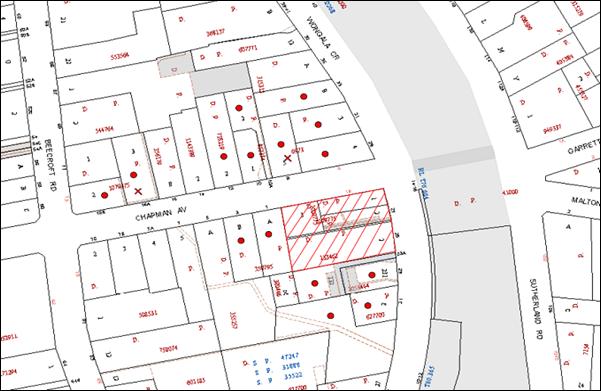
|
NOTIFICATION PLAN |
|
||
|
• PROPERTIES NOTIFIED
|
X SUBMISSIONS RECEIVED |
PROPERTY SUBJECT OF DEVELOPMENT |
|
ONE SUBMISSION RECEIVED OUT OF MAP RANGE
Three submissions raised concerns regarding the amended plans generally on the following grounds:
· Ground floor units should be at or below natural ground level;
· Tree protection of Sydney Blue Gum corner Chapman Avenue and Wongala Crescent;
· Basement car park intrudes into the 10m setback; and
· No deep soil planting between buildings.
The merits of the matters raised in community submissions have been addressed in the body of the report.
5. THE PUBLIC INTEREST
Section 79C(1)(e) of the Act requires Council to consider “the public interest”.
The public interest is an overarching requirement, which includes the consideration of the matters discussed in this report. Implicit to the public interest is the achievement of future built outcomes adequately responding to and respecting the future desired outcomes expressed in environmental planning instruments and development control plans.
The application is considered to have satisfactorily addressed Council’s and relevant agencies’ criteria and would provide a development outcome that, on balance, would result in a positive impact for the community. Accordingly, it is considered that the approval of the proposed development would be in the public interest.
CONCLUSION
The application was considered by Council at its meeting on 16 October 2013. At the meeting Council resolved to defer the application to allow the applicant to submit amended plans.
The amended plans submitted by the applicant in response, generally address the matters raised in Council’s resolution other than the setback of the basement car park from Chapman Avenue. In this regard, it is considered the proposed basement setback is satisfactory with respect to the presentation of the development to the corner site and the proposed landscaping.
The amended proposal generally maintains the built form as originally proposed and is satisfactory in respect to the SEPP 65 Code for Residential Flat Development and the Housing Strategy DCP.
The conditions as previously recommended have been revised accordingly in respect to the amended plans.
Three submissions were received in response to the amended plans.
It is recommended the application be approved.
|
Rod Pickles Manager - Development Assessment Planning Division |
James Farrington Group Manager Planning Division |
|
1.View |
Locality Map |
|
|
|
2.View |
Group Manager's Report No. PL92/13 |
|
|
|
3.View |
Action Memo 16/10/2013 |
|
|
|
4.View |
Floor Plans - Elevations and Sections |
|
|
|
5.View |
Amended Landscape Plans located at http://hsconline.hornsby.nsw.gov.au/appenquiry/modules/DocumentMaster/ViewDocument.aspx?key=%2bzjnDuwi5oQ%3d |
|
|
|
6.View |
Revised Shadow Analysis Plan |
|
|
|
7.View |
Revised Section Shadow Analysis Plan |
|
|
|
8.View |
Photomontage |
|
|
File Reference: DA/38/2013
Document Number: D02701199
SCHEDULE 1
GENERAL CONDITIONS
The conditions of consent within this notice of determination have been applied to ensure that the use of the land and/or building is carried out in such a manner that is consistent with the aims and objectives of the relevant legislation, planning instruments and council policies affecting the land and does not disrupt the amenity of the neighbourhood or impact upon the environment.
Note: For the purpose of this consent, the term ‘applicant’ means any person who has the authority to act on or the benefit of the development consent.
Note: For the purpose of this consent, any reference to an Act, Regulation, Australian Standard or publication by a public authority shall be taken to mean the gazetted Act or Regulation, or adopted Australian Standard or publication as in force on the date that the application for a construction certificate is made.
1. Approved Plans and Supporting Documentation
The development must be carried out in accordance with the plans and documentation listed below and endorsed with Council’s stamp, except where amended by Council and/or other conditions of this consent:
|
Plan No. |
Plan Title |
Drawn by |
Dated |
|
A14 Rev C |
Notification Plan |
Architects Becerra |
Aug 2012 |
|
A02 Rev H |
Basement Plan |
Architects Becerra |
Aug 2012 |
|
A03 Rev G |
Level 1 Floor Plan |
Architects Becerra |
Aug 2012 |
|
A04 Rev F |
Level 2 Floor Plan |
Architects Becerra |
Aug 2012 |
|
A05 Rev G |
Level 3 Floor Plan |
Architects Becerra |
Aug 2012 |
|
A06 Rev H |
Level 4 Floor Plan |
Architects Becerra |
Aug 2012 |
|
A07 Rev G |
Level 5 Floor Plan |
Architects Becerra |
Aug 2012 |
|
A08 Rev D |
Level 6 Floor Plan |
Architects Becerra |
Aug 2012 |
|
A09 Rev E |
Elevations |
Architects Becerra |
Sept 2012 |
|
A10 Rev E |
Elevations |
Architects Becerra |
Sept 2012 |
|
A11 Rev D |
Sections |
Architects Becerra |
Aug 2012 |
|
A12 Rev B |
Materials & Finishes |
Architects Becerra |
Sept 2012 |
|
A21 Rev A |
Chapman Avenue Landscape Section |
Architects Becerra |
Aug 2012 |
|
LPDA 13 - 107/1 Issue G |
Landscape Plan |
Conzept Landscape Architects |
Nov 2013 |
|
LPDA 13 – 107/2 Issue A |
Landscape Details |
Conzept Landscape Architects |
Oct 2012 |
|
Document Title |
Prepared By |
Dated |
|
Arboricultural Assessment Report |
Jacksons Nature Works |
11 Sept 2013 |
|
Rail Noise Assessment |
Acoustic Dynamics |
17 Jan 2013 |
|
Heritage Impact Assessment and Demolition Report |
Andrew Starr and Associates Heritage Consultants |
October 2012 |
|
Waste Management Plan |
Architects Becerra |
Undated |
2. Amendment of Plans
The approved plans are to be amended as follows:
a) The basement car park must include 1 motor cycle parking space and a minimum of 42 car parking spaces including 5 visitor spaces.
b) Units 5, 14 and 21 are to be made adaptable housing units.
3. Removal of Existing Trees
This development consent only permits the removal of tree(s) numbered 6, 7, 10, 14, 16, 18, 20, 29, 30, 32, 33, 34 and 35 as identified on Plan No. LPDA 13 – 107/1 prepared by Conzept Landscape Architects dated Dec 2012. The removal of any other trees requires separate approval under Council’s Tree Preservation Order.
4. Construction Certificate
A Construction Certificate is required to be approved by Council or a Private Certifying Authority prior to the commencement of any works under this consent.
REQUIREMENTS PRIOR TO THE ISSUE OF A CONSTRUCTION CERTIFICATE
5. Building Code of Australia
All building work must be carried out in accordance with the relevant requirements of the Building Code of Australia.
6. Contract of Insurance (Residential Building Work)
In the case of residential building work for which the Home Building Act, 1989 requires there to be a contract of insurance in force in accordance with Part 6 of that Act, that such a contract of insurance is in force before any building work authorised to be carried out by the consent commences.
7. Notification of Home Building Act, 1989 Requirements
Residential building work within the meaning of the Home Building Act, 1989 must not be carried out unless the principal certifying authority for the development to which the work relates (not being Council) has given Council written notice of the following information:
a) In the case of work for which a principal contractor is required to be appointed:
i) The name and licence number of the principal contractor; and
ii) The name of the insurer by which the work is insured under Part 6 of that Act.
b) In the case of work to be done by an owner-builder:
i) The name of the owner-builder and;
ii) If the owner-builder is required to hold an owner-builder’s permit under that Act, the number of the owner-builder’s permit.
Note: If arrangements for doing the residential building work are changed while the work is in progress so that the information notified becomes out of date, further work must not be carried out unless the principal certifying authority for the development to which the work relates (not being Council) has given Council written notification of the updated information.
8. Water/Electricity Utility Services
The applicant must submit written evidence of the following service provider requirements:
a) Energy Australia – a letter of consent demonstrating that satisfactory arrangements have been made to service the proposed development.
b) Sydney Water – the submission of a ‘Notice of Requirements’ under s73 of the Sydney Water Act 1994.
Note: Sydney Water requires that s73 applications are to be made through an authorised Sydney Water Servicing Coordinator. Refer to www.sydneywater.com.au or telephone 13 20 92 for assistance.
9. Adaptable Units
a) The details of the adaptable units Nos. 1, 5, 6, 9, 13, 14, 17, 21, 22, 25, 29 and 30 must be provided with the Construction Certificate Plans.
10. Dilapidation Report
A ‘Dilapidation Report’ is to be prepared by a ‘chartered structural engineer’ detailing the structural condition of all adjoining properties including:
No. 23 Wongala Crescent, Beecroft.
No. 23A Wongala Crescent, Beecroft.
No. 1 Chapman Avenue, Beecroft.
11. Noise – Rail Corridor
The development must be carried out in accordance with the recommendations contained within the acoustic report submitted with the development application, titled Rail Noise Assessment, prepared by Acoustic Dynamics and dated 17 January 2013 and the requirements of the Department of Planning’s Development Near Rail Corridors and Busy Roads – Interim Guideline and RailCorp’s Interim Guidelines for Applicants.
Note: The Department of Planning’s document is available at www.planning.nsw.gov.au (development assessments). The RailCorp document is available at www.railcorp.nsw.gov.au/publications.
12. Preservation of Survey Infrastructure
Prior to the issue of a construction certificate, a registered surveyor shall identify all survey marks in the vicinity of the proposed development. Any survey marks required to be removed or displaced as a result of the proposed development shall be undertaken by a registered surveyor in accordance with Section 24 (1) of the Surveying and Spatial Information Act 2002 and following the Surveyor General’s Directions No.11 – "Preservation of Survey Infrastructure".
13. Waste Management Details
The following waste management requirements must be complied with:
a) A Waste Management Plan Section One – Demolition Stage and Section Three – Construction Stage, covering the scope of this project and including the following details, is required to be submitted to Council:
i) An estimate of the types and volumes of waste and recyclables to be generated;
ii) A site plan showing sorting and storage areas for demolition and construction waste and the vehicle access to these areas;
iii) How excavation, demolition and construction waste materials will be reused or recycled and where residual wastes will be disposed;
iv) The total percentage (by weight) of demolition and construction waste that will be reused or recycled.
REQUIREMENTS PRIOR TO THE COMMENCEMENT OF ANY WORKS
14. Erection of Construction Sign
A sign must be erected in a prominent position on any site on which building work, subdivision work or demolition work is being carried out:
a) Showing the name, address and telephone number of the principal certifying authority for the work;
b) Showing the name of the principal contractor (if any) for any demolition or building work and a telephone number on which that person may be contacted outside working hours; and
c) Stating that unauthorised entry to the work site is prohibited.
Note: Any such sign is to be maintained while the building work, subdivision work or demolition work is being carried out, but must be removed when the work has been completed.
15. Protection of Adjoining Areas
A temporary hoarding, fence or awning must be erected between the work site and adjoining lands before the works begin and must be kept in place until after the completion of the works if the works:
a) Could cause a danger, obstruction or inconvenience to pedestrian or vehicular traffic.
b) Could cause damage to adjoining lands by falling objects.
c) Involve the enclosure of a public place or part of a public place.
Note: Notwithstanding the above, Council’s separate written approval is required prior to the erection of any structure or other obstruction on public land.
16. Toilet Facilities
Toilet facilities must be available or provided at the works site before works begin and must be maintained until the works are completed at a ratio of one toilet for every 20 persons employed at the site. Each toilet must:
a) be a standard flushing toilet connected to a public sewer; or
b) be a temporary chemical closet approved under the Local Government Act, 1993; or
c) have an on-site effluent disposal system approved under the Local Government Act, 1993.
17. Erosion and Sediment Control
Erosion and sediment control measures must be provided and maintained throughout the construction period in accordance with the manual ‘Soils and Construction 2004 (Bluebook)’, the approved plans, Council specifications and to the satisfaction of the principal certifying authority. The erosion and sediment control devices must remain in place until the site has been stabilised and revegetated.
Note: On the spot penalties up to $1,500 may be issued for any non-compliance with this requirement without any further notification or warning.
18. Tree Protection Barriers
To avoid injury or damage, trees numbered 9, 11, 12, and 13 must have trunks protected by 2 metre lengths of 75mm x 25mm hardwood timbers spaced at 80mm secured with galvanised wire (not fixed or nailed to the tree in any way.
19. Heritage Conservation
A photographic and measured drawing record of the dwelling-house and heritage listed garden at No. 25 Wongala Crescent shall be taken by a suitable qualified professional prior to the demolition of any structures or garden features on the site. The photographic record should be undertaken in accordance with the Office of Environment and Heritage, Heritage Branch guidelines and two (2) complete copies submitted to Hornsby Council. The photographic and measured drawing record shall include (but not be limited to) an accurate record of the exterior and interior of the dwelling-house, all physical features that contribute to their cultural significance, original and significant elements of the garden, and the context of the site. Any boarding over window and door openings shall be removed for the duration of the archival recording to provide a clear recording of the built form and materials. Satisfaction of this condition shall be confirmed by written advice by Council’s Strategic Planning Branch.
REQUIREMENTS DURING CONSTRUCTION
20. Construction Work Hours
All work on site (including demolition and earth works) must only occur between 7am and 5pm Monday to Saturday, in accordance with Interim Construction Noise Guidelines 2009 – NSW Department of Environment and Climate Change.
No work is to be undertaken on Sundays or public holidays.
21. Demolition
All demolition work must be carried out in accordance with “Australian Standard 2601-2001 – The Demolition of Structures” and the following requirements:
a) Demolition material must be disposed of to an authorised recycling and/or waste disposal site and/or in accordance with an approved waste management plan;
b) Demolition works, where asbestos material is being removed, must be undertaken by a contractor that holds an appropriate licence issued by WorkCover NSW in accordance with Chapter 10 of the Occupational Health and Safety Regulation 2001 and Clause 29 of the Protection of the Environment Operations (Waste) Regulation 2005 and;
c) On construction sites where buildings contain asbestos material, a standard commercially manufactured sign containing the words ‘DANGER ASBESTOS REMOVAL IN PROGRESS’ measuring not less than 400mm x 300mm must be erected in a prominent position visible from the street.
22. Environmental Management
The site must be managed in accordance with the publication ‘Managing Urban Stormwater – Landcom (March 2004) and the Protection of the Environment Operations Act 1997 by way of implementing appropriate measures to prevent sediment run-off, excessive dust, noise or odour emanating from the site during the construction of the development.
23. Street Sweeping
Street sweeping must be undertaken following sediment tracking from the site along Wongala Crescent during works and until the site is established.
24. Works Near Trees
All required tree protection measures are to be maintained in good condition for the duration of the construction period.
All works (including driveways and retaining walls) within 5 metres of any trees required to be retained (whether or not on the subject property, and pursuant to this consent or the Tree Preservation Order), must be carried out under the supervision of an ‘AQF Level 5 Arborist’ and a certificate submitted to the principal certifying authority detailing the method(s) used to preserve the tree(s).
Note: Except as provided above, the applicant is to ensure that no excavation, filling or stockpiling of building materials, parking of vehicles or plant, disposal of cement slurry, waste water or other contaminants is to occur within 4 metres of any tree to be retained.
25. Council Property
During construction works, no building materials, waste, machinery or related matter is to be stored on the road or footpath. The public reserve must be kept in a clean, tidy and safe condition at all times.
26. Landfill
Landfill must be constructed in accordance with Council’s ‘Construction Specification, 2005’ and the following requirements:
a) All fill material imported to the site is to wholly consist of Virgin Excavated Natural Material (VENM) as defined in Schedule 1 of the Protection of the Environment Operations Act 1997 or a material approved under the Department of Environment and Climate Change’s general resource recovery exemption.
b) A compaction certificate is to be obtained from a geotechnical engineer verifying that the specified compaction requirements have been met.
27. Excavated Material
All excavated material removed from the site must be classified in accordance with the Department of Environment, Climate Change and Water NSW Waste Classification Guidelines prior to disposal to an approved waste management facility and reported to the principal certifying authority.
28. Waste Management Details
Waste management during the demolition and construction phase of the development must be undertaken in accordance with the approved Waste Management Plan. Additionally written records of the following items must be maintained during the removal of any waste from the site and such information submitted to the Principal Certifying Authority within fourteen days of the date of completion of the works:
a) The identity of the person removing the waste.
b) The waste carrier vehicle registration.
c) Date and time of waste collection.
d) A description of the waste (type of waste and estimated quantity).
e) Details of the site to which the waste is to be taken.
f) The corresponding tip docket/receipt from the site to which the waste is transferred (noting date and time of delivery, description (type and quantity) of waste).
g) Whether the waste is expected to be reused, recycled or go to landfill.
Note: In accordance with the Protection of the Environment Operations Act 1997, the definition of waste includes any unwanted substance, regardless of whether it is reused, recycled or disposed to landfill.
29. Survey Report – Finished Floor Level
A report(s) must be prepared by a registered surveyor and submitted to the principal certifying authority prior to the pouring of concrete at each level of the building certifying that:
a) The building, retaining walls and the like have been correctly positioned on the site and;
b) The finished floor level(s) are in accordance with the approved plans.
REQUIREMENTS PRIOR TO THE ISSUE OF AN OCCUPATION CERTIFICATE
Note: For the purpose of this consent, a reference to ‘occupation certificate’ shall not be taken to mean an ‘interim occupation certificate’ unless otherwise stated.
30. Fulfilment of BASIX Commitments
The applicant must demonstrate the fulfilment of BASIX commitments pertaining to the development.
31. Sydney Water – s73 Certificate
An s73 Certificate must be obtained from Sydney Water.
32. Stormwater Drainage – Dwellings
Stormwater from the site shall be connected to the Council’s piped system within Wongala Crescent via an on site detention system and shall be in accordance with Council’s Civil Works-Design and Construction Specifications 2005 and the following requirements:
a) Necessary pits and drainage lines are to be constructed to connect to the nearest Council pit.
b) The stormwater drainage plan is to indicate all the trees in the proximity of drainage lines and method of protection of the trees that are to be retained.
c) Obtain a construction certificate from Council to carry out drainage works within Council’s road reserve (Council is the only authority to approve works within is road reserves).
33. On-Site Detention
An on-site stormwater detention system must be designed by a chartered civil engineer and constructed in accordance with the following requirements:
a) The drainage system to control all collected roof and surface stormwater shall be designed with an on-site-detention system (rain water tanks/above or below ground facility). Stormwater discharge from the development site shall be limited to 5 year pre development ARI discharge level. On site detention storage shall be provided for up to 50 year ARI storm events. Detail calculations are to be submitted with a construction certificate application.
b) Have a surcharge/inspection grate located directly above the outlet. An overland flowpath is to be constructed ensuring that stormwater flows to Wongala Crescent.
c) Discharge from the detention system to be controlled via 1 metre length of pipe, not less than 50 millimetres diameter or via a stainless plate with sharply drilled orifice bolted over the face of the outlet discharging into a larger diameter pipe capable of carrying the design flow to an approved Council system.
d) Where above ground and the average depth is greater than 0.3 metres, a ‘pool type’ safety fence and warning signs to be installed.
e) Not be constructed in a location that would impact upon the visual or recreational amenity of residents.
f) A construction certificate application is to be submitted and approval obtained prior to commencement of works.
34. Internal Driveway/Vehicular Areas
The driveway and parking areas on site must be designed in accordance with Australian Standards 2890.1, 2809.2 and 3727 and the following requirements:
a) Design levels at the front boundary be obtained from Council.
b) The driveway be a rigid pavement.
c) The driveway pavement be 0.15 metres thick reinforced concrete with F72 steel reinforcing fabric and a 0.15 metre sub-base.
d) The driveway grade must not exceed 25 percent and changes in grade must not exceed 8 percent.
e) A speed hump must be installed on the driveway in accordance with appropriate safety standards at the Wongala Crescent boundary line.
f) A warning sign must be erected at the driveway exist to alert motorists to pedestrians.
35. Footpath and Kerb and Gutter
The uneven sections of the nature strip along frontage of the development must be properly graded and turfed.
Damaged footpath and kerb and gutter must be replaced.
36. Vehicle Crossing
A separate application under the Local Government Act, 1993 and the Roads Act, 1993 must be submitted to Council for the installation of a new vehicular crossing and the removal of the redundant crossing. The vehicular crossing must be constructed in accordance with Council’s Civil Works Design, 2005 and the following requirements:
a) Any redundant crossings to be replaced with integral kerb and gutter.
b) The footway area to be restored by turfing.
c) Approval obtained from all relevant utility providers that all necessary conduits be provided and protected under the crossing.
Note: An application for a vehicular crossing can only be made to one of Council’s Authorised Vehicular Crossing Contractors. You are advised to contact Council on 02 9847 6940 to obtain a list of contractors.
37. Traffic Control Plan
A Traffic Control Plan (TCP) must be prepared by a qualified traffic controller in accordance with the Roads & Traffic Authority’s Traffic Control at Worksites Manual 1998 and Australian Standard 1742.3 for all work on a public road and be submitted to Council. The TCP must detail the following:
a) Arrangements for public notification of the works.
b) Temporary construction signage.
c) Permanent post-construction signage.
d) Vehicle movement plans.
e) Traffic management plans.
f) Pedestrian and cyclist access/safety.
38. Creation of Easements
The following matter(s) must be nominated on the plan of subdivision under s88B of the Conveyancing Act 1919:
a) The creation of an appropriate "Positive Covenant" and "Restriction as to User" over the constructed on-site detention/retention systems and outlet works, within the lots in favour of Council in accordance with Council’s prescribed wording. The position of the on-site detention system is to be clearly indicated on the title.
b) To register the OSD easement, the restriction on the use of land “works-as-executed” details of the on-site-detention system must be submitted verifying that the required storage and discharge rates have been constructed in accordance with the design requirements. The details must show the invert levels of the on site system together with pipe sizes and grades. Any variations to the approved plans must be shown in red on the “works-as-executed” plan and supported by calculations.
Note: Council must be nominated as the authority to release, vary or modify any easement, restriction or covenant.
39. Installation of Privacy Devices
The following device(s) must be installed to maintain an element of privacy.
a) Opposing balconies must be fitted with sliding stackable louvered metal screens extendable to the full width of the balconies;
b) All glass balustrades must be translucent glass.
40. Retaining Walls
All required retaining walls must be constructed as part of the development.
41. Works As Executed Plan
A works-as-executed plan(s) must be prepared by a registered surveyor and submitted to Council for completed drainage system and on-site detention system.
42. Survey Infrastructure
A registered surveyor shall certify that there is no removal, damage, destruction, displacement or defacing of the existing survey marks in the vicinity of the proposed development and/or the re-establishment of damaged, removed or displaced survey marks has been undertaken in accordance with the Surveyor General’s Directions No.11 – "Preservation of Survey Infrastructure".
43. Completion of Landscaping
a) A certificate must be provided by a practicing landscape architect, horticulturalist or person with similar qualifications and experience certifying that all required landscaping works have been satisfactorily completed in accordance with the approved landscape plans.
b) The 1.2m high front boundary fence noted on the approved Landscape Plan is not approved under this consent. A development application must be submitted to Council for the proposed front boundary fencing of the site.
Note: Advice on suitable species for landscaping can be obtained from Council’s planting guide ‘Indigenous Plants for the Bushland Shire’, available at www.hornsby.nsw.gov.au.
44. External Lighting
All external lighting must be designed and installed in accordance with Australian Standard AS 4282 – Control of the Obtrusive Effects of Outdoor Lighting. Certification of compliance with the Standard must be obtained from a suitably qualified person.
45. Garbage Collection Easement
For the purpose of waste collection, an easement entitling Council, its servants and agents and persons authorised by it to enter upon the subject land and to operate thereon, vehicles and other equipment for the purposes of garbage collection must be granted to Council by the owner of the land.
Note: The easement must be in a form prescribed by Council and must include covenants to the effect that parties will not be liable for any damage caused to the subject land or any part thereof or to any property located therein or thereon by reason of the operation thereon of any vehicle or other equipment used in connection with the collection of garbage and to the effect that the owner for the time being of the subject land shall indemnify the Council, its servants, agents and persons authorised by it to collect garbage against liability in respect of any such claims made by any person whomsoever.
46. Unit Numbering
The allocation of unit numbering must be authorised by Council prior to the numbering of each unit in the development.
47. Section 94 Development Contributions
In accordance with Section 80A(1) of the Environmental Planning and Assessment Act 1979 and the Hornsby Shire Council Section 94 Development Contributions Plan 2012-2021, the following monetary contributions shall be paid to Council to cater for the increased demand for community infrastructure resulting from the development:
|
Description |
Contribution (4) |
|
Roads |
$21,207.35 |
|
Open Space and Recreation |
$382,983.40 |
|
Community Facilities |
$53,712.05 |
|
Plan Preparation and Administration |
$1605.45 |
|
TOTAL |
$459,508.25 |
being for 5 x 1 bedroom units, 27 x 2 bedroom units and 4 x 3 bedroom units and including a credit for four existing allotments.
a) If the contributions are not paid within the financial quarter that this consent is granted, the contributions payable will be adjusted in accordance with the provisions of the Hornsby Shire Council Section 94 Development Contributions Plan and the amount payable will be calculated at the time of payment in the following manner:
$CPY = $CDC x CPIPY
CPIDC
Where:
$CPY is the amount of the contribution at the date of Payment
$CDC is the amount of the contribution as set out in this Development Consent
CPIPY is the latest release of the Consumer Price Index (Sydney – All Groups) at the date of Payment as published by the ABS.
CPIDC is the Consumer Price Index (Sydney – All Groups) for the financial quarter at the date of this Development Consent.
b) The monetary contributions shall be paid to Council:
i) prior to the issue of the Subdivision Certificate where the development is for subdivision; or
ii) prior to the issue of the first Construction Certificate where the development is for building work; or
iii) prior to issue of the Subdivision Certificate or first Construction Certificate, whichever occurs first, where the development involves both subdivision and building work; or
iv) prior to the works commencing where the development does not require a Construction Certificate or Subdivision Certificate.
It is the professional responsibility of the Principal Certifying Authority to ensure that the monetary contributions have been paid to Council in accordance with the above timeframes.
Council’s Development Contributions Plan may be viewed at www.hornsby.nsw.gov.au or a copy may be inspected at Council’s Administration Centre during normal business hours.
48. Waste Management Details
The following waste management requirements must be complied with:
a) The bin storage room at the basement level must include water or a hose for cleaning, graded floors with drainage to sewer, a robust door, sealed and impervious surface, adequate lighting and ventilation. The bin rooms at each residential level must include sealed and impervious surface, adequate lighting and ventilation.
b) A report must be prepared by an appropriately qualified person, certifying the following:
i) A comparison of the estimated quantities of each waste type against the actual quantities of each waste type.
Note: Explanations of any deviations to the approved Waste Management Plan is required to be included in this report.
ii) That at least 60% of the waste generated during the demolition and construction phase of the development was reused or recycled.
Note: If the 60% diversion from landfill cannot be achieved in the Construction Stage, the Report is to include the reasons why this occurred and certify that appropriate work practices were employed to implement the approved Waste Management Plan. The Report must be based on documentary evidence such as tipping dockets/receipts from recycling depots, transfer stations and landfills, audits of procedures etc. which are to be attached to the report.
iii) All waste was taken to site(s) that were lawfully permitted to accept that waste.
c) Each unit must be provided with an indoor waste/recycling cupboard for the interim storage of a minimum one day’s waste generation with separate containers for general waste and recyclable materials.
d) Space must be provided for either individual compost containers for each unit or a communal compost container;
Note: The location of the compost containers should have regard for potential amenity impacts.
e) The bin carting routes must be devoid of any steps.
Note: Ramps between different levels are acceptable.
f) “No parking” signs must be erected to prohibit parking in the waste collection vehicle turning area and loading area.
g) A report(s) must be prepared by a registered surveyor and submitted to the principal certifying authority prior to the issue of the Subdivision/Occupation Certificate, certifying that:
i) The finished access way (including ramp, vehicle turning area, loading bay and site entry/exit) to be used by waste collection vehicles, complies with Australian Standard AS2890.2-2002 Parking Facilities Part 2: Off-street Commercial Vehicle Facilities for small rigid vehicles with minimum design vehicle dimensions of 6.4 metres overall length, width of 2.3 metres, with maximum gradient of 1:6.5 and minimum 3.5 metre clearance height; and
ii) The finished gradient(s), dimensions and geometry of the road/access way (including vehicle turning area) are in accordance with the approved plans.
h) The 3.5 metre clearance height within the truck travel path must not be reduced by ducting, pipes or anything else.
49. Landscaping
a) On slab planter boxes must include waterproofing, subsoil drainage (proprietary drainage cell, 50mm sand and filter fabric) automatic irrigation, minimum 500mm planting soil for shrubs and minimum 1000mm planting soil for trees and palms and 75mm mulch to ensure sustainable landscape is achieved.
b) An additional one Jacaranda mimosifolia is to be planted in the landscape setback on the Wongala Crescent frontage. Trees shall be installed at minimum 100 litre pot size.
c) A certificate must be provided by a practicing landscape architect, horticulturalist or person with similar qualifications and experience certifying that all required landscaping works have been satisfactorily completed in accordance with the approved landscape plans.
50. Safety and Security
a) Fire exist doors to the development must be fitted with single cylinder locksets (Australia and New Zealand Standard – Lock Sets) to restrict unauthorized access to the development.
b) Ground floor windows must be fitted with window locks that can be locked with a key.
c) A graffiti management plan must be incorporated into the maintenance plan for the development for graffiti to be removed within a forty-eight hour period.
d) The basement car park entry must be secured by security gates/roller shutters and controlled by secure access located at the top of the driveway.
OPERATIONAL CONDITIONS
51. Noise
All noise generated by the proposed development must be attenuated to prevent levels of noise being emitted to adjacent premises which possess tonal, beating and similar characteristics or which exceeds background noise levels by more than 5dB(A).
52. Fire Safety Statement - Annual
On at least one occasion in every 12 month period following the date of the first ‘Fire Safety Certificate’ issued for the property, the owner must provide Council with an annual ‘Fire Safety Certificate’ to each essential service installed in the building.
53. Car Parking
All car parking must be constructed and operated in accordance with Australian Standard AS/NZS 2890.1:2004 – Off-street car parking and Australian Standard AS 2890.2:2002 – Off-street commercial vehicle facilities.
a) All parking areas and driveways are to be sealed to an all weather standard, line marked and signposted;
b) Car parking, loading and manoeuvring areas to be used solely for nominated purposes;
c) Vehicles awaiting loading, unloading or servicing shall be parked on site and not on adjacent or nearby public roads;
d) All vehicular entry on to the site and egress from the site shall be made in a forward direction.
54. Disabled Car Parking
All parking spaces for people with disabilities must be constructed and operated in accordance with Australian Standard AS/NZS 2890.6:2009 – Off-street parking for people with disabilities
55. Driveway Design
The driveway design must be in accordance with AS2890.1 and AS2890.2.
56. Waste Storage and Waste Management
The waste management on site must be in accordance with the following requirements:
a) Site security measures implemented on the property, including electronic gates, must not prevent access to the bin room/collection point by waste removal services.
b) A site caretaker must be employed and be responsible for moving bins where and when necessary, washing bins and maintaining waste storage areas, ensuring the chute system and related devices are maintained in effective and efficient working order, managing the communal composting area, managing the bulky item storage area (including, but not limited to, ensuring that items placed there do not block or hinder access to bins for bin collection services), arranging the prompt removal of dumped rubbish, ensuring the vehicle turning area and truck loading area is kept clear of parked cars, and ensuring all residents are informed of the use of the waste management system.
57. Landscape Establishment
The landscape works must be maintained into the future to ensure the establishment and successful growth of plant material to meet the intent of the landscape design. This must include but not be limited to watering, weeding, replacement of failed plant material and promoting the growth of plants through standard industry practices.
- END OF CONDITIONS -
ADVISORY NOTES
The following information is provided for your assistance to ensure compliance with the Environmental Planning and Assessment Act, 1979, Environmental Planning and Assessment Regulation 2000, other relevant legislation and Council’s policies and specifications. This information does not form part of the conditions of development consent pursuant to Section 80a of the Act.
Environmental Planning and Assessment Act, 1979 Requirements
The Environmental Planning and Assessment Act, 1979 requires:
· The issue of a construction certificate prior to the commencement of any works. Enquiries can be made to Council’s Customer Services Branch on 9847 6760.
· A principal certifying authority to be nominated and Council notified of that appointment prior to the commencement of any works.
· Council to be given at least two days written notice prior to the commencement of any works.
· Mandatory inspections of nominated stages of the construction inspected.
· An occupation certificate to be issued before occupying any building or commencing the use of the land.
Long Service Levy
In accordance with Section 34 of the Building and Construction Industry Long Service Payments Act 1986, a ‘Long Service Levy’ must be paid to the Long Service Payments Corporation or Hornsby Council.
Note: The rate of the Long Service Levy is 0.35% of the total cost of the work.
Note: Hornsby Council requires the payment of the Long Service Levy prior to the issue of a construction certificate.
Tree Preservation Order
To ensure the maintenance and protection of the existing natural environment, it is an offence to ringbark, cut down, top, lop, remove, wilfully injure or destroy a tree outside 3 metres of the approved building envelope without the prior written consent from Council.
Note: A tree is defined as a single or multi-trunked wood perennial plant having a height of not less than three (3) metres, and which develops many branches, usually from a distance of not less than one (1) metre from the ground, but excluding any plant which, in its particular location, is a noxious plant declared as such pursuant to the Noxious Weeds Act 1993. This definition of ‘tree’ includes any and all types of Palm trees.
All distances are determined under Australian Standard AS4970-2009 ”Protection of Trees on Development Sites”.
Fines may be imposed for non-compliance with Council’s Tree Preservation Order.
Disability Discrimination Act
The applicant’s attention is drawn to the existence of the Disability Discrimination Act. A construction certificate is required to be obtained for the proposed building/s, which will provide consideration under the Building Code of Australia, however, the development may not comply with the requirements of the Disability Discrimination Act. This is the sole responsibility of the applicant.
Subdivision Certificate Requirements
A subdivision certificate application is required to be lodged with Council containing the following information:
· A surveyor’s certificate certifying that all structures within the subject land comply with the development consent in regard to the setbacks from the new boundaries.
· A surveyor’s certificate certifying that all services, drainage lines or access are located wholly within the property boundaries. Where services encroach over the new boundaries, easements are to be created.
· Certification that the requirements of relevant utility authorities have been met.
· A surveyor’s certificate certifying finished ground levels are in accordance with the approved plans.
Note: Council will not issue a subdivision certificate until all conditions of the development consent have been completed.
Fees and Charges – Subdivision
All fees payable to Council as part of any construction, compliance or subdivision certificate or inspection associated with the development (including the registration of privately issued certificates) are required to be paid in full prior to the issue of the subdivision certificate. Any additional Council inspections beyond the scope of any compliance certificate required to verify compliance with the terms of this consent will be charged at the individual inspection rate nominated in Council's Fees and Charges Schedule.
Dial Before You Dig
Prior to commencing any works, the applicant is encouraged to contact Dial Before You Dig on 1100 or www.dialbeforeyoudig.com.au for free information on potential underground pipes and cables within the vicinity of the development site.
Telecommunications Act 1997 (Commonwealth)
If you are aware of any works or proposed works which may affect or impact on Telstra’s assets in any way, you are required to contact: Telstra’s Network Integrity Team on Phone Number 1800810443.
Asbestos Warning
Should asbestos or asbestos products be encountered during demolition or construction works, you are advised to seek advice and information prior to disturbing this material. It is recommended that a contractor holding an asbestos-handling permit (issued by WorkCover NSW)be engaged to manage the proper handling of this material. Further information regarding the safe handling and removal of asbestos can be found at:
Alternatively, telephone the WorkCover Asbestos and Demolition Team on 8260 5885.
Group Manager's Report No. PL113/13
Planning Division
Date of Meeting: 18/12/2013
14 REPORT ON SUBMISSIONS - VEHICULAR ACCESS TO PROPERTIES IN NANCY PLACE, GALSTON
EXECUTIVE SUMMARY
· The Hornsby Development Control Plan (HDCP) 2013 contains controls which restrict vehicular access to Nancy Place only, for all properties with dual frontages to Nancy Place and Arcadia Road.
· Draft development control plan (DCP) amendments permitting vehicular access to Arcadia Road were exhibited from 30 July 2013 to 30 August 2013.
· Seventy-two submissions were received in response to the exhibition, including one from the Roads and Maritime Services (RMS).
· A positive response to the proposed amendments was received from the community with 86% of submissions supporting the amendments, including the RMS.
· Submissions in support of the amendments note that the proposal would improve the streetscape of Arcadia Road, would assist with the viability of businesses with Galston Village, provide additional opportunities for new families to move into the area, improve the future traffic conditions within Nancy Place and provide additional subdivision options.
· Concerns raised in response to the exhibition include pedestrian safety, future efficiency of the road network, restriction as to user, compliance with RMS policy, potential cost of associated works and the notification of exhibition.
· Issues raised in submissions do not raise any additional matters to justify maintaining the existing access restriction. Accordingly, it is recommended that the amendments to the HDCP 2013 (Attachment 1) to permit vehicle access to Arcadia Road be adopted.
|
THAT: 1. The amendments to the Hornsby Development Control Plan 2013 attached to Group Manager’s Report No. PL113/13 to permit vehicle access to Arcadia Road be adopted. 2. All persons who made a submission be advised of Council’s decision. |
PURPOSE
The purpose of this report is to present the outcome of the exhibition of draft amendments to the Hornsby Development Control Plan (HDCP) 2013 to permit direct vehicular access from Arcadia Road for properties on the western side of Nancy Place, Galston.
BACKGROUND
At its meeting on 17 July 2013, Council considered Group Manager’s Report No. PL61/13 that presented options to Council concerning a review of controls relating to vehicular access from Arcadia Road for properties on the western side of Nancy Place.
The report presented a balanced summary of the opportunities and constraints associated with maintaining or relaxing the access restriction to Arcadia Road. The following two options were proposed:
· Option 1 – Retain Existing Controls in the Rural Lands DCP
This option retains the existing controls and restrictions for vehicular access from Arcadia Road. It was acknowledged that achieving vehicle access to the rear of some properties from Nancy Place is restricted due to setbacks. However, there are alternate options for lots which do not have sufficient side setbacks such as partial demolition/alteration to the existing dwellings or a shared access way with adjoining lots. Based on an assessment of opportunities and constraints, it was noted that the private benefit of direct access to Arcadia Road is outweighed by the potential impact on road user safety of the Regional Road and existing streetscape. This option is also consistent with RMS policy in regards to vehicle access to Regional roads.
· Option 2 – Amend Existing Controls to Allow Direct Vehicular Access from Arcadia Road
This option would result in more traditional lots for properties along the western side of Nancy Place, with direct house and vehicle access to Arcadia Road, resulting in reduced amenity impacts for existing dwellings within Nancy Place. The Arcadia Road streetscape may be improved with the development of conventional street facing dwellings instead of the current rear facades and fences. The feasibility of development would also be improved by the provision of a reticulated sewage system by Sydney Water.
In summary, the report acknowledged that a private benefit would be obtained by permitting conventional street facing dwellings to be constructed. This benefit, however, may be outweighed by the likely impact on the safety and efficiency of the regional road network and streetscape impact of permitting an ad-hoc arrangement of front and rear fences long the length of Arcadia Road. Accordingly, Option 1 was recommended.
Council resolved to exhibit draft amendments to permit vehicle access to Arcadia Road subject to additional controls for consolidation of driveways and street tree planting. In accordance with Council’s resolution, the draft DCP amendments were placed on public exhibition.
DISCUSSION
This report discusses submissions received in response to the exhibition of the amendments to the HDCP 2013 to permit vehicle access to Arcadia Road.
DCP Amendments
Part 2 - Rural of the HDCP 2013 contains the Galston Village Master Plan which prohibits access to Arcadia Road for properties with dual frontages to Arcadia Road and Nancy Place. Part 6 - Subdivision also includes a prescriptive measure which prohibits new direct vehicle access to Arcadia Road (between Arcadia Road and Nancy Place).
In accordance with Council’s resolution, amendments to Part 2 - Rural and Part 6 - Subdivision to permit vehicle access to Arcadia Road were placed on public exhibition. Additional controls were included within Part 6 - Subdivision which promote:
· consolidation of vehicular crossings and driveways; and
· street tree planting within the road reserve on the eastern side of Arcadia Road between Galston Road and Gribbenmount Road.
Exhibition and Review of Submissions
The draft DCP amendments were publicly exhibited from 30 July 2013 to 30 August 2013 in accordance with the requirements of the Environmental Planning and Assessment (EP&A) Act 1979. A notice was placed in the Hills News, the Hills Shire Times and on Council’s website. Letters were sent to properties along Arcadia Road, between Galston Road and Gribbenmount Road. Copies of the draft DCP amendments were made available for inspection at Council’s Administration Building and Galston Library. Electronic copies were placed on Council’s website.
A total of 72 submissions have been received, including:
· 31 form letters supporting the DCP amendments;
· 30 individual letters supporting the DCP amendments;
· 10 individual letters opposing the draft amendments; and
· 1 Public Authority submission supporting the DCP amendments.
Supporting submissions received from local residents and business owners within the village centre identified the following benefits of the proposal:
· reduced traffic and improved safety for residents within Nancy Place;
· improved streetscape of Arcadia Road;
· residents of Nancy Place would have more options for subdividing their properties without demolishing their homes;
· new lots created would provide young families an opportunity to move into the area; and
· the proposal would assist with the viability of businesses within Galston Village.
Key issues raised in submissions objecting to the DCP amendments include concerns for pedestrian safety, future efficiency of the road network, restriction as to user, compliance with Roads and Maritime Services policy (RMS), potential cost of associated works and notification of exhibition. A summary of submissions is attached to this report (Attachment 2). Major issues raised in submissions are addressed below.
Public Authority Submission
Arcadia Road is listed as a classified main road. Due to this status, the RMS has the option of applying higher standards of access. The classification of Arcadia Road was adopted by the RMS to enhance the function of the road as an alternative route between the Pacific Highway at Berowra and Galston via the ferry crossing at Berowra Waters.
Whilst direct vehicular access is generally not encouraged by the RMS, it does not object to permitting access to Arcadia Road from properties within Nancy Place. Due to the potential for new street trees to obstruct sight lines, the RMS has referenced the Australian Standard regarding sight distance at access driveway/exit points for compliance.
Comment: The HDCP 2013 contains notes which are not development controls but include additional information such as definitions, educational material and reference to further information, guidelines and other legislative requirements including Australian Standards. A note referencing the Australian Standard for sight distance at driveways would address the concern raised by the RMS.
Recommendation: Inclusion of a note within Section ‘6.4 Accessway Design’ of the HDCP 2013 stating that driveway design should comply with section 3.2.4 Sight distance at access driveway exits of the Australian Standard 2890.1:2004 Parking facilities – Off street car parking.
Public Submissions
Ten submissions were received objecting to the proposal, the major issues raised are addressed below.
a) Pedestrian Safety
There is concern that the proposed DCP amendments would compromise the safety of pedestrians, especially children walking to, and from, Galston Public School and crossing Arcadia Road. Submissions comment that traffic on Arcadia Road is heavy at times and the proposal would increase vehicle movements leading to an increase in pedestrian accidents.
It is suggested that the pedestrian island located on Arcadia Road, just north of Martin Place, be formalised as a pedestrian crossing.
Comment: A pedestrian pathway currently exists on the western side of Arcadia Road. A pedestrian refuge also exists on Arcadia Road, just north of Martin Place, which assists pedestrians in crossing Arcadia Road.
Galston public school is located on the western side of Arcadia Road. There is a set down and pick up area located directly outside of Galston Public School on School Road which allows parents to drop off and pick up their children without the need for parking or crossing of Arcadia Road.
The RMS has strict requirements that need to be met before a pedestrian crossing can be considered. In 2008, Council conducted a survey in the area to assess whether the location met the RMS requirements to install a pedestrian crossing. It was determined that pedestrian volumes were significantly lower than the threshold needed. Should the need arise in the future, Council may undertake a further survey.
Recommendation: No amendments be made to the proposal to permit vehicular access to Arcadia Road as a result of the submissions concerning pedestrian safety.
b) Efficiency and Safety of Road Network
Submissions raise concerns that the proposal would increase traffic on Arcadia Road, which is already a busy road and this will lead to more car accidents, especially around the ‘kiss and drop’ area and for parents parking on the eastern side of Arcadia Road. There is concern that Council has further plans to subdivide the rural area around Galston and this would contribute to traffic on Arcadia Road. The restriction is needed for the safety and efficiency of Arcadia Road and should not be compromised for a small number of land owners.
Comment: The proposed DCP amendments were referred to the RMS who raises no concerns regarding the efficiency and safety of Arcadia Road. As stated above under ‘Pedestrian Safety’, there is a set down and pick up area located on School Road which allows parents to drop off and pick up their children without the need for parking on Arcadia Road.
Recommendation: No amendments be made to the proposal to permit vehicular access to Arcadia Road as a result of the submissions concerning the efficiency and safety of the road network.
c) Restriction as to User
A Restriction as to User applies to the western boundary of all properties with dual frontage to Nancy Place and Arcadia Road. This restriction was placed on titles in the 1970s and imposes a setback from Arcadia Road and prohibits vehicular access to Arcadia Road.
Submissions comment that the restriction as to user was imposed as part of the original subdivision of the area to avoid traffic and safety impacts on Arcadia Road. The submissions also comment that this is a standard practice used across the State and should continue to be applied by Council.
Comment: In 1964, a road widening plan for Arcadia Road was registered. To preserve the future function of the road, a restriction as to user was placed on properties from the 1970s at the time of subdivision for lots with dual frontages to Arcadia Road and Nancy Place, Galston. Widening of the road reservation of Arcadia Road between Galston Road and Gribbenmount Road has been completed. The road corridor is capable of accommodating a six lane road, with central median and footpaths on either side to cater for future development between Galston town centre and Berowra Waters. On the grounds that widening of the road reserve is complete and that the RMS has not objected to the proposal, there is no reason to retain this restriction.
Recommendation: No amendments be made to the proposal to permit vehicular access to Arcadia Road as a result of the submissions concerning the restriction as to user.
d) RMS Policy
There is concern that the proposed draft amendments contradict RMS policy in regards to limiting the number of vehicle access points along arterial roads to promote safety and efficiency of the road network.
Comment: In accordance with the Roads Act 1993, the RMS is the responsible Authority in relation to road works, traffic control facilities, connections to roads and other works to classified roads. The RMS was consulted as part of the exhibition and raises no objections to the proposal. If the proposal was to proceed, any development application that seeks direct access to Arcadia Road would require the concurrence of the RMS.
Recommendation: No amendments be made to the proposal to permit vehicular access to Arcadia Road as a result of the submissions concerning RMS policy.
e) Future Costs
There is concern regarding the potential cost to rate payers for the provision of kerb and guttering on the eastern side of Arcadia Road. These funds should be used for higher priority needs within the Shire. Submissions also comment that the cost of a footpath along the eastern side of Arcadia Road was not included in Council’s estimate.
Comment: Should the proposal proceed, Council would require kerb, gutter and footpath to be provided as a condition of development consent where access to Arcadia Road is proposed. This may lead to missing sections that would be the responsibility of Council to complete. The scheduling and funding of works would occur as per Council’s usual capital works program should the need arise. The estimated cost of $33,000 per lot is inclusive of a footpath but may vary depending on the diameter of stormwater pipes to be confirmed at the development application stage.
Recommendation: No amendments be made to the proposal to permit vehicular access to Arcadia Road as a result of the submissions concerning future costs.
f) Exhibition Process
The Galston Public School Parents and Citizens Association notes that Galston Public School did not receive formal notification advising of the exhibition of the draft DCP amendments.
Comment: Council records indicate that a notification letter advising of the exhibition of the draft DCP amendments was sent to Galston Public School. During the exhibition of the DCP amendments, Council officers spoke to the Principal of Galston Public School and a copy of Group Manager’s Report PL61/13 and the notification letter sent out was emailed on 16 August 2013. A submission was not received from Galston Public School.
Recommendation: No amendments be made to the proposal to permit vehicular access to Arcadia Road as a result of the submission concerning the notification of the exhibition.
BUDGET
Should the proposal proceed and future applications be received for access to Arcadia Road, Council would require kerb and guttering to be provided to the frontage of properties. This may lead to missing sections of kerb and gutter that would be the responsibility of Council to complete. The cost to Council to complete missing sections of kerb, gutter, footpath and drainage along Arcadia Road would be approximately $33,000 per lot subject to detailed design. The funding of this work would need to be allocated in future capital works budgets when required.
POLICY
At the time of exhibition, the draft DCP amendments were prepared to amend the (then) draft HDCP 2013. However, on 11 October 2013, the Hornsby Local Environmental Plan 2013 and HDCP 2013 came into force. This report recommends that the amended controls be incorporated into the adopted HDCP 2013.
CONCLUSION
Amendments to permit vehicular access to Arcadia Road for properties with dual frontages to Nancy Place and Arcadia Road were exhibited from 30 July 2013 to 30 August 2013. Seventy-two submissions were received in response to the exhibition. Despite concerns raised regarding the efficiency of the road network and pedestrian safety, an overwhelming positive response to the proposed amendments was received from the community during the exhibition, including the RMS.
Issues raised in submissions do not raise any additional matters to justify maintaining the existing access restriction. Permitting access to Arcadia Road would result in more traditional lots with street facing dwellings instead of the current rear facades and fences. Development controls to consolidate driveways and to provide street tree plantings may further improve road safety and streetscape outcomes.
Accordingly, it is recommended that Council adopt the amendments to the HDCP 2013 to permit vehicle access to Arcadia Road from properties on the eastern side of Nancy Place.
RESPONSIBLE OFFICER
The officer responsible for the preparation of this Report is the Manager, Strategic Planning Branch – Fletcher Rayner - who can be contacted on 9847 6744.
|
Fletcher Rayner Manager - Strategic Planning Planning Division |
James Farrington Group Manager Planning Division |
|
1.View |
HDCP 2013 Amendments |
|
|
|
2.View |
Summary of Submissions |
|
|
File Reference: F2013/00231
Document Number: D02617329
Group Manager's Report No. PL114/13
Planning Division
Date of Meeting: 18/12/2013
15 PLANNING PROPOSAL - REZONING OF PROPERTY NO. 99 NEW LINE ROAD, CHERRYBROOK
EXECUTIVE SUMMARY
· Council has received a Planning Proposal on behalf of the West Pennant Hills Sports Club to rezone property No. 99 New Line Road, Cherrybrook from R2 (Low Density Residential) to RE2 (Private Recreation).
· The Planning Proposal would facilitate the construction of a car park with direct access from New Line Road for use by staff and patrons of the West Pennant Hills Sports Club. The car park would provide for approximately 42 spaces over and above the existing master plan previously approved by Council for the Club.
· The proposed zoning is consistent with the existing zoning of property Nos. 103-109 New Line Road, Cherrybrook which represents the primary land holding of the Club.
· The Planning Proposal has addressed the potential isolation of property No. 101 New Line Road, Cherrybrook which could be purchased and integrated with the Club for parking in the future.
· Informal consultation with adjoining neighbours and notification on Council’s website resulted in the lodgement of 4 submissions. The submissions do not object to the proposal but raise matters in relation to residential amenity for consideration should the plan proceed.
· It is recommended that Council endorse the Planning Proposal for public exhibition.
|
THAT: 1. Council forward the Planning Proposal attached to Group Manager’s Report No. PL114/13 to the Department of Planning and Infrastructure seeking endorsement for exhibition. 2. In accordance with the plan making powers delegated to Council, Council Exercise Authorisation to prepare and make the Planning Proposal following the receipt of Gateway Authorisation. 3. The General Manager be given delegated authority to endorse the exhibition material. 4. Following the exhibition, a report on submissions be presented to Council. |
PURPOSE
The purpose of this report is to present a Planning Proposal submitted on behalf of the West Pennant Hills Sports Club to rezone Lot 2 in DP 612896 known as No. 99 New Line Road, Cherrybrook from R2 (Low Density Residential) to RE2 (Private Recreation) to facilitate the provision of a car park associated with the Club.
BACKGROUND
In 2008, Council approved Development Application No. 1046/2007 for major alterations and additions to the Club including a new car park, relocation of bowling greens, tennis courts and cricket nets. Consent conditions restrict the total number of staff, patrons and visitors to 750 and require the provision of 388 car spaces.
During the exhibition of the draft Hornsby Local Environmental Plan (HLEP) in 2012, Council received a submission requesting the draft HLEP be amended to enable the construction of a car park on property No. 99 New Line Road, Cherrybrook. On 19 December 2012, Council considered Group Manager’s Report No.54/2012 on submissions, where in relation to the Club’s proposal, the matter was considered outside the scope of the draft HLEP and would require a separate rezoning submission to be lodged.
The Club was subsequently notified of Council’s resolution and invited to submit a separate Planning Proposal. The Planning Proposal was lodged with Council on 2 October 2013.
SITE
Property No. 99 New Line Road, Cherrybrook is a vacant block of land that previously accommodated a single storey weather board cottage and garage. The buildings were demolished by the Club in accordance with Council approval granted on 9 June 2011 (DA/477/2011). The site has an area of 1,680m2 and the topography is gentle to moderate sloping with a fall from the south-eastern street corner to the north-western rear boundary. The site is affected by easements associated with drainage and a high voltage transmission line.
To the north of the site is a single dwelling known as No.101 New Line Road, Cherrybrook which is zoned RE2 (Private Recreation). The property separates the subject site from the primary landholding of the Club. The site is also adjacent to an existing town house development which shares the western and southern boundaries of the site.
A location plan is provided on page 2 of the attached Planning Proposal.
PROPOSAL
The Planning Proposal, submitted by the proponent DEM Pty Ltd on behalf of the West Pennant Hills Sports Club, seeks to rezone the site from R2 (Low Density Residential) to RE2 (Private Recreation). The applicant provides that the intended outcome of the Planning Proposal is to:
· provide an additional new parking area to be used in conjunction with the existing Club;
· facilitate management of patron parking close to existing Club entries which would encourage visitors to park within the Club and not on surrounding local streets;
· facilitate future improvements to the Club operations by providing supplementary parking, especially during the construction of the master plan;
· provide for a consistent zoning across the Club’s land holdings; and
· provide for the future consolidation of No.101 New Line Road to facilitate a functional and cohesive land holding for the Club in the future.
An indicative concept plan illustrating how the site could be configured for car parking is provided in the attached Planning Proposal. Whilst the design of the car park cannot be finalised until the submission of a Development Application, the applicant has identified that the final design would include:
· appropriate boundary setbacks to separate the car park from adjoining dwellings; and
· perimeter landscaping and fencing to visually screen and buffer acoustic and light impacts from the car park to separate the car park from adjoining dwellings.
The applicant advises that the rezoning is required on the grounds that the existing R2 (Low Density Residential) zone does not permit ‘car parks’ or ‘registered clubs’, or any activity ancillary to the existing Club.
The Planning Proposal is accompanied by the following information:
· Political donations form confirming that no political donations have been made by the Club;
· Survey plan;
· Indicative car park layout; and
· Traffic Report.
Importantly, the proposal would not restrict the future use to car parking given other permitted uses within the RE2 (Private Recreation) zone. Other permissible uses include registered clubs, indoor and outdoor recreation facilities, entertainment facilities and child care centres. In considering the proposal, Council should be satisfied that the zoning is appropriate.
DISCUSSION
This report considers the strategic context of the planning proposal in relation to state and local planning policies and the potential impacts of the proposal. Details of the preliminary consultation with adjoining land owners and submissions received are also summarised.
1. Strategic Context
1.1 Metropolitan Plan for Sydney 2036
The NSW Government’s Metropolitan Plan for Sydney 2036 aims to promote the liveability of the city by promoting in part, access to social infrastructure. Actions H1.1 and H1.4 provide for socially inclusive places that encourage people to come together formally and informally and stimulate cultural and recreation activities. Action H2.3 promotes open space planning processes by government and sports groups to manage parks, recreation areas and sports grounds to cater for community needs. Action H3.1 promotes design and planning for healthy, safe accessible and inclusive places. This document is due to be replaced by the Draft Metropolitan Strategy for Sydney to 2031 which is currently being reviewed by the DP&I pending submissions received earlier in the year.
Whilst the Strategy is primarily related to public open space and cultural facilities, local residents use the West Pennant Hills Sports Club as a community and recreation resource. Therefore, additional parking facilities are consistent with the Strategy’s objectives of supporting the social and recreational needs of an expanding population in the Northern Subregion.
1.2 Draft North Subregional Strategy
The draft Northern Subregional Strategy was prepared to implement the Metropolitan Plan and State Plan. This document is currently being reviewed by the DP&I pending the commencement of a new Metropolitan Strategy.
Private recreation and Club facilities are not specifically referenced by the draft Strategy, however the key directions of the Strategy in relation to parks, public places and culture are relevant. The planning proposal is consistent with the draft Strategy as it provides for improved access to an existing facility for residents and visitors.
1.3 Draft Metropolitan Strategy for Sydney to 2031
The State Government released the draft Metropolitan Strategy for Sydney 2031 for public exhibition in March 2013. Once finalised, the draft Strategy will replace the Metropolitan Plan for Sydney 2036. The draft Strategy alters subregional boundaries and groups Hornsby, Ku-ring-gai, Manly, Pittwater and Warringah Council’s to form the North Subregion.
Objectives 8 and 9 promote accessible and adaptable recreation and open space for social inclusion. Whilst the Strategy is primarily related to public open space and cultural facilities, local residents use the West Pennant Hills Sports Club as a community and recreation resource. Therefore, additional parking facilities are consistent with the draft Strategy’s objectives.
1.4 Section 117 Local Planning Directions
Section 117 of the EP&A Act allows the Minister for Planning and Infrastructure to give directions to Council regarding principals, aims, objectives or policies to be achieved or given effect to in the preparation of draft local environmental plans. The Planning proposal includes a table listing the Section 117 Directions and whether the proposal complies with them.
In relation to the Planning Proposal, the Direction 3.1 Residential Zones is relevant. The objectives of this Direction are:
· to encourage a variety and choice of housing types to provide for existing and future housing needs,
· to make efficient use of existing infrastructure and services and ensure that new housing has appropriate access to infrastructure and services, and
· to minimise the impact of residential development on the environment and resource lands.
Whilst the proposal involves the loss of residential land in Cherrybrook, the rezoning is minor and would not impact the supply and variety of housing. The land does not form part of Council’s Housing Strategy and is not required to achieve Council’s housing targets under the existing or draft Metropolitan Strategy. Therefore, the planning proposal is not inconsistent with the Direction.
1.5 Hornsby Local Environmental Plan 2013
The site is zoned R2 (Low Density Residential) under the HLEP 2013 which does not permit car parks or Clubs. As the applicant is proposing to construct a car park associated with the existing approved Club, the applicant proposes that the site be rezoned RE2 (Private Recreation).
The HLEP also specifies a maximum height of 8.5m for the subject land and a minimum lot size of 500m2. Should the proposal proceed, a minimum lot size or building height control does not apply to the RE2 zone under the HLEP.
The suitability of the site for a private recreation zoning is discussed below under the heading ‘environmental evaluation’.
1.6 Hornsby Development Control Plan 2013
Under the current zoning, development of the site would be assessed having regard to Part 1 General and Part 3 Residential. If the site were to be rezoned to RE2 (Private Recreation), Part 1 General of the HDCP would only apply which includes requirements in relation to:
· Transport and parking;
· Stormwater management;
· Noise and vibration;
· Air Quality;
· Landscaping;
· Services and lighting; and
· Avoiding isolated sites.
In relation to the proposed use of the site for car parking, the above development controls are sufficient to address the proposed impacts of the development at the development assessment stage.
1.7 Community Plan 2013-2023
The Hornsby Shire Community Plan is a 10 year vision that identifies the main priorities and aspirations for the future of the Hornsby Shire and is Council's long term plan to deliver the best possible services for Shire.
Key outcomes identified by the Community Plan include promoting opportunities for residents to participate in sporting and recreational facilities and providing infrastructure and services to serve the current and future recreational needs of the community. The provision of additional parking for the Club is consistent with the key outcomes identified by the Community Plan.
1.8 Leisure Strategic Plan 2003
The Hornsby Shire Leisure Strategic Plan provides a comprehensive review of the Shire’s leisure facilities. The Strategic Plan included a review of both private and public resources within the Shire including parks, sportsgrounds and community facilities. The plan identified the following key service area needs for the Shire:
· Additional sports grounds – particularly for cricket and senior soccer;
· A greater diversity of play spaces/facilities;
· More activity options for older adults; and
· Improved access to a range of facilities for aged and disabled people.
The Leisure Plan and the subsequent Sports Facilities Strategy (2006) recognise the role the Shire’s private recreation facilities, including West Pennant Hills Recreation Club in the delivery of leisure activities within the Shire. The provision of additional parking facilities is consistent with the draft Strategy’s recommendations.
2. Environmental Evaluation
2.1 Isolation
Part 1 General of HDCP 2013 provides that where a development may result in the creation of an isolated site, the applicant should demonstrate that negotiations for amalgamation of the sites have commenced and that orderly and economic development of the site can be achieved consistent with the HLEP and HDCP.
In this regard, the isolation of No.101 New Line Road is relevant to the Planning Proposal. For example, should the proposal proceed and the Club construct the car park, there may be less incentive for the Club to purchase No.101 New Line Road. The continued use of No.101 for a dwelling (which is prohibited in the RE2 zone) or any future improvements would be reliant upon existing use rights.
To address this matter, the applicant has provided evidence of consultation with the owner of No.101 New Line Road indicating the Club’s interest in the potential future purchase of the property for future amalgamation with the Club. An acknowledgment letter from the owner of No.101 has also been provided detailing their understanding of the planning proposal and future use of No. 99 New Line Road as a car park.
The applicant has also provided a concept drawing that illustrates how car parking for the Club could be integrated with No.101 New Line Road to provide extended parking for a further 32 spaces consistent with the requirement to demonstrate that orderly and economic development could occur in the future.
Therefore, based on the information provided, sufficient evidence has been provided to address the isolated land requirements of the HDCP.
2.2 Need for Additional Parking
The supporting Traffic and Parking Assessment Report identifies that the proposal to create additional parking is not required to support the Club’s approved master plan consent. The previous master plan approval required that the Club provide all parking for staff and patrons on site at all times during the construction stages. To confirm this outcome, the applicant has attached the approved Construction Traffic and Pedestrian Management Plan for the master plan that details how each stage of development will meet relevant parking requirements without impacting the public domain.
Council’s records indicate that the Stage 1 Construction Certificate has been approved with all required parking for the additional floor space being provided within the Club’s site.
The applicant advises that the proposal to provide additional parking is not required to address a deficiency in parking but to provide for ‘overflow’ parking. The following benefits of additional parking are provided:
· Long term flexibility with managing the parking needs of patrons and staff during peak periods;
· Provides for the various sporting and community groups who use the Club’s facilities; and
· Provides for users of the adjoining Edward Bennet Park who commonly use the Club’s parking facilities.
Additional parking would also address previous concerns raised by local residents during the assessment of the master plan that Club patrons were parking in local streets despite the Club meeting Council’s HDCP parking requirements.
2.3 Traffic and Access
The Club currently provides on site car parking for up to 154 cars which are accessed by separate entry and exist driveways located on the New Line Road frontage. The approved master plan (DA/1046/2007/B) provides for the staged expansion of the Club including increased car parking from 154 spaces to 388 spaces. New access arrangements to support the development include a ‘sea gull’ island treatment on New Line Road and pedestrian refuge island to control access.
The traffic report identifies that the future access arrangement to the new car park would be via a new 5.5m wide combined ingress / egress driveway located towards the southern boundary of the subject property. Vehicle movements would be restricted to left in / left out and would comply with relevant sight distances. Preliminary investigation by Council engineers has identified design issues regarding the distance of the proposed access point to the approved ‘seagull’ island treatment. As there is no concern with obtaining direct access to New Line Road, design matters may be appropriately addressed at the development application stage should the rezoning proceed.
Traffic generation from the additional 42 parking spaces is identified by the report to be minor and would not result in any unsatisfactory traffic implications. Should the Planning Proposal proceed, consultation with Roads and Maritime Services would occur to confirm its requirements.
2.4 Residential Amenity
Due to the proximity of the subject site to adjoining town houses, the future car park design would need to address potential impacts such as vehicle and pedestrian noise, security, light disturbance and visual impact. Given that detailed plans are not required until the development application stage, a detailed assessment cannot be undertaken at this stage. Notwithstanding, the applicant has confirmed these matters would be addressed in the future and references the existing master plan consent as evidence that similar issues have been appropriately addressed.
2.5 Drainage
Preliminary investigation by Council engineers has identified a history of stormwater inundation in the locality. As the north-western corner of the property is lower than the curb height of New Line Road, stormwater naturally flows through the adjoining property at No. 47 Edward Bennet Drive. Any increase in hard stand area would require the management of stormwater runoff and would require on site stormwater detention and inter-allotment drainage with the adjoining down stream property.
The HDCP does not require inter-allotment drainage for single dwellings on existing lots. However, the proposed rezoning and development of a car park would require the Club to negotiate the creation of an easement over the adjoining down stream property for drainage purposes at the development application stage.
3. CONSULTATION
3.1 Preliminary Notification
The Planning Proposal was informally exhibited from 18 October 2013 to 21 November 2013 via a notice on Council’s website (under major plans on exhibition) and letters were sent to adjoining property owners. Copies of the Planning Proposal were made available for inspection at Council’s Administration Building and Hornsby Library.
A total of 4 submissions were received from adjoining owners none of whom objected to the rezoning but raised matters relating to:
· Concern that the Club will reclaim land currently occupied by trees behind the existing fence which is located within the property and not on the boundary;
· Landscaping of the future car park so there is a tree barrier between the adjoining villas;
· The existing fence needing to be higher and maintained to manage noise and light spill from the future car park;
· Security of the car park, noting that there is an existing problem with patrons throwing bottles over the fence; and
· The driveway access should not be directly from New Line Road to avoid conflict between pedestrian and cars.
The above issues indicate that the future use of the site for a car park is generally acceptable to adjoining property owners. As detailed in this report, solutions for noise and light spill can only be addressed at the development application stage. Given that similar matters were previously addressed in DA/1046/2007B there is no reason that the Planning Proposal should not progress for Gateway consideration by the DP&I.
3.2 Formal Consultation
“A guide to preparing local environmental plans” has been prepared by the DP&I to assist councils in preparing planning proposals and LEPs. In accordance with the Guidelines, the Planning Proposal is required to be exhibited for a period of 28 days.
A consultation strategy relevant to the public exhibition of the draft LEP has been prepared as part of the Planning Proposal for endorsement by the DP&I. Part 5 of the Planning Proposal contains the Consultation Strategy for public exhibition. The consultation strategy involves letters to affected and adjoining property owners, advertisements in local newspapers and on the Council website and exhibition material at the Administration Building and libraries.
Should Council resolve to proceed with the Planning Proposal, and Gateway Authorisation is issued by the DP&I, the Plan would be formally exhibited in accordance with the Consultation Strategy contained within the attached Planning Proposal.
A report outlining the outcomes of the public agency consultation, submissions received during public exhibition and hearing would be presented to Council for its consideration at the conclusion of the exhibition period.
4. STATUTORY CONSIDERATIONS
The preparation of a Planning Proposal is the first step in the process of requesting changes to a planning instrument. The initial Gateway Determination would confirm the technical studies and community consultation required to support the proposal. As additional investigation and consultation is undertaken, relevant parts of the planning proposal will be updated, amended and embellished.
In accordance with usual practice, the applicant’s Planning Proposal has been re-drafted by Council into a new document to enable additional information to be included for submission to the Department’s LEP Review Panel. The re-drafted Planning Proposal (Attachment 1) also includes the applicant’s Survey Plan, indicative car park layout and Traffic Report. A number of issues have been identified in the applicant’s Planning Proposal and have been addressed in the re-drafted Planning Proposal including:
· Reference to the subject site being changed from No. 99 -101 New Line Road to No. 99 New Line Road; and
· Consideration of the Draft Metropolitan Strategy for Sydney to 2031, the Community Plan 2013 - 2023 and the Leisure Strategic Plan 2003.
As part of the Gateway Authorisation process, Section 23 of the Environmental Planning and Assessment Act allows the Minister and the Director-General to delegate functions to a council and/or an officer or employee of a council. When submitting a planning proposal, Council is required to identify whether it wishes to Exercise Delegation (the Authorisation). Authorisation delegates the following plan making powers to Council:
· to make and determine not to make an LEP;
· to defer inclusion of certain matters; and
· to identify which matters must be considered and which stages of the plan making process must be carried out again.
At its meeting on 12 December 2012, Council resolved to formally accept the plan making delegations and delegate the plan making functions to the General Manager. Acknowledgement of Council’s resolution was received from the DP&I on 3 March 2013.
On the grounds that the planning proposal is consistent with the types of draft LEPs to be routinely delegated by the DP&I, it is recommended that Council exercise the Authorisation in this instance.
BUDGET
There are no budgetary implications associated with this Report.
POLICY
There are no policy implications associated with this Report.
CONCLUSION
The Planning Proposal to rezone No. 99 New Line Road, Cherrybrook to RE2 (Private Recreation) to facilitate the construction of a car park was informally exhibited from 18 October 2013 to 21 November 2013. A total of 4 submissions were received from adjoining owners none of whom objected to the rezoning but raised matters relating to light spill, security, fencing and noise. Despite these issues being raised, submissions indicate that the future use of the site for a car park is generally acceptable to adjoining property owners subject to their concerns being satisfactorily addressed at the development application stage.
Issues relating to the potential isolation of the adjoining property, No. 101 New Line Road, Cherrybrook has been addressed by the Planning Proposal. Accordingly, it is recommended that Council endorse the Planning Proposal for submission to the DP&I for Gateway Determination and exhibition.
RESPONSIBLE OFFICER
The officer responsible for the preparation of this Report is the Manager, Strategic Planning Branch – Fletcher Rayner - who can be contacted on 9847 6744.
|
Fletcher Rayner Manager - Strategic Planning Planning Division |
James Farrington Group Manager Planning Division |
|
1.View |
Planning Proposal - 99 New Line Road, Cherrybrook (PP/2/2013) |
|
|
File Reference: F2013/00511
Document Number: D02620023
Group Manager's Report No. PL117/13
Planning Division
Date of Meeting: 18/12/2013
16 SOUTH DURAL PLANNING PROPOSAL
EXECUTIVE SUMMARY
· A Planning Proposal has been submitted on behalf of the South Dural Resident and Ratepayers Association to rezone South Dural for urban purposes. A mix of residential, educational, business and open space uses is proposed, with an indicative yield of 2,500 – 3,000 dwellings. Consideration of the rezoning would be consistent with Council’s previous resolution to support investigations into the precinct, subject to the delivery of infrastructure and detailed studies to address constraints.
· Council received 123 submissions in response to preliminary notification, of the Planning Proposal, including 79 letters in support, or conditional support, and 44 in objection. Key concerns include traffic, biodiversity, agricultural potential and location of future development.
· It is recommended that Council seek a conditional Gateway determination which requires a Business Plan to confirm the feasibility of the project being delivered with all necessary infrastructure at no net cost to government, followed by the necessary technical studies.
· Should a Gateway determination be received, Council should be responsible for the preparation of study briefs, tenders and project management. The proponent should enter into a binding agreement to fund such studies and Council resources for project management.
|
THAT: 1. Council forward the South Dural Planning Proposal attached to Group Manager’s Report No. PL117/13 to the Minister for Planning and Infrastructure seeking a conditional Gateway determination which: a) requires the proponent to fund a Business Plan, to be commissioned by Council, to confirm the feasibility of the project being delivered with all necessary infrastructure at no net cost to government; and b) subject to the Regional Director, Sydney West Region, being satisfied with the Business Plan, outlines the necessary studies to be prepared to justify the proposal. 2. Should a Gateway determination be issued, Council not proceed further with the Planning Proposal until such time as the proponent has entered into a binding agreement to fund the studies and Council resources for project management and a bank guarantee has been received by Council for same. 3. Submitters be advised of Council’s resolution. |
PURPOSE
The purpose of this Report is to consider a Planning Proposal, submitted by Michael Brown Planning Strategies on behalf of the South Dural Residents and Ratepayers Group, to rezone land known as South Dural for urban purposes.
BACKGROUND
The area known as South Dural has been the subject of numerous submissions and applications seeking rezoning since 1990. Most recently, Council considered Report No. PLN17/12 in February 2012 concerning the NSW Government review of housing opportunities on landowner nominated sites (Potential Home Sites Program). The report advised that South Dural was nominated by the South Dural Residents and Ratepayers Group for the Potential Homes Sites (PHS) Program. Council resolved (in part) that:
1. A submission based on the discussion contained in Executive Manager’s Report No. PLN17/12 concerning the NSW Government review of housing opportunities be forwarded to the Department of Planning and Infrastructure concerning landowner nominated sites and stating that:
(a) Council confirms its support for the progression of investigations for the release of South Dural for urban purposes, subject to those investigations containing all the necessary studies to demonstrate that all required public infrastructure and community services would be in place to accommodate the additional population and surrounding neighbours.
(b) Any release of lands at South Dural and/or North Glenhaven should be accompanied by a funding and delivery plan for the associated infrastructure works.
(c) Any plan to release lands at South Dural and/or North Glenhaven should have comprehensive and exhaustive consultation with the ratepayers and residents to discuss all infrastructural, educational, medical and other civic services in view of the future increase in residents.
(d) Any community consultation process should include consultation with all persons who made a submission on the Hornsby Shire Housing Strategy to gauge a view of the residents of Hornsby Shire concerning the potential release of South Dural for urban purposes and the contribution of the precinct towards meeting Council’s dwelling target under the State Government’s Metropolitan Plan.
(e) Any release of lands at South Dural and/or North Glenhaven assess the impacts on the Endangered and Critically Endangered Ecological Communities of Turpentine Ironbark Forest and Blue Gum High Forest on the site under the Australian Environmental Protection and Biodiversity Conservation Act and the NSW Threatened Species Conservation Act 1995.
(f) Any release of lands at South Dural and/or North Glenhaven conserve and protect the Endangered and Critically Endangered Ecological Communities, the significant vegetation of the Georges Creek wildlife corridor, and allow for the enhancement and revegetation to enable a viable connection from the Georges Creek corridor to the Dooral Dooral Creek corridor through the creation of a viable bushland reserve network.
(g) Any release of lands at South Dural and/or North Glenhaven requiring the removal of native vegetation provide an offset for the loss of the native vegetation in accordance with Council’s Green Offsets Code.
(h) Any release of lands at South Dural and/or North Glenhaven provide for all stormwater management devices, detention basins and bushfire asset protection zones to be located outside the bushland reserve network.
In accordance with Council’s resolution, a letter was sent to the DP&I advising the above. In March 2013, the Minister for Planning and Infrastructure announced that immediate action will be taken to support development of new homes for 7 sites nominated through the PHS Program. South Dural was not included on the list of sites. The NSW Government’s PHS program evaluation summary notes that South Dural is currently not deliverable due to multiple landowners, high fragmentation, long lead times and potential cost to government.
At a meeting with Council and the South Dural Residents and Ratepayers Group in June 2013, representatives from the DP&I confirmed that the State Government is not in a position to initiate the release of South Dural as a State lead process for the reasons outlined above. The Department representatives indicated that a planning proposal to rezone South Dural could be considered subject to it being demonstrated that there would be no net cost to government. It was advised that the Gateway process should be used to determine the scope of supporting studies required. It is understood that similar advice was also provided by the DP&I to The Hills Council and proponents of the North Box Hill Precinct, which was similarly classified under the PHS program.
Council, by letter to the applicant dated 25 July 2013, requested that a Business Plan outlining how the development of South Dural could be achieved at no cost to government be submitted with any planning proposal. It was requested that the Business Plan include cost estimates for infrastructure and confirm the viability of the project being delivered with all necessary infrastructure.
A Planning Proposal has been submitted by a consultant to rezone South Dural for residential/urban development. A Planning Proposal for Box Hill North has also been submitted to The Hills Shire Council and was considered at its Ordinary meeting of Council on 8 October 2013, where the plan was endorsed for progression to the DP&I for Gateway determination. A Gateway determination was issued by the DP&I on 23 November 2013.
SITE
The land known as South Dural is bounded by Old Northern Road, New Line Road and Hastings Road and spans part of the suburbs of Dural, Glenhaven and Castle Hill. The site has an area of approximately 240 hectares and consists of 135 allotments. Existing land uses include large lot rural/residential development, a water reservoir, caravan park, seniors living development, landscape supplies, child care centre and a hotel/motel.
The topography varies and slopes from the ridgeline of Old Northern Road down to a densely vegetated valley along Georges Creek. The land is zoned part RU2 (Rural Landscape), part E3 (Environmental Management) and part SP2 (Infrastructure - Road) under the Hornsby Local Environmental Plan (HLEP) 2013. Approximately one third of the land is mapped as Bushfire Prone on the Bushfire Prone Land Map certified by the NSW Rural Fire Service. A map showing the location of the site is attached to this report.
The subject land is surrounded by a mix of uses, including Round Corner (commercial uses) and residential development immediately to the north, the Dural Service Centre (commercial/industrial uses) immediately to the east, residential to the south and rural to the west. Further north and north east of the site, the land uses are rural. Old Northern Road forms the western boundary of the South Dural area and is also the Shire boundary. Land on the western side of Old Northern Road, opposite South Dural, is located within The Hills Council area.
PROPOSAL
The South Dural Planning Proposal has been submitted by a consultant on behalf of the South Dural Residents and Ratepayers Group. The applicant states that the intended objectives and outcomes of the planning proposal are to:
· facilitate the comprehensive urban development of the land in accordance with its environmental capacity and capitalising on existing infrastructure;
· conserve and enhance elements of the natural environment;
· establish a framework for more detailed planning;
· utilise and embellish existing physical and human infrastructure; and
· meet housing targets provided in the Sydney Metropolitan Strategy and promoting housing choice and diversity which respond to the needs of Hornsby’s community.
A preliminary concept plan indicates a mix of residential and potential educational uses. The applicant identifies an indicative yield of 2,500 – 3,000 dwellings in the following mix:
· low rise (3-5 storey) residential flat buildings at 40-50 dwellings per hectare;
· townhouses and terrace housing on small lots at 25 dwellings per hectare;
· detached dwellings on average 450 – 600sqm lots at 10 – 15 dwellings per hectare; and
· large lot housing along creeks and where there are remnant areas of vegetation at 2 dwellings per hectare.
Should Council support progression of the Planning Proposal, further investigation would be required into the location and mix of residential, educational, open space and potential retail uses.
The Planning Proposal is accompanied by a number of technical studies which were prepared in 2008/9 as follows:
· Flora and Fauna Investigation (January 2009) – Hayes Environmental;
· Bushfire Planning Investigation (January 2009) – BES;
· Infrastructure Report (January 2009) – Maunsell Australia;
· Traffic, Transport and Accessibility Assessment (January 2009) – Maunsell Australia; and
· Retail and Commercial Potential (December 2008) – Don Fox Planning.
The Planning Proposal and accompanying studies submitted by the consultant are available for viewing on Council’s website at hornsby.nsw.gov.au/property/planning-legislation/planning-studies/south-dural-planning-proposal.
DISCUSSION
This report discusses the strategic context of the South Dural Planning Proposal and outlines issues which should be considered in any investigation into the rezoning of the land. It also discusses preliminary comments received from property owners within and adjoining the precinct and other residents.
1. Strategic Context
There are a number of State and local planning strategies which set the context for growth and development into the future, as discussed below.
1.1 Metropolitan Plan for Sydney 2036
The State Government’s Metropolitan Plan for Sydney 2036 provides a framework for the sustainable growth of Sydney over the next 25 years. The Plan encourages the provision of housing near jobs, transport and services to ensure there is an adequate supply of housing to accommodate the forecast population growth. Hornsby and Ku-ring-gai Councils are grouped together to form the North subregion, with housing and employment targets of 29,000 new dwellings and 15,000 new jobs to be created between 2004 and 2036. The Plan promotes housing in and around urban centres, and the protection of rural and resource lands. The impacts of urban expansion would need to be addressed in the progression of the South Dural Planning Proposal.
1.2 Draft North Subregional Strategy
The draft North Subregional Strategy was prepared to provide more detailed guidance for the growth of the North subregion and breaks down the dwelling and employment targets separately for Hornsby and Ku-ring-gai Councils. However, the breakdown is based on previous targets issued by the DP&I. The draft North Subregional Strategy sets out a target of 11,000 new dwellings and 9,000 new jobs within Hornsby Shire by 2031.
Council is well placed to meet its share of dwelling obligations. Potential for approximately 4,500 new dwellings can be achieved through infill development/subdivision. Opportunities for a further 3,000 new homes was provided through the finalisation of the Housing Strategy in 2011. The Epping Urban Activation Precinct being led by the DP&I promotes opportunities for 2,500 new dwellings within Hornsby Shire at Epping. Council is also reviewing the opportunities for additional development within the Hornsby West Side, which could provide approximately 1,000 new dwellings. The table below illustrates how Council could meet its current dwelling target.
|
Source/Strategy |
Approx number of dwellings |
|
Infill |
4,500 |
|
Housing Strategy |
3,000 |
|
Epping UAP |
2,500 |
|
Draft Hornsby West Side Planning Proposal |
1,000 |
|
TOTAL |
11,000 |
Council’s dwelling target is expected to increase when the draft Subregional Strategy is finalised, and in light of the draft Metropolitan Strategy for Sydney 2031 (discussed below). The provision of housing at South Dural would further contribute to the achievement of Council’s dwelling target.
1.3 Draft Metropolitan Strategy for Sydney 2031
The State Government released the draft Metropolitan Strategy for Sydney 2031 for public exhibition in March 2013. Once finalised, the draft Strategy will replace the Metropolitan Plan for Sydney 2036. The draft Strategy alters subregional boundaries and groups Hornsby, Ku-ring-gai, Manly, Pittwater and Warringah Councils to form the North subregion.
The new housing and employment targets set out in the draft Strategy for the North subregion are 37,000 new dwellings and 39,000 new jobs to be created between 2011 and 2031. As discussed above, Council is well placed to meet its share of dwelling obligations and the provision of housing at South Dural would further contribute to the achievement of Council’s dwelling target.
The draft Strategy categorises the land within the Sydney Region into a Metropolitan Urban Area and a Metropolitan Rural Area. The northern two thirds of South Dural is identified as being within the Metropolitan Rural Area, while the remaining southern third is identified as within the Metropolitan Urban Area.
The Metropolitan Rural Area is one of nine “city shapers” identified in the draft Strategy, along with the North West Rail Link (NWRL), that will directly influence Sydney’s growth to 2031. The relevance of these city shapers to the Planning Proposal is summarised below.
1.3.1 Metropolitan Rural Area
The Metropolitan Rural Area provides opportunities for agricultural activities that contribute to Sydney’s future ability to maintain a reliable and local source of fresh food and produce. The draft Strategy identifies priorities for Sydney’s Metropolitan Rural Area including:
· Manage and monitor land for possible future extension of the Metropolitan Urban Area;
· Support the function of the Metropolitan Urban Area to accommodate most of Sydney’s urban growth;
· Encourage renewable energy investment resources;
· Increase the productivity of agricultural and resource lands and grow associated employment opportunities; and
· Identify and protect priority green corridors.
The South Dural Planning Proposal seeks rezoning of rural land for urban purposes. Consideration of this through the DP&I’s Gateway process would be consistent with the identified priority to manage and monitor land for possible extension of the Metropolitan Urban Area. The appropriateness of extending the Metropolitan Urban Area into the northern two thirds of Dural would need to be addressed in the progression of the Planning Proposal.
1.3.2 North West Rail Link
The North West Rail Link corridor runs 23 kilometres between Epping and Rouse Hill in Sydney’s North West Growth Centre. The main priorities of the draft Strategy relevant to Hornsby Shire are to:
· Prepare structure plans to guide the growth around NWRL stations; and
· Facilitate the delivery of the Epping Urban Activation Precinct (UAP).
Whilst the finalisation of the Epping UAP is imminent, planning around the Cherrybrook station precinct has not commenced. The final Corridor Strategy (October 2013) prepared by the DP&I estimates that a total of 3,200 additional dwellings and 50 additional jobs could be accommodated within the Cherrybrook Study Area.
The Department has advised that the Corridor Strategy will form the basis for future detailed planning within each precinct and will be supported by a Section 117 Direction to ensure that the Corridor Strategy is taken into consideration when preparing future detailed plans.
The preparation of a Precinct Plan for the Cherrybrook Station Precinct is not listed on the Strategic Planning Branch’s Programme for the current financial year. However, the Department has informally indicated it would support Council commencing the process.
1.4 Hornsby Local Environmental Plan 2013
The HLEP 2013 applies to the subject land and zones the majority of the land RU2 (Rural Landscape). Part of the land is zoned E3 (Environmental Management). A small portion of the frontage of approximately 38 properties is zoned SP2 (Infrastructure).
The objectives of the RU2 (Rural Landscape) zone are:
· To encourage sustainable primary industry production by maintaining and enhancing the natural resource base;
· To maintain the rural landscape character of the land;
· To provide for a range of compatible land uses, including extensive agriculture;
· To encourage land uses that support primary industry, including low-scale and low-intensity tourist and visitor accommodation and the provision of farm produce direct to the public; and
· To ensure that development does not unreasonably increase the demand for public infrastructure, services or facilities.
Land uses permissible in the zone include (but are not limited to) aquaculture, animal boarding or training establishments, child care centres, community facilities, dwelling houses, eco-tourist facilities, environmental facilities, extractive industries, farm buildings, garden centres, intensive livestock agriculture, intensive plant agriculture, roadside stalls bed and breakfast accommodation and farm stay accommodation.
The objectives of the E3 (Environmental Management) zone are:
· To protect, manage and restore areas with special ecological, scientific, cultural or aesthetic values;
· To provide for a limited range of development that does not have an adverse effect on those values; and
· To protect the natural environment of steep lands and floodplains within the catchment of the Hawkesbury River.
Land uses permissible in the zone include (but are not limited to) aquaculture, dwelling houses, environmental facilities, farm buildings, bed and breakfast accommodation and farm stay accommodation.
The objectives of the SP2 (Infrastructure - Road) zone are:
· To provide for infrastructure and related uses; and
· To prevent development that is not compatible with or that may detract from the provision of infrastructure.
The only land use permitted in the zone is roads, including any development that is ordinarily incidental or ancillary to development for the purpose of a road.
The HLEP specifies a maximum height limit of 10.5m for the subject land. A minimum lot size of 2 hectares applies to that part of the land zoned RU2 Rural Landscapes, with a minimum lot size of 40 hectares applying to the E3 Environmental Management zoned portion.
A number of maps accompany the HLEP and apply to the subject site. Parts of South Dural are identified on the Terrestrial Biodiversity Map to which Clause 6.4 of the HLEP applies. The Clause aims to protect native flora and fauna and their habitats.
The Heritage Map identifies parts of the road reserve in New Line Road (street trees and bushland) and Old Northern Road (roadside trees) as heritage listed, along with property Nos. 671 – 673 Old Northern Road (house).
The properties which have a part zoning of SP2 Infrastructure (Roads) are identified on the Land Reservation Acquisition Map. The frontages of approximately 38 properties are identified as SP2 Roads and the relevant acquisition authority is the Roads and Maritime Services.
Although not identified on the Flood Planning Map, a number of properties are affected by an overland flow path as identified in the Hornsby Overland Flow Study 2010. Any studies investigating the rezoning of South Dural would need to address the constraints mapped in the HLEP.
1.5 Hornsby Development Control Plan 2013
The Hornsby Development Control Plan (HDCP) 2013 contains development guidelines which apply to the land at South Dural. “Part 1 – General” identifies controls concerning the Built Environment (such as car parking and effluent disposal), Natural Environment (such as biodiversity and stormwater management) and hazards (such as bushfire and flooding).
“Part 2 – Rural” also applies to the subject land and identifies controls concerning the scale and design of rural dwellings/buildings and controls for rural land uses such as agriculture and tourism.
2. Evaluation
The Planning Proposal is accompanied by a number of technical studies prepared in 2008/2009 as follows:
2.1 Flora and Fauna Investigation (January 2009) – Hayes Environmental
The report identifies ecological features and habitats of conservation significance within the subject land including a riparian corridor, threatened flora and fauna species, and endangered ecological communities. In general, most of the ecological features and habitats converge within the Georges Creek Vegetation Corridor, but some endangered ecological communities occur outside the main corridor. The report acknowledges that further detailed studies and design would be required to retain and revegetate a wildlife corridor along Georges Creek, and to improve the quality and security of retained vegetation within the study area.
2.1.1 Comment
Council has completed vegetation studies across the Shire. There is variation between Council’s vegetation mapping studies for the South Dural area and the Hayes Environmental mapping and assessment submitted with the Planning Proposal, as outlined below.
|
|
Smith and Smith 2008 (Council mapping)
|
Hayes Environmental 2009 (Planning Proposal) |
|
Blue Gum High Forest (BGHF) |
9.01 ha plant community 11.3 ha remnant trees |
4 ha in good condition 12 ha in poor condition |
|
BGHF total remaining remnants |
20.31 ha |
16 ha |
|
Sydney Turpentine Ironbark Forest (STIF) |
2.1 ha plant community 13.5 ha remnant trees |
3.5 ha in good condition 3.0 ha in poor condition |
|
STIF total remaining remnants |
15.6 ha |
6.5ha |
The vegetation mapping is consistent with the definition of both BGHF and STIF under the Threatened Species Act 1993. The condition of the vegetation does not exclude it from protection under the Act. As acknowledged in the Hayes Environmental report, there are areas of native vegetation and remnant Endangered Ecological Communities which are not being considered for conservation within the proposed parkland corridors identified in the Planning Proposal. The Hornsby Shire Biodiversity Conservation Strategy 2006 has a policy of net improvement for native vegetation. Further detailed studies and planning would be required to investigate how the additional remnant native vegetation can be retained.
The proposal to include all stormwater management, detention ponds and swales within the open space area implies that these would be constructed within the identified corridor area. This would impact on native vegetation and may compromise the long term health and biodiversity value of the corridor. Detailed site specific water management measures and locations of any constructed wetlands or detention ponds should be investigated to ensure these initiatives would not remove or impact existing native vegetation.
2.2 Bushfire Planning Investigation (January 2009) – BES
This report concludes that South Dural is suitable and capable of being development for urban use whilst accommodating the minimum bushfire protection measures required. However, the report states that the retention of the Georges Creek bushland and riparian corridor, including its associated tributaries, creates a bushfire hazard that would require detailed assessment to design the appropriate bushfire measures.
2.2.1 Comment
The proposed Asset Protection Zones (APZs) and the requirements of Planning for Bushfire Protection as detailed in the Planning Proposal would need to be reviewed in consultation with the Rural Fire Service and within the context of native vegetation retention and offsetting. Council has adopted a Green Offset Code to address the unavoidable loss of valuable native vegetation across Hornsby Shire through the impacts of development. Any offsetting plan would need to comply with Council’s policy and clearly demonstrate that a net improvement for native vegetation could be achieved through the development.
The provision of services, stormwater management, detention ponds and swales should be integrated within designated APZ’s to further reduce impacts to bushland and biodiversity. Further detailed planning and assessment would be required to ensure that any future APZ’s do not impact upon vegetation mapped as Biodiversity in the HLEP including Endangered Ecological Communities and regionally significant vegetation communities.
2.3 Infrastructure Report (January 2009) – Maunsell Australia
Preliminary investigations conclude that there is insufficient capacity in the existing water supply system to service the proposed development. The West Hornsby Sewerage Treatment Plant has sufficient capacity to service the proposed development, with an extension of the carrier main required to service the northern parts of South Dural.
Possible servicing options for power include new underground feeder mains from either the substation at Glenhaven or the substation at Galston. South Dural is serviced with limited telecommunications infrastructure and would required augmentation to service further development.
2.3.1 Comment
Further work and consultation with infrastructure agencies is required to ensure that infrastructure can be provided or upgraded to service any future development within South Dural, and that this can be achieved at no cost to government.
The Planning Proposal seeks rezoning for urban development which would change the natural landscape and transform vegetative ground cover to buildings and infrastructure with impervious services, roadways, roofing, driveways and paving. A Water Sensitive Urban Design (WSUD) integrated approach would be essential to mitigate impacts of the urban environment by developing a treatment train approach such as rain gardens, street tree bio-retention systems, vegetated swales, infiltration buffers strips, control detention ponds and wetlands for reducing pollutant export, retarding storm flows through on-site reuse and temporary storage of stormwater. Infrastructure necessary for urban development should be provided in such a way that natural stream flows in watercourses are maintained, riparian corridors are protected, groundwater resources are protected, pollution is minimised and water consumption and conservation plans should include water recycling and re-use programs.
2.4 Traffic, Transport and Accessibility Assessment (January 2009) – Maunsell Australia
This report identifies that road network upgrades would be required prior to the development of South Dural including:
· Duplication of Old Northern Road between Hastings Road and New Line Road;
· Duplication of New Line Road between Old Northern Road and Hastings Road;
· Signalisation of Old Northern Road and Glenhaven Road; and
· Addition of turn lanes on Old Northern Road.
The report also indicates that some intersection enhancements would be required.
2.4.1 Comment
The Traffic report is based on 2006 Journey to Work (JTW) data, 2005 Average Annual Daily Traffic (AADT) volumes, and 2008 traffic counts. New traffic modelling with a base model using current counts, JTW data and AADT volumes would be required to assess existing traffic volumes and potential traffic impacts associated with the proposal. Further detailed modelling would need to identify road network upgrades and intersection enhancements to support future development.
2.5 Retail and Commercial Potential (December 2008) – Don Fox Planning
The report states that, notwithstanding the availability of retail services in other nearby centres, there could be demand for local retail floorspace within South Dural. The report recommends that this be provided in one location as part of a community hub and adjacent to other uses such as open space or education. The addition of dwellings in South Dural would also support existing retail facilities in other centres. The additional dwellings could also generate demands for health, education and child care facilities.
2.5.1 Comment
The report on Retail and Commercial Potential was prepared in 2008. Further studies would be required to assess the availability of, and demand for, retail, health, education and childcare services and employment for future residents.
In summary, the studies submitted with the Planning Proposal are outdated and would be required to be reviewed and updated if the South Dural Planning Proposal was progressed. The studies identify constraints to urban development such as bushfire hazard, biodiversity, traffic and servicing which require further investigation and analysis. The preparation of a planning proposal is the first step in the process of requesting changes to a planning instrument. The initial Gateway determination would confirm the technical studies and community consultation required to justify the proposal. As the studies and consultation are undertaken, relevant parts of the planning proposal would be updated, amended and embellished.
3. Previous Council Adopted Position
A Planning Proposal to rezone land at South Dural for urban purposes would be consistent with Council’s previous resolutions in 2011 and 2012 that, subject to being satisfied that all necessary public infrastructure and community services would be in place to accommodate the additional population, it would support investigations by the NSW Government to release the land for urban purposes. A rezoning for urban purposes would result in a change from the current rural zone to a residential zone, with different objectives to that of a rural zone. This would represent a change in the character of the area. The provision of housing at South Dural would assist Council meet revised dwelling targets in the draft Metropolitan Strategy for Sydney to 2031 and the draft North Subregional Strategy when finalised.
At its meeting on 1 February 2012 Council indicated its support for the progression of investigations into the rezoning of South Dural for urban purposes, subject to a number of conditions. The table below sets out the conditions outlined in Council’s previous resolution and how they could be addressed if the South Dural Planning Proposal is progressed.
|
Condition of Council Resolution 1/2/12 |
South Dural Planning Proposal |
|
A funding and delivery plan should be prepared for infrastructure works required. |
It is recommended that a Business Plan be provided to confirm the viability of the project being delivered with all necessary infrastructure at no net cost to government. |
|
Comprehensive consultation should be carried out with ratepayers and residents. |
Council practice includes extensive community consultation on major planning proposals. |
|
The community consultation process should include consultation with all persons who made a submission on the Housing Strategy. |
The re-drafted planning proposal attached to this report outlines a consultation strategy which includes consultation with persons who made a submission on the Housing Strategy. |
|
Assess the impacts on the Endangered and Critically Endangered Ecological Communities of Turpentine Ironbark Forest and Blue Gum High Forest. |
Biodiversity studies would need to assess this. |
|
Conserve and protect the significant. vegetation of the Georges Creek wildlife corridor, allow for the enhancement and revegetation to enable a viable connection from the Georges Creek corridor to the Dooral Dooral Creek corridor through the creation of a viable bushland reserve network. |
The brief for the preparation of any precinct plan would include this requirement. |
|
Offsets should be provided in accordance with Council’s Green Offsets Code where the removal of native vegetation is required. |
The brief for the preparation of any precinct plan would include this requirement. |
|
All stormwater management devices, detention basins and bushfire asset protection zones be located outside the bushland reserve network. |
The brief for the water cycle management and bushfire studies would include this requirement. |
Due to the age of the studies submitted with the Planning Proposal, the constraints identified, and as indicated in the table above, a number of studies would need to be carried out to address/investigate, at minimum, the following issues:
· Bushfire;
· Biodiversity;
· Land Capability (including soils, contamination, agricultural potential etc);
· Water Cycle Management and Water Sensitive Urban Design;
· Flooding;
· Traffic;
· Infrastructure;
· Heritage (Aboriginal and European);
· Open space and recreation;
· Community facilities; and
· Retail and employment.
The Environmental Planning and Assessment (EP&A) Act 1979 sets out that, if a planning proposal is requested by a proponent, council may require the owner to carry out studies or provide other information concerning the proposal, or to pay the costs of the council in carrying out the studies.
Due to the fragmented ownership of the existing 135 allotments within the South Dural precinct, it is recommended that Council undertake the planning process if a Gateway determination is sought and issued. This would require the applicant to fund the preparation of studies and an additional staff resource within the Strategic Planning Branch for a period up to two years.
It is recommended that Council be responsible for the preparation of study briefs, tenders and project management to ensure transparency and accountability through the following:
· Compliance with legal and policy requirements;
· Use of a competitive tender process for the engagement of consultants; and
· Identification and declaration of conflicts of interest.
The process of establishing the above framework would be outlined within a project plan and probity plan to be developed in consultation with Council and the proponent. The project plan would outline objectives, deliverables and governance arrangements for the project. The probity plan would outline how principals of fairness and impartiality, consistency and transparency, security and confidentiality and identification and resolution of conflicts of interest would be addressed.
CONSULTATION
Letters were sent to property owners within and adjoining the precinct seeking preliminary comments on the Proposal. The public notification was not intended to fulfil the requirements of the relevant sections of the EP&A Act. Rather, its purpose was to include preliminary community opinion to assist Council in deciding whether to support progression of investigations into rezoning South Dural for urban purposes.
The DP&I's Guide to preparing Planning Proposals states that it may be premature to undertake consultation with the broader community on a particular planning proposal before the Gateway determination. This is on the basis that there is no certainty that investigation of the planning proposal will be supported by either the Council or the DP&I. Furthermore, the Gateway will confirm the scope of additional information that may be required and the range of agencies to be consulted. As a result, the planning proposal may vary from the time it is initially conceived to the point where a definite proposal evolves for the site.
Notwithstanding, Hornsby Council has adopted a process of notifying owners directly affected by a planning proposal before the matter is reported to Council. Along with the letters to property owners within and adjoining the precinct, the South Dural Planning Proposal was exhibited on Council’s website from 28 October 2013 to 25 November 2013.
In response to preliminary notification, 123 submissions were received, including submissions from the Roads and Maritime Services and The Hills Shire Council. Approximately 53% of submissions (65) indicated support for the progression of the South Dural Planning Proposal to the next stage of consideration. Of the 65 submissions in support, 52 were form letters outlining support for the proposal and acknowledging that the concept plan would be amended following the technical studies that would need to be undertaken. Approximately 11% of submissions (14) were supportive in principle but raised issues of concern and 36% (44) raised objections to the proposal, including submissions from the following community groups:
· Community Voice;
· Hornsby Conservation Society;
· Friends of Berowra Valley;
· Galston Area Residents Association;
· Association for Berowra Creek;
· Dural District Progress Association;
· Friends of South Dural;
· Hornsby Kuring-gai Greens;
· Sydney Agricultural Rural and Public Lands Trust Incorporated; and
· Pennant Hills District Civic Trust.
Key issues raised in submissions which object to the proposal, or are supportive with concerns, are discussed below.
Traffic
The submissions from the Roads and Maritime Services (RMS) and the Hills Shire Council note that the Traffic, Transport and Accessibility Assessment submitted with the proposal was undertaken in January 2009 and contains incorrect and out of date information and should be updated. The RMS requests that the report be submitted to the RMS for review, and that the updated report consider signalising all proposed intersections from New Line Road, including the roundabout located at the intersection of Old Northern Road and New Line Road to ensure efficient traffic flow within South Dural.
Other submissions state that the roads in the area are already congested and further development would exacerbate the problem and would increase traffic in neighbouring suburbs. Concerns are raised that significant investment in road infrastructure would be required to fix existing problems and support new development.
Protection of Biodiversity
A number of submissions raise concern regarding areas of endangered Blue Gum High Forest (BGHF) and Sydney Turpentine Ironbark Forest (STIF) which are located outside the open space corridor identified for protection in the Planning Proposal. Submissions also comment that the identified corridor is not likely to be sufficient to protect habitat for the threatened species recorded in the area. Submitters are concerned that all BGHF and STIF should be protected regardless of its condition and that the proposal for offsets is not adequate.
Agricultural Potential
Submissions comment that the Hornsby Shire Housing Strategy advocates the preservation of agricultural land and that rezoning South Dural would result in a loss of existing and potential agricultural activity. Concerns are raised that if agricultural land is not preserved it may impact on Sydney’s long term food security and that many properties within the area are used for viable agriculture such as plant nurseries, vegetable production, sheep and cattle farming and alpaca grazing. Submissions also comment that the proposal would be inconsistent with the State Government’s Metropolitan Strategy in regards to rural and agricultural land.
Infrastructure
A number of submissions raise concern with the lack of infrastructure to support new development. Concerns are raised regarding the need for fire fighting water, not just potable water. Submissions question the ability of the applicants to cover the costs of infrastructure and the timeliness of provision. One submission states that the cost to the developer of providing infrastructure would be prohibitive and would drive the cost of the land beyond the means of the market.
Rural Character
Concerns are raised that the area within and around South Dural is a desirable place to live because of the rural character and country charm, and that rezoning for urban purposes would destroy this character. One submission comments that Council’s current rural zoning seeks to restrain population growth, promote the rural character and to ensure environmental sustainability, which is the opposite objective of the Planning Proposal.
Location of Development
A number of submissions raise concern with the planning process and how decisions have or will be made to locate the mix of residential, educational, open space and business uses. The land use concept plan (September 2013) submitted with the Planning Proposal identifies an indicative primary school and oval location. Submissions comment that this location does not give consideration to the level of capitalisation and landscape setting of that area compared to other parts of South Dural which may be more suitable for educational and open space areas due to their proximity to existing commercial development and infrastructure.
Notification Process
Some submissions raise concern with the consultation period and some raise concern that the broader community has not been informed.
Comment
The issues raised in submissions are addressed in this report. Further studies would be required to progress a planning proposal for the site. These studies would include traffic, biodiversity, land capability and infrastructure. The studies would be placed on public exhibition after authorisation from the DP&I and those who made submissions during the preliminary notification would have the chance to comment on the completed studies and any Precinct Plan resulting from the studies.
NEXT STEPS
The applicant acknowledges that infrastructure would be required to be augmented to support the development of South Dural. Principal infrastructure costs would include the upgrade of existing roads, the extension of trunk water and sewer mains, drainage, electricity and communications.
At this stage, no firm financial or business plan has been provided to estimate the infrastructure costs and how they would be funded to confirm the viability of the project. Council, by letter to the applicant dated 25 July 2013, requested that a Business Plan outlining how the development of South Dural could be achieved at no cost to government be submitted with any planning proposal. A letter was received from the South Dural Residents and Ratepayers Group on 22 October 2013 acknowledging that the progression of any rezoning would be subject to there being no cost to government. However, the Group states that it has concerns with making a commitment before support is received in writing from the DP&I that the matter can proceed (subject to technical studies being prepared), particularly as the matter has been discussed over many years.
The provision of detailed information confirming the ability and commitment to finance and deliver the full estimated infrastructure is a key element of the proposal. Similar requirements are placed on proposals with the North West and South West Growth Centres Precincts where proponents apply to accelerate the release of a Precinct using the Precinct Acceleration Protocol which is managed by the DP&I. Under this Protocol, proponents are required to undertake a two staged approach for the funding of infrastructure:
· Stage 1 – Outline the extent to which they will pay monetary contributions and / or carry out works-in-kind. No cost to government resulting from acceleration is a precondition of acceptance.
· Stage 2 – Similar to the DP&I’s Gateway process, proponents who are approved in Stage 1 must identify the infrastructure required, the contribution required for connecting infrastructure and agree to meet the costs of the Department in preparing the Precinct Plan. This step is formalised by a Voluntary Planning Agreement.
Accordingly, it is recommended that Council commission a detailed Business Plan following any Gateway determination and prior to any studies being carried out. This is consistent with similar accelerated Precincts within the Growth Centres.
Should Council be of a mind to progress the South Dural Planning Proposal to the next stage of consideration, it is recommended that Council seek a Gateway determination from the DP&I which sets out the following conditions:
1. A Business Plan be commissioned to confirm the feasibility of the project being delivered with all necessary infrastructure at no net cost to government.
2. Once the Regional Director, Sydney West Region is satisfied that the Business Plan contains robust estimates for the provision of infrastructure and outlines details concerning the funding and delivery of the infrastructure at no cost to government:
a) Relevant studies be prepared (DP&I to confirm the studies required);
b) A revised Planning Proposal including a Precinct Plan, Development Control Plan, Section 94 Developer Contributions Plan based on the outcomes of the above studies, be submitted to the DP&I for consideration prior to exhibition.
To progress Step 2a above, the proponent would need to offer and enter into a binding legal agreement such as a Voluntary Planning Agreement or similar contract to secure payment for the studies and Council resources in project managing steps 2a and 2b above.
Upon completion of step 2b and authorisation from the DP&I for exhibition, the revised Planning Proposal and associated studies would undergo community consultation as outlined in the consultation strategy contained in Part 5 of the Planning Proposal.
Should Council be of a mind to progress the Planning Proposal (in its exhibited or an amended form) after the exhibition, Council would need to request the DP&I to make the Planning Proposal through an amending LEP.
BUDGET
Given the scale of the subject site and the scope of studies required, it is anticipated that costs for the engagement of consultants and staff resources for project management would be up to $1 Million (subject to the costs being confirmed by tender evaluation). This cost is estimate is based on feedback from the DP&I regarding its experience in releasing Growth Centre Precincts of a similar size.
If the South Dural Planning Proposal was progressed to the next stage of consideration, the preparation of supporting studies would require a dedicated staff resource to manage the process for a period up to two years. Council advised the applicant that the preparation of studies and staff resources would cost up to $1 Million by letters dated 25 July 2013 and 16 October 2013.
A letter was received from the South Dural Residents and Ratepayers Group on 22 October 2013 indicating that options to fund upfront the preparation of studies necessary for the progression of the planning proposal include seeking commitments from individual landowners or funding from a developer who would take over the project. This funding would need to be secured prior to Council progressing to seek tenders for any studies identified as part of the Gateway determination.
Whilst the NSW Government requires that the proposal is conditional on being at no cost to government, the experience in the Growth Centres suggests that this requirement is a ‘net’ outcome that may result in both the NSW Government and Council incurring costs before they are recovered from contributions or offset by works-in-kind.
Should Council be of a mind to progress the South Dural Planning Proposal, it would be added to the Strategic Planning Program (SPP).
STATUTORY CONSIDERATIONS
In accordance with usual practice, the applicant’s Planning Proposal has been re-drafted into Council’s standard template. This has enabled additional information to be included for submission to the DP&I for Gateway determination, should Council resolve to progress the Planning Proposal. A number of issues have been identified in the applicant’s Planning Proposal and have been addressed in the re-drafted Planning Proposal including:
· The objective of the Planning Proposal has been updated from capitalising on existing infrastructure to including the delivery of new infrastructure to support growth;
· Reference to the Hornsby LEP 1994 has been updated to the Hornsby Local Environmental Plan 2013;
· Consideration of the Draft Metropolitan Strategy for Sydney to 2031; and
· Updating the responses to the Section 117 Directions.
Section 117 of the EP& A Act allows the Minister for Planning and Infrastructure to give directions to Council regarding principals, aims, objectives or policies to be achieved or given effect to in the preparation of draft local environmental plans. The Planning Proposal includes a table listing the Section 117 Directions and whether the proposal complies with them.
The Director-General would need to be satisfied that any inconsistencies with the Section 117 Directions are justified by a study prepared in support of the planning proposal which gives consideration to the objectives of the direction. Any studies prepared to investigate the rezoning of South Dural would need to consider the 117 Directions where there may be an inconsistency, in particular Direction 1.2 Rural Zones. Confirmation would need to be sought that the Director-General is satisfied that any inconsistency is justified.
CONCLUSION
The provision of housing at South Dural would assist Council meet revised dwelling targets outlined in the draft Metropolitan Strategy for Sydney to 2031. The progression of the South Dural Planning Proposal to investigate the rezoning of the area for urban development would be consistent with previous resolutions of Council to indicate its support for the progression of investigations of the precinct by the DP&I, subject to the delivery of all necessary infrastructure and community facilities and further studies including (but not limited to) traffic, biodiversity, bushfire, and land capability.
Due to the fragmented ownership of the existing 135 allotments within the South Dural precinct, it is recommended that Council undertake the planning process if a Gateway determination is sought and issued. This would require the applicant to fund the preparation of studies and an additional staff resource within the Strategic Planning Branch for a period up to two years.
RESPONSIBLE OFFICER
The officer responsible for the preparation of this Report is the Manager, Strategic Planning – Fletcher Rayner - who can be contacted on 9847 6744.
|
Fletcher Rayner Manager - Strategic Planning Planning Division |
James Farrington Group Manager Planning Division |
|
1.View |
South Dural Location Map |
|
|
|
2.View |
South Dural Planning Proposal - Version 1 - December 2013 |
|
|
File Reference: PP/1/2013
Document Number: D02670027
Group Manager's Report No. PL116/13
Planning Division
Date of Meeting: 18/12/2013
17 NATIVE TITLE DETERMINATION APPLICATION TO THE FEDERAL COURT - AWABAKAL AND GURINGAI PEOPLE
EXECUTIVE SUMMARY
· Council has received notification that a native title application has been made to the Federal Court. The Claim has been made over Crown Land within a large area of eastern NSW that covers 10 local government areas, including Hornsby Shire. The purpose of the notification is to provide Council with the opportunity to become a party to the application.
· Council’s interests relate to Crown Land under its care, control and management. These lands include sports fields and associated facilities, local parks, car parks, fire trails, bush care / regeneration, wharfs, roads, road reserves, residential property, community facilities and cemeteries.
· Council should raise concerns that the granting of any Claim should not restrict the availability of land under Council’s care, control and management for essential public purposes including recreation and bushland management. Further, the Claim should not compromise Council’s autonomy in decision making for lands under its control.
· The NSW Government is the “primary respondent party” protecting the interests of the Crown in its land within the State. Legal advice indicates that separate representation by local councils is unnecessary where the State government is represented.
· It is recommended that Council not apply to become a party to the application in the Federal Court and Council write to the Crown Lands Division of NSW Trade and Investment and advise that it would be willing to assist the Crown in defence of the Claim.
|
THAT Council: 1. Write to the Crown Lands Division of NSW Trade and Investment advising that Council would be willing to assist the Crown in defence of the Claim as the granting of any Claim should not restrict the availability of land under Council’s care, control and management for essential public purposes including recreation and bushland management and should not compromise Council’s autonomy in decision making for lands under its control. 2. Not apply to become a party to the application. 3. Write to the National Native Title Tribunal advising of its decision. 4. Notify other affected local government authorities of Council’s position. |
PURPOSE
The purpose of this Report is to inform Council about a Notification of Native Title Application Awabakal and Guringai People and to discuss whether Council should become a party to the application.
BACKGROUND
A native title determination is a decision by the Federal Court that native title does, or does not, exist over an area of land or water. The Native Title Act 1993 (‘the NTA’) requires that to gain recognition and protection of native title rights and interests through a determination of native title, Aboriginal people must show that they have maintained a connection to the land or waters over which those native title rights and interests are claimed.
This means that a consent determination can only be made over an area of land where native title has not been extinguished by previous dealings in land. For example, the Act does not allow native title over the following areas where ‘a previous exclusive possession act’ (PEPA) has been done. PEPAs are certain things done prior to 24 December 1996, including:
· Residential freehold;
· Farms held in freehold;
· Pastoral or agricultural leases that grant exclusive possession;
· Residential, commercial or community purpose leases; and
· Construction or establishment of any public works.
Native title determinations may be either made through mediation or litigation. If the parties to the native title determination do not reach an agreement, the court will order that the matter go to trial. The parties to a native title determination usually include the Claim Group, an Aboriginal representative body and the State. Other parties such as local councils do not automatically become a party to a native title claim and must apply to the Court and show an interest that would be affected by a determination.
Information from the National Native Title Tribunal (‘the NNTT’) website suggests that the timeframe for matters determined by consent is approximately 6 years and 7 years for a litigated determination. An unopposed determination could be completed within 1 year.
DISCUSSION
This report discusses whether Council should apply to the Federal Court to join the proceedings, the potential impacts on Council, the role of the NSW State Government as the primary respondent party and the prospects of Council successfully becoming a party to the application.
a) Claimant Application
Council has received notification from the NNTT that a native title application has been made to the Federal Court as provided in Attachment 1. The Native Title Act provides that the Registrar of the Tribunal must notify councils when an application is made within its local government area.
Should Council wish to become a party to the application, an application must be made to the Registrar of the Federal Court, on or before 8 January 2014. After this date, the Federal Court’s permission to become a party is required.
The notification identifies that the NSW Government, as the manager of Crown land in the State, is the primary respondent party. In this case, the NSW Trade and Investment, Crown Lands Division is the relevant Department. The role of the State is to keep the interests of the community in mind and to ensure that the assessment of evidence for a consent determination is rigorous and evidence meets the requirements of the NTA. In addition to assessing evidentiary material, the role of the State is to compile and assess tenure history information for the claim area. A flow chart of the assessment process is provided within Attachment 1.
Without undertaking a detailed tenure history to identify past actions that may have extinguished native title, it is difficult to determine land to which the application may apply. In relation to this issue, Crown Lands is responsible for determining the underlying tenure or scheduled interests that apply to the land.
b) Description of the Area Covered by the Claim
The application has been made over a large area of eastern New South Wales and includes the following Local Government Areas in addition to Hornsby Shire:
· Cessnock City Council
· Gosford City Council
· Ku-ring-gai Council
· Lake Macquarie City Council
· Maitland City Council
· Pittwater Council
· Warringah Council
· Wyong Shire Council
The scale of the map provided with the notice of Claim is too small to identify the individual parcels involved. By default, the application applies to all Crown Land and Water within the Hornsby Local Government Area. Although the Claim does not include Crown Land that contains a public work that existed on 23 December 1996, it may cover part of Crown Land on which public work is situated.
Council has approximately 1779 hectares of Crown Land under its care, control and management. These lands are comprised of the following land uses under Hornsby Local Environmental Plan 2013 (HLEP):
|
Zone |
Ha |
|
B2 - Local Centre |
1.02 |
|
E1 - National Parks and Nature reserves |
225.81 |
|
E2 - Environmental Conservation |
214.21 |
|
E3 - Environmental Management |
260.62 |
|
IN1 – General Industrial |
0.97 |
|
IN4 – Light Industrial |
0.03 |
|
R2 – Low Density Residential |
181.34 |
|
RE1 – Public Recreation |
789.21 |
|
RU1 – Primary Production |
37.04 |
|
RU4 – Primary Production Small Lots |
11.50 |
|
SP2 – Infrastructure |
34.25 |
|
W1 – Natural Waterways |
20.37 |
|
W2 – Recreational Waterways |
2.37 |
|
Total |
1778.75 |
The types of assets and activities that Council maintains on the above land includes sports fields, local parks, car parks, fire trails, bush care / regeneration, wharfs, roads, road reserves, residential property, community facilities and cemeteries.
Further assessment is required to identify which land is excluded from the application. It is proposed that a complete listing of each property, existing or proposed public works or programs will be provided to the Crown Lands Division of NSW Trade and Investment for consideration during its review.
c) Impact on Council
Based on the identified uses above, the establishment of native title has the potential to impact on Council’s care control and management of these lands. In particular, should native title be granted, the next step would involve the preparation of an Indigenous Land Use Agreement (ILUA). An ILUA is a legally binding agreement about the use and management of land and water. Should the Claim progress to this stage, Council may be required to consult with the native title group prior to undertaking any activities or projects covered by the agreement.
Should this outcome eventuate, Council’s autonomy in decision making as manager of the subject lands would be compromised and may require new or additional expenditure to participate in the agreement. The process may also add additional time to the process of undertaking activities or projects and compromise the efficient expenditure of public funds. Therefore, Council should raise these concerns with Crown Lands on the basis that the subject lands have been reserved for an essential public purpose and comprise public works for the benefit of all residents within the Hornsby Shire.
d) Should Council Become a Respondent Party?
The NNTT notification provides that a person or organisation with an interest in the claimant application can seek to become a respondent party to the application in the Federal Court. The notification letter provides that the NSW Government is the “primary respondent party” protecting the interests of the Crown in its land within the State.
As Council has an interest in the land, legal advice has been obtained to consider whether an application to become a respondent party should be lodged and whether an application would likely be granted by the Court. The advice considers a previous case in the Federal Court Akiba & ors on behalf of the Torres Straight Regional Seas Claim People v Queensland (No 1) [2006] FCA 1102.
In Akiba, the Torres Shire Council sought to join proceedings relating to the claim over an area seaward of the high water mark. The Council claimed that its interests related to the management and regulation of jetties, barge loading and boat ramps and vessels and vehicles using them.
The Court held that the Council was not entitled to become a respondent party as the rights of the council would be sufficiently represented by the State Government of Queensland. The Court also found that as any determination would be subject to the laws and instruments of the State, there was no practical purpose for the appearance of the local council of the area. The application by the Council to join the proceedings was refused.
The application lodged by the Awabakal and Guringai People is for Crown lands within, and outside, the Hornsby local government area. The NSW State government will appear in the proceedings in respect of its interests in the Crown Lands over which the claim has been made. The Federal Court has previously indicated that it considers that separate representation by local councils is unnecessary where the State government is represented.
Therefore, Council’s interests are likely to be adequately protected by the representation of the NSW Government. However, Council should indicate that it would be willing to assist the Crown in its proceedings by preparing information concerning Council’s assets and activities on land under the care, control and management of Council.
e) Request from Gosford Council
A request has been received from the General Manager of Gosford City Council and addressed to other affected councils seeking joint legal representation of all affected councils in the proceedings.
To assist with costs, it is suggested that all councils involved consider briefing one barrister who would represent all affected councils in the proceedings. If engaged, the barrister through consultation with Gosford Council’s Legal Team would arrange for a joint application to be made prior to the 8 January 2014 deadline. Each council would contribute to legal costs.
For the reasons outlined above, an application by Council to become a respondent party is not likely to be successful. The preferred action is to make direct representations to the Crown Lands Division regarding Council’s interests in Crown Land under its care, control and management. Council’s legal advice has been shared with Gosford Council to assist further discussion.
BUDGET
Information from the NNTT website suggests that the timeframe for matters determined by consent is approximately 6 years and 7 years for a litigated determination. An unopposed determination could be completed within 1 year. Therefore, the request to become a respondent party could involve proceedings lasting between 1-7 years with associated costs.
Funds for making a joint or individual application to the Federal Court have not been allocated within the Planning Division Budget.
POLICY
There are no policy implications associated with this Report.
CONCLUSION
Council has received notification that the Awabakal and Guringai People have made a native title claim to the Federal Court. Legal advice has been obtained which advises that the Federal Court has previously indicated that it considers separate representation by local councils unnecessary where the State government is represented.
Whilst Council may choose to become a respondent party to the application on the grounds that Council has care, control and management of Crown Land, Council’s interests are likely to be adequately protected by the representation of the NSW Government. Therefore, it is recommended that Council not apply to become a party to the application in the Federal Court.
Alternatively, it is recommended that concerns regarding Council’s autonomy in decision making and impact on the community use of the land be made to Crown Lands. In addition, Council should offer to provide assistance to Crown Lands in defence of the Claim and provide information regarding Council’s interests in the land.
RESPONSIBLE OFFICER
The officer responsible for the preparation of this report is the Mr Fletcher Rayner, Manager Strategic Planning Branch - who can be contacted on 9847 6744.
|
Fletcher Rayner Manager - Strategic Planning Planning Division |
James Farrington Group Manager Planning Division |
|
1.View |
Advice - Native Title Claimant Application for Registration Accepted - Awabakal and Guringai People - Federal Court - NSD780/2013 |
|
|
File Reference: F2004/06302
Document Number: D02657083
Deputy General Manager's Report No. IR26/13
Infrastructure and Recreation Division
Date of Meeting: 18/12/2013
18 REVIEW OF POLICIES AND CODES - INFRASTRUCTURE AND RECREATION DIVISION
EXECUTIVE SUMMARY
· Council’s Policy – “Adoption, Alteration and Review of Policies and Codes” – states that each Division of Council has a two month period in the first and third year of each term of Council to review all policies and codes under their control and recommend any changes to Council.
· The current policies and codes pertaining to the Infrastructure and Recreation Division have now been reviewed and recommendations have been made for each policy/code based on current service needs and legislative changes.
|
THAT Council adopt the recommendations contained in the table in Deputy General Manager’s Report No. IR26/13 in respect of each of the current policies and codes under the jurisdiction of the Infrastructure and Recreation Division. |
PURPOSE
The purpose of this Report is to present to Council the outcomes of the review of policies and codes under the jurisdiction of the Infrastructure and Recreation Division, and to seek Council’s endorsement of the recommended actions in response to the review of those policies and codes.
BACKGROUND
Council’s Policy – “Adoption, Alteration and Review of Policies and Codes” – states that each Division of Council has a two month period in the first and third year of each term of Council to review all policies and codes under their control and recommend any changes to Council.
The policies and codes under the jurisdiction of the Infrastructure and Recreation Division have not been reviewed for two years or more.
ExCo has decided that current policies and codes should be combined into one category called policies, and that the following definitions should apply in respect of the terms Policy, Determination, Guideline and Procedure.
A “Policy” is a document which is:
1. required or allowed by legislation to be determined by resolution of Council;
2. a broad statement of objectives, protocols or principles in relation to specific activities/issues of Council, the merits of which require it to be determined by resolution of Council;
3. a collection of rules, regulations, codes and standards relating to a particular subject and designed to provide guidance to Council staff and external parties about how business is done with Council, the merits of which require it to be determined by resolution of Council.
A “Determination” is a document which has the same characteristics as a Policy but the merits of which do not require it to be determined by formal resolution of Council. A Determination is made effective by decision of the General Manager and/or ExCo.
A “Guideline” or “Procedure” is a document which provides more specific direction on how a Policy or Determination is to be implemented or applied, or which outlines specific work tasks within the organisation. A Guideline or Procedure can be made effective by decision of a Branch Manager, Divisional Manager, General Manager or ExCo.
DISCUSSION
Infrastructure and Recreation Division Policies and Codes
A review of the current
policies and codes under the jurisdiction of the Infrastructure and Recreation
Division has been undertaken and a listing, together with a summary of
proposed amendments, is contained below. The policies and codes, incorporating
amendments where they are proposed, are attached. Deletions are shown in the attachments by strikethrough
and additions by italics.
|
Current Policy or Code Title |
Comment and Recommendation |
|
Assets Management and Maintenance Branch |
|
|
Policy - Asset Management POL00287 |
The content and intent of this document remains relevant and should be retained, subject to some minor amendments, as shown in the attached policy Recommendation – That this Policy be retained, subject to some minor amendments. |
|
Policy - Corporate Attire - Outdoor Staff POL00195 |
It is proposed that this Policy be deleted and be rewritten as a Determination. Recommendation – That this Policy be deleted and be rewritten as a Determination. |
|
Policy - Road and Footpaths - Opening POL00254 |
The intent of this document is covered by Council’s Fees and Charges and should be deleted. Recommendation – That this Policy be deleted. |
|
Policy - Road Boundary Levels POL00250 |
The intent of this document is covered by Council’s Fees and Charges and should be deleted. Recommendation – That this Policy be deleted. |
|
Policy - Road Improvement Projects - Funding Allocation POL00252 |
It is proposed that this Policy be deleted. The Policy requires expenditure on road improvements to be provided on an equal basis to all three Wards and with ten percent of Council’s road funds allocated to projects in the rural area. It is contended that this approach is no longer warranted and is an inefficient use of Council’s funds. Expenditure should be allocated on the basis of need, irrespective of Ward boundaries, and approved as part of the adoption of annual budgets. Recommendation – That this Policy be deleted. |
|
Policy - Street Lighting POL00260 |
The content and intent of this document remains relevant and should be retained. Recommendation – That this Policy be retained as is. |
Policy - Street Signs POL00261 |
The content and intent of this document remains relevant and should be retained, subject to outcome of a corporate design being developed by Corporate Support Division. Recommendation – That this Policy be retained as is. |
|
Code - Stormwater Management POL00178 |
It is proposed that this Code be deleted and rewritten as a Policy. Recommendation – That this Code be rewritten as a Policy |
|
Policy - Footpath and Footway Widths POL00213 |
It is proposed that this Policy be deleted as adequate provisions are contained within Council’s Civil Works Design Specifications. Recommendation – That this Policy be deleted. |
|
Policy - Footpath Levels – Alterations POL00214 |
The content and intent of this document remains relevant and should be retained subject to minor amendment to reflect the branch name of the Division’s organisation structure. Recommendation – That this Policy be retained as is. |
|
Policy - Kerbing Guttering and Footpaths - Contributions for Construction POL00222 |
It is proposed that this Policy be deleted as adequate provisions are contained within the Local Government Act, 1993 and the Environmental Planning and Assessment Act, 1979. Recommendation – That this Policy be deleted. |
|
Design and Construction Branch |
|
|
Policy – Carriageway Widths POL00181 |
It is proposed that this Policy be deleted as adequate provisions are contained within Council’s Civil Works Design Specifications. Recommendation – That this Policy be deleted. |
|
Policy - Vehicular Crossings POL00266 |
The content and intent of this document remains relevant and should be retained, subject to a minor amendment. Recommendation – That this Policy be retained as is. |
|
Policy - Civil Infrastructure - Heritage Conservation and Selected Areas POL00183 |
It is proposed that this Policy be deleted as adequate provisions are contained within the Review of Environmental Factors (REF) for each project. Recommendation – That this Policy be deleted |
|
Policy - Civil Infrastructure - Maintenance POL00184 |
It is proposed that this Policy be deleted as adequate provisions are contained within the Local Government Act, 1993 that address the provision and maintenance of civil infrastructure. Recommendation – That this Policy be deleted. |
|
Policy – Civil Infrastructure - Provision POL00185 |
It is proposed that this Policy be deleted as adequate provisions are contained within the Local Government Act, 1993 that address the provision and maintenance of civil infrastructure. Recommendation – That this Policy be deleted. |
|
Policy - Stormwater - On-site Detention POL00259 |
It is proposed that this Policy be deleted as adequate provisions are contained within Council’s Civil Works Design Specifications. Recommendation – That this Policy be deleted. |
Parks and Recreation Team |
|
|
Code - Landscape - Development and Building Approval POL00173 |
The content and intent of this document remains relevant and should be retained. Recommendation – That this Code be retained as is. |
|
Traffic and Road Safety |
|
|
POL00406 - Parking Restrictions near Driveways and Laneways |
The content and intent of this document remains relevant and should be retained. Recommendation – That this Policy be retained as is. |
Policy - Parking Restrictions - Council Car Parks POL00233 |
The content and intent of this document remains relevant and should be retained. Recommendation – That this Policy be retained as is. |
|
Policy - Roads - Light Traffic POL00253 |
It is proposed that this Policy be deleted as adequate provisions are contained in the Roads Transport (Vehicle & Driver Management) Act 2005. Recommendation – That this Policy be deleted. |
|
Waste Management Branch |
|
|
Policy - Cleaning - Council Buildings POL00186 |
It is proposed that this Policy be deleted. This is essentially an operational matter that is/can be adequately dealt with in the contract agreement between Council and the cleaning contractor. Recommendation – That this Policy be deleted. |
|
Policy - Cleanliness - Public Places POL00187 |
It is recommended that this Policy be deleted. The purpose of this Policy is adequately addressed through other legislation such as the Protection of the Environment Operations Act, 1997 and the Roads Act, 1993. Recommendation – That this Policy be deleted. |
|
Policy - Litter Bins - Design and Location in Public Places POL00228 |
The content and intent of this document remains relevant and should be retained. Recommendation – That this Policy be retained as is. |
|
Policy - Recycling – Logo POL00243 |
It is proposed that this Policy be deleted as it has been superseded by the Hornsby Shire Council Brand Manual. Recommendation – That this Policy be deleted. |
Policy - Recycling - Waste Matter POL00244 |
It is proposed that this Policy be deleted as it is adequately addressed by the NSW Waste Avoidance and Resource Recovery Act, 2001, and supporting waste strategies at both NSW and Council levels. Recommendation – That this Policy be deleted. |
|
Policy - Sullage Collection POL00262 |
It is proposed that this Policy be deleted as Council no longer offers a sullage collection service to its residents. Recommendation – That this Policy be deleted. |
|
Policy - Sullage Depot POL00263 |
It is proposed that this Policy be deleted as Council no longer offers a sullage collection service to its residents. Recommendation – That this Policy be deleted. |
|
Policy - Waste Containers POL00267 |
The content and intent of this document remains relevant and should be retained. Recommendation – That this Policy be retained as is. |
|
Policy - Waste Service to Infirmed Households - Provision of POL00353 |
The content and intent of this document remains relevant and should be retained. Recommendation – That this Policy be retained as is. |
|
Policy - Waste Service - Provision of POL00268 |
It is proposed that this Policy be deleted as adequate provisions are contained with Council’s adopted Development Control Plans. Recommendation – That this Policy be deleted. |
|
Policy - Waste Storage - Proposed Developments POL00269 |
It is proposed that this Policy be deleted as adequate provisions are contained with Council’s adopted Development Control Plans. Recommendation – That this Policy be deleted. |
BUDGET
There are no budgetary implications associated with this Report.
POLICY
Details of the review that has been undertaken of each current Policy and Code within the two Divisions is summarised within this Report.
CONCLUSION
The review of policies and codes under the jurisdiction of the Infrastructure and Recreation Division has been undertaken and a number of existing policies are no longer considered relevant or appropriate to current circumstances. It is recommended that these policies be deleted and the remaining policies be retained.
RESPONSIBLE OFFICER
The officer responsible for the preparation of this Report is the Deputy General Manager - Infrastructure and Recreation Division – Robert Stephens - who can be contacted on 9847–6665
|
Robert Stephens Deputy General Manager Infrastructure and Recreation Division |
|
|
1.View |
Infrastructure and Recreation Division Review of Policies-Codes (32) |
|
|
File Reference: F2013/00454
Document Number: D02442752
Deputy General Manager's Report No. IR33/13
Infrastructure and Recreation Division
Date of Meeting: 18/12/2013
19 TENDER NO. T22/2013: ELECTRICAL SERVICES
EXECUTIVE SUMMARY
· The proposed contract for “Electrical Services” is required to provide Council with the services of licensed electrical contractors to carry out maintenance and some new installation work for Council’s buildings, depots, parks, ovals, aquatic centres and various other facilities.
· Council does not have licensed trades-persons and specialist personnel to carry out these works and therefore open tenders have recently been called in accordance with the Local Government Act.
· The proposed contract will be for 24 months duration with an option to extend the contract for a further 12 month period. D & JF Scaife Electrical Contractors and REES Electrical Pty Ltd. have been recommended for acceptance for this tender.
|
THAT Council accept tenders for Tender No. T22/2013: Electrical Services as follows:
|
PURPOSE
The purpose of this Report is to provide a recommendation for the acceptance of Tender No. T22/2013: Electrical Services.
BACKGROUND
Electrical Services is a specialised service and currently the works are being carried out by licensed electrical contractors. The term of the current contracts expire soon and the purpose of this tender is to renew the current contracts through public tender process.
DISCUSSION
The Tender No. T22/2013 is a Schedule of Rates tender. Excepting this report, the summary and details of the tenders received are to be treated as confidential in accordance with the Local Government Act.
The objective of the tender is to determine a suitable contractor that will provide Council value for money for electrical installations and maintenance work.
A public tender notice was advertised in the Sydney Morning Herald, relevant local newspapers together with Tenderlink. The tender was issued in October with a closing date of 6 November 2013.
Five (5) tenders were received for Tender No. T22/2013 from the following companies.
· Brooklyn Trade Services Pty Ltd;
· Hornsby Electric Pty Ltd;
· REES Electrical Pty Ltd;
· D & JF Scaife Electrical Contractors; and
· Stacey Electrical Pty Ltd.
Tender Evaluation
As part of the evaluation process weighted and non-weighted evaluation criteria were developed and scored by the evaluation panel.
The criteria included:
· Cost of the Works;
· Past performance and experience in similar types of works;
· Plant and equipment resources;
· Labour and subcontractor resources;
· Work Health and Safety Systems; and
· Sustainability.
The tendered schedule of rates were evaluated by applying them to estimated annual quantities for the main items of work that would normally be expected for the proposed contract. The other criteria were assessed based on information submitted with the tender, information gained from the tenderer’s nominated referees and past performance with Hornsby Shire Council where applicable.
It is considered that the work available under this contract will require the engagement of two contractors. The results of the evaluation indicate that the tenders from D & JF Scaife Electrical Contractors and REES Electrical Pty Ltd. are the most advantageous tenders to Council.
The total estimated work under this contract is in the order of $400,000 per annum. The attached Confidential Memo and Evaluation Report provide details of each of the tenders and an evaluated value for a period of two years. Details of the tender evaluation are in folder F2013/00512.
BUDGET
There are no budgetary implications associated with this Report.
POLICY
There are no policy implications associated with this Report.
CONCLUSION
The evaluation Panel has recommended that the tenders from D & JF Scaife Electrical Contractors and REES Electrical Pty Ltd. be accepted with the preferences shown in the table below.
|
Work Area |
First Preference |
Second Preference |
|
Parks Ovals and Gardens |
REES Electrical Pty Ltd. |
D & JF Scaife Electrical Contractors |
|
Buildings including Aquatic Centres |
D & JF Scaife Electrical Contractors |
REES Electrical Pty Ltd. |
RESPONSIBLE OFFICER
The officer responsible for the preparation of this Report is the Manager Design and Construction – Mr- Rob Rajca who can be contacted on 9847 6675.
|
Robert Stephens Deputy General Manager Infrastructure and Recreation Division |
|
|
Confidential Memo - Tender 22/2013 - Electrical Services - (D02703789) - This attachment should be dealt with in confidential session, under Section 10A (2) (d) of the Local Government Act, 1993. This report contains commercial information of a confidential nature that would, if disclosed (i) prejudice the commercial position of the person who supplied it; or (ii) confer a commercial advantage on a competitor of the council; or (iii) reveal a trade secret. |
|
|
|
|
Tender Evaluation Report - T22/2013 - Electrical Services (D02693328) - This attachment should be dealt with in confidential session, under Section 10A (2) (d) of the Local Government Act, 1993. This report contains commercial information of a confidential nature that would, if disclosed (i) prejudice the commercial position of the person who supplied it; or (ii) confer a commercial advantage on a competitor of the council; or (iii) reveal a trade secret. |
|
|
File Reference: F2013/00512
Document Number: D02702064
Mayor's Note No. MN12/13
Date of Meeting: 18/12/2013
20 MAYOR'S NOTES FROM 1 TO 30 NOVEMBER 2013
Friday 1 November 2013 - The Mayor spoke to students from Barker College during their visit to Council Chambers.
Friday 1 November 2013 - The Mayor attended the Sydney Adventist Hospital’s Clinical Education Centre Official Opening.
Friday 1 November 2013 - The Mayor attended the Susan Joyce Art Exhibition Opening Night at Wallarobba Arts and Cultural Centre.
Saturday 2 November 2013 - The Mayor officiated at the 2013 Relay for Life Event at Rofe Park, Hornsby Heights.
Saturday 2 November 2013 - The Mayor attended the Northern Suburbs Football Association President’s Dinner at Killara Golf Club.
Sunday 3 November 2013 - Councillor Browne, on the Mayor’s behalf, attended the North Shore District Rifle Association’s Annual Open Prize Meeting at Hornsby Heights.
Saturday 9 November 2013 - The Mayor officiated at the Hornsby Art Prize at Wallarobba Arts and Cultural Centre.
Sunday 10 November 2013 - The Deputy Mayor, on the Mayor’s behalf, attended the MICS Busking Day in Hornsby Mall.
Monday 11 November 2013 - The Mayor and Councillor Browne attended the Hornsby RSL Sub Branch Remembrance Day Service at Hornsby Cenotaph.
Tuesday 12 November 2013 - Councillor Browne, on the Mayor’s behalf, attended the Ray Park Heritage Group High Tea Christmas Function at Oatlands Golf Club.
Friday 15 November 2013 - Councillor Browne, on the Mayor’s behalf, attended the Hornsby Men’s Shed Christmas Gathering at Thornleigh.
Sunday 17 November 2013 - Councillor Hutchence, on the Mayor’s behalf, attended the Neighbourhood Watch Area EW44 Meeting and BBQ.
Monday 18 November 2013 - The Mayor attended a School Visit to Arden Christian School at Beecroft.
Monday 18 November 2013 - The Mayor attended the Insights from the Israeli Government’s Arabic Media Spokesperson Lunch.
Tuesday 19 November 2013 - The Mayor attended the Ian McGilvray Art Exhibition at Wallarobba Arts and Cultural Centre.
Thursday 21 November 2013 - The Mayor hosted the NSROC Meeting and AGM at Hornsby Council Chambers.
Friday 22 November 2013 - The Mayor attended the Art on Loftus Exhibition in Pennant Hills.
Friday 22 November 2013 - The Deputy Mayor, on the Mayor’s behalf, attended the North Epping Bendigo Bank 10th Anniversary Party.
Saturday 23 November 2013 - The Mayor attended the Bendigo Bank North Epping Village Fair.
Saturday 23 November 2013 - The Mayor attended the Baby Bumps Parents Time Event at Hornsby Heights.
Saturday 23 November 2013 - The Mayor and Councillor Browne attended the Hornsby War Memorial Hall Committee’s Christmas Function at Hornsby RSL Club.
Monday 25 November 2013 - The Mayor attended the Rotary Club of Epping, John Langston Scholarship Presentation Dinner at Epping.
Tuesday 26 November 2013 - The Mayor and Councillors Gallagher and Singh hosted three Citizenship Ceremonies at Council Chambers.
Wednesday 27 November 2013 - The Mayor and Deputy Mayor attended the Northern District Cricket Club Ashes Lunch at Hornsby RSL Club.
Friday 29 November 2013 - The Mayor and Deputy Mayor attended the White Ribbon Breakfast at Asquith Golf Club.
Saturday 30 November 2013 - The Mayor participated in Studio Artes Ride a Day in My Wheels fundraising activity in Hornsby Mall.
Note: These are the functions that the Mayor, or his representative, has attended in addition to the normal Council Meetings, Workshops, Mayoral Interviews and other Council Committee Meetings.
Document Number: D02711989
