
Hornsby Shire Council Table of Contents
Page 1
AGENDA AND SUMMARY OF RECOMMENDATIONS
Rescission Motions
ITEMS PASSED BY EXCEPTION / CALL FOR SPEAKERS ON AGENDA ITEMS
GENERAL BUSINESS
General Manager's Division
Nil
Corporate Support Division
Item 1 CS1/14 Investments and Borrowings for 2013/14 - Status for Periods Ending 30 November 2013 and 31 December 2013........................................................................................................... 1
Item 2 CS2/14 Delivery Program for 2013-17 Including Operational Plan (Budget) for 2013/14 - December 2013 Quarter Review............................................................................................................ 4
Environment and Human Services Division
Item 3 EH1/14 Community Donations Program - Second Funding Round 2013/14....................... 8
Planning Division
Item 4 PL12/14 Development Application - Dwelling-House - 158A Copeland Road, Beecroft....... 11
Item 5 PL1/14 Development Application - Subdivision Involving the Realignment of the Boundaries of Two Allotments - 146A and 148 Arcadia Road, Arcadia........................................................ 34
Item 6 PL7/14 Development Application - Child Care Centre - 48 Somerset Street, Epping......... 47
Item 7 PL10/14 Development Application - Five Storey Residential Flat Building Comprising 26 Units - 14-16 Lords Avenue, Asquith............................................................................................... 78
Item 8 PL4/14 Reporting Variations to Development Standards............................................... 118
Item 9 PL11/14 Section 94 Contributions for Granny Flats..................................................... 121
Infrastructure and Recreation Division
Item 10 IR1/14 Tender T25/2013: Minor Asphalt Works........................................................... 128
Item 11 IR3/14 Tender T17/2013: Cherrybrook Skatepark Upgrading......................................... 131
PUBLIC FORUM – NON AGENDA ITEMS
Questions of Which Notice Has Been Given
Mayor's Notes
Item 12 MN1/14 Mayor's Notes 1 to 31 December 2013.......................................................... 134
Item 13 MN2/14 Mayor's Notes from 1 to 31 January 2014....................................................... 136
Mayoral Minutes
Item 14 MM1/14 Passing of Mayor Pat Reilly, Mayor of Willoughby City Council....................... 137
Notices of Motion
SUPPLEMENTARY AGENDA
MATTERS OF URGENCY
QUESTIONS WITHOUT NOTICE
Hornsby Shire Council Agenda and Summary of Recommendations
Page 1
AGENDA AND SUMMARY OF RECOMMENDATIONS
PRESENT
NATIONAL ANTHEM
OPENING PRAYER/S
Reverend Ann Hogan, from Hornsby Uniting Church, will open the meeting in prayer.
Acknowledgement of RELIGIOUS DIVERSITY
Statement by the Chairperson:
"We recognise our Shire's rich cultural and religious diversity and we acknowledge and pay respect to the beliefs of all members of our community, regardless of creed or faith."
ABORIGINAL RECOGNITION
Statement by the Chairperson:
"We acknowledge we are on the traditional lands of the Darug and Guringai Peoples. We pay our respects to elders past and present."
AUDIO RECORDING OF COUNCIL MEETING
Statement by the Chairperson:
"I advise all present that tonight's meeting is being audio recorded for the purposes of providing a record of public comment at the meeting, supporting the democratic process, broadening knowledge and participation in community affairs, and demonstrating Council’s commitment to openness and accountability. The recordings of the non-confidential parts of the meeting will be made available on Council’s website once the Minutes have been finalised. All speakers are requested to ensure their comments are relevant to the issue at hand and to refrain from making personal comments or criticisms."
APOLOGIES / LEAVE OF ABSENCE
political donations disclosure
Statement by the Chairperson:
“In accordance with Section 147 of the Environmental Planning and Assessment Act 1979, any person or organisation who has made a relevant planning application or a submission in respect of a relevant planning application which is on tonight’s agenda, and who has made a reportable political donation or gift to a Councillor or employee of the Council, must make a Political Donations Disclosure Statement.
If a Councillor or employee has received a reportable political donation or gift from a person or organisation who has made a relevant planning application or a submission in respect of a relevant planning application which is on tonight’s agenda, they must declare a non-pecuniary conflict of interests to the meeting, disclose the nature of the interest and manage the conflict of interests in accordance with Council’s Code of Conduct.”
declarations of interest
Clause 52 of Council’s Code of Meeting Practice (Section 451 of the Local Government Act, 1993) requires that a councillor or a member of a Council committee who has a pecuniary interest in a matter which is before the Council or committee and who is present at a meeting of the Council or committee at which the matter is being considered must disclose the nature of the interest to the meeting as soon as practicable. The disclosure is also to be submitted in writing (on the form titled “Declaration of Interest”).
The Councillor or member of a Council committee must not be present at, or in sight of, the meeting of the Council or committee:
(a) at any time during which the matter is being considered or discussed by the Council or committee.
(b) at any time during which the Council or committee is voting on any question in relation to the matter.
Clause 51A of Council’s Code of Meeting Practice provides that a Councillor, Council officer, or a member of a Council committee who has a non pecuniary interest in any matter with which the Council is concerned and who is present at a meeting of the Council or committee at which the matter is being considered must disclose the nature of the interest to the meeting as soon as practicable. The disclosure is also to be submitted in writing (on the form titled “Declaration of Interest”).
If the non-pecuniary interest is significant, the Councillor must:
a) remove the source of conflict, by relinquishing or divesting the interest that creates the conflict, or reallocating the conflicting duties to another Council official.
OR
b) have no involvement in the matter by absenting themself from and not taking part in any debate or voting on the issue as if the provisions of Section 451(2) of the Act apply.
If the non-pecuniary interest is less than significant, the Councillor must provide an explanation of why they consider that the interest does not require further action in the circumstances.
confirmation of minutes
THAT the Minutes of the General Meeting held on 18 December 2013 be confirmed; a copy having been distributed to all Councillors.
Petitions
presentations
Rescission Motions
ITEMS PASSED BY EXCEPTION / CALL FOR SPEAKERS ON AGENDA ITEMS
Note:
Persons wishing to address Council on matters which are on the Agenda are permitted to speak, prior to the item being discussed, and their names will be recorded in the Minutes in respect of that particular item.
Persons wishing to address Council on non agenda matters, are permitted to speak after all items on the agenda in respect of which there is a speaker from the public have been finalised by Council. Their names will be recorded in the Minutes under the heading "Public Forum for Non Agenda Items".
GENERAL BUSINESS
· Items for which there is a Public Forum Speaker
· Public Forum for non agenda items
· Balance of General Business items
General Manager's Division
Nil
Corporate Support Division
Page Number 1
Item 1 CS1/14 Investments and Borrowings for 2013/14 - Status for Periods Ending 30 November 2013 and 31 December 2013
RECOMMENDATION
THAT the contents of Deputy General Manager’s Report No. CS1/14, incorporating the revised Investment Strategy, be received and noted.
Page Number 4
Item 2 CS2/14 Delivery Program for 2013-17 Including Operational Plan (Budget) for 2013/14 - December 2013 Quarter Review
RECOMMENDATION
THAT the December 2013 Quarter Review of the 2013-17 Delivery Program, including the Operational Plan (Budget) for 2013/14, be received and noted.
Environment and Human Services Division
Page Number 8
Item 3 EH1/14 Community Donations Program - Second Funding Round 2013/14
RECOMMENDATION
THAT Council grant $1,710 to the Hornsby Art Society to develop and deliver a Hornsby Young Artists Exhibition during Council’s Healthy Living Festival.
Planning Division
Page Number 11
Item 4 PL12/14 Development Application - Dwelling-House - 158A Copeland Road, Beecroft
RECOMMENDATION
THAT Council assume the concurrence of the Director-General of the Department of Planning and Infrastructure pursuant to State Environmental Planning Policy No. 1 and approve Development Application No. DA/797/2013 for the erection of 2 storey dwelling-house at Lot 121, DP 1189558, No. 158A Copeland Road Beecroft, subject to the conditions of consent detailed in Schedule 1 of Group Manager’s Report No. PL12/14.
Page Number 34
Item 5 PL1/14 Development Application - Subdivision Involving the Realignment of the Boundaries of Two Allotments - 146A and 148 Arcadia Road, Arcadia
RECOMMENDATION
THAT Council seek the concurrence of the Director-General of the Department of Planning and Infrastructure pursuant to State Environmental Planning Policy No. 1 and approve Development Application No. DA/1046/2012 for subdivision involving the realignment of the boundaries of two allotments at Lot 5 DP 232364, Nos. 146A and 148 Arcadia Road, Arcadia subject to the conditions of consent detailed in Schedule 1 of Group Manager’s Report No. PL1/14.
Page Number 47
Item 6 PL7/14 Development Application - Child Care Centre - 48 Somerset Street, Epping
RECOMMENDATION
THAT Development Application No. DA/910/2013 for construction of an 81 place purpose built child care centre with basement car park at Lot 4 DP 25433 No. 48 Somerset Street Epping be approved subject to the conditions of consent detailed in Schedule 1 of Group Manager’s Report No. PL7/14.
Page Number 78
Item 7 PL10/14 Development Application - Five Storey Residential Flat Building Comprising 26 Units - 14-16 Lords Avenue, Asquith
RECOMMENDATION
THAT Development Application No. DA/889/2013 for demolition of existing structures and construction of a five storey residential flat buildings comprising 26 units with basement car parking at Lot 30 DP 12901 and Lot 31 DP 12901, Nos. 14 and 16 Lords Avenue, Asquith be approved as a deferred commencement pursuant to Section 80(3) of the Environmental Planning and Assessment Act, 1979 subject to the conditions of consent detailed in Schedule 1 of Group Manager’s Report No. PL10/14.
Page Number 118
Item 8 PL4/14 Reporting Variations to Development Standards
RECOMMENDATION
THAT the contents of Group Manager’s Report No. PL4/14 be received and noted.
Page Number 121
Item 9 PL11/14 Section 94 Contributions for Granny Flats
RECOMMENDATION
THAT:
1. The Hornsby Shire Council Section 94 Development Contributions Plan 2012-2021 attached to Group Manager’s Report No. PL11/14 to reduce the contribution rate for granny flats be exhibited.
2. Following exhibition, a report on submissions be presented to Council for its consideration.
3. Applications for secondary dwelling (granny flat) developments lodged prior to the commencement of the Hornsby Shire Council Section 94 Development Contributions Plan 2012-2021 be exempt from the requirement to make a monetary contribution.
Infrastructure and Recreation Division
Page Number 128
Item 10 IR1/14 Tender T25/2013: Minor Asphalt Works
RECOMMENDATION
THAT Council accept the tender of Kizan Pty Ltd., trading as A & J Paving, for all work under Tender No T25/2013: Minor Asphalt Works.
Page Number 131
Item 11 IR3/14 Tender T17/2013: Cherrybrook Skatepark Upgrading
RECOMMENDATION
THAT
1. Council accept the tender submitted by Convic Skateparks Pty Ltd of Richmond, Victoria for Tender T17/2013 Cherrybrook Skatepark Upgrading.
2. The price be made public upon formal acceptance of the tender.
PUBLIC FORUM – NON AGENDA ITEMS
Questions of Which Notice Has Been Given
Mayor's Notes
Page Number 134
Item 12 MN1/14 Mayor's Notes 1 to 31 December 2013
Page Number 136
Item 13 MN2/14 Mayor's Notes from 1 to 31 January 2014
Mayoral Minutes
Page Number 137
Item 14 MM1/14 Passing of Mayor Pat Reilly, Mayor of Willoughby City Council
RECOMMENDATION
THAT:
1. Council express its sincere condolences to Mayor Pat Reilly's family, Willoughby City Council and the community of Willoughby in respect of Mayor Reilly's recent passing.
2. A message of sympathy be forwarded to Mayor Reilly's family on behalf of Council.
Notices of Motion
SUPPLEMENTARY AGENDA
MATTERS OF URGENCY
QUESTIONS WITHOUT NOTICE
Deputy General Manager's Report No. CS1/14
Corporate Support Division
Date of Meeting: 12/02/2014
1 INVESTMENTS AND BORROWINGS FOR 2013/14 - STATUS FOR PERIODS ENDING 30 NOVEMBER 2013 AND 31 DECEMBER 2013
EXECUTIVE SUMMARY
· Council may invest funds that are not, for the time being, required for any other purpose. The investments must be in accordance with relevant legislative requirements and Council’s policies. The Chief Financial Officer must report monthly to Council on the details of funds invested.
· This Report provides details of Council’s investment performance for the periods ending 30 November 2013 and 31 December 2013. It indicates that for total investments, the annualised return for the month of November was 3.70% compared to the benchmark of 2.50%. The annualised return for the month of December was 3.68% compared to the benchmark of 2.50%.
· All investments have been made in accordance with the Local Government Act, the Local Government (General) Regulation and Council's Investment of Surplus Funds Policy and Investment Strategy. A review of the Investment Strategy has recently been undertaken and a copy of the revised document is attached for noting by Council.
· In respect of Council borrowings, the weighted average interest rate payable on loans taken out from June 2004 to December 2013, based on the principal balances outstanding, is 6.02%.
· Council’s investment portfolio is unable to be applied to reducing current outstanding loan balances, due in part to the estimated cash-flow requirements associated with the Hornsby Aquatic Centre during 2013/14. Also, opportunities to renegotiate Council’s existing loans to attain a lower interest rate are negated by the break costs which would apply.
|
THAT the contents of Deputy General Manager’s Report No. CS1/14, incorporating the revised Investment Strategy, be received and noted. |
PURPOSE
The purpose of this Report is to advise Council of funds invested in accordance with Section 625 of the Local Government Act; and to provide details as required by Clause 212(1) of the Local Government (General) Regulation and Council's Investment of Surplus Funds Policy.
BACKGROUND
A report is required to be submitted for Council’s consideration each month detailing Council's investments and borrowings and highlighting the monthly and year to date performance of the investments. Initial investments and reallocation of funds are made, where appropriate, after consultation with Council's financial investment adviser and fund managers.
DISCUSSION
Council may invest funds which are not, for the time being, required for any other purpose. Such investment must be in accordance with relevant legislative requirements and Council Policies, and the Chief Financial Officer must report monthly to Council on the details of the funds invested.
Council’s investment performance for the months ending 30 November 2013 and 31 December 2013 is detailed in the attached documents and summarised below:
· The At-Call and Term Deposits achieved an annualised return of 3.85% for November and 3.83% for December compared to the benchmark of 2.50%.
· The Capital Guaranteed Notes achieved an annualised return of 0% for this period. No interest will be accrued for the remaining life of the securities.*
· For total investments, the annualised return for November was 3.70% compared to the benchmark of 2.50% whilst the annualised return for December was 3.68% compared to the benchmark of 2.50%.
(* At 30 September 2013, the fair value of the Capital Guaranteed Notes was $1,957,000, having increased from their 30 June 2013 value of $1,933,000. A review of the Notes is undertaken on a regular basis to determine if the yield to maturity on the Notes could be improved. Due to low interest rates on term deposits and the short time until maturity of the Notes, the latest review indicates it would not be financially prudent to take any action currently.)
In respect of Council borrowings, the weighted average interest rate payable on loans taken out from June 2004 to December 2013, based on the principal balances outstanding, is 6.02%. It is noted that the opportunity to renegotiate Council’s existing loans to attain a lower interest rate is negated by the break costs which would apply.
The weighted average interest rate payable on loans indicates that Council’s cost of borrowing is low even when compared to present rates that could be obtained. The Borrowings Schedules as at 30 November and 31 December 2013 are attached for Council’s information.
CONSULTATION
Appropriate consultation has occurred with Council's financial investment adviser and fund managers.
BUDGET
Budgeted investment income for 2013/14 was increased from $720,000 to $1,420,000 as part of the September 2013 Quarter Budget Review. Investment income for the period ending 31 December 2013 was $945,000, which compares favourably to the budgeted income for the same period of $640,000. Approximately 22% of the total investment income received by Council relates to externally restricted funds and is required to be allocated to those funds.
POLICY
All investments have been made in accordance with the Local Government Act, the Local Government (General) Regulation and Council's Investment of Surplus Funds Policy and Investment Strategy. A review of the Investment Strategy has recently been undertaken and a copy of the revised document is attached for noting by Council. The two main changes to the current Investment Strategy are:
· The maximum holding limit in the A rated Institution Category has been raised from 65% to 100%. In this regard, as the current limit restricts further investments in the A rated Category once the target 65% is reached, further investments would have to be diverted to the B rated or Unrated Categories. As the majority of Council’s investments fall in the A rated Category (noting that there is only a considerably small number of banks rated AA, and hardly any in AAA), this change to the Strategy will allow flexibility to increase investments in the A rated Category rather than investing in the BBB or less rated Categories.
· Restricting exposure to individual Counterparties or financial Institutions by their rating, so that single entity exposure is limited. The limit has been revised from 20% to 25% in the A Category. This will provide flexibility when there is a change in the movement or size of the investment portfolio.
CONCLUSION
The investment of Council funds for the periods ending 30 November 2013 and 31 December 2013 are detailed in the documents attached to this Report. Council’s consideration of the Report and its attachments ensures that the relevant legislative requirements and Council protocols have been met in respect of those investments.
RESPONSIBLE OFFICER
The officer responsible for the preparation of this Report is the Chief Financial Officer – Glen Magus – who can be contacted on 9847 6635.
|
Glen Magus Chief Financial Officer - Financial Services Corporate Support Division |
Gary Bensley Deputy General Manager Corporate Support Division |
|
1.View |
HSC Investment Portfolio as at 30 November 2013 |
|
|
|
2.View |
HSC Investment Portfolio as at 31 December 2013 |
|
|
|
3.View |
HSC Borrowings Schedule as at 30 November 2013 |
|
|
|
4.View |
HSC Borrowings Schedule as at 31 December 2013 |
|
|
|
5.View |
Investment Strategy 2014 |
|
|
File Reference: F2004/06987
Document Number: D02743906
Deputy General Manager's Report No. CS2/14
Corporate Support Division
Date of Meeting: 12/02/2014
2 DELIVERY PROGRAM FOR 2013-17 INCLUDING OPERATIONAL PLAN (BUDGET) FOR 2013/14 - DECEMBER 2013 QUARTER REVIEW
EXECUTIVE SUMMARY
· Accountable organisations like Council review their budget and operational performance at least each quarter. In this regard, the December 2013 Quarter Review of the 2013-17 Delivery Program including the 2013/14 Operational Plan and Budget is attached.
· The 2013/14 Original Budget forecast a surplus at 30 June 2014 of $355K. As no net budget changes were made in the September 2013 Quarter Review, and none are recommended as part of this December 2013 Quarter Review, the forecast Budget position at 30 June 2014 remains at $355K.
· As part of the December 2013 Quarter Review, the Hornsby Aquatic Centre capital budget for 2013/14 has been increased by $1.8 million and this has been offset from various funding sources. The increase to the budget has been mainly due to poor ground conditions experienced on the site that necessitated significantly higher tipping costs and changes to the structure. An amount has also been included in the budget to allow for the creation of a larger gymnasium at a later date in the mezzanine level of the car park.
· Progress against the adopted Delivery Program 2013-17 and the operational performance of the organisation has been in line with the service delivery standards adopted by Council.
|
THAT the December 2013 Quarter Review of the 2013-17 Delivery Program, including the Operational Plan (Budget) for 2013/14, be received and noted. |
PURPOSE
The purpose of this Report is to present for Council’s consideration the December 2013 Quarter Review of the Delivery Program 2013-17 including the 2013/14 Operational Plan.
BACKGROUND
On 19 June 2013, Council adopted its new four year Delivery Program 2013-17 which included the 2013/14 Operational Plan and the 2013/14 Fees and Charges. The Delivery Program and Operational Plan set out the manner in which Council intends to deliver services and measure performance.
In line with Division of Local Government requirements, a Quarterly Budget Review Statement (QBRS) must be submitted for Council’s consideration at the end of each quarter. The Statement must be based on key financial indicators and the estimate of income and expenditure set out in Council’s Operational Plan for the relevant year.
DISCUSSION
Operational performance for the second quarter of 2013/14 has been satisfactory. The highlights achieved during the quarter include:
· A considerable reduction in the number of incidents and repair costs associated with vandalism - due to the introduction of CCTV surveillance on properties with previous high incident rates.
· An increase in Development Application fees and Developer Contribution (Section 94) income compared to 2012/13 - well in excess of 2013/14 budget.
· A continuing decrease in illegal dumping around high rise unit blocks (over the past 18 months) due to a targeted education and compliance program
Other highlights are contained in Attachment 1.
Budget Comment
This Review includes the year to date second quarter results for 2013/14, comparing actual expenditure and income against the budget. The Net Operating and Capital result after internal funding movements showed a positive variance of $351K as compared to the December 2013 year to date Budget. This positive variance is largely the result of timing differences associated with project related works and the initial phasing of the 2013/14 Budget.
The 2013/14 Original Budget forecast a surplus at 30 June 2014 of $355K and this position was not varied as part of the September 2013 Quarter Review. As the December 2013 Quarter Review recommends no net budget changes, the forecast Budget position at 30 June 2014 remains at $355K. The predicted budget result is satisfactory in maintaining Council’s existing liquidity levels.
The Hornsby Aquatic Centre is a significant capital project for Council which has been undertaken from a $26 million budget allocated over the 2012/13 and 2013/14 financial years. A budget increase for 2013/14 of $1.8 million is now required mainly due to poor ground conditions experienced on the site that necessitated significantly higher tipping costs and changes to the structure. An amount has also been included in the budget to allow for the creation of a larger gymnasium at a later date in the mezzanine level of the car park. This increased expenditure equates to a 7% variation on the adopted budget over the 2012/13 and 2013/14 financial years which is well within the accepted range for projects of this nature.
It is noted that Council reached a settlement concerning its challenge over the valuation of the Hornsby Quarry and has received an amount of $6 million. The net settlement monies received has been placed in a restricted asset account for the future rehabilitation of the Quarry site and/or adjoining lands in Old Mans Valley. This is in accordance with the resolution emanating from Council’s consideration of Group Manager’s Report No. PL95/13 at the Council meeting held on 18 September 2013.
While the 2013/14 December Budget Review recommends no net budget changes, there are a number of material budget changes and offsets that are listed below:
· $1,800,000 - increased capital expenditure for the Hornsby Aquatic Centre
· ($300,000) - reduced operational expenditure in the Infrastructure and Recreation Division
· ($510,000) - release of restricted asset funds set aside for Hornsby Aquatic Centre
· ($65,000) - reduction in aquatic centres maintenance expenses
· ($800,000) – increased revenue from asset sales
· ($90,000) - reduction in other capital expenditure works
· ($278,000) – above budget general rates income
· $243,000 – above budget employee related expenditure
· $810,011 - increase in the 2013/14 budget for legal fees associated with Hornsby Quarry
· ($6,000,000) - increased revenue – settlement monies received in respect of the Hornsby Quarry
· $1,901,433 – recoupment of prior year Hornsby Quarry legal costs paid from general funds
· $3,288,556 - transfer to Hornsby Quarry Restricted Asset account.
BUDGET
This Report provides the December 2013 Quarter Review of the 2013/14 Operational Plan (Budget), which, if adopted will maintain a forecast surplus at 30 June 2014 of $355K.
POLICY
There are no policy implications associated with this Report.
CONCLUSION
Council’s consideration of this Report ensures that relevant statutory requirements have been met. The December 2013 Quarter Review demonstrates that Council remains in a strong position to deliver local services and facilities in a financially responsible manner.
RESPONSIBLE OFFICER
The officers responsible for preparation of this Report are Julie Williams - Manager, Strategy and Communications and Glen Magus – Chief Financial Officer. They can be contacted on 9847 6790 and 9847 6635 respectively.
|
Gary Bensley Deputy General Manager Corporate Support Division |
Scott Phillips General Manager General Manager's Division |
|
1.View |
December 2013 2nd Quarter Review |
|
|
|
2.View |
Quarterly Budget Review Statement - December 2013 |
|
|
File Reference: F2012/00885
Document Number: D02757451
Group Manager's Report No. EH1/14
Environment and Human Services Division
Date of Meeting: 12/02/2014
3 COMMUNITY DONATIONS PROGRAM - SECOND FUNDING ROUND 2013/14
EXECUTIVE SUMMARY
· Council’s Community Donations Program provides financial assistance to local community groups or organisations to deliver projects that address identified needs and provide support to Hornsby Shire residents.
· One application has been received in the second funding round for 2013/14. This application was from the Hornsby Art Society for $1,710 to engage young people in the arts via the hosting of a Hornsby Young Artists Exhibition during the Healthy Living Festival.
· It is considered that the application satisfies the Community Donations Program Policy criteria as a Hornsby Young Artists Exhibition would assist in creating a vibrant culture within the Shire, improve awareness and use of cultural resources within the Shire and increase participation in local events building a sense of belonging.
· It is recommended that the application from the Hornsby Art Society to develop and deliver a Hornsby Young Artists Exhibition during Council’s Healthy Living Festival be funded.
|
THAT Council grant $1,710 to the Hornsby Art Society to develop and deliver a Hornsby Young Artists Exhibition during Council’s Healthy Living Festival. |
PURPOSE
The purpose of this Report is to provide Council with the information required to allocate funds from the 2013/14 Community Donations Program.
BACKGROUND
Council’s Community Donations Program (the Donations Program) is designed to reflect Council’s commitment to its community development role and to encourage participation in creative and relevant community driven events and activities within the Shire that address the diverse needs identified in Council’s Community Plan.
It does this by providing financial assistance to local community groups or organisations in accordance with Council’s Donations and Grants – Council Cash and Non-Cash Policy (http://hsconline.hornsby.nsw.gov.au/appenquiry/user/policy).
A budget of $65,000 is allocated to the Donations Program for 2013/14. In the first funding round, internal allocations of $3,000, $5,000 and $5,000 were respectively made for the Mayor’s Youth Trust Fund, Council’s Emergency Relief Fund and the Fee Waiver Request Fund. These allocations are made in accordance with the relevant Policy and amount to $13,000.
Council also resolved at its December 2013 General Meeting to donate $1,000 towards the establishment of a Hornsby Women’s Shelter.
A balance of $51,000 is available for distribution to applicant community groups in the remaining funding rounds.
DISCUSSION
Only one application for funding has been received in the second funding round of the Community Donations Program. This application for $1,710 from the Hornsby Art Society would enable the development and delivery of a Hornsby Young Artists Exhibition during Council’s Healthy Living Festival.
Following assessment, it is considered that the application meets the revised policy criteria in that it closely aligns with the three program objectives. Specifically, it is considered that the subject of the application will seek to create a vibrant culture within the Shire, will improve awareness and use of cultural resources within the Shire and it will increase participation in local events which builds a sense of belonging. Accordingly, funding is recommended for this application.
BUDGET
There is a total of $51,000 remaining available in the 2013/14 Community Donations Program budget for distribution.
A balance of $49,290 would remain if the recommended allocation of $1,710 to the Hornsby Art Society is supported by Council.
POLICY
The 2013/14 Donations Program has been conducted in accordance with Council’s Donations and Grants – Council Cash and Non Cash Policy.
CONCLUSION
One application for financial assistance was received from the Hornsby Art Society during the second round of Council’s 2103/14 Community Donations Program.
Council officers have conducted an assessment of the application against the Community Donations Program Policy and are of the view that the application satisfies the policy criteria as a Hornsby Young Artists Exhibition would assist in creating a vibrant culture within the Shire, improve awareness and use of cultural resources within the Shire and increase participation in local events building a sense of belonging.
Accordingly it is recommended that this application be funded.
RESPONSIBLE OFFICER
The officer responsible for the preparation of this Report is the Manager Community Services Branch – David Johnston – who can be contacted on 9847 6800.
|
David Johnston Manager - Community Services Environment and Human Services Division |
Stephen Fedorow Group Manager Environment and Human Services Division |
There are no attachments for this report.
File Reference: F2013/00283
Document Number: D02747414
Group Manager’s Report No. PL12/14
Planning Division
Date of Meeting: 12/02/2014
4 DEVELOPMENT APPLICATION - DWELLING-HOUSE - 158A COPELAND ROAD, BEECROFT
EXECUTIVE SUMMARY
|
DA No: |
DA/797/2013 (Lodged 6 August 2013) |
|
Description: |
Erection of two storey dwelling-house on a vacant allotment |
|
Property: |
Lot 121, DP 1189558, No 158A Copeland Road , Beecroft |
|
Applicant: |
Boronia Building |
|
Owner: |
Laguzza Holdings Pty Ltd |
|
Estimated Value: |
$500,000 |
|
Ward: |
C |
· The proposal includes the erection of a two storey dwelling-house on a vacant allotment.
· The proposal does not comply with the Hornsby Shire Local Environmental Plan 1994 with regard to Clause 15 (Floor Space Ratio). The applicant has made a submission pursuant to State Environmental Planning Policy No. 1 (Development Standards) to vary the development standard. The submission is considered well-founded and is supported.
· Two submissions have been received in respect of the application.
· It is recommended that the application be approved.
|
THAT Council assume the concurrence of the Director-General of the Department of Planning and Infrastructure pursuant to State Environmental Planning Policy No. 1 and approve Development Application No. DA/797/2013 for the erection of 2 storey dwelling-house at Lot 121, DP 1189558, No. 158A Copeland Road Beecroft, subject to the conditions of consent detailed in Schedule 1 of Group Manager’s Report No. PL12/14. |
BACKGROUND
On 3 August 2012, Council approved DA/240/2012 for the subdivision of one allotment into two lots which created the subject site.
On 4 September 2013, Council released the final linen plan (SC/37/2013) for the subdivision.
SITE
The 971m2 (787m2 excluding the area of the access handle) irregular shaped, vacant site is located on the southern side of Copeland Road, Beecroft.
The site is burdened by a right-of-way access handle on the eastern side, to the benefit of the lot at the rear (Lot 122).
The site experiences a 3 metre fall towards the rear, southern boundary.
The site is bushfire prone and is located within the Beecroft/Cheltenham Heritage Conservation Area listed under the provisions of Schedule E (Heritage Conservation Areas) of the HSLEP 1994. The site is also located in the vicinity of five heritage items of local significance listed under the provisions of Schedule D (Heritage Items) of the HSLEP 1994, namely the dwelling-houses and gardens at Nos. 156A, 159, 161, 162 and 163 Copeland Road.
The surrounding area is characterised by an eclectic blend of older style, one and two storey dwelling-houses surrounded by well established landscaped areas and gardens.
PROPOSAL
The application proposes the erection of a two storey dwelling-house. The ground floor would comprise a double garage, lounge, study, front patio, foyer, laundry, bathroom, kitchen with walk-in pantry, family room, dinning room and an alfresco area at the rear.
The first floor would comprise 4 bedrooms, a toilet, bathroom, ensuite, walk-in wardrobe and a sitting/rumpus room.
An in-ground swimming pool is proposed in the rear yard.
The application proposes to remove 10 trees from the site.
ASSESSMENT
The development application has been assessed having regard to the ‘Metropolitan Plan for Sydney 2036’, the ‘North Subregion (Draft) Subregional Strategy’ and the matters for consideration prescribed under Section 79C of the Environmental Planning and Assessment Act 1979 (the Act). The following issues have been identified for further consideration.
1. STRATEGIC CONTEXT
1.1 Metropolitan Plan for Sydney and (Draft) North Subregional Strategy
The (Draft) Metropolitan Strategy for Sydney 2031 is a broad framework to provide for Sydney’s growth to help plan for housing, employment, transport, infrastructure, the environment and open space. It outlines a vision for Sydney to 2031; the challenges faced, and the directions to follow to address these challenges and achieve the vision.
The North Subregion comprises Hornsby, Ku-ring-gai, Manly, Warringah and Pittwater Local Government Areas. The Draft North Subregional Strategy acts as a framework for Council in its preparation of the Comprehensive LEP by the end of 2013.
Within the North Subregion, the Draft Metropolitan Strategy proposes:
· Population growth of 81,000 from the current 2011 baseline of 529,000;
· Housing growth of 37,000 from the current 2011 baseline of 204,000; and
· Employment growth of 39,000 from the current 2011 baseline of 186,000.
The proposed development would be consistent with the Metropolitan Plan for Sydney 2031 by providing an additional dwelling in the locality contributing to the achievement of the dwelling target for the Shire.
2. STATUTORY CONTROLS
Section 79C(1)(a) requires Council to consider “any relevant environmental planning instruments, draft environmental planning instruments, development control plans, planning agreements and regulations”.
2.1 Hornsby Shire Local Environmental Plan 1994
The subject land is zoned Residential AS (Low Density – Sensitive Lands) under the Hornsby Shire Local Environmental Plan 1994 (HSLEP). The objectives of the Residential AS zone are:
(a) to provide for the housing needs of the population of the Hornsby area;
(b) to promote a variety of housing types and other land uses compatible with a low density residential environment and sensitive to the land capability and established character of this environment; and
(c) to provide for development that is within the environmental capacity of a sensitive low density residential environment.
The proposed development is defined as a ‘dwelling-house’ under the HSLEP and is permissible in the zone with Council’s consent.
Clause 15 of the HSLEP prescribes that the maximum floor space ratio (FSR) of development within the Residential AS zone is 0.4:1. The proposal FSR of the dwelling-house is 0.49:1.
The applicant has submitted a State Environmental Planning Policy No. 1 (SEPP 1) objection to the development standard. This submission is referred to in Section 2.3 of this report.
2.2 Hornsby Shire Local Environmental Plan 2013
The Hornsby Local Environmental Plan 2013 (HLEP) was made on 27 September 2013 and came into effect on 11 October 2013. The HLEP includes a savings provision stating that if a development application is made and not finally determined before the commencement of the HLEP 2013, the application must be determined as if the Plan had been exhibited but not commenced. The relevant provisions of the HLEP are addressed below.
Under the HLEP, the subject land is zoned R2 (Low Density Residential) and a “dwelling-house” is permissible within the zone with Council’s consent.
The HLEP also prescribes a maximum building height of 8.5 metres. The proposed dwelling-house would have a building height of 8.7 metres and would not comply with this standard as discussed in Section 2.10 of this report.
2.3 State Environmental Planning Policy No. 1 – Development Standards
The proposed dwelling-house has a gross floor area of 387m2 resulting in a floor space ratio (FSR) of 0.49:1. The FSR exceeds the applicable 0.4:1 FSR development standard under the HSLEP 1994.
To address the variation to the 0.4:1 development standard, the applicant has made a submission pursuant to State Environmental Planning Policy No. 1 – Development Standards (SEPP1).
The application has been assessed against the requirements of SEPP1. This Policy provides flexibility in the application of development standards in circumstances where strict compliance with those standards would, in any particular case, be unreasonable or unnecessary or tend to hinder the attainment of the objectives specified in section 5(a) (i) and (ii) of the Environmental Planning and Assessment Act which states:
‘The objectives of this Act are:
(a) to encourage:
(i) the proper management, development and conservation of natural and artificial resources, including agricultural land, natural areas, forests, minerals, water, cities, towns and villages for the purpose of promoting the social and economic welfare of the community and a better environment,
(ii) the promotion and co-ordination of the orderly and economic use and development of land.’
Where development could, but for any development standard, be carried out under the Act (either with or without the necessity for consent under the Act being obtained) the person intending to carry out that development may make a development application supported by a written objection that compliance with that development standard is unreasonable or unnecessary in the circumstances of the case, and specifying the grounds of that objection.
The Land and Environment Court has expressed the view that there are 5 different ways in which an objection pursuant to SEPP 1 may be well founded and that approval of the objection may be consistent with the aims of the policy as follows:
1. The objectives of the standard are achieved notwithstanding non-compliance with the standard;
2. The underlying objective or purpose of the standard is not relevant to the development and therefore compliance is unnecessary;
3. The underlying object or purpose would be defeated or thwarted if compliance was required and therefore compliance is unreasonable;
4. The development standard has been virtually abandoned or destroyed by the Council's own actions in granting consents departing from the standard and hence compliance with the standard is unnecessary and unreasonable;
5. The zoning of the particular land is unreasonable or inappropriate so that a development standard appropriate for that zoning is also unreasonable and unnecessary as it applies to the land and compliance with the standard would be unreasonable or unnecessary. That is, the particular parcel of land should not have been included in the particular zone.
In regard to whether the objection may be well founded, the applicant contends that:
· “Strict compliance with the FSR would not allow for the most effective and economic design solution given the constraints of the access handle on the site.
· Non-compliance with the FSR development standard does not add to the bulk and scale of the building when viewed from the neighbouring properties, particularly since the building is designed to work sympathetically with the slope of the land.
· The proposal complies with all the other objectives of Council’s LEP.
· There is no perceived impact on the streetscape and adjoining properties by the proposed development and it will compliment and blend with the character of the area whilst adhering to the objectives of the zone and the environment.
· The objective of the development standard is to be a measure to ensure the dwelling does not have an unreasonable impact on the adjoining properties and streetscape with regards to overshadowing, privacy and visual bulk.
· The proposed development complies with the objectives set out in section 5 (a) (i) and (ii). The proposed development will be constructed on an existing allotment which is considered orderly and economic use of the land and proposed development which will not affect the social and economic welfare and environment of the area.”
The matters listed above have been taken into consideration in assessing the merits of the SEPP 1 objection.
The proposal takes into consideration the environmental and size constraints of the site. The additional floor space would not adversely impact on the environmental and amenity aspects of the site and the underlying objectives of the zone. The dwelling-house would provide accommodation that would not detract from the scale and variety of dwelling-houses in the low density areas of the Shire as the proposal is considered to meet the zone objectives outlined in the HSLEP. Furthermore, the size of the dwelling is consistent with the maximum dwelling size permitted for the allotment under the State Government’s Housing Code as discussed in Section 2.4 of this report.
In this instance, compliance with the FSR development standard would be considered unreasonable as Council has previously approved dwelling-houses in excess of 0.4:1. Accordingly, the SEPP 1 objection is considered well founded and is acceptable.
2.4 State Environmental Planning Policy (Exempt and Complying Development Codes) – 2008 – NSW Housing Code
The application has been assessed against the requirements of State Environmental Planning Policy (Exempt and Complying Development Codes) 2008 – NSW Housing Code. The policy provides exempt and complying development codes that have State-wide application, identifying, in the General Exempt Development Code, types of development that are of minimal environmental impact that may be carried out without the need for development consent and in the General Housing Code, the types of complying development that may be carried out in accordance with a complying development certificate as defined in the Environmental Planning and Assessment Act, 1979.
The following table sets out the proposal’s compliance with the requirements of the NSW Housing Code.
|
NSW Housing Code |
|||
|
Control |
Proposal |
Requirement |
Compliance |
|
Frontage (excl. access) |
14.9m |
12m |
Yes |
|
Site Coverage Lots 450m2 – 900m2 |
27% |
50% |
Yes |
|
Maximum Floor Area |
380m2 |
380m2 |
Yes |
|
Maximum Building Height |
8.7m |
8.5m |
No |
|
Front Setback |
7.6m |
6.5m |
Yes |
|
Side Setback (east) |
1.28m |
0.9m for the ground floor component; 1.95m for the first storey component |
No |
|
Side Setback (west) |
1.28m |
0.9m for the ground floor component; 1.95m for the first storey component |
No |
|
Rear Setback |
13.8m |
3m setback for up to 4.5m height, and 8m for 4.5m height and above |
Yes |
|
Landscaping |
48% |
30% |
Yes |
|
Private Open Space |
>24m2 |
24m2 |
Yes |
As addressed above, the proposal complies with the requirements of the NSW Housing Code except for the building height and side boundary setbacks.
The proposal generally complies with the relevant requirements of the Dwelling House DCP (as outlined in Section 2.10) and is acceptable in these respects.
2.5 State Environmental Planning Policy No. 55 – Remediation of Land
Clause 7 of State Environmental Planning Policy No. 55 – Remediation of Land (SEPP 55) requires Council to consider whether land is contaminated prior to granting consent to the carrying out of any development on that land. Should the land be contaminated, Council must be satisfied that the land is suitable in a contaminated state for the proposed use. If the land requires remediation to be undertaken to make the land suitable for the proposed use, Council must be satisfied that the land will be remediated before the land is used for that purpose.
The site history indicates the area was previously densely vegetated with no history of residential use. It is not likely that the site has experienced contamination. Accordingly, further assessment under SEPP 55 is not required.
2.6 Sydney Regional Environmental Plan (Sydney Harbour Catchment) 2005
The site is located within the catchment of the Sydney Harbour Catchment. Sydney Regional Environmental Plan (Sydney Harbour Catchment) 2005 which aims to protect the environment of the Sydney Harbour Catchment by ensuring that the impacts of future land uses are considered in a regional context.
Subject to the implementation of sediment and erosion control measures and stormwater management to protect water quality, the proposal would comply with the requirements of the Policy.
2.7 State Environmental Planning Policy (Building Sustainability Index – BASIX) – 2004
The application has been assessed against the requirements of State Environmental Planning Policy (Building Sustainability Index: BASIX) 2004. The proposal includes BASIX Certificate No. 490708S for the dwelling-house and is considered to be satisfactory with respect to SEPP BASIX.
2.8 Section 94 Contribution
A Section 94 contribution was levied when the subject lot was subdivided under DA/240/2013. Accordingly, a Section 94 contribution is not applicable with respect to the subject application.
2.9 Clause 74BA Environmental Planning and Assessment Act, 1979 - Purpose and Status of Development Control Plans
On 1 March 2013, the Environmental Planning and Assessment Act, 1979 was amended so that a DCP provision will have no effect if it has the practical effect of “preventing or unreasonably restricting development” that is otherwise permitted and complies with the development standards set out in relevant Local Environmental Plans and State Environmental Planning Policies.
The principal purpose of a development control plan is to provide guidance on the aims of any environmental planning instrument that applies to the development; facilitating development that is permissible under any such instrument and achieving the objectives of land zones under any such instrument. The provisions of a development control plan made for that purpose are not statutory requirements.
2.10 Hornsby Development Control Plan 2013
The Hornsby Development Control Plan (HDCP) 2013 came into effect on 11 October 2013, applies to all land within Hornsby Shire and has replaced all of Council’s previous DCPs. The following sections of this report include an assessment of the proposal against Council’s previous DCP controls. Although the HDCP was not in force at the time of lodgement of this application, the proposal has been assessed against the Plan.
The HDCP is generally a translation of Council’s previous DCPs into a consolidated plan. When assessed against the HDCP, the proposed development would comply with all elements except setbacks, privacy and height.
The HDCP states that the single storey portion of a dwelling-house should have a 900mm side boundary setback with the two storey portion having a 1.95 metre side boundary setback. The proposed design includes a two storey element which protrudes from the side elevation towards the eastern and western boundaries with a 670mm encroachment into the side boundary setback. The balance of the dwelling-house complies with the desired outcomes of the Setbacks element.
The first floor level sitting/rumpus room would not comply with the prescriptive measures of Section 3.1.6 Privacy of the HDCP which states that “living and entertaining areas of dwelling houses should be located on the ground floor and orientated towards the private open space of the dwelling house and not side boundaries”.
To address this issue, the plans indicate that the window within the western elevation serving this room would have a sill height of 1.5 metres above floor level. As a consequence, this window would have negligible adverse privacy impacts on the adjoining premises at No. 158 Copeland Road.
The HDCP prescribes 8.5 metres as the maximum building height. The proposed development would result in a building height of 8.7 metres and would not comply with this prescriptive measure. Notwithstanding this, the height of the proposal would be consistent with the surrounding development in terms of the height, bulk and scale. Furthermore, the proposed development would not create solar access issues or privacy impacts in relation to adjoining properties. The proposal would be compatible and have negligible adverse impact to the existing streetscape.
The proposal meets the desired outcomes of the HDCP and is considered acceptable.
2.11 Dwelling-House Development Control Plan
The proposed development has been assessed having regard to the relevant performance and prescriptive requirements within Council’s Dwelling House Development Control Plan. The following table sets out the proposal’s compliance with the prescriptive requirements of the Plan:
|
Dwelling House Development Control Plan |
|||
|
Control |
Proposal |
Requirement |
Complies |
|
Floor space ratio |
0.49:1 |
0.4:1 |
No |
|
Site cover |
27% |
40% |
Yes |
|
Setbacks Front (northern) Side (eastern) Side (western) Rear (southern) |
7.6m 1.28m 1.28m 13.8m |
6m 1m 1m 3m |
Yes Yes Yes Yes |
|
Height |
8.7m |
9m |
Yes |
|
Unbroken Wall length |
10m |
10m |
Yes |
|
Building length |
22m |
24m |
Yes |
|
Cut and fill |
<1m |
1m |
Yes |
|
Private Open Space |
339m2 |
120m² |
Yes |
|
Landscaped area |
48% |
45% |
Yes |
|
Carparking |
2 spaces |
2 spaces |
Yes |
As detailed in the above table, the proposal does not comply with the prescriptive measures of the Scale element within the Dwelling House DCP. This matter of non-compliance is detailed below, as well as a brief discussion on compliance with the relevant performance requirements.
2.11.1 Floor Space Ratio
The objective of the Scale element is to encourage “development of a scale compatible with the low density residential environment”.
The proposal does not comply with the 0.4:1 prescriptive measure of the Dwelling House DCP. However, the dwelling-house is not considered to be excessive in bulk and scale for the site and is in keeping with similar developments in the area. The matter has been discussed under Section 2.4 of this report.
The proposal meets the objectives of the Scale element and is considered acceptable.
2.11.2 Privacy
The objective of the Privacy element is to encourage “development that ensures reasonable privacy in the home and privacy open space for existing and future residents”.
The first floor of the proposal would include a sitting/rumpus room which does not comply with the prescriptive measures of the Privacy element which seeks to have living and entertaining areas located on the ground floor only.
This room is served by window within the western elevation only with a proposed sill height of 1.5 metres above floor level. As a consequence, the development would have negligible adverse privacy impacts on the adjoining premises.
The proposal meets the objectives of the Privacy element and is considered acceptable.
2.11.3 Solar Access
The Solar Access element states that dwelling-houses should be designed “to allow 3 hours of sunshine to the north-facing windows serving living rooms and 4 hours of sunshine to private open spaces between 9am and 3pm on 22 June (winter solstice)”.
The shadow diagrams submitted indicate that the shadows from the proposed development at 9am on 22 June (the winter solstice) would be cast over a portion the eastern aspect of the adjoining property at No. 156 Copeland Road.
The shadows cast at 12 noon would be contained within the subject site.
The shadows cast at 3pm would extend over on the western aspect of the adjoining property at No. 160A Copeland Road.
The proposal would comply with the prescriptive measures of the Solar Access element by maintaining a minimum of 3 hours of solar access to adjacent properties.
The proposal meets the objectives of the Solar Access element and is considered acceptable.
2.11.4 Flora and Fauna Protection
As the proposal includes the removal of 10 trees on site, the applicant submitted an Arborist’s report for consideration. None of the trees to be removed are identified as indigenous or significant species. The proposed development would result in the removal of these trees to facilitate the dwelling-house and associated works.
No objections are raised to the removal of these trees, subject to a condition of replacement with 3 locally indigenous specimens on site.
The proposal meets the objectives of the Flora and Fauna Protection element and is considered acceptable.
2.11.5 Heritage Development Control Plan
The site is located within the Beecroft/Cheltenham Heritage Conservation Area listed under the provisions of Schedule E (Heritage Conservation Areas) of the HSLEP 1994. The site is also located in the vicinity of five heritage items of local significance under the provisions of Schedule 5 (Environmental Heritage) of the HLEP 2013, namely the dwelling-houses and gardens at Nos. 156A, 159, 161, 162 and 163 Copeland Road.
The application was considered at the Heritage Advisory Committee meeting on 3 September 2013.
Following the submission of pictures showing architectural details of the front element to address concerns about the impact of the development on the heritage character of the streetscape, no objections were raised by the Heritage Advisory Committee to the proposal.
The proposed development would not create an adverse impact on the surrounding heritage items or the character of the surrounding heritage conservation area.
The proposal meets the objectives of the Heritage DCP and is considered acceptable.
3. ENVIRONMENTAL IMPACTS
Section 79C(1)(b) of the Act requires Council to consider “the likely impacts of that development, including environmental impacts on both the natural and built environments, and social and economic impacts in the locality”.
3.1 Natural Environment
As discussed above under Section 2.10.4 “Flora and Fauna Protection”, the proposal would have an acceptable impact on the natural environment.
3.2 Built Environment
The design of the dwelling-house would not create an adverse impact on the streetscape or built environment in the surrounding area. The proposal would result in a built form that would be consistent with the character of development permissible in the locality.
3.3 Social Impacts
The proposal would not create any adverse social impacts to the surrounding area.
3.4 Economic Impacts
The proposal would have a minor positive impact on the local economy in conjunction with other new low density residential development in the locality by generating an increase in demand for local services.
4. SITE SUITABILITY
Section 79C(1)(c) of the Act requires Council to consider “the suitability of the site for the development”.
4.1 Bushfire Risk
As the land is identified as being bushfire prone, the application was referred to the NSW Rural Fire Services (RFS) for comment.
No objections were raised to the proposal, subject to appropriate conditions of consent requiring sensitive construction steps.
5. PUBLIC PARTICIPATION
Section 79C(1)(d) of the Act requires Council to consider “any submissions made in accordance with this Act”.
5.1 Community Consultation
The proposed development was placed on public exhibition and was notified to adjoining and nearby landowners between 8 August and 22 August 2013 in accordance with Council’s Notification and Exhibition Development Control Plan.
During this period, Council received 2 submissions. The map below illustrates the location of the nearby landowner who made a submission. A submission was also made by the Beecroft/Cheltenham Civic Trust.
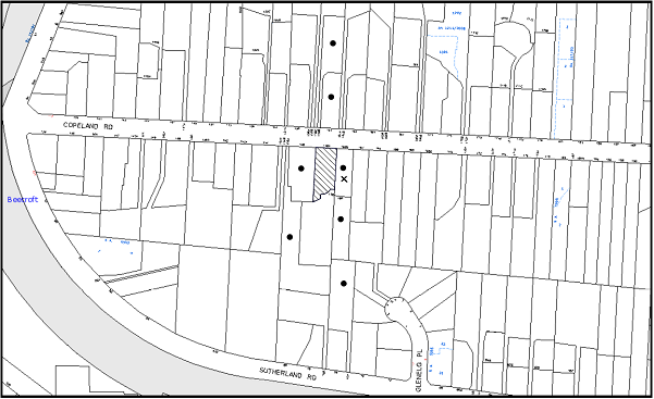
|
NOTIFICATION PLAN |
|
||
|
• PROPERTIES NOTIFIED
|
X SUBMISSIONS RECEIVED |
PROPERTY SUBJECT OF DEVELOPMENT |
|
|
1 SUBMISSION RECEIVED OUT OF MAP RANGE |
|||
Two submissions objected to the development, generally on the grounds that the development would result in:
· Unacceptable front setback;
· Unacceptable height of the proposed development;
· Design inconsistent with surrounding developments and the heritage conservation area;
· Unacceptable location of the garage;
· New driveway crossing;
· No landscape plan;
· The removal of trees;
· Retention of existing front fence;
· Request for application to be referred to Heritage Advisory Committee;
· Inaccurate Information; and
· Loss of privacy.
The merits of the matters raised in these submissions have been addressed in the body of the report with the exception of the following:
5.1.1 Unacceptable Front Setback
A submission has been received regarding the front setback of the proposal, noting that it is inconsistent with the setback of the dwelling-house on the adjoining property, No. 156 Copeland Road.
The front boundary setback of 7.6 metres complies with the 6 metre prescriptive measure of the Setbacks element within the Dwelling House DCP and would also be consistent with existing development in the immediate vicinity which has front boundary setbacks of between 7 and 8 metres.
The proposal meets the objectives of the Setbacks element and is considered acceptable.
5.1.2 Unacceptable Height of the Proposed Development
A submission has been received regarding the height of the proposal, expressing the view that the development should have the two storey component located only at the rear of the dwelling-house or the second storey should be located within the roof space, attic style.
The prescriptive measures of the Height element of the Dwelling-House DCP state that “two storey dwelling-houses should not exceed 9 metres in height”. The proposed development has a maximum height of 8.7 metres, which complies with this requirement.
The height of the proposal would be consistent with the surrounding development and would not create solar access issues or privacy impacts in relation to adjoining properties.
The proposal meets the objectives of the Height element and is considered acceptable.
5.1.3 Design Inconsistent with Surrounding Developments and Heritage Conservation Area
One submission has been received regarding the design of the proposal, noting that it would be inconsistent with the heritage values of the surrounding Beecroft/Cheltenham Heritage Conservation Area.
The application has included a palette of colours and materials that are generally sympathetic to the surrounding development. The Heritage Advisory Committee raised no objections to the design.
The proposal meets the objectives of the Design and Heritage elements and is considered acceptable.
5.1.4 Unacceptable Location of the Garage
Two submissions have been received regarding the location of the double garage and the need to remove trees to accommodate its location.
The garage would be located behind the building line and meets the prescriptive measures of the Setbacks element of the DCP.
No objections were raised on heritage grounds to the location of the garage and approval has been recommended for the removal of the trees on the site.
5.1.5 New Driveway Crossing
One submission has been received regarding the proposed “new driveway crossing”.
It is noted that the plans refer to a “new driveway” but not a “new driveway crossing”. The existing driveway to the east of the subject property serves to provide vehicular access to the battle-axe property at the rear, No. 158 Copeland Road.
The proposed “new driveway” for the subject property would be located immediately adjacent to this accessway in a manner that would be consistent with the surrounding development, where the majority of subdivided allotments have separate driveways and driveway crossings for each property.
5.1.6 No Landscape Plan
A submission has raised concerns that a landscape plan has not submitted with the application.
It is noted that whilst a landscape plan has not been included with this application, the plans that have been submitted demonstrate that adequate area would be available for future landscaping.
5.1.7 Retention of Existing Front Fence
A submission has been received regarding the existing front masonry fence, noting that it has been truncated at the side boundary without approval, together with a request that the “original fence be reinstated and a new fence, that would be sympathetic to the existing fence in front of No 156, be constructed across the rest of the front boundary of No. 158”.
The application does not propose to erect a new front boundary fence. Should the applicant wish to erect a front fence, it would be subject to separate development application.
5.1.8 Inaccurate Information
A submission has been received with respect to the ‘inaccuracy’ of the plans submitted with the application.
The plans are considered to be sufficiently accurate in detail and information to enable a full and proper assessment of the proposal to be made.
5.1.9 Privacy
A submission has been received regarding the loss of privacy at No. 160A Copeland Road from the proposed alfresco dining area and the in-ground swimming pool at the rear of the dwelling-house.
These aspects of the proposal would be located at ground floor level, which complies with the prescriptive measures of the Privacy element which seeks to have living and entertaining areas located on the ground floor only.
The proposal meets the objectives of the Privacy element and is considered acceptable.
5.2 Public Agencies
The development application was referred to NSW Rural Fire Service (RFS) for comment. No objections were raised to the proposal subject to conditions.
6. THE PUBLIC INTEREST
Section 79C(1)(e) of the Act requires Council to consider “the public interest”.
The public interest is an overarching requirement, which includes the consideration of the matters discussed in this report. Implicit to the public interest is the achievement of future built outcomes adequately responding to and respecting the future desired outcomes expressed in environmental planning instruments and development control plans.
The application is considered to have satisfactorily addressed Council’s and relevant agencies’ criteria and would provide a development outcome that, on balance, would result in a positive impact for the community. Accordingly, it is considered that the approval of the proposed development would be in the public interest.
CONCLUSION
The application proposes the erection of a two storey dwelling-house, a swimming pool and associated works on a vacant allotment.
The application does not comply with the Hornsby Shire Council Local Environmental Plan 1994 in respect to clause 15 ‘Floor Space Ratio’. The applicant submitted a State Environmental Planning Policy No. 1 objection to vary the floor space ratio development standard. The objection is considered well founded with regard to the existing development and the principles established by the Land and Environment Court.
Council received two submissions in response to notification of the proposed development. The matters raised have been addressed in the body of the report.
Having regard to the circumstances of the case and consideration of the SEPP 1 objection, approval of the application is recommended.
Note: At the time of the completion of this planning report, no persons have made a Political Donations Disclosure Statement pursuant to Section 147 of the Environmental Planning and Assessment Act 1979 in respect of the subject planning application.
|
Philip Vergison Acting Manager - Development Assessment Planning Division |
James Farrington Group Manager Planning Division |
|
1.View |
Locality Map |
|
|
|
2.View |
Floor Plan |
|
|
|
3.View |
Site Analysis Plan |
|
|
|
4.View |
Elevation Plan |
|
|
|
5.View |
Civil Engineering Stormwater Water Management Plans |
|
|
File Reference: DA/797/2013
Document Number: D02721858
SCHEDULE 1
GENERAL CONDITIONS
The conditions of consent within this notice of determination have been applied to ensure that the use of the land and/or building is carried out in such a manner that is consistent with the aims and objectives of the relevant legislation, planning instruments and Council policies affecting the land and does not disrupt the amenity of the neighbourhood or impact upon the environment.
Note: For the purpose of this consent, the term ‘applicant’ means any person who has the authority to act on or the benefit of the development consent.
Note: For the purpose of this consent, any reference to an Act, Regulation, Australian Standard or publication by a public authority shall be taken to mean the gazetted Act or Regulation, or adopted Australian Standard or publication as in force on the date that the application for a construction certificate is made.
1. Approved Plans and Supporting Documentation
The development must be carried out in accordance with the plans and documentation listed below and endorsed with Council’s stamp, except where amended by Council and/or other conditions of this consent:
Approved Plans:
|
Plan No. |
Drawn by |
Dated |
|
Drawing No. 1564 (pages 1-3 |
Distinct Innovations |
2.08.13 |
|
Drawing No. SW13301 – S1 & S2 – Site Stormwater Management Layout – Issue A (2 pages) |
Alw design |
26.07.13 |
Supporting Documents:
|
Document No. |
Prepared by |
Dated |
|
Arboricultural Impact Assessment |
Australis Tree Management |
29.10.13 |
2. Removal of Existing Trees
This development consent only permits the removal of trees numbered 2-4, 7,9,12-14,16,17 as identified Arboricultural Impact Assessment (Document D02649396) Proposed Site Map located in Appendix D prepared by Australis Tree Management dated 29.10.13. The removal of any other trees requires separate approval under Council’s Tree Preservation Order.
3. Construction Certificate
A construction certificate must be issued by Council or a Private Certifying Authority prior to the commencement of any works under this consent.
REQUIREMENTS PRIOR TO THE ISSUE OF A CONSTRUCTION CERTIFICATE
4. Building Code of Australia
All building work must be carried out in accordance with the relevant requirements of the Building Code of Australia.
5. Contract of Insurance (Residential Building Work)
In the case of residential building work for which the Home Building Act, 1989 requires there to be a contract of insurance in force in accordance with Part 6 of that Act, that such a contract of insurance is in force before any building work authorised to be carried out by the consent commences.
6. Notification of Home Building Act, 1989 Requirements
Residential building work within the meaning of the Home Building Act, 1989 must not be carried out unless the principal certifying authority for the development to which the work relates (not being Council) has given Council written notice of the following information:
a) In the case of work for which a principal contractor is required to be appointed:
i) The name and licence number of the principal contractor; and
ii) The name of the insurer by which the work is insured under Part 6 of that Act.
b) In the case of work to be done by an owner-builder:
i) The name of the owner-builder; and
ii) If the owner-builder is required to hold an owner-builder’s permit under that Act, the number of the owner-builder’s permit.
Note: If arrangements for doing the residential building work are changed while the work is in progress so that the information notified becomes out of date, further work must not be carried out unless the principal certifying authority for the development to which the work relates (not being Council) has given Council written notification of the updated information.
7. Sydney Water – Quick Check
This application must be submitted to a Sydney Water ‘Quick Check Agent’ or ‘Customer Centre’ for approval to determine whether the development would affect any Sydney Water infrastructure, and whether further requirements are to be met.
Note: Refer to www.sydneywater.com.au or telephone 13 20 92 for assistance.
8. Design and Construction - Bushfire Attack Category
New construction must comply with the current Australian Standard AS3959 ‘Construction of buildings in bush fire-prone areas’ in accordance with the Bushfire Attack Level (BAL) and section A3.7 Addendum Appendix 3 of Planning for Bushfire Protection indicated below, together with conditions based on Planning for Bush Fire Protection 2006, as follows:-
a) The southern, eastern and western elevations must comply with section 3 and 7 (BAL 29);
b) The northern elevation must comply with Sections 3 and 6 (BAL 19); and
c) Water, electricity and gas must comply with section 4.1.3 of Planning for Bushfire Protection 2006.
Note: Timbers treated with an applied intumescent paint are no longer recognised by the Rural Fire Service as a fire retardant treated timber or a performance option to increase fire resistance.
REQUIREMENTS PRIOR TO THE COMMENCEMENT OF ANY WORKS
9. Erection of Construction Sign
A sign must be erected in a prominent position on any site on which building work, subdivision work or demolition work is being carried out:
a) Showing the name, address and telephone number of the principal certifying authority for the work;
b) Showing the name of the principal contractor (if any) for any demolition or building work and a telephone number on which that person may be contacted outside working hours; and
c) Stating that unauthorised entry to the work site is prohibited.
Note: Any such sign is to be maintained while the building work, subdivision work or demolition work is being carried out, but must be removed when the work has been completed.
10. Toilet Facilities
Toilet facilities must be available or provided at the works site before works begin and must be maintained until the works are completed at a ratio of one toilet for every 20 persons employed at the site. Each toilet must:
a) be a standard flushing toilet connected to a public sewer; or
b) be a temporary chemical closet approved under the Local Government Act, 1993; or
c) have an on-site effluent disposal system approved under the Local Government Act, 1993.
11. Tree Protection Barriers
Tree protection fencing must be erected around trees numbered 1, 5, 6, 8, 10, 15, and 18 to be retained at a setback as described in the arboricultural impact assessment reference D02649396. The tree fencing must be constructed of 1.8 metre ‘cyclone chainmesh fence’ or star pickets spaced at 2 metre intervals, connected by a continuous high-visibility barrier/hazard mesh at a height of 1 metre.
12. Erosion and Sediment Control
Erosion and sediment control measures must be provided and maintained throughout the construction period in accordance with the manual ‘Soils and Construction 2004 (Bluebook)’, the approved plans, Council specifications and to the satisfaction of the principal certifying authority. The erosion and sediment control devices must remain in place until the site has been stabilised and revegetated.
Note: On the spot penalties up to $1,500 may be issued for any non-compliance with this requirement without any further notification or warning.
13. Bushfire Management – Protection Zones
At the commencement of building works and in perpetuity the entire property must be managed as an Inner Protection Area (IPA) as outlined within section 4.1.3 and Appendix 5 of “Planning for Bush Fire Protection 2006” and the NSW Rural Fire Service’s document “Standards for asset protection zones”.
REQUIREMENTS DURING CONSTRUCTION
14. Construction Work Hours
All work on site (including demolition and earth works) must only occur between 7am and 5pm Monday to Saturday. No work is to be undertaken on Sundays or public holidays.
15. Works Near Trees
a) All required tree protection measures are to be maintained in good condition for the duration of the construction period; and
b) All works (including driveways and retaining walls) within 9 metres of any trees required to be retained (whether or not on the subject property, and pursuant to this consent or the Tree Preservation Order), must be carried out under the supervision of an ‘AQF Level 5 Arborist’ and a certificate submitted to the principal certifying authority detailing the methods used to preserve the trees.
Note: Except as provided above, the applicant is to ensure that no excavation, filling or stockpiling of building materials, parking of vehicles or plant, disposal of cement slurry, waste water or other contaminants is to occur within 4 metres of any tree to be retained.
16. Council Property
During construction works, no building materials, waste, machinery or related matter is to be stored on the road or footpath. The public reserve must be kept in a clean, tidy and safe condition at all times.
17. Disturbance of Existing Site
During construction works, the existing ground levels of open space areas and natural landscape features, (including natural rock-outcrops, vegetation, soil and watercourses) must not be altered unless otherwise nominated on the approved plans.
18. Survey Report – Finished Floor Level
A report(s) must be prepared by a registered surveyor and submitted to the principal certifying authority prior to the pouring of concrete at each level of the building certifying that:
a) The building, retaining walls and the like have been correctly positioned on the site; and
b) The finished floor level(s) are in accordance with the approved plans.
REQUIREMENTS PRIOR TO THE ISSUE OF AN OCCUPATION CERTIFICATE
Note: For the purpose of this consent, a reference to ‘occupation certificate’ shall not be taken to mean an ‘interim occupation certificate’ unless otherwise stated.
19. Fulfilment of BASIX Commitments
The applicant must demonstrate the fulfilment of BASIX commitments pertaining to the development.
20. Stormwater Drainage
The stormwater drainage system for the development must be designed and constructed for an average recurrence interval of 20 years and be gravity drained and connected to an existing inter-allotment drainage system.
21. On Site Stormwater Detention
An on-site stormwater detention system must be designed by a chartered civil engineer and constructed in accordance with the following requirements:
a) Have a capacity of not less than 5 cubic metres, and a maximum discharge (when full) of 8 litres per second;
b) Have a surcharge/inspection grate located directly above the outlet;
c) Discharge from the detention system to be controlled via 1 metre length of pipe, not less than 50 millimetres diameter or via a stainless plate with sharply drilled orifice bolted over the face of the outlet discharging into a larger diameter pipe capable of carrying the design flow to an approved Council system;
d) Where above ground and the average depth is greater than 0.3 metres, a ‘pool type’ safety fence and warning signs to be installed; and
e) Not be constructed in a location that would impact upon the visual or recreational amenity of residents.
22. Internal Driveway/Vehicular Areas
The driveway and parking areas on site must be designed in accordance with Australian Standards 2890.1, 2890.2, 3727 and the following requirements:
a) Design levels at the front boundary must be obtained from Council;
b) The driveway must be a rigid pavement; and
c) The driveway grade must not exceed 25 percent and changes in grade must not exceed 8 percent.
23. Vehicular Crossing
A separate application under the Local Government Act, 1993 and the Roads Act, 1993 must be submitted to Council for the installation of a new vehicular crossing. The vehicular crossing must be constructed in accordance with Council’s Civil Works Design, 2005 and the following requirements:
a) Approval must be obtained from all relevant utility providers that all necessary conduits be provided and protected under the crossing; and
b) The edge of the vehicular crossing should a minimum 500 mm clear of the electricity pole and if relocation is necessary it should be carried out to the requirements of the relevant authority.
Note: An application for a vehicular crossing can only be made to one of Council’s Authorised Vehicular Crossing Contractors. You are advised to contact Council on 02 9847 6940 to obtain a list of contractors.
24. Creation of Easements
The following matter(s) must be nominated on the plan of subdivision under s88B of the Conveyancing Act 1919:
a) The creation of an appropriate "Positive Covenant" and "Restriction as to User" over the constructed on-site detention/retention systems and outlet works, within the lots in favour of Council in accordance with Council’s prescribed wording. The position of the on-site detention system is to be clearly indicated on the title; and
b) To register the OSD easement, the restriction on the use of land “works-as-executed” details of the on-site-detention system must be submitted verifying that the required storage and discharge rates have been constructed in accordance with the design requirements. The details must show the invert levels of the on site system together with pipe sizes and grades. Any variations to the approved plans must be shown in red on the “works-as-executed” plan and supported by calculations.
Note: Council must be nominated as the authority to release, vary or modify any easement, restriction or covenant.
25. Maintain Canopy Cover
To maintain canopy cover, 3 trees selected from Council’s booklet ‘Indigenous Plants for the Bushland Shire’ http://www.hornsby.nsw.gov.au/services/trees/indigenous-trees) such as Syncarpia glomulifera (turpentine), Eucalyptus pilularis (Blackbutt), Angophora costata (Sydney Red Gum) must be planted within the property. The planting location must not be within 4 metres of the foundation walls of the proposed dwelling-house or in-ground pool.
Note: A certificate from suitably qualified and experienced horticulturalist is to be submitted to the Principal Certifying Authority stating that all plant stock meet the specifications outlined in Specifying Trees’ (Ross Clark, NATSPEC Books) and that the planting methods were current professional (best practice) industry standards at the time of planting.
26. Damage to Council Assets
Any damage caused to Council’s assets as a result of the construction of the development must be rectified in accordance with Council’s written requirements and at the sole cost of the applicant.
OPERATIONAL CONDITIONS
27. Swimming Pool Requirements
The construction and operation of the swimming pool must comply with the provisions of the Swimming Pool Act 1992, the Swimming Pool Regulation, 2008, Australian Standards 1926.1-3 – Swimming Pool Safety and the following requirements:
a) All waste water from the pool’s filtration system must be piped to Sydney Water’s sewer system. In the event that Sydney Water’s sewer system is not accessible, a filtration system that does not require backwashing must be installed;
b) The filtration motor and pump, or spa heater and blower unit must be housed in a soundproofed structure. Sound from the equipment must not exceed 5(dBA) above ambient noise levels at any residential property boundary; and
c) The applicant must participate in the ‘Static Water Supply Project’ initiative of the NSW Fire Brigade, to make available the water in the swimming pool for use as a static water supply for fire fighting purposes by the NSW Fire Brigade or the NSW Rural Fire Service.
Note: On completion of the swimming pool, the applicant is to contact the local NSW Fire Brigade Station or NSW Rural Fire Service Station to arrange the installation of a static water supply identification plate.
- END OF CONDITIONS -
ADVISORY NOTES
The following information is provided for your assistance to ensure compliance with the Environmental Planning and Assessment Act, 1979, Environmental Planning and Assessment Regulation 2000, other relevant legislation and Council’s policies and specifications. This information does not form part of the conditions of development consent pursuant to Section 80A of the Act.
Environmental Planning and Assessment Act, 1979 Requirements
The Environmental Planning and Assessment Act, 1979 requires:
· The issue of a construction certificate prior to the commencement of any works. Enquiries can be made to Council’s Customer Services Branch on 9847 6760;
· a principal certifying authority to be nominated and Council notified of that appointment prior to the commencement of any works;
· Council to be given at least two days written notice prior to the commencement of any works;
· mandatory inspections of nominated stages of the construction inspected; and
· an occupation certificate to be issued before occupying any building or commencing the use of the land.
Long Service Levy
In accordance with Section 34 of the Building and Construction Industry Long Service Payments Act 1986, a ‘Long Service Levy’ must be paid to the Long Service Payments Corporation or Hornsby Council.
Note: The rate of the Long Service Levy is 0.35% of the total cost of the work.
Note: Hornsby Council requires the payment of the Long Service Levy prior to the issue of a construction certificate.
Tree Preservation Order
To ensure the maintenance and protection of the existing natural environment, it is an offence to ringbark, cut down, top, lop, remove, wilfully injure or destroy a tree outside 3 metres of the approved building envelope without the prior written consent from Council.
Note: A tree is defined a s a single or multi-trunked wood perennial plant having a height of not less than three (3) metres, and which develops many branches, usually form a distance of not less than one (1) metre from the ground, but excluding any plant which, in its particular location, is a noxious plant declared as such pursuant to the Noxious Weeds Act 1993. This definition of ‘tree’ includes any and all types of Palm trees.
All distances are determined under Australian Standard AS4970-2009 “Protection of Trees on Development Sites”.
Fines may be imposed for non-compliance with Council’s Tree Preservation Order.
Dial Before You Dig
Prior to commencing any works, the applicant is encouraged to contact Dial Before You Dig on 1100 or www.dialbeforeyoudig.com.au for free information on potential underground pipes and cables within the vicinity of the development site.
Asbestos Warning
Should asbestos or asbestos products be encountered during demolition or construction works, you are advised to seek advice and information prior to disturbing this material. It is recommended that a contractor holding an asbestos-handling permit (issued by WorkCover NSW) be engaged to manage the proper handling of this material. Further information regarding the safe handling and removal of asbestos can be found at:
Alternatively, telephone the WorkCover Asbestos and Demolition Team on 8260 5885.
Group Manager’s Report No. PL1/14
Planning Division
Date of Meeting: 12/02/2014
5 DEVELOPMENT APPLICATION - SUBDIVISION INVOLVING THE REALIGNMENT OF THE BOUNDARIES OF TWO ALLOTMENTS - 146A AND 148 ARCADIA ROAD, ARCADIA
EXECUTIVE SUMMARY
|
DA No: |
DA/1046/2012 (Lodged 10 October 2012) |
|
Description: |
Subdivision involving the realignment of the boundaries of two allotments |
|
Property: |
Lot 5 DP 232364, Nos. 146A and 148 Arcadia Road, Arcadia |
|
Applicant: |
Don Fox Planning |
|
Owner: |
Mrs Bronwyn Joyce Geeve, Mr Matthew John Geeve |
|
Estimated Value: |
Nil |
|
Ward: |
A |
· The application proposes a subdivision involving the realignment of the boundaries of two allotments. No additional lots are proposed to be created.
· The proposal does not comply with the minimum lot size pursuant to Clause 14 of the Hornsby Shire Local Environmental Plan 1994. The applicant has made a submission pursuant to State Environmental Planning Policy No. 1 – Development Standards to vary the 2 hectare minimum allotment size development standard. The submission is considered well founded and is supported.
· No submissions have been received in respect of the application.
· It is recommended that Council seek the concurrence of the Director-General of the Department of Planning and Infrastructure to approve the application.
|
THAT Council seek the concurrence of the Director-General of the Department of Planning and Infrastructure pursuant to State Environmental Planning Policy No. 1 and approve Development Application No. DA/1046/2012 for subdivision involving the realignment of the boundaries of two allotments at Lot 5 DP 232364, Nos. 146A and 148 Arcadia Road, Arcadia subject to the conditions of consent detailed in Schedule 1 of Group Manager’s Report No. PL1/14. |
BACKGROUND
In 1968, Lot 5 was created for road widening by the RMS (previously called RTA). In 1991, the road widening order was wholly rescinded by the RMS as it was deemed unnecessary. Lot 5 is no longer affected by any RMS road widening proposal.
SITE
The site is known as Lots 4 and 5 in DP 232346, Nos. 146A and 148 Arcadia Road, Arcadia and is located on the corner of Arcadia Road and Geelans Road. The site comprises a rural holding with a total area of 1.99ha. The site is generally rectangular in shape with an access handle from Geelans Road.
The site has a fall of 8 metres towards Arcadia Road.
The surrounding land uses include horticulture, mixed grazing and other farming pursuits and rural residential use. The site is south of Arcadia Park on Arcadia Road which is an open space recreation area.
Lot 4 is irregular in shape and has an area of 1.661ha. The lot contains an existing rural dwelling, outbuildings and a dam. Access to the lot is via an existing driveway fronting Arcadia Road.
Lot 5 is an irregular battleaxe allotment and has an area of 3,360m2. The lot was created for road widening and was rescinded in 1991 by the RMS. The site is currently vacant and is mapped with Critically Endangered Ecological Community, containing Sydney Turpentine Ironbark Forest.
PROPOSAL
The application proposes a boundary adjustment between Nos. 146A and 148 Arcadia Road, Arcadia.
The applicant originally proposed subdivision of the land on an east/ west alignment which included subdivision of that part of the land zoned Special Uses B (Transport Corridor) which is prohibited under the Hornsby Local Environmental Plan 1994. The application was subsequently amended to a north/south alignment.
The proposal would result in No. 146A Arcadia Road (proposed Lot 42) increasing in area from 0.336ha to 1.03ha and No. 148 Arcadia Road (proposed Lot 41) decreasing in area from 1.661ha to 0.961ha. The purpose of the boundary adjustment, as stated by the applicant, is to regularise the layout of the two existing allotments to create conventional rural allotments. The proposal would not result in an increase in the number of lots.
Proposed Lot 41 will continue to use the existing driveway fronting Arcadia Road and proposed Lot 42 will use an existing access handle off Geelans Road.
The application also proposes dedication of splay corners to Council, located on the north western side of Proposed Lot 42, along Arcadia Road and south western side of Proposed Lot 42, corner of Arcadia Road and Geelans Road.
ASSESSMENT
The development application has been assessed having regard to the ‘Metropolitan Plan for Sydney 2031’, the ‘North Subregion (Draft) Subregional Strategy’ and the matters for consideration prescribed under Section 79C of the Environmental Planning and Assessment Act 1979 (the Act). The following issues have been identified for further consideration.
1. STRATEGIC CONTEXT
1.1 Metropolitan Plan for Sydney and (Draft) North Subregional Strategy
The (Draft) Metropolitan Strategy for Sydney 2031 is a broad framework to provide for Sydney’s growth to help plan for housing, employment, transport, infrastructure, the environment and open space. It outlines a vision for Sydney to 2031; the challenges faced, and the directions to follow to address these challenges and achieve the vision.
The North Subregion comprises Hornsby, Kuring-gai, Manly, Warringah and Pittwater Local Government Areas. The Draft North Subregional Strategy provided a framework for Council in its preparation of the HLEP 2013.
Within the North Subregion, the Draft Metropolitan Strategy proposes:
· Population growth of 81,000 from the current 2011 baseline of 529,000
· Housing growth of 37,000 from the current 2011 baseline of 204,000
· Employment growth of 39,000 from the current 2011 baseline of 186,000
The proposed development would be consistent with the Metropolitan Plan for Sydney 2031 by providing two regular shaped allotments capable of accommodating dwelling-houses.
2. STATUTORY CONTROLS
Section 79C(1)(a) requires Council to consider “any relevant environmental planning instruments, draft environmental planning instruments, development control plans, planning agreements and regulations”.
2.1 Hornsby Shire Local Environmental Plan 1994
The subject land is zoned Special Uses B (Transport Corridor) and Rural BA (Small Holdings—Agricultural Landscapes) under the Hornsby Shire Local Environmental Plan 1994 (HSLEP).
The objectives of the Special Uses B (Transport Corridor) zone are:
(a) to provide for the transport needs of the community.
(b) to identify land for the provision of transportation networks and facilities.
(c) to preserve land identified for community purposes and transport corridors.
The objectives of the Rural BA (Small Holdings—Agricultural Landscapes) zone are:
(a) to restrain population growth, maintain the rural character of the area and ensure that existing or potentially productive agricultural land is preserved.
(b) to promote agricultural use of land and provide for a range of compatible land uses which maintain the agricultural and rural environment of the area.
(c) to ensure development is carried out in a manner that improves the environmental qualities, and is within the servicing capacity, of the area.
The proposed development is defined as ‘subdivision’ under the HSLEP and is permissible in the Rural BA (Small Holdings – Agricultural Landscapes) zone with Council’s consent, and is prohibited in the Special Uses B (Transport Corridor) zone.
Notwithstanding, the application proposes to realign the boundary between the two existing lots which would result in proposed Lot 42 being zoned part Special Uses B and part Rural BA, and proposed Lot 41 would be zoned Rural BA. The realignment would not result in subdivision of the existing land (Lot 5) zoned Special Uses B, and therefore the proposal is permissible with Council’s consent.
The boundary adjustment would not result in an additional dwelling entitlement on either allotment and would provide a more regular allotment layout. Therefore, the proposed development is consistent with the zone objectives.
Clause 14 of the HSLEP prescribes that the minimum area per allotment within the Rural BA zone is 2 hectares. The existing allotments and the allotments that would result from the proposed boundary adjustment do not comply with the minimum lot area requirement. In this regard, the application is supported by a submission pursuant to State Environmental Planning Policy No. 1 Development Standards (SEPP 1) to vary the minimum allotment size development standard. This matter is addressed in Section 2.3 of this report.
Clause 18 of the HSLEP sets out heritage conservation provisions for Hornsby Shire. The subject site is not an item of environmental heritage and is not located within a heritage conservation area. Therefore, no further assessment in this regard is necessary.
2.2 Hornsby Local Environmental Plan 2013
The Hornsby Local Environmental Plan 2013 (HLEP) was made on 27 September 2013 and came into effect on 11 October 2013. The HLEP includes a savings provision stating that if a development application is made and not finally determined before the commencement of the HLEP, the application must be determined as if the Plan had been exhibited but not commenced. The relevant provisions of the HLEP are addressed below.
Under the HLEP, the subject lots are zoned RU4 Primary Production Small Lots and “subdivision” is permissible within the zone with Council’s consent.
Clause 4.6 – ‘Exemptions to development standards’ states that ‘development consent must not be granted under this clause for a subdivision of land in zone RU4 Primary Production Small Lots if the subdivision will result in 2 or more lots of less than the minimum area specified for such lots by a development standard, or the subdivision will result in at least one lot that is less than 90% of the minimum area specified for such a lot by a development standard’.
The proposed development would result in two lots of less than 90% of the minimum of 2 hectare lot size development standard specified for this zone under the HLEP and accordingly, the clause would prohibit the proposed development.
The provisions of HLEP are a matter for consideration under Section 79C(1)(a)(ii) of the Environmental Planning and Assessment Act 1979 but such consideration should not be determinative to the application. In this regard, the subdivision is permissible development under the HSLEP 1994 and the submitted objection to the minimum lot area development standard is considered well founded and is supported as discussed in Section 2.3.
2.3 State Environmental Planning Policy No. 1 – Development Standards
The application has been assessed against the requirements of State Environmental Planning Policy No. 1 – Development Standards (SEPP 1). This Policy provides State-wide planning controls for flexibility in the application of development standards in circumstances where strict compliance with those standards would, in any particular case, be unreasonable or unnecessary or tend to hinder the attainment of the objectives of the Act.
The applicant has submitted an objection against Council’s adherence to the minimum 2 hectare lot size development standard under Clause 14 of the HSLEP. The two proposed lots are 1.030 hectares and 0.961 hectares respectively.
The Land and Environment Court has expressed the view that there are five different ways in which an objection may be well founded and that approval of the objection may be consistent with the aims of the Policy:
1. The objectives of the standard are achieved notwithstanding non-compliance with the standards;
2. The underlying objective or purpose of the standard is not relevant to the development and therefore compliance is unnecessary;
3. The underlying object or purpose would be defeated or thwarted if compliance was required and therefore compliance is unreasonable;
4. The development standard has been virtually abandoned or destroyed by the Council’s own actions in granting consents departing from the standard and hence compliance with the standard is unnecessary and unreasonable;
5. The zoning of the particular land is unreasonable or inappropriate so that a development standard appropriate for that zoning is also unreasonable and unnecessary as it applies to the land and compliance with the standard would be unreasonable or unnecessary. That is, the particular parcel of land should not have been included in the particular zone.
The applicant’s objection is made with regard to the above five point test and the objectives of the Rural BR (Small Holdings – Rural Landscapes) Zone and includes the following statement:
To require strict compliance with the minimum site area requirement for allotments within the Rural BR Zone is considered both unreasonable and unnecessary for the following reasons:
· The proposal is consistent with the objectives of the zone, the objectives of the density/lot size development standard and other provisions of Hornsby LEP 1994 relating to the development of rural land for residential purpose.
· The proposal does not increase the total number of lots and will not modify the existing streetscape or character of the locality.
· The proposal will maintain the pattern of rural development in the area following rescission of the road acquisition order.
· The proposed boundary adjustment will resolve conflicts between planning constraints, environmental constraints and easements on the land to enable the erection of a dwelling on a more suitable and conventional area of the site.
· The proposed subdivision is considered to be compatible with the existing surrounding subdivision pattern which contains lots of similar or smaller size, namely Nos. 4-6 Sallaway Road, Galston with areas of 3,259m2 and 18,843m2, No. 63 Arcadia Road, Galston with areas of 1.136 ha and 1.135 ha.
· The proposal will enhance the rural nature of the area by regularising the current lot layout and will not diminish the prospect of the landowners engaging in agriculture or other rural pursuits.
· The departure from the minimum allotment size requirement will not impact upon the density, given a dwelling-house is permissible with consent on both the lots.
The applicant’s objection to the 2 hectare minimum lot size development standard is considered well founded and is supported for the following reasons:
(a) the proposal completes the pattern of development following the closure of the road reservation through adjoining land;
(b) the proposal maintains the linear pattern of rural development along Arcadia Road and is consistent with the pattern of development in the surrounding area;
(c) the proposal would not detract from the rural character of the area given the number of rural lots in the locality that are less than 2 hectares in size notwithstanding the Rural BA zoning; and
(d) the proposal would not result in a precedent given the unique circumstances of the case involving existing undersized lots formed by a road reservation.
The approval of the Director-General of the Department of Planning and Infrastructure is required for the proposed rural subdivision in accordance with Planning Circular PS 08-003 concerning variation to development standards. In accordance with the Circular, approval of the Director-General is required as more than one allotment does not comply with the minimum allotment size and the variation sought is greater than 10%.
2.4 Sydney Regional Environmental Plan No. 20 – Hawkesbury Nepean River
The site is located within the catchment of the Hawkesbury Nepean River. Part 2 of this Plan contains general planning considerations and strategies requiring Council to consider the impacts of development on water quality, aquaculture, recreation and tourism.
The proposed subdivision does not require any works and would maintain the rural use of the land. The proposal would therefore not adversely impact on the Hawkesbury Nepean River.
2.5 State Environmental Planning Policy No. 55 - Remediation of Land
The Policy provides for the remediation of contaminated land to reduce risks to human health and the environment and includes provision for identifying potentially contaminated land and standards for remediation.
The site has a low intensive agricultural use, includes bushland and an existing dwelling house. The site of a future dwelling on proposed Lot 101 would be subject to preliminary investigation for any land contamination.
2.6 Section 100B - Rural Fires Act 1997
The proposed subdivision is within a bushfire prone area and is ‘integrated development’ subject to approval of the NSW Rural Fire Service for the issue of a Bushfire Safety Authority.
The NSW Rural Fire Service has granted approval, with no specific conditions.
2.7 Section 94 Contribution
A Section 94 contribution levy would not be applicable as the proposed development would not result in an additional lot.
2.8 Clause 74BA Environmental Planning and Assessment Act, 1979 - Purpose and Status of Development Control Plans
On 1 March 2013, the Environmental Planning and Assessment Act, 1979 was amended so that a DCP provision will have no effect if it has the practical effect of “preventing or unreasonably restricting development” that is otherwise permitted and complies with the development standards set out in relevant Local Environmental Plans and State Environmental Planning Policies.
The principal purpose of a development control plan is to provide guidance on the aims of any environmental planning instrument that applies to the development; facilitating development that is permissible under any such instrument; and achieving the objectives of land zones under any such instrument. The provisions of a development control plan made for that purpose are not statutory requirements.
2.9 Rural Development Control Plan
The proposed development has been assessed having regard to the relevant performance and prescriptive requirements within Council’s Rural Lands Development Control Plan (Rural Lands DCP). The following table sets out the proposal’s compliance with the prescriptive requirements of the Plan:
|
Rural Lands Development Control Plan |
|||
|
Control |
Proposal |
Requirement |
Compliance |
|
Density Lot 41 Lot 42 |
1.030 hectares 0.961 hectares |
2 hectares 2 hectares |
No No |
|
Setback Lot 41 - Existing dwelling - road - side (west) - side (east) - rear Lot 42 - Building Envelope - road - side (west) - side (east) - rear |
23m 11m 3.5m 63m
44m 38m 10m 58m |
15m 15m 15m 15m
15m 15m 15m 15m |
Yes No No Yes
Yes Yes No Yes |
As detailed in the above table, the proposed development does not comply with the lot size and setback prescriptive requirements within Council’s Rural Lands DCP. The matters of non-compliance are detailed below, as well as a brief discussion on compliance with relevant performance requirements.
2.9.1 Subdivision
The proposed lots are less than the minimum 2 hectare lot size. Notwithstanding, the lots are consistent with other small lots in the locality including:
No. 60 Arcadia Road Galston 0.777 hectares
No. 69 Arcadia Road Galston 1.127 hectares
No. 63 Arcadia Road Galston 1.135 hectares
No. 4-6 Sallaway Road Galston 0.326 hectares and 1.884 hectares
No. 10 Thomas Road Galston 0.606 hectares
No. 18 Thomas Road Galston 1.012 hectares
No. 20 Thomas Road Galston 0.404 hectares
No. 22 Thomas Road Galston 0.405 hectares
In this regard, the proposed lot sizes would be compatible with the character of the surrounding area and retain the rural character. This matter has been discussed under Section 2.3 of this report.
The proposal meets the objectives of the Subdivision element and is considered acceptable.
2.9.2 Setbacks
The existing dwelling- house and outbuilding on proposed Lot 41 would not comply with the 15 metre side (east) setback requirement. Given that the dwelling-house and the outbuilding are existing structures, would not be visible from public roads and would be keeping with the rural appearance, the proposal is considered acceptable with respect to the setbacks of the dwelling-house.
The building envelope on proposed Lot 42 does not comply with the eastern side setback requirement. The proposed building envelope is indicative only and any new development proposed on site would be subject to a future application. Notwithstanding, the indicative setback would provide for appropriate separation between dwellings and opportunities for landscaping.
The proposal meets the objectives of the Setbacks element and is considered acceptable.
2.9.3 Drainage Control
The proposed subdivision does not involve any works and would not impact on the existing drainage system. The proposed Lot 42 provides sufficient space to accommodate any future onsite detention and absorption systems.
2.9.4 Flora and Fauna Protection
The site includes Sydney Turpentine Ironbark Forest (STIF), an endangered ecological community. Council’s environmental assessment concludes that the proposed development would not have a detrimental impact upon the STIF, as the proposed building envelope is located well outside the STIF area.
2.9.5 Visual Amenity
The proposed subdivision would not require any works, the removal of any trees or construction of vehicle crossings and would have minimal impact on views and vistas.
The existing allotment 5 has a dwelling entitlement. The erection of a dwelling on the existing allotment would impact on significant trees and encroach within setback areas. The proposal would result in regular shaped allotments with opportunity for greater setbacks and landscaping around a future dwelling on proposed Lot 42.
2.9.6 Dedication of Splay Corners
The application proposes dedication of splay corners at the corner of Geelans Road and Arcadia Road, and Arcadia Road at the north western corner of Proposed Lot 42, to Council. This proposal would provide a better vehicular and pedestrian sightline and would reduce traffic safety issues. Council’s assessment supports this proposal subject to a condition that the dedication of splay corners to Council is to be at applicant’s cost.
2.9.7 Effluent Disposal
The on-site waste water management system for the existing dwelling-house on proposed Lot 41 is contained within the proposed lot and is considered satisfactory. The proposed Lot 42 provides sufficient space to accommodate any future on-site waste water management system.
3. ENVIRONMENTAL IMPACTS
Section 79C(1)(b) of the Act requires Council to consider “the likely impacts of that development, including environmental impacts on both the natural and built environments, and social and economic impacts in the locality”.
3.1 Natural Environment
The site includes STIF, an endangered ecological community. The proposed subdivision would be unlikely to have a significant impact on threatened species, populations and communities and their habitat as listed under the Threatened Species Conservation Act 1995, as the proposed building envelope is located well outside the STIF.
3.2 Built Environment
The proposed subdivision retains the existing dwelling, outbuildings and driveways. The proposed subdivision layout provides opportunity for a future dwelling-house on the vacant Lot (proposed Lot 42) with greater setbacks, landscaped area and would minimise the impact on the STIF than the current subdivision layout would. This would overall result in a better outcome for the natural and built environment.
3.3 Social Impacts
The proposal would not result in a social impact.
3.4 Economic Impacts
The proposal would have a minor positive impact on the local economy by generating an increase in demand for local services.
4. SITE SUITABILITY
Section 79C(1)(c) of the Act requires Council to consider “the suitability of the site for the development”.
4.1 Bushfire Risk
The land is identified as being subject to bushfire risk from bushland within the property and neighbouring properties. The NSW Rural Fire Service has issued general terms of approval with no specific conditions.
5. PUBLIC PARTICIPATION
Section 79C(1)(d) of the Act requires Council to consider “any submissions made in accordance with this Act”.
5.1 Community Consultation
The proposed development was placed on public exhibition and was notified to adjoining and nearby landowners between 30 October 2012 and 20 November 2012 in accordance with Council’s Notification and Exhibition Development Control Plan. During this period, Council received no submissions. The map below illustrates the location of the development site.
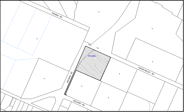
|
NOTIFICATION PLAN |
|
||
|
• PROPERTIES NOTIFIED
|
X SUBMISSIONS RECEIVED |
PROPERTY SUBJECT OF DEVELOPMENT |
|
5.2 Public Agencies
The development application is Integrated Development under the Act. Accordingly, the application was referred to the NSW Rural Fire Service for comment. As previously stated, the NSW Rural Fire Service has issued general terms of approval with no specific conditions.
6. THE PUBLIC INTEREST
Section 79C(1)(e) of the Act requires Council to consider “the public interest”.
The public interest is an overarching requirement, which includes the consideration of the matters discussed in this report. Implicit to the public interest is the achievement of future built outcomes adequately responding to and respecting the future desired outcomes expressed in environmental planning instruments and development control plans.
The application is considered to have satisfactorily addressed Council’s and relevant agencies’ criteria and would provide a development outcome that, on balance, would result in a positive impact for the community. Accordingly, it is considered that the approval of the proposed development would be in the public interest.
CONCLUSION
The proposed development is for subdivision involving the realignment of the boundaries of two allotments.
The proposed subdivision is considered satisfactory in maintaining the rural character of the locality, notwithstanding non-compliance with the minimum lot size applicable for the subject Rural BA zone. A number of allotments in the locality are less than the minimum 2 hectare development standard.
The applicant’s submitted SEPP 1 objection to the development standard is considered well founded with regard to the planning principles established by the Land and Environment Court.
The circumstances of the application are considered to be unique with the existing 2 under sized lots. The proposal would maintain the pattern of rural development following un-acquired land for road widening and in this regard would not establish an undesirable precedent for smaller rural lot subdivision.
The proposed subdivision is considered acceptable with regard the provisions of the relevant environmental planning instruments applicable to the site, the Rural Lands DCP and the requirements of the NSW Rural Fire Service.
The application is recommended for approval.
Note: At the time of the completion of this planning report, no persons have made a Political Donations Disclosure Statement pursuant to Section 147 of the Environmental Planning and Assessment Act 1979 in respect of the subject planning application.
|
Cassandra Williams Team Leader - Major Applications Planning Division |
James Farrington Group Manager Planning Division |
|
1.View |
Locality Plan |
|
|
|
2.View |
Proposed Subdivision Plan |
|
|
File Reference: DA/1046/2012
Document Number: D02738999
SCHEDULE 1
GENERAL CONDITIONS
The conditions of consent within this notice of determination have been applied to ensure that the use of the land and/or building is carried out in such a manner that is consistent with the aims and objectives of the relevant legislation, planning instruments and Council policies affecting the land and does not disrupt the amenity of the neighbourhood or impact upon the environment.
Note: For the purpose of this consent, the term ‘applicant’ means any person who has the authority to act on or the benefit of the development consent.
Note: For the purpose of this consent, any reference to an Act, Regulation, Australian Standard or publication by a public authority shall be taken to mean the gazetted Act or Regulation, or adopted Australian Standard or publication as in force on the date that the application for a construction certificate is made.
1. Approved Plans and Supporting Documentation
The development must be carried out in accordance with the plans and documentation listed below and endorsed with Council’s stamp, except where amended by Council and/or other conditions of this consent:
|
Plan No./ Title |
Drawn by |
Dated |
|
Drg No. DET1 - Plan of Proposed Subdivision |
Mepstead & Associates |
18/12/2013 |
|
Document Title |
Prepared by |
Dated |
|
Bushfire Hazard Assessment Report |
Building Code & Bushfire Hazard Solutions |
13 June 2003 |
REQUIREMENTS PRIOR TO THE ISSUE OF A SUBDIVISION CERTIFICATE
Note: For the purpose of this consent, a reference to ‘occupation certificate’ shall not be taken to mean an ‘interim occupation certificate’ unless otherwise stated:
2. Sydney Water – s73 Certificate
An s73 Certificate must be obtained from Sydney Water.
3. Dedication of Splay Corners
Splay corners at Geelans/Arcadia Roads and Arcadia Road at north western corner of proposed Lot 42 shall be dedicated to Council at no cost to Council.
4. Damage to Council Assets
Any damage caused to Council’s assets as a result of the construction of the development must be rectified in accordance with Council’s written requirements and at the sole cost of the applicant.
- END OF CONDITIONS -
ADVISORY NOTES
The following information is provided for your assistance to ensure compliance with the Environmental Planning and Assessment Act, 1979, Environmental Planning and Assessment Regulation 2000, other relevant legislation and Council’s policies and specifications. This information does not form part of the conditions of development consent pursuant to Section 80A of the Act.
Tree Preservation Order
To ensure the maintenance and protection of the existing natural environment, it is an offence to ringbark, cut down, top, lop, remove, wilfully injure or destroy a tree outside 3 metres of the approved building envelope without the prior written consent from Council.
Note: A tree is defined a s a single or multi-trunked wood perennial plant having a height of not less than three (3) metres, and which develops many branches, usually form a distance of not less than one (1) metre from the ground, but excluding any plant which, in its particular location, is a noxious plant declared as such pursuant to the Noxious Weeds Act 1993. This definition of ‘tree’ includes any and all types of Palm trees.
All distances are determined under Australian Standard AS4970-2009 “Protection of Trees on Development Sites”.
Fines may be imposed for non-compliance with Council’s Tree Preservation Order.
Fees and Charges – Subdivision
All fees payable to Council as part of any construction, compliance or subdivision certificate or inspection associated with the development (including the registration of privately issued certificates) are required to be paid in full prior to the issue of the subdivision certificate. Any additional Council inspections beyond the scope of any compliance certificate required to verify compliance with the terms of this consent will be charged at the individual inspection rate nominated in Council's Fees and Charges Schedule.
Rural Lands Incentive Program
The subject property may be eligible to participate in the Hornsby Shire Council Rural Lands Incentive Program, which provides assistance to landowners in the management conservation and restoration of remnant vegetation communities through the provision of technical advice and incentives. For further information, contact Council’s Bushland and Biodiversity Team on 9847 6832.
Group Manager’s Report No. PL7/14
Planning Division
Date of Meeting: 12/02/2014
6 DEVELOPMENT APPLICATION - CHILD CARE CENTRE - 48 SOMERSET STREET, EPPING
EXECUTIVE SUMMARY
|
DA No: |
DA/910/2013 (Lodged 5 September 2013) |
|
Description: |
Construction of an 81 place purpose built child care centre with basement car park |
|
Property: |
Lot 4 DP 25433, No. 48 Somerset Street, Epping |
|
Applicant: |
Revelop Projects Pty Ltd |
|
Owner: |
Somerset Group Pty Limited |
|
Estimated Value: |
$1.3 million |
|
Ward: |
C |
· The application proposes the construction of a single storey purpose built child care centre with basement car park.
· The proposal complies with the provisions of the Hornsby Shire Local Environmental Plan 1994. The proposal does not comply with Council’s Community Uses Development Control Plan with regard to the proposed size of the centre.
· A Red Sticker has been placed on the application requiring that the proposal be determined at a Council meeting.
· Nine submissions have been received in respect of the application.
· It is recommended that the application be approved.
|
THAT Development Application No. DA/910/2013 for construction of an 81 place purpose built child care centre with basement car park at Lot 4 DP 25433 No. 48 Somerset Street Epping be approved subject to the conditions of consent detailed in Schedule 1 of Group Manager’s Report No. PL7/14. |
BACKGROUND
The site has been used for residential purposes.
The dwelling on the site has recently being demolished in accordance with Complying Development Certificate CDP/1341/2013.
SITE
The site is located on the southern side of Somerset Street Epping. The site has an area of 1227m2 with a frontage of 17.4m to the street. The site has an average gradient of 12% to the northern section which falls to the street. The rear section of the site has a relatively steeper 14% slope.
The site is cleared of all structures and accommodates a large number of trees at the rear. Vehicular access to the site is gained via an existing driveway fronting Somerset Street.
Surrounding developments consist of one and two storey residential dwelling houses. The site is located in close proximity to the M2 motorway corridor.
PROPOSAL
The proposal involves the construction of an 81 place purpose built chid care centre with basement car park. The building is to be designed in a contemporary style with the front façade resembling a multi-unit housing development.
Proposed hours of operation would be 7.00am to 6.30pm Monday to Friday.
The details of the proposal are provided below:
Lower Ground Level
· A car park comprising 22 spaces with 1 disabled space and access via a two way driveway ramp from Somerset Street;
· A children’s community purpose room with separate access from the street. The room would be dedicated for children’s service practitioners on a rotational basis during the day; and
· A lift for access to the upper floor.
Upper Ground Floor
· A child care centre with 81 spaces in the following categories:
· 0-2 years: 27 children
· 2-3 years: 24 children
· 3-6 years: 30 children
· The Child Care Centre comprises three separate indoor play rooms to cater for the age groups, office, children’s toilet, staff room, WC, laundry, kitchen, craft room, cot room, bottle preparation area and storage; and
· A covered patio with a sand pit located at the rear.
Outdoor Play Area
· The outdoor play area would have access from the covered area; and
· The outdoor play area would be located in the rear section of the site and would be divided into five tiers with ramp and stair access between each level.
ASSESSMENT
The development application has been assessed having regard to the ‘Metropolitan Plan for Sydney 2031’, the ‘North Subregion (Draft) Subregional Strategy’ and the matters for consideration prescribed under Section 79C of the Environmental Planning and Assessment Act 1979 (the Act). The following issues have been identified for further consideration.
1. STRATEGIC CONTEXT
1.1 Metropolitan Plan for Sydney and (Draft) North Subregional Strategy
The (Draft) Metropolitan Strategy for Sydney 2031 is a broad framework to provide for Sydney’s growth to help plan for housing, employment, transport, infrastructure, the environment and open space. It outlines a vision for Sydney to 2031; the challenges faced, and the directions to follow to address these challenges and achieve the vision.
The North Subregion comprises Hornsby, Kuring-gai, Manly, Warringah and Pittwater Local Government Areas. The Draft North Subregional Strategy provided a framework for Council in its preparation of the Hornsby Local Environmental Plan 2013.
Within the North Subregion, the Draft Metropolitan Strategy proposes:
· Population growth of 81,000 from the current 2011 baseline of 529,000
· Housing growth of 37,000 from the current 2011 baseline of 204,000
· Employment growth of 39,000 from the current 2011 baseline of 186,000
The proposed development would be consistent with the Metropolitan Plan for Sydney 2031 by providing child care facilities to support a growing population.
2. STATUTORY CONTROLS
Section 79C(1)(a) requires Council to consider “any relevant environmental planning instruments, draft environmental planning instruments, development control plans, planning agreements and regulations”.
2.1 Hornsby Shire Local Environmental Plan 1994
The subject land is zoned Residential A (Low Density) under the Hornsby Local Environmental Plan 1994 (HSLEP). The objectives of the Residential A (Low Density) zone are:
(a) to provide for the housing needs of the population of the Hornsby area.
(b) to promote a variety of housing types and other land uses compatible with a low density residential environment.
(c) to provide for development that is within the environmental capacity of a low density residential environment.
The proposed development is defined as ‘child care centre’ under the HSLEP and is permissible in the zone with Council’s consent. The proposal comprises a low key development which blends with the surroundings with regard to bulk and scale. The development complies with the zone objectives.
Clause 15 of the HSLEP prescribes that the maximum floor space ratio (FSR) of development within the Residential A (Low Density) zone is 0.4:1. The proposal addresses this requirement with a floor area of 201m2 and an FSR of 0.3:1 which complies with the development standard.
Clause 18 of the HSLEP sets out heritage conservation provisions for Hornsby Shire. The development is not within a heritage conservation area or in the vicinity of a heritage listed item under Schedule D of the HSLEP. In this regard, no further heritage assessment is required.
2.2 Hornsby Shire Local Environmental Plan (2013)
The Hornsby Local Environmental Plan 2013 (HLEP) was gazetted by the Minister for Planning and Infrastructure on 27 September 2013 and came into force on 11 October 2013. The HLEP includes a savings provision that a development application made and not finally determined before the commencement of the HLEP, must be determined as if the Plan had been exhibited but not commenced. The relevant provisions of the HLEP are addressed below.
2.2.1 Zoning
The site is zoned R2 (Low Density Residential) pursuant to the Land Use Table of the HLEP. The proposed development is defined as a ‘child care centre’ and is a permissible use in the zone with Council’s consent.
2.2.2 Height of Building
Clause 4.3 of the HLEP provides that the height of a building on any land is not to exceed the maximum height shown for the land on the Height of Buildings Map. The maximum permissible height for the subject site is 8.5m. The proposal complies with this provision.
2.3 Children (Education and Care Services) Supplementary Provisions Regulation 2012
Compliance with the Regulation is required for the licensing of child care centres by the NSW Department of Community Services.
The proposed development has been designed in accordance with Clause 28 of the Regulation which requires the provision of 3.25 sqm of unencumbered indoor play area per child and 7 sqm of useable outdoor play area per child. The development also includes a separate sleeping area for under 2 year olds, administration/meeting room and staff room. Apart from a covered patio at the rear of the child care centre, other shade structures are also proposed in the outdoor play areas which are considered to be adequate. Notwithstanding, a condition is recommended that the outdoor play space be adequately shaded in accordance with The Shade Handbook, published by the New South Wales Cancer Council in 2008 prior to the issue of the occupation certificate.
The Statement of Environmental Effects indicates that the proposed child care centre has been designed in accordance with Clause 52-Staff to Child Ratios. The centre would employ 13 staff members distributed in 3 rooms to comply with the respective child ratios as follows:
· 1:4 for 0-2 year olds;
· 1:8 for 2 – 3 year olds; and
· 1:10 for 3-6 year olds.
In this regard, subject to conditions, the proposal complies with the Children (Education and Care Services) Supplementary Provisions Regulations 2012.
2.4 State Environmental Planning Policy No. 55 - Remediation of Land
The application has been assessed against the requirements of State Environmental Planning Policy No. 55 (SEPP 55). This Policy provides State-wide planning controls to promote the remediation of contaminated land to reduce the risk of harm to human health and the environment.
The applicant has addressed SEPP 55 by submitting a “Preliminary Site Contamination Report” which concludes that soil contamination present on the site is considered to be low to negligible; and the land is considered suitable (from a contamination perspective) for the proposed childcare centre. In this regard, no remedial works are deemed necessary.
Notwithstanding, the site previously accommodated a dwelling house containing asbestos. The report recommends that clearance certificates are to be obtained from a suitably experienced asbestos consultant confirming that all asbestos containing materials have been removed from structures which may contain asbestos and that no residual asbestos containing materials are present on the site.
Council’s environmental assessment of the application concludes that subject to the implementation of the recommended conditions of consent, the proposal is satisfactory in respect to the requirements of SEPP 55.
2.5 State Environmental Planning Policy (Infrastructure) 2007
The application has been assessed against the requirements of State Environmental Planning Policy (Infrastructure) 2007 (Infrastructure SEPP) as it is located in close proximity to the M2 corridor.
2.5.1 Clause 101 - Development with Frontage to Classified Road
Clause 101 of the Infrastructure SEPP states:
“The consent authority must not grant consent to development on land that has a frontage to a classified road unless it is satisfied that the development is of a type that is not sensitive to traffic noise or vehicle emissions, or is appropriately located and designed, or includes measures, to ameliorate potential traffic noise or vehicle emissions within the site of the development arising from the adjacent classified road.”
The proposal includes an Air Quality Report to address the impact of vehicle emissions on the development in accordance with the requirement of Clause 101 Infrastructure SEPP. The Air Quality Report has been assessed as satisfactory.
2.5.2 Clause 102 - Impact of Road Noise or Vibration on Non-Road Development
The occupants of the proposed development would be impacted due to road noise intrusion. In accordance with Clause 102 of the Infrastructure SEPP and the document “Development near Rail Corridors and Busy Roads – Interim Guidelines”, the applicant has submitted an Acoustic Assessment Report.
The report includes recommendations for construction techniques so that the internal noise intrusion within the teaching and sleeping areas does not exceed 40dB(A) and noise intrusion within the administrative area does not exceed 45dB(A). A condition of consent is recommended to ensure that details of the recommended construction techniques are incorporated in the Construction Certificate plans. Additionally, the Acoustic Assessment recommends the installation of a 2.2m - 2.4m high imperforate acoustic fence along the side and rear boundaries to mitigate noise impacts from the outdoor play space. This is further discussed under Section 2.8.7.
Subject to the implementation of the above recommendations within the Acoustic Report, the proposal is assessed as satisfactory against the requirements of Clause 102 of SEPP Infrastructure.
2.5.3 Clause 104 - Traffic-Generating Development
Schedule 3 of SEPP Infrastructure sets out a list including the types of developments, their relative sizes and parking capacities, considered to be traffic generating developments. In accordance with this list, a child care centre would be considered as a traffic generating development if it requires the parking of 200 or more vehicles and fronts any road (irrespective of the hierarchy).
As discussed earlier in this report, the proposed development would include a car parking area with 22 spaces. Therefore, the development is not categorised as a traffic generating development. No further assessment in this regard is considered necessary.
The impact of the proposed development on the local road network is discussed later in this report.
2.6 Sydney Regional Environmental Plan (Sydney Harbour Catchment) 2005
The application has been assessed against the requirements of Sydney Regional Environmental Plan (Sydney Harbour Catchment) 2005. This Policy provides general planning considerations and strategies to ensure that the catchment, foreshores, waterways and islands of Sydney Harbour are recognised, protected, enhanced and maintained.
The development proposes to drain to the street via an on-site detention system. Council’s engineering assessment of the proposal in this regard concludes that the development is satisfactory. A condition is recommended with respect to installation of sediment and erosion control measures prior to, and during, construction. Subject to the recommended conditions, the proposed development would have minimal potential to impact on the Sydney Harbour Catchment.
2.7 Clause 74BA Environmental Planning and Assessment Act, 1979 - Purpose and Status of Development Control Plans
On 1 March 2013, the Environmental Planning and Assessment Act, 1979 was amended so that a DCP provision will have no effect if it has the practical effect of “preventing or unreasonably restricting development” that is otherwise permitted and complies with the development standards set out in relevant Local Environmental Plans and State Environmental Planning Policies.
The principal purpose of a development control plan is to provide guidance on the aims of any environmental planning instrument that applies to the development; facilitating development that is permissible under any such instrument; and achieving the objectives of land zones under any such instrument. The provisions of a development control plan made for that purpose are not statutory requirements.
2.8 Hornsby Development Control Plan 2013
The Hornsby Development Control Plan (HDCP) 2013 applies to all land within Hornsby Shire and replaces Council’s previous DCPs, providing development controls to complement the HLEP. The HDCP came into effect on 11 October 2013.
Although the HDCP was not in force at the date of lodgement of the application, the development proposal has been assessed against the Plan. The HDCP is generally a transition of Council’s previous DCPs, into a consolidation Plan. The development controls within the HDCP relating to child care centres are generally similar to the Community Uses DCP. The relevant matters and non-compliances are discussed in Section 2.9 under the heading Community Use Development Control Plan.
2.9 Community Uses Development Control Plan
The proposed development has been assessed having regard to the relevant performance and prescriptive design requirements within Council’s Community Uses Development Control Plan (Community Uses DCP). The following table sets out the proposal’s compliance with the prescriptive requirements of the Plan:
|
Community Uses Development Control Plan |
|||
|
Control |
Proposal |
Requirement |
Compliance |
|
Site Area |
1227m2 |
N/A |
N/A |
|
Density - Floor Area - FSR - Site Coverage |
398m2 0.32:1 34% |
400m2 0.4:1 40% |
Yes Yes Yes |
|
Number of Children - 0-2 age group (33% of total) - Total number of children |
27 81 |
27 60 |
Yes No |
|
Height |
Single storey |
Max. 2 storeys |
Yes |
|
Recreation Space - Child care: Outdoor (7m2 per child) - Child care: Indoor (3.25m2 per child) |
570m2 272m2 |
567m2 263.25m2 |
Yes Yes |
|
Landscaping |
46% |
45% |
Yes |
|
Car Parking |
22 spaces |
21 spaces |
Yes |
|
Setbacks - Somerset Street - Rear (south) - Side (east) - Side (west) |
8m 32.6m 1.5 - 2.1m 1.575 - 2m |
6m 3m 2m 2m |
Yes Yes No No |
As detailed in the above table, the proposed development does not comply with a number of prescriptive requirements within Council’s Community Uses DCP. The matters of non-compliance are detailed below, as well as a brief discussion on compliance with relevant performance requirements.
2.9.1 Site Selection
The ‘Site Selection’ element of the Community Uses DCP provides site selection criteria that aim to encourage the location of special use developments on sites with the lowest potential social and environmental impacts. The DCP states that a site accommodating a community use should not adjoin a major classified road. The DCP does not encourage the location of child care centres on streets that end in a cul-de-sac.
The site is an allotment fronting Somerset Street which is a local unclassified road running parallel to the M2 motorway and is not a noise sensitive residential site. The width of the carriageway of Somerset Street in front of the site is sufficient to accommodate two-way traffic flow. Further east, the street ends in a cul-de-sac at a considerable distance from the site (approximately 300m). Therefore, the location of the cul-de-sac end would not cause any hindrance to the traffic flow on the street in the near vicinity of the development. The proposal incorporates safe vehicular access with basement car parking. The site has an area of 1227sqm. Thus, it is capable of accommodating extensive recreation areas and adequate car parking for the proposed number of children.
The site is within a low density residential area within Hornsby Shire. These areas are dominated by “couple with children” households. The proposed centre is not located within 700m of a railway station or an employment centre. However, being located in a residential zone, it would service the population in the greater Epping catchment. The site is not adjacent to transmission lines and a preliminary analysis report was submitted with the application which concludes that the land is not contaminated.
The site constitutes bushfire prone land. The submitted report incorporates mitigation measures and construction techniques which have been assessed as satisfactory by the NSW Rural Fire Service. The land has a relatively steep slope of 14% at the rear. However, the design of the outdoor play area follows the slope of the land and provides a safe playing area for children, with disabled access to all levels.
Accordingly, the attributes of the site are considered conducive to the proposed development.
2.9.2 Density - Maximum Size of Child Care Centres
The ‘Density’ element of the Community Uses DCP states that child care centres on land zoned low density residential should be limited to 40 children. The DCP states that the size of a purpose built child care centre may be increased to 60 places only when the following requirements are met:
· A minimum of 33% of places are provided for 0-2 year olds, and
· A minimum of 4.5m2 of unencumbered indoor play space and a minimum of 15m2 of unencumbered outdoor place space is provided per child in accordance with best practice; and/or
· Where other children’s services are integrated into the development.
The proposed development involves a child centre for 81 children and does not comply with this requirement. However, the non-compliance is supported due to the following reasons:
· The development proposes 27 places for 0-2 year olds (33% of total number of children), integrates additional children’s services with the development and complies with the space requirements within the Children Services Regulations.
· The 4.5m2 and 15m2 play area requirements, as mentioned above, are “Best Practise” standards. Therefore, numerical compliance is not mandatory. The building meets the minimum space requirements within the Regulations and the DCP. Therefore, the proposed density is considered to be suitable for the site.
· The ‘Density’ element also states that the maximum footprint of any building in a child care centre should be 350 - 400m². The proposal’s building footprint is 398m² which complies with this measure.
· The Community Uses DCP does not include a minimum site area requirement for child care centres. Therefore, subject to compliance with the other clauses, a block of land in a residential zone with a site area of 500sqm can accommodate a child care centre with 60 places. The site has an area of 1227sqm which is equivalent to the area of two standard residential blocks. Given that this site has a much larger area and that the proposed development complies other prescriptive measures relating to child care centres, it is considered that the site is capable of accommodating a higher density than prescribed within the Community Uses DCP.
The proposed development is of a scale and density that ensures compatibility with the low density residential character of the surrounding development. The non-compliance regarding the number of children is therefore acceptable.
2.9.3 Parking and Access
Council’s Community Uses DCP states that “A drive-through accessway with separate ingress/egress access points should be provided for purpose built child care centres in residential zones.”
The proposal does not have a separate ingress/egress access point. The parking is provided at the basement level with access via a 6.1m wide two-way driveway ramp. Pedestrian access is via a separate walkway ramp along the western side of the driveway which connects to the entrance of the child care centre. A lift is proposed to provide barrier free access between the floors. However, the pick up/set down parking spaces are located in a manner which results in pedestrians accessing the centre walking behind reversing vehicles.
Although the Community Uses DCP requires a drive-through access way with separate ingress/egress access points, the site constraints preclude this arrangement for this application. To ensure safety for pedestrians, a condition is recommended that a “Shared Zone” sign be installed at the entrance to the car park, and three speed humps similar to Saferoads Rubber Speed Humps be installed along the parking aisle. Subject to conditions, the design of the driveway satisfies the intent of the Community Uses DCP in this regard.
In accordance with the parking requirements of the DCP, 1 space is required to be provided per 4 children. This gives a parking requirement of 21 spaces for the proposed child care centre with a capacity for 81 children. The proposed car park at the basement level would provide 22 car parking spaces, including 1 disabled parking space.
It is noted that a turning area has not been provided within the basement car park area. Should all the car spaces be occupied, a vehicle would need to reverse out of the car park which is not acceptable. Therefore, a condition of consent recommends the conversion of one of the car spaces to a designated turning bay to facilitate ingress and egress of vehicles in a forward direction. Given that the car parking area has one additional car space, this would be achievable while maintaining compliance with the required car parking for the use.
Subject to conditions, the proposed development is considered satisfactory in regards to car parking and access.
2.9.4 Setbacks
The proposed 1.5m – 2m eastern side setback and 1.575m – 2.1m western side setback do not fully comply with the 2m side setback requirement of the Community Uses DCP. Notwithstanding, a 2.2m 2.4m high acoustic fence is proposed along the side setbacks which would mitigate noise and privacy impacts to adjoining properties. Subject to the recommended conditions, the proposal would provide for landscaping and protect the privacy and solar access of adjacent dwellings.
In this regard, the proposed development is considered satisfactory in regards to setbacks.
2.9.5 Recreation Space
The proposal complies with the requirements of Clause 28 (Space requirements) of the Children (Education and Care Services) Supplementary Provisions Regulation 2012. The indoor play areas are separated into three separate rooms in accordance with the age groups and include unencumbered play space. As discussed earlier in the report, the centre would cater for 81 children which does not comply with the maximum size of centres encouraged within Hornsby Shire. The Community Uses DCP requires larger centres to comply with the Best Practice standards (4.5m2 of indoor play area and 15m2 of outdoor play area per child). The proposal does not comply with the Best Practice standards.
Given that the development complies with the minimum standards within the Regulation, and that the Regulation does not pose any restriction on the number of children subject to compliance with the space requirements, it is considered that the non-compliance with the requirements of the Community Uses DCP is acceptable. As such, the requirements of the Regulation would take precedence over the DCP numerical controls.
The Community Uses DCP requires the child care centre to provide unencumbered outdoor play area. The proposed outdoor play area would be located at the rear section of the site which has a slope of 14%. Accordingly, the outdoor play area is proposed to be divided into 5 tiers connected by ramps with safe disabled access. Natural settings of the site are maintained around the perimeter of the outdoor play area.
The design of the play area does not comply with the prescriptive measures of the Community Uses DCP. However, it is noted that provision of an unencumbered outdoor play area is not a requirement of the Children (Education and Care Services) Supplementary Provisions Regulation 2012. Examples of outdoor play areas within child care centres in various parts of New South Wales have been studied during the assessment process and it is noted that that safe playing areas for children of different age groups can be designed on steep sites with varying levels.
Given the above, it is considered that the proposed outdoor play area is useable and accessible by children of all age groups. The play area includes a covered patio and temporary shade sails over the open areas.
The design of the indoor and outdoor recreation spaces have been assessed as satisfactory despite the numerical non-compliance with the provisions of the Community Uses DCP.
2.9.6 Acoustics
An Acoustic Assessment Report for the proposed child care centre was submitted with the application. The report concludes that the following mitigation measures are to be implemented on the site to ensure that the noise emission from the outdoor play area and internal activities do not exceed the required 55dB(A):
· Install a 2.2m high imperforate fence along the southern and western boundary of the site and 2.4m high fence along the eastern boundary of the site. The details of the construction materials have also been provided;
· Install acoustic measures in the cot room and soffit of the roof over the verandah;
· Special glazing in certain areas of the building;
· Noise emission addressed by the mechanical plants; and
· Appropriate signage.
To ensure that the outdoor play activities comply with the Acoustic Rating guidelines, the recommendations have been included as conditions of consent.
Subject to compliance with the conditions of consent, the proposal is considered satisfactory with respect to potential acoustic impacts.
2.9.7 Solar Access
The submitted shadow diagrams indicate that the building or the fence would not overshadow any of the adjoining properties during winter solstice.
The outdoor play area, being located on the southern side, would be adequately shaded as required by the Community Uses DCP.
2.10 Car Parking Development Control Plan
The primary purpose of this Car Parking Development Control Plan is to provide parking controls for the development. The proposal includes the required number of parking spaces within the basement car park in accordance with the Car Parking Development Control Plan. This matter is discussed in detail in Section 2.9 of this report.
2.11 Access and Mobility Development Control Plan
The objective of the Access and Mobility DCP is to ensure that new development is accessible and usable by all people in Hornsby Shire, including those people with disabilities. The proposed development includes barrier free access and continuous paths of travel between all levels, being provided by lifts and ramps. Disabled parking spaces and toilets have also been incorporated into the development.
The application includes an Access Report which concludes that the proposal complies with all the relevant Acts with regard to accessibility and incorporates recommendations regarding construction of the building. Subject to the implementation of the recommendations, the application is assessed as satisfactory with regard to access.
2.12 Waste Minimisation and Management Development Control Plan
The primary purpose of this Waste Minimisation and Management Development Control Plan (Waste Management DCP) is to provide planning strategies and controls to promote waste minimisation and management. The applicant has submitted a waste management plan for the demolition and construction stages of the development in accordance with the requirements of the Waste Management DCP. The development includes a bin area of sufficient size within the basement. The bins would be taken up the ramp for kerbside collection.
The application is assessed as satisfactory with regard to waste management.
2.13 Sustainable Water Development Control Plan
The objective of the Sustainable Water Development Control Plan is to ensure the sustainability of water as a renewable resource and adopt the principles of Ecologically Sustainable Development to achieve this goal. The development site is not located in close proximity to an existing creek.
Recommended conditions of consent address erosion and sediment control and stormwater management. The application is assessed as satisfactory with regard to the provisions of the Sustainable Water Development Control Plan.
2.14 Section 94A Contributions Plan
Council would require a contribution to maintain and enhance amenity and service delivery within the Epping area. A condition of consent is recommended for the payment of a contribution towards the cost of infrastructure and services in accordance with Council’s Section 94A Contributions Plan.
3. ENVIRONMENTAL IMPACTS
Section 79C(1)(b) of the Act requires Council to consider “the likely impacts of that development, including environmental impacts on both the natural and built environments, and social and economic impacts in the locality”.
3.1 Natural Environment
3.1.1 Trees
The rear section of the site is mapped as containing Blackbutt Gu lly Forest (Community L) and contains a mixture of native and remnant trees. Nine (9) trees located within the site are protected under Council’s Tree Protection Order. All the other trees are mainly shrubs or exotic species and are exempt under Council’s Tree Protection Order.
The proposed development would necessitate the removal of 6 trees from the site out of the 9 trees due to the location of the basement and the disabled ramps within the outdoor play area. The remaining 3 significant trees would be retained. The application includes an Arborist Report with recommendations regarding tree retention and tree protection measures during construction. The application also includes a landscape plan with details of additional planting within the site.
Given that the removal of the trees are required to facilitate the development on the site, the removal of the trees is supported subject to a condition requiring the planting of 5 trees within the site to replace the loss of vegetation.
Council’s assessment with regard to the tree protection measures is satisfactory subject to the implementation of the recommendations contained within the Arborist Report.
3.1.2 Stormwater Drainage
The proposed development would be gravity drained to Council’s street drainage system located in Somerset Street, via an on-site detention system to control peak flow rates from the site. A condition of consent requiring the inclusion of an on-site stormwater detention system to be designed by a chartered civil engineer is recommended in Schedule 1.
Subject to recommended conditions, the proposal would not have any adverse impact on the natural water flow in the area.
3.2 Built Environment
3.2.1 Building Design
The proposed development is a single storey child care centre with an internal and outdoor play area at the rear of the site which is of sufficient size in accordance with the Children (Education and Care Services) Supplementary Provisions Regulation 2012. The front setback is 9 metres from Somerset Street and all setbacks provide for sufficient landscape screening to retain the privacy of the adjoining properties. The architectural features of the building include a contemporary style with the appearance of a multi-unit housing development. It is considered that the design is sympathetic to the existing streetscape and amenity of the locality and is acceptable in this regard.
3.2.2 Traffic
The proposed development would be located fronting Somerset Street which is an unclassified local road. The site is located in the vicinity of M2 and Epping Roads which are classified as State Roads.
As discussed earlier in the report, the proposal is not a traffic generating development. The Roads and Maritime Services publication “Guide to Traffic Generating Development” states that traffic speed limits are necessary on minor roads as pedestrian safety here is of primary concern. The speed limit on Somerset Street is 50kms/hr which is considered appropriate for a local road.
The Guideline also states environmental capacity considerations are relevant to streets in residential areas and includes a table with the recommended Environmental Capacity performance standards. In accordance with this table, the maximum peak hour traffic volume that can be safely accommodated on a local road such as Somerset Street with a speed limit of 40kms/hr is 300 vehicles per hr.
The submitted Traffic Report states that the proposal would result in approximately 65 vehicular trips per hour during the morning commuter peak period and 57 vehicular trips during the afternoon peak. According to the report, the projected increase in traffic activities is minimal when compared to the maximum number of vehicles that can be accommodated by the local road network surrounding the site.
Council’s traffic assessment concludes that the proposal would not result in an unsafe environment for pedestrians in the locality and would not have a negative impact on the local traffic network.
3.3 Social Impacts
The proposed child care centre would provide an extra 81 child care spaces in a locality that currently has reported shortages in vacancies. The development would make a positive social contribution to the local community by providing additional child care options in the 0-2 year age group.
3.4 Economic Impacts
The proposal would have a minor positive impact on the local economy generating an increase in demand for local services.
4. SITE SUITABILITY
Section 79C(1)(c) of the Act requires Council to consider “the suitability of the site for the development”.
4.1 Bushfire Risk
The site constitutes bushfire prone land and the application is integrated development pursuant to the Rural Fires Act 1997. The application was referred to NSW RFS whereby no objections were raised subject to recommended conditions of consent.
5. PUBLIC PARTICIPATION
Section 79C(1)(d) of the Act requires Council to consider “any submissions made in accordance with this Act”.
5.1 Community Consultation
The proposed development was placed on public exhibition and was notified to adjoining and nearby landowners between 18 September 2013 and 9 October 2013 in accordance with Council’s Notification and Exhibition Development Control Plan. During this period, Council received 9 submissions objecting to the proposal from residents of 5 properties. The map below illustrates the location of those nearby landowners who made a submission that are in close proximity to the development site.
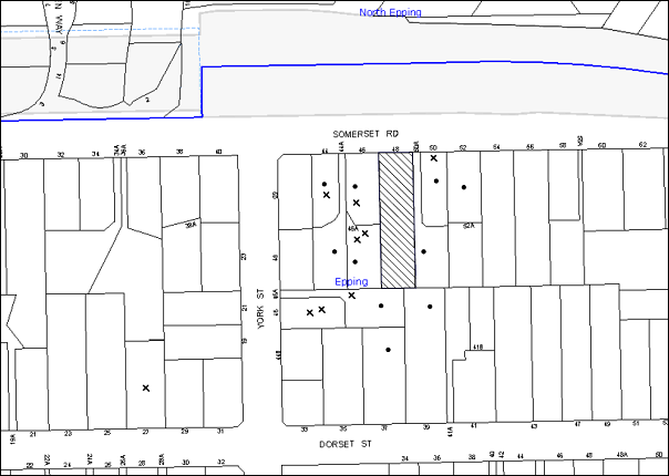
|
NOTIFICATION PLAN |
|
||
|
• PROPERTIES NOTIFIED
|
X SUBMISSIONS RECEIVED |
PROPERTY SUBJECT OF DEVELOPMENT |
|
9 submissions objected to the development, generally on the grounds that the development would result in:
· Unacceptable traffic and parking on local streets;
· Insufficient parking provided within the centre;
· Site not located within 700m of a commercial centre;
· Site in a zone with no data showing that it comprises a large population of 0-4 age group;
· Road ending in a cul-de-sac causing evacuation issues during a bushfire;
· Site with no separate ingress and egress points;
· Childcare size exceeding the Council requirements;
· Unacceptable noise from the outdoor play space and due to the proposed hours of operation;
· Loss of pedestrian safety on Somerset Street;
· Loss of privacy for adjoining developments;
· The removal of a number of trees;
· Development that is excessive in bulk and scale; and
· Potential contamination from asbestos during demolition.
The merits of the matters raised in community submissions have been addressed in the body of the report with the exception of the following:
5.1.1 Unacceptable Noise from the Outdoor Play Space
An Acoustic Report has been submitted with the application. Appropriate conditions are recommended in Schedule 1 to mitigate potential noise emissions to adjoining properties including construction of 2.4m high fences.
5.1.2 The Removal of Trees
The proposal results in the removal of 6 trees on the site. To compensate for the loss of trees, a condition of consent recommends the planting of 5 trees within the site. Subject to this condition, the application is assessed as satisfactory with regard to tree removal.
5.1.3 Hours of Operation and Impact of Noise
The site and the surroundings are subject to the traffic noise from M2. The hours of operation for the child care centre are from 7am - 6:30pm Monday to Friday which are considered to be standard hours of operation for a purpose built centre. The application includes an acoustic report with recommendations regarding noise mitigation measures. Subject to implementation of such mitigation measures, it is considered that the hours of operation would not have any detrimental impact on the amenity of the neighbouring properties.
5.1.4 Loss of Privacy
The adjoining neighbour has objected to the development and raised concerns that the windows of the centre would overlook onto the courtyards of the properties to the east and west of the site.
The submitted plans indicate that the windows are located at a lower level than the proposed fence along the boundary. Accordingly, no overlooking opportunities are envisaged. The proposal incorporates landscaping along the perimeter of the outdoor play area in addition to the fencing to maintain the privacy of the neighbouring properties.
5.2 Public Agencies
The development application is Integrated Development under the Act. Accordingly, the application was referred to NSW Rural Fire Service for comment and no objections were raised to the development subject to recommended conditions.
6. THE PUBLIC INTEREST
Section 79C(1)(e) of the Act requires Council to consider “the public interest”.
The public interest is an overarching requirement, which includes the consideration of the matters discussed in this report. Implicit to the public interest is the achievement of future built outcomes adequately responding to and respecting the future desired outcomes expressed in environmental planning instruments and development control plans.
The application is considered to have satisfactorily addressed Council’s and relevant agency’s criteria and would provide a development outcome that, on balance, would result in a positive impact for the community. Accordingly, it is considered that the approval of the proposed development would be in the public interest.
CONCLUSION
The proposal involves the erection of a child care centre accommodating 81 child placements and basement car park. 9 public submissions from the residents of 5 properties were received objecting to the proposal on the grounds of traffic, density, landscaping and noise. The issues raised are addressed in the body of the report and by relevant consent conditions under Schedule 1.
The proposed size of the child care centre does not comply with the maximum permissible under Council’s Community Uses Development Control Plan. However, the site is large enough to accommodate the development without causing any negative amenity impact on the neighbouring properties. The proposal generally complies with the relevant provisions of the Hornsby Shire Local Environmental Plan, the objectives of the Council’s Community Uses DCP, Access and Mobility Development Control Plan, Car Parking Development Control Plan and Waste Minimisation and Management Development Control Plan. The development is permissible in the zone and is considered to be within the environmental capacity of the site.
Accordingly, the proposed development is recommended for approval.
Note: At the time of the completion of this planning report, no persons have made a Political Donations Disclosure Statement pursuant to Section 147 of the Environmental Planning and Assessment Act 1979 in respect of the subject planning application.
|
Rod Pickles Manager - Development Assessment Planning Division |
James Farrington Group Manager Planning Division |
|
1.View |
Locality Map |
|
|
|
2.View |
Landscape Plans |
|
|
|
3.View |
Amended Floor Plans - Fence Elevations and Shadow and Play Area Dimensions |
|
|
|
4.View |
Shadow Diagram |
|
|
|
5.View |
Architectural Plans |
|
|
File Reference: DA/910/2013
Document Number: D02749482
SCHEDULE 1
GENERAL CONDITIONS
The conditions of consent within this notice of determination have been applied to ensure that the use of the land and/or building is carried out in such a manner that is consistent with the aims and objectives of the relevant legislation, planning instruments and council policies affecting the land and does not disrupt the amenity of the neighbourhood or impact upon the environment.
Note: For the purpose of this consent, the term ‘applicant’ means any person who has the authority to act on or the benefit of the development consent.
Note: For the purpose of this consent, any reference to an Act, Regulation, Australian Standard or publication by a public authority shall be taken to mean the gazetted Act or Regulation, or adopted Australian Standard or publication as in force on the date that the application for a construction certificate is made.
1. Approved Plans and Supporting Documentation
The development must be carried out in accordance with the plans and documentation listed below and endorsed with Council’s stamp, except where amended by Council and/or other conditions of this consent:
|
Plan No. |
Drawn by |
Dated |
|
Survey Plan - 12263/001 Rev B |
RGM Property Surveys |
13/09/2012 |
|
Photomontage - 13090/00 Rev A |
Baini Design |
August 2013 |
|
Demolition and Site Analysis plan Rev A |
Baini Design |
August 2013 |
|
Plans - 13090/02 Rev A |
Baini Design |
14/10/2013 |
|
Elevation - 13090/03 Rev A |
Baini Design |
August 2013 |
|
Sections - 13090/04 - Rev A |
Baini Design |
August 2013 |
|
Fence elevations |
Baini Design |
14/10/2013 |
|
SK 01 - Landscape Plan and Section |
Carmichael Studios |
Received by Council on 5/9/2013 |
|
SK 02 - Landscape Planting plan |
Carmichael Studios |
Received by Council on 5/9/2013 |
|
Stormwater plan - site and erosion and sediment control plan 1 of 2/A |
Ing Consulting Engineers Pty Ltd |
31/08/2013 |
|
Stormwater plan notes and details 2 of 2/A |
Ing Consulting Engineers Pty Ltd |
31/08/2013 |
|
Document No./ Name |
Prepared by |
Dated |
|
Hazardous Building Materials Register |
Getex |
11 October 2013 |
|
DA Acoustic Assessment |
Acoustic Logic |
14/08/2013 |
|
Boundary Fence shadow diagram |
Baini Design |
14/10/2013 |
|
Preliminary Air Quality Study |
Getex |
2 October 2013 |
|
Statement of Environmental Effects |
Think Planners Pty Ltd |
14 August 2013 |
|
Phase 1 Preliminary Site Contamination Investigation |
Getex |
11 October 2013 |
|
Traffic and Parking Assessment Report |
Varga Traffic Planning |
20 August 2013 |
|
Bushfire Hazard Assessment Report |
Building Code and Bushfire Solutions Pty Ltd |
20 June 2013 |
|
Waste Management Plan |
Redevelop |
3/09/2013 |
|
Access Report |
John Everden |
9/08/2013 |
|
Schedule of finishes |
Redevelop |
Received by Council on 5/09/2013 |
|
Arboricultural Impact Assessment Report |
Redgum Horticultural Consultants |
4/09/2013 |
|
General Terms of Approval Ref: D13/2086 - DA13091788991 MS |
NSW Rural Fire Service |
4 October 2013 |
2. Removal of Existing Trees
This development consent only permits the removal of trees numbered 1, 2, 3, 4, 5, 6 as identified on “Appendix E – Site Plan A – Survey of Subject Trees” within the Arboricultural Impact Assessment Report prepared by Redgum Horticultural dated 4/09/2013. The removal of any other trees requires separate approval under Council’s Tree Preservation Order.
3. Construction Certificate
A Construction Certificate is required to be approved by Council or a Private Certifying Authority prior to the commencement of any works under this consent.
REQUIREMENTS PRIOR TO THE ISSUE OF A CONSTRUCTION CERTIFICATE
4. Building Code of Australia
All building work must be carried out in accordance with the relevant requirements of the Building Code of Australia.
5. Sydney Water – Quick Check
This application must be submitted to a Sydney Water ‘Quick Check Agent’ or ‘Customer Centre’ for approval to determine whether the development would affect any Sydney Water infrastructure, and whether further requirements are to be met.
Note: Refer to www.sydneywater.com.au or telephone 13 20 92 for assistance.
6. Construction Certificate Plans
The construction certificate plans must incorporate all the construction details recommended in the following reports:
|
Document No and name |
Prepared by |
Dated |
|
DA Acoustic Assessment |
Acoustic Logic |
14/08/2013 |
|
Access Report |
John Everden |
9/08/2013 |
REQUIREMENTS PRIOR TO THE COMMENCEMENT OF ANY WORKS
7. Erection of Construction Sign
A sign must be erected in a prominent position on any site on which building work, subdivision work or demolition work is being carried out:
a) Showing the name, address and telephone number of the principal certifying authority for the work;
b) Showing the name of the principal contractor (if any) for any demolition or building work and a telephone number on which that person may be contacted outside working hours; and
c) Stating that unauthorised entry to the work site is prohibited.
Note: Any such sign is to be maintained while the building work, subdivision work or demolition work is being carried out, but must be removed when the work has been completed.
8. Protection of Adjoining Areas
A temporary hoarding, fence or awning must be erected between the work site and adjoining lands before the works begin and must be kept in place until after the completion of the works if the works:
a) Could cause a danger, obstruction or inconvenience to pedestrian or vehicular traffic.
b) Could cause damage to adjoining lands by falling objects.
c) Involve the enclosure of a public place or part of a public place.
Note: Notwithstanding the above, Council’s separate written approval is required prior to the erection of any structure or other obstruction on public land.
9. Toilet Facilities
Toilet facilities must be available or provided at the works site before works begin and must be maintained until the works are completed at a ratio of one toilet for every 20 persons employed at the site. Each toilet must:
a) be a standard flushing toilet connected to a public sewer; or
b) be a temporary chemical closet approved under the Local Government Act, 1993; or
c) have an on-site effluent disposal system approved under the Local Government Act, 1993.
10. Erosion and Sediment Control
Erosion and sediment control measures must be provided and maintained throughout the construction period in accordance with the manual ‘Soils and Construction 2004 (Bluebook)’, the approved plans, Council specifications and to the satisfaction of the principal certifying authority. The erosion and sediment control devices must remain in place until the site has been stabilised and revegetated.
Note: On the spot penalties up to $1,500 may be issued for any non-compliance with this requirement without any further notification or warning.
11. Tree Protection Barriers
Tree protection fencing must be erected around trees numbered 7,8 and 9 as identified on “Appendix E – Site Plan A – Survey of Subject Trees” within the Arboricultural Impact Assessment Report prepared by Redgum Horticultural dated 4/09/2013 in accordance with the following table:
|
Tree No. |
Tree Protection Zone |
Tree Protection Fencing Distance |
|
7 |
5m |
4.5m |
|
8 |
3.6m |
3.2m |
|
9 |
3.6m |
3.2m |
The tree fencing must be constructed of 1.8 metre ‘cyclone chainmesh fence’ or star pickets spaced at 2 metre intervals, connected by a continuous high-visibility barrier/hazard mesh at a height of 1 metre.
12. Traffic Control Plan
A Traffic Control Plan (TCP) must be prepared by a qualified traffic controller in accordance with the Roads & Traffic Authority’s Traffic Control at Worksites Manual 1998 and Australian Standard 1742.3 for all work on a public road and be submitted to Council. The TCP must detail the following:
a) Arrangements for public notification of the works.
b) Temporary construction signage.
c) Permanent post-construction signage.
d) Vehicle movement plans.
e) Traffic management plans.
f) Pedestrian and cyclist access/safety.
13. Return of Domestic Waste Bins
Arrangements must be made with Hornsby Shire Council Waste Management Services to return the domestic waste bins to Council.
REQUIREMENTS DURING CONSTRUCTION
14. Construction Work Hours
All work on site (including demolition and earth works) must only occur between 7am and 5pm Monday to Saturday. No work is to be undertaken on Sundays or public holidays.
15. Environmental Management
The site must be managed in accordance with the publication ‘Managing Urban Stormwater – Landcom (March 2004) and the Protection of the Environment Operations Act 1997 by way of implementing appropriate measures to prevent sediment run-off, excessive dust, noise or odour emanating from the site during the construction of the development.
16. Works Near Trees
All required tree protection measures are to be maintained in good condition for the duration of the construction period.
All works (including driveways and retaining walls) within 4 metres of any trees required to be retained (whether or not on the subject property, and pursuant to this consent or the Tree Preservation Order), must be carried out under the supervision of an ‘AQF Level 5 Arborist’ and a certificate submitted to the principal certifying authority detailing the method(s) used to preserve the tree(s).
Note: Except as provided above, the applicant is to ensure that no excavation, filling or stockpiling of building materials, parking of vehicles or plant, disposal of cement slurry, waste water or other contaminants is to occur within 4 metres of any tree to be retained.
17. Council Property
During construction works, no building materials, waste, machinery or related matter is to be stored on the road or footpath. The public reserve must be kept in a clean, tidy and safe condition at all times.
18. Street Sweeping
Street sweeping must be undertaken following sediment tracking from the site along Somerset Street during works and until the site is established.
19. Disturbance of Existing Site
During construction works, the existing ground levels of open space areas and natural landscape features, (including natural rock-outcrops, vegetation, soil and watercourses) must not be altered unless otherwise nominated on the approved plans.
20. Landfill
Landfill must be constructed in accordance with Council’s ‘Construction Specification, 2005’ and the following requirements:
a) All fill material imported to the site is to wholly consist of Virgin Excavated Natural Material (VENM) as defined in Schedule 1 of the Protection of the Environment Operations Act 1997 or a material approved under the Department of Environment and Climate Change’s general resource recovery exemption.
21. Excavated Material
All excavated material removed from the site must be classified in accordance with the Department of Environment, Climate Change and Water NSW Waste Classification Guidelines prior to disposal to an approved waste management facility and reported to the principal certifying authority.
22. Survey Report – Finished Floor Level
A report(s) must be prepared by a registered surveyor and submitted to the principal certifying authority prior to the pouring of concrete at each level of the building certifying that:
a) The building, retaining walls and the like have been correctly positioned on the site; and
b) The finished floor level(s) are in accordance with the approved plans.
23. Waste Management
Waste management during the demolition and construction phase of the development must be undertaken in accordance with the approved Waste Management Plan. Additionally written records of the following items must be maintained during the removal of any waste from the site and such information submitted to the Principal Certifying Authority within fourteen days of the date of completion of the works:
a) The identity of the person removing the waste.
b) The waste carrier vehicle registration
c) Date and time of waste collection.
d) A description of the waste (type of waste and estimated quantity).
e) Details of the site to which the waste is to be taken.
f) The corresponding tip docket/receipt from the site to which the waste is transferred (noting date and time of delivery, description (type and quantity) of waste).
g) Whether the waste is expected to be reused, recycled or go to landfill.
Note: In accordance with the Protection of the Environment Operations Act 1997, the definition of waste includes any unwanted substance, regardless of whether it is reused, recycled or disposed to landfill.
REQUIREMENTS PRIOR TO THE ISSUE OF AN OCCUPATION CERTIFICATE
Note: For the purpose of this consent, a reference to ‘occupation certificate’ shall not be taken to mean an ‘interim occupation certificate’ unless otherwise stated.
24. Sydney Water – s73 Certificate
An s73 Certificate must be obtained from Sydney Water.
25. Stormwater Drainage
The stormwater drainage system for the development must be designed and constructed in accordance with Council’s Civil Works – Design and Construction Specification 2005 and the following requirements:
a) Connected directly to Council’s street drainage system via an on site detention system.
Note: Details of the stormwater management system must be included in the construction certificate plans.
26. On Site Stormwater Detention
An on-site stormwater detention system must be designed by a chartered civil engineer and constructed in accordance with the following requirements:
a) Details of the on-site detention system be provided with the construction certificate plans.
b) Have a capacity of not less than 14.5 cubic metres, and a maximum discharge (when full) of 18 litres per second.
c) Have a surcharge/inspection grate located directly above the outlet.
d) Discharge from the detention system to be controlled via 1 metre length of pipe, not less than 50 millimetres diameter or via a stainless plate with sharply drilled orifice bolted over the face of the outlet discharging into a larger diameter pipe capable of carrying the design flow to an approved Council system.
e) Where above ground and the average depth is greater than 0.3 metres, a ‘pool type’ safety fence and warning signs to be installed.
f) Not be constructed in a location that would impact upon the visual or recreational amenity of residents.
27. Internal Driveway/Vehicular Areas
The driveway and parking areas on site must be designed and constructed in accordance with Australian Standards 2890.1, 2890.2, 3727 and the following requirements:
a) Design levels at the front boundary be obtained from Council.
b) The driveway be bitumen sealed and concreted.
c) The driveway grade must not exceed 25 percent ad the change in grade must not exceed 8 percent.
d) Details of the internal driveway be provided with the construction certificate plans.
e) The driveway and the parking areas are to be paved, line marked and signposted.
f) A “Shared Zone” sign be installed at the entrance to the car park.
g) Three speed humps similar to Saferoads Rubber Speed Humps be installed along the parking aisle.
h) All parking spaces for people with disabilities must be constructed in accordance with Australian Standard AS/NZS 2890.6:2009 – Off-street parking for people with disabilities.
28. Vehicular Crossing
A separate application under the Local Government Act, 1993 and the Roads Act, 1993 must be submitted to Council for the installation of a new vehicular crossing and the removal of the redundant crossing. The vehicular crossing must be constructed in accordance with Council’s Civil Works Design, 2005 and the following requirements:
a) Any redundant crossings must be replaced with integral kerb and gutter;
b) Approval must be obtained from all relevant utility providers that all necessary conduits be provided and protected under the crossing.
Note: An application for a vehicular crossing can only be made to one of Council’s Authorised Vehicular Crossing Contractors. You are advised to contact Council on 02 9847 6940 to obtain a list of contractors.
29. Damage to Council Assets
Any damage caused to Council’s assets as a result of the construction of the development must be rectified in accordance with Council’s Civil Works Specifications. Council’s Restorations Supervision must be notified for a formwork inspection prior to pouring concrete.
30. Completion of Landscaping
A certificate must be provided by a practicing landscape architect, horticulturalist or person with similar qualifications and experience certifying that all required landscaping works have been satisfactorily completed in accordance with the approved landscape plans.
Note: Advice on suitable species for landscaping can be obtained from Council’s planting guide ‘Indigenous Plants for the Bushland Shire’, available at www.hornsby.nsw.gov.au.
31. Waste Management
Documentary evidence (i.e. tipping dockets/receipts from recycling depots, transfer stations and landfills, audit reports etc) that all demolition and construction waste was taken to site(s) that were lawfully permitted to accept that waste, must be provided to the Principal Certifying Authority.
32. External Lighting
All external lighting must be designed and installed in accordance with Australian Standard AS 4282 – Control of the Obtrusive Effects of Outdoor Lighting. Certification of compliance with the Standard must be obtained from a suitably qualified person.
33. Shade Structure/s
The outdoor play space must be adequately shaded in accordance with The Shade Handbook, published by the New South Wales Cancer Council in 2008.
34. Acoustic/Privacy Fence
A 2.2m high imperforate fence must be constructed along the southern and western boundary of the site and 2.4m high imperforate fence must be constructed along the eastern boundary of the site. The fences must be constructed of any of the following materials:
a) 9mm fibre cement; or
b) lapped and capped timber; or
c) masonry or equivalent; or
d) a combination of the above
The section of the fence above 1.8m may be angled towards the site at 45 degrees, subject to the overall height not being less than 2.2 – 2.4m as stated above. The fence is to be installed gap free between the panels and no gap at the bottom.
35. Food Premises
The fit out and operation of that part of the building to be used for the manufacture, preparation or storage of food for sale, must be in accordance with Australian Standard 4674-2004 – Design and fit out of food premises, the Food Act 2003, and the Food Regulation 20010 and the Food Standards Code developed by Food Standards Australia New Zealand. Food Standards 3.3.1. 3.2.2 and 3.2.3 are mandatory for all food businesses.
Note: Walls are to be of solid construction.
36. Site Remediation Verification
The applicant must provide documentation from a suitably qualified environmental consultant verifying that the site has been remediated in accordance with the NSW Environment Protection Authority’s Contaminated Sites – Guidelines for Consultants Reporting on Contaminated Sites, the Contaminated Sites - Sampling Design Guidelines Contaminated Sites – Guidelines for the NSW Site Auditor Scheme and the recommendations of the Preliminary Contamination Report prepared by Getex dated 11/10/2013.
37. Kitchen Exhaust Installation
A kitchen exhaust system must be designed and installed to effectively prevent air pollution in accordance with the Protection of the Environment Operations Act 1997.
38. Maintain Canopy Cover
To maintain canopy cover, five medium to large trees selected from Council’s booklet ‘Indigenous Plants for the Bushland Shire’ such as Eucalyptus Pilularis are to be planted on the subject site. The planning location shall not be within 4 metres of the foundation walls of a dwelling or in-ground pool. The pot size is to be a minimum 25 litres and the tree(s) must be maintained until they reach the height of 3 metres.
39. Retaining Walls
All required retaining walls must be constructed as part of the development.
40. Section 94A Development Contributions
In accordance with Section 80A(1) of the Environmental Planning and Assessment Act 1979 and the Hornsby Shire Council Section 94A Development Contributions Plan 2012-2021, $13,728.95 shall be paid to Council to cater for the increased demand for community infrastructure resulting from the development, based on development costs of $1,372,895.
If the contributions are not paid within the financial quarter that this consent is granted, the contributions payable will be adjusted in accordance with the provisions of the Hornsby Shire Council Section 94A Development Contributions Plan and the amount payable will be calculated at the time of payment in the following manner:
$CPY = $CDC x CPIPY
CPIDC
Where:
$CPY is the amount of the contribution at the date of Payment.
$CDC is the amount of the contribution as set out in this Development Consent.
CPIPY is the latest release of the Consumer Price Index (Sydney – All Groups) at the date of Payment as published by the ABS.
CPIDC is the Consumer Price Index (Sydney – All Groups) for the financial quarter at the date of this Development Consent.
a) The monetary contributions shall be paid to Council:
i) prior to the issue of the Subdivision Certificate where the development is for subdivision; or
ii) prior to the issue of the first Construction Certificate where the development is for building work; or
iii) prior to issue of the Subdivision Certificate or first Construction Certificate, whichever occurs first, where the development involves both subdivision and building work; or
iv) prior to the works commencing where the development does not require a Construction Certificate or Subdivision Certificate.
It is the professional responsibility of the Principal Certifying Authority to ensure that the monetary contributions have been paid to Council in accordance with the above timeframes.
Council’s Development Contributions Plan may be viewed at www.hornsby.nsw.gov.au or a copy may be inspected at Council’s Administration Centre during normal business hours.
OPERATIONAL CONDITIONS
41. Use of Premises
The development approved under this consent shall be used for ‘child care centre’ and not for any other purpose without Council’s separate written consent.
The centre would include a maximum of 81 places and a minimum of 13 staff members to cater for the children.
42. Number of Children
a) The centre shall accommodate a maximum of 81 children.
b) A maximum of 54 children at the centre shall be at, or above, 2 years of age as at 1 January of each calendar year.
43. Hours of Operation
The hours of operation of the premise are restricted to those times listed below:
Monday to Friday 7:00 am to 6:30 pm
Saturday, Sunday & Public Holidays No work
44. Noise
All noise generated by the proposed development must be attenuated to prevent levels of noise being emitted to adjacent premises which possess tonal, beating and similar characteristics or which exceeds background noise levels by more than 5dB(A).
45. Waste Management
All commercial tenants must keep written evidence on site of a valid contract with a licensed waste contractor(s) for the regular collection and disposal of the waste and recyclables that are generated on site.
46. Waste Collection
Due to the close proximity of residential dwellings, waste collection services must only take place within the hours of 9 AM to 7 PM on Sundays and Public Holidays or within the hours of 7 AM to 7 PM on other days.
47. Car Parking and Deliveries
All car parking must be operated in accordance with the following requirements:
a) Car parking, loading and manoeuvring areas to be used solely for nominated purposes;
b) Vehicles awaiting loading, unloading or servicing shall be parked on site and not on adjacent or nearby public roads;
c) All vehicular entry on to the site and egress from the site shall be made in a forward direction.
48. Fire Safety Statement - Annual
On at least one occasion in every 12 month period following the date of the first ‘Fire Safety Certificate’ issued for the property, the owner must provide Council with an annual ‘Fire Safety Certificate’ to each essential service installed in the building.
GENERAL TERMS OF APPROVAL – NSW RURAL FIRE SERVICE
The following conditions of consent are General Terms of Approval from the nominated State Agency pursuant to Section 91A of the Environmental Planning and Assessment Act 1979 and must be complied with to the satisfaction of that Agency:
49. Asset Protection Zones
At the commencement of building works and in perpetuity the entire property shall be managed as an inner protection area (IPA) as outlined within section 4.1.3 and Appendix 5 of ‘Planning for Bush Fire Protection 2006’ and the NSW Rural Fire Service’s document ‘Standards for asset protection zones’.
50. Water and Utilities
Water, electricity and gas are to comply with sections 4.1.3 and 4.2.7 of ‘Planning for Bush Fire Protection 2006’.
51. Evacuation and Emergency Management
Arrangement for emergency and evacuation are to comply with section 4.2.7 of ‘Planning for Bush Fire Protection 2006’.
52. Design and Construction
New construction shall comply with Sections 3 and 5 (BAL 12.5) Australian Standard AS3959-2009 ‘Construction of buildings in bush fire pone areas’ and section A3.7 Addendum Appendix 3 of ‘Planning for Bush Fire Protection’.
- END OF CONDITIONS -
ADVISORY NOTES
The following information is provided for your assistance to ensure compliance with the Environmental Planning and Assessment Act, 1979, Environmental Planning and Assessment Regulation 2000, other relevant legislation and Council’s policies and specifications. This information does not form part of the conditions of development consent pursuant to Section 80a of the Act.
Environmental Planning and Assessment Act, 1979 Requirements
The Environmental Planning and Assessment Act, 1979 requires:
· The issue of a construction certificate prior to the commencement of any works. Enquiries can be made to Council’s Customer Services Branch on 9847 6760.
· A principal certifying authority to be nominated and Council notified of that appointment prior to the commencement of any works.
· Council to be given at least two days written notice prior to the commencement of any works.
· Mandatory inspections of nominated stages of the construction inspected.
· An occupation certificate to be issued before occupying any building or commencing the use of the land.
Long Service Levy
In accordance with Section 34 of the Building and Construction Industry Long Service Payments Act 1986, a ‘Long Service Levy’ must be paid to the Long Service Payments Corporation or Hornsby Council.
Note: The rate of the Long Service Levy is 0.35% of the total cost of the work.
Note: Hornsby Council requires the payment of the Long Service Levy prior to the issue of a construction certificate.
Tree Preservation Order
To ensure the maintenance and protection of the existing natural environment, it is an offence to ringbark, cut down, top, lop, remove, wilfully injure or destroy a tree outside 3 metres of the approved building envelope without the prior written consent from Council.
Note: A tree is defined as a single or multi-trunked wood perennial plant having a height of not less than three (3) metres, and which develops many branches, usually from a distance of not less than one (1) metre from the ground, but excluding any plant which, in its particular location, is a noxious plant declared as such pursuant to the Noxious Weeds Act 1993. This definition of ‘tree’ includes any and all types of Palm trees.
All distances are determined under Australian Standard AS4970-2009 ”Protection of Trees on Development Sites”.
Fines may be imposed for non-compliance with Council’s Tree Preservation Order.
Disability Discrimination Act
The applicant’s attention is drawn to the existence of the Disability Discrimination Act. A construction certificate is required to be obtained for the proposed building/s, which will provide consideration under the Building Code of Australia, however, the development may not comply with the requirements of the Disability Discrimination Act. This is the sole responsibility of the applicant.
Covenants
The land upon which the subject building is to be constructed may be affected by restrictive covenants. Council issues this approval without enquiry as to whether any restrictive covenant affecting the land would be breached by the construction of the building, the subject of this consent. Applicants must rely on their own enquiries as to whether or not the building breaches any such covenant.
Advertising Signage – Separate DA Required
This consent does not permit the erection or display of any advertising signs. Most advertising signs or structures require development consent. Applicants should make separate enquiries with Council prior to erecting or displaying any advertising signage.
Dial Before You Dig
Prior to commencing any works, the applicant is encouraged to contact Dial Before You Dig on 1100 or www.dialbeforeyoudig.com.au for free information on potential underground pipes and cables within the vicinity of the development site.
Telecommunications Act 1997 (Commonwealth)
If you are aware of any works or proposed works which may affect or impact on Telstra’s assets in any way, you are required to contact: Telstra’s Network Integrity Team on Phone Number 1800810443.
Asbestos Warning
Should asbestos or asbestos products be encountered during demolition or construction works, you are advised to seek advice and information prior to disturbing this material. It is recommended that a contractor holding an asbestos-handling permit (issued by WorkCover NSW) be engaged to manage the proper handling of this material. Further information regarding the safe handling and removal of asbestos can be found at:
Alternatively, telephone the WorkCover Asbestos and Demolition Team on 8260 5885.
Rain Water Tank
It is recommended that water collected within any rainwater tank as part of the development be limited to non-potable uses. NSW Health recommends that the use of rainwater tanks for drinking purposes not occur where a reticulated potable water supply is available.
Food Authority Notification
The NSW Food Authority requires businesses to electronically notify the Authority prior to the commencement of its operation.
Note: NSW Food Authority can be contacted at www.foodnotify.nsw.gov.au.
Council Notification – Food Premises
Prior to the commencement of the business, the operator is requested to contact Council’s Environmental Health Team to arrange an inspection for compliance against the relevant legislation and guidelines outlined in this approval.
Note: Council’s Environmental Health Officer can be contacted on 02 9847 6745.
Group Manager’s Report No. PL10/14
Planning Division
Date of Meeting: 12/02/2014
7 DEVELOPMENT APPLICATION - FIVE STOREY RESIDENTIAL FLAT BUILDING COMPRISING 26 UNITS - 14-16 LORDS AVENUE, ASQUITH
EXECUTIVE SUMMARY
|
DA No: |
DA/889/2013 (Lodged 2 September 2013) |
|
Description: |
Construction of a five storey residential flat building containing 26 units and basement car parking |
|
Property: |
Lot 30 DP 12901 and Lot 31 DP 12901, Nos. 14 and 16 Lords Avenue, Asquith |
|
Applicant: |
MS Properties Pty Ltd |
|
Owner: |
Mr Alan Keith Stewart, Mrs Brenda Grace Stewart, Miss Thuy Trang Anna Nguyen |
|
Estimated Value: |
$4,643,699 |
|
Ward: |
A |
· The application proposes demolition of the existing structures and construction of a five storey residential flat building comprising 26 units and basement car park.
· The proposal generally complies with the Hornsby Shire Local Environmental Plan 1994, Hornsby Local Environmental Plan 2013, State Environmental Planning Policy No. 65 – Design Quality Residential Flat Building, Hornsby Shire Housing Strategy Development Control Pan and the Hornsby Development Control Plan 2013.
· Three submissions have been received in respect of the application.
· It is recommended that the application be approved as a deferred commencement to allow the registration and creation of an easement to drain water through adjoining properties to the rear of the site.
|
THAT Development Application No. DA/889/2013 for demolition of existing structures and construction of a five storey residential flat buildings comprising 26 units with basement car parking at Lot 30 DP 12901 and Lot 31 DP 12901, Nos. 14 and 16 Lords Avenue, Asquith be approved as a deferred commencement pursuant to Section 80(3) of the Environmental Planning and Assessment Act, 1979 subject to the conditions of consent detailed in Schedule 1 of Group Manager’s Report No. PL10/14. |
BACKGROUND
The subject land was rezoned from Residential A (Low Density) to Residential C (Medium-High Density) on 2 September 2011 as part of Council’s Housing Strategy.
SITE
The site comprises two allotments, Lots 30 and 31 DP 12901, Nos. 14 and 16 Lords Avenue, Asquith and is located on the eastern side of the road. The site is irregular in shape and has an area of 1,472m2. The site has a 31.8m frontage to Lords Avenue and a length of 47.86m on the northern boundary and a length of 48.75m on the southern boundary. The site is relatively flat with a minor slope from the south-western corner of the site to the north-eastern corner (rear).
Existing improvements on the allotments include two dwelling-houses with associated garages and carports. Vehicular access to the site is gained via existing driveways fronting Lords Avenue.
The site contains a number of exotic, native and locally indigenous trees.
The site adjoins a nursery and preschool centre to the north and other surrounding developments include single and two storey residential dwellings. The site is located in close proximity to Asquith Railway Station and the Asquith Commercial Centre.
PROPOSAL
The proposal is for the demolition of two existing dwelling-houses and associated outbuildings and construction of a five storey residential flat building comprising 26 units with two levels of basement car parking.
The unit configuration includes 3 x 1 bedroom, 20 x 2 bedroom and 3 x 3 bedroom units. The units include balconies fronting the street, rear and side setbacks.
The development would be accessed from Lords Avenue via a driveway located adjacent to the north western boundary of the site. A total of 32 residential car parking spaces, including 5 visitor’s parking spaces are proposed in two basement levels.
ASSESSMENT
The development application has been assessed having regard to the ‘Metropolitan Plan for Sydney 2031’, the ‘North Subregion (Draft) Subregional Strategy’ and the matters for consideration prescribed under Section 79C of the Environmental Planning and Assessment Act 1979 (the Act). The following issues have been identified for further consideration.
1. STRATEGIC CONTEXT
1.1 Metropolitan Plan for Sydney and (Draft) North Subregional Strategy
The (Draft) Metropolitan Strategy for Sydney 2031 is a broad framework to provide for Sydney’s growth to help plan for housing, employment, transport, infrastructure, the environment and open space. It outlines a vision for Sydney to 2031; the challenges faced, and the directions to follow to address these challenges and achieve the vision.
The North Subregion comprises Hornsby, Kuring-gai, Manly, Warringah and Pittwater Local Government Areas. The Draft North Subregional Strategy provides a framework for Council in its preparation of the HLEP 2013.
Within the North Subregion, the Draft Metropolitan Strategy proposes:
· Population growth of 81,000 from the current 2011 baseline of 529,000
· Housing growth of 37,000 from the current 2011 baseline of 204,000
· Employment growth of 39,000 from the current 2011 baseline of 186,000
The proposed development would be consistent with the Metropolitan Plan for Sydney 2031 by providing 24 additional dwellings and would contribute to housing choice in the locality.
2. STATUTORY CONTROLS
Section 79C(1)(a) requires Council to consider “any relevant environmental planning instruments, draft environmental planning instruments, development control plans, planning agreements and regulations”.
2.1 Hornsby Shire Local Environmental Plan 1994
The subject land is zoned Residential C (Medium/High Density) under the Hornsby Local Environmental Plan 1994 (HSLEP). The objectives of the zone are:
(a) to provide for the housing needs of the population of the Hornsby area.
(b) to promote a variety of housing types and other land uses compatible with a medium to high density residential environment.
(c) to provide for development that is within the environmental capacity of a medium to high density residential environment.
Clause 15 of the HSLEP prescribes the maximum floor space ratio (FSR) for development within the Residential C zone. Subclause (5) of clause 15 states that “This clause does not apply to land shown edged heavy black on diagrams 1-8 in Schedule BB.” The site is identified in Diagram 4 of Schedule BB of the HSLEP. Therefore, clause 15 does not apply to the subject site.
Clause 15A of the HSLEP prescribes that the maximum building height within the area detailed under Schedule BB is not to exceed 17.5 metres. The proposed building complies with this requirement.
Clause 18 of the HSLEP sets out heritage conservation provisions for Hornsby Shire. The site is located in the vicinity of property No. 419 Pacific Highway (House) which is listed as a heritage item of local significance under Schedule D of the HSLEP. One submission received from this property owner objects to the proximity of the development to the heritage listed property. Council’s heritage assessment of the proposal notes that; the proposed development provides a well articulated built form and appropriate separations and setbacks and would not have an impact on the heritage significance of the item. The proposal provides screen landscaping to the rear of the site and complies with the Key Principles Diagram for properties adjoining heritage items.
The objection also raises concerns in relation to the future development potential of the heritage listed property and questions the possibility of removing the heritage listing of the site. The property is heritage listed for being a representative example of a relatively intact Inter-War period bungalow. The property was included on the heritage list in 1994 upon gazettal of the HSLEP 1994, and was originally assessed as part of the Hornsby Shire Heritage Study which was carried out in 1993.
Taking into consideration the heritage value of the property in comparison with similar representative examples of Inter-War period houses within the locality, review of the heritage listing at No. 419 Pacific Highway would be appropriate. Accordingly, Council’s Strategic Planning Branch will review the listing as part of the next Heritage Review (Stage 6) or as part of the next amendment to the HLEP 2013.
2.2 Hornsby Local Environmental Plan 2013
The Hornsby Local Environmental Plan 2013 (HLEP) was gazetted by the Minister for Planning on 11 October 2013. The HLEP includes a savings provision stating that if a development application is made and not finally determined before the commencement of the HLEP, the application must be determined as if the Plan had been exhibited but not commenced. Notwithstanding, the HLEP essentially reiterates the current land use zoning and height control applicable to the site as outlined below.
2.2.1 Zoning
Under the HLEP, the subject land is zoned R4 (High Density Residential). The proposed development is defined as a ‘residential flat building’ and is permissible within the zone with Council’s consent.
2.2.2 Height of Building
Clause 4.3 of the HLEP provides that the height of a building on any land is not to exceed the maximum height shown for the land on the Height of Buildings Map. The maximum permissible height for the subject site is 17.5 metres. The proposal complies with this provision.
2.3 State Environmental Planning Policy No. 55 – Remediation of Land
State Environmental Planning Policy No. 55 (SEPP 55) requires that Council must not consent to the carrying out of any development on land unless it has considered whether the land is contaminated or requires remediation for the proposed use.
The site has been used for residential purposes and is unlikely to be contaminated. No further assessment is considered necessary in this regard. A condition is recommended should any contamination be found during construction requiring that Council or the Private Certifying Authority be notified.
2.4 State Environmental Planning Policy No. 65 – Design Quality of Residential Flat Development
The Policy provides for design principles to improve the design quality of residential flat development and for consistency in planning controls across the State.
The applicant has submitted a design verification statement prepared by a qualified designer stating how the proposed development achieves the design principles of SEPP 65. The design principles of SEPP 65 and the submitted design verification statement are addressed below.
2.4.1 Principle 1 - Context
Design Principle 1 is as follows:
Good design responds and contributes to its context. Context can be defined as the key natural and built features of an area.
Responding to context involves identifying the desirable elements of a location’s current character or, in the case of precincts undergoing a transition, the desired future character as stated in planning and design policies. New buildings will thereby contribute to the quality and identity of the area.
The subject site is located within a precinct zoned for five storey residential flat buildings in close proximity to Asquith shopping centre. The desired future character of the area, as outlined in Council’s Housing Strategy Development Control Plan, is that of a high density residential precinct incorporating five storey developments in garden settings with parking in basements.
The applicant’s ‘Design Verification Statement’ indicates that the proposal responds to the desired future character of the precinct as envisaged by Council. Once the development of the precinct is completed, the proposal would integrate with the surrounding sites and would be in keeping with the desired urban form. It is considered that the proposed building would contribute to the identity and future character of the precinct.
2.4.2 Principle 2 - Scale
Design Principle 2 is as follows:
Good design provides an appropriate scale in terms of the bulk and height that suits the scale of the street and the surrounding buildings.
Establishing an appropriate scale requires a considered response to the scale of existing development. In precincts undergoing a transition, proposed bulk and height needs to achieve the scale identified for the desired future character of the area.
The scale of the development is in accordance with the required building height and setbacks for the precinct and provides an architectural composition that achieves the required pavilion built form to minimize bulk and scale. The scale of the development is considered appropriate for the site and consistent with the desired future character of the precinct.
2.4.3 Principle 3 – Built Form
Design Principle 3 is as follows:
Good design achieves an appropriate built form for a site and the building’s purpose, in terms of building alignments, proportions, building type and the manipulation of building elements.
Appropriate built form defines the public domain, contributes to the character of streetscape and parks, including their views and vistas, and provides internal amenity and outlook.
The proposed building is appropriately articulated to minimise the perceived scale and to add to the visual interest of the development. The proposed development presents a distinct architectural design which would set an appropriate precedent for the locality and is considered acceptable in terms of built form.
2.4.4 Principle 4 – Density
Design Principle 4 is as follows:
Good design has a density appropriate for a site and its context, in terms of floor space yields (or number of units or residents).
Appropriate densities are sustainable and consistent with the existing density in an area or in precincts undergoing a transition, are consistent with the stated desired future density. Sustainable densities respond to the regional context, availability of infrastructure, public transport, community facilities and environmental quality.
The HSLEP does not incorporate floor space ratio requirements for the site. The density of the development is governed by the height of the building and the required setbacks. The proposed density is considered to be sustainable as it responds to the regional context, availability of infrastructure, public transport, community facilities and environmental quality and is considered acceptable in terms of density.
2.4.5 Principle 5 – Resource, Energy and Water Efficiency
Design Principle 5 is as follows:
Good design makes efficient use of natural resources, energy and water throughout its full life cycle, including construction.
Sustainability is integral to the design process. Aspects include demolition of existing structures, recycling of materials, selection of appropriate and sustainable materials, adaptability and reuse of buildings, layouts and built form, passive solar design principles, efficient appliances and mechanical services, soil zones for vegetation and reuse of water.
The applicant has submitted a BASIX Certificate for the proposed development. In achieving the required BASIX targets for sustainable water use, thermal comfort and energy efficiency, the proposed development achieves the design criteria and is considered acceptable in this regard.
2.4.6 Principle 6 – Landscape
Design Principle 6 is as follows:
Good design recognises that together landscape and buildings operate as an integral and sustainable system, resulting in greater aesthetic quality and amenity for both occupants and the adjoining public domain.
Landscape design builds on the existing site’s natural and cultural features in responsible and creative ways. It enhances the development’s natural environmental performance by co-ordinating water and soil management, solar access, micro-climate, tree canopy and habitat values. It contributes to the positive image and contextual fit of development through respect for streetscape and neighbourhood character, or desired future character.
Landscape design should optimise useability, privacy and social opportunity, equitable access and respect for neighbour’s amenity, and provide for practical establishment and long term management.
The application includes a landscape concept plan providing landscaping along the street frontage and side and rear boundaries. The planting would provide an appropriate landscape setting for the development. Deep soil zones are provided around the building envelope which would enhance the development’s natural environmental performance and provide an appropriate landscaped setting.
2.4.7 Principle 7 – Amenity
Design Principle 7 is as follows:
Good design provides amenity through the physical, spatial and environmental quality of a development.
Optimising amenity requires appropriate room dimensions and shapes, access to sunlight, natural ventilation, visual and acoustic privacy, storage, indoor and outdoor space, efficient layouts and service areas, outlook and ease of access for all age groups and degrees of mobility.
The proposed units are designed to achieve natural ventilation, solar access and acoustic privacy. All units incorporate balconies accessible from living areas and privacy has been achieved through appropriate layout and orientation of the units. Storage areas have been provided within each of the units and within the basement levels. The proposal would provide convenient and safe access via a central lift connecting the basement and all other levels. The application is considered acceptable in this regard.
2.4.8 Principle 8 – Safety and Security
Design Principle 8 is as follows:
Good design optimises safety and security, both internal to the development and for the public domain.
This is achieved by maximising overlooking of public and communal spaces while maintaining internal privacy, avoiding dark and non-visible areas, maximising activity on streets, providing clear, safe access points, providing quality public spaces that cater for desired recreational uses, providing lighting appropriate to the location and desired activities, and clear definition between public and private spaces.
The design orientates the balconies and windows of individual apartments towards the street and rear boundary, providing passive surveillance of the public domain and communal open space areas. Entry points are secured and visibly prominent from the street.
The proposal includes an assessment of the development against crime prevention controls in the Design Verification Statement and the Statement of Environmental Effects. The applicant submits that the safety of the public domain is enhanced by the following design elements:
· The proposal optimizes safety and security both within the development and the public domain. The proposal affords good casual surveillance of the street frontages through a visual interaction with the main entrance on the ground floor.
· With regards to parking areas, secure access is to be maintained at all times. Security garage door is to be installed with access provided through an intercom system for visitors and remote control access for residents.
Conditions are recommended for lighting, territorial re-enforcement, environmental maintenance and access control. Subject to the imposition of conditions of consent addressing the above matters, the proposal is supported in respect of safety and security. The proposed development is considered satisfactory in respect to Crime Prevention Through Environmental Design principles (CPTED).
2.4.9 Principle 9 – Social Dimensions and Housing Affordability
Design Principle 9 is as follows:
Good design responds to the social context and needs of the local community in terms of lifestyles, affordability, and access to social facilities.
New development should optimise the provision of housing to suit the social mix and needs in the neighbourhood or, in the case of precincts undergoing transition, provide for the desired future community.
New development should address housing affordability by optimising the provision of economic housing choices and providing a mix of housing types to cater for different budgets and housing needs.
The Housing Strategy DCP includes prescriptive measures for housing choice and for adaptable housing to provide for aging in place. The proposal provides a varied housing mix and adaptable housing and is supported in respect to this Principle.
2.4.10 Principle 10 – Aesthetics
Design Principle 10 is as follows:
Quality aesthetics require the appropriate composition of building elements, textures, materials and colours and reflect the use, internal design and structure of the development. Aesthetics should respond to the environment and context, particularly to desirable elements of the existing streetscape or, in precincts undergoing transition, contribute to the desired future character of the area.
The architectural treatment of the building is generally consistent with the design principles contained within the RFDC. It is considered that the aesthetic quality of the building would contribute to the desired future character of the precinct. The details of the assessment of the built form and the aesthetics of the development are contained in Section 2.12 of this report.
2.5 SEPP 65 - Residential Flat Design Code
SEPP 65 also requires consideration of the Residential Flat Design Code, NSW Planning Department 2002. The Code includes development controls and best practice benchmarks for achieving the design principles of SEPP 65. The following table sets out the proposal’s compliance with the Code:
|
Residential Flat Design Code |
|||
|
Control |
Proposal |
Requirement |
Compliance |
|
Deep Soil Zone |
30% |
25% |
Yes |
|
Communal Open Space |
28% |
25-30% |
Yes |
|
Ground Level Private Open Space |
Unit 1, 4, 5 – 15m2 |
25m2 Min. Dimension 4m |
No |
|
Minimum Dwelling Size |
1 br – 56m² 2 br – 73m² 3 br – 102m² |
1 br – 50m2 2 br – 70m2 3 br – 95m2 |
Yes Yes Yes |
|
Maximum Kitchen Distance |
8.5m – unit nos. 3, 9, 12, 15, 18, 21, 24 |
8m |
No |
|
Minimum Balcony Depth |
2m |
2m |
Yes |
|
Dual Aspect & Cross Ventilation |
69% |
60% |
Yes |
|
Adaptable Housing |
30% |
10% |
Yes |
|
Total Storage Areas |
1 br > 6m3 2 br. > 8m3 3 br > 10 m3 |
1 br - 6m3 (Min) 2 br – 8m3 (Min) 3 br – 10 m3 (Min) |
Yes Yes Yes |
As detailed in the above table, the proposed development complies with the prescriptive measures within the Residential Flat Design Code (RFDC) other than ground floor open space and maximum kitchen distance for some units. Below is a brief discussion regarding the relevant development controls and best practice guidelines.
2.5.1 Ground Floor Apartments and Private Open Space
Of the 6 units located on the ground floor, 3 of the proposed units do not comply with the Code’s best practice for a 25m2 of courtyard space. However, the proposed ground floor open space areas are considered appropriate for the respective ground floor units in respect to dwelling size, aspect, unit configuration and amenity.
Notwithstanding the above, the private open space areas for all units generally comply with the minimum area requirements of Council’s Housing Strategy DCP. The proposed development includes sufficient landscaped communal open space areas to compensate for this non-compliance.
2.5.2 Apartment Layout
The layout of the proposed apartments includes a combination of single aspect units and dual aspect corner units. The proposal does not include any south facing single aspect apartments which maximises sunlight access to the development. The unit layouts would provide for housing choice and a range of household types.
The RFDC requires that the back of a kitchen should be no greater than 8m from a window. Of the 26 units proposed, 7 units contain kitchens where the back wall is up to 8.5m from a window. These units offer an open layout with natural ventilation. In addition to this, the submitted BASIX certificate indicates that a ducted ventilation system is required in each kitchen to ensure appropriate ventilation. Accordingly, the minor non-compliance is acceptable with respect to residential amenity.
The proposed apartment layouts are functional and satisfy the RFDC requirements for internal privacy, access to sunlight, natural ventilation and acoustic privacy. It is considered that the apartment layout and mix achieves the intent of the best practice requirements of the RFDC.
2.5.3 Internal Circulation
The proposed development includes access to all floors including basement levels via a lift. The internal corridors meet the Code’s requirements for the number of units accessed (less than 8) and design for amenity. All unit entries are a relatively short distance from the lift.
An access pathway is provided to the open space to the rear and each unit includes a stairway leading from terraces to the common open space areas. The proposal is acceptable with respect to the RFDC best practice guidelines for internal circulation.
2.5.4 Acoustic Privacy
The internal layout of the residential units is designed such that noise generating areas would mainly adjoin each other. Storage or circulation zones would act as a buffer between units. Bedrooms and service areas such as kitchens, bathrooms and laundries would be grouped together wherever possible. The proposal is consistent with the RFDC for acoustic privacy.
2.5.5 Storage
The proposed building includes resident storage areas for all units within the building and caged storage areas would be located within the basement levels. The proposed storage areas are allocated in accordance with the size requirements of the Code for the respective units.
2.6 State Environmental Planning Policy (Building Sustainability Index – BASIX) - 2004
The application has been assessed against the requirements of State Environmental Planning Policy (Building Sustainability Index: BASIX) 2004. The proposal includes BASIX Certificate No. 499058M for the proposed units and is considered to be satisfactory.
2.7 State Environmental Planning Policy No. 32 - Urban Consolidation (Redevelopment of Urban Land) (SEPP 32)
The application has been assessed against the requirements of SEPP 32, which requires Council to implement the aims and objectives of this Policy to the fullest extent practicable when considering development applications relating to redevelopment of urban land. The application complies with the objectives of the Policy as it would promote the social and economic welfare of the locality and would result in the orderly and economic use of under utilised land within the Shire.
2.8 State Environmental Planning Policy (Infrastructure) 2007
The application has been assessed against the requirements of State Environmental Planning Policy (Infrastructure) 2007. This Policy contains State-wide planning controls for developments adjoining busy roads. The development is not classified as a Traffic Generating Development in accordance with Clause 104 and Schedule 3 of SEPP (Infrastructure). Therefore, referral of the application to the RMS is not required.
2.9 Sydney Regional Environmental Plan No. 20 – Hawkesbury-Nepean River
The application has been assessed against the requirements of Sydney Regional Environmental Plan No. 20 – Hawkesbury-Nepean River. The Policy provides general planning considerations and strategies to ensure Council considers the impacts of this proposal on water quality, scenic quality, aquaculture, recreation and tourism.
The proposal includes details of soil and water management during construction works. Council’s assessment of the proposal in this regard concludes that the development is satisfactory subject to compliance with a condition in Schedule 1 with respect to installation of sediment and erosion control measures prior to, and during, construction.
The proposed development would have minimal potential to impact on the Hawkesbury-Nepean Rivers Catchment subject to the implementation of recommended conditions.
2.10 Clause 74BA Environmental Planning and Assessment Act, 1979 - Purpose and Status of Development Control Plans
On 1 March 2013, the Environmental Planning and Assessment Act, 1979 was amended so that a DCP provision will have no effect if it has the practical effect of “preventing or unreasonably restricting development” that is otherwise permitted and complies with the development standards set out in relevant Local Environmental Plans and State Environmental Planning Policies.
The principal purpose of a development control plan is to provide guidance on the aims of any environmental planning instrument that applies to the development; facilitating development that is permissible under any such instrument; and achieving the objectives of land zones under any such instrument. The provisions of a development control plan made for that purpose are not statutory requirements.
2.11 Hornsby Development Control Plan 2013
The Hornsby Development Control Plan (HDCP) 2013 applies to all land within Hornsby Shire and replaces Council’s previous DCPs, providing development controls to complement the HLEP. The HDCP came into effect on 11 October 2013.
The following sections of this report include a detailed assessment of the proposal against Council’s DCP controls that were in force at the time the application was lodged. The HDCP is generally a transition of Council’s previous DCPs, into a consolidation Plan. Notwithstanding, it is noted that the following controls are inconsistent with the previous DCP requirements and a brief discussion of the HDCP requirements is provided below.
2.11.1 Building Form and Separation
The north, south and eastern boundaries of the site adjoin undeveloped sites resulting in the proposed development not complying with the HDCP requirement to provide half of the building separation required by the RFDC under SEPP 65 - Design Quality of Residential Flat Buildings.
The non-compliance with the HDCP is considered acceptable in the circumstances given the merit of the design in achieving the desired outcome for built form and separation as discussed in Section 2.12.
2.11.2 Vehicle Access and Parking
The HDCP includes revised car parking requirements with regard to proximity to a railway station and a new provision for motor cycle parking. In this regard, the proposed car parking would exceed the required 27 spaces for residents, 4 spaces for visitors and would require 1 motor cycle space. A condition is recommended for the provision of 1 motor cycle spaces in accordance with the revised controls for transport and parking under the HDCP.
2.12 Housing Strategy Development Control Plan
The proposed development has been assessed having regard to the relevant performance and prescriptive design requirements within Council’s Housing Strategy Development Control Plan (Housing Strategy DCP). The following table sets out the compliance of the proposal with the various elements of the Housing Strategy DCP:
|
Housing Strategy Development Control Plan |
|||
|
Control |
Proposal |
Requirement |
Compliance |
|
Site Width |
31.8m |
30m |
Yes |
|
Height |
5 storeys – 17.5m |
5 storeys – 17.5m |
Yes |
|
Lowest Residential Floor Above Ground |
1.34m
|
Max - 1.5m
|
Yes
|
|
Maximum Floorplate Dimension |
33m |
35m |
Yes |
|
Building Indentation |
4m x 4m |
4m x 4m |
Yes |
|
Front Setback |
10m 8m – 9.8m (for 7m length) 7m (balconies) |
10m 8m < 1/3 of frontage 7m (balconies) |
Yes
|
|
Side Setback (North) |
6m 4m < (for 5.8m length) 1/3 frontage 4m (balconies) |
6m 4m < 1/3 frontage 4m (balconies) |
Yes
|
|
Side Setback (South) |
6m 4m < (for 5.8m length) < 1/3 frontage 4m (balconies) |
6m 4m < 1/3 frontage 4m (balconies) |
Yes
|
|
Rear Setback |
10m 8m – 9.4m (for 12m length) 6.6m balconies |
10m 8m < 1/3 frontage 7m balconies |
No |
|
Top Storey Setback |
1m – 5.2m |
3m |
No |
|
Underground Parking Setback |
7m front 2m sides 6.8m rear |
7m front 4m sides 7m rear |
Yes No No |
|
Basement Ramp Setback |
2m |
2m |
Yes |
|
Parking |
29 resident spaces 5 visitor spaces 9 bicycle racks |
27 resident spaces 5 visitor spaces 8 bicycle racks |
Yes Yes Yes |
|
Landscaped areas |
Front – 7m Sides – 4m |
7m wide 4m wide |
Yes Yes |
|
Private Open Space with Min Width 2.5m |
1 br units –14 m2 2 br units – 13 m2 3 br units – 23m2 |
1 br units 10m2 (min) 2 br units 12m2 (min) 3 br units 16m2 (min) |
Yes Yes Yes |
|
Communal Open Space with minimum dimension 2.5m |
28% |
25% |
Yes |
|
Solar Access |
84% |
70% |
Yes |
|
Housing Choice |
1br – 12% 2br – 76% 3br – 12% |
10% of each type (min) 10% of each type (min) 10% of each type (min) |
Yes Yes Yes |
|
Adaptable Units |
8 units – 30% |
30% |
Yes |
As detailed in the above table, the proposed development does not comply with the setback prescriptive measure within Council’s Housing Strategy DCP. The matter of non-compliance is detailed below, as well as a brief discussion on compliance with relevant performance requirements.
2.12.1 Desired Future Character
Two submissions object to the proposal stating it is out of character with the surrounding area. The site is included in the Lords Avenue, Asquith Precinct which was rezoned from Residential A (Low Density) to Residential C (Medium-High Density) on 2 September 2011 as part of Council’s Housing Strategy.
The proposed building is in accordance with required key principles for the future character of the precinct for well articulated five storey residential flat buildings in garden settings with basement car parking. The proposal complies with the desired outcome for the precinct.
2.12.2 Design Quality – SEPP 65
The proposed development is designed in accordance with the design principles of SEPP 65. Refer to discussion in Sections 2.4 and 2.5.
2.12.3 Site Requirements
The Housing Strategy DCP requires sites to have a minimum frontage of 30 metres. The subject site has a frontage of 31.8 m to Lords Avenue and complies with this requirement. The proposal would not result in an isolated site or compromise development in accordance with the Housing Strategy DCP. Hornsby DCP 2013 reiterates the site requirements of the strategy and the proposal complies in this respect.
2.12.4 Height
The proposed building complies with the 17.5 metre maximum height limit. The proposed basement car park would not project more than 1.5m above finished ground level. Accordingly, the proposed development is satisfactory in respect to the five storey built form.
2.12.5 Setbacks
The proposed five storey building is generally set back from the site boundaries in accordance with the prescriptive measures of the Housing Strategy DCP. A minor section of the top floor (4th storey) has a varied setback of 1m to 5.2m to the ground floor exterior wall. The non-compliance would not result in any amenity or privacy impacts to adjoining properties due to the inclusion of 1.8m high privacy louvers. The minor variation is considered acceptable with regard to the building articulation.
The submitted application included terraces at a varied setback of 7m to 5m from the front boundary and did not comply with the DCP requirements. One submission raised concerns in relation to the terraces to the front of the building encroaching on the front setback requirement. The applicant subsequently submitted amended plans reducing the terrace areas to comply with the setback requirement of 7m. Accordingly, the proposal complies with the setback requirement of the DCP.
The rear setback presents a non-compliance with the DCP requirements. Due to the irregular shape of the site, the proposal does not achieve the numerical requirement of an 8m setback for 1/3 of the building width. The applicant included a diagram that reflects the calculation of the setback in terms of area rather than linear dimension. This approach is adopted to increase the functional amenities of the apartment’s layout due to the irregular land shape of the site. The proposal includes an articulated façade which incorporates balconies fronting the common open space. The encroachment does not impact on the provision of deep soil planting and common open space at the rear of the site which meets the intent of the control. The units provide open, useable, terrace areas and provide for the amenity of future occupants and accordingly, meet the desired outcome for a five storey residential flat building.
The emergency exit stairway encroaches into the side setback by 1.1m providing a reduced setback of 2.9m from the southern boundary. The encroachment is for a length of 6m and is due to the irregular shape of the site. The encroachment does not impact on the provision of deep soil planting for the development. The proposal meets the desired outcome of the setback element of the DCP.
2.12.6 Landscaping
The landscaped areas within the front and side setbacks generally comply with the requirements of the Housing Strategy DCP and have been designed to accommodate mature canopy trees.
Amended plans were submitted providing reduced paving and terraced areas and increased planting. However, the northern side setback includes garden courtyards for units 4 and 5. To ensure these areas are maintained and incorporate soft landscaping, a condition of consent is included in Schedule 1 requiring the area be included as common open space and maintained accordingly. Sufficient area remains within the terraces to meet the open space requirement for one and two bedroom units.
There is a minor non-compliance in the width of the landscaped area in the rear south western corner of the site. To provide a useable terrace area for the future occupants of unit 2, the terrace area slightly encroaches into the required landscape area for a length of 2m. This is due to the splayed nature of the site. Notwithstanding, the proposed development achieves the required area of open space and provides a useable space easily accessible to future occupants. The minor non-compliance is acceptable in this regard.
The rear, and part of the side, setbacks would provide useable communal open space with appropriate planting and is considered satisfactory.
2.12.7 Floorplates, Separation and Articulation
The proposed building complies with the floorplate length of 35m. The floorplate includes 4m x 4m indentations and the building achieves the appearance of two separate pavilions in accordance with the prescriptive measures.
The façade treatment, size and placement of windows, protruding balconies, vertical panels and stepped levels of the building, minimises the bulk and scale and would contribute to the streetscape.
The proposed building complies with the Housing Strategy DCP articulation prescriptive measures and meets the key principles for built form within the ‘Lords Avenue, Asquith Precinct’.
Accordingly, the design of the floorplate, the proposed indentations and the articulation of the facades has been assessed as satisfactory.
2.12.8 Open Space
The proposed units comply with the required minimum area for private open space accessible from the main living areas. The proposal includes a communal open space area in accordance with the minimum requirement.
The proposed private and communal open space provision is in accordance with the prescriptive measures to provide for a range of outdoor activities and to encourage active living.
2.12.9 Privacy
The matters in relation to acoustic privacy of the units have been discussed in detail under the heading “Residential Flat Design Code” in Section 2.5.4 of this report. The proposed design of the building achieves the ‘building separation’ requirements required by SEPP 65.
The living areas of the residential units have been positioned to face the front and the rear wherever possible. The ground floor balconies fronting the communal open space would be suitably screened by landscaping including planter boxes. Privacy screens are provided on balconies and habitable rooms fronting side setbacks where required.
One submission raises concerns in relation to privacy impacts from the proposed development overlooking properties to the rear. The proposal includes privacy screens on balconies to the rear of the building. Furthermore, the submitted landscape plan includes four elaeocarpus reticulates (Blueberry Ash) trees and two acemena smithli (Lily Pilli) trees which would reach approximate heights of 8m and 12m respectively. This would aid in the provision of privacy to adjoining properties. Although the proposal provides a minor numerical non-compliance in terms of the rear setback, the proposal provides appropriate separation given the irregular shape of the site and the screening measures adopted. The development has been designed to provide reasonable privacy to future proposed developments and adjacent properties.
The proposal has been assessed as satisfactory in this regard and would not compromise the privacy of the future occupants.
2.12.10 Sunlight and Ventilation
The applicant has submitted detailed hourly solar access diagrams for elevations demonstrating compliance of individual units with solar access requirements. The applicant submits that 84% of the units would receive a minimum 2 hours solar access between 9am and 3 pm during Winter Solstice. Council’s assessment in this regard concludes that the proposal would comply with the 70% requirement.
The communal area would be orientated towards the northern, eastern and southern boundaries. The components of the communal open space located within the northern and eastern setbacks would receive 2 hours of solar access between 9am and 3pm during Winter Solstice.
The solar access diagrams submitted with the application demonstrate the overshadowing impacts of the development to adjoining properties at 9am, 12pm and 3pm on June 21. The proposed building would overshadow the southern adjoining property at No. 12 Lords Avenue between 9am and 3pm. However, north facing windows on the western half of the site would maintain solar access between 1pm and 3pm. The potential five storey development on the southern side would be required to demonstrate compliance with the solar access and setbacks requirements for five storey developments governed by the RFDC and Council’s Housing Strategy DCP. This would be assessed in a future application.
Three submissions raise concerns in relation to overshadowing impacts from the proposed development on properties at No. 415 Pacific Highway, No. 419 Pacific Highway and No. 25 Lords Avenue. The proposal would not impact on sunlight access to the western side of Lords Avenue between 11am and 3pm on the Winter Solstice. Furthermore, the development would not impede on sunlight access to the properties to the rear fronting Pacific Highway between 9am and 12pm during the Winter Solstice. The properties to the rear of the site are included in the Lords Avenue, Asquith Precinct of the Housing Strategy. The proposal is considered acceptable in respect to sunlight access.
2.12.11 Housing Choice
The proposed development includes a mix of one, two and three bedroom units and includes adaptable housing units (30%). One submission suggests an increase in the number of one bedroom units. The proposal provides 3 x 1 bedroom units which complies with the DCP requirement of 10% of each unit type. The proposal complies with the requirements of the DCP.
2.12.12 Vehicle Access and Parking
The proposed basement car park is over two levels and is accessed via a 6m wide driveway from Lords Avenue. The proposed car parking has a total of 29 car parking spaces, including 27 resident spaces (inclusive of 8 spaces for people with a disability), 5 visitor car spaces and 9 bicycle racks. The parking provision is in excess of the minimum number of car spaces prescribed by the Housing Strategy DCP. The driveway width, ramp gradients and aisle widths are assessed as satisfactory. The basement level includes storage for residents.
2.13 Waste Minimisation and Management Development Control Plan
The proposal includes a waste management plan with details of waste management during the demolition phase and the construction phase of building works. However, further details are required prior to the issue of a Construction Certificate as per conditions included in Schedule 1 of this report.
A garbage chute and recycling bins are provided on each level. For 26 dwellings, the proposal provides 6 x 240 litre garbage bins serviced twice weekly plus 6 x 240 litre recycling bins serviced weekly. The basement bin room is sufficient in size to house the required number of bins. Volume handling equipment arrangements have also been provided. The basement also includes a room for placement of unwanted bulky items awaiting collection.
The proposal provides a bin collection point on the northern side of the driveway easily accessible by the waste collection vehicle. A condition of consent is included in Schedule 1 requiring the extension of this area to facilitate the required number of bins for the development. A bulky storage collection point is allocated on the southern side of the driveway. This area would be used infrequently and would not impact on the amenity of the future occupants of unit no. 6.
A small rigid waste collection vehicle would reverse onto the site and park on the driveway while servicing the bins and then leave the site in a forward direction.
Subject to recommended conditions, the proposed development is satisfactory in respect to the DCP.
2.14 Access and Mobility Development Control Plan
The proposed development has been assessed having regard to the relevant performance and prescriptive design requirements within Council’s Access and Mobility Development Control Plan.
The development proposes continuous barrier free access to all floors via a lift and complies with the requirements of the Housing Strategy DCP with regard to the provision of adaptable and accessible units subject to conditions. Thirty percent of the units provided are adaptable to meet the needs of the community.
The application is assessed as satisfactory with regard to the Access and Mobility DCP.
2.15 Sustainable Water Development Control Plan
Subject to sediment and erosion control measures being implemented on site during construction, the proposal would comply with the requirements contained within the Sustainable Water Development Control Plan.
2.16 Car Parking Development Control Plan
The proposed development has been assessed having regard to the relevant performance and prescriptive design requirements contained within Council’s Car Parking Development Control Plan. The matter has been discussed in detail under Sections 2.11.2 and 2.12.12 of this report.
2.17 Section 94 Contributions Plan
Council’s Section 94 Plan applies to the development as it would result in the addition of 24 residential units in lieu of the two existing residences. Accordingly, the requirement for a monetary Section 94 contribution is recommended as a condition of development consent.
3. ENVIRONMENTAL IMPACTS
Section 79C(1)(b) of the Act requires Council to consider “the likely impacts of that development, including environmental impacts on both the natural and built environments, and social and economic impacts in the locality”.
3.1 Natural Environment
The proposed development would necessitate the removal of eight trees from the site. One submission objects to the impact of the proposal on surrounding flora and fauna. Only one of the trees to be removed is subject to Council’s Tree Protection Order. The Syzygium paniculatum would be directly impacted by the location of the proposed easement to the rear of the site. No objection is raised to the removal of this tree subject to a condition of consent included in Schedule 1 of this report requiring planting of four medium to large trees selected from Council’s booklet ‘Indigenous Plants for the Bushland Shire’ in the rear open space area.
The proposed development would result in the removal of one tree (a callitris rhomboidea) from Council’s nature strip, which is noted as being heavily pruned, to facilitate driveway access. No objection is raised to the removal of this tree subject to replacement with one locally indigenous specimen planted on the nature strip area.
A landscape plan has been submitted with the application that includes a range of locally native plant species to achieve canopy trees, a shrub layer and ground covers. The landscaping of the site has been discussed in Section 2.12.6 of this report. Subject to conditions and on-going maintenance of the landscaped areas, the development would achieve a landscape setting and would be acceptable with respect to the natural environment.
The proposal is acceptable in relation to the natural environment.
3.2 Built Environment
3.2.1 Built Form
The buildings would be located within a precinct identified with a future character of five storey residential flat buildings in landscaped setting with underground car parking. The built form of the proposal would be consistent with the desired future character of the precinct.
3.2.2 Traffic
A submission raises concern regarding the increase in traffic volumes and road safety in the area.
The application is accompanied by a Traffic Impact Report and Car Parking Certification prepared by Safeway Traffic Management Solutions. The report estimates the future traffic generation of proposed development using RMS traffic generation rates. The traffic generation of the proposal is estimated to be 14 vehicles in the peak hour. The net traffic generation of the proposed development is 12 trips per hour in the peak period. This is considered negligible when compared with the traffic volumes on the adjacent road network. Council’s traffic assessment does not raise any objection to the proposed development and it is considered that the adjoining Pacific Highway is capable of facilitating the additional traffic.
A Traffic Management Improvement Plan, Figure 3.4(k), is included in the DCP 2013 relating to the Asquith precincts. This includes the extension of Wattle Street to Amor Street, construction of a new roundabout at the junction of Wattle Street, Amor Street and Lords Avenue and restriction of left in, left out movements from Amor Street to Pacific Highway. These improvements have been included in the Works Schedule in Council’s Section 94 Development Contribution Plan 2012 – 2021 for implementation. These works would provide for the increase in traffic in the area and ease of traffic flow within the existing network. The proposal is in keeping with the key principles diagram and desired future outcome for the precinct.
3.2.3 Stormwater Management
Stormwater from the proposed development would be connected to Council’s street drainage system via an on-side detention (OSD) system. The proposal includes the creation of an easement to drain water through the adjoining properties to the north and east. Hornsby Shire Council is the current owner of the land referred to in the deferred commencement condition in Schedule 1.
The applicant provided drainage details demonstrating the ability to effectively drain the site through the proposed easement location with negligible impact on the natural environment. Accordingly, a deferred commencement condition is included in Schedule 1 of this report. Council’s engineering assessment of the proposal does not raise any objection to the development. The proposed method of stormwater drainage from the development is assessed as satisfactory subject to recommended conditions of consent.
It is noted that nothing in this recommendation should be construed as an indication of Council agreeing in principle to the grant of the required easement. The applicant has demonstrated the ability to effectively drain the site. However, the creation of the easement would be dealt with on its merits and in accordance with Council’s commercial and statutory obligations as a separate matter.
3.2.4 Social Impacts
The residential development would improve housing choice in the locality by providing a range of household types. The location of the development is in close proximity to the Asquith commercial precinct and Asquith Train Station allowing direct access to retail, business, recreational, health and educational facilities for future residents.
3.3 Economic Impacts
The proposal would have a minor positive impact on the local economy in conjunction with other new residential development in the locality by generating an increase in demand for local services. Two submissions raise concerns in relation to the loss in value of surrounding properties. This is not a matter required to be considered under Section 79C of the Environmental Planning and Assessment Act 1979. Notwithstanding, the proposal provides for a development that satisfies the landscaping, height, car parking, housing mix and open space requirements of the Council’s Housing Strategy DCP and is consistent with the desired future outcome for the precinct.
4. SITE SUITABILITY
Section 79C(1)(c) of the Act requires Council to consider “the suitability of the site for the development”.
There is no known hazard or risk associated with the site with respect to landslip, subsidence, flooding and bushfire that would preclude development of the site.
5. PUBLIC PARTICIPATION
Section 79C(1)(d) of the Act requires Council to consider “any submissions made in accordance with this Act”.
5.1 Community Consultation
The proposed development was placed on public exhibition and was notified to adjoining and nearby landowners between 19 September and 17 October 2013 in accordance with Council’s Notification and Exhibition Development Control Plan. During this period, Council received three submissions. The map below illustrates the location of those nearby landowners who made a submission.
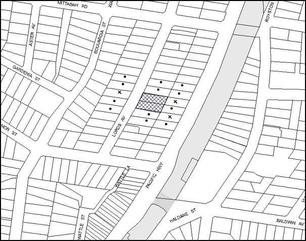
|
NOTIFICATION PLAN |
|
||
|
• PROPERTIES NOTIFIED
|
X SUBMISSIONS RECEIVED |
PROPERTY SUBJECT OF DEVELOPMENT |
|
Three submissions object to the development, generally on the grounds that the development would result in:
· Increased volume of traffic in the area;
· Unacceptable overshadowing of adjoining properties;
· Unacceptable noise from the development;
· Setback encroachments;
· Overlooking of adjoining properties;
· The development is out of character with the surrounding low density development;
· Negative impact on surrounding flora and fauna and wild life; and
· Devalue adjoining properties.
The merits of the matters raised in community submissions have been addressed in the body of the report.
5.2 Public Agencies
The development application was not referred to any Public Agencies for comment.
6. THE PUBLIC INTEREST
Section 79C(1)(e) of the Act requires Council to consider “the public interest”.
The public interest is an overarching requirement, which includes the consideration of the matters discussed in this report. Implicit to the public interest is the achievement of future built outcomes adequately responding to and respecting the future desired outcomes expressed in environmental planning instruments and development control plans.
The application is considered to have satisfactorily addressed Council’s and relevant agencies’ criteria and would provide a development outcome that, on balance, would result in a positive impact for the community. Accordingly, it is considered that the approval of the proposed development would be in the public interest.
CONCLUSION
The application seeks approval for the demolition of existing structures and construction of a five storey residential flat building comprising 26 units with basement car parking.
The proposed development is generally in accordance with the development controls for the ‘Lords Avenue, Asquith’ Precinct of the Housing Strategy DCP and would contribute to the future desired five storey residential character of the precinct. The minor non-compliance with prescriptive measures for top storey setbacks and basement setbacks are considered acceptable. The proposal complies with the design principles of SEPP 65 and the Residential Flat Design Code.
The proposal would result in a development that would be in keeping with the desired future character of the precinct.
|
Cassandra Williams Team Leader - Major Applications Planning Division |
James Farrington Group Manager Planning Division |
|
1.View |
Locality Map |
|
|
|
2.View |
Plans - Part 1 |
|
|
|
3.View |
Plans - Part 2 |
|
|
|
4.View |
Plans - Part 3 |
|
|
|
5.View |
Landscape Plan |
|
|
|
6.View |
Elevations and Sections |
|
|
|
7.View |
Colour Schedule |
|
|
|
8.View |
Shadow Diagrams |
|
|
File Reference: DA/889/2013
Document Number: D02753650
‘
SCHEDULE 1
GENERAL CONDITIONS
The conditions of consent within this notice of determination have been applied to ensure that the use of the land and/or building is carried out in such a manner that is consistent with the aims and objectives of the relevant legislation, planning instruments and council policies affecting the land and does not disrupt the amenity of the neighbourhood or impact upon the environment.
Note: For the purpose of this consent, the term ‘applicant’ means any person who has the authority to act on or the benefit of the development consent.
Note: For the purpose of this consent, any reference to an Act, regulation, Australian Standard or publication by a public authority shall be taken to mean the gazetted act or regulation, or adopted Australian Standard or publication as in force on the date that the application for a construction certificate is made.
1. Deferred Commencement
Pursuant to Section 80(3) of the Environmental Planning and Assessment Act 1979, this consent does not operate until the following information is submitted to Council:
a) The registration and creation of an easement to drain water from the site over Lot 29 DP 12901 & Lot 3 DP 136220.
b) A public positive covenant shall be created burdening Lot 30 DP 12901 whereby the owner for the time being of such lot will maintain, repair and replace any pipes laid within the site of the easement.
c) Any pipes to be laid within the site of the easement must be located beneath the surface of the burdened lot.
Such information shall be submitted within 12 months of the date of this notice.
Note: Hornsby Shire Council is the current owner of the land being the site of the required easement referred to in this deferred commencement condition. Nothing in this Determination should be construed expressly or impliedly as an indication of such Council agreeing in principle or in fact to the grant of the required easement. If Council is approached by the Applicant or agents on its behalf to grant the required easement then such application will be dealt with on its merits and in accordance with the Council’s commercial and statutory obligations to its stakeholders.
Upon Council’s written satisfaction of the above information, the following conditions of development consent will apply.
2. Approved Plans and Supporting Documentation
The development must be carried out in accordance with the plans and documentation listed below and endorsed with Council’s stamp, except where amended by Council and/or other conditions of this consent:
Approved Plans
|
Plan No. |
Plan Title |
Drawn by |
Dated |
|
100159 DA01 – Issue C |
Site Plan |
Faubourg 24 |
14-01-2014 |
|
100159 DA02 – Issue A |
Basement Plan 2 |
Faubourg 24 |
- |
|
100159 DA03 – Issue C |
Basement Plan 1 |
Faubourg 24 |
14-01-2014 |
|
100159 DA04 – Issue C |
Ground Floor Plan |
Faubourg 24 |
14-01-2014 |
|
100159 DA05 – Issue B |
First Floor Plan |
Faubourg 24 |
30-10-2013 |
|
100159 DA06 – Issue B |
Second Floor Plan |
Faubourg 24 |
30-10-2013 |
|
100159 DA07 – Issue B |
Third Floor Plan |
Faubourg 24 |
30-10-2013 |
|
100159 DA08 – Issue B |
Fourth Floor Plan |
Faubourg 24 |
30-10-2013 |
|
100159 DA09 – Issue B |
Roof Plan |
Faubourg 24 |
30-10-2013 |
|
100159 DA10 – Issue B |
Section AA and BB |
Faubourg 24 |
30-10-2013 |
|
100159 DA11 – Issue B |
Section CC and Streetscape |
Faubourg 24 |
30-10-2013 |
|
100159 DA13 – Issue B |
Elevations 1 |
Faubourg 24 |
30-10-2013 |
|
100159 DA13 – Issue B |
Elevations 2 |
Faubourg 24 |
30-10-2013 |
|
13153 DA1 B – Issue B |
Landscape Concept Plan |
Vision Dynamics |
01-11-2013 |
|
100159 CS 04 – Issue B |
Schedule of Finishes |
Faubourg 24 |
- |
Supporting Documentation
|
Document Title |
Drawn by |
Dated |
|
Survey Plan |
Norton Survey Partners |
27-4-2013 |
|
Proposed Easement Layout |
A/W Design |
03-12-2013 |
|
Setback Compliance – 100159 DA14 – Issue A |
Faubourg 24 |
- |
|
BASIX Certificate 499058M |
Design Review |
26-08-2013 |
|
Traffic Impact Report and Car Parking Certification |
Safeway Traffic Management Solutions |
August 2013 |
|
Design Verification Statement |
Danny Khoury |
- |
|
Assessor Certificate (Thermal Performance) - 14750032 |
Design Review |
23-08-2013 |
|
Waste Management Plan |
Faubourg 24 |
30-08-2013 |
|
Access Compliance Assessment Report |
Certified Building Specialists |
28-08-2013 |
|
Solar Analysis 1 – 7 |
Faubourg 24 |
- |
|
Shadow Analysis 1 – 3 |
Faubourg 24 |
- |
3. Removal of Existing Trees
This development consent permits the removal of trees numbered 1, 4, 5, 6, 7, 8, 9, 10 and 11 as identified on the Site Tree Location Plan prepared by Hornsby Council dated 23/10/13. The removal of any other trees requires separate approval under Council’s Tree Preservation Order.
The removal of tree 1 located on the nature strip shall be undertaken in accordance with the following:
a) A suitably qualified and experienced Arborist (Australian Qualification Level 3 or higher) shall be employed to undertake the works.
b) A copy of the Arborist’s (Tree Contractor’s) Public Liability Insurance Certificate and qualifications shall be provided to Council prior to the works date.
c) Notification of the date of works is to be provided to Council one week in advance.
4. Amendment of Plans
The approved plans are to be amended as follows:
a) The approved Ground Floor Plan DA-04 Issue C, prepared by Faubourg 24, dated 14-1-2014 is to be amended to remove the courtyard garden areas of unit numbers 4 and 5 and the area included as communal landscaping. Terraces are to be provided with 1.5m fencing and appropriate landscape screening for resident privacy as marked in red on the approved plans.
5. Construction Certificate
A Construction Certificate is required to be approved by Council or a Private Certifying Authority prior to the commencement of any works under this consent.
REQUIREMENTS PRIOR TO THE ISSUE OF A CONSTRUCTION CERTIFICATE
6. Building Code of Australia
All building work must be carried out in accordance with the relevant requirements of the Building Code of Australia.
7. Contract of Insurance (Residential Building Work)
In the case of residential building work for which the Home Building Act, 1989 requires there to be a contract of insurance in force in accordance with Part 6 of that Act, that such a contract of insurance is in force before any building work authorised to be carried out by the consent commences.
8. Notification of Home Building Act, 1989 Requirements
Residential building work within the meaning of the Home Building Act, 1989 must not be carried out unless the principal certifying authority for the development to which the work relates (not being Council) has given Council written notice of the following information:
a) In the case of work for which a principal contractor is required to be appointed:
i) The name and licence number of the principal contractor; and
ii) The name of the insurer by which the work is insured under Part 6 of that Act.
b) In the case of work to be done by an owner-builder:
i) The name of the owner-builder; and
ii) If the owner-builder is required to hold an owner-builder’s permit under that Act, the number of the owner-builder’s permit.
Note: If arrangements for doing the residential building work are changed while the work is in progress so that the information notified becomes out of date, further work must not be carried out unless the principal certifying authority for the development to which the work relates (not being Council) has given Council written notification of the updated information.
9. Utility Services
The applicant must submit written evidence of the following service provider requirements:
a) Ausgrid (formerly Energy Australia) – a letter of consent demonstrating that satisfactory arrangements have been made to service the proposed development.
10. Dilapidation Report
A ‘Dilapidation Report’ is to be prepared by a ‘chartered structural engineer’ detailing the structural condition of all adjoining properties.
11. Adaptable Units
The details of fit-outs of all accessible units and details of adaptable units must be provided with the Construction Certificate Plans.
12. Letter Boxes
The details of letter boxes must be provided with the Construction Certificate Plans. The letter boxes must be provided with a minimum setback of 2m from the front property boundary.
13. Car Parking and Deliveries
All car parking must be constructed and operated in accordance with Australian Standard AS 2890.1 – 2004 – Off Street Car Parking and Australian Standard 2890.2 - 2002 – Off Street Commercial and the following requirement:
a) All parking areas and driveways are to be sealed to an all weather standard, line marked and signposted.
b) Car parking, loading and manoeuvring areas to be used solely for nominated purposes.
c) Vehicles awaiting loading, unloading or servicing shall be parked on site and not on adjacent or nearby public roads.
d) All vehicular entry on to the site and egress from the site shall be made in a forward direction.
14. Motorcycle Parking
One motorcycle space is to be provided in the basement parking area and designed in accordance with AS2890.1-2004 Off Street Car Parking and the following requirements:
a) The car parking spaces are to be re-configured to provide 1 motorcycle parking space;
b) The motorcycle parking space is to be designed and located so that parked motorcycles are not vulnerable to being struck by a manoeuvring vehicle.
15. Parking Spaces for People with Disabilities
All parking spaces for people with disabilities must be constructed and operated in accordance with Australian Standard AS/NZS 2890.6:2009 – Off-street parking for people with disabilities.
16. Traffic Control Plan
A Traffic Control Plan (TCP) must be prepared by a qualified traffic controller in accordance with the Roads & Traffic Authority’s Traffic Control at Worksites Manual 1998 and Australian Standard 1742.3 for all work on a public road and be submitted to Council. The TCP must detail the following where required:
a) Arrangements for public notification of the works.
b) Temporary construction signage.
c) Permanent post-construction signage.
d) Vehicle movement plans.
e) Traffic management plans.
f) Pedestrian and cyclist access/safety.
17. Waste Management Details
The following waste management requirements must be complied with:
a) The bin collection area needs to be increased in area to 4.2 m x 2.3 m. There must be no steps between the bin collection area and the driveway.
b) Vehicle turning paths demonstrating that a small rigid vehicle is able to reverse in and forward out of the site (in accordance with AS 2890.2).
c) A Waste Management Plan Section One – Demolition Stage and Section Three – Construction Stage, covering the scope of this project and including the following details, is required to be submitted to Council:
i) An estimate of the types and volumes of waste and recyclables to be generated;
ii) A site plan showing sorting and storage areas for demolition and construction waste and the vehicle access to these areas;
iii) How excavation, demolition and construction waste materials will be reused or recycled and where residual wastes will be disposed;
iv) The total percentage (by weight) of demolition and construction waste that will be reused or recycled.
18. Stormwater Drainage
The stormwater drainage system for the development must be designed and constructed in accordance with Council’s Civil Works – Design and Construction Specification 2005 and the following requirements:
a) Connected directly to Council’s street drainage system in the Pacific Highway.
b) An inter-allotment stormwater drainage system to service the proposed with pits being constructed in situ.
c) A Construction Certificate is to be issued for this work.
19. On Site Stormwater Detention
An on-site stormwater detention system must be designed by a chartered civil engineer and constructed in accordance with the following requirements:
a) Have a capacity of not less than 23.5 cubic metres, and a maximum discharge (when full) of 29 litres per second.
b) Have a surcharge/inspection grate located directly above the outlet.
c) Discharge from the detention system to be controlled via 1 metre length of pipe, not less than 50 millimetres diameter or via a stainless plate with sharply drilled orifice bolted over the face of the outlet discharging into a larger diameter pipe capable of carrying the design flow to an approved Council system.
d) A Construction Certificate is to be issued for this work.
e) Not be constructed in a location that would impact upon the visual or recreational amenity of residents.
20. Internal Driveway/Vehicular Areas
The driveway and parking areas on site must be designed in accordance with Australian Standards 2890.1, 2890.2, 3727 and the following requirements:
a) Design levels at the front boundary must be obtained from Council.
21. Footpath
A separate application under the Local Government Act, 1993 and the Roads Act, 1993 must be submitted to Council for the construction of a new footpath and removal of the redundant crossing. A concrete footpath must be constructed along the full frontage of the subject site in accordance Council’s Civil Works Design and Construction Specification, 2005 and the following requirements:
a) The existing footpath being removed and reconstructed.
b) Any public utility adjustments to be carried out at the cost of the applicant and to the requirements of the relevant public authority.
c) No work is to occur within the public road reserve until such time as the written approval of Hornsby Shire Council has been obtained under the Roads Act.
d) The land adjoining the footpath to be fully turfed.
22. Vehicular Crossing
A separate application under the Local Government Act, 1993 and the Roads Act, 1993 must be submitted to Council for the installation of a new vehicular crossing and the removal of the redundant crossing. The vehicular crossing must be constructed in accordance with Council’s Civil Works Design, 2005 and the following requirements:
a) Any redundant crossings must be replaced with integral kerb and gutter.
23. Road Works
A separate application under the Local Government Act, 1993 and the Roads Act, 1993 must be submitted to Council for the reconstruction of the kerb and gutter across the frontage of the site in Lords Avenue. All road works approved under this consent must be constructed in accordance with Council’s Civil Works Design and Construction Specification, 2005 and the following requirements:
a) The existing road pavement to be saw cut a minimum of 300 mm from the existing edge of the bitumen and reconstructed.
b) No work is to occur within the public road reserve until such time as the written approval of Hornsby Shire Council has been obtained under the Roads Act.
REQUIREMENTS PRIOR TO THE COMMENCEMENT OF ANY WORKS
24. Erection of Construction Sign
A sign must be erected in a prominent position on any site on which building work, subdivision work or demolition work is being carried out:
a) Showing the name, address and telephone number of the principal certifying authority for the work;
b) Showing the name of the principal contractor (if any) for any demolition or building work and a telephone number on which that person may be contacted outside working hours; and
c) Stating that unauthorised entry to the work site is prohibited.
Note: Any such sign is to be maintained while the building work, subdivision work or demolition work is being carried out, but must be removed when the work has been completed.
25. Protection of Adjoining Areas
A temporary hoarding, fence or awning must be erected between the work site and adjoining lands before the works begin and must be kept in place until after the completion of the works if the works:
a) Could cause a danger, obstruction or inconvenience to pedestrian or vehicular traffic.
b) Could cause damage to adjoining lands by falling objects.
c) Involve the enclosure of a public place or part of a public place.
Note: Notwithstanding the above, Council’s separate written approval is required prior to the erection of any structure or other obstruction on public land.
26. Toilet Facilities
Toilet facilities must be available or provided at the works site before works begin and must be maintained until the works are completed at a ratio of one toilet for every 20 persons employed at the site. Each toilet must:
a) be a standard flushing toilet connected to a public sewer; or
b) be a temporary chemical closet approved under the Local Government Act, 1993; or
c) have an on-site effluent disposal system approved under the Local Government Act, 1993.
27. Erosion and Sediment Control
Erosion and sediment control measures must be provided and maintained throughout the construction period in accordance with the manual ‘Soils and Construction 2004 (Bluebook)’, the approved plans, Council specifications and to the satisfaction of the principal certifying authority. The erosion and sediment control devices must remain in place until the site has been stabilised and revegetated.
Note: On the spot penalties up to $1,500 may be issued for any non-compliance with this requirement without any further notification or warning.
28. Waste Management Details
Waste management during the demolition and construction phase of the development must be undertaken in accordance with the approved Waste Management Plan. Additionally written records of the following items must be maintained during the removal of any waste from the site and such information submitted to the Principal Certifying Authority within fourteen days of the date of completion of the works:
a) The identity of the person removing the waste.
b) The waste carrier vehicle registration.
c) Date and time of waste collection.
d) A description of the waste (type of waste and estimated quantity).
e) Details of the site to which the waste is to be taken.
f) The corresponding tip docket/receipt from the site to which the waste is transferred (noting date and time of delivery, description (type and quantity) of waste).
g) Whether the waste is expected to be reused, recycled or go to landfill.
Note: In accordance with the Protection of the Environment Operations Act 1997, the definition of waste includes any unwanted substance, regardless of whether it is reused, recycled or disposed to landfill.
REQUIREMENTS DURING CONSTRUCTION
29. Construction Work Hours
All work on site (including demolition and earth works) must only occur between 7am and 5pm Monday to Saturday. No work is to be undertaken on Sundays or public holidays.
30. Demolition
All demolition work must be carried out in accordance with “Australian Standard 2601-2001 – The Demolition of Structures” and the following requirements:
a) Demolition material must be disposed of to an authorised recycling and/or waste disposal site and/or in accordance with an approved waste management plan;
b) Demolition works, where asbestos material is being removed, must be undertaken by a contractor that holds an appropriate licence issued by WorkCover NSW in accordance with Chapter 10 of the Occupational Health and Safety Regulation 2001 and Clause 29 of the Protection of the Environment Operations (Waste) Regulation 2005 ; and
c) On construction sites where buildings contain asbestos material, a standard commercially manufactured sign containing the words ‘DANGER ASBESTOS REMOVAL IN PROGRESS’ measuring not less than 400mm x 300mm must be erected in a prominent position visible from the street.
31. Environmental Management
The site must be managed in accordance with the publication ‘Managing Urban Stormwater – Landcom (March 2004) and the Protection of the Environment Operations Act 1997 by way of implementing appropriate measures to prevent sediment run-off, excessive dust, noise or odour emanating from the site during the construction of the development.
32. Street Sweeping
Street sweeping must be undertaken following sediment tracking from the site along Lords Avenue, Asquith during works and until the site is established.
33. Council Property
During construction works, no building materials, waste, machinery or related matter is to be stored on the road or footpath. The public reserve must be kept in a clean, tidy and safe condition at all times.
34. Disturbance of Existing Site
During construction works, the existing ground levels of open space areas and natural landscape features, (including natural rock-outcrops, vegetation, soil and watercourses) must not be altered unless otherwise nominated on the approved plans.
35. Landfill
Landfill must be constructed in accordance with Council’s ‘Construction Specification, 2005’ and the following requirements:
a) All fill material imported to the site is to wholly consist of Virgin Excavated Natural Material (VENM) as defined in Schedule 1 of the Protection of the Environment Operations Act 1997 or a material approved under the Department of Environment and Climate Change’s general resource recovery exemption.
b) A compaction certificate is to be obtained from a geotechnical engineer verifying that the specified compaction requirements have been met.
36. Excavated Material
All excavated material removed from the site must be classified in accordance with the Department of Environment, Climate Change and Water NSW Waste Classification Guidelines prior to disposal to an approved waste management facility and reported to the principal certifying authority.
37. Survey Report – Finished Floor Level
A report(s) must be prepared by a registered surveyor and submitted to the principal certifying authority prior to the pouring of concrete at each level of the building certifying that:
a) The building, retaining walls and the like have been correctly positioned on the site; and
b) The finished floor level(s) are in accordance with the approved plans.
38. Contamination During Construction Works
Should the presence of asbestos or soil contamination, not recognised during the application process be identified during demolition, the applicant must immediately notify the Principal Certifying Authority and Council.
39. Construction Noise Management
The construction works must be undertaken in accordance with the “Interim Construction Noise Guidelines – 2009” published by Department of Environment and Climate Change NSW.
38. Waste Management Details
Waste management during the demolition and construction phase of the development must be undertaken in accordance with the approved Waste Management Plan. Additionally written records of the following items must be maintained during the removal of any waste from the site and such information submitted to the Principal Certifying Authority within fourteen days of the date of completion of the works:
a) The identity of the person removing the waste.
b) The waste carrier vehicle registration.
c) Date and time of waste collection.
d) A description of the waste (type of waste and estimated quantity).
e) Details of the site to which the waste is to be taken.
f) The corresponding tip docket/receipt from the site to which the waste is transferred (noting date and time of delivery, description (type and quantity) of waste).
g) Whether the waste is expected to be reused, recycled or go to landfill.
39. Works Near Trees
All required tree protection measures are to be maintained in good condition for the duration of the construction period.
All works (including driveways and retaining walls) within 6 metres of any trees required to be retained (whether or not on the subject property, and pursuant to this consent or the Tree Preservation Order), must be carried out under the supervision of an ‘AQF Level 5 Arborist’ and a certificate submitted to the principal certifying authority detailing the method(s) used to preserve the tree(s).
Note: Except as provided above, the applicant is to ensure that no excavation, filling or stockpiling of building materials, parking of vehicles or plant, disposal of cement slurry, waste water or other contaminants is to occur within 4 metres of any tree to be retained.
REQUIREMENTS PRIOR TO THE ISSUE OF AN OCCUPATION CERTIFICATE
Note: For the purpose of this consent, a reference to ‘occupation certificate’ shall not be taken to mean an ‘interim occupation certificate’ unless otherwise stated.
40. Fulfilment of BASIX Commitments
The applicant must demonstrate the fulfilment of BASIX commitments pertaining to the development.
41. Sydney Water – s73 Certificate
An s73 Certificate must be obtained from Sydney Water.
Note: Sydney Water requires that s73 applications are to be made through an authorised Sydney Water Servicing Coordinator. Refer to www.sydneywater.com.au or telephone 13 20 92 for assistance.
42. Damage to Council Assets
Any damage caused to Council’s assets as a result of the construction of the development must be rectified in accordance with Council’s written requirements and at the sole cost of the applicant. The restoration of public assets shall be considered for approval with Hornsby Shire Council’s Compliance Certificate matters in the Condition titled Road Works.
43. Consolidation of Lots
All lots in the subject allotment are to be consolidated into one allotment.
44. Completion of Landscaping
A certificate must be provided by a practicing landscape architect, horticulturalist or person with similar qualifications and experience certifying that all required landscaping works have been satisfactorily completed in accordance with the approved landscape plans.
Note: Advice on suitable species for landscaping can be obtained from Council’s planting guide ‘Indigenous Plants for the Bushland Shire’, available at www.hornsby.nsw.gov.au.
45. Creation of Easements
The following matter(s) must be created on the title of the property in accordance with the Conveyancing Act 1919:
a) The creation of an appropriate "Positive Covenant" and "Restriction as to User" over the constructed on-site detention/retention systems and outlet works, within the lots in favour of Council in accordance with Council’s prescribed wording. The position of the on-site detention system is to be clearly indicated on the title.
b) To register the OSD easement, the restriction on the use of land “works-as-executed” details of the on-site-detention system must be submitted verifying that the required storage and discharge rates have been constructed in accordance with the design requirements. The details must show the invert levels of the on site system together with pipe sizes and grades. Any variations to the approved plans must be shown in red on the “works-as-executed” plan and supported by calculations.
Note: Council must be nominated as the authority to release, vary or modify any easement, restriction or covenant.
46. Garbage Collection Easement
For the purpose of waste collection, an easement entitling Council, its servants and agents and persons authorised by it to enter upon the subject land and to operate thereon, vehicles and other equipment for the purposes of garbage collection must be granted to Council by the owner of the land.
Note: The easement must be in a form prescribed by Council and must include covenants to the effect that parties will not be liable for any damage caused to the subject land or any part thereof or to any property located therein or thereon by reason of the operation thereon of any vehicle or other equipment used in connection with the collection of garbage and to the effect that the owner for the time being of the subject land shall indemnify the Council, its servants, agents and persons authorised by it to collect garbage against liability in respect of any such claims made by any person whomsoever.
47. Works as Executed Plan
A works-as-executed plan(s) must be prepared by a registered surveyor and submitted to Council for completed road pavement, kerb & gutter, public drainage systems, driveways and on-site detention system. The plan(s) must be accompanied by a certificate from a registered surveyor certifying that all pipelines and associated structures lie wholly within any relevant easements.
48. Retaining Walls
All required retaining walls must be constructed as part of the development.
49. Construction for a Safe Environment
Prior to the issue of the Occupation Certificate, the site must include the following elements:
a) An intercom system be installed at gate locations to ensure screening of persons entering the units.
b) The entryway to the site be illuminated in high luminance at all times.
c) The communal open space areas are to be illuminated with high luminance by motion sensor lighting.
d) The service areas of the ground floor and the garbage room at the basement be illuminated with high luminance by motion sensor lighting.
e) The driveway and the basement car park is to be illuminated with low luminance at all times.
f) Robust materials which cannot be forced or breached with minimised maintenance requirements are to be used for construction work in the common areas.
g) The lamps and lighting levels must comply with Australian and New Zealand Lighting Standard 1158.1.
h) Effective signage be provided to guide visitors to the main areas and parking areas.
i) A street sign be prominently displayed in front of the site in accordance with Order No. 8, Section 124 Local Government Act 1993.
j) The communal area must include a clear sign to restrict access for non-residents.
k) Units’ numbers, entry and exit signs must be legible and clear.
l) Fire exit doors to be fitted with single cylinder locksets (Australia New Zealand Standard-Locksets).
m) The entry doors to the pedestrian foyer is to be constructed of safety rated glass to enable residents a clear line of site before entering or exiting the residential apartments.
n) Lighting is to be provided to pathways, building foyer entries, driveways and common external spaces.
o) Security deadlocks are to be provided to each apartment door.
p) Peep holes are to be provided to individual apartment doors to promote resident safety.
50. External Lighting
All external lighting must be designed and installed in accordance with Australian Standard AS 4282 – Control of the Obtrusive Effects of Outdoor Lighting. Certification of compliance with the Standard must be obtained from a suitably qualified person.
51. Unit Numbering
The allocation of unit numbering must be authorised by Council prior to the numbering of each unit in the development.
52. Car Parking Allocation and Resident Storage
The basement resident storage areas are to be allocated in accordance with the size requirements of the Residential Flat Design Code for the respective units and proximity to the unit car parking space.
53. Planter Boxes / On Slab Planting
On slab planter boxes must include waterproofing, subsoil drainage (proprietary drainage cell, 50mm sand and filter fabric) automatic irrigation, minimum 500mm planting soil for shrubs and minimum 1000mm planting soil for trees and palms and 75mm mulch to ensure sustainable landscape is achieved.
54. Tree Planting
Tree planting to the rear (eastern) landscape setback area must include One (1) additional Angophora costata (Sydney Red Gum). Trees shall be installed at minimum 25 litre pot size.
55. Street Tree Plantings
The existing Callitris rhomboidea on the Lords Avenue street verge is to be removed and replaced by a Lagerstroemia indica (Crepe myrtle). Tree shall be installed at minimum 75 litre pot size.
56. Waste Management Details
The following waste management requirements must be complied with:
a) The bin storage room(s) at the basement level must include water or a hose for cleaning, graded floors with drainage to sewer, a robust door, sealed and impervious surface, adequate lighting and ventilation. The bin rooms at each residential level must include sealed and impervious surface, adequate lighting and ventilation.
b) A report must be prepared by an appropriately qualified person, certifying the following:
i) A comparison of the estimated quantities of each waste type against the actual quantities of each waste type.
Note: Explanations of any deviations to the approved Waste Management Plan is required to be included in this report.
ii) That at least 60% of the waste generated during the demolition and construction phase of the development was reused or recycled.
Note: If the 60% diversion from landfill cannot be achieved in the Construction Stage, the Report is to include the reasons why this occurred and certify that appropriate work practices were employed to implement the approved Waste Management Plan. The Report must be based on documentary evidence such as tipping dockets/receipts from recycling depots, transfer stations and landfills, audits of procedures etc. which are to be attached to the report.
iii) All waste was taken to site(s) that were lawfully permitted to accept that waste.
c) Each unit must be provided with an indoor waste/recycling cupboard for the interim storage of a minimum one day’s waste generation with separate containers for general waste and recyclable materials.
d) Space must be provided for either individual compost containers for each unit or a communal compost container.
Note: The location of the compost containers should have regard for potential amenity impacts.
e) The bin carting routes must be devoid of any steps.
Note: Ramps between different levels are acceptable.
57. Maintain Canopy Cover
In addition to the submitted Landscape Plan drawing number 13153DA 1 Issue A dated 26.5.13 prepared by Vision Dynamics landscape architects, and to maintain canopy cover, 4 medium to large trees selected from Council’s booklet ‘Indigenous Plants for the Bushland Shire’ such as Syncarpia glomulifera (Turpentine), Angophora floribunda (Rough Barked Apple), Corymbia gummifera (Red Bloodwood), Corymbia eximia (Yellow Bloodwood) and Allocasuarina littoralis (Black She-oak) are to be planted on the subject site. The planting location of these additional trees shall be located within the common open space on the eastern side of the site and shall not be within 4 metres of the foundation walls of a dwelling or in-ground pool. The pot size is to be a minimum 75 litres and the trees must be maintained until they reach the height of 3 metres. Trees must be native to Hornsby Shire and reach a mature height greater than 10 metres.
58. Section 94 Development Contributions
In accordance with Section 80A(1) of the Environmental Planning and Assessment Act 1979 and the Hornsby Shire Council Section 94 Development Contributions Plan 2012-2021, the following monetary contributions shall be paid to Council to cater for the increased demand for community infrastructure resulting from the development:
|
Description |
Contribution (4) |
|
Roads |
$27,228.75 |
|
Open Space and Recreation |
$297,879.70 |
|
Community Facilities |
$41,753.45 |
|
Plan Preparation and Administration |
$1,220.10 |
|
TOTAL |
$368,082.00 |
being for 26 units, 3 x 1 bedroom, 3 x 20 bedroom and 3 x 3 bedroom in place of 2 dwelling houses.
a) If the contributions are not paid within the financial quarter that this consent is granted, the contributions payable will be adjusted in accordance with the provisions of the Hornsby Shire Council Section 94 Development Contributions Plan and the amount payable will be calculated at the time of payment in the following manner:
$CPY = $CDC x CPIPY
CPIDC
Where:
$CPY is the amount of the contribution at the date of Payment.
$CDC is the amount of the contribution as set out in this Development Consent.
CPIPY is the latest release of the Consumer Price Index (Sydney – All Groups) at the date of Payment as published by the ABS.
CPIDC is the Consumer Price Index (Sydney – All Groups) for the financial quarter at the date of this Development Consent.
b) The monetary contributions shall be paid to Council:
i) prior to the issue of the Subdivision Certificate where the development is for subdivision; or
ii) prior to the issue of the first Construction Certificate where the development is for building work; or
iii) prior to issue of the Subdivision Certificate or first Construction Certificate, whichever occurs first, where the development involves both subdivision and building work; or
iv) prior to the works commencing where the development does not require a Construction Certificate or Subdivision Certificate.
It is the professional responsibility of the Principal Certifying Authority to ensure that the monetary contributions have been paid to Council in accordance with the above timeframes.
Council’s Development Contributions Plan may be viewed at www.hornsby.nsw.gov.au or a copy may be inspected at Council’s Administration Centre during normal business hours.
OPERATIONAL CONDITIONS
59. Visitor Access
Visitors are to have access to the parking area at all times. Visitors are to be able to access the basement car park by an audio/visual intercom system located at the top of the ramped driveway.
60. Waste Storage Area and Waste Management
The waste management on site must be in accordance with the following requirements:
a) A site caretaker must be employed and be responsible for moving bins where and when necessary, washing bins and maintaining waste storage areas, ensuring the chute system and related devices are maintained in effective and efficient working order, managing the communal composting area, managing the bulky item storage area, arranging the prompt removal of dumped rubbish, and ensuring all residents are informed of the use of the waste management system.
61. Landscape Establishment
The landscape works must be maintained into the future to ensure the establishment and successful growth of plant material to meet the intent of the landscape design. This must include but not be limited to watering, weeding, replacement of failed plant material and promoting the growth of plants through standard industry practices.
62. Noise
The level of total continuous noise emanating from operation of the premises including all the plant, including air conditioning units and processes in all buildings (LA10) (measured for at least 15 minutes) in or on the above premises, must not exceed the background level by more than 5dB(A) when measured at all property boundaries.
63. Fire Safety Statement - Annual
On at least one occasion in every 12 month period following the date of the first ‘Fire Safety Certificate’ issued for the property, the owner must provide Council with an annual ‘Fire Safety Certificate’ to each essential service installed in the building.
- END OF CONDITIONS -
ADVISORY NOTES
The following information is provided for your assistance to ensure compliance with the Environmental Planning and Assessment Act, 1979, Environmental Planning and Assessment Regulation 2000, other relevant legislation and Council’s policies and specifications. This information does not form part of the conditions of development consent pursuant to Section 80A of the Act.
Environmental Planning and Assessment Act, 1979 Requirements
The Environmental Planning and Assessment Act, 1979 requires:
· The issue of a construction certificate prior to the commencement of any works. Enquiries can be made to Council’s Customer Services Branch on 9847 6760.
· A principal certifying authority to be nominated and Council notified of that appointment prior to the commencement of any works.
· Council to be given at least two days written notice prior to the commencement of any works.
· Mandatory inspections of nominated stages of the construction inspected.
· An occupation certificate to be issued before occupying any building or commencing the use of the land.
Long Service Levy
In accordance with Section 34 of the Building and Construction Industry Long Service Payments Act 1986, a ‘Long Service Levy’ must be paid to the Long Service Payments Corporation or Hornsby Council.
Note: The rate of the Long Service Levy is 0.35% of the total cost of the work.
Note: Hornsby Council requires the payment of the Long Service Levy prior to the issue of a construction certificate.
Disability Discrimination Act
The applicant’s attention is drawn to the existence of the Disability Discrimination Act. A construction certificate is required to be obtained for the proposed building/s, which will provide consideration under the Building Code of Australia, however, the development may not comply with the requirements of the Disability Discrimination Act. This is the sole responsibility of the applicant.
Covenants
The land upon which the subject building is to be constructed may be affected by restrictive covenants. Council issues this approval without enquiry as to whether any restrictive covenant affecting the land would be breached by the construction of the building, the subject of this consent. Applicants must rely on their own enquiries as to whether or not the building breaches any such covenant.
Tree Preservation Order
To ensure the maintenance and protection of the existing natural environment, it is an offence to ringbark, cut down, top, lop, remove, wilfully injure or destroy a tree outside 3 metres of the approved building envelope without the prior written consent from Council.
Note: A tree is defined as a single or multi-trunked wood perennial plant having a height of not less than three (3) metres, and which develops many branches, usually from a distance of not less than one (1) metre from the ground, but excluding any plant which, in its particular location, is a noxious plant declared as such pursuant to the Noxious Weeds Act 1993. This definition of ‘tree’ includes any and all types of Palm trees.
All distances are determined under Australian Standard AS4970-2009 ”Protection of Trees on Development Sites”.
Fines may be imposed for non-compliance with Council’s Tree Preservation Order.
Dial Before You Dig
Prior to commencing any works, the applicant is encouraged to contact Dial Before You Dig on 1100 or www.dialbeforeyoudig.com.au for free information on potential underground pipes and cables within the vicinity of the development site.
Telecommunications Act 1997 (Commonwealth)
If you are aware of any works or proposed works which may affect or impact on Telstra’s assets in any way, you are required to contact: Telstra’s Network Integrity Team on Phone Number 1800810443.
Asbestos Warning
Should asbestos or asbestos products be encountered during demolition or construction works, you are advised to seek advice and information prior to disturbing this material. It is recommended that a contractor holding an asbestos-handling permit (issued by WorkCover NSW)be engaged to manage the proper handling of this material. Further information regarding the safe handling and removal of asbestos can be found at:
Alternatively, telephone the WorkCover Asbestos and Demolition Team on 8260 5885.
House Numbering
House numbering can only be authorised by Council. Before proceeding to number each premise in the development, the allocation of numbers is required to be obtained from Council's Planning Division prior to the issue of a Subdivision Certificate. The authorised numbers are required to comply with Council’s Property Numbering Policy and be displayed in a clear manner at or near the main entrance to each premise.
Group Manager's Report No. PL4/14
Planning Division
Date of Meeting: 12/02/2014
8 REPORTING VARIATIONS TO DEVELOPMENT STANDARDS
EXECUTIVE SUMMARY
· In accordance with the Department of Planning and Infrastructure’s Planning Circular PS 08‑14, Council is required to report variations to development standards for development applications approved under delegated authority, which relied upon State Environmental Planning Policy No. 1 – Development Standards (SEPP 1).
· Council’s consideration of this report ensures Council’s obligation to monitor variations to development standards is complied with.
|
THAT the contents of Group Manager’s Report No. PL4/14 be received and noted. |
PURPOSE
The purpose of this report is to advise Council of determined development applications under delegated authority involving a SEPP 1 variation to a development standard for the period 1 October 2013 to 31 December 2013.
DISCUSSION
The Department of Planning and Infrastructure’s Circular B1, issued in March 1989, requested that councils monitor the use of the Director-General’s assumed concurrence under SEPP 1 on a quarterly basis. This reporting requirement remains effective.
Monitoring of variations to development standards is important to provide the Department and councils with an overview of the manner in which established development standards are being varied and whether the assumed concurrence is being used as intended. This enables Council and the Department to determine whether development standards are appropriate, or whether changes are required.
The Department issued Circular PS 08–014 on 14 November 2008. The purpose of the Circular was to remind councils of their responsibilities to monitor the use of the Director-General’s assumed concurrence under SEPP 1. Councils were reminded of the need to keep accurate records of the use of SEPP 1 and to report on a quarterly basis.
The Circular also provides that councils are required to adopt the following four measures:
1. Establish a register of development applications determined with variations in standards under SEPP 1.
2. Require all development applications where there has been a variation greater than 10% in standards under SEPP 1 to be determined by full council (rather than General Manager or nominated staff member).
3. Provide a report to Council on the development applications determined where there had been a variation in standards under SEPP 1.
4. Make the register of development applications determined with variations in standards under SEPP 1 available to the public on the council’s website.
In accordance with Point 3 of the Department’s Circular, attached is a list of development applications determined under delegated authority involving a SEPP 1 variation to a development standard for the period 1 October 2013 to 31 December 2013.
A copy of the attachment to this report is also reproduced on Council’s website.
BUDGET
There are no budget implications.
POLICY
This report addresses Council’s reporting obligations for development applications determined where there has been a variation in standards under SEPP 1. Under the HLEP 2013, the application of the provisions of SEPP 1 have been replaced by Clause 4.6 (exceptions to development standards). The Department has advised that the current reporting practice for variation to development standards will continue to apply for applications involving a submission pursuant to Clause 4.6 of the HLEP 2013. To date, no approvals have been granted for applications involving a submission pursuant to Clause 4.6 of the LEP.
CONCLUSION
Council is required to monitor the manner in which development standards are being varied. This assists in determining whether changes are required to relevant standards. This report provides advice to Council on standards varied under delegated authority during the reporting period from 1 October 2013 to 31 December 2013.
RESPONSIBLE OFFICER
The officer responsible for the preparation of this report is the Group Manager – Planning Division – James Farrington, who can be contacted on 9847 6750.
|
James Farrington Group Manager Planning Division |
|
|
1.View |
SEPP 1 Returns |
|
|
File Reference: F2004/07599
Document Number: D02742424
Group Manager's Report No. PL11/14
Planning Division
Date of Meeting: 12/02/2014
9 SECTION 94 CONTRIBUTIONS FOR GRANNY FLATS
EXECUTIVE SUMMARY
· The Hornsby Shire Council Section 94 Development Contributions Plan 2012-2021 (Section 94 Plan) and Hornsby Shire Council Section 94A Development Contributions Plan 2012-2021 (Section 94A Plan) commenced on 5 September 2013.
· The Section 94 Plan applies to secondary dwellings (granny flats) which are categorised as a form of Residential Accommodation which results in the creation of an additional dwelling.
· Since the Section 94 Plan came into force, Council has received considerable feedback and concerns that the contribution rate for granny flats is too high and that applicants lodging development applications prior to the commencement of the Plan were unaware of the fee a granny flat development would attract.
· As future occupants of granny flats would contribute to the demand for local services, it is appropriate that such development be proportionally levied to contribute to the cost of providing infrastructure and services. However, granny flats are generally a smaller format dwelling offering accommodation for family members.
· It is recommended that the contribution rate for secondary dwellings (granny flats) be reduced to reflect their predominant use for the accommodation of family members. It is also recommended that applications for secondary dwellings lodged prior to the commencement of the Plan be exempt from the requirement to make a monetary contribution. This would address the community’s concerns and still allow for the collection of funds to assist with the delivery of necessary infrastructure and services.
|
THAT: 1. The Hornsby Shire Council Section 94 Development Contributions Plan 2012-2021 attached to Group Manager’s Report No. PL11/14 to reduce the contribution rate for granny flats be exhibited. 2. Following exhibition, a report on submissions be presented to Council for its consideration. 3. Applications for secondary dwelling (granny flat) developments lodged prior to the commencement of the Hornsby Shire Council Section 94 Development Contributions Plan 2012-2021 be exempt from the requirement to make a monetary contribution. |
PURPOSE
The purpose of this report is to address community feedback regarding concerns that the contribution rate for granny flat development under Council’s Section 94 Plan is too high.
BACKGROUND
Since 1979, the Environmental Planning and Assessment Act has allowed councils in New South Wales to charge a contribution towards the cost of providing local services and facilities which are required as a result of new development.
At its meeting on 21 August 2013, Council considered Group Manager’s Report No. PL77/13 regarding the exhibition of a new draft Section 94 Plan and Section 94A Plan. Council resolved to adopt the Plans, which aim to cater for the forecast increase in development and population within the Shire over the next 10 years. The Plans commenced on 5 September 2013 following notification in the local newspaper.
The Section 94 Plan in part applies to Residential Accommodation which includes attached dwellings, dual occupancies, and secondary dwellings (granny flats). Since the Section 94 Plan came into force, Council has received considerable feedback concerning the levying of Section 94 contributions for secondary dwellings (granny flats) and the occupancy rate used to calculate the contribution rate. These concerns include:
· That granny flats assist in providing affordable housing in the Shire but a high Section 94 contribution rate makes this form of development unaffordable;
· The current occupancy rate of 2.30 for granny flats is too high, and granny flats are usually constructed to accommodate elderly family members of 1 to 2 people; and
· Applicants were unaware of the additional cost that would be associated with their granny flat development application at the time of lodgement with Council or their Accredited Certifier.
DISCUSSION
Concerns raised by the community that the contribution rate for granny flat development under Council’s Section 94 Plan is too high were discussed with Councillors at an informal workshop on 4 December 2013. Councillors agreed to review the contribution rate. Accordingly, this report summarises the current method used for calculating the contribution rate for granny flats and proposes an alternative method to reduce the rate and the process for refunding payments already received.
Granny Flats
Council has not charged development contributions for granny flats in the past as Council has not traditionally permitted granny flats, secondary dwellings or dual occupancies under previous Local Environmental Plans. Council has preferred the approach of planning for growth in planned precincts such as those identified in the Housing Strategy, so that the location of population increases are known and upgrades to roads and services can be planned for accordingly.
State Environmental Planning Policy (Affordable Rental Housing) (AHSEPP) was introduced by the State Government in 2009 and encourages the development of secondary dwellings, commonly known as granny flats by allowing:
· Granny flats to be approved as complying development; and
· Granny flats to be built in all residential zones.
A fact sheet released by the Department of Planning and Infrastructure in December 2011 concerning secondary dwellings (granny flats), states that the AHSEPP does not affect the levying of development contributions under Section 94 of the Environmental Planning and Assessment Act 1979.
Council’s new Hornsby Local Environmental Plan (HLEP) 2013, which commenced on 11 October 2013, permits secondary dwellings (granny flats) within rural zones. Given that the AHSEPP also permits granny flats in residential zones, this form of development was included within Council’s adopted Section 94 Plan.
On the basis that future occupants of granny flat developments would contribute towards demand for local services and infrastructure, it is appropriate they continue to attract a levy under the Section 94 Plan.
Section 94 Contribution Rates - Granny Flats
The Section 94 Plan is based on a population forecast up to 2021 with an associated works program to improve local traffic, open space and community facilities. Rates for residential development applicable under Council’s Section 94 Plan are summarised below.
|
DEVELOPMENT TYPE |
Peak Vehicle Trips |
Residential Occupancy Rate |
LOCALITY |
||
|
North |
Central |
South |
|||
|
Dwelling House / Lot / Exhibition Home |
0.85 |
3.02 |
$22,957 ($20,000 capped) |
$24,313 ($20,000 capped) |
$23,438 ($20,000 capped) |
|
Residential Accommodation (attached, semi-detached dwellings, townhouses, granny flats/secondary dwellings) |
0.85 |
2.30 |
$17,708 |
$19,059 |
$18,192 |
|
Residential Flat Buildings and Shop Top Housing with 1 bedroom / bedsit |
0.45 |
1.24 |
$9,550 |
$10,265 |
$9,807 |
|
Residential Flat Buildings and Shop Top Housing with 2 bedrooms |
0.45 |
2.02 |
$15,270 |
$15,985 |
$15,526 |
|
Residential Flat Buildings and Shop Top Housing with 3 or more bedrooms |
0.575 |
2.70 |
$20,343 ($20,000 capped) |
$21,260 ($20,000 capped) |
$20,668 ($20,000 capped) |
|
Seniors Housing |
0.15 |
1.58 |
$11,722 |
$11,960 |
$11,807 |
Granny flats are grouped with other housing types within the Residential Accommodation category to provide an average rate per dwelling. This method assumes an average occupancy rate of 2.30 persons per dwelling and peak vehicle trip rate of 0.85 that applies to all developments within this category.
This grouping results in the high contribution rate for granny flats as shown in the table above. Based on feedback received, there is a reasonable argument to define granny flats within their own category with associated occupancy rate and trip generation assumption. The housing types within the Residential Accommodation category could include developments with 3 or 4 bedrooms. Granny flats are a smaller type of development that generally contains 1 bedroom.
Review of Rate
To reflect that granny flats generally accommodate fewer people and generate less vehicle trips than a town house, the following assumptions are proposed:
· apply an occupancy rate of 1.24 persons which is equivalent to a 1 bedroom unit; and
· apply a trip generation rate of 0.15 which is equivalent to a Senior Housing unit.
Reducing the occupancy rate for granny flats to be equivalent to the occupancy rate for a 1 bedroom unit would more accurately represent their predominant use for the accommodation of family members. Similarly, reducing the trip generation rate to that of Senior Housing units would reflect the trips made by elderly family members.
The impact of reducing the occupancy rate for granny flats is an overall reduction of the total assumed population to be funded by the plan from 10,020 to 9,720. Whilst the contribution rate for a granny flat is reduced by approximately 50%, the rate for other housing types is increased slightly as summarised in the table below (note this example applies to the central catchment only).
|
Development Type |
Peak Vehicle Trips |
Residential Occupancy Rate |
Contribution Rate |
Percentage change |
|||
|
Existing |
New |
Existing |
New |
Existing |
New |
||
|
Dwelling House / Lot / Exhibition Home |
0.85 |
0.85 |
3.02 |
3.02 |
$24,313 ($20,000 capped) |
$25,095 ($20,000 capped) |
3% |
|
Residential Accommodation |
0.85 |
0.85 |
2.30 |
2.30 |
$19,059 |
$19,688 |
3% |
|
Secondary Dwellings |
0.85 |
0.15 |
2.30 |
1.24 |
$19,059 |
$9,775 |
49% |
|
Residential Flat Buildings and Shop Top Housing with 1 bedroom / bedsit |
0.45 |
0.45 |
1.24 |
1.24 |
$10,265 |
$10,604 |
3% |
|
Seniors Housing |
0.15 |
0.15 |
1.58 |
1.58 |
$11,960 |
$12,345 |
3% |
The reduced population associated with separately defining granny flats also requires the works program to be adjusted to reflect the apportionment between the existing and forecast population funded by the Plan. Therefore, based on an updated population of 9,720 and indexation since September 2013, the above rates are based on a capital works program valued at $79,294,009.
Transitional Arrangements
Clause 1.10 of the Section 94 Plan states that a development application submitted prior to the adoption of the plan but not determined shall be subject to the Plan. This practice is commonly applied by Council with respect to the commencement of planning instruments and contributions plans.
To address concerns regarding the awareness of the new contribution rate for granny flats for development applications and complying development certificates lodged prior to commencement of the Plan on 5 September 2013, it is proposed that consideration be given to:
· Waiving the requirement to pay a monetary contribution for granny flat applications lodged prior to 5 September 2013; and
· For applications lodged after 5 September 2013, refund the difference between the paid amount and proposed new rate following the exhibition and adoption of the new amended plan.
As the Contributions Plan is an adopted policy of Council, staff do not have the delegation to vary the requirements of the Plan. Therefore, a resolution of Council is required to implement the above actions.
Since the commencement of the Section 94 Plan, 20 applications have been approved for granny flats, including:
Lodged prior to 5 September 2013:
· 5 development applications; and
· 1 complying development certificate issued by Council.
At the time of writing, none of these applicants had paid the Section 94 contribution fees.
Lodged after 5 September 2013:
· 14 complying development certificates issued by private certifiers.
At the time of writing, 5 of the above applicants have paid the Section 94 contribution fees in full. The remaining applicants who have not paid would need to lodge a Section 96 application (for development applications) or a Section 87 application (for complying development) to modify their conditions of consent to reduce the Section 94 fee payable.
Survey of Other Councils
To establish how secondary dwellings (granny flats) are levied under Section 94 in other Local Government Areas, a survey regarding granny flats was sent to 39 NSW Councils, including the Northern Sydney Regional Organisation of Councils. A total of 19 responses were received, of which 74% (14 Councils) levy Section 94 contributions for granny flats. Ten councils charge a contribution rate for granny flats under their section 94 Plans and 4 councils charge a contribution rate under their Section 94A Plans. A summary of the contribution rates charged for granny flats under Section 94 Plans is presented in the table below.
|
Rate Under Section 94 Plans |
Number of Councils Charging this Rate |
|
$0 - $5,000 |
3 |
|
$5,000 - $10,000 |
3 |
|
$10,000 - $15,000 |
2 |
|
$15,000 - $20,000 |
2 |
Whilst the contribution rate varies across councils, the proposed rates of $9,460.80, $9,708.09 and $9,545.71 for the North, Central and South Catchments respectively are consistent with the rates charged by other councils surveyed.
next steps
Should Council be of a mind to reduce the contribution rate for granny flats, an amended Section 94 Plan is attached to this report. The Plan would need to be placed on public exhibition and would include an advertisement in local newspapers and on the Council website and displays at the Administration Building and Council Libraries. Following the exhibition, a report on submissions would be presented to Council for its consideration.
BUDGET
Should Council reduce the contribution rate for granny flats, the contribution rate for other development types would increase. Accordingly, the Works Schedule would not be affected. Should Council waive the fee for applications lodged prior to the Plan, no refunds would be required as those applicants have not yet paid the contribution fees. However, at the time of writing, 5 applicants for applications lodged after the commencement of the Plan have paid the Section 94 contribution fees in full. Should Council resolve to refund the difference if the amended Plan is adopted, the difference would be approximately $43,000. The majority of the refund would be offset by the increase in contributions for other categories of development. The minor shortfall as a result of applications approved prior to the increase in contributions for other categories would need to be sourced through General Funds at the end of the life of the Plan.
POLICY
There are no policy implications associated with this Report.
CONCLUSION
Since the commencement of the new Section 94 Plan, Council has received considerable feedback concerning the levying of granny flats. As future occupants of granny flats would contribute to the demand for local services, it is appropriate that such development be proportionally levied to contribute to the cost of providing infrastructure and services. As demonstrated by a survey of Councils granny flats commonly attract a Section 94 levy in other council plans and therefore a contribution should continue to apply.
The proposed contribution rate for granny flats now attracts the lowest levy compared to other housing types within the Plan. This outcome is appropriate as granny flats are generally a smaller format dwelling, providing accommodation to family members.
On the grounds that the proposed amendments and transitional arrangements outlined in this report address the concerns received, it is recommended that Council endorse the attached Section 94 Plan containing a new secondary dwelling (granny flat) category, with a reduced contribution rate, for public exhibition.
RESPONSIBLE OFFICER
The officer responsible for the preparation of this Report is the Acting Manager Strategic Planning – Katherine Vickery – who can be contacted on 9847 6728.
|
Katherine Vickery Principal Strategic Town Planner - Strategic Planning Planning Division |
James Farrington Group Manager Planning Division |
|
1.View |
Hornsby Shire Council Section 94 Development Contributions Plan 2012-2021 |
|
|
File Reference: F2010/00015-01
Document Number: D02720084
Deputy General Manager's Report No. IR1/14
Infrastructure and Recreation Division
Date of Meeting: 12/02/2014
10 TENDER T25/2013: MINOR ASPHALT WORKS
EXECUTIVE SUMMARY
· The proposed contract for “Minor Asphalt Works” is required to service Council’s needs for the restoration of road pavements over utility services, restoration of road shoulders in asphalt and other minor works such as asphalt vehicular crossings and footpaths.
· Council does not have the specialist personnel and equipment required to carry out these works and therefore open tenders have recently been called in accordance with the Local Government Act.
· The proposed contract will be for 12 months duration with an option to extend the contract for a further 12 month period. Kizan Pty Ltd. trading as A & J Paving has been recommended for acceptance for this tender.
|
THAT Council accept the tender of Kizan Pty Ltd., trading as A & J Paving, for all work under Tender No T25/2013: Minor Asphalt Works. |
PURPOSE
The purpose of this Report is to provide a recommendation for the acceptance of Tender No.T25/2013: Minor Asphalt Works.
BACKGROUND
Minor Asphalt Works is a specialised service and currently the works are being carried out by a contractor. The term of the current contract expires soon and the purpose of this tender is to renew the contract through a public tender process.
DISCUSSION
The Tender No. T25/2013 is a Schedule of Rates tender. A summary, together with full evaluation details are in Folder F2013/00652. Excepting this report, the summary and details of the tenders received are to be treated as confidential in accordance with the Local Government Act.
The objective of the tender is to determine a suitable contractor that will provide Council value for money for minor asphalt works.
A public tender notice was advertised in the Sydney Morning Herald, relevant local newspapers together with Tenderlink. The tender was issued in November 2013 with a closing date of 11 December 2013.
Four (4) tenders were received for Tender No. T25/2013 from the following companies:
· J&G Excavations & Asphalting Pty Ltd;
· Kizan Pty Ltd. trading as A & J Paving;
· North Shore Paving Co Pty Ltd; and
· Ozpave (Aust) Pty Ltd.
Tender Evaluation
As part of the evaluation process weighted and non-weighted evaluation criteria were developed and scored by the evaluation panel.
The criteria included:
· Cost of the Works;
· Past performance and experience in similar types of works;
· Plant and equipment resources;
· Labour and subcontractor resources;
· Material supply sources;
· Traffic Control Systems;
· Quality Assurance Systems;
· Work Health and Safety Systems; and
· Sustainability.
The tendered Schedule of Rates were evaluated by applying them to estimated annual quantities for the main items of work that would normally be expected for the proposed contract. The other criteria were assessed based on information submitted with the tender, information gained from the tenderer’s nominated referees and past performance with Hornsby Shire Council where applicable.
The results of the evaluation indicate that the tender from Kizan Pty Ltd., trading as A & J Paving, is recommended.
The total estimated work under this contract is in the order of $300,000 per annum. The attached Confidential Memo provides the evaluated value for a period of 12 months and a summary of the evaluation. Full details of the tender evaluation are on folder F2013/00652.
BUDGET
There are no budgetary implications associated with this Report.
POLICY
There are no policy implications associated with this Report.
CONCLUSION
Based on the evaluation, the tender from Kizan Pty Ltd., trading as A & J Paving, was found satisfactory. The evaluation Panel has recommended that the tender from Kizan Pty Ltd., trading as A & J Paving, be accepted.
RESPONSIBLE OFFICER
The officer responsible for the preparation of this Report is the Manager Design and Construction – Rob Rajca – who can be contacted on 9847 6675.
|
Robert Stephens Deputy General Manager Infrastructure and Recreation Division |
|
|
Tender Evaluation Report - T25/2013: Minor Asphalt Works - This attachment should be dealt with in confidential session, under Section 10A (2) (d) of the Local Government Act, 1993. This report contains commercial information of a confidential nature that would, if disclosed (i) prejudice the commercial position of the person who supplied it; or (ii) confer a commercial advantage on a competitor of the council; or (iii) reveal a trade secret. |
|
|
|
|
Memo - Tender T25/2013: Minor Asphalt Works - This attachment should be dealt with in confidential session, under Section 10A (2) (d) of the Local Government Act, 1993. This report contains commercial information of a confidential nature that would, if disclosed (i) prejudice the commercial position of the person who supplied it; or (ii) confer a commercial advantage on a competitor of the council; or (iii) reveal a trade secret. |
|
|
File Reference: F2013/00652
Document Number: D02754052
Deputy General Manager's Report No. IR3/14
Infrastructure and Recreation Division
Date of Meeting: 12/02/2014
11 TENDER T17/2013: CHERRYBROOK SKATEPARK UPGRADING
EXECUTIVE SUMMARY
· Council at its meeting held on 18 September 2013 resolved that the only tender submission received for this tender not be accepted and that negotiations take place with the tenderer, Precision Skateparks Pty Ltd, with the aim of reaching an agreed outcome.
· It was further resolved that if these negotiations were not successful then negotiations were to take place with Convic Skateparks Pty Ltd, Oasis Skateparks Pty Ltd and Skateparks Design & Construction Pty Ltd.
· Negotiations with Precision Skateparks Pty Ltd for the construction of the Cherrybrook Skatepark have not proved successful.
· Negotiations have taken place with Convic Design Pty Ltd and Oasis Skateparks Pty Ltd. It has not been possible to contact Skateparks Design and Construction Pty Ltd.
· Convic Skateparks Pty Ltd has been recommended for acceptance for this tender.
|
THAT 1. Council accept the tender submitted by Convic Skateparks Pty Ltd of Richmond, Victoria for Tender T17/2013 Cherrybrook Skatepark Upgrading. 2. The price be made public upon formal acceptance of the tender. |
PURPOSE
The purpose of this Report is to provide a recommendation for the acceptance of Tender No T17/2013: Cherrybrook Skatepark Upgrading.
BACKGROUND
At the 18 September 2013 General Meeting Council considered Deputy General Manager’s Report No. IR24/13 and resolved:
THAT:
1. The tender submission received from Precision Skate Parks Pty. Ltd. for Tender T17/2013 Cherrybrook Skatepark Upgrading not be accepted.
2. Council decline to invite fresh tenders or seek fresh applications from tenderers or persons expressing interest in the contract, for the following reasons:
a) Council has tested the market for the project and further tendering or fresh applications are unlikely to produce a better result.
b) Timing constraints to not unduly delay this project.
3. Council agree that negotiation with Precision Skate Parks Pty. Ltd. is likely to provide a better outcome for Council in financial and project delivery terms.
4. The General Manager be given delegated authority to enter into negotiations with Precision Skate Parks Pty. Ltd. with a view to entering into a contract for the revised scope of works.
In the event that these negotiations were not successful then it was recommended that negotiations be entered into with Convic Design Pty. Ltd. of Richmond, Victoria; Oasis Skate Parks Pty. Ltd. of Ballina, New South Wales; and Skateparks Design & Construction Pty. Ltd. of Karrabin, Queensland and that a further report be provided to Council reporting on the results of these negotiations.
DISCUSSION
In accordance with Resolution 4 above extended negotiations have taken place with Precision Skateparks Pty Ltd, based on a revised scope of works, however this company is no longer able to meet Council’s timeframe for completion of the works in the current financial year and has therefore been discounted.
Negotiations occurred with Convic Skateparks Pty Ltd and Oasis Skateparks Pty Ltd. Skateparks Design and Construction Pty Ltd of Queensland could not be contacted despite extensive searches and has therefore been discounted. Oasis Skateparks Pty Ltd failed to return any tender proposal to Council within the requested timeframe and has also been discounted.
Convic Skateparks Pty Ltd has responded to Council’s invitation and has provided a design and construction solution that satisfies Councils timeframe, budget and design requirements. Convic Skateparks has previously completed skate parks at Thornleigh and Berowra for Hornsby Council and these were constructed to a satisfactory standard, on time and within budget.
BUDGET
Based on the submission from Convic Skateparks Pty Ltd there would be sufficient funding available in Council’s 2013/2014 Delivery Program to proceed with the work detailed in this tender.
POLICY
There are no policy implications associated with this Report.
CONCLUSION
Based on the negotiations with the companies detailed in Council’s earlier resolution the tender submitted by Convic Skateparks Pty Ltd of Richmond, Vic is considered the most advantageous to Council and it is recommended that this tender be accepted.
RESPONSIBLE OFFICER
The officer responsible for the preparation of this Report is the Manager Design and Construction – Mr Rob Rajca - who can be contacted on 9847 6675.
|
Robert Stephens Deputy General Manager Infrastructure and Recreation Division |
|
|
Attachment to Report IRD 03-14 - Confidential Memo T17-2013 dated 21 January 2014 - This attachment should be dealt with in confidential session, under Section 10A (2) (d) of the Local Government Act, 1993. This report contains commercial information of a confidential nature that would, if disclosed (i) prejudice the commercial position of the person who supplied it; or (ii) confer a commercial advantage on a competitor of the council; or (iii) reveal a trade secret. |
|
|
File Reference: F2013/00313
Document Number: D02759482
Mayor's Note No. MN1/14
Date of Meeting: 12/02/2014
12 MAYOR'S NOTES 1 TO 31 DECEMBER 2013
Sunday 1 December 2013 - Councillor Browne, on the Mayor’s behalf, attended the Friends of Lisgar Gardens End of Year Celebration.
Sunday 1 December 2013 - Councillor Browne, on the Mayor’s behalf, attended the Golden Kangaroos Concert.
Tuesday 3 December 2013 - The Mayor attended Galston High School’s Annual Presentation Evening.
Wednesday 4 December 2013 - The Mayor attended the Fagan Park Eco Garden End of Year Party.
Wednesday 4 December 2013 - The Mayor attended the Menorah Lighting Event in Hornsby Mall.
Thursday 5 December 2013 - Councillor Anisse, on the Mayor’s behalf, attended the Mount St Benedict Catholic High School’s 2013 Presentation Day.
Thursday 5 December 2013 - The Mayor attended the International Volunteer Day Morning Tea.
Thursday 5 December 2013 - The Mayor and Deputy Mayor attended the Women’s Shelter Community Forum.
Friday 6 December 2013 - The Mayor attended the Celebration of Learning event at Karonga School, Epping.
Friday 6 December 2013 - The Mayor attended the Hornsby Ku-ring-gai Parkinsons Support Group’s Christmas Party at Asquith Golf Club.
Friday 6 December 2013 - Councillor Browne, on the Mayor’s behalf, attended the Roselea Community Centre Christmas Lunch.
Saturday 7 December 2013 - The Deputy Mayor, on the Mayor’s behalf, attended the Hornsby Shire Council Christmas Spectacular at Rofe Park.
Monday 9 December 2013 - The Mayor attended the Galston and Glenorie Wastewater Scheme Information Session at Galston Community Centre.
Monday 9 December 2013 - The Mayor attended Mr Matt Kean MP’s Community Christmas Celebration
Tuesday 10 December 2013 - The Mayor and Councillor Gallagher hosted three Citizenship Ceremonies in Council Chambers.
Tuesday 10 December 2013 - The Mayor attended the Hornsby Lions Club Christmas Dinner at Event Cinema, Hornsby.
Wednesday 11 December 2013 - The Mayor attended the Thornleigh West Public School Presentation.
Wednesday 11 December 2013 - The Mayor attended the Brooklyn Public School End of Year Presentation Day Assembly.
Thursday 12 December 2013 - The Mayor attended the Galston Public School Presentation Day.
Thursday 12 December 2013 - The Deputy Mayor, on the Mayor’s behalf, attended the Berowra Public School Presentation Day.
Thursday 12 December 2013 - The Deputy Mayor, on the Mayor’s behalf, attended the Ku-ring-gai Creative Arts High School Presentation Day.
Thursday 12 December 2013 - The Mayor hosted his Community Christmas Reception.
Friday 13 December 2013 - The Mayor attended the Asquith Girls High School Presentation at Hornsby RSL Club.
Friday 13 December 2013 - The Deputy Mayor, on the Mayor’s behalf, attended the Wideview Public School Annual Presentation Day at Berowra.
Friday 13 December 2013 - The Mayor attended the Mt Wilga Private Hospital 60th Birthday Celebrations at Knox Grammar School.
Monday 16 December 2013 - The Mayor attended the Hornsby Girls High School Annual Speech Day at Sydney Town Hall.
Monday 16 December 2013 - The Deputy Mayor, on the Mayor’s behalf, attended the Asquith Boys High School Presentation.
Tuesday 17 December 2013 - The Mayor and Councillor Gallagher hosted two Citizenship Ceremonies in Council Chambers.
Tuesday 17 December 2013 - The Mayor attended the Normanhurst Boys High School Annual Presentation at Hornsby RSL Club.
Note: These are the functions that the Mayor, or his representative, has attended in addition to the normal Council Meetings, Workshops, Mayoral Interviews and other Council Committee Meetings.
File Reference: F2004/07053
Document Number: D02800920
Mayor's Note No. MN2/14
Date of Meeting: 12/02/2014
13 MAYOR'S NOTES FROM 1 TO 31 JANUARY 2014
Monday 20 January 2014 - The Mayor attended the Rotary Club of Pennant Hills Monthly Meeting.
Sunday 26 January 2014 - The Mayor and Deputy Mayor attended the Australia Day activities in Hornsby Mall.
Note: These are the functions that the Mayor, or his representative, has attended in addition to the normal Council Meetings, Workshops, Mayoral Interviews and other Council Committee Meetings.
File Reference: F2004/07053
Document Number: D02807097
Mayoral Minute No. MM1/14
Date of Meeting: 12/02/2014
14 PASSING OF MAYOR PAT REILLY, MAYOR OF WILLOUGHBY CITY COUNCIL
It is with profound sadness that we share the news of the passing of Pat Reilly, Mayor of Willoughby City Council.
Pat was elected to Willoughby Council for Middle Harbour Ward in 1987, and re-elected in 1991 and 1995. He was elected Mayor of Willoughby City in September 1997, and in 1999 became the first popularly elected Mayor of Willoughby. He is one of the longest serving mayors in Australia, being the longest serving on the North Shore having served as Mayor for 17 years, and on Council for 27 years.
Pat made a tremendous contribution to local government and will always be remembered as a man who would do anything for his community. Having lived in Willoughby his entire life he dedicated himself to the people of Willoughby. He was the people's Mayor and will be remembered for bringing major city issues to the attention of State and Federal governments, listening to and fighting for the community and attending every event requested of him.
At the time of his death, Pat was also the Deputy President of NSROC and in that capacity made a significant contribution in support of the welfare of the community of Hornsby Shire. I am sure that my fellow Councillors will agree with me in saying that Pat was an incredible man. He always listened to everybody’s point of view and sought to find resolution to any problem or disagreement. No words can describe the immense contribution that he made to the communities that he touched and his passing is an incredible loss to us all.
|
THAT: 1. Council express its sincere condolences to Mayor Pat Reilly's family, Willoughby City Council and the community of Willoughby in respect of Mayor Reilly's recent passing. 2. A message of sympathy be forwarded to Mayor Reilly's family on behalf of Council. |
STEVE RUSSELL
Mayor
There are no attachments for this report.
File Reference: F2004/05878
Document Number: D02801687
