
Hornsby Shire Council Table of Contents
Page 1
AGENDA AND SUMMARY OF RECOMMENDATIONS
Rescission Motions
ITEMS PASSED BY EXCEPTION / CALL FOR SPEAKERS ON AGENDA ITEMS
GENERAL BUSINESS
General Manager's Division
Nil
Corporate Support Division
Item 1 CS3/14 Pecuniary Interest and Other Matters Returns - Disclosures by Councillors and Designated Persons...................................................................................................................... 1
Item 2 CS7/14 Outstanding Council Resolutions - Period Until 30 November 2013....................... 4
Item 3 CS4/14 Investments and Borrowings for 2013/14 - Status for Period Ending 31 January 2014 7
Item 4 CS5/14 Independent Local Government Review Panel - Final Report - "Revitalising Local Government"................................................................................................................................ 10
Item 5 CS6/14 Local Government Acts Taskforce - Final Report - "A New Local Government Act for New South Wales and Review of the City of Sydney Act 1988" ...................................................... 29
Environment and Human Services Division
Item 6 EH2/14 Proposal to Enter into a Biobanking Agreement for Upper Pyes Creek and New Farm Road Bushland.................................................................................................................. 51
Planning Division
Item 7 PL6/14 Development Application - Residential Flat Building Comprising 36 Units - 40 and 42a Park Avenue, Waitara........................................................................................................ 55
Item 8 PL2/14 Further Report - Subdivision of One Lot into Two - 1549 Singleton Road, Singletons Mill 97
Item 9 PL18/14 Further Report - Child Care Centre - 48 Somerset Street, Epping..................... 115
Item 10 PL17/14 Further Report - Child Care Centre - 23 Bellamy Street, Pennant Hills.............. 147
Item 11 PL13/14 Section 82A Review of Development Application - Alterations and Additions to a Dwelling-House - 3 Gum Blossom Drive, Westleigh ................................................................. 186
Item 12 PL15/14 North West Rail Link Urban Renewal Project................................................. 206
Infrastructure and Recreation Division
Nil
PUBLIC FORUM – NON AGENDA ITEMS
Questions of Which Notice Has Been Given
Mayor's Notes
Item 13 MN3/14 Mayor's Notes from 1 to 28 February 2014..................................................... 211
Mayoral Minutes
Notices of Motion
Item 14 NOM1/14 Epping Third Track Noise Issues................................................................. 212
SUPPLEMENTARY AGENDA
MATTERS OF URGENCY
QUESTIONS WITHOUT NOTICE
Hornsby Shire Council Agenda and Summary of Recommendations
Page 1
AGENDA AND SUMMARY OF RECOMMENDATIONS
PRESENT
NATIONAL ANTHEM
OPENING PRAYER/S
Reverend Ann Hogan, from Hornsby Uniting Church, will open the meeting in prayer.
Acknowledgement of RELIGIOUS DIVERSITY
Statement by the Chairperson:
"We recognise our Shire's rich cultural and religious diversity and we acknowledge and pay respect to the beliefs of all members of our community, regardless of creed or faith."
ABORIGINAL RECOGNITION
Statement by the Chairperson:
"We acknowledge we are on the traditional lands of the Darug and Guringai Peoples. We pay our respects to elders past and present."
AUDIO RECORDING OF COUNCIL MEETING
Statement by the Chairperson:
"I advise all present that tonight's meeting is being audio recorded for the purposes of providing a record of public comment at the meeting, supporting the democratic process, broadening knowledge and participation in community affairs, and demonstrating Council’s commitment to openness and accountability. The recordings of the non-confidential parts of the meeting will be made available on Council’s website once the Minutes have been finalised. All speakers are requested to ensure their comments are relevant to the issue at hand and to refrain from making personal comments or criticisms."
APOLOGIES / LEAVE OF ABSENCE
political donations disclosure
Statement by the Chairperson:
“In accordance with Section 147 of the Environmental Planning and Assessment Act 1979, any person or organisation who has made a relevant planning application or a submission in respect of a relevant planning application which is on tonight’s agenda, and who has made a reportable political donation or gift to a Councillor or employee of the Council, must make a Political Donations Disclosure Statement.
If a Councillor or employee has received a reportable political donation or gift from a person or organisation who has made a relevant planning application or a submission in respect of a relevant planning application which is on tonight’s agenda, they must declare a non-pecuniary conflict of interests to the meeting, disclose the nature of the interest and manage the conflict of interests in accordance with Council’s Code of Conduct.”
declarations of interest
Clause 52 of Council’s Code of Meeting Practice (Section 451 of the Local Government Act, 1993) requires that a councillor or a member of a Council committee who has a pecuniary interest in a matter which is before the Council or committee and who is present at a meeting of the Council or committee at which the matter is being considered must disclose the nature of the interest to the meeting as soon as practicable. The disclosure is also to be submitted in writing (on the form titled “Declaration of Interest”).
The Councillor or member of a Council committee must not be present at, or in sight of, the meeting of the Council or committee:
(a) at any time during which the matter is being considered or discussed by the Council or committee.
(b) at any time during which the Council or committee is voting on any question in relation to the matter.
Clause 51A of Council’s Code of Meeting Practice provides that a Councillor, Council officer, or a member of a Council committee who has a non pecuniary interest in any matter with which the Council is concerned and who is present at a meeting of the Council or committee at which the matter is being considered must disclose the nature of the interest to the meeting as soon as practicable. The disclosure is also to be submitted in writing (on the form titled “Declaration of Interest”).
If the non-pecuniary interest is significant, the Councillor must:
a) remove the source of conflict, by relinquishing or divesting the interest that creates the conflict, or reallocating the conflicting duties to another Council official.
OR
b) have no involvement in the matter by absenting themself from and not taking part in any debate or voting on the issue as if the provisions of Section 451(2) of the Act apply.
If the non-pecuniary interest is less than significant, the Councillor must provide an explanation of why they consider that the interest does not require further action in the circumstances.
confirmation of minutes
THAT the Minutes of the General Meeting held on 12 February 2014 be confirmed; a copy having been distributed to all Councillors.
Petitions
presentations
Rescission Motions
ITEMS PASSED BY EXCEPTION / CALL FOR SPEAKERS ON AGENDA ITEMS
Note:
Persons wishing to address Council on matters which are on the Agenda are permitted to speak, prior to the item being discussed, and their names will be recorded in the Minutes in respect of that particular item.
Persons wishing to address Council on non agenda matters, are permitted to speak after all items on the agenda in respect of which there is a speaker from the public have been finalised by Council. Their names will be recorded in the Minutes under the heading "Public Forum for Non Agenda Items".
GENERAL BUSINESS
· Items for which there is a Public Forum Speaker
· Public Forum for non agenda items
· Balance of General Business items
General Manager's Division
Nil
Corporate Support Division
Page Number 1
Item 1 CS3/14 Pecuniary Interest and Other Matters Returns - Disclosures by Councillors and Designated Persons
RECOMMENDATION
THAT Council note the Disclosure of Pecuniary Interests and Other Matters Returns recently lodged with the General Manager have been tabled as required by the Local Government Act.
Page Number 4
Item 2 CS7/14 Outstanding Council Resolutions - Period Until 30 November 2013
RECOMMENDATION
THAT the contents of Deputy General Manager’s Report No. CS7/14 be received and noted.
Page Number 7
Item 3 CS4/14 Investments and Borrowings for 2013/14 - Status for Period Ending 31 January 2014
RECOMMENDATION
THAT the contents of Deputy General Manager’s Report No. CS4/14 be received and noted.
Page Number 10
Item 4 CS5/14 Independent Local Government Review Panel - Final Report - "Revitalising Local Government"
RECOMMENDATION
THAT the responses to the Independent Local Government Review Panel’s recommendations, as detailed in Deputy General Manager’s Report No. CS5/14, form the basis of a submission to the NSW Government.
Page Number 29
Item 5 CS6/14 Local Government Acts Taskforce - Final Report - "A New Local Government Act for New South Wales and Review of the City of Sydney Act 1988"
RECOMMENDATION
THAT the responses to the Local Government Acts Taskforce recommendations, as detailed in Deputy General Manager’s Report No. CS6/14, form the basis of a submission to the NSW Government.
Environment and Human Services Division
Page Number 51
Item 6 EH2/14 Proposal to Enter into a Biobanking Agreement for Upper Pyes Creek and New Farm Road Bushland
RECOMMENDATION
THAT:
1. Council submit a proposed Biobanking agreement to the Office of Environment and Heritage for land known as Upper Pyes Creek and New Farm Road Bushland.
2. The General Manager be authorised to enter into negotiations with Transport for NSW to sell any Biobanking credits generated for Upper Pyes Creek and New Farm Road Bushland at a price within the range outlined in the confidential attachment to Group Managers Report No.EH2/14.
3. The General Manager be authorised to execute any documents in relation to Biobanking agreements for Upper Pyes Creek and New Farm Road Bushland as deemed appropriate by Council’s legal advisors.
Planning Division
Page Number 55
Item 7 PL6/14 Development Application - Residential Flat Building Comprising 36 Units - 40 and 42a Park Avenue, Waitara
RECOMMENDATION
THAT Development Application No. DA/1028/2013 for demolition of existing structures and construction of two, five storey residential flat buildings containing 36 units and basement car park at Lot 1 DP384182 and Lot 2 DP384182, Nos. 40 and 42A Park Avenue, Waitara be approved subject to the conditions of consent detailed in Schedule 1 of Group Manager’s Report No. PL6/14.
Page Number 97
Item 8 PL2/14 Further Report - Subdivision of One Lot into Two - 1549 Singleton Road, Singletons Mill
RECOMMENDATION
THAT Development Application No. DA/272/2013 for Torrens title subdivision of one allotment into two allotments at Lot 4 DP 75209, No. 1549 Singleton Road, Singletons Mill be refused subject to the reasons for refusal detailed in Schedule 1 of Group Manager’s Report No. PL2/14.
Page Number 115
Item 9 PL18/14 Further Report - Child Care Centre - 48 Somerset Street, Epping
RECOMMENDATION
THAT Development Application No. DA/910/2013 for construction of a 60 place purpose built child care centre with basement car park at Lot 4 DP 25433, No. 48 Somerset Street, Epping be approved subject to the conditions of consent detailed in Schedule 1 of Group Manager’s Report No. PL18/14.
Page Number 147
Item 10 PL17/14 Further Report - Child Care Centre - 23 Bellamy Street, Pennant Hills
RECOMMENDATION
THAT Development Application No. DA/679/2012 for demolition of existing structures and construction of a purpose built 60 place child care centre at Lots 9 and 10, DP 17123, No. 23 Bellamy Street, Pennant Hills be approved subject to the conditions of consent detailed in Schedule 1 of Group Manager’s Report No. PL17/14.
Page Number 186
Item 11 PL13/14 Section 82A Review of Development Application - Alterations and Additions to a Dwelling-House - 3 Gum Blossom Drive, Westleigh
RECOMMENDATION:
THAT Council assume the concurrence of the Director-General of the Department of Planning and Infrastructure pursuant to State Environmental Planning Policy No. 1 and approve the Section 82A review of Development Application No. DA/514/2013 for alterations and additions to a dwelling-house at Lot 8, DP 237968, No. 3 Gum Blossom Drive Westleigh, subject to the conditions of consent detailed in Schedule 1 of Group Manager’s Report No. PL13/14.
Page Number 206
Item 12 PL15/14 North West Rail Link Urban Renewal Project
RECOMMENDATION
THAT:
1. Council write to Urban Growth NSW and accept the invitation to participate on the Precinct Working Group for the urban renewal strategy program for the North West Rail Link project.
2. Council indicate that a Project Plan should be prepared for Council’s endorsement that addresses:
a) previous concerns regarding actions, responsibility, timeframe, community consultation, infrastructure and delivery;
b) opportunity to review the boundary of the Cherrybrook Study Area in response to community concerns; and
c) Councillor representation on a Steering Committee or Executive Liaison Group to provide guidance on overall strategic direction.
3. Council’s General Manager or his nominee be delegated authority to participate on the Project Working Group.
Infrastructure and Recreation Division
Nil
PUBLIC FORUM – NON AGENDA ITEMS
Questions of Which Notice Has Been Given
Mayor's Notes
Page Number 211
Item 13 MN3/14 Mayor's Notes from 1 to 28 February 2014
Mayoral Minutes
Notices of Motion
Page Number 212
Item 14 NOM1/14 Epping Third Track Noise Issues
COUNCILLOR Hutchence To Move
THAT:
1. Council commission an independent review of the Epping Third Track’s operational noise and vibration report with a view to assessing the adequacy of the technical report and the recommended amelioration measures.
2. Council write to the NSW and Federal Governments seeking a commitment over the next five years to work with industry to identify and implement solutions to address noise and vibration issues associated with the existing fixed infrastructure and rolling stock.
SUPPLEMENTARY AGENDA
MATTERS OF URGENCY
QUESTIONS WITHOUT NOTICE
Deputy General Manager's Report No. CS3/14
Corporate Support Division
Date of Meeting: 12/03/2014
1 PECUNIARY INTEREST AND OTHER MATTERS RETURNS - DISCLOSURES BY COUNCILLORS AND DESIGNATED PERSONS
EXECUTIVE SUMMARY
· Section 449 of the Local Government Act (the Act) details the statutory requirements in respect of the lodgement of Disclosure of Pecuniary Interests and Other Matters Return/s by Councillors and Designated Persons.
· Section 450A(2) of the Act requires that Returns lodged under Section 449 are to be tabled at the next available Council meeting.
· In line with Section 450A(2), this Report seeks to table the Return/s recently lodged with the General Manager.
|
THAT Council note the Disclosure of Pecuniary Interests and Other Matters Returns recently lodged with the General Manager have been tabled as required by the Local Government Act. |
PURPOSE
The purpose of this Report is to table the Disclosure of Pecuniary Interests and Other Matters Returns lodged by Councillors/Designated Persons who have left, commenced with, or internally transferred to a relevant position within Council.
BACKGROUND
Section 449(1) of the Act requires a Councillor or Designated Person to complete and lodge with the General Manager a Disclosure of Pecuniary Interests and Other Matters Return within three months after becoming a Councillor or a Designated Person. Section 449(3) requires a Councillor or Designated Person holding that position at 30 June in any year to complete and lodge with the General Manager a Return within three months after that date. Section 449(5) states that nothing prevents a Councillor or Designated Person from lodging more than one Return in any year.
Section 450A(2) of the Act requires that Returns lodged under Section 449 are to be tabled at a meeting of Council. Returns lodged under Sections 449(1) and 449(3) are to be tabled at the first meeting held after the last day for lodgement under those Sections; and Returns lodged for any other reason are to be tabled at the first meeting after their lodgement.
Council's procedures in respect of the disclosing of interests have been developed to cater for the election/appointment/employment/retirement/resignation/etc of Councillors or Designated Persons. These procedures:
· Require all Councillors and Designated Persons who hold that position at 30 June in any year to submit Returns to the General Manager by 30 September in that year (i.e. they are lodged under S449(3)). These Returns are tabled at the October General Meeting of Council in that year.
· Require newly elected Councillors or newly appointed Designated Persons to lodge Returns to the General Manager within three months of their election/appointment (i.e. they are lodged under S449(1)). These Returns are tabled at the next available General Meeting of Council.
· Require those Councillors or Designated Persons who are leaving Council (because of retirement, resignation, etc) to lodge Returns to the General Manager by their last day with Council. These Returns are tabled at the next available General Meeting of Council.
DISCUSSION
Returns Lodged in Accordance with Section 449(1) and/or 449(5) of the Local Government Act and Council's Procedures
Council last considered the tabling of Disclosure of Pecuniary Interests and Other Matters Returns under these Sections of the Act at the General Meeting held on 18 December 2013 (see Deputy General Manager’s Report No. CS32/13). Since that Report was prepared, three additional Returns have been lodged with the General Manager and are now tabled as required by the Act.
|
Date Lodged |
Councillor/Designated Person (Position) |
Reason for Lodgement |
|
27/12/2013 |
Purchasing Manager |
Resignation |
|
31/01/2014 |
Town Planner |
New Employee |
|
04/02/2014 |
Purchasing Manager |
New Employee |
BUDGET
There are no budgetary implications associated with this Report.
POLICY
There are no policy implications associated with this Report.
CONCLUSION
In line with the requirements of the Act, it is necessary for the Returns lodged with the General Manager to be tabled at this General Meeting.
RESPONSIBLE OFFICER
The officer responsible for the preparation of this Report is the Manager, Governance and Customer Service – Ms Robyn Abicair - who can be contacted on 9847 6608.
|
Robyn Abicair Manager - Governance and Customer Service Corporate Support Division |
Gary Bensley Deputy General Manager Corporate Support Division |
There are no attachments for this report.
File Reference: F2013/00386
Document Number: D02800273
Deputy General Manager's Report No. CS7/14
Corporate Support Division
Date of Meeting: 12/03/2014
2 OUTSTANDING COUNCIL RESOLUTIONS - PERIOD UNTIL 30 NOVEMBER 2013
EXECUTIVE SUMMARY
· Clause 32A of the Code of Meeting Practice deals with the implementation of Council resolutions.
· The Clause requires that a quarterly report be prepared for Council’s consideration detailing resolutions which have not been substantially implemented within two months of being adopted as well as any impediments to their finalisation.
· In accordance with the Code, each Division has carried out a review of any resolutions adopted by Council up until the end of November 2013 which have not been substantially implemented.
· Council should consider the comments provided in the attachment to this Report in respect of each of the outstanding resolutions and determine if any further action is required.
|
THAT the contents of Deputy General Manager’s Report No. CS7/14 be received and noted. |
PURPOSE
The purpose of this Report is to comply with Council’s Code of Meeting Practice and provide details in respect of resolutions adopted by Council up until the end of November 2013 which have not been substantially implemented.
BACKGROUND
Clause 32A of the Code of Meeting Practice deals with the implementation of Council resolutions and requires that a quarterly report be prepared detailing resolutions which have not been substantially implemented within two months of being adopted as well as any impediments to their finalisation. The reports are generally submitted for Council’s consideration at the General Meetings in March, June, September and December each year.
DISCUSSION
In accordance with the Code of Meeting Practice, each Division has carried out a review of any resolutions adopted by Council up until the end of November 2013 which have not been substantially implemented. This has resulted in the attached spreadsheet being prepared which shows a list of outstanding resolutions per Division. Details are provided about the:
· Report Number and Name
· Outstanding Resolution
· Latest Status
· Comment
In preparing Outstanding Council Resolutions reports, Divisional Managers give special consideration to any long outstanding resolutions and, where such resolutions exist, provide comments about whether further action may be unlikely or impractical. In these cases, Council may wish to determine whether or not the item should be removed from further reporting in the Outstanding Council Resolutions report.
BUDGET
Any budgetary implications are included in the relevant report or in the “Latest Status” column of the attached spreadsheet.
POLICY
The preparation of this Report meets the requirements of Clause 32A of the Code of Meeting Practice.
CONCLUSION
Council should consider the comments provided in the attachment in respect of each of the outstanding resolutions and, if necessary, determine if any further action is required.
RESPONSIBLE OFFICER
The officer responsible for the preparation of this Report is the Manager, Governance and Customer Service – Robyn Abicair - who can be contacted on 9847 6608.
|
Robyn Abicair Manager - Governance and Customer Service Corporate Support Division |
Gary Bensley Deputy General Manager Corporate Support Division |
|
1.View |
Table Outstanding Resolutions - as at 30 November 2013 |
|
|
File Reference: F2005/00112
Document Number: D02838554
Deputy General Manager's Report No. CS4/14
Corporate Support Division
Date of Meeting: 12/03/2014
3 INVESTMENTS AND BORROWINGS FOR 2013/14 - STATUS FOR PERIOD ENDING 31 JANUARY 2014
EXECUTIVE SUMMARY
· Council may invest funds that are not, for the time being, required for any other purpose. The investments must be in accordance with relevant legislative requirements and Council’s policies. The Chief Financial Officer must report monthly to Council on the details of funds invested.
· This Report provides details of Council’s investment performance for the period ending 31 January 2014. It indicates that for total investments, the annualised return for the month of January was 3.62% compared to the benchmark of 2.51%.
· All investments have been made in accordance with the Local Government Act, the Local Government (General) Regulation and Council's Investment of Surplus Funds Policy and Investment Strategy.
· In respect of Council borrowings, the weighted average interest rate payable on loans taken out from June 2004 to January 2014, based on the principal balances outstanding, is 6.02%.
· Council’s investment portfolio is unable to be applied to reducing current outstanding loan balances, due in part to the estimated cash-flow requirements associated with the Hornsby Aquatic Centre during 2013/14. Also, opportunities to renegotiate Council’s existing loans to attain a lower interest rate are negated by the break costs which would apply.
|
THAT the contents of Deputy General Manager’s Report No. CS4/14 be received and noted. |
PURPOSE
The purpose of this Report is to advise Council of funds invested in accordance with Section 625 of the Local Government Act; and to provide details as required by Clause 212(1) of the Local Government (General) Regulation and Council's Investment of Surplus Funds Policy.
BACKGROUND
A report is required to be submitted for Council’s consideration each month detailing Council's investments and borrowings and highlighting the monthly and year to date performance of the investments. Initial investments and reallocation of funds are made, where appropriate, after consultation with Council's financial investment adviser and fund managers.
DISCUSSION
Council may invest funds which are not, for the time being, required for any other purpose. Such investment must be in accordance with relevant legislative requirements and Council Policies, and the Chief Financial Officer must report monthly to Council on the details of the funds invested.
Council’s investment performance for the month ending 31 January 2014 is detailed in the attached document and summarised below:
· The At-Call and Term Deposits achieved an annualised return of 3.77% for January compared to the benchmark of 2.50%.
· The Capital Guaranteed Notes achieved an annualised return of 0% for this period. No interest will be accrued for the remaining life of the securities.*
· For total investments, the annualised return for January was 3.62% compared to the benchmark of 2.51%.
(* At 31 December 2013, the fair value of the Capital Guaranteed Notes was $1,970,000, having increased from their 30 June 2013 value of $1,933,000. A review of the Notes is undertaken on a regular basis to determine if the yield to maturity on the Notes could be improved. Due to low interest rates on term deposits and the short time until maturity of the Notes, the latest review indicates it would not be financially prudent to take any action currently.)
In respect of Council borrowings, the weighted average interest rate payable on loans taken out from June 2004 to December 2013, based on the principal balances outstanding, is 6.02%. It is noted that the opportunity to renegotiate Council’s existing loans to attain a lower interest rate is negated by the break costs which would apply. The weighted average interest rate payable on loans indicates that Council’s cost of borrowing is low even when compared to present rates that could be obtained. The Borrowings Schedule as at 31 January 2014 is attached for Council’s information.
CONSULTATION
Appropriate consultation has occurred with Council's financial investment adviser and fund managers.
BUDGET
Budgeted investment income for 2013/14 was increased from $720,000 to $1,420,000 as part of the September 2013 Quarter Budget Review. Investment income for the period ending 31 January 2014 was $1,106,000 which compares favourably to the budgeted income for the same period of $740,000. Approximately 25% of the total investment income received by Council relates to externally restricted funds and is required to be allocated to those funds.
POLICY
All investments have been made in accordance with the Local Government Act, the Local Government (General) Regulation and Council's Investment of Surplus Funds Policy and Investment Strategy.
CONCLUSION
The investment of Council funds for the period ending 31 January 2014 is detailed in the documents attached to this Report. Council’s consideration of the Report and its attachments ensures that the relevant legislative requirements and Council protocols have been met in respect of those investments.
RESPONSIBLE OFFICER
The officer responsible for the preparation of this Report is the Chief Financial Officer – Glen Magus – who can be contacted on 9847 6635.
|
Glen Magus Chief Financial Officer - Financial Services Corporate Support Division |
Gary Bensley Deputy General Manager Corporate Support Division |
|
1.View |
HSC Investment Portfolio as at 31 January 2014 |
|
|
|
2.View |
HSC Borrowings Schedule as at 31 January 2014 |
|
|
File Reference: F2004/06987
Document Number: D02810501
Deputy General Manager's Report No. CS5/14
Corporate Support Division
Date of Meeting: 12/03/2014
4 INDEPENDENT LOCAL GOVERNMENT REVIEW PANEL - FINAL REPORT - "REVITALISING LOCAL GOVERNMENT"
EXECUTIVE SUMMARY
· Following its consideration of the Independent Local Government Review Panel’s April 2013 paper titled “Future Directions for NSW Local Government – Twenty Essential Steps”, Council made a submission to the Panel in June 2013. It was one of many submissions that the Panel considered in developing its final report. That report was submitted to the Minister for Local Government on 16 October 2013 and subsequently released by the Minister in January 2014 for public comment, with comments due to the NSW Government by 4 April 2014.
· The Panel has made 65 recommendations which respond to 12 key themes and are grouped under the headings of Fiscal Responsibility; Strengthening the Revenue Base; Meeting Infrastructure Needs; Improvement, Productivity and Accountability; Political Leadership and Good Governance; Advancing Structural Reform; Regional Joint Organisations; Rural Councils and Community Boards; Metropolitan Sydney, Hunter and Central Coast; Non-Metropolitan Regions; Far West; and State-Local Government Relations. The main recommendation for Hornsby is to amalgamate with Ku-ring-gai Council; or that Hornsby and Ku-ring-gai combine as a strong Joint Organisation. The Panel has also recommended that Hornsby’s current boundary with Parramatta and/or Ryde Councils be shifted north to the M2.
· As a means of developing a Council submission on the Panel’s final report, a table is provided in this Report which summarises the Panel’s 65 recommendations along with a response to each. The responses are based on feedback received from Councillors at informal briefings and/or comments from relevant managers/staff from across the organisation.
· An update is also provided about the research Council has commissioned in respect of local government reform i.e. PricewaterhouseCoopers investigation of potential mergers of Hornsby/The Hills with each other and/or with neighbouring councils; and the Crosby Textor research regarding community opinion about the local government reform process. It is noted that a further report from KPMG, which provides a high level strategic and financial assessment of potential options for structural reform of local government in the northern Sydney area, is expected to be considered by Council at its 9 April 2014 General Meeting.
|
THAT the responses to the Independent Local Government Review Panel’s recommendations, as detailed in Deputy General Manager’s Report No. CS5/14, form the basis of a submission to the NSW Government. |
PURPOSE
The purpose of this Report is to provide Council with details of the NSW Independent Local Government Review Panel’s final report to the Minister for Local Government titled “Revitalising Local Government”; and to propose an appropriate Council response to the NSW Government in respect of the Panel’s recommendations.
BACKGROUND
Deputy General Manager’s Report No. CS22/13, which was submitted for Council’s consideration at the 19 June 2013 General Meeting, provides background details about the establishment of the Independent Local Government Review Panel together with Council’s response to the Panel’s April 2013 consultation paper titled “Future Directions for NSW Local Government – Twenty Essential Steps”. Council’s submission, which was sent on 27 June 2013, was one of many that the Panel received and considered in developing its final report.
DISCUSSION
The Panel submitted its final report to the Minister for Local Government in October 2013 and it was subsequently released for public comment by the Minister in January 2014. Comments on the final report were originally due by 7 March 2014, but this date has recently been extended by the Minister until 4 April 2014.
The Panel has made a total of 65 recommendations which respond to the following 12 key themes that run throughout the report:
· The overarching imperative is to ensure the long-term sustainability and effectiveness of NSW local government. In its present form and under current policy settings the system as a whole will not remain sustainable and fit-for-purpose for much longer.
· The focus of policy should be on strengthening ‘strategic capacity’ – ensuring that local government has the right structures, governance models, skills and resources to discharge its responsibilities and realise its potential.
· Major new initiatives are required to tackle the underlying problems of financial weakness and infrastructure backlogs.
· In particular, a series of measures must be put in place to promote greater ‘fiscal responsibility’ within local government and to make associated improvements to local government’s efficiency, accountability and political governance.
· Changes to the rating system and rate-pegging are essential to generate the revenues needed to fund infrastructure and services, and – equally as important – to make the system more equitable.
· Given limited funds, the distribution of grants must change to direct more assistance to areas of greatest need.
· Stronger regional organisations are vital to ensure increased resource sharing and joint planning, and to support vulnerable rural-remote councils.
· Structural reform – including council amalgamations – is another essential component of reform, notably in metropolitan Sydney.
· The process for considering possible amalgamations and boundary changes needs to be overhauled, and a package of incentives introduced to encourage voluntary mergers.
· The particular issues and problems facing the Far West of NSW require special arrangements.
· Working relations between local government and State agencies need to be improved across the board, and regional coordination should be the centrepiece of this effort.
· Reforms must be pursued as an integrated package, not one-off measures.
The Panel’s principal recommendations in response to the above key themes can be summarised as follows (noting that the relevant section of the Panel’s report is shown in brackets for those interested in obtaining further information):
Fiscal Responsibility
· Establish an integrated Fiscal Responsibility Program, coordinated by the Division of Local Government (DLG) and also involving the Treasury Corporation (TCorp), the Independent Pricing and Regulatory Tribunal (IPART) and Local Government NSW (LGNSW)… (5.1 and 5.3)
· Introduce more rigorous guidelines for Delivery Programs… (5.2)
· Place local government audits under the aegis of the Auditor General (5.4)
Strengthening the Revenue Base
· Commission IPART to undertake a further review of the rating system focused on: options to reduce or remove excessive exemptions and concessions… (6.2); more equitable rating of apartments and other multi-unit dwellings… (6.3)
· Either replace rate-pegging with a new system of ‘rate benchmarking’ or streamline current arrangements to remove unwarranted complexity, costs, and constraints to sound financial management (6.5)
· Subject to any legal constraints, seek to redistribute Federal Financial Assistance Grants and some State grants in order to channel additional support to councils and communities with the greatest needs (6.6)
· Establish a State-wide borrowing facility to enable local government to make increased use of debt where appropriate… (6.7)
Meeting Infrastructure Needs
· Maintain the Local Infrastructure Renewal Scheme (LIRS) for at least five years, with a focus on councils facing the most severe infrastructure problems (7.2)
· Pool a proportion of funds from the roads component of Federal Financial Assistance Grants and, if possible, the Roads to Recovery program in order to establish a Strategic Projects Fund for roads and bridges… (7.2)
· Adopt a similar model to Queensland’s of Regional Roads and Transport Groups… (7.4)
Improvement, Productivity and Accountability
· Commission IPART to undertake a whole-of-government review of the regulatory, compliance and reporting burden on councils (8.2)
· Amend Integrated Planning and Reporting (IPR) Guidelines to require councils to incorporate regular service reviews in their Delivery Programs (8.4)
· Strengthen requirements for internal and performance auditing as proposed in Box 17 (8.5)
Political Leadership and Good Governance
· Require councils to undertake regular Representation Reviews … (9.1)
· Amend the legislated role of councillors and mayors… and introduce mandatory professional development programs (9.2 and 9.3)
· Amend the legislated role and standard contract provisions of General Managers… (9.5)
· Develop a Good Governance Guide …(9.7)
Advancing Structural Reform
· Introduce additional options for local government structures, including regional Joint Organisations, ‘Rural Councils’ and Community Boards, to facilitate a better response to the needs and circumstances of different regions (10.1)
· Legislate a revised process for considering potential amalgamations and boundary changes through a re-constituted and more independent Boundaries Commission (10.3)
· Encourage voluntary mergers of councils through measures to lower barriers and provide professional and financial support (10.4)
Regional Joint Organisations
· Establish new Joint Organisations (JOs) for each of the regions shown on Map 2 … under new provisions of the Local Government Act that replace those for County Councils (11.5)
· Establish Regional Water Alliances in each JO along the lines proposed in the 2009 Armstrong-Gellatly report (11.3)
‘Rural Councils’ and Community Boards
· Establish a working party to further develop the concept of ‘Rural Councils’ (12.1)
· Include provisions for optional Community Boards … (12.2)
Metropolitan Sydney, Hunter and Central Coast
· Seek evidence-based responses from councils to the Panel’s proposals for mergers and major boundary changes… (13.3, 14.1, 14.2)
· Maximise utilisation of the local government revenue base in the eastern half of the Sydney region in order to free-up State resources…(13.6)
Non-Metropolitan Regions
· Progressively refer (non-metropolitan) councils … to the reconstituted Boundaries Commission in accordance with Table 11 and the proposed timeline (15.1)
The Far West
· Agree in principle to the establishment of a Far West Regional Authority (16.3)
· Adopt the preferred new arrangements for local government set out in Box 40…(16.4)
State-Local Government Relations
· Introduce new arrangements for collaborative, whole-of-government strategic planning at a regional level (17.3)
· Amend the State Constitution to strengthen recognition of elected local government (17.4)
Metropolitan Sydney
Chapter 13 of the Panel’s report deals with metropolitan Sydney and has the most relevance to Hornsby Shire Council. A summary of the matters raised by the Panel in Chapter 13 is provided below:
Reshaping metropolitan governance
· The Panel is convinced that for Sydney to remain Australasia’s pre-eminent global city, very substantial changes are needed to the way the region is governed at both local and State levels.
· Achieving more effective metropolitan governance requires a partnership approach involving State, local and, if possible, Federal governments.
Alternative futures for local government
· The Panel sees two distinct alternatives for the future structure of metropolitan local government:
o Retain more or less the current number and distribution of councils, and rely heavily on sub-regional Joint Organisations to contribute to metropolitan issues, engage with State agencies at a sub-regional level, undertake joint planning and projects, and promote increased delivery of shared services.
o Substantially reduce the number of councils so that each has the resources and credibility to be a player in metropolitan affairs in its own right, and so that they can all come together in a strong metropolitan-wide organisation such as a ‘Council of Mayors’.
· In considering these options the Panel has taken the following factors into account.
o With 41 councils in metropolitan Sydney (excluding the Central Coast) local government is fragmented (especially in the eastern half of the region) and lacks credibility as a significant player and partner in metropolitan planning and management.
o There is continuing unnecessary duplication between councils in planning and service delivery, and scarce expertise and resources are not being used to their full potential.
o Without changes to council boundaries there will be an increasingly severe imbalance in the structures of local government between eastern and western Sydney.
o Coordination and cooperation between councils would undoubtedly be improved by the establishment of robust sub-regional organisations.
o Enhanced capacity for local government to play a major role in strategic planning, delivery of major infrastructure and improvement projects, and partnering effectively with State and Federal agencies is more likely to be achieved if the basic building blocks – individual councils – are larger and more capable.
o There is an often expressed community concern that creating substantially larger local government areas will reduce local representation and destroy local identity. However, there are a number of ways in which local identity and representation can be maintained.
Options for mergers
· The Panel has concluded that the number of local councils in the Sydney basin should be significantly reduced. This applies mainly to the inner and eastern suburbs, the lower North Shore and around Parramatta and Liverpool.
· The Panel’s proposals have been amended in several key respects from those put forward in its earlier Future Directions Discussion Paper to take into account issues raised in submissions, as well as the opportunity to align sub-regional boundaries with those to be used for the State Plan and Metropolitan Strategy.
· In particular, the Metropolitan Strategy places particular emphasis on the planning and development of a series of regional centres. Looking ahead, it will be important to ensure that the centres of both Parramatta and Liverpool are governed by councils with considerably greater capacity and strength in sub-regional leadership than has been the case.
· The options put forward are far-reaching but not as radical as some might prefer. The Panel’s view is that on balance, looking ahead to the mid-21st Century when Sydney’s population will reach about 7 million, having about 15-18 councils is appropriate. A smaller number could tend to create several ‘mini-states’, which would not be helpful at this stage. The Panel’s proposals leave scope to make further structural changes in the future if required.
· Amalgamated councils should have the option of establishing Community Boards. This would help smooth the transition to much larger local government areas and enable ongoing representation of local communities of interest.
· Submissions to the Panel indicate intense opposition to mergers amongst some metropolitan councils, but also a significant degree of support for change. The same applies in the community, and analysis of polling suggests that initial ‘reflex’ opposition to amalgamations is not as firm as it might appear. At least three councils (including Hornsby) have commissioned studies to explore the potential benefits of mergers, and others have suggested substantial boundary changes.
· It is essential that any changes to boundaries in metropolitan Sydney occur within a consistent strategic framework designed to support strategic planning and infrastructure provision, and to complement State government efforts to improve metropolitan governance. The Panel therefore believes that the best way forward would be first, to seek evidence-based responses from councils to its proposals; then to refer both the proposals and responses to the proposed Ministerial Advisory Group; and then, if warranted, to the Boundaries Commission for further consideration. The Panel would caution against supporting any isolated voluntary amalgamations until there is a clear long-term strategy. Experience with the ‘semi-voluntary’ mergers that occurred in Adelaide in the mid-1990s indicates that, whilst some benefits are achieved, the overall outcome can be a very unsatisfactory ‘patchwork quilt’.
Sub-regional arrangements
· If the number of councils in the Sydney region is substantially reduced, then sub-regional arrangements would be focused primarily on working with the Department of Planning and Infrastructure (DPI) and the Department of Premier and Cabinet (DPC) to prepare and implement sub-regional Delivery Plans and Regional Action Plans.
· If there is little or no restructuring of existing council boundaries, then multi-purpose JOs should be established to undertake a wide range of functions on behalf of their members, as in the rest of NSW. Close collaboration in strategic planning, infrastructure provision and shared services would be especially important. The JOs would also be critical for strengthening partnerships with State and Federal agencies to bring about more effective metropolitan governance and growth management. Given the large number of councils in the inner and middle rings of Sydney, there may be a need to split some of the sub-regions shown on Map 3.
Maximising available resources
· Restructuring local government in the eastern half of metropolitan Sydney would maximise opportunities to make more use of the revenue potential from high land values and, in particular, the surge in medium and high-density residential development.
· 23 Sydney councils (including Hornsby) receive only the minimum general-purpose financial assistance grants (FAGs), suggesting little or no need for external support. Property owners in most of those areas pay relatively low rates as a proportion of land values. Preliminary calculations show that if they paid a similar percentage of land value as the metropolitan average, the councils concerned could collectively raise more than $150 million extra each year.
· Local councils in relatively affluent areas and with significant under-utilised revenue potential can and should contribute more to the task of managing metropolitan growth and change. This would free-up State resources to provide greater assistance to councils in western Sydney and elsewhere in NSW that are struggling to fund essential infrastructure and services.
A metropolitan Council of Mayors
· Sydney needs a metropolitan councils organisation that can provide a ‘voice’ for the region, and that can represent local government and local communities in high-level consultations with State and Federal governments, as well as internationally. With many fewer councils, there would be an opportunity – as well as a strong case – to establish a body similar to the South East Queensland Council of Mayors. If restructuring takes place along the lines suggested by the Panel, such a Council of Mayors would logically be chaired by the Lord Mayor of either Sydney or Parramatta.
· If the number of councils remains more or less as at present, then an alternative model would be several sub-regional Councils of Mayors that come together periodically as a metropolitan local government assembly.
Hornsby-specific Recommendations
The specific recommendation for Hornsby Shire Council detailed in Table 8 of the Panel’s report is that Hornsby amalgamate with Ku-ring-gai Council; or that Hornsby and Ku-ring-gai Councils combine as a strong Joint Organisation. The Panel has also recommended, in line with its proposed expansion of the Parramatta City Council boundaries, that Hornsby’s current boundary with Parramatta and/or Ryde Councils be shifted north to the M2. Under the Joint Organisation (JO) model, the JO would undertake a broad range of strategic functions to support both Hornsby and Ku-ring-gai Councils e.g. strategic regional and sub-regional planning; inter-government relations and regional advocacy; road network planning and major projects; collaboration with State and Federal agencies in infrastructure and service provision; strategic procurement; high level corporate services or back office functions; etc. It is noted, however, that the Panel has recommended that establishment of JO’s in metropolitan Sydney should be deferred pending further consideration of potential mergers by the State Government.
Response to Panel’s Recommendations
As a means of developing a Council submission on the Panel’s final report, a table is provided below summarising the Panel’s 65 recommendations along with a response to each recommendation based on feedback received from Councillors at informal briefings on the matter and/or comments from relevant managers/staff across the organisation.
|
No. |
Fiscal Responsibility |
Comments |
|
1 |
Establish an integrated Fiscal Responsibility Program, coordinated by DLG and also involving TCorp, IPART and LGNSW to address the key findings and recommendations of TCorp’s financial sustainability review and DLG’s infrastructure audit (5.1 and 5.3) |
Supported |
|
2 |
As part of the program: · Adopt an agreed set of sustainability benchmarks (5.1) · Introduce more rigorous guidelines for Delivery Programs as proposed in Box 9 (5.2) · Commission TCorp to undertake regular follow-up sustainability assessments (5.3) · Provide additional training programs for councillors and staff (5.3) · Require all councils to employ an appropriately qualified Chief Financial Officer (5.3) |
Supported
Supported
Supported
Supported
Supported, subject to this not being a legislative requirement. It is noted that Council has had a Chief Financial Officer since 2012. |
|
3 |
Place local government audits under the aegis of the Auditor General (5.4) |
Supported |
|
4 |
Ensure that the provisions of the State-Local Government Agreement are used effectively to address cost-shifting (5.5) |
Supported |
|
No. |
Strengthening Revenues |
Comments |
|
5 |
Require councils to prepare and publish more rigorous Revenue Policies (6.1) |
Supported |
|
6 |
Commission IPART to undertake a further review of the rating system focused on: · Options to reduce or remove excessive exemptions and concessions that are contrary to sound fiscal policy and jeopardise councils’ long term sustainability (6.2) · More equitable rating of apartments and other multi-unit dwellings, including giving councils the option of rating residential properties on Capital Improved Values, with a view to raising additional revenues where affordable (6.3) |
Supported
Supported |
|
7 |
Either replace rate-pegging with a new system of ‘rate benchmarking’ or streamline current arrangements to remove unwarranted complexity, costs, and constraints to sound financial management (6.5) |
Supported |
|
8 |
Subject to any legal constraints, seek to redistribute Federal Financial Assistance Grants and some State grants in order to channel additional support to councils and communities with the greatest needs (6.6) |
As Council currently receives the minimum Financial Assistance Grant (FAG) entitlement, it would be significantly disadvantaged under this proposal. Council believes that the total pool of FAG funds provided by the Commonwealth Government should be increased, or other specific grant funding be provided to rural-remote councils who have limited rating potential. Alternatively, if the current rate capping restrictions were relaxed, Council would have an opportunity to recoup any lost FAG funding and continue to maintain its services and infrastructure. |
|
9 |
Establish a State-borrowing facility to encourage local government to make increased use of debt where appropriate by: · Reducing the level of interest rates paid by councils · Providing low-cost financial and treasury management advisory services (6.7) |
Supported |
|
10 |
Encourage councils to make increased use of fees and charges and remove restrictions on fees for statutory approvals and inspections, subject to monitoring and benchmarking by IPART (6.8) |
Supported |
|
No. |
Meeting Infrastructure Needs |
Comments |
|
11 |
Factor the need to address infrastructure backlogs into any future rate-pegging or local government cost index (7.1) |
Supported |
|
12 |
Maintain the Local Infrastructure Renewal Scheme (LIRS) for at least five years, with a focus on councils facing the most severe infrastructure problems (7.2) |
Supported |
|
13 |
Pool a proportion of funds from the roads component of Federal Financial Assistance Grants and, if possible, the Roads to Recovery Program in order to establish a Strategic Projects Fund for roads and bridges that would: · Provide supplementary support for councils facing severe infrastructure backlogs that cannot reasonably be funded from other available sources · Fund regional projects of particular economic, social or environmental value (7.2) |
Generally supported, but refer to comment against Recommendation No. 8 |
|
14 |
Require councils applying for supplementary support from the Strategic Projects Fund to undergo independent assessments of their asset and financial management performance (7.2) |
Supported |
|
15 |
Carefully examine any changes to development (infrastructure) contributions to ensure there are no unwarranted impacts on council finances and ratepayers (7.3) |
Supported, noting that Council has made a separate submission to IPART on this matter. |
|
16 |
Adopt a similar model to Queensland’s Regional Roads and Transport Groups in order to improve strategic network planning and foster ongoing improvement of asset management expertise in councils (7.4) |
Supported |
|
17 |
Establish Regional Water Alliances as part of new regional Joint Organisations proposed in section 11 (7.5) |
Supported in principle, however it is noted that non-metropolitan councils are in a better position to inform the Government on this matter. |
|
No. |
Improvement, Productivity and Accountability |
Comments |
|
18 |
Adopt a uniform core set of performance indicators for councils, linked to IPR requirements, and ensure ongoing performance monitoring is adequately resourced (8.1) |
Council has already provided comments to the Division of Local Government (DLG) about the November 2013 Discussion Paper titled “Strengthening councils and communities – Building a new framework for measuring performance in Local Government”. In that submission, Council advised that it supports in principle the direction proposed in the Discussion Paper and is committed to working with the DLG towards the proposed outcome. Council also advised it would be willing to be involved in a pilot program to test the validity of the approach if the DLG sees fit. |
|
19 |
Commission IPART to undertake a whole-of-government review of the regulatory, compliance and reporting burden on councils (8.2) |
Supported |
|
20 |
Establish a new sector-wide program to promote, capture and disseminate innovation and best practice (8.3) |
Supported |
|
21 |
Amend IPR Guidelines to require councils to incorporate regular service reviews in their Delivery Programs (8.4) |
Supported |
|
22 |
Strengthen requirements for internal and performance auditing as proposed in Box 17 (8.5) |
Council does not support the compulsory establishment of audit, risk and improvement committees for all councils. The proposition that it should be mandatory for every council to have an unelected body overseeing the allocation of resources is overly bureaucratic and contradictory to the premise on which local government is founded, being a local democracy. Our view is that the responsibility for efficient and effective local government rests solely with the elected Councillors and professional senior management group. Given that a very large number of councils in NSW have been financially constrained for many decades, it is reasonable to assume that the majority of inefficiencies have already been dealt with. The issues confronting most councils are structural and are beyond the capacity of any audit, risk and improvement committee to resolve. The cost of resources required by each Council to support and sustain a permanent audit, risk and improvement committee structure is not likely to yield proportionate productivity gains year on year. Whilst Council supports the establishment of audit, risk and improvement committees by any council where it believes it would add value to the operation of that council, we do not believe this should be mandated. In recent years, Council has engaged consultants to undertake extensive internal and external service reviews. This process was independent and achieved considerable efficiency and financial gains which we believe were beyond the capacity of any audit, risk and improvement committee to achieve. As an alternate suggestion, it is recommended that councils be given the option to either have an audit, risk and improvement committee or a requirement to undertake an independent full service review at least every four years to coincide with the first year of every term of council. |
|
23 |
Introduce legislative provisions for councils to hold Annual General Meetings (8.6) |
Not considered necessary as the IPR process already addresses these issues. |
|
24 |
Develop a NSW Local Government Workforce Strategy (8.7) |
Supported |
|
25 |
Explore opportunities for the Local Government Award to continue to evolve to address future challenges facing the sector and changing operational needs |
Supported |
|
No. |
Political Leadership and Good Governance |
Comments |
|
26 |
Amend the Local Government Act to strengthen political leadership: · Require councils to undertake regular ‘representation reviews’ covering matters such as the number of councillors, method of election and use of wards (9.1) · Before their nomination is accepted, require all potential candidates for election to local government to attend an information session covering the roles and responsibilities of councillors and mayors (9.1) · Amend the legislated role of councillors and mayors as proposed in Boxes 19 and 21, and introduce mandatory professional development programs (9.2 and 9.3) · Provide for full-time mayors, and in some cases deputy mayors, in larger councils and major regional centres (9.3) · Amend the provisions for election of mayors as proposed in Box 22 (9.3) |
Supported
Supported
Supported
Supported
Supported, noting that Council has had a popularly-elected Mayor since the 2004 local government election. |
|
27 |
Increase remuneration for councillors and mayors who successfully complete recognised professional development programs (9.2-9.4) |
Supported |
|
28 |
Amend the legislated role and standard contract provisions of General Managers as proposed in Boxes 23 and 24 (9.5) |
Supported |
|
29 |
Amend the provisions for organisation reviews as proposed in section 9.6 |
Supported |
|
30 |
Develop a Good Governance Guide as a basis for ‘performance improvement orders’ and to provide additional guidance on building effective working relationships between the governing body, councillors, mayors and General Managers (9.7) |
Supported |
|
No. |
Advance Structural Reform |
Comments |
|
31 |
Introduce additional options for local government structures, including regional Joint Organisations, ‘Rural Councils’ and Community Boards, to facilitate a better response to the needs and circumstances of different regions (10.1) |
Supported in principle, subject to review when all details are available. |
|
32 |
Legislate a revised process for considering potential amalgamations and boundary changes through a re-constituted and more independent Boundaries Commission (10.3) |
Supported |
|
33 |
Encourage voluntary mergers of councils through measures to lower barriers and provide professional and financial support (10.4) |
Supported |
|
34 |
Provide and promote a range of options to maintain local identity and representation in local government areas with large populations and/or diverse localities (10.5) |
Supported |
|
No. |
Regional Joint Organisations |
Comments |
|
35 |
Establish new Joint Organisations for each of the regions shown on Map 2 by means of individual proclamations negotiated under new provisions of the Local Government Act that replace those for County Councils(11.5) · Defer establishment of JOs in the Sydney metropolitan region, except for sub-regional strategic planning, pending further consideration of options for council mergers (11.5) · Enter into discussions with two to three regions to establish ‘pilot’ JOs (11.5)
· Re-constitute existing County Councils as subsidiaries of new regional Joint Organisations, as indicated in Table 5 (11.2) · Establish Regional Water Alliances in each JO along the lines proposed in the 2009 Armstrong-Gellatly report (11.3) · Set the core functions of Joint Organisations by means of Ministerial Guidelines (11.6) · Seek Federal government agreement to make JOs eligible for general-purpose FAGs (11.6) |
Supported
Supported in principle, however, non-metropolitan councils are in a better position to inform the Government on this matter. Supported in principle, however, non-metropolitan councils are in a better position to inform the Government on this matter.
Supported in principle, however, non-metropolitan councils are in a better position to inform the Government on this matter. Supported
Supported |
|
36 |
Identify one or more regional centres within each Joint Organisation and: · Create a network of those centres to drive development across regional NSW (11.7) · Consider potential mergers of councils to consolidate regional centres, as indicated in Table 6 (11.7) |
Supported in principle, however, non-metropolitan councils are in a better position to inform the Government on this matter.
|
|
37 |
Develop close working partnerships between Joint Organisations and State agencies for strategic planning, infrastructure development and regional service delivery (11.8), and · Add representatives of Joint Organisations to State agency Regional Leadership Groups (11.8) · Give particular attention to cross-border issues and relationships in the operations of Joint Organisations and in future regional strategies (11.9) |
Supported |
|
No. |
‘Rural Councils’ and Community Boards |
Comments |
|
38 |
Establish a working party as part of the Ministerial Advisory Group proposed in section 18 to further develop the concept of ‘Rural Councils’ for inclusion in the re-written Local Government Act (12.1) |
Supported in principle, however non-metropolitan councils are in a better position to inform the Government on this matter.
|
|
39 |
Include provisions for optional Community Boards in the re-written Act, based on the New Zealand model, but also enabling the setting of a supplementary ‘community rate’ with the approval of the ‘parent’ council (12.2) |
Supported |
|
No. |
Metropolitan Sydney |
Comments |
|
40 |
Strengthen arrangements within State government for coordinated metropolitan planning and governance, and to ensure more effective collaboration with local government (13.1) |
Supported |
|
41 |
Seek evidence-based responses from metropolitan councils to the Panel’s proposals for mergers and major boundary changes, and refer both the proposals and responses to the proposed Ministerial Advisory Group (section 18.1) for review, with the possibility of subsequent referrals to the Boundaries Commission (13.3) |
Supported, noting that Council has already undertaken a body of work on this matter which is available on its website. A further report by KPMG which analyses local government reform options in the Northern Sydney area is expected to be considered by Council in April 2014. It is expected that the report will subsequently be published on Council’s website. |
|
42 |
Prioritise assessments of potential changes to the boundaries of the Cities of Sydney and Parramatta, and · Retain a separate City of Sydney Act to recognise its Capital City role · Establish State-local City Partnership Committees for Sydney and Parramatta along the lines of Adelaide’s Capital City Committee (13.4) |
Supported |
|
43 |
Pending any future action on mergers, establish Joint Organisations of councils for the purposes of strategic sub-regional planning (13.5) |
Supported |
|
44 |
Maximise utilisation of the available local government revenue base in order to free-up State resources for support to councils in less advantaged areas (13.6) |
Supported |
|
45 |
Continue to monitor the sustainability and appropriateness in their current form of the Hawkesbury, Blue Mountains and Wollondilly local government areas (13.7) |
Supported |
|
46 |
Promote the establishment of a Metropolitan Council of Mayors (13.8) |
Supported |
|
No. |
Hunter, Central Coast and Illawarra |
Comments |
|
47 |
Seek evidence-based responses from Hunter and Central Coast councils to the Panel’s proposals for mergers and boundary changes, and refer both the proposals and responses to the proposed Ministerial Advisory Group (section 18.1) for review, with the possibility of subsequent referrals to the Boundaries Commission (14.1 and 14.2) |
Supported in principle, however the affected councils are in a better position to inform the Government on this matter.
|
|
48 |
Defer negotiations for the establishment of a Central Coast Joint Organisation pending investigation of a possible merger of Gosford and Wyong councils (14.2) |
Supported in principle, however the affected councils are in a better position to inform the Government on this matter.
|
|
49 |
Pursue the establishment of Joint Organisations for the Hunter and Illawarra in accordance with Recommendation 35 (14.1 and 14.3) |
Supported in principle, however the affected councils are in a better position to inform the Government on this matter.
|
|
No. |
Non-Metropolitan Regions |
Comments |
|
50 |
Explore options for non-metropolitan councils in Group A as part of establishing the Western Region Authority proposed in section 16 (15.1) |
Supported in principle, however the affected councils are in a better position to inform the Government on this matter.
|
|
51 |
Refer councils in Groups B-F to the Boundaries Commission in accordance with Table 11 and the proposed timeline (15.1) |
Supported in principle, however the affected councils are in a better position to inform the Government on this matter.
|
|
52 |
Complete updated sustainability assessments and revised long term asset and financial plans for the 38 councils identified in Table 11 by no later than mid-2015 (15.2) |
Supported in principle, however the affected councils are in a better position to inform the Government on this matter.
|
|
No. |
Far West |
Comments |
|
53 |
Agree in principle to the establishment of a Far West Regional Authority with the functions proposed in Box 39 and membership as proposed in Figure 9 (16.3) |
Supported in principle, however the affected councils are in a better position to inform the Government on this matter.
|
|
54 |
Adopt the preferred new arrangements for local government set out in Box 40 as a basis for further consultation (16.4) |
Supported in principle, however the affected councils are in a better position to inform the Government on this matter. |
|
55 |
Establish a project team and reference group of key stakeholders within the DPC Regional Coordination Program to finalise proposals (16.5) |
Supported in principle, however the affected councils are in a better position to inform the Government on this matter.
|
|
No. |
State-Local Government Relations |
Comments |
|
56 |
Use the State-Local Agreement as the basis and framework for a range of actions to build a lasting partnership, and negotiate supplementary agreements as appropriate (17.2) |
Supported |
|
57 |
Introduce new arrangements for collaborative, whole-of-government strategic planning at a regional level (17.3) |
Supported |
|
58 |
Amend the State Constitution to strengthen recognition of elected local government (17.4) |
Supported |
|
59 |
Seek advice from LGNSW on the measures it proposes to take to meet its obligations under the State-Local Agreement (17.5) |
Supported |
|
60 |
Strengthen the focus of DLG on sector development and seek to reduce its workload in regulation and compliance (17.6) |
Supported |
|
No. |
Driving and Monitoring Reform |
Comments |
|
61 |
Establish a Ministerial Advisory Group and Project Management Office (18.1 and 18.2) |
Supported |
|
62 |
Refer outstanding elements of the Destination 2036 Action Plan to the Ministerial Advisory Group (18.1) |
Supported |
|
63 |
Adopt in principle the proposed priority initial implementation package set out in Box 42, as a basis for discussions with LGNSW under the State-Local Government Agreement (18.3) |
Supported |
|
64 |
Further develop the proposals for legislative changes detailed in Boxes 43 and 44, and seek to introduce the amendments listed in Box 43 in early 2014 (18.5) |
Supported |
|
65 |
Adopt in principle the proposed implementation timeline (18.6) |
This timeline will need to be reviewed having regard to when the Government’s response to the Panel’s report is forthcoming. |
Research Undertaken by Council
It is noted that Council has been collecting and developing its own research in respect of local government reform. Firstly, Hornsby and The Hills Councils jointly commissioned PricewaterhouseCoopers (PWC) to undertake a project to investigate potential mergers of Hornsby and The Hills with each other and/or with neighbouring councils. Secondly, Hornsby contracted Crosby Textor Pty Ltd to undertake independent, scientifically robust and informative research that would assist Council in understanding community opinion about the local government reform process as it affects the community.
Crosby Textor’s research provides insights into the community’s view about reforms proposed by the Independent Panel in its April 2013 Discussion Paper and in particular council amalgamations and/or shared services; whilst the PWC research details the potential issues, benefits and disadvantages associated with Hornsby amalgamating with its neighbouring councils.
As the Crosby Textor research was understood to be the only comprehensive independent community research of this nature to be undertaken at local or State Government level, Council offered both the Independent Panel and the Minister for Local Government briefings on the findings to assist them in their continuing deliberations on local government reform. It is pleasing to note that the Panel was briefed on the Crosby Textor research and has referred to it favourably in its final report.
Crosby Textor’s research indicated that:
· Local issues are low on the order of local residents’ issues. Issues concerning matters of State Government rank higher on the top-of-mind agenda for the local residents of Hornsby, The Hills, Parramatta and Ryde. These issues predominantly include the provision of better public and social infrastructure and traffic congestion.
· There is a low level of awareness of local council amalgamation. Total awareness of the current local government reform process sits around 53%.
· There is a high level of indecision – “soft” support/opposition for reform. The recommended option from the Independent Review Panel to amalgamate councils has a ‘soft’ position of approximately 60% of surveyed people. This finding is particularly important because it shows that community members are neither genuinely in support or opposed to the proposed reforms.
· The shared services model is preferred over amalgamation. Total support for a shared services model sits at 73% with minimal ‘strong’ opposition at 9%. Of the reform options proposed, a shared services model was the most readily accepted. A reduction in council costs and improved service delivery were viewed as the primary reasons to support the model.
· There are disparate Hornsby Ward views about amalgamation. The results show that the views of residents in A, B and C wards are different. The geographical distances between these wards and the change of community landscape shows that there is not homogeneity in their views.
· Attitudes are consistent amongst residents from all surveyed councils. There appears to be relative levels of parity in the views expressed by community members surveyed in neighbouring council areas. The results showed that varying levels of awareness, opposition and support were only marginal if any at all.
· There is potential to convince those who are undecided on amalgamations by explaining the arguments which support lower costs and improved efficiencies.
Following the receipt and consideration of the Crosby Textor research at its 21 August 2013 General Meeting, Council resolved that:
1. The research undertaken for Council by Crosby Textor and PricewaterhouseCoopers be received and noted and briefings on the Crosby Textor research continue to be offered to the Independent Local Government Review Panel and the Minister for Local Government.
2. Due to public interest in this matter, copies of the PricewaterhouseCoopers and Crosby Textor quantitative research be made available with other relevant information on a “Local Government Reform” section of Council’s website.
3. Prior to formalising its position on local government reform, Council commission an independent, high level strategic and financial assessment of potential options for structural reform of local government in the northern Sydney area. Such assessment would be similar to assessments already undertaken by Randwick and Warringah Councils for the eastern suburbs and northern beaches areas respectively.
In line with point 2 of the resolution, copies of the PWC and Crosby Textor research have been made available on Council’s website.
In respect of point 3 of the resolution, KPMG was commissioned to undertake the high level strategic and financial assessment of options for structural reform and has advised that it will finalise its report in the near future. It is expected that the report will be submitted for Council’s formal consideration at the 9 April 2014 General Meeting.
CONSULTATION
This (and previous) Reports detail the consultation that has occurred as a consequence of the local government reform process. As such, there have been ongoing discussions with the Local Government Acts Taskforce, the Independent Local Government Review Panel, industry bodies and representatives of other councils.
BUDGET
There are no budgetary implications associated with this Report.
POLICY
There are no policy implications associated with this Report.
CONCLUSION
The local government reform process has entered a critical stage in which the State Government is progressing the development of its response to the final reports of the Independent Local Government Review Panel and the Local Government Acts Taskforce by seeking comments about the reports from the local government industry and other interested parties. The Independent Panel’s report titled “Revitalising Local Government” is attached to this Report and contains a series of recommendations to Government. To assist Council in commenting on the Panel’s report, a table is provided in this Report summarising the Panel’s recommendations. For each recommendation, a Council response has been prepared based on feedback received from Councillors and relevant managers/staff from across the organisation. It is proposed that those responses form the basis of a submission to the NSW Government.
RESPONSIBLE OFFICER
The officer responsible for the preparation of this Report is the Deputy General Manager, Corporate Support Division – Gary Bensley - who can be contacted on 9847-6605.
|
Gary Bensley Deputy General Manager Corporate Support Division |
Scott Phillips General Manager General Manager's Division |
|
1.View |
Independent Local Government Review Panel Final Report |
|
|
File Reference: F2004/07217
Document Number: D02828340
Deputy General Manager's Report No. CS6/14
Corporate Support Division
Date of Meeting: 12/03/2014
5 LOCAL GOVERNMENT ACTS TASKFORCE - FINAL REPORT - "A NEW LOCAL GOVERNMENT ACT FOR NEW SOUTH WALES AND REVIEW OF THE CITY OF SYDNEY ACT 1988"
EXECUTIVE SUMMARY
· Following its consideration of the Local Government Acts Taskforce April 2013 discussion paper titled “A New Local Government Act for NSW”, Council made a submission to the Taskforce in June 2013. It was one of many submissions that the Taskforce considered in developing its final report.
· The Taskforce’s final report titled “A New Local Government Act for New South Wales and Review of the City of Sydney Act 1988” was submitted to the Minister for Local Government on 16 October 2013. It was subsequently released by the Minister in January 2014 for public comment, with comments due to the NSW Government by 4 April 2014.
· The Taskforce has endeavoured to remove unnecessary prescription from the existing Act by recommending principles-based legislation that is sufficiently flexible to support the diverse local government sector. The Taskforce considers it is essential for the long term sustainability of local government that integrated planning and reporting (IPR) provisions of the Act be given much greater prominence in a new Act.
· The Taskforce has recommended that the Act be restructured with IPR as its central framework whilst ensuring that wherever possible the other sections of the Act are redrafted to align with IPR. They believe an IPR framework will enhance collaboration between councils and the State Government, and provide increased autonomy to councils to facilitate strong and sustainable local government capable of delivering appropriate services and resources based on community expectations and aspirations.
· As a means of developing a Council submission on the Taskforce’s final report, a table is provided in this Report which summarises the Taskforce’s recommendations along with a response to each recommendation which is based on feedback received from Councillors at informal briefings on the matter and/or comments from relevant managers/staff across the organisation.
|
THAT the responses to the Local Government Acts Taskforce recommendations, as detailed in Deputy General Manager’s Report No. CS6/14, form the basis of a submission to the NSW Government. |
PURPOSE
The purpose of this Report is to provide Council with details of the Local Government Acts Taskforce’s final report to the Minister for Local Government titled “A New Local Government Act for New South Wales and Review of the City of Sydney Act 1988”; and to propose an appropriate Council response to the NSW Government in respect of the Taskforce’s recommendations.
BACKGROUND
Deputy General Manager’s Report No. CS23/13, which was submitted for Council’s consideration at the 19 June 2013 General Meeting, provides background details about the establishment of the Local Government Acts Taskforce together with Council’s response to the recommendations in the Taskforce’s April 2013 discussion paper titled “A New Local Government Act for NSW”. Council’s submission, which was sent on 27 June 2013, was one of many that the Taskforce received and considered in developing its final report.
DISCUSSION
The Taskforce submitted its final report to the Minister for Local Government on 16 October 2013 and it was subsequently released for public comment by the Minister in January 2014. Comments on the final report were originally due by 7 March 2014, but this date has recently been extended by the Minister until 4 April 2014.
The Taskforce has indicated that it has endeavoured to remove unnecessary prescription from the existing Act by recommending principles-based legislation that is sufficiently flexible to support the diverse local government sector. The Taskforce believes that many aspects of the current Act still work well, however its effectiveness has been eroded as a consequence of the manner in which the Act is currently structured, and that this is as a result of incremental amendments over the past 20 years.
The integrated planning and reporting (IPR) provisions of the Act, which commenced in 2009, provide the primary strategic planning mechanism for local government in NSW. The Taskforce believes that these provisions are working extremely well and have widespread support across local government. The Taskforce considers it is essential for the long term sustainability of local government that IPR is given much greater prominence in a new Act. Accordingly, the primary recommendation of the Taskforce is that the IPR sections of the Act are given more prominence and a new Act be written using IPR as its central framework.
The Taskforce’s view is that the Act should be restructured with IPR as its central framework whilst ensuring that wherever possible the other sections of the Act are redrafted to align with IPR – and that this will result in a more logical, streamlined Act. An IPR framework will enhance collaboration between councils and the State Government, and provide increased autonomy to councils to facilitate strong and sustainable local government capable of delivering appropriate services and resources based on community expectations and aspirations.
As a means of developing a Council submission on the Taskforce’s final report, a table is provided below which summarises the Taskforce’s recommendations (see pages 11 to 18 of the attached document) along with a response to each recommendation based on feedback that has been received from Councillors at informal briefings on the matter and/or comments from relevant managers/staff across the organisation.
|
Approach and Principles for the Development of the New Act |
Comments |
|
(1) IP&R form the central framework for the new Act providing local government with a robust strategic planning mechanism that is based on community engagement, expectations and aspirations, and financial responsibilities. (2) A flexible, principles-based legislative framework, avoiding excessive prescription and unnecessary red tape, written in plain language and presented in a logical format. The new Act should be confined to setting out the principles of how councils are established and operate. When further detail or explanation is required as to how these principles are to be achieved, regulations, codes and guidelines should be used. (3) A more consistent approach be adopted to the definition, naming and use of regulatory and other instruments, noting that currently there is inconsistent use of mandatory and discretionary codes, guidelines, practice notes, discretionary guidelines and the like. |
Supported
Supported
Supported
|
|
Structure of the New Local Government Act |
Comments |
|
The new Act is structured with the following elements: Part I - Structural Framework of Local Government in NSW · Purpose of Local Government Act · Role of Local Government · Guiding Principles · Legal status of councils (includes establishment) · Roles and Responsibilities of Council Officials
Part II - Strategic Framework for Local Government in NSW · Integrated Planning and Reporting · Community Engagement · Performance of Local Government
Part III - Council Operations · Governance Framework · Financial practices · Public Private Partnerships · Public Land · Regulatory Functions · Other functions
Part IV - Tribunals and Commissions |
Supported
Supported
Supported
Supported |
|
Purposes of the Local Government Act |
Comments |
|
The Purposes of the Local Government Act be drafted as follows: (1) a legal framework for the NSW system of local government in accordance with section 51 of the Constitution Act 1902 (NSW) (2) the nature and extent of the responsibilities and powers of local government (3) a system of local government that is democratically elected, interactive with and accountable to the community, and is sustainable, flexible, effective and maximises value. |
Supported
Supported
Supported |
|
Role and Guiding Principles of Local Government |
Comments |
|
The inclusion of a new Role of local government and a set of Guiding Principles for local government as follows: The Role of local government is to provide local democracy, strategic civic leadership, stewardship and sound governance to achieve sustainable social, economic, environmental, health and wellbeing and civic engagement through: (1) utilising integrated planning and reporting (2) working in cooperative arrangements with the community, other councils, State and Commonwealth Governments to achieve and report outcomes based on community priority as established through integrated planning and reporting (3) providing or procuring effective, efficient and financially affordable economic assets, services and regulation (4) exercising democratic local leadership and inclusive decision-making (5) having regard to the long term and cumulative effects of its decisions (6) valuing local difference and system diversity (7) committing to the application of the Guiding Principles of local government Guiding Principles to be observed by local government are to: (1) provide elected community-based representative and participatory local democracy, and open and accountable government (2) foster and balance the needs, interests, social and economic wellbeing of individuals, diverse groups and community (3) adhere to the social justice principles of equity, rights, access and participation (4) encourage stewardship and facilitate sustainable, responsible management of resources, infrastructure and development (5) consider future generations by protecting, restoring and enhancing the quality of the environment to maintain ecologically sustainable development, reduce risks to human health and prevent environmental degradation (6) ensure sustainable management and that all decisions incorporate considerations of risk management and long-term sustainability (7) recognise the responsibility of other levels of government in the provision of local services while accepting that local choices should be made at the local level wherever possible under the principle of subsidiarity (8) achieve and maintain accepted best practice public governance and administration, and act fairly, responsibly, ethically, transparently and in the public interest (9) optimise technology, and foster innovation and continuous improvement. |
Supported Supported
Supported
Supported
Supported
Supported Supported
Supported
Supported
Supported
Supported
Supported
Supported
Supported
Supported
Supported |
|
Constitution of Councils |
Comments |
|
The legal status of councils remains as a “body politic”. |
Supported |
|
Roles and Responsibilities of Council Officials |
Comments |
|
Following consideration of the final report of the Independent Panel, the roles and responsibilities of mayors, councillors and general managers are reviewed to ensure they align with the requirements of the strengthened IPR framework (see section below) and any recommendations of the Independent Panel that may be adopted by the State Government. |
Supported |
|
Integrated Planning and Reporting (IPR) |
Comments |
|
(1) Elevating IPR to form the central framework of the new Act and the primary strategic tool that enables councils to fulfil their civic leadership role and deliver infrastructure, services and regulation based on community priorities identified by working in partnership with the community, other councils and the State Government (2) strengthening and embedding the principles of IPR in the Act more broadly, setting minimum standards in the Act and defining process through regulation, codes and/or guidelines (3) removing duplication from other parts of the Act, where the principle or practice is already captured in the IPR legislation or guidelines (4) ensuring the legislation facilitates a strategic leadership role for councils in their local communities (5) moving sections of the Act to other legislation, in order to create an Act that better reflects the strategic role of councils and the framework that ensures and enables that role. The Taskforce proposes the outline displayed in Table 6 as the chapter structure of the new Act (6) simplifying the provisions of IPR to increase flexibility for councils to deliver IPR in a locally appropriate manner. |
Supported
Supported
Supported
Supported
Supported
Supported |
|
Community Engagement |
Comments |
|
Councils to prepare the most locally appropriate and flexible community engagement strategy guidelines. This will provide communities the opportunity to engage, through the following and other locally appropriate principles, and allow a flexible framework for continuing community engagement. The principles for such strategy will: a. include commitment to the community being at the centre of local government using ongoing engagement which ensures fairness in the distribution of resources; rights are recognised and promoted; people have fairer access to economic resources and services essential to meet basic needs and improve quality of life; and people have better opportunities to become informed and involved especially through use of technology b. consider and understand that persons who may be affected by, or have an interest in, a decision or matter should be provided with access to relevant information concerning the purpose of the engagement and the scope of the decision(s) to be taken c. consider and understand that interested persons should have adequate time and reasonable opportunity to present their views to the council in an appropriate manner and format d. ensure that views presented to council will be given due consideration e. consider and understand that councils, in exercising their discretion as to how engagement will proceed in any particular circumstance, will have regard to the reasonable expectations of the community, the nature and significance of the decision or matter, the costs and benefits of the consultation process, and to intergenerational equity f. arrange flexible special engagement procedures in particular instances g. consider all groups, even though it may be difficult to reach every diverse community group, and some groups will choose not to engage. |
Supported, on the basis that there is consistency with the requirements of other Acts under which Council has to operate – particularly the Environmental Planning and Assessment Act.
|
|
Performance of Local Government |
Comments |
|
A performance system is developed that is linked to IPR and includes the following elements: (1) a standard series of measures that can compare the performance of councils across the State (2) an analysis of the performance measures results so that councils can identify the actions required to elevate performance (3) a self-assessment of the performance of the governing body on an annual basis (4) in lieu of an end of term report, councils provide a mid-term report as to progress with the Community Strategic Plan. |
Supported, noting that Council has already provided comments to the Division of Local Government (DLG) about the November 2013 Discussion Paper titled “Strengthening councils and communities – Building a new framework for measuring performance in Local Government”. In that submission, Council advised that it supports in principle the direction proposed in the Discussion Paper and is committed to working with the DLG towards the proposed outcome. Council also advised it would be willing to be involved in a pilot program to test the validity of the approach if the DLG sees fit.
|
|
Technology |
Comments |
|
(1) as a general principle the Act should enable optimal, flexible and innovative use of technology by councils to promote efficiency and enhance accessibility and engagement for the benefit of constituents (2) the Act should allow each council to determine the most appropriate use of technology taking into account the Guiding Principles of local government and community engagement through the IPR framework. |
Supported
Supported |
|
Elections |
Comments |
|
(1) councils to have the option of using universal postal voting or alternative means of voting such as technology assisted voting where feasible as a means of increasing efficiency and voter participation and reducing council costs (2) the Act be drafted so as to enable the adoption of new technologies such as technology assisted voting when feasible to do so (3) include mechanisms for removing the need for by-elections, when a vacancy occurs either in the first year following an ordinary council election or up to 18 months prior to an ordinary election as a means of avoiding the holding of costly by-elections (4) a counting system should be adopted as an appropriate mechanism for filling vacancies that occur within the first year following an ordinary election whereby the unelected candidate who had the next highest number of votes be appointed to fill the vacant position (5) councils to be required to fill vacancies occurring after the first year following an ordinary election and up to 18 months prior to the next ordinary election by the postal voting method (6) where universal postal voting is used for any election, a candidate information booklet is to be included in ballot packs as a way of increasing voter knowledge of the candidates (7) the transfer of local government elections law to a single new Elections Act to consolidate all State and local government election provisions along with the regulation of campaign finance and expenditure (8) the term of mayors elected by the councillors to be extended from 1 year to 2 years. |
Supported
Supported
Supported
Supported
Supported
Supported
Supported
Supported, although it is noted that Hornsby is not affected as it has had a popularly-elected Mayor since the 2004 local government elections. |
|
Meetings |
Comments |
|
The provisions relating to council meetings be: (1) consolidated into a generic mandatory Code of Meeting Practice that may if necessary be supplemented to meet local requirements, provided the amendments are not inconsistent with the provisions of the Act and standard Code of Meeting Practice (2) modernised and unnecessary prescription and red tape removed (3) designed to facilitate councils utilising current and emerging technologies in the conduct of meetings and facilitating public access (4) flexible to enable remote attendance through technology at council meetings in emergencies such as natural disasters. |
Supported
Supported
Supported
Supported |
|
Appointment and Management of Staff |
Comments |
|
(1) the strategic responsibilities of the council be clearly separated from operational responsibilities and be aligned with IPR by: · the council being responsible: · for determining those services and priorities required by the community, and for providing the necessary resources to achieve the council’s Delivery Program; and
· on the advice of the general manager, the council determine the organisation structure to the level that directly reports to the general manager · the general manager being responsible: · for determining the balance of the organisation structure; and · for recruiting all staff with appropriate qualifications to fulfil each role within the structure. The general manager will consult with council regarding the appointment and dismissal of senior staff (2) positions meeting the criteria as senior staff be appointed under the prescribed standard contract for senior staff, identified as senior staff positions within the organisation structure, and remuneration be reported in the council’s annual report
(3) each council to determine arrangements for regulatory responsibilities other than under the Act (4) the current prescription relating to advertising of staff positions and staff appointments be transferred to regulation or to relevant industrial award
(5) that the maximum term allowable for temporary staff appointments be extended from 1 year to 2 years. |
Supported on the basis that the term “resources” is clarified/defined in the legislative framework. The elected Council should determine which "financial or capital" resources are to be supplied and apportioned (through approval of the budget) in order to achieve the Delivery Program, but not the "human or material resources", which are management's responsibility. Whilst later points in this recommendation indicate that the employment of staff and determination of structure (below divisional level) should be the General Manager's responsibility, this point seems to be in conflict, as it could be read as the Council having overall responsibility for providing all resources. To remove this confusion, the recommendation could be amended to read "....providing the necessary financial resources...". Supported
Supported. Whilst not directly related to this recommendation, consideration should be given to legislatively enshrining the principles of natural justice in the termination provisions within the standard contract for general managers, especially where the general manager can be terminated without reason, e.g. under clauses 10.3.5 or 11.3.
Supported. In respect of the determination of senior staff positions, this should not be solely based on remuneration of the position but should have regard to where the position is placed within the structure of the organisation. In this regard, it is proposed that in addition to general managers, all level 2 managers (i.e. director/divisional level reporting to the general manager) should be automatically senior staff positions regardless of the council size or the remuneration level. Level 3 managers (i.e. those reporting to level 2 managers) who meet the existing criteria could be senior staff, but that should be at the discretion of the general manager.
Supported
The provisions within Part 5 of Chapter 11 of the Act relating to advertising of staff positions and the appointment of staff certainly need to be modernised, but proposing that they be transferred into an industrial instrument is considered unwise. Despite them being outdated in some instances, these provisions oversee and preserve the integrity of recruitment and selection in NSW local government and should not be subject to the risks of industrial negotiation every three years. They should only be transferred to the more prescriptive Regulations, and modernised in the process. Supported |
|
Regional Strategic Organisations of Councils and Formation and Involvement in Corporations and Other Entities |
Comments |
|
(1) the Act include a mechanism enabling councils to form statutory entities to undertake regional strategic collaboration activities. The Taskforce is of the view that, in place of Regional Organisations of Councils, a model similar to that developed by the Hunter Councils – Council of Mayors provides a suitable mechanism for achieving regional strategic collaboration, with the exception of Western NSW. ROCs could transition to a Council of Mayors to broaden joint collaboration between councils (2) the provisions of the Act relating to the formation of corporations and other entities should continue. |
Supported
Supported |
|
Protection from Liability |
Comments |
|
No changes proposed to the liability provisions of the Act. |
Supported |
|
Code of Conduct |
Comments |
|
No changes proposed to the conduct provisions of the Act. |
Supported |
|
Pecuniary Interest |
Comments |
|
(1) the pecuniary interest provisions be reviewed to ensure they are written in plain language, easily understood and with unnecessary red tape removed (2) consideration be given to utilising technology to assist with the submission and maintenance of pecuniary interest disclosures and to facilitate appropriate access to this information, while ensuring that privacy rights are protected. |
Supported
Supported |
Delegations |
Comments |
|
(1) that the provisions of the Act relating to delegations be reviewed to ensure that they are streamlined, written in plain language and are reflective of the roles and responsibilities of the council and the general manager to facilitate the efficient, effective and accountable operation of local government. (2) that the exceptions to delegations of an operational nature not be carried forward to the new Act, ensuring the council focuses on strategic decisions, consistent with IPR. These would include for example: · acceptance of tenders · provision of minor financial assistance to community groups · delegation of regulatory functions to another council or shared services body. |
Supported
Supported |
|
Financial Governance |
Comments |
|
(1) there be greater focus on principles and definition of financial systems and minimum standards in the new legislative framework and for assimilation of financial governance with the IPR requirements (2) there be a realignment of the regulatory focus under the legislative framework towards systems and risk management rather than process prescription (3) complementing the Guiding Principles of local government, the new Act should articulate a set of financial (or corporate) governance principles that align more effectively with the principles and objectives of IPR, especially in relation to stewardship of resources and accountability. For example: a. safeguarding integrity in financial reporting b. making timely and balanced disclosures c. recognising and managing risk (4) minimum expectations be prescribed by legislation or sub-regulatory instrument. A potential framework is: a. financial management governance and oversight b. financial management structure, systems, policies and procedures c. financial management reporting (5) financial statement requirements be included under IPR annual reporting requirements (6) a further review of rating and finance matters be undertaken as required after the Independent Panel recommendations are determined by the State Government. |
Supported
Supported
Supported
Supported
Supported
Supported |
|
Procurement |
Comments |
|
(1) the adoption of central principles of procurement combined with a medium level of regulation to ensure support of the following principles: a. accountability b. value for money c. probity, equity, fairness and risk management d. efficient and effective competition e. market assessment (2) main considerations for each principle be contained in the Act or regulations, with further considerations contained in guidelines or a mandatory code (3) a council’s procurement framework be consistent with its IPR framework (4) rather than the legislation setting a monetary threshold, a more flexible principles-based approach be established to enable councils to determine their threshold based on risk assessment of the proposed procurement and the procurement principles (5) regulation of procurement support councils entering into collaborative procurement arrangements and utilising technologies to assist with efficient, effective and economic procurement processes that are accessible to all relevant stakeholders and are fair, open and transparent (6) a regulation or code to express councils’ default procurement framework (7) councils be qualified to adopt a more strategic approach through “earned autonomy” whereby: a. the Division of Local Government may exempt a council from compliance with a requirement under the regulation or code where it is satisfied that a council’s procurement framework is consistent with the procurement principles; and b. qualification for a council’s earned autonomy may be through an accreditation process or by council’s development and diligent maintenance of policies and practices that are consistent with requirements issued by the Division of Local Government or other oversight entity. Qualification by accreditation is preferred as this should increase the accountability of councils to the community. (8) councils continue to be able to take advantage of purchasing from Commonwealth and State Government procurement panels and the State Government policies which afford exemption from tendering obligations such as when purchasing from registered Australian Disability Enterprises. |
Supported
Supported
Supported
Supported
Supported
Supported
Supported
Supported
Supported |
|
Capital Expenditure Framework |
Comments |
|
A capital expenditure and monitoring guideline be developed that integrates with the IPR framework and enables the appropriate management of risk by councils. This guideline should be tailored to risk levels, including significance of the project, materiality and whole of life costs, and not based on arbitrary monetary thresholds or procurement vehicles. |
The current capital expenditure guidelines provide a general overview of the capital expenditure review process but lack detailed explanation of appropriate economic and financial appraisal methodology. Many councils may not have the expertise in house to enable reviews to be completed with confidence and often employ consultants at additional cost. However, Council staff will still require sufficient knowledge to understand the process so that they can review an external consultant’s appraisal in a confident manner. The NSW Treasury Policy and Guidelines Papers are general principles which agencies should apply to their particular situation and develop procedures for undertaking appraisals in their field of operation in consultation with Treasury. These principles are based on the utilisation of economic and financial appraisal techniques to ensure the efficient allocation of resources. A framework should be developed which is consistent with the Treasury Guidelines and makes it mandatory for all NSW councils to apply a consistent financial methodology to all significant capital projects. It may be appropriate that an independent level of review be obtained either from NSW Treasury, DLG or alternative external organisation that can confirm these financial assessments for high value projects. |
|
Public Private Partnerships (PPPs) |
Comments |
|
(1) that PPP projects continue to be subject to regulation due to the significance of the risks involved (2) aspects that could be streamlined or simplified be identified and mechanisms for ensuring PPPs be considered for inclusion in the IPR framework. |
Supported in principle subject to an evaluation of the details when available.
Supported |
|
Acquisition of Land |
Comments |
|
Council plans for the compulsory acquisition of land be linked with the IPR processes, and in particular the expressed opinion of the community in the Community Strategic Plan on the need for additional public land or the sale of public land be included in Delivery Program provisions. |
There is some risk if planned acquisitions (and particularly financials) are identified in the community strategic plan. It potentially precludes free market competitive processes and the opportunity for cost minimisation for Council. It is also noted that opportunities for strategic land acquisition do not always arise in a predictable manner. Council believes that change is needed to address the risks associated with VG valuations. Decisions to acquire land should have reference to the 'value for money' principles and proper market value. Most procedures in government require two valuations, as valuations are not scientific (like engineering), but opinion based. In order to make informed decisions about acquisitions, the VG should have to provide a pre-acquisition "appraisal" and/or "valuation", depending on the circumstances, and should be accountable for the advice. The acquiring authority could then make an informed decision as to whether or not to proceed. There should also be a right for council to ask for second opinion of valuation. Currently the VG issues a valuation for compensation. Only the dispossessed owner has the right to object, which protects against an undervaluation. However, there is no protection for the acquiring authority for an overvaluation. The only opportunity for the authority is opened up when the dispossessed owner objects and then the authority can seek a different valuation, however it comes at significant cost. Proceeding to the Land and Environment Court is costly, risky, time consuming and not socially ideal. |
|
Public Land |
Comments |
|
(1) Councils be required to strategically manage council-owned public land as assets through the IPR framework (2) balancing reasonable protections for public land use and disposal by retaining the classification regime of public land as either community or operational land and require a council resolution at time of acquiring or purchasing land to specify the classification, category and proposed uses (3) a proposed change in the use or disposal of community land be addressed through the council's Asset Management Planning and Delivery Program (4) a public hearing be held by an independent person where it is proposed to change the existing dominant use or to dispose of community land, with the results of the public hearing to be reported to and considered by the council before a decision is made (5) any use of a public hearing or other consultation process under the Act be specified in the council’s Community Engagement Strategy (6) recognising the LEP zoning processes and restrictions applying to council owned public land (7) simplifying and reducing the categories and sub-categories of use to which community land may be applied through the Asset Management Planning process so as to identify and accommodate other ancillary or compatible uses appropriate to the current and future needs of the community (8) ceasing the need for separate plans of management for community land to be prepared and maintained, and in lieu, utilise the Asset Management Planning and Delivery Program of the IPR process (9) ceasing the need for a separate report to be obtained from the Department of Planning and the need for ministerial approval where council proposes to grant a lease, licence or other estate over community land in excess of the current 5 years, where an objection has been received by the council (10) proposed leases and licences be addressed as part of the council’s Asset Management Plan and adopted Community Engagement Strategy with the 30 year maximum term to remain unchanged. |
Supported
Council believes the classification should be ended but that the requirement for a council resolution at the time of acquiring land should be maintained. Such resolution should occur as part of the IPR process which is in line with the central plank of the new Act as proposed by the Taskforce. Supported
Not supported. This matter is addressed through the community consultation charter for the Local Environmental Plan process and does not require a separately mandated public hearing process.
Supported
Supported
Supported
Supported
Supported
Supported
|
|
Approvals, Orders and Enforcement |
Comments |
|
(1) regulatory provisions be reviewed to ensure that the Act provides guidance on regulatory principles but contains flexibility and less prescription in regulation implementation, provision of statutory minimum standards or thresholds, and councils having discretionary “on-the-ground” functions (2) consideration be given to the notion of a risk based approval process where persons or corporations are given general approval to conduct certain work rather than dealing with applications on a piecemeal basis (3) within this framework, the prescriptive processes of approvals and orders be streamlined and, subject to risk assessment, be placed into regulations (4) removal of as many approvals and orders as possible and placing in specialist legislation if they cannot be repealed (5) the principles for dealing with approvals and orders be incorporated into a council’s IPR framework through the Delivery and Operational Plans, including adoption of an Enforcement Policy and any LAPs and LOPs (6) penalties for offences in the Act and regulations be increased to ensure they are proportionate to the nature of the offence, and that the ability to serve a penalty notice should be made an option for additional offences (7) councils be required to adopt an Enforcement Policy stating what factors will be considered in determining whether or not to take action, including the level of risk. The factors should be consistent across all councils (8) improving councils’ ability to recover costs for conducting work on private land (9) aligning council powers of entry with contemporary legislative standards (10) increasing the time limit for commencing summary proceedings from 6 to 12 months. |
Supported
Supported
Supported
Supported
Supported
Supported
Supported
Supported
Supported
Supported
|
|
Water Management |
Comments |
|
The Taskforce supports changes proposed to water recycling provisions which will consolidate and simplify the legislative framework. Otherwise the Taskforce makes no recommendations regarding the structures for the delivery of water and sewerage in non-urban areas, noting that the Taskforce gave the issue consideration but is aware this area is being dealt with by other reviews. |
Supported in principle, however, non metropolitan councils are in a better position to inform the Government on this matter |
|
Tribunals and Commissions |
Comments |
|
The Taskforce notes (1) it is expected the Local Government Pecuniary Interest and Disciplinary Tribunal will be consolidated into the newly constituted NSW Civil and Administrative Tribunal (2) the Independent Panel is examining the issue of structures and boundaries, how boundary changes might be facilitated, and possible change of method of operation of the Local Government Boundaries Commission and accordingly makes no comment pending the outcome of this review (3) consideration be given whether to merge the Local Government Remuneration Tribunal with the Statutory and Other Officers Remuneration Tribunal. |
Supported
Supported
Supported |
|
Other Matters |
Comments |
|
(1) in place of sections 23A and 10B(5) that the Act empowers the Director General to issue mandatory codes on operational and governance matters relevant to local government (2) a formal Oath of Office for councillors introduced as a mechanism for inducting councillors into their role and reinforcing the serious nature of the role and the chief responsibilities and duties the role entails (3) the provisions of the Act governing councils’ expenses and facilities policy reviewed to ensure its streamlined and unnecessary red tape eliminated (4) a review be undertaken of circumstances that do not invalidate council decisions and including consideration of the appropriateness of adding the following to those circumstances that do not invalidate council decisions – “a failure to comply with the consultation and engagement principles” (5) conferring authority on councils to allocate, maintain and enforce property numbering (6) councils be provided with an effective means to regulate camping in vehicles on road and road related areas (7) the following matters be reviewed depending on the outcomes of other reviews currently incomplete: a. how councils are financed, particularly rating. The Taskforce consistently received feedback detailing issues with the provisions of the Act relating to how councils are financed b. community engagement to ensure consistency with the planning community participation proposals under new Planning Act if adopted c. Tribunals and Commissions, particularly role and functions of Boundaries Commission to ensure Act supports recommendations of the Independent Panel adopted by State Government d. roles and responsibilities of council officials. It is essential that the Act clearly defines the roles and responsibilities of the mayor, councillors and the general manager. The Taskforce recommends that these definitions are reviewed to ensure they reflect recommendations of the Independent Panel adopted by the State Government. |
Supported
Supported. A process similar to that being proposed has been undertaken by Hornsby at the commencement of the last two terms of Council.
Supported
Supported
Supported
Supported
Supported
Supported
Supported
Supported |
CONSULTATION
This (and previous) Reports detail the consultation that has occurred as a consequence of the local government reform process. As such, there have been ongoing discussions with the Local Government Acts Taskforce, the Independent Local Government Review Panel, industry bodies and representatives of other councils.
BUDGET
There are no budgetary implications associated with this Report.
POLICY
There are no policy implications associated with this Report.
CONCLUSION
The local government reform process has entered a critical stage in which the State Government is progressing the development of its response to the final reports of the Independent Local Government Review Panel and the Local Government Acts Taskforce by seeking comments about the reports from the local government industry and other interested parties. The Taskforce’s report titled “A New Local Government Act for New South Wales and Review of the City of Sydney Act 1988” is attached to this Report and contains a series of recommendations to Government. To assist Council in commenting on the report, a table is provided in this Report summarising the Taskforce’s recommendations. For each recommendation, a Council response has been prepared based on feedback received from Councillors and/or relevant managers/staff from across the organisation. It is proposed that those responses form the basis of a submission to the NSW Government.
RESPONSIBLE OFFICER
The officer responsible for the preparation of this Report is the Deputy General Manager, Corporate Support Division – Gary Bensley - who can be contacted on 9847-6605.
|
Gary Bensley Deputy General Manager Corporate Support Division |
Scott Phillips General Manager General Manager's Division |
|
1.View |
Local Government Acts Taskforce Final Report |
|
|
File Reference: F2009/00463
Document Number: D02828363
Group Manager's Report No. EH2/14
Environment and Human Services Division
Date of Meeting: 12/03/2014
6 PROPOSAL TO ENTER INTO A BIOBANKING AGREEMENT FOR UPPER PYES CREEK AND NEW FARM ROAD BUSHLAND
EXECUTIVE SUMMARY
· Council has progressed investigations of Biobanking proposal for land known as Upper Pyes Creek and New Farm Road Bushland (‘the subject sites’).
· The proposed Biobanking offset sites would offset the loss of vegetation associated with two major infrastructure projects, the North West Rail Link and the Epping to Thornleigh Third Track, meeting the terms of the project approvals.
· The subject sites have been investigated with respect to the number of biodiversity credits generated on the land, the management actions required to restore the bushland and the in‑perpetuity cost of management. These investigations have led to estimates of the total fund deposit that would be required to be deposited by Transport for NSW to ensure conservation of the subject sites in-perpetuity.
· Subject to final negotiations with Transport for NSW to sell any Biobanking credits generated across the subject sites within the range outlined in the confidential attachment to Group Managers Report No. EH2/14, it is recommended that a Biobanking agreement application be lodged with the Office of Environment and Heritage.
|
THAT: 1. Council submit a proposed Biobanking agreement to the Office of Environment and Heritage for land known as Upper Pyes Creek and New Farm Road Bushland. 2. The General Manager be authorised to enter into negotiations with Transport for NSW to sell any Biobanking credits generated for Upper Pyes Creek and New Farm Road Bushland at a price within the range outlined in the confidential attachment to Group Managers Report No.EH2/14. 3. The General Manager be authorised to execute any documents in relation to Biobanking agreements for Upper Pyes Creek and New Farm Road Bushland as deemed appropriate by Council’s legal advisors. |
PURPOSE
The purpose of this Report is to seek Council’s consideration and approval to proceed with lodging a Biobanking application with the Office of Environment and Heritage for Upper Pyes Creek and New Farm Road Bushland.
BACKGROUND
At the 16 October 2013 General Meeting, Council considered Group Manager’s Report No. EH17/13 and resolved:
“THAT:
1. Council amend its Plans of Management for Community Land and Crown Reserves to include the establishment of Biobank sites as a permitted use.
2. Council publicly exhibit the amended Plans of Management for Community Land and Crown Reserves for public comment.
3. Council advertise the proposed Biobank sites associated with the ‘Linking Landscapes’ grant, North West Rail Link, Epping to Thornleigh Third Track project and the M2 Upgrade project as shown in Attachments 1-6 of Group Manager’s Report No. EH17/13.
4. A further Report be prepared for Council’s consideration once detailed investigations into the Biobank sites have been undertaken.”
The amended Plans of Management were adopted at the 18 December 2013 General Meeting, where Council considered Group Manager’s Report No. EH26/13 and resolved:
“THAT Council amend its generic Plans of Management for Community Land and Crown Reserves for Districts 1-9 to include the establishment of Biobank sites as a permitted use.”
As such, Biobanking is now able to be considered for Upper Pyes Creek and New Farm Road Bushland.
DISCUSSION
Upper Pyes Creek and New Farm Road Bushland – Transport for NSW Projects
Council has received a formal expression of interest from Transport for NSW (TFN) to pursue discussions with a view to entering into an agreement to purchase any Biobanking credits registered under the NSW Government’s Biobanking and Offsets Scheme for Upper Pyes Creek and New Farm Road Bushland (‘the subject sites’). Attachment 1 to this Report provides maps of the subject sites.
Biobanking credits generated under the scheme would be used by TFN to offset the loss of biodiversity associated with two major infrastructure projects, namely the North West Rail Link and the Epping to Thornleigh Third Track.
As part of its investigations Council has consulted with the community regarding the proposal to establish Biobanking agreements on the subject sites. No objections were received to the proposal.
In accordance with Biobanking Assessment requirements, detailed biodiversity surveys have been undertaken on the subject sites by accredited Biobanking assessors to enable the type and number of biodiversity credits to be calculated.
Draft management actions, monitoring and reporting requirements have also been prepared and the costs of undertaking the required actions in-perpetuity have been calculated. This has resulted in an estimate of the total fund deposit required for the subject sites.
A confidential attachment to this Report outlines the estimated range of costs for the sites, biodiversity credits generated from the sites, a cost per credit and an estimate of total costs. This would form the basis of negotiations within an indicative price range.
Following further negotiations with TFN to finalise estimates and Council consideration of this Report, a Biobanking agreement application would be submitted to the Office of Environment and Heritage by TFN.
CONSULTATION
In the preparation of this Report Council has consulted with Transport for NSW and the Office of Environment and Heritage.
BUDGET
Progression of the Biobank proposal for Upper Pyes Creek and New Farm Road Bushland would result in a Trust fund being established with the investment proceeds providing ongoing funding to manage these two Bushland reserves in perpetuity, with Council receiving an annual payment to undertake a set of agreed management actions to improve the conservation value of the sites.
POLICY
The proposal is consistent with Council’s plans and policies including its Plans of Management for Community Land and Crown Reserves, Hornsby Local Environmental Plan 2013, Biodiversity Conservation Strategy and complements its Green Offsets Policy.
CONCLUSION
The Biobanking proposal for New Farm Road and Upper Pyes Creek should it proceed, would result in long-term benefit to Council and the community by enabling Council to more effectively manage bushland, endangered ecological communities and threatened species on its land.
RESPONSIBLE OFFICER
The officer responsible for the preparation of this Report is the Manager Natural Resources – Diane Campbell - who can be contacted on 9847 6903.
|
Diane Campbell Manager - Natural Resources Environment and Human Services Division |
Stephen Fedorow Group Manager Environment and Human Services Division |
|
1.View |
Maps - Upper Pyes Creek and New Farm Road Bushland |
|
|
|
Confidential Memo - This attachment should be dealt with in confidential session, under Section 10A (2) (c) of the Local Government Act, 1993. This report contains information that would, if disclosed, confer a commercial advantage on a person with whom the council is conducting (or proposes to conduct) business. |
|
|
File Reference: F2004/09595
Document Number: D02827504
Group Manager’s Report No. PL6/14
Planning Division
Date of Meeting: 12/03/2014
7 DEVELOPMENT APPLICATION - RESIDENTIAL FLAT BUILDING COMPRISING 36 UNITS - 40 AND 42A PARK AVENUE, WAITARA
EXECUTIVE SUMMARY
|
DA No: |
DA/1028/2013 (Lodged 30 September 2013) |
|
Description: |
Construction of two, five storey residential flat buildings containing 36 units and basement car parking |
|
Property: |
Lot 1 DP384182 and Lot 2 DP384182, Nos. 40 and 42A Park Avenue, Waitara |
|
Applicant: |
Zhinar Architects |
|
Owner: |
Mr Peter Gordon Loxton, Mrs Janet Stephen Loxton, Mrs Dawn Haije |
|
Estimated Value: |
$6,480,000 |
|
Ward: |
B |
· The application proposes demolition of existing structures and construction of two, five storey residential flat buildings comprising 36 units and basement car park.
· The proposal generally complies with the Hornsby Local Environmental Plan 1994, Hornsby Local Environmental Plan 2013, State Environmental Planning Policy No. 65 – Design Quality of Residential Flat Buildings, Hornsby Shire Housing Strategy Development Control Plan and Hornsby Development Control Plan 2013.
· Four submissions have been received in respect of the application.
· It is recommended that the application be approved.
|
THAT Development Application No. DA/1028/2013 for demolition of existing structures and construction of two, five storey residential flat buildings containing 36 units and basement car park at Lot 1 DP384182 and Lot 2 DP384182, Nos. 40 and 42A Park Avenue, Waitara be approved subject to the conditions of consent detailed in Schedule 1 of Group Manager’s Report No. PL6/14. |
BACKGROUND
The subject site was rezoned from Residential A (Low Density) to Residential C (Medium- High Density) on 2 September 2011 as part of Council’s Housing Strategy.
SITE
The site comprises two allotments, Lot 1 DP384182 and Lot 2 DP384182, Nos. 40 and 42A Park Avenue, Waitara and is located on the eastern side of the road. The site has an area of 2,238.91 square metres and is irregular in shape. The site includes a battle-axe allotment and results in the formation of an ‘L-shaped’ allotment. The site has a frontage of 28.65m to Park Avenue and a rear boundary width of 46.02m. The site slopes gently towards Park Avenue.
Each allotment comprising the development site contains a dwelling-house of brick and tile roof construction and ancillary outbuildings.
The site forms part of the Housing Strategy ‘Balmoral Street, Waitara Precinct’ bounded by Balmoral Street, Alexandria Parade, Park Avenue and Edgeworth David Avenue.
The surrounding development within the precinct includes low density dwelling houses. To the west, the site adjoins Waitara Park and bowling greens.
The site is located approximately 600m north of Waitara Railway Station and approximately 700m from the Hornsby Town Centre. A neighbourhood shopping centre is located on the corner of Edgeworth David Avenue and Palmerston Road, approximately 100m north of the site and Westfield Shopping Centre is approximately 600m from the site.
PROPOSAL
The proposal is for the demolition of two existing dwelling-houses, construction of two, five storey residential flat buildings comprising 36 dwellings with basement car parking.
The unit configuration includes 4 x 1 bedroom units, 27 x 2 bedroom units and 5 x 3 bedroom units. The units include balconies fronting the street, rear and side setbacks.
The development would be accessed from Park Avenue via a driveway located adjacent to the south western boundary of the site. Pedestrian entry to each building is proposed to be provided from Park Avenue on the south western side of the site adjoining the driveway. A total of 44 residential car parking spaces, including 8 visitor’s parking spaces are proposed in one basement level.
ASSESSMENT
The development application has been assessed having regard to the ‘Metropolitan Plan for Sydney 2031’, the ‘North Subregion (Draft) Subregional Strategy’ and the matters for consideration prescribed under Section 79C of the Environmental Planning and Assessment Act 1979 (the Act). The following issues have been identified for further consideration.
1. STRATEGIC CONTEXT
1.1 Metropolitan Plan for Sydney and (Draft) North Subregional Strategy
The (Draft) Metropolitan Strategy for Sydney 2031 is a broad framework to provide for Sydney’s growth to help plan for housing, employment, transport, infrastructure, the environment and open space. It outlines a vision for Sydney to 2031; the challenges faced, and the directions to follow to address these challenges and achieve the vision.
The North Subregion comprises Hornsby, Kuring-gai, Manly, Warringah and Pittwater Local Government Areas. The Draft North Subregional Strategy provided a framework for Council in its preparation of the HLEP 2013.
Within the North Subregion, the Draft Metropolitan Strategy proposes:
· Population growth of 81,000 from the current 2011 baseline of 529,000
· Housing growth of 37,000 from the current 2011 baseline of 204,000
· Employment growth of 39,000 from the current 2011 baseline of 186,000
The proposed development would be consistent with the Metropolitan Plan for Sydney 2031 by providing 34 additional dwellings and would contribute to housing choice in the locality.
2. STATUTORY CONTROLS
Section 79C(1)(a) requires Council to consider “any relevant environmental planning instruments, draft environmental planning instruments, development control plans, planning agreements and regulations”.
2.1 Hornsby Shire Local Environmental Plan 1994
The subject land is zoned Residential C (Medium/High Density) under the Hornsby Shire Local Environmental Plan 1994 (HSLEP). The objectives of the zone are:
(a) to provide for the housing needs of the population of the Hornsby area.
(b) to promote a variety of housing types and other land uses compatible with a medium to high density residential environment.
(c) to provide for development that is within the environmental capacity of a medium to high density residential environment.
The proposed development is defined as ‘multi-unit housing’ under the HSLEP and is permissible in the zone with Council’s consent.
Clause 15 of the HSLEP prescribes the maximum floor space ratio (FSR) of development within the Residential C zone. Subclause (5) of clause 15 states that “This clause does not apply to land shown edged heavy black on diagrams 1-8 in Schedule BB.” The site is identified in Diagram 4 of Schedule BB of the HSLEP. Therefore, clause 15 does not apply to the subject site.
Clause 15A of the HSLEP prescribes that the maximum building height within the area detailed under Schedule BB is not to exceed 17.5 metres.
Part 2 of the Clause applies to architectural roof features and states that an architectural roof feature may exceed the height limit if the consent authority is satisfied that;
a) the architectural roof feature:
i) comprises a decorative element on the uppermost portion of a building, and
ii) is not an advertising structure, and
iii) does not include floor space area and is not reasonably capable of modification to include floor space area, and
iv) will cause minimal overshadowing, and
b) any building identification signage or equipment for servicing the building (such as plant, lift motor rooms, fire stairs and the like) contained in or supported by the roof feature is fully integrated into the design of the roof feature.
The proposal includes a lift shaft in each building which has been incorporated as a prominent vertical architectural feature. The lift shaft exceeds the height requirement by 1.14m on building 1 and by 0.35m on building 2. The feature has a width of 2.6m and would not cause any additional adverse impacts on the adjoining properties. A minor section of the roof exceeds the requirement by 0.2m due to the topography of the site and does not contribute to floor area. The roof features would add visual interest to the built form and are considered in keeping with the objective of Clause 15A of HSLEP.
Clause 18 of the HSLEP sets out heritage conservation provisions for Hornsby Shire. The site is located in the vicinity of properties No. 20X Waitara Avenue (Waitara Park) and Edgeworth David Avenue (street trees) which are listed as heritage items of local significance under Schedule D of the HSLEP. The proposed development would not have an impact on the heritage significance of the items as the proposal is consistent with the desired future character of the area.
2.2 Hornsby Local Environmental Plan 2013
The Hornsby Local Environmental Plan 2013 (HLEP) was gazetted by the Minister for Planning on 11 October 2013. The HLEP includes a savings provision stating that if a development application is made and not finally determined before the commencement of the HLEP, the application must be determined as if the Plan had been exhibited but not commenced. Notwithstanding, the HLEP essentially reiterates the current land use zoning and height control applicable to the site as outlined below.
2.2.1 Zoning
Under the HLEP, the subject land is zoned R4 (High Density Residential). The proposed development is defined as a ‘residential flat building’ and is permissible within the zone with Council’s consent.
2.2.2 Height of Building
Clause 4.3 of the HLEP provides that the height of a building on any land is not to exceed the maximum height shown for the land on the Height of Buildings Map. The maximum permissible height for the subject site is 17.5 metres. As discussed above, the proposal utilises the lift shafts as an architectural feature of interest within the built form which exceeds the height requirement. Clause 5.6 of the HLEP 2013 provides for architectural roof features. The proposal complies with this provision.
2.3 State Environmental Planning Policy No. 55 – Remediation of Land
State Environmental Planning Policy No. 55 (SEPP 55) requires that Council must not consent to the carrying out of any development on land unless it has considered whether the land is contaminated or requires remediation for the proposed use.
The site has been used for residential purposes and is unlikely to be contaminated. No further assessment is considered necessary in this regard. A condition is recommended should any contamination be found during construction requiring that Council or the Private Certifying Authority be notified.
2.4 State Environmental Planning Policy No. 65 – Design Quality of Residential Flat Development
The Policy provides for design principles to improve the design quality of residential flat development and for consistency in planning controls across the State.
The applicant has submitted a design verification statement prepared by a qualified designer stating how the proposed development achieves the design principles of SEPP 65. The design principles of SEPP 65 and the submitted design verification statement are addressed below.
2.4.1 Principle 1 - Context
Design Principle 1 is as follows:
Good design responds and contributes to its context. Context can be defined as the key natural and built features of an area.
Responding to context involves identifying the desirable elements of a location’s current character or, in the case of precincts undergoing a transition, the desired future character as stated in planning and design policies. New buildings will thereby contribute to the quality and identity of the area.
The subject site is located within a precinct zoned for five storey residential flat buildings in close proximity to Edgeworth David Avenue neighbourhood shopping centre and the Hornsby town centre. The desired future character of the area, as outlined in Council’s Housing Strategy Development Control Plan, is that of a high density residential precinct incorporating five storey developments in garden settings with parking in basements.
The Design Verification Statement submitted with the application states that the proposal responds to the desired future character of the precinct as envisaged by Council. Once the development of the precinct is completed, the proposal would integrate with the surrounding sites and would be in keeping with the desired urban form. It is considered that the proposed building would contribute to the identity and future character of the precinct.
2.4.2 Principle 2 - Scale
Design Principle 2 is as follows:
Good design provides an appropriate scale in terms of the bulk and height that suits the scale of the street and the surrounding buildings.
Establishing an appropriate scale requires a considered response to the scale of existing development. In precincts undergoing a transition, proposed bulk and height needs to achieve the scale identified for the desired future character of the area.
The scale of the development is generally in accordance with the requirements for the precinct and provides an architectural composition that achieves the required pavilion built forms to minimize bulk and scale. The proposal includes two buildings with compliant floor plates which minimises the perceived bulk of the development. The scale of the development is considered appropriate for the site and consistent with the desired future character of the precinct.
2.4.3 Principle 3 – Built Form
Design Principle 3 is as follows:
Good design achieves an appropriate built form for a site and the building’s purpose, in terms of building alignments, proportions, building type and the manipulation of building elements.
Appropriate built form defines the public domain, contributes to the character of streetscape and parks, including their views and vistas, and provides internal amenity and outlook.
The proposed buildings are appropriately articulated to minimise the perceived scale and the chosen materials add to the visual interest of the development. The proposed development presents a distinct architectural design including a prominent lift shaft on each building which adds a unique architectural feature to the development. The development would set an appropriate precedent for the locality and is considered acceptable in terms of built form.
2.4.4 Principle 4 – Density
Design Principle 4 is as follows:
Good design has a density appropriate for a site and its context, in terms of floor space yields (or number of units or residents).
Appropriate densities are sustainable and consistent with the existing density in an area or in precincts undergoing a transition, are consistent with the stated desired future density. Sustainable densities respond to the regional context, availability of infrastructure, public transport, community facilities and environmental quality.
The HSLEP does not incorporate floor space ratio requirements for the site. The density of the development is governed by the height of the building and the required setbacks. The proposed density is considered to be sustainable as it responds to the regional context, availability of infrastructure, public transport, community facilities and environmental quality and is considered acceptable in terms of density.
2.4.5 Principle 5 – Resource, Energy and Water Efficiency
Design Principle 5 is as follows:
Good design makes efficient use of natural resources, energy and water throughout its full life cycle, including construction.
Sustainability is integral to the design process. Aspects include demolition of existing structures, recycling of materials, selection of appropriate and sustainable materials, adaptability and reuse of buildings, layouts and built form, passive solar design principles, efficient appliances and mechanical services, soil zones for vegetation and reuse of water.
The applicant has submitted a BASIX Certificate for the proposed development. In achieving the required BASIX targets for sustainable water use, thermal comfort and energy efficiency, the proposed development achieves the design criteria and is considered acceptable in this regard.
2.4.6 Principle 6 – Landscape
Design Principle 6 is as follows:
Good design recognises that together landscape and buildings operate as an integral and sustainable system, resulting in greater aesthetic quality and amenity for both occupants and the adjoining public domain.
Landscape design builds on the existing site’s natural and cultural features in responsible and creative ways. It enhances the development’s natural environmental performance by co-ordinating water and soil management, solar access, micro-climate, tree canopy and habitat values. It contributes to the positive image and contextual fit of development through respect for streetscape and neighbourhood character, or desired future character.
Landscape design should optimise useability, privacy and social opportunity, equitable access and respect for neighbour’s amenity, and provide for practical establishment and long term management.
The application includes a landscape concept plan providing landscaping along the street frontage and side and rear boundaries. Given the irregular shape of the site, the rear south-eastern corner of the site provides for a large landscaped area and useable open space. Landscaping has also been provided between the two buildings, softening the appearance of the second building and offering increased privacy to the occupants. Deep soil zones are provided around the building envelope which would enhance the development’s natural environmental performance and provide an appropriate landscaped setting.
2.4.7 Principle 7 – Amenity
Design Principle 7 is as follows:
Good design provides amenity through the physical, spatial and environmental quality of a development.
Optimising amenity requires appropriate room dimensions and shapes, access to sunlight, natural ventilation, visual and acoustic privacy, storage, indoor and outdoor space, efficient layouts and service areas, outlook and ease of access for all age groups and degrees of mobility.
The proposed units are designed to achieve natural ventilation, solar access and acoustic privacy. All units incorporate balconies accessible from living areas and privacy has been achieved through appropriate design. Storage areas have been provided within each unit and within the basement levels. A condition of consent is recommended in Schedule 1 of this report ensuring adequate storage is provided in accordance with the Code. The proposal would provide convenient and safe access via a central lift located in each building connecting the basement and all other levels. The application is considered acceptable in this regard.
2.4.8 Principle 8 – Safety and Security
Design Principle 8 is as follows:
Good design optimises safety and security, both internal to the development and for the public domain.
This is achieved by maximising overlooking of public and communal spaces while maintaining internal privacy, avoiding dark and non-visible areas, maximising activity on streets, providing clear, safe access points, providing quality public spaces that cater for desired recreational uses, providing lighting appropriate to the location and desired activities, and clear definition between public and private spaces.
The balconies and windows of individual apartments are designed to be orientated towards the street and rear boundary, providing passive surveillance of the public domain and communal open space areas. Entry points are secured and visibly prominent from the street.
The RFDC requires the preparation of a formal Crime Assessment Report for development that comprises more than twenty residential units. The proposal includes a Crime Risk Assessment and conditions are recommended for lighting, territorial re-enforcement, environmental maintenance and access control. Subject to the imposition of conditions of consent addressing the above matters, the proposal is supported in respect of safety and security.
2.4.9 Principle 9 – Social Dimensions and Housing Affordability
Design Principle 9 is as follows:
Good design responds to the social context and needs of the local community in terms of lifestyles, affordability, and access to social facilities.
New development should optimise the provision of housing to suit the social mix and needs in the neighbourhood or, in the case of precincts undergoing transition, provide for the desired future community.
New development should address housing affordability by optimising the provision of economic housing choices and providing a mix of housing types to cater for different budgets and housing needs.
The site is located approximately 600m east of Waitara Railway Station and approximately 700m from the Hornsby Town Centre, which contains a Westfield Shopping Centre. A neighbourhood shopping centre is located on Edgeworth David Avenue, approximately 100m north of the site. The location of the site allows direct access to retail, educational, health and recreational facilities.
The proposed development includes a mix of dwelling types and sizes which complies with the requirement within the RFDC to improve housing choice in the locality. In this regard, the development is considered acceptable in terms of social dimensions.
2.4.10 Principle 10 – Aesthetics
Design Principle 10 is as follows:
Quality aesthetics require the appropriate composition of building elements, textures, materials and colours and reflect the use, internal design and structure of the development. Aesthetics should respond to the environment and context, particularly to desirable elements of the existing streetscape or, in precincts undergoing transition, contribute to the desired future character of the area.
The architectural treatment of the building is generally consistent with the design principles contained within the RFDC. It is considered that the aesthetic quality of the building would contribute to the desired future character of the precinct. The details of the assessment of the built form and the aesthetics of the development are contained in Section 2.12 of this report.
2.5 SEPP 65 - Residential Flat Design Code
SEPP 65 also requires consideration of the Residential Flat Design Code, NSW Planning Department 2002. The Code includes development controls and best practice benchmarks for achieving the design principles of SEPP 65. The following table sets out the proposal’s compliance with the Code.
|
Residential Flat Design Code |
|||
|
Control |
Proposal |
Requirement |
Compliance |
|
Deep Soil Zone |
25% |
25% |
Yes |
|
Communal Open Space |
>30% |
25-30% |
Yes |
|
Ground Level Private Open Space |
15.71m² |
25m2 Min. Dimension 4m |
No |
|
Minimum Dwelling Size |
1 br – 53.30m (unit 14) 2 br – 72.98m (unit 10) 3 br – 95.85m (unit 34) |
1 br – 50m2 2 br – 70m2 3 br – 95m2 |
Yes Yes Yes |
|
Maximum Kitchen Distance |
8m |
8m |
Yes |
|
Minimum Balcony Depth |
2m |
2m |
Yes |
|
Dual Aspect & Cross Ventilation |
78% |
60% |
Yes |
|
Adaptable Housing |
30% (11 units) |
10% |
Yes |
|
Total Storage Areas |
1 br - 6m3 2 br - 8m3 3 br - 10m3 |
1br - 6m3 (Min) 2br - 8m3 (Min) 3br - 10 m3(Min) |
Yes Yes Yes |
As detailed in the above table, the proposed development complies with the prescriptive measures within the Residential Flat Design Code (RFDC) other than ground floor open space. Below is a brief discussion regarding the relevant development controls and best practice guidelines.
2.5.1 Ground Floor Apartments and Private Open Space
The units located on the ground floor do not comply with the Code’s best practice for 25m2 of courtyard space and 4m minimum width dimension. However, the proposed ground floor open space areas are considered appropriate for the respective ground floor units in respect to dwelling size, aspect, unit configuration and amenity. Furthermore, 497.77m² of useable open space is included in the development which is considered of high amenity value to the occupants. The development also directly fronts Waitara Park which provides open space to cater for the recreational needs of future occupants.
The private open space areas for all units generally comply with the minimum area requirements of Council’s Housing Strategy DCP. The proposed development includes sufficient landscaped communal open space areas to compensate for this non-compliance.
2.5.2 Apartment Layout
The layout of the proposed apartments includes a combination of single aspect units and dual aspect corner units. The unit layouts would provide for housing choice and a range of household types.
The RFDC requires that the back of a kitchen should be no greater than 8m from a window. All units meet this requirement.
The proposed apartment layouts are functional and satisfy the RFDC requirements for internal privacy, access to sunlight, natural ventilation and acoustic privacy. It is considered that the apartment layout and mix achieves the intent of the best practice requirements of the RFDC and is acceptable in this regard.
2.5.3 Internal Circulation
The proposed development includes access to all floors via a lift in each building. The internal corridors meet the Code’s requirements for a maximum of 8 units via a left on each flor. The application proposes 4 per floor and 2 units on the fourth floor. All unit entries are located within a short distance from the lift.
The ground floor corridors of both buildings open onto the landscaped separation in the centre of the site and provide easy access to the large communal open space area to the rear of the site. The proposal is acceptable with respect to the requirements of the RFDC requirements for internal circulation.
2.5.4 Acoustic Privacy
The internal layout of the residential units is designed such that noise generating areas would mainly adjoin each other. Storage or circulation zones would act as a buffer between units. Bedrooms and service areas such as kitchens, bathrooms and laundries would be grouped together wherever possible. The proposal is consistent with the RFDC for acoustic privacy.
Two submissions raise concern in relation to additional noise generated from the development. It is anticipated that noise emanating from the proposal would be consistent with that of a residential use and would not be excessive. A condition of consent recommends that the level of total continuous noise emanating from operation of the premises must not exceed the background level by more than 5dB(A) when measured at all property boundaries. This would ensure minimal impact on surrounding properties.
2.5.5 Storage
The proposed building includes resident storage areas for all units within the building and storage areas would be located within the basement levels. A condition is recommended for the storage areas to be allocated in accordance with the size requirements of the Code for the respective units.
2.5.6 Building Separation
The proposed development is an irregular shaped allotment with an area of 2,238.91m² and would accommodate two buildings separated by a landscaped area 6m wide providing a central common open space area. Each building includes a corner balcony which would face the separation area. The proposed separation between the balconies is 6m and privacy louvers have been included on both balconies.
The proposed residential flat buildings have been designed in accordance with the design principles of SEPP 65 and generally comply in respect to the RFDC. It is considered the proposal would achieve good residential amenity and contribute to the desired future residential character of the Balmoral Street Precinct.
2.6 State Environmental Planning Policy (Building Sustainability Index – BASIX) - 2004
The application has been assessed against the requirements of State Environmental Planning Policy (Building Sustainability Index: BASIX) 2004. The proposal includes BASIX Certificate No. 505896M for the proposed units and is considered to be satisfactory.
2.7 State Environmental Planning Policy No. 32 - Urban Consolidation (Redevelopment of Urban Land) (SEPP 32)
The application has been assessed against the requirements of SEPP 32, which requires Council to implement the aims and objectives of this Policy to the fullest extent practicable when considering development applications relating to redevelopment of urban land. The application complies with the objectives of the Policy as it would promote social and economic welfare of the locality and would result in the orderly and economic use of under utilised land within the Shire.
2.8 State Environmental Planning Policy (Infrastructure) 2007
The application has been assessed against the requirements of State Environmental Planning Policy (Infrastructure) 2007. This Policy contains State-wide planning controls for developments adjoining busy roads. The development is not classified as a Traffic Generating Development in accordance with Clause 104 and Schedule 3 of SEPP (Infrastructure). Therefore, referral of the application to the RMS is not required.
2.9 Sydney Regional Environmental Plan No. 20 – Hawkesbury-Nepean Rivers
The application has been assessed against the requirements of Sydney Regional Environmental Plan No. 20 – Hawkesbury-Nepean Rivers. The Policy provides general planning considerations and strategies to ensure Council considers the impacts of this proposal on water quality, scenic quality, aquaculture, recreation and tourism.
The proposal includes details of soil and water management during construction works. A condition is recommended with respect to installation of sediment and erosion control measures prior to, and during, construction.
The proposed development would have minimal potential to impact on the Hawkesbury-Nepean Rivers Catchment subject to the implementation of recommended conditions.
2.10 Clause 74BA Environmental Planning and Assessment Act, 1979 - Purpose and Status of Development Control Plans
On 1 March 2013, the Environmental Planning and Assessment Act, 1979 was amended so that a DCP provision will have no effect if it has the practical effect of “preventing or unreasonably restricting development” that is otherwise permitted and complies with the development standards set out in relevant Local Environmental Plans and State Environmental Planning Policies.
The principal purpose of a development control plan is to provide guidance on the aims of any environmental planning instrument that applies to the development; facilitating development that is permissible under any such instrument; and achieving the objectives of land zones under any such instrument. The provisions of a development control plan made for that purpose are not statutory requirements.
2.11 Hornsby Development Control Plan 2013
The Hornsby Development Control Plan (HDCP) 2013 applies to all land within Hornsby Shire and replaces Council’s existing DCPs, providing development controls to complement the HLEP. The HDCP came into effect on 11 October 2013.
The following sections of this report include a detailed assessment of the proposal against Council’s existing DCP controls. The HDCP is generally a transition of Council’s existing DCPs, into a consolidation Plan. Notwithstanding, it is noted that the following controls are inconsistent with the existing DCP requirements and a brief discussion of the HDCP requirements is provided below:
2.11.1 Building Separation
The HDCP requires a separation of 9m between buildings on the same site. The Development Application was lodged prior to the commencement of the HDCP and the proposal provides a separation of 6m which complies with the requirements of the Housing Strategy DCP. The buildings provide suitable privacy measures such as highlight windows and privacy screens to ensure a high quality of amenity for the occupants. The proposal is considered acceptable in this respect.
2.11.2 Vehicle Access and Parking
The HDCP includes revised car parking requirements with regard to proximity to a railway station and a new provision for motor cycle parking. In this regard, the proposed car parking would exceed the required 43 parking spaces and would require 1 motor cycle space. A condition is recommended for the provision of 1 motor cycle space in accordance with the revised controls for transport and parking under the HDCP.
2.12 Housing Strategy Development Control Plan
The proposed development has been assessed having regard to the relevant performance and prescriptive design requirements within Council’s Housing Strategy Development Control Plan (Housing Strategy DCP). The following table sets out the compliance of the proposal with the various elements of the Housing Strategy DCP:
|
Housing Strategy Development Control Plan |
|||
|
Control |
Proposal |
Requirement |
Compliance |
|
Site Width |
28.65m |
30m |
No |
|
Height |
5 storeys – 18.64m |
5 storeys – 17.5m |
No |
|
Lowest Residential Floor Above Ground |
1m
|
Max - 1.5m
|
Yes
|
|
Maximum Floorplate Dimension |
22.4m (Eastern building) 22.4m (Western building)
|
25m |
Yes |
|
Front Setback |
10m 8m (for 4m length) of frontage 7m (balconies) |
10m 8m < 1/3 of frontage 7m (balconies) |
Yes
|
|
Northern Side Setback – Building 1 and 2 |
6m 4m < (for 6.3m length) 1/3 of width |
6m 4m < 1/3 of width |
Yes
|
|
Southern Side Setback Building 1
Building 2 |
6m 4m < (for 6.5m length)1/3 width 6m 4m (9.7m length) width |
6m 4m < 1/3 width
6m 4m < 1/3 width |
Yes
No |
|
Rear |
10m 8m (for 11m length) width |
10m 8m< 1/3 of width |
No |
|
Top Storey Setback From Ground Floor |
Western building 0m – 3.8m Eastern building 1.2m - 3.6m |
3m
3m
|
No
No
|
|
Underground Parking Setback |
7m front (southern corner) 0.6m – 4m sides North 4m Rear 0.6m – 7m |
7m front 4m side
4m side 7m
|
Yes No
Yes No |
|
Balcony setback |
7m front 4m sides |
7m front 4m sides |
Yes Yes |
|
Basement Ramp Setback |
2m |
2m |
Yes |
|
Parking |
44 resident spaces 7 visitor spaces 11 bicycle racks |
36 resident spaces 7 visitor spaces 11 bicycle racks |
Yes |
|
Landscaped areas |
Front - 7m wide Sides – 4m wide |
7m wide 4m wide |
Yes Yes |
|
Private Open Space with Min Width 2.5m |
1 br units - 10m2 2 br units - 12m2 3 br units - >16m² |
1 br units 10m2 (min) 2 br units 12m2 (min) 3 br units 16m2 (min) |
Yes Yes Yes |
|
Communal Open Space with minimum dimension 2.5m |
>30% |
25% |
Yes |
|
Solar Access |
88.8% |
70% |
Yes |
|
Housing Choice |
1 br unit – 11% - 4 units 2 br unit – 75% – 27 units 3 br unit – 14% - 5 units |
10% of each type (min) 10% of each type (min) 10% of each type (min) |
Yes |
|
Adaptable Units |
30% (16 units) |
30% |
Yes |
As detailed in the above table, the proposed development does not comply with the site width, height and setback prescriptive measures within Council’s Housing Strategy DCP. The matters of non-compliance are detailed below, as well as a brief discussion regarding the desired outcomes and the prescriptive measures.
2.12.1 Desired Future Character
Two submissions object to the scale of the proposal stating that it is out of character with the surrounding low density development. The site is included in the ‘Balmoral Waitara Precinct’ which was rezoned from Residential A (Low Density) to Residential C (Medium- High Density) on 2 September, 2011 as part of Council’s Housing Strategy.
The proposed building is in accordance with required key principles for the future character of the precinct for well articulated five storey residential flat buildings in garden settings with basement car parking. The proposal complies with the desired future outcome for the precinct.
2.12.2 Design Quality – SEPP 65
The proposed development is designed in accordance with the design principles of SEPP 65. Refer to discussion in Section 2.5.
2.12.3 Site Requirements
The Housing Strategy DCP requires sites to have a minimum frontage of 30 metres. The subject site has a frontage of 28.65m to Park Avenue and does not comply with this requirement. The applicant submits that; ‘although the site frontage does not meet the required 30m width, the proposal would not result in the creation of an isolated site.’ The applicant further submits that; ‘there was no opportunity to purchase a strip of land from the adjoining site to the north to make up the additional 1.35m required to reach compliance as the site has recently been consolidated with adjoining sites for 5 storey development. The HSLEP and DCP do not contain a minimum allotment size and as such the bulk and scale of the proposed buildings are modulated to achieve the desired future outcome.’
The applicant submission notes that the adjoining property owner at No. 38 Park Avenue declined a purchase offer made by the applicant to amalgamate the allotment as part of the subject proposal. The applicant notes that ‘the consolidation of No. 38 Park Avenue with land to the south can readily occur to ensure orderly development of land’ and that ‘the proposed residential flat building that presents to Park Avenue would still reflect the key characteristics of the desired future character of the neighbourhood. Deep soil planting is provided around the perimeter of the site and appropriate setbacks are implemented.’
The DCP states that ‘Where a development proposal results in an adjoining site within the precinct with no street frontage or a primary street frontage of less than 30m, proponents should demonstrate that orderly and economic development of the site can be achieved under this DCP.’
The site comprises two allotments and although the frontage to Park Avenue is less than 30 metres, the rear of the site is 46.02 metres wide. The proposal would not result in an isolated site as there is opportunity for No. 38 Park Avenue to be consolidated with the adjoining sites to the south and facilitate orderly development of the precinct as envisaged in the DCP. The proposed residential flat building generally complies with the controls set out within the DCP and the minor reduction of site width by 1.35m would not impact on the development of the site to its full potential. The proposal is consistent with the desired future character of the Housing Strategy DCP.
2.12.4 Height
The height of the proposed building is generally in accordance with the Housing Strategy DCP with the exception of the lift overrun which reaches a height of 18.64m at the highest point. This has been discussed in Section 2.1 above and is considered acceptable in relation to Clause 15A of HSLEP and Clause 5.6 of HLEP. The proposed basement car park would not project more than 1.5m above finished ground level. The proposal is considered acceptable in relation Clause 15A and accordingly, the proposed development is satisfactory in respect to the five storey built form.
2.12.5 Setbacks
The proposed five storey buildings are generally set back from the site boundaries in accordance with the Housing Strategy DCP. Minor sections of the top floor on both buildings present non compliances in terms of the 3m setback from the exterior wall of the ground floor. The fourth floor of the western building (Building 2) includes a zero setback on the southern side. This section of the building is setback over 22m from the boundary and would not result in any overlooking or privacy impacts. The building is well articulated and the non compliance would not have an adverse visual impact on the built form.
Building 2 also presents a non compliance with the setbacks requirements from the side and rear boundary. This is a numerical non compliance due to the irregular shape of the site. There would be no adverse overlooking or privacy impacts as a result of the non compliance.
The basement rear and southern side setbacks are reduced to 0.6m in the rear western corner of the site and 2.9m to the southern boundary. This encroachment is due to the shape of the consolidated allotments. The area above provides for useable communal open space and landscaping, while deep soil planting has been provided throughout the site. The applicant has provided appropriate setbacks from trees on the neighbouring property to ensure no impact during construction. The non compliances are acceptable in this regard.
2.12.6 Landscaping
The landscaped areas within the front and side setbacks generally comply with the requirements of the Housing Strategy DCP and have been designed to accommodate mature canopy trees.
The application originally proposed a reduction in the area of landscaping along the southern boundary and within the separation between the two buildings. The applicant subsequently submitted amended plans providing planter boxes 0.7m deep between the buildings. This improves the interface between the two facades and also provides privacy for the occupants on the lower levels. The plan also provides for planting along the entrance walkway to the south west side of the site.
One submission requests a boundary fence be provided at the boundary between the subject site and No. 34A Park Avenue. The Statement of Environmental Effects (SEE) indicates that a 1.8m lapped and capped timber fence is proposed on the side and rear boundaries. There is also a significant amount of landscaping proposed in this corner of the site and is considered sufficient to provide adequate separation between the two sites.
Subject to conditions for the replacement of boundary fencing and on-going maintenance of the landscaped areas, the development would achieve a landscape setting that is generally consistent with the desired future character of the precinct. The proposal is assessed as acceptable with respect to the landscaping.
2.12.7 Floorplates, Separation and Articulation
The proposed buildings include floor plates 22.4m in length which complies with the DCP requirement. The proposed buildings have appropriate articulation in achieving the required pavilion built form, landscaping and common open space areas. The proposal complies with the design requirements of SEPP 65. The façade treatment, size and placement of windows, protruding balconies, vertical panels and stepped levels of the building, minimises the bulk and scale and would contribute to the streetscape.
The proposal is on a relatively large site and consists of two five storey buildings. A 6m separation is maintained between the two proposed buildings, as well as a 6m x 6m area of deep soil adjacent to the southern boundary, which complies with the requirements of the Housing Strategy DCP.
The proposal includes indentations on the front and side elevations of both buildings to create the appearance of separate building pavilions. The design includes balconies and a varied use of colours and materials to break up the built form.
Accordingly, the design of the floor plate, the proposed indentations and the articulation of the facades has been assessed as satisfactory.
2.12.8 Open Space
The proposed private open space and communal open space areas comply with the prescriptive area requirements and are designed for active living and to maximise useable space.
It is considered the proposed private and communal open space areas achieve the desired outcome for active recreation areas with privacy and access to sunlight.
2.12.9 Privacy
The primary living areas of the residential units have been positioned to face the front and the rear wherever possible. The ground floor balconies fronting the communal open spaces at the rear would be suitably screened by landscaping and privacy screens. Privacy louvers are proposed for balconies facing side boundaries which do not numerically achieve the separation requirements as per SEPP 65 or the Housing Strategy DCP. A condition of consent requires privacy screens on the balconies of units 1, 5, 9 and 13 to ensure privacy for the future occupants.
Between the two buildings, there is one corner balcony which is dual aspect and retains a 6m setback from the opposing building. Both balconies have been provided with moveable privacy screens. The majority of internal windows are highlight and have been offset to minimise opportunity for overlooking between the two proposed buildings. One kitchen window has not been offset however, a privacy screen has been included on the window of building 1. In addition the fourth floor of the buildings is separated by 12m and a privacy screen has been included on the balcony of unit 18.
Three submissions raise concerns with respect to overlooking of adjoining properties to the south of the site. The proposal generally complies with the privacy and setbacks requirements of the RFDC and Council’s Housing Strategy DCP. Privacy screens and highlight windows have been incorporated on the southern façade of the buildings. The landscape plan indicates that the tree species Banksia serrata, Banksia integrifolia and Angophora floribunda which reach heights of 6m, 15m and 20m respectively would be planted on the southern boundary and would aid in the provision of privacy to the adjoining properties. Although the proposal provides a numerical non compliance with the setback requirement in the south eastern corner of the site, the proposal provides appropriate separation given the irregular shape of the site and the screening measures adopted.
The proposal has been assessed as satisfactory in this regard and would not compromise the privacy of future occupants or adjoining neighbours.
2.12.10 Sunlight and Ventilation
The applicant has submitted amended solar access diagrams demonstrating compliance of individual units with solar access requirements. As the site is located within a re-development precinct, the solar access analysis has taken into account the overshadowing impacts of the approved five storey development to the north of the site. The applicant submits that 88.8% of the units would receive a minimum 2 hours solar access between 9am and 3pm on June 21. Based on Council’s assessment, the proposal would comply with the sunlight access requirements for units under the Housing Strategy DCP and is acceptable in this regard.
The solar access diagrams submitted with the application demonstrate the overshadowing impacts of the development to adjoining properties at 9am, 12pm and 3pm on June 21. Two submissions were received with respect to excessive overshadowing of adjoining properties to the south. The proposed building would not overshadow the adjoining property at No. 36A Park Avenue. The property at No. 38 Park Avenue would receive sunlight access to the rear private open space between 12pm and 2pm on 21 June. It is noted that the area is zoned for five storey buildings and the potential five storey development on the southern side would be required to demonstrate compliance with the solar access and setbacks requirements for five storey developments governed by the RFDC and Council’s Housing Strategy DCP. This would be assessed in a future development application.
2.12.11 Housing Choice
The proposed development includes a mix of 4 x 1 bedroom, 27 x 2 bedroom and 5 x 3 units and includes adaptable housing units (30%). The proposal complies with the Housing Strategy DCP in terms of unit mix.
2.12.12 Vehicle Access and Parking
The proposed basement car park is over one level and is accessed via a 6.1m wide driveway from Park Avenue. The proposed car parking has a total of 44 car parking spaces, including 36 resident spaces (inclusive of 4 spaces for people with a disability), 8 visitor car spaces and 11 bicycle spaces. Four submissions raise objections to the loss of on street parking in Park Avenue due to the development. The parking provision is in accordance with the minimum number of car spaces prescribed by the Housing Strategy DCP and the site is located approximately 600m from Waitara Railway Station. The proposal is considered acceptable in relation to parking provision. The driveway width, ramp gradients and aisle widths are assessed as satisfactory. The basement level includes storage for residents and lift access from both buildings.
2.12.13 Balmoral Street, Waitara Precinct
The strategy for redevelopment of this precinct is to incorporate five storey residential flat buildings in garden settings with parking in basements.
A submission raises concern that the Balmoral Street, Waitara precinct key principles diagram shows a large green space proposed through the centre of the precinct and that this development does not incorporate the green space. Under the Key Principles Diagram within the Balmoral Street, Waitara precinct, a public open space area is not required to be provided.
The Balmoral Street, Waitara precinct Key Principles Diagram identifies significant trees adjacent to the site. The Landscape Setting strategy for the precinct requires broad setbacks to be provided along street frontages to retain significant trees.
The development would provide for a landscaped setting and a built-form that is consistent with the desired future outcome for the Balmoral Street, Waitara precinct.
2.13 Access and Mobility Development Control Plan
The proposed development has been assessed having regard to the relevant performance and prescriptive design requirements within Council’s Access and Mobility Development Control Plan.
The development proposes continuous barrier free access to all floors via a lift and complies with the requirements of the Housing Strategy DCP with regard to the provision of adaptable and accessible units. The disabled car spaces within the basement levels are designed to comply with AS2890.6 -2009 Parking facilities – Off street parking for people with a disability.
The application is assessed as satisfactory with regard to the Access and Mobility Development Control Plan.
2.14 Waste Minimisation and Management Development Control Plan (WMMDCP)
The applicant has submitted a Waste Management Plan which is satisfactory in meeting criteria for recycling and reuse of materials in the proposed demolition of the three existing dwelling houses. The plan includes appropriate project management measures for waste minimisation in the construction of the building.
Each residential level has a waste facility including a garbage bin and a recycling bin. A 240 L garbage bin on each floor is considered sufficient for more than two days garbage generation. Garbage bins are serviced twice per week. The site caretaker, using a bin lifter, would empty the 240 L bins into 660 L bins, then return the 240 L bins to each floor
The main bin room/collection point is of sufficient area to house all the bins awaiting collection, plus has aisle space to manoeuvre the bins. An area of 8m2 has been provided next to the main bin room for residents to place unwanted bulky items awaiting removal.
A small rigid waste collection vehicle would be able to reverse onto the site and park on the driveway while servicing the bins and then leave the site in a forward direction.
Subject to recommended conditions, the proposed development is satisfactory in respect to the WMMDCP.
2.15 Car Parking Development Control Plan
The proposed development has been assessed having regard to the relevant performance and prescriptive design requirements contained within Council’s Car Parking Development Control Plan. The matter has been discussed in detail under Section 2.12.12 of this report.
2.16 Sustainable Water Development Control Plan
Subject to sediment and erosion control measures being implemented on site during construction, the proposal would comply with the requirements contained within the Sustainable Water Development Control Plan.
2.17 Section 94 Contributions Plans
Hornsby Shire Council Section 94 Development Contributions Plan 2012-2021 applies to the development as it would result in the addition of 34 residential units in lieu of the two existing residences. Accordingly, the requirement for a monetary Section 94 contribution has been recommended as a condition of development consent.
One submission states that the proposal would result in local amenities, such as the park, being used beyond capacity. It is noted that Waitara Oval is directly opposite the site and covers an area of approximately 2ha. It is also noted that the Works Schedule of Council’s Section 94 Contribution Plan also includes proposals for a new park in Waitara and also the provision of a sports facility. Hornsby Aquatic Centre is also under construction within close proximity. It is considered that current and future amenities would provide for the residents of the area.
3. ENVIRONMENTAL IMPACTS
Section 79C(1)(b) of the Act requires Council to consider “the likely impacts of that development, including environmental impacts on both the natural and built environments, and social and economic impacts in the locality”.
3.1 Natural Environment
The application proposes the removal of 23 trees from the site. The proposal is supported by an Arboricultural Impact Assessment Report prepared by Glenyss Laws. Of the 23 trees to be removed, one is noted as significant. A Syncarpia glomulifera (Turpentine) would be located within the footprint of the proposed building envelope. The applicant submitted an amended landscape plan including three native trees in place of the tree to be removed.
One other tree to be removed is located on the nature strip and would facilitate driveway access to the site. The tree is identified as a Lophostemon confertus and has been lopped to 4m for clearance from the power line.
Council’s assessment of the proposal raises no objection to the removal of the trees to facilitate orderly development given the proposed planting. The remaining trees are exempt from Council’s Tree Protection Order.
Two submissions raise concerns in relation to the impact of the proposal on the natural environment. One submission raises concerns in relation to the retention of a hedge on the adjoining property at 34A Park Avenue. It is noted that no buildings are proposed to the rear corner of the site and this area would be utilised for deep soil planting and common open space. The basement is setback 3m from the boundary and there would be no impact on the hedge. The second submission raises concerns in relation to the loss of green space and planting. The site previously accommodated residential development and was not used as open space. In addition, the amended landscape plan includes the planting of 43 trees onsite, six of which are native species.
It is considered that the removal of the trees is acceptable in the circumstances of the case and the proposal is considered acceptable in terms of the natural environment.
3.2 Built Environment
3.2.1 Built Form
The buildings would be located within a precinct identified with a future character of five storey residential flat buildings in landscaped setting with underground car parking. The built form of the proposal would be consistent with the desired future character of the precinct.
3.2.2 Traffic
Fours submissions raise concerns regarding the increase in traffic and road safety in the area.
In the preparation of Council’s Housing Strategy DCP, transport modelling was undertaken to determine the traffic impact of precincts’ to be rezoned as part of the Strategy. Traffic modelling and assessment for the Waitara Precinct established that additional traffic that would be generated in the Precinct would not have a significant impact on existing roadway conditions and intersection performance in the area.
The most significant traffic increase in envisaged to occur on arterial routes such as Edgeworth David Avenue. These increases are mainly attributed to anticipated growth and developments in other regions and to a greater extent to the re-distribution effect arising from the growth in through traffic.
Council has reviewed traffic and road safety issues for this precinct through the State Government Black Spot Funding program. Council has successfully received funding for the provision of traffic signals at the intersection of Balmoral Street and Edgeworth David Avenue and for a median at the intersection of Edgeworth David Avenue and Park Avenue. It is anticipated that the traffic improvements measures will be constructed in the current financial year.
In addition Council is undertaking further traffic and dwelling yield modelling of the Balmoral Street, Waitara precinct to confirm the road and other improvements required to facilitate future development within the Precinct.
A Traffic and Parking Impact Assessment prepared by Varga Traffic Planning Pty Ltd has been submitted with the proposal. The report concludes that the proposed development would generate a net increase in traffic generation potential of 17 vehicle trips per hour. This is considered acceptable regarding the capacity of the road network. Council’s assessment of the proposal concludes that the traffic impact is acceptable.
3.2.3 Stormwater
The application proposes an above ground on-site detention (OSD) system, within the front setback, to control the discharge of water from the site. The development proposes to connect to Council’s drainage system located in Park Avenue. Council’s engineering assessment concludes that the OSD system is satisfactory, subject to conditions.
3.3 Social Impacts
The residential development would improve housing choice in the locality by providing a range of household types. The location of the development is in close proximity to Waitara Railway Station, a neighbourhood shopping centre on the Edgeworth David Avenue and the Hornsby town centre, which contains Westfield Shopping Centre allowing direct access to retail, business, recreational, health and educational facilities for future residents. It is considered that there are sufficient amenities available in the locality to provide for both existing and future residents.
3.4 Economic Impacts
The development would result in a positive economic impact on the locality via employment generation during construction and minor increase in demand for local services following completion of the development.
4. SITE SUITABILITY
Section 79C(1)(c) of the Act requires Council to consider “the suitability of the site for the development”.
The subject site has not been identified as bushfire prone or flood prone land. The site is considered to be capable of accommodating the proposed development. The scale of the proposed development is consistent with the capability of the site and is considered acceptable.
5. PUBLIC PARTICIPATION
Section 79C(1)(d) of the Act requires Council to consider “any submissions made in accordance with this Act”.
5.1 Community Consultation
The proposed development was placed on public exhibition and was notified to adjoining and nearby landowners between 17 October 2013 and 18 November 2013 in accordance with Council’s Notification and Exhibition Development Control Plan. During this period, Council received four submissions. The map below illustrates the location of those nearby landowners who made a submission that are in close proximity to the development site.
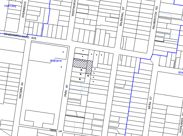
|
NOTIFICATION PLAN |
|
||
|
• PROPERTIES NOTIFIED
|
X SUBMISSIONS RECEIVED |
PROPERTY SUBJECT OF DEVELOPMENT |
|
Four submissions object to the development, generally on the grounds that the development would result in:
· Visual Impact of the development;
· Unacceptable traffic on local streets;
· Visual impact of the development;
· The bulk of the development is disproportionate compared to surrounding low density development;
· Overshadowing and unacceptable loss of light;
· Adverse privacy and overlooking impacts on adjoining properties;
· An increase in noise in the area;
· The increase in traffic will result in a detrimental effect on the safety of the neighbourhood;
· Inadequate on-street parking for current owners and potential visitors to the units;
· Loss of valuable green space;
· Request for boundary fencing from 34A Park Avenue;
· Excavation setback is sufficient to ensure minimal impact on the neighbouring trees at 34A Park Avenue; and
· Increased usage of local amenities.
The merits of the matters raised in community submissions have been addressed in the body of the report.
5.2 Public Agencies
The development application was not referred to any Public Agencies for comment.
6. THE PUBLIC INTEREST
Section 79C(1)(e) of the Act requires Council to consider “the public interest”.
The public interest is an overarching requirement, which includes the consideration of the matters discussed in this report. Implicit to the public interest is the achievement of future built outcomes adequately responding to and respecting the future desired outcomes expressed in environmental planning instruments and development control plans.
The application is considered to have satisfactorily addressed Council’s and relevant agencies’ criteria and would provide a development outcome that, on balance, would result in a positive impact for the community. Accordingly, it is considered that the approval of the proposed development would be in the public interest.
CONCLUSION
The application seeks approval for the demolition of existing structures and construction of two, five storey residential flat buildings comprising 36 units with basement car parking.
The proposed development is generally in accordance with the development controls for the ‘Balmoral Street, Waitara’ Precinct of the Housing Strategy DCP and would contribute to the future desired five storey residential character of the precinct. The minor non-compliance with prescriptive measures for site requirement and setbacks are considered acceptable. The proposal complies with the design principles of SEPP 65 and the Residential Flat Design Code.
The proposal would result in a development that would be in keeping with the desired future character of the precinct.
Note: At the time of the completion of this planning report, no persons have made a Political Donations Disclosure Statement pursuant to Section 147 of the Environmental Planning and Assessment Act 1979 in respect of the subject planning application.
|
Rod Pickles Manager - Development Assessment Planning Division |
James Farrington Group Manager Planning Division |
|
1.View |
Locality Map |
|
|
|
2.View |
Floor Plans |
|
|
|
3.View |
Photomontage |
|
|
|
4.View |
Elevations Plans |
|
|
|
5.View |
Landscape Plan |
|
|
|
6.View |
Shadow Plans |
|
|
|
7.View |
Height Diagram Plan |
|
|
File Reference: DA/1028/2013
Document Number: D02745651
SCHEDULE 1
GENERAL CONDITIONS
The conditions of consent within this notice of determination have been applied to ensure that the use of the land and/or building is carried out in such a manner that is consistent with the aims and objectives of the relevant legislation, planning instruments and council policies affecting the land and does not disrupt the amenity of the neighbourhood or impact upon the environment.
Note: For the purpose of this consent, the term ‘applicant’ means any person who has the authority to act on or the benefit of the development consent.
Note: For the purpose of this consent, any reference to an Act, Regulation, Australian Standard or publication by a public authority shall be taken to mean the gazetted Act or Regulation, or adopted Australian Standard or publication as in force on the date that the application for a construction certificate is made.
1. Approved Plans and Supporting Documentation
The development must be carried out in accordance with the plans and documentation listed below and endorsed with Council’s stamp, except where amended by Council and/or other conditions of this consent:
|
Plan No. |
Plan Title |
Drawn by |
Dated |
|
DA04 – Issue D |
Basement Plan |
Zhinar Architects Pty Ltd |
10/2/2014 |
|
DA05 – Issue D |
Ground Floor and Site Plan |
Zhinar Architects Pty Ltd |
10/2/2014 |
|
DA06 – Issue D |
First Floor Plan |
Zhinar Architects Pty Ltd |
10/2/2014 |
|
DA07 – Issue D |
Second Floor Plan |
Zhinar Architects Pty Ltd |
10/2/2014 |
|
DA08 – Issue D |
Third Floor Plan |
Zhinar Architects Pty Ltd |
10/2/2014 |
|
DA09 – Issue D |
Fourth Floor |
Zhinar Architects Pty Ltd |
10/2/2014 |
|
Da10 – Issue D |
Roof Plan |
Zhinar Architects Pty Ltd |
10/2/2014 |
|
DA11 – Issue D |
North and South Elevations |
Zhinar Architects Pty Ltd |
10/2/2014 |
|
DA12 – Issue D |
East and West Elevations |
Zhinar Architects Pty Ltd |
10/2/2014 |
|
DA13 – Issue D |
Sections |
Zhinar Architects Pty Ltd |
10/2/2014 |
|
13185 DA1 – Issue E |
Landscape Concept Plan |
Vision Dynamics |
19/12/2013 |
|
Rev. DA – D |
Schedule of Finishes |
Zhinar Architects Pty Ltd |
Received 12/2/2013 |
|
Plan No. |
Plan Title |
Drawn by |
Dated |
|
5987 –Issue A |
Detail and Level Survey |
SDG – Land Develop Solutions |
3/9/2013 |
|
505896M |
BASIX Certificate |
Design View |
27/9/2013 |
|
Issue A |
Design Verification Statement |
André Mulder |
September 2013 |
|
15250009 |
Assessor Certificate (Thermal Performance) |
Design View |
26/9/2013 |
|
- |
Waste Management Plan |
- |
Received 30/9/2013 |
|
2013 – 093SS |
Access Compliance Report |
Certified Building Specialists |
24/9/2013 |
|
- |
Traffic and Parking Impact Assessment |
Varga Traffic Consultants Pty Ltd |
27/9/2013 |
|
- |
Arboricultural Impact Assessment Report |
Glenyss Laws |
25/9/2013 |
|
DA17 – Issue C |
Shadow Model |
Zhinar Architects Pty Ltd |
20/12/2013 |
|
E78470 – D1 to D6 |
Stormwater Management Plan |
Donovan Associates |
26 – 9 - 2013 |
2. Removal of Existing Trees
This development consent only permits the removal of trees numbered 1 – 22 and 30 as identified within the Arboricultural Impact Assessment prepared by Glenyss Laws dated September 2013. The removal of any other trees requires separate approval in accordance with the Tree & Vegetation Chapter 1B.6 Hornsby Development Control Plan (HDCP).
3. Amendment of Plans
The approved plans are to be amended as follows:
a) The balconies of units Nos. 1, 5, 9 and 13 must be fitted with sliding stackable louvered privacy screens extendable to the full width of the balconies on the southern elevation.
4. Construction Certificate
A Construction Certificate is required to be approved by Council or a Private Certifying Authority prior to the commencement of any works under this consent.
5. Section 94 Development Contributions
In accordance with Section 80A(1) of the Environmental Planning and Assessment Act 1979 and the Hornsby Shire Council Section 94 Development Contributions Plan 2012-2021, the following monetary contributions shall be paid to Council to cater for the increased demand for community infrastructure resulting from the development:
|
Description |
Contribution (4) |
|
Roads |
$38,768.65 |
|
Open Space and Recreation |
$433,256.25 |
|
Community Facilities |
$60,727.05 |
|
Plan Preparation and Administration |
$1,778.65 |
|
TOTAL |
$534,530.60 |
being for 4 x 1 bedroom units, 27 x 2 bedroom units and 5 x 3 bedroom units in lieu of two existing dwelling houses.
a) If the contributions are not paid within the financial quarter that this consent is granted, the contributions payable will be adjusted in accordance with the provisions of the Hornsby Shire Council Section 94 Development Contributions Plan and the amount payable will be calculated at the time of payment in the following manner:
$CPY = $CDC x CPIPY
CPIDC
Where:
$CPY is the amount of the contribution at the date of Payment.
$CDC is the amount of the contribution as set out in this Development Consent.
CPIPY is the latest release of the Consumer Price Index (Sydney – All Groups) at the date of Payment as published by the ABS.
CPIDC is the Consumer Price Index (Sydney – All Groups) for the financial quarter at the date of this Development Consent.
b) The monetary contributions shall be paid to Council:
i) prior to the issue of the Subdivision Certificate where the development is for subdivision; or
ii) prior to the issue of the first Construction Certificate where the development is for building work; or
iii) prior to issue of the Subdivision Certificate or first Construction Certificate, whichever occurs first, where the development involves both subdivision and building work; or
iv) prior to the works commencing where the development does not require a Construction Certificate or Subdivision Certificate.
It is the professional responsibility of the Principal Certifying Authority to ensure that the monetary contributions have been paid to Council in accordance with the above timeframes.
Council’s Development Contributions Plan may be viewed at www.hornsby.nsw.gov.au or a copy may be inspected at Council’s Administration Centre during normal business hours.
REQUIREMENTS PRIOR TO THE ISSUE OF A CONSTRUCTION CERTIFICATE
6. Building Code of Australia
All building work must be carried out in accordance with the relevant requirements of the Building Code of Australia.
7. Contract of Insurance (Residential Building Work)
In the case of residential building work for which the Home Building Act, 1989 requires there to be a contract of insurance in force in accordance with Part 6 of that Act, that such a contract of insurance is in force before any building work authorised to be carried out by the consent commences.
8. Notification of Home Building Act, 1989 Requirements
Residential building work within the meaning of the Home Building Act, 1989 must not be carried out unless the principal certifying authority for the development to which the work relates (not being Council) has given Council written notice of the following information:
a) In the case of work for which a principal contractor is required to be appointed:
i) The name and licence number of the principal contractor; and
ii) The name of the insurer by which the work is insured under Part 6 of that Act.
b) In the case of work to be done by an owner-builder:
i) The name of the owner-builder; and
ii) If the owner-builder is required to hold an owner-builder’s permit under that Act, the number of the owner-builder’s permit.
Note: If arrangements for doing the residential building work are changed while the work is in progress so that the information notified becomes out of date, further work must not be carried out unless the principal certifying authority for the development to which the work relates (not being Council) has given Council written notification of the updated information.
9. Utility Services
The applicant must submit written evidence of the following service provider requirements:
a) Ausgrid (formerly Energy Australia) – a letter of consent demonstrating that satisfactory arrangements have been made to service the proposed development.
10. Dilapidation Report
A ‘Dilapidation Report’ is to be prepared by a ‘chartered structural engineer’ detailing the structural condition of all adjoining properties.
11. Adaptable Units
The details of fit-outs of all accessible units and details of adaptable units must be provided with the Construction Certificate Plans.
12. Letter Boxes
The details of letter boxes must be provided with the Construction Certificate Plans. The letter boxes must be provided with a minimum setback of 2m from the front property boundary.
13. Car Parking and Deliveries
All car parking must be constructed and operated in accordance with Australian Standard AS 2890.1 – 2004 – Off Street Car Parking and Australian Standard 2890.2 - 2002 – Off Street Commercial and the following requirement:
a) All parking areas and driveways are to be sealed to an all weather standard, line marked and signposted.
b) Car parking, loading and manoeuvring areas to be used solely for nominated purposes.
c) Vehicles awaiting loading, unloading or servicing shall be parked on site and not on adjacent or nearby public roads.
d) All vehicular entry on to the site and egress from the site shall be made in a forward direction.
14. Motorcycle Parking
One motorcycle space is to be provided in the basement parking area and designed in accordance with AS2890.1-2004 Off Street Car Parking and the following requirements:
a) The car parking spaces are to be re-configured to provide 1 motorcycle parking space;
b) The motorcycle parking space is to be designed and located so that parked motorcycles are not vulnerable to being struck by a manoeuvring vehicle.
15. Parking Spaces for People with Disabilities
All parking spaces for people with disabilities must be constructed and operated in accordance with Australian Standard AS/NZS 2890.6:2009 – Off-street parking for people with disabilities.
16. Car Parking Allocation & Resident Storage
The basement and unit resident storage areas are to be allocated in accordance with the size requirements of the SEPP 65 - Residential Flat Design Code for the respective units and proximity to the unit car parking space.
17. Traffic Control Plan
A Traffic Control Plan (TCP) must be prepared by a qualified traffic controller in accordance with the Roads & Traffic Authority’s Traffic Control at Worksites Manual 1998 and Australian Standard 1742.3 for all work on a public road and be submitted to Council. The TCP must detail the following where required:
a) Arrangements for public notification of the works.
b) Temporary construction signage.
c) Permanent post-construction signage.
d) Vehicle movement plans.
e) Traffic management plans.
f) Pedestrian and cyclist access/safety.
18. Road Works
All road works approved under this consent must be designed and constructed in accordance with Council’s Civil Works Design and Construction Specification, 2005 and the following requirements at the Applicant’s cost: -
a) Council’s standard 150 mm integral kerb and gutter across the Park Avenue frontage of the site, with a minimum 300 mm thick shoulder pavement width of 4.5 metres on this frontage to match with the Park Avenue centre carriageway seal.
b) A Council’s standard 1.2m wide 80 mm thick concrete footpath to be constructed on the Park Avenue frontage of the site with crossfall graded at 2% up from the top of the proposed kerb and matched to the adjacent footpath. The remaining footpath area shall be turfed.
c) Matching and relocation of all pits, poles, services, signage and other assets shall be undertaken at the applicant’s cost.
d) The submission of compaction certificates from a geotechnical engineer for any fill within road reserves, and all road sub-grade and road pavement materials.
e) Pursuant to Section 138 Roads Act 1993, the Applicant shall apply for a Construction Certificate (SCC) from Hornsby Shire Council for the SCC construction approval and compliance inspections. The Applicant must pay the Council’s quoted Application fees with the SCC Application. The subsequent Council compliance inspection checklist for those works shall be released by Council prior to the release of the final Occupation Certificate for Units.
19. Vehicular Crossing
A separate application under the Local Government Act, 1993 and the Roads Act, 1993 must be submitted to Council for the installation of a new heavy duty vehicular crossing and the removal of the redundant crossing. The vehicular crossing must be constructed in accordance with Council’s Civil Works Design, 2005 and the following requirements:
a) The footway area must be restored by turfing;
Note: An application for a vehicular crossing can only be made to one of Council’s Authorised Vehicular Crossing Contractors, or be the subject of a Construction Certificate Application to Council as Roads Authority. You are advised to contact Council on 02 9847 6940 to obtain a list of contractors.
20. Pedestrian Sight Lines
Sight lines for pedestrians are to be provided at the driveway in accordance with Australian Standard AS2890.1.
21. Stormwater Drainage
The stormwater drainage system for the development must be designed and constructed in accordance with Council’s Civil Works – Design and Construction Specification 2005 and the following requirements:-
a) Connected directly to Council’s street drainage system.
22. On Site Stormwater Detention
An on-site stormwater detention system must be designed by a chartered civil engineer and constructed in accordance with the following requirements:-
a) Have a capacity of not less than 25 cubic metres, and a maximum discharge (when full) of 40 litres per second.
b) Have a surcharge/inspection grate located directly above the outlet with stepirons installed wherever access points are more than 1.2m deep.
c) Discharge from the detention system to be controlled via 1 metre length of pipe, not less than 50 millimetres diameter or via a stainless plate with sharply drilled orifice bolted over the face of the outlet discharging into a larger diameter pipe capable of carrying the design flow to an approved Council system.
d) An emergency pipe overflow system sited above the top water level shall be designed and constructed between the on-site detention volume and the receiving system capable of draining the 20 year average recurrence interval stormflow from the site.
23. Internal Driveway/Vehicular Areas
The driveway and parking areas on site must be designed in accordance with Australian Standards 2890.1, 2890.2, 3727 and the following requirements: -
a) Design levels at the front boundary must be obtained from Council;
b) The driveway and basement ramp must be a rigid pavement;
24. Waste Management Details
The following waste management requirements must be complied with:
a) A Waste Management Plan Section One – Demolition Stage and Section Three – Construction Stage, covering the scope of this project and including the following details, is required to be submitted to Council:
i) An estimate of the types and volumes of waste and recyclables to be generated;
ii) A site plan showing sorting and storage areas for demolition and construction waste and the vehicle access to these areas;
iii) How excavation, demolition and construction waste materials will be reused or recycled and where residual wastes will be disposed;
iv) The total percentage (by weight) of demolition and construction waste that will be reused or recycled.
REQUIREMENTS PRIOR TO THE COMMENCEMENT OF ANY WORKS
25. Erection of Construction Sign
A sign must be erected in a prominent position on any site on which building work, subdivision work or demolition work is being carried out:
a) Showing the name, address and telephone number of the principal certifying authority for the work;
b) Showing the name of the principal contractor (if any) for any demolition or building work and a telephone number on which that person may be contacted outside working hours; and
c) Stating that unauthorised entry to the work site is prohibited.
Note: Any such sign is to be maintained while the building work, subdivision work or demolition work is being carried out, but must be removed when the work has been completed.
26. Protection of Adjoining Areas
A temporary hoarding, fence or awning must be erected between the work site and adjoining lands before the works begin and must be kept in place until after the completion of the works if the works:
a) Could cause a danger, obstruction or inconvenience to pedestrian or vehicular traffic.
b) Could cause damage to adjoining lands by falling objects.
c) Involve the enclosure of a public place or part of a public place.
Note: Notwithstanding the above, Council’s separate written approval is required prior to the erection of any structure or other obstruction on public land.
27. Toilet Facilities
Toilet facilities must be available or provided at the works site before works begin and must be maintained until the works are completed at a ratio of one toilet for every 20 persons employed at the site. Each toilet must:
a) be a standard flushing toilet connected to a public sewer; or
b) be a temporary chemical closet approved under the Local Government Act, 1993; or
c) have an on-site effluent disposal system approved under the Local Government Act, 1993.
28. Erosion and Sediment Control
Erosion and sediment control measures must be provided and maintained throughout the construction period in accordance with the manual ‘Soils and Construction 2004 (Bluebook)’, the approved plans, Council specifications and to the satisfaction of the principal certifying authority. The erosion and sediment control devices must remain in place until the site has been stabilised and revegetated.
Note: On the spot penalties up to $1,500 may be issued for any non-compliance with this requirement without any further notification or warning.
29. Tree Protection Barriers
Tree protection fencing must be erected around trees numbered 23, 24 and 25 to be retained at an 8m setback from tree No. 23 and 6m from tree No. 24 and 25. The tree fencing must be constructed of 1.8 metre ‘cyclone chainmesh fence’ or star pickets spaced at 2 metre intervals, connected by a continuous high-visibility barrier/hazard mesh at a height of 1 metre.
30. Tree Ground Protection
Prior to works commencing and throughout construction, the area of TPZ (located on the property) of trees 23, 24 & 25 is to be protected by the use of wood-chip mulch. The mulch is to be maintained at a depth of 150mm using material that complies with AS 4454.
31. Tree Trunk Protection
To avoid injury or damage, trees numbered 28 & 29 must have trunks protected by 2 metre lengths of 75mm x 25mm hardwood timbers spaced at 80mm secured with galvanised wire (not fixed or nailed to the tree in any way.
Note: A certificate from a qualified Arborist (AQF 5) is to be submitted to the Principal Certifying Authority stating that all tree protection measures are in accordance with the above and consistent with the intentions of the Australian Standard ‘Protection of Trees on Development Sites (AS 4970-2009) prior to commencement of works.
REQUIREMENTS DURING CONSTRUCTION
32. Construction Work Hours
All work on site (including demolition and earth works) must only occur between 7am and 5pm Monday to Saturday. No work is to be undertaken on Sundays or public holidays.
33. Demolition
All demolition work must be carried out in accordance with “Australian Standard 2601-2001 – The Demolition of Structures” and the following requirements
a) Demolition material must be disposed of to an authorised recycling and/or waste disposal site and/or in accordance with an approved waste management plan;
b) Demolition works, where asbestos material is being removed, must be undertaken by a contractor that holds an appropriate licence issued by WorkCover NSW in accordance with Chapter 10 of the Occupational Health and Safety Regulation 2001 and Clause 29 of the Protection of the Environment Operations (Waste) Regulation 2005 ;and
c) On construction sites where buildings contain asbestos material, a standard commercially manufactured sign containing the words ‘DANGER ASBESTOS REMOVAL IN PROGRESS’ measuring not less than 400mm x 300mm must be erected in a prominent position visible from the street.
34. Environmental Management
The site must be managed in accordance with the publication ‘Managing Urban Stormwater – Landcom (March 2004) and the Protection of the Environment Operations Act 1997 by way of implementing appropriate measures to prevent sediment run-off, excessive dust, noise or odour emanating from the site during the construction of the development.
35. Works Near Trees
All required tree protection measures are to be maintained in good condition for the duration of the construction period.
The applicant is to ensure that no excavation, including sub-surface trenching for stormwater or other services, filling or stockpiling of building materials, parking of vehicles or plant, the use of machinery other than hand held, disposal of cement slurry, waste water or other contaminants is to occur within the nominated Tree Protection Zone of any tree to be retained.
36. Street Sweeping
Street sweeping must be undertaken following sediment tracking from the site along Park Avenue during works and until the site is established.
37. Council Property
During construction works, no building materials, waste, machinery or related matter is to be stored on the road or footpath. The public reserve must be kept in a clean, tidy and safe condition at all times.
38. Disturbance of Existing Site
During construction works, the existing ground levels of open space areas and natural landscape features, (including natural rock-outcrops, vegetation, soil and watercourses) must not be altered unless otherwise nominated on the approved plans.
39. Landfill
Landfill must be constructed in accordance with Council’s ‘Construction Specification, 2005’ and the following requirements:
a) All fill material imported to the site is to wholly consist of Virgin Excavated Natural Material (VENM) as defined in Schedule 1 of the Protection of the Environment Operations Act 1997 or a material approved under the Department of Environment and Climate Change’s general resource recovery exemption.
b) A compaction certificate is to be obtained from a geotechnical engineer verifying that the specified compaction requirements have been met.
40. Excavated Material
All excavated material removed from the site must be classified in accordance with the Department of Environment, Climate Change and Water NSW Waste Classification Guidelines prior to disposal to an approved waste management facility and reported to the principal certifying authority.
41. Survey Report – Finished Floor Level
A report(s) must be prepared by a registered surveyor and submitted to the principal certifying authority prior to the pouring of concrete at each level of the building certifying that:
a) The building, retaining walls and the like have been correctly positioned on the site; and
b) The finished floor level(s) are in accordance with the approved plans.
42. Contamination During Construction Works
Should the presence of asbestos or soil contamination, not recognised during the application process be identified during demolition, the applicant must immediately notify the Principal Certifying Authority and Council.
43. Construction Noise Management
The construction works must be undertaken in accordance with the “Interim Construction Noise Guidelines – 2009” published by Department of Environment and Climate Change NSW.
44. Waste Management Details
Waste management during the demolition and construction phase of the development must be undertaken in accordance with the approved Waste Management Plan. Additionally written records of the following items must be maintained during the removal of any waste from the site and such information submitted to the Principal Certifying Authority within fourteen days of the date of completion of the works:
a) The identity of the person removing the waste.
b) The waste carrier vehicle registration.
c) Date and time of waste collection.
d) A description of the waste (type of waste and estimated quantity).
e) Details of the site to which the waste is to be taken.
f) The corresponding tip docket/receipt from the site to which the waste is transferred (noting date and time of delivery, description (type and quantity) of waste).
g) Whether the waste is expected to be reused, recycled or go to landfill.
Note: In accordance with the Protection of the Environment Operations Act 1997, the definition of waste includes any unwanted substance, regardless of whether it is reused, recycled or disposed to landfill.
REQUIREMENTS PRIOR TO THE ISSUE OF AN OCCUPATION CERTIFICATE
Note: For the purpose of this consent, a reference to ‘occupation certificate’ shall not be taken to mean an ‘interim occupation certificate’ unless otherwise stated.
45. Fulfilment of BASIX Commitments
The applicant must demonstrate the fulfilment of BASIX commitments pertaining to the development.
46. Sydney Water – s73 Certificate
An s73 Certificate must be obtained from Sydney Water.
47. Installation of Privacy Devices
The following device(s) must be installed to maintain an element of privacy.
a) Opposing balconies must be fitted with sliding stackable louvered metal screens extendable to the full width of the balconies;
b) All glass balustrades must be translucent glass.
48. Damage to Council Assets
Any damage caused to Council’s assets as a result of the construction of the development must be rectified in accordance with Council’s Civil Works Specifications. Council’s Restorations Supervision must be notified for a formwork inspection prior to pouring concrete.
49. Consolidation of Lots
All lots in the subject allotment are to be consolidated into one allotment.
50. Works as Executed Plan
A works-as-executed plan(s) must be prepared by a registered surveyor and submitted to Council for completed road pavement, kerb & gutter, public drainage systems, driveways and on-site detention system. The plan(s) must be accompanied by a certificate from a registered surveyor certifying that all pipelines and associated structures lie wholly within any relevant easements.
51. Planter Boxes / On Slab Planting
On slab planter boxes must include waterproofing, subsoil drainage (proprietary drainage cell, 50mm sand and filter fabric) automatic irrigation, minimum 500mm planting soil for shrubs and minimum 1000mm planting soil for trees and palms and 75mm mulch to ensure sustainable landscape is achieved.
52. Tree Planting
Tree planting to the Northern boundary landscape setback areas must include:
a) Four additional Backhousia citriadora (Lemon scented Myrtle) shall be installed at minimum 25 litre pot size.
b) Tree planting to the southern boundary landscape deep soil setback areas must include four additional Angophora floribunda (Rough barked apple). Trees shall be installed at minimum 25 litre pot size.
c) Tree planting to the eastern boundary landscape deep soil setback areas must include three additional Angophora costata (Sydney Red Gum). Trees shall be installed at minimum 25 litre pot size.
53. Completion of Landscaping
A certificate must be provided by a practicing landscape architect or person with similar qualifications and experience certifying that all required landscaping works have been satisfactorily completed in accordance with the approved landscape plans.
54. Retaining Walls
All required retaining walls must be constructed as part of the development.
55. Creation of Easements
The following matter(s) must be nominated on the plan of subdivision under s88B of the Conveyancing Act 1919:
a) The creation of an appropriate "Positive Covenant" and "Restriction as to User" over the constructed on-site detention/retention systems and outlet works, within the lots in favour of Council in accordance with Council’s prescribed wording. The position of the on-site detention system is to be clearly indicated on the title.
b) To register the OSD easement, the restriction on the use of land “works-as-executed” details of the on-site-detention system must be submitted verifying that the required storage and discharge rates have been constructed in accordance with the design requirements. The details must show the invert levels of the on site system together with pipe sizes and grades. Any variations to the approved plans must be shown in red on the “works-as-executed” plan and supported by calculations.
Note: Council must be nominated as the authority to release, vary or modify any easement, restriction or covenant required by this condition.
56. Construction for a Safe Environment
Prior to the issue of the Occupation Certificate, the site must include the following elements:
a) An intercom system be installed at gate locations to ensure screening of persons entering the units.
b) The entryway to the site be illuminated in high luminance at all times.
c) The communal open space areas are to be illuminated with high luminance by motion sensor lighting.
d) The service areas of the ground floor and the garbage room at the basement be illuminated with high luminance by motion sensor lighting.
e) The driveway and the basement car park is to be illuminated with low luminance at all times.
f) Robust materials which cannot be forced or breached with minimised maintenance requirements are to be used for construction work in the common areas.
g) The lamps and lighting levels must comply with Australian and New Zealand Lighting Standard 1158.1.
h) Effective signage be provided to guide visitors to the main areas and parking areas.
i) A street sign be prominently displayed in front of the site in accordance with Order No. 8, Section 124 Local Government Act 1993.
j) The communal area must include a clear sign to restrict access for non-residents.
k) Units’ numbers, entry and exit signs must be legible and clear.
l) Fire exit doors to be fitted with single cylinder locksets (Australia New Zealand Standard-Locksets).
m) The entry doors to the pedestrian foyer is to be constructed of safety rated glass to enable residents a clear line of site before entering or exiting the residential apartments.
n) Lighting is to be provided to pathways, building foyer entries, driveways and common external spaces.
o) Security deadlocks are to be provided to each apartment door.
p) Peep holes are to be provided to individual apartment doors to promote resident safety.
57. External Lighting
All external lighting must be designed and installed in accordance with Australian Standard AS 4282 – Control of the Obtrusive Effects of Outdoor Lighting. Certification of compliance with the Standard must be obtained from a suitably qualified person.
58. Car Parking Allocation and Resident Storage
The basement resident storage areas are to be allocated in accordance with the size requirements of the Residential Flat Design Code for the respective units and proximity to the unit car parking space.
59. Garbage Collection Easement
For the purpose of waste collection, an easement entitling Council, its servants and agents and persons authorised by it to enter upon the subject land and to operate thereon, vehicles and other equipment for the purposes of garbage collection must be granted to Council by the owner of the land.
Note The easement must be in a form prescribed by Council and must include covenants to the effect that parties will not be liable for any damage caused to the subject land or any part thereof or to any property located therein or thereon by reason of the operation thereon of any vehicle or other equipment used in connection with the collection of garbage and to the effect that the owner for the time being of the subject land shall indemnify the Council, its servants, agents and persons authorised by it to collect garbage against liability in respect of any such claims made by any person whomsoever.
60. Waste Management Details
The following waste management requirements must be complied with:
a) The bin storage room at the basement level must include water or a hose for cleaning, graded floors with drainage to sewer, a robust door, sealed and impervious surface, adequate lighting and ventilation, and must be lockable. The waste facility rooms at each residential level must include sealed and impervious surface, adequate lighting and ventilation.
b) A report must be prepared by an appropriately qualified person, certifying the following:
i) A comparison of the estimated quantities of each waste type against the actual quantities of each waste type.
Note: Explanations of any deviations to the approved Waste Management Plan is required to be included in this report
ii) That at least 60% of the waste generated during the demolition and construction phase of the development was reused or recycled.
Note: If the 60% diversion from landfill cannot be achieved in the Construction Stage, the Report is to include the reasons why this occurred and certify that appropriate work practices were employed to implement the approved Waste Management Plan. The Report must be based on documentary evidence such as tipping dockets/receipts from recycling depots, transfer stations and landfills, audits of procedures etc. which are to be attached to the report.
iii) All waste was taken to site(s) that were lawfully permitted to accept that waste.
c) Each unit must be provided with an indoor waste/recycling cupboard for the interim storage of a minimum one day’s waste generation with separate containers for general waste and recyclable materials.
d) Space must be provided for either individual compost containers for each unit or a communal compost container;
Note: The location of the compost containers should have regard for potential amenity impacts.
e) The bin carting routes must be devoid of any steps.
Note: Ramps between different levels are acceptable
f) Access to the bin lifter/decanting equipment by unauthorised persons (including residents and waste collectors) must be prevented.
Note: Caging of equipment is acceptable.
61. Maintain Canopy Cover
Replacement planting is to be undertaken in accordance with the Landscape Concept Plan Drawing No. 13185 DA 1 Revision E drawn by FF (TRIM—D02730350) provided by Vision Dynamics Pty Ltd.
The planting location shall not be within four metres (4m) of the foundation walls of a dwelling or in-ground pool.
Note: A certificate from suitably qualified and experienced Horticulturalist is to be submitted to the Principal Certifying Authority stating that all plant stock meet the specifications outlined in ‘Specifying Trees’ (Ross Clark, NATSPEC Books) and that the planting methods were current professional (best practice) industry standards at the time of planting.
OPERATIONAL CONDITIONS
62. Visitor Access
Visitors are to have access to the parking area at all times. Visitors are to be able to access the basement car park by an audio/visual intercom system located at the top of the ramped driveway.
63. Landscape Establishment
The landscape works must be maintained into the future to ensure the establishment and successful growth of plant material to meet the intent of the landscape design. This must include but not be limited to watering, weeding, replacement of failed plant material and promoting the growth of plants through standard industry practices.
64. Noise
The level of total continuous noise emanating from operation of the premises including all the plant, including air conditioning units and processes in all buildings (LA10) (measured for at least 15 minutes) in or on the above premises, must not exceed the background level by more than 5dB(A) when measured at all property boundaries.
65. Fire Safety Statement - Annual
On at least one occasion in every 12 month period following the date of the first ‘Fire Safety Certificate’ issued for the property, the owner must provide Council with an annual ‘Fire Safety Certificate’ to each essential service installed in the building.
66. Waste Management
The waste management on site must be in accordance with the following requirements:
a) A site caretaker must be employed and be responsible for moving bins where and when necessary, washing bins and maintaining waste storage areas, decanting the 240 L garbage bins into 660 L garbage bins, managing the communal composting area, managing the bulky item storage area, arranging the prompt removal of dumped rubbish, and ensuring all residents are informed of the use of the waste management system.
Note: The site caretaker may require the use of equipment (such as a motorised trolley) to assist in bin transfers, for the purposes of work safety and time efficiency.
- END OF CONDITIONS -
ADVISORY NOTES
The following information is provided for your assistance to ensure compliance with the Environmental Planning and Assessment Act, 1979, Environmental Planning and Assessment Regulation 2000, other relevant legislation and Council’s policies and specifications. This information does not form part of the conditions of development consent pursuant to Section 80a of the Act.
Environmental Planning and Assessment Act, 1979 Requirements
The Environmental Planning and Assessment Act, 1979 requires:
· The issue of a construction certificate prior to the commencement of any works. Enquiries can be made to Council’s Customer Services Branch on 9847 6760.
· A principal certifying authority to be nominated and Council notified of that appointment prior to the commencement of any works.
· Council to be given at least two days written notice prior to the commencement of any works.
· Mandatory inspections of nominated stages of the construction inspected.
· An occupation certificate to be issued before occupying any building or commencing the use of the land.
Long Service Levy
In accordance with Section 34 of the Building and Construction Industry Long Service Payments Act 1986, a ‘Long Service Levy’ must be paid to the Long Service Payments Corporation or Hornsby Council.
Note: The rate of the Long Service Levy is 0.35% of the total cost of the work.
Note: Hornsby Council requires the payment of the Long Service Levy prior to the issue of a construction certificate.
Tree Preservation Order
In accordance with Clause 5.9 Hornsby Local Environment Plan (HLEP) a person must not ringbark, cut down, top, lop, remove, injure or wilfully destroy any tree or other vegetation to which any such development control plan applies without the authority conferred by a development consent or a permit granted by Council.
Fines may be imposed for non-compliance with both the HLEP and the HDCP.
Note: A tree is defined as a long lived, woody perennial plant with one or relatively few main stems with the potential to grow to a height greater than three metres (3m). (HDCP 1B.6.1.c).
Tree protection measures and distances are determined using the Australian Standard AS 4970:2009, “Protection of Trees on Development Sites”.
Disability Discrimination Act
The applicant’s attention is drawn to the existence of the Disability Discrimination Act. A construction certificate is required to be obtained for the proposed building/s, which will provide consideration under the Building Code of Australia, however, the development may not comply with the requirements of the Disability Discrimination Act. This is the sole responsibility of the applicant.
Covenants
The land upon which the subject building is to be constructed may be affected by restrictive covenants. Council issues this approval without enquiry as to whether any restrictive covenant affecting the land would be breached by the construction of the building, the subject of this consent. Applicants must rely on their own enquiries as to whether or not the building breaches any such covenant.
Dial Before You Dig
Prior to commencing any works, the applicant is encouraged to contact Dial Before You Dig on 1100 or www.dialbeforeyoudig.com.au for free information on potential underground pipes and cables within the vicinity of the development site.
Telecommunications Act 1997 (Commonwealth)
If you are aware of any works or proposed works which may affect or impact on Telstra’s assets in any way, you are required to contact: Telstra’s Network Integrity Team on Phone Number 1800810443.
Asbestos Warning
Should asbestos or asbestos products be encountered during demolition or construction works, you are advised to seek advice and information prior to disturbing this material. It is recommended that a contractor holding an asbestos-handling permit (issued by WorkCover NSW)be engaged to manage the proper handling of this material. Further information regarding the safe handling and removal of asbestos can be found at:
Alternatively, telephone the WorkCover Asbestos and Demolition Team on 8260 5885.
House Numbering
House numbering can only be authorised by Council. Before proceeding to number each premise in the development, the allocation of numbers is required to be obtained from Council's Planning Division prior to the issue of a Subdivision Certificate. The authorised numbers are required to comply with Council’s Property Numbering Policy and be displayed in a clear manner at or near the main entrance to each premise.
Group Manager’s Report No. PL2/14
Planning Division
Date of Meeting: 12/03/2014
8 FURTHER REPORT - SUBDIVISION OF ONE LOT INTO TWO - 1549 SINGLETON ROAD, SINGLETONS MILL
EXECUTIVE SUMMARY
|
DA No: |
DA/272/2013 (Lodged on 22 March 2013) |
|
Description: |
Subdivision of one allotment into two lots |
|
Property: |
Lot 4 DP 75209, No. 1549 Singleton Road, Singletons Mill |
|
Applicant: |
Mr Bradley Kent De Burgh Thew |
|
Owner: |
Mr Bradley Kent De Burgh Thew |
|
Estimated Value: |
Nil |
|
Ward: |
A |
· The application proposes the Torrens title subdivision of one allotment into two allotments.
· On 18 December 2013, Council deferred the matter to enable an onsite meeting with available Councillors to review the potential for the proposal to set a precedent for similar applications within the Environmental zones within the Shire.
· An onsite meeting was held on 6 February 2014 with available Councillors and staff. At the conclusion of the meeting, it was noted that the matter would be referred back to Council for determination.
· The proposal does not comply with the minimum rural lot size pursuant to Clause 14 of Hornsby Shire Local Environmental Plan. The applicant’s submission seeking to vary the minimum lot size development standard is not considered well founded with regard to State Environmental Planning Policy No. 1 – Development Standards.
· No submissions have been received in respect of the application.
· It is recommended that the application be refused.
|
THAT Development Application No. DA/272/2013 for Torrens title subdivision of one allotment into two allotments at Lot 4 DP 75209, No. 1549 Singleton Road, Singletons Mill be refused subject to the reasons for refusal detailed in Schedule 1 of Group Manager’s Report No. PL2/14. |
BACKGROUND
A weather board cottage has existed on the eastern side of the site since the late 1800’s.
On 28 September 1971, Building Application No. 2219/1971 for the erection of a dwelling on the western side of the site was approved by Council.
On 6 November 1989, DA/450/1989 for the subdivision of one allotment into four lots was refused by Council due to insufficient information.
On 7 July 1997, Building Application No. 289/1997 for alterations and additions to a dwelling was approved by Council. The approved development comprised a new roof and addition of a verandah. Conditions were applied to the consent requiring that a heritage evaluation be completed on the existing cottage on the site.
On 2 June 2011, DA/559/2011 was lodged for the subdivision of one allotment into two lots. A SEPP 1 objection was submitted seeking a variation to the minimum allotment size. Council advised that the proposal would not be supported. The application was subsequently withdrawn.
On 7 August 2012, DA/111/2012 for the use of the cottage as bed and breakfast accommodation was approved by Council.
On 22 March 2013, DA/272/2013 was lodged for the subdivision of one allotment into two lots. A SEPP 1 objection was submitted seeking a variation to the minimum allotment size. This application is the subject of this report.
On 18 December 2013, Council considered the subject application and resolved that:
Consideration of this matter be deferred to enable the Group Manager Planning to convene a site inspection for available Councillors to review the potential for the proposal to set a precedent for similar applications within the Environmental zones within the Shire.
In accordance with Council’s resolution, on 6 February 2014 an on-site meeting was held to discuss the application. The meeting was attended by the applicant and owner of the site, the applicant’s planning consultant, available Councillors and Planning Division officers.
At the onsite meeting, the applicant provided an overview of the application. Discussion included consideration of the following:
· The occupation of the cottage as a dwelling house prior to the approval of the dwelling on the western side of the site in accordance with BA/2219/1971.
· Acknowledgment that the owner has made a significant effort to restore the draft heritage listed cottage.
· Permissibility of the proposal under the Hornsby Shire Local Environmental Plan 1994 and a future proposal under the Hornsby Local Environmental Plan 2013.
· Whether the approval of the application would set a precedent for the subdivision of similar applications which proposes the subdivision of Environmental Protection zoned land.
· The application of Clause 4.6(6) and Clause 5.10 (Heritage Conservation Incentives) of the Hornsby Local Environmental Plan 2013 for a future proposal.
At the conclusion of the meeting, it was noted that the application would be reported back to Council at its meeting on 12 March 2014 for Council’s consideration.
SITE
The site has an area of 14.47 ha and is located approximately 5 kilometres east of Wisemans Ferry along Singleton Road. The site is located on part of a peninsula extending into the Hawkesbury River and bounded by Marramarra National Park to the south. Singleton Road loops through the southern part of the property. A Crown Road extends north through the centre of the property providing access to two other properties within the peninsula.
The site comprises a dwelling house constructed in the 1970s and a cottage constructed in the late 1800s. The cottage is a single storey weatherboard cottage with a large verandah located on the eastern side of the Crown Road and has been approved for use as bed and breakfast accommodation. The dwelling constructed in the 1970s is a two storey brick dwelling located on the western side of the Crown Road located amongst dense bushland.
The dwelling on the western side of the property is accessed via the Crown Road, approximately 10 metres north of Singleton Road. Access to the cottage is provided via the Crown Road and a driveway that diverts to the east. A parking area for four vehicles is provided adjacent to the cottage.
The site is densely vegetated and comprises significant bushland including Coastal Saltmarsh which is considered an Endangered Ecological Community protected under the Threatened Species Conservation Act 1995. An existing cleared area is located around the dwelling house.
The site is partially flood affected along the foreshore areas to the Hawkesbury River, however this does not extend to the buildings. The site contains colluvial and estuarine acid sulphate soils.
The site is not a heritage item and is not within a heritage conservation area. The cottage on the eastern side of the site is a draft heritage item under the Planning Proposal adopted by Council to implement the recommendations of Heritage Review Stage 5.
PROPOSAL
The proposal is for the subdivision of one allotment into two lots.
Proposed Lot 1 has an area of 7.62 hectares, is located on the western side of the Crown Road Reserve and includes an existing dwelling house. Proposed lot one includes residual parcels of land on the southern side of Singleton Road.
Proposed Lot 2 has an area of 6.85 hectares, is located on the eastern side of the Crown Road and includes the existing cottage.
The existing buildings are located either side of a Crown Road reserve providing a logical partition of the property.
The dwelling house on proposed Lot 1 has driveway access from Singleton Road via the Crown Road. The driveway access for the cottage on proposed Lot 2 utilises a small section adjacent to Singleton Road. The eastern driveway serving the cottage meanders outside the road reservation near the cottage. It is proposed to recognise this extent in a right of way to ensure access to the properties to the north at the head of the peninsula.
ASSESSMENT
The development application has been assessed having regard to the ‘Metropolitan Plan for Sydney 2031’, the ‘North Subregion (Draft) Subregional Strategy’ and the matters for consideration prescribed under Section 79C of the Environmental Planning and Assessment Act 1979 (the Act). The following issues have been identified for further consideration.
1. LEGAL ADVICE
On 3 February 2014, the applicant submitted legal advice (copy attached) regarding the assessment of the application. The issues raised in legal advice are addressed below.
1.1 Council Authority to Approve the Application
The legal advice confirms that Council has the authority to approve the application and there is no legal impediment to Council’s approval.
The permissibility of the proposal or Council’s authority as the consent authority has not been an issue of contention in the assessment of the application. It is acknowledged that subdivision is permissible development within the zone with Council’s consent. Additionally, as noted in Section 3.5 of this report, should Council be of the view to approve the development application, the approval of the Director-General of the Department of Planning and Infrastructure is required as more than one allotment does not comply with the minimum allotment size standard and the variation sought is greater than 10%.
However, whilst there is no disagreement concerning Council’s authority to determine the application, this report concludes that the proposal should not be supported based on the merits of the application.
1.2 Precedent for the Subdivision of Other Properties
The notion within the legal advice that each development should be considered on its merits is supported. However, precedence is a relevant matter in the merit assessment of any application. This notion is confirmed in the Statement of Environmental Effects submitted with the application which argues that precedence is relevant and that approval by Council of other subdivisions along Peebles Road, Fiddletown should apply to the assessment of the subject application. This issue is addressed in Section 3.5 of this report.
Additionally, the applicant has submitted a SEPP 1 Objection to vary the applicable minimum allotment size development standard. As detailed in Section 3.5 of this report, the Land and Environment Court has expressed the view that there are five different ways in which an objection may be well founded and that approval of the objection may be consistent with the aims of the SEPP. One of the issues of consideration relates to whether Council has consistently applied the development standard.
It is acknowledged that under Clause 4.6(6) the Hornsby Local Environmental Plan 2013, the subdivision of land in the rural and environmental zones is no longer permissible development where the proposal involves two or more allotments less than the required minimum allotment size. In this regard, a similar application lodged under Council’s Hornsby Local Environmental Plan 2013 would be prohibited. This limits the creation of a precent for future development applications should Council be of a mind to approve the subject application.
However, the determination of the application in relation to the variation of the minimum allotment size would be relevant in the consideration of current undetermined development applications proposing the subdivision of Environmental Projection land and any appeals against the refusal of applications with similar circumstances.
1.3 Clause 5.10 (Heritage Conservation Incentives) of the Hornsby Local Environmental Plan 2013
The legal advice argues that subclause 10 would allow Council to approve an application involving subdivision of a heritage listed property notwithstanding the non-compliance with the applicable minimum allotment sizes.
The legal advice acknowledges that the subject application was lodged under the previous Hornsby Shire Local Environmental Plan 1994. Furthermore, the property is being progressed for heritage listing as part of the Heritage Review Stage 5 Planning Proposal which is awaiting finalisation by the Department of Planning and Infrastructure. The property does not currently contain a heritage item. Accordingly, Clause 5.10 is not applicable to the subject application.
It is acknowledged that, following the heritage listing of the cottage on the property, a further application for development not otherwise permissible under the HLEP 2013 could be lodged under Clause 5.10.10. However, a requirement of Clause 5.10 is that the conservation of the heritage item is facilitated by the development and that a heritage management document has been prepared and approved by the consent authority. This document is required to identify the works necessary for the conservation of the item.
The subject application proposes the subdivision of a draft heritage item onto a separate allotment of land. It has not been identified in the application or the legal advice as to how the subdivision would facilitate the conservation of the draft item.
The other matters raised in the legal advice are comments on merit issues associated with the consideration of the SEPP 1 Objection. These matters are addressed in this report.
2. STRATEGIC CONTEXT
2.1 Metropolitan Plan for Sydney and (Draft) North Subregional Strategy
The (Draft) Metropolitan Strategy for Sydney 2031 is a broad framework to provide for Sydney’s growth to help plan for housing, employment, transport, infrastructure, the environment and open space. It outlines a vision for Sydney to 2031; the challenges faced, and the directions to follow to address these challenges and achieve the vision.
The North Subregion comprises Hornsby, Kuring-gai, Manly, Warringah and Pittwater Local Government Areas. The Draft North Subregional Strategy provided a framework for Council in its preparation of the HLEP 2013. Within the North Subregion, the Draft Metropolitan Strategy proposes:
· Population growth of 81,000 from the current 2011 baseline of 529,000
· Housing growth of 37,000 from the current 2011 baseline of 204,000
· Employment growth of 39,000 from the current 2011 baseline of 186,000
The proposed development would be consistent with the Metropolitan Plan for Sydney 2031 by providing an additional allotment with a dwelling entitlement contributing to the achievement of Council’s dwelling target.
3. STATUTORY CONTROLS
Section 79C(1)(a) requires Council to consider “any relevant environmental planning instruments, draft environmental planning instruments, development control plans, planning agreements and regulations”.
3.1 Hornsby Shire Local Environmental Plan 1994
The subject land is zoned Part Environmental Protection A (Wetlands) zone and Part Environmental Protection B (River Catchment) zone under the Hornsby Local Environmental Plan 1994 (HSLEP).
The objectives of the Environmental Protection A (Wetlands) zone are:
(a) to protect the ecological value of wetland areas.
(b) to assist in the maintenance of acceptable water quality in the Hawkesbury River.
(c) to provide for development that is compatible with the ecology of wetland areas.
The objectives of the Environmental Protection B (River Catchment) zone are:
(a) to protect the natural environment of sensitive areas within the catchment of the Hawkesbury River.
(b) to protect the valleys and escarpments within the catchment of the Hawkesbury River and accommodate land uses, including housing, that recognise environmental sensitivity of the area.
(c) to protect the scenic quality of visually prominent areas and water quality within the catchment of the Hawkesbury River.
Under the HSLEP the proposed development is defined as ‘subdivision’ and is permissible in the zone with Council’s consent.
Clause 14 of the HSLEP prescribes that the minimum area per allotment within the Environmental Protection A zone and the Environmental Protection B zone is 40 hectares. The existing allotment and the proposed subdivision do not comply with the minimum lot area requirements. In this regard, the application is the subject of an objection pursuant to State Environmental Planning Policy No. 1 – Development Standards.
Clause 18 of the HSLEP sets out heritage conservation provisions for Hornsby Shire. The subject site is not an item of environmental heritage. However, the cottage (on proposed lot 2) is a draft heritage item for inclusion in Schedule D (Heritage Items) of the HLEP. This is further discussed under Section 3.8.4.
3.2 Hornsby Local Environmental Plan 2013
The Hornsby Local Environmental Plan 2013 (HLEP) was gazetted by the Minister of Planning on 11 October 2013. The HLEP includes a savings provision stating that if a development application is made and not finally determined before the commencement of the LEP, the application must be determined as if the Plan has been exhibited but not commenced. The HLEP essentially reiterates the current land use zoning control applicable to the site as outlined below:
3.2.1 Zoning
Under the HLEP, the subject land is zoned E2 (Environmental Conservation) and E3( Environmental Management). The proposed development is defined as ‘subdivision’ and is permissible with the consent of Council. However, the subdivision would not be permissible as the lot sizes are less than the minimum shown on the Lot Size Map as prescribed under Part 4.1.
The Lot Size Map indicates that the minimum lot size for land zoned E2 (Environmental Conservation) and E3 (Environmental zone) is 40 hectares. The proposed 7.62 hectares (lot 1) and 6.85 hectares (lot 2) are undersized and do not comply with this requirement. Part 4.6(6) prescribes that development consent must not be granted under this clause for subdivision of land in the E2 or E3 zones if the subdivision will result in 2 or more lots of less than the minimum area specified for such lots by a development standard.
3.3 The Sydney Regional Environmental Plan No. 20 – Hawkesbury-Nepean River
The site is located within the catchment of the Hawkesbury-Nepean River. Part 2 of this Plan contains general planning considerations and strategies requiring Council to consider the impacts of development on water quality, aquaculture, recreation and tourism.
The application proposes the subdivision of one lot into two lots and does not involve any development works. As no building works are proposed, it is unlikely that the proposal would have any impact on the water quality of the catchment. The relevant matters of SREP 20 requiring further consideration are discussed below.
3.3.1 Environmentally Sensitive Areas
The Plan requires the quality of environmentally sensitive areas to be protected and adverse impacts on water quality to be minimised. The relevant strategies require minimising potential impacts on water quality, aquatic habits and riverine vegetation.
The site is identified as an environmentally sensitive area due to its location within the riverine corridor of the Hawkesbury River, riparian land, vegetation and habitats and scenic qualities. The proposal includes no building works as part of the application. The site contains significant vegetation and some areas have been disturbed by previous activities by the owners.
3.3.2 Cultural Heritage
Whilst the heritage listing of the cottage on proposed lot 2 is being progressed under the Planning Proposal to implement the recommendations of Heritage Review Stage 5, the site does not currently contain a heritage listed item under Clause Schedule D (Heritage Items) of the HSLEP. This has been discussed under Section 3.1 of this report. Additionally, there is no evidence to suggest that the site contains any Aboriginal relics of cultural significance. Accordingly, the proposal is assessed as acceptable with respect to ‘Cultural Heritage’.
3.3.3 Flora and Fauna
This matter is addressed under Section 4.1 of this report.
3.3.4 Riverine Scenic Quality
The Plan requires that the scenic quality of the riverine corridor is protected by way of ensuring areas of extensive, prominent or significant vegetation is maintained.
The proposal does not involve any building works to the existing buildings on site and would not adversely impact on the riverine scenic quality.
3.4 State Environmental Planning Policy No. 44 – Koala Habitat Protection
The provisions of SEPP No. 44 apply as the site is greater than one (1) hectare in size. The site, however, does not represent a potential or core koala habitat and consequently no further consideration of the Policy is required.
3.5 State Environmental Planning Policy No.1 – Development Standards (SEPP 1)
The applicant has submitted an objection against Council’s adherence to the minimum 40 hectare lot size development standard under Clause 14 of the HSLEP. The existing lot area is 14.47 hectares. The two proposed lots are 7.62 hectares and 6.85 hectares respectively.
The application has been assessed against the requirements of SEPP 1. This Policy provides flexibility in the application of development standards in circumstances where strict compliance with those standards would, in any particular case, be unreasonable or unnecessary or tend to hinder the attainment of the objectives of the Act.
The Land and Environment Court has expressed the view that there are five different ways in which an objection may be well founded and that approval of the objection may be consistent with the aims of the Policy:
1. The objectives of the standard are achieved notwithstanding non-compliance with the standards;
2. The underlying objective or purpose of the standard is not relevant to the development and therefore compliance is unnecessary;
3. The underlying object of purpose would be defeated or thwarted if compliance was required and therefore compliance is unreasonable;
4. The development standard has been virtually abandoned or destroyed by the Council’s own actions in granting consents departing from the standard and hence compliance with the standard is unnecessary and unreasonable;
5. The zoning of the particular land is unreasonable or inappropriate so that a development standard appropriate for that zoning is also unreasonable and unnecessary as it applies to the land and compliance with the standard would be unreasonable or unnecessary. That is, the particular parcel of land should not have been included in the particular zone.
The applicant’s objection is made with regard to the above 5 point test and the objectives of the Environmental Protection A zone and the Environment Protection B zone.
In assessing whether the SEPP 1 objection is well founded, consideration is given to the questions raised in Winten Property Group Limited v North Sydney Council (2001) NSWLEC 46:
1. Is the Planning Control in Question a Development Standard?
The land to which the SEPP 1 applies is subject to the development standards within the HSLEP, which requires a minimum allotment size of 40 hectares. The current proposal seeks to subdivide the land into two allotments, with proposed lot 1 being 7.62 hectares and proposed lot 2 being 6.85 hectares. Consequently, the proposal does not comply with Clause 14 of the HSLEP with respect to the minimum allotment size development standard.
2. If So, What is the Underlying Objective of the Standard?
The objective of Clause 14 of the HSLEP is ‘to provide for the development of land at a density that is in accordance with the lands environmental capacity and zone objectives;
The objectives of the Environmental A (wetlands) zone are:
(a) to protect the ecological value of wetland areas.
(b) to assist in the maintenance of acceptable water quality in the Hawkesbury River.
(c) to provide for development that is compatible with the ecology of wetland areas.
The objectives of the Environmental Protection B (River Catchment) zone:
(a) to protect the natural environment of sensitive areas within the catchment of the Hawkesbury River.
(b) to protect the valleys and escarpments within the catchment of the Hawkesbury River and accommodate land uses, including housing, that recognise environmental sensitivity of the area.
(c) to protect the scenic quality of visually prominent areas and water quality within the catchment of the Hawkesbury River.
The proposal would not be consistent with the objectives of both zones.
3. Is compliance with the standard consistent with the aims and objectives of the policy and in particular, does compliance with the standard tend to hinder the attainment of the objectives specified in s 5(a)(i) and (ii) of the EP&A Act?
In relation to this test, the SEPP 1 objection states that:
‘The subdivision is required to remove the anomalous situation of 2 dwellings being located on the same land, which is understood to have hindered refinancing packages. The owner wants to remain in his dwelling but can’t afford to retain the lot on which the heritage cottage is located which requires continuous and ongoing funding to maintain the building and setting in its current state of repair and improvement. The proposal to permit the subdivision to enable the ongoing retention and management of the heritage dwelling and built works around the property is consistent with the objects of the Act. The subdivision will enable this to occur conserving and promoting the long-term maintenance of the heritage item and contributing to the social knowledge of the locality.’
It is recognised that two buildings exist on the one allotment, with the cottage on the east constructed over a century ago and the western dwelling approved in 1971. On 7 August 2012, DA/111/2012 for the use of the cottage as a bed and breakfast accommodation was approved by Council on the basis that the accommodation must be ancillary and subsumed by the dwelling-house approved under BA/2219/1971 and must not be capable of being occupied as a separate dwelling or as self contained accommodation. Only one dwelling-house has been approved for the subject site. The retention of these buildings is not dependent on an approval for subdivision.
It is not accepted that the conservation and maintenance of the cottage approved as bed and breakfast accommodation is dependant on the approval of the subdivision. The cottage is not currently listed as a heritage item under HSLEP. However, regardless of whether the cottage is listed as a heritage item, any building requires maintenance and the long term maintenance of the cottage is not a circumstance of the case which would justify the subdivision of the site below the minimum allotment standard. The Land and Environment Court in the case of Purves v The Hills Shire Council (2011) NSW LEC 1103 (4 May 2011) ruled that the maintenance of a heritage item does not justify variation to the minimum allotment size.
Refusal of the application would not hinder the attainment of the objectives specified in Section 5 (a)(i) and (ii) of the Act, as refusal of the subdivision would not prevent the orderly and economic use of the land. It has not been demonstrated that compliance with the standard is unreasonable and unnecessary.
4. Is Compliance with the Development Standard Unreasonable or Unnecessary in the Circumstances of the Case?
The objection submits that compliance is unreasonable and unnecessary in the circumstances of the case given:
(a) ‘The subdivision is simply to recognise two existing dwellings on the land so will not intensify any development on the land.
(b) Council approved one of the dwellings on Proposed Lot 1 in 1971 and the other has existed on the Proposed Lot 2 for over a century. The older dwelling has been assessed as having heritage value including other earlier structures from the late 1800s.
(c) Custodians of heritage properties often give substantial financial and physical resources to their preservation and maintenance. Unfortunately after years of painstakingly undertaking works to ensure the heritage cottage is retained the owner can no longer give this commitment and in this respect the property is best sold to a person who can manage the heritage setting and dwelling.
(d) The proposed development is permissible in the zone and is a reasonable and appropriate development to address the existing situation while formalising access to the properties to the north. Strict application of the standard would hinder the economic use and development of land by not formalising an informal access through the property and threatening the long-term management of the heritage building and its setting.’
It is not accepted that a subdivision is necessary to address the existing situation where two buildings exist on one allotment. Only one dwelling-house and use of the cottage for bed and breakfast accommodation have been approved on the site. The existing situation does not provide justification for a subdivision of under sized allotments. Should the subdivision be supported, it would create an undesirable precedent for the subdivision of other properties in the rural and non-urban areas of the Shire where more than one building exists on an allotment. This includes lots that contain a dwelling and a rural workers dwelling, lots that contain a dwelling and heritage listed item, and lots that contain a dwelling and a secondary dwelling (granny flat).
It is acknowledged that the site is bisected by a Crown Road reserve that provides access to two properties within the peninsular. However, given that only two properties utilise this road for access, the use of this road is not intensive and does not provide justification for the subdivision.
The subdivision would result in further fragmentation of the site, particularly for proposed lot 1 where two residual portions of land would be located on the southern side of Singleton Road. There are a number of properties that are bisected by public or paper roads within the area. It is considered that the approval of the subdivision would set an undesirable precedent for the subdivision of other undersized allotments that are dissected by roads.
The application states that the driveway meanders outside the Crown road reservation near the cottage and it is proposed to recognise this in a right of carriageway to ensure access to the properties to the north. This matter could be resolved separate to an application to subdivide through the creation of easements for access.
5. Is the Objection Well Founded?
The SEPP 1 objection states that:
“The matters raised above and as outlined in the Statement of Environmental Effects demonstrate that the objection is well founded”.
Compliance with the development standard is reasonable and necessary in this instance and it follows and that the SEPP 1 objection is not well founded for the following reasons:
· The site is an environmentally sensitive area as it contains dense bushland (including an endangered ecological community), is bounded by the Hawkesbury River, is bushfire prone land, is partially flood affected and comprises acid sulphate soils. Although the application does not propose any building works, the subdivision would increase opportunities for more intensive use of the site that may not be within the environmental capacity of the site. For instance, two separate ownerships would legitimise the cottage as a separate dwelling house which may make it more likely that proposals would be lodged to extend each dwelling or propose additional sheds/ outbuilding or secondary dwellings, resulting in further site disturbance.
· The purpose of the standard is to provide for development of the land within the environmental capacity of the site and consistent with the zone objectives. The objectives of the Environmental Protection B (River Catchment) zone are to protect the natural environment of sensitive areas within the catchment of the Hawkesbury River, protect the valleys and escarpments within the catchment of the Hawkesbury River and accommodated land uses, including housing, that recognise environmental sensitivity of the area and protect the scenic quality of visually prominent areas and water quality within the catchment of the Hawkesbury River. The proposed subdivision to facilitate more intense use of the land is inconsistent with the zone objective.
· Since the commencement of the HSLEP, there have been no known subdivision approvals along the Singleton Road area that have resulted in undersized allotments except for a minor boundary adjustment for DA/370/2009 at 1070 and 1098 Singleton Road, Laughtondale. The application involved two existing allotments, did not create any additional allotments and rectified building encroachments.
Whilst consent has been granted for subdivisions where there has been a road bisecting a property in other areas of the Shire (such as DA/86/2012 34 Peebles Road Fiddletown), these have been within rural zones where surrounding subdivision for undersized allotments were approved under the Local Government Act. Notwithstanding, should Council be of the view to approve the development application, the approval of the Director-General of the Department of Planning and Infrastructure is required for the proposed rural subdivision in accordance with Planning Circular PS 08-003 concerning variation to development standards. In accordance with the Circular, approval of the Director-General is required as more than one allotment does not comply with the minimum allotment size and the variation sought is greater than 10%.
3.6 Clause 74BA Environmental Planning and Assessment Act, 1979 - Purpose and Status of Development Control Plans
On 1 March 2013, the Environmental Planning and Assessment Act, 1979 was amended so that a DCP provision will have no effect if it has the practical effect of “preventing or unreasonably restricting development” that is otherwise permitted and complies with the development standards set out in relevant Local Environmental Plans and State Environmental Planning Policies.
The principal purpose of a development control plan is to provide guidance on the aims of any environmental planning instrument that applies to the development; facilitating development that is permissible under any such instrument; and achieving the objectives of land zones under any such instrument.
3.7 Hornsby Development Control Plan 2013
The Hornsby Development Control Plan (HDCP) 2013 applies to all land within Hornsby Shire and replaces Council’s existing DCPs, providing development controls to complement the HLEP. The HDCP came into effect on 11 October 2013.
The HDCP is generally a transition of Council’s existing DCPs, into a consolidation Plan. Notwithstanding, it is noted that the following controls are inconsistent with the existing DCP requirements and a brief discussion of the HDCP requirements is provided below.
3.7.1 Rural Subdivision
Part 6.3.1 of the HDCP requires that the minimum allotment size for land within the rural areas of the Shire be in accordance with the HELP Minimum Lot Size map. The Lot Size Map indicates that the minimum lot size within the E2 (Environmental Conservation) and E3 (Environmental Management) zones is 40 hectares. The proposal includes undersized allotments of 7.62 hectares (proposed lot 1) and 6.85 hectares (proposed lot 2) which does not comply with the requirement.
3.8 Rural Lands DCP
The proposed development has been assessed having regard to the relevant performance and prescriptive requirements within Council’s Rural Lands Development Control Plan (DCP). The following table sets out the proposal’s compliance with the prescriptive requirements of the Plan:
|
Rural Lands DCP |
|||
|
Control |
Proposal |
Requirement |
Complies |
|
Site area |
14.47 ha |
N/A |
|
|
Allotment size |
Lot 1 – 7.62 ha Lot 2 – 6.85 ha |
40 ha 40 ha |
No No |
|
Setbacks (Existing Dwelling on Proposed Lot 1) |
|||
|
North |
>15m |
15m |
Yes |
|
South |
>15m |
15m |
Yes |
|
East |
>15m |
15m |
Yes |
|
West (River) |
>15m |
15m |
Yes |
|
Setbacks (Existing Dwelling/B&B on Proposed Lot 2) |
|||
|
North |
>15m |
15m |
Yes |
|
South |
>15m |
15m |
Yes |
|
East (River) |
>15m |
15m |
Yes |
|
West |
>15m |
15m |
Yes |
The proposed development does not comply with the minimum lot area prescriptive standard within Council’s DCP. The matter of non-compliance is detailed below as well as a brief discussion on compliance with the relevant performance requirements.
3.8.1 Subdivision
The proposal is for the subdivision of one allotment into two lots. The proposed lots do not comply with the 40 hectare requirement under Council’s DCP.
The objective of the Subdivision land use control is to “control the density of development in order to limit population growth and maintain the rural character of the area and to promote lots of sufficient size to conduct agriculture and other rural pursuits”. One of the performance criteria is that “lot sizes and lot layouts should be consistent with the environmental constraints of the area (e.g. topography, bushland, water courses).”
Whilst the Statement of Environmental Effects argues that “the subdivision is required to simply remedy the existing anomalous situation where there are two existing dwellings…located (on) either side of Singleton Road on the one allotment”, the site is an environmentally constrained sensitive area as it contains dense bushland (including an endangered ecological community), is bounded by the Hawkesbury River, is bushfire prone land, is partially flood affected and comprises acid sulphate soils.
In this regard, the non-compliance with minimum lot sizes cannot be supported as the proposal does not comply with the objectives, performance criteria and prescriptive measure of the Subdivision land use control.
3.8.2 Environmental Strategy
The objective of the Environmental Strategy is to “provide for Ecologically Sustainable Development within the rural catchment of the Hawkesbury River including the protection and improvement of water quality, native flor and fauna, soil, air and other environmental values”. One performance criteria is that “development proposal should not proceed where they will have an adverse impact on water quality, native flora and fauna, soils, air and other environmental vales, or where the likely or potential impact cannot be scientifically and/or satisfactorily resolved.”
The proposed development does not include any physical works and the approval of the development would legitimise one dwelling on each proposed allotment.
3.8.3 Rural Strategy
The objective of the Rural Strategy is to “maintain the rural character of the area and promote the conservation and proper management of existing or potentially productive agricultural land”.
The proposed development does not comply with the environmental protection zones of the rural character of the area which requires the minimum allotment size of 40 hectares. Approval of the already undersized allotment to be further subdivided would not maintain the rural character of the area or promote the conservation and proper management of the existing environmental constraints of the site.
3.8.4 Heritage Development Control Plan
A Heritage Impact Assessment was submitted with the application.
Council’s Heritage assessment of the proposed development notes that the heritage significance of the item was assessed as part of Heritage Review Stage 5. Within the study, it was recommended that the proposed heritage listing to apply only to the riverfront portion of the property which includes the former farmed area and cottage.
The heritage inventory sheet for the item also identifies the heritage significance of the property to be the single-storey weatherboard cottage built pre 1884, historical association with the Singleton Family and evidence of early settlement along the Hawkesbury River.
Although the proposal reduces the current curtilage of the draft heritage item, subdivision along the established road alignment would assist the definition of the property for the intended heritage listing. The creation of a separate allotment containing the cottage and riverfront portion of the property would allow heritage listing of the identified cottage and surrounding area only.
Accordingly, no objections are raised on heritage grounds to the proposal.
4. ENVIRONMENTAL IMPACTS
Section 79C(1)(b) of the Act requires Council to consider “the likely impacts of that development, including environmental impacts on both the natural and built environments, and social and economic impacts in the locality”.
4.1 Natural Environment
The proposed subdivision does not involve any physical works on the site.
Council’s bushland assessment notes that the site contains Coastal Saltmarsh plant communities which are identified as endangered ecological communities protected under the Threatened Species Conservation Act. No works are proposed or required by the subdivision, nor are any future development or buildings proposed.
If consent was granted to the application, conditions requiring the following would be imposed: compensatory planting of locally native plant species (including canopy trees, groundcovers and shrubs within unauthorised cleared areas) and appropriate weed control removal, suppression works and bush regeneration methods in accordance with Appendix 4 of Recovering bushland on the Cumberland Plain: Best practice guidelines for the management and restoration of bushland prepared by the Department of Environment and Conservation (2005).
4.2 Built Environment
No built works are proposed as part of this application. The proposal seeks to retain the two existing buildings on the site.
4.3 Social Impacts
The proposed development would not have a significant social impact.
4.4 Economic Impacts
The proposed development would not have a significant economic impact.
5. SITE SUITABILITY
Section 79C(1)(c) of the Act requires Council to consider “the suitability of the site for the development”.
5.1 Flooding
As the site is located on part of a peninsula extending into the Hawkesbury River, part of the land within the subject development is identified as being below the 1:100 year flood level. The existing dwellings on the site are located above the 1 in 100 year flood level. Council’s engineering assessment concludes that there are no concerns raised with respect to flooding.
5.2 Bushfire Risk
The site is within a bushfire prone area. The development application for subdivision forms ‘integrated development’ and required referral to the NSW Rural Fire Service (RFS) for assessment in accordance with Planning For Bushfire Protection NSW 2006 guidelines. The proposed subdivision was assessed by the RFS and no objections were raised to the proposal, subject to conditions regarding Asset Protection Zones, access and design and construction.
6. PUBLIC PARTICIPATION
Section 79C(1)(d) of the Act requires Council to consider “any submissions made in accordance with this Act”.
6.1 Community Consultation
The proposed development was placed on public exhibition and was notified to adjoining and nearby landowners between 9 April 2013 and 30 April 2013 in accordance with Council’s Notification and Exhibition Development Control Plan. During this period, Council did not receive any submissions. The map below illustrates the location of those nearby landowners who were notified.
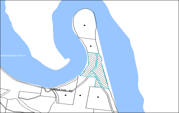
|
NOTIFICATION PLAN |
|
||
|
• PROPERTIES NOTIFIED
|
|
PROPERTY SUBJECT OF DEVELOPMENT |
|
6.2 Public Agencies
The development application is Integrated Development under the Act. Accordingly, the application was referred to the NSW RFS who provided general terms of approval for the application.
7. THE PUBLIC INTEREST
Section 79C(1)(e) of the Act requires Council to consider “the public interest”.
The public interest is an overarching requirement, which includes the consideration of the matters discussed in this report. Implicit to the public interest is the achievement of future built outcomes adequately responding to and respecting the future desired outcomes expressed in environmental planning instruments and development control plans.
The proposed subdivision of an existing undersized allotment would set an undesirable precedent for similar inappropriate subdivision of land that is severed by a formed or unformed road. Accordingly, it is considered that the approval of the proposed would not be in the public interest.
CONCLUSION
The application proposes the subdivision of one allotment into two.
The proposal does not comply with the minimum lot size pursuant to Clause 14 of Hornsby Shire Local Environmental Plan. The submitted objection to the minimum lot size development standard is not considered well founded with regard to State Environmental Planning Policy No. 1 – Development Standards.
Refusal of the application is recommended.
Note: At the time of the completion of this planning report, no persons have made a Political Donations Disclosure Statement pursuant to Section 147 of the Environmental Planning and Assessment Act 1979 in respect of the subject planning application.
|
Rod Pickles Manager - Development Assessment Planning Division |
James Farrington Group Manager Planning Division |
|
1.View |
Locality Map |
|
|
|
2.View |
Subdivision Plan |
|
|
|
Legal Advice from Hunt and Hunt Lawyers - This attachment should be dealt with in confidential session, under Section 10A (2) (g) of the Local Government Act, 1993. This report contains advice concerning litigation, or advice that would otherwise be privileged from production in legal proceedings on the ground of legal professional privilege. |
|
|
|
|
Legal Advice from Robert Wilcher - This attachment should be dealt with in confidential session, under Section 10A (2) (g) of the Local Government Act, 1993. This report contains advice concerning litigation, or advice that would otherwise be privileged from production in legal proceedings on the ground of legal professional privilege. |
|
|
File Reference: DA/272/2013
Document Number: D02742391
SCHEDULE 1
- REASONS FOR REFUSAL -
1. Pursuant to the provisions of Section 79C(1)(a)(i) of the Environmental Planning and Assessment Act, 1979, the proposal does not comply with the prescriptive standard and objectives of Clause 14 Density of the Hornsby Shire Local Environmental Plan 1994.
2. Pursuant to the provisions of Section 79C(1)(a)(i) of the Environmental Planning and Assessment Act, 1979, the proposal does not demonstrate that compliance with the development standard under Clause 14 of the Hornsby Shire Local Environmental Plan 1994 is unnecessary or unreasonable in the circumstances of the case, pursuant to State Environmental Planning Policy No. 1 – Development Standards.
3. Pursuant to the provisions of Section 79C(1)(e) of the Environmental Planning and Assessment Act, 1979, the proposal would set an undesirable precedent for similar inappropriate development and is not considered to be in the public interest.
- END OF REASONS FOR REFUSAL -
Group Manager’s Report No. PL18/14
Planning Division
Date of Meeting: 12/03/2014
9 FURTHER REPORT - CHILD CARE CENTRE - 48 SOMERSET STREET, EPPING
EXECUTIVE SUMMARY
|
DA No: |
DA/910/2013 (Lodged 5 September 2013) |
|
Description: |
Construction of a 60 place purpose built child care centre with basement car park |
|
Property: |
Lot 4 DP 25433, No. 48 Somerset Street, Epping |
|
Applicant: |
Revelop Projects Pty Ltd |
|
Owner: |
Somerset Group Pty Limited |
|
Estimated Value: |
$1.3 million |
|
Ward: |
C |
· The application proposes the construction of a single storey purpose built child care centre with basement car park.
· On 12 February 2014, Council resolved to defer the matter to enable an onsite meeting with available Councillors, the applicant and interested residents. An onsite meeting was held on 27 February 2014. Following the meeting, the applicant made a submission proposing to reduce the number of child placements from 81 to 60.
· The proposal generally complies with the provisions of the Hornsby Shire Local Environmental Plan 1994 and Council’s Community Uses Development Control Plan.
· A Red Sticker has been placed on the application requiring that the proposal be determined at a Council meeting.
· Ten submissions have been received in respect of the application.
· It is recommended that the application be approved.
|
THAT Development Application No. DA/910/2013 for construction of a 60 place purpose built child care centre with basement car park at Lot 4 DP 25433, No. 48 Somerset Street, Epping be approved subject to the conditions of consent detailed in Schedule 1 of Group Manager’s Report No. PL18/14. |
BACKGROUND
The site has been used for residential purposes.
The dwelling on the site has recently being demolished in accordance with Complying Development Certificate CDP/1341/2013.
On 20 February 2014, Council considered the subject application and resolved to:
Defer consideration of the application to facilitate discussions between available Councillors, the applicant and submitters to discuss opportunities to address residents’ concerns.
In accordance with Council’s resolution, on 27 February 2014 an on-site meeting was held to discuss the application. The meeting was attended by the applicant, the applicant’s planner, approximately 20 adjoining property owners and persons who made submissions on the application, available Councillors and Planning Division officers.
At the onsite meeting, Council officers and the applicant provided an overview of the application and residents outlined their concerns. Discussion included consideration of the following:
· Extent of notification of the application;
· Traffic impacts in the morning and afternoon associated with parents, staff, delivery trucks and cleaners;
· Noise and amenity impacts in a quiet street;
· Height of acoustic fence should be increased;
· Tree removal;
· Cars will park on the opposite side of road where there is no kerb and guttering;
· Corner of York and Somerset Streets is narrow with a blind spot because of the trees;
· Request for a reduction in the total number of children to no more than 60;
· Demand for child care places in the locality;
· Safety of children playing on the road riding skate boards;
· Demolition of the existing dwelling that contained asbestos; and
· Permissibility of a child care centre in Somerset Street.
At the conclusion of the meeting, it was noted that the application would be reported back to Council at its meeting on 12 March 2014 for Council’s consideration.
The matters raised at the onsite meeting are addressed in this report. With regard to tree removal, it was noted that on 28 February 2014, Council received representations from residents concerning trees being removed from the site. Council’s compliance officers attended the site. The tree loppers had left the site prior to Council officers arriving. However, there was evidence that works had commenced towards removing a large gum tree. The applicant has confirmed the works were the result of a miscommunication with a contractor. Council officers are currently reviewing the matter in regards to the pruning of a tree without consent.
Following the site meeting, the applicant made a submission to reduce the number of children proposed to attend the centre from 81 to 60 places.
SITE
The site is located on the southern side of Somerset Street Epping. The site has an area of 1227m2 with a frontage of 17.4m to the street. The site has an average gradient of 12% to the northern section which falls to the street. The rear section of the site has a relatively steeper 14% slope.
The site is cleared of all structures and accommodates a large number of trees at the rear. Vehicular access to the site is gained via an existing driveway fronting Somerset Street.
Surrounding developments consist of one and two storey residential dwelling houses. The site is located in close proximity to the M2 motorway corridor.
PROPOSAL
The proposal (as amended) involves the construction of a 60 place purpose built chid care centre with basement car park. The building is to be designed in a contemporary style with the front façade resembling a multi-unit housing development.
Proposed hours of operation would be 7.00am to 6.30pm Monday to Friday.
The details of the proposal are provided below:
Lower Ground Level
· A car park comprising 22 spaces with 1 disabled space and access via a two way driveway ramp from Somerset Street;
· A children’s community purpose room with separate access from the street. The room would be dedicated for children’s service practitioners on a rotational basis during the day; and
· A lift for access to the upper floor.
Upper Ground Floor
· A child care centre with the capacity for 81 spaces in the following categories:
· 0-2 years: 27 children
· 2-3 years: 24 children
· 3-6 years: 30 children
· The Child Care Centre comprises three separate indoor play rooms to cater for the age groups, office, children’s toilet, staff room, WC, laundry, kitchen, craft room, cot room, bottle preparation area and storage; and
· A covered patio with a sand pit located at the rear.
Outdoor Play Area
· The outdoor play area would have access from the covered area; and
· The outdoor play area would be located in the rear section of the site and would be divided into five tiers with ramp and stair access between each level.
ASSESSMENT
The development application has been assessed having regard to the ‘Metropolitan Plan for Sydney 2031’, the ‘North Subregion (Draft) Subregional Strategy’ and the matters for consideration prescribed under Section 79C of the Environmental Planning and Assessment Act 1979 (the Act). The following issues have been identified for further consideration.
1. OUTCOME OF SITE MEETING
As a response to the issues raised by residents at the site meeting held on 27 February 2014, the applicant has made a submission to amend the application from the construction of an 81 place purpose built child care centre with basement car park to the construction of a 60 place purpose built child care centre with basement car park. No change to the design of the child care centre is proposed.
The purpose of the proposed amendment is to enable the operation of the child care centre to be monitored for a period of 12 months in regards to its amenity impacts on the surrounding locality. Subject to confirmation that the development results in minimal adverse impacts with respect to traffic, noise and privacy, the applicant notes that a Section 96 application may be lodged to modify the number of child placements to 81 after 12 months of operation. Although the applicant has made a submission to reduce the child numbers, no changes to the built form are proposed.
The reduction in child placements would reduce the intensity of the development with less impacts on the locality than a child care centre for 81 child placements. Any future proposal to increase the number of children at the centre would be the subject of a future application pursuant to Section 96 of the Environmental Planning and Assessment Act. This process would enable an appropriate process to monitor the operation of the centre and for the consideration of the environmental impacts of any future increase in child numbers.
Additional planning issues raised at the site meeting have been addressed in the body of this report and recommended conditions of consent to mitigate adverse impacts to neighbourhood amenity.
2. STRATEGIC CONTEXT
2.1 Metropolitan Plan for Sydney and (Draft) North Subregional Strategy
The (Draft) Metropolitan Strategy for Sydney 2031 is a broad framework to provide for Sydney’s growth to help plan for housing, employment, transport, infrastructure, the environment and open space. It outlines a vision for Sydney to 2031; the challenges faced, and the directions to follow to address these challenges and achieve the vision.
The North Subregion comprises Hornsby, Kuring-gai, Manly, Warringah and Pittwater Local Government Areas. The Draft North Subregional Strategy provided a framework for Council in its preparation of the Hornsby Local Environmental Plan 2013.
Within the North Subregion, the Draft Metropolitan Strategy proposes:
· Population growth of 81,000 from the current 2011 baseline of 529,000
· Housing growth of 37,000 from the current 2011 baseline of 204,000
· Employment growth of 39,000 from the current 2011 baseline of 186,000
The proposed development would be consistent with the Metropolitan Plan for Sydney 2031 by providing child care facilities to support a growing population.
3. STATUTORY CONTROLS
Section 79C(1)(a) requires Council to consider “any relevant environmental planning instruments, draft environmental planning instruments, development control plans, planning agreements and regulations”.
3.1 Hornsby Shire Local Environmental Plan 1994
The subject land is zoned Residential A (Low Density) under the Hornsby Local Environmental Plan 1994 (HSLEP). The objectives of the Residential A (Low Density) zone are:
(a) to provide for the housing needs of the population of the Hornsby area.
(b) to promote a variety of housing types and other land uses compatible with a low density residential environment.
(c) to provide for development that is within the environmental capacity of a low density residential environment.
The proposed development is defined as ‘child care centre’ under the HSLEP and is permissible in the zone with Council’s consent. The proposal comprises a low key development which blends with the surroundings with regard to bulk and scale. The development complies with the zone objectives.
Clause 15 of the HSLEP prescribes that the maximum floor space ratio (FSR) of development within the Residential A (Low Density) zone is 0.4:1. The proposal addresses this requirement with a floor area of 201m2 and an FSR of 0.3:1 which complies with the development standard.
Clause 18 of the HSLEP sets out heritage conservation provisions for Hornsby Shire. The development is not within a heritage conservation area or in the vicinity of a heritage listed item under Schedule D of the HSLEP. In this regard, no further heritage assessment is required.
3.2 Hornsby Shire Local Environmental Plan (2013)
The Hornsby Local Environmental Plan 2013 (HLEP) was gazetted by the Minister for Planning and Infrastructure on 27 September 2013 and came into force on 11 October 2013. The HLEP includes a savings provision that a development application made and not finally determined before the commencement of the HLEP, must be determined as if the Plan had been exhibited but not commenced. The relevant provisions of the HLEP are addressed below.
3.2.1 Zoning
The site is zoned R2 (Low Density Residential) pursuant to the Land Use Table of the HLEP. The proposed development is defined as a ‘child care centre’ and is a permissible use in the zone with Council’s consent.
3.2.2 Height of Building
Clause 4.3 of the HLEP provides that the height of a building on any land is not to exceed the maximum height shown for the land on the Height of Buildings Map. The maximum permissible height for the subject site is 8.5m. The proposal complies with this provision.
3.3 Children (Education and Care Services) Supplementary Provisions Regulation 2012
Compliance with the Regulation is required for the licensing of child care centres by the NSW Department of Community Services.
The proposed development has been designed in accordance with Clause 28 of the Regulation which requires the provision of 3.25 sqm of unencumbered indoor play area per child and 7 sqm of useable outdoor play area per child. The development also includes a separate sleeping area for under 2 year olds, administration/meeting room and staff room. Apart from a covered patio at the rear of the child care centre, other shade structures are also proposed in the outdoor play areas which are considered to be adequate. Notwithstanding, a condition is recommended that the outdoor play space be adequately shaded in accordance with The Shade Handbook, published by the New South Wales Cancer Council in 2008 prior to the issue of the occupation certificate.
The Statement of Environmental Effects indicates that the proposed child care centre has been designed in accordance with Clause 52-Staff to Child Ratios. The centre would employ 13 staff members distributed in 3 rooms to comply with the respective child ratios as follows:
· 1:4 for 0-2 year olds;
· 1:8 for 2 – 3 year olds; and
· 1:10 for 3-6 year olds.
The number of staff would be reduced as a result of the amended proposal reducing the number of children to a maximum of 60.
Subject to conditions, the proposal complies with the Children (Education and Care Services) Supplementary Provisions Regulations 2012.
3.4 State Environmental Planning Policy No. 55 - Remediation of Land
The application has been assessed against the requirements of State Environmental Planning Policy No. 55 (SEPP 55). This Policy provides State-wide planning controls to promote the remediation of contaminated land to reduce the risk of harm to human health and the environment.
The applicant has addressed SEPP 55 by submitting a “Preliminary Site Contamination Report” which concludes that soil contamination present on the site is considered to be low to negligible; and the land is considered suitable (from a contamination perspective) for the proposed childcare centre. In this regard, no remedial works are deemed necessary.
Notwithstanding, the site previously accommodated a dwelling house containing asbestos. The report recommends that clearance certificates are to be obtained from a suitably experienced asbestos consultant confirming that all asbestos containing materials have been removed from structures which may contain asbestos and that no residual asbestos containing materials are present on the site.
Council’s environmental assessment of the application concludes that subject to the implementation of the recommended conditions of consent, the proposal is satisfactory in respect to the requirements of SEPP 55.
3.5 State Environmental Planning Policy (Infrastructure) 2007
The application has been assessed against the requirements of State Environmental Planning Policy (Infrastructure) 2007 (Infrastructure SEPP) as it is located in close proximity to the M2 corridor.
3.5.1 Clause 101 - Development with Frontage to Classified Road
Clause 101 of the Infrastructure SEPP states:
“The consent authority must not grant consent to development on land that has a frontage to a classified road unless it is satisfied that the development is of a type that is not sensitive to traffic noise or vehicle emissions, or is appropriately located and designed, or includes measures, to ameliorate potential traffic noise or vehicle emissions within the site of the development arising from the adjacent classified road.”
The proposal includes an Air Quality Report to address the impact of vehicle emissions on the development in accordance with the requirement of Clause 101 Infrastructure SEPP. The Air Quality Report has been assessed as satisfactory.
3.5.2 Clause 102 - Impact of Road Noise or Vibration on Non-Road Development
The occupants of the proposed development would be impacted due to road noise intrusion. In accordance with Clause 102 of the Infrastructure SEPP and the document “Development near Rail Corridors and Busy Roads – Interim Guidelines”, the applicant has submitted an Acoustic Assessment Report.
The report includes recommendations for construction techniques so that the internal noise intrusion within the teaching and sleeping areas does not exceed 40dB(A) Leq and noise intrusion within the administrative area does not exceed 45dB(A). A condition of consent is recommended to ensure that details of the recommended construction techniques are incorporated in the Construction Certificate plans. Additionally, the Acoustic Assessment recommends the installation of a 2.2m - 2.4m high imperforate acoustic fence along the side and rear boundaries to mitigate noise impacts from the outdoor play space. This is further discussed under Section 3.9.6.
Subject to the implementation of the above recommendations within the Acoustic Report, the proposal is assessed as satisfactory against the requirements of Clause 102 of SEPP Infrastructure.
3.5.3 Clause 104 - Traffic-Generating Development
Schedule 3 of SEPP Infrastructure sets out a list including the types of developments, their relative sizes and parking capacities, considered to be traffic generating developments. In accordance with this list, a child care centre would be considered as a traffic generating development if it requires the parking of 200 or more vehicles and fronts any road (irrespective of the hierarchy).
As discussed earlier in this report, the proposed development would include a car parking area with 22 spaces. Therefore, the development is not categorised as a traffic generating development. No further assessment in this regard is considered necessary.
The impact of the proposed development on the local road network is discussed later in this report.
3.6 Sydney Regional Environmental Plan (Sydney Harbour Catchment) 2005
The application has been assessed against the requirements of Sydney Regional Environmental Plan (Sydney Harbour Catchment) 2005. This Policy provides general planning considerations and strategies to ensure that the catchment, foreshores, waterways and islands of Sydney Harbour are recognised, protected, enhanced and maintained.
The development proposes to drain to the street via an on-site detention system. Council’s engineering assessment of the proposal in this regard concludes that the development is satisfactory. A condition is recommended with respect to installation of sediment and erosion control measures prior to, and during, construction. Subject to the recommended conditions, the proposed development would have minimal potential to impact on the Sydney Harbour Catchment.
3.7 Clause 74BA Environmental Planning and Assessment Act, 1979 - Purpose and Status of Development Control Plans
On 1 March 2013, the Environmental Planning and Assessment Act, 1979 was amended so that a DCP provision will have no effect if it has the practical effect of “preventing or unreasonably restricting development” that is otherwise permitted and complies with the development standards set out in relevant Local Environmental Plans and State Environmental Planning Policies.
The principal purpose of a development control plan is to provide guidance on the aims of any environmental planning instrument that applies to the development; facilitating development that is permissible under any such instrument; and achieving the objectives of land zones under any such instrument. The provisions of a development control plan made for that purpose are not statutory requirements.
3.8 Hornsby Development Control Plan 2013
The Hornsby Development Control Plan (HDCP) 2013 applies to all land within Hornsby Shire and replaces Council’s previous DCPs, providing development controls to complement the HLEP. The HDCP came into effect on 11 October 2013.
Although the HDCP was not in force at the date of lodgement of the application, the development proposal has been assessed against the Plan. The HDCP is generally a transition of Council’s previous DCPs, into a consolidation Plan. The development controls within the HDCP relating to child care centres are generally similar to the Community Uses DCP. The relevant matters and non-compliances are discussed in Section 3.9 under the heading Community Use Development Control Plan.
3.9 Community Uses Development Control Plan
The proposed development has been assessed having regard to the relevant performance and prescriptive design requirements within Council’s Community Uses Development Control Plan (Community Uses DCP). The following table sets out the proposal’s compliance with the prescriptive requirements of the Plan:
|
Community Uses Development Control Plan |
|||
|
Control |
Proposal |
Requirement |
Compliance |
|
Site Area |
1227m2 |
N/A |
N/A |
|
Density - Floor Area - FSR - Site Coverage |
398m2 0.32:1 34% |
400m2 0.4:1 40% |
Yes Yes Yes |
|
Number of Children - 0-2 age group (33% of total) - Total number of children |
20 60 |
20 60 |
Yes Yes |
|
Height |
Single storey |
Max. 2 storeys |
Yes |
|
Recreation Space - Child care: Outdoor (7m2 per child) - Child care: Indoor (3.25m2 per child) |
570m2 272m2 |
420m2 195 |
Yes Yes |
|
Landscaping |
46% |
45% |
Yes |
|
Car Parking |
22 spaces |
15 spaces |
Yes |
|
Setbacks - Somerset Street - Rear (south) - Side (east) - Side (west) |
8m 32.6m 1.5 - 2.1m 1.575 - 2m |
6m 3m 2m 2m |
Yes Yes No No |
As detailed in the above table, the proposed development does not comply with the setback prescriptive requirements within Council’s Community Uses DCP. The matters of non-compliance are detailed below, as well as a brief discussion on compliance with relevant performance requirements.
3.9.1 Site Selection
The ‘Site Selection’ element of the Community Uses DCP provides site selection criteria that aim to encourage the location of special use developments on sites with the lowest potential social and environmental impacts. The DCP states that a site accommodating a community use should not adjoin a major classified road. The DCP does not encourage the location of child care centres on streets that end in a cul-de-sac.
The site is an allotment fronting Somerset Street which is a local unclassified road running parallel to the M2 motorway and is not a noise sensitive residential site. The width of the carriageway of Somerset Street in front of the site is sufficient to accommodate two-way traffic flow. Further east, the street ends in a cul-de-sac at a considerable distance from the site (approximately 300m). Therefore, the location of the cul-de-sac end would not cause any hindrance to the traffic flow on the street in the near vicinity of the development. The proposal incorporates safe vehicular access with basement car parking. The site has an area of 1227sqm. Thus, it is capable of accommodating extensive recreation areas and adequate car parking for the proposed number of children.
The site is within a low density residential area within Hornsby Shire. These areas are dominated by “couple with children” households. The proposed centre is not located within 700m of a railway station or an employment centre. However, being located in a residential zone, it would service the population in the greater Epping catchment. The site is not adjacent to transmission lines and a preliminary analysis report was submitted with the application which concludes that the land is not contaminated.
The site constitutes bushfire prone land. The submitted report incorporates mitigation measures and construction techniques which have been assessed as satisfactory by the NSW Rural Fire Service. The land has a relatively steep slope of 14% at the rear. However, the design of the outdoor play area follows the slope of the land and provides a safe playing area for children, with disabled access to all levels.
Accordingly, the attributes of the site are considered conducive to the proposed development.
3.9.2 Density - Maximum Size of Child Care Centres
The ‘Density’ element of the Community Uses DCP states that child care centres on land zoned low density residential should be limited to 40 children. The DCP states that the size of a purpose built child care centre may be increased to 60 places only when the following requirements are met:
· A minimum of 33% of places are provided for 0-2 year olds, and
· A minimum of 4.5m2 of unencumbered indoor play space and a minimum of 15m2 of unencumbered outdoor place space is provided per child in accordance with best practice; and/or
· Where other children’s services are integrated into the development.
The amended development proposal involves a child centre for 60 child placements with the future built capacity for 81 children. Whilst the current proposal complies with the maximum size requirement, a future proposed development for 81 children would not comply with this requirement. Any increase in child numbers would be the subject of a future application to Council. The 60 place centre is supported for the following reasons:
· The development proposes 33% of places for 0-2 year olds, integrates additional children’s services with the development and complies with the space requirements within the Children Services Regulations.
· The ‘Density’ element also states that the maximum footprint of any building in a child care centre should be 350 - 400m². The proposal’s building footprint is 398m² which complies with this measure.
· The Community Uses DCP does not include a minimum site area requirement for child care centres. Therefore, subject to compliance with the other clauses, a block of land in a residential zone with a site area of 500sqm can accommodate a child care centre with 60 places. The site has an area of 1227sqm which is equivalent to the area of two standard residential blocks.
The amended development proposal is of a scale, density and intensity that ensures compatibility with the low density residential character of the surrounding development.
3.9.3 Parking and Access
Council’s Community Uses DCP states that “A drive-through accessway with separate ingress/egress access points should be provided for purpose built child care centres in residential zones.”
The proposal does not have a separate ingress/egress access point. The parking is provided at the basement level with access via a 6.1m wide two-way driveway ramp. Pedestrian access is via a separate walkway ramp along the western side of the driveway which connects to the entrance of the child care centre. A lift is proposed to provide barrier free access between the floors. However, the pick up/set down parking spaces are located in a manner which results in pedestrians accessing the centre walking behind reversing vehicles.
Although the Community Uses DCP requires a drive-through access way with separate ingress/egress access points, the site constraints preclude this arrangement for this application. To ensure safety for pedestrians, a condition is recommended that a “Shared Zone” sign be installed at the entrance to the car park, and three speed humps similar to Saferoads Rubber Speed Humps be installed along the parking aisle. Subject to conditions, the design of the driveway satisfies the intent of the Community Uses DCP in this regard.
In accordance with the parking requirements of the DCP, 1 space is required to be provided per 4 children. This gives a parking requirement of 15 spaces for the proposed child care centre with a capacity for 60 children. The proposed car park at the basement level would provide 22 car parking spaces, including 1 disabled parking space.
It is noted that a turning area has not been provided within the basement car park area. Should all the car spaces be occupied, a vehicle would need to reverse out of the car park which is not acceptable. Therefore, a condition of consent recommends the conversion of one of the car spaces to a designated turning bay to facilitate ingress and egress of vehicles in a forward direction. Given that the car parking area has additional car spaces, this would be achievable while maintaining compliance with the required car parking for the use.
Subject to conditions, the proposed development is considered satisfactory in regards to car parking and access.
3.9.4 Setbacks
The proposed 1.5m – 2m eastern side setback and 1.575m – 2.1m western side setback do not fully comply with the 2m side setback requirement of the Community Uses DCP. Notwithstanding, a 2.2m 2.4m high acoustic fence is proposed along the side setbacks which would mitigate noise and privacy impacts to adjoining properties. Subject to the recommended conditions, the proposal would provide for landscaping and protect the privacy and solar access of adjacent dwellings.
In this regard, the proposed development is considered satisfactory in regards to setbacks.
3.9.5 Recreation Space
The proposal complies with the requirements of Clause 28 (Space requirements) of the Children (Education and Care Services) Supplementary Provisions Regulation 2012. The indoor play areas are separated into three separate rooms in accordance with the age groups and include unencumbered play space. As discussed earlier in the report, the applicant has amended the proposal to 60 children. The Community Uses DCP requires larger centres to comply with the Best Practice standards (4.5m2 of indoor play area and 15m2 of outdoor play area per child). The proposal complies with the Best Practice standards for indoor space but not outdoor play area.
Given that the development complies with the minimum standards within the Regulation, and that the Regulation does not pose any restriction on the number of children subject to compliance with the space requirements, it is considered that the non-compliance with the requirements of the Community Uses DCP is acceptable. As such, the requirements of the Regulation would take precedence over the DCP numerical controls.
The Community Uses DCP requires the child care centre to provide unencumbered outdoor play area. The proposed outdoor play area would be located at the rear section of the site which has a slope of 14%. Accordingly, the outdoor play area is proposed to be divided into 5 tiers connected by ramps with safe disabled access. Natural settings of the site are maintained around the perimeter of the outdoor play area.
The design of the play area does not comply with the prescriptive measures of the Community Uses DCP. However, it is noted that provision of an unencumbered outdoor play area is not a requirement of the Children (Education and Care Services) Supplementary Provisions Regulation 2012. Examples of outdoor play areas within child care centres in various parts of New South Wales have been studied during the assessment process and it is noted that that safe playing areas for children of different age groups can be designed on steep sites with varying levels.
Given the above, it is considered that the proposed outdoor play area is useable and accessible by children of all age groups. The play area includes a covered patio and temporary shade sails over the open areas.
The design of the indoor and outdoor recreation spaces have been assessed as satisfactory despite the numerical non-compliance with the provisions of the Community Uses DCP with respect to outdoor play area.
3.9.6 Acoustics
An Acoustic Assessment Report for the proposed child care centre was submitted with the application. The report concludes that the following mitigation measures are to be implemented on the site to ensure that the noise emission from the outdoor play area and internal activities do not exceed the required 55dB(A):
· Install a 2.2m high imperforate fence along the southern and western boundary of the site and 2.4m high fence along the eastern boundary of the site. The details of the construction materials have also been provided;
· Install acoustic measures in the cot room and soffit of the roof over the verandah;
· Special glazing in certain areas of the building;
· Ensure that not more than 18 children are playing in the outdoor play area at any one time;
· Noise emission addressed by the mechanical plants; and
· Appropriate signage.
The acoustic report is based on an evaluation of a proposed centre of 81 children. The reduction in the number of children to a maximum of 60 will reduce the acoustic impacts associated with the development.
To ensure that the outdoor play activities comply with the Acoustic Rating guidelines, the recommendations have been included as conditions of consent.
Subject to compliance with the conditions of consent, the proposal is considered satisfactory with respect to potential acoustic impacts.
3.9.7 Solar Access
The submitted shadow diagrams indicate that the building or the fence would not overshadow any of the adjoining properties during winter solstice.
The outdoor play area, being located on the southern side, would be adequately shaded as required by the Community Uses DCP.
3.10 Car Parking Development Control Plan
The primary purpose of this Car Parking Development Control Plan is to provide parking controls for the development. The proposal includes the required number of parking spaces within the basement car park in accordance with the Car Parking Development Control Plan. This matter is discussed in detail in Section 3.9 of this report.
3.11 Access and Mobility Development Control Plan
The objective of the Access and Mobility DCP is to ensure that new development is accessible and usable by all people in Hornsby Shire, including those people with disabilities. The proposed development includes barrier free access and continuous paths of travel between all levels, being provided by lifts and ramps. Disabled parking spaces and toilets have also been incorporated into the development.
The application includes an Access Report which concludes that the proposal complies with all the relevant Acts with regard to accessibility and incorporates recommendations regarding construction of the building. Subject to the implementation of the recommendations, the application is assessed as satisfactory with regard to access.
3.12 Waste Minimisation and Management Development Control Plan
The primary purpose of this Waste Minimisation and Management Development Control Plan (Waste Management DCP) is to provide planning strategies and controls to promote waste minimisation and management. The applicant has submitted a waste management plan for the demolition and construction stages of the development in accordance with the requirements of the Waste Management DCP. The development includes a bin area of sufficient size within the basement. The bins would be taken up the ramp for kerbside collection.
The application is assessed as satisfactory with regard to waste management.
3.13 Sustainable Water Development Control Plan
The objective of the Sustainable Water Development Control Plan is to ensure the sustainability of water as a renewable resource and adopt the principles of Ecologically Sustainable Development to achieve this goal. The development site is not located in close proximity to an existing creek.
Recommended conditions of consent address erosion and sediment control and stormwater management. The application is assessed as satisfactory with regard to the provisions of the Sustainable Water Development Control Plan.
3.14 Section 94A Contributions Plan
Council would require a contribution to maintain and enhance amenity and service delivery within the Epping area. A condition of consent is recommended for the payment of a contribution towards the cost of infrastructure and services in accordance with Council’s Section 94A Contributions Plan.
4. ENVIRONMENTAL IMPACTS
Section 79C(1)(b) of the Act requires Council to consider “the likely impacts of that development, including environmental impacts on both the natural and built environments, and social and economic impacts in the locality”.
4.1 Natural Environment
4.1.1 Trees
The rear section of the site is mapped as containing Blackbutt Gully Forest (Community L) and contains a mixture of native and remnant trees. Nine (9) trees located within the site are protected under Council’s Tree Protection Order. All the other trees are mainly shrubs or exotic species and are exempt under Council’s Tree Protection Order.
The proposed development would necessitate the removal of 6 trees from the site out of the 9 trees due to the location of the basement and the disabled ramps within the outdoor play area. The remaining 3 significant trees would be retained. The application includes an Arborist Report with recommendations regarding tree retention and tree protection measures during construction. The application also includes a landscape plan with details of additional planting within the site.
Given that the removal of the trees are required to facilitate the development on the site, the removal of the trees is supported subject to a condition requiring the planting of 6 trees within the site to replace the loss of vegetation.
Council’s assessment with regard to the tree protection measures is satisfactory subject to the implementation of the recommendations contained within the Arborist Report.
4.1.2 Stormwater Drainage
The proposed development would be gravity drained to Council’s street drainage system located in Somerset Street, via an on-site detention system to control peak flow rates from the site. A condition of consent requiring the inclusion of an on-site stormwater detention system to be designed by a chartered civil engineer is recommended in Schedule 1.
Subject to recommended conditions, the proposal would not have any adverse impact on the natural water flow in the area.
4.2 Built Environment
4.2.1 Building Design
The proposed development is a single storey child care centre with an internal and outdoor play area at the rear of the site which is of sufficient size in accordance with the Children (Education and Care Services) Supplementary Provisions Regulation 2012. The front setback is 9 metres from Somerset Street and all setbacks provide for sufficient landscape screening to retain the privacy of the adjoining properties. The architectural features of the building include a contemporary style with the appearance of a multi-unit housing development. It is considered that the design is sympathetic to the existing streetscape and amenity of the locality and is acceptable in this regard.
4.2.2 Traffic
The proposed development would be located fronting Somerset Street which is an unclassified local road. The site is located in the vicinity of M2 and Epping Roads which are classified as State Roads.
As discussed earlier in the report, the proposal is not a traffic generating development. The Roads and Maritime Services publication “Guide to Traffic Generating Development” states that traffic speed limits are necessary on minor roads as pedestrian safety here is of primary concern. The speed limit on Somerset Street is 50kms/hr which is considered appropriate for a local road.
The Guideline also states environmental capacity considerations are relevant to streets in residential areas and includes a table with the recommended Environmental Capacity performance standards. In accordance with this table, the maximum peak hour traffic volume that can be safely accommodated on a local road such as Somerset Street with a speed limit of 40kms/hr is 300 vehicles per hr.
The submitted Traffic Report is based on a child care centre of 81 places and states that the proposal would result in approximately 65 vehicular trips per hour during the morning commuter peak period and 57 vehicular trips during the afternoon peak. According to the report, the projected increase in traffic activities is minimal when compared to the maximum number of vehicles that can be accommodated by the local road network surrounding the site. The amended proposal reduces the number of child places to 60 which would also reduce the traffic generation associated with the proposed development.
At the site meeting, concerns were raised regarding difficulties getting out into Norfolk Road during the morning peak. These issues have been reviewed and it is noted that the intersection of Norfolk Road and Dorset Street is controlled by a single lane roundabout. The roundabout is operating at a good level of service with space capacity in the morning peak. Council’s traffic assessment concludes that the traffic generated by the proposed development will not impact on the level of service.
Council’s traffic assessment concludes that the proposal would not result in an unsafe environment for pedestrians in the locality and would not have a negative impact on the local traffic network.
4.3 Social Impacts
The proposed child care centre would provide an extra 60 child care spaces in a locality that currently has reported shortages in vacancies. The development would make a positive social contribution to the local community by providing additional child care options in the 0-2 year age group.
4.4 Economic Impacts
The proposal would have a minor positive impact on the local economy generating an increase in demand for local services.
5. SITE SUITABILITY
Section 79C(1)(c) of the Act requires Council to consider “the suitability of the site for the development”.
5.1 Bushfire Risk
The site constitutes bushfire prone land and the application is integrated development pursuant to the Rural Fires Act 1997. The application was referred to NSW RFS whereby no objections were raised subject to recommended conditions of consent.
6. PUBLIC PARTICIPATION
Section 79C(1)(d) of the Act requires Council to consider “any submissions made in accordance with this Act”.
6.1 Community Consultation
The proposed development was placed on public exhibition and was notified to adjoining and nearby landowners between 18 September 2013 and 9 October 2013 in accordance with Council’s Notification and Exhibition Development Control Plan. At the site meeting, concern was raised regarding the notification of the application. The application was advertised in accordance with Council policy which included letters to the adjoining property owners. The application was also advertised in the local newspaper, on Council’s website and a sign erected on the subject site.
Council received 10 submissions objecting to the proposal from residents of 8 properties. The map below illustrates the location of those nearby landowners who made a submission that are in close proximity to the development site.
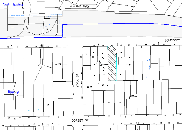
|
NOTIFICATION PLAN |
|
||
|
• PROPERTIES NOTIFIED
|
X SUBMISSIONS RECEIVED |
PROPERTY SUBJECT OF DEVELOPMENT |
|
10 submissions objected to the development, generally on the grounds that the development would result in:
· Unacceptable traffic and parking on local streets;
· Insufficient parking provided within the centre;
· Site not located within 700m of a commercial centre;
· Site in a zone with no data showing that it comprises a large population of 0-4 age group;
· Road ending in a cul-de-sac causing evacuation issues during a bushfire;
· Site with no separate ingress and egress points;
· Childcare size exceeding the Council requirements;
· Unacceptable noise from the outdoor play space and due to the proposed hours of operation;
· Loss of pedestrian safety on Somerset Street;
· Loss of privacy for adjoining developments;
· The removal of a number of trees;
· Development that is excessive in bulk and scale; and
· Potential contamination from asbestos during demolition.
The merits of the matters raised in community submissions have been addressed in the body of the report with the exception of the following:
6.1.1 Unacceptable Noise from the Outdoor Play Space
An Acoustic Report has been submitted with the application. Appropriate conditions are recommended in Schedule 1 to mitigate potential noise emissions to adjoining properties including construction of 2.4m high fences and a restriction limiting the maximum number of children in the outdoor play space at any give time to 18.
6.1.2 The Removal of Trees
The proposal results in the removal of 6 trees on the site. To compensate for the loss of trees, a condition of consent recommends the planting of 6 trees within the site. Subject to this condition, the application is assessed as satisfactory with regard to tree removal.
6.1.3 Hours of Operation and Impact of Noise
The site and the surroundings are subject to the traffic noise from M2. The hours of operation for the child care centre are from 7am - 6:30pm Monday to Friday which are standard hours of operation for a purpose built centre. The application includes an acoustic report with recommendations regarding noise mitigation measures. Subject to implementation of such mitigation measures, it is considered that the hours of operation would have minimal detrimental impact on the amenity of the neighbouring properties.
6.1.4 Loss of Privacy
The adjoining neighbour has objected to the development and raised concerns that the windows of the centre would overlook onto the courtyards of the properties to the east and west of the site.
The submitted plans indicate that the windows are located at a lower level than the proposed fence along the boundary. Accordingly, no overlooking opportunities are envisaged. The proposal incorporates landscaping along the perimeter of the outdoor play area in addition to the fencing to maintain the privacy of the neighbouring properties.
6.2 Public Agencies
The development application is Integrated Development under the Act. Accordingly, the application was referred to NSW Rural Fire Service for comment and no objections were raised to the development subject to recommended conditions.
7. THE PUBLIC INTEREST
Section 79C(1)(e) of the Act requires Council to consider “the public interest”.
The public interest is an overarching requirement, which includes the consideration of the matters discussed in this report. Implicit to the public interest is the achievement of future built outcomes adequately responding to and respecting the future desired outcomes expressed in environmental planning instruments and development control plans.
The amended application is considered to have satisfactorily addressed Council’s and relevant agency’s criteria and would provide a development outcome that, on balance, would result in a positive impact for the community. Accordingly, it is considered that the approval of the proposed development would be in the public interest.
CONCLUSION
The proposal involves the erection of a child care centre accommodating 60 child placements and basement car park. A total of 10 public submissions from the residents of 8 properties were received objecting to the proposal on the grounds of traffic, density, privacy, landscaping and noise. The issues raised are addressed in the body of the report and by relevant consent conditions under Schedule 1.
The proposed size of the child care centre (as amended) complies with the maximum permissible under Council’s Community Uses Development Control Plan. The built form is large enough to accommodate a child care centre for 81 child placements. Any proposal to increase the number of children would be the subject of a future application to Council.
The proposal generally complies with the relevant provisions of the Hornsby Shire Local Environmental Plan, the objectives of the Council’s Community Uses DCP, Access and Mobility Development Control Plan, Car Parking Development Control Plan and Waste Minimisation and Management Development Control Plan. The development is permissible in the zone and is considered to be within the environmental capacity of the site.
Accordingly, the proposed development is recommended for approval.
Note: At the time of the completion of this planning report, no persons have made a Political Donations Disclosure Statement pursuant to Section 147 of the Environmental Planning and Assessment Act 1979 in respect of the subject planning application.
|
Rod Pickles Manager - Development Assessment Planning Division |
James Farrington Group Manager Planning Division |
|
1.View |
Locality Map |
|
|
|
2.View |
Landscape Plans |
|
|
|
3.View |
Amended Floor Plans - Fence Elevations and Shadow and Play Area Dimensions |
|
|
|
4.View |
Shadow Diagram |
|
|
|
5.View |
Architectural Plans |
|
|
File Reference: DA/910/2013
Document Number: D02823490
SCHEDULE 1
GENERAL CONDITIONS
The conditions of consent within this notice of determination have been applied to ensure that the use of the land and/or building is carried out in such a manner that is consistent with the aims and objectives of the relevant legislation, planning instruments and council policies affecting the land and does not disrupt the amenity of the neighbourhood or impact upon the environment.
Note: For the purpose of this consent, the term ‘applicant’ means any person who has the authority to act on or the benefit of the development consent.
Note: For the purpose of this consent, any reference to an Act, Regulation, Australian Standard or publication by a public authority shall be taken to mean the gazetted Act or Regulation, or adopted Australian Standard or publication as in force on the date that the application for a construction certificate is made.
1. Approved Plans and Supporting Documentation
The development must be carried out in accordance with the plans and documentation listed below and endorsed with Council’s stamp, except where amended by Council and/or other conditions of this consent:
|
Plan No. |
Drawn by |
Dated |
|
Survey Plan - 12263/001 Rev B |
RGM Property Surveys |
13/09/2012 |
|
Photomontage - 13090/00 Rev A |
Baini Design |
August 2013 |
|
Demolition and Site Analysis plan Rev A |
Baini Design |
August 2013 |
|
Plans - 13090/02 Rev A |
Baini Design |
14/10/2013 |
|
Elevation - 13090/03 Rev A |
Baini Design |
August 2013 |
|
Sections - 13090/04 - Rev A |
Baini Design |
August 2013 |
|
Fence elevations |
Baini Design |
14/10/2013 |
|
SK 01 - Landscape Plan and Section |
Carmichael Studios |
Received by Council on 5/9/2013 |
|
SK 02 - Landscape Planting plan |
Carmichael Studios |
Received by Council on 5/9/2013 |
|
Stormwater plan - site and erosion and sediment control plan 1 of 2/A |
Ing Consulting Engineers Pty Ltd |
31/08/2013 |
|
Stormwater plan notes and details 2 of 2/A |
Ing Consulting Engineers Pty Ltd |
31/08/2013 |
|
Document No./ Name |
Prepared by |
Dated |
|
Hazardous Building Materials Register |
Getex |
11 October 2013 |
|
DA Acoustic Assessment |
Acoustic Logic |
14/08/2013 |
|
Boundary Fence shadow diagram |
Baini Design |
14/10/2013 |
|
Preliminary Air Quality Study |
Getex |
2 October 2013 |
|
Statement of Environmental Effects |
Think Planners Pty Ltd |
14 August 2013 |
|
Phase 1 Preliminary Site Contamination Investigation |
Getex |
11 October 2013 |
|
Traffic and Parking Assessment Report |
Varga Traffic Planning |
20 August 2013 |
|
Bushfire Hazard Assessment Report |
Building Code and Bushfire Solutions Pty Ltd |
20 June 2013 |
|
Waste Management Plan |
Redevelop |
3/09/2013 |
|
Access Report |
John Everden |
9/08/2013 |
|
Schedule of finishes |
Redevelop |
Received by Council on 5/09/2013 |
|
Arboricultural Impact Assessment Report |
Redgum Horticultural Consultants |
4/09/2013 |
|
General Terms of Approval Ref: D13/2086 - DA13091788991 MS |
NSW Rural Fire Service |
4 October 2013 |
2. Amendment of Plans
One of the carparking spaces in the basement level shall be deleted to form a turning area to enable vehicles to enter and leave the site in a forward direction.
3. Removal of Existing Trees
This development consent only permits the removal of trees numbered 1, 2, 3, 4, 5, 6 as identified on “Appendix E – Site Plan A – Survey of Subject Trees” within the Arboricultural Impact Assessment Report prepared by Redgum Horticultural dated 4/09/2013. The removal of any other trees requires separate approval under Council’s Tree Preservation Order.
4. Construction Certificate
A Construction Certificate is required to be approved by Council or a Private Certifying Authority prior to the commencement of any works under this consent.
REQUIREMENTS PRIOR TO THE ISSUE OF A CONSTRUCTION CERTIFICATE
5. Building Code of Australia
All building work must be carried out in accordance with the relevant requirements of the Building Code of Australia.
6. Sydney Water – Quick Check
This application must be submitted to a Sydney Water ‘Quick Check Agent’ or ‘Customer Centre’ for approval to determine whether the development would affect any Sydney Water infrastructure, and whether further requirements are to be met.
Note: Refer to www.sydneywater.com.au or telephone 13 20 92 for assistance.
7. Construction Certificate Plans
The construction certificate plans must incorporate all the construction details recommended in the following reports:
|
Document No and name |
Prepared by |
Dated |
|
DA Acoustic Assessment |
Acoustic Logic |
14/08/2013 |
|
Access Report |
John Everden |
9/08/2013 |
REQUIREMENTS PRIOR TO THE COMMENCEMENT OF ANY WORKS
8. Erection of Construction Sign
A sign must be erected in a prominent position on any site on which building work, subdivision work or demolition work is being carried out:
a) Showing the name, address and telephone number of the principal certifying authority for the work;
b) Showing the name of the principal contractor (if any) for any demolition or building work and a telephone number on which that person may be contacted outside working hours; and
c) Stating that unauthorised entry to the work site is prohibited.
Note: Any such sign is to be maintained while the building work, subdivision work or demolition work is being carried out, but must be removed when the work has been completed.
9. Protection of Adjoining Areas
A temporary hoarding, fence or awning must be erected between the work site and adjoining lands before the works begin and must be kept in place until after the completion of the works if the works:
a) Could cause a danger, obstruction or inconvenience to pedestrian or vehicular traffic.
b) Could cause damage to adjoining lands by falling objects.
c) Involve the enclosure of a public place or part of a public place.
Note: Notwithstanding the above, Council’s separate written approval is required prior to the erection of any structure or other obstruction on public land.
10. Toilet Facilities
Toilet facilities must be available or provided at the works site before works begin and must be maintained until the works are completed at a ratio of one toilet for every 20 persons employed at the site. Each toilet must:
a) be a standard flushing toilet connected to a public sewer; or
b) be a temporary chemical closet approved under the Local Government Act, 1993; or
c) have an on-site effluent disposal system approved under the Local Government Act, 1993.
11. Erosion and Sediment Control
Erosion and sediment control measures must be provided and maintained throughout the construction period in accordance with the manual ‘Soils and Construction 2004 (Bluebook)’, the approved plans, Council specifications and to the satisfaction of the principal certifying authority. The erosion and sediment control devices must remain in place until the site has been stabilised and revegetated.
Note: On the spot penalties up to $1,500 may be issued for any non-compliance with this requirement without any further notification or warning.
12. Tree Protection Barriers
Tree protection fencing must be erected around trees numbered 7,8 and 9 as identified on “Appendix E – Site Plan A – Survey of Subject Trees” within the Arboricultural Impact Assessment Report prepared by Redgum Horticultural dated 4/09/2013 in accordance with the following table:
|
Tree No. |
Tree Protection Zone |
Tree Protection Fencing Distance |
|
7 |
5m |
4.5m |
|
8 |
3.6m |
3.2m |
|
9 |
3.6m |
3.2m |
The tree fencing must be constructed of 1.8 metre ‘cyclone chainmesh fence’ or star pickets spaced at 2 metre intervals, connected by a continuous high-visibility barrier/hazard mesh at a height of 1 metre.
13. Traffic Control Plan
A Traffic Control Plan (TCP) must be prepared by a qualified traffic controller in accordance with the Roads & Traffic Authority’s Traffic Control at Worksites Manual 1998 and Australian Standard 1742.3 for all work on a public road and be submitted to Council. The TCP must detail the following:
a) Arrangements for public notification of the works.
b) Temporary construction signage.
c) Permanent post-construction signage.
d) Vehicle movement plans.
e) Traffic management plans.
f) Pedestrian and cyclist access/safety.
14. Return of Domestic Waste Bins
Arrangements must be made with Hornsby Shire Council Waste Management Services to return the domestic waste bins to Council.
REQUIREMENTS DURING CONSTRUCTION
15. Construction Work Hours
All work on site (including demolition and earth works) must only occur between 7am and 5pm Monday to Saturday. No work is to be undertaken on Sundays or public holidays.
16. Environmental Management
The site must be managed in accordance with the publication ‘Managing Urban Stormwater – Landcom (March 2004) and the Protection of the Environment Operations Act 1997 by way of implementing appropriate measures to prevent sediment run-off, excessive dust, noise or odour emanating from the site during the construction of the development.
17. Works Near Trees
All required tree protection measures are to be maintained in good condition for the duration of the construction period.
All works (including driveways and retaining walls) within 4 metres of any trees required to be retained (whether or not on the subject property, and pursuant to this consent or the Tree Preservation Order), must be carried out under the supervision of an ‘AQF Level 5 Arborist’ and a certificate submitted to the principal certifying authority detailing the method(s) used to preserve the tree(s).
Note: Except as provided above, the applicant is to ensure that no excavation, filling or stockpiling of building materials, parking of vehicles or plant, disposal of cement slurry, waste water or other contaminants is to occur within 4 metres of any tree to be retained.
18. Council Property
During construction works, no building materials, waste, machinery or related matter is to be stored on the road or footpath. The public reserve must be kept in a clean, tidy and safe condition at all times.
19. Street Sweeping
Street sweeping must be undertaken following sediment tracking from the site along Somerset Street during works and until the site is established.
20. Disturbance of Existing Site
During construction works, the existing ground levels of open space areas and natural landscape features, (including natural rock-outcrops, vegetation, soil and watercourses) must not be altered unless otherwise nominated on the approved plans.
21. Landfill
Landfill must be constructed in accordance with Council’s ‘Construction Specification, 2005’ and the following requirements:
a) All fill material imported to the site is to wholly consist of Virgin Excavated Natural Material (VENM) as defined in Schedule 1 of the Protection of the Environment Operations Act 1997 or a material approved under the Department of Environment and Climate Change’s general resource recovery exemption.
22. Excavated Material
All excavated material removed from the site must be classified in accordance with the Department of Environment, Climate Change and Water NSW Waste Classification Guidelines prior to disposal to an approved waste management facility and reported to the principal certifying authority.
23. Survey Report – Finished Floor Level
A report(s) must be prepared by a registered surveyor and submitted to the principal certifying authority prior to the pouring of concrete at each level of the building certifying that:
a) The building, retaining walls and the like have been correctly positioned on the site; and
b) The finished floor level(s) are in accordance with the approved plans.
24. Waste Management
Waste management during the demolition and construction phase of the development must be undertaken in accordance with the approved Waste Management Plan. Additionally written records of the following items must be maintained during the removal of any waste from the site and such information submitted to the Principal Certifying Authority within fourteen days of the date of completion of the works:
a) The identity of the person removing the waste.
b) The waste carrier vehicle registration
c) Date and time of waste collection.
d) A description of the waste (type of waste and estimated quantity).
e) Details of the site to which the waste is to be taken.
f) The corresponding tip docket/receipt from the site to which the waste is transferred (noting date and time of delivery, description (type and quantity) of waste).
g) Whether the waste is expected to be reused, recycled or go to landfill.
Note: In accordance with the Protection of the Environment Operations Act 1997, the definition of waste includes any unwanted substance, regardless of whether it is reused, recycled or disposed to landfill.
REQUIREMENTS PRIOR TO THE ISSUE OF AN OCCUPATION CERTIFICATE
Note: For the purpose of this consent, a reference to ‘occupation certificate’ shall not be taken to mean an ‘interim occupation certificate’ unless otherwise stated.
25. Sydney Water – s73 Certificate
An s73 Certificate must be obtained from Sydney Water.
26. Stormwater Drainage
The stormwater drainage system for the development must be designed and constructed in accordance with Council’s Civil Works – Design and Construction Specification 2005 and the following requirements:
a) Connected directly to Council’s street drainage system via an on site detention system.
Note: Details of the stormwater management system must be included in the construction certificate plans.
27. On Site Stormwater Detention
An on-site stormwater detention system must be designed by a chartered civil engineer and constructed in accordance with the following requirements:
a) Details of the on-site detention system be provided with the construction certificate plans.
b) Have a capacity of not less than 14.5 cubic metres, and a maximum discharge (when full) of 18 litres per second.
c) Have a surcharge/inspection grate located directly above the outlet.
d) Discharge from the detention system to be controlled via 1 metre length of pipe, not less than 50 millimetres diameter or via a stainless plate with sharply drilled orifice bolted over the face of the outlet discharging into a larger diameter pipe capable of carrying the design flow to an approved Council system.
e) Where above ground and the average depth is greater than 0.3 metres, a ‘pool type’ safety fence and warning signs to be installed.
f) Not be constructed in a location that would impact upon the visual or recreational amenity of residents.
28. Internal Driveway/Vehicular Areas
The driveway and parking areas on site must be designed and constructed in accordance with Australian Standards 2890.1, 2890.2, 3727 and the following requirements:
a) Design levels at the front boundary be obtained from Council.
b) The driveway be bitumen sealed and concreted.
c) The driveway grade must not exceed 25 percent and the change in grade must not exceed 8 percent.
d) Details of the internal driveway be provided with the construction certificate plans.
e) The driveway and the parking areas are to be paved, line marked and signposted.
f) A “Shared Zone” sign be installed at the entrance to the car park.
g) Three speed humps similar to Saferoads Rubber Speed Humps be installed along the parking aisle.
h) All parking spaces for people with disabilities must be constructed in accordance with Australian Standard AS/NZS 2890.6:2009 – Off-street parking for people with disabilities.
29. Vehicular Crossing
A separate application under the Local Government Act, 1993 and the Roads Act, 1993 must be submitted to Council for the installation of a new vehicular crossing and the removal of the redundant crossing. The vehicular crossing must be constructed in accordance with Council’s Civil Works Design, 2005 and the following requirements:
a) Any redundant crossings must be replaced with integral kerb and gutter;
b) Approval must be obtained from all relevant utility providers that all necessary conduits be provided and protected under the crossing.
Note: An application for a vehicular crossing can only be made to one of Council’s Authorised Vehicular Crossing Contractors. You are advised to contact Council on 02 9847 6940 to obtain a list of contractors.
30. Damage to Council Assets
Any damage caused to Council’s assets as a result of the construction of the development must be rectified in accordance with Council’s Civil Works Specifications. Council’s Restorations Supervision must be notified for a formwork inspection prior to pouring concrete.
31. Completion of Landscaping
A certificate must be provided by a practicing landscape architect, horticulturalist or person with similar qualifications and experience certifying that all required landscaping works have been satisfactorily completed in accordance with the approved landscape plans.
Note: Advice on suitable species for landscaping can be obtained from Council’s planting guide ‘Indigenous Plants for the Bushland Shire’, available at www.hornsby.nsw.gov.au.
32. Waste Management
Documentary evidence (i.e. tipping dockets/receipts from recycling depots, transfer stations and landfills, audit reports etc) that all demolition and construction waste was taken to site(s) that were lawfully permitted to accept that waste, must be provided to the Principal Certifying Authority.
33. External Lighting
All external lighting must be designed and installed in accordance with Australian Standard AS 4282 – Control of the Obtrusive Effects of Outdoor Lighting. Certification of compliance with the Standard must be obtained from a suitably qualified person.
34. Shade Structure/s
The outdoor play space must be adequately shaded in accordance with The Shade Handbook, published by the New South Wales Cancer Council in 2008.
35. Acoustic/Privacy Fence
A 2.2m high imperforate fence must be constructed along the southern and western boundary of the site and 2.4m high imperforate fence must be constructed along the eastern boundary of the site. The fences must be constructed of any of the following materials:
a) 9mm fibre cement; or
b) lapped and capped timber; or
c) masonry or equivalent; or
d) a combination of the above
The section of the fence above 1.8m may be angled towards the site at 45 degrees, subject to the overall height not being less than 2.2 – 2.4m as stated above. The fence is to be installed gap free between the panels and no gap at the bottom.
36. Food Premises
The fit out and operation of that part of the building to be used for the manufacture, preparation or storage of food for sale, must be in accordance with Australian Standard 4674-2004 – Design and fit out of food premises, the Food Act 2003, and the Food Regulation 20010 and the Food Standards Code developed by Food Standards Australia New Zealand. Food Standards 3.3.1. 3.2.2 and 3.2.3 are mandatory for all food businesses.
Note: Walls are to be of solid construction.
37. Site Remediation Verification
The applicant must provide documentation from a suitably qualified environmental consultant verifying that the site has been remediated in accordance with the NSW Environment Protection Authority’s Contaminated Sites – Guidelines for Consultants Reporting on Contaminated Sites, the Contaminated Sites - Sampling Design Guidelines Contaminated Sites – Guidelines for the NSW Site Auditor Scheme and the recommendations of the Preliminary Contamination Report prepared by Getex dated 11/10/2013.
38. Kitchen Exhaust Installation
A kitchen exhaust system must be designed and installed to effectively prevent air pollution in accordance with the Protection of the Environment Operations Act 1997.
39. Maintain Canopy Cover
To maintain canopy cover, six medium to large trees selected from Council’s booklet ‘Indigenous Plants for the Bushland Shire’ such as Eucalyptus Pilularis are to be planted on the subject site. The planning location shall not be within 4 metres of the foundation walls of a dwelling or in-ground pool. The pot size is to be a minimum 25 litres and the tree(s) must be maintained until they reach the height of 3 metres.
40. Retaining Walls
All required retaining walls must be constructed as part of the development.
41. Section 94A Development Contributions
In accordance with Section 80A(1) of the Environmental Planning and Assessment Act 1979 and the Hornsby Shire Council Section 94A Development Contributions Plan 2012-2021, $13,728.95 shall be paid to Council to cater for the increased demand for community infrastructure resulting from the development, based on development costs of $1,372,895.
If the contributions are not paid within the financial quarter that this consent is granted, the contributions payable will be adjusted in accordance with the provisions of the Hornsby Shire Council Section 94A Development Contributions Plan and the amount payable will be calculated at the time of payment in the following manner:
$CPY = $CDC x CPIPY
CPIDC
Where:
$CPY is the amount of the contribution at the date of Payment.
$CDC is the amount of the contribution as set out in this Development Consent.
CPIPY is the latest release of the Consumer Price Index (Sydney – All Groups) at the date of Payment as published by the ABS.
CPIDC is the Consumer Price Index (Sydney – All Groups) for the financial quarter at the date of this Development Consent.
a) The monetary contributions shall be paid to Council:
i) prior to the issue of the Subdivision Certificate where the development is for subdivision; or
ii) prior to the issue of the first Construction Certificate where the development is for building work; or
iii) prior to issue of the Subdivision Certificate or first Construction Certificate, whichever occurs first, where the development involves both subdivision and building work; or
iv) prior to the works commencing where the development does not require a Construction Certificate or Subdivision Certificate.
It is the professional responsibility of the Principal Certifying Authority to ensure that the monetary contributions have been paid to Council in accordance with the above timeframes.
Council’s Development Contributions Plan may be viewed at www.hornsby.nsw.gov.au or a copy may be inspected at Council’s Administration Centre during normal business hours.
OPERATIONAL CONDITIONS
42. Use of Premises
The development approved under this consent shall be used for ‘child care centre’ and not for any other purpose without Council’s separate written consent.
43. Number of Children
The centre shall accommodate a maximum of 60 children with a minimum of 33% of children within the 0-2 age group as at 1 January of each calendar year.
Note: Twelve months after occupation of the child care centre, subject to there being no significant amenity impacts including noise, traffic and / or privacy, arising from the operation of the centre in the preceding 12 months, the applicant may lodge an application in accordance with Section 96 of the Environmental Planning and Assessment Act 1979 to amend this consent to increase the number of children at the centre to 81 children.
44. Hours of Operation
The hours of operation of the premise are restricted to those times listed below:
Monday to Friday 7:00 am to 6:30 pm
Saturday, Sunday & Public Holidays No work
45. Noise
All noise generated by the proposed development must be attenuated to prevent levels of noise being emitted to adjacent premises which possess tonal, beating and similar characteristics or which exceeds background noise levels by more than 5dB(A).
46. Waste Management
All commercial tenants must keep written evidence on site of a valid contract with a licensed waste contractor(s) for the regular collection and disposal of the waste and recyclables that are generated on site.
47. Waste Collection
Due to the close proximity of residential dwellings, waste collection services must only take place within the hours of 9 AM to 7 PM on Sundays and Public Holidays or within the hours of 7 AM to 7 PM on other days.
48. Car Parking and Deliveries
All car parking must be operated in accordance with the following requirements:
a) Car parking, loading and manoeuvring areas to be used solely for nominated purposes;
b) Vehicles awaiting loading, unloading or servicing shall be parked on site and not on adjacent or nearby public roads;
c) All vehicular entry on to the site and egress from the site shall be made in a forward direction.
49. Staff Car Parking
All staff are required to park on-site in the basement car park.
50. Number of Children in Outdoor Play Space
A maximum of 18 children are permitted to play in the outdoor play area at any one time.
51. Fire Safety Statement - Annual
On at least one occasion in every 12 month period following the date of the first ‘Fire Safety Certificate’ issued for the property, the owner must provide Council with an annual ‘Fire Safety Certificate’ to each essential service installed in the building.
GENERAL TERMS OF APPROVAL – NSW RURAL FIRE SERVICE
The following conditions of consent are General Terms of Approval from the nominated State Agency pursuant to Section 91A of the Environmental Planning and Assessment Act 1979 and must be complied with to the satisfaction of that Agency:
52. Asset Protection Zones
At the commencement of building works and in perpetuity the entire property shall be managed as an inner protection area (IPA) as outlined within section 4.1.3 and Appendix 5 of ‘Planning for Bush Fire Protection 2006’ and the NSW Rural Fire Service’s document ‘Standards for asset protection zones’.
53. Water and Utilities
Water, electricity and gas are to comply with sections 4.1.3 and 4.2.7 of ‘Planning for Bush Fire Protection 2006’.
54. Evacuation and Emergency Management
Arrangement for emergency and evacuation are to comply with section 4.2.7 of ‘Planning for Bush Fire Protection 2006’.
55. Design and Construction
New construction shall comply with Sections 3 and 5 (BAL 12.5) Australian Standard AS3959-2009 ‘Construction of buildings in bush fire pone areas’ and section A3.7 Addendum Appendix 3 of ‘Planning for Bush Fire Protection’.
- END OF CONDITIONS -
ADVISORY NOTES
The following information is provided for your assistance to ensure compliance with the Environmental Planning and Assessment Act, 1979, Environmental Planning and Assessment Regulation 2000, other relevant legislation and Council’s policies and specifications. This information does not form part of the conditions of development consent pursuant to Section 80a of the Act.
Environmental Planning and Assessment Act, 1979 Requirements
The Environmental Planning and Assessment Act, 1979 requires:
· The issue of a construction certificate prior to the commencement of any works. Enquiries can be made to Council’s Customer Services Branch on 9847 6760.
· A principal certifying authority to be nominated and Council notified of that appointment prior to the commencement of any works.
· Council to be given at least two days written notice prior to the commencement of any works.
· Mandatory inspections of nominated stages of the construction inspected.
· An occupation certificate to be issued before occupying any building or commencing the use of the land.
Long Service Levy
In accordance with Section 34 of the Building and Construction Industry Long Service Payments Act 1986, a ‘Long Service Levy’ must be paid to the Long Service Payments Corporation or Hornsby Council.
Note: The rate of the Long Service Levy is 0.35% of the total cost of the work.
Note: Hornsby Council requires the payment of the Long Service Levy prior to the issue of a construction certificate.
Tree Preservation Order
To ensure the maintenance and protection of the existing natural environment, it is an offence to ringbark, cut down, top, lop, remove, wilfully injure or destroy a tree outside 3 metres of the approved building envelope without the prior written consent from Council.
Note: A tree is defined as a single or multi-trunked wood perennial plant having a height of not less than three (3) metres, and which develops many branches, usually from a distance of not less than one (1) metre from the ground, but excluding any plant which, in its particular location, is a noxious plant declared as such pursuant to the Noxious Weeds Act 1993. This definition of ‘tree’ includes any and all types of Palm trees.
All distances are determined under Australian Standard AS4970-2009 ”Protection of Trees on Development Sites”.
Fines may be imposed for non-compliance with Council’s Tree Preservation Order.
Disability Discrimination Act
The applicant’s attention is drawn to the existence of the Disability Discrimination Act. A construction certificate is required to be obtained for the proposed building/s, which will provide consideration under the Building Code of Australia, however, the development may not comply with the requirements of the Disability Discrimination Act. This is the sole responsibility of the applicant.
Covenants
The land upon which the subject building is to be constructed may be affected by restrictive covenants. Council issues this approval without enquiry as to whether any restrictive covenant affecting the land would be breached by the construction of the building, the subject of this consent. Applicants must rely on their own enquiries as to whether or not the building breaches any such covenant.
Advertising Signage – Separate DA Required
This consent does not permit the erection or display of any advertising signs. Most advertising signs or structures require development consent. Applicants should make separate enquiries with Council prior to erecting or displaying any advertising signage.
Dial Before You Dig
Prior to commencing any works, the applicant is encouraged to contact Dial Before You Dig on 1100 or www.dialbeforeyoudig.com.au for free information on potential underground pipes and cables within the vicinity of the development site.
Telecommunications Act 1997 (Commonwealth)
If you are aware of any works or proposed works which may affect or impact on Telstra’s assets in any way, you are required to contact: Telstra’s Network Integrity Team on Phone Number 1800810443.
Asbestos Warning
Should asbestos or asbestos products be encountered during demolition or construction works, you are advised to seek advice and information prior to disturbing this material. It is recommended that a contractor holding an asbestos-handling permit (issued by WorkCover NSW) be engaged to manage the proper handling of this material. Further information regarding the safe handling and removal of asbestos can be found at:
Alternatively, telephone the WorkCover Asbestos and Demolition Team on 8260 5885.
Rain Water Tank
It is recommended that water collected within any rainwater tank as part of the development be limited to non-potable uses. NSW Health recommends that the use of rainwater tanks for drinking purposes not occur where a reticulated potable water supply is available.
Food Authority Notification
The NSW Food Authority requires businesses to electronically notify the Authority prior to the commencement of its operation.
Note: NSW Food Authority can be contacted at www.foodnotify.nsw.gov.au.
Council Notification – Food Premises
Prior to the commencement of the business, the operator is requested to contact Council’s Environmental Health Team to arrange an inspection for compliance against the relevant legislation and guidelines outlined in this approval.
Note: Council’s Environmental Health Officer can be contacted on 02 9847 6745.
Group Manager’s Report No. PL17/14
Planning Division
Date of Meeting: 12/03/2014
10 FURTHER REPORT - CHILD CARE CENTRE - 23 BELLAMY STREET, PENNANT HILLS
EXECUTIVE SUMMARY
|
DA No: |
DA/679/2012 (Lodged 5 July 2012) |
|
Description: |
Demolition of existing structures and construction of a new purpose built 60 place child care centre |
|
Property: |
Lots 9 and 10, DP 17123, No. 23 Bellamy Street, Pennant Hills |
|
Applicant: |
Shayne Lysaght |
|
Owner: |
Shayne Lysaght |
|
Estimated Value: |
$750,000 |
|
Ward: |
C |
· The application proposes demolition of existing structures and construction of a new purpose built 60 place child care centre.
· On 20 November 2013, Council considered Group Manager’s Report No. PL110/13 evaluating the application and resolved to defer the matter to enable the preparation of detailed design drawings of the recommended traffic improvements to facilitate the development for consideration by the Local Traffic Committee. These designs were considered at an onsite meeting with residents and the Traffic Committee on 11 February 2014. The Traffic Committee raises no objections to the proposal subject to the implementation of recommended traffic improvement measures.
· The proposal complies with the objectives of the Hornsby Shire Local Environmental Plan 1994. The proposal generally complies with the requirements of Council’s Community Uses Development Control Plan with the exception of the number of children and the provision of landscaping.
· It is recommended that the application be approved.
|
THAT Development Application No. DA/679/2012 for demolition of existing structures and construction of a purpose built 60 place child care centre at Lots 9 and 10, DP 17123, No. 23 Bellamy Street, Pennant Hills be approved subject to the conditions of consent detailed in Schedule 1 of Group Manager’s Report No. PL17/14. |
BACKGROUND
On 5 July 2012, Development Application No. 769/2012 was lodged for the demolition of existing structures and construction of a new purpose built 60 place child care centre.
On 20 November 2013, Council considered the subject application and resolved that:
Consideration of Development Application No. DA/679/2012 for demolition of existing structures and construction of a purpose built 60 place child care centre at Lots 9 and 10, DP 17123, No. 23 Bellamy Street, Pennant Hills be deferred to enable the preparation of detailed design drawings of the recommended traffic improvements to facilitate the development, including a median strip in Bellamy Street, for consideration by the Local Traffic Committee. These designs are to take into consideration impact on residents and are to minimise these impacts. These designs, along with Traffic Committee comments, are then to be reported to Council when Development Application No. DA/679/2012 is to be reconsidered.
In accordance with Council’s resolution, Council prepared 3 options for access to the proposed child care centre for consideration by the Local Traffic Committee at the on-site meeting held on 11 February 2014. The meeting was attended by the owners of the site and their traffic consultant, adjoining property owners and persons who had made submission’s on the application, available Councillors, Greg Smith MP, Planning Division officers and Local Traffic Committee representatives.
At the onsite meeting, the applicant provided an overview of the application and residents outlined their concerns. The applicant’s traffic consultant reviewed Council’s suggested options and summarised the benefits and disbenefits of each option. The traffic consultant also presented traffic data showing times and duration of traffic peaks for the road network and the child care centre and expressed a preference for Option 1 as the child care centre management had the ability to educate and influence the child care centre’s staff and clients’ behaviour regarding parking and access.
The resident representatives raised concerns regarding:
· the location of the child care centre on such a busy road;
· the volume of traffic on Bellamy Street causing queuing through the roundabout at Laurence Street and in front of the proposed child care centre;
· the duration of the traffic peaks, in particular the extensive afternoon peaks influenced by local school traffic in addition to non local traffic using Bellamy Street to avoid congestion on Pennant Hills Road;
· restricting resident access was considered an unnecessary impediment due to the circuitous nature of eastbound trips; and
· restricting on street parking would impact on their access, particularly for visitors.
Overall the resident representatives objected to the location of the child care centre on traffic grounds but considered Option 1 to be the least objectionable access option.
The outcome of the Local Traffic Committee meeting and its recommendations are addressed in Section 2.8.4 of this report.
SITE
The site comprises 2 lots, has an area of 1653.66m2 and is located on the north-western side of Bellamy Street approximately 60m south of the intersection with Laurence Street. The site adjoins the Lilian Fraser Garden which is listed as a heritage item (local) in Schedule D of the Hornsby Shire Local Environmental Plan 1994.
There is a single storey dwelling positioned towards the centre of the site and located over the boundary of Lots 9 and 10. The site has a driveway, 3.5m wide extending along the south western boundary which provides access for the dwelling at the rear of the site on Lot E DP 380042, No. 21A Bellamy Street. The site is traversed by a watercourse along the south-west corner.
The site contains a number of exotic trees. It is noted that there are no trees protected by Council’s Tree Preservation Order, which would be impacted upon by this proposal. The site is surrounded by one and two storey residential dwellings.
The site is located in close proximity to Pennant Hills High School.
PROPOSAL
The proposal is for the construction of a new 2 storey child care centre. The proposed works include:
· Demolition of the existing dwelling-house and associated outbuildings;
· Removal of existing concrete driveway;
· Clearing and removal of existing landscaping (tree removal has been undertaken already);
· Removal of existing front and northern side boundary fencing;
· Construction of a new split-level childcare centre;
· New covered outdoor learning area;
· New gazebo/sandpit in the north-western corner of site;
· New car-parking area within the front boundary of the site;
· New additional driveway entry and configuration of the car-park;
· New pathway parallel to the northern side boundary; and
· New fencing parallel to the existing watercourse which transects the rear of the site.
The centre would cater for 60 children and the proposed hours of operation would be 7.30am to 6.00pm Monday to Friday.
ASSESSMENT
The development application has been assessed having regard to the ‘Metropolitan Plan for Sydney 2031’, the ‘North Subregion (Draft) Subregional Strategy’ and the matters for consideration prescribed under Section 79C of the Environmental Planning and Assessment Act 1979 (the Act). The following issues have been identified for further consideration.
1. STRATEGIC CONTEXT
1.1 Metropolitan Plan for Sydney and (Draft) North Subregional Strategy
The (Draft) Metropolitan Strategy for Sydney 2031 is a broad framework to provide for Sydney’s growth to help plan for housing, employment, transport, infrastructure, the environment and open space. It outlines a vision for Sydney to 2031; the challenges faced, and the directions to follow to address these challenges and achieve the vision.
The North Subregion comprises Hornsby, Kuring-gai, Manly, Warringah and Pittwater Local Government Areas. The Draft North Subregional Strategy provided a framework for Council in its preparation of the Hornsby Local Environmental Plan 2013.
Within the North Subregion, the Draft Metropolitan Strategy proposes:
· Population growth of 81,000 from the current 2011 baseline of 529,000
· Housing growth of 37,000 from the current 2011 baseline of 204,000
· Employment growth of 39,000 from the current 2011 baseline of 186,000
The proposed development would be consistent with the Metropolitan Plan for Sydney 2031 by providing child care facilities to support a growing population.
2. STATUTORY CONTROLS
Section 79C(1)(a) requires Council to consider “any relevant environmental planning instruments, draft environmental planning instruments, development control plans, planning agreements and regulations”.
2.1 Hornsby Shire Local Environmental Plan 1994
The subject land is zoned Residential A (Low Density) under the Hornsby Shire Local Environmental Plan 1994 (HSLEP). The objectives of the Residential A zone are:
(a) to provide for the housing needs of the population of the Hornsby area.
(b) to promote a variety of housing types and other land uses compatible with a low density residential environment.
(c) to provide for development that is within the environmental capacity of a low density residential environment.
The proposed development is defined as ‘demolition’ and ‘child care centre’ under the HSLEP and is permissible in the zone with Council’s consent.
Clause 15 of the HSLEP prescribes that the maximum floor space ratio (FSR) of development within the Residential A (Low Density) zone is 0.4:1. The proposed development has a FSR of 0.35:1 which complies with this requirement.
Clause 18 of the HSLEP sets out heritage conservation provisions for Hornsby Shire. The property is located adjacent to property No. 1 Laurence Street, Pennant Hills which is listed as a heritage item (Lilian Fraser Garden - Landscape Item) of local significance under the provisions of Schedule D (Heritage Items) of the HSLEP.
The inventory sheet for the property provides the following statement of significance and description for the item:
“Garden, commemorating Lilian Fraser, plant biologist horticulturist and gardener of 60 years, displaying an almost rural, rambling character evolving over period from c1915 to 1970s and becoming a rarity. The garden includes a number of rare species and is a mecca for native birds. Of high local significance.”
“The garden has evolved into a fine, rambling, almost rural, woodland garden densely planted under mature trees with a wide array of shrubbery and low planting. Trees include an old Camphorlaurel (with Monsteria from c1900's) Dawn Redwood to 22m, Oak, Jacaranda, Firewheel, N.Z. Christmas, Gnarled Banksia, Magnolias, Dogwoods, Crab-apple, flowering Cherries, Pocket-Hanker chief, Fringe tree, and shrubbery including Camellias, Azaleas, Plumbago, Hydrangeas, Rose bushes, Abutilions, bulbs and perennials. The garden has been and remains a mecca for bird life (36 native species are listed as visiting the garden)”.
During the assessment of the application, the owner removed a number of trees from the site which are exempt under Council’s Tree Preservation Order and erected a 1.8m high paling fence on the boundary shared with the Lilian Fraser Garden.
Accordingly, Council’s Heritage assessment raises no objection to the proposal subject to suitable landscape planting at the interface, including trailing plants over the fence consistent with the species in the Lilian Fraser Garden.
2.2 Hornsby Local Environmental Plan 2013
The Hornsby Local Environmental Plan 2013 (HLEP) was made on 27 September 2013 and came into effect on 11 October 2013. The HLEP includes a savings provision stating that if a development application is made and not finally determined before the commencement of the HLEP, the application must be determined as if the Plan had been exhibited but not commenced. The relevant provisions of the HLEP are addressed below.
2.2.1 Zoning
The site is zoned R2 (Low Density Residential) pursuant to the Land Use Table of the HLEP. The proposed development is defined as a ‘child care centre’ and is a permissible use in the zone with Council’s consent.
2.2.2 Height of Building
Clause 4.3 of the HLEP provides that the height of a building on any land is not to exceed the maximum height shown for the land on the Height of Buildings Map. The maximum permissible height for the subject site is 8.5m.
The proposal generally complies with this provision as the bulk of the building is at or below 8.5m in height with the exception of a small component of the building in the centre of the site that is 9m due to the topography of the site and the design of the roof. Notwithstanding, the development presents as single storey to Bellamy Street and is consistent with the surrounding residential development.
2.3 State Environmental Planning Policy No. 55 Remediation of Land
The application has been assessed against the requirements of State Environmental Planning Policy No. 55. This Policy provides State-wide planning controls to promote the remediation of contaminated land to reduce the risk of harm to human health and the environment.
The site contamination report submitted with the application states that based on the historical review, site inspection and laboratory analysis of the soil samples, the site is suitable for the proposed child care centre.
Council’s environmental review of the report concludes that the information submitted is adequate. No further investigation is required in this instance and the proposal is satisfactory in respect to the requirements of SEPP 55.
2.4 Sydney Regional Environmental Plan No. 20 Hawkesbury-Nepean River
The site is located within the catchment of the Hawkesbury Nepean River. Part 2 of this Plan contains general planning considerations and strategies requiring Council to consider the impacts of development on water quality, aquaculture, recreation and tourism.
Subject to the implementation of sediment and erosion control measures and stormwater management to protect water quality, the proposal would comply with the requirements of the Policy.
2.5 Children (Education and Care Services) Supplementary Provisions Regulation 2012
Compliance with the Regulation is required for the licensing of child care centres by the NSW Department of Community Services.
The applicant has submitted a Statement of Compliance from the building designer that the proposed development has the potential to comply with the facilities and equipment requirements of the Regulation. The proposed development is in accordance with the Regulation with respect to Clause 28 Space requirements for the provision of indoor and outdoor play areas, administration/meeting room and staff room and includes a separate room that is used only for sleeping for children under 2 years of age.
In this regard, subject to conditions, the proposal complies with the Children (Education and Care Services) Supplementary Provisions Regulations 2012.
2.6 Clause 74BA Environmental Planning and Assessment Act, 1979 - Purpose and Status of Development Control Plans
On 1 March 2013, the Environmental Planning and Assessment Act, 1979 was amended so that a DCP provision will have no effect if it has the practical effect of “preventing or unreasonably restricting development” that is otherwise permitted and complies with the development standards set out in relevant Local Environmental Plans and State Environmental Planning Policies.
The principal purpose of a development control plan is to provide guidance on the aims of any environmental planning instrument that applies to the development; facilitating development that is permissible under any such instrument; and achieving the objectives of land zones under any such instrument. The provisions of a development control plan made for that purpose are not statutory requirements.
2.7 Hornsby Development Control Plan 2013
The Hornsby Development Control Plan (HDCP) 2013 applies to all land within Hornsby Shire and will replace Council’s existing DCPs, providing development controls to complement the HLEP. The HDCP came into effect on 11 October 2013.
The following sections of this report include a detailed assessment of the proposal against Council’s existing DCP controls that applied at the time the application was lodged. Although the HDCP was not in force at the date of lodgement of the application, the development proposal has been assessed against the Plan.
The HDCP is generally a transition of Council’s existing DCPs, into a consolidation Plan. Notwithstanding, it is noted that the following controls are inconsistent with the existing DCP requirements and a brief discussion of the HDCP requirements is provided below:
2.7.1 Scale
The proposed development has a minor non-compliance with the maximum building height of 8.5m which has been discussed in Section 2.2.2 above. The development satisfies the provisions to permit 60 children as 22 places will be available to 0-2 year old (36%) which exceeds the minimum 33% requirement and other children’s services will be integrated into the development.
The development has a floor area of 511.4m2 which does not comply with the maximum floor area of 430m2 for lot sizes 900m2 or larger. Notwithstanding, the development is located over 2 lots and if it were designed as 2 buildings, the total floor area of both centres could be a maximum of 760m2 (380m2) for each lot. As the bulk and scale of the building is consistent with the surrounding residential development, the application is assessed as satisfactory with regard to the scale requirements of the HDCP.
2.8 Community Uses Development Control Plan
The proposed development has been assessed having regard to the relevant performance and prescriptive requirements within Council’s Community Uses Development Control Plan (Community Uses DCP). The following table sets out the proposal’s compliance with the prescriptive requirements of the Plan:
|
Community Uses Development Control Plan |
|||
|
Control |
Proposal |
Requirement |
Compliance |
|
Site Area |
1653.66m2 |
N/A |
N/A |
|
Density - Floor Area - FSR - Site Coverage |
581.1m2 0.35:1 37% |
Max. 661.5m2 0.4:1 40% |
Yes Yes Yes |
|
Number of Children - 0-2 age group - Total number of children |
22 60 |
33% of total =. 20 40 |
Yes No |
|
Height |
2 storeys |
Max. 2 storeys |
Yes |
|
Recreation Space - Child care: Outdoor (7m2 per child) - Child care: Indoor (3.25m2 per child) |
490m2 214m2 |
420m2 195m2 |
Yes Yes |
|
Landscaping |
27% |
45% |
No |
|
Car Parking |
15 spaces |
15 spaces |
Yes |
|
Setbacks Building - Bellamy Street - Rear (north-west) - Side (north-east) - Side (south-west) Gazebo/Sandpit - Rear (north-west) - Side (north-east) |
18.3m 12m 2m 4m
2m 4m |
6m 3m 2m 2m
3m 2m |
Yes Yes Yes Yes
No Yes |
As detailed in the above table, the proposed development does not comply with a number of prescriptive requirements within Council’s Community Uses DCP. The matters of non-compliance are detailed below, as well as a brief discussion on compliance with relevant performance requirements.
2.8.1 Density
The ‘density element’ of the Community Uses DCP states that child care centres on land zoned residential should be limited to 40 children. However, a maximum of 60 places may be permitted where all other DCP requirements are met, a minimum of 33% of places are provided for 0-2 year olds; and
· The child care centre involves the conservation of a heritage item or a building of contributory value in a heritage conservation area in the case of a dwelling-house conversion; and/or
· A minimum of 4.5m2 of unencumbered indoor play space and a minimum of 15m2 of unencumbered outdoor play space is provided per child in accordance with best practice; and/or
· Where other children’s services are integrated into the development.
The development proposes to provide 22 places for the 0-2 year old (36%) which exceeds the minimum 33% requirement and to provide other children’s services integrated into the development to justify the increase in number of children from 40 to 60 places.
The applicant has advised that the ‘other children’s services’ integrated into the development include partnerships with community groups, community meeting space, early childhood professional and health services, early intervention and support programs for children with additional needs, brokerage services for back up child care for emergencies and sick children.
The ‘Density’ element also requires the maximum footprint of any building in a child care centre should be 350m² (for centres meeting minimum space provision standards) or 400m2 (for centres meeting the ECA best practice space provision standards). The proposal’s building footprint is 429.3m² which does not comply with this requirement.
The objective of the above prescriptive measures is to maintain the character of residential areas and minimise the impact of noise on adjacent properties.
Submissions raise concern in respect of the potential impact on the amenity of the immediate area through the use of the site as a child care facility in a residential area. However, the scale of the development is in keeping with the low density scale of the surrounding residential development and is a permissible use in the zone.
Furthermore, the development is located over 2 lots and if it were designed as 2 separate buildings, the total floor area of both centres could be a maximum of 700m2 and the 2 centres could have a combined total of 80 children.
As the bulk and scale of the building is consistent with the surrounding residential development, the application is assessed as satisfactory with regard to the density requirements of the Community Uses DCP.
2.8.2 Site Selection
The ‘Site Selection’ element of the Community Uses DCP aims to provide site selection criteria that would encourage the location of special use developments on sites with the lowest potential social and environmental impacts.
The site is well served by train and bus services and is large enough to provide extensive recreation areas and adequate car parking for the proposed child care centre. Council’s traffic assessment of the proposal concludes that the development has been designed to provide sufficient car parking spaces and allows for adequate vehicular turning areas.
The DCP states that child care centres should have safe vehicular access and where possible, not be located on a main road. The site is located on Bellamy Street which is considered to be an unclassified regional road which is not defined as a Main Road, Secondary Road or Tourist Road under the Roads Act 1993. Therefore, it is considered that the site has safe vehicular access.
The site is within a low density residential area which would therefore be close to populations with a large proportion in the 0-4 age group. The site is not adjacent to transmission lines and a preliminary contamination assessment was submitted with the application which concludes that the land is not contaminated. The site is not situated on steep land or within a bushfire prone area.
Accordingly, the site’s attributes are considered conducive to the proposed development.
2.8.3 Setbacks
The ‘Setbacks’ element of the Community Uses DCP aims to provide for landscaping and to protect the privacy and visual amenity of adjacent dwellings.
The proposed building setbacks are considered to be appropriate on the basis that adequate area is provided to screen the building and the car parking area from the street.
A gazebo/ sandpit is proposed to be located at the rear of the property and set back 2m from the property boundary, which represents a variation of 1m from the requirement of the Community Uses DCP. The variation is considered to be acceptable for the following reasons:
· The structure is lightweight construction and is single storey.
· The structure would not be intrusive to the adjoining properties.
The applicant has generally demonstrated that sufficient setbacks would be provided to the adjacent development and that acoustic measures would be implemented to mitigate potential noise generated by the operation of the centre. The proposed setbacks comply with the element objective for ‘Setbacks’ of the Community Uses DCP.
2.8.4 Traffic, Parking and Access
The nearest train station is Pennant Hills Railway Station, which is located approximately 790m away and connecting train services to Hornsby and nearby suburbs is provided from this facility.
There is public transport in the form of bus stops located near the site. However, it is considered that the majority of trips to, and from, the site would occur mainly via private motor vehicle.
All of the submissions raise concerns with respect to the traffic impacts the development would have on the local traffic network and parking. In particular, concern is raised with respect to increased traffic congestion; accuracy of the submitted report, right turn would cause delays to through traffic; delays in exit from centre; danger if parents and children try to cross Bellamy Street to access centre; poor sight distance at driveway; potential traffic calming measures that would limit access to other residents is not appropriate and pedestrian safety.
The applicant submitted a Traffic and Parking Assessment Report (TPAR) prepared by Terraffic Pty Ltd dated 24 June 2011 to support the proposed development. Council’s Traffic and Road Safety assessment is detailed below.
2.8.4.1 Traffic Generation
The TPAR states that PM traffic counts were carried out between 3:30pm and 4:30pm on Wednesday 16 February 2011. However, the data provided in Appendix A shows the PM counts were carried out between 3:30pm and 6:30pm, with the peak hour being 5.00pm to 6.00pm.
Additional traffic volume counts were carried out by Terraffic Pty Ltd on Tuesday 18 September 2012 at the intersection of Bellamy Street and Boundary Road. Comparison of traffic volumes in the section of Bellamy Street between Boundary Road and Laurence Street show a decrease in traffic between February 2011 and September 2012.
Using RTA data for traffic generation, there would be 48 vehicle trips per hour (vtph) in the AM peak and 42 vtph in the PM peak. The TPAR has assumed that the 10 staff would arrive by car as driver. To be consistent with the parking provision this should be reduced to 8, thus giving 28 inbound and 20 outbound trips in the AM peak and 17 inbound and 25 outbound trips in the PM peak.
Traffic counts were carried out on one day, as is normal traffic analysis practice.
The results of the SIDRA analysis conclude that traffic generated by the proposed development is relatively negligible and would not have a noticeable impact on the operating performance of intersections serving the development. Accordingly, traffic generation is not considered to be an issue with the proposed development.
2.8.4.2 Access
The proposed development has separate entry and exit driveways, allowing a one way system through the development. INTANAL analysis provided in the TPAR shows that vehicles turning right into the development would be delayed by an average of 5.2 seconds in the AM and PM peak periods. Observation of the site shows that during peak periods traffic can queue across the proposed entry and exit driveways. The delay for right turn vehicles does not take into account vehicles queuing across the access and thus delaying the right turn in.
Sight distance at driveways is considered to be adequate. Sight line to pedestrians is to be in accordance with AS/NZS 2890.1:2004.
To ameliorate access issues, Council recommended the following traffic calming measures be imposed on any consent granted:
· Construction of a median and right turn bay to provide for south bound access.
· Parking to be retained on the east side of Bellamy Street and the centre line relocated to the west to retain the parking lane and traffic lane on the east side.
· Exit traffic is to be limited to left out only.
· To prevent parents parking on the east side of Bellamy Street to drop off and pick up children “NO STOPPING, 7AM – 9AM, 2:30PM – 6PM, MON to FRI” restrictions to installed between the power pole at 28 Bellamy Street and the power pole at the boundary of 24 and 22A Bellamy Street, subject to approval by the Hornsby Local Traffic Committee.
As stated earlier, on 20 November 2013, Council resolved to defer the application to enable the preparation of detailed design drawings of the recommended traffic improvements to facilitate the development, including a median strip in Bellamy Street, for consideration by the Local Traffic Committee. These designs are to take into consideration impact on residents and are to minimise these impacts.
Three options were prepared and put to the Local Traffic Committee (LTC) at the on-site meeting held on 11 February 2014. Discussion at the meeting focused on how to provide adequate levels of safety without unduly impacting on residents. The voting members concluded that a median treatment option would be an undue imposition on residents.
Council presented SIDRA modelling data, using the applicant’s traffic figures, that showed Bellamy Street would operate at Level of Service F westbound due to vehicles waiting to turn right into the child care centre holding up following traffic while waiting for gaps in oncoming traffic. This can only be addressed with parking restrictions, time restricted to minimise impacts on residents.
The voting members of the LTC agreed that a variation of Option 1 was preferred. A plan of this option, called ‘Option 1A’, is attached to this report and includes:
· The child care centre entry and exit driveways to be perpendicular across the footway (not angled);
· A speed hump, of the style used in private car parks, to be provided at the boundary of the exit driveway to restrict speeds across the footway;
· “Left turn only” signs to be provided both sides of the exit driveway;
· “No Stopping 7am - 9am and 3pm - 7pm Mon - Fri” signs to be provided on the northern side of Bellamy Street across the frontage of the child care centre; and
· “No Stopping 7am to 9am and 3pm to 7pm Mon - Fri” signs to be provided on the southern side of Bellamy Street, in front of the driveways of house Nos. 28 to 22.
2.8.4.3 Parking
Council’s Community Uses DCP and Car Parking DCP specify a parking requirement of 1 space per 4 children, giving a parking requirement of 15 spaces for the proposed child care centre with a capacity for 60 children.
The pick up/set down parking spaces are adjacent to the building so that parents and children do not have to walk onto the internal access road.
The number of parking spaces proposed is in accordance with the DCP requirements.
2.8.5 Recreation Space
The proposed child care centre complies with Clause 30 of the Children (Education and Care Services) Supplementary Provisions Regulation 2012, in respect to spatial and functional requirements. The proposed outdoor play area complies with the regulatory area requirement and meets the Community Uses DCP site selection requirements for extensive play areas. The proposed floor plan layout includes sufficient suitable areas for activities and services ancillary to the operation of the child care centre.
2.8.6 Landscaping
The Community Uses DCP requires 45% of the total site area to be landscaped. The application includes a concept landscape plan prepared by Tessa Rose Playspace and Landscape Design and the submitted plans indicate that 27% of the total site area is to be reserved for landscaping which does not comply with the prescriptive measure. Notwithstanding, the submitted architectural plans indicate that the site would have 49% landscape area through the use of pervious paving to the car parking spaces.
The landscape design includes planting several trees which would soften the view of the building from the front boundary and in conjunction with planting to the side and rear boundaries would be consistent with the residential amenity of the area. Whilst the proposal does not comply with the prescriptive measures, the proposed landscaping is capable of reinforcing the residential function of the street and enhances the amenity of the child care centre building.
To enhance the interface of the development with the adjoining heritage garden, a condition in Schedule 1 requiring additional landscaping with trailing plants over the boundary fence is recommended.
In this regard, the variation to the prescriptive measure is considered to be acceptable.
2.8.7 Acoustics
Concerns are raised with respect to the noise impact the development would have to adjoining properties.
An Acoustic Assessment Report for the proposed child care centre was submitted with the application, and subject to compliance with the recommendations of the acoustic report and conditions contained in Schedule 1 requiring the erection of an acoustic fence on the property boundaries, the proposal is considered satisfactory with respect to potential acoustic impacts.
2.8.8 Crime Prevention
The element objective for ‘Crime Prevention’, as per Council’s Community Uses DCP, is ‘to reduce crime risk and minimise opportunities for crime’.
The main entry point to the site is located on the south-eastern elevation. It is considered that the proposal provides a distinctive entry point, which would control access to the centre.
The play area is located at the rear of the building and would feature a 1.8 metre high acoustic fence, which would restrict the vision of the neighbours to the play area. The north-western facing windows of the indoor play areas and sliding doors would allow effective surveillance to the outdoor play ground areas.
Accordingly, the proposed development does not raise any issues with respect to safety, security and crime.
The application may be subject to additional safety and security requirements in accordance with the Children and Young Persons (Care and Protection) Act 1998 and the Children (Education and Care Services) Supplementary Provisions Regulation 2012. All such requirements are to be satisfied in the design specification for the child care centre, prior to the issue of a Construction Certificate. A condition is recommended to ensure that the above mentioned requirement is accomplished should development consent be granted.
2.8.9 Fence
The provision of fencing is necessary to ensure that adequate visual and acoustic privacy arrangements are maintained in accordance with the requirements of Clause 45 ‘Fencing’ of the Children (Education and Care Services) Supplementary Provisions Regulation 2012.
New fencing is proposed to be erected along the north-east and north-west property boundaries and on the south-west elevation to separate the watercourse from the play area to the rear. The proposed fencing is required to meet the acoustic recommendations for the proposal being a noise background level not exceeding 5 dB(A).
The application is considered to be acceptable in respect to this matter.
2.9 Car Parking Uses Development Control Plan
The primary purpose of this DCP is to provide parking controls for the development. This matter is discussed in detailed in Section 2.8.4 of this report.
2.10 Access and Mobility Development Control Plan
The objective of this DCP is to ensure that new development is accessible and usable by all people in Hornsby Shire, including those people with disabilities. The applicant submitted an Access Report. The application proposes a continuous path of travel and incorporates accessible toilets and an accessible car parking space within the development.
2.11 Waste Minimisation and Management Development Control Plan
The primary purpose of this Development Control Plan is to provide planning strategies and controls to promote waste minimisation and management. The applicant has submitted a waste management plan which in conjunction with the recommended conditions in Schedule 1 ensures the development would be in accordance with the requirements of the DCP.
2.12 Sustainable Water Development Control Plan
The objective of this DCP is to ensure the sustainability of water as a renewable resource and adopt the principles of Ecologically Sustainable Development to achieve this goal. The development site is located in close proximity to an existing creek. Recommended conditions of consent address erosion and sediment control and stormwater management.
3. ENVIRONMENTAL IMPACTS
Section 79C(1)(b) of the Act requires Council to consider “the likely impacts of that development, including environmental impacts on both the natural and built environments, and social and economic impacts in the locality”.
3.1 Natural Environment
All trees on the site are exempt from Council’s Tree Preservation Order and a number of trees within the development footprint have been removed from the site already. Notwithstanding, subject to conditions and landscaping of the site in accordance with the submitted plans, the proposed development would not have a detrimental impact upon the natural environment.
3.2 Built Environment
3.2.1 Building Design
The proposed development is for a two storey child care centre with an internal and outdoor play area at the rear of the site which is of sufficient size in accordance with the Children (Education and Care Services) Supplementary Provisions Regulation 2012.
The front of the building is shown on the plans as being setback 18m from Bellamy Street. It is considered that the design approach is sympathetic to the character and amenity of the area.
In scale and appearance, it is considered that the proposed child care centre would be consistent with existing development in the locality.
The applicant submitted a schedule of finishes for the proposal. The colours and proposed textures of the finishes are considered compatible with the surrounding built form and would contribute to the visual amenity of the adjoining properties.
3.2.2 Traffic
A Traffic and Parking Assessment Report (TPAR) prepared by Terraffic Pty Ltd dated 24 June 2011 was submitted with the application. The traffic, access and parking issue are discussed in Section 2.8.4 of this report. Council’s traffic assessment that traffic generation is not considered an issue with the proposed development.
It is considered that the proposal would have minimal impacts to the existing local road network and is considered to be acceptable in this regard.
3.3 Social Impacts
The proposed child care centre would provide an extra 60 child care spaces in a locality that currently has reported shortages in vacancies. The development would make a positive social contribution to the local community by providing additional child care options particularly in the 0-2 year age group.
3.4 Economic Impacts
The proposal would have a minor positive impact on the local economy by generating an increase in demand for local services.
4. SITE SUITABILITY
Section 79C(1)(c) of the Act requires Council to consider “the suitability of the site for the development”.
4.1 Flooding
Part of the land the subject of the development is identified as being below the 1:100 year flood level.
At present there is a 825mm diameter stormwater pipe running from a stormwater pit in Bellamy Street at the front boundary of Lot D DP 380042 (No. 21 Bellamy Street) to an existing headwall located on the common boundary between Nos. 21 and 23 Bellamy Street, approximately 33m from the front boundary. The pipe is contained within a 1.83m wide drainage easement. The easement flows through the adjacent property Lot D (No. 21) then across Lot 9 (No. 23), which contains an open channel downstream of the headwall. The open channel continues through the rear property Lot E DP 380042 (No. 21A Bellamy Street). The drainage line forms part of Council’s stormwater system. The proposal includes works to relocate and pipe part of the drainage line.
The application was accompanied by a Drainage Report prepared by GJ McDonald Consulting Engineers Ltd which addresses flood levels in a 1 in 100 ARI, the containment of the overland flow path and the potential flooding impacts of the proposal on existing development. The report concluded that:
· The outdoor play area would be dry in the 1 in 100 year ARI;
· The covered area on the lower ground floor would be above the 1 in 100 year ARI;
· The threshold of the fire stairs on the south-west elevation would be above the 1 in 100 year ARI;
· The window sills (glass blocks) on the south-west elevation would be above the 1 in 100 year ARI; and
· The post-development flood regime (level and extent of the 1 in 100 year ARI) for Lot E DP 380042, No. 21A Bellamy Street is the same as the pre-development flood regime.
Council’s engineering assessment of the proposal concludes that the development is satisfactory in respect to a 1 in 100 year storm event.
5. PUBLIC PARTICIPATION
Section 79C(1)(d) of the Act requires Council to consider “any submissions made in accordance with this Act”.
5.1 Community Consultation
The proposed development was placed on public exhibition and was notified to adjoining and nearby landowners between 17 July 2012 and 9 August 2012 in accordance with Council’s Notification and Exhibition Development Control Plan. During this period, Council received 53 submissions and 1 petition with 63 signatures. The map below illustrates the location of those nearby landowners who made a submission that are in close proximity to the development site. A further 3 submissions were received from properties that had previously made submissions after the Council meeting held on 20 November 2013.
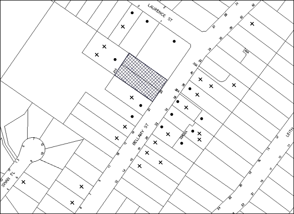
|
NOTIFICATION PLAN |
|
||
|
• PROPERTIES NOTIFIED |
X SUBMISSIONS RECEIVED |
PROPERTY SUBJECT OF DEVELOPMENT |
|
|
31 SUBMISSIONS RECEIVED OUT OF MAP RANGE |
|||
56 submissions and 1 petition with 63 signatures objected to the development, generally on the grounds that the development would result in:
· Unacceptable traffic parking and safety impacts;
· Unacceptable impact on the adjoining heritage item, Lilian Fraser Garden;
· Removal of trees from the site;
· Development that is excessive in bulk and scale;
· Noise, visual and privacy impacts;
· Setbacks;
· Number of children in the facility;
· Drainage impacts;
· Number of child care centres in locality;
· Future development for a granny flat on the adjoining property in close proximity to the proposed gazebo;
· Flood risk to No. 21A Bellamy Street;
· Access to No. 21A Bellamy Street during construction of the driveway
· Potential increase to hours of operation; and
· Retention of existing structures on carriageway.
The merits of the matters raised in community submissions have been addressed in the body of the report with the exception of the following:
5.1.1 Location of Proposed Gazebo with Respect to Future Development on the Adjoining Site
The submission raises concerns that the variation of the rear setback control for the proposed gazebo/ sandpit would potentially impact on future development of their site for a granny flat. As detailed in the report, the minor non-compliance is supported as the structure is of lightweight construction and single storey; and therefore is not considered to be intrusive to the adjoining properties.
Any future development on the adjoining property would be considered on its merits. Accordingly, the matters raised do not warrant refusal of the application
5.1.2 Flood Risk to No. 21A Bellamy Street
The submission raises concerns that a significant volume of water comes down the stormwater easement during heavy rains and that when the rain gets really heavy, water flows directly under the fence (on the boarder of 21a and 23) onto the garden. The submission seeks clarification of the measure that will be undertaken to ensure the flood risk to No. 21A Bellamy Street is not exacerbated.
As detailed in the report, the post-development flood regime (level and extent of the 1 in 100 year ARI) for Lot E DP 380042, No. 21A Bellamy Street is the same as the pre-development flood regime.
5.1.3 Access During Driveway Construction
The submission raises concern with regards to vehicular and pedestrian access to No. 21A Bellamy Street during the construction period for works within the driveway to No. 21A Bellamy Street. Access arrangements during the construction works within the driveway is a civil matter between the owners of No. 21A and No. 23 Bellamy Street. Notwithstanding, a condition is recommended in Schedule 1 requiring access and services to No. 21A Bellamy Street to be maintained during construction works, unless prior arrangement is made to the satisfaction of the owner of No. 21A Bellamy Street.
5.1.4 Potential Increase to Hours of Operation
The submission notes that the proposed hours of operation is limited to Monday to Friday business hours. However, the submission raises concerns with regards to future uses of the building as a community centre and an extension or change to the approved hours including weekends.
Should the application be approved with the recommended hours of operation in Schedule 1, then the applicant would be required to amend the consent to extend the hours of operation and demonstrate the acoustic impacts of any proposed amendments with that future application.
5.1.5 Retention of Existing Structures on Carriageway
The submission advises that the previous owner of 21A has built a pergola within the driveway, and there are also a significant amount of plants along the driveway. The submission queries what will happen to the pergola and the plants. All works with respect to the upgrading of the driveway are contained wholly within the boundaries of No. 23 Bellamy Street and would not impact upon any structures or plantings within the adjoining property at No. 21A Bellamy Street.
5.2 Public Agencies
The development application is Integrated Development under the Act. Accordingly, the application was referred to the following Agency for comment:
5.2.1 NSW Office of Water
The site is traversed by a tributary of Tedbury Creek. The development includes piping of part of the watercourse located under the right of carriageway to access No. 21A Bellamy Street. Accordingly, the proposed development is a controlled activity under the Water Management Act 2000 and requires the approval of the Office of Water (OW). In this regard, the application is ‘integrated development’ and was referred to the OW for assessment.
The OW has granted ‘General Terms of Approval’ for the proposed development which are included in Schedule 1.
6. THE PUBLIC INTEREST
Section 79C(1)(e) of the Act requires Council to consider “the public interest”.
The public interest is an overarching requirement, which includes the consideration of the matters discussed in this report. Implicit to the public interest is the achievement of future built outcomes adequately responding to and respecting the future desired outcomes expressed in environmental planning instruments and development control plans.
The application is considered to have satisfactorily addressed Council’s and relevant agencies’ criteria and would provide a development outcome that, on balance, would result in a positive impact for the community. Accordingly, it is considered that the approval of the proposed development would be in the public interest.
CONCLUSION
The proposal involves the demolition of an existing dwelling-house and associated structures and the construction of a purposed built child care centre 60 children. A total of 53 public submissions and 1 petition with 63 signatures were received objecting to the proposal on grounds including traffic, parking and design and environmental grounds. The issues raised in the submissions are addressed in the report and by relevant conditions to ensure any potential impacts are mitigated.
The proposal generally complies with the relevant provisions of the Hornsby Shire Local Environmental Plan 1994, Community Uses Development Control Plan, Access and Mobility Development Control Plan and Waste Minimisation and Management Development Control Plan. The application is permissible in the zone and is considered to be within the environmental capacity of the site.
On balance, and having regard to the community benefit of the proposal, it is considered that the development is worthy of Council’s consent. Accordingly, the proposed development is recommended for approval.
Note: At the time of the completion of this planning report, no persons have made a Political Donations Disclosure Statement pursuant to Section 147 of the Environmental Planning and Assessment Act 1979 in respect of the subject planning application.
|
Rod Pickles Manager - Development Assessment Planning Division |
James Farrington Group Manager Planning Division |
|
1.View |
Locality Map |
|
|
|
2.View |
Site Plans and Demolition Plan |
|
|
|
3.View |
Floor Plans |
|
|
|
4.View |
Elevations and Sections |
|
|
|
5.View |
Landscape Plan |
|
|
|
6.View |
Shadow Diagram |
|
|
|
7.View |
Proposed Traffic Device - Option 1A Concept Plan |
|
|
File Reference: DA/679/2012
Document Number: D02821547
SCHEDULE 1
GENERAL CONDITIONS
The conditions of consent within this notice of determination have been applied to ensure that the use of the land and/or building is carried out in such a manner that is consistent with the aims and objectives of the relevant legislation, planning instruments and council policies affecting the land and does not disrupt the amenity of the neighbourhood or impact upon the environment.
Note: For the purpose of this consent, the term ‘applicant’ means any person who has the authority to act on or the benefit of the development consent.
Note: For the purpose of this consent, any reference to an Act, regulation, Australian Standard or publication by a public authority shall be taken to mean the gazetted act or regulation, or adopted Australian Standard or publication as in force on the date that the application for a construction certificate is made.
1. Approved Plans and Supporting Documentation
The development must be carried out in accordance with the plans and documentation listed below and endorsed with Council’s stamp, except where amended by Council and/or other conditions of this consent:
Architectural Plans prepared by Project Works
|
Plan No. |
Plan Title |
Rev |
Dated |
|
DA01 |
Site Plan |
C |
12.12.12 |
|
DA02 |
Site Analysis Plan (Demolition) |
A |
12.12.12 |
|
DA03 |
Site Management Plan |
A |
12.12.12 |
|
DA04 |
Lower Level Plan |
C |
12.12.12 |
|
DA05 |
Ground Floor Plan |
C |
12.12.12 |
|
DA06 |
Level 1 Plan |
C |
12.12.12 |
|
DA07 |
Elevations |
C |
12.12.12 |
|
DA08 |
Sections |
C |
12.12.12 |
Landscape Plans prepared by Tessa Rose Playspace and Landscape Design
|
Plan No. |
Plan Title |
Rev |
Dated |
|
1 |
Landscape Plan |
|
7 June 2012 |
Supporting Documents
|
Document Title |
Prepared by |
Dated |
|
Statement of Environmental Effects Ref No. 10228 |
Project Works Design |
20 May 2012 |
|
Traffic and Parking Assessment Report Ref: 11010 |
Terraffic Pty Ltd |
24 June 2011 |
|
Assessment of Environmental Noise – Report No. EN-CCC -070910AJ |
Pollution Control Consultancy and Design |
July 2012 |
|
Asbestos Audit – G10072PH-R01F |
Geo-Environmental Engineering Pty Ltd |
29 October 2010 |
|
Landscape Sample Board/ Specification Notes |
Tessa Rose Playspace and Landscape Design |
June 2012 |
|
Site Tree Location Plan |
HSC |
23 January 2013 |
|
Drainage Report Ref: 11082 |
GJ McDonald Consulting Engineers |
March 2012 |
|
Addendum Drainage Report Ref: 12085 |
GJ McDonald Consulting Engineers |
May 2013 |
|
Plan No. 11020C Sheets 1 and 2 (Engineering Concept Plans) |
GJ McDonald Consulting Engineers |
22 March 2013 |
|
Assessment and Design of proposed works for CAA Ref: 782ww |
Harris Environmental Consulting |
10 October 2012 |
|
Disability Access Report Ref: 1133 |
Lindsay Perry Access + Architecture |
9 May 2012 |
|
External Materials and Colour Schedule |
unknown |
undated |
|
Adventures Preschool & Long Day Care Letter re: ‘integrated children’s services’ |
Nerrilee Lysaght |
18 April 2013 |
|
General Terms of Approval |
NSW Office of Water |
20 June 2013 |
|
Plan No. LTC01/2014 Proposed Traffic Device Option 1A Concept Plan, Issue 1 |
Hornsby Shire Council |
4 February 2014 |
2. Amendment of Plans
The approved plans are to be amended as follows:
a) Plan No. 1 Landscape Plan, prepared by Tessa Rose Playspace and Landscape Design, dated 7 June 2012 is to be amended to incorporate the landscaping indicated on Plan No. DA01 Site Plan Rev C, prepared by Project Works, dated 12 December 2012.
b) Plan No. 1 Landscape Plan, prepared by Tessa Rose Playspace and Landscape Design, dated 7 June 2012 is to be amended to incorporate additional trailing plant species along the north-east boundary to screen the boundary fence and to enhance the visual landscape setting of the adjoining property of Lilian Fraser Gardens.
c) The approved plans are to be amended to ensure that walls, fences and landscaping at the exit driveway are modified to achieve the Australian Standard AS2890.1 (2.0 x 2.5 m) sight triangles for adequate sight distance between egressing drivers and pedestrians
Note: Advice on suitable species for landscaping can be obtained from Council’s planting guide ‘Indigenous Plants for the Bushland Shire’, available at www.hornsby.nsw.gov.au.
3. Project Arborist
A Project Arborist is to be appointed in accordance with AS 4970-2009 (1.4.4) to provide monitoring and certification throughout the development process.
4. Construction Certificate
A Construction Certificate is required to be approved by Council or a Private Certifying Authority prior to the commencement of any works under this consent.
5. Acoustic Report Compliance
The proposed development must be designed and constructed in accordance with the recommendations of the Assessment of Environmental Noise - Report No. EN-CCC -070910AJ prepared by Pollution Control Consultancy and Design, dated July 2012.
REQUIREMENTS PRIOR TO THE ISSUE OF A CONSTRUCTION CERTIFICATE
6. Licences
A Controlled Activity Approval (CAA) under the Water Management Act 2000 from the NSW Office of Water must be obtained prior to the issued of a Construction Certificate.
7. Children (Education and Care Services) Supplementary Provisions Regulation 2004
Documentation prepared by a registered architect is to be submitted with the Construction Certificate to certify that the proposed development is in accordance with the requirements of the Children and Young Persons (Care & Protection) Act 1998 and the Children’s Services Regulation 2012.
8. Building Code of Australia
All building work must be carried out in accordance with the relevant requirements of the Building Code of Australia.
9. Sydney Water – Quick Check
This application must be submitted to a Sydney Water ‘Quick Check Agent’ or ‘Customer Centre’ for approval to determine whether the development would affect any Sydney Water infrastructure, and whether further requirements are to be met.
Note: Refer to www.sydneywater.com.au or telephone 13 20 92 for assistance.
10. Internal Parking/ Service Areas
The driveway and parking areas on site must be designed in accordance with Australian Standard AS 2890.1-2004 - Off Street Car Parking and Australian Standard 2890.2-2002 - Off Street Commercial (for anticipated service vehicles) and Australian Standard 2890.6-2009 - Off Street Parking for individuals with a disability and the following requirements:
a) Design levels at the front boundary crossing thresholds must be obtained from Council;
b) The driveway and parking modules must be a rigid pavement or sealed to an all weather standard, and designed by a Civil or Structural Engineer with plans submitted with the Construction Certificate;
c) The driveway grade must not exceed 25 percent and transitions changes in grade must not exceed 8 percent per plan metre;
d) The pavements must have a kerb to at least one side and a one-way cross fall with a minimum gradient of 2 percent and a kerb inlets and pits provided on grade and at low points;
e) Retaining walls required to support the carriageway and the compaction of all fill batters must be in accordance with the requirements of a chartered structural engineer; and
f) Safety rails must be provided where there is a level difference more than 0.3 metres and a 1:4 batter can not be achieved;
11. Driveway Servicing No. 21A Bellamy Street
To adequately control overland flows in the driveway in accordance with GJ McDonald Consulting Engineers’ Drainage Report (the Drainage Report) Dated March 2012, the driveway to Lot E DP 380042, No. 21A Bellamy Street must be removed, designed and reconstructed in accordance with Australian Standards 2890.1, 3727 and the following requirements:
a) Design levels at the front boundary must be obtained from Council;
b) The driveway must be a rigid pavement;
c) The driveway grade must not exceed 25 percent and transitions changes in grade must not exceed 8 percent per plan metre;
d) The driveway pavement must be a minimum 3 metres wide, 0.15 metres thick reinforced concrete with SL72 steel reinforcing fabric and a 0.15 metre sub-base;
e) The pavement must have a kerb to one side and a one-way cross fall with a minimum gradient of 2 percent and a 2.4m kerb inlet and pit provided over the Council piped drainage junction pit;
f) The driveway shall be graded downstream of the Council junction pit in order to shed the design storm flow in to the natural watercourse system as per the Drainage Report design;
g) Safety fencing must be provided where there is a level difference more than 0.3 metres and a 1:4 batter can not be achieved;
h) Where required by Council, landscaping strips must be planted 0.5 metres wide along both sides of the length of the driveway; and
i) Conduit for utility services including electricity, water, gas and telephone must be provided in accordance with the relevant utilities current standard.
12. Stormwater and Trunk Drainage General
The stormwater drainage system for the development must be designed and constructed in accordance with Council’s Civil Works – Design and Construction Specification 2005 and the following requirements:
a) Rooflines and paved area drainage system for the carparking and upstream courtyard areas and shall be connected directly to the proposed on-site detention (OSD) system;
b) The OSD system permissible site discharge and overflows from the OSD system shall be connected directly to the proposed piped drainage system or natural watercourse;
c) The existing natural watercourse from the proposed driveway pavement to the rear boundary of the subject site shall be constructed to contain the 100 year Average Recurrence Interval (ARI) storm event generally as per the requirements of G J McDonald Consulting Engineers’ Drainage Report (the Drainage Report) dated March 2012 (while not designing habitable levels in accordance with the proposed minimum floor levels discussed therein);
d) Council’s piped drainage system shall be designed and constructed as modified by Council requirements and in accordance with the Drainage Report. The 825 mm diameter pipe under the driveway pavement to Lot E DP 380042, No. 21A Bellamy Street shall be removed and a Council’s standard junction pit with grated kerb inlet pit top and 900 mm diameter reinforced concrete pipe and headwall shall be constructed downstream of the proposed building’s rear wall alignment;
e) Pier and beam method construction adjacent to easements to the depth of the invert of proposed and existing pipes running adjacent the proposed building.
Note: A certificate from a chartered civil engineer together with a works as executed design plan must be submitted to the principal certifying authority to demonstrate the satisfaction of this condition.
13. Overland Flow Path
The stormwater drainage system for the development must be designed and constructed in accordance with the Drainage Report and the following requirements:
a) Ground levels at the rear of the proposal must be shallow filled to the proposed level on the approved plans up the proposed line of acoustic fencing;
b) The minimum floor level and step threshold on the southern side of the proposed building shall be as proposed on the approved plans and protected from rain inundation;
c) The sill level of the southern side hallway glass block window shall be at least RL 162.94. There must be no southern side wall vents lower than the 100 year ARI design storm flow level;
d) The natural watercourse between the proposed and acoustic fence shall be designed and constructed in accordance with the Drainage Report and revegetated using endemic riparian species. Details of engineering long-sections, cross-sections and plantings to be provided on the construction plans.
14. Council Shall Approve Council Drainage Works
In accordance with Section 59A and Section 68 of the Local Government Act 1993, construction for the civil works and Council-controlled drainage conditions above cannot be approved by the Principal Certifying Authority before Council thus approves. An Application shall be made to Hornsby Shire Council for the works and the Applicant shall pay Hornsby Shire Council the scheduled fees for the assessment and required compliance inspections for those works.
15. On Site Stormwater Detention
An on-site stormwater detention system must be designed by a chartered civil engineer and constructed in accordance with the following requirements:
a) Have a capacity of not less than 24 cubic metres, and a maximum discharge (when full) of 20 litres per second.
b) Have a surcharge/inspection grate located directly above the outlet.
c) Discharge from the detention system to be controlled via 1 metre length of pipe, not less than 50 millimetres diameter or via a stainless plate with sharply drilled orifice bolted over the face of the outlet discharging into a larger diameter pipe capable of carrying the design flow to an approved Council system.
d) Where above ground and the average depth is greater than 0.3 metres, a ‘pool type’ safety fence and warning signs to be installed.
e) Not be constructed in a location that would impact upon the visual or recreational amenity of residents.
16. Waste Management Plan
Prior to issue of the Construction Certificate, A Waste Management Plan Section One - Demolition Stage, Section Two - Design Stage, Section Three - Construction Stage and Section Four - Use and On-going Management as applicable, covering the scope of this project is required to be submitted to Council in accordance with the Waste Minimisation and Management Development Control Plan.
REQUIREMENTS PRIOR TO THE COMMENCEMENT OF ANY WORKS
17. Erection of Construction Sign
A sign must be erected in a prominent position on any site on which building work, subdivision work or demolition work is being carried out:
a) Showing the name, address and telephone number of the principal certifying authority for the work;
b) Showing the name of the principal contractor (if any) for any demolition or building work and a telephone number on which that person may be contacted outside working hours; and
c) Stating that unauthorised entry to the work site is prohibited.
Note: Any such sign is to be maintained while the building work, subdivision work or demolition work is being carried out, but must be removed when the work has been completed.
18. Protection of Adjoining Areas
A temporary hoarding, fence or awning must be erected between the work site and adjoining lands before the works begin and must be kept in place until after the completion of the works if the works:
a) Could cause a danger, obstruction or inconvenience to pedestrian or vehicular traffic.
b) Could cause damage to adjoining lands by falling objects.
c) Involve the enclosure of a public place or part of a public place.
Note: Notwithstanding the above, Council’s separate written approval is required prior to the erection of any structure or other obstruction on public land.
19. Toilet Facilities
Toilet facilities must be available or provided at the works site before works begin and must be maintained until the works are completed at a ratio of one toilet for every 20 persons employed at the site. Each toilet must:
a) be a standard flushing toilet connected to a public sewer; or
b) be a temporary chemical closet approved under the Local Government Act, 1993; or
c) have an on-site effluent disposal system approved under the Local Government Act, 1993.
20. Tree Protection Barriers
Tree protection fencing must be erected around trees to be retained at a minimum 4 metre setback. The tree fencing must be constructed of 1.8 metre ‘cyclone chainmesh fence’.
A certificate from a Project Arborist must be supplied to the certifier before the commencement of construction in accordance with the above and the AS 4970-2009 (Section 4) – Protection of Trees on Development Sites.
21. Erosion and Sediment Control
Erosion and sediment control measures must be provided and maintained throughout the construction period in accordance with the manual ‘Soils and Construction 2004 (Bluebook)’, the approved plans, Council specifications and to the satisfaction of the principal certifying authority. The erosion and sediment control devices must remain in place until the site has been stabilised and revegetated.
Note: On the spot penalties up to $1,500 may be issued for any non-compliance with this requirement without any further notification or warning.
22. Return of Domestic Waste Bins
Arrangements must be made with Hornsby Shire Council Waste Management Services to return the domestic waste bins to Council.
REQUIREMENTS DURING CONSTRUCTION
23. Access/ Services
It is necessary to ensure access and services to Lot E DP 380042, No. 21A Bellamy Street are maintained at all time during construction, unless prior arrangement is made to the satisfaction of the owner of Lot E DP 380042, No. 21A Bellamy Street.
24. Construction Work Hours
All work on site (including demolition and earth works) must only occur between 7am and 5pm Monday to Saturday. No work is to be undertaken on Sundays or public holidays.
25. Demolition
All demolition work must be carried out in accordance with “Australian Standard 2601-2001 – The Demolition of Structures” and the following requirements:
a) Demolition material must be disposed of to an authorised recycling and/or waste disposal site and/or in accordance with an approved waste management plan;
b) Demolition works, where asbestos material is being removed, must be undertaken by a contractor that holds an appropriate licence issued by WorkCover NSW in accordance with Chapter 10 of the Occupational Health and Safety Regulation 2001 and Clause 29 of the Protection of the Environment Operations (Waste) Regulation 2005 ;and
c) On construction sites where buildings contain asbestos material, a standard commercially manufactured sign containing the words ‘DANGER ASBESTOS REMOVAL IN PROGRESS’ measuring not less than 400mm x 300mm must be erected in a prominent position visible from the street.
26. Asbestos or Soil Contamination
Should the presence of asbestos or soil contamination, not recognised during the application process be identified during demolition, the applicant must immediately notify the principal certifying authority and Council.
27. Environmental Management
The site must be managed in accordance with the publication ‘Managing Urban Stormwater – Landcom (March 2004) and the Protection of the Environment Operations Act 1997 by way of implementing appropriate measures to prevent sediment run-off, excessive dust, noise or odour emanating from the site during the construction of the development.
28. Works Near Trees
All required tree protection measures are to be maintained in good condition for the duration of the construction period.
No trenching is to occur within the Tree Protection Zone (TPZ) of tree numbered 19 located on the neighbouring property.
Tree sensitive construction techniques will be required to undertake works within the TPZ’s of trees 8 and 19 to minimise potential impacts on the roots of trees to be retained.
Should the excavation of any underground services (i.e. drainage/sewer/stormwater) be approved within the TPZ of tree numbered 19 and any trees required to be retained on the subject property or neighbouring property, excavation by hand ONLY shall be undertaken.
Consent is granted to undertake works within the TPZ of trees 8 for the construction of the driveway only, provided the following conditions are met:
a) To ensure any work for the construction of the driveway on the southern side of the property will not adversely affect the longevity of the tree, pier and beam construction of the driveway within the TPZ shall be used with piers being located no closer than 3 metres to the trunks of the trees. The driveway edge shall be no closer than 1 metre to the edge of the trunk. The excavation for the piers within the TPZ shall be hand dug to reveal the presence of any roots.
b) Works must be carried out under the supervision of the Project Arborist and is to be on site overseeing the work to ensure no roots greater than 50mm in diameter are severed, and root damage is minimised.
c) All works (including driveways and retaining walls) within 4 metres of any trees required to be retained (whether or not on the subject property, and pursuant to this consent or the Tree Preservation Order), must be carried out under the supervision of an ‘AQF Level 5 Arborist’ and a certificate submitted to the principal certifying authority detailing the method(s) used to preserve the tree(s).
Note: Except as provided above, the applicant is to ensure that no excavation, filling or stockpiling of building materials, parking of vehicles or plant, disposal of cement slurry, waste water or other contaminants is to occur within the TPZ of any tree to be retained.
29. Disturbance of Existing Site
During construction works, the existing ground levels of open space areas and natural landscape features, (including natural rock-outcrops, vegetation, soil and watercourses) must not be altered unless otherwise nominated on the approved plans.
30. Landfill
Landfill must be constructed in accordance with Council’s ‘Construction Specification, 2005’ and all fill material imported to the site is to wholly consist of Virgin Excavated Natural Material (VENM) as defined in Schedule 1 of the Protection of the Environment Operations Act 1997 or a material approved under the Department of Environment and Climate Change’s general resource recovery exemption.
31. Excavated Material
All excavated material removed from the site must be classified in accordance with the Department of Environment, Climate Change and Water NSW Waste Classification Guidelines prior to disposal to an approved waste management facility and reported to the principal certifying authority.
32. Survey Report – Finished Floor Level
A report(s) must be prepared by a registered surveyor and submitted to the principal certifying authority prior to the pouring of concrete at each level of the building certifying that:
a) The building, retaining walls and the like have been correctly positioned on the site and;
b) The finished floor level(s) are in accordance with the approved plans.
33. Council Property
During construction works, no building materials, waste, machinery or related matter is to be stored on the road or footpath. The public reserve must be kept in a clean, tidy and safe condition at all times.
34. Vehicular Crossings
A separate application under the Local Government Act, 1993 and the Roads Act, 1993 must be submitted to Council for the installation of two new vehicular crossings and the removal of any redundant crossing. The vehicular crossings must be constructed in accordance with Council’s Civil Works Design, 2005 and the following requirements:
a) Any redundant crossings must be replaced with integral kerb and gutter;
b) The footway area must be restored by turfing;
c) Street trees, signage and utility services that are impacted by such works shall be adjusted in accordance with the relevant specification at the Applicant’s cost.
Note: An application for a vehicular crossing can only be made to one of Council’s Authorised Vehicular Crossing Contractors, or be the subject of a Construction Certificate applied for at Council. You are advised to contact Council on 02 9847 6940 to obtain a list of contractors.
35. Traffic Control Plan
A Traffic Control Plan (TCP) must be prepared by a qualified traffic controller in accordance with the Roads & Traffic Authority’s Traffic Control at Worksites Manual 1998 and Australian Standard 1742.3 for all work on a public road and be submitted to Council. The TCP must detail the following:
a) Arrangements for public notification of the works.
b) Temporary construction signage.
c) Permanent post-construction signage.
d) Vehicle movement plans.
e) Traffic management plans.
f) Pedestrian and cyclist access/safety.
36. Waste Management During Works
Waste management during the demolition and construction phase of the development must be undertaken in accordance with the approved Waste Management Plan. Additionally written records of the following items must be maintained during the removal of any waste from the site and such information submitted to the Principal Certifying Authority within fourteen days of the date of completion of the works:
a) The identity of the person removing the waste.
b) The waste carrier vehicle registration.
c) Date and time of waste collection.
d) A description of the waste (type of waste and estimated quantity).
e) Details of the site to which the waste is to be taken.
f) The corresponding tip docket/receipt from the site to which the waste is transferred (noting date and time of delivery, description (type and quantity) of waste).
g) Whether the waste is expected to be reused, recycled or go to landfill.
Note: In accordance with the Protection of the Environment Operations Act 1997, the definition of waste includes any unwanted substance, regardless of whether it is reused, recycled or disposed to landfill.
REQUIREMENTS PRIOR TO THE ISSUE OF AN OCCUPATION CERTIFICATE
Note: For the purpose of this consent, a reference to ‘occupation certificate’ shall not be taken to mean an ‘interim occupation certificate’ unless otherwise stated.
37. Sydney Water – s73 Certificate
An s73 Certificate must be obtained from Sydney Water.
Note: Sydney Water requires that s73 applications are to be made through an authorised Sydney Water Servicing Coordinator. Refer to www.sydneywater.com.au or telephone 13 20 92 for assistance.
38. Stormwater Drainage – Land Adjoining a Watercourse
In addition to other stormwater drainage requirements under this consent, all headwall outlets must incorporate flow velocity reduction controls (i.e. bedded boulders and small stones) to minimise erosive and scouring impacts to the watercourse. Energy dissipater controls must be landscaped to accommodate outlet sheet flow (forced jump). No engineering works are permitted within the bed of the watercourse.
39. Damage to Council Assets
Any damage caused to Council’s assets as a result of the construction of the development must be rectified in accordance with Council’s written requirements and at the sole cost of the applicant. Where concrete footpath has been cracked, all affected panels shall be removed and reconstructed to Council’s standard. Damaged road seal shall be profiled out and reconstructed as Council’s standard asphaltic concrete seal.
40. Consolidation of Allotments
All allotments the subject of this consent must be consolidated into one allotment.
Note: The applicant is recommended to submit the plan of subdivision to consolidate allotments to the NSW Department of Lands at least 4-6 weeks prior to seeking an occupation certificate.
41. Creation of Easements
The following matter(s) must be nominated on the plan of subdivision under s88 of the Conveyancing Act 1919:
a) A right of access and easement for services over the proposed driveway in favour of Lot E DP 380042, No. 21A Bellamy Street.
b) A Council drainage easement 3 metres wide over the burdened lot in favour of Council and in accordance with the terms set out in Memorandum B5341305V filed with the NSW Department of Lands.
c) A restriction over the pipeline and the flow path for a 100 year average recurrence interval storm. The "Restriction on the Use of Land" over the affected lots is to prohibit the alteration of the final floodway shape and the erection of any structures, including fencing, in the floodway without the written permission of Council. The terms of this restriction must be obtained from Council.
d) A "Restriction on the Use of Land" for the lot adjacent the floodway, requiring the finished floor level of any habitable room to be not less than 500mm and the garage 300mm above the 100 year average recurrence interval storm level. The levels must be related to Australian Height Datum.
e) The creation of an appropriate "Positive Covenant" and "Restriction as to User" over the constructed on-site detention/retention systems and outlet works, within the lots in favour of Council in accordance with Council’s prescribed wording. The position of the on-site detention system is to be clearly indicated on the title.
f) To register the OSD easement, the restriction on the use of land “works-as-executed” details of the on-site-detention system must be submitted verifying that the required storage and discharge rates have been constructed in accordance with the design requirements. The details must show the invert levels of the on site system together with pipe sizes and grades. Any variations to the approved plans must be shown in red on the “works-as-executed” plan and supported by calculations.
Note: Council must be nominated as the authority to release, vary or modify any easement, restriction or covenant.
42. Works as Executed Plan
A works-as-executed plan(s) must be prepared by a registered surveyor and submitted to Council for completed pavement, kerb & gutter, public drainage systems, driveways and on-site detention system. The plan(s) must be accompanied by a certificate from a registered surveyor certifying that all pipelines and associated structures lie wholly within any relevant easements.
43. External Lighting
All external lighting must be designed and installed in accordance with Australian Standard AS 4282 – Control of the Obtrusive Effects of Outdoor Lighting. Certification of compliance with the Standard must be obtained from a suitably qualified person.
44. Retaining Walls
All required retaining walls must be constructed as part of the development.
45. Food Premises
The fit out and operation of that part of the building to be used for the manufacture, preparation or storage of food for sale, must be in accordance with Australian Standard 4674-2004 – Design and fit out of food premises, the Food Act 2003, and the Food Regulation 20010 and the Food Standards Code developed by Food Standards Australia New Zealand. Food Standards 3.3.1. 3.2.2 and 3.2.3 are mandatory for all food businesses.
Note: Walls are to be of solid construction.
46. Final Arborist Certification
The Project Arborist should assess the condition of the trees and their growing environment, and make recommendations for any necessary remedial actions.
Following the final inspection and the completion of any remedial works, the project arborist must certify (as appropriate) that the completed works have been carried out in compliance with the approved plans and specification for tree protection. Certification must include a statement on the condition of the retained trees, details of any deviations from the approved tree protection measures and their impacts on trees. Copies of monitoring documentation may be required.
47. Car Parking and Deliveries
All car parking must be constructed and operated in accordance with Australian Standard AS 2890.1 – 2004 – Off Street Car Parking and Australian Standard 2890.2 - 2002 – Off Street Commercial and the following requirement:
a) All parking areas and driveways are to be sealed to an all weather standard, line marked and signposted.
b) Car parking, loading and manoeuvring areas to be used solely for nominated purposes.
c) Vehicles awaiting loading, unloading or servicing shall be parked on site and not on adjacent or nearby public roads;
d) All vehicular entry on to the site and egress from the site shall be made in a forward direction.
e) Parking for people with disabilities shall be in accordance with AS/NZS 289.6:2009 Off-street parking for people with disabilities.
48. Installation of Traffic Control Measures
The signs and facilities detailed on Plan No. LTC01/2014 Proposed Traffic Device Option 1A Concept Plan, Issue 1, prepared by Hornsby Shire Council, dated 4 February 2014 including the following works must be installed prior to occupation of the child care centre:
a) The child care centre entry and exit driveways to be perpendicular across the footway (not angled).
b) A speed hump, of the style used in private car parks, to be provided at the boundary of the exit driveway to restrict speeds across the footway.
c) “Left turn only” signs to be provided on both sides of the exit driveway (signs are to be installed clear of sight lines for pedestrians.
d) “No Stopping 7am - 9am and 3pm - 7pm Mon - Fri” sings to be provided on the northern side of Bellamy Street across the child care centre frontage.
e) “No Stopping 7am to 9am and 3pm to 7pm Mon - Fri” signs to be provided on the southern side of Bellamy Street, covering the driveways of house Nos. 28 to 22.
OPERATIONAL CONDITIONS
49. Use of Premises
The development approved under this consent shall be used for ‘child care centre’ and not for any other purpose without Council’s separate written consent.
50. Number of Children
a) The centre shall accommodate a maximum of 60 children.
b) A maximum of 40 children at the centre shall be at, or above 2 years of age as at 1 January of each calendar year.
51. Hours of Operation
The hours of operation of the premise are restricted to those times listed below:
Monday to Friday 7.00am to 6.00pm
Saturday, Sunday & Public Holidays No work
52. Noise
All noise generated by the proposed development must be attenuated to prevent levels of noise being emitted to adjacent premises which possess tonal, beating and similar characteristics or which exceeds background noise levels by more than 5dB(A).
53. Driveway Access Management
The child care centre operator is to implement a management plan to ensure that clients and staff abide by the approved access arrangements (i.e. left out only to Bellamy Street).
54. Fire Safety Statement - Annual
On at least one occasion in every 12 month period following the date of the first ‘Fire Safety Certificate’ issued for the property, the owner must provide Council with an annual ‘Fire Safety Certificate’ to each essential service installed in the building.
55. Waste Contract Details
All commercial tenants must keep written evidence on site of a valid contract with a licensed waste contractor(s) for the regular collection and disposal of the waste and recyclables that are generated on site.
GENERAL TERMS OF APPROVAL - NSW OFFICE OF WATER
The following conditions of consent are General Terms of Approval from the nominated State Agency pursuant to Section 91A of the Environmental Planning and Assessment Act, 1979 and must be complied with to the satisfaction of that Agency.
56. GTA 1
These General Terms of Approval (GTA) only apply to the controlled activities described in the plans and associated documentation relating to DA2012/679 and provided by Council:
a) Site plan, map and/or surveys
Any amendments or modifications to the proposed controlled activities may render these GTA invalid. If the proposed controlled activities are amended or modified the NSW Office of Water must be notified to determine if any variations to these GTA will be required.
57. GTA 2
Prior to the commencement of any controlled activity (works) on waterfront land, the consent holder must obtain a Controlled Activity Approval (CAA) under the Water Management Act from the NSW Office of Water. Waterfront land for the purposes of this DA is land and material in or within 40 metres of the top of the bank or shore of the river identified.
58. GTA 3
The consent holder must prepare or commission the preparation of:
a) Vegetation Management Plan
b) Erosion and Sediment Control Plan
c) Soil and Water Management Plan
d) In-stream works with scour protection, energy dissipater
59. GTA 4
All plans must be prepared by a suitably qualified person and submitted to the NSW Office of Water for approval prior to any controlled activity commencing. The following plans must be prepared in accordance with the NSW Office of Water’s guideline located at www.water.nsw.gov.au/Water-Licensign/Approvals/default.aspx:
a) Vegetation Management Plans
b) Riparian Corridors
c) In-stream works
d) Outlet structures
60. GTA 5
The consent holder must:
a) Carry out any controlled activity in accordance with approved plans and
b) Construct and/or implement any controlled activity by or under direct supervision of a suitably qualified professional and
c) When required, provide a certificate of completion to the NSW Office of Water.
61. GTA 6
The consent holder must carry out a maintenance period of 2 years after practical completion of all controlled activities, rehabilitation and vegetation management in accordance with a plan approved by the NSW Office of Water.
62. GTA 7
The consent holder must reinstate waterfront land affected by the carrying out of any controlled activity in accordance with a plan or design approved by the NSW Office of Water.
63. GTA 8
The consent holder must use a suitably qualified person to monitor progress, completion, performance works, rehabilitation and maintenance and report to the NSW Office of Water as required.
64. GTA 9
The consent holder must provide a security deposit (bank guarantee or cash bond) - equal to the sum of the cost of complying with the obligations under any approval - to the NSW Office of Water as and when required.
65. GTA 11
The consent holder must not locate ramps, stairs, access ways, cycle paths, pedestrian paths or any other non-vehicular form of access way in a riparian corridor other than in accordance with a plan approved by the NSW Office of Water.
66. GTA 12
The consent holder must ensure that the construction of any bridge, causeway, culvert of crossing does not result in erosion, obstruction of flow, destabilisation or damage to the bed or banks of the river or waterfront land, other then in accordance with a plan approved by the NSW Office of Water.
67. GTA 13
The consent holder must ensure that any bridge, causeway, culvert or crossing does not obstruct water flow and direction, is the same width as the river or sufficiently wide to maintain water circulation, with no significant water level difference either side of the structure other then in accordance with a plan approved by the NSW Office of Water.
68. GTA 14
The consent holder must ensure that no materials or cleared vegetation that may:
a) Obstruct flow,
b) Wash into the water body, or
c) Cause damage to river banks,
are left on waterfront land other than in accordance with a plan approved by the NSW Office of Water.
69. GTA 15
The consent holder is to ensure that all drainage works:
a) Capture and convey runoffs, discharges and flood flows to low flow water level in accordance with a plan approved by the NSW Office of Water; and
b) Do not obstruct the flow of water other than in accordance with a plan approved by the NSW Office of Water.
70. GTA 16
The consent holder must stabilise drain discharge points to prevent erosion in accordance with a plan approved by the NSW Office of Water.
71. GTA 17
The consent holder must establish all erosion and sediment control works and water diversion structures in accordance with a plan approved by the NSW Office of Water. These works and structures must be inspected and maintained throughout the working period and must not be removed until the site has been full stabilised.
72. GTA 18
The consent holder must ensure that no excavation is undertaken on waterfront land other than in accordance with a plan approved by the NSW Office of Water.
73. GTA 19
The consent holder must ensure that any excavation does not result in:
a) Diversion of any river,
b) Bed or bank instability, or
c) Damage to native vegetation within the area where a controlled activity has been authorised,
other than in accordance with a plan approved by the NSW Office of Water.
74. GTA 20
The consent holder must ensure that:
a) River diversion, realignment or alteration does not result from any controlled activity work, and
b) Bank control or protection works maintain the existing river hydraulic and geomorphic functions, and
c) Bed control structures do not result in river degradation,
other than in accordance with a plan approved by the NSW Office of Water.
75. GTA 23
The consent holder must establish a riparian corridor along the tributary of Tedbury Creek in accordance with a plan approved by the NSW Office of Water.
- END OF CONDITIONS -
ADVISORY NOTES
The following information is provided for your assistance to ensure compliance with the Environmental Planning and Assessment Act, 1979, Environmental Planning and Assessment Regulation 2000, other relevant legislation and Council’s policies and specifications. This information does not form part of the conditions of development consent pursuant to Section 80A of the Act.
Environmental Planning and Assessment Act, 1979 Requirements
The Environmental Planning and Assessment Act, 1979 requires:
· The issue of a construction certificate prior to the commencement of any works. Enquiries can be made to Council’s Customer Services Branch on 9847 6760.
· A principal certifying authority to be nominated and Council notified of that appointment prior to the commencement of any works.
· Council to be given at least two days written notice prior to the commencement of any works.
· Mandatory inspections of nominated stages of the construction inspected.
· An occupation certificate to be issued before occupying any building or commencing the use of the land.
Long Service Levy
In accordance with Section 34 of the Building and Construction Industry Long Service Payments Act 1986, a ‘Long Service Levy’ must be paid to the Long Service Payments Corporation or Hornsby Council.
Note: The rate of the Long Service Levy is 0.35% of the total cost of the work.
Note: Hornsby Council requires the payment of the Long Service Levy prior to the issue of a construction certificate.
Tree Preservation Order
To ensure the maintenance and protection of the existing natural environment, it is an offence to ringbark, cut down, top, lop, remove, wilfully injure or destroy a tree outside 3 metres of the approved building envelope without the prior written consent from Council.
Note: A tree is defined as a single or multi-trunked wood perennial plant having a height of not less than three (3) metres, and which develops many branches, usually from a distance of not less than one (1) metre from the ground, but excluding any plant which, in its particular location, is a noxious plant declared as such pursuant to the Noxious Weeds Act 1993. This definition of ‘tree’ includes any and all types of Palm trees.
All distances are determined under Australian Standard AS4970-2009 ”Protection of Trees on Development Sites”.
Fines may be imposed for non-compliance with Council’s Tree Preservation Order.
Disability Discrimination Act
The applicant’s attention is drawn to the existence of the Disability Discrimination Act. A construction certificate is required to be obtained for the proposed building/s, which will provide consideration under the Building Code of Australia, however, the development may not comply with the requirements of the Disability Discrimination Act. This is the sole responsibility of the applicant.
Covenants
The land upon which the subject building is to be constructed may be affected by restrictive covenants. Council issues this approval without enquiry as to whether any restrictive covenant affecting the land would be breached by the construction of the building, the subject of this consent. Applicants must rely on their own enquiries as to whether or not the building breaches any such covenant.
Advertising Signage – Separate DA Required
This consent does not permit the erection or display of any advertising signs. Most advertising signs or structures require development consent. Applicants should make separate enquiries with Council prior to erecting or displaying any advertising signage.
Dial Before You Dig
Prior to commencing any works, the applicant is encouraged to contact Dial Before You Dig on 1100 or www.dialbeforeyoudig.com.au for free information on potential underground pipes and cables within the vicinity of the development site.
Telecommunications Act 1997 (Commonwealth)
If you are aware of any works or proposed works which may affect or impact on Telstra’s assets in any way, you are required to contact: Telstra’s Network Integrity Team on Phone Number 1800810443.
Asbestos Warning
Should asbestos or asbestos products be encountered during demolition or construction works, you are advised to seek advice and information prior to disturbing this material. It is recommended that a contractor holding an asbestos-handling permit (issued by WorkCover NSW)be engaged to manage the proper handling of this material. Further information regarding the safe handling and removal of asbestos can be found at:
Alternatively, telephone the WorkCover Asbestos and Demolition Team on 8260 5885.
Food Authority Notification
The NSW Food Authority requires businesses to electronically notify the Authority prior to the commencement of its operation.
Note: NSW Food Authority can be contacted at www.foodnotify.nsw.gov.au.
Council Notification - Food Premises
Prior to the commencement of the business, the operator is requested to contact Council’s Environmental Health Team to arrange an inspection for compliance against the relevant legislation and guidelines outlined in this approval.
Note: Council’s Environmental Health Officer can be contacted on 02 9847 6745.
Group Manager’s Report No. PL13/14
Planning Division
Date of Meeting: 12/03/2014
11 SECTION 82A REVIEW OF DEVELOPMENT APPLICATION - ALTERATIONS AND ADDITIONS TO A DWELLING-HOUSE - 3 GUM BLOSSOM DRIVE, WESTLEIGH
EXECUTIVE SUMMARY
|
DA No: |
DA/514/2013 82A Review (Lodged 21 May 2013) |
|
Description: |
Alterations and additions to a dwelling-house |
|
Property: |
Lot 8, DP 237968, No. 3 Gum Blossom Drive, Westleigh |
|
Applicant: |
Mr Matthew James Treatt |
|
Owner: |
Mr M J and Mrs K Treatt |
|
Estimated Value: |
$420,000 |
|
Ward: |
B |
· On 24 September 2013, Council refused consent for alterations and additions to a dwelling-house on environmental grounds, including the loss of significant trees.
· Pursuant to Section 82A of the Environmental Planning and Assessment Act, 1979 (the Act), a request has been made for Council to review its determination. Amended plans were submitted with the application, deleting the proposed swimming pool.
· The proposal does not comply with the Hornsby Shire Local Environmental Plan 1994 with regard to Clause 15 (Floor Space Ratio). The applicant has made a submission pursuant to State Environmental Planning Policy No. 1 (Development Standards) to vary the development standard. The submission is considered well-founded and is supported.
· No submissions have been received in respect of the application.
· It is recommended that Council change the determination and approve the application.
|
THAT Council assume the concurrence of the Director-General of the Department of Planning and Infrastructure pursuant to State Environmental Planning Policy No. 1 and approve the Section 82A review of Development Application No. DA/514/2013 for alterations and additions to a dwelling-house at Lot 8, DP 237968, No. 3 Gum Blossom Drive Westleigh, subject to the conditions of consent detailed in Schedule 1 of Group Manager’s Report No. PL13/14. |
BACKGROUND
On 24 September 2013, Council refused consent for alterations and additions to a dwelling-house on the following grounds:
1. In accordance with Section 79C(1)(a)(ii) of the Environmental Planning and Assessment Act, 1979, the proposal does not comply with the aims and objectives of State Environmental Planning Policy No. 19 – Bushlands in Urban Areas as the proposed development would incur in the loss of habitat for native flora and fauna, the loss of significant flora specimens and detrimental impacts to the adjoining bushland.
2. In accordance with Section 79C(1)(a)(iii) of the Environmental Planning and Assessment Act, 1979, the proposal does not comply with the element objectives of the Flora and Fauna Protection element of the Dwelling House Development Control Plan as the proposed development would incur in the loss of significant trees within and outside the subject site and would not capacitate the conservation of bushland, significant flora and fauna habitats and wildlife corridors from the impacts of development.
3. In accordance with Section 79C(1)(b) of the Environmental Planning and Assessment Act, 1979, the proposal, because of the proposed clearing of the subject site and adjoining properties, would result in detrimental impacts on the natural environment of the site and its surroundings.
4. In accordance with Section 79C(1)(e) of the Environmental Planning and Assessment Act, 1979, the proposal, because of the proposed clearing of the subject site and adjoining properties and its detrimental impacts on the ecological value of the site and its surroundings, would not be in public interest.
On 8 November 2013, the applicant submitted a Section 82A application to review the earlier determination to refuse consent, together with amended plans deleting the swimming pool.
SITE
The rectangular, 695.6m2 site is located on the northern side of Gum Blossom Drive, Westleigh and contains a 1970s era, single storey dwelling-house with a sub-floor level garage.
The site has a 3 metre fall towards the front, south-west corner.
The site is bush fire prone and adjoins a Sydney Water storage reserve along the rear, northern boundary.
The site is not flood prone and is not burdened or benefited by any easements or restrictions.
The site is not a heritage listed item, is not located within a heritage conservation area and is not in vicinity of a heritage listed item.
PROPOSAL
The application proposes the following works:
a) extension of the existing sub-floor level garage to create 2 additional spaces, the erection of a verandah, external stairs and planter box and the demolition of a stone wall along the western side of the driveway to widen the parking area;
b) demolition of the timber deck, pergola and ramp at the rear of the dwelling-house, replacing it with an “entertaining” deck and patio, partly covered with a pitched roof pergola;
c) reconfiguration of the ground floor level rooms to create an open plan kitchen/family/rumpus room, a laundry, dining room, study, guest bedroom, toilet, ensuite and a living room atop the garage extension; and
d) erection of a first floor level addition incorporating four bedrooms, a bathroom, an ensuite, a walk-in-robe and a lounge room.
ASSESSMENT
The development application has been assessed having regard to the ‘Metropolitan Plan for Sydney 2031’, the ‘North Subregion (Draft) Subregional Strategy’ and the matters for consideration prescribed under Section 79C of the Environmental Planning and Assessment Act 1979 (the Act). The following issues have been identified for further consideration.
1. STRATEGIC CONTEXT
1.1 Metropolitan Plan for Sydney and (Draft) North Subregional Strategy
The (Draft) Metropolitan Strategy for Sydney 2031 is a broad framework to provide for Sydney’s growth to help plan for housing, employment, transport, infrastructure, the environment and open space. It outlines a vision for Sydney to 2031, the challenges faced and the directions to follow to address these challenges and achieve the vision.
The North Subregion comprises Hornsby, Ku-ring-gai, Manly, Warringah and Pittwater Local Government Areas. The Draft North Subregional Strategy acted as a framework for Council in its preparation of the Comprehensive LEP by the end of 2013.
Within the North Subregion, the Draft Metropolitan Strategy proposes:
· Population growth of 81,000 from the current 2011 baseline of 529,000;
· Housing growth of 37,000 from the current 2011 baseline of 204,000; and
· Employment growth of 39,000 from the current 2011 baseline of 186,000.
The proposal would be consistent with the Metropolitan Plan for Sydney 2031 by renewed housing stock in the locality to cater for the growing population.
2. STATUTORY CONTROLS
Section 79C(1)(a) requires Council to consider “any relevant environmental planning instruments, draft environmental planning instruments, development control plans, planning agreements and regulations”.
2.1 Hornsby Shire Local Environmental Plan 1994
The subject land is zoned Residential A (Low Density) Zone under the Hornsby Shire Local Environmental Plan 1994 (HSLEP). The objectives of the Residential A zone are:
(a) to provide for the housing needs of the population of the Hornsby area.
(b) to promote a variety of housing types and other land uses compatible with a low density residential environment.
(c) to provide for development that is within the environmental capacity of a low density residential environment.
The proposed development is defined as a ‘dwelling-house’ under the HSLEP and is permissible in the zone with Council’s consent.
Clause 15 of the HSLEP prescribes that the maximum floor space ratio (FSR) of development within the Residential A zone is 0.4:1. The proposed development would have an FSR of 0.49:1 which does not comply with this development standard.
To address this issue, the applicant has submitted a State Environmental Planning Policy No. 1 (SEPP 1) objection to the development standard, which is assessed in Section 2.3 of this report.
Clause 18 of the HSLEP sets out heritage conservation provisions for Hornsby Shire. The subject site is not an item of environmental heritage and is not located within a heritage conservation area. Therefore, no further assessment in this regard is necessary.
2.2 Hornsby Shire Local Environmental Plan 2013
The Hornsby Local Environmental Plan 2013 (HLEP) was made on 27 September 2013 and came into effect on 11 October 2013. The HLEP includes a savings provision stating that if a development application is made and not finally determined before the commencement of the HLEP 2013, the application must be determined as if the Plan had been exhibited but not commenced. The relevant provisions of the HLEP are addressed below.
Under the HLEP, the subject land is zoned R2 (Low Density Residential) and a “dwelling-house” is permissible within the zone with Council’s consent.
The HLEP also prescribes a maximum building height of 8.5 metres. The proposed alterations and additions to the dwelling-house would have a building height of 8.7 metres, which would not comply with this standard as discussed in Section 2.7 of this report.
2.3 State Environmental Planning Policy No. 1 – Development Standards
The proposed development has a gross floor area of 341.4m2 resulting in a floor space ratio (FSR) of 0.49:1 on a site with an area of 695.6m2. The FSR exceeds the applicable 0.4:1 FSR development standard under the HSLEP 1994 which would permit a maximum floor area of 278.2m2.
To address the variation to the 0.4:1 development standard, the applicant has made a submission pursuant to State Environmental Planning Policy No. 1 – Development Standards (SEPP1).
The application has been assessed against the requirements of SEPP1. This Policy provides flexibility in the application of development standards in circumstances where strict compliance with those standards would, in any particular case, be unreasonable or unnecessary or tend to hinder the attainment of the objectives specified in section 5(a) (i) and (ii) of the Environmental Planning and Assessment Act which states:
‘The objectives of this Act are to encourage:
i) the proper management, development and conservation of natural and artificial resources, including agricultural land, natural areas, forests, minerals, water, cities, towns and villages for the purpose of promoting the social and economic welfare of the community and a better environment,
ii) the promotion and co-ordination of the orderly and economic use and development of land.’
Where development could, but for any development standard, be carried out under the Act (either with or without the necessity for consent under the Act being obtained), the person intending to carry out that development may make a development application supported by a written objection that compliance with that development standard is unreasonable or unnecessary in the circumstances of the case, and specifying the grounds of that objection.
The Land and Environment Court has expressed the view that there are 5 different ways in which an objection pursuant to SEPP 1 may be well founded and that approval of the objection may be consistent with the aims of the policy as follows:
1. The objectives of the standard are achieved notwithstanding non-compliance with the standard;
2. The underlying objective or purpose of the standard is not relevant to the development and therefore compliance is unnecessary;
3. The underlying object or purpose would be defeated or thwarted if compliance was required and therefore compliance is unreasonable;
4. The development standard has been virtually abandoned or destroyed by the Council's own actions in granting consents departing from the standard and hence compliance with the standard is unnecessary and unreasonable;
5. The zoning of the particular land is unreasonable or inappropriate so that a development standard appropriate for that zoning is also unreasonable and unnecessary as it applies to the land and compliance with the standard would be unreasonable or unnecessary. That is, the particular parcel of land should not have been included in the particular zone.
In regard to whether the objection may be well founded, the applicant contends that:
“The objection under Clause 6 of the State Environmental Planning Policy No.1 – Development Standards is made in relation to Floor Space Ratio on the following grounds:
· The proposed development when viewed from the street and adjoining properties, would have no apparent height, bulk and scale impacts and would be consistent with surrounding development;
· The proposed development would not result in significant bulk when viewed from the street. In particular, the first floor additions have been sited over the existing residence to provide roof to the front and sides which helps reduce the overall bulk and scale;
· The proposal complies with the requirements for sunlight to adjoining properties and only results in a minor increase in overshadowing to the adjoining properties;
· The proposal does not result in any loss of privacy to the adjoining premises, specifically as windows have been placed to look over the subject property;
· Strict compliance fails to recognise the role that the site’s lot size plays in the calculation of the FSR;
· The development generally complies with the setback and height requirements of the DCP and LEP, as well as the landscaping / built upon area requirements which largely set the standards for bulk and scale of development in the Hornsby area;
· The floor area is very close to that which will be allowable in the Draft LEP / DCP which is to be adopted;
· The failure of the development to meet the floor space ratio requirements has not diminished the ability of the proposal to unquestionably achieve the aims and objectives of the Hornsby Shire Local Environmental Plan 1994; and
· The extent of non compliance does not hinder the proposal in achieving relevant objectives and is therefore considered the proposed development be supported in its current form.”
The matters listed above have been taken into consideration in assessing the merits of the SEPP 1 objection.
The SEPP 1 submission in support of the proposal appropriately addresses the objective of the floor space ratio provision in the HSLEP. The design of the alterations and additions to the dwelling-house would not overly intensify the scale of the development of the land in regard to the land’s environmental capacity, the character of adjacent development and the zone objectives.
In addition to the above, Council’s assessment has had regard to the provisions of the NSW Housing Code, which provides that the maximum gross floor area for complying development within the low density residential zones of the Shire as being 380m2, if the lot has an area of at least 600m2 but less than 900m2. Accordingly, if applicable, the development would satisfy the maximum floor area requirements.
Given that the recently introduced NSW Housing Code is now enacted in many parts of the Shire, it is anticipated that more developments will be approved under this Code, which will change the characteristics of dwelling-houses. Consequently, whilst Council has previously applied a maximum FSR of 0.4:1 for dwelling-houses in the low density residential zones within the Shire under the HSLEP, the introduction of the NSW Housing Code is changing the effect of this standard.
The proposal takes into consideration the environmental and topographical constraints of the site. The additional floor space would not impinge on the environmental and amenity aspects of the site and the underlying objectives of the zoning.
The proposal meets the objectives of the Scale element and is considered acceptable.
2.4 State Environmental Planning Policy (Exempt and Complying Development Codes) – 2008 – NSW Housing Code
The application has been assessed against the requirements of State Environmental Planning Policy (Exempt and Complying Development Codes) 2008 – NSW Housing Code. The policy provides exempt and complying development codes that have State-wide application, identifying, in the General Exempt Development Code, types of development that are of minimal environmental impact that may be carried out without the need for development consent and in the General Housing Code, the types of complying development that may be carried out in accordance with a complying development certificate as defined in the Environmental Planning and Assessment Act, 1979.
The following table sets out the proposal’s compliance with the requirements of the NSW Housing Code.
|
NSW Housing Code |
|||
|
Control |
Proposal |
Requirement |
Compliance |
|
Site Coverage Lots 450m2 – 900m2 |
27% |
50% |
Yes |
|
Maximum Floor Area |
380m2 |
380m2 |
Yes |
|
Maximum Building Height |
8.7m |
8.5m |
No |
|
Front Setback |
7.6m |
6.5m |
Yes |
|
Side Setback (east) |
0.9m/2.2m |
0.9m for the ground floor component; 1.95m for the first storey component |
Yes |
|
Side Setback (west) |
0.9m/2.7m |
0.9m for the ground floor component; 1.95m for the first storey component |
Yes |
|
Rear Setback |
13.8m |
3m setback for up to 4.5m height, and 8m for 4.5m height and above |
Yes |
|
Landscaping |
48% |
30% |
Yes |
|
Private Open Space |
>24m2 |
24m2 |
Yes |
As addressed above, the proposal complies with the requirements of the NSW Housing Code except for the building height.
The proposal generally complies with the relevant requirements of the Dwelling House DCP (as outlined in Section 2.10) and is acceptable in these respects.
2.5 State Environmental Planning Policy (Building Sustainability Index – BASIX) – 2004
The application has been assessed against the requirements of State Environmental Planning Policy (Building Sustainability Index: BASIX) 2004. The proposal includes BASIX Certificate No. A 161895-02 for the development and is considered to be satisfactory with respect to SEPP BASIX.
2.6 Clause 74BA Environmental Planning and Assessment Act, 1979 - Purpose and Status of Development Control Plans
On 1 March 2013, the Environmental Planning and Assessment Act, 1979 was amended so that a DCP provision will have no effect if it has the practical effect of “preventing or unreasonably restricting development” that is otherwise permitted and complies with the development standards set out in relevant Local Environmental Plans and State Environmental Planning Policies.
The principal purpose of a development control plan is to provide guidance on the aims of any environmental planning instrument that applies to the development; facilitating development that is permissible under any such instrument and achieving the objectives of land zones under any such instrument. The provisions of a development control plan made for that purpose are not statutory requirements.
2.7 Hornsby Development Control Plan 2013
The Hornsby Development Control Plan (HDCP) 2013 came into effect on 11 October 2013, applies to all land within Hornsby Shire and has replaced all of Council’s previous DCPs. The following sections of this report include an assessment of the proposal against Council’s previous DCP controls. Although the HDCP was not in force at the time of lodgement of the original application, the Section 82A proposal has been assessed against this Plan.
The HDCP is generally a translation of Council’s previous DCPs into a consolidated plan. When assessed against the HDCP, the proposed development would comply with all elements except privacy and height.
The first floor level lounge room would not comply with the prescriptive measures of Section 3.1.6 Privacy of the HDCP which states that “living and entertaining areas of dwelling houses should be located on the ground floor and orientated towards the private open space of the dwelling house and not side boundaries”.
As the windows that would serve this lounge room are orientated towards the rear yard only, the development would have negligible adverse privacy impacts on the adjoining premises Nos. 1 and 5 Gum Blossom Drive.
The HDCP prescribes 8.5 metres as the maximum building height. The proposed development would result in a building height of 8.7 metres and would not comply with this prescriptive measure.
This is considered to be a minor encroachment. The height of the proposal would be consistent with the surrounding development and would not create solar access or privacy impacts in relation to adjoining properties.
The proposal would be compatible with the existing streetscape, meets the desired outcomes of the HDCP and is considered acceptable.
2.8 Dwelling-House Development Control Plan
The proposed development has been assessed having regard to the relevant performance and prescriptive requirements within Council’s Dwelling House Development Control Plan. The following table sets out the proposal’s compliance with the prescriptive requirements of the Plan:
|
Dwelling House Development Control Plan |
|||
|
Control |
Proposal |
Requirement |
Complies |
|
Floor space ratio |
0.49:1 |
0.4:1 |
No |
|
Site cover |
35% |
40% |
Yes |
|
Setbacks Front (southern) Side (eastern) Side (western) Rear (southern) |
7.8m 0.9m 0.9m 7.4m |
6m 1m 1m 3m |
Yes No No Yes |
|
Height |
8.7m |
9m |
Yes |
|
Unbroken Wall length |
13.5m |
10m |
No |
|
Building length |
18m |
24m |
Yes |
|
Cut and fill |
<1m |
1m |
Yes |
|
Private Open Space |
250m2 |
120m² |
Yes |
|
Landscaped area |
50% |
45% |
Yes |
|
Carparking |
4 spaces |
2 spaces |
Yes |
As detailed in the above table, the proposal does not comply with the prescriptive measures of the Scale, Design and Setbacks elements within the Dwelling House DCP. These matters of non-compliance are addressed below, together with a brief discussion on compliance with the relevant performance requirements.
2.8.1 Scale
The objective of the Scale element is to encourage “development of a scale compatible with the low density residential environment”.
The proposal does not comply with the 0.4:1 prescriptive measure of the Dwelling House DCP. However, the dwelling-house is not considered to be excessive in bulk and scale for the site and is in keeping with similar developments in the area. The matter has been discussed under Section 2.4 of this report.
The proposal meets the objectives of the Scale element and is considered acceptable.
2.8.2 Design
To minimise visual impacts, the prescriptive measures of the Design element states that “dwelling-house walls should not exceed 10m in length without a physical break such as an indentation, bay window or change in level”.
In this instance, the western side wall has an unbroken wall length of 13.5 metres. The encroachment is supported in this instance as the wall is subject to variations in height and levels and with windows and doors positioned to avoid a symmetrical or monotonous appearance when viewed from adjacent properties.
The proposal meets the objectives of the Design element and is considered acceptable.
2.8.3 Setbacks
The prescriptive measures of the Setbacks element state that “Side setbacks for dwelling-houses should generally be a minimum of 1m”.
In this instance, the existing dwelling-house stands at a setback of 0.9m in relation to the eastern and western side boundaries.
The proposed garage/living room extension to the front of the dwelling-house and “entertaining deck” to the rear of the dwelling-house, both at the existing 0.9m setback, would have minimal environmental and amenity impacts.
The proposal meets the objectives of the Setbacks element and is considered acceptable.
2.8.4 Privacy
The objective of the Privacy element is to encourage “development that ensures reasonable privacy in the home and privacy open space for existing and future residents”.
The proposal includes a first floor level lounge room which does not comply with the prescriptive measures of the Privacy element which seeks to have living and entertaining areas located on the ground floor only.
In this instance, the lounge room is served by 2 windows within the northern elevation only, facing the rear yard and the Sydney Water reserve beyond.
There would be no direct overlooking of the private open spaces of the adjacent premises at Nos. 1 and 5 Gum Blossom Place. As a consequence, the development would have negligible adverse privacy impacts.
The proposal meets the objectives of the Privacy element and is considered acceptable.
2.8.5 Solar Access
The Solar Access element states that dwelling-houses should be designed “to allow 3 hours of sunshine to the north-facing windows serving living rooms and 4 hours of sunshine to private open spaces between 9am and 3pm on 22 June (the Winter Solstice)”.
The diagrams submitted with the original application indicate that the shadows from the proposed first floor level portion of the development at 9am, 12 noon and 3pm on 22 June would comply with the prescriptive measures of the Solar Access element by maintaining a minimum of 3 hours of solar access to the north facing windows of habitable rooms and 4 hours to the private open spaces of the adjacent properties.
The proposal meets the objectives of the Solar Access element and is considered acceptable.
2.8.6 Flora and Fauna Protection
The plans submitted with the Section 82A application have been amended to delete the in-ground swimming pool that would have impacted on 8 Turpentine trees growing in the rear yard of the property.
Council’s tree assessment of the proposal confirms that the trees are significant and that removal of these trees should not be supported, as they form part of Sydney Turpentine Ironbark Forest Endangered Ecological Community listed under the NSW Threatened Species Conservation Act, 1995. The trees form a significant group of trees and are considered to be in good condition.
The recommendations of the bushfire threat assessment submitted with the application do not justify the removal of these trees and that offsetting via compensatory tree planting is not considered a satisfactory reason for the removal of large healthy trees.
The amended proposal to delete the inground swimming pool enables retention of the significant trees. Accordingly, Council’s tree assessment raises no objections to the proposal, subject to the minor pruning of Tree 10, which may have limbs overhanging the proposed development.
The amended proposal meets the objectives of the Flora and Fauna Protection element and is considered acceptable.
2.8.7 Fire Hazard
The plans submitted with the Section 82A review were referred to the New South Wales Rural Fire Service (RFS) as the site is bushfire prone.
The RFS reviewed its earlier recommendation and raises no objections to the proposal, subject to conditions.
The proposal meets the objectives of the Fire Hazard element and is considered acceptable.
3. ENVIRONMENTAL IMPACTS
Section 79C(1)(b) of the Act requires Council to consider “the likely impacts of that development, including environmental impacts on both the natural and built environments, and social and economic impacts in the locality”.
3.1 Natural Environment
As discussed above under Section 2.8.6 “Flora and Fauna Protection”, the amended proposal would have an acceptable impact on the natural environment. The proposed swimming pool which would have had a significant impact on trees on the site and adjacent lands has been deleted from the proposal.
3.2 Built Environment
The design of the alterations and additions is consistent with the built form of the existing dwelling-house and would be in keeping with the established character of the surrounding streetscape.
3.3 Social Impacts
The proposal would not create any adverse social impacts on the surrounding area.
3.4 Economic Impacts
The proposal would have a minor positive impact on the local economy in conjunction with other new low density residential development in the locality by generating an increase in demand for local services.
4. SITE SUITABILITY
Section 79C(1)(c) of the Act requires Council to consider “the suitability of the site for the development”.
The site is capable of accommodating the proposed development. The scale of the proposed development is consistent with the capability of the site and is considered acceptable.
4.1 Bushfire Risk
The land is identified as being bushfire prone. The issues raised by this risk have been addressed in Section 2.8.7 of this report.
5. PUBLIC PARTICIPATION
Section 79C(1)(d) of the Act requires Council to consider “any submissions made in accordance with this Act”.
5.1 Community Consultation
The proposed development was placed on public exhibition and was notified to adjoining and nearby landowners between 22 May 2013 and 5 June 2013 in accordance with Council’s Notification and Exhibition Development Control Plan. During this period, Council received no submissions.
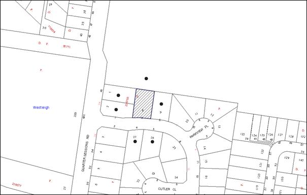
|
NOTIFICATION PLAN |
|
||
|
• PROPERTIES NOTIFIED
|
X SUBMISSIONS RECEIVED |
PROPERTY SUBJECT OF DEVELOPMENT |
|
6. THE PUBLIC INTEREST
Section 79C(1)(e) of the Act requires Council to consider “the public interest”.
The public interest is an overarching requirement, which includes the consideration of the matters discussed in this report. Implicit to the public interest is the achievement of future built outcomes adequately responding to and respecting the future desired outcomes expressed in environmental planning instruments and development control plans.
The application is considered to have satisfactorily addressed Council’s and relevant agencies’ criteria and would provide a development outcome that, on balance, would result in a positive impact for the community. Accordingly, it is considered that the approval of the proposed development would be in the public interest.
CONCLUSION
The application proposes alterations and additions to a dwelling-house.
The application does not comply with the Hornsby Shire Council Local Environmental Plan 1994 in respect to clause 15 ‘Floor Space Ratio’. The applicant has made a submission in accordance with State Environmental Planning Policy No. 1 to vary the floor space ratio development standard. The submission is considered well founded with regard to the existing development and the principles established by the Land and Environment Court.
Council received no submissions in response to notification of the proposed development.
It is recommended that Council change the determination of the application and that approval be granted subject to compliance with conditions in Schedule 1 of this report.
Note: At the time of the completion of this planning report, no persons have made a Political Donations Disclosure Statement pursuant to Section 147 of the Environmental Planning and Assessment Act 1979 in respect of the subject planning application.
|
Rod Pickles Manager - Development Assessment Planning Division |
James Farrington Group Manager Planning Division |
|
1.View |
Locality Map |
|
|
|
2.View |
Site Plan |
|
|
|
3.View |
Floor Plan |
|
|
|
4.View |
Elevation Plan |
|
|
|
5.View |
Site Tree Location Plan |
|
|
|
6.View |
Shadow Diagrams |
|
|
File Reference: DA/514/2013
Document Number: D02801057
SCHEDULE 1
GENERAL CONDITIONS
The conditions of consent within this notice of determination have been applied to ensure that the use of the land and/or building is carried out in such a manner that is consistent with the aims and objectives of the relevant legislation, planning instruments and Council policies affecting the land and does not disrupt the amenity of the neighbourhood or impact upon the environment.
Note: For the purpose of this consent, the term ‘applicant’ means any person who has the authority to act on or the benefit of the development consent.
Note: For the purpose of this consent, any reference to an Act, Regulation, Australian Standard or publication by a public authority shall be taken to mean the gazetted Act or Regulation, or adopted Australian Standard or publication as in force on the date that the application for a construction certificate is made.
1. Approved Plans and Supporting Documentation
The development must be carried out in accordance with the plans and documentation listed below and endorsed with Council’s stamp, except where amended by Council and/or other conditions of this consent:
|
Plan No. |
Drawn by |
Dated |
|
S82-01 to S82-04: (4 sheets) |
Lifestyle Home Designs |
October 2013 |
|
Document No. |
Prepared by |
Dated |
|
Site Tree Location Plan |
Council |
21 June 2013 |
2. Construction Certificate
A construction certificate is required to be approved by Council or a Private Certifying Authority (PCA) prior to the commencement of any works approved under this consent.
REQUIREMENTS PRIOR TO THE ISSUE OF A CONSTRUCTION CERTIFICATE
3. Building Code of Australia
All building work must be carried out in accordance with the relevant requirements of the Building Code of Australia.
4. Contract of Insurance (Residential Building Work)
In the case of residential building work for which the Home Building Act, 1989 requires there to be a contract of insurance in force in accordance with Part 6 of that Act, that such a contract of insurance is in force before any building work authorised to be carried out by the consent commences.
5. Notification of Home Building Act, 1989 Requirements
Residential building work within the meaning of the Home Building Act, 1989 must not be carried out unless the principal certifying authority for the development to which the work relates (not being Council) has given Council written notice of the following information:
a) In the case of work for which a principal contractor is required to be appointed:
i) The name and licence number of the principal contractor; and
ii) The name of the insurer by which the work is insured under Part 6 of that Act.
b) In the case of work to be done by an owner-builder:
i) The name of the owner-builder; and
ii) If the owner-builder is required to hold an owner-builder’s permit under that Act, the number of the owner-builder’s permit.
Note: If arrangements for doing the residential building work are changed while the work is in progress so that the information notified becomes out of date, further work must not be carried out unless the principal certifying authority for the development to which the work relates (not being Council) has given Council written notification of the updated information.
6. Sydney Water – Quick Check
This application must be submitted to a Sydney Water ‘Quick Check Agent’ or ‘Customer Centre’ for approval to determine whether the development would affect any Sydney Water infrastructure, and whether further requirements are to be met.
Note: Refer to www.sydneywater.com.au or telephone 13 20 92 for assistance.
7. Design and Construction - Bushfire Attack Category
a) New construction on the northern, eastern and western elevations must comply with section 7 (BAL 29) Australian Standard AS3959-2009 'Construction of buildings in bushfire-prone areas'.
b) New construction on the southern elevation must comply with Australian Standard AS3959-2009 'Construction of buildings in bush fire-prone areas' section 6 (BAL 19) and section A3.7 of Addendum Appendix 3 of ‘Planning for Bush Fire Protection 2006’.
c) Landscaping to the site is to comply with the principles of Appendix 5 of 'Planning for Bush Fire Protection 2006'.
Note: Timbers treated with an applied intumescent paint are no longer recognised by the Rural Fire Service as a fire retardant treated timber or a performance option to increase fire resistance.
REQUIREMENTS PRIOR TO THE COMMENCEMENT OF ANY WORKS
8. Erection of Construction Sign
A sign must be erected in a prominent position on any site on which building work, subdivision work or demolition work is being carried out:
a) Showing the name, address and telephone number of the principal certifying authority for the work;
b) Showing the name of the principal contractor (if any) for any demolition or building work and a telephone number on which that person may be contacted outside working hours; and
c) Stating that unauthorised entry to the work site is prohibited.
Note: Any such sign is to be maintained while the building work, subdivision work or demolition work is being carried out, but must be removed when the work has been completed.
9. Toilet Facilities
Toilet facilities must be available or provided at the works site before works begin and must be maintained until the works are completed at a ratio of one toilet for every 20 persons employed at the site. Each toilet must:
a) be a standard flushing toilet connected to a public sewer; or
b) be a temporary chemical closet approved under the Local Government Act, 1993.
10. Tree Protection Barriers
a) All tree protection measures are to be in accordance with AS 4970-2009 (Section 4) prior to commencement of works.
b) Tree Protection Zones (TPZ) of trees proposed for retention must be fenced in accordance with AS 4970-2009 and as advised by the appointed project arborist.
c) The fencing must be constructed of 1.8 metre ‘cyclone chainmesh fence’ to ensure that no excavation, filling or stockpiling of building materials, parking of vehicles or plant, disposal of cement slurry, waste water or other contaminants is to occur within the TPZ of any tree and adjoining bushland to be retained.
11. Erosion and Sediment Control
Erosion and sediment control measures must be provided and maintained throughout the construction period in accordance with the manual ‘Soils and Construction 2004 (Bluebook)’, the approved plans, Council specifications and to the satisfaction of the principal certifying authority. The erosion and sediment control devices must remain in place until the site has been stabilised and revegetated.
Note: On the spot penalties up to $1,500 may be issued for any non-compliance with this requirement without any further notification or warning.
12. Bushfire Management – Protection Zones
a) At the commencement of building works and in perpetuity, the entire property must be managed as an inner protection area (IPA) as outlined within section 4.1.3 and Appendix 5 of 'Planning for Bush Fire Protection 2006' and the NSW Rural Fire Service's document 'Standards for asset protection zones'.
b) Water, electricity and gas are to comply with section 4.1.3 of ‘Planning for Bush Fire Protection 2006’.
c) A 10,000 litre water supply must be provided for fire fighting purposes.
d) If an above ground tank is provided it must be non combustible and fitted with a 65mm Storz outlet with a gate or ball valve via a 50mm diameter metal pipe. The tank should (where practicable) be located no closer than 10 metres from the dwelling-house and no greater than 20 metres. A fire fighting vehicle must be able to gain access to within 4 metres of the water supply.
Note: Further information concerning planning for bush fire protection can be found at: www.rfs.nsw.gov.au.
REQUIREMENTS DURING CONSTRUCTION
13. Works Near Trees
a) All required tree protection measures are to be maintained in accordance with AS 4373-2009 (Section.4) for the duration of the construction period.
b) Should the excavation of any underground services (i.e. drainage/sewer/stormwater) be approved within the specified TPZ of the trees that to be retained on the subject property or neighbouring property, excavation by hand only must be undertaken.
c) Protection fencing must be maintained during the entire construction period.
d) All machinery must be cleaned of soil and debris before entering the site to prevent the spread of weeds and fungal pathogens.
Note: Except as provided above, the applicant is to ensure that no excavation, filling or stockpiling of building materials, parking of vehicles or plant, disposal of cement slurry, waste water or other contaminants is to occur within the TPZ of any tree and adjoining bushland to be retained.
14. Tree Pruning and Removal
a) To minimise the bushfire risk in relation to the development, the pruning of Tree 10 in the rear yard is permitted, where its limbs overhang the proposed development. Such pruning must be carried out under the supervision of an AQF Level 5 arborist.
b) All tree pruning must be undertaken in accordance with AS 4373-2009 (Pruning of Amenity Trees) and must be carried out in a manner that does not adversely affect retained indigenous trees.
Note: This development consent does not permit the removal of any trees from the site. The removal of any other trees requires separate approval under Council’s Tree Preservation Order.
15. Construction Work Hours
All work on site (including demolition and earth works) must only occur between 7am and 5pm Monday to Saturday. No work is to be undertaken on Sundays or public holidays.
16. Council Property
During construction works, no building materials, waste, machinery or related matter is to be stored on the road or footpath. The public reserve must be kept in a clean, tidy and safe condition at all times.
17. Disturbance of Existing Site
During construction works, the existing ground levels of open space areas and natural landscape features must not be altered unless otherwise nominated on the approved plans.
REQUIREMENTS PRIOR TO THE ISSUE OF AN OCCUPATION CERTIFICATE
Note: For the purpose of this consent, a reference to ‘occupation certificate’ shall not be taken to mean an ‘interim occupation certificate’ unless otherwise stated.
18. Fulfilment of BASIX Commitments
The applicant must demonstrate the fulfilment of BASIX commitments pertaining to the development.
19. Stormwater Drainage
The stormwater drainage system for the development must be designed and constructed for an average recurrence interval of 20 years and be gravity drained and connected to the existing internal drainage system.
20. Damage to Council Assets
Any damage caused to Council’s assets as a result of the construction of the development must be rectified in accordance with Council’s written requirements and at the sole cost of the applicant.
21. Final Certification - Trees
a) The project arborist must assess the condition of trees and their growing environment and make recommendations for, and if necessary carry out, remedial actions.
b) Following the final inspection and the completion of any remedial works, a qualified and experienced arborist must submit documentation to the principal certifying authority stating that the works have been carried out in compliance with the approved plans and specifications for tree protection and pruning as above and AS 4970-2009.
22. Smoke Alarms
Smoke alarms must be installed in the existing building and the proposed additions in accordance with the requirements of the Building Code of Australia.
- END OF CONDITIONS -
ADVISORY NOTES
The following information is provided for your assistance to ensure compliance with the Environmental Planning and Assessment Act, 1979, Environmental Planning and Assessment Regulation 2000, other relevant legislation and Council’s policies and specifications. This information does not form part of the conditions of development consent pursuant to Section 80A of the Act.
Environmental Planning and Assessment Act, 1979 Requirements
The Environmental Planning and Assessment Act, 1979 requires:
· The issue of a construction certificate prior to the commencement of any works. Enquiries can be made to Council’s Customer Services Branch on 9847 6760;
· a principal certifying authority to be nominated and Council notified of that appointment prior to the commencement of any works;
· Council to be given at least two days written notice prior to the commencement of any works;
· mandatory inspections of nominated stages of the construction inspected; and
· an occupation certificate to be issued before occupying any building or commencing the use of the land.
Long Service Levy
In accordance with Section 34 of the Building and Construction Industry Long Service Payments Act 1986, a ‘Long Service Levy’ must be paid to the Long Service Payments Corporation or Hornsby Council.
Note: The rate of the Long Service Levy is 0.35% of the total cost of the work.
Note: Hornsby Council requires the payment of the Long Service Levy prior to the issue of a construction certificate.
Tree and Vegetation Preservation
In accordance with Clause 5.9 of the Hornsby Local Environmental Plan 2013 a person must not ringbark, cut down, top, lop, remove, injure or wilfully destroy any tree or other vegetation protected under the Hornsby Development Control Plan 2013 without the authority conferred by a development consent or a permit granted by Council.
Notes: A tree is defined as a long lived, woody perennial plant with one or relatively few main stems with the potential to grow to a height greater than three metres (3M). (HDCP 1B.6.1.c).
Tree protection measures and distances are determined using the Australian Standard AS 4970:2009, “Protection of Trees on Development Sites”.
Fines may be imposed for non-compliance with both the Hornsby Local Environmental Plan 2013 and the Hornsby Development Control Plan 2013.
Dial Before You Dig
Prior to commencing any works, the applicant is encouraged to contact Dial Before You Dig on 1100 or www.dialbeforeyoudig.com.au for free information on potential underground pipes and cables within the vicinity of the development site.
Asbestos Warning
Should asbestos or asbestos products be encountered during demolition or construction works, you are advised to seek advice and information prior to disturbing this material. It is recommended that a contractor holding an asbestos-handling permit (issued by WorkCover NSW) be engaged to manage the proper handling of this material. Further information regarding the safe handling and removal of asbestos can be found at:
Alternatively, telephone the WorkCover Asbestos and Demolition Team on 8260 5885.
Group Manager's Report No. PL15/14
Planning Division
Date of Meeting: 12/03/2014
12 NORTH WEST RAIL LINK URBAN RENEWAL PROJECT
EXECUTIVE SUMMARY
· Planning and Infrastructure (formerly known as Department of Planning and Infrastructure) published the final Corridor Strategy for the North West Rail Link in October 2013.
· The NSW Government has nominated Urban Growth NSW to lead the urban renewal strategy program for the NWRL.
· The planning process will involve the NWRL Project Team and Planning and Infrastructure in partnership with Hornsby, The Hills and Blacktown Councils.
· Urban Growth NSW has requested Council’s agreement to participate on the Precinct Working Group which will oversee the planning for individual station precincts, including Cherrybrook.
· Participation on the Precinct Working Group will provide an opportunity for Council to ensure that concerns regarding the extent of the study area, timeframe, community consultation and supporting infrastructure are appropriately addressed.
· It is recommended that Council agree to participate on the Precinct Working Group and the General Manager or his nominee represent Council.
|
THAT: 1. Council write to Urban Growth NSW and accept the invitation to participate on the Precinct Working Group for the urban renewal strategy program for the North West Rail Link project. 2. Council indicate that a Project Plan should be prepared for Council’s endorsement that addresses: a) previous concerns regarding actions, responsibility, timeframe, community consultation, infrastructure and delivery; b) opportunity to review the boundary of the Cherrybrook Study Area in response to community concerns; and c) Councillor representation on a Steering Committee or Executive Liaison Group to provide guidance on overall strategic direction. 3. Council’s General Manager or his nominee be delegated authority to participate on the Project Working Group. |
PURPOSE
The purpose of this report is to outline a request from Urban Growth NSW to participate on a Precinct Working Group in relation to the urban renewal of land surrounding the eight new stations along the North West Rail Link, including Cherrybrook.
BACKGROUND
At it meeting on 17 April 2013, Council considered Group Manager’s Report No.PL20/13 concerning the exhibition of the draft North West Rail Link (NWRL) Corridor Strategy and resolved that:
1. Council forward a submission to the Department of Planning and Infrastructure regarding the State Government's Draft North West Rail Link Corridor Strategy raising concerns that:
1.1 The exhibition process conducted by the Department is inconsistent with the proposed Community Participation Charter contained within the State Government's new White Paper and Exposure Bills which aim to maximise community engagement at the strategic planning stage.
1.2 The exhibition process has not appropriately notified affected property owners of the draft Strategy and drop-in sessions.
2. The Department be requested to extend the exhibition period for the Draft Strategy to enable the Department to individually notify property owners within the Study Area and invite submissions.
3. The submission also indicate that in considering the progression of any Strategy, the concerns raised in Group Manager's Report No. PL20/13 should be addressed, namely that:
3.1 The Strategy should clearly outline the actions, responsibility and timeframes for the progression of investigations to rezone the Study Areas.
3.2 An infrastructure plan and associated delivery plan should be prepared prior to the progression of any rezoning of the Study area.
3.3 The Department should coordinate a regional traffic and parking study.
3.4 The delivery of the community facility within Cherrybrook Station should be a requirement of the contract, to develop the Cherrybrook Station.
3.5 The Department should prepare, or fund Council to prepare, detailed environmental studies to inform future planning of the Cherrybrook Station Precinct.
In accordance with Council’s resolution, a submission dated 29 April 2013 was forwarded to Planning and Infrastructure (P&I). A response to Council’s submission was not provided. However, an Issues Paper was published by P&I which responded to the main issues raised by Council. With respect to the above issues, P&I’s standard response was that further studies would be undertaken during detailed precinct planning.
In October 2013, the P&I published the final North West Rail Link Corridor Strategy (“the Corridor Strategy”). A Section 117 Direction was also issued by the Minister for Planning and Infrastructure to ensure that the Strategy is taken into consideration when preparing future detailed plans.
The Corridor Strategy provides that over the long term, the future character of the Cherrybrook Study Area will comprise low to medium density residential dwellings, ranging in height from 2-3 storey town houses and 3-6 storey residential flat buildings with higher density located closest to the Cherrybrook train station. The study area is identified as having the potential to contain approximately 3,200 dwellings which also includes land within The Hills local government area south of Castle Hill Road.
Consistent with Council’s resolution, a further letter was forwarded to P&I on 26 November 2013 seeking comment on the opportunity for grant funding to undertake investigation of issues outlined in Council’s submission.
A response has been received from Urban Growth NSW who have been nominated by the NSW Government to lead the urban renewal strategy program for the North West Rail Link project as outlined in this report.
DISCUSSION
This report outlines the proposal from Urban Growth NSW to establish a Precinct Working Group to oversee planning for individual station precincts, including Cherrybrook and the potential implications for Council.
Cherrybrook Study Area
The Cherrybrook Study Area consists of land within Hornsby and The Hills local government areas. Land within Hornsby Shire is bounded by Castle Hill Road, Edward Bennet Drive, Neale Avenue, John Road and County Drive.
The Study Area was selected by P&I and its consultant during the preparation of the Corridor Strategy in 2012 / 2013 and is generally based on a radius of approximately 800m from the proposed Cherrybrook Station. This distance is generally considered to reflect a 10 minute walking trip.
Representations to Council on the selection of this boundary have raised concern regarding the impact on recently constructed housing. Therefore, the planning process should include the opportunity to revisit the precinct boundary to confirm the appropriateness of the study area.
Precinct Working Group
The NSW Government has nominated Urban Growth NSW to lead the urban renewal strategy program for the NWRL project as part of its Major Urban Renewal Projects Portfolio. The planning process is intended to involve the NWRL Project Team, the Department of Planning and Infrastructure and representatives from Hornsby, The Hills and Blacktown Councils.
Urban Growth NSW commenced operating in January 2013 as an initiative of the NSW Government and is the new trading name for Landcom. The organisation was established to unlock private sector investment in development projects, drive the government’s approach to housing delivery and lead development in identified projects across the state.
The aim of project, as outlined by Urban Growth NSW, is to create a framework to release the urban renewal opportunity offered by construction of the NWRL. The proposed framework includes:
· Achieving positive rezoning and DCP controls to promote urban renewal opportunities, including testing the economic and market demand for various types of development opportunities;
· A strategic assessment of infrastructure required to service the full development potential of the station precincts;
· Promoting accessibility through piloting with Transport for NSW an integrated transport and land use planning approach for all modes of travel, maximising mode change behaviours and public transport integration and ease of mode shift;
· Piloting with P&I Sub-Regional and Growth Infrastructure Planning to accommodate the future urban renewal and maximise the economic benefits of urban renewal activity;
· Local infrastructure planning for trunk drainage, water quality, local roads, open space, recreation and community infrastructure to meet the needs of the incoming community and businesses;
· Extensive community engagement to understand community views regarding change and building community acceptance of redevelopment opportunities; and
· Maximising amenity, safety and customer experience of station precincts on rail service commencement in 2019.
To progress the above work, Urban Growth NSW is proposing to establish a Precinct Working Group (PWG) that includes Council officers to oversee planning for individual precincts on a day-to-day basis. Urban Growth NSW has requested Council’s agreement to participate in the process which it describes will be a collaborative process.
Implications for Council
Unlike the NSW Government’s Urban Activation Precinct process, the urban renewal strategy program for the NWRL appears limited to the progression of technical studies and gauging of community views in relation to the vision for each station precinct.
Council is likely to retain the role of preparing and exhibiting amendments to the Local Environmental Plan and Development Control Plan. This will need to be confirmed with P&I prior to finalising the governance arrangements for the project.
Notwithstanding the final Corridor Strategy for Cherrybrook (as provided in Attachment 1), Council does not have an endorsed vision for the Precinct. Whilst the final Corridor Strategy identifies the opportunity for development up to 6 storeys and a total yield of approximately 3,200 dwellings, the capacity of the precinct to support this growth has not been appropriately tested.
Council officer participation on Project Working Group is likely to involve the following:
· Assist the preparation of consultant briefs;
· Participate on tender selection panels;
· Attend day-to-day project meetings;
· Coordinate specialist Council input on technical reports;
· Review and comment on draft and final reports; and
· Brief or report to Council on key milestones.
Should Council agree to participate on the PWG, it is appropriate that Urban Growth NSW prepare a Project Plan that details the scope of the project, actions, responsibility, timeframe, community consultation, infrastructure and delivery. This would ensure the issues raised in Council’s previous resolution are addressed. A further briefing of Council could occur at this stage to confirm the project scope, including the role of Councillors which is not clear.
Previous projects undertaken by Council such as the Epping Town Centre Study have included a Steering Committee with Councillor representation. Unlike the PWG which addresses the day to day management of the project, the framework proposed by Urban Growth NSW may benefit from a Steering Committee whose role is to provide guidance on overall strategic direction. Councillor representation on the project would assist with decision making at key milestones and assist with addressing community concerns.
To address the role of Councillors in the planning process, Urban Growth NSW proposes to establish an Executive Liaison Group (ELG) involving the Mayor and General Manager of each Council (or their nominees) to facilitate co-ordination with local government at an executive level. Formation of the ELG does not form part of the current invitation and would be confirmed upon further consultation with Council.
With respect to the PWG, it is appropriate that Council’s representative be the General Manager or his nominee. Day to day contact will be via the Manager Strategic Planning within the Planning Division.
BUDGET
Urban Growth NSW will be responsible for all contracts associated with undertaking specialist studies for the Cherrybrook Study Area. Staff resources will be required for the project and will likely require the input of staff from the Planning and Works Divisions of Council for a period of up to two years. Participation on the project will require an amendment to the Strategic Planning Programme to manage staff resources during this time.
POLICY
There are no policy implications associated with this Report.
CONCLUSION
The invitation from Urban Growth NSW for Council to participate on the Precinct Working Group provides an opportunity for Council to ensure that concerns regarding the extent of the study area, timeframe, community consultation and supporting infrastructure are appropriately addressed. Whist much of the detail is yet to the confirmed, it appears that Urban Growth NSW is willing to work collaboratively with Council to plan the Cherrybrook Station Precinct. Accordingly, it is recommended that Council agree to participate on the Precinct Working Group and the General Manager or his nominee represent Council.
RESPONSIBLE OFFICER
The officer responsible for the preparation of this Report is the Manager Strategic Planning – Mr Fletcher Rayner - who can be contacted on 9847 6744.
|
Fletcher Rayner Manager - Strategic Planning Planning Division |
James Farrington Group Manager Planning Division |
|
1.View |
DP&I Final Corridor Strategy - Cherrybrook Study Area |
|
|
File Reference: F2012/00597
Document Number: D02819069
Mayor's Note No. MN3/14
Date of Meeting: 12/03/2014
13 MAYOR'S NOTES FROM 1 TO 28 FEBRUARY 2014
Thursday 6 February 2014 - The Mayor attended the Catholic Women’s League Celebration Mass for the Installation of the National Executive 2014-2015 at Our Lady of the Rosary Cathedral in Waitara.
Thursday 6 February 2014 - The Mayor attended the Boyd Office Management Services Launch Party in Hornsby.
Saturday 8 February 2014 - The Mayor attended the Volunteer Marine Rescue NSW Hawkesbury Unit for the dedication of the new rescue vessel at Mooney Mooney Club.
Sunday 9 February 2014 - The Mayor attended the Cherrybrook Chinese Association Chinese New Year Dinner.
Thursday 13 February 2014 - The Mayor met with students of Studio Artes to discuss their art exhibition at Wallarobba in May 2014.
Thursday 13 February 2014 - The Mayor attended the NSWCHS Boys Cricket State Carnival held at Mark Taylor Oval.
Tuesday 18 February 2014 - The Mayor and Councillors Singh and Gallagher hosted three Citizenship Ceremonies in the Council Chambers.
Tuesday 18 February 2014 - The Deputy Mayor, on the Mayor’s behalf, attended the Retirement of Mr George Harris as long term Treasurer of Thornleigh Community Centre.
Thursday 20 February 2014 - The Mayor attended the Hornsby Kuring-gai Volunteer Services Free Movie Night Event at Hornsby.
Sunday 23 February 2014 - The Mayor attended the Commissioning Service for the new Head of Barker College, Mr Phillip Heath.
Wednesday 26 February 2014 - The Mayor and Councillor Hutchence attended the Epping Chamber of Commerce Breakfast Meeting.
Note: These are the functions that the Mayor, or his representative, has attended in addition to the normal Council Meetings, Workshops, Mayoral Interviews and other Council Committee Meetings.
File Reference: F2004/07053
Document Number: D02845966
Notice of Motion No. NOM1/14
Date of Meeting: 12/03/2014
14 EPPING THIRD TRACK NOISE ISSUES
|
THAT: 1. Council commission an independent review of the Epping Third Track’s operational noise and vibration report with a view to assessing the adequacy of the technical report and the recommended amelioration measures. 2. Council write to the NSW and Federal Governments seeking a commitment over the next five years to work with industry to identify and implement solutions to address noise and vibration issues associated with the existing fixed infrastructure and rolling stock. |
There are no attachments for this report.
File Reference: F2012/00157-02
Document Number: D02845929
