
Hornsby Shire Council Table of Contents
Page 1
AGENDA AND SUMMARY OF RECOMMENDATIONS
Rescission Motions
ITEMS PASSED BY EXCEPTION / CALL FOR SPEAKERS ON AGENDA ITEMS
GENERAL BUSINESS
General Manager's Division
Item 1 GM2/14 Northern Sydney Regional Organisation of Councils (NSROC) - Future Options. 1
Corporate Support Division
Item 2 CS11/14 Investments and Borrowings for 2013/14 - Status for Period Ending 31 March 2014 9
Item 3 CS12/14 Delivery Program 2013-17 including Operational Plan (Budget) for 2013/14 - March 2014 Quarter Review.......................................................................................................... 12
Environment and Human Services Division
Item 4 EH6/14 Delegations Under the Noxious Weeds Act 1993............................................. 15
Item 5 EH7/14 Catchments Remediation Rate (CRR) Program Expenditure Review 31 December 2013 - Progress Report ...................................................................................................... 18
Planning Division
Item 6 PL5/14 Development Application - Alterations and Additions - Existing Registered Club - 11-37 Alexandria Parade, Waitara........................................................................................ 21
Item 7 PL31/14 Development Application - Residential Flat Building Comprising 34 Units - 1 and 3 Belair Close, Hornsby......................................................................................................... 43
Item 8 PL30/14 Reporting Variations to Development Standards............................................ 86
Item 9 PL33/14 Draft Voluntary Planning Agreement, 26-30 Orara Street and 39 Waitara Avenue, Waitara................................................................................................................................ 89
Item 10 PL35/14 Epping Town Centre Urban Activation Precinct - Draft Development Control Plan 95
Infrastructure and Recreation Division
Item 11 IR2/14 Hornsby Development Control Plan - Review of Tree and Vegetation Provisions 101
Item 12 IR8/14 Request for Tender - RFT09/2014: Supply of Galston Aquatic Centre Energy Performance Contract.................................................................................................................. 109
PUBLIC FORUM – NON AGENDA ITEMS
Questions of Which Notice Has Been Given
Mayor's Notes
Item 13 MN5/14 Mayor's Notes from 1 to 30 April 2014......................................................... 113
Mayoral Minutes
Notices of Motion
Item 14 NOM3/14 Regulation of Brothels in NSW.................................................................. 114
SUPPLEMENTARY AGENDA
MATTERS OF URGENCY
QUESTIONS WITHOUT NOTICE
Hornsby Shire Council Agenda and Summary of Recommendations
Page 1
AGENDA AND SUMMARY OF RECOMMENDATIONS
PRESENT
NATIONAL ANTHEM
OPENING PRAYER/S
Pastor Mbakwe, from Awesomerock Church, Hornsby, will open the meeting in prayer.
Acknowledgement of RELIGIOUS DIVERSITY
Statement by the Chairperson:
"We recognise our Shire's rich cultural and religious diversity and we acknowledge and pay respect to the beliefs of all members of our community, regardless of creed or faith."
ABORIGINAL RECOGNITION
Statement by the Chairperson:
"We acknowledge we are on the traditional lands of the Darug and Guringai Peoples. We pay our respects to elders past and present."
AUDIO RECORDING OF COUNCIL MEETING
Statement by the Chairperson:
"I advise all present that tonight's meeting is being audio recorded for the purposes of providing a record of public comment at the meeting, supporting the democratic process, broadening knowledge and participation in community affairs, and demonstrating Council’s commitment to openness and accountability. The recordings of the non-confidential parts of the meeting will be made available on Council’s website once the Minutes have been finalised. All speakers are requested to ensure their comments are relevant to the issue at hand and to refrain from making personal comments or criticisms. No other persons are permitted to record the Meeting, unless specifically authorised by Council to do so.”
APOLOGIES / LEAVE OF ABSENCE
political donations disclosure
Statement by the Chairperson:
“In accordance with Section 147 of the Environmental Planning and Assessment Act 1979, any person or organisation who has made a relevant planning application or a submission in respect of a relevant planning application which is on tonight’s agenda, and who has made a reportable political donation or gift to a Councillor or employee of the Council, must make a Political Donations Disclosure Statement.
If a Councillor or employee has received a reportable political donation or gift from a person or organisation who has made a relevant planning application or a submission in respect of a relevant planning application which is on tonight’s agenda, they must declare a non-pecuniary conflict of interests to the meeting, disclose the nature of the interest and manage the conflict of interests in accordance with Council’s Code of Conduct.”
declarations of interest
Clause 52 of Council’s Code of Meeting Practice (Section 451 of the Local Government Act, 1993) requires that a councillor or a member of a Council committee who has a pecuniary interest in a matter which is before the Council or committee and who is present at a meeting of the Council or committee at which the matter is being considered must disclose the nature of the interest to the meeting as soon as practicable. The disclosure is also to be submitted in writing (on the form titled “Declaration of Interest”).
The Councillor or member of a Council committee must not be present at, or in sight of, the meeting of the Council or committee:
(a) at any time during which the matter is being considered or discussed by the Council or committee.
(b) at any time during which the Council or committee is voting on any question in relation to the matter.
Clause 51A of Council’s Code of Meeting Practice provides that a Councillor, Council officer, or a member of a Council committee who has a non pecuniary interest in any matter with which the Council is concerned and who is present at a meeting of the Council or committee at which the matter is being considered must disclose the nature of the interest to the meeting as soon as practicable. The disclosure is also to be submitted in writing (on the form titled “Declaration of Interest”).
If the non-pecuniary interest is significant, the Councillor must:
a) remove the source of conflict, by relinquishing or divesting the interest that creates the conflict, or reallocating the conflicting duties to another Council official.
OR
b) have no involvement in the matter by absenting themself from and not taking part in any debate or voting on the issue as if the provisions of Section 451(2) of the Act apply.
If the non-pecuniary interest is less than significant, the Councillor must provide an explanation of why they consider that the interest does not require further action in the circumstances.
confirmation of minutes
THAT the Minutes of the General Meeting held on 9 April 2014 be confirmed; a copy having been distributed to all Councillors.
Petitions
presentations
Rescission Motions
ITEMS PASSED BY EXCEPTION / CALL FOR SPEAKERS ON AGENDA ITEMS
Note:
Persons wishing to address Council on matters which are on the Agenda are permitted to speak, prior to the item being discussed, and their names will be recorded in the Minutes in respect of that particular item.
Persons wishing to address Council on non agenda matters, are permitted to speak after all items on the agenda in respect of which there is a speaker from the public have been finalised by Council. Their names will be recorded in the Minutes under the heading "Public Forum for Non Agenda Items".
GENERAL BUSINESS
· Items for which there is a Public Forum Speaker
· Public Forum for non agenda items
· Balance of General Business items
General Manager's Division
Page Number 1
Item 1 GM2/14 Northern Sydney Regional Organisation of Councils (NSROC) - Future Options
RECOMMENDATION
THAT Council:
1. Express its in-principle support for the formation and participation in a Northern Metropolitan Council of Mayors (NMCM) subject to:
a) The costs associated with membership being comparable to Council’s current costs as a member of the Northern Sydney Regional Organisation of Councils (NSROC).
b) All existing members of NSROC and the Shore Regional Organisation of Councils (SHOROC) also participating.
c) The final terms of reference not binding Council to a majority decision vote on any matter considered by the NMCM.
2. Authorise the Mayor and General Manager to sign a Memorandum of Understanding for Council to become a member of the NMCM generally under the terms outlined in the Draft Terms of Reference, subject to point 1 above.
3. Continue its current membership of NSROC until or unless Council enters into membership of NMCM.
Corporate Support Division
Page Number 9
Item 2 CS11/14 Investments and Borrowings for 2013/14 - Status for Period Ending 31 March 2014
RECOMMENDATION
THAT the contents of Deputy General Manager’s Report No. CS11/14 be received and noted.
Page Number 12
Item 3 CS12/14 Delivery Program 2013-17 including Operational Plan (Budget) for 2013/14 - March 2014 Quarter Review
RECOMMENDATION
THAT the March 2014 Quarter Review of the 2013-17 Delivery Program, including the Operational Plan (Budget) for 2013/14, be received and noted.
Environment and Human Services Division
Page Number 15
Item 4 EH6/14 Delegations Under the Noxious Weeds Act 1993
RECOMMENDATION
THAT Council issue delegations and Certificates of Authority for staff to carry out the functions of the Noxious Weeds Act 1993 as shown in Attachments 1 and 2 to Group Manager’s Report No. EH6/14.
Page Number 18
Item 5 EH7/14 Catchments Remediation Rate (CRR) Program Expenditure Review 31 December 2013 - Progress Report
RECOMMENDATION
THAT the contents of Group Manager’s Report No. EH7/14 be received and noted.
Planning Division
Page Number 21
Item 6 PL5/14 Development Application - Alterations and Additions - Existing Registered Club - 11-37 Alexandria Parade, Waitara
RECOMMENDATION
THAT Council assume the concurrence of the Director-General of the Department of Planning and Infrastructure and approve Development Application No. DA/1408/2013 for alterations and additions to the existing Asquith Leagues Club building including two new pavilions and an alfresco gaming area at Lot 100 DP 848501, Nos. 11-37 Alexandria Parade, Waitara subject to the conditions of consent detailed in Schedule 1 of Group Manager’s Report No. PL5/14.
Page Number 43
Item 7 PL31/14 Development Application - Residential Flat Building Comprising 34 Units - 1 and 3 Belair Close, Hornsby
RECOMMENDATION
THAT Development Application No. DA/1031/2013 for the demolition of existing structures and construction of a five storey residential flat building comprising 34 units with basement car parking and strata subdivision at Lot 1 SP 39068, Lot 2 SP 39068 and Lot 2 DP 204624, Nos. 1 and 3 Belair Close, Hornsby be approved subject to the conditions of consent detailed in Schedule 1 of the Group Manager’s Report No. PL31/14.
Page Number 86
Item 8 PL30/14 Reporting Variations to Development Standards
RECOMMENDATION
THAT the contents of Group Manager’s Report No. PL30/14 be received and noted.
Page Number 89
Item 9 PL33/14 Draft Voluntary Planning Agreement, 26-30 Orara Street and 39 Waitara Avenue, Waitara
RECOMMENDATION
THAT:
1. The draft Voluntary Planning Agreement attached to Group Managers Report PL33/14 be exhibited for 28 days in accordance with the Environmental Planning and Assessment Act 1979.
2. The General Manager be given delegated authority to endorse the exhibition material.
3. Following the exhibition, a report on submissions be presented to Council.
Page Number 95
Item 10 PL35/14 Epping Town Centre Urban Activation Precinct - Draft Development Control Plan
RECOMMENDATION
THAT:
1. Amendments to Draft Hornsby Development Control Plan 2013 attached to Group Manager’s Report No. PL35/14 be exhibited for 28 days.
2. The General Manager be given delegated authority to endorse the exhibition material.
3. Following the exhibition, a report on submissions be presented to Council.
Infrastructure and Recreation Division
Page Number 101
Item 11 IR2/14 Hornsby Development Control Plan - Review of Tree and Vegetation Provisions
RECOMMENDATION
THAT:
1. The Hornsby Development Control Plan not be amended to include a further 22 tree species not indigenous to Hornsby Shire for protection, and a Significant Tree Register not be introduced.
2. A report on investigations into an upgraded street tree planting program, its purpose, costs and benefits, to be brought to a Council meeting by July 2014.
Page Number 109
Item 12 IR8/14 Request for Tender - RFT09/2014: Supply of Galston Aquatic Centre Energy Performance Contract
RECOMMENDATION
THAT:
1. Council note the contents of the Evaluation Report attached to Deputy General Manager’s Report No. IR8/14 and decline to accept any tender for the provision of a dehumidifier at Galston Aquatic Centre.
2. Council decline to invite fresh tenders or seek fresh applications from tenderers or persons expressing interest in the contract for the following reasons:
a) Council has tested the market for the project and further tendering or fresh applications are unlikely to produce a better result.
b) Timing constraints to not unduly delay the project.
3. In accordance with Section 178 (3)(e) of the Local Government (General) Regulation 2005 the General Manager be delegated authority to enter into negotiations with Air Change Australia Pty Ltd with a view to entering into a contract for installation of a new dehumidifier and water heating system for the Galston Aquatic Centre based on RFT09/2014: Supply of Galston Aquatic Centre Energy Performance Contract and their submission as it is considered that this would produce the most advantageous outcome for Council.
PUBLIC FORUM – NON AGENDA ITEMS
Questions of Which Notice Has Been Given
Mayor's Notes
Page Number 113
Item 13 MN5/14 Mayor's Notes from 1 to 30 April 2014
Mayoral Minutes
Notices of Motion
Page Number 114
Item 14 NOM3/14 Regulation of Brothels in NSW
COUNCILLOR Berman To Move
THAT Council write to the Attorney General and the Minister for Local Government requesting an update on the NSW Government's progress in establishing a licensing regime for the better regulation of brothels in NSW following the release of its September 2012 Issues Paper titled “Regulation of Brothels in NSW”.
SUPPLEMENTARY AGENDA
MATTERS OF URGENCY
QUESTIONS WITHOUT NOTICE
General Manager's Report No. GM2/14
General Manager's Division
Date of Meeting: 14/05/2014
1 NORTHERN SYDNEY REGIONAL ORGANISATION OF COUNCILS (NSROC) - FUTURE OPTIONS
EXECUTIVE SUMMARY
· Over the last two years there has been considerable discussion regarding local government reform and the future role of councils and regional organisations. To assist in establishing its position in the policy debate, Council has requested that a report be presented on the merits of continuing its membership of the Northern Sydney Regional Organisation of Councils (NSROC).
· Concurrent to Council’s request, NSROC has been approached by the Shore Regional Organisation of Councils (SHOROC) to consider a merger of the two organisations. Initial discussions have taken place between the organisations and Council now needs to express its position on whether it wishes to become a member of the proposed new organisation.
· This Report sets out the principal benefits and disbenefits of such membership and recommends that Council continue to be party to discussions on the proposal.
|
THAT Council: 1. Express its in-principle support for the formation and participation in a Northern Metropolitan Council of Mayors (NMCM) subject to: a) The costs associated with membership being comparable to Council’s current costs as a member of the Northern Sydney Regional Organisation of Councils (NSROC). b) All existing members of NSROC and the Shore Regional Organisation of Councils (SHOROC) also participating. c) The final terms of reference not binding Council to a majority decision vote on any matter considered by the NMCM. 2. Authorise the Mayor and General Manager to sign a Memorandum of Understanding for Council to become a member of the NMCM generally under the terms outlined in the Draft Terms of Reference, subject to point 1 above. 3. Continue its current membership of NSROC until or unless Council enters into membership of NMCM. |
PURPOSE
The purpose of this Report is to provide Council with information such that it can determine a position on its ongoing membership of NSROC and whether Council should participate in a proposed merger of NSROC and SHOROC.
BACKGROUND
At the August 2013 General Meeting, Council considered Mayoral Minute No. MM11/13 and resolved that:
1. The General Manager undertake a review of the merits of Hornsby Council’s ongoing membership of NSROC and presents a report to a future General Meeting setting out the findings of that review, including outlining options that place Council in the best position to play a leading role in promoting the interests of Hornsby Shire residents in the formulation of State and Commonwealth policies.
2. Until such time as Council has adopted a position on the report, Council not enter into any further significant, long term binding NSROC contracts or similar agreements.
DISCUSSION
NSROC is a voluntary organisation of local government established to provide strong local government leadership; to work co-operatively for the benefit of the Northern Sydney region; and to effectively advocate on agreed regional positions and priorities. The current membership of NSROC is Hornsby, Hunters Hill, Ku-ring-gai, Lane Cove, North Sydney, Ryde and Willoughby Councils.
The NSROC region includes a geographic area of almost 680 square kilometres and is home to around 550,000 people. The Hornsby local government area (LGA) represents 75 per cent of the land area and 30 per cent of the population of the region. NSROC was formed to assist member councils to collaborate on key issues and activities to generate social, environmental and economic benefits for their individual councils and for the region as a whole.
NSROC is charged with four main aims:
1. Regional Advocacy – to promote a united voice on shared concerns in the region.
2. Regional Project Management – to coordinate councils on regional or cross council projects.
3. Regional Research – to assess and evaluate regional needs and trends.
4. Regional Information Provision – to provide councils and their communities with supporting resources.
The current key priorities of NSROC, as adopted by member councils, are:
Priority 1 – Make transport infrastructure work for businesses and communities.
Priority 2 – Provide a complete transport service for communities.
Priority 3 – Provide for ageing in the region.
Priority 4 – Growth access to open space to support community productivity.
Priority 5 – Reinvigorate existing urban centres to grow business.
Priority 6 – Develop regional sustainable waste treatment and resource recovery.
Priority 7 – Encourage collaborative regional performance improvement.
Over the last two years, NSROC has participated and added expertise in a number of policy initiatives, including the following:
· Development of regional waste management solutions including energy from waste EPA draft policy.
· Preparation of a regional ageing strategy.
· Advocacy for a motorway connection between the F3 (now M1) and M2.
· Preparation of a Northern “Sydney over the next 20 years” submission.
· Preparation of a Planning reform submission.
· Contribution to the debate on the reform of local government and related legislation.
The NSROC Board comprises the Mayor and another nominated Councillor of each member council. The Board conducts four ordinary meetings and one annual general meeting each year as well as hosting an annual conference. NSROC operates with 1.5 (EFT) staff (the Secretariat) comprising an Executive Director and a part time support officer. In addition to supporting the functions of the Board, the Secretariat supports NSROC’s General Managers’ Advisory Committee (GMAC) and several sub committees. Irrespective of their size, councils pay an annual membership fee of approximately $25,000 plus a contribution towards specialty projects. In 2013/14, total fees per council were approximately $37,500 resulting in NSROC having an operating budget of approximately $260,000.
Comparative Analysis with Other Regional Organisations of Councils (ROC’s)
Most councils in NSW are members of a ROC. There are currently 17 ROCs (or similarly named organisations), five of which are in the metropolitan area. Each ROC operates within different business models which influence structure, policy aims and relationships between member organisations. By way of example, whereas NSROC operates with 1.5 staff and a budget of $260,000, the ROC average in the metropolitan area is three staff and a budget of over $1,000,000. The Hunter Group of Councils (comprising 11 councils) has an operating budget of approximately $8,000,000 and employs over 50 staff.
A preeminent contemporary report on NSW ROCs, titled ‘A Comparative Analysis of Regional Organisations of Councils in NSW and Western Australia’, was released in January 2012 by the Australian Centre of Excellence for Local Government. By all measures, NSROC is an efficient and cost effective vehicle for member councils to collaborate and advocate on matters of common interest to the northern Sydney region. It is considered that membership of NSROC has been and remains good value for Council and it is recommended (subject to the circumstances detailed in subsequent sections of this report) that Council remain a member.
Other Council Relationships
In addition to being a member of NSROC, Council has formal and/or cooperative relationships with a number of other Councils. These include:
1. (Proposed) Strategic Alliance – Hornsby, The Hills and Warringah Councils
In October 2013, Hornsby and Warringah Councils each resolved to enter into a ‘strategic alliance’ with each other and to invite The Hills Shire Council to also participate. The Hills has yet to advise on whether it will join such an alliance. The principal purpose of the alliance is to explore and take advantage of joint procurement opportunities that are of mutual benefit. It is intended that the alliance facilitate outcomes on a case-by-case voluntary basis and not require any additional resources or administrative processes to operate. A report will be presented to Council later this year outlining the status of the proposed alliance.
2. Memorandum of Understanding – Hornsby, The Hills and Hawkesbury Councils
In 2010, Hornsby, The Hills and Hawkesbury Councils signed a Memorandum of Understanding (MOU) which aims to provide closer relationships on matters of common interest to each Council and to collaborate on matters of regional significance. The basis of the MOU is better coordination of tourism initiatives and environmental management. In effect, the MOU has not resulted in any significant changes to the relationship between member Councils since its adoption. Nor has the MOU resulted in measurable improvements to tourism numbers or environmental management.
3. Community Relationships – Hornsby and Tumut Councils; and Hornsby and Leeton Councils
Several years ago, Hornsby and Tumut Councils and Hornsby and Leeton Councils entered into separate ‘Community Relationships’. Hornsby was one of a number of metropolitan councils that entered into such relationship/s with small rural councils, which were primarily aimed at providing support to councils that have a reduced strategic capacity than the larger and better resourced metropolitan council. Since its inception, Hornsby has sent staff to Tumut on two separate occasions to assist them with a skills shortage and to provide training and expertise in key functions. However, there has been no communication between the organisations for approximately four years and the relationships are dormant.
NSROC/SHOROC Merger – Northern Metropolitan Council of Mayors
In mid 2013, NSROC was approached by SHOROC seeking to commence discussions on a possible merger of the two organisations. The catalyst for those discussions was the NSW Government’s local government and planning reforms agenda premised on new forms of engagement between local government and State Government, through groupings of councils.
Like NSROC, SHOROC is a voluntary organisation of local government established to provide strong local government leadership; to work co-operatively for the benefit of the northern Sydney beaches region; and to effectively advocate on agreed regional positions and priorities. The current membership of SHOROC is Manly, Mosman, Pittwater and Warringah Councils. However, despite being a smaller ROC, SHOROC employs more staff and has a larger operating budget than NSROC.
On 10 October 2013 the Mayors and General Managers (or their delegates) from the 11 councils of the SHOROC and NSROC regions met and agreed to explore options for establishing a single ROC for northern Sydney. A working party was formed to progress the matter, made up of Mayors and General Managers from more than half of the councils. The Mayors and General Managers (or their delegates) from all 11 councils met again on 29 November 2013 and supported a model developed by the working party, based on two organisations:
· A Council of Mayors focussed on regional advocacy, intergovernmental relations and strategic planning.
· A Regional Services Group to provide joint services for participating councils.
This meeting agreed to move forward with the new regional model and asked the working party to develop more detailed terms of reference and a draft implementation plan for establishing the proposed model in the first half of 2014. The working party met again on 30 January 2014 and considered the implications of the Independent Local Government Review Panel’s ‘Revitalising Local Government’ report on the terms of reference for the regional model.
Working Group Position
Those delegates who have been involved in discussions over several months about forming a larger ROC, as set out above and in the attached papers, have supported the concept of establishing a larger regional grouping of 11 councils that would eventually subsume the functions performed by the two ROC’s (NSROC and SHOROC) and the working group has recommended that member councils proceed. The underlying drivers of this view are the shared policy challenges faced by all councils and the expected impact that a larger regional organisation will have in advocating for the region. Establishing a larger regional organisation will bring the northern Sydney region into closer alignment with the number of LGAs in the ROC’s for western Sydney (WSROC) and southern Sydney (SSROC).
The working group has identified that the advantages of this model for Council are that the larger regional organisation can provide:
· Greater scale and more effective advocacy on key issues affecting the region.
· The opportunity to provide a more substantial interface between councils and the NSW Government on major policies, issues and proposed reforms.
· Increased opportunities for regional planning in relation to transport, infrastructure, strategic planning, housing and employment.
· Increased opportunities to share resources and knowledge.
Conversely, the working group has identified the downsides of the move to a larger regional structure as:
· Challenges of creating common positions and shared goals across a larger group.
· The potential for local policy issues to be lost because they do not resonate across a larger region.
· The potential for cost shifting by the NSW Government to a more substantial regional organisation.
The working group representatives worked through these issues and concluded that the advantages were likely to outweigh the risks, which could be managed. In summary, the advantages are that:
· By establishing a larger scale in the regional organisation, councils will have a more effective interface partner advocate for the region in sub-regional strategic and planning engagement with the NSW Government.
· By forming the new regional group through a process of self-determination, rather than having its design imposed externally, councils will demonstrate a positive approach to local government reform that supports existing regional affiliations.
Council representatives also considered that the larger regional grouping would allow those councils seeking efficiencies through shared services to develop a program of regional service delivery, shared contracting and shared resources. However, the working party agreed it would be prudent to put on hold the establishment of the proposed Regional Services Group until after the Council of Mayors is operational. This aspect of the model would be revisited when further information is available on the NSW Government’s policy regarding Joint Organisations, and any legislative changes are made. In all discussions, the Regional Services Group has been discussed as an organisation that councils would deal with on an opt in/opt out basis.
The Draft Terms of Reference for the proposed Northern Metropolitan Council of Mayors is attached to this Report. It is recommended that Council express its ‘in principle’ support to become a member of this organisation. However, notwithstanding the Working Group’s position on the proposed Regional Services Group, it is considered that there is insufficient evidence to suggest that Hornsby Council would benefit from being party to such a Group and, therefore, it is recommended that Council not participate at this time.
NSROC Board Position
At its meeting on 6 March 2014, the NSROC Board considered the proposed merger between the two ROCs and resolved:
“That the Board encourage member Councils to support the formation of, and participation in, the Northern Metropolitan Council of Mayors, when the matter is considered by individual Councils.”
It is proposed to implement the new regional model in stages, commencing with the establishment of an MOU between all 11 northern Sydney councils to form the Northern Metropolitan Council of Mayors (working name only). The objectives of the proposed Northern Metropolitan Council of Mayors (NMCM) are to:
· Provide a collective voice for the councils and communities of northern Sydney on whole-of-region issues including infrastructure, land-use planning, economic, social and environmental issues, and regulation and reform of the local government sector.
· Facilitate effective and efficient intergovernmental relations and partnerships between all levels of government on regional strategic planning, projects and programs for the benefit of northern Sydney.
· Support enhanced financial sustainability and capacity of councils and assist councils to adapt or respond to NSW Government policy and legislative change.
The major roles of the NMCM would be:
· Leadership, advocacy and intergovernmental relations on whole-of-region issues.
· Coordinating strategic regional planning in partnership with the NSW and Commonwealth governments.
· Leading and coordinating regional and subregional strategies and programs.
Operating Rules including Board representation, decision-making roles, administrative arrangements, and powers of the organisation have been drafted under a Terms of Reference set out in the attachment to this Report. Secretariat support for the NMCM would be provided by SHOROC and NSROC. The ROCs already collaborate in many areas and ongoing close collaboration would be a central element under the MOU, to avoid duplication and maximise effectiveness.
The NMCM would transition at a later date from operating under an MOU to a more robust governance model, expected to becoming available from reforms to the Local Government Act that will arise from the Government’s response to the Independent Local Government Review Panel (ILGRP) process. Establishing the NSCM now, rather than waiting for legislative amendments, will allow time to sharpen the priorities and working methods of the Council of Mayors and avoid the composition of the organisation being determined outside the region.
For the time being, NSROC and SHOROC will both continue to operate. Each Board will consider a transition timetable for a full merger of the organisations into a new entity or entities, once options are clearer. The advantages of this approach are that there will be no additional costs to councils over and above current membership fees for the existing ROCs and the valued services of the ROCs will be maintained. Once the priorities of the larger regional organisation or organisations are clarified and the structures under local government legislation are devised, it is expected that the MOU Group would migrate to form a properly constituted organisation.
Other Councils’ Positions
At the time of the preparation of this Report, nine of the 11 Councils in NSROC and SHOROC have considered the proposed merger with only Ku-ring-gai and Hornsby to still consider their respective positions. Hunters Hill, Lane Cove, Manly, Mosman, Pittwater and Ryde Councils have resolved to support the merger. North Sydney Council has resolved not to participate in the merger at this time and Willoughby has resolved to defer consideration (presumably pending the result of the Mayoral by-election).
Warringah Council has expressed concerns in becoming a member of the proposed NMCM if there is no proportional representation and has resolved not to participate unless this will be accommodated. The proposed model does not propose proportional representation, which is a carry over of the current arrangements in both NSROC and SHOROC. Warringah Council points out that, on this basis, Hunters Hill Council would have a 10 to one voting parity compared to Warringah’s population.
As mentioned previously, Hornsby Council as a long time member of NSROC, has operated under a one council one vote arrangement without any adverse impacts on Council’s ability to influence policy outcomes. Hornsby is the largest Council (by population, land area and operating budget) of all NSROC and SHOROC Councils. Subject to not being bound to majority voting under the new model, it is not considered necessary to advocate for proportional voting rights for matters relating to regional policy.
BUDGET
There are no budgetary implications associated with this Report.
POLICY
There are no policy implications associated with this Report.
CONCLUSION
Over the last two years there has been considerable discussion regarding local government reform and the future role of councils and regional organisations. To assist Council in establishing its position in the policy debate, Council requested that a report be presented on the merits of continuing its membership of NSROC. Concurrent to Council’s request, NSROC has been approached by SHOROC to consider a merger of the two organisations. Initial discussions have taken place between the organisations and Council is asked to express its position on whether it wishes to become a member of the proposed new organisation. This Report recommends that Council continue to be party to discussions on the proposed new organisation.
RESPONSIBLE OFFICER
The officer responsible for the preparation of this Report is the General Manager.
|
Scott Phillips General Manager General Manager's Division |
|
|
1.View |
Draft Terms of Reference for the Proposed Northern Metropolitan Council of Mayors |
|
|
File Reference: F2004/07189-02
Document Number: D02941498
Deputy General Manager's Report No. CS11/14
Corporate Support Division
Date of Meeting: 14/05/2014
2 INVESTMENTS AND BORROWINGS FOR 2013/14 - STATUS FOR PERIOD ENDING 31 MARCH 2014
EXECUTIVE SUMMARY
· Council may invest funds that are not, for the time being, required for any other purpose. The investments must be in accordance with relevant legislative requirements and Council’s policies. The Chief Financial Officer must report monthly to Council on the details of funds invested.
· This Report provides details of Council’s investment performance for the period ending 31 March 2014. It indicates that for total investments, the annualised return for the month of March was 3.62% compared to the benchmark of 2.50%.
· All investments have been made in accordance with the Local Government Act, the Local Government (General) Regulation and Council's Investment of Surplus Funds Policy and Investment Strategy.
· In respect of Council borrowings, the weighted average interest rate payable on loans taken out from June 2004 to March 2014, based on the principal balances outstanding, is 6.00%.
· Council’s investment portfolio is unable to be applied to reducing current outstanding loan balances, due in part to the estimated cash-flow requirements associated with the Hornsby Aquatic Centre during 2013/14. Also, opportunities to renegotiate Council’s existing loans to attain a lower interest rate are negated by the break costs which would apply.
|
THAT the contents of Deputy General Manager’s Report No. CS11/14 be received and noted. |
PURPOSE
The purpose of this Report is to advise Council of funds invested in accordance with Section 625 of the Local Government Act; and to provide details as required by Clause 212(1) of the Local Government (General) Regulation and Council's Investment of Surplus Funds Policy.
BACKGROUND
A report is required to be submitted for Council’s consideration each month detailing Council's investments and borrowings and highlighting the monthly and year to date performance of the investments. Initial investments and reallocation of funds are made, where appropriate, after consultation with Council's financial investment adviser and fund managers.
DISCUSSION
Council may invest funds which are not, for the time being, required for any other purpose. Such investment must be in accordance with relevant legislative requirements and Council Policies, and the Chief Financial Officer must report monthly to Council on the details of the funds invested.
Council’s investment performance for the month ending 31 March 2014 is detailed in the attached document and summarised below:
· The At-Call and Term Deposits achieved an annualised return of 3.77% for March compared to the benchmark of 2.50%.
· The Capital Guaranteed Notes achieved an annualised return of 0% for this period. No interest will be accrued for the remaining life of the securities.*
· For total investments, the annualised return for March was 3.62% compared to the benchmark of 2.50%.
[* At 31 March 2014, the fair value of the Capital Guaranteed Notes was $1,981,300, having increased from their 30 June 2013 value of $1,933,000. The Notes ($1 million each) will be redeemed in full upon maturity in April 2014 and September 2014 respectively.]
In respect of Council borrowings, the weighted average interest rate payable on loans taken out from June 2004 to March 2014, based on the principal balances outstanding, is 6.00%. It is noted that the opportunity to renegotiate Council’s existing loans to attain a lower interest rate is negated by the break costs which would apply. The weighted average interest rate payable on loans indicates that Council’s cost of borrowing is low even when compared to present rates that could be obtained. The Borrowings Schedule as at 31 March 2014 is attached for Council’s information.
CONSULTATION
Appropriate consultation has occurred with Council's financial investment adviser and fund managers.
BUDGET
Budgeted investment income for 2013/14 was increased from $720,000 to $1,420,000 as part of the September 2013 Quarter Budget Review. Investment income for the period ending 31 March 2014 was $1,414,000 which compares favourably to the budgeted income for the same period of $940,000. Approximately 23% of the total investment income received by Council relates to externally restricted funds (i.e. Section 94 monies) and is required to be allocated to those funds.
POLICY
All investments have been made in accordance with the Local Government Act, the Local Government (General) Regulation and Council's Investment of Surplus Funds Policy and Investment Strategy.
CONCLUSION
The investment of Council funds for the period ending 31 March 2014 is detailed in the documents attached to this Report. Council’s consideration of the Report and its attachments ensures that the relevant legislative requirements and Council protocols have been met in respect of those investments.
RESPONSIBLE OFFICER
The officer responsible for the preparation of this Report is the Chief Financial Officer – Glen Magus – who can be contacted on 9847 6635.
|
Glen Magus Chief Financial Officer - Financial Services Corporate Support Division |
Gary Bensley Deputy General Manager Corporate Support Division |
|
1.View |
HSC Investment Portfolio as at 31 March 2014 |
|
|
|
2.View |
HSC Borrowings Schedule as at 31 March 2014 |
|
|
File Reference: F2004/06987
Document Number: D02906178
Deputy General Manager's Report No. CS12/14
Corporate Support Division
Date of Meeting: 14/05/2014
3 DELIVERY PROGRAM 2013-17 INCLUDING OPERATIONAL PLAN (BUDGET) FOR 2013/14 - MARCH 2014 QUARTER REVIEW
EXECUTIVE SUMMARY
· Accountable organisations like Council review their budget and operational performance at least each quarter. In this regard, the March 2014 Quarter Review of the 2013-17 Delivery Program including the 2013/14 Operational Plan and Budget is attached.
· The 2013/14 Original Budget forecast a surplus at 30 June 2014 of $355K and this position was not varied as part of the September and December 2013 Quarter Reviews. As the March 2014 Quarter Review recommends budget changes of $228K, the forecast Budget surplus at 30 June 2014 has been reduced to $127K. The predicted budget result is satisfactory in maintaining Council’s existing liquidity levels.
· Progress against the adopted Delivery Program 2013-17 and the operational performance of the organisation has been in line with the service delivery standards adopted by Council.
|
THAT the March 2014 Quarter Review of the 2013-17 Delivery Program, including the Operational Plan (Budget) for 2013/14, be received and noted. |
PURPOSE
The purpose of this Report is to present for Council’s consideration the March 2014 Quarter Review of the Delivery Program 2013-17 including the 2013/14 Operational Plan.
BACKGROUND
On 19 June 2013, Council adopted a new four year Delivery Program 2013-17 which included the 2013/14 Operational Plan and the 2013/14 Fees and Charges. The Delivery Program and Operational Plan set out the manner in which Council intends to deliver services and measure performance.
In line with Office of Local Government requirements, a Quarterly Budget Review Statement (QBRS) must be submitted for Council’s consideration at the end of each quarter. The Statement must be based on key financial indicators and the estimate of income and expenditure set out in Council’s Operational Plan for the relevant year.
DISCUSSION
Operational performance for the third quarter of 2013/14 has been satisfactory. The highlights achieved during the quarter include:
· Official opening of the Roselea Community Centre on Sunday 16 March after completion of a $1.6 million renovation funded jointly by the Federal Government and Council
· Contract signed to finalise the detailed design of the Hornsby Station Footbridge by October 2014. This will lead to the selection of a contractor in early 2015 to undertake the project
· Continued increases in income from Development Applications and Section 94 contributions as a result of increased economic activity in the Shire
Other highlights are contained in Attachment 1.
Budget Comment
This Review includes the year to date third quarter results for 2013/14, comparing actual expenditure and income against the budget. The Net Operating and Capital result after internal funding movements showed a positive variance of $982K as compared to the March 2014 year to date Budget. This positive variance is largely the result of timing differences associated with project related works and the initial phasing of the 2013/14 Budget.
The 2013/14 Original Budget forecast a surplus at 30 June 2014 of $355K and this position was not varied as part of the September and December 2013 Quarter Reviews. As the March 2014 Quarter Review recommends budget changes of $228K, the forecast Budget surplus at 30 June 2014 has been reduced to $127K. The predicted budget result is satisfactory in maintaining Council’s existing liquidity levels.
The 2013/14 March Quarter budget recommends budget changes of $228K which are due in part to the acceptance by Council of Tender No. T9/2013 – Management and Operations of Aquatic Centres – which occurred at the General Meeting held on 18 September 2013. The new management arrangements for Council’s aquatic centres resulted in net budget changes of approximately $110K. The further $118K was a result of an allocation to Galston Aquatic Centre to allow the purchase of gymnasium equipment rather than procurement of the equipment through a lease. It is noted that the $118K will be paid back to general funds using future surpluses forecast for the Aquatic Centre.
BUDGET
This Report provides the March 2014 Quarter Review of the 2013/14 Operational Plan (Budget), which, if adopted, forecasts a surplus for 2013/14 of $127K.
POLICY
There are no policy implications associated with this Report.
CONCLUSION
Council’s consideration of this Report ensures that relevant statutory requirements have been met. The March 2014 Quarter Review demonstrates that Council remains in a strong position to deliver local services and facilities in a financially responsible and sustainable manner.
RESPONSIBLE OFFICER
The officers responsible for preparation of this Report are Julie Williams – Manager, Strategy and Communications and Glen Magus – Chief Financial Officer. They can be contacted on 9847 6790 and 9847 6635 respectively.
|
Gary Bensley Deputy General Manager Corporate Support Division |
Scott Phillips General Manager General Manager's Division |
|
1.View |
3rd Quarter Review - March 2014 |
|
|
|
2.View |
Quarterly Budget Review Statement - March 2014 |
|
|
File Reference: F2012/00885
Document Number: D02928812
Group Manager's Report No. EH6/14
Environment and Human Services Division
Date of Meeting: 14/05/2014
4 DELEGATIONS UNDER THE NOXIOUS WEEDS ACT 1993
EXECUTIVE SUMMARY
· Advice from the NSW Department of Primary Industries (DPI) which oversees the Noxious Weeds Act has resulted in Council making delegations specifically under the Noxious Weeds Act 1993. This report increases the number of delegations and expands the list of responsible officers.
· Biosecurity NSW is developing new legislation. In order for consistency it now recommends that Councils issue Certificates of Authority to its Noxious Weed Inspectors in a standard form.
· This report outlines the standard delegation procedures for this Act, recommends delegations accordingly for Inspectors and issuing of Certificates of Authority to Inspectors in the standard form.
|
THAT Council issue delegations and Certificates of Authority for staff to carry out the functions of the Noxious Weeds Act 1993 as shown in Attachments 1 and 2 to Group Manager’s Report No. EH6/14. |
PURPOSE
The purpose of this Report is to issue delegations and Certificates of Authority to relevant staff in accordance with advice from the NSW Department of Primary Industries (‘the DPI’) and Biosecurity NSW.
BACKGROUND
At the Ordinary Meetings of 8 August 2007, 10 June 2009 and 16 June 2010, Council considered Executive Manager’s Reports No. EN30/07, EN14/09 and EN24/10 and resolved to appoint various staff as inspectors under the Noxious Weeds Act and to issue to those staff delegations of functions of the Act.
DISCUSSION
The DPI recommends Local Control Authorities issue noxious weed delegations to all staff involved in enforcing the provisions of the Act. The recommendation from the DPI is to ensure that the delegation is given under Section 68 of the Noxious Weeds Act 1993 and not Councils general delegation power contained in s377 (1) of the Local Government Act 1993.
Proposed Delegations
The proposed delegations adopt the recommendations contained in the letter from the DPI. These delegations authorise certain actions to be undertaken by the General Manager and Inspectors to enable Council to fulfil its role as the Local Control Authority. Specific delegations are outlined in Attachment 1 to Group Manager’s Report No. EH6/14.
This report recommends that Council retain all previous appointments to currently approved Inspectors, expand the list of officers who undertake inspections, update delegations in line with DPI recommendations and issue Inspectors with approved Certificates of Authority in line with Biosecurity NSW recommendations.
Certificates of Authority
Biosecurity NSW is developing new legislation that will require Certificates of Authority to be issued to exercise certain powers. Biosecurity NSW has prepared a revised approved form and recommends that Local Control Authorities issue Certificates of Authority using the approved form.
The proposed Certificates of Authority are in a standard form approved by Biosecurity NSW and the Secretary of the Department of Trade, Investment, Regional Infrastructure and Services. Further details on the standard Certificate of Authority can be seen in Attachment 2 to Group Manager’s Report No. EH6/14. This is the standard form and should be issued to all Inspectors.
CONSULTATION
Council’s legal advisor Ian Woodward was consulted in the preparation of this Report.
BUDGET
There are no budgetary implications associated with this Report.
POLICY
There are no policy implications associated with this Report.
CONCLUSION
It is recommended that Council issue delegations and Certificates of Authority to relevant staff in accordance with advice from the NSW Department of Primary Industries and Biosecurity NSW.
RESPONSIBLE OFFICER
The officer responsible for the preparation of this Report is the Manager Natural Resources – Diane Campbell – who can be contacted on 9847 6903.
|
Diane Campbell Manager - Natural Resources Environment and Human Services Division |
Stephen Fedorow Group Manager Environment and Human Services Division |
|
1.View |
Delegations Under the Noxious Weeds Act 1993 |
|
|
|
2.View |
Certificate of Authority 2014 |
|
|
File Reference: F2004/08897-02
Document Number: D02911537
Group Manager's Report No. EH7/14
Environment and Human Services Division
Date of Meeting: 14/05/2014
5 CATCHMENTS REMEDIATION RATE (CRR) PROGRAM EXPENDITURE REVIEW 31 DECEMBER 2013 - PROGRESS REPORT
EXECUTIVE SUMMARY
· Catchments Remediation Rate Program (‘CRR’) expenditure for the six months to December 2013 has been reviewed by the independent CRR Expenditure Review Panel (‘the Panel’) and is considered to be reasonable and acceptable.
· During the six months to 31 December 2013, the CRR raised income of $1,769,000.
· $1,170,000 was spent on a range of capital and non-capital items including the construction of two large end-of-pipe bioretention basins and a large gross pollutant device.
· The accrued balance of funds at 31 December 2013 was $1,308,000.
· A cost summary of expenditure for the first half of 2013/14 and the CRR Expenditure Review Panel's report are provided in Attachments 1-3 of Group Manager’s Report No. EH7/14.
|
THAT the contents of Group Manager’s Report No. EH7/14 be received and noted. |
PURPOSE
The purpose of this Report is to inform Council about the expenditure of CRR funds for the first two quarters of 2013/14 financial year and to table the comments of the external CRR Expenditure Review Panel.
BACKGROUND
Council’s CRR Expenditure Review Panel was initially established in 1997 to provide public accountability and transparency to CRR expenditure and it continues to perform this function.
The Panel is comprised of five community members and two Councillors and meets bi-annually to review CRR expenditure.
DISCUSSION
Catchments Remediation Program Capital Works
For the six months to 31 December 2013, $477,000 has been spent on:
· Two large end-of-pipe bioretention basins in Hornsby Heights and Cherrybrook
· One large gross pollutant device (trash rack) in Castle Hill
· Repair and modification of two sediment basins at Mount Colah and Cherrybrook into bioretention basins.
Survey and design work was also undertaken for an additional three projects on the 2013/14 works schedule. Construction for these projects is scheduled to occur in 2014.
Non-Capital Expenditure
$693,000 was spent in non-capital expenditure during the first two quarters of 2013/2014 that supported various Council operations that contributed to improving water quality Shire-wide including:
· Pro-active maintenance of all stormwater improvement devices
· Water quality monitoring and research
· Street sweeping
· Riparian restoration works
· Community education and project support, e.g. Streamwatch and Bushcare
· Emergency response to spills
· Salaries, wages, overheads and associated administrative costs for project management.
CRR Expenditure Review Panel
On 11 March 2014, the Panel went on a catchment inspection of recently constructed CRR projects, including three bioretention basins in Hornsby Heights, Pennant Hills and Cherrybrook and a large trash rack in Castle Hill.
During the inspection the Panel discussed issues such as site selection, project objectives, construction methods, material selection, community perception and value for money. The Panel made a number of observations but in summary considered the works to be well designed and constructed, environmentally beneficial and represent good value for money.
The Panel’s report is included as Attachment 1.
BUDGET
The relevant budget and incurred expenditure for the CRR is shown in Attachments 2 and 3.
POLICY
There are no policy implications arising as a result of this Report.
CONCLUSION
In the first two quarters of 2013/14, $1,170,000 in CRR funds were spent on a range of capital and non-capital projects designed to improve water quality across the Shire.
Through on-site inspections of capital works projects the Panel concluded that they were well designed and constructed, environmentally beneficial and represented good value for money.
RESPONSIBLE OFFICER
The officer responsible for the preparation of this Report is the Manager Natural Resources – Diane Campbell – who can be contacted on 9847 6903.
|
Diane Campbell Manager - Natural Resources Environment and Human Services Division |
Stephen Fedorow Group Manager Environment and Human Services Division |
Attachments:
|
1.View |
CRR Panel Report - March 2014 |
|
|
|
2.View |
CRR Balances - 1st and 2nd Qtr 2013-2014 |
|
|
|
3.View |
CRR Expenditure - 1st and 2nd Qtr 2013-14 |
|
|
File Reference: F2005/00829-02
Document Number: D02926649
Group Manager’s Report No. PL5/14
Planning Division
Date of Meeting: 14/05/2014
6 DEVELOPMENT APPLICATION - ALTERATIONS AND ADDITIONS - EXISTING REGISTERED CLUB - 11-37 ALEXANDRIA PARADE, WAITARA
EXECUTIVE SUMMARY
|
DA No: |
DA/1408/2013 (Lodged 17 December 2013) |
|
Description: |
Alterations and additions to the existing Asquith Leagues Club building including two new pavilions and an alfresco gaming area. |
|
Property: |
Lot 100 DP 848501, Nos. 11 - 37 Alexandria Parade, Waitara |
|
Applicant: |
Asquith Rugby League Club Ltd. C/- Glendinning Minto and Associates Pty. Ltd. |
|
Owner: |
Asquith Rugby League Club Ltd. |
|
Estimated Value: |
$3,255,005 |
|
Ward: |
Ward B |
· The application proposes alterations and additions to the existing Asquith Leagues Club building including two new pavilions and an alfresco gaming area.
· The proposal does not comply with the Hornsby Local Environmental Plan 2013 with respect to development standards for Floor Space Ratio (FSR) and Height. The application is supported by submissions from the applicant under Clause 4.6 – Exceptions to Development Standards and Clause 5.6 – Architectural Roof Features.
· One submission has been received in respect of the application.
· It is recommended that the application be approved.
|
THAT Council assume the concurrence of the Director-General of the Department of Planning and Infrastructure and approve Development Application No. DA/1408/2013 for alterations and additions to the existing Asquith Leagues Club building including two new pavilions and an alfresco gaming area at Lot 100 DP 848501, Nos. 11-37 Alexandria Parade, Waitara subject to the conditions of consent detailed in Schedule 1 of Group Manager’s Report No. PL5/14. |
BACKGROUND
A number of development applications have been approved for the club premises as follows:-
On 22 September 1994, Development Application No. 10/1994 was approved for alterations and additions to Asquith Rugby Leagues Club.
On 15 November 1996, Section 96 modification of Development Application No. 10/1994 was approved for alterations and additions to Asquith Rugby Leagues Club.
On 28 June 1999, Development Application No. 979/1999 was approved for the erection of an awning.
On 14 July 1999, Development Application No. 387/1999 was approved for the erection of two illuminated wall signs.
On 12 November 2002, Development Application No. 446/2001 was approved for erection of a temporary display unit on top of the roof of the Asquith Leagues Club.
On 20 March 2002, Development Application No. 2516/2001 was approved for alterations and additions to the existing Asquith Leagues Club building. The application included a parking study and approval was granted for 96 parking spaces in conjunction with the additions to the club.
On 7 January 2003, Development Application No. 32/2003 was approved for the erection of illuminated advertising sign.
On 22 December 2005, Development Application No. 2074/2005 was approved for extension and internal modification of the existing club.
On 6 June 2007, Development Application No. 1713/2006 was approved as a deferred commencement for alterations and additions to the existing club building including 3 external terraces subject to the provision of a Noise Management Plan.
SITE
The subject site is identified as Lot 100 in Deposited Plan 848501 and is known as Nos. 11-37 Alexandria Parade Waitara. The site is a parallelogram shape with a total area of 4,223m² and is located on the north western corner of the intersection of Alexandria Parade and Waitara Avenue. The site has a frontage of approximately 70m to Alexandria Parade and a frontage of approximately 62m to Waitara Avenue.
Existing improvements onsite include a part one, two and three storey registered club building which is occupied by Asquith Leagues Club. On the same site to the south eastern corner is a two storey heritage listed mixed use building known as the ‘Curiosity Shop’. The building is listed as a heritage item (shop) under Schedule 5 – Environmental Heritage of Hornsby LEP 2013.
The site is directly opposite Waitara Railway Station and adjoins a gym and real estate agent to the northwest. Surrounding development to the north and west includes 9 storey residential flat buildings and the area is zoned for high density residential development. Development to the east comprises a three storey residential development and the area is also zoned for high density residential development.
PROPOSAL
The application seeks approval for alterations and additions to the existing registered club as follows;
· Addition of a new ground floor storage room adjacent to the northern boundary,
· Addition of two new pavilion / terrace spaces over the existing driveway on the eastern side of the building,
· Deletion of one car parking space to accommodate the pavilion,
· Demolition of the existing amenities, reception, offices and back of house areas,
· Reconfiguration of existing terraces on the eastern side of the club to provide a link to the proposed pavilions,
· Reconfiguration of the existing alfresco gaming area to comply with the relevant provisions of the Smoke Free Environment Regulations 2007. The existing area does not comply with the requirements in that 25% of the external walls and roof is not open. The newly renovated area would facilitate 47 gaming machines,
· Inclusion of a new beer garden and outdoor TAB as well as associated back of house area,
· Reconfiguration of the existing function room area,
· Reconfiguration of the existing bar and café area to provide a new food offering area,
· Reconfiguration of existing entry airlock and reception/foyer area,
· Cosmetic upgrade of the existing Irish Bar,
· Cosmetic upgrade of the existing internal gaming and bar/cashier area.
There is no change proposed to the basement or first floor levels, nor is any change proposed to the existing heritage listed building onsite.
It is noted that the majority of the proposed alterations are contained within the existing building envelope with the exception of the pavilion terraces.
The proposed hours of use for the new pavilions and outdoor alfresco gaming area would remain the same as the existing club being:
Sunday to Thursday: 10am to midnight
Friday and Saturday: 10am to 2am
ASSESSMENT
The development application has been assessed having regard to the ‘Metropolitan Plan for Sydney 2031’, the ‘North Subregion (Draft) Subregional Strategy’ and the matters for consideration prescribed under Section 79C of the Environmental Planning and Assessment Act 1979 (the Act). The following issues have been identified for further consideration.
1. STRATEGIC CONTEXT
1.1 Metropolitan Plan for Sydney and (Draft) North Subregional Strategy
The (Draft) Metropolitan Strategy for Sydney 2031 is a broad framework to provide for Sydney’s growth to help plan for housing, employment, transport, infrastructure, the environment and open space. It outlines a vision for Sydney to 2031; the challenges faced, and the directions to follow to address these challenges and achieve the vision.
The North Subregion comprises Hornsby, Kuring-gai, Manly, Warringah and Pittwater Local Government Areas. The Draft North Subregional Strategy acted as a framework for Council in its preparation of the Hornsby LEP 2013.
Within the North Subregion, the Draft Metropolitan Strategy proposes:
· Population growth of 81,000 from the current 2011 baseline of 529,000
· Housing growth of 37,000 from the current 2011 baseline of 204,000
· Employment growth of 39,000 from the current 2011 baseline of 186,000
The proposed development would be consistent with the Metropolitan Plan for Sydney 2031.
2. STATUTORY CONTROLS
Section 79C(1)(a) requires Council to consider “any relevant environmental planning instruments, draft environmental planning instruments, development control plans, planning agreements and regulations”.
2.1 Hornsby Local Environmental Plan 2013
The subject land is zoned B2 Local Centre under the Hornsby Local Environmental Plan 2013 (HLEP). The objectives of the zone are:
(a) To provide a range of retail, business, entertainment and community uses that serve the needs of people who live in, work in and visit the local area.
(b) To encourage employment opportunities in accessible locations.
(c) To maximise public transport patronage and encourage walking and cycling.
2.1.1 Zoning
The proposed development is defined as a ‘registered club’ under the HLEP 2013 and is permissible in the zone with Council’s consent.
2.1.2 Height
Clause 4.3 of the HLEP 2013 prescribes that the height of a building on any land is not to exceed the maximum height shown for the land on the Height of Buildings Map. The maximum height shown on the map for the site is 8.5m. The proposal includes two pavilions which reach heights of 9.72m and 8.91m. This does not comply with the height requirement. The applicant submitted a request to vary the standard under Clause 5.6 – Architectural Roof Features of HLEP 2013 as follows:
The objectives of this clause are as follows:
(a) To permit variations to maximum building height standards for roof features of visual interest,
(b) To ensure that roof features are decorative elements and that the majority of the roof is contained within the maximum building height standard.
The applicant states the following in relation to Clause 5.6:
Development consent must not be granted to any such development unless the consent authority is satisfied that the architectural roof feature:
i) Comprises a decorative element on the uppermost portion of a building,
The proposal includes a decorative roof element atop each of the pavilion structures. The elements comprise a raised pop up roof with clerestory windows which is designed to both provide additional natural light within the pavilion as well as act as a decorative feature of the overall structure.
ii) Is not an advertising structure, and
The proposal is not and does not include any advertising structures.
iii) Does not include floor space area and is not reasonably capable of modification to include floor space area, and
The proposal does not include floor space area and is not reasonably capable of modification to include floor space area.
iv) Will cause minimal overshadowing.
The decorative roof feature would not result in any overshadowing.
The proposed northern and southern pavilion structures would exceed the maximum height limit by 1.22m and 0.41m respectively. The proposed roof feature would not result in any overshadowing or adverse amenity impacts to adjoining properties. The roof would not accommodate any advertising signage nor is the area capable of being converted to floor area. Given the location of the site adjoining high density residential development to a height of 26.5m to 32.5m, the non-compliance is considered negligible in terms of the surrounding built form. The proposal is acceptable in relation to Clause 5.6 of the HLEP 2013.
2.1.3 Floor Space Ratio
Clause 4.4 of the HLEP states that the maximum floor space ratio for a building on any land is not to exceed the floor space ratio shown for the land on the Floor Space Ratio (FSR) Map. The FSR for the subject site is 0.5:1. The proposal would result in a FSR of 0.78:1 and does not comply with this requirement and accordingly the applicant has submitted a request to vary the standard under Clause 4.6 of HLEP.
2.1.4 Clause 4.6 – Exceptions to Development Standards
The proposal does not comply with Clause 4.1 of the HLEP. The application has been assessed against the requirements of Clause 4.6 – Exceptions to Development Standards. This clause provides flexibility in the application of development standards in circumstances where strict compliance with those standards would, in any particular case, be unreasonable or unnecessary or tend to hinder the attainment of the objectives of the zone.
The objectives of this clause are as follows:
(a) to provide an appropriate degree of flexibility in applying certain development standards to particular development,
(b) to achieve better outcomes for and from development by allowing flexibility in particular circumstances.
The applicant has submitted a request pursuant to Clause 4.6 to contravene the development standard as follows:
Is compliance with the development standard unreasonable or unnecessary in the circumstances of the case?
· The FSR control of 0.5:1 is not reflective of the FSR controls which apply to the adjoining sites and which range from 2:1 to 3:1.
· The proposal would not result in any impacts upon adjoining properties.
· The objectives of the standard are achieved notwithstanding non-compliance with the standard and accordingly strict compliance with the standard and would be unreasonable.
Are there sufficient environmental planning grounds to justify contravening the development standard?
· The non-compliance would not result in any unreasonable impacts upon adjoining properties.
· The proposal would allow for the provision of improved facilities and amenity for the patrons of the Asquith Leagues Club in a manner which does not result in any detrimental impacts.
The proposal is considered to be consistent with the objectives of the B2 – Local Centre zone as previously identified. The applicant notes that the objective of Clause 4.4 of HLEP is:
· To permit development of a bulk and scale that is appropriate for the site constraints, development potential and infrastructure capacity of the locality.
The applicant further submits that ‘the proposed additions would be built upon the existing car park area and accordingly does not result in an increase in the sites built upon area. The proposed additions are also provided with generous setbacks from the site boundaries and are of a height bulk and scale in keeping with the character of the locality. The subject site is located directly opposite Waitara Railway Station and is within walking distance of the Hornsby Town Centre. The proposal is considered consistent with the objective of Clause 4.4.’
The applicant’s objection to the FSR development standard is considered well founded and is supported for the following reasons:
(a) The applicant has adequately addressed the matters required to be demonstrated by subclause (3) in Clause 4.6;
(b) The applicant has demonstrated that proposed development would be in the public interest as it is consistent with the objectives of the floor space ratio development standard and the objectives for development within the zone;
(c) The alterations and additions would not result in a development with an overall bulk and scale that would dominate the streetscape. The proposal is in keeping with the scale of development in the surrounding locality;
(d) The shadows cast by the proposed development would not result in adverse overshadowing of any adjoining property;
(e) The proposal would not result in a precedent given the unique circumstances of the case.
The proposal is considered acceptable in relation to Clause 4.6 of HLEP 2013.
The definition of gross floor area (GFA) in the LEP states that:
‘the sum of the floor area of each floor of a building measured from the internal face of external walls, or from the internal face of walls separating the building from any other building, measured at a height of 1.4 metres above the floor’.
The applicant proposes that these areas could reasonably be excluded from the calculation of GFA as they are open areas. The applicant also notes that the terraces are not intended to increase the intensity of use, but rather to provide an alternative outdoor environment that Club patrons could move to for brief periods of time. The terrace areas have been included in the calculation in accordance with the definition. The applicant’s objection, however, remains applicable concerning the non-compliance with the standard.
2.1.5 Heritage
The property is listed as a heritage item ‘Shop’ of local significance under the provisions of Schedule 5 (Environmental Heritage) of the Hornsby Local Environmental Plan 2013. The application has been accompanied by a Heritage Impact Statement prepared by Hardline Dezign Architects / Heritage Consultants dated November 2013. Council’s records note the significance of the item as being:
‘A good example of an Inter-War period corner shop. Most of the original fabric survives, including the shopfront. It is a major streetscape impact due to its prominent position’.
The corner shop building is an isolated free-standing Inter-war period corner shop constructed in c1925. The building has been assessed as having heritage significance for its capacity to demonstrate a connection with the early 20th century subdivision of the locality, being a highly intact and good quality example of its type and rare surviving example in the local area.
Council’s Heritage assessment of the proposal notes that the new work would maintain a physical separation between the Club premises and the heritage item, preserving the existing character of the item. The assessment further notes that the proposed alterations and additions would present as a single storey element, set back approximately 24m from the streetscape, respecting the scale and prominence of the heritage item and significant views afforded from Alexandria Parade and Waitara Avenue.
Accordingly, no objections are raised to the proposed development on heritage grounds.
2.2 State Environmental Planning Policy (Infrastructure) 2007
The proposed development whilst resulting in a minor increase to the total floor area would not alter the approved patron numbers and would not require additional parking. Therefore referral to the RMS under Schedule 3 of SEPP (Infrastructure) 2007 is not required.
2.3 Sydney Regional Environmental Plan No. 20 – Hawkesbury – Nepean River
The site is located within the catchment of the Hawkesbury Nepean River. Part 2 of this Plan contains general planning considerations and strategies requiring Council to consider the impacts of development on water quality, aquaculture, recreation and tourism:
Subject to continued implementation of sediment and erosion control measures and stormwater management to protect water quality, the proposal would comply with the requirements of the Policy.
2.4 Section 94 Contributions
The proposal is for alterations and additions to the existing building and increases the floor area of the premise. Accordingly, Council’s Section 94 Development Contribution Plan 2012 – 2021 would apply to the proposal. A condition of consent is recommended in Schedule 1 of this report to this effect.
2.5 Clause 74BA Environmental Planning and Assessment Act, 1979 – Purpose and Status of Development Control Plans
On 1 March 2013, the Environmental Planning and Assessment Act, 1979 was amended so that a DCP provision will have no effect if it has the practical effect of “preventing or unreasonably restricting development” that is otherwise permitted and complies with the development standards set out in relevant Local Environmental Plans and State Environmental Planning Policies. The principal purpose of a development control plan is to provide guidance on the aims of any environmental planning instrument that applies to the development; facilitating development that is permissible under any such instrument; and achieving the objectives of land zones under any such instrument.
The provisions of a development control plan made for that purpose are not statutory requirements.
2.6 Hornsby Development Control Plan 2013
The proposed development has been assessed having regard to the relevant performance and prescriptive requirements within Part 1 – General and Part 4 – Business of Council’s Development Control Plan 2013. The following table sets out the proposal’s compliance with the prescriptive requirements of the Plan:
|
Part 4 – Business of Hornsby Development Control Plan 2013 |
||||
|
Control |
Proposal |
Requirement |
Compliance |
|
|
Site area |
4,215m² (as per council records) |
N/A |
N/A |
|
|
Floor Area (existing) |
3,120m2 (including terraces) |
N/A |
N/A |
|
|
Floor Area (proposed) |
3291.23m² (including terraces and outdoor alfresco area) |
N/A |
N/A |
|
|
Existing Floor Space Ratio |
0.74:1 |
0.5:1 |
No |
|
|
Floor Space Ratio (Proposed) |
0.78:1 |
0.5:1 |
No |
|
|
Height (Storeys) |
2 storeys |
2 storeys |
Yes |
|
|
Height Pavilion (North) Pavilion(South) |
9.72m 8.91m |
8.5m 8.5m |
No No |
|
|
Setbacks (New Additions) |
||||
|
Front (Alexandria Parade) |
0m |
0m |
Yes |
|
|
Side (Waitara Avenue) |
0m |
0m |
Yes |
|
|
Side (Western) |
0m |
1m |
No – Existing |
|
|
Rear |
0m |
3m |
No – Existing |
|
|
Car Parking |
92 |
Parking Study Required |
Parking Study discussed below |
|
As detailed in the above table, the proposed development does not comply with the setbacks, FSR and car parking requirements within Council’s DCP 2013. The matters of non-compliance are detailed below, as well as a brief discussion on compliance with relevant performance requirements.
2.6.1 Scale
The objective of the Scale element is to provide for ‘Development with a height, scale and intensity compatible with the role and function of the centre under the commercial centres hierarchy’.
The proposal does not comply with the maximum height and floor space ratio allowable for the site in accordance with HLEP 2013. The application was accompanied by submissions pursuant to Clauses 4.3 and 4.6 and as discussed above is supported in the circumstances of the case.
The proposal meets the objective of part 4.2.1 Scale of HDCP and is considered acceptable.
2.6.2 Setbacks
The proposal does not comply with the minimum boundary setback requirements in the DCP. The existing building footprint has a nil setback to the northern and western elevations. The application proposes a minor addition of a storage room to the northern boundary and this would continue the existing nil setback to the boundary. A lightweight roof structure to cover the outdoor TAB area would extend to the boundary on the western elevation. There would be no adverse amenity impact or impact on the streetscape as a result of the proposed additions. The works are minor in nature and are considered acceptable.
The existing ‘Curiosity Shop’ accounts for the sites nil setback to Waitara Avenue and Alexandria Parade and addresses the corner frontage. There is no change proposed to this building as part of the subject application.
The proposed pavilions would be setback 6.45m from Waitara Avenue and 21.43m from Alexandria Parade. The proposed additions provide a suitable setback from the heritage item and also present to the streetscape of Waitara Avenue. Notwithstanding, the pavilions would be largely screened from the street by the existing landscaping on the boundary. The proposal is considered acceptable with respect to the prescriptive measures of the Setbacks element of Part 4.2.2 of HDCP.
2.6.3 Car Parking
Part 1C.2(q) of HDCP 2013 notes that a parking study should be provided for:
· any significant variation proposed to the minimum parking rates prescribed in Table 1C.2.1(c),
· land uses not specified in Table 1C.2.1(c).
In this regard, a ‘registered club’ is not a specified use, notwithstanding the application is supported by a Traffic Impact Assessment report prepared by Bitzios Consulting.
The report reviews the existing conditions for parking and traffic management on the site and any potential impacts that would arise due to the proposed alterations and additions. The report presents a detailed study of the existing parking provision within the boundaries of the site and that available on-street in the surrounding locality. It notes the loss of one space onsite, a reduction from 93 to 92 spaces as a result of the proposed pavilions on the eastern boundary. The study also takes account of a possible increase in patronage due to the renovations.
The study showed that the peak demand for parking onsite reached 89% occupancy at 7pm. In contrast, demand for on-street parking declined throughout the afternoon and evening, coinciding with the return of rail commuters after 5pm. The site is also located adjacent to Waitara Train Station which is serviced by regular north and southbound trains every 15 minutes. The Club also operates a courtesy shuttle bus for patrons to the local area.
The key findings of the study conclude that:
· The proposed development would not significantly increase the floor area of the existing development even when including the outdoor gaming area;
· The car parking survey indicates that the car park occupancy peaked at 84 vehicles of a potential 93 (89%) on Friday night in the hour starting 7pm;
· On- street parking demand within 300m of the site decreased from 481 occupied spaces at 4pm to 298 at 7pm, with 52% utilisation during the peak demand at the club;
· The existing loading dock would be unaffected by the proposed pavilion.
The report demonstrates that there is sufficient parking available to cater for the needs of the club. Council’s traffic assessment of the proposal did not raise any objections to development subject to conditions of consent. The proposal complies with the parking requirements of HDCP.
2.6.4 Acoustics
The application is supported by an Acoustic Assessment prepared by Renzo Tonin and Associates. The report quantifies the noise emission from activities associated with the proposed outdoor gaming area and new pavilions. The study assesses operational noise on sensitive receivers in accordance with the standard noise conditions issued by the New South Wales (NSW) Office of Liquor, Gaming and Racing (OLGR). The NSW Environmental Protection Agency Industrial Noise Policy (INP) was utilised to determine the background noise level at the site. The assessment has been based on no live entertainment occurring in the lounge area of the Club.
One submission objects to the proposal on the basis that the noise assessment notes that the noise arriving at the apartment building at Nos. 2 – 10 Orara Street from the Alfresco Gaming Area can be expected to be higher than recommended. The submission raises concern in relation to additional actual noise from the “music” of live performances in the Asquith Club which has not been taken into account.
It is noted that the proposal exceeds the requirement by 3db(A) in the area indicated by the objector. In this respect, specific controls have been recommended and would be implemented within the alfresco gaming area including; muting the game machines after midnight and also staff management of the area. The acoustic report submitted also recommends specific controls in relation to the use of Terrace 2 which adjoins the outdoor alfresco gaming area. These include; solid sound proofed partitions between the alfresco area and the terrace and a limitation of 12 occupants within the terrace area at any one time. Any noise from live entertainment within the club would be contained due to the partition and airlock doors.
Similar controls would apply to the proposed pavilion area. The number of occupants would be limited to 70 people at any one time and all windows, doors and partitions would be closed after 10pm. Furthermore, the use of the pavilions, Terrace 1 and Terrace 2 would cease after midnight.
The specification of the required finishes would be reviewed by an acoustic consultant at design and completion stage. Conditions of consent also require the preparation of a management plan to be adhered to in accordance with the recommendations of the submitted acoustic report. Subject to the implementation of these measures it is considered that proposed changes to the club would not impact on the amenity of neighbouring residential properties.
2.6.5 Accessible Design
Part 1C.2.2 of HDCP requires that; ‘publicly accessible buildings provide a safe and continuous path of travel for people with impaired mobility’. In this respect, the application has been accompanied by a BCA Assessment Report prepared by Blackett Maguire and Goldsmith. The proposal was assessed against the requirements of the deemed-to-satisfy provisions of the Building Code of Australia 2013 (BCA). The report notes that Part 3: Access for people with disabilities of the BCA requires access generally from;
· All main entry points on the allotment boundary;
· Any adjacent accessible buildings;
· Any accessible car parking within the site.
Access to the building is also required to and within not less than 50% of all entrances as per AS1428.1 – 2009.
The report concludes that the proposed design can readily achieve compliance with the relevant provisions. Subject to compliance with the provisions of the BCA, the proposal is acceptable in terms of accessible design.
3. ENVIRONMENTAL IMPACTS
Section 79C(1)(b) of the Act requires Council to consider “the likely impacts of that development, including environmental impacts on both the natural and built environments, and social and economic impacts in the locality”.
3.1 Natural Environment
There would be no impact on the natural environment as a result of the proposal.
3.2 Built Environment
The proposed alterations are mostly contained within the existing footprint of the building and would not have a significant impact on the built environment. The proposed pavilions to the side of the existing building would front Waitara Avenue and provide a secondary street frontage that would respect the existing heritage item in terms of separation and design.
3.2.1 Acoustics
The applicant submitted an ‘Acoustic Report’ prepared by Renzo Tonin and Associates. Council’s environmental assessment of the application (as discussed in detail in Section 2.5.4) has concluded that the acoustic impact of the proposal is acceptable subject to the implementation of appropriate consent conditions.
3.2.2 Traffic
The application is supported by a Traffic Impact Assessment report prepared by Bitzios Consulting. The report reviews the existing conditions for parking and traffic management on the site and any potential impacts that would arise due to the proposed alterations and additions. The report presents a detailed study of the existing parking provision within the boundaries of the site and that available on-street in the surrounding locality and this has been discussed in detail in Section 2.5.3 above. The study also takes account of a possible increase in patronage due to the renovations. The study notes that, if there was an increase in patronage as a result of the renovations, the surrounding road network and local intersections have sufficient capacity to handle any additional traffic. The report notes that ‘Traffic volumes peaked from 4.30pm – 5.30pm whereas the club’s peak traffic generation would occur 2 hours later’.
Council’s assessment of the report notes that the traffic generation of the development peaks after the peak of the road network allowing spare capacity. The proposed renovations would have a negligible impact on the surrounding traffic network and accordingly, no further concerns are raised in this regard.
3.3 Social Impacts
The Smoke Free Environment Act 2000 has banned indoor smoking from July 2007. The associated Smoke-free Environment Regulation 2007 has defined an enclosed public place. The applicant has advised that the design of the development as submitted to the Council would comply with the definition of an unenclosed public space. This is a matter for the NSW Department of Health.
3.4 Economic Impacts
The proposal includes a minor increase in the floor area of the existing club and does not propose an increase in patronage numbers. Accordingly, there would be limited economic impact on the locality.
4. SITE SUITABILITY
Section 79C(1)c of the Act requires Council to consider “the suitability of the site for the development”.
The subject site has not been identified as bushfire prone or flood prone land. The site is considered to be capable of accommodating the proposed development. The scale of the proposed development is consistent with the capability of the site and is considered acceptable.
5. PUBLIC PARTICIPATION
Section 79C(1)(d) of the Act requires Council to consider “any submissions made in accordance with this Act”.
5.1 Community Consultation
The proposed development was placed on public exhibition and was notified to adjoining and nearby landowners between 9 January 2014 and 23 January 2014 in accordance with Hornsby Development Control Plan 2013. During this period, Council received one submission. The map below illustrates the location of those nearby landowners who were notified and those who made a submission.
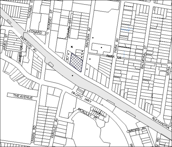
|
NOTIFICATION PLAN |
|
||
|
• PROPERTIES NOTIFIED
|
X SUBMISSIONS RECEIVED |
PROPERTY SUBJECT OF DEVELOPMENT |
|
The submission objected to the development, generally on the grounds that the development would result in unacceptable noise emanating from the proposed alfresco/outdoor gaming area. This has been addressed under Section 2.5.4 of the report.
5.2 Public Agencies
The development application was referred to RailCorp as an adjoining property owner for comment. No response was provided in relation to the proposal.
6. THE PUBLIC INTEREST
Section 79C(1)(e) of the Act requires Council to consider “the public interest”.
The public interest is an overarching requirement, which includes the consideration of the matters discussed in this report. Implicit to the public interest is the achievement of future built outcomes adequately responding to and respecting the future desired outcomes expressed in environmental planning instruments and development control plans.
The application is considered to have satisfactorily addressed Council’s and relevant agencies’ criteria and would provide a development outcome that, on balance, would result in a positive impact for the community. Accordingly, it is considered that the approval of the proposed alterations and additions would be in the public interest.
CONCLUSION
The application proposes alterations and additions to the Asquith Leagues Club including two new pavilions and an alfresco gaming area.
The application does not comply with the Hornsby Local Environmental Plan 2013 with regard to Clause 4.3 – Heritage and Clause 4.4 – Floor Space Ratio. The applicant has provided a submission under Clause 4.6 of HLEP 2013 to vary the floor space ratio development standard. The objection is considered well founded with regard to the existing development and the objectives of the clause.
Council received one submission in response to notification of the proposed development and this has been addressed in the body of the report.
Having regard to the circumstances of the case and consideration of the Clause 4.6 objection, approval of the application is recommended.
Note: At the time of the completion of this planning report, no persons have made a Political Donations Disclosure Statement pursuant to Section 147 of the Environmental Planning and Assessment Act 1979 in respect of the subject planning application.
|
Rod Pickles Manager - Development Assessment Planning Division |
Simon Evans Acting Group Manager Planning Division |
|
1.View |
Locality Map |
|
|
|
2.View |
Site Plan |
|
|
|
3.View |
Floor Plans |
|
|
|
4.View |
Elevations |
|
|
|
5.View |
Schedule of Finishes |
|
|
File Reference: DA/1408/2013
Document Number: D02745628
SCHEDULE 1
GENERAL CONDITIONS
The conditions of consent within this notice of determination have been applied to ensure that the use of the land and/or building is carried out in such a manner that is consistent with the aims and objectives of the relevant legislation, planning instruments and council policies affecting the land and does not disrupt the amenity of the neighbourhood or impact upon the environment.
Note: For the purpose of this consent, the term ‘applicant’ means any person who has the authority to act on or the benefit of the development consent.
Note: For the purpose of this consent, any reference to an Act, Regulation, Australian Standard or publication by a public authority shall be taken to mean the gazetted Act or Regulation, or adopted Australian Standard or publication as in force on the date that the application for a construction certificate is made.
1. Approved Plans and Supporting Documentation
The development must be carried out in accordance with the plans and documentation listed below and endorsed with Council’s stamp, except where amended by Council and/or other conditions of this consent:
Approved Plans
|
Document No. |
Plan Title |
Drawn by |
Dated |
|
A-002 |
Location Plan and Proposed Site Plan |
Abeo Architects |
December 2013 |
|
A-101 |
Proposed Part Ground Floor Plan – Gaming |
Abeo Architects |
December 2013 |
|
A-102 |
Proposed Ground Floor Plan |
Abeo Architects |
December 2013 |
|
A-110 |
Lower Ground Floor Plan |
Abeo Architects |
December 2013 |
|
A-200 |
Proposed Elevations and Sections |
Abeo Architects |
December 2013 |
|
A-120 |
Proposed Roof Plan |
Abeo Architects |
December 2013 |
|
A-FINS |
Finishes Board |
Abeo Architects |
December 2013 |
|
Revision 1 – No. 130506 |
BCA Assessment Report |
Blackett Maguire and Goldsmith |
11 December 2013 |
|
TG246-01F02 (r1) |
DA Acoustic Assessment
|
Renzo Tonin & Associates |
11 December 2013 |
Supporting Documentation
|
Document No. |
Document Title |
Drawn by |
Dated |
|
|
Statement of Heritage Impact |
Hardline Dezign Architects/Heritage Consultants |
November 2013 |
|
P1480 Revision 1 |
Traffic Impact Assessment |
Bitzios Consulting |
18 March 2014 |
|
- |
Gaming Area Entry Gate Treatment |
Abeo Architects |
December 2013 |
2. Acoustic Treatment
Acoustic treatment must be provided to the existing and proposed buildings in accordance with the recommendations contained with Section 4.4 of the DA Acoustic Assessment prepared by Renzo Tonin and Associates dated 11th December, 2013.
3. Acoustic Certificate
On completion of all works and prior to the issue of an Occupation Certificate, the certifier is to be provided with a certificate from a qualified acoustic engineer/consultant certifying that all acoustic works have been completed in accordance with the recommendations contained in the report prepared by Renzo Tonin and Associates dated 11th December, 2013.
4. Club Management
The use of the club premise must be managed in accordance with the recommendations of the Acoustic Report prepared by Renzo Tonin and Associates dated 11th December, 2013. A management plan must be prepared and adhered to in accordance with the recommendations of the acoustic report.
5. Accessible Access
The proposal is to comply with the requirements and recommendations of the BCA Assessment Report (Revision 1) prepared by Blackett Maguire and Goldsmith dated 11 December 2013.
6. Section 94 Development Contributions
In accordance with Section 80A(1) of the Environmental Planning and Assessment Act 1979 and the Hornsby Shire Council Section 94 Development Contributions Plan 2012-2021, the following monetary contributions shall be paid to Council to cater for the increased demand for community infrastructure resulting from the development:
|
Description |
Contribution (4) |
|
Roads |
$8,266.50 |
|
Open Space and Recreation |
$0 |
|
Community Facilities |
$0 |
|
Plan Preparation and Administration |
$100.40 |
|
TOTAL |
$8,366.90 |
being for 159.37m² (the pavilion) of additional gross floor area.
a) If the contributions are not paid within the financial quarter that this consent is granted, the contributions payable will be adjusted in accordance with the provisions of the Hornsby Shire Council Section 94 Development Contributions Plan and the amount payable will be calculated at the time of payment in the following manner:
$CPY = $CDC x CPIPY
CPIDC
Where:
$CPY is the amount of the contribution at the date of Payment.
$CDC is the amount of the contribution as set out in this Development Consent.
CPIPY is the latest release of the Consumer Price Index (Sydney – All Groups) at the date of Payment as published by the ABS.
CPIDC is the Consumer Price Index (Sydney – All Groups) for the financial quarter at the date of this Development Consent.
b) The monetary contributions shall be paid to Council:
i) prior to the issue of the Subdivision Certificate where the development is for subdivision; or
ii) prior to the issue of the first Construction Certificate where the development is for building work; or
iii) prior to issue of the Subdivision Certificate or first Construction Certificate, whichever occurs first, where the development involves both subdivision and building work; or
iv) prior to the works commencing where the development does not require a Construction Certificate or Subdivision Certificate.
It is the professional responsibility of the Principal Certifying Authority to ensure that the monetary contributions have been paid to Council in accordance with the above timeframes.
Council’s Development Contributions Plan may be viewed at www.hornsby.nsw.gov.au or a copy may be inspected at Council’s Administration Centre during normal business hours.
REQUIREMENTS PRIOR TO THE ISSUE OF A CONSTRUCTION CERTIFICATE
7. Building Code of Australia
All building work must be carried out in accordance with the relevant requirements of the Building Code of Australia.
REQUIREMENTS PRIOR TO THE COMMENCEMENT OF ANY WORKS
8. Erection of Construction Sign
A sign must be erected in a prominent position on any site on which building work, subdivision work or demolition work is being carried out:
a) Showing the name, address and telephone number of the principal certifying authority for the work;
b) Showing the name of the principal contractor (if any) for any demolition or building work and a telephone number on which that person may be contacted outside working hours; and
c) Stating that unauthorised entry to the work site is prohibited.
Note: Any such sign is to be maintained while the building work, subdivision work or demolition work is being carried out, but must be removed when the work has been completed.
9. Protection of Adjoining Areas
A temporary hoarding, fence or awning must be erected between the work site and adjoining lands before the works begin and must be kept in place until after the completion of the works if the works:
a) Could cause a danger, obstruction or inconvenience to pedestrian or vehicular traffic.
b) Could cause damage to adjoining lands by falling objects.
c) Involve the enclosure of a public place or part of a public place.
Note: Notwithstanding the above, Council’s separate written approval is required prior to the erection of any structure or other obstruction on public land.
10. Toilet Facilities
Toilet facilities must be available or provided at the works site before works begin and must be maintained until the works are completed at a ratio of one toilet for every 20 persons employed at the site. Each toilet must:
a) be a standard flushing toilet connected to a public sewer; or
b) be a temporary chemical closet approved under the Local Government Act, 1993; or
c) have an on-site effluent disposal system approved under the Local Government Act, 1993.
11. Erosion and Sediment Control
Erosion and sediment control measures must be provided and maintained throughout the construction period in accordance with the manual ‘Soils and Construction 2004 (Bluebook)’, the approved plans, Council specifications and to the satisfaction of the principal certifying authority. The erosion and sediment control devices must remain in place until the site has been stabilised and revegetated.
Note: On the spot penalties up to $1,500 may be issued for any non-compliance with this requirement without any further notification or warning.
REQUIREMENTS DURING CONSTRUCTION
12. Construction Work Hours
All work on site (including demolition and earth works) must only occur between 7am and 5pm Monday to Saturday. No work is to be undertaken on Sundays or public holidays.
13. Demolition
All demolition work must be carried out in accordance with “Australian Standard 2601-2001 – The Demolition of Structures” and the following requirements:
a) Demolition material must be disposed of to an authorised recycling and/or waste disposal site and/or in accordance with an approved waste management plan;
b) Demolition works, where asbestos material is being removed, must be undertaken by a contractor that holds an appropriate licence issued by WorkCover NSW in accordance with Chapter 10 of the Occupational Health and Safety Regulation 2001 and Clause 29 of the Protection of the Environment Operations (Waste) Regulation 2005 ;and
c) On construction sites where buildings contain asbestos material, a standard commercially manufactured sign containing the words ‘DANGER ASBESTOS REMOVAL IN PROGRESS’ measuring not less than 400mm x 300mm must be erected in a prominent position visible from the street.
14. Environmental Management
The site must be managed in accordance with the publication ‘Managing Urban Stormwater – Landcom (March 2004) and the Protection of the Environment Operations Act 1997 by way of implementing appropriate measures to prevent sediment run-off, excessive dust, noise or odour emanating from the site during the construction of the development.
15. Disturbance of Existing Site
During construction works, the existing ground levels of open space areas and natural landscape features, (including natural rock-outcrops, vegetation, soil and watercourses) must not be altered unless otherwise nominated on the approved plans.
16. Landfill
Landfill must be constructed in accordance with Council’s ‘Construction Specification, 2005’ and the following requirements:
a) All fill material imported to the site is to wholly consist of Virgin Excavated Natural Material (VENM) as defined in Schedule 1 of the Protection of the Environment Operations Act 1997 or a material approved under the Department of Environment and Climate Change’s general resource recovery exemption.
17. Excavated Material
All excavated material removed from the site must be classified in accordance with the Department of Environment, Climate Change and Water NSW Waste Classification Guidelines prior to disposal to an approved waste management facility and reported to the principal certifying authority.
REQUIREMENTS PRIOR TO THE ISSUE OF AN OCCUPATION CERTIFICATE
Note: For the purpose of this consent, a reference to ‘occupation certificate’ shall not be taken to mean an ‘interim occupation certificate’ unless otherwise stated.
18. Food Premises
The fit out and operation of that part of the building to be used for the manufacture, preparation or storage of food for sale, must be in accordance with Australian Standard 4674-2004 – Design and fit out of food premises, the Food Act 2003, and the Food Regulation 2010 and the Food Standards Code developed by Food Standards Australia New Zealand. Food Standards 3.3.1. 3.2.2 and 3.2.3 are mandatory for all food businesses.
Note: Walls are to be of solid construction.
19. Trade Waste
Written permission must be obtained from Sydney Water before discharging trade wastewater to the sewer. Food outlets and food services are required to install and maintain an adequately sized grease trap. A dry basket arrestor or bucket trap is necessary if there are floor wastes in the food preparation and handling areas. Floor wastes must drain to the grease trap servicing the kitchen. Refer to the Sydney Water publication ‘Managing trade wastewater in the food service industry’. An application must be submitted to Sydney Water, refer to sydneywater.com.au or phone 13 20 92.
20. Kitchen Exhaust
A kitchen exhaust system must be designed and installed to effectively prevent air pollution in accordance with the Protection of the Environment Operations Act 1997.
OPERATIONAL CONDITIONS
21. Courtesy Shuttle Bus
A courtesy shuttle bus service for patrons must be provided to minimise the demand for onsite carparking.
22. Use of Outdoor Areas
The use of the outdoor gaming area must be in accordance with the Acoustic Report prepared by Renzo Tonin and Associates dated 11th December, 2013 and as follows:
a) Terrace 1, Terrace 2 and the Pavilion are to be closed at midnight.
b) No amplified music/announcements are permitted within the outdoor gaming area.
c) The gaming machine music/noise is to be reduced so that the ambient noise level in the area is at least 3db lower than the levels used for the acoustic assessment being 1kHz to 4KHz octave bands only.
d) Terrace 2 is to be occupied by a maximum of 12 patrons at any one time.
e) Terrace 2 is to be restricted after midnight and a solid operable partition is to be incorporated into the design between Terrace 2 and the TAB. The solid and acoustically sealed partition should have an acoustic performance no less Weighted Sound Reduction Index (Rw) 25.
f) Terrace 1 is to be occupied by a maximum of 10 patrons at any one time.
g) The Pavilion is to be occupied by a maximum of 70 patrons at any one time.
h) For operation after 10pm, doors and windows on the western façade of the pavilion are to be closed.
i) Signs must be posted at the exit to the outdoor gaming area and on the outdoor gaming area stating: “CONSIDER OUR NEIGHBOURS. PLEASE KEEP NOISE TO A MINIMUM.”
j) All noise complaints must be recorded by the Duty Manager and must be dealt with immediately.
23. Acoustics
a) The LA10 noise level emitted from the use must not exceed the background noise level (LA90) in any Octave Band Centre Frequency (31.5 Hz to 8 kHz inclusive) by more than 5dB between the hours of 7.00am and 12.00 midnight when assessed at the boundary of any affected residence.
b) The LA10 noise level emitted from the use must not exceed the background noise level (LA90) in any Octave Band Centre Frequency (31.5 Hz to 8 kHz inclusive) between the hours of 12.00 midnight and 7.00am when assessed at the boundary of any affected residence.
c) Notwithstanding compliance with (a) and (b) above, the noise from the use must not be audible within any habitable room in any residential property between the hours of 12.00 midnight and 7.00am.
d) The L10 noise level emitted from the use must not exceed the background noise level (L90) in any Octave Band Centre Frequency (31.5 Hz to 8 kHz inclusive) by more than 3dB when assessed indoors at any affected commercial premises.
e) The use of the premise must be controlled so that any emitted noise is at a level so as not to create an “offensive noise” as defined in the Protection of the Environment Operations Act 1997 to any affected receiver.
f) Should a noise complaint be received by Council from a place of different occupancy (including commercial premises) the Club shall, upon receipt of a direction from Council, cease the use of the area concerned until a report can be provided by an appropriately qualified acoustic consultant who possesses the qualifications to render them eligible for membership of the Australian Acoustic Society, Institution of Engineers Australia or the Australian Association of Acoustic Consultants confirming that the premises complies with the relevant Noise conditions as detailed in (a) - (e) above.
24. Fire Safety Statement - Annual
On at least one occasion in every 12 month period following the date of the first ‘Fire Safety Certificate’ issued for the property, the owner must provide Council with an annual ‘Fire Safety Certificate’ to each essential service installed in the building.
25. Maintenance of Wastewater Device
All wastewater and stormwater treatment devices (including drainage systems, sumps and traps) must be regularly maintained in order to remain effective. All solid and liquid wastes collected from the device must be disposed of in accordance with the Protection of the Environment Operations Act 1997.
– END OF CONDITIONS –
ADVISORY NOTES
The following information is provided for your assistance to ensure compliance with the Environmental Planning and Assessment Act, 1979, Environmental Planning and Assessment Regulation 2000, other relevant legislation and Council’s policies and specifications. This information does not form part of the conditions of development consent pursuant to Section 80a of the Act.
Environmental Planning and Assessment Act, 1979 Requirements
The Environmental Planning and Assessment Act, 1979 requires:
· The issue of a construction certificate prior to the commencement of any works. Enquiries can be made to Council’s Customer Services Branch on 9847 6760.
· A principal certifying authority to be nominated and Council notified of that appointment prior to the commencement of any works.
· Council to be given at least two days written notice prior to the commencement of any works.
· Mandatory inspections of nominated stages of the construction inspected.
· An occupation certificate to be issued before occupying any building or commencing the use of the land.
Asbestos Warning
Should asbestos or asbestos products be encountered during demolition or construction works, you are advised to seek advice and information prior to disturbing this material. It is recommended that a contractor holding an asbestos-handling permit (issued by WorkCover NSW) be engaged to manage the proper handling of this material. Further information regarding the safe handling and removal of asbestos can be found at:
Alternatively, telephone the WorkCover Asbestos and Demolition Team on 8260 5885.
Food Authority Notification
The NSW Food Authority requires businesses to electronically notify the Authority prior to the commencement of its operation.
Note: NSW Food Authority can be contacted at www.foodnotify.nsw.gov.au.
Council Notification – Food Premises
Prior to the commencement of the business, the operator is requested to contact Council’s Environmental Health Team to arrange an inspection for compliance against the relevant legislation and guidelines outlined in this approval.
Note: Council’s Environmental Health Officer can be contacted on 02 9847 6745.
Group Manager’s Report No. PL31/14
Planning Division
Date of Meeting: 14/05/2014
7 DEVELOPMENT APPLICATION - RESIDENTIAL FLAT BUILDING COMPRISING 34 UNITS - 1 AND 3 BELAIR CLOSE, HORNSBY
EXECUTIVE SUMMARY
|
DA No. |
DA/1031/2013 (Lodged 30 September 2013) |
|
Description: |
Construction of a five storey residential flat building comprising 34 units with basement car parking and strata subdivision |
|
Property: |
Lot 1 SP 39068, Lot 2 SP 39068 and Lot 2 DP 204624, Nos. 1 and 3 Belair Close, Hornsby |
|
Applicant: |
CBD Core Pty Ltd |
|
Owners: |
Est. Late Mr Ashley T Day and Mr James A Day, Mr Trent W Gardiner, Mr P and Mrs R Hrastnik |
|
Estimated Value: |
$4,805,008 |
|
Ward: |
A |
· The application proposes the demolition of existing structures and construction of a five storey residential flat building comprising 34 units with basement car parking and strata subdivision.
· The proposal generally complies with the Hornsby Shire Local Environmental Plan 1994, Hornsby Local Environmental Plan 2013, State Environmental Planning Policy No. 65 – Design Quality Residential Flat Building, Hornsby Shire Housing Strategy Development Control Plan and the Hornsby Development Control Plan 2013, other than minor variations to the setbacks and height elements. These non-compliances are considered acceptable.
· One public submission has been received in respect of the application.
· It is recommended that the application be approved.
|
THAT Development Application No. DA/1031/2013 for the demolition of existing structures and construction of a five storey residential flat building comprising 34 units with basement car parking and strata subdivision at Lot 1 SP 39068, Lot 2 SP 39068 and Lot 2 DP 204624, Nos. 1 and 3 Belair Close, Hornsby be approved subject to the conditions of consent detailed in Schedule 1 of the Group Manager’s Report No. PL31/14. |
BACKGROUND
The subject land, being part of the Belair Precinct, was rezoned from Residential A (Low Density) to Residential C (Medium-High Density) on 2 September 2011 as part of Council’s Housing Strategy.
SITE
The site has an area of 1,685.43 square metres and a frontage of approximately 31.3 metres to Belair Close and 44.57 metres to Sherbrook Road, being located at the corner of the two roads. The site has a north-easterly aspect and an average gradient of 14% from the south-western side to the north-eastern corner (Sherbrook Road and Belair Close corner).
An overland flow path crosses the Sherbrook Road frontage of the site in a northerly direction prior to draining to Hornsby Creek, being a part of the Hawkesbury River Catchment area. This section of the development site constitutes flood prone land being No. 1 Belair Close.
The site consists of two irregular shaped lots, orientated in a general north-south direction. Lot 2 contains a single detached dwelling-house with vegetation scattered throughout the lot while the adjoining lot is strata titled (fronting Sherbrook Road), containing two detached dwellings.
The site forms a part of the Belair Close Housing Strategy Precinct. The western side of the precinct adjoins medium to high density residential developments comprising townhouses and three storey residential flat buildings with basement car parks. Development Consent No. 4/2013 approved two, five storey buildings comprising 64 units on the western side of the site in Belair Close. Development Consent No. 547/2013 was approved for the construction of two, five storey residential flat buildings comprising 73 units opposite the site, in Belair Close.
The site is located 750 metres north-east of Hornsby Railway Station and is within 130 metres of a regular bus service connection to the station.
THE PROPOSAL
The proposal is for the demolition of existing dwellings and construction of a five storey residential flat building comprising 34 units over two levels of basement parking and strata subdivision.
The unit mix would comprise of 4 x 1 bedroom, 25 x 2 bedroom and 5 x 3 bedroom units. The building accommodates 7 adaptable units. The building includes a central lift for vertical circulation.
The design of the proposed five storey building relates to the topography of the site. The proposed building is of concrete construction, with glazed and painted masonry finishes and metal roofing. Two separate pedestrian entries are provided for the building leading up to a foyer at the ground level. The main pedestrian entry would be via Belair Close.
The proposed car park is designed in two basement levels with a ramp and driveway entry from Belair Close. A total of 41 car parking spaces including 7 visitor car parking spaces, resident storage facilities, bicycle storage and waste management facilities would be accommodated within the basement levels.
Landscaped areas are proposed fronting Belair Close, Sherbrook Road and the rear of the site. The primary communal open space area is proposed to be located to the south of the building and includes retaining walls for level paved court yards and perimeter gardens.
ASSESSMENT
The development application has been assessed having regard to the ‘Metropolitan Plan for Sydney 2036’, the ‘North Subregion (Draft) Subregional Strategy’ and the matters for consideration prescribed under Section 79C of the Environmental Planning and Assessment Act 1979 (the Act). Subsequently, the following issues have been identified for further consideration.
1. STRATEGIC CONTEXT
1.1 Metropolitan Plan for Sydney and (Draft) North Subregional Strategy
The (Draft) Metropolitan Strategy for Sydney 2031 is a broad framework to provide for Sydney’s growth to help plan for housing, employment, transport, infrastructure, the environment and open space. It outlines a vision for Sydney to 2031; the challenges faced, and the directions to follow to address these challenges and achieve the vision.
The North Subregion comprises Hornsby, Kuring-gai, Manly, Warringah and Pittwater Local Government Areas. The Draft North Subregional Strategy provided a framework for Council in its preparation of the Hornsby Local Environmental Plan 2013.
Within the North Subregion, the Draft Metropolitan Strategy proposes:
· Population growth of 81,000 from the current 2011 baseline of 529,000
· Housing growth of 37,000 from the current 2011 baseline of 204,000
· Employment growth of 39,000 from the current 2011 baseline of 186,000
The proposed development would be consistent with the Metropolitan Plan for Sydney 2031 by providing 31 additional dwellings and would contribute to housing choice in the locality.
2. STATUTORY CONTROLS
Section 79C(1)(a) requires Council to consider “any relevant environmental planning instruments, draft environmental planning instruments, development control plans, planning agreements and regulations”.
2.1 Hornsby Shire Local Environmental Plan 1994
The subject land is zoned Residential C (Medium/High Density) under the Hornsby Shire Local Environmental Plan 1994 (HSLEP). The objectives of the Residential C (Medium/High Density) zone are:
(a) to provide for the housing needs of the population of the Hornsby area.
(b) to promote a variety of housing types and other land uses compatible with a medium to high density residential environment.
(c) to provide for development that is within the environmental capacity of a medium to high density residential environment.
The proposed development is defined as ‘multi-unit housing’ under the HSLEP and is permissible in the zone with Council’s consent.
Clause 15 of the HSLEP prescribes the maximum floor space ratio (FSR) of development within the Residential C zone. Subclause (5) of clause 15 states that “This clause does not apply to land shown edged heavy black on diagrams 1-8 in Schedule BB.” The site is identified in Diagram 4 of Schedule BB of the HSLEP. Therefore, clause 15 does not apply to the subject site.
Clause 15A of the HSLEP prescribes a maximum building height of 17.5 metres for development on the subject site. The proposed building does not comply with this development standard. The applicant addresses the requirement by submitting an objection to the development standard pursuant to the State Environmental Planning Policy No. 1 as discussed further under Section 2.3 of this report.
Clause 18 of the HSLEP sets out heritage conservation provisions for Hornsby Shire. The site is not identified as a heritage item and is not in the vicinity of an item or within a heritage conservation area.
2.2 Hornsby Shire Local Environmental Plan 2013
The Hornsby Local Environmental Plan 2013 was gazetted by the Minister of Planning on 11 October 2013. The HLEP includes a savings provision stating that if a development application is made and not finally determined before the commencement of the HLEP, the application must be determined as if the Plan had been exhibited but not commenced. The relevant provisions of the HLEP are addressed below.
2.2.1 Zoning
Under the HLEP, the site is zoned R4 (High Density Residential). The proposed development is defined as a ‘residential flat building’ and is a permissible use in the zone with Council’s consent.
2.2.2 Height of Building
Clause 4.3 of the HLEP provides that the height of a building on any land is not to exceed the maximum height shown for the land on the Height of Buildings Map. The maximum permissible height for the subject site is 17.5 metres. There are some sections, which do not comply with the stipulated development standard.
2.3 State Environmental Planning Policy No. 1 – Development Standards
The application has been assessed against the requirements of State Environmental Planning Policy No. 1 – Development Standards (SEPP 1). This policy provides flexibility in the application of development standards in circumstances where strict compliance with those standards would, in particular case, be unreasonable or unnecessary or tend to hinder the attainment of the objectives of the Act.
The Land and Environment Court has expressed the view that there are five different ways in which an objection may be well founded and the approval of the objection may be consistent with the aims of the Policy as follows: -
1. The objectives of the standard are achieved notwithstanding non-compliance with the standard;
2. The underlying objective or purpose of the standard is not relevant to the development and therefore compliance is unnecessary;
3. The underlying object of purpose would be defeated or thwarted if compliance was required and therefore compliance is unreasonable;
4. The development standard has been virtually abandoned or destroyed by the Council’s own actions in granting consents departing from the standard and hence compliance with the standard is unnecessary and unreasonable;
5. The zoning of the particular land is unreasonable or inappropriate so that a development standard appropriate for that zoning is also unreasonable and unnecessary, as it applies to the land and compliance with the standard would be unreasonable and unnecessary. That is, the particular parcel of land should not have been included in the particular zone.
The topography of the land falls steeply from the west to the east and as consequence some small sections of the proposed building extend above the stipulated 17.5 metres height limit. These structures are: -
· Part of the building lift overrun – increases the height by approximately 518 millimetres (being a variation of 3%),
· Pergola – increases the overall height by 548 millimetres to 1064 millimetres (being a variation of approximately 3% to 6%),
· Part of the metal roof over Units Nos. 33 and 34 – increases height by 358 millimetres to 516 millimetres.
The applicant made a written submission in accordance with the SEPP 1. The provisions of the SEPP 1 are applicable to development standards prescribed under an Environmental Planning Instrument that was prepared in accordance with the provisions contained within the Environmental Planning and Assessment Act 1979. Clause 15A ‘Height of Buildings’ contained within the Hornsby Local Environmental Plan 1994 is a standard within an Environmental Planning Instrument and is therefore a development standard that controls the building height.
The SEPP 1 indicates that ‘compliance with the development standard is deemed to be both unreasonable and unnecessary under the circumstances because the departure sought does not create any unreasonable impacts upon the built and natural environments.
The proposal clearly demonstrates that the proposed minor increases in building height (i.e. part lift overrun, part pergola and part metal roof) do not increase amenity impacts such as overshadowing, view loss or bulk and scale.
Notwithstanding the non-compliance with the planning control, the proposed increase in building height is extremely minor in relation to the objective of the standard, it nevertheless satisfies the underlying intent of the control.’
Among other things, the applicant considers that the objection to the strict application of the development standard has demonstrated to be both unreasonable and unnecessary given that the proposal:
· Responds to the topography of the land,
· Does not generate additional amenity impacts as any additional shadow cast falls onto the proposed residential flat building’s roof to that of a fully compliant 17.5 metre high building scheme,
· Promotes the orderly and economic development of land that is conducive to urban consolidation principles in built urban environments where they are close to quality public amenities,
· The design is consistent with the underlying objectives of the building height development standard in that it seeks to encourage high density housing,
· Does not increase the building footprint or the need to screen structures,
· The building bulk, scale, form and height will largely remain the same to that of a fully compliant building scheme,
· Satisfies the Land and Environment Court’s parameters for a well-founded objection to depart from a development standard,
· The change to the height control does not undermine the objects contained in Section 5 (a)(i) and (ii) of the Environmental Planning and Assessment Act 1979.
Compliance with the standard is therefore considered unreasonable, given the proposed development complies with all other DCP requirements (i.e. Site Requirements, Landscape Area, Private Open Space, Floor Plates and Articulations). It is considered to be well within the environmental capacity of the high density residential zone and is considered minor due to the circumstances of the case.
For the reasons detailed in the applicant’s submission, it is considered that strict compliance with the minimum height is unnecessary and unreasonable and that the submitted SEPP No. 1 objection is supported in the circumstances of this case.
2.4 State Environmental Planning Policy No. 55 – Remediation of the Land
State Environmental Planning Policy No. 55 (SEPP 55) requires that Council must not consent to the carrying out of any development on land unless it has considered whether the land is contaminated or requires remediation for the proposed use.
The site has been used for residential purposes and is unlikely to be contaminated. A condition is recommended should any contamination be found during construction requiring that Council or the Private Certifying Authority be notified.
2.5 State Environmental Planning Policy No. 65 - Design Quality Residential Flat Development
The Policy provides for design principles to improve the design quality of residential flat development and for consistency in planning controls across the State.
The applicant has submitted a design verification statement prepared by a qualified designer stating how the proposed development achieves the design principles of SEPP 65. The design principles of SEPP 65 and the submitted design verification statement are addressed below.
2.5.1 Principle 1 - Context
Design Principle 1 is as follows:
Good design responds and contributes to its context. Context can be defined as the key natural and built features of an area.
Responding to context involves identifying the desirable elements of a location’s current character or, in the case of precincts undergoing a transition, the desired future character as stated in planning and design policies. New buildings will thereby contribute to the quality and identity of the area.
The site is located within a precinct zoned for five storey residential flat buildings in close proximity to the Hornsby commercial centre. The desired future character of the area, as outlined in Council’s Housing Strategy Development Control Plan, is that of a high density residential precinct incorporating five storey developments in a landscaped setting.
The submitted “Design Verification Statement” indicates that the proposal responds to the desired future character of the area visualised by Council. The building is appropriately stepped with sufficient setbacks. The site plan retains significant trees within the road reserve on the northern side. Once the precinct is redeveloped, the proposal would integrate with the surrounding sites, the existing medium-high density developments in close proximity on the western side and the approved high density residential buildings on the opposite side of the road.
The development responds appropriately to the ‘context’ principle of SEPP 65, and would contribute to the identity and future character of the precinct.
2.5.2 Principle 2 - Scale
Design Principle 2 is as follows:
Good design provides an appropriate scale in terms of the bulk and height that suits the scale of the street and the surrounding buildings.
Establishing an appropriate scale requires a considered response to the scale of existing development. In precincts undergoing a transition, proposed bulk and height needs to achieve the scale identified for the desired future character of the area.
The precinct is undergoing transition. The scale of the future built environment is commensurate with Council’s planning controls which promote five storey residential flat buildings with a maximum height of 17.5 metres. The proposed development generally complies with the maximum height limit permitted in the residential precinct and provides a building envelope, which generally confines itself within the setbacks required by Council’s Housing Strategy Development Control Plan.
The elevations achieve an appropriate aesthetic outcome and composition and create the appearance of separate pavilions. The scale of the proposed development is appropriate for the site in accordance with the planning controls and desired future character of the precinct.
2.5.3 Principle 3 - Built Form
Design Principle 3 is as follows:
Good design achieves an appropriate built form for a site and the building’s purpose, in terms of building alignments, proportions, building type and the manipulation of building elements.
Appropriate built form defines the public domain, contributes to the character of streetscape and parks, including their views and vistas, and provides internal amenity and outlook.
The proposed building is appropriately modulated and articulated to reduce bulk and scale and blend with the surrounding residential character. The details of the elements of the built form are assessed in Section 2.11 of this report.
2.5.4 Principle 4 - Density
Design Principle 4 is as follows:
Good design has a density appropriate for a site and its context, in terms of floor space yields (or number of units or residents).
Appropriate densities are sustainable and consistent with the existing density in an area or in precincts undergoing a transition, are consistent with the stated desired future density. Sustainable densities respond to the regional context, availability of infrastructure, public transport, community facilities and environmental quality.
The proposal achieves a dwelling density consistent with the requirements of the Housing Strategy Development Control Plan which establishes the desired future character for the “Belair Close, Hornsby” precinct. The proposal is within the DCP prescriptive measures as addressed in Section 2.11 of this report.
2.5.5 Principle 5 - Resource, Energy and Water Efficiency
Design Principle 5 is as follows:
Good design makes efficient use of natural resources, energy and water throughout its full life cycle, including construction.
Sustainability is integral to the design process. Aspects include demolition of existing structures, recycling of materials, selection of appropriate and sustainable materials, adaptability and reuse of buildings, layouts and built form, passive solar design principles, efficient appliances and mechanical services, soil zones for vegetation and reuse of water.
The proposed development includes a BASIX Certificate and complies with the requirements with regard to water, thermal comfort and energy. The proposal also complies with the natural ventilation and solar access requirements within the Residential Flat Design Code (RFDC). The details of the above matters are discussed in Section 2.6 of this report.
2.5.6 Principle 6 - Landscape
Design Principle 6 is as follows:
Good design recognises that together landscape and buildings operate as an integral and sustainable system, resulting in greater aesthetic quality and amenity for both occupants and the adjoining public domain.
Landscape design builds on the existing site’s natural and cultural features in responsible and creative ways. It enhances the development’s natural environmental performance by co-ordinating water and soil management, solar access, micro-climate, tree canopy and habitat values. It contributes to the positive image and contextual fit of development through respect for streetscape and neighbourhood character, or desired future character.
Landscape design should optimise useability, privacy and social opportunity, equitable access and respect for neighbour’s amenity, and provide for practical establishment and long term management.
The application includes a landscape concept plan providing landscaping to the Belair Close and Sherbrook Road frontages, communal open space area, and the side boundaries. This planting would activate the street frontages and provide a landscaped setting for the proposed development.
The proposed development incorporates deep soil planting wherever possible and common open space within the rear setback. Given the above, the proposal satisfies the intent of the ‘Landscaping’ principle of SEPP 65.
2.5.7 Principle 7 - Amenity
Design Principle 7 is as follows:
Good design provides amenity through the physical, spatial and environmental quality of a development.
Optimising amenity requires appropriate room dimensions and shapes, access to sunlight, natural ventilation, visual and acoustic privacy, storage, indoor and outdoor space, efficient layouts and service areas, outlook and ease of access for all age groups and degrees of mobility.
The proposal would provide convenient and safe access to the development via a centrally located lift connecting the basement and all other levels. The application has been assessed against the ‘Building Amenity’ criteria within the RFDC and is discussed in Section 2.6 of this report.
2.5.8 Principle 8 - Safety and Security
Design Principle 8 is as follows:
Good design optimises safety and security, both internal to the development and for the public domain.
This is achieved by maximising overlooking of public and communal spaces while maintaining internal privacy, avoiding dark and non-visible areas, maximising activity on streets, providing clear, safe access points, providing quality public spaces that cater for desired recreational uses, providing lighting appropriate to the location and desired activities, and clear definition between public and private spaces.
The proposed design has regard to ‘Crime Prevention through Environmental Design (CPTED)’ principles and does not include any obvious unobserved areas.
The RFDC requires the preparation of a formal Crime Assessment Report for development that comprises more than twenty residential units. The proposal includes an assessment of the development against crime prevention controls in the Statement of Environmental Effects. The applicant advises that the safety of the public domain is enhanced by providing apartment layouts that optimise occupant surveillance, well-lit entry lobbies, communal open spaces, garden paths and public areas, secured car-park entry and casual surveillance for all communal areas.
The landscaping strategy ensures a high level of amenity whilst maintaining clear sight lines and minimising potential hiding places. The applicant also states that the proposed access to the site is able to be achieved from Belair Close through secured entry doors to the lobby, where access to each level will only be available to residents and their visitors.
The application was referred to NSW Police Force and raised no concerns to the proposal. The proposal is assessed as satisfactory with regard to safety and security, subject to a condition requiring lighting of the service areas of the lower ground floor, garbage room and the communal open space at the rear.
2.5.9 Principle 9 - Social Dimensions and Housing Affordability
Design Principle 9 is as follows:
Good design responds to the social context and needs of the local community in terms of lifestyles, affordability, and access to social facilities.
New development should optimise the provision of housing to suit the social mix and needs in the neighbourhood or, in the case of precincts undergoing transition, provide for the desired future community.
New development should address housing affordability by optimising the provision of economic housing choices and providing a mix of housing types to cater for different budgets and housing needs.
The Housing Strategy DCP includes prescriptive measures for housing choice and for adaptable housing to provide for aging in place. The proposal provides a housing mix and adaptable housing and is supported in respect to this Principle.
2.5.10 Principle 10 - Aesthetics
Design Principle 10 is as follows:
Quality aesthetics require the appropriate composition of building elements, textures, materials and colours and reflect the use, internal design and structure of the development. Aesthetics should respond to the environment and context, particularly to desirable elements of the existing streetscape or, in precincts undergoing transition, contribute to the desired future character of the area.
The proposal is consistent with the design principles contained within the RFDC. It is considered that the aesthetic quality of the building contributes to the desired future character of the precinct. The details of the assessment of the built form and the aesthetics of the development are contained in Section 2.12 of this report.
2.6 SEPP 65 - Residential Flat Design Code
SEPP 65 requires consideration of the Residential Flat Design Code, NSW Planning Department 2002. The Code includes development controls and best practice benchmarks for achieving the design principles of SEPP 65. The following table sets out the proposal’s compliance with the Code.
|
Control |
Proposal |
Requirement |
Compliance |
|
Deep Soil Zone |
>44% |
Min. 25% |
Yes |
|
Communal Open Space |
>30% |
25-30% |
Yes |
|
Ground Level Private Open Space |
<25m2 Min. Dimension 2.5m |
25m2 Min. Dimension 4m |
No No |
|
Minimum Dwelling Size |
1 br – 50.1m2 2 br – 78m2 3 br – 95m2 |
1 br – 50m2 2 br – 70m2 3 br – 95m2 |
Yes Yes Yes |
|
Maximum Kitchen Distance |
8m |
8m |
Yes |
|
Minimum Balcony Depth |
2.5m (overall) |
2.0m |
Yes |
|
Ceiling Heights |
2.7m |
2.7m (Min) |
Yes |
|
Total Storage Area
|
1 br - >6m3 2 br - >8m3 3 br - >10m3 >50% accessible from the apartments |
1 br - 6m3 min 2 br - 8m3 min 3 br -10m3 min 50% accessible from the apartments |
Yes |
|
Dual Aspect and Cross Ventilation |
76% (corresponding 26 units) |
60% |
Yes |
|
Adaptable Housing |
30% |
10% |
Yes |
As detailed in the above table, the proposed development generally complies with the prescriptive measures within the Residential Flat Design Code. Below is a brief discussion regarding the relevant development controls and best practice guidelines.
2.6.1 Building Depth and Separation
The proposed building depths and the design of the facades are in accordance with the requirements of Council’s Housing Strategy Development Control Plan and are discussed in Section 2.12.
The majority of the living areas and single aspect balconies would be orientated towards a street and the common open space at the rear (southern side). There are single and dual aspect balconies fronting the western side of the site. Notwithstanding, privacy louvers are proposed for the western side of the upper level balconies and are setback 4 metres from the boundary. The top level balconies on the western side would not comply with the required 18 metre separation from the boundary. The matter is discussed in Section 2.12 of this report.
It is considered that the proposal would not result in unreasonable compromise of natural ventilation and solar access to the proposed or future adjoining, developments subject to the implementation of conditions of consent.
2.6.2 Apartment Layout and Mix
The proposed building is designed in response to the topography and shape of the site. The proposal includes a range of apartment sizes and layouts appropriate to the configuration of the buildings.
The proposed layouts of the units are functional and feature well appointed spaces. The depth and width of the units ensure adequate natural light and ventilation. The majority of kitchen spaces either include a window, or are located within 8 metres of a window.
The proposal includes a range of smaller units providing for housing choice. It is considered the proposed unit layouts meet the best practice requirements of the Code.
2.6.3 Ground Floor Apartments and Private Open Space
The Code encourages separate entries for ground floor apartments and private gardens areas at ground level.
The proposed ground floor unit open space areas include courtyards and balconies contained within the building envelope. The unit open space areas are considered appropriate for the respective ground floor units in respect to dwelling size, aspect, unit configuration and amenity. The ground floor units would not include 25 square metres courtyards adjoining the living areas. The non-compliance with the best practice 25 square metres open space area and 4 metre dimension is considered acceptable as the larger area would be lost to private use and not contribute to landscaping with regard to the Housing Strategy Development Control Plan key principle for five storey residential flat buildings in garden settings. The units comply with the minimum requirements of the Housing Strategy Development Control Plan with regard to private open space areas. The proposal is assessed as satisfactory in this regard.
The adaptable dwellings benefit from convenient access via ramps and lifts to common outdoor open space areas. It is considered that the design of the proposed ground floor units is satisfactory in meeting the requirements of the Code.
2.6.4 Internal Circulation
Each floor includes an open foyer/corridor with the lift to provide internal circulation. The lifts are within ready access of the respective units. The lift corridors meet the Code’s requirements for the number of units accessed (less than 8) and design for amenity.
2.6.5 Acoustic Privacy
The internal layout of the residential units is designed such that noise generating areas would generally adjoin each other. Storage or circulation zones would act as a buffer between units. Bedrooms and service areas such as kitchens, bathrooms and laundries would be grouped together wherever possible. Measures to reduce noise transmission from common corridors have been provided within the unit layouts.
Subject to recommended conditions for noise mitigation, the proposed development meets the Code’s best practice requirements for acoustic privacy.
2.6.6 Storage
The proposed units include built-in robes and linen cupboard storage. The basement includes caged storage areas for all 34 units. The proposal would comply with the Codes best practice storage areas requirement.
2.7 State Environmental Planning Policy No. 32 - Urban Consolidation (Redevelopment of Urban Land) (SEPP 32)
The application has been assessed against the requirements of SEPP 32, which requires Council to implement the aims and objectives of this Policy to the fullest extent practicable when considering development applications relating to redevelopment of urban land. The application complies with the objectives of the Policy as it would promote social and economic welfare of the locality and would result in the orderly and economic use of under utilised land within the Shire.
2.8 State Environmental Planning Policy (Building Sustainability Index - BASIX) - 2004
The application has been assessed against the requirements of State Environmental Planning Policy (Building Sustainability Index: BASIX) 2004. The proposal includes a BASIX Certificate for the proposed development and is considered to be satisfactory.
2.9 Sydney Regional Environmental Plan No. 20 - Hawkesbury - Nepean River
The site is located within the catchment of the Hawkesbury Nepean River. Part 2 of this Plan contains general planning considerations and strategies requiring Council to consider the impacts of development on water quality, aquaculture, recreation and tourism.
Subject to the implementation of sediment and erosion control measures and stormwater management to protect water quality, the proposal would comply with the requirements of the Policy.
2.10 Clause 74BA Environmental Planning and Assessment Act, 1979 - Purpose and Status of Development Control Plans
On 1 March 2013, the Environmental Planning and Assessment Act, 1979 was amended so that a DCP provision will have no effect if it has the practical effect of “preventing or unreasonably restricting development” that is otherwise permitted and complies with the development standards set out in relevant Local Environmental Plans and State Environmental Planning Policies.
The principal purpose of a development control plan is to provide guidance on the aims of any environmental planning instrument that applies to the development; facilitating development that is permissible under any such instrument; and achieving the objectives of land zones under any such instrument. The provisions of a development control plan made for that purpose are not statutory requirements.
2.11 Hornsby Development Control Plan 2013
The Hornsby Development Control Plan (HDCP) 2013 applies to all land within Hornsby Shire and replaces Council’s existing DCPs, providing development controls to complement the HLEP. The HDCP came into effect on 11 October 2013.
The following sections of this report include a detailed assessment of the proposal against Council’s DCP controls that were in force at the time the application was lodged. The HDCP is generally a transition of Council’s existing DCPs, into a consolidation Plan. Notwithstanding, it is noted that the following controls are inconsistent with the existing DCP requirements and a brief discussion of the HDCP requirements is provided below:
2.11.1 Setbacks
The proposed development includes minor balcony encroachments to within 4 metres of the western side boundary, which is inconsistent with the side boundary setback requirements of the HDCP. The development’s western boundary would adjoin a five storey development approved under Development Consent No. 4/2013. Balconies would feature a combined separation between 8.2 metres to 9.85 metres. Balconies which front the western side would be provided with privacy louvers to comply with the privacy requirements of SEPP 65 and satisfy the intent of the prescriptive measures to not impact on the achievement of daylight access, visual privacy and acoustic privacy.
In addition the rear setback (south) would not comply with the prescriptive measure stipulated under Council’s DCP. The setback encroaches in more than the required 1/3 of the building width. However, the site’s southern boundary adjoins a 4.6 metre wide. This driveway provides access to a medium density residential development located at (No. 41) Sherbrook Road. The separation distances would be consistent with the stipulated under the Residential Flat Design Code. Accordingly, the non-compliance would not impact on the achievement of day light access, visual and acoustic privacy for the subject and adjoining residential developments.
The application is assessed as satisfactory with regard to the setback requirements of the HDCP.
2.11.2 Landscaping
The total landscaped areas are approximately 706 square metres, which represents 42% of the total site area. The proposal generally complies with this requirement and there is sufficient area available for deep soil landscaping on the site including provision for the planting of locally indigenous canopy trees.
The application is assessed as satisfactory with regard to the landscaping requirements of the HDCP.
2.11.3 Vehicle Access and Parking
The proposed vehicle access to the common basement area is via a 6 metre wide driveway off Belair Close. The driveway provides access to the basements, which accommodates 41 car parking spaces comprising 34 resident car spaces plus 7 car spaces for visitors including one car parking space for mobility impaired persons. A minimum of 5 visitors and 36 residential parking spaces is required for the development under the HDCP and the development complies with this requirement.
Provision has been made for bicycle parking in Basement Levels 01 and 02. Ten bicycle spaces are required for the development under the HDCP. The proposal complies with Council’s DCP requirements.
The HDCP also requires that one motorcycle space be provided for the development. One motorcycle space has been provided within Basement Level 01.
Subject to the recommended conditions regarding parking and manoeuvrability, the application is assessed as satisfactory with regard to vehicle access and parking requirements.
2.12 Housing Strategy Development Control Plan
The proposed development has been assessed having regard to the relevant performance and prescriptive requirements within Council’s Housing Strategy Development Control Plan (Housing Strategy DCP). The following table sets out the proposal’s compliance with the prescriptive requirements of the Plan: -
|
Control |
Proposal |
Requirement |
Compliance |
|
Site Width |
44.57m (Sherbrook Road) 31.85m (Belair Close) 5.3m - Splay corner |
Min 30m |
Yes |
|
Height |
Part 6 storeys - 17.5m |
5 storeys - 17.5m |
No |
|
Lowest Residential Floor Above Ground North Elevation South Elevation East Elevation West Elevation |
+1.5m -0.8m -0.4m - +0.8m -0.6m - 1m |
Max. 1.5m |
Yes |
|
Maximum Floor Plate Dimension |
34m |
35m
|
Yes
|
|
Building Indentation |
4m x 4m |
4m x 4m |
Yes |
|
Side Setback (Sherbrook Road) Building Line Balcony Basement Maximum building length between 4m – 6m |
5.2m – 7.8m 4m 4m 11.3m |
4m - 6m 4m 4m 11.3m (1/3 of 34m)
|
Yes Yes Yes Yes |
|
Front Setback (Belair Close) – North Elevation Building Line Balcony Basement Maximum building length between 8m – 10m |
8m-8.6m 5m - 7m 5m - 7m Same alignment |
8m - 10m 7m 7m 8.6 m (1/3 of 25.9m) |
No No No No |
|
West Side Setback Building Line Balcony Basement Maximum building length between 4m – 6m |
4m - 6m 4m 4m 8m |
6m 4m 4m 11.6m (1/3 of 35m) |
Yes Yes Yes Yes |
|
Rear Setback |
8m – 10m |
8m – 10m |
Yes |
|
Additional top Storey Setback From Ground Floor |
3m |
3m |
Yes |
|
Basement Ramp Setback |
4m |
2m |
Yes |
|
Car Parking |
41 resident spaces 7 visitor spaces |
34 resident spaces 7 visitor spaces |
Yes Yes |
|
Landscaping Belair Close Western Side Sherbrook Road Rear (South Side) |
8m wide 4m wide 4m wide 7m wide |
7m wide 4m wide 4m wide 7m wide |
Yes Yes Yes Yes |
|
Min Private Open Space (Min Width 2.5m) |
1 br units - >10m2 2 br units - >12m2 3 br units - >16m2 |
10m2 12m2 16m2 |
Yes Yes Yes |
|
Communal Open Space |
33% |
25% |
Yes |
|
Sunlight Access |
82% (represent 28 units) |
70% |
Yes |
|
Housing Choice |
1 br units – 12% 2 br units – 73% 3 br units – 15% |
10% 10% 10% |
Yes Yes Yes |
|
Adaptable Units |
30% |
30% |
Yes |
As detailed in the above table, the proposed development does not comply with a number of prescriptive requirements within Council’s Housing Strategy DCP. These non-compliances are largely a result of the irregular shape of the site and the corner element. The matters of non-compliance are detailed below, as well as a brief discussion on compliance with relevant performance requirements.
2.12.1 Desired Future Character
The proposed building is in accordance with required key principles for the future character of the Belair Close, Hornsby Precinct f or well articulated five storey residential flat buildings in garden settings with basement car parking. The design of the building would suit the desired future character of the locality.
2.12.2 Design Quality - SEPP 65
The proposed development accords with the design principles of SEPP 65 as discussed in Sections 2.4 and 2.5 of this report.
2.12.3 Site Requirements
The Housing Strategy DCP requires sites to have a minimum frontage of 30 metres. The subject site has a frontage of 44.57m to Sherbrook Road and 31.85m to Belair Close and complies with this requirement. The proposal would not result in an isolated site or compromise development in accordance with the Housing Strategy DCP. Hornsby DCP 2013 reiterates the site requirements of the strategy and the proposal complies in this respect.
2.12.4 Height
The site topography is relatively steep with variation in levels and an average gradient of 14%. The proposed development involves a substantial amount of excavation to a maximum depth of 9.5 metres at the highest point of Belair Close. The stepping of the development includes distinct changes in levels.
It is noted that the proposed building is stepped on the site and include a lower ground floor section and a six storey height element where the fifth floor overlaps the step in level. The overlap includes minimal floor space and does not substantially contribute to the overall height of the development. The setting of the development is considered an appropriate design response to the topography of the site. In this regard, the proposed non-compliant sixth floor element of the building is considered acceptable.
The roof heights of the proposed building (RL 164.7 - RL 165.9) are consistent with the height of the approved development at Nos. 5-15 Belair Close (RL 163.035 on the western side adjoining the development site).
The height of the proposed building is in accordance with the Housing Strategy DCP maximum 17.5 metre building height. Accordingly, the proposed development is considered satisfactory in respect to a five storey built form.
2.12.5 Setbacks
The proposed front setback of the building is 8 metres along the front boundary, increasing to 11.3 metres at the top level. The setback to the Belair Close boundary would not strictly conform to the requirements of the Housing Strategy DCP. In addition, the emergency exit stairway from the basement encroaches into the front setback by 2 metres reducing the setback to 5 metres. The encroachment is for a length of 5 metres and is considered minor and would not impact on the provision of deep soil planting for the overall development site.
However, the development site is a corner allotment and the setbacks respond to its physical and commensurate constraints. The proposal would result in an appropriate visual pattern and would provide sufficient amenity to its future residents.
The majority of the primary living areas on the southern side would be setback 8 metres and 10 metres from the boundary increasing to 14 metres at the top level. The future building separation between the proposal and adjoining development would be 14 metres from the edge of the building and is in accordance with the RFDC and Housing Strategy DCP for the heights and distances proportions.
In addition, the site’s southern boundary adjoins a driveway of approximately 4.6 metre wide. This driveway provides vehicular and pedestrian access to a medium density residential development located at (No. 41) Sherbrook Road, south of the development site. Accordingly, the proposed south separation would not impact on the achievement of day light access, visual and acoustic privacy for the subject and adjoining residential developments.
The proposed setbacks on the southern side are assessed as satisfactory with regard to Council’s Housing Strategy DCP design principles of SEPP 65.
2.12.6 Building Encroachments
The emergency exit stairway from the basement encroaches into the front setback by 2 metres reducing the setback to 5 metres. The encroachment is for a length of 5 metres and is considered minor as it does not impact on the provision of deep soil planting and would not have a visual impact on the streetscape. The emergency exit stairway can not be relocated given the topography of the site and the requirements of the BCA to provide safe egress to open space that connects to a road.
The setback to the western side boundary of the proposed building mostly complies with the Housing Strategy DCP prescriptive measures. Some secondary living areas of the units encroach within the 6 metre setback. The balconies fronting the western side with a setback of 4 metres are provided with louvers to comply with the privacy requirements of SEPP 65 and Council’s Housing Strategy DCP.
The upper storey of the building is provided with an additional 3 metre setback to most of the facades. The top storey for the building includes an additional 3 metre setback on the western side providing a separation of 18 metres (required by the RFDC) with any future development on the adjoining site.
The top storey of the building includes an additional 6 metre setback on the southern side providing an overall separation of approximately 19 metres to the neighbouring development.
The resulting scale, built form and presentation of the proposed building to Belair Close and Sherbrook Road would integrate well with the approved development on the opposite side of the street and would also provide an appropriate pattern for future development within the precinct.
2.12.7 Floor Plate and Separation
The floor plates of the building comply with the prescriptive measures of 4m x 4m indentations for floor plates exceeding the 25 metre dimension and for the maximum floor plate dimension of 35 metres.
2.12.8 Landscaping
The submitted landscaping plan provides suitable landscaped areas for the presentation of the building in the streetscape, active and passive open space areas and screen planting. A number of existing trees along the Sherbrook road frontage and on the adjoining road reserve are retained.
A communal open space is proposed at the rear (south) of the site and on the western side. The landscaped area fronting Belair Close is compromised to some extent due to the location of the driveway. However, as the site falls steeply, the landscaped area fronting Belair close would not be suitable as a communal open space. Further, the ground floor courtyards are placed at a lower level than Belair Close. Landscaped terraces with planter boxes stepping down from the front boundary would provide privacy to the courtyards. Pockets of flat lawn areas are proposed in between the terraces. The design of the landscaped area fronting Belair Close responds appropriately to the constraints of the site and the non-compliance of the landscaped frontage dimension with the Housing Strategy DCP prescriptive measure is considered acceptable.
Retaining walls are proposed within the deep soil area fronting Sherbrook Road and Belair Close. The design and location of the retaining walls are acceptable.
2.12.9 Articulation
The building is stepped in accordance with the topography of the site. The building comply with the Housing Strategy DCP articulation prescriptive measures and meet the key principles for built form for development within the ‘Belair Close, Hornsby Precinct’. The articulation of the building facades has been achieved in the following ways: -
· The buildings have been vertically stepped, two steps being provided across 50% of the width of each façade.
· Vertical solid planes have been provided intercepting the balconies on the front and rear façade up to the fourth floor.
· The facades have been divided into vertical ‘panels’, no wider than 8 metres. Such panels have been visually separated by indentations and projections across the alignment of the exterior walls, balconies and terraces to achieve the desired articulation.
· Wrap around balconies have been provided at the building corners. The balustrades of the balconies would incorporate light weight materials such as glass and steel.
· A flat roof has been provided without parapet.
· The top storey would incorp orate larger units with mezzanines and adjoining terraces with a large proportion of openings.
· The façades would display a varied pattern of solid to void.
· The buildings would incorporate contemporary colours in pastel shades.
The design of the floor plates, the proposed indentations and the articulation of the facades have been assessed as satisfactory.
2.12.10 Open Space
The proposed unit open space areas comply with the prescriptive area requirements, include a range of space layouts with access off living areas and would provide for a range of outdoor activities.
The communal open space areas comply with the prescriptive area requirements and would provide for larger gatherings and family groups. It is considered the proposed open space provision would encourage active living.
2.12.11 Privacy
The building separation and privacy provisions have been discussed in the previous sections of this report.
The primary living areas of the residential units have been positioned to face the front and the rear wherever possible. The ground floor balconies fronting the communal open space at the rear would be suitably screened by landscaping and privacy screens. Privacy louvers are proposed for balconies fronting each other within the site or for the balconies facing side boundaries, which do not numerically achieve the separation requirements as per SEPP 65 or the Housing Strategy DCP. The proposal has been assessed as satisfactory in this regard and would not compromise the privacy of future occupants or adjoining neighbours subject to the recommended conditions of consent.
2.12.12 Sunlight Access
The site has a northerly aspect, has frontage to two roads and the rear adjoins a driveway that provides access to a medium density residential development. Only the western side would adjoin residential developments.
The submitted solar access diagrams demonstrate that the adjoining developments would receive more than three hours of sunlight between 9:00 am and 3:00 pm.
Of the proposed dwellings, 70% would receive a minimum of two hours of sunlight to living room windows and private open space areas between 9 am and 3 pm, 22 June in accordance with the Housing Strategy DCP and SEPP 65 requirements. Less than 10% of the units are south-facing single aspect units. The proposed active common open space areas are located on the northern and eastern sides of the development and would comply with the Housing Strategy DCP requirement for two hours of sunlight during mid-winter.
The majority of the units would have a dual aspect and are assessed as satisfactory with regard to cross-ventilation requirements.
2.12.13 Housing Choice
The proposed buildings includes a mix of dwellings including; one bedroom, one bedroom + study, two bedroom, two bedroom + study, three bedroom and three bedroom + study units.
The proposed mix complies with the Housing Strategy DCP requirement for at least 10% of each unit type and for 30% adaptable units. The proposal also includes details of accessible units.
The application is assessed as satisfactory with regard to housing choice and mix.
2.12.14 Vehicle Access and Parking
The proposed vehicle access to the common basement area is via a 6 metre wide driveway off Belair Close. The basement and lower-ground levels are shared between the two buildings and include 41 car parking spaces comprising 34 resident spaces and 7 visitor spaces including disabled car parking. A minimum of 34 visitor and 7 residential parking spaces is required for the development under the Housing Strategy DCP
As discussed in Section 2.10.4, the proposed development complies with the resident and visitor car parking requirements of the HDCP and subject to the recommended conditions regarding bicycle and motorcycle parking spaces, the application is assessed as satisfactory with regard to vehicle access and parking requirements.
2.13 Waste Minimisation and Management Development Control Plan
The development would require 6 x 660 litre garbage bins serviced twice weekly plus 15 x 240 litre recycling bins. A waste facility comprising of a garbage chute and recycling bin housed in a small room, has been provided on the upper four residential levels. The waste facility is accessible by persons with a disability.
A bin collection point has been provided next to the driveway. The site caretaker is to take the bins from the bin room to the collection point next to the driveway.
Vehicle turning paths have been provided demonstrating that small rigid vehicles are able to reverse in and forward out of the site. The SRV waste collection vehicle would park next to the collection point. The balcony that overhangs the driveway has been amended to provide a 3.5 m height clearance for the truck to facilitate waste collection.
All bin transfers between the waste facility on each level and the lower ground level garbage room and the collection point are to be carried out by the site caretaker. There must be no steps along the bin carting route, including between the bin room, collection point and the truck parking location.
The proposed waste management system complies with the requirements of the Waste Minimisation and Management DCP subject to recommended conditions.
3. ENVIRONMENTAL IMPACTS
Section 79C(1)(b) of the Act requires Council to consider “the likely impacts of that development, including environmental impacts on both the natural and built environments, and social and economic impacts in the locality”.
3.1 Natural Environment
3.1.1 Trees
The applicant provided an Arboricultural Impact Assessment prepared by RedGum Horticultural – Arboriculture and Horticulture Consultants. The report concluded that ‘all trees on the site are to be retained and protected through the implementation of adequate measures.’
Council’s Tree Management Team considered the proposal acceptable in the circumstances of the case and recommended suitable conditions of consent.
3.1.2 Stormwater Drainage
An overland flow path crosses the Sherbrook Road frontage of the site in a northerly direction prior to draining to a nearby Hornsby Creek being a part of the Hawkesbury River Catchment area. This section of the development site constitutes flood prone land being No. 1 Belair Close.
The revised plan shows that the floor levels of Units 4, 3 and 2 are below the required level (which is 0.5 metres above the 100 ARI overland flow level). The applicant has proposed a bund wall to prevent overland flow entering the buildings. The height of the wall is 0.5 metres above the 100 year ARI flood level. The freeboard complies with Council’s requirements. The erection of the wall does not cause any significant change to the flow depth and velocity product of the overland flow that is used to check the risk on people’s safety. Moreover, Sherbrook Road abutting the property provides adequate space to accommodate overland flow in the event it exceeds the 100 year ARI estimated level without impacting on properties on the opposite side of the development or down stream. The bund wall is considered adequate to protect the development from a 100 year ARI overland flow and does not create impacts on other properties.
Council’s engineering assessment concludes that the proposal is satisfactory in regards to stormwater drainage subject to suitable conditions for proper maintenance of the bund wall.
3.2 Built Environment
3.2.1 Residential Character
The site is within a precinct undergoing transition to higher density housing. The proposed scale, built form and presentation of the development would establish an appropriate precedent for development within the precent. The proposed development is in accordance with the key principles of the Belair Close, Hornsby Precinct of the Housing Strategy DCP.
3.2.2 Traffic Generation
The applicant submitted a Traffic and Parking Statement for the proposed development, which determined a traffic generation of 26 vehicle trips in the peak hours with regard to the proximity to Hornsby Town Centre and the Railway Interchange.
The TPS has used RMS data to estimate the traffic generation of the proposed development. The net traffic generation is estimated to be four vehicles in the peak periods, which is negligible when compared with the traffic volumes on the adjacent road network.
The increase in traffic generation is relatively minor and would not detract from the level of service of Belair Close or the surrounding road network.
3.2.3 Excavation
The geology of the site comprises sandstone formation, which provides a stable foundation. The proposal involves excavation work to a depth of 10 metres. A condition is recommended for the foundation system and footings design to be certified by a structural engineer.
A condition is also recommended for a dilapidation report to be prepared for adjoining properties.
3.3 Social Impacts
The proposed development would increase the availability of housing in the locality including the provision of adaptable housing and be of positive social impact.
3.4 Economic Impacts
The proposal would have a minor positive impact on the local economy in conjunction with other new residential development in the locality by generating an increase in demand for local services.
4. SITE SUITABILITY
Section 79C(1)(c) of the Act requires Council to consider “the suitability of the site for the development”.
The subject site has not been identified as bushfire prone land. The section of the site fronting Sherbrook Road is affected by an overland flow path and constitutes flood-prone land. The application includes a flood study which is assessed as satisfactory. The hydrological analysis and the relevant model shows that the design would not have any impact on flood levels, both upstream and downstream. Thus adjoining properties would remain unaffected. The report suggests that the courtyards of the ground floor units adjoining the overland flow paths should include a bund wall to eliminate any chance of flooding in the future. This is recommended as a condition of consent.
The site is capable of accommodating the proposed development. The scale of the proposed development is consistent with the capability of the site and is considered acceptable.
5. PUBLIC PARTICIPATION
Section 79C(1)(d) of the Act requires Council to consider “any submissions made in accordance with this Act”.
5.1 Community Consultation
The proposed development was placed on public exhibition and was notified to adjoining and nearby landowners between 17 October 2013 and 7 November 2013 in accordance with Council’s Notification and Exhibition Development Control Plan. During this period, Council received one public submission. The map below illustrates the location of this nearby landowner who made a submission that is in close proximity to the development site.
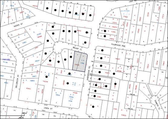
|
NOTIFICATION PLAN |
|
||
|
• PROPERTIES NOTIFIED
|
X SUBMISSIONS RECEIVED |
PROPERTY SUBJECT OF DEVELOPMENT |
|
|
ONE SUBMISSION WAS RECEIVED OUT OF MAP RANGE |
|||
The submission objected to the development, generally on the following grounds that the development would result in: -
· Poor dwelling workmanship which leads to constant reselling of the units;
· Increase in vandalism and ‘joy rides’ on the local roads;
· Insufficient parking, and
· Traffic.
The merits of the matters raised in community submissions have been addressed in the body of the report.
5.2 Public Agencies
The proposal was referred to NSW Police Force for comments whereby no objections were raised.
6. THE PUBLIC INTEREST
Section 79C(1)(e) of the Act requires Council to consider “the public interest”.
The public interest is an overarching requirement, which includes the consideration of the matters discussed in this report. Implicit to the public interest is the achievement of future built outcomes adequately responding to and respecting the future desired outcomes expressed in environmental planning instruments and development control plans.
The application is considered to have satisfactorily addressed Council’s and relevant agencies’ criteria and would provide a development outcome that, on balance, would result in a positive impact for the community. Accordingly, it is considered that the approval of the proposed development would be in the public interest.
CONCLUSION
The proposal is for the demolition of existing structures and construction of a five storey residential flat building comprising 34 units with basement car parking and strata subdivision.
The proposed development is considered satisfactory in respect to achieving the Housing Strategy DCP desired future character of the Belair Close Housing Precinct together with the outcomes for design quality, site requirements, height, setbacks, landscaping, floor plates and separations, articulation, open space, privacy, sunlight and ventilation, housing choice and vehicle access and parking. The non-compliance with the prescriptive measures for height and setbacks is considered acceptable on merit.
The proposed development is in accordance with the SEPP 65 design principles and the best practice benchmarks of the Residential Flat Design Code. The scale, built form and presentation of the development to Belair Close and Sherbrook Road would establish an appropriate pattern with regard to the approved and future developments within the precinct.
The notification of the application received considerable public interest. The proposal is considered generally acceptable in respect to neighbourhood amenity and Council’s planning controls for a medium to high density residential environment.
The application is recommended for approval.
Note: At the time of the completion of this planning report, no persons have made a Political Donations Disclosure Statement pursuant to Section 147 of the Environmental Planning and Assessment Act 1979 in respect of the subject planning application.
|
Rod Pickles Manager - Development Assessment Planning Division |
Simon Evans Acting Group Manager Planning Division |
|
1.View |
Locality Map |
|
|
|
2.View |
Survey Plan |
|
|
|
3.View |
Landscape Concept Plan |
|
|
|
4.View |
Cover Page - BASIX Schedule |
|
|
|
5.View |
Floor Plans |
|
|
|
6.View |
Roof Plan |
|
|
|
7.View |
Elevations and Sections |
|
|
|
8.View |
Height Limit Study |
|
|
|
9.View |
Block Model and Material Legend |
|
|
|
10.View |
Shadow Diagrams |
|
|
File Reference: DA/1031/2013
Document Number: D02915290
SCHEDULE 1
GENERAL CONDITIONS
The conditions of consent within this notice of determination have been applied to ensure that the use of the land and/or building is carried out in such a manner that is consistent with the aims and objectives of the relevant legislation, planning instruments and council policies affecting the land and does not disrupt the amenity of the neighbourhood or impact upon the environment.
Note: For the purpose of this consent, the term ‘applicant’ means any person who has the authority to act on or the benefit of the development consent.
Note: For the purpose of this consent, any reference to an Act, Regulation, Australian Standard or publication by a public authority shall be taken to mean the gazetted Act or Regulation, or adopted Australian Standard or publication as in force on the date that the application for a construction certificate is made.
1. Approved Plans and Supporting Documentation
The development must be carried out in accordance with the plans and documentation listed below and endorsed with Council’s stamp, except where amended by Council and/or other conditions of this consent:
Approved Plans
|
Plan No. |
Plan Title |
Drawn by |
Dated |
|
12490 |
Plan showing detail and levels over Lot 2 in DP 204624 and Lot 1 and 2 in SP 39068 Nos. 1/1, 2/1 and 3 Belair Close, Hornsby |
SurveyPlus – Surveyors, Planners and Engineers |
15.07.2013 |
|
DA-D:00 - Issue D |
Cover Page, BASIX Schedule |
Zhinar Architects |
01.05.2014 |
|
DA-D:01 - Issue D |
Basement Level 2 |
Zhinar Architects |
01.05.2014 |
|
DA-D:02 - Issue D |
Basement Level 1 |
Zhinar Architects |
01.05.2014 |
|
DA-D:03 - Issue D |
Lower Ground Level |
Zhinar Architects |
01.05.2014 |
|
DA-D:04 - Issue D |
Ground Level |
Zhinar Architects |
01.05.2014 |
|
DA-D:05 - Issue D |
Level 1 |
Zhinar Architects |
01.05.2014 |
|
DA-D:06 - Issue D |
Level 2 |
Zhinar Architects |
01.05.2014 |
|
DA-D:07 - Issue D |
Level 3 |
Zhinar Architects |
01.05.2014 |
|
DA-D:08 - Issue D |
Level 4 |
Zhinar Architects |
01.05.2014 |
|
DA-D:09 - Issue D |
Roof Plan |
Zhinar Architects |
01.05.2014 |
|
DA-D:10 - Issue D |
North and East Elevations |
Zhinar Architects |
01.05.2014 |
|
DA-D:11 - Issue D |
South and West Elevations |
Zhinar Architects |
01.05.2014 |
|
DA-D:12 - Issue D |
Section A-A |
Zhinar Architects |
01.05.2014 |
|
DA-D:13 - Issue D |
Section B-B |
Zhinar Architects |
01.05.2014 |
|
DA-D:14 - Issue D |
Section C-C |
Zhinar Architects |
01.05.2014 |
|
DA-D:15 - Issue D |
Height Limit Study |
Zhinar Architects |
01.05.2014 |
|
DA-D:16 - Issue D |
Block Model and Material Legend |
Zhinar Architects |
01.05.2014 |
|
13149 DA 1 - Revision C |
Landscape Concept Plan |
Vision Dynamics Pty Ltd – Landscape Design |
04.03.2014 |
|
Reference No. 9033a |
Appendix F – Site Plan B Survey of Trees to be retained and tree protection plan |
RedGum Horticultural Arboriculture and Horticulture Consultants |
24 January 2014 |
Supporting Documentation
|
Document Title |
Prepared by |
Dated |
|
Arboricultural Impact Assessment (Revised) |
Redgum Horticultural - Arboriculture and Horticulture Consultants |
24 January 2014 |
|
Overland Flow Study – Revision B |
HKMA - Engineers |
January 2014 |
|
Stormwater Drainage Layout Drawing Basement Level and Pump out Tank Plan and Section Details and Notes – Issue B |
HKMA - Engineers |
30/01/2014 |
|
Stormwater Drainage Layout Drawing Lower Ground Level – Issue B |
HKMA - Engineers |
30/01/2014 |
|
Stormwater Drainage Layout Drawing Ground Level – Issue B |
HKMA - Engineers |
30/01/2014 |
|
OSD Tank Plan and Section Details and Overland Flow path section Details – Issue B |
HKMA - Engineers |
30/01/2014 |
|
Access Compliance Assessment Report |
Certified Building Specialists |
19 September 2013 |
|
DA Acoustic Assessment |
Acoustic Logic |
10/09/2013 |
|
BASIX Certificate No. 505398M_02 |
Designview |
30 September 2013 |
|
Nathers Rating Table 14750075 |
Robert Mallindine |
04/05/2014 |
|
Thermal Performance Specifications - Certificate No. 14570040 |
Robert Mallindine |
04/05/2014 |
|
Waste Management Plan |
CBD Core Pty Ltd |
_ |
2. Section 94 Development Contributions
In accordance with Section 80A(1) of the Environmental Planning and Assessment Act 1979 and the Hornsby Shire Council Section 94 Development Contributions Plan 2012-2021, the following monetary contributions shall be paid to Council to cater for the increased demand for community infrastructure resulting from the development:
|
Description |
Contribution (4) |
|
Local Roads |
$34,793.90 |
|
Open Space and Recreation |
$393,389.30 |
|
Community Facilities |
$55,140.45 |
|
Plan Preparation and Administration |
$1,607.90 |
|
TOTAL |
$484,931.55 |
being for 34 units comprising 4 x 1-bedroom units, 25 x 2 bedroom units and 5 x 3 bedroom units and credit for 3 dwellings.
a) If the contributions are not paid within the financial quarter that this consent is granted, the contributions payable will be adjusted in accordance with the provisions of the Hornsby Shire Council Section 94 Development Contributions Plan and the amount payable will be calculated at the time of payment in the following manner:
$CPY = $CDC x CPIPY
CPIDC
Where:
$CPY is the amount of the contribution at the date of Payment.
$CDC is the amount of the contribution as set out in this Development Consent.
CPIPY is the latest release of the Consumer Price Index (Sydney – All Groups) at the date of Payment as published by the ABS.
CPIDC is the Consumer Price Index (Sydney – All Groups) for the financial quarter at the date of this Development Consent.
b) The monetary contributions shall be paid to Council:
i) prior to the issue of the Subdivision Certificate where the development is for subdivision; or
ii) prior to the issue of the first Construction Certificate where the development is for building work; or
iii) prior to issue of the Subdivision Certificate or first Construction Certificate, whichever occurs first, where the development involves both subdivision and building work; or
iv) prior to the works commencing where the development does not require a Construction Certificate or Subdivision Certificate.
It is the professional responsibility of the Principal Certifying Authority to ensure that the monetary contributions have been paid to Council in accordance with the above timeframes.
Council’s Development Contributions Plan may be viewed at www.hornsby.nsw.gov.au or a copy may be inspected at Council’s Administration Centre during normal business hours.
3. Project Arborist
A Project Arborist is to be appointed in accordance with AS 4970-2009 (Clause 1.4.4) to provide monitoring and certification throughout the development process.
REQUIREMENTS PRIOR TO THE ISSUE OF A CONSTRUCTION CERTIFICATE
4. Building Code of Australia
All building work must be carried out in accordance with the relevant requirements of the Building Code of Australia.
5. Contract of Insurance (Residential Building Work)
In the case of residential building work for which the Home Building Act 1989 requires there to be a contract of insurance in force in accordance with Part 6 of that Act, that such a contract of insurance is in force before any building work authorised to be carried out by the consent commences.
6. Water/Electricity Utility Services
The applicant must submit written evidence of the following service provider requirements:
a) Ausgrid (formerly Energy Australia) – a letter of consent demonstrating that satisfactory arrangements have been made to service the proposed development.
7. Adaptable Units
The details of fit-outs of all accessible units and details of adaptable units must be provided with the Construction Certificate plans.
8. Dilapidation Report
A ‘Dilapidation Report’ is to be prepared by a ‘chartered structural engineer’ detailing the structural condition of all adjoining properties.
9. Preservation of Survey Infrastructure
Prior to the issue of a construction certificate, a registered surveyor shall identify all survey marks in the vicinity of the proposed development. Any survey marks required to be removed or displaced as a result of the proposed development shall be undertaken by a registered surveyor in accordance with Section 24 (1) of the Surveying and Spatial Information Act 2002 and following the Surveyor General’s Directions No.11 – "Preservation of Survey Infrastructure".
10. Waste Management Details
The following waste management requirements must be complied with:
a) The garbage chute system must include volume handling equipment fitted with at least 2 x 660 L bins.
b) There should be a waste facility separate to the garbage room on the lower ground level.
Note: It is recommended that the waste facility consist of a recycling bin in a cupboard (with a door on both sides so the caretaker can easily retrieve the recycling bin directly into the bin room) and a garbage chute that drops into a bin in the bin room on the other side of the wall.
11. Traffic Management Plan
A Construction Traffic Management Plan detailing construction vehicle routes, number of trucks, hours of operation, access arrangements and traffic control should be submitted to Council prior to the issue of a construction certificate.
REQUIREMENTS PRIOR TO THE COMMENCEMENT OF ANY WORKS
12. Erection of Construction Sign
A sign must be erected in a prominent position on any site on which building work, subdivision work or demolition work is being carried out:
a) Showing the name, address and telephone number of the principal certifying authority for the work;
b) Showing the name of the principal contractor (if any) for any demolition or building work and a telephone number on which that person may be contacted outside working hours; and
c) Stating that unauthorised entry to the work site is prohibited.
Note: Any such sign is to be maintained while the building work, subdivision work or demolition work is being carried out, but must be removed when the work has been completed.
13. Erosion and Sediment Control
Erosion and sediment control measures must be provided and maintained throughout the construction period in accordance with the manual ‘Soils and Construction 2004 (Bluebook)’, the approved plans, Council specifications and to the satisfaction of the principal certifying authority. The erosion and sediment control devices must remain in place until the site has been stabilised and revegetated.
Note: On the spot penalties up to $1,500 may be issued for any non-compliance with this requirement without any further notification or warning.
14. Protection of Adjoining Areas
A temporary hoarding, fence or awning must be erected between the work site and adjoining lands before the works begin and must be kept in place until after the completion of the works if the works:
a) Could cause a danger, obstruction or inconvenience to pedestrian or vehicular traffic.
b) Could cause damage to adjoining lands by falling objects.
c) Involve the enclosure of a public place or part of a public place.
Note: Notwithstanding the above, Council’s separate written approval is required prior to the erection of any structure or other obstruction on public land.
15. Toilet Facilities
Toilet facilities must be available or provided at the works site before works begin and must be maintained until the works are completed at a ratio of one toilet for every 20 persons employed at the site. Each toilet must:
a) be a standard flushing toilet connected to a public sewer; or
b) be a temporary chemical closet approved under the Local Government Act 1993; or
c) have an on-site effluent disposal system approved under the Local Government Act 1993.
16. Tree Protection Barriers
Tree protection fencing must be erected around tree/s numbered T1 to be retained in accordance with Appendix F – Site Plan B, Tree Protection Plan and installed in accordance with the requirements of Section 5.13 and 5.14 of the Arboricultural Impact Assessment, prepared by Redgum Horticultural Consultants dated 24 January 2014.
17. Tree Ground Protection
Prior to works commencing and throughout construction, the area of TPZ (located on the property) of tree T1 is to be protected by the use of wood-chip mulch in accordance with Section 5.13 of the Arboricultural Impact Assessment, prepared by Redgum Horticultural Consultants dated 24 January 2014.
Note: A certificate from the Project Arborist is to be submitted to the Principal Certifying Authority stating that all tree protection measures are in accordance with the above and consistent with the intentions of the Australian Standard ‘Protection of Trees on Development Sites (AS 4970-2009) prior to commencement of works.
REQUIREMENTS DURING CONSTRUCTION
18. Construction Work Hours
All work on site (including demolition and earth works) must only occur between 7am and 5pm Monday to Saturday. No work is to be undertaken on Sundays or public holidays.
19. Demolition
All demolition work must be carried out in accordance with “Australian Standard 2601-2001 – The Demolition of Structures” and the following requirements:
a) Demolition material must be disposed of to an authorised recycling and/or waste disposal site and/or in accordance with an approved waste management plan;
b) Demolition works, where asbestos material is being removed, must be undertaken by a contractor that holds an appropriate licence issued by WorkCover NSW in accordance with Chapter 10 of the Occupational Health and Safety Regulation 2001 and Clause 29 of the Protection of the Environment Operations (Waste) Regulation 2005 ;and
c) On construction sites where buildings contain asbestos material, a standard commercially manufactured sign containing the words ‘DANGER ASBESTOS REMOVAL IN PROGRESS’ measuring not less than 400mm x 300mm must be erected in a prominent position visible from the street.
20. Environmental Management
The site must be managed in accordance with the publication ‘Managing Urban Stormwater – Landcom (March 2004) and the Protection of the Environment Operations Act 1997 by way of implementing appropriate measures to prevent sediment run-off, excessive dust, noise or odour emanating from the site during the construction of the development.
21. Street Sweeping
Street sweeping must be undertaken following sediment tracking from the site along Belair Close and Sherbrooke Road during works and until the site is established.
22. Landfill
Landfill must be constructed in accordance with Council’s ‘Construction Specification 2005’ and the following requirements:
a) All fill material imported to the site is to wholly consist of Virgin Excavated Natural Material (VENM) as defined in Schedule 1 of the Protection of the Environment Operations Act 1997 or a material approved under the Department of Environment and Climate Change’s general resource recovery exemption.
b) A compaction certificate is to be obtained from a geotechnical engineer verifying that the specified compaction requirements have been met.
23. Excavated Material
All excavated material removed from the site must be classified in accordance with the Department of Environment, Climate Change and Water NSW Waste Classification Guidelines prior to disposal to an approved waste management facility and reported to the principal certifying authority.
24. Survey Report – Finished Floor Level
A report(s) must be prepared by a registered surveyor and submitted to the principal certifying authority prior to the pouring of concrete at each level of the building certifying that:
a) The building, retaining walls and the like have been correctly positioned on the site; and
b) The finished floor level(s) are in accordance with the approved plans.
25. Council Property
During construction works, no building materials, waste, machinery or related matter is to be stored on the road or footpath. The public reserve is to be kept in a clean, tidy and safe condition at all times.
Note: This consent does not give right of access to the site via Council’s park or reserve. Should such access be required, separate written approval is to be obtained from Council.
26. Disturbance of Existing Site
During construction works, the existing ground levels of open space areas and natural landscape features, (including natural rock-outcrops, vegetation, soil and watercourses) must not be altered unless otherwise nominated on the approved plans.
27. Waste Management Details
Waste management during the demolition and construction phase of the development must be undertaken in accordance with the approved Waste Management Plan. Additionally written records of the following items must be maintained during the removal of any waste from the site and such information submitted to the Principal Certifying Authority within fourteen days of the date of completion of the works:
a) The identity of the person removing the waste.
b) The waste carrier vehicle registration.
c) Date and time of waste collection.
d) A description of the waste (type of waste and estimated quantity).
e) Details of the site to which the waste is to be taken.
f) The corresponding tip docket/receipt from the site to which the waste is transferred (noting date and time of delivery, description (type and quantity) of waste).
g) Whether the waste is expected to be reused, recycled or go to landfill.
Note: In accordance with the Protection of the Environment Operations Act 1997, the definition of waste includes any unwanted substance, regardless of whether it is reused, recycled or disposed to landfill.
28. Construction Vehicles
All construction vehicles associated with the proposed development are to be contained on site as no construction zones will be permitted on Belair Close or Sherbrook Road in the vicinity of the site.
29. Work Near Trees
All required tree protection measures are to be maintained in good condition for the duration of the construction period.
All works must remain outside the fenced Tree Protection Zone Appendix F – Site Plan B, Tree Protection Plan Arboricultural Impact Assessment, prepared by Redgum Horticultural Consultants dated 24 January 2014.
30. Root Pruning
No tree root greater than 40mm diameter located within the nominated TPZ of any tree to be retained on or off-site shall be severed or injured in the process of any works during the entirety of the consent.
Tree roots less than 40mm diameter required to be severed for the purposes of this consent shall be cut cleanly by hand under supervision of the Project Arborist. All pruning shall be undertaken as specified in the Australian Standard ‘Pruning of Amenity Trees’ (AS 4373-2007).
Note: Except as provided above, the applicant is to ensure that no excavation, including sub-surface trenching for stormwater or other services or stockpiling of building materials, parking of vehicles or plant, the use of machinery other than hand held, disposal of cement slurry, waste water or other contaminants is to occur within the Tree Protection Zone of any tree to be retained.
REQUIREMENTS PRIOR TO THE ISSUE OF AN OCCUPATION CERTIFICATE
Note: For the purpose of this consent, a reference to ‘occupation certificate’ shall not be taken to mean an ‘interim occupation certificate’ unless otherwise stated.
31. Fulfilment of BASIX Commitments
The applicant must demonstrate the fulfilment of BASIX commitments pertaining to the development.
32. Sydney Water – s73 Certificate
An s73 Certificate must be obtained from Sydney Water.
Note: Sydney Water requires that s73 applications are to be made through an authorised Sydney Water Servicing Coordinator. Refer to www.sydneywater.com.au or telephone 13 20 92 for assistance.
33. Damage to Council Assets
Any damage caused to Council’s assets as a result of the construction of the development must be rectified in accordance with Council’s Civil Works Specifications. Council’s Restorations Supervision must be notified for a formwork inspection prior to pouring concrete.
34. Stormwater Drainage
The stormwater drainage system for the development must be designed and constructed for an average recurrence interval of 20 years and be gravity drained in accordance with the following requirements:
a) Connected to an existing Council piped drainage system via an on site detention system.
b) For connection to Council pit, a construction certificate application is to be submitted to Council (as council is the authority to approve a plan for connection to Council system).
c) Be designed by a qualified Hydraulic Engineer.
35. On-site Stormwater Detention
An on-site stormwater detention system must be designed by a chartered civil engineer and constructed in accordance with the following requirements:
a) Storage capacity to accommodate volume from up to 20 years ARI (average recurrence interval) and a maximum discharge (when full) limited to 5 years pre development rate.
b) Have a surcharge/inspection grate located directly above the outlet.
c) Discharge from the detention system to be controlled via 1 metre length of pipe, not less than 50 millimetres diameter or via a stainless plate with sharply drilled orifice bolted over the face of the outlet discharging into a larger diameter pipe capable of carrying the design flow to an approved Council system.
d) Where above ground and the average depth are greater than 0.3 metres, a ‘pool type’ safety fence and warning signs to be installed.
e) Not be constructed in a location that would impact upon the visual or recreational amenity of residents.
f) Detail calculations are to be shown in Construction Certificate plan.
36. Flooding – Overland Flow Path and Flood Proofing
a) A 100 year ARI overland flow path, based on the report from HKMA Engineers, Revision A, May 2013 is to be constructed to ensure uninterrupted flow through the property.
b) Any structural wall/bund wall (to prevent overland flow entering the development) abutting the overland flow path shall be flood proofed in accordance with Floodplain Development Manual of New South Wales Government.
c) All fences within the overland flow path shall be swimming pool type.
d) All works are to be carried out in accordance to the report by H K M A Engineers, Revision B, January 2014 and drawing No 1646-DA, SW004, Issue B. .
e) A construction certificate is to be submitted to Council for approval.
f) A works as executed plan is to be submitted to Council.
Note: Council is the only authority to approve works within Council roads and easements.
37. Vehicular Crossing
A separate application under the Local Government Act, 1993 and the Roads Act, 1993 must be submitted to Council for the installation of a new vehicular crossing and the removal of the redundant crossing. The vehicular crossing must be constructed in accordance with Council’s Civil Works Design, 2005 and the following requirements
a) Any redundant crossings to be replaced with integral kerb and gutter.
b) The footway area to be restored by turfing.
c) Approval obtained from all relevant utility providers that all necessary conduits be provided and protected under the crossing.
Note: An application for a vehicular crossing can only be made to one of Council’s Authorised Vehicular Crossing Contractors. You are advised to contact Council on 02 9847 6940 to obtain a list of contractors.
38. Internal Driveway/Vehicular Areas
The driveway and parking areas on site must be designed in accordance with Australian Standards 2890.1, 2890.2, 3727 and the following requirements:
a) Design levels at the front boundary are to be obtained from Council.
39. Road Works
All road works approved under this consent must be constructed in accordance with Council’s Civil Works Design and Construction Specification, 2005 and the following requirements:
a) Kerb and gutter along Belair Close and Sherbrook Road frontages are to be replaced. The existing road pavement to be sawn cut a minimum of 300 mm from the existing edge of the bitumen and reconstructed.
b) Concrete footpath along Belair Close is to be constructed. All damaged sections of footpath along Sherbrook Road are to be replaced.
c) A construction certificate is to be submitted to Council for approval.
Note: Council is the only authority to approve works within Council roads.
40. Traffic Control Plan
A Traffic Control Plan (TCP) must be prepared by a qualified traffic controller in accordance with the Roads & Traffic Authority’s Traffic Control at Worksites Manual 1998 and Australian Standard 1742.3 for all work on a public road and be submitted to Council. The TCP must detail the following: -
a) Arrangements for public notification of the works.
b) Temporary construction signage.
c) Permanent post-construction signage.
d) Vehicle movement plans.
e) Traffic management plans.
f) Pedestrian and cyclist access/safety.
41. Works as Executed Plan
A works-as-executed plan(s) must be prepared by a registered surveyor and submitted to Council for completed road pavement, kerb & gutter, overland flow path, drainage systems, driveways and on-site detention system.
42. Foundations of Structure within Council’s Stormwater Pipe Zone of Influence
Foundation of structure in the proximity of Council stormwater pipe shall be carried out by a Chartered Structural Engineer of the Institution of Engineers, Australia ensuring that the Council pipes are not impacted.
After completion of works, a certificate from a Chartered Professional Structural Engineer of the Institution of Engineers, Australia confirming that works have been carried out in a manner that no impact has been created on Council drainage system.
43. Creation of Easements
The following matter(s) must be nominated on the plan of subdivision under s88B of the Conveyancing Act 1919:
a) A restriction over the pipeline and the flow path for a 100 year average recurrence interval storm. The "Restriction on the Use of Land" over the affected lots is to prohibit the alteration of the final floodway shape, the bund wall (to prevent overland flow entering the development) and the erection of any structures, including fencing, in the floodway without the written permission of Council. The terms of this restriction must be obtained from Council.
b) A positive covenant is to be created on the title to maintain the bund wall (to prevent stormwater from entering the development) in flood proofed state in accordance with Floodplain Development Manual of New South Wales Government and the height of the wall maintained to the level shown in the plan, prepared by H K M A Engineers, Revision B, January 2014, drawing No 1646-DA, SW004, Issue B.
c) The creation of an appropriate "Positive Covenant" and "Restriction as to User" over the constructed on-site detention/retention systems and outlet works, within the lots in favour of Council in accordance with Council’s prescribed wording. The position of the on-site detention system is to be clearly indicated on the title.
d) To register the OSD easement, the restriction on the use of land “works-as-executed” details of the on-site-detention system must be submitted verifying that the required storage and discharge rates have been constructed in accordance with the design requirements. The details must show the invert levels of the on site system together with pipe sizes and grades. Any variations to the approved plans must be shown in red on the “works-as-executed” plan and supported by calculations.
Note: Council must be nominated as the authority to release, vary or modify any easement, restriction or covenant.
44. Certificate of Preservation of Survey Marks
A certificate by a Registered Surveyor shall be submitted to the Principal Certifying Authority, certifying that there has been no removal, damage, destruction, displacement or defacing of the existing survey marks in the vicinity of the proposed development or otherwise the re-establishment of damaged, removed or displaced survey marks has been undertaken in accordance with the Surveyor General’s Direction No.11 – “Preservation of Survey Infrastructure”.
45. Garbage Collection Easement
For the purpose of waste collection, an easement entitling Council, its servants and agents and persons authorised by it to enter upon the subject land and to operate thereon, vehicles and other equipment for the purposes of garbage collection must be granted to Council by the owner of the land.
Note: The easement must be in a form prescribed by Council and must include covenants to the effect that parties will not be liable for any damage caused to the subject land or any part thereof or to any property located therein or thereon by reason of the operation thereon of any vehicle or other equipment used in connection with the collection of garbage and to the effect that the owner for the time being of the subject land shall indemnify the Council, its servants, agents and persons authorised by it to collect garbage against liability in respect of any such claims made by any person whomsoever.
46. Waste Management Details
The following waste management requirements must be complied with:
a) The bin storage room at the lower ground level must include water or a hose for cleaning, graded floors with drainage to sewer, a robust door, sealed and impervious surface, adequate lighting and ventilation, and must be lockable. The waste facility rooms at each residential level must include sealed and impervious surface, adequate lighting and ventilation.
b) A report must be prepared by an appropriately qualified person, certifying the following:
i) A comparison of the estimated quantities of each waste type against the actual quantities of each waste type.
Note: Explanations of any deviations to the approved Waste Management Plan is required to be included in this report
ii) That at least 60% of the waste generated during the demolition and construction phase of the development was reused or recycled.
Note: If the 60% diversion from landfill cannot be achieved in the Construction Stage, the Report is to include the reasons why this occurred and certify that appropriate work practices were employed to implement the approved Waste Management Plan. The Report must be based on documentary evidence such as tipping dockets/receipts from recycling depots, transfer stations and landfills, audits of procedures etc. which are to be attached to the report.
iii) All waste was taken to site(s) that were lawfully permitted to accept that waste.
c) Each unit must be provided with an indoor waste/recycling cupboard for the interim storage of a minimum one day’s waste generation with separate containers for general waste and recyclable materials.
d) Space must be provided for either individual compost containers for each unit or a communal compost container;
Note: The location of the compost containers should have regard for potential amenity impacts.
e) The bin carting routes must be devoid of any steps.
Note: Ramps between different levels are acceptable.
f) Access to the waste volume handling equipment by unauthorised persons (including residents and waste collectors) must be prevented.
Note: Caging of the volume handling equipment is acceptable.
47. Planter Boxes/On-Slab Planting
On slab planter boxes must include waterproofing, subsoil drainage (proprietary drainage cell, 50mm sand and filter fabric) automatic irrigation, minimum 500mm planting soil for shrubs and minimum 1000mm planting soil for trees and palms and 75mm mulch to ensure sustainable landscape is achieved.
48. Tree Planting
a) Tree planting to the Belair Close landscape setback areas must include four (4) additional Backhousia citriadora (Lemon scented Myrtle) shall be installed at minimum 25 litre pot size.
b) Tree planting to the Sherbrook Road landscape setback areas must include two (2) additional Angophora costata (Sydney Red Gum). Trees shall be installed at minimum 25 litre pot size.
c) Tree planting to the southern boundary landscape setback areas must include two (2) additional Angophora floribunda (Rough barked apple). Trees shall be installed at minimum 25 litre pot size.
49. Street Tree Plantings
a) Planting to the Belair verge must include three (3) Angophora costata (Sydney Red Gum). Trees shall be installed at minimum 45 litre pot size. Trees shall be located to ensure driver sightlines from driveway in Belair close are not blocked and trees allow for footpath construction.
b) Planting to the Sherbrook Road verge must include two (2) Tristaniopsis laurina (Water Gums). Trees shall be installed at minimum 45 litre pot size.
50. Completion of Landscaping
A certificate must be provided by a practicing landscape architect or person with similar qualifications and experience certifying that all required landscaping works have been satisfactorily completed in accordance with the approved landscape plans.
51. Final Certification
The project arborist must assess the condition of trees and their growing environment and make recommendations for, and if necessary carry out remedial actions.
Following the final inspection and the completion of any remedial works, the project arborist must submit to the Principal Certifying Authority documentation stating that the completed works have been carried out in compliance with the approved plans and specifications for tree protection as above and AS 4970-2009.
OPERATIONAL CONDITIONS
52. Noise
All noise generated by the proposed development must be attenuated to prevent levels of noise being emitted to adjacent premises which possess tonal, beating and similar characteristics or which exceeds background noise levels by more than 5dB(A).
53. Disabled Parking
All parking spaces for people with disabilities must be constructed and operated in accordance with Australia Standard AS?NZ 2890.6:2009 – Off-street parking for people with disabilities.
54. Fire Safety Statement - Annual
On at least one occasion in every 12 month period following the date of the first ‘Fire Safety Certificate’ issued for the property, the owner must provide Council with an annual ‘Fire Safety Certificate’ to each essential service installed in the building.
55. Waste Management
The waste management on site must be in accordance with the following requirements:
a) A site caretaker must be employed and be responsible for moving bins where and when necessary, washing bins and maintaining waste storage areas, ensuring the chute system and related devices are maintained in effective and efficient working order, managing the communal composting area, managing the bulky item storage area, arranging the prompt removal of dumped rubbish, and ensuring all residents are informed of the use of the waste management system.
56. Car Parking
All car parking must be constructed and operated in accordance with Australian Standard AS/NZS 2890.1:2004 – Off-street car parking and Australian Standard AS 2890.2:2002 – Off-street commercial vehicle facilities.
a) All parking areas and driveways are to be sealed to an all weather standard, line marked and signposted;
b) Car parking, loading and manoeuvring areas to be used solely for nominated purposes;
c) Vehicles awaiting loading, unloading or servicing shall be parked on site and not on adjacent or nearby public roads;
d) All vehicular entry on to the site and egress from the site shall be made in a forward direction.
57. Parking Management
a) Any proposed landscaping and/or fencing must not restrict sight distance to pedestrians and cyclists travelling along the footpath.
b) Residential parking spaces are to be secure spaces with access controlled by card or numeric pad.
c) Visitors must be able to access the visitor parking spaces in the basement car park at all times.
d) All parking for people with disabilities is to comply with AS/NZS 2890.6:2009 Off-street parking for people with disabilities.
e) Bicycle parking spaces are to be designed in accordance with AS 2890.3-1993.
f) Motorcycle parking spaces are to be designed in accordance with AS 2890.5-1993.
58. Landscape Establishment
The landscape works must be maintained into the future to ensure the establishment and successful growth of plant material to meet the intent of the landscape design. This must include but not be limited to watering, weeding, replacement of failed plant material and promoting the growth of plants through standard industry practices.
– END OF CONDITIONS –
ADVISORY NOTES
The following information is provided for your assistance to ensure compliance with the Environmental Planning and Assessment Act, 1979, Environmental Planning and Assessment Regulation 2000, other relevant legislation and Council’s policies and specifications. This information does not form part of the conditions of development consent pursuant to Section 80a of the Act.
Environmental Planning and Assessment Act, 1979 Requirements
The Environmental Planning and Assessment Act, 1979 requires:
· The issue of a construction certificate prior to the commencement of any works. Enquiries can be made to Council’s Customer Services Branch on 9847 6760.
· A principal certifying authority to be nominated and Council notified of that appointment prior to the commencement of any works.
· Council to be given at least two days written notice prior to the commencement of any works.
· Mandatory inspections of nominated stages of the construction inspected.
· An occupation certificate to be issued before occupying any building or commencing the use of the land.
Long Service Levy
In accordance with Section 34 of the Building and Construction Industry Long Service Payments Act 1986, a ‘Long Service Levy’ must be paid to the Long Service Payments Corporation or Hornsby Council.
Note: The rate of the Long Service Levy is 0.35% of the total cost of the work.
Note: Hornsby Council requires the payment of the Long Service Levy prior to the issue of a construction certificate.
Tree and Vegetation Preservation
In accordance with Clause 5.9 of the Hornsby Local Environmental Plan 2013 a person must not ringbark, cut down, top, lop, remove, injure or wilfully destroy any tree or other vegetation protected under the Hornsby Development Control Plan 2013 without the authority conferred by a development consent or a permit granted by Council.
Note: A tree is defined as a long lived, woody perennial plant with one or relatively few main stems with the potential to grow to a height greater than three metres (3M). (HDCP 1B.6.1.c).
Tree protection measures and distances are determined using the Australian Standard AS 4970:2009, “Protection of Trees on Development Sites”.
Fines may be imposed for non-compliance with both the Hornsby Local Environmental Plan 2013 and the Hornsby Development Control Plan 2013.
Disability Discrimination Act
The applicant’s attention is drawn to the existence of the Disability Discrimination Act. A construction certificate is required to be obtained for the proposed building/s, which will provide consideration under the Building Code of Australia; however, the development may not comply with the requirements of the Disability Discrimination Act. This is the sole responsibility of the applicant.
Dial Before You Dig
Prior to commencing any works, the applicant is encouraged to contact Dial before You Dig on 1100 or www.dialbeforeyoudig.com.au for free information on potential underground pipes and cables within the vicinity of the development site.
Telecommunications Act 1997 (Commonwealth)
If you are aware of any works or proposed works which may affect or impact on Telstra’s assets in any way, you are required to contact: Telstra’s Network Integrity Team on Phone Number 1800810443.
Asbestos Warning
Should asbestos or asbestos products be encountered during demolition or construction works, you are advised to seek advice and information prior to disturbing this material. It is recommended that a contractor holding an asbestos-handling permit (issued by WorkCover NSW) be engaged to manage the proper handling of this material. Further information regarding the safe handling and removal of asbestos can be found at:
Alternatively, telephone the WorkCover Asbestos and Demolition Team on 8260 5885.
House Numbering
House numbering can only be authorised by Council. Before proceeding to number each premise in the development, the allocation of numbers is required to be obtained from Council's Planning Division prior to the issue of a Subdivision Certificate. The authorised numbers are required to comply with Council’s Property Numbering Policy and be displayed in a clear manner at or near the main entrance to each premise.
Telecommunications Act 1997
If you are aware of any works or proposed works, which may affect or impact on Telstra’s assets in any way, you are required to contact Telstra’s network Integrity Team on phone: 1800 810 443.
Group Manager's Report No. PL30/14
Planning Division
Date of Meeting: 14/05/2014
8 REPORTING VARIATIONS TO DEVELOPMENT STANDARDS
EXECUTIVE SUMMARY
· In accordance with NSW Planning and Infrastructure’s Planning Circular PS 08‑14, Council is required to report variations to development standards for development applications approved under delegated authority, which relied upon State Environmental Planning Policy No. 1 – Development Standards (SEPP 1) or Clause 4.6 of the Hornsby Local Environmental Plan - 2013. (HLEP)
· Council’s consideration of this report ensures Council’s obligation to monitor variations to development standards is complied with.
|
THAT the contents of Group Manager’s Report No. PL30/14 be received and noted. |
PURPOSE
The purpose of this report is to advise Council of determined development applications under delegated authority involving a SEPP 1 or Clause 4.6 variation to a development standard for the period 1 January 2014 to 31 March 2014.
DISCUSSION
NSW Planning and Infrastructure’s (P&I) Circular B1, issued in March 1989, requested that councils monitor the use of the Director-General’s assumed concurrence under SEPP 1 on a quarterly basis. This reporting requirement remains effective.
Monitoring of variations to development standards is important to provide P&I and councils with an overview of the manner in which established development standards are being varied and whether the assumed concurrence is being used as intended. This enables Council and P&I to determine whether development standards are appropriate, or whether changes are required.
P&I issued Circular PS 08–014 on 14 November 2008. The purpose of the Circular was to remind councils of their responsibilities to monitor the use of the Director-General’s assumed concurrence under SEPP 1. Councils were reminded of the need to keep accurate records of the use of SEPP 1 and to report on a quarterly basis.
The Circular also provides that councils are required to adopt the following four measures:
1. Establish a register of development applications determined with variations in standards under SEPP 1.
2. Require all development applications where there has been a variation greater than 10% in standards under SEPP 1 to be determined by full council (rather than General Manager or nominated staff member).
3. Provide a report to Council on the development applications determined where there had been a variation in standards under SEPP 1.
4. Make the register of development applications determined with variations in standards under SEPP 1 available to the public on the council’s website.
In accordance with Point 3 of P&I Circular, attached is a list of development applications determined under delegated authority involving a SEPP 1 variation to a development standard for the period 1 January 2014 to 31 March 2014.
A copy of the attachment to this report is also reproduced on Council’s website.
BUDGET
There are no budget implications.
POLICY
This report addresses Council’s reporting obligations for development applications determined where there has been a variation in standards under SEPP 1. Under the HLEP 2013, the application of the provisions of SEPP 1 has been replaced by Clause 4.6 (exceptions to development standards). P&I has advised that the current reporting practice for variation to development standards will continue to apply for applications involving a submission pursuant to Clause 4.6 of the HLEP 2013.
CONCLUSION
Council is required to monitor the manner in which development standards are being varied. This assists in determining whether changes are required to relevant standards. This report provides advice to Council on standards varied under delegated authority which relied upon SEPP 1 or Clause 4.6 of the HLEP during the reporting period from 1 January 2014 to 31 March 2014.
RESPONSIBLE OFFICER
The officer responsible for the preparation of this report is the Acting Group Manager – Planning Division – Simon Evans who can be contacted on 9847 6780.
|
Simon Evans Acting Group Manager Planning Division |
|
|
1.View |
SEPP 1 Returns |
|
|
File Reference: F2004/07599
Document Number: D02908379
Group Manager's Report No. PL33/14
Planning Division
Date of Meeting: 14/05/2014
9 DRAFT VOLUNTARY PLANNING AGREEMENT, 26-30 ORARA STREET AND 39 WAITARA AVENUE, WAITARA
EXECUTIVE SUMMARY
· A draft Voluntary Planning Agreement has been submitted on behalf of the owners of land in relation to Development Application DA/1370/2013 for property Nos. 21-39 Waitara Avenue, Waitara and Nos. 20-30 Orara Street, Waitara.
· The draft Voluntary Planning Agreement proposes the dedication of land zoned RE1 Public Recreation under Hornsby Local Environmental Plan 2013 and known as Property Nos. 26, 28 and 30 Orara Street, Waitara and 39 Waitara Avenue, Waitara at no cost to Council.
· Council has an obligation to acquire the land pursuant to the Land Acquisition (Just Terms Compensation) Act 1991 as the land is reserved for public recreation under Hornsby Local Environmental Plan 2013.
· The land proposed to be dedicated is located within the 1994 Housing Strategy Orara Street Precinct. The western half of the open space area has already been dedicated to Council through previous development applications.
· The draft Voluntary Planning Agreement offers a public benefit by providing an opportunity to facilitate an increase in real open space which can be delivered in the short term. In the absence of the draft Voluntary Planning Agreement, Council would continue to have a financial obligation to acquire the land.
· Council’s solicitor has review the draft Voluntary Planning Agreement and confirms the document provides a reasonable means of securing the dedication. Accordingly, it is recommended that Council exhibit the draft Agreement for public comment.
|
THAT: 1. The draft Voluntary Planning Agreement attached to Group Managers Report PL33/14 be exhibited for 28 days in accordance with the Environmental Planning and Assessment Act 1979. 2. The General Manager be given delegated authority to endorse the exhibition material. 3. Following the exhibition, a report on submissions be presented to Council. |
PURPOSE
The purpose of this Report is to present to Council a draft Voluntary Planning Agreement (“the draft Agreement”) which proposes the dedication of land zoned RE1 Public Recreation at no cost to Council.
BACKGROUND
The Orara Street Precinct formed part of the 1994 Hornsby Shire Housing Strategy where it was envisaged that land for open space would be dedicated to Council as future development of the precinct occurred. Accordingly, open space land within the precinct was not zoned under Hornsby LEP 1994. Instead, the (now repealed) Hornsby Town Centre Development Control Plan (HTC DCP) required a central public open space area to be provided through the middle of the precinct. In accordance with the HTC DCP, the western half of the open space area has been dedicated to Council and embellishment works have been carried out in accordance with Council’s previous Section 94 Plan 2007 (now repealed).
With the introduction of the Standard Instrument LEP and the conversion of the Hornsby LEP 1994 into the State Government’s template, the land identified for central public open space in the Orara Street precinct was zoned RE1 Public Recreation under the Hornsby Local Environmental Plan (HLEP) 2013 in October 2013. The land is also identified on the HELP 2013 Land Acquisition Map which formalises Council’s obligation to acquire the land.
Council does not presently have a financial strategy or timeframe for acquisition of the land. Council’s current Section 94 Plan 2012 – 2021 lists the acquisition and embellishment of a new Local Park, Waitara (OS-018) in the Works Schedule. The location of the park is yet to be determined but the need for the park is attributed to the anticipated additional population generated from the 2011 Housing Strategy rezonings in Waitara (Park Avenue, Balmoral Street and Palmerston Road precincts). Council’s previous Section 94 Plan 2007 (now repealed) did not include the acquisition of the land but made provision for the embellishment, with Stage 1 works completed as discussed above.
DISCUSSION
This report outlines the draft Agreement which proposes the dedication of the remaining open space land within the Orara Street Precinct at no cost to Council. Section 93F of the Environmental Planning and Assessment Act (“the Act”) 1979 defines a planning agreement as:
A voluntary agreement or other arrangement between a planning authority and a person such as a developer:
· who has made, or proposes to make, a Development Application, or
· who has entered into an agreement with, or is otherwise associated with, a person to who has made the Development Application to Council,
under which the developer is required to dedicate land free of cost, pay a monetary contribution, or provide any other public benefit, or any combination of them, to be used for or applied towards a public purpose.
The Act prescribes the content, form, subject matter and procedures for making planning agreements. The draft Agreement submitted by the applicant has been made in accordance with the Act as discussed below.
1. Draft Voluntary Planning Agreement
On 17 April 2014, the applicant submitted a formal letter of offer and draft Voluntary Plan Agreement, pursuant to Section 93I(3) of the Environmental Planning and Assessment Act 1979.
The draft Agreement proposes the dedication of land at no cost to Council for future use as a local park. Timing for the transfer of the dedication lands is proposed prior to the issuing of the first occupation certificate for DA/1370/2013 (“the Development”).
The draft Agreement would not take effect unless DA/1370/2013 is granted, a Construction Certificate is issued and the works commenced.
Security for the draft Agreement is proposed as follows:
· Council can refuse to issue an Occupation Certificate with respect to the Development if the open space land is not dedicated in accordance with the draft Agreement;
· The draft Agreement must be registered on the title of the open space lands; and
· Council can compulsorily acquire the open space lands for $1 if not dedicated to Council in accordance with the requirements of the draft Agreement.
The Winten Property Group is the applicant for the development, however, it does not own the relevant land to be dedicated. Therefore, the draft Agreement makes provision for the transfer of the open space land to Winten (who have options to acquire the land) prior to dedication.
The draft Agreement does not exclude the application of Section 94 and therefore, monetary contributions as required by Council’s Section 94 Development Contributions Plan 2012 – 2021 will continue to apply.
A copy of the draft Agreement and Explanatory Note is provided in Attachment 1.
2. Proposed Development
Development Application DA/1370/2013 has been submitted for the redevelopment of property Nos 21-39 Waitara Avenue and property Nos. 20-30 Orara Street Waitara involving the construction of 3 nine storey residential flat buildings comprising a total of 295 units with basement car parking and the dedication of a public park to Council. The development application is to be determined by the Joint Regional Planning Panel (JRPP).
The site has a total area of 10,064sqm comprising 7,596sqm of land zoned R4 High Density Residential and 2,468sqm of land zoned RE1 Public Recreation under the HLEP 2013. The proposal is defined as a ‘residential flat building’ under the HLEP 2013 and is permissible in the part of the site zoned R4 High Density Residential subject to development consent. No development is proposed on the RE1 Public Recreation zoned land other than the establishment of a public park, which is a use permitted with development consent.
In order to allow for the transfer of the land zoned RE1 at no cost to Council, the proposed development redistributes the development potential that could have otherwise been achieved on the RE1 land, had the site not been zoned for public open space, to the balance of the development.
The proposed development involves a gross building area of 30,195sqm. In comparison, a complying scheme on the R4 zoned land could achieve a gross building area of 22,800sqm. As a result of redistributing the development potential, the proposed development involves variations to Council’s planning controls in relation to building height, footprint widths and setbacks.
Notwithstanding, the proposed development would be consistent with adjoining development sites with respect to building height and scale as approved under the previous Hornsby Local Environmental Plan 1994.
Assessment of the development application is being undertaken by independent external planning consultants to ensure that the offer does not compromise Council’s functions under the Environmental Planning and Assessment Act (“the Act”) 1979. The development application is scheduled to be determined by the JRPP at its meeting of 29 May 2014.
3. Acceptability Test
The Development Contributions Practice Notes 2005 published by the NSW Planning and Infrastructure provide that planning agreements should meet the acceptability test as provided below:
· Be directed towards proper or legitimate planning purposes, ordinarily ascertainable from the statutory planning controls and other adopted planning policies applying to development,
Comment: The open space land is identified within Council’s Hornsby Local Environmental Plan 2013 Land Reservation Acquisition Map. Therefore, dedication of the land to Council is consistent with Council’s adopted strategy to provide for the future open space needs of residents in the locality.
· Provide for public benefits that bear a relationship to development, produce outcomes that meet the general values and expectations of the public and protect the overall public interest,
Comment: The dedication is reliant upon the granting of development consent to be independently determined by the Joint Regional Planning Panel. The open space lands have formed part of Council’s adopted planning strategy since 1994 and will benefit existing and future residents in the locality.
In the future, Council would be able to carry out works to convert the dedicated land into open space for public use. This open space will ultimately provide the missing link between dwellings on Orara Street, and Romsey Street to Waitara Park to the east.
In the absence of the draft Agreement, Council would continue to have a financial obligation to acquire the land and would be required to expend general funds to acquire the land in the future in accordance with the requirements of the Land Acquisition (Just Terms Compensation) Act 1991.
Provide for a reasonable means of achieving the relevant purposes and outcomes and securing the benefits,
Comment: The draft Agreement provides a reasonable means of achieving and securing dedication of the open space land by identifying the subject land, method of security and timing to ensure the public benefits secured by the draft Agreement meet the increased demand for public open space as envisaged by Council’s 1994 Housing Strategy and current HLEP 2013.
· Protect the community against planning harm.
Comment: The draft Agreement provides for interested persons to consider and comment on the merits of the proposal through a public exhibition process.
In summary, the draft Agreement has a positive impact and a community benefit. It provides an opportunity to facilitate an increase in local open space to meet demand. The dedication of the land at no cost to Council means the public open space can be delivered to the community in the short term and reduces Council’s financial obligations concerning the future acquisition of open space.
4. Legal Review
The draft Agreement has been reviewed by Council’s panel solicitor (Marsdens Law Group) to ensure the draft Agreement provides a reasonable means of achieving and securing dedication of the open space.
The following comments were noted by Council’s solicitor:
· Restriction on the grant of an occupation certificate is appropriate security for Council;
· The parties to the draft Agreement being the land owners of the open space land and commercial agreements between the Applicant and land owners are acceptable.
· The associated Development Application (DA/1370/2013) can be determined by the JRPP prior to exhibition and adoption of the draft Agreement by Council.
Suggested administrative amendments identified by Marsdens have been agreed to by the applicant.
CONSULTATION
Should Council endorse the exhibition of the draft Agreement, it will be exhibited for a minimum period of 28 days for public comment. Following the exhibition, an assessment of submissions would be undertaken and a further report prepared detailing any recommended amendments to the draft Agreement. The draft Agreement could then be adopted and executed.
Development Application DA/1370/2013, if approved, would include a condition of consent in relation to the execution of the draft Agreement.
BUDGET
No additional costs would result from the public exhibition of the draft Agreement.
POLICY
There are no policy implications associated with this report.
CONCLUSION
The proposal to dedicate open space lands at no cost to Council is consistent with Council’s existing adopted policies. Whilst the dedication is reliant upon the granting of development consent to DA/1370/2013, the application is being independently assessed and will be determined by the JRPP.
The draft Agreement offers a public benefit by providing an opportunity to facilitate an increase in local open space which can be delivered in the short term.
In the absence of the Agreement, Council would continue to have a financial obligation to acquire the land. At present, there is no financial strategy or timeframe in place for acquisition of the land. Council would be required to expend general funds to acquire the land in the future which may reduce Council’s ability to provide planned open space to meet the future needs of residents in the locality. Given that Council’s solicitor has reviewed the draft Agreement and confirms the document provides a reasonable means of securing the dedication, it is recommended that Council exhibit the draft Agreement for public comment.
RESPONSIBLE OFFICER
The officer responsible for the preparation of this Report is the Manager Strategic Planning – Mr Fletcher Rayner - who can be contacted on 9847 6744.
|
Fletcher Rayner Manager - Strategic Planning Planning Division |
Simon Evans Acting Group Manager Planning Division |
|
1.View |
Attachment 1 - Draft Voluntary Planning Agreement and Explanatory Note |
|
|
File Reference: DA/1370/2013
Document Number: D02932401
Group Manager's Report No. PL35/14
Planning Division
Date of Meeting: 14/05/2014
10 EPPING TOWN CENTRE URBAN ACTIVATION PRECINCT - DRAFT DEVELOPMENT CONTROL PLAN
EXECUTIVE SUMMARY
· On 14 March 2014, State Environmental Planning Policy (Epping Town Centre) 2013 (“the SEPP Amendment”) was published on the NSW Legislation website. The SEPP Amendment applies to both the Hornsby Local Environmental Plan 2013 (HLEP) 2013 and Parramatta Local Environmental Plan (PLEP) 2011.
· The published SEPP Amendment is generally consistent with documents exhibited by NSW Planning and Infrastructure (NSW P&I) with amendments in relation to zoning, building height, floor space ratio and heritage provisions.
· The SEPP Amendment provides opportunities for approximately 3,750 additional dwellings within the Epping Town Centre.
· Council is responsible for the preparation of a development control plan to be read in conjunction with HLEP 2013 as amended. The documents exhibited by NSW P&I included suggested development controls that have been translated into the Hornsby Development Control Plan (HDCP) 2013.
· Council has received significant interest from land owners and developers seeking to develop land in accordance with the final plan. Therefore, it is recommended that Council endorse the proposed amendments to the HDCP 2013 for public exhibition.
|
THAT: 1. Amendments to Draft Hornsby Development Control Plan 2013 attached to Group Manager’s Report No. PL35/14 be exhibited for 28 days. 2. The General Manager be given delegated authority to endorse the exhibition material. 3. Following the exhibition, a report on submissions be presented to Council. |
PURPOSE
The purpose of this report is to summarise the key features and changes to the SEPP Amendment for the Epping Town Centre and to present proposed amendments to HDCP 2013 to be read in conjunction with the HLEP 2013 as amended.
BACKGROUND
In March 2013, the NSW Government announced the identification of eight Urban Activation Precincts (UAPs) across Sydney for renewal, including the Epping Town Centre. Comments on the exhibition package for the draft Epping Town Centre Urban Activation Precinct were sought by NSW P&I until 19 May 2013.
At its meeting on 17 April 2013, Council considered Group Manager’s Report No. 21/13 regarding the draft SEPP Amendment. Council resolved to forward a submission to NSW P&I indicating its general support subject to issues outlined in the report being addressed prior to finalisation, including consistency with Council’s then draft HLEP, feasibility of the Cliff Avenue Precinct, progression of the proposed road and intersection upgrades and inclusion of a delayed commencement provision prior to finalising the SEPP. A submission was subsequently forwarded to NSW P&I on 30 April 2013.
An application for grant funding of $10 million under the Precinct Support Scheme was made in July 2013. NSW P&I has advised that a grant of $2.5 million will be provided consistent with their original commitment to share $50 million between the eight pilot precincts.
On 14 March 2014, the SEPP Amendment for the Epping Town Centre was finalised when published on the NSW Legislation notification website. The SEPP Amendment applies to both the Hornsby HLEP 2013 and PLEP 2011.
DISCUSSION
This report provides the details of the final SEPP Amendment for the Epping Town Centre and proposes a suite of amendments to the HDCP 2013 to guide future development within the Precinct.
1. Epping Town Centre SEPP Amendment
The SEPP Amendment for the Epping Town Centre seeks to facilitate 3,750 additional dwellings within the precinct over the next 20 years, including:
· 2,450 dwellings within the commercial core of the Epping Town Centre (Hornsby and Parramatta LGA);
· 1,300 dwellings within the following residential intensification areas located outside the commercial core (Hornsby LGA):
o Derby Street Precinct
o Essex/Chester Street Precinct
o Essex/Pembroke Street
o Cliff Avenue Precinct
o Forest Grove Precinct
· 11 additional heritage items and 3 new Heritage Conservation Areas (HCAs) within the Hornsby LGA known as:
o East Epping HCA
o Essex Street HCA
o Rosebank Avenue HCA
· Buildings of between 8 and 22 storeys within 400 metres of Epping Station, and up to 5 storeys in other selected areas.
· Local road upgrades to the intersections of Essex Street and Epping Road, Carlingford and Beecroft Roads, and widening of parts of Epping Road.
· Widening of the current Bridge Street rail overpass by removing the pedestrian footways is not feasible according to Roads and Maritime Services (RMS). Further investigation of widening options is ongoing and according to NSW P&I, the NSW Government has committed to funding the upgrade works.
The final report prepared by NSW P&I indicates that 749 submissions were received during the exhibition period held between March and May last year. Key amendments to the exhibited maps and controls include:
Town Centre Core
The following properties have been rezoned from B2 Local Business to R4 High Density Residential:
· 3-5 Pembroke Street – NSW P&I advises that commercial development is unlikely given the heritage listing of the churches, with potential for residential development at the rear of the heritage items.
· 240 – 242 Beecroft Road – NSW P&I advises that retail analysis undertaken by the land owner identified limited opportunity for ground floor retail due to the distance from the railway station, limited pedestrian trade and constrained vehicular access from Carlingford Road. Development controls for building height and floor space ratio remain unchanged.
Outside Town Centre Core
The maximum building height for several properties within the Cliff Road and Forest Grove residential intensification precincts has changed from 12 metres (3 storeys) to 17.5m (5 storeys). NSW P&I considered that the visual and amenity impact of five storey development can be appropriately managed through DCP controls such as increased setbacks and deep soil landscaping.
Consistent with Council’s HLEP 2013, floor space ratio controls for residential areas have been removed and the R4 High Density Residential Zone has been applied within areas where five storey residential flat buildings are proposed.
Heritage Items and Conservation Area
The proposed heritage items at 9-19 Cliff Road, 2-14 Bridge Street, 4 Epping Road, 50 Dorset Street and 86 Essex Street and the existing heritage item at 34 Carlingford Road have not been included as heritage items.
2. Precinct Support Scheme Funding
Councils who partner with the NSW State Government in the UAP Program may be provided payments through the Precinct Support Scheme to fund local infrastructure (both social and economic) to address increased demand for infrastructure and to create high quality urban environments for existing and new residents.
In accordance with this scheme, NSW P&I has offered grant funding of $2.5 million to both Hornsby and Parramatta Councils to be formalised through a Memorandum of Understanding (MoU) which is yet to be finalised. On 3 March 2014, a draft MoU was submitted to NSW P&I for the following works:
· Town Centre Public Domain Guideline;
· Plan of Management for West Epping Park;
· Detailed design and construction documentation for West Epping Park; and
· The tender and appointment of contractors to construct Stage 1 park improvements at West Epping Park.
NSW P&I are yet to return a final MOU for signing. However, should the agreement proceed, commencement of the work could proceed this year with completion by 2016.
3. Proposed Amendments to Hornsby Development Control Plan 2013
Council is responsible for preparing development controls to be read in conjunction with the HLEP 2013. Amendments to the following parts of HDCP 2013 are proposed to incorporate controls translated from Appendix G of the exhibition material prepared by NSW P&I. The controls principally apply to the Town Centre Core area as summarised below.
A copy of the proposed amendments is available for viewing on Council’s website: http://www.hornsby.nsw.gov.au/council/major-projects/epping-town-centre (Trim Reference: D02966361).
Part 1 General
Hornsby and Parramatta Councils currently have different rates for car parking within Epping Town Centre. NSW P&I prepared recommended development controls for Parramatta and Hornsby Councils having regard to the format of each of the Councils’ adopted and draft DCPs, including common car parking rates for the two Councils.
Group Manager’s Report No.21/13 included a review of the draft DCP prepared by NSW P&I and acknowledged that a single set of parking controls for the Epping Town Centre, which satisfies both Councils, would ensure the economic feasibility of development within the Centre is not unfairly impacted by different parking rates and would provide a consistent approach to development across the Centre.
Accordingly, amended car parking rates are proposed that recognise the proximity of future development in the Town Centre Core to public transport routes, retail and other services. The rates are consistent with those already adopted by Parramatta Council.
Part 3 Residential
The Residential part of HDCP 2013 contains controls for residential zoned land. Amendments are required to update the relationship between building height and dwelling type. For example, the SEPP Amendment now permits 3 storey town house developments within the R3 Medium Density Zone, where the existing Hornsby DCP only contemplates 2 storey town houses.
Key Development Principals Diagrams for the new precincts within Epping Town Centre have also been prepared to supplement existing controls in the HDCP 2013.
Part 4 Business
The Business part of HDCP 2013 contains controls for business zoned land. Amendments are required to insert a new section that addresses future character, site requirements, scale, setbacks, open spaces, landscaping, privacy and security, sunlight and ventilation, housing choice, vehicle access and parking, public domain and traffic management works and key development principles within the Town Centre Core.
Part 9 Heritage
The Heritage part of the HDCP 2013 contains provisions relating to listed HCAs and heritage items. Amendments are required to provide controls for the three new HCAs including character statements, statements of significance and prescriptive measures.
Annexures
Pedestrian and Cycle Linkage Diagrams are contained in the Annexures part of HDCP 2013. The amendment provides a new linkage diagram for Epping.
CONSULTATION
Should Council endorse the proposed amendments to HDCP 2013, they would be exhibited for a minimum period of 28 days for public comment. Following the exhibition, an assessment of submissions would be undertaken and a further report prepared detailing any recommended amendments to HDCP 2013. The amendments could then be finalised, adopted and come into force upon publication in a local newspaper.
BUDGET
The costs of public exhibition of the amendments to HDCP 2013 can be met with funds from the 2013/2014 Advertising Budget.
POLICY
There are no policy implications associated with this report.
CONCLUSION
Residents and business owners of Epping have been awaiting the completion of plans for the urban renewal of Epping Town Centre since 2008. Finalisation of the SEPP Amendment and exhibition of development controls represents the final step to implement the vision initially set out within the Epping Town Centre Study adopted by Council in 2011.
Since commencement of the SEPP Amendment on 14 March 2014, Council has received significant interest from land owners and developers seeking to develop land in accordance with the final plan. Therefore, it is recommended that Council proceed to exhibit a draft amendment to the Hornsby Development Control Plan 2013 for public comment.
RESPONSIBLE OFFICER
The officer responsible for the preparation of this Report is the Manager, Strategic Planning – Fletcher Rayner - who can be contacted on 9847 6744.
|
Fletcher Rayner Manager - Strategic Planning Planning Division |
Simon Evans Acting Group Manager Planning Division |
There are no attachments for this report.
File Reference: F2007/00707
Document Number: D02943401
Deputy General Manager's Report No. IR2/14
Infrastructure and Recreation Division
Date of Meeting: 14/05/2014
11 HORNSBY DEVELOPMENT CONTROL PLAN - REVIEW OF TREE AND VEGETATION PROVISIONS
EXECUTIVE SUMMARY
· In 2013, Council resolved to exhibit a list of 22 tree species for proposed additional protection, in response to a report of tree canopy loss monitoring in the year following an amendment to the Tree Preservation Order (‘the TPO’) in 2011.
· The Hornsby Development Control Plan 2013 (‘the DCP’) has replaced the TPO and the proposal to amend the DCP for the protection of the additional tree species failed to gain majority community support (55% in favour of the no change, 45% in favour of additional species for protection).
· A further survey of recent tree canopy loss found that the level of canopy loss has greatly reduced following the 2011 amendment of the TPO, turning what appeared to be a 56% increase in canopy loss to 38% canopy loss when a longer period of time was surveyed.
· The survey of tree canopy loss found that canopy loss has been exceeding replacement for some time regardless of the changes to regulatory provisions Council has made. Upgraded street tree planting to offset this loss is recommended for investigation.
· Recent NSW Government legislative amendments have been designed to deregulate tree protection and Council may wish to take this into account when considering its own tree regulation changes.
· Trees in high value areas seem to be adequately protected despite the decision to remove 14 properties with valuable trees from heritage protection, and no further protection is recommended for trees on these properties.
· A Significant Tree Register that Council has proposed for investigation would not have sufficient legislative force to be an effective tool for tree protection and would add complexity to tree regulation with little or no benefit, and it is not recommended.
· It is recommended that Council not proceed with the addition of 22 tree species to the Hornsby Development Control Plan for protection.
|
THAT: 1. The Hornsby Development Control Plan not be amended to include a further 22 tree species not indigenous to Hornsby Shire for protection, and a Significant Tree Register not be introduced. 2. A report on investigations into an upgraded street tree planting program, its purpose, costs and benefits, to be brought to a Council meeting by July 2014. |
PURPOSE
The chief purpose of this report is to provide the results of the exhibition of the proposed 22 additional tree species for protection. Another purpose is to present and discuss the findings of a recent survey into tree canopy loss. There is also discussion about the effect upon tree protection of recently adopted changes to heritage conservation provisions. The report recommends a response in each of these areas.
BACKGROUND
At the June 2013 General Meeting, Council considered Deputy General Manager’s Report No. IR13/13 on a Review of the 2011 Tree Preservation Order and resolved:
“THAT the list of tree species at Attachment 1 of Deputy General Manager’s Report No. IR13/13 be publicly exhibited for inclusion in an amended Tree Preservation Order and a further report be brought back to Council reporting on the results of the public exhibition.”
At the 21 August 2013 General Meeting, Council considered a Notice of Motion No. 9/13 regarding the Draft Hornsby Development Control Plan Amendment – Tree and Vegetation Preservation and resolved in part that:
“A. 1. The Draft Hornsby Development Control Plan be amended by inserting a list of tree species considered to have cultural heritage value as identified in draft amendments to Council’s Tree Preservation Order as currently being progressed for public consultation.
2. Council exhibit amendments to the Draft Hornsby Development Control Plan concurrently with amendments to the Tree Preservation Order for a minimum period of 28 days.
3. A further report be presented to Council reporting on the results of the public exhibition.”
At the 20 November 2013 General Meeting when considering Group Manager’s Report PL108/13 on Submissions Report – Heritage Review Stage 5 Planning Proposal, Council resolved in part that:
“B. 1. Council investigate the establishment of a Significant Tree Register or alternative mechanism in conjunction with the current review of the Tree and Vegetation Preservation provisions of the Hornsby Development Control Plan 2013 to protect significant trees that are worthy of protection because of their cultural, amenity, biodiversity and landscape values.”
DISCUSSION
In 2011, and following public consultation, Council resolved to amend the Tree Preservation Order so that only tree species indigenous to Hornsby Shire are protected, except for Heritage Conservation Areas, where all tree species are protected. The Tree Preservation Order was subsumed into the Hornsby Local Environmental Plan 2013 (‘the HLEP’) and the Hornsby Development Control Plan (DCP) with almost identical provisions in respect of tree protection. The relevant section of the DCP containing provisions for Tree and Vegetation Preservation, as they stand, is available on Council’s website at hornsby.nsw.gov.au/property/development-applications/hornsby-development-control-planand and is saved in TRIM as D02759668.
Following subsequent monitoring that showed an increase in tree canopy loss, Council resolved to exhibit an amendment to the DCP to include for protection 22 tree species not indigenous to Hornsby Shire and considered to have heritage conservation value. The relevant chapter of the DCP containing the exhibited proposed amendment is at Attachment 1.
The proposal to add a list of tree species considered to have cultural heritage value (hereinafter called ‘additional species’) was then publicly exhibited. In choosing the list of species, there was regard to species that grow large and are commonly grown in Hornsby Shire (those whose preservation therefore would cause a noticeable reduction of canopy loss) and species that are neither notorious environmental weeds, nor are often the culprits in property damage via invasive roots.
The details of the exhibition and the results are explained in the Consultation section of this report.
The proposal to add additional species to the DCP for protection did not receive majority public support. Fewer than half the survey respondents supported the move, and Council may consider this to be reason enough not to proceed with it. Without strong public support, regulatory controls may not meet their objectives.
In addition to the lack of a majority of public support for the protection of the additional species, if adopted it would have the effect of the reversing the main benefit for the community of the 2011 amendment of the TPO, which was to reduce Council’s regulatory control over private property and hand more responsibility for tree management decisions to property owners.
A further consideration is the complexity that would be introduced to tree preservation policy if the amendment was adopted. What is at present a comparatively simple proposition that Council’s consent for removal is only required for trees indigenous to Hornsby Shire and those within Heritage Conservation Areas (HCAs) and on heritage listed properties would be more complex for property owners and for consulting arborists advising them if the additional species also required Council’s consent.
The additional species would add a compliance cost to property owners due to tree application fees applying to these species, and the additional compliance workload would draw Council resources away from other essential work, particularly the management of trees on public land. The increase in compliance cost for property owners risks a weakening of compliance effectiveness.
Latest Survey of Tree Canopy Loss
In 2012, Council considered a report from P & J Smith, ecological consultants, on a survey of tree canopy loss in Hornsby Shire. The survey was undertaken to compare tree loss in the year following the 2011 change to tree protection with the two years before the change. This survey found a 56% increase in tree canopy loss following the 2011 amendment of the TPO.
The consultants were subsequently engaged for a second tree canopy loss survey, extending the survey period over four years (2009-2013). The second survey was conducted using the same sample sites throughout the urban areas of the Shire as were used in the first survey. This extended period of the second tree canopy loss survey gives more accurate information upon which to base decision making. The survey report is at Attachment 2.
The second survey report shows that, while the 2011 changes to tree preservation correspond with a subsequent increase in tree canopy loss, the canopy loss has not increased as much as previously indicated. The first survey found that the tree canopy loss in the first year after the 2011 was 56% greater than the average of the two years prior to the change. In 2013, the second year since the 2011 change produced only a 16% increase over the combined 2009 and 2010 average canopy loss. The average of the increase in tree canopy loss since 2011 is now 38%, not the 56% recorded in the first monitoring.
The latest survey produced no evidence that the 2011 change to tree protection has resulted in an increase in the number of trees removed annually from the urban areas of the Shire, although tree canopy loss had increased. The consultants concluded that the change to tree protection has had a selective effect, resulting in more large trees being removed, but not more trees overall.
A further survey to provide a total of six survey years 2008-2014 would provide an even clearer picture of the trend, to show whether the observed increase in tree canopy loss has slowed.
The consultants examined the effect of construction works on tree canopy loss and concluded that construction in the Shire was not a factor in the increase in tree canopy loss, which was found to be occurring on properties with established development, in the absence of construction at the time of the survey.
The consultant’s report provides further reason for concern that there is a long term trend of tree canopy loss exceeding replacement level, prior to and since the change to tree preservation in 2011. As mentioned however, although more tree canopy has been lost, the number of trees lost has not changed.
Tree canopy loss was lowest in heritage conservation areas such as Beecroft South, with a canopy loss of 27 square metres per hectare compared to the survey-wide average of 82 square metres per hectare. This led the consultants to conclude that the tighter tree protection in the heritage areas reduced tree canopy loss, lending evidence to their conclusion that the 2011 change to tree protection is the reason for the accelerated canopy loss.
Replacement of Tree Canopy Loss
Both the 2012 and 2014 consultant’s reports stressed that the tree canopy loss is exceeding replacement rates, and this would appear to have still been occurring even if the 2011 change to tree protection had not been made by Council.
A possible means to offset that loss and restore some tree canopy would be to increase the level and quality of tree planting in public areas. This could be of most benefit if carried out in town centres such as Epping, Pennant Hills or Hornsby West Side, for example. A thoroughly planned and well executed street planting scheme in these areas of high visitation could not only beautify these areas but provide demonstrations of the amenity value of trees in suburban situations, encouraging the cultivation and preservation of trees on residential land throughout the Shire.
An investigation of costs and benefits of an upgraded tree planting program will be made and a further report prepared for Council consideration.
Preservation of Formerly Heritage-Listed Trees
Group Manager’s Report No. PL108/13, considered by Council in November 2013, discussed the findings of a Heritage Review Stage 5, where it was recommended that some heritage items no longer satisfied the criteria for heritage listing. It recommended the removal of heritage listing on 21 privately owned gardens which no longer satisfy the criteria for heritage significance. Some 14 of these items included large mature trees recommended for inclusion on a Significant Tree Register as an alternative to the DCP which only relates to indigenous tree species except in Heritage Conservation Areas.
It was suggested in the report that the 22 additional species that were exhibited for inclusion in the DCP may go some way to allaying the Heritage Advisory Committee’s concern about protection of these trees. Council adopted the resolution quoted above, asking for investigation of a list of significant trees or other mechanism to protect trees formerly heritage listed.
In considering whether a Significant Tree Register would be of benefit, it is helpful to consider where the register would reside. To have full statutory force, it would reside in the HLEP, which is also where the list of heritage items including the trees on the abovementioned 14 properties currently resides (until gazettal of the amendment to the HELP removes them). That raises the question of whether it is good regulatory practice to remove trees from one list in the HLEP only to reinstate them in a newly created list of Significant Trees. It is submitted that this would not be appropriate.
Including a register in the DCP would not be advisable either. A DCP is designed in the Environmental Planning & Assessment Act 1979 to be a general guideline, not specific for individual properties. It is difficult therefore to identify a way of creating a Significant Tree Register that would have legislative support.
It is submitted that a Significant Tree Register, if instituted, would be subject to lobbying by residents to have neighbouring trees included, or their own trees removed from the register, setting up local conflicts about tree preservation. It could become unwieldy and onerous to administer, transferring responsibility to monitor the condition of trees on private property from the owner to Council.
The exhibited additional species would go some way to protecting some of the trees on this property, but given the case made against including the additional species in the DCP, it is considered that the benefit of protecting trees on these 14 properties does not warrant adding the additional species affecting all properties in the Shire with these additional species growing on them.
Trees in ‘High Value Areas’
A further part of Council’s resolution in response to NOM9/13 was that:
“C. The Group Manager, Environment and Human Services and the Deputy General Manager, Infrastructure and Environment investigate options to mitigate unauthorised removal of vegetation in high value areas.”
For the purposes of tree protection, Council’s gazetted HCAs could be considered to be high value areas. In these areas, all tree species are protected (whereas in the remainder of the Shire, only the 100 or so species indigenous to Hornsby Shire are protected). The Tree Monitoring report mentioned above demonstrated that tree canopy loss in HCAs is only a small fraction of that in the Shire generally, and this could be interpreted as a sign that tree loss is already mitigated in these high value areas.
A further level of protection of trees exists for land identified as "biodiversity" on the HLEP Terrestrial Biodiversity Map that covers vegetation communities identified to be of national, state and regional significance by Smith and Smith, the consultants that were also engaged for the tree canopy loss survey discussed above.
It is difficult to identify effective strategies to deter unauthorised tree removal or destruction, whether in high value areas or elsewhere. Currently, compliance is highly dependent upon residents reporting and querying tree removal in their neighbourhoods. In a few cases each year, fines are issued and usually paid without the matter going to court. This appears to provide some deterrent. Without resident reporting it is not easy to detect unauthorised tree removal. Tree loss monitoring could identify trees that have been removed, but it is likely to be difficult to establish culpability for the removal or whether, post facto, the removed tree was a protected species and not diseased, dying or dangerous. Evidence gathering would rely heavily on oral evidence from the property owner and neighbours.
Given the critical role residents play in reporting tree removal, a community education strategy may be effective in informing the community which trees are protected and encouraging reporting of tree removals. Such a strategy would require increased resources for the education campaign and a response to any increase in the level of resident reporting.
Recent Legislative Change
NSW has introduced, or is considering, changes to regulation around tree protection.
In 2013, amendments to the Exempt and Complying Development State Environmental Planning Policy (the SEPP) made by the NSW Government came into effect. Clauses 3A.6, 3A.7 and 5A.3 of the SEPP amendments include development standards that are inconsistent with those contained in the DCP for "exempt tree work". The clauses permit removal of trees under various Complying Codes where the tree or vegetation is within three metres of the proposed building and the tree or vegetation has a height that is less than eight metres. This means that there could be impacts on the tree canopy in Hornsby Shire greater than that envisaged in the formulation of the DCP but it should be noted that such tree loss could only occur when associated with a complying development approval for a building.
Following destructive bushfires in NSW in late 2013 the NSW Government foreshadowed legislative changes where home owners within designated bushfire prone areas would not need to get permission to clear trees on their own land within 10 metres of their homes. They will be able to clear undergrowth and shrubs within 50 metres of their homes, on their own land. Such a legislative change would apply to thousands of properties in Hornsby Shire.
It is considered that including additional species for protection in Council’s DCP would be largely negated by moves at the State level to deregulate tree protection associated with bushfire prone land.
Consultation
In the preparation of this report there was consultation through a public exhibition for more than 28 days with a notice and associated information remaining on Council’s web site for the duration. A notice was also placed in local newspapers.
A mail-out survey was sent to almost 2000 single-dwelling households, with 286 responses received. The survey form is attached. Those surveyed were asked whether they supported the amendment to add more tree species for protection (yes/no), whether they had trees on their property, and were asked to state their suburb. There was space to write an optional comment.
An online survey was placed on Council’s web site, with the same information sought as in the mail-out survey. Responses received were 42.
Letters advising of the exhibition were sent to key stakeholders such as civic trusts and other interested parties, including those who had previously corresponded with Council in the past. Included in each letter was a copy of the mail-out survey.
Results of Consultation
The mail-out survey yielded an almost 15% return rate, a very good rate for this survey method. Statistically, the results had a 95% confidence interval and an acceptable 5.39% error margin. Attachment 3 is an example survey form.
Some 54.76% of respondents answered ‘no’ to the question ‘Should Council protect these additional tree species?’, and 45.24% answered ‘yes’. Some 82% of respondents answered ‘yes’ to another question, ‘Do you have large trees on your property?’
The survey response number was not high enough to break down responses into wards or suburbs whilst maintaining an acceptable statistical margin of error.
Most of the survey respondents wrote comments on the survey form received. Some 258 such comments were received. Attachment 4 contains all the comments.
In summary, comments were general in nature and either in favour of or opposed to the proposal to protect additional species.
Those in favour anticipated that more trees would be preserved under the proposal, commenting that too many trees are removed and they believe suburban amenity and fauna habitat are therefore being compromised. A range of environmental and public amenity benefits provided by trees was cited. These were said to include provision of fauna habitats, fauna corridors, shade, soil protection, air quality, landscape value, visual amenity and screening.
Those opposed to the protection of additional species cited concerns about the danger posed by large trees on private property, the existence of a large compensatory supply of trees in surrounding national parks, the fire hazard posed by trees on private property, and the cost of tree-related maintenance.
A large category of comments were about overregulation, the desirability of property owners having more control over their trees, and objection to the tree application fees they would be forced to pay if the additional species were protected. A few commented that strict regulation of trees deters them from planting trees in case Council refuses future permission to remove.
The survey form set out the list of additional species. Some respondents took time to place ticks or crosses or yes and/or no next to some of the species, indicating support or opposition.
Some 20 respondents each wrote a submission separately from the completed survey form. These submissions were about evenly split between support for and opposition to the introduction of additional species. Several submissions argued against certain additional species (e.g. Pine, Jacaranda) or favoured the inclusion of further tree species that were not proposed by Council. Comments were made about the weed potential of certain trees, the inclusion of non-native species, or the unsuitably large size of some of the additional species.
Among those written submissions, the Beecroft and Cheltenham Civic Trust (BCCT) recommended the adoption of its list of 24 additional species for protection. Nine species on the BCCT list are on Council’s exhibited list of additional species. Most of Beecroft and all of Cheltenham are within a HCA where all tree species are now protected. Pennant Hills Civic Trust (PHCC) supported the proposal as exhibited. The Bushland Management Advisory Committee (BMAC) submitted its own list of ten additional species for preservation, some of which are on Council’s exhibited list (e.g. Jacaranda) and others not (Liquidambar).
The submissions of the BCCT and the PHCC and BMAC are combined in Attachment 5.
BUDGET
If the amendments are adopted, additional tree applications would be received. The cost of processing tree applications is roughly equivalent to the revenue received from the application fees; however the staff involved would need to be diverted from other tree management tasks such as management of trees on public land.
POLICY
The report discusses proposed change to tree preservation policy.
CONCLUSION
The proposal to protect additional tree species in the DCP lacks majority community support. It would add complexity and cost to tree protection for Council and residents. To some extent, it would be negated by foreshadowed NSW legislative amendments and would have the effect of reversing Council’s own 2011 amendments to deregulate tree protection and hand more control back to property owners.
A new survey of tree canopy loss shows that an initial increase in canopy loss following the 2011 TPO amendments appears to be levelling and it may settle back to something like the rate of canopy loss prior to the amendments. The survey also demonstrates that tree canopy is decreasing and has been for some time before the 2011 amendments. An upgraded street tree planting program should be investigated as a means to offset the canopy loss.
A Significant Tree Register does not appear to have sufficient merit as a means of protecting trees and would add more complexity to tree regulation. Although trees on 14 previously heritage listed properties will lose special protection, this alone would not justify the proposed change to the DCP.
It is recommended that no change be made to tree preservation provisions at this time.
RESPONSIBLE OFFICER
The officer responsible for the preparation of this Report is the Manager, Parks and Recreation – Peter Kemp – who can be contacted on 9847 6792.
|
Robert Stephens Deputy General Manager Infrastructure and Recreation Division |
|
|
1.View |
Attachment 1 - Proposed Amendments to Hornsby Development Control Plan Tree and Vegetation Chapter - Extract |
|
|
|
2.View |
Attachment 2 - Monitoring of Tree Loss in Urban Areas of Hornsby Shire-2009-2013 - Smith and Smith |
|
|
|
3.View |
Attachment 3 - Sample of Resident Survey - Proposed Amendment HDCP - Tree and Vegetation Chapter |
|
|
|
4.View |
Attachment 4 - Comments Section - Resident Survey - Proposed Amendment HDCP - Tree and Vegetation Chapter |
|
|
|
5.View |
Attachment 5 - Submissions from BCCT, PHCT and BMAC |
|
|
File Reference: F2013/00457
Document Number: D02757525
Deputy General Manager's Report No. IR8/14
Infrastructure and Recreation Division
Date of Meeting: 14/05/2014
12 REQUEST FOR TENDER - RFT09/2014: SUPPLY OF GALSTON AQUATIC CENTRE ENERGY PERFORMANCE CONTRACT
EXECUTIVE SUMMARY
· A Request for Tender RFT09/2014 was called for the Supply of an Energy Performance Contract to provide a dehumidifier at Galston Aquatic Centre.
· Three submissions were received - Air Change Australia Pty Ltd, Alerton Australia and Total Energy Solutions Pty Ltd.
· The evaluation panel considered that acceptance of any submission would not be advantageous for Council and recommends that Council declines to accept any of the tenders.
· The submission from Air Change Australia Pty Ltd was close to Council’s requirements and it is considered that subject to negotiations, an acceptable outcome may be achieved for Council.
· It is recommended that Council enter into negotiations with Air Change Australia Pty Ltd based upon RFT09/2014: Supply of Galston Aquatic Centre Energy Performance Contract and their submission.
|
THAT: 1. Council note the contents of the Evaluation Report attached to Deputy General Manager’s Report No. IR8/14 and decline to accept any tender for the provision of a dehumidifier at Galston Aquatic Centre. 2. Council decline to invite fresh tenders or seek fresh applications from tenderers or persons expressing interest in the contract for the following reasons: a) Council has tested the market for the project and further tendering or fresh applications are unlikely to produce a better result. b) Timing constraints to not unduly delay the project. 3. In accordance with Section 178 (3)(e) of the Local Government (General) Regulation 2005 the General Manager be delegated authority to enter into negotiations with Air Change Australia Pty Ltd with a view to entering into a contract for installation of a new dehumidifier and water heating system for the Galston Aquatic Centre based on RFT09/2014: Supply of Galston Aquatic Centre Energy Performance Contract and their submission as it is considered that this would produce the most advantageous outcome for Council. |
PURPOSE
The purpose of this Report is to provide a recommendation for RFT09/2014: Supply of Galston Aquatic Centre Energy Performance Contract.
BACKGROUND
Galston Aquatic Centre requires the replacement of the existing dehumidifier to improve the indoor air quality in the pool hall while reducing energy and other operating costs, including maintenance.
Requests for quotations were originally called for this work in June 2013. Quotations were received from Nilsair, Air Change Australia Pty Ltd and Crest Air Conditioning; however the installation costs were above the tender threshold.
The approach was subsequently amended to pursue an energy performance contract (EPC) with an energy service company (ESCO) to supply and install the dehumidifier and identify other energy savings onsite.
The EPC aimed to improve the energy efficiency of Galston Aquatic Centre, with the guaranteed energy savings paying for the capital investment required to implement improvements over an agreed term. If there are no savings, the ESCO would be obligated to repay savings shortfalls over the life of the contract and/or make amendments to the equipment to achieve the guaranteed savings. At the end of the specific contract period the full benefits of the cost savings would revert to Council.
An Expression of Interest (EOI) was advertised on 4 February 2014 to call for interested parties to carry out an EPC and maximise the system efficiency and lower operating costs associated with the dehumidifier at Galston Aquatic Centre.
Six (6) EOIs were received and the responses were evaluated by a panel of Council officers. Due to the competitive nature of the proposals the panel sent out a selective tender notice for an EPC to all respondents on 13 March 2014, with the tender period closing on 9 April 2014. Submissions were received from Air Change Australia Pty Ltd, Alerton Australia and Total Energy Solutions Pty Ltd.
DISCUSSION
A summary of all tenders together with full evaluation details have been placed on file and are attached to this report. Excepting this report, the attached Tender Evaluation Form and details for the tenders received are to be treated as confidential. Tenders were received from the following companies:
· Air Change Australia Pty Ltd
· Alerton Australia
· Total Energy Solutions
The following criteria have been used for the evaluation of the tenders:
· Past Performance and Experience
· Skills, Qualifications & Experience of the Project Team
· References
· Local Business and Industry
· Quality Assurance Systems
· Any other Information
· Tender WHS Management Systems
· Detailed Breakdown of Works
· Financial Details of Proposal
The tenders were evaluated by Council’s Aquatic and Brickpit Manager, Scott Hewitt; Sustainable Energy Officer, Dr Rima Lauge-Kristensen; Building Services Capital Works Officer, Vince Carro; Operations Co-ordinator (Aquatic & Brickpit), Andrew Jackson and Sustainability Officer, Julie Ryland.
The evaluation panel considered all submissions and found that the submission from Alerton Australia was non-conforming and accordingly was not evaluated any further.
The Air Change Australia Pty Ltd and Total Energy Solutions submissions were evaluated against financial and non financial criteria and the panel concluded that acceptance of any submission would not be advantageous to Council as the proposals were not a true EPC.
Although the submission from Air Change Australia Pty Ltd did not meet the criteria for an EPC it closely matched Council’s requirements for the installation of a dehumidifier and has the added benefit of being able to supplement pool heating. It is considered that negotiations on the final price and payment schedule should provide an acceptable outcome for Council.
CONSULTATION
In the preparation of this Report Ian Stewart of A G Coombs Advisory Pty Ltd was consulted for advice on the development of the Request for Proposal. Ian Stewart is an energy management consultant with experience in the development of energy performance contacts.
BUDGET
Funding for the project is included in Council’s Operational Plan and Budget.
POLICY
There are no policy implications associated with this Report.
CONCLUSION
From the results of the evaluation it is recommended that Council not accept any tender and instead enter into negotiations with Air Change Australia Pty Ltd based upon RFT 09/2014 ‘Supply of Galston Aquatic Centre Energy Performance Contract’ and their submission.
RESPONSIBLE OFFICER
The officer responsible for the preparation of this Report is the Aquatic and Brickpit Manager – Mr Scott Hewitt – who can be contacted on 9847 6304.
|
Stephen Fedorow Group Manager Environment and Human Services Division |
Robert Stephens Deputy General Manager Infrastructure and Recreation Division |
|
Tender Evaluation Report - RFT09/2014: Supply of Galston Aquatic Centre Energy Performance Contract - This attachment should be dealt with in confidential session, under Section 10A (2) (d) of the Local Government Act, 1993. This report contains commercial information of a confidential nature that would, if disclosed (i) prejudice the commercial position of the person who supplied it; or (ii) confer a commercial advantage on a competitor of the council; or (iii) reveal a trade secret. |
|
|
File Reference: F2013/00550
Document Number: D02896562
Mayor's Note No. MN5/14
Date of Meeting: 14/05/2014
13 MAYOR'S NOTES FROM 1 TO 30 APRIL 2014
Thursday 3 April 2014 - The Mayor attended the Youth Week Activities in Hornsby Mall.
Saturday 5 April 2014 - The Mayor took part in the PCYC Time4Kids fundraising event in Hornsby Mall.
Sunday 6 April 2014 - The Mayor attended the Brooklyn RSL Sub Branch ANZAC Day Commemoration Service at Brooklyn Park.
Monday 7 April 2014 - The Mayor attended the Waitara Public School ANZAC Ceremony.
Tuesday 8 April 2014 - The Mayor attended the Hornsby Shire Council LEP and DCP Workshop for Residents in the Council Chambers.
Thursday 10 April 2014 - The Mayor attended the Northern Districts Cricket Association’s Presentation Night at Asquith Leagues Club.
Sunday 13 April 2014 - The Mayor attended the Hornsby RSL Sub Branch ANZAC Day March and Service at Hornsby Cenotaph.
Sunday 13 April 2014 - Councillor Gallagher, on the Mayor’s behalf, attended the Berowra RSL Sub Branch ANZAC Ceremony.
Sunday 13 April 2014 - The Mayor attended The Hills District RSL Sub Branch ANZAC Day Commemoration Service at Galston.
Tuesday 15 April 2014 - The Mayor was a guest speaker at the Community Voice Public Meeting at Hornsby Library.
Tuesday 22 April 2014 - The Mayor and Councillors Gallagher and Singh hosted three Citizenship Ceremonies in the Council Chambers.
Friday 25 April 2014 - The Mayor attended the Hornsby RSL Sub Branch ANZAC Dawn Service at Hornsby Cenotaph.
Friday 25 April 2014 - Councillor Gallagher, on the Mayor’s behalf, attended the Glenorie RSL Sub Branch ANZAC Memorial Service.
Friday 25 April 2014 - The Mayor attended the Beecroft Cheltenham Lions Club ANZAC Day Service at Beecroft Cenotaph.
Tuesday 29 April 2014 - The Mayor was the Guest Speaker at the Carlingford Ladies Club Lunch.
Note: These are the functions that the Mayor, or his representative, has attended in addition to the normal Council Meetings, Workshops, Mayoral Interviews and other Council Committee Meetings.
Notice of Motion No. NOM3/14
Date of Meeting: 14/05/2014
14 REGULATION OF BROTHELS IN NSW
|
THAT Council write to the Attorney General and the Minister for Local Government requesting an update on the NSW Government's progress in establishing a licensing regime for the better regulation of brothels in NSW following the release of its September 2012 Issues Paper titled “Regulation of Brothels in NSW”. |
There are no attachments for this report.
File Reference: F2004/07513
Document Number: D02946524
