
Hornsby Shire Council Table of Contents
Page 1
AGENDA AND SUMMARY OF RECOMMENDATIONS
ITEMS PASSED BY EXCEPTION / CALL FOR SPEAKERS ON AGENDA ITEMS
GENERAL BUSINESS
General Manager's Division
Nil
Corporate Support Division
Item 1 CS14/14 Pecuniary Interest and Other Matters Returns - Disclosures by Councillors and Designated Persons..................................................................................................................... 1
Item 2 CS15/14 Outstanding Council Resolutions - Period Until 28 February 2014..................... 4
Item 3 CS13/14 Analysis of Local Government Reform Options in the Northern Sydney Area - Report Prepared by KPMG..................................................................................................... 7
Item 4 CS17/14 Investments and Borrowings for 2013/14 - Status for Period Ending 30 April 2014 21
Item 5 CS18/14 Adoption of 2014/15 Operational Plan - Including the Budget, Fees and Charges and Rating Structure for 2014/15................................................................................................. 24
Item 6 CS20/14 Debts to be Written Off - 2013/14 Financial Year........................................... 33
Item 7 CS21/14 Beattie Lane, Hornsby - Proposed Road Closure........................................... 36
Item 8 CS22/14 Local Government Remuneration Tribunal - 2014 Report and Determination - Mayor and Councillor Fees - 2014/15 Financial Year..................................................................... 39
Environment and Human Services Division
Item 9 EH8/14 Commercial Fishing Reforms......................................................................... 42
Item 10 EH9/14 Future Use of Council Building - 3 Baden Powell Avenue, Brooklyn.................. 45
Item 11 EH10/14 Consideration of Council Bushland Reserves for Biobanking......................... 50
Planning Division
Item 12 PL28/14 Development Application - Five Storey Residential Flat Building Comprising 25 Units - 10 and 12 Lords Ave, Asquith........................................................................................ 53
Item 13 PL40/14 Development Application - Multi-Unit Housing Comprising Two Detached Dwelling-Houses - 8 Thorn Street, Pennant Hills...................................................................................... 96
Item 14 PL36/14 Development Application - Nine Storey Residential Flat Building Containing 54 Units - 5, 7 and 9 Waitara Avenue, Waitara................................................................................. 117
Item 15 PL42/14 Development Application - Section 96(2) - Construction of an Affordable Rental Housing Development Comprising 8 Townhouses - 3 and 5 Fulbourne Avenue, Pennant Hills... 161
Item 16 PL38/14 Report on Submissions - Rezoning of 99 New Line Road, Cherrybrook ........ 187
Item 17 PL32/14 Report on Submissions - Section 94 Contributions for Granny Flats.............. 192
Item 18 PL41/14 Hornsby West Side Planning Proposal - After Exhibition.............................. 198
Item 19 PL44/14 Future Cities Program................................................................................. 212
Infrastructure and Recreation Division
PUBLIC FORUM – NON AGENDA ITEMS
Questions of Which Notice Has Been Given
Mayor's Notes
Item 20 MN6/14 Mayor's Notes from 1 to 31 May 2014.......................................................... 215
Mayoral Minutes
Notices of Motion
Item 21 NOM4/14 New Line Road, Cherrybrook - Traffic and Access Issues........................... 217
Item 22 NOM5/14 Burdett Street Footpath............................................................................ 218
SUPPLEMENTARY AGENDA
MATTERS OF URGENCY
QUESTIONS WITHOUT NOTICE
Hornsby Shire Council Agenda and Summary of Recommendations
Page 1
AGENDA AND SUMMARY OF RECOMMENDATIONS
PRESENT
NATIONAL ANTHEM
OPENING PRAYER/S
Father Robert Borg, from Our Lady of the Rosary Cathedral, Waitara, will open the meeting in prayer.
Acknowledgement of RELIGIOUS DIVERSITY
Statement by the Chairperson:
"We recognise our Shire's rich cultural and religious diversity and we acknowledge and pay respect to the beliefs of all members of our community, regardless of creed or faith."
ABORIGINAL RECOGNITION
Statement by the Chairperson:
"We acknowledge we are on the traditional lands of the Darug and Guringai Peoples. We pay our respects to elders past and present."
AUDIO RECORDING OF COUNCIL MEETING
Statement by the Chairperson:
"I advise all present that tonight's meeting is being audio recorded for the purposes of providing a record of public comment at the meeting, supporting the democratic process, broadening knowledge and participation in community affairs, and demonstrating Council’s commitment to openness and accountability. The recordings of the non-confidential parts of the meeting will be made available on Council’s website once the Minutes have been finalised. All speakers are requested to ensure their comments are relevant to the issue at hand and to refrain from making personal comments or criticisms."
APOLOGIES / LEAVE OF ABSENCE
political donations disclosure
Statement by the Chairperson:
“In accordance with Section 147 of the Environmental Planning and Assessment Act 1979, any person or organisation who has made a relevant planning application or a submission in respect of a relevant planning application which is on tonight’s agenda, and who has made a reportable political donation or gift to a Councillor or employee of the Council, must make a Political Donations Disclosure Statement.
If a Councillor or employee has received a reportable political donation or gift from a person or organisation who has made a relevant planning application or a submission in respect of a relevant planning application which is on tonight’s agenda, they must declare a non-pecuniary conflict of interests to the meeting, disclose the nature of the interest and manage the conflict of interests in accordance with Council’s Code of Conduct.”
declarations of interest
Clause 52 of Council’s Code of Meeting Practice (Section 451 of the Local Government Act, 1993) requires that a councillor or a member of a Council committee who has a pecuniary interest in a matter which is before the Council or committee and who is present at a meeting of the Council or committee at which the matter is being considered must disclose the nature of the interest to the meeting as soon as practicable. The disclosure is also to be submitted in writing (on the form titled “Declaration of Interest”).
The Councillor or member of a Council committee must not be present at, or in sight of, the meeting of the Council or committee:
(a) at any time during which the matter is being considered or discussed by the Council or committee.
(b) at any time during which the Council or committee is voting on any question in relation to the matter.
Clause 51A of Council’s Code of Meeting Practice provides that a Councillor, Council officer, or a member of a Council committee who has a non pecuniary interest in any matter with which the Council is concerned and who is present at a meeting of the Council or committee at which the matter is being considered must disclose the nature of the interest to the meeting as soon as practicable. The disclosure is also to be submitted in writing (on the form titled “Declaration of Interest”).
If the non-pecuniary interest is significant, the Councillor must:
a) remove the source of conflict, by relinquishing or divesting the interest that creates the conflict, or reallocating the conflicting duties to another Council official.
OR
b) have no involvement in the matter by absenting themself from and not taking part in any debate or voting on the issue as if the provisions of Section 451(2) of the Act apply.
If the non-pecuniary interest is less than significant, the Councillor must provide an explanation of why they consider that the interest does not require further action in the circumstances.
confirmation of minutes
THAT the Minutes of the General Meeting held on 14 May 2014 be confirmed; a copy having been distributed to all Councillors.
Petitions
presentations
Rescission Motions
ITEMS PASSED BY EXCEPTION / CALL FOR SPEAKERS ON AGENDA ITEMS
Note:
Persons wishing to address Council on matters which are on the Agenda are permitted to speak, prior to the item being discussed, and their names will be recorded in the Minutes in respect of that particular item.
Persons wishing to address Council on non agenda matters, are permitted to speak after all items on the agenda in respect of which there is a speaker from the public have been finalised by Council. Their names will be recorded in the Minutes under the heading "Public Forum for Non Agenda Items".
GENERAL BUSINESS
· Items for which there is a Public Forum Speaker
· Public Forum for non agenda items
· Balance of General Business items
General Manager's Division
Nil
Corporate Support Division
Page Number 1
Item 1 CS14/14 Pecuniary Interest and Other Matters Returns - Disclosures by Councillors and Designated Persons
RECOMMENDATION
THAT Council note the Disclosure of Pecuniary Interests and Other Matters Returns recently lodged with the General Manager have been tabled as required by the Local Government Act.
Page Number 4
Item 2 CS15/14 Outstanding Council Resolutions - Period Until 28 February 2014
RECOMMENDATION
THAT the contents of Deputy General Manager’s Report No. CS15/14 be received and noted.
Page Number 7
Item 3 CS13/14 Analysis of Local Government Reform Options in the Northern Sydney Area - Report Prepared by KPMG
RECOMMENDATION
THAT:
1. KPMG’s “Analysis of local government reform options in the Northern Sydney area” report be made available on Council’s website and a copy sent to the Minister for Local Government and The Hills and Ku-ring-gai Councils.
2. The NSW Government be encouraged to facilitate local government reform having regard to the research undertaken for Council by KPMG, PWC and Crosby Textor; and the recommendations made by the ILGRP and the LGAT.
3. The Hills and Ku-ring-gai Councils be requested to provide their comments on the reform options outlined by KPMG.
4. When the NSW Government releases its responses to the recommendations made by the ILGRP and the LGAT, a further report be prepared for Council’s consideration incorporating any feedback received from The Hills and Ku-ring-gai Councils about the KPMG reports.
Page Number 21
Item 4 CS17/14 Investments and Borrowings for 2013/14 - Status for Period Ending 30 April 2014
RECOMMENDATION
THAT the contents of Deputy General Manager’s Report No. CS17/14 be received and noted.
Page Number 24
Item 5 CS18/14 Adoption of 2014/15 Operational Plan - Including the Budget, Fees and Charges and Rating Structure for 2014/15
RECOMMENDATION
THAT:
1. Subject to the incorporation of the minor amendments recommended in Tables 1A and 1B of Deputy General Manager’s Report No. CS18/14, Council adopt the 2014/15 Operational Plan which includes the Budget, Fees and Charges and Rating Structure for 2014/15.
2. Council make and levy the 2014/15 Ordinary Rates in accordance with Table 2 of Deputy General Manager’s Report No. CS18/14.
3. Council make and levy the 2014/15 Catchments Remediation Rate on all rateable land in the Shire in accordance with Table 3 of Deputy General Manager’s Report No. CS18/14.
4. Council make and levy the Hornsby Quarry Loan Rate on all rateable land in the Shire in accordance with Table 4 of Deputy General Manager’s Report No. CS18/14.
5. Council continue to provide eligible pensioners with a $10 concession in respect of the Hornsby Quarry Loan Rate, represented by a reduction in the Base amount.
6. Council continue to provide eligible pensioners with a $20 concession in respect of the Special Rate Variation approved for the 2011/12, 2012/13 and 2013/14 financial years, represented by a reduction in the Base amount.
Page Number 33
Item 6 CS20/14 Debts to be Written Off - 2013/14 Financial Year
RECOMMENDATION
THAT for 2013/14, and in accordance with Clause 213 of the Local Government (General) Regulation, Council:
1. Write off debts considered bad totalling $7,477 (as detailed in Schedule A attached to Deputy General Manager’s Report No. CS20/14).
2. Note debts considered bad totalling $3,016 which will be written off under the General Manager’s delegated authority (as detailed in Schedule B attached to Deputy General Manager’s Report No. CS20/14).
Page Number 36
Item 7 CS21/14 Beattie Lane, Hornsby - Proposed Road Closure
RECOMMENDATION
THAT:
1. Council make application to the NSW Department of Lands to close the road known as Beattie Lane, Hornsby.
2. Upon closure of Beattie Lane, the land be classified as Operational Land for the purposes of the Local Government Act.
3. The General Manager be authorised to execute any documents in relation to this matter, deemed appropriate by Council’s legal advisers.
Page Number 39
Item 8 CS22/14 Local Government Remuneration Tribunal - 2014 Report and Determination - Mayor and Councillor Fees - 2014/15 Financial Year
RECOMMENDATION
THAT:
1. Council note that as a consequence of the 2014 Report and Determination of the Local Government Remuneration Tribunal, it remains in the Metropolitan Centre Category of NSW councils for the period 1 July 2014 to 30 June 2015.
2. In accordance with Section 248 of the Local Government Act, and having considered the 2014 Report and Determination of the Local Government Remuneration Tribunal, an annual fee of $22,800 be paid to each Councillor for the period 1 July 2014 to 30 June 2015.
3. In accordance with Section 249 of the Local Government Act, and having considered the 2014 Report and Determination of the Local Government Remuneration Tribunal, an additional annual fee of $60,580 be paid to the Mayor for the period 1 July 2014 to 30 June 2015.
Environment and Human Services Division
Page Number 42
Item 9 EH8/14 Commercial Fishing Reforms
RECOMMENDATION
THAT Council:
1. Receive and note the minutes of the Lower Hawkesbury Estuary Management Committee attached to Group Manager’s Report No. EH8/14.
2. Write to the NSW Department of Primary Industries and members of the NSW Parliament adjacent to the Hawkesbury seeking to have social, economic and environmental considerations factored into the NSW Fisheries reforms for the Hawkesbury River.
Page Number 45
Item 10 EH9/14 Future Use of Council Building - 3 Baden Powell Avenue, Brooklyn
RECOMMENDATION
THAT Council:
1. Note the immediate and long term asset management costs associated with the building at 3 Baden Powell Avenue, Brooklyn.
2. Provide 1 months’ notice to the current tenant of 3 Baden Powell Avenue, Brooklyn to vacate the premises.
3. Demolish the building at 3 Baden Powell Avenue, Brooklyn.
Page Number 50
Item 11 EH10/14 Consideration of Council Bushland Reserves for Biobanking
RECOMMENDATION
THAT:
1. Council investigate and advertise the potential Biobank sites, as shown in Attachments 1-3 of Group Manager’s Report No. EH10/14, associated with the ‘Linking Landscapes’ grant, the North West Rail Link and Epping to Thornleigh Third Track project.
2. A further Report be prepared for Council’s consideration once detailed investigations into the Biobank sites have been undertaken.
Planning Division
Page Number 53
Item 12 PL28/14 Development Application - Five Storey Residential Flat Building Comprising 25 Units - 10 and 12 Lords Ave, Asquith
RECOMMENDATION
THAT Development Application No. DA/1433/2013 for demolition of existing structures and erection of a five storey residential flat building comprising 25 units with basement car parking and strata subdivision at Lot 32 and 33 DP 12901, Nos. 10 and 12 Lords Ave, Asquith be approved subject to the conditions of consent detailed in Schedule 1 of Group Manager’s Report No. PL28/14.
Page Number 96
Item 13 PL40/14 Development Application - Multi-Unit Housing Comprising Two Detached Dwelling-Houses - 8 Thorn Street, Pennant Hills
RECOMMENDATION
THAT Council assume the concurrence of the Secretary of the Department of Planning and Environment pursuant to State Environmental Planning Policy No. 1 and approve Development Application No. DA/892/2013 for multi-unit housing comprising the erection of two detached dwelling-houses at Lot 5 DP 235034, No. 8 Thorn Street, Pennant Hills subject to the conditions of consent detailed in Schedule 1 of Group Manager’s Report No. PL40/14.
Page Number 117
Item 14 PL36/14 Development Application - Nine Storey Residential Flat Building Containing 54 Units - 5, 7 and 9 Waitara Avenue, Waitara
RECOMMENDATION
THAT Council assume the concurrence of the Secretary of the Department of Planning and Environment pursuant to Clause 4.6 of the Hornsby Local Environmental Plan 2013 6 to vary Clause 4.3 (Height of Buildings) and approve Development Application No. DA/1255/2013 for demolition of existing structures and construction of a nine storey residential flat building containing 54 units and basement car parking at Lot 1 DP 948232, Lot 84 DP 1053416 and Lot 1 DP 121106, Nos. 5, 7 and 9 Waitara Avenue, Waitara subject to the conditions of consent detailed in Schedule 1 of Group Manager’s Report No. PL36/14.
Page Number 161
Item 15 PL42/14 Development Application - Section 96(2) - Construction of an Affordable Rental Housing Development Comprising 8 Townhouses - 3 and 5 Fulbourne Avenue, Pennant Hills
RECOMMENDATION
THAT pursuant to Section 96(2) of the Environmental Planning and Assessment Act, 1979, Development Application No. DA/1021/2010/A for construction of an affordable rental housing development comprising eight townhouses at Lot 16 & Lot 15 DP 10203, Nos. 3 and 5 Fulbourne Avenue, Pennant Hills be amended as detailed in Schedule 1 of Group Manager’s Report No. PL42/14.
Page Number 187
Item 16 PL38/14 Report on Submissions - Rezoning of 99 New Line Road, Cherrybrook
RECOMMENDATION
THAT:
1. Council forward the Planning Proposal attached to Group Manager’s Report No. PL38/14 to rezone property No. 99 New Line Road, Cherrybrook from R2 (Low Density Residential) to RE2 (Private Recreation) to the Minister for Planning for gazettal.
2. In accordance with the plan making powers delegated to Council, the General Manager exercise the functions of the Minister for Planning and proceed to make the plan.
3. All persons who made submissions be advised of Council’s resolution.
Page Number 192
Item 17 PL32/14 Report on Submissions - Section 94 Contributions for Granny Flats
RECOMMENDATION
THAT:
1. Council adopt the amended Hornsby Shire Council Section 94 Development Contributions Plan 2012-2021 attached to Group Manager’s Report No. PL32/14.
2. For applications lodged after 5 September 2013, a refund be provided to applicants who have paid Section 94 contributions for a secondary dwelling (granny flat). The refund being the difference between the paid amount and new rate for secondary dwellings.
3. All persons who made a submission be advised of Council’s decision.
Page Number 198
Item 18 PL41/14 Hornsby West Side Planning Proposal - After Exhibition
RECOMMENDATION
THAT:
1. Council forward the Hornsby West Side Planning Proposal attached to Group Manager’s Report No. PL39/14 to the Minster for Planning for finalisation pursuant to Section 59 of the Environmental Planning and Assessment Act 1979.
2. Revised DCP amendments be re-exhibited for a period of 28 days incorporating:
2.1 Sustainability requirements such as car share schemes, green walls and roofs and thermal efficiency;
2.2 A requirement for a wind effects report for buildings over 13 storeys in height;
2.3 Provisions addressing State Environmental Planning Policy 65 Design Quality of Residential Flat Buildings;
2.4 A minimum site frontage of 40m for development over 10 storeys in height;
2.5 An increase in the podium height for the Odeon Cinema from 2 storeys to 3 storeys;
2.6 Administrative amendments including labelling Gateway sites, confirming that the western RSL car park in Ashley Street is included in the Planning Proposal and updating diagrams to reflect traffic modelling recommendations.
3. A separate report be prepared and presented to Council concerning options for ensuring design quality of future high density development.
4. Submitters be advised of Council’s decision.
Page Number 212
Item 19 PL44/14 Future Cities Program
RECOMMENDATION
THAT Council accept the nomination of Westfield to join Council’s delegation to participate in the Future Cities Program.
Infrastructure and Recreation Division
Nil
PUBLIC FORUM – NON AGENDA ITEMS
Questions of Which Notice Has Been Given
Mayor's Notes
Page Number 215
Item 20 MN6/14 Mayor's Notes from 1 to 31 May 2014
Mayoral Minutes
Notices of Motion
Page Number 217
Item 21 NOM4/14 New Line Road, Cherrybrook - Traffic and Access Issues
COUNCILLOR Tilbury To Move
THAT Council write to the Minister for Roads, Duncan Gay, and relevant local Members of Parliament seeking an urgent meeting to discuss solutions to address the congestion and road safety problems experienced on a daily basis on New Line Road.
Note From Councillor:
New Line Road is unable to meet the urban growth demands of north western Sydney and the rate of growth is rapidly making traffic conditions worse.
It is of great concern to Council that the recommendations of the Strategic Route Development Study for Old Northern Road and New Line Road completed for the then RTA in 1998 are yet to be acknowledged or otherwise advanced by Roads and Maritime Services. In the meantime, the State Government has given Council no choice but to approve new residential and commercial development in suburbs accessed from New Line Road.
A delegation from Hornsby Shire Council and the former Baulkham Hills Shire Council, along with the Local Member for Hawkesbury, met with the Minister for Roads in 2006, to urge progress on the matter, without success.
Traffic volumes on New Line Road are in the order of 30,000 vehicles per day while the section between Old Northern Road and Purchase Road has extensive lengths of one lane in each direction and no footpath. In the previous five years of available data, there have been 70 crashes recorded, 22 of which involved injuries in this section.
Pedestrian crossing points are over half a kilometre apart, making pedestrian access to bus services and local schools difficult. The only planned improvement Council is aware of is the installation of traffic signals at the intersection of Sebastian Drive with New Line Road, hopefully scheduled in the next 12 months. While Council appreciates this upgrade, it will only address a small part of the overall problem.
Page Number 218
Item 22 NOM5/14 Burdett Street Footpath
COUNCILLOR Tilbury To Move
THAT:
1. The Deputy General Manager, Infrastructure and Recreation be authorised to direct any savings from the construction of the 2014/15 Footpath Program to the construction of a footpath on the south side of Burdett Street Waitara, between Wentworth Avenue and Balmoral Street.
2. In the event that savings do not eventuate, the Deputy General Manager Infrastructure and Recreation report back to Council identifying footpath projects that could be deferred to allow construction of the Burdett Street footpath during the 2014/15 financial year.
SUPPLEMENTARY AGENDA
MATTERS OF URGENCY
QUESTIONS WITHOUT NOTICE
Deputy General Manager's Report No. CS14/14
Corporate Support Division
Date of Meeting: 11/06/2014
1 PECUNIARY INTEREST AND OTHER MATTERS RETURNS - DISCLOSURES BY COUNCILLORS AND DESIGNATED PERSONS
EXECUTIVE SUMMARY
· Section 449 of the Local Government Act (the Act) details the statutory requirements in respect of the lodgement of Disclosure of Pecuniary Interests and Other Matters Return/s by Councillors and Designated Persons.
· Section 450A(2) of the Act requires that Returns lodged under Section 449 are to be tabled at the next available Council meeting.
· In line with Section 450A(2), this Report seeks to table the Return/s recently lodged with the General Manager.
|
THAT Council note the Disclosure of Pecuniary Interests and Other Matters Returns recently lodged with the General Manager have been tabled as required by the Local Government Act. |
PURPOSE
The purpose of this Report is to table the Disclosure of Pecuniary Interests and Other Matters Returns lodged by Councillors/Designated Persons who have left, commenced with, or internally transferred to a relevant position within Council.
BACKGROUND
Section 449(1) of the Act requires a Councillor or Designated Person to complete and lodge with the General Manager a Disclosure of Pecuniary Interests and Other Matters Return within three months after becoming a Councillor or a Designated Person. Section 449(3) requires a Councillor or Designated Person holding that position at 30 June in any year to complete and lodge with the General Manager a Return within three months after that date. Section 449(5) states that nothing prevents a Councillor or Designated Person from lodging more than one Return in any year.
Section 450A(2) of the Act requires that Returns lodged under Section 449 are to be tabled at a meeting of Council. Returns lodged under Sections 449(1) and 449(3) are to be tabled at the first meeting held after the last day for lodgement under those Sections; and Returns lodged for any other reason are to be tabled at the first meeting after their lodgement.
Council's procedures in respect of the disclosing of interests have been developed to cater for the election/appointment/employment/retirement/resignation/etc. of Councillors or Designated Persons. These procedures:
· Require all Councillors and Designated Persons who hold that position at 30 June in any year to submit Returns to the General Manager by 30 September in that year (i.e. they are lodged under S449(3)). These Returns are tabled at the October General Meeting of Council in that year.
· Require newly elected Councillors or newly appointed Designated Persons to lodge Returns to the General Manager within three months of their election/appointment (i.e. they are lodged under S449(1)). These Returns are tabled at the next available General Meeting of Council.
· Require those Councillors or Designated Persons who are leaving Council (because of retirement, resignation, etc.) to lodge Returns to the General Manager by their last day with Council. These Returns are tabled at the next available General Meeting of Council.
DISCUSSION
Returns Lodged in Accordance with Section 449(1) and/or 449(5) of the Local Government Act and Council's Procedures
Council last considered the tabling of Disclosure of Pecuniary Interests and Other Matters Returns under these Sections of the Act at the General Meeting held on 12 March 2014 (see Deputy General Manager’s Report No. CS3/14). Since that Report was prepared, three additional Returns have been lodged with the General Manager and are now tabled as required by the Act.
|
Date Lodged |
Councillor/Designated Person (Position) |
Reason for Lodgement |
|
13 May 2014 |
Principal Strategic Planner |
New employee |
|
28 April 2014 |
Media Coordinator |
New appointment |
|
1 May 2014 |
Manager, Strategy and Communications |
New appointment |
BUDGET
There are no budgetary implications associated with this Report.
POLICY
There are no policy implications associated with this Report.
CONCLUSION
In line with the requirements of the Act, it is necessary for the Returns lodged with the General Manager to be tabled at this General Meeting.
RESPONSIBLE OFFICER
The officer responsible for the preparation of this Report is the Manager, Governance and Customer Service – Ms Robyn Abicair – who can be contacted on 9847 6608.
|
Robyn Abicair Manager - Governance and Customer Service Corporate Support Division |
Gary Bensley Deputy General Manager Corporate Support Division |
There are no attachments for this report.
File Reference: F2013/00386
Document Number: D02945850
Deputy General Manager's Report No. CS15/14
Corporate Support Division
Date of Meeting: 11/06/2014
2 OUTSTANDING COUNCIL RESOLUTIONS - PERIOD UNTIL 28 FEBRUARY 2014
EXECUTIVE SUMMARY
· Clause 32A of the Code of Meeting Practice deals with the implementation of Council resolutions.
· The Clause requires that a quarterly report be prepared for Council’s consideration detailing resolutions which have not been substantially implemented within two months of being adopted as well as any impediments to their finalisation.
· In accordance with the Code, each Division has carried out a review of any resolutions adopted by Council up until the end of February 2014 which have not been substantially implemented.
· Council should consider the comments provided in the attachment to this Report in respect of each of the outstanding resolutions and determine if any further action is required.
|
THAT the contents of Deputy General Manager’s Report No. CS15/14 be received and noted. |
PURPOSE
The purpose of this Report is to comply with Council’s Code of Meeting Practice and provide details in respect of resolutions adopted by Council up until the end of February 2014 which have not been substantially implemented.
BACKGROUND
Clause 32A of the Code of Meeting Practice deals with the implementation of Council resolutions and requires that a quarterly report be prepared detailing resolutions which have not been substantially implemented within two months of being adopted as well as any impediments to their finalisation. The reports are generally submitted for Council’s consideration at the General Meetings in March, June, September and December each year.
DISCUSSION
In accordance with the Code of Meeting Practice, each Division has carried out a review of any resolutions adopted by Council up until the end of February 2014 which have not been substantially implemented. This has resulted in the attached table being prepared which shows a list of outstanding resolutions per Division. Details are provided about the:
· Report Number and Name
· Outstanding Resolution
· Latest Status
· Comment
In preparing Outstanding Council Resolutions reports, Divisional Managers give special consideration to any long outstanding resolutions and, where such resolutions exist, provide comments about whether further action may be unlikely or impractical. In these cases, Council may wish to determine whether or not the item should be removed from further reporting in the Outstanding Council Resolutions report.
BUDGET
Any budgetary implications are included in the relevant report or in the “Latest Status” column of the attached spreadsheet.
POLICY
The preparation of this Report meets the requirements of Clause 32A of the Code of Meeting Practice.
CONCLUSION
Council should consider the comments provided in the attachment in respect of each of the outstanding resolutions and, if necessary, determine if any further action is required.
RESPONSIBLE OFFICER
The officer responsible for the preparation of this Report is the Manager Governance and Customer Service – Robyn Abicair, who can be contacted on 9847 6608.
|
Robyn Abicair Manager - Governance and Customer Service Corporate Support Division |
Gary Bensley Deputy General Manager Corporate Support Division |
|
1.View |
Outstanding Council Resolutions - Period Until 28 February 2014 |
|
|
File Reference: F2005/00112
Document Number: D02945870
Deputy General Manager's Report No. CS13/14
Corporate Support Division
Date of Meeting: 11/06/2014
3 ANALYSIS OF LOCAL GOVERNMENT REFORM OPTIONS IN THE NORTHERN SYDNEY AREA - REPORT PREPARED BY KPMG
EXECUTIVE SUMMARY
· As part of the local government reform process, Council commissioned research from PricewaterhouseCoopers (PWC) and Crosby Textor as well as responding to the final reports of the Independent Local Government Review Panel (ILGRP) and the Local Government Acts Taskforce (LGAT). KPMG has subsequently completed further work commissioned by Council about local government reform options in the northern Sydney area.
· Now that Council has the benefit of considerable research and has supported the majority of recommendations from the ILGRP and the LGAT, it is apparent that reform of the local government industry is required in one form or another. As such, it is proposed that a copy of the KPMG research be provided to the Minister for Local Government so the Government can take the research into account when developing a response to the final reports of the ILGRP and LGAT. It is also proposed that a copy of the research be forwarded to The Hills and Ku-ring-gai Councils seeking their comments on the reform options discussed in the KPMG reports.
· Once the Government responds to the recommendations of the ILGRP and the LGAT, a further report will be prepared for Council detailing the Government’s approach to local government reform and comments from The Hills and Ku-ring-gai about the KPMG research.
|
THAT: 1. KPMG’s “Analysis of local government reform options in the Northern Sydney area” report be made available on Council’s website and a copy sent to the Minister for Local Government and The Hills and Ku-ring-gai Councils. 2. The NSW Government be encouraged to facilitate local government reform having regard to the research undertaken for Council by KPMG, PWC and Crosby Textor; and the recommendations made by the ILGRP and the LGAT. 3. The Hills and Ku-ring-gai Councils be requested to provide their comments on the reform options outlined by KPMG. 4. When the NSW Government releases its responses to the recommendations made by the ILGRP and the LGAT, a further report be prepared for Council’s consideration incorporating any feedback received from The Hills and Ku-ring-gai Councils about the KPMG reports. |
PURPOSE
The purpose of this Report is to submit for Council’s consideration a report prepared by KPMG titled “Analysis of local government reform options in the Northern Sydney area” and to propose a course of action to assist Council in determining its position in respect of local government reform.
BACKGROUND
Apart from responding to papers prepared by the ILGRP and the LGAT about local government reform (refer to Deputy General Manager’s Report Nos CS5/14 and CS6/14 – 12 March 2014 General Meeting), Council has been collecting and developing its own research about reform options.
Firstly, Hornsby and The Hills Councils jointly commissioned PWC to undertake a project to investigate potential mergers of Hornsby and The Hills with each other and/or with neighbouring councils. Secondly, Hornsby contracted Crosby Textor to undertake independent, scientifically robust and informative research to assist Council in understanding community opinion about the local government reform process as it affects the community.
Whilst the PWC research details the potential issues, benefits and disadvantages associated with Hornsby amalgamating with its neighbouring councils; Crosby Textor’s research provides insights into the community’s view about reforms proposed by the ILGRP in its April 2013 Discussion Paper and, in particular, council amalgamations and/or shared services.
The main messages emanating from the PWC research were:
· Strategic Capacity - access to a larger pool of financial and non-financial resources would enable a merged Hornsby/The Hills Council to undertake new functions and deliver new services.
· Lobbying - a larger Council would have greater weight in applying for State and Federal funding in addition to having a stronger negotiating position when discussing tenders and preferred supplier arrangements.
· Asset Utilisation and Rationalisation - there would be an increased ability to utilise assets by sharing resources and disposing of surplus or duplicated assets.
· Administrative Rationalisation - both Hornsby and The Hills operate through a similar organisational structure based on the configuration of functional expertise and the delivery of services. This would reduce the execution risk of removing duplicate functions.
· Increased Service Delivery – removing duplicate activities in multiple community centres, standardisation of services and increased scale of process would allow for more cost efficient delivery of services. Strategic location of newly developed infrastructure assets of a newly merged council would benefit a larger population, reducing the need to duplicate investment in infrastructure.
· Investment in Future Capital Assets – realisation of surplus assets may provide additional funds to reinvest in future capital projects, reduce the need to borrow or allow for the redeployment of reserves for new projects.
· Upgrade Existing Infrastructure – an amalgamation would allow for some facilities to be closed, delivering maintenance savings and income from property sales. An evaluation of the infrastructure requiring remediation would need to be undertaken to identify overlap and identify areas of potential savings.
· Re-calibrate Capital Structure – the loan funding levels of Hornsby and The Hills Councils are relatively low, with debt service ratios not exceeding 5%. There is capacity to increase borrowings to fund capital budgets and reduce backlogs in costs to bring assets to a satisfactory condition. There would also be an ability to refinance or repay existing debt to reduce borrowing costs given the stronger balance sheet position of the merged council.
· Strategic Alignment – there is an alignment of a number of strategic goals of Hornsby and The Hills. This alignment indicates that there are potential synergies to be gained in achieving these goals from an amalgamation of the two Councils e.g.
o Ecology and environment strategies in relation to climate change, bushland and natural areas, environmental education, development and water.
o Economy and infrastructure strategies in relation to transport, economic development, recreation, employment, assets and business development.
o Community strategies in relation to community engagement, service provision, cultural engagement and crime.
o Governance strategies in relation to reporting, internal policies, stakeholder management and risk management.
· In respect of financial benefits:
o The rationalisation of corporate support functions like information technology, financial services, records, and human resources would lead to significant expense reductions.
o Labour consolidation could also be applied to managerial staff, administrative support staff, property sections and strategy and communication groups.
o A review of the information system requirements of a combined council may result in reasonable savings in lease payments.
o Rationalisation of assets that on review are surplus to needs may present opportunities to improve cash-flow and address infrastructure backlogs. Reduced maintenance budgets may also be a side benefit.
o Reduced operating expenses due to labour consolidation and asset rationalisation to address infrastructure backlogs would improve a council’s strategic ability to manage reliance on rate pegging allowances.
Crosby Textor’s research indicated that:
· Local issues are low on the order of local residents’ issues. Issues concerning matters of State Government rank higher on the top-of-mind agenda for the local residents of Hornsby, The Hills, Parramatta and Ryde. These issues predominantly include the provision of better public and social infrastructure and traffic congestion.
· There is a low level of awareness of local council amalgamation. Total awareness of the current local government reform process sits around 53%.
· There is a high level of indecision – “soft” support/opposition for reform. The recommended option from the ILGRP to amalgamate councils has a “soft” position of approximately 60% of surveyed people. This finding is particularly important because it shows that community members are neither genuinely in support or opposed to the proposed reforms.
· The shared services model is preferred over amalgamation. Total support for a shared services model sits at 73% with minimal “strong” opposition at 9%. Of the reform options proposed, a shared services model was the most readily accepted. A reduction in council costs and improved service delivery were viewed as the primary reasons to support the model.
· There are disparate Hornsby Ward views about amalgamation. The results show that the views of residents in A, B and C wards are different. The geographical distances between these wards and the change of community landscape shows that there is not homogeneity in their views.
· Attitudes are consistent amongst residents from all surveyed councils. There appears to be relative levels of parity in the views expressed by community members surveyed in neighbouring council areas. The results showed that varying levels of awareness, opposition and support were only marginal if any at all.
· There is potential to convince those who are undecided on amalgamations by explaining the arguments which support lower costs and improved efficiencies.
Following the receipt and consideration of the Crosby Textor and PWC research at its 21 August 2013 General Meeting, Council resolved that:
1. The research undertaken for Council by Crosby Textor and PricewaterhouseCoopers be received and noted and briefings on the Crosby Textor research continue to be offered to the Independent Local Government Review Panel and the Minister for Local Government.
2. Due to public interest in this matter, copies of the PricewaterhouseCoopers and Crosby Textor quantitative research be made available with other relevant information on a “Local Government Reform” section of Council’s website.
3. Prior to formalising its position on local government reform, Council commission an independent, high level strategic and financial assessment of potential options for structural reform of local government in the northern Sydney area. Such assessment would be similar to assessments already undertaken by Randwick and Warringah Councils for the eastern suburbs and northern beaches areas respectively.
In respect of point 1 of the resolution, Council offered both the ILGRP and the Minister for Local Government briefings on the Crosby Textor findings to assist them in their continuing deliberations on local government reform. It is pleasing to note that the Panel took the opportunity to be briefed on the Crosby Textor research and to then refer favourably to the research in its final report.
In line with point 2 of the resolution, copies of the PWC and Crosby Textor research were made available on Council’s website.
In respect of point 3 of the resolution, KPMG was commissioned to undertake the high level strategic and financial assessment of options for structural reform – and their response is the subject of this Report.
DISCUSSION
The scope of Council’s engagement of KPMG to undertake the high level strategic and financial assessment of options for structural reform of local government in the northern Sydney area was to:
· Develop up to seven local government reform options (including a base case) with reference to a predetermined set of local government reform principles.
· Conduct a financial strategic analysis of options, including:
o detailed financial statement analysis of Hornsby Shire Council data
o high level financial statement analysis of publicly available council data for neighbouring councils
o financial modelling and sensitivity testing of options
o internal stakeholder consultations and testing with up to three internal stakeholders at Hornsby Shire Council
o analysis of broader supporting strategies and mechanisms, including service delivery pathways, asset utilisation and renewal, socio-economic and cultural considerations, and governance structures
o multi-criteria analysis with up to five financial and non-financial criteria to determine the preferred option for Hornsby Shire Council.
· Seek input to the analysis from neighbouring councils that may be impacted by local government reform options considered in KPMG’s report.
Following its appointment, KPMG worked with Council to develop the following set of local government reform principles to be used in its analysis.
|
Reform Principles |
Indicators |
Key Considerations |
|
Local Government Capacity - the ability of local government to maintain or enhance service delivery |
Quality of service delivery Quality of planning and infrastructure delivery Capacity to attract specialist skills |
With effective coordination and management, larger councils tend to have greater capacity than smaller councils to leverage financial and operational scale to: · better manage planning and infrastructure delivery · concurrently maintain or improve the quality and efficiency of services to residents |
|
Financial Sustainability - the ability of the council to sustainably fund adequate and effective services |
The capacity to secure economies of scale and scope Scope and scale of the resource base |
Continued or improved financial sustainability is crucial in maintaining the capacity to deliver services, and it is often a key motivation of pursuing boundary reforms. Ensuring that any boundary reforms increase the financial sustainability of council is vital, and this will be assessed through the financial statement analysis and cost benefit analysis. |
|
Local Representation - the ability of the local government authority to effectively represent ratepayers |
Quality of local representation Communities of interest Quality of stakeholder management |
Boundary reform options should be evaluated with respect to their impact on the effectiveness of local representation. The effectiveness of representation affects the quality of governance. Representation that is more reflective of the community is more likely to lead to outcomes aligned with the needs of the governed. Effective representation also helps manage the diverse (and sometimes competing) communities of interest that form a council locality. |
KPMG and Council also agreed that the following seven local government reform options were those to be investigated as part of this project:
|
Reform Options |
Description |
|
Option 1 - Base Case |
Option 1 is the base case – or “do nothing” option – in which the current structure of local government areas considered were assumed to remain constant. |
|
Amalgamation Options |
|
|
Option 2 - Hornsby and The Hills Councils |
Option 2 is an amalgamation option that would involve combining Hornsby and The Hills Councils, with minor adjustments to each Council’s southern boundaries. |
|
Option 3 - Hornsby and Ku-ring-gai Councils |
Option 3 is an amalgamation option that would involve combining Hornsby and Ku-ring-gai Councils, with a minor adjustment to the southern boundary of Hornsby Council. The specification of Option 3 is consistent with the recommendation made in the ILGRP’s Final Report. |
|
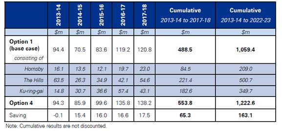
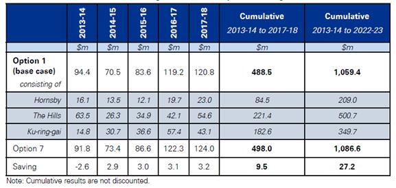
Option 4 - Hornsby, The Hills and Ku-ring-gai Councils |
Option 4 is an amalgamation option that would involve combining Hornsby, The Hills and Ku-ring-gai Councils, with an adjustment to the southern boundary of Hornsby and The Hills Councils. |
|
Shared Services Options |
|
|
Option 5 - Shared Infrastructure and Recreation Division between Hornsby and The Hills Councils |
Option 5 is a shared services model between Hornsby and The Hills Councils, where an Infrastructure and Recreation Division would be shared across the Councils. |
|
Option 6 - Shared Infrastructure and Recreation Division between Hornsby and Ku-ring-gai Councils |
Option 6 is a shared services model between Hornsby and Ku-ring-gai Councils, where an Infrastructure and Recreation Division would be shared across the Councils. |
|
Option 7 - Shared Infrastructure and Recreation Division between Hornsby, The Hills and Ku-ring-gai Councils |
Option 7 is a shared services model between Hornsby, The Hills and Ku-ring-gai Councils, where an Infrastructure and Recreation Division would be shared across the Councils. |
KPMG has now completed its research and provided Council with its final report. That report is supplemented by a summary version of the report which may be useful for interested members of the public. Copies of the reports have been provided to Councillors under separate cover and it is recommended that they be made public after Council’s consideration of this Report. The key findings of KPMG’s research are that:
· Local governments in NSW perform crucial functions and are key platforms for local democracy and representation, however, their structure and functions have largely remained static despite structural changes in the economy.
· Financial sustainability is a key consideration for local government in NSW, with 46 percent of councils estimated to have a financial sustainability rating of “weak” or lower within three years.
· To support more sustainable local governments over the long term, there are a number of potential reform options, including – for example – amalgamations, boundary reform and shared services. The recent report by the ILGRP - Revitalising Local Government - provided a comprehensive analysis of these options in the NSW context.
· Although there are broader impacts associated with reform, a key consideration is the potential financial benefits. Evidence suggests that economies of scale can be achieved in Australia, as demonstrated by seven out of nine studies of domestic reform experience.
· Previous experience suggests that the quality of service delivery, financial sustainability and the effectiveness of local representation are consistently applied to develop and analyse the impacts of local government reform.
· The seven reform options were developed based on the common underlying principles of previous reform experience and consultations with Hornsby Council. Reform options included both amalgamations and shared services arrangements.
· Option 1 – Base Case Scenario
o Under Option 1, where Hornsby, The Hills and Ku-ring-gai Councils remain as separate entities, it is estimated that:
· Hornsby’s net operating result before capital items would be $23.0 million in 2017/18, and over the ten year period from 2013/14 to 2022/23 would show a cumulative net operating result before capital items of $209.0 million.
· The Hills’ net operating result before capital items would be $54.6 million in 2017/18, and over the ten year period from 2013/14 to 2022/23 would show a cumulative net operating result before capital items of $500.7 million.
· Ku-ring-gai’s net operating result before capital items would be $43.1 million in 2017/18, and over the ten year period from 2013/14 to 2022/23 would show a cumulative net operating result before capital items of $349.7 million.
· Options 2 and 5 - Amalgamation and Shared Services - Hornsby and The Hills
o An amalgamation of Hornsby and The Hills Councils – Option 2 - is estimated to achieve a net operating result of about $26.9 million in 2017/18 (for the Hornsby Shire entity – refer Table 7.13 on page 59 of KPMG’s report), representing about a 17 percent improvement to the current forecast net operating result in Option 1.
o Under Option 2, the cumulative net operating result over the period 2013/14 to 2022/23 for the aggregate Hornsby/The Hills entity is estimated to be $783.7 million (which is $74.0 million – or 10 percent - greater than what the Councils are estimated to achieve as separate entities in the same period) – see Table below.
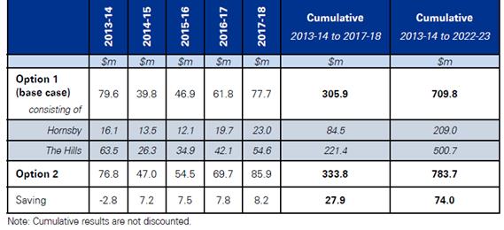
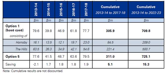
o A shared services model between Hornsby and The Hills Councils (where they would share an Infrastructure and Recreation Division) – Option 5 - is estimated to achieve a net operating result of around $24.0 million in 2017/18 (for the Hornsby Shire entity - refer Table 7.16 on page 62 of KPMG’s report), representing about a 4 percent improvement to the current forecast net operating result in Option 1.
o Under Option 5, the cumulative net operating result over the period to 2013/14 to 2022/23 for the Hornsby/The Hills shared services entity is estimated to be $725.1 million (which is $15.3 million – or 2 percent - greater than what the Councils are estimated to achieve as separate entities in the same period) – see Table below.
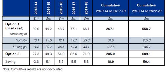
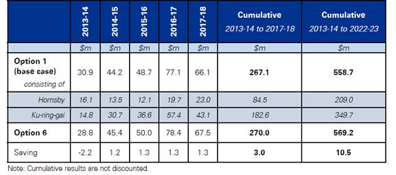
· Options 3 and 6 - Amalgamation and Shared Services - Hornsby and Ku-ring-gai
o An amalgamation of Hornsby and Ku-ring-gai Councils – Option 3 - is estimated to achieve a net operating result of about $26.2 million in 2017/18 (for the Hornsby Shire entity - refer Table 7.14 on page 60 of KPMG’s report), representing about a 14 percent improvement to the current forecast net operating result in Option 1.
o Under Option 3, the cumulative net operating result over the period 2013/14 to 2022/23 for the aggregate Hornsby/Ku-ring-gai entity is estimated to be $609.1 million (which is $50.4 million – or 9 percent - greater than what the Councils are estimated to achieve as separate entities in the same period) – see Table below.
o A shared services model between Hornsby and Ku-ring-gai Councils (where they would share an Infrastructure and Recreation Division) – Option 6 - is estimated to achieve a net operating result of around $23.9 million in 2017/18 (for the Hornsby Shire entity - refer Table 7.17 on page 63 of KPMG’s report), representing about a 3 percent improvement to the current forecast net operating result in Option 1.
o Under Option 6, the cumulative net operating result over the period 2013/14 to 2022/23 for the Hornsby/Ku-ring-gai shared services entity is estimated to be $569.2 million (which is $10.5 million – or 2 percent - greater than what the Councils are estimated to achieve as separate entities in the same period) – see Table below.
· Options 4 and 7 - Amalgamation and Shared Services – Hornsby, The Hills and Ku-ring-gai
o An amalgamation of Hornsby, The Hills and Ku-ring-gai Councils – Option 4 - is estimated to achieve a net operating result of about $29.0 million in 2017/18 (for the Hornsby Shire entity - refer Table 7.15 on page 61 of KPMG’s report), representing about a 26 percent improvement to the current forecast net operating result in Option 1.
o Under Option 4, the cumulative net operating result over the period 2013/14 to 2022/23 for the aggregate Hornsby/The Hills/Ku-ring-gai entity is estimated to be $1,222.6 million (which is $163.1 million – or 15 percent - greater than what the Councils are estimated to achieve as separate entities in the same period) – see Table below.
o A shared services model between Hornsby, The Hills and Ku-ring-gai Councils (where they would share an Infrastructure and Recreation Division) – Option 7 - is estimated to achieve a net operating result of around $24.2 million in 2017/18 (for the Hornsby Shire entity - refer Table 7.18 on page 64 of KPMG’s report), representing about a 5 percent improvement to the current forecast net operating result in Option 1.
o Under Option 7, the cumulative net operating result over the period 2013/14 to 2022/23 for the Hornsby/The Hills/Ku-ring-gai shared services entity is estimated to be $1,086.6 million (which is 27.2 million – or 3 percent - greater than what the Councils are estimated to achieve as separate entities in the same period) – see Table below.
KPMG has stated that implementing local government reform, whether through boundary reform or shared services, requires consideration of a variety of supporting factors in addition to the expected financial impacts. The supporting strategies and mechanisms include:
· Asset utilisation, renewal and financial sustainability, including:
o valuation and stocktake of assets
o maintenance of infrastructure
· Service delivery pathways to promote quality provision of council services, including consideration of:
o service levels between councils
o human resource management across councils
o corporate support functions
· Governance structures of new council entities, including consideration of how governance may impact the effectiveness of local representation
· Transition measures to underpin the implementation of reforms
KPMG go on to say that Council’s preferred option for reform should be identified using multi-criteria analysis to recognise that broader supporting strategies need to be considered in conjunction with the projected financial impacts for different reform options. The framework for conducting a multi-criteria analysis should, therefore, consider a range of appropriate financial and non-financial criteria, for example:
· the expected financial impacts of options
· risks to financial sustainability over the longer term
· strategic risks
· risks to service quality and effectiveness
· risks to the effectiveness of local representation
· risk to effective implementation and management over time
KPMG have provided a framework (see table below and Section 7.5 – pages 77-78 of KPMG’s report) which Council could use to undertake the multi-criteria analysis.
|
Financial Criteria |
|
|
The net financial benefits of the options |
Ranking of percentage point impacts relative to the base case net operating results. |
|
Risks to financial sustainability over the medium to long term |
Informed by the financial analysis and financial statement analysis of Hornsby Shire Council and neighbouring councils in the northern Sydney area. |
|
Non-Financial Criteria |
|
|
Strategic Risks |
Determined with respect to the analysis of supporting strategies and mechanisms and high level implementation considerations. |
|
Risks to service quality and effectiveness over time |
Determined with respect to the analysis of supporting strategies and mechanisms and high level implementation considerations. |
|
Risks to quality and effectiveness of local representation |
Determined with respect to the analysis of supporting strategies and mechanisms and high level implementation considerations. |
|
Risks to effective implementation and management over time |
Determined with respect to the analysis of supporting strategies and mechanisms and high level implementation considerations. |
KPMG have, however, indicated that further consultation and analysis is required to determine:
· the scoring for each criteria, particularly non-financial
· appropriate weightings for each criterion, to be determined by stakeholders
KPMG have noted that there are a number of precursors to the finalisation and implementation of a preferred option by Council. These include, for example:
· Continued engagement in the broader local government reform debate in NSW, particularly when the NSW Government formalises its position to the Revitalising Local Government report recently released by the ILGRP.
· Further, more detailed, due diligence of reform options, particularly from the perspective of other councils in the reform process.
The approach recommended by KPMG is for Council to actively engage all relevant councils and the NSW Government concurrently to undertake a more comprehensive evaluation of the costs and benefits of all options. The approach to developing the analysis in KPMG’s report has the flexibility to be extended and refined over time should further, more detailed, data become available.
KPMG go on to say that following the completion of due diligence, stakeholder engagement and agreement of a preferred option, there should be detailed implementation planning to ensure successful delivery of reform over time. A structured and effectively communicated approach to implementation and management of the reform process is critical for its overall success, including the realisation of the potential benefits.
KPMG have provided a high level implementation plan for an amalgamation or shared services reform model (see Section 8 – pages 79-84 of KPMG’s report), however, they have noted that a more complete implementation plan will be required following the completion of all required due diligence that provides:
· greater detail that is targeted to the specific option being considered
· target completion dates for actions
· accountabilities for those actions in agreed timeframes
_______________________________
Now that Council has the benefit of the considerable research it has commissioned from KPMG, PWC and Crosby Textor about local government reform and has supported the majority of recommendations made by the ILGRP and the LGAT in their final reports, it is apparent that reform of the local government industry in NSW is required in one form or another.
As Council and the Hornsby community would be beneficiaries of reform which provides a more sustainable future for local government in NSW, it is appropriate that Council now provide a copy of the recently finalised KPMG research to the Minister for Local Government so that the Government can take the research into account when developing its responses to the final reports of the ILGRP and the LGAT.
Whilst awaiting the Government’s response to the ILGRP’s and LGAT’s reports, it is also appropriate that a copy of the KPMG research be forwarded to The Hills and Ku-ring-gai Councils seeking their comments on the reform options discussed. This will allow a further report to be prepared for Council’s consideration when the Government’s, The Hills’ and Ku-ring-gai’s responses are received.
CONSULTATION
In the preparation of this Report, there was consultation with staff from KPMG as the authors of the work that is referred to. KPMG representatives also attended Council to provide Councillors and relevant staff with informal briefings at the commencement and during the project.
BUDGET
The costs associated with this project will be met from existing budgetary allocations in 2013/14. Depending on Council’s resolution in respect of this Report, funding may need to be allocated in a future quarterly review to fund further projects associated with local government reform.
POLICY
There are no policy implications associated with this Report.
CONCLUSION
Council is now in possession of another valuable piece of research which analyses local government reform options in northern Sydney and which will be of assistance in formulating a position about where to next in the reform process. This research complements that already undertaken by Crosby Textor which provided an insight into the community’s view about local government reform in general, and in particular amalgamations and shared services; and also by PWC which detailed the issues, benefits and disadvantages associated with Council amalgamating with its neighbouring councils in the northern Sydney region.
Subject to Council not requiring any further information at this point to assist in its understanding of the local government reform process, staff believe it is appropriate to send a copy of the KPMG research to the Minister for Local Government and The Hills and Ku-ring-gai Councils whilst the State Government’s response to the final reports of the ILGRP and the LGAT are being finalised.
Once the Government’s response to the ILGRP and the LGAT reports are made public, it is proposed that a further report be prepared for Council’s consideration detailing that response as well as any comments received from The Hills and Ku-ring-gai Councils about the KPMG research. Council should then be able to determine its preferred position in respect of local government reform.
RESPONSIBLE OFFICER
The officer responsible for the preparation of this Report is the Deputy General Manager, Corporate Support Division – Mr Gary Bensley - who can be contacted on 9847-6605.
|
Gary Bensley Deputy General Manager Corporate Support Division |
Scott Phillips General Manager General Manager's Division |
There are no attachments for this report.
File Reference: F2004/07217
Document Number: D02931621
Deputy General Manager's Report No. CS17/14
Corporate Support Division
Date of Meeting: 11/06/2014
4 INVESTMENTS AND BORROWINGS FOR 2013/14 - STATUS FOR PERIOD ENDING 30 APRIL 2014
EXECUTIVE SUMMARY
· Council may invest funds that are not, for the time being, required for any other purpose. The investments must be in accordance with relevant legislative requirements and Council’s policies. The Chief Financial Officer must report monthly to Council on the details of funds invested.
· This Report provides details of Council’s investment performance for the period ending 30 April 2014. It indicates that for total investments, the annualised return for the month of April was 3.64% compared to the benchmark of 2.51%.
· All investments have been made in accordance with the Local Government Act, the Local Government (General) Regulation and Council's Investment of Surplus Funds Policy and Investment Strategy.
· In respect of Council borrowings, the weighted average interest rate payable on loans taken out from June 2004 to April 2014, based on the principal balances outstanding, is 6.00%.
· Council’s investment portfolio is unable to be applied to reducing current outstanding loan balances, due in part to the estimated cash-flow requirements associated with the Hornsby Aquatic Centre during 2013/14. Also, opportunities to renegotiate Council’s existing loans to attain a lower interest rate are negated by the break costs which would apply.
|
THAT the contents of Deputy General Manager’s Report No. CS17/14 be received and noted. |
PURPOSE
The purpose of this Report is to advise Council of funds invested in accordance with Section 625 of the Local Government Act; and to provide details as required by Clause 212(1) of the Local Government (General) Regulation and Council's Investment of Surplus Funds Policy.
BACKGROUND
A report is required to be submitted for Council’s consideration each month detailing Council's investments and borrowings and highlighting the monthly and year to date performance of the investments. Initial investments and reallocation of funds are made, where appropriate, after consultation with Council's financial investment adviser and fund managers.
DISCUSSION
Council may invest funds which are not, for the time being, required for any other purpose. Such investment must be in accordance with relevant legislative requirements and Council Policies, and the Chief Financial Officer must report monthly to Council on the details of the funds invested.
Council’s investment performance for the month ending 30 April 2014 is detailed in the attached document and summarised below:
· The At-Call and Term Deposits achieved an annualised return of 3.76% for April compared to the benchmark of 2.50%.
· The Capital Guaranteed Notes achieved an annualised return of 0% for this period. No interest will be accrued for the remaining life of the securities.*
· For total investments, the annualised return for April was 3.64% compared to the benchmark of 2.51%.
[*Capital Guaranteed Notes - Longreach I&U ($1 million) was fully redeemed in April 2014; and Longreach Tri-sector ($1 million) will be fully redeemed at maturity in September 2014.]
In respect of Council borrowings, the weighted average interest rate payable on loans taken out from June 2004 to March 2014, based on the principal balances outstanding, is 6.00%. It is noted that the opportunity to renegotiate Council’s existing loans to attain a lower interest rate is negated by the break costs which would apply. The weighted average interest rate payable on loans indicates that Council’s cost of borrowing is low even when compared to present rates that could be obtained. The Borrowings Schedule as at 30 April 2014 is attached for Council’s information.
CONSULTATION
Appropriate consultation has occurred with Council's financial investment adviser and fund managers.
BUDGET
Budgeted investment income for 2013/14 was increased from $720,000 to $1,420,000 as part of the September 2013 Quarter Budget Review. Investment income for the period ending 30 April 2014 was $1,583,000 which compares favourably to the budgeted income for the same period of $1,040,000. Approximately 29% of the total investment income received by Council relates to externally restricted funds (e.g. Section 94 monies) and is required to be allocated to those funds. All investments have been made in accordance with the Local Government Act, the Local Government (General) Regulation and Council's Investment of Surplus Funds Policy and Investment Strategy.
CONCLUSION
The investment of Council funds for the period ending 30 April 2014 is detailed in the documents attached to this Report. Council’s consideration of the Report and its attachments ensures that the relevant legislative requirements and Council protocols have been met in respect of those investments.
RESPONSIBLE OFFICER
The officer responsible for the preparation of this Report is the Chief Financial Officer – Glen Magus – who can be contacted on 9847 6635.
|
Glen Magus Chief Financial Officer - Financial Services Corporate Support Division |
Gary Bensley Deputy General Manager Corporate Support Division |
Attachments:
|
1.View |
HSC Investment Portfolio as at 30 April 2014 |
|
|
|
2.View |
HSC Borrowings Schedule as at 30 April 2014 |
|
|
File Reference: F2004/06987
Document Number: D02983919
Deputy General Manager's Report No. CS18/14
Corporate Support Division
Date of Meeting: 11/06/2014
5 ADOPTION OF 2014/15 OPERATIONAL PLAN - INCLUDING THE BUDGET, FEES AND CHARGES AND RATING STRUCTURE FOR 2014/15
EXECUTIVE SUMMARY
· Council adopted the draft 2014/15 Operational Plan for the purpose of public exhibition at its 9 April 2014 General Meeting. The draft Plan includes the Budget, Fees and Charges and Rating Structure for 2014/15.
· The draft documents were publicly exhibited from 10 April until 9 May 2014 and submissions invited. Ten submissions were received which are summarised in Table 1A of this Report. Table 1B of the Report contains a summary of administrative changes proposed by internal Divisions of Council.
· Following a review of all submissions by appropriate Council staff, no material changes to the publicly exhibited documents are recommended.
· Once adopted, the final 2014/15 Operational Plan (including the Budget and Fees and Charges for 2014/15) will be distributed electronically and in hard copy to Councillors, staff and interested persons.
|
THAT: 1. Subject to the incorporation of the minor amendments recommended in Tables 1A and 1B of Deputy General Manager’s Report No. CS18/14, Council adopt the 2014/15 Operational Plan which includes the Budget, Fees and Charges and Rating Structure for 2014/15. 2. Council make and levy the 2014/15 Ordinary Rates in accordance with Table 2 of Deputy General Manager’s Report No. CS18/14. 3. Council make and levy the 2014/15 Catchments Remediation Rate on all rateable land in the Shire in accordance with Table 3 of Deputy General Manager’s Report No. CS18/14. 4. Council make and levy the Hornsby Quarry Loan Rate on all rateable land in the Shire in accordance with Table 4 of Deputy General Manager’s Report No. CS18/14. 5. Council continue to provide eligible pensioners with a $10 concession in respect of the Hornsby Quarry Loan Rate, represented by a reduction in the Base amount. 6. Council continue to provide eligible pensioners with a $20 concession in respect of the Special Rate Variation approved for the 2011/12, 2012/13 and 2013/14 financial years, represented by a reduction in the Base amount. |
PURPOSE
The purpose of this Report is to provide Council with information and recommendations regarding the submissions received in respect of the public exhibition of the draft 2014/15 Operational Plan, which includes the Budget, Fees and Charges and Rating Structure for 2014/15.
BACKGROUND
By 30 June in the year following local government elections, all councils are required to develop a 10 year community strategic plan, a four year delivery program and a one year operational plan as well as a resourcing strategy aligned to an integrated planning framework. The purpose is to identify the main priorities and aspirations for the future of the council area and the resources required to move to that preferred future.
Your Community Plan 2013-2023, which is Hornsby Shire Council’s 10 year Community Strategic Plan, was adopted on 19 June 2013 together with a Delivery Program for 2013-17 and a 2013/14 Operational Plan. The rolling four year program of major projects in the Delivery Program 2013-17 has been reviewed and no changes are proposed. As such, the Delivery Program was not required to be further exhibited.
At the General Meeting held on 9 April 2014, Council considered Deputy General Manager’s Report No. CS9/14 and resolved that:
1. Council adopt for public exhibition and make available for public comment from 10 April to 9 May 2014, the draft Operational Plan 2014/15 which includes the draft Budget, Fees and Charges and Rating Structure for 2014/15.
2. Council note that the rating information contained in the draft Operational Plan 2014/15 is in line with the Independent Pricing and Regulatory Tribunal’s approval for NSW councils (i.e. a 2.3% rate increase for 2014/15).
3. Following the public exhibition period, and before 30 June 2014, a further report be prepared for Council’s consideration which provides details of any submissions received and recommends the adoption of a final Operational Plan 2014/15, including the Budget, Fees and Charges and Rating Structure for that year.
DISCUSSION
Consultation on the Documents
During the exhibition period from 10 April to 9 May 2014, copies of the draft 2014/15 Operational Plan were on display at Council’s reception areas and five libraries and were available electronically on Council’s website. Advertisements advising of the document’s availability were placed in three local newspapers, the newsletter distributed to 47,000 households with the April 2014 rates instalment notices and the May monthly enewsletter database of 6,000.
Submissions
A total of 10 submissions were received during the formal exhibition period of the draft Plan including one late submission. None of the submissions are considered to have any material impact on the Plan. Of the submissions:
· five relate to the proposed increase in childcare fees
· three relate to the proposed fees for the new Hornsby Aquatic and Leisure Centre
· one relates to the lack of projected capital works at the Epping Aquatic Centre
· one requests the upgrade of floodlights at Greenway Park No. 2 Oval be brought forward in the capital works program.
The submissions are summarised in Table 1A below, with staff recommendations in bold italics.
Table 1A
|
No. |
Name |
Issue |
Summary of Points Made |
Staff Recommendation |
|
1 |
Melissa Caboche |
Child care |
· Proposed child care fee increase is extreme - would equate to approximately $1,300 per annum extra for her family |
Not Supported · Council has determined that fees for child care should reflect the full cost of delivering the service, including administrative and operating costs · The fee increases proposed for 2014/15 reflect: § CPI increases § increasing energy costs § increased staff salary and retraining costs as higher qualifications are now required to meet the National Regulations and Quality Standards, and § a rental component for each property · Council’s child care services are provided to 311 families and there have only been five comments received on the proposed fee increase |
|
2 |
Sergei Mazourov |
Child care |
· Unacceptable 7.5% increase to child care fees |
|
|
3 |
Neha and Jitendra Khatri |
Asquith Nursery and Preschool |
· Son started at Asquith Nursery and Preschool centre recently. Whilst fee was higher than other centres in Hornsby, they recognise the higher standard of facilities and care provided at the council managed centre · Would like child care fees minimised so they are able to increase their son's days |
|
|
4 |
Buddhima Kannangara |
Somerville Park Early Childhood Education |
· $7 per day proposed fee increase for Somerville Park Early Childhood Education Centre is too high, especially for an independent preschooler |
|
|
5 |
Adam Cruickshank |
Child care |
· 5.9% proposed increase for under three-year-olds is unreasonable. · Would not object if child care staff salaries were also increased by 5.9% |
|
|
6 |
Michael Pritchard |
Hornsby Aquatic and Leisure |
· New fees for Hornsby Aquatic and Leisure Centre are 16% more than other pools in area |
Not Supported · *Hornsby is a brand new state of the art facility and costs have increased in line with the new facilities the Centre will have to offer |
|
7 |
Michael Kramer |
Hornsby Aquatic and Leisure |
· Proposed charges at Hornsby Aquatic Centre are higher than those at Epping and Galston and much higher than prior to closure in 2010 · Lower initial pricing and free swimming days should be offered as an incentive for patrons to return |
Not Supported · *See note in No. 6 above · There are free swimming days planned when the Centre opens · Hornsby's learn to swim fees have been incentivised to bring back business that has gone to other centres during the Hornsby Pool closure |
|
8 |
Lee Kemp |
Hornsby Aquatic and Leisure |
· Proposed charges at Hornsby Aquatic Centre are higher than those at Epping and Galston and unfair to charge more as there will be lower operating and maintenance costs · Inconsistent fees are unfair, and will also mean not able to use multi-entry tickets between Council pools as previously. Family D fee (2 adults + 2 children / 1 adult + 3 children) not listed for Hornsby or Epping pools · Learn to swim lessons cheaper at Epping than Hornsby or Galston while it costs the same to provide swimming coaches |
Not Supported · *See note in No. 6 above · Different price structures work for the different Centres. Each pool's fee structure has been set based on historical clientele usage. There is a price category covering 2 adults + 2 children / 1 adult + 3 children at Hornsby - Category descriptions have now been updated to reflect common definitions · Multi-entry tickets will no longer be valid for entry across Council's three pools. However, as a promotional offer the Unlimited Swim/Gym will be transferable between Hornsby and Galston as they both have new gym facilities · Epping's learn to swim classes are $1 cheaper as they are held outdoors, whereas Hornsby and Galston are indoor facilities. Additionally learn to swim fees at Hornsby Pool have been incentivised to attract business lost to other centres during Hornsby Pool closure |
|
9 |
Lee Kemp |
Epping Aquatic Centre |
· No capital works for Epping Aquatic Centre in Operational Plan for 2014/15 to 2016/17. SRV application outlined capital works every year until 2020/21 · This indicates that Epping Aquatic Centre will close permanently · Requests that Epping Aquatic Centre be added to the Section 94 Contributions Plan as there will be 8,000 new residents with planned urban activation |
Not Supported · An assessment of the maintenance and capital renewal requirements for the Centre is being undertaken and Council will consider the most appropriate program of works when the full scope is determined · There has been no Council decision to close Epping Aquatic Centre · Epping Aquatic Centre is not currently in the Section 94 Plan. Any consideration for future inclusion would be based on the full assessment of the facility’s requirements and the funding gap remaining after Section 94 contributions from the new population and SRV money was applied. Also, Section 94 funding is dependent on there being an increased demand from the new population and access to other nearby aquatic facilities would need to be considered · Council is presently undertaking a recreation and open space study (Active Living Hornsby Strategy) which will identify future requirements and gaps in recreation facilities, parks and open space areas within the Shire for all users |
|
10 |
Cherrybrook Little Athletics Club |
Greenway Park No. 2 |
· Club requests the lighting upgrade scheduled for Greenway Park No. 2 Oval in 2015/16 be brought forward in the capital works program to 2014/15 |
Supported Council's Parks Branch recommends this project be brought forward and substituted in the capital works program with the floodlight replacement at Storey Park scheduled for 2014/15: · More participants train under lights at Greenway Park No. 2 than at Storey Park · Lights are used year-round at Greenway Park No. 2, while at Storey Park only from March-September Note: Regular hirers of Storey Park have not been advised of any deferral of that project. |
There were also administrative issues identified by staff during the exhibition period regarding changes to wording for clarity and correction to an incorrectly advertised fee. These are summarised in Table 1B below.
Table 1B
|
No. |
Summary of Issues |
Commentary |
|
1b |
· Draft Fees and Charges 2014/15, p63 – Item 6, Crosslands ‘3-5 people / night’ - typographical error in fee - $13 should be $40 · Exhibition copies and website updated and interest groups advised 15 April. Exhibition of this fee was extended to 20 May 2014 |
No submissions received on this amended fee |
|
2b |
· Draft Fees and Charges 2014/15, p76, Hornsby Aquatic and Leisure Centre - Item 8, Car parking – wording clarified to show that 3 hours free parking requires ticket validation |
‘with validated ticket’ added |
|
3b |
· Financial overview on pp6-7 to be adjusted to reflect the $8M to S94 restricted asset (CS9/14, 9 April 2014) |
Financial overview and pie chart updated |
|
4b |
· Draft Fees and Charges 2014/15, p24, Thornleigh Community Centre - # symbol incorrectly placed on second line of item 27A. Should be on third line |
# moved as requested and extra category added - 27E. Other Charges - to clarify who general charges apply to |
|
5b |
· Draft fees and charges 2014/15, p36, Hornsby Mall - Item 8, B.3.3. Markets - (*) symbol added to clarify that Development consent is required |
(*) added to clarify that Development Consent is required |
During the exhibition period, there were further minor changes suggested by Council staff to improve clarity of the information contained in the documents, and those changes have been incorporated in the final versions of the documents.
Rates Structure
The rates structure included in the draft 2014/15 Operational Plan was based on the general increase determined by IPART i.e. a 2.3% increase to apply to the Ordinary, Catchments Remediation and Hornsby Quarry Loan Rates. The Ordinary, Catchments Remediation and Hornsby Quarry Loan Rate tables (Tables 2, 3 and 4 below) have been updated to take into account adjustments due to recategorisation of properties since exhibition. This has affected the ‘Rate in the $ (based on land value)’, ‘% of Total Rate’, ‘Yield $’ columns and the overall totals, increasing the total rates levied from $73,795,706 to $74,009,267. It is noted that there was a comment in the draft 2014/15 Operational Plan 2014/15 which alluded to the need for this recalculation and no submissions were received regarding the proposed rates or rating structure.
Table 2 - Ordinary Rates
|
Category |
Rate in the $ |
Minimum |
Base |
Base |
% of |
Yield $ |
|
Residential |
0.00154321 |
|
496 |
46 |
87.59 |
59,019,721 |
|
Farmland |
0.00140017 |
|
496 |
28 |
0.80 |
539,054 |
|
Business |
0.00528119 |
525 |
|
|
6.86 |
4,622,383 |
|
Business - |
0.01193706 |
525 |
|
|
4.75 |
3,200,633 |
|
Total |
|
|
|
|
100 |
67,381,790 |
Table 3 - Catchments Remediation Rate
(NB. There are no minimum or base amounts in respect of this rate)
|
Category |
Rate in the $ |
Yield $ |
|
Residential |
0.00014219 |
2,949,240 |
|
Farmland |
0.00009763 |
26,935 |
|
Business |
0.00027758 |
230,979 |
|
Business – Hornsby CBD |
0.00059866 |
159,933 |
|
Total |
|
3,367,087 |
Table 4 - Hornsby Quarry Loan Rate
|
Category |
Rate in the $ (based on land value) |
Base Amount $ |
Base Amount % |
Yield $ |
|
Residential |
0.00007467 |
24 |
46 |
2,855,763 |
|
Farmland |
0.00005324 |
37 |
44 |
26,084 |
|
Business |
0.00013746 |
53 |
49 |
223,669 |
|
Business – Hornsby CBD |
0.00031731 |
138 |
45 |
154,874 |
|
Total |
|
|
|
3,260,390 |
Total Rates Levied $74,009,267
Eligible Pensioner Rebates
In line with statutory requirements, eligible pensioners across NSW are entitled to a $250 reduction in the ordinary rates and domestic waste management services that are payable to their councils in respect of their properties. Council currently provides for a rebate to eligible pensioners of $280 which is $30 above the statutory requirement. This includes an amount of $10 for the Hornsby Quarry Rate and $20 for the IPART approved special rate increase for the 2011/12, 2012/13 and 2013/14 financial years.
While the special rate variation increase period has been completed, it is proposed that Council extends the $20 pensioner rebate for a further year. At the end of the 2014/15 period, this rebate may require further consideration particularly having regard to the Commonwealth Government’s removal of its support for pensioner rate rebates as part of its 2014/15 Budget.
CONSULTATION
Council engaged its community in discussing a preferred future for the Shire which resulted in Council’s first Community Strategic Plan being adopted in 2010. The pages titled ‘Your Involvement’, pp26-27, outline the lengthy consultations undertaken in the preparation of Your Community Plan 2013–2023. The 2014/15 Operational Plan (including the Budget and Fees and Charges) has been prepared after detailed discussions with relevant staff, consideration by Council and public exhibition of draft proposals. Councillors were provided with a briefing on the contents of the draft documents on 19 March 2014.
Publicity about the Plan included advertisements in three local newspapers, the newsletter delivered to 47,000 households with the April 2014 rates instalment, the May 2014 monthly enewsletter database of 6,000 as well as prominent signage at Council’s five libraries and Administration Centre reception area. All users of Council’s child care services, regular hirers of Council’s community centres and sporting associations were advised of the proposed fee increases for 2014/15. Prospective hirers of Crosslands Reserve were advised in writing of a typographical error in the Fees and Charges document and the period for submissions was extended to ensure adequate opportunity for comments to be received.
BUDGET
The publicly displayed draft 2014/15 Annual Budget included an estimated surplus of $143K after allowing for a transfer of $8 million towards funding a Section 94 funding gap (of approximately $19 million) identified in Council’s 2012-2021 Section 94 Development Contributions Plan. This is consistent with Council’s goal to maintain prudent financial management of its finances and to allocate financial surpluses towards key strategic issues. This estimated surplus has been achieved without the need to undertake external loan borrowing.
Over the past five years, considerable savings have been made by not providing for any increase in non-salary related operating budgets, i.e. no increases in the costs associated with plant, materials, etc. Any increases in these areas have needed to be met by efficiency and other gains across Council in those years. Further changes to the budget while on public display include a revised estimate for Section 94 contributions to be received over the 2014/15 financial period. Approximately $8 million additional Section 94 funds are anticipated to be received next financial year that will be spent over future years in accordance with the Section 94 Development Contributions Plan.
POLICY
The Delivery Program 2013-17 is Council’s principal instruction to the organisation and the underlying annual Operational Plans allocate resources and contain the detail on what will be done to implement the Delivery Program.
CONCLUSION
The 2014/15 Operational Plan including the Budget and Fees and Charges for that year encompass the priorities and expected levels of service voiced by the community. Council will respond by providing services in a prudent and financially viable manner. Once adopted, the 2014/15 Operational Plan (including the Budget and Fees and Charges for 2014/15) will be distributed electronically and in hard copy to Councillors, staff and interested persons.
RESPONSIBLE OFFICER
The officers responsible for the preparation of this Report are the Chief Financial Officer – Glen Magus and the Manager Strategy - Julie Williams - who can be contacted on 9847-6635 and 9847‑6790 respectively.
|
Gary Bensley Deputy General Manager Corporate Support Division |
Scott Phillips General Manager General Manager's Division |
Attachments:
There are no attachments for this report.
File Reference: F2013/00651
Document Number: D03012569
Deputy General Manager's Report No. CS20/14
Corporate Support Division
Date of Meeting: 11/06/2014
6 DEBTS TO BE WRITTEN OFF - 2013/14 FINANCIAL YEAR
EXECUTIVE SUMMARY
· The Financial Services Branch is responsible for assessing Council’s outstanding debtors on a regular basis to determine those debts which are bad, doubtful or recoverable.
· For 2013/14, it is recommended that Council write off debts considered bad totalling $7,477 (see Schedule A); and note debts considered bad totalling $3,016 (see Schedule B) which will be written off under the General Manager's delegated authority.
· Council’s consideration of this Report ensures that the relevant legislative requirements and Council protocols have been met in respect of those debts to be written off.
· The write-off of debts for 2013/14 is able to be met from the budget allocated for this purpose.
|
THAT for 2013/14, and in accordance with Clause 213 of the Local Government (General) Regulation, Council: 1. Write off debts considered bad totalling $7,477 (as detailed in Schedule A attached to Deputy General Manager’s Report No. CS20/14). 2. Note debts considered bad totalling $3,016 which will be written off under the General Manager’s delegated authority (as detailed in Schedule B attached to Deputy General Manager’s Report No. CS20/14). |
PURPOSE
The purpose of this Report is to seek Council approval, in accordance with Clause 213 of the Local Government (General) Regulation, to write off debts considered bad for the 2013/14 financial year.
BACKGROUND
Each year, the Financial Services Branch assesses the status of outstanding debtors to determine those debts which are bad, doubtful or recoverable. Debts considered bad are either recommended for write off by the General Manager under delegated authority or submitted to Council for approval to write off. (N.B. Doubtful debts are provided for in the financial records in contrast to bad debts which are written off)
DISCUSSION
The writing off of debts by Council is undertaken in accordance with Clause 213 of the Local Government (General) Regulation. At the Ordinary Meeting held on 10 July 1996, Council resolved that the General Manager be delegated authority to write off individual debts up to $1,000 which are considered irrecoverable. Debts over $1,000 may only be written off by resolution of Council. The amount of bad debts written off by Council in accordance with Clause 213 of the Regulation over the last three financial years has been:
2010/11 $15,254
2011/12 $28,634
2012/13 $75,430
For 2013/14, it is recommended that Council write off debts considered bad totalling $7,477 (see details in Schedule A); and note debts considered bad totalling $3,016 which will be written off under the General Manager's delegated authority (see details in Schedule B). It should be noted that even if a debt is written off, Council is not prevented from taking future legal proceedings to recover the debt.
The level of debt to be written off in the 2013/14 financial year has decreased when compared to prior years. In respect of the rates related debt in Schedule A, the Crown, as the property owner for this Crown lease, is not liable for any debt (in this case for rates and accrued interest) that was due and payable to Council by the lessee. For any other property owner, a rates debt would be able to be secured against the property.
CONSULTATION
This Report has been prepared in consultation with Council’s debt collection agency – Recoveries and Reconstruction (Australia) Pty Ltd; Council’s Operations Accountant and other relevant Council staff.
BUDGET
The 2013/14 budget for bad debts written off is $14,000. The allocated budget is able to meet the actual bad debt write-off this financial year.
POLICY
There are no policy implications associated with this Report.
CONCLUSION
The write-off of bad debts for the 2013/14 financial year is detailed in the documents attached to this Report. Council’s consideration of the Report and its attachments ensures that the relevant legislative requirements and Council protocols have been met in respect of those debts to be written off.
RESPONSIBLE OFFICER
The officer responsible for the preparation of this Report is the Chief Financial Officer – Glen Magus who can be contacted on 9847 6635.
|
Glen Magus Chief Financial Officer - Financial Services Corporate Support Division |
Gary Bensley Deputy General Manager Corporate Support Division |
Attachments:
|
1.View |
Schedule A - Debtor Write-Off |
|
|
|
2.View |
Schedule B - Debtor Write-Off |
|
|
File Reference: F2004/06978-02
Document Number: D03038945
Deputy General Manager's Report No. CS21/14
Corporate Support Division
Date of Meeting: 11/06/2014
7 BEATTIE LANE, HORNSBY - PROPOSED ROAD CLOSURE
EXECUTIVE SUMMARY
· Beattie Lane, Hornsby is a lane situated within the Hornsby West Side Precinct, connecting Jersey Lane (behind the Police Station) with Jersey Street. The Lane severs Council owned property to the north and south.
· It is proposed to lodge an application for the closure of the road (lane) which will allow Council to consolidate the adjacent properties whilst maintaining suitable vehicular access.
· It is recommended that Council authorise the Land and Property Services Branch to make application to the NSW Department of Lands to commence the process of closing Beattie Lane, Hornsby.
|
THAT: 1. Council make application to the NSW Department of Lands to close the road known as Beattie Lane, Hornsby. 2. Upon closure of Beattie Lane, the land be classified as Operational Land for the purposes of the Local Government Act. 3. The General Manager be authorised to execute any documents in relation to this matter, deemed appropriate by Council’s legal advisers. |
PURPOSE
The purpose of this Report is to seek Council’s approval to make application to NSW Department of Lands for the closure of Beattie Lane, Hornsby, which connects Jersey Lane and Jersey Street, Hornsby.
BACKGROUND
Beattie Lane is situated within Council’s Hornsby West Side Precinct. It borders Council owned properties at 1-11 Coronation Street to the south and 1-3 Jersey Street to the north. It is bordered to the west by Jersey Lane and to the east by Jersey Street. Beattie Lane is shown as a “lane” in DP2947, which was lodged in 1895, and is part of a 60 acre grant which was made to Thomas Hyndes in 1839. The Lane has never formally been dedicated as a public road and currently remains residue land vested with the heirs of Thomas Hyndes.
As no owner of Beattie Lane is readily identifiable, Council has recently enacted its powers under Sections 16(2) and 17 of the Roads Act 1993 to provide for formal dedication of the Lane as a public road with Council as the Roads Authority and owner. The required public notification period has been completed and no submissions were received. Formal dedication of the Lane as a public road is, therefore, imminent. A copy of the notification, including a location plan, is annexed to this Report. It is noted that NSW Police were directly consulted as a main user of the Lane and no objections were raised by the Local Area Command.
Once the dedication by notice in the Government Gazette is complete, Council has the ability, as the Roads Authority, to make application to the Minister for closure of the road. Once closed in accordance with the Roads Act 1993, ownership of the land comprising the former road (known as Beattie Lane) would be vested in Council and a Certificate of Title issued with a new Lot and DP number.
DISCUSSION
As part of plans to transform the West Side of Hornsby, Council owned sites located at 1-11 Coronation Street, Hornsby, and 1–5 Jersey Street, Hornsby, have been identified for potential redevelopment. As Beattie Lane currently severs the Council owned sites, closure of the road will allow Council to provide a more regular future development site whilst maintaining suitable vehicular access.
Hornsby West Side Precinct
In late 2013, Council publicly exhibited a Planning Proposal and draft Development Control Plan amendments which apply to the commercial precinct along the Pacific Highway, Hornsby, from Coronation Street in the north to the RSL Club in the south. The objective of the Proposal is to increase residential and employment development opportunities; revitalise and preserve the heritage character of the area; and to reinforce the role and status of Hornsby Town Centre as a Major Centre. The Planning Proposal looks to increase the indicative permissible building height for the Council owned sites along Coronation Street to approximately 15 storeys. It is noted that progression of the Planning Proposal is the subject of a separate report for Council’s consideration at the 11 June 2014 General Meeting (refer Group Manager’s Report No. PL41/14)
Road Closure Process
Under Section 43 of the Roads Act, a public road that is formally vested in Council remains vested in Council as operational land for the purposes of the Local Government Act when it is closed. For a road closure, Council must make formal application, and submit a deposited plan suitable for registration in the Land and Property Information (LPI). The plan must be a plan of survey and show the closed road as a single lot in accordance with the proposed closure. Council must submit the plan to the Crown Lands Division for investigation and signature by an authorised officer prior to lodgement at the LPI. On registration of the plan and completion of all other actions by Crown Lands, the road ceases to be a public road (refer section 38 of the Roads Act 1993). Council would then be issued with a certificate of title for the former road.
The road closure process requires a:
· Council resolution to formally approve the making of the application for the road closure;
· Public advertisement seeking submissions from the public and the adjoining owners; and
· Submission to the Crown Lands Division for a formal final consent.
If there are objections to the proposed closure following the public advertisement, then there needs to be a referral to the Minister for Roads. It is noted that recent advice indicates that the road closure process is currently taking between two to three years to complete.
BUDGET
It is estimated that total costs of approximately $14,500 will be incurred in respect of the road closure process. These costs will be met from existing operational budgets.
POLICY
There are no policy implications associated with this Report.
CONCLUSION
Council has identified an opportunity to close Beattie Lane, Hornsby to allow the consolidation of adjacent properties to provide a more regular future development site. As the road closure process can be lengthy, it is recommended that Council progress the matter at this time.
RESPONSIBLE OFFICER
The officer responsible for the preparation of this Report is the Manager Land and Property Services Branch, Peter Thompson – who can be contacted on 9847 6669.
|
Peter Thompson Manager - Land and Property Services Corporate Support Division |
Gary Bensley Deputy General Manager Corporate Support Division |
Attachments:
|
1.View |
Dedication of Public Road Notification |
|
|
File Reference: F2014/00246
Document Number: D03042693
Deputy General Manager's Report No. CS22/14
Corporate Support Division
Date of Meeting: 11/06/2014
8 LOCAL GOVERNMENT REMUNERATION TRIBUNAL - 2014 REPORT AND DETERMINATION - MAYOR AND COUNCILLOR FEES - 2014/15 FINANCIAL YEAR
EXECUTIVE SUMMARY
· Sections 248(2) and 249(3) of the Local Government Act provide respectively for Council to once each year fix the annual fee payable to Councillors and the additional annual fee payable to the Mayor.
· The annual fees must be fixed in accordance with the relevant annual determination of the Local Government Remuneration Tribunal.
· Based on the Tribunal’s 2014 Report and Determination, it is recommended that Council approve a 2.5% increase in Councillor and Mayoral fees for 2014/15.
· Acceptance of such recommendation would result in each Councillor receiving an annual fee of $22,800 and the Mayor receiving an additional annual fee of $60,580 for the 2014/15 financial year.
· Sufficient funds have been allocated in the 2014/15 Budget to cover a 2.5% increase in the fees payable to Councillors and the Mayor.
|
THAT: 1. Council note that as a consequence of the 2014 Report and Determination of the Local Government Remuneration Tribunal, it remains in the Metropolitan Centre Category of NSW councils for the period 1 July 2014 to 30 June 2015. 2. In accordance with Section 248 of the Local Government Act, and having considered the 2014 Report and Determination of the Local Government Remuneration Tribunal, an annual fee of $22,800 be paid to each Councillor for the period 1 July 2014 to 30 June 2015. 3. In accordance with Section 249 of the Local Government Act, and having considered the 2014 Report and Determination of the Local Government Remuneration Tribunal, an additional annual fee of $60,580 be paid to the Mayor for the period 1 July 2014 to 30 June 2015. |
PURPOSE
The purpose of this Report is to provide Council with the 2014 Report and Determination of the Local Government Remuneration Tribunal such that Council can determine the amount of the fee payable to each Councillor, and the additional fee payable to the Mayor, for the 2014/15 financial year.
BACKGROUND
The Local Government Remuneration Tribunal is established under Chapter 9, Part 2, Division 4 of the Local Government Act. In this regard, Section 239 of the Act states:
(1) The Remuneration Tribunal must, at least once every 3 years:
(a) determine categories for councils and mayoral offices, and
(b) place each council and mayoral office into one of the categories it has determined.
(2) The determination of categories by the Remuneration Tribunal is for the purpose of enabling the Remuneration Tribunal to determine the maximum and minimum amounts of fees to be paid to mayors and councillors in each of the categories so determined.
Section 241 of the Act states:
The Remuneration Tribunal must, not later than 1 May in each year, determine, in each of the categories determined under section 239, the maximum and minimum amounts of fees to be paid during the following year to councillors (other than mayors) and mayors.
Council is in receipt of Circular No. 14-12 from the Office of Local Government (OLG) which refers to the Tribunal’s 2014 Report and Determination in respect of fees payable to councillors and mayors for the 2014/15 financial year. A copy of the Circular and Report and Determination are attached.
DISCUSSION
The Tribunal’s 2014 Report advises that it last undertook a fundamental review of the categories of councils in 2012 and will next consider this matter in 2015. As a consequence, Hornsby remains in the Metropolitan Centre category of NSW councils along with Bankstown, Campbelltown, Fairfield, Gosford, The Hills, Hurstville, Lake Macquarie, Liverpool, North Sydney, Randwick, Ryde, Sutherland, Warringah, Willoughby and Wyong Councils.
The Report also notes that the final reports of the Independent Local Government Review Panel and the Local Government Acts Taskforce were released on 8 January 2014. These reports make a series of recommendations for reform, some of which address remuneration for councillors and mayors. At the time the Tribunal commenced the annual review, it was not expected that a decision on, or implementation of, any proposed reforms would be finalised prior to the Tribunal making its determination on or before 30 April 2014. For that reason the Tribunal, like in 2013, did not call for general submissions from individual councils for the 2014 review. Although general submissions were not called for, the Tribunal received two submissions from individual councils and one from Local Government NSW. These submissions are detailed in the Tribunal’s Report and Determination.
Having considered the Government’s wages policy, a number of key economic indicators including the Consumer Price Index and Wage Price Index, as well as the requirements of relevant legislation and the views of the Tribunal’s assessors, the Tribunal has determined that an increase of 2.5% in fees payable to councillors and mayors is appropriate for the 2014/15 financial year. The Tribunal has noted that such increase is the maximum increase that it was authorised by the NSW Government to determine.
Impact on Council
The fees determined by the Tribunal as being applicable to the Metropolitan Centre category of councils are:
|
Councillor |
Mayor |
|
Annual Fee Minimum - Maximum |
Additional Fee Minimum - Maximum |
|
$12,210 - $22,800 |
$25,950 - $60,580 |
In July 2013, when Council determined the fees payable to Councillors and the Mayor for the 2013/14 financial year, it resolved to pay fees at the maximum level which applied to Metropolitan Centre councils.
BUDGET
Sufficient funds have been allocated in the 2014/15 Budget to cover a 2.5% increase in the fees payable to Councillors and the Mayor.
POLICY
There are no policy implications associated with this Report.
CONCLUSION
It is considered appropriate that the maximum fee for the Metropolitan Centre category continue to be paid to Hornsby Shire Councillors and the Mayor for the period 1 July 2014 to 30 June 2015. This would result in each Councillor receiving an annual fee of $22,800 and the Mayor receiving an additional annual fee of $60,580 for the 2014/15 financial year.
RESPONSIBLE OFFICER
The officer responsible for the preparation of this Report is the Manager, Governance and Customer Service Branch - Mrs Robyn Abicair - who can be contacted on 9847 6608.
|
Robyn Abicair Manager - Governance and Customer Service Corporate Support Division |
Gary Bensley Deputy General Manager Corporate Support Division |
Attachments:
|
1.View |
DLG Circular 14-12 - Local Government Remuneration 2014 |
|
|
|
2.View |
Remuneration Tribunal Report 2014 |
|
|
File Reference: F2004/09552
Document Number: D03043006
Group Manager's Report No. EH8/14
Environment and Human Services Division
Date of Meeting: 11/06/2014
9 COMMERCIAL FISHING REFORMS
EXECUTIVE SUMMARY
· The NSW Government is currently calling for submissions on its Commercial Fisheries Reform Program.
· The Hawkesbury River supports a local commercial fishing industry that contributes to the local economy with the majority of commercial fishers also being local families.
· At the March meeting of the Lower Hawkesbury Estuary Management Committee (LHEMC), representatives from the local commercial fishing industry raised concerns about the social and economic impact of the proposed reforms to the fishing industry and the need for these issues to be considered by the NSW Government.
· In considering the proposed reforms the LHEMC resolved that “the LHEMC write to the NSW Department of Primary Industries (DPI) and Members of Parliament within the Hawkesbury noting support for the sustainable management of fisheries in which commercial fishers are recognised for their contributions. Further, the committee notes the concerns of the fishers and seeks NSW DPI to include social, economic and environmental concerns in their deliberations regarding NSW Fisheries reforms for the Hawkesbury River.”
· In response to the LHEMC resolution, Council’s support to write to the NSW DPI and Members of the NSW Parliament representing the Hawkesbury is sought.
|
THAT Council: 1. Receive and note the minutes of the Lower Hawkesbury Estuary Management Committee attached to Group Manager’s Report No. EH8/14. 2. Write to the NSW Department of Primary Industries and members of the NSW Parliament adjacent to the Hawkesbury seeking to have social, economic and environmental considerations factored into the NSW Fisheries reforms for the Hawkesbury River. |
PURPOSE
The purpose of this Report is to table the minutes of the March meeting of the LHEMC and seek Council’s concurrence to write to the NSW DPI and Members of the NSW Parliament representing the Hawkesbury, noting the concerns of local commercial fishers in respect of the NSW Government’s Commercial Fisheries Reform Process.
DISCUSSION
The future for commercial fishing within the Hawkesbury River is uncertain. The options for reforming commercial fishing in the Hawkesbury River will place additional financial costs and subsequent hardship on the industry. This is difficult timing for the local riverside community, as it follows the decimation of the commercial oyster industry on the river due to the impact of Pacific Oyster Mortality Syndrome.
At the March meeting of the LHEMC (Minutes included in Attachment 1), representatives from the local fishing industry raised concerns regarding the future of the industry within the Hawkesbury River.
These concerns relate to proposed structural adjustments which would require commercial fishers to purchase additional shares to remain fishing (in order to buy out latent effort) and changes to working rules governing commercial fishing.
Following the presentation by local commercial fishers, the committee passed a motion in support of the proposition; that “the LHEMC writes to the NSW DPI, and Members of Parliament within the Hawkesbury, noting support for the sustainable management of fisheries in which local commercial fishers are recognised for their contributions. Further, the committee notes the concerns of the fishers and seeks NSW DPI include social, economic and environmental concerns in their deliberations regarding NSW Fisheries reforms for the Hawkesbury River."
Council’s support in respect of the LHEMC resolution is sought. Many operators are unlikely to continue if these reforms are enacted without social and economic implications being factored into reform proposals.
BUDGET
There are no budgetary implications associated with this Report.
POLICY
There are no policy implications associated with this Report.
CONCLUSION
Concerns have been raised by local commercial fishers regarding the social and economic impacts of the NSW Government’s Commercial Fisheries Reform Program.
These concerns were raised at the March LHEMC meeting and the committee supported a motion to write to the NSW DPI and Members of the NSW Parliament representing the Hawkesbury seeking to have social, economic and environmental heads of consideration be factored into the NSW Fisheries reforms for the Hawkesbury River.
In response to the LHEMC resolution, Council’s support to write to the NSW DPI and Members of the NSW Parliament representing the Hawkesbury is sought
RESPONSIBLE OFFICER
The officer responsible for the preparation of this Report is the Manger of Natural Resources, Diane Campbell - who can be contacted on 9847 6903.
|
Diane Campbell Manager - Natural Resources Environment and Human Services Division |
Stephen Fedorow Group Manager Environment and Human Services Division |
|
1.View |
March Minutes of the Lower Hawkesbury Estuary Committee |
|
|
File Reference: F2013/00784
Document Number: D02941410
Group Manager's Report No. EH9/14
Environment and Human Services Division
Date of Meeting: 11/06/2014
10 FUTURE USE OF COUNCIL BUILDING - 3 BADEN POWELL AVENUE, BROOKLYN
EXECUTIVE SUMMARY
· KU Children’s Services occupy a Council building at 3 Baden Powell Avenue, Brooklyn who provide a two day per week preschool program during school terms and pay $4,435 per annum in rent.
· KU Children’s Services have raised safety concerns regarding damaged asbestos wall sheeting at the property. It will cost approximately $30,000 to remove and replace all asbestos sheeting from the property. In addition to the immediate costs to address safety concerns, asset management costs for the building are forecast to cost $174,000 over the next 10 years.
· The property is forecast to generate an income of approximately $5,000 per year over the next 10 years, with the only available source of maintenance funds being this rental income. As such, there is a shortfall in asset maintenance funding for the property of approximately $125,000 over the next 10 years.
· The property has a low level of utilisation and there is spare capacity for community use in the two other community facilities located in Brooklyn, however it is noted that these properties are not appropriate for the delivery of a preschool program.
· Discussions with KU Children’s Services have suggested that the mobile preschool could operate at the Cowan Community Centre where the Management Committee has provided in-principle support to host the preschool.
· It is not considered to be economically viable to maintain the building and having regard to the safety concerns associated with the damaged asbestos, it is recommended that 1 months’ notice be given to the current tenant and the building be demolished.
|
THAT Council: 1. Note the immediate and long term asset management costs associated with the building at 3 Baden Powell Avenue, Brooklyn. 2. Provide 1 months’ notice to the current tenant of 3 Baden Powell Avenue, Brooklyn to vacate the premises. 3. Demolish the building at 3 Baden Powell Avenue, Brooklyn. |
PURPOSE
The purpose of this Report is to draw Council’s attention to safety concerns relating to damaged asbestos and the long term asset management costs associated with the “Old Scout Hall” at 3 Baden Powell Avenue, Brooklyn and to seek Council’s approval to demolish the building.
BACKGROUND
Council leases 11 buildings across the Shire at heavily subsidised rentals that are used to provide pre-school services to the community by a variety of organisations.
These buildings are leased under the Council Buildings - Use by Kindergartens Policy (POL00197). The basis of the rental formula associated with this policy is that it charges a rate per child, per operational day.
The original intent of this policy was to provide a mechanism to determine a rental cost based on affordability for service users. The policy in no way reflects market rental conditions or the cost to Council in maintaining the assets over time. The policy is currently being reviewed with a view to ensuring that Council is able to sustainably manage its assets over time.
KU Children’s Services operate a two day per week, mobile preschool service during school terms out of a Council owned property at 3 Baden Powell Avenue, Brooklyn. The licence has expired and KU Children’s Services are operating on holding over provisions with an annual rental amount of $4,435.20 per annum inclusive of GST.
The property in question is located on a Crown Reserve which includes Brooklyn Park and is adjacent to tennis courts, the skate ramp and a playing field.
DISCUSSION
The Council property at 3 Baden Powell Avenue, Brooklyn is licensed for use by KU Children’s Services who operate a mobile preschool from the site on Wednesdays and Thursdays during school terms. The preschool accommodates up to 20 children per day and operates between 9:30am and 3:00pm.
The building in question is an old fibro scout hall with a fenced playground on one side. The other side of the building backs onto Brooklyn Park. It is used two days per week during school terms by the kindergarten and has no other authorised users.
The current rent generated by the property, as calculated under the Council Buildings – Use by Kindergartens Policy, amounts to $4,435.20 per annum inclusive of GST.
As a leased Council building, the property only has the revenue derived from its tenants to fund asset maintenance. Historically, general Council funds have not been allocated to maintain leased community facilities as they are considered to be “commercial” properties and therefore self funding. This approach has caused properties to degrade in their levels of service over time as insufficient funds have been available to fund ongoing preventative maintenance.
In March 2014, KU Children’s Services wrote to Council raising concern about damage to the asbestos sheeting on the building. After attending the property and making it safe, Council officers sourced quotes to replace the old asbestos sheeting on the building per Council’s determination on the treatment of exposed asbestos. Quotes received placed the cost of removing and replacing the asbestos sheeting at approximately $30,000.
The property at 3 Baden Powell Avenue, Brooklyn has been temporarily made safe by covering exposed areas in plastic sheet and tape. This is a short term measure only and is designed to address immediate safety concerns presented to users of the facility.
Separately, an asset management plan for this facility was completed in February 2014 that indicates the following:
· The facility is classified as being in average condition.
· Exclusive of asbestos removal, it will cost $174,630 over the next ten years to adequately maintain the facility (including the adjoining playground) in its current condition.
· There is also $3,180 in urgent backlog works required to address statutory or health and safety issues (outside of the damaged asbestos). Outstanding works include repairs to ramps, joining downpipes to stormwater systems and repairing damaged toilet seats.
Given the absence of available funding for the asbestos removal and longer term asset management costs, the financial sustainability of this building is questionable.
Other factors impacting upon Council’s decision in respect of the future use of the property at 3 Baden Powell Avenue, Brooklyn include:
· Utilisation of the building is limited to two days per week by KU Children’s Services.
· The building generates less than $4,500 per year in rent – well short of the costs needed to maintain the building over time.
· Other community buildings in Brooklyn are not particularly well utilised. These include the Leisure and Learning Centre and the Community Meeting Room, both of which are on Dangar Road, Brooklyn.
It is apparent that Council is not in a position to fund the replacement asbestos sheeting in the short term, nor is it in a position to fund the ongoing asset maintenance costs for the building when it is used only two days per week and generates less than $4,500 per year in rent.
The cost of holding this community asset over time is substantial. Insufficient funds are generated by the facility to meet these costs and the asset has relatively low utilisation. As such, the continued existence of the asset is financially unsustainable and demolition is likely to be the best course of action from a financial perspective.
It is noted that the biggest impact of decommissioning the Council building at 3 Baden Powell Avenue, Brooklyn is the impact that will be had on the current and future service users of the preschool.
Council officers have discussed an appropriate notice period with KU Children’s Services who have indicated that provided the asbestos safety issues are able to be managed, a 6 month notice period to vacate the premises would be preferable as it would enable them to complete the school year in their current location.
It is noted the building has been temporarily made safe by covering exposed asbestos with plastic sheet and tape, and these measures are unlikely to satisfactorily address the asbestos issue for the remainder of the year.
In order to minimise impacts on service users as much as possible, an alternate service delivery location has been discussed with KU Children’s Services. KU Children’s Services runs the preschool as a mobile service and in this respect, following early discussions the Cowan Community Centre is a relocation option that is attractive to KU.
Initial discussions have been held with the volunteer management committee at Cowan Community Centre who have provided in-principle support for the re‑accommodation of the preschool subject to further discussions taking place around detailed use requirements.
It would appear that by relocating to the Cowan Community Centre the KU mobile preschool would still be able to provide a preschool service to the district for the remainder of the school year and beyond.
Accordingly, a 1 month notice period to vacate 3 Baden Powell Avenue, Brooklyn would enable the preschool to finish the 2nd school term at Brooklyn and commence providing services for the 3rd term at Cowan.
CONSULTATION
KU Children’s Services have been consulted in the preparation of this Report.
BUDGET
In addition to the approximately $30,000 required to address safety concerns related to asbestos, maintenance costs for the building at 3 Baden Powell Avenue, Brooklyn are projected to cost Council $174,360 over the next 10 years. Current rental income is insufficient to cover these costs and it is considered highly unlikely that an appropriate rental rate could be achieved from the asset in order to address the ongoing asset maintenance requirements.
The one off costs of demolition are approximately $30,000.
POLICY
There are no policy implications associated with this Report.
CONCLUSION
The Council building at 3 Baden Powell Avenue, Brooklyn is utilised two days per week during school terms (approximately 80 days per year) and generates a rental income of less than $4,500 per annum.
There are substantial asset management challenges with the building and there are currently insufficient funds available to address these issues. Of critical importance, is the treatment of an asbestos issue which is quoted to cost approximately $30,000 to resolve.
The building is underutilised at present and the investment in repairs and maintenance works at this stage is considered to be unwise given the low likelihood that any additional use of the facility would address basic asset maintenance costs.
Whilst an approach based on providing subsidised rentals to community groups operating child care service has, in the short term, provided an affordable rental rate for service users, the long term consequences of this approach have been degraded facilities with insufficient funds available to repair or upgrade facilities.
An option is available for the KU Mobile preschool to relocate to the Cowan Community Centre. Discussions are progressing around this relocation and at the time of writing, this relocation option would appear to be viable for both parties.
It is recommended that Council provide 1 months’ notice to KU Children’s Services to vacate the premises at 3 Baden Powell Avenue, Brooklyn and then demolish the building.
RESPONSIBLE OFFICER
The officer responsible for the preparation of this Report is the Manager Community Services Branch – David Johnston - who can be contacted on 9847 6800.
|
David Johnston Manager - Community Services Environment and Human Services Division |
Stephen Fedorow Group Manager Environment and Human Services Division |
Attachments:
There are no attachments for this report.
File Reference: F2004/06469
Document Number: D03024007
Group Manager's Report No. EH10/14
Environment and Human Services Division
Date of Meeting: 11/06/2014
11 CONSIDERATION OF COUNCIL BUSHLAND RESERVES FOR BIOBANKING
EXECUTIVE SUMMARY
· Biobanking is a NSW Government initiative that seeks to address the decline of biodiversity by giving it an economic value through the creation of biodiversity credits. Creation of a Biobanking agreement for land registered as a Biobank site provides on-going funds to help Council manage its bushland and threatened species.
· Several of Council’s bushland reserves are being considered for Biobank sites under a grant opportunity and additional potential sites associated with major railway infrastructure projects.
· Under a Biobanking agreement, credits generated at a site are sold to achieve conservation goals and offset the impacts of a development, or purchased under a grant scheme.
· Proceeds of the sale of Biobank credits are paid into a Trust fund established under the management of TCorp NSW. The investment proceeds would provide an annual funding stream for the Council to undertake agreed management actions on the bushland reserves.
|
THAT: 1. Council investigate and advertise the potential Biobank sites, as shown in Attachments 1-3 of Group Manager’s Report No. EH10/14, associated with the ‘Linking Landscapes’ grant, the North West Rail Link and Epping to Thornleigh Third Track project. 2. A further Report be prepared for Council’s consideration once detailed investigations into the Biobank sites have been undertaken. |
PURPOSE
The purpose of this Report is to seek Council’s approval to investigate and to advertise several bushland reserves as being suitable as potential Biobank sites with a view to entering into Biobanking agreements.
BACKGROUND
Since October 2013 Council has considered a number of reports relating to Biobanking and has progressed proposals relating to Upper Pyes Creek and New Farm Road Bushland.
A grant opportunity has recently arisen under the Linking Landscapes program and an additional request has been received from Transport for NSW for potential Biobank sites associated with the North West Rail Link and Epping to Thornleigh Third Track projects.
DISCUSSION
Potential Biobank Sites - Linking Landscapes
Council has recently received a grant under the NSW Office of Environment and Heritage’s ‘Linking Landscapes’ program to enable the investigation of Biobank sites across a network of Council bushland reserves in creek lines between Westleigh and Hornsby.
The reserves, identified in Attachment 1, include Florence Cotton Reserve, Waitara Creek Bushland, Larool Creek Bushland and Dog Pound Creek.
Should the investigations lead to the creation of Biobank sites on the land, a Trust Fund would be established under the scheme that would provide Council annual funding in perpetuity to allow for their ongoing management.
Potential Biobank Sites – Transport Projects
Representatives from Transport for NSW have recently approached Council to explore the potential for Council to provide additional Biobanking sites to offset the loss of vegetation associated with two major infrastructure projects, the North West Rail Link and the Epping to Thornleigh Third Track.
The sites include Tim Brownscombe Reserve, Galston and the bushland area of Arcadia Park. These reserves are identified in Attachments 2 and 3.
Investigations
Should Council approve of the proposals being investigated, an assessment of the flora and fauna would be undertaken and a management action plan prepared where the costs of management of the land in perpetuity would be calculated. These costs would inform the price of any credits generated should any of the reserves become registered Biobanking sites.
In addition, the proposals would also be advertised for a period of 28 days in accordance with Section 47 of the Local Government Act, as creating a Biobank site is considered to be granting an estate under that Act.
CONSULTATION
There has been consultation with representatives of Transport for NSW and the Office of Environment and Heritage in the preparation of this report.
BUDGET
Council’s adoption of the recommendation would not result in any additional costs to Council.
The costs associated with undertaking the investigations and development of the management action plans would be borne in the case of the Linking Landscapes proposal by the grant and in relation to the transport projects, by Transport for NSW.
Further progression of the Biobank proposals may result in Trust funds being established with the investment proceeds providing ongoing funding to manage the reserves’ bushland values.
POLICY
The proposals are consistent with Council’s Biodiversity Conservation Strategy and complement its Green Offsets Policy. Should the proposals proceed, the specific areas of land would need to be advertised in accordance with Section 47 of the Local Government Act, as creating a Biobank site is considered to be granting an estate under that Act.
CONCLUSION
Biobanking proposals would result in long-term benefit to Council and the community by enabling Council to more effectively manage bushland, endangered ecological communities and threatened species on its land.
Accordingly, it is recommended that Council investigate and advertise the proposals as potential Biobank sites.
RESPONSIBLE OFFICER
The officer responsible for the preparation of this Report is the Manager Natural Resources – Diane Campbell - who can be contacted on 0947 6903.
|
Diane Campbell Manager - Natural Resources Environment and Human Services Division |
Stephen Fedorow Group Manager Environment and Human Services Division |
Attachments:
|
1.View |
Attachment 1 - Dog Pound Creek and Other Reserves |
|
|
|
2.View |
Attachment 2 - Part of Arcadia Park |
|
|
|
3.View |
Attachment 3 - Tim Brownscombe Reserve |
|
|
File Reference: F2004/09595
Document Number: D03061905
Group Manager’s Report No. PL28/14
Planning Division
Date of Meeting: 11/06/2014
12 DEVELOPMENT APPLICATION - FIVE STOREY RESIDENTIAL FLAT BUILDING COMPRISING 25 UNITS - 10 AND 12 LORDS AVE, ASQUITH
EXECUTIVE SUMMARY
|
DA No: |
DA/1433/2013 (Lodged 20 December 2013) |
|
Description: |
Demolition of existing structures and erection of a five storey residential flat building comprising 25 units with basement car parking and strata subdivision. |
|
Property: |
Lot 32 and 33 DP 12901, Nos. 10 and 12 Lords Ave, Asquith |
|
Applicant: |
Araluen Group Pty Ltd |
|
Owner: |
Mr Andrew Murray Hall and Mrs Veronica Cecilia Hall Ms Aila Mushtaq Khan |
|
Estimated Value: |
$6,860,000 |
|
Ward: |
A |
· The application proposes demolition of existing structures and erection of a five storey residential flat building comprising 25 units with basement car parking and strata subdivision.
· The proposal generally complies with the Hornsby Local Environmental Plan 2013, State Environmental Planning Policy No. 65 – Design Quality Residential Flat Building and the Hornsby Development Control Plan.
· Two submissions have been received in respect of the application.
· It is recommended that the application be approved.
|
THAT Development Application No. DA/1433/2013 for demolition of existing structures and erection of a five storey residential flat building comprising 25 units with basement car parking and strata subdivision at Lot 32 and 33 DP 12901, Nos. 10 and 12 Lords Ave, Asquith be approved subject to the conditions of consent detailed in Schedule 1 of Group Manager’s Report No. PL28/14. |
BACKGROUND
The subject land was rezoned from Residential A (Low Density) to Residential C (Medium-High Density) on 2 September 2011 as part of Council’s Housing Strategy.
SITE
The site comprises two allotments, Nos. 10 and 12 Lords Avenue and is located on the eastern side of the street, with the nearest cross street being Amor Avenue to the south. The site is irregular in shape with an area of 1,486m². The site has a frontage to Lords Avenue of 32.5m and average depth of 48.755m. The site has a gentle slope of 4.4% from the front, south-western corner to the rear, north-eastern corner.
Existing improvements on the allotments include two dwelling-houses with associated garages and carports. Vehicular access to the site is gained via existing driveways fronting Lords Avenue.
The site comprises a number of exotic and native planted trees located predominately at the rear of the site with the exception of a significant Sydney Red Gum (Angophora Costata) tree that is located at the front, north western corner of the site.
The site forms part of a precinct which is undergoing redevelopment. The surrounding developments include single and two storey residential dwellings. Development applications for five storey residential flat buildings have been approved on a number of sites fronting Lords Avenue, including the adjoining northern property at Nos. 14-16 Lords Ave, Asquith.
The site is located in close proximity to Asquith Railway Station and the Asquith Commercial Centre.
PROPOSAL
The proposal involves the demolition of existing structures on the site and construction of a five storey residential flat building comprising 25 units with two levels of basement car parking and strata subdivision.
The unit mix would comprise of 4 x 1 bedroom, 15 x 2 bedroom and 6 x 3 bedroom units. The units would be accessed via a centrally located lift and include balconies that face the front, rear and side property boundaries.
The development would be accessed from Lords Avenue via a driveway located adjacent to the northern property boundary. A total of 27 residential car parking spaces, including 4 visitors parking spaces are proposed in two basement levels.
ASSESSMENT
The development application has been assessed having regard to the ‘Metropolitan Plan for Sydney 2031’, the ‘North Subregion (Draft) Subregional Strategy’ and the matters for consideration prescribed under Section 79C of the Environmental Planning and Assessment Act 1979 (the Act). The following issues have been identified for further consideration.
1. STRATEGIC CONTEXT
1.1 Metropolitan Plan for Sydney and (Draft) North Subregional Strategy
The (Draft) Metropolitan Strategy for Sydney 2031 is a broad framework to provide for Sydney’s growth to help plan for housing, employment, transport, infrastructure, the environment and open space. It outlines a vision for Sydney to 2031; the challenges faced, and the directions to follow to address these challenges and achieve the vision.
The North Subregion comprises Hornsby, Kuring-gai, Manly, Warringah and Pittwater Local Government Areas. The Draft North Subregional Strategy acts as a framework for Council in its preparation of the Hornsby Local Environmental Plan 2013.
Within the North Subregion, the Draft Metropolitan Strategy proposes:
· Population growth of 81,000 from the current 2011 baseline of 529,000
· Housing growth of 37,000 from the current 2011 baseline of 204,000
· Employment growth of 39,000 from the current 2011 baseline of 186,000
The proposed development would be consistent with the Metropolitan Plan for Sydney 2031 by providing 23 additional dwellings and would contribute to housing choice in the locality.
2. STATUTORY CONTROLS
Section 79C(1)(a) requires Council to consider “any relevant environmental planning instruments, draft environmental planning instruments, development control plans, planning agreements and regulations”.
2.1 Hornsby Local Environmental Plan 2013
The relevant provisions of the Plan are discussed below.
2.1.1 Land Use Zones and Permissibility
The subject land is zoned R4 (High Density Residential) zone under the Hornsby Local Environmental Plan 2013 (HLEP). The objectives of the zone are:
(a) To provide for the housing needs of the community within a high density residential environment.
(b) To provide a variety of housing types within a high density residential environment.
(c) To enable other land uses that provide facilities or services to meet the day to day needs of residents.
The development proposed is a high density residential development and complies with the zone objectives. The proposed development is defined as a “Residential flat building” under the HLEP and is permissible in the zone with Council’s consent.
2.1.2 Height of Buildings
Clause 4.3 of the HLEP provides that the height of a building on any land is not to exceed the maximum height shown for the land on the Height of Buildings Map. The maximum permissible height for the subject site is 17.5 metres. The proposal complies with this provision.
2.1.3 Heritage Conservation
Clause 5.10 of the HLEP sets out heritage conservation provisions for Hornsby Shire. The site is located in the vicinity of property No. 419 Pacific Highway (House) which is listed as a heritage item of local significance under Schedule 5 (Environmental Heritage) of the HLEP. The proposed development would not have an impact on the heritage significance of the item as the heritage item fronts the Pacific Highway and is separated from the subject site by an approved residential flat building at Nos. 14 – 16 Lords Avenue.
2.2 State Environmental Planning Policy No. 55 – Remediation of Land
State Environmental Planning Policy No. 55 (SEPP 55) requires that Council must not consent to the carrying out of any development on land unless it has considered whether the land is contaminated or requires remediation for the proposed use.
The site has been used for residential purposes and is unlikely to be contaminated. No further assessment is considered necessary in this regard. A condition is recommended should any contamination be found during construction requiring that Council or the Private Certifying Authority be notified.
2.3 State Environmental Planning Policy No. 65 - Design Quality of Residential Flat Development
The Policy provides for design principles to improve the design quality of residential flat development and for consistency in planning controls across the State.
The applicant has submitted a “Design Verification Statement” prepared by a qualified designer stating how the proposed development achieves the design principles of SEPP 65. The design principles of SEPP 65 and the submitted design verification statement are addressed below.
2.3.1 Principle 1 - Context
Design Principle 1 is as follows:
Good design responds and contributes to its context. Context can be defined as the key natural and built features of an area.
Responding to context involves identifying the desirable elements of a location’s current character or, in the case of precincts undergoing a transition, the desired future character as stated in planning and design policies. New buildings will thereby contribute to the quality and identity of the area.
The subject site is located within a precinct zoned for five storey residential flat buildings in close proximity to Asquith commercial centre. The desired future character of the area, as outlined in the Hornsby Development Control Plan (HDCP), is that of a high density residential precinct incorporating five storey developments in garden settings with parking in basements.
The submitted ‘Design Verification Statement’ indicates that the proposal responds to the desired future character of the precinct as envisaged by Council. Once the development of the precinct is completed, the proposal would be consistent with development on surrounding sites and would be in keeping with the desired built form. The proposed building would contribute to the identity and future character of the precinct.
The development responds suitably to the ‘context’ principle of SEPP 65, considering the desired future character of the area.
2.3.2 Principle 2 – Scale
Design Principle 2 is as follows:
Good design provides an appropriate scale in terms of the bulk and height that suits the scale of the street and the surrounding buildings.
Establishing an appropriate scale requires a considered response to the scale of existing development. In precincts undergoing a transition, proposed bulk and height needs to achieve the scale identified for the desired future character of the area.
The scale of the development is in accordance with the required building height and setbacks for the precinct and provides an architectural composition that achieves the required pavilion built form to minimize bulk and scale. The scale of the development is considered appropriate for the site and consistent with the desired future character of the precinct.
2.3.3 Principle 3 – Built Form
Design Principle 3 is as follows:
Good design achieves an appropriate built form for a site and the building’s purpose, in terms of building alignments, proportions, building type and the manipulation of building elements.
Appropriate built form defines the public domain, contributes to the character of streetscape and parks, including their views and vistas, and provides internal amenity and outlook.
The proposed building is well articulated on each elevation with a juxtaposition of vertical planes with appropriate building indentations and balcony projections. The materials proposed are a combination of face brickwork, masonry, aluminium and glass. A predominately flat roof with low pitched roofs above the pavilion forms and an increased top storey setback would minimise bulk and scale of the building. The proposal complies with the built form principle of SEPP 65.
2.3.4 Principle 4 – Density
Design Principle 4 is as follows:
Good design has a density appropriate for a site and its context, in terms of floor space yields (or number of units or residents).
Appropriate densities are sustainable and consistent with the existing density in an area or in precincts undergoing a transition, are consistent with the stated desired future density. Sustainable densities respond to the regional context, availability of infrastructure, public transport, community facilities and environmental quality.
The HLEP does not incorporate floor space ratio requirements for the site. The density of the development is governed by the height of the building and the required setbacks. The proposed density is considered to be sustainable as it responds to the regional context, availability of infrastructure, public transport, community facilities and environmental quality and is acceptable in terms of density.
2.3.5 Principle 5 – Resource, Energy and Water Efficiency
Design Principle 5 is as follows:
Good design makes efficient use of natural resources, energy and water throughout its full life cycle, including construction.
Sustainability is integral to the design process. Aspects include demolition of existing structures, recycling of materials, selection of appropriate and sustainable materials, adaptability and reuse of buildings, layouts and built form, passive solar design principles, efficient appliances and mechanical services, soil zones for vegetation and reuse of water.
The applicant has submitted a BASIX Certificate for the proposed development. In achieving the required BASIX targets for sustainable water use, thermal comfort and energy efficiency, the proposed development achieves the design criteria and is considered acceptable in this regard.
2.3.6 Principle 6 – Landscape
Design Principle 6 is as follows:
Good design recognises that together landscape and buildings operate as an integral and sustainable system, resulting in greater aesthetic quality and amenity for both occupants and the adjoining public domain.
Landscape design builds on the existing site’s natural and cultural features in responsible and creative ways. It enhances the development’s natural environmental performance by co-ordinating water and soil management, solar access, micro-climate, tree canopy and habitat values. It contributes to the positive image and contextual fit of development through respect for streetscape and neighbourhood character, or desired future character.
Landscape design should optimise useability, privacy and social opportunity, equitable access and respect for neighbour’s amenity, and provide for practical establishment and long term management.
The application includes a landscape concept plan providing landscaping along the street frontage, side and rear boundaries. The proposal would retain significant trees, wherever possible, with appropriate setbacks. Additionally, large trees are proposed along the street frontage intercepted by shrubs and hedges which would soften the appearance of the development when viewed from the street. A 0.9m – 1.2m high solid steel infill fence is proposed along the front property boundary which is complementary to the proposed landscaping. Deep soil zones are provided around the building envelope to the north, front and rear which would enhance the natural environmental performance of the development and provide an appropriate landscaped setting.
Given the above, the proposal satisfies the intent of the ‘Landscaping’ principle of SEPP 65.
2.3.7 Principle 7 – Amenity
Design Principle 7 is as follows:
Good design provides amenity through the physical, spatial and environmental quality of a development.
Optimising amenity requires appropriate room dimensions and shapes, access to sunlight, natural ventilation, visual and acoustic privacy, storage, indoor and outdoor space, efficient layouts and service areas, outlook and ease of access for all age groups and degrees of mobility.
The proposed units are designed to achieve natural ventilation, solar access and acoustic privacy. All units incorporate balconies accessible from living areas and privacy has been achieved through appropriate design. Subject to conditions, appropriate storage areas would be provided in each unit. This is addressed in Section 2.4.6. The proposal would provide convenient and safe access via a central lift connecting the basement and all other levels. The proposal satisfies the ‘Amenity’ principle of SEPP 65.
2.3.8 Principle 8 – Safety and Security
Design Principle 8 is as follows:
Good design optimises safety and security, both internal to the development and for the public domain.
This is achieved by maximising overlooking of public and communal spaces while maintaining internal privacy, avoiding dark and non-visible areas, maximising activity on streets, providing clear, safe access points, providing quality public spaces that cater for desired recreational uses, providing lighting appropriate to the location and desired activities, and clear definition between public and private spaces.
The design orientates the balconies and windows of individual apartments towards the street, rear and side boundaries, providing passive surveillance of the public domain and communal open space areas. Both the pedestrian and vehicular entry points are secured and visibly prominent from Lords Avenue.
The proposal includes an assessment of the development against crime prevention controls in the Design Verification Statement and the Statement of Environmental Effects. Although a formal Crime Risk Assessment was not submitted with the application, the proposed design provides for secure entries and the passive surveillance of the public domain from both the ground level and upper level residential apartments. Appropriate conditions of consent for building security are recommended for the safety and security of the proposed development. Subject to the imposition of conditions, the proposal is supported in respect of safety and security.
2.3.9 Principle 9 – Social Dimensions and Housing Affordability
Design Principle 9 is as follows:
Good design responds to the social context and needs of the local community in terms of lifestyles, affordability, and access to social facilities.
New development should optimise the provision of housing to suit the social mix and needs in the neighbourhood or, in the case of precincts undergoing transition, provide for the desired future community.
New development should address housing affordability by optimising the provision of economic housing choices and providing a mix of housing types to cater for different budgets and housing needs.
The HDCP includes prescriptive measures for housing choice and for adaptable housing to provide for aging in place. The proposal provides a varied housing mix and adaptable housing and is supported in respect to this Principle.
2.3.10 Principle 10 – Aesthetics
Design Principle 10 is as follows:
Quality aesthetics require the appropriate composition of building elements, textures, materials and colours and reflect the use, internal design and structure of the development. Aesthetics should respond to the environment and context, particularly to desirable elements of the existing streetscape or, in precincts undergoing transition, contribute to the desired future character of the area.
The architectural treatment of the building is consistent with the design principles contained within the RFDC and HDCP. The aesthetic quality of the building would contribute to the desired future character of the precinct. The details of the assessment of the built form and the aesthetics of the development are contained in Section 2.10 of this report.
2.4 SEPP 65 - Residential Flat Design Code
SEPP 65 also requires consideration of the Residential Flat Design Code, NSW Planning Department 2002. The Code includes development controls and best practice benchmarks for achieving the design principles of SEPP 65. The following table sets out the proposal’s compliance with the Code:
|
Residential Flat Design Code |
|||
|
Control |
Proposal |
Requirement |
Compliance |
|
Deep Soil Zone |
30% |
Min 25% |
Yes |
|
Communal Open Space |
30% |
25-30% |
Yes |
|
Ground Level Private Open Space |
25m2 Min Dimension <4m |
25m2 Min Dimension 4m |
Yes No |
|
Minimum Dwelling Size |
1 br – 55.7m2 2 br – 79.8m2 3 br – 100.5m2 |
1 br – 50m2 2 br – 70m2 3 br – 95 m2 |
Yes Yes Yes |
|
Unit Depth and Maximum Kitchen Distance |
8.5m - 9m (U3,5, 8, 10, 11,14, 16, 17,20, 22 & 23) |
8m |
No |
|
Minimum Balcony Depth |
2m |
2m |
Yes |
|
Ceiling Heights - Residential Floors |
2.7m |
2.7m (Min) |
Yes |
|
Total Storage Area
|
1 br - > 6m3 2 br - > 8m3 3 br - > 10m3 All units contain less than 50% of internal storage areas accessible from the apartments Basement Storage Area = 447.8m³ |
6m3 (Min) 8m3 (Min) 10 m3 (Min) 50% accessible from the apartments
Basement Storage Area required (204m³) |
Yes Yes Yes No
Yes
|
|
Dual Aspect & Cross Ventilation |
18/25 = 72% |
60% |
Yes |
|
Adaptable Housing |
32% (8/25) |
10% |
Yes |
As detailed in the above table, the proposed development complies with the prescriptive measures within the Residential Flat Design Code (RFDC) other than the minimum dimensions of the ground floor open space and minimum balcony depth. Below is a brief discussion regarding the relevant development controls and best practice guidelines.
2.4.1 Building Separation
The proposed building depth and the design of the building facades are in accordance with the requirements of the HDCP as discussed in Section 2.10. The RFDC requires a building separation of 12m between the unscreened habitable areas or balconies increasing to 18m from the fifth level, for two adjoining residential flat buildings.
The northern and southern façades of the proposed development do not comply with this requirement. The matter is discussed in Section 2.10 of this report.
2.4.2 Ground Floor Apartments and Private Open Space
The proposal does not comply with the Code’s best practice for the 4 metre minimum width dimension for ground floor open spaces. Notwithstanding, the proposed ground floor terraces and balconies are considered appropriate for the respective ground floor units in respect to dwelling size, aspect, unit configuration and amenity. Furthermore, the non-compliance is in response to the requirement of the HDCP for communal open space to provide a landscape setting for the development.
The numerical non-compliance is considered minor and is acceptable.
2.4.3 Apartment Layout
The proposed development includes a mix of single aspect and corner units including one, two and three bedroom apartments. All units would be well ventilated and some corner units would be provided with dual aspect balconies.
Units 3, 8, 14 and 20 would not comply with the 8m depth limitation from a window as prescribed by RFDC in that the depth of the single aspect units are 8.7m from a window. However, the minor non-compliance is considered satisfactory given that the units still achieve good environmental performance and amenity outcomes for residents.
The RFDC requires that the back of a kitchen should be no greater than 8m from a window. Of the 25 units proposed, 11 units contain kitchens where the back wall is up to 9m from a window. These units offer an open layout with natural light and ventilation. Accordingly, the minor non-compliance is acceptable with respect to residential amenity.
The proposed apartment layouts are functional and satisfy the RFDC requirements for internal privacy, access to sunlight, natural ventilation and acoustic privacy. The apartment layout and mix achieves the intent of the best practice requirements of the RFDC and is acceptable in this regard.
2.4.4 Internal Circulation
The proposed development includes access to all floors via a lift. The internal corridors meet the Code’s requirements for the number of units accessed (less than 8) and design for amenity. The ground floor foyer also provides direct, level access to the communal open space at the rear of the site.
The proposal is acceptable with respect to the requirements of the RFDC for internal circulation.
2.4.5 Acoustic Privacy
The internal layout of the residential units is designed such that noise generating areas would adjoin each other wherever possible. Storage or circulation zones would act as a buffer between units. Bedrooms and service areas such as kitchens, bathrooms and laundries would be grouped together wherever possible. The proposal is consistent with the RFDC for acoustic privacy.
2.4.6 Storage
The storage areas are provided at the basement levels and additional storage areas are also provided within the apartments. Although the space provided in the basement exceeds that required by the RFDC, the plans and area schedule submitted do not denote that 50% of internal storage areas are accessible from the apartments as prescribed under the RFDC. A condition of consent is recommended requiring the floor plans to be amended to include internal storage areas for all units in accordance with the size requirements of the Code for the respective units.
2.5 State Environmental Planning Policy (Building Sustainability Index – BASIX) – 2004
The application has been assessed against the requirements of State Environmental Planning Policy (Building Sustainability Index: BASIX) 2004. The proposal includes a BASIX Certificate for the proposed units and is considered to be satisfactory.
2.6 State Environmental Planning Policy No. 32 - Urban Consolidation (Redevelopment of Urban Land) (SEPP 32)
The application has been assessed against the requirements of SEPP 32, which requires Council to implement the aims and objectives of this Policy to the fullest extent practicable when considering development applications relating to redevelopment of urban land. The application complies with the objectives of the Policy as it would promote social and economic welfare of the locality and would result in the orderly and economic use of under utilised land within the Shire.
2.7 State Environmental Planning Policy (Infrastructure) 2007
The application has been assessed against the requirements of State Environmental Planning Policy (Infrastructure) 2007. This Policy contains State-wide planning controls for developments adjoining busy roads. The development is not classified as a Traffic Generating Development in accordance with Clause 104 and Schedule 3 of SEPP (Infrastructure). Therefore, referral of the application to the RMS is not required.
2.8 Sydney Regional Environmental Plan No. 20 – Hawkesbury–Nepean River
The site is located within the catchment of the Hawkesbury Nepean River. Part 2 of this Plan contains general planning considerations and strategies requiring Council to consider the impacts of development on water quality, aquaculture, recreation and tourism.
The proposal includes details of soil and water management during construction works. A condition is recommended with respect to installation of sediment and erosion control measures prior to, and during, construction.
The proposed development would have minimal potential to impact on the Hawkesbury-Nepean Rivers Catchment subject to the implementation of recommended conditions.
2.9 Clause 74BA Environmental Planning and Assessment Act, 1979 - Purpose and Status of Development Control Plans
On 1 March 2013, the Environmental Planning and Assessment Act, 1979 was amended so that a DCP provision will have no effect if it has the practical effect of “preventing or unreasonably restricting development” that is otherwise permitted and complies with the development standards set out in relevant Local Environmental Plans and State Environmental Planning Policies.
The principal purpose of a development control plan is to provide guidance on the aims of any environmental planning instrument that applies to the development; facilitating development that is permissible under any such instrument; and achieving the objectives of land zones under any such instrument. The provisions of a development control plan made for that purpose are not statutory requirements.
2.10 Hornsby Development Control Plan 2013
The proposed development has been assessed having regard to the relevant performance and prescriptive design requirements within the Hornsby Development Control Plan 2013 (HDCP). The following table sets out the compliance of the proposal with the various elements of the DCP:
|
Hornsby Development Control Plan 2013 |
|||
|
Control |
Proposal |
Requirement |
Compliance |
|
Site Width |
32.5m |
30m |
Yes |
|
Height |
5 storeys – 17.1m |
5 storeys – 17.5m |
Yes |
|
Lowest Residential Floor Above Ground |
1.1m (NE corner)
|
Max - 1.5m
|
Yes
|
|
Height of Basement above ground |
<1m
|
Max – 1m |
Yes |
|
Maximum Floorplate Dimension |
31m (E -W) 21.5m (N - S)
|
35m |
Yes |
|
Building Indentation |
4m x 4.2m (southern side) 4m x 4m (northern side) |
4m x 4m
|
Yes Yes |
|
Front Setback (Lords Avenue) |
10m 8m (for 5.5m length) < 1/3 frontage 6m-7m (balconies) |
10m 8m < 1/3 of frontage (6m length) 7m (balconies) |
Yes Yes
No |
|
Rear Setback
|
7-10m 8m (for 2m length) < 1/3 frontage 6m (balconies) |
10m 8m < 1/3 of frontage (7.2m length) 7m (balconies) |
No Yes
No |
|
Northern Side Setback |
6m 4m (for 7m length)< 1/3 frontage 3.5m - 4m |
6m 4m < 1/3 frontage
4m (balconies) |
Yes Yes
No |
|
Southern Side Setback |
6m 4m (for 16.4m length) < 1/3 frontage 4m (balconies) |
6m 4m < 1/3 frontage(10.3m)
4m(balconies) |
Yes No Yes |
|
Top Storey Setback From Ground Floor |
North - 1m for a building length of 14m East – 0.5m for a length of 1.25m, 1m for a length of 2.25m length & 1.5m for a length of 1m South – 1m for a length of 4.5m |
3m additional
|
No
|
|
Basement Parking Setback |
7.4m front 7m rear 2.5m - 4m southern side 4m northern side |
7m front 7m rear 4m sides 4m sides |
Yes Yes No Yes |
|
Basement Ramp Setback |
2m |
2m |
Yes |
|
Parking |
27 resident spaces 4 visitor spaces Whilst unspecified, 5 bicycle racks could fit in basement. 3 bicycle visitors spaces on ground level |
27 resident spaces 4 visitor spaces 5 bicycle spaces in the basement and 3 bicycle visitors spaces |
Yes Yes Yes |
|
Deep Soil Landscaped areas |
Front 5m -7m wide Rear 6m - 7m wide Northern side – 4wide Southern Side – 2.5m - 4m wide |
7m wide 7m wide 4m wide 4m wide |
No No Yes No |
|
Private Open Space with Min Width 2.5m |
1 br units = 10m2
2 br units (U6, 9 -12) = 6m2
3 br units = 16m² |
1 br units 10m2 (min)
2 br units 12m2 (min)
3 br units 16m2 (min) |
Yes
No
Yes |
|
Communal Open Space with minimum dimension 2.5m |
30% |
25% |
Yes |
|
Solar Access |
70% |
70% |
Yes |
|
Housing Choice |
1 br unit - 16% 2 br unit - 60% 3 br unit - 24% |
10% of each type (min) 10% of each type (min) 10% of each type (min) |
Yes Yes Yes |
|
Adaptable Units |
8/25 = 32% |
30% |
Yes |
As detailed in the above table, the proposed development does not comply with the prescriptive measures within the HDCP regarding setbacks, parking, landscaped areas and private open space with minimum width of 2.5m. The matters of non-compliance are detailed below, as well as a brief discussion regarding the desired outcomes and the prescriptive measures.
2.10.1 Desired Future Character
The site is included in the Lords Avenue, Asquith Precinct which was rezoned from Residential A (Low Density) to Residential C (Medium-High Density) on 2 September 2011 as part of Council’s Housing Strategy.
The proposed building is in accordance with required key principles for the future character of the precinct for well articulated five storey residential flat buildings in landscaped settings with underground car parking. The proposal complies with the desired outcome for the precinct.
2.10.2 Design Quality – SEPP 65
The proposed development is designed in accordance with the design principles of SEPP 65 except the building separation on the southern side. Refer to discussion in Sections 2.3 and 2.4.
2.10.3 Site Requirements
The HDCP requires sites to have a minimum frontage of 30 metres. The subject site has a frontage of 32.5m to Lords Avenue and complies with this requirement. The proposal would not result in an isolated site or compromise development in accordance with the HDCP.
2.10.4 Height Requirements
The proposed building complies with the 17.5 metre maximum height limit. The proposed basement car park would not project more than 1m above finished ground level. Accordingly, the proposed development is satisfactory in respect to the five storey built form.
2.10.5 Setbacks
As noted in the table above, sections of the building do not comply with the setback requirements as follows:
Front (Western) Setback
The front building setback is 8.5m to 12.5m and complies with the HDCP requirement that the minimum building front setback of 10m, which can be reduced to 8m for a maximum of 1/3 of the building width. The majority of balconies comply with the 7m front balcony encroachment except for a 2m length off the balcony serving the living area of Unit 1 which results in a further encroachment of a metre. However, due to the parallelogram shape of the site, the proposal incorporates an angled front boundary.
The encroachment within the front setback would reduce the deep soil planting area negligibly. To address any negative impact due to the reduced setbacks, the proposal incorporates planter boxes with screen planting along the entire length of the balconies. Additionally, the buildings are considered to be well articulated and capable of incorporating landscaping and open space, the non-compliance is considered minor in nature and satisfies the intent of the Setbacks measure.
Northern Side
The north facing primary living areas and balconies on levels 1-3 encroach within the 6m side boundary setback which does not comply with the requirements of the RFDC and HDCP. However, privacy mitigation measures such as the incorporation of privacy screens and highlight windows are proposed for those sections of the balconies, which would have a setback of 3.5m-4m from the boundary.
The north facing living areas and balconies on the top level encroach within the required setback of 9m. However, the trafficable areas on the balconies are at least 6m from the northern property boundary with 1m wide planter boxes proposed along the edges. In addition, 1.8m high sliding privacy screens are proposed along the planter boxes to mitigate overlooking impacts to adjoining properties.
The proposed setbacks on the northern side are assessed as satisfactory with regard to the HDCP design principles of SEPP 65.
Southern Side
More than 1/3 of the building length (up to the fourth level) is located at a setback of 4m from the southern boundary which does not comply with the requirements of the HDCP. The majority of the habitable living areas and balconies on the southern side would not be able to achieve the required 12m building separation from a future five-storey development on the adjoining southern allotment. Notwithstanding, the windows on this elevation are either highlight windows with 1.5m high sills or contain vertical louvered privacy screens which would mitigate overlooking impacts to adjoining properties. In addition, the south elevation incorporates a 4m x 4m indentation, horizontal and vertical blade walls, interesting fenestration and wrap around balconies, the façade is considered to be well articulated and the non-compliance is considered acceptable. As such, the building length that exceeds the requirement is minor compared to the overall scale of the building. The building length would also not have any negative visual impact on the streetscape as it relates to the side façade only.
The emergency exit stairways from the basement on the south eastern and south western corners of the building encroach into the southern side setback by 1.5m reducing the setback to 2.5m. The encroachment is for a length of 5.5m and 7m respectively and is considered minor as the proposed development complies with the provision of deep soil planting within the front, side and rear setbacks.
The ground floor balcony adjoining unit 5 has a 3m setback from the southern side boundary resulting in non-compliance with the prescriptive measures of the HDCP. However, the extent of hard stand areas is confined to the southern side of the site and reasonable provision has been made for deep soil areas to accommodate mature canopy trees, within the front, rear and northern side setback.
Additionally, the balconies on the southern side adjoining the units on the top floor would have a setback of 4m from the boundary. The setback from trafficable areas on the balconies are only 5m from the southern property boundary with 1m wide planter boxes proposed along the edges. Whilst 1.8m high movable privacy screens are proposed in the middle of the balconies serving bedroom 1 in both units 24 and 25, they would do little to alleviate overlooking impacts from occupants standing on the balcony. In this regard, to ensure that overlooking impacts from future developments on adjoining properties are mitigated, a condition is recommended that the balconies are further setback 1m to allow a 6m setback from trafficable areas on the balconies and 1.8m high privacy screens are to be erected along the planter boxes. The design of the future developments adjoining the subject site on the southern side would need to ensure that a 12 - 18 metre building separation is maintained between habitable rooms/balconies or else privacy devices provided.
Given the above and subject to conditions, the non-compliances relating to setback and building separation are acceptable.
Eastern Side (Rear)
The rear setback presents a non-compliance with the HDCP requirements. Due to the irregular shape of the site the proposal does not achieve the numerical requirement of a 10m setback which can be reduced to 8m for a maximum of 1/3 of the building width. However, the proposal has been adopted to increase the functional amenities of the apartment’s layout due to the irregular shape of the site and the average of the rear setback complies with the numerical control.
The proposal includes an articulated façade which incorporates balconies fronting the common open space. The rear facing balconies have a 6m – 8m setback from the rear property boundary resulting in non-compliance with the prescriptive measures of the HDCP. However, the encroachment within the rear setback does not impact on the provision of deep soil planting and common open space for the rear of the site which meets the intent of the control. The units provide open, useable terrace areas and provide for the amenity of future occupants and accordingly meet the desired outcome for a five storey residential flat building. It is considered that the numerical non-compliances with respect to balcony setbacks are minor and acceptable on merits.
The proposed setbacks to the rear boundary would achieve the required 12 – 18 metres building separation from the approved development on the eastern side. The proposed building separation would not result in unreasonable compromise to natural ventilation and solar access to the proposed or the adjoining future development and is considered to be acceptable.
Top Storey Setback
The majority of the building incorporates a 3m building setback for the top storey on the western and eastern sides. However, the building only incorporates a 1m additional setback for a length of 14m for the top storey on the northern side, a 0.5m – 1.5m additional setback for a length of 4.5m on the eastern, rear side and a 1m additional setback for a length of 4.5m on the southern side which does not comply with the numerical requirements of the HDCP. However, this is considered negligible as the overall articulation of the building has been assessed as satisfactory under Section 2.10.7 and these non-compliances are located on the side and rear elevations and are not visible from the street. The top storey setbacks generally comply with the numerical requirements of the HDCP. The proposal would contribute to a well articulated building form and is therefore considered to be acceptable.
Letterboxes
The letterboxes would be setback 0.6m from the front property boundary. The proposal setback would not allow sufficient space for screen plantings. A condition is recommended that the letterboxes be relocated at least 2m from the front property boundary. With this condition, the proposal is considered acceptable.
It is considered that the overall intent of the setbacks provision is achieved given that the proposal includes a well articulated built form that is set back to facilitate landscaping and common open space.
2.10.6 Deep Soil Landscaping
The landscaping provisions of the HDCP prescribes that a 7m wide landscaped area is to be provided at the front and a 4m wide landscaped area is provided along the side boundaries. The proposal does not comply with these controls in that balconies encroach within the front and rear setbacks by 1m and a courtyard and emergency stairs exists on the southern side encroach a further 1.5m.
The minor balcony encroachment to the front landscaped areas exists within unit 1 which has a front setback of 6m for a length of 2m. This has been designed as a result of the splayed nature of the site, to provide a useable terrace area for the future occupants of unit 1. Notwithstanding, the proposed development achieves the required area of open space and provides a useable space easily accessible to future occupants. The minor non-compliance is acceptable in this regard.
Similarly, the balcony encroachments to the rear landscaped area have a setback of between 6m – 8m. As indicated in Section 2.10.5, these encroachments do not impact on the provision of deep soil planting and common open space for the rear of the site which meets the intent of the control.
The location of the emergency stairs on the south eastern corner and the south western corner of the of the building and the courtyard off Unit 5 results in a non-compliance with the 4m side landscaping requirement from the southern side boundary. However, the extent of hard stand areas are confined to the southern side of the site and reasonable provision has been made for deep soil areas to accommodate mature canopy trees, within the front, rear and northern side setback and achieves an appropriate landscape setting. In this regard, the non-compliances are considered to be acceptable.
Above ground on-site detention (OSD) tanks are to be provided at the front of the site within the deep soil area. The tanks have been located in an appropriate location considering the slope of the site, location of Council’s stormwater inlet pit on Lords Avenue and relevant engineering requirements. Notwithstanding the location of the OSD, the front landscaped areas include turf and planting areas. Additional landscape screening and a 1m – 1.2m high concrete and a steel infill fence is proposed to be provided along the Lords Avenue frontage to soften the appearance of the building.
Subject to conditions and on-going maintenance of the landscaped areas, the development would achieve a landscape setting that is generally consistent with the desired future character of the precinct.
2.10.7 Building Articulation
Indentation
The proposed building has a maximum floorplate of 31m which complies with the required maximum floorplate length of 35m in the HDCP. The proposal includes a 4m x 4m indentations on the northern and southern façades which complies with the HDCP.
Articulation
The articulation of the building facades has been achieved in the following ways:
· The building has been vertically stepped, two steps being provided on the ground and the fifth storey across 50% of the width of each façade along with four storey high vertical solid panels.
· The facades have been divided into vertical ‘panels’, no wider than 8 metres except for a 11.5m panel on the southern elevation. However, this panel has been visually separated by a vertical blade projection across the alignment of the exterior wall and the overall southern façade achieves the desired articulation.
· The façade treatment, interesting fenestration, protruding balconies, vertical and horizontal blade walls and panels, stepped levels of the building, flat roof and large proportion of openings including clerestory windows at the topmost storey minimises the bulk and scale and would contribute to the streetscape.
· The building would incorporate a varied use of finishes including face brickwork, cement render, stonework, glass and masonry balustrades, planter boxes on balconies and contemporary colours.
The design of the floor plates, the proposed indentations and the articulation of the facades have been assessed as satisfactory.
2.10.8 Open Space
The proposed communal open space areas comply with the prescriptive area requirements and a principal communal open space area of at least 50sqm with a minimum dimension of 4m has been provided at the rear of the site. The principal communal open area would receive 2 hours of sunlight between 9am – 3pm during mid winter and can be accessed from the foyer via an entry door centrally located on the southern side of the building which provides convenient access from all dwellings. In addition, passive surveillance from rear facing balconies results in high visibility.
The majority of proposed private open space areas achieve the prescriptive area requirements apart from 3 out of 25 units. Units 6, 12 and 18 have an open space area of 6m² for a minimum width of 2.5m. However, the overall area is 12m² and the layout proposed could incorporate the provision of outdoor seating furniture and activities and an area for clothes drying. As such, the non-compliance is considered to be acceptable.
It is considered the proposed private and communal open space areas achieve the desired outcome for active recreation areas with privacy and access to sunlight.
2.10.9 Privacy and Security
Given the orientation of the site, and the site constraints derived from an irregular shaped allotment, a number of balconies and primary living areas would front the side boundaries. Privacy louvers are proposed for balconies facing side boundaries which do not numerically achieve the separation requirements as per SEPP 65 or the HDCP. The ground floor balconies fronting the communal open spaces at the rear would be suitably screened by landscaping and privacy screens. Highlight windows are proposed in many sections of the building to alleviate overlooking opportunities.
In terms of security, the proposal comprises an identity safe, clear and direct pedestrian and cyclist entrance to the centrally located foyer of the building from Lords Avenue. A separate pedestrian entry is also located along the southern property boundary. Passive surveillance is achieved by the orientation of private open space and living room windows of units being oriented to the street and rear, communal open spaces on the site.
The proposal complies with the privacy and security requirements of the RFDC and HDCP and would not compromise the privacy of future occupants or adjoining neighbours.
2.10.10 Sunlight and Ventilation
The applicant has submitted solar access diagrams demonstrating compliance of individual units with solar access requirements. As the site is located within a redevelopment precinct, the solar access analysis has taken into account the overshadowing impacts from future five storey developments on adjoining sites. The applicant submits that 70% of the units would receive a minimum 2 hours solar access between 9am and 3pm during the Winter Solstice. Based on Council’s assessment, the proposal would comply with the sunlight access requirements for units under the HDCP and is acceptable in this regard.
The solar access diagrams submitted with the application demonstrate the overshadowing impacts of the development to adjoining properties at 9am, 12pm and 3pm on June 21. The proposed building would overshadow the southern adjoining property at No. 8 and 8B Lords Avenue between 9am and 3pm and the eastern adjoining property at No. 413 Pacific Highway between 12pm and 3pm. However, the north facing windows on the western half of the southern adjoining site (No. 8 Lords Avenue) would maintain solar access between 1pm and 3pm. The potential five storey developments on the southern and eastern sides would be required to demonstrate compliance with the solar access and setbacks requirements for five storey developments governed by the RFDC and the HDCP. This would be assessed in future applications.
2.10.11 Housing Choice
The proposed development includes a mix of one, two and three bedroom units and adaptable housing units which complies with the prescriptive measures. Eight out of 25 units are proposed as adaptable units which exceed the 30% requirement of the HDCP. The proposal complies with the prescriptive measures of the HDCP and the RFDC.
2.10.12 Vehicle Access and Parking
The proposed car parking complies with the required spaces for residents and visitor spaces and provides for 1 motor cycle space. The proposed basement car park is over two levels and is accessed via a 6.1m wide driveway from Lords Avenue. The driveway width, ramp gradients and aisle widths are assessed as satisfactory. The basement level includes storage areas for residents and a bicycle parking area, however the details including the number of spaces are unclear. A condition is recommended for the provision of 5 resident bicycle spaces in accordance with the revised controls for transport and parking under the HDCP. Twelve visitors bicycle spaces are indicated on the ground floor plan which complies with the 1 space per 10 dwellings requirement of the HDCP.
2.10.13 Stormwater Management
The development proposes to connect to Council’s drainage system located in Lords Avenue via two above ground on-site detention (OSD) systems located at the front of the site to control the discharge of water from the site. Council’s engineering assessment concludes that subject to conditions recommended in Schedule 1, the OSD and stormwater management system would minimise the effects of flooding and maintain natural environmental flows. Additionally, subject to sediment and erosion control measures being implemented on site during construction, the proposal would comply with the desired outcomes of the HDCP.
2.10.14 Waste Management
The proposal includes a waste management plan with details of waste management during the demolition phase and the construction phase of building works. However, further details are required prior to the issue of a Construction Certificate as per condition No. 22 included in Schedule 1 of this report.
A garbage chute and a recycling bin is provided on each level. For 25 dwellings, the development would require 6 x 240 litre garbage bins serviced twice weekly plus 6 x 240 litre recycling bins serviced weekly. The basement bin room is sufficient in size to house the required number of bins. Volume handling equipment arrangements have also been provided. A 5 x 240 L bin carousel is shown on the plans and is considered acceptable.
The proposal provides a bin collection area, with dimensions 3.9m x 1.7m, on the northern side of the driveway easily accessible by the waste collection vehicle. A bulky waste storage area has been provided next to the driveway at ground level. A condition of consent is included in Schedule 1 requiring extension of this area marginally to accommodate the required number of bins for the development. A small rigid waste collection vehicle would be able to reverse onto the site and park on the driveway while servicing the bins and then leave the site in a forward direction.
Subject to recommended conditions, the proposed development is satisfactory in respect to the HDCP.
2.10.15 Accessible Design
The development proposes continuous barrier free access to all floors via a lift. The proposal complies with the requirements of the HDCP with regard to the provision of adaptable and accessible units. The disabled car spaces within the basement levels are designed to comply with AS2890.6 -2009 Parking facilities – Off street parking for people with a disability.
Subject to recommended conditions, the application is assessed as satisfactory with regard to the HDCP.
2.10.16 Tree and Vegetation Preservation
The proposed development includes the removal of 1 significant tree (tree No. 1, Sydney Red Gum Angophora Costata). Subject to conditions requiring replacement planting, the removal of this tree is considered to be satisfactory. This is addressed under Section 3.1 of this report.
2.11 Section 94 Contributions Plans
Hornsby Shire Council Section 94 Development Contributions Plan 2012-2021 applies to the development as it would result in the addition of 23 residential units in lieu of the two existing residences. Accordingly, the requirement for a monetary Section 94 contribution has been recommended as a condition of development consent.
3. ENVIRONMENTAL IMPACTS
Section 79C(1)(b) of the Act requires Council to consider “the likely impacts of that development, including environmental impacts on both the natural and built environments, and social and economic impacts in the locality”.
3.1 Natural Environment
3.1.1 Trees
The proposed development would necessitate the removal of nine trees from the site. One of the trees to be removed (tree No. 1, Sydney Red Gum Angophora Costata) is identified as ‘significant’. However, this tree is located 5m inside the front property boundary and would be impacted upon by the driveway and basement car park that services the five storey development in accordance with the HDCP. No objection is raised to the removal of this tree subject to replacement planting of 3 medium to large trees selected from Council’s booklet ‘Indigenous Plants for the Bushland Shire.
A landscape plan has been submitted with the application that includes a range of locally native plant species to achieve canopy trees, a shrub layer and ground covers. The landscaping of the site has been discussed in Section 2.10.6 of this report. Subject to conditions and on-going maintenance of the landscaped areas, the development would achieve a landscape setting and would be acceptable with respect to the natural environment.
The proposal is acceptable in relation to the natural environment.
3.1.2 Stormwater Management
The development proposes to connect to Council’s drainage system located in Lords Avenue via two above ground on-site detention (OSD) systems located at the front of the site. Council’s engineering assessment concludes that the OSD systems are satisfactory, subject to conditions recommended in Schedule 1.
3.2 Built Environment
3.2.1 Built Form
The buildings would be located within a precinct identified with a future character of five storey residential flat buildings in a landscaped setting with underground car parking. The built form of the proposal would be consistent with the desired future character of the precinct.
3.2.2 Traffic
The proposed development would result in 23 additional units and is not classified as a traffic generating development. Council has undertaken an assessment of the likely traffic to be generated due to the proposed development using RMS Traffic generation rates. The traffic generation of the proposal is estimated to be 14 vehicles per hour in the peak period, which is negligible in comparison with the traffic volumes on the surrounding road network. A condition of consent is recommended for the payment of a Section 94 Contribution which would contribute to funds to implement the recommended traffic improvements for the precinct as identified in the HDCP.
Council’s traffic assessment does not raise any objection to the proposed development on traffic and safety grounds. The proposal is acceptable in this respect.
3.3 Social Impacts
The residential development would improve housing choice in the locality by providing a range of household types. The location of the development is in close proximity to Asquith Railway Station and Asquith Commercial precinct allowing direct access to retail, business, recreational, health and educational facilities for future residents.
3.4 Economic Impacts
The development would result in a positive economic impact on the locality via employment generation during construction and minor increase in demand for local services following completion of the development.
4. SITE SUITABILITY
Section 79C(1)(c) of the Act requires Council to consider “the suitability of the site for the development”.
There is no known hazard or risk associated with the site with respect to landslip, subsidence, flooding and bushfire that would preclude development of the site. For the reasons detailed in this report, it is considered that the site is suitable to accommodate the development.
5. PUBLIC PARTICIPATION
Section 79C(1)(d) of the Act requires Council to consider “any submissions made in accordance with this Act”.
5.1 Community Consultation
The proposed development was placed on public exhibition and was notified to adjoining and nearby landowners between 16 January 2014 and 29 January 2014 in accordance with Council’s HDCP. During this period, Council received 2 submissions. The map below illustrates the location of those nearby landowners who made a submission that are in close proximity to the development site.
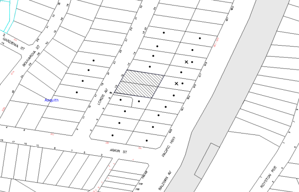
|
NOTIFICATION PLAN |
|
||
|
• PROPERTIES NOTIFIED
|
X SUBMISSIONS RECEIVED |
PROPERTY SUBJECT OF DEVELOPMENT |
|
Two submissions object to the development. One of the submissions related to the adjoining five storey development at Nos. 14 - 16 Lords Avenue, Asquith for DA/899/2013. The concerns raised have already been addressed in that application. The other submission objects to the development generally on the grounds that the development would result in:
· Detrimental visual amenity impacts;
· Unacceptable overshadowing of adjoining properties;
· Unacceptable privacy impacts to adjoining properties;
· Traffic and Noise impacts;
· Negative impact on surrounding flora and fauna and wildlife;
· Detrimental impacts to the value of adjoining properties.
The merits of the matters raised in community submissions have been addressed in the body of the report with the exception of the following:
5.1.1 Overshadowing
One submission raises concern that the development would overshadow the existing dwellings to the rear of the site, including No. 415 Pacific Highway.
The submitted shadow diagrams demonstrate that the private open space area at No. 415 Pacific Highway would receive an additional hour of overshadowing between 9am and 3pm, during the Winter Solstice. No additional overshadowing impacts would occur to the north facing windows of the existing dwelling house at No. 415 Pacific Highway between 9am and 3pm, during the Winter Solstice. The properties fronting Pacific Highway form part of the Lords Avenue High Density Housing Precinct and are likely to be subject to future development.
5.1.2 Devaluation of Property
The site has been rezoned to form a part of a high density residential precinct. The proposed density conforms with the development controls within Part 3.4 of the Hornsby Development Control Plan. The impacts of the high density zone on the surrounding locality had been considered in detail during the rezoning process. Devaluation of neighbouring properties due to redevelopment of the site is not a matter for consideration under Section 79C of the Environmental Planning and Assessment Act.
No further assessment in this regard is necessary.
5.2 Public Agencies
The development application was not referred to any Public Agencies for comment.
6. THE PUBLIC INTEREST
Section 79C(1)(e) of the Act requires Council to consider “the public interest”.
The public interest is an overarching requirement, which includes the consideration of the matters discussed in this report. Implicit to the public interest is the achievement of future built outcomes adequately responding to and respecting the future desired outcomes expressed in environmental planning instruments and development control plans.
The application is considered to have satisfactorily addressed Council’s and relevant agencies’ criteria and would provide a development outcome that, on balance, would result in a positive impact for the community. Accordingly, it is considered that the approval of the proposed development would be in the public interest.
CONCLUSION
The application seeks approval for the demolition of existing structures and construction of a five storey residential flat building comprising 25 units with basement car parking and strata title subdivision.
The proposed development is generally in accordance with the development controls for the ‘Lords Avenue, Asquith’ Precinct of the Hornsby Development Control Plan and would contribute to the future desired five storey residential character of the precinct. The minor non-compliance with prescriptive measures for setbacks, private open space and landscaping are considered acceptable. The proposal complies with the design principles of SEPP 65 and the Residential Flat Design Code.
The proposal would result in a development that would be in keeping with the desired future character of the precinct.
Note: At the time of the completion of this planning report, no persons have made a Political Donations Disclosure Statement pursuant to Section 147 of the Environmental Planning and Assessment Act 1979 in respect of the subject planning application.
|
Rod Pickles Manager - Development Assessment Planning Division |
James Farrington Group Manager Planning Division |
|
1.View |
Locality Map |
|
|
|
2.View |
Site Plan |
|
|
|
3.View |
Floor Plans and Basement Plan |
|
|
|
4.View |
Elevation Plans |
|
|
|
5.View |
Shadow Plan |
|
|
File Reference: DA/1433/2013
Document Number: D02887222
SCHEDULE 1
GENERAL CONDITIONS
The conditions of consent within this notice of determination have been applied to ensure that the use of the land and/or building is carried out in such a manner that is consistent with the aims and objectives of the relevant legislation, planning instruments and council policies affecting the land and does not disrupt the amenity of the neighbourhood or impact upon the environment.
Note: For the purpose of this consent, the term ‘applicant’ means any person who has the authority to act on or the benefit of the development consent.
Note: For the purpose of this consent, any reference to an Act, Regulation, Australian Standard or publication by a public authority shall be taken to mean the gazetted Act or Regulation, or adopted Australian Standard or publication as in force on the date that the application for a construction certificate is made.
1. Approved Plans and Supporting Documentation
The development must be carried out in accordance with the plans and documentation listed below and endorsed with Council’s stamp, except where amended by Council and/or other conditions of this consent:
|
Plan No. |
Plan Title |
Drawn by |
Dated |
|
2301 Sheet 01 Rev E - |
Site/Roof Plan |
Innovative Architects |
May 2014 |
|
2301 Sheet 02 Rev E - |
Basement 2 Floor Plan |
Innovative Architects |
May 2014 |
|
2301 Sheet 03 Rev E - |
Basement 1 Floor Plan |
Innovative Architects |
May 2014 |
|
2301 Sheet 04 Rev E - |
Ground Floor Plan |
Innovative Architects |
May 2014 |
|
2301 Sheet 05 Rev E - |
Levels 1-3 Floor Plan |
Innovative Architects |
May 2014 |
|
2301 Sheet 06 Rev E - |
Level 4 Floor Plan |
Innovative Architects |
May 2014 |
|
2301 Sheet 07 Rev E - |
Elevations (West and South) |
Innovative Architects |
May 2014 |
|
2301 Sheet 08 Rev E - |
Elevations (East and North) |
Innovative Architects |
May 2014 |
|
2301 Sheet 09 Rev E - |
Section A-A |
Innovative Architects |
May 2014 |
|
2301 Sheet 10 Rev A - |
Shadow Diagrams |
Innovative Architects |
December 2013 |
|
D1-D4 Issue A |
Stormwater Plan |
Storm Civil Engineering Solutions |
16 December 2013 |
|
1145 Issue A/1 |
Landscape Plan |
Site Design +Studios |
19 December 2013 |
|
Document Title |
Prepared By |
Date |
|
Statement of Environmental Effects |
Planning Ingenuity |
19 Dec 2013 |
|
Basix Certificate No. 522086M_02 |
Efficient Living |
19 May 2014 |
|
Access Report |
Accessible Building Solutions |
18 Dec 2013 |
|
Design Verification Statement |
Innovative Architects |
18 Dec 2013 |
|
Schedule of Finishes |
Annette Bennett |
19 Dec 2013 |
|
Waste Management Plan |
Scott Soames |
20 Dec 2013 |
|
Solar Access Table and Diagrams |
Innovative Architects |
Received on 24 Mar 2014 |
|
Schedule of Area |
Innovative Architects |
Received in May 2014 |
|
Tree Report |
Bolans Tree Service Trust P/L |
12 Mar 2104 |
|
Traffic and Parking Report |
Solution Traffic Engineer |
Dec 2013 |
|
SEPP 65 Design Quality Principles |
Innovative Architects |
Dec 2013 |
2. Removal of Existing Trees
This development consent only permits the removal of trees numbered 1,3,6,8,9,11,13,14,15 as identified on Amended Architectural Plans (D0284300) prepared by Innovative Architects dated 24 March 2014. The removal of any other trees requires separate approval in accordance with the Tree and Vegetation Chapter 1B.6 Hornsby Development Control Plan (HDCP).
3. Amendment of Plans
a) The Landscape plan listed in Condition 1 is to be amended in accordance with the site layout as approved in “2301 Sheet 04 Rev C - Ground Floor Plan drawing by Innovative Architects dated March 2014.
b) The approved floor plans titled 2301 Sheet 04 Rev C – Ground Floor Plan, 2301 Sheet 05 Rev C – Levels 1-3 Floor Plan and 2301 Sheet 06 Rev C – Level 4 Floor Plan prepared by Innovative Architects dated May 2014 and listed in Condition 1 of this development consent, are to be amended to include an internal storage area for all units. The storage areas must have a minimum volume of 2m³ for 1 bedroom units, 4m3 for 2 bedroom units and 5m3 for 3 bedroom units in accordance with the requirements of the RFDC.
c) The approved floor plan titled 2301 Sheet 06 Rev C – Level 4 Floor Plan prepared by Innovative Architects dated May 2014 is required to be amended to provide privacy mitigation measures for future occupants on the southern adjoining property. The following measures are to be provided:
i) The trafficable areas of balconies are required to be setback at least 6m from the southern side property boundary.
ii) 1.8m high privacy screens are required to be erected along the southern side of the balcony.
d) The letterboxes are to be setback at least 2m from the front boundary and be screened by plantings.
4. Construction Certificate
A Construction Certificate is required to be approved by Council or a Private Certifying Authority prior to the commencement of any works under this consent.
5. Project Arborist
A Project Arborist is to be appointed in accordance with AS 4970-2009 (1.4.4) to provide monitoring and certification through the development process.
6. Section 94 Development Contributions
In accordance with Section 80A(1) of the Environmental Planning and Assessment Act 1979 and the Hornsby Shire Council Section 94 Development Contributions Plan 2012-2021, the following monetary contributions shall be paid to Council to cater for the increased demand for community infrastructure resulting from the development:
|
Description |
Contribution (4) |
|
Roads |
$27,075.70 |
|
Open Space and Recreation |
$293141.30 |
|
Community Facilities |
$41092.80 |
|
Plan Preparation and Administration |
$1175.20 |
|
TOTAL |
$362,485 |
being for 4 x 1 bedroom units, 15 x 2 bedroom units and 6 x 3 bedroom units in lieu of two existing dwelling houses.
a) If the contributions are not paid within the financial quarter that this consent is granted, the contributions payable will be adjusted in accordance with the provisions of the Hornsby Shire Council Section 94 Development Contributions Plan and the amount payable will be calculated at the time of payment in the following manner:
$CPY = $CDC x CPIPY
CPIDC
Where:
$CPY is the amount of the contribution at the date of Payment.
$CDC is the amount of the contribution as set out in this Development Consent.
CPIPY is the latest release of the Consumer Price Index (Sydney – All Groups) at the date of Payment as published by the ABS.
CPIDC is the Consumer Price Index (Sydney – All Groups) for the financial quarter at the date of this Development Consent.
b) The monetary contributions shall be paid to Council:
i) prior to the issue of the Subdivision Certificate where the development is for subdivision; or
ii) prior to the issue of the first Construction Certificate where the development is for building work; or
iii) prior to issue of the Subdivision Certificate or first Construction Certificate, whichever occurs first, where the development involves both subdivision and building work; or
iv) prior to the works commencing where the development does not require a Construction Certificate or Subdivision Certificate.
It is the professional responsibility of the Principal Certifying Authority to ensure that the monetary contributions have been paid to Council in accordance with the above timeframes.
Council’s Development Contributions Plan may be viewed at www.hornsby.nsw.gov.au or a copy may be inspected at Council’s Administration Centre during normal business hours.
REQUIREMENTS PRIOR TO THE ISSUE OF A CONSTRUCTION CERTIFICATE
7. Building Code of Australia
All building work must be carried out in accordance with the relevant requirements of the Building Code of Australia.
8. Contract of Insurance (Residential Building Work)
In the case of residential building work for which the Home Building Act 1989 requires there to be a contract of insurance in force in accordance with Part 6 of that Act, that such a contract of insurance is in force before any building work authorised to be carried out by the consent commences.
9. Notification of Home Building Act, 1989 Requirements
Residential building work within the meaning of the Home Building Act 1989 must not be carried out unless the principal certifying authority for the development to which the work relates (not being Council) has given Council written notice of the following information:
a) In the case of work for which a principal contractor is required to be appointed:
i) The name and licence number of the principal contractor; and
ii) The name of the insurer by which the work is insured under Part 6 of that Act.
b) In the case of work to be done by an owner-builder:
i) The name of the owner-builder; and
ii) If the owner-builder is required to hold an owner-builder’s permit under that Act, the number of the owner-builder’s permit.
Note: If arrangements for doing the residential building work are changed while the work is in progress so that the information notified becomes out of date, further work must not be carried out unless the principal certifying authority for the development to which the work relates (not being Council) has given Council written notification of the updated information.
10. Water/Electricity Utility Services
The applicant must submit written evidence of the following service provider requirements:
a) Ausgrid (formerly Energy Australia) – a letter of consent demonstrating that satisfactory arrangements have been made to service the proposed development.
b) Sydney Water – the submission of a ‘Notice of Requirements’ under s73 of the Sydney Water Act 1994.
Note: Sydney Water requires that s73 applications are to be made through an authorised Sydney Water Servicing Coordinator. Refer to www.sydneywater.com.au or telephone 13 20 92 for assistance.
11. Dilapidation Report
A ‘Dilapidation Report’ is to be prepared by a ‘chartered structural engineer’ detailing the structural condition of all adjoining properties.
12. Adaptable Units
The details of the fit-outs of all accessible units and details of adaptable units must be provided with the Construction Certificate Plans.
13. Letter Boxes
The details of letter boxes must be provided with the Construction Certificate Plans. The letter boxes must be provided with a minimum setback of 2m from the front property boundary and not located within the overland flow path.
14. Swept Path Analysis
A swept path analysis for the SRV garbage vehicle reversing into the site and departing in a forward direction shall be submitted in accordance with AUSTROADS. The analysis is to assume vehicles are parked in Lords Avenue.
15. Driveway
The driveway between the property and Lords Avenue is to be constructed perpendicular to the road alignment.
16. Construction Vehicles
All construction vehicles associated with the proposed development are to be contained on site as no construction zones will be permitted on Lords Avenue in the vicinity of the site.
17. Construction Traffic Management Plan
A Construction Traffic Management Plan detailing construction vehicle routes, number of trucks, hours of operation, access arrangements and traffic control should be submitted to Council prior to the issue of a construction certificate.
18. Car Parking
All car parking must be constructed and operated in accordance with Australian Standard AS 2890.1 – 2004 – Off Street Car Parking and Australian Standard 2890.2 - 2002 – Off Street Commercial and the following requirements:
a) All parking areas and driveways are to be sealed to an all weather standard, line marked and signposted.
b) Car parking, loading and manoeuvring areas to be used solely for nominated purposes.
c) Vehicles awaiting loading, unloading or servicing shall be parked on site and not on adjacent or nearby public roads;
d) All vehicular entry on to the site and egress from the site shall be made in a forward direction.
19. Parking for People with Disabilities
All parking for people with disabilities is to comply with AS/NZS 2890.6:2009 Off-street parking for people with disabilities.
20. Bicycle Parking
At least 5 resident bicycle spaces are to be provided in the basement car park. Bicycle parking spaces are to be designed in accordance with AS 2890.3-1993.
21. Motorcycle Parking Spaces
Motorcycle parking spaces are to be designed in accordance with AS 2890.5-1993.
22. Waste Management Details
The following waste management requirements must be complied with:
a) The waste collection area needs to be increased in area to 4.0 m wide by 1.6 m deep.
b) A Waste Management Plan Section One – Demolition Stage and Section Three – Construction Stage, covering the scope of this project and including the following details, is required to be submitted to Council:
i) An estimate of the types and volumes of waste and recyclables to be generated;
ii) A site plan showing sorting and storage areas for demolition and construction waste and the vehicle access to these areas;
iii) How excavation, demolition and construction waste materials will be reused or recycled and where residual wastes will be disposed;
iv) The total percentage (by weight) of demolition and construction waste that will be reused or recycled.
REQUIREMENTS PRIOR TO THE COMMENCEMENT OF ANY WORKS
23. Erection of Construction Sign
A sign must be erected in a prominent position on any site on which building work, subdivision work or demolition work is being carried out:
a) Showing the name, address and telephone number of the principal certifying authority for the work;
b) Showing the name of the principal contractor (if any) for any demolition or building work and a telephone number on which that person may be contacted outside working hours; and
c) Stating that unauthorised entry to the work site is prohibited.
Note: Any such sign is to be maintained while the building work, subdivision work or demolition work is being carried out, but must be removed when the work has been completed.
24. Protection of Adjoining Areas
A temporary hoarding, fence or awning must be erected between the work site and adjoining lands before the works begin and must be kept in place until after the completion of the works if the works:
a) Could cause a danger, obstruction or inconvenience to pedestrian or vehicular traffic.
b) Could cause damage to adjoining lands by falling objects.
c) Involve the enclosure of a public place or part of a public place.
Note: Notwithstanding the above, Council’s separate written approval is required prior to the erection of any structure or other obstruction on public land.
25. Toilet Facilities
Toilet facilities must be available or provided at the works site before works begin and must be maintained until the works are completed at a ratio of one toilet for every 20 persons employed at the site. Each toilet must:
a) be a standard flushing toilet connected to a public sewer; or
b) be a temporary chemical closet approved under the Local Government Act 1993; or
c) have an on-site effluent disposal system approved under the Local Government Act 1993.
26. Erosion and Sediment Control
Erosion and sediment control measures must be provided and maintained throughout the construction period in accordance with the manual ‘Soils and Construction 2004 (Bluebook)’, the approved plans, Council specifications and to the satisfaction of the principal certifying authority. The erosion and sediment control devices must remain in place until the site has been stabilised and revegetated.
Note: On the spot penalties up to $1,500 may be issued for any non-compliance with this requirement without any further notification or warning.
27. Tree Protection Barriers
Tree protection fencing must be erected around trees numbered 2,5,10 to be retained at a 4 metre setback. The Tree Protection Zones for all trees on site have been incorrectly calculated based on the Australian Standard AS 4970-2009.
To avoid injury or damage, trees numbered 2,5,10 must have trunks protected by 2 metre lengths of 75mm x 25mm hardwood timbers spaced at 80mm secured with galvanised wire (not fixed or nailed to the tree in any way.
a) Tree Protection Zones (TPZ) of trees proposed for retention shall be fenced in accordance with AS 4970-2009 and as advised by the appointment project Arborist. The tree fencing must be constructed of 1.8m ‘cyclone chainmesh fence’ or star pickets spaced at 2m intervals, connected by a continuous high-visibility barrier/hazard mesh at a height of 1m. The fencing will assist in ensuring that no excavation, filling, or stockpiling of building materials, parking of vehicles or plant, disposal of cement slurry, waste water or other contaminants is to occur within the TPZ of any tree and adjoining bushland to be retained.
b) A certificate from the project Arborist (AQF 5) is to be submitted to the Principal Certifying Authority stating that all tree protection measures are in accordance with AS 4970-2009 (Section 4) prior to commencement of works.
REQUIREMENTS DURING CONSTRUCTION
28. Construction Work Hours
All work on site (including demolition and earth works) must only occur between 7am and 5pm Monday to Saturday. No work is to be undertaken on Sundays or public holidays.
29. Demolition
All demolition work must be carried out in accordance with “Australian Standard 2601-2001 – The Demolition of Structures” and the following requirements
a) Demolition material must be disposed of to an authorised recycling and/or waste disposal site and/or in accordance with an approved waste management plan;
b) Demolition works, where asbestos material is being removed, must be undertaken by a contractor that holds an appropriate licence issued by WorkCover NSW in accordance with Chapter 10 of the Occupational Health and Safety Regulation 2001 and Clause 29 of the Protection of the Environment Operations (Waste) Regulation 2005 ;and
c) On construction sites where buildings contain asbestos material, a standard commercially manufactured sign containing the words ‘DANGER ASBESTOS REMOVAL IN PROGRESS’ measuring not less than 400mm x 300mm must be erected in a prominent position visible from the street.
30. Environmental Management
The site must be managed in accordance with the publication ‘Managing Urban Stormwater – Landcom (March 2004) and the Protection of the Environment Operations Act 1997 by way of implementing appropriate measures to prevent sediment run-off, excessive dust, noise or odour emanating from the site during the construction of the development.
31. Street Sweeping
Street sweeping must be undertaken following sediment tracking from the site along Lords Avenue during works and until the site is established.
32. Works Near Trees
All required tree protection measures are to be maintained in good condition for the duration of the construction period.
All works (including driveways and retaining walls) within the nominated Tree Protection Zones of any trees required to be retained (whether or not on the subject property, and pursuant to this consent or the Tree Preservation Order), must be carried out under the supervision of an ‘AQF Level 5 Arborist’ and a certificate submitted to the principal certifying authority detailing the method(s) used to preserve the tree(s).
a) All required tree protection measures are to be maintained in accordance with AS 4970-2009 (Section 4) for the duration of the construction period.
b) Should the excavation of any underground services (i.e. drainage/sewer/stormwater) be approved within the specified TPZ of tree to be retained on the subject property or neighbouring property, excavation by hand ONLY shall be undertaken.
c) Excavation works near trees must be carried out under the supervision of the Project Arborist.
d) Tree sensitive construction techniques such as pier and beam construction and hand excavation are to be undertaken for all works within the TPZ’s of any tree to be retained. Tree Protection Fencing (as specific in Condition 11 above) must be maintained during the entire construction period.
e) All machinery to be cleaned of soil and debris before entering the site to prevent the spread of weeds and fungal pathogens.
Note: Except as provided above, the applicant is to ensure that no excavation, filling or stockpiling of building materials, parking of vehicles or plant, disposal of cement slurry, waste water or other contaminants is to occur within 4 metres of any tree to be retained.
33. Waste Management Details
Waste management during the demolition and construction phase of the development must be undertaken in accordance with the approved Waste Management Plan. Additionally written records of the following items must be maintained during the removal of any waste from the site and such information submitted to the Principal Certifying Authority within fourteen days of the date of completion of the works:
a) The identity of the person removing the waste;
b) The waste carrier vehicle registration;
c) Date and time of waste collection;
d) A description of the waste (type of waste and estimated quantity);
e) Details of the site to which the waste is to be taken;
f) The corresponding tip docket/receipt from the site to which the waste is transferred (noting date and time of delivery, description (type and quantity) of waste); and
g) Whether the waste is expected to be reused, recycled or go to landfill.
Note: In accordance with the Protection of the Environment Operations Act 1997, the definition of waste includes any unwanted substance, regardless of whether it is reused, recycled or disposed to landfill.
34. Council Property
During construction works, no building materials, waste, machinery or related matter is to be stored on the road or footpath. The public reserve must be kept in a clean, tidy and safe condition at all times.
35. Disturbance of Existing Site
During construction works, the existing ground levels of open space areas and natural landscape features, (including natural rock-outcrops, vegetation, soil and watercourses) must not be altered unless otherwise nominated on the approved plans.
36. Landfill
Landfill must be constructed in accordance with Council’s ‘Construction Specification 2005’ and the following requirements:
a) All fill material imported to the site is to wholly consist of Virgin Excavated Natural Material (VENM) as defined in Schedule 1 of the Protection of the Environment Operations Act 1997 or a material approved under the Department of Environment and Climate Change’s general resource recovery exemption.
b) A compaction certificate is to be obtained from a geotechnical engineer verifying that the specified compaction requirements have been met.
37. Excavated Material
All excavated material removed from the site must be classified in accordance with the Department of Environment, Climate Change and Water NSW Waste Classification Guidelines prior to disposal to an approved waste management facility and reported to the principal certifying authority.
38. Survey Report – Finished Floor Level
A report(s) must be prepared by a registered surveyor and submitted to the principal certifying authority prior to the pouring of concrete at each level of the building certifying that:
a) The building, retaining walls and the like have been correctly positioned on the site; and
b) The finished floor level(s) are in accordance with the approved plans.
39. Contamination During Construction Works
The construction works must be undertaken in accordance with the “Interim Construction Noise Guidelines – 2009” published by Department of Environment and Climate Change NSW.
REQUIREMENTS PRIOR TO THE ISSUE OF AN OCCUPATION CERTIFICATE
Note: For the purpose of this consent, a reference to ‘occupation certificate’ shall not be taken to mean an ‘interim occupation certificate’ unless otherwise stated.
40. Fulfilment of BASIX Commitments
The applicant must demonstrate the fulfilment of BASIX commitments pertaining to the development.
41. Sydney Water – s73 Certificate
An s73 Certificate must be obtained from Sydney Water.
42. Maintain Canopy Cover
To maintain canopy cover, 3 medium to large trees selected from Council’s booklet ‘Indigenous Plants for the Bushland Shire’ such as Syncarpia glomulifera, Angophora costata, Eucalyptus gummifera are to be planted on the subject site. The planning location shall not be within 4 metres of the foundation walls of a dwelling or in-ground pool. The pot size is to be a minimum 25 litres and the tree(s) must be maintained until they reach the height of 3 metres. Trees must be native to Hornsby Shire and reach a mature height greater than 20 metres.
43. Garbage Collection Easement
For the purpose of waste collection, an easement entitling Council, its servants and agents and persons authorised by it to enter upon the subject land and to operate thereon, vehicles and other equipment for the purposes of garbage collection must be granted to Council by the owner of the land.
Note The easement must be in a form prescribed by Council and must include covenants to the effect that parties will not be liable for any damage caused to the subject land or any part thereof or to any property located therein or thereon by reason of the operation thereon of any vehicle or other equipment used in connection with the collection of garbage and to the effect that the owner for the time being of the subject land shall indemnify the Council, its servants, agents and persons authorised by it to collect garbage against liability in respect of any such claims made by any person whomsoever.
44. Waste Management Details
The following waste management requirements must be complied with:
a) The bin storage room at the basement level must include water or a hose for cleaning, graded floors with drainage to sewer, a robust door, sealed and impervious surface, adequate lighting and ventilation, and must be lockable. The waste facility cupboards at each residential level must include sealed and impervious surface, adequate lighting and ventilation.
b) A report must be prepared by an appropriately qualified person, certifying the following:
i) A comparison of the estimated quantities of each waste type against the actual quantities of each waste type.
Note: Explanations of any deviations to the approved Waste Management Plan is required to be included in this report.
ii) That at least 60% of the waste generated during the demolition and construction phase of the development was reused or recycled.
Note: If the 60% diversion from landfill cannot be achieved in the Construction Stage, the Report is to include the reasons why this occurred and certify that appropriate work practices were employed to implement the approved Waste Management Plan. The Report must be based on documentary evidence such as tipping dockets/receipts from recycling depots, transfer stations and landfills, audits of procedures etc. which are to be attached to the report.
iii) All waste was taken to site(s) that were lawfully permitted to accept that waste.
c) Each unit must be provided with an indoor waste/recycling cupboard for the interim storage of a minimum one day’s waste generation with separate containers for general waste and recyclable materials.
d) Space must be provided for either individual compost containers for each unit or a communal compost container;
Note: The location of the compost containers should have regard for potential amenity impacts.
e) The bin carting routes must be devoid of any steps.
Note: Ramps between the different levels are acceptable
f) Access to the waste volume handling equipment by unauthorised persons (including residents and waste collectors) must be prevented.
Note: Caging of the volume handling equipment is acceptable.
45. Stormwater Drainage
The stormwater drainage system for the development must be designed and constructed for an average recurrence interval of 20 years and be gravity drained in accordance with following requirements:
a) Connected directly to Council’s drainage system (pipe/gutter) via an on site detention system.
b) Be designed by a qualified Hydraulic Engineer.
46. On Site Stormwater Detention
An on-site stormwater detention system must be designed by a chartered civil engineer and constructed in accordance with the following requirements:
a) Storage capacity to accommodate volume from up to 20 years ARI (average recurrence interval) and a maximum discharge (when full) of 5 years predevelopment rate.
b) Have a surcharge/inspection grate located directly above the outlet.
c) Discharge from the detention system to be controlled via 1 metre length of pipe, not less than 50 millimetres diameter or via a stainless plate with sharply drilled orifice bolted over the face of the outlet discharging into a larger diameter pipe capable of carrying the design flow to an approved Council system.
d) Where above ground and the average depth is greater than 0.3 metres, a ‘pool type’ safety fence and warning signs to be installed.
e) Not be constructed in a location that would impact upon the visual or recreational amenity of residents.
f) Detail calculations are to be shown on the construction certificate plan.
47. Vehicular Crossing
A separate application under the Local Government Act 1993 and the Roads Act 1993 must be submitted to Council for the installation of a new vehicular crossing and the removal of the redundant crossing. The vehicular crossing must be constructed in accordance with Council’s Civil Works Design 2005 and the following requirements:
a) Any redundant crossings must be replaced with integral kerb and gutter;
b) The footway area must be restored by turfing;
c) Approval must be obtained from all relevant utility providers that all necessary conduits be provided and protected under the crossing.
Note: An application for a vehicular crossing can only be made to one of Council’s Authorised Vehicular Crossing Contractors. You are advised to contact Council on 02 9847 6940 to obtain a list of contractors.
48. Internal Driveway/Vehicular Areas
The driveway and parking areas on site must be designed in accordance with Australian Standards 2890.1, 2890.2, 3727 and the following requirements:
a) Design levels at the front boundary must be obtained from Council;
b) The driveway must be a rigid pavement;
49. Road Works
All road works approved under this consent must be constructed in accordance with Council’s Civil Works Design and Construction Specification 2005 and the following requirements:
a) Concrete footpath to be replaced along the frontage of the development. The nature strip on both sides of the footpath shall be repaired, top soiled and turfed.
b) The existing kerb and gutter along the frontage of the development are to be replaced if damaged during development works. The existing road pavement to be saw cut a minimum of 300mm from the existing edge of the gutter reconstructed.
c) A Construction Certificate application is to be submitted to Council for replacement of footpath and kerb and gutter (if required to be replaced that will be checked).
Note: Council is the only authority to approve works within Council roads.
50. Traffic Control Plan
A Traffic Control Plan (TCP) must be prepared by a qualified traffic controller in accordance with the Roads & Traffic Authority’s Traffic Control at Worksites Manual 1998 and Australian Standard 1742.3 for all work on a public road and be submitted to Council. The TCP must detail the following:
a) Arrangements for public notification of the works.
b) Temporary construction signage.
c) Permanent post-construction signage.
d) Vehicle movement plans.
e) Traffic management plans.
f) Pedestrian and cyclist access/safety.
51. Works as Executed Plan
A works-as-executed plan(s) must be prepared by a registered surveyor and submitted to Council for drainage works, kerb and gutter and on-site detention system.
52. Creation of Easements
The following matter(s) must be nominated on the plan of subdivision under s88B of the Conveyancing Act 1919:
a) The creation of an appropriate "Positive Covenant" and "Restriction as to User" over the constructed on-site detention/retention systems and outlet works, within the lots in favour of Council in accordance with Council’s prescribed wording. The position of the on-site detention system is to be clearly indicated on the title.
b) To register the OSD easement, the restriction on the use of land “works-as-executed” details of the on-site-detention system must be submitted verifying that the required storage and discharge rates have been constructed in accordance with the design requirements. The details must show the invert levels of the on site system together with pipe sizes and grades. Any variations to the approved plans must be shown in red on the “works-as-executed” plan and supported by calculations.
Note: Council must be nominated as the authority to release, vary or modify any easement, restriction or covenant.
53. Damage to Council Assets
Any damage caused to Council’s assets as a result of the construction of the development must be rectified in accordance with Council’s Civil Works Specifications. Council’s Restorations Supervision must be notified for a formwork inspection prior to pouring concrete.
54. Planter Boxes / On Slab Planting
On slab planter boxes must include waterproofing and subsoil drainage (proprietary drainage cell, 50mm sand and filter fabric) and automatic irrigation, minimum 500mm planting soil for shrubs and minimum 1000mm planting soil for trees and palms and 75mm mulch to ensure sustainable landscape is achieved.
55. Tree Planting
Tree planting to the Front Setback Areas to Include:
a) A minimum of one Angophora floribunda (Sydney Red Gum) as additional or substitution planting for proposed Banksia or Glochidion in this setback, installed at minimum 25 litre pot size.
Tree planting to the rear setback area to include:
b) A minimum of two Angophora floribunda (Sydney Red Gum) or other endemic species likely of exceeding 10 metres height at maturity as additional or substitution planting for proposed trees in this setback, installed at minimum 25 litre pot size.
Tree planting to the northern and southern side setback areas to include:
c) Three Angophora floribunda (Sydney Red Gum) or other endemic species as additional planting, installed at minimum 25 litre pot size.
56. Street Tree Plantings
Planting to the front verge to include one Tristaniopsis laurina (Water Gum) installed at minimum 100 litre pot size.
57. Access to Communal Open Space
The southern side access is to provide access to the rear communal open space in accordance with wheelchair accessibility standards.
58. Completion of Landscaping
A certificate must be provided by a practicing landscape architect or person with similar qualifications and experience certifying that all required landscape works have been satisfactorily completed in accordance with the approved landscape plans.
Note: Applicants are advised to pre-order plant material required in pot sizes 45 litre or larger to ensure Nurseries have stock available at the time of install.
59. Car Parking Allocation and Residential Storage
The basement resident storage areas are to be allocated in accordance with the size requirements of the Residential Flat Design Code for the respective units and proximity to the unit car parking space.
60. Retaining Walls
All required retaining walls must be constructed as part of the development.
61. Boundary Fencing
Fencing must be erected along all property boundaries behind the front building alignment to a height of 1.8 metres.
Note: Alternative fencing may be erected subject to the written consent of the adjoining property owner(s).
62. External Lighting
All external lighting must be designed and installed in accordance with Australian Standard AS 4282 – Control of the Obtrusive Effects of Outdoor Lighting. Certification of compliance with the Standard must be obtained from a suitably qualified person.
63. Unit Numbering
The allocation of unit numbering must be authorised by Council prior to the numbering of each unit in the development.
64. Construction of a Safe Environment
Prior to the issue of the Occupation Certificate, the site must include the following elements:
a) An intercom system be installed at gate locations to ensure screening of persons entering the units;
b) The entryway to the site be illuminated in high luminance at all times;
c) The communal open space areas are to be illuminated with high luminance by motion sensor lighting;
d) The service areas of the ground floor and the garbage room at the basement be illuminated with high luminance by motion sensor lighting;
e) The driveway and the basement car park is to be illuminated with low luminance at all times;
f) Robust materials which cannot be forced or breached with minimised maintenance requirements are to be used for construction work in the common areas;
g) The lamps and lighting levels must comply with Australian and New Zealand Lighting Standard 1158.1;
h) Effective signage be provided to guide visitors to the main areas and parking areas;
i) A street sign be prominently displayed in front of the site in accordance with Order No. 8, Section 124 Local Government Act 1993;
j) The communal area must include a clear sign to restrict access for non-residents;
k) Units’ numbers, entry and exit signs must be legible and clear;
l) Fire exit doors to be fitted with single cylinder locksets (Australia New Zealand Standard-Locksets);
m) The entry doors to the pedestrian foyer is to be constructed of safety rated glass to enable residents a clear line of site before entering or exiting the residential apartments;
n) Lighting is to be provided to pathways, building foyer entries, driveways and common external spaces;
o) Security deadlocks are to be provided to each apartment door; and
p) Peep holes are to be provided to individual apartment doors to promote resident safety.
OPERATIONAL CONDITIONS
65. Sight Distances for Pedestrians and Cyclists
Any proposed landscaping and/or fencing must not restrict sight distances to pedestrians and cyclists travelling along the footpath (AS2890.1 – sight lines for pedestrians).
66. Residential Parking Spaces
Residential parking spaces are to be secure spaces with access controlled by card or numeric pad.
67. Visitor Access
Visitors must be able to access the visitors parking spaces in the basement car park at all times. Visitors are to be able to access the basement car park by an audio/visual intercom system located at the top of the ramped driveway.
68. Waste Storage Area and Waste Management
The waste management on site must be in accordance with the following requirements:
a) A site caretaker must be employed and be responsible for moving bins where and when necessary, washing bins and maintaining waste storage areas, ensuring the chute system and related devices are maintained in effective and efficient working order, managing the communal composting area, managing the bulky item storage area, arranging the prompt removal of dumped rubbish, and ensuring all residents are informed of the use of the waste management system.
69. Landscape Establishment
The landscape works must be maintained into the future to ensure the establishment and successful growth of plant material to meet the intent of the landscape design. This must include but not be limited to watering, weeding, replacement of failed plant material and promoting the growth of plants through standard industry practices.
70. Noise
The level of total continuous noise emanating from operation of the premises including all the plant, including air conditioning units and processes in all buildings (LA10) (measured for at least 15 minutes) in or on the above premises, must not exceed the background level by more than 5dB(A) when measured at all property boundaries.
71. Fire Safety Statement - Annual
On at least one occasion in every 12 month period following the date of the first ‘Fire Safety Certificate’ issued for the property, the owner must provide Council with an annual ‘Fire Safety Certificate’ to each essential service installed in the building.
- END OF CONDITIONS -
ADVISORY NOTES
The following information is provided for your assistance to ensure compliance with the Environmental Planning and Assessment Act, 1979, Environmental Planning and Assessment Regulation 2000, other relevant legislation and Council’s policies and specifications. This information does not form part of the conditions of development consent pursuant to Section 80a of the Act.
Environmental Planning and Assessment Act, 1979 Requirements
The Environmental Planning and Assessment Act, 1979 requires:
· The issue of a construction certificate prior to the commencement of any works. Enquiries can be made to Council’s Customer Services Branch on 9847 6760.
· A principal certifying authority to be nominated and Council notified of that appointment prior to the commencement of any works.
· Council to be given at least two days written notice prior to the commencement of any works.
· Mandatory inspections of nominated stages of the construction inspected.
· An occupation certificate to be issued before occupying any building or commencing the use of the land.
Long Service Levy
In accordance with Section 34 of the Building and Construction Industry Long Service Payments Act 1986, a ‘Long Service Levy’ must be paid to the Long Service Payments Corporation or Hornsby Council.
Note: The rate of the Long Service Levy is 0.35% of the total cost of the work.
Note: Hornsby Council requires the payment of the Long Service Levy prior to the issue of a construction certificate.
Tree and Vegetation Preservation
In accordance with Clause 5.9 of the Hornsby Local Environmental Plan 2013 a person must not ringbark, cut down, top, lop, remove, injure or wilfully destroy any tree or other vegetation protected under the Hornsby Development Control Plan 2013 without the authority conferred by a development consent or a permit granted by Council.
Notes: A tree is defined as a long lived, woody perennial plant with one or relatively few main stems with the potential to grow to a height greater than three metres (3M). (HDCP 1B.6.1.c).
Tree protection measures and distances are determined using the Australian Standard AS 4970:2009, “Protection of Trees on Development Sites”.
Fines may be imposed for non-compliance with both the Hornsby Local Environmental Plan 2013 and the Hornsby Development Control Plan 2013.
Disability Discrimination Act
The applicant’s attention is drawn to the existence of the Disability Discrimination Act. A construction certificate is required to be obtained for the proposed building/s, which will provide consideration under the Building Code of Australia, however, the development may not comply with the requirements of the Disability Discrimination Act. This is the sole responsibility of the applicant.
Subdivision Certificate Requirements
A subdivision certificate application is required to be lodged with Council containing the following information:
· A surveyor’s certificate certifying that all structures within the subject land comply with the development consent in regard to the setbacks from the new boundaries.
· A surveyor’s certificate certifying that all services, drainage lines or access are located wholly within the property boundaries. Where services encroach over the new boundaries, easements are to be created.
· Certification that the requirements of relevant utility authorities have been met.
· A surveyor’s certificate certifying finished ground levels are in accordance with the approved plans.
Note: Council will not issue a subdivision certificate until all conditions of the development consent have been completed.
Fees and Charges – Subdivision
All fees payable to Council as part of any construction, compliance or subdivision certificate or inspection associated with the development (including the registration of privately issued certificates) are required to be paid in full prior to the issue of the subdivision certificate. Any additional Council inspections beyond the scope of any compliance certificate required to verify compliance with the terms of this consent will be charged at the individual inspection rate nominated in Council's Fees and Charges Schedule.
Dial Before You Dig
Prior to commencing any works, the applicant is encouraged to contact Dial Before You Dig on 1100 or www.dialbeforeyoudig.com.au for free information on potential underground pipes and cables within the vicinity of the development site.
Telecommunications Act 1997 (Commonwealth)
If you are aware of any works or proposed works which may affect or impact on Telstra’s assets in any way, you are required to contact: Telstra’s Network Integrity Team on Phone Number 1800810443.
Asbestos Warning
Should asbestos or asbestos products be encountered during demolition or construction works, you are advised to seek advice and information prior to disturbing this material. It is recommended that a contractor holding an asbestos-handling permit (issued by WorkCover NSW) be engaged to manage the proper handling of this material. Further information regarding the safe handling and removal of asbestos can be found at:
Alternatively, telephone the WorkCover Asbestos and Demolition Team on 8260 5885.
House Numbering
House numbering can only be authorised by Council. Before proceeding to number each premise in the development, the allocation of numbers is required to be obtained from Council's Planning Division prior to the issue of a Subdivision Certificate. The authorised numbers are required to comply with Council’s Property Numbering Policy and be displayed in a clear manner at or near the main entrance to each premise.
Group Manager’s Report No. PL40/14
Planning Division
Date of Meeting: 11/06/2014
13 DEVELOPMENT APPLICATION - MULTI-UNIT HOUSING COMPRISING TWO DETACHED DWELLING-HOUSES - 8 THORN STREET, PENNANT HILLS
EXECUTIVE SUMMARY
|
DA No: |
DA/892/2013 (Lodged 3 September 2013) |
|
Description: |
Multi-unit housing comprising the erection of two detached dwelling-houses |
|
Property: |
Lot 5, DP 235034, No. 8 Thorn Street, Pennant Hills |
|
Applicant: |
P S Graham & Associates |
|
Owner: |
Mrs F T Srour |
|
Estimated Value: |
$615,000 |
|
Ward: |
C |
· The application proposes the erection of multi-unit housing comprising two detached dwelling-houses.
· The proposal does not comply with the Hornsby Shire Local Environmental Plan 1994 with regard to Clause 15 (Floor Space Ratio). The applicant has made a submission pursuant to State Environmental Planning Policy No. 1 - Development Standards to vary the standard. The submission is considered well-founded and is supported.
· Council received two submissions during the exhibition period.
· It is recommended that the application be approved.
|
THAT Council assume the concurrence of the Secretary of the Department of Planning and Environment pursuant to State Environmental Planning Policy No. 1 and approve Development Application No. DA/892/2013 for multi-unit housing comprising the erection of two detached dwelling-houses at Lot 5 DP 235034, No. 8 Thorn Street, Pennant Hills subject to the conditions of consent detailed in Schedule 1 of Group Manager’s Report No. PL40/14. |
BACKGROUND
On 20 June 2013, Council refused Development Application No. DA/406/2013 for the subdivision of the subject allotment into two lots. The reasons for refusal were that the proposal would result in one lot being 400m² which does not comply with the 500m² minimum lot size development standard under the Hornsby Shire Local Environmental Plan (HSLEP) 1994 and would set an undesirable precedent for the area.
On 3 September 2013, the applicant lodged the subject development application, DA/892/2013, for the demolition of a dwelling-house, erection of multi-unit housing and subdivision of one allotment into two lots.
On 12 December 2013, the applicant submitted additional plans including elevations and shadow diagrams.
On 4 February 2014, the applicant submitted a stormwater concept plan.
On 20 March 2014, the applicant submitted an amended site plan removing the subdivision component of the application.
SITE
The site has an area of 1,214m² and is located on the north-eastern side of Thorn Street, Pennant Hills. The site gains access to Thorn Street via a battle-axe handle with varying widths.
The site has an average fall of 10% to the rear, south-eastern corner of the site and contains a two storey brick and tile dwelling-house.
The surrounding area is characterised by a mix of one and two storey residential dwellings.
The site is not identified as being located on bushfire prone or flood prone land.
The site adjoins No. 6 Thorn Street which is listed as a heritage item (“House”) of local significance under the provisions of Schedule D of the HSLEP. The site is not located in a heritage conservation area.
PROPOSAL
The application proposes demolition of a dwelling-house and the erection of multi-unit housing comprising two detached dwellings (hereafter referred to as Dwelling 1 and Dwelling 2) and associated works.
Dwelling 1 would be located on the south-western portion of the site. The ground floor level of the dwelling would comprise a porch, entry, double garage, lounge/dining room, water closet, family room, kitchen, laundry and an alfresco area. The first floor level would comprise 4 bedrooms, bathroom, walk-in-robe, and an ensuite.
Dwelling 2 would be located on the north-eastern portion of the site. The ground floor level of the dwelling would comprise a porch, foyer, double garage, lounge and dining room, family room, powder room, laundry, kitchen and an alfresco area. The first floor level would comprise 3 bedrooms, bathroom, walk-in-robe, and an ensuite.
The application also involves the construction of a driveway, installation of an on-site stormwater detention system and the erection of a dividing fence between the two properties. The development would not necessitate the removal of any trees.
ASSESSMENT
The development application has been assessed having regard to the ‘Metropolitan Plan for Sydney 2031’, the ‘North Subregion (Draft) Subregional Strategy’ and the matters for consideration prescribed under Section 79C of the Environmental Planning and Assessment Act 1979 (the Act). The following issues have been identified for further consideration.
1. STRATEGIC CONTEXT
1.1 Metropolitan Plan for Sydney and (Draft) North Subregional Strategy
The (Draft) Metropolitan Strategy for Sydney 2031 is a broad framework to provide for Sydney’s growth to help plan for housing, employment, transport, infrastructure, the environment and open space. It outlines a vision for Sydney to 2031; the challenges faced, and the directions to follow to address these challenges and achieve the vision.
The North Subregion comprises Hornsby, Kuring-gai, Manly, Warringah and Pittwater Local Government Areas. The Draft North Subregional Strategy acted as a framework for Council in its preparation of the Hornsby Local Environmental Plan 2013.
Within the North Subregion, the Draft Metropolitan Strategy proposes:
· Population growth of 81,000 from the current 2011 baseline of 529,000
· Housing growth of 37,000 from the current 2011 baseline of 204,000
· Employment growth of 39,000 from the current 2011 baseline of 186,000
The proposed development would be consistent with the Metropolitan Plan for Sydney 2031 by providing an additional dwelling-house to assist in achieving Council’s dwelling target.
2. STATUTORY CONTROLS
Section 79C(1)(a) requires Council to consider “any relevant environmental planning instruments, draft environmental planning instruments, development control plans, planning agreements and regulations”.
2.1 Hornsby Shire Local Environmental Plan 1994
The subject land is zoned Residential A (Low Density) under the Hornsby Shire Local Environmental Plan 1994 (HSLEP). The objectives of the Residential A (Low Density) zone are:
(a) to provide for the housing needs of the population of the Hornsby area.
(b) to promote a variety of housing types and other land uses compatible with a low density residential environment.
(c) to provide for development that is within the environmental capacity of a low density residential environment.
The proposed development is defined as “multi-unit housing” under the HSLEP and is permissible in the zone with Council’s consent.
Clause 14 of the HSLEP prescribes that regardless of minimum allotment size requirements, Council may consent to the development of land for the purpose of multi-unit housing, but only where the Council is satisfied that the development would not result in a density not greater than one dwelling per 350m² within the Residential A (Low Density) zone. The proposed development would result in the site having one dwelling per 460.4m² which complies with the development standard.
Clause 15 of the HSLEP prescribes that the maximum floor space ratio (FSR) of development within the Residential A (Low Density) zone is 0.4:1. The proposed development would result in a FSR of 0.45:1 which does not comply with this development standard. To address this, the applicant has submitted a formal objection under the State Environmental Planning Policy No. 1 – Development Standards. This matter is addressed below under Section 2.3.
2.2 Hornsby Shire Local Environmental Plan 2013
The Hornsby Local Environmental Plan 2013 (HLEP) was gazetted by the then Minister for Planning and Infrastructure on 27 September 2013 and came into force on 11 October 2013. The HLEP includes a savings provision that a development application made and not finally determined before the commencement of the HLEP should be determined under the HSLEP 1994.
Under the HLEP, the subject land is zoned R2 (Low Density Residential) and “multi dwelling housing” would be prohibited within the zone.
Notwithstanding this, the application was lodged prior to the gazettal of the HLEP and, as a result, is assessed under the HSLEP 1994.
2.3 State Environmental Planning Policy No. 1 – Development Standards
The application has been assessed against the requirements of State Environmental Planning Policy No. 1 – Development Standards (SEPP 1). This Policy provides flexibility in the application of development standards in circumstances where strict compliance with those standards would, in any particular case, be unreasonable or unnecessary or tend to hinder the attainment of the objectives of the Act. The applicant has made a written submission in accordance with SEPP 1.
The NSW Land and Environment Court has expressed the view that there are 5 different ways in which an objection pursuant to SEPP 1 may be well founded and that approval of the objection may be consistent with the aims of the Policy as follows:
1. The objectives of the standard are achieved notwithstanding non-compliance with the standard;
2. The underlying objective or purpose of the standard is not relevant to the development and therefore compliance is unnecessary;
3. The underlying object or purpose would be defeated or thwarted if compliance was required and therefore compliance is unreasonable;
4. The development standard has been virtually abandoned or destroyed by the Council's own actions in granting consents departing from the standard and hence compliance with the standard is unnecessary and unreasonable; and
5. The zoning of the particular land is unreasonable or inappropriate so that a development standard appropriate for that zoning is also unreasonable and unnecessary as it applies to the land and compliance with the standard would be unreasonable or unnecessary. That is, the particular parcel of land should not have been included in the particular zone.
In regard to whether the objection may be well founded, the applicant contends that:
“The aims or objectives of the Residential A (Low Density) Zone are met by the proposal. (The proposal) can accommodate dwellings that would comply with Council’s DCP requirements for side and rear setbacks, private open space, design, privacy, solar access and landscaping as demonstrated on the (submitted plans).
The Hornsby Draft LEP 2013 does not have FSR requirements for this site and the dwellings would comply with setbacks from boundaries.
The non-compliances are not a matter of state or regional significance.”
The matters listed above have been taken into consideration in assessing the merits of the SEPP 1 objection.
It is considered that the additional floor space would not impinge on the environmental and amenity aspects of the site and would be in keeping with the bulk and scale of developments in Thorn Street which are characterised by a variety of one and two storey dwellings on lots ranging from 420.3m² to 2,106m². Strict compliance with the numerical standard is considered unwarranted in this instance as the proposal would not create any significant impacts to the surrounding area. In this regard, the objection under SEPP 1 objection is considered well founded.
The introduction of the NSW Housing Code under State Environmental Planning Policy (Exempt and Complying Development Codes) 2008 allows applicants to gain approval for dwelling-houses and other ancillary development as Complying Development with floor space ratios which exceed Council’s development standards. Notwithstanding “multi dwelling housing” is not permissible under the NSW Housing Code, the Code allows sites with areas of 300m² to 450m² to construct dwelling houses with a gross floor area of up to 270m² and sites with areas between 450m² and 600m² to construct dwelling houses with a gross floor area of up to 330m² of which the proposed dwellings would be in keeping in terms of the built form, bulk and scale.
Given the NSW Housing Code is now enacted in many parts of the Shire, it is anticipated that more developments will be approved under this Code which will change the characteristics of dwelling-houses in the surrounding area.
The proposal takes into consideration the topographical constraints of the site and the additional floor space would not impinge on the environmental and amenity aspects of the site as well as the underlying objectives of the zoning. Accordingly, the SEPP 1 objection is supported in this instance.
2.4 Sydney Regional Environmental Plan (Sydney Harbour Catchment) 2005
The site is located within the Sydney Harbour Catchment. Sydney Regional Environmental Plan (Sydney Harbour Catchment) 2005 aims to protect the environment of the Sydney Harbour Catchment by ensuring that the impacts of future land uses are considered in a regional context.
Subject to the implementation of sediment and erosion control measures and stormwater management to protect water quality, the proposal would comply with the requirements of the Policy.
2.5 Environmental Planning and Assessment Act 1979 – Section 94 Contributions
Section 94 contribution fees would apply to the proposal as the development would result in an additional detached dwelling. Section 94 contributions have been levied as a condition of consent under Schedule 1.
2.6 Clause 74BA Environmental Planning and Assessment Act, 1979 - Purpose and Status of Development Control Plans
On 1 March 2013, the Environmental Planning and Assessment Act, 1979 was amended so that a DCP provision will have no effect if it has the practical effect of “preventing or unreasonably restricting development” that is otherwise permitted and complies with the development standards set out in relevant Local Environmental Plans and State Environmental Planning Policies.
The principal purpose of a development control plan is to provide guidance on the aims of any environmental planning instrument that applies to the development; facilitating development that is permissible under any such instrument; and achieving the objectives of land zones under any such instrument. The provisions of a development control plan made for that purpose are not statutory requirements.
2.7 Low Density Multi-Unit Housing Development Control Plan
The proposed development has been assessed having regard to the relevant performance and prescriptive requirements within Council’s Low Density Multi-Unit Housing Development Control Plan (Housing DCP). The following table sets out the proposal’s compliance with the prescriptive requirements of the Plan:
|
Low Density Multi-Unit Housing Development Control Plan |
||||
|
Control |
Proposal |
Requirement |
Complies |
|
|
Density |
||||
|
Density |
1 dwg/460.4m2 |
1 dwg/350m2 |
Yes |
|
|
Floor space ratio |
0.45:1 |
0.4:1 |
No |
|
|
Site coverage |
29% |
40% |
Yes |
|
|
Setbacks |
||||
|
Dwelling 1: Front Side (north-western) Side (south-eastern) Rear |
5.7m 1.4m 20.7m 6.5m |
1m 1m 1m 3m |
Yes Yes Yes Yes |
|
|
Dwelling 2: Front Side (north-western) Side (south-eastern) Rear |
6m 19.5m 1.8m 6.4m |
1m 1m 1m 3m |
Yes Yes Yes Yes |
|
|
Between dwellings |
3.2m |
5m |
No |
|
|
Design |
||||
|
Height: Dwelling 1 Dwelling 2 |
8.1m 7.8m |
9m 9m |
Yes Yes |
|
|
No. of storeys |
2 storeys |
Max. 2 storeys |
Yes |
|
|
Unbroken Wall length: Dwelling 1 Dwelling 2 |
12.1m 12.1m |
10m 10m |
No No |
|
|
Building length: Dwelling 1 Dwelling 2 |
15.0m 14.8m |
24m 24m |
Yes Yes |
|
|
Cut and fill |
800mm |
1m |
Yes |
|
|
Private Open Space |
||||
|
Dwelling 1 Dwelling 2 |
130.0m² 153.7m² |
120m² 120m² |
Yes Yes |
|
|
Minimum dimension: Dwelling 1 Dwelling 2 |
5.9m 5.8m |
5m 5m |
Yes Yes |
|
|
Landscaping |
||||
|
Landscaped area |
46% |
45% |
Yes |
|
|
Vehicle Access and Parking |
||||
|
No. of spaces |
2 spaces per dwelling |
2 spaces per dwelling |
Yes |
|
|
Garage dimensions: Dwelling 1 Dwelling 2 |
6.0m x 5.6m 5.6m x 5.5m |
5.7m x 5.4m 5.7m x 5.4m |
Yes No |
|
|
Solar Access |
||||
|
Windows to north-facing living rooms on adjoining development Adjoining land |
>3 hours on 22 June |
3 hours on 22 June |
Yes – See discussion |
|
|
Private open space on adjoining land |
>4 hours on 22 June |
4 hours on 22 June |
Yes |
|
As detailed in the above table, the proposed development does not comply with a number of prescriptive requirements within Council’s Housing DCP. The matters of non-compliance are detailed below, as well as a brief discussion on compliance with relevant performance requirements.
2.7.1 Density
The proposed development would generate a floor space ratio of 0.45:1 which does not comply with the 0.4:1 prescriptive measure of the Density element. The matters relating to floor space ratio have been discussed above under Section 2.3 of this report.
2.7.2 Setbacks
The Setbacks element of the Housing DCP states that detached dwellings on the one property should be separated from each other by at least 5 metres. The proposed dwellings would have a 3.2 metre separation which does not comply with this prescriptive measure. Notwithstanding this, the area between the two proposed dwellings would be their side boundary setbacks, would provide sufficient space for landscaping and would maintain amenity between the proposed dwellings.
The proposal meets the objectives of the Setbacks element and is considered acceptable.
2.7.3 Design
The design element prescribes that external wall should not exceed 10 metres in length without a physical “break”. The 10.43 metre wall length of the ground floor level north-western elevation and 11.51 metre wall length of the first floor level south-western elevation of Dwelling 1 as well as the 10.67 metre wall length of the ground floor level north-western elevation and 12.11 metre wall length of the first floor level south-eastern elevation of Dwelling 2 do not comply with this prescriptive measure. Notwithstanding this, variations in rooflines and fenestration provide sufficient articulation and avoid a monotonous and symmetrical design.
Furthermore, the proposed dwellings would be located on a battle-axe allotment. Therefore, the design of dwellings would not impact on the character and amenity of the streetscape.
The proposal meets the objectives of the Design element and is considered acceptable.
2.7.4 Vehicle Access and Parking
The proposed internal dimensions of the garage in Dwelling 2 would be 5.6m x 5.5m which do not comply with Council’s requirements of 5.7m x 5.4m. Notwithstanding this, the proposed garage would comply with the Australian Standard AS which prescribes minimum dimensions of 5.4m x 5.4m for a double garage.
The driveway design and carparking areas have been designed to provide safe ingress/egress to the site by allowing vehicles to enter and leave the property in a forward direction. Furthermore, the design of the double garages for both dwellings would meet projected needs for future residents for parking and storage space.
The proposal meets the objectives of the Vehicle Access and Parking element and is considered acceptable.
2.7.5 Solar Access
The Solar Access element prescribes that development should allow at least 3 hours of sunshine to a portion of the north-facing windows to living areas of adjoining properties between 9am and 3pm on 22 June (Winter Solstice).
The shadow diagrams submitted by the applicant indicate that the 9am shadow cast by Dwelling 2 and the 3pm shadow cast by Dwelling 1 would intersect with the north facing rumpus room window of the dwelling at No. 6A Thorn Street.
Notwithstanding this, the 9am shadow cast by Dwelling 2 would not cover the entire window serving the rumpus room and would allow at least 3 hours of sunshine to a portion of the window surface.
The proposal meets the objectives of the Solar Access element and is considered acceptable.
2.8 Heritage Development Control Plan
The site adjoins No. 6 Thorn Street which is listed as a heritage item (“House”) of local significance under the provisions of Schedule D of the HSLEP.
There is a minimal setback between the heritage item and the newly constructed bitumen driveway on the subject site which is screened by citrus trees within the heritage listed property and the dividing fence.
In regards to the demolition of the existing house and construction of multi-unit housing, the proposed dwellings would not have significant impact on the heritage significance of the heritage item or its setting. A previous subdivision has reduced the original setting of the heritage item on its residential allotment. The proposed development would be located on a battle-axe allotment setback from the heritage item which has a street frontage.
The bitumen driveway and timber boundary fence provides a harsh boundary to the heritage item, which is unsympathetic to the setting of the adjacent heritage item. To address this issue, a condition is recommended that a garden bed with appropriate plantings should be introduced along the boundary fence.
Subject to this condition, the proposed development would not have a detrimental impact on the significance of the adjacent heritage item at No. 6 Thorn Street.
3. ENVIRONMENTAL IMPACTS
Section 79C(1)(b) of the Act requires Council to consider “the likely impacts of that development, including environmental impacts on both the natural and built environments, and social and economic impacts in the locality”.
3.1 Natural Environment
The proposed development would not necessitate the removal of any trees from the site. Subject to the implementation of sediment and erosion control and stormwater management measures, the proposal would not have a detrimental impact on the natural environment and is considered acceptable.
3.2 Built Environment
The proposed dwellings would be in keeping with the scale and character of dwellings in the surrounding area. Notwithstanding the dwellings are two storeys, they would allow adequate solar access to adjoining properties, would be located below street level and would be largely screened by the dwelling at No. 10 Thorn Street from the streetscape. As a result, the proposal would create negligible impacts to the built environment of the surrounding area and is considered acceptable.
3.3 Social Impacts
The proposed development would not create any significant social impacts.
3.4 Economic Impacts
The proposal would have a minor positive impact on the local economy in conjunction with other new low density residential development in the locality by generating an increase in demand for local services.
4. SITE SUITABILITY
Section 79C(1)(c) of the Act requires Council to consider “the suitability of the site for the development”.
The subject site is not identified as being located on bushfire prone or flood prone land and is considered suitable for the proposed development.
5. PUBLIC PARTICIPATION
Section 79C(1)(d) of the Act requires Council to consider “any submissions made in accordance with this Act”.
5.1 Community Consultation
The proposed development was placed on public exhibition and was notified to adjoining and nearby landowners between 20 September 2013 and 10 October 2013 as well as between 28 March 2014 and 11 April 2014 in accordance with Council’s Notification and Exhibition Development Control Plan. During these periods Council received two submissions. The map below illustrates the location of those nearby landowners who made a submission that are in close proximity to the development site.
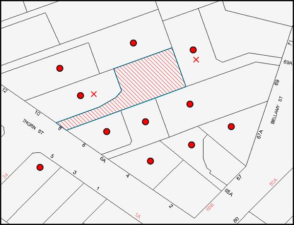
|
NOTIFICATION PLAN |
|||
|
• PROPERTIES NOTIFIED |
X SUBMISSIONS RECEIVED |
PROPERTY SUBJECT OF DEVELOPMENT |
|
Of the two submissions received, one raised concerns over the content included in the initial notification of the application. The material was reviewed and then later renotified to adjoining properties advising them of the additional content as well as the amendment in the application to remove the subdivision component.
The second submission received raised concerns regarding the parking of trucks on the access handle and the increase in acoustic impacts associated with the use of the driveway by residents and visitors to the proposed dwellings. With regards to the storage of trucks on the access handle, Council does not restrict where such vehicles are stored so long as they do not restrict access to properties benefitted by a right of access or right of carriageway.
With regards to acoustic impacts, the vehicular movement associated with the proposed development would not create a significant additional impact and would be in keeping with a low density residential environment.
5.2 Public Agencies
The development application was not required to be referred to any Public Agencies for comment.
6. THE PUBLIC INTEREST
Section 79C(1)(e) of the Act requires Council to consider “the public interest”.
The public interest is an overarching requirement, which includes the consideration of the matters discussed in this report. Implicit to the public interest is the achievement of future built outcomes adequately responding to and respecting the future desired outcomes expressed in environmental planning instruments and development control plans.
The application is considered to have satisfactorily addressed Council’s and relevant agencies’ criteria and would provide a development outcome that, on balance, would result in a positive impact for the community. Accordingly, it is considered that the approval of the proposed development would be in the public interest.
CONCLUSION
The application proposes the demolition of a dwelling-house and the erection of multi-unit housing.
The application does not comply with the Hornsby Shire Council Local Environmental Plan 1994 in respect to Clause 15 ‘Floor Space Ratio’. The applicant submitted a State Environmental Planning Policy No. 1 objection to vary the floor space ratio development standard. The objection is considered well founded with regard to the density of existing development in the area and the principles established by the Land and Environment Court.
There were two submissions received in response to notification of the proposed development. These matters have been addressed in the body of the report
Having regard to the circumstances of the case and consideration of the SEPP 1 objection, approval of the application is recommended.
Note: At the time of the completion of this planning report, no persons have made a Political Donations Disclosure Statement pursuant to Section 147 of the Environmental Planning and Assessment Act 1979 in respect of the subject planning application.
|
Rod Pickles Manager - Development Assessment Planning Division |
James Farrington Group Manager Planning Division |
Attachments:
|
1.View |
Locality Map |
|
|
|
2.View |
Floor Plans |
|
|
|
3.View |
Levels Plan |
|
|
|
4.View |
Elevations |
|
|
|
5.View |
Shadow Diagrams |
|
|
File Reference: DA/892/2013
Document Number: D03007076
SCHEDULE 1
GENERAL CONDITIONS
The conditions of consent within this notice of determination have been applied to ensure that the use of the land and/or building is carried out in such a manner that is consistent with the aims and objectives of the relevant legislation, planning instruments and Council policies affecting the land and does not disrupt the amenity of the neighbourhood or impact upon the environment.
Note: For the purpose of this consent, the term ‘applicant’ means any person who has the authority to act on or the benefit of the development consent.
Note: For the purpose of this consent, any reference to an Act, Regulation, Australian Standard or publication by a public authority shall be taken to mean the gazetted Act or Regulation, or adopted Australian Standard or publication as in force on the date that the application for a construction certificate is made.
1. Approved Plans and Supporting Documentation
The development must be carried out in accordance with the plans and documentation listed below and endorsed with Council’s stamp, except where amended by Council and/or other conditions of this consent:
|
Plan No. |
Drawn by |
Dated |
|
S.15067A Sheet 1 of 1 – Site Plan |
P. S. Graham & Associates |
22/02/2013 |
|
3398.00.1A – Building Set Out Plan |
Plan Concepts Pty Ltd |
August 2013 |
|
3398.51.11A – Floor Plans |
Plan Concepts Pty Ltd |
August 2013 |
|
3398.51.12B – Elevations |
Plan Concepts Pty Ltd |
August 2013 |
|
3398.51.13B - Elevations |
Plan Concepts Pty Ltd |
August 2013 |
|
3398.52.21A – Floor Plans |
Plan Concepts Pty Ltd |
August 2013 |
|
3398.52.22B – Elevations |
Plan Concepts Pty Ltd |
August 2013 |
|
3398.52.23B – Elevations |
Plan Concepts Pty Ltd |
August 2013 |
|
3398.SD1 – Shadow Diagram |
Plan Concepts Pty Ltd |
August 2013 |
|
3398.SD2 – Shadow Diagram |
Plan Concepts Pty Ltd |
August 2013 |
2. Removal of Existing Trees
This development consent does not permit the removal of tree(s) on the site. The removal of any other trees requires separate approval under Council’s Tree Preservation Order.
3. Construction Certificate
A Construction Certificate is required to be approved by Council or a Private Certifying Authority prior to the commencement of any works under this consent.
4. Section 94 Development Contributions
In accordance with Section 80A(1) of the Environmental Planning and Assessment Act 1979 and the Hornsby Shire Council Section 94 Development Contributions Plan 2012-2021, the following monetary contributions shall be paid to Council to cater for the increased demand for community infrastructure resulting from the development:
|
Description |
Contribution (4) |
|
Roads |
$1,140.00 |
|
Open Space and Recreation |
$16,480.00 |
|
Community Facilities |
$2,300.00 |
|
Plan Preparation and Administration |
$80.00 |
|
TOTAL |
$20,000.00 |
being for the creation of an additional detached dwelling.
a) If the contributions are not paid within the financial quarter that this consent is granted, the contributions payable will be adjusted in accordance with the provisions of the Hornsby Shire Council Section 94 Development Contributions Plan and the amount payable will be calculated at the time of payment in the following manner:
$CPY = $CDC x CPIPY
CPIDC
Where:
$CPY is the amount of the contribution at the date of Payment.
$CDC is the amount of the contribution as set out in this Development Consent.
CPIPY is the latest release of the Consumer Price Index (Sydney – All Groups) at the date of Payment as published by the ABS.
CPIDC is the Consumer Price Index (Sydney – All Groups) for the financial quarter at the date of this Development Consent.
b) The monetary contributions shall be paid to Council:
i) prior to the issue of the Subdivision Certificate where the development is for subdivision; or
ii) prior to the issue of the first Construction Certificate where the development is for building work; or
iii) prior to issue of the Subdivision Certificate or first Construction Certificate, whichever occurs first, where the development involves both subdivision and building work; or
iv) prior to the works commencing where the development does not require a Construction Certificate or Subdivision Certificate.
It is the professional responsibility of the Principal Certifying Authority to ensure that the monetary contributions have been paid to Council in accordance with the above timeframes.
Council’s Development Contributions Plan may be viewed at www.hornsby.nsw.gov.au or a copy may be inspected at Council’s Administration Centre during normal business hours.
REQUIREMENTS PRIOR TO THE ISSUE OF A CONSTRUCTION CERTIFICATE
5. Building Code of Australia
All building work must be carried out in accordance with the relevant requirements of the Building Code of Australia.
6. Contract of Insurance (Residential Building Work)
In the case of residential building work for which the Home Building Act 1989 requires there to be a contract of insurance in force in accordance with Part 6 of that Act, that such a contract of insurance is in force before any building work authorised to be carried out by the consent commences.
7. Notification of Home Building Act 1989 Requirements
Residential building work within the meaning of the Home Building Act 1989 must not be carried out unless the principal certifying authority for the development to which the work relates (not being Council) has given Council written notice of the following information:
a) In the case of work for which a principal contractor is required to be appointed:
i) The name and licence number of the principal contractor; and
ii) The name of the insurer by which the work is insured under Part 6 of that Act.
b) In the case of work to be done by an owner-builder:
i) The name of the owner-builder; and
ii) If the owner-builder is required to hold an owner-builder’s permit under that Act, the number of the owner-builder’s permit.
Note: If arrangements for doing the residential building work are changed while the work is in progress so that the information notified becomes out of date, further work must not be carried out unless the principal certifying authority for the development to which the work relates (not being Council) has given Council written notification of the updated information.
8. Sydney Water – Quick Check
This application must be submitted to a Sydney Water ‘Quick Check Agent’ or ‘Customer Centre’ for approval to determine whether the development would affect any Sydney Water infrastructure, and whether further requirements are to be met.
Note: Refer to www.sydneywater.com.au or telephone 13 20 92 for assistance.
REQUIREMENTS PRIOR TO THE COMMENCEMENT OF ANY WORKS
9. Erection of Construction Sign
A sign must be erected in a prominent position on any site on which building work, subdivision work or demolition work is being carried out:
a) Showing the name, address and telephone number of the principal certifying authority for the work;
b) Showing the name of the principal contractor (if any) for any demolition or building work and a telephone number on which that person may be contacted outside working hours; and
c) Stating that unauthorised entry to the work site is prohibited.
Note: Any such sign is to be maintained while the building work, subdivision work or demolition work is being carried out, but must be removed when the work has been completed.
10. Toilet Facilities
Toilet facilities must be available or provided at the works site before works begin and must be maintained until the works are completed at a ratio of one toilet for every 20 persons employed at the site. Each toilet must:
a) be a standard flushing toilet connected to a public sewer; or
b) be a temporary chemical closet approved under the Local Government Act 1993.
11. Erosion and Sediment Control
Erosion and sediment control measures must be provided and maintained throughout the construction period in accordance with the manual ‘Soils and Construction 2004 (Bluebook)’, the approved plans, Council specifications and to the satisfaction of the principal certifying authority. The erosion and sediment control devices must remain in place until the site has been stabilised and revegetated.
Note: On the spot penalties up to $1,500 may be issued for any non-compliance with this requirement without any further notification or warning.
12. Traffic Control Plan
A Traffic Control Plan (TCP) must be prepared by a qualified traffic controller in accordance with the Roads & Traffic Authority’s Traffic Control at Worksites Manual 1998 and Australian Standard 1742.3 for all work on a public road and be submitted to Council. The TCP must detail the following where required:
a) Arrangements for public notification of the works.
b) Temporary construction signage.
c) Permanent post-construction signage.
d) Vehicle movement plans.
e) Traffic management plans.
f) Pedestrian and cyclist access/safety.
REQUIREMENTS DURING CONSTRUCTION
13. Construction Work Hours
All work on site (including demolition and earth works) must only occur between 7am and 5pm Monday to Saturday. No work is to be undertaken on Sundays or public holidays.
14. Demolition
All demolition work must be carried out in accordance with “Australian Standard 2601-2001 – The Demolition of Structures” and the following requirements:
a) Demolition material must be disposed of to an authorised recycling and/or waste disposal site and/or in accordance with an approved waste management plan;
b) Demolition works, where asbestos material is being removed, must be undertaken by a contractor that holds an appropriate licence issued by WorkCover NSW in accordance with Chapter 10 of the Occupational Health and Safety Regulation 2001 and Clause 29 of the Protection of the Environment Operations (Waste) Regulation 2005; and
c) On construction sites where buildings contain asbestos material, a standard commercially manufactured sign containing the words ‘DANGER ASBESTOS REMOVAL IN PROGRESS’ measuring not less than 400mm x 300mm must be erected in a prominent position visible from the street.
15. Council Property
During construction works, no building materials, waste, machinery or related matter is to be stored on the road or footpath. The public reserve must be kept in a clean, tidy and safe condition at all times.
16. Disturbance of Existing Site
During construction works, the existing ground levels of open space areas and natural landscape features, (including natural rock-outcrops, vegetation, soil and watercourses) must not be altered unless otherwise nominated on the approved plans.
17. Works Near Trees
All works (including driveways and retaining walls) within 6 metres of any trees required to be retained (whether or not on the subject property, and pursuant to this consent or the Tree Preservation Order), must be carried out under the supervision of an ‘AQF Level 5 Arborist’ and a certificate submitted to the principal certifying authority detailing the method(s) used to preserve the tree(s).
Note: Except as provided above, the applicant is to ensure that no excavation, filling or stockpiling of building materials, parking of vehicles or plant, disposal of cement slurry, waste water or other contaminants is to occur within 6 metres of any tree to be retained.
18. Survey Report – Finished Floor Level
A report(s) must be prepared by a registered surveyor and submitted to the principal certifying authority prior to the pouring of concrete at each level of the building certifying that:
a) The building, retaining walls and the like have been correctly positioned on the site; and
b) The finished floor level(s) are in accordance with the approved plans.
REQUIREMENTS PRIOR TO THE ISSUE OF AN OCCUPATION CERTIFICATE
Note: For the purpose of this consent, a reference to ‘occupation certificate’ shall not be taken to mean an ‘interim occupation certificate’ unless otherwise stated.
19. Fulfilment of BASIX Commitments
The applicant must demonstrate the fulfilment of BASIX commitments pertaining to the development.
20. Stormwater Drainage
The stormwater drainage system for the development must be designed and constructed in accordance with Council’s Civil Works – Design and Construction Specification 2005 and the following requirements:
a) The existing piped inter-allotment stormwater drainage system is to be reconstructed and be located within the existing easement.
21. On Site Stormwater Detention
An on-site stormwater detention system must be designed by a chartered civil engineer and constructed in accordance with the following requirements:
a) Have a capacity of not less than 5 cubic metres, and a maximum discharge (when full) of 8 litres per second.
b) Have a surcharge/inspection grate located directly above the outlet.
c) Discharge from the detention system to be controlled via 1 metre length of pipe, not less than 50 millimetres diameter or via a stainless plate with sharply drilled orifice bolted over the face of the outlet discharging into a larger diameter pipe capable of carrying the design flow to an approved Council system.
d) Where above ground and the average depth is greater than 0.3 metres, a ‘pool type’ safety fence and warning signs to be installed.
e) Not be constructed in a location that would impact upon the visual or recreational amenity of residents.
22. Internal Driveway/Vehicular Areas
The driveway and parking areas on site must be designed and constructed in accordance with Australian Standards 2890.1, 2890.2, 3727 and the following requirements:
a) Design levels at the front boundary must be obtained from Council;
b) The driveway must be a rigid pavement;
c) The driveway grade must not exceed 25 percent and changes in grade must not exceed 8 percent;
d) The pavement must have a kerb to one side and a one-way cross fall with a minimum gradient of 2 percent and a lintel and pit provided at the low point;
e) Retaining walls required to support the carriageway and the compaction of all fill batters must be in accordance with the requirements of a chartered structural engineer;
f) Safety rails must be provided where there is a level difference more than 0.3 metres and a 1:4 batter can not be achieved;
g) Landscaping strips must be planted 0.5 metres wide along both sides of the length of the driveway; and
h) Conduit for utility services including electricity, water, gas and telephone must be provided.
23. Vehicular Crossing
A separate application under the Local Government Act 1993 and the Roads Act 1993 must be submitted to Council for the installation of a new vehicular crossing and the removal of the redundant crossing. The vehicular crossing must be constructed in accordance with Council’s Civil Works Design 2005.
24. Damage to Council Assets
Any damage caused to Council’s assets as a result of the construction of the development must be rectified in accordance with Council’s written requirements and at the sole cost of the applicant.
25. Installation of Air Conditioner
To protect the amenity of adjacent properties, the condenser unit for the air conditioner must be sited a minimum of 3 metres from the property boundary of any adjoining residential premises unless a certificate has been prepared by a suitably qualified person confirming that the unit has been tested for heating and cooling on the highest settings and that the noise levels generated do not exceed 5 dB(A) above background noise levels when tested at the property boundary between 8 pm and 10 pm.
26. Creation of Easements
The following matter(s) must be created on the title of the property in accordance with the Conveyancing Act 1919:
a) The creation of an appropriate "Positive Covenant" and "Restriction as to User" over the constructed on-site detention/retention systems and outlet works, within the lots in favour of Council in accordance with Council’s prescribed wording. The position of the on-site detention system is to be clearly indicated on the title.
b) To register the OSD easement, the restriction on the use of land “works-as-executed” details of the on-site-detention system must be submitted verifying that the required storage and discharge rates have been constructed in accordance with the design requirements. The details must show the invert levels of the on site system together with pipe sizes and grades. Any variations to the approved plans must be shown in red on the “works-as-executed” plan and supported by calculations.
Note: Council must be nominated as the authority to release, vary or modify any easement, restriction or covenant.
27. Works as Executed Plan
A works-as-executed plan(s) must be prepared by a registered surveyor and submitted to Council for completed road pavement, kerb & gutter, public drainage systems, driveways and on-site detention system.
– END OF CONDITIONS –
ADVISORY NOTES
The following information is provided for your assistance to ensure compliance with the Environmental Planning and Assessment Act 1979, Environmental Planning and Assessment Regulation 2000, other relevant legislation and Council’s policies and specifications. This information does not form part of the conditions of development consent pursuant to Section 80A of the Act.
Environmental Planning and Assessment Act 1979 Requirements
The Environmental Planning and Assessment Act 1979 requires:
· The issue of a construction certificate prior to the commencement of any works. Enquiries can be made to Council’s Customer Services Branch on 9847 6760;
· a principal certifying authority to be nominated and Council notified of that appointment prior to the commencement of any works;
· Council to be given at least two days written notice prior to the commencement of any works;
· mandatory inspections of nominated stages of the construction inspected; and
· an occupation certificate to be issued before occupying any building or commencing the use of the land.
Long Service Levy
In accordance with Section 34 of the Building and Construction Industry Long Service Payments Act 1986, a ‘Long Service Levy’ must be paid to the Long Service Payments Corporation or Hornsby Council.
Note: The rate of the Long Service Levy is 0.35% of the total cost of the work.
Note: Hornsby Council requires the payment of the Long Service Levy prior to the issue of a construction certificate.
Tree Preservation Order
To ensure the maintenance and protection of the existing natural environment, it is an offence to ringbark, cut down, top, lop, remove, wilfully injure or destroy a tree outside 3 metres of the approved building envelope without the prior written consent from Council.
Note: A tree is defined as a single or multi-trunked wood perennial plant having a height of not less than three (3) metres, and which develops many branches, usually from a distance of not less than one (1) metre from the ground, but excluding any plant which, in its particular location, is a noxious plant declared as such pursuant to the Noxious Weeds Act 1993. This definition of ‘tree’ includes any and all types of Palm trees.
All distances are determined under Australian Standard AS4970-2009 ”Protection of Trees on Development Sites”.
Fines may be imposed for non-compliance with Council’s Tree Preservation Order.
Dial Before You Dig
Prior to commencing any works, the applicant is encouraged to contact Dial Before You Dig on 1100 or www.dialbeforeyoudig.com.au for free information on potential underground pipes and cables within the vicinity of the development site.
Asbestos Warning
Should asbestos or asbestos products be encountered during demolition or construction works, you are advised to seek advice and information prior to disturbing this material. It is recommended that a contractor holding an asbestos-handling permit (issued by WorkCover NSW) be engaged to manage the proper handling of this material. Further information regarding the safe handling and removal of asbestos can be found at:
Alternatively, telephone the WorkCover Asbestos and Demolition Team on 8260 5885.
Group Manager’s Report No. PL36/14
Planning Division
Date of Meeting: 11/06/2014
14 DEVELOPMENT APPLICATION - NINE STOREY RESIDENTIAL FLAT BUILDING CONTAINING 54 UNITS - 5, 7 AND 9 WAITARA AVENUE, WAITARA
EXECUTIVE SUMMARY
|
DA No. |
DA/1255/2013 (Lodged 13 November 2013) |
|
Description: |
Demolition of existing structures and construction of a nine storey residential flat building containing 54 units and basement car parking |
|
Property |
Lot 1 DP 948232, Lot 84 DP 1053416 and Lot 1 DP 121106, Nos. 5, 7 and 9 Waitara Avenue, Waitara |
|
Applicant: |
Zhinar Architects |
|
Owner: |
Advance International Investment Group Pty Ltd |
|
Estimated Value: |
$11,000,000 |
|
Ward: |
B |
· The application proposes demolition of existing structures and construction of a nine storey residential flat building containing 54 units and basement car parking.
· The proposal does not comply with the Clause 4.3 (Height of Buildings) of the Hornsby Local Environmental Plan 2013. A submission pursuant to Clause 4.3 of the Hornsby Local Environmental Plan 2013 has been made in support of the variation to the height standard, which is considered well-founded.
· Three submissions have been received in respect of the application.
· It is recommended that the application be approved subject to conditions.
|
THAT Council assume the concurrence of the Secretary of the Department of Planning and Environment pursuant to Clause 4.6 of the Hornsby Local Environmental Plan 2013 6 to vary Clause 4.3 (Height of Buildings) and approve Development Application No. DA/1255/2013 for demolition of existing structures and construction of a nine storey residential flat building containing 54 units and basement car parking at Lot 1 DP 948232, Lot 84 DP 1053416 and Lot 1 DP 121106, Nos. 5, 7 and 9 Waitara Avenue, Waitara subject to the conditions of consent detailed in Schedule 1 of Group Manager’s Report No. PL36/14. |
BACKGROUND
The subject land was rezoned from low density residential to Residential D (High Density) in 1994 as part of Council’s Housing Strategy as incorporated in the Hornsby Shire Local Environmental Plan 1994 on 22 July 1994.
SITE
The site comprises two rectangular allotments and one triangular allotment and is located on the western side of Waitara Avenue. The site is irregular in shape and has an area of 1,853m2.
The site has a 52.61m frontage to Waitara Avenue and is 31.52m along the rear boundary. The site contains a 1.8m wide drainage easement which is located along the northern boundary of the site.
The site has a gentle slope from east to west of approximately 1m and cross fall along Waitara Avenue frontage from south to north of approximately 2.5m.
Existing improvements on the allotments include three single storey dwelling-houses with associated outbuildings. The existing building at No. 7 Waitara Avenue has been previously utilised for medical purposes and contains a concrete driveway and car parking area for 10 vehicles.
The site contains shrubs and trees, including two significant eucalyptus trees located on the north-eastern common boundary which are to be retained and protected.
The site adjoins an existing nine storey residential flat buildings to the north and north-west. To the south, the site adjoins the existing two to three storey Asquith Rugby Leagues Club.
Located to the east and on the opposite side of Waitara Avenue is the Parkview Retirement Village. The retirement village is comprised of a two storey building with multiple wings. To the north-east there are existing tennis courts and the Mark Taylor Cricket Oval.
The proposed development is located on one of the last sites in the precinct to be redeveloped. Another vacant site at Nos. 21-39 Waitara Ave and Nos. 20-30 Orara Street, Waitara is the subject of an application (DA/1370/2013).
The site is in close proximity to the Hornsby Town Centre and approximately 100m north of Waitara Railway Station.
PROPOSAL
The proposal is for the demolition of three existing dwelling-houses and associated outbuildings and construction of a nine storey residential flat building comprising 54 units with two levels of basement car parking.
The unit configuration includes 7 x 1 bedroom, 40 x 2 bedroom and 7 x 3 bedroom units. The units include balconies fronting the street, rear and southern side setback.
The development would be accessed from Waitara Avenue via a driveway located adjacent to the southern boundary of the site. A total of 64 residential car parking spaces, including 8 visitor’s parking spaces are proposed in two basement levels.
ASSESSMENT
The development application has been assessed having regard to the ‘Metropolitan Plan for Sydney 2031’, the ‘North Subregion (Draft) Subregional Strategy’ and the matters for consideration prescribed under Section 79C of the Environmental Planning and Assessment Act 1979 (the Act). The following issues have been identified for further consideration.
1. STRATEGIC CONTEXT
1.1 Metropolitan Plan for Sydney and (Draft) North Subregional Strategy
The (Draft) Metropolitan Strategy for Sydney 2031 is a broad framework to provide for Sydney’s growth to help plan for housing, employment, transport, infrastructure, the environment and open space. It outlines a vision for Sydney to 2031; the challenges faced, and the directions to follow to address these challenges and achieve the vision.
The North Subregion comprises Hornsby, Kuring-gai, Manly, Warringah and Pittwater Local Government Areas. The Draft North Subregional Strategy acted as a framework for Council in its preparation of the Hornsby Local Environmental Plan 2013.
Within the North Subregion, the Draft Metropolitan Strategy proposes:
· Population growth of 81,000 from the current 2011 baseline of 529,000
· Housing growth of 37,000 from the current 2011 baseline of 204,000
· Employment growth of 39,000 from the current 2011 baseline of 186,000
The proposed development would be consistent with the Metropolitan Plan for Sydney 2031 by providing 51 additional dwellings and would contribute to housing choice in the locality.
2. STATUTORY CONTROLS
Section 79C(1)(a) requires Council to consider “any relevant environmental planning instruments, draft environmental planning instruments, development control plans, planning agreements and regulations”.
2.1 Hornsby Local Environmental Plan 2013
The Hornsby Local Environmental Plan 2013 (HLEP) was gazetted by the Minister for Planning on 11 October 2013.
2.1.1 Zoning
Under the HLEP, the subject land is zoned R4 (High Density Residential). The proposed development is defined as a ‘residential flat building’ and is permissible within the zone with Council’s consent.
2.1.2 Clause 4.3 – Height of Building
Clause 4.3 of the HLEP provides that the height of a building on any land is not to exceed the maximum height shown for the land on the Height of Buildings Map. The maximum permissible height for the subject site is 26.5m. The proposed development has a maximum height of 28.8m and results in a variation of the building height control by 2.36m. The variation to the height control relates to the skillion roof treatment, lift overrun and feature blade wall treatment. To address this issue, the application is supported by a submission pursuant to Section 4.6 of the HLEP to vary the maximum building height development standard. This matter is addressed below.
2.1.3 Clause 4.6 – Exceptions to Development Standards
The application has been assessed against the requirements within Clause 4.6 of the HLEP. This clause provides flexibility in the application of development standards in circumstances where strict compliance with those standards would, in any particular case, be unreasonable or unnecessary or tend to hinder the attainment of the objectives of the zone.
On the Height of Buildings Map, the maximum building height is 26.5m. The proposed building exceeds the maximum height control, having a maximum height of 28.8m.
Building Height is defined by the HLEP as follows:
“building height (or height of building) means the vertical distance between ground level (existing) and the highest point of the building, including plant and lift overruns, but excluding communication devices, antennae, satellite dishes, masts, flagpoles, chimneys, flues and the like.”
The applicant has made a submission in support of a variation to the maximum building height of 26.5m development standard under Clause 4.6 of the HLEP. The development application seeks to vary the height by 2.3m.
The applicant’s submission is made pursuant to Clause 4.6 and the objectives of the R4 High Density Residential zone. The applicant states the proposed height variation is considered to be consistent with the objectives of the control and is justified as follows:
· The site geometry has considerable constraints to redevelopment for high density residential accommodation. The long front boundary and narrow rear boundary have necessitated the proposed height non-compliance in order to appropriately distribute the available amount of floorspace in the most efficient way possible;
· The proposal generally meets the applicable envelope controls under the Council’s DCP and therefore the distribution of the mass into a higher building reflects an appropriate expression of development potential. That is, to achieve the density facilitated by the envelope controls, when taking into account the constraints of geometry, the proposed height could be reasonably expected. The proposed height does not result in any additional units and therefore the proposal would not provide any significant additional load on surrounding infrastructure capacity;
· It is noted that the planning controls have only recently been altered from a 9 storey height limit to a maximum height of 26.5m (effectively 8 storeys). Notwithstanding, the proposed encroachment to the maximum building height is considered to be minor and would not substantially change the appearance of the proposal within the locality, nor would the additional height be readily apparent or obvious to the casual observer at the street level;
· The proposed building has been designed to a high standard of architecture. The proposed built form on the site features a unique appearance, incorporating a number of design features which are encouraged by the Hornsby DCP 2013, such as a gentle skillion roof pitch and blade wall elements. It has been designed to relate to the adjoining residential flat building to the north in terms of overall height and building style;
· In infrastructure terms, the proposed height would not result in any noticeable road capacity impacts and the close proximity to frequent public transport services and close positioning to local services and facilities demonstrate the site’s suitability for development of the density proposed;
· It is considered that the proposal responds appropriately to the site and reduces residential amenity impacts where possible. The minor variation of building height is not expected to provide any tangible disruption to solar access to any surrounding properties. Supporting this is the presence of commercial uses to the south of the site. The degree of shadow cast by the proposal could be reasonably expected under the permissible building envelope controls on the site;
· Any complaint proposal is likely to have an impact on existing district views gained across the site towards the south. As such, no reasonable view loss can be expected as a result of minor non-compliance proposed; and
· The site is not located within close proximity to any identified heritage items.
Having regard to the above points, the following matters are considered relevant:
· The development is consistent with the objectives of Section 5 of the Environmental Planning and Assessment Act 1979 and the aims of the HLEP in that it encourages the improved management of urban land and promotes the orderly use of the otherwise underutilised land.
· The minor breach of the height relates mainly to the blade wall elements, the top storey eaves, lift overrun and skillion roof.
· In considering if the request to vary the standard is reasonable, the interface of the development to the northern boundary has been considered to be most critical. The proposed building has a roof RL of 204.4m AHD. The building to the immediate north and down slope of the site has a parapet RL 202.95m AHD. The adjoining building is nine storeys in height and exceeds the maximum height limit. The proposed building height is in context with the height of the adjoining building to the north.
· The ninth level would be appropriately setback and is not considered to be visually intrusive to the streetscape or the neighbouring properties.
· The building does not result in unreasonable overshadowing of the neighbouring properties, as discussed in Section 2.9.11 of this report.
· The proposed unit layouts along the northern side setback have been revised to orientate the living rooms and balconies to the front and rear. The proposed development involves the inclusion of privacy screens and highlight windows along the northern elevation. This would alleviate any adverse privacy impacts.
· The proposed development is located on one of the last sites in the precinct which is to be redeveloped. The proposal would not set an unacceptable precedent for the precinct.
· Notwithstanding the height non-compliance, the application is a reasonable outcome for the site and achieves the aims of the HLEP and Hornsby DCP.
· Should the development comply strictly comply with the “height” requirements, the proposal would result in underutilisation of the land and would not satisfy the broad objectives of the Act, the aims of the HLEP and Hornsby DCP.
Based on this assessment, it is considered that the applicant’s Clause 4.6 submission is well founded and that compliance with the development standard would be unreasonable and unnecessary in the circumstances of the case. Accordingly, the Clause 4.6 submission is supported.
2.1.4 Clause 5.10 – Heritage Conservation
The property is located in the immediate vicinity of the heritage item Shop, at Nos. 11-37 Alexandria Parade, Waitara of local significance listed under the provisions of Schedule 5 (Environmental Heritage) of the Hornsby Local Environmental Plan 2013.
The adjacent heritage listed item, is an isolated free-standing Inter-war period corner shop constructed in c1920. Most of the original fabric survives, making a major contribution to the corner of Alexandria Parade and Waitara Avenue.
The land associated with the heritage item has been amalgamated with the adjoining Asquith Rugby League Club site, and the rear and side boundary setting has already been compromised by the surrounding open bitumen car park.
Considering the subject site is located within the R4 High Density Residential Zone, surrounded by similar multi-storey residential apartments, no heritage concerns are raised to the proposed residential flat building. Generally, the proposed development would not dominate or provide a significant change to the setting of the adjacent heritage listed corner shop.
Council’s heritage assessment of the proposal identified initial concerns with respect to the lack of adequate screen planting along the adjoining boundary. The plans have been revised to provide a 6m to 3m wide deep soil landscaping area in the south eastern corner of the site. The deep soil area would provide a sufficient area for planting of a canopy tree and would provide an adequate visual buffer between the heritage item and the residential flat building.
Accordingly, no objections are raised to the proposed development on heritage grounds.
2.2 State Environmental Planning Policy No. 55 – Remediation of Land
State Environmental Planning Policy No. 55 (SEPP 55) requires that Council must not consent to the carrying out of any development on land unless it has considered whether the land is contaminated or requires remediation for the proposed use.
The site has been used for residential purposes and is unlikely to be contaminated. No further assessment is considered necessary in this regard. However, a condition is recommended should any contamination be found during construction requiring that Council or the Private Certifying Authority be notified.
2.3 State Environmental Planning Policy (Infrastructure) 2007
The application has been assessed against the requirements of State Environmental Planning Policy (Infrastructure) 2007. This Policy contains State-wide planning controls for developments adjoining busy roads. The development is not classified as a Traffic Generating Development in accordance with Clause 104 and Schedule 3 of SEPP (Infrastructure). Therefore, referral of the application to the Roads and Maritime Service is not required.
2.4 Sydney Regional Environmental Plan No. 20 – Hawkesbury-Nepean River
The application has been assessed against the requirements of Sydney Regional Environmental Plan No. 20 – Hawkesbury-Nepean River. The Policy provides general planning considerations and strategies to ensure Council considers the impacts of this proposal on water quality, scenic quality, aquaculture, recreation and tourism.
The proposal includes details of soil and water management during construction works. Council’s assessment of the proposal in this regard concludes that the development is satisfactory subject to compliance with a condition in Schedule 1 with respect to installation of sediment and erosion control measures prior to, and during, construction.
The proposed development would have minimal potential to impact on the Hawkesbury-Nepean Rivers Catchment subject to the implementation of recommended conditions.
2.5 State Environmental Planning Policy (Building Sustainability Index – BASIX) - 2004
The application has been assessed against the requirements of State Environmental Planning Policy (Building Sustainability Index: BASIX) 2004. The proposal includes BASIX Certificate No. 513263M_02 for the proposed units and is considered to be satisfactory.
2.6 State Environmental Planning Policy No. 65 – Design Quality of Residential Flat Development
The Policy provides for design principles to improve the design quality of residential flat development and for consistency in planning controls across the State.
The applicant has submitted a design verification statement prepared by a qualified designer stating how the proposed development achieves the design principles of SEPP 65. The design principles of SEPP 65 and the submitted design verification statement are addressed below.
2.6.1 Principle 1 - Context
Design Principle 1 is as follows:
Good design responds and contributes to its context. Context can be defined as the key natural and built features of an area.
Responding to context involves identifying the desirable elements of a location’s current character or, in the case of precincts undergoing a transition, the desired future character as stated in planning and design policies. New buildings will thereby contribute to the quality and identity of the area.
The site is located within an existing high density precinct characterised by 8-9 storey residential flat buildings in close proximity to Waitara Railway Station. It is one of the last sites in the precinct to be redeveloped.
The applicant’s ‘Design Verification Statement’ indicates that the proposal responds to the existing and desired future character of the precinct as envisaged by Council. Once the development of the precinct is completed, the proposal would integrate with the surrounding sites and would be in keeping with the existing urban form. It is considered that the proposed building would contribute to the identity and future character of the precinct.
2.6.2 Principle 2 - Scale
Design Principle 2 is as follows:
Good design provides an appropriate scale in terms of the bulk and height that suits the scale of the street and the surrounding buildings.
Establishing an appropriate scale requires a considered response to the scale of existing development. In precincts undergoing a transition, proposed bulk and height needs to achieve the scale identified for the desired future character of the area.
The scale of the development is in accordance with adjoining buildings and setbacks for the precinct and provides an architectural composition that achieves a scale consistent with the desired future character of the precinct of residential flat buildings in landscape settings with underground car parking.
2.6.3 Principle 3 – Built Form
Design Principle 3 is as follows:
Good design achieves an appropriate built form for a site and the building’s purpose, in terms of building alignments, proportions, building type and the manipulation of building elements.
Appropriate built form defines the public domain, contributes to the character of streetscape and parks, including their views and vistas, and provides internal amenity and outlook.
The proposed building is appropriately articulated to minimise the perceived scale and the chosen materials add to the visual interest of the development. The development is considered to be acceptable in terms of built form.
2.6.4 Principle 4 – Density
Design Principle 4 is as follows:
Good design has a density appropriate for a site and its context, in terms of floor space yields (or number of units or residents).
Appropriate densities are sustainable and consistent with the existing density in an area or in precincts undergoing a transition, are consistent with the stated desired future density. Sustainable densities respond to the regional context, availability of infrastructure, public transport, community facilities and environmental quality.
The HLEP does not incorporate floor space ratio requirements for the site. The density of the development is governed by the height of the building and the required setbacks. The proposed density is considered to be sustainable as it responds to the regional context, availability of infrastructure, public transport, community facilities and environmental quality and is considered acceptable in terms of density.
2.6.5 Principle 5 – Resource, Energy and Water Efficiency
Design Principle 5 is as follows:
Good design makes efficient use of natural resources, energy and water throughout its full life cycle, including construction.
Sustainability is integral to the design process. Aspects include demolition of existing structures, recycling of materials, selection of appropriate and sustainable materials, adaptability and reuse of buildings, layouts and built form, passive solar design principles, efficient appliances and mechanical services, soil zones for vegetation and reuse of water.
The applicant has submitted a BASIX Certificate for the proposed development. In achieving the required BASIX targets for sustainable water use, thermal comfort and energy efficiency, the proposed development achieves the design criteria and is considered acceptable in this regard.
2.6.6 Principle 6 – Landscape
Design Principle 6 is as follows:
Good design recognises that together landscape and buildings operate as an integral and sustainable system, resulting in greater aesthetic quality and amenity for both occupants and the adjoining public domain.
Landscape design builds on the existing site’s natural and cultural features in responsible and creative ways. It enhances the development’s natural environmental performance by co-ordinating water and soil management, solar access, micro-climate, tree canopy and habitat values. It contributes to the positive image and contextual fit of development through respect for streetscape and neighbourhood character, or desired future character.
Landscape design should optimise useability, privacy and social opportunity, equitable access and respect for neighbour’s amenity, and provide for practical establishment and long term management.
The application includes a landscape concept plan providing landscaping along the street frontage and side and rear boundaries. The rear portion the site provides for a deep soil landscaped area and useable open space. Landscaping has also been provided along the northern boundary to soften the appearance of the building and offering increased privacy to the future occupants.
2.6.7 Principle 7 – Amenity
Design Principle 7 is as follows:
Good design provides amenity through the physical, spatial and environmental quality of a development.
Optimising amenity requires appropriate room dimensions and shapes, access to sunlight, natural ventilation, visual and acoustic privacy, storage, indoor and outdoor space, efficient layouts and service areas, outlook and ease of access for all age groups and degrees of mobility.
The proposed units are designed to achieve natural ventilation, solar access and acoustic privacy. All units incorporate balconies accessible from living areas and privacy has been achieved through appropriate design and orientation of balconies and living areas. Storage areas have been provided within each unit and within the basement levels. The proposal would provide convenient and safe access via a central lift connecting the basement and all other levels. The application is considered acceptable in this regard.
2.6.8 Principle 8 – Safety and Security
Design Principle 8 is as follows:
Good design optimises safety and security, both internal to the development and for the public domain.
This is achieved by maximising overlooking of public and communal spaces while maintaining internal privacy, avoiding dark and non-visible areas, maximising activity on streets, providing clear, safe access points, providing quality public spaces that cater for desired recreational uses, providing lighting appropriate to the location and desired activities, and clear definition between public and private spaces.
The design orientates the balconies and windows of individual apartments towards the street, rear and side boundaries, providing passive surveillance of the public domain and communal open space areas. Both the pedestrian and vehicular entry points are secured and visibly prominent from Waitara Avenue.
The RFDC requires the preparation of a formal Crime Assessment Report for development that comprises more than twenty residential units. The proposal includes a Crime Risk Assessment. The application was referred to the NSW Police. The NSW Police raises no objections to the proposal. Conditions are recommended for lighting, territorial re-enforcement, environmental maintenance and access control. Subject to the imposition of a condition of consent addressing the above matters, the proposal is supported in respect of safety and security.
2.6.9 Principle 9 – Social Dimensions and Housing Affordability
Design Principle 9 is as follows:
Good design responds to the social context and needs of the local community in terms of lifestyles, affordability, and access to social facilities.
New development should optimise the provision of housing to suit the social mix and needs in the neighbourhood or, in the case of precincts undergoing transition, provide for the desired future community.
New development should address housing affordability by optimising the provision of economic housing choices and providing a mix of housing types to cater for different budgets and housing needs.
The site is located approximately 100 metres north of Waitara Railway Station and in close proximity to Hornsby Town Centre. The location of the site allows direct access to retail, educational, health and recreational facilities.
The proposed development includes a mix of dwelling types and sizes which complies with the requirement within the RFDC to improve housing choice in the locality. In this regard, the development is considered acceptable in terms of social dimensions.
2.6.10 Principle 10 – Aesthetics
Design Principle 10 is as follows:
Quality aesthetics require the appropriate composition of building elements, textures, materials and colours and reflect the use, internal design and structure of the development. Aesthetics should respond to the environment and context, particularly to desirable elements of the existing streetscape or, in precincts undergoing transition, contribute to the desired future character of the area.
The architectural treatment of the building is generally consistent with the design principles contained within the RFDC. It is considered that the aesthetic quality of the building would contribute to the existing character of the precinct. The details of the assessment of the built form and the aesthetics of the development are contained in Sections 2.7 and 2.9 of this report.
2.7 State Environmental Planning Policy No. 65 - Residential Flat Design Code
SEPP 65 also requires consideration of the Residential Flat Design Code, NSW Planning Department 2002. The Code includes development controls and best practice benchmarks for achieving the design principles of SEPP 65. The following table sets out the proposal’s compliance with the Code:
|
Residential Flat Design Code |
|||
|
Control |
Proposal |
Requirement |
Compliance |
|
Deep Soil Zone |
25% |
25% |
Yes |
|
Communal Open Space |
25% |
25-30% |
Yes |
|
Ground Level Private Open Space |
>13m2 2.5m |
25m2 Min Dimension 4m |
No No |
|
Minimum Dwelling Size |
1 br – 50m2 2 br – 70m2 3 br – 95m2 |
1 br – 50m2 2 br – 70m2 3 br – 95m2 |
Yes Yes Yes |
|
Maximum Kitchen Distance |
9.4m (Units 13, 20, 27, 33, 39, 45 and 51)
|
8m |
No |
|
Minimum Balcony Depth |
2m |
2m |
Yes |
|
Ceiling Heights - Residential floors |
2.7m |
2.7m (Min) |
Yes |
|
Dual Aspect & Cross Ventilation |
64% |
60% |
Yes |
|
South Facing Single Aspect |
6% (3 units) |
10% (Max) |
Yes |
|
Adaptable Housing |
14% |
10% |
Yes |
As detailed in the above table, the proposed development complies with the prescriptive measures within the Residential Flat Design Code (RFDC) other than minimum dimension for ground level open space and maximum kitchen distance. Below is a brief discussion regarding the relevant development controls and best practice guidelines:
2.7.1 Apartment Layout
The layout of the proposed apartments includes a combination of single aspect units and dual aspect corner units. The unit layouts would provide for housing choice and a range of household types.
The RFDC requires that the back of a kitchen should be no greater than 8m from a window. Of the 54 units proposed, 7 units contain kitchens where the back wall is up to 9.4m from a window. These units offer an open layout with natural ventilation and accordingly, the minor non-compliance is acceptable with respect to residential amenity.
The proposed apartment layouts are functional and satisfy the RFDC requirements for internal privacy, access to sunlight, natural ventilation and acoustic privacy. It is considered that the apartment layout and mix achieve the intent of the best practice requirements of the RFDC and is acceptable in this regard.
2.7.2 Ground Floor Apartments and Private Open Space
Of the 6 units located on the ground floor, 2 units have been provided with greater than 25m2 of courtyard space and none of the units meet the minimum 4m dimension. The proposed ground floor unit open space areas include recessed balconies and courtyards contained within the building envelope. The landscaped area surrounding the building is not allocated for private gardens for individual ground floor units. Therefore, the non-compliance with the RFDC is in response to the Hornsby DCP key principle for buildings to be in landscaped settings.
The provision of additional private courtyard area within the side and rear setbacks would compromise the pedestrian access to the building and further reduce the communal open space provisions for the site.
Notwithstanding the above, the private open space areas for all units comply with the minimum area requirement of the Hornsby DCP. The proposed development includes sufficient landscaped communal open space areas to compensate for this non-compliance.
2.7.3 Internal Circulation
The proposed building includes 3 to 7 units with lift access on each respective level in accordance with the Code’s best practice guidelines for up to 8 units per lift. The ground floor corridor also provides level access to the communal open space.
The proposal is acceptable with respect to the requirements of the RFDC for internal circulation.
2.7.4 Acoustic Privacy
The proposed apartment layouts are designed such that noise generating areas would mainly adjoin each other. Storage or circulation zones would act as a buffer between units. Bedrooms and service areas such as kitchens, bathrooms and laundries would be grouped together wherever possible.
The proposal complies with the ‘Acoustic Privacy’ requirements within the RFDC and is assessed as satisfactory.
2.7.5 Storage
The proposed building includes resident storage areas for all units within the building and storage areas would be located within the basement levels. A condition is recommended for the storage areas to be allocated in accordance with the size requirements of the Code for the respective units.
In summary, the proposed residential flat building has been designed in accordance with the design principles of SEPP 65 and generally complies in respect to the Residential Flat Design Code subject to the imposition of appropriate conditions of consent. It is considered the proposal would achieve good residential amenity and contribute to the established character of the existing precinct.
2.8 Clause 74BA Environmental Planning and Assessment Act, 1979 - Purpose and Status of Development Control Plans
On 1 March 2013, the Environmental Planning and Assessment Act, 1979 was amended so that a DCP provision will have no effect if it has the practical effect of “preventing or unreasonably restricting development” that is otherwise permitted and complies with the development standards set out in relevant Local Environmental Plans and State Environmental Planning Policies.
The principal purpose of a development control plan is to provide guidance on the aims of any environmental planning instrument that applies to the development; facilitating development that is permissible under any such instrument; and achieving the objectives of land zones under any such instrument. The provisions of a development control plan made for that purpose are not statutory requirements.
2.9 Hornsby Development Control Plan 2013
The proposed development has been assessed having regard to the relevant performance and prescriptive requirements within Hornsby Development Control Plan 2013 (HDCP). The following table sets out the proposal’s compliance with the relevant provisions of the Plan:
|
Hornsby Development Control Plan |
|||
|
Control |
Proposal |
Requirement |
Compliance |
|
Site Width |
52m |
40m |
Yes |
|
Height |
28.8m – 9 storeys |
26.5m – 8 Storeys |
No |
|
Height of basement above ground |
<1m
|
1m (max)
|
Yes
|
|
Floorplate dimension |
32m |
35m (max) |
Yes |
|
Setbacks |
|||
|
Front building
Balcony to front |
10m
8m
|
10m 8m < 1/3 building length
7m |
Yes
Yes
|
|
Northern Side
Balcony to northern side |
7m
6m |
9m 7m < 1/3 bldg length
6m |
No
Yes |
|
Southern Side
Balcony to southern side |
4.8m-7m (average 6m)
4.5m |
9m 7m < 1/3 bldg length
6m
|
No
No |
|
Rear Setback
Balcony to rear |
10m 8m < 1/3 building length
7m
|
10m 8m < 1/3 building length
7m
|
Yes
Yes
|
|
Underground Parking Setback |
7m front 7m rear 4m (North) Nil (South) |
7m front 7m rear 6m side 6m side |
Yes Yes No No |
|
Additional Top Storey Setback From Ground Floor |
3m (top storey) |
3m (top two storeys) |
No |
|
Driveway setback |
6.5m – Nil |
2m |
No |
|
Building Form and Separation |
|||
|
Up to 4 storeys – 12m |
>12m for both rear and side setbacks adjoining residential developments |
12m |
Yes |
|
4 – 8 storeys up to 25m |
>18m rear setback 13m side setback |
18m 18m |
Yes No |
|
9 storey and above – over 25m |
24m rear setback 18m side setback |
24m 24m |
Yes No |
|
Landscaping |
|||
|
Landscaped area Front Rear Northern side Southern side
Driveway |
7m 7m 4m Nil
Nil |
7m 7m 6m 6m
2m |
Yes Yes No No
No
|
|
Open Space |
|||
|
Private Open Space with Min Width 2.5m |
1 br units >10m2 2 br units >12m2 3 br units >16m² |
1 br units 10m2 (min) 2 br units 12m2 (min) 3 br units 16m2 (min) |
Yes Yes Yes |
|
Communal Open Space with minimum dimension 4m |
> 50 m2 |
50 m2 (min) |
Yes |
|
Parking |
56 resident spaces 8 visitor spaces 16 bicycle racks 2 motorbike space |
56 resident spaces 8 visitor spaces 16 bicycle racks 2 motorbike space |
Yes Yes Yes Yes |
|
Solar Access 9.00am to 3.00pm |
56% |
70% |
No |
|
Housing Choice |
1 br unit - 13% 2 br unit - 74% 3 br unit - 13% |
10% of each type (min) 10% of each type (min) 10% of each type (min) |
Yes Yes Yes |
|
Adaptable Units |
30% (16 units) |
30% |
Yes |
As detailed in the above table, the proposed development does not comply with a number of prescriptive requirements within HDCP. The matters of non-compliance are detailed below, as well as a brief discussion on compliance with relevant performance requirements.
2.9.1 Desired Future Character
The site is included in the Orara Street, Waitara precinct and is zoned R4 High Density Residential. The site is located within an existing high density precinct characterised by 8-9 storey residential flat buildings in close proximity to Waitara Railway Station. It is one of the last sites’ in the precinct to be redeveloped.
The proposal complies with the desired outcome for the precinct.
2.9.2 Design Quality – SEPP 65
The proposed development is designed in accordance with the design principles of SEPP 65. Refer to discussion in Sections 2.6 and 2.7.
2.9.3 Site Requirements
The Housing Strategy DCP requires sites to have a minimum frontage of 40m. The subject site has a frontage of 52m to Waitara Avenue and complies with this requirement.
2.9.4 Height
The site is subject to a maximum height of building standard of 26.5m under the HLEP and Hornsby DCP. Part 3.5.4 of the Hornsby DCP translates the LEP height to a maximum of 8 storeys. The proposal seeks consent for a building of up to 9 storeys and up to 28.8m in height. The application is supported by a request to vary a development standard prepared in accordance with clause 4.6 of HLEP. The non-compliance has been discussed in Section 2.1 above and is considered acceptable.
2.9.5 Setbacks
As noted in the table above, sections of the building do not comply with the setback requirements as follows:
Side Setbacks
In accordance with the setback requirements of the Hornsby DCP, a 9m side setback is required, with up to 7m for 1/3 length of the building. Greater than 1/3 of the building length is located at a setback of 6m from the northern and southern boundary which does not comply with the requirements of the Hornsby DCP. This is a numerical non-compliance due to the narrow rear boundary and the irregular shape of the site. Notwithstanding, the layout of the proposed units has been revised to minimise overlooking of the adjoining properties, by relocating the living rooms and balconies mainly to the front and rear.
In addition, adequate visual privacy has been achieved by the provision of privacy screens and highlight windows on the northern elevation from the ground floor level to Level 7.
Basement Setback
The proposed basement has a nil setback to the southern boundary and 4m to the northern boundary of the site and does not comply with the minimum 6m setback requirement of the Hornsby DCP. The nil setback of the basement adjoins the existing Asquith Leagues Club. Due to the irregular shape and dimensions of the site, the required side setback from southern boundary has not been provided. However, the development allows a reasonable level of deep soil and landscaping to the north and west adjoining existing residential flat buildings. Strict compliance with the side setback requirement would result in the provision of a third basement level which would not be an economically feasible option for the proposed development.
Balcony Setbacks
The balconies located on the southern elevation have 4.5m setbacks from the southern boundary resulting in non-compliance with the prescriptive measures of the Hornsby DCP. The application, as submitted originally, complied with the balcony setback control within the Hornsby DCP. However, during the assessment, it was identified that the balconies of Units 8, 15 and 22 did not comply with the Hornsby DCP requirements with respect to the minimum 2.5m width. The encroachment is over a portion of the driveway ramp and would not impact on landscaped area. Given the location of the site adjacent to the Asquith Leagues Club which has an existing 2 to 3 storey height, the non-compliance is considered acceptable.
It is considered that the numerical non-compliance with respect to balcony setback is acceptable on merits.
Top Storey Setback
The Hornsby DCP requires the provision of a 3m setback between the exterior walls of the lowest storey and the exterior walls of the top two storeys. The plans have been amended to comply with the 3m setback provision for the top most storey. The 3m setback has been provided over the top most level only and not the two levels as required by the Hornsby DCP. The proposed top level setback over a single level is consistent with the design of the adjoining developments to the north and west and satisfies the intent of the setback provision.
It is considered that the development responds appropriately to the constraints of the site by proposing reduced setbacks. The resultant outcome would facilitate orderly and economic development of the land without unreasonably compromising the privacy, natural ventilation or solar access of adjoining development.
Given the above, the non-compliances relating to setback is considered acceptable.
2.9.6 Building Separation
The existing development on the adjoining northern boundary has a setback of approximately 5m, with windows of habitable rooms and balconies facing the site. Accordingly, the required building separation cannot be achieved for this development. However, the application was amended to provide an increased setback to between 6 to 7.6m and orientation of the living rooms and balconies mainly to the front and rear. The amended plans demonstrate that approximately 13 – 16m separation would be achieved between the habitable rooms from the ground floor level to Level 7 to the habitable rooms and balconies of the adjoining development.
The building incorporates an additional 3m setback for the top storey on all sides and achieves a minimum 24m building separation on the ninth level with the exception of a small portion of the northern side setback. The terraces on the northern side on the uppermost floor level would have a separation of 18 metres from the adjoining development. The layout of the proposed units on the ninth level has been revised to minimise overlooking of the adjoining property to the north, by relocating the living rooms and balconies to the front and rear. The design avoids the placement of windows facing the existing windows of adjoining developments.
2.9.7 Floorplates and Articulation
The proposed building includes a floorplate which is 32m in length and complies with the Hornsby DCP requirement. The proposed building has appropriate articulation in achieving the required built form, landscaping and common open space areas. The proposal development complies with the design requirements of SEPP 65. The façade treatment, size and placement of windows, balconies, vertical panels and stepped levels of the building, minimises the bulk and scale and would contribute to the streetscape.
The façades of the proposed building provides three distinct levels, including a base, middle and top. The design includes varied use of colours and materials to break up the built form.
Accordingly, the design of the floorplate, the proposed indentations and the articulation of the facades has been assessed as satisfactory.
2.9.8 Landscaping
The landscaping provisions of the Hornsby DCP prescribes that a 7m wide landscaped area is to be provided at the front and rear, and a 6m wide landscaped area along the side boundaries. In addition, driveways are required to have a minimum 2m setback from the side boundary to allow a deep soil landscape area.
Due to the irregular shape and dimensions of the site, strict compliance with the landscaping setbacks is unable to be achieved for this development. The proposed development has been designed to provide the required 7m wide landscape area to front and rear of the site. The rear setback area would be landscaped and would be utilised as the communal open space.
The driveway and service facilities have been located along the southern boundary of the site, adjoining the Asquith Leagues Club. This club has a loading dock and car parking along this boundary. Council’s landscaping assessment of the application recommends a condition of consent requiring trellis planting to be provided along the southern fence line above the driveway ramp to soften the visual appearance of the development.
A sufficient deep soil area has been provided along the northern boundary, adjacent to the existing residential flat building, to accommodate mature canopy trees and retain the significant Eucalyptus trees to achieve a landscape setting.
The on-site detention system (OSD) is proposed to be located within the deep soil area at the front which would hinder the planting of canopy trees in this section of the site. However, the location of the OSD within the front setback is based on the slope of the site, engineering requirements and to facilitate the connection of the stormwater discharged from the site to the street. The applicant has submitted amended stormwater plans showing the relocation of the OSD a distance of 1m from the front boundary wall. The proposed OSD is an above ground detention basin with an average depth 200mm. Council’s landscaping assessment of the applicant has concluded that the setback and the shallow depth of the OSD would allow canopy trees and shrubs to be planted along the frontage.
2.9.9 Open Space
The proposed private open space and communal open space areas comply with the prescriptive area requirements and are designed for active living and to maximise useable space.
It is considered the proposed private and communal open space areas achieve the desired outcome for active recreation areas with privacy and access to sunlight.
2.9.10 Privacy
The ground floor balconies fronting the communal open spaces at the rear would be suitably screened by landscaping and privacy screens. Highlight windows and privacy screens are proposed along the northern elevation of the building to alleviate overlooking opportunities to the north. The proposal complies with the privacy requirements of the RFDC and the Hornsby DCP and would not compromise the privacy of future occupants or adjoining properties.
2.9.11 Solar Access
The RFDC and Hornsby DCP require 70% of dwellings should receive 2 hours of solar access between 9.00am and 3.00pm in midwinter to at least half of the principal living room windows and principal private open space. The proposal does not achieve these levels of solar access. The applicant has provided solar access analysis plans. The solar access plans demonstrate that 30 units or 56% of units would receive the required 2 hours of solar access between 9.00am and 3.00pm. By considering solar access received between 7.30am and 4.00pm, a further 10 units would receive 2 hours of solar access to the principal living rooms and private open space. If these units are included, the total number of units receiving solar access would be 74%.
The difficulty in achieving the RFDC and Hornsby DCP provisions for solar access relate to the irregular shape and orientation of the site. The longest elevation is to the east. The eastern elevation along Waitara Avenue loses solar access from 10.30am in mid-winter. The proposed building footprint along Waitara Avenue is consistent with the existing built form in the precinct. In the circumstances and given the nature of development characteristic of the locality, the proposed building configuration is acceptable and reasonable solar amenity for the proposed dwellings has been demonstrated.
The communal area would be orientated towards the northern, eastern and western boundaries and would receive 2 hours of solar access in midwinter.
The proposal would not compromise the solar access provisions of any future redevelopment of the Asquith Leagues Club to the south of the site.
2.9.12 Housing Choice
The proposed development includes a mix of one, two and three bedroom units and includes adaptable housing units. The percentage of the adaptable complies with the required 30% and is considered acceptable.
2.9.13 Vehicle Access and Parking
The proposed basement car park is over two levels and is accessed via a 6.1m wide driveway from Waitara Avenue. The parking provision is in accordance with the minimum number of car spaces prescribed by the Hornsby DCP. The driveway width, ramp gradients and aisle widths are assessed as satisfactory. The basement level includes storage areas for residents.
2.10 Section 94 Contributions Plans
Hornsby Shire Council Section 94 Development Contributions Plan 2012-2021 applies to the development as it would result in the addition of 51 residential units in lieu of the three existing residences. Accordingly, the requirement for a monetary Section 94 contribution has been recommended as a condition of development consent.
3. ENVIRONMENTAL IMPACTS
Section 79C(1)(b) of the Act requires Council to consider “the likely impacts of that development, including environmental impacts on both the natural and built environments, and social and economic impacts in the locality”.
3.1 Natural Environment
3.1.1 Trees
The site comprises a number of native planted trees and locally indigenous trees and shrubs. The application includes an Arborist Report which identifies and assesses the impact of the development on two Eucalyptus trees which are located on the neighbouring property to the north.
The Arborist Report recommends tree protection measures for the trees within the neighbouring property. Council’s assessment of the application with regard to its impact on trees concludes that the proposal is satisfactory subject to recommended conditions of consent regarding tree protection measures and additional planting to maintain the canopy cover.
3.2 Built Environment
3.2.1 Built Form
The building would be located within an existing high density precinct characterised by 8 to 9 storey residential flat buildings in a landscaped setting with underground car parking. The built form of the proposal would be consistent with the existing and the desired future character of the precinct.
3.2.2 Traffic
A submission raises concern regarding the increase in traffic in the area as a result of the proposed development.
The development provides the required quantum of car parking spaces and has been assessed as having a traffic generation consistent with that expected when the land was rezoned to permit higher density residential development.
A Traffic and Parking Impact Assessment has been submitted with the proposal. The report concludes that the proposed development would generate 13 vehicle trips in peak hour traffic which is considered acceptable regarding the capacity of the road network. Notwithstanding this, traffic management measures are to be provided for the precinct in accordance with Council’s Section 94 plan including traffic signals at the intersection of Alexandria Parade and Waitara Avenue. This will assist in managing the traffic anticipated by this development.
Furthermore, the site is in close proximity to shopping facilities and public transport. Waitara railway station is south of the site, within some 100 metres walking distance. Services through Waitara operate on a 15 minute headway in each direction, with service frequency further improving in peak periods. In addition, a number of bus services run along Edgeworth David Avenue, with services in walking distance to the site. The site is also within walking distance of the Hornsby Town Centre which provides a full range of retail services and facilities.
3.2.3 Stormwater Management
The development proposes to connect to Council’s drainage system located in Waitara Avenue via an above ground on-site detention (OSD) system located within the front setback area, to control the discharge of water from the site. Council’s engineering assessment concludes that the OSD system is satisfactory. Subject to conditions recommended in Schedule 1, the proposed drainage system would not result in any additional stormwater flows onto the adjoining properties.
3.3 Social Impacts
The residential development would improve housing choice in the locality by providing a range of household types. The location of the development is in close proximity to Waitara Railway Station and Hornsby Town Centre allowing direct access to retail, business, recreational, health and educational facilities for future residents.
3.4 Economic Impacts
The development would result in a positive economic impact on the locality via employment generation during construction and minor increase in demand for local services following completion of the development.
4. SITE SUITABILITY
Section 79C(1)(c) of the Act requires Council to consider “the suitability of the site for the development”.
There is no known hazard or risk associated with the site with respect to landslip, subsidence, flooding and bushfire that would preclude development of the site. For the reasons detailed in this report, it is considered that the site is suitable to accommodate the development.
5. PUBLIC PARTICIPATION
Section 79C(1)(d) of the Act requires Council to consider “any submissions made in accordance with this Act”.
5.1 Community Consultation
The proposed development was placed on public exhibition and was notified to adjoining and nearby landowners between 29 November 2013 and 29 January 2014 in accordance with the HDCP 2013. During this period, Council received one submission.
The design was subsequently modified and the amended proposal was notified to adjoining and nearby landowners between 18 March 2014 and 2 April 2014. During this period, Council received two submissions. One of the submissions reiterated the original objection in response to the amended plans.
The map below illustrates the location of the nearby landowner who made a submission that is in close proximity to the development site.
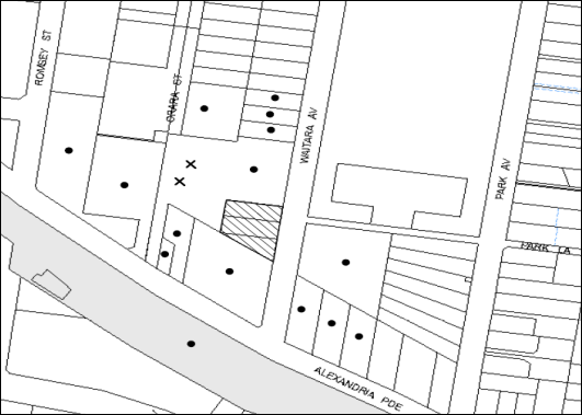
|
NOTIFICATION PLAN |
|
||
|
• PROPERTIES NOTIFIED |
X SUBMISSIONS RECEIVED |
PROPERTY SUBJECT OF DEVELOPMENT |
|
|
One submission received out of map range |
|||
One submission was received in response to the initial notification of the application and two submissions object to the development in response to the amended plans. The submissions object to the proposal generally on the following grounds:
· Non-compliance with numerous building rules and regulations.
· Increased traffic in the area.
· Possible structural impact on the adjoining development.
The merits of the matters raised in community submission have been addressed in the body of the report and as follows:
5.1.1 Structural Impact of Development on Adjoining Development
With respect to concerns regarding the impact of the excavation for the basement, a condition is recommended to be imposed on the consent requiring a ‘Dilapidation Report’ to be prepared by a ‘chartered structural engineer’ detailing the structural condition of all adjoining properties.
5.2 Public Agencies
The development application is not Integrated Development under the Act. Accordingly, the application was not referred to an Agency for comment:
6. THE PUBLIC INTEREST
Section 79C(1)(e) of the Act requires Council to consider “the public interest”.
The public interest is an overarching requirement, which includes the consideration of the matters discussed in this report. Implicit to the public interest is the achievement of future built outcomes adequately responding to and respecting the future desired outcomes expressed in environmental planning instruments and development control plans.
The application is considered to have satisfactorily addressed Council’s and relevant agencies’ criteria and would provide a development outcome that, on balance, would result in a positive impact for the community. Accordingly, it is considered that the approval of the proposed development would be in the public interest.
CONCLUSION
The application seeks approval for the demolition of the existing structures and the construction of a nine storey residential flat building comprising 54 units with basement car parking. The proposed development would be located on a site within a locality zoned as a high density residential precinct.
The proposal does not comply with the Clause 4.6 (Height of Buildings) of the Hornsby Local Environmental Plan 2013. A submission pursuant to Clause 4.3 of the Hornsby Local Environmental Plan 2013 has been submitted to support the development, which is considered well-founded.
The proposed development is satisfactory in respect to the design principles under SEPP 65 and the best practice guidelines of the SEPP 65 – Residential Flat Design Code, subject to recommended conditions. The proposed development has regard to the requirements of the Hornsby DCP and is considered acceptable in the existing high density precinct.
The application is recommended for approval.
Note: At the time of the completion of this planning report, no persons have made a Political Donations Disclosure Statement pursuant to Section 147 of the Environmental Planning and Assessment Act 1979 in respect of the subject planning application.
|
Rod Pickles Manager - Development Assessment Planning Division |
James Farrington Group Manager Planning Division |
Attachments:
|
1.View |
Locality Map |
|
|
|
2.View |
Ground Floor and Site Plan |
|
|
|
3.View |
Floor Plans |
|
|
|
4.View |
Elevations and Sections |
|
|
|
5.View |
Shadow Diagrams |
|
|
|
6.View |
Landscape Plan |
|
|
File Reference: DA/1255/2013
Document Number: D02969469
SCHEDULE 1
GENERAL CONDITIONS
The conditions of consent within this notice of determination have been applied to ensure that the use of the land and/or building is carried out in such a manner that is consistent with the aims and objectives of the relevant legislation, planning instruments and council policies affecting the land and does not disrupt the amenity of the neighbourhood or impact upon the environment.
Note: For the purpose of this consent, the term ‘applicant’ means any person who has the authority to act on or the benefit of the development consent.
Note: For the purpose of this consent, any reference to an Act, Regulation, Australian Standard or Publication by a public authority shall be taken to mean the gazetted Act or Regulation, or adopted Australian Standard or publication as in force on the date that the application for a construction certificate is made.
1. Approved Plans and Supporting Documentation
The development must be carried out in accordance with the plans and documentation listed below and endorsed with Council’s stamp, except where amended by Council and/or other conditions of this consent:
Architectural Plans prepared by Zhinar Architects
|
Plan No. |
Issue |
Plan Title |
Dated |
|
8270 DA-G:00 |
G |
Cover Page |
23.05.2014 |
|
8270 DA-G:02 |
G |
Basement 2 Plan |
23.05.2014 |
|
8270 DA-G:03 |
G |
Basement 1 Plan |
23.05.2014 |
|
8270 DA-G:04 |
G |
Ground Floor + Site Plan |
23.05.2014 |
|
8270 DA-G:05 |
G |
Level 1-3 Plan |
23.05.2014 |
|
8270 DA-G:06 |
G |
Level 4-6 Plans (Typical) |
23.05.2014 |
|
8270 DA-G:07 |
G |
Level 7 Plan |
23.05.2014 |
|
8270 DA-G:08 |
G |
Level 8 Floor Plan |
23.05.2014 |
|
8270 DA-G:09 |
G |
Roof Plan |
23.05.2014 |
|
8270 DA-G10 |
G |
North Elevation |
23.05.2014 |
|
8270 DA-G:11 |
G |
South Elevation |
23.05.2014 |
|
8270 DA-G:12 |
G |
East Elevation |
23.05.2014 |
|
8270 DA-G:13 |
G |
West Elevation |
23.05.2014 |
|
8270 DA-G:14 |
G |
Section A |
23.05.2014 |
|
8270 DA-G:15 |
G |
Section B |
23.05.2014 |
|
8270 DA-G:16 |
G |
Section C |
23.05.2014 |
Landscaping Plans prepared by Vision Dynamics Pty Ltd
|
Plan No. |
Revision |
Plan Title |
Dated |
|
13173 DA1 |
B |
Landscape Concept Plan |
5.03.2014 |
Stormwater Drainage Plans prepared by Donovan Associates
|
Plan No. |
Issue |
Plan Title |
Dated |
|
D1 |
D |
Details, Legend and Notes |
23.05.2014 |
|
D2 |
D |
Stormwater Management Plan – Basement 2 Floor |
22.05.2014 |
|
D3 |
D |
Stormwater Management Plan – Basement 1 Floor |
22.05.2014 |
|
D4 |
D |
Stormwater Management Plan –Site/Ground |
22.05.2014 |
|
D5 |
D |
Stormwater Details |
23.05.2014 |
|
D6 |
D |
Cross Sections – Overland Flow |
23.05.2014 |
|
D7 |
D |
Calculations |
23.05.2014 |
Supporting Documents
|
Document Title |
Prepared by |
Dated |
|
Detail and Level Survey (Reference: Drawing No. 5965 Issue B) |
SDG |
14.05.2014 |
|
Site Analysis (Reference: Drawing No. 8270 DA-G:01 Issue G) |
Zhinar Architects |
23.05.2014 |
|
Shadow Diagram 9.00am & 12.00pm (Reference: Drawing No. 8270 DA-G:17 Issue G) |
Zhinar Architects |
23.05.2014 |
|
Shadow Diagram 3.00pm (Reference: Drawing No. 8270 DA-G:18 Issue G) |
Zhinar Architects |
23.05.2014 |
|
Material Schedule (Reference: Drawing No. 8270 DA-G:19 Issue G) |
Zhinar Architects |
23.05.2014 |
|
Photomontage (Reference: Drawing No. 8270 DA-G:20 Issue G) |
Zhinar Architects |
23.05.2014 |
|
Solar Access Plan 01 (Reference: Drawing No. 8270 DA-G:21 Issue G) |
Zhinar Architects |
23.05.2014 |
|
Solar Access 02 (Reference: Drawing No. 8270 DA-G:22 Issue G) |
Zhinar Architects |
23.05.2014 |
|
Solar Analysis – Eastern Elevation 01 (Reference: Drawing No. 8270 DA-G:23 Issue G) |
Zhinar Architects |
23.05.2014 |
|
Solar Analysis – Eastern Elevation 02 (Reference: Drawing No. 8270 DA-G:24 Issue G) |
Zhinar Architects |
23.05.2014 |
|
Solar Analysis – Western Elevation (Reference: Drawing No. 8270 DA-G:25 Issue G) |
Zhinar Architects |
23.05.2014 |
|
Statement of Environmental Effects (Reference No. 0221/13) |
Planning Ingenuity |
7 November 2013 |
|
Statement of Environmental Effects – Addendum (Reference No. 0221/13) |
Planning Ingenuity |
6 March 2014 |
|
SEPP 65 Design Verification Statement (Reference No. 08270 Issue C) |
Zhinar Architects |
6 March 2014 |
|
Traffic and Parking Assessment Report (Reference No. 13425) |
Varga Traffic Planning Pty Ltd |
28 February 2014 |
|
Access Compliance Assessment Report (Reference No. 2013-105SS-R1) |
Certified Building Specialist |
5 March 2014 |
|
BASIX Certificate No. 513263M_02 |
Building Sustainability Assessments |
5 March 2014 |
|
Overland Flow Study Report (Reference No. E78437 Revision 5) |
Donovan Associates |
22 May 2014 |
|
Sediment Control Plan (Reference No. D8 Issue D) |
Donovan Associates |
23.05.2014 |
|
Sediment Control Details (Reference No. D9 Issue D) |
Donovan Associates |
23.05.2014 |
|
Waste Management Plan |
Advance International Investment Group Pty Ltd |
17 February 2014 |
|
Arboricultural Impact Assessment (Reference No. 9031) |
Redgum Horticultural |
30 October 2013 |
|
DA Acoustic Assessment (Reference No. 20130887.1) |
Acoustic Logic |
24.10.2013 |
2. Amendment of Plans
The following approved plans listed in Condition 1 are to be amended in accordance with the Ground Floor + Site Plan as approved in Drawing No. 8270 DA-G:04, Issue G prepared by Zhinar Architects Ltd dated 23.05.2014:
Landscaping Plans prepared by Vision Dynamics Pty Ltd
|
Plan No. |
Revision |
Plan Title |
Dated |
|
13173 DA1 |
B |
Landscape Concept Plan |
5.03.2014 |
3. Removal of Existing Trees
This development consent only permits the removal of trees identified for removal in the Arboricultural Impact Assessment prepared by Redgum Horticultural dated 30 October 2013. The removal of any other trees requires separate approval under Tree and Vegetation Chapter 1B.6 Hornsby Development Control Plan 2013.
4. Construction Certificate
A Construction Certificate is required to be approved by Council or a Private Certifying Authority prior to the commencement of any works under this consent.
5. Section 94 Development Contributions
In accordance with Section 80A(1) of the Environmental Planning and Assessment Act 1979 and the Hornsby Shire Council Section 94 Development Contributions Plan 2012-2021, the following monetary contributions shall be paid to Council to cater for the increased demand for community infrastructure resulting from the development:
|
Description |
Contribution (4) |
|
Roads |
$59,530.35 |
|
Open Space and Recreation |
$643,123.00 |
|
Community Facilities |
$90,145.10 |
|
Plan Preparation and Administration |
$2,634.00 |
|
TOTAL |
$795,432.45 |
being for 51 additional dwellings.
a) If the contributions are not paid within the financial quarter that this consent is granted, the contributions payable will be adjusted in accordance with the provisions of the Hornsby Shire Council Section 94 Development Contributions Plan and the amount payable will be calculated at the time of payment in the following manner:
$CPY = $CDC x CPIPY
CPIDC
Where:
$CPY is the amount of the contribution at the date of Payment.
$CDC is the amount of the contribution as set out in this Development Consent.
CPIPY is the latest release of the Consumer Price Index (Sydney – All Groups) at the date of Payment as published by the ABS.
CPIDC is the Consumer Price Index (Sydney – All Groups) for the financial quarter at the date of this Development Consent.
b) The monetary contributions shall be paid to Council:
i) prior to the issue of the Subdivision Certificate where the development is for subdivision; or
ii) prior to the issue of the first Construction Certificate where the development is for building work; or
iii) prior to issue of the Subdivision Certificate or first Construction Certificate, whichever occurs first, where the development involves both subdivision and building work; or
iv) prior to the works commencing where the development does not require a Construction Certificate or Subdivision Certificate.
It is the professional responsibility of the Principal Certifying Authority to ensure that the monetary contributions have been paid to Council in accordance with the above timeframes.
Council’s Development Contributions Plan may be viewed at www.hornsby.nsw.gov.au or a copy may be inspected at Council’s Administration Centre during normal business hours.
REQUIREMENTS PRIOR TO THE ISSUE OF A CONSTRUCTION CERTIFICATE
6. Building Code of Australia
All building work must be carried out in accordance with the relevant requirements of the Building Code of Australia.
7. Contract of Insurance (Residential Building Work)
In the case of residential building work for which the Home Building Act 1989 requires there to be a contract of insurance in force in accordance with Part 6 of that Act, that such a contract of insurance is in force before any building work authorised to be carried out by the consent commences.
8. Notification of Home Building Act, 1989 Requirements
Residential building work within the meaning of the Home Building Act 1989 must not be carried out unless the principal certifying authority for the development to which the work relates (not being Council) has given Council written notice of the following information:
a) In the case of work for which a principal contractor is required to be appointed:
i) The name and licence number of the principal contractor; and
ii) The name of the insurer by which the work is insured under Part 6 of that Act.
b) In the case of work to be done by an owner-builder:
i) The name of the owner-builder; and
ii) If the owner-builder is required to hold an owner-builder’s permit under that Act, the number of the owner-builder’s permit.
Note: If arrangements for doing the residential building work are changed while the work is in progress so that the information notified becomes out of date, further work must not be carried out unless the principal certifying authority for the development to which the work relates (not being Council) has given Council written notification of the updated information.
9. Water/Electricity Utility Services
The applicant must submit written evidence of the following service provider requirements:
a) Ausgrid (formerly Energy Australia) – a letter of consent demonstrating that satisfactory arrangements have been made to service the proposed development.
b) Sydney Water – the submission of a ‘Notice of Requirements’ under s73 of the Sydney Water Act 1994.
Note: Sydney Water requires that s73 applications are to be made through an authorised Sydney Water Servicing Coordinator. Refer to www.sydneywater.com.au or telephone 13 20 92 for assistance.
10. Dilapidation Report
A ‘Dilapidation Report’ is to be prepared by a ‘chartered structural engineer’ detailing the structural condition of all adjoining properties.
11. Car Parking and Deliveries
All car parking must be designed, constructed and operated in accordance with Australian Standard AS 2890.1 – 2004 – Off Street Car Parking and Australian Standard 2890.2 - 2002 – Off Street Commercial and the following requirements
a) All parking areas and driveways are to be sealed to an all weather standard, line marked and signposted.
b) Car parking, loading and manoeuvring areas to be used solely for nominated purposes.
c) Vehicles awaiting loading, unloading or servicing shall be parked on site and not on adjacent or nearby public roads;
d) All vehicular entry on to the site and egress from the site shall be made in a forward direction.
e) All parking for people with disabilities is to comply with AS/NZS 2890.6:2009 Off-street parking for people with disabilities.
f) Bicycle parking spaces are to be designed in accordance with AS 2890.3-1993 Bicycle parking facilities.
g) Motorcycle parking spaces are to be designed in accordance with AS 2890.5-1993.
12. Adaptable Units
A minimum of 16 units are to be provided as adaptable housing in accordance with AS4299 (Class A). Six (6) of the units are to be allocated a car parking space designed for people with a disability per AS2890.6. Details of the adaptable units must be provided with the Construction Certificate Plans.
13. Letter Boxes
The details of letter boxes must be provided with the Construction Certificate Plans. The letter boxes must be provided with a minimum setback of 2m from the front property boundary.
14. Construction Management Plan
A Construction Management Plan detailing construction vehicle routes, number of trucks, hours of operation, access arrangements and traffic control should be submitted to Council prior to the issue of a Construction Certificate.
15. Traffic Control Plan
A Traffic Control Plan (TCP) must be prepared by a qualified traffic controller in accordance with the Roads & Traffic Authority’s Traffic Control at Worksites Manual 1998 and Australian Standard 1742.3 for all work on a public road and be submitted to Council. The TCP must detail the following:
a) Arrangements for public notification of the works.
b) Temporary construction signage.
c) Permanent post-construction signage.
d) Vehicle movement plans.
e) Traffic management plans.
f) Pedestrian and cyclist access/safety.
16. Preservation of Survey Infrastructure
Prior to the issue of a construction certificate, a registered surveyor shall identify all survey marks in the vicinity of the proposed development. Any survey marks required to be removed or displaced as a result of the proposed development shall be undertaken by a registered surveyor in accordance with Section 24 (1) of the Surveying and Spatial Information Act 2002 and following the Surveyor General’s Directions No.11 – "Preservation of Survey Infrastructure".
REQUIREMENTS PRIOR TO THE COMMENCEMENT OF ANY WORKS
17. Erection of Construction Sign
A sign must be erected in a prominent position on any site on which building work, subdivision work or demolition work is being carried out:
a) Showing the name, address and telephone number of the principal certifying authority for the work;
b) Showing the name of the principal contractor (if any) for any demolition or building work and a telephone number on which that person may be contacted outside working hours; and
c) Stating that unauthorised entry to the work site is prohibited.
Note: Any such sign is to be maintained while the building work, subdivision work or demolition work is being carried out, but must be removed when the work has been completed.
18. Protection of Adjoining Areas
A temporary hoarding, fence or awning must be erected between the work site and adjoining lands before the works begin and must be kept in place until after the completion of the works if the works:
a) Could cause a danger, obstruction or inconvenience to pedestrian or vehicular traffic.
b) Could cause damage to adjoining lands by falling objects.
c) Involve the enclosure of a public place or part of a public place.
Note: Notwithstanding the above, Council’s separate written approval is required prior to the erection of any structure or other obstruction on public land.
19. Toilet Facilities
Toilet facilities must be available or provided at the works site before works begin and must be maintained until the works are completed at a ratio of one toilet for every 20 persons employed at the site. Each toilet must:
a) be a standard flushing toilet connected to a public sewer; or
b) be a temporary chemical closet approved under the Local Government Act 1993; or
c) have an on-site effluent disposal system approved under the Local Government Act 1993.
20. Erosion and Sediment Control
Erosion and sediment control measures must be provided and maintained throughout the construction period in accordance with the manual ‘Soils and Construction 2004 (Bluebook)’, the approved plans, Council specifications and to the satisfaction of the principal certifying authority. The erosion and sediment control devices must remain in place until the site has been stabilised and revegetated.
Note: On the spot penalties up to $1,500 may be issued for any non-compliance with this requirement without any further notification or warning.
21. Tree Protection Barriers
Tree protection fencing must be erected around trees numbered 1 and 2 as identified in the Arboricultural Impact Assessment prepared by Redgum Horticultural dated 30 October 2013 and are to be retained at a 5 metre setback. The tree fencing must be constructed of 1.8 metre ‘cyclone chainmesh fence’ or star pickets spaced at 2 metre intervals, connected by a continuous high-visibility barrier/hazard mesh at a height of 1 metre.
To avoid injury or damage, trees numbered 1 and 2 must have trunks protected by 2 metre lengths of 75mm x 25mm hardwood timbers spaced at 80mm secured with galvanised wire (not fixed or nailed to the tree in any way.
REQUIREMENTS DURING CONSTRUCTION
22. Construction Work Hours
All work on site (including demolition and earth works) must only occur between 7am and 5pm Monday to Saturday. No work is to be undertaken on Sundays or public holidays.
23. Work Zone
All construction vehicles associated with the proposed development are to be contained on site as no construction zones will be permitted on Waitara Avenue in the vicinity of the site.
24. Demolition
All demolition work must be carried out in accordance with “Australian Standard 2601-2001 – The Demolition of Structures” and the following requirements:
a) Demolition material must be disposed of to an authorised recycling and/or waste disposal site and/or in accordance with an approved waste management plan;
b) Demolition works, where asbestos material is being removed, must be undertaken by a contractor that holds an appropriate licence issued by WorkCover NSW in accordance with Chapter 10 of the Occupational Health and Safety Regulation 2001 and Clause 29 of the Protection of the Environment Operations (Waste) Regulation 2005 ;and
c) On construction sites where buildings contain asbestos material, a standard commercially manufactured sign containing the words ‘DANGER ASBESTOS REMOVAL IN PROGRESS’ measuring not less than 400mm x 300mm must be erected in a prominent position visible from the street.
25. Environmental Management
The site must be managed in accordance with the publication ‘Managing Urban Stormwater – Landcom (March 2004) and the Protection of the Environment Operations Act 1997 by way of implementing appropriate measures to prevent sediment run-off, excessive dust, noise or odour emanating from the site during the construction of the development.
26. Street Sweeping
Street sweeping must be undertaken following sediment tracking from the site along Waitara Avenue during works and until the site is established.
27. Works Near Trees
All required tree protection measures are to be maintained in good condition for the duration of the construction period.
All works (including driveways and retaining walls) within 5 metres of any trees required to be retained (whether or not on the subject property, and pursuant to this consent or the Hornsby Development Control Plan), must be carried out under the supervision of an ‘AQF Level 5 Arborist’ and a certificate submitted to the principal certifying authority detailing the method(s) used to preserve the tree(s).
Note: Except as provided above, the applicant is to ensure that no excavation, filling or stockpiling of building materials, parking of vehicles or plant, disposal of cement slurry, waste water or other contaminants is to occur within 4 metres of any tree to be retained.
28. Council Property
During construction works, no building materials, waste, machinery or related matter is to be stored on the road or footpath. The public reserve must be kept in a clean, tidy and safe condition at all times.
29. Disturbance of Existing Site
During construction works, the existing ground levels of open space areas and natural landscape features, (including natural rock-outcrops, vegetation, soil and watercourses) must not be altered unless otherwise nominated on the approved plans.
30. Landfill
Landfill must be constructed in accordance with Council’s ‘Construction Specification 2005’ and the following requirements:
a) All fill material imported to the site is to wholly consist of Virgin Excavated Natural Material (VENM) as defined in Schedule 1 of the Protection of the Environment Operations Act 1997 or a material approved under the Department of Environment and Climate Change’s general resource recovery exemption.
b) A compaction certificate is to be obtained from a geotechnical engineer verifying that the specified compaction requirements have been met.
31. Excavated Material
All excavated material removed from the site must be classified in accordance with the Department of Environment, Climate Change and Water NSW Waste Classification Guidelines prior to disposal to an approved waste management facility and reported to the principal certifying authority.
32. Survey Report – Finished Floor Level
A report(s) must be prepared by a registered surveyor and submitted to the principal certifying authority prior to the pouring of concrete at each level of the building certifying that:
a) The building, retaining walls and the like have been correctly positioned on the site; and
b) The finished floor level(s) are in accordance with the approved plans.
33. Contamination During Construction Works
Should the presence of asbestos or soil contamination, not recognised during the application process be identified during demolition, the applicant must immediately notify the Principal Certifying Authority and Council.
34. Construction Noise Management
The construction works must be undertaken in accordance with the “Interim Construction Noise Guidelines – 2009” published by Department of Environment and Climate Change NSW.
35. Waste Management
Waste management during the demolition and construction phase of the development must be undertaken in accordance with the approved Waste Management Plans.
Additionally written records of the following items must be maintained during the removal of any waste from the site and such information submitted to the Principal Certifying Authority within fourteen days of the date of completion of the works:
a) The identity of the person removing the waste.
b) The waste carrier vehicle registration.
c) Date and time of waste collection.
d) A description of the waste (type of waste and estimated quantity).
e) Details of the site to which the waste is to be taken.
f) The corresponding tip docket/receipt from the site to which the waste is transferred (noting date and time of delivery, description (type and quantity) of waste).
g) Whether the waste is expected to be reused, recycled or go to landfill.
Note: In accordance with the Protection of the Environment Operations Act 1997, the definition of waste includes any unwanted substance, regardless of whether it is reused, recycled or disposed to landfill.
REQUIREMENTS PRIOR TO THE ISSUE OF AN OCCUPATION CERTIFICATE
Note: For the purpose of this consent, a reference to ‘occupation certificate’ shall not be taken to mean an ‘interim occupation certificate’ unless otherwise stated.
36. Fulfilment of BASIX Commitments
The applicant must demonstrate the fulfilment of BASIX commitments pertaining to the development.
37. Safety and Security
Prior to the issue of the Occupation Certificate, the site must include the following elements:
a) An intercom system be installed at gate locations to ensure screening of persons entering the units;
b) The entryway to the site be illuminated in high luminance at all times;
c) The communal open space areas are to be illuminated with high luminance by motion sensor lighting;
d) The service areas of the ground floor and the garbage room be illuminated with high luminance by motion sensor lighting;
e) The driveway and the basement car park is to be illuminated with low luminance at all times;
f) Robust materials which cannot be forced or breached with minimised maintenance requirements are to be used for construction work in the common areas;
g) The lamps and lighting levels must comply with Australian and New Zealand Lighting Standard 1158.1;
h) Effective signage be provided to guide visitors to the main areas and parking areas;
i) A street sign be prominently displayed in front of the site in accordance with Order No. 8, Section 124 Local Government Act 1993;
j) The communal area must include a clear sign to restrict access for non-residents;
k) Units’ numbers, entry and exit signs must be legible and clear;
l) Fire exit doors to be fitted with single cylinder locksets (Australia New Zealand Standard-Locksets);
m) The entry doors to the pedestrian foyer is to be constructed of safety rated glass to enable residents a clear line of site before entering or exiting the residential apartments;
n) Lighting is to be provided to pathways, building foyer entries, driveways and common external spaces;
o) Security deadlocks are to be provided to each apartment door; and
p) Peep holes are to be provided to individual apartment doors to promote resident safety.
38. Residential Storage
The basement resident storage areas are to be allocated in accordance with the size requirements of the Residential Flat Design Code for the respective units.
39. Sydney Water – s73 Certificate
An s73 Certificate must be obtained from Sydney Water.
40. Maintain Canopy Cover
To maintain canopy cover, 5 medium to large trees selected from Council’s booklet ‘Indigenous Plants for the Bushland Shire’ such as Angophora costata and Syncarpia glomulifera are to be planted on the subject site. The planning location shall not be within 4 metres of the foundation walls of a dwelling or in-ground pool. The pot size is to be a minimum 25 litres and the tree(s) must be maintained until they reach the height of 3 metres. Trees must be native to Hornsby Shire and reach a mature height of at least 10-12 metres.
41. Damage to Council Assets
Any damage caused to Council’s assets as a result of the construction of the development must be rectified in accordance with Council’s Civil Works Specifications. Council’s Restorations Supervision must be notified for a formwork inspection prior to pouring concrete.
42. Underground Installation of Powerlines
Existing overhead powerlines located across the frontage of the property must be relocated and installed underground, including removal of poles and replacement with street lighting as required.
43. Trellis Planting
Trellis planting must be provided along the southern fenceline for the entire length of the driveway entry. Planting must be a minimum of ten (10) vines / climbing plants (5 at each end in deep soil area) using a few species which are capable of trailing across the visually exposed boundary area. Climbers must be in minimum 2.5 litre pot sizes.
44. Planter Boxes / On Slab Planting / Gravel Bed
On slab planter boxes and proposed gravel bed must include waterproofing and subsoil drainage (proprietary drainage cell, 50mm sand and filter fabric). Planter boxes must include automatic irrigation, minimum 500mm planting soil for shrubs and minimum 1000mm planting soil for trees and palms and 75mm mulch to ensure sustainable landscape is achieved.
45. Tree Planting
Tree planting to the Waitara Avenue front setback areas must include:
a) A minimum of two Corymbia maculata (Spotted Gum) as additional or substitution planting for the proposed Angophora floribunda, installed at minimum 25 litre pot size.
Tree planting to the northern side setback areas must include:
b) Three Corymbia maculata (Spotted Gum) as additional planting, installed at minimum 25 litre pot size.
46. Street Tree Plantings
Planting to the front verge must include three Angophora costata (Sydney Red Gum). Trees must be installed at minimum 100 litre pot size.
47. Completion of Landscaping
A certificate must be provided by a practicing landscape architect or person with similar qualifications and experience certifying that all required landscaping works have been satisfactorily completed in accordance with the approved landscape plans.
Note: Applicants are advised to pre-order plant material required in pot sizes 45 litre or larger to ensure Nurseries have stock available at the time of install.
48. Retaining Walls
All required retaining walls must be constructed as part of the development.
49. Boundary Fencing
Fencing must be erected along all property boundaries behind the front building alignment to a height of 1.8 metres.
Note: Alternative fencing may be erected subject to the written consent of the adjoining property owner(s).
50. External Lighting
All external lighting must be designed and installed in accordance with Australian Standard AS 4282 – Control of the Obtrusive Effects of Outdoor Lighting. Certification of compliance with the Standard must be obtained from a suitably qualified person.
51. Unit Numbering
The allocation of unit numbering must be authorised by Council prior to the numbering of each unit in the development.
52. Waste Management Details
The following waste management requirements must be complied with:
a) The bin storage room at the ground level must include water or a hose for cleaning, graded floors with drainage to sewer, a robust door, sealed and impervious surface, adequate lighting and ventilation, and must be lockable. The waste facility cupboards at each residential level must include sealed and impervious surface, adequate lighting and ventilation.
b) A report must be prepared by an appropriately qualified person, certifying the following:
i) A comparison of the estimated quantities of each waste type against the actual quantities of each waste type.
Note: Explanations of any deviations to the approved Waste Management Plan is required to be included in this report
ii) That at least 60% of the waste generated during the demolition and construction phase of the development was reused or recycled.
Note: If the 60% diversion from landfill cannot be achieved in the Construction Stage, the Report is to include the reasons why this occurred and certify that appropriate work practices were employed to implement the approved Waste Management Plan. The Report must be based on documentary evidence such as tipping dockets/receipts from recycling depots, transfer stations and landfills, audits of procedures etc. which are to be attached to the report.
iii) All waste was taken to site(s) that were lawfully permitted to accept that waste.
c) Each unit must be provided with an indoor waste/recycling cupboard for the interim storage of a minimum one day’s waste generation with separate containers for general waste and recyclable materials.
d) Space must be provided for either individual compost containers for each unit or a communal compost container;
Note: The location of the compost containers should have regard for potential amenity impacts.
e) The bin carting routes must be devoid of any steps.
Note: Ramps between different levels are acceptable
53. Garbage Collection Easement
For the purpose of waste collection, an easement entitling Council, its servants and agents and persons authorised by it to enter upon the subject land and to operate thereon, vehicles and other equipment for the purposes of garbage collection must be granted to Council by the owner of the land.
Note: The easement must be in a form prescribed by Council and must include covenants to the effect that parties will not be liable for any damage caused to the subject land or any part thereof or to any property located therein or thereon by reason of the operation thereon of any vehicle or other equipment used in connection with the collection of garbage and to the effect that the owner for the time being of the subject land shall indemnify the Council, its servants, agents and persons authorised by it to collect garbage against liability in respect of any such claims made by any person whomsoever.
54. Consolidation of Allotments
All allotments the subject of this consent must be consolidated into one allotment.
Note: The applicant is recommended to submit the plan of subdivision to consolidate allotments to the NSW Department of Lands at least 4-6 weeks prior to seeking an occupation certificate.
55. Provision for National Broadband Network (NBN)
Provision must be made for fibre ready passive infrastructure (pits and pipes) generally in accordance with NBN Co's pit and pipe installation guidelines to service the proposed development. A certificate from NBN Co or Telstra must be submitted to the PCA that the fibre optic cabling provided for the development complies with MDU Building Design Guides for Development.
56. Stormwater Drainage
The stormwater drainage system for the development must be designed and constructed for an average recurrence interval of 20 years and be gravity drained in accordance with the following requirements:
a) Connected to an existing Council drainage system via an on site detention system.
b) For connection to Council pit, a construction certificate application is to be submitted to Council (as council is the authority to approve a plan for connection to Council system).
c) Be designed by a Chartered Professional Engineer/ Civil Engineer of the Institution of Engineers, Australia.
57. On Site Stormwater Detention
An on-site stormwater detention system must be designed by a chartered civil engineer and constructed in accordance with the following requirements:
a) Storage capacity to accommodate volume from up to 20 years ARI (average recurrence interval) and a maximum discharge (when full) limited to 5 years pre development rate.
b) Have a surcharge/inspection grate located directly above the outlet.
c) Discharge from the detention system to be controlled via 1 metre length of pipe, not less than 50 millimetres diameter or via a stainless plate with sharply drilled orifice bolted over the face of the outlet discharging into a larger diameter pipe capable of carrying the design flow to an approved Council system.
d) Where above ground and the average depth is greater than 0.3 metres, a ‘pool type’ safety fence and warning signs to be installed.
e) Not be constructed in a location that would impact upon the visual or recreational amenity of residents.
f) Detail calculations are to be shown in construction certificate plan.
58. Flooding - Overland Flowpath, Flood Proofing, Floor Level
a) Any structural wall abutting the overland flowpath must be flood proofed in accordance with Floodplain Development manual of New South Wales Government.
b) Floor levels of habitable rooms of the development abutting the 100 year ARI overland flowpath shall be 0.5m above the 100 year ARI flood levels (at the corresponding point in the Overland Flow Study Report (Reference No. E78437 Revision 5) prepared by Donovan Associates, dated 22 May 2014.
c) The finished ground level of the overland flowpath must be in accordance with the Cross Sections – Overland Flow plan, prepared by Donovan Associates, Drawing No.D6 Issue D, dated 23.05.2014.
d) No structure is to be erected within the overland flowpath or drainage easement running through the property to impede flow.
e) Fences across overland flowpath must be swimming pool type or hinged at 0.5m above the 100 ARI overland flow level.
f) A works as executed plan of the finished ground level of the overland flowpath, prepared by a registered surveyor is to be submitted to the Principal Certifying Authority.
59. Vehicular Crossing
A separate application under the Local Government Act, 1993 and the Roads Act, 1993 must be submitted to Council for the installation of a new vehicular crossing and the removal of the redundant crossing. The vehicular crossing must be constructed in accordance with Council’s Civil Works Design, 2005 and the following requirements:
a) Any redundant crossings to be replaced with integral kerb and gutter.
b) The footway area to be restored by turfing.
c) Approval obtained from all relevant utility providers that all necessary conduits be provided and protected under the crossing.
Note: An application for a vehicular crossing can only be made to one of Council’s Authorised Vehicular Crossing Contractors. You are advised to contact Council on 02 9847 6940 to obtain a list of contractors.
60. Internal Driveway/Vehicular Areas
The driveway and parking areas on site must be designed in accordance with Australian Standards 2890.1, 2890.2, 3727 and the following requirements:
a) Design levels at the front boundary be obtained from Council.
b) The driveway be a rigid pavement.
61. Road Works
All road works approved under this consent must be constructed in accordance with Council’s Civil Works Design and Construction Specification, 2005 and the following requirements:
a) Concrete footpath, kerb and gutter along Waitara Avenue along the frontage of the development are to replaced. The existing road pavement to be saw cut a minimum of 300 mm from the existing edge of the bitumen and reconstructed.
b) A construction certificate is to be submitted to Council for approval.
Note: Council is the only authority to approve works within Council roads.
62. Works as Executed Plan
Works-as-executed plans must be prepared by a registered surveyor and submitted to Council for completed road pavement, kerb & gutter, overland flowpath, drainage systems, driveways and on-site detention system.
63. Foundation of Structure within Council’s Stormwater Pipe Zone of Influence
Foundations of structures in the proximity of Council stormwater pipe shall be carried out under the supervision of a Chartered Structural Engineer of the Institution of Engineers, Australia ensuring that the efficiency of Council’s stormwater system is not reduced.
After completion of works, a certificate from the Chartered Professional Structural Engineer confirming that works have been carried out in a manner that no impact has been created on Council drainage pipes shall be submitted to the Principal Certifying Authority.
64. Creation of Easements
The following matter(s) must be nominated on the plan of subdivision under s88B of the Conveyancing Act 1919:
a) A restriction over the pipeline and the flow path for a 100 year average recurrence interval storm. The "Restriction on the Use of Land" over the affected lots is to prohibit the alteration of the final floodway shape and the erection of any structures, including fencing, in the floodway without the written permission of Council. The terms of this restriction must be obtained from Council.
b) The creation of an appropriate "Positive Covenant" and "Restriction as to User" over the constructed on-site detention/retention systems and outlet works, within the lots in favour of Council in accordance with Council’s prescribed wording. The position of the on-site detention system is to be clearly indicated on the title.
c) To register the OSD easement, the restriction on the use of land “works-as-executed” details of the on-site-detention system must be submitted verifying that the required storage and discharge rates have been constructed in accordance with the design requirements. The details must show the invert levels of the on site system together with pipe sizes and grades. Any variations to the approved plans must be shown in red on the “works-as-executed” plan and supported by calculations.
Note: Council must be nominated as the authority to release, vary or modify any easement, restriction or covenant.
65. Certificate of Preservation of Survey Marks
A certificate by a Registered Surveyor shall be submitted to the Principal Certifying Authority, certifying that there has been no removal, damage, destruction, displacement or defacing of the existing survey marks in the vicinity of the proposed development or otherwise the re-establishment of damaged, removed or displaced survey marks has been undertaken in accordance with the Surveyor General’s Direction No.11 – “Preservation of Survey Infrastructure”.
OPERATIONAL CONDITIONS
66. Access to/from and Use of the Car Park
a) Residential parking spaces must be secure spaces with access controlled by card or numeric pad.
b) Visitors must be able to access the visitor parking spaces in the basement car park at all times.
c) Any proposed landscaping and/or fencing must not restrict sight distance from the driveway to pedestrians and cyclists travelling along the footpath.
67. Noise
The level of total continuous noise emanating from operation of the premises including all the plant, including air conditioning units and processes in all buildings (LA10) (measured for at least 15 minutes) in or on the above premises, must not exceed the background level by more than 5dB(A) when measured at all property boundaries.
68. Landscape Establishment
The landscape works must be maintained into the future to ensure the establishment and successful growth of plant material to meet the intent of the landscape design. This must include but not be limited to watering, weeding, replacement of failed plant material and promoting the growth of plants through standard industry practices.
69. Waste Management
The waste management on site must be in accordance with the following requirements:
a) A site caretaker must be employed and be responsible for moving bins where and when necessary, washing bins and maintaining waste storage areas, decanting the 240 L garbage bins into the 660 L garbage bins, managing the communal composting area, managing the bulky item storage area, arranging the prompt removal of dumped rubbish, and ensuring all residents are informed of the use of the waste management system.
70. Fire Safety Statement – Annual
On at least one occasion in every 12 month period following the date of the first ‘Fire Safety Certificate’ issued for the property, the owner must provide Council with an annual ‘Fire Safety Certificate’ to each essential service installed in the building.
- END OF CONDITIONS -
ADVISORY NOTES
The following information is provided for your assistance to ensure compliance with the Environmental Planning and Assessment Act, 1979, Environmental Planning and Assessment Regulation 2000, other relevant legislation and Council’s policies and specifications. This information does not form part of the conditions of development consent pursuant to Section 80a of the Act.
Environmental Planning and Assessment Act 1979 Requirements
The Environmental Planning and Assessment Act 1979 requires:
· The issue of a construction certificate prior to the commencement of any works. Enquiries can be made to Council’s Customer Services Branch on 9847 6760.
· A principal certifying authority to be nominated and Council notified of that appointment prior to the commencement of any works.
· Council to be given at least two days written notice prior to the commencement of any works.
· Mandatory inspections of nominated stages of the construction inspected.
· An occupation certificate to be issued before occupying any building or commencing the use of the land.
Long Service Levy
In accordance with Section 34 of the Building and Construction Industry Long Service Payments Act 1986, a ‘Long Service Levy’ must be paid to the Long Service Payments Corporation or Hornsby Council.
Note: The rate of the Long Service Levy is 0.35% of the total cost of the work.
Note: Hornsby Council requires the payment of the Long Service Levy prior to the issue of a construction certificate.
Tree and Vegetation Preservation
In accordance with Clause 5.9 of the Hornsby Local Environmental Plan 2013 a person must not ringbark, cut down, top, lop, remove, injure or wilfully destroy any tree or other vegetation protected under the Hornsby Development Control Plan 2013 without the authority conferred by a development consent or a permit granted by Council.
Note: A tree is defined as a long lived, woody perennial plant with one or relatively few main stems with the potential to grow to a height greater than three metres (3M). (HDCP 1B.6.1.c).
Tree protection measures and distances are determined using the Australian Standard AS 4970:2009, “Protection of Trees on Development Sites”.
Fines may be imposed for non-compliance with both the Hornsby Local Environmental Plan 2013 and the Hornsby Development Control Plan 2013.
Disability Discrimination Act
The applicant’s attention is drawn to the existence of the Disability Discrimination Act. A construction certificate is required to be obtained for the proposed building/s, which will provide consideration under the Building Code of Australia, however, the development may not comply with the requirements of the Disability Discrimination Act. This is the sole responsibility of the applicant.
Covenants
The land upon which the subject building is to be constructed may be affected by restrictive covenants. Council issues this approval without enquiry as to whether any restrictive covenant affecting the land would be breached by the construction of the building, the subject of this consent. Applicants must rely on their own enquiries as to whether or not the building breaches any such covenant.
Dial Before You Dig
Prior to commencing any works, the applicant is encouraged to contact Dial Before You Dig on 1100 or www.dialbeforeyoudig.com.au for free information on potential underground pipes and cables within the vicinity of the development site.
Telecommunications Act 1997 (Commonwealth)
If you are aware of any works or proposed works which may affect or impact on Telstra’s assets in any way, you are required to contact: Telstra’s Network Integrity Team on Phone Number 1800810443.
Asbestos Warning
Should asbestos or asbestos products be encountered during demolition or construction works, you are advised to seek advice and information prior to disturbing this material. It is recommended that a contractor holding an asbestos-handling permit (issued by WorkCover NSW) be engaged to manage the proper handling of this material. Further information regarding the safe handling and removal of asbestos can be found at:
Alternatively, telephone the WorkCover Asbestos and Demolition Team on 8260 5885.
Group Manager’s Report No. PL42/14
Planning Division
Date of Meeting: 11/06/2014
15 DEVELOPMENT APPLICATION - SECTION 96(2) - CONSTRUCTION OF AN AFFORDABLE RENTAL HOUSING DEVELOPMENT COMPRISING 8 TOWNHOUSES - 3 AND 5 FULBOURNE AVENUE, PENNANT HILLS
EXECUTIVE SUMMARY
|
DA No: |
DA/1021/2010/A (Lodged 23 May 2013) |
|
Description: |
Section 96(2) modification of an affordable rental housing development to increase the number of dwellings from 8 to 14 |
|
Property: |
Lot 16 DP 10203, Lot 15 DP 10203, Nos. 3 and 5 Fulbourne Avenue, Pennant Hills |
|
Applicant: |
Mr Ram Shanker Kangatharan C/- Glendinning Minto & Associates Pty Ltd |
|
Owner: |
Mr R S Kangatharan |
|
Estimated Value: |
N/A |
|
Ward: |
C |
· The application proposes modification of approved plans to convent townhouses to multi-dwelling housing increasing the number of dwellings from 8 to 14.
· The proposal complies with State Environmental Planning Policy (Affordable Rental Housing) 2009 and is substantially the same development as approved pursuant to Section 96 of the Environmental Planning and Assessment Act, 1979.
· Eighteen submissions have been received in respect of the application.
· A Red Sticker has been placed on the application requiring that the matter be determined at a Council meeting.
· It is recommended that the application be approved.
|
THAT pursuant to Section 96(2) of the Environmental Planning and Assessment Act, 1979, Development Application No. DA/1021/2010/A for construction of an affordable rental housing development comprising eight townhouses at Lot 16 & Lot 15 DP 10203, Nos. 3 and 5 Fulbourne Avenue, Pennant Hills be amended as detailed in Schedule 1 of Group Manager’s Report No. PL42/14. |
BACKGROUND
On 2 February 2011, Council approved Development Application DA/1021/2010 for construction of an affordable rental housing development comprising eight townhouses.
State Environmental Planning Policy (Affordable Rental Housing) 2009 was amended on 20 May 2011 to include provision for development proposals to be subject to a local character test.
On 23 May 2013, the subject Section 96(2) application was lodged for modification of consent to increase the number of dwellings from 8 to 12 dwellings through conversion of four of the townhouses to multi dwelling housing.
On 27 November 2013, the subject application was amended to include a basement car park and increase the number of dwellings to 14.
On 23 January 2014, the applicant submitted legal advice that the proposed modification is substantially the same development as approved, and submitted further amended plans to increase the area of landscaping and provide an outdoor clothes drying area for proposed first floor units.
On 17 April 2014, the applicant amended the proposal to include privacy screening and increase the separation between buildings.
SITE
The site comprises two existing allotments located on the southern side of Fulbourne Avenue. The site has an area of 2,089.5m2 and is of regular shape with a frontage of 41.5m and depth of 50.5m. The site has an average fall of 6% to the rear, south-western corner.
The site includes two existing single storey dwelling houses. An existing stormwater drainage easement is across the south-east corner of the site. The site includes several trees including a number of locally indigenous trees in the western rear part of the site.
The surrounding locality is a low density residential area. A child care centre on the corner of Fulbourne Avenue and Yarrara Road adjoins the eastern side boundary. The dwelling house adjoining the western side boundary is a heritage item of local significance.
The Main Northern Rail Corridor is located 45m east of the site and parallel to Yarrara Road.
The site is situated 670m north-east of Pennant Hills Railway Station and commercial centre.
APPROVED DEVELOPMENT
The approved development is for the demolition of two existing dwelling houses and construction of eight townhouses comprising two, two storey semi-detached townhouses at the front of the site and a row of four two storey townhouses at the rear of the site.
A central driveway provides access to the rear townhouses.
Each of the two semi-detached townhouse buildings at the frontage of the site includes a separate driveway off Fulbourne Avenue.
The approved townhouses include 4 x 3 bedroom and 4 x 4 bedroom dwellings.
Five of the townhouses include attached single garages. Four open car parking spaces, including a visitor space, are provided off the central driveway turning area.
The approved development has not physically commenced.
PROPOSED MODIFICATION
The proposal is for the modification of the approved plans to convert the townhouses to multi dwelling housing, include a basement car park and increase the number of dwellings from 8 to 14.
The proposed modification includes the following amendments:
· The approved semi-detached town houses at the frontage of the site would be modified to comprise multi dwelling housing with 2 x 1 bedroom ground floor units and 2 x 2 bedroom first floor units, each with entry at ground level. The second semi-detached townhouse building would be redesigned to comprise 2 x 3 bedroom townhouses and include two attached single garages.
· The approved townhouses at the rear of the site would be redesigned into multi dwelling housing comprising 4 ground floor units and 4 first floor units each with separate entry at ground level and containing 6 x 2 bedroom and 2 x 3 bedroom dwellings. The multi dwelling housing building would be constructed over a proposed basement car park.
· The driveway is to be relocated to the western side of the site for access to the proposed basement car park. The basement car park would include 14 resident car parking spaces and 1 visitor space and includes stair access.
· The addition of first floor deck areas to the first floor units and revised window placement at the western and eastern elevations.
· Increase in building height of the proposed multi unit housing building at the frontage by 0.63m and 0.18m at the rear of the site.
· Construction of a garbage storage facility at the street frontage.
· Units 2, 3, 9, 10, 11 and 12 would be provided for affordable rental housing.
ASSESSMENT
The development application has been assessed having regard to the ‘Metropolitan Plan for Sydney 2031’, the ‘North Subregion (Draft) Subregional Strategy’ and the matters for consideration prescribed under Section 79C of the Environmental Planning and Assessment Act 1979 (the Act). The following issues have been identified for further consideration.
1. STRATEGIC CONTEXT
1.1 Metropolitan Plan for Sydney and (Draft) North Subregional Strategy
The (Draft) Metropolitan Strategy for Sydney 2031 is a broad framework to provide for Sydney’s growth to help plan for housing, employment, transport, infrastructure, the environment and open space. It outlines a vision for Sydney to 2031; the challenges faced, and the directions to follow to address these challenges and achieve the vision.
The North Subregion comprises Hornsby, Kuring-gai, Manly, Warringah and Pittwater Local Government Areas. The Draft North Subregional Strategy acts as a framework for Council in its preparation of the Comprehensive LEP by the end of 2013.
Within the North Subregion, the Draft Metropolitan Strategy proposes:
· Population growth of 81,000 from the current 2011 baseline of 529,000
· Housing growth of 37,000 from the current 2011 baseline of 204,000
· Employment growth of 39,000 from the current 2011 baseline of 186,000
The proposed modification would be consistent with the Metropolitan Plan for Sydney 2031 and would provide 6 dwellings in addition to the approved dwellings which would assist in achieving Council’s dwelling target.
2. STATUTORY CONTROLS
Section 79C(1)(a) of the Environmental Planning and Assessment Act, 1979 requires Council to consider “any relevant environmental planning instruments, draft environmental planning instruments, development control plans, planning agreements and regulations”.
2.1 Environmental Planning and Assessment Act 1979 – Section 96(2)
Pursuant to Section 96(2) of the Act, Council may consider an application for modification of development consent provided that, inter alia:
(2) Other modifications
A consent authority may, on application being made by the applicant or any other person entitled to act on a consent granted by the consent authority and subject to and in accordance with the regulations, modify the consent if:
(a) it is satisfied that the development to which the consent as modified relates is substantially the same development as the development for which consent was originally granted and before that consent as originally granted was modified (if at all), and
(b) it has consulted with the relevant Minister, public authority or approval body (within the meaning of Division 5) in respect of a condition imposed as a requirement of a concurrence to the consent or in accordance with the general terms of an approval proposed to be granted by the approval body and that Minister, authority or body has not, within 21 days after being consulted, objected to the modification of that consent, and
(c) it has notified the application in accordance with:
(i) the regulations, if the regulations so require, or
(ii) a development control plan, if the consent authority is a council that has made a development control plan that requires the notification or advertising of applications for modification of a development consent, and
(d) it has considered any submissions made concerning the proposed modification within the period prescribed by the regulations or provided by the development control plan, as the case may be.
(3) In determining an application for modification of a consent under this section, the consent authority must take into consideration such of the matters referred to in section 79C (1) as are of relevance to the development the subject of the application.
(4) The modification of a development consent in accordance with this section is taken not to be the granting of development consent under this Part, but a reference in this or any other Act to a development consent includes a reference to a development consent as so modified.
The proposed modification has been notified and the submissions received in response considered in the assessment of the application.
The submissions raise concerns that the proposed modification is not substantially the same development as approved. The applicant submitted legal advice concluding that the proposed modification involving an increase in dwelling numbers and change in dwelling type from townhouse to multi-unit housing is substantially the same development as approved pursuant to Section 96(2)(a), primarily as the approved built form would be maintained.
Council’s solicitor has confirmed the proposed modification would be consistent with decisions of the Land and Environment Court involving modifications that were considered substantially the same development as approved. Accordingly, based on legal advice, Council may consider the modification pursuant to Section 96(2) of the Act.
2.2 Hornsby Local Environmental Plan 2013
The subject land is zoned R2 Low Density Residential under the Hornsby Local Environmental Plan 2013 (HLEP). The objectives of the R2 zone are:
(a) To provide for the housing needs of the community within a low density residential environment.
(b) To enable other land uses that provide facilities or services to meet the day to day needs of residents.
The approved and proposed dwellings are defined as ‘multi dwelling housing’ under HLEP as follows:
Multi dwelling housing means 3 or more dwellings (whether attached or detached) on one lot of land, each with access at ground level, but does not include a residential flat building.
Pursuant to Part 2 of HELP, residential development other than dwelling houses is prohibited in the R2 Low Density Residential Zone. Consequently, the approved development would be prohibited under the provisions of State Environmental Planning Policy (Affordable Rental Housing) 2009.
Notwithstanding the development is prohibited, the subject development consent is valid and can be modified in accordance with Section 96 of the Act, subject to Council being satisfied the modified development is substantially the same as approved taking into consideration the relevant matters under Section 79C.
Clause 4.3 of HLEP permits a maximum building height of 8.5 metres for development in the subject R2 Low Density Residential zone. The proposed modification would comply with this requirement.
Clause 5.10 of HLEP provides for the conservation of heritage items, heritage conservation areas, archaeological sites and Aboriginal heritage. The proposed modification involves development in the vicinity of a heritage item at No. 7 Fulbourne Avenue, Pennant Hills comprising an Inter-War weatherboard cottage of local significance. The proposed modification generally maintains the approved built form and would not detract from the significance of the adjoining heritage item. Refer to comments in Section 3.2.2.
2.3 State Environmental Planning Policy (Affordable Rental Housing) 2009
The application has been assessed against the requirements of State Environmental Planning Policy (Affordable Rental Housing) 2009 (AHSEPP). The provisions of the Policy provide planning incentives for increasing the supply of affordable rental housing and to retain existing rental housing. The planning incentives are applicable for sites that are within walking distance of public transport.
On 20 May 2011, the Policy was amended to exclude private sector medium and high density developments from low density residential areas. The amendments include a local character test and public transport test for permissibility of development under the Policy.
The applicable provisions under Part 2 Division 1 of the Policy in respect to the subject site and the modified development are discussed as follows:
2.3.1 Clause 10 – Development to Which Division Applies
Pursuant to Clause 10, the Policy applies for the purpose of dual occupancies, multi-dwelling housing and residential flat buildings if that form of development is permitted under an environmental planning instrument and the site is within an accessible area.
At the time of the consent approval on 2 February 2011, multi-unit housing was permitted in the Residential A (Low Density) Zone under HSLEP 1994 with development consent. The site is within an accessible area being within 670m of Pennant Hills Railway Station. The Policy is therefore relevant to the proposed modification.
2.3.2 Clause 13 – Floor Space Ratio
The affordable housing component of the modified proposal comprises 41% of the total gross floor area of 1,187m2. Pursuant to Clause 13, the maximum floor space ratio permissible for the proposal is 0.81:1. A floor space ratio of 0.56:1 is proposed for the site.
2.3.3 Clause 14 – Standards That Cannot be Used to Refuse Consent
Pursuant to Clause 14, a consent authority must not refuse a development application that complies with the standards for site area, landscaped area, deep soil zones, solar access, parking and dwelling size as assessed in the table below.
|
Affordable Housing Non-Discretionary Standards |
|||
|
Control |
Proposal |
Requirement |
Compliance |
|
Site Area |
2,089.5m2 |
450m2 |
Yes |
|
Landscaped Area |
Approved - 34% Proposed – 34% |
30% |
Yes |
|
Deep Soil Zone |
Approved - 28% Proposed – 17% |
15% |
Yes |
|
Solar Access |
71% dwellings receive 3 hrs between 9am and 3pm |
Min 70% dwellings 3 hrs between 9am and 3pm |
Yes |
|
Car Parking |
17 spaces |
0.5 spaces 1 br x 2 = 1 1 space 2 br x 8 = 8 1.5 spaces 3 br x 4 = 6 |
Yes |
|
Minimum Dwelling Size |
Unit 1, 2 br – 70m2 Unit 2, 3 br – 96m2 Unit 3, 3 br – 96m2 Unit 4, 2 br – 70m2 Unit 5, 1 br – 72m2 Unit 6, 1 br – 72m2 Unit 7, 3 br – 133m2 Unit 8, 3 br – 133m2 Unit 9, 2 br – 74m2 Unit 10, 2 br – 74m2 Unit 11, 2 br – 74m2 Unit 12, 2 br – 74m2 Unit 13, 2 br – 75m2 Unit 14, 2 br – 75m2 |
70m2 95m2 95m2 70m2 50m2 50m2 95m2 95m2 70m2 70m2 70m2 70m2 70m2 70m2 |
Yes Yes Yes Yes Yes Yes Yes Yes Yes Yes Yes Yes Yes Yes |
As indicated in the above table, the proposed modification complies with the AHSEPP non-discretionary standards whereby a consent authority must not refuse development consent.
2.3.4 Clause 15 – Design Requirements
The Policy requires consideration of the Seniors Living Policy Urban Design Guidelines For Infill Development (SL Design Guidelines).
The guidelines include consideration of context, site planning and design, impacts on streetscape, impacts on neighbours and internal site amenity.
Responding To Context
The appearance of the approved development would alter in the streetscape in respect to the first floor balconies of proposed Units 13 and 14, the proposed garages and first floor windows of townhouses Unit 7 and Unit 8. The proposed appearance of the development would not be inconsistent with two storey dwelling house development permissible in the low density residential area.
The proposed modification would generally maintain the built form appearance of the approved development and would be acceptable in respect to the SL Design Guidelines.
Site Planning and Design
The proposed modification would result in a redesign of the layout and siting of approved buildings and driveways. The reduction in the number of driveways and provision of basement carparking would improve pedestrian safety and the residential amenity of the development. The location of the driveway along the western side boundary would not result in additional amenity impacts on adjoining residents subject to the provision of boundary fencing.
The proposed increase in height of the development would not exceed the 8.5m height limit applicable to the development under the provisions of the AHSEPP at the time of the approval.
The proposal would reduce the ground floor rear setback from 5.9m to 5.6m and increase the first floor rear setback from 4.0m to 5.6m. The proposal would replace the recessed ground floor patio areas with external decks setback 3.6m-5.0m from the rear boundary. The proposed decks would reduce the approved patio setbacks by 0.5m which is considered acceptable.
The site planning and design of the proposed modification is consistent with the SL Design Guidelines.
Streetscape Impacts
The proposed modification to the development would increase the number of dwellings at the frontage of the site and the size of two first floor balconies.
The proposed modification would retain a 3.8m-4.3m wide landscaped area along the frontage of the site. Front courtyards would be enclosed with fencing comprising brick pier with metal infill panels, and screened by landscaping. A condition is recommended that the landscape plan be amended in accordance with the modified ground floor plan. Subject to the recommended condition, the proposed modification would not significantly detract from the existing streetscape (Refer to Condition No. 3 a).
Impacts on Neighbours
The proposed modification includes provision of highlight windows and frosted glass treatment to first floor windows to ensure privacy of neighbouring residents.
The operation of the driveway along the western side boundary would not detract from the amenity of adjoining residents subject to the implementation of the current condition for installation of boundary fencing.
Internal Site Amenity
The proposed modification increases the number of dwellings from 8 to 14. Two first floor balconies are proposed for dwelling private open space at the frontage of the proposed western multi dwelling housing building. The two balconies would not detract from the amenity of the streetscape.
The proposed separation between buildings would reduce from 9.5m to 5.0m. The proposed modification includes privacy screens and louvers at the interface between the two buildings to minimise overlooking of dwelling courtyards and unit entries. In this regard, the proposed modification is acceptable in respect to the SL Design Guidelines to provide useable private open space areas.
The internal site amenity of the proposed modification is satisfactory in respect to the SL Design Guidelines, particularly the modification to provide basement carparking, in lieu of ground level vehicle parking, turning areas and driveway from the central part of the site.
2.3.5 Clause 16A – Character of Local Area
The surrounding area is a low density residential comprising dwelling houses on suburban lots.
Clause 16A of the Policy provides as follows:
A consent authority must not consent to development to which this Division applies unless it has taken into consideration whether the design of the development is compatible with the character of the local area.
The applicant submits the design of the proposed modification is compatible with the local area for the following reasons:
1. The proposal is provided with front, side and rear setbacks consistent with the surrounding and adjoining development.
2. The proposal provides for two storey dwellings with a conventional pitched roof form reflective of surrounding development.
3. The massing of the proposed front buildings is consistent with that of 2 x two storey dwelling houses and which in turn is consistent with a low density outcome.
4. The proposal has been designed having regard to the adjoining heritage item.
5. The proposal provides for a landscape outcome commensurate with the requirements of the Council.
6. The proposal is to incorporate colours and materials reflective of surrounding development.
7. The proposal provides for the provision if significant replenishment vegetation in order to maintain the treed character of the local area.
The proposed modification generally maintains the townhouse built form and building envelope of the approved development. The proposed modification would not substantially change the appearance of the approved development which would maintain the pattern of detached dwelling house development in the streetscape.
The proposed modification is substantially the same development in terms of built form and would not significantly detract from the residential character of the area.
2.3.6 Clause 17 – Must be Used for Affordable Housing for 10 Years
Pursuant to Clause 17, the affordable housing must be used for a period of 10 years and managed by a registered community housing provider and subject to a restriction on title.
The applicant has nominated proposed Units 2, 3, 9, 10, 11 and 12 for affordable rental housing (Refer to Condition No. 33).
2.4 State Environmental Planning Policy (Building Sustainability Index – BASIX) 2004
The application has been assessed against the requirements of State Environmental Planning Policy (Building Sustainability Index: BASIX) 2004. The submitted BASIX Certificate for the proposed units is satisfactory.
2.5 State Environmental Planning Policy No. 55 – Remediation of Land
Clause 7 of State Environmental Planning Policy No. 55 – Remediation of Land requires Council to consider whether land is contaminated prior to granting consent to the carrying out of any development on that land.
The approved development was assessed as satisfactory against the objectives of the above Policy. No further action is required in respect to the proposed modification.
2.6 Sydney Regional Environmental Plan No. 20 – Hawkesbury-Nepean River
The site is located within the catchment of the Hawkesbury Nepean River. Part 2 of this Plan contains general planning considerations and strategies requiring Council to consider the impacts of development on water quality, aquaculture, recreation and tourism:
Subject to the implementation of sediment and erosion control measures and stormwater management to protect water quality, the proposed modifications would comply with the requirements of the Policy.
2.7 Clause 74BA Environmental Planning and Assessment Act, 1979 - Purpose and Status of Development Control Plans
On 1 March 2013, the Environmental Planning and Assessment Act, 1979 was amended so that a DCP provision will have no effect if it has the practical effect of “preventing or unreasonably restricting development” that is otherwise permitted and complies with the development standards set out in relevant Local Environmental Plans and State Environmental Planning Policies.
The principal purpose of a development control plan is to provide guidance on the aims of any environmental planning instrument that applies to the development; facilitating development that is permissible under any such instrument; and achieving the objectives of land zones under any such instrument. The provisions of a development control plan made for that purpose are not statutory requirements.
2.8 Hornsby Development Control Plan 2013
The proposed modification has been assessed against the relevant provisions of the Hornsby Development Control Plan 2013 as follows:
2.8.1 Waste Management
The proposed modification increases the number of dwellings from 8 to 14 and includes an adequate bin storage facility located at the frontage of the site.
A condition is recommended for the provision of an area at the frontage for the collection of bulky waste items.
A condition is recommended for a site caretaker to be responsible for ongoing waste management of the development (Refer Condition No. 12A).
2.8.2 Stormwater Drainage
The proposed basement car park adjoins the overland flow path of Council’s stormwater drainage system across the south-east corner of the site. To avoid potential flooding of the basement car park through an open ventilation system, mechanical ventilation of the basement car park is recommended as a condition of consent (Refer to Condition No. 4 b).
The submitted stormwater drainage concept plan is acceptable subject to amendment of current conditions Nos. 10 and 11.
2.8.2 Heritage Conservation
A heritage item adjoins the western boundary of the site and comprises an Inter-War weatherboard cottage (No. 7 Fulbourne Avenue, Pennant Hills).
The proposed modification maintains the approved building envelope other than the proposed basement car park and driveway along the western side boundary. The proposed driveway and basement car park would not detract from the significance of the adjoining heritage item.
2.9 Section 94 Development Contributions
The proposed increase in the number of dwellings is subject to modification of the required development contribution payable prior to the issue of a Construction Certificate (Refer to Condition No. 12B).
3. ENVIRONMENTAL IMPACTS
Section 79C(1)(b) of the Act requires Council to consider “the likely impacts of that development, including environmental impacts on both the natural and built environments, and social and economic impacts in the locality”.
3.1 Natural Environment
The proposed modification would not significantly alter the impact of the approved development on the natural environment. The current consent conditions are appropriate for the protection of existing trees to be retained.
The proposal would not adversely impact on downstream water quality subject to implementation of erosion and sediment control measures and the provision of an onsite stormwater detention system.
3.2 Built Environment
3.2.1 Built Form
The proposed modification generally maintains the approved built form of the development which would not significantly detract from the residential character of the locality.
3.2.2 Traffic & Car Parking
The proposed modification includes a total of 17 car parking spaces and complies with the required 15 car parking spaces in accordance with the AHSEPP provisions.
The proposed car parking is considered adequate for the proposed development and would not detract from the efficiency of the local road network.
The proposed modification would result in the approved driveway being relocated form the eastern to the western side of the site, a reduction in the number of driveways from 3 to 2 driveways and a basement car park provided for the development. Accordingly, the proposed modification would provide an improved outcome for traffic safety than the approved development.
3.3 Social Impacts
The proposed modification would increase opportunities for affordable rental housing and be of positive social impact in addressing demand for well located, affordable housing, in close proximity to public transport and employment.
3.4 Economic Impacts
The proposal would have a minor positive impact on the local economy in conjunction with other new residential development in the locality by generating an increase in demand for local services.
4. SITE SUITABILITY
Section 79C(1)(c) of the Act requires Council to consider “the suitability of the site for the development”.
The proposed modification would not alter the suitability of the site for residential development.
5. PUBLIC PARTICIPATION
Section 79C(1)(d) of the Act requires Council to consider “any submissions made in accordance with this Act”.
5.1 Community Consultation
The proposed modification was placed on public exhibition and was notified to nearby landowners and previous respondents between 7 June and 20 June 2013. The notification was extended from 20 June to 4 July 2013 in accordance with Council’s notification requirements. During this period, Council received 13 submissions. Amended plans were notified from 3 December to 18 December 2013 when 5 submissions were received. The map below illustrates the location of those nearby landowners who made a submission that are in close proximity to the development site.
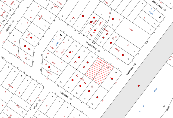
|
NOTIFICATION PLAN |
|
||
|
• PROPERTIES NOTIFIED
|
X SUBMISSIONS RECEIVED |
PROPERTY SUBJECT OF DEVELOPMENT |
|
|
ONE SUBMISSION RECEIVED OUT OF MAP RANGE |
|||
Eighteen submissions object to the modification of the development, generally on the following grounds:
· Development not substantially the same as approved;
· Unacceptable traffic safety and inadequate on-street parking;
· Unacceptable streetscape impact;
· Reduced residential amenity and privacy;
· Development inconsistent with residential character;
· Development fails SEPP character test;
· Development does not meet S L Design Guidelines.
· Proposal is now prohibited and not in the public interest.
The merits of the matters raised in community submissions have been addressed in the body of the report.
6. THE PUBLIC INTEREST
Section 79C(1)(e) of the Act requires Council to consider “the public interest”.
The public interest is an overarching requirement, which includes the consideration of the matters discussed in this report. Implicit to the public interest is the achievement of future built outcomes adequately responding to and respecting the future desired outcomes expressed in environmental planning instruments and development control plans.
The application is considered to have satisfactorily addressed the requirements of the State policy and would provide a development outcome that, on balance, would result in a positive impact for the community. Accordingly, it is considered that the approval of the proposed modification would be in the public interest.
CONCLUSION
The application is for the modification of approved plans to convert townhouses to multi dwelling housing, include a basement car park and increase the number of dwellings from 8 to 14.
The proposed modification generally maintains the approved built form notwithstanding the increase in number of dwellings and in this regard is substantially the same development as approved, pursuant to Section 96 of the Environmental Planning and Assessment Act, 1979.
The proposed modification complies with the non-discretionary development standards under the AHSEPP whereby Council cannot refuse consent and is considered acceptable in respect to the S L Design Guidelines.
The current consent conditions are modified accordingly for the proposal as detailed in Schedule 1.
A total of 18 submissions were received in response to the proposal.
The application is recommended for approval.
|
Rod Pickles Manager - Development Assessment Planning Division |
James Farrington Group Manager Planning Division |
|
1.View |
Locality Map |
|
|
|
2.View |
Project Detail |
|
|
|
3.View |
Floor Plans |
|
|
|
4.View |
Sections |
|
|
|
5.View |
Elevations |
|
|
|
6.View |
Shadow Diagram |
|
|
|
7.View |
Approved Plans |
|
|
File Reference: DA/1021/2010/A
Document Number: D03046934
SCHEDULE 1
|
Date of this modification: |
11 June 2014 |
|
Details of this modification: |
Section 96(2) modification to increase the number of dwellings from 8 to 14 dwellings. |
|
Conditions Added: |
4a, 4b, 12j, 12A, 12B, 36 |
|
Conditions Deleted: |
10f, 11f, 32 |
|
Conditions Modified: |
3 a, 4, 33b, 33c |
CONDITIONS OF APPROVAL
GENERAL CONDITIONS
The conditions of consent within this notice of determination have been applied to ensure that the use of the land and/or building is carried out in such a manner that is consistent with the aims and objectives of the relevant legislation, planning instruments and Council policies affecting the land and does not disrupt the amenity of the neighbourhood or impact upon the environment.
Note: For the purpose of this consent, the term ‘applicant’ means any person who has the authority to act on or the benefit of the development consent.
Note: For the purpose of this consent, any reference to an Act, Regulation, Australian Standard or publication by a public authority shall be taken to mean the gazetted Act or Regulation, or adopted Australian Standard or publication as in force on the date that the application for a construction certificate is made.
1. Approved Plans and Supporting Documentation
The development must be carried out in accordance with the plans and documentation listed below and endorsed with Council’s stamp, except where amended by Council and/or other conditions of this consent:
|
Plan No. |
Drawn by |
Dated |
|
DA 00 Revision O – Calculations |
McCullum Ashby Architects |
09/05/14 |
|
DA 03 Revision O – Ground Floor Plan |
McCullum Ashby Architects |
08/04/14 |
|
DA 04 – Demolition |
GGF Architects |
27/07/10 |
|
DA 04 Revision O – First Floor Plan |
McCullum Ashby Architects |
08/04/14 |
|
DA 05 Revision O – Sections A-A & B-B |
McCullum Ashby Architects |
08/04/14 |
|
DA 06 Revision O – East Elevation & Sections C-C & D-D |
McCullum Ashby Architects |
08/04/14 |
|
DA 07 Revision O – Street & South Internal Elevations |
McCullum Ashby Architects |
08/04/14 |
|
DA 08 Revision O – Internal North & South Rear Elevations |
McCullum Ashby Architects |
08/04/14 |
|
108.10/179 ‘A’ |
ISCAPE Landscape Architecture |
November 2010 |
2. Removal of Existing Trees
This development consent only permits the removal of tree(s) numbered T1 –T7, T12, T14, T17 and T19 as identified on Drawing No. DA 02 prepared by GGF Architects dated 27/07/10. The removal of any other trees requires separate approval under Council’s Tree Preservation Order.
3. Amendment of Plans
The approved plans are to be amended as follows:
a) The approved landscape is to be amended in accordance with Drawing DA 03 Revision O - Ground Floor Plan dated 08/04/14 and is to include additional layering of locally indigenous plant species in the south west corner of the site and screen planting along the western boundary.
b) The letterboxes are to be erected within a face brick enclosure matching the face brick of the buildings.
REQUIREMENTS PRIOR TO THE ISSUE OF A CONSTRUCTION CERTIFICATE
4. Building Code of Australia
a) All building work must be carried out in accordance with the requirements of the Building Code of Australia.
a) Mechanical ventilation is to be provided to the basement car park in accordance with Part F4.11 (Car Parks) of the Building Code of Australia.
5. Contract of Insurance (Residential Building Work)
In the case of residential building work for which the Home Building Act, 1989 requires there to be a contract of insurance in force in accordance with Part 6 of that Act, that such a contract of insurance is in force before any building work authorised to be carried out by the consent commences.
Note: This condition does not apply to the extent to which an exemption is in force under Clause 187 or 188 of the Act, subject to the terms of any condition or requirement referred to in Clause 187(6) or 188(4) of the Act, or to the erection of a temporary building.
6. Notification of Home Building Act, 1989 Requirements
Residential building work within the meaning of the Home Building Act, 1989 must not be carried out unless the principal certifying authority for the development to which the work relates (not being Council) has given Council written notice of the following information:
a) In the case of work for which a principal contractor is required to be appointed:
i) The name and licence number of the principal contractor.
ii) The name of the insurer by which the work is insured under Part 6 of that Act.
b) In the case of work to be done by an owner-builder:
i) The name of the owner-builder.
ii) If the owner-builder is required to hold an owner-builder’s permit under that Act, the number of the owner-builder’s permit.
Note: If arrangements for doing the residential building work are changed while the work is in progress so that the information notified becomes out of date, further work must not be carried out unless the principal certifying authority for the development to which the work relates (not being Council) has given Council written notification of the updated information.
7. Water/Electricity Utility Services
The applicant must submit written evidence of the following service provider requirements:
a) Energy Australia – a letter of consent demonstrating that satisfactory arrangements have been made to service the proposed development.
a) Sydney Water – the submission of a ‘Notice of Requirements’ under s73 of the Sydney Water Act 1994.
Note: Sydney Water requires that s73 applications are to be made through an authorised Sydney Water Servicing Coordinator. Refer to www.sydneywater.com.au or telephone 13 20 92 for assistance.
8. Noise – Rail Corridor
An acoustic assessment is to be submitted to Council prior to the issue of a construction certificate demonstrating how the proposed development will comply with the Department of Planning’s document titled “Development Near Rail Corridors and Busy Roads- Interim Guidelines.
9. Foundation Design
Foundations are to be designed by a Structural Engineer to extend below the level of the Council-controlled drainage system.
10. On Site Stormwater Detention
An on-site stormwater detention system must be designed by a chartered civil engineer and constructed in accordance with the following requirements:
a) Have a capacity of not less than 27 cubic metres, and a maximum discharge (when full) of 40 litres per second.
a) Have a surcharge/inspection grate located directly above the outlet and accessible exterior of the dwellings.
b) Discharge from the detention system to be controlled via 1 metre length of pipe, not less than 50 millimetres diameter or via a stainless plate with sharply drilled orifice bolted over the face of the outlet discharging into a larger diameter pipe capable of carrying the design flow to an approved Council system.
c) Where above ground and the average depth is greater than 0.3 metres, a ‘pool type’ safety fence and warning signs to be installed.
d) Not be constructed in a location that would impact upon the visual or recreational amenity of residents.
e) Deleted.
11. Stormwater Drainage
The stormwater drainage system for the development must be designed and constructed in accordance with Council’s Civil Works – Design and Construction Specification 2005 and the following requirements:
a) Connected to the on-site detention system and then the existing Council piped drainage system, using a full depth 900 mm x 900 mm Council standard junction pit on-line, stepirons and grated pit cover.
b) The existing depression be constructed to contain the 1 in 100 year Average Recurrence Interval storm event as per overland flow design prepared by Acor Appleyard (reference GO100353).
c) Minimum floor levels are to be set at least 500mm above the 100 year design storm level as set out by Acor Appleyard.
d) Fencing in the area affected by the design overland flow shall be constructed as described by Acor Appleyard.
e) Pier and beam method construction adjacent to easements to the depth of the invert of proposed and existing pipes.
f) Deleted.
12. Internal Driveway/Vehicular Areas
The driveway and parking areas on site must be designed in accordance with Australian Standards 2890.1, 3727 and the following requirements:
a) Design levels at the front boundary be obtained from Council.
b) The driveway be a rigid pavement.
c) The driveway grade must not exceed 25 percent and transitions for changes in grade must not exceed 8 percent per plan metre.
d) The driveway pavement be a minimum 3 metres wide, 0.15 metres thick reinforced concrete with F72 steel reinforcing fabric and a 0.15 metre sub-base.
e) The pavement have a kerb to one side and a one-way cross fall with a minimum gradient of 2 percent and a lintel and pit provided at the low points and on grade.
f) Retaining walls required to support the carriageway and the compaction of all fill batters to be in accordance with the requirements of a chartered structural engineer.
g) The provision of safety rails where there is a level difference more than 0.3 metres and a 1:4 batter can not be achieved.
h) Conduit for utility services including electricity, water, gas and telephone be provided.
i) All driveways and external car parking spaces are to be finished with decorative stencilled concrete or similar.
j) The basement and basement ramp shall be designed and constructed in accordance with AS2890.1 – off street parking facilities. A basement water pump and internal drainage system shall be designed by a chartered civil/hydraulic engineer with details provided on construction certificate plans.
12A. Waste Management
An area of at least 8 square metres within about 6 metres of the road boundary and near the bin storage facility, must be allocated for residents to place unwanted bulky items awaiting removal.
Note: This area need not be concreted or paved – a grassed area is acceptable. Bulky items must not be placed on the verge as this causes many problems including illegal dumping.
12B. Section 94 Development Contributions
In accordance with Section 80A(1) of the Environmental Planning and Assessment Act 1979 and the Hornsby Shire Council Section 94 Development Contributions Plan 2012-2021, the following monetary contributions shall be paid to Council to cater for the increased demand for community infrastructure resulting from the development:
|
Description |
Contribution |
|
Roads |
$8366.10 |
|
Open Space and Recreation |
$154,033.05 |
|
Community Facilities |
$21,605.10 |
|
Plan Preparation and Administration |
$664.95 |
|
TOTAL |
$184,669.20 |
being for 2 x 1 bedroom dwellings, 8 x 2 bedroom dwellings, 4 x 3 bedroom dwellings and including a credit for the two existing allotments.
a) If the contributions are not paid within the financial quarter that this consent is granted, the contributions payable will be adjusted in accordance with the provisions of the Hornsby Shire Council Section 94 Development Contributions Plan and the amount payable will be calculated at the time of payment in the following manner:
$CPY = $CDC x CPIPY
CPIDC
Where:
$CPY is the amount of the contribution at the date of Payment.
$CDC is the amount of the contribution as set out in this Development Consent.
CPIPY is the latest release of the Consumer Price Index (Sydney – All Groups) at the date of Payment as published by the ABS.
CPIDC is the Consumer Price Index (Sydney – All Groups) for the financial quarter at the date of this Development Consent.
b) The monetary contributions shall be paid to Council:
i) prior to the issue of the Subdivision Certificate where the development is for subdivision; or
ii) prior to the issue of the first Construction Certificate where the development is for building work; or
iii) prior to issue of the Subdivision Certificate or first Construction Certificate, whichever occurs first, where the development involves both subdivision and building work; or
iv) prior to the works commencing where the development does not require a Construction Certificate or Subdivision Certificate.
It is the professional responsibility of the Principal Certifying Authority to ensure that the monetary contributions have been paid to Council in accordance with the above timeframes.
Council’s Development Contributions Plan may be viewed at www.hornsby.nsw.gov.au or a copy may be inspected at Council’s Administration Centre during normal business hours.
REQUIREMENTS PRIOR TO THE COMMENCEMENT OF ANY WORKS
13. Erection of Construction Sign
A sign must be erected in a prominent position on any site on which building work, subdivision work or demolition work is being carried out:
a) Showing the name, address and telephone number of the principal certifying authority for the work,
b) Showing the name of the principal contractor (if any) for any demolition or building work and a telephone number on which that person may be contacted outside working hours, and
c) Stating that unauthorised entry to the work site is prohibited.
Note: Any such sign is to be maintained while the building work, subdivision work or demolition work is being carried out, but must be removed when the work has been completed.
13A. Notification of Schedule of Works
A Schedule of Works must be provided to the management of the adjoining Pennant Hills Preschool Kindergarten detailing the construction phases of the development.
14. Erosion and Sediment Control
Erosion and sediment control measures must be provided and maintained throughout the construction period in accordance with the manual ‘Soils and Construction 2004 (Bluebook)’, the approved plans, Council specifications and to the satisfaction of the principal certifying authority. The erosion and sediment control devices must remain in place until the site has been stabilised and revegetated.
Note: On the spot penalties up to $1,500 may be issued for any non-compliance with this requirement without any further notification or warning.
15. Dilapidation Report
A ‘Dilapidation Report’ is to be prepared by a chartered engineer detailing the condition of adjoining properties and assets in the public road and submitted to Hornsby Shire Council.
16. Toilet Facilities
Toilet facilities must be available or provided at the works site before works begin and must be maintained until the works are completed at a ratio of one toilet for every 20 persons employed at the site. Each toilet must:
a) be a standard flushing toilet connected to a public sewer; or
b) be a temporary chemical closet approved under the Local Government Act, 1993; or
c) have an on-site effluent disposal system approved under the Local Government Act, 1993
17. Tree Protection Barriers
Tree protection fencing must be erected around trees numbered 20 to be retained at a 3 metre setback. The tree fencing must be constructed of 1.8 metre ‘cyclone chainmesh fence’ or star pickets spaced at 2 metre intervals, connected by a continuous high-visibility barrier/hazard mesh at a height of 1 metre.
REQUIREMENTS DURING CONSTRUCTION
18. Construction Work Hours
a) All work on site (including demolition and earth works) must only occur between 7am and 5pm Monday to Saturday.
b) No work is to be undertaken on Sundays or public holidays.
19. Demolition
All demolition work must be carried out in accordance with Australian Standard 2601-2001 – The Demolition of Structures and the following requirements:
a) Demolition material is to be disposed of to an authorised recycling and/or waste disposal site and/or in accordance with an approved waste management plan.
b) Demolition works, where asbestos material is being removed, must be undertaken by a contractor that holds an appropriate licence issued by WorkCover NSW in accordance with Chapter 10 of the Occupational Health and Safety Regulation 2001 and Clause 29 of the Protection of the Environment Operations (Waste) Regulation 1996.
c) On construction sites where buildings contain asbestos material, a standard commercially manufactured sign containing the words ‘DANGER ASBESTOS REMOVAL IN PROGRESS’ measuring not less than 400mm x 300mm must be erected in a prominent position visible from the street.
20. Environmental Management
The site must be managed in accordance with the publication ‘Managing Urban Stormwater – Landcom (March 2004) and the Protection of the Environment Operations Act 1997 by way of implementing appropriate measures to prevent sediment run-off, excessive dust, noise or odour emanating from the site during the construction of the development.
21. Council Property
During construction works, no building materials, waste, machinery or related matter is to be stored on the road or footpath. The public reserve is to be kept in a clean, tidy and safe condition at all times.
22. Vehicular Crossing
Separate applications under the Local Government Act, 1993 and the Roads Act, 1993 must be submitted to Council for the installation of a new vehicular crossings and the removal of any redundant crossing. The vehicular crossings must be constructed in accordance with Council’s Civil Works Design, 2005 and the following requirements:
a) Any redundant crossings to be replaced with integral kerb and gutter.
b) The footway area to be restored by turfing.
Note: An application for a vehicular crossing can only be made to one of Council’s Authorised Vehicular Crossing Contractors. You are advised to contact Council on 02 9847 6940 to obtain a list of contractors.
23. Works Near Trees
All required tree protection measures are to be maintained in good condition for the duration of the construction period.
All works (including driveways and retaining walls) within 5 metres of any trees required to be retained (whether or not on the subject property, and pursuant to this consent or the Tree Preservation Order), must be carried out under the supervision of an ‘AQF Level 5 Arborist’ and a certificate submitted to the principal certifying authority detailing the method(s) used to preserve the tree(s).
Note: Except as provided above, the applicant is to ensure that no excavation, filling or stockpiling of building materials, parking of vehicles or plant, disposal of cement slurry, waste water or other contaminants is to occur within 4 metres of any tree to be retained.
REQUIREMENTS PRIOR TO THE ISSUE OF AN OCCUPATION CERTIFICATE
Note: For the purpose of this consent, any reference to ‘occupation certificate’ shall also be taken to mean ‘interim occupation certificate’ unless otherwise stated.
24. Sydney Water – s73 Certificate
An s73 Certificate must be obtained from Sydney Water.
25. Damage to Council Assets
Any damage caused to Council’s assets as a result of the construction of the development must be rectified in accordance with Council’s written requirements and at the sole cost of the applicant.
26. Creation of Easements
The following matter(s) must be nominated on the plan of subdivision under s88B of the Conveyancing Act 1919:
a) A drainage easement 3 metres wide located centrally over the Council pipeline within the burdened lot in favour of Council and in accordance with the terms set out in Memorandum B5341305V filed with the NSW Department of Lands.
b) A restriction over the pipeline and the flow path for a 100 year average recurrence interval storm. The "Restriction on the Use of Land" over the affected lots is to prohibit the alteration of the final floodway shape and the erection of any structures, including fencing, in the floodway without the written permission of Council. The terms of this restriction must be obtained from Council.
c) A "Restriction on the Use of Land" for any lot adjacent to the floodway, requiring the finished floor level of any habitable room to be not less than 500mm and the garage 300mm above the 100 year average recurrence interval storm level. The levels must be related to Australian Height Datum.
d) The creation of an appropriate "Positive Covenant" and "Restriction as to User" over the constructed on-site detention/retention systems and outlet works, within the lot in favour of Council in accordance with Council’s prescribed wording. The position of the on-site detention system is to be clearly indicated on the title.
e) To register the OSD, easement, and restriction on the use of land “works-as-executed” details of the on-site-detention system must be submitted verifying that the required storage and discharge rates have been constructed in accordance with the design requirements. The details must show the invert levels of the on site system together with pipe sizes and grades. Any variations to the approved plans must be shown in red on the “works-as-executed” plan and supported by calculations.
Note: Council must be nominated as the authority to release, vary or modify any easement, restriction or covenant.
27. Maintain Canopy Cover
To maintain canopy cover, 10 medium to large trees selected from Council’s booklet ‘Indigenous Plants for the Bushland Shire’ are to be planted on the subject site. The planning location shall not be within 4 metres of the foundation walls of a dwelling or in-ground pool. The pot size is to be a minimum 25 litres and the tree(s) must be maintained until they reach the height of 3 metres. Trees must be native to Hornsby Shire and reach a mature height greater than 10 metres.
28. Fulfilment of BASIX Commitments
The applicant must demonstrate the fulfilment of BASIX commitments pertaining to the development.
29. Completion of Landscaping
A certificate must be provided by a practicing landscape architect, horticulturalist or person with similar qualifications and experience certifying that all required landscaping works have been satisfactorily completed in accordance with the approved landscape plans.
Note: Advice on suitable species for landscaping can be obtained from Council’s planting guide ‘Indigenous Plants for the Bushland Shire’, available at www.hornsby.nsw.gov.au.
30. Boundary Fencing
Fencing must be erected along all property boundaries behind the front building alignment to a height of 1.8 metres at nil cost to adjoining owners, the type of fence to be determined after consultation and agreement of adjoining owners. Additional privacy screens are also to be constructed where requested by adjoining landowners at nil cost to these owners, the type to be agreed by affected parties.
31. Consolidation of Allotments
All allotments the subject of this consent must be consolidated into one allotment.
Note: The applicant is recommended to submit the plan of subdivision to consolidate allotments to the NSW Department of Lands at least 4-6 weeks prior to seeking an occupation certificate.
32. Deleted
33. Restriction as to User – Affordable Rental Housing
To inform current and future owners that the townhouse development on the site is for affordable rental housing, a Restriction as to User must be created under Section 88B of the Conveyancing Act 1919 identifying the following:
a) The development is for affordable rental housing pursuant to State Environmental Planning Policy (Affordable Rental Housing) 2009 for a period of 10 years from the date of the issue of the occupation certificate.
b) The dwellings identified as Units Nos. 2, 3, 9, 10, 11 and 12 on the approved plans must be used for the purpose of affordable housing pursuant to Clause 6 of State Environmental Planning Policy (Affordable Rental Housing) 2009.
c) The dwellings identified as Units Nos. 2, 3, 9, 10, 11 and 12 on the approved plans must be managed by a registered community housing provider as defined in the Housing Act 2001.
Note: The wording of the Restriction as to User must be to Council’s satisfaction and Council must be nominated as the authority to release, vary or modify the Restriction.
OPERATIONAL CONDITIONS
34. Landscaping Maintenance
All of the approved landscaping for the development must be continually maintained to ensure screening for privacy and the presentation of the development.
35. Driveway Operation
The internal accessway and manoeuvring areas are to be unobstructed at all times. The parking of vehicles on site is prohibited other than in approved car parking spaces.
36. Waste Management
A site caretaker must be employed and be responsible for washing bins and maintaining waste storage area, managing the communal composting area, managing the bulky item storage area, arranging the prompt removal of dumped rubbish, and ensuring all residents are informed of the use of the waste management system.
- END OF CONDITIONS -
ADVISORY NOTES
The following information is provided for your assistance to ensure compliance with the Environmental Planning and Assessment Act, 1979, Environmental Planning and Assessment Regulation 2000, other relevant legislation and Council’s policies and specifications. This information does not form part of the conditions of development consent pursuant to Section 80A of the Act.
Environmental Planning and Assessment Act, 1979 Requirements
The Environmental Planning and Assessment Act, 1979 requires:
· The issue of a construction certificate prior to the commencement of any works. Enquiries regarding the issue of a construction certificate can be made to Council’s Customer Services Branch on 9847 6760.
· A principal certifying authority to be nominated and Council notified of that appointment prior to the commencement of any works.
· Council to be given at least two days written notice prior to the commencement of any works.
· Mandatory inspections of nominated stages of the construction inspected.
· An occupation certificate to be issued before occupying any building or commencing the use of the land.
Long Service Levy
In accordance with Section 34 of the Building and Construction Industry Long Service Payments Act 1986, a ‘Long Service Levy’ must be paid to the Long Service Payments Corporation or Hornsby Council.
Note: The rate of the Long Service Levy is 0.35% of the total cost of the work.
Note: Hornsby Council requires the payment of the Long Service Levy prior to the issue of a construction certificate.
Tree Preservation Order
To ensure the maintenance and protection of the existing natural environment, it is an offence to ringbark, cut down, top, lop, remove, wilfully injure or destroy a tree outside 3 metres of the approved building envelope without the prior written consent from Council.
Note: A tree is defined as a single or multi-trunked wood perennial plant having a height of not less than three (3) metres, and which develops many branches, usually from a distance of not less than one (1) metre from the ground, but excluding any plant which, in its particular location, is a noxious plant declared as such pursuant to the Noxious Weeds Act 1993. This definition of ‘tree’ includes any and all types of Palm trees.
All distances are determined under Australian Standard AS4970-2009 “Protection of Trees on Development Sites”.
Fines may be imposed for non-compliance with Council’s Tree Preservation Order.
Dial Before You Dig
Prior to commencing any works, the applicant is encouraged to contact Dial Before You Dig on 1100 or www.dialbeforeyoudig.com.au for free information on potential underground pipes and cables within the vicinity of the development site.
Asbestos
Should asbestos or asbestos products be encountered during demolition or construction works you are advised to seek advice and information should be prior to disturbing the material. It is recommended that a contractor holding an asbestos-handling permit (issued by WorkCover NSW) be engaged to manage the proper handling of the material. Further information regarding the safe handling and removal of asbestos can be found at:
Alternatively, telephone the WorkCover Asbestos and Demolition Team on 8260 5885.
House Numbering
House numbering can only be authorised by Council. Before proceeding to number each premise in the development, the allocation of numbers is required to be obtained from Council's Planning Division. The authorised numbers are required to be displayed in a clear manner at or near the main entrance to each premise.
Group Manager's Report No. PL38/14
Planning Division
Date of Meeting: 11/06/2014
16 REPORT ON SUBMISSIONS - REZONING OF 99 NEW LINE ROAD, CHERRYBROOK
EXECUTIVE SUMMARY
· At its meeting on 18 December 2013, Council considered a report concerning a Planning Proposal to rezone property No. 99 New Line Road, Cherrybrook from R2 (Low Density Residential) to RE2 (Private Recreation).
· Council resolved to forward the Planning Proposal to the Department of Planning and Environment (formerly the Department of Planning and Infrastructure) requesting authorisation for public exhibition.
· A Gateway Determination was received indicating that the Planning Proposal could be exhibited. Accordingly, the Proposal was placed on public exhibition from 11 March 2014 to 11 April 2014.
· Two submissions were received from public authorities in response to the exhibition of the Planning Proposal neither of which object to the rezoning. Submissions received are addressed in this report.
· It is recommended that Council forward the Planning Proposal (Attachment 1) to the Department of Planning and Environment for finalisation.
|
THAT: 1. Council forward the Planning Proposal attached to Group Manager’s Report No. PL38/14 to rezone property No. 99 New Line Road, Cherrybrook from R2 (Low Density Residential) to RE2 (Private Recreation) to the Minister for Planning for gazettal. 2. In accordance with the plan making powers delegated to Council, the General Manager exercise the functions of the Minister for Planning and proceed to make the plan. 3. All persons who made submissions be advised of Council’s resolution. |
PURPOSE
The purpose of this Report is to review submissions received in response to the exhibition of the Planning Proposal for No. 99 New Line Road, Cherrybrook and to recommend that Council proceed with the making of the plan.
BACKGROUND
In 2008, Council approved Development Application No. 1046/2007 for major alterations and additions to the Club including a new car park, relocation of bowling greens, tennis courts and cricket nets. Consent conditions restrict the total number of staff, patrons and visitors to 750 and require the provision of 388 car spaces.
During the exhibition of the draft Hornsby Local Environmental Plan (HLEP) in 2012, Council received a submission requesting the draft HLEP be amended to enable the construction of a car park on property No. 99 New Line Road, Cherrybrook. On 19 December 2012, Council considered Group Manager’s Report No. 54/2012 on submissions, where in relation to the Club’s proposal, the matter was considered outside the scope of the draft HLEP and would require a separate Planning Proposal.
The Club was subsequently notified of Council’s resolution and invited to submit a separate Planning Proposal. The Planning Proposal was lodged with Council on 2 October 2013.
The Planning Proposal was informally exhibited to assist the preparation of a report to Council. The informal exhibition occurred from 18 October 2013 to 21 November 2013 via a notice on Council’s website and letters were sent to adjoining property owners. Copies of the Planning Proposal were also made available for inspection at Council’s Administration Building and Hornsby Library. A total of 4 submissions were received from adjoining owners none of whom objected to the rezoning but raised matters relating to light spill, security, fencing and noise. Despite these issues being raised, submissions indicated that a car park use would be generally acceptable subject to their concerns being satisfactorily addressed at the development application stage.
Council at its meeting on 18 December 2013, considered Group Manager’s Report No. PL114/13 concerning the Planning Proposal and resolved that:
1. Council forward the Planning Proposal attached to Group Manager’s Report No. PL114/13 to the Department of Planning and Infrastructure seeking endorsement for exhibition.
2. In accordance with the plan making powers delegated to Council, Council Exercise Authorisation to prepare and make the Planning Proposal following the receipt of Gateway Authorisation.
3. The General Manager be given delegated authority to endorse the exhibition material.
4. Following the exhibition, a report on submissions be presented to Council.
In accordance with the Council’s resolution, Gateway Authorisation to proceed with the Planning Proposal was issued by the then Department of Planning and Infrastructure (DP&I) on 14 January 2014. In accordance with the Gateway, the Planning Proposal was exhibited from 11 March 2014 to 11 April 2014.
DISCUSSION
This report discusses the exhibition of the Planning Proposal for No. 99 New Line Road, Cherrybrook and submissions received during the exhibition period.
No. 99 New Line Road, Cherrybrook Planning Proposal
Council received the Planning Proposal on behalf of the West Pennant Hills Sports Club to rezone property No. 99 New Line Road, Cherrybrook from R2 (Low Density Residential) to RE2 (Private Recreation). The applicant provides that the intended outcome of the Planning Proposal is to:
· provide an additional new parking area to be used in conjunction with the existing Club;
· facilitate management of patron parking close to existing Club entries which will encourage visitors to park within the Club and not on surrounding local streets;
· facilitate future improvements to the Club operations by providing supplementary parking, especially during the construction of the master plan;
· provide for a consistent zoning across the Club’s land holdings; and
· provide for the future consolidation of No.101 New Line Road to facilitate a functional and cohesive land holding for the Club in the future.
The applicant advises that the rezoning is required on the grounds that the existing R2 Low Density Residential Zone does not permit ‘car parks’ or ‘registered clubs’, or any activity ancillary to the existing club.
Exhibition and Review of Submissions
In accordance with the Consultation Strategy outlined in the Planning Proposal, the documents were exhibited from 11 March 2014 to 11 April 2014. Advertisements were placed in local newspapers and on Council’s website. Letters were sent to affected property owners and relevant local community groups. The Planning Proposal was also displayed at the Council Administration Centre and local branch libraries.
Two (2) submissions were received from public authorities, namely TransGrid and Roads and Maritime Services.
TransGrid
TransGrid advise that its infrastructure would be unaffected by the Planning Proposal and raises no objections. TransGrid notes that there is a power line affecting the subject property and is subject solely to the restrictions of Ausgrid and not of TransGrid.
Comment: Further consultation with Ausgrid would occur at the development application stage should the Planning Proposal proceed.
Recommendation: No amendment be made to the exhibited Planning Proposal in response to the comments concerning infrastructure by TransGrid.
Transport for NSW – Roads and Maritime Services
Roads and Maritime Services (RMS) raises no objections to the Planning Proposal. Comments were provided concerning the design of the car park to ensure its future design meets Australian Standards and with access restricted to left-in left-out.
Comment: The Planning Proposal relates to the future use of the land for a car park and is not restricted to the submitted design concept. Whilst the RMS has no concern regarding the proposed land use, comments relating to design may be addressed at the development application stage when a detailed design is submitted.
Recommendation: No amendment to the exhibited Planning Proposal in response to comments by the RMS concerning vehicular access to a future car park on the site.
STATUTORY CONSIDERATIONS
As part of the Gateway Authorisation, Council was granted delegated authority to request the making of the LEP amendment. Section 23 of the Act allows the Minister and the Director-General to delegate functions to a council and/or an officer or employee of a council. Under Section 59 of the Act, the Minister has delegated the plan making powers with respect to the Planning Proposal to Council.
At its meeting on 19 December 2012, Council resolved to formally accept the plan making delegations and delegate the plan making functions to the General Manager. Acknowledgement of Council’s resolution was received from the then DP&I on 3 March 2013.
Should Council resolve to adopt the Planning Proposal, the next step involves the forwarding of all relevant documentation, including a copy of Council’s assessment report (i.e. details of community consultation, responses to submissions, maps, a copy of the Opinion from Parliamentary Counsel Office, any other relevant material, and the completed delegation reporting template) to the Department.
The Department will then arrange for the Plan to be notified on the NSW Government legislation website.
CONSULTATION
In accordance with the Gateway Determination, the Planning Proposal was exhibited for a minimum period of 28 days in accordance with the Consultation Strategy outlined in the Planning Proposal. The Consultation Strategy included letters to adjoining property owners and relevant public authorities advising of the exhibition. The exhibition also involved advertisements in local newspapers, Council’s website and displays at Council’s Administration Centre and local branch libraries.
BUDGET
There are no budgetary implications associated with this Report.
POLICY
There are no policy implications associated with this Report.
CONCLUSION
The Planning Proposal to rezone No. 99 New Line Road, Cherrybrook to RE2 (Private Recreation) to facilitate the construction of a car park was exhibited from 11 March 2014 to 11 April 2014. A total of 2 submissions were received from Public Authorities, neither of which objected to the rezoning. As there is no concern with obtaining direct access to New Line Road, design matters may be appropriately addressed at the development application stage with further consultation with Roads and Maritime Services should the rezoning proceed. Accordingly, it is recommended that in accordance with the instrument of delegations under Section 59 of the EP&A Act, Council adopt the exhibited Planning Proposal and proceed with the making of the plan.
RESPONSIBLE OFFICER
The officer responsible for the preparation of this Report is the Manager, Strategic Planning – Fletcher Rayner – who can be contacted on 9847 6744.
|
Fletcher Rayner Manager - Strategic Planning Planning Division |
James Farrington Group Manager Planning Division |
Attachments:
|
1.View |
Planning Proposal for No. 99 New Line Road, Cherrybrook |
|
|
File Reference: F2013/00511
Document Number: D02984433
Group Manager's Report No. PL32/14
Planning Division
Date of Meeting: 11/06/2014
17 REPORT ON SUBMISSIONS - SECTION 94 CONTRIBUTIONS FOR GRANNY FLATS
EXECUTIVE SUMMARY
· At its meeting on 12 February 2014, Council resolved to exhibit amendments to the Hornsby Shire Council Section 94 Development Contributions Plan 2012-2021 (Section 94 Plan).
· The amendments proposed a reduction in the rate for secondary dwellings (granny flats) of approximately 50%, with a consequential increase in the rate for other development types of approximately 3%.
· The amended Section 94 Plan was exhibited from 13 March 2014 to 11 April 2014 with notification appearing in local newspapers and on Council’s website.
· Eleven submissions were received in response to the exhibition. The majority of submissions suggest that the amended rate remains too high and should be reduced further.
· As future occupants of granny flats would contribute to the demand for local services, it is appropriate that such development be proportionally levied to contribute to the cost of providing infrastructure and services.
· The amended assumptions for occupancy and traffic generation rates reflect the predominate use of granny flats to accommodate family members. The proposed contribution rate for granny flats now attracts the lowest levy compared to other housing types within the amended Section 94 Plan.
· It is recommended that Council adopt the amended Hornsby Shire Council Section 94 Development Contributions Plan 2012-2021.
|
THAT: 1. Council adopt the amended Hornsby Shire Council Section 94 Development Contributions Plan 2012-2021 attached to Group Manager’s Report No. PL32/14. 2. For applications lodged after 5 September 2013, a refund be provided to applicants who have paid Section 94 contributions for a secondary dwelling (granny flat). The refund being the difference between the paid amount and new rate for secondary dwellings. 3. All persons who made a submission be advised of Council’s decision. |
PURPOSE
The purpose of this Report is to review submissions received in response to the exhibition of the amended Section 94 Plan and to recommend that Council proceed to adopt the amended Plan.
BACKGROUND
The Section 94 Plan commenced on 5 September 2013. Since the Plan came into force, Council has received considerable feedback and concerns that the contribution rate for granny flats is too high.
At its meeting on 12 February 2014, Council considered Group Manager’s Report No. PLN11/14 that presented an amended Section 94 Plan with a new development type for secondary dwellings otherwise known as granny flats. In summary, the report acknowledged that future occupants of granny flats would contribute to the demand for local services. Accordingly, it is appropriate that such development be proportionally levied to contribute to the cost of providing infrastructure and services.
Granny flats are generally a smaller format dwelling offering accommodation for family members. Therefore, the contribution rate should be reduced to reflect this predominate use. The report noted that if there was a reduction in contribution rate for granny flats, there would be a consequential increase for other development types.
Council resolved to exhibit the amended Section 94 Plan. In accordance with Council’s resolution, the amended Section 94 Plan was placed on public exhibition.
DISCUSSION
This report discusses submissions received in response to the exhibition of the amended Section 94 Plan.
Exhibition and Review of Submissions
In accordance with Council’s resolution, the amended Section 94 Plan was publicly exhibited for 30 days from 13 March 2014 to 11 April 2014. A notice was placed in the Hornsby Advocate and on Council’s website. Copies of the amended Plan were made available for inspection at Council’s Administration Building and Council libraries. An electronic copy was placed on Council’s website. Over 140 letters were sent to building certifiers and those who had provided comments and feedback to Council regarding the contribution rate for granny flats.
A total of 11 submissions have been received. The majority of submissions comment that the amended rate remains too high and should be reduced further. A summary of submissions is attached to this report (Attachment 1). Major issues raised in submissions are addressed below.
1. State Environmental Planning Policy (Affordable Rental Housing) (AHSEPP)
There is concern that the proposed contribution rate for secondary dwellings (granny flats) within the amended Section 94 Plan contradicts the State Government’s intention of providing affordable housing through the AHSEPP.
Comment: The AHSEPP was introduced by the State Government in 2009 and encourages the development of secondary dwellings. It is acknowledged that the AHSEPP has increased the supply and diversity of residential accommodation by permitting a smaller type within all residential zones, providing greater options for affordable rental housing. However, the AHSEPP does not override the need to ensure that appropriate services and facilities are provided to meet the demands of an increasing population.
A fact sheet released by the (then) Department of Planning and Infrastructure in December 2011 concerning secondary dwellings (granny flats), confirms that the AHSEPP does not affect the levying of development contributions under Section 94 of the EP&A Act.
Recommendation: No amendments be made to the amended Section 94 Plan as a result of submissions concerning the AHSEPP.
2. Other Local Council Contribution Rates
Submissions raise concerns that the amended contribution rate for secondary dwellings is still higher than other local Sydney councils. Submissions state that other councils charge between $0-$5,000 or 1% of the cost of works.
Comment: Contribution rates for secondary dwellings vary across councils due to the population and works program being serviced by the council’s plan. The total cost of individual council works programs will influence the contribution levied for secondary dwellings and other development types. The contribution rate will also depend on the type of contributions plan applied. For example, if granny flats were levied under a Section 94A Contribution Plan, the rate would be a percentage of the construction cost. In most cases, a granny flat would not meet the criteria for payment if the construction cost is below $100,000.
Many councils have not recently reviewed their Section 94 Plans. Accordingly, these plans may not take into account the AHSEPP which permits granny flats in all residential zones, and the potential impact this may have on local infrastructure and services required.
The reduced rate for secondary dwellings within the amended Section 94 Plan is now more proportionate to that charged by other councils.
Recommendation: No amendments be made to the amended Section 94 Plan as a result of submissions concerning the contribution rate charged by other councils.
3. Method Used for Calculating the Contribution Rate
There is concern that the rate applied to secondary dwellings is unfair and inequitable as the Plan does not take into consideration the size of the dwelling or the associated impact. It is suggested that the rate should be calculated on a sliding scale based on the number of bedrooms or people who would reside in the dwelling.
Comment: Council’s Section 94 Plan is based on the average number of people who may reside in the dwelling and the number of vehicle trips they may generate. In the case of residential flat buildings, it is also dependent on the number of bedrooms.
Due to feedback received that secondary dwellings are predominately used for the accommodation of elderly family members, the occupancy rate was reduced from 2.30 to 1.24 which is equivalent to a 1 bedroom unit. Traffic generation based on peak hour vehicle trips was reduced from 0.85 to 0.15 which is equivalent to a Seniors Housing unit. Therefore, in relation to other development types levied under the Plan, granny flats have been amended to reflect the lowest demand for services and are proposed to have the lowest rate.
During the preparation of the current Section 94 Plan, consideration was given to the use of a sliding scale based on the number of bedrooms for all development types to calculate the contribution rates. However, if a sliding scale was to be used, separate rates would apply to 1, 2 and 3 bedroom granny flats. This would have no impact on the lowest rate, but would make 2 and 3 bedroom granny flats more expensive. This outcome is not supported.
Recommendation: No amendments be made to the amended Section 94 Plan as a result of the submission concerning the method used for calculating the contribution rate.
4. Epping Town Centre
Concern is raised that Council’s Contribution Plans do not contain infrastructure for Epping (such as a new aquatic centre) within the works schedule to accommodate the future population increase that will occur as a result of the finalisation of the Epping Town Centre Urban Activation Precinct (UAP) by the State Government.
Comment: The community infrastructure within the works schedules of the Section 94 Plan and Hornsby Shire Council Section 94A Development Contributions Plan 2012-2021 (Section 94A Plan) were compiled for the forecast population based on the zoning of land within the Shire at time the Plans were prepared. Since that time, the Epping Town Centre UAP was gazetted by the State Government allowing for 3,750 additional dwellings within the precinct. A proportion of this growth will occur within the Hornsby Shire.
The future population will increase demand on local infrastructure and services which are currently not identified by Council’s Contribution Plans. Accordingly, an assessment will be undertaken of the additional dwellings which may occur within the Shire and the services and infrastructure which may be required for the future population of Epping based on the newly finalised planning controls. These changes are scheduled to be progressed as a separate amendment to the Section 94 Plan and Section 94A Plan commencing in July 2014 in line with the Strategic Planning Program 2014-2016 adopted by Council.
Recommendation: No amendments be made to the amended Section 94 Plan as a result of the submission concerning infrastructure in Epping.
5. Exemptions
A submission sought clarification in regard to the exemptions that apply to the Section 94 Plan.
Comment: Page 16 of the Section 94 Plan outlines that exemptions for the payment of contributions will not be granted other than exemptions and/or discounts afforded under direction of the Minister for Planning and Infrastructure. This includes exemptions for seniors housing undertaken by social housing providers, school projects under the Building the Education Revolution program and capping of the contribution rate charged for additional lots/dwellings. No changes are proposed to the exemptions clause as part of the amendments to the Section 94 Plan.
Recommendation: No amendments be made to the amended Section 94 Plan as a result of the submission concerning exemptions.
Transitional Arrangements
Since the commencement of the Section 94 Plan, 38 applications have been approved for granny flats, including:
· 26 complying development certificates issued by private certifiers;
· 1 complying development certificate issued by Council; and
· 11 development applications.
As at 30 April 2014, 14 of the above applicants have paid the Section 94 contributions in full, including:
· 13 complying development certificates issued by private certifiers; and
· 1 development application.
Should Council be of a mind to adopt the amended Section 94 Plan, it is recommended that a refund be provided to applicants who have paid their contribution. The refund would be calculated by subtracting the new rate from the amount paid.
The remaining applicants who have not paid would need to lodge a Section 96 application (for development applications) or a Section 87 application (for complying development) to modify their conditions of consent to reduce the Section 94 fee payable.
Plan Indexation
Contribution rates for all development types are adjusted each financial quarter in accordance with the Consumer Price Index increase. Since the amended Section 94 Plan was placed on exhibition a Consumer Price Index of 0.6% was released. Accordingly, the works program and contribution rates for all development types within the Plan have been adjusted in accordance with this increase.
BUDGET
This Report recommends that Council refund the difference between the amount paid and the reduced rate if the amended Plan is adopted. Based on the payment of monetary contributions at 30 April 2014, the value of the refunds would be approximately $99,000. Refunds would not impact on the net balance of income produced under the Plan as the refunds would be offset by the increase in contributions for other categories of development.
POLICY
Should Council approve the amended Section 94 Plan, a notice would be placed in local newspapers. The Plan would come into effect from the date the public notice appears.
CONCLUSION
An amended Section 94 Plan has been publicly exhibited from 13 March 2014 to 11 April 2014. Eleven public submissions were received in response to the exhibition. Issues raised in submissions do not introduce any additional matters that would require amendments to the proposed Plan.
As future occupants of granny flats would contribute to the demand for local services, it is appropriate that such development be proportionally levied to contribute to the cost of providing infrastructure and services. The amended assumptions to occupancy and traffic generation rates reflect the predominate use of granny flats to accommodate family members. The proposed contribution rate for granny flats now attracts the lowest levy compared to other housing types within the Plan.
Accordingly, it is recommended that Council adopt the amended Section 94 Plan attached to this Report. It is also recommended that for those applicants who have paid the Section 94 contribution for granny flats in full, a refund be granted for the difference between the paid amount and proposed new rate.
RESPONSIBLE OFFICER
The officer responsible for the preparation of this Report is the Manager, Strategic Planning – Fletcher Rayner – who can be contacted on 9847 6744.
|
Fletcher Rayner Manager - Strategic Planning Planning Division |
James Farrington Group Manager Planning Division |
|
1.View |
Summary of Submissions |
|
|
|
2.View |
Hornsby Shire Council Section 94 Development Contributions Plan 2012-2021 |
|
|
File Reference: F2010/00015-02
Document Number: D02926607
Group Manager's Report No. PL41/14
Planning Division
Date of Meeting: 11/06/2014
18 HORNSBY WEST SIDE PLANNING PROPOSAL - AFTER EXHIBITION
EXECUTIVE SUMMARY
· The Hornsby West Side Planning Proposal and associated draft DCP amendments were exhibited from 4 September 2013 to 8 November 2013. A total of 110 submissions have been received. Approximately 35% of submissions support the Planning Proposal, 38% object and 27% give conditional support or partial objection.
· JBA Planning was engaged to review the submissions and concludes that the submissions do not introduce matters requiring amendment of the Planning Proposal. However, revised DCP amendments have been drafted in response to submissions and should be re-exhibited.
· Reports should be presented to Council concerning options for ensuring design quality of future high density development and amendment to the Section 94 Development Contributions Plan 2012 – 2021. It is recommended that Council forward the Hornsby West Side Planning Proposal to the Minister for Planning for finalisation and that revised DCP amendments be re-exhibited.
|
THAT: 1. Council forward the Hornsby West Side Planning Proposal attached to Group Manager’s Report No. PL39/14 to the Minster for Planning for finalisation pursuant to Section 59 of the Environmental Planning and Assessment Act 1979. 2. Revised DCP amendments be re-exhibited for a period of 28 days incorporating: 2.1 Sustainability requirements such as car share schemes, green walls and roofs and thermal efficiency; 2.2 A requirement for a wind effects report for buildings over 13 storeys in height; 2.3 Provisions addressing State Environmental Planning Policy 65 Design Quality of Residential Flat Buildings; 2.4 A minimum site frontage of 40m for development over 10 storeys in height; 2.5 An increase in the podium height for the Odeon Cinema from 2 storeys to 3 storeys; 2.6 Administrative amendments including labelling Gateway sites, confirming that the western RSL car park in Ashley Street is included in the Planning Proposal and updating diagrams to reflect traffic modelling recommendations. 3. A separate report be prepared and presented to Council concerning options for ensuring design quality of future high density development. 4. Submitters be advised of Council’s decision. |
PURPOSE
The purpose of this report is to present the outcome of the exhibition of the Hornsby West Side Planning Proposal and associated Development Control Plan amendments and provide recommendations for the progression of the project.
BACKGROUND
At its meeting on 17 July 2013, Council considered Group Manager’s Report No. PL60/13 concerning the Hornsby West Side Planning Proposal. Council resolved that:
1. Council forward the revised Hornsby West Side Precinct Planning Proposal attached to Group Manager’s Report No. PL60/13 to the Department of Planning and Infrastructure seeking endorsement for exhibition.
2. Should endorsement be received, Council publicly exhibit the Planning Proposal for a period of two months in accordance with the consultation strategy outlined in the Planning Proposal (or as otherwise directed by the Minister).
3. The draft Development Control Plan amendments attached to Group Manager’s Report No. PL60/13 be exhibited concurrently with the Planning Proposal.
4. The General Manager be delegated authority to endorse the exhibition material.
5. Advice be provided to Councillors mid-way through the exhibition period to provide an opportunity for an extension of the exhibition period for a further month if required.
6. Following the completion of the exhibition period, a report on submissions be presented to Council.
In accordance with Council’s resolution, the Planning Proposal was sent to the (then) Department of Planning and Infrastructure (DP&I). In August 2013, the DP&I confirmed that the Planning Proposal could be placed on public exhibition. The Hornsby West Side Planning Proposal was exhibited for public comment from 4 September 2013 to 8 November 2013.
DISCUSSION
This report presents a summary of the submissions received in response to the exhibition of the Hornsby West Side Planning Proposal and associated development control plan amendments.
1. Exhibition
The Planning Proposal was exhibited from 4 September 2013 to 8 November 2013 in accordance with Council’s adopted consultation strategy which included:
· Letters to affected and adjoining owners;
· Letters to occupants within the precinct;
· Letters to public authorities;
· Letters to community and industry groups;
· Advertisements in the Hornsby Advocate;
· Advertisement on the Council website;
· Online forum – yoursayhornsby.com.au;
· Article in Council’s ENewsletter;
· Brochure and Postcard;
· Displays at the Council Administration Centre and libraries; and
· Drop-in Sessions.
A total of 110 formal written submissions were received during the exhibition. Approximately 35% of submissions support the Planning Proposal, 38% object and 27% give conditional support or partial objection to the Proposal. Most submissions comment generally on the Proposal or aspects of it. Some submissions raise objections on behalf of a particular residential property adjoining the precinct, other submissions request additional height or changes to development controls for sites within the precinct.
In addition to formal submissions, 38 people made 164 comments through the online forum and almost 300 people undertook the survey conducted as part of the online forum. On average, 77% of survey participants support the proposed changes to road layout, public domain improvements, and the proposal for residential development above shops and businesses. However, only 39% of survey participants support the increased heights proposed.
Full details of the consultation strategy and a statistical summary of submissions can be found in the Hornsby West Side Planning Proposal Report on Submissions 2014 attached to this report.
2. Review of Submissions by Consultant
JBA Planning was engaged to review all submissions and provide commentary and/or recommendations to address the major and recurring issues of significance to the community. The consultant team was also requested to conduct a site-specific review of submissions which comment explicitly on particular parcels of land. A summary of submissions and the responses from the consultant’s review are outlined below.
2.1 General Issues
The majority of submissions received in objection to the Planning Proposal raise issues general to the proposed changes within the West Side precinct. Major issues are discussed below.
Height
A number of submissions raise concerns with the proposed height limits. Submissions state that heights should be lower across the precinct, that 25 storeys is too high, and that preliminary consultation at the beginning of the project indicated the community wanted to see a maximum of 8 storeys within the precinct.
JBA Comment: The proposed heights of buildings have been considered within the context of the hierarchy of centres identified by the Department of Planning and Environment. Hornsby is a Major Centre and the northern gateway to Sydney with excellent transport links. Given this position, it is appropriate that taller buildings be located within Hornsby Town Centre.
The taller buildings are focussed in the centre of the West Side precinct to minimise impacts on nearby existing residential development and concentrate increased densities within the precinct rather than being spread throughout surrounding neighbourhoods. The use of height is also a key place making principle. The Planning Proposal seeks to refocus and shift the traditional commercial and cultural heart of Hornsby back to the western side of the station. To achieve this and revitalise the centre, larger buildings that provide a wide range of uses are necessary.
Recommendation: No change to the Planning Proposal as a result of submissions objecting to height.
Traffic
A number of submissions raise concerns with traffic impacts, congestion and access for emergency vehicles.
JBA Comment: It is acknowledged that increasing densities will have an effect on the local road network. To determine the extent of this impact, a detailed traffic model was developed to illustrate where the greatest impact will be, which intersections will require upgrades and changes to signalisation. The traffic study considered an area beyond the West Side precinct to better understand the larger traffic implications.
The Planning Proposal aims to reinforce the role of the Pacific Highway as a local road to complement the new main street vision. The primary traffic impacts will be to the arterial route of George Street and the Bridge Road intersection. This is due to general background growth outside the Hornsby Town Centre and the prioritisation of George Street as the major road through Hornsby. These impacts will be managed in conjunction with the Roads and Maritime Services (RMS) who is responsible for George Street.
It should be noted that the traffic modelling acknowledges improvements to the road system will be necessary to facilitate the level of development envisaged. These improvements include realigning the bus exit road at the south of the station to form a four way intersection with the Pacific Highway and High Street, extending the left turn lane from William Street, extending the left turn lane on the Pacific Highway at the intersection of George Street and changes to traffic signal coordination. Should Council support the progression of the Planning Proposal, an amendment to Council’s Section 94 Contributions Plan should be progressed to ensure funding for required works.
Council’s traffic management evaluation of the Planning Proposal and consultation with the Roads and Maritime Services (see below under 3. Consultation with Authorities) has resulted in the preparation of updates to the draft DCP amendments to reflect the increased length of turning lanes in the Key Principles Diagram and the circulation and access points in the Traffic Access Routes diagram, Circulation Routes diagram and Pedestrian Network Plan.
As part of the exhibition process, Council wrote to the local police and Rural Fire Service. No objections were received. In response to submissions concerning access through the precinct for emergency service vehicles, Council wrote to Hornsby Fire Brigade and Fire and Rescue NSW (Head Office and Sydney North Zone Office). No response was received.
Recommendation: No change to the Planning Proposal as a result of submissions concerning traffic. The draft DCP amendments be revised to update diagrams to reflect consistency with traffic modelling and future network requirements.
Heritage
Some submissions raise concerns with how the heritage character of the precinct could be retained with the scale of development proposed. Some submissions comment that intact buildings and not just facades should be retained.
JBA Comment: The Planning Proposal seeks to incorporate locally important heritage buildings and high quality facades into any new building to retain a connection to the past. This is a key principle of the Structure Plan. In particular, intact buildings such as the Odeon Cinema should be retained and conserved. However, a balance of historical preservation and an openness to creative adaptive reuse of existing heritage structures is required to avoid sterilising development potential. Where the original fabric and internal elements of heritage items have been altered, it is appropriate that external features and facades be retained where possible to reflect the history of the commercial streetscape. The public domain improvements that reconnect Cenotaph Park will provide a more dignified setting for the War Memorial and provide a place for people to engage with the history of the Hornsby community.
Recommendation: No change to the Planning Proposal as a result of submissions on heritage.
Viability Versus Community Expectations
Some submissions object to the fact that economic feasibility studies were carried out in the preparation of the Planning Proposal. Submissions raise concern that developer interests were prioritised in the preparation of the Proposal.
JBA Comment: The preparation of an economic feasibility study was required by the Gateway Determination issued by Department of Planning and Environment prior to public exhibition. Development feasibility plays a role in place making and town planning. If planning controls do not promote economically feasible development, the vision embodied in the controls will not be delivered. To achieve Council’s vision of a vibrant mixed use centre with a revitalised main street and high quality public domain, development potential in the centre must be unlocked to deliver the proposed upgrades.
Recommendation: No change to the Planning Proposal as a result of submissions on viability versus community expectations.
Other Issues
Some submissions suggest that the Proposal should include consideration of sustainability and wind effects.
Comment: It is acknowledged that the DCP amendments should be strengthened to have more reference to sustainability practices, innovations and/or concepts for delivering sustainable energy, water and waste services. The vision for the precinct is to deliver and encourage sustainable transport, community interaction, health benefits, affordable and diverse lifestyles and local employment. There is opportunity to deliver infrastructure which is environmentally friendly and viable.
Council’s environmental evaluation of the Planning Proposal and DCP controls has resulted in the preparation of additional clauses and prescriptive measures for insertion into the DCP amendments to address opportunities for car share schemes, green walls and roofs, thermal efficiency and Water Sensitive Urban Design. The draft DCP amendments for the Epping Urban Activation Precinct (UAP) include a requirement for a wind effects report for buildings higher than 40m (13 storeys). This requirement would be appropriate for the Hornsby West Side precinct and should be included in the DCP amendments to supplement the Planning Proposal.
Recommendation: No change to the Planning Proposal as a result of submissions on sustainability and wind effects. The draft DCP amendments be revised to include measures to address sustainability and wind effects.
2.2 Site Specific Objections
JBA Planning was requested to review submissions which raise objections specific to residential flat developments which adjoin the precinct to the west. Major issues are discussed below.
Overshadowing
Submissions from residents within a number of existing residential flat developments adjoining the western boundary of the precinct raise concerns about the impacts of overshadowing due to the height of the proposed buildings.
JBA Comment: The Structure Plan depicts a hypothetical built form which has been tested to determine overshadowing impacts to existing properties. The hypothetical built form demonstrates that development can be achieved whilst maintaining appropriate solar access to the existing residential flat development adjoining the western boundary of the precinct. Overshadowing is most affected by building mass (the shape, position and length of buildings) rather than height. Building mass can be adjusted to minimise overshadowing impacts, which would be further assessed at the Development Application stage.
Recommendation: No change to the Planning Proposal based on submissions concerning overshadowing.
Privacy
Submissions from residents within a number of existing residential flat developments adjoining the western boundary of the precinct raise concerns about the potential loss of privacy, particularly if the proposed towers overlook bedrooms or the new Aquatic Centre.
JBA Comment: Privacy impacts would be managed through architectural design and would be assessed at the Development Application stage. Design solutions to address privacy issues may include orientation, layout of units, privacy screens, planting and adherence to SEPP 65 design criteria.
Recommendation: No change to the Planning Proposal as a result of submissions concerning privacy.
Crime
Some submissions raise concern in relation to safety, graffiti and drug use.
JBA Comment: One of the aims of the Proposal is to encourage more vitality and activity within the precinct. Increased activity discourages anti-social behaviour and increases safety. Future developments would be assessed in regards to Crime Prevention Through Environmental Design Principles.
Recommendation: No change to the Planning Proposal as a result of submissions concerning crime.
Impacts of New Laneway
Submissions from residents within the existing residential development which adjoins the Dural Street Council car park site (property Nos. 5-9 Dural Street, Hornsby) raise concerns in relation to the proposed new laneway at the rear of the Dural Street car park site. Concerns include risks to safety and increased traffic and noise.
JBA Comment: The proposed new laneway at the rear of the Dural Street car park site and the proposed laneway through the William Street car park are offset from each other. This adds friction and discourages rat running and in addition to the partial closure of Dural Lane would assist with the management traffic volume and speed.
Recommendation: No change to the Planning Proposal as a result of submissions concerning the proposed new laneway.
Structural Integrity, Noise and Stormwater Run-off
Submissions from the existing residential development which adjoins the western boundary of the RSL Club car park on Ashley Street (property Nos. 14-18 Ashley Street, Hornsby) raise concerns with the impacts of noise from a late opening entertainment facility, drainage, water runoff and the structural integrity of the existing building should redevelopment of the car park take place.
JBA Comment: Noise impacts from any expansion of the RSL Club would need to be considered at the Development Application stage for any new proposal for the site. Similarly, drainage impacts and stormwater runoff must be considered in the detailed design of any new proposal. The construction of any new building must not structurally impact upon neighbouring properties.
Recommendation: No change to the Planning Proposal as a result of the submission on structural integrity, noise and stormwater runoff.
Property Values
Some submissions raise concern that the proposed development will impact negatively on property values for sites surrounding the precinct.
JBA Comment: The Proposal provides a framework that is targeted towards renewing interest and feasibility for redevelopment the West Side precinct. Given the economically depressed nature of the precinct, it is envisioned that renewed interest and investment would protect property values in the surrounding area.
Recommendation: No change to the Planning Proposal based on submissions concerning property values.
2.3 Site Specific Requests for Increased Heights
JBA Planning was asked to review submissions which requested additional height or changes to development controls for sites within the precinct. The requests are summarised below.
Gateway Site – Bounded by Hornsby Park and Dural Street
The submission raises concern that the requirement for a minimum floor space ratio of 1:1 commercial development will affect feasibility and should be removed. It is also requested that the proposed heights for the precinct of 20 storeys in the eastern portion and 12 storeys in the western portion be increased to 25 and 14 storeys respectively. The submission requests minor amendments to the DCP controls for consistency (labelling of diagrams and language used in heritage controls) and the inclusion of a clause to encourage site amalgamations and ensure adequate separation between sites if developed individually.
JBA Comment: One of the primary objectives of the Planning Proposal is to provide jobs and activity within the centre. The vision of the West Side as a safe and vibrant mixed use centre during the day and night cannot be achieved without commercial development. The 20 storey height limit proposed for the eastern portion of the site is consistent with the principles of the Structure Plan and the logic of heights spread across the centre. The 12 storey height limit provides a transition to the adjoining residential area and is considered appropriate. The existing Site Requirement provision in Section 4 Business of the DCP (Clause 4.5.2 (c)) seeks to minimise the isolation of small sites, and the existing Privacy and Security provision (Clause 4.5.7 (d)) addresses minimum separation between buildings. The draft DCP amendments for the Epping Urban Activation Precinct (UAP) introduce a minimum site frontage requirement of 40m. This requirement would be appropriate for the Hornsby West Side precinct to encourage amalgamation and should be included in the DCP amendments.
Recommendation: No change to the Planning Proposal as a result of the submission concerning the site bounded by Hornsby Park and Dural Street. The draft DCP amendments be revised to include a minimum site frontage requirement, and to ensure consistency in diagram labels and the language used in heritage controls.
Gateway Site – Railway Hotel
The submission raises concern that the urban design study and height recommendations were influenced by landowner submissions. It is requested that the proposed height for the precinct of 20 storeys be increased to 25 storeys to match the icon site proposed at the corner of Station Street and Pacific Highway (the ‘triangle’ site) and encourage a more integrated design solution. The site should be identified as a Gateway site as the corner site terminates a recognised view corridor down Jersey Street and signifies arrival at the centre. It is also requested that podium heights not be restricted to 2 – 5 storeys.
JBA Comment: The urban design study and height recommendations were not influenced by existing landowners. The logic of heights applied across the precinct is deliberate to create focal points in key places.
The 25 storey height limit for the ‘triangle’ site differs to the sites fronting Coronation Street to support an iconic building at the apex of the triangle with a lower height across the remainder of the block. A height limit of 20 storeys applies to the Railway Hotel site.
The Structure Plan illustrates one possibility for urban form. Other forms may be appropriate provided they contribute to the precinct and meet overall height, setback, separation and design requirements. The podium heights in the DCP are set to deliver a desired street character. Generally, a 2-3 storey street wall/podium height has been applied across the precinct to reduce the overall scale of new buildings to the street. The 5 storey street wall height/podium along Station Street is to create a more urban setting due to the proximity to the station and Cenotaph Park and character of Station Street.
Recommendation: No change to the Planning Proposal as a result of the submission concerning the Railway Hotel.
Gateway Site – Bounded by William Street and Ashley Lane
The submission states that to be economically viable, a development of 24-25 storeys is required instead of the proposed 20 storey height limit. The submission states that the height limit should match the height of the icon ‘triangle’ site due to its Gateway location.
JBA Comment: The Economic Feasibility Study prepared by Hill PDA concludes that 15 storeys would be feasible within the precinct. The purpose of the 25 storey height limit on the ‘triangle’ site is to create an iconic structure that stands above all other buildings. Its proximity to the station and Cenotaph Park give it locational dominance over other buildings. The 20 storey height limit proposed for the subject site reflects its importance as a gateway site.
Recommendation: No change to the Planning Proposal as a result of the submission concerning the site bounded by William Street and Ashley Lane.
Odeon Cinema
The submission requests that the podium height be increased from 2 storeys to 3 storeys to accommodate the existing Cinema. The submission also states that the measurement of height for the Cinema site should start from the podium level above the Cinema, essentially creating an 18-20 storey building rather than a 15 storey building as proposed in the Planning Proposal.
JBA Comment: It is acknowledged that the podium height for this site should be increased from 2 to 3 storeys to accommodate the existing cinema. However, building height is measured from the natural ground level. The 15 storey overall height limit for this site is part of a logic of heights that places the tallest buildings in prominent locations which have been identified as gateway sites and the icon site at the apex of the ‘triangle’.
Recommendation: No change to the Planning Proposal as a result of the submission concerning the Odeon Cinema. The draft DCP amendments be revised to permit a 3 storey podium to accommodate retention of the existing cinema building.
RSL Club
The submission objects to the 5 – 8 storey height limit and states that heights should be increased similar to heights proposed for other sites which have a residential interface. The submission states that the proposed maximum height of 8 storeys does not meet the minimum threshold outlined in the Economic Feasibility Study prepared by Hill PDA. The submission requests that the proposed overall 8 storey height limit be increased to 15 storeys, the proposed 5 storey height limit along Ashley Street contained within the DCP be increased to 10 storeys and the diagrams in the DCP be updated to correctly reflect that the western car park on Ashley Street is included in the Planning Proposal. The RSL has submitted concept plans also seeking an increased height limit of 15 storeys for the car park between William Street and Ashley Lane (currently proposed as a 12 storey height limit) and the inclusion of sites owned by the RSL on the southern side of Ashley Street (property No’s 7 – 9 Ashley Street and 2 – 4 Webb Avenue).
JBA Comment: The submission concerning height and feasibility on the RSL site is reasonable given the location and nature of the site. However, the Urban Design Study and Structure Plan do not envision major redevelopment of the RSL Club in the near term. If in the future the RSL wishes to fully redevelop its site, it would be appropriate to consider the following:
· Whether the minimum floor space ratio control of 1:1 commercial development could be reduced as the site does not form part of the main street or commercial core of the West Side precinct. A strip of retail/commercial development with frontage to High Street may be an acceptable alternative. Should a reduced minimum floor space ratio for commercial development be acceptable, the redevelopment feasibility would be improved and would allow for new residential buildings of a lower scale to appropriately interface with residential development to the west and south; and
· Whether an increase in height from 8 storeys to 12 storeys would be acceptable for the northern portion of the site if the 5 storey edge to Ashley Street is retained.
The additional sites the RSL Club has put forward for inclusion in Ashley Street and Webb Avenue are zoned R3 Medium Density Residential under the HLEP 2013 and are therefore outside the study area. The Planning Proposal relates to Business zoned sites within the Hornsby West Side precinct as identified in Council’s current planning controls. A revised Gateway Determination would need to be sought from the Department of Planning and Environment if expansion of the precinct study area was to be considered. Subject to a revised Gateway Determination being issued, revised traffic studies, economic studies and urban design analysis would need to be undertaken.
Although some issues raised in the submission from the RSL Club may warrant consideration, no changes to the Planning Proposal are recommended. The concept plan from the RSL Club indicates that there are plans for redevelopment of RSL landholdings. However, some landholdings are outside the scope of the current Planning Proposal. It would be appropriate to consider the RSL landholdings holistically as a separate site-specific project. Should the RSL Club wish to pursue an amendment to the Hornsby Local Environmental Plan 2013 for its land holdings, including those outside the West Side precinct boundary, it may wish to lodge a separate planning proposal.
Recommendation: No change to the Planning Proposal as a result of the submission concerning the RSL Club. The draft DCP amendments be revised to correctly reflect that the western car park on Ashley Street is included in the Planning Proposal.
In summary, issues raised in submissions do not introduce any additional matters that would require amendments to the Planning Proposal. However, some submissions raise valid points concerning consistency of language and diagrams in the DCP amendments, and issues which should be managed or expanded such as sustainability and wind effects. Revised draft DCP amendments have been prepared to incorporate the following changes:
· Add sustainability requirements such as car share schemes, green walls and roofs and thermal efficiency;
· Add a provision requiring a wind effects report for buildings over 13 storeys in height;
· Add a provision addressing State Environmental Planning Policy 65 Design Quality of Residential Flat Buildings;
· Increase the podium height for the Odeon Cinema from 2 storeys to 3 storeys to accommodate retention of the existing cinema building.
· Update various elements for consistency with the draft Epping Urban Activation Precinct and the existing Hornsby Development Control Plan, including the introduction of a minimum site frontage of 40m for development over 10 storeys in height; and
· Amend diagrams and wording for consistency, including labelling Gateway sites on all diagrams, correctly reflecting that the western RSL car park in Ashley Street is included in the Planning Proposal and updating diagrams to reflect traffic modelling and future network requirements.
The revised DCP amendments are available for viewing on Council’s website: http://www.hornsby.nsw.gov.au/council/major-projects/hornsby-west-side (Trim Reference: D03043914). This report recommends that the revised DCP amendments be re-exhibited.
3. Consultation with Authorities
The following statutory authorities were consulted during the preparation and exhibition of the Planning Proposal and review of submissions:
· Roads and Maritime Services (RMS);
· Office of Environment and Heritage;
· NSW Rural Fire Service;
· Transport for NSW;
· Ku-ring-gai Local Area Command, NSW Police;
· NSW Fire and Rescue; and
· Hornsby Fire Brigade.
Responses were received from the NSW Rural Fire Service and the Office of Environment and Heritage. As part of the preparation of the Planning Proposal, Council consulted with the RMS and Transport for NSW on numerous occasions. No objections to the Proposal were raised.
In November 2012, representatives from Council and the consultant engaged to undertake the Traffic Study for the project met with the RMS for input into traffic modelling. In September 2013, as part of the exhibition, Council sent referral letters to the RMS and Transport for NSW with full copies of the Planning Proposal and supporting studies. In November 2013, Council representatives met with the RMS to discuss the project. The RMS requested some minor changes to lane lengths and turning lanes, and confirmed that it would need to work with Council to look at the regional impacts on the future of the road network around the study area.
In March 2014, Council representatives met with Transport for NSW, RMS and RailCorp representatives. The future of the regional network and the location of the Hornsby bus interchange were discussed, along with minor queries relating to the station concourse capacity, bus/taxi shareway, and assumptions in the traffic modelling. It was understood that Transport for NSW would prepare combined comments in writing. However, no comments have been forthcoming.
The following bus and taxi authorities and companies were consulted during the exhibition of the Planning Proposal:
· Transdev – Shorelink Buses;
· Hillsbus – ComfortDelgro Cabcharge;
· Silver Service;
· Taxis Combined Services;
· NSW Taxi Council;
· State Transit Authority; and
· Premier Cabs.
A submission was received from ComfortDelgro Cabcharge (CDC), operator of Hillsbus and Metrobus M60 suggesting that the bus interchange should be relocated to the eastern side of the railway station and that it would like to work with Council and Transport NSW to consider the appropriate location for the bus interchange. The potential relocation of the bus interchange has been discussed informally over the years with no conclusion forthcoming.
Council wrote to Transport for NSW indicating that representation had been received from CDC indicating it is willing to work with Transport NSW and Council to consider whether the interchange should be relocated to the eastern side of the railway. Specifically, Council’s letter queried whether there are any plans for the relocation of the bus interchange at Hornsby to the arterial route of George Street on the eastern side of the railway and whether there is an opportunity to discuss or progress this as part of the Hornsby West Side Planning Proposal, scheduled to be finalised by the end of this year. To date, no response has been received.
4. Councillor Updates
In accordance with Council’s resolution on 17 July 2013 (see above under Background), advice was provided to Councillors in October 2013 to provide an opportunity for an extension of the exhibition period. A memo was distributed to Councillors providing a summary of submissions received at that date and advising that no extensions of time had been requested from the public. The exhibition period was not extended and submissions closed as scheduled on 8 November 2013.
Two workshops with Councillors were held to provide an overview of submissions received and to discuss the review of submissions undertaken by JBA Planning (19 February 2014 and 7 May 2014 respectively). At the workshops the issue of design quality was raised, in particular how to ensure design excellence in future high density development.
State Environmental Planning Policy (SEPP) 65 – Design Quality of Residential Flat Buildings would apply to future development proposed within the Hornsby West Side precinct. It contains design quality principles which guide good design and assessment of the merit of design solutions. Relevant chapters of the Hornsby DCP include an element highlighting the requirement to comply with SEPP 65. It would be appropriate to include a SEPP 65 Design Quality element in the DCP amendments for Hornsby West Side.
There are a number of other options available to Council to encourage design quality. These include Design Competitions, the establishment of an Independent Hearing and Assessment Panel or SEPP 65 Design Review Panel, referrals to an architectural review panel or the inclusion of a Design Excellence clause in the Hornsby Local Environmental Plan (HLEP) 2013. It is recommended that each option be explored and reviewed in terms of advantages and disadvantages, and consideration be given to whether any of these measures should apply not just to the Hornsby West Side precinct but to other major development in the Epping UAP and Housing Strategy precincts. It is recommended that a separate report be presented to Council concerning the options for ensuring design quality for future high density development.
BUDGET
There are no budgetary implications associated with this Report.
Statutory considerations
The Hornsby West Side Planning Proposal was exhibited in accordance with the requirements of the Gateway Determination issued by the (then) Department of Planning and Infrastructure in August 2011. The Gateway Determination has since been amended to grant a number of extensions of time for completion and now requires finalisation of the Hornsby West Side Planning Proposal by September 2014. It is recommended that the Hornsby West Side Planning Proposal attached to this report be forwarded to the Minster for Planning and Environment for finalisation. This would ensure that the Proposal is completed within the extended timeframe.
NEXT STEPS
Should Council be of a mind to progress the Planning Proposal attached to this report, it would be forwarded to the Minister for Planning for finalisation. Revised DCP amendments have been prepared and, subject to endorsement by Council, would be re-exhibited with a further report on submissions presented to Council prior to adoption. After re-exhibition, the DCP amendments would be updated to reflect the change of name for the Pacific Highway through the West Side to Peats Ferry Road which Council resolved to progress at its meeting in October 2013. Due to lead times for reporting, the DCP amendments do not reflect the name change (which at the time of writing had not occurred). However, it is anticipated that the name change will be gazetted at the end of June 2014 and the DCP would be updated to reflect this prior to adoption.
An amendment to the Section 94 Development Contributions Plan 2012 – 2021 would be drafted and presented to Council for endorsement for exhibition, to fund the public domain and traffic improvement works associated with the Planning Proposal. The Section 94 Plan amendment for Hornsby West Side is listed on the Strategic Planning Programme and is scheduled to commence in July 2014.
A Public Domain Plan should be prepared to guide the design of streets and public spaces within the West Side precinct. It would be appropriate that developers deliver landscape works around and adjacent to development sites. To achieve a unified and high quality public domain a Public Domain Plan would be required to outline the materials, finishes, furniture, lighting and planting that should be used.
A Public Domain Plan for Hornsby West Side is not included in the current Strategic Planning Programme and there is no funding allocated to such a project. The State Government has provided grant money under the Precinct Support Scheme for the preparation of a Public Domain Plan for Epping UAP. Once completed, this document could be replicated and updated to suit the requirements of the Hornsby West Side public domain upgrade. Funding would be required to be allocated in a future budget for the preparation of such a document.
CONCLUSION
The Hornsby West Side Planning Proposal, supporting studies and associated DCP amendments were exhibited from 4 September 2013 to 8 November 2013. A total of 110 submissions were received. Issues raised in submissions do not introduce any additional matters that would require amendments to the Planning Proposal. However, some submissions raise valid points concerning sustainability, wind effects, consistency of language and accuracy of diagrams. These concerns have been addressed through revised DCP amendments which are available for viewing on Council’s website: http://www.hornsby.nsw.gov.au/council/major-projects/hornsby-west-side (Trim Reference: D03043914).
It is recommended that the Hornsby West Side Planning Proposal attached to this report be forwarded to the Minster for finalisation, that the revised DCP amendments be re-exhibited for public comment and that an amendment to the Section 94 Development Contributions Plan 2012 – 2021 be drafted and presented to Council for endorsement for exhibition. It is also recommended that a separate report be prepared a presented to Council concerning options for encouraging design quality.
RESPONSIBLE OFFICER
The officer responsible for the preparation of this Report is the Manager, Strategic Planning – Fletcher Rayner - who can be contacted on 9847 6744.
|
Fletcher Rayner Manager - Strategic Planning Planning Division |
James Farrington Group Manager Planning Division |
Attachments:
|
1.View |
Hornsby West Side Planning Proposal - May 2014 |
|
|
|
2.View |
Hornsby West Side Planning Proposal Report on Submissions 2014 |
|
|
File Reference: F2011/00441-02
Document Number: D03044074
Group Manager's Report No. PL44/14
Planning Division
Date of Meeting: 11/06/2014
19 FUTURE CITIES PROGRAM
EXECUTIVE SUMMARY
· At its General Meeting on 9 April 2014, Council resolved to apply to participate in a ‘Future Cities Program’ being conducted by the United States Studies Centre at the University of Sydney.
· On 9 May 2014, Council was advised of its successful application.
· Given the timeframe between notification of Council’s participation and the date of the first series of workshops in the Program, there has been insufficient time to write to potential business leader participants and receive and evaluate nominations.
· The General Manager has had discussions with representatives of Westfield Hornsby with a view to Westfield participating in the Program at its own cost. Westfield has advised that it would be pleased to support Council in the Program.
· Accordingly, it is recommended that Council accept the nomination of Westfield to join Council’s delegation to participate in the Future Cities Program.
|
THAT Council accept the nomination of Westfield to join Council’s delegation to participate in the Future Cities Program. |
PURPOSE
The purpose of this report is to nominate a suitable business leader to join Council’s delegation to participate in the Future Cities Program.
BACKGROUND
At its meeting on 9 April 2014, Council considered Group Manager’s Report No. PL29/14 concerning the Future Cities Program. Council resolved to:
1. Register its expression of interest in participating in the 2014 Future Cities Program organised by the United States Studies Centre at the University of Sydney and nominate the land identified within the Hornsby Westside planning proposal as the town centre for renewal and redevelopment.
2. Commit to participating in the Mayors’ Forum, the study tour and agreeing to the identified financial commitments.
3. Nominate the Mayor, the General Manager and the Group Manager Planning to participate in the Future Cities Program.
4. Write to the local business chamber and service clubs inviting nominations for a suitable business leader with an interest in town centre renewal to join Council’s delegation to participate in the Future Cities Program.
5. Receive a further report which identifies those persons who have nominated to join Council’s delegation to determine the person(s) who will participate in the Future Cities Program.
In accordance with Council’s resolution, an expression of interest was submitted electronically via the program’s website on 15 April 2014.
DISCUSSION
At its General Meeting on 9 April 214, Council resolved to apply to participate in a ‘Future Cities Program’ being conducted by the United States Studies Centre at the University of Sydney. Subject to being successful in its application, Council further resolved to write to the local business chamber and service clubs inviting nominations for a suitable business leader with an interest in town centre renewal to join Council’s delegation to participate in the Program.
On 9 May 2014, Council was advised of its successful application. However, given the timeframe between notification of Council’s participation and the date of the first series of workshops in the Program (mid June 2014), there has been insufficient time to write to potential participants and receive and evaluate nominations. Council officers discussed this matter with representatives of the Program and it was suggested that as has occurred in previous years, a major business owner with a retail and/or commercial focus would be a suitable partner to participate.
Having regard to the above, the General Manager has had discussions with representatives of Westfield Hornsby with a view to Westfield participating in the program at its own cost. Westfield is a major business owner in the Hornsby town centre and has successfully worked with councils in other local government areas in this Program in previous years. Westfield has advised that it would be pleased to support Council in the Program.
BUDGET
There are no budgetary implications associated with this Report.
POLICY
There are no policy implications associated with this Report.
CONCLUSION
The nomination of a business leader to join Council’s delegation will complete Council’s commitment to participate in the Future Cities Program 2014. Accordingly, based on the circumstances set out in this report, it is recommended that Council invite Westfield to participate with Council in the Program.
RESPONSIBLE OFFICER
The officer responsible for the preparation of this Report is the Group Manager Planning – James Farrington - who can be contacted on 9847 6750.
|
James Farrington Group Manager Planning Division |
|
Attachments:
There are no attachments for this report.
File Reference: F2014/00162
Document Number: D03089414
Mayor's Note No. MN6/14
Date of Meeting: 11/06/2014
20 MAYOR'S NOTES FROM 1 TO 31 MAY 2014
Thursday 1 May 2014 – The Deputy Mayor, on the Mayor’s behalf, attended the ‘Our Place’ screening of three short films celebrating the Indigenous Heritage of the Hornsby Shire at Event Cinemas.
Sunday 4 May 2014 – The Mayor and Councillors Tilbury and Cox attended the Dangar Island Historical Society’s 125th Anniversary of the Hawkesbury River Railway Bridge.
Friday 9 May 2014 – The Mayor attended the Opening Night of the Studio Artes ‘Face and Place’ Art Exhibition at Wallarobba Arts Centre.
Tuesday 13 May 2014 – The Mayor attended the 2014 HACC Volunteer Lunch at Pennant Hills Golf Club.
Wednesday 14 May 2014 – The Mayor attended the Studio Artes Afternoon Tea at Wallarobba Arts Centre.
Friday 16 May 2014 – The Deputy Mayor, on the Mayor’s behalf, attended the Hornsby/Ku-ring-gai Women’s Shelter Benefit Night at Asquith Leagues Club.
Saturday 17 May 2014 – The Deputy Mayor, on the Mayor’s behalf, attended the Arcadia Public School 120 Year Celebrations.
Tuesday 20 May 2014 – The Mayor and Councillor Singh hosted three Citizenship Ceremonies in the Council Chambers.
Tuesday 20 May 2014 – The Mayor attended the Asquith Girls High School Vision 2020 Community Forum.
Wednesday 21 May 2014 – The Mayor attended the Pacific Hills Christian School 35th Anniversary Lunch.
Thursday 22 May 2014 – The Mayor attended the Guardian Funerals Warrawee Cancer Council Biggest Morning Tea.
Friday 23 May 2014 – The Mayor officially opened the Spark. Cinder. Seed. Art Exhibition at Wallarobba Arts Centre.
Saturday 24 May 2014 – The Mayor welcomed guests to the NSW Justices Association Conference held at Hornsby RSL Club.
Sunday 25 May 2014 – Councillor Browne, on the Mayor’s behalf, attended the 1st Cherrybrook Scout Group Annual Report Presentation.
Tuesday 27 May 2014 – The Mayor attended the Bushcare Volunteers Morning Tea at Wallarobba Arts Centre.
Tuesday 27 May 2014 – The Mayor attended the Official Opening of the new Bendigo Bank Epping.
Friday 30 May 2014 – The Mayor officiated at the Children’s Voices for Reconciliation event in Hornsby Mall.
Saturday 31 May 2014 – The Mayor attended the Novus Foundation 2014 Charity Dinner.
Note: These are the functions that the Mayor, or his representative, has attended in addition to the normal Council Meetings, Workshops, Mayoral Interviews and other Council Committee Meetings.
File Reference: F2004/07053
Document Number: D03073193
Notice of Motion No. NOM4/14
Date of Meeting: 11/06/2014
21 NEW LINE ROAD, CHERRYBROOK - TRAFFIC AND ACCESS ISSUES
|
THAT Council write to the Minister for Roads, Duncan Gay, and relevant local Members of Parliament seeking an urgent meeting to discuss solutions to address the congestion and road safety problems experienced on a daily basis on New Line Road.
Note From Councillor: New Line Road is unable to meet the urban growth demands of north western Sydney and the rate of growth is rapidly making traffic conditions worse. It is of great concern to Council that the recommendations of the Strategic Route Development Study for Old Northern Road and New Line Road completed for the then RTA in 1998 are yet to be acknowledged or otherwise advanced by Roads and Maritime Services. In the meantime, the State Government has given Council no choice but to approve new residential and commercial development in suburbs accessed from New Line Road. A delegation from Hornsby Shire Council and the former Baulkham Hills Shire Council, along with the Local Member for Hawkesbury, met with the Minister for Roads in 2006, to urge progress on the matter, without success. Traffic volumes on New Line Road are in the order of 30,000 vehicles per day while the section between Old Northern Road and Purchase Road has extensive lengths of one lane in each direction and no footpath. In the previous five years of available data, there have been 70 crashes recorded, 22 of which involved injuries in this section. Pedestrian crossing points are over half a kilometre apart, making pedestrian access to bus services and local schools difficult. The only planned improvement Council is aware of is the installation of traffic signals at the intersection of Sebastian Drive with New Line Road, hopefully scheduled in the next 12 months. While Council appreciates this upgrade, it will only address a small part of the overall problem. |
Attachments:
There are no attachments for this report.
File Reference: F2004/09785-02
Document Number: D03080276
Notice of Motion No. NOM5/14
Date of Meeting: 11/06/2014
22 BURDETT STREET FOOTPATH
|
THAT: 1. The Deputy General Manager, Infrastructure and Recreation be authorised to direct any savings from the construction of the 2014/15 Footpath Program to the construction of a footpath on the south side of Burdett Street Waitara, between Wentworth Avenue and Balmoral Street. 2. In the event that savings do not eventuate, the Deputy General Manager Infrastructure and Recreation report back to Council identifying footpath projects that could be deferred to allow construction of the Burdett Street footpath during the 2014/15 financial year. |
Attachments:
There are no attachments for this report.
File Reference: F2005/00174
Document Number: D03080290
