
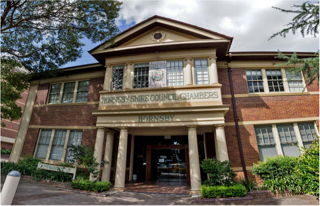
Hornsby Shire Council Table of Contents
Page 1
AGENDA AND SUMMARY OF RECOMMENDATIONS
Rescission Motions
MAYORAL MINUTES
ITEMS PASSED BY EXCEPTION / CALL FOR SPEAKERS ON AGENDA ITEMS
GENERAL BUSINESS
Office of the General Manager
Nil
Corporate Support Division
Item 1 CS31/14 Councillors' Expenses and Facilities Policy - Annual Review for 2014............... 1
Item 2 CS40/14 Investments and Borrowings for 2014/15 - Status for Period Ending 31 August 2014 4
Item 3 CS41/14 General Purpose and Special Purpose Financial Reports - 2013/14 Financial Year 7
Environment and Human Services Division
Item 4 EH15/14 Review of Financial Management Arrangements for Volunteer Community Centre Management Committees.......................................................................................... 10
Planning Division
Item 5 PL64/14 Development Application - Seniors Living Development Comprising 26 Dwellings - 396-398 Peats Ferry Road and 5A and 15 Mildred Avenue, Hornsby......................................... 15
Item 6 PL66/14 Development Application - Alterations and Additions - Dwelling-House - 4 Cherrybrook Road, West Pennant Hills.......................................................................................... 54
Item 7 PL67/14 Development Application - Five Storey Residential Flat Buildings Comprising 90 Units - 16-20 Park Avenue, Waitara............................................................................................ 68
Item 8 PL69/14 Development Application - Subdivision of One Allotment into Two Lots - 895 Old Northern Road, Dural............................................................................................................ 116
Item 9 PL70/14 Development Application - Subdivision of One Allotment into Two Lots - 65 Balmoral Street, Waitara........................................................................................................ 135
Item 10 PL71/14 Development Application - Seniors Living Development Comprising 10 Units - 186 Beecroft Road, Cheltenham - Further Report .......................................................................... 148
Item 11 PL72/14 Epping Town Centre Urban Activation Precinct - Amendments to Hornsby Development Control Plan 2013 - After Exhibition.......................................................................... 198
Item 12 PL73/14 Epping Town Centre Urban Activation Precinct - Memorandum of Understanding with Parramatta City Council........................................................................................... 209
Infrastructure and Recreation Division
Item 13 IR13/14 Rehabilitation of Hornsby Quarry.................................................................. 212
Item 14 IR15/14 RFT15/2014 - Supply, Installation and Maintenance of CCTV Systems............ 219
Item 15 IR18/14 Request to Remove Trees at 24 Star Crescent, West Pennant Hills................. 222
Item 16 IR20/14 Northern Sydney Regional Waste Strategy 2014-2021.................................... 226
Item 17 IR21/14 Expression of Interest - EOI 28/2014 - Construction of Hornsby Station Footbridge 234
Confidential Items
Item 18 CS38/14 Proposed Option to Purchase Council Land - 18X Water Street, Hornsby
PUBLIC FORUM – NON AGENDA ITEMS
Questions of Which Notice Has Been Given
Mayor's Notes
Item 19 MN10/14 Mayor's Notes 1 to 30 September 2014...................................................... 238
Notices of Motion
SUPPLEMENTARY AGENDA
MATTERS OF URGENCY
QUESTIONS WITHOUT NOTICE
Hornsby Shire Council Agenda and Summary of Recommendations
Page 1
AGENDA AND SUMMARY OF RECOMMENDATIONS
PRESENT
NATIONAL ANTHEM
OPENING PRAYER/S
Pastor Andrew Maxwell, from Asquith Church of Christ, will open the meeting in prayer.
Acknowledgement of RELIGIOUS DIVERSITY
Statement by the Chairperson:
"We recognise our Shire's rich cultural and religious diversity and we acknowledge and pay respect to the beliefs of all members of our community, regardless of creed or faith."
ABORIGINAL RECOGNITION
Statement by the Chairperson:
"We acknowledge we are on the traditional lands of the Darug and Guringai Peoples. We pay our respects to elders past and present."
AUDIO RECORDING OF COUNCIL MEETING
Statement by the Chairperson:
"I advise all present that tonight's meeting is being audio recorded for the purposes of providing a record of public comment at the meeting, supporting the democratic process, broadening knowledge and participation in community affairs, and demonstrating Council’s commitment to openness and accountability. The recordings of the non-confidential parts of the meeting will be made available on Council’s website once the Minutes have been finalised. All speakers are requested to ensure their comments are relevant to the issue at hand and to refrain from making personal comments or criticisms. No other persons are permitted to record the Meeting, unless specifically authorised by Council to do so."
APOLOGIES / LEAVE OF ABSENCE
political donations disclosure
Statement by the Chairperson:
“In accordance with Section 147 of the Environmental Planning and Assessment Act 1979, any person or organisation who has made a relevant planning application or a submission in respect of a relevant planning application which is on tonight’s agenda, and who has made a reportable political donation or gift to a Councillor or employee of the Council, must make a Political Donations Disclosure Statement.
If a Councillor or employee has received a reportable political donation or gift from a person or organisation who has made a relevant planning application or a submission in respect of a relevant planning application which is on tonight’s agenda, they must declare a non-pecuniary conflict of interests to the meeting, disclose the nature of the interest and manage the conflict of interests in accordance with Council’s Code of Conduct.”
declarations of interest
Clause 52 of Council’s Code of Meeting Practice (Section 451 of the Local Government Act, 1993) requires that a councillor or a member of a Council committee who has a pecuniary interest in a matter which is before the Council or committee and who is present at a meeting of the Council or committee at which the matter is being considered must disclose the nature of the interest to the meeting as soon as practicable. The disclosure is also to be submitted in writing (on the form titled “Declaration of Interest”).
The Councillor or member of a Council committee must not be present at, or in sight of, the meeting of the Council or committee:
(a) at any time during which the matter is being considered or discussed by the Council or committee.
(b) at any time during which the Council or committee is voting on any question in relation to the matter.
Clause 51A of Council’s Code of Meeting Practice provides that a Councillor, Council officer, or a member of a Council committee who has a non pecuniary interest in any matter with which the Council is concerned and who is present at a meeting of the Council or committee at which the matter is being considered must disclose the nature of the interest to the meeting as soon as practicable. The disclosure is also to be submitted in writing (on the form titled “Declaration of Interest”).
If the non-pecuniary interest is significant, the Councillor must:
a) remove the source of conflict, by relinquishing or divesting the interest that creates the conflict, or reallocating the conflicting duties to another Council official.
OR
b) have no involvement in the matter by absenting themself from and not taking part in any debate or voting on the issue as if the provisions of Section 451(2) of the Act apply.
If the non-pecuniary interest is less than significant, the Councillor must provide an explanation of why they consider that the interest does not require further action in the circumstances.
confirmation of minutes
THAT the Minutes of the General Meeting held on 3 September 2014 be confirmed; a copy having been distributed to all Councillors.
Petitions
presentations
Rescission Motions
MAYORAL MINUTES
ITEMS PASSED BY EXCEPTION / CALL FOR SPEAKERS ON AGENDA ITEMS
Note:
Persons wishing to address Council on matters which are on the Agenda are permitted to speak, prior to the item being discussed, and their names will be recorded in the Minutes in respect of that particular item.
Persons wishing to address Council on non agenda matters, are permitted to speak after all items on the agenda in respect of which there is a speaker from the public have been finalised by Council. Their names will be recorded in the Minutes under the heading "Public Forum for Non Agenda Items".
GENERAL BUSINESS
· Items for which there is a Public Forum Speaker
· Public Forum for non agenda items
· Balance of General Business items
OFFICE OF THE General Manager
Nil
Corporate Support Division
Page Number 1
Item 1 CS31/14 Councillors' Expenses and Facilities Policy - Annual Review for 2014
RECOMMENDATION
THAT:
1. The amended Councillors’ Expenses and Facilities Policy, as attached to Deputy General Manager’s Report No. CS31/14, be adopted for the purpose of public exhibition.
2. If submissions are received during the public exhibition period, a further report be prepared for Council’s consideration which addresses those submissions.
3. Should no submissions be received by the end of the public exhibition period, the draft Policy attached to Deputy General Manager’s Report No. CS31/14 be adopted as final and a copy be forwarded to the Office of Local Government.
Page Number 4
Item 2 CS40/14 Investments and Borrowings for 2014/15 - Status for Period Ending 31 August 2014
RECOMMENDATION
THAT the contents of Deputy General Manager’s Report No. CS40/14 be received and noted.
Page Number 7
Item 3 CS41/14 General Purpose and Special Purpose Financial Reports - 2013/14 Financial Year
RECOMMENDATION
THAT:
1. The 2013/14 General Purpose and Special Purpose Financial Reports be received and noted and referred for audit.
2. The Mayor and Deputy Mayor be authorised to sign the Statutory Statements in connection with the 2013/14 Financial Reports.
3. The 2013/14 Financial Reports be authorised for “presentation to the public” on receipt of the Auditor’s Report.
4. The General Manager be delegated authority to fix the date of the General Meeting at which the 2013/14 Financial Reports and Auditor’s Report will be formally “presented to the public”.
Environment and Human Services Division
Page Number 10
Item 4 EH15/14 Review of Financial Management Arrangements for Volunteer Community Centre Management Committees
RECOMMENDATION
THAT Council:
1. Note the resignations of the Beecroft and Thornleigh volunteer management committees and thank them for their many years of combined volunteer service.
2. Assume the direct management of the Beecroft and Thornleigh community centres.
3. Note that the operational procedures for the volunteer management committee run community centres now mirror the operational procedures of Council managed facilities.
Planning Division
Page Number 15
Item 5 PL64/14 Development Application - Seniors Living Development Comprising 26 Dwellings - 396-398 Peats Ferry Road and 5A and 15 Mildred Avenue, Hornsby
RECOMMENDATION
THAT Council assume the concurrence of the Secretary of NSW Planning and Environment pursuant to Clause 4.6 of the Hornsby Local Environmental Plan 2013 and approve Development Application No. DA/373/2014 for demolition of existing structures and staged construction of a seniors living development comprising 26 self-contained dwellings, a multi-purpose centre and administrative offices with basement parking at Lot 102 DP 1018824, Nos. 396-398 Peats Ferry Road, Lot 2 DP 502705, No. 5A Mildred Avenue and Lot B DP 320473, No. 15 Mildred Avenue, Hornsby subject to the conditions of consent detailed in Schedule 1 of Group Manager’s Report No. PL64/14.
Page Number 54
Item 6 PL66/14 Development Application - Alterations and Additions - Dwelling-House - 4 Cherrybrook Road, West Pennant Hills
RECOMMENDATION
THAT:
1. Development Application No. DA/726/2014 for alterations and additions to a dwelling house involving a swimming pool and retaining wall at Lot 1011 DP 1134002, No. 4 Cherrybrook Road, West Pennant Hills be approved subject to the conditions of consent detailed in Schedule 1 of Group Manager’s Report No. PL66/14.
2. That any future development applications for Nos. 4 and 4A Cherrybrook Road, West Pennant Hills no longer be required to be determined by Council where the proposal is within the delegations of Council officers to determine.
Page Number 68
Item 7 PL67/14 Development Application - Five Storey Residential Flat Buildings Comprising 90 Units - 16-20 Park Avenue, Waitara
RECOMMENDATION
THAT Council assume the concurrence of the Secretary of the Department of Planning and Environment pursuant to State Environmental Planning Policy No. 1 and approve Development Application No. DA/1001/2013 for demolition of existing structures and the erection of 4 x five storey residential flat buildings comprising 90 units with basement car parking at Nos. 16-20 Park Avenue, Waitara subject to the conditions of consent detailed in Schedule 1 of Group Manager’s Report No. PL67/14.
Page Number 116
Item 8 PL69/14 Development Application - Subdivision of One Allotment into Two Lots - 895 Old Northern Road, Dural
RECOMMENDATION
THAT Council seek the concurrence of the Secretary of NSW Planning and Environment pursuant to State Environmental Planning Policy No. 1 and approve Development Application No. DA/1069/2013 for subdivision of one allotment into two lots at Lot 1 DP 558601, No. 895 Old Northern Road, Dural subject to the conditions of consent detailed in Schedule 1 of Group Manager’s Report No. PL69/14.
Page Number 135
Item 9 PL70/14 Development Application - Subdivision of One Allotment into Two Lots - 65 Balmoral Street, Waitara
RECOMMENDATION
THAT Council assume the concurrence of the Secretary of NSW Planning and Environment pursuant to Clause 4.6 of the Hornsby Local Environmental Plan 2013 and approve Development Application No. DA/519/2014 for Torrens title subdivision of one allotment into two lots at SP 44601, No. 65 Balmoral Street, Waitara subject to the conditions of consent detailed in Schedule 1 of Group Manager’s Report No. PL70/14.
Page Number 148
Item 10 PL71/14 Development Application - Seniors Living Development Comprising 10 Units - 186 Beecroft Road, Cheltenham - Further Report
RECOMMENDATION
THAT Council assume the concurrence of the Secretary of the Department of Planning and Environment pursuant to State Environmental Planning Policy No. 1 and approve Development Application No. DA/1394/2013 for the demolition of existing structures and construction of a seniors living development comprising 10 self-contained dwellings with car parking and strata subdivision at Lot 18 DP 1067166, No. 186 Beecroft Road, Cheltenham subject to the conditions of consent detailed in Schedule 1 of Group Manager’s Report No. PL71/14.
Page Number 198
Item 11 PL72/14 Epping Town Centre Urban Activation Precinct - Amendments to Hornsby Development Control Plan 2013 - After Exhibition
RECOMMENDATION
THAT:
1. The amendments to Part 1 – General, Part 3 – Residential, Part 4 – Business and Part 9 – Heritage of the Hornsby Development Control Plan 2013 attached to Group Manager’s Report No. PL72/14 be adopted and notified in the local newspaper.
2. A Planning Proposal be prepared to amend the Height of Building Map for Property Nos. 2-4 Epping Road from 5 storeys to 8 storeys.
3. All persons who made a submission be advised of Council’s decision.
Page Number 209
Item 12 PL73/14 Epping Town Centre Urban Activation Precinct - Memorandum of Understanding with Parramatta City Council
RECOMMENDATION
THAT:
1. Council begin discussions with Parramatta City Council about developing a formal Memorandum of Understanding regarding the Epping Town Centre.
2. The Agreement should include, but not be limited to, actions regarding the treatment of the public domain, joint applications for State and Federal government grants, community programs and traffic and transport management.
3. A further report be present to Council outlining the draft Memorandum of Understanding for endorsement.
4. Parramatta City Council be advised of Council’s resolution.
Infrastructure and Recreation Division
Page Number 212
Item 13 IR13/14 Rehabilitation of Hornsby Quarry
RECOMMENDATION
THAT Council:
1. Endorse the attached report from Clouston Associates into future recreation uses of Hornsby Quarry and continues to refine the design of the quarry for recreation.
2. Support in-principle the option of placing limited fill from the NorthConnex tunnel project in Hornsby Quarry to achieve the landform best suited to recreation, subject to a Supplementary Environmental Impact Statement (EIS) prepared on behalf of the NorthConnex proponent.
3. Subject to approval of the Supplementary EIS for the quarry filling following its public exhibition, and addressing any issues raised in the EIS, commences preparation of a Plan of Management for the quarry, Old Mans Valley and Hornsby Park to allow recreation uses and facilities.
Page Number 219
Item 14 IR15/14 RFT15/2014 - Supply, Installation and Maintenance of CCTV Systems
RECOMMENDATION
THAT Council:
1. Accept the tender from Ryalex Holdings for the Geutebruck CCTV System for Request for Tender No. RFT15/2014 – Supply, Installation and Maintenance of CCTV Systems for the price as stated in the attached Confidential Memo.
2. The price will be made public on formal acceptance of the tender.
3. Note Council’s obligation to monitor and manage the CCTV System in accordance with legislation and various guidelines.
Page Number 222
Item 15 IR18/14 Request to Remove Trees at 24 Star Crescent, West Pennant Hills
RECOMMENDATION
THAT Council refuse consent to remove two Eucalyptus pilularis (Blackbutt) trees located at the front of the property at 24 Star Crescent, West Pennant Hills.
Page Number 226
Item 16 IR20/14 Northern Sydney Regional Waste Strategy 2014-2021
RECOMMENDATION
THAT Council:
1. Adopt the Northern Sydney Regional Waste Strategy 2014-2021 as an element of Council’s strategic planning framework and the priority projects identified in the 2014/15 Action Plan.
2. Note that the Annual Action Plan will be revised each year to reflect progress, Council’s needs and adaptation to changing circumstances.
Page Number 234
Item 17 IR21/14 Expression of Interest - EOI 28/2014 - Construction of Hornsby Station Footbridge
RECOMMENDATION
THAT Council invite Abergeldie Contractors Pty Ltd, Delaney Civil Pty Ltd, Fernandes Constructions Pty Ltd and Talis Civil Pty Ltd to tender for the construction of Hornsby Station Footbridge.
Confidential Items
Item 18 CS38/14 Proposed Option to Purchase Council Land - 18X Water Street, Hornsby
This report should be dealt with in confidential session, under Section 10A (2) (c) of the Local Government Act, 1993. This report contains information that would, if disclosed, confer a commercial advantage on a person with whom the council is conducting (or proposes to conduct) business.
PUBLIC FORUM – NON AGENDA ITEMS
Questions of Which Notice Has Been Given
Mayor's Notes
Page Number 238
Item 19 MN10/14 Mayor's Notes 1 to 30 September 2014
Notices of Motion
SUPPLEMENTARY AGENDA
MATTERS OF URGENCY
QUESTIONS WITHOUT NOTICE
Deputy General Manager's Report No. CS31/14
Corporate Support Division
Date of Meeting: 8/10/2014
1 COUNCILLORS' EXPENSES AND FACILITIES POLICY - ANNUAL REVIEW FOR 2014
EXECUTIVE SUMMARY
· In accordance with Section 252 of the Local Government Act, Council is required to annually review its policy dealing with the payment of expenses and provision of facilities to councillors. Once such review is complete, the updated policy is required to be forwarded to the Office of Local Government (OLG).
· A review of Council’s current Councillors’ Expenses and Facilities Policy has been completed and the updated draft Policy is included in the attachment to this Report, with proposed amendments shown in track changes.
· The 2014 review of the Policy has regard to the latest “Guidelines for the payment of expenses and the provision of facilities for Mayors and Councillors in NSW” (issued by the OLG in October 2009) and a Circular from the OLG issued on 21 September 2011 titled “Findings from Review of Councillor Expenses and Facilities Policies”.
· It is recommended that Council adopt the attached draft Policy for the purpose of public exhibition.
|
THAT: 1. The amended Councillors’ Expenses and Facilities Policy, as attached to Deputy General Manager’s Report No. CS31/14, be adopted for the purpose of public exhibition. 2. If submissions are received during the public exhibition period, a further report be prepared for Council’s consideration which addresses those submissions. 3. Should no submissions be received by the end of the public exhibition period, the draft Policy attached to Deputy General Manager’s Report No. CS31/14 be adopted as final and a copy be forwarded to the Office of Local Government. |
PURPOSE
The purpose of this Report is to comply with the requirements of Section 252 of the Local Government Act; provide Council with the opportunity to consider proposed amendments to its Councillors’ Expenses and Facilities Policy; and seek Council’s endorsement of the amended Policy for the purpose of public exhibition.
BACKGROUND
Having regard to the provisions of Section 252 of the Local Government Act; the latest “Guidelines for the payment of expenses and the provision of facilities for Mayors and Councillors in NSW” (issued by the OLG in October 2009); and Circular No 11-27 issued by the OLG in September 2011 titled “Findings from Review of Councillor Expenses and Facilities Policies”, all NSW councils are required to undertake an annual review of their Councillors’ Expenses and Facilities Policy and submit their Policy to the OLG by 30 November.
Council last reviewed its Councillors’ Expenses and Facilities Policy in September 2013 as a consequence of its consideration of Deputy General Manager’s Report No. CS34/13. Following the required public exhibition of the draft Policy, a copy of the final Policy was forwarded to the OLG by the due date.
DISCUSSION
The 2014 review of the Councillors’ Expenses and Facilities Policy has identified some minor amendments for Council to consider. Those proposed amendments are shown in track changes in the attached draft Policy and include:
· a small number of minor grammatical amendments to ensure consistency of wording across the Policy
· updated references to relevant documents
· a change in wording relating to the nomination of Council’s voting delegates to the Local Government NSW (LGNSW) Annual Conference – noting that Council is now entitled to 10 voting delegates.
CONSULTATION
The review of the Policy has regard to the latest “Guidelines for the payment of expenses and the provision of facilities for Mayors and Councillors in NSW” issued by the OLG in October 2009 and a Circular from the OLG issued on 21 September 2011 titled “Findings from Review of Councillor Expenses and Facilities Policies”.
BUDGET
An allocation exists within Council’s budget for the payment of Councillor expenses and facilities that fall within the provisions of the subject Policy. This budget is monitored on a monthly basis and is subject to a quarterly review by Council.
POLICY
This Report proposes minor amendments to the Councillors’ Expenses and Facilities Policy. Should Council resolve to adopt the amended Policy for the purpose of public exhibition, the public exhibition process will be undertaken having regard to relevant legislation and Council’s Public and Community Input Policy.
CONCLUSION
It is proposed that Council adopt the attached draft Policy for the purpose of public exhibition. If submissions are received during the public exhibition period, a further report will be prepared for Council’s consideration which addresses those submissions. Should no submissions be received by the end of the 28 day exhibition period, it is recommended that the Policy as attached to Deputy General Manager’s Report No. CS31/14 be adopted and a copy of the amended Policy forwarded to the OLG.
RESPONSIBLE OFFICER
The officer responsible for the preparation of this Report is the Manager Governance and Customer Service – Robyn Abicair, who can be contacted on 9847 6608.
|
Robyn Abicair Manager - Governance and Customer Service Corporate Support Division |
Gary Bensley Deputy General Manager Corporate Support Division |
|
1.View |
Councillors' Expenses and Facilities Policy - September 2014 - Track Changes Showing |
|
|
File Reference: F2004/09552
Document Number: D03295624
Deputy General Manager's Report No. CS40/14
Corporate Support Division
Date of Meeting: 8/10/2014
2 INVESTMENTS AND BORROWINGS FOR 2014/15 - STATUS FOR PERIOD ENDING 31 AUGUST 2014
EXECUTIVE SUMMARY
· Council may invest funds that are not, for the time being, required for any other purpose. The investments must be in accordance with relevant legislative requirements and Council’s policies. The Chief Financial Officer must report monthly to Council on the details of funds invested.
· This Report provides details of Council’s investment performance for the period ending 31 August 2014. It indicates that for the total cash and term deposit investments, the annualised return for the month of August was 3.71% compared to the benchmark of 2.50%. The annualised return for the total investments for the month ending 31 August 2014 was 3.63% compared to the benchmark of 2.50%.
· All investments have been made in accordance with the Local Government Act, the Local Government (General) Regulation and Council's Investment of Surplus Funds Policy and Investment Strategy.
· In respect of Council borrowings, the weighted average interest rate payable on loans taken out from June 2004 to August 2014, based on the principal balances outstanding, is 6.10%.
|
THAT the contents of Deputy General Manager’s Report No. CS40/14 be received and noted. |
PURPOSE
The purpose of this Report is to advise Council of funds invested in accordance with Section 625 of the Local Government Act; and to provide details as required by Clause 212(1) of the Local Government (General) Regulation and Council's Investment of Surplus Funds Policy.
BACKGROUND
A report is required to be submitted for Council’s consideration each month detailing Council's investments and borrowings and highlighting the monthly and year to date performance of the investments. Initial investments and reallocation of funds are made, where appropriate, after consultation with Council's financial investment adviser and fund managers.
DISCUSSION
Council may invest funds which are not, for the time being, required for any other purpose. Such investment must be in accordance with relevant legislative requirements and Council Policies, and the Chief Financial Officer must report monthly to Council on the details of the funds invested.
Council’s investment performance for the month ending 31 August 2014 is detailed in the attached document and summarised below:
· The At-Call and Term Deposits achieved an annualised return of 3.71% for August compared to the benchmark of 2.50%.
· The Capital Guaranteed Note achieved an annualised return of 0% for this period. The Note will be fully redeemed at maturity in September 2014.
· For total investments, the annualised return for August 2014 was 3.63% compared to the benchmark of 2.50%.
· In respect of Council borrowings, the weighted average interest rate payable on outstanding loans taken out from June 2005 to August 2014, based on the principal balances outstanding, is 6.10%. The Borrowings Schedule as at 31 August 2014 is attached for Council’s information.
CONSULTATION
Appropriate consultation has occurred with Council's financial investment adviser and fund managers.
BUDGET
Budgeted investment income for 2014/15 is $1,764,000, with an average budgeted monthly income of $147,000. Total investment income for the months of July and August was $285,800 compared to budget for the same period of $294,000. Approximately 30% of the total investment income received by Council relates to externally restricted funds (e.g. Section 94 monies) and is required to be allocated to those funds. All investments have been made in accordance with the Local Government Act, the Local Government (General) Regulation and Council's Investment of Surplus Funds Policy and Investment Strategy.
CONCLUSION
The investment of Council funds for the period ending 31 August 2014 is detailed in the documents attached to this Report. Council’s consideration of the Report and its attachments ensures that the relevant legislative requirements and Council protocols have been met in respect of those investments.
RESPONSIBLE OFFICER
The officer responsible for the preparation of this Report is the Chief Financial Officer – Glen Magus, who can be contacted on 9847 6635.
|
Glen Magus Chief Financial Officer - Financial Services Corporate Support Division |
Gary Bensley Deputy General Manager Corporate Support Division |
|
1.View |
HSC Investment Portfolio as at 31 August 2014 |
|
|
|
2.View |
HSC Borrowings Schedule as at 31 August 2014 |
|
|
File Reference: F2004/06987
Document Number: D03606219
Deputy General Manager's Report No. CS41/14
Corporate Support Division
Date of Meeting: 8/10/2014
3 GENERAL PURPOSE AND SPECIAL PURPOSE FINANCIAL REPORTS - 2013/14 FINANCIAL YEAR
EXECUTIVE SUMMARY
· Council’s General Purpose and Special Purpose Financial Reports for the year ended 30 June 2014 (the Financial Reports) have been completed by staff in accordance with the requirements of the Local Government Act, the Local Government Code of Accounting Practice and relevant Accounting Standards.
· Subject to Council’s approval, the Financial Reports will be referred for audit.
· Following receipt of the Auditor’s Reports, it is proposed that the Financial Reports and Auditor’s Report be "presented to the public" at the 12 November 2014 General Meeting.
|
THAT: 1. The 2013/14 General Purpose and Special Purpose Financial Reports be received and noted and referred for audit. 2. The Mayor and Deputy Mayor be authorised to sign the Statutory Statements in connection with the 2013/14 Financial Reports. 3. The 2013/14 Financial Reports be authorised for “presentation to the public” on receipt of the Auditor’s Report. 4. The General Manager be delegated authority to fix the date of the General Meeting at which the 2013/14 Financial Reports and Auditor’s Report will be formally “presented to the public”. |
PURPOSE
The purpose of this Report is to recommend that Council’s 2013/14 Financial Reports be received and noted and referred for audit.
BACKGROUND
In accordance with Section 413 of the Local Government Act, Council must prepare a set of Financial Reports for each year, and must refer them for external audit as soon as practicable after the end of that year.
DISCUSSION
Council’s Financial Reports for 2013/14 have been completed by staff in accordance with the requirements of the Local Government Act, the Local Government Code of Accounting Practice and relevant Accounting Standards. It is recommended that they be referred to Council’s external auditors for review. The unaudited Financial Reports (a copy of which has been provided to Councillors under separate cover) are not for distribution to the public at this stage. The audited Reports are those that will be made available to the public in accordance with Local Government Act requirements.
Council is required to give notice as to the Meeting at which the Financial Reports (including the Auditor's Reports) will be formally "presented to the public". The proposed date for this Meeting will be set as soon as possible after the Auditor's Reports have been received. At this stage, it is anticipated that the Reports will be "presented to the public" at the 12 November 2014 General Meeting. Council's external auditor, Mr Dennis Banicevic of PricewaterhouseCoopers, is expected to be available to make a presentation on the Reports at that General Meeting.
Following presentation of the Reports to the public, any person may make a submission concerning the Reports within a period of seven days after the General Meeting.
BUDGET
There are no budgetary implications associated with this Report.
POLICY
The Financial Reports have been compiled in accordance with the Local Government Act, the Local Government (General) Regulation 2005 and the Local Government Code of Accounting Practice issued by the Office of Local Government.
CONCLUSION
Council’s referral of the 2013/14 Financial Reports for audit, and ultimately the presentation of the Financial and Auditor’s Report to the public at the 12 November 2014 General Meeting, will ensure that the requirements of the Local Government Act have been met.
RESPONSIBLE OFFICER
The officer responsible for the preparation of this Report is the Chief Financial Officer – Glen Magus, who can be contacted on 9847 6635.
|
Glen Magus Chief Financial Officer - Financial Services Corporate Support Division |
Gary Bensley Deputy General Manager Corporate Support Division |
There are no attachments for this report.
File Reference: F2014/00272
Document Number: D03606622
Group Manager's Report No. EH15/14
Environment and Human Services Division
Date of Meeting: 8/10/2014
4 REVIEW OF FINANCIAL MANAGEMENT ARRANGEMENTS FOR VOLUNTEER COMMUNITY CENTRE MANAGEMENT COMMITTEES
EXECUTIVE SUMMARY
· Council has a network of 30 community centres across the Shire. The majority of these are managed directly by Council; with 11 being run on Council’s behalf by a volunteer management committee.
· In 2012, Council’s Enterprise Risk Management Strategy identified that volunteer management committees operated numerous bank accounts holding public money that were separate to Council’s consolidated account. To ensure that Council meets its legislated requirements under the Local Government Act relating to its financial accounts, the Enterprise Risk Management Strategy recommended that these separate bank accounts be closed, and the funds transferred into Council’s consolidated account.
· Throughout 2013 and 2014 Council officers have worked through a reform process with volunteer management committees such that their separate accounts have been closed and $872,802.93 of accumulated public money is now held within Council’s consolidated account. These funds have been quarantined for use by the volunteer management committees that accumulated them on items such as building maintenance and capital upgrades.
· Volunteer management committees have also integrated with Council’s software systems to manage all bookings and payments associated with the centres resulting in enhanced referral possibilities between centres.
· Through the course of this reform process, the Beecroft and Thornleigh volunteer management committees have tendered their resignations with management reverting to Council. It is recommended that Council express it’s thanks to the Thornleigh and Beecroft committees for their long term volunteer contribution to the operation of these centres and the community.
|
THAT Council: 1. Note the resignations of the Beecroft and Thornleigh volunteer management committees and thank them for their many years of combined volunteer service. 2. Assume the direct management of the Beecroft and Thornleigh community centres. 3. Note that the operational procedures for the volunteer management committee run community centres now mirror the operational procedures of Council managed facilities. |
PURPOSE
The purpose of this Report is to inform Council of, and seek its endorsement for, changes made to the financial arrangements associated with volunteer management committee run community centres.
BACKGROUND
Council has a network of 30 community centres across the Shire. The majority of these are managed directly by Council; with 11 being run by a volunteer management committee (VMC)
Historically VMC’s have assisted Council in managing the day to day operations of some of its community centres. Typical functions of a VMC include managing hire enquiries and bookings, centre maintenance and cleaning and liaising with Council regarding capital upgrades. VMC’s also established and operated their own bank accounts through which all income and expenditure associated with the centre was channelled.
In 2012, Council’s Enterprise Risk Management Strategy recommended that the numerous separate bank accounts held by VMC’s be closed and the funds transferred into Council’s consolidated account. This would ensure that Council’s financial structures and controls were consistently applied and ensure that Council was complaint with its legislated requirements under the Local Government Act 1993.
DISCUSSION
The issue of VMC financial arrangements was brought to Councillors attention at an informal briefing in June 2013 where the need to ensure compliance with the Local Government Act 1993 was discussed.
Throughout 2013 and 2014, Council officers have worked with VMC’s to implement a suitable response to the findings of the Enterprise Risk Management Strategy. Broadly speaking this has resulted in:
· VMC’s adopting Council’s systems to manage all bookings and payments associated with the centre.
· VMC’s closing individual bank accounts and transferring funds to Council’s consolidated account where it is separately accounted for.
· Accumulated funds generated by VMC’s have been quarantined for use at the centre that raised the funds.
· Hire payments being made through Council’s online payment facilities or at Council’s cashiers rather than directly to committee booking officers/treasurers.
This system of operation has been progressively rolled out from the beginning of 2014 and has been in place for all centres since mid-July 2014.
It is acknowledged that whilst necessary, these changes have resulted in significant adjustments to how VMC’s have previously operated and this has caused a degree of frustration amongst some VMC’s. These frustrations are primarily related to losing direct control of funds raised by the hire of centres which they manage, and the need to use Council software systems for bookings and payments.
Access to Council’s software systems is necessarily limited to paid staff members of Council, and has meant that some VMC’s have needed to pay a casual staff member to undertake the bookings function that were previously done on voluntary basis - in most instances the existing booking officer has transitioned to become a casual employee of Council and is funded through revenue generated by the centre. Other VMC’s already employed a paid booking officer.
It is noted that the solution:
· Allows VMC’s to retain control over the bookings that take place in the centres which they manage. VMC’s also continue to be responsible for invoicing hirers.
· Allows VMC’s to retain control over funds generated from the hire of community centres. The only difference with the new system is that they now are required to use Council’s procurement systems to expend funds.
· Allows funds raised from the hire of the centres to be rolled over year to year in order for VMC’s to save for major capital investments in the centres.
· Incurs an additional cost to some VMC’s in that tasks previously undertaken by volunteers are now undertaken by paid casual staff. The staff costs are being funded by revenue generated from the hire of the centres.
From the perspective of a facility user, the benefits of the solution are:
· Enhanced referral possibilities between centres in that all staff can see which facilities are available for hire through the one booking system.
· Online availability/bookings of centres where the VMC has activated this feature. It is noted that not all VMC’s have chosen to activate this option at this stage.
· Retention of local community input in the management and administration of the community centres.
From Council’s perspective, $872,802.93 of public money that was previously kept in separate VMC controlled bank accounts has now been deposited in Council’s consolidated account, bringing Council into compliance with its requirements under the Local Government Act. Standardised financial reporting, ordering and work order processes between community centres can now also occur.
A schedule of returns from each VMC is provided as Attachment 1 to this Report.
VMC funds have been placed in a restricted asset account and will be used to fund the ongoing operation of the centres including building maintenance, and capital upgrades to the buildings. This approach is consistent with historical arrangements for the VMC’s and allows VMC’s to continue to save funds for major renovations or upgrades.
It is noted that future reporting to Council on the financial operation of Council’s community centres will take place through Council’s standard financial reporting mechanisms rather than the provision of a stand-alone report on VMC financial operations. As a result the previously adopted Finance and Procedures Manual is now considered to be redundant. Likewise Council’s WHS Policies and Determinations are considered to appropriately cover volunteer involvement.
Retiring/Resigning Committees
Throughout the course of the reform process, both the Beecroft and Thornleigh VMC’s resigned as committees - it is noted that in the case of the Beecroft VMC this was by a majority vote of the committee.
Whilst Council is appreciative of the work that the Beecroft VMC has contributed over a significant period of time, following its resignation in June 2014 Council has made necessary staffing changes and has been directly managing the centre since July 2014.
It is recommended that Council accept the resignation of the Beecroft and Thornleigh VMC’s, and note that these centres are now directly managed by Council.
Volunteer involvement plays an important part in the social fabric of many communities and in Hornsby we are lucky to have high levels of volunteer involvement. In recognition of their many years of combined volunteer service, it is recommended that Council express its gratitude to the long term members of the former Beecroft and Thornleigh VMC’s at a function to be held later in 2014.
BUDGET
Previous experience with moving centres from individual, ad-hoc booking arrangements across to a common linked system has shown that any additional staff costs are able to be offset by increased centre utilisation and revenue. As such, necessary changes associated with VMC financial arrangements have been made on a budget neutral basis.
POLICY
There are no policy implications associated with this Report.
CONCLUSION
Council maintains a network of 30 community centres that, in the main are managed directly by Council. There are 11 community centres where, largely due to historical arrangements, the centres are managed on behalf of Council by a VMC.
In 2012, Council’s Enterprise Risk Management Strategy identified that VMC’s operated numerous bank accounts holding public money that were separate to Council’s consolidated account. To ensure that Council met its legislated requirement under the Local Government Act 1993 relating to its financial accounts, the Enterprise Risk Management Strategy recommended that these separate bank accounts held by VMC’s be closed, and the funds be transferred into Council’s consolidated account.
Throughout 2013 and 2014 Council officers have worked through a reform process and VMC’s have now transferred accumulated public funds of $872,802.93 into Council’s consolidated account and integrated with Council’s software systems to manage all bookings and payments associated with the centres.
It is recommended that Council note the transfer of funds from VMC bank accounts into Council’s consolidated account and that future financial reporting relating to VMC managed centres will now take place through Council’s standard financial reporting mechanisms.
Over the course of the reform process, two long serving VMC’s have resigned - Beecroft and Thornleigh. It is recommended that Council accept the resignations of these VMC’s and extend its thanks for the many hours of volunteer service that they have provided to the community.
Following the resignations of the Beecroft and Thornleigh VMC’s, it is recommended that Council does not seek to form new VMC’s, rather assume direct management of these centres.
RESPONSIBLE OFFICER
The officer responsible for the preparation of this Report is the Manager Community Services Branch – David Johnston, who can be contacted on 9847 6800.
|
David Johnston Manager - Community Services Environment and Human Services Division |
Stephen Fedorow Group Manager Environment and Human Services Division |
|
1.View |
Volunteer Management Committee Funds |
|
|
File Reference: F2004/05947
Document Number: D03192812
Group Manager’s Report No. PL64/14
Planning Division
Date of Meeting: 8/10/2014
5 DEVELOPMENT APPLICATION - SENIORS LIVING DEVELOPMENT COMPRISING 26 DWELLINGS - 396-398 PEATS FERRY ROAD AND 5A AND 15 MILDRED AVENUE, HORNSBY
EXECUTIVE SUMMARY
|
DA No: |
DA/373/2014 (Lodged 14 April 2014) |
|
Description: |
Demolition and staged construction of a Seniors Living Development comprising 26 self-contained dwellings, a multi-purpose centre and administrative offices with basement parking. |
|
Property: |
Lot 102 DP 1018824, Nos. 396-398 Peats Ferry Road, Lot 2 DP 502705, No. 5A Mildred Avenue, and Lot B DP 320473, No. 15 Mildred Avenue, Hornsby |
|
Applicant: |
Creative Planning Solution |
|
Owner: |
Christophorus House Retirement Village |
|
Estimated Value: |
$11,826,000 |
|
Ward: |
A |
· The application includes demolition of existing structures and staged construction of a seniors living development comprising 26 self-contained dwellings, a multi-purpose centre and administrative offices with basement parking.
· The proposal does not comply with the Hornsby Local Environmental Plan 2013 with regard to Clause 4.1 - Height. A submission has been made pursuant to Clause 4.6 of the LEP to support the variation, which is considered well-founded.
· Six submissions have been received in respect of the application.
· It is recommended that the application be approved.
|
THAT Council assume the concurrence of the Secretary of NSW Planning and Environment pursuant to Clause 4.6 of the Hornsby Local Environmental Plan 2013 and approve Development Application No. DA/373/2014 for demolition of existing structures and staged construction of a seniors living development comprising 26 self-contained dwellings, a multi-purpose centre and administrative offices with basement parking at Lot 102 DP 1018824, Nos. 396-398 Peats Ferry Road, Lot 2 DP 502705, No. 5A Mildred Avenue and Lot B DP 320473, No. 15 Mildred Avenue, Hornsby subject to the conditions of consent detailed in Schedule 1 of Group Manager’s Report No. PL64/14. |
SITE
The site has a total area of 14,570m2 and contains the existing Christophorus House Retirement Village, together with 2 recently acquired lots accessed via Mildred Avenue.
Property Nos. 396-398 Peats Ferry Road contains the existing Christophorus House Retirement Village comprising 23 self-contained dwellings within a cluster of 5 villa style buildings and includes a 24 bed hostel. There are two existing buildings in the form of a dwelling house for administration and community activities.
Property No. 5A Mildred Avenue contains a two storey brick residence, attached carport, brick clad shed, swimming pool and associated structures.
Property No. 15 Mildred Avenue contains a single storey clad residence, detached fibro clad garage, 3 metal sheds and associated structures.
The site is located on the southern side of Peats Ferry Road and on the northern side of Mildred Avenue and experiences an average grade of 8% to the eastern boundary of the site.
The site is irregular in shape with a frontage of 34m to Peats Ferry Road and a site width varying from 46m to 93m and extends for 260m through to Mildred Avenue where the site has a 16m frontage and a separate 3.5m wide access way.
The site is within an area recently rezoned R3 Medium Density Residential as part of Council’s Housing Strategy. The surrounding development comprises single and two storey dwellings adjoining the western and southern boundaries of the site and a medium density public housing estate adjoining the eastern boundary.
The site is located 1km north of Hornsby Railway Station and 800m south west of Asquith Railway Station. The site is within 150m of a bus stop on Peats Ferry Road (Route 595) which provides a regular bus service to Hornsby Railway Station.
PROPOSAL
The proposal involves the demolition of the existing dwelling houses and associated improvements, located on the site and the staged construction of two seniors housing buildings containing self-care housing, multi-purpose rooms, administration offices, servery, storage rooms, basement car parking, site landscaping and associated works pursuant to State Environmental Planning Policy (Housing for Seniors or People with a Disability) 2004.
The existing development is being expanded to include an additional 26 self-care dwellings on the consolidated lots. The new development comprises 2 new buildings and includes 20 x 2-bedroom dwellings and 6 x 3-bedroom dwellings.
The proposed dwellings range in size from 91m2 to 113m2. The gross floor area of the development is 3556.9m2. Each dwelling includes the primary living area being directly connected to a balcony or terrace.
The development would be accessed via the existing access way off Mildred Avenue on the southern boundary of the site. A total of 37 car parking spaces are proposed, including 32 spaces within the basement parking areas, of which 3 car parking spaces are designated as disabled/ accessible car parking space. An additional 5 car parking spaces are proposed adjacent to the main access drive near Mildred Avenue.
The application also includes associated landscape works within the site and includes a staging plan for the construction works as follows:
Stage 1
· Demolition of existing buildings;
· Construction of Building 1;
· Stormwater management works for the development;
· Landscaping works;
· Construction of driveway and pedestrian access from Mildred Avenue; and
· Provision of pedestrian through link to the existing seniors living development fronting Peats Ferry Road.
Stage 2
· Construction of Building 2; and
· Completion of landscaping works.
ASSESSMENT
The development application has been assessed having regard to the ‘Metropolitan Plan for Sydney 2031’, the ‘North Subregion (Draft) Subregional Strategy’ and the matters for consideration prescribed under Section 79C of the Environmental Planning and Assessment Act 1979 (the Act). The following issues have been identified for further consideration.
1. STRATEGIC CONTEXT
1.1 Metropolitan Plan for Sydney and (Draft) North Subregional Strategy
The (Draft) Metropolitan Strategy for Sydney 2031 is a broad framework to provide for Sydney’s growth to help plan for housing, employment, transport, infrastructure, the environment and open space. It outlines a vision for Sydney to 2031; the challenges faced, and the directions to follow to address these challenges and achieve the vision.
The North Subregion comprises Hornsby, Kuring-gai, Manly, Warringah and Pittwater Local Government Areas. The Draft North Subregional Strategy acted as a framework for Council in its preparation of the Hornsby Local Environmental Plan 2013.
Within the North Subregion, the Draft Metropolitan Strategy proposes:
· Population growth of 81,000 from the current 2011 baseline of 529,000
· Housing growth of 37,000 from the current 2011 baseline of 204,000
· Employment growth of 39,000 from the current 2011 baseline of 186,000
The proposed development would be consistent with the Metropolitan Plan for Sydney 2031 by providing an additional 26 independent living dwellings for seniors living.
2. STATUTORY CONTROLS
Section 79C(1)(a) requires Council to consider “any relevant environmental planning instruments, draft environmental planning instruments, development control plans, planning agreements and regulations”.
2.1 Hornsby Local Environmental Plan 2013
2.1.1 Zoning
The subject land is zoned R3 Medium Density Residential under the Hornsby Local Environmental Plan 2013 (HLEP). The objectives of the R3 zone are:
(a) To provide for the housing needs of the community within a medium density residential environment.
(b) To provide a variety of housing types within a medium density residential environment.
(c) To enable other land uses that provide facilities or services to the meet the day to day needs of residents.
The proposed development is defined as ‘Seniors Housing’ under the HLEP and is permissible in the zone with Council’s consent.
Notwithstanding, the proposal is permitted pursuant to Clause 4 of State Environmental Planning Policy (Housing for Seniors or People with a Disability) 2004 where land is zoned for urban purposes and where residential development is permitted. The provisions of the State Environmental Planning Policy prevail to the extent of any inconsistency with the HLEP.
2.1.2 Height of Buildings
Clause 4.3 of the HLEP provides that the height of a building on any land is not to exceed the maximum height shown for the land on the Height of Buildings Map. The maximum permissible height for the site is 10.5m. Building 1 has a maximum height of 11.38m and Building 2 has a maximum height of 11.7m. Accordingly, the proposed development does not comply with the development standard and the applicant has made a submission in accordance with Clause 4.6 Exceptions to development standards, to vary the height control, which is discussed below.
2.1.3 Exceptions to Development Standards
The proposal does not comply with Clause 4.3 of the HLEP. The application has been assessed against the requirements of Clause 4.6 - Exceptions to development standards. This clause provides flexibility in the application of development standards in circumstances where strict compliance with those standards would, in any particular case, be unreasonable or unnecessary or tend to hinder the attainment of the objectives of the zone.
The objectives of this clause are as follows:
(a) to provide an appropriate degree of flexibility in applying certain development standards to particular development,
(b) to achieve better outcomes for and from development by allowing flexibility in particular circumstances.
The applicant has submitted a request pursuant to Clause 4.6 to contravene the development standard as follows:
Is compliance with the development standard unreasonable or unnecessary in the circumstances of the case?
· Strict enforcement of the height of buildings development standard in this instance would hinder the desired redevelopment outcome for the site, the orderly and economic use as well as the development of the land and would not be in line with the scale of surrounding future development.
· The height of the non-compliance generally relates to the plant deck walls and lift overrun provided on the rooftop of the proposed buildings and does not provide for any additional floor space.
· The proposal would not result in any detrimental impacts upon adjoining properties.
· The objectives of the standard are achieved notwithstanding non-compliance with the standard and accordingly strict compliance with the standard and would be unreasonable.
Are there sufficient environmental planning grounds to justify contravening the development standard?
· The non-compliance would not result in any unreasonable impacts upon adjoining properties.
· The proposal is considered to be consistent with the objectives of the R3 - Medium Density Residential zone.
· The applicant notes that the objective of Clause 4.3 of HLEP is:
· To permit a height of buildings that is appropriate for the site constraints, development potential and infrastructure capacity of the locality.
· The applicant submits that the building height does not result in a development outcome that is inappropriate for the constraints inherent to the subject site.
· The proposed development has been designed with appropriate setbacks, which combined with considered building orientation and window size and positioning has ensured height levels of both visual and acoustic privacy are maintained to surrounding allotments now and into the future. Accordingly, the surrounding locality is anticipated to be unaffected by the proposed development in terms of impacting the re-development of other sites.
The Land and Environment Court has set out the following five part test for consent authorities to consider when assessing an application to vary a standard to determine whether the objection to the development standards is well founded:
· The objectives of the standard are achieved notwithstanding non-compliance with the standard;
· The underlying objective or the purpose of the standard is not relevant to the development and therefore compliance is unnecessary;
· The underlying object of purpose would be defeated or thwarted if compliance was required and therefore compliance is unreasonable;
· The development standard has been virtually abandoned or destroyed by the Council’s own actions in granting consents departing from the standard and hence compliance with the standard would be unnecessary and unreasonable.
· The zoning of the particular land is unreasonable or inappropriate so that a development standard appropriate for that zoning is also unreasonable and unnecessary as it applies to the land and compliance with the standard would be unreasonable or unnecessary. That is, a particular parcel of land should not have been included in the particular zone.
Having regard to the above points the applicant’s objection to the 10.5m building height development standard is considered well founded and is supported for the following reasons:
· The applicant has adequately addressed the matters required to be demonstrated by subclause (3) in Clause 4.6;
· The proposed development will be in the public interest because it is consistent with the objectives of the building height development standard and the objectives for development within the zone;
· The overall bulk and scale of the development would not be dominant in the streetscape as it is located on a battle-axe allotment and would be in keeping with the desired future character of the area which is zoned for medium density residential development;
· The building would not result in unreasonable overshadowing of the neighbouring properties, as discussed in Section 2.2 of this report. Privacy impacts are alleviated via site planning, careful location of windows and appropriate landscaping; and
· The proposal would not result in a precedent given the unique circumstances of the case.
Notwithstanding the non-compliance, the application is a reasonable outcome for the site and achieves the aims of SEPP HS&PD. As such, the proposed development would provide housing choice in the locality.
Based on this assessment, it is considered that the applicant’s submission is well founded and that compliance with the development standard would be unreasonable and unnecessary in the circumstances of the case. Accordingly, the proposal is considered acceptable in relation to Clause 4.6 of the HLEP.
2.1.4 Heritage Conservation
Clause 5.10 of the HLEP sets out heritage conservation provisions for Hornsby Shire. The property is located within the vicinity of property No. 368 Peats Ferry Road (‘Carnralia’ house), No. 384 Peats Ferry Road (‘Hovedan’ house) and No. 394 Peats Ferry Road (house) which are all listed as a heritage item (House) of Local significance under the provisions of Schedule 5 (Environmental Heritage) of the HLEP.
Council’s heritage assessment concludes that the development is sited at a sufficient distance from the heritage listed houses at Nos. 368, 384 and 394 Peats Ferry Road, Hornsby to ensure that the development would not detract from the heritage significance of the items in the vicinity.
2.1.5 Earthworks
Clause 6.2 of the HLEP states that consent is required for earthworks. Before granting consent for earthworks, Council is required to assess the impacts of the works on adjoining properties, drainage patterns and soil stability of the locality. Council’s assessment of the proposed earthworks and excavation concludes that the proposal is satisfactory, given:
· the development is unlikely to adversely disrupt drainage patterns or soil stability;
· the excavation is consistent with the intended purpose for which the land is zoned;
· the excavation is to be undertaken on sites with a long history of residential use and present a low risk to potential contamination;
· the excavation is unlikely to result in adverse amenity impacts on adjoining properties, and conditions of consent would be imposed relating to hours of work and management of soil and sedimentation impacts;
· excavated material would be required to be disposed of at appropriately licensed waste disposal sites;
· there is a low likelihood of disturbing relics;
· the site is not in proximity to any waterway, drinking water catchment or environmentally sensitive area and is therefore, unlikely to have adverse impacts with appropriate site management conditions being imposed, and
· standard conditions of consent would be imposed relating to site management requirements to mitigate against potential adverse impacts.
2.2 State Environmental Planning Policy (Housing for Seniors or People with a Disability) 2004
State Environmental Planning Policy (Housing for Seniors or People with a Disability) 2004 (SEPP HS&PD) is the overriding planning instrument for the development of housing for aged and disabled people in NSW and provides for hostels, residential care facilities (nursing homes) self-contained dwellings and multi-storey buildings. SEPP HS&PD is comprehensive in scope including land use planning provisions, design principles, development standards and standards specifically to meet the housing needs of aged and disabled people. SEPP HS&PD also includes design guidelines for infill development. Assessment of the proposal in accordance with the relevant requirements of SEPP HS&PD is provided as follows:
2.2.1 Clause 13 - Self Contained Dwellings
SEPP HS&PD includes the following definitions for ‘self-contained dwellings’:
“General term: “self-contained dwelling
In this Policy, a self-contained dwelling is a dwelling or part of a building (other than a hostel), whether attached to another dwelling or not, housing seniors or people with a disability, where private facilities for significant cooking, sleeping and washing are included in the dwelling or part of the building, but where clothes washing facilities or other facilities for use in connection with the dwelling or part of the building may be provided on a shared basis.
Example: “in-fill self-care housing”
In this Policy, in-fill self-care housing is seniors housing on land zoned primarily for urban purposes that consists of 2 or more self-contained dwellings where none of the following services are provided on site as part of the development: meals, cleaning services, personal care, nursing care.”
For the purposes of assessment against SEPP HS&PD, the proposed development is defined as ‘in-fill self-care housing’ comprising 26 ‘self-contained dwellings’.
2.2.2 Clause 26 - Location and Access to Facilities
SEPP HS&PD includes mandatory standards for accessibility and useability of self-contained dwellings to ensure wheelchair accessibility throughout the development and to a public road. Mandatory standards also apply for access to public transport, medical services and shops. The applicant submitted a Disability Access Report which includes a detailed assessment of the subject site and the proposed development, concerning compliance with the mandatory standards.
The site is located 1km north of Hornsby Railway Station and 800m south west of Asquith Railway Station.
The site is within 150m of a bus stop on Peats Ferry Road (Route 595) which provides a regular and frequent bus service to Hornsby Railway Station and the Hornsby town centre with all the required amenities and facilities. In addition, the site is within 800m of Asquith shops which is also on the bus route and provides supplementary amenities and facilities.
Given the above, the proposal complies with the provisions of Clause 26.
2.2.3 Clause 30 - Site Analysis
The application includes a Site Analysis in accordance with the requirements of the SEPP HS& PD. The proposal is assessed as satisfactory in this regard.
2.2.4 Clause 31 - Design of In-Fill Self-Care Housing
In determining a development application seeking approval for in-fill self-care housing, a consent authority must take into consideration (in addition to any other matters that are required to be, or may be, taken into consideration) the provisions of the Seniors Living Policy: Urban Design Guideline for Infill Development published by the then Department of Infrastructure, Planning and Natural Resources in March 2004.
The merits of the proposal in meeting the SEPP HS&PD design principles and the Seniors Living Policy Urban Design Guidelines for Infill Development are discussed in the following sections of this report.
2.2.5 Clause 33 - Neighbourhood Amenity and Streetscape
Part of the consolidated site is already developed and used for seniors living with self-contained dwellings and a hostel. The proposed ‘in-fill self-care housing’ forms an integral component of the established land use pattern in this locality. The height, bulk and scale of the proposed built form reflect the scale and desired future character of the locality for medium density housing as anticipated by the HLEP.
The development is sited on a battle-axe allotment and the setbacks as proposed respond to the desired future character of the locality and the setback controls in the HDCP for medium density development. The development provides for appropriate spatial separation to neighbouring dwellings in terms of access to light, sunlight and visual privacy with respect to both existing development and that envisaged by the HLEP and the desired future character of the area. The landscape treatment to the curtilage areas of the building as proposed will reinforce the landscape setting of the locality. As such, the proposal has addressed the neighbourhood amenity and streetscape so as to be compatible with the existing and future natural and built environment.
2.2.6 Clause 34 - Visual and Acoustic Privacy
The proposed dwellings are designed with regard to visual privacy to avoid overlooking neighbouring residencies. This coupled with the proposed landscaping and setbacks results in adequate space for effective landscape settings along the boundaries of the development and separation between neighbouring buildings.
The proposed private open space areas are integrated with the living areas of the dwellings and have regard to acoustic privacy. The development is to be used as a seniors living and therefore, would be a low noise generating development. The proposal would not have any unreasonable acoustic impact on the surroundings.
Subject to the above, the proposal complies with the provisions of Clause 34.
2.2.7 Clause 35 - Solar Access and Design for Climate
The living areas of the proposed dwellings are orientated towards the north-west for appropriate solar access. The submitted shadow diagrams demonstrate that the buildings would not overshadow any of the neighbouring dwellings.
Additional discussion regarding solar access is provided in Section 2.2.14.2 of this report. Notwithstanding, the proposal complies with the provisions of Clause 35.
2.2.8 Clause 36 - Stormwater
The proposed stormwater drainage system is designed to minimise impacts on downstream waterways and would be connected to the Council controlled drainage system in Mildred Avenue via an on-site detention system. Conditions are recommended for the system to be designed and constructed in accordance with Council’s Civil Works – Design and Construction Specification 2005.
2.2.9 Clause 37 - Crime Prevention
The accessway design, pedestrian linkages and orientation of dwellings ensures casual surveillance of the development and separation of public and private areas. Conditions are recommended for the basement car park to be made secure.
Subject to recommended conditions the proposal is satisfactory in respect to crime prevention.
2.2.10 Clause 38 - Accessibility
The development remains fully accessible with the internal and outdoor layouts satisfying the applicable standards of the Building Code of Australia and the Disability Discrimination Act. The matter is assessed in detail later in this report.
2.2.11 Clause 39 - Waste Management
The 26 self-contained dwellings would require 12 x 240L garbage bins serviced weekly plus 6 x 240L recycling bins serviced weekly. It is proposed that the site have 18 x 240L garbage bins plus 9 x 240L recycling bins. This would allow additional bin capacity for the hall, kitchen, therapy room and administration rooms.
Each residential level has a bin room housing a garbage bin and recycling bin. Each of these rooms is accessible by persons with a disability. Each building also has a larger bin room on the ground level for storage of spare bins and for placing full bins for servicing. It is proposed that a site caretaker would cart the bins from the bin area to the bin collection point for servicing.
Waste collection services would be carried out by the truck driving on site. Council’s assessment in this regard concludes that the vehicle turning paths show that a 10.7m truck can enter the site in a forward direction, turn around and exit in a forward direction.
Given the above, the application is assessed as satisfactory with regard to Clause 39.
2.2.12 Clause 40 - Development Standards
The proposal complies with the standards in respect to the site area being greater than 1,000m2 and site frontage of 20m at the building line, as the site has an area of 14,468m2 and a site frontage of approximately 34m to Peats Ferry Road.
Clause 40 (4) specifies height requirements in zones where residential flat buildings are not permitted. A residential flat building is defined as a building containing two or more self-contained dwellings. Residential flat buildings are permissible in the R3 Medium Density Residential zone and Clause 40 (4) is therefore not applicable.
2.2.13 Clause 41 - Standards Regarding Accessibility and Useability
This clause requires developments to comply with development standards contained within Schedule 3 of SEPP HS&PD to ensure an adequate level of access for people with disabilities. The application includes a Disability Access Assessment Report that addresses the controls. Compliance with the controls is discussed below and reinforced by conditions of consent.
|
Clause |
Control |
Compliance |
Comments |
|
2 |
Wheelchair access: 100% of the units must have wheelchair access by a continuous path of travel to an adjoining public road and to common areas.
Site gradient should be less than 1:10
Common areas |
Yes
Yes
Yes |
The levels are designed to provide a continuous accessible path from the units to the internal driveway and public road. Lifts/ramps are provided in the two storey block. The access report certifies that all gradients are suitable for wheelchair access.
Site not classified as sloping.
Wheelchair accessibility provided to all common areas |
|
3 |
Security: Pathway lighting |
Yes
|
Low Level lighting adjacent to all pathways, courtyards and dwelling entrances. |
|
4 |
Letterboxes: |
Yes |
To be provided at the entry point |
|
5 |
Private car accommodation: If car parking (not being car parking for employees) is provided: Car spaces must comply with AS2890, and 5% of total number must be designed to enable width to be increased to 3.8 metres. Garage with power operated doors |
Yes
Yes
Yes |
Parking spaces comply with AS2890.6
|
|
6 |
Accessible entry Every entry must comply with AS4299. |
Yes
|
The Access Report advises that the units comply. Compliance can be ensured via condition of consent |
|
7 |
Interior: general Widths of internal corridors and circulation at internal doorways must comply with AS1428.1. |
Yes
|
The Access Report advises that the units comply with AS1428.1. Compliance can be ensured via conditions of consent |
|
8 |
Bedroom One bedroom to accommodate a wardrobe and queen-size bed and a clear area of at least 1200mm at the foot of the bed and 1000mm wide beside the bed and the wall. |
Yes
|
The Access Report advises that the units comply with AS1428.1. Compliance can be ensured via condition of consent |
|
9 |
Bathroom At least 1 bathroom to comply with AS1428.1 |
Yes
|
The Access Report advises that the units comply with AS1428.1. Compliance can be ensured via condition of consent |
|
10 |
Toilet Provide a visitable toilet per AS4299. |
Yes
|
The Access Report advises that the units comply with this provision. Compliance can be ensured via condition of consent |
|
11/ 12/ 13 |
Surface finishes/ Door hardware/ Ancillary items . |
Yes
|
Compliance via condition of consent recommended and as per Access Report advice. |
|
15 |
Living room and dining room Circulation space per AS4299. |
Yes
|
The Access Report advises that the units comply with this provision. Compliance can be ensured via condition of consent |
|
16/ 17 |
Kitchen/ Access Circulation space per Cl.4.5.2 of AS4299. Width of door approaches of 1200mm. |
Yes
|
The Access Report advises that the units comply with this provision. Compliance can be ensured via condition of consent |
|
18 |
Lifts Lifts in multi-storey buildings |
Yes |
Lifts incorporated in the proposed design and compliance via condition of consent recommended as per Access Report advice. |
|
19 |
Laundry Width of door approach to be 1200mm Clear space in front of appliances of 1300mm. |
Yes |
The Access Report advises that the units comply with this provision. Compliance can be ensured via condition of consent. |
|
20 |
Storage for Linen |
Yes |
Linen cupboards provided. |
|
21 |
Garbage A garbage storage area must be provided in an accessible location. |
Yes |
An accessible path of travel is provided to the garbage storage rooms. |
As indicated in the above table, the proposal complies with the development standards contained within Schedule 3 of the SEPP.
2.2.14 Clause 50 - Standards that Cannot be Used to Refuse Development Consent for Self-Contained Dwellings
The SEPP HS&PD includes non-discretionary development standards whereby compliance cannot be used to refuse development consent. The following table sets out the proposal’s compliance with these standards.
|
Clause |
Control |
Proposal |
Requirement |
Compliance |
|
50(a) |
Building Height |
9.8m 3 storeys |
8m 2 storeys |
No No |
|
50(b) |
Density and Scale |
0.4:1 |
0.5:1 |
Yes |
|
50(c) |
Landscaped Area |
30% |
30% |
Yes |
|
50(d) |
Deep Soil Percentage Deep soil at the rear Minimum dimension |
15% Internal allotment 3m |
15% 2/3 of site area 3m |
Yes N/A Yes |
|
50(e) |
Solar Access |
73% |
70% |
Yes |
|
50(f) |
Private open Space Ground level units Minimum dimension Upper level units Minimum dimension upper level |
10-22m2 3m 10m2 2m |
15m2 (min) 3m 10m2 (min) 2m |
No Yes Yes Yes |
|
50(h) |
No. of car spaces
|
32 spaces |
29 spaces (58 bedrooms @ minimum of 0.5 car spaces per bedroom) |
Yes |
The relevant matters and compliance of the proposal with Clause 50 of the SEPP HS&PD are discussed below.
2.2.14.1 Building Height
As indicated above, SEPP HS&PD prescribes that a consent authority must not refuse consent to a development on the basis of height if the proposed development has a building height which is less than 8m.
SEPP HS&PD defines building height to mean ‘the vertical distance from any point of the ceiling of the topmost floor of the building to the ground level immediately below that point’.
The proposed development has a maximum height as per the definition in SEPP HS&PD of 9.8m and 3 residential storeys over a basement car park and service area. However, the subject control is not a development standard per se but rather is a control that cannot be used to refuse an application where the control is satisfied.
The HLEP stipulates a maximum building height of 10.5m for the R3 zone. Pursuant to these provisions, the building provides for a maximum height of 11.7m. In the circumstances, a determination of the height proposed by the application becomes a discretionary issue for the consent authority.
Whilst exceeding the height control prescribed under Clause 48 of SEPP HS&PD, the height of the proposed development is considered reasonable as previously addressed in Section 2.1.3 of the report. Given that the height non-compliance is primarily a result of the lift over run and plant for each building and is located within the centre of the roof of each building, the proposed development would not have a detrimental impact on surrounding development.
In addition, the proposal has been designed to be in keeping with the desired future medium density character for the locality and the large landscaped setbacks will soften the appearance of the development to the surrounding area.
2.2.14.2 Solar Access
The dwellings have been designed to maximum solar access to the living areas, north-facing windows and private open space areas, wherever possible. The applicant states all units would receive 3 hours of solar access between 9am and 3pm on 22 June.
An assessment of the shadow diagrams has been conducted and it is concluded that Units 1-7, 10-13, 16-19, 22-24 and 26 would comply with the solar access provisions. As such, 19 out 26 units (73%) would receive adequate sunlight between 9am and 3pm during Winter Solstice which satisfies Clause 50(e) of the SEPP HS&PD.
2.2.14.3 Landscaping and Deep Soil Zones
The proposed development does not have a street frontage. Notwithstanding the landscaping is satisfactory in providing amenity to both the proposed development and surrounding lots as well as communal open space areas on the site. The areas of deep soil planting surrounding each of the buildings allows for appropriate areas for replacement planting.
The development is sited on an internal allotment therefore, the requirement for two-thirds of the deep-soil zone to be provided at the rear is not applicable. Notwithstanding, the development complies with the setback requirements which permit deep soil planting around the perimeter of the site. The application is considered acceptable in this regard.
A condition of consent is recommended to ensure completion of all landscape works in accordance with the plan, prior to the issue of the Occupation Certificate.
2.2.14.4 Private Open Space
Three of the four dwellings located on the ground floor of Building 1 do not have a minimum of 15m2 of private open space. The subject control is not a development standard per se but rather is a control that cannot be used to refuse an application where the control is satisfied.
Notwithstanding, the private open space is located adjacent to the main living areas of the dwelling and is orientated towards the north to provide solar access. The private open space is also located adjacent to the communal areas and landscaping to the boundary that would serve as an extension to the area.
2.3 State Environmental Planning Policy No. 32 - Urban Consolidation (Redevelopment of Urban land)
The application has been assessed against the requirements of SEPP 32, which requires Council to implement the aims and objectives of this Policy to the fullest extent practicable when considering development applications relating to redevelopment of urban land. The application complies with the objectives of the Policy as it would promote the social and economic welfare of the locality and would result in the orderly and economic use of underutilised land within the Shire.
2.4 State Environmental Planning Policy No. 55 – Remediation of Land
The policy provides guidelines for the remediation of contaminated land for the purpose of reducing the risk of harm to human health or any other aspect of the environment. Clause 7 requires Council to consider whether land is contaminated prior to granting consent to the carrying out of any development on that land. Should the land be contaminated Council must be satisfied that the land is suitable in a contaminated state for the proposed use.
The applicant states that the land has a history of residential use and the site investigation did not identify any indicators or potential contaminating land uses. Accordingly, the applicant considers there to be no reason to suspect the site is contaminated given the historical use.
Council concurs that the site has not likely experienced any significant contamination, and further assessment under SEPP 55 is not required.
2.5 State Environmental Planning Policy (Building Sustainability Index: BASIX) 2004
The aim of the Policy is to encourage sustainable residential development. The submitted BASIX Certificate for the proposed development satisfies this requirement.
2.6 Sydney Regional Environmental Plan No. 20 Hawkesbury-Nepean River
The site is located within the catchment of the Hawkesbury Nepean River. Part 2 of this Plan contains general planning considerations and strategies requiring Council to consider the impacts of development on water quality, aquaculture, recreation and tourism.
Subject to the implementation of sediment and erosion control measures and stormwater management to protect water quality, the proposal would comply with the requirements of the Policy.
2.7 Section 94 Contributions Plan 2012 – 2021
The Hornsby Shire Council Section 94 Development Contributions Plan 2012 - 2021 came into force on 5 September 2013. The S94 Plan applies to this development as it is for a “seniors living’ development. A condition of consent is recommended for the payment of Section 94 contributions.
2.8 Clause 74BA Environmental Planning and Assessment Act, 1979 - Purpose and Status of Development Control Plans
On 1 March 2013, the Environmental Planning and Assessment Act, 1979 was amended so that a DCP provision will have no effect if it has the practical effect of “preventing or unreasonably restricting development” that is otherwise permitted and complies with the development standards set out in relevant Local Environmental Plans and State Environmental Planning Policies.
The principal purpose of a development control plan is to provide guidance on the aims of any environmental planning instrument that applies to the development; facilitating development that is permissible under any such instrument; and achieving the objectives of land zones under any such instrument. The provisions of a development control plan made for that purpose are not statutory requirements.
2.9 Hornsby Development Control Plan 2013
The Hornsby Development Control Plan 2013 (HDCP) applies to all land within Hornsby Shire. Parts 1, 7 and 9 apply to the proposed development. Below is a discussion on the relevant parts of the HDCP that apply to the proposed development.
2.9.1 Part 1C General Controls
This section of the DCP provides general controls for the protection of the environment and applies to all forms of development. The following matters under Part 1C General Controls apply to the proposed development:
2.9.1.1 Stormwater Management
The proposed stormwater drainage system is designed to minimise impacts on downstream waterways and would be connected to the Council controlled drainage system in Mildred Avenue via an on-site detention system. Conditions are recommended for the system to be designed and constructed in accordance with Council’s Civil Works - Design and Construction Specification 2005. Accordingly, the proposed development satisfies the desired outcomes and prescriptive measures of the DCP with respect to stormwater management.
2.9.1.2 Earthworks and Slope
This section of the DCP has been addressed in Section 2.1.3 of this report.
2.9.1.3 Transport and Parking
This section of the DCP provides controls for the management of transport demand around transit nodes, provision of parking to meet the requirement of future occupants and their visitors and provide development with simple, safe and direct vehicular access. The DCP requires Seniors Housing developments to satisfy the parking requirements of SEPP HS&PD.
A Traffic and Parking Impact Assessment was submitted with the application. The report estimates traffic generation of the existing site and proposed development using RMS traffic generation rates. The traffic generation of the development is estimated to be 11 vehicle trips per hour (vtph) in the peak hours. Taking into account the existing dwellings generate 1.8 vtph, the net traffic generation of the development is estimated to be 9 vtph in the peak hours. Existing traffic volumes along Mildred Avenue are in the order of 181 vehicles in the AM peak and 85 vehicles in the PM peak. The street will continue to operate within the 300 vehicles per hour environmental capacity.
The Key Development Principles Diagram for the Mildred Avenue, Hornsby Precinct proposes a median on Peats Ferry Road outside the existing Christophorus House site. Notwithstanding, vehicular access to the development site is not available via Peats Ferry Road through the existing Christophorus House site, however, a link access way is to be constructed connecting the existing internal road system with the new driveway off Mildred Avenue. This connecting link is to be used by pedestrians and a mobility vehicle. The internal link access way would not be used by cars or trucks. A condition is recommended to require a gate to be installed to control legitimate use by the on-site ‘golf cart’.
Conditions of consent would ensure that the driveway include vehicular crossings as per Council’s standards and sight lines for pedestrians in accordance with AS2890.1.
The development proposes 32 car parking spaces and complies with the SEPP HS&PD. Council’s traffic assessment concludes that subject to the recommended conditions, the proposal would have minimal impacts to the existing local road network and is considered to be acceptable in this regard.
2.9.1.4 Accessible Design
The DCP states that access for Seniors Housing, is to be provided in accordance with the requirements of SEPP HS&PD. The applicant has submitted an Access Report in accordance with the requirements for the DCP which has been discussed in Section 2.2.13 of this report.
2.9.1.5 Waste Management
The application includes a waste management plan in accordance with the requirements of the DCP. A detailed discussion on the design of the waste facility for on-going waste management has been discussed in Section 2.2.11 of this report.
2.9.1.6 Crime Prevention
The proposal incorporates crime prevention through environmental design principle throughout the development. The accessway design, pedestrian linkages and orientation of dwellings ensures casual surveillance of the development and separation of public and private areas. Conditions are recommended for the basement car park to be made secure.
Subject to recommended conditions, the proposal is satisfactory in respect to crime prevention.
2.9.1.7 Building Sustainability
The development includes a BASIX Certificate demonstrating that the building complies with SEPP BASIX.
2.9.1.8 Landscaping
The proposed development incorporates landscaping that integrates the built form with the locality and reinforces the desire future character of the area that is evolving to medium density residential development. The landscaping softens the visual impact of the buildings and improves the aesthetic quality of the development.
2.9.1.9 Services and Lighting
The proposal has been designed to integrate required services in the building and site and the air conditioning units and mechanical plant located on the roof have been screened and integrated into the building form in accordance with the prescriptive requirements of the DCP.
2.9.2 Part 7.2 Community Housing
This part of the DCP provides guidelines for the development of land for seniors housing, boarding houses, group homes and hostels throughout the Hornsby Shire. Part 7.2.1 provides the following desired outcomes and prescriptive measures for Seniors Housing:
Desired Outcomes
a. Development with a bulk, scale and intensity that is compatible with the character of the area.
Prescriptive Measures
a. Development for Seniors Housing Should comply with the planning controls in State Environmental Planning policy (Housing for Seniors or People with a Disability) 2004 (as amended).
Part 3.2.1 of the HDCP identifies that the desired outcome for medium density housing development is for development that contributes to the desired future character of the area. The R3 Medium Density locality is to be characterised by:
· Medium density housing comprising 2 storey town houses and 2 storey residential flat buildings in a landscaped setting.
· Buildings are to have low pitched roofs with wide eaves. Additional floor space is provided within an attic, where the floor area is contained wholly within the roof space.
· Development footprints are limited in scale and located to achieve setbacks to boundaries incorporating soft landscaping. Where more than one building is provided on-site, the buildings are separated by garden areas.
· Contemporary buildings utilise façade modulation and incorporate shade elements, such as pergolas, verandahs and the like.
The proposal generally conforms with the desired outcomes. While the height control has been exceeded, the resulting building envelopes are consistent with the desired future character for medium density development in the locality. The design has modulated the elevations through design and use of materials to minimise the perception of building bulk and the buildings would be accommodated in a landscape setting.
The development delivers a wide choice of private and communal open space.
The proposal satisfies the desired future character requirements in the specific circumstances. The compliance of the proposal with the planning controls in SEPP HS&PD has been addressed in Section 2.2 of the report
2.9.3 Part 9 Heritage
Section 9.4 of the HDCP sets out requirements for development in the vicinity of heritage items. The matter has been addressed in Section 2.1 of this report. No further assessment is required in this regard.
3. ENVIRONMENTAL IMPACTS
Section 79C(1)(b) of the Act requires Council to consider “the likely impacts of that development, including environmental impacts on both the natural and built environments, and social and economic impacts in the locality”.
3.1 Natural Environment
The proposed development would necessitate the removal of 1 tree (Tree 6) from the site and the implementation of tree protection measures for 7 trees. The application is supported by an arborist report which contains recommendations for the removal of the tree and protection of the identified trees.
Tree 6 is an Angophora floribunda (Rough Barked Apple tree), located within the proposed building 2 footprint. The tree is considered to be of medium significance but is in decline. It is considered that the removal of tree 6 is acceptable, as the tree has significant dieback and 50% of the crown is epicormic growth.
Subject to the compliance with the recommended conditions and replacement tree planting in accordance with the Landscape Plan for the site, the proposed development is considered acceptable in respect to the natural environment.
3.2 Built Environment
The impact of the proposed design and site planning on the built environment of the locality has been discussed in previous sections of this report.
3.3 Social Impacts
The development would make a positive social contribution to the local community by providing housing for older persons and persons with disabilities.
3.4 Economic Impacts
The proposal would have a minor positive impact on the local economy in conjunction with other new residential development in the locality by generating an increase in demand for local services.
4. SITE SUITABILITY
Section 79C(1)(c) of the Act requires Council to consider “the suitability of the site for the development”.
The subject site has not been identified as bushfire prone or flood prone land. The site is considered to be capable of accommodating the proposed development. The scale of the proposed development is consistent with the desired future outcome for the site as outlined in HLEP and HDCP. The location of the building footprint would not have major impacts on the amenity of the surrounding properties. The anticipated negative impacts have been mitigated via proposed landscaping and privacy screens and conditions of consent.
Given the above, it is concluded that the site is suitable for the development.
5. PUBLIC PARTICIPATION
Section 79C(1)(d) of the Act requires Council to consider “any submissions made in accordance with this Act”.
5.1 Community Consultation
The proposed development was placed on public exhibition and was notified to adjoining and nearby landowners between 9 May 2014 and 23 May 2014 in accordance with Part 1B.5 of the HDCP. During this period, Council received 6 submissions. The map below illustrates the location of those nearby landowners who made a submission that are in close proximity to the development site.
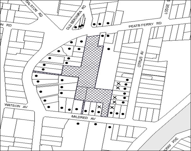
|
NOTIFICATION PLAN |
|
||
|
• PROPERTIES NOTIFIED
|
X SUBMISSIONS RECEIVED |
PROPERTY SUBJECT OF DEVELOPMENT |
|
Six submissions objected to the development, generally on the following grounds that the development would result in:
· Contrary to strategy and exceeds key design principles for the Mildred Avenue, Hornsby Precinct;
· Excessive height and number of storeys proposed;
· Not consistent with desired future character of the area;
· Bulk and scale and visual impact of the development;
· Privacy and overshadowing impacts on adjoining properties;
· Increased traffic along the existing access way from Mildred Avenue;
· Potential drainage and stormwater run-off impacts; and
· Potential impacts with mowing narrow grass area when boundary fence is erected.
The merits of the matters raised in community submissions have been addressed in the body of the report with the exception of the following:
5.1.1 The Development is Contrary to the Strategy and Exceeds Key Design Principles for the Mildred Avenue, Hornsby Precinct
The Key Development Principles Diagram for the Mildred Avenue, Hornsby Precinct is contained with Part 3.2 of the HDCP which provides controls for the erection of medium density housing in the R3 zone. As the proposal is for Seniors Housing, this Part of the DCP does not apply. Notwithstanding, the proposed development has applied a number of the key development principles including providing broad setbacks to rear boundaries; surrounding and screening the new buildings with canopy trees and shrubs; the development has provided access from Mildred Avenue and employs setbacks and building forms that retain reasonable sunlight and privacy to adjoining development.
Accordingly it is considered that the proposed development generally meets the key development principles for the Mildred Avenue, Hornsby Precinct.
5.1.2 Not Consistent with Desired Future Character of the Area
Discussion on the desired future character of the R3 Medium Density Residential zone is provided in Section 2.9.2 of this report.
5.1.3 Bulk and Scale and Visual Impact of the Development
The bulk and scale of the building including the detailing is consistent with the desired future character of the locality for medium density residential development as opposed to an institutional structure. The buildings are articulated with variable setbacks and sit within a landscape setting with the landscape maturing to a height in excess of the built form.
5.1.4 Increased Traffic Along the Existing Access Way from Mildred Avenue
One of the submissions received raised concerns that the proposed development would generate heavy traffic through a driveway next to their house.
Council’s traffic assessment concluded that traffic generation is not considered to be an issue with the proposed development as the street (Mildred Avenue) will continue to operate within the 300 vehicles per hour environmental capacity. Furthermore, concerns that the new driveway created in Mildred Avenue may expose existing residents to traffic noise and light spillage along the side boundaries has been addressed by conditions of consent with respect to boundary fencing and landscaping to ensure that adjoining properties are not exposed to unacceptable levels of traffic noise and spill lighting from vehicles parked in spaces provided in the driveway along the side boundary of existing homes.
5.1.5 Potential Impacts with Mowing Narrow Grass Area When Boundary Fence is Erected
This would be a civil matter to be negotiated with the adjoining land owners.
5.2 Public Agencies
The development application was not referred to any Public Agencies for comment.
6. THE PUBLIC INTEREST
Section 79C(1)(e) of the Act requires Council to consider “the public interest”.
The public interest is an overarching requirement, which includes the consideration of the matters discussed in this report. Implicit to the public interest is the achievement of future built outcomes adequately responding to and respecting the future desired outcomes expressed in environmental planning instruments and development control plans.
The application is considered to have satisfactorily addressed Council’s criteria and would provide a development outcome that, on balance, would result in a positive impact for the community. Accordingly, it is considered that the approval of the proposed development would be in the public interest.
CONCLUSION
The application proposes demolition of the existing structures and staged construction of a seniors living development comprising 26 self-contained dwellings, a multi-purpose centre and administrative offices with basement parking.
The use is permissible in the R3 zone pursuant to the HLEP and is permissible under SEPP HS&PD and generally complies with the objectives and controls contained in this Policy.
The proposal does not comply with Clause 4.3 Height of Buildings of the HLEP and an exception to the development standard pursuant to Clause 4.6 of the HLEP has been submitted to support the development and is considered well-founded.
The proposal is assessed as satisfactory with regard to the matters for consideration pursuant to Section 79C of Environmental Planning and Assessment Act 1979. Council received 6 submissions during the notification period and conditions of consent would ensure that the proposal does not adversely impact on the natural and built environment of the locality.
Having regard to the circumstances of the case, approval of the application is recommended.
Note: At the time of the completion of this planning report, no persons have made a Political Donations Disclosure Statement pursuant to Section 147 of the Environmental Planning and Assessment Act 1979 in respect of the subject planning application.
|
Rod Pickles Manager - Development Assessment Planning Division |
James Farrington Group Manager Planning Division |
|
1.View |
Locality Plan |
|
|
|
2.View |
Site Plan - Demolition Plan - Staging Plan |
|
|
|
3.View |
Floor and Roof Plans |
|
|
|
4.View |
Elevations and Sections |
|
|
|
5.View |
Shadow Diagrams |
|
|
|
6.View |
Landscape Plans |
|
|
|
7.View |
Schedule of Finishes |
|
|
File Reference: DA/373/2014
Document Number: D03483988
SCHEDULE 1
GENERAL CONDITIONS
The conditions of consent within this notice of determination have been applied to ensure that the use of the land and/or building is carried out in such a manner that is consistent with the aims and objectives of the relevant legislation, planning instruments and Council policies affecting the land and does not disrupt the amenity of the neighbourhood or impact upon the environment.
Note: For the purpose of this consent, the term ‘applicant’ means any person who has the authority to act on or the benefit of the development consent.
Note: For the purpose of this consent, any reference to an Act, Regulation, Australian Standard or publication by a public authority shall be taken to mean the gazetted Act or Regulation, or adopted Australian Standard or publication as in force on the date that the application for a construction certificate is made.
CONDITIONS APPLICABLE TO ALL STAGES
1. Approved Plans and Supporting Documentation
The development must be carried out in accordance with the plans and documentation listed below and endorsed with Council’s stamp, except where amended by Council and/or other conditions of this consent:
Approved Architectural Plans prepared by dwp suters:
|
Plan No. |
Plan Title |
Issue |
Dated |
|
DA071 |
Existing/ Demolition Plan |
D |
10 September 2014 |
|
DA101 |
Proposed Site Plan |
J |
10 September 2014 |
|
DA161 |
Staging/ Key Plan |
C |
10 September 2014 |
|
DA201 |
B1_Basement |
F |
10 September 2014 |
|
DA202 |
B1_Ground Floor |
H |
10 September 2014 |
|
DA203 |
B1_Level 1 |
H |
10 September 2014 |
|
DA204 |
B1_Level 2 |
E |
10 September 2014 |
|
DA205 |
B1_Roof Plan |
F |
10 September 2014 |
|
DA206 |
B2_Basement |
F |
10 September 2014 |
|
DA207 |
B2_Ground Floor |
J |
10 September 2014 |
|
DA208 |
B2_Level 1 |
G |
10 September 2014 |
|
DA209 |
B2_Level 2 |
F |
10 September 2014 |
|
DA210 |
B2_Roof Plan |
E |
10 September 2014 |
|
DA211 |
Typical Bedrooms |
D |
10 September 2014 |
|
DA212 |
Typical Bedrooms |
E |
10 September 2014 |
|
DA402 |
Building 1 South & East Elevations |
F |
10 September 2014 |
|
DA403 |
Building 1 North & West Elevations |
F |
10 September 2014 |
|
DA404 |
Building 2 North & East Elevations |
F |
10 September 2014 |
|
DA405 |
Building 2 South & West Elevations |
F |
10 September 2014 |
|
DA501 |
Building 1 Sections |
D |
10 September 2014 |
|
DA502 |
Building 2 Sections |
D |
10 September 2014 |
Approved Landscape Plans prepared by Site Image Landscape Architects:
|
Plan No. |
Plan Title |
Issue |
Dated |
|
C100 |
Landscape Masterplan |
B |
2 April 2014 |
|
C101 |
Landscape Plan |
B |
2 April 2014 |
|
C102 |
Landscape Plan |
B |
2 April 2014 |
|
000 |
Cover Sheet |
D |
2 April 2014 |
|
101 |
Landscape Plan |
D |
2 April 2014 |
|
102 |
Landscape Plan |
D |
2 April 2014 |
|
501 |
Details |
A |
2 April 2014 |
Supporting Documentation:
|
Document Title |
Prepared by |
Dated |
|
Detailed Survey Ref No. 17982, Sheets 1 and 7-10 of 10 |
Bee & Lethbridge |
January 2014 |
|
Stormwater Layout Plan Sheet C10 Rev.3 |
Opus |
2 April 2014 |
|
Stormwater OSD Calculations |
Opus |
9 April 2014 |
|
Concept Sediment Control Plan |
Opus |
9 April 2014 |
|
Traffic and Parking Impact Assessment Project No.:1350 |
Ray Dowsett Traffic and Transport Planning P/L |
27 March 2014 |
|
Disability Access Report Ref: 1354 |
Lindsay Perry Access + Architecture |
3 April 2014 |
|
Waste Management Plan |
CPS |
11 April 2014 |
|
Schedule of Finishes (3D Perspectives) Dwg No. DA001 Issue D |
dwp suters |
10 April 2014 |
|
Arboricultural Impact Assessment Report |
Aboreport |
4 April 2014 |
|
BASIX Certificated No. 541293M |
Sustainable Thermal Solutions |
10 April 2014 |
|
ABSA Energy Certificate No. 14570085 |
Bruce Carr |
10 April 2014 |
2. Construction Certificate
A Construction Certificate is required to be approved by Council or a Private Certifying Authority prior to the commencement of any works under this consent.
3. Section 94 Development Contributions
In accordance with Section 80A(1) of the Environmental Planning and Assessment Act 1979 and the Hornsby Shire Council Section 94 Development Contributions Plan 2012-2021, the following monetary contributions shall be paid to Council to cater for the increased demand for community infrastructure resulting from the development:
|
Description |
Contribution (4) |
|
Roads |
$7,019.00 |
|
Open Space and Recreation |
$242,371.55 |
|
Community Facilities |
$33,778.90 |
|
Plan Preparation and Administration |
$1,008.95 |
|
TOTAL |
$284,178.40 |
being for 26 units and 2 credits.
a) The value of this contribution is current as at 16 September 2014. If the contributions are not paid within the financial quarter that this condition was generated, the contributions payable will be adjusted in accordance with the provisions of the Hornsby Shire Council Section 94 Development Contributions Plan and the amount payable will be calculated at the time of payment in the following manner:
$CPY = $CDC x CPIPY
CPIDC
Where:
$CPY is the amount of the contribution at the date of Payment
$CDC is the amount of the contribution as set out in this Development Consent
CPIPY is the latest release of the Consumer Price Index (Sydney – All Groups) at the date of Payment as published by the ABS.
CPIDC is the Consumer Price Index (Sydney – All Groups) for the financial quarter at the date applicable in this Development Consent Condition.
b) The monetary contributions shall be paid to Council:
i) prior to the issue of the Subdivision Certificate where the development is for subdivision; or
ii) prior to the issue of the first Construction Certificate where the development is for building work; or
iii) prior to issue of the Subdivision Certificate or first Construction Certificate, whichever occurs first, where the development involves both subdivision and building work; or
iv) prior to the works commencing where the development does not require a Construction Certificate or Subdivision Certificate.
It is the professional responsibility of the Principal Certifying Authority to ensure that the monetary contributions have been paid to Council in accordance with the above timeframes.
Council’s Development Contributions Plan may be viewed at www.hornsby.nsw.gov.au or a copy may be inspected at Council’s Administration Centre during normal business hours.
4. Removal of Existing Trees
This development consent only permits the removal of tree number 6 as identified on Part 9 Tree Location Plan of the Aboricultural Impact Report prepared by Andrew Morrison (Aboreport) dated 4 April 2014. The removal of any other trees requires separate approval in accordance with the Tree and Vegetation Chapter 1B.6 Hornsby Development Control Plan (HDCP).
REQUIREMENTS PRIOR TO THE ISSUE OF A CONSTRUCTION CERTIFICATE
5. Building Code of Australia
All building work must be carried out in accordance with the relevant requirements of the Building Code of Australia.
6. Contract of Insurance (Residential Building Work)
In the case of residential building work for which the Home Building Act 1989 requires there to be a contract of insurance in force in accordance with Part 6 of that Act, that such a contract of insurance is in force before any building work authorised to be carried out by the consent commences.
7. Notification of Home Building Act, 1989 Requirements
Residential building work within the meaning of the Home Building Act 1989 must not be carried out unless the principal certifying authority for the development to which the work relates (not being Council) has given Council written notice of the following information:
a) In the case of work for which a principal contractor is required to be appointed:
i) The name and licence number of the principal contractor; and
ii) The name of the insurer by which the work is insured under Part 6 of that Act.
b) In the case of work to be done by an owner-builder:
i) The name of the owner-builder; and
ii) If the owner-builder is required to hold an owner-builder’s permit under that Act, the number of the owner-builder’s permit.
Note: If arrangements for doing the residential building work are changed while the work is in progress so that the information notified becomes out of date, further work must not be carried out unless the principal certifying authority for the development to which the work relates (not being Council) has given Council written notification of the updated information.
8. Utility Services
The applicant must submit written evidence of the following service provider requirements:
a) Ausgrid (formerly Energy Australia) - a letter of consent demonstrating that satisfactory arrangements have been made to service the proposed development.
b) Telstra – a letter of consent demonstrating that satisfactory arrangements have been made to service the proposed development.
9. Sydney Water – Quick Check
This application must be submitted to a Sydney Water ‘Quick Check Agent’ or ‘Customer Centre’ for approval to determine whether the development would affect any Sydney Water infrastructure, and whether further requirements are to be met.
Note: Refer to www.sydneywater.com.au or telephone 13 20 92 for assistance.
10. Dilapidation Report
A ‘Dilapidation Report’ is to be prepared by a ‘chartered structural engineer’ detailing the structural condition of all adjoining properties.
11. Car Parking Design
a) All car parking must be designed and constructed in accordance with Australian Standard AS 2890.1 – 2004 – Off Street Car Parking and Australian Standard 2890.2 - 2002 – Off Street Commercial; and:
b) All parking spaces for people with disabilities must be designed and constructed in accordance with Australian Standard AS/NZS 2890.6:2009 – Off-street parking for people with disabilities.
12. Construction Traffic Management Plan
A Construction Traffic Management Plan prepared by an accredited RMS red card or orange card holder, detailing construction vehicle routes, number of trucks, hours of operation, access arrangements and traffic control should be submitted to Council prior to the issue of a construction certificate.
REQUIREMENTS PRIOR TO THE COMMENCEMENT OF ANY WORKS
13. Erection of Construction Sign
A sign must be erected in a prominent position on any site on which building work, subdivision work or demolition work is being carried out:
a) Showing the name, address and telephone number of the principal certifying authority for the work;
b) Showing the name of the principal contractor (if any) for any demolition or building work and a telephone number on which that person may be contacted outside working hours; and
c) Stating that unauthorised entry to the work site is prohibited.
Note: Any such sign is to be maintained while the building work, subdivision work or demolition work is being carried out, but must be removed when the work has been completed.
14. Protection of Adjoining Areas
A temporary hoarding, fence or awning must be erected between the work site and adjoining lands before the works begin and must be kept in place until after the completion of the works if the works:
a) Could cause a danger, obstruction or inconvenience to pedestrian or vehicular traffic.
b) Could cause damage to adjoining lands by falling objects.
c) Involve the enclosure of a public place or part of a public place.
Note: Notwithstanding the above, Council’s separate written approval is required prior to the erection of any structure or other obstruction on public land.
15. Toilet Facilities
Toilet facilities must be available or provided at the works site before works begin and must be maintained until the works are completed at a ratio of one toilet for every 20 persons employed at the site. Each toilet must:
a) be a standard flushing toilet connected to a public sewer; or
b) be a temporary chemical closet approved under the Local Government Act 1993; or
c) have an on-site effluent disposal system approved under the Local Government Act 1993.
16. Erosion and Sediment Control
Erosion and sediment control measures must be provided and maintained throughout the construction period in accordance with the manual ‘Soils and Construction 2004 (Bluebook)’, the approved plans, Council specifications and to the satisfaction of the principal certifying authority. The erosion and sediment control devices must remain in place until the site has been stabilised and revegetated.
Note: On the spot penalties up to $1,500 may be issued for any non-compliance with this requirement without any further notification or warning.
17. Tree Protection Barriers
Tree Protection Zones (TPZ) of trees 1, 2, 3, 4, 5, 7 and 8 proposed for retention shall be fenced in accordance with AS 4970-2009 and as advised by the appointed project Arborist. The fencing must be constructed of 1.8 metre ‘cyclone chainmesh fence’ and will assist in ensuring that no excavation, filling or stockpiling of building materials, parking of vehicles or plant, disposal of cement slurry, waste water or other contaminants is to occur within the TPZ of any tree and adjoining bushland to be retained.
A certificate from the project Arborist (AQF 5) is to be submitted to the Principal Certifying Authority stating that all tree protection measures are in accordance with AS 4970-2009 (Section 4) prior to commencement of works.
REQUIREMENTS DURING CONSTRUCTION
18. Construction Work Hours
All work on site (including demolition and earth works) must only occur between 7am and 5pm Monday to Saturday. No work is to be undertaken on Sundays or public holidays.
19. Demolition
All demolition work must be carried out in accordance with “Australian Standard 2601-2001 – The Demolition of Structures” and the following requirements:
a) Demolition material must be disposed of to an authorised recycling and/or waste disposal site and/or in accordance with an approved waste management plan;
b) Demolition works, where asbestos material is being removed, must be undertaken by a contractor that holds an appropriate licence issued by WorkCover NSW in accordance with Chapter 10 of the Occupational Health and Safety Regulation 2001 and Clause 29 of the Protection of the Environment Operations (Waste) Regulation 2005 ;and
c) On construction sites where buildings contain asbestos material, a standard commercially manufactured sign containing the words ‘DANGER ASBESTOS REMOVAL IN PROGRESS’ measuring not less than 400mm x 300mm must be erected in a prominent position visible from the street.
20. Environmental Management
The site must be managed in accordance with the publication ‘Managing Urban Stormwater – Landcom (March 2004) and the Protection of the Environment Operations Act 1997 by way of implementing appropriate measures to prevent sediment run-off, excessive dust, noise or odour emanating from the site during the construction of the development.
21. Works Near Trees
a) All required tree protection measures are to be maintained in accordance with AS 4970-2009 (Section.4) for the duration of the construction period.
b) Should the excavation of any underground services (i.e. drainage/sewer/stormwater) be approved within the specified TPZ of tree to be retained on the subject property or neighbouring property, excavation by hand ONLY shall be undertaken.
c) Excavation works near trees must be carried out under the supervision of the Project Arborist.
d) Tree sensitive construction techniques such as pier and beam construction and hand excavation is to be undertaken for all works within the TPZ’s of any tree to be retained. Tree Protection Fencing (as specific in Condition 17 above) must be maintained during the entire construction period.
e) Installation of the proposed driveway on the Mildred street frontage is to be laid on existing grade to minimise the impacts to tree 1.
f) Installation of proposed paving adjacent to Tree 3 is to be above grade to reduce impacts to the tree.
g) All machinery to be cleaned of soil and debris before entering the site to prevent the spread of weeds and fungal pathogens.
Note: Except as provided above, the applicant is to ensure that no excavation, filling or stockpiling of building materials, parking of vehicles or plant, disposal of cement slurry, waste water or other contaminants is to occur within 4 metres of any tree to be retained.
22. Construction Work Zones
All construction vehicles associated with the proposed development are to be contained on site as no construction zones will be permitted on Peats Ferry Road or Mildred Avenue in the vicinity of the site.
23. Disturbance of Existing Site
During construction works, the existing ground levels of open space areas and natural landscape features, (including natural rock-outcrops, vegetation, soil and watercourses) must not be altered unless otherwise nominated on the approved plans.
24. Council Property
During construction works, no building materials, waste, machinery or related matter is to be stored on the road or footpath. The public reserve must be kept in a clean, tidy and safe condition at all times.
Note: This consent does not give right of access to the site via Council’s park or reserve. Should such access be required, separate written approval is to be obtained from Council.
25. Excavated Material
All excavated material removed from the site must be classified in accordance with the Department of Environment, Climate Change and Water NSW Waste Classification Guidelines prior to disposal to an approved waste management facility and reported to the principal certifying authority.
26. Survey Report – Finished Floor Level
A report(s) must be prepared by a registered surveyor and submitted to the principal certifying authority prior to the pouring of concrete at each level of the building certifying that:
a) The building, retaining walls and the like have been correctly positioned on the site; and
b) The finished floor level(s) are in accordance with the approved plans.
27. Waste Management
Waste management during the demolition and construction phase of the development must be undertaken in accordance with the approved Waste Management Plans.
Additionally written records of the following items must be maintained during the removal of any waste from the site and such information submitted to the Principal Certifying Authority within fourteen days of the date of completion of the works:
a) The identity of the person removing the waste.
b) The waste carrier vehicle registration.
c) Date and time of waste collection.
d) A description of the waste (type of waste and estimated quantity).
e) Details of the site to which the waste is to be taken.
f) The corresponding tip docket/receipt from the site to which the waste is transferred (noting date and time of delivery, description (type and quantity) of waste).
g) Whether the waste is expected to be reused, recycled or go to landfill.
Note: In accordance with the Protection of the Environment Operations Act 1997, the definition of waste includes any unwanted substance, regardless of whether it is reused, recycled or disposed to landfill.
REQUIREMENTS PRIOR TO THE ISSUE OF AN OCCUPATION CERTIFICATE
Note: For the purpose of this consent, a reference to ‘occupation certificate’ shall not be taken to mean an ‘interim occupation certificate’ unless otherwise stated.
28. Fulfilment of BASIX Commitments
The applicant must demonstrate the fulfilment of BASIX commitments pertaining to the development.
29. Safety and Security
a) Fire exit doors to the development must be fitted with single cylinder locksets (Australia and New Zealand Standard – Lock Sets) to restrict unauthorized access to the development.
b) Ground floor windows must be fitted with window locks that can be locked with a key.
c) A graffiti management plan must be incorporated into the maintenance plan for the development for graffiti to be removed within a forty-eight hour period.
d) The basement car park entry must be secured by security gates/roller shutters and controlled by secure access. The access control to include an audio/visual intercom system to allow visitor access to the parking area where required.
e) Lighting of pedestrian pathways throughout the development must comply with AS 1158.1 – Pedestrian.
f) Sign posting and way finding to be colour coded with the respective unit block in clear legible signage so that emergency services are able to clearly identify location of a unit and location of the unit block entry.
g) Lobby access to be controlled by security card or similar.
30. Stormwater Drainage
The stormwater drainage system for the development must be designed and constructed in accordance with Council’s Civil Works – Design and Construction Specification 2005 and the following requirements:
a) Connected to an existing Council piped drainage system in Mildred Avenue.
31. Damage to Council Assets
Any damage caused to Council’s assets as a result of the construction of the development must be rectified in accordance with Council’s Civil Works Specifications. Council’s Restorations Supervision must be notified for a formwork inspection prior to pouring concrete.
32. Works as Executed Plan
A works-as-executed plan(s) must be prepared by a registered surveyor and submitted to Council for completed road pavement, kerb & gutter, public drainage systems, driveways and on-site detention system.
33. Garbage Collection Easement
For the purpose of waste collection, an easement entitling Council, its servants and agents and persons authorised by it to enter upon the subject land and to operate thereon, vehicles and other equipment for the purposes of garbage collection must be granted to Council by the owner of the land.
Note: The easement must be in a form prescribed by Council and must include covenants to the effect that parties will not be liable for any damage caused to the subject land or any part thereof or to any property located therein or thereon by reason of the operation thereon of any vehicle or other equipment used in connection with the collection of garbage and to the effect that the owner for the time being of the subject land shall indemnify the Council, its servants, agents and persons authorised by it to collect garbage against liability in respect of any such claims made by any person whomsoever.
34. Maintain Canopy Cover
All planting within the consented Development Area at the front and rear of the site shall be completed in accordance with the approved Landscape Plan.
A certificate must be provided by a practicing landscape architect, horticulturalist or person with similar qualifications and experience certifying that all required landscaping works have been satisfactorily completed in accordance with the approved landscape plans.
Note: Advice on suitable species for landscaping can be obtained from Council’s planting guide ‘Indigenous Plants for the Bushland Shire’, available at www.hornsby.nsw.gov.au.
35. Completion of Landscaping
A certificate must be provided by a practicing landscape architect, horticulturalist or person with similar qualifications and experience certifying that all required landscaping works have been satisfactorily completed in accordance with the approved landscape plans.
Note: Advice on suitable species for landscaping can be obtained from Council’s planting guide ‘Indigenous Plants for the Bushland Shire’, available at www.hornsby.nsw.gov.au.
36. Boundary Fencing
Fencing must be erected along all property boundaries behind the front building alignment to a height of 1.8 metres.
Note: Alternative fencing may be erected subject to the written consent of the adjoining property owner(s).
37. Restriction on Occupation – Housing for Seniors or People with a Disability
A restriction as to user must be created under s88B of the Conveyancing Act 1919 and registered, requiring the dwellings approved under this consent to be solely used for the accommodation of:
a) Seniors (55+ age) or people with a disability.
b) People who live within the same household as seniors or people with a disability.
c) Staff employed to assist the administration and provision of services to housing provided under SEPP (Housing for Seniors or People with a Disability) 2004.
Note: The restriction must nominate Council as the authority to release, vary or modify the restriction.
38. Retaining Walls
All required retaining walls must be constructed as part of the development.
39. External Lighting
All external lighting must be designed and installed in accordance with Australian Standard AS 4282 – Control of the Obtrusive Effects of Outdoor Lighting. Certification of compliance with the Standard must be obtained from a suitably qualified person.
40. Unit Numbering
The allocation of unit numbering must be authorised by Council prior to the numbering of each unit in the development.
41. Provision for National Broadband Network (NBN)
Provision must be made for fibre ready passive infrastructure (pits and pipes) generally in accordance with NBN Co's pit and pipe installation guidelines to service the proposed development. A certificate from NBN Co or Telstra must be submitted to the PCA that the fibre optic cabling provided for the development complies with MDU Building Design Guides for Development.
OPERATIONAL CONDITIONS
42. Noise – Plant and Machinery
The level of total continuous noise emanating from operation of all the plant, including air conditioning units and processes in all buildings (LA10) (measured for at least 15 minutes) in or on the above premises, must not exceed the background level by more than 5dB(A) when measured at all property boundaries.
43. Fire Safety Statement - Annual
On at least one occasion in every 12 month period following the date of the first ‘Fire Safety Certificate’ issued for the property, the owner must provide Council with an annual ‘Fire Safety Certificate’ to each essential service installed in the building.
44. Car Parking
All car parking must be operated in accordance with Australian Standard AS/NZS 2890.1:2004 – Off-street car parking and Australian Standard AS 2890.2:2002 – Off-street commercial vehicle facilities and the following requirements:
a) All parking areas and driveways are to be sealed to an all weather standard, line marked and signposted;
b) Car parking, loading and manoeuvring areas to be used solely for nominated purposes;
c) Vehicles awaiting loading, unloading or servicing shall be parked on site and not on adjacent or nearby public roads;
d) All vehicular entry on to the site and egress from the site shall be made in a forward direction.
45. Parking for People with Disabilities
All parking spaces for people with disabilities must be constructed and operated in accordance with Australian Standard AS/NZS 2890.6:2009 – Off-street parking for people with disabilities.
46. Sight Lines
Any proposed landscaping and/or fencing must not restrict sight distance to pedestrians and cyclists travelling along the footpath.
47. Pedestrian/ Mobility Vehicle Link
The connecting link road is to be used by pedestrians and a mobility vehicle. The internal link access way shall not be used by cars or trucks. A gate should be installed to control legitimate use by the on-site ‘golf cart’.
48. Landscape Establishment
The landscape works must be maintained into the future to ensure the establishment and successful growth of plant material to meet the intent of the landscape design. This must include but not be limited to watering, weeding, replacement of failed plant material and promoting the growth of plants through standard industry practices.
ADDITIONAL CONDITIONS APPLICABLE TO STAGE 1
REQUIREMENTS PRIOR TO THE ISSUE OF AN OCCUPATION CERTIFICATE
Note: For the purpose of this consent, a reference to ‘occupation certificate’ shall not be taken to mean an ‘interim occupation certificate’ unless otherwise stated.
49. Consolidation of Allotments
All allotments the subject of this consent must be consolidated into one allotment.
Note: The applicant is recommended to submit the plan of subdivision to consolidate allotments to the NSW Department of Lands at least 4-6 weeks prior to seeking an occupation certificate.
50. On-Site Stormwater Detention
An on-site stormwater detention system must be designed by a chartered civil engineer and constructed in accordance with the following requirements:
a) Have a capacity of not less than 45 cubic metres, and a maximum discharge (when full) of 171 litres per second.
b) Have a surcharge/inspection grate located directly above the outlet.
c) Discharge from the detention system to be controlled via 1 metre length of pipe, not less than 50 millimetres diameter or via a stainless plate with sharply drilled orifice bolted over the face of the outlet discharging into a larger diameter pipe capable of carrying the design flow to an approved Council system.
d) Not be constructed in a location that would impact upon the visual or recreational amenity of residents.
51. Internal Driveway/ Vehicular Access
The driveway and parking areas on site must be designed in accordance with Australian Standards 2890.1, 2890.2, 3727 and the following requirements:
a) Design levels at the front boundary must be obtained from Council;
b) The driveway must be a rigid pavement;
52. Vehicular Crossing
A separate application under the Local Government Act 1993 and the Roads Act 1993 must be submitted to Council for the installation of a new vehicular crossing and the removal of the redundant crossing. The vehicular crossing must be constructed in accordance with Council’s Civil Works Design 2005 and the following requirements:
a) The footway area must be restored by turfing.
Note: An application for a vehicular crossing can only be made to one of Council’s Authorised Vehicular Crossing Contractors. You are advised to contact Council on 02 9847 6940 to obtain a list of contractors.
53. Traffic Control Plan
A Traffic Control Plan (TCP) must be prepared by a qualified traffic controller in accordance with the Roads & Traffic Authority’s Traffic Control at Worksites Manual 1998 and Australian Standard 1742.3 for all work on a public road and be submitted to Council. The TCP must detail the following:
a) Arrangements for public notification of the works.
b) Temporary construction signage.
c) Permanent post-construction signage.
d) Vehicle movement plans.
e) Traffic management plans.
f) Pedestrian and cyclist access/safety.
54. Creation of Easements
The following matter(s) must be nominated on the plan of subdivision under s88B of the Conveyancing Act 1919:
a) The creation of an appropriate "Positive Covenant" and "Restriction as to User" over the constructed on-site detention/retention systems and outlet works, within the lots in favour of Council in accordance with Council’s prescribed wording. The position of the on-site detention system is to be clearly indicated on the title.
b) To register the OSD easement, the restriction on the use of land “works-as-executed” details of the on-site-detention system must be submitted verifying that the required storage and discharge rates have been constructed in accordance with the design requirements. The details must show the invert levels of the on site system together with pipe sizes and grades. Any variations to the approved plans must be shown in red on the “works-as-executed” plan and supported by calculations.
Note: Council must be nominated as the authority to release, vary or modify any easement, restriction or covenant.
55. Works as Executed Plan
A works-as-executed plan(s) must be prepared by a registered surveyor and submitted to Council for completed road pavement, kerb & gutter, public drainage systems, driveways and on-site detention system.
ADDITIONAL CONDITIONS APPLICABLE TO STAGE 2
REQUIREMENTS PRIOR TO THE ISSUE OF AN OCCUPATION
Note: For the purpose of this consent, a reference to ‘occupation certificate’ shall not be taken to mean an ‘interim occupation certificate’ unless otherwise stated.
56. Food Premises
The fit out and operation of that part of the building to be used for the manufacture, preparation or storage of food for sale, must be in accordance with Australian Standard 4674-2004 – Design and fit out of food premises, the Food Act 2003, and the Food Regulation 20010 and the Food Standards Code developed by Food Standards Australia New Zealand. Food Standards 3.3.1. 3.2.2 and 3.2.3 are mandatory for all food businesses.
Note: Walls are to be of solid construction.
57. Kitchen Exhaust Installation
A kitchen exhaust system must be designed and installed to effectively prevent air pollution in accordance with the Protection of the Environment Operations Act 1997.
- END OF CONDITIONS -
ADVISORY NOTES
The following information is provided for your assistance to ensure compliance with the Environmental Planning and Assessment Act 1979, Environmental Planning and Assessment Regulation 2000, other relevant legislation and Council’s policies and specifications. This information does not form part of the conditions of development consent pursuant to Section 80A of the Act.
Environmental Planning and Assessment Act 1979 Requirements
The Environmental Planning and Assessment Act 1979 requires:
· The issue of a construction certificate prior to the commencement of any works. Enquiries can be made to Council’s Customer Services Branch on 9847 6760.
· A principal certifying authority to be nominated and Council notified of that appointment prior to the commencement of any works.
· Council to be given at least two days written notice prior to the commencement of any works.
· Mandatory inspections of nominated stages of the construction inspected.
· An occupation certificate to be issued before occupying any building or commencing the use of the land.
Long Service Levy
In accordance with Section 34 of the Building and Construction Industry Long Service Payments Act 1986, a ‘Long Service Levy’ must be paid to the Long Service Payments Corporation or Hornsby Council.
Note: The rate of the Long Service Levy is 0.35% of the total cost of the work.
Note: Hornsby Council requires the payment of the Long Service Levy prior to the issue of a construction certificate.
Tree and Vegetation Preservation
In accordance with Clause 5.9 of the Hornsby Local Environmental Plan 2013 a person must not ringbark, cut down, top, lop, remove, injure or wilfully destroy any tree or other vegetation protected under the Hornsby Development Control Plan 2013 without the authority conferred by a development consent or a permit granted by Council.
Notes: A tree is defined as a long lived, woody perennial plant with one or relatively few main stems with the potential to grow to a height greater than three metres (3M). (HDCP 1B.6.1.c).
Tree protection measures and distances are determined using the Australian Standard AS 4970:2009, “Protection of Trees on Development Sites”.
Fines may be imposed for non-compliance with both the Hornsby Local Environmental Plan 2013 and the Hornsby Development Control Plan 2013.
Disability Discrimination Act
The applicant’s attention is drawn to the existence of the Disability Discrimination Act. A construction certificate is required to be obtained for the proposed building/s, which will provide consideration under the Building Code of Australia, however, the development may not comply with the requirements of the Disability Discrimination Act. This is the sole responsibility of the applicant.
Covenants
The land upon which the subject building is to be constructed may be affected by restrictive covenants. Council issues this approval without enquiry as to whether any restrictive covenant affecting the land would be breached by the construction of the building, the subject of this consent. Applicants must rely on their own enquiries as to whether or not the building breaches any such covenant.
Dial Before You Dig
Prior to commencing any works, the applicant is encouraged to contact Dial Before You Dig on 1100 or www.dialbeforeyoudig.com.au for free information on potential underground pipes and cables within the vicinity of the development site.
Telecommunications Act 1997 (Commonwealth)
If you are aware of any works or proposed works which may affect or impact on Telstra’s assets in any way, you are required to contact: Telstra’s Network Integrity Team on Phone Number 1800810443.
Asbestos Warning
Should asbestos or asbestos products be encountered during demolition or construction works, you are advised to seek advice and information prior to disturbing this material. It is recommended that a contractor holding an asbestos-handling permit (issued by WorkCover NSW) be engaged to manage the proper handling of this material. Further information regarding the safe handling and removal of asbestos can be found at:
Alternatively, telephone the WorkCover Asbestos and Demolition Team on 8260 5885.
Group Manager’s Report No. PL66/14
Planning Division
Date of Meeting: 8/10/2014
6 DEVELOPMENT APPLICATION - ALTERATIONS AND ADDITIONS - DWELLING-HOUSE - 4 CHERRYBROOK ROAD, WEST PENNANT HILLS
EXECUTIVE SUMMARY
|
DA No: |
DA/726/2014 (Lodged 2 July 2014) |
|
Description: |
Alterations and additions to a dwelling house involving a swimming pool and retaining wall |
|
Property: |
Lot 1011 DP 1134002, No. 4 Cherrybrook Road, West Pennant Hills |
|
Applicant: |
Priority Pools Pty Ltd |
|
Owner: |
Mr Benjamin Murray and Mrs Claudia Antunez |
|
Estimated Value: |
$35,200 |
|
Ward: |
C |
· The application involves alterations and additions to a dwelling house including a swimming pool and retaining wall.
· The proposal generally complies with the Hornsby Local Environment Plan 2013 and the Hornsby Development Control Plan 2013.
· No submissions have been received in respect of the application.
· A 2005 Council resolution requires that development applications for the property be reported to Council for determination.
· It is recommended that the application be approved.
|
THAT: 1. Development Application No. DA/726/2014 for alterations and additions to a dwelling house involving a swimming pool and retaining wall at Lot 1011 DP 1134002, No. 4 Cherrybrook Road, West Pennant Hills be approved subject to the conditions of consent detailed in Schedule 1 of Group Manager’s Report No. PL66/14. 2. That any future development applications for Nos. 4 and 4A Cherrybrook Road, West Pennant Hills no longer be required to be determined by Council where the proposal is within the delegations of Council officers to determine. |
BACKGROUND
On 21 December 2005 Report PLN/363/05 was considered by Council for DA/716/2005 involving the subdivision of one lot into two and demolition of an existing dwelling. Council resolved that:
“A. Development Application No. 716/05 for subdivision of one (1) lot into two (2) and demolition of an existing dwelling be approved in accordance with plans dated 21 September, 2005 (Document No. D000273513), subject to conditions.
B. Any future development applications for either block be determined by Council.
C. The drainage be maintained and kept on 4 Cherrybrook Road, West Pennant Hills”.
On 2 September 2009, DA/591/2009 was approved for the erection of a dwelling house.
On 26 March 2010, DA/591/2009/A was approved for the relocation of an air-conditioning unit.
The purpose of resolution C was to ensure that development of the sites following the subdivision was determined at a Council meeting in response to submissions received in relation to the subdivision. As both of the subject lots have since been developed, there is no longer a need for Council to determine applications for the site if the proposal is within Council officer’s delegation.
SITE
The 844.1m2 site is located on the eastern side of Cherrybrook Road West Pennant Hills. The site experiences a fall of 14.5% to the south and contains a two storey dwelling house.
The site is burdened by an easement for support 2.135 metres wide along the front boundary line.
The site is not located on bushfire prone or flood prone land.
The site is not a heritage listed item, in the vicinity of any heritage listed items or in a heritage conservation area.
PROPOSAL
The application proposes an in-ground swimming pool located on the northern side of the dwelling house and a stone retaining wall along the northern and western boundaries.
No trees would be removed or impacted by the development.
ASSESSMENT
The development application has been assessed having regard to the ‘Metropolitan Plan for Sydney 2031’, the ‘North Subregion (Draft) Subregional Strategy’ and the matters for consideration prescribed under Section 79C of the Environmental Planning and Assessment Act 1979 (the Act). The following issues have been identified for further consideration.
1. STRATEGIC CONTEXT
1.1 Metropolitan Plan for Sydney and (Draft) North Subregional Strategy
The (Draft) Metropolitan Strategy for Sydney 2031 is a broad framework to provide for Sydney’s growth to help plan for housing, employment, transport, infrastructure, the environment and open space. It outlines a vision for Sydney to 2031; the challenges faced, and the directions to follow to address these challenges and achieve the vision.
The North Subregion comprises Hornsby, Kuring-gai, Manly, Warringah and Pittwater Local Government Areas. The Draft North Subregional Strategy acted as a framework for Council in its preparation of the Hornsby Local Environmental Plan 2013.
Within the North Subregion, the Draft Metropolitan Strategy proposes:
· Population growth of 81,000 from the current 2011 baseline of 529,000
· Housing growth of 37,000 from the current 2011 baseline of 204,000
· Employment growth of 39,000 from the current 2011 baseline of 186,000
The proposed development would be consistent with the Metropolitan Plan for Sydney 2031.
2. STATUTORY CONTROLS
Section 79C(1)(a) requires Council to consider “any relevant environmental planning instruments, draft environmental planning instruments, development control plans, planning agreements and regulations”.
2.1 Hornsby Local Environmental Plan 2013
The subject land is zoned R2 (low density residential) under the Hornsby Local Environmental Plan 2013 (HLEP). The objectives of the R2 zone are:
(a) To provide for the housing needs of the community within a low density residential environment.
(b) To enable other land uses that provide facilities or services to meet the day to day needs of residents.
The proposed development is defined as ancillary to a dwelling house under the HLEP and is permissible in the zone with Council’s consent.
2.2 Sydney Regional Environmental Plan No. 20 – Hawkesbury – Nepean River
The site is located within the catchment of the Hawkesbury Nepean River. Part 2 of this Plan contains general planning considerations and strategies requiring Council to consider the impacts of development on water quality, aquaculture, recreation and tourism.
Subject to the implementation of sediment and erosion control measures and stormwater management to protect water quality, the proposal would comply with the requirements of the Policy.
2.3 Clause 74BA Environmental Planning and Assessment Act, 1979 - Purpose and Status of Development Control Plans
On 1 March 2013, the Environmental Planning and Assessment Act, 1979 was amended so that a DCP provision will have no effect if it has the practical effect of “preventing or unreasonably restricting development” that is otherwise permitted and complies with the development standards set out in relevant Local Environmental Plans and State Environmental Planning Policies.
The principal purpose of a development control plan is to provide guidance on the aims of any environmental planning instrument that applies to the development; facilitating development that is permissible under any such instrument; and achieving the objectives of land zones under any such instrument. The provisions of a development control plan made for that purpose are not statutory requirements.
2.4 State Environmental Planning Policy (Building Sustainability Index: BASIX) 2004
The application has been assessed against the requirements of State Environmental Planning Policy (Building Sustainability Index: BASIX) 2004. The proposal includes BASIX Certificate No. A192853 for the erection of a swimming pool and is considered to be satisfactory with respect to SEPP BASIX.
2.5 Hornsby Development Control Plan 2013
The proposed development has been assessed having regard to the relevant performance and prescriptive requirements within Hornsby Development Control Plan (HDCP). The following table sets out the proposal’s compliance with the prescriptive requirements of the Plan:
|
HDCP – Part 3.1 Dwelling Houses |
|||
|
Control |
Proposal |
Requirement |
Complies |
|
Site Area |
844.1m2 |
N/A |
N/A |
|
Site Coverage |
25% |
max 50% |
Yes |
|
Setbacks |
|
|
|
|
- front |
4m |
6m |
No |
|
- Side (North) |
1.5m |
900mm |
Yes |
|
Landscaped Area |
60% |
30% |
Yes |
As detailed in the above table, the proposed development does not comply with prescriptive requirements within the HDCP in respect to setbacks. The matter of non-compliance is detailed below, as well as a brief discussion on compliance with relevant performance requirements.
2.5.1 Easements and Restrictions
The site is burdened by an easement for support 2.135 metres wide along the front (western) boundary. The application proposes a stone retaining wall along the front boundary varying between 800 millimetres and 1.5 metres from the boundary. The retaining wall would be located within the easement for support varying between 600 millimetres and 2.6 metres in height.
Council’s engineering assessment concludes that there would be no detrimental impacts on the easement for support as a result of the construction of the retaining wall within the easement, subject to condition requiring that a Category C7 Accredited Engineer certify the structural stability of the retaining wall. A condition is also recommended requiring that a covenant be placed on the title that the owner is responsible for all maintenance, malfunction or non-operation of the structure, removing any liability from Council.
2.5.2 Setbacks
The desired outcomes of the Setbacks element of the HDCP are to encourage “setbacks that are compatible with adjacent development and complement the streetscape” and “setbacks that allow for canopy trees to be retained and planted along the front and rear property boundaries.”
The proposed swimming pool would be located to the north of the dwelling house within the front boundary setback of the site. The swimming pool would be setback 4 metres from the front boundary which does not comply with the minimum 6 metre front boundary setback prescriptive measure.
The proposed location of the swimming pool is the only available area to construct the swimming pool and would be consistent with the neighbouring property at No.6 Cherrybrook Road which has a swimming pool located in a similar position in relation to the dwelling house. The proposed non-compliance with the front setback requirement would be acceptable as the swimming pool would be located well below street level as the land has already been excavated to allow a flat open space area in this location.
The slope of the site results in a 2 metre fall from the northern portion of the proposed retaining wall to the southern portion of the retaining wall. The proposed height of the retaining wall changes with the slope of the site. At the high point of the site, the retaining wall is 2.4 metres, however due to existing excavation of the site only 400 millimetres would be visible from street level. At the low point of the site, the retaining wall falls 600 millimetres, the maximum height of the wall visible from the street would be 1.2 metres.
Section 3.1.3 of the HDCP prescribes that “within front setbacks, fences should not be higher than 1.2 metres”. Although the retaining wall is 2.4 metres at its highest point, the maximum height visible from the street level within the front setback would be 1.2 metres which complies with the prescriptive measure.
The HDCP also prescribes that “front fencing be constructed from predominantly lightweight materials” Although the application proposes the retaining wall to be stone, the material would be consistent with the contemporary architectural style of the dwelling house on site and surrounding development. A large portion of the retaining wall would be screened by existing vegetation which would soften the appearance. The proposed pool fencing would not be visible from the street.
The proposed setbacks of the development comply with the desired outcomes of the Setbacks element and are considered acceptable.
3. ENVIRONMENTAL IMPACTS
Section 79C(1)(b) of the Act requires Council to consider “the likely impacts of that development, including environmental impacts on both the natural and built environments, and social and economic impacts in the locality”.
3.1 Natural Environment
The proposal would not have any impacts on the natural environment as there is no tree removal required for the construction of the swimming pool or retaining wall. A standard condition is recommended regarding erosion and sediment control during construction.
3.2 Built Environment
The proposal would not have any detrimental impacts on the built environment as the proposed swimming pool and retaining walls would only be partially visible from the street to a maximum height of 1.2 metres. The proposed use of a stone retaining wall would be in keeping with the character of the street.
3.3 Social Impacts
The proposal would not have any social impacts.
3.4 Economic Impacts
The proposal would not have any economic impacts.
4. SITE SUITABILITY
Section 79C(1)(c) of the Act requires Council to consider “the suitability of the site for the development”.
The subject site has not been identified as bushfire prone or flood prone land. The site is considered to be capable of accommodating the proposed development. The scale of the proposed development is consistent with the capability of the site and is considered acceptable.
5. PUBLIC PARTICIPATION
Section 79C(1)(d) of the Act requires Council to consider “any submissions made in accordance with this Act”.
5.1 Community Consultation
The proposed development was placed on public exhibition and was notified to adjoining and nearby landowners between 9 and 23 July 2014 in accordance with the Hornsby Development Control Plan 2013. During this period, Council did not receive any submissions. The map below illustrates the location of those nearby landowners who were notified of the development.
|
NOTIFICATION PLAN |
|
||
|
• PROPERTIES NOTIFIED
|
X SUBMISSIONS RECEIVED |
PROPERTY SUBJECT OF DEVELOPMENT |
|
|
NO SUBMISSIONS RECEIVED |
|||
6. THE PUBLIC INTEREST
Section 79C(1)(e) of the Act requires Council to consider “the public interest”.
The public interest is an overarching requirement, which includes the consideration of the matters discussed in this report. Implicit to the public interest is the achievement of future built outcomes adequately responding to and respecting the future desired outcomes expressed in environmental planning instruments and development control plans.
The application is considered to have satisfactorily addressed Council’s and relevant agencies’ criteria and would provide a development outcome that, on balance, would result in a positive impact for the community. Accordingly, it is considered that the approval of the proposed development would be in the public interest.
CONCLUSION
The application proposes alterations and additions to a dwelling house involving the erection of a swimming pool and retaining wall.
The development generally meets the desired outcomes of Council’s planning controls and is satisfactory having regard to the matters for consideration under Section 79C of the Environmental Planning and Assessment Act, 1979.
Council did not receive and submissions during the public notification period.
Conditions are recommended to minimise disruption to residential amenity.
Note: At the time of the completion of this planning report, no persons have made a Political Donations Disclosure Statement pursuant to Section 147 of the Environmental Planning and Assessment Act 1979 in respect of the subject planning application.
|
Rod Pickles Manager - Development Assessment Planning Division |
James Farrington Group Manager Planning Division |
|
1.View |
Locality Plan |
|
|
|
2.View |
Site Plan |
|
|
|
3.View |
Engineering Plans |
|
|
|
4.View |
Retaining Wall Plan |
|
|
File Reference: DA/726/2014
Document Number: D03559039
SCHEDULE 1
GENERAL CONDITIONS
The conditions of consent within this notice of determination have been applied to ensure that the use of the land and/or building is carried out in such a manner that is consistent with the aims and objectives of the relevant legislation, planning instruments and council policies affecting the land and does not disrupt the amenity of the neighbourhood or impact upon the environment.
Note: For the purpose of this consent, the term ‘applicant’ means any person who has the authority to act on or the benefit of the development consent.
Note: For the purpose of this consent, any reference to an Act, Regulation, Australian Standard or publication by a public authority shall be taken to mean the gazetted Act or Regulation, or adopted Australian Standard or publication as in force on the date that the application for a construction certificate is made.
1. Approved Plans and Supporting Documentation
The development must be carried out in accordance with the plans and documentation listed below and endorsed with Council’s stamp, except where amended by Council and/or other conditions of this consent:
|
Plan No. |
Plan Title |
Drawn by |
Dated |
|
Job No. 1408 Drawing No. 1 |
Site Plan |
J.T. Davies & Co. Pty Ltd |
13.01.2014 |
|
Job No. 1408 Drawings 1-3 of 3 |
Plan, Details, Sections |
J.T. Davies & Co. Pty Ltd |
15.01.2014 |
|
Job No. 133412 Drawing S01 Rev A |
Retaining Wall Plan and Detail |
ODG Consulting Pty Ltd |
04.04.2014 |
|
Document No. |
Document Title |
Prepared by |
Dated |
|
A192853 |
BASIX Certificate |
Priority Pools Pty Ltd |
27.06.2014 |
2. Construction Certificate
A Construction Certificate is required to be approved by Council or a Private Certifying Authority prior to the commencement of any works under this consent.
REQUIREMENTS PRIOR TO THE ISSUE OF A CONSTRUCTION CERTIFICATE
3. Building Code of Australia
All building work must be carried out in accordance with the relevant requirements of the Building Code of Australia.
4. Contract of Insurance (Residential Building Work)
In the case of residential building work for which the Home Building Act 1989 requires there to be a contract of insurance in force in accordance with Part 6 of that Act, that such a contract of insurance is in force before any building work authorised to be carried out by the consent commences.
5. Notification of Home Building Act, 1989 Requirements
Residential building work within the meaning of the Home Building Act 1989 must not be carried out unless the principal certifying authority for the development to which the work relates (not being Council) has given Council written notice of the following information:
a) In the case of work for which a principal contractor is required to be appointed:
i) The name and licence number of the principal contractor; and
ii) The name of the insurer by which the work is insured under Part 6 of that Act.
b) In the case of work to be done by an owner-builder:
i) The name of the owner-builder; and
ii) If the owner-builder is required to hold an owner-builder’s permit under that Act, the number of the owner-builder’s permit.
Note: If arrangements for doing the residential building work are changed while the work is in progress so that the information notified becomes out of date, further work must not be carried out unless the principal certifying authority for the development to which the work relates (not being Council) has given Council written notification of the updated information.
6. Sydney Water – Quick Check
This application must be submitted to a Sydney Water ‘Quick Check Agent’ or ‘Customer Centre’ for approval to determine whether the development would affect any Sydney Water infrastructure, and whether further requirements are to be met.
Note: Refer to www.sydneywater.com.au or telephone 13 20 92 for assistance.
REQUIREMENTS PRIOR TO THE COMMENCEMENT OF ANY WORKS
7. Erection of Construction Sign
A sign must be erected in a prominent position on any site on which building work, subdivision work or demolition work is being carried out:
a) Showing the name, address and telephone number of the principal certifying authority for the work;
b) Showing the name of the principal contractor (if any) for any demolition or building work and a telephone number on which that person may be contacted outside working hours; and
c) Stating that unauthorised entry to the work site is prohibited.
Note: Any such sign is to be maintained while the building work, subdivision work or demolition work is being carried out, but must be removed when the work has been completed.
8. Toilet Facilities
Toilet facilities must be available or provided at the works site before works begin and must be maintained until the works are completed at a ratio of one toilet for every 20 persons employed at the site.
9. Erosion and Sediment Control
Erosion and sediment control measures must be provided and maintained throughout the construction period in accordance with the manual ‘Soils and Construction 2004 (Bluebook)’, the approved plans, Council specifications and to the satisfaction of the principal certifying authority. The erosion and sediment control devices must remain in place until the site has been stabilised and revegetated.
Note: On the spot penalties up to $1,500 may be issued for any non-compliance with this requirement without any further notification or warning.
REQUIREMENTS DURING CONSTRUCTION
10. Construction Work Hours
All work on site (including demolition and earth works) must only occur between 7am and 5pm Monday to Saturday. No work is to be undertaken on Sundays or public holidays.
11. Council Property
During construction works, no building materials, waste, machinery or related matter is to be stored on the road or footpath. The public reserve must be kept in a clean, tidy and safe condition at all times.
Note: This consent does not give right of access to the site via Council’s park or reserve. Should such access be required, separate written approval is to be obtained from Council.
12. Excavated Material
All excavated material removed from the site must be classified in accordance with the Department of Environment, Climate Change and Water NSW Waste Classification Guidelines prior to disposal to an approved waste management facility and reported to the principal certifying authority.
REQUIREMENTS PRIOR TO THE ISSUE OF AN OCCUPATION CERTIFICATE
Note: For the purpose of this consent, a reference to ‘occupation certificate’ shall not be taken to mean an ‘interim occupation certificate’ unless otherwise stated.
13. Stormwater Drainage – Dwellings
The stormwater drainage system for the development must be designed and constructed for an average recurrence interval of 20 years and be connected to an existing inter-allotment drainage system.
14. Fulfilment of BASIX Commitments
The applicant must demonstrate the fulfilment of BASIX commitments pertaining to the development.
15. Structural Certification
A Certificate prepared by a Category C7 Accredited Engineer (Structural Compliance), certifying that the proposed retaining wall within the “Easement For Support” has been constructed in accordance with the Structural Engineer’s design shall be submitted to Hornsby Shire Council.
16. Creation of Easements
Prior to release of the Occupation Certificate, the applicant shall make an application for “Execution of Legal Documents” to Hornsby Shire Council for a “Positive Covenant” to be added to the title, which shall use Council’s standard terms and include the following:
a) The registered proprietor of the land shall be responsible for ongoing maintenance of all structures located in the Easement For Support, be responsible for the repair, reconstruction, battering, reinforcement and stabilisation of any part thereof due to decay or damage without delay so that all structures and Easement For Support land will function in a safe and efficient manner.
b) The registered proprietor shall indemnify and keep indemnified Hornsby Shire Council from and against all claims, demands, actions, suits, causes of actions, sum or sums of money, compensation, damages, costs and expenses which the Hornsby Shire Council or any other person may suffer as a result of any malfunction or non-operation of a structure or any part of Easement For Support land or any failure of the registered proprietor to comply with the terms of this Covenant.
17. Damage to Council Assets
Any damage caused to Council’s assets as a result of the construction of the development must be rectified in accordance with Council’s Civil Works Specifications. Council’s Restorations Supervision must be notified for a formwork inspection prior to pouring concrete.
OPERATIONAL CONDITIONS
18. Swimming Pool Requirements
The construction and operation of the swimming pool must comply with the provisions of the Swimming Pool Act 1992, the Swimming Pool Regulation 2008 Australian Standards 1926.1-3 – Swimming Pool Safety and the following requirements:
a) All waste water from the pool’s filtration system must be piped to Sydney Water’s sewer system. In the event that Sydney Water’s sewer system is not accessible, a filtration system that does not require backwashing must be installed; and
b) The filtration motor and pump, or spa heater and blower unit must be housed in a soundproofed structure. Sound from the equipment must not exceed 5(dBA) above ambient noise levels at any residential property boundary.
ADVISORY NOTES
The following information is provided for your assistance to ensure compliance with the Environmental Planning and Assessment Act, 1979, Environmental Planning and Assessment Regulation 2000, other relevant legislation and Council’s policies and specifications. This information does not form part of the conditions of development consent pursuant to Section 80a of the Act.
Environmental Planning and Assessment Act 1979 Requirements
The Environmental Planning and Assessment Act 1979 requires:
· The issue of a construction certificate prior to the commencement of any works. Enquiries can be made to Council’s Customer Services Branch on 9847 6760.
· A principal certifying authority to be nominated and Council notified of that appointment prior to the commencement of any works.
· Council to be given at least two days written notice prior to the commencement of any works.
· Mandatory inspections of nominated stages of the construction inspected.
· An occupation certificate to be issued before occupying any building or commencing the use of the land.
Long Service Levy
In accordance with Section 34 of the Building and Construction Industry Long Service Payments Act 1986, a ‘Long Service Levy’ must be paid to the Long Service Payments Corporation or Hornsby Council.
Note: The rate of the Long Service Levy is 0.35% of the total cost of the work.
Note: Hornsby Council requires the payment of the Long Service Levy prior to the issue of a construction certificate.
Tree and Vegetation Preservation
In accordance with Clause 5.9 of the Hornsby Local Environmental Plan 2013 a person must not ringbark, cut down, top, lop, remove, injure or wilfully destroy any tree or other vegetation protected under the Hornsby Development Control Plan 2013 without the authority conferred by a development consent or a permit granted by Council.
Notes: A tree is defined as a long lived, woody perennial plant with one or relatively few main stems with the potential to grow to a height greater than three metres (3M). (HDCP 1B.6.1.c).
Tree protection measures and distances are determined using the Australian Standard AS 4970:2009, “Protection of Trees on Development Sites”.
Fines may be imposed for non-compliance with both the Hornsby Local Environmental Plan 2013 and the Hornsby Development Control Plan 2013.
Dial Before You Dig
Prior to commencing any works, the applicant is encouraged to contact Dial Before You Dig on 1100 or www.dialbeforeyoudig.com.au for free information on potential underground pipes and cables within the vicinity of the development site.
Telecommunications Act 1997 (Commonwealth)
If you are aware of any works or proposed works which may affect or impact on Telstra’s assets in any way, you are required to contact: Telstra’s Network Integrity Team on Phone Number 1800810443.
Group Manager’s Report No. PL67/14
Planning Division
Date of Meeting: 8/10/2014
7 DEVELOPMENT APPLICATION - FIVE STOREY RESIDENTIAL FLAT BUILDINGS COMPRISING 90 UNITS - 16-20 PARK AVENUE, WAITARA
EXECUTIVE SUMMARY
|
DA No: |
DA/1001/2013 (Lodged 23 September 2013) |
|
Description: |
Demolition of existing structures and the erection of 4 x five storey residential flat buildings comprising 90 units with basement car parking |
|
Property: |
Lots 7, 8, 9 DP 6852 and Lot 10 DP 1003563, Nos. 16 – 20 Park Avenue, Waitara |
|
Applicant: |
Zhinar Architects |
|
Owner: |
Mr G and Mrs R Stoemer and Mr Cheng Xiang Lu and Mrs Cui Ping Wu |
|
Estimated Value: |
$19,674,176 |
|
Ward: |
B |
· The application proposes demolition of existing structures and the erection of 4 x five storey residential flat buildings comprising 90 units with basement car parking.
· The proposal generally complies with the Hornsby Shire Local Environmental Plan 1994, Hornsby Local Environmental Plan 2013, State Environmental Planning Policy No. 65 – Design Quality Residential Flat Building, Hornsby Shire Housing Strategy Development Control Plan and the Hornsby Development Control Plan 2013.
· The proposal does not comply with the height development standard under the HSLEP. A submission has been made in accordance with State Environmental Planning Policy No. 1 to vary the standard. The submission is well founded and is supported.
· Two submissions have been received in respect of the application.
· It is recommended that the application be approved.
|
THAT Council assume the concurrence of the Secretary of the Department of Planning and Environment pursuant to State Environmental Planning Policy No. 1 and approve Development Application No. DA/1001/2013 for demolition of existing structures and the erection of 4 x five storey residential flat buildings comprising 90 units with basement car parking at Nos. 16-20 Park Avenue, Waitara subject to the conditions of consent detailed in Schedule 1 of Group Manager’s Report No. PL67/14. |
BACKGROUND
The subject land was zoned from Residential A (Low Density) to Residential C (Medium-High Density) on 2 September 2011 as part of Council’s Housing Strategy.
SITE
The site is located on the eastern side of Park Avenue and north of Park Lane. The site is regular in shape with a total area of 3857m² and frontage of 55.17m to the street. The site comprises three rectangular shaped allotments with dwelling entitlements, known as Nos. 16, 18 and 20 Park Avenue and a narrow, 1m wide allotment known as Lot 10 DP 1003563. Lot 10 DP 1003563 is located on the northern side of the property and has an approximate area of 70m². The site has an average downward slope of 2% to the north western corner of the site on Park Avenue. The site adjoins a Council owned drainage easement known as Lot 1 DP 172597, No. 22X Park Avenue.
Existing improvements on the allotments include three dwelling-houses with associated garages and carports. Vehicular access to the site is gained via existing driveways fronting Park Avenue.
The allotments contain a number of exotic and locally indigenous trees. A significant group of trees exist along the southern property boundary. Five trees on the site form part of this group.
The site forms part of a precinct which is undergoing redevelopment. The surrounding developments include single and two storey residential developments. Development applications for five storey residential flat buildings have been approved on a number of sites within the Balmoral Street, Waitara Precinct including DA/1062/2013 at Nos. 35-39 Balmoral Street which is located to the north east of the site.
The site is located approximately 305m from Waitara Railway Station and approximately 1.2km to the south east of Hornsby Town Centre.
PROPOSAL
The proposal involves the demolition of existing structures within the site and construction of 4 x five storey residential flat buildings comprising 90 units with 1.5 levels of basement car parking.
The unit mix would comprise 28 x 1 bedroom, 54 x 2 bedroom, 8 x 3 bedroom units. The units would be accessed via a lift centrally located in each building and would include balconies fronting the street, rear and side property boundaries.
The development would be accessed from Park Avenue via a driveway located along the northern boundary of the site. A separate pedestrian entry centrally located at the front of the property would provide access to all levels from the foyers in all four buildings via a landscaped pathway. A total of 106 car parking spaces, including 14 visitors’ parking spaces are proposed in 1.5 basement levels.
A Council owned drainage lot (easement) with a brick culvert adjoins the northern property boundary. The easement runs along the northern property boundary which connects to the drainage system in Park Avenue. Upgrade works to the Council drainage line are proposed as part of the application. The site would drain to the front of the property via a below ground detention tank proposed adjacent to the driveway at the front of the site.
ASSESSMENT
The development application has been assessed having regard to the ‘Metropolitan Plan for Sydney 2031’, the ‘North Subregion (Draft) Subregional Strategy’ and the matters for consideration prescribed under Section 79C of the Environmental Planning and Assessment Act 1979 (the Act). The following issues have been identified for further consideration.
1. STRATEGIC CONTEXT
1.1 Metropolitan Plan for Sydney and (Draft) North Subregional Strategy
The (Draft) Metropolitan Strategy for Sydney 2031 is a broad framework to provide for Sydney’s growth to help plan for housing, employment, transport, infrastructure, the environment and open space. It outlines a vision for Sydney to 2031; the challenges faced, and the directions to follow to address these challenges and achieve the vision.
The North Subregion comprises Hornsby, Kuring-gai, Manly, Warringah and Pittwater Local Government Areas. The Draft North Subregional Strategy acts as a framework for Council in its preparation of the Comprehensive LEP by the end of 2013.
Within the North Subregion, the Draft Metropolitan Strategy proposes:
· Population growth of 81,000 from the current 2011 baseline of 529,000
· Housing growth of 37,000 from the current 2011 baseline of 204,000
· Employment growth of 39,000 from the current 2011 baseline of 186,000
The proposed development would be consistent with the Metropolitan Plan for Sydney 2031 by providing 87 additional dwellings and would contribute to housing choice in the locality.
2. STATUTORY CONTROLS
Section 79C(1)(a) requires Council to consider “any relevant environmental planning instruments, draft environmental planning instruments, development control plans, planning agreements and regulations”.
2.1 Hornsby Shire Local Environmental Plan 1994
The subject land is zoned Residential C (Medium/High Density) under the Hornsby Shire Local Environmental Plan 1994 (HSLEP). The objectives of the zone are:
(a) to provide for the housing needs of the population of the Hornsby area.
(b) to promote a variety of housing types and other land uses compatible with a medium to high density residential environment.
(c) to provide for development that is within the environmental capacity of a medium to high density residential environment.
The proposed development is defined as ‘multi-unit housing’ under the HSLEP and is permissible in the zone with Council’s consent.
Clause 15 of the HSLEP prescribes the maximum floor space ratio (FSR) of development within the Residential C zone. Subclause (5) of clause 15 states that “This clause does not apply to land shown edged heavy black on diagrams 1-8 in Schedule BB”. The site is identified in Diagram 4 of Schedule BB of the HSLEP. Therefore, clause 15 does not apply to the subject site.
Clause 15A of the HSLEP prescribes that the maximum building height within the area detailed under Schedule BB is not to exceed 17.5 metres. The proposed building has a maximum building height of 18.45m which does not comply with this requirement. A SEPP 1 Objection has been submitted with the application and is assessed under Section 2.3 of this report.
Clause 18 of the HSLEP prescribes that Council must take into consideration the likely effect of the proposed development on the heritage significance of a heritage item and its setting, and on the heritage significance of a heritage conservation area, archaeological site or potential archaeological site when determining an application for consent to carry out development on land in its vicinity.
The site is within the vicinity of a heritage listed item at No. 20X Waitara Avenue, Waitara (Waitara Park – Mark Taylor Oval) and Nos. 28-36 Balmoral Street (Gardens). Waitara Park is located on the western side of Park Avenue and is zoned for public recreation. The Gardens at Nos. 28-46 Balmoral Street are not within the Balmoral Street, Waitara Housing Strategy Precinct.
Council’s heritage assessment is that the proposal would not adversely affect the heritage significance or landscape setting of the nearby heritage items should it incorporate a suitable landscaped setting and comply with Hornsby Shire Council’s desired building form, sitting and design quality requirements for a 5 storey residential flat building. Accordingly, no objections are raised to the proposal on heritage grounds.
2.2 Hornsby Shire Local Environmental Plan 2013
The Hornsby Local Environmental Plan (DHLEP) was gazetted by the Minister of Planning on 11 October 2013. The HLEP includes a savings provision stating that if a development application is made and not finally determined before the commencement of the HLEP, the application must be determined as if the Plan had been exhibited but not commenced. Notwithstanding, the HLEP essentially reiterates the current land use zoning and height controls applicable to the site as outlined below.
2.2.1 Zoning
Under the HLEP, the subject land is zoned R4 (High Density Residential). The proposed development is defined as ‘residential flat buildings’ and is permissible within the zone with Council’s consent.
2.2.2 Height of Building
Clause 4.3 of the HLEP provides that the height of a building on any land is not to exceed the maximum height shown for the land on the Height of Buildings Map. The maximum permissible height for the subject site is 17.5 metres. The proposed development has a maximum building height of 18.45m which does not comply with this development standard.
The site is a flood affected lot due to the location of a Council drainage easement along the northern property boundary. In this regard, the floor levels are required to be elevated 500mm above the 1 in 100 year flood level to protect against flooding. The height of the lowest residential floor (RL 173.30) is in accordance with the minimum floor levels recommended in the flood study submitted with the application. As a result, the overall building heights exceed the height limit by 250mm to 996mm. This is addressed in a SEPP 1 Objection below.
2.3 State Environmental Planning Policy No. 1 – Development Standards
The application has been assessed against the requirements of State Environmental Planning Policy No. 1 – Development Standards (SEPP 1). This policy provides flexibility in the application of development standards in circumstances where strict compliance with those standards would, in particular case, be unreasonable or unnecessary or tend to hinder the attainment of the objectives of the Act.
The Land and Environment Court has expressed the view that there are five different ways in which an objection may be well founded and the approval of the objection may be consistent with the aims of the Policy as follows:
1. The objectives of the standard are achieved notwithstanding non-compliance with the standard;
2. The underlying objective or purpose of the standard is not relevant to the development and therefore compliance is unnecessary;
3. The underlying object of purpose would be defeated or thwarted if compliance was required and therefore compliance is unreasonable;
4. The development standard has been virtually abandoned or destroyed by the Council’s own actions in granting consents departing from the standard and hence compliance with the standard is unnecessary and unreasonable;
5. The zoning of the particular land is unreasonable or inappropriate so that a development standard appropriate for that zoning is also unreasonable and unnecessary, as it applies to the land and compliance with the standard would be unreasonable and unnecessary. That is, the particular parcel of land should not have been included in the particular zone.
The site is flood affected due to the location of a Council drainage easement along the northern property boundary. In this regard, the floor levels are required to be elevated 500mm above the 1 in 100 year flood level to protect against flooding. The topography of the land falls from the south eastern corner of the site to the north western corner of the site. The height of the lowest residential floor (RL 173.30) is in accordance with the minimum floor levels recommended in the flood study submitted with the application. As a result, the overall building heights exceed the height limit by 250mm to 996mm. More specifically, the buildings fronting Park Avenue exceed the 17.5m height restriction by 380mm (approximately 2.2%) for the south west building and 980mm (approximately 5.6%) for the north west building, the south western building fronting Park Lane exceeds the height limit by approximately 250mm (approximately 1.5%) and the northern elevations fronting the stormwater easement exceed the height restriction by 354mm (approximately 2%) for the north east building and 996mm (approximately 5.69%) for the north west building.
The applicant made a written submission in accordance with SEPP 1. The applicant submits the following:
‘The variations to the height controls are best described as minor and do not cast additional shadow to that of structures, which would comply with the maximum building height nor is the buildings bulk and scale of the affected buildings accentuated by the increase in height. Accordingly, it is considered that the impact upon the amenity of neighbours or future residents within the development will not be noticed. None of these structures are clearly visible from the street and as such the increased height will have no impact upon the streetscape or visual amenity of this neighbourhood…
…Provision of high density housing in the manner proposed will increase residential densities to better utilize the quality public amenities and services that this neighbourhood has to offer. Provision is made for a variety of unit sizes and types (1, 2 and 3 bedrooms and accessible units). The local road network and public infrastructure will be able to accommodate the proposed increased demand. Should demand upon local infrastructure require upgrading, standard conditions of consent will require the applicant to augment such services (i.e.: Section 73 Certificate, Section 94 Contributions, satisfaction of service providers for gas, electricity, telephone etc.)...
…Compliance with the development standard is deemed to be both unreasonable and unnecessary under the circumstances of the case because the departures sought do not generate any unreasonable impacts upon the built and natural environments. The variation does allow the site, which is constrained by overland flooding along its northern boundary to be developed in accordance with both the height and high density housing zone objectives. The proposal clearly demonstrates that the proposed minor increases in building height (i.e. mezzanine levels) do not increase amenity impacts such as overshadowing, view loss or excessive bulk and scale.
Notwithstanding the non-compliance with the planning control, the proposed increase in building height is minor in relation to the objective of the standard, it nevertheless satisfies the underlying intent of the control. ’
The objection to the strict application of the development standard is considered both unreasonable and unnecessary given that the proposal:
· Responds well to the topography of the land and flooding constraints along the northern side boundary with Council’s stormwater easement,
· Does not generate any additional amenity impacts as any additional shadow cast falls onto the proposed residential flat buildings’ roofs to that of a fully compliant 17.5m building height scheme,
· Would not impact upon the streetscape of the development as it is in keeping with the strategic character of new built form in this Housing Strategy Precinct,
· Promotes the orderly and economic development of land that is conducive to urban consolidation principles in built urban environments where they are close to quality public amenities and services, such as schools, shops, parks and public transport,
· The design is consistent with the underlying objectives of the building height development standard in that it seeks to encourage high density housing up to 17.5m in height,
· Does not increase the building footprint or the need to screen structures,
· The building bulk, scale, form and height will largely remain the same to that of a fully compliant building scheme with mezzanine levels,
· Satisfies the Land and Environment Court’s requirements for a well-founded objection to depart from a development standard,
· The change to the height control does not undermine the objects contained in Section 5 (a)(i) and (ii) of the Environmental Planning and Assessment Act 1979.
Compliance with the standard is therefore considered unreasonable, given the proposed development complies with all other DCP requirements (i.e. Site Requirements, Landscape Area, Private Open Space, Floor Plates and Articulation). It is considered to be within the environmental capacity of the high density residential zone and is considered minor.
For the reasons detailed in the applicant’s submission, it is considered that strict compliance with the minimum height is unnecessary and unreasonable and that the submitted SEPP No. 1 objection is supported in the circumstances of this case.
2.4 State Environmental Planning Policy No. 55 – Remediation of Land
State Environmental Planning Policy No. 55 (SEPP 55) requires that Council must not consent to the carrying out of any development on land unless it has considered whether the land is contaminated or requires remediation for the proposed use.
The site has been used for residential purposes and is unlikely to be contaminated. No further assessment is considered necessary in this regard.
2.5 State Environmental Planning Policy No. 65 – Design Quality of Residential Flat Development
The Policy provides for design principles to improve the design quality of residential flat development and for consistency in planning controls across the State.
The applicant has submitted a “Design Verification Statement” prepared by a qualified Architect stating how the proposed development achieves the design principles of SEPP 65. The design principles of SEPP 65 and the submitted design verification statement are addressed below.
2.5.1 Principle 1 – Context
Design Principle 1 is as follows:
Good design responds and contributes to its context. Context can be defined as the key natural and built features of an area.
Responding to context involves identifying the desirable elements of a location’s current character or, in the case of precincts undergoing a transition, the desired future character as stated in planning and design policies. New buildings will thereby contribute to the quality and identity of the area.
The subject site is located within a precinct zoned for five storey residential flat buildings in close proximity to retail shops located at Edgeworth David Avenue and Hornsby Westfield Shopping Centre. The desired future character of the area, as outlined in Council’s Housing Strategy Development Control Plan, is that of a high density residential precinct incorporating five storey developments in garden settings with parking in basements.
The applicant’s ‘Design Verification Statement’ indicates that the proposal responds to the desired future character of the precinct as envisaged by Council. Once the development of the precinct is completed, the proposal would integrate with the surrounding sites and would be in keeping with the desired urban form. It is considered that the proposed building would contribute to the identity and future character of the precinct.
The development responds suitably to the ‘context’ principle of SEPP 65, considering the desired future character of the area.
2.5.2 Principle 2 – Scale
Design Principle 2 is as follows:
Good design provides an appropriate scale in terms of the bulk and height that suits the scale of the street and the surrounding buildings.
Establishing an appropriate scale requires a considered response to the scale of existing development. In precincts undergoing a transition, proposed bulk and height needs to achieve the scale identified for the desired future character of the area.
The scale of the development is in accordance with the required building height and setbacks for the precinct and the architectural composition of four residential flat buildings of approximately 20m - 23m in building length. The buildings are separated by a 6m x 6m wide deep soil landscaping located at the centre of the development. The scale of the development is considered appropriate for the site and is consistent with the desired future character of the precinct.
2.5.3 Principle 3 – Built Form
Design Principle 3 is as follows:
Good design achieves an appropriate built form for a site and the building’s purpose, in terms of building alignments, proportions, building type and the manipulation of building elements.
Appropriate built form defines the public domain, contributes to the character of streetscape and parks, including their views and vistas, and provides internal amenity and outlook.
The proposed buildings are well-articulated on the Park Avenue, Park Lane, north and rear external elevations and internal elevations with recessed walls, balcony projections and the appropriate use of materials and finishes. Flat roof forms have been adopted for each building with an increased top storey setback on the external facades to minimise bulk and height of the building and to mitigate amenity impacts to the street and adjoining properties. The proposal complies with the built form principle of SEPP 65.
2.5.4 Principle 4 – Density
Design Principle 4 is as follows:
Good design has a density appropriate for a site and its context, in terms of floor space yields (or number of units or residents).
Appropriate densities are sustainable and consistent with the existing density in an area or in precincts undergoing a transition, are consistent with the stated desired future density. Sustainable densities respond to the regional context, availability of infrastructure, public transport, community facilities and environmental quality.
The HSLEP does not incorporate floor space ratio requirements for the site. The density of the development is governed by the height of the building and the required setbacks. The proposed density is considered to be sustainable as it responds to the regional context, availability of infrastructure, public transport, community facilities and environmental quality and is considered acceptable in terms of density.
2.5.5 Principle 5 – Resource, Energy and Water Efficiency
Design Principle 5 is as follows:
Good design makes efficient use of natural resources, energy and water throughout its full life cycle, including construction.
Sustainability is integral to the design process. Aspects include demolition of existing structures, recycling of materials, selection of appropriate and sustainable materials, adaptability and reuse of buildings, layouts and built form, passive solar design principles, efficient appliances and mechanical services, soil zones for vegetation and reuse of water.
The applicant has submitted a BASIX Certificate for the proposed development. In achieving the required BASIX targets for sustainable water use, thermal comfort and energy efficiency, the proposed development achieves the design criteria and is considered acceptable in this regard.
2.5.6 Principle 6 – Landscape
Design Principle 6 is as follows:
Good design recognises that together landscape and buildings operate as an integral and sustainable system, resulting in greater aesthetic quality and amenity for both occupants and the adjoining public domain.
Landscape design builds on the existing site’s natural and cultural features in responsible and creative ways. It enhances the development’s natural environmental performance by co-ordinating water and soil management, solar access, micro-climate, tree canopy and habitat values. It contributes to the positive image and contextual fit of development through respect for streetscape and neighbourhood character, or desired future character.
Landscape design should optimise useability, privacy and social opportunity, equitable access and respect for neighbour’s amenity, and provide for practical establishment and long term management.
The application includes a landscape concept plan which provides landscaping along the street frontage, side and rear boundaries and includes a 6m x 6m deep soil landscaping area located at the centre of the four residential flat buildings. A group of significant trees are located on the Park Lane property boundary. With conditions, the proposal would retain the significant trees, wherever possible, with appropriate setbacks. Additionally, large trees are proposed along the street frontage intercepted by shrubs and hedges which would soften the appearance of the development when viewed from the street. Deep soil zones that incorporate large canopy trees are provided around the building envelopes which would enhance the development’s natural environmental performance and provide an appropriate landscaped setting.
Given the above, the proposal satisfies the intent of the ‘Landscaping’ principle of SEPP 65.
2.5.7 Principle 7 – Amenity
Design Principle 7 is as follows:
Good design provides amenity through the physical, spatial and environmental quality of a development.
Optimising amenity requires appropriate room dimensions and shapes, access to sunlight, natural ventilation, visual and acoustic privacy, storage, indoor and outdoor space, efficient layouts and service areas, outlook and ease of access for all age groups and degrees of mobility.
The proposed units are designed to achieve natural ventilation, solar access and acoustic privacy. All units incorporate balconies accessible from living areas and privacy has been achieved through appropriate design. Storage areas have been provided within each unit and within the basement levels. The proposal would provide convenient and safe access via a central lift in each building, connecting the basement and all other levels. The proposal satisfies the ‘Amenity’ principle of SEPP 65.
2.5.8 Principle 8 – Safety and Security
Design Principle 8 is as follows:
Good design optimises safety and security, both internal to the development and for the public domain.
This is achieved by maximising overlooking of public and communal spaces while maintaining internal privacy, avoiding dark and non-visible areas, maximising activity on streets, providing clear, safe access points, providing quality public spaces that cater for desired recreational uses, providing lighting appropriate to the location and desired activities, and clear definition between public and private spaces.
The design orientates the balconies and windows of individual apartments towards the street, rear and side boundaries, providing passive surveillance of the public domain and communal open space areas. Both the pedestrian and vehicular entry points are secured and visibly prominent from Park Avenue.
The proposal includes an assessment of the development against crime prevention controls in the Statement of Environmental Effects. The Statement of Environmental Effects has regard to Crime Prevention Through Environmental Design Principles (CPTED) and includes details of surveillance, access control, territorial reinforcement and space management such as an artificial lighting in public places, attractive landscaping whilst maintaining clear sight lines, security coded door lock or swipe card entry, physical or symbolic barriers to attract, channel or restrict the movement of people, security controlled access to basement car park; intercom access for pedestrians; design with clear transitions and boundaries between public and private space clear design cues on who is to use space and what it is to be used for its use and condition and security cameras located at the entrance of each building.
Subject to the imposition of conditions of consent addressing the above matters, the proposal is supported in respect of safety and security.
2.5.9 Principle 9 – Social Dimensions and Housing Affordability
Design Principle 9 is as follows:
Good design responds to the social context and needs of the local community in terms of lifestyles, affordability, and access to social facilities.
New development should optimise the provision of housing to suit the social mix and needs in the neighbourhood or, in the case of precincts undergoing transition, provide for the desired future community.
New development should address housing affordability by optimising the provision of economic housing choices and providing a mix of housing types to cater for different budgets and housing needs.
The site is located approximately 305m from Waitara Railway Station and approximately 1.2km from the Hornsby Town Centre, which contains Westfield Shopping Centre. A small shopping centre is located on Edgeworth David Avenue, approximately 300m north east of the site. The location of the site allows direct access to retail, educational, health and recreational facilities. The proposed development includes a mix of dwelling types and sizes which complies with the requirement within the RFDC to improve housing choice in the locality. In this regard, the development is considered acceptable in terms of social dimensions.
2.5.10 Principle 10 – Aesthetics
Design Principle 10 is as follows:
Quality aesthetics require the appropriate composition of building elements, textures, materials and colours and reflect the use, internal design and structure of the development. Aesthetics should respond to the environment and context, particularly to desirable elements of the existing streetscape or, in precincts undergoing transition, contribute to the desired future character of the area.
The applicant submitted a statement which includes the following comment:
“An appropriate composition of building elements, material textures and colours has been utilised to reflect the building’s residential use character.
The external appearance of the building reflects the “base middle and top” typology encouraged by the SEPP 65 guidelines. The articulation of the building facades, the design’s massing composition seek to find balance with its surroundings” and
“The building is to be constructed primarily of face brickwork with masonry trimmings to break up each building’s facades. Further, metal roofing is proposed. Glass balustrading is provided for with aluminium framed glass windows and sliding balcony doors. Aluminium sliding privacy screens are provided on the balconies of some units and traditional earthy colours are being used to reflect the leafy character of this neighbourhood.”
The architectural treatment of the buildings is generally consistent with the design principles contained within the Residential Flat Design Code and Council’s Housing Strategy Development Control Plan. The aesthetic quality of the building would contribute to the desired future character of the precinct. The details of the assessment of the built form and the aesthetics of the development are contained in Section 2.12 of this report.
2.6 SEPP 65 – Residential Flat Design Code
SEPP 65 also requires consideration of the Residential Flat Design Code, NSW Planning Department 2002. The Code includes development controls and best practice benchmarks for achieving the design principles of SEPP 65. The following table sets out the proposal’s compliance with the Code:
|
Residential Flat Design Code |
|||
|
Control |
Proposal |
Requirement |
Compliance |
|
Deep Soil Zone |
25% |
Min 25% |
Yes |
|
Communal Open Space |
30% |
25-30% |
Yes |
|
Ground Level Private Open Space |
<25m2 (Units 1, 4, 22, 23, 24, 45, 47, 48 and 49) Min Dimension <4m (for all Units) |
25m2
Min Dimension 4m |
No
No |
|
Minimum Dwelling Size |
1 br – 50.02m2 to 57.65m2 2 br – 70.03m2 to 82.85m2 3 br – 95.01m2 to 96.55m2 |
1 br – 50m2
2 br – 70m2
3 br – 95 m2 |
Yes
Yes
Yes |
|
Unit Depth and Maximum Kitchen Distance |
8m |
8m |
Yes |
|
Minimum Balcony Depth |
2m |
2m |
Yes |
|
Ceiling Heights - Residential Floors |
2.7m |
2.7m (Min) |
Yes |
|
Total Storage Area
|
1 br – > 50% x 6m3 + basement storage 2 br - > 50% x 8m3+ basement storage 3 br - > 50% x 10m3+ basement storage 50% accessible from the apartments
346m³ (total basement storage area) |
6m3 (Min)
8m3 (Min)
10m3 (Min)
50% accessible from the apartments
Basement storage area required for ½ x (28 x 1B, 54 x 2B & 8 x 3B) = 340m³ |
No
No
No
No
Yes |
|
Dual Aspect & Cross Ventilation |
75% |
60% |
Yes |
|
Adaptable Housing |
30% |
10% |
Yes |
As detailed in the above table, the proposed development complies with the prescriptive measures within the Residential Flat Design Code (RFDC) other than the minimum dimensions of the ground floor open space and storage areas. Below is a brief discussion regarding the relevant development controls and best practice guidelines.
2.6.1 Building Separation
The proposed building depth and the design of the building facades are in accordance with the requirements of Council’s Housing Strategy Development Control Plan as discussed in Section 2.13. The RFDC requires a building separation of 12m between unscreened habitable areas or balconies increasing to 18m from the fifth level, for two adjoining residential flat buildings. Whilst the internal separation between the north east, north west, south east and south west buildings is less than required by the RFDC, the building separation accords with Council’s Housing Strategy Development Control Plan as discussed under Section 2.13.
Additionally, corner units on the northern facades of the north eastern and north western buildings encroach within the northern setback by 1m. The matter is also discussed in Section 2.12 of this report.
2.6.2 Ground Floor Apartments and Private Open Space
The proposal does not comply with the Code’s best practice for the 4 metre minimum width dimension for ground floor open spaces and half of the ground floor units (numbered 1, 4, 22, 23, 24, 45, 47, 48 and 49) do not comply with the minimum 25m² area requirement. However, the proposed ground floor open space areas are appropriate for the respective ground floor units in respect to dwelling size, aspect, unit configuration and amenity with a number of private yards proposed at the rear of the development.
Furthermore, the private open space areas have been designed in accordance with the requirements of Council’s Housing Strategy Development Control Plan. The DCP states that the deep soil area within the setbacks of the development should be retained as communal open space. The objective of this control is to provide a landscape setting to the development. As such, the numerical non-compliance is considered minor and is acceptable.
2.6.3 Apartment Layout
The proposed architectural composition of four separate buildings includes a mix of single aspect and corner units including one, two and three bedroom apartments. The apartment sizes range to address the Code’s requirements for affordable housing and well-organised, functional and high quality apartment layouts. The majority of units would be well ventilated and be provided with balconies that permit direct access from living areas that comply with the required private open space areas and minimum depth requirements of the RFDC.
The proposed apartment layouts are functional and satisfy the RFDC requirements for internal privacy, access to sunlight, natural ventilation and acoustic privacy. The apartment layout and mix achieves the intent of the best practice requirements of the RFDC and is acceptable in this regard.
2.6.4 Internal Circulation
The proposed development includes access to all floors via a lift. The internal corridors meet the Code’s requirements for the number of units accessed (less than 8) and design for amenity. The ground floor corridors also provide level access to the communal open space.
The proposal is acceptable with respect to the requirements of the RFDC for internal circulation.
2.6.5 Acoustic Privacy
The internal layout of the residential units is designed such that noise generating areas would adjoin each other wherever possible. Circulation zones, communal services or fire stairs would act as a buffer between units. Bedrooms and service areas such as kitchens, bathrooms and laundries would be grouped together wherever possible. The proposal is consistent with the RFDC for acoustic privacy.
2.6.6 Storage
Storage areas are provided within the apartments and additional storage is provided within the basement levels. However, the majority of storage areas within the apartments (75/90 units) are under the 50% requirement for storage areas in 1 bedroom, 2 bedroom and 3 bedroom units. A condition is recommended that each dwelling within the development must have a minimum area for storage (not including built-in storage) of 6m³ for one bedroom units, 8m³ for two bedroom units and 10m³ for three bedroom units, where 50% is required to be located within the apartment and accessible from either the hall or living area. Whilst storage cages within the basement are not yet designated to each unit, the total storage area within the basement levels exceed 50% of the storage areas required for 28 x 1 bedroom units, 54 x 2 bedroom units and 8 x 3 bedroom units which complies with the RFDC.
With conditions, the proposal is acceptable with respect to the requirements of the RFDC for storage.
2.7 State Environmental Planning Policy (Building Sustainability Index – BASIX) – 2004
The application has been assessed against the requirements of State Environmental Planning Policy (Building Sustainability Index: BASIX) 2004. The proposal includes a BASIX Certificate for the proposed units and is considered to be satisfactory.
2.8 State Environmental Planning Policy No. 32 – Urban Consolidation (Redevelopment of Urban Land) (SEPP 32)
The application has been assessed against the requirements of SEPP 32, which requires Council to implement the aims and objectives of this Policy to the fullest extent practicable when considering development applications relating to redevelopment of urban land. The application complies with the objectives of the Policy as it would promote social and economic welfare of the locality and would result in the orderly and economic use of under-utilised land within the Shire.
2.9 State Environmental Planning Policy (Infrastructure) 2007
The application has been assessed against the requirements of State Environmental Planning Policy (Infrastructure) 2007. This Policy contains State-wide planning controls for developments adjoining busy roads. Schedule 3 of SEPP Infrastructure identifies the types of developments, their relative sizes and parking capacities, considered to be traffic generating developments. In accordance with this list, a residential flat building fronting a road which connects to a classified road within 90m, would be considered as a traffic generating development if it accommodates 75 or more dwellings.
As the proposed residential flat building does not front a road which connects to a classified road within 90m, the development is not classified as a Traffic Generating Development in accordance with Clause 104 and Schedule 3 of SEPP (Infrastructure). Therefore, referral of the application to the Roads and Maritime Services is not required.
2.10 Sydney Regional Environmental Plan No. 20 – Hawkesbury-Nepean River
The site is located within the catchment of the Hawkesbury Nepean River. Part 2 of this Plan contains general planning considerations and strategies requiring Council to consider the impacts of development on water quality, aquaculture, recreation and tourism.
The proposal includes details of soil and water management during construction works. A condition is recommended with respect to installation of sediment and erosion control measures prior to, and during, construction.
The proposed development would have minimal potential to impact on the Hawkesbury-Nepean Rivers Catchment subject to the implementation of recommended conditions.
2.11 Clause 74BA Environmental Planning and Assessment Act, 1979 – Purpose and Status of Development Control Plans
On 1 March 2013, the Environmental Planning and Assessment Act, 1979 was amended so that a DCP provision will have no effect if it has the practical effect of “preventing or unreasonably restricting development” that is otherwise permitted and complies with the development standards set out in relevant Local Environmental Plans and State Environmental Planning Policies.
The principal purpose of a development control plan is to provide guidance on the aims of any environmental planning instrument that applies to the development; facilitating development that is permissible under any such instrument; and achieving the objectives of land zones under any such instrument. The provisions of a development control plan made for that purpose are not statutory requirements.
2.12 Hornsby Development Control Plan 2013
The Hornsby Development Control Plan (HDCP) 2013 applies to all land within Hornsby Shire and replaces Council’s existing DCPs, providing development controls to complement the HLEP. The HDCP came into effect on 11 October 2013.
The following sections of this report include a detailed assessment of the proposal against Council’s DCP controls that were in force at the time the application was lodged. The HDCP is generally a transition of Council’s existing DCPs, into a consolidation Plan. Notwithstanding, it is noted that the following controls are inconsistent with the existing DCP requirements and a brief discussion of the HDCP requirements is provided below:
2.12.1 Setbacks
The proposed development includes encroachments within the minimum side setback requirements of 6m, which can be reduced to 4m for a maximum of 1/3 of the building length for the northern and southern sides.
The northern side boundary for the north-west and north-east buildings is setback 2.2m to 3.7m from the northern property boundary. However, the overland flow along the northern property boundary due to the location of Council drainage easement (Lot 1 DP172597, No. 22X Park Avenue) has constrained development on the site. Concession has been allowed for the setback to be taken from this northern property boundary which would result in a setback of between 4.8m to 6m. Over half of the building length of the northern buildings (including balconies) is reduced to 4.8m to 5m, which does not fully comply with the minimum setback requirement of 6m, which can be reduced to 4m for a maximum of 1/3 of the building width. The encroachment is for a length of 8m for each building and consists of north facing balconies. However, full height moveable louvres are attached to the northern sides of the balconies to mitigate privacy impacts to the adjoining northern properties.
The flooding constraints on the site do not allow the provision of deep soil landscaping along the northern property boundary. Accordingly, the non-compliance would not impact on the achievement of deep soil landscaping, daylight access and visual privacy.
The southern boundary of the site adjoins Park Lane. The southern side boundary setbacks for the south west and south east buildings are inconsistent with the side boundary setback requirements of the HDCP in that ½ of the building length (including balconies) for the south east and south west building are within 4m of the southern side boundary and the south western corner units of the south western building include balconies that are setback 5m from the southern side boundary. More specifically, the encroachments are for a building length of 4m for each building and consist of balconies. Notwithstanding, the proposal provides adequate provision for deep soil landscaping on the southern, Park Lane setback and would not impact upon the daylight access or amenity of adjoining properties. Additionally, the 1m south-western corner balcony encroachment for the south west building is for a non-trafficable area and looks onto Park Lane. As there would be no impact on the achievement of deep soil landscaping, daylight access, visual privacy and acoustic privacy, the encroachments within the side setbacks are considered to be acceptable.
2.12.2 Building Form and Separation
The required minimum separation between buildings on large sites is increased from 6m to 9m under the HDCP. The proposed development does not comply with this requirement in that the internal building separation between the northern and southern buildings and eastern and western buildings is 6m. However, the internal facades are well articulated and incorporate appropriate privacy mitigate measures including privacy screens on opposing bedroom windows, narrow windows serving living rooms that do not directly face one another and privacy screens off balconies. Additionally, the buildings each have a maximum floor plate dimension of between 20m to 23m and are separated by garden areas incorporating deep soil landscaping and large canopy trees.
The proposed building separation is in accordance with Council’s Housing Strategy Development Control Plan and is discussed under Section 2.13 of this report.
2.12.3 Vehicle Access and Parking
The HDCP includes revised car parking requirements with regard to proximity to a railway station and provision for motor cycle parking. In this regard, the proposed car parking would exceed the required spaces for residents and visitor spaces and provide adequate spaces for bicycles and motorcycles.
2.13 Housing Strategy Development Control Plan
The proposed development has been assessed having regard to the relevant performance and prescriptive design requirements within Council’s Housing Strategy Development Control Plan (Housing Strategy DCP). The following table sets out the compliance of the proposal with the various elements of the Housing Strategy DCP:
|
Housing Strategy Development Control Plan |
|||
|
Control |
Proposal |
Requirement |
Compliance |
|
Site Width |
55.17m |
30m |
Yes |
|
Height |
5 storeys + mezzanine – 18.45m |
5 storeys – 17.5m |
No |
|
Lowest Residential Floor Above Ground |
1.4m (NW corner)
|
Max - 1.5m
|
Yes
|
|
Maximum Floorplate Dimension |
SW Building - 23m SE Building –23m NE Building – 22m NW Building – 22m |
35m 35m 35m 35m |
Yes Yes Yes Yes |
|
Indent |
N/A as maximum dimension for all buildings are <25m |
N/A |
N/A |
|
Front Setback (Park Avenue) |
NW Building 10m 8m (for 5.5m length) < 1/3 frontage 7m (balconies)
SW Building 10m 8m (for 6m length) < 1/3 frontage 7m (balconies) |
10m 8m < 1/3 of frontage (6.7m) 7m (balconies)
10m 8m < 1/3 of frontage (7m)
7m (balconies) |
Yes Yes
Yes
Yes Yes
Yes |
|
Rear Setback
|
NE Building 10m 8m (for 6m length) < 1/3 frontage 7m (balconies)
SE Building 10 to 11m 8m (for 6m length) < 1/3 frontage 7m (balconies) |
10m 8m < 1/3 of frontage (7m)
7m (balconies)
10m 8m < 1/3 of frontage (7m)
7m (balconies) |
Yes Yes
Yes
Yes Yes
Yes |
|
Northern Side Setback |
NW Building 2.7m (5m to northern property boundary of Council owned Lot 1 DP172597) 2.7m (for 7m length) > 1/3 frontage 2.7m (balconies)
NE Building 2.7m (5m to northern property boundary of Council owned Lot 1 DP172597) 2.7m (for 7m length) > 1/3 frontage 2.7m (balconies) |
6m
4m < 1/3 frontage (7.7m)
4m (balconies)
6m
4m < 1/3 frontage (7.3m)
4m (balconies) |
No
No
No
No
No
No |
|
Southern Side Setback |
SW Building 6m 4m (for 8m length) > 1/3 frontage 4m (balconies)
SE Building – 6m 4m (for 9.5m length) > 1/3 frontage 4m (balconies)
|
6m 4m < 1/3 frontage(7.7m)
4m(balconies)
6m 4m < 1/3 frontage(7.7m)
4m(balconies) |
Yes No Yes
Yes No
Yes |
|
Setbacks between adjoining buildings on large sites |
Between Building NW & NE = 6m Between Building SW & SE = 6m Between NW & SW = 6m Between NE & SE = 6m |
6m
6m 6m 6m |
Yes
Yes Yes Yes |
|
Top Storey Setback From Ground Floor |
3m to internal elevations facing buildings within site except for walls adjoining lift and entry |
3m additional
|
Yes
|
|
Underground Parking Setback |
7m front and rear N - 2.7m (5m from northern boundary of Council owned Lot 1 DP172597) S - 2.7m to 6m |
7m front and rear 4m sides
4m sides |
Yes No
No |
|
Basement Ramp Setback |
5m |
2m |
Yes |
|
Parking |
106 resident spaces 14 visitor spaces 20 bicycle racks 10 visitor bicycle racks |
90 resident spaces 18 visitor spaces 18 bicycle racks 9 visitor bicycle racks |
Yes No Yes Yes |
|
Landscaped areas |
Front and rear - 7m wide N – 2.7m S – 4m to 6m wide |
7m wide 4m wide 4m wide |
Yes No Yes |
|
Deep Soil Landscaping |
7m front 7m rear N - 2.7m sides S – 4m
Between Building NW & NE = 6m Between Building SW & SE = 6m Between NW & SW = 6m Between NE & SE = 6m |
7m front 7m rear 4m sides 4m sides
6m sides
6m sides 6m sides 6m sides |
Yes Yes No Yes
Yes
Yes Yes Yes |
|
Private Open Space with Min Width 2.5m |
1 br units - 10m2 (min) 2 br units - 12m2(min) 3 br units - >16m²(min) |
1 br units 10m2 (min) 2 br units 12m2 (min) 3 br units 16m2 (min) |
Yes Yes Yes |
|
Communal Open Space with minimum dimension 2.5m |
25% |
25% |
Yes |
|
Solar Access |
79% |
70% |
Yes |
|
Housing Choice |
1 br unit – 31% 2 br unit – 60 % 3 br unit - 9% |
10% of each type (min) 10% of each type (min) 10% of each type (min) |
Yes Yes No |
|
Adaptable Units |
30% |
30% |
Yes |
As detailed in the above table, the proposed development does not comply with the prescriptive measures within Council’s Housing Strategy DCP regarding setback encroachments from side boundaries. The matters of non-compliance are detailed below, as well as a brief discussion regarding the desired outcomes and prescriptive measures.
2.13.1 Desired Future Character
The site is included in the Balmoral Street Waitara Precinct which was rezoned from Residential A (Low Density) to Residential C (Medium-High Density) on 2 September 2011 as part of Council’s Housing Strategy.
The proposed building is in accordance with the required key principles for the future character of the precinct for well-articulated five storey residential flat buildings in garden settings with basement car parking. The proposal complies with the desired outcome for the precinct.
2.13.2 Design Quality – SEPP 65
The proposed development is designed in accordance with the design principles of SEPP 65 except the building separation on the northern side and internally between each building. Refer to discussion in Section 2.5 and 2.12.
2.13.3 Site Requirements
The Housing Strategy DCP requires sites to have a minimum frontage of 30 metres. The subject site has a frontage of 55.17m to Park Avenue and complies with this requirement. The proposed development would not result in an isolated site or compromise development in accordance with the Housing Strategy DCP.
2.13.4 Height Requirements
The proposed development does not comply with the 17.5m maximum height limit. This non-compliance to the development standard has been addressed and supported under a SEPP No.1 Objection in Section 2.2 and 2.3 of this report. The proposed basement car park would not project more than 1.5m above finished ground level. Accordingly, the proposed development is satisfactory in respect to the five storey built form.
2.13.5 Setbacks
As noted in the table above, the proposal complies with the front and rear setbacks. However, the proposal does not comply with the side setback requirements as follows:
Northern Side
The Housing Strategy DCP requires that the minimum side setbacks for all buildings and structures to the side boundaries is 6m, which can be reduced to 4m for a maximum of 1/3 of the building width. As Council’s drainage easement (Lot 1 DP172597, No. 22X Park Avenue) runs alongside the northern property boundary, the overland flow path severely constrains the site. Concession has been granted for the setback to be taken from this northern property boundary which would result in a setback of 4.8m to 6m for both northern buildings. Full height, movable privacy screens are proposed along the northern side facing balconies to mitigate any potential overlooking impacts to existing and future adjoining properties.
Less than 1/3 of the building widths (7m) of both northern buildings would encroach to 5m from the northern property boundary of Lot 1 DP172597 with balcony encroachments over 4m from the side boundaries, which would comply with the requirements of the Housing Strategy DCP.
The proposed setbacks on the northern side are assessed as satisfactory with regard to Council’s Housing Strategy DCP.
Southern Side
More than 1/3 of the building length of the south western building (an additional 0.3m in building length) and more than 1/3 of the building length of the south eastern building (an additional 1.8m in building length) is located at a setback of 4m from the southern, Park Lane boundary which does not comply with the requirements of the Housing Strategy DCP. However, as the proposed southern boundary adjoins a laneway, this would act as a buffer to mitigate potential privacy impacts to adjoining southern properties. It is considered that the development complies with the intent of the prescriptive measures which is to provide for landscaping, open space and separation between buildings. The additional building lengths are considered to be minor compared to the overall scale of the building.
Top Storey Setback
The four residential flat buildings incorporate a 3m additional setback for the top storey on all front, rear and side elevations except for a 0m setback within the walls enclosing the lift shaft. These minor non-compliances are located within the inner corner of each building which are not prominent when viewed from the public domain. In addition, a large canopy tree is proposed in the middle of the development which would obscure this part of the building when viewed internally within the development. In this regard, the minor non-compliance is considered acceptable.
Underground Parking Setbacks
The Housing Strategy DCP requires an underground basement setback of 4m from side boundaries to allow for deep soil landscaping. The northern basement setback is 2.7m from the northern property boundary which does not comply with this requirement. However, when the concession for the overland flow is applied, there is a 5m setback from the northern property boundary of Council’s drainage easement (Lot 1 DP172597, No. 22X Park Avenue). As deep soil landscaping cannot be provided within the overland flow path along the northern side setback, the non-compliance is considered to be acceptable as it would not detrimentally impact upon landscaping, open space and separation between buildings.
The southern basement setback is generally 4m to the southern side property boundary except for the encroachment of two emergency exit stairways which are setback 2.5m from the side property boundary. The encroachment is for a length of 4m (western stairway) and 6m (eastern stairway) and is considered minor as the proposed development complies with the provision of deep soil planting within the front, rear and southern setbacks.
Letterboxes
The letterboxes would be setback 0.6m from the front property boundary. The proposal setback would not allow sufficient space for screen plantings. A condition is recommended that the letterboxes be relocated at least 2m from the front property boundary. With this condition, the proposal is considered acceptable.
It is considered that the overall intent of the setbacks provision is achieved given that the proposal includes a well-articulated built form that is set back to facilitate landscaping and common open space.
2.13.6 Landscaping
The landscaping provisions of the Housing Strategy DCP prescribes that a 7m wide landscaped area is to be provided at the front and rear and a 4m wide landscaped area is provided along the side boundaries. With the exception of the flooding constraints as identified along the northern property boundary, the proposal complies with this control.
A Landscape Plan prepared by Vision Dynamics dated 6 September 2014 was submitted with the application. Council’s DCP requires the planting of large canopy trees that would reach mature heights of at least 10m to 12m at the front and rear setbacks. The landscape plan indicates that adequate deep soil landscaping can be provided within the rear and front setbacks, however insufficient large canopy trees are proposed. To ensure that adequate large canopy trees are provided, conditions are recommended that four additional Backhousia citriadora (Lemon scented Myrtle) to be planted within the front setback and four additional Angophora costata (Sydney Red Gum) to be planted within the rear setback.
An active recreation space of at least 50sqm is provided within the rear setback, behind the eastern buildings on the site. The extent of hard stand areas proposed is considered to be minimal, with pathways and planter boxes in between the residential buildings which are located at the main pedestrian entry on Park Avenue to the lobby entrances for each building. Reasonable provision has been made for deep soil areas in between the buildings to accommodate mature canopy trees such as Magnolia grandiflora (Magnolia), which reach a mature height of up to 10m. Provision has also been made to retain the majority of significant trees located on the Park Lane frontage and achieve a landscape setting.
Subject to conditions and on-going maintenance of the landscaped areas, the development would achieve a landscape setting that is consistent with the desired future character of the precinct.
2.13.7 Floorplate, Separation and Articulation
Floorplates and Separation
Four residential flat buildings are proposed on the subject site, with each building comprising a maximum floorplate of between 22m to 23m. All four buildings are each separated by a minimum distance of 6m, including an area of deep soil located at the centre of the site that measures 6m x 6m. A large canopy tree, Magnolia grandiflora (Magnolia) that reaches a mature height of 10m and smaller trees and shrubs are proposed within this landscaped area. The proposed buildings are limited in width and depth and separated by garden areas and comply with the Housing Strategy DCP.
Articulation
The articulation of each of the building facades has been achieved in the following ways:
· All four buildings have been vertically stepped, two steps being provided on the ground and the fifth storey across 50% of the width of each façade fronting the front, rear and side boundaries, along with four storey high vertical solid panels.
· Facades have been divided into vertical ‘panels’, no wider than 8 metres, except for the internal side elevations that directly face residential flat buildings within the site. Whilst the wall lengths vary between 10m to 11m, the façade treatment includes visual separations by indentations, balconies that project forward of walls. Additionally, these vertical panels are located on facades which are not visually prominent from the public domain. It is considered that the minor non-compliance is acceptable, given the low visibility from the public domain and the architectural treatment of these facades.
· All other facades containing 8m wide vertical panels have also been visually separated by indentations and projections across the alignment of the exterior walls, balconies and terraces.
· The façade treatment, size and placement of windows, protruding balconies, vertical panels and stepped levels of the building, flat roofs and large proportion of openings particularly at the topmost storey minimises the bulk and scale and would contribute to the streetscape.
· The building would incorporate predominantly neutral colours with gold highlight panels and a juxtaposition of varied materials and textures.
The design of the floor plates and the articulation of the facades have been assessed as satisfactory.
2.13.8 Open Space
The proposed private open space and communal open space areas comply with the prescriptive area requirements and are designed for active living and to maximise useable space.
It is considered the proposed private and communal open space areas achieve the desired outcome for active recreation areas with privacy and access to sunlight.
2.13.9 Privacy
Given the orientation of the site, a number of balconies and primary living areas would front the side boundaries. Full height movable privacy louvers and highlight windows are proposed for balconies facing side boundaries which do not numerically achieve the separation requirements as per SEPP 65 or the Housing Strategy DCP. The ground floor balconies fronting the communal open spaces at the rear boundary would be suitably screened by a full height movable privacy screens.
Highlight windows and narrow windows are proposed in many sections of the building to alleviate overlooking opportunities. The proposal complies with the privacy and setbacks requirements of the RFDC and Council’s Housing Strategy DCP and would not compromise the privacy of future occupants or adjoining neighbours.
2.13.10 Solar Access
The applicant has submitted solar access diagrams demonstrating compliance of individual units with solar access requirements. As the site is located within a redevelopment precinct, the solar access analysis has taken into account the overshadowing impacts from future five storey developments on adjoining sites. The applicant submits that 71 out of the 90 units (79%) would receive a minimum 2 hours solar access between 9am and 3pm on June 21. Based on Council’s assessment, the proposal would comply with the sunlight access requirements for units under the Housing Strategy DCP and is acceptable in this regard.
The solar access diagrams submitted with the application indicate the overshadowing impacts of the development to adjoining properties at 9am, 12pm and 3pm on June 21. The proposed five storey development would overshadow the existing eastern adjoining property for 1 hour in the afternoon at the rear. A proposal for potential five storey development on the eastern side would need to demonstrate compliance with the solar access and setbacks requirements for five storey developments governed by the RFDC and Council’s Housing Strategy DCP. This would be assessed in a future application.
2.13.11 Housing Choice
The proposed development includes a mix of one, two and three bedroom units and includes adaptable housing units. The proposal complies with the required adaptable housing units and one and two bedroom units. However, only 8 out of 90 units (9%) are three bedroom units which is less than the required 10%. The applicant submits the following planning justification:
“The proposal still provides for a range of unit types, including adaptable units; 1 additional adaptable unit is provided above the 30% requirement; the current market demonstrates that a higher portion of first home buyers are buying 1 and 2 bedroom units because 3 bedroom units exceed first home buyers financial incomes”
The constraints of the overland flow path along the northern property boundary have reduced opportunities to increase the size of some units. In this regard, the minor non-compliance is considered to be acceptable.
2.13.12 Vehicle Access and Parking
The proposed basement car park is located on one and a half levels and is accessed via a 6.5m wide driveway from Park Avenue. Council’s Housing Strategy DCP requires 90 residential spaces and 18 visitor car spaces. The proposal provides 106 residential spaces and 14 visitor spaces, including 7 accessible spaces which results in a shortfall of 4 visitor spaces. Notwithstanding, Council’s HDCP includes revised car parking requirements with regard to proximity to a railway station and provision for motor cycle parking.
As the proposal is less than 800m from Waitara Station, the required parking spaces under the new controls would be 86 resident spaces and 13 visitor spaces. In this regard, the proposal exceeds the requirement for residential car spaces and provides sufficient spaces for visitors. The proposal also provides for 20 resident bicycle spaces, 10 visitor bicycle spaces, 1 motorcycle space and adequate storage areas in the basement which exceeds the required spaces for the Housing Strategy DCP and HDCP.
2.13.13 Balmoral Street Waitara Precinct
The strategy for redevelopment of this precinct is to incorporate five storey residential flat buildings in garden settings with parking in basements. The development would provide for a landscaped setting and a built-form that is consistent with the desired outcome for the Balmoral Street, Waitara Precinct.
The proposal maintains setbacks generally in accordance with the Housing Strategy DCP retaining significant trees within the street frontage wherever possible. The development would provide for a landscaped setting and a built-form that is consistent with the desired future outcome for the Balmoral Street, Waitara Precinct.
2.14 Waste Minimisation and Management Development Control Plan
The proposal includes a waste management plan with details of waste management during the demolition phase and the construction phase of building works. However, further details are required prior to the issue of a Construction Certificate as per conditions included in Schedule 1 of this report.
For each building, a garbage chute and recycling bin is provided on each level. The proposed development contains 90 dwellings and would require 6 x 660L garbage bins serviced twice a week, 2 x 660L paper/cardboard bins serviced once a week and 20 x 240L recycling bins serviced once a week.
A bulky waste storage area has been provided within the basement bin room. Whilst the basement bin storage room could fit the garbage bins, paper bins and the bin lifter, the room is required to be larger to accommodate sufficient space to store motorised bin carting equipment. A condition is recommended to this effect.
A bin collection area has been provided on the ground level that is of sufficient size. A small rigid waste collection would be able to reverse onto the site and park on the driveway while servicing the bins and then leave the site in a forward direction.
Subject to recommended conditions, the proposed development is satisfactory in respect to this DCP.
2.15 Access and Mobility Development Control Plan
The proposed development has been assessed having regard to the relevant performance and prescriptive design requirements within Council’s Access and Mobility Development Control Plan.
The development proposes continuous barrier free access to all floors via a lift. The disabled car spaces within the basement levels are designed to comply with AS2890.6-2009 Parking facilities – Off Street parking for people with a disability.
The application is assessed as satisfactory with regard to the Access and Mobility Development Control Plan.
2.16 Car Parking Development Control Plan
The proposed development has been assessed having regard to the relevant performance and prescriptive design requirements contained with Council’s Car Parking Development Control Plan. The matter has been discussed in detailed under Section 2.13 of this report.
2.17 Sustainable Water Development Control Plan
Subject to sediment and erosion control measures being implemented on site during construction, the proposal would comply with the requirements contained within the Sustainable Waster Development Control Plan.
2.18 Heritage Development Control Plan
The proposal complies with Council’s Heritage Development Control Plan. Heritage matters are addressed under Section 2.1 of this report.
2.19 Section 94 Contribution Plans
Hornsby Shire Council Section 94 Development Contributions Plan 2012-2012 applies to the development as it would result in the addition of 87 residential units in lieu of the three existing residences. Accordingly, the requirement for a monetary Section 94 contribution has been recommended as a condition of development consent.
3. ENVIRONMENTAL IMPACTS
Section 79C(1)(b) of the Act requires Council to consider “the likely impacts of that development, including environmental impacts on both the natural and built environments, and social and economic impacts in the locality”.
3.1 Natural Environment
3.1.1 Trees
The site comprises a number of exotic and locally indigenous specimens.
Tree numbered 3 (Eucalyptus acmenoides) is centrally located on the southern property boundary and is considered to be a locally indigenous tree that satisfies Councils criteria of an individually significant tree. The tree is also part of a significant group of trees which are located on Park Lane boundary of the property and adjoining properties east, south and west of the site. These trees also include tree numbered 6 (Angophora costata) and 8 (Angophora costata).
The submitted plans result in detrimental impacts to trees numbered 3, 6 and 8. The encroachments to the tree protection zones is more than the allowance of 10% as prescribed in the Australian Standard ‘Protection of Trees on Development Sites’ (AS 4970-2009). The building encroachment to the Tree Protection Zone (TPZ) of tree numbered 3 is considered to be detrimental to the health of the tree, and sensitive construction methods must be employed when undertaking works within the TPZ. This has been addressed as a condition of consent.
Council’s assessment of the application in this regard concludes that the proposal is satisfactory subject to the protection of five significant trees (numbered 3, 5, 6, 7 and 8) and replacement tree planting.
A landscape plan has been submitted with the application that includes a range of locally native plant species, small to medium canopy trees, shrub layer and ground covers. A condition is recommended for the planting of 4 additional large canopy trees within the front setback and 4 additional large canopy trees within the rear setback. This is discussed in Section 2.13.6 of this report. Subject to conditions and on-going maintenance of the landscaped area, the development would achieve a landscape setting and would be acceptable with respect to the natural environment.
3.1.2 Stormwater Management
The development proposes to adopt Council’s “Proposed Stormwater Upgrade Works Plans” which includes upgrade works to Council storm water drainage easement that runs along the northern property of the site. An Overland Flow Study was submitted with the application. The proposal incorporates flood risk management measures including a free standing bund wall to be constructed along the northern boundary of the northern drainage easement. In addition, the finished floor levels (FFL) of the ground floor units and the driveway’s top of crest has been designed above the required freeboard levels affected by flooding.
Stormwater from the proposed development would be connected to Council’s drainage system on Park Avenue via a below ground on-site detention (OSD) system to control the discharge from the site.
Council’s engineering assessment concludes that the proposed reconstruction of Council’s drainage easement and the OSD system is satisfactory subject to recommended conditions of consent in Schedule 1.
3.2 Built Environment
3.2.1 Built Form
The buildings would be located within a precinct identified with a future character of five storey residential flat buildings in a landscaped setting with underground car parking. The built form of the proposal would be consistent with the desired future character of the precinct.
3.2.2 Traffic
Council has undertaken an assessment of the overall traffic impact of the redeveloped precinct on the locality.
In the preparation of Council’s Housing Strategy transport modelling was undertaken to determine the traffic impact precincts to be rezoned as part of the Strategy. Traffic modelling and assessment for the Waitara Precinct established that additional traffic that would be generated in the Precinct would not have a significant impact on existing roadway conditions and intersection performance in the area.
The most significant traffic increase is envisaged to occur on arterial routes such as Edgeworth David Avenue. These increases are mainly attributed to anticipated growth and developments in other regions and to a greater extent to the re-distribution effect arising from the growth in through traffic.
The modelling also established that the existing access to Balmoral Street via Edgeworth David Avenue is unsatisfactory during the morning peak period. Council has recently received approval from RMS for the signalisation of the intersection of Edgeworth David Avenue and Balmoral Street. The program is to be funded by the National Blackspot Program with the works are currently under construction.
A Traffic and Parking Impact Assessment has been submitted with the proposal. The report indicates that Park Avenue is a local road and as such has an environmental capacity of 300 vehicles per hour as defined in the RMS Guide to Traffic Generating Developments. Existing volumes are well below this threshold and an additional 18 vehicles per hour during peak periods would have negligible impact on the environmental capacity of the street. The residential amenity of Park Avenue would not be adversely affected and the road would continue to operate with a local road function, with volumes that are commensurate with this function.
Council’s engineering assessment of the traffic impacts of the development concludes that the proposal is satisfactory.
3.3 Social Impacts
The residential development would improve housing choice in the locality by providing a range of household types. The location of the development is in close proximity to Waitara Railway Station and the Hornsby Town Centre allowing direct access to retail, business, recreational, health and educational facilities for future residents.
3.4 Economic Impacts
The development would result in a positive economic impact on the locality via employment generation during construction and minor increase in demand for local services following completion of the development.
4. SITE SUITABILITY
Section 79C(1)(c) of the Act requires Council to consider “the suitability of the site for the development”.
A portion of the site along the northern property boundary is identified as being below the 1:100 year flood level. The applicant proposes to upgrade the existing drainage works including the erection of bund walls and finished floor levels 500 mm above the 1:100 year flood level. In this regard, it is considered that the site is suitable to accommodate the development.
5. PUBLIC PARTICIPATION
Section 79C(1)(d) of the Act requires Council to consider “any submissions made in accordance with this Act”.
5.1 Community Consultation
The proposed development was placed on public exhibition and was first notified to adjoining and nearby landowners between 10 October 2013 and 29 November 2013 in accordance with Council’s Notification and Exhibition Development Control Plan. During this period, Council received one submission. Following the submission of amended plans including the increase of number of units from 72 units to 96 units and the addition of a mezzanine floor, the application was renotified to adjoining properties between 7 August 2014 and 21 August 2014. During this period, Council received one other submission.
The map below illustrates the location of those nearby landowners who made a submission that are in close proximity to the development site.
|
NOTIFICATION PLAN |
|
||
|
• PROPERTIES NOTIFIED
|
X SUBMISSIONS RECEIVED |
PROPERTY SUBJECT OF DEVELOPMENT |
|
Two submissions objected to the development, generally on the grounds that the development would result in:
· Unacceptable traffic and parking on local streets;
· Health and Safety of adjoining neighbours as a result of the demolition of structures containing asbestos.
The merits of the matters raised in community submissions have been addressed in the body of the report with the exception of the following:
5.1.1 Street Parking
A concern was raised regarding the inadequate parking for future residents of the proposed development and inadequate street parking for commuters to the railway station. As mentioned in the body of the report, the proposed development includes all residential and visitor parking within the basement levels which complies with Council’s requirements.
5.1.2 Health and Safety of Neighbours During Demolition
A concern was raised regarding the health and safety of adjoining neighbours during the demolition of existing structures. A recommended condition of consent is included under Schedule 1 which requires that all demolition work must be carried out in accordance with “Australian Standard 2601-2001 – The Demolition of Structures” and that where asbestos material is being removed, must be undertaken by a contractor that holds an appropriate licence issued by WorkCover NSW in accordance with Chapter 10 of the Occupational Health and Safety Regulation 2001 and Clause 29 of the Protection of the Environment Operations (Waste) Regulation 2005; and signage must be erected in a prominent position visible from the street.
5.2 Public Agencies
The development application was not referred to any Public Agencies for comment.
6. THE PUBLIC INTEREST
Section 79C(1)(e) of the Act requires Council to consider “the public interest”.
The public interest is an overarching requirement, which includes the consideration of the matters discussed in this report. Implicit to the public interest is the achievement of future built outcomes adequately responding to and respecting the future desired outcomes expressed in environmental planning instruments and development control plans.
The application is considered to have satisfactorily addressed Council’s and relevant agencies’ criteria and would provide a development outcome that, on balance, would result in a positive impact for the community. Accordingly, it is considered that the approval of the proposed development would be in the public interest.
CONCLUSION
The application seeks approval for the demolition of existing structures and construction of four detached, five storey residential flat buildings comprising 90 units and basement car parking.
The proposed development is generally in accordance with the development controls for the ‘Balmoral Street, Waitara’ Precinct of the Housing Strategy DCP and would contribute to the future desired five storey residential character of the precinct. With conditions, the minor non-compliance with prescriptive measures for height, setbacks, building separation, articulation, privacy, landscaping, and housing choice are considered acceptable. The proposal complies with the design principles of SEPP 65 and the Residential Flat Design Code.
The proposal would result in a development that would be in keeping with the desired future character of the precinct.
Note: At the time of the completion of this planning report, no persons have made a Political Donations Disclosure Statement pursuant to Section 147 of the Environmental Planning and Assessment Act 1979 in respect of the subject planning application.
|
Rod Pickles Manager - Development Assessment Planning Division |
James Farrington Group Manager Planning Division |
|
1.View |
Locality Map |
|
|
|
2.View |
Site Plan |
|
|
|
3.View |
Landscape Plan |
|
|
|
4.View |
Floor Plans |
|
|
|
5.View |
Elevations |
|
|
File Reference: DA/1001/2013
Document Number: D03571693
SCHEDULE 1
GENERAL CONDITIONS
The conditions of consent within this notice of determination have been applied to ensure that the use of the land and/or building is carried out in such a manner that is consistent with the aims and objectives of the relevant legislation, planning instruments and council policies affecting the land and does not disrupt the amenity of the neighbourhood or impact upon the environment.
Note: For the purpose of this consent, the term ‘applicant’ means any person who has the authority to act on or the benefit of the development consent.
Note: For the purpose of this consent, any reference to an Act, Regulation, Australian Standard or publication by a public authority shall be taken to mean the gazetted Act or Regulation, or adopted Australian Standard or publication as in force on the date that the application for a construction certificate is made.
1. Approved Plans and Supporting Documentation
The development must be carried out in accordance with the plans and documentation listed below and endorsed with Council’s stamp, except where amended by Council and/or other conditions of this consent:
|
Plan No. |
Plan Title |
Drawn by |
Dated |
|
018259 DA-D:04 Rev F |
Basement-2 Plan |
Zhinar Architects P/L |
22/9/2014 |
|
018259 DA-D:05 Rev F |
Basement – 1 Plan |
Zhinar Architects P/L |
22/9/2014 |
|
018259 DA-D:06 Rev F |
Ground Floor + Site Plan |
Zhinar Architects P/L |
22/9/2014 |
|
018259 DA-D:07 Rev F |
First Floor Plan |
Zhinar Architects P/L |
22/9/2014 |
|
018259 DA-D:08 Rev F |
Second Floor Plan |
Zhinar Architects P/L |
22/9/2014 |
|
018259 DA-D:09 Rev F |
Third Floor Plan |
Zhinar Architects P/L |
22/9/2014 |
|
018259 DA-D:10 Rev F |
Fourth Floor Plan |
Zhinar Architects P/L |
22/9/2014 |
|
018259 DA-D:11 Rev F |
Fourth Floor (Upper) Plan |
Zhinar Architects P/L |
22/9/2014 |
|
018259 DA-D:12 Rev F |
Roof Plan |
Zhinar Architects P/L |
22/9/2014 |
|
018259 DA-D:13 Rev F |
West + South Elevations |
Zhinar Architects P/L |
22/9/2014 |
|
018259 DA-D:14 Rev F |
East + North Elevations |
Zhinar Architects P/L |
22/9/2014 |
|
018259 DA-D:15 Rev F |
Internal Elevations 1 |
Zhinar Architects P/L |
22/9/2014 |
|
018259 DA-D:16 Rev F |
Internal Elevations 2 |
Zhinar Architects P/L |
22/9/2014 |
|
018259 DA-D:17 Rev F |
Street + Fence Details |
Zhinar Architects P/L |
22/9/2014 |
|
018259 DA-D:18 Rev F |
Sections A & B |
Zhinar Architects P/L |
22/9/2014 |
|
E78386 D1 Rev A |
Flood Risk Management Plan |
Donovan Associates P/L |
8/9/2014 |
|
E78386 D2 Rev D |
Stormwater Management Plan |
Donovan Associates P/L |
8/9/2014 |
|
Council Plan No. 554-38 |
HSC Survey & Design of Major Stormwater Drainage Upgrade Works – Myra Street to Park Ave, Wahroonga – Stormwater Upgrade Works Plans |
Bannister & Hunter P/L |
12/4/2012 |
|
13163 DA1 Issue E |
Landscape Concept Plan |
Vision Dynamics |
6/9/2014 |
|
Document Titles |
Prepared by |
Dated |
|
Statement of Environmental Effects |
Caladines Town Planning P/L |
July 2014 |
|
Basix Certificate No. 501192M_02 |
Designview |
25/7/ 2014 |
|
External Materials Schedule Rev A |
Zhinar Architects P/L |
Undated |
|
E78386 Issue C Overland Flow Study Report |
Donovan Associates P/L |
8/9/2014 |
|
Waste Management Plan |
Unnamed |
Received on 23/9/2014 |
|
SEPP 65 Design Verification Statement – Issue A |
Zhinar Architects P/L |
September 2014 |
|
Access Compliance Assessment Report No. 2013-08055 |
Certified Building Specialists |
16/9/2014 |
|
Arboricultural Impact Assessment Report |
Redgum Arboriculture & Horticulture Consultants |
9/9/2013 |
|
Traffic & Parking Report (Ref No. 13453) |
Varga Traffic Planning P/L |
13/9/2013 |
|
ABSA Certificate No. 15250009 |
Roy Mock BDAV/13/1525 |
9/9/2013 |
2. Amendment of Plans
The Architectural Plans are to be amended as follows:
a) Each dwelling within the development must have a minimum area for storage (not (not including built-in storage) of 6m³ for one bedroom units, 8m³ for two bedroom units and 10m³ for three bedroom units, where 50% is required to be located within the apartment and accessible from either the hall or living area.
b) The approved Fourth Floor (Upper) Plan, Drawing No. DA-F:11, Revision F dated 22/9/2014 shall be amended as follows:
i) The mezzanine levels within proposed units 18-21, 41-44, 65-67 and 88-90 shall not exceed 1/3 of the total floor area of the room in which they are situated.
c) Letterboxes are to be relocated at least 2m from the front property boundary.
d) The basement bin storage room is enlarged to store motorised bin carting equipment.
e) 2 x 660L paper/cardboard recycling bins for flattened removalist boxes etc. are to be placed in a common area and serviced once per week.
3. Removal of Existing Trees
This development consent does not permit the removal of tree(s) numbered 3, 5, 6, 7 and 8 as identified on Tree Survey Plan Modified by Tree Management dated 24 September 2014 (D 03735649).
REQUIREMENTS PRIOR TO THE ISSUE OF A CONSTRUCTION CERTIFICATE
4. Section 94 Development Contributions
In accordance with Section 80A(1) of the Environmental Planning and Assessment Act 1979 and the Hornsby Shire Council Section 94 Development Contributions Plan 2012-2021, the following monetary contributions shall be paid to Council to cater for the increased demand for community infrastructure resulting from the development:
|
Description |
Contribution (4) |
|
Roads |
$106,648.60 |
|
Open Space and Recreation |
$1,043,588.30 |
|
Community Facilities |
$145,499.15 |
|
Plan Preparation and Administration |
$4,363.60 |
|
TOTAL |
$1,300,099.65 |
being for 28 x 1 bedroom units, 54 x 2 bedroom units and 8 x 3 bedroom units and including a credit for 3 existing allotments.
a) If the contributions are not paid within the financial quarter that this consent is granted, the contributions payable will be adjusted in accordance with the provisions of the Hornsby Shire Council Section 94 Development Contributions Plan and the amount payable will be calculated at the time of payment in the following manner:
$CPY = $CDC x CPIPY
CPIDC
Where:
$CPY is the amount of the contribution at the date of Payment.
$CDC is the amount of the contribution as set out in this Development Consent.
CPIPY is the latest release of the Consumer Price Index (Sydney – All Groups) at the date of Payment as published by the ABS.
CPIDC is the Consumer Price Index (Sydney – All Groups) for the financial quarter at the date of this Development Consent.
b) The monetary contributions shall be paid to Council:
i) prior to the issue of the Subdivision Certificate where the development is for subdivision; or
ii) prior to the issue of the first Construction Certificate where the development is for building work; or
iii) prior to issue of the Subdivision Certificate or first Construction Certificate, whichever occurs first, where the development involves both subdivision and building work; or
iv) prior to the works commencing where the development does not require a Construction Certificate or Subdivision Certificate.
It is the professional responsibility of the Principal Certifying Authority to ensure that the monetary contributions have been paid to Council in accordance with the above timeframes.
Council’s Development Contributions Plan may be viewed at www.hornsby.nsw.gov.au or a copy may be inspected at Council’s Administration Centre during normal business hours.
5. Building Code of Australia
All building work must be carried out in accordance with the relevant requirements of the Building Code of Australia.
6. Contract of Insurance (Residential Building Work)
In the case of residential building work for which the Home Building Act 1989 requires there to be a contract of insurance in force in accordance with Part 6 of that Act, that such a contract of insurance is in force before any building work authorised to be carried out by the consent commences.
7. Water/Electricity Utility Services
The applicant must submit written evidence of the following service provider requirements:
a) Ausgrid (formerly Energy Australia) – a letter of consent demonstrating that satisfactory arrangements have been made to service the proposed development.
b) Sydney Water – the submission of a ‘Notice of Requirements’ under s73 of the Sydney Water Act 1994.
Note: Sydney Water requires that s73 applications are to be made through an authorised Sydney Water Servicing Coordinator. Refer to www.sydneywater.com.au or telephone 13 20 92 for assistance.
8. Accessible Units
The details of all accessible units and details of adaptable units must be provided with the Construction Certificate Plans.
9. Dilapidation Report
A ‘Dilapidation Report’ is to be prepared by a ‘chartered structural engineer’ detailing the structural condition of all adjoining properties.
10. Preservation of Survey Infrastructure
Prior to the issue of a construction certificate, a registered surveyor shall identify all survey marks in the vicinity of the proposed development. Any survey marks required to be removed or displaced as a result of the proposed development shall be undertaken by a registered surveyor in accordance with Section 24 (1) of the Surveying and Spatial Information Act 2002 and following the Surveyor General’s Directions No. 11 – “Preservation of Survey Infrastructure”.
11. Construction Vehicles
All construction vehicles associated with the proposed development are to be contained on site as not construction zones will be permitted on Park Avenue in the vicinity of the site.
12. Construction Management Plan
A Construction Management Plan detailing construction vehicle routes, number of trucks, hours of operation, access arrangements and traffic control should be submitted to Council prior to the issue of a Construction Certificate.
13. Waste Management Details
The following waste management requirements must be complied with:
a) Space must be provided for storage of motorised bin carting equipment.
b) Bins in the ground level bin collection area are to be screened from the street by landscaping.
Note: Bin height is 1400mm.
REQUIREMENTS PRIOR TO THE COMMENCEMENT OF ANY WORKS
14. Erection of Construction Sign
A sign must be erected in a prominent position on any site on which building work, subdivision work or demolition work is being carried out:
a) Showing the name, address and telephone number of the principal certifying authority for the work;
b) Showing the name of the principal contractor (if any) for any demolition or building work and a telephone number on which that person may be contacted outside working hours; and
c) Stating that unauthorised entry to the work site is prohibited.
Note: Any such sign is to be maintained while the building work, subdivision work or demolition work is being carried out, but must be removed when the work has been completed.
15. Protection of Adjoining Areas
A temporary hoarding, fence or awning must be erected between the work site and adjoining lands before the works begin and must be kept in place until after the completion of the works if the works:
a) Could cause a danger, obstruction or inconvenience to pedestrian or vehicular traffic.
b) Could cause damage to adjoining lands by falling objects.
c) Involve the enclosure of a public place or part of a public place.
Note: Notwithstanding the above, Council’s separate written approval is required prior to the erection of any structure or other obstruction on public land.
16. Toilet Facilities
Toilet facilities must be available or provided at the works site before works begin and must be maintained until the works are completed at a ratio of one toilet for every 20 persons employed at the site. Each toilet must:
a) be a standard flushing toilet connected to a public sewer; or
b) be a temporary chemical closet approved under the Local Government Act 1993; or
c) have an on-site effluent disposal system approved under the Local Government Act 1993.
17. Erosion and Sediment Control
Erosion and sediment control measures must be provided and maintained throughout the construction period in accordance with the manual ‘Soils and Construction 2004 (Bluebook)’, the approved plans, Council specifications and to the satisfaction of the principal certifying authority. The erosion and sediment control devices must remain in place until the site has been stabilised and revegetated.
Note: On the spot penalties up to $1,500 may be issued for any non-compliance with this requirement without any further notification or warning.
18. Tree Protection Barriers
Tree protection fencing must be erected around trees numbered 3, 5, 6, 7 and 8 to be retained at a 6 metre setback. The tree fencing must be constructed of 1.8 metre ‘cyclone chainmesh fence’ or star pickets spaced at 2 metre intervals, connected by a continuous high-visibility barrier/hazard mesh at a height of 1 metre.
To avoid injury or damage, trees numbered 3, 5, 6, 7 and 8 must have trunks protected by 2 metre lengths of 75mm x 25mm hardwood timbers spaced at 80mm secured with galvanised wire (not fixed or nailed to the tree in any way.
REQUIREMENTS DURING CONSTRUCTION
19. Council Property
During construction works, no building materials, waste, machinery or related matter is to be stored on the road or footpath. The public reserve is to be kept in a clean, tidy and safe condition at all times.
Note: This consent does not give right of access to the site via Council’s park or reserve. Should such access be required, separate written approval is to be obtained from Council.
20. Disturbance of Existing Site
During construction works, the existing ground levels of open space areas and natural landscape features, (including natural rock-outcrops, vegetation, soil and watercourses) must not be altered unless otherwise nominated on the approved plans.
21. Works Near Trees
a) All works (including driveways and retaining walls) within 6 metres of any trees required to be retained (whether or not on the subject property, and pursuant to this consent or the Tree Preservation Order), must be carried out under the supervision of an ‘AQF Level 5 Arborist’ and a certificate submitted to the principal certifying authority detailing the method(s) used to preserve the tree(s).
i) All required tree protection measures are to be maintained in accordance with AS 4970-2009 (Section.4) for the duration of the construction period.
ii) Should the excavation of the basement and any underground services (i.e. drainage/sewer/stormwater) be approved within the specified TPZ of tree to be retained on the subject property or neighbouring property, excavation by hand ONLY shall be undertaken.
iii) Excavation works near trees must be carried out under the supervision of the Project Arborist.
iv) Tree sensitive construction techniques such as pier and beam construction and hand excavation is to be undertaken for all works within the TPZ’s of any tree to be retained. Tree Protection Fencing (as specific in Condition 11 above) must be maintained during the entire construction period.
v) All machinery to be cleaned of soil and debris before entering the site to prevent the spread of weeds and fungal pathogens.
Note: Except as provided above, the applicant is to ensure that no excavation, filling or stockpiling of building materials, parking of vehicles or plant, disposal of cement slurry, waste water or other contaminants is to occur within the TPZ of any tree and adjoining bushland to be retained.
b) The TPZ’s for all trees on site have been calculated, based on the Australian standard-AS 4970-2009 the Dbh is multiplied by 12 to provide the TPZ this will be seen as a minimum.
TPZ for the trees being retained are as follows:
· Tree No3: TPZ is 12m
· Tree No 5: TPZ is 1.2m
· Tree No 6: TPZ is 8.4m
· Tree No 7: TPZ is 2.4m
· Tree No 8: TPZ is 7.2m
Note: Except as provided above, the applicant is to ensure that no excavation, filling or stockpiling of building materials, parking of vehicles or plant, disposal of cement slurry, waste water or other contaminants is to occur within 4 metres of any tree to be retained.
22. Construction Work Hours
All work on site (including demolition and earth works) must only occur between 7am and 5pm Monday to Saturday. No work is to be undertaken on Sundays or public holidays.
23. Demolition
All demolition work must be carried out in accordance with “Australian Standard 2601-2001 – The Demolition of Structures” and the following requirements
a) Demolition material must be disposed of to an authorised recycling and/or waste disposal site and/or in accordance with an approved waste management plan;
b) Demolition works, where asbestos material is being removed, must be undertaken by a contractor that holds an appropriate licence issued by WorkCover NSW in accordance with Chapter 10 of the Occupational Health and Safety Regulation 2001 and Clause 29 of the Protection of the Environment Operations (Waste) Regulation 2005 ;and
c) On construction sites where buildings contain asbestos material, a standard commercially manufactured sign containing the words ‘DANGER ASBESTOS REMOVAL IN PROGRESS’ measuring not less than 400mm x 300mm must be erected in a prominent position visible from the street.
24. Landfill
Landfill must be constructed in accordance with Council’s ‘Construction Specification 2005’ and the following requirements:
a) All fill material imported to the site is to wholly consist of Virgin Excavated Natural Material (VENM) as defined in Schedule 1 of the Protection of the Environment Operations Act 1997 or a material approved under the Department of Environment and Climate Change’s general resource recovery exemption.
b) A compaction certificate is to be obtained from a geotechnical engineer verifying that the specified compaction requirements have been met.
25. Excavated Material
All excavated material removed from the site must be classified in accordance with the Department of Environment, Climate Change and Water NSW Waste Classification Guidelines prior to disposal to an approved waste management facility and reported to the principal certifying authority.
26. Waste Management Details
Waste management during the demolition and construction phase of the development must be undertaken in accordance with the approved Waste Management Plan. Additionally written record of the following items must be maintained during the removal of any waste from the site and such information submitted to the Principal Certifying Authority within fourteen days of the date of completion of the works;
a) The identity of the person removing the waste.
b) The waste carrier vehicle registration.
c) Date and time of waste collection.
d) A description of the waste (type of waste and estimated quantity).
e) Details of the site to which the waste is to be taken.
f) The corresponding tip docket/receipt from the site to which the waste is transferred (noting date and time of delivery, description (type and quantity) of waste).
g) Whether the waste is expected to be reused, recycled or go to landfill.
Note: In accordance with the Protection of the Environment Operations Act 1997, the definition of waste includes any unwanted substance, regardless of whether it is reused, recycled or disposed to landfill.
27. Survey Report – Finished Floor Level
A report(s) must be prepared by a registered surveyor and submitted to the principal certifying authority prior to the pouring of concrete at each level of the building certifying that:
a) The building, retaining walls and the like have been correctly positioned on the site; and
b) The finished floor level(s) are in accordance with the approved plans.
REQUIREMENTS PRIOR TO THE ISSUE OF AN OCCUPATION CERTIFICATE
Note: For the purpose of this consent, a reference to ‘occupation certificate’ shall not be taken to mean an ‘interim occupation certificate’ unless otherwise stated.
28. Fulfilment of BASIX Commitments
The applicant must demonstrate the fulfilment of BASIX commitments pertaining to the development.
29. Sydney Water – s73 Certificate
An s73 Certificate must be obtained from Sydney Water.
30. Damage to Council Assets
Any damage caused to Council’s assets as a result of the construction of the development must be rectified in accordance with Council’s Civil Works Specifications. Council’s Restorations Supervision must be notified for a formwork inspection prior to pouring concrete.
31. Boundary Fencing
Fencing must be erected along all property boundaries behind the front building alignment to a height of 1.8 metres. Please refer to condition No. 34 for fencing along the overland flow path on the northern property boundary.
Note: Alternative fencing may be erected subject to the written consent of the adjoining property owner(s).
32. Stormwater Drainage
The stormwater drainage system for the development must be designed and constructed for an average recurrence interval of 20 years and be gravity drained in accordance with the following requirements:
a) Connected to an existing Council drainage system via an on-site detention system.
b) For connection to Council pit, a construction certificate application is to be submitted to Council (as Council is the authority to approve a plan for connection to Council system).
c) All pipes are to be contained within the property boundary, except the connection to Council system.
d) Be designed by a Chartered Professional Civil/Hydraulic Engineer of the Institution of Engineers, Australia.
33. On Site Stormwater Detention
An on-site stormwater detention system must be designed by a chartered civil engineer and constructed in accordance with the following requirements:
a) Storage capacity to accommodate volume from up to 20 years ARI (average recurrence interval) and a maximum discharge (when full) limited to 5 years pre development rate.
b) Have a surcharge/inspection grate located directly above the outlet.
c) Discharge from the detention system to be controlled via 1m length of pipe, not less than 50 mm diameter or via a stainless plate with sharply drilled orifice bolted over the face of the outlet discharging into a larger diameter pipe capable of carrying the design flow to an approved Council system.
d) Where above ground and the average depth is greater than 0.3m, a ‘pool type’ safety fence and warning signs to be installed.
e) Not to be constructed in a location that would impact upon the visual or recreational amenity of residents.
f) Detail calculations are to be shown in construction certificate plan.
34. Overland Flow – Replacement of Existing Stormwater Pipe Line, Flood Proofing and Floor Levels
a) The existing Council pipe running through the development site along the boundary shall be replaced at the developer’s expense (by the developer) in accordance with Council’s Plan No. 554.38 and include the following:
i) 66.5m of 2.4m (w) x 0.750m (h) RCBC at 1.68% grade
ii) Upstream invert: 171.750 AHD
iii) Downstream invert: 170.630 AHD
iv) Two pits, G10273I and G10273H connecting the pipe line (upstream and downstream) are to be constructed in accordance with the Council Plan No. 554.38.
b) A Construction Certificate application is to be submitted to Council (Council is the only authority to issue a Construction Certificate for works of its assets).
c) Any structural wall abutting the overland flowpath shall be flood proofed in accordance with Floodplain Development manual of New South Wales Government.
d) Floor levels of habitable rooms of the development abutting the 100 year ARI overland flowpath shall be 0.5m above the 100 year ARI flood levels and driveway 0.3m above the 100 year ARI flood levels to prevent floodwater entering basement parking (at the corresponding point in the flood report by Donovan Associates, E 78386 – Issue C, Dated 8 September 2014.
e) The finished ground level of the overland flowpath shall be in accordance with Overland Flow Sections, prepared by Donovan Associates, Job No. E78386, Dwg No. D6, Council document No. D03061790.
f) No structure is to be erected within the overland flowpath or drainage easement running through the property to impede flow.
g) Fences across overland flowpath shall be swimming pool type or hinged at 0.5m above the 100 ARI overland flow level.
h) Flood risk management measures, including construction of walls and erection of warning assign are to be implemented in accordance with the Flood Risk Management Plan, prepared by Donovan Associates, E78386, Drawing No. 1 and maintained.
i) A works as executed plan of the finished ground level of the overland flowpath, flood protection walls and warning signs, prepared by a registered Surveyor is to be submitted to Council.
35. Vehicular Crossing
A separate application under the Local Government Act 1993 and the Roads Act 1993 must be submitted to Council for the installation of a new vehicular crossing and the removal of the redundant crossing. The vehicular crossing must be constructed in accordance with Council’s Civil Works Design 2005 and the following requirements:
a) Any redundant crossings must be replaced with integral kerb and gutter;
b) The footway area must be restored by turfing;
c) Approval must be obtained from all relevant utility providers that all necessary conduits be provided and protected under the crossing.
Note: An application for a vehicular crossing can only be made to one of Council’s Authorised Vehicular Crossing Contractors. You are advised to contact Council on 02 9847 6940 to obtain a list of contractors.
36. Internal Driveway/Vehicular Areas
The driveway and parking areas on site must be designed in accordance with Australian Standards 2890.1, 2890.2, 3727 and the following requirements:
a) Design levels at the front boundary must be obtained from Council;
b) The driveway must be a rigid pavement
37. Road Works
All road works approved under this consent must be constructed in accordance with Council’s Civil Works Design and Construction Specification 2005 and the following requirements:
a) The concrete footpath, kerb and gutter along the Park Avenue frontage of the development are to be replaced. The existing road pavement is to be saw cut a minimum of 300 mm from the existing edge of the bitumen and reconstructed.
b) A Construction Certificate is to be submitted to Council for approval.
Note: Council is the only authority to approve works within Council roads.
38. Traffic Control Plan
A Traffic Control Plan (TCP) must be prepared by a qualified traffic controller in accordance with the Roads & Traffic Authority’s Traffic Control at Worksites Manual 1998 and Australian Standard 1742.3 for all work on a public road and be submitted to Council. The TCP must detail the following:
a) Arrangements for public notification of the works.
b) Temporary construction signage.
c) Permanent post-construction signage.
d) Vehicle movement plans.
e) Traffic management plans.
f) Pedestrian and cyclist access/safety.
39. Works as Executed Plan
A works-as-executed plan(s) must be prepared by a registered surveyor and submitted to Council for completed road pavement, kerb & gutter, public drainage systems, driveways and on-site detention system.
40. Foundation of Structure within Council’s Stormwater Pipe Zone of Influence
Foundation of structure in the proximity of Council stormwater pipe/structure shall be carried out by a Chartered Structural Engineer of the Institution of Engineers, Australia ensuring that the Council pipes are not impacted.
After completion of works, a certificate from a Chartered Professional Structural Engineer of the Institution of Engineers, Australia confirming that works have been carried out in a manner that no impact has been created on Council drainage pipes.
41. Creation of Easements
The following matter(s) must be nominated on the plan of subdivision under s88B of the Conveyancing Act 1919:
a) A restriction over the pipeline and the flow path for a 100 year average recurrence interval storm. The "Restriction on the Use of Land" over the affected lots is to prohibit the alteration of the final floodway shape and the erection of any structures, including fencing, in the floodway and no flood warning signs are to be removed without the written permission of Council.
b) The creation of an appropriate "Positive Covenant" to maintain all the warning signs so as to be visible to member of public all the time and the overland flow protection wall along the southern boundary to the levels constructed with the development flood proofed.
c) To register the OSD easement, the restriction on the use of land “works-as-executed” details of the on-site-detention system must be submitted verifying that the required storage and discharge rates have been constructed in accordance with the design requirements. The details must show the invert levels of the on-site system together with pipe sizes and grades. Any variations to the approved plans must be shown in red on the “works-as-executed” plan and supported by calculations.
Note: Council must be nominated as the authority to release, vary or modify any easement, restriction or covenant.
42. Certificate of Preservation of Survey Marks
A certificate by a Registered Surveyor shall be submitted to the Principal Certifying Authority, certifying that there has been no removal, damage, destruction, displacement or defacing of the existing survey marks in the vicinity of the proposed development or otherwise the re-establishment of damaged, removed or displaced survey marks has been undertaken in accordance with the Surveyor General’s Direction No. 11 – “Preservation of Survey Infrastructure”
43. Planter Boxes/On Slab Planting
On slab planter boxes must include waterproofing, subsoil drainage (proprietary drainage cell, 50mm sand and filter fabric) automatic irrigation, minimum 500mm planting soil for shrubs and minimum 1000mm planting soil for trees and palms and 75mm mulch to ensure sustainable landscape is achieved.
44. Tree Planting
Tree planting to the Park Avenue landscape setback areas must include:
a) Four additional Backhousia citriadora (Lemon Scented Myrtle) shall be installed at minimum 25 litre pot size.
Tree planting to the rear landscape setback areas must include:
b) Four additional Angophora costata (Sydney Red Gum). Trees shall be installed at minimum 25 litre pot size.
Note: Applicants are advised to pre-order plant material required in pot sizes 45 litre or larger to ensure Nurseries have stock available at the time of install.
45. Street Tree Plantings
Planting to the front verge must include three Lophostemon confertus (Brush Box). Trees shall be installed at minimum 75 litre pot size.
46. Completion of Landscaping
A certificate must be provided by a practicing landscape architect, horticulturalist or person with similar qualifications and experience certifying that all required landscaping works have been satisfactorily completed in accordance with the approved landscape plans.
47. Garbage Collection Easement
For the purpose of waste collection, an easement entitling Council, its servants and agents and persons authorised by it to enter upon the subject land and to operate thereon, vehicles and other equipment for the purposes of garbage collection must be granted to Council by the owner of the land.
Note: The easement must be in a form prescribed by Council and must include covenants to the effect that parties will not be liable for any damage caused to the subject land or any part thereof or to any property located therein or thereon by reason of the operation thereon of any vehicle or other equipment used in connection with the collection of garbage and to the effect that the owner for the time being of the subject land shall indemnify the Council, its servants, agents and persons authorised by it to collect garbage against liability in respect of any such claims made by any person whomsoever.
48. Waste Management Details
The following waste management requirements must be complied with:
a) The garbage bin storage room at the basement level must include water or a hose for cleaning, graded floors with drainage to sewer, a robust door, sealed and impervious surface, adequate lighting and ventilation. The waste facility at each residential level must include sealed and impervious surface, adequate lighting and ventilation.
b) A report must be prepared by an appropriately qualified person, certifying the following:
i) A comparison of the estimated quantities of each waste type against the actual quantities of each waste type.
Note: Explanations of any deviations to the approved Waste management Plan is required to be included in this report.
ii) That at least 60% of the waste generated during the demolition and construction phase of the development was reused or recycled.
Note: If the 60% diversion from landfill cannot be achieved in the Construction Stage, the Report is to include the reasons why this occurred and certify that appropriate work practices were employed to implement the approved Waste Management Plan. The Report must be based on documentary evidence such as tipping dockets/receipts from recycling depots, transfer stations and landfills, audits of procedures etc. which are to be attached to the report.
iii) All waste was taken to site(s) that were lawfully permitted to accept that waste.
c) Each unit must be provided with an indoor waste/recycling cupboard for the interim storage of a minimum on day’s waste generation with separate containers for general waste and recyclable materials.
d) Space must be provided for either individual compost containers for each unit or a communal compost container;
Note: The location of the compost containers should have regard for potential amenity impacts.
e) The bin carting routes must be devoid of any steps.
Note: Ramps between different levels are acceptable.
f) A comparison of the estimated quantities of each waste type against the actual quantities of each waste type.
Note: Explanations of any deviations to the approved Waste management Plan is required to be included in this report.
49. External Lighting
All external lighting must be designed and installed in accordance with Australian Standard AS 4282 – Control of the Obtrusive Effects of Outdoor Lighting. Certification of compliance with the Standard must be obtained from a suitably qualified person.
50. Safety and Security
This site must include the following elements:
a) An intercom system must be installed at gate locations to ensure screening of persons entering the units.
b) The entry doors to the pedestrian foyer is to be constructed of safety rated glass to enable residents a clear line of site before entering or exiting the residential apartments.
c) Lighting is to be provided to pathways, building foyer entries, driveways and common external spaces.
d) Security gate access is to be provided to the car parking areas allowing residents-only access to private car spaces.
e) The communal open space, at the rear and north of the site must be illuminated with high luminance by motion sensor lighting.
f) The driveway and basement car parking must be illuminated with low luminance at all times.
g) Security deadlocks are to be provided to each apartment door.
h) Peep holes are to be provided to individual apartment doors to promote resident safety.
OPERATIONAL CONDITIONS
51. Landscape Establishment
The landscape works must be maintained into the future to ensure the establishment and successful growth of plant material to meet the intent of the landscape design. This must include but not limited to watering, weeding, replacement of failed plant material and promoting the growth of plants through standard industry practices.
52. Car Parking
All car parking must be constructed and operated in accordance with Australian Standard AS/NZS 2890.1:2004 – Off-street car parking and Australian Standard AS 2890.2:2002 – Off-street commercial vehicle facilities.
a) All parking areas and driveways are to be sealed to an all-weather standard, line marked and signposted;
b) Car parking, loading and manoeuvring areas to be used solely for nominated purposes;
c) Vehicles awaiting loading, unloading or servicing shall be parked on site and not on adjacent or nearby public roads.
53. Disabled Parking
All parking spaces for people with disabilities must be constructed and operated in accordance with Australian Standard AS/NZS 2890.6:2009 – Off-street parking for people with disabilities
54. Bicycle Parking
a) All bicycle parking spaces are to be designed in accordance with Australian Standard 2890.3-1993 – Bicycle parking facilities.
b) Residential bicycle facilities are to be secure and under cover, preferably in the basement.
55. Headroom Clearance of Vehicles in the Basement
Headroom clearance of 3.5m is to be maintained at change of grade to basement level.
56. Maximum Grade of Access
Maximum grade of access ramp is to be in accordance with AS 2890.2-2002.
57. Sight Lines
Minimum sight lines for pedestrian safety are to be provided at the driveway.
58. Motorcycle Parking Spaces
Two motorcycle parking spaces are to be provided.
59. Waste Management
The waste management on site must be in accordance with the following requirements:
a) A site caretaker must be employed and be responsible for moving bins where and when necessary, washing bins and maintaining waste storage areas, managing the communal composting area, managing the bulky item storage area, arranging the prompt removal of dumped rubbish, and ensuring all residents are informed of the use of the waste management system.
60. Noise
All noise generated by the proposed development must be attenuated to prevent levels of noise being emitted to adjacent premises which possess tonal, beating and similar characteristics or which exceeds background noise levels by more than 5dB(A).
61. Fire Safety Statement – Annual
On at least one occasion in every 12 month period following the date of the first ‘Fire Safety Certificate’ issued for the property, the owner must provide Council with an annual ‘Fire Safety Certificate’ to each essential service installed in the building.
- END OF CONDITIONS -
ADVISORY NOTES
The following information is provided for your assistance to ensure compliance with the Environmental Planning and Assessment Act 1979, Environmental Planning and Assessment Regulation 2000, other relevant legislation and Council’s policies and specifications. This information does not form part of the conditions of development consent pursuant to Section 80a of the Act.
Environmental Planning and Assessment Act 1979 Requirements
The Environmental Planning and Assessment Act 1979 requires:
· The issue of a construction certificate prior to the commencement of any works. Enquiries can be made to Council’s Customer Services Branch on 9847 6760.
· A principal certifying authority to be nominated and Council notified of that appointment prior to the commencement of any works.
· Council to be given at least two days written notice prior to the commencement of any works.
· Mandatory inspections of nominated stages of the construction inspected.
· An occupation certificate to be issued before occupying any building or commencing the use of the land.
Long Service Levy
In accordance with Section 34 of the Building and Construction Industry Long Service Payments Act 1986, a ‘Long Service Levy’ must be paid to the Long Service Payments Corporation or Hornsby Council.
Note: The rate of the Long Service Levy is 0.35% of the total cost of the work.
Note: Hornsby Council requires the payment of the Long Service Levy prior to the issue of a construction certificate.
Tree and Vegetation Preservation
In accordance with Clause 5.9 of the Hornsby Local Environmental Plan 2013 a person must not ringbark, cut down, top, lop, remove, injure or wilfully destroy any tree or other vegetation protected under the Hornsby Development Control Plan 2013 without the authority conferred by a development consent or a permit granted by Council.
Notes: A tree is defined as a long lived, woody perennial plant with one or relatively few main stems with the potential to grow to a height greater than three metres (3M). (HDCP 1B.6.1.c).
Tree protection measures and distances are determined using the Australian Standard AS 4970:2009, “Protection of Trees on Development Sites”.
Fines may be imposed for non-compliance with both the Hornsby Local Environmental Plan 2013 and the Hornsby Development Control Plan 2013.
Disability Discrimination Act
The applicant’s attention is drawn to the existence of the Disability Discrimination Act. A construction certificate is required to be obtained for the proposed building/s, which will provide consideration under the Building Code of Australia, however, the development may not comply with the requirements of the Disability Discrimination Act. This is the sole responsibility of the applicant.
Dial Before You Dig
Prior to commencing any works, the applicant is encouraged to contact Dial Before You Dig on 1100 or www.dialbeforeyoudig.com.au for free information on potential underground pipes and cables within the vicinity of the development site.
Telecommunications Act 1997 (Commonwealth)
If you are aware of any works or proposed works which may affect or impact on Telstra’s assets in any way, you are required to contact: Telstra’s Network Integrity Team on Phone Number 1800810443.
Asbestos Warning
Should asbestos or asbestos products be encountered during demolition or construction works, you are advised to seek advice and information prior to disturbing this material. It is recommended that a contractor holding an asbestos-handling permit (issued by WorkCover NSW)be engaged to manage the proper handling of this material. Further information regarding the safe handling and removal of asbestos can be found at:
Alternatively, telephone the WorkCover Asbestos and Demolition Team on 8260 5885.
House/Unit Numbering
House numbering can only be authorised by Council. Before proceeding to number each premise in the development, the allocation of numbers is required to be obtained from Council's Planning Division prior to the issue of a Subdivision Certificate. The authorised numbers are required to comply with Council’s Property Numbering Policy and be displayed in a clear manner at or near the main entrance to each premise.
Group Manager’s Report No. PL69/14
Planning Division
Date of Meeting: 8/10/2014
8 DEVELOPMENT APPLICATION - SUBDIVISION OF ONE ALLOTMENT INTO TWO LOTS - 895 OLD NORTHERN ROAD, DURAL
EXECUTIVE SUMMARY
|
DA No: |
DA/1069/2013 (Lodged 3 October 2013) |
|
Description: |
Subdivision of one allotment into two lots |
|
Property: |
Lot 1 DP 558601, No. 895 Old Northern Road, Dural |
|
Applicant: |
Surveyplus Pty Ltd |
|
Owner: |
Mr Ian Douglas Bell |
|
Estimated Value: |
$20,000 |
|
Ward: |
A |
· The application proposes subdivision of one allotment into two lots.
· The proposal does not comply with the minimum lot size pursuant to Clause 14 of the Hornsby Shire Local Environmental Plan 1994. The applicant has made a submission pursuant to State Environmental Planning Policy No. 1 – Development Standards to vary the 2 hectare minimum allotment size development standard. The submission is considered well founded and is supported.
· No submissions have been received in respect of the application.
· It is recommended that Council seek the concurrence of the Secretary of the NSW Planning and Environment to approve the application
|
THAT Council seek the concurrence of the Secretary of NSW Planning and Environment pursuant to State Environmental Planning Policy No. 1 and approve Development Application No. DA/1069/2013 for subdivision of one allotment into two lots at Lot 1 DP 558601, No. 895 Old Northern Road, Dural subject to the conditions of consent detailed in Schedule 1 of Group Manager’s Report No. PL69/14. |
BACKGROUND
On 16 October 1975, Council approved Development Application No. 152/75 for the erection of eight Squash Courts on the site.
On 8 June 1978, Council approved Development Application No. 97/78 for additions to the existing squash court building.
SITE
The site is known as Lot 1 in DP 558601, No. 895 Old Northern Road, Dural and is located on the eastern side of Old Northern Road. The site has an area of 10,259m2 and has a 27 metre frontage. Improvements on the site include a squash and fitness centre at the rear and associated car parking spaces in two areas and a single garage at the rear, southern corner of the site. The site is an irregular shaped allotment with access from Old Northern Road.
The surrounding land uses include horticulture, mixed grazing, farming pursuits, industrial, commercial, cemetery and rural residential use.
The rear portion of the site is bushfire prone land.
The site is in the vicinity of two heritage listed items of local significance namely ‘House, former Uniting Church and chapel’ at Nos. 925-937 Old Northern Road, Dural and ‘Cemetery’ at Nos. 885-887 Old Northern Road, Dural listed under Schedule E of the Hornsby Shire Local Environmental Plan 1994.
PROPOSAL
The application proposes subdivision of one lot into two lots. The proposed Lot 1 would have an area of 3,037m2 and proposed Lot 2 would have an area of 7,222m2 (including access handle). Proposed Lot 2 would contain the existing squash court, fitness centre and the associated car parking spaces.
The application proposes an easement to use car parking spaces located on proposed Lot 1 for the squash centre located on proposed Lot 2.
ASSESSMENT
The development application has been assessed having regard to the ‘Metropolitan Plan for Sydney 2031’, the ‘North Subregion (Draft) Subregional Strategy’ and the matters for consideration prescribed under Section 79C of the Environmental Planning and Assessment Act 1979 (the Act). The following issues have been identified for further consideration.
1. STRATEGIC CONTEXT
1.1 Metropolitan Plan for Sydney and (Draft) North Subregional Strategy
The (Draft) Metropolitan Strategy for Sydney 2031 is a broad framework to provide for Sydney’s growth to help plan for housing, employment, transport, infrastructure, the environment and open space. It outlines a vision for Sydney to 2031; the challenges faced, and the directions to follow to address these challenges and achieve the vision.
The North Subregion comprises Hornsby, Kuring-gai, Manly, Warringah and Pittwater Local Government Areas. The Draft North Subregional Strategy acted as a framework for Council in its preparation of the HLEP 2013.
Within the North Subregion, the Draft Metropolitan Strategy proposes:
· Population growth of 81,000 from the current 2011 baseline of 529,000
· Housing growth of 37,000 from the current 2011 baseline of 204,000
· Employment growth of 39,000 from the current 2011 baseline of 186,000
The proposed development would be consistent with the Metropolitan Plan for Sydney 2031 by providing two regular shaped allotments capable of accommodating dwelling-houses.
2. STATUTORY CONTROLS
Section 79C(1)(a) requires Council to consider “any relevant environmental planning instruments, draft environmental planning instruments, development control plans, planning agreements and regulations”.
2.1 Hornsby Shire Local Environmental Plan 1994
The subject land is zoned part Residential AR (Low Density – Rural Village) and part Rural BA (Small holdings – Agricultural Landscape) under the Hornsby Shire Local Environmental Plan 1994 (HSLEP).
The objectives of the Residential AR (Low Density – Rural Village) zone are:
(a) to provide for the housing needs of the rural village population of the Hornsby area.
(b) to promote a variety of housing types and other land uses compatible with a low density rural village environment.
(c) to provide for development that is within the environment capacity of a low density rural village environment.
The objectives of the Rural BA (Small holdings – Agricultural Landscape) zone are:
(a) to restrain population, maintain the rural character of the area and ensure that existing or potentially productive agricultural land is preserved.
(b) to promote agricultural use of land and provide for a range of compatible land uses which maintain the agricultural and rural environment of the area.
(c) to ensure development is carried out is a manner that improves the environmental qualities, and is within the servicing capacity, of the area.
The proposed development is defined as ‘subdivision’ under the HSLEP and is permissible in both the Residential AR (Low Density – Rural Village) and Rural BA (Small Holdings – Agricultural Landscapes) zones with Council’s consent.
Clause 14 of the HSLEP prescribes the minimum allotment size for zones within Hornsby Shire. The minimum allotment size for the Residential AR zone is 500m2 and for the Rural BA zone is 2ha. Proposed Lot 1 complies with the minimum allotment size of 500m2 for land within Residential AR zone. However, proposed Lot 2 does not comply with the minimum allotment size of 2ha for land within the Rural BA zone. The application is supported by a submission pursuant to State Environmental Planning Policy No. 1 to vary the minimum 2ha allotment size development standard and is discussed in Section 2.3 of this report.
2.2 Hornsby Local Environmental Plan 2013
The Hornsby Local Environmental Plan 2013 (HLEP) was made on 27 September 2013 and came into effect on 11 October 2013. The HLEP includes a savings provision stating that if a development application is made and not finally determined before the commencement of the HLEP, the application must be determined as if the Plan had been exhibited but not commenced. The relevant provisions of the HLEP are addressed below.
Under the HLEP, the subject lots are zoned RU5 Village and RU2 Rural Landscape and “subdivision” is permissible within both zones with Council’s consent.
Clause 4.6 – ‘Exemptions to development standards’ states that ‘development consent must not be granted under this clause for a subdivision of land in zone RU2 Rural Landscape if the subdivision will result in 2 or more lots of less than the minimum area specified for such lots by a development standard, or the subdivision will result in at least one lot that is less than 90% of the minimum area specified for such a lot by a development standard’.
The development would result in proposed Lot 2 being less than 90% of the minimum of 2 hectare lot size development standard specified for this zone under the HLEP and accordingly, the clause would prohibit the proposed development.
The provisions of HLEP are a matter for consideration under Section 79C(1)(a)(ii) of the Environmental Planning and Assessment Act 1979 but such consideration should not be determinative to the application. In this regard, the subdivision is permissible development under the HSLEP 1994 and the submitted objection to the minimum lot area development standard is considered well founded and is supported as discussed in Section 2.3.
2.3 State Environmental Planning Policy No. 1 – Development Standards
The application has been assessed against the requirements of State Environmental Planning Policy No. 1 – Development Standards (SEPP 1). This Policy provides State-wide planning controls for flexibility in the application of development standards in circumstances where strict compliance with those standards would, in any particular case, be unreasonable or unnecessary or tend to hinder the attainment of the objectives of the Act.
The applicant has submitted an objection against Council’s adherence to the minimum 2 hectare lot size development standard for Rural BA zoned land under Clause 14 of the HSLEP. Proposed Lot 2 would have an area of 0.722 hectares.
The Land and Environment Court has expressed the view that there are five different ways in which an objection may be well founded and that approval of the objection may be consistent with the aims of the Policy:
1. The objectives of the standard are achieved notwithstanding non-compliance with the standards;
2. The underlying objective or purpose of the standard is not relevant to the development and therefore compliance is unnecessary;
3. The underlying object or purpose would be defeated or thwarted if compliance was required and therefore compliance is unreasonable;
4. The development standard has been virtually abandoned or destroyed by the Council’s own actions in granting consents departing from the standard and hence compliance with the standard is unnecessary and unreasonable;
5. The zoning of the particular land is unreasonable or inappropriate so that a development standard appropriate for that zoning is also unreasonable and unnecessary as it applies to the land and compliance with the standard would be unreasonable or unnecessary. That is, the particular parcel of land should not have been included in the particular zone.
The applicant’s objection is made with regard to the above five point test and the objectives of the Rural BA (Small Holdings – Agricultural Landscapes) Zone and includes the following statement:
To require strict compliance with the minimum site area requirement for allotments within the Rural BA Zone is considered both unreasonable and unnecessary for the following reasons:
· The proposal redefines the lot such that two lots are developed with a common boundary coincident with the zone boundary passing through the site.
· The proposed subdivision is considered to be compatible with the existing surrounding subdivision pattern, which contains lots of similar size. There are several small and similarly sized rural allotments with areas between 1,100m2 and 2,100m2 in the immediate area including Nos. 863, 865 and 881 Old Northern Road, Dural.
· The proposed subdivision does not set a precedent for undersize lots due to the unique nature of the split zoning of the site.
· The proposed subdivision maintains the existing recreational facility as part of the development proposal, in keeping with Council’s community services strategy.
· Requiring the lots to comply strictly with the numerical requirements of this clause would serve no beneficial purpose to the development, surrounding properties or the character of the locality given that an undersized lot already exists.
· The departure from the minimum allotment size requirement would not impact upon the density of this area and would not modify the existing streetscape or character of the locality.
The applicant’s objection to the 2 hectare minimum lot size development standard is considered well founded and is supported for the following reasons:
a) the proposal would maintain the existing subdivision pattern consistent with the zone boundaries in the locality.
b) the proposal would not detract from the character of the area being residential development along Old Northern Road and with rural development located behind the residential developments.
c) the proposal would be compatible with the existing surrounding subdivision pattern where there are a number of undersized rural lots in the locality that are less than 2 hectares in size.
d) the proposal would not result in a precedent given the unique circumstances of the case involving existing undersized lots due to the split zoning.
The approval of the Secretary of the NSW Department of Planning and Environment is required for the proposed rural subdivision in accordance with Planning Circular PS 08-003 concerning variation to development standards. In accordance with the Circular, approval of the Secretary is required as one allotment does not comply with the minimum allotment size and the variation sought is greater than 10%.
2.4 Sydney Regional Environmental Plan No. 20 – Hawkesbury – Nepean River
The site is located within the catchment of the Hawkesbury Nepean River. Part 2 of this Plan contains general planning considerations and strategies requiring Council to consider the impacts of development on water quality, aquaculture, recreation and tourism.
Subject to the implementation of sediment and erosion control measures and stormwater management to protect water quality, the proposal would comply with the requirements of the Policy.
2.5 State Environmental Planning Policy No. 55 – Remediation of Land
The Policy provides for the remediation of contaminated land to reduce risks to human health and the environment and includes provision for identifying potentially contaminated land and standards for remediation.
The site has a low intensive agricultural use, includes bushland and an existing squash centre. The site of a future dwelling on proposed Lot 1 would be subject to preliminary investigation for any land contamination.
2.6 Section 100B – Rural Fires Act 1997
The proposed lots are located within a bushfire prone area and the development is ‘integrated development’ subject to approval of the NSW Rural Fire Service for the issue of a Bushfire Safety Authority.
The NSW Rural Fire Service has granted approval, with no specific conditions.
2.7 Section 94 Contribution
A Section 94 contribution levy would be applicable as the proposed development would result in an additional lot. A condition has been recommended in Schedule 1.
2.8 Clause 74BA Environmental Planning and Assessment Act, 1979 - Purpose and Status of Development Control Plans
On 1 March 2013, the Environmental Planning and Assessment Act, 1979 was amended so that a DCP provision will have no effect if it has the practical effect of “preventing or unreasonably restricting development” that is otherwise permitted and complies with the development standards set out in relevant Local Environmental Plans and State Environmental Planning Policies.
The principal purpose of a development control plan is to provide guidance on the aims of any environmental planning instrument that applies to the development; facilitating development that is permissible under any such instrument; and achieving the objectives of land zones under any such instrument. The provisions of a development control plan made for that purpose are not statutory requirements.
2.9 Rural Lands Development Control Plan
The proposed development has been assessed having regard to the relevant performance and prescriptive requirements within Council’s Rural Lands Development Control Plan (Rural Lands DCP) and Car Parking Development Control Plan. The following table sets out the proposal’s compliance with the prescriptive requirements of the Plan:
|
Rural Lands DCP and Car Parking DCP |
|||
|
Control |
Proposal |
Requirement |
Compliance |
|
Density Lot 1 Lot 2 |
3,037m2 0.6251ha |
500m2 2ha |
Yes No |
|
Setback Lot 1 – Building Envelope - road - side (north) - side (south) - rear Lot 2 - Existing Building - side (west) - side (north) - side (south) - rear |
18.3m 1m 1.6m 71.2m
27m existing existing existing |
9m 1m 1m 3m
1m 1m 1m 3m |
Yes Yes Yes Yes
Yes Yes Yes Yes |
|
Car Parking Lot 2 |
27 spaces |
44 spaces |
No |
As detailed in the above table, the proposed development does not comply with a number of prescriptive requirements within Council’s Rural Lands DCP and Car Parking DCP. The matters of non-compliance are detailed below, as well as a brief discussion on compliance with relevant performance requirements.
2.9.1 Subdivision
Proposed Lot 2 is less than the minimum 2 hectare lot size. Notwithstanding, the lot is consistent with other small lots in the locality including:
No. 863 Old Northern Road, Dural 0.216 hectares
No. 865 Old Northern Road, Dural 0.105 hectares
No. 881 Old Northern Road, Dural 0.143 hectares
No. 857 Old Northern Road, Dural 0.122 hectares
No. 527A Old Northern Road, Dural 1.452 hectares
In this regard, the proposed lot sizes would be compatible with the character of the surrounding area and retain the rural character. This matter has been discussed under Section 2.2 and 2.3 of this report.
The proposal meets the objectives of the Subdivision element and is considered acceptable.
2.9.2 Drainage Control
The applicant submitted a concept drainage plan proposing creation of a drainage easement over No. 893 Old Northern Road, Dural. Council’s engineering assessment raises no objections to the proposal subject to a deferred commencement condition to create and register the proposed drainage easement.
2.9.3 Effluent Disposal
The on-site waste water management system for the existing squash court building on proposed Lot 2 is contained within the lot. Proposed Lot 1 provides sufficient space to accommodate any future on-site waste water management system. Council’s environmental protection assessment raises no objection to the proposal subject to conditions.
2.9.4 Heritage
The site is in the vicinity of two heritage listed items of local significance namely ‘House, former Uniting Church and chapel’ at Nos. 925-937 Old Northern Road, Dural and ‘Cemetery’ at Nos. 885-887 Old Northern Road, Dural under Schedule E of the Hornsby Shire Local Environmental Plan 1994.
The proposed development would not have detrimental impact on the heritage listed items or the streetscape as the nature of the proposal does not physically alter the environment and there is a distance of approximately 20m-120m between the subject site and the heritage items creating natural separation. The proposal meets the objectives of the heritage element and is considered acceptable.
2.9.5 Car Parking
The Dural Squash and Fitness Centre is currently service by 59 car spaces (in two separate car park areas). The proposed subdivision would retain the two car park areas on two separate lots. Proposed Lot 2 containing the recreation facility would contain 27 car spaces.
Proposed Lot 1 would provide 17 car spaces with an easement provided in favour of Lot 2. The application has been assessed against Council DCP and a submitted ‘Parking Assessment Statement’ prepared by GTK Consulting dated September 2013. A total of 44 car spaces are required for the existing recreation facility on proposed Lot 2. Given that there are no other suitable locations on proposed Lot 2 for the additional 17 car spaces, the provision of parking on Lot 1 subject to an easement is considered acceptable.
3. ENVIRONMENTAL IMPACTS
Section 79C(1)(b) of the Act requires Council to consider “the likely impacts of that development, including environmental impacts on both the natural and built environments, and social and economic impacts in the locality”.
3.1 Natural Environment
The proposed development would not have any impact on the natural environment.
3.2 Built Environment
The proposed subdivision retains the existing building, outbuildings and driveways. The proposed subdivision layout provides opportunity for future subdivision and a dwelling-house on proposed Lot 1.
3.3 Social Impacts
The proposal would not result in a negative social impact.
3.4 Economic Impacts
The proposal would have a minor positive impact on the local economy by generating an increase in demand for local services.
4. SITE SUITABILITY
Section 79C(1)(c) of the Act requires Council to consider “the suitability of the site for the development”.
4.1 Bushfire Risk
The land is identified as being subject to bushfire risk from bushland from the neighbouring properties. The NSW Rural Fire Service has issued general terms of approval with no specific conditions.
5. PUBLIC PARTICIPATION
Section 79C(1)(d) of the Act requires Council to consider “any submissions made in accordance with this Act”.
5.1 Community Consultation
The proposed development was placed on public exhibition and was notified to adjoining and nearby landowners between 21 October 2013 and 12 November 2013 in accordance with Council’s Notification and Exhibition Development Control Plan. During this period, Council received no submissions. The map below illustrates the location of those nearby landowners who were notified. Nos. 628, 632, 630, 634 Old Northern Road in the adjoining Hills Shire Council were also notified of the proposal.
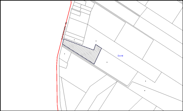
|
NOTIFICATION PLAN |
|
||
|
• PROPERTIES NOTIFIED
|
X SUBMISSIONS RECEIVED |
PROPERTY SUBJECT OF DEVELOPMENT |
|
5.2 Public Agencies
The development application is Integrated Development under the Act. Accordingly, the application was referred to the NSW Rural Fire Service for comment. The NSW Rural Fire Service has issued general terms of approval with no specific conditions.
6. THE PUBLIC INTEREST
Section 79C(1)(e) of the Act requires Council to consider “the public interest”.
The public interest is an overarching requirement, which includes the consideration of the matters discussed in this report. Implicit to the public interest is the achievement of future built outcomes adequately responding to and respecting the future desired outcomes expressed in environmental planning instruments and development control plans.
The application is considered to have satisfactorily addressed Council’s and relevant agencies’ criteria and would provide a development outcome that, on balance, would result in a positive impact for the community. Accordingly, it is considered that the approval of the proposed development would be in the public interest.
CONCLUSION
The proposed development is for subdivision of one allotment into two lots.
The proposed subdivision is considered satisfactory in maintaining the rural character of the locality, notwithstanding non-compliance with the minimum lot size applicable to the Rural BA zone. A number of allotments in the locality are less than the minimum 2 hectare development standard.
The applicant submitted a SEPP 1 objection to the development standard and is considered well founded with regard to the planning principles established by the Land and Environment Court.
The circumstances of the application are considered to be unique with the split residential and rural zone. The proposal would maintain the pattern of rural development and in this regard would not establish an undesirable precedent for smaller rural lot subdivision.
The proposed subdivision is considered acceptable with regard the provisions of the relevant environmental planning instruments applicable to the site, including the Rural Lands DCP and Car Parking DCP and the requirements of the NSW Rural Fire Service.
The application is recommended for approval.
Note: At the time of the completion of this planning report, no persons have made a Political Donations Disclosure Statement pursuant to Section 147 of the Environmental Planning and Assessment Act 1979 in respect of the subject planning application.
|
Rod Pickles Manager - Development Assessment Planning Division |
James Farrington Group Manager Planning Division |
|
1.View |
Locality Map |
|
|
|
2.View |
Subdivision Plan |
|
|
|
3.View |
Concept Stormwater Plan |
|
|
|
4.View |
Heavy Vehicle Turning Area Plan |
|
|
File Reference: DA/1069/2013
Document Number: D03596215
SCHEDULE 1
CONDITIONS OF APPROVAL
GENERAL CONDITIONS
The conditions of consent within this notice of determination have been applied to ensure that the use of the land and/or building is carried out in such a manner that is consistent with the aims and objectives of the relevant legislation, planning instruments and Council policies affecting the land and does not disrupt the amenity of the neighbourhood or impact upon the environment.
Note: For the purpose of this consent, the term ‘applicant’ means any person who has the authority to act on or the benefit of the development consent.
Note: For the purpose of this consent, any reference to an Act, Regulation, Australian Standard or publication by a public authority shall be taken to mean the gazetted Act or Regulation, or adopted Australian Standard or publication as in force on the date that the application for a construction certificate is made.
1. Deferred Commencement
Pursuant to Section 80(3) of the Environmental Planning and Assessment Act 1979, this consent does not operate until the following information is submitted to Council:
a) The registration and creation of an easement to drain water from the site over Lot 2 DP 558601, No 893 Old Northern Rd Dural.
b) Submission of engineering plans and hydraulic analysis demonstrating that the existing stormwater drainage system and the proposed stormwater drainage system complies with the requirements of Councils Civil Works Specification with respect to pipeline capacities. The plan is to be prepared by a suitable qualified civil engineer.
Such information shall be submitted within 12 months of the date of this notice.
Upon Council’s written satisfaction of the above information, the following conditions of development consent will apply:
2. Approved Plans and Supporting Documentation
The development must be carried out in accordance with the plans and documentation listed below and endorsed with Council’s stamp, except where amended by Council and/or other conditions of this consent:
|
Plan No. |
Drawn by |
Dated |
|
Job No. 10109 Rev E Plan Showing Detail & Levels over Proposed Lot 1 & Part of Proposed Lot 2 |
Surveyplus |
26.07.2014 |
|
Job No. 10109 Rev A Plan Showing Heavy Vehicle Turning Area as part of a Proposed Subdivision of Lot 1 |
Surveyplus |
28.02.2014 |
|
Job No. 10109 Rev B Plan of Concept Stormwater, On Site Sewer Disposal and Access as Part of a proposed Subdivision of Lot 1 |
Surveyplus |
26.07.2014 |
|
Document Name |
Prepared by |
Dated |
|
Bushfire Hazard Assessment Report Reference No. 140313 |
Building Code & Bushfire Hazard Solutions Pty Limited |
25 September 2013 |
|
Statement of Environmental Effects |
Surveyplus |
3 October 2013 |
|
Parking Assessment Statement |
GTK Consulting Pty Ltd
|
September 2013 |
|
Objection Pursuant to State Environmental Planning Policy No. 1 – Development Standards |
Surveyplus |
3 October 2013 |
3. Removal of Existing Trees
This development consent does not permit the removal of tree(s) on the site. The removal of any other trees requires separate approval in accordance with the Tree and Vegetation Chapter 1B.6 Hornsby Development Control Plan (HDCP).
4. Section 94 Development Contributions
In accordance with Section 80A(1) of the Environmental Planning and Assessment Act 1979 and the Hornsby Shire Council Section 94 Development Contributions Plan 2012-2021, the following monetary contributions shall be paid to Council to cater for the increased demand for community infrastructure resulting from the development:
|
Description |
Contribution (4) |
|
Roads |
$740.00 |
|
Open Space and Recreation |
$16,820.00 |
|
Community Facilities |
$2,360.00 |
|
Plan Preparation and Administration |
$80.00 |
|
TOTAL |
$20,000.00 |
being for one additional lot.
a) The value of this contribution is current as at 9 September 2014. If the contributions are not paid within the financial quarter that this condition was generated, the contributions payable will be adjusted in accordance with the provisions of the Hornsby Shire Council Section 94 Development Contributions Plan and the amount payable will be calculated at the time of payment in the following manner:
$CPY = $CDC x CPIPY
CPIDC
Where:
$CPY is the amount of the contribution at the date of Payment
$CDC is the amount of the contribution as set out in this Development Consent
CPIPY is the latest release of the Consumer Price Index (Sydney – All Groups) at the date of Payment as published by the ABS.
CPIDC is the Consumer Price Index (Sydney – All Groups) for the financial quarter at the date applicable in this Development Consent Condition.
b) The monetary contributions shall be paid to Council:
i) prior to the issue of the Subdivision Certificate where the development is for subdivision; or
ii) prior to the issue of the first Construction Certificate where the development is for building work; or
iii) prior to issue of the Subdivision Certificate or first Construction Certificate, whichever occurs first, where the development involves both subdivision and building work; or
iv) prior to the works commencing where the development does not require a Construction Certificate or Subdivision Certificate.
It is the professional responsibility of the Principal Certifying Authority to ensure that the monetary contributions have been paid to Council in accordance with the above timeframes.
Council’s Development Contributions Plan may be viewed at www.hornsby.nsw.gov.au or a copy may be inspected at Council’s Administration Centre during normal business hours.
REQUIREMENTS PRIOR TO THE COMMENCEMENT OF ANY WORKS
5. Erection of Construction Sign
A sign must be erected in a prominent position on any site on which building work, subdivision work or demolition work is being carried out:
a) Showing the name, address and telephone number of the principal certifying authority for the work;
b) Showing the name of the principal contractor (if any) for any demolition or building work and a telephone number on which that person may be contacted outside working hours; and
c) Stating that unauthorised entry to the work site is prohibited.
Note: Any such sign is to be maintained while the building work, subdivision work or demolition work is being carried out, but must be removed when the work has been completed.
6. Toilet Facilities
Toilet facilities must be available or provided at the works site before works begin and must be maintained until the works are completed at a ratio of one toilet for every 20 persons employed at the site. Each toilet must:
a) be a standard flushing toilet connected to a public sewer; or
b) be a temporary chemical closet approved under the Local Government Act 1993; or
c) have an on-site effluent disposal system approved under the Local Government Act 1993.
7. Erosion and Sediment Control
Erosion and sediment control measures must be provided and maintained throughout the construction period in accordance with the manual ‘Soils and Construction 2004 (Bluebook)’, the approved plans, Council specifications and to the satisfaction of the principal certifying authority. The erosion and sediment control devices must remain in place until the site has been stabilised and revegetated.
Note: On the spot penalties up to $1,500 may be issued for any non-compliance with this requirement without any further notification or warning.
8. Environmental Management
The site must be managed in accordance with the publication ‘Managing Urban Stormwater – Landcom (March 2004) and the Protection of the Environment Operations Act 1997 by way of implementing appropriate measures to prevent sediment run-off, excessive dust, noise or odour emanating from the site during the construction of the development.
REQUIREMENTS DURING CONSTRUCTION
9. Construction Work Hours
All work on site (including demolition and earth works) must only occur between 7am and 5pm Monday to Saturday. No work is to be undertaken on Sundays or public holidays.
10. Council Property
During construction works, no building materials, waste, machinery or related matter is to be stored on the road or footpath. The public reserve must be kept in a clean, tidy and safe condition at all times.
11. Disturbance of Existing Site
During construction works, the existing ground levels of open space areas and natural landscape features, (including natural rock-outcrops, vegetation, soil and watercourses) must not be altered unless otherwise nominated on the approved plans.
REQUIREMENTS PRIOR TO THE ISSUE OF SUBDIVISION CERTIFICATE
Note: For the purpose of this consent, a reference to ‘occupation certificate’ shall not be taken to mean an ‘interim occupation certificate’ unless otherwise stated:
12. Sydney Water – s73 Certificate
An s73 Certificate must be obtained from Sydney Water.
13. Stormwater Drainage – Dwellings
The stormwater drainage system for the development must be designed and constructed in accordance with Council’s Civil Works – Design and Construction Specification 2005 and the following requirements:
a) Connected to the existing stormwater drainage system within 893 Old Northern Rd.
b) An inter-allotment stormwater drainage system to service the proposed subdivision with pits being cast in situ or pre-cast concrete pits being used.
c) The roof and stormwater drainage system from the existing squash courts to be connected to the proposed inter-allotment drainage system.
14. Stormwater Drainage – Land Adjoining a Watercourse
In addition to other stormwater drainage requirements under this consent, all headwall outlets must incorporate flow velocity reduction controls (i.e. bedded boulders and small stones) to minimise erosive and scouring impacts to the watercourse. Energy dissipater controls must be landscaped to accommodate outlet sheet flow (forced jump). No engineering works are permitted within the bed of the watercourse.
15. Internal Driveway/Vehicular Areas
The existing bitumen driveway is to be removed and reconstructed in accordance with Australian Standards 2890.1, 2890.2, 3727 and the following requirements:
a) Design levels at the front boundary must be obtained from Council. The driveway is to extend from the kerb line in Old Northern Road to the end of the existing driveway. The reconstruction works do not include the two parking areas;
b) The driveway must be a rigid pavement;
c) The driveway grade must not exceed 25 percent and changes in grade must not exceed 8 percent;
d) The driveway pavement must be a minimum 3.5 metres wide, 0.15 metres thick reinforced concrete with F72 steel reinforcing fabric and a 0.15 metre sub-base;
e) The pavement must have a kerb to one side and a one-way cross fall with a minimum gradient of 2 percent and a lintel and pit provided at the low point;
f) Retaining walls required to support the carriageway and the compaction of all fill batters must be in accordance with the requirements of a chartered structural engineer;
g) Safety rails must be provided where there is a level difference more than 0.3 metres and a 1:4 batter cannot be achieved;
h) Landscaping strips must be planted 0.5 metres wide along both sides of the length of the driveway; and
i) Conduit for utility services including electricity, water, gas and telephone must be provided where required.
16. Damage to Council Assets
Any damage caused to Council’s assets as a result of the construction of the development must be rectified in accordance with Council’s written requirements and at the sole cost of the applicant.
17. Creation of Easements
The following matter(s) must be nominated on the plan of subdivision under s88B of the Conveyancing Act 1919:
a) A right of access and easement for services over the access corridor.
b) An inter-allotment drainage easement(s) over each of the burdened lots.
c) An easement for Parking be created over proposed Lot 1 benefiting proposed Lot 2.
Note: Council must be nominated as the authority to release, vary or modify any easement, restriction or covenant.
18. Works as Executed Plan
A works-as-executed plan(s) must be prepared by a registered surveyor and submitted to Council for completed road pavement, kerb & gutter, public drainage systems, driveways and on-site detention system. The plan(s) must be accompanied by a certificate from a registered surveyor certifying that all pipelines and associated structures lie wholly within any relevant easements.
OPERATIONAL CONDITIONS
19. Use of Premises
The squash courts and fitness centre shall operate in accordance with the conditions of consent Nos. 152/75 and 97/78.
- END OF CONDITIONS -
ADVISORY NOTES
The following information is provided for your assistance to ensure compliance with the Environmental Planning and Assessment Act 1979, Environmental Planning and Assessment Regulation 2000, other relevant legislation and Council’s policies and specifications. This information does not form part of the conditions of development consent pursuant to Section 80A of the Act.
Environmental Planning and Assessment Act 1979 Requirements
The Environmental Planning and Assessment Act 1979 requires:
· a principal certifying authority to be nominated and Council notified of that appointment prior to the commencement of any works;
· Council to be given at least two days written notice prior to the commencement of any works;
· mandatory inspections of nominated stages of the construction inspected; and
· an occupation certificate to be issued before occupying any building or commencing the use of the land.
Long Service Levy
In accordance with Section 34 of the Building and Construction Industry Long Service Payments Act 1986, a ‘Long Service Levy’ must be paid to the Long Service Payments Corporation or Hornsby Council.
Note: The rate of the Long Service Levy is 0.35% of the total cost of the work.
Note: Hornsby Council requires the payment of the Long Service Levy prior to the issue of a construction certificate.
Subdivision Certificate Requirements
A subdivision certificate application is required to be lodged with Council containing the following information:
· A surveyor’s certificate certifying that all structures within the subject land comply with the development consent in regard to the setbacks from the new boundaries.
· A surveyor’s certificate certifying that all services, drainage lines or access are located wholly within the property boundaries. Where services encroach over the new boundaries, easements are to be created.
· Certification that the requirements of relevant utility authorities have been met.
· A surveyor’s certificate certifying finished ground levels are in accordance with the approved plans.
Note: Council will not issue a subdivision certificate until all conditions of the development consent have been completed.
Fees and Charges – Subdivision
All fees payable to Council as part of any construction, compliance or subdivision certificate or inspection associated with the development (including the registration of privately issued certificates) are required to be paid in full prior to the issue of the subdivision certificate. Any additional Council inspections beyond the scope of any compliance certificate required to verify compliance with the terms of this consent will be charged at the individual inspection rate nominated in Council's Fees and Charges Schedule.
Tree and Vegetation Preservation
In accordance with Clause 5.9 of the Hornsby Local Environmental Plan 2013 a person must not ringbark, cut down, top, lop, remove, injure or wilfully destroy any tree or other vegetation protected under the Hornsby Development Control Plan 2013 without the authority conferred by a development consent or a permit granted by Council.
Notes: A tree is defined as a long lived, woody perennial plant with one or relatively few main stems with the potential to grow to a height greater than three metres (3M). (HDCP 1B.6.1.c).
Tree protection measures and distances are determined using the Australian Standard AS 4970:2009, “Protection of Trees on Development Sites”.
Fines may be imposed for non-compliance with both the Hornsby Local Environmental Plan 2013 and the Hornsby Development Control Plan 2013.
Dial Before You Dig
Prior to commencing any works, the applicant is encouraged to contact Dial Before You Dig on 1100 or www.dialbeforeyoudig.com.au for free information on potential underground pipes and cables within the vicinity of the development site.
Asbestos Warning
Should asbestos or asbestos products be encountered during demolition or construction works, you are advised to seek advice and information prior to disturbing this material. It is recommended that a contractor holding an asbestos-handling permit (issued by WorkCover NSW) be engaged to manage the proper handling of this material. Further information regarding the safe handling and removal of asbestos can be found at:
Alternatively, telephone the WorkCover Asbestos and Demolition Team on 8260 5885.
Telecommunications Act 1997 (Commonwealth)
If you are aware of any works or proposed works which may affect or impact on Telstra’s assets in any way, you are required to contact: Telstra’s Network Integrity Team on Phone Number 1800810443.
House Numbering
House numbering can only be authorised by Council. Before proceeding to number each premise in the development, the allocation of numbers is required to be obtained from Council's Planning Division prior to the issue of a Subdivision Certificate. The authorised numbers are required to comply with Council’s Property Numbering Policy and be displayed in a clear manner at or near the main entrance to each premise.
Group Manager’s Report No. PL70/14
Planning Division
Date of Meeting: 8/10/2014
9 DEVELOPMENT APPLICATION - SUBDIVISION OF ONE ALLOTMENT INTO TWO LOTS - 65 BALMORAL STREET, WAITARA
EXECUTIVE SUMMARY
|
DA No: |
DA/519/2014 (Lodged on 15 May 2014) |
|
Description: |
Torrens title subdivision of an existing strata titled dual occupancy development comprising two detached dwellings |
|
Property: |
SP 44601, No. 65 Balmoral Street, Waitara |
|
Applicant: |
Mrs D Wickham and Mrs C Wickham |
|
Owner: |
Owners Corporation – SP 44601 |
|
Estimated Value: |
Nil |
|
Ward: |
A |
· The application proposes the Torrens title subdivision of existing strata titled dual occupancy development comprising two detached dwellings.
· The proposal does not comply with the minimum allotment size for the R2 zone within the Hornsby Local Environmental Plan 2013. The applicant has made a submission pursuant to Clause 4.6 ‘Exceptions to development standards’ of the HLEP 2013 to vary the minimum 500m2 lot size development standard. The proposed variation to the development standard is considered well founded and is supported.
· No public submissions have been received in respect of the application.
· It is recommended that the application be approved.
|
THAT Council assume the concurrence of the Secretary of NSW Planning and Environment pursuant to Clause 4.6 of the Hornsby Local Environmental Plan 2013 and approve Development Application No. DA/519/2014 for Torrens title subdivision of one allotment into two lots at SP 44601, No. 65 Balmoral Street, Waitara subject to the conditions of consent detailed in Schedule 1 of Group Manager’s Report No. PL70/14. |
BACKGROUND
On 21 November 1991, Council approved Development Application No. 352/1991 to create a dual occupancy under the provisions of Sydney Regional Environmental Plan No. 12 – Dual Occupancy.
On 22 June 1993, Council approved Subdivision Certificate No. 841/1993 to create two strata lots. The subdivision did not create any common property, with each dwelling contained entirely within separate lots.
SITE
The allotment has an area of 1,010 m2, is located on the western side of Balmoral Street, Waitara and experiences a 3% fall to the west.
The site has a 13.48 metre frontage to Balmoral Street with a depth of 74.96 metres. Current improvements on the site include a single storey dwelling-house positioned towards Balmoral Street and a rear single storey detached dwelling-house with a backyard swimming pool and outbuildings. The dwellings are each located on separate strata titled lots.
Both dwellings have their respective carports currently accessed by a common driveway located along the northern side boundary. An easement to drain water affects proposed Lot No. 1 from the south-western boundary, diagonally across the backyard and then along the shared driveway to Balmoral Street.
The subject site is surrounded by low density residential development and is located in close proximity to Waitara Primary School and the Hornsby and Ku-ring-gai Hospital.
The site is not located in bushfire prone land, is not a heritage listed item, and is not in a heritage conservation area or in the vicinity of a heritage listed item.
PROPOSAL
The application proposes the Torrens title subdivision of an existing strata titled dual occupancy development comprising two detached dwellings. The existing detached dwellings on the property would each be located on a separate Torrens title allotment. The eastern lot (Lot No. 1) has an area of 371 m2 while the western lot (Lot No. 2) has an area of 531.9 m2. The area of the easement for access is 104.9 m2.
ASSESSMENT
The development application has been assessed having regard to the ‘Metropolitan Plan for Sydney 2031, the ‘North Subregion (Draft) Subregional Strategy’ and the matters for consideration prescribed under Section 79C of the Environmental Planning and Assessment Act 1979 (the Act). The following issues have been identified for further consideration.
1. STRATEGIC CONTEXT
1.1 Metropolitan Plan for Sydney and (Draft) North Subregional Strategy
The (Draft) Metropolitan Strategy for Sydney 2031 is a broad framework to provide for Sydney’s growth to help plan for housing, employment, transport, infrastructure, the environment and open space. It outlines a vision for Sydney to 2031; the challenges faced, and the directions to follow to address these challenges and achieve the vision.
The North Subregion comprises Hornsby, Kuring-gai, Manly, Warringah and Pittwater Local Government Areas. The Draft North Subregional Strategy acted as a framework for Council in its preparation of the Hornsby Local Environmental Plan 2013.
Within the North Subregion, the Draft Metropolitan Strategy proposes:
· Population growth of 81,000 from the current 2011 baseline of 529,000
· Housing growth of 37,000 from the current 2011 baseline of 204,000
· Employment growth of 39,000 from the current 2011 baseline of 186,000
The proposed development would alter the type of subdivision of an existing residential development. Accordingly, the proposal is not inconsistent with the draft Strategy.
2. STATUTORY CONTROLS
Section 79C(1)(a) requires Council to consider “any relevant environmental planning instruments, draft environmental planning instruments, development control plans, planning agreements and regulations”.
2.1 Hornsby Shire Local Environmental Plan 2013
2.1.1 Zoning
The subject land is zoned R2 Low Density Residential under the Hornsby Local Environmental Plan 2013 (HLEP). The objectives of the R2 zone are:
(a) To provide for the housing needs of the community within a low density residential environment.
(b) To enable other land uses that provide facilities or services to meet the day to day needs of residents.
The proposed development is defined as ‘Subdivision’ under the HLEP and is permissible in the zone with Council’s consent.
2.1.2 Minimum Subdivision Lot Size
Clause 4.1 of the HLEP prescribes that the minimum lot size of development within the R2 ‘Low Density Residential’ zone is 500 m2. The application does not comply with the development standard as proposed Lot No. 1 is 371.2 m2 in area. The applicant addresses the requirement by submitting an objection to the development standard pursuant to Clause 4.6 of the HLEP. The variation proposed represents a shortfall of 128.8 m2 or a 25.76% variation to the minimum lot size of 500 m2.
2.1.3 Exceptions to Development Standards
The proposal does not comply with Clause 4.1 of the HLEP. The application has been assessed against the requirements of Clause 4.6 ‘Exceptions to development standards’. This clause provides flexibility in the application of development standards in circumstances where strict compliance with those standards would, in any particular case, be unreasonable or unnecessary or tend to hinder the attainment of the objectives of the zone.
The objectives of this clause are as follows:
(a) to provide an appropriate degree of flexibility in applying certain development standards to particular development,
(b) to achieve better outcomes for and from development by allowing flexibility in particular circumstances.
The applicant made a written submission in accordance with Clause 4.6(3), which is summarized as follows:
“1. The proposal is consistent with the objectives of the minimum subdivision size development standard, and the objectives of the R2 zone under the Hornsby LEP 2013.
The land has already been strata subdivided into two lots (with two detached dwelling houses) since August 2013, and as such the proposed conversion of land titling from strata to Torrens title would not change the density of the land, nor have any impact upon site characteristics or local infrastructure. Both strata subdivided lots currently accommodate a detached dwelling each, with the front lot (proposed Lot No. 1) providing off street parking and 97 square metre private open space area. The proposed conversion of land titling to Torrens would not change this existing situation and on-going independent functioning of the two lots and dwelling-houses.
2. There would be no adverse amenity impacts as a consequence of the proposed conversion from strata title to Torrens title.
The proposed Torrens title subdivision would result in no physical change to the subject property and is simply converting the property titling arrangement from strata to Torrens title. The boundaries of the two proposed Torrens title lots follow the logical physical boundaries of the existing two dwelling-houses and open space areas and as such would not change the independent functioning of two lots and dwelling-houses. It is noted that a right of carriageway would be created over the access handle for Lot No. 2 in order for Lot No. 1 to be provided with vehicular access to its carport.
3. The non-compliance is exclusive to Lot No. 1.
Proposed Lot No. 1 is undersized at 371.2 square metres; however proposed Lot No. 2 is well in excess of the 500 square metre minimum lot size development standard at 520.4 square metres (excluding the access handle). The proposed 371.2 square metre lot size follows the existing physical arrangement of the front dwelling house and is larger from a titling arrangement given the existing carport and dwelling house periphery is included as part of the lot and not as common property. It is noted that the immediately adjoining property to the south was approved for Torrens title subdivision in February 1994 and the front lot (No. 63) is 354.6 square metres and features a detached dwelling house.
4. There is a demonstrable precedent is allowing variation to the 500 square metre minimum subdivision lot size.
The existing strata title allotments and therefore the proposed Torrens title allotments accommodate reasonably sized dwelling houses and are within the environmental capacity of the site. No physical works are proposed in converting the land titling from strata to Torrens and as such the established character of the streetscape remains unchanged.”
The Land and Environment Court (LEC) has set out the following five part test for consent authorities to consider when assessing an application to vary a standard to determine whether the objection to the development standards is well founded:
· The objectives of the standard are achieved notwithstanding non-compliance with the standard;
· The underlying objective or the purpose of the standard is not relevant to the development and therefore compliance is unnecessary;
· The underlying object of purpose would be defeated or thwarted if compliance was required and therefore compliance is unreasonable;
· The development standard has been virtually abandoned or destroyed by the Council’s own actions in granting consents departing from the standard and hence compliance with the standard would be unnecessary and unreasonable.
· The zoning of the particular land is unreasonable or inappropriate so that a development standard appropriate for that zoning is also unreasonable and unnecessary as it applies to the land and compliance with the standard would be unreasonable or unnecessary. That is, a particular parcel of land should not have been included in the particular zone.
Having regard to the above points the applicant’s objection to the 500 m2 – lot size development standard is considered well founded and is supported for the following reasons: -
· The applicant has adequately addressed the matters required to be demonstrated by subclause (3) in Clause 4.6.
· This lot reflects the lot boundaries currently registered on the Strata Plan. There would be no visually perceptible increase or change to the scale of development present on the site. The proposed variation would maintain the housing needs of the residents and would maintain the level of development currently existing on the site.
· The granting of consent to such a variation would not adversely affect or thwart the intent of the lot size standard nor does it create an undesirable precedent as the subdivision reflects the existing dual occupancy development approved under a now repealed State planning instrument.
· There would be no increase in the total number of dwellings present on the site and no subsequent increase in parking demand. Further, the proposed subdivision boundaries would be the same as the existing strata lot boundaries.
· The proposal would allow for the registration of the lots as separate and unencumbered titles. Each existing dwelling would be maintained and would not represent an increase in development intensity (in floor space terms) relative to the proposed new lots in which they will sit.
Based on this assessment, it is considered that the applicant’s submission is well founded and that compliance with the development standard would be unreasonable and unnecessary in the circumstances of the case. Accordingly, the proposal is considered acceptable in relation to Clause 4.6 of the HLEP.
2.1.4 Heritage
Clause 5 of the HLEP sets out heritage conservation provisions for Hornsby Shire. The site is not listed as a heritage item nor located within a heritage conservation area.
2.2 Sydney Regional Environmental Plan No. 20 Hawkesbury-Nepean River
The site is located within the catchment of the Hawkesbury Nepean River. Part 2 of this Plan contains general planning considerations and strategies requiring Council to consider the impacts of development on water quality, aquaculture, recreation and tourism.
The proposal does not involve any building works and therefore further assessment under the Plan is not required.
2.3 Hornsby Shire Council Section 94 Development Contribution Plan 2012 - 2021
Section 94 contributions were not applicable at the time consent was granted to the original dual occupancy. As there is no additional dwelling or lot created by the proposed development, there is no nexus for the levying of a Section 94 contribution.
2.4 Clause 74BA Environmental Planning and Assessment Act, 1979 - Purpose and Status of Development Control Plans
On 1 March 2013, the Environmental Planning and Assessment Act, 1979 was amended so that a DCP provision will have no effect if it has the practical effect of “preventing or unreasonably restricting development” that is otherwise permitted and complies with the development standards set out in relevant Local Environmental Plans and State Environmental Planning Policies.
The principal purpose of a development control plan is to provide guidance on the aims of any environmental planning instrument that applies to the development; facilitating development that is permissible under any such instrument; and achieving the objectives of land zones under any such instrument. The provisions of a development control plan made for that purpose are not statutory requirements.
2.5 Hornsby Development Control Plan 2013
The proposed development has been assessed having regard to the relevant performance and prescriptive requirements within the Hornsby Development Control Plan 2013 (HDCP). The following table sets out the proposal’s compliance with the prescriptive requirements of the Plan:
|
Hornsby Development Control Plan 2013 – Parts 3 and 6 |
|||
|
Control |
Proposal |
Requirement |
Complies |
|
Density |
|||
|
Allotment sizes (excluding the accessway)
Lot No. 1 Lot No. 2 |
371.2 m2 533.8 m2 |
500 m2 500 m2 |
No Yes |
|
Existing Dwelling on Proposed Lot No. 1 |
|||
|
Floor Area |
131 m2 |
Max. 270 m2 |
Yes |
|
Site cover |
43% |
55% |
Yes |
|
Private open space |
97 m2 |
24 m2 |
Yes |
|
Existing Dwelling on Proposed Lot No. 2 |
|||
|
Floor Area |
241.1 m2 |
Max. 380 m2 |
Yes |
|
Site cover |
40% |
50% |
Yes |
|
Private open space |
190 m2 |
24 m2 |
Yes |
|
Setbacks Existing Dwelling on Proposed Lot No. 1 |
|||
|
Front (Balmoral Street) |
7.6 m |
Existing |
Unchanged |
|
Northern Side |
1.3 m |
Existing |
Unchanged |
|
Southern Side |
0.6 m |
Existing |
Unchanged |
|
Rear (POS) |
7 m |
Existing |
Unchanged |
|
Setbacks Existing Dwelling on Proposed Lot No. 2 |
|||
|
Front (east) |
1 m |
Existing |
Unchanged |
|
Northern Side |
1 m |
Existing |
Unchanged |
|
Southern Side |
1 m |
Existing |
Unchanged |
|
Rear (POS) |
12 m |
Existing |
Unchanged |
|
Landscape Area |
|||
|
Lot 1 |
15% |
15% |
Yes |
|
Lot 2 |
20% |
20% |
Yes |
|
Car Parking |
|||
|
Number of spaces (Lots Nos. 1 and 2) |
2 spaces |
2 spaces |
Yes |
As detailed in the above table, the proposed development generally complies with the prescriptive requirements within the HDCP. A brief discussion on compliance with relevant performance requirements and Part 1C General Controls is provided below.
2.5.1 Minimum Lot Size
As previously discussed, proposed Lot No. 1 is less than the minimum 500 m2 lot size. Notwithstanding, the applicant has requested variation to the minimum 500m2 lot size development standard under Clause 4.1 of the HLEP.
The proposal is for Torrens title subdivision of an existing strata titled dual occupancy development, which was approved under the Sydney Regional Environmental Plan No. 12 (SREP 12). The development complied with the requirements of SREP 12 at the time of assessment and the current proposal does not seek to alter the existing built form on the site.
The applicant’s submission pursuant to Section 4.6 of the HLEP to vary the minimum allotment size development standard is considered well founded. This matter is addressed in Section 2.1 of this report.
2.5.2 Setbacks
The proposed subdivision does not involve any alterations to the front, rear and side setbacks of the existing detached dwellings.
2.5.3 Landscaping
The proposal does not involve the removal of any vegetation. The proposed lots would achieve the required level of landscaping as stipulated under the Hornsby Development Control Plan. The proposal is considered acceptable in this regard.
2.5.4 Fencing
No new fencing has been proposed as part of this application. As this development application does not alter the allotment boundaries, no additional fencing requirements are considered necessary.
3. ENVIRONMENTAL IMPACTS
Section 79C(1)(b) of the Act requires Council to consider “the likely impacts of that development, including environmental impacts on both the natural and built environments, and social and economic impacts in the locality”.
3.1 Natural Environment
The proposal does not include any physical works and therefore, would not result in an adverse environmental impact.
3.2 Built Environment
The proposed Torrens title subdivision would not alter the approved built form of the development. The density and scale of the development is within the environmental capacity of the site and is acceptable with respect to the built environment.
3.3 Social and Economic Impacts
There are no anticipated adverse social or economic impacts resulting from the proposed development.
4. SITE SUITABILITY
Section 79C(1)(c) of the Act requires Council to consider “the suitability of the site for the development”.
The subject site has not been identified as bushfire prone or flood prone land. The proposed subdivision would not alter the existing built form of the development on site.
5. PUBLIC PARTICIPATION
Section 79C(1)(d) of the Act requires Council to consider “any submissions made in accordance with this Act”.
5.1 Community Consultation
The proposed development was placed on public exhibition and was notified to adjoining and nearby landowners between 5 June 2014 and 19 June 2014 in accordance with the requirements of the Hornsby Development Control Plan 2013. During this period, Council received no submissions. The map below illustrates the location of those nearby landowners who were notified of the application.
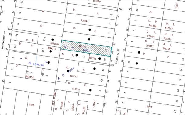
|
|
|||
|
• PROPERTIES NOTIFIED |
X SUBMISSIONS RECEIVED |
PROPERTY SUBJECT OF DEVELOPMENT |
|
5.2 Public Agencies
The development application was not required to be referred to any Public Agencies for comment.
6. THE PUBLIC INTEREST
Section 79C(1)(e) of the Act requires Council to consider “the public interest”.
The public interest is an overarching requirement, which includes the consideration of the matters discussed in this report. Implicit to the public interest is the achievement of future built outcomes adequately responding to and respecting the future desired outcomes expressed in environmental planning instruments and development control plans.
The application is considered to have satisfactorily addressed Council’s criteria under the Hornsby Local Environmental Plan 2013 and the Hornsby Development Control Plan and therefore, the development would be in the public interest.
CONCLUSION
The application proposes the Torrens title subdivision of an existing strata titled dual occupancy development comprising two detached dwellings.
The application does not comply with the Hornsby Local Environmental Plan 2013 in respect to Clause 4.1 ‘Minimum Subdivision Lot Size’. The applicant requested a Clause 4.6 variation to the minimum allotment size development standard. The proposed variation to the development standard is considered well founded and is supported.
There were no submissions received in response to notification of the proposed development.
Having regard to the circumstances of the case and consideration of the Clause 4.6 variation, approval of the application is recommended.
Note: At the time of the completion of this planning report, no persons have made a Political Donations Disclosure Statement pursuant to Section 147 of the Environmental Planning and Assessment Act 1979 in respect of the subject planning application.
|
Rod Pickles Manager - Development Assessment Planning Division |
James Farrington Group Manager Planning Division |
|
1.View |
Locality Plan |
|
|
|
2.View |
Subdivision Plan |
|
|
File Reference: DA/519/2014
Document Number: D03606404
SCHEDULE 1
GENERAL CONDITIONS
The conditions of consent within this notice of determination have been applied to ensure that the use of the land and/or building is carried out in such a manner that is consistent with the aims and objectives of the relevant legislation, planning instruments and council policies affecting the land and does not disrupt the amenity of the neighbourhood or impact upon the environment.
Note: For the purpose of this consent, the term ‘applicant’ means any person who has the authority to act on or the benefit of the development consent.
Note: For the purpose of this consent, any reference to an Act, Regulation, Australian Standard or publication by a public authority shall be taken to mean the gazetted Act or Regulation, or adopted Australian Standard or publication as in force on the date that the application for a construction certificate is made.
1. Approved Plans and Supporting Documentation
The development must be carried out in accordance with the plans and documentation listed below and endorsed with Council’s stamp, except where amended by Council and/or other conditions of this consent:
Approved Plan
|
Plan No. |
Plan Title |
Drawn by |
Dated |
|
5190-SUB1 |
Plan of proposed subdivision |
Mepstead and Associates |
30.04.14 |
Supporting Documentation
|
Document Title |
Prepared by |
Dated |
|
Statement of Environmental Effects |
dfp Planning Consultants |
6 May 2014 |
REQUIREMENTS PRIOR TO THE ISSUE OF A SUBDIVISION CERTIFICATE
Note: For the purpose of this consent, a reference to ‘occupation certificate’ shall not be taken to mean an ‘interim occupation certificate’ unless otherwise stated.
2. Sydney Water – s73 Certificate
An s73 Certificate must be obtained from Sydney Water.
3. Creation of Easements
The following matter(s) must be nominated on the plan of subdivision under Section 88B of the Conveyancing Act 1919:
a) A right of access and easement for services over the access corridor.
b) An easement for letterboxes to be created.
c) An inter-allotment drainage easement(s) over each of the burdened lots.
d) A restriction over the pipeline and the flow path for a 100 year average recurrence interval storm. The "Restriction on the Use of Land" over the affected lots is to prohibit the alteration of the final floodway shape and the erection of any structures, including fencing, in the floodway without the written permission of Council. (refer to DA352/91) The terms of this restriction must be obtained from Council.
e) A "Restriction on the Use of Land" for any lot adjacent to the floodway, requiring the finished floor level of any habitable room to be not less than 500mm and the garage 300mm above the 100 year average recurrence interval storm level. (refer DA/352/91) The levels must be related to Australian Height Datum.
f) The creation of an appropriate "Positive Covenant" and "Restriction as to User" over the constructed on-site detention/retention systems and outlet works, within the lots in favour of Council in accordance with Council’s prescribed wording. (Refer to DA/352/91) The position of the on-site detention system is to be clearly indicated on the plan of subdivision.
g) To register the OSD easement, the restriction on the use of land “works-as-executed” details of the on-site-detention system must be submitted verifying that the required storage and discharge rates have been constructed in accordance with the design requirements. The details must show the invert levels of the on-site system together with pipe sizes and grades. Any variations to the approved plans must be shown in red on the “works-as-executed” plan and supported by calculations.
Note: Council must be nominated as the authority to release, vary or modify any easement, restriction or covenant.
- END OF CONDITIONS -
ADVISORY NOTES
The following information is provided for your assistance to ensure compliance with the Environmental Planning and Assessment Act 1979, Environmental Planning and Assessment Regulation 2000, other relevant legislation and Council’s policies and specifications. This information does not form part of the conditions of development consent pursuant to Section 80A of the Act.
Tree and Vegetation Preservation
In accordance with Clause 5.9 of the Hornsby Local Environmental Plan 2013 a person must not ringbark, cut down, top, lop, remove, injure or wilfully destroy any tree or other vegetation protected under the Hornsby Development Control Plan 2013 without the authority conferred by a development consent or a permit granted by Council.
Notes: A tree is defined as a long lived, woody perennial plant with one or relatively few main stems with the potential to grow to a height greater than 3 metres. (HDCP 1B.6.1.c)
Tree protection measures and distances are determined using the Australian Standard AS 4970:2009, “Protection of Trees on Development Sites”.
Fines may be imposed for non-compliance with both the Hornsby Local Environmental Plan 2013 and the Hornsby Development Control Plan 2013.
Subdivision Certificate Requirements
A subdivision certificate application is required to be lodged with Council containing the following information:
· A surveyor’s certificate certifying that all structures within the subject land comply with the development consent in regard to the setbacks from the new boundaries.
· A surveyor’s certificate certifying that all services, drainage lines or access are located wholly within the property boundaries. Where services encroach over the new boundaries, easements are to be created.
· Certification that the requirements of relevant utility authorities have been met.
· A surveyor’s certificate certifying finished ground levels are in accordance with the approved plans.
Note: Council will not issue a subdivision certificate until all conditions of the development consent have been completed.
Fees and Charges – Subdivision
All fees payable to Council as part of any construction, compliance or subdivision certificate or inspection associated with the development (including the registration of privately issued certificates) are required to be paid in full prior to the issue of the subdivision certificate. Any additional Council inspections beyond the scope of any compliance certificate required to verify compliance with the terms of this consent will be charged at the individual inspection rate nominated in Council's Fees and Charges Schedule.
House Numbering
House numbering can only be authorised by Council. Before proceeding to number each premise in the development, the allocation of numbers is required to be obtained from Council's Planning Division prior to the issue of a Subdivision Certificate. The authorised numbers are required to comply with Council’s Property Numbering Policy and be displayed in a clear manner at or near the main entrance to each premise.
Group Manager’s Report No. PL71/14
Planning Division
Date of Meeting: 8/10/2014
10 DEVELOPMENT APPLICATION - SENIORS LIVING DEVELOPMENT COMPRISING 10 UNITS - 186 BEECROFT ROAD, CHELTENHAM - FURTHER REPORT
EXECUTIVE SUMMARY
|
DA No: |
DA/1394/2013 (Lodged 16 December 2013) |
|
Description: |
Demolition of existing structures and construction of a Seniors Living Development comprising 10 self-contained dwellings and strata subdivision |
|
Property: |
Lot 18 DP 1067166, No. 186 Beecroft Road, Cheltenham |
|
Applicant: |
Byric Pty Ltd |
|
Owner: |
Byric Pty Ltd; Mr Rui Yang |
|
Estimated Value: |
$3.65 million |
|
Ward: |
C |
· The application involves demolition of existing structures and construction of a seniors living development comprising 10 self-contained dwellings with ground floor and basement parking and strata subdivision.
· On 3 September 2014, Council resolved to defer the matter to enable an onsite meeting with available Councillors and Council Officers. An onsite meeting was held on 10 September 2014.
· The proposal does not comply with State Environmental Planning Policy (Housing for Seniors or People with a Disability) 2004 with regard to Clause 40 - Development Standards (Height). A submission to vary the development standard has been made in accordance with State Environmental Planning Policy No. 1 and is considered well-founded.
· Thirteen submissions have been received in respect of the application.
· A Red Sticker has been placed on the application requiring that it be considered at a Council Meeting.
· It is recommended that the application be approved.
|
THAT Council assume the concurrence of the Secretary of the Department of Planning and Environment pursuant to State Environmental Planning Policy No. 1 and approve Development Application No. DA/1394/2013 for the demolition of existing structures and construction of a seniors living development comprising 10 self-contained dwellings with car parking and strata subdivision at Lot 18 DP 1067166, No. 186 Beecroft Road, Cheltenham subject to the conditions of consent detailed in Schedule 1 of Group Manager’s Report No. PL71/14. |
BACKGROUND
The site has a history of residential land use.
In August 2013, the applicant held a pre-lodgement meeting with Council officers regarding the subject proposal.
The application was lodged on 16 December 2013. Multiple sets of amended plans have been submitted to address concerns raised by Council officers and objectors during the assessment of the proposal.
Council held an on-site meeting with the owners of the adjoining property at No. 184 Beecroft Road to discuss the impacts of the proposal on the privacy of the neighbours. The following concerns were raised by the adjoining owner at the meeting:
· Location of the sit out areas facing north-west and the associated impacts on the privacy of the adjoining property;
· Visual impact of the structure; and
· Detrimental impacts due to absence of a fence at the boundary separating the two blocks.
Subsequently, a meeting was held between the applicant and Council officers regarding the planning concerns and the overall impact of the proposal on adjoining properties.
The proposal was amended on 14 August 2014 to address planning concerns raised by Council officers and the adjoining owner at No. 184 Beecroft Road.
On 3 September 2014, Council considered the subject application and resolved the following:
THAT consideration of Development Application No. DA/1394/2013 for the demolition of existing structures and construction of a seniors living development comprising 10 self-contained dwellings with car parking and strata subdivision at Lot 18 DP 1067166, No. 186 Beecroft Road, Cheltenham be deferred to allow an onsite meeting with available Councillors and Council officers to observe the impact and implications of this development on surrounding properties and the impact on the heritage conservation area.
In accordance with Council’s resolution, on 10 September 2014, an on-site meeting was held to discuss the application. The meeting was attended by available Councillors and Planning Division officers. At the onsite meeting, Council officers provided an overview of the application and outlined the concerns raised in the public submissions. Discussion included consideration of the following:
· The front setback to Beecroft Road and the proposed screening;
· Removal of trees and the distance of trees from the dwellings;
· Bulk and scale of the two storey building at the front of the site;
· The existing levels and the proposed cut and fill;
· Location and type of fences adjoining No. 5 Redmill Close and No. 184 Beecroft Road; and
· Location of the private open space areas and impacts on the neighbouring dwellings.
At the conclusion of the meeting, the Councillors agreed that:
· The tennis court fence adjoining the boundary with No. 5 Redmill Close should be retained and an additional solid timber fence be erected within the property boundary to retain privacy of the neighbours; and
· Opportunities for retaining the tennis court fence along the north-western boundary in addition to constructing a solid fence be explored and the resident of No. 184 Beecroft Road be contacted in this regard.
It was also noted that the application would be reported back to Council at its meeting on 8 October 2014 for Council’s consideration.
Following the meeting, the owners of No. 184 Beecroft Road were contacted by Council Officers to seek their views regarding retention of the tennis court fence and building an additional solid fence on the boundary within the subject site. The matters regarding the fencing have been addressed in Section 5.1 of this report.
SITE
The site comprises one allotment, No. 186 Beecroft Road. The site has an area of 2992 m2, is located on the southern side of Beecroft Road, opposite the intersection with The Boulevard. The site has 10% average downward slope from west to east (sideways) and a gentle (2%) fall towards the rear from Beecroft Road.
The current improvements on the site include a large single storey brick dwelling house, swimming pool, an elevated tennis court, associated outbuildings, driveways and a metal palisade front fence. The dwelling sits at a lower level than the street (about 1.4m) in a garden setting with numerous mature trees and ornamental shrubs along the front boundary and within the front setback.
Access to the site is provided via a driveway off Beecroft Road, with a turning area located within the front setback area.
The site comprises a large number of native turpentine trees, being remnant to the Sydney Turpentine Ironbark Forest at the north-western corner (front), along the eastern boundary and the south-eastern corner (rear). A tall fence and camellia hedge (3m high) exists around the tennis court at the north-western corner of the site and acts as a screen.
The adjoining properties comprise single and two storey dwelling houses including a number of battle-axe lots on the eastern side. A shared bitumen driveway providing access to the eastern allotments runs along the boundary of the site. The dwelling houses adjoining the rear of the site have frontage to Redmill Close. Development in the locality is characteristic of Federation era dwellings. However the subject site and the immediate surroundings comprise predominantly post-war dwellings on large allotments containing remnant trees.
The site is located 370m south of Cheltenham Railway Station and approximately 1.6km to Beecroft Railway Station and shops. Bus stops are located within 240m of the site on Beecroft Road and provide connection between Beecroft, Castle Hill and Macquarie Shopping Centre (Route 651). The signalised intersection at the crossing of Cheltenham Road and Beecroft Road provides safety for users of the bus service in crossing Beecroft Road.
PROPOSAL
The proposal involves the demolition of the existing dwelling house and associated structures, and construction of seniors living housing development comprising 10 self-care dwellings. The development would be accessed via a common driveway off Beecroft Road, located on the eastern side of the site. The driveway would provide access to three detached single-two storey buildings located along the north-south axis of the site. The units are accommodated in the following way:
Dwellings 1 to 6: 6 units (3 x 2 br + studio, 2 x 3 br and 1 x 2 br) within a two storey residential flat building with basement car park containing 8 car parking spaces (lockable garages);
Dwellings 7 and 8: 1 single storey building with attic comprising two attached dwellings (1 x 3 br + studio and 1 x 3 br) with attached double garages. The second storey would be accommodated within the roof space.
Dwellings 9 and 10: 1 single storey building with attic comprising two attached dwellings (1x 3 br and 1 x 2 br). Dwelling 9 includes the second level within the roof space whereas dwelling 10 (rearmost unit) comprises a single level dwelling.
The proposed dwellings range in size from 115m2 to 184m2. The gross floor area of the development would be 1477m2. Each dwelling includes the primary living area being directly connected to a balcony or terrace. The proposed detached dwellings and residential flat building would be face brick with tiled hip roofs.
The application also includes associated landscape works within the site. An enclosed garbage bin room is proposed at the entrance to the site with an adjoining visitors’ parking space.
ASSESSMENT
The development application has been assessed having regard to the ‘Metropolitan Plan for Sydney 2031’, the ‘North Subregion (Draft) Subregional Strategy’ and the matters for consideration prescribed under Section 79C of the Environmental Planning and Assessment Act 1979 (the Act). The following issues have been identified for further consideration.
1. STRATEGIC CONTEXT
1.1 Metropolitan Plan for Sydney and (Draft) North Subregional Strategy
The (Draft) Metropolitan Strategy for Sydney 2031 is a broad framework to provide for Sydney’s growth to help plan for housing, employment, transport, infrastructure, the environment and open space. It outlines a vision for Sydney to 2031; the challenges faced, and the directions to follow to address these challenges and achieve the vision.
The North Subregion comprises Hornsby, Kuring-gai, Manly, Warringah and Pittwater Local Government Areas. The Draft North Subregional Strategy acted as a framework for Council in its preparation of the Hornsby Local Environmental Plan 2013.
Within the North Subregion, the Draft Metropolitan Strategy proposes:
· Population growth of 81,000 from the current 2011 baseline of 529,000
· Housing growth of 37,000 from the current 2011 baseline of 204,000
· Employment growth of 39,000 from the current 2011 baseline of 186,000
The proposed development would be consistent with the Metropolitan Plan for Sydney 2031 by providing an additional 9 dwellings in the locality.
2. STATUTORY CONTROLS
Section 79C(1)(a) requires Council to consider “any relevant environmental planning instruments, draft environmental planning instruments, development control plans, planning agreements and regulations”.
2.1 Hornsby Local Environmental Plan 2013
2.1.1 Permissibility
The subject land is zoned R2 - Low Density Residential under the Hornsby Local Environmental Plan 2013 (HLEP). The objectives of the zone are:
(a) To provide for the housing needs of the community within a low density residential environment.
(b) To enable other land uses that provides facilities or services to meet the day to day needs of residents.
The proposed development is defined as ‘Seniors Housing.’ Seniors Housing is prohibited under the HLEP in the R2 zone. Notwithstanding, the proposal is permitted pursuant to Clause 4 of State Environmental Planning Policy (Housing for Seniors or People with a Disability) 2004 where land is zoned for urban purposes and where residential development is permitted. The provisions of State Environmental Planning Policy (Housing for Seniors or People with a Disability) 2004 prevail to the extent of any inconsistency with the HLEP.
2.1.2 Height
Clause 4.3 of the HLEP provides that the height of a building on any land is not to exceed the maximum height shown for the land on the Height of Buildings Map. The maximum permissible height for the site is 8.5m. The proposal complies with this provision.
2.1.3 Heritage Conservation
Clause 5.10 of the HLEP sets out heritage conservation provisions for Hornsby Shire. The subject site is located within the Beecroft/Cheltenham Heritage Conservation Area under the provisions of Schedule 5 (Environmental Heritage) of the HLEP.
The applicant held discussions with Council prior to the lodgement of the application (PL/72/2013). The application was referred to the Heritage Advisory Committee at that time and the following comments were provided.
“The current dwelling-house is not considered to be a contributory item in relation to the surrounding Beecroft/Cheltenham Heritage Conservation Area, and as such no objections are raised on heritage grounds to the demolition of the existing structures on the site.
The Committee considered the proposed Senior Living Residences and raised no objections to the proposed development.”
The development application is generally in accordance with the proposal which was considered by the Heritage Advisory Committee under the pre-lodgement application PL/72/2013. Minor modifications have been made to the exterior form and internal layout, and two additional trees are proposed to be removed. However, Council’s heritage assessment of the application raised no concerns as the original design concept has been maintained. The site contains a large number of mature trees and the loss of the selected specimens would have a minimal impact on the overall contribution of the site to the tree and vegetation qualities of the Beecroft/Cheltenham Heritage Conservation Area.
Council’s heritage assessment concludes that the impact of the proposal on the heritage conservation area has been suitably addressed in the Statement of Heritage Impact prepared by NBRS+Partners Architects. Accordingly, the proposal is assessed as satisfactory with regard to Clause 5.10 of the HLEP.
2.1.4 Earthworks
Clause 6.2 of the HLEP states that consent is required for earthworks on the site. Before granting consent for earthworks, Council is required to assess the impacts of the works on adjoining properties, drainage patterns and soil stability of the locality. Council’s assessment of the proposed earthworks and excavation concludes that the proposal is satisfactory.
2.2 State Environmental Planning Policy (Building Sustainability Index: BASIX) 2004
The aim of the Policy is to encourage sustainable residential development. The submitted BASIX Certificate for the proposed development satisfies this requirement.
2.3 State Environmental Planning Policy (Housing for Seniors or People with a Disability) 2004
The State Environmental Planning Policy (Housing for Seniors or People with a Disability) 2004 (SEPP HSPD) is the overriding planning instrument for the development of housing for aged and disabled people in NSW and provides for hostels, residential care facilities (nursing homes) self-contained dwellings and multi-storey buildings. SEPP HSPD is comprehensive in scope including land use planning provisions, design principles, development standards and standards specifically to meet the housing needs of aged and disabled people. SEPP HSPD also includes design guidelines for infill development. The assessment of the proposal in accordance with the relevant requirements of SEPP HSPD is provided as follows:
2.3.1 Clause 13 – Self Contained Dwellings
The SEPP HSPD includes the following definitions for “Self-contained dwellings”:
“General term: “self-contained dwelling
In this Policy, a self-contained dwelling is a dwelling or part of a building (other than a hostel), whether attached to another dwelling or not, housing seniors or people with a disability, where private facilities for significant cooking, sleeping and washing are included in the dwelling or part of the building, but where clothes washing facilities or other facilities for use in connection with the dwelling or part of the building may be provided on a shared basis.
Example: “in-fill self-care housing”
In this Policy, in-fill self-care housing is seniors housing on land zoned primarily for urban purposes that consists of 2 or more self-contained dwellings where none of the following services are provided on site as part of the development: meals, cleaning services, personal care, nursing care.”
For the purposes of assessment against SEPP HSPD, the proposed development is defined as ‘in-fill self-care housing’ comprising 10 ‘self-contained dwellings’.
2.3.2 Clause 26 – Location and Access to Facilities
The SEPP HSPD includes mandatory standards for accessibility and useability of self-contained dwellings to ensure wheelchair accessibility throughout the development and to a public road. Mandatory standards also apply for access to public transport, medical services and shops. The applicant submitted a report prepared by Accessibility Solutions, which includes a detailed assessment of the subject site and the proposed development, concerning compliance with the mandatory standards.
Cheltenham Railway Station is located at a distance of approximately 400m from the site.
The site is serviced by a regular and frequent bus services (bus route 651); the bus stops being located approximately 220m and 240m from the subject site on Beecroft Road (adjacent to 170 and 183 Beecroft Road). A signalised intersection at the crossing with Cheltenham Road includes kerb ramps and provides wheelchair access to the bus stops on the opposite side of the road. The buses and trains provide access to Beecroft village, Castle Hill and Macquarie shopping centres with all the required amenities and facilities.
Given the above, the proposal complies with the provisions of Clause 26.
2.3.3 Clause 30 – Site Analysis
The application includes a Site Analysis plan in accordance with the requirements of the SEPP HS& PD. The proposal is assessed as satisfactory in this regard.
2.3.4 Clause 31 – Design of In-Fill Self-Care Housing
In determining a development application for in-fill self-care housing, a consent authority must take into consideration (in addition to any other matters that are required to be, or may be, taken into consideration) the provisions of Seniors Living Policy: Urban Design Guideline for Infill Development published by the Department of Planning and Environment.
The merits of the proposal in meeting the SEPP HSPD design principles and the Seniors Living Policy Urban Design Guidelines for Infill Development are discussed in the following sections of this report.
2.3.5 Clause 33 – Neighbourhood Amenity and Streetscape
The site generally slopes towards the south-east and rear. Given this, the proposed development would result in a two storey built-form as viewed from the street. The proposed detached and semi-detached dwellings maintain the predominant built form and contribute to the residential character of the area. The setback between the site and Beecroft Road allows for landscaping and planting that complement the streetscape. A 1.5m high wall intercepted by landscape elements would form the front fence of the development and would not be inconsistent with the character of the area.
The proposed density is generally consistent with Council’s planning controls for maintaining a low density residential area. The impact of the proposed buildings on neighbourhood amenity is discussed below:
South-Eastern Side
The dwellings would mostly be orientated to front the proposed driveway. A large side setback has been maintained to the south-eastern boundary due to the presence of significant trees which would also act as a natural screen maintaining the amenity of the neighbouring properties to the east. The distance between the proposed dwellings and the neighbouring dwellings on the eastern side would vary between 20 - 25m.
North-Western Side
The proposed buildings have been designed to retain the significant trees along the eastern boundary, being remnant of the Sydney Turpentine Ironbark Forest (STIF), an Ecologically Endangered Community. The setbacks on the northern-western side have been reduced to some extent due to this site constraint.
Further, the proposed living areas of the ground floor dwellings 3, 7, 9 and 10 are also orientated to the north-west to gain solar access for the future occupants. Land fill ranging between 300mm – 850mm is proposed at the rear section of the site along this boundary extending up to dwelling 8 (300mm). The property to the west (184 Beecroft Road) accommodates a dwelling house with a large front setback, private open space/pool/deck at the rear and two bedroom windows located in close proximity to the detached building accommodating Units 7 – 8. The neighbouring dwelling house is located 1 metre higher (window head height RL 117.27) compared to units 7 - 8 (window head height RL 116.25).
The applicant submitted amended plans to address concerns regarding impacts of the proposed development on the dwelling house at No. 184 Beecroft Road. The amendments include:
· Relocation of the private open space area for dwelling 7 to face the front yard of the adjoining property;
· Relocation of the private open space area for dwelling 8 to the south-eastern side of the dwelling;
· A 1.8m high fence (from the natural ground level) is proposed along the entire boundary with a 300mm high lattice screen on top of the fence. The fence would comprise a 200mm thick concrete block acoustic wall at its interface with dwellings 7 and 8. A timber lapped and capped fence is proposed for the remaining length of the boundary;
· 3m high screen planting is proposed on the western boundary fronting dwelling 7, 8 and 9; and
· The balcony for dwelling 5, on the upper level has been amended to face Beecroft Road;
The living and private open space areas for dwellings 3 and 7 would however face the front yard of the adjoining dwelling. Subject to erection of a boundary fence, no concerns are raised regarding the location of these sit-out areas.
Notwithstanding the above, the sliding doors to the living area for dwelling 8 would be located at a distance of 2.6m from the western boundary and in close proximity to the bedroom window of the adjoining dwelling house (4m separation). It is considered that this would result in the future occupants using the rear yard as an extension to the living space and is not supported. Thus, a condition of consent is recommended requiring the doors to be replaced by windows, being similar in height to the bedroom windows, to alleviate any negative visual or acoustic impact on the neighbouring dwelling.
Further, it is also noted that 3 windows for dwelling 5, with low sill height at the upper level, would face the front yard of the adjoining dwelling and would impact on the neighbour’s privacy. A condition of consent is therefore recommended requiring these windows be replaced by highlight windows.
The distance between the principal private open space area of No. 184 Beecroft Road and that for dwellings 9 – 10 would be 9m to 10m. This distance is sufficient to maintain reasonable privacy for both dwellings. However, it is noted that the sit out areas and rear lawn areas for dwellings 9 and 10 would be located at RL 113.85 above the natural ground level due to the proposed fill. The survey plan indicates that lawn areas for No. 184 Beecroft Road, at this boundary, would vary between RL 113.5 to RL 113. Given the proposed fill and the level differences, it is recommended that the fence be constructed over the finished levels/retaining walls of the proposed lawn areas for Units 7, 8, 9 and 10 rather than the natural ground level as indicated on the plans. The existing 3m high hedge would be retained along the north-western boundary providing a dense natural screen for the two properties. This coupled with the proposed fencing would alleviate privacy impacts on the neighbouring property to the north-west.
Rear (South-East)
The lawn area for dwelling 10 would be partially located along the southern boundary. The existing pool and garden area associated with the dwelling house at No. 5 Redmill Close are located in close proximity to this boundary at a lower level than the site. A 3m high Camellia hedge provides screening for both properties. The applicant has submitted a section to demonstrate that, given the setbacks, the level difference and the screen planting, amenity of this neighbouring property would be maintained. Additionally a condition of consent requires a solid fence is to be constructed along the rear boundary to retain privacy of the neighbours.
It is considered that the proposed amendments and additional privacy measures along the western boundary would minimise overlooking opportunities and provide acoustic privacy to the adjoining property. The proposed buildings are satisfactorily integrated in design to provide for internal amenity, minimise impacts on neighbours and reduce impacts on the streetscape of the heritage conservation area. The application is assessed as satisfactory in this regard.
2.3.6 Clause 34 – Visual and Acoustic Privacy
As discussed earlier, the proposed dwellings are designed with regard to visual privacy to avoid overlooking on to neighbouring residents. This coupled with the landscape details and setbacks results in adequate space for the effective landscape settings along the boundaries of the development and separation between neighbouring buildings.
The proposed private open space areas are integrated with the living areas of the dwellings and have regard to acoustic privacy. A condition regarding fencing along the western boundary would ensure further noise mitigation from Beecroft Road. The development is to be used as a seniors living and therefore, would be a low noise generating development. The proposal would not have any unreasonable acoustic impact on the surroundings.
2.3.7 Clause 35 – Solar Access and Design for Climate
The living areas of the proposed dwellings are orientated towards the north-west, wherever possible, for appropriate solar access. The submitted shadow diagrams demonstrate that the buildings would not overshadow any of the neighbouring properties. The existing shadow cast by the neighbouring dwelling at No. 184 Beecroft Road would not restrict solar access to the private open space areas for dwellings 7 and 8.
The matter regarding solar access is discussed later in this report.
2.3.8 Clause 36 – Stormwater
The proposed stormwater drainage system is designed to minimise impacts on downstream waterways and would be connected to the Council controlled drainage system within Beecroft Road via an on-site detention system. Conditions are recommended for the system to be designed and constructed in accordance with Council’s Civil Works – Design and Construction Specification 2005.
2.3.9 Clause 37 – Crime Prevention
The access way design, pedestrian linkages and orientation of dwellings ensures casual surveillance of the development and separation of public and private areas. Conditions are recommended for the basement car park to be made secure.
Subject to recommended conditions the proposal is satisfactory in respect to crime prevention.
2.3.10 Clause 38 – Accessibility
The development remains fully accessible with the internal and outdoor layouts satisfying the applicable standards of the Building Code of Australia and the Disability Discrimination Act. The matter is assessed in detail later in this report.
2.3.11 Clause 39 – Waste Management
Adequate waste storage and collection facilities are available on the site. The 10 self-contained dwellings would require 5 x 240 litre garbage bins plus 3 x 240 litre recycling bins serviced weekly.
A covered bin storage room is proposed to be located adjacent to the driveway within 6 metres of the front boundary. An additional bin area is located between dwellings 8 and 9. The bins are within accessible distances of the dwellings. It is proposed that a site caretaker would take the bins from the bin area to the bin collection point for servicing. The applicant proposes that bins be serviced from the bin collection area via a rear-loader garbage truck. Council’s assessment in this regard concludes that kerbside collection via a side-loader garbage truck would be a safer option for Beecroft Road. This is recommended as a condition of development consent.
The proposal is assessed as satisfactory with regard to Clause 39.
2.3.12 Clause 40 – Development Standards
The site has an area of 2992m2 and complies with the standard in respect to the site area being greater than the minimum 1,000m2. The site frontage is approximately 39.4m to Beecroft Road and complies with the minimum frontage of 20m at the building line.
Clause 40 (4) specifies height requirements in zones where residential flat buildings are not permitted as follows:
“(4) Height in zones where residential flat buildings are not permitted:
a) the height of all buildings in the proposed development must be 8 metres or less, and
b) a building that is adjacent to a boundary of the site (being the site, not only of that particular development, but also of any other associated development to which this Policy applies) must be not more than 2 storeys in height, and
c) a building located in the rear 25% area of the site must not exceed 1 storey in height.”
“Residential flat buildings” are not permissible in the R2 Low Density Residential zone and Clause 40 (4) is therefore applicable. Height is defined in the SEPP HSPD as follows:
“height in relation to a building, means the distance measured vertically from any point on the ceiling of the topmost floor of the building to the ground level immediately below that point.
ground level means the level of the site before development is carried out pursuant to this Policy.”
The proposed development would result in a height of 8m which complies with Clause 40(4)(a).
The building in front generally presents a two storey frontage to Beecroft Road and the side boundaries. However, a portion of the basement car park extends more than 1 metre above the existing ground level on the eastern side. This is counted as an additional storey pursuant to Clause 3(2) of SEPP HSPD and therefore, the proposal would not comply with Clause 40(4)(b).
The applicant has submitted an objection pursuant to State Environmental Planning Policy No. 1 – Development Standards supporting the variation in height limits. The matter is discussed in Section 2.4 of this report.
The building located within the rear 25% of the site would be single storey and complies with Clause 40(4)(c).
2.3.13 Clause 41 – Standards Regarding Accessibility and Useability
This clause requires developments to comply with development standards contained within Schedule 3 of SEPP HSPD to ensure an adequate level of access for people with disabilities. The application includes a Disability Access Assessment report that addresses the controls. Compliance with the controls is discussed below and reinforced by conditions of consent.
|
Clause |
Provision |
Compliance |
Comments |
|
2(1)&(3) |
Wheelchair Access 100% of the units must have wheelchair access by a continuous path of travel to an adjoining public road and to common areas.
Site gradient should be less than 1:10 |
Yes
Yes |
The levels are designed to provide a continuous accessible path from the units to the internal driveway and public road. Lifts/ramps are provided in the two storey block. The access report certifies that all gradients are suitable for wheelchair access. Slope – 1:30 |
|
2(3) |
Security Pathway lighting. |
Yes
|
Low Level lighting adjacent to all pathways, courtyards and dwelling entrances. |
|
2(4) |
Letterboxes |
Yes |
To be provided at the entry point |
|
2(5) |
Private Car Accommodation If car parking (not being car parking for employees) is provided: · car paces must comply with AS2890, and · 5% of total number must be designed to enable width to be increased to 3.8 metres. · Garage with power operated doors |
Yes
Yes
Yes |
Parking spaces comply with AS2890.6
|
|
2(6) |
Accessible Entry Every entry must comply with AS4299. |
Yes
|
The Access Report advises that the units comply. Compliance can be enforced via condition of consent. |
|
2(7) |
Interior: General Widths of internal corridors and circulation at internal doorways must comply with AS1428.1. |
Yes
|
The Access Report advises that the units comply with AS1428.1. Compliance can be enforced via conditions of consent. |
|
2(8) |
Bedroom One bedroom to accommodate a wardrobe and queen-size bed and a clear area of at least 1200mm at the foot of the bed and 1000mm wide beside the bed and the wall. |
Yes
|
The Access Report advises that the units comply with AS1428.1. Compliance can be enforced via a condition of consent. |
|
2(9) |
Bathroom At least 1 bathroom to comply with AS1428.1 |
Yes
|
The Access Report advises that the units comply with AS1428.1. Compliance can be enforced via a condition of consent. |
|
2(10) |
Toilet Provide a visitable toilet per AS4299. |
Yes
|
The Access Report advises that the units comply with this provision. Compliance can be enforced via a condition of consent. |
|
2(11, 12 and 13) |
Surface Finishes, Door Hardware, Ancillary Items Slip resistance surfaces. |
Yes
|
Compliance via condition of consent recommended and as per Access Report advice. |
|
2(15) |
Living Room and Dining Room Circulation space per AS4299. |
Yes
|
The Access Report advises that the units comply with this provision. Compliance can be enforced via a condition of consent. |
|
2(16 and 17) |
Kitchen and Access Circulation space per Cl.4.5.2 of AS4299. Width of door approaches of 1200mm. |
Yes
|
The Access Report advises that the units comply with this provision. Compliance can be enforced via a condition of consent. |
|
2(18) |
Lifts Lifts in multi-storey buildings |
Yes |
Compliance via condition of consent recommended and as per Access Report advice. |
|
2(19) |
Laundry Width of door approach to be 1200mm Clear space in front of appliances of 1300mm. |
Yes |
The Access Report advises that the units comply with this provision. Compliance can be enforced via a condition of consent. |
|
2(20) |
Storage for Linen Linen cupboard per AS4299. |
Yes |
Linen cupboards provided. |
|
2(21) |
Garbage A garbage storage area must be provided in an accessible location. |
Yes |
An accessible path of travel is provided to the garbage storage rooms. |
2.3.14 Clause 50 – Standards That Cannot be Used to Refuse Development Consent for Self-Contained Dwellings
The SEPP HSPD includes non-discretionary development standards whereby compliance cannot be used to refuse development consent. The following table sets out the proposal’s compliance with these standards.
|
Clause |
Control |
Proposal |
Requirement |
Compliance |
|
50(a) |
Building Height |
8m >2 storey |
8m 2 storeys |
Yes No |
|
50(b) |
Density and Scale |
0.49:1 |
0.5:1 |
Yes |
|
50(c) |
Landscaped Area |
37% |
30% |
Yes |
|
50(d) |
Deep Soil Percentage Deep soil at the rear Minimum dimension |
23% 2/3 3.6m |
15% <2/3 3m |
Yes No Yes |
|
50(e) |
Solar Access |
80% |
70% |
Yes |
|
50(f) |
Private open Space Ground level units Minimum dimension Upper level units Minimum dimension upper level |
15m2 3m >10 m2 2m |
15m2 (min) 3m 10 m2(min) 2m |
Yes Yes Yes Yes |
|
50(h) |
No. of car spaces
|
16
|
10 (20 bedrooms @ minimum of 0.5 car spaces per bedroom) |
Yes |
The relevant matters and compliance of the proposal with Clause 50 of the SEPP HS&PD are discussed below.
Building Height
The proposed building accommodating dwellings 1 – 6, would exceed the 2 storey height limit. The matter is discussed in Section 2.4 of this report.
Solar Access
The dwellings have been designed to maximum solar access to the living areas, north-facing windows and private open space areas, wherever possible. The applicant states that all dwellings would receive 3 hours of solar access between 9am and 3pm on 22 June. It is assessed that dwelling 1, 3-6, 7, 9 and 10 would comply with the solar access provisions. The sit-out area for Unit 8 may be affected by the shadow cast by dwellings 9 and the sit-out area for dwelling 2 would be overshadowed during Winter Solstice, given its location.
Notwithstanding the above, 8 out 10 dwellings (80%) would receive adequate sunlight between 9am and 3pm during Winter Solstice which satisfies Clause 50(e) of the SEPP HSPD.
Landscaping and Deep Soil Zones
The proposed landscaping is satisfactory in providing for streetscape amenity and pockets of communal open space areas. The areas of deep soil planting, in particular along the eastern boundary, enable retention of the existing STIF canopy and allow for appropriate areas of replacement planting.
The proposed elevated pedestrian walkway along the east, the community garden at the front and the scattered resting areas promote interaction in providing useable meeting and resting places.
It is noted that 2/3 of the deep-soil zone cannot be provided at the rear. The development has been orientated to face the eastern side rather than providing a large rear setback along the entire length. The orientation is guided by the need to retain the significant STIF community on the site. Accordingly, the majority of the deep soil area is located along the eastern side stretching to the rear. Given the site planning, strict compliance with this numerical requirement cannot be achieved. The application is considered acceptable in this regard.
A condition of consent is recommended to ensure completion of all landscape works in accordance with the plan, prior to the issue of an Occupation Certificate.
2.4 State Environmental Planning Policy No. 1 – Development Standards
The application has been assessed against the requirements of State Environmental Planning Policy No.1 (SEPP 1). This Policy provides flexibility in the application of development standards in circumstances where strict compliance with those standards would, in any particular case, be unreasonable or unnecessary or tend to hinder the attainment of the objectives of Act. The relevant objectives of Section 5(a) of the Act are to encourage:
“(i) the proper management, development and conservation of natural and artificial resources, including agricultural land, natural areas, forests, minerals, water, cities, towns and villages for the purpose of promoting the social and economic welfare of the community and a better environment,
(ii) the promotion and co-ordination of the orderly and economic use and development of land,
(v) the provision and co-ordination of community services and facilities,”
The aims of SEPP HSPD encourage the provision of housing (including infill self-care housing) that will:
· increase the supply and diversity of residences that meet the needs of seniors or people with a disability, and
· make efficient use of existing infrastructure and services, and
· be of good design.
The proposed development would exceed the 2-storey height limit as stipulated by Clause 40(4)(b) of the SEPP as the basement car park protrudes more than 1m above the natural ground level in a minor section of the building.
Clause 3(2) – Interpretation of the SEPP HSPD, states the following:
“(2) In calculating the number of storeys in a development for the purposes of this Policy, a car park that does not extend above ground level by more than 1 metre is not to be counted as a storey.”
At its lowest point, the existing ground level directly below the car park for Building A (in front) is RL 112.5. The car park ceiling is at RL 114.3, resulting in a maximum protrusion of 1.8 metres. The applicant has submitted a SEPP 1 objection against the adherence to the “Height” development standard. The applicant submits that strict compliance with the “Height” requirement is unreasonable and unnecessary for the following reasons:
· “The proposal provides for a development outcome that is consistent with the bulk and scale of the surrounding residential development.
· The proposal meets the design control and setback controls of the SEPP(HS) except for the minor departure of the storey control in Building A as detailed in the attached plan.
· The proposal is well articulated with generous setbacks and a landscape design that provides good landscape screening between the proposed building and adjoining site boundary.”
The applicant also mentions the following:
“There is no stated objective of Clause 40. However, the intent of the Clause is guided by the Seniors Living Policy Urban Design Guidelines for Infill Development which includes the following guidelines:
· Protect Neighbour amenity by carefully designing the bulk and scale of the new development;
· Designing second storeys to reduce overshadowing and overlooking of neighbouring properties;
· To avoid abrupt changes in the scale of the development when viewed from the street; and
· Setting upper storeys back behind the side or rear building line.
The objectives of this provision are satisfied by the design of the building.”
The Land and Environment Court has expressed the view that there are five different ways in which an objection may be well founded and that approval of an objection may be consistent with the aims of the Policy:
1. The objectives of the standard are achieved notwithstanding non-compliance with the standard;
2. The underlying objective or the purpose of the standard is not relevant to the development and therefore compliance is unnecessary;
3. The underlying object of purpose would be defeated or thwarted if compliance was required and therefore compliance is unreasonable;
4. The development standard has been virtually abandoned or destroyed by the Council’s own actions in granting consents departing from the standard and hence compliance with the standard would be unnecessary and unreasonable.
5. The zoning of the particular land is unreasonable or inappropriate so that a development standard appropriate for that zoning is also unreasonable and unnecessary as it applies to the land and compliance with the standard would be unreasonable or unnecessary. That is, a particular parcel of land should not have been included in the particular zone.
Having regard to the above points the following matters are considered relevant:
· The development is consistent with the objectives of Section 5 of the Act in that it encourages the improved management of urban land and promotes the orderly use of the otherwise underutilised land.
· The 3 storey element is well setback from the neighbouring property to the east.
· The non-compliance with the height limit does not result in an additional level or floor space and the proposal complies with the required floor space ratio. The additional height is contained within the basement car park and the breach is minor, being 800mm.
· The 3 storey element occurs due to the building design following the natural slope of the site and the entry to the basement car park being located at the lowest point of the site. The third level would be appropriately setback from the street and is not visually intrusive to the streetscape or the neighbouring properties.
· The building would not result in unreasonable overshadowing of the neighbouring properties, as discussed in Section 2.3 of this report. Privacy impacts are alleviated via site planning, careful location of windows and appropriate landscaping.
· Notwithstanding the non-compliance, the application is a reasonable outcome for the site and achieves the aims of SEPP HSPD. As such, the proposed development would provide housing choice in the locality.
Based on this assessment, it is considered that the applicant’s SEPP 1 submission is well founded and that compliance with the development standard would be unreasonable and unnecessary in the circumstances of the case. Accordingly, the SEPP 1 objection is supported.
2.5 State Environmental Planning Policy No. 55 – Remediation of Land (SEPP 55)
The Policy provides guidelines for the remediation of contaminated land for the purpose of reducing the risk of harm to human health or any other aspect of the environment. Clause 7 requires Council to consider whether land is contaminated prior to granting consent to the carrying out of any development on that land. Should the land be contaminated Council must be satisfied that the land is suitable in a contaminated state for the proposed use.
The applicant states that the land has a history of residential use and therefore, contamination of soil is unlikely to occur. The applicant’s statement is supported and it is agreed that the site has not likely experienced any significant contamination, and further assessment under SEPP 55 is not required.
2.6 State Environmental Planning Policy (Infrastructure) 2007
The application has been assessed against the requirements of State Environmental Planning Policy (Infrastructure) 2007. This Policy contains State-wide planning controls for developments adjoining busy roads. The development is located immediately adjoining a classified road corridor (Beecroft Road). The following matters are required to be considered pursuant to the SEPP.
2.6.1 Development with Frontage to a Classified Road
The proposal has been assessed against the requirements of Clause 101 of SEPP (Infrastructure) as it proposes new vehicular access from Beecroft Road.
The proposed development was referred to the NSW Roads and Maritime Services (RMS) for concurrence under Section 138 of the Roads Act 1993. No objections have been raised regarding the driveway location subject to conditions of consent. Council’s engineering assessment concludes that the width of the driveway is satisfactory to enable vehicles to pass and enter and leave the site in a forward direction.
The proposal includes a swept path analysis for a small rigid vehicle (SRV) and proposes a turning area adjoining the bin storage room in accordance with RMS requirements. The turning area has been assessed as satisfactory.
2.6.2 Impact of Road Noise
Assessment of the impact of road noise on a residential use is required pursuant to Clause 102 of SEPP (Infrastructure), where a development fronts a road with an annual average daily traffic volume of more than 40,000 vehicles. “Average Daily Traffic Volume data” published by RMS in 2012 reveals that the average daily traffic volume on Beecroft Road is less than 40,000 vehicles. Accordingly, based on traffic generation, the SEPP does not apply.
Notwithstanding, the applicant has submitted a Traffic Noise Assessment report. The report provides details of construction techniques and measures to attenuate road noise and vibration. The report concludes that the development would not exceed the specified noise criteria and LAeq levels within Clause 102 of the SEPP (Infrastructure) subject to adherence to the recommendations. Council’s assessment in this regard concludes that the proposed noise mitigation measures are satisfactory.
The Construction Certificate Plans would be required to demonstrate compliance with the recommendations of the acoustic report through the use of appropriate materials for glazing and construction.
2.6.3 Traffic Generating Development
The development is not classified as a Traffic Generating Development in accordance with Clause 104 and Schedule 3 of SEPP (Infrastructure) as it would not result in more than 75 dwellings fronting a classified road. No objections have been raised by RMS with regard to traffic generation.
2.7 State Environmental Planning Policy No. 32 – Urban Consolidation (Redevelopment of Urban Land) (SEPP 32)
The application has been assessed against the requirements of SEPP 32, which requires Council to implement the aims and objectives of this Policy to the fullest extent practicable when considering development applications relating to redevelopment of urban land. The application complies with the objectives of the Policy as it would promote social and economic welfare of the locality and would result in the orderly and economic use of underutilised land within the Shire.
2.8 Sydney Regional Environmental Plan (Sydney Harbour Catchment) 2005
The application has been assessed against the requirements of Sydney Regional Environmental Plan (Sydney Harbour Catchment) 2005. This Plan ensures that the catchment, foreshores, waterways and islands of Sydney Harbour are recognised, protected and maintained.
The proposal is consistent with the aims and objectives of the Plan as the proposal would not have a detrimental impact upon the catchment, foreshores waterways or islands of Sydney Harbour.
2.9 Threatened Species Conservation Act 1995
The site contains significant vegetation identified as STIF which is listed as an Endangered Ecological Community listed under the Threatened Species Conservation Act 1995.
An assessment of the impact of the development on the STIF is discussed in Section 3.1 of this report.
2.10 Green Offset Code (2012)
Council’s Green Offset Code (2012) was adopted on 20 June 2012. The purpose of the Code is to provide guidance on the approach to conducting offsets for the loss of healthy native trees and vegetation in Hornsby Shire, integrating the regulatory requirements of the environmental legislation and policies.
The Code applies to development that would impact on native vegetation and requires consideration of the following Principles:
· The Principle of Avoid, Minimise and Mitigate.
· The Precautionary Principle.
· The Principle of Net Gain.
· The Principle of Avoiding the Effects of Cumulative Impacts.
The Code provides for offset actions to protect, enhance, manage and create habitat on receiving land that is ecologically suitable and appropriate. Contributions made into this program will go towards restoration and revegetation works on Council managed land.
The application includes a Voluntary Planning Agreement to offset the loss of STIF on the site. The VPA includes a monetary contribution of $19,505.97 to offset the loss of STIF and enable Council, through its Bushcare Program, to rehabilitate and regenerate bushland on an area of Council land. The monetary contribution offered to Council is in accordance with the formulas and rates outlined in the Code for the removal of 183 square metres of STIF canopy.
2.11 Section 93F Environmental Planning and Assessment Act, 1979
The proposed VPA has been submitted pursuant to Section 93F of the Environmental Planning and Assessment Act, 1979. Council has a Policy on Planning Agreements which embodies the legislative criteria and sets the framework governing the use of Planning Agreements within Hornsby Shire. The Policy includes the following ‘acceptability test’ of a proper planning purpose to ensure that Planning Agreements:
· Are directed towards proper or legitimate planning purposes, ordinarily ascertainable from the statutory planning controls and other adopted planning policies applying to development.
· Provide for public benefits that bear a relationship to development that are not wholly unrelated to the development.
· Produce outcomes that meet the general values and expectations of the public and protect the overall public interest.
· Provide for a reasonable means of achieving the relevant purposes and outcomes and securing the benefits.
· Protect the community against harm.
The VPA would offset the loss of STIF from the site and facilitate bushland regeneration works on Council land. Under Council’s Policy on Planning Agreements, bushland regeneration works are listed as an appropriate planning benefit for a planning agreement. The VPA has been reviewed by Council’s Solicitor and is considered to be directed to a legitimate planning purpose and would facilitate an appropriate outcome through bushland regeneration.
It is an appropriate environmental outcome for Council to enter into a VPA in this instance to balance the opportunity for sustainable development against the environmental attributes of the locality. The VPA is considered to satisfy the above acceptability test and is consistent with Council’s Policy on Planning Agreements.
A condition is recommended requiring the applicant to enter into a VPA with Council to offset the loss of STIF on the site. In accordance with Section 93G of the Environmental Planning and Assessment Act, 1979 the VPA was required to be publically notified and available for public inspection for a period of 28 days before being entered into. In this regard, the VPA was exhibited from 16 July 2014 to 13 August 2014 and one submission was received.
2.12 Clause 74BA Environmental Planning and Assessment Act, 1979 – Purpose and Status of Development Control Plans
On 1 March 2013, the Environmental Planning and Assessment Act, 1979 was amended so that a DCP provision will have no effect if it has the practical effect of “preventing or unreasonably restricting development” that is otherwise permitted and complies with the development standards set out in relevant Local Environmental Plans and State Environmental Planning Policies. The principal purpose of a development control plan is to provide guidance on the aims of any environmental planning instrument that applies to the development; facilitating development that is permissible under any such instrument; and achieving the objectives of land zones under any such instrument.
2.13 Hornsby Development Control Plan 2013
The Hornsby Development Control Plan 2013(HDCP) applies to all land within Hornsby Shire and came into effect on 11 October 2013. As discussed in Section 2.1 of this report, the development is prohibited within the R2 zone pursuant to HLEP. Accordingly, the HDCP provisions would not apply to this development.
Section 9.3 of the HDCP sets out development controls for heritage conservation areas within the Hornsby Shire. The matter has been assessed in detail under Section 2.1 of this report. No further assessment is required in this regard.
2.14 Section 94 Contributions Plan 2012 – 2021
The Hornsby Shire Council Section 94A Development Contributions Plan 2012 - 2021 came into force on 5 September 2013. The S94 Plan applies to this development as it is for a “seniors living development. The relevant contributions are recommended to be levied as a condition of consent.
3. ENVIRONMENTAL IMPACTS
Section 79C(1)(b) of the Act requires Council to consider “the likely impacts of that development, including environmental impacts on both the natural and built environments, and social and economic impacts in the locality”.
3.1 Natural Environment
3.1.1 Trees and Ecological Impact
The site and neighbouring properties contain a mix of locally indigenous, native and exotic tree species. The property is located in the Beecroft Cheltenham Conservation Area all tree species are therefore, protected.
The site contains numerous trees that are remnant to the Sydney Turpentine Ironbark Forest (STIF), Critically Endangered Ecological Community (CEEC) listed under the Threatened Species Conservation Act 1995. The vegetation primarily occurs along the eastern part of the site with other significant trees sporadically located at the front and rear including a large multi-trunked tree within the front yard of the existing dwelling house. The proposal would require the removal of 18 trees from the site.
The applicant has submitted a Flora and Fauna Report including an assessment of the site pursuant to Clause 5A of the Environmental Planning and Assessment Act, 1979. The report acknowledges that the site comprises the Sydney Turpentine Ironbark Forest (STIF) ecological community and also specimens of threatened fauna. The report recommends retention of the forest along the eastern boundary, compensation of loss of seven significant remnant trees via replacement planting and provision of external lighting with very low luminosity.
The application also includes a Tree Impact Assessment report which includes tree protection measures to be implemented on site during construction to retain significant trees along the eastern boundary. The driveway is proposed to be cantilevered in various sections to restore the structural root zones of the trees. Council’s assessment with regard to tree protection concurs that the recommended measures are appropriate.
In addition, replacement planting is proposed to offset the loss in accordance with Council’s Green Offsets Code, where the negative impacts of tree removal may be offset through other positive actions. The Code provides for an appropriate offset ratio for the replacement of Remnant Endangered Ecological Community trees as 5:1 which are to be planted within the subject site. The landscape plan includes details of compensatory planting along the eastern side to retain the canopy wherever possible. Having regard to this and the Voluntary Planning Agreement to offset the loss of STIF from the site, as discussed in Section 2.10, the proposal’s impact on significant vegetation does not warrant refusal of the application. It is considered to be an appropriate environmental outcome for Council to enter into a Green Offset agreement in this instance to balance the opportunity for sustainable development against the environmental attributes of the locality.
3.1.2 Stormwater Management
The development is proposed to be connected to Council’s piped drainage system on Beecroft Road via an underground on-site detention (OSD) tank located in front to control the discharge of water from the site. Council’s engineering assessment concludes that the proposed method of stormwater treatment is appropriate
3.2 Built Environment
3.2.1 Building Design
The building presents a two storey elevation to Beecroft Road. The impact of the proposed design and site planning on the built environment of the locality has been discussed in Section 2.3 of this report.
It is noted that the bulk and scale of the development is similar to the intensity of development that would otherwise be permitted on the property with subdivision and construction of a dwelling house on each allotment created.
3.2.2 Traffic
A Traffic Impact Assessment Report prepared by Varga Traffic Planning was submitted with the application. The Report estimates that the proposed development would generate some 2 vehicle trips per hour (vtph) during peak periods. Discounting this generation for the existing site use (0.85vtph during peaks) gives a net traffic generation of 1.1 vtph which would have negligible impact on the capacity of the surrounding road network.
Conditions of consent would ensure that the driveway include vehicular crossings as per Council’s standards and sight lines for pedestrians in accordance with AS2890.1.
The development proposes 16 car parking spaces and complies with SEPP HSPD. Additionally, 2 visitors parking spaces and a turning area within the site for SRV access is provided. Council’s traffic assessment concludes that subject to recommended conditions, the proposal would have minimal impacts on the existing local road network and is considered to be acceptable in this regard.
3.3 Social Impacts
The development would make a positive social contribution to the local community by providing housing for older persons and persons with disabilities.
3.4 Economic Impacts
The proposal would have a minor positive impact on the local economy in conjunction with other residential type development in the locality by generating an increase in demand for local services.
4. SITE SUITABILITY
Section 79C(1)(c) of the Act requires Council to consider “the suitability of the site for the development”.
The subject site has not been identified as bushfire prone or flood prone land. The site has an area of 2992 m2 and can potentially be subdivided into a minimum of 4 allotments (each with a lot size of at least 600 m2) which would result in 4 detached dwelling houses, each with 380m2 floor area and 8.5m building height. Due to the location of the STIF community, potential dwelling house footprints would also have been restricted to the western portion of the site as being currently proposed.
It is considered that the scale of the proposed development is consistent with the desired future outcome for the site as outlined in HLEP and HDCP. The development is suitable considering the capability of the site and the compliance with development standards within the SEPP HSPD. The location of the building footprint would not have major impacts on the amenity of the surrounding properties and would retain the STIF within the site. The anticipated negative impacts have been mitigated via additional measures/privacy screens/offsets pursuant to the Green Offsets Code and conditions of consent. The proposal would also adversely impact on the heritage conservation principles of the Beecroft-Cheltenham Heritage Conservation Area.
Given the above, it is concluded that the site is suitable for the development.
5. PUBLIC PARTICIPATION
Section 79C(1)(d) of the Act requires Council to consider “any submissions made in accordance with this Act”.
5.1 Community Consultation
The proposed development was placed on public exhibition and was notified to adjoining and nearby landowners between 8 January 2014 and 22 January 2014 in accordance with the HDCP. During this period, Council received twelve submissions including one from the Beecroft Cheltenham Civic Trust. A draft voluntary planning agreement was also notified between 16 July 2014 to 13 August 2014 in accordance with Section 93G of the Environmental Planning and Assessment Act, 1979. During this period, Council received one submission. The amended plans lodged on 14 August 2014 were forwarded to the owner of No. 184 Beecroft Road for comments. The map below illustrates the location of those nearby landowners who made a submission that are in close proximity to the development site.

|
NOTIFICATION PLAN |
|
||
|
• PROPERTIES NOTIFIED
|
X SUBMISSIONS RECEIVED |
PROPERTY SUBJECT OF DEVELOPMENT |
|
|
One SUBMISSION RECEIVED OUT OF MAP RANGE (Beecroft-Cheltenham Civic Trust) |
|||
Twelve submissions including one from the Beecroft Cheltenham Civic Trust object to the development, generally on the grounds that the development would result in:
· A three storey building which is not in keeping with the area;
· Height of the building exceeds 8m and basement protrudes over 1m above ground;
· Overdevelopment for the site as floor space ratio exceeds 0.5:1;
· Loss of significant trees and unacceptable impact on STIF;
· Loss of a contributory building within the heritage conservation area;
· Negative impacts on the privacy of the adjoining properties specially No. 184 Beecroft Road due to the location the private open spaces of dwellings 7 and 8 being close to the bedrooms;
· Insufficient open space;
· The generation of 20 – 30 additional garbage bins along the Beecroft Road frontage;
· Illegal parking along the Beecroft Road frontage due to insufficient parking being available on site;
· A noise generating development;
· Increase in air pollution;
· Adverse impact on stormwater in the area as the site does not include satisfactory stormwater disposal methods and on-site detention system; and
· Increase in accidents in the area as right turn on Beecroft Road by vehicles is dangerous.
Additionally, the objectors made the following observations:
· The site is unsafe and not suitable for a seniors living development as there are no facilities such as shops or hospitals nearby;
· The development appears to be commercial rather than a seniors living development;
· The bin carting distance would exceed 100m and is not acceptable;
· Subdivision of land and construction of dwelling houses would be a preferred option for the neighbourhood;
· No ambulance parking space has been provided;
· No facilities for home care or nursing have been provided on site;
· A minimum 5m setback should be provided from No. 184 Beecroft Road and the balconies fronting the property should include moveable privacy screens or be redesigned;
· A 2.2m high fence is requested to be erected along the western boundary to retain the privacy of the property at No. 184 Beecroft Road;
· The existing 4m high tennis court chain wire fence along the southern side should be replaced by a 1.8m high chain wire mesh fence which is compliant with the Swimming Pool Fencing legislation;
· It is unclear whether the existing natural ground levels adjoining the property at No. 5 Redmill Close have been maintained;
· The retaining wall in close proximity to the southern boundary would impact on the existing camellia hedge;
· There is insufficient space along the southern boundary (2.5m) for the proposed plants to grow;
· Large trees proposed along the southern boundary of the site are inappropriate as they would overshadow the solar panels of the property at No. 5 Redmill Close;
· The stormwater pipe from the development would run uphill to be connected to Council’s drainage system on Beecroft Road which is not possible;
· Objectors request clarification to the piping size, location and on-site detention system capacity;
· The proposal does not comply with the document Urban Design Guidelines For Infill Development;
· The air-conditioning units would cause adverse impact on neighbouring properties due to proximity to the boundaries;
· Excessive noise would be generated during construction works;
· External lights would cause unacceptable spill;
· The roof form for dwelling 10 would be visually intrusive to No. 5 Redmill Close;
· The proposed trees would impact on the sewer line;
· The design of the garbage enclosure is unsympathetic to the character of the area;
· The Arborist Report is erroneous;
· The contour levels are incorrect;
· A Restricted Development Area should be established to retain the existing STIF.
The objection against the draft Voluntary Planning Agreement raised the following concerns:
· The definition of “Development” is incorrect;
· The proposed agreement is not acceptable as monetary contribution cannot compensate the loss of significant and heritage listed trees on the site;
· The trees are remnant to the forest which extends from Devlin Creek; and
· The Draft agreement is not in the public interest.
The amended plans submitted on 14 August 2014 were viewed by the adjoining owner at No. 184 Beecroft Road and the following concerns raised:
· The north-facing attic level bedroom window for dwelling 7 would result in overlooking on to the neighbour’s bedrooms;
· The fence height should be 2m for the entire length of the property rather than 1.8m with a 300mm lattice on top;
· The current tennis court fence is also the swimming pool fence and therefore, any new fence should be compliant with the relevant Swimming Pool Fencing regulations; and
· The camellia hedges on the north-western boundary should not be impacted upon due to the proposal.
As discussed under the heading “background”, the owners of No. 184 Beecroft Road were contacted by Council Officers to seek their views regarding the proposed retention of the tennis court fence. The following comments have been received:
· The retention of the tennis court fence in addition to the solid fence would not provide any additional amenity benefit for the future occupants and the neighbouring properties;
· A 2m high acoustic fence with lattice screen on top should be provided along the entire length of the boundary to retain privacy of No. 184 Beecroft Road; and
· This fence should be built prior to any other building works commencing on the site.
The merits of the matters raised in community submissions have been addressed in the body of the report with the exception of the following:
5.1.1 Retention of Camellia Hedge/Natural Ground Level and Planting Along the Southern Boundary
The existing natural ground level at the south-western corner (tennis court) is RL 113.00. The proposed finished floor level for dwellings 9 and 10 is RL 114.00. It is noted that a retaining wall is proposed along the south-western elevation of the building at the rear. The landfill associated with this retaining wall would be up to 1.5m due to the natural slope of the land. The natural ground level (RL 113.00) between this retaining wall and the property at No. 5 Redmill Close is however maintained. A retaining wall with fill to a depth of 850 mm is also proposed at the north-western corner of the site.
Council has conducted a detailed assessment of the impact of the proposed retaining walls and the associated landscaping works on the existing Camellia hedge along the north-western and rear boundaries. Conditions of consent are recommended requiring sensitive construction techniques to retain the Camellia hedges on the north-western and south-eastern boundaries as requested by the adjoining property owners.
As discussed in the “Background” section of this report, a condition of consent is also recommended requiring retention of the tennis court fence along the rear boundary to protect the hedges. However, it is considered that a solid fence would be required along the southern boundary to retain the privacy of the neighbouring property. Accordingly, the proposed fence is required to be built inside the boundary of the subject site to reduce any adverse impacts on the privacy of the neighbouring properties (condition No. 4(c)).
One objector raises concerns that there is insufficient space between the retaining wall and the southern boundary for planting opportunities. A 2.6m - 3.2m wide deep soil zone is provided at the rear of Unit 10, which would enable satisfactory planting. No objections are raised regarding the planting plan at the rear. The sewer line is located on the rear boundary. This would not be impacted upon by the proposed planting.
5.1.2 Overlooking Due to Attic Level Window
The attic level window would be located at a distance of 3.5m from the side boundary which is in excess of the setback required for a dwelling house from the side boundary. The upper level window services a secondary living area. The window would have a sill height of 1.2m above the finished floor level and would not directly face any window of the adjoining dwelling.
Accordingly, it is not considered that this window would have an adverse impact on the privacy of the neighbours.
5.1.3 Height of Fence
The owner of No. 184 Beecroft Road has raised concerns regarding the proposed height of the fence and has requested that the height be a minimum of 2m with lattice screen on top. Further, it is also requested that it be a solid concrete/brick acoustic fence along the entire length.
The acoustic wall is only proposed at the interface of the development with the dwelling house at No. 184 Beecroft Road. A timber lapped and capped fence is proposed along the remaining length of the boundary. As discussed in Section 2.3 of this report, the 1.8m high fence is proposed to be built over the finished level (considering the fill and the retaining wall) at the north-western boundary. Given this, the effective height of the fence would be over 1.8m. This coupled with a 300mm lattice screen on top would achieve the desired acoustic and privacy levels for both the future occupants on the site and the adjoining neighbours.
An acoustic wall along the entire boundary would be visually obtrusive and unreasonable given that the development is low noise generating and sufficient measures have been undertaken to retain the visual and acoustic privacy of the surrounding developments. A further increase in height of the boundary fence would restrict solar access to the open space and living areas of the proposed dwellings on the subject site and is not considered appropriate.
A condition of consent is recommended requiring the rear section of fence (up to dwelling 9) to comply with the provisions of the Swimming Pool Act 1992 and the Swimming Pool Regulation 1998 Australian Standards 1926.1-3 – Swimming Pool Safety.
5.1.4 Timing for Construction of the Fence
The proposed fence is required to be constructed over the finished level of the site. This cannot be achieved if the fencing works are undertaken as per the objector’s request. Further, construction of the fence prior to any other works commencing on the site may lead to damage of the structure during construction works on the site. There is already an existing tennis court fence separating the two properties. It is anticipated that a temporary construction fence would enclose the site during works to maintain security and amenity of the neighbouring properties. As such, conditions of consent ensure that amenity of the surrounding residences are maintained during construction works.
Accordingly, construction of the fence prior to commencement of any works on the site is not supported.
5.1.5 Impact of Planting on Solar Panel
The resident of No. 5 Redmill Close raises concerns that the proposed large shady trees along the southern boundary would impact on the solar panels. A condition of consent is recommended requiring the relocation of the turpentine tree proposed at the north-western corner, along the eastern boundary of the site.
5.1.6 Stormwater Drainage
Stormwater Connection
Stormwater from the development would be drained via gravity to the piped drainage system in Beecroft Road. This would require an extension of the existing public drainage system up to the property frontage in Beecroft Road. The invert level of the outlet pipe from the detention tank is RL113.00. This would drain to a junction pit at the boundary with a pipe invert RL112.25, followed by a new grated gully pit in Beecroft Road invert RL 112.20 and then to the existing pit on the northern side of Beecroft Road.
Pipe Diameter
The higher section of driveway beyond dwelling 7 would drain by gravity to Beecroft Road by gravity via a 150 mm diameter pipe suspended under the elevated walkway. The stormwater pipe is required to be designed to cater for all storms up to the 20 year ARI storm event. The stormwater runoff from the lower driveway is directed to a pump out pit / tank that pumps the stormwater to the on-site detention tank.
Sizes of Pits
Two 1,200mm square access grates and a grated trench drain are proposed to collect stormwater runoff from the lower driveway area at the entrance to the basement car park. The stormwater runoff would be directed to a tank and collected water pumped to the on-site detention tank. A series of 450 mm square surface inlet pits and 200 mm wide grated trench drains are designed to collect surface water from the driveway.
On-Site Detention System
The on-site detention system has been designed with an internal overflow chamber that would be discharged directly to the public piped drainage system in Beecroft Road via a 300 mm diameter outlet pipe to cater for all storm events up to the 100 year ARI. A secondary high level emergency overflow facility is provided, should the outlet pipe become blocked.
Council’s engineering assessment concludes that the stormwater discharge from the site is satisfactory subject to recommended conditions of consent.
5.1.7 Ambulance Parking and Care Within the Site
The proposal is infill self-care housing and therefore, such facilities would not be required on site.
5.1.8 Noise During Construction/Air-Conditioning Units and Impact of Light Spill
Conditions are recommended under Schedule 1 to ensure that minimal noise impacts result from construction works including requirements restricting construction hours and a Traffic Control Plan detailing vehicle movements.
A condition of consent is recommended to reduce adverse amenity impact due to location of air-conditioning units close to the boundary. Conditions of consent are also recommended to alleviate light spill by reducing the luminosity of external lighting.
5.1.9 Unsafe Vehicular Sightlines
Council’s engineering assessment concludes that the driveway gradient and sightlines for drivers is satisfactory. The application has been assessed by the Roads and Maritime Services and no objections are raised in this regard.
5.1.10 Draft Voluntary Planning Agreement
The above matters raised in the submission have been discussed earlier in this report. Council has received Legal Advice regarding the accuracy of the agreement and no objections have been raised.
The draft agreement has been assessed as satisfactory and would be in the public interest.
5.2 Public Agencies
The development application was referred to the following Agency for comment:
5.2.1 Roads and Maritime Services
The application was referred to the Roads and Maritime Services (RMS) for concurrence. No objections have been raised subject to recommended conditions. The RMS requests that the applicant submit the swept path analysis for the longest vehicle accessing the site to Council for approval. The application includes details of SRV access to the site and compliant swept path analysis which demonstrates that vehicles can enter and exit the site in a forward direction.
6. THE PUBLIC INTEREST
Section 79C(1)(e) of the Act requires Council to consider “the public interest”.
The public interest is an overarching requirement, which includes the consideration of the matters discussed in this report. Implicit to the public interest is the achievement of future built outcomes adequately responding to and respecting the future desired outcomes expressed in environmental planning instruments and development control plans.
The application is considered to have satisfactorily addressed Council’s and relevant agencies’ criteria and would provide a development outcome that, on balance, would result in a positive impact for the community. Accordingly, it is considered that the approval of the proposed development would be in the public interest.
CONCLUSION
The application proposes the demolition of existing buildings and construction of an infill self-care seniors living development including 10 self-contained dwellings.
The use is prohibited in the R2 zone pursuant to the Hornsby Local Environmental Plan 2013. The proposed development is permissible under State Environmental Planning Policy (Housing for Seniors or People with a Disability) 2004 and generally complies with the objectives and controls contained in the Policy.
The proposal does not comply with the State Environmental Planning Policy (Housing for Seniors or People with a Disability) 2004 with regard to Clause 40 (Height). An objection pursuant to State Environmental Planning Policy No. 1 has been submitted to support the development and is considered well-founded.
The application proposes the removal of Sydney Turpentine Ironbark Forest and is the subject of an offer to enter into a Planning Agreement to offset the loss of canopy area in accordance with Council’s Green Offset Code.
The proposal is assessed as satisfactory with regard to the matters for consideration pursuant to Section 79C of the Environmental Planning and Assessment Act 1979. Council received thirteen submissions during notification period and the proposal has been amended to address the concerns of the surrounding neighbours. Conditions of consent would ensure that proposal does not adversely impact on the natural and built environment of the locality.
Having regard to the circumstances of the case, approval of the application is recommended.
Note: At the time of the completion of this planning report, no persons have made a ‘Political Donations Disclosure Statement’ pursuant to Section 147 of the ‘Environmental Planning and Assessment Act 1979’ in respect of the subject planning application.
|
Rod Pickles Manager - Development Assessment Planning Division |
James Farrington Group Manager Planning Division |
|
1.View |
Locality Map |
|
|
|
2.View |
Site Plan |
|
|
|
3.View |
Floor Plan |
|
|
|
4.View |
Elevations and Sections |
|
|
|
5.View |
Landscape Plan |
|
|
|
6.View |
SEPP 1 Objection |
|
|
|
7.View |
Draft Planning Agreement |
|
|
File Reference: DA/1394/2013
Document Number: D03637176
SCHEDULE 1
GENERAL CONDITIONS
The conditions of consent within this notice of determination have been applied to ensure that the use of the land and/or building is carried out in such a manner that is consistent with the aims and objectives of the relevant legislation, planning instruments and council policies affecting the land and does not disrupt the amenity of the neighbourhood or impact upon the environment.
Note: For the purpose of this consent, the term ‘applicant’ means any person who has the authority to act on or the benefit of the development consent.
Note: For the purpose of this consent, any reference to an Act, Regulation, Australian Standard or publication by a public authority shall be taken to mean the gazetted Act or Regulation, or adopted Australian Standard or publication as in force on the date that the application for a construction certificate is made.
1. Approved Plans and Supporting Documentation
The development must be carried out in accordance with the plans and documentation listed below and endorsed with Council’s stamp, except where amended by Council and/or other conditions of this consent:
|
Plan Title |
Rev |
Drawn by |
Dated |
|
Site Plan – 01 |
C |
Paul Myer Design Pty Ltd |
12/08/2014 |
|
Demolition Plan-03 |
- |
Paul Myer Design Pty Ltd |
19/11/2013 |
|
Excavation Plan-04 |
- |
Paul Myer Design Pty Ltd |
19/11/2013 |
|
Basement Parking Level Plan – 05 |
A |
Paul Myer Design Pty Ltd |
9/05/2014 |
|
Floor Plan Units 1 – 4 – 06-WD |
A |
Paul Myer Design Pty Ltd |
14/08/2014 |
|
Floor Plan Unit 5-6 -07-WD |
A |
Paul Myer Design Pty Ltd |
14/08/2014 |
|
Floor plans Units 7 – 8 -03 WD |
- |
Paul Myer Design Pty Ltd |
14/08/2014 |
|
Units 9 and 10 floor plan-10 |
- |
Paul Myer Design Pty Ltd |
19/11/2013 |
|
Units 9 and 10 loft plan-11 |
- |
Paul Myer Design Pty Ltd |
19/11/2013 |
|
Elevation 1- 08-WD |
A |
Paul Myer Design Pty Ltd |
14/08/2014 |
|
Elevation 2- 09-WD |
A |
Paul Myer Design Pty Ltd |
14/08/2014 |
|
Sections Units 1 – 6 –13A |
A |
Paul Myer Design Pty Ltd |
14/04/2014 |
|
Elevations/Sections 7 -8 – 04WD |
- |
Paul Myer Design Pty Ltd |
14/08/2014 |
|
Unit 7 and 8 Sections – 15 |
- |
Paul Myer Design Pty Ltd |
19/11/2013 |
|
Unit 9 and 10 elevation – 16 |
- |
Paul Myer Design Pty Ltd |
19/11/2013 |
|
Unit 9 and 10 sections – 17 |
- |
Paul Myer Design Pty Ltd |
19/11/2013 |
|
Cross site sections – 18 |
- |
Paul Myer Design Pty Ltd |
19/11/2013 |
|
Roof plan – 19 |
- |
Paul Myer Design Pty Ltd |
21/03/2014 |
|
Landscape Plan -20 |
B |
Paul Myer Design Pty Ltd |
29/07/2014 |
|
Landscape Details – 21 |
A |
Paul Myer Design Pty Ltd |
10/03/2014 |
|
Site Sections – 22 |
- |
Paul Myer Design Pty Ltd |
19/11/2013 |
|
Site plan showing driveway work details – 01 |
- |
Paul Myer Design Pty Ltd |
14/05/2014 |
|
General Notes C00.01 |
C |
Engineering Studio Civil and Structural |
11/03/2014 |
|
Sediment and Erosion Control Plan C01.01 |
C |
Engineering Studio Civil and Structural |
11/03/2014 |
|
Roof Stormwater Drainage Plan C02.01 |
D |
Engineering Studio Civil and Structural |
11/03/2014 |
|
Lower Ground Stormwater drainage Plan C02.02 |
C |
Engineering Studio Civil and Structural |
11/03/2014 |
|
Driveway Longitudinal Sections C03.01 |
C |
Engineering Studio Civil and Structural |
11/03/2014 |
|
Stormwater Details C03.02 |
C |
Engineering Studio Civil and Structural |
11/03/2014 |
|
Strata Plans – Sheets 1 – 4 |
- |
Stella Walter |
Received on 16/12/2013 |
|
Swept path diagram – ADD 06 |
C |
Paul Myer Design Pty Ltd |
4/06/2014 |
|
Boundary Fence Elevations – 01 |
- |
Paul Myer Design Pty Ltd |
15/08/2014 |
Supporting Documents
|
Document Title |
Prepared by |
Dated |
|
Detailed Survey 073-13 |
Craig and Rhodes |
14/05/2013 |
|
Draft Planning Agreement, attachments and Survey Plan |
Byric Pty Ltd |
Received by Council on 30/06/2014 |
|
Site Analysis plan – 02 -A |
Paul Myer Design Pty Ltd |
12/05/2014 |
|
Deep Soil Zone Calculation Diagram - 27 |
Paul Myer Design Pty Ltd |
19/11/2013 |
|
Shadow Diagrams– 23, 24 and 25 |
Paul Myer Design Pty Ltd |
19/11/2013 |
|
Building Code of Australia Report |
McKenzie Group |
12/12/2013 |
|
Materials Board |
- |
Received on 16/12/2013 |
|
Design Statement |
Paul Myer Design Pty Ltd |
12/12/2013 |
|
Statement of Environmental Effects |
Glendinning Minto and Associates |
December 2013 |
|
SEPP 1 Objection |
Ian Glendinning |
March 2014 |
|
Arboricultural Impact Assessment Report |
Jackson Nature Works |
18/13/2014, 22/05/2014, |
|
Traffic and Parking Assessment Report |
Varga Traffic Planning |
3/12/2013 |
|
Traffic Noise Assessment |
PKA Acoustic Consultants |
November 2013 |
|
Access Report and Addendum |
Mark Relf |
12/12/2013 and 21/05/2014 |
|
Waste Management Plan |
Byric Pty Ltd |
16/12/2013 |
|
Statement of Heritage Impact |
NBRS + Partners |
October 2013 |
|
Geotechnical Investigation Report |
Douglas and Partners |
October 2013 |
|
Flora and Fauna Assessment Report |
Keystone Ecological Pty Ltd |
28/11/2013 |
|
ABSA Energy Certificate no. 1005825391 |
Jeremy Moy |
24/10/2013 |
|
BASIX Certificate No. 511438M |
Greenfield DA Services |
31/10/2013 |
2. Removal of Existing Trees
This development consent only permits the removal of tree(s) numbered 6, 7, 8, 24, 26/27/28, 30, 34, 41, 43, 44/45, 46, 47, 49, 50, 51 and 54 as identified on “Landscape Plan – 20B”, prepared by “Paul Meyer Design” dated 29/07/2014 (as amended by Condition 4). The removal of any other trees requires separate approval in accordance with the Tree and Vegetation Chapter 1B.6 Hornsby Development Control Plan (HDCP).
3. Project Arborist
A Project Arborist is to be appointed in accordance with AS 4970-2009 (1.4.4) to provide monitoring and certification throughout the development process.
4. Amendment of Plans
The approved plans “Floor Plan Unit 5-6 -07-WD, Elevation 2- 09-WD, Elevation 1- 08-WD, Floor plans Units 7 – 8 -03 WD and Elevations/Sections 7 -8 – 04WD” prepared by Paul Myer Design Pty Ltd dated 14/08/2014 must be amended as follows:
a) Replace the two living room windows and the kitchen window for dwelling 5, as marked in red on the approve plan, with one highlight window with a minimum sill height of 1.5m above the finished floor level.
b) Replace the living room window for dwelling 8 (as marked in red) by a window with no access to the adjoining yard area.
The approved plans “Boundary Fence Elevations – 01 prepared by Paul Myer Design Pty Ltd dated 15/08/2014 must be amended as follows:
a) The height of the fence on the north-western boundary shall be 1.8m above the finished lawn area and retaining walls rather than the natural ground level as marked on the approved plan.
b) The boundary fencing up to the alignment of the northern elevation of dwelling 9 must comply with the provisions of the Swimming Pool Act 1992 and the Swimming Pool Regulation 1998 Australian Standards 1926.1-3 – Swimming Pool Safety.
c) The existing Tennis Court Fence along the rear boundary adjoining No. 5 Redmill Close must be retained and the proposed solid fence be built within the boundary of the subject site.
The following plans must be amended in accordance with approved “Site Plan – 01 Issue C, Floor Plan Unit 5-6 -07-WD, Elevation 2- 09-WD, Elevation 1- 08-WD, Floor plans Units 7 – 8 -03 WD and Elevations/Sections 7 -8 – 04WD prepared by Paul Myer Design Pty Ltd dated 14/08/2014:
|
Plan Title |
Rev |
Drawn by |
Dated |
|
Roof plan – 19 |
- |
Paul Myer Design Pty Ltd |
21/03/2014 |
|
Landscape Plan -20 |
B |
Paul Myer Design Pty Ltd |
29/07/2014 |
|
Landscape Details – 21 |
A |
Paul Myer Design Pty Ltd |
10/03/2014 |
|
Site Sections – 22 |
- |
Paul Myer Design Pty Ltd |
19/11/2013 |
|
Sediment and Erosion Control Plan C01.01 |
C |
Engineering Studio Civil and Structural |
11/03/2014 |
|
Roof Stormwater Drainage Plan C02.01 |
D |
Engineering Studio Civil and Structural |
11/03/2014 |
|
Lower Ground Stormwater drainage Plan C02.02 |
C |
Engineering Studio Civil and Structural |
11/03/2014 |
|
Stormwater Details C03.02 |
C |
Engineering Studio Civil and Structural |
11/03/2014 |
|
Strata Plans – Sheets 1 – 4 |
- |
Stella Walter |
Received on 16/12/2013 |
|
Swept path diagram – ADD 06 |
C |
Paul Myer Design Pty Ltd |
4/06/2014 |
The approved “Landscape Plan – 20B”, prepared by “Paul Meyer Design” dated 29/07/2014 must be amended by relocating the proposed Turpentine tree at the north-western corner to the south-eastern boundary of the site.
5. Construction Certificate
A Construction Certificate is required to be approved by Council or a Private Certifying Authority prior to the commencement of any works under this consent.
6. Section 94 Development Contributions
In accordance with Section 80A(1) of the Environmental Planning and Assessment Act 1979 and the Hornsby Shire Council Section 94 Development Contributions Plan 2012-2021, the following monetary contributions shall be paid to Council to cater for the increased demand for community infrastructure resulting from the development:
|
Description |
Contribution (4) |
|
Roads |
$1,301.40 |
|
Open Space and Recreation |
$88,962.90 |
|
Community Facilities |
$12,404.20 |
|
Plan Preparation and Administration |
$361.90 |
|
TOTAL |
$103,030.40 |
being for nine additional self-contained dwellings comprising seniors living development.
a) The value of this contribution is current as at 5 August 2014. If the contributions are not paid within the financial quarter that this condition was generated, the contributions payable will be adjusted in accordance with the provisions of the Hornsby Shire Council Section 94 Development Contributions Plan and the amount payable will be calculated at the time of payment in the following manner:
$CPY = $CDC x CPIPY
CPIDC
Where:
$CPY is the amount of the contribution at the date of Payment
$CDC is the amount of the contribution as set out in this Development Consent
CPIPY is the latest release of the Consumer Price Index (Sydney – All Groups) at the date of Payment as published by the ABS.
CPIDC is the Consumer Price Index (Sydney – All Groups) for the financial quarter at the date applicable in this Development Consent Condition.
b) The monetary contributions shall be paid to Council:
i) prior to the issue of the Subdivision Certificate where the development is for subdivision; or
ii) prior to the issue of the first Construction Certificate where the development is for building work; or
iii) prior to issue of the Subdivision Certificate or first Construction Certificate, whichever occurs first, where the development involves both subdivision and building work; or
iv) prior to the works commencing where the development does not require a Construction Certificate or Subdivision Certificate.
It is the professional responsibility of the Principal Certifying Authority to ensure that the monetary contributions have been paid to Council in accordance with the above timeframes.
Council’s Development Contributions Plan may be viewed at www.hornsby.nsw.gov.au or a copy may be inspected at Council’s Administration Centre during normal business hours.
REQUIREMENTS PRIOR TO THE ISSUE OF A CONSTRUCTION CERTIFICATE
7. Building Code of Australia
All building work must be carried out in accordance with the relevant requirements of the Building Code of Australia.
8. Contract of Insurance (Residential Building Work)
In the case of residential building work for which the Home Building Act 1989 requires there to be a contract of insurance in force in accordance with Part 6 of that Act, that such a contract of insurance is in force before any building work authorised to be carried out by the consent commences.
9. Notification of Home Building Act, 1989 Requirements
Residential building work within the meaning of the Home Building Act 1989 must not be carried out unless the principal certifying authority for the development to which the work relates (not being Council) has given Council written notice of the following information:
a) In the case of work for which a principal contractor is required to be appointed:
i) The name and licence number of the principal contractor; and
ii) The name of the insurer by which the work is insured under Part 6 of that Act.
b) In the case of work to be done by an owner-builder:
i) The name of the owner-builder; and
ii) If the owner-builder is required to hold an owner-builder’s permit under that Act, the number of the owner-builder’s permit.
Note: If arrangements for doing the residential building work are changed while the work is in progress so that the information notified becomes out of date, further work must not be carried out unless the principal certifying authority for the development to which the work relates (not being Council) has given Council written notification of the updated information.
10. Water/Electricity Utility Services
The applicant must submit written evidence of the following service provider requirements:
a) Ausgrid (formerly Energy Australia) – a letter of consent demonstrating that satisfactory arrangements have been made to service the proposed development.
b) Sydney Water – the submission of a ‘Notice of Requirements’ under s73 of the Sydney Water Act 1994.
Note: Sydney Water requires that s73 applications are to be made through an authorised Sydney Water Servicing Coordinator. Refer to www.sydneywater.com.au or telephone 13 20 92 for assistance.
11. Dilapidation Report
A ‘Dilapidation Report’ is to be prepared by a ‘chartered structural engineer’ detailing the structural condition of the dwelling houses at Nos. 184 Beecroft Road and No. 5 Redmill Close.
12. Internal Driveway/Vehicular Areas
The driveway and parking areas on site must be designed in accordance with Australian Standards 2890.1, 2890.2, 3727 and the following requirements:
a) Design levels at the front boundary must be obtained from Council;
b) The driveway must be a rigid pavement;
c) The driveway shall be a minimum 5.5 metres wide for at least the first 6 metres from the property boundary.
d) The driveway grade must not exceed 25% and changes in grade must not exceed 8% per plan metre;
13. Noise – Road Corridor
The development must be carried out in accordance with the recommendations contained within the “Traffic Noise Assessment Report” submitted with the development application, prepared by PKA Acoustic Consulting and dated November 2013 and the requirements of the Department of Planning’s Development Near Rail Corridors and Busy Roads – Interim Guideline, EPA criteria for new land use developments (The Environmental Criteria for Road Traffic Noise, May 1999) and the RMS’s Environmental Noise Management Manual.
Note: The Department of Planning’s document is available at www.planning.nsw.gov.au (development assessments).
14. Waste Management
The following waste management requirements must be complied with:
a) A Waste Management Plan Section One – Demolition Stage and Section Three – Construction Stage, covering the scope of this project and including the following details, is required to be submitted to Council:
i) An estimate of the types and volumes of waste and recyclables to be generated;
ii) A site plan showing sorting and storage areas for demolition and construction waste and the vehicle access to these areas;
iii) How excavation, demolition and construction waste materials will be reused or recycled and where residual wastes will be disposed;
iv) The total percentage (by weight) of demolition and construction waste that will be reused or recycled.
b) There must be an area of at least 8 m2 allocated for residents to place unwanted bulky items awaiting removal.
15. Construction Traffic Management Plan
A Construction Traffic Management Plan detailing construction vehicle routes, number of trucks, hours of operation, access arrangements and traffic control must be submitted to Council for approval.
16. Voluntary Planning Agreement
Pursuant to section 93F of the Environmental Planning and Assessment Act 1979, the applicant must prepare and enter into a Voluntary Planning Agreement (VPA) with Hornsby Shire Council to offset the loss of Sydney Turpentine Ironbark Forest (STIF) under Council’s Green Offset Code (2012). The terms of the VPA must include but not be limited to the following:
a) The Applicant must pay Council a monetary contribution of $19,505.97 towards the replacement of 183m2 of STIF lost from the site as result of the development
b) The Applicant agrees to pay all costs (including Council’s costs) associated with the preparation, public notification, legal costs and administration costs of the VPA.
REQUIREMENTS PRIOR TO THE COMMENCEMENT OF ANY WORKS
17. Erection of Construction Sign
A sign must be erected in a prominent position on any site on which building work, subdivision work or demolition work is being carried out:
a) Showing the name, address and telephone number of the principal certifying authority for the work;
b) Showing the name of the principal contractor (if any) for any demolition or building work and a telephone number on which that person may be contacted outside working hours; and
c) Stating that unauthorised entry to the work site is prohibited.
Note: Any such sign is to be maintained while the building work, subdivision work or demolition work is being carried out, but must be removed when the work has been completed.
18. Protection of Adjoining Areas
A temporary hoarding, fence or awning must be erected between the work site and adjoining lands before the works begin and must be kept in place until after the completion of the works if the works:
a) Could cause a danger, obstruction or inconvenience to pedestrian or vehicular traffic.
b) Could cause damage to adjoining lands by falling objects.
c) Involve the enclosure of a public place or part of a public place.
Note: Notwithstanding the above, Council’s separate written approval is required prior to the erection of any structure or other obstruction on public land.
19. Toilet Facilities
Toilet facilities must be available or provided at the works site before works begin and must be maintained until the works are completed at a ratio of one toilet for every 20 persons employed at the site. Each toilet must:
a) be a standard flushing toilet connected to a public sewer; or
b) be a temporary chemical closet approved under the Local Government Act 1993; or
c) have an on-site effluent disposal system approved under the Local Government Act 1993.
20. Erosion and Sediment Control
Erosion and sediment control measures must be provided and maintained throughout the construction period in accordance with the manual ‘Soils and Construction 2004 (Bluebook)’, the approved plans, Council specifications and to the satisfaction of the principal certifying authority. The erosion and sediment control devices must remain in place until the site has been stabilised and revegetated.
Note: On the spot penalties up to $1,500 may be issued for any non-compliance with this requirement without any further notification or warning.
21. Tree Protection Barriers
Tree protection measures must be undertaken in accordance with the following requirements around the trees identified in “Landscape Plan – 20B”, prepared by “Paul Meyer Design” dated 29/07/2014 (as amended by Condition 4):
a) Tree protection fencing must be erected around trees numbered 1, 2, 3, 4 and 5 to be retained at four metres (4m) from edge of trunk. The tree fencing must be constructed of 1.8 metre ‘cyclone chainmesh fence.
b) To avoid injury or damage, trees numbered 4, 9, 10, 11, 12, 17, 19, 20, 21, 23, 31, 32, 33, 35, 36, 37, 39, 41, 42, 53, 54, 57, 58 must have trunks protected by 2 metre lengths of 75mm x 25mm hardwood timbers spaced at 80mm secured with galvanised wire (not fixed or nailed to the tree in any way.
c) Prior to works commencing and throughout construction, the area of the Tree Root Zone of tree 1 is to be protected by the use of temporary wood-chip mulch, gravel mulch or bridges to prevent soil compaction around tree roots. Wood-chip or gravel mulch is to be installed at 150mm – 300mm depth on top of a geotextile landscape fabric and will be placed over the root zone of the trees to be protected.
Note: A certificate from the Project Arborist (AQF 5) is to be submitted to the Principal Certifying Authority stating that all tree protection measures are in accordance with the above and consistent with the intentions of the Australian Standard ‘Protection of Trees on Development Sites (AS 4970-2009) prior to commencement of works.
22. Traffic Control Plan
A Traffic Control Plan (TCP) must be prepared by a qualified traffic controller in accordance with the Roads & Traffic Authority’s Traffic Control at Worksites Manual 1998 and Australian Standard 1742.3 for all work on a public road and be submitted to Council. The TCP must detail the following:
a) Arrangements for public notification of the works.
b) Temporary construction signage.
c) Permanent post-construction signage.
d) Vehicle movement plans.
e) Traffic management plans.
f) Pedestrian and cyclist access/safety.
REQUIREMENTS DURING CONSTRUCTION
23. Construction Work Hours
All work on site (including demolition and earth works) must only occur between 7am and 5pm Monday to Saturday. No work is to be undertaken on Sundays or public holidays.
24. Demolition
All demolition work must be carried out in accordance with “Australian Standard 2601-2001 – The Demolition of Structures” and the following requirements:
a) Demolition material must be disposed of to an authorised recycling and/or waste disposal site and/or in accordance with an approved waste management plan;
b) Demolition works, where asbestos material is being removed, must be undertaken by a contractor that holds an appropriate licence issued by WorkCover NSW in accordance with Chapter 10 of the Occupational Health and Safety Regulation 2001 and Clause 29 of the Protection of the Environment Operations (Waste) Regulation 2005 ;and
c) On construction sites where buildings contain asbestos material, a standard commercially manufactured sign containing the words ‘DANGER ASBESTOS REMOVAL IN PROGRESS’ measuring not less than 400mm x 300mm must be erected in a prominent position visible from the street.
25. Environmental Management
The site must be managed in accordance with the publication ‘Managing Urban Stormwater – Landcom (March 2004) and the Protection of the Environment Operations Act 1997 by way of implementing appropriate measures to prevent sediment run-off, excessive dust, noise or odour emanating from the site during the construction of the development.
26. Street Sweeping
Street sweeping must be undertaken following sediment tracking from the site along Beecroft Road during works and until the site is established.
27. Works Near Trees
a) Existing soil grades within the Tree Root Zone of trees to be retained must be maintained. The tree root zones are provided below:
Tree Root Zones (TRZ)
|
HDCP Section 1B.6.1 (i). |
TRZ |
|
Trees with a diameter at breast height greater than 800mm |
9m |
|
Trees with a diameter at breast height greater between 400mm & 800mm |
7m |
|
Trees with a diameter at breast height greater less than 400mm |
4m |
Note: Diameter at breast height (Dbh) for trees is in accordance with the Tree Schedule provided by Jackson Nature Works.
b) Any vehicle or machinery (other than hand held) is to remain outside the Tree Root Zone of any tree to be retained, unless Tree Ground protection in accordance with Condition No. 21 is provided.
c) Consent is granted to undertake works within the Tree Root Zone of trees 9, 10, 11, 12, 17, 19, 20, 21, 23, 31, 32, 33, 35, 36, 37, 39, 41, 42, 53, 54, 57, 58, 60, 61 as identified on “Landscape Plan – 20B”, prepared by “Paul Meyer Design” dated 29/07/2014 (as amended by Condition 4), in accordance with the following requirements:
d) Works must not reduce the useful life expectancy of the tree and be carried out under the supervision of the Project Arborist. The Project Arborist must assess the condition of tree/s and the growing environment and make recommendations for and carry out remedial action (if required) to ensure the health and vigour of the trees. A certificate submitted by the Arborist to the principal certifying authority detailing the method(s) used to preserve the trees during the construction phase of this consent.
e) The installation of any services within the nominated Tree Root Zone of any tree to be retained must utilise the thrust boring method. Thrust boring shall be carried out so that ‘top of pipe’ is a minimum 700mm depth beneath existing ground level.
f) Excavation for the installation of piers within the nominated Tree Root Zone of trees 9, 10, 11, 12, 17, 19, 20, 21, 23, 31, 32, 33, 35, 36, 37, 39, 41, 42, 53, 54, 57, 58 identified on the “Landscape Plan – 20B”, prepared by “Paul Meyer Design” dated 29/07/2014 (as amended by Condition 4) must be carried out by hand excavation ONLY.
g) Piers are to be located at a distance greater than 100mm from any retained tree root regardless of diameter.
h) Piers required for the driveway must be located and constructed in accordance with the specifications provided in the approved plan no. Site Plan 01 (Driveway works) provided by Paul Meyer Design dated 14/05/2014.
i) No tree root greater than 30mm diameter located within the nominated TRZ of any tree to be retained on or off-site shall be severed or injured in the process of any works during the entirety of the consent.
j) Tree roots less than 30mm diameter required to be severed for the purposes of this consent shall be cut cleanly by hand, by a qualified and experienced Arborist or Horticulturalist with minimum qualifications of Horticultural Certificate or Tree Surgery Certificate (AQF 3). All pruning shall be undertaken as specified in the Australian Standard ‘Pruning of Amenity Trees’ (AS 4373-2007).
k) A certificate must be submitted by the Arborist to the principal certifying authority detailing the method(s) used to preserve the tree(s).
Note: Except as provided above, the applicant is to ensure that no excavation, filling or stockpiling of building materials, parking of vehicles or plant, disposal of cement slurry, waste water or other contaminants is to occur within 4 metres of any tree to be retained.
28. Council Property
During construction works, no building materials, waste, machinery or related matter is to be stored on the road or footpath. The public reserve must be kept in a clean, tidy and safe condition at all times.
29. Disturbance of Existing Site
During construction works, the existing ground levels of open space areas and natural landscape features, (including natural rock-outcrops, vegetation, soil and watercourses) must not be altered unless otherwise nominated on the approved plans.
30. Landfill
Landfill must be constructed in accordance with Council’s ‘Construction Specification 2005’ and the following requirements:
a) All fill material imported to the site is to wholly consist of Virgin Excavated Natural Material (VENM) as defined in Schedule 1 of the Protection of the Environment Operations Act 1997 or a material approved under the Department of Environment and Climate Change’s general resource recovery exemption.
31. Excavated Material
All excavated material removed from the site must be classified in accordance with the Department of Environment, Climate Change and Water NSW Waste Classification Guidelines prior to disposal to an approved waste management facility and reported to the principal certifying authority.
32. Survey Report – Finished Floor Level
A report(s) must be prepared by a registered surveyor and submitted to the principal certifying authority prior to the pouring of concrete at each level of the building certifying that:
a) The building, retaining walls and the like have been correctly positioned on the site; and
b) The finished floor level(s) are in accordance with the approved plans.
33. Waste Management
Waste management during the demolition and construction phase of the development must be undertaken in accordance with the approved Waste Management Plan. Additionally written records of the following items must be maintained during the removal of any waste from the site and such information submitted to the Principal Certifying Authority within fourteen days of the date of completion of the works:
a) The identity of the person removing the waste.
b) The waste carrier vehicle registration.
c) Date and time of waste collection.
d) A description of the waste (type of waste and estimated quantity).
e) Details of the site to which the waste is to be taken.
f) The corresponding tip docket/receipt from the site to which the waste is transferred (noting date and time of delivery, description (type and quantity) of waste).
g) Whether the waste is expected to be reused, recycled or go to landfill.
Note: In accordance with the Protection of the Environment Operations Act 1997, the definition of waste includes any unwanted substance, regardless of whether it is reused, recycled or disposed to landfill.
34. Construction Vehicles
All construction vehicles associated with the proposed development are to be contained on site as no construction zones are permitted on Beecroft Road in the vicinity of the site.
35. Bushland Protection
To prevent the spread of weeds and fungal pathogens such as Cinnamon Fungus (Phytophthora cinnamomi) and Chytrid Fungus (Batrachochytrium dendrobatidis), all machinery shall be cleaned of soil and debris before entering the subject site for the installation of services.
REQUIREMENTS PRIOR TO THE ISSUE OF AN OCCUPATION CERTIFICATE
Note: For the purpose of this consent, a reference to ‘occupation certificate’ shall not be taken to mean an ‘interim occupation certificate’ unless otherwise stated.
36. Fulfilment of BASIX Commitments
The applicant must demonstrate the fulfilment of BASIX commitments pertaining to the development.
37. Sydney Water – s73 Certificate
An s73 Certificate must be obtained from Sydney Water.
38. Stormwater Drainage
The stormwater drainage system for the development must be constructed for an average recurrence interval of 20 years and be gravity drained in accordance with the following requirements:
a) Details of the design are to be provided with the construction certificate plans.
b) Connected directly to the public piped drainage system in Beecroft Road. The public drainage stormwater pipe is required to be extended up to the property frontage.
39. On-Site Stormwater Detention
An on-site stormwater detention system must be designed by a chartered civil engineer and constructed in accordance with the approved plans and the following requirements:
a) Have a capacity of not less than 21.5 cubic metres, and a maximum discharge (when full) of 98 litres per second.
b) Have a surcharge/inspection grate located directly above the outlet.
c) Discharge from the detention system to be controlled via 1 metre length of pipe, not less than 50 millimetres diameter or via a stainless plate with sharply drilled orifice bolted over the face of the outlet discharging into a larger diameter pipe capable of carrying the design flow to an approved Council system.
d) Where above ground and the average depth is greater than 0.3 metres, a ‘pool type’ safety fence and warning signs to be installed.
e) Not be constructed in a location that would impact upon the visual or recreational amenity of residents.
f) Details of the design be provided with the Construction Certificate plans.
40. Public Road and Drainage Works
A separate application under the Local Government Act, 1993 and the Roads Act, 1993 must be submitted to Council for all public road and drainage works. The works approved under this consent must be constructed in accordance with Council’s Civil Works Design and Construction Specification, 2005 and the following requirements:
a) The design details must be submitted with the construction certificate plans.
b) The existing concrete footpath shall be removed and reconstructed along the full frontage of the development site within the road verge with the remaining area turfed.
c) A minimum 375 diameter reinforced concrete pipe shall be constructed under the kerb and gutter at a minimum 1% grade and the kerb and gutter reconstructed as required for the installation of the pipe.
d) A grated gully pit with a minimum 1.8 metre wide lintel shall be constructed at the discharge point from the development site.
41. Vehicular Crossing
A separate application under the Local Government Act 1993 and the Roads Act 1993 must be submitted to Council for the installation of a new vehicular crossing and the removal of the redundant crossing. The vehicular crossing must be constructed in accordance with Council’s Civil Works Design 2005 and the following requirements:
a) Any redundant crossings must be replaced with integral kerb and gutter;
b) The footway area must be restored by turfing;
c) Approval must be obtained from all relevant utility providers that all necessary conduits be provided and protected under the crossing; and
d) All details must be provided on the construction certificate plans.
Note: An application for a vehicular crossing can only be made to one of Council’s Authorised Vehicular Crossing Contractors. You are advised to contact Council on 02 9847 6940 to obtain a list of contractors.
42. Car Parking and Deliveries
All car parking and driveway areas including turning paths, aisle widths, parking bay dimensions, sight lines and grades must be constructed in accordance with Australian Standard AS 2890.1 – 2004 – Off Street Car Parking, Australian Standard 2890.2 - 2002 – Off Street Commercial and the following requirements;
a) The driveway works are to be completed in accordance with Condition No.12;
b) All parking areas and driveways are to be sealed to an all weather standard, line marked and signposted.
c) No landscaping or fencing within the front setback should restrict sight distance to pedestrians and cyclists travelling along the footpath.
d) All parking spaces for people with disabilities must be constructed in accordance with Australian Standard AS/NZS 2890.6:2009 – Off-street parking for people with disabilities.
43. Creation of Easements
The following matter(s) must be nominated on the plan of subdivision under s88B of the Conveyancing Act 1919:
a) The creation of an appropriate "Positive Covenant" and "Restriction as to User" over the constructed on-site detention/retention systems and outlet works, within the lots in favour of Council in accordance with Council’s prescribed wording. The position of the on-site detention system is to be clearly indicated on the title.
b) To register the OSD easement, the restriction on the use of land “works-as-executed” details of the on-site-detention system must be submitted verifying that the required storage and discharge rates have been constructed in accordance with the design requirements. The details must show the invert levels of the on site system together with pipe sizes and grades. Any variations to the approved plans must be shown in red on the “works-as-executed” plan and supported by calculations.
Note: Council must be nominated as the authority to release, vary or modify any easement, restriction or covenant.
44. Damage to Council Assets
Any damage caused to Council’s assets including the removal, damage, destruction, displacement or defacing of the existing survey marks as a result of the construction of the development must be rectified in accordance with Council’s Civil Works Specifications. Council’s Restorations Supervision must be notified for a formwork inspection prior to pouring concrete.
45. Works as Executed Plan
A works-as-executed plan(s) must be prepared by a registered surveyor and submitted to Council for completed road pavement, kerb & gutter, public drainage systems, driveways and on-site detention system. The plan(s) must be accompanied by a certificate from a registered surveyor certifying that all pipelines and associated structures lie wholly within any relevant easements.
46. Preservation of Survey Infrastructure
A certificate by a Registered Surveyor shall be submitted to the Principal Certifying Authority, certifying that there has been no removal, damage, destruction, displacement or defacing of the existing survey marks in the vicinity of the proposed development or otherwise the re-establishment of damaged, removed or displaced survey marks has been undertaken in accordance with the Surveyor General’s Direction No.11 – “Preservation of Survey Infrastructure”.
47. Waste Management
The following waste management requirements must be complied with:
a) The garbage/recycling bin storage room must include a robust door, sealed and impervious surface, adequate lighting and ventilation, water or a hose for cleaning, graded floors with drainage to sewer.
b) A report must be prepared by an appropriately qualified person, certifying the following:
i) A comparison of the estimated quantities of each waste type against the actual quantities of each waste type.
Note: Explanations of any deviations to the approved Waste Management Plan is required to be included in this report
ii) That at least 60% of the waste generated during the demolition and construction phase of the development was reused or recycled.
Note: If the 60% diversion from landfill cannot be achieved in the Construction Stage, the Report is to include the reasons why this occurred and certify that appropriate work practices were employed to implement the approved Waste Management Plan. The Report must be based on documentary evidence such as tipping dockets/receipts from recycling depots, transfer stations and landfills, audits of procedures etc. which are to be attached to the report.
iii) All waste was taken to site(s) that were lawfully permitted to accept that waste.
c) The bin carting routes must be devoid of any steps.
Note: Ramps between different levels are acceptable
d) Each dwelling must be provided with an indoor waste/recycling cupboard for the interim storage of a minimum one day’s waste generation with separate containers for general waste and recyclable materials.
e) Space must be provided for either individual compost containers for each unit or a communal compost container.
Note: The location of the compost container must have regard to the potential amenity impact.
48. Landscape Specification
To ensure that sustainable landscape is achieved, the on slab planter boxes must include the following:
a) Waterproofing;
b) Subsoil drainage (proprietary drainage cell, 50mm sand and filter fabric);
c) Automatic irrigation;
d) Minimum 500mm planting soil for shrubs;
e) Minimum 1000mm planting soil for trees and palms; and
f) 75mm mulch.
Note: Applicants are advised to pre-order plant material required in pot sizes 45 litre or larger to ensure Nurseries have stock available at the time of install.
49. Completion of Landscaping
The Project Arborist must assess the condition of trees and their growing environment and make recommendations for, and if necessary carry out remedial actions.
Following the final inspection and the completion of any remedial works, the Project Arborist must submit to the Principal Certifying Authority documentation stating that the completed works have been carried out in compliance with the approved plans and specifications for tree protection as above, the conditions of development consent and AS 4970-2009.
A certificate must be provided by a practicing landscape architect, horticulturalist or person with similar qualifications and experience certifying that all required landscaping works have been satisfactorily completed in accordance with the approved landscape plans.
Note: Advice on suitable species for landscaping can be obtained from Council’s planting guide ‘Indigenous Plants for the Bushland Shire’, available at www.hornsby.nsw.gov.au.
50. Retaining Walls
All required retaining walls must be constructed as part of the development and must not impact upon the health and vigour of any trees/plants shrubs located at the boundary or within the neighbouring properties including the existing camellia hedges.
51. Installation of Air Conditioner
To protect the amenity of adjacent properties, the condenser unit for the air conditioner must be sited a minimum of 3 metres from the property boundary of any adjoining residential premises unless a certificate has been prepared by a suitably qualified person confirming that the unit has been tested for heating and cooling on the highest settings and that the noise levels generated do not exceed 5 dB(A) above background noise levels when tested at the property boundary between 8 pm and 10 pm.
52. Installation of Privacy Devices
All privacy devices and fencing must be constructed with established landscaping.
53. External Lighting
All external lighting must be designed and installed in accordance with Australian Standard AS 4282 – Control of the Obtrusive Effects of Outdoor Lighting and the recommendations within the Flora and Fauna Assessment Report prepared by Keystone Ecological Pty Ltd dated 28/11/2013. Certification of compliance with the Standard must be obtained from a suitably qualified person.
54. Restriction on Occupation – Housing for Seniors or People with a Disability
A restriction as to user must be created under s88B of the Conveyancing Act 1919 and registered, requiring the dwellings approved under this consent to be solely used for the accommodation of:
a) Seniors (55+ age) or people with a disability.
b) People who live within the same household as seniors or people with a disability.
c) Staff employed to assist the administration and provision of services to housing provided under SEPP (Housing for Seniors or People with a Disability) 2004.
Note: The restriction must nominate Council as the authority to release, vary or modify the restriction.
55. Unit Numbering
The allocation of unit numbering must be authorised by Council prior to the numbering of each dwelling in the development.
OPERATIONAL CONDITIONS
56. Ongoing Waste Management
A site caretaker must be employed and be responsible for moving bins where and when necessary, washing bins and maintaining waste storage areas, managing the communal composting area, managing the bulky waste items storage area, arranging the prompt removal of dumped rubbish, and ensuring all residents are informed of the use of the waste management system.
57. Car Parking and Deliveries
All car parking must be operated in accordance with Australian Standard AS 2890.1 – 2004 – Off Street Car Parking and Australian Standard 2890.2 - 2002 – Off Street Commercial and the following requirement:
a) Car parking, loading and manoeuvring areas to be used solely for nominated purposes.
b) Vehicles awaiting loading, unloading or servicing shall be parked on site and not on adjacent or nearby public roads.
c) All vehicular entry on to the site and egress from the site shall be made in a forward direction.
58. Landscape Establishment
a) The trees must be maintained until they reach a height of 3m.
b) Plantings that fail to survive or do not exhibit normal health and vigour growth characteristics for their species prior to reaching mature height for that species must be replaced.
c) The landscape works must be maintained into the future to ensure the establishment and successful growth of plant material to meet the intent of the landscape design. This must include but not be limited to watering, weeding, replacement of failed plant material and promoting the growth of plants through standard industry practices.
59. Noise – Plant and Machinery
The level of total continuous noise emanating from operation of all the plant, including air conditioning units and processes in all buildings (LA10) (measured for at least 15 minutes) in or on the above premises, must not exceed the background level by more than 5dB(A) when measured at all property boundaries.
60. Fire Safety Statement – Annual
On at least one occasion in every 12 month period following the date of the first ‘Fire Safety Certificate’ issued for the property, the owner must provide Council with an annual ‘Fire Safety Certificate’ to each essential service installed in the building.
CONDITIONS OF CONCURRENCE – ROADS AND MARITIME SERVICES
The following conditions of consent are from the nominated State Agency pursuant to Section 79B of the Environmental Planning and Assessment Act 1979 and must be complied with to the satisfaction of that Agency.
61. Road Works
A road occupancy licence must be obtained from TMC for any works which may impact upon the traffic flows on Beecroft Road during the construction activities.
All works/ regulatory signposting are to be installed at no cost to the RMS.
62. Driveway Crossing
The redundant driveways must be removed and replaced with kerb and gutter to match existing along the entire frontage of the site, prior to the issue of the Occupation Certificate.
Detailed design plans for the proposed driveway crossing on Beecroft Road in accordance with RMS requirements must be submitted to RMS prior to the issue of the Construction Certificate.
Note: The details of RMS requirements must be obtained from RMS’s Project Services Manager, Traffic Projects Section, Parramatta (telephone 8849 2496).
A plan checking fee (amount to be advised) and lodgement of a performance bond may be required from the applicant prior to the release of the approved road design plans by RMS.
63. Stormwater Discharge
Should the post development stormwater discharge from the site onto the RMS drainage system exceed the pre-development discharge, detailed design plans and hydraulic calculations of any discharges are to be submitted to RMS for approval, prior to the commencement of works.
Note: The details must be submitted to
Sydney Asset Management
Roads and Maritime Services
PO Box 973
Parramatta CBD 2124
- END OF CONDITIONS -
ADVISORY NOTES
The following information is provided for your assistance to ensure compliance with the Environmental Planning and Assessment Act, 1979, Environmental Planning and Assessment Regulation 2000, other relevant legislation and Council’s policies and specifications. This information does not form part of the conditions of development consent pursuant to Section 80a of the Act.
Environmental Planning and Assessment Act 1979 Requirements
The Environmental Planning and Assessment Act 1979 require:
· The issue of a construction certificate prior to the commencement of any works. Enquiries can be made to Council’s Customer Services Branch on 9847 6760.
· A principal certifying authority to be nominated and Council notified of that appointment prior to the commencement of any works.
· Council to be given at least two days written notice prior to the commencement of any works.
· Mandatory inspections of nominated stages of the construction inspected.
· An occupation certificate to be issued before occupying any building or commencing the use of the land.
Long Service Levy
In accordance with Section 34 of the Building and Construction Industry Long Service Payments Act 1986, a ‘Long Service Levy’ must be paid to the Long Service Payments Corporation or Hornsby Council.
Note: The rate of the Long Service Levy is 0.35% of the total cost of the work.
Note: Hornsby Council requires the payment of the Long Service Levy prior to the issue of a construction certificate.
Tree and Vegetation Preservation
In accordance with Clause 5.9 of the Hornsby Local Environmental Plan 2013 a person must not ringbark, cut down, top, lop, remove, injure or wilfully destroy any tree or other vegetation protected under the Hornsby Development Control Plan 2013 without the authority conferred by a development consent or a permit granted by Council.
Note: A tree is defined as a long lived, woody perennial plant with one or relatively few main stems with the potential to grow to a height greater than three metres (3M). (HDCP 1B.6.1.c).
Tree protection measures and distances are determined using the Australian Standard AS 4970:2009, “Protection of Trees on Development Sites”.
Fines may be imposed for non-compliance with both the Hornsby Local Environmental Plan 2013 and the Hornsby Development Control Plan 2013.
Disability Discrimination Act
The applicant’s attention is drawn to the existence of the Disability Discrimination Act. A construction certificate is required to be obtained for the proposed building/s, which will provide consideration under the Building Code of Australia, however, the development may not comply with the requirements of the Disability Discrimination Act. This is the sole responsibility of the applicant.
Covenants
The land upon which the subject building is to be constructed may be affected by restrictive covenants. Council issues this approval without enquiry as to whether any restrictive covenant affecting the land would be breached by the construction of the building, the subject of this consent. Applicants must rely on their own enquiries as to whether or not the building breaches any such covenant.
Fees and Charges – Subdivision
All fees payable to Council as part of any construction, compliance or subdivision certificate or inspection associated with the development (including the registration of privately issued certificates) are required to be paid in full prior to the issue of the subdivision certificate. Any additional Council inspections beyond the scope of any compliance certificate required to verify compliance with the terms of this consent will be charged at the individual inspection rate nominated in Council's Fees and Charges Schedule.
Dial Before You Dig
Prior to commencing any works, the applicant is encouraged to contact Dial Before You Dig on 1100 or www.dialbeforeyoudig.com.au for free information on potential underground pipes and cables within the vicinity of the development site.
Telecommunications Act 1997 (Commonwealth)
If you are aware of any works or proposed works which may affect or impact on Telstra’s assets in any way, you are required to contact: Telstra’s Network Integrity Team on Phone Number 1800810443.
Asbestos Warning
Should asbestos or asbestos products be encountered during demolition or construction works, you are advised to seek advice and information prior to disturbing this material. It is recommended that a contractor holding an asbestos-handling permit (issued by WorkCover NSW) be engaged to manage the proper handling of this material. Further information regarding the safe handling and removal of asbestos can be found at:
Alternatively, telephone the WorkCover Asbestos and Demolition Team on 8260 5885.
House Numbering
House numbering can only be authorised by Council. Before proceeding to number each premise in the development, the allocation of numbers is required to be obtained from Council's Planning Division prior to the issue of a Subdivision Certificate. The authorised numbers are required to comply with Council’s Property Numbering Policy and be displayed in a clear manner at or near the main entrance to each premise.
Group Manager's Report No. PL72/14
Planning Division
Date of Meeting: 8/10/2014
11 EPPING TOWN CENTRE URBAN ACTIVATION PRECINCT - AMENDMENTS TO HORNSBY DEVELOPMENT CONTROL PLAN 2013 - AFTER EXHIBITION
EXECUTIVE SUMMARY
· Draft Epping Town Centre amendments to Council’s Hornsby Development Control Plan were exhibited from 28 May 2014 to 27 June 2014.
· Thirty two submissions were received with the majority of issues relating to zoning issues arising from the amendment of the Hornsby Local Environmental Plan (HLEP) 2013 by the Department of Planning and Environment in March 2014. Other significant issues included the impact of five storey development on adjoining Heritage Conservation Areas and commercial built form controls within the town centre core.
· In response to submissions concerning the building height controls for Property Nos. 2 – 4 Epping Road, it is recommended that a planning proposal be prepared to amend the Height of Building Map from 5 to 8 storeys. The amendment to the HLEP would address concerns regarding the feasibility of redeveloping the properties and would also be consistent with Council’s previously adopted Epping Town Centre Study which proposed an eight storey outcome for the properties.
· Issues raised in submissions have resulted in a number of recommended amendments in relation to heritage conservation areas, mapping of the town centre core and key development principal diagrams. As these amendments are in response to submissions or are corrections, they are considered minor and therefore do not require re-exhibition. Accordingly, it is recommended the amended Parts of the Hornsby Development Control Plan be adopted.
|
THAT: 1. The amendments to Part 1 – General, Part 3 – Residential, Part 4 – Business and Part 9 – Heritage of the Hornsby Development Control Plan 2013 attached to Group Manager’s Report No. PL72/14 be adopted and notified in the local newspaper. 2. A Planning Proposal be prepared to amend the Height of Building Map for Property Nos. 2-4 Epping Road from 5 storeys to 8 storeys. 3. All persons who made a submission be advised of Council’s decision. |
PURPOSE
The purpose of this Report is to review submissions received in response to the exhibition of the draft Epping Town Centre amendments to the Hornsby Development Control Plan 2013 (“the HDCP amendments”) and to present the amended HDCP for adoption by Council.
BACKGROUND
On 14 March 2014, the Department of Planning and Environment finalised the Epping Urban Activation Precinct amendments to the Hornsby and Parramatta Local Environmental Plan via State Environmental Planning Policy (Epping Town Centre) 2013 (“the SEPP Amendment”). The SEPP Amendment provides opportunities for approximately 3,750 additional dwellings and a revitalised commercial and retail core adjacent to a major transport hub.
A development control plan is required to support, and be read in conjunction with, the Epping Town Centre amendments to the HLEP 2013. At its meeting on 14 May 2014, Council considered Group Manager’s Report No.PL35/14 and resolved to exhibit the draft Epping Town Centre HDCP amendments for a period of 28 days.
DISCUSSION
This report provides a summary of submissions received in response to the exhibition of the draft HDCP amendments and presents an amended plan for adoption by Council. The report also addresses concerns in relation to the Hornsby Local Environmental Plan 2013 arising from the Department’s Urban Activation Precinct amendment in March 2014.
Draft DCP Amendments
The draft HDCP amendments translate design controls recommended for the precinct by the Department of Planning and Environment. The amendments primarily relate to the Epping Town Centre commercial core and three newly scheduled Heritage Conservation Areas and apply to the following Parts of Council's HDCP:
· Part 1 General
· Part 3 Residential
· Part 4 Business
· Part 9 Heritage
The amendments include:
· a single set of parking controls for the Epping Town Centre that reflect its proximity to public transport routes, retail and other services;
· various amendments to update the relationship between building height and dwelling type permitted by the HLEP 2013;
· key development principals diagrams for the new precincts within Epping Town Centre to supplement existing controls;
· a new section that addresses future character, site requirements, scale, setbacks, open spaces, landscaping, privacy and security, sunlight and ventilation, housing choice, vehicle access and parking, public domain and traffic management works; and
· controls for the three new Heritage Conservation Areas (HCAs) including character statements and statements of significance.
Since the finalisation of the Epping UAP in March 2014, there has been significant interest from land owners and developers. Commencement of the amended controls is required to facilitate the orderly redevelopment of the town centre through the submission and determination of future development applications.
Exhibition
The draft Epping HDCP amendments were placed on public exhibition from 28 May 2014 to 27 June 2014 in accordance with the requirements of the Environmental Planning and Regulation 2000. A notice was placed in the Northern District Times on the 28 May 2014 and 11 June 2014 and notification letters sent to over 2,000 owners of properties that were directly affected by the draft amendments including several State agency land owners. Notification letters were also forwarded to the Department of Planning and Environment and Roads and Maritime Services.
Hard copies of the draft HDCP amendments, along with a copy of the amended HLEP 2013, were made available for inspection at Council’s Administration Building and Epping Library. Electronic copies were placed on Council’s website. Submissions closed on 27 June 2014 however, late submissions were received up to 11 July 2014.
A total of 32 submissions were received. No submissions from State agencies were received. Many submissions (53%) raise, or focus on, issues relating to the SEPP Amendment such as traffic and environmental effects of land use intensification, building heights and heritage conservation areas. Twenty one submissions (67%) provide comment, or objections to, specific provisions of the proposed amendments.
The major issues raised in submissions are discussed below.
a) Impact on Heritage Conservation Areas
Issue: Concerns are raised about adverse amenity, traffic congestion, privacy, heritage significance and land value impacts of the R4 High Density Residential zone on the adjoining Essex Street and Rosebank Avenue Heritage Conservation Areas. Submissions primarily seek either a reduction in the maximum height from 5 storeys (17.5) to 3 storeys (12m) of the adjoining R4 zoned areas or the removal of the Essex Street and Rosebank Avenue HCAs in whole, or part, from the Heritage Schedule of the HLEP.
Comment: Concerns in relation to heritage and building height are outside the scope of the amendments to Council’s HDCP. These matters were considered during the preparation and exhibition of the Urban Activation Precinct amendment to the HLEP by the Department of Planning and Environment. To assist the understanding of this process, a brief history is summarised below.
The investigation of the East Epping, Essex Street and Rosebank Avenue HCAs was undertaken from 2001 to 2003 and eventually formed part of the Epping Town Centre Study. Given significant community interest around this issue, Council considered Group Manager’s Report PLN28/12 in June 2012 and resolved (in part) to endorse the progression of a planning proposal for the Epping Town Centre subject to a review of the proposed East Epping and Essex Street Heritage Conservation Area boundaries.
This review was undertaken by the Department of Planning and Environment in accordance with the NSW Government’s Urban Activation Precinct Program. Perumal Murphy Alessi Heritage Consultants were engaged by the Department to review the studies undertaken by Tropman and Tropman Architects (2001) and CPC Consulting (2003) where the boundaries of the Essex Street and East Epping Heritage Conservation Areas were recommended for extension. The boundary of the Rosebank Avenue Heritage Conservation Area was also considered appropriate.
The Perumal Murphy Alessi Report also recommended that adjoining residential intensification precincts be limited to 3 stories as exhibited from March to April 2013. This outcome was support by Council in its consideration of Group Managers Report PL21/13 regarding the exhibition of the UAP. The report noted the recommendations of the Perumal Murphy Alessi review to provide a transition in height from the residential intensification areas to the proposed HCAs. Council resolved to forward a submission generally supporting the UAP subject to addressing a number of concerns relating to traffic and procedural matters.
Notwithstanding, the Department of Planning and Environment finalised the UAP to permit 5 storey development on land adjoining the Essex Street and Rosebank Avenue HCAs. The Finalisation Report prepared by the Department addresses the change in building height from 3 to 5 storeys with justification for the amendment based on submissions received from land owners concerned about the feasibility of redevelopment. The Department notes that concerns about the impact on adjoining HCAs could be addressed by sufficient setback and deep soil planting requirements in the Council’s DCP.
It is acknowledged that future five storey residential development directly adjacent to the Essex Street and Rosebank Avenue HCAs, will have some adverse heritage impact. Some middle to long distance views from certain public spaces within the HCAs will be impacted as the siting, proportions, design and bulk of the adjacent 5 storey buildings will present as an abrupt and dominating departure from the current treed or semi open backdrop and context.
These impacts, however, are not considered sufficient justification, in heritage terms, to warrant removing the Essex Street and Rosebank HCAs from HLEP 2013. The impacts would not so adversely impact the primary heritage significance of each HCA that removal of either area could be supported on heritage grounds.
Alternatively, it is proposed that the Heritage Section of Council’s DCP be amended to provide additional design guidance at the interface between five storey development and Heritage Conservation Areas. Additional rear setbacks beyond those already required by the HDCP are not considered necessary as their implementation would only reduce the feasibility of development or impact on design outcomes at the street interface.
Recommendation:
· No action in response to submission requests to reduce the height of buildings from 5 to 3 storeys or review the boundaries of the Heritage Conservation Areas.
· Update Section 9.4 of the HDCP to include additional transitional measures to assist mitigate the impact of 5 storey development on adjoining Heritage Conservation Areas.
b) Feasibility of Redevelopment at Property No. 4 Epping Road
Issue: Several submissions raise concern that the current 5 storey (17.5m) building height does not provide a return that would enable the owners to purchase an equivalent unit elsewhere in Epping. The submissions note that Council’s original Study adopted in 2012 provided for 8 storey development on their site, however this was reduced to 5 storeys when the UAP was exhibited in 2013.
To address their concerns regarding feasibility, the strata owners engaged Hill PDA to undertake a feasibility analysis of redevelopment using 5, 8 or 10 storeys. The analysis concludes that development of 5 storeys is not feasible as the cost to purchase the existing 8 units exceeds the residual land value and would produce a negative return. Alternatively, an 8 storey development would return a profit margin that would encourage redevelopment.
Comment: The Epping Town Centre study adopted by Council in 2012 previously identified an 8 storey limit for both 2 and 4 Epping Road. Inquiries to the Department have indicated that the reduction in height subsequently introduced through the SEPP Amendment, was most likely for urban design reasons due to the proposed heritage listing of No. 4 Epping Road. The heritage listing of No. 4 Epping Road, however, did not proceed.
Given that Council has previously endorsed the rezoning of the subject property to support an eight storey residential flat building, there appears to be a sound argument for Nos. 2 - 4 Epping Road to have the same building height as Nos. 6 - 14 Epping Road. On 11 July 2014, Council officers wrote to the Department seeking advice about whether the Department would be prepared to respond via a SEPP Amendment or would support a Council initiated planning proposal to increase the maximum building height for Properties No. 2 and No. 4 Epping Road to 8 storeys (26.5m). On 30 July 2014, the Department replied:
“…………..It appears that the site could be considered for further development, however, (it) would be subject to detailed assessment to determine whether a development density beyond that provided under the LEP was found to have strategic merit”.
On the grounds that Council previously adopted an 8 storey outcome for Property Nos. 2 – 4 Epping Road, it is considered reasonable in this case, to support a change in building height. The location of the properties on the corner of Epping and Blaxland Roads provide an appropriate setting for increased building height consistent with the 8 storey building height for the remainder of the block from 6 to 14 Epping Road.
Recommendation:
· That Council prepare a planning proposal for Property Nos. 2 – 4 Epping Road to amend the Height of Buildings Map from 5 (17.5m) storeys to 8 (26.5) storeys.
c) Adverse impacts of the Split R3 and R4 Zoning Along Rockleigh Way
Issue: Concerns are raised about the amenity, noise and traffic congestion impacts of the R4 zoning along part of Rockleigh Way on residents in the R3 Medium Density Residential part of Rockleigh Way. A consistent R4 High Density Residential zoning on both sides of Rockleigh Way would ensure development impacts are fairly distributed.
Comment: Lots along Rockleigh Way are small and shallow generally ranging between 250m2 and 380m2 and would require amalgamation to achieve lots of developable size. The 3 storey maximum height limit along the eastern part of the street was established to reflect the capability of the land to support medium density development and provides more sensitive transition to the adjoining East Epping HCA.
Recommendation:
· No change to the Height of Building Map as a result of concerns regarding development impact on Rockleigh Way.
d) Adverse Impacts of Intensification and Multi-Storey Development in Epping
Issue: Several submissions raise concerns about the intensification of Epping and the impacts of growth and overcrowding on environmental health, water and air quality, traffic, safety, infrastructure capacity, urban character, sunlight access and amenity.
Comment: The intensification of Epping will have substantial housing supply, employment, retail and commercial benefits, however, it will change a part of Epping’s urban character, increase its population, result in a different urban form and require substantial infrastructure augmentation.
In 2012, the NSW Government committed to providing funding through the Housing Acceleration Fund, to support additional growth in the Epping Precinct and to address short term regional traffic growth. Council has been advised that $16 million has been allocated for road upgrades which include:
· Epping Road/Essex Street intersection;
· Epping Road/Blaxland Road intersection;
· Carriageway widening – Epping Road;
· Carlingford Road/Beecroft Road intersection; and
· Pedestrian/cycle footbridges over the rail line.
Work on the upgrades is still being finalised by the RMS and will require consultation with Council for works on local roads.
Council’s adopted Strategic Planning Program also includes a project to update its Section 94 Contributions Plan to identify essential infrastructure to meet the needs of the future population. This plan is currently under preparation and will be presented to Council for consideration in early 2015.
Recommendation:
· No change to the exhibited draft HDCP amendments as a result of concerns regarding environmental health, urban character and infrastructure concerns.
e) Deferral of 1-5 Ray Road and 16-18 Cambridge Street from the HDCP to Allow Site Specific Controls and Concepts to be Developed
Issue: Submissions seek deferral of the Epping Baptist Church at 1-5 Ray Road and 16-18 Cambridge Street from the DCP to allow site specific development controls and/or a site specific DCP to be developed.
Comment: The deferral of draft amendments for 1-5 Ray Road and 16-18 Cambridge Street would result in the continuation of existing controls which do not reflect the desired outcomes of the Epping Urban Activation Precinct Plan. A more appropriate outcome would be to seek a variation at the development application stage based on detailed design for merit assessment by Council or to make an application to amend the HDCP.
Recommendation:
· No change to the exhibited draft HDCP amendments as a result of request to defer controls for specific sites.
f) Parking and Recreation Space for Educational Establishments
Issue: Concerns are raised that the current parking rates for educational establishments are generic and do not reflect reduced parking demand for development close to railway stations. A revision of Council’s requirement for recreation space to be provided on-site is also raised with opportunity for recreation space to be provided in other locations.
Comment: The revision of parking rates as outlined in the Epping Town Centre Study was prepared in consultation with Parramatta Council to achieve a consistent approach across the centre. Reduced parking and recreation space for educational establishments is outside the scope of this review and would require further investigation. There is no reason why a development application could not propose off-site recreation space where it is demonstrated that the cost of providing such space was prohibitive within a town centre setting. Such a proposal would be assessed on its merits.
Recommendation:
· No change to the exhibited draft HDCP amendments as a result of the request for a reduced parking rate and recreation space for Educational Establishments.
g) The Draft Prescriptive Measures Limit Built Form and Development Potential
Issue: Several submissions seek specific changes to the draft prescriptive measures applying to land zoned B2 Local Business in the Epping Town Centre Core. The changes proposed include revising the floor plate measurement controls, deleting the 90% active street frontage requirement, reducing minimum street frontage widths and deleting the requirement for irregular or L shaped balconies and separate clothes drying areas.
Submissions also seek the deletion of landscaping requirements for shop-top housing, reducing the ratio of adaptable housing from 30% to 10% and revising the 12m set-back control for tower elements. One submission requests a revision to the front balcony set-back encroachment limit of 600mm.
Comment: Most of the prescriptive measures included in the Part 4 of the HDCP amendments are unchanged from the current in force plan and equally apply to other town centres. The exhibited amendments align with the recommended controls previously prepared by architects engaged by the Department of Planning and Environment and also adopted by Parramatta Council. The proposal to enlarge the lot width requirement for development greater than 10 storeys from 30m to 40m has been reviewed with respect to potential development sites and is considered unnecessary given that building design controls already inform site requirements. Accordingly, this amendment is recommended for deletion from the exhibited plan.
Recommendation:
· Amend Clause 4.6.3 to delete the requirement for developments greater than 10 storeys to have a minimum lot width of 40 metres.
h) Some Draft Prescriptive Measures and Maps Need Amending and Clarifying
Issue: Several submissions request clarification about the range of uses allowed for podium floors in the B2 Local Centre zone and suggest amending or deleting Figure 4.6(d) (the Epping Town Centre Structure Plan) as it is not consistent with the zone or maximum building height provisions of the HLEP.
Other submissions indicate that it is difficult to identify what part of the HDCP applies to Property Nos. 2 and 4 Epping Road, Nos.1-5 and 7 Ray Road and Nos. 8,10,12 and 14 Cliff Road.
Comment: The B2 Local Centre zoning allows for a range of uses including medical centres and educational establishments and facilities. Where residential uses are proposed, they may only occur as shop top housing where one or more dwellings are located above ground floor retail or business premises. While retail or business uses are required on ground floors for shop-top housing, other podia uses are not prescribed and would be assessed on merit in a development application. It is agreed that Figure 4.6(d) is no longer relevant and should be deleted from the plan.
Property Nos. 2 and 4 Epping Road, Nos.1-5 and 7 Ray Road and Nos. 8,10,12 and 14 Cliff Road were previously identified within the Epping Town Centre Study as suitable for zoning as B2 Local Centre. Accordingly, base maps for the draft HDCP identify these areas within the Town Centre Core Boundary. This has caused confusion as there are no business related controls, other than parking that apply to these properties. Application of the Town Centre Core parking controls is intended to apply to land that is commercially zoned or bound within a commercially zoned precinct. The UAP Amendment applied a R4 High Density Residential Zone to these properties and consistent with adjoining residential intensification precincts should also be subject to the same parking controls.
Recommendation:
· Delete Figure 4.6(d) from the draft HDCP.
· Amend all maps and plans that depict the Epping Town Centre Core in Parts 3 and 4 and elsewhere within the HDCP to omit Property Nos. 2 and 4 Epping Road, Nos. 1 - 5 and 7 Ray Road and Nos. 8, 10, 12 and 14 Cliff Road.
i) The Key Development Principles Diagrams are too General and Lack Detail
Issue: Several submissions raise concern with the accuracy and relevance of some Epping Town Centre Key Development Principles Diagrams (KDPs). The concerns relate to features such as stormwater overland flow paths and absence of detailed information such as lot amalgamation, circulation plans and floorplate locations. One submission notes that the KDP for Pembroke Street should include an overlay of the Barren Ridges Saw Milling archaeological remains.
A submission also indicates that the KDP for the Epping Road/Forest Grove Precinct requires amending to identify a rear laneway/share-way from Blaxland Road to properties fronting Epping Road as shown in the UAP Structure Plan exhibited by the Department of Planning and Environment.
Comment: The key development principal diagrams are indicative only and identify design, environmental and development principles. These principles are not prescriptive and many of the issues raised in submissions are matters to be addressed by an applicant during the preparation of a development application to Council.
As Council has not yet finalised the Shire Wide Stormwater Overland Flow and Flood Study, it is appropriate to remove notation from all KDP diagrams pending completion of the studies. Identification of potential flooding hazards during the development process would still be addressed through Flood Control Lot notation in Section 149 Planning Certificates and relevant sections of Council’s HLEP and HDCP which require the consideration of stormwater and flood impacts prior to the issuing of development consent.
Identification of the Barren Ridges Saw Milling archaeological remains on the KDP diagrams for the Pembroke and Cambridge Street Precincts is supported. Whilst archaeological testing is required to confirm their location, the remains are a relevant development constraint and require consideration as part of the development assessment process as per the heritage conservation requirements of the HLEP and HDCP.
A change to the key development principal diagram for the Epping Road/Forest Grove Precinct KDP and associated HDCP text is proposed to provide space for the identified laneway/shareway from Blaxland Road. The laneway was identified in the exhibited structure plan for the Epping UAP and is intended to support the relocation of existing driveways on Epping Road to a consolidated access way connecting Forest Grove with Blaxland Road.
Recommendation:
· Delete stormwater overland flow paths from all KDPs
· Amend the KDP for the Epping Road/Forest Grove Precinct and associated HDCP text to identify a laneway/shareway from Blaxland Road to properties fronting Epping Road.
· Amend the KDP for the Pembroke Street Precinct to indicate the approximate location of the Barren Ridges Saw Milling archaeological site.
j) The Draft Amendments for Managing Heritage are Inadequate
Issue: Submissions from residents within the Essex Street and Rosebank Avenue HCAs raise concern that the existing and proposed heritage measures of the draft HDCP are insufficient to mitigate the impact of adjacent five storey developments. A submission from a heritage architect proposes that the following additional information is required:
· define contributory items by street address, lot and deposited plan
· Include general descriptions and key details about heritage, contributory items, tree species and landscape elements
· Include additional measures to protect the demolition of contributory items
· requirement for detailed fabric surveys
Comment: Additional measures are proposed in Section 9.4 (Development in the Vicinity of Heritage) of the HDCP to ensure that development in the vicinity of HCAs respects the curtilage and setting of the HCA, protects its views and is sympathetic with the primary values and characteristics of the HCA.
With respect to the request for additional information, the existing studies prepared to inform the Heritage Conservation Areas provide a sufficient reference for preparing or assessing a development application. The term “contributory” in relation to conservation areas refers to the contribution that a property makes to the overall values of the area. This contribution mostly relates to historic and aesthetic values, but may in some circumstances also relate to technical or social values. A detailed description of this information is more appropriately addressed within Heritage Impact Statements submitted for assessment on a case by case basis. Accordingly, the figures describing the location of heritage and contributory items within the exhibited plan are proposed to be removed. This will ensure the character statements for the Essex, Rosebank and East Epping HCAs are consistently presented and each site is assessed on its merit.
Recommendation:
· Delete figures 9.3(I), 9.3(n) and 9.3(p) in relation to the maps depicting the heritage items and contributory items within the Essex, Rosebank and East Epping Heritage Conservation Areas.
· Update Section 9.4 of the HDCP – Development within the vicinity of Heritage, to include additional transitional measures.
In summary, issues raised in submissions have resulted in a number of recommended amendments in relation to heritage conservation areas, mapping of the town centre core and key development principal diagrams. As these amendments are in response to submissions or are corrections, they are considered minor and therefore do not require re-exhibition.
In response to submissions concerning the building height controls for Property Nos. 2 – 4 Epping Road, it is recommended that a planning proposal be prepared to amend the Height of Building Map from 5 to 8 storeys. The amendment to Council’s Local Environmental Plan 2013 would address concerns regarding the feasibility of redeveloping the property and would also be consistent with Council’s previously adopted Epping Town Centre Study which also proposed an eight storey outcome for the properties.
The revised HDCP amendments are available for viewing on Council’s website: http://www.hornsby.nsw.gov.au/council/major-projects/epping-town-centre (Trim Reference: D03740329).
BUDGET
There are no budgetary implications associated with this Report.
Statutory considerations
The draft Epping Town Centre Amendments to Council’s Hornsby Development Control Plan were exhibited in accordance with the requirements of the Environmental Planning and Assessment Regulation. The exhibited amendments are consistent with controls recommended by the Department of Planning and Environment will ensure that development within the Town Centre is subject to similar development guidelines irrespective of its location within the Hornsby or Parramatta Local Government Areas.
NEXT STEPS
Should Council be of a mind to adopt the amended draft HDCP attached to this report, commencement would occur upon notification in the local newspaper.
Council’s adopted Strategic Planning Program identifies a project for review of the Section 94 Development Contributions Plan 2012 – 2021 to include additional essential community infrastructure to support the future population of the Epping Town Centre. This project has commenced and a report presenting proposed works and an amended contribution rate will be presented to Council in early 2015.
Precinct Support Scheme funding of $2.5 million was granted to Council in June 2014 through a Memorandum of Understanding. The MOU provides for the delivery of the following works:
· Town Centre Public Domain Guideline;
· Plan of Management for West Epping Park;
· Detailed design and construction documentation for West Epping Park; and
· The tender and appointment of contractors to construct Stage 1 park improvements at West Epping Park.
These works have commenced with completion of the Public Domain Guidelines scheduled in 2015 and appointment of contractors for the West Epping Park scheduled for completion by 2016. Separate reports regarding these items will be presented prior to seeking public comment.
CONCLUSION
Residents and business owners of Epping have been awaiting the completion of plans for the urban renewal of Epping Town Centre since 2008. Adoption of development controls represents the final step to implement the vision initially set out within the Epping Town Centre Study adopted by Council in 2012.
Since commencement of the SEPP Amendment on 14 March 2014, Council has received significant interest from land owners and developers seeking to develop land in accordance with the final plan. Therefore, it is recommended that Council adopt the draft Hornsby Development Control Plan with amendments in response to submissions as detailed within this report.
RESPONSIBLE OFFICER
The officer responsible for the preparation of this Report is the Manager – Strategic Planning – Fletcher Rayner, who can be contacted on 9847 6744.
|
Fletcher Rayner Manager - Strategic Planning Planning Division |
James Farrington Group Manager Planning Division |
There are no attachments for this report.
File Reference: F2014/00222
Document Number: D03643043
Group Manager's Report No. PL73/14
Planning Division
Date of Meeting: 8/10/2014
12 EPPING TOWN CENTRE URBAN ACTIVATION PRECINCT - MEMORANDUM OF UNDERSTANDING WITH PARRAMATTA CITY COUNCIL
EXECUTIVE SUMMARY
· Parramatta City Council has invited Council to begin discussions about formulating a Memorandum of Understanding (MOU) to coordinate the construction and management of the Epping Town Centre public domain.
· A Public Domain Guideline is currently under preparation for the Hornsby Council side of the Epping Town Centre using grant funds from the Department of Planning and Environment Precinct Support Scheme.
· The Guideline is likely to identify and prescribe public domain treatments, construction standards and traffic circulation plans that would impact the public domain at the interface of the two local government areas.
· There is merit in entering into discussions with Parramatta City Council about a MOU to ensure that the public domain and other community programs are coordinated across the Epping Town Centre.
|
THAT: 1. Council begin discussions with Parramatta City Council about developing a formal Memorandum of Understanding regarding the Epping Town Centre. 2. The Agreement should include, but not be limited to, actions regarding the treatment of the public domain, joint applications for State and Federal government grants, community programs and traffic and transport management. 3. A further report be present to Council outlining the draft Memorandum of Understanding for endorsement. 4. Parramatta City Council be advised of Council’s resolution. |
PURPOSE
The purpose of this report is to seek endorsement to begin discussions with Parramatta City Council about formulating a Memorandum of Understanding about the Epping Town Centre Urban Activation Area Precinct.
BACKGROUND
In June 2014, Council entered into a Memorandum of Understanding (MOU) with NSW Planning and Infrastructure (now Department of Planning & Environment) regarding public domain works in the Epping Town Centre Urban Activation Area Precinct (UAP). The MOU establishes a funding agreement that sets the framework for the State Government to contribute $2.5 million to Council for the completion of Public Domain Guidelines for the Epping Town Centre, a Plan of Management for West Epping Park and the design, tender and construction of capital works at West Epping Park.
Hornsby Council and Parramatta City Council each manage part of the town centre which can lead to alternate approaches to the construction and management of the public domain and community services for the people of Epping. In recognition of this, in June 2014 Parramatta City Council wrote to Hornsby Shire Council advising it that Parramatta City Council had resolved:
‘That Council begin discussions with Hornsby Shire Council with the expressed outcome of creating a formal Memorandum of Understanding regarding the Epping Town Centre. The Memorandum of Understanding should include but not be limited to formalised and agreed protocols and actions regarding treatment of public domain, lobby for additional resources from state and federal governments and community programs undertaken in the Town Centre’.
Council officers have commenced informal discussions with relevant contacts at Parramatta Council to acknowledge their request. Parramatta Council has been advised that a formal resolution of Hornsby Council is required prior to commencing formal discussions.
DISCUSSION
The Public Domain Guideline for the Epping Town Centre will detail a cohesive plan that identifies the style and character for streetscape design, construction requirements for works such as kerb and gutter, footpaths, landscaping, street furniture, street lighting, public spaces and signage. It is anticipated that changes to traffic planning in the local area will also be identified during its development.
Whilst the Guideline will only apply to the Hornsby Council side of the Epping Town Centre, the guide may prescribe outcomes which may directly impact public domain at the interface with the Parramatta City Council. Consequently, there is merit in entering into discussions with Parramatta City Council about a MOU to ensure that public domain treatments, design principles and construction standards are agreed and consistently applied and that traffic management planning and resource lobbying is coordinated across the Epping UAP.
Hornsby and Parramatta Councils have recently participated in the United States Studies Centre’s Future Cities Program which challenges participants to promote and implement innovative urban design and public domain outcomes, including lessons learned from projects within American cities. Accordingly, both Councils are well placed to coordinate an appropriate public domain treatment.
Should Council endorse the recommendation of this report, Council officers will commence discussions and a further report will be present to Council outlining a draft MOU for endorsement.
BUDGET
There are no budgetary implications associated with this Report.
POLICY
There are no policy implications associated with this Report.
CONCLUSION
It is recommended that Council resolve to begin discussions with Parramatta City Council about developing a formal Memorandum of Understanding regarding the Epping Town Centre. The Agreement should include, but not be limited to, actions regarding the treatment of the public domain, joint applications for state and federal government grants, community programs and traffic and transport management.
RESPONSIBLE OFFICER
The officer responsible for the preparation of this Report is the Manager – Strategic Planning – Fletcher Rayner, who can be contacted on 9847 6744.
|
Fletcher Rayner Manager - Strategic Planning Planning Division |
James Farrington Group Manager Planning Division |
There are no attachments for this report.
File Reference: F2014/00222
Document Number: D03693433
Deputy General Manager's Report No. IR13/14
Infrastructure and Recreation Division
Date of Meeting: 8 October 2014
13 REHABILITATION OF HORNSBY QUARRY
EXECUTIVE SUMMARY
· Council has previously resolved that the quarry and adjoining land be developed for recreation. An attached study identifies the quarry’s regional and local recreation potential if the landform is appropriately shaped.
· For recreation use, the quarry void should be raised to a level of approximately RL55 AHD and fill should be both imported and generated from certain areas of the site. This approach would achieve stabilisation of quarry walls and minimise the amount of imported fill required to attain the desired level.
· The proposed NorthConnex motorway project provides a rare opportunity for the relatively rapid delivery of the required volume of landfill, subject to the completion of a supplementary Environmental Impact Statement (EIS) prepared by the NorthConnex proponent.
· Confining imported fill volume to approximately 1 million cubic metres would reduce previously identified neighbourhood impacts from transporting larger amounts to fill over a longer period to raise the quarry to a higher level.
· The methods described above are capable of transforming the quarry and adjoining Hornsby Park and the Old Mans Valley lands into a distinctive regional park within five years.
· The report recommends that Council endorses further study to refine the best recreation uses of Hornsby Quarry; works with the community to finalise the recreation uses; and accepts in-principle the placement of landfill from the proposed NorthConnex expressway tunnel in the quarry (subject to environmental assessment and project approval) to achieve the quarry landforms that most suit the identified future recreation uses.
|
THAT Council: 1. Endorse the attached report from Clouston Associates into future recreation uses of Hornsby Quarry and continues to refine the design of the quarry for recreation. 2. Support in-principle the option of placing limited fill from the NorthConnex tunnel project in Hornsby Quarry to achieve the landform best suited to recreation, subject to a Supplementary Environmental Impact Statement (EIS) prepared on behalf of the NorthConnex proponent. 3. Subject to approval of the Supplementary EIS for the quarry filling following its public exhibition, and addressing any issues raised in the EIS, commences preparation of a Plan of Management for the quarry, Old Mans Valley and Hornsby Park to allow recreation uses and facilities. |
PURPOSE
The purpose of this report is to present recommended means of creating an attractive and versatile park at Hornsby Quarry and adjoining land under Council’s management in Old Mans Valley and Hornsby Park that is useful and accessible to the community, through stabilising the quarry and shaping it to the optimum level.
BACKGROUND
Since its involuntary acquisition of the quarry lands in 2002 Council has investigated many alternative options for developing the quarry and adjoining lands for suitable community purposes.
The quarry is currently managed as a closed site due to geotechnical stability issues that make it unsafe for the public to enter.
The land is zoned for Recreation in the Hornsby Local Environment Plan 2013.
At the meeting of 16 July 2008, Council resolved in report WK42/08 in part:
“THAT:
1. Council agrees in principle to the following future directions for the former Hornsby Quarry and Old Man Valley precincts:
o The two areas will be principally for public recreation and open space.
o Any residential/commercial development that might be considered will have minimal impact in terms of its location, density and effect on the primary purpose of the site. This implies scope for complementary uses such as an “eco-lodge”, café/restaurant and appropriate community/educational facilities.”
At the meeting of 12 August 2009, Council resolved in report WK60/09 in part:
“THAT:
4. In accordance with Council’s adopted policy position in Report WK42/08, Council prepare a master plan for Old Mans Valley that identifies the preferred range and staging of recreation and leisure facilities. The masterplan shall be prepared in consultation with the community, have due regard to potential recreation and other uses on the adjoining quarry lands and be reported to Council no later than the Ordinary meeting in March 2010.”
A Plan of Management for Old Mans Valley (excluding the quarry) was subsequently adopted by Council in 2011.
At the 19 June 2013 Meeting, Council considered Executive Manager’s Report No. PL43/13 and resolved that:
“1. Council defer consideration of the proposal to fill Hornsby Quarry with off-site Virgin Excavated Natural Material at this time.
2. Council investigate alternate options for the long term management and stabilisation of the Quarry including filling the Quarry with water.”
DISCUSSION
In response to the June 2013 decision, Council has investigated a wide range of potential outcomes for the development of this parkland, with the aim of finding a long term landform solution that can meet projected future open space demands.
This involved investigation of:
1. Filling the quarry void with water
2. Potential recreation uses for the quarry, Old Mans Valley (OMV) and Hornsby Park
3. Landform options and their potential to provide flexible and useful parkland and other possible recreation settings that relate to community recreation needs and opportunities
4. Options for the filling of the quarry by either sourcing site won material or importing material from off site to achieve the desired landform.
Filling the quarry with water was initially investigated by consultants Pells Sullivan Meynink (PSM). It was considered that the various water-based solutions did not provide significant usable space for recreation. As such it was considered that this solution did not warrant further investigation, although variations to this initial approach are considered further in the discussion below.
For points 1 to 2 above, Council engaged the consultants Clouston Associates to review the recreation potential of the site. Further advice was also sought from PSM, on approaches to the stabilisation of the steep quarry walls.
Investigation of Potential Recreation Uses of the Site
It was determined that it is important to firstly identify the recreation potential and consider the best mix of recreation settings of the site, prior to any decision around what the final landform should be. Council engaged the consultants Clouston Associates to assist in identifying the recreation opportunities for the Hornsby Quarry and Old Mans Valley lands. Attachment 1 is a copy of a report they have prepared.
The Clouston study found that:
· The study site is unique in Sydney. The quarry is a dramatic landscape only minutes from the centre of Hornsby. The surrounding bushland creates a sense of remoteness.
· The site provides Council with the opportunity to create a very special place for our residents and the wider Sydney community. There is potential to open the site to the public and take advantage of the quarry landscape for adventure style recreation. There is also potential to promote the site for events and festivals whilst still providing for the local visitor.
· There is an under-provision of open space in the combined area of Hornsby, Asquith and Waitara. The recent up-zonings in Hornsby, Waitara and Asquith will generate significant numbers of new residents locally who need access to new open space. The combined site provides an important and valuable opportunity to address this shortfall and provide for the open space needs of planned development in these suburbs.
· Old Mans Valley and the quarry crusher plant area both provide valuable gateways to facilities that may be sited in the quarry.
· The distinctive bushland setting and excavated quarry void present as a distinctive landscape that lends itself to contemporary adventure recreation pursuits including zip lines (a large scale flying fox), rope climbing, rock climbing and abseiling that could be developed in the site by commercial operators with an ongoing financial return to Council.
· The site has potential to provide for sportsgrounds however this needs to be considered in the context of the steep topography of the site, the required high level of landfill and associated cost of creating this landform and the diminution of the visual quality of the dramatic landscape setting that would result. A number of alternatives for development of sportsgrounds in adjacent Old Mans Valley and elsewhere in the shire are identified.
In summary, the study finds that the site provides a valuable opportunity to create a regional attraction and hub for open space and recreation, building on the established aquatic centre and opportunities identified in the adopted Plan of Management for Old Mans Valley reserve adjoining the quarry, including a large sportsground, a village green area and mountain bike trails and the local recreation demands of recent and current re-zonings.
Opening a portion of the site to adventure recreation could have the benefit of creating a regional and tourism attraction that could contribute to stimulating the local economy in the Hornsby Westside and CBD. Preliminary feasibility investigations by the consultants found that there is potential for adventure recreation facilities to both attract a high level of visitation and for this type of development to generate an income for Council.
It is recommended that Council endorse the Clouston Study as a valuable tool for understanding the recreation and open space potential of the site.
Landform Options Investigation
A design team, including Council officers with input and evaluation by the consultants, prepared a number of landform design options that sought to respond to recreation opportunities of the site.
Options included consideration of importing either minimal or larger volumes of fill. Methods for stabilising and making the quarry publicly accessible at minimal cost to Council were evaluated.
The quarry hole currently extends down to a level of RL8 AHD, with past Council solutions looking at filling to a level of RL90 AHD requiring up to 4 million cubic metres of fill.
Below is a summary of the scope of options considered and the issues identified in this preliminary design phase:
Minimal Fill - Retaining the Quarry Hole with a Major Lake Element
This option requires significant stabilisation of the quarry walls with associated high financial cost. The option largely retains the dramatic visual character of the quarry including the geologically significant diatreme. A proposed water level was not specifically set although it was recognised that it could go up to the RL90 height. It was found that these solutions could accommodate adventure recreation but are restricted by access constraints and predominant steep slopes; provide limited potential for informal recreation use or cultural events; and produce a physically divided site.
Major Fill - Filling of the Quarry Void and the Steep Northern and Southern Embankments
This would create larger level areas around the RL90 AHD height, coupled with 1 in 3 batters to the northern and southern embankments. It requires up to 4.0 million cubic metres of fill that can be expected to take a very long time to deliver to the site with prolonged community impacts from the associated transport.
Earlier consultant advice received by Council estimated that filling with this volume would take a minimum of eight years of truck movements, based on an assumed flow of trucks that local roads have capacity to accommodate, and is subject to availability of imported fill over this period. The neighbourhood noise, vibration and traffic congestion associated with such a volume and long period of truck movements would be substantial. Such an outcome was not favoured by Council when previously considered.
Major fill would have the advantage of reducing the cost and effort of stabilisation of the quarry walls as the currently unstable embankments would be covered over with fill. This would, however, diminish the dramatic visual character of existing quarry landform. The resulting parkland would have flat areas suited to sport but could not take advantage of the distinct landscape character of the quarry.
Moderate Fill – Create an Amphitheatre in the Quarry Hole with Stabilised Steep Embankments to the North and South
This option loses some of the visual scale of the quarry while retaining most of the quarry character, including the geologically significant volcanic diatreme. Whilst this approach will require expenditure on the stabilisation of the northern and southern embankments, it can provide for a wider range of recreation pursuits.
Following this initial evaluation, the design team looked further at the moderate fill solution, developing three further options that looked more closely at final landform. To assist in evaluation, Council prepared a three dimensional computer model of the site which confirmed that the three further options require between 1.6 and 2.0 million cubic metres of fill.
There was also investigation of options to limit the extent of imported fill by looking at opportunities to generate material from within OMV and the quarry land.
The Clouston report at Attachment 1 evaluates the recreation potential of these three final landform options. Clouston found that the greatest recreation potential is gained from Option 1, which has a landform that requires 2.0 million cubic metres of fill of which 1 million cubic metres is generated on site from material that may be moved to create the optimal landform and works to stabilise the exposed quarry walls.
The outcome of these investigations was confirmation that it is most advantageous to pursue a landform that involves the partial filling of the quarry void to approximately RL55. This approach will create a landform that shall provide a large amphitheatre in the quarry and that creates a focal point on the visually interesting and heritage listed volcanic diatreme. It would have the space and range of landforms to accommodate a variety of recreation and cultural pursuits. The sculpting of other portions of the site would aim to improve accessibility while building on the dramatic setting of the site.
Options for the Filling of the Quarry
A key aspect of Council’s investigation has been the consideration of options for how to create the identified final landform. This has included investigation of opportunities to generate landfill from within the Quarry and OMV as well as consideration of opportunities to source fill from off-site.
Site Won Fill Solutions
This investigation determined that a significant volume of fill material, of up to approximately 1.6 million cubic metres of fill, could be sourced from within the site by undertaking substantial cutting to OMV, the existing embankments to the north and south of the quarry hole and the south western corner of the quarry lands adjacent to Hornsby Park.
This preliminary investigation found that this approach would not achieve a reasonable final landform and would come at a significant and unacceptable cost. The resulting landform would not provide an optimal outcome, particularly in OMV and the quarry. The key issues are that the landform would include major retaining walls and steep grades limiting access across the site area.
On balance, it was concluded that this approach, while not requiring material to be brought to the site, would not achieve an optimal landform for future park development and come at a significant financial cost penalty. For these reasons, the design team concluded this approach did not warrant further investigation.
External Sourced Fill Opportunities
Council has had discussions with the State Government exploring opportunities to source fill from major infrastructure projects and in particular NorthConnex. The aim of these discussions was to identify a feasible solution for the delivery and placement of fill with minimal local environmental impact. The discussions therefore sought to identify a volume of fill that is feasible to deliver and could bring financial savings to Council.
Council investigations have found that the ideal volume of fill to achieve the preferred landform is approximately 2 million cubic metres of fill, with approximately 50% of this volume generated from within the site and the remainder imported.
In discussing these issues with NorthConnex, Council sought solutions that minimise the impact of a potential fill operation by use of delivery methods that would have minimal noise impact through methods such as the use of tunnels and above or below ground conveyor.
The noise impacts on local residents of trucks delivering material to the quarry will be a factor to be evaluated in a supplementary EIS that would be required to be carried out by the proponent. Council can support the government’s conduct of a robust engagement process with residents who may be affected by this proposal. However, these impacts should be balanced against the unique opportunity provided by the NorthConnex project and potentially provide fill in a short period of time to deliver recreational facilities with benefits for the wider community.
Council’s investigations show that without importing fill to the quarry, it would not be possible to optimise the site for recreation purposes. Council could also expect significant costs in completing the required major earthworks.
In principle these investigations and discussions have determined that:
· A minimum volume of approximately 1.0 million cubic metres of externally sourced fill is required to enable its feasible delivery from NorthConnex by road
· The fill from NorthConnex could be delivered and placed in the quarry in only a two year timeframe
· Delivery by other methods such as by construction of a purpose-built tunnel or conveyor from outside of the quarry/OMV sites is not feasible due to excessive costs
· A road delivery method could be completed within a relatively short timeframe, minimising as far as possible any disruption associated with transporting the fill to the quarry (expected to be about two years), enabling the subsequent completion of a final landform for the parkland that is able to be then equipped with recreation facilities opened to the public within approximately 5 years
· There would need to be a careful consideration of the impacts of such a proposal by NorthConnex, through the preparation of a supplementary Environmental Impact Statement that assesses all options and determines methods of minimising impacts on the environment and effected residents/businesses and allows for robust public consultation.
CONSULTATION
In the investigations for this Report there was consultation with the NSW Roads and Maritime Service.
BUDGET
There are significant budgetary implications associated with this report. If Council accepts the landfill to the quarry there would be additional major costs in quarry stabilisation, and the construction of recreation facilities that would be addressed with in future reports. However, investigations have shown that accepting landfill from the NorthConnex project would result in cost savings compared to other methods of preparing the quarry for recreation.
POLICY
The suggested preparation of the quarry for recreation purposes is consistent with Council’s prior resolutions.
CONCLUSION
The site provides an excellent opportunity to create a large and distinctive regional park in close proximity to Hornsby Town Centre and Hornsby Station. The combination of the recreation zone of the quarry and adjoining recreation space in Old Mans Valley and Hornsby Park, including newly developed Hornsby Aquatic and Leisure Centre and the Old Mans Valley Mountain Bike Trails provide the basis for a major new recreation hub in Hornsby.
The site is constrained by its current landform and not accessible to the public. There is an opportunity (unlikely to be repeated soon) for the site to be rapidly filled with virgin landfill from the proposed NorthConnex tunnel, which represents a valuable opportunity for Council to move towards opening a park on this land. Importing fill could provide for the commencement of park development that could proceed quickly and enable a park to be established within five years. The use of fill won on site through quarry wall stabilisation and reshaping the land to meet future park uses will minimise any disruption associated with transporting the fill to the quarry, however the early development of the site for recreation would not be feasible without importing fill.
RESPONSIBLE OFFICER
The officer responsible for the preparation of this Report is the Manager, Parks and Recreation – Peter Kemp, who can be contacted on 9847 6792.
|
Robert Stephens Deputy General Manager Infrastructure and Recreation Division |
|
|
1.View |
Hornsby Quarry Recreation Potential Study by Clouston Associates |
|
|
File Reference: F2013/00463
Document Number: D03397057
Deputy General Manager's Report No. IR15/14
Infrastructure and Recreation Division
Date of Meeting: 8/10/2014
14 RFT15/2014 - SUPPLY, INSTALLATION AND MAINTENANCE OF CCTV SYSTEMS
EXECUTIVE SUMMARY
· In late 2013, it was determined that there was a need to install new or upgrade existing CCTV systems at a number of Council premises to improve asset protection and reduce the potential for crime. Due to the complex nature of CCTV systems, it was agreed that Council should go to the market for a standardised CCTV system that could be implemented in a variety of Council premises, over a long period of time.
· A Request for Quotation was sent out in December 2013 to nine (9) companies that responded to an Expression of Interest. Responses were received from three (3) companies. All of these responses were in excess of the tender threshold as determined by Part 7 of the Local Government (General) Regulation 2005, therefore Council was required to advertise a public tender.
· In April 2014 public open tenders were called for the supply, installation and maintenance of CCTV systems.
· The buildings included in the Request for Tender were: Administration Centre (new system); Brickpit Stadium (upgrade existing system); Galston Aquatic Centre (upgrade existing system); Hornsby Library (new system) and Roselea Community Centre (new system). The proposed contract is for a period of 3 years with two 1 year options to extend. It is envisaged that the installation at each site will be staggered over the contract period.
· A total of 12 tender submissions were received. Following its evaluation, the evaluation team has recommended that the tender submitted by Ryalex Holdings for the Geutebruck CCTV System be accepted.
|
THAT Council: 1. Accept the tender from Ryalex Holdings for the Geutebruck CCTV System for Request for Tender No. RFT15/2014 – Supply, Installation and Maintenance of CCTV Systems for the price as stated in the attached Confidential Memo. 2. The price will be made public on formal acceptance of the tender. 3. Note Council’s obligation to monitor and manage the CCTV System in accordance with legislation and various guidelines. |
PURPOSE
The purpose of this Report is to provide information to Council in respect of Request for Tender No. RFT15/2014 – Supply, Installation and Maintenance of CCTV Systems, and to recommend a preferred tenderer.
BACKGROUND
In response to the need to improve asset protection at key Council facilities, and to reduce the potential for crime, it was determined that Council required a standardised CCTV system which could be installed or replaced at Council sites considered at risk. The initial premises identified were; Administration Centre (new system); Brickpit Stadium (upgrade existing system); Galston Aquatic Centre (upgrade existing system); Hornsby Library (new system) and Roselea Community Centre (new system).
DISCUSSION
Public open tenders were invited in April 2014 based on technical specifications written for this purpose by specialist consultant, National Security Consulting with a closing date for submissions of 21 May 2014. 12 submissions were received.
To improve the probity over this process, a second independent consultant, Matryx Consulting Pty Ltd was appointed to review the technical specifications and undertake the tender evaluation.
Tender Evaluation
The evaluation of the tenders was based on the following criteria:
· Price
· Past Performance and Experience
· Specifications and Suitability of CCTV System
· Reference Checks
These criteria were assessed on information provided with each submission or additional information provided by the organisation.
The attached Confidential Memo provides a summary of the evaluation. Full details of the tender evaluation are also attached.
From the results of the evaluation it is recommended that Council accept the tender submitted by Ryalex Holdings for the Geutebruck CCTV System.
BUDGET
The budget for these works is held in the Risk & Audit budget and is funded from insurance incentive rebates. It is envisaged that these works will be carried out over the life of the contract, which is three years plus 2 one year options.
POLICY
There are no policy implications associated with this Report, however, the new CCTV specification will now become the benchmark for installation or upgrading of future systems.
CONCLUSION
Following its evaluation, the Evaluation Team has recommended that the tender submitted by Ryalex Holdings for the Geutebruck CCTV System be accepted for the Supply, Installation and Maintenance of CCTV Systems. It is proposed that the contract be for a period of three years, commencing 1 October 2014 with two further options of one year each available.
RESPONSIBLE OFFICER
The officer responsible for the preparation of this Report is the Manager – Asset Management and Maintenance – Peter Powell, who can be contacted on 9847 4803.
|
Robert Stephens Deputy General Manager Infrastructure and Recreation Division |
|
|
Confidential Memo - RFT15 2014 - Supply, Installation and Maintenance of CCTV Systems - This attachment should be dealt with in confidential session, under Section 10A (2) (d) of the Local Government Act, 1993. This report contains commercial information of a confidential nature that would, if disclosed (i) prejudice the commercial position of the person who supplied it; or (ii) confer a commercial advantage on a competitor of the council; or (iii) reveal a trade secret. |
|
|
|
|
Hornsby CCTV Tender Evaluation Rev 1 - This attachment should be dealt with in confidential session, under Section 10A (2) (d) of the Local Government Act, 1993. This report contains commercial information of a confidential nature that would, if disclosed (i) prejudice the commercial position of the person who supplied it; or (ii) confer a commercial advantage on a competitor of the council; or (iii) reveal a trade secret. |
|
|
|
|
Hornsby Council CCTV Preliminary Report - Matryx Consulting Pty Ltd - This attachment should be dealt with in confidential session, under Section 10A (2) (d) of the Local Government Act, 1993. This report contains commercial information of a confidential nature that would, if disclosed (i) prejudice the commercial position of the person who supplied it; or (ii) confer a commercial advantage on a competitor of the council; or (iii) reveal a trade secret. |
|
|
File Reference: F2014/00095
Document Number: D03487217
Deputy General Manager's Report No. IR18/14
Infrastructure and Recreation Division
Date of Meeting: 8/10/2014
15 REQUEST TO REMOVE TREES AT 24 STAR CRESCENT, WEST PENNANT HILLS
EXECUTIVE SUMMARY
· The owners of 24 Star Crescent, West Pennant Hills have sought Council approval to remove two Eucalyptus pilularis (Blackbutt) trees located at the front of the property. An initial Tree Application (TA/763/2011), submitted in August 2011 was refused.
· The owner has sought a review of the refusal of consent to remove the trees, claiming the trees have damaged the driveway and garage floor.
· Insufficient evidence has been supplied to demonstrate that tree roots have caused the damage to the garage.
· This report recommends that Council refuse the application for consent to remove the two Blackbutt trees.
|
THAT Council refuse consent to remove two Eucalyptus pilularis (Blackbutt) trees located at the front of the property at 24 Star Crescent, West Pennant Hills. |
PURPOSE
The purpose of this report is to provide Council with the information required to consider an application by the owner of 24 Star Crescent, West Pennant Hills to remove two Eucalyptus pilularis (Blackbutt), located in the front yard of the property.
BACKGROUND
In August 2011, Council received an application from the owner of 24 Star Crescent, West Pennant Hills (TA/763/2011) to remove two Eucalyptus pilularis (Blackbutt) trees located at the front of the property on the grounds that the trees’ surface roots are damaging the driveway and threatening structural walls of the dwelling.
Inspections undertaken by Council officers in 2011 (TA/763/2011) noted that the subject trees were in good health and condition. It was accepted that roots had caused driveway damage, though there was no evidence presented that roots from these trees were the cause of the damage to the garage floor. This application was refused by Council officers on the basis that insufficient information had been provided to grant approval to remove.
Council recommended that a consulting arborist be engaged to investigate the possibility of installing a root barrier in front of the garage to prevent the tree roots causing damage to the building.
No written appeal of Council’s determination to refuse the application to remove these trees (which is Council’s adopted process) was submitted.
In December 2012, the owners made representations in reference to tree damage to the subject property and their neighbour’s property (D02075010).
Advice was provided regarding Council’s process for tree application appeals and that the applicant should provide documented evidence that can be tested to determine what the damage is, what has caused it, whether it can be repaired and/or prevented by reasonable steps other than the removal of the trees.
In February 2013, an engineer from Council staff in conjunction with a Tree Management Officer inspected the site and provided advice to the resident on appropriate remedial action. At the time of this inspection, tree-related damage to the driveway was evident to Council’s Engineer and Tree Management Officer however, it could not be determined from a visual inspection that the cracking of the garage floor was as a direct result of tree root damage.
In July, 2014 the owners engaged a Principal Geotechnical Engineer from Davies Geotechnical Engineer to undertake a Geotechnical appraisal. This Geotechnical appraisal (Attachment 1) was submitted in July 2014 and provides observations and comments regarding tree root problems observed at the subject property.
In September 2014, Council received a letter (D03649824) from solicitors representing the neighbour at 22 Star Crescent addressed to Council and the tree owners threatening legal action if removal of the offending tree is not permitted. The letter indicates that if consent is not received by 30 September, the residents will have no alternative but to commence proceedings in the Land and Environment Court. In any such proceedings the solicitor’s client will be seeking an order that Council pay legal costs of their proceedings.
While such correspondence is unfortunate, it should not form the basis of any Council decision in respect of the matter.
DISCUSSION
Tree Details
Species: Eucalyptus pilularis
Common Name: Blackbutt
Height: 25m
Age: Mature
Photographs taken of the trees have been included for Council’s information (Attachment 2).
The trees are located within the Northern Triangle Precinct of the Beecroft/Cheltenham Heritage Conservation Area under Schedule 5 (Environmental Heritage) of the HLEP 2013 and are considered to provide a positive contribution to the landscape amenity. Part 9.3 Heritage Conservation Areas of the HDCP prescribes that the remnant forest canopy is important to the area’s character.
The trees are locally indigenous remnant trees on land mapped as Biodiversity on the Hornsby Local Environmental Plan (HLEP) Biodiversity Map and are located within a Heritage Conservation Area. The trees are located adjacent to mapped remnant Blue Gum High Forest (BGHF) community, but are not part of it.
Concerns Regarding Property Damage
The property owner was requested to undertake exploratory excavation along the edge of the driveway, coupled with the garage floor interface to be saw-cut so that excavation could be carried out to determine if woody roots were present. This process would aim to assist in determining if roots were contributing to damage observed in the concrete driveway and garage floor. Council officers could then inspect again and make a fresh determination on the application.
However, no evidence of exploratory excavation at the garage floor interface nor evidence to indicate that roots are the direct cause of the cracking to the garage floor has been supplied.
In the Geotechnical Appraisal, the author states that he did not see any direct evidence that structural cracking of the exterior walls of the front of the dwelling or at the garage has occurred to date.
Council’s Tree Management Officers, advised by its Civil Engineers, are of the opinion that reconstruction or repairs to the driveway can be undertaken without removing the trees. This can be achieved by using root mapping in conjunction with sensitive driveway reconstruction techniques such as pier and beam construction in accordance with Australian Standard AS4970-2009 ‘Protection of trees on Development Sites’ so that the trees can be retained. These works will require supervision by an AQF Level 5 Arborist. If the works are undertaken in this manner it will prevent any future damage to the driveway surface and ensure the long term health and viability of these trees.
NSW 10/50 Law
Since 1 August 2014, the NSW 10/50 law allows tree removal within 10 metres of a dwelling house without consent if the land is within a mapped vegetation clearing entitlement area, unless trees are considered to form part of an endangered ecological community and under Commonwealth legislation that overrides the 10/50 law. The property owners may wish to investigate whether the property is within a vegetation clearing entitlement area using the NSW Rural Fire Service’s online search tool. The subject trees and their proximity to the dwelling are: 8.95 metres (Tree 1) and 11.4 metres (Tree 2).
BUDGET
There are no budgetary implications associated with this Report.
POLICY
The recommendation contained within the report is consistent with Council’s Tree Preservation Policy (HDCP) that provides protection to trees that are indigenous to Hornsby Shire such as the Eucalyptus pilularis (Blackbutt) and permits removal only when the trees are found to have caused substantial property damage.
CONCLUSION
Inspections have found the trees to be generally healthy and there is lack of evidence linking the trees to damage garage floor concrete slab. The damage to the driveway can be repaired and further damage prevented without removing the trees. It is recommended that that Council refuse the application for consent to the two Eucalyptus pilularis (Blackbutt) trees located at the front of 24 Star Crescent, West Pennant Hills.
RESPONSIBLE OFFICER
The officer responsible for the preparation of this Report is Manager Parks and Recreation – Peter Kemp, who can be contacted on 9847 6792.
|
Robert Stephens Deputy General Manager Infrastructure and Recreation Division |
|
|
1.View |
Attachment 1 - Geotechnical Appraisal - 24 Star Crescent, West Pennant Hills |
|
|
|
2.View |
Attachment 2 - Photos - 24 Star Crescent, West Pennant Hills |
|
|
|
3.View |
Attachment 3 - Request for Council to Review Refusal of Application - TA/763/2011 - 24 Star Crescent, West Pennant Hills |
|
|
File Reference: TA/763/2011
Document Number: D03518922
Deputy General Manager's Report No. IR20/14
Infrastructure and Recreation Division
Date of Meeting: 8/10/2014
16 NORTHERN SYDNEY REGIONAL WASTE STRATEGY 2014-2021
EXECUTIVE SUMMARY
· This report seeks adoption of the Northern Sydney Regional Waste Strategy 2014-2021 by Council and agreement to its incorporation into Council’s strategic planning framework.
· The Strategy has been developed on behalf of the seven Northern Sydney Regional Councils by NSROC, working closely with Waste Managers at the seven Councils. The NSROC General Managers Advisory Committee has endorsed the draft Strategy for adoption by member Councils.
· The Strategy creates an ongoing platform of agreed goals in waste management for the seven NSROC Councils to work on together for the mutual benefit of their communities. Adopting the Strategy should improve funding opportunities for Council through the NSW Environment Protection Authority‘s Waste Less, Recycle More initiative and also offer economies of scale by implementing projects over multiple Council areas.
· The Strategy covers a seven year period and includes Annual Action Plans, which are revised by NSROC in consultation with its member Councils.
|
THAT Council: 1. Adopt the Northern Sydney Regional Waste Strategy 2014-2021 as an element of Council’s strategic planning framework and the priority projects identified in the 2014/15 Action Plan. 2. Note that the Annual Action Plan will be revised each year to reflect progress, Council’s needs and adaptation to changing circumstances. |
PURPOSE
The purpose of this Report is to seek adoption of the Northern Sydney Regional Waste Strategy 2014 – 2021 by Council and agreement to its incorporation into Council’s strategic planning framework.
BACKGROUND
The NSW Government’s Northern Sydney Regional Action Plan includes a commitment for the NSW Environment Protection Authority (EPA) to deliver a Regional Waste Strategy for Northern Sydney. In 2012 the EPA sought expressions of interest from regional groups of Councils to apply for four-year funding for regional waste coordination. The funding is available under the five-year $465.7 million Waste Less, Recycle More initiative which is the funding mechanism supporting the Draft NSW Waste Avoidance and Resource Recovery Strategy 2013-21 and the means by which a share of funds collected under the Waste Levy (section 88 of the Protection of the Environment Operations Act) is returned to local government.
Following consultation with General Managers and waste specialists in member Councils the NSROC submission for funding under this program was successful.
In December 2013 the EPA confirmed a grant over the four years of $600,000 for regional waste coordination, including the preparation of the Regional Waste Strategy (the Strategy) by June 2014.
In order to obtain greater consistency and allow comparison across regions, the EPA required all strategies to follow their Regional Waste Avoidance and Resource Recovery Strategy Guidance document.
In addition to the NSW policy settings expressed in the draft Waste Avoidance and Resource Recovery Strategy, the approach to the Strategy in northern Sydney has been guided by the shared objectives for waste management developed in 2013 for the NSROC regional waste tender project and formally endorsed by applicant Councils, which are:
· Better waste outcomes: reducing the total volume of waste and the percentage of material disposed of to landfill.
· Public benefits by working together: combining resources to tackle market, behavioural, infrastructure and policy challenges.
· Improved value for money: containing costs escalation by combining demand over a sustained time period to stimulate market competition.
· Secure waste disposal, processing and recycling infrastructure: working together to ensure long-term provision of economically and environmentally sustainable waste solutions.
Strategy Development
In late January 2014 NSROC appointed a Regional Waste Management Coordinator to project manage the development and implementation of the Strategy. The Regional Coordinator will also seek additional funding through the Waste Less, Recycle More programs for regional action on waste avoidance and resource recovery. In developing the Strategy NSROC has worked closely with the Waste Advisory Group, and the Executive Director has facilitated reporting to and endorsement by the General Managers Advisory Committee for key steps in the process.
In March SLR Consulting Australia Pty Ltd was engaged to prepare the draft Strategy. Given the very short timeframe available and the fact that all Councils had undertaken extensive community consultation in preparing their Community Strategic Plans, it was decided to rely on Council staff to provide input on behalf of their communities. The consultant interviewed staff at each of the Councils and facilitated three workshops to ensure that both local and regional issues were considered and that key officers were able to contribute to developing the Strategy.
Waste management is influenced by a complex web of legislative, policy, market, demographic and behavioural factors. In developing the Strategy, these factors were condensed into the following key drivers:
· Changes in waste composition
· Changes to population and housing mix
· Key legislative and policy drivers
· Waste Hierarchy
· Lack of waste infrastructure in the Northern Sydney region
The draft Strategy reflects the influence of these drivers.
The basis of regional waste management planning was the current services provided by the seven Councils and the experiences of Councils in developing and implementing policies to minimise waste and increase reuse and recycling.
More than 50% of all household waste produced in the NSROC region is recycled from waste separated by residents at the kerbside. An additional 5% of waste is recovered for recycling at an alternative waste treatment (AWT) facility, which means that approximately 56% of waste generated within the NSROC region is currently diverted from landfill. This leaves 44% of total household waste disposed of at a landfill facility, a position that has been stable for the last 3-4 years. While this achievement is better than both the NSW and Sydney metropolitan average, it is still well below the State target for 2021 of 70% recycling of municipal solid waste.
The challenge for northern Sydney is the lack of available capacity of waste infrastructure to increase reuse and recovery rates. Increasing capacity requires both levels of government to work together to create incentive for industry to invest in new facilities.
In identifying the overarching direction for the Strategy, Council waste staff agreed on the following vision and objectives, which were endorsed by the General Managers Advisory Committee.
Vision: A community actively engaged in waste reduction, recycling and resource recovery, to protect the environment and enhance community well-being.
|
Concept |
Regional Objective |
|
Service Quality |
To continuously improve waste management services for the community. |
|
Responsibility |
To better integrate waste management into Council policies, plans and processes. To contribute to an improved policy framework with appropriate allocation of roles and responsibilities consistent with statutory powers. |
|
Amenity and Public Health |
To improve public amenity and maintain public health and safety through effective waste management. |
|
Community Engagement |
To increase the regional community’s understanding of and participation in waste reduction, recycling and resource recovery. |
|
Innovation and Sustainability |
To increase access to improved waste management services and facilities for the region. |
|
Value for Money |
To increase the cost effectiveness of waste management services. |
Once the direction was identified, five regional targets were proposed. These targets will contribute towards State objectives while at the same time recognise the particular circumstances and challenges of the region. The targets and the basis for them are as follows:
3. 70% landfill diversion by 2021-22 (based on regional 2010-11 data)
a) NSROC Councils are currently achieving just over 50% landfill diversion. Of the remaining waste currently going to landfill, compositional data suggests that 22% can be recycled through better segregation of dry recyclables under existing collection services.
b) The waste which cannot be recycled through existing services (up to 40% of the red bin) can be managed through mechanical biological treatment (MBT) process similar to composting to produce a soil improver for land application and rehabilitation. The regional waste tender for disposal and recovery will set this goal.
c) A further 16,000 tonnes of clean-up waste is currently managed in the region. Much of this waste stream can be re-used or recycled.
4. 1% per capita reduction in waste generation by 2021-22 (based on regional 2013‑14 data)
a) Achieving a per capita waste reduction target relies predominantly on external factors such as:
i) changes in individual behaviour in respect of waste management.
ii) economic conditions (e.g. reduction in consumer spending will reduce waste generation).
iii) changes in technology and manufacturing (e.g. changes to packaging and increased use of electronic equipment can change the overall composition and quantity of waste generated).
b) Based on the future waste growth forecasts the waste generation per person in 2021-22 will be 509 kilograms.
c) To achieve the 1% reduction in waste generation per person would require a reduction of 5.09 kilograms per year or 100 grams per week.
5. Access to waste drop-off centre for all NSROC LGA residents on the basis of 1 per 50,000 households by 2021-22 OR within 11 km of home.
a) Annual Household Chemical Clean-out events are becoming overly subscribed, with residents queuing for up to two hours to dispose of their problem wastes.
b) Collection volumes for those events are increasing by 10% per year.
c) Approximately 85% of the waste collected is low toxicity, with over 50% being paint.
d) Data from Victoria has informed the population and travel distances in the target.
6. 20% reduction in reported illegal dumping incidents by 2021-22 (based on regional 2012‑13 data).
a) Baseline data for regional illegal dumping incidents is not readily available. At a Strategy workshop one of the Councils reported a reduction in illegal dumping incidents of more than 20% in one year following a targeted illegal dumping campaign.
7. Increased promotion of active community participation in litter control through targeted programs.
a) Baseline data for litter is not available at the regional level. NSROC Councils manage litter collection and collaborate on litter management issues which can be built upon under the Strategy.
Achievement of the targets will be heavily influenced by external economic and social impacts such as the commercial sector’s response to increased service demand and success in influencing behaviour of local residents and businesses. In addition, any changes to legislation and State waste management policies and objectives will have an impact on local council waste management services and policies. Accordingly the implementation plan for the Strategy allows for flexibility to adapt to changing circumstances and opportunities through the Annual Action Plan revision process.
Based on the targets, Council identified a list of possible projects/programs and agreed on the assessment criteria used to rank them. These were:
· Maximising regional access to new services or programs
· Alignment with regional targets and objectives
· Alignment with State targets and objectives
· Prioritising improved management of harmful and problem waste streams
· Maximising landfill diversion
· Maximising value for money
After assessing the projects/programs against the criteria, the five highest ranked options became the five key Focus Areas in the Strategy:
· Managing Problem Wastes;
· Illegal Dumping Program;
· Improved Waste Management in Multi Unit Dwellings (MUDs);
· Community Education Programs; and
· Joint Waste Management Contracts.
Each of these Focus Areas includes a priority project which forms the basis of the Strategy and the Action Plan. These are shown at pages 28-32 of the Directions document, attached. The Action Plan is reviewed and updated each year until 2017 when the funding initiative ends. Following endorsement by the General Managers Advisory Committee, the 2014-15 Action Plan was submitted to the EPA as part of the draft Strategy.
The EPA does not formally endorse regional strategies, but has accepted that the draft Northern Sydney Strategy meets the contractual milestone under the funding agreement.
Council Position
Council officers have contributed towards the development of the Regional Waste Strategy and the priority of projects under the five focus areas. The information in the Regional Profile has been checked for accuracy and the Strategy reflects the discussion and input from the member Councils. The draft Strategy is consistent with Council’s objectives for waste management and with the Waste Avoidance and Resource Recovery Strategy of the NSW Government, a document established under legislation.
The strategy is flexible and does not lock Council into programs that it considers are not the most appropriate or as high on the priority list as some other programs. All of the programs listed in the strategy have merit with most having a regional benefit. However, there may be projects that Council believes are best serviced as a Council program or not to be involved in for other reasons. Other reasons could include not being beneficial due to other similar long term programs already in place, not fitting the demographics of the Council area or not considered as a high priority compared to other programs at the time of implementation as a regional program.
DISCUSSION
The suite of documents which make up the Strategy consists of:
· The Directions report setting out the regional vision for sustainable waste management and the objectives, targets and projects which will help achieve the vision.
· The Regional Profile report sets out regional waste data, the policy context and the current services offered by Councils.
· The Project Options Assessment report explains the process used to appraise and prioritise projects.
· The Action Plan lists the actions and timetable necessary to implement the priority projects.
The short time available to prepare the Strategy has meant that it is a high level strategy with a focus for implementation coming under the Annual Action Plans. Annual reviews of that Plan by NSROC in conjunction with the Councils will ensure the Strategy remains relevant and reflects any changes in regional priorities.
The positioning of the Regional Waste Strategy within the planning framework for Councils is intended to be that it will both influence and be influenced by their waste management plans, as they evolve over the life of the Strategy.
Not all the actions proposed in the Strategy will be high priorities in each LGA, but the Strategy creates a valuable opportunity for the seven NSROC Councils to work collaboratively for the mutual benefit of their communities in waste management. Greater regional collaboration and shared services is one of the acknowledged future pathways under the NSW local government reform agenda. The Final Report of the Independent Panel on Local Government Reform Revitalising Local Government, recommends that increasing the scale of all or some Council operations and policy roles is one of the pathways for increased efficiencies in Council operations. Joint action and shared projects in waste management will demonstrate the capacity of the seven Northern Sydney Councils to work co-operatively to improve economic and environmental outcomes in a fundamental area of Council operations.
Financial Implications
The funding model for the Regional Waste Strategy has three components:
· Funds granted to NSROC to help implement the Strategy. NSROC will receive $160,000 per annum for the next three years, which will generally be used to establish business cases for regional projects.
· Council contributions. Where Councils participate in a regional project, they will contribute a share of its cost. These funds may be sourced from EPA allocations.
· EPA special purpose program funds. In most cases, regional projects will seek additional funding through the Waste Less Recycle More initiative.
Adopting the Strategy should improve Council’s own chances of obtaining individual Council project funding where projects are consistent with the Northern Sydney Regional Waste Strategy.
CONSULTATION
In the preparation of this Report there was consultation with the Northern Sydney Region of Councils’ Regional Waste Management Coordinator who prepared the report after a lengthy period of consultation with the General Managers and Waste Managers from the seven member Councils.
BUDGET
There are no budgetary implications associated with this Report. All programs that Council participates in are provided for from the existing and future Domestic Waste budgets without affecting services or other programs in existence or planned.
POLICY
There are no policy implications associated with this Report.
CONCLUSION
Council has contributed towards the development of the Northern Sydney Regional Waste Strategy and the Strategy’s objectives support Council’s Waste Management Plan. Adoption of the Strategy is recommended to help create a more consistent approach to waste management across the region and obtain the benefits of cooperation, where appropriate. As waste management has high community recognition amongst Council services, it is recommended that the Strategy is incorporated into the next update of Council’s Community Strategic Plan.
RESPONSIBLE OFFICER
The officer responsible for the preparation of this Report is the Manager, Waste Management Services – Rob Holliday, who can be contacted on 9847 4816.
|
Robert Stephens Deputy General Manager Infrastructure and Recreation Division |
|
|
1.View |
NSROC Action Plan |
|
|
|
2.View |
NSROC Directions Report |
|
|
|
3.View |
NSROC Option Assessment |
|
|
|
4.View |
NSROC Profile |
|
|
File Reference: F2004/07191-02
Document Number: D03595304
Deputy General Manager's Report No. IR21/14
Infrastructure and Recreation Division
Date of Meeting: 8/10/2014
17 EXPRESSION OF INTEREST - EOI 28/2014 - CONSTRUCTION OF HORNSBY STATION FOOTBRIDGE
EXECUTIVE SUMMARY
· The NSW State Government has approved part funding for the replacement of the Hornsby Station Footbridge under the Transport for NSW (TfNSW) Easy Access program.
· The funding commitment by TfNSW is $4.6 million representing approximately two thirds of the estimated construction cost of $7.0 million, and $175,000 representing one half of the estimated cost of $350,000 for design, approvals and tender documentation.
· Expressions of Interest (EOI) were called in accordance with the Local Government Act in order to select a number of suitably qualified and experienced contractors to submit tenders for the construction of Hornsby Station Footbridge.
· Seven submissions were received and evaluated according to the stated criteria. Three submissions were evaluated as non-conforming to the criteria and the evaluation team has recommended that the four conforming submissions be invited to submit tenders for the construction of Hornsby Station Footbridge.
|
THAT Council invite Abergeldie Contractors Pty Ltd, Delaney Civil Pty Ltd, Fernandes Constructions Pty Ltd and Talis Civil Pty Ltd to tender for the construction of Hornsby Station Footbridge. |
PURPOSE
This report provides a recommendation for EOI 28/2014 – Construction of Hornsby Station Footbridge.
BACKGROUND
Council at its meeting on 16 October 2013 resolved:
“THAT Council:
1. Write to Transport for NSW to advise outcomes of the consultation and request confirmation and timing of its funding contribution for construction of the footbridge, including sharing equally the cost of investigation and documentation of those elements in point 2 of this resolution.
2. Proceed to detailed design and documentation, seek any necessary planning approvals and prepare tender documentation for construction of the bridge in consultation with Transport for NSW. Design development shall include:
a) further investigation of access options on the Florence Street side of the footbridge.
b) detailed design of the footbridge and the Florence Street entry including the mall extension.
3. Call tenders for construction after receiving a funding commitment from Transport for NSW.
4. Authorise for any funding shortfalls for the development of detailed designs and tender documentation to be considered as part of the quarterly budget review process.”
State Government funding under the Transport for NSW (TfNSW) Easy Access program for replacement of the pedestrian footbridge at Hornsby Railway station across George Street was approved in August 2014. The approved funding commitment is made up of $4.6 million based on two-thirds of the estimated construction costs of $7 million and half of the estimated $350,000 cost for design, approvals and tender documentation
DISCUSSION
EOI 28/2014 was called to select a short list of contractors from which tenders can be sought for the Construction of Hornsby Station Footbridge. A summary of all submissions together with full evaluation details are attached. Excepting this report, the summary and details of the EOI’s received are to be treated as confidential in accordance with the Local Government Act.
Seven (7) EOI submissions were received from the following companies:
· Abergeldie Contractors Pty Ltd
· Delaney Civil Pty Ltd
· Fernandes Constructions Pty Ltd
· Gartner Rose Pty Ltd
· Momentum Built Pty Ltd
· Rapid Construction Pty Ltd
· Talis Civil Pty Ltd
The following criteria have been used for the evaluation of the EOI’s:
· Skills, Qualifications and Experience of the Project Team The level of skills, qualifications and experience of proposed staff, contractors and sub-contractors.
· Past performance and experience. Evidence that tenderers have satisfactorily completed projects similar in nature to that required by a potential contract (type, size and value of work) and that they are competent to carry out the works pertaining to the contract in a workmanlike manner and to the satisfaction of the Principal.
· Organisational Structure. Company organisation plan submitted with explanations where necessary. Satisfactory support resources available for this project.
· Sustainability. Evidence of a comprehensive environmental management system and/or evidence of certification to AS/NZS ISO 14001:2004.
· Financial Capability. Financial documents as requested have been submitted.
· Quality Assurance Systems. Evidence of a comprehensive quality assurance management system and/or evidence of certification to AS/NZS ISO 9001:2008.
· Occupational Health and Safety systems. Evidence of a comprehensive OH&S Policy and documented management system and/or evidence of certification to AS/NZS ISO 4801:2001.
· Prequalification to Roads and Maritime Services, “Guidelines - National Prequalification System for Civil (Road and Bridge) Construction Contracts”
These criteria were assessed on information provided with each submission or additional information provided by the organisation.
The attached Confidential Memo provides a summary of the evaluation. Full details of the EOI evaluation are also attached.
From the results of the evaluation it is recommended that Council invite the following organisations to tender for the construction of Hornsby Station Footbridge.
· Abergeldie Contractors Pty Ltd
· Delaney Civil Pty Ltd
· Fernandes Constructions Pty Ltd
· Talis Civil Pty Ltd
BUDGET
There are no budgetary implications associated with this Report.
POLICY
There are no policy implications associated with this Report.
CONCLUSION
The Evaluation Panel has recommended that Council invite Abergeldie Contractors Pty Ltd, Delaney Civil Pty Ltd, Fernandes Constructions Pty Ltd and Talis Civil Pty Ltd to tender for the Construction of Hornsby Station Footbridge.
RESPONSIBLE OFFICER
The officer responsible for the preparation of this Report is the Manager Design and Construction – Mr Rob Rajca, who can be contacted on 9847 6675.
|
Robert Stephens Deputy General Manager Infrastructure and Recreation Division |
|
|
EOI Evaluation Report EOI 28-2014 - Final - Signed - This attachment should be dealt with in confidential session, under Section 10A (2) (d) of the Local Government Act, 1993. This report contains commercial information of a confidential nature that would, if disclosed (i) prejudice the commercial position of the person who supplied it; or (ii) confer a commercial advantage on a competitor of the council; or (iii) reveal a trade secret. |
|
|
|
|
Confidential Memo Expression Of Interest No 28-2014 - Attachment to IR21/14 - This attachment should be dealt with in confidential session, under Section 10A (2) (d) of the Local Government Act, 1993. This report contains commercial information of a confidential nature that would, if disclosed (i) prejudice the commercial position of the person who supplied it; or (ii) confer a commercial advantage on a competitor of the council; or (iii) reveal a trade secret. |
|
|
File Reference: F2014/00332
Document Number: D03691928
Mayor's Note No. MN10/14
Date of Meeting: 8/10/2014
19 MAYOR'S NOTES 1 TO 30 SEPTEMBER 2014
Tuesday 2 September 2014 – The Mayor and the Deputy Mayor Councillor Tilbury hosted three Citizenship Ceremonies in the Council Chambers.
Saturday 6 September 2014 – Councillor Tilbury, on the Mayor’s behalf, attended the Asquith Boys High School 2014 Big Band Jazz Fundraising Concert.
Saturday 13 September 2014 – The Deputy Mayor Councillor Singh, on the Mayor’s behalf, attended the Launch of the Pink Sari Project by the Multicultural Health Communication Services to help raise awareness of breast screening in the Indian community.
Saturday 13 September 2014 – Councillor Tilbury, on the Mayor’s behalf, attended St Luke’s Anglican Church Opening of new facilities ceremony.
Saturday 13 September 2014 – Councillor Anisse, on the Mayor’s behalf, and Councillor Gallagher attended the Warrah Society Inaugural Community Open Day in Dural.
Sunday 14 September 2014 – The Deputy Mayor Councillor Singh, on the Mayor’s behalf, attended the Hindi Divas Celebrations 2014 at Thornleigh West Public School.
Thursday 25 September 2014 – The Deputy Mayor Councillor Singh, on the Mayor’s behalf, attended the NSW Volunteer of the Year Awards Ceremony at Castle Hill.
Sunday 28 September 2014 – The Deputy Mayor Councillor Singh, on the Mayor’s behalf, officially opened the Cherrybrook Stake Park.
Note: These are the functions that the Mayor, or his representative, has attended in addition to the normal Council Meetings, Workshops, Mayoral Interviews and other Council Committee Meetings.
File Reference: F2004/07053
Document Number: D03739651
