Hornsby Shire Council Table of Contents
Page 2
AGENDA AND SUMMARY OF RECOMMENDATIONS
Rescission Motions
Mayoral Minutes
Item 1 MM8/14 Local Government NSW Annual Conference 2014............................................ 1
Item 2 MM7/14 General Manager's Performance Review 2014.................................................. 3
ITEMS PASSED BY EXCEPTION / CALL FOR SPEAKERS ON AGENDA ITEMS
GENERAL BUSINESS
Office of the General Manager
Item 3 GM4/14 Code Of Conduct Complaints - Annual Report................................................. 4
Item 4 GM3/14 Contractual Conditions of Senior Staff............................................................ 7
Corporate Support Division
Item 5 CS47/14 2013/14 Audited Financial Statements - Presentation to the Public................. 10
Item 6 CS42/14 Local Government Reform - NSW Government's "Fit for the Future" Announcements 13
Item 7 CS44/14 Investments and Borrowings for 2014/15 - Status for Period Ending 30 September 2014................................................................................................................................ 23
Item 8 CS46/14 Council's 2013/14 Annual Report.................................................................. 26
Item 9 CS45/14 Delivery Program for 2013-17 and Operational Plan (Budget) for 2014/15 - September 2014 Quarter Review.......................................................................................................... 29
Item 10 CS43/14 Pecuniary Interest and Other Matters Returns - Disclosures by Councillors and Designated Persons.................................................................................................................... 32
Item 11 CS50/14 Beattie Lane, Hornsby - Creation of Easements to Facilitate Closure.............. 36
Item 12 CS51/14 Chambers Court, Epping - Proposed Road Closure....................................... 40
Environment and Human Services Division
Item 13 EH16/14 Future Use of 179 Beecroft Road, Cheltenham.............................................. 44
Item 14 EH20/14 Community Donations Program.................................................................... 49
Item 15 EH21/14 Catchments Remediation Rate (CRR) Annual Expenditure Report 2013/2014... 53
Planning Division
Item 16 PL52/14 Development Application - Five Storey Residential Flat Buildings Comprising 90 Units - 544-552 Pacific Highway and 1 and 1A Cowan Road, Mount Colah.............................. 56
Item 17 PL79/14 Development Application - Five Storey Residential Flat Building Comprising 35 Units - 12 and 14 Carlingford Road, Epping............................................................................. 108
Item 18 PL76/14 Development Application - Alterations and Additions to a Dwelling-House - 65 Boronia Avenue, Cheltenham................................................................................................ 150
Item 19 PL80/14 Reporting Variations to Development Standards.......................................... 172
Item 20 PL78/14 Design Quality of Residential Flat Development........................................... 175
Item 21 PL82/14 Rural Lands Planning Issues Survey - Summary of Responses..................... 185
Infrastructure and Recreation Division
Item 22 IR24/14 Proposed Tender "Waste Disposal of Domestic, Trade, Clean-up, Street Sweeper and Green Waste".................................................................................................................... 191
Item 23 IR22/14 Tender RFT29/2014 - Sportsground Lighting at Foxglove Oval and Greenway Park Oval No. 2............................................................................................................................ 195
Item 24 IR23/14 Tender RFT30/2014 - Netball Courts at Pennant Hills Park Netball Complex.... 198
Item 25 IR26/14 Tender T35/2014: Supply and Lay Asphaltic Concrete.................................... 201
Item 26 IR27/14 Tender T36/2014: Concreting - Form and Finish............................................. 205
Confidential Items
Item 27 CS48/14 Proposed Consultancy - Property Asset Management - Epping Urban Activation Precinct
PUBLIC FORUM – NON AGENDA ITEMS
Questions of Which Notice Has Been Given
Mayor's Notes
Item 28 MN11/14 Mayor's Notes from 1 to 31 October 2014.................................................. 209
Notices of Motion
SUPPLEMENTARY AGENDA
MATTERS OF URGENCY
QUESTIONS WITHOUT NOTICE
Hornsby Shire Council Agenda and Summary of Recommendations
Page 1
AGENDA AND SUMMARY OF RECOMMENDATIONS
PRESENT
NATIONAL ANTHEM
OPENING PRAYER/S
Father Robert Borg, from Our Lady of the Rosary Cathedral, Waitara, will open the meeting in prayer.
Acknowledgement of RELIGIOUS DIVERSITY
Statement by the Chairperson:
"We recognise our Shire's rich cultural and religious diversity and we acknowledge and pay respect to the beliefs of all members of our community, regardless of creed or faith."
ABORIGINAL RECOGNITION
Statement by the Chairperson:
"We acknowledge we are on the traditional lands of the Darug and Guringai Peoples. We pay our respects to elders past and present."
AUDIO RECORDING OF COUNCIL MEETING
Statement by the Chairperson:
"I advise all present that tonight's meeting is being audio recorded for the purposes of providing a record of public comment at the meeting, supporting the democratic process, broadening knowledge and participation in community affairs, and demonstrating Council’s commitment to openness and accountability. The recordings of the non-confidential parts of the meeting will be made available on Council’s website once the Minutes have been finalised. All speakers are requested to ensure their comments are relevant to the issue at hand and to refrain from making personal comments or criticisms. No other persons are permitted to record the Meeting, unless specifically authorised by Council to do so."
APOLOGIES / LEAVE OF ABSENCE
political donations disclosure
Statement by the Chairperson:
“In accordance with Section 147 of the Environmental Planning and Assessment Act 1979, any person or organisation who has made a relevant planning application or a submission in respect of a relevant planning application which is on tonight’s agenda, and who has made a reportable political donation or gift to a Councillor or employee of the Council, must make a Political Donations Disclosure Statement.
If a Councillor or employee has received a reportable political donation or gift from a person or organisation who has made a relevant planning application or a submission in respect of a relevant planning application which is on tonight’s agenda, they must declare a non-pecuniary conflict of interests to the meeting, disclose the nature of the interest and manage the conflict of interests in accordance with Council’s Code of Conduct.”
declarations of interest
Clause 52 of Council’s Code of Meeting Practice (Section 451 of the Local Government Act, 1993) requires that a councillor or a member of a Council committee who has a pecuniary interest in a matter which is before the Council or committee and who is present at a meeting of the Council or committee at which the matter is being considered must disclose the nature of the interest to the meeting as soon as practicable. The disclosure is also to be submitted in writing (on the form titled “Declaration of Interest”).
The Councillor or member of a Council committee must not be present at, or in sight of, the meeting of the Council or committee:
(a) at any time during which the matter is being considered or discussed by the Council or committee.
(b) at any time during which the Council or committee is voting on any question in relation to the matter.
Clause 51A of Council’s Code of Meeting Practice provides that a Councillor, Council officer, or a member of a Council committee who has a non pecuniary interest in any matter with which the Council is concerned and who is present at a meeting of the Council or committee at which the matter is being considered must disclose the nature of the interest to the meeting as soon as practicable. The disclosure is also to be submitted in writing (on the form titled “Declaration of Interest”).
If the non-pecuniary interest is significant, the Councillor must:
a) remove the source of conflict, by relinquishing or divesting the interest that creates the conflict, or reallocating the conflicting duties to another Council official.
OR
b) have no involvement in the matter by absenting themself from and not taking part in any debate or voting on the issue as if the provisions of Section 451(2) of the Act apply.
If the non-pecuniary interest is less than significant, the Councillor must provide an explanation of why they consider that the interest does not require further action in the circumstances.
confirmation of minutes
THAT the Minutes of the General Meeting held on 8 October 2014 be confirmed; a copy having been distributed to all Councillors.
Petitions
presentations
2014 Local Government Aboriginal Network Award for Non Aboriginal Staff
To be presented to Ms Lisa Cahill.
Rescission Motions
Mayoral Minutes
Page Number 1
Item 1 MM8/14 Local Government NSW Annual Conference 2014
RECOMMENDATION
THAT Council write to the President of Local Government NSW asking him to demonstrate how the Board will improve the relevance of the annual conference by focussing on much needed structural and planning reform of local government in a manner that justifies Hornsby Council’s ongoing financial commitment and attendance.
Page Number 3
Item 2 MM7/14 General Manager's Performance Review 2014
RECOMMENDATION
THAT:
1. The 2013/14 annual performance review of the General Manager contained in the Confidential Attachment to Mayoral Minute No. MM7/14 be received and noted.
2. Having regard to the latest determination of the Statutory and Other Offices Remuneration Tribunal (SOORT), the General Manager’s contract be adjusted by 2.5% in line with the recommendations contained in the Confidential Attachment to Mayoral Minute No. MM7/14.
ITEMS PASSED BY EXCEPTION / CALL FOR SPEAKERS ON AGENDA ITEMS
Note:
Persons wishing to address Council on matters which are on the Agenda are permitted to speak, prior to the item being discussed, and their names will be recorded in the Minutes in respect of that particular item.
Persons wishing to address Council on non agenda matters, are permitted to speak after all items on the agenda in respect of which there is a speaker from the public have been finalised by Council. Their names will be recorded in the Minutes under the heading "Public Forum for Non Agenda Items".
GENERAL BUSINESS
· Items for which there is a Public Forum Speaker
· Public Forum for non agenda items
· Balance of General Business items
Office of the General Manager
Page Number 4
Item 3 GM4/14 Code Of Conduct Complaints - Annual Report
RECOMMENDATION
THAT the contents of General Manager’s Report No. GM4/14 be received and noted.
Page Number 7
Item 4 GM3/14 Contractual Conditions of Senior Staff
RECOMMENDATION
THAT the contractual conditions of current Senior Staff (as set out in General Manager’s Report No. GM3/14) be noted.
Corporate Support Division
Page Number 10
Item 5 CS47/14 2013/14 Audited Financial Statements - Presentation to the Public
RECOMMENDATION
THAT the 2013/14 General Purpose and Special Purpose Financial Statements and associated Auditor's Report, as presented to the public on 12 November 2014, be adopted.
Page Number 13
Item 6 CS42/14 Local Government Reform - NSW Government's "Fit for the Future" Announcements
RECOMMENDATION
THAT prior to developing its Fit for the Future roadmap submission, Council undertake the self-assessment exercise required by the NSW Government and continue to engage with Ku-ring-gai Council (and other neighbouring councils as appropriate) to explore relevant opportunities for local government reform as outlined in the NSW Government’s Fit for the Future program.
Page Number 23
Item 7 CS44/14 Investments and Borrowings for 2014/15 - Status for Period Ending 30 September 2014
RECOMMENDATION
THAT the contents of Deputy General Manager’s Report No. CS44/14 be received and noted.
Page Number 26
Item 8 CS46/14 Council's 2013/14 Annual Report
RECOMMENDATION
THAT:
1. The Hornsby Shire Council Annual Report 2013/14, which has been made available on Council’s website, be received and noted.
2. The Annual Report be supplemented by Council’s 2013/14 audited Financial Statements once they are “presented to the public” at the 12 November 2014 General Meeting.
3. A copy of the final Annual Report 2013/14 be submitted to the Office of Local Government by 30 November 2014.
Page Number 29
Item 9 CS45/14 Delivery Program for 2013-17 and Operational Plan (Budget) for 2014/15 - September 2014 Quarter Review
RECOMMENDATION
THAT the September 2014 Quarter Review of the 2013-17 Delivery Program and the Operational Plan (Budget) for 2014/15 be received and noted.
Page Number 32
Item 10 CS43/14 Pecuniary Interest and Other Matters Returns - Disclosures by Councillors and Designated Persons
RECOMMENDATION
THAT Council note the Disclosure of Pecuniary Interests and Other Matters Returns recently lodged with the General Manager have been tabled as required by the Local Government Act.
Page Number 36
Item 11 CS50/14 Beattie Lane, Hornsby - Creation of Easements to Facilitate Closure
RECOMMENDATION
THAT:
1. An electricity easement over Beattie Lane, Hornsby be granted in favour of Ausgrid to allow Ausgrid to access their assets currently within Beattie Lane for the purpose of maintenance, repair or replacement.
2. An easement in gross be created in favour of Hornsby Shire Council which will provide public access for vehicles and pedestrians over Beattie Lane, Hornsby once it is formally closed.
3. The General Manager be authorised to execute any documents in relation to this matter, deemed appropriate by Council’s legal advisers.
4. In the absence of the General Manager, or as may be legally required, Council authorise the use of its Seal on any legal document, survey or other documents, directly related to the creation of the proposed easement for electricity over Beattie Lane, Hornsby in favour of Ausgrid and the proposed easement in gross in favour of Hornsby Shire Council, as deemed appropriate by Council’s legal advisers.
Page Number 40
Item 12 CS51/14 Chambers Court, Epping - Proposed Road Closure
RECOMMENDATION
THAT:
1. Council make application to the NSW Trade & Investment, Crown Lands to close the road known as Chambers Court, Epping.
2. Upon closure of Chambers Court and in accordance with Section 43 of the Roads Act, the Chambers Court land be classified as Operational Land for the purposes of the Local Government Act.
3. The General Manager be authorised to create any easements deemed necessary to facilitate closure of Chambers Court.
4. The General Manager be authorised to execute any documents in relation to this matter as deemed appropriate by Council’s legal advisers.
5. In the absence of the General Manager, or as may be legally required, Council authorise the use of its Seal on any legal document, survey or other documents, directly related to the closure of Chambers Court, as deemed appropriate by Council’s legal advisers.
Environment and Human Services Division
Page Number 44
Item 13 EH16/14 Future Use of 179 Beecroft Road, Cheltenham
RECOMMENDATION
THAT:
1. Council agree to the sale of Lots 83 and 84 DP 9085, known as 179 Beecroft Road, Cheltenham, at a minimum price determined in accordance with the basis outlined in Confidential Attachment 3 to Group Manager’s Report No. EH16/14.
2. The General Manager be authorised to determine the most appropriate method of sale, generally in accordance with the Disposal of Land Policy and negotiate the detailed terms and conditions of the sale agreement; and to execute any documents in relation to the sale, as deemed appropriate by Council's legal advisers.
3. Council authorise the use of its Seal on the Contract for the Sale of Land or on any legal, or other documents directly related to the sale of Lots 83 and 84 DP 9085, known as 179 Beecroft Road, Cheltenham as deemed appropriate by Council’s legal advisers.
4. The Golden Kangaroos be offered the licensed use of Beecroft Community Centre on the terms outlined in Attachment 2 to Group Manager’s Report No. EH16/14.
5. A portion of funds from the sale of the property at 179 Beecroft Road, Cheltenham provide the balance of funding required for the capital upgrades at Beecroft Community Centre.
Page Number 49
Item 14 EH20/14 Community Donations Program
RECOMMENDATION
THAT Council:
1. Allocate $3,000 to the Australian Indian Cultural Council Inc.
2. Allocate $2,779 to the Sydney North Off Road Cyclists.
3. Assist unsuccessful applicants to identify alternative funding opportunities that may better align with their proposed projects, or advise on how to revise their submissions in order to satisfy Council’s policy framework for future applications.
4. Amend its Donations and Grants – Council Cash and Non-Cash Policy to include the capacity to waive fees associated with Council services for charities/not for profit organisations, schools and churches.
Page Number 53
Item 15 EH21/14 Catchments Remediation Rate (CRR) Annual Expenditure Report 2013/2014
RECOMMENDATION
THAT the contents of Group Manager’s Report No. EH21/14 be received and noted.
Planning Division
Page Number 56
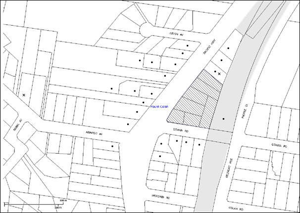
Item 16 PL52/14 Development Application - Five Storey Residential Flat Buildings Comprising 90 Units - 544-552 Pacific Highway and 1 and 1A Cowan Road, Mount Colah
RECOMMENDATION
THAT Development Application No. DA/1096/2013 for demolition of existing structures and the erection of 3 x five storey residential flat buildings comprising 90 units with basement car parking at Lot 21 DP 1044911, Lot 3 DP 20511, Lot 4 DP 20511, Lot A DP 372148, Lot B DP 372148, Lot 22 DP 1044911, Lot 1 DP 20511, Nos. 544-552 Pacific Highway and 1 and 1A Cowan Road, Mount Colah be approved as a deferred commencement pursuant to Section 80(3) of the Environmental Planning and Assessment Act, 1979 subject to the conditions of consent detailed in Schedule 1 of Group Manager’s Report No. PL52/14.
Page Number 108
Item 17 PL79/14 Development Application - Five Storey Residential Flat Building Comprising 35 Units - 12 and 14 Carlingford Road, Epping
RECOMMENDATION
THAT Development Application No. DA/797/2014 for demolition of existing structures and construction of a five storey residential flat building comprising 35 units with basement car parking at Lots 13 and 14 DP 10899, Nos. 12 and 14 Carlingford Road, Epping be approved subject to the conditions of consent detailed in Schedule 1 of Group Manager’s Report No. PL79/14.
Page Number 150
Item 18 PL76/14 Development Application - Alterations and Additions to a Dwelling-House - 65 Boronia Avenue, Cheltenham
RECOMMENDATION
THAT Development Application No. DA/898/2014 for alterations and additions to a dwelling-house at Lot 5, DP 29186, No. 65 Boronia Avenue Cheltenham be approved, subject to the conditions of consent detailed in Schedule 1 of Group Manager’s Report No. PL76/14.
Page Number 172
Item 19 PL80/14 Reporting Variations to Development Standards
RECOMMENDATION
THAT the contents of Group Manager’s Report No. PL80/14 be received and noted.
Page Number 175
Item 20 PL78/14 Design Quality of Residential Flat Development
RECOMMENDATION
THAT a submission be forwarded to the Department of Planning and Environment indicating Council’s general support for the draft amendments to State Environmental Planning Policy 65 – Design Quality of Residential Flat Development and the Residential Flat Design Code subject to the Department addressing the major issues for Hornsby Shire identified in Group Manager’s Report No. PL78/14, including:
1. Clause 6A in the draft SEPP should be deleted. The SEPP should not override Council’s controls and preclude Council from applying higher than minimum standards.
2. Car parking should not be added as a standard that cannot be used as grounds for refusal.
3. The internal unit areas in the current RFDC should be retained to promote good design rather than placing the sole emphasis on affordability.
4. A numerical control requiring a mix of unit types should be inserted to increase housing choice, including minimum requirements for dual key units.
5. The RMS Guide to Traffic Generating Development should be updated if this document is to be relied upon for setting parking standards within 800 metres of a train station.
6. Provision for deep soil zones should also accommodate planting within side setbacks where a minimum dimension of 4 metres is appropriate.
7. The existing minimum setbacks for non-habitable rooms of 6, 9 and 12 metres should be retained to preserve outcomes in relation to visual impact and landscape design.
Page Number 185
Item 21 PL82/14 Rural Lands Planning Issues Survey - Summary of Responses
RECOMMENDATION
THAT:
1. The Rural Lands Planning Issues Survey – Summary of Response Report (attached to Group Manager’s Report No. PL82/14) be received and noted.
2. The Summary of Response Report be made available for viewing on Council’s website to inform the community of the findings.
3. A Councillor Briefing be held to discuss the preparation of a strategy that responds to the findings of the survey prior to a report being presented for Council’s consideration.
4. All persons who responded to the survey be advised of Council’s resolution.
Infrastructure and Recreation Division
Page Number 191
Item 22 IR24/14 Proposed Tender "Waste Disposal of Domestic, Trade, Clean-up, Street Sweeper and Green Waste"
RECOMMENDATION
THAT Council endorse the calling of tenders for “Waste Disposal of Domestic, Trade, Clean-up, Street Sweeper and Green Waste” as outlined in Deputy General Manager’s Report No. IR24/14.
Page Number 195
Item 23 IR22/14 Tender RFT29/2014 - Sportsground Lighting at Foxglove Oval and Greenway Park Oval No. 2
RECOMMENDATION
THAT:
1. Council accept the tender from Havencord Pty Ltd T/A Floodlighting Australia in respect of Request for Tender No. RFT29/2014 Sportsground Lighting at Foxglove Oval and Greenway Park Oval No. 2.
2. The price be made public upon formal acceptance of the Tender.
Page Number 198
Item 24 IR23/14 Tender RFT30/2014 - Netball Courts at Pennant Hills Park Netball Complex
RECOMMENDATION
THAT:
1. Council accept the tender from Court Craft (Aust) Pty Ltd for the construction of asphaltic concrete courts in respect to Request for Tender No. RFT30/2014 – Netball Courts at Pennant Hills Park Netball Complex.
2. The price be made public upon formal acceptance of the Tender.
Page Number 201
Item 25 IR26/14 Tender T35/2014: Supply and Lay Asphaltic Concrete
RECOMMENDATION
THAT Council accept tender of Downer EDI Works Pty Ltd as the preferred contractor and J & E Excavations and Plant Hire Pty Ltd as the alternative (backup) contractor for all work under Tender No. T35/2014: Supply and Lay Asphaltic Concrete.
Page Number 205
Item 26 IR27/14 Tender T36/2014: Concreting - Form and Finish
RECOMMENDATION
THAT Council accept tenders of Foster Civil Contracting Construction Pty Ltd and South West Kerbing for concrete paving and drainage structures, and kerb and guttering laybacks respectively.
Confidential Items
Item 27 CS48/14 Proposed Consultancy - Property Asset Management - Epping Urban Activation Precinct
This report should be dealt with in confidential session, under Section 10A (2) (c) of the Local Government Act, 1993. This report contains information that would, if disclosed, confer a commercial advantage on a person with whom the council is conducting (or proposes to conduct) business.
PUBLIC FORUM – NON AGENDA ITEMS
Questions of Which Notice Has Been Given
Mayor's Notes
Page Number 209
Item 28 MN11/14 Mayor's Notes from 1 to 31 October 2014
Notices of Motion
SUPPLEMENTARY AGENDA
MATTERS OF URGENCY
QUESTIONS WITHOUT NOTICE
Mayoral Minute No. MM8/14
Date of Meeting: 12/11/2014
1 LOCAL GOVERNMENT NSW ANNUAL CONFERENCE 2014
From 19 to 22 October 2014, the majority of Councillors together with senior staff attended the annual Local Government NSW (LGNSW) Conference in Coffs Harbour. The Conference brings together most councils in NSW with the stated aim of local councillors being able to share ideas and debate issues that shape the way we are governed.
At a cost of almost $1,000 per delegate, plus meals accommodation and transport, Council makes a significant financial contribution to the conference. In addition to Council’s financial costs, most Councillors are required to take annual leave from their place of employment and forgo weekend and evening time with families to attend the conference. One would expect that such a significant commitment would lead to measurable benefits to Council and the local government industry itself.
However, as in previous years, I was profoundly disappointed in the quality of debate and lack of meaningful outcomes emanating from the conference Motions. Rather than focusing on the most important reform package facing local government in generations, some delegates appeared to be more concerned about the location of annual conferences, the standing orders and/or what constitutes a quorum. Less than thirty percent of the Motions on the agenda were debated and of those that were debated, a significant number of Motions were not worthy of the attendance of over 600 councillors and senior council officers.
This year the Premier and the Minister for Local Government addressed the conference to discuss local government reform and to ask councils to partner with the NSW Government in making much needed changes to the structure and governance of the industry. Both the Premier and the Minister should be congratulated for their commitment to the conference. However I am sure that they would share my disappointment in the reaction from many councils which refused to recognise and commit to the Government’s Fit for the Future initiatives, aimed at significantly improving the strategic and financial capacity of local government.
Fit for the Future is the NSW Government’s response to over three years of detailed investigations and consultation concerning the long term future of local government. The package will deliver sensible structural reform, greater financial independence, improved strategic capacity and much needed regional planning for local government.
In short, I am of the opinion that unless the LGNSW Board ensures that future conferences are relevant, meaningful and give high priority to the most important policy initiatives of the industry, Council should review whether or not it continues investing valuable ratepayer dollars attending future conferences. Accordingly, I ask Councillors to support me in writing to the President of LGNSW calling upon the Board to show cause as to how the conference will be improved in future years.
|
THAT Council write to the President of Local Government NSW asking him to demonstrate how the Board will improve the relevance of the annual conference by focussing on much needed structural and planning reform of local government in a manner that justifies Hornsby Council’s ongoing financial commitment and attendance. |
STEVE RUSSELL
Mayor
There are no attachments for this report.
File Reference: F2014/00245
Document Number: D03938750
Mayoral Minute No. MM7/14
Date of Meeting: 12/11/2014
2 GENERAL MANAGER'S PERFORMANCE REVIEW 2014
In 2011, the Division (now Office) of Local Government established Guidelines for the Appointment and Oversight of General Managers. Consistent with those Guidelines, Council engaged independent employment services firm McArthur to facilitate the General Manager’s performance review for 2013/14.
McArthur have presented me with the final report of the General Manager’s performance review for 2013/14 and it is attached to this Mayoral Minute. I am pleased to advise that the General Manager has again met or exceeded performance requirements in all ‘key result areas’ and ‘strategic performance objectives’.
Through the performance review negotiation process, new strategic performance objectives for 2014/15 have been established for the General Manager and he will be reviewed against these objectives as part of his performance review for that year.
|
THAT: 1. The 2013/14 annual performance review of the General Manager contained in the Confidential Attachment to Mayoral Minute No. MM7/14 be received and noted. 2. Having regard to the latest determination of the Statutory and Other Offices Remuneration Tribunal (SOORT), the General Manager’s contract be adjusted by 2.5% in line with the recommendations contained in the Confidential Attachment to Mayoral Minute No. MM7/14. |
STEVE RUSSELL
Mayor
|
Final Report 2014 - General Manager's Performance Review - This attachment should be dealt with in confidential session, under Section 10A (2) (a) of the Local Government Act, 1993. This report contains personnel matters concerning particular individuals (other than councillors). |
|
|
File Reference: F2013/00402
Document Number: D03938539
General Manager's Report No. GM4/14
Office of the General Manager
Date of Meeting: 12/11/2014
3 CODE OF CONDUCT COMPLAINTS - ANNUAL REPORT
EXECUTIVE SUMMARY
· Clause 12.1 of Council’s Procedures for the Administration of the Code of Conduct requires the Complaints Coordinator to report annually (within three months of the end of September) to Council on Code of Conduct complaints made about Councillors and the General Manager.
· This report covers the period from 30 September 2013 to 30 September 2014.
· In this period, there were no Code of Conduct complaints about Councillors or the General Manager.
|
THAT the contents of General Manager’s Report No. GM4/14 be received and noted. |
PURPOSE
The purpose of this Report is to formally report on Code of Conduct complaints for the period 30 September 2013 to 30 September 2014 and advise of the outcomes, if any.
BACKGROUND
Clause 12.1 of Council’s Procedures for the Administration of the Code of Conduct states:
12.1 The Complaints Coordinator must arrange for the following statistics to be reported to the Council within 3 months of the end of September of each year:
a) the total number of code of conduct complaints made about Councillors and the General Manager under the code of conduct in the year to September,
b) the number of code of conduct complaints referred to a conduct reviewer,
c) the number of code of conduct complaints finalised by a conduct reviewer at the preliminary assessment stage and the outcome of those complaints,
d) the number of code of conduct complaints investigated by a conduct reviewer,
e) the number of code of conduct complaints investigated by a conduct review committee,
f) without identifying particular matters, the outcome of code of conduct complaints investigated by a conduct reviewer or conduct review committee under these procedures,
g) the number of matters reviewed by the Division and, without identifying particular matters, the outcome of the reviews, and
h) the total cost of dealing with code of conduct complaints made about Councillors and the General Manager in the year to September, including staff costs.
DISCUSSION
There were no Code of Conduct complaints made against the Councillors or the General Manager in the period from 30 September 2013 to 30 September 2014.
BUDGET
There are no budget implications associated with this Report.
POLICY
There are no policy implications associated with this Report.
CONCLUSION
There were no Code of Conduct complaints made against the Councillors or the General Manager in the period from 30 September 2013 to 30 September 2014. A report will now be forwarded to the Office of Local Government to advise of this result.
RESPONSIBLE OFFICER
The officer responsible for the preparation of this Report is the Risk and Audit Manager (and Complaints Coordinator) – Mr Scott Allen, who can be contacted on 9847 6609.
|
Scott Phillips General Manager Office of the General Manager |
|
There are no attachments for this report.
File Reference: F2006/00554
Document Number: D03762798
General Manager's Report No. GM3/14
Office of the General Manager
Date of Meeting: 12/11/2014
4 CONTRACTUAL CONDITIONS OF SENIOR STAFF
EXECUTIVE SUMMARY
· On 16 May 2012, Council resolved that the following Senior Staff Positions exist in the Organisation Structure - Deputy General Manager, Corporate Support Division; Deputy General Manager, Infrastructure and Recreation Division; Group Manager, Environment and Human Services Division; and Group Manager, Planning Division.
· The Senior Staff Positions have operated successfully since 4 June 2012 and no changes are considered necessary. It is noted that all current Senior Staff Contracts are in accordance with Standard Contracts issued by the Office of Local Government.
· It is recommended that the current contractual conditions in respect of the current Senior Staff Positions be noted.
|
THAT the contractual conditions of current Senior Staff (as set out in General Manager’s Report No. GM3/14) be noted. |
PURPOSE
The purpose of this Report is to allow Council to meet legislative requirements associated with its reporting on Senior Staff Positions.
BACKGROUND
Section 339 of the Local Government Act requires that the General Manager must at least annually report to Council on the contractual conditions of Senior Staff.
DISCUSSION
Organisation Structure
Following a review by independent consultants of Council’s Internal Services (in 2011) and External Services (in 2012), and my appointment as General Manager in 2011, the previous Council adopted a new Organisation Structure which became effective from 4 June 2012 (refer General Manager’s Report No. GM10/12 considered at the 14 March 2012 Workshop Meeting). The new Structure comprises the Office of the General Manager and four Divisions - Corporate Support; Infrastructure and Recreation; Environment and Human Services; and Planning.
In the period from 4 June 2012 until now, the Structure has operated successfully and no changes to the Structure are considered necessary.
Senior Staff Positions
At its Ordinary Meeting on 16 May 2012 (refer Mayoral Minute No. MM5/12) Council resolved that the following be determined as Senior Staff Positions in the Organisation Structure - Deputy General Manager, Corporate Support Division; Deputy General Manager, Infrastructure and Recreation Division; Group Manager, Environment and Human Services Division; and Group Manager, Planning Division. This structure was re-determined by Council at its General Meeting on 18 December 2013 (refer General Manager’s Report No. GM6/13).
In the period from 4 June 2012 until now, the Senior Staff Positions in the Structure have operated successfully and no changes are considered necessary. As a consequence, it is recommended that the existing Senior Staff Positions be re-determined by Council.
Contractual Conditions of Senior Staff
Appointments to Council’s current Senior Staff Positions took effect on the following dates for the periods shown:
Senior Staff Position Appointment Date Period
General Manager 26 August 2013 5 years
Deputy General Manager, Corporate Support 4 June 2012 5 years
Deputy General Manager, Infrastructure and Recreation 4 June 2012 5 years
Group Manager, Environment and Human Services 4 June 2012 5 years
Group Manager, Planning 4 June 2012 5 years
(NB. In accordance with Office of Local Government (OLG) requirements, all Senior Staff contracts are in accordance with Standard Contracts issued by the OLG).
It is recommended the above contractual conditions of Senior Staff be received and noted.
BUDGET
There are no budgetary implications associated with this Report.
POLICY
There are no policy implications associated with this Report.
CONCLUSION
Council’s consideration of this Report ensures that relevant legislative requirements have been met in respect of Senior Staff Positions.
RESPONSIBLE OFFICER
The officer responsible for the preparation of this Report is the Risk and Audit Manager – Scott Allen, who can be contacted on 9847 6609.
|
Scott Phillips General Manager Office of the General Manager |
|
There are no attachments for this report.
File Reference: F2005/00481
Document Number: D03762773
Deputy General Manager's Report No. CS47/14
Corporate Support Division
Date of Meeting: 12/11/2014
5 2013/14 AUDITED FINANCIAL STATEMENTS - PRESENTATION TO THE PUBLIC
EXECUTIVE SUMMARY
· In accordance with Sections 413, 415, 416 and 417 of the Local Government Act, Council must prepare and have audited its General Purpose and Special Purpose Financial Statements within four months of the end of each financial year.
· At the 8 October 2014 General Meeting, Council received and noted the 2013/14 Financial Statements and resolved to refer them for audit. Council also delegated authority to the General Manager to fix the date at which the Financial Statements and Auditor’s Report would be presented to the public. Following receipt of the Auditor’s Report, the General Manager determined that such presentation would occur at the 12 November 2014 General Meeting.
· Following formal presentation of the Financial Statements and Auditor's Reports to the public at the 12 November 2014 General Meeting, members of the public, in accordance with Section 420 of the Local Government Act, have seven days, i.e. until 19 November 2014, to make submissions about the Statements.
|
THAT the 2013/14 General Purpose and Special Purpose Financial Statements and associated Auditor's Report, as presented to the public on 12 November 2014, be adopted. |
PURPOSE
The purpose of this Report is to allow Council's 2013/14 General Purpose and Special Purpose Financial Statements and associated Auditor's Reports to be presented to the public in accordance with Section 419(1) of the Local Government Act.
BACKGROUND
In accordance with Sections 413, 415, 416 and 417 of the Local Government Act, Council must prepare and have audited its General Purpose and Special Purpose Financial Statements within four months of the end of each financial year.
At the 8 October 2014 General Meeting, Council considered Deputy General Manager’s Report No. CS41/14 – General Purpose and Special Purpose Financial Reports – 2013/14 Financial Year – and resolved that:
1. The 2013/14 General Purpose and Special Purpose Financial Reports be received and noted and referred for audit.
2. The Mayor and Deputy Mayor be authorised to sign the Statutory Statements in connection with the 2013/14 Financial Reports.
3. The 2013/14 Financial Reports be authorised for “presentation to the public” on receipt of the Auditor’s Report.
4. The General Manager be delegated authority to fix the date of the General Meeting at which the 2013/14 Financial Reports and Auditor’s Report are formally “presented to the public”.
DISCUSSION
Following the 8 October 2014 General Meeting, the 2013/14 General Purpose and Special Purpose Financial Statements were signed and referred to PricewaterhouseCoopers for audit. PricewaterhouseCoopers have subsequently issued an Auditor’s Report and identified no issues, other than minor presentation matters, which required changes to the Financial Statements.
Following receipt of the Auditor's Report, the General Manager authorised, in accordance with Council’s resolution of 8 October 2014, that presentation of the Financial Statements and Auditor’s Report to the public would occur at the 12 November 2014 General Meeting. As a result, public notices have been placed in local newspapers and on Council's website in accordance with Section 418 of the Act.
Hard copies of the Financial Statements and Auditor's Report are available for viewing by members of the public at Council's Administration Centre and Branch Libraries. An electronic copy of the Financial Statements and Auditor's Reports has also been placed on Council's website at http://www.hornsby.nsw.gov.au/__data/assets/pdf_file/0007/67579/lowres-Total-Hornsby-Shire-Council-Financial-Statements-2013-14.pdf and is available in TRIM (refer Document No. D03932858).
Following formal presentation of the Financial Statements and Auditor's Report to the public at the 12 November 2014 General Meeting, members of the public, in accordance with Section 420 of the Local Government Act have seven days, i.e. until 19 November 2014, to make submissions about the documents. Such submissions must be in writing and must be referred by Council to the Auditor for his response.
It is noted that Council's external auditor, Dennis Banicevic of PricewaterhouseCoopers, has indicated his availability to make a presentation about the Financial Statements, Auditor’s Report and Council's financial position at the 12 November 2014 General Meeting.
CONSULTATION
In the preparation of this Report there was consultation with Council’s External Auditor.
BUDGET
There are no budgetary implications associated with this Report.
POLICY
There are no policy implications associated with this Report.
CONCLUSION
The presentation of the 2013/14 Financial Statements and Auditor’s Report to the public at the 12 November 2014 General Meeting will ensure that the requirements of the Local Government Act have been met and that the public have an opportunity to make any relevant submissions to Council about the documents.
RESPONSIBLE OFFICER
The officer responsible for the preparation of this Report is the Chief Financial Officer – Mr Glen Magus, who can be contacted on 9847 6635.
|
Glen Magus Chief Financial Officer - Financial Services Corporate Support Division |
Gary Bensley Deputy General Manager Corporate Support Division |
There are no attachments for this report.
File Reference: F2014/00272
Document Number: D03850620
Deputy General Manager's Report No. CS42/14
Corporate Support Division
Date of Meeting: 12/11/2014
6 LOCAL GOVERNMENT REFORM - NSW GOVERNMENT'S "FIT FOR THE FUTURE" ANNOUNCEMENTS
EXECUTIVE SUMMARY
· In March 2014, Council made submissions to the NSW Government in respect of the local government reform recommendations of the Independent Local Government Review Panel (ILGRP) and the Local Government Acts Taskforce (LGAT). In September 2014, the Government released its responses to the ILGRP and LGAT recommendations under the banner Fit for the Future. The responses were mostly consistent with Council’s submissions.
· The Government has indicated that a Fit for the Future council in NSW will be sustainable; efficient; effectively manage infrastructure and deliver services for communities; and have the scale and capacity to engage effectively across community, industry and government. By being Fit for the Future, councils will have access to a streamlined IPART process for rate increases; access to a TCorp borrowing facility; priority access to other State funding and grants; and be eligible for additional devolved planning powers.
· Stage 1 of the Fit for the Future process will see councils use a self-assessment tool to review their current performance against defined criteria. Based on these results, councils will progress to Stage 2 to prepare a roadmap demonstrating how they will become Fit for the Future. In Stage 3 an expert panel will review each council’s roadmap. If approved, councils will move to Stage 4 and implement their roadmaps and take advantage of available benefits.
· The Government’s recommendation for Hornsby is that it voluntarily merge with Ku-ring-gai Council to form a new local government area with a population of approximately 280,000. The Councils would be eligible for funded support from the Government to investigate reform opportunities and, if a merger was approved to take place, the new local government area would be eligible for at least $10.5 million from the Government to implement the merger.
· It is important for Council to fully engage in the next stage of the process with the Government and with its neighbouring councils before developing a joint or single Fit for the Future roadmap submission. In this regard, Council should undertake the self-assessment exercise as well as continuing discussions with Ku-ring-gai Council (and other neighbouring councils as appropriate) to explore Fit for the Future reform opportunities.
|
THAT prior to developing its Fit for the Future roadmap submission, Council undertake the self-assessment exercise required by the NSW Government and continue to engage with Ku-ring-gai Council (and other neighbouring councils as appropriate) to explore relevant opportunities for local government reform as outlined in the NSW Government’s Fit for the Future program. |
PURPOSE
The purpose of this Report is to advise Council of the NSW Government’s recent announcements about local government reform initiatives under the Fit for the Future banner and to table a response received from Ku-ring-gai Council about its reaction to the KPMG report which was commissioned by Hornsby Council earlier this year to advise Council about local government reform options in northern Sydney.
BACKGROUND
At the 12 March 2014 General Meeting, Council considered Deputy General Manager’s Report No. CS5/14 – Independent Local Government Review Panel – Final Report – “Revitalising Local Government” – and resolved:
THAT responses to the Independent Local Government Review Panel’s recommendations, as detailed in Deputy General Manager’s Report No. CS5/14, form the basis of a submission to the NSW Government.
Also at the 12 March 2014 General Meeting, Council considered Deputy General Manager’s Report No. CS6/14 – Local Government Acts Taskforce – Final Report – “A New Local Government Act for New South Wales and Review of the City of Sydney Act 1988” – and resolved:
THAT responses to the Local Government Acts Taskforce recommendations, as detailed in Deputy General Manager’s Report No. CS6/14, form the basis of a submission to the NSW Government.
Following the 12 March 2014 General Meeting, the General Manager forwarded Council’s submissions about the Panel’s and Taskforce’s recommendations to the Office of Local Government and copies of the submissions were placed on Council’s website under the Local Government Reform tab.
At the 11 June 2014 General Meeting, Council considered Deputy General Manager’s Report No. CS13/14 – Analysis of Local Government Reform Options in the Northern Sydney Area – Report Prepared by KPMG – and resolved that:
1. KPMG’s “Analysis of local government reform options in the Northern Sydney area” report be made available on Council’s website and a copy sent to the Minister for Local Government and The Hills and Ku-ring-gai Councils.
2. The NSW Government be encouraged to facilitate local government reform having regard to the research undertaken for Council by KPMG, PWC and Crosby Textor; and the recommendations made by the ILGRP and the LGAT.
3. The Hills and Ku-ring-gai Councils be requested to provide their comments on the reform options outlined by KPMG.
4. When the NSW Government releases its responses to the recommendations made by the ILGRP and the LGAT, a further report be prepared for Council’s consideration incorporating any feedback received from The Hills and Ku-ring-gai Councils about the KPMG reports.
Following the Meeting, KPMG’s report was placed on Council’s website under the Local Government Reform tab; the Mayor provided a copy of the report to the Minister for Local Government and encouraged the NSW Government to commence reform of the local government industry; and the General Manager provided a copy of the report to the General Managers of The Hills and Ku-ring-gai Councils asking those Councils to provide any comments they may have on the reform options outlined in KPMG’s report.
DISCUSSION
NSW Government’s Response to Independent Local Government Review Panel (ILGRP) and Local Governments Acts Taskforce (LGAT) Recommendations
On 10 September 2014, the NSW Government released its responses to the ILGRP and LGAT recommendations contained in their respective reports from 2013 titled “Revitalising Local Government” and “A New Local Government Act for New South Wales and Review of the Sydney of City Act 1988”. A copy of the Government’s responses to the recommendations from the ILGRP and LGAT reports is held in TRIM (refer Document No. D03932915) and is also available on the NSW Government’s website www.fitforthefuture.nsw.gov.au. The Government’s responses are in line with Council’s responses to the same recommendations.
The Government has stated that more than one-third of the State’s councils are facing financial problems, infrastructure backlogs are overwhelming, many of our growing suburbs are being constrained by boundaries that date back to the horse and cart days, and councils are missing out on opportunities to take a more active role in regional and State planning because they lack the scale and structures to engage. The work of the ILGRP and the NSW Treasury Corporation (TCorp) has helped the Government to build a clearer picture of what they believe a sustainable council looks like.
Based on the above, the Government has released a number of publications which outline in more detail how they intend to move down the local government reform path under the banner Fit for the Future. The publications include the following:
· Fit for the Future – A Roadmap for Stronger, Smarter Councils
· Fit for the Future – A Blueprint for the Future of Local Government
· Fit for the Future – Frequently Asked Questions.
Copies of the documents are held in TRIM (refer Document Nos D03932917, D03932936 and D03932939 respectively) and are also available on www.fitforthefuture.nsw.gov.au.
Fit for the Future Councils
The Government has indicated that, in its view, a Fit for the Future council will have the following features which will ensure that the council has the strategic capacity to govern effectively and partner with industry and the Government to deliver key priorities:
· it will be sustainable
· it will be efficient
· it will effectively manage infrastructure and deliver services for communities
· it will have the scale and capacity to engage effectively across community, industry and government.
Financial Sustainability
For councils to meet the service and infrastructure needs of their communities, they will need to be financially sustainable. TCorp has defined a sustainable council as one that, over the long term, is able to generate sufficient funds to provide the level and scope of services and infrastructure, agreed with the community through the Integrated Planning and Reporting (IP&R) process.
The criteria proposed to be used by the Government to determine if a council is Fit for the Future in terms of financial sustainability are:
· Operating Performance Ratio – a score greater than or equal to break-even averaged over a three year period is required
· Own Source Revenue Ratio – a score greater than 60% of total operating revenue is required
· Building and Infrastructure Asset Renewal Ratio – a score greater than 1 averaged over a three year period is required.
Infrastructure and Services
In respect of effectively managing infrastructure and services, a Fit for the Future council will be one that:
· knows the current and future infrastructure needs of the community
· develops, maintains and renews infrastructure using the right mix of revenue and borrowing
· works with others to deliver cost effective services
· delivers services and infrastructure that meets the needs of communities as identified through the IP&R reporting process
· delivers services and infrastructure on time and on budget.
The criteria proposed to be used by the Government to determine if a council is Fit for the Future in terms of infrastructure and services management are:
· Infrastructure Backlog Ratio – a score less than 2% is required
· Asset Maintenance Ratio – a score greater than 1 is required
· Debt Service Ratio – a score greater than 0% and less than 20% is required.
Efficiency
The Government has indicated that an efficient Fit for the Future council will be able to:
· minimise unnecessary burden on business and the community
· provide value for money to the community
· manage resources well to deliver services and infrastructure.
The criteria proposed to be used by the Government to determine if a council is Fit for the Future in terms of efficiency is:
· Movement in Real Operating Expenditure per Capita over a five year period.
Scale and Capacity
The Government believes that scale is a key component of strategic capacity – both in creating individual councils with the resources and skills to provide leadership on regional planning and to advocate on behalf of communities by creating a system of local government where State and Local Government can work together effectively. As a consequence, a Fit for the Future council will be one that:
· saves money on bureaucracy and administration, freeing up funds for frontline services and community facilities
· can contribute to projects and tackle issues that impact on its residents and extend beyond the council boundary
· has credibility and influence across councils, across government and with industry.
The criteria proposed to be used by the Government to determine if a council is Fit for the Future in terms of scale and capacity is:
· whether the scale and capacity of the local government area being assessed is consistent with the recommendations of the ILGRP.
Benefits of Being a Fit for the Future Council
The Government believes that councils who have made the changes necessary to become Fit for the Future will have the capacity, strength, expertise and credibility to help shape the future of NSW. In recognition of that, the Government has indicated that it will give Fit for the Future councils:
· access to a streamlined IPART process for rate increases above the rate pegging limit, particularly focused on infrastructure funding needs, making it easier for councils to increase rates to fund services and infrastructure the community has said it wants and is willing to pay for
· access to a TCorp borrowing facility that will save NSW councils up to $600 million on the cost of borrowing, helping them to fund the crucial infrastructure that communities need
· priority access to other State funding and grants
· eligibility for additional devolved planning powers in relation to the making of local environmental plans and development decisions, and opportunities for devolving further planning powers.
Metropolitan Sydney
In respect of metropolitan Sydney, which has the most relevance to Hornsby, the Government has commented that Sydney is the fastest growing capital city in Australia. In the next 20 years, a further two million people will make Sydney their home with most of them settling in the western suburbs. A new international airport will be established and major growth centres will be developed in the north-west and south-west regions. Some communities will quadruple their size. New motorways and freight hubs will be needed, as well as hospitals, schools and large scale sporting facilities. To cope with this growth and Sydney’s emerging role as a global city, NSW needs a modern, more connected system of local government.
There are currently 41 councils in Greater Sydney, all with their own rules and regulations. This means multiple licences, fees and approvals for small business and different development rules for people who want to build or renovate their homes. It also means people in different suburbs receive different levels of service. The Government believes everyone in Sydney deserves a strong future and that Sydney cannot continue to be constrained by boundaries that were set over 100 years ago. If governments are to deliver the housing, jobs and transport people will need in the next 20 years, a more connected system of local government must be created.
The Fit for the Future program has been established to help councils and their communities take advantage of emerging opportunities. Fit for the Future councils will be provided with a seat at the table in planning Greater Sydney’s future, and will receive more local planning powers. They will also have access to cheaper finance to build and maintain the facilities that communities need, such as roads, parks, footpaths, sporting facilities and community centres. The Government intends to invest up to $1 billion to create a more connected Global city and a smarter system of local government that can provide the services our growing communities need.
Determining Which Council Areas are Fit for the Future
In its document “Fit for the Future – A Blueprint for the Future of Local Government”, the Government has requested that councils across NSW review their situation, prepare a submission and then transition to being Fit for the Future.
Reviewing the Current Situation
Each council has been requested to look at its current situation and consider the future needs of its community and the recommendations of the ILGRP. The Government has recently provided a self-assessment tool to help guide the discussion. The assessment will help councils to get a clear picture of how they are performing in financial management, service delivery and scale of operations. It will also help them to identify what they may need to do to ensure they are Fit for the Future. Councils will be encouraged to discuss ideas and options with their community and neighbouring local government areas. The Office of Local Government (OLG) will help with guidelines and templates and councils will be able to access support from their regional relationship manager through the OLG’s One Stop Shop.
Preparing a Submission
After considering their situation, councils will be asked to submit a proposal by 30 June 2015 about how they intend to be/become Fit for the Future. The Government has assisted by providing guidelines and templates. Councils will be able to get support from their OLG relationship manager and will also have access to expert assistance if they want to look at voluntary merger options. In this regard, the ILGRP’s recommendations are proposed as a good starting point for how councils can achieve the scale and capacity they require to become Fit for the Future. For some councils, joining forces with their neighbours may be the best option. The Government has committed to providing generous support if councils want to pursue that path. Larger councils who are already performing well may develop strategies to strengthen their operations and improve efficiencies. The proposals will be assessed by an independent expert panel and councils will receive feedback. The panel will then make recommendations to the Minister for Local Government.
Making the Transition
Once councils have a plan in place to become Fit for the Future, they will receive assistance and support from the Government to implement their plan. For merging councils, this includes funding to support the transition process and establish their new Fit for the Future venture. When Fit for the Future councils have completed their transition, they will have access to a range of opportunities including cheaper finance options, simplified reporting requirements, priority access to State funding and grants and options for additional planning powers.
Fit for the Future Process and Timeline
The Government has proposed the following four stages in its Fit for the Future process:
Stage 1
Councils were recently provided with a self-assessment tool to help them review their current performance against the Fit for the Future criteria. Based on these results, councils will progress to Stage 2 to prepare a roadmap demonstrating how they will move towards becoming Fit for the Future.
Stage 2
Councils will need to prepare a roadmap for becoming Fit for the Future, taking account of their community’s needs and future outlook. Consideration of scale and capacity will be the starting point and will be based on the ILGRP’s recommendations for each council. Councils may submit proposals for scale and capacity that are different to the recommendations made by the ILGRP so long as they are broadly consistent with the recommendations. Councils will not need to address the other three criteria (i.e. sustainability, efficiency and effective services and infrastructure) until they have made the changes to have the right scale and capacity. Councils that already have the right scale and capacity based on the ILGRP’s recommendations will need to prepare a roadmap for how they will address the other three criteria. Fit for the Future roadmaps must be submitted by 30 June 2015 for review by a team of independent experts.
Stage 3
During this stage, the expert panel will review each Council’s roadmap. The Panel will make recommendations to the Minister for Local Government based on the Panel’s assessment.
Stage 4
In Stage 4, councils who are Fit for the Future will begin to implement their roadmaps and take advantage of the benefits of being a Fit for the Future council. Newly formed councils will provide a plan for how they will meet the sustainability, efficiency and effective services and infrastructure criteria.
Assistance in Preparing a Roadmap
The Government has committed to supporting councils to develop their roadmap and to make the changes necessary to become Fit for the Future. The support and funding includes:
· a One Stop Shop, hosted by the OLG, giving councils access to Regional Relationship Managers to assist them explore options and access additional support
· access to fully funded skilled facilitators, to assist in bringing councils to the table to identify risks, benefits and options for voluntary mergers
· establishing a panel of technical experts, with skills in financial analysis, asset management and governance, to support councils gaining access to the information and skills they need
· access to a structural change expert panel for councils that commit to structural change, to provide affordable access to technical advice to undertake due diligence and community consultation to support voluntary merger proposals. The State will fund 50% of the cost to councils.
Government’s Recommendation for Hornsby and Assistance Potentially Available
The Government’s recommendation for Hornsby Shire Council is that it voluntarily merge with Ku-ring-gai Council to form a new local government area with a population of approximately 280,000. If Council is supportive of such a recommendation, it appears that Council would be eligible for the following support from the Government to progress the matter:
· access to an OLG Relationship Manager to assist in exploring options and additional support which may be available
· access to fully funded skilled facilitators, to assist Hornsby and Ku-ring-gai to meet and to identify risks, benefits and options for such a merger
· access to a panel of technical experts to assist in gathering all the information required to make a decision
· if there was agreement to the merger, access to a structural change expert panel who could provide affordable access (50% of cost covered by the Government) to technical advice to undertake due diligence and community consultation to support voluntary merger proposals.
If a merger was approved to take place, the new local government area would also be eligible for at least $10.5 million (and possibly up to $13.5 million if the total population estimate reached 300,000) from the Government to implement the merger. It would also be eligible for other components of the Government’s Fit for the Future package.
Moving Forward
Having regard to all of the above, and in particular the requirement for Council to make a submission to the OLG by 30 June 2015 about how it will be Fit for the Future, it is apparent that Council needs to move down the following path or similar:
· October/November 2014 - undertake the self-assessment questionnaire distributed by the OLG to determine Council’s placement against the Fit for the Future criteria.
· November/December 2014 - continue discussions with Ku-ring-gai Council (and potentially other neighbouring councils) to formally determine their willingness to participate in discussions about the potential for merger opportunities – this may involve assistance from the OLG’s Relationship Manager and/or an experienced facilitator.
· January-June 2015 - depending on the response from Ku-ring-gai (or other neighbouring councils), commence preparation of a joint or single submission showing how a merged council, or Hornsby as a single entity, is Fit for the Future.
___________________________________
Neighbouring Council Responses to KPMG Report - “Analysis of local government reform options in the Northern Sydney area”
At the time of preparing this Report, a response has only been received from the General Manager of Ku-ring-gai Council about the KPMG report. A copy of the response is attached. It indicates that Ku-ring-gai Council considered the KPMG report at its 12 August 2014 Ordinary Meeting and resolved that:
Council note that the report commissioned by Hornsby Council “Analysis of local government reform options in the Northern Sydney area – 22 May 2014” does not support the case for amalgamation of Ku-ring-gai and Hornsby Councils as the forecast saving is small compared to the risks involved, representing only 1.6% of the combined budgets over 10 years. This forecast:
i. Is based on simplistic assumptions derived from case studies of Council amalgamations of much larger scale and range of services offered
ii. Is likely to be optimistic and does not include an adequate allowance for transition costs
iii. Does not provide an adequate return for the substantial risks and disruption involved in an amalgamation
iv. Does not take into account the impact on Ku-ring-gai ratepayers in sharing in substantial costs to rehabilitate and stabilise the Hornsby Quarry
v. Does not take into account the impact of rates redistribution on Ku-ring-gai ratepayers due to higher land values, resulting in an increase in rates likely to be much greater than the forecast savings from amalgamation
vi. Does not address the loss of councillor representation, nor the operational difficulties, social challenges, town planning issues and political complexities in managing an amalgamation of two large, diverse council areas that stretch from the rural locality of Wisemans Ferry through to the urban suburb of Roseville, some 65 km to the south
vii. That Ku-ring-gai Council’s response to the report commissioned by Hornsby Council be sent to the State MPs for Ku-ring-gai, Davidson and Hornsby
Ku-ring-gai’s report on the matter states that it would be exposed to the following risks if there was an amalgamation of Ku-ring-gai and Hornsby Councils:
· Reduced representation and less say in decision making for the local area; the risk of decisions about the Ku-ring-gai area being made by a majority of councillors elected from the Hornsby area due to a larger population
· Increased rates for Ku-ring-gai ratepayers due to redistribution of the rates burden from areas of lower land value (Hornsby) to areas of higher land value (Ku-ring-gai)
· Unknown financial liabilities such as for rehabilitation of the Hornsby Quarry
· Impact on the composition, quality and quantity of services due to the rationalisation of facilities and services
· Disruption to service provision, loss of skilled workers, fall in staff morale and productivity loss
· Utilising simplistic assumptions based on anecdotal evidence from the KPMG report could lead to increased costs rather than savings
· Forecast financial savings are small in comparison to the substantial risks and disruption from amalgamation.
CONSULTATION
In the preparation of this Report, there was consultation with The Hills and Ku-ring-gai Councils in respect of the KPMG report. Council has also been represented at discussions and presentations about the Fit for the Future program recently announced by the State Government.
BUDGET
At this stage of the process there are no budgetary implications. Depending on how the local government reform process progresses, Council may incur costs and may be eligible for funding from the Government. These will be detailed in a future report when further details are known and included in a quarterly budget review as appropriate.
POLICY
As a responsible local government authority, Council continues to be committed to participating in an ongoing discussion with the NSW Government and neighbouring councils about reform of local government.
CONCLUSION
Now that the NSW Government has formalised its approach to the reform of local government, it is important for Council to fully engage in the next stage of the process with the Government and with its neighbouring councils. Council is already in an excellent position to contribute to discussions and research, having received reports from KPMG (about local government reform options in northern Sydney; from Crosby Textor (about the community’s view of local government reform in general and in particular amalgamations and shared services); and from PricewaterhouseCoopers (about the issues, benefits and disadvantages associated with Council amalgamating with its neighbouring councils).
It is proposed that Council undertake the self-assessment questionnaire distributed by the OLG and continue discussions with Ku-ring-gai Council (and potentially other neighbouring councils) to explore potential merger opportunities. Depending on the responses it receives, Council should then commence the preparation of a joint or single submission to the NSW Government showing how it is Fit for the Future.
RESPONSIBLE OFFICER
The officer responsible for the preparation of this Report is the Deputy General Manager, Corporate Support Division – Gary Bensley, who can be contacted on 9847 6605.
|
Gary Bensley Deputy General Manager Corporate Support Division |
Scott Phillips General Manager Office of the General Manager |
|
1.View |
Ku-ring-gai Council Letter - 15 August 2014 - Response to KPMG Report |
|
|
File Reference: F2014/00494
Document Number: D03662698
Deputy General Manager's Report No. CS44/14
Corporate Support Division
Date of Meeting: 12/11/2014
7 INVESTMENTS AND BORROWINGS FOR 2014/15 - STATUS FOR PERIOD ENDING 30 SEPTEMBER 2014
EXECUTIVE SUMMARY
· Council may invest funds that are not, for the time being, required for any other purpose. The investments must be in accordance with relevant legislative requirements and Council’s policies. The Chief Financial Officer must report monthly to Council on the details of funds invested.
· This Report provides details of Council’s investment performance for the period ending 30 September 2014. It indicates that for cash and term deposit investments, the annualised return for the month of September was 3.64% compared to the benchmark of 2.50%. The annualised return for the investments for the month ending 30 September 2014 (including investments which matured/expired this financial year) was 3.61% compared to the benchmark of 2.50%.
· All investments have been made in accordance with the Local Government Act, the Local Government (General) Regulation and Council's Investment of Surplus Funds Policy and Investment Strategy.
· In respect of Council borrowings, the weighted average interest rate payable on loans taken out from June 2005 to September 2014, based on the principal balances outstanding, is 6.07%.
|
THAT the contents of Deputy General Manager’s Report No. CS44/14 be received and noted. |
PURPOSE
The purpose of this Report is to advise Council of funds invested in accordance with Section 625 of the Local Government Act; and to provide details as required by Clause 212(1) of the Local Government (General) Regulation and Council's Investment of Surplus Funds Policy.
BACKGROUND
A report is required to be submitted for Council’s consideration each month detailing Council's investments and borrowings and highlighting the monthly and year to date performance of the investments. Initial investments and reallocation of funds are made, where appropriate, after consultation with Council's financial investment adviser and fund managers.
DISCUSSION
Council may invest funds which are not, for the time being, required for any other purpose. Such investment must be in accordance with relevant legislative requirements and Council Policies, and the Chief Financial Officer must report monthly to Council on the details of the funds invested.
Council’s investment performance for the month ending 30 September 2014 is detailed in the attached document and summarised below:
· The At-Call and Term Deposits achieved an annualised return of 3.64% for September compared to the benchmark of 2.50%.
· A Capital Protected Note, Longreach Series 29 Tri-Sector (for $1 million), was fully redeemed at maturity in September 2014.
· For total investments, the annualised return for September 2014 was 3.61% compared to the benchmark of 2.50%.
· In respect of Council borrowings, the weighted average interest rate payable on outstanding loans taken out from June 2005 to September 2014, based on the principal balances outstanding, is 6.07%. The Borrowings Schedule as at 30 September 2014 is attached for Council’s information.
CONSULTATION
Appropriate consultation has occurred with Council's financial investment adviser and fund managers.
BUDGET
Budgeted investment income for 2014/15 is $1,764,000, with an average budgeted monthly income of $147,000. Actual investment income for the quarter ended September 2014 was $478,000 compared to budget for the same period of $441,000. Approximately 28% of the investment income received by Council relates to externally restricted funds (e.g. Section 94 monies) and is required to be allocated to those funds. All investments have been made in accordance with the Local Government Act, the Local Government (General) Regulation and Council's Investment of Surplus Funds Policy and Investment Strategy.
CONCLUSION
The investment of Council funds for the period ending 30 September 2014 is detailed in the documents attached to this Report. Council’s consideration of the Report and its attachments ensures that the relevant legislative requirements and Council protocols have been met in respect of those investments.
RESPONSIBLE OFFICER
The officer responsible for the preparation of this Report is the Chief Financial Officer – Glen Magus, who can be contacted on 9847 6635.
|
Glen Magus Chief Financial Officer - Financial Services Corporate Support Division |
Gary Bensley Deputy General Manager Corporate Support Division |
|
1.View |
HSC Investment Portfolio as at 30 September 2014 |
|
|
|
2.View |
HSC Borrowings Schedule as at 30 September 2014 |
|
|
File Reference: F2004/06987
Document Number: D03769612
Deputy General Manager's Report No. CS46/14
Corporate Support Division
Date of Meeting: 12/11/2014
8 COUNCIL'S 2013/14 ANNUAL REPORT
EXECUTIVE SUMMARY
· An annual report is one of the key points of accountability between a council and its community. In this regard, NSW councils are required to prepare an annual report within five months of the end of the financial year, place the report on their website and submit the report to the Office of Local Government (OLG).
· The Hornsby Shire Council Annual Report 2013/14 has been prepared in accordance with the requirements of the legislation (Local Government Act and Regulation) and the OLG. The Annual Report also includes information which ensures that annual reporting requirements imposed on Council by other legislation or statutory bodies are met.
· The 2013/14 Annual Report focuses on Council’s achievements in implementation of its Delivery Program. Council’s 2013/14 audited Financial Statements are to form part of the Annual Report once they are “presented to the public” at the 12 November 2014 General Meeting.
|
THAT: 1. The Hornsby Shire Council Annual Report 2013/14, which has been made available on Council’s website, be received and noted. 2. The Annual Report be supplemented by Council’s 2013/14 audited Financial Statements once they are “presented to the public” at the 12 November 2014 General Meeting. 3. A copy of the final Annual Report 2013/14 be submitted to the Office of Local Government by 30 November 2014. |
PURPOSE
The purpose of this Report is to present the 2013/14 Annual Report for Council’s consideration.
BACKGROUND
Section 428 of the Local Government Act requires that a council prepare an annual report within five months of the end of the financial year. The council is required to place the report on its website and submit a copy to the OLG. The annual report must contain information required by the Act and the Local Government (General) Regulation as well as the Integrated Planning and Reporting guidelines developed by the OLG in line with section 406 of the Act.
DISCUSSION
The Hornsby Shire Council Annual Report 2013/14 has been prepared in accordance with the requirements of the Local Government Act, the Local Government (General) Regulation and the OLG’s Integrated Planning and Reporting Guidelines. The Annual Report also includes information to meet requirements imposed by other legislation and statutory bodies, including information on Voluntary Planning Agreements required by the Independent Commission Against Corruption and a report on implementation of recovery plans required under the Threatened Species Conservation Act 1995. A copy of the Annual Report is held in TRIM (refer Document No. PUB000237) and is also available for viewing on Council’s website at hornsby.nsw.gov.au/council/about-council/corporate-documents-and-reports/annual-report.
The Annual Report will formally be supplemented by Council’s audited financial statements once Council has considered Deputy General Manager’s Report No. CS47/14 – 2013/14 Audited Financial Statements – Presentation to the Public (at the 12 November 2014 General Meeting). A copy of the final Annual Report for 2013/14, including the 2013/14 Financial Statements, will then be provided to the OLG by 30 November 2014.
BUDGET
There are no budgetary implications associated with this Report.
POLICY
There are no policy implications associated with this Report.
CONCLUSION
Council’s consideration of this Report will ensure that the Hornsby Shire Council Annual Report 2013/14 is submitted to the OLG in line with statutory requirements.
RESPONSIBLE OFFICER
The officer responsible for the preparation of this Report is the Manager, Strategy and Communications – Julie Williams, who can be contacted on 9847 6790.
|
Julie Williams Manager - Strategy and Communications Corporate Support Division |
Gary Bensley Deputy General Manager Corporate Support Division |
There are no attachments for this report.
File Reference: F2013/00651
Document Number: D03821707
Deputy General Manager's Report No. CS45/14
Corporate Support Division
Date of Meeting: 12/11/2014
9 DELIVERY PROGRAM FOR 2013-17 AND OPERATIONAL PLAN (BUDGET) FOR 2014/15 - SEPTEMBER 2014 QUARTER REVIEW
EXECUTIVE SUMMARY
· Accountable organisations like Council review their budget and operational performance at least each quarter. In this regard, the September 2014 Quarter Review of the 2013-17 Delivery Program including the 2014/15 Operational Plan and Budget is attached.
· The 2014/15 Original Budget forecast a surplus at 30 June 2015 of $143K. This September Review recommends changes of $65K which reduces the forecast 30 June 2015 Budget surplus to $78K.
· Progress against the adopted Delivery Program 2013-17 and the operational performance of the organisation has been in line with the service delivery standards adopted by Council.
|
THAT the September 2014 Quarter Review of the 2013-17 Delivery Program and the Operational Plan (Budget) for 2014/15 be received and noted. |
PURPOSE
The purpose of this Report is to present for Council’s consideration the September 2014 Quarter Review of the 2013-17 Delivery Program and the 2014/15 Operational Plan.
BACKGROUND
On 19 June 2013, Council adopted its four year Delivery Program 2013-17. The annual Operational Plan and Fees and Charges for 2014/15 were adopted by Council on 11 June 2014. The Delivery Program and Operational Plan set out the manner in which Council intends to deliver services and measure performance.
In line with Office of Local Government requirements, a Quarterly Budget Review Statement (QBRS) must be submitted for Council’s consideration at the end of each quarter. The Statement must be based on key financial indicators and the estimate of income and expenditure set out in Council’s Operational Plan for the relevant year.
DISCUSSION
Operational Comment
Operational performance for the first quarter of 2014/15 has been satisfactory. The highlights achieved during the quarter include:
· Installation of solar panels at Hornsby and Epping libraries which is expected to save Council almost $30,000 per year
· Completion, and official opening on 28 September 2014, of the upgrade of the Cherrybrook Skate Park at Greenway Park
· Development of an Online Interactive Planning Map Application on Council’s website which allows residents to see planning controls applying to their property
Other highlights are contained in Attachment 1.
Budget Comment
This Review includes the first quarter results for 2014/15, comparing actual expenditure and income for the first quarter against the Budget. The Net Operating and Capital result after internal funding movements showed a positive variance of $2.539 million as compared to the September 2014 Quarter Budget. This positive variance is largely the result of sale proceeds from the Berowra Waters subdivision of which $1.8 million has been applied as a funding source for the newly constructed Hornsby Aquatic and Leisure Centre.
The 2014/15 Original Budget forecast a surplus at 30 June 2015 of $143K. As this Review recommends net Budget changes of $65K, the forecast Budget position at 30 June 2015 has been amended to a surplus of $78K. The recommended Budget changes for this quarter include a $50K contribution towards the Pennant Hills High School sportsground upgrade as approved by Council at the General Meeting of 13 August 2014 – refer Deputy General Manager’s Report No. IR12/14; and an $18K adjustment required to reflect the movement of staff from wages to salaries.
Negotiations are currently in progress regarding variations and other claims made in relation to the construction of the Hornsby Aquatic and Leisure Centre. Any financial considerations resulting from these discussions will be reported to Council as part of the December 2014 Quarterly Budget Review.
The financial performance on the operations of the Aquatic Centres during the 2013/14 financial year achieved year 1 of the tender forecasts. The 2014/15 financial year represents year 2 of the tender forecasts with Epping and Hornsby meeting first quarter expectations. The Galston Aquatic Centre budget has been based on an increase in learn to swim income resulting from the construction of a program pool on the site. As the program pool has not been completed at this stage, there will be an impact on the 2014/15 Budget. This assessment is currently underway and more detail will be provided as part of the December 2014 Quarterly Budget Review.
BUDGET
This Report provides the September 2014 Quarter Review of the 2014/15 Operational Plan (Budget), which, if adopted, will have a revised forecast surplus at 30 June 2015 of $78K.
POLICY
There are no policy implications associated with this Report.
CONCLUSION
Council’s consideration of this Report ensures that relevant statutory requirements have been met. The September 2014 Quarter Review demonstrates that Council remains in a strong position to deliver local services and facilities in a financially responsible manner.
RESPONSIBLE OFFICER
The officers responsible for preparation of this Report are Julie Williams – Manager, Strategy and Communications and Glen Magus – Chief Financial Officer. They can be contacted on 9847 6790 and 9847 6635 respectively.
|
Gary Bensley Deputy General Manager Corporate Support Division |
Scott Phillips General Manager Office of the General Manager |
|
1.View |
1st Quarter Review - September 2014 |
|
|
|
2.View |
Quarterly Review Budget Statement - September 2014 |
|
|
File Reference: F2013/00651
Document Number: D03821512
Deputy General Manager's Report No. CS43/14
Corporate Support Division
Date of Meeting: 12/11/2014
10 PECUNIARY INTEREST AND OTHER MATTERS RETURNS - DISCLOSURES BY COUNCILLORS AND DESIGNATED PERSONS
EXECUTIVE SUMMARY
· Section 449 of the Local Government Act (the Act) details the statutory requirements in respect of the lodgement of Disclosure of Pecuniary Interests and Other Matters Return/s by Councillors and Designated Persons.
· Section 450A(2) of the Act requires that Returns lodged under Section 449 are to be tabled at the next available Council meeting.
· In line with Section 450A(2), this Report seeks to table the Return/s recently lodged with the General Manager.
|
THAT Council note the Disclosure of Pecuniary Interests and Other Matters Returns recently lodged with the General Manager have been tabled as required by the Local Government Act. |
PURPOSE
The purpose of this Report is to table the Disclosure of Pecuniary Interests and Other Matters Returns lodged by Councillors/Designated Persons who have left, commenced with, or internally transferred to a relevant position within Council; and to table the Disclosure of Pecuniary Interests and Other Matters Returns of all Councillors and Designated Persons which were required to be lodged for the period ending June 2014.
BACKGROUND
Section 449(1) of the Act requires a Councillor or Designated Person to complete and lodge with the General Manager a Disclosure of Pecuniary Interests and Other Matters Return within three months after becoming a Councillor or a Designated Person. Section 449(3) requires a Councillor or Designated Person holding that position at 30 June in any year to complete and lodge with the General Manager a Return within three months after that date. Section 449(5) states that nothing prevents a Councillor or Designated Person from lodging more than one Return in any year.
Section 450A(2) of the Act requires that Returns lodged under Section 449 are to be tabled at a meeting of Council. Returns lodged under Sections 449(1) and 449(3) are to be tabled at the first meeting held after the last day for lodgement under those Sections; and Returns lodged for any other reason are to be tabled at the first meeting after their lodgement.
Council's procedures in respect of the disclosing of interests have been developed to cater for the election/appointment/employment/retirement/resignation/etc. of Councillors or Designated Persons. These procedures:
· Require all Councillors and Designated Persons who hold that position at 30 June in any year to submit Returns to the General Manager by 30 September in that year (i.e. they are lodged under S449(3)). These Returns are tabled at Council’s October or November General Meeting for that year.
· Require newly elected Councillors or newly appointed Designated Persons to lodge Returns to the General Manager within three months of their election/appointment (i.e. they are lodged under S449(1)). These Returns are tabled at the next available General Meeting of Council.
· Require those Councillors or Designated Persons who are leaving Council (because of retirement, resignation, etc.) to lodge Returns to the General Manager by their last day with Council. These Returns are tabled at the next available General Meeting of Council.
DISCUSSION
Returns Lodged in Accordance with Sections 449(1) and/or 449(5) of the Act and Council's Procedures
Council last considered the tabling of Disclosure of Pecuniary Interests and Other Matters Returns under Sections 449(1) and (5) of the Act at the General Meeting held on 13 August 2014 (see Deputy General Manager’s Report No. CS27/14). Since that time, three additional Returns have been lodged with the General Manager and are now tabled as required by the Act.
|
Date Lodged |
Councillor/Designated Person (Position) |
Reason for Lodgement |
|
18 August 2014 |
Team Leader, Environmental Health |
Resignation |
|
22 September 2014 |
Development Assessment Officer |
Return from maternity leave |
|
29 September 2014 |
Traffic Ranger |
Resignation |
Returns Lodged in Accordance with Section 449(3) of the Local Government Act
Council last considered the tabling of Disclosure of Pecuniary Interests and Other Matters Returns under Section 449(3) of the Act at the General Meeting held on 16 October 2013.
In preparation for the tabling of this Report, Council’s intranet page dedicated to Pecuniary Interest Declarations was updated to reflect information and advice concerning collection of Pecuniary Interest Declarations for the period ending 30 June 2014. The page contains general information and simple instructions concerning the annual disclosure process together with links to the Pecuniary Interest Declaration form and the Office of Local Government’s Self Help Guide.
During August 2014, advice was sent to Designated Persons and Councillors alerting them to Council’s intranet page and the necessity for them to complete a form. Councillors were emailed directly with a Pecuniary Interest Declaration form and the Office of Local Government’s Self Help Guide. During September and October several additional reminders have been issued to all Designated Persons advising of the time frame for completing their Returns. At the time of writing this Report, three Disclosure of Pecuniary Interest and Other Matters Returns remain outstanding. Of those, one of the Designated Persons is on annual leave. The Governance and Customer Service Branch has been, and will continue to, take appropriate steps to follow up all outstanding Returns and will keep the General Manager informed of the status of all Returns.
Apart from those outstanding Returns mentioned above, all Pecuniary Interest Declaration Returns lodged with the General Manager under Section 449(3) are now tabled as required by the Local Government Act. All Returns are held in a Register maintained by Council's Governance and Administration Coordinator.
BUDGET
There are no budgetary implications associated with this Report.
POLICY
There are no policy implications associated with this Report.
CONCLUSION
Council’s consideration of this Report satisfies the requirements of the Act regarding the lodgement of Disclosure of Pecuniary Interests and Other Matters Return/s by Councillors and Designated Persons.
RESPONSIBLE OFFICER
The officer responsible for the preparation of this Report is the Manager, Governance and Customer Service – Ms Robyn Abicair, who can be contacted on 9847 6608.
|
Robyn Abicair Manager - Governance and Customer Service Corporate Support Division |
Gary Bensley Deputy General Manager Corporate Support Division |
There are no attachments for this report.
File Reference: F2013/00386
Document Number: D03686674
Deputy General Manager's Report No. CS50/14
Corporate Support Division
Date of Meeting: 12/11/2014
11 BEATTIE LANE, HORNSBY - CREATION OF EASEMENTS TO FACILITATE CLOSURE
EXECUTIVE SUMMARY
· In June 2014, Council resolved to make application to close Beattie Lane, Hornsby which is situated within the Hornsby West Side Precinct connecting Jersey Lane (behind the Hornsby Police Station) with Jersey Street.
· Following the required public notification of the Beattie Lane road closure process, Council has received three objections – one relating to access to electricity infrastructure and two relating to maintenance of public access to the Lane.
· To satisfy the objections, it is proposed to create an electricity easement to allow access to electricity infrastructure within the road and an easement for public vehicle and pedestrian access to retain the same level of public access to the road as currently exists.
· The creation of the proposed easements provides the opportunity to continue facilitation of the road closure process. This will lead to the creation of title over Beattie Lane, providing the opportunity for consolidation of Council’s land which is currently severed by Beattie Lane.
|
THAT: 1. An electricity easement over Beattie Lane, Hornsby be granted in favour of Ausgrid to allow Ausgrid to access their assets currently within Beattie Lane for the purpose of maintenance, repair or replacement. 2. An easement in gross be created in favour of Hornsby Shire Council which will provide public access for vehicles and pedestrians over Beattie Lane, Hornsby once it is formally closed. 3. The General Manager be authorised to execute any documents in relation to this matter, deemed appropriate by Council’s legal advisers. 4. In the absence of the General Manager, or as may be legally required, Council authorise the use of its Seal on any legal document, survey or other documents, directly related to the creation of the proposed easement for electricity over Beattie Lane, Hornsby in favour of Ausgrid and the proposed easement in gross in favour of Hornsby Shire Council, as deemed appropriate by Council’s legal advisers. |
PURPOSE
The purpose of this Report is to advise Council of the public exhibition conducted as part of the Beattie Lane road closure process. It is also to recommend that Council create an electricity easement in favour of Ausgrid to allow Ausgrid to access their current infrastructure assets in Beattie Lane and an easement in gross in favour of Council to allow the maintenance of public vehicle and pedestrian access upon formal closure of the Lane.
BACKGROUND
At the 11 June 2014 General Meeting, Council considered Deputy General Manager’s Report No. CS21/14 – Beattie Lane, Hornsby – Proposed Road Closure and resolved that:
1. Council make application to the NSW Trade & Investment, Crown Lands to close the road known as Beattie Lane, Hornsby.
2. Upon closure of Beattie Lane, the land be classified as Operational Land for the purposes of the Local Government Act.
3. The General Manager be authorised to execute any documents in relation to this matter, deemed appropriate by Council’s legal advisers.
The Report discussed the procedure for closing Beattie Lane including the requirement to publicly advertise Council’s intention to close the road and seek submissions from the public and adjoining landowners.
DISCUSSION
Road Closure Process
Under Section 43 of the Roads Act, a public road that is formally vested in Council remains vested in Council as operational land for the purposes of the Local Government Act when it is closed. For a road closure, Council must make formal application, and submit a deposited plan suitable for registration in the Land and Property Information (LPI). The plan must be a plan of survey and show the closed road as a single lot in accordance with the proposed closure. Council must submit the plan to the Crown Lands Division for investigation and signature by an authorised officer prior to lodgement at the LPI. On registration of the plan and completion of all other actions by Crown Lands, the road ceases to be a public road (refer section 38 of the Roads Act 1993). Council would then be issued with a certificate of title for the former road.
The road closure process requires a:
· Council resolution to formally approve the making of the application for the road closure
· Public advertisement seeking submissions from the public and the adjoining owners
· Submission to the Crown Lands Division for a formal final consent.
If there are unresolved objections to the proposed closure following the public advertisement, then there needs to be a referral to the Minister for Roads. It is noted that closure is intended only from a title perspective and no physical change to the road or current public vehicle and pedestrian access is currently proposed.
Results of Public Notification Process
The process of public notification included the placing of an advertisement in the Hornsby Advocate on 18 September 2014 along with written notification to adjoining landholders and nearby landholders likely to use the road including NSW Police, Telstra and Australia Post. Notifications were also sent to service authorities identified following a Dial Before You Dig enquiry. At the conclusion of the process, Council received two written objections and one verbal objection.
The first written objection came from Ausgrid. In this regard, an initial Dial Before You Dig search identified that Ausgrid owned infrastructure was contained within Beattie Lane. Upon notification of Council’s intention to close the Lane, Ausgrid provided a formal objection requesting creation of an easement in Ausgrid’s favour in accordance with Ausgrid’s Network Standard 143 “Easements, Lease and Rights of Way”; or relocation of the affected assets at Council’s cost. The most appropriate method of dealing with this objection is to agree to Ausgrid’s request for an easement. Any potential relocation of Ausgrid’s assets can be assessed at the time any redevelopment of the area is proposed.
The second written objection and the verbal objection were both in relation to use of Beattie Lane. The written objection was from a member of the public who objected to the road closure on the basis that “With all the current over development of Hornsby we cannot afford to lose ANY roads in Hornsby.” The verbal objection was received from NSW Police who had a concern about possible additional travel times to emergencies without access to Beattie Lane. The most appropriate method of dealing with these objections is to grant an easement in gross for public access over Beattie Lane. In this way, public vehicle and pedestrian access will be maintained and will provide the ability for re-alignment of the access at the time any redevelopment of the area is proposed.
Proposed Easements
The proposed electricity easement in favour of Ausgrid will be in compliance with Ausgrid’s Networks Standard 143 document referred to above. Ausgrid’s easement requirements in relation to underground cables will normally require a width of 4.5 metres travelling the length of the Lane between Jersey Street and Jersey Lane (approximately 37 metres). Whilst the location of Ausgrid’s infrastructure is shown as the northern side of Beattie Lane, a formal survey will need to be undertaken to determine the exact location of the required easement.
The easement proposed in relation to maintaining public vehicular and pedestrian access will cover the width of the currently paved section of the Lane (approximately 5.0 metres) and travel the length of the Lane between Jersey Street to Jersey Lane (approximately 37 metres). Again, the exact size of the easement will be confirmed by a formal survey.
BUDGET
It is estimated that total costs of approximately $5,000 will be incurred in respect of the road closure process. These costs will be met from existing operational budgets.
POLICY
There are no policy implications associated with this Report.
CONCLUSION
To continue the process of closing Beattie Lane, Hornsby, the objections raised during the public notification period need to be resolved. This can occur through the creation of the electricity and public access easements discussed above.
RESPONSIBLE OFFICER
The officer responsible for the preparation of this Report is the Manager Land and Property Services Branch – Peter Thompson, who can be contacted on 9847 6669.
|
Peter Thompson Manager - Land and Property Services Corporate Support Division |
Gary Bensley Deputy General Manager Corporate Support Division |
There are no attachments for this report.
File Reference: F2014/00246
Document Number: D03890034
Deputy General Manager's Report No. CS51/14
Corporate Support Division
Date of Meeting: 12/11/2014
12 CHAMBERS COURT, EPPING - PROPOSED ROAD CLOSURE
EXECUTIVE SUMMARY
· Chambers Court, Epping is a short cul-de-sac public road providing access to Council’s ‘pocket’ park and Epping Library properties at 8 and 10 Pembroke Street and the privately owned “Westpac” property at 12-22 Langston Place. It is located within the Epping Urban Activation Precinct.
· It is proposed to lodge an application for the closure of the Chambers Court road to create title, providing Council with an opportunity to consolidate the adjacent properties whilst maintaining suitable vehicular access.
· It is not proposed to physically close Chambers Court to public vehicle and pedestrian access upon the subject road closure, but merely to create title to provide Council with a future option to consolidate the land with adjoining land should the opportunity arise, to facilitate orderly redevelopment of the area.
· It is recommended that Council authorise the Land and Property Services Branch to make application to the NSW Trade & Investment, Crown Lands to commence the process of closing Chambers Court, Epping.
|
THAT: 1. Council make application to the NSW Trade & Investment, Crown Lands to close the road known as Chambers Court, Epping. 2. Upon closure of Chambers Court and in accordance with Section 43 of the Roads Act, the Chambers Court land be classified as Operational Land for the purposes of the Local Government Act. 3. The General Manager be authorised to create any easements deemed necessary to facilitate closure of Chambers Court. 4. The General Manager be authorised to execute any documents in relation to this matter as deemed appropriate by Council’s legal advisers. 5. In the absence of the General Manager, or as may be legally required, Council authorise the use of its Seal on any legal document, survey or other documents, directly related to the closure of Chambers Court, as deemed appropriate by Council’s legal advisers. |
PURPOSE
The purpose of this Report is to seek Council’s approval to make application to NSW Trade & Investment, Crown Lands for the closure of Chambers Court, Epping.
BACKGROUND
Chambers Court, Epping is a public road situated within Council’s Epping Urban Activation Precinct. The road provides vehicular and pedestrian access to Council’s ‘pocket’ park and Epping Library properties at 8 and 10 Pembroke Street and the privately owned “Westpac” property at 12-22 Langston Place. A location plan is attached to this Report.
Chambers Court initially became a public road when the whole of the land described as Lot 4 Deposited Plan 249822 in certificate of title Volume 12885 Folio 110 was declared as Public Road on 22 January 1976. An addition was added to the road following registration of Deposited Plan 615879 where a small parcel was dedicated as Public Road to create a turning circle at the southern end of the road.
Council has the ability, as the Roads Authority, to make application to the Minister for closure of the road. Once closed in accordance with the Roads Act 1993, ownership of the land comprising the former road (known as Chambers Court) would be vested in Council and a Certificate of Title issued with a new Lot and DP number.
DISCUSSION
The Epping Urban Activation Precinct has been created following the State Government’s initiative to provide detailed planning for precincts, undertaken in close consultation with local communities and councils. The benefits to the community include greater housing choices, increased amenities, services and improved public spaces.
The Epping Town Centre Study (2012) and subsequent Urban Activation Precinct documents prepared by the Department of Planning and Environment (2013) identify the opportunity to provide a new civic space known as the Pembroke Street Town Square, which includes the Epping Branch Library, adjoining park and access road (Chambers Court).
The vision, from the Study, for this space includes:
· realignment of Chambers Court to enable contiguous public open space and conversion of Chambers Court to a shared pedestrian space
· provision of a new public open space on the ‘pan-handle’ on 12 - 20 Pembroke Street;
· allowance for publicly accessible north-south and east-west linkages through the block and for the longer term pedestrian connections to Smith Street
· consideration of redeveloping the existing Epping Library and the Epping Learning and Leisure Centre and providing upgraded facilities on site or as part of new development within the street block.
The Epping Town Centre Urban Activation Precinct (UAP) Amendments to the Hornsby Local Environmental Plan (HLEP) 2013 came into force on 14 March 2014 and the Hornsby Development Control Plan 2013 came into force on 29 October 2014. The Epping UAP covers areas within both Hornsby and Parramatta local government areas and is generally situated within an 800 metre radius of Epping Railway Station. The UAP Amendment will facilitate 3,750 additional dwellings within the precinct over the next 20 years, including:
· 2,450 dwellings within the commercial core of Epping Town Centre (Hornsby and Parramatta Council areas)
· 1,300 dwellings in five residential intensification areas located outside the commercial core (Hornsby Council area)
· 11 additional heritage items and three new heritage conservation areas within the Hornsby Council area
· buildings of between 8 and 22 storeys within 400 metres of Epping Station, and up to five storeys in other selected areas.
The effect of revitalisation of the area on Chambers Court and to Council owned land at 10 Pembroke Street, Epping is an increase in permitted building height to 44 metres, a Floor Space Ratio of 4.5:1 and a zoning of B2 Local Centre. 8 Pembroke Street, Epping also owned by Council has been reserved as RE1 Public Recreation land.
In order to move towards realising the vision of The Epping Town Centre Study (2012) and subsequent Urban Activation Precinct documents prepared by the Department of Planning and Environment (2013), it is proposed to make application to close the public road known as Chambers Court. It is not proposed to physically close the road to public vehicle and pedestrian access upon the subject road closure, but merely to create title to enable “contiguous public open space and convert Chambers Court to a shared pedestrian space”, and provide a future option to consolidate the land with adjoining land, should the opportunity arise, to facilitate orderly redevelopment of the area.
Road Closure Process
Under Section 43 of the Roads Act 1993, a public road that is formally vested in Council remains vested in Council as operational land for the purposes of the Local Government Act when it is closed. For a road closure, Council must make formal application, and submit a deposited plan suitable for registration in the Land and Property Information (LPI). The plan must be a plan of survey and show the closed road as a single lot in accordance with the proposed closure. Council must submit the plan to the Crown Lands Division for investigation and signature by an authorised officer prior to lodgement at the LPI. On registration of the plan and completion of all other actions by Crown Lands, the road ceases to be a public road (refer section 38 of the Roads Act 1993). Council would then be issued with a certificate of title for the former road.
The road closure process requires a:
· Council resolution to formally approve the making of the application for the road closure
· public advertisement seeking submissions from the public and the adjoining owners
· submission to the Crown Lands Division for a formal final consent
If there are objections to the proposed closure following the public advertisement, then there needs to be a referral to the Minister for Roads. It is noted that recent advice indicates that the road closure process is currently taking between two to three years to complete.
BUDGET
It is estimated that total costs of approximately $14,500 will be incurred in respect of the road closure process. These costs will be met from existing operational budgets.
POLICY
There are no policy implications associated with this Report.
CONCLUSION
Council has identified an opportunity to close Chambers Court, Epping to allow for the consolidation of adjacent properties to facilitate orderly redevelopment of the area in line with the vision of the Epping UAP. As the road closure process can be lengthy, it is recommended that Council progress the matter at this time and agree to make application with the NSW Trade & Investment, Crown Lands to close Chambers Court, Epping.
RESPONSIBLE OFFICER
The officer responsible for the preparation of this Report is the Manager Land and Property Services Branch – Peter Thompson, who can be contacted on 9847 6669.
|
Peter Thompson Manager - Land and Property Services Corporate Support Division |
Gary Bensley Deputy General Manager Corporate Support Division |
|
1.View |
Location Plan - Chambers Court, Epping |
|
|
File Reference: F2014/00496
Document Number: D03890152
Group Manager's Report No. EH16/14
Environment and Human Services Division
Date of Meeting: 12/11/2014
13 FUTURE USE OF 179 BEECROFT ROAD, CHELTENHAM
EXECUTIVE SUMMARY
· The Golden Kangaroos Hornsby Concert Band Inc. (‘the Golden Kangaroos’) have exclusively occupied the property at 179 Beecroft Road, Cheltenham for the past 24 years following Council’s acquisition of the property in early 1990.
· A property strategy has been developed that provides for the relocation of the Golden Kangaroos to the Beecroft Community Centre on a shared use basis, and the sale of 179 Beecroft Road, Cheltenham. The relocation has been discussed at length with the Golden Kangaroos and some capital investment by Council to provide a parking/drop-off facility, upgrade storage, improve security, widen internal doorways and improve the acoustic performance of the centre would be required. These works are considered to be reasonable and beneficial to all users of the facility.
· The former management committee had progressively accumulated $240,000 with the intent of constructing on-site car parking. It is recommended that these funds be applied towards the parking/drop-off facility, with the remaining capital works to be funded by a portion of the proceeds of the sale of 179 Beecroft Road, Cheltenham.
|
THAT: 1. Council agree to the sale of Lots 83 and 84 DP 9085, known as 179 Beecroft Road, Cheltenham, at a minimum price determined in accordance with the basis outlined in Confidential Attachment 3 to Group Manager’s Report No. EH16/14. 2. The General Manager be authorised to determine the most appropriate method of sale, generally in accordance with the Disposal of Land Policy and negotiate the detailed terms and conditions of the sale agreement; and to execute any documents in relation to the sale, as deemed appropriate by Council's legal advisers. 3. Council authorise the use of its Seal on the Contract for the Sale of Land or on any legal, or other documents directly related to the sale of Lots 83 and 84 DP 9085, known as 179 Beecroft Road, Cheltenham as deemed appropriate by Council’s legal advisers. 4. The Golden Kangaroos be offered the licensed use of Beecroft Community Centre on the terms outlined in Attachment 2 to Group Manager’s Report No. EH16/14. 5. A portion of funds from the sale of the property at 179 Beecroft Road, Cheltenham provide the balance of funding required for the capital upgrades at Beecroft Community Centre. |
PURPOSE
The purpose of this report is to seek the required resolutions to enter into a licence for use of Beecroft Community Centre by the Golden Kangaroos and the sale of 179 Beecroft Road, Cheltenham.
BACKGROUND
Throughout 2011, Council considered a number of reports on the future use of the Council property at 179 Beecroft Road, Cheltenham. The property is leased to the Golden Kangaroos.
In 2011, staff recommended that the property be sold on the basis that the forecast asset management costs associated with keeping the property were cost prohibitive. Annual maintenance costs were forecast to be in the vicinity of $80,000 and there was $200,000 in backlog maintenance required on the property.
Most recently, at its December 2011 Ordinary Meeting, Council considered Executive Manager’s Report No. CC67/11 and resolved, amongst other things that:
· Council enter into a lease of 179 Beecroft Road, Cheltenham with the Epping RSL Golden Kangaroos for a period of two years with three one year options at Council’s discretion.
· A property strategy for 179 Beecroft Road, Cheltenham be developed which discusses the reinvestment of a proportion of the proceeds from its sale (if it eventuates) into the construction of a new facility that has the capacity to be shared by the Golden Kangaroos and other community groups.
The two year non optional lease period concluded on 31 December 2013.
DISCUSSION
Addressing the Operational Needs of the Golden Kangaroos
A limiting issue in the disposal of 179 Beecroft Road in 2011 was the absence of relocation options for the Golden Kangaroos who had been tenants of the property for approximately 24 years. The group has amassed a significant music library, instrument collection and marching wardrobe for band members. All of these items require easy access storage.
The Golden Kangaroos also have substantial requirements around loading and unloading equipment as well as provisions for parking for those elderly members who have responsibility for large musical instruments. In addition, the group has acoustic requirements associated with their rehearsal space. The exclusive use of the property at 179 Beecroft Road, Cheltenham has historically met these requirements for the Golden Kangaroos.
Council officers have had discussions with the executive members of the Golden Kangaroos since 2011 and an opportunity has been identified to relocate the Golden Kangaroos to the Beecroft Community Centre. Some capital investment by Council to upgrade storage, improve security, widen internal doorways and improve the acoustic performance of the centre would be required; however these works are considered to be reasonable and beneficial to all users of the facility.
These works are estimated at up to $100,000 and it is recommended that in line with Council’s 2011 resolution on the possible future sale of 179 Beecroft Road, Cheltenham, a portion of funds from the sale of the property be used to implement the necessary modifications at the Beecroft Community Centre.
Parking at Beecroft Community Centre
The delivery of a parking solution at Beecroft Community Centre is nominated in Council’s 2014/15 capital works schedule. Council has investigated parking options at this site for many years with no solution for substantial parking allocations able to be found. The parking/drop-off solution (Attachment 1) provides for up to five parking spaces immediately outside of the centre and a drop-off facility and is considered to be the best possible outcome for a challenging site.
The concept involves the relocation of the Boer War Memorial, possibly into the Beecroft Station Park alongside the other war memorials for the district. Further community consultation is required around this component of the parking project at Beecroft Community Centre however it is noted that the Epping RSL has provided its support for the relocation of this memorial.
The Beecroft Community Centre Management Committee, who resigned in June 2014, had accumulated approximately $240,000 in reserve funds to put towards the construction of a parking solution at the Beecroft Community Centre. The parking/drop-off project has been informally estimated at $300,000 and it is recommended that the balance of funds required to complete the project be derived from proceeds of the sale of the property at 179 Beecroft Road, Cheltenham. This outcome will support both the relocation of the Golden Kangaroos as well as other hirers of the Beecroft Community Centre.
Terms of Use of Beecroft Community Centre for the Golden Kangaroos
In transitioning to use Beecroft Community Centre, the Golden Kangaroos will be moving from the exclusive use of their current premises to the shared use of the Beecroft Community Centre. Whilst storage is the most pressing requirement for the group, an arrangement has been reached whereby shared use of the main hall can be achieved.
It is recommended that a licensing arrangement be entered into for the shared use of the main hall and exclusive use of storage space at Beecroft Community Centre as per Attachment 2.
It is noted that this arrangement constitutes an increase of the cash rental component that the Golden Kangaroos were paying for the exclusive use of their current premises at 179 Beecroft Road from $9,751 to $15,000 p.a.
Property Strategy – 179 Beecroft Road, Cheltenham
The property at 179 Beecroft Road, Cheltenham has been exclusively used by the Golden Kangaroos at subsidised rent since its acquisition by Council in early 1990. Current best practice in community space provision is to provide multi-purpose facilities that can be used by a broad range of user groups, and the relocation of the Golden Kangaroos to the Beecroft Community Centre is consistent with this approach.
179 Beecroft Road, Cheltenham is located on operational land - that is land that is held by Council as an asset to facilitate the carrying out of its functions. This property is considered surplus to Council’s requirements as there is no operational need for Council to retain this property and previous reports have indicated that significant future asset management costs are associated with the facility. The opportunity now exists for Council to sell the property and apply the proceeds towards the delivery of core functions. Accordingly it is recommended that Council dispose of the property in accordance with Council’s Disposal of Land Policy.
Confidential Attachment 1 provides further detail about the property strategy that has been developed for this site.
CONSULTATION
There has been consultation with the Golden Kangaroos and the Epping R.S.L. in the preparation of this Report.
BUDGET
A range of capital upgrade works are required to be implemented at the Beecroft Community Centre to improve its functionality and to make it suitable to accommodate the Golden Kangaroos on a shared use basis. $240,000 has been progressively accumulated by the former volunteer management committee for the purpose of providing parking to the site and is held in a restricted account. It is recommended that the balance of required funds to implement the parking/drop-off facility and other internal works be derived from the proceeds of the sale of 179 Beecroft Road, Cheltenham and be included in a quarterly budget review.
POLICY
The relevant policies are: Policy - Disposal of Land (POL00207) and Policy – Land Lease/Licence by Council (POL00223).
CONCLUSION
An outcome has been achieved which will see the Council property at 179 Beecroft Road, Cheltenham sold and the tenants of that building reaccommodated in an existing facility.
A portion of funds from the sale of the property are required in order to effect this outcome for both the building fit out to accommodate the Golden Kangaroos on a shared use basis as well as the provision of on-site parking.
It is recommended that a licence be entered into with Golden Kangaroos which will allow their activities to continue via a shared use arrangement at Beecroft Community Centre.
RESPONSIBLE OFFICER
The officer responsible for the preparation of this Report is the Manager Community Services – David Johnston, who can be contacted on 9847 6800.
|
Stephen Fedorow Group Manager Environment and Human Services Division |
Gary Bensley Deputy General Manager Corporate Support Division |
|
1.View |
Beecroft Community Centre Parking Concept |
|
|
|
2.View |
Proposed Licence Conditions - Epping RSL Golden Kangaroo |
|
|
|
Confidential Property Strategy - 179 Beecroft Road, Cheltenham - This attachment should be dealt with in confidential session, under Section 10A (2) (c) of the Local Government Act, 1993. This report contains information that would, if disclosed, confer a commercial advantage on a person with whom the council is conducting (or proposes to conduct) business. |
|
|
File Reference: F2004/09440
Document Number: D03196997
Group Manager's Report No. EH20/14
Environment and Human Services Division
Date of Meeting: 12/11/2014
14 COMMUNITY DONATIONS PROGRAM
EXECUTIVE SUMMARY
· Council’s Community Donations Program provides financial assistance to local community groups or organisations to deliver projects that address identified needs and provide support to Hornsby Shire residents.
· A budget of $60,000 is allocated for the Community Donations Program for the 2014/2015 financial year. $47,000 remains available for distribution to applicants after funds were allocated to the Mayors Youth Trust Fund ($3,000), Emergency Relief Fund ($5,000) and the Fee Waiver Request Fund ($5,000) at the 13 August 2014 General Meeting.
· Three applications for funding in the current round were received, totalling $9,664.
· Following assessment, two applications being the Australian Indian Cultural Council Inc ($3,000) and Sydney North Off-Road Cyclists ($2,779) are recommended for funding. An application received from the St Johns Anglican Church Asquith ($1,885) is not recommended for funding.
· Council staff are available to assist unsuccessful applicants to identify alternative funding opportunities that may better align with their proposed projects, or advise on how to revise their submissions in order to satisfy Council’s policy framework for future applications.
· In addition to the Community Donations Program, Council provides significant annual support to community and sporting groups in areas such as foregone rental on the use of Council buildings and subsidies to sporting groups in respect of their use of sports grounds. During the 2013/14 financial year, such subsidies were estimated at approximately $2,900,000.
|
THAT Council: 1. Allocate $3,000 to the Australian Indian Cultural Council Inc. 2. Allocate $2,779 to the Sydney North Off Road Cyclists. 3. Assist unsuccessful applicants to identify alternative funding opportunities that may better align with their proposed projects, or advise on how to revise their submissions in order to satisfy Council’s policy framework for future applications. 4. Amend its Donations and Grants – Council Cash and Non-Cash Policy to include the capacity to waive fees associated with Council services for charities/not for profit organisations, schools and churches. |
PURPOSE
The purpose of this Report is to provide Council with the information required to allocate funds from the Community Donations Program.
BACKGROUND
Council’s Community Donations Program (the Donations Program) is designed to reflect Council’s commitment to its community and cultural development role and to encourage participation in creative and relevant community driven events and activities within the Shire that address the diverse needs identified in Council’s Community Plan.
It does this by providing financial assistance to local community groups or organisations in accordance with Council’s Donations and Grants – Council Cash and Non-Cash Policy (http://hsconline.hornsby.nsw.gov.au/appenquiry/user/policy).
The Donations Program policy objectives are:
· To create a vibrant culture within the Shire by supporting cultural and community based projects, events and activities occurring throughout the year. Priority will be given to groups that deliver an event within Council’s Healthy Living Festival and/or Festival of the Arts.
· To improve awareness and use of cultural and community services and resources within the Shire.
· To increase participation at local events and community and cultural development activities within the local community, building a sense of community and promoting social inclusion.
A budget of $47,000 has been made available via the application processes associated with the Donations Program in 2014/15. Three applications for funding have been received. Attachment 1 provides an overview of the applications and an officer recommendation.
DISCUSSION
Council officers with expertise in the relevant policy areas have assessed the community applications for financial assistance in accordance with Council’s Donations and Grants – Council Cash and Non Cash Policy and made recommendations for funding.
Following assessment, two applications being the Australian Indian Cultural Council Inc ($3,000) and Sydney North Off-Road Cyclists ($2,779) are recommended for funding. The remaining application being the Asquith St Johns Anglican Church ($1,885) was not considered to have adequately satisfied the policy criteria and accordingly, funding is not recommended.
The applicants recommended for funding are proposing the following:
· Australian Indian Cultural Council has held a Diwali event in Cherrybrook. Retrospective funding is recommended in this instance.
· Sydney North Off-Road Cyclists are proposing a cyclocross event in Old Man’s Valley.
The applicant not recommended for funding proposed an outdoor movie event to be held in their church car park. Staff encouraged the applicant to host the event in a local park with additional Council support such that a broader cross section of the community could attend. The applicant preferred to focus the event within the church grounds.
Council staff are available to assist unsuccessful applicants to identify alternative funding opportunities that may better align with their proposed projects, or advise on how to revise their submissions in order to satisfy Council’s policy framework for future applications.
Other Council Donations to the Community
In 2006, Council resolved in respect of Report No. CC24/06, that:
“As part of its consideration of the annual donations program, Council be provided with relevant information regarding:
a) Foregone rental for community groups’ use of Council buildings.
b) Subsidies to sporting groups in respect of their use of sports grounds.
c) Any other financial assistance provided by Council to community groups.”
During the 2013/2014 financial year, Council subsidies to community and sporting groups were estimated at approximately $2,900,000.
Other Council initiatives to assist community groups include a Community Fundraising Barbeque Trailer that is available for use by community groups as part of their fundraising activities. The take up of use of the BBQ has been exceptional with the trailer now booked many months in advance. Further details regarding the trailer including bookings can be found at http://www.hornsby.nsw.gov.au/my-lifestyle/events/community-barbeque-trailer.
BUDGET
A budget allocation of $47,000 is available for application via the Community Donations Program.
POLICY
Council’s 2014/15 donations program is conducted in accordance with Council’s Donations and Grants – Council Cash and Non-Cash Policy. Amongst other matters this Policy includes provision for Council to waive the fees associated with use of Council facilities for community groups.
From time to time Council also receives requests from charities/not for profit organisations to waive the fees associated with Council services such as food/health inspections, essential services registrations, development and construction certificate applications, swimming pool inspections and general advice.
It is considered appropriate that Council expand its Donations and Grants – Council Cash and Non-Cash Policy to include the capacity to waive fees associated with the above Council services for charities/not for profit organisations, schools and churches. It is noted that the inclusion of this policy element will not adversely impact on the level of funding available to the community via the application process.
CONCLUSION
Three funding applications have been received in the current funding round of Council’s Community Donations Program and following assessment, two applications being the Australian Indian Cultural Council Inc ($3,000) and Sydney North Off-Road Cyclists ($2,779) are recommended for funding.
Council staff are available to assist unsuccessful applicants to identify alternative funding opportunities that may better align with their proposed projects, or advise on how to revise their submissions in order to satisfy Council’s policy framework for future applications.
Other Council initiatives to assist community groups include a Community Fundraising Barbeque Trailer that is available for use by community groups as part of their fundraising activities.
RESPONSIBLE OFFICER
The officer responsible for the preparation of this Report is the Manager, Community Services – David Johnston, who can be contacted on 9847 6800.
|
David Johnston Manager - Community Services Environment and Human Services Division |
Stephen Fedorow Group Manager Environment and Human Services Division |
|
1.View |
Assessment Table for Council Report Donations Program Round 1 2014/15 |
|
|
File Reference: F2013/00283
Document Number: D03720576
Group Manager's Report No. EH21/14
Environment and Human Services Division
Date of Meeting: 12/11/2014
15 CATCHMENTS REMEDIATION RATE (CRR) ANNUAL EXPENDITURE REPORT 2013/2014
EXECUTIVE SUMMARY
· Revenue received for the Catchments Remediation Rate (CRR) in 2013/14 was $3,049,000 with the balance of funds at 30 June 2014 being $799,000. This was as a result of income generated, $3,049,000 plus $709,000 brought forward from 2012/13, less expenditure of $2,959,000.
· At the CRR Expenditure Review Panel (the Panel) meeting held on 18 September 2014, the Panel noted that it had sighted and discussed the financial details of CRR expenditure as of 30 June 2014 and considered all reports acceptable and reasonable.
· The Panel discussed the 2013/14 capital works program with reference to estimates versus actual expenditure. It was noted that while variations do occur processes are in place to ensure they were reviewed and understood, with feedback then provided to the appropriate parties to allow for the continual improvement of design, estimating and construction works.
· The Panel noted that benchmarking had shown the average cost per square metre to construct water quality treatment devices was comparable with other Sydney Council’s. Furthermore, analysis had confirmed that due to economies of scale the cost-effectiveness of constructing devices was directly proportional to the footprint of the device. As a result, it was considered prudent by the Panel that closer assessment be undertaken on smaller sites to ensure we are receiving value for money.
|
THAT the contents of Group Manager’s Report No. EH21/14 be received and noted. |
PURPOSE
The purpose of this Report is to inform Council about the expenditure of CRR funds for the 2013/14 financial year and to table the comments of the external CRR Expenditure Review Panel.
DISCUSSION
Catchments Remediation Capital Works
Capital works projects undertaken across the Shire during 2013/14 included the construction of biofilters, a bioswale, up-flow wetland and gross pollutant trap.
As of 30 June 2014, $1,016,000 was spent on capital works with eight catchments remediation projects being completed:
· Five end-of-pipe biofilters: Hornsby Heights, Mount Colah, Cherrybrook (x3)
· One car park bioswale: Pennant Hills
· One up-flow wetland: Thornleigh
· One large graduated trash rack: Cherrybrook
In addition:
· 7,617 native tube stock were planted at new and existing catchment remediation assets to replace weeds and facilitate the process of water quality treatment
· Four projects on the 2014/15 works schedule had survey and design work done
Non-Capital Expenditure
Non-capital expenditure during 2013/2014 supported various Council operations that contributed to improving water quality Shire-wide including:
· Pro-active maintenance of all stormwater improvement assets
· Water quality monitoring and research
· Street sweeping
· Community project support, e.g. Bushcare, Streamwatch and various committees
· Implementation of a Geographic Information System (GIS)
· Emergency response to spills
· Riparian restoration works
· Salaries, wages, overheads and associated administrative costs for project management
CRR Expenditure Review Panel
Council’s CRR Expenditure Review Panel was initially established in 1997 to provide public accountability and transparency to CRR expenditure and it continues to perform this function.
On 18 September 2014, the CRR Expenditure Review Panel met to discuss expenditure for the 2013/14 financial year. The Panel noted that it had sighted and discussed the financial details of the CRR expenditure and considered all reports presented by council officers as acceptable and accountable.
The Panel discussed the 2013/14 capital works program with reference to estimates versus actual expenditure. It was noted that while variations do occur processes are in place to ensure they were reviewed and understood, with feedback then provided to the appropriate parties to allow for the continual improvement of design, estimating and construction works.
The Panel noted that benchmarking had shown the average cost per square metre to construct water quality treatment devices was comparable with other Sydney councils. Furthermore, analysis had confirmed that due to economies of scale the cost-effectiveness of constructing devices was directly proportional to the footprint of the device. As a result, it was considered prudent by the Panel that closer assessment be undertaken on smaller sites to ensure we are receiving value for money.
The Panel’s report is included as Attachment 1.
BUDGET
The relevant budget and incurred expenditure for the CRR is shown in Attachments 2 and 3.
POLICY
There are no policy implications arising as a result of this Report.
CONCLUSION
$2,959,000 in CRR funds were spent throughout 2013/14 on a range of capital and non-capital projects designed to improve water quality across the Shire.
In line with its Charter, the CRR Expenditure Review Panel has sighted and discussed the financial details of CRR expenditure as of 30 June 2014, and considers all reports to be acceptable and reasonable.
RESPONSIBLE OFFICER
The officer responsible for the preparation of this Report is the Manager Natural Resources – Diane Campbell, who can be contacted on 9847 6903.
|
Diane Campbell Manager - Natural Resources Environment and Human Services Division |
Stephen Fedorow Group Manager Environment and Human Services Division |
|
1.View |
CRR Panel Report_18 September 2014 |
|
|
|
2.View |
CRR Balance_2013-14 |
|
|
|
3.View |
CRR Summary of Total Expenditure_2013-14 |
|
|
File Reference: F2005/00829-02
Document Number: D03863335
Group Manager’s Report No. PL52/14
Planning Division
Date of Meeting: 12/11/2014
16 DEVELOPMENT APPLICATION - FIVE STOREY RESIDENTIAL FLAT BUILDINGS COMPRISING 90 UNITS - 544-552 PACIFIC HIGHWAY AND 1 AND 1A COWAN ROAD, MOUNT COLAH
EXECUTIVE SUMMARY
|
DA No: |
DA/1096/2013 (Lodged 9 October 2013) |
|
Description: |
Demolition of existing structures and the erection of 3 x five storey residential flat buildings comprising 90 units with basement car parking |
|
Property: |
Lot 21 DP 1044911, Lot 3 DP 20511, Lot 4 DP 20511, Lot A DP 372148, Lot B DP 372148, Lot 22 DP 1044911, Lot 1 DP 20511, Nos 544-552 Pacific Highway and 1 and 1A Cowan Road, Mount Colah |
|
Applicant: |
Blake Organisation |
|
Owner: |
Mr B D Hamilton, Mr M J, Ms J, Mr E R Moriarty, Mr C G Steptoe and Mrs A M Steptoe, Mr P E Harvey, Mr R C Lewis and Mrs C J Lewis |
|
Estimated Value: |
$18,044,704 |
|
Ward: |
A |
· The application proposes demolition of existing structures and the erection of 3 x five storey residential flat buildings comprising a total of 90 units with basement car parking.
· The proposal generally complies with the Hornsby Shire Local Environmental Plan 1994, Hornsby Local Environmental Plan 2013, State Environmental Planning Policy No. 65 – Design Quality Residential Flat Building, Hornsby Shire Housing Strategy Development Control Plan and the Hornsby Development Control Plan 2013.
· Five submissions have been received in respect of the application.
· It is recommended that the application be approved as a deferred commencement subject to an easement to drain water being created.
|
THAT Development Application No. DA/1096/2013 for demolition of existing structures and the erection of 3 x five storey residential flat buildings comprising 90 units with basement car parking at Lot 21 DP 1044911, Lot 3 DP 20511, Lot 4 DP 20511, Lot A DP 372148, Lot B DP 372148, Lot 22 DP 1044911, Lot 1 DP 20511, Nos. 544-552 Pacific Highway and 1 and 1A Cowan Road, Mount Colah be approved as a deferred commencement pursuant to Section 80(3) of the Environmental Planning and Assessment Act, 1979 subject to the conditions of consent detailed in Schedule 1 of Group Manager’s Report No. PL52/14. |
BACKGROUND
The subject land was rezoned from Residential A (Low Density) to Residential C (Medium-High Density) on 2 September 2011 as part of Council’s Housing Strategy.
The subject application for the construction of a five storey residential flat development comprising 90 units was lodged on 9 October 2013.
On 30 October 2013, Railcorp stopped the clock on the assessment of the application and requested additional information.
On 22 January 2014, Council sent a letter to the applicant raising concerns regarding the design of the building and other planning issues. Meetings were subsequently held between Council officers and the applicant to discuss the concerns.
On 30 April 2014, additional information and amended plans were submitted to Council.
On 8 July 2014, a response was received from Railcorp who maintained concerns with the proposal, particularly in relation to stormwater disposal as works were proposed on Railcorp land.
On 20 August 2014, amended plans and additional information was submitted, including modifications to the stormwater plan to address concerns by Railcorp.
On 2 October 2014, a response was received from Railcorp including recommended consent conditions.
SITE
The site is located on the eastern side of the Pacific Highway and north of Cowan Road. The site is irregular in shape and has an area of 5282m2 with a 107m frontage to the Pacific Highway, a 72m frontage to Cowan Road and a 77m eastern boundary with the Northern Railway line. The site comprises seven allotments, Nos. 544-552 Pacific Highway and 1 and 1A Cowan Road at Mount Colah. The site has a gentle slope downwards from the Pacific Highway towards the eastern boundary with the railway line, with an average gradient of 7%. The land also has a gentle slope downwards from south to north, with an average gradient of 3%.
Existing improvements on the allotments include seven dwelling-houses with associated garages and carports. Vehicular access to the site is via existing driveways from the Pacific Highway and Cowan Road.
The site contains a number of exotic, native and locally indigenous trees. A number of street trees are located on the verge fronting the subject site. A significant group of trees exist on the site and in the adjacent road reserve along the western boundary with the Pacific Highway. Six trees on the site form part of this group.
The site forms part of a precinct which is undergoing redevelopment. The surrounding developments currently include predominately single storey residential dwellings.
The site is located approximately 240m from Mount Colah Railway Station and approximately 185m to the south east of Mount Colah neighbourhood shops.
PROPOSAL
The proposal involves the demolition of existing structures on the site and construction of a 3 x five storey residential flat buildings comprising 90 units with two levels of basement car parking and associated landscaping works.
The unit mix would comprise 12 x 1 bedrooms, 68 x 2 bedroom, and 10 x 3 bedroom units. The units would be accessed via a lift centrally located in each building and would include balconies fronting the street, rear and side property boundaries.
The development would be accessed from Cowan Road via a driveway located close to the eastern boundary of the site, adjacent to the Northern Railway line. Pedestrian access to the development is provided via both the Pacific Highway and Cowan Road frontages. A total of 122 car parking spaces, including 18 visitors’ parking spaces are proposed in two basement levels.
The site would drain to a detention tank adjacent to the northern boundary, and thereafter to the north via a proposed drainage easement over the neighbouring property towards a Council stormwater drainage line that traverses the railway corridor.
ASSESSMENT
The development application has been assessed having regard to the ‘Metropolitan Plan for Sydney 2031’, the ‘North Subregion (Draft) Subregional Strategy’ and the matters for consideration prescribed under Section 79C of the Environmental Planning and Assessment Act 1979 (the Act). The following issues have been identified for further consideration.
1. STRATEGIC CONTEXT
1.1 Metropolitan Plan for Sydney and (Draft) North Subregional Strategy
The (Draft) Metropolitan Strategy for Sydney 2031 is a broad framework to provide for Sydney’s growth to help plan for housing, employment, transport, infrastructure, the environment and open space. It outlines a vision for Sydney to 2031; the challenges faced, and the directions to follow to address these challenges and achieve the vision.
The North Subregion comprises Hornsby, Kuring-gai, Manly, Warringah and Pittwater Local Government Areas. The Draft North Subregional Strategy acted as a framework for Council in its preparation of the Hornsby Local Environmental Plan 2013.
Within the North Subregion, the Draft Metropolitan Strategy proposes:
· Population growth of 81,000 from the current 2011 baseline of 529,000
· Housing growth of 37,000 from the current 2011 baseline of 204,000
· Employment growth of 39,000 from the current 2011 baseline of 186,000
The proposed development would be consistent with the Metropolitan Plan for Sydney 2031 by providing 83 additional dwellings and would contribute to housing choice in the locality.
2. STATUTORY CONTROLS
Section 79C(1)(a) requires Council to consider “any relevant environmental planning instruments, draft environmental planning instruments, development control plans, planning agreements and regulations”.
2.1 Hornsby Shire Local Environmental Plan 1994
The subject land is zoned Residential C (Medium/High Density) under the Hornsby Local Environmental Plan 1994 (HSLEP). The objectives of the zone are:
(a) to provide for the housing needs of the population of the Hornsby area.
(b) to promote a variety of housing types and other land uses compatible with a medium to high density residential environment.
(c) to provide for development that is within the environmental capacity of a medium to high density residential environment.
The proposed development is defined as ‘multi-unit housing’ under the HSLEP and is permissible in the zone with Council’s consent.
Clause 15 of the HSLEP prescribes the maximum floor space ratio (FSR) for development within the Residential C zone. Subclause (5) of clause 15 states that “This clause does not apply to land shown edged heavy black on diagrams 1-8 in Schedule BB.” The site is identified in Diagram 1 of Schedule BB of the HSLEP. Therefore, clause 15 does not apply to the subject site.
Clause 15A of the HSLEP prescribes that the maximum building height within the area detailed under Schedule BB is not to exceed 17.5 metres. The proposed building complies with this requirement.
2.2 Hornsby Local Environmental Plan 2013
The Hornsby Local Environmental Plan 2013 (HLEP) was gazetted by the Minister for Planning on 11 October 2013. The HLEP includes a savings provision stating that if a development application is made and not finally determined before the commencement of the HLEP, the application must be determined as if the Plan had been exhibited but not commenced. Notwithstanding, the HLEP essentially reiterates the applicable land use zoning and height controls under the HSLEP as outlined below.
2.2.1 Zoning
Under the HLEP, the subject land is zoned R4 (High Density Residential). The proposed development is defined as ‘residential flat buildings’ and is permissible within the zone with Council’s consent.
2.2.2 Height of Building
Clause 4.3 of the HLEP provides that the height of a building on any land is not to exceed the maximum height shown for the land on the Height of Buildings Map. The maximum permissible height for the subject site is 17.5 metres. The proposal complies with this provision.
2.3 State Environmental Planning Policy No. 55 – Remediation of Land
State Environmental Planning Policy No. 55 (SEPP 55) requires that Council must not consent to the carrying out of any development on land unless it has considered whether the land is contaminated or requires remediation for the proposed use.
The site has been used for residential purposes and is unlikely to be contaminated. No further assessment is considered necessary in this regard.
2.4 State Environmental Planning Policy No. 65 – Design Quality of Residential Flat Development
The Policy provides for design principles to improve the design quality of residential flat development and for consistency in planning controls across the State.
The applicant has submitted a “Design Verification Statement” prepared by a qualified Architect stating how the proposed development achieves the design principles of SEPP 65. The design principles of SEPP 65 and the submitted design verification statement are addressed below.
2.4.1 Principle 1 – Context
Design Principle 1 is as follows:
Good design responds and contributes to its context. Context can be defined as the key natural and built features of an area.
Responding to context involves identifying the desirable elements of a location’s current character or, in the case of precincts undergoing a transition, the desired future character as stated in planning and design policies. New buildings will thereby contribute to the quality and identity of the area.
The site is located within a planned five storey residential flat building precinct in close proximity to Mount Colah Railway Station.
The applicant’s ‘Design Verification Statement’ indicates that the proposal responds to the desired future character of the precinct as envisaged by Council. Once the development of the precinct is completed, the proposal would integrate with the surrounding sites and would be in keeping with the future urban form. It is considered that the proposed building would contribute to the identity and future character of the precinct.
The development responds suitably to the “context” principle of SEPP 65, considering the desired future character of the area.
2.4.2 Principle 2 – Scale
Design Principle 2 is as follows:
Good design provides an appropriate scale in terms of the bulk and height that suits the scale of the street and the surrounding buildings.
Establishing an appropriate scale requires a considered response to the scale of existing development. In precincts undergoing a transition, proposed bulk and height needs to achieve the scale identified for the desired future character of the area.
The scale of the development is in accordance with the height control and setbacks for the precinct prescribed within the Housing Strategy DCP, being the applicable planning controls at the time the application was submitted. The building footprints also comply with the maximum floorplate of 35m prescribed within the Housing Strategy DCP. The development achieves a scale consistent with the desired future character of the precinct of residential flat buildings in landscape settings with underground car parking.
2.4.3 Principle 3 – Built Form
Design Principle 3 is as follows:
Good design achieves an appropriate built form for a site and the building’s purpose, in terms of building alignments, proportions, building type and the manipulation of building elements.
Appropriate built form defines the public domain, contributes to the character of streetscape and parks, including their views and vistas, and provides internal amenity and outlook.
The proposed buildings are appropriately articulated to minimise the perceived scale and the chosen materials add to the visual interest of the development. Flat roof forms have been adopted for each building with an increased top storey setback on the external facades to minimise bulk and height of the building as required by the Housing Strategy DCP. The proposal complies with the built form principle of SEPP 65.
2.4.4 Principle 4 – Density
Design Principle 4 is as follows:
Good design has a density appropriate for a site and its context, in terms of floor space yields (or number of units or residents).
Appropriate densities are sustainable and consistent with the existing density in an area or in precincts undergoing a transition, are consistent with the stated desired future density. Sustainable densities respond to the regional context, availability of infrastructure, public transport, community facilities and environmental quality.
The HLEP does not incorporate floor space ratio requirements for the site. The density of the development is governed by the height of the building and the required setbacks. The proposed density is considered to be sustainable as it responds to the regional context, availability of infrastructure, public transport, community facilities and environmental quality and is considered acceptable in terms of density.
2.4.5 Principle 5 – Resource, Energy and Water Efficiency
Design Principle 5 is as follows:
Good design makes efficient use of natural resources, energy and water throughout its full life cycle, including construction.
Sustainability is integral to the design process. Aspects include demolition of existing structures, recycling of materials, selection of appropriate and sustainable materials, adaptability and reuse of buildings, layouts and built form, passive solar design principles, efficient appliances and mechanical services, soil zones for vegetation and reuse of water.
The applicant has submitted a BASIX Certificate for the proposed development. In achieving the required BASIX targets for sustainable water use, thermal comfort and energy efficiency, the proposed development achieves the design criteria and is considered acceptable in this regard.
2.4.6 Principle 6 – Landscape
Design Principle 6 is as follows:
Good design recognises that together landscape and buildings operate as an integral and sustainable system, resulting in greater aesthetic quality and amenity for both occupants and the adjoining public domain.
Landscape design builds on the existing site’s natural and cultural features in responsible and creative ways. It enhances the development’s natural environmental performance by co-ordinating water and soil management, solar access, micro-climate, tree canopy and habitat values. It contributes to the positive image and contextual fit of development through respect for streetscape and neighbourhood character, or desired future character.
Landscape design should optimise useability, privacy and social opportunity, equitable access and respect for neighbour’s amenity, and provide for practical establishment and long term management.
The application includes a landscape concept plan which provides landscaping along the street frontages, side and rear boundaries and includes two 7m x 7m deep soil landscaped areas between the buildings. A substantial deep soil landscaped area, well in excess of the minimum requirement, is sited along the Pacific Highway frontage to facilitate the retention of a group of significant trees. Large trees are proposed along the street frontages intercepted by shrubs and hedges which would soften the appearance of the development when viewed from the streets. Deep soil areas that incorporate canopy trees are provided around the building enveloped which would enhance the development’s natural environmental performance and provide an appropriate landscaped setting. Given the above, the proposal satisfies the intent of the ‘Landscaping’ principle of SEPP 65.
2.4.7 Principle 7 – Amenity
Design Principle 7 is as follows:
Good design provides amenity through the physical, spatial and environmental quality of a development.
Optimising amenity requires appropriate room dimensions and shapes, access to sunlight, natural ventilation, visual and acoustic privacy, storage, indoor and outdoor space, efficient layouts and service areas, outlook and ease of access for all age groups and degrees of mobility.
The proposed units are designed to achieve natural ventilation, solar access and acoustic privacy. All units incorporate balconies accessible from living areas and privacy has been achieved through appropriate design and orientation of balconies and living areas. Consent conditions are recommended to require some additional high sills and balcony screens to further improve privacy. Storage areas have been provided within each unit and in the basement levels. The proposal would provide convenient and safe access via a central lift in each building connecting the basement and all other levels. The proposal satisfies the ‘Amenity principle of SEPP 65.
2.4.8 Principle 8 – Safety and Security
Design Principle 8 is as follows:
Good design optimises safety and security, both internal to the development and for the public domain.
This is achieved by maximising overlooking of public and communal spaces while maintaining internal privacy, avoiding dark and non-visible areas, maximising activity on streets, providing clear, safe access points, providing quality public spaces that cater for desired recreational uses, providing lighting appropriate to the location and desired activities, and clear definition between public and private spaces.
The design orientates the balconies and windows of individual apartments towards the street, rear and side boundaries, providing passive surveillance of the public domain and communal open space areas. Both the pedestrian and vehicular entry points are secured and visibly prominent from the Pacific Highway and/or Cowan Road.
The proposal includes an assessment of the development against crime prevention controls in the Statement of Environmental Effects. The Statement of Environmental Effects has regard to Crime Prevention Through Environmental Design Principles (CPTED) and includes details of surveillance, access control, territorial reinforcement and space management such as an artificial lighting in public places, attractive landscaping whilst maintaining clear sight lines, security coded door lock or swipe card entry, physical or symbolic barriers to attract, channel or restrict the movement of people, security controlled access to basement car park; intercom access for pedestrians; design with clear transitions and boundaries between public and private space clear design cues on who is to use space and what it is to be used for its use and condition and security cameras located at the entrance of each building. Railcorp has raised concerns about residents potentially throwing items from the units onto the railway corridor. Subject to the imposition of conditions of consent addressing the above matters including screening of balconies adjacent to the rail corridor, the proposal is supported in respect of safety and security.
2.4.9 Principle 9 – Social Dimensions and Housing Affordability
Design Principle 9 is as follows:
Good design responds to the social context and needs of the local community in terms of lifestyles, affordability, and access to social facilities.
New development should optimise the provision of housing to suit the social mix and needs in the neighbourhood or, in the case of precincts undergoing transition, provide for the desired future community.
New development should address housing affordability by optimising the provision of economic housing choices and providing a mix of housing types to cater for different budgets and housing needs.
The site is located in close proximity to the Mount Colah railway station and shops. The location of the site allows direct access to services and facilities.
The proposed development includes a mix of dwelling types and sizes which complies with the requirement within the RFDC to improve housing choice in the locality. Consent conditions require compliance with Council’s adaptable housing controls. In this regard, the development is considered acceptable in terms of social dimensions.
2.4.10 Principle 10 – Aesthetics
Design Principle 10 is as follows:
Quality aesthetics require the appropriate composition of building elements, textures, materials and colours and reflect the use, internal design and structure of the development. Aesthetics should respond to the environment and context, particularly to desirable elements of the existing streetscape or, in precincts undergoing transition, contribute to the desired future character of the area.
The architectural treatment of the building is generally consistent with the design principles contained within the Residential Flat Design Code and the Council’s Housing Strategy Development Control Plan. It is considered that the aesthetic quality of the building would contribute to the desired future character of the precinct. The details of the assessment of the built form and the aesthetics of the development are contained in Section 2.11 of this report.
2.5 State Environmental Planning Policy No. 65 – Residential Flat Design Code
SEPP 65 also requires consideration of the Residential Flat Design Code, NSW Planning Department 2002. The Code includes development controls and best practice benchmarks for achieving the design principles of SEPP 65. The following table sets out the proposal’s compliance with the Code:
|
Residential Flat Design Code |
|||
|
Control |
Proposal |
Requirement |
Compliance |
|
Deep Soil Zone |
28% |
25% |
Yes |
|
Communal Open Space |
36% |
25-30% |
Yes |
|
Ground Level Private Open Space |
<25m2 (Unit A101)
Min Dimension<4m (for all units) |
25m2
Min Dimension 4m |
No
No |
|
Minimum Dwelling Size |
1 br – 52m2 -73m2 2 br – 70m2 -114m2 3 br – 99m2 -131m2 |
1 br – 50m2 2 br – 70m2 3 br – 95m2 |
Yes Yes Yes |
|
Maximum Kitchen Distance |
9m (15 units)
|
8m |
No |
|
Minimum Balcony Depth |
2m |
2m |
Yes |
|
Ceiling Heights - Residential floors |
2.7m |
2.7m (Min) |
Yes |
|
Total Storage Area |
1 bed - 6m3 (Min) 2 bed - 8m3 (Min) 3 bed - 10m3 (Min)
|
1 bed - 6m3 (Min) 2 bed - 8m3 (Min) 3 bed - 10m3 (Min)
50% accessible from the apartments |
Yes |
|
Dual Aspect & Cross Ventilation |
66% |
60% |
Yes |
|
Adaptable Housing |
3% |
10% |
No |
As detailed in the above table, the proposed development complies with the prescriptive measures within the Residential Flat Design Code (RFDC) other than minimum dimension for ground level open space, maximum kitchen distance and adaptable housing. Below is a brief discussion regarding the relevant development controls and best practice guidelines:
2.5.1 Building Separation
The proposed building depth and the design of the building facades are in accordance with the requirements of Council’s Housing Strategy Development Control Plan as discussed in Section 2.11. The RFDC requires a building separation of 12m between unscreened habitable areas or balconies increasing to 18m from the fifth level. Whilst the internal separation between the three proposed buildings is less than required by the RFDC, the building separation accords with Council’s Housing Strategy Development Control Plan as discussed under Section 2.11.
2.5.2 Ground Floor Apartments and Private Open Space
Of the 18 units located on the ground floor, 17 units have been provided with greater than 25m2 of courtyard space. The exception is Unit A101 which is a small 1 bedroom apartment. The 10m2 courtyard for Unit A101 complies with the minimum area for private open space in the HDCP. Increasing the size of the Unit A101 courtyard would come at the expense of the communal landscape setting. Furthermore, the recommended conditions require the removal of some courtyard paving for Unit C101 as it compromises the deep soil setback to Cowan Road. The open space available for C101 is still able to comply with the Hornsby DCP. Therefore, the non-compliance with the RFDC is in response to the Hornsby DCP key principle for buildings to be in landscaped settings.
Many of the ground floor courtyards have a minimum dimension of 2m to 3m rather than the RFDC minimum 4m dimension. The proposed ground floor unit open space areas include recessed balconies and courtyards contained within the building envelope. The provision of additional private courtyard area within the setback areas would compromise the communal open space provisions for the site. However, the courtyard area of Unit C103 is slightly too narrow and is addressed by a consent condition to comply with the RFDC requirements. As a result, the development would provide courtyard areas that are useable and provide a high level of amenity for the apartments.
Notwithstanding the above, the private open space areas for all units are able to comply with the minimum area requirement of the Hornsby DCP.
2.5.3 Apartment Layout
The layout of the proposed apartments includes a combination of single aspect units and dual aspect corner units. The unit layouts would provide for housing choice and a range of household types.
The RFDC requires that not more than 10% of apartments (9 units) be south facing. The application provides 12 units with a south facing aspect. The proposal attempts to address this non-compliance by including an east facing living room window in the 4x4 recess in Building B to give units B201,301 and 401 a small easterly orientation. This would create an acoustic and visual privacy conflict with a bedroom in Units B207, 307 and 407. It is recommended that the consent condition require the deletion of this living room window. This minor non-compliance is acceptable as the overall proportion of floor space with a southern orientation has been limited.
The RFDC requires that the back of a kitchen should be no greater than 8m from a window. Of the 90 units proposed, 15 units contain kitchens where the back wall is up to 9m from a window. These units offer an open layout with natural ventilation and accordingly, the minor non-compliance is acceptable with respect to residential amenity.
The proposed apartment layouts are functional and satisfy the RFDC objectives for internal privacy, access to sunlight, natural ventilation and acoustic privacy. It is considered that the apartment layout and mix achieve the intent of the best practice requirements of the RFDC and is acceptable in this regard.
2.5.4 Internal Circulation
The proposed buildings include 5 to 8 units with lift access on each respective level in accordance with the Code’s best practice guidelines for up to 8 units per lift. The ground floor corridor in Blocks A and B also provide level access to the communal open space areas.
The proposal is acceptable with respect to the requirements of the RFDC for internal circulation.
2.5.5 Acoustic Privacy
The internal layout of the residential units is designed such that noise generating areas would adjoin each other wherever possible. Circulation zones, communal services or fire stairs would act as a buffer between units. Bedrooms and service areas such as kitchens, bathrooms and laundries would be grouped together wherever possible. As the site adjoins the Pacific Highway and the Railway Corridor, the application includes an acoustic report to recommend acoustic mitigation measures to comply with the acoustic aims of SEPP Infrastructure. This requires thickened glass, acoustic seals to windows and mechanical ventilation to some apartments. The consent conditions require the installation of acoustic attenuation measures to achieve the standards in the SEPP. The proposal is consistent with the RFDC for acoustic privacy.
2.5.6 Storage
The proposed building includes resident storage areas for all units within the apartments. In addition storage rooms are provided in the basement and the plans indicate storage cages over each of the resident parking spaces. The applicant has indicated that the total storage volume is to comply with the provisions of the Residential Flat Design Code. A condition is recommended that each dwelling within the development must have a minimum area for storage of 6m³ for one bedroom units, 8m³ for two bedroom units and 10m³ for three bedroom units, where 50% is required to be located within the apartment and accessible from either the hall or living area. A condition is recommended that the basement storage areas be allocated in accordance with the size requirements of the Code for the respective units. With conditions, the proposal is acceptable with respect to the requirements of the RFDC for storage.
In summary, the proposed residential flat buildings have been designed in accordance with the design principles of SEPP 65 and generally comply in respect to the Residential Flat Design Code subject to the imposition of appropriate conditions of consent. It is considered the proposal would achieve good residential amenity and contribute to the desired future character of the precinct.
2.6 State Environmental Planning Policy (Infrastructure) 2007
The application has been assessed against the requirements of State Environmental Planning Policy (Infrastructure) 2007. This Policy contains State-wide planning controls for developments adjoining railway corridors and busy roads.
The application was referred to the Roads and Maritime Service that raised no objection and provided recommended conditions of consent for the application. The application was referred to Railcorp that raised no objections subject to the imposition of a number of consent conditions. See further discussion at 5.2 of this report.
2.7 State Environmental Planning Policy (Building Sustainability Index – BASIX) – 2004
The application has been assessed against the requirements of State Environmental Planning Policy (Building Sustainability Index: BASIX) 2004. The proposal includes a BASIX Certificate for the proposed units and is considered to be satisfactory.
2.8 State Environmental Planning Policy No. 32 – Urban Consolidation (Redevelopment of Urban Land) (SEPP 32)
The application has been assessed against the requirements of SEPP 32, which requires Council to implement the aims and objectives of this Policy to the fullest extent practicable when considering development applications relating to redevelopment of urban land. The application complies with the objectives of the Policy as it would promote social and economic welfare of the locality and would result in the orderly and economic use of under-utilised land within the Shire.
2.9 Sydney Regional Environmental Plan No. 20 – Hawkesbury-Nepean River
The application has been assessed against the requirements of Sydney Regional Environmental Plan No. 20 – Hawkesbury-Nepean River. The Policy provides general planning considerations and strategies to ensure Council considers the impacts of this proposal on water quality, scenic quality, aquaculture, recreation and tourism.
The proposal includes details of soil and water management during construction works. Council’s assessment of the proposal in this regard concludes that the development is satisfactory subject to compliance with a condition in Schedule 1 with respect to installation of sediment and erosion control measures prior to, and during, construction.
The proposed development would have minimal potential to impact on the Hawkesbury-Nepean Rivers Catchment subject to the implementation of recommended conditions.
2.10 Clause 74BA Environmental Planning and Assessment Act, 1979 - Purpose and Status of Development Control Plans
On 1 March 2013, the Environmental Planning and Assessment Act, 1979 was amended so that a DCP provision will have no effect if it has the practical effect of “preventing or unreasonably restricting development” that is otherwise permitted and complies with the development standards set out in relevant Local Environmental Plans and State Environmental Planning Policies.
The principal purpose of a development control plan is to provide guidance on the aims of any environmental planning instrument that applies to the development; facilitating development that is permissible under any such instrument; and achieving the objectives of land zones under any such instrument. The provisions of a development control plan made for that purpose are not statutory requirements.
2.11 Hornsby Development Control Plan 2013
The Hornsby Development Control Plan (HDCP) 2013 applies to all land within Hornsby Shire and provides development controls to complement the HLEP. The HDCP came into effect on 11 October 2013.
The following sections of this report include a detailed assessment of the proposal against Council’s DCP controls that were in force at the time the application was lodged. The HDCP is generally a transition of Council’s earlier DCPs including the Housing Strategy DCP, into a consolidated Plan. Notwithstanding, it is noted that the following controls are inconsistent with the existing DCP requirements and a brief discussion of the HDCP requirements is provided below:
2.11.1 Setbacks
The proposed development includes encroachments within the minimum side setback requirements of 6m, which can be reduced to 4m for a maximum of 1/3 of the building length for the northern and southern sides.
Building A adjoins the northern side boundary. The land to the north is capable of being redeveloped as a 5 storey residential flat building in the future. The enclosing walls of Building A comply with the requirement that the building setback can be reduced to 4m for a maximum of 1/3 of the building length. However, balconies encroach into the setback to 4m as previously permitted under the Housing Strategy DCP. As a result, 4/5 of the building length (including the balconies) of Building A is within 4m of the northern side boundary. The balcony encroachments are in the form of a wraparound balcony element on the Pacific Highway elevation and a balcony adjacent to bedrooms. These two elements provide a positive contribution to the articulation of the façade and should be retained. To ensure that these areas remain as architectural elements rather than principle active open space areas, it is recommended that the balcony depths be decreased from 2m to 1m.
Building C adjoins the southern side boundary, being the secondary frontage to Cowan Road. The enclosing walls of Building C comply with the requirement that the building setback can be reduced to 4m for a maximum of 1/3 of the building length. However, balconies encroach into the setback to 4m as previously permitted under the Housing Strategy DCP. As a result 3/4 of the building length (including the balconies) of Building C is within 4m of Cowan Road. The Cowan Road boundary is a long 72m frontage. Building C has been designed to comply with the 35m maximum footprint control and retain a significant group of trees and as a result the portion of the building with a 4m setback comprises only 40% of the site’s 72 metre frontage to Cowan Road. Some of the ground floor courtyards encroach into the deep soil landscaped area. A condition of consent is recommended to remove the encroachments.
As a result there would be no impact on the achievement of deep soil landscaping, daylight access, visual privacy and acoustic privacy, the encroachments within the side setbacks are considered to be acceptable.
2.11.2 Building Form and Separation
The required minimum separation between buildings on large sites is increased from 6m to 9m under the HDCP. The development has a variable separation of 6m to 9m between Buildings A and B which provides a transition between the previous and current planning controls. The separation between Buildings B and C varies from 14m at the western (Pacific Highway) façade, decreasing to a 6m separation at the eastern façade adjacent to the railway line. However, these internal facades have been designed to screen any internally opposing balconies and living room windows. To further enhance privacy within the development, consent conditions are recommended to require high sills for bedroom windows that are located less than 12m from an opposing unscreened habitable window or principle private open space area. On Level 5, where the RFDC requires the separation between unscreened windows to increase to 18m, the development has been designed so that the internal southern facades are screened adjacent to the living rooms.
The development’s northern façade (Building A) faces an undeveloped residential flat building site. Along this interface the development has a 4m side boundary setback which is consistent with the provisions of the Housing Strategy DCP. Consent conditions are recommended to require high sills for bedroom windows and screens for balconies located within 6m of this side boundary to facilitate compliance with the RFDC.
2.11.3 Vehicle Access and Parking
The HDCP permits a reduction for car parking for development located within 800m of a railway station. The current parking rates require a total of 92 resident parking spaces and 13 visitor spaces for the development, together with 2 motor cycle spaces, 18 resident bicycle spaces and 9 visitor bicycle spaces. The development complies with the minimum requirements by providing a total of 122 car parking spaces and 34 bike racks. The development does not provide sufficient parking for people with disabilities to address the requirements for adaptable housing. However, this is able to be addressed by consent conditions and maintain compliance with the HDCP. Disabled parking would need to increase from 3 to 9 spaces, requiring the removal of 3 spaces to act as a shared circulation space for the 6 additional disabled parking spaces. As a result the development is able to comply with all the parking rates within the HDCP.
2.11.4 Landscaping
The landscaping area between buildings is increased from a minimum 6m x 6m to 7m x 7m of deep soil landscaping under the HDCP. The proposed development includes two large areas of deep soil landscaping with a dimension of 7mx7m between the buildings with a total area of 150m2. This complies with the HDCP controls.
2.11.5 Open Spaces
The minimum private open space requirement for one, two and three bedroom dwellings remains the same. However, an additional separate screen clothes drying area is required under the HDCP.
A number of the proposed balconies are of a design to meet this requirement. However, given the majority of balconies would require redesign with regard to increased private open space, articulation and privacy, it is considered onerous to require compliance given the savings provision under Clause 1.8A of HLEP requires assessment according to the statutory planning controls prior to 11 October 2013. The non-compliance does not warrant refusal of the application.
2.12 Housing Strategy Development Control Plan
The proposed development has been assessed having regard to the desired outcomes and prescriptive measures within Council’s Housing Strategy Development Control Plan (Housing Strategy DCP). The following table sets out the proposal’s compliance with the prescriptive measures of the Plan:
|
Housing Strategy Development Control Plan |
|||
|
Control |
Proposal |
Requirement |
Compliance |
|
Site Width |
72m |
Min – 30m |
Yes |
|
Height |
Block A - 5 storey – 16m Block B – 5 storey – 17.2m Block C – 5 storey – 17.3m |
5 storey – 17.5m |
Yes Yes Yes |
|
Lowest Residential Floor Above Ground |
Block A - +1.5m (rear) Block B – 1.1m to 1.2m Block C – 1m to 1.5m |
Max 1.5m |
Yes |
|
Maximum Floorplate Dimension |
Block A – 30m Block B – 34m Block C – 35m |
35m |
Yes Yes Yes |
|
Building Indentations |
4m x 4m
|
4m x 4m |
Yes |
|
Setback Bldg A – Front Setback Pacific Hwy (West) |
8-10m 8m < 39% building Balc. 7m |
10m 8m < 33% building Balc. 7m |
Yes No Yes |
|
Setback Bldg A – North Side |
4-6m (var) 4m < 1/3rd building Balc. 4m |
6m 4m < 1/3rd building Balc. 4m |
Yes Yes Yes |
|
Setback Bldg A – East Rear |
8-12.5m (var) 8m < 1/3rd building Balc. 7m |
10m 8m < 1/3rd building Balc. 7m |
Yes Yes Yes |
|
Setback Bldg B – Front Setback Pacific Hwy (West) |
10m 8m – nil Balc. 7m |
10m 8m < 1/3rd building Balc. 7m |
Yes Yes Yes |
|
Setback Bldg B – East Rear |
8-14.5m (var) 8m < 1/3rd building Balc. 5-12.5m (var) |
10m 8m < 1/3rd building Balc. 7m |
Yes Yes No |
|
Setback Bldg C – Front Setback Pacific Hwy (West) |
8-18.5m (var) 8m < 1/3rd building Balc. 7m |
10m 8m < 1/3rd building Balc. 7m |
Yes Yes Yes |
|
Setback Bldg C– Secondary Frontage Cowan Road |
4-6m (var) 4m < 1/3rd building Balc. 4m |
6m 4m < 1/3rd building Balc. 4m |
Yes Yes Yes |
|
Setback Bldg C – East Rear |
19-21m (var) 8m nil Balc. 16-19m (var) |
10m 8m < 1/3rd building Balc. 7m |
Yes Yes Yes |
|
Top Storey Setback From Ground Floor |
3m setback, except for the area adjacent to the 4x4 indent which is predominately internal |
3m 3m 3m |
Yes Yes Yes |
|
Underground Parking Setback |
Pacific Hwy Front – 7m N Side – 4m E Rear – 7m Cowan Road S – 4m |
7m 4m 7m 4m |
Yes Yes Yes Yes |
|
Separation between Buildings |
Building A to B - 6-9m Building B to C – 6-14m |
6m |
Yes |
|
Car Parking 80 units<100m2 10 units >100m2 |
106 resident spaces 18 visitor spaces
|
100 resident spaces 18 visitor spaces
|
Yes Yes
|
|
Landscaped Setbacks |
Pacific Hwy – 7-12.5m Cowan Rd S – 1.5-4m North Side – 4m Railway Rear – 3m-7m |
7m 4m 4m 7m |
Yes No Yes No |
|
Deep Soil Landscaping between Buildings |
Building A to B – 7mx7m Building B to C – 7mx7m |
6m x 6m 6m x 6m |
Yes Yes |
|
Private Open Space Min Width 2.5m |
1 br units - > 10m2 2 br units - > 12m2 3 br units - > 16m2 Units A101 and C103 slightly too narrow |
10m2 12m2 16m2 Min 2.5m wide |
Yes Yes Yes No |
|
Communal Open Space with minimum dimension 2.5m |
36% |
25% |
Yes |
|
Sunlight Access |
78% |
70% |
Yes |
|
Housing Choice |
12 x 1 br units – 13% 68 x 2 br units – 76% 10 x 3 br units – 11% |
10% 10% 10% |
Yes Yes Yes |
|
Adaptable Units |
3% (3 units) |
30% |
No |
As detailed in the above table, the proposed development does not comply with the prescriptive measures within the Council’s Housing Strategy DCP regarding setbacks, landscaping and adaptable units. The matters of non-compliance are detailed below, as well as a brief discussion regarding the desired outcomes and the prescriptive measures.
2.12.1 Desired Future Character
The proposed development of three x 5 storey residential flat buildings would be sited within the Pacific Highway Mount Colah housing precinct in accordance with required key principles for the precinct, namely for well-articulated five storey residential flat buildings in garden settings with basement car parking. The development has been sited and designed to retain a group of significant trees along the Pacific Highway frontage.
The proposed materials and finishes include rendered brickwork in grey tones with orange highlights. The balconies include a combination of rendered or glass balustrades, some including operable or fixed louvres. The modern design of the building is in keeping with the desired future character of the area.
2.12.2 Design Quality – SEPP 65
The proposed development is designed in accordance with the design principles of SEPP 65 except for building separation where the building has been designed to comply with the Housing Strategy DCP. Refer to discussion in Section 2.5 and 2.11.
2.12.3 Site Requirements
The Housing Strategy DCP requires sites to have a minimum frontage of 30 metres. The subject site has a frontage of 107m to the Pacific Highway and 72m to Cowan Road and complies with this requirement. The proposed development would not result in an isolated site or compromise development in accordance with the Housing Strategy DCP.
2.12.4 Height Requirements
The proposed five storey buildings comply with the maximum 17.5m building height. The proposed buildings involve excavation works for the basement car park and for finished ground levels. The ground floor of the three blocks is generally in the order of 1m to 1.5m below existing ground level along the Pacific Highway frontage to provide a cut and fill balance for the building footprint. To further minimise the cut and fill balance the footprints of Blocks B and C also incorporate a split level design. Accordingly, the proposed development is considered satisfactory in respect to five storey built form.
2.12.5 Setbacks
As noted in the table above, the proposal generally complies with most of the building setback controls. There are some encroachments into the setbacks which are addressed as follows:
Pacific Highway Setback
The Housing Strategy DCP permits up to 1/3 of the external enclosing walls to be setback between 8m and 10m. Building A does not comply as 39% of the walls are setback at 8m. This minor encroachment is acceptable taking into account that the external walls of Building B are setback at least 10m from the highway and Building C is setback between 8m and 18.5m to the highway. Therefore, on average, a more substantial setback is provided to the Pacific Highway than otherwise permitted by the Housing Strategy DCP.
Northern Side Setback
The Building A setback to the northern side boundary complies with the Housing Strategy DCP. The onsite stormwater detention (OSD) tank is located within the northern side setback area. A long narrow tank is proposed to maintain a 2m wide deep soil landscape setback to the boundary to facilitate tree planting. The height of the tank is level with the ground floor apartments which are within 1m of natural ground level. The landscape plan shows planting over the OSD tank. Accordingly the encroachment by the OSD tank still complies with the intent of the setback control to provide for landscaping, open space and separation between buildings.
Eastern Rear Boundary
The Housing Strategy DCP permits the external walls of the buildings to be setback 8m for a maximum of 1/3 of the building width. The rear setback is on an angle compared to the footprint of Buildings A and B. Accordingly, it is appropriate to consider an averaging of the setback encroachment in this location. Using this argument, Buildings A and B comply with the 1/3 encroachment control for the external walls. Similarly the balconies on Buildings A and B marginally encroach into the 7m rear setback control, being setback 6.8m for Building A and 5m for Building B. However, taking into account the balconies setback increases to 9.5m for Building A and 12m for Building B, on average the setback complies with the 7m control.
Top Storey Setback
The three residential flat buildings incorporate a 3m additional setback for the top storey on all elevations. This top storey setback is not provided immediately adjacent to the 4x4m indent which is provided in the long facades. This non-compliance does not raise any concerns in relation to open space and separation between buildings. It is considered acceptable taking into account that Buildings B and C incorporate a stepped building footprint that provides horizontal articulation to the top floor, and the bulk of the top floor is limited as it does not include a mezzanine.
2.12.6 Landscaping
The landscaping provisions of the Housing Strategy DCP prescribe that a 7m wide landscaped area is to be provided at the front and rear and a 4m wide landscaped area it provided along the side boundaries. The proposed development has designed the basement and building footprints to achieve these deep soil landscaped setback areas. However, there are some minor encroachments into these setback areas, such as the OSD tank in the northern setback and a small portion of balcony areas in the rear setback, as previously discussed. In addition there is additional courtyard paving proposed at the ground floor to the rear of Building A and the south of Building C that is unnecessary and encroaches into the required deep soil landscape area. The consent conditions require these courtyard encroachments to be reduced to improve compliance with the intent of the planning controls for buildings in a landscaped setting. The driveway along the rear boundary has a 2m to 5m wide deep soil setback which complies with the Housing Strategy DCP controls for encroachments.
The proposed development would provide suitable landscaped areas for the presentation of the proposed buildings in the streetscape, for the provision of active and passive open space areas and for screen planting. The proposed landscaping includes the planting of locally indigenous trees in suitable locations that would contribute to the streetscape setting and the local tree canopy.
A condition is recommended for the retention of the significant trees along the Pacific Highway and two other substantial trees in the east of the site. The retained trees would provide screening of the development in the streetscape.
Subject to recommended conditions, the proposed landscaping generally complies with the landscaping prescriptive measures and meets the Housing Strategy key principle for five storey residential flat buildings in garden settings.
2.12.7 Floorplates and Separations
The proposed buildings comply with the maximum floorplate dimension of 35m and incorporate 4m x 4m indentations. A 4m x 4m indent is not provided in the northern façade of Building A as the building footprint has been stepped to reduce the length of the northern façade to 25m. The buildings on the site are separated by a minimum of 6m including an area of deep soil of at least 6m x 6m, consistent with the provisions in the DCP. The proposed development achieves the Housing Strategy DCP desired outcome for floorplates and separations.
2.12.8 Articulation
The proposed buildings are stepped to conform with the topography of the site and are well articulated with the façade treatment, size and placement of windows, wrap-around balconies, vertical panels, indentations and setback variations to minimise the bulk and scale of the buildings. The proposed facades include a mix of contrasting materials, finishes and fenestration that contribute to the building articulation.
The buildings are generally divided into vertical panels by including indentations in the alignment of the external walls and the inclusion of balconies that project forward of the walls. The facades that face the public domain are expressed as 2 or 3 distinct levels and include vertical steps. The sheer vertical rise of the building adjacent to the 4mx4m indent is up to 5 storeys; however this is predominately on the internal elevations which are not visually prominent from the public domain with the exception of the Cowan Road façade. The applicant has argued that the siting of the 4x4 is appropriate as the top storey is setback 3m from the level below reducing the visual scale of the upper level of the development and the portion of the upper level adjoining the recessed 4x4 element is not visually dominant
The proposed buildings comply with the Housing Strategy DCP and meet the desired outcome for development of a scale and bulk which enhances the streetscape character.
2.12.9 Open Space
The proposed private open space areas generally comply with the prescriptive area requirements, include a range of layouts with access off living areas and would provide for a range of outdoor activities. The courtyard of one unit (Unit C103) is recommended to be widened and is addressed by a condition of consent.
The proposed communal open space areas comply with the prescriptive area requirements and would provide for larger gatherings. The proposed basement includes provision for bike storage in accordance with the Housing Strategy DCP. It is considered the proposed open space provision would provide for a range of outdoor activities and encourage active living.
2.12.10 Privacy
The proposed development is appropriately designed for privacy with the majority of units having an external outlook. The proposed balconies with internal orientation are generally non-opposing and are provided with privacy screens.
The site’s northern boundary adjoins land capable of being redeveloped in the future for a 5 storey building. Building A is located here and incorporates two units on each floor adjacent to the northern boundary, both of which have living areas oriented towards the front (highway) or the rear (railway) to minimise privacy conflicts with any future redevelopment to the north. In addition, high sill windows and balcony screens are able to be erected along the northern façade to further mitigate against any future privacy conflicts.
2.12.11 Sunlight and Ventilation
The proposed development complies with the Housing Strategy DCP prescriptive measure for at least 70% of dwellings to receive 2 or more hours of sunlight to living room windows and private open space. The proposal complies with the requirement for at least 60% of dwellings to have dual aspect and natural cross ventilation.
The solar access diagrams submitted with the application indicate the overshadowing impacts of the development to adjoining properties at 9am, 12pm and 3pm on June 21. The proposed five storey development would overshadow the properties to the south of Cowan Road at 3pm in mid-winter. A proposal for potential five storey development on the southern side of Cowan Road would need to demonstrate compliance with the solar access requirements for five storey developments governed by the RFDC and Council’s DCP.
2.12.12 Housing Choice
The proposed buildings include a mix of one, two and three bedroom units range in size and style.
Of the proposed dwellings, 13% are one bedroom, 76% two bedroom and 11% three bedroom dwellings. The adaptable dwellings only comprise 3% however this is able to be increased to 30% to comply with the DCP via consent condition.
The proposed housing mix complies with the Housing Strategy DCP requirement for at least 10% of each dwelling type and is able to comply with 30% adaptable units.
2.12.13 Vehicle Access and Parking
Vehicle access to the proposed basement car park is via a 6.7m wide driveway off Cowan Road and adjacent to the rear eastern boundary with the railway corridor.
The basement is shared between the three proposed buildings and includes 122 car parking spaces and 34 bicycle spaces. The development provides for only 3 disabled parking spaces, which is able to be increased to comply with the Council’s requirement for 9 disabled car parking spaces for 9 adaptable housing units via consent conditions.
Therefore, a condition is recommended for the configuration of the basement to facilitate provision for a minimum of 105 resident car parking spaces including 9 accessible car parking spaces, 13 visitor car parking spaces, 2 motor cycle parking spaces, 18 resident bike racks and 9 visitor bike racks consistent with the provisions of the Hornsby DCP 2013.
The basement includes resident storage spaces. A condition is recommended for storage provision to meet the minimum requirements of the SEPP 65 Code, for 6m2 – one bedroom units, 8m2 – two bedroom units, and 10m2 – three bedroom units, with 50% provided in the basement and the balance within the units.
Subject to recommended conditions, the proposal is considered satisfactory in respect to the Housing Strategy DCP requirements for vehicle access and parking.
2.12.14 Pacific Highway Mount Colah Precinct
The strategy for redevelopment of this precinct is to incorporate five storey residential flat buildings in garden settings with parking in basements. The development would provide for a landscaped setting and a built form that is consistent with the desired outcome for the Pacific Highway Mount Colah precinct. The development is consistent with the servicing strategy to promote access from local streets. The scheme is also consistent with the residential amenity principle to minimise the width of facades and communal recreation areas that directly face or adjoin the railway.
The proposal maintains setbacks generally in accordance with the Housing Strategy DCP retaining significant trees within the street frontage wherever possible. The development would provide a landscaped setting and a built form that is consistent with the desired future outcome for the precinct.
2.13 Waste Minimisation and Management Development Control Plan (WMMDCP)
Each floor in the proposed development of 90 units is provided with a garbage room that provides space for a recycling bin and chute system. Each garbage chute is able to terminate in a bin storage/ chute service room in the basement. The bins would then be transferred to a communal bin collection area within the basement, adjacent to a truck standing area. The bin collection rooms are adequately sized.
The proposed development would be serviced by a small rigid waste collection vehicle (SRV) that would enter the development’s basement.
The proposed development would meet the waste facility design performance criteria of the WMMDCP subject to recommended conditions for design for access and waste collection by a SRV.
The submitted Demolition Waste Management Plan and Construction Waste Management Plan are considered acceptable in facilitating waste reduction. The Waste Management Plan – Use And On-Going would be acceptable subject to recommended conditions for implementation.
2.14 Access and Mobility Development Control Plan
The proposed development has been assessed having regard to the relevant performance and prescriptive design requirements within Council’s Access and Mobility Development Control Plan.
The development provides barrier free access from the primary communal pedestrian frontage at Cowan Road to all buildings via pedestrian pathways and ramps. Disabled access is thereafter provided to the floors of all buildings via a lift. Due to the topography of the site, stairs are provided from the buildings to the Pacific Highway frontage. The disabled car spaces within the basement levels are designed to comply with AS2890.6-2009 Parking Facilities.
The application is assessed as satisfactory with regard to the Access and Mobility Development Control Plan.
2.15 Sustainable Water Development Control Plan
Subject to sediment and erosion control measures being implemented on site during construction, the proposal would comply with the requirements of the Sustainable Water Development Control Plan.
2.16 Section 94 Contributions Plans
Hornsby Shire Council Section 94 Contributions Plan 2012-2012 applies to the development as it would result in the addition of 83 residential units in lieu of the seven existing residences. Accordingly, the requirement for a monetary contribution has been recommended as a condition of development consent.
3. ENVIRONMENTAL IMPACTS
Section 79C(1)(b) of the Act requires Council to consider “the likely impacts of that development, including environmental impacts on both the natural and built environments, and social and economic impacts in the locality”.
3.1 Natural Environment
3.1.1 Trees
The site comprises a number of exotic, native planted trees and locally indigenous specimens.
The group of trees located on the Pacific Highway frontage and on the nature strip of the property satisfies Councils criteria of a significant group of native trees including Trees 9, 12, 13, 24, 25 and 26. Trees 9, 24, 25 and 26 are to be retained as part of the development. Trees 12 and 13 are permitted for removal, due to their condition and conflict with the building envelope that provides complying setbacks. Tree 26, a 21m high Angophora costata tree on the site adjacent to the Pacific Highway is considered individually significant. For the trees to be retained excavation and construction is limited to less than 10% of each Tree Protection Zone (TPZ) as per AS 4970-2009. T26 must be protected and although the TPZ is 10 metres it is accepted that the existing concrete driveway will form part of that protection zone.
The application also facilitates the retention of Tree 1, being a stringy bark street tree in Cowan Road. Tree 4, a Jacaranda adjacent to the railway corridor is also proposed to be retained and the driveway has been modified to allow for the root zone.
In total, the development proposes the removal of 24 trees to facilitate the development. These trees are predominately planted specimens or non indigenous species. A landscape plan has been submitted with the application that includes a range of locally native plant species, small to medium canopy trees, shrub layer and ground covers. The landscape planting schedule indicates that 192 trees are to be planted. Subject to conditions and on-going maintenance of the landscaped area, the development would achieve a landscape setting and would be acceptable with respect to the natural environment.
3.1.2 Stormwater Management
The application initially proposed to dispose of stormwater from the development by connecting into a stormwater drainage line immediately adjacent on the rail corridor land, via an on-site detention (OSD) system to control the discharge from the site. Railcorp advised that it would not provide owners consent for stormwater work within the rail corridor. It was advised that Railcorp prefers stormwater connections through the railway corridor to be consolidated for ongoing safety and management reasons.
As a result, the application was amended to dispose of the development’s stormwater via a drainage easement over the neighbouring property to the north to connect into a Council stormwater drainage line outside of the Railway corridor. This stormwater management proposal was notified to the neighbouring property owner, however consent from the owner for the easement has not been obtained. It is recommended that the application be approved as a deferred commencement requiring the easement to be obtained.
Council’s engineering assessment concludes that the proposed stormwater management system is satisfactory subject to recommended conditions of consent in Schedule 1.
3.2 Built Environment
3.2.1 Built Form
The buildings would be located within a precinct identified with a future character of five storey residential flat buildings in a landscaped setting with underground car parking. The built form of the proposal would be consistent with the desired future character of the precinct.
3.2.2 Traffic
A Traffic and Parking Impact Assessment submitted with the proposal has estimated traffic generation of the existing site and proposed development using RMS traffic generation rates. The net traffic generation is estimated to be 20 vehicle trips per hour in the AM and PM peak hours, which is negligible when compared with the traffic volumes on the adjacent road network for this development alone. In this regard, the traffic volume on the Pacific Highway is currently in the order of 2100 AADT which is significantly less than the capacity of the road being 3800 AADT.
In the vicinity of the development site, the Pacific Highway has two travel lanes per direction. In terms of carriageway capacity, this equates to 3,800 vehicles per hour. Based on the observed traffic flows, the estimated V/C ratio or Volume to Capacity Ratio (the degree of congestion) of the Pacific Highway has been established to be less than 0.50 which is less than 50% of nominal capacity.
Council has undertaken an assessment of the overall traffic impact of the redeveloped precinct on the locality. Council’s traffic assessment notes that if all sites in the precinct are redeveloped for future housing, the existing seagull facility provided at the intersection of Pacific Highway with Cowan Road will require replacement with an alternative traffic management solution. Any works to the Pacific Highway to improve the intersection would be required to be reported to the Local Traffic Committee for approval and inclusion in Council’s Section 94 Contributions Plan.
The RMS provided comments on this application on 16 December 2013 requiring extension of the right turn bay from the Pacific Highway into Cowan Road. The applicant responded by advising that the traffic survey modelling in the Traffic and Parking Assessment Report confirms that this development proposal will not result in stacking at the intersection of the Pacific Highway and Cowan Road north bound. In response, on 22 May 2014 the RMS withdrew the requirement for this development to extend the right turn bay from the Pacific Highway into Cowan Road and provided recommended conditions that are incorporated within the conditions of consent. The RMS conditions include that there be no construction zones on the Pacific Highway, that the development be designed to mitigate against road noise and the driveway and basement design comply with the Australian Standard.
3.3 Social Impacts
The residential development would improve housing choice in the locality by providing a range of house hold types. The location of the development is in close proximity to Mount Colah Railway Station and shops allowing direct access to retail facilities and transportation.
3.4 Economic Impacts
The development would result in a positive economic impact on the locality via employment generation during construction and minor increase in demand for local services following completion of the development.
4. SITE SUITABILITY
Section 79C(1)(c) of the Act requires Council to consider “the suitability of the site for the development”.
The subject site is zoned for 5 storey apartments and the proposal involves three x 5 storey apartment buildings. The site is not identified as bushfire prone, flood prone or bushland. Consent conditions address the impact of noise from the railway corridor and Pacific Highway on the proposed apartments. The scale of the proposed development is consistent with the capability of the site and is considered acceptable.
5. PUBLIC PARTICIPATION
Section 79C(1)(d) of the Act requires Council to consider “any submissions made in accordance with this Act”.
5.1 Community Consultation
The proposed development was placed on public exhibition and was notified to adjoining and nearby landowners between 26 November 2013 and 12 December 2013 in accordance with Council’s Notification and Exhibition Development Control Plan. During this period, Council received four submissions, including submissions from the North of Hornsby Resident Action Group. Following the submission of amended plans in April 2014, the application was renotified to adjoining properties and previous objectors between 6 May 2014 and 22 May 2014. During this period, Council received five submissions. An amended stormwater plan that impacted on the adjacent property to the north was notified to the neighbouring property owner from 21 August 2014 to 5 September 2014. The map below illustrates the location of those nearby landowners who made a submission that are in close proximity to the development site.
|
NOTIFICATION PLAN |
|
||
|
• PROPERTIES NOTIFIED
|
X SUBMISSIONS RECEIVED |
PROPERTY SUBJECT OF DEVELOPMENT |
|
|
8 SUBMISSIONS RECEIVED OUT OF MAP RANGE |
|||
Nine submissions objected to the development, generally on the grounds that the development would result in:
· The site should not be high density and should be rezoned for 2 storey townhouses;
· Cumulative impacts of high rise developments on bush fire safety;
· Inadequate infrastructure to support an increase in population;
· Development inconsistent with the existing character of the area;
· Impact on residential amenity including noise, visual impact and privacy;
· Excessive tree removal and inadequate tree replacement;
· Poor architectural merit, including inadequate articulation of facades and inadequate energy efficiency;
· External and internal lighting of the building should be limited;
· Asbestos impacts during the demolition phase;
· The estimated cost of work is incorrect;
· Inadequate public notification; and
· Not in the public interest.
One submission was neutral to the development and made the following observations:
· The development’s design along the northern interface and stormwater management measures should not compromise the future redevelopment at 554-558 Pacific Highway;
The merits of the matters raised in community submissions have been addressed in the body of the report with the exception of the following:
5.1.1 Site Unsuitable for 5 Storey Apartments
Submissions argue that the 5 storey development is inconsistent with the character of the area and the site should be rezoned for 2 storey townhouses. In this regard, concerns were raised about conflicts with the existing character of the area, bushfire safety, traffic, inadequate infrastructure, and access to services.
The Land and Environment Court planning principle regarding the “weight to be given to zoning” as described in BGP Properties Pty Limited v Lake Macquarie City Council [2004] NSWLEC 399 advises that in the ordinary course, where by its zoning land has been identified as generally suitable for a particular purpose, weight must be given to that zoning in the resolution of a dispute as to the appropriate development of any site. Part 3 of the EP&A Act provides complex provisions involving extensive public participation directed towards determining the nature and intensity of development which may be appropriate on any site. If the zoning is not given weight, the integrity of the planning process provided by the legislation would be seriously threatened. The principle further advises that in most cases it can be expected that the Court will approve an application to use a site for a purpose for which it is zoned, provided of course the design of the project results in acceptable environmental impacts.
5.1.2 Bushfire Safety
Concerns are raised that a 5 storey development on this site is contrary to advice received from the Rural Fire Service (RFS) during the rezoning of the precinct that high rise development north of Yirra Road should be avoided. Concern is raised that the density of the development achieved so far in the three development applications submitted for the area already exceeds the yields planned for the precinct. It is contended that the safety of residents living north of Yirra Road is jeopardised by the additional population in the event of an emergency. The submission contends that the determination of the development applications for Mount Colah should be deferred until the issue of safety is reconsidered in light of the increased population density being achieved in the precinct.
The dwelling targets within Council’s Housing Strategy for the precinct are not development controls for the purpose of development assessment. These targets were based on indicative yields developed in consultation with the Department of Planning and based on densities achieved for this form of development in other local government areas. The indicative dwelling yields were a mechanism to demonstrate that Council’s dwelling target would be achieved. The yield is not included as a development control in Council’s planning instruments. The proposed number of units is subject to merit assessment in accordance with the requirements of the Housing Strategy Development Control Plan and impacts on the built environment. The density of the proposed development is guided by the Housing Strategy DCP requirements for building height, setbacks, landscaping, floorplates and separations, open space and dwelling mix.
During the rezoning process the Council consulted with the NSW RFS on a number of occasions. The RFS raised concerns regarding future development north of the Yirra Road overpass, in particular the Berowra and Mt Colah commercial centre precincts, after the exhibited plan had been referred to the Department of Planning for determination and gazettal. The Department of Planning deleted the precincts of concern to the RFS prior to gazetting the Housing Strategy. Although the subject site is not designated as bushfire prone, the Council referred the development application to the RFS for advice as it was understood that the RFS had received representations from the community concerning this development application. The RFS advised that it raises no concerns in relation to bushfire, as further detailed at 5.2.3 of this report.
5.1.3 Inadequate Infrastructure
Concerns are raised that existing infrastructure is inadequate to cater for an increased population. In particular the traffic assessment did not consider the impact of the additional units when there was an emergency/ closure on the M1 and traffic was rerouted to the Pacific Highway. Other concerns raised include the adequacy of water supply, no disabled access to Mount Colah train station, inadequate train service frequency, and no supermarket in walking distance. The suitability of the locality for high density residential development was considered by the Council and the Department of Planning during the recent rezoning of the precinct. As previously identified at 5.1.1 above, weight must be given to the applicable zoning of the land in the resolution of a dispute as to the appropriate development of any site.
5.1.4 Development Inconsistent with the Existing Character of the Area
Concerns are raised that the development’s built form is not consistent with the existing village character of the area. The Land and Environment Court planning principle regarding the “assessment of height and bulk” as described in Veloshin v Randwick Council [2007] NSWLEC 428 advises that the appropriateness of a proposal’s height and bulk is most usefully assessed against planning controls related to these attributes, such as maximum height, floor space ratio, site coverage and setbacks. The planning controls for the 5 storey precinct are aimed at creating a new character for the precinct. Therefore, the planning principle requires that the development be consistent with the bulk and character intended by the planning controls. As previously discussed, the development is consistent with the desired future character for the precinct identified in the Housing Strategy Development Control Plan.
5.1.5 External and Internal Lighting of the Buildings
Concerns are raised in relation to light spill from within, and around, the new residential apartment buildings. The submission raises concern about light spill from the common stairwells, however these elements are within the core of the proposed buildings and no light spill is anticipated. A recommended condition of consent is included under Schedule 1 that requires external lighting to comply with “Australian Standard 4282 – Control of the Obtrusive Effects of Outdoor Lighting.”
5.1.6 Health and Safety of Neighbours During Demolition
A concern is raised regarding the health and safety of residents during the demolition of existing structures. A recommended condition of consent is included under Schedule 1 which required that all demolition work must be carried out in accordance with “Australian Standards 2601-2001- Demolition of Structures” and that where asbestos material is being removed, must be undertaken by a contractor that holds an appropriate license issued by WorkCover NSW in accordance with Occupational Health and Safety legislation and signage must be erected in a prominent position visible from the street.
5.1.7 Incorrect Estimated Cost of Work
Concerns are raised that the estimated cost of work advised by the applicant is incorrect and that the application should be determined by the Joint Regional Planning Panel (JRPP). In response to a request from Council, the applicant provided a report from a quantity surveyor detailing the cost of development works. The Quantity Surveyor report advises that the cost of work is $18,044,704, which is less than $20 million at which time the consent authority changes to the JRPP. The estimated cost of development works is consistent with similar scale five storey developments approved by Council.
5.1.8 Inadequate Public Notification
Concerns are raised that the notification should have stated that the development was for high rise. The application was notified in accordance with the Council’s Notification and Exhibition Development Control Plan which includes letters to adjacent neighbours, a sign on the site and an advertisement in the paper. The application was described as multi-unit residential flat building comprising 90 units which reflects the significance of the proposal.
5.2 Public Agencies
5.2.1 Roads and Maritime Service
The application was referred to the Roads and Maritime Service (RMS) pursuant to the provisions of SEPP Infrastructure as the development is sited adjacent to the Pacific Highway. The RMS initially raised concerns requiring plans to be prepared by the applicant to modify the seagull traffic device at the intersection of the Pacific Highway and Cowan Road. Subsequently, the RMS withdrew this requirement and it no longer requires any modifications to the Pacific Highway as part of this development application. A discussion on traffic management for this precinct is provided in more detail at Section 3.2.2 of this report.
5.2.2 Railcorp
The application was referred to Railcorp pursuant to the provisions of SEPP Infrastructure as the development involved excavation of land adjacent to a railway corridor. Railcorp raised no objections subject to the imposition of consent conditions relating to the development’s potential impact on the railway corridor. This included that balconies facing and within 20m of the railway corridor be enclosed and approved by Railcorp, as detailed in the following:
Given the possible likelihood of objects being dropped or thrown onto the rail corridor from balconies, windows and other external features (e.g. roof terraces and external fire escapes) that face and are within 20m of the rail corridor, the Applicant is required to install measures (e.g. awning windows, louvres, enclosed balconies etc.) which prevent the throwing of objects onto the rail corridor. The Principle Certifying Authority shall not issue the Construction Certificate until written confirmation has been received from Sydney Trains confirming that this condition has been satisfied and that the endorsed measures have been indicated on the Construction Drawings.
To provide certainty for Council on the urban design outcome achieved for the development and to minimise the impact of this recommended consent condition on the amenity of the apartments, consent condition No.3 is recommended that prescribes the location and manner in which the balconies should be enclosed. Consent condition No.3 requires the rear balconies facing and within 20metres of the railway corridor to be enclosed with glass louvres above the balustrade to a minimum height of 1.8metres above the finished floor level of the balcony. Railcorp conditions are included under the heading of “Conditions of Concurrence”.
5.2.3 Rural Fire Service
Although the subject site is not designated as bushfire prone, the Council referred the development application to the RFS for advice as it was understood that the RFS had received representations from the community concerning this development application. The RFS advised that:
The NSW Rural Fire Service (NSW RFS) acknowledges the rezoning of the site formed part of the Hornsby Shire Housing Strategy. As you would be aware, the NSW RFS previously raised significant concerns in regards to future development north of the Yirra Road overpass, in particular the Berowra and Mt Colah commercial centre precincts. It is my understanding that these two precincts have since been removed by council from the Hornsby Shire Housing Strategy.
In relation to this particular proposal, the Service has reviewed the plans and documents received and subsequently raise no concerns in relation to bush fire.
As previously indicated, the NSW RFS will continue to work closely with Council to ensure that developments in the Berowra and Mt Colah areas, in particular north of the Yirra Road overpass, are appropriately considered, to ensure the resilience of development to the effects of bush fires.
6. THE PUBLIC INTEREST
Section 79C(1)(e) of the Act requires Council to consider “the public interest”.
The public interest is an overarching requirement, which includes the consideration of the matters discussed in this report. Implicit to the public interest is the achievement of future built outcomes adequately responding to and respecting the future desired outcomes expressed in environmental planning instruments and development control plans.
The application is considered to have satisfactorily addressed Council’s and relevant agencies’ criteria and would provide a development outcome that, on balance, would result in a positive impact for the community. Accordingly, it is considered that the approval of the proposed development would be in the public interest.
CONCLUSION
The application seeks approval for the demolition of existing structures and construction of three detached, five storey residential flat buildings comprising 90 units and basement car parking.
The proposed development is generally in accordance with the development controls for the ‘Pacific Highway, Mount Colah’ Precinct of the Housing Strategy DCP and would contribute to the future desired five storey residential character of the precinct. With conditions, the minor non-compliance with prescriptive measures for setbacks, building separation, articulation, privacy, landscaping and housing choice are considered acceptable. The proposal complies with the design principles of SEPP 65 and the Residential Flat Design Code.
The proposal would result in a development that would be in keeping with the desired future character of the precinct.
Note: At the time of the completion of this planning report, no persons have made a Political Donations Disclosure Statement pursuant to Section 147 of the Environmental Planning and Assessment Act 1979 in respect of the subject planning application.
|
Rod Pickles Manager - Development Assessment Planning Division |
James Farrington Group Manager Planning Division |
|
1.View |
Locality Map |
|
|
|
2.View |
Site Plan |
|
|
|
3.View |
Floor Plans |
|
|
|
4.View |
Elevations |
|
|
|
5.View |
Perspectives |
|
|
File Reference: DA/1096/2013
Document Number: D03234248
SCHEDULE 1
GENERAL CONDITIONS
The conditions of consent within this notice of determination have been applied to ensure that the use of the land and/or building is carried out in such a manner that is consistent with the aims and objectives of the relevant legislation, planning instruments and council policies affecting the land and does not disrupt the amenity of the neighbourhood or impact upon the environment.
Note: For the purpose of this consent, the term ‘applicant’ means any person who has the authority to act on or the benefit of the development consent.
Note: For the purpose of this consent, any reference to an Act, Regulation, Australian Standard or publication by a public authority shall be taken to mean the gazetted Act or Regulation, or adopted Australian Standard or publication as in force on the date that the application for a construction certificate is made.
1. Deferred Commencement
Pursuant to Section 80(3) of the Environmental Planning and Assessment Act 1979, this consent does not operate until the following information is submitted to Council:
a) An Easement to Drain Water is to be created over Lot 6 DP 20511 (544 Pacific Highway Mount Colah).
Such information shall be submitted within 12 months of the date of this notice.
Upon Council’s written satisfaction of the above information, the following conditions of development consent will apply:
2. Approved Plans and Supporting Documentation
The development must be carried out in accordance with the plans and documentation listed below and endorsed with Council’s stamp, except where amended by Council and/or other conditions of this consent:
|
Plan No. |
Plan Title |
Drawn by |
Dated |
|
DA 00 Rev A |
Survey Plan |
Winten Group Vietnam |
Rec 30.4.4 |
|
DA 01 Rev A |
Site Analysis |
Winten Group Vietnam |
Rec 30.4.4 |
|
DA02 Rev A |
Site Plan |
Winten Group Vietnam |
Rec 30.4.4 |
|
DA03 Rev A |
Basement B1 Plan |
Winten Group Vietnam |
Rec 21.10.14 |
|
DA04 Rev A |
Basement B2 Plan |
Winten Group Vietnam |
Rec 30.4.4 |
|
DA05 Rev A |
Ground Floor Plan |
Winten Group Vietnam |
Rec 30.4.4 |
|
DA06 Rev A |
Typical Floor Plan Level 2-3 |
Winten Group Vietnam |
Rec 30.4.4 |
|
DA07 Rev A |
4th Floor Plan |
Winten Group Vietnam |
Rec 30.4.4 |
|
DA08 Rev A |
5th Floor Plan |
Winten Group Vietnam |
Rec 30.4.4 |
|
DA09 Rev A |
Roof Plan |
Winten Group Vietnam |
Rec 30.4.4 |
|
DA10 Rev A |
Elevations Block A |
Winten Group Vietnam |
Rec 30.4.4 |
|
DA11 Rev A |
Elevations Block A |
Winten Group Vietnam |
Rec 30.4.4 |
|
DA12 Rev A |
Elevations Block B |
Winten Group Vietnam |
Rec 30.4.4 |
|
DA13 Rev A |
Elevations Block B |
Winten Group Vietnam |
Rec 30.4.4 |
|
DA14 Rev A |
Elevations Block C |
Winten Group Vietnam |
Rec 30.4.4 |
|
DA15 Rev A |
Elevations Block C |
Winten Group Vietnam |
Rec 30.4.4 |
|
DA16 Rev A |
Sections - Basement |
Winten Group Vietnam |
Rec 21.10.14 |
|
DA17 Rev A |
Sections Block A |
Winten Group Vietnam |
Rec 30.4.4 |
|
DA18 Rev A |
Sections Block B |
Winten Group Vietnam |
Rec 30.4.4 |
|
DA19 Rev A |
Sections Block C |
Winten Group Vietnam |
Rec 30.4.4 |
|
DA20 Rev A |
Shadow Diagram |
Winten Group Vietnam |
Rec 30.4.4 |
|
DA21 Rev A |
Waste Management Plan |
Winten Group Vietnam |
Rec 30.4.14 |
|
DA22 Rev A |
Communal Open Space |
Winten Group Vietnam |
Rec 30.4.4 |
|
DA1-2 Rev F |
Landscape concept plan |
Vision Dynamics |
4.8.14 |
|
DA 2-2 Rev F |
Plant schedule & details |
Vision Dynamics |
4.8.14 |
|
C13180-Sw1, Sw2, Sw3 Rev D |
Stormwater Management Plan Details and Sections |
CAM Consulting |
25.7.14 |
|
|
Detail Survey |
Survey Plus |
21.7.14 |
|
S01-01 |
Bulk Excavation Plan |
MYD Engineers |
30.7.14 |
|
S6-21 |
Ground Floor Concrete Profile Plan |
MYD Engineers |
30.7.14 |
|
S08-01, S08-11 |
Building Sections |
MYD Engineers |
30.7.14 |
|
S11-01 to 05 |
Retaining wall construction methodology |
MYD Engineers |
30.7.14 |
|
S6-21 |
Ground Floor concrete profile plan |
MYD Engineers |
3.4.14 |
|
S6-11 |
Basement 1 concrete profile plan |
MYD Engineers |
3.4.14 |
|
S6-01 |
Basement 2 Concrete Profile Plan |
MYD Engineers |
3.4.14 |
|
S8-01 |
RC Building Sections |
MYD Engineers |
3.4.14 |
|
S8-11 |
RC Building Sections Isometric Views Sheet 1 |
MYD Engineers |
3.4.14 |
|
Convey 2X660 Rev 2 |
EcoPack 100 2x660 |
WasteTech Engineering |
8.10.99 |
|
Document Title |
Prepared by |
Date |
|
Statement of Environmental Effects |
Chapman Planning |
8.10.13 |
|
Basix Certificate No.507959M_02 |
Building Sustainability Solutions |
4.07.14 |
|
Finished Schedule and associated colours 3D perspectives (Doc No.D02961500) |
Winten Group Vietnam |
4.7.14 |
|
Tree Report 550 Pacific Highway Mt Colah |
Dr Treegood |
March 2014 |
|
Construction Methodology Report |
MYD Engineers |
24.2.14 |
|
Preliminary Geotechnical Assessment |
Martens Consulting Engineers |
Feb 2014 |
|
Railcorp Impact Assessment (supplementary geotechnical advice |
Martens Consulting Engineers |
30.7.14 |
|
Waste Management Plan |
Winten Group Vietnam |
April 2014 |
|
Disability Access Report |
Access Solutions |
Oct 2013 |
|
Traffic & Parking Report |
Terraffic |
16.10.13 |
|
Travers Bushfire & Ecology |
Travers bushfire & ecology |
Sep 2013 |
|
DA Acoustic Report |
Acoustic Logic |
8.10.13 |
3. Amendment of Plans
The approved plans are to be amended as follows:
a) Reduce the width of the paved courtyard at Unit C101 and C106 to achieve a minimum 4m wide deep soil planting in the Cowan Road boundary setback. Unit C106 is to have a balcony with a minimum dimension of 2.5m and area of 12m2.
b) Reduce the width of the planter adjacent to Unit C103 to ensure the paved courtyard has a minimum depth of 2.5m and area of 16m2.
c) Reduce the width of the paved courtyards to Units A104 and A105 to achieve a minimum 7m wide deep soil planting to the railway corridor setback.
d) Decrease the width of the balconies at Units A203, A303, A304, to maintain a 5m wide setback to the northern (side) boundary.
e) The south elevations of Blocks A, B and C are to be amended so that the balconies, roof terraces and ground level terraces facing and located within 20 metres of the rail corridor incorporate the following design requirements:
i) A 2m high glass wall/ balustrade along the eastern elevation of all balconies at ground level;
ii) Enclosure of the eastern elevation of the upper level balconies and roof terraces on the eastern façade of the building by providing 1m high glass louver screening (maximum 80 mm opening) on top of the 1m high balustrade.
f) The roof terrace on Block C is to be reduced to maintain a 20m setback to the railway corridor and as a result not require enclosure as per 3(e) above.
g) Provide a total of 9 resident parking spaces designed for people with a disability as per AS2890.6, and 2 motorcycle parking spaces.
4. Removal of Existing Trees
This development consent does not permit the removal of Trees numbered 1,4,9,24,25 and 26 as identified in the Tree Report by Dr Treegood dated March 2014.
5. Construction Certificate
A Construction Certificate is required to be approved by Council or a Private Certifying Authority prior to the commencement of any works under this consent.
REQUIREMENTS PRIOR TO THE ISSUE OF A CONSTRUCTION CERTIFICATE
6. Section 94 Development Contributions
In accordance with Section 80A(1) of the Environmental Planning and Assessment Act 1979 and the Hornsby Shire Council Section 94 Development Contributions Plan 2012-2021, the following monetary contributions shall be paid to Council to cater for the increased demand for community infrastructure resulting from the development:
|
Description |
Contribution (4) |
|
Roads |
$43,591.50 |
|
Open Space and Recreation |
$1,187,542.20 |
|
Community Facilities |
$165,604.00 |
|
Plan Preparation and Administration |
$4,977.10 |
|
TOTAL |
$1,401,714.80 |
being for 12 x 1 bed, 68 x 2 bed and 10 x 3 bed units and a credit for 7 existing lots.
a) The value of this contribution is current as at 17 October 2014. If the contributions are not paid within the financial quarter that this condition was generated, the contributions payable will be adjusted in accordance with the provisions of the Hornsby Shire Council Section 94 Development Contributions Plan and the amount payable will be calculated at the time of payment in the following manner:
$CPY = $CDC x CPIPY
CPIDC
Where:
$CPY is the amount of the contribution at the date of Payment
$CDC is the amount of the contribution as set out in this Development Consent
CPIPY is the latest release of the Consumer Price Index (Sydney – All Groups) at the date of Payment as published by the ABS.
CPIDC is the Consumer Price Index (Sydney – All Groups) for the financial quarter at the date applicable in this Development Consent Condition.
b) The monetary contributions shall be paid to Council:
i) prior to the issue of the Subdivision Certificate where the development is for subdivision; or
ii) prior to the issue of the first Construction Certificate where the development is for building work; or
iii) prior to issue of the Subdivision Certificate or first Construction Certificate, whichever occurs first, where the development involves both subdivision and building work; or
iv) prior to the works commencing where the development does not require a Construction Certificate or Subdivision Certificate.
It is the professional responsibility of the Principal Certifying Authority to ensure that the monetary contributions have been paid to Council in accordance with the above timeframes.
Council’s Development Contributions Plan may be viewed at www.hornsby.nsw.gov.au or a copy may be inspected at Council’s Administration Centre during normal business hours.
7. Building Code of Australia
All building work must be carried out in accordance with the relevant requirements of the Building Code of Australia.
8. Contract of Insurance (Residential Building Work)
In the case of residential building work for which the Home Building Act 1989 requires there to be a contract of insurance in force in accordance with Part 6 of that Act, that such a contract of insurance is in force before any building work authorised to be carried out by the consent commences.
9. Water/Electricity Utility Services
The applicant must submit written evidence of the following service provider requirements:
a) Ausgrid (formerly Energy Australia) – a letter of consent demonstrating that satisfactory arrangements have been made to service the proposed development.
b) Sydney Water – the submission of a ‘Notice of Requirements’ under s73 of the Sydney Water Act 1994.
Note: Sydney Water requires that s73 applications are to be made through an authorised Sydney Water Servicing Coordinator. Refer to www.sydneywater.com.au or telephone 13 20 92 for assistance.
10. Accessible Units
The development is required to provide 27 units designed as adaptable housing pursuant to the requirements of 1C.2.2 of the Hornsby Development Control Plan. In this regard nine (9) car parking spaces are to be designed for people with a disability and allocated to 9 adaptable units. The details of all adaptable units must be provided with the Construction Certificate plans.
11. Waste Design
The space available for each waste facility on each residential level must be sufficient for the garbage chute (including chute entry hopper, noise insulation etc.) and the 240 L recycling bin. Details must be submitted with the Construction Certificate plans.
12. Dilapidation Report
A ‘Dilapidation Report’ is to be prepared by a ‘chartered structural engineer’ detailing the structural condition of all adjoining properties.
13. Noise – Rail Corridor
The development must be carried out in accordance with the recommendations contained within the acoustic report submitted with the development application, titled, prepared by Acoustic Logic and dated 8/10/2013 and the requirements of the Department of Planning’s Development Near Rail Corridors and Busy Roads – Interim Guideline and RailCorp’s Interim Guidelines for Applicants.
Note: The Department of Planning’s document is available at www.planning.nsw.gov.au (development assessments). The RailCorp document is available at www.railcorp.nsw.gov.au/publications.
14. Traffic Control Plan
A Traffic Control Plan (TCP) must be prepared by a qualified traffic controller in accordance with the Roads & Traffic Authority’s Traffic Control at Worksites Manual 1998 and Australian Standard 1742.3 for all work on a public road and be submitted to Council. The TCP must detail the following:
a) Arrangements for public notification of the works.
b) Temporary construction signage.
c) Permanent post-construction signage.
d) Vehicle movement plans detailing construction vehicle routes, number of trucks, hours of operation, access arrangements and traffic control
e) Traffic management plans.
f) Pedestrian and cyclist access/safety.
REQUIREMENTS PRIOR TO THE COMMENCEMENT OF ANY WORKS
15. Erection of Construction Sign
A sign must be erected in a prominent position on any site on which building work, subdivision work or demolition work is being carried out:
a) Showing the name, address and telephone number of the principal certifying authority for the work;
b) Showing the name of the principal contractor (if any) for any demolition or building work and a telephone number on which that person may be contacted outside working hours; and
c) Stating that unauthorised entry to the work site is prohibited.
Note: Any such sign is to be maintained while the building work, subdivision work or demolition work is being carried out, but must be removed when the work has been completed.
16. Protection of Adjoining Areas
A temporary hoarding, fence or awning must be erected between the work site and adjoining lands before the works begin and must be kept in place until after the completion of the works if the works:
a) Could cause a danger, obstruction or inconvenience to pedestrian or vehicular traffic.
b) Could cause damage to adjoining lands by falling objects.
c) Involve the enclosure of a public place or part of a public place.
Note: Notwithstanding the above, Council’s separate written approval is required prior to the erection of any structure or other obstruction on public land.
17. Toilet Facilities
Toilet facilities must be available or provided at the works site before works begin and must be maintained until the works are completed at a ratio of one toilet for every 20 persons employed at the site. Each toilet must:
a) be a standard flushing toilet connected to a public sewer; or
b) be a temporary chemical closet approved under the Local Government Act 1993; or
c) have an on-site effluent disposal system approved under the Local Government Act 1993.
18. Erosion and Sediment Control
Erosion and sediment control measures must be provided and maintained throughout the construction period in accordance with the manual ‘Soils and Construction 2004 (Bluebook)’, the approved plans, Council specifications and to the satisfaction of the principal certifying authority. The erosion and sediment control devices must remain in place until the site has been stabilised and revegetated.
Note: On the spot penalties up to $1,500 may be issued for any non-compliance with this requirement without any further notification or warning.
19. Tree Protection Barriers
Tree protection fencing must be erected around trees identified for protection at their specified setback as specified below. The tree fencing must be constructed of 1.8 metre ‘cyclone chainmesh fence’ or star pickets spaced at 2 metre intervals, connected by a continuous high-visibility barrier/hazard mesh at a height of 1 metre.
|
TREE NUMBER |
TPZ |
|
T1, T4 |
4 metres |
|
T24, T25 |
8 metres |
|
T 26 |
10 metres |
|
T9 |
12 metres |
REQUIREMENTS DURING CONSTRUCTION
20. Construction Work Hours
All work on site (including demolition and earth works) must only occur between 7am and 5pm Monday to Saturday. No work is to be undertaken on Sundays or public holidays.
21. Demolition
All demolition work must be carried out in accordance with “Australian Standard 2601-2001 – The Demolition of Structures” and the following requirements:
a) Demolition material must be disposed of to an authorised recycling and/or waste disposal site and/or in accordance with an approved waste management plan;
b) Demolition works, where asbestos material is being removed, must be undertaken by a contractor that holds an appropriate licence issued by WorkCover NSW in accordance with Chapter 10 of the Occupational Health and Safety Regulation 2001 and Clause 29 of the Protection of the Environment Operations (Waste) Regulation 2005 ;and
c) On construction sites where buildings contain asbestos material, a standard commercially manufactured sign containing the words ‘DANGER ASBESTOS REMOVAL IN PROGRESS’ measuring not less than 400mm x 300mm must be erected in a prominent position visible from the street.
22. Environmental Management
The site must be managed in accordance with the publication ‘Managing Urban Stormwater – Landcom (March 2004) and the Protection of the Environment Operations Act 1997 by way of implementing appropriate measures to prevent sediment run-off, excessive dust, noise or odour emanating from the site during the construction of the development.
23. Council Property
During construction works, no building materials, waste, machinery or related matter is to be stored on the road or footpath. The public reserve must be kept in a clean, tidy and safe condition at all times.
24. Disturbance of Existing Site
During construction works, the existing ground levels of open space areas and natural landscape features, (including natural rock-outcrops, vegetation, soil and watercourses) must not be altered unless otherwise nominated on the approved plans.
25. Landfill
Landfill must be constructed in accordance with Council’s ‘Construction Specification 2005’ and the following requirements:
a) All fill material imported to the site is to wholly consist of Virgin Excavated Natural Material (VENM) as defined in Schedule 1 of the Protection of the Environment Operations Act 1997 or a material approved under the Department of Environment and Climate Change’s general resource recovery exemption.
b) A compaction certificate is to be obtained from a geotechnical engineer verifying that the specified compaction requirements have been met.
26. Excavated Material
All excavated material removed from the site must be classified in accordance with the Department of Environment, Climate Change and Water NSW Waste Classification Guidelines prior to disposal to an approved waste management facility and reported to the principal certifying authority.
27. Survey Report – Finished Floor Level
A report(s) must be prepared by a registered surveyor and submitted to the principal certifying authority prior to the pouring of concrete at each level of the building certifying that:
a) The building, retaining walls and the like have been correctly positioned on the site; and
b) The finished floor level(s) are in accordance with the approved plans.
28. Works Near Trees
All required tree protection measures are to be maintained in good condition for the duration of the construction period.
All works (including driveways and retaining walls) within 4 metres of any trees required to be retained (whether or not on the subject property, and pursuant to this consent or the Tree Preservation Order), must be carried out under the supervision of an ‘AQF Level 5 Arborist’ and a certificate submitted to the principal certifying authority detailing the method(s) used to preserve the tree(s).
Note: Except as provided above, the applicant is to ensure that no excavation, filling or stockpiling of building materials, parking of vehicles or plant, disposal of cement slurry, waste water or other contaminants is to occur within 4 metres of any tree to be retained.
29. Waste Management Details
Waste management during the demolition and construction phase of the development must be undertaken in accordance with the approved Waste Management Plan. Additionally written records of the following items must be maintained during the removal of any waste from the site and such information submitted to the Principal Certifying Authority within fourteen days of the date of completion of the works:
a) Identity of the person removing the waste.
b) The waste carrier vehicle registration.
c) Date and time of waste collection.
d) A description of the waste (type of waste and estimated quantity).
e) Details of the site to which the waste is to be taken.
f) The corresponding tip docket/receipt from the site to which the waste is transferred (noting date and time of delivery, description (type and quantity) of waste).
g) Whether the waste is expected to be reused, recycled or go to landfill.
Note: In accordance with the Protection of the Environment Operations Act 1997, the definition of waste includes any unwanted substance, regardless of whether it is reused, recycled or disposed to landfill.
30. Construction Vehicles
All construction vehicles associated with the proposed development are to be contained on site as no construction zones will be permitted on Pacific Highway or Cowan Road in the vicinity of the site.
REQUIREMENTS PRIOR TO THE ISSUE OF AN OCCUPATION CERTIFICATE
Note: For the purpose of this consent, a reference to ‘occupation certificate’ shall not be taken to mean an ‘interim occupation certificate’ unless otherwise stated.
31. Fulfilment of BASIX Commitments
The applicant must demonstrate the fulfilment of BASIX commitments pertaining to the development.
32. Sydney Water – s73 Certificate
An s73 Certificate must be obtained from Sydney Water.
33. Stormwater Drainage
The stormwater drainage system for the development must be designed and constructed in accordance with Council’s Civil Works – Design and Construction Specification 2005 and the following requirements:
a) Connected to the existing piped drainage system within No 544 Pacific Highway
b) A Construction Certificate is to be issued for these works
34. On Site Stormwater Detention
An on-site stormwater detention system must be designed by a chartered civil engineer and constructed in accordance with the following requirements:
a) Have a capacity of not less than 85 cubic metres, and a maximum discharge (when full) of 128 litres per second.
b) Have a surcharge/inspection grate located directly above the outlet.
c) Discharge from the detention system to be controlled via 1 metre length of pipe, not less than 50 millimetres diameter or via a stainless plate with sharply drilled orifice bolted over the face of the outlet discharging into a larger diameter pipe capable of carrying the design flow to an approved Council system.
d) Not be constructed on a location that would impact upon the visual or recreational amenity of residents
e) A Construction Certificate is to be issued for these works.
35. Internal Driveway/Vehicular Areas
The driveway and parking areas on site must be designed in accordance with Australian Standards 2890.1, 2890.2, 3727, Hornsby Shire Councils Civil Works Specification and the following requirements:
a) Design levels at the front boundary must be obtained from Council;
b) The driveway must be a rigid pavement;
c) All parking areas and driveways are to be sealed to an all-weather standard, line marked and signposted;
d) Car parking, loading and manoeuvring areas to be used solely for nominated purposes;
e) Vehicles awaiting loading, unloading or servicing shall be parked on site and not on adjacent or nearby public roads;
f) All vehicular entry on to the site and egress from the site shall be made in a forward direction.
g) Parking in the basement is to be allocated to the units in accordance with the following minimum parking rates:
i) 1 bed units - 0.75 car spaces/ unit (average)
ii) 2 bed units – 1 car space/ unit
iii) 3 bed units – 1.5 car spaces/ unit (average)
iv) Visitors – 13 car spaces and 2 motorcycle spaces
36. Footpath
A concrete footpath must be constructed along the full frontage of the subject site in the Pacific Highway and Cowan Road in accordance Council’s Civil Works Design and Construction Specification 2005 and the following requirements:
a) The existing footpath being removed.
b) The consent of Hornsby Shire Council under Section 138 of the Roads Act is to be obtained prior to any works occurring.
c) The land adjoining the footpath to be fully turfed.
d) Any public utility adjustments to be carried out at the cost of the applicant and to the requirements of the relevant public authority.
37. Road Works
All road works approved under this consent must be constructed in accordance with Council’s Civil Works Design and Construction Specification 2005 and the following requirements:
a) The existing kerb and gutter (including the kerb return) in Cowan Road is to be removed and a new kerb and gutter (including kerb return) is to be constructed. The new kerb and gutter is to be located centrally within the road reserve and is to provide for an 11m width between the face of kerbs.
b) A half road cul de sac is to be constructed at the Eastern end of Cowan Road adjacent to the railway corridor. The cul de sac shall be 15m in diameter. The construction shall include half road construction within the cul de sac bulb. All road pavements shall be designed and constructed in accordance with Councils Civil Works Specification.
c) The existing road pavement to be saw cut a minimum of 300 mm from the existing edge of the bitumen and reconstructed.
d) The submission of a compaction certificate from a geotechnical engineer for any fill within road reserves, and all road sub-grade and road pavement materials.
e) No work is to commence within the road reserve until approval under Section 138 of the Roads Act is obtained from Hornsby Shire Council.
38. Damage to Council Assets
Any damage caused to Council’s assets as a result of the construction of the development must be rectified in accordance with Council’s Civil Works Specifications. Council’s Restorations Supervision must be notified for a formwork inspection prior to pouring concrete.
39. Creation of Easements
The following matter(s) must be nominated on the plan of subdivision under s88B of the Conveyancing Act 1919:
a) The creation of an appropriate "Positive Covenant" and "Restriction as to User" over the constructed on-site detention/retention systems and outlet works, within the lots in favour of Council in accordance with Council’s prescribed wording. The position of the on-site detention system is to be clearly indicated on the title.
b) To register the OSD easement, the restriction on the use of land “works-as-executed” details of the on-site-detention system must be submitted verifying that the required storage and discharge rates have been constructed in accordance with the design requirements. The details must show the invert levels of the onsite system together with pipe sizes and grades. Any variations to the approved plans must be shown in red on the “works-as-executed” plan and supported by calculations. The “work as executed” plans are to be supported by an engineer’s certificate certifying that the OSD system has been constructed to function hydraulically in accordance with the requirements of this consent.
Note: Council must be nominated as the authority to release, vary or modify any easement, restriction or covenant.
40. Works as Executed Plan
A works-as-executed plan(s) must be prepared by a registered surveyor and submitted to Council for completed road pavement, kerb & gutter, public drainage systems, driveways and on-site detention system.
41. Consolidation of Allotments
All allotments the subject of this consent must be consolidated into one allotment prior to the issue of the Occupation Certificate.
Note: The applicant is recommended to submit the plan of subdivision to consolidate allotments to the NSW Department of Lands at least 4-6 weeks prior to seeking an occupation certificate.
42. Garbage Collection Easement
For the purpose of waste collection, an easement entitling Council, its servants and agents and persons authorised by it to enter upon the subject land and to operate thereon, vehicles and other equipment for the purposes of garbage collection must be granted to Council by the owner of the land.
Note: The easement must be in a form prescribed by Council and must include covenants to the effect that parties will not be liable for any damage caused to the subject land or any part thereof or to any property located therein or thereon by reason of the operation thereon of any vehicle or other equipment used in connection with the collection of garbage and to the effect that the owner for the time being of the subject land shall indemnify the Council, its servants, agents and persons authorised by it to collect garbage against liability in respect of any such claims made by any person whomsoever.
43. Waste Management
The following waste management requirements must be complied with:
a) The garbage rooms at the basement level must include water or a hose for cleaning, graded floors with drainage to sewer, a robust door, sealed and impervious surface, adequate lighting and ventilation, and must be lockable. The waste facility at each residential level must include sealed and impervious surface, adequate lighting and ventilation.
b) A report must be prepared by an appropriately qualified person, certifying the following:
i) A comparison of the estimated quantities of each waste type against the actual quantities of each waste type. Note: Explanations of any deviations to the approved Waste Management Plan is required to be included in this report
ii) That at least 60% of the waste generated during the demolition and construction phase of the development was reused or recycled. Note: If the 60% diversion from landfill cannot be achieved in the Construction Stage, the Report is to include the reasons why this occurred and certify that appropriate work practices were employed to implement the approved Waste Management Plan. The Report must be based on documentary evidence such as tipping dockets/receipts from recycling depots, transfer stations and landfills, audits of procedures etc. which are to be attached to the report.
iii) All waste was taken to site(s) that were lawfully permitted to accept that waste.
c) A report(s) must be prepared by a registered surveyor and submitted to the principal certifying authority prior to the issue of the Subdivision/Occupation Certificate, certifying that the finished access way (including ramp, loading bay and site entry/exit) to be used by waste collection vehicles, complies with Australian Standard AS2890.2-2002 Parking Facilities Part 2: Off-street Commercial Vehicle Facilities for small rigid vehicles.
d) Each unit must be provided with an indoor waste/recycling cupboard for the interim storage of a minimum one day’s waste generation with separate containers for general waste and recyclable materials.
e) Space must be provided for either individual compost containers for each unit or a communal compost container;
Note: The location of the compost containers should have regard for potential amenity impacts.
f) The bin carting routes must be devoid of any steps.
Note: Ramps between different levels are acceptable.
g) Access to the waste volume handling equipment by unauthorised persons (including residents and waste collectors) must be prevented.
Note: Caging of the volume handling equipment is acceptable.
h) “No Parking” signs must be installed to prevent cars parking in the loading bay.
44. Landscaping
The following matter(s) must be incorporated in the approved landscaping:
a) Planter Boxes/ On Slab Planting
On slab planter boxes must include waterproofing, subsoil drainage (proprietary drainage cell, 50mm sand and filter fabric) automatic irrigation, minimum 500mm planting soil for shrubs and minimum 1000mm soil for trees and palms and 75mm mulch to ensure sustainable landscape is achieved.
b) Retaining Walls
Revise retaining wall heights adjacent to communal paths between Buildings A and B to reflect an approximate height above pavement of 700mm.
c) Courtyard Paving
Reduce the width of the paved courtyard at Units C101 and C106 to achieve a minimum 4 metre wide deep soil planting in the Cowan Road boundary setback.
Reduce the width of the paved courtyards to Units A104 and A105 to achieve a minimum 7 metre wide deep soil planting to the railway corridor setback.
d) Fencing
Fences to the primary and secondary frontages (along the Pacific Highway and Cowan Road) are to retain visual transparency (not lapped / solid) and be 1.2 metres in height.
A gate is to be used to screen the substation that is compatible with the fencing installed along the property boundary.
e) Tree Planting Along Railway Corridor
The tree planting to the rear of Building A is to be relocated to be setback 2.5 metres from the railway corridor boundary to minimise the potential for the new tree canopy to encroach over the boundary.
45. Completion of Landscaping
A certificate must be provided by a practicing landscape architect, horticulturalist or person with similar qualifications and experience certifying that all required landscaping works have been satisfactorily completed in accordance with the approved landscape plans.
Note: Advice on suitable species for landscaping can be obtained from Council’s planting guide ‘Indigenous Plants for the Bushland Shire’, available at www.hornsby.nsw.gov.au.
46. Installation of Privacy Devices
The following device(s) must be installed to maintain an element of privacy towards the adjoining property:
a) The sill heights of the following windows to be increased to a minimum height of 1.5 metres above finished floor;
Block A:
A201 (Bed 1, Bed 2), A202 (Bed 1), A204 (Bed 1, Bed 2)
A301 (Bed 1, Bed 2), A302 (Bed 1), A304 (Bed 1, Bed 2)
A401 (Bed 1, Bed 2), A402 (Bed 1), A404 (Bed 1, Bed 2)
A502 (Bed 2)
Block B:
B201 (living east), B202 (Bed 1) B204 (Bed 2), B205 (Bed 2), B206 (Bed 1)
B301 (living east), B302 (Bed 1) B304 (Bed 2), B305 (Bed 2), B306 (Bed 1)
B401 (living east), B402 (Bed 1), B404 (Bed 2), B405 (Bed 2), B406 (Bed 1)
Block C:
C205 (Bed 1), C206 (Bed1)
C305 (Bed 1), C306 (Bed1)
C405 (Bed 1), C406 (Bed 1)
b) A (1.7 to 2.2) metre high privacy screen is to be erected in the following locations to minimise a direct line of sight to the adjacent property to the north. The screen must have no individual openings more than 30mm wide and have a total of all openings less than 30% of the surface area of the screen:
i) along the northern facade adjacent to the principle private open space/ balcony of Unit A203, A303, A304, A501, A502.
47. Storage
Each dwelling within the development must be provided and allocated a minimum area for storage (not including bedroom and kitchen cupboards) of 6m³ for one bedroom units, 8m³ for two bedroom units and 10m³ for three bedroom units, where 50% is required to be located within the apartment and accessible from either the hall or living area and the balance provided in the basement.
48. Installation of Air Conditioner
To protect the amenity of adjacent properties, the condenser unit for the air conditioner must be sited a minimum of 3 metres from the property boundary of any adjoining residential premises unless a certificate has been prepared by a suitably qualified person confirming that the unit has been tested for heating and cooling on the highest settings and that the noise levels generated do not exceed 5 dB(A) above background noise levels when tested at the property boundary between 8 pm and 10 pm.
49. External Lighting
All external lighting must be designed and installed in accordance with Australian Standard AS 4282 – Control of the Obtrusive Effects of Outdoor Lighting. Certification of compliance with the Standard must be obtained from a suitably qualified person.
50. Safety and Security
This site must include the following elements:
a) An intercom system must be installed at gate locations to ensure screening of persons entering the units.
b) The entry doors to the pedestrian foyer is to be constructed of safety rated glass to enable residents a clear line of site before entering or exiting the residential apartments.
c) Lighting is to be provided to pathways, building foyer entries, driveways and common external spaces.
d) Security gate access is to be provided to the car parking areas allowing residents-only access to private car spaces.
e) The communal open space, at the rear and north of the site must be illuminated with high luminance by motion sensor lighting.
f) The driveway and basement car parking must be illuminated with low luminance at all times.
g) Security deadlocks are to be provided to each apartment door.
h) Peep holes are to be provided to individual apartment doors to promote resident safety.
OPERATIONAL CONDITIONS
51. Landscape Establishment
The landscape works must be maintained into the future to ensure the establishment and successful growth of plant material to meet the intent of the landscape design. This must include but not limited to watering, weeding, replacement of failed plant material and promoting the growth of plants through standard industry practices.
52. Waste Management
The waste management on site must be in accordance with the following requirements:
a) A site caretaker must be employed and be responsible for moving bins where and when necessary, washing bins and maintaining waste storage areas, ensuring the chute system and related devices are maintained in effective and efficient working order, managing the communal composting area, managing the bulky item storage area, arranging the prompt removal of dumped rubbish, and ensuring cars do not park in the loading bay and that all residents are informed of the use of the waste management system.
53. Car Park
The operation of the basement car park must be in accordance with the following requirements:
a) Any proposed landscaping and/or fencing must not restrict sight distance to pedestrians and cyclists travelling along the footpath.
b) Residential parking spaces are to be secure spaces with access controlled by card or numeric pad.
c) Visitors must be able to access the visitor parking spaces in the basement car park at all times.
d) All parking for people with disabilities is to comply with AS/NZS 2890.6:2009 Off-street parking for people with disabilities.
e) Bicycle parking spaces are to be designed in accordance with AS 2890.3-1993 Bicycle parking facilities
f) Two motorcycle parking spaces are to be provided and are to be designed in accordance with AS 2890.5-1993.
54. Landscape Establishment
The waste management on site must be in accordance with the following requirements:
55. Noise
All noise generated by the proposed development must be attenuated to prevent levels of noise being emitted to adjacent premises which possess tonal, beating and similar characteristics or which exceeds background noise levels by more than 5dB(A).
56. Fire Safety Statement – Annual
On at least one occasion in every 12 month period following the date of the first ‘Fire Safety Certificate’ issued for the property, the owner must provide Council with an annual ‘Fire Safety Certificate’ to each essential service installed in the building.
CONDITIONS OF CONCURRENCE - RAILCORP
The following conditions of consent are from the nominated State Agency pursuant to Section 79B of the Environmental Planning and Assessment Act 1979 and must be complied with to the satisfaction of that Agency.
A1. Prior to the issuing of a Construction Certificate, the Applicant shall submit the following documentation to Sydney Trains for review and endorsement:
· Revised Geotechnical Report to be undertaken following the demolition of structures on the site. This revised report is to be based on new boreholes at a number of locations closest to the rail corridor boundary. The revised report is to also include information rock strength and ground profiles.
· Revised Structural Drawings based on the Revised Geotechnical Report.
· Revised plans and section drawings showing above ground structures such as light poles, overhead wiring structures and the proposed building superstructures shown. The relative distances between the building superstructure and rail assets should be reviewed to assess compliance to the following requirements from RailCorp Standard ESC 380 - External Developments.
o Clause 5.7, Minimum clearances to overhead transmission lines in accordance with RailCorp's electrical engineering standards.
o Clause 5.11, Structures shall comply with derailment protection requirements as per AS5100-Bridge design. The alignment of boundary wall suggests that derailment requirements were not considered.
· Revised impact assessment that quantifies (e.g. via a numerical assessment) the associated impacts of the development on the rail corridor, track and infrastructure. This revised assessment is to be based on the revised geotechnical report.
· Revised monitoring plan. (It is recommended that the trial monitoring should include monitoring excavation of medium to high strength rock at the base of the excavation. The monitoring results should be forwarded to Sydney Trains for assessment of additional monitoring requirements, prior to bulk excavation).
· Machinery to be used during excavation/construction.
The Principle Certifying Authority is not to issue the Construction Certificate until it has received written confirmation from Sydney Trains that this condition has been complied with.
A2. All piling and excavation works with 25m of the rail corridor are to be supervised by a geotechnical engineer experience with such excavation projects.
A3. No rock anchors/bolts are to be installed into Sydney Trains property or easements.
A4. Prior to the commencement of works, the Applicant shall peg-out the common boundary with Sydney Trains property and/or easement to ensure that there is no encroachment. This work is to be undertaken by a registered surveyor.
A5. If required by Sydney Trains, prior to the commencement of works, the Applicant shall identify via survey or services search rail services along the rail corridor and undertake an assessment of the excavation induced impact on these services.
A6. Prior to the commencement of works, and following the dilapidations survey of the retaining wall, the Applicant is to submit to Sydney Trains a final track/ground/retaining wall movement Monitoring Plan for endorsement. Works shall not commence until Sydney Trains has issued its written endorsement to the Monitoring Plan. The monitoring plan is to be in place until the end of construction works. Monitoring results are to be assessed by a geotechnical consultant and submitted to Sydney Trains for review on a two weekly basis during excavation and monthly during construction phases.
A7. Prior to the commencement of works and prior to the issue of the Occupation Certificate, a joint inspection of the rail infrastructure and property in the vicinity of the project (including Sydney Trains retaining wall) is to be carried out by representatives from Sydney Trains and the Applicant. These dilapidation surveys will establish the extent of any existing damage and enable any deterioration during construction to be observed. The submission of a detailed dilapidation report will be required unless otherwise notified by Sydney Trains. In relation to the brick retaining wall the dilapidation survey is to be undertaken twice weekly and on completion of works in addition to the above requirements. Any new cracking is not acceptable and any widening of any existing cracking must not exceed 2mm.
A8. An acoustic assessment is to be submitted to Council prior to the issue of a construction certificate demonstrating how the proposed development will comply with the Department of Planning’s document titled “Development Near Rail Corridors and Busy Roads- Interim Guidelines”.
A9. Prior to the issue of a Construction Certificate the Applicant is to engage an Electrolysis Expert to prepare a report on the Electrolysis Risk to the development from stray currents. The Applicant must incorporate in the development all the measures recommended in the report to control that risk. A copy of the report is to be provided to the Principle Certifying Authority with the application for a Construction Certificate.
A10. The design, installation and use of lights, signs and reflective materials, whether permanent or temporary, which are (or from which reflected light might be) visible from the rail corridor must limit glare and reflectivity to the satisfaction of Sydney Trains.
The Principle Certifying Authority shall not issue the Construction Certificate until written confirmation has been received from Sydney Trains confirming that this condition has been satisfied.
A11. Given the possible likelihood of objects being dropped or thrown onto the rail corridor from balconies, windows and other external features (e.g. roof terraces and external fire escapes) that face and are within 20m of the rail corridor, the Applicant is required to install measures (e.g. awning windows, louvres, enclosed balconies etc.) which prevent the throwing of objects onto the rail corridor. The Principle Certifying Authority shall not issue the Construction Certificate until written confirmation has been received from Sydney Trains confirming that this condition has been satisfied and that the endorsed measures have been indicated on the Construction Drawings.
A12. Prior to the issue of a Construction Certificate a Risk Assessment, Rail Safety Management Plan, and detailed Safe Work Method Statements (SWMS) for the proposed works are to be submitted to Sydney Trains for review and comment on the impacts on rail corridor (these documents should also assess the impact on Sydney Trains 33kV cable within Grosvenor Street). The Principle Certifying Authority shall not issue the Construction Certificate until written confirmation has been received from Sydney Trains confirming that this condition has been satisfied.
A13. No metal ladders, tapes and plant/machinery, or conductive material are to be used within 6 horizontal metres of any live electrical equipment. This applies to the train pantographs and 1500V catenary, contact and pull-off wires of the adjacent tracks, and to any high voltage aerial supplies within or adjacent to the rail corridor.
A14. The Applicant is to obtain Sydney Trains endorsement prior to the installation of any hoarding or scaffolding facing the common boundary with the rail corridor.
A15. Prior to the issuing of a Construction Certificate the Applicant is to submit to Sydney Trains a plan showing all craneage and other aerial operations for the development and must comply with all Sydney Trains requirements. The Principle Certifying Authority shall not issue the Construction Certificate until written confirmation has been received from Sydney Trains confirming that this condition has been satisfied.
A16. The development must be designed and constructed so that supporting elements comply with the redundancy requirements or the minimum collision loads specified in Australian Standard AS5100. Prior to the issue of a Construction Certificate the Applicant is to provide Sydney Trains with a report from a qualified structural engineer demonstrating that the structural design of the development satisfies the requirements of AS5100. The Principle Certifying Authority shall not issue the Construction Certificate until it has received written confirmation from Sydney Trains that it has received this report and the Principle Certifying Authority has also confirmed that the measures recommended in engineers report have been indicated on the Construction Drawings.
A17. If required by Sydney Trains, prior to the issue of a Construction Certificate the Applicant must hold current public liability insurance cover for a sum to be determined by Sydney Trains. This insurance shall not contain any exclusion in relation to works on or near the rail corridor, rail infrastructure. The Applicant is to contact Sydney Trains Rail Corridor Management Group to obtain the level of insurance required for this particular proposal. Prior to issuing the Construction Certificate the Principle Certifying Authority must witness written proof from Sydney Trains the level of insurance required, and if insurance is required, that this insurance is in place.
A18. Prior to the commencement of works the Applicant shall obtain Sydney Trains advice regarding the adequacy of the existing fencing along the rail corridor to prevent access to the rail corridor during these works. Should Sydney Trains determine that fencing needs to be augmented in order to comply with this requirement then this shall be undertaken in accordance with the Sydney Trains requirements.
A19. Prior to the issuing of an Occupation Certificate the Applicant shall obtain Sydney Trains advice regarding the appropriateness and adequacy of the fencing for the intended use of the site in order to prevent access to the rail corridor. Should the fencing need to be augmented or replaced in order to comply with this requirement then this shall be undertaken in accordance with Sydney Trains requirements.
A20. Rainwater from the roof must not be projected and/or falling into the rail corridor and must be piped down the face of the building which faces the rail corridor.
A21. There is a need to ensure that the roots and foliage of trees being planted beside the rail corridor do not have an impact on the rail corridor. The development’s landscaping and planting plan should be submitted to Sydney Trains for review.
A22. The proponent must provide a plan of how future maintenance of the development facing the rail corridor is to be undertaken. The maintenance plan is to be submitted to Sydney Trains prior to the issuing of the Occupancy Certificate. The Principle Certifying Authority shall not issue an Occupation Certificate until written confirmation has been received from Sydney Trains advising that the maintenance plan has been prepared to its satisfaction.
A23. Drainage shall be installed in accordance with Drawing No. C13180 – SW2, Revision D dated 25/07/2014 prepared by CAM Consulting.
A24. Prior to the issuing of an Occupation Certificate the Applicant is to submit the as-built drawings to Sydney Trains and Council. The as-built drawings are to be endorsed by a Registered Surveyor confirming that there has been no encroachment into Sydney Trains property or easement.
The Principle Certifying Authority is not to issue the Occupation Certificate until written confirmation has been received from Sydney Trains confirming that this condition has been satisfied.
- END OF CONDITIONS -
ADVISORY NOTES
The following information is provided for your assistance to ensure compliance with the Environmental Planning and Assessment Act 1979, Environmental Planning and Assessment Regulation 2000, other relevant legislation and Council’s policies and specifications. This information does not form part of the conditions of development consent pursuant to Section 80a of the Act.
Environmental Planning and Assessment Act 1979 Requirements
The Environmental Planning and Assessment Act 1979 requires:
· The issue of a construction certificate prior to the commencement of any works. Enquiries can be made to Council’s Customer Services Branch on 9847 6760.
· A principal certifying authority to be nominated and Council notified of that appointment prior to the commencement of any works.
· Council to be given at least two days written notice prior to the commencement of any works.
· Mandatory inspections of nominated stages of the construction inspected.
· An occupation certificate to be issued before occupying any building or commencing the use of the land.
Long Service Levy
In accordance with Section 34 of the Building and Construction Industry Long Service Payments Act 1986, a ‘Long Service Levy’ must be paid to the Long Service Payments Corporation or Hornsby Council.
Note: The rate of the Long Service Levy is 0.35% of the total cost of the work.
Note: Hornsby Council requires the payment of the Long Service Levy prior to the issue of a construction certificate.
Tree and Vegetation Preservation
In accordance with Clause 5.9 of the Hornsby Local Environmental Plan 2013 a person must not ringbark, cut down, top, lop, remove, injure or wilfully destroy any tree or other vegetation protected under the Hornsby Development Control Plan 2013 without the authority conferred by a development consent or a permit granted by Council.
Notes: A tree is defined as a long lived, woody perennial plant with one or relatively few main stems with the potential to grow to a height greater than three metres (3M). (HDCP 1B.6.1.c).
Tree protection measures and distances are determined using the Australian Standard AS 4970:2009, “Protection of Trees on Development Sites”.
Fines may be imposed for non-compliance with both the Hornsby Local Environmental Plan 2013 and the Hornsby Development Control Plan 2013.
Disability Discrimination Act
The applicant’s attention is drawn to the existence of the Disability Discrimination Act. A construction certificate is required to be obtained for the proposed building/s, which will provide consideration under the Building Code of Australia, however, the development may not comply with the requirements of the Disability Discrimination Act. This is the sole responsibility of the applicant.
Dial Before You Dig
Prior to commencing any works, the applicant is encouraged to contact Dial Before You Dig on 1100 or www.dialbeforeyoudig.com.au for free information on potential underground pipes and cables within the vicinity of the development site.
Telecommunications Act 1997 (Commonwealth)
If you are aware of any works or proposed works which may affect or impact on Telstra’s assets in any way, you are required to contact: Telstra’s Network Integrity Team on Phone Number 1800810443.
Asbestos Warning
Should asbestos or asbestos products be encountered during demolition or construction works, you are advised to seek advice and information prior to disturbing this material. It is recommended that a contractor holding an asbestos-handling permit (issued by WorkCover NSW) be engaged to manage the proper handling of this material. Further information regarding the safe handling and removal of asbestos can be found at:
Alternatively, telephone the WorkCover Asbestos and Demolition Team on 8260 5885.
House/Unit Numbering
House numbering can only be authorised by Council. Before proceeding to number each premise in the development, the allocation of numbers is required to be obtained from Council's Planning Division prior to the issue of a Subdivision Certificate. The authorised numbers are required to comply with Council’s Property Numbering Policy and be displayed in a clear manner at or near the main entrance to each premise.
Group Manager’s Report No. PL79/14
Planning Division
Date of Meeting: 12/11/2014
17 DEVELOPMENT APPLICATION - FIVE STOREY RESIDENTIAL FLAT BUILDING COMPRISING 35 UNITS - 12 AND 14 CARLINGFORD ROAD, EPPING
EXECUTIVE SUMMARY
|
DA No: |
DA/797/2014 (Lodged 18 July 2014) |
|
Description: |
Five storey residential flat building comprising 35 units and 2 levels of basement car parking |
|
Property: |
Lot 13 and 14 DP 10899, Nos. 12 and 14 Carlingford Road, Epping |
|
Applicant: |
Dickson Rothschild |
|
Owner: |
Ms Jingmei Cheng, Mr Yinghao Cao and Ms Chin Ha Fung |
|
Estimated Value: |
$8,585,860 |
|
Ward: |
C |
· The application proposes the demolition of existing structures and construction of a five storey residential flat building comprising 35 units with basement car parking.
· The proposal generally complies with the Hornsby Local Environmental Plan 2013, State Environmental Planning Policy No. 65 – Design Quality Residential Flat Building and the Hornsby Development Control Plan.
· 4 submissions have been received in respect of the application.
· It is recommended that the application be approved.
|
THAT Development Application No. DA/797/2014 for demolition of existing structures and construction of a five storey residential flat building comprising 35 units with basement car parking at Lots 13 and 14 DP 10899, Nos. 12 and 14 Carlingford Road, Epping be approved subject to the conditions of consent detailed in Schedule 1 of Group Manager’s Report No. PL79/14. |
BACKGROUND
The site forms part of the Epping Urban Activation Precinct (Epping UAP).
On 14 March 2014, the Department of Planning and Environment finalised amendments to the Hornsby Local Environmental Plan 2013 (HLEP 2013) to implement the Epping UAP via State Environmental Planning Policy (Epping Town Centre) 2013 (“the SEPP Amendment”).
The Epping Town Centre amendments to the HLEP 2013 involved rezoning of low density residential areas for the purpose of medium to high density residential and mixed use developments. The site is within the Cliff Road, Epping Precinct which was rezoned to R4 (High Density Residential) to permit residential flat buildings to a height of 5 to 8 storeys.
Amendments to the HDCP were consequently prepared by Council to translate design controls recommended by the Department of Planning and Environment and provided planning controls to be read in conjunction with the HLEP 2013 amendments. The DCP amendments have been exhibited and endorsed by Council on 8 October 2014.
A pre-lodgement meeting was held between Council officers and the applicant to discuss the design, prior to lodgement of the application. At the meeting, concerns were raised by Council regarding the proposed design in terms of building form, building separation and privacy and setbacks.
SITE
The site comprises two allotments, Nos. 12 and 14 Carlingford Road and is located on the northern side of the road, with the nearest cross street being Cliff Road to the east. The site is located approximately 300 metres north west of Epping Railway Station and Epping Town Centre. The site is regular in shape with an area of 1,706m². The site has a frontage to Carlingford Road of 36.58m and a depth of 46.66m. The site has a gentle slope of 6% from the western side property boundary to the south eastern corner of the site.
Existing improvements on the allotments include two dwelling-houses with associated garages. Vehicular access to the site is gained via existing driveways fronting Carlingford Road.
The site comprises a number of exotic, native planted trees and locally indigenous trees located predominantly at the rear of the site.
The site is within a precinct identified for redevelopment for five to eight storey residential flat buildings. The existing surrounding development includes single and two storey residential dwellings to the north, east and west and medium density housing on the southern side of Carlingford Road.
PROPOSAL
The proposal involves the demolition of existing structures on the site and the construction of a five storey residential flat building comprising 35 units over two levels of basement car parking.
The unit mix would consist of 4 x 1 bedroom, 3 x 1 bedroom and study, 24 x 2 bedroom and 4 x 3 bedroom units. The units would be accessed via a centrally located lift and include balconies that face the front, rear and side property boundaries.
The development would be accessed from Carlingford Road via a driveway located adjacent to the eastern property boundary of the site. A total of 42 residential car parking spaces, including 5 visitors parking spaces are proposed in two basement levels.
ASSESSMENT
The development application has been assessed having regard to the ‘Metropolitan Plan for Sydney 2031, the ‘North Subregion (Draft) Subregional Strategy’ and the matters for consideration prescribed under Section 79C of the Environmental Planning and Assessment Act 1979 (the Act). The following issues have been identified for further consideration.
1. STRATEGIC CONTEXT
1.1 Metropolitan Plan for Sydney and (Draft) North Subregional Strategy
The (Draft) Metropolitan Strategy for Sydney 2031 is a broad framework to provide for Sydney’s growth to help plan for housing, employment, transport, infrastructure, the environment and open space. It outlines a vision for Sydney to 2031; the challenges faced, and the directions to follow to address these challenges and achieve the vision.
The North Subregion comprises Hornsby, Kuring-gai, Manly, Warringah and Pittwater Local Government Areas. The Draft North Subregional Strategy acted as a framework for Council in its preparation of the Hornsby Local Environmental Plan.
Within the North Subregion, the Draft Metropolitan Strategy proposes:
· Population growth of 81,000 from the current 2011 baseline of 529,000
· Housing growth of 37,000 from the current 2011 baseline of 204,000
· Employment growth of 39,000 from the current 2011 baseline of 186,000
The subject land is located to utilise existing public transportation including Epping Railway Station. The proposed development would be consistent with the Metropolitan Plan for Sydney 2031 by providing 33 additional dwellings and would contribute to housing choice in the locality.
2. STATUTORY CONTROLS
Section 79C(1)(a) requires Council to consider “any relevant environmental planning instruments, draft environmental planning instruments, development control plans, planning agreements and regulations”.
2.1 Hornsby Shire Local Environmental Plan 2013
2.1.1 Land Use Zones and Permissibility
The subject land is zoned R4 (High Density Residential) under the Hornsby Local Environmental Plan 2013 (HLEP). The objectives of the zone are:
(a) To provide for the housing needs of the community within a high density residential environment.
(b) To promote a variety of housing types within a high density residential environment.
(c) To enable other land uses that provide facilities or services to meet the day to day needs of residents.
The development proposed is a high density residential development and complies with the zone objectives. The proposed development is defined as a “Residential flat building” under the HLEP and is permissible in the zone with Council’s consent.
2.1.2 Height of Buildings
Clause 4.3 of the HLEP provides that the height of a building on any land is not to exceed the maximum height shown for the land on the Height of Buildings Map. The maximum permissible height for the subject site is 17.5 metres. The proposal complies with this provision.
2.1.3 Heritage Conservation
Clause 5.10 of the HLEP sets out heritage conservation provisions for Hornsby Shire. The site is located in the vicinity of Rosebank Avenue (Epping) Heritage Conservation Area. However, the proposed development would not have any negative impact on the heritage significance of the heritage conservation area as the site does not immediately adjoin the conservation area as it is separated by Cliff Road and located over 115m south west of the dwellings within the heritage conservation area. The application is assessed as satisfactory in this regard.
2.2 State Environmental Planning Policy No. 55 – Remediation of Land
State Environmental Planning Policy No. 55 (SEPP 55) requires that Council must not consent to the carrying out of any development on land unless it has considered whether the land is contaminated or requires remediation for the proposed use.
The site has been used for residential purposes and is unlikely to be contaminated. No further assessment is considered necessary in this regard.
2.3 State Environmental Planning Policy No. 65 – Design Quality of Residential Flat Development
The policy provides for design principles to improve the design quality of residential flat development and for consistency in planning controls across the State.
The applicant has submitted a “Design Verification Statement” prepared by a qualified designer stating that the proposed development achieves the design principles of SEPP 65. An assessment against the design principles has been included in the Statement of Environmental Effects. The design principles of SEPP 65 are addressed below:
2.3.1 Principle 1 – Context
Design Principle 1 is as follows:
Good design responds and contributes to its context. Context can be defined as the key natural and built features of an area.
Responding to context involves identifying the desirable elements of a location’s current character or, in the case of precincts undergoing a transition, the desired future character as stated in planning and design policies. New buildings will thereby contribute to the quality and identity of the area.
The subject site is located within a precinct zoned for five to eight storey residential flat buildings in close proximity to Epping Town Centre. The desired future character of the area, as outlined in the Hornsby Development Control Plan 2013 (HDCP), is that of a high density residential precinct incorporating five to eight storey developments in garden settings with parking in basements.
The submitted ‘Design Verification Statement’ indicates that the proposal responds to the desired future character of the precinct as envisaged by Council. Once the development of the precinct is completed, the proposal would be consistent with development on surrounding sites and would be in keeping with the desired built form. The proposed building would contribute to the identity and future character of the precinct.
The development responds suitably to the ‘context’ principle of SEPP 65, considering the desired future character of the area.
2.3.2 Principle 2 – Scale
Design Principle 2 is as follows:
Good design provides an appropriate scale in terms of the bulk and height that suits the scale of the street and the surrounding buildings.
Establishing an appropriate scale requires a considered response to the scale of existing development. In precincts undergoing a transition, proposed bulk and height needs to achieve the scale identified for the desired future character of the area.
The scale of the development is in accordance with the required building height and setbacks for the precinct and provides an architectural composition that achieves the required pavilion built form to minimize bulk and scale. The scale of the development is considered appropriate for the site and consistent with the desired future character of the precinct.
2.3.3 Principle 3 – Built Form
Design Principle 3 is as follows:
Good design achieves an appropriate built form for a site and the building’s purpose, in terms of building alignments, proportions, building type and the manipulation of building elements.
Appropriate built form defines the public domain, contributes to the character of streetscape and parks, including their views and vistas, and provides internal amenity and outlook.
The proposed building is well articulated on each elevation with a juxtaposition of vertical and horizontal elements with appropriate building indentations and balcony projections. The materials proposed are a combination of masonry, aluminium, timber and glass with white and natural earthy tones. A flat roof and an increased top storey setback minimise the bulk and scale of the building. The proposal complies with the built form principle of SEPP 65.
2.3.4 Principle 4 – Density
Design Principle 4 is as follows:
Good design has a density appropriate for a site and its context, in terms of floor space yields (or number of units or residents).
Appropriate densities are sustainable and consistent with the existing density in an area or in precincts undergoing a transition, are consistent with the stated desired future density. Sustainable densities respond to the regional context, availability of infrastructure, public transport, community facilities and environmental quality.
The HLEP does not incorporate floor space ratio requirements for the site. The density of the development is governed by the height of the building and the required setbacks. The proposed density is considered to be sustainable as it responds to the regional context, availability of infrastructure, public transport, community facilities and environmental quality and is acceptable in terms of density.
2.3.5 Principle 5 – Resource, Energy and Water Efficiency
Design Principle 5 is as follows:
Good design makes efficient use of natural resources, energy and water throughout its full life cycle, including construction.
Sustainability is integral to the design process. Aspects include demolition of existing structures, recycling of materials, selection of appropriate and sustainable materials, adaptability and reuse of buildings, layouts and built form, passive solar design principles, efficient appliances and mechanical services, soil zones for vegetation and reuse of water.
The applicant has submitted a BASIX Certificate for the proposed development. In achieving the required BASIX targets for sustainable water use, thermal comfort and energy efficiency, the proposed development achieves the design criteria and is considered acceptable in this regard.
2.3.6 Principle 6 – Landscape
Design Principle 6 is as follows:
Good design recognises that together landscape and buildings operate as an integral and sustainable system, resulting in greater aesthetic quality and amenity for both occupants and the adjoining public domain.
Landscape design builds on the existing site’s natural and cultural features in responsible and creative ways. It enhances the development’s natural environmental performance by co-ordinating water and soil management, solar access, micro-climate, tree canopy and habitat values. It contributes to the positive image and contextual fit of development through respect for streetscape and neighbourhood character, or desired future character.
Landscape design should optimise useability, privacy and social opportunity, equitable access and respect for neighbour’s amenity, and provide for practical establishment and long term management.
The application includes a landscape concept plan providing landscaping along the street frontage, side and rear boundaries. The proposal does not require the removal of any significant trees and seeks to retain large trees on site, where possible. Additionally, large trees are proposed along the street frontage intercepted by shrubs and hedges which would soften the appearance of the development when viewed from the street. A 1.2m high sandstone retaining wall/fence is proposed along the front property boundary which is complementary to the proposed landscaping. Deep soil zones are provided around the building envelope to the front, west and rear which would enhance the natural environmental performance of the development and provide an appropriate landscaped setting.
Given the above, the proposal satisfies the intent of the ‘Landscaping’ principle of SEPP 65.
2.3.7 Principle 7 – Amenity
Design Principle 7 is as follows:
Good design provides amenity through the physical, spatial and environmental quality of a development.
Optimising amenity requires appropriate room dimensions and shapes, access to sunlight, natural ventilation, visual and acoustic privacy, storage, indoor and outdoor space, efficient layouts and service areas, outlook and ease of access for all age groups and degrees of mobility.
The proposed units are designed to achieve natural ventilation, solar access and acoustic privacy. All units incorporate balconies accessible from living areas and privacy has been achieved through appropriate design. Subject to conditions, appropriate storage areas would be provided in each unit. This is addressed in Section 2.4.6. The proposal would provide convenient and safe access via a central lift connecting the basement and all other levels. The proposal satisfies the ‘Amenity’ principle of SEPP 65.
2.3.8 Principle 8 – Safety and Security
Design Principle 8 is as follows:
Good design optimises safety and security, both internal to the development and for the public domain.
This is achieved by maximising overlooking of public and communal spaces while maintaining internal privacy, avoiding dark and non-visible areas, maximising activity on streets, providing clear, safe access points, providing quality public spaces that cater for desired recreational uses, providing lighting appropriate to the location and desired activities, and clear definition between public and private spaces.
The design orientates the balconies and windows of individual apartments towards the street, rear and side boundaries, providing passive surveillance of the public domain and communal open space areas. Both the pedestrian and vehicular entry points are secured and visibly prominent from Carlingford Road.
A Crime Risk Assessment Report has been submitted with the application which includes an assessment of the development against crime prevention controls including Surveillance, Access Control, Territorial Reinforcement, and Space Management. The proposed design provides for secure gated entries, clear sightlines and passive surveillance of the public domain from both ground level and upper level residential apartments, key fob system for access, intercom and swipe system entry to basement, effective lighting and attractive landscaping.
Appropriate conditions of consent for building security are recommended for the safety and security of the proposed development. Subject to the imposition of conditions, the proposal is supported in respect of safety and security.
2.3.9 Principle 9 – Social Dimensions and Housing Affordability
Design Principle 9 is as follows:
Good design responds to the social context and needs of the local community in terms of lifestyles, affordability, and access to social facilities.
New development should optimise the provision of housing to suit the social mix and needs in the neighbourhood or, in the case of precincts undergoing transition, provide for the desired future community.
New development should address housing affordability by optimising the provision of economic housing choices and providing a mix of housing types to cater for different budgets and housing needs.
The HDCP includes prescriptive measures for housing choice and for adaptable housing to provide for aging in place. The proposal provides a varied housing mix and adaptable housing and is supported in respect to this Principle.
2.3.10 Principle 10 – Aesthetics
Design Principle 10 is as follows:
Quality aesthetics require the appropriate composition of building elements, textures, materials and colours and reflect the use, internal design and structure of the development. Aesthetics should respond to the environment and context, particularly to desirable elements of the existing streetscape or, in precincts undergoing transition, contribute to the desired future character of the area.
The architectural treatment of the building is consistent with the design principles contained within the RFDC and HDCP. The aesthetic quality of the building would contribute to the desired future character of the precinct. The details of the assessment of the built form and the aesthetics of the development are contained in Section 2.10 of this report.
2.4 SEPP 65 – Residential Flat Design Code
SEPP 65 also requires consideration of the Residential Flat Design Code, NSW Planning Department 2002. The Code includes development controls and best practice benchmarks for achieving the design principles of SEPP 65. The following table sets out the proposal’s compliance with the Code:
|
Residential Flat Design Code |
|||
|
Control |
Proposed |
Requirement |
Compliance |
|
Deep Soil Zone |
33% |
25% |
Yes |
|
Communal Open Space |
25% |
25% |
Yes |
|
Ground Level Private Open Space |
26m2 <4m depth |
25m2 4m min depth |
Yes No |
|
Minimum Dwelling Size |
1 br – 50m2 – 55m2 2 br – 70m2 – 90m2 3 br – 95m2 –100m2 |
1 br – 50m2 2 br – 70m2 3 br – 95m2 |
Yes Yes Yes |
|
Maximum Distance to Back of the Kitchen |
Kitchen distance for all units is less than 8m |
8m max |
Yes |
|
Minimum Balcony Depth |
2m |
2m |
Yes |
|
Ceiling Heights – Residential Floors |
2.7m |
2.7m |
Yes |
|
Total Storage Area |
1 br - > 6m3 2 br - > 8m3 3 br - > 10m3 > 50% accessible from the apartments (except for 3 bedroom units) Basement storage = 194m³ |
1 br - > 6m3 2 br - > 8m3 3 br - > 10m3 > 50% accessible from the apartments
Basement storage required = 137m³ |
Yes
No
Yes |
|
Dual Aspect and Cross Ventilation |
65% |
>60% |
Yes |
|
Adaptable Housing |
31% |
10% |
Yes |
|
Units Accessed from a Single Corridor |
8 |
8 |
Yes |
|
Single Aspect South Facing Units |
8.6% |
10% max |
Yes |
|
Kitchen with Access to Natural Ventilation |
25% |
25% min |
Yes |
As detailed in the above table, the proposed development complies with the prescriptive measures within the Residential Flat Design Code (RFDC) other than the minimum dimensions of the ground floor open space. Below is a brief discussion regarding the relevant development controls and best practice guidelines.
2.4.1 Building Separation
The RFDC requires a building separation of 12m between the unscreened habitable areas or balconies increasing to 18m from the fifth level, for two residential buildings on adjoining sites. The eastern and western facades of the proposed development do not comply with this requirement. The matter is discussed in Section 2.10 of this report.
2.4.2 Ground Floor Apartments and Private Open Space
The proposal does not comply with the Code’s best
practice for the 4 metre minimum width dimension for ground floor open spaces,
however complies with the 25m² ground level private open space requirement.
Notwithstanding, the proposed ground floor terraces and balconies are
considered appropriate for the respective ground floor units in respect to
dwelling size, aspect, unit configuration and amenity. Furthermore, the
non-compliance is in response to the requirement of the HDCP for
communal open space to provide a landscape setting for the development.
The numerical non-compliance is considered minor and is acceptable.
2.4.3 Apartment Layout
Eleven of the single aspect units have a depth ranging from 9m to 11m which does not comply with the better design practice guidelines for single aspect apartments to be limited in depth to 8m from a window. However, the spaces that exceed this required depth are utilised for thoroughfare, laundry or storage. All habitable spaces such as kitchens, living spaces and bedrooms do not exceed a depth of 8m from a window. The proposed development includes a mix of single aspect and corner units including one, two and three bedroom apartments. The apartment sizes range to address the Code’s requirements for affordable housing and well-organised, functional and high quality apartment layouts. The majority of units would be well ventilated and some corner units would be provided with dual aspect balconies. In this regard, adequate ventilation and solar access is provided for each unit and the minor non-compliance is considered acceptable.
The proposed apartment layouts are functional and satisfy the RFDC requirements for internal privacy, access to sunlight, natural ventilation and acoustic privacy. The apartment layout and mix achieves the intent of the best practice requirements of the RFDC and is acceptable in this regard.
2.4.4 Internal Circulation
The proposed development includes access to all floors via a lift. The internal corridors meet the Code’s requirements for the number of units accessed (less than 8) and design for amenity. The ground floor foyer also provides direct, level access to communal open space at the rear of the site.
The proposal is acceptable with respect to the requirements of the RFDC for internal circulation.
2.4.5 Acoustic Privacy
The internal layout of the residential units is designed such that noise generating areas would adjoin each other wherever possible. Storage or circulation zones would act as a buffer between units. Bedroom and service areas such as kitchens, bathrooms and laundries would be grouped together wherever possible. The proposal is consistent with the RFDC for acoustic privacy.
2.4.6 Storage
The storage areas are provided at the basement levels and additional storage areas are also provided within the apartments. The space provided in the basement exceeds that required by the RFDC and the area schedule submitted denotes that 50% of internal storage areas are accessible from the apartments except for 3 bedroom units which have a shortfall of between 0.55m³ to 0.64m³. In this regard, a condition of consent is recommended requiring the floor plans to be amended to include internal storage areas for the 3 bedroom units in accordance with the size requirements of the Code.
2.5 State Environmental Planning Policy (Building Sustainability Index – BASIX)
The application has been assessed against the requirements of State Environmental Planning Policy (Building Sustainability Index: BASIX) 2004. The proposal includes a BASIX Certificate for the proposed units and is considered to be satisfactory.
2.6 State Environmental Planning Policy No. 32 – Urban Consolidation (Redevelopment of Urban Land) (SEPP 32)
The application has been assessed against the requirements of SEPP 32, which requires Council to implement the aims and objectives of this Policy to the fullest extent practicable when considering development applications relating to redevelopment of urban land. The application complies with the objectives of the Policy as it would promote social and economic welfare of the locality and would result in the orderly and economic use of under-utilised land within the Shire.
2.7 State Environmental Planning Policy (Infrastructure) 2007
The application has been assessed against the requirements of State Environmental Planning Policy (Infrastructure) 2007. This Policy contains State-wide planning controls for developments adjoining busy roads. The development is located immediately adjoining a classified road corridor (Carlingford Road) and the following matters have been considered in this regard:
2.7.1 Development with Frontage to a Classified Road
The proposal has been assessed against the requirements of Clause 101 of SEPP (Infrastructure) as the site has frontage to Carlingford Road and proposes new vehicular access from the road.
Council’s assessment of the proposal concludes that the existing driveway complies with AS/NZS 2890.1:2004 and the location of the driveway is satisfactory. The proposed development was referred to the NSW Roads and Maritime Services (RMS) for concurrence under Section 138 of the Roads Act 1993. No objections have been raised regarding the driveway location. RMS requires the provision of a 6m wide driveway facilitating two way vehicle flows from the entrance of the site to the basement level. The proposal provides a 6.9m wide driveway and complies with this requirement. Council’s engineering assessment in this regard concludes that the width of the driveway is satisfactory. RMS supports the left in and left out access arrangement which has been designed with splayed driveways.
RMS also comments that the driveway and turning areas should be designed to cater for light and heavy vehicles. However, Council requires Small Rigid Vehicle access only for such developments fronting Carlingford Road. The proposal complies with this requirement and is assessed as satisfactory.
2.7.2 Impact of Noise
The RMS advises that the development should be designed to mitigate the traffic noise and vibration from Carlingford Road by using durable materials to satisfy the requirements for habitable rooms under Clause 102(3) of State Environmental Planning Policy (Infrastructure) 2007.
Notwithstanding the above, the application includes an Acoustic Report which provides details of construction techniques and measures to attenuate road noise and vibration and concludes that the development would not exceed the specified noise criteria and LAeq levels within Clause 102 of the SEPP (Infrastructure) subject to adherence to the recommendations. The report has been assessed as satisfactory.
The Construction Certificate Plans would be required to demonstrate compliance with the recommendations of the acoustic report via use of appropriate materials for glazing and construction.
2.7.3 Traffic Generating Development
The development is not classified as a Traffic Generating Development in accordance with Clause 104 and Schedule 3 of SEPP (Infrastructure) as it would not result in more than 75 dwellings fronting a classified road. No objections have been raised by RMS with regard to traffic generation.
2.8 Sydney Regional Environmental Plan (Sydney Harbour Catchment) 2005
The application has been assessed against the requirements of Sydney Regional Environmental Plan (Sydney Harbour Catchment) 2005. This Policy provides general planning considerations and strategies to ensure that the catchment, foreshores, waterways and islands of Sydney Harbour are recognised, protected, enhanced and maintained.
The proposal includes details of stormwater management of the site by providing an on-site detention system. Council’s assessment of the proposal in this regard concludes that the development is satisfactory subject to conditions, with respect to installation of sediment and erosion control measures prior to, and during, construction.
The proposed development would have minimal potential to impact on the Sydney Harbour Catchment.
2.9 Clause 74BA Environmental Planning and Assessment Act, 1979 - Purpose and Status of Development Control Plans
On 1 March 2013, the Environmental Planning and Assessment Act, 1979 was amended so that a DCP provision will have no effect if it has the practical effect of “preventing or unreasonably restricting development” that is otherwise permitted and complies with the development standards set out in relevant Local Environmental Plans and State Environmental Planning Policies.
The principal purpose of a development control plan is to provide guidance on the aims of any environmental planning instrument that applies to the development; facilitating development that is permissible under any such instrument; and achieving the objectives of land zones under any such instrument. The provisions of a development control plan made for that purpose are not statutory requirements.
2.10 Hornsby Development Control Plan 2013
The site is subject to the amendments relating to the Epping UAP within the Hornsby Development Control Plan 2013 (HDCP).
The proposed development has been assessed having regard to the relevant performance and prescriptive requirements within Part 1 and “Section 3.4--Residential Flat Building (5 storeys)” of the Hornsby Development Control Plan 2013 (HDCP) as well as the amendments to the HDCP regarding Epping UAP that are relevant to the site.
The following table sets out the proposal’s compliance with the relevant provisions of the Plan:
|
Hornsby Development Control Plan 2013 |
|||
|
Control |
Proposal |
Requirement |
Compliance |
|
Site Width |
36.58m |
30m (min) |
Yes |
|
Height |
5 storeys + mezzanine – 17.5m |
5 storeys – 17.5m |
Yes |
|
Maximum Floorplate Dimension |
32m (N-S) 28m (E-W)
|
35m 35m |
Yes Yes |
|
Height of Basement Above Ground |
0.6m
|
1m (max)
|
Yes
|
|
Front Setback (Carlingford Road) |
10m 8m (for 4m length) < 1/3 frontage 7m (balconies) |
10m 8m < 1/3 of frontage (9.3m length) 7m (balconies) |
Yes Yes Yes |
|
Rear Setback |
10m 8.5m (for 8m length) < 1/3 frontage 7m (balconies) |
10m 8m < 1/3 frontage (9.3m length) 7m (balconies) |
Yes Yes Yes |
|
Eastern Side Setback |
6m 4m (for 8m length) < 1/3 frontage 5m (balconies) 4m (for 7m length) < 1.3 frontage (ground floor) 3m (balconies – ground floor) |
6m 4m < 1/3 frontage (10.7m length) 6m (balconies) 4m < 1/3 frontage (10.7m length) 4m (balconies)
|
Yes Yes
No Yes No |
|
Western Side Setback |
6m 4m (for 8m length) < 1/3 frontage 5m (balconies) 4m (for 7m length) < 1.3 frontage (ground floor) 3m (balconies – ground floor) |
6m 4m < 1/3 frontage (10.7m length) 6m (balconies) 4m < 1/3 frontage (10.7m length) 4m (balconies)
|
Yes Yes
No Yes No |
|
Top Storey Setback From Ground Floor |
3m additional provided except for front and rear setback Front (S) – 2m for a building length of 4m Rear (N) – 1m for a building length of 2m |
3m additional |
Yes, with negligible encroachments to front and rear setbacks.
|
|
Underground Parking Setback |
7m – front 7m – rear 2m – eastern side 4m – western side |
7m front and rear
4m sides
|
Yes Yes No Yes |
|
Basement Ramp Setback |
2m |
2m |
Yes |
|
Deep Soil Landscaped Areas |
7 m front 7m rear 3m - 4m sides |
7m front and rear
4m sides |
Yes Yes No |
|
Private Open Space with Min Width 2.5m |
1 br units >10m2 2 br units >12m2 3 br units >16m² |
1 br units 10m2 (min) 2 br units 12m2 (min) 3 br units 16m2 (min) |
Yes Yes Yes |
|
Communal Open Space with Minimum Dimension of 2.5m |
50m2 (min)
|
50m2 (min)
|
Yes
|
|
Parking (Site within 800m of Railway Station) |
42 resident spaces 5 visitor spaces 7 bicycle spaces for residents 4 bicycle spaces for visitors 1 motorbike space |
41 resident spaces 5 visitor spaces 7 bicycle spaces for residents 4 bicycle spaces for visitors 1 motorbike space |
Yes Yes Yes
Yes Yes |
|
Solar Access |
71% units receive 2 hours At least 2 hours to Communal Open Space |
70% units receive 2 hours
2 hours to Communal Open Space |
Yes
Yes |
|
Housing Choice |
1 br unit – 20% 2 br unit – 69% 3 br unit – 11% |
10% of each type (min)
|
Yes Yes Yes |
|
Adaptable Units |
31% |
30% |
Yes |
As detailed in the above table, the proposed development does not comply with a number of prescriptive requirements within Council’s DCP regarding setbacks. The matters of non-compliance are detailed below, as well as a brief discussion on compliance with relevant performance requirements.
2.10.1 Desired Future Character
The site is included in the Cliff Road, Epping Precinct which was rezoned from R2 (Low Density Residential) to R4 (High Density Residential) Zone recently.
The proposed building is in accordance with required key principles for the future character of the precinct for well-articulated five to eight storey residential flat buildings in garden settings with underground car parking. The proposal complies with the desired outcome for the precinct.
2.10.2 Design Quality – SEPP 65
The proposed development is designed in accordance with the design principles of SEPP 65 except the building separation on the southern side. Refer to discussion in Sections 2.3 and 2.4.
2.10.3 Site Requirements
The HDCP requires sites to have a minimum frontage of 30 metres. The subject site has a frontage of 36.58m to Carlingford Road and complies with this requirement. Whilst three lots exist to the east of the site, the number of lots fronting Carlingford Road within the Cliff Road Epping precinct is uneven. Therefore a three lot amalgamation is inevitable. In this regard, the proposal would not result in an isolated site or compromise development in accordance with the HDCP.
2.10.4 Height Requirements
The proposed building complies with the 17.5 metre maximum height limit. The proposed basement car park would not project more than 1m above finished ground level. Accordingly, the proposed development is satisfactory in respect to the five storey built form.
2.10.5 Setbacks
As noted in the above table, sections of the building do not comply with the setback requirements as follows:
Eastern Side
The east facing primary living areas and balconies on levels 1 to 3 encroach within the 6m side boundary setback which does not comply with the requirements of the RFDC and HDCP. However, privacy mitigation measures such as fixed louvres are proposed for those sections of the balconies and living room windows, which would have a setback of 4m – 5m from the boundary. The east facing ground floor balcony serving Unit 6 is setback 2m from the eastern side property boundary. However, this width contains a 1m wide trafficable area, a 1m wide raised planter box and a 1.8m high property boundary fence would mitigate any privacy impacts to adjoining properties.
The proposed setbacks on the eastern side are assessed as satisfactory with regard to the HDCP design principles of SEPP 65.
Western Side
An 8.6m section of the building (up to the fourth level) is located at a setback of 4m which is less than 1/3 of the building length (10m) which complies with the requirements of the RFDC and HDCP. However, the primary living areas and corner balconies are setback within 4m - 5m from the western side property boundary which encroach within the 6m side boundary setback requirement. Notwithstanding, privacy mitigation measures such as fixed louvres are proposed for those sections of the balconies and living room windows that encroach within the required side setbacks.
The west facing ground floor balconies serving units 2, 3 and 4 are setback 2.5m from the western side property boundary. However, 4m wide deep soil landscaping (2.5m wide communal landscaping and 1.5m wide private landscaping) is provided along the western setback. In addition, mitigation measures such as a raised landscaped area is provided along the western edge of the balconies and a 1.8m high boundary fence would be constructed along the western property boundary. The western elevation incorporates a 4m x 4m indentation, horizontal and vertical blade elements, interesting fenestration and wrap around balconies and is therefore considered to be well articulated. The non-compliances are also orientated to the sides and would not have any negative impact on the streetscape. As such, the numerical non-compliances to the side setbacks requirement are considered to be minor when compared to the overall scale of the building.
Basement Setback
The eastern basement setback is 2m which does not comply with the 4m requirement of the HDCP. However, the driveway is located along the eastern property boundary at a 2m setback. To ensure that adequate turning areas are provided for vehicles, the northern end of the basement would also be required to be setback at 2m. As adequate deep soil landscaping is provided within the front, rear and western side boundaries, the non-compliance is considered to be acceptable.
Top Storey Setback
The majority of the building incorporates a 3m building setback for the top storey on all sides. The front top storey setback is 2m for a building length of 4m and the rear top storey setback is 1m for a building length of 2m. As the building design provides 4m x 4m indentations on each elevation, a balanced juxtaposition of horizontal and vertical blade elements, interesting fenestration and wrap around balconies, the overall building is considered to be well articulated. In this regard, the minor top storey setbacks are considered to be acceptable.
2.10.6 Deep Soil Landscaping
The landscaping provisions of the HDCP prescribes that a 7m wide landscaped area is to be provided at the front and a 4m wide landscaped area is provided along the side boundaries. The proposal does not comply with these controls in that the basement and a balcony encroach within the eastern side setback by 2m and the emergency stairs encroach within the western side setback by 500mm.
The 2m basement and balcony encroachment within the eastern side setback is addressed in Section 2.10.5 above. The submitted landscape plan indicates that an additional planter has been provided along the eastern edge of the building above the basement to provide for planting in this area. The plan indicates that medium sized evergreen trees including 5 x Elaeocarpus reticulatus (Blue Berry Ash) and 7 x Ceratopetalum gummiferum (NSW Christmas Bush) which grow to a mature height of 8m and 5m respectively, are proposed to be planted within the 2m setback. This complies with the HDCP requirement that trees that reach a mature height of at least 6m to 7m be provided in the side setbacks.
The minor encroachment of 500mm for the emergency stairs exists for a length of 4m. The submitted landscape plan indicates that 6 x Elaeocarpus reticulatus (Blue Berry Ash) medium sized trees which grow to a mature height of 8m would be planted along the western side setback. The extent of hard stand areas are confined to the western side of the site and reasonable provision has been made for deep soil areas to accommodate mature canopy trees, within the front, rear and side setback and achieves an appropriate landscape setting. In this regard, the non-compliance is considered to be acceptable.
Below ground on-site detention (OSD) tanks are to be provided at the front, south eastern corner of the site within the deep soil area and driveway. The tanks have been located in an appropriate location considering the slope of the site and Council’s existing street drainage system on Carlingford Road. Notwithstanding the location of the OSD, the front landscaped areas include turf and planting areas. Additional landscape screening and a 1.2m high retaining wall/fence is proposed to be provided along the Carlingford Road frontage to soften the appearance of the building.
Subject to conditions and on-going maintenance of the landscaped areas, the development would achieve a landscape setting that is generally consistent with the desired future character of the precinct.
2.10.7 Building Articulation
Indentation
The proposed building has a maximum floorplate of 32m (North to South) which complies with the required maximum floorplate dimension of 35m in the HDCP. The proposal includes a 4m x 4m indentation on each elevation which complies with the HDCP.
Articulation
The articulation of the building facades has been achieved in the following ways:
· The building has been vertically stepped, two steps being provided on the ground and the fifth storey across 50% of the width of each façade along with four storey high vertical solid panels.
· The facades have been divided into vertical ‘panels’, no wider than 8m except for a 9m wide panel on the eastern and western elevations. However, these panels face the side and are visually separated by vertical louvres across the alignment of the exterior walls. The non-compliance is considered to be minor and would not impact upon the front façade which achieves the desired articulation.
· The minimalist facade treatment, interesting fenestration, wrap around balconies, vertical and horizontal blade elements, stepped levels of the building, flat roof and large proportion of openings at the topmost storey minimises the bulk and scale and would contribute to the streetscape of Carlingford Road.
· The building would incorporate a varied use of finishes including masonry, stonework, glass, aluminium, timber, planter boxes on balconies and white and neutral colour palette.
The design of the floorplates, the proposed indentations and the articulation of the facades has been addressed as satisfactory.
2.10.8 Open Space
The proposed communal open space areas comply with the prescriptive area requirements and a principle communal open space area of at least 50sqm with a minimum dimension of 4m has been provided at the rear of the site. The north facing principle communal open area would receive 2 hours of sunlight between 9am – 3pm during mid-winter and be accessed from the foyer via an entry door centrally located on the western side of the building which provides convenient access from all dwellings. In addition, passive surveillance from rear facing balconies results in high visibility.
All units would achieve the prescriptive open space area requirements of 10m² for 1 bedroom units, 12m² for 2 bedroom units and 16m² for 3 bedroom units.
It is considered the proposed private and communal open space areas achieve the desired outcome for active recreation areas with privacy and access to sunlight.
2.10.9 Privacy and Security
A number of balconies and primary living areas would front the side boundaries. However, privacy louvres are proposed for the balconies and living room windows which do not numerically achieve the separation requirements as per SEPP 65 or the HDCP. The ground floor balconies fronting the communal open space would be suitably screened by a 1.5m high fence. Highlight windows are proposed in many sections of the building to alleviate overlooking opportunities.
In terms of security, the proposal comprises an identity safe, clear and direct pedestrian entrance to the centrally located foyer of the building from Carlingford Road. A separate pedestrian entry is also located along the western property boundary. Passive surveillance is achieved by the orientation of private open space and living room windows of units being oriented to the street and rear, communal open spaces on the site.
2.10.10 Sunlight and Ventilation
The application has submitted solar access diagrams demonstrating compliance of individual units with solar access requirements. As the site is located within a redevelopment precinct, the solar access analysis has taken into account the overshadowing impacts from future five storey development on adjoining sites. The applicant submits that 71% of the units would receive a minimum 2 hours solar access between 9am and 3pm during the Winter Solstice. Based on Council’s assessment, the proposal would comply with the sunlight access requirements for units under the HDCP and is acceptable in this regard.
2.10.11 Housing Choice
The proposed development includes a mix of one, two and three bedroom units and adaptable housing units which complies with the prescriptive measures. A total of 11 out of 35 units are proposed as adaptable units which exceeds the 30% requirement of the HDCP. The proposal complies with the prescriptive measures of the HDCP and the RFDC.
2.10.12 Vehicle Access and Parking
The proposed car parking complies with the required spaces for residents and visitor spaces and provides for 1 motor cycle space. The proposed basement car park is over two levels and is accessed via a 6.9m wide driveway from Carlingford Road. The driveway width, ramp gradients and aisle widths are assessed as satisfactory. The basement level includes sufficient storage areas for residents and bicycle parking areas and complies with the prescriptive measures of the HDCP.
2.10.13 Cliff Road, Epping Precinct
The strategy for redevelopment of this precinct is to incorporate five to eight storey residential flat buildings in garden settings with parking in basements. The development would provide for a landscaped setting and a built-form that is consistent with the desired outcome for the Cliff Road, Epping Precinct.
The proposal maintains setbacks generally in accordance with the HDCP. The development would provide for a landscaped setting and a built-form that is consistent with the desired future outcome for the Cliff Road, Epping Precinct.
2.10.14 Stormwater Management
The development would connect to Council’s drainage system located in Carlingford Road via a combined onsite detention and rainwater tank located at the front of the site to control the discharge of water from the site. Council’s engineering assessment concludes that subject to conditions recommended in Schedule 1, the OSD and stormwater management system would minimise the effects of flooding and maintain natural environmental flows. Additionally, subject to sediment and erosion control measures being implemented on site during construction, the proposal would comply with the desired outcomes of the HDCP.
2.10.15 Waste Management
The proposal includes a waste management plan with details of waste management during the Construction Stage and Use and on-going management. However, further details are required prior to the issue of a Construction Certificate as included in Schedule 1 of this report.
A garbage chute and a recycling bin are provided on each level. For 35 dwellings, the development would require 3 x 660L garbage bins serviced twice weekly, 8 x 240L recycling bins serviced weekly and 1 x 660L cardboard/paper bin. The basement bin room is of sufficient size to house the required number of bins. Volume handling equipment arrangements have also been provided. A 3 x 660L bin linear is shown on the plans and is considered acceptable. A bulky waste storage area of more than 8m² is shown on the plans. All bin transfers between the waste facility on each level and the basement garbage are to be carried out by the site caretaker.
The proposal includes the bin collection area in the basement. The sections of driveway/access way that will be used by waste collection vehicles will need to be designed in accordance with AS 2890.2-2002 Parking Facilities Part 2: Off-street commercial vehicle facilities. Vehicle turning paths have been provided and the loading bay complies with AS 2890.2-2002 and an SRV is able to turn around in a three point turn which is considered acceptable. Whilst the waste collection vehicle will protrude from the loading bay, the Traffic Report submitted demonstrates that cars can safely pass the truck in the loading bay and allows for a convex mirror to assist drivers seeing the parked truck.
Subject to recommended conditions, the proposed development is satisfactory in respect to the HDCP.
2.10.16 Accessible Design
The development proposes continuous barrier free access to all floors via a lift. The proposal complies with the requirements of the HDCP with regard to the provision of adaptable and accessible units. The disabled car spaces within the basement levels are designed to comply with AS2890.6-2009 Parking facilities – Off Street parking for people with a disability.
Subject to recommended conditions, the application is assessed as satisfactory with regard to the HDCP.
2.10.17 Tree and Vegetation Preservation
The proposed development does not include the removal of any significant trees. Seven exotic trees would be removed from the site. Subject to conditions requiring replanting, the proposal would provide adequate tree canopy areas required within the precinct. This is addressed under Section 3.1 of this report.
2.11 Section 94 Contribution Plans
Hornsby Shire Council Section 94 Development Contributions Plan 2012-2021 applies to the development as it would result in the addition of 33 residential units in lieu of the two existing residences. Accordingly, the requirement for monetary Section 94 contribution has been recommended as a condition of development consent.
3. ENVIRONMENTAL IMPACTS
Section 79C(1)(b) of the Act requires Council to consider “the likely impacts of that development, including environmental impacts on both the natural and built environments, and social and economic impacts in the locality”.
3.1 Natural Environment
3.1.1 Trees
The proposed development would necessitate the removal of 7 trees from the site. None of these trees are considered to be significant. Trees numbered 2 C.Leglandii Leighton’s Green (Leighton’s Green Conifer), 3 C.Leglandii Leighton’s Green (Leighton’s Green Conifer) 4 C.Leglandii Leighton’s Green (Leighton’s Green Conifer), 5 Cedrus deodara (Himalayan Cedar), 6 Jacaranda mimosifolia (Jacaranda), 7 Acer negundo (Box elder) and 9 Roystonea oleracea (Royal Palm) are exotic species and are exempt from the Tree and Vegetation Preservation Chapter of the HDCP. Tree numbered 8 Arancaria columnaris (Cook Pine) is also an exotic species but is located on the adjoining property at No. 9 Cliff Road. The Arborist report submitted indicates that the proposed development would not impact within the tree’s full Tree Protection Zone.
Council’s Tree Assessment does not raise objection to the proposed removal of exotic trees, subject to replacement planting in accordance with the submitted landscape plan that includes a range of locally native plant species to achieve canopy trees, a shrub layer and ground covers. The landscaping of the site has been discussed in Section 2.10.6 of this report. Subject to conditions and on-going maintenance of the landscaped areas, the development would achieve a landscape setting and would be acceptable with respect to natural environment.
The proposal is acceptable in relation to the natural environment.
3.1.2 Stormwater Management
The development proposes to connect to Council’s drainage system located in Carlingford Road via a combined below ground on-site detention (OSD) and rainwater tank located at the front, south eastern corner of the site. Council’s engineering assessment concludes that the OSD system is satisfactory, subject to conditions recommended in Schedule 1. Consent conditions have also been recommended requiring the design to comply with the water quality targets as specified in Section 1C.1.2 Stormwater Management of the HDCP and following the completion of the development, a certificate from a suitably qualified engineer is to be submitted to the PCA confirming that the water quality targets have been met.
3.2 Built Environment
3.2.1 Built Form
The buildings would be located within a precinct identified with a future character of five to eight storey residential flat buildings in a garden setting with underground car parking. The built form of the proposal would be consistent with the desired future character of the precinct.
3.2.2 Traffic
The proposed development would result in 33 additional units and is not classified as a traffic generating development. Council has undertaken an assessment of the likely traffic to be generated due to the proposed development using RMS Traffic generation rates. The traffic generation of the proposal is estimated to be 10 vehicles per hour in the peak period, which is negligible in comparison with the traffic volumes on the surrounding road network.
Council’s traffic assessment does not raise any objection to the proposed development on traffic and safety grounds. The proposal is acceptable in this respect.
3.3 Social Impacts
The residential development would improve housing choice in the locality by providing a range of household types. The location of the development is in close proximity to Epping Railway Station and Epping Town Centre allowing direct access to retail, business, recreational, health and educational facilities for future residents.
3.4 Economic Impacts
The proposal would result in a positive impact on the locality via employment generation during construction and minor increase in demand for local services following completion of the development.
4. SITE SUITABILITY
Section 79C(1)(c) of the Act requires Council to consider “the suitability of the site for the development”.
There is no known hazard or risk associated with the site with respect to landslip, subsidence, flooding and bushfire that would preclude development of the site. For reasons detailed in this report, it is considered that the site is suitable to accommodate the development.
5. PUBLIC PARTICIPATION
Section 79C(1)(d) of the Act requires Council to consider “any submissions made in accordance with this Act”.
5.1 Community Consultation
The proposed development was placed on public exhibition and was notified to adjoining and nearby landowners between 30 July 2014 and 13 August 2014 in accordance with Council’s Notification and Exhibition Development Control Plan. During this period, Council received 1 submission. 3 submissions were received after the notification period. The map below illustrates the location of the nearby landowners who made a submission.
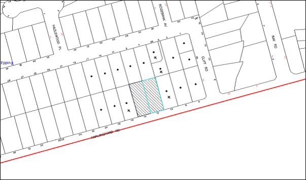
|
NOTIFICATION PLAN |
|
||
|
• PROPERTIES NOTIFIED
|
X SUBMISSIONS RECEIVED |
PROPERTY SUBJECT OF DEVELOPMENT |
|
4 submissions objected to the development, generally on the grounds that the development would result in:
· Unacceptable traffic on local streets;
· Unacceptable overshadowing of adjoining properties;
· Unacceptable noise and disruption from construction;
· Dissatisfaction with the rezoning of the Epping Urban Activation Precinct;
· Devaluation of adjoining properties; and
· Isolation of sites on Carlingford Road and Cliff Road within the Cliff Road, Epping Precinct.
The merits of the matters raised in the community submission have been addressed in the body of the report with the exception of the following:
5.1.1 Unacceptable Noise and Disruption from Construction
Conditions have been recommended requiring the all noise generated by the development to be attenuated to prevent levels of noise being emitted to adjacent premises which possess tonal, beating and similar characteristics or which exceeds background noise levels by more than 5dB(A) and that the construction hours (including demolition and earth works) must only occur between 7am and 5pm Monday to Saturday, in accordance with Interim Construction Noise Guidelines 2009 – NSW Department of Environment and Climate Change and no work is to be undertaken on Sundays or public holidays.
5.1.2 Overshadowing
The submitted shadow diagrams demonstrate that north facing windows of the dwelling and the private open space area at No. 16 Carlingford Road would receive overshadowing between 9am to 12pm, during the Winter Solstice. However, solar access would be provided for at least 3 hours during 12pm to 3pm. The properties fronting Carlingford Road form part of the Cliff Road, Epping High Density Housing Precinct and are likely to be subject to future development.
5.1.3 Dissatisfaction with the Rezoning of the Epping Urban Activation Precinct
The Epping Urban Activation Precinct is part of a Growth Infrastructure Plan prepared and implemented by the State Government to provide greater housing choices, increased amenities, services and improved public spaces to support the inevitable growth of Sydney. The Plan included a detailed study on the identification of centres, selection of precincts and evaluation of precincts under close consultation with the community and Councils.
5.1.4 Devaluation of Adjoining Properties
A concern was raised with regard to the devaluation of adjoining properties and requests that Council impose a condition delaying construction works for 12 months to allow the adjoining property owner at No. 16 Carlingford Road to sell their property.
It is acknowledged that there may be an adjustment to the development value of adjoining properties as a result of the NSW State Government’s Epping Urban Activation Precinct program. However, the request to delay constructions works to allow the adjoining property owner to sell their property is unwarranted. Under the current Freehold tenure system, landowners may redevelop land on the basis of own individual decisions. Under the Environmental Planning and Assessment Act, 1979, matters of consideration are limited to the likely impacts of the development in regards to the natural environment, social and economic impacts.
5.1.5 Isolation of Sites
A concern was raised with regard to the isolation of adjoining properties within the Cliff Road, Epping precinct including No. 10 Carlingford Road and Nos. 5 and 5A Cliff Road, Epping. As indicated in Part 2.10.3 Site Requirements, three lots exist to the east of the site including No. 10 Carlingford Road. The number of lots fronting Carlingford Road and Cliff Road within the Cliff Road Epping precinct is uneven. Therefore, a three lot amalgamation is inevitable. Opportunity still exists to amalgamate No. 10 Carlingford Road with Nos. 6 and 8 Carlingford Road. With regard to No. 5 and 5A Cliff Road, opportunity still exists to amalgamate these lots with Nos. 1, 1B and 3 Cliff Road. In this regard, the proposal would not result in an isolated site or compromise development in accordance with the HDCP.
5.2 Public Agencies
The development application was referred to the following Public Agencies for comment:
5.2.1 Roads and Maritime Services
The application was referred to the Roads and Maritime Services (RMS) for comments under the provisions of Section 138 of the Roads Act 1993. RMS raises no objections subject to the implementation of recommended conditions of consent. The matters have been discussed in Sections 2.10 and 3.2 of this report.
6. THE PUBLIC INTEREST
Section 79C(1)(e) of the Act requires Council to consider “the public interest”.
The public interest is an overarching requirement, which includes the consideration of the matters discussed in this report. Implicit to the public interest is the achievement of future built outcomes adequately responding to and respecting the future desired outcomes expressed in environmental planning instruments and development control plans.
The application is considered to have satisfactorily addressed Council’s and relevant agencies’ criteria and would provide a development outcome that, on balance, would result in a positive impact for the community. Accordingly, it is considered that the approval of the proposed development would be in the public interest.
CONCLUSION
The application seeks approval for the demolition of existing structures and the construction of a five storey residential flat building comprising 35 units with basement car parking. The proposed development would be located on a site within a locality zoned as a high density precinct.
The proposed development is generally in accordance with the development controls for the ‘Cliff Road, Epping’ Precinct of the Hornsby Development Control Plan and would contribute to the future desired five to eight storey residential character of the precinct. The minor non-compliance with prescriptive measures for setbacks and landscaping are considered acceptable. The proposal complies in respect to the Hornsby Local Environmental Plan 2013, the design principles of SEPP 65 and the Residential Flat Design Code.
The proposal would result in a development that would be in keeping with the desired future character of the precinct.
Note: At the time of the completion of this planning report, no persons have made a Political Donations Disclosure Statement pursuant to Section 147 of the Environmental Planning and Assessment Act 1979 in respect of the subject planning application.
|
Rod Pickles Manager - Development Assessment Planning Division |
James Farrington Group Manager Planning Division |
|
1.View |
Locality Map |
|
|
|
2.View |
Site Plan |
|
|
|
3.View |
Landscape Plan |
|
|
|
4.View |
Floor Plans |
|
|
|
5.View |
Elevations |
|
|
|
6.View |
Shadow Plans |
|
|
File Reference: DA/797/2014
Document Number: D03821799
SCHEDULE 1
GENERAL CONDITIONS
The conditions of consent within this notice of determination have been applied to ensure that the use of the land and/or building is carried out in such a manner that is consistent with the aims and objectives of the relevant legislation, planning instruments and council policies affecting the land and does not disrupt the amenity of the neighbourhood or impact upon the environment.
Note: For the purpose of this consent, the term ‘applicant’ means any person who has the authority to act on or the benefit of the development consent.
Note: For the purpose of this consent, any reference to an Act, Regulation, Australian Standard or publication by a public authority shall be taken to mean the gazetted Act or Regulation, or adopted Australian Standard or publication as in force on the date that the application for a construction certificate is made.
1. Approved Plans and Supporting Documentation
The development must be carried out in accordance with the plans and documentation listed below and endorsed with Council’s stamp, except where amended by Council and/or other conditions of this consent:
|
Plan No. |
Plan Title |
Drawn by |
Dated |
|
DA-101 Rev 1 |
Site Analysis A |
Dickson Rothschild |
7/7/2014 |
|
DA-102 Rev 2 |
Site Analysis A |
Dickson Rothschild |
7/7/2014 |
|
DA-103 Rev 1 |
Demolition Plan |
Dickson Rothschild |
7/7/2014 |
|
DA-200 Rev 3 |
Basement Plan 2 |
Dickson Rothschild |
29/9/2014 |
|
DA-201 Rev 5 |
Basement Plan 1 |
Dickson Rothschild |
29/9/2014 |
|
DA-202 Rev 4 |
Ground Level Floor Plan |
Dickson Rothschild |
8/10/2014 |
|
DA-203 Rev 3 |
Level 1 Floor Plan |
Dickson Rothschild |
8/10/2014 |
|
DA-204 Rev 3 |
Level 2 Floor Plan |
Dickson Rothschild |
8/10/2014 |
|
DA-205 Rev 3 |
Level 3 Floor Plan |
Dickson Rothschild |
8/10/2014 |
|
DA-206 Rev 4 |
Level 4 Floor Plan |
Dickson Rothschild |
10/10/2014 |
|
DA-207 Rev 3 |
Mezzanine Floor Plan |
Dickson Rothschild |
10/10/2014 |
|
DA-208 Rev 1 |
Roof Plan |
Dickson Rothschild |
7/7/2014 |
|
DA-300 Rev 2 |
Section A |
Dickson Rothschild |
8/10/2014 |
|
DA-301 Rev 3 |
Section B |
Dickson Rothschild |
8/10/2014 |
|
DA-302 Rev 3 |
Section C |
Dickson Rothschild |
8/10/2014 |
|
DA-400 Rev 3 |
South & North Elevations |
Dickson Rothschild |
8/10/2014 |
|
DA-401 Rev 3 |
West & East Elevations |
Dickson Rothschild |
8/10/2014 |
|
DA-701 Rev 2 |
Adaptable Units Type 3 & 4 |
Dickson Rothschild |
8/10/2014 |
|
DA-802 Rev 1 |
Solar & Cross Ventilation Plan Level 1 |
Dickson Rothschild |
7/7/2014 |
|
DA-803 Rev 1 |
Solar & Cross Ventilation Plan Level 2 |
Dickson Rothschild |
7/7/2014 |
|
DA-804 Rev 1 |
Solar & Cross Ventilation Plan Level 3 |
Dickson Rothschild |
7/7/2014 |
|
DA-805 Rev 1 |
Solar & Cross Ventilation Plan Level 4 and Mezzanine |
Dickson Rothschild |
7/7/2014 |
|
DA-810 Rev 1 |
Winter Solstice Shadow Diagram |
Dickson Rothschild |
7/7/2014 |
|
DA-900 Rev 2 |
Garbage Room Detail |
Dickson Rothschild |
20/9/2014 |
|
LP01 Issue C |
Landscape Plan |
SITEDESIGN + STUDIOS |
22/9/2014 |
|
Document Title |
Prepared by |
Date |
|
Statement of Environmental Effects |
Dickson Rothschild |
17/7/2014 |
|
SEPP 65 Design Verification Statement |
Dickson Rothschild |
17/7/2014 |
|
Traffic and Parking Impact Assessment |
McLaren Traffic Engineering |
10/7/2014 |
|
Acoustic Report |
Renzo Tonin & Associates |
4/7/2014 |
|
DA Report Building Services |
Cundall |
July 2014 |
|
BCA Report |
VIC LILLI & Partners Consultants |
7/7/2014 |
|
Waste Management Plan |
Elephants Foot Recycling Solutions |
July 2014 |
|
BASIX Certificate No. 560571M |
Gradwell Consulting |
16/7/2014 |
|
Arboricultural Impact Assessment |
Advanced Treescape Consulting |
23/6/2014 |
|
Statement of Compliance Access for People with a Disability |
Accessible Building Solutions |
16/7/2014 |
|
Crime Prevention Report |
Dickson Rothschild |
9/7/2014 |
|
Schedule of Finishes |
Dickson Rothschild |
7/7/2014 |
2. Removal of Existing Trees
This development consent only permits the removal of tree(s) as identified on the Site Plan with Trees Appendix 1, in the Arboricultural Impact Assessment, prepared by Advanced Treescape Consulting, dated 23/6/2014. The removal of any other trees requires separate approval in accordance with the Tree and Vegetation Chapter 1B.6 Hornsby Development Control Plan (HDCP).
3. Amendment of Plans
The approved plans are to be amended as follows:
a) The internal storage areas for each unit must have a minimum volume of 2m³ for 1 bedroom units, 4m³ for 2 bedroom units and 5m³ for 3 bedroom units in accordance with the requirements of the RFDC.
4. Construction Certificate
A Construction Certificate is required to be approved by Council or a Private Certifying Authority prior to the commencement of any works under this consent.
REQUIREMENTS PRIOR TO THE ISSUE OF A CONSTRUCTION CERTIFICATE
5. Section 94 Developer Contributions
In accordance with Section 80A(1) of the Environmental Planning and Assessment Act 1979 and the Hornsby Shire Council Section 94 Development Contributions Plan 2012-2021, the following monetary contributions shall be paid to Council to cater for the increased demand for community infrastructure resulting from the development:
|
Description |
Contribution (4) |
|
Roads |
$18,227.75 |
|
Open Space and Recreation |
$324,265.30 |
|
Community Facilities |
$45,215.45 |
|
Plan Preparation and Administration |
$1,337.15 |
|
TOTAL |
$389,045.65 |
being for 7 x 1 bedroom units, 24 x 2 bedroom units and 4 x 3 bedroom units and including a credit for 2 existing allotments.
a) If the contributions are not paid within the financial quarter that this consent is granted, the contributions payable will be adjusted in accordance with the provisions of the Hornsby Shire Council Section 94 Development Contributions Plan and the amount payable will be calculated at the time of payment in the following manner:
$CPY = $CDC x CPIPY
CPIDC
Where:
$CPY is the amount of the contribution at the date of Payment.
$CDC is the amount of the contribution as set out in this Development Consent.
CPIPY is the latest release of the Consumer Price Index (Sydney – All Groups) at the date of Payment as published by the ABS.
CPIDC is the Consumer Price Index (Sydney – All Groups) for the financial quarter at the date of this Development Consent.
b) The monetary contributions shall be paid to Council:
i) prior to the issue of the Subdivision Certificate where the development is for subdivision; or
ii) prior to the issue of the first Construction Certificate where the development is for building work; or
iii) prior to issue of the Subdivision Certificate or first Construction Certificate, whichever occurs first, where the development involves both subdivision and building work; or
iv) prior to the works commencing where the development does not require a Construction Certificate or Subdivision Certificate.
It is the professional responsibility of the Principal Certifying Authority to ensure that the monetary contributions have been paid to Council in accordance with the above timeframes.
Council’s Development Contributions Plan may be viewed at www.hornsby.nsw.gov.au or a copy may be inspected at Council’s Administration Centre during normal business hours.
6. Building Code of Australia
All building work must be carried out in accordance with the relevant requirements of the Building Code of Australia.
7. Contract of Insurance (Residential Building Work)
In the case of residential building work for which the Home Building Act 1989 requires there to be a contract of insurance in force in accordance with Part 6 of that Act, that such a contract of insurance is in force before any building work authorised to be carried out by the consent commences.
8. Notification of Home Building Act, 1989 Requirements
Residential building work within the meaning of the Home Building Act 1989 must not be carried out unless the principal certifying authority for the development to which the work relates (not being Council) has given Council written notice of the following information:
a) In the case of work for which a principal contractor is required to be appointed:
i) The name and licence number of the principal contractor; and
ii) The name of the insurer by which the work is insured under Part 6 of that Act.
b) In the case of work to be done by an owner-builder:
i) The name of the owner-builder; and
ii) If the owner-builder is required to hold an owner-builder’s permit under that Act, the number of the owner-builder’s permit.
Note: If arrangements for doing the residential building work are changed while the work is in progress so that the information notified becomes out of date, further work must not be carried out unless the principal certifying authority for the development to which the work relates (not being Council) has given Council written notification of the updated information.
9. Water/Electricity Utility Services
The applicant must submit written evidence of the following service provider requirements:
a) Ausgrid (formerly Energy Australia) – a letter of consent demonstrating that satisfactory arrangements have been made to service the proposed development.
b) Sydney Water – the submission of a ‘Notice of Requirements’ under s73 of the Sydney Water Act 1994.
Note: Sydney Water requires that s73 applications are to be made through an authorised Sydney Water Servicing Coordinator. Refer to www.sydneywater.com.au or telephone 13 20 92 for assistance.
10. Dilapidation Report
A ‘Dilapidation Report’ is to be prepared by a ‘chartered structural engineer’ detailing the structural condition of all adjoining properties.
11. Adaptable Units
The details of the fit-outs of all accessible units and details of adaptable units must be provided with the Construction Certificate Plans.
12. Letter Boxes
The details of the letter boxes must be provided with the Construction Certificate Plans. The letter boxes must be provided with a minimum setback of 2m from the front property boundary.
13. Construction Traffic Management Plan
A Construction Traffic Management Plan detailing construction vehicle routes, number of trucks, hours of operation, access arrangements and traffic control should be submitted to Council prior to the issue of a construction certificate.
14. Stormwater Drainage
The stormwater drainage system for the development must be designed and constructed in accordance with Council’s Civil Works – Design and Construction Specification 2005 and the following requirements:
a) Connected directly to the street drainage system in Carlingford Road via the proposed on site detention system.
b) Be in accordance with the requirements of the RMS. The design shall comply with the water quality targets as specified in the Hornsby Development Control Plan.
c) Following the completion of the development, a Certificate from a suitably qualified engineer is to be submitted to the PCA confirming that the water quality targets have been met.
15. On-Site Stormwater Detention
An on-site stormwater detention system must be designed by a chartered civil engineer and constructed in accordance with the following requirements:
a) Have a capacity of not less than 65 cubic metres, and a maximum discharge (when full) of 12.3 litres per second.
b) Have a surcharge/inspection grate located directly above the outlet.
c) Discharge from the detention system to be controlled via 1 metre length of pipe, not less than 50 millimetres diameter or via a stainless plate with sharply drilled orifice bolted over the face of the outlet discharging into a larger diameter pipe capable of carrying the design flow to an approved Council system.
d) Not be constructed in a location that would impact upon the visual or recreational amenity of residents.
16. Internal Driveway/Vehicular Areas
The driveway and parking areas on site must be designed in accordance with Australian Standards 2890.1, 2890.2, 3727 and the following requirements:
a) Design levels at the front boundary must be obtained from Council;
b) The driveway must be a rigid pavement;
c) The driveway grade must not exceed 16.7% and changes in grade must not exceed 8 percent;
d) The driveway grade for the first 6m inside the property boundary shall not exceed 5%.
17. Footpath
A concrete footpath must be constructed along the full frontage of the subject site in accordance with Council’s Civil Works Design and Construction Specification 2005 and the following requirements:
a) The existing footpath being removed.
b) Pouring of the concrete footpath to the full frontage of the subject site.
c) Any public utility adjustments to be carried out at the cost of the applicant and to the requirements of the relevant public authority.
d) No work is to commence on the road reserve without obtaining written consent from Hornsby Shire Council in accordance with Section 138 of the Roads Act.
18. Vehicular Crossing
A separate application under the Local Government Act 1993 and the Roads Act 1993 must be submitted to Council for the installation of a new vehicular crossing and the removal of the redundant crossing. The vehicular crossing must be constructed in accordance with Council’s Civil Works Design 2005 and the following requirements:
a) Any redundant crossings must be replaced with integral kerb and gutter;
b) The footway area must be restored by turfing;
c) Be in accordance with the requirements of the RMS.
Note: An application for a vehicular crossing can only be made to one of Council’s Authorised Vehicular Crossing Contractors. You are advised to contact Council on 02 9847 6940 to obtain a list of contractors.
19. Traffic Control Plan
A Traffic Control Plan (TCP) must be prepared by a qualified traffic controller in accordance with the Roads & Traffic Authority’s Traffic Control at Worksites Manual 1998 and Australian Standard 1742.3 for all work on a public road and be submitted to Council. The TCP must detail the following:
a) Arrangements for public notification of the works.
b) Temporary construction signage.
c) Permanent post-construction signage.
d) Vehicle movement plans.
e) Traffic management plans.
f) Pedestrian and cyclist access/safety.
REQUIREMENTS PRIOR TO THE COMMENCEMENT OF ANY WORKS
20. Erection of Construction Sign
A sign must be erected in a prominent position on any site on which building work, subdivision work or demolition work is being carried out:
a) Showing the name, address and telephone number of the principal certifying authority for the work;
b) Showing the name of the principal contractor (if any) for any demolition or building work and a telephone number on which that person may be contacted outside working hours; and
c) Stating that unauthorised entry to the work site is prohibited.
Note: Any such sign is to be maintained while the building work, subdivision work or demolition work is being carried out, but must be removed when the work has been completed.
21. Protection of Adjoining Areas
A temporary hoarding, fence or awning must be erected between the work site and adjoining lands before the works begin and must be kept in place until after the completion of the works if the works:
a) Could cause a danger, obstruction or inconvenience to pedestrian or vehicular traffic.
b) Could cause damage to adjoining lands by falling objects.
c) Involve the enclosure of a public place or part of a public place.
Note: Notwithstanding the above, Council’s separate written approval is required prior to the erection of any structure or other obstruction on public land.
22. Toilet Facilities
Toilet facilities must be available or provided at the works site before works begin and must be maintained until the works are completed at a ratio of one toilet for every 20 persons employed at the site. Each toilet must:
a) be a standard flushing toilet connected to a public sewer; or
b) be a temporary chemical closet approved under the Local Government Act 1993; or
c) have an on-site effluent disposal system approved under the Local Government Act 1993.
23. Toilet Facilities
Toilet facilities must be available or provided at the works site before works begin and must be maintained until the works are completed at a ratio of one toilet for every 20 persons employed at the site. Each toilet must:
a) be a standard flushing toilet connected to a public sewer; or
b) be a temporary chemical closet approved under the Local Government Act 1993; or
c) have an on-site effluent disposal system approved under the Local Government Act 1993.
24. Erosion and Sediment Control
Erosion and sediment control measures must be provided and maintained throughout the construction period in accordance with the manual ‘Soils and Construction 2004 (Bluebook)’, the approved plans, Council specifications and to the satisfaction of the principal certifying authority. The erosion and sediment control devices must remain in place until the site has been stabilised and revegetated.
Note: On the spot penalties up to $1,500 may be issued for any non-compliance with this requirement without any further notification or warning.
25. Tree Protection Barriers
Tree protection fencing must be in accordance with the Arboricultural Impact Assessment, prepared by Advanced Treescape Consulting, dated 23/6/2014, Sections 5.4, 5.5 and 6.
REQUIREMENTS DURING CONSTRUCTION
26. Construction Work Hours
All work on site (including demolition and earth works) must only occur between 7am and 5pm Monday to Saturday. No work is to be undertaken on Sundays or public holidays.
27. Environmental Management
The site must be managed in accordance with the publication ‘Managing Urban Stormwater – Landcom (March 2004) and the Protection of the Environment Operations Act 1997 by way of implementing appropriate measures to prevent sediment run-off, excessive dust, noise or odour emanating from the site during the construction of the development.
28. Street Sweeping
Street sweeping must be undertaken following sediment tracking from the site along Carlingford Road during works and until the site is established.
29. Demolition
All demolition work must be carried out in accordance with “Australian Standard 2601-2001 – The Demolition of Structures” and the following requirements
a) Demolition material must be disposed of to an authorised recycling and/or waste disposal site and/or in accordance with an approved waste management plan;
b) Demolition works, where asbestos material is being removed, must be undertaken by a contractor that holds an appropriate licence issued by WorkCover NSW in accordance with Chapter 10 of the Occupational Health and Safety Regulation 2001 and Clause 29 of the Protection of the Environment Operations (Waste) Regulation 2005 ;and
c) On construction sites where buildings contain asbestos material, a standard commercially manufactured sign containing the words ‘DANGER ASBESTOS REMOVAL IN PROGRESS’ measuring not less than 400mm x 300mm must be erected in a prominent position visible from the street.
30. Works Near Trees
Works near trees must be carried out in accordance with the Arboricultural Impact Assessment, prepared by Advanced Treescape Consulting, dated 23/6/2014, Sections 5.4, 6.1, 6.2, 6.3, 6.4 and 6.5.
31. Waste Management Details
Waste management during the demolition and construction phase of the development must be undertaken in accordance with the approved Waste Management Plan. Additionally written record of the following items must be maintained during the removal of any waste from the site and such information submitted to the Principal Certifying Authority within fourteen days of the date of completion of the works;
a) The identity of the person removing the waste.
b) The waste carrier vehicle registration.
c) Date and time of waste collection.
d) A description of the waste (type of waste and estimated quantity).
e) Details of the site to which the waste is to be taken.
f) The corresponding tip docket/receipt from the site to which the waste is transferred (noting date and time of delivery, description (type and quantity) of waste).
g) Whether the waste is expected to be reused, recycled or go to landfill.
Note: In accordance with the Protection of the Environment Operations Act 1997, the definition of waste includes any unwanted substance, regardless of whether it is reused, recycled or disposed to landfill.
32. Council Property
During construction works, no building materials, waste, machinery or related matter is to be stored on the road or footpath. The public reserve must be kept in a clean, tidy and safe condition at all times.
33. Disturbance of Existing Site
During construction works, the existing ground levels of open space areas and natural landscape features, (including natural rock-outcrops, vegetation, soil and watercourses) must not be altered unless otherwise nominated on the approved plans.
34. Landfill
Landfill must be constructed in accordance with Council’s ‘Construction Specification 2005’ and the following requirements:
a) All fill material imported to the site is to wholly consist of Virgin Excavated Natural Material (VENM) as defined in Schedule 1 of the Protection of the Environment Operations Act 1997 or a material approved under the Department of Environment and Climate Change’s general resource recovery exemption.
b) A compaction certificate is to be obtained from a geotechnical engineer verifying that the specified compaction requirements have been met.
35. Excavated Material
All excavated material removed from the site must be classified in accordance with the Department of Environment, Climate Change and Water NSW Waste Classification Guidelines prior to disposal to an approved waste management facility and reported to the principal certifying authority.
36. Survey Report – Finished Floor Level
A report(s) must be prepared by a registered surveyor and submitted to the principal certifying authority prior to the pouring of concrete at each level of the building certifying that:
a) The building, retaining walls and the like have been correctly positioned on the site; and
b) The finished floor level(s) are in accordance with the approved plans.
REQUIREMENTS PRIOR TO THE ISSUE OF AN OCCUPATION CERTIFICATE
Note: For the purpose of this consent, a reference to ‘occupation certificate’ shall not be taken to mean an ‘interim occupation certificate’ unless otherwise stated.
37. Fulfilment of BASIX Commitments
The applicant must demonstrate the fulfilment of BASIX commitments pertaining to the development.
38. Sydney Water – s73 Certificate
An s73 Certificate must be obtained from Sydney Water.
39. Maintain Canopy Cover
Replacement planting must be in accordance with the approved Landscape Plan, prepared by SITEDESIGN+STUDIOS, Drawing No. LP01, dated 10/7/2014.
Note: A certificate from suitably qualified and experienced Horticulturalist is to be submitted to the Principal Certifying Authority stating the above requirements have been met, that all plant stock meet the specifications outlined in ‘Specifying Trees’ (Ross Clark, NATSPEC Books) and that the planting methods are current, professional (best practice) industry standards at the time of planting.
40. Planter Boxes/On Slab Planting
On slab planter boxes must include waterproofing, subsoil drainage (proprietary drainage cell, 50mm sand and filter fabric) automatic irrigation, minimum 500mm planting soil for shrubs and minimum 1000mm planting soil for trees and palms and 75mm mulch to ensure sustainable landscape is achieved.
41. Completion of Landscaping
A certificate must be provided by a practicing landscape architect, horticulturalist or person with similar qualifications and experience certifying that all required landscaping works have been satisfactorily completed in accordance with the approved landscape plans.
Note: Applicants are advised to pre-order plant material required in pot sizes 45 litre or larger to ensure Nurseries have stock available at the time of install.
42. Garbage Collection Easement
For the purpose of waste collection, an easement entitling Council, its servants and agents and persons authorised by it to enter upon the subject land and to operate thereon, vehicles and other equipment for the purposes of garbage collection must be granted to Council by the owner of the land.
Note: The easement must be in a form prescribed by Council and must include covenants to the effect that parties will not be liable for any damage caused to the subject land or any part thereof or to any property located therein or thereon by reason of the operation thereon of any vehicle or other equipment used in connection with the collection of garbage and to the effect that the owner for the time being of the subject land shall indemnify the Council, its servants, agents and persons authorised by it to collect garbage against liability in respect of any such claims made by any person whomsoever.
43. Waste Management Details
The following waste management requirements must be complied with:
a) The garbage bin storage room at the basement level must include water or a hose for cleaning, graded floors with drainage to sewer, a robust door, sealed and impervious surface, adequate lighting and ventilation, and must be lockable. The waste facility rooms/cupboards at each residential level must include sealed and impervious surface, adequate lighting and ventilation.
b) A report must be prepared by an appropriately qualified person, certifying the following:
i) A comparison of the estimated quantities of each waste type against the actual quantities of each waste type.
Note: Explanations of any deviations to the approved Waste management Plan is required to be included in this report.
ii) That at least 60% of the waste generated during the demolition and construction phase of the development was reused or recycled.
Note: If the 60% diversion from landfill cannot be achieved in the Construction Stage, the Report is to include the reasons why this occurred and certify that appropriate work practices were employed to implement the approved Waste Management Plan. The Report must be based on documentary evidence such as tipping dockets/receipts from recycling depots, transfer stations and landfills, audits of procedures etc. which are to be attached to the report.
iii) All waste was taken to site(s) that were lawfully permitted to accept that waste.
c) Each unit must be provided with an indoor waste/recycling cupboard for the interim storage of a minimum on day’s waste generation with separate containers for general waste and recyclable materials.
d) Space must be provided for either individual compost containers for each unit or a communal compost container;
Note: The location of the compost containers should have regard for potential amenity impacts.
e) The bin carting routes must be devoid of any steps.
Note: Ramps between different levels are acceptable.
f) “No parking” signs must be erected to prohibit parking in the waste collection vehicle turning area and loading area.
g) A report(s) must be prepared by a registered surveyor and submitted to the principal certifying authority prior to the issue of the Subdivision/Occupation Certificate, certifying that: The finished access way (including ramp, vehicle turning area, loading bay and site entry/exit) to be used by waste collection vehicles, complies with Australian Standard AS 2890.2-2002 Parking Facilities Part 2: Off-street Commercial Vehicle Facilities for small rigid vehicles with minimum design vehicle dimensions of 6.4m overall length, width of 2.3m, with maximum gradient of 1:6.5 and minimum 3.5 m clearance height.
h) The 3.5m clearance height within the waste collection vehicle travel path must be reduced by ducting, pipes or anything else.
44. Consolidation of Allotments
Lots 13 and 14 of DP 10899 are to be consolidated into one allotment prior to the issue of the Occupation Certificate.
45. Damage to Council Assets
Any damage caused to Council’s assets as a result of the construction of the development must be rectified in accordance with Council’s Civil Works Specifications. Council’s Restorations Supervision must be notified for a formwork inspection prior to pouring concrete.
46. Creation of Easements
The following matter(s) must be nominated on the plan of subdivision under s88B of the Conveyancing Act 1919:
a) The creation of an appropriate "Positive Covenant" and "Restriction as to User" over the constructed on-site detention/retention systems and outlet works, within the lots in favour of Council in accordance with Council’s prescribed wording. The position of the on-site detention system is to be clearly indicated on the title.
b) To register the OSD easement, the restriction on the use of land “works-as-executed” details of the on-site-detention system must be submitted verifying that the required storage and discharge rates have been constructed in accordance with the design requirements. The details must show the invert levels of the onsite system together with pipe sizes and grades. Any variations to the approved plans must be shown in red on the “works-as-executed” plan and supported by calculations.
Note: Council must be nominated as the authority to release, vary or modify any easement, restriction or covenant.
47. Works as Executed Plan
A works-as-executed plan(s) must be prepared by a registered surveyor and submitted to Council for completed road pavement, kerb & gutter, public drainage systems, driveways and on-site detention system.
48. Retaining Walls
All required retaining walls must be constructed as part of the development.
49. Boundary Fencing
Fencing must be erected along all property boundaries behind the front building alignment to a height of 1.8 metres.
Note: Alternative fencing may be erected subject to the written consent of the adjoining property owner(s).
50. External Lighting
All external lighting must be designed and installed in accordance with Australian Standard AS 4282 – Control of the Obtrusive Effects of Outdoor Lighting. Certification of compliance with the Standard must be obtained from a suitably qualified person.
51. Unit Numbering
The allocation of unit numbering must be authorised by Council prior to the numbering of each unit in the development.
52. Safety and Security
The site must include safety and security measures as recommended in the submitted Crime Prevention Report, prepared by Dickson Rothschild dated 9 July 2014 and the following elements:
a) The entry doors to the pedestrian foyer is to be constructed of safety rated glass to enable residents a clear line of site before entering or exiting the residential apartments.
b) Lighting is to be provided to pathways, building foyer entries, driveways and common external spaces.
c) Security gate access is to be provided to the car parking areas allowing residents-only access to private car spaces.
d) The communal open space, at the rear and north of the site must be illuminated with high luminance by motion sensor lighting.
e) The driveway and basement car parking must be illuminated with low luminance at all times.
f) Security deadlocks are to be provided to each apartment door.
g) Peep holes are to be provided to individual apartment doors to promote resident safety.
OPERATIONAL CONDITIONS
53. Car Parking
All car parking must be constructed and operated in accordance with Australian Standard AS/NZS 2890/1:2004 – Off-street car parking and Australian Standard AS 2890.2:2002- Off-street commercial vehicle facilities.
a) All parking areas and driveways are to be sealed to an all-weather standard, line marked and signposted;
b) Car parking, loading and manoeuvring areas to be used solely for nominated purposes;
c) Vehicles awaiting loading, unloading or servicing shall be parked on site and not on adjacent or nearby public roads;
54. Landscaping
Any proposed landscaping and/or fencing must not restrict sight distance to pedestrians and cyclists travelling along the footpath.
55. Residential Car Parking
Residential parking spaces are to be secure spaces with access controlled by card or numeric pad.
56. Visitor Access
Visitors must be able to access the visitor parking spaces in the basement car park at all times.
57. Disabled Parking
All parking for people with disabilities is to comply with AS/NZS 2890.6:2009 Off-street parking for people with disabilities.
58. Bicycle Parking
Bicycle parking spaces are to be designed in accordance with AS 2890.3-1993 Bicycle parking facilities.
59. Motorcycle Parking
Motorcycle parking spaces are to be designed in accordance with AS 2890.5-1993.
60. Landscape Establishment
The landscape works must be maintained into the future to ensure the establishment and successful growth of plant material to meet the intent of the landscape design. This must include but not be limited to watering, weeding, replacement of failed plant material and promoting the growth of plants through standard industry practices.
61. Waste Management
The waste management on site must be in accordance with the following requirements:
a) A site caretaker must be employed and be responsible for moving bins where and when necessary, washing bins and maintaining waste storage areas, managing the communal composting area, managing the bulky item storage area, arranging the prompt removal of dumped rubbish, and ensuring all residents are informed of the use of the waste management system.
b) Site security measures implemented on the property, including electronic gates, must not prevent access to the bin room/collection point by waste removal services.
62. Noise
All noise generated by the proposed development must be attenuated to prevent levels of noise being emitted to adjacent premises which possess tonal, beating and similar characteristics or which exceeds background noise levels by more than 5dB(A).
63. Fire Safety Statement – Annual
On at least one occasion in every 12 month period following the date of the first ‘Fire Safety Certificate’ issued for the property, the owner must provide Council with an annual ‘Fire Safety Certificate’ to each essential service installed in the building.
CONDITIONS OF CONCURRENCE – ROADS & MARITIME SERVICES
The following conditions of consent are from the nominated State Agency pursuant to Section 79B of the Environmental Planning and Assessment Act 1979 and must be complied with to the satisfaction of that Agency.
64. The redundant driveway on Carlingford Road shall be removed and replaced with kerb and gutter to match the existing kerb and gutter.
65. The design and construction of the kerb and gutter crossings on Carlingford Road shall be in accordance with the Roads and Maritime requirements. Details of these requirements should be obtained from Roads and Maritime Project Services Manager, Traffic Projects Section, Parramatta (telephone 88492138).
Detailed design plans of the proposed kerb and gutter crossing are to be submitted to Roads and Maritime for approval prior to the commencement of any road works.
A plan checking fee (amount to be advised) and lodgement of a performance bond may be required from the applicant prior to the release of the approved road design plans by Roads and Maritime.
66. The layout of the proposed car parking areas associated with the subject development (including driveways, grades, turn paths, sight distance requirements, aisle widths, aisle lengths, and parking bay dimensions) should be in accordance with AS 2890.1-2004 and AS 2890.2-2002 for heavy vehicle usage.
67. A construction zone will not be permitted on Carlingford Road.
68. The developer is to submit design drawings and documents relating to the excavation of the site and support structures to Roads and Maritime for assessment, in accordance with Technical Direction GTD2012/001.
The developer is to submit all documentation at least six (6) weeks prior to commencement of construction and is to meet the full cost of the assessment by Roads and Maritime.
The report and any enquiries should be forwarded to:
Project Engineer, External Works
Sydney Asset Management
Roads and Maritime Services
PO Box 973 Parramatta CBD 2124.
Telephone: 8849 2114
Fax: 8849 2766
If it is necessary to excavate below the level of the base of the footings of the adjoining roadways, the person acting on the consent shall ensure that the owner/s of the roadway is/are given at least seven (7) days’ notice of the intention to excavate below the base of the footings. The notice is to include complete details of the work.
69. Post development storm water discharge from the subject site into the Roads and Maritime drainage system must not exceed the pre-development discharge.
70. The proposed development must be designed such that road traffic noise from Carlingford Road is mitigated by durable materials in order to satisfy the requirements for habitable rooms under Clause 102(3) of State Environmental Planning Policy (Infrastructure) 2007.
- END OF CONDITIONS -
ADVISORY NOTES
The following information is provided for your assistance to ensure compliance with the Environmental Planning and Assessment Act 1979, Environmental Planning and Assessment Regulation 2000, other relevant legislation and Council’s policies and specifications. This information does not form part of the conditions of development consent pursuant to Section 80a of the Act.
Environmental Planning and Assessment Act 1979 Requirements
The Environmental Planning and Assessment Act 1979 requires:
· The issue of a construction certificate prior to the commencement of any works. Enquiries can be made to Council’s Customer Services Branch on 9847 6760.
· A principal certifying authority to be nominated and Council notified of that appointment prior to the commencement of any works.
· Council to be given at least two days written notice prior to the commencement of any works.
· Mandatory inspections of nominated stages of the construction inspected.
· An occupation certificate to be issued before occupying any building or commencing the use of the land.
Long Service Levy
In accordance with Section 34 of the Building and Construction Industry Long Service Payments Act 1986, a ‘Long Service Levy’ must be paid to the Long Service Payments Corporation or Hornsby Council.
Note: The rate of the Long Service Levy is 0.35% of the total cost of the work.
Note: Hornsby Council requires the payment of the Long Service Levy prior to the issue of a construction certificate.
Tree and Vegetation Preservation
In accordance with Clause 5.9 of the Hornsby Local Environmental Plan 2013 a person must not ringbark, cut down, top, lop, remove, injure or wilfully destroy any tree or other vegetation protected under the Hornsby Development Control Plan 2013 without the authority conferred by a development consent or a permit granted by Council.
Notes: A tree is defined as a long lived, woody perennial plant with one or relatively few main stems with the potential to grow to a height greater than three metres (3M). (HDCP 1B.6.1.c).
Tree protection measures and distances are determined using the Australian Standard AS 4970:2009, “Protection of Trees on Development Sites”.
Fines may be imposed for non-compliance with both the Hornsby Local Environmental Plan 2013 and the Hornsby Development Control Plan 2013.
Disability Discrimination Act
The applicant’s attention is drawn to the existence of the Disability Discrimination Act. A construction certificate is required to be obtained for the proposed building/s, which will provide consideration under the Building Code of Australia, however, the development may not comply with the requirements of the Disability Discrimination Act. This is the sole responsibility of the applicant.
Dial Before You Dig
Prior to commencing any works, the applicant is encouraged to contact Dial Before You Dig on 1100 or www.dialbeforeyoudig.com.au for free information on potential underground pipes and cables within the vicinity of the development site.
Telecommunications Act 1997 (Commonwealth)
If you are aware of any works or proposed works which may affect or impact on Telstra’s assets in any way, you are required to contact: Telstra’s Network Integrity Team on Phone Number 1800810443.
Asbestos Warning
Should asbestos or asbestos products be encountered during demolition or construction works, you are advised to seek advice and information prior to disturbing this material. It is recommended that a contractor holding an asbestos-handling permit (issued by WorkCover NSW)be engaged to manage the proper handling of this material. Further information regarding the safe handling and removal of asbestos can be found at:
Alternatively, telephone the WorkCover Asbestos and Demolition Team on 8260 5885.
House/Unit Numbering
House numbering can only be authorised by Council. Before proceeding to number each premise in the development, the allocation of numbers is required to be obtained from Council's Planning Division prior to the issue of a Subdivision Certificate. The authorised numbers are required to comply with Council’s Property Numbering Policy and be displayed in a clear manner at or near the main entrance to each premise.
Group Manager’s Report No. PL76/14
Planning Division
Date of Meeting: 12/11/2014
18 DEVELOPMENT APPLICATION - ALTERATIONS AND ADDITIONS TO A DWELLING-HOUSE - 65 BORONIA AVENUE, CHELTENHAM
EXECUTIVE SUMMARY
|
DA No: |
DA/898/2014 (Lodged 8 August 2014) |
|
Description: |
Alterations and additions to a dwelling-house |
|
Property: |
Lot 5, DP 29186, No. 65 Boronia Avenue, Cheltenham |
|
Applicant: |
Mr Harkirat Singh Dhindsa |
|
Owners: |
Mr Harkirat Singh Dhindsa and Mrs Daljit Kaur Dhindsa |
|
Estimated Value: |
$375,000 |
|
Ward: |
C |
· The application proposes alterations and additions to a dwelling-house.
· The proposal generally complies with the Hornsby Local Environmental Plan 2013 and the Hornsby Development Control Plan 2013.
· Four submissions have been received in respect of the application.
· A Red Sticker has been placed on the application requiring that it be determined at a Council meeting.
· It is recommended that the application be approved.
|
THAT Development Application No. DA/898/2014 for alterations and additions to a dwelling-house at Lot 5, DP 29186, No. 65 Boronia Avenue Cheltenham be approved, subject to the conditions of consent detailed in Schedule 1 of Group Manager’s Report No. PL76/14. |
SITE
The 910.5m2 site is located on the northern side of Boronia Avenue, Cheltenham. The site experiences an average fall of 10% to the south and contains a part 1 and part 2 storey dwelling-house.
The site does not contain a heritage listed item and is not within the vicinity of a heritage listed item. The site is located within the Beecroft/Cheltenham Heritage Conservation Area – Precinct 1 – Beecroft/Cheltenham Plateau.
The site is not bushfire prone or flood prone.
Surrounding development in the immediate area is typified by an eclectic blend of one and two storey post-war era dwelling-houses surrounded by well-established gardens and landscaped areas. Front fencing, if erected, is low in height and modest in design.
PROPOSAL
The application proposes alterations and additions to a dwelling-house including a double storey addition to the front elevation and a first floor addition to the existing single storey element of the dwelling-house.
The lower ground floor of the dwelling-house would comprise a double space garage and a lobby.
The ground floor would comprise a foyer, lounge room, living room, two bathrooms, kitchen, walk-in pantry, laundry, and games room with a bar.
A covered area would be located at the rear of the dwelling-house adjacent to the living rooms with a detached garden store room and toilet.
The first floor would consist of a master bedroom with a walk-in wardrobe and an en-suite, three bedrooms with en-suite, guest bedroom, bathroom, toilet and a ‘gallery’. One bedroom and the guest bedroom would each have access to a balcony.
Eleven trees would be impacted or removed as part of this application.
ASSESSMENT
The development application has been assessed having regard to the ‘Metropolitan Plan for Sydney 2031’, the ‘North Subregion (Draft) Subregional Strategy’ and the matters for consideration prescribed under Section 79C of the Environmental Planning and Assessment Act 1979 (the Act). The following issues have been identified for further consideration.
1. STRATEGIC CONTEXT
1.1 Metropolitan Plan for Sydney and (Draft) North Subregional Strategy
The (Draft) Metropolitan Strategy for Sydney 2031 is a broad framework to provide for Sydney’s growth to help plan for housing, employment, transport, infrastructure, the environment and open space. It outlines a vision for Sydney to 2031, the challenges faced and the directions to follow to address these challenges and achieve the vision.
The North Subregion comprises Hornsby, Ku-ring-gai, Manly, Warringah and Pittwater Local Government Areas. The Draft North Subregional Strategy acted as a framework for Council in its preparation of the HLEP 2013.
Within the North Subregion, the Draft Metropolitan Strategy proposes:
· Population growth of 81,000 from the current 2011 baseline of 529,000;
· Housing growth of 37,000 from the current 2011 baseline of 204,000; and
· Employment growth of 39,000 from the current 2011 baseline of 186,000.
The proposed development would be consistent with the Metropolitan Plan for Sydney 2031 by providing renewed housing stock for a growing population.
2. STATUTORY CONTROLS
Section 79C(1)(a) requires Council to consider “any relevant environmental planning instruments, draft environmental planning instruments, development control plans, planning agreements and regulations”.
2.1 Hornsby Shire Local Environmental Plan 2013
The subject land is zoned R2 (Low Density Residential) under the Hornsby Local Environmental Plan 2013 (HLEP). The objectives of the R2 zone are:
(a) To provide for the housing needs of the community within a low density residential environment; and
(b) To enable other land uses that provide facilities or services to meet the day to day needs of residents.
The proposed development is defined as a dwelling-house under the HLEP and is permissible in the zone with Council’s consent.
2.1.1 Clause 4.3 – Height of Buildings
Clause 4.3 of the HLEP provides that the height of a building on any land is not to exceed the maximum height shown for the land on the Height of Buildings Map. The maximum permissible height for the site is 8.5 metres. The dwelling-house would have a maximum height of 7.8 metres above natural ground level, which complies with this requirement.
2.1.2 Clause 5.10 – Heritage Conservation
The site is located within the Beecroft/Cheltenham Heritage Conservation Area. The proposal was considered by Council’s Heritage Advisory Committee and no objections were raised, subject to conditions. This issue is addressed is more detail in Section 2.6.5 of this report.
2.2 State Environmental Planning Policy (Exempt and Complying Development Codes) 2008 – NSW Housing Code
The application has been assessed against the requirements of State Environmental Planning Policy (Exempt and Complying Development Codes) 2008 – NSW Housing Code. The Policy provides exempt and complying development codes that have State-wide application. The Policy identifies types of development that are of minimal environmental impact that may be carried out without the need for development consent and types of complying development (including dwelling-houses) that may be carried out in accordance with a complying development certificate.
The proposed dwelling-house cannot be approved as Complying Development, as the subject site is identified within the Beecroft/Cheltenham Heritage Conservation Area. For this reasons, the proposal is precluded from being assessed as complying development.
The proposal would otherwise comply with the requirements of the NSW Housing Code except for the north-western boundary setbacks, front setbacks, first floor balcony areas, and earthworks.
The NSW Housing Code’s requirement for side setbacks on a site with a width of 18m to 24m states “(i) for any part of the building with a height of up to 4.5m-1.5m, and (ii) for any part of the building with a height of more than 4.5m-1.5 plus one-quarter of the height of the building above 4.5m”. To comply with the NSW Housing Code, the ground floor must be setback 1.5 metres, and the first floor must be set back 2.125m from the side boundaries. The application proposes setbacks of 925mm for ground floor elements and 925mm-1.285m for first floor elements.
The NSW Housing Code’s requirement for setbacks from a road requires “the average distance of the setbacks of the nearest 2 dwelling-houses having the same primary road boundary and located within 40m of the lot on which the dwelling-house is erected”. The average setback of the adjoining properties, No. 63 and No. 67 Boronia Avenue is approximately 15 metres. The application proposes a front setback of 9 metres.
The NSW Housing Code’s states that “The total floor area of all balconies, decks, patios, terraces and verandahs on a lot must not be more than 12m2 if: (a) any part of the structure is within 6m from a side or the rear boundary, and (b) the structure has any point of its finished floor level more than 2m above ground level (existing)”. The proposal would include three balconies with a total of 43m2 which meet the criteria of the NSW Housing Code.
The NSW Housing Code states that “Excavation for the purposes of development…must not exceed a maximum depth measured at ground level (existing) of: (a) if located not more than 1m from any boundary—1m, and (b) if located more than 1m but not more than 1.5m from any boundary—2m, and (c) if located more than 1.5m from any boundary—3m”. The application indicates a maximum excavation of 1.8 metres within 1m of the north-western boundary to allow for the stairway from the double garage to the living spaces on the ground floor.
2.3 Sydney Regional Environmental Plan (Sydney Harbour Catchment) 2005
The site is located within the catchment of Sydney Harbour. Sydney Regional Environmental Plan (Sydney Harbour Catchment) 2005 aims to protect the environment of the Sydney Harbour Catchment by ensuring that the impacts of future land uses are considered in a regional context.
Subject to the implementation of sediment and erosion control measures and stormwater management to protect water quality, the proposal would comply with the requirements of the Policy.
2.4 State Environmental Planning Policy (Building Sustainability Index: BASIX) 2004
The application has been assessed against the requirements of State Environmental Planning Policy (Building Sustainability Index: BASIX) 2004. The proposal includes BASIX Certificate No. A195009 for alterations and additions and is considered to be satisfactory with respect to SEPP BASIX.
2.5 Section 94A Environmental Planning and Assessment Act 1979 – Fixed Development Consent Levies
Section 94A contribution fees are payable as the development is for alterations and additions to residential accommodation with a cost of works greater than $100,001. Should the application be approved, an appropriate condition of consent is recommended requiring the payment of a contribution in accordance with Council’s Contributions plan.
2.6 Clause 74BA Environmental Planning and Assessment Act, 1979 - Purpose and Status of Development Control Plans
On 1 March 2013, the Environmental Planning and Assessment Act, 1979 was amended so that a DCP provision will have no effect if it has the practical effect of “preventing or unreasonably restricting development” that is otherwise permitted and complies with the development standards set out in relevant Local Environmental Plans and State Environmental Planning Policies.
The principal purpose of a development control plan is to provide guidance on the aims of any environmental planning instrument that applies to the development; facilitating development that is permissible under any such instrument; and achieving the objectives of land zones under any such instrument. The provisions of a development control plan made for that purpose are not statutory requirements.
2.7 Hornsby Development Control Plan 2013
The proposed development has been assessed having regard to the relevant performance and prescriptive requirements within the Hornsby Development Control Plan (HDCP). The following table sets out the proposal’s compliance with the prescriptive requirements of the Plan:
|
HDCP – Part 3.1 Dwelling-Houses |
|||
|
Control |
Proposal |
Requirement |
Complies |
|
Site Area |
910.5m2 |
N/A |
N/A |
|
Building Height |
7.8m |
8.5m |
Yes |
|
Storeys |
2 storeys |
2 storeys + attic |
Yes |
|
Site Coverage |
34% |
max 40% |
Yes |
|
Floor Area |
406m2 |
430m2 |
Yes |
|
Setbacks |
|
|
|
|
- Front (Boronia Ave) |
9m |
7.6m |
Yes |
|
- Side (north-west) |
|
|
|
|
- Ground floor |
925mm |
900mm |
Yes |
|
- First floor |
925mm-1.285m |
1.5m |
No |
|
- Side (south-east) |
|
|
|
|
- Ground floor |
2.17m |
900mm |
Yes |
|
- First floor |
900m (existing) |
1.5m |
No |
|
- Rear (north-east) |
|
|
|
|
- Ground floor |
17.9m |
3m |
Yes |
|
- First floor |
20.2m |
8m |
Yes |
|
Landscaped Area |
58% |
min 40% |
Yes |
|
Private Open Space - minimum area - minimum dimension |
>60m2 5.7m |
24m2 3m |
Yes Yes |
|
Car Parking |
2 spaces |
2 spaces |
Yes |
As detailed in the above table, the proposed development generally complies with the prescriptive requirements within HDCP other than setbacks at the first floor level. The matters of non-compliance are detailed below, as well as a brief discussion on compliance with relevant performance requirements.
2.7.1 Scale
The desired outcome of the Scale element is to encourage “development with a height, bulk and scale that is compatible with a low density residential environment.”
The application would result in a 7.8 metre high, two storey, split level dwelling-house. The lower ground floor would comprise a double garage, the ground floor comprises mainly living areas and the first floor consists of primarily bedrooms and bathrooms.
The Scale element prescribes a maximum of 2 storeys and an attic for dwelling-houses. A storey, as defined by the HDCP, “means a space within a building that is situated between one floor level and the floor level next above, or if there is no floor above, the ceiling or roof above, but does not include: (a) a space that contains only a lift shaft, stairway or meter room, or (b) a mezzanine, or (c) an attic”.
In this instance, a section of the dwelling-house would have three floor levels; however the lowest level comprise the stairway leading from the double garage only and is not defined a ‘storey’.
The dwelling-house when viewed from the north-western and south-eastern elevations would not present as a three storey dwelling-house and is considered acceptable.
The first floor of the existing dwelling-house is set back 9 metres from the front boundary. To minimise the bulk and scale of the dwelling-house when viewed from Boronia Avenue the proposed double garage would be set back 9.8 metres from the front boundary, with the ground floor lounge room set back 11.6 metres and the first floor en-suite setback 16 metres.
The ridge height of the adjoining properties, No. 63 Boronia Avenue is RL 106.9 and RL 104.36 for the dwelling-house at No. 67 Boronia Avenue as identified on the submitted site plan. The final ridge height of the dwelling-house on the subject site would be RL 108.29 which is 1.39 metres higher than No. 63 and 3.93 metres higher than No. 67. In this instance, the comparisons are made between single storey dwelling-houses at No. 63 and No. 67 and a proposed double storey dwelling-house at the subject site.
Council’s Heritage Advisory Committee agreed that “the design proposes articulation of the front elevations through varied wall heights, wall widths, roofs, windows and verandahs which breaks up the building form, thereby reducing the bulk and scale of the building”.
It is considered that the proposal is compatible with a low density residential environment. The 2 storey height and appearance would be consistent with other 2 storey dwelling-houses in Boronia Avenue and would not set an undesirable precedent in the locality.
The proposal meets the desired outcomes of the Scale element and is considered acceptable.
2.7.2 Setbacks
The desired outcomes of the Setbacks element are to encourage “setbacks that are compatible with adjacent development and complement the streetscape” and “setbacks that allow for canopy trees to be retained and planted along the front and rear property boundaries.”
The ground floor elements of the dwelling-house would be set back a minimum of 925mm from the north-western, side boundary of the site. This complies with the prescriptive measures of the Setbacks element which requires a minimum setback of 900mm from side boundaries for ground floor elements.
The first floor elements of the dwelling-house, including the lounge room above the ground floor garage, and master bedroom on the first floor would be set back 0.925m and 1.285m, respectively, from the north-western boundary. This does not comply with the prescriptive measure of the Setbacks element which requires a minimum setback of 1.5 metres for first floor elements.
The proposal does not include any first floor windows on the north-western elevation of the dwelling-house that would allow for overlooking into the adjoining property.
The orientation of the site and the siting of the dwelling-house would result in shadows cast primarily over the front yard of the subject site and the driveway of the adjacent property, No. 67C Boronia Avenue.
In this instance, the non-compliance with the side setback prescriptive measure is considered minimal and is unlikely to impact on the privacy of, or solar access to, the adjoining property, No. 63 Boronia Avenue.
The ground floor of the dwelling-house would be set back 2.1 metres from south-eastern boundary. This complies with the prescriptive measures of the Setbacks element. The first floor of the existing dwelling-house includes a balcony which is set back 900mm from the south-eastern boundary. In this instance, the balcony is existing and would service a guest bedroom and is considered acceptable.
The proposed ground and first floor additions would be setback 3.9 metres from the south-eastern property boundary and comply with the prescriptive measures of the Setbacks element.
The front and rear setbacks of the dwelling-house would allow for the retention and replanting of canopy trees.
The proposal meets the desired outcomes of the Setbacks element and is considered acceptable.
2.7.3 Landscaping
The desired outcomes of the Landscaping element are to encourage “landscaping that integrates the built form with soft landscaping and retains and enhances tree canopy” and “development that retains existing landscape features.”
Eleven trees would be impacted or removed as part of this proposal. Six Cyprus Pine trees have been identified for removal located within the front setback. Typically, Cyprus Pines are not protected species has identified in Part 1B.6 Tree and Vegetation Preservation of the HDCP, however as the site is located within a Heritage Conservation Area, these trees are protected and must be assessed as part of this application.
Four of the Cyprus Pine trees are within 3 metres of the dwelling-house and are not considered significant or worthy of retention. One Cyprus Pine is located adjacent to the north-western boundary and is not considered significant or worthy of retention. To offset the proposed removal of these five Cyprus Pines, a condition of consent is recommended for four locally indigenous trees to be replanted within the front setback.
The sixth Cyprus Pine is located adjacent to the existing driveway. Council’s Heritage Advisory Committee agreed that “the loss of the large conifer closest to the front boundary will result in an adverse impact on the landscape character of the area and should be retained”. With consideration to the Heritage Advisory Committee’s recommendation, a condition of consent is recommended for the Cyprus Pine to be retained as part of the application.
The proposal would impact on a further five trees, identified as four Syncarpia glomulifera (Turpentines) and a Melaleuca quinquenervia (Broad-leaved Paperbark). The application was accompanied by an Arboricultural Assessment prepared by Redgum Horticultural dated 30 July 2014.
The assessment report recommends methods to protect the trees to be retained on the site including tree protection fencing and that a qualified arborist be appointed to oversee all works within the Tree Protection Zones of these trees. Appropriate conditions of consent are recommended generally in accordance with the assessment report.
Subject to recommended conditions of consent, the proposal meets the desired outcomes of the Landscaping element and is considered acceptable.
2.7.4 Privacy
The desired outcome of the Privacy element is to encourage “development that is designed to provide reasonable privacy to adjacent properties.”
The ground floor includes a lounge room with access to a balcony which has a floor level of 1.7 metres above natural ground level at its highest point. The prescriptive measures of the Privacy element state that “decks and the like that need to located more than 600mm above existing ground should not face a window of another habitable room, balcony or private open space of another dwelling located within 9 metres of the proposed deck unless appropriately screened”. The balcony would be orientated to the front of the dwelling-house and would allow overlooking of the front yards and driveways of adjoining properties only.
Bedroom 4 would have access to a balcony attached to the front of the dwelling-house. This balcony is primarily orientated to the front boundary of the site would not directly face the adjoining property, No. 67 Boronia Avenue. The dwelling-house and private open space at No. 67 Boronia Avenue is located approximately 11 metres from the balcony. The balcony complies with the prescriptive measures of Privacy element and is considered acceptable.
The bedrooms on the first floor of the dwelling-house, in particular, the master bedroom and bedroom 3 would not have windows on the side elevations of the dwelling-house and would be served by windows orientated towards the rear of the site only. It is considered that these windows would not result in additional privacy impact to adjoining properties.
The proposal meets the desired outcome of the Privacy element and is considered acceptable.
2.7.5 Sunlight Access
The desired outcomes of the Sunlight Access element are to encourage “dwelling-houses designed to provide solar access to open space areas” and “development designed to provide reasonable sunlight to adjacent properties.”
The application was accompanied by shadow diagrams detailing the anticipated shadows cast by the proposal at 9am, 12noon and 3pm on the winter solstice (22 June).
The shadows cast by the proposal would be cast over a small portion of the front yard of No. 63 Boronia Avenue up to 9am only.
The proposal would not unreasonably overshadow the adjoining properties to the south and would provide a minimum of 3 hours of direct sunlight to 50% of the private open space of the subject property and adjoining properties on 22 June as prescribes in Part 3.1.5 Sunlight Access of HDCP.
The proposal meets the desired outcomes and prescriptive measures of the Sunlight Access element and is considered acceptable.
2.7.6 Earthworks and Slope
The desired outcomes of the Earthworks and Slope element are to encourage “development that is designed to respect the natural landform characteristics and protects the stability of the land” and “development that limits landform modification to maintain the amenity of adjoining properties and streetscape character”.
The application proposed approximately 1.8 metres of excavation adjacent to the north-western boundary of the site. This does not comply with the prescriptive measures of the Earthworks and Slope element which seeks to restrict excavation and filling of a site to a maximum of 1 metre.
In this instance, the excavation would allow for the construction of the double garage and stairway providing access to the living spaces on the ground floor. The excavation would be confined within the footprint of the dwelling-house only and would provide for safe vehicular access to the site.
To assess whether the excavation of the site would result in structure damage to the adjoining property, a condition of consent is recommended for a dilapidation report to be prepared to assess the structure integrity of the dwelling-house at No. 63 Boronia Avenue.
The proposal meets the desired outcomes of the Earthworks and Slope element and is considered acceptable.
2.7.7 Heritage
The site does not contain a heritage listed item and is not in the vicinity of a heritage listed item. The site is located within the Beecroft/Cheltenham Heritage Conservation Area. The proposal was considered by Council’s Heritage Advisory Committee and no objection was raised generally on the following grounds:
· The proposed additions have included articulation within the front façade to reduce the bulk and scale of the building when viewed from the streetscape;
· The setbacks on Boronia Avenue, in particular at the ‘dog-leg’ of the street, are varied and the proposal is generally consistent with the varied pattern in the street;
· No objection is raised to the rendering of the walls as a rendered dwelling-houses exist in the immediate streetscape;
· The ‘wheel-strip’ driveway is appropriate as it would soften the visual appearance of the proposal from the streetscape; and
· The trees can be removed from the site provided replacement trees are planted on site.
The Heritage Advisory Committee recommended conditions of consent generally on the following grounds:
· Remove all reference to the proposed fence on the front boundary;
· Retain the Cyprus Pine tree located adjacent to the driveway;
· Incorporate vertical detailing in the double garage door to reduce the scale visually;
· The windows servicing the en-suite for the master bedroom must be vertical in design similar to the remaining windows on the front elevation; and
· The colour scheme of the dwelling-house is to be of a darker colour.
Subject to conditions, the proposal meets the relevant desired outcomes of Part 9 of the HDCP and is considered acceptable.
3. ENVIRONMENTAL IMPACTS
Section 79C(1)(b) of the Act requires Council to consider “the likely impacts of that development, including environmental impacts on both the natural and built environments, and social and economic impacts in the locality”.
3.1 Natural Environment
The proposed development would necessitate the removal of 5 trees from the site identified as Cyprus Pine trees. The removal of these trees has been addressed in Part 2.7.3 Landscaping of this report.
It is considered that the removal of the trees is acceptable in the circumstances of the case.
3.2 Built Environment
The bulk and scale of the development would be in keeping with the character of the streetscape. Council’s Heritage Advisory Committee concludes that the design of the dwelling-house would be compatible with other dwelling-houses in the streetscape.
3.3 Social Impacts
The proposal would not result in a social impact.
3.4 Economic Impacts
The proposal would not result in an economic impact.
4. SITE SUITABILITY
Section 79C(1)(c) of the Act requires Council to consider “the suitability of the site for the development”.
The subject site has not been identified as bushfire prone or flood prone land. The site is considered to be capable of accommodating the proposed development. The scale of the proposed development is consistent with the capability of the site and is considered acceptable.
5. PUBLIC PARTICIPATION
Section 79C(1)(d) of the Act requires Council to consider “any submissions made in accordance with this Act”.
5.1 Community Consultation
The proposed development was placed on public exhibition and was notified to adjoining and nearby landowners between 14 August 2014 and 29 August 2014 in accordance with the notification and exhibition requirements of the HDCP. During this period, Council received 3 submissions and a further submission was received after the notification period had concluded. The map below illustrates the location of those nearby landowners who made a submission that are in close proximity to the development site.
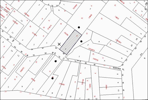
|
NOTIFICATION PLAN |
|
||
|
• PROPERTIES NOTIFIED
|
X SUBMISSIONS RECEIVED |
PROPERTY SUBJECT OF DEVELOPMENT |
|
|
THREE SUBMISSIONS WERE RECEIVED OUT OF MAP RANGE |
|||
Four submissions objected to the development generally on the following grounds:
· Potential structure damage to adjacent properties due to earthworks;
· Unacceptable removal and impact on trees;
· The proposal is not in keeping with the heritage character;
· Non-compliance with Part 3.1.2 Setbacks;
· Non-compliance with Part 3.1.1 Scale;
· The front fence is not consistent with the streetscape;
· Inadequate information for stormwater drainage; and
· The proposal is excessive in bulk and scale.
Further to the written submissions received by Council, an on-site meeting was conducted on the 9 October 2014 between Planning Division officers, the adjoining property owner and their planning consultant to discuss the issues raised in the submissions in more detail. At this meeting, the following additional concerns were discussed:
· The potential for the rear of the ground floor to be enclosed as additional floor space;
· The scale of the proposal is not consistent with adjacent properties; and
· The proposal may result in additional overshadowing impacts to adjoining properties.
The merits of the matters raised in community submissions have been addressed in the body of the report with the exception of the following:
5.1.1 Potential Structural Damage to the Adjacent Property
Three submissions raise concerns that the excavation works for the construction of the additions to the dwelling-house may result in structural damage to the adjacent dwelling-house at No. 63 Boronia Avenue, Cheltenham.
Given the 12% slope of the land within building envelope and the anticipated use of conventional footings to support the proposal, it is not anticipated that the works would have any detrimental impacts on the stability of the dwelling-house on the adjoining property.
To address the concerns raised in submissions, a condition is recommended for a dilapidation report to be prepared by a chartered structural engineer detailing the structural condition of No. 63 Boronia Avenue prior to the issue of a construction certificate.
5.1.2 Non-Compliance with Part 3.1.1 Scale
A submission raises concerns that the proposal does not comply with the maximum floor area prescriptive measure of the HDCP. The floor area of the dwelling-house, as defined by State Environmental Planning Policy (Exempt and Complying Development) 2008, is calculated to be 398m2 which complies with the 430m2 maximum floor area for a dwelling-house on a lot with an area over 900m2.
The submission also raises concerns that the ‘proposed covered area addition’ at the rear of the dwelling-house could be enclosed in the future and would increase the floor area of the dwelling-house by an additional 74m2.
Calculations of the floor area of the proposal have been made on the basis that the ‘proposed covered area addition’ will remain as such and a condition of consent is recommended for the ‘proposed covered area addition’ not to be enclosed without the prior consent of Council.
5.1.3 Inadequate Information for Stormwater Drainage
The submissions raise concerns that the application does not include sufficient information with respect to the stormwater drainage of the dwelling-house and ancillary structures.
The application is accompanied by a concept stormwater drainage plan which indicates that the existing dwelling-house drains directly to Boronia Avenue and the proposed additions would also drain directly to Boronia Avenue. The application includes sufficient information for the purposes of this assessment. A condition of consent is recommended for the proposal to drain directly to Boronia Avenue and further details would be provided to the principal certifying authority with the application for a construction certificate.
6. THE PUBLIC INTEREST
Section 79C(1)(e) of the Act requires Council to consider “the public interest”.
The public interest is an overarching requirement, which includes the consideration of the matters discussed in this report. Implicit to the public interest is the achievement of future built outcomes adequately responding to and respecting the future desired outcomes expressed in environmental planning instruments and development control plans.
The application is considered to have satisfactorily addressed Council’s criteria and would provide a development outcome that, on balance, would result in a positive impact for the community. Accordingly, it is considered that the approval of the proposed development would be in the public interest.
CONCLUSION
The application proposes alterations and additions to a dwelling-house.
The development generally meets the desired outcomes of Council’s planning controls and is satisfactory having regard to the matters for consideration under Section 79C of the Environmental Planning and Assessment Act, 1979.
Council received 4 submissions objecting to the proposal during the public notification period. These matters have been addressed in the body of the report and appropriate conditions are recommended to minimise disruption to residential amenity.
Note: At the time of the completion of this planning report, no persons have made a Political Donations Disclosure Statement pursuant to Section 147 of the Environmental Planning and Assessment Act 1979 in respect of the subject planning application.
|
Rod Pickles Manager - Development Assessment Planning Division |
James Farrington Group Manager Planning Division |
|
1.View |
Locality Map |
|
|
|
2.View |
Site and Elevations Plan |
|
|
|
3.View |
Floor Plan |
|
|
|
4.View |
Shadow Plans |
|
|
|
5.View |
Schedule of Finishes |
|
|
File Reference: DA/898/2014
Document Number: D03814233
SCHEDULE 1
GENERAL CONDITIONS
The conditions of consent within this notice of determination have been applied to ensure that the use of the land and/or building is carried out in such a manner that is consistent with the aims and objectives of the relevant legislation, planning instruments and Council policies affecting the land and does not disrupt the amenity of the neighbourhood or impact upon the environment.
Note: For the purpose of this consent, the term ‘applicant’ means any person who has the authority to act on or the benefit of the development consent.
Note: For the purpose of this consent, any reference to an Act, Regulation, Australian Standard or publication by a public authority shall be taken to mean the gazetted Act or Regulation, or adopted Australian Standard or publication as in force on the date that the application for a construction certificate is made.
1. Approved Plans and Supporting Documentation
The development must be carried out in accordance with the plans and documentation listed below and endorsed with Council’s stamp, except where amended by Council and/or other conditions of this consent:
|
Plan Name/No. |
Drawn by |
Dated |
|
Proposed Alterations and additions to existing residence - Drawing No. 1824-14CCb - Sheet No. 1 of 3 - Revision B |
D.B. |
06-08-2014 |
|
Proposed Alterations and additions to existing residence - Drawing No. 1824-14CCb - Sheet No. 2 of 3 - Revision B |
D.B. |
06-08-2014 |
|
Proposed Alterations and additions to existing residence - Drawing No. 1824-14CCb - Sheet No. 3 of 3 - Revision B |
D.B. |
06-08-2014 |
|
Document Title |
Prepared by |
Dated |
|
Waste Management Plan |
H. Dhindsa |
21-07-2014 |
|
BASIX Certificate No. A195009 |
Planning Approvals |
24 July 2014 |
|
Arboricultural Assessment Ref: 9173 |
REDGUM Horticultural |
30 July 2014 |
|
Statement of Environmental Effects |
Planning Approvals |
23 July 2014 |
2. Removal of Existing Trees
This development consent permits the removal of five exotic trees as indicated for removal on the site identified on approved Drawing No. 1824-14CCb, Sheet 1 of 3. The removal of any other trees requires separate approval in accordance with the Tree and Vegetation Chapter 1B.6 Hornsby Development Control Plan (HDCP).
3. Amendment of Plans
To ensure that the development has acceptable impacts on the heritage character of the streetscape, the approved plans are to be amended as follows:
a) No consent is granted for the erection a fence and gate on the front boundary;
b) The double width garage door on the front elevation must incorporate a decorative panel with vertical detailing; and
c) The window(s) to serve en-suite to the master bedroom must be vertical in design similar to the remaining windows on the front elevation.
These amended plans are to be submitted with the application for the construction certificate.
4. Section 94A Development Contributions
In accordance with Section 80A(1) of the Environmental Planning and Assessment Act 1979 and the Hornsby Shire Council Section 94A Development Contributions Plan 2012-2021, $3,750.00 shall be paid to Council to cater for the increased demand for community infrastructure resulting from the development, based on development costs of $375,000.
a) The value of this contribution is current as at 16 October 2014. If the contributions are not paid within the financial quarter that this condition was generated, the contributions payable will be adjusted in accordance with the provisions of the Hornsby Shire Council Section 94 Development Contributions Plan and the amount payable will be calculated at the time of payment in the following manner:
$CPY = $CDC x CPIPY
CPIDC
Where:
$CPY is the amount of the contribution at the date of Payment
$CDC is the amount of the contribution as set out in this Development Consent
CPIPY is the latest release of the Consumer Price Index (Sydney – All Groups) at the date of Payment as published by the ABS.
CPIDC is the Consumer Price Index (Sydney – All Groups) for the financial quarter at the date applicable in this Development Consent Condition.
b) The monetary contributions shall be paid to Council:
i) prior to the issue of the Subdivision Certificate where the development is for subdivision; or
ii) prior to the issue of the first Construction Certificate where the development is for building work; or
iii) prior to issue of the Subdivision Certificate or first Construction Certificate, whichever occurs first, where the development involves both subdivision and building work; or
iv) prior to the works commencing where the development does not require a Construction Certificate or Subdivision Certificate.
It is the professional responsibility of the Principal Certifying Authority to ensure that the monetary contributions have been paid to Council in accordance with the above timeframes.
Council’s S94A Development Contributions Plan may be viewed at www.hornsby.nsw.gov.au or a copy may be inspected at Council’s Administration Centre during normal business hours.
5. Construction Certificate
A Construction Certificate is required to be approved by Council or a Private Certifying Authority prior to the commencement of any works under this consent.
REQUIREMENTS PRIOR TO THE ISSUE OF A CONSTRUCTION CERTIFICATE
6. Building Code of Australia
All building work must be carried out in accordance with the relevant requirements of the Building Code of Australia.
7. Contract of Insurance (Residential Building Work)
In the case of residential building work for which the Home Building Act 1989 requires there to be a contract of insurance in force in accordance with Part 6 of that Act, that such a contract of insurance is in force before any building work authorised to be carried out by the consent commences.
8. Notification of Home Building Act 1989 Requirements
Residential building work within the meaning of the Home Building Act 1989 must not be carried out unless the principal certifying authority for the development to which the work relates (not being Council) has given Council written notice of the following information:
a) In the case of work for which a principal contractor is required to be appointed:
i) The name and licence number of the principal contractor; and
ii) The name of the insurer by which the work is insured under Part 6 of that Act.
b) In the case of work to be done by an owner-builder:
i) The name of the owner-builder; and
ii) If the owner-builder is required to hold an owner-builder’s permit under that Act, the number of the owner-builder’s permit.
Note: If arrangements for doing the residential building work are changed while the work is in progress so that the information notified becomes out of date, further work must not be carried out unless the principal certifying authority for the development to which the work relates (not being Council) has given Council written notification of the updated information.
9. Sydney Water – Quick Check
This application must be submitted to a Sydney Water ‘Quick Check Agent’ or ‘Customer Centre’ for approval to determine whether the development would affect any Sydney Water infrastructure, and whether further requirements are to be met.
Note: Refer to www.sydneywater.com.au or telephone 13 20 92 for assistance.
10. Dilapidation Report
A ‘Dilapidation Report’ is to be prepared by a ‘chartered structural engineer’ detailing the structural condition of No. 63 Boronia Avenue, Cheltenham.
REQUIREMENTS PRIOR TO THE COMMENCEMENT OF ANY WORKS
11. Erection of Construction Sign
A sign must be erected in a prominent position on any site on which building work, subdivision work or demolition work is being carried out:
a) Showing the name, address and telephone number of the principal certifying authority for the work;
b) Showing the name of the principal contractor (if any) for any demolition or building work and a telephone number on which that person may be contacted outside working hours; and
c) Stating that unauthorised entry to the work site is prohibited.
Note: Any such sign is to be maintained while the building work, subdivision work or demolition work is being carried out, but must be removed when the work has been completed.
12. Toilet Facilities
Toilet facilities must be available or provided at the works site before works begin and must be maintained until the works are completed at a ratio of one toilet for every 20 persons employed at the site. Each toilet must:
a) be a standard flushing toilet connected to a public sewer; or
b) be a temporary chemical closet approved under the Local Government Act 1993; or
c) have an on-site effluent disposal system approved under the Local Government Act 1993.
13. Tree Protection Barriers
a) Tree protection fencing must be erected in accordance with Arboricultural Assessment Ref: 9173 prepared by REDGUM Horticultural dated 30 July 2014 around trees numbered 1, 2, 3, 4 and 5 to be retained at the nominated setbacks in table 13(c) below.
b) The tree fencing must be constructed of 1.8 metre ‘cyclone chainmesh fence’ or star pickets spaced at 2 metre intervals, connected by a continuous high-visibility barrier/hazard mesh at a height of 1 metre.
|
Tree No. |
Tree Species |
Tree Protection Zone |
|
1 |
Syncarpia glomulifera |
8.6 metres |
|
2 |
Syncarpia glomulifera |
7.0 metres |
|
3 |
Syncarpia glomulifera |
5.4 metres |
|
4 |
Syncarpia glomulifera |
3.2 metres |
|
5 |
Melaleuca quinquenervia |
5.3 metres |
14. Erosion and Sediment Control
Erosion and sediment control measures must be provided and maintained throughout the construction period in accordance with the manual ‘Soils and Construction 2004 (Bluebook)’, the approved plans, Council specifications and to the satisfaction of the principal certifying authority. The erosion and sediment control devices must remain in place until the site has been stabilised and revegetated.
Note: On the spot penalties up to $1,500 may be issued for any non-compliance with this requirement without any further notification or warning.
REQUIREMENTS DURING CONSTRUCTION
15. Construction Work Hours
All work on site (including demolition and earth works) must only occur between 7am and 5pm Monday to Saturday. No work is to be undertaken on Sundays or public holidays.
16. Demolition
All demolition work must be carried out in accordance with “Australian Standard 2601-2001 – The Demolition of Structures” and the following requirements
a) Demolition material must be disposed of to an authorised recycling and/or waste disposal site and/or in accordance with an approved waste management plan;
b) Demolition works, where asbestos material is being removed, must be undertaken by a contractor that holds an appropriate licence issued by WorkCover NSW in accordance with Chapter 10 of the Occupational Health and Safety Regulation 2001 and Clause 29 of the Protection of the Environment Operations (Waste) Regulation 2005; and
c) On construction sites where buildings contain asbestos material, a standard commercially manufactured sign containing the words ‘DANGER ASBESTOS REMOVAL IN PROGRESS’ measuring not less than 400mm x 300mm must be erected in a prominent position visible from the street.
17. Works Near Trees
a) All required tree protection measures are to be maintained in good condition for the duration of the construction period.
b) All works (including driveways and retaining walls) within the designated Tree Protection Zones of any trees required to be retained (whether or not on the subject property, and pursuant to this consent or the Tree Preservation Order), must be carried out under the supervision of an ‘AQF Level 5 Arborist’ and a certificate submitted to the principal certifying authority detailing the method(s) used to preserve the tree(s).
Note: Except as provided above, the applicant is to ensure that no excavation, filling or stockpiling of building materials, parking of vehicles or plant, disposal of cement slurry, waste water or other contaminants is to occur within 4 metres of any tree to be retained.
18. Council Property
During construction works, no building materials, waste, machinery or related matter is to be stored on the road or footpath. The public reserve must be kept in a clean, tidy and safe condition at all times.
19. Disturbance of Existing Site
During construction works, the existing ground levels of open space areas and natural landscape features, (including natural rock-outcrops, vegetation, soil and watercourses) must not be altered unless otherwise nominated on the approved plans.
REQUIREMENTS PRIOR TO THE ISSUE OF AN OCCUPATION CERTIFICATE
Note: For the purpose of this consent, a reference to ‘occupation certificate’ shall not be taken to mean an ‘interim occupation certificate’ unless otherwise stated.
20. Fulfilment of BASIX Commitments
The applicant must demonstrate the fulfilment of BASIX commitments pertaining to the development.
21. Stormwater Drainage
The stormwater drainage system for the development must be designed and constructed for an average recurrence interval of 20 years, be gravity drained and connected to the existing internal drainage system and then connected directly to Council’s street drainage system.
22. Damage to Council Assets
Any damage caused to Council’s assets as a result of the construction of the development must be rectified in accordance with Council’s written requirements and at the sole cost of the applicant.
23. Smoke Alarms
Smoke alarms must be installed in the existing building and the proposed additions in accordance with the requirements of the Building Code of Australia.
24. Retaining Walls
All required retaining walls must be constructed as part of the development.
25. Replacement Screen Planting
To maintain canopy cover, 4 medium to large trees selected from Council’s booklet ‘Indigenous Plants for the Bushland Shire’ are to be planted within the front setback on the subject site. The planning location shall not be within 4 metres of the foundation walls of a dwelling or in-ground pool. The pot size is to be a minimum 25 litres and the trees must be maintained until they reach the height of 3 metres.
OPERATIONAL CONDITIONS
26. Covered Area
The ‘proposed covered area addition’ to the rear of the dwelling-house must not be enclosed without the prior written consent of council.
- END OF CONDITIONS -
ADVISORY NOTES
The following information is provided for your assistance to ensure compliance with the Environmental Planning and Assessment Act 1979, Environmental Planning and Assessment Regulation 2000, other relevant legislation and Council’s policies and specifications. This information does not form part of the conditions of development consent pursuant to Section 80A of the Act.
Environmental Planning and Assessment Act 1979 Requirements
The Environmental Planning and Assessment Act 1979 requires:
· The issue of a construction certificate prior to the commencement of any works. Enquiries can be made to Council’s Customer Services Branch on 9847 6760;
· a principal certifying authority to be nominated and Council notified of that appointment prior to the commencement of any works;
· Council to be given at least two days written notice prior to the commencement of any works;
· mandatory inspections of nominated stages of the construction inspected; and
· an occupation certificate to be issued before occupying any building or commencing the use of the land.
Long Service Levy
In accordance with Section 34 of the Building and Construction Industry Long Service Payments Act 1986, a ‘Long Service Levy’ must be paid to the Long Service Payments Corporation or Hornsby Council.
Note: The rate of the Long Service Levy is 0.35% of the total cost of the work.
Note: Hornsby Council requires the payment of the Long Service Levy prior to the issue of a construction certificate.
Tree and Vegetation Preservation
In accordance with Clause 5.9 of the Hornsby Local Environmental Plan 2013 a person must not ringbark, cut down, top, lop, remove, injure or wilfully destroy any tree or other vegetation protected under the Hornsby Development Control Plan 2013 without the authority conferred by a development consent or a permit granted by Council.
Notes: A tree is defined as a long lived, woody perennial plant with one or relatively few main stems with the potential to grow to a height greater than three metres (3M). (HDCP 1B.6.1.c).
Tree protection measures and distances are determined using the Australian Standard AS 4970:2009, “Protection of Trees on Development Sites”.
Fines may be imposed for non-compliance with both the Hornsby Local Environmental Plan 2013 and the Hornsby Development Control Plan 2013.
Dial Before You Dig
Prior to commencing any works, the applicant is encouraged to contact Dial Before You Dig on 1100 or www.dialbeforeyoudig.com.au for free information on potential underground pipes and cables within the vicinity of the development site.
Asbestos Warning
Should asbestos or asbestos products be encountered during demolition or construction works, you are advised to seek advice and information prior to disturbing this material. It is recommended that a contractor holding an asbestos-handling permit (issued by WorkCover NSW) be engaged to manage the proper handling of this material. Further information regarding the safe handling and removal of asbestos can be found at:
Alternatively, telephone the WorkCover Asbestos and Demolition Team on 8260 5885.
Group Manager's Report No. PL80/14
Planning Division
Date of Meeting: 12/11/2014
19 REPORTING VARIATIONS TO DEVELOPMENT STANDARDS
EXECUTIVE SUMMARY
· In accordance with Department of Planning and Environment’s Planning Circular PS 08‑14, Council is required to report variations to development standards for development applications approved under delegated authority, which relied upon State Environmental Planning Policy No. 1 – Development Standards (SEPP 1) or Clause 4.6 of the Hornsby Local Environmental Plan - 2013 (HLEP).
· Council’s consideration of this report ensures Council’s obligation to monitor variations to development standards is complied with.
|
THAT the contents of Group Manager’s Report No. PL80/14 be received and noted. |
PURPOSE
The purpose of this report is to advise Council of determined development applications under delegated authority involving a SEPP 1 or Clause 4.6 variation to a development standard for the period 1 July 2014 to 30 September 2014.
DISCUSSION
Department of Planning and Environment’s Circular B1, issued in March 1989, requested that councils monitor the use of the Secretary’s assumed concurrence under SEPP 1 on a quarterly basis. This reporting requirement remains effective.
Monitoring of variations to development standards is important to provide the Department and councils with an overview of the manner in which established development standards are being varied and whether the assumed concurrence is being used as intended. This enables Council and the Department to determine whether development standards are appropriate, or whether changes are required.
The Department issued Circular PS 08–014 on 14 November 2008. The purpose of the Circular was to remind councils of their responsibilities to monitor the use of the Secretary’s assumed concurrence under SEPP 1. Councils were reminded of the need to keep accurate records of the use of SEPP 1 and to report on a quarterly basis.
The Circular also provides that councils are required to adopt the following four measures:
1. Establish a register of development applications determined with variations in standards under SEPP 1.
2. Require all development applications where there has been a variation greater than 10% in standards under SEPP 1 to be determined by full council (rather than General Manager or nominated staff member).
3. Provide a report to Council on the development applications determined where there had been a variation in standards under SEPP 1.
4. Make the register of development applications determined with variations in standards under SEPP 1 available to the public on the council’s website.
In accordance with Point 3 of Department Circular, attached is a list of development applications determined between 1 July 2014 and 30 September 2014.
A copy of the attachment to this report is also reproduced on Council’s website.
BUDGET
There are no budget implications.
POLICY
This report addresses Council’s reporting obligations for development applications determined where there has been a variation in standards under SEPP 1. Under the HLEP 2013, the application of the provisions of SEPP 1 has been replaced by Clause 4.6 (exceptions to development standards). The Department of Planning and Environment has advised that the current reporting practice for variation to development standards will continue to apply for applications involving a submission pursuant to Clause 4.6 of the HLEP 2013.
CONCLUSION
Council is required to monitor the manner in which development standards are being varied. This assists in determining whether changes are required to relevant standards. This report provides advice to Council on standards varied under delegated authority which relied upon SEPP 1 or Clause 4.6 of the HLEP during the reporting period from 1 July 2014 to 30 September 2014.
RESPONSIBLE OFFICER
The officer responsible for the preparation of this report is the Group Manager Planning Division – James Farrington, who can be contacted on 9847 6750.
|
James Farrington Group Manager Planning Division |
|
|
1.View |
SEPP 1 Returns - Quarter for 1 July 2014 to 30 September 2014 |
|
|
File Reference: F2004/07599
Document Number: D03828208
Group Manager's Report No. PL78/14
Planning Division
Date of Meeting: 12/11/2014
20 DESIGN QUALITY OF RESIDENTIAL FLAT DEVELOPMENT
EXECUTIVE SUMMARY
· The Department of Planning and Environment (DP&E) has released draft amendments to State Environmental Planning Policy (SEPP) 65 – Design Quality of Residential Flat Development and the Residential Flat Design Code (RFDC).
· The majority of the proposed amendments are consistent with the Discussion Paper released in 2012 and Council’s submission at the time.
· The amendments primarily relate to the types of development addressed by the policy, rationalisation of design quality principles and the introduction of new minimum standards aimed at addressing affordability.
· It is recommended that Council forward a submission to the DP&E supporting the review of SEPP 65 and outlining its concerns in relation to key areas of the draft amendments.
|
THAT a submission be forwarded to the Department of Planning and Environment indicating Council’s general support for the draft amendments to State Environmental Planning Policy 65 – Design Quality of Residential Flat Development and the Residential Flat Design Code subject to the Department addressing the major issues for Hornsby Shire identified in Group Manager’s Report No. PL78/14, including: 1. Clause 6A in the draft SEPP should be deleted. The SEPP should not override Council’s controls and preclude Council from applying higher than minimum standards. 2. Car parking should not be added as a standard that cannot be used as grounds for refusal. 3. The internal unit areas in the current RFDC should be retained to promote good design rather than placing the sole emphasis on affordability. 4. A numerical control requiring a mix of unit types should be inserted to increase housing choice, including minimum requirements for dual key units. 5. The RMS Guide to Traffic Generating Development should be updated if this document is to be relied upon for setting parking standards within 800 metres of a train station. 6. Provision for deep soil zones should also accommodate planting within side setbacks where a minimum dimension of 4 metres is appropriate. 7. The existing minimum setbacks for non-habitable rooms of 6, 9 and 12 metres should be retained to preserve outcomes in relation to visual impact and landscape design. |
PURPOSE
The purpose of this report is to seek endorsement of a submission to the DP&E concerning draft amendments to SEPP 65 and the accompanying design guidelines.
BACKGROUND
SEPP 65 aims to improve the design quality of Residential Flat Buildings in NSW. It is accompanied by a Residential Flat Design Code which provides design guidelines. There has not been a substantial review of the SEPP since its gazettal in 2002.
In 2012, the Department of Planning and Environment released a Discussion Paper concerning a review of SEPP 65 and the RFDC. At its meeting on 1 February 2012, Council considered Executive Manager’s Report No. PLN16/12 concerning the Discussion Paper. Council resolved to forward a submission which generally supported the review and suggested improvements to the SEPP and RFDC code. The main issues raised related to:
· definition of land use terms to be consistent with the Standard Instrument;
· streamlining of design quality principles to avoid duplication;
· reducing parking rates in close proximity to high frequency public transport;
· support for a private open space sliding scale consistent with Council’s DCP; and
· provision of standards for apartment mix and adaptable design.
Submissions to the Discussion Paper are summarised in the Department’s document entitled “Overview – Proposed amendments to SEPP 65 and the Residential Flat Design Code” along with the results of a technical analysis. Whilst the paper does not individually address Council’s submission, the issues raised are addressed with the exception of minimum standards for apartment mix and adaptable design.
The Department is inviting submissions on the amendments to the SEPP and RFDC until 31 October 2014. Council has forwarded a submission to the Department requesting an extension of time for the making of a submission to enable the matter to be reported to the November 2014 Council meeting.
DISCUSSION
This report outlines the proposed amendments to SEPP 65 and the RFDC and identifies the implications for Hornsby Shire.
1. SEPP 65
The majority of the proposed changes to the SEPP are generally consistent with the 2012 Discussion Paper and Council’s submission at that time. The draft amendment clarifies the application of the SEPP to residential flat buildings, mixed use development with a residential component and shop top housing. A new clause is proposed which confirms that SEPP BASIX applies. The ten Design Quality Principles identified in the SEPP are proposed to be renamed and reduced to nine by combining Built Form and Scale into one principle. The draft amendment also incorporates additional aims and objectives, including contribution to the provision of affordable housing options.
Of concern are changes which seek to allow developments to be approved based on minimum standards, which may be lower than Council’s standards. Inserting minimum standards places emphasis on affordability rather than good design and amenity for future residents. The newly inserted aim to contribute to the provision of affordable housing should not outweigh the overall aim of the SEPP to improve the design quality of residential flat development. These concerns are outlined below.
1.1 Standards that Cannot be Used as Grounds for Refusal
The SEPP contains standards (ceiling heights and apartment area) which cannot be used as grounds to refuse an application. In the draft SEPP, it is proposed that car parking be added as an additional standard for which an application cannot be refused if it complies with the recommended minimum amount of car parking set out in the RFDC.
Concern is raised with the removal of car parking as grounds for refusal by Council. Council’s car parking requirements are greater than those proposed under the RFDC (see discussion below under the heading Car Parking) and Council should be permitted to refuse an application if it does not comply with local minimum requirements and is not supported by a local parking study.
Clarification is required concerning the existing apartment area standard which cannot be used as grounds to refuse an application. The draft SEPP states that apartment area cannot be used as grounds to refuse an application if the proposed area for each apartment is equal to, or greater than, the recommended internal area for the relevant apartment type in the RFDC. However, the recommended internal areas for well organised, functional and high quality apartments have been removed from the RFDC. The minimum apartment sizes in the draft Apartment Design Guide (ADG) are based on the minimum apartment sizes for affordable housing from the RFDC (see discussion below under the heading Apartment layout).
Recommendation
1a Car parking should not be added as a standard that cannot be used as grounds for refusal. Council should be permitted to refuse an application if it does not comply with local minimum requirements and is not supported by a local parking study.
1b The wording of Clause 30(b) in the draft SEPP requires review and clarification. The apartment area standard which cannot be used as grounds to refuse an application refers to internal areas which are contained in the current RFDC and does not correspond with the new table in the ADG.
1.2 Statutory Weight of the Apartment Design Guide
A new clause (Clause 6A) is proposed which would allow particular sections of the ADG to prevail over the provisions within the Hornsby Development Control Plan (HDCP). Council’s controls relating to certain matters would be overridden by the following controls contained within the ADG:
· Visual privacy;
· Solar and daylight access;
· Common circulation and spaces;
· Apartment layout (size);
· Ceiling heights;
· Balconies and private open space;
· Natural ventilation; and
· Storage.
The HDCP was prepared having regard to SEPP 65, Council’s Housing Strategy, and urban design advice. The controls in the HDCP in relation to the above matters are generally consistent with SEPP 65, with the exception of private open space. Council’s requirement for the provision of private open space is greater than that set out in the ADG (see below discussion under the heading Private Open Space). While the intention of the SEPP is to improve design quality and set a minimum benchmark for liveable apartments, it should not preclude Council from applying higher than minimum standards. Council should retain the ability to set local development standards based on the needs and expectation of the community and future residents of new development.
Where a council has an adopted policy concerning the design and development of residential flat buildings which has been prepared having regard to SEPP 65, those controls should be the primary development standards to be considered during the assessment of applications. However, if a council does not have an adopted policy concerning the development of residential flat buildings, then the ADG standards should be applied with similar weight as DCP controls. Alternatively, the development standards which are to be applied to residential flat development should be either those contained in a DCP, or the ADG, whichever is the greater.
This would reflect the main aims of the SEPP to better satisfy the increasing demand, changing social and demographic profile of the community and the needs of the widest range of people from childhood to old age and to maximise amenity, safety and security for the benefit of occupants and the wider community. Affordability should not take precedence over design quality. Council promotes affordability through increasing the supply of housing and mandating a mix of housing to provide housing choice. Affordability should not be promoted to the detriment of good design.
Recommendation
1b Clause 6A in the draft SEPP should be deleted. The SEPP should not override Council’s controls and preclude Council from applying higher than minimum standards. Council should retain the ability to set local development standards based on the needs and expectations of the community and future residents of new development.
1c Where a council has an adopted policy concerning the design and development of residential flat buildings which has been prepared having regard to SEPP 65, those controls should be the primary development standards to be considered during the assessment of applications.
1d If Clause 6A is retained, it needs to be reviewed to clearly identify when provisions in the Guideline under each heading have precedence.
1e If a council does not have an adopted policy concerning the development of residential flat buildings, then the RFDC standards should be applied with similar weight as DCP controls.
1f Alternatively, the development standards which are to be applied to residential flat development should be either those contained in a DCP, or the RFDC, whichever is the greater.
1.3 Design Review Panel
SEPP 65 contains provisions for the establishment of Design Review Panels. These Panels can provide independent advice to councils about the quality of developments against the SEPP 65 design quality principles. The Panels can also provide pre-lodgement design advice to applicants regarding compliance with SEPP 65. The review has found that the take up of panels by councils has been relatively low and the need for panels to operate consistently.
Accordingly, the Department proposes to amend the SEPP to require that members of a design review panel are qualified and experienced in the fields of architecture, landscape architecture or urban design. The amendments also specify a minimum term of 2 years for panel members and reference procedures in the ADG for the establishment and running of panels.
Council does not operate a SEPP 65 panel. However, Council recently considered Group Manager’s Report PL53/14 in relation to the design quality of high density development. Council resolved in part to prepare an internal policy for the referral of development applications over 10 storeys in height to a suitably qualified urban design / architecture consultant for review against the design excellence clause of Council’s LEP (once implemented).
The draft SEPP amendment does not impact on this initiative as the formation of a SEPP 65 panel is optional and considered impractical for Council on the grounds that the cost of remunerating and administering the panel would be prohibitive.
2. Apartment Design Guide
It is proposed that the RFDC be renamed the Apartment Design Guide (ADG). The ADG has been updated to reflect a performance based approach, with performance criteria and acceptable solutions (formerly rules of thumb) for each section. Alternative solutions are also provided for some sections, allowing greater flexibility. New elements concerning the public domain interface, adaptive re-use and noise and pollution are proposed to be inserted. A matrix showing the relationship between the Design Quality Principles and the elements of ADG has been incorporated. The above changes are supported. However, concern is raised regarding the following elements.
2.1 Apartment Layout (Size)
The ADG specifies minimum sizes of 50m2, 70m2 and 95m2 for 1, 2 and 3 bedroom units respectively, and a minimum size of 35m2 for studio units, consistent with the Affordable Housing State Environmental Planning Policy. Concern is raised with the basis of these minimums. Currently under the RFDC, higher internal unit areas ranging from 38.5m2 for a studio to 124m2 for a 3 bedroom unit are specified as functional, high quality apartment layouts. The lower sizes of 50m2, 70m2 and 95m2 are noted in the RFDC as a guide which can contribute to affordable housing.
Changing the minimum unit areas in the ADG to require only the “affordable” size means that, generally, only these size units would be provided by developers who wish to maximise development yield. These sorts of minimum standards do not promote dwelling stock which offers a desirable housing alternative for families and does not reflect the range of services and amenities in the area. Inserting minimum standards places sole emphasis on affordability rather than good design and amenity for future residents. The newly inserted aim to contribute to the provision of affordable housing should not outweigh the overall aim of the SEPP to improve the design quality of residential flat development.
As discussed above, Council promotes affordability through increasing the supply of housing and mandating a mix of housing to provide housing choice. Affordability does not have to be achieved to the detriment of good design. The higher internal unit areas which represent functional, high quality apartment layouts should be reinstated as the minimum requirement in the ADG, with a maximum allowance (say 30%) of smaller units which can be provided at the “affordable” size.
Recommendation
2a The internal areas in the current RFDC should be retained in the ADG. The draft minimum standards place sole emphasis on affordability rather than good design and amenity for future residents. The newly inserted aim to contribute to the provision of affordable housing should not outweigh the overall aim of the SEPP to improve the design quality of residential flat development.
2b A maximum allowance (no more than 30%) of smaller units should be provided at the “affordable” size. However, Council prefers to promote affordability through increasing the supply of housing and mandating a mix of housing to provide housing choice.
2.2 Dwelling Mix
The ADG requires a range of apartment types and sizes to cater for different household types. However, there remains no numerical control for dwelling mix. The HDCP requires that developments should include at least 10% of 1, 2 and 3 bedroom units. This type of requirement in the ADG would be supported, particularly because apartment area is identified as a standard which cannot be used by Council as grounds for refusal. There is concern that, without a numerical standard, the aim of the ADG to ensure housing choice and support the needs of the community now and into the future will not be achieved. Inserting a numerical control requiring a mix of unit types would assist meet the new aim of the SEPP to contribute to the provision of affordable housing.
In addition to specifying the mix of unit types, the ADG should also extend to addressing dual key apartments. The trend towards the provision of dual key apartments as a means of accommodating families or providing improved rental yields is increasing with implications concerning parking, open space and demand for services similar to granny flats. Accordingly, a policy position that establishes an appropriate mix, design and parking requirement would be beneficial in guiding appropriate outcomes.
Recommendation
2c A numerical control requiring a mix of unit types (for example at least 10% of each 1, 2 and 3 bedroom units) should be inserted to increase housing choice and assist meet the new aim of the SEPP to contribute to the provision of affordable housing.
2d A numerical control that establishes a maximum mix of dual key units and appropriate development standards is required to manage the impacts of this emerging unit type.
2.3 Private Open Space
The HDCP requires the provision of open space on a sliding scale depending on the number of bedrooms and ranges from 10m2, 12m2 and 16m2 for 1, 2 and 3 bedroom units respectively, with a minimum dimension of 2.5m. Council’s sliding scale is generally consistent with the State Government’s Housing Code for small lots, which identifies that a 3 bedroom house/townhouse/unit on a small lot should include a minimum 16m2 of private open space.
The ADG has been amended to also require the provision of open space on a sliding scale. However, the sliding scale ranges from 8m2, 10m2 and 12m2 for 1, 2 and 3 bedroom units respectively, with a minimum dimension of 2m for 1 and 2 bedroom units and 2.5m for 3 bedrooms. It is unclear on what basis the sliding scale in the ADG been set. A balcony with a minimum dimension of 2m would only accommodate a round table and two chairs and therefore, would not provide adequate usable open space for a range of household types.
The changes to the SEPP mean that the controls for open space in the ADG will override the controls in the HDCP. Concern is raised regarding the amenity of households moving into higher density living if the lower ADG standard prevails. The sliding scale in the ADG should be increased to an adequate level, and/or Council should not be precluded from setting local development standards higher than the minimum based on the needs and expectations of the community and future residents of new development.
Recommendation
2e The sliding scale for the provision of open space in the ADG should be increased to require the minimum area to start from 10m2 and minimum dimension to be 2.5m to provide for the amenity of future residents.
2f Alternatively, Council should not be precluded from setting local development standards higher than the minimum based on the needs and expectations of the community and future residents of new development.
2.4 Car Parking
Car parking standards are proposed to be introduced which reduce minimum car parking requirements for development located near public transport. For inner and middle ring councils (which is defined in the ADG), car parking is not required for development within 400m of a railway station or light rail stop (this does not apply to Hornsby).
For Hornsby, the new standard would mean that development located within 800m of a railway station would be required to provide the minimum requirement set out in the RMS Guide to Traffic Generating Development or the car parking rate prescribed by Council, whichever is less. A comparison is provided below.
|
Development Type |
Council Requirement (parking spaces) |
RMS Guidelines (parking spaces) |
|
Residential Flat Building within 800m of a railway station |
0.75 per 1 bed unit 1 per 2 bed unit 1.5 per 3 / 3+ bed unit |
0.4 per 1 bed unit 0.7 per 2 bed unit 1.2 per 3 bed unit |
|
Example: 30 units (7 x 1 bed, 18 x 2 bed, 5 x 3 bed) |
31 spaces |
22 spaces |
The RMS Guidelines require significantly less car parking than would be required under Council’s DCP. The objective of a reduction in car parking rates for sites with good proximity to public transport is supported and embodied in the HDCP with the inclusion of separate rates of car parking dependent on proximity to railway stations. However, concern is raised with the extent of the reduction in car parking rates in the ADG in the absence of any local parking studies. The RMS Guide to Traffic Generating Development is a regional document which does not have regard to local issues or community demands. Further, the RMS Guide to Traffic Generating Development is a dated document which should be revised and reissued.
As discussed above, the SEPP amendments proposed to include car parking as a standard that cannot be used as a ground for refusal if the proposed car parking is equal to, or greater than, the recommended minimum in the ADG. Council would not be able to refuse a development on the grounds of car parking if it complies with the ADG, despite the fact that the HDCP requires more car parking.
Recommendation
2g The RMS Guide to Traffic Generating Development is a dated document which should be revised and reissued if it is to be relied upon for car parking standards. For example, parking standards for dual key apartments are not addressed.
2h Application of the RMS parking rates in the absence of local parking studies will further increase pressure on off-street parking.
2i Clarification is required concerning which areas in the RMS Guide are identified as Metropolitan Regional (CBD) Centres and which are Metropolitan Sub-Regional Centres as different parking rates apply, which may cause confusion when applying the ADG within 800m of a railway station.
2j The objective of a reduction in car parking rates for sites with good proximity to public transport is supported and embodied in the Hornsby Development Control Plan with the inclusion of separate rates of car parking dependent on proximity to railway stations. However, the RMS rates are significantly lower than those required by Council.
2.5 Deep Soil Zones
The ADG introduces a sliding scale for the provision of deep soil zones, based on site area as follows:
|
Site Area |
Deep Soil Zone (% of Site Area) |
Minimum Dimensions |
|
Less than 650m2 |
7% |
- |
|
650m2 – 1,500m2 |
10% |
3m |
|
Greater than 1,500m2 |
15% |
6m |
|
Greater than 1,500m2 and significant tree cover |
20% |
6m |
These percentages are an increase from the RFDC, which identifies a rule of thumb guide of 25% deep soil planting of the open space area which itself is 25% of the site area. Council’s HDCP prescribes the width and location of deep soil areas adjoining property boundaries without setting a percentage requirement. The requirement for 7m deep soil area at the front and rear boundaries and 4m at the side boundaries in the HDCP achieves the desired future character in Hornsby Shire of residential flat buildings in landscaped settings, and may be a more appropriate way of optimising deep soil areas. The ADG’s minimum dimension of 6m would not provide for deep soil planning alongside boundary setbacks which is a key feature of Council’s approach.
Recommendation
2k The introduction of a sliding scale for the provision of deep soil zones that increase the existing requirement of the RFDC is supported.
2l The minimum dimension for deep soil zones should also accommodate planting within side setbacks where a minimum dimension of 4 metres is appropriate.
2.6 Building Separation
Council’s building separation and setback controls are based on the existing RFDC which provide an appropriate outcome in relation to visual privacy and landscaping. The ADG maintains the building setback for habitable rooms and balconies, but introduces reduced setbacks for non-habitable rooms as set out below:
|
Building Height |
Habitable Rooms and Balconies |
Non-habitable Rooms |
|
Up to 12m (4 storeys) |
6m |
3m |
|
Up to 25m (5 – 8 storeys) |
9m |
4.5 |
|
Over 25m (9+ storeys) |
12m |
6m |
In relation to Council’s requirements for 5 storey development, the minimum building separation is 9m. Council also encourages building designs that incorporate wrap around balconies and articulation to provide development of visual interest and amenity for occupants. The proposal to reduce the setback to 3 and 4.5 metres for non-habitable rooms may encourage the provision of blank facades to internal and external boundaries to increase yield, whilst reducing setbacks and opportunity for landscaping along side boundaries.
Recommendation
2m The existing minimum setbacks for non-habitable rooms of 6, 9 and 12 metres should be retained to preserve outcomes in relation to visual impact and landscape design.
In summary, it is recommended that Council make a submission to the DP&E based on the discussion above, supporting the review but outlining the concerns relevant to Hornsby Council. The draft amendments seek to allow developments to be approved based on minimum standards, which may be lower than Council’s standards. Inserting minimum standards places sole emphasis on affordability rather than good design and amenity for future residents.
Submissions closed on 31 October 2014. A copy of this report, a draft submission and a request for an extension of time have been submitted to the Local Plans, Codes and Development Guides section of the DP&E. A final submission will be forwarded after Council’s consideration of this report and in accordance with its resolution.
BUDGET
There are no budgetary implications associated with this Report.
POLICY
The amendments to SEPP 65 and the Apartment Design Guide, if progressed, would have implications for Councils Development Control Plan, which are discussed in this report.
CONCLUSION
The majority of the proposed changes to the SEPP are generally consistent with the 2012 Discussion Paper and Council’s submission at that time. However, concerns are raised regarding changes which seek to allow developments to be approved based on minimum standards, some of which are lower than Council’s standards. It is recommended that Council make a submission to the DP&E supporting the review but raising concern with the changes that impede Council’s ability to set higher development standards based on the needs and expectations of the local community and future residents of new development.
RESPONSIBLE OFFICER
The officer responsible for the preparation of this Report is the Manager, Strategic Planning Branch – Fletcher Rayner, who can be contacted on 9847 6744.
|
Fletcher Rayner Manager - Strategic Planning Planning Division |
James Farrington Group Manager Planning Division |
There are no attachments for this report.
File Reference: F2004/06504
Document Number: D03821046
Group Manager's Report No. PL82/14
Planning Division
Date of Meeting: 12/11/2014
21 RURAL LANDS PLANNING ISSUES SURVEY - SUMMARY OF RESPONSES
EXECUTIVE SUMMARY
· Council invited a total of 6,430 landowners in the Shire to participate in an on-line survey (conducted between 20 June and 18 July) to identify the community’s vision for the rural areas, and attitudes to a number of planning controls and development opportunities.
· Council received a total of 1,398 responses to the survey. Analysis of the responses has identified there is general support for permitting larger granny flats; introducing attached dual occupancies as a permissible land use; permitting larger roadside stalls that sell local produce; and introducing rural cluster housing as a permissible form of development.
· Generally responses across the Shire indicated equal support for and against reducing lot size. However, there is greater support for reducing lot size from respondents in the rural area and rural zone. Furthermore, there is support for including environmental zoned land when calculating lot size.
· As the survey findings indicate general support to amend Council’s planning controls in relation to various development opportunities, a Councillor Briefing should be held to discuss the preparation of a strategy to outline future actions, budget and priority with respect to existing projects on Council’s Strategic Planning Program.
|
THAT: 1. The Rural Lands Planning Issues Survey – Summary of Response Report (attached to Group Manager’s Report No. PL82/14) be received and noted. 2. The Summary of Response Report be made available for viewing on Council’s website to inform the community of the findings. 3. A Councillor Briefing be held to discuss the preparation of a strategy that responds to the findings of the survey prior to a report being presented for Council’s consideration. 4. All persons who responded to the survey be advised of Council’s resolution. |
PURPOSE
The purpose of this Report is to present a summary of responses to the Rural Lands Planning Issues Survey and recommend that Council prepare a strategy that responds to the findings of the survey.
BACKGROUND
At its meeting on 9 April 2014, Council considered Group Manager’s Report No. PL26/14 outlining a community consultation strategy that expanded upon Council’s previous resolution to consult the community on options for a review of minimum allotment sizes in the Galston and Glenorie areas. Council resolved that:
1. Council expand the project brief for the “Galston and Glenorie Subdivision Review” on its Strategic Planning Program to undertake a survey to identify the contemporary planning issues and the community’s vision for the rural areas of the Shire.
2. Consultation be undertaken with the community in accordance with the Community Consultation Strategy discussed in Group Manager’s Report No. PL26/14.
3. The General Manager be authorised to approve any consultation material and/or additional consultation techniques recommended by Council’s community consultation specialist to engage with the broader community.
4. Council accept receipt of written submissions in addition to feedback provided in the survey.
5. Any responses to the survey and written submissions received be evaluated and a report be presented to Council for its consideration.
In accordance Council’s resolution, an independent consultation specialist was engaged to prepare an on-line survey. A Councillor Briefing was held on 7 May 2014 to confirm satisfaction with the draft survey before Council invited a total of 6,430 landowners in the Shire to participate in the on-line survey. The landowners invited to participate comprised all 3,215 landowners in suburbs that comprise the rural areas of the Shire and the equivalent number of randomly selected landowners in the urban areas of the Shire. The on-line survey was conducted between 20 June and 18 July 2014.
DISCUSSION
This report presents a summary of responses to the Rural Lands Planning Issues Survey that were received on-line via Survey Monkey and by written submission.
Response to Survey
The on-line survey was conducted between 20 June and 18 July 2014 in accordance with Council’s adopted consultation strategy. Council received a total of 1,398 responses (or 21.7% of the 6,430 landowners invited).
Council officers and the independent consultation specialist have reviewed the responses received to the survey and prepared the Rural Lands Planning Issues Survey – Summary of Response Report (copy attached) to provide an overview of the feedback received. The Report identifies the following key findings:
Who Responded?
· 72% of the respondents were from the rural areas and 28% were from the urban areas of the Shire;
· A large number of the respondents (53.5%) were from the 50-69 year age group which is disproportionate to the population demographics of the Shire (23.4%) for that age group;
· The majority of respondents (71.5%) identified themselves to be from the retired, professional, and manager or directors occupation categories; and
· The majority of respondents (47%) have lived in the Shire for more than 20 years.
What Did They Say? – Vision Statements for Rural Area
The survey included questions to test attitudes to statements of vision. A clear majority (i.e. greater than 50%) of the respondents agreed with the following vision statements:
· I take an interest in Council's planning controls for the rural areas and any potential changes;
· Agricultural land use in Hornsby Shire is not as viable today as it used to be;
· Development in the rural areas should be limited by land constraints;
· Council should change its planning controls to promote an alternate housing format that provides for a rural/residential lifestyle;
· I feel strongly that we should maintain farming and agricultural use in Hornsby Shire;
· I am in favour of introducing more business and tourism based development opportunities in the rural areas; and
· We need more housing opportunities for extended family and renters in the rural areas of Hornsby Shire.
The responses indicate that the community has an interest in Council’s planning strategy for rural lands and that development opportunity should respect environmental constraints and opportunities for agriculture. Support for the provision of alternate housing formats, business and tourism opportunities is generally reflected in the survey results for nominated development opportunities as discussed below.
What Did They Say? – Development Opportunities
The survey included questions to test attitudes to existing planning controls and nominated development opportunities. Analysis of the responses has identified the following key results for the nominated development opportunities:
· Larger Granny Flats: Support (75.2%) for larger granny flats, with a combined preference (62.2%) for the size limit to be increased to between 30% and 50% of principal dwelling size.
· Attached Dual Occupancy: Support (75.8%) for the introduction of attached dual occupancy. There is no clear preferred size limit.
· Roadside Stalls: Support for larger roadside stalls (65.4%) that sell local produce (91.9%) rather than being restricted to selling produce from the property. There is no clear preferred size limit.
· Rural Cluster Housing: Support for introducing rural cluster housing (62.5%) throughout all rural lands (47.6%) to permit a smaller lot size on those parts of the land with a greater capacity to support development as an offset for the conservation of environmentally sensitive land. There is a need to define the development type, including identifying minimum rural zone lot size and density.
· Reduced Lot Sizes: Generally, there is equal support for (48.3%) and against (46.6%) reducing lot size at the Shire-wide level based on satisfaction with current controls.
However, when asked specific questions about the preferred lot size (i.e. various lot size options were provided ranging from maintaining existing lot size down to 1 acre), there is some support for reducing lot size. There is 66% support for a reduction of the 10 hectare lot size (currently applied to land north of Glenorie Village), with 2 hectare lots being the preferred lot size (40.1%). There is 58.1% support for a reduction of the 2 hectare lot size (currently applied to land south of Glenorie Village), with 1 acre lots being the preferred lot size (34.6%).
The level of support for reducing lot size across all survey questions increases when analysis is undertaken at the rural area and rural zone levels. However, when asked the question on the preferred location for reduced lot size (i.e. within specific suburbs, 1km of various rural villages and/or the suburban/rural boundary), there was no one clear preferred location.
· Split Zone Lots: There is support (59.0%) for the inclusion of the environmental zoned land when calculating lot size for the subdivision of split zoned land throughout all rural lands (61.8%). There is also a need to define the minimum rural zone lot size.
In summary, the survey findings indicate general support to amend planning controls in relation to various development opportunities. However, should Council be of a mind to progress the amendments, further evaluation and analysis is required prior to undertaking future community consultation. Considerations include the preparation of a strategy to outline future actions, budget and priority with respect to existing projects on Council’s Strategic Planning Program.
Written Submissions
Four written submissions have been received providing comment on the survey. The issues raised and comments/resolve on same are as follows:
· Survey Compromised: One submission suggests that the survey has been compromised by the distribution of a flyer prepared by “The Committee of Concerned Residents” as it included recommendations on how to answer the survey and could have been confused as being Council endorsed and distributed.
Comment: The flyer was marked as representing the views of the Committee of Concerned Residents and was not endorsed or distributed by Council. All of Council’s consultation material included Council’s logo. Further consultation would also be undertaken in preparing amendments to planning controls.
· Matters for Consideration: Two submissions suggest that there are a number of matters that Council needs to consider prior to changing planning controls to promote new development opportunities in the rural lands. The submissions suggest that the agricultural use of the land should be better promoted and there is inadequate infrastructure (including roads, power, sewerage and public transport) to support further development.
Comment: It is acknowledged that any change to planning controls would require further evaluation and consultation with relevant State Government agencies to determine the capacity of infrastructure to support any or all of the development opportunities identified in the Rural Lands Planning Issues Survey.
· Financial Gain: A submission objecting to a change to the rural zoning and reduced lot sizes suggests that financial gain for property owners rather than good planning is what is motivating Council in undertaking the Survey.
Comment: Council resolved to undertake the survey to identify the community’s attitudes towards current planning controls, planning issues and vision for the rural lands. The feedback will assist Council in responding to sub-regional planning actions, new policies that impact rural lands and issues for consideration and their priority in future planning programmes adopted by Council.
In summary, the comments concerning the distribution of the flyer, inadequate infrastructure and financial gain for property owners does not impact on consideration of the findings of the Summary of Response Report.
BUDGET
There are no budgetary implications associated with this report.
POLICY
There are no policy implications associated with this Report.
NEXT STEPS
The Summary of Response Report should be made available for viewing on Council’s project webpage www.hornsby.nsw.gov.au/ruralplanning to inform the community of the findings.
As the survey findings indicate general support to amend Council’s planning controls in relation to various development opportunities, a response strategy is required to outline future actions, budget and priority with respect to existing projects on Council’s Strategic Planning Program.
CONCLUSION
Council received a total of 1,398 responses to the Rural Lands Planning Issues Survey. The Summary of Response Report contains key findings from the Survey, including that there is general support to amend Council’s planning controls in relation to various subdivision, housing and business development opportunities.
A Councillor Briefing should be held to discuss the preparation of a strategy that responds to the findings of the Summary of Response Report prior to a report being presented for Council’s consideration. All persons who responded to the Rural Lands Planning Issues Survey should be advised of Council’s resolution.
RESPONSIBLE OFFICER
The officer responsible for the preparation of this Report is the Manager Strategic Planning – Fletcher Rayner, who can be contacted on 9847 6744.
|
Fletcher Rayner Manager - Strategic Planning Planning Division |
James Farrington Group Manager Planning Division |
|
1.View |
Rural Lands Planning Issues Survey - Summary of Response Report |
|
|
File Reference: F2014/00279
Document Number: D03859215
Deputy General Manager's Report No. IR24/14
Infrastructure and Recreation Division
Date of Meeting: 12/11/2014
22 PROPOSED TENDER "WASTE DISPOSAL OF DOMESTIC, TRADE, CLEAN-UP, STREET SWEEPER AND GREEN WASTE"
EXECUTIVE SUMMARY
· This report seeks Council endorsement to call tenders for Waste Disposal of Domestic, Trade, Clean-up, Street Sweeper and Green Waste for a period of three years with four, six month extension options.
· The waste streams included in the tender include:
o Domestic residual waste (red lidded bin)
o Domestic green waste (green lidded bin)
o Commercial waste from Council’s commercial waste services
o Clean up waste
o Street sweeper waste.
· A further tender for a long term contract incorporating waste processing as required under the EPA’s ‘NSW Waste Avoidance and Resource Recovery Strategy 2013-2021’ will be called at a later stage.
|
THAT Council endorse the calling of tenders for “Waste Disposal of Domestic, Trade, Clean-up, Street Sweeper and Green Waste” as outlined in Deputy General Manager’s Report No. IR24/14. |
PURPOSE
The purpose of this Report is to provide Council with an update on the need to call tenders for the disposal of various waste streams and to seek Council’s endorsement to proceed to calling a Tender for the disposal of domestic, trade, clean-up, street sweepings and green waste.
BACKGROUND
Council currently has contractual agreements with Veolia Environmental Service and Kimbriki Environmental Enterprises Pty Ltd to receive and dispose (or process) of waste generated from its domestic and commercial waste collection services. This arrangement ceases on 20 June 2015.
At the 9 April 2014 General Meeting, Council considered Executive Manager’s Report No. IR5/14 – Waste Disposal Options, and resolved:
“THAT Council:
1. Discontinue involvement with the Northern Sydney region of Councils’ tender for waste disposal and processing.
2. Extend the existing waste disposal contracts with Veolia and Kimbriki until 30 June 2015 as provided for in the current contracts.
3. Review options for a waste disposal/processing tender in February 2015.”
DISCUSSION
The following is a summary of the actions taken to date to progress the Council resolution as shown above:
· Advice to The Northern Region of Councils (NSROC) that Council will no longer be participating in the regional tender for waste disposal and processing of waste.
· Contractual arrangements with both Veolia and Kimbriki extended until 30 June 2015.
· Draft tender documents for a short term contract (three years with four options to extend for further periods of six months) have been prepared.
· The draft tender has been reviewed by Council’s Procurement Team and complies with Council’s Tendering Procedures and Policy.
· A copy of the draft tender has been sent to Council’s solicitors, Marsdens for a final review before tenders are called.
· It is proposed to call tenders late January or early February 2015.
· Once this tender is finalised and awarded, preparation will commence to call tenders for the longer term contract to process waste generated from Council’s domestic and commercial waste services.
Tender Details
This tender is for waste disposal only for three years with four extension periods of six month duration. The tender will include the waste disposal of the following waste streams:-
· Domestic residual waste (red lidded bin)
· Domestic green waste (green lidded bin)
· Commercial waste from Council’s commercial waste services
· Clean-up waste
· Street sweeper waste.
The tender provides for waste disposal only, other than green waste. Green waste is to be processed for reuse. There is capacity in the tender to consider alternative options if provided that may incorporate some form of waste processing.
The expectation is that tenders received will have an annual cost in excess of $11 million including the EPA Waste levy. The majority is related to the Domestic and Commercial waste services.
The assessment criteria will be based on:
· Price
· Environmental benefits
· Drop off location.
Tenders will be called for a minimum of four (4) weeks allowing ample time for submissions to be received. It is anticipated that only a small number of submissions will be received.
The proposed timetable is:
· Call tenders mid-January, early February 2015
· Close tenders by the end of February 2015
· Assess tenders (2 weeks)
· Report to Council April 2015.
Long Term Tender
A further tender is anticipated to be called shortly after the short term tender has commenced. This tender will be for a longer term contract (possibly 10 to 15 years) for waste processing and recovery to commence sometime in the next three to five years.
This tender will fall in line with the requirements of the EPA’s “NSW Waste Avoidance and Resource Recovery Strategy 2013-2021” which has a requirement to reach a diversion from landfill rate of 70% by the year 2021.
BUDGET
There are no budgetary implications associated with this Report.
POLICY
There are no policy implications associated with this Report.
CONCLUSION
The existing contract will expire on 30 June 2015 for the disposal of various wastes as outlined in the report. For that reason it is necessary that Tenders are called during either January or at the latest, February 2015.
Once the tender has been awarded and commenced, preparation for a long term waste processing tender will commence.
RESPONSIBLE OFFICER
The officer responsible for the preparation of this Report is the Manager, Waste Management Services – Rob Holliday, who can be contacted on 9847 4816.
|
Robert Stephens Deputy General Manager Infrastructure and Recreation Division |
|
There are no attachments for this report.
File Reference: F2014/00478
Document Number: D03821630
Deputy General Manager's Report No. IR22/14
Infrastructure and Recreation Division
Date of Meeting: 12/11/2014
23 TENDER RFT29/2014 - SPORTSGROUND LIGHTING AT FOXGLOVE OVAL AND GREENWAY PARK OVAL NO. 2
EXECUTIVE SUMMARY
· The contract for sportsground lighting at Foxglove Oval, Mt Colah and Greenway Park Oval No. 2, Cherrybrook is required to ensure the lighting complies with current Australian Standards.
· Council recently called open tenders in accordance with the Local Government Act and three tenders were received.
· The tender from Havencord Pty Ltd T/A Floodlighting Australia is the most advantageous to Council.
· The proposed contract will be a lump sum contract.
|
THAT: 1. Council accept the tender from Havencord Pty Ltd T/A Floodlighting Australia in respect of Request for Tender No. RFT29/2014 Sportsground Lighting at Foxglove Oval and Greenway Park Oval No. 2. 2. The price be made public upon formal acceptance of the Tender. |
PURPOSE
The purpose of this Report is to provide a recommendation for the acceptance of Tender RFT29/2014 - Sportsground Lighting at Foxglove Oval and Greenway Park Oval No. 2.
BACKGROUND
Council has a commitment under the Plans of Management for Community Land and Crown Reserves to progressively upgrade sportsground lighting to achieve the relevant current Australian Standard to ensure the facilities are safe to use in the evening. The fields proposed for work require new lighting to ensure that this action is met.
A Review of Environmental Factors in relation to the work, including consultation with the community and other stakeholders, was completed in accordance with requirements for approval under State Environmental Planning Policy (Infrastructure) 2007 prior to the calling of tenders.
Council does not have the specialist personnel or equipment to undertake this work and open tenders were called in accordance with the Local Government Act and Regulation. Council had the option in the Tender to award the work for each site to individual contractors or to award all the work to one contractor.
DISCUSSION
The tender is for a contract to provide sportsground lighting to the following sites:
· Foxglove Oval, Mt Colah
· Greenway Park Oval No. 2, Cherrybrook.
The contract includes supply and installation of lighting, poles and all associated electrical works.
Tender RFT29/2014 is a lump sum tender. A summary of tenders, together with full evaluation details, are on file (Trim Folder F2014/00334). Except for this report, the summary and details of the tenders received are to be treated as confidential in accordance with the Local Government Act.
Three tenders were received from the following companies:
· Havencord Pty Ltd T/A Floodlighting Australia
· REES Electrical Pty Ltd
· SMADA Electrical Pty Ltd.
The tenders were evaluated based on the stipulated criteria namely:
· Price / value for money
· Past performance and experience
· Skills, qualifications and licences of the proposed personnel including subcontractors
· Equipment, resources and supplier details
· Project program.
The tendered prices were evaluated for each tender. The other criteria were assessed based on non‑price evaluation criteria which provided a rating from 0 - 10 based on information submitted with each tender.
BUDGET
Both sites have funds allocated within the 2014/15 capital works program. Additional funding is also being provided by Northern Suburbs Football Association and the Cherrybrook Senior and Little Athletics through NSW State Government grants. There is sufficient funding available to complete the works.
POLICY
There are no policy implications associated with this Report.
CONCLUSION
The evaluation of submissions for Tender No. RFT29/2014 - Sportsground Lighting for Foxglove Oval and Greenway Park Oval No. 2 has concluded that the Havencord Pty Ltd T/A Floodlighting Australia is the most advantageous to Council and is recommended for acceptance.
RESPONSIBLE OFFICER
The officer responsible for the preparation of this Report is the Acting Manager, Parks and Recreation – Kurt Henkel, who can be contacted on 9847 6792.
|
Robert Stephens Deputy General Manager Infrastructure and Recreation Division |
|
|
Attachment 1 - Confidential Memo - Tender RFT29/2014 - This attachment should be dealt with in confidential session, under Section 10A (2) (d) of the Local Government Act, 1993. This report contains commercial information of a confidential nature that would, if disclosed (i) prejudice the commercial position of the person who supplied it; or (ii) confer a commercial advantage on a competitor of the council; or (iii) reveal a trade secret. |
|
|
|
|
Attachment 2 - Tender Evaluation Report - RFT29/2014 - Sportsground Lighting at Foxglove Oval and Greenway Park Oval No. 2 - This attachment should be dealt with in confidential session, under Section 10A (2) (d) of the Local Government Act, 1993. This report contains commercial information of a confidential nature that would, if disclosed (i) prejudice the commercial position of the person who supplied it; or (ii) confer a commercial advantage on a competitor of the council; or (iii) reveal a trade secret. |
|
|
File Reference: F2014/00334
Document Number: D03734714
Deputy General Manager's Report No. IR23/14
Infrastructure and Recreation Division
Date of Meeting: 12/11/2014
24 TENDER RFT30/2014 - NETBALL COURTS AT PENNANT HILLS PARK NETBALL COMPLEX
EXECUTIVE SUMMARY
· The contract for construction of netball courts at Pennant Hills Park is required to replace five existing courts that need to be rebuilt to ensure that they are safe for use in competition matches.
· Council recently called open tenders in accordance with the Local Government Act and four tenders were received.
· The tender from Court Craft (Aust) Pty Ltd is the most advantageous to Council.
· The proposed contract will be a lump sum contract.
|
THAT: 1. Council accept the tender from Court Craft (Aust) Pty Ltd for the construction of asphaltic concrete courts in respect to Request for Tender No. RFT30/2014 – Netball Courts at Pennant Hills Park Netball Complex. 2. The price be made public upon formal acceptance of the Tender. |
PURPOSE
The purpose of this Report is to provide a recommendation for the acceptance of Tender RFT30/2014 – Netball Courts at Pennant Hills Park Netball Complex.
BACKGROUND
Council has a commitment under the Plans of Management for Community Land and Crown Reserves to ensure sporting facilities are maintained in a useable and safe condition. The current courts are in a state where they require extensive reconstruction to ensure this action is met.
The work will be completed in accordance with requirements for approval under State Environmental Planning Policy (Infrastructure) 2007.
Council does not have the specialist personnel or equipment to undertake this work and open tenders were called in accordance with the Local Government Act and Regulation.
DISCUSSION
The tender is for a contract to provide five netball courts to the Pennant Hills Park Netball Complex. The tender provided an option for tenderers to price either concrete or asphaltic concrete netball courts with Council reserving the right to award the contract to either form of construction.
The tender includes removal of existing courts, re-establishment and compaction of subgrades, drainage works, fencing and construction and surface painting of new courts.
Tender RFT30/2014 is a lump sum tender. A summary of tenders, together with full evaluation details, are on file (Trim Folder F2014/00335). Excepting this report, the summary and details of the tenders received are to be treated as confidential in accordance with the Local Government Act.
Four tenders were received from the following companies:
· Court Craft (Aust) Pty Ltd
· J & E Excavations and Plant Hire Pty Ltd
· North Shore Paving Pty Ltd
· Polytan Asia Pty Ltd T/A Polytan STI.
The tenders were evaluated based on the stipulated criteria namely:
· Price / value for money
· Past performance and experience
· Skills, qualifications and licences of the proposed personnel including subcontractors
· Equipment, resources and supplier details
· Project program
· Work Health Safety.
The tendered prices were evaluated for each tender. The other criteria were assessed based on non‑price evaluation criteria which provided a rating from 0 - 10 based on information submitted with each tender.
As a result of the cost of the works and the current available budget, it was decided that asphaltic concrete be selected as the court surface due to the lower cost compared to concrete.
CONSULTATION
In the preparation of this Report there was consultation with Hills District Netball Association.
BUDGET
The work has funds allocated within the 2014/15 Parks and Recreation capital works program. Additional funding is also being provided by Hills District Netball Association. There is sufficient funding available to complete the works.
POLICY
There are no policy implications associated with this Report.
CONCLUSION
The evaluation of submissions has concluded that Court Craft (Aust) Pty Ltd is the most advantageous to Council and is recommended for acceptance.
RESPONSIBLE OFFICER
The officer responsible for the preparation of this Report is the Acting Manager, Parks and Recreation – Kurt Henkel, who can be contacted on 9847 6792.
|
Robert Stephens Deputy General Manager Infrastructure and Recreation Division |
|
|
IR23_14 - Attachment 1 - Confidential Memo - RFT_30_2014 - Netball Courts - Pennant Hills Park - This attachment should be dealt with in confidential session, under Section 10A (2) (d) of the Local Government Act, 1993. This report contains commercial information of a confidential nature that would, if disclosed (i) prejudice the commercial position of the person who supplied it; or (ii) confer a commercial advantage on a competitor of the council; or (iii) reveal a trade secret. |
|
|
|
|
IR23_14 - Attachment 2 - RFT 30/2014 - Tender Evaluation Report - Netball Courts Pennant Hills Park - This attachment should be dealt with in confidential session, under Section 10A (2) (d) of the Local Government Act, 1993. This report contains commercial information of a confidential nature that would, if disclosed (i) prejudice the commercial position of the person who supplied it; or (ii) confer a commercial advantage on a competitor of the council; or (iii) reveal a trade secret. |
|
|
File Reference: F2014/00335
Document Number: D03734843
Deputy General Manager's Report No. IR26/14
Infrastructure and Recreation Division
Date of Meeting: 12/11/2014
25 TENDER T35/2014: SUPPLY AND LAY ASPHALTIC CONCRETE
EXECUTIVE SUMMARY
· The proposed contract for “Supply and Lay Asphaltic Concrete” is required to service Council’s needs in carrying out road and car park construction and maintenance.
· Council does not have the specialist personnel and equipment required to carry out these works and therefore open tenders have recently been called in accordance with the Local Government Act.
· The proposed contract will be for 12 months duration with an option to extend the contract for a further 12 month period. Downer EDI Works Pty Ltd as the preferred contractor and J & E Excavations and Plant Hire Pty Ltd as the alternative (backup) contractor, have been recommended for acceptance for this tender.
|
THAT Council accept tender of Downer EDI Works Pty Ltd as the preferred contractor and J & E Excavations and Plant Hire Pty Ltd as the alternative (backup) contractor for all work under Tender No. T35/2014: Supply and Lay Asphaltic Concrete. |
PURPOSE
The purpose of this Report is to provide a recommendation for the acceptance of Tender No.T35/2014: Supply and Lay Asphaltic Concrete.
BACKGROUND
Supply and Lay Asphaltic Concrete is a specialised service and currently the works are being carried out by Downer EDI Works Pty Ltd. The term of the current contract expires soon and the purpose of this tender is to renew the contract through a public tender process.
DISCUSSION
Tender No. T35/2014 is a Schedule of Rates tender. A summary, together with full evaluation details are in Folder F2014/00407. Excepting this report, the summary and details of the tenders received are to be treated as confidential in accordance with the Local Government Act.
The objective of the tender is to determine a suitable contractor that will provide Council value for money for supply and lay asphalt works.
A public tender notice was advertised in the Sydney Morning Herald, relevant local newspapers together with Tender link. The tender was issued in August 2014 with a closing date of 17 September 2014.
Six (6) tenders were received for Tender No. T35/2014 from the following companies:
· Downer EDI Works Pty Ltd
· Fulton Hogan Industries Pty Ltd
· J & E Excavations and Plant Hire Pty Ltd
· North Shore Paving Co Pty Ltd
· Ozpave (Aust) Pty Ltd
· State Asphalt Pty Ltd.
Tender Evaluation
As part of the evaluation process weighted and non-weighted evaluation criteria were developed and scored by the evaluation panel.
The criteria included:
· Cost of the Works
· Past performance and experience in similar types of works
· Plant and equipment resources
· Labour and subcontractor resources
· Material supply sources
· Traffic Control Systems
· Quality assurance Systems
· Work Health and Safety Systems
· Sustainability.
The tendered Schedule of Rates were evaluated by applying them to estimated annual quantities for the main items of work that would normally be expected for the proposed contract. The other criteria were assessed based on information submitted with the tender, information gained from the tenderer’s nominated referees and past performance with Hornsby Shire Council where applicable.
The results of the evaluation indicate that the tender from Downer EDI Works Pty Ltd is the most advantageous tender and the tender from J & E Excavations and Plant Hire Pty Ltd is the second best tender.
The total estimated work under this contract is in the order of $2,500,000 per annum. The attached Confidential Memo provides the evaluated value for a period of 12 months and a summary of the evaluation. Full details of the tender evaluation are on folder F2014/00407.
BUDGET
There are no budgetary implications associated with this Report.
POLICY
There are no policy implications associated with this Report.
CONCLUSION
The evaluation of submissions for Tender No. T35/2014 – Supply and Lay Asphaltic Concrete has identified Downer EDI Works Pty Ltd as the preferred contractor and J & E Excavations and Plant Hire Pty Ltd as the alternative (backup) contractor. Both have been recommended for acceptance for this tender.
RESPONSIBLE OFFICER
The officer responsible for the preparation of this Report is the Manager Design and Construction – Mr Rob Rajca, who can be contacted on 9847 6675.
|
Robert Stephens Deputy General Manager Infrastructure and Recreation Division |
|
|
Confidential Memo dated 15 October 2014 - Tender T35-2014 - This attachment should be dealt with in confidential session, under Section 10A (2) (d) of the Local Government Act, 1993. This report contains commercial information of a confidential nature that would, if disclosed (i) prejudice the commercial position of the person who supplied it; or (ii) confer a commercial advantage on a competitor of the council; or (iii) reveal a trade secret. |
|
|
|
|
Evaluation Report - Tender T35-2014 - This attachment should be dealt with in confidential session, under Section 10A (2) (d) of the Local Government Act, 1993. This report contains commercial information of a confidential nature that would, if disclosed (i) prejudice the commercial position of the person who supplied it; or (ii) confer a commercial advantage on a competitor of the council; or (iii) reveal a trade secret. |
|
|
File Reference: F2014/00407
Document Number: D03857623
Deputy General Manager's Report No. IR27/14
Infrastructure and Recreation Division
Date of Meeting: 12/11/2014
26 TENDER T36/2014: CONCRETING - FORM AND FINISH
EXECUTIVE SUMMARY
· The proposed contract for “Concreting - Form and Finish” is required to service Council’s needs in construction of concrete formwork, fixing of reinforcing steel and paving and finishing of concrete. The types of concreting have been grouped under two categories as follows:
Category 1: Concrete Paving and Drainage Structures.
Category 2: Kerb & Guttering and Laybacks.
· Council does not have the specialist personnel and equipment required to carry out these works and therefore open tenders have recently been called in accordance with the Local Government Act.
· The proposed contract will be for 12 months duration with an option to extend the contract for a further 12 month period. Foster Civil Contracting Construction Pty Ltd for Category 1 works and South West Kerbing for Category 2 works, have been recommended for acceptance for this tender.
|
THAT Council accept tenders of Foster Civil Contracting Construction Pty Ltd and South West Kerbing for concrete paving and drainage structures, and kerb and guttering laybacks respectively. |
PURPOSE
The purpose of this Report is to provide a recommendation for the acceptance of Tender No.T36/2014: Concreting - Form and Finish.
BACKGROUND
Concreting - Form and Finish is a specialised service and currently the works are being carried out by Foster Civil Contracting Construction Pty Ltd, South West Kerbing and Devcon Civil Pty Ltd. The term of current contract expires soon and the purpose of this tender is to renew the contract through a public tender process.
DISCUSSION
Tender No. T36/2014 is a Schedule of Rates tender. A summary, together with full evaluation details are in Folder F2014/00424. Excepting this report, the summary and details of the tenders received are to be treated as confidential in accordance with the Local Government Act.
The objective of the tender is to determine a suitable contractor that will provide Council value for money for concrete formwork, fixing of reinforcing steel and paving and finishing of concrete.
A public tender notice was advertised in the Sydney Morning Herald, relevant local newspapers together with Tenderlink. The tender was issued in September 2014 with a closing date of 08 October 2014.
Seven (7) tenders were received for Tender No. T36/2014 from the following companies:
· Boucon Group Pty Ltd
· Downer EDI Works Pty Ltd
· Foster Civil Contracting Construction Pty Ltd
· Mansour Paving (Aust) Pty Ltd
· Performance Concrete Pty Ltd
· South West Kerbing
· TGB & Son Pty Ltd.
Tender Evaluation
As part of the evaluation process weighted and non-weighted evaluation criteria were developed and scored by the evaluation panel.
The criteria included:
· Cost of the Works
· Past performance and experience in similar types of works
· Plant and equipment resources
· Labour and subcontractor resources
· Work Health and Safety Systems
· Sustainability
The tendered Schedule of Rates were evaluated by applying them to estimated annual quantities for the main items of work that would normally be expected for the proposed contract. The other criteria were assessed based on information submitted with the tender, information gained from the tenderer’s nominated referees and past performance with Hornsby Shire Council where applicable.
The results of the evaluation indicate that the tender from Foster Civil Contracting Construction Pty Ltd is the most advantageous tender for works under Category 1 and the tender from South West Kerbing is the most advantageous tender for works under Category 2.
The total estimated work under this contract in both categories is in the order of $350,000 per annum. The attached Confidential Memo provides the evaluated value for a period of 12 months and a summary of the evaluation. Full details of the tender evaluation are on folder F2014/00424.
BUDGET
There are no budgetary implications associated with this Report.
POLICY
There are no policy implications associated with this Report.
CONCLUSION
Based on the evaluation, the tenders from Foster Civil Contracting Construction Pty Ltd and South West Kerbing were found to be the most advantageous to Council. The evaluation panel has recommended that the tenders from Foster Civil Contracting Construction Pty Ltd and South West Kerbing be accepted for concrete paving and drainage structures, and kerb and guttering laybacks respectively.
RESPONSIBLE OFFICER
The officer responsible for the preparation of this Report is the Manager Design and Construction – Mr Rob Rajca, who can be contacted on 9847 6675.
|
Robert Stephens Deputy General Manager Infrastructure and Recreation Division |
|
|
Confidential Memo dated 15 October 2014 - This attachment should be dealt with in confidential session, under Section 10A (2) (d) of the Local Government Act, 1993. This report contains commercial information of a confidential nature that would, if disclosed (i) prejudice the commercial position of the person who supplied it; or (ii) confer a commercial advantage on a competitor of the council; or (iii) reveal a trade secret. |
|
|
|
|
Evaluation Report - This attachment should be dealt with in confidential session, under Section 10A (2) (d) of the Local Government Act, 1993. This report contains commercial information of a confidential nature that would, if disclosed (i) prejudice the commercial position of the person who supplied it; or (ii) confer a commercial advantage on a competitor of the council; or (iii) reveal a trade secret. |
|
|
File Reference: F2014/00424
Document Number: D03865677
Mayor's Note No. MN11/14
Date of Meeting: 12/11/2014
28 MAYOR'S NOTES FROM 1 TO 31 OCTOBER 2014
Friday 3 October 2014 – The Deputy Mayor Councillor Singh, on the Mayor’s behalf, attended the Nestle Choose Wellness Event in Hornsby Mall.
Wednesday 8 October 2014 – Councillor Browne, on the Mayor’s behalf, attended the Pennant Hills Neighbour Aid Inc. 45th AGM in Pennant Hills.
Thursday 9 October 2014 – The Deputy Mayor Councillor Singh, on the Mayor’s behalf, attended the Youth Leading the World Community Forum at Normanhurst Boys High School.
Friday 10 October 2014 – The Mayor attended the Emerging Artist Exhibition as part of the Festival of the Arts at Wallarobba.
Saturday 11 October 2014 – The Mayor officially opened the Bowden Brae Retirement Village Annual Community Fete at Normanhurst.
Sunday 12 October 2014 – The Deputy Mayor Councillor Singh, on the Mayor’s behalf, attended the AICCI Indian Diwali Celebration Fair at Greenway Park, Cherrybrook.
Tuesday 14 October 2014 – The Deputy Mayor Councillor Singh, on the Mayor’s behalf, attended the Young Business Mind Awards Nominations Meeting in Dural.
Wednesday 15 October 2014 – The Mayor attended the Chinese Calligraphy and Painting Exhibition at Hornsby Library.
Friday 17 October 2014 – The Deputy Mayor Councillor Singh, on the Mayor’s behalf, attended the official opening of Sydney Adventist Hospital $200m Redevelopment.
Saturday 18 October 2014 – The Mayor officially opened the Hornsby Heights Public School Bushland Fair.
Sunday 19 October 2014 – The Mayor and Councillors Berman and Gallagher attended the NSW Rural Fire Service Opening of Dangar Island Rural Fire Brigade Station.
Saturday 25 October 2014 – The Mayor attended the St Patrick’s Public School Annual Fete at Asquith.
Saturday 25 October 2014 – The Mayor officiated at the Cherrybrook Chinese Community Association’s Chinese Lantern Night at Greenway Park, Cherrybrook.
Sunday 26 October 2014 – The Deputy Mayor Councillor Singh, on the Mayor’s behalf, officially opened the newly renovated James Park at Hornsby.
Tuesday 28 October 2014 – The Mayor, Deputy Mayor Councillor Singh and Councillor Gallagher hosted three Citizenship Ceremonies in the Council Chambers.
Tuesday 28 October 2014 – The Deputy Mayor Councillor Singh, on the Mayor’s behalf, attended the NSW Police Force – Kuring-gai Local Area Command Awards Ceremony at Asquith Golf Club.
Wednesday 29 October 2014 – The Mayor attended the 2014 Northern Sydney Leaders Breakfast in St Leonards.
Wednesday 29 October 2014 – The Deputy Mayor Councillor Singh, on the Mayor’s behalf, attended the Dural and Round Corner Chamber of Commerce Youth Business Mind Awards in Dural.
Note: These are the functions that the Mayor, or his representative, has attended in addition to the normal Council Meetings, Workshops, Mayoral Interviews and other Council Committee Meetings.
File Reference: F2004/07053
Document Number: D03932829