
Hornsby Shire Council Table of Contents
Page 2
AGENDA AND SUMMARY OF RECOMMENDATIONS
Rescission Motions
Mayoral Minutes
ITEMS PASSED BY EXCEPTION / CALL FOR SPEAKERS ON AGENDA ITEMS
GENERAL BUSINESS
Office of the General Manager
Nil
Corporate Support Division
Item 1 CS52/14 Investments and Borrowings for 2014/15 - Status for Period Ending 31 October 2014 1
Item 2 CS49/14 Administration of Council's 2016 Local Government Election........................... 4
Item 3 CS54/14 Councillors' Strategic Planning Weekend - 7 and 8 November 2014................ 11
Item 4 CS55/14 Outstanding Council Resolutions - Period Until 31 August 2014...................... 16
Environment and Human Services Division
Item 5 EH22/14 Property Strategies - 2 Darwin Street, Carlingford and 122 Berowra Waters Road, Berowra................................................................................................................................ 19
Item 6 EH23/14 Tender No. RFT32/2014 - Library Management System ................................. 22
Item 7 EH25/14 Expressions of Interest No. EOI33/2014 - Childcare Services......................... 26
Planning Division
Item 8 PL85/14 Development Application - Five Storey Residential Flat Building Comprising 33 Units - 11-19 Thornleigh Street, Thornleigh ................................................................................ 34
Item 9 PL84/14 Development Application - Five Storey Residential Flat Building Comprising 58 Units - 442 - 446A Peats Ferry Road, Asquith................................................................................ 74
Item 10 PL86/14 Development Application - Five Storey Residential Flat Building Comprising 41 Units - 1-3 Werombi Road, Mount Colah................................................................................... 120
Item 11 PL89/14 Development Application - Subdivision of Two Allotments into Four Lots - 7 and 9 Welham Street, Beecroft....................................................................................................... 166
Item 12 PL87/14 Development Application - Subdivision of One Allotment into Six Lots - 79-87 Malton Road Beecroft................................................................................................................. 191
Item 13 PL75/14 Report on Submissions - Draft Voluntary Planning Agreement - 79-87 Malton Road, Beecroft................................................................................................................. 208
Item 14 PL90/14 Submission Report - Proposed Amendments to State Environmental Planning Policy (Housing for Seniors or People with a Disability) 2004............................................... 214
Item 15 PL88/14 North West Rail Link Urban Renewal - Memorandum of Understanding and Project Plan 219
Item 16 PL91/14 Future Cities Program................................................................................. 226
Item 17 PL77/14 Hornsby West Side Development Control Plan Amendments........................ 232
Infrastructure and Recreation Division
Item 18 IR33/14 Town Centre Improvements - Hornsby Westside............................................ 237
Item 19 IR29/14 West Epping Park - Plan of Management..................................................... 243
Item 20 IR31/14 Tender RFT5/2014 – Clearing and Cleaning of Council Stormwater Drainage Pits 250
Item 21 IR32/14 Tender RFT18/2014 - Tree Services and Associated Activities........................ 254
Item 22 IR25/14 Request to Remove Tree - 34 Dean Street, West Pennant Hills....................... 257
Confidential Items
Item 23 CS53/14 Proposed Lease of Part of Brickpit Park at 1A Dartford Road, Thornleigh, to Telstra Corporation Limited
PUBLIC FORUM – NON AGENDA ITEMS
Questions of Which Notice Has Been Given
Item 24 QWNHBG1/14 Brothel Regulations - NSW Government 2011...................................... 261
Mayor's Notes
Item 25 MN12/14 Mayor's Notes from 1 to 30 November 2014............................................... 263
Notices of Motion
Item 26 NOM7/14 2015 Christmas Celebrations .................................................................... 265
SUPPLEMENTARY AGENDA
MATTERS OF URGENCY
QUESTIONS WITHOUT NOTICE
Hornsby Shire Council Agenda and Summary of Recommendations
Page 1
AGENDA AND SUMMARY OF RECOMMENDATIONS
PRESENT
NATIONAL ANTHEM
OPENING PRAYER/S
Reverend Ann Hogan, from Hornsby Uniting Church, will open the meeting in prayer.
Acknowledgement of RELIGIOUS DIVERSITY
Statement by the Chairperson:
"We recognise our Shire's rich cultural and religious diversity and we acknowledge and pay respect to the beliefs of all members of our community, regardless of creed or faith."
ABORIGINAL RECOGNITION
Statement by the Chairperson:
"We acknowledge we are on the traditional lands of the Darug and Guringai Peoples. We pay our respects to elders past and present."
AUDIO RECORDING OF COUNCIL MEETING
Statement by the Chairperson:
"I advise all present that tonight's meeting is being audio recorded for the purposes of providing a record of public comment at the meeting, supporting the democratic process, broadening knowledge and participation in community affairs, and demonstrating Council’s commitment to openness and accountability. The recordings of the non-confidential parts of the meeting will be made available on Council’s website once the Minutes have been finalised. All speakers are requested to ensure their comments are relevant to the issue at hand and to refrain from making personal comments or criticisms. No other persons are permitted to record the Meeting, unless specifically authorised by Council to do so."
APOLOGIES / LEAVE OF ABSENCE
political donations disclosure
Statement by the Chairperson:
“In accordance with Section 147 of the Environmental Planning and Assessment Act 1979, any person or organisation who has made a relevant planning application or a submission in respect of a relevant planning application which is on tonight’s agenda, and who has made a reportable political donation or gift to a Councillor or employee of the Council, must make a Political Donations Disclosure Statement.
If a Councillor or employee has received a reportable political donation or gift from a person or organisation who has made a relevant planning application or a submission in respect of a relevant planning application which is on tonight’s agenda, they must declare a non-pecuniary conflict of interests to the meeting, disclose the nature of the interest and manage the conflict of interests in accordance with Council’s Code of Conduct.”
declarations of interest
Clause 52 of Council’s Code of Meeting Practice (Section 451 of the Local Government Act, 1993) requires that a councillor or a member of a Council committee who has a pecuniary interest in a matter which is before the Council or committee and who is present at a meeting of the Council or committee at which the matter is being considered must disclose the nature of the interest to the meeting as soon as practicable. The disclosure is also to be submitted in writing (on the form titled “Declaration of Interest”).
The Councillor or member of a Council committee must not be present at, or in sight of, the meeting of the Council or committee:
(a) at any time during which the matter is being considered or discussed by the Council or committee.
(b) at any time during which the Council or committee is voting on any question in relation to the matter.
Clause 51A of Council’s Code of Meeting Practice provides that a Councillor, Council officer, or a member of a Council committee who has a non pecuniary interest in any matter with which the Council is concerned and who is present at a meeting of the Council or committee at which the matter is being considered must disclose the nature of the interest to the meeting as soon as practicable. The disclosure is also to be submitted in writing (on the form titled “Declaration of Interest”).
If the non-pecuniary interest is significant, the Councillor must:
a) remove the source of conflict, by relinquishing or divesting the interest that creates the conflict, or reallocating the conflicting duties to another Council official.
OR
b) have no involvement in the matter by absenting themself from and not taking part in any debate or voting on the issue as if the provisions of Section 451(2) of the Act apply.
If the non-pecuniary interest is less than significant, the Councillor must provide an explanation of why they consider that the interest does not require further action in the circumstances.
confirmation of minutes
THAT the Minutes of the General Meeting held on 12 November 2014 be confirmed; a copy having been distributed to all Councillors.
Petitions
presentations
Hornsby Shire Heritage Awards 2014
Category B is for sensitively designed extensions or alterations to a Heritage Item, a building in the vicinity of a Heritage Item, or a building within a Heritage Conservation Area.
WINNER – Sympathetic restoration of the original timber verandah of a Federation house within the Beecroft/Cheltenham Heritage Conservation Area at 105 Copeland Road, Beecroft - Tim and Rae Clark
The reinstatement of the original front verandah restores the architectural style of the Federation house, which positively contributes to the Conservation Area.
COMMENDED – Sympathetic new carport with shed within the grounds of a heritage listed house and within the Beecroft/Cheltenham Heritage Conservation Area at the 26 The Boulevard, Cheltenham – Caroline Thomas
A sensitively designed new structure which complements the scale and form of the house and the character of the streetscape.
Owen Nannelli Memorial Award is awarded to a group or individual who has made an outstanding contribution to the education and promotion of heritage.
WINNER – Dangar Island Historical Society
This award recognises the Dangar Island Historical Society’s outstanding celebrations of the 125th anniversary of the Hawkesbury River Railway Bridge held over the weekend of 3 and 4 May 2014, which contributed to the preservation and promotion of the history of the Hornsby Shire and its people.
Rescission Motions
Mayoral Minutes
ITEMS PASSED BY EXCEPTION / CALL FOR SPEAKERS ON AGENDA ITEMS
Note:
Persons wishing to address Council on matters which are on the Agenda are permitted to speak, prior to the item being discussed, and their names will be recorded in the Minutes in respect of that particular item.
Persons wishing to address Council on non agenda matters, are permitted to speak after all items on the agenda in respect of which there is a speaker from the public have been finalised by Council. Their names will be recorded in the Minutes under the heading "Public Forum for Non Agenda Items".
GENERAL BUSINESS
· Items for which there is a Public Forum Speaker
· Public Forum for non agenda items
· Balance of General Business items
Office of the General Manager
Nil
Corporate Support Division
Page Number 1
Item 1 CS52/14 Investments and Borrowings for 2014/15 - Status for Period Ending 31 October 2014
RECOMMENDATION
THAT the contents of Deputy General Manager’s Report No. CS52/14 be received and noted.
Page Number 4
Item 2 CS49/14 Administration of Council's 2016 Local Government Election
RECOMMENDATION
THAT:
1. Pursuant to Section 296(2) and (3) of the Local Government Act, Hornsby Shire Council enter into an election arrangement contract for the Electoral Commissioner to administer all elections of the Council.
2. Pursuant to Section 296(2) and (3) of the Local Government Act, as applied and modified by Section 18 of the Act, Hornsby Shire Council enter into a council poll arrangement contract for the Electoral Commissioner to administer all council polls of the Council.
3. Pursuant to Section 296(2) and (3) of the Local Government Act, as applied and modified by Section 18 of the Act, Hornsby Shire Council enter into a constitutional referendum arrangement contract for the Electoral Commissioner to administer all constitutional referenda of the Council.
Page Number 11
Item 3 CS54/14 Councillors' Strategic Planning Weekend - 7 and 8 November 2014
RECOMMENDATION
THAT Council:
1. Endorse the outcomes from the 2014 Strategic Planning Weekend.
2. Officers provide Councillors with further research and briefings to determine which “key achievement” projects can be progressed within this term of Council.
Page Number 16
Item 4 CS55/14 Outstanding Council Resolutions - Period Until 31 August 2014
RECOMMENDATION
THAT the contents of Deputy General Manager’s Report No. CS55/14 be received and noted.
Environment and Human Services Division
Page Number 19
Item 5 EH22/14 Property Strategies - 2 Darwin Street, Carlingford and 122 Berowra Waters Road, Berowra
RECOMMENDATION
THAT:
1. Council agree to the sale of Lot 1 DP 1191476, known as 122 Berowra Waters Road, Berowra; and to the sale or lease of Lot 4 DP 514292, known as 2 Darwin Street, Carlingford, in accordance with the property strategies outlined in Group Manager’s Report No. EH22/14.
2. The General Manager be authorised to determine the most appropriate method of sale of 122 Berowra Waters Road; to negotiate the detailed terms and conditions of the sale agreement, subject to the limitations outlined in Group Manager’s Report No. EH22/14; and to execute documents in relation to the sale, as deemed appropriate by Council's legal advisers.
3. The General Manager be authorised to determine the most appropriate method of sale of 2 Darwin Street, Carlingford; to negotiate the detailed terms and conditions of the sale or lease agreement subject to the limitations outlined in Group Manager’s Report No. EH22/14; and to execute documents in relation to the sale, as deemed appropriate by Council's legal advisers.
4. Council authorise the use of its Seal on the Contract for the Sale of Land or any legal or other documents directly related to the sale of 122 Berowra Waters Road, Berowra; or the Contract for the Sale of Land or Lease or any legal or other documents directly related to the sale or lease of 2 Darwin Street, Carlingford as deemed appropriate by Council’s legal advisers.
Page Number 22
Item 6 EH23/14 Tender No. RFT32/2014 - Library Management System
RECOMMENDATION
THAT:
1. Council accept the tender of Civica Pty Ltd as the preferred contractor for all work under Tender No. RFT32/2014 - Library Management System.
2. The General Manager be authorised to finalise contract negotiations with Civica Pty Ltd prior to final contract signing.
Page Number 26
Item 7 EH25/14 Expressions of Interest No. EOI33/2014 - Childcare Services
RECOMMENDATION
THAT:
1. Council close the Asquith Nursery and Preschool and Asquith Leisure and Learning Centre.
2. Council agree to the sale of Lots 27-29 DP 12901 known as 18-22 Lords Avenue, Asquith; and Lots 2‑3 DP 136220, known as 421 and 425 Pacific Highway, Asquith; and Lot 13 DP 653870 known as 423 Pacific Highway, Asquith in accordance with the property strategy outlined in Group Manager’s Report No. EH25/14.
3. The General Manager be authorised to determine the most appropriate method of sale of 18-22 Lords Avenue, Asquith and 421-425 Pacific Highway Asquith; to negotiate the detailed terms and conditions of the sale agreement, subject to the limitations outlined in Group Manager’s Report No. EH25/14; and to execute documents in relation to the sale, as deemed appropriate by Council’s legal advisors.
4. Council authorise the use of its Seal on the Contract for the Sale of Land or on any legal, or other documents directly related to the sale of 18-22 Lords Avenue, Asquith and 421-425 Pacific Highway, Hornsby, as deemed appropriate by Council’s legal advisors.
5. Council determine whether it wishes to progress down the path of Option 1 or Option 2 in respect of the provision of childcare services from the Greenway Park Early Childhood Education Centre, Somerville Park Early Childhood Education Centre, and Hornsby Nursery and Preschool centre.
Planning Division
Page Number 34
Item 8 PL85/14 Development Application - Five Storey Residential Flat Building Comprising 33 Units - 11-19 Thornleigh Street, Thornleigh
RECOMMENDATION
THAT Development Application No. DA/376/2014 for demolition of existing structures and construction of a five storey residential flat building comprising 33 units with basement car parking at Lot 30, Sec 4 DP 1854 Nos. 11-19 Thornleigh Street, Thornleigh be approved subject to the conditions of consent detailed in Schedule 1 of Group Manager’s Report No. PL85/14.
Page Number 74
Item 9 PL84/14 Development Application - Five Storey Residential Flat Building Comprising 58 Units - 442 - 446A Peats Ferry Road, Asquith
RECOMMENDATION
THAT Council assume the concurrence of the Secretary of the Department of Planning and Environment pursuant to Clause 4.6 of the Hornsby Local Environmental Plan 2013 and vary the building height development standard and approve Development Application No. DA/690/2014 for demolition of existing structures and the erection of a five storey residential flat building comprising 58 units with basement car parking at Lot 30 DP 23965, Lot 1 DP 1052515, Lot 3 DP 1052515, Lot 2 DP 1052515, Nos. 442-446A Peats Ferry Road, Asquith subject to the conditions of consent detailed in Schedule 1 of Group Manager’s Report No.PL84/14.
Page Number 120
Item 10 PL86/14 Development Application - Five Storey Residential Flat Building Comprising 41 Units - 1-3 Werombi Road, Mount Colah
RECOMMENDATION
THAT Development Application No. DA/629/2014 for the demolition of existing structures and construction of a five storey residential flat building containing 41 units with basement car parking at Lot A and B DP 361646, Nos. 1 - 3 Werombi Road, Mount Colah be approved as a deferred commencement pursuant to Section 80(3) of the Environmental Planning and Assessment Act, 1979 subject to the conditions of consent detailed in Schedule 1 of Group Manager’s Report No. PL86/14.
Page Number 166
Item 11 PL89/14 Development Application - Subdivision of Two Allotments into Four Lots - 7 and 9 Welham Street, Beecroft
RECOMMENDATION
THAT Development Application No. DA/1442/2013 for subdivision of two allotments into four lots at Lot 10, Sec 1, DP 758074 and Lot 11, Sec 1, DP 758074, Nos. 7 and 9 Welham Street, Beecroft be approved as a deferred commencement pursuant to Section 80(3) of the Environmental Planning and Assessment Act, 1979 subject to the conditions of consent detailed in Schedule 1 of Group Manager’s Report No. PL89/14.
Page Number 191
Item 12 PL87/14 Development Application - Subdivision of One Allotment into Six Lots - 79-87 Malton Road Beecroft
RECOMMENDATION
THAT Development Application No. DA/94/2013 for subdivision of one allotment into six and dedication of proposed Lot 6 at Lot 2 DP 847605, Nos. 79 - 87 Malton Road, Beecroft be approved as a deferred commencement pursuant to Section 80(3) of the Environmental Planning and Assessment Act, 1979 subject to the conditions of consent detailed in Schedule 1 of Group Manager’s Report No. PL87/14.
Page Number 208
Item 13 PL75/14 Report on Submissions - Draft Voluntary Planning Agreement - 79-87 Malton Road, Beecroft
RECOMMENDATION
THAT:
1. Council adopt and execute the Voluntary Planning Agreement attached to Group Manager’s Report No. PL75/14 to dedicate land zoned RE1 Public Recreation under the Hornsby Local Environmental Plan (HLEP) 2013, in lieu of the payment of Section 94 Contributions.
2. Should Council be of a mind to approve Development Application DA/94/2013, the Mayor and General Manager be authorised to sign the Agreement on behalf of Council.
3. Submitters be advised of Council’s resolution.
Page Number 214
Item 14 PL90/14 Submission Report - Proposed Amendments to State Environmental Planning Policy (Housing for Seniors or People with a Disability) 2004
RECOMMENDATION
THAT Council write to the Department of Planning and Environment advising that:
1. No objection would be raised should State Environmental Planning Policy (Housing for Seniors or People with a Disability) 2004 be amended to restore the application of the SEPP to property Nos. 589-593 and 599-607 Old Northern Road, Glenhaven.
2. The Department should also consider including property Nos. 595-597 Old Northern Road in the SEPP amendment to provide for the future orderly development of this land.
Page Number 219
Item 15 PL88/14 North West Rail Link Urban Renewal - Memorandum of Understanding and Project Plan
RECOMMENDATION
THAT:
1. The Mayor and General Manager be authorised to enter into a Memorandum of Understanding for the North West Rail Link Urban Renewal Program that is consistent with the terms as attached to Group Manager’s Report No. PL88/2014 and agree to a final Project Plan for the urban transformation of the Cherrybrook Station Precinct.
2. The Mayor and three additional Councillors (Council to nominate three Councillors from Wards B and/or C) be nominated as the Hornsby Shire Council Councillor representative on the Planning and Local Government Reference Group of the North West Rail Link Urban Renewal Program.
Page Number 226
Item 16 PL91/14 Future Cities Program
RECOMMENDATION
THAT:
1. Council note the contents of Group Manager’s Report No. PL91/14 and the outcomes of the Future Cities Program 2014.
2. Council subscribe to the Future Cities Collaborative for an initial 12 month period, with the cost met within the existing Annual Operating Budget for the Planning Division.
Page Number 232
Item 17 PL77/14 Hornsby West Side Development Control Plan Amendments
RECOMMENDATION
THAT:
1. The amendments to Part 1 – General, Part 4 – Business and Part 9 – Heritage of the Hornsby Development Control Plan 2013, available for viewing on Council’s website, hornsby.nsw.gov.au/council/major-projects/hornsby-west-side (Trim Reference: D03952518) be adopted and notified in the local newspaper.
2. All persons who made a submission be advised of Council’s decision.
Infrastructure and Recreation Division
Page Number 237
Item 18 IR33/14 Town Centre Improvements - Hornsby Westside
RECOMMENDATION
THAT:
1. Council authorise the preparation of a detailed design for the public realm within the Hornsby Westside Precinct with an initial emphasis on Peats Ferry Road.
2. That street trees and associated road works be put in place along Peats Ferry Road within the Westside Planning Proposal Precinct by the end of 2015.
3. A further report be presented to Council by June 2015 outlining opportunities for the implementation of long term streetscape and quality public domain improvements for Hornsby Westside.
4. Planning for the implementation of a long term streetscape and public domain improvement program for Pennant Hills, Beecroft, Asquith and Epping be completed and reported to Council by the June 2015.
Page Number 243
Item 19 IR29/14 West Epping Park - Plan of Management
RECOMMENDATION
THAT Council:
1. Adopt the amended West Epping Park draft Plan of Management as set out in Deputy General Manager’s Report No. IR29/14.
2. Continue to engage the School Community and the Department of Education and Communities about traffic management issues in the vicinity of Epping West Public School.
Page Number 250
Item 20 IR31/14 Tender RFT5/2014 – Clearing and Cleaning of Council Stormwater Drainage Pits
RECOMMENDATION
THAT Council accept the tender from Jason Tripousis Services in respect of Request for Tender No. RFT5/2014 – Clearing and Cleaning of Council Stormwater Drainage Pits.
Page Number 254
Item 21 IR32/14 Tender RFT18/2014 - Tree Services and Associated Activities
RECOMMENDATION
THAT Council:
1. Accept Tenders received from Active Tree Services, Plateau Tree Services, Hornsby Tree Service and Simply Stumps for the provision of Tree Services and Associated Activities - Tender RFT18/2014.
2. The new contracts are for a period of two years concluding on 31 January 2017, with two one year extension options.
Page Number 257
Item 22 IR25/14 Request to Remove Tree - 34 Dean Street, West Pennant Hills
RECOMMENDATION
THAT Council refuse the application for consent to remove one Eucalyptus saligna (Sydney Blue Gum) located at the front of the property at 34 Dean Street, West Pennant Hills.
Confidential Items
Item 23 CS53/14 Proposed Lease of Part of Brickpit Park at 1A Dartford Road, Thornleigh, to Telstra Corporation Limited
This report should be dealt with in confidential session, under Section 10A (2) (d) of the Local Government Act, 1993. This report contains commercial information of a confidential nature that would, if disclosed (i) prejudice the commercial position of the person who supplied it; or (ii) confer a commercial advantage on a competitor of the council; or (iii) reveal a trade secret.
PUBLIC FORUM – NON AGENDA ITEMS
Questions of Which Notice Has Been Given
Page Number 261
Item 24 QWNHBG1/14 Brothel Regulations - NSW Government 2011
Mayor's Notes
Page Number 263
Item 25 MN12/14 Mayor's Notes from 1 to 30 November 2014
Notices of Motion
Page Number 265
Item 26 NOM7/14 2015 Christmas Celebrations
COUNCILLOR Berman To Move
THAT:
1. Council consult with the community, including churches, schools and business owners, with respect to opportunities for facilitating activities and public domain decorations in the Shire.
2. A briefing be provided to Councillors by May 2015 on feedback received and support offered.
3. A report be prepared to determine Council’s contribution to Christmas activities and decorations in time for the festive season in 2015.
SUPPLEMENTARY AGENDA
MATTERS OF URGENCY
QUESTIONS WITHOUT NOTICE
Deputy General Manager's Report No. CS52/14
Corporate Support Division
Date of Meeting: 10/12/2014
1 INVESTMENTS AND BORROWINGS FOR 2014/15 - STATUS FOR PERIOD ENDING 31 OCTOBER 2014
EXECUTIVE SUMMARY
· This Report provides details of Council’s investment performance for the period ending 31 October 2014 and the extent of its borrowings at the end of the same period.
· Council may invest funds that are not, for the time being, required for any other purpose. The investments must be in accordance with relevant legislative requirements and Council’s policies and the Chief Financial Officer must report monthly to Council on the details of funds invested.
· All of Council’s investments have been made in accordance with the Local Government Act, the Local Government (General) Regulation and Council's Investment of Surplus Funds Policy and Investment Strategy.
· In respect of Council’s cash and term deposit investments, the annualised return for the month of October was 3.60% compared to the benchmark of 2.50%. The annualised return for total investments for the period ending 31 October 2014 was 3.62%, compared to the benchmark of 2.50%.
· In respect of Council borrowings, the weighted average interest rate payable on loans taken out from June 2005 to October 2014, based on the principal balances outstanding, is 6.06%.
|
THAT the contents of Deputy General Manager’s Report No. CS52/14 be received and noted. |
PURPOSE
The purpose of this Report is to advise Council of funds invested in accordance with Section 625 of the Local Government Act; to provide details as required by Clause 212(1) of the Local Government (General) Regulation and Council's Investment of Surplus Funds Policy; and to advise on the extent of Council’s current borrowings.
BACKGROUND
A report is required to be submitted for Council’s consideration each month detailing Council's investments and borrowings and highlighting the monthly and year to date performance of the investments. Initial investments and reallocation of funds are made, where appropriate, after consultation with Council's financial investment adviser and fund managers.
DISCUSSION
Council may invest funds which are not, for the time being, required for any other purpose. Such investment must be in accordance with relevant legislative requirements and Council Policies, and the Chief Financial Officer must report monthly to Council on the details of the funds invested.
Council’s investment performance for the month ending 31 October 2014 is detailed in the attached document and summarised below:
· The At-Call and Term Deposits achieved an annualised return of 3.60% for October 2014 compared to the benchmark of 2.50%.
· The annualised return for total investments, which currently only includes At-Call and Term Deposits, for the period ending 31 October 2014 was 3.62% compared to the benchmark of 2.50%.
In respect of Council borrowings, the weighted average interest rate payable on outstanding loans taken out from June 2005 to October 2014, based on the principal balances outstanding, was 6.06%. The Borrowings Schedule as at 31 October 2014 is also attached for Council’s information.
CONSULTATION
Appropriate consultation has occurred with Council's financial investment adviser and fund managers.
BUDGET
Budgeted investment income for 2014/15 is $1,764,000, with an average budgeted monthly income of $147,000. Actual investment income for the period ended October 2014 (i.e. 2014/15 year to date) was $666,000 compared to the budget for the same period of $588,000. Approximately 32% of the investment income received by Council relates to externally restricted funds (e.g. Section 94 monies) and is required to be allocated to those funds. All investments have been made in accordance with the Local Government Act, the Local Government (General) Regulation and Council's Investment of Surplus Funds Policy and Investment Strategy.
CONCLUSION
The investment of Council funds and the extent of its borrowings as at 31 October 2014 are detailed in the documents attached to this Report. Council’s consideration of the Report and its attachments ensures that the relevant legislative requirements and Council protocols have been met in respect of those investments.
RESPONSIBLE OFFICER
The officer responsible for the preparation of this Report is the Chief Financial Officer – Glen Magus, who can be contacted on 9847 6635.
|
Glen Magus Chief Financial Officer - Financial Services Corporate Support Division |
Gary Bensley Deputy General Manager Corporate Support Division |
|
1.View |
HSC Investment Portfolio as at 31 October 2014 |
|
|
|
2.View |
HSC Borrowings Schedule as at 31 October 2014 |
|
|
File Reference: F2004/06987
Document Number: D03942290
Deputy General Manager's Report No. CS49/14
Corporate Support Division
Date of Meeting: 10/12/2014
2 ADMINISTRATION OF COUNCIL'S 2016 LOCAL GOVERNMENT ELECTION
EXECUTIVE SUMMARY
· Section 296 of the Local Government Act provides that council elections are to be administered by the general manager of the council. Councils do, however, have an option to enter into a contract or make arrangements with the NSW Electoral Commission (NSWEC) to administer the council’s elections. For its 2008 and 2012 election, Hornsby used the services of the NSWEC and those elections were run successfully and without incident.
· This Report provides background information to assist Council with its decision about who should administer Council’s 2016 election and includes details about the responsibilities associated with conducting a Council election; information sourced from various reports and publications about the 2012 local government election experiences of the NSWEC and other councils; the costs incurred by Council for its 2008 and 2012 elections; and an estimate of costs for the 2016 election.
· Staff believe it is appropriate that the NSWEC be engaged to administer Council’s 2016 election. The main reasons for such recommendation are that a decision to appoint the NSWEC will allow Council to remain at arms’ length from the election process; it will ensure that the NSWEC will wear all risks associated with the management of the election; and will allow Council to eliminate a major resourcing issue that would best be avoided whilst Council is participating in the NSW Government’s Fit for the Future initiatives. Based on the 2012 election experience, there also does not appear to be significant savings available to Council to administer its own election in 2016.
|
THAT: 1. Pursuant to Section 296(2) and (3) of the Local Government Act, Hornsby Shire Council enter into an election arrangement contract for the Electoral Commissioner to administer all elections of the Council. 2. Pursuant to Section 296(2) and (3) of the Local Government Act, as applied and modified by Section 18 of the Act, Hornsby Shire Council enter into a council poll arrangement contract for the Electoral Commissioner to administer all council polls of the Council. 3. Pursuant to Section 296(2) and (3) of the Local Government Act, as applied and modified by Section 18 of the Act, Hornsby Shire Council enter into a constitutional referendum arrangement contract for the Electoral Commissioner to administer all constitutional referenda of the Council. |
PURPOSE
The purpose of this Report is to provide Council with information to enable it to make a decision in respect of who will conduct its September 2016 election.
BACKGROUND
Section 296 of the Local Government Act provides that council elections are to be administered by the general manager of the council. Councils do, however, have an option to enter into a contract or make arrangements with the NSWEC to administer the council elections. In line with Section 55(3)(p) of the Act, a council does not need to invite tenders before entering into such a contract with the NSWEC.
Where a council decides to conduct its own elections, the general manager has full responsibility. In this regard, the general manager may choose to engage the services of an external provider to manage and/or assist in running the election. Where specific costs of engaging such a provider are expected to exceed $150,000, tenders must be called for the required service in line with the tendering requirements of the Local Government Act.
Following consideration of Executive Manager’s Report No. CC69/11 in 2011, Council engaged the NSWEC to run its 2012 local government election. In preparing this Report about who should run Council’s 2016 election, staff have evaluated the costs and services provided by the NSWEC to Hornsby in respect of the 2012 election; consulted various relevant documents including the NSW Parliament’s Joint Standing Committee on Electoral Matters Inquiry into the 2012 Local Government Elections, the Review of 2012 Council Run Elections issued by the Office of Local Government and a presentation by the NSWEC titled Go Forward Strategy with Local Government Councils; as well as considering feedback provided by staff from councils who ran their own elections in 2012.
It should be noted that any decision to appoint the NSWEC to administer Council’s 2016 election is required by legislation to be made at least 18 months prior to the election i.e. by March 2015.
DISCUSSION
Administering an Election
The responsibilities of a general manager in administering a council election are comprehensive and broad-ranging. They include tasks such as:
· ensuring compliance with all relevant legislation
· management of all election costs
· appointing a suitably qualified independent returning officer and a substitute returning officer
· determining the fees payable to those officers and other electoral officials
· determining the polling places
· managing candidate information
· developing and printing all forms
· preparing rolls for non-resident owners and occupiers/rate-paying lessees
· managing postal voting and pre-poll voting
· ensuring results and all relevant information is included on Council’s website
· determining non-voters and providing a list to the NSWEC within 14 days of the election
· preparing a detailed report to the Minister for Local Government on the conduct of the election, ensuring disclosure of a number of things required by legislation including full and transparent costs.
Section 296A of the Act provides that an employee of a council cannot be appointed as a returning officer or substitute returning officer for that area. They may, however, be an electoral official. Section 296A also provides that a general manager cannot be appointed as a returning officer, substitute returning officer or electoral official for any area.
It should be noted that there are no staff currently employed at Council who have experience in fully administering a local government election.
Council’s 2012 Election – Run by NSWEC
The level of service provided by the NSWEC in administering Council’s 2012 election was generally very good and saw relevant Council staff working well with the appointed Returning Officer. The Returning Officer was knowledgeable, experienced and efficient, and although key staff had regular update meetings with the Returning Officer, there was little other impact on the staff’s time which left them available to carry out their usual Council duties.
The election itself ran smoothly, with no major issues being experienced. Following the election, notification of results by the NSWEC was efficient and timely. During the whole pre-election, election, and post-election process, any issues, concerns, and questions from the public were dealt with by the Returning Officer and/or her staff. It is also noted that the Returning Officer was also able to support and assist Council in making representations to the NSWEC on certain matters which resulted in a reduction of costs for the election.
Other Council Elections Run by the NSWEC in 2012
The NSWEC administered elections in 136 council areas in 2012 - which was 91.6% of the required elections across NSW. In overall terms, the cost of NSWEC run elections reduced from $25.9 million in 2008 to $23.4 million in 2012. This cost saving can partly be attributed to a reduction in the total number of elections run by the NSWEC, but also incorporates substantial efficiency savings on big expenditure items such as ballot paper production, use of regional returning officers, etc. Metropolitan councils were cheaper to service on average at $6.21 per elector, rising to $6.53 on average per elector for regional councils and $7.30 on average per elector for rural councils
Following the 2012 election, the NSWEC sought feedback from general managers of all councils who used the services of the NSWEC to run their elections. A response rate to the survey of 82.5% (which included Hornsby’s response) was achieved. Results from the survey were compared to targets for service standards set out by the NSWEC prior to the election, with an average 90% satisfaction rate being achieved across 14 different specific measures. As a result of the survey, the NSWEC has indicated that some of the areas for improvement that it will strive for in future elections include:
· more timely provision of cost estimates to councils
· increased public awareness of elections
· flexible options for returning officers’ accommodation
· greater liaison with councils in respect of location of pre-poll and polling places as well as timing and location of candidate seminars
· better timing and content of candidate seminars
· increased communication and dedicated contact persons at both the NSWEC and councils.
Councils Who Ran Their Own Elections in 2012
14 councils across NSW conducted their own elections in 2012, with varying levels of assistance from providers of electoral services. Details of the experience of those councils are included in the Joint Standing Committee Inquiry into the 2012 Local Government Elections. Feedback was provided by three of these councils at a Local Government Professionals Australia governance network group meeting which was attended by the authors of this Report.
Each of the three councils managed their elections successfully with the engagement of an election services provider and each reported savings on costs of varying degrees. The three councils explained the importance of having a competent and experienced returning officer and the need to engage such personnel early on. Whilst all of the councils concerned advised that the Office of Local Government had been extremely helpful, they also conversely noted that virtually no support was provided by the NSWEC and that this made some aspects of their election difficult.
It should be noted that a reliable cost comparison with councils who ran their own elections is difficult to achieve. There are many variable aspects to consider, and without the benefit of a detailed cost sheet from each of the councils in the same format as provided by the NSWEC, it is not clear whether equitable cost elements have been included in their calculations. For example, the method of voting impacts on election costs as does whether the election included a popularly elector Mayor, how many Councillors were elected across how many wards, etc. It is also not apparent from the information available whether the reported total expenditure for those councils includes the full resourcing costs of existing staff to manage aspects of the elections and/or any costs of back-filling their own positions (even in part) whilst doing so.
Review of Council’s Election Costs – 2008 and 2012
A summary of the costs (exclusive of GST) incurred by Council for the 2008 and 2012 elections is included in the below table.
|
|
Estimated Cost - NSWEC |
Total Actual Cost - NSWEC |
Number of Electors |
Actual Cost per Elector |
|
2008 |
$746,000 |
$616,000 |
107,583 |
$5.72 |
|
2012 |
$684,794 |
$637,009 |
110,124 |
$5.78 |
Whilst the figures show an increase in actual cost per elector from 2008 to 2012 of approximately 1%, there was an increase in the CPI of approximately 10% during the same period. In doing comparisons of cost per elector across councils, it is important to note that Hornsby’s 2008 and 2012 elections consisted of a Mayoral election and three ward elections for the election of three councillors each. The number of elections to be run is obviously different from council to council.
In the lead up to the 2012 elections, Council requested and received a quote from an external election services supplier to fully run Council’s election. That quote totalled $561,658 and was based on their estimate of 98,000 electors – equating to a cost of $5.73 per elector. If the cost per elector figure was extrapolated to an election involving 110,124 electors (as existed at the 2012 election), the total estimated costs for Hornsby’s 2012 election would have been approximately $631,000. That figure is very similar to the actual costs incurred by the NSWEC in running Hornsby’s 2012 election.
Various Reviews of 2012 Council Elections
In November 2013, the NSWEC issued its Report on the Local Government Elections 2012. The Report set out details of the NSWEC’s conduct of the 2012 elections, the services provided and their performance against the service targets identified in the “2012 Local Government Elections Service Charter for NSW Councils”. The Report is available on file – TRIM Document D03783067.
In March 2014, the NSW Parliament’s Joint Standing Committee on Electoral Matters released its Inquiry Into the 2012 Local Government Elections. The Inquiry made 15 recommendations covering such issues as the future administration of local government elections, electoral rolls, candidate requirements, by-elections, postal and pre-poll voting, electronic voting, and the management of non-resident rolls. The Report is available on file – TRIM Document D03815585.
In June 2014, the Office of Local Government issued a Review of 2012 Council Run Elections and concluded that overall, the 14 councils who administered their own 2012 elections did so successfully. The Review noted, however, the importance of early engagement of competent returning officers and electoral staff, and the difficulty of some councils gaining access to such staff, particularly in regional areas. The Review is available on file – TRIM Document D03822466.
In October 2014, the NSW Government released its response to the Joint Standing Committee on Electoral Matters’ Report. The response largely supports the recommendations of the Committee and provides some clarifications and additional requirements for councils choosing to run their own elections in future. Notably, the use of postal voting and i-voting is supported but it is recognised that time constraints are likely to prohibit this being in place by the 2016 elections. These and other recommendations from the response have been incorporated in the Local Government Amendment (Elections) Bill which is currently before the NSW Parliament. The Response is available on file – TRIM Document D03935221.
Administering Hornsby’s 2016 Election?
In determining who should run Council’s 2016 elections, consideration has been given to the following points.
· the NSWEC has successfully administered Council’s 2008 and 2012 elections
· it is prudent that Council remain at arms’ length from the election process, ensuring openness and accountability. By Council engaging the NSWEC and not being directly involved in the running of its own election, such openness and accountability is clearly demonstrated to the community.
· if the NSWEC are contracted they would wear all the risks associated with running and managing the full election process. If Council runs its own election, it is accountable under the Local Government Act.
· should Council choose to run its own election it would be vital to engage an experienced and reliable returning officer as well as senior election personnel, either independently or through another election services provider. Such personnel are in limited supply and can be difficult to identify and locate, and there may be no assurances of their capability. Even if the personnel were able to be resourced, there would still need to be considerable involvement of Council staff, none of whom are experienced in the detailed process of actually running an election.
· involvement of Council staff would continue beyond the finalisation of the election as it is necessary to prepare a detailed report about the election for submission to the Minister for Local Government
· if engaged, the NSWEC would manage all interfaces with the public. Their appointed staff would be responsible for responding to questions and enquiries from the public, ensuring all relevant information is loaded to our website, etc. leaving Council staff free to carry on with their usual duties.
· with the engagement of the NSWEC, any problems and issues would be handled by them, with back up able to be provided readily by their head office if required
· the NSWEC have effectively adopted an “all or nothing” approach. In other words, if councils choose not to engage the NSWEC, the NSWEC is not responsible for providing any advice, assistance or materials whatsoever in relation to the election. The only thing provided through the NSWEC is the electoral roll, which is a legislative requirement.
· with the local government reform and Fit For the Future initiatives proposed to be implemented by September 2016, there is considerable uncertainty regarding the makeup of local councils across NSW, including Hornsby, that will exist at that time. Amalgamation with another council//s, amended ward boundaries, number of councillors in total and per ward, are all matters which will have significant impact on planning for, and running, the 2016 election. In light of such uncertainty, and given pressing timelines to achieve the requirements for sustainability set by the Government, it would seem prudent for Council to eliminate as many other risks and uncertainties as possible.
· based on 2012 election costs and estimates, there does not appear to be significant savings that Council can achieve by choosing to run its own election in 2016.
Appointing the NSWEC to Administer Council’s 2016 Election
If Council believes it is appropriate to engage the NSWEC to administer its 2016 election (and other associated by-elections and referendums as necessary), the OLG has provided a model resolution to assist Council. The recommendation to this Report is consistent with that model resolution.
BUDGET
The NSWEC has advised that due to the fact that they operate on a cost recovery basis, they are unable to provide a firm cost to Council for the 2016 elections. They have, however, indicated that an estimate of costs will be provided to Council. Whilst such an estimate has not yet been received, the estimate is anticipated to incorporate further efficiencies and economies of scale over that achieved in 2012. The NSWEC have also indicated that they will work with Council to reduce costs wherever possible during the 2016 pre-election period.
In calculating an expected cost for Council’s 2016 elections, an estimated cost per elector and an estimated number of electors is required. In respect of cost per elector, staff have applied an annual 3% CPI increase to Council’s cost per elector for 2012. This calculation results in an estimated cost per elector for the 2016 election of $6.50. In estimating the number of electors for the 2016 election, staff have reviewed the increase in electors in the period 2012 to 2014 and allowed a similar increase between 2014 and 2016. This results in an estimate of 115,000 electors for the 2016 election.
Using the estimates of cost per elector and the number of electors, the expected cost for the 2016 election (not including any further efficiencies that can be provided by, or negotiated, with the NSWEC) is 115,000 x $6.50 which equals $747,500. This amount is adequately provided for in Council’s Long Term Financial Plan.
POLICY
There are no policy implications associated with this Report.
CONCLUSION
Having regard to the information contained in this Report, staff believe it is appropriate that the NSWEC be engaged to administer Council’s 2016 election. The main reasons for such a recommendation are that the NSWEC has successfully administered Council’s 2008 and 2012 elections; it will allow Council to remain at arms’ length from the election process, ensuring openness and accountability; the NSWEC will wear all the risks associated with running and managing the election, with experienced and substantial back up readily available if necessary; it eliminates a major resourcing issue that Council can do without whilst it is participating in the NSW Government’s Fit for the Future initiatives; and there does not appear to be significant savings available to Council to administer its own election in 2016.
RESPONSIBLE OFFICER
The officer responsible for the preparation of this Report is the Manager, Governance and Customer Service – Robyn Abicair, who can be contacted on 9847 6608.
|
Robyn Abicair Manager - Governance and Customer Service Corporate Support Division |
Gary Bensley Deputy General Manager Corporate Support Division |
There are no attachments for this report.
File Reference: F2012/00820
Document Number: D03888442
Deputy General Manager's Report No. CS54/14
Corporate Support Division
Date of Meeting: 10/12/2014
3 COUNCILLORS' STRATEGIC PLANNING WEEKEND - 7 AND 8 NOVEMBER 2014
EXECUTIVE SUMMARY
· Councillors participated in a Strategic Planning Weekend from Friday 7 to Saturday 8 November 2014. The purpose of the Weekend was for Councillors to articulate their vision for the coming two years.
· The Weekend was moderated by an independent facilitator to manage both the process and the interactions, and create a favourable environment to optimise the time and ensure all views were given consideration.
· The Friday session focused on the achievements to date in this Council term and perceptions of the community. The session on Saturday was used to discuss and determine the way forward with the local government reform program “Fit for the Future”, and discuss and prioritise achievements desired by Councillors for the remainder of their term.
· The overarching outcomes of the workshop were that:
o Councillors unanimously agreed to move forward for Stage One of the “Fit for the Future” process - completion of Template 1 – Merger Proposal
o Council officers to provide further research and reports to move ahead with Councillor priorities for the remaining term of Council.
|
THAT Council: 1. Endorse the outcomes from the 2014 Strategic Planning Weekend. 2. Officers provide Councillors with further research and briefings to determine which “key achievement” projects can be progressed within this term of Council. |
PURPOSE
The purpose of this Report is to provide details of the outcomes of the Councillors’ Strategic Planning Weekend which was held from Friday 7 November to Saturday 8 November 2014.
BACKGROUND
During their elected term, Councillors attend Strategic Planning Weekends so that they can exercise both creativity and rationality in articulating their vision for the future. As many Councillors have daytime commitments, weekday workshops are not a viable option for such a process. Evening workshops are also not conducive to intense examination of issues and do not allow sufficient time for thorough discussion.
DISCUSSION
The Strategic Planning Weekend workshop was held from 7-8 November 2014 and provided Councillors and senior management the appropriate time and space to reflect on strategic future directions of Council. As in previous years, the Weekend was moderated by an independent facilitator who could manage both the process and the interactions, and create a favourable environment to optimise the time and ensure all views were given consideration. In this regard, Council engaged the services of Elizabeth Darlison of The Miller Group. Ms Darlison developed the agenda and format for the workshop following discussion with Councillors.
The Friday session focused on the achievements to date in this Council term. A three minute video produced by Council staff was shown highlighting snapshots of capital works carried out across the Shire over the past two years, and referencing other achievements e.g.:
· Citizenship being conferred on 3,428 people
· 1.9 million visits to Council libraries, and 2.5 million library loans
· 33,038 people participating in Council’s social programs
· 17,957 people participating in sustainability initiatives
· E-waste recommenced, collecting 70 tonnes of material.
The session on Saturday was used for discussion and the provision of information about:
· Local government reform and “Fit for the Future”
· Council’s financial position
· Desired key priorities for the remaining two years of this Council term.
The table below contains the major discussion topics, agreed position and future actions.
|
Discussion Topic and Agreed Position |
Future Actions |
|
Fit for the Future Move forward with Stage One of the “Fit for the Future” process - completion of Template 1 – Merger Proposal |
· Complete Template 1 · Regular updates to Councillors regarding Fit for the Future |
|
Council’s Financial Position Continue with strong financial position |
· Adopt Long Term Financial Plan recommendations · Maintain TCorp indicators of “Sound with Neutral Outlook” · Continue to allocate funds to address Section 94 shortfall |
|
Hornsby Quarry Site Continue to investigate fill options
|
· Continue discussion with NSW Government · Commission detailed studies to progress with future use options |
|
Hornsby Station Footbridge To be provided in partnership with NSW Government |
· Construction to be completed by December 2015 · Ensure the community is kept up to date with progress |
|
Infrastructure Assets Improve infrastructure maintenance and renewal |
· Review and improve depreciation data · Review budget allocations · Highest and best use analysis of major parking sites · Investigate “whole of precinct” solution for Epping |
|
Sportsgrounds and Community Facilities Need to provide additional capacity |
· Maximise the use of existing facilities · Advocate for regional venues in the Shire |
|
Masterplanning To be guided and informed by urban growth and vision for the future of the Shire |
· Progress masterplanning for Brooklyn · Include Hornsby CBD (eastside) and Cherrybrook as priorities for the current term of Council in the strategic planning program · Progress community consultation in early 2016 to inform a revised masterplan for Pennant Hills |
|
Town Centres Revitalise town centres |
· Rejuvenation to include street plantings and modern street furniture · Investigate establishing ‘eat streets’ to stimulate interest and activity |
|
Special Rate Variation Projects Determine projects still to be delivered |
· Undertake an audit of original list of projects funded by special rate and general rate and report to Councillors |
Other discussion topics focussed on the need to continue to deliver good community outcomes, in particular to:
· Reduce lead times on the programme to deliver new footpaths
· Undertake a safety audit around schools in conjunction with NSW Police
· Review the Waste contract
· Review the level of recycling in the community
· Finalise the childcare review
· Promote tourism within Hornsby Shire
· Rejuvenate Beecroft village
· Advocate for the land at Stringybark Ridge to be nominated as high priority
· Consider a performing arts centre in Hornsby Shire
· Ensure planning controls are adapted to meet future needs
· Provide local infrastructure in Mount Colah.
In respect of the future actions for these matters, the relevant Division will undertake initial investigations prior to providing information to Council through reports, briefings, etc. about what opportunities may exist for their achievement over the remainder of the Council term.
BUDGET
The hosting of the Councillors’ Strategic Planning Weekend is funded from within existing resources and does not have an impact on the current budget. There may be future budgetary implications as and when Council moves forward with its key priorities.
POLICY
The Councillor workshop is a discussion forum only. There are no policy implications associated with this Report.
CONCLUSION
The time and effort devoted to the Strategic Planning Weekend was valuable and worthwhile. The workshop led to Councillors determining the way forward for Stage One of the “Fit for the Future” process - completion of Template 1 – Merger Proposal; and requests for further research and reports in order to move ahead with Councillor priorities for the remaining term of Council.
RESPONSIBLE OFFICER
The officer responsible for the preparation of this Report is the Manager, Strategy and Communications – Julie Williams, who can be contacted on 9847 6790.
|
Gary Bensley Deputy General Manager Corporate Support Division |
Scott Phillips General Manager Office of the General Manager |
There are no attachments for this report.
File Reference: F2012/00928
Document Number: D03944143
Deputy General Manager's Report No. CS55/14
Corporate Support Division
Date of Meeting: 10/12/2014
4 OUTSTANDING COUNCIL RESOLUTIONS - PERIOD UNTIL 31 AUGUST 2014
EXECUTIVE SUMMARY
· Clause 32A of the Code of Meeting Practice deals with the implementation of Council resolutions. The Clause requires that a quarterly report be prepared for Council’s consideration detailing resolutions which have not been substantially implemented within two months of being adopted, as well as any impediments to their finalisation.
· In accordance with the requirements of Clause 32A, each Division has carried out a review of any resolutions adopted by Council up until the end of August 2014 which have not been substantially implemented.
· Council should consider the comments provided in the attachment to this Report in respect of each of the outstanding resolutions to determine if any further action is required in respect of those resolutions.
|
THAT the contents of Deputy General Manager’s Report No. CS55/14 be received and noted. |
PURPOSE
The purpose of this Report is to comply with Council’s Code of Meeting Practice and provide details in respect of resolutions adopted by Council up until the end of August 2014 which have not been substantially implemented.
BACKGROUND
Clause 32A of the Code of Meeting Practice deals with the implementation of Council resolutions and requires that a quarterly report be prepared detailing resolutions which have not been substantially implemented within two months of being adopted as well as any impediments to their finalisation. The reports are generally submitted for Council’s consideration at the General Meetings in March, June, September and December each year.
DISCUSSION
In accordance with the Code of Meeting Practice, each Division has carried out a review of any resolutions adopted by Council up until the end of August 2014 which have not been substantially implemented. This has resulted in the attached table being prepared which shows a list of outstanding resolutions per Division. Details are provided about the:
· Report Number and Name
· Outstanding Resolution
· Latest Status
· Comment
In preparing Outstanding Council Resolutions reports, Divisional Managers give special consideration to any long outstanding resolutions and, where such resolutions exist, provide comments about whether further action may be unlikely or impractical. In these cases, Council may wish to determine whether or not the item should be removed from further reporting in the Outstanding Council Resolutions report.
BUDGET
Any budgetary implications are included in the relevant report or in the “Latest Status” column of the attachment.
POLICY
The preparation of this Report meets the requirements of Clause 32A of the Code of Meeting Practice.
CONCLUSION
As part of its consideration of this Report, Council should refer to the comments provided in the attachment for each of the outstanding resolutions to determine if any further action is required in respect of those resolutions.
RESPONSIBLE OFFICER
The officer responsible for the preparation of this Report is the Manager Governance and Customer Service – Robyn Abicair, who can be contacted on 9847 6608.
|
Robyn Abicair Manager - Governance and Customer Service Corporate Support Division |
Gary Bensley Deputy General Manager Corporate Support Division |
|
1.View |
Outstanding Council Resolutions - Period Until 31 August 2014 |
|
|
File Reference: F2005/00112
Document Number: D03947506
Group Manager's Report No. EH22/14
Environment and Human Services Division
Date of Meeting: 10/12/2014
5 PROPERTY STRATEGIES - 2 DARWIN STREET, CARLINGFORD AND 122 BEROWRA WATERS ROAD, BEROWRA
EXECUTIVE SUMMARY
· Council’s properties at 2 Darwin Street, Carlingford and 122 Berowra Waters Road, Berowra have historically been occupied by the Northern Sydney Local Health Service (NSLHS) for the purposes of providing Early Childhood Health Services. NSLHS vacated Darwin Street in October 2014 and have advised that they will vacate Berowra Waters Road by January 2015.
· The properties are located on operational land and hold no strategic, environmental or social value to Council. They are considered to be surplus to the operational needs of Council and have the potential to provide a significant financial return to Council through sale or lease.
· It is considered prudent to offer 122 Berowra Waters Road, Berowra to the open market for sale with vacant possession. Council could lease 2 Darwin Street, Carlingford on commercial terms at a full market rental and hold or sell the property with vacant possession. It is considered prudent to publicly offer that property to the open market both for sale or lease in order to identify the most financially beneficial outcome for Council.
|
THAT: 1. Council agree to the sale of Lot 1 DP 1191476, known as 122 Berowra Waters Road, Berowra; and to the sale or lease of Lot 4 DP 514292, known as 2 Darwin Street, Carlingford, in accordance with the property strategies outlined in Group Manager’s Report No. EH22/14. 2. The General Manager be authorised to determine the most appropriate method of sale of 122 Berowra Waters Road; to negotiate the detailed terms and conditions of the sale agreement, subject to the limitations outlined in Group Manager’s Report No. EH22/14; and to execute documents in relation to the sale, as deemed appropriate by Council's legal advisers. 3. The General Manager be authorised to determine the most appropriate method of sale of 2 Darwin Street, Carlingford; to negotiate the detailed terms and conditions of the sale or lease agreement subject to the limitations outlined in Group Manager’s Report No. EH22/14; and to execute documents in relation to the sale, as deemed appropriate by Council's legal advisers. 4. Council authorise the use of its Seal on the Contract for the Sale of Land or any legal or other documents directly related to the sale of 122 Berowra Waters Road, Berowra; or the Contract for the Sale of Land or Lease or any legal or other documents directly related to the sale or lease of 2 Darwin Street, Carlingford as deemed appropriate by Council’s legal advisers. |
PURPOSE
The purpose of this Report is to seek Council’s agreement to the asset management strategy to publicly offer its property at 2 Darwin Street, Carlingford to the market for lease or sale; and to publicly offer its property at 122 Berowra Waters Road, Berowra for sale. The report also seeks Council’s agreement to delegate authority to the General Manager to conduct detailed negotiations in respect of lease or sale of the property and to make the decision as to the most financially beneficial outcome of either leasing or selling the property.
BACKGROUND
Council’s properties at 2 Darwin Street, Carlingford and 122 Berowra Waters Road, Berowra (“subject properties”) have been occupied by the NSLHS for the purpose of providing early childhood health services. This occupancy commenced in the mid 1960’s under a loose occupancy arrangement at no rent. All outgoings, including cleaning, ground maintenance, phone bills, utilities and other expenses have been paid by Council during NSLHS’s occupancy. These terms were negotiated at the time having regard to Council having supplied the land and the NSW Government having supplied the funds for the building.
At its General Meeting on 9 July 2014, Council considered Group Manager’s Report No. EH12/14 relating to the portfolio of three Early Childhood Health Centres operated by NSLHS located on Council owned land and resolved to endorse the property strategies for the subject properties, being:
· to offer a two year lease to NSLHS of 122 Berowra Waters Road, Berowra prior to selling the property; and
· to achieve vacant possession, then sell or lease (according to the best financial outcome), of 2 Darwin Street Carlingford.
DISCUSSION
Subsequent to Council’s resolution in July 2014, negotiations have proceeded with NSLHS and have resulted in NSLHS vacating 2 Darwin Street, Carlingford, and providing notice that they intend to vacate 122 Berowra Waters Road, Berowra by January 2015. The vacant possession of the subject properties now provides Council with the opportunity to sell 122 Berowra Waters Road, Berowra and sell or lease 2 Darwin Street, Carlingford, in line with the property strategies endorsed by Council in July 2014.
Having regard to the current buoyant property market, it is proposed to commence public marketing of the properties as soon as possible. It is recommended that the General Manager be delegated authority to determine the most appropriate method of sale or lease and to negotiate details of the terms of any sale or lease agreements, with the mandate to achieve the best possible financial outcomes for Council, based on current valuation advice (to be commissioned). Such delegated authority is to be limited to the sale price or rent being agreed no more than six months after the date of valuation and at a figure that is no less than 95% of the lower end of the market valuation range. These limitations are in recognition of the inexact nature of valuation and potential market fluctuations.
BUDGET
Whilst NSLHS was its tenant, Council provided both premises on a rent free basis and paid all outgoings associated with each. As such, the achievement of sales/lease of the subject properties would serve to improve Council’s net budget position.
POLICY
This Report has been prepared having regard to the following Council policies: Disposal of Land (POL00207), Land Lease/Licence by Council (POL00223) and Land Property Sales – Use of Funds (POL00224).
CONCLUSION
Council’s properties at 2 Darwin Street, Carlingford and 122 Berowra Waters Road, Berowra have historically been occupied by the NSLHS for the purposes of providing Early Childhood Health Services. Both properties will be vacated by NSLHS by January 2015.
As the properties are located on operational land and hold no strategic, environmental or social value to Council, they are considered to be surplus to the operational needs of Council and have the potential to provide a significant financial return to Council through sale or lease. Accordingly, it is recommended that Council sell 122 Berowra Waters Road, Berowra and sell or lease 2 Darwin Street, Carlingford.
RESPONSIBLE OFFICER
The officer responsible for the preparation of this Report is the Manager, Property Services – Peter Thompson, who can be contacted on 9847 6669.
|
Stephen Fedorow Group Manager Environment and Human Services Division |
Gary Bensley Deputy General Manager Corporate Support Division |
There are no attachments for this report.
File Reference: F2012/00709
Document Number: D03872095
Group Manager's Report No. EH23/14
Environment and Human Services Division
Date of Meeting: 10/12/2014
6 TENDER NO. RFT32/2014 - LIBRARY MANAGEMENT SYSTEM
EXECUTIVE SUMMARY
· Council’s current Library Management System is approximately 12 years old and is struggling to meet current functional and customer requirements.
· Due to the expiry of the contract term for the System in the near future, Council advertised Tender No. RFT32/2014 - Library Management System in August 2014.
· Following assessment against a range of price and non-price criteria of the six tender responses received, the tender evaluation panel considers that the submission from Civica Pty Ltd is the most beneficial to Council.
· Accordingly, the tender panel has recommended that the tender from Civica Pty Ltd be accepted with a proposed contract period of five years.
|
THAT: 1. Council accept the tender of Civica Pty Ltd as the preferred contractor for all work under Tender No. RFT32/2014 - Library Management System. 2. The General Manager be authorised to finalise contract negotiations with Civica Pty Ltd prior to final contract signing. |
PURPOSE
The purpose of this Report is to provide a recommendation for the acceptance of a preferred supplier in respect of Tender No. RFT32/2014 - Library Management System.
BACKGROUND
Council’s current investment and contract in a Corporate Computer Systems Solution (known as Councils Online) includes the provision of a Library Management System. The overall Corporate Solution, which commenced in December 2002, was originally provided by CapGemini Pty Ltd as part of a managed service provision for a syndicate comprising Lake Macquarie, Wyong, Parramatta, Randwick and Hornsby Councils. A further contract with CapGemini commenced in February 2012 for a syndicate comprising Hornsby, Lake Macquarie and Wyong Councils. The contract expires in January 2017.
DISCUSSION
Tender No. RFT32/2014 – Library Management System was advertised in the Sydney Morning Herald and on Tender Link as a public tender with a closing date of 17 September 2014. The objective of the tender was to determine a suitable contractor that could deliver a Library Management System (via a hosted or cloud solution) and associated implementation and operational services over the next five years. Six tender submissions were received from the following companies:
· Aurora Information Technologies Pty Ltd.
· Civica Pty Ltd.
· Iiicom Pty Ltd.
· Insight Informatics Pty Ltd.
· OCLC Pty Ltd.
· Srsi Dynix Pty Ltd.
Tender Evaluation
As part of the evaluation process, weighted and non-weighted evaluation criteria were developed and scored by the evaluation panel. The criteria included:
· compliance with functional requirements
· compliance with conditions of contract
· experience and demonstrated track record
· previous experience in performing similar services
· demonstrated capability to provide services of comparable complexity and size
· implementation approach
· technical fit
· overall value for money of the solution
· financial viability of the tenderer
· compliance with the conditions of tender and the Procure IT agreement
· risk assessment of the proposed solution and vendor
The results of the evaluation indicate that the tender from Civica Pty Ltd is the most advantageous to Council because:
· Civica achieved the highest overall compliance score of 85.06%
· Civica has more experience in the provision of hosted solutions with local government
· Civica is an established leader in local government solutions, presents a much lower risk in all the areas of access to resources, succession planning, corporate acquisition and product development.
· a choice of Civica is likely to result in minimal additional tangible and intangible costs when compared to other tenderers e.g. on additional licensing costs and a drain on staff time to develop aspects of the solution.
· there are neighbouring councils currently using the Civica Library Management System called “Spydus” – and this may be of benefit to Council as it progresses down the “Fit for the Future” path.
Detailed information on the tender evaluation process, final scoring and overall costs are contained in the confidential tender evaluation report attached.
CONSULTATION
Votar Partners Pty Ltd, an external information technology consulting company, prepared the detailed evaluation report following in depth consultation with key staff from the Library and Information Services Branch and the Information, Communication and Technology Branch.
BUDGET
Sufficient funding is available in the Corporate Systems Replacement Restricted Asset Account and Council’s operational budget to fund the replacement and ongoing operation of the preferred Library Management System.
POLICY
There are no policy implications associated with this Report.
CONCLUSION
Council’s current Library Management System is approximately 12 years old and is struggling to meet functional and user requirements. Following an evaluation of the six tender responses received for a replacement System, the tender panel considers Civica Pty Ltd’s tender to be the most beneficial to Council. Accordingly, it is recommended that the tender from Civica Pty Ltd be accepted with a proposed contract period of five years.
RESPONSIBLE OFFICER
The officers responsible for the preparation of this Report are the Manager, Library and Information Services – Cheryl Etheridge and the Manager Information, Communication and Technology – Craig Munns who can be contacted on 9847 6801 and 9847 6983 respectively.
|
Stephen Fedorow Group Manager Environment and Human Services Division |
Gary Bensley Deputy General Manager Corporate Support Division |
|
Library Management System - Final Evaluation and Recommendation Report - This attachment should be dealt with in confidential session, under Section 10A (2) (d) of the Local Government Act, 1993. This report contains commercial information of a confidential nature that would, if disclosed (i) prejudice the commercial position of the person who supplied it; or (ii) confer a commercial advantage on a competitor of the council; or (iii) reveal a trade secret. |
|
|
File Reference: F2014/00353
Document Number: D03919608
Group Manager's Report No. EH25/14
Environment and Human Services Division
Date of Meeting: 10/12/2014
7 EXPRESSIONS OF INTEREST NO. EOI33/2014 - CHILDCARE SERVICES
EXECUTIVE SUMMARY
· As part of a review and benchmarking exercise, Expressions of Interest (EOI) were called in respect of Council’s Children’s Services business unit. Nine submissions were received and evaluated and compared against Council’s historical performance in operating the business unit.
· The results of the EOI process clearly demonstrated that the highest and best use of the Asquith Nursery and Preschool site is as a development site for residential units. The results also suggest that the remaining centres Greenway Park, Hornsby and Somerville Park should continue to operate as childcare centres. However, there was no clear outcome as to whether they should continue as a Council operation or whether private operators should be invited to lease and run the centres. Council will need to determine whether it wishes to continue its involvement with the direct provision of Children’s Services at these locations or whether it wishes to seek selected tenders from private operators to lease and run these centres.
|
THAT: 1. Council close the Asquith Nursery and Preschool and Asquith Leisure and Learning Centre. 2. Council agree to the sale of Lots 27-29 DP 12901 known as 18-22 Lords Avenue, Asquith; and Lots 2‑3 DP 136220, known as 421 and 425 Pacific Highway, Asquith; and Lot 13 DP 653870 known as 423 Pacific Highway, Asquith in accordance with the property strategy outlined in Group Manager’s Report No. EH25/14. 3. The General Manager be authorised to determine the most appropriate method of sale of 18-22 Lords Avenue, Asquith and 421-425 Pacific Highway Asquith; to negotiate the detailed terms and conditions of the sale agreement, subject to the limitations outlined in Group Manager’s Report No. EH25/14; and to execute documents in relation to the sale, as deemed appropriate by Council’s legal advisors. 4. Council authorise the use of its Seal on the Contract for the Sale of Land or on any legal, or other documents directly related to the sale of 18-22 Lords Avenue, Asquith and 421-425 Pacific Highway, Hornsby, as deemed appropriate by Council’s legal advisors. 5. Council determine whether it wishes to progress down the path of Option 1 or Option 2 in respect of the provision of childcare services from the Greenway Park Early Childhood Education Centre, Somerville Park Early Childhood Education Centre, and Hornsby Nursery and Preschool centre. |
PURPOSE
The purpose of this Report is to provide Council with the results of EOI 33/2014 that was recently conducted in respect of Children’s Services. It also outlines a property strategy for the consolidated Council owned property at 18-22 Lords Avenue, Asquith and 421-425 Pacific Highway Asquith, recommending its disposal.
BACKGROUND
At the July 2014 General Meeting, Council considered Group Manager’s Report No.EH13/14 and resolved that:
1. Council review and benchmark its childcare services.
2. As part of its review and benchmarking exercise, Council seek expressions of interest from the market for the purchase and operation of its childcare services
3. Any expressions of interest sought are based on the current service model provided by Council including the number of licenced places for each age group, operating hours and operating days.
4. Expressions of interest for the Asquith and Hornsby centres include an option for the purchase of the business and/or underlying land holdings.
DISCUSSION
In response to Council’s resolution, a public EOI notice in respect of Council’s Children’s Service was advertised in the Sydney Morning Herald and Tenderlink on 27 July 2014 and in the Hornsby Advocate on 31 July 2014, with a closing date of 1 October 2014.
A total of nine (9) responses were received for EOI No. 33/2014 from the following companies/individuals:
· Alphabet Academy Pty Ltd
· Glory (Australia) Investments Pty Ltd
· Heritage House Childcare and Early Learning Centres
· Learning and Education Australia Pty Ltd
· Little Learning School Pty Ltd
· Platinum One Childcare Pty Ltd
· Caring 4 Kids Pty Ltd
· UTS Childcare Inc.
· Vinay Lopes
EOI Evaluation
The following criteria have been used for the evaluation of the EOI’s:
· Indicative Pricing including:
o Business Acquisition
o Annual Rental
o Land Purchase (where appropriate)
· Past performance, experience and quality
· Staff qualifications
· Additional features
EOI submissions were carefully assessed against the criteria and compared against Council’s historical performance in operating the centres. The results were provided to Councillors at an informal briefing in November 2014 and can be found in TRIM folder F2014/00337. Excepting this report, the summary and details of the EOI’s received are to be treated as confidential in accordance with the Local Government Act 1993.
EOI Results – Asquith Nursery and Preschool (18-22 Lords Avenue and 421-425 Pacific Highway, Asquith)
The results of the EOI process clearly demonstrated that the highest and best use of the Asquith Nursery and Preschool site is as a development site for residential units. This reflects the large land area that it occupies and its zoning being R4 High Density Residential. It should be noted that the Asquith Leisure and Learning Centre is also located on this land, and as a result its users would be affected by any decision made by Council regarding the future of the Nursery and Preschool.
Asquith Nursery and Preschool was designed and constructed as a purpose built childcare centre in the 1980’s and has been continuously operated by Council as such since its opening. Given the age of the building and changes to regulations, approximately $400,000 is required to be spent over the next 10 years to bring the centre up to Education and Care Service National Law compliance and adequately maintain the facility.
Having regard to the underlying land value and investment required in maintaining the facility, it is recommended that Council sell the land that Asquith Nursery and Preschool, and Asquith Leisure and Learning Centre are located on; and that Council should cease providing these services from this site.
It is noted that the closure of the Asquith Nursery and Preschool would impact upon the families that use the centre who would need to make alternate child care arrangements for their children. In the event that Council resolved to endorse this recommendation, a closure plan based on Council continuing to operate the Asquith Nursery and Preschool until the normal Christmas shut down in December 2015 is recommended. This plan would take into account the impacts on affected families and staff, and seek to assist families in finding alternative placements for their children.
As identified earlier, the Asquith Leisure and Learning Centre is located in a stand-alone building on the same site as the Asquith Nursery and Preschool. This centre is currently used by seven regular user groups, including Computer Pals for Seniors Hornsby Inc. and the Asquith Senior Citizens Group. The centre will incur approximately $180,000 in maintenance costs over the next 10 years.
Due to its location on the same site, the recommendation to close Asquith Nursery and Preschool and sell the land would also impact upon users of the Asquith Leisure and Learning Centre. To provide Council and affected groups sufficient time to identify alternative accommodation, it is envisaged that Council would continue to hire the Asquith Leisure and Learning Centre until December 2015 whilst a sale process is finalised. Alternative accommodation could include nearby Council facilities where capacity exists, or other non-council community space providers such as churches and schools etc.
In light of the above, a property strategy for the sale of 18-22 Lords Avenue, Asquith and 421-425 Pacific Highway, Asquith (the Asquith Nursery and Preschool and Leisure and Learning Centre site), has been developed and can be found in confidential Attachment 1.
EOI Results – Greenway Park, Hornsby and Somerville Park
The EOI results also suggested that the remaining centres Greenway Park (Cherrybrook), Hornsby and Somerville Park (Eastwood) should continue to operate as childcare centres. However there was no clear outcome as to whether they should continue as a Council operation or whether private operators should be invited to lease and run the centres.
Accordingly Council will need to determine whether it wishes to continue its involvement with the direct provision of Children’s Services at Greenway Park, Hornsby and Somerville Park; or whether it wishes to seek selected tenders from private operators to lease and run these centres.
These options have been explored in further detail below.
Option 1
Should Council be of a mind to sell the Asquith Nursery and Preschool and continue its direct provision of Children’s Services at Cherrybrook, Eastwood, and Hornsby, the following resolution might be considered:
THAT Council:
1. Close the Asquith Nursery and Preschool and Asquith Leisure and Learning Centre.
2. Agree to the sale of Lots 27-29 DP 12901 known as 18-22 Lords Avenue, Asquith; and Lots 2‑3 DP 136220, known as 421 and 425 Pacific Highway, Asquith; and Lot 13 DP 653870 known as 423 Pacific Highway, Asquith in accordance with the property strategy outlined in Group Manager’s Report No. EH25/14.
3. The General Manager be authorised to determine the most appropriate method of sale of 18-22 Lords Avenue, Asquith and 421-425 Pacific Highway Asquith; to negotiate the detailed terms and conditions of the sale agreement, subject to the limitations outlined in Group Manager’s Report No. EH25/14; and to execute documents in relation to the sale, as deemed appropriate by Council’s legal advisors.
4. Council authorise the use of its Seal on the Contract for the Sale of Land or on any legal, or other documents directly related to the sale of 18-22 Lords Avenue, Asquith and 421-425 Pacific Highway, Hornsby, as deemed appropriate by Council’s legal advisors.
5. Continue to directly provide Children’s Services at the Greenway Park Early Childhood Education Centre, Hornsby Nursery and Preschool, and Somerville Park Early Childhood Education Centre.
6. Inform respondents to Expression of Interest EOI 33/2014 of Council’s decision.
Option 2
Should Council be of a mind to sell the Asquith Nursery and Preschool, but wish to explore in further detail how the private sector might operate Council’s Cherrybrook, Eastwood and Hornsby centres, it is suggested that a selective tender process be followed.
Such a process would entail the top three respondents for each centre from the EOI process, being invited to submit a tender to purchase the business (not including the underlying land), and lease and operate the centres.
It should be noted that there are important business implications associated with this option including the impact upon families and staff, and a negative financial impact on the business.
Based upon Council’s experience with the tender for the operation of Westleigh Nursery and Preschool during 2010 and 2011, it can reasonably be expected that a decision by Council to invite selected tenders would result in a significant percentage of families withdrawing their 2015 enrolments from Council’s centres. This is an understandable response as the certainty and availability of child care plays a large role in the capacity of a family to earn a sufficient income to meet cost of living expenses.
It is important to note that the withdrawal of significant numbers of children from care would have a negative impact on the financial viability of Council’s centres. Council’s children’s services business unit has a long term stable workforce, primarily comprised of permanent and fixed-term contract employees, with a limited number of casual staff. This stability is something that reflects highly on the management of the centres and is valued by the families that utilise the centres, who in many cases have had successive children cared for by the same staff. This feature would however limit Council’s ability to quickly respond to declining enrolments resulting from the uncertainty associated with a selective tender process.
In considering whether or not to seek selective tenders from private operators to continue to run the centres, Council will also need to be mindful of the impact that this may have upon some families. Being a continuing Council/not-for-profit provider of long day care services provides certain families with an opportunity to access state funding in addition to any federal rebates that ordinarily apply. This situation might change if Council did seek selective tenders and the centres were to be run by a new, commercial provider/s.
Historically, Council’s involvement with the direct provision of childcare services has been based upon an identified need that was not being met by the market and the provision of subsidised places, particularly for the 0-2 age group which due to staff/child ratios are more costly to provide. As a result childcare services were largely provided by the government/not-for-profit sector, with state and federal funding being associated with the provider rather than the child/family. Over time the funding model has shifted where funding has followed the child/family to their choice of provider. This has resulted in a significant increase in new, commercial operators entering the market and providing childcare services, to the point that today the majority of childcare places are provided by commercial operators.
In response to policy direction from Council, over the past three to four years Council officers have progressively moved the operation of the Children’s Services business unit from a subsidised care model to full cost recovery model. This has been achieved through internal efficiencies identified by the business unit management and increasing the fees such that Council’s fees are now situated at the middle to upper end of the market. This pricing component is reflected in the quality ratings achieved by Council’s centres.
Council has a culture of continuous improvement and notwithstanding the improvements that have been made to date, there may be other ideas or opportunities for improvement that centre staff themselves may identify and bring to management’s attention for consideration. Should Council be of a mind to call selective tenders, it would be fitting that this opportunity be provided to staff. Worthwhile suggestions would be factored into Council’s benchmark operation that selective tenders would be assessed against.
Having regard to the above, should Council be of a mind to sell the Asquith Nursery and Preschool, but wish to explore in further detail how the private sector might operate Council’s Cherrybrook, Eastwood and Hornsby centres, the following resolution might be considered:
THAT:
1. Council close the Asquith Nursery and Preschool and Asquith Leisure and Learning Centre.
2. Council agree to the sale of Lots 27-29 DP 12901 known as 18-22 Lords Avenue, Asquith; and Lots 2‑3 DP 136220, known as 421 and 425 Pacific Highway, Asquith; and Lot 13 DP 653870 known as 423 Pacific Highway, Asquith in accordance with the property strategy outlined in Group Manager’s Report No. EH25/14.
3. The General Manager be authorised to determine the most appropriate method of sale of 18‑22 Lords Avenue, Asquith and 421-425 Pacific Highway Asquith; to negotiate the detailed terms and conditions of the sale agreement, subject to the limitations outlined in Group Manager’s Report No. EH25/14; and to execute documents in relation to the sale, as deemed appropriate by Council’s legal advisors.
4. Council authorise the use of its Seal on the Contract for the Sale of Land or on any legal, or other documents directly related to the sale of 18-22 Lords Avenue, Asquith and 421‑425 Pacific Highway, Hornsby, as deemed appropriate by Council’s legal advisors.
5. Council invite Caring 4 Kids Pty Ltd, Little Learning School Pty Ltd and Platinum One Childcare Pty Ltd to tender for the operation of Greenway Park Early Childhood Education Centre.
6. Council invite Alphabet Academy Pty Ltd, Caring 4 Kids Pty Ltd and Little Learning School Pty Ltd to tender for the operation of Somerville Park Early Childhood Education Centre.
7. Council invite Caring 4 Kids Pty Ltd, Heritage House Childcare & Early Learning Centres, and Little Learning School Pty Ltd to tender for the operation of the Hornsby Nursery and Preschool.
8. Council inform respondents to Expression of Interest EOI 33/2014 of Council’s decision.
CONSULTATION
Council management have met with Childcare staff and the United Services Union to inform them that this Report would be presented to Council. Parents and carers at Council’s childcare centres have also been advised of this Report.
Regular users of the Asquith Leisure and Learning Centre have likewise been informed.
BUDGET
The sale of 18-22 Lords Avenue, Asquith and 421-425 Pacific Highway, Asquith would result in a significant one-off capital improvement to Council’s budget.
It is likely that there would be a negative short-term impact upon Council’s budget should Council decide to seek selective tenders for its Greenway Park, Hornsby and Somerville Park childcare centres. The overall financial implications however would not be known until the results of the tender are received.
POLICY
Whilst Council does not have an explicit policy with respect to childcare, historically Council has been involved with the direct provision of childcare due to an identified market need. The childcare market has since matured with the majority of places now provided by commercial operators.
This Report provides Council with an opportunity to consider the community benefit of continuing its involvement with the direct provision of childcare or whether it focuses on the delivery of core services that are unable to be provided by the market.
As this Report recommends the sale of Council property in Asquith, it has been prepared having regard to the following Council policies: Disposal of Land (POL00207) and Land Property Sales – Use of Funds (POL00224).
CONCLUSION
Council received nine responses to its call for EOI’s regarding the future operation of Council’s Children’s Services.
Following assessment, the results of the EOI process clearly demonstrated that the highest and best use of the Asquith Nursery and Preschool site is as a development site for residential units. This suggests that Council should cease providing these services from this site and sell the land that the Asquith Nursery and Preschool, and the Asquith Leisure and Learning Centre are located on.
The results also suggested that the remaining centres (Greenway Park, Hornsby and Somerville Park) should continue to operate as childcare centres. However there was no clear outcome as to whether they should continue as a Council operation or whether private operators should be invited to lease and run the centres.
Accordingly, Council will need to determine whether it wishes to continue its involvement with the direct provision of Children’s Services at Greenway Park, Hornsby and Somerville Park; or whether it wishes to seek selected tenders from private operators to purchase the business and then lease and run these centres.
RESPONSIBLE OFFICER
The officer responsible for the preparation of this Report is the Group Manager, Environment and Human Services – Steve Fedorow, who can be contacted on 9847 6541. The officer responsible for the preparation of the property strategy and managing the disposal of property is the Manager of Land and Property Services – Peter Thompson, who can be contacted on 9847 6669.
|
Stephen Fedorow Group Manager Environment and Human Services Division |
|
|
Property Strategy Asquith Nursery and Preschool - This attachment should be dealt with in confidential session, under Section 10A (2) (d) of the Local Government Act, 1993. This report contains commercial information of a confidential nature that would, if disclosed (i) prejudice the commercial position of the person who supplied it; or (ii) confer a commercial advantage on a competitor of the council; or (iii) reveal a trade secret. |
|
|
File Reference: F2014/00337
Document Number: D04000245
Group Manager’s Report No. PL85/14
Planning Division
Date of Meeting: 10/12/2014
8 DEVELOPMENT APPLICATION - FIVE STOREY RESIDENTIAL FLAT BUILDING COMPRISING 33 UNITS - 11-19 THORNLEIGH STREET, THORNLEIGH
EXECUTIVE SUMMARY
|
DA No: |
DA/376/2014 (Lodged 15 April 2014) |
|
Description: |
Five storey residential flat building comprising 33 units and 2 levels of basement car parking |
|
Property: |
Lot 30, Sec 4 DP 1854 Nos. 11-19 Thornleigh Street, Thornleigh |
|
Applicant: |
Blueball Industries Pty Ltd |
|
Owner: |
Blueball Industries Pty Ltd, Mr Andrew Stuart Mackie, Mrs Anne Mary Mackie, Mrs S M Summerson and Mrs Marie Rosemary Abraham |
|
Estimated Value: |
$7,438,004 |
|
Ward: |
C |
· The application proposes the demolition of existing structures and erection of a five storey residential flat building comprising 33 units with basement car parking.
· The proposal generally complies with the Hornsby Local Environmental Plan 2013, State Environmental Planning Policy No. 65 – Design Quality Residential Flat Building and the Hornsby Development Control Plan.
· Three submissions have been received in respect of the application.
· It is recommended that the application be approved.
|
THAT Development Application No. DA/376/2014 for demolition of existing structures and construction of a five storey residential flat building comprising 33 units with basement car parking at Lot 30, Sec 4 DP 1854 Nos. 11-19 Thornleigh Street, Thornleigh be approved subject to the conditions of consent detailed in Schedule 1 of Group Manager’s Report No. PL85/14. |
BACKGROUND
The subject land was rezoned from Residential A (Low Density) to Residential C (Medium-High Density) on 2 September 2011 as part of Council’s Housing Strategy.
SITE
The site comprises four allotments, Nos. 11, 13, 14 and 17 Thornleigh Street and is located on the northern side of the street, with the nearest cross streets being Pennant Hills Road to the north-west and Wood Street to the south-east. The site is regular in shape with an area of 1,783.66m². The site has a frontage to Thornleigh Street of 36.58m and depth of 48.77m. The site has an average slope of 8% from the northern corner of the site to Thornleigh Street.
Existing improvements on the site include dwelling-houses with associated garages and carports on each lot. Vehicular access to the site is via existing driveways fronting Thornleigh Street.
The site comprises a number of exotic and native planted trees and locally indigenous trees located predominantly at the front and rear of the site.
The site is within a precinct which is undergoing redevelopment. The surrounding developments include single and two storey residential dwellings. A development application for five storey mixed use development comprising 1 commercial unit and 21 residential units has been approved at Nos. 5-7 Thornleigh Street.
The site is located in close proximity to Thornleigh Station and on the southern edge of the Thornleigh Commercial Precinct. Development approximately 60m north-west of the site includes one to three storey high commercial developments. Shops, offices and a gymnasium are located in these commercial buildings.
PROPOSAL
The proposal involves the demolition of existing structures on the site, lot consolidation and construction of a five storey residential flat building comprising 33 units with two levels of basement car parking.
The unit mix would comprise of 6 x 1 bedroom, 24 x 2 bedroom and 3 x 3 bedroom units. The units would be accessed via a centrally located lift and include balconies that face the front, rear and side property boundaries.
The development would be accessed from Thornleigh Street via a driveway located adjacent to the eastern side property boundary. A total of 37 residential car parking spaces, including 5 visitors parking spaces are proposed in two basement levels.
ASSESSMENT
The development application has been assessed having regard to the ‘Metropolitan Plan for Sydney 2031’, the ‘North Subregion (Draft) Subregional Strategy’ and the matters for consideration prescribed under Section 79C of the Environmental Planning and Assessment Act 1979 (the Act). The following issues have been identified for further consideration.
1. STRATEGIC CONTEXT
1.1 Metropolitan Plan for Sydney and (Draft) North Subregional Strategy
The (Draft) Metropolitan Strategy for Sydney 2031 is a broad framework to provide for Sydney’s growth to help plan for housing, employment, transport, infrastructure, the environment and open space. It outlines a vision for Sydney to 2031; the challenges faced, and the directions to follow to address these challenges and achieve the vision.
The North Subregion comprises Hornsby, Kuring-gai, Manly, Warringah and Pittwater Local Government Areas. The Draft North Subregional Strategy acted as a framework for Council in its preparation of the Hornsby Local Environmental Plan 2013.
Within the North Subregion, the Draft Metropolitan Strategy proposes:
· Population growth of 81,000 from the current 2011 baseline of 529,000
· Housing growth of 37,000 from the current 2011 baseline of 204,000
· Employment growth of 39,000 from the current 2011 baseline of 186,000
The subject land is located to utilise existing public transportation including Thornleigh Railway Station. The proposed development would be consistent with the Metropolitan Plan for Sydney 2031 by providing 29 additional dwellings and would contribute to the housing choice in the locality.
2. STATUTORY CONTROLS
Section 79C(1)(a) requires Council to consider “any relevant environmental planning instruments, draft environmental planning instruments, development control plans, planning agreements and regulations”.
2.1 Hornsby Local Environmental Plan 2013
2.1.1 Land Use Zones and Permissibility
The subject land is zoned R4 (High Density Residential) under the Hornsby Local Environmental Plan 2013 (HLEP). The objectives of the zone are:
(a) To provide for the housing needs of the community within a high density residential environment.
(b) To promote a variety of housing types within a high density residential environment.
(c) To enable other land uses that provide facilities or services to meet the day to day needs of residents.
The development proposed is a high density residential development and complies with the zone objectives. The proposed development is defined as a “Residential Flat Building” under the HLEP and is permissible in the zone with Council’s consent.
2.1.2 Height of Buildings
Clause 4.3 of the HLEP provides that the height of a building on any land is not to exceed the maximum height shown on the Height of Buildings Map. The maximum permissible height for the subject site is 17.5 metres. The proposal complies with this provision.
2.1.3 Heritage Conservation
Clause 5.10 of the HLEP sets out heritage conservation provisions for Hornsby Shire. The site does not include a heritage item and is not located in a Heritage Conservation Area. However, the site is within the vicinity of a heritage listed house of local significance known as No. 9 Station Street. This house is located 60m north of the subject site, on the northern side of Station Street. As there is sufficient separation between the proposed development and the heritage item, minimal impacts would result from the proposed development. In this regard, no further assessment is necessary.
2.2 State Environmental Planning Policy No. 55 – Remediation of Land
State Environmental Planning Policy No. 55 (SEPP 55) requires that Council must not consent to the carrying out of any development on land unless it has considered whether the land is contaminated or requires remediation for the proposed use.
The site has been used for residential purposes and is unlikely to be contaminated. No further assessment is considered necessary in this regard.
2.3 State Environmental Planning Policy No. 65 – Design Quality of Residential Flat Development
The policy provides for design principles to improve the design quality of residential flat development and for consistency in planning controls across the State.
The applicant has submitted a “Design Verification Statement” prepared by a registered Architect stating that the proposed development achieves the design principles of SEPP 65. The design principles of SEPP 65 and the submitted Statement are addressed below:
2.3.1 Principle 1 – Context
Design Principle 1 is as follows:
Good design responds and contributes to its context. Context can be defined as the key natural and built features of an area.
Responding to context involves identifying the desirable elements of a location’s current character or, in the case of precincts undergoing a transition, the desired future character as stated in planning and design policies. New buildings will thereby contribute to the quality and identity of the area.
The subject site is located within a precinct zoned for five storey residential flat buildings in close proximity to the Thornleigh Commercial Precinct. The desired future character of the area, as outlined in the Hornsby Development Control Plan 2013 (HDCP), is that of a high density residential precinct incorporating five storey developments in garden settings with parking in basements.
The submitted ‘Design Verification Statement’ indicates that the proposal responds to the desired future character of the precinct as envisaged by Council. Once the development of the precinct is completed, the proposal would be consistent with development on surrounding sites and would be in keeping with the desired built form. The proposed building would contribute to the identity and future character of the precinct.
The development responds suitably to the ‘context’ principle of SEPP 65, considering the desired future character of the area.
2.3.2 Principle 2 – Scale
Design Principle 2 is as follows:
Good design provides an appropriate scale in terms of the bulk and height that suits the scale of the street and the surrounding buildings.
Establishing an appropriate scale requires a considered response to the scale of existing development. In precincts undergoing a transition, proposed bulk and height needs to achieve the scale identified for the desired future character of the area.
The scale of the development is in accordance with the required building height and setbacks for the precinct and provides an architectural composition that achieves the required pavilion built form to minimize bulk and scale. The scale of the development is considered appropriate for the site and consistent with the desired future character of the precinct.
2.3.3 Principle 3 – Built Form
Design Principle 3 is as follows:
Good design achieves an appropriate built form for a site and the building’s purpose, in terms of building alignments, proportions, building type and the manipulation of building elements.
Appropriate built form defines the public domain, contributes to the character of streetscape and parks, including their views and vistas, and provides internal amenity and outlook.
The proposed building is well articulated on each elevation with a visual interplay of vertical and horizontal blade and banding elements with appropriate building indentations and balcony projections. The materials proposed are a combination of rendered and painted finishes including masonry, stone, aluminium and glass with white, grey and natural earthy tones. A low pitched butterfly roof and an increased top storey setback minimise the bulk and scale of the building. The proposal complies with the built form principle of SEPP 65.
2.3.4 Principle 4 – Density
Design Principle 4 is as follows:
Good design has a density appropriate for a site and its context, in terms of floor space yields (or number of units or residents).
Appropriate densities are sustainable and consistent with the existing density in an area or in precincts undergoing a transition, are consistent with the stated desired future density. Sustainable densities respond to the regional context, availability of infrastructure, public transport, community facilities and environmental quality.
The HLEP does not incorporate floor space ratio requirements for the site. The density of the development is governed by the height of the building and the required setbacks. The proposed density is considered to be sustainable as it responds to the regional context, availability of infrastructure, public transport, community facilities and environmental quality and is acceptable in terms of density.
2.3.5 Principle 5 – Resource, Energy and Water Efficiency
Design Principle 5 is as follows:
Good design makes efficient use of natural resources, energy and water throughout its full life cycle, including construction.
Sustainability is integral to the design process. Aspects include demolition of existing structures, recycling of materials, selection of appropriate and sustainable materials, adaptability and reuse of buildings, layouts and built form, passive solar design principles, efficient appliances and mechanical services, soil zones for vegetation and reuse of water.
The applicant has submitted a BASIX Certificate for the proposed development. In achieving the required BASIX targets for sustainable water use, thermal comfort and energy efficiency, the proposed development achieves the design criteria and is considered acceptable in this regard.
2.3.6 Principle 6 – Landscape
Design Principle 6 is as follows:
Good design recognises that together landscape and buildings operate as an integral and sustainable system, resulting in greater aesthetic quality and amenity for both occupants and the adjoining public domain.
Landscape design builds on the existing site’s natural and cultural features in responsible and creative ways. It enhances the development’s natural environmental performance by co-ordinating water and soil management, solar access, micro-climate, tree canopy and habitat values. It contributes to the positive image and contextual fit of development through respect for streetscape and neighbourhood character, or desired future character.
Landscape design should optimise useability, privacy and social opportunity, equitable access and respect for neighbour’s amenity, and provide for practical establishment and long term management.
The application includes a landscape concept plan providing landscaping along the street frontage, side and rear boundaries. The proposal does not require the removal of any significant trees and seeks to retain large trees on site, where possible. Additionally, large trees are proposed along the street frontage intercepted by shrubs and hedges which would soften the appearance of the development when viewed from the street. A 1.2m high concrete render and metal fence is proposed along the front property boundary which is complementary to the proposed landscaping. Deep soil zones are provided around the building envelope to the front, sides and rear which would enhance the natural environmental performance of the development and provide an appropriate landscaped setting.
Given the above, the proposal satisfies the intent of the ‘Landscaping’ principle of SEPP 65.
2.3.7 Principle 7 – Amenity
Design Principle 7 is as follows:
Good design provides amenity through the physical, spatial and environmental quality of a development.
Optimising amenity requires appropriate room dimensions and shapes, access to sunlight, natural ventilation, visual and acoustic privacy, storage, indoor and outdoor space, efficient layouts and service areas, outlook and ease of access for all age groups and degrees of mobility.
The proposed units are designed to achieve natural ventilation, solar access and acoustic privacy. All units incorporate balconies accessible from living areas and privacy has been achieved through appropriate design. Subject to conditions, appropriate storage areas would be provided in each unit. This is addressed in Section 2.4.6. The proposal would provide convenient and safe access via a central lift connecting the basement and all other levels. The proposal satisfies the ‘Amenity’ principle of SEPP 65.
2.3.8 Principle 8 – Safety and Security
Design Principle 8 is as follows:
Good design optimises safety and security, both internal to the development and for the public domain.
This is achieved by maximising overlooking of public and communal spaces while maintaining internal privacy, avoiding dark and non-visible areas, maximising activity on streets, providing clear, safe access points, providing quality public spaces that cater for desired recreational uses, providing lighting appropriate to the location and desired activities, and clear definition between public and private spaces.
The design orientates the balconies and windows of individual apartments towards the street, rear and side boundaries, providing passive surveillance of the public domain and communal open space areas. Both the pedestrian and vehicular entry points are secured and visibly prominent from Thornleigh Street.
The proposal includes an assessment of the development against crime prevention controls in the Statement of Environmental Effects and Design Verification Statement. The Statement of Environmental Effects and Design Verification Statement have regard to Crime Prevention Through Environmental Design Principles (CPTED) and include details of surveillance, access control, territorial reinforcement and space management such as attractive clear sight lines and passive surveillance of the public domain from both ground level and upper level residential apartments, security controlled access to basement car park, intercom access for pedestrians, design with clear transitions and boundaries between public and private space clear design cues.
Additional conditions of consent for building security are also recommended for the safety and security of the future occupants of the proposed development. Subject to the imposition of conditions, the proposal is supported in respect of safety and security.
2.3.9 Principle 9 – Social Dimensions and Housing Affordability
Design Principle 9 is as follows:
Good design responds to the social context and needs of the local community in terms of lifestyles, affordability, and access to social facilities.
New development should optimise the provision of housing to suit the social mix and needs in the neighbourhood or, in the case of precincts undergoing transition, provide for the desired future community.
New development should address housing affordability by optimising the provision of economic housing choices and providing a mix of housing types to cater for different budgets and housing needs.
The HDCP includes prescriptive measures for housing choice and for adaptable housing to provide for aging in place. The proposal provides a varied housing mix and adaptable housing and is supported in respect to this Principle.
2.3.10 Principle 10 – Aesthetics
Design Principle 10 is as follows:
Quality aesthetics require the appropriate composition of building elements, textures, materials and colours and reflect the use, internal design and structure of the development. Aesthetics should respond to the environment and context, particularly to desirable elements of the existing streetscape or, in precincts undergoing transition, contribute to the desired future character of the area.
The architectural treatment of the building is consistent with the design principles contained within the RFDC and HDCP. The aesthetic quality of the building would contribute to the desired future character of the precinct. The details of the assessment of the built form and the aesthetics of the development are contained in Section 2.10 of this report.
2.4 SEPP 65 – Residential Flat Design Code
SEPP 65 also requires consideration of the Residential Flat Design Code, NSW Planning Department 2002. The Code includes development controls and best practice benchmarks for achieving the design principles of SEPP 65. The following table sets out the proposal’s compliance with the Code:
|
Residential Flat Design Code |
|||
|
Control |
Proposed |
Requirement |
Compliance |
|
Deep Soil Zone |
35% |
25% |
Yes |
|
Communal Open Space |
26% |
25% |
Yes |
|
Ground Level Private Open Space |
10m2 to 61m2 <4m depth |
25m2 4m min depth |
No No |
|
Minimum Dwelling Size |
1 br – 50.3m2 – 78.4m2 2 br – 71.7m2 – 78.4m2 3 br – 95m2 |
1 br – 50m2 2 br – 70m2 3 br – 95m2 |
Yes Yes Yes |
|
Maximum Distance to Back of the Kitchen |
8.5m – 9m (16 units)
|
8m max |
No |
|
Minimum Balcony Depth |
2m |
2m |
Yes |
|
Ceiling Heights – Residential Floors |
2.7m |
2.7m |
Yes |
|
Total Storage Area |
1 br - > 6m3 2 br – > 8m3 3 br - > 10m3 < 50% accessible from the apartments (28 units)
50% Basement storage = 523.67m³ |
1 br - > 6m3 2 br - > 8m3 3 br - > 10m3 > 50% accessible from the apartments
50% Basement storage required = 348.3m³ |
Yes
No
Yes |
|
Dual Aspect and Cross Ventilation |
61% |
>60% |
Yes |
|
Adaptable Housing |
30.3% |
10% |
Yes |
|
Units Accessed from a Single Corridor |
8 |
8 |
Yes |
|
Kitchen with Access to Natural Ventilation |
25% |
25% min |
Yes |
As detailed in the above table, the proposed development complies with the prescriptive measures within the Residential Flat Design Code (RFDC) other than the minimum dimensions of the ground floor open space, maximum kitchen distances and accessible storage areas. Below is a brief discussion regarding the relevant development controls and best practice guidelines.
2.4.1 Building Separation
The RFDC requires a building separation of 12m between the unscreened habitable areas or balconies increasing to 18m from the fifth level, for two residential buildings on adjoining sites. Whilst the balconies on the eastern and western facades of the proposed development do not comply with this requirement, the building separation accords with the Hornsby Development Control Plan 2013 (HDCP). The matter is discussed in Section 2.10 of this report.
2.4.2 Ground Floor Apartments and Private Open Space
The proposal does not comply with the Code’s best practice of 25m² ground level private open space requirement for units 1, 4, 5 and 8 and all ground floor courtyards do not have a 4 metre minimum width dimension.
Notwithstanding, the proposed ground floor terraces and balconies are considered appropriate for the respective ground floor units in respect to dwelling size, aspect, unit configuration and amenity. Furthermore, the non-compliance is in response to the requirement of the HDCP for communal open space to provide a landscape setting for the development. The numerical non-compliance is considered minor and is acceptable.
2.4.3 Apartment Layout
The layout of the proposed apartments includes a combination of single aspect units and dual aspect corner units. The unit layouts would provide for housing choice and a range of household types. The apartment sizes range to address the Code’s requirements for affordable housing and well-organised, functional and high quality apartment layouts.
The RFDC requires that not more than 10% of single aspect apartments (3 units) be south facing. The application provides 5 units with a south facing aspect. This minor non-compliance is acceptable as the overall proportion of floor space with a southern orientation has been limited.
The RFDC requires that the back of the kitchen and the depth of single aspect units should be no greater than 8m from a window. Of the 33 units proposed, 16 units contain kitchens where the back wall is up to 9m from a window. These units offer an open layout with natural ventilation and accordingly, the minor non-compliance is acceptable with regard to residential amenity.
The proposed apartment layouts are functional and satisfy the RFDC requirements for internal privacy, access to sunlight, natural ventilation and acoustic privacy. The apartment layout and mix achieves the intent of the best practice requirements of the RFDC and is acceptable in this regard.
2.4.4 Internal Circulation
The proposed development includes access to all floors via a lift. The internal corridors meet the Code’s requirements for the number of units accessed (less than 8) and design for amenity. The ground floor foyer also provides direct, level access to communal open space at the rear of the site.
The proposal is acceptable with respect to the requirements of the RFDC for internal circulation.
2.4.5 Acoustic Privacy
The internal layout of the residential units is designed such that noise generating areas would adjoin each other wherever possible. Storage or circulation zones would act as a buffer between units. Bedroom and service areas such as kitchens, bathrooms and laundries would be grouped together wherever possible. The proposal is consistent with the RFDC for acoustic privacy.
2.4.6 Storage
The storage areas are provided at the basement levels and additional storage areas are also provided within the apartments. The space provided in the basement exceeds that required by the RFDC. Of the 33 units, 28 units provide less than 50% of internal storage areas accessible from the apartments. In this regard, a condition of consent is recommended requiring the floor plans to be amended to include internal storage areas for the all units in accordance with the size requirements of the Code.
2.5 State Environmental Planning Policy (Building Sustainability Index – BASIX)
The application has been assessed against the requirements of State Environmental Planning Policy (Building Sustainability Index: BASIX) 2004. The proposal includes a BASIX Certificate for the proposed units and is considered to be satisfactory.
2.6 State Environmental Planning Policy No. 32 – Urban Consolidation (Redevelopment of Urban Land) (SEPP 32)
The application has been assessed against the requirements of SEPP 32, which requires Council to implement the aims and objectives of this Policy to the fullest extent practicable when considering development applications relating to redevelopment of urban land. The application complies with the objectives of the Policy as it would promote social and economic welfare of the locality and would result in the orderly and economic use of under-utilised land within the Shire.
2.7 State Environmental Planning Policy (Infrastructure) 2007
The application has been assessed against the requirements of State Environmental Planning Policy (Infrastructure) 2007. This Policy contains State-wide planning controls for developments adjoining busy roads. The development is not classified as a Traffic Generating Development in accordance with Clause 104 and Schedule 3 of SEPP (Infrastructure). Therefore, referral of the application to the RMS is not required.
2.8 Sydney Regional Environmental Plan (Sydney Harbour Catchment) 2005
The application has been assessed against the requirements of Sydney Regional Environmental Plan (Sydney Harbour Catchment) 2005. This Policy provides general planning considerations and strategies to ensure that the catchment, foreshores, waterways and islands of Sydney Harbour are recognised, protected, enhanced and maintained.
The proposal includes details of stormwater management of the site by providing an on-site detention system. Council’s assessment of the proposal in this regard concludes that the development is satisfactory subject to conditions, with respect to installation of sediment and erosion control measures prior to, and during, construction.
The proposed development would have minimal potential to impact on the Sydney Harbour Catchment.
2.9 Clause 74BA Environmental Planning and Assessment Act, 1979 – Purpose and Status of Development Control Plans
On 1 March 2013, the Environmental Planning and Assessment Act, 1979 was amended so that a DCP provision will have no effect if it has the practical effect of “preventing or unreasonably restricting development” that is otherwise permitted and complies with the development standards set out in relevant Local Environmental Plans and State Environmental Planning Policies.
The principal purpose of a development control plan is to provide guidance on the aims of any environmental planning instrument that applies to the development; facilitating development that is permissible under any such instrument; and achieving the objectives of land zones under any such instrument. The provisions of a development control plan made for that purpose are not statutory requirements.
2.10 Hornsby Development Control Plan 2013
The proposed development has been assessed having regard to the relevant performance and prescriptive requirements within Part 1 and “Section 3.4 – Residential Flat Building (5 Storeys)” of the Hornsby Development Control Plan 2013 (HDCP). The following table sets out the proposal’s compliance with the prescriptive requirements of the Plan:
|
Hornsby Development Control Plan 2013 |
|||
|
Control |
Proposal |
Requirement |
Compliance |
|
Site Width |
36.58m |
30m (min) |
Yes |
|
Height |
5 storeys – 17.5m |
5 storeys – 17.5m |
Yes |
|
Maximum Floorplate Dimension |
19.5m (N-S) 36.8m (E-W)
|
35m 35m |
Yes No |
|
Height of Basement Above Ground |
1m |
1m (max)
|
Yes
|
|
Front Setback (Thornleigh Street) |
10m 8m (for 9.5m length) < 1/3 frontage 7m (balconies) |
10m 8m < 1/3 of frontage (12.3m length) 7m (balconies) |
Yes Yes
Yes |
|
Rear Setback |
10m 9m (for 18m length) < 1/3 frontage 7m (balconies) |
10m 8m < 1/3 frontage (12.3m length) 7m (balconies) |
Yes No
Yes |
|
Eastern Side Setback |
6m 4.8m (for 10m length) < 1/3 frontage 4.8m (balconies) |
6m 4m < 1/3 frontage (7.7m length) 6m (balconies) |
Yes No
No |
|
Western Side Setback |
6m 4.8m (for 10m length) < 1/3 frontage 4.8m (balconies) |
6m 4m < 1/3 frontage (7.7m length) 6m (balconies) |
Yes No
No |
|
Top Storey Setback From Ground Floor |
3m additional provided except for rear and eastern side setback Rear (N) – 2m additional setback for a building length of 8m Side (E) – 2m additional setback for a building length of 10.5m |
3m additional |
Yes, with negligible encroachments to rear and eastern side setbacks.
|
|
Underground Parking Setback |
7m – front 7m – rear 4m western side 4m eastern side |
7m front and rear
4m sides
|
Yes Yes Yes Yes |
|
Basement Ramp Setback |
2.2m |
2m |
Yes |
|
Deep Soil Landscaped Areas |
7 m front 7m rear 4m western side 4m eastern side (2.2m within basement setback) |
7m front and rear
4m sides |
Yes Yes Yes Yes |
|
Private Open Space with Min Width 2.5m |
1 br units >10m2 2 br units >12m2 3 br units >16m² |
1 br units 10m2 (min) 2 br units 12m2 (min) 3 br units 16m2 (min) |
Yes Yes Yes |
|
Communal Open Space with Minimum Dimension of 2.5m |
50m2 (min)
|
50m2 (min)
|
Yes
|
|
Parking (Site within 800m of Railway Station) |
37 resident spaces 5 visitor spaces 10 bicycle spaces for residents and visitors
1 motorbike space |
34 resident spaces 5 visitor spaces 7 bicycle spaces for residents 3 bicycle spaces for visitors 1 motorbike space |
Yes Yes Yes
Yes |
|
Solar Access |
23/33 units = 70% units receive 2 hours At least 2 hours to Communal Open Space |
70% units receive 2 hours
2 hours to Communal Open Space |
Yes
Yes |
|
Housing Choice |
1 br unit – 18% 2 br unit – 73% 3 br unit – 9% |
10% of each type (min)
|
Yes Yes No |
|
Adaptable Units |
30.3% |
30% |
Yes |
As detailed in the above table, the proposed development does not comply with prescriptive requirements within Council’s DCP regarding maximum floorplate dimension, setbacks and housing choice. The matters of non-compliance are detailed below, as well as a brief discussion on compliance with relevant performance requirements.
2.10.1 Desired Future Character
The proposed building is in accordance with required key principles for the future character of the precinct for well-articulated five storey residential flat buildings in garden setting with basement car parking. The proposal complies with the desired outcome for the precinct.
2.10.2 Design Quality – SEPP 65
The proposed development is designed in accordance with the design principles of SEPP 65 except for building separation within the eastern side setback. This is addressed in Section 2.10.6 below.
2.10.3 Site Requirements
The HDCP requires sites to have a minimum frontage of 30 metres. The subject site has a frontage of 36.58m to Thornleigh Street and complies with this requirement. Two lots exist to the west of the site that could be amalgamated as part of future five storey development. In this regard, the proposal would not result in an isolated site or compromise development in accordance with the HDCP.
2.10.4 Height Requirements
The proposed building complies with the 17.5 metre maximum height requirement. The proposed basement car park would not project more than 1m above finished ground level. Accordingly, the proposed development is satisfactory in respect to the five storey built form.
2.10.5 Setbacks
As noted in the above table, sections of the building do not comply with the setback requirements as follows:
Rear
The rear, northern façade incorporates a 9m – 9.5m setback for an 18m length which does not fully comply with the numerical requirements of the HDCP which prescribes that a 12.3m length (less than 1/3 of the frontage) is permitted to encroach to an 8m setback from the rear property boundary. However, when averaged out, the areas of non-compliance are less than that required for a numerically compliant scheme. Additionally, the building indentations break up the wall lengths to create a stepped in design promoting a well-articulated rear facade. In this regard, the proposed rear setback is considered to be acceptable.
Eastern Side
The east facing balconies on levels 1 to 3 encroach within the 6m side boundary setback which does not comply with the requirements of the RFDC and HDCP. However, these are wrap-around balconies which have been incorporated into the design to provide articulation to the facades. Privacy mitigation measures in the form of movable louvres are proposed for the eastern side of these balconies which would have a setback of 4.8m from the boundary. The east facing ground floor courtyards serving Unit 6 and 7 are setback between 2.2m to 4m from the side property boundary. However, the provision of a 1.8m high boundary fence would mitigate any overlooking impacts to adjoining eastern properties.
The proposed setbacks on the eastern side are assessed as satisfactory with regard to the HDCP and design principles of SEPP 65.
Top Storey Setback
The majority of the building incorporates a 3m building setback for the top storey on all sides. The rear top storey setbacks is 2m for a building length of 8m and the eastern side top storey setback is 2m for a building length of 10.5m. These non-compliances are not visible when viewed from the street and would not detrimentally impact upon the visual amenity of the streetscape. Additionally, the building design provides appropriate building indentations on the front and rear elevations, a balanced juxtaposition of horizontal and vertical blade elements, a variety of materials and wrap around balconies. Therefore, the overall building is considered to be well articulated. In this regard, the minor top storey setbacks are considered to be acceptable.
Letter Boxes
The letterboxes would be setback 1m from the front property boundary. The proposed setback would not allow sufficient space for screen plantings. A condition is recommended that the letterboxes be relocated at least 2m from the front property boundary. With this condition, the proposal is considered to be acceptable.
It is considered that the overall intent of the setbacks provision is achieved given that the proposal includes a well-articulated built form that is set back to facilitate landscaping and common open space.
2.10.6 Building Form and Separation
The RFDC and HDCP require a building separation of 12m between unscreened habitable areas or balconies increasing to 18m from the fifth level, for two residential buildings on adjoining sites.
The proposed residential flat building’s eastern and western elevations face future undeveloped residential flat building sites. Along these facades, wrap around balconies serving corner units contain a 4.8m side setback which does not comply with the minimum separation requirements. However, as these wrap-around balconies provide articulation and privacy mitigation measures, the minor non-compliance is considered to be appropriate.
2.10.7 Deep Soil Landscaping
The landscaping provisions for the HDCP prescribe that a 7m wide landscaped area is to be provided at the front and rear setback and a 4m side landscaped area is provided along the side boundaries. The proposal complies with this requirement.
The submitted landscape plan indicates that a number of large canopy trees would be provided within the front and rear setbacks including tree species such as Eucalyptus punctate (Grey Gum) and Angophora floribunda (Rough-barked Apple) which would reach mature heights of 20m and medium size canopy trees would be provided within the side setbacks including tree species such as Elaeocarpus reticulatus (Blueberry Ash) and Acmena smithii (Lilly Pilli) which would reach mature heights of between 8m and 10m.
As a result, the proposed development would achieve the required deep soil landscaping provisions, provide for daylight access visual and acoustic privacy and is considered acceptable in this regard.
2.10.8 Building Articulation
Indentation
The proposed building has a maximum floorplate dimension of 36.8m (East to West) which exceeds the maximum floorplate dimension of 35m in the HDCP. However, the proposal provides a 4m x 4m wide building indentation on the front façade and incorporates top storey setbacks and a low pitched butterfly roof that defines the appearance of two separate “building pavilions” rather than a single building mass. The minor non-compliance is considered negligible when viewed from the street.
The proposal also provides a 2m x 4.3m wide building indentation on the rear façade. Whilst this does not technically comply with the numerical requirements, solid walls and full height louvres are projected on adjoining balconies to exacerbate this depth to a 4m x 4.3m wide building indentation. This, together with the well-articulated rear façade and low pitched butterfly roof creates the appearance of two separate “building pavilions” when viewed from the rear. The 2m numerical non-compliance is considered to be acceptable.
Articulation
The articulation of the building facades has also been achieved in the following ways:
· The building has been vertically stepped, two steps being provided on the ground and the fifth storey across 50% of the width of each façade along with four storey high vertical solid panels.
· The facades have been divided into vertical ‘panels’, no wider than 8m except for a 12m wide panel on the east and west elevations. However, these panels face the side and are visual separated by vertical blade elements or interesting fenestration. The non-compliance is considered to be minor and would not impact upon the front façade which achieves the desired articulation.
· The minimalist façade treatment, interesting fenestration, wrap around balconies, vertical and horizontal blade elements, stepped levels of the building and butterfly roof minimises the bulk and scale and would contribute to the streetscape of Thornleigh Street.
· The building would incorporate a varied use of finishes including masonry, stonework, glass, aluminium on a neutral colour palette.
The design of the floorplates, the proposed indentations and the articulation of the facades has been addressed as satisfactory.
2.10.9 Open Space
The proposed communal open space areas comply with the prescriptive area requirements and a principle communal open space area of at least 50sqm with a minimum dimension of 4m has been provided at the rear of the site. The north facing principle communal open space would receive more than 2 hours of sunlight between 9am to 3pm during mid-winter and would be accessed from the foyer via an entry door centrally located on the northern rear of the building which would provide convenient access from all units. In addition, passive surveillance from rear facing balconies results in high visibility. All units would achieve the prescriptive open space area requirements of 10m² for 1 bedroom units, 12m² for 2 bedroom units and 16m² for 3 bedroom units.
It is considered that the proposed private and communal open space areas achieve the desired outcome for active recreation areas with privacy and access to sunlight.
2.10.10 Privacy and Security
All wrap around balconies would front the side boundaries. However, movable privacy louvres are proposed for the side facing balconies which do not numerically achieve the separation requirements as per SEPP 65 or the HDCP. The ground floor balconies fronting the communal open space would be suitably screened by a 1m high fence and landscaping including Magnolia Little Gem (Magnolia) trees which grow to a mature height of 5m and Acmena “Allyn’s Magic” (Lilly Pilli) which grows to a mature height of 1.5m.
In terms of security, the proposal comprises an identity safe, clear and direct pedestrian entrance to the centrally located foyer of the building from Thornleigh Street. Passive surveillance is achieved by the orientation of private open space and living room windows of units being oriented to the street and rear, communal open spaces on the site.
2.10.11 Sunlight and Ventilation
The application has submitted solar access diagrams demonstrating compliance of individual units with solar access requirements. As the site is located within a redevelopment precinct, the solar access analysis has taken into account the overshadowing impacts from future five storey development on adjoining sites. Council’s assessment concludes that 70% of the units would receive a minimum 2 hours solar access between 9am and 3pm during the Winter Solstice. Based on this assessment, the proposal would comply with the sunlight access requirements for units under the HDCP and is acceptable in this regard.
2.10.12 Housing Choice
Of the 33 units proposed, 3 are 3 bedroom units which result in a unit mix of 9%. This does not comply with the minimum 10% unit mix requirement of the HDCP. The applicant has submitted the following planning justification:
“Rather than 10%, the proposal is for 9% of the apartments to be 3 bedrooms. 10% of 33 apartments require a minimum of 3.3 apartments to be 3 bedrooms. The logical “rounding down” to 3 apartments is appropriate in the circumstance and does not represent a significant departure from the intention of the control.”
The intention of the control is to provide for a range of dwelling types that match the demographic diversity of Hornsby Shire. The proposed development includes a mix of one, two and three bedroom units, including adaptable housing units. Ten out of 33 units (30.3%) are proposed as adaptable units which exceed the minimum 30% requirement of the HDCP. In this regard, the minor non-compliance is considered to be acceptable.
2.10.13 Vehicle Access and Parking
The proposed car parking complies with the required spaces for residents and visitor spaces and provides for 1 motor cycle space. The proposed basement car park is over two levels and is accessed via a 6.1m wide driveway from Thornleigh Street. The driveway width, ramp gradients and aisle widths are assessed as satisfactory. The basement level includes sufficient storage areas for residents and bicycle parking areas and complies with the prescriptive measures of the HDCP.
2.10.14 Station Street, Thornleigh Precinct
The strategy for redevelopment of this precinct is to predominantly incorporate five storey residential flat buildings in garden settings with parking in basements. The proposal complies with this strategy for the precinct. The development would provide for a landscaped setting and a built form that is consistent with the desired outcome for the Station Street, Thornleigh precinct.
2.10.15 Stormwater Management
The development would connect to Council’s drainage system located in Thornleigh Street via an onsite detention tank and rainwater tank located at the front pedestrian access and ramp of the site to control the discharge of water from the site. Council’s engineering assessment concludes that subject to conditions recommended in Schedule 1, the OSD and stormwater management system would minimise the effects of flooding and maintain natural environmental flows. Additionally, subject to sediment and erosion control measures being implemented on site during construction, the proposal would comply with the desired outcomes of the HDCP.
2.10.16 Waste Management
The proposal includes a waste management plan with details of waste management during the Construction Stage and Use and on-going management. However, further details are required prior to the issue of a Construction Certificate as addressed by condition in Schedule 1 of this report.
A garbage chute and a recycling bin are provided on each level. For 33 dwellings, the development would require 8 x 240L (or 3 x 660L) recycling bins serviced twice weekly and 7 x 240L recycling bins serviced weekly, plus 1 x 660L paper/cardboard bin for flattened removalist boxes. There is sufficient space in the basement bin room for the volume handling equipment, bin storage and for bulky waste storage. All bin transfers between the waste facility on each level and the basement garbage are to be carried out by the site caretaker.
The proposal provides a bin collection area, with dimensions 3m x 5.5m, on the western side of the driveway easily accessible by the waste collection vehicle. The area is of sufficient size to house the number of bins required. A small rigid waste collection vehicle would be able to reverse onto the site and park on the driveway while servicing the bins and then leave the site in a forward direction.
Subject to recommended conditions, the proposed development is satisfactory in respect to the HDCP.
2.10.17 Accessible Design
The development proposes continuous barrier free access to all floors via a lift and provides access and egress for wheelchairs to the front and rear of the property. The proposal complies with the requirements of the HDCP with regard to the provision of adaptable and accessible units. The disabled car spaces within the basement levels are designed to comply with AS2890.3-2009 Parking facilities – Off street parking for people with a disability.
Subject to recommended conditions, the application is assessed as satisfactory with regard to the HDCP.
2.10.18 Tree and Vegetation Preservation
The proposed development does not include the removal of any significant trees. Thirteen exotic trees would be removed from the site. Subject to conditions requiring replanting as per the submitted landscape plan, the proposal would provide adequate tree canopy areas required within the precinct. This is addressed under Section 3.1 of this report.
2.11 Section 94 Contribution Plans
Hornsby Shire Council Section 94 Development Contributions Plan 2012-2021 applies to the development as it would result in the addition of 29 residential units in lieu of the four existing residences. Accordingly, the requirement for monetary Section 94 contribution has been recommended as a condition of development consent.
3. ENVIRONMENTAL IMPACTS
Section 79C(1)(b) of the Act requires Council to consider “the likely impacts of that development, including environmental impacts on both the natural and built environments, and social and economic impacts in the locality”.
3.1 Natural Environment
The proposed development would necessitate the removal of thirteen (13) trees from the site. None of these trees are considered to be significant. The trees are exotic species and are exempt from the Tree and Vegetation Preservation Chapter of the HDCP. Trees numbered 1 Araucaria heterophylla and 2 Melia azederach are also exotic species but are located on the adjoining rear properties at No. 18 and 20 Station Street. The Arborist report submitted indicates that these trees are sufficiently setback from the proposed development and would not impact within the trees’ tree protection zones.
Council’s tree assessment does not raise objection to the proposed removal of exotic trees, subject to replacement planting in accordance with the submitted landscape plan which incorporate 3 large trees at the front setback including 3 x Angophora floribunda (Rough-barked Apple) which reaches a mature height of 20m, 4 large trees at the rear setback including 3 x Angophora floribunda (Rough-barked Apple) and 1 x Eucalyptus punctate (Grey Gum) which would also reach a mature height of 20m, 5 medium trees at the western setback including 1 x Acmena smithii (Lilly Pilli) which would reach a mature height of 10m and 4 x Eleocarpus reticulates (Blue berry ash) which would reach a mature height of 8m and 7 medium sized canopy trees on the eastern setback including 1 x Acmena smithii (Lilly Pilli), 5 x 4 x Eleocarpus reticulates (Blue berry ash) and 1 x Tristaniopsis laurina (Water box) which would reach a mature height of 7m.
The proposal includes a range of locally native plant species to achieve large canopy trees within the front and rear setbacks and medium canopy trees within the side setbacks, which are also interspersed with a shrub layer and ground covers. The landscaping of the site has been discussed in Section 2.10.7 of this report. Subject to conditions and on-going maintenance of the landscaped areas, the development would achieve a landscape setting and would be acceptable with respect to natural environment.
The proposal is acceptable in relation to the natural environment.
3.2 Stormwater Management
The development proposes to connect to Council’s drainage system located in Thornleigh Street via a below ground on-site detention (OSD) and rainwater tank located at the front, pedestrian access/ramp of the site. Council’s engineering assessment concludes that the OSD system is satisfactory, subject to conditions recommended in Schedule 1. Consent conditions are also recommended requiring the design to comply with the water quality targets as specified in Section 1C.1.2 Stormwater Management of the HDCP and following the completion of the development, a certificate from a suitably qualified engineer is to be submitted to the PCA confirming that the water quality targets have been met.
3.3 Built Environment
3.3.1 Built Form
The buildings would be located within a precinct identified with a future character of five storey residential flat buildings in a garden setting with underground car parking. The built form of the proposal would be consistent with the desired future character of the precinct.
3.3.2 Traffic
The proposed development would result in 29 additional units and is not classified as a traffic generating development. Council has undertaken an assessment of the likely traffic to be generated due to the proposed development using RMS Traffic generation rates. The traffic generation of the proposal is estimated to be 18 vehicles per hour in the peak period, which is negligible in comparison with the traffic volumes on the surrounding road network.
Council’s traffic assessment does not raise any objection to the proposed development on traffic and safety grounds. The proposal is acceptable in this respect.
3.4 Social Impacts
The residential development would improve housing choice in the locality by providing a range of household types. The location of the development is in close proximity to Thornleigh Railway Station and Thornleigh Commercial Precinct allowing direct access to retail, business, recreational, health and educational facilities for future residents.
3.5 Economic Impacts
The proposal would result in a positive impact on the locality via employment generation during construction and minor increase in demand for local services following completion of the development.
4. SITE SUITABILITY
Section 79C(1)(c) of the Act requires Council to consider “the suitability of the site for the development”.
There is no known hazard or risk associated with the site with respect to landslip, subsidence, flooding and bushfire that would preclude development of the site. For reasons detailed in this report, it is considered that the site is suitable to accommodate the development.
5. PUBLIC PARTICIPATION
Section 79C(1)(d) of the Act requires Council to consider “any submissions made in accordance with this Act”.
5.1 Community Consultation
The proposed development was placed on public exhibition and was notified to adjoining and nearby landowners between 1 May 2014 and 15 May 2014 in accordance with Council’s Notification and Exhibition Development Control Plan. During this period, Council received 3 submissions. The map below illustrates the location of those nearby landowners who made a submission that are in close proximity to the development site.
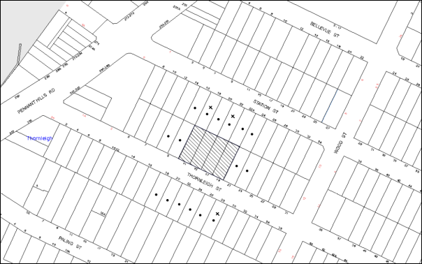
|
NOTIFICATION PLAN |
|
||
|
• PROPERTIES NOTIFIED
|
X SUBMISSIONS RECEIVED |
PROPERTY SUBJECT OF DEVELOPMENT |
|
Three submissions object to the development, generally on the grounds that the development would result in:
· Unacceptable traffic on local streets;
· Unacceptable street parking which is also impacted by the opening of Aldi and existing businesses within the Thornleigh Commercial Precinct;
· Unacceptable Setbacks;
· Potential Geotechnical Issues to adjoining properties;
· Potential Stormwater Drainage Issues if no easement is created;
· Potential Privacy and noise impacts to adjoining properties;
· Unacceptable visual amenity issues with the use of “reflective” materials;
· Detrimental Impacts to local fauna including existing possum families; and
· Loss of view of the “wider neighbourhood” and trees.
The merits of the matters raised in community submissions have been addressed in the body of the report with the exception of the following:
5.1.1 Traffic Congestion and Street Parking on Local Streets Due to the Cumulative Impact of the Completed Aldi Development and Existing Businesses within the Thornleigh Commercial Precinct
Council’s traffic assessment concludes that traffic generation is not considered to be an issue with the proposed development as discussed in Section 3.3.2. The Aldi development access is via driveways in Bellevue Street and Station Street. Council approved the development application DA/1848/2007, construction of an Aldi supermarket on Pennant Hills Road subject to Aldi providing a treatment at the intersection of Station and Wood Streets to encourage departing traffic in Station Street to turn left (north) onto Wood Street. The purpose of the condition was to minimise the traffic impact of the development on the local residential streets south of Station Street.
The proposed device consists of a raised threshold / entry treatment in Wood Street, south of Station Street. Two landscaped kerb blisters and contrasting pavement treatment will be provided to encourage drivers departing from Aldi store to return to Pennant Hills Road by the shortest route. Traffic flow at the device will be limited to one lane to discourage non local traffic.
Parking for the proposed development is provided in accordance with HDCP. On-street parking by commuters using nearby Thornleigh is typical of streets in close proximity to train stations and major centres. The proposed development will not impact on the demand or availability of commuter parking.
5.1.2 Potential Geotechnical Issues Concerning Adjoining Properties During Demolition and Construction of Development
A condition is recommended requiring a dilapidation report prepared by a structural engineer detailing the structural condition of all adjoining properties. Additionally other conditions are recommended for the protection of adjoining areas including temporary hoarding, fence or awning to be erected between the work site and adjoining lands before the works begin.
5.1.3 Potential Stormwater Drainage Issues
As discussed in Section 3.2, an underground on site detention system (OSD) is proposed within the front of the site. Council’s engineering assessment concludes that the OSD system is satisfactory, subject to conditions recommended in Schedule 1.
5.1.4 Privacy and Noise Concerns from the Rear Facing Balconies to Adjoining Gardens
The rear setbacks and privacy mitigation measures implemented in the design are in accordance with the SEPP 65 – RFDC and the HDCP. The adjoining rear properties are also located within the Station Street, Thornleigh precinct where the desired future character is for five storey residential development in garden settings.
5.1.5 Visual Amenity Impacts from the Use of Reflective Materials
The proposed building does not incorporate reflective materials in the finishes schedule and is considered to be acceptable with regard to visual amenity.
5.1.6 Loss of Flora and Fauna i.e. Trees and Possum Families
An Arborist Report was submitted with the application which indicates that no significant trees are proposed to be removed. No Fauna Report was required as possums are not included within the Threatened Species Conservation Act, 1995. In this regard, no further consideration is required in this matter.
5.1.7 Loss of Views Due to the Height of the Proposed Development
The height of the proposed development is under the 17.5m height restriction as per the HDCP. It is inevitable that some view loss to the “wider community” would occur with the rezoning for higher density development.
5.2 Public Agencies
The development application was not referred to any Public Agencies for comment.
6. THE PUBLIC INTEREST
Section 79C(1)(e) of the Act requires Council to consider “the public interest”.
The public interest is an overarching requirement, which includes the consideration of the matters discussed in this report. Implicit to the public interest is the achievement of future built outcomes adequately responding to and respecting the future desired outcomes expressed in environmental planning instruments and development control plans.
The application is considered to have satisfactorily addressed Council’s and relevant agencies’ criteria and would provide a development outcome that, on balance, would result in a positive impact for the community. Accordingly, it is considered that the approval of the proposed development would be in the public interest.
CONCLUSION
The application seeks approval for the demolition of existing structures and the construction of a five storey residential flat building comprising 33 units with basement car parking.
The proposed development is generally in accordance with the development controls for the ‘Station Street, Thornleigh’ Precinct of the Hornsby Development Control Plan and would contribute to the future desired five storey residential character of the precinct. The minor non-compliance with prescriptive measures for maximum floorplate dimension, setbacks and housing choice are considered acceptable.
The proposal would result in a development that would be in keeping with the desired future character of the precinct.
Note: At the time of the completion of this planning report, no persons have made a Political Donations Disclosure Statement pursuant to Section 147 of the Environmental Planning and Assessment Act 1979 in respect of the subject planning application.
RESPONSIBLE OFFICER
The officer responsible for the preparation of this Report is the Manager – Development Assessments, Rodney Pickles, who can be contacted on 9847 6731.
|
Rod Pickles Manager - Development Assessment Planning Division |
James Farrington Group Manager Planning Division |
|
1.View |
Locality Map |
|
|
|
2.View |
Site Plan |
|
|
|
3.View |
Landscape Plan |
|
|
|
4.View |
Floor Plans |
|
|
|
5.View |
Elevations |
|
|
|
6.View |
Shadow Plans |
|
|
File Reference: DA/376/2014
Document Number: D03941195
SCHEDULE 1
GENERAL CONDITIONS
The conditions of consent within this notice of determination have been applied to ensure that the use of the land and/or building is carried out in such a manner that is consistent with the aims and objectives of the relevant legislation, planning instruments and council policies affecting the land and does not disrupt the amenity of the neighbourhood or impact upon the environment.
Note: For the purpose of this consent, the term ‘applicant’ means any person who has the authority to act on or the benefit of the development consent.
Note: For the purpose of this consent, any reference to an Act, Regulation, Australian Standard or publication by a public authority shall be taken to mean the gazetted Act or Regulation, or adopted Australian Standard or publication as in force on the date that the application for a construction certificate is made.
1. Approved Plans and Supporting Documentation
The development must be carried out in accordance with the plans and documentation listed below and endorsed with Council’s stamp, except where amended by Council and/or other conditions of this consent:
|
Plan No. |
Plan Title |
Drawn by |
Dated |
|
DA200 Issue F |
Site Plan |
Design Cubicle |
19/11/2014 |
|
DA201 Issue D |
Basement 2 Plan |
Design Cubicle |
25/9/2014 |
|
DA202 Issue E |
Basement 1 Plan |
Design Cubicle |
19/11/2014 |
|
DA203 Issue F |
Ground Floor Plan |
Design Cubicle |
19/11/2014 |
|
DA204 Issue C |
First Floor Plan |
Design Cubicle |
1/9/2014 |
|
DA205 Issue C |
Second Floor Plan |
Design Cubicle |
1/9/2014 |
|
DA206 Issue C |
Third Floor Plan |
Design Cubicle |
1/9/2014 |
|
DA207 Issue C |
Fourth Floor Plan |
Design Cubicle |
1/9/2014 |
|
DA208 Issue C |
Roof Plan |
Design Cubicle |
1/9/2014 |
|
DA301 Issue C |
Elevations 1/2 |
Design Cubicle |
1/9/2014 |
|
DA302 Issue D |
Elevations 2/2 |
Design Cubicle |
19/11/2014 |
|
DA303 Issue C |
Sections |
Design Cubicle |
1/9/2014 |
|
DA701Issue C |
SRV Swept Path Analysis 1/2 |
Design Cubicle |
18/9/2014 |
|
DA702 Issue C |
SRV Swept Path Analysis 2/2 |
Design Cubicle |
18/9/2014 |
|
13184 DA1 Rev D |
Landscape Concept Plan |
Vision Dynamics P/L |
7/11/2014 |
|
SW374-1 to SW374-5 (5 pages) |
Stormwater Plans |
Wehbe Consulting P/L |
24/9/2014 |
|
Document Title |
Prepared By |
Date |
|
Statement of Environmental Effects |
Think Planners P/L |
2/4/2014 |
|
Basix Certificate No. 537711M |
Green Star Energy Solutions |
2/4/2014 |
|
Design Verification Statement |
Design Cubicle |
3/4/2014 |
|
Quantity Survey Report |
MMD Construction Consultants |
2/4/2014 |
|
Traffic & Parking Report |
ML Traffic Engineers |
March 2014 |
|
Arboricultural Impact Assessment |
Redgum Horticultural |
19/3/2014 |
|
Access Report |
Design Cubicle |
March 2014 |
|
ABSA Assessor Energy Certificate |
Gradwell Consulting |
1/4/2014 |
|
Waste Management Plan |
Design Cubicle |
March 2014 |
|
Music Modelling Report (Stormwater Drainage) |
Wehbe Consulting |
7/10/2014 |
|
External Materials and Finishes Schedule |
Design Cubicle |
Submitted 15/10/2014 |
|
Photomontage |
Design Cubicle |
Submitted 15/10/2014 |
2. Amendment of Plans
The approved plans are to be amended as follows:
a) Each dwelling unit must be provided and allocated a minimum area for storage (not including bedroom and kitchen cupboards) of 6m³ for one bedroom units, 8m³ for two bedroom units and 10m³ for three bedroom units, where 50% is required to be located within the apartment and accessible from either the hall or living area and the balance provided within the basement.
b) Letter boxes are to be relocated at least 2m from the front property boundary.
3. Removal of Existing Trees
This development consent only permits the removal of trees numbered 4, 5, 6, 7, 8, 9, 10, 11, 12, 13, 14, 15 and 16 as identified on the Site Tree Location Plan prepared by Hornsby Council dated 21/5/14. The removal of any other trees requires separate approval in accordance with the Tree & Vegetation Chapter 1B.6 Hornsby Development Control Plan (HDCP).
4. Construction Certificate
A Construction Certificate is required to be approved by Council or a Private Certifying Authority prior to the commencement of any works under this consent.
REQUIREMENTS PRIOR TO THE ISSUE OF A CONSTRUCTION CERTIFICATE
5. Section 94 Development Contributions
In accordance with Section 80A(1) of the Environmental Planning and Assessment Act 1979 and the Hornsby Shire Council Section 94 Development Contributions Plan 2012-2021, the following monetary contributions shall be paid to Council to cater for the increased demand for community infrastructure resulting from the development:
|
Description |
Contribution (4) |
|
Roads |
$20,152.70 |
|
Open Space and Recreation |
$360,303.65 |
|
Community Facilities |
$50,237.30 |
|
Plan Preparation and Administration |
$1,466.15 |
|
TOTAL |
$432,159.80 |
being for 6 x 1 bedroom units, 24 x 2 bedroom units and 3 x 3 bedroom units in lieu of four existing dwelling houses.
a) If the contributions are not paid within the financial quarter that this consent is granted, the contributions payable will be adjusted in accordance with the provisions of the Hornsby Shire Council Section 94 Development Contributions Plan and the amount payable will be calculated at the time of payment in the following manner:
$CPY = $CDC x CPIPY
CPIDC
Where:
$CPY is the amount of the contribution at the date of Payment.
$CDC is the amount of the contribution as set out in this Development Consent.
CPIPY is the latest release of the Consumer Price Index (Sydney – All Groups) at the date of Payment as published by the ABS.
CPIDC is the Consumer Price Index (Sydney – All Groups) for the financial quarter at the date of this Development Consent.
b) The monetary contributions shall be paid to Council:
i) prior to the issue of the Subdivision Certificate where the development is for subdivision; or
ii) prior to the issue of the first Construction Certificate where the development is for building work; or
iii) prior to issue of the Subdivision Certificate or first Construction Certificate, whichever occurs first, where the development involves both subdivision and building work; or
iv) prior to the works commencing where the development does not require a Construction Certificate or Subdivision Certificate.
It is the professional responsibility of the Principal Certifying Authority to ensure that the monetary contributions have been paid to Council in accordance with the above timeframes.
Council’s Development Contributions Plan may be viewed at www.hornsby.nsw.gov.au or a copy may be inspected at Council’s Administration Centre during normal business hours.
6. Building Code of Australia
All building work must be carried out in accordance with the relevant requirements of the Building Code of Australia.
7. Contract of Insurance (Residential Building Work)
In the case of residential building work for which the Home Building Act 1989 requires there to be a contract of insurance in force in accordance with Part 6 of that Act, that such a contract of insurance is in force before any building work authorised to be carried out by the consent commences.
8. Water/Electricity Utility Services
The applicant must submit written evidence of the following service provider requirements:
a) Ausgrid (formerly Energy Australia) – a letter of consent demonstrating that satisfactory arrangements have been made to service the proposed development.
b) Sydney Water – the submission of a ‘Notice of Requirements’ under s73 of the Sydney Water Act 1994.
Note: Sydney Water requires that s73 applications are to be made through an authorised Sydney Water Servicing Coordinator. Refer to www.sydneywater.com.au or telephone 13 20 92 for assistance.
9. Waste Management Details
The following waste management requirements must be complied with:
a) There must be sufficient space for the garbage chute system on each residential level.
b) The recycling bin cupboard on each residential level must have internal dimension no less than 750mm wide by 870mm deep.
10. Accessible Units
The development is required to provide 10 units designed as adaptable housing pursuant to the requirements of 1C.2.2 of the Hornsby Development Control Plan. In this regard four (4) car parking spaces are to be designed for people with a disability and allocated to 4 adaptable units. The details of all adaptable units must be provided with the Construction Certificate plans.
11. Dilapidation Report
A ‘Dilapidation Report’ is to be prepared by a ‘chartered structural engineer’ detailing the structural condition of all adjoining properties.
12. Construction Traffic Management Plan (CTMP)
A Construction Traffic Management Plan detailing construction vehicle routes, number of trucks, hours of operation, access arrangements and traffic control should be submitted to Council prior to the issue of a construction certificate.
13. Stormwater Drainage
The stormwater drainage system for the development must be designed and constructed in accordance with Council’s Civil Works – Design and Construction Specification 2005 and the following requirements:
a) Connected directly to Council’s drainage system (pipe/gutter) via an on-site detention system.
b) The internal drainage system shall have a piped capacity for the 20 year average recurrence interval storm.
14. On Site Stormwater Detention
An on-site stormwater detention system must be designed by a chartered civil engineer and constructed in accordance with the following requirements:
a) To improve water quality, the development shall be designed and constructed with a water harvesting system to comply with Council’s Water Quality provisions pursuant to Council’s HDCP 2013 Section 1C.1.2.j. Details to be provided on drainage plans;
b) Have a separate detention capacity of not less than 20 cubic metres, and a maximum discharge (when full) of 36 L per second for the control of runoff. High early discharge systems are not required to be used;
c) Have a surcharge/inspection grate located directly above the outlet. Where grates are located in pedestrian pathways, the grate shall be fabricated with a galvanised fine expanded metal mesh covering to prevent trip and injury to persons;
d) Discharge from the detention system to be controlled via 1 metre length of pipe, not less than 50 millimetres diameter or via a stainless plate with sharply drilled orifice bolted over the face of the outlet discharging into a larger diameter pipe capable of carrying the design flow to an approved Council drainage system;
e) To avoid nuisance flooding, an emergency pipe spillway system shall be designed and constructed between the tank design top water level and the tank obvert to carry rare storm flow events directly to the Council drainage system.
15. Road Works
All road works approved under this consent must be constructed in accordance with Council’s Civil Works Design and Construction Specification 2005 and the following requirements:
a) Council’s standard 150mm integral kerb and gutter to be removed and reconstructed across the frontage of the development on the existing alignment and level; with a 2.4m long kerb inlet and pit to match the existing pit;
b) Council’s standard 1.2m wide 100mm thick concrete footpath to be constructed across the frontage within the road verge on Council’s standard alignment with the remaining area turfed;
c) The existing road pavement to be saw cut a minimum 2.0m from the existing lip of kerb and reconstructed;
d) The submission of a compaction certificate from a geotechnical engineer for any fill within road reserves, and all road sub-grade and road pavement materials’
e) Pursuant to Section 138 Roads Act 1993, a Construction Certificate application for these works shall be made to Hornsby Council for assessment and approval prior to the commencement of the road work. The Applicant shall [pay Council’s fee for application assessment and compliance inspections prior to Construction Certificate approval.
16. Vehicular Crossing
A separate application under the Local Government Act 1993 and the Roads Act 1993 must be submitted to Council for the installation of a new vehicular crossing and the removal of the redundant crossing. The vehicular crossing must be constructed in accordance with Council’s Civil Works Design 2005 and the following requirements:
a) The crossing shall be designed and constructed for two-way movement of vehicles on the crossing;
b) The crossing ramp grades shall be designed and constructed in accordance with AS2890.1-2004.
c) A longitudinal section of the crossing shall be provided with Construction Certificate plans.
Note: An application for a vehicular crossing can only be made to one of Council’s Authorised Vehicular Crossing Contractors. You are advised to contact Council on 02 9847 6940 to obtain a list of contractors.
17. Traffic Control Plan
A Traffic Control Plan (TCP) must be prepared by a qualified traffic controller in accordance with the Roads & Traffic Authority’s Traffic Control at Worksites Manual 1998 and Australian Standard 1742.3 for all work on a public road and be submitted to Council. The TCP must detail the following:
a) Arrangements for public notification of the works.
b) Temporary construction signage.
c) Vehicle movement plans.
d) Traffic management plans.
e) Pedestrian and cyclist access/safety.
18. Internal Driveway/Vehicular Areas
The driveway and parking areas on site must be designed in accordance with Australian Standards 2890.1, 2890.2, 3727 and the following requirements:
a) Design levels at the front boundary must be obtained from Council;
b) The driveway must be a rigid pavement;
c) Retaining walls must have a setback of at least 300mm from kerb lines or edges of carriageways;
d) Basement ramps must have a cross fall with a minimum gradient of 2 percent with kerb inlet pits provided on grade and at low points.
REQUIREMENTS PRIOR TO THE COMMENCEMENT OF ANY WORKS
19. Erection of Construction Sign
A sign must be erected in a prominent position on any site on which building work, subdivision work or demolition work is being carried out:
a) Showing the name, address and telephone number of the principal certifying authority for the work;
b) Showing the name of the principal contractor (if any) for any demolition or building work and a telephone number on which that person may be contacted outside working hours; and
c) Stating that unauthorised entry to the work site is prohibited.
Note: Any such sign is to be maintained while the building work, subdivision work or demolition work is being carried out, but must be removed when the work has been completed.
20. Protection of Adjoining Areas
A temporary hoarding, fence or awning must be erected between the work site and adjoining lands before the works begin and must be kept in place until after the completion of the works if the works:
a) Could cause a danger, obstruction or inconvenience to pedestrian or vehicular traffic.
b) Could cause damage to adjoining lands by falling objects.
c) Involve the enclosure of a public place or part of a public place.
Note: Notwithstanding the above, Council’s separate written approval is required prior to the erection of any structure or other obstruction on public land.
21. Toilet Facilities
Toilet facilities must be available or provided at the works site before works begin and must be maintained until the works are completed at a ratio of one toilet for every 20 persons employed at the site. Each toilet must:
a) be a standard flushing toilet connected to a public sewer; or
b) be a temporary chemical closet approved under the Local Government Act 1993; or
c) have an on-site effluent disposal system approved under the Local Government Act 1993.
22. Erosion and Sediment Control
Erosion and sediment control measures must be provided and maintained throughout the construction period in accordance with the manual ‘Soils and Construction 2004 (Bluebook)’, the approved plans, Council specifications and to the satisfaction of the principal certifying authority. The erosion and sediment control devices must remain in place until the site has been stabilised and revegetated.
Note: On the spot penalties up to $1,500 may be issued for any non-compliance with this requirement without any further notification or warning.
23. Tree Protection Barriers
Tree protection fencing must be erected around trees numbered 1 and 2 located on the neighbouring property to be retained at the measured Tree Protection Zone (TPZ) as outlined in Appendix F – Tree Protection Plan within the submitted Arboricultural Impact Assessment prepared by Redgum Horticultural dated 22 November 2013 and revised on 19 March 2014.
All Tree Protection Works must be in accordance with Section 5 within the submitted aforementioned Report. Tree fencing must be constructed of 1.8 metre ‘cyclone chain link wire fence’.
Once erected, tree protection fencing must not be removed or altered without approval by the project arborist.
REQUIREMENTS DURING CONSTRUCTION
24. Construction Work Hours
All work on site (including demolition and earth works) must only occur between 7am and 5pm Monday to Saturday. No work is to be undertaken on Sundays or public holidays.
25. Demolition
All demolition work must be carried out in accordance with “Australian Standard 2601-2001 – The Demolition of Structures” and the following requirements
a) Demolition material must be disposed of to an authorised recycling and/or waste disposal site and/or in accordance with an approved waste management plan;
b) Demolition works, where asbestos material is being removed, must be undertaken by a contractor that holds an appropriate licence issued by WorkCover NSW in accordance with Chapter 10 of the Occupational Health and Safety Regulation 2001 and Clause 29 of the Protection of the Environment Operations (Waste) Regulation 2005 ;and
c) On construction sites where buildings contain asbestos material, a standard commercially manufactured sign containing the words ‘DANGER ASBESTOS REMOVAL IN PROGRESS’ measuring not less than 400mm x 300mm must be erected in a prominent position visible from the street.
26. Environmental Management
The site must be managed in accordance with the publication ‘Managing Urban Stormwater – Landcom (March 2004) and the Protection of the Environment Operations Act 1997 by way of implementing appropriate measures to prevent sediment run-off, excessive dust, noise or odour emanating from the site during the construction of the development.
27. Council Property
During construction works, no building materials, waste, machinery or related matter is to be stored on the road or footpath. The public reserve must be kept in a clean, tidy and safe condition at all times.
28. Disturbance of Existing Site
During construction works, the existing ground levels of open space areas and natural landscape features, (including natural rock-outcrops, vegetation, soil and watercourses) must not be altered unless otherwise nominated on the approved plans.
29. Landfill
Landfill must be constructed in accordance with Council’s ‘Construction Specification 2005’ and the following requirements:
a) All fill material imported to the site is to wholly consist of Virgin Excavated Natural Material (VENM) as defined in Schedule 1 of the Protection of the Environment Operations Act 1997 or a material approved under the Department of Environment and Climate Change’s general resource recovery exemption.
b) A compaction certificate is to be obtained from a geotechnical engineer verifying that the specified compaction requirements have been met.
30. Excavated Material
All excavated material removed from the site must be classified in accordance with the Department of Environment, Climate Change and Water NSW Waste Classification Guidelines prior to disposal to an approved waste management facility and reported to the principal certifying authority.
31. Survey Report – Finished Floor Level
A report(s) must be prepared by a registered surveyor and submitted to the principal certifying authority prior to the pouring of concrete at each level of the building certifying that:
a) The building, retaining walls and the like have been correctly positioned on the site; and
b) The finished floor level(s) are in accordance with the approved plans.
32. Works Near Trees
All required tree protection measures are to be maintained in good condition for the duration of the construction period.
All works (including driveways and retaining walls) within the TPZ of any trees required to be retained (whether or not on the subject property, and pursuant to this consent or the Tree Preservation Chapter), must be carried out under the supervision of an ‘AQF Level 5 Arborist’ and a certificate submitted to the principal certifying authority detailing the method(s) used to preserve the tree(s).
Note: Except as provided above, the applicant is to ensure that no excavation, filling or stockpiling of building materials, parking of vehicles or plant, disposal of cement slurry, waste water or other contaminants is to occur within 4 metres of any tree to be retained.
33. Waste Management Details
Waste management during the demolition and construction phase of the development must be undertaken in accordance with the approved Waste Management Plan. Additionally written records of the following items must be maintained during the removal of any waste from the site and such information submitted to the Principal Certifying Authority within fourteen days of the date of completion of the works:
a) The identity of the person removing the waste;
b) The waste carrier vehicle registration;
c) Date and time of waste collection;
d) A description of the waste (type of waste and estimated quantity);
e) Details of the site to which the waste is to be taken;
f) The corresponding tip docket/receipt from the site to which the waste is transferred (noting date and time of delivery, description (type and quantity) of waste); and
g) Whether the waste is expected to be reused, recycled or go to landfill.
Note: In accordance with the Protection of the Environment Operations Act 1997, the definition of waste includes any unwanted substance, regardless of whether it is reused, recycled or disposed to landfill.
REQUIREMENTS PRIOR TO THE ISSUE OF AN OCCUPATION CERTIFICATE
Note: For the purpose of this consent, a reference to ‘occupation certificate’ shall not be taken to mean an ‘interim occupation certificate’ unless otherwise stated.
34. Fulfilment of BASIX Commitments
The applicant must demonstrate the fulfilment of BASIX commitments pertaining to the development.
35. Sydney Water – s73 Certificate
An s73 Certificate must be obtained from Sydney Water.
36. Damage to Council Assets
Any damage caused to Council’s assets as a result of the construction of the development must be rectified in accordance with Council’s Civil Works Specifications. Council’s Restorations Supervision must be notified for a formwork inspection prior to pouring concrete.
37. Creation of Easements
The following matter(s) must be nominated on the plan of strata subdivision under s88B of the Conveyancing Act 191 or as a Dealing under s88E:
a) The creation of an appropriate "Positive Covenant" and "Restriction as to User" over the constructed on-site detention/retention systems and outlet works, within the lots in favour of Council in accordance with Council’s prescribed wording. The position of the on-site detention system is to be clearly indicated on the title.
b) To register the OSD easement, the restriction on the use of land “works-as-executed” details of the on-site-detention system must be submitted verifying that the required storage and discharge rates have been constructed in accordance with the design requirements. The details must show the invert levels of the on site system together with pipe sizes and grades. Any variations to the approved plans must be shown in red on the “works-as-executed” plan and supported by calculations.
c) A separate Execution of Legal Documents (ELD) Application shall be lodged with Council with payment of Council’s scheduled fee for the assessment and approval of the creation of the Positive Covenant and Restriction.
Note: Council must be nominated as the authority to release, vary or modify any easement, restriction or covenant.
38. Works as Executed Plan
A works-as-executed plan(s) must be prepared by a registered surveyor and submitted to Hornsby Shire Council for completed road works, utility works, kerb & gutter, public drainage systems, driveways, internal drainage systems, services and service conduits.
39. Garbage Collection Easement
For the purpose of waste collection, an easement entitling Council, its servants and agents and persons authorised by it to enter upon the subject land and to operate thereon, vehicles and other equipment for the purposes of garbage collection must be granted to Council by the owner of the land.
Note: The easement must be in a form prescribed by Council and must include covenants to the effect that parties will not be liable for any damage caused to the subject land or any part thereof or to any property located therein or thereon by reason of the operation thereon of any vehicle or other equipment used in connection with the collection of garbage and to the effect that the owner for the time being of the subject land shall indemnify the Council, its servants, agents and persons authorised by it to collect garbage against liability in respect of any such claims made by any person whomsoever.
40. Waste Management Details
The following waste management requirements must be complied with:
a) The bin storage room at the basement level must include water or a hose for cleaning, graded floors with drainage to sewer, a robust door, sealed and impervious surface, adequate lighting and ventilation, and must be lockable. The waste facility cupboards at each residential level must include sealed and impervious surface, adequate lighting and ventilation.
b) A report must be prepared by an appropriately qualified person, certifying the following:
i) A comparison of the estimated quantities of each waste type against the actual quantities of each waste type.
Note: Explanations of any deviations to the approved Waste Management Plan is required to be included in this report.
ii) That at least 60% of the waste generated during the demolition and construction phase of the development was reused or recycled.
Note: If the 60% diversion from landfill cannot be achieved in the Construction Stage, the Report is to include the reasons why this occurred and certify that appropriate work practices were employed to implement the approved Waste Management Plan. The Report must be based on documentary evidence such as tipping dockets/receipts from recycling depots, transfer stations and landfills, audits of procedures etc. which are to be attached to the report.
iii) All waste was taken to site(s) that were lawfully permitted to accept that waste.
c) Each unit must be provided with an indoor waste/recycling cupboard for the interim storage of a minimum one day’s waste generation with separate containers for general waste and recyclable materials.
d) Space must be provided for either individual compost containers for each unit or a communal compost container;
Note: The location of the compost containers should have regard for potential amenity impacts.
e) The bin carting routes must be devoid of any steps.
Note: Ramps between the different levels are acceptable.
f) Access to the waste volume handling equipment by unauthorised persons (including residents and waste collectors) must be prevented.
Note: Caging of the volume handling equipment is acceptable.
41. Planter Boxes/On Slab Planting
On slab planter boxes must include waterproofing and subsoil drainage (proprietary drainage cell, 50mm sand and filter fabric) and automatic irrigation, minimum 500mm planting soil for shrubs and minimum 1000mm planting soil for trees and palms and 75mm mulch to ensure sustainable landscape is achieved.
42. Street Tree Plantings
The 4 x Callistemon viminalis (Weeping bottlebrush) trees proposed on the front verge as shown in Landscape Concept Plan numbered 13184 DA1 Rev D dated 7/11/2014 drawn by Vision Dynamics P/L shall be installed at a minimum 75L pot size.
Note: Applicants are advised to pre-order plant material required in pot sizes 45 L or larger to ensure Nurseries have stock available at the time of install.
43. Maintain Canopy Cover
The submitted Landscape Concept Plan prepared by Vision Dynamics Pty Ltd drawing No 13184 DA 1 – Revision D dated 7/11/14 must be adhered to.
44. Completion of Landscaping
A certificate must be provided by a practicing landscape architect or person with similar qualifications and experience certifying that all required landscape works have been satisfactorily completed in accordance with the approved landscape plans.
Note: Applicants are advised to pre-order plant material required in pot sizes 45 litre or larger to ensure Nurseries have stock available at the time of install.
45. Storage
Each dwelling within the development must be provided and allocated a minimum area for storage (not including bedroom and kitchen cupboards) of 6m³ for one bedroom units, 8m³ for two bedroom units and 10m³ for three bedroom units, where 50% is required to be located within the apartment and accessible from either the hall or living area and the balance provided within the basement.
46. Installation of Air Conditioner
To protect the amenity of adjacent properties, the condenser unit for the air conditioner must be sited a minimum of 3 metres from the property boundary of any adjoining residential premises unless a certificate has been prepared by a suitably qualified person confirming that the unit has been tested for heating and cooling on the highest settings and that the noise levels generated do not exceed 5 dB(A) above background noise levels when tested at the property boundary between 8 pm and 10 pm.
47. External Lighting
All external lighting must be designed and installed in accordance with Australian Standard AS 4282 – Control of the Obtrusive Effects of Outdoor Lighting. Certification of compliance with the Standard must be obtained from a suitably qualified person.
48. Safety and Security
Prior to the issue of the Occupation Certificate, the site must include the following elements:
a) An intercom system be installed at gate locations to ensure screening of persons entering the units;
b) The entryway to the site be illuminated in high luminance at all times;
c) The communal open space areas are to be illuminated with high luminance by motion sensor lighting;
d) The service areas of the ground floor and the garbage room at the basement be illuminated with high luminance by motion sensor lighting;
e) The driveway and the basement car park is to be illuminated with low luminance at all times;
f) Robust materials which cannot be forced or breached with minimised maintenance requirements are to be used for construction work in the common areas;
g) The lamps and lighting levels must comply with Australian and New Zealand Lighting Standard 1158.1;
h) Effective signage be provided to guide visitors to the main areas and parking areas;
i) A street sign be prominently displayed in front of the site in accordance with Order No. 8, Section 124 Local Government Act 1993;
j) The communal area must include a clear sign to restrict access for non-residents;
k) Units’ numbers, entry and exit signs must be legible and clear;
l) Fire exit doors to be fitted with single cylinder locksets (Australia New Zealand Standard-Locksets);
m) The entry doors to the pedestrian foyer is to be constructed of safety rated glass to enable residents a clear line of site before entering or exiting the residential apartments;
n) Lighting is to be provided to pathways, building foyer entries, driveways and common external spaces;
o) Security deadlocks are to be provided to each apartment door; and
p) Peep holes are to be provided to individual apartment doors to promote resident safety.
OPERATIONAL CONDITIONS
49. Waste Management
The waste management on site must be in accordance with the following requirements:
a) A site caretaker must be employed and be responsible for moving bins where and when necessary, washing bins and maintaining waste storage areas, ensuring the chute system and related devices are maintained in effective and efficient working order, managing the communal composting area, managing the bulky item storage area, arranging the prompt removal of dumped rubbish, and ensuring all residents are informed of the use of the waste management system.
50. Landscape Establishment
The landscape works must be maintained into the future to ensure the establishment and successful growth of plant material to meet the intent of the landscape design. This must include but not be limited to watering, weeding, replacement of failed plant material and promoting the growth of plants through standard industry practices.
51. Sight Distance to Pedestrians/Cyclists
Any proposed landscaping and/or fencing must not restrict sight distance to pedestrians and cyclists travelling along the footpath.
52. Residential Parking Spaces
Residential parking spaces are to be secure spaces with access controlled by card or numeric pad.
53. Visitor Parking Spaces
Visitors must be able to access the visitor parking spaces in the basement car park at all times.
54. Disabled Parking
All parking spaces for people with disabilities must be constructed and operated in accordance with AS/NZS 2890.6:2009 Off-street parking for people with disabilities.
55. Bicycle Parking
Bicycle parking spaces are to be designed in accordance with AS 2890.3-1993 Bicycle parking facilities.
56. Motorcycle Parking
Motorcycle parking spaces are to be designed in accordance with AS 2890.5- 1993.
57. Visitor Parking
Residential visitors must be able to access the visitor parking spaces on basement 1 at all times.
58. Noise
All noise generated by the proposed development must be attenuated to prevent levels of noise being emitted to adjacent premises which possess tonal, beating and similar characteristics or which exceeds background noise levels by more than 5dB(A).
59. Fire Safety Statement – Annual
On at least one occasion in every 12 month period following the date of the first ‘Fire Safety Certificate’ issued for the property, the owner must provide Council with an annual ‘Fire Safety Certificate’ to each essential service installed in the building.
- END OF CONDITIONS -
ADVISORY NOTES
The following information is provided for your assistance to ensure compliance with the Environmental Planning and Assessment Act, 1979, Environmental Planning and Assessment Regulation 2000, other relevant legislation and Council’s policies and specifications. This information does not form part of the conditions of development consent pursuant to Section 80a of the Act.
Environmental Planning and Assessment Act, 1979 Requirements
The Environmental Planning and Assessment Act, 1979 requires:
· The issue of a construction certificate prior to the commencement of any works. Enquiries can be made to Council’s Customer Services Branch on 9847 6760.
· A principal certifying authority to be nominated and Council notified of that appointment prior to the commencement of any works.
· Council to be given at least two days written notice prior to the commencement of any works.
· Mandatory inspections of nominated stages of the construction inspected.
· An occupation certificate to be issued before occupying any building or commencing the use of the land.
Long Service Levy
In accordance with Section 34 of the Building and Construction Industry Long Service Payments Act 1986, a ‘Long Service Levy’ must be paid to the Long Service Payments Corporation or Hornsby Council.
Note: The rate of the Long Service Levy is 0.35% of the total cost of the work.
Note: Hornsby Council requires the payment of the Long Service Levy prior to the issue of a construction certificate.
Tree and Vegetation Preservation
In accordance with Clause 5.9 of the Hornsby Local Environmental Plan 2013 a person must not ringbark, cut down, top, lop, remove, injure or wilfully destroy any tree or other vegetation protected under the Hornsby Development Control Plan 2013 without the authority conferred by a development consent or a permit granted by Council.
Notes: A tree is defined as a long lived, woody perennial plant with one or relatively few main stems with the potential to grow to a height greater than three metres (3M). (HDCP 1B.6.1.c).
Tree protection measures and distances are determined using the Australian Standard AS 4970:2009, “Protection of Trees on Development Sites”.
Fines may be imposed for non-compliance with both the Hornsby Local Environmental Plan 2013 and the Hornsby Development Control Plan 2013.
Disability Discrimination Act
The applicant’s attention is drawn to the existence of the Disability Discrimination Act. A construction certificate is required to be obtained for the proposed building/s, which will provide consideration under the Building Code of Australia, however, the development may not comply with the requirements of the Disability Discrimination Act. This is the sole responsibility of the applicant.
Occupation Certificate Requirements
The requirements are required to be lodged with Hornsby Shire Council containing the following information:
· A certificate by a Registered Surveyor shall be submitted to the Principal Certifying Authority and Council, certifying that there has been no removal, damage, destruction, displacement or defacing of the existing survey marks in the vicinity of the proposed development, or otherwise certifying that the necessary re-establishment of any damaged, removed or displaces survey marks has been undertaken in accordance with the Surveyor General’s Direction No. 11 – “Preservation of Survey Infrastructure”.
Subdivision Certificate Requirements
A subdivision certificate application is required to be lodged with Council containing the following information:
· A surveyor’s certificate certifying that all structures within the subject land comply with the development consent in regard to the setbacks from the new boundaries.
· A surveyor’s certificate certifying that all services, drainage lines or access are located wholly within the property boundaries. Where services encroach over the new boundaries, easements are to be created.
· Certification that the requirements of relevant utility authorities have been met.
· A surveyor’s certificate certifying finished ground levels are in accordance with the approved plans.
Note: Council will not issue a subdivision certificate until all conditions of the development consent have been completed.
Fees and Charges – Subdivision
All fees payable to Council as part of any construction, compliance or subdivision certificate or inspection associated with the development (including the registration of privately issued certificates) are required to be paid in full prior to the issue of the subdivision certificate. Any additional Council inspections beyond the scope of any compliance certificate required to verify compliance with the terms of this consent will be charged at the individual inspection rate nominated in Council's Fees and Charges Schedule.
Dial Before You Dig
Prior to commencing any works, the applicant is encouraged to contact Dial Before You Dig on 1100 or www.dialbeforeyoudig.com.au for free information on potential underground pipes and cables within the vicinity of the development site.
Telecommunications Act 1997 (Commonwealth)
If you are aware of any works or proposed works which may affect or impact on Telstra’s assets in any way, you are required to contact: Telstra’s Network Integrity Team on Phone Number 1800810443.
Asbestos Warning
Should asbestos or asbestos products be encountered during demolition or construction works, you are advised to seek advice and information prior to disturbing this material. It is recommended that a contractor holding an asbestos-handling permit (issued by WorkCover NSW) be engaged to manage the proper handling of this material. Further information regarding the safe handling and removal of asbestos can be found at:
Alternatively, telephone the WorkCover Asbestos and Demolition Team on 8260 5885.
House Numbering
House numbering can only be authorised by Council. Before proceeding to number each premise in the development, the allocation of numbers is required to be obtained from Council's Planning Division prior to the issue of a Subdivision Certificate. The authorised numbers are required to comply with Council’s Property Numbering Policy and be displayed in a clear manner at or near the main entrance to each premise.
Group Manager’s Report No. PL84/14
Planning Division
Date of Meeting: 10/12/2014
9 DEVELOPMENT APPLICATION - FIVE STOREY RESIDENTIAL FLAT BUILDING COMPRISING 58 UNITS - 442 - 446A PEATS FERRY ROAD, ASQUITH
EXECUTIVE SUMMARY
|
DA No: |
DA/690/2014 (Lodged 25 June 2014) |
|
Description: |
Demolition of existing structures and the erection of a five storey residential flat building comprising 58 units with basement car parking |
|
Property: |
Lot 30 DP 23965, Lot 1 DP 1052515, Lot 3 DP 1052515, Lot 2 DP 1052515, Nos. 442-446A Peats Ferry Road, Asquith |
|
Applicant: |
TF Development Trust |
|
Owner: |
Mr G Fusca, Mrs A Fusca, Mr A Speziale, Mrs N Speziale, Ms D Reid, Mr A Minko, Mrs E Minko |
|
Estimated Value: |
$11,800,000 |
|
Ward: |
A |
· The application proposes demolition of existing structures and the erection of a five storey residential flat building comprising a total of 58 units with basement parking.
· The proposal generally complies with the Hornsby Local Environmental Plan 2013, State Environmental Planning Policy No. 65 – Design Quality Residential Flat Building and the Hornsby Development Control Plan 2013.
· The proposal does not comply with the 17.5m height development standard under the HLEP. A submission has been made in accordance with Clause 4.6 of the HLEP to vary the standard. The submission to vary the standard is well founded and is supported.
· Three submissions have been received in respect of the application.
· It is recommended that the application be approved.
|
THAT Council assume the concurrence of the Secretary of the Department of Planning and Environment pursuant to Clause 4.6 of the Hornsby Local Environmental Plan 2013 and vary the building height development standard and approve Development Application No. DA/690/2014 for demolition of existing structures and the erection of a five storey residential flat building comprising 58 units with basement car parking at Lot 30 DP 23965, Lot 1 DP 1052515, Lot 3 DP 1052515, Lot 2 DP 1052515, Nos. 442-446A Peats Ferry Road, Asquith subject to the conditions of consent detailed in Schedule 1 of Group Manager’s Report No.PL84/14. |
BACKGROUND
The subject land was zoned from Residential A (Low Density) to Residential C (Medium-High Density) on 2 September 2011 as part of Council’s Housing Strategy.
The subject application for the construction of a five storey residential flat development comprising 64 units, or 72 dual key apartments, was lodged on 25 June 2014.
On 5 August 2014, Council raised concerns regarding the design of the building. This included non-compliances with building setbacks, design, locating the stormwater OSD on the roof, the mix and amenity of the proposed units, and conflicts with siting the driveway adjacent to the NE (side) boundary and pedestrian crossing. Meetings were subsequently held between Council officers and the applicant to discuss the concerns.
On 22 September 2014, the applicant forwarded amended concept plans and a plan of the driveway and pedestrian crossing requested by the RMS.
On 10 October 2014, a meeting was held to discuss the amended concept plans received. A number of design issues were raised. Council recommended that the driveway be relocated to the south-western side boundary away from the pedestrian crossing.
On 27 October 2014, Council received a letter from the RMS recommending the driveway be relocated to the southern boundary, away from the pedestrian crossing.
On 29 October 2014, amended plans were formally submitted involving a redesign of the building to accommodate 58 units and the relocation of the driveway to the south-western side boundary. These plans were renotified to neighbours and objectors.
On 10 November 2014, a meeting was held with the applicant to discuss further minor amendments to the plans. Minor changes included modifications to the basement, alterations to the units facing Asquith Boys High School to improve solar access, increasing the setback of a balcony adjacent to the NE boundary and stepping down the roof height adjacent to the 4x4 indentation.
SITE
The site is located on the south-eastern side of the Peats Ferry Road, Asquith, formerly known as the Pacific Highway. The site is irregular in shape and has an area of 2566m2 with a 50m frontage to Peats Ferry Road and a 55m south-western side boundary with Asquith Boys High School. The site comprises four allotments, Nos. 442-446A Peats Ferry Road, Asquith. The site has a gentle slope of less than 1% downwards from the Pacific Highway towards the rear property boundary.
Existing improvements on the allotments include four dwelling-houses with associated garages and carports. Vehicular access to the site is via three existing driveways from Peats Ferry Road.
The site contains a number of exotic and native planted trees.
The site forms part of a precinct which is undergoing redevelopment. The surrounding developments currently include predominately single storey residential dwellings. The adjacent property to the rear has been approved for five storey residential flat buildings.
The site is located approximately 390m from Asquith Railway Station and approximately 220m to the south west of Asquith shops.
PROPOSAL
The proposal involves demolition of existing structures on the site and construction of a five storey plus mezzanine residential flat building comprising 58 units with two levels of basement car parking and associated landscaping works.
The unit mix would comprise 11 x 1 bedrooms, 35 x 2 bedroom, and 12 x 3 bedroom units. The units would be accessed via two lifts centrally located on either side of the building and would include balconies fronting the street, rear and side property boundaries.
The development would be accessed from Peats Ferry Road via a driveway located close to the south-western side boundary, adjacent to Asquith Boys High School. Pedestrian access to the development is provided towards the centre of the building via Peats Ferry Road. A total of 71 car parking spaces, including 8 visitors’ parking spaces are proposed in two basement levels.
The site would drain to a detention tank located 1m above ground adjacent to the northern corner of the building, and thereafter drain to Council’s drainage system in Peats Ferry Road.
ASSESSMENT
The development application has been assessed having regard to the ‘Metropolitan Plan for Sydney 2031’, the ‘North Subregion (Draft) Subregional Strategy’ and the matters for consideration prescribed under Section 79C of the Environmental Planning and Assessment Act 1979 (the Act). The following issues have been identified for further consideration.
1. STRATEGIC CONTEXT
1.1 Metropolitan Plan for Sydney and (Draft) North Subregional Strategy
The (Draft) Metropolitan Strategy for Sydney 2031 is a broad framework to provide for Sydney’s growth to help plan for housing, employment, transport, infrastructure, the environment and open space. It outlines a vision for Sydney to 2031; the challenges faced, and the directions to follow to address these challenges and achieve the vision.
The North Subregion comprises Hornsby, Kuring-gai, Manly, Warringah and Pittwater Local Government Areas. The Draft North Subregional Strategy acted as a framework for the preparation of the Hornsby Local Environmental Plan 2013.
Within the North Subregion, the Draft Metropolitan Strategy proposes:
· Population growth of 81,000 from the current 2011 baseline of 529,000
· Housing growth of 37,000 from the current 2011 baseline of 204,000
· Employment growth of 39,000 from the current 2011 baseline of 186,000
The proposed development would be consistent with the Metropolitan Plan for Sydney 2031 by providing 54 additional dwellings and would contribute to housing choice in the locality.
2. STATUTORY CONTROLS
Section 79C(1)(a) requires Council to consider “any relevant environmental planning instruments, draft environmental planning instruments, development control plans, planning agreements and regulations”.
2.1 Hornsby Shire Local Environmental Plan 2013
The Hornsby Local Environmental Plan 2013 (HLEP) was gazetted by the Minister for Planning on 11 October 2013.
2.1.1 Land Use Zones and Permissibility
The subject land is zoned R4 (High Density Residential) zone under the Hornsby Local Environmental Plan 2013 (HLEP). The objectives of the zone are:
(a) To provide for the housing needs of the community within a high density residential environment.
(b) To provide a variety of housing types within a high density residential environment.
(c) To enable other land uses that provide facilities or services to meet the day to day needs of residents.
The proposed development is defined as ‘residential flat building’ under the HLEP and is permissible in the zone with Council’s consent.
2.1.2 Height of Building
Clause 4.3 of the HLEP provides that the height of a building on any land is not to exceed the maximum height shown for the land on the Height of Buildings Map. The maximum permissible height for the subject site is 17.5 metres. The proposal does not comply with this provision and exceeds the height by 0.325m as discussed in detail at 2.1.3 below.
2.1.3 Exceptions to Development Standards
The application has been assessed against the requirements within Clause 4.6 of the HLEP. This clause provides flexibility in the application of development standards in circumstances where strict compliance with those standards would, in any particular case, be unreasonable or unnecessary or tend to hinder the attainment of the objectives of the zone.
On the Height of Buildings Map, the maximum height is 17.5m. The proposed building exceeds the maximum control.
Building Height is defined by the HLEP as follows:
“building height means the vertical distance between the ground level (existing) and the highest point of the building, including plant and lift overruns, but excluding communication devices, antennae, satellite dishes, masts, flagpoles, chimneys, flues and the like.”
Clause 4.3 of the HLEP states that the objective of the Building Height control is to permit buildings appropriate for the site constraints, development potential and infrastructure capacity of the locality.
The applicant has made a submission in support of a variation to the maximum Building Height of 17.5m under Clause 4.6 of the HLEP. The development application seeks to vary the maximum building height by 0.325m or 2% for a length of approximately 8m in the eastern corner of the building footprint. The applicant states the proposed building height variation is considered to be consistent with the objectives of the control and is justified as follows:
· The building is 5 storeys in height and is contextually appropriate;
· The height standard is exceeded as a result of a depression in the land and that most of the proposed building is compliant with the height standard;
· Full compliance with the height standard would simply increase the amount of soil excavated;
· The building’s bulk and scale is not unreasonably increased and the variation of the height control will not be readily visible from the street;
· The variation to the height control would not result in additional overshadowing, overlooking or impacts on views in comparison to a fully compliant building height scheme;
· The development is consistent with Council’s strategic planning vision, the underlying objectives of the building height standard, the R4 High Density Residential zone objectives, and State and Regional Planning Policies; and
· Compliance is unreasonable and unnecessary in the circumstances of this case.
Having regard to the above points, the following matters are assessed as relevant:
· Planning and Infrastructure NSW Guidelines on varying development standards recommend considering the provisions of Clause 4.6 of the LEP and the ‘five part test’ established by the Land and Environment Court relating to the variation, as reproduced in the following:
The ‘Five Part Test’
a) the objectives of the standard are achieved notwithstanding noncompliance with the standard;
b) the underlying objective or purpose of the standard is not relevant to the development and therefore compliance is unnecessary;
c) the underlying object of purpose would be defeated or thwarted if compliance was required and therefore compliance is unreasonable;
d) the development standard has been virtually abandoned or destroyed by the council’s own actions in granting consents departing from the standard and hence compliance with the standard is unnecessary and unreasonable;
e) the compliance with development standard is unreasonable or inappropriate due to existing use of land and current environmental character of the particular parcel of land. That is, the particular parcel of land should not have been included in the zone.
· The development satisfies Part 1 of the test as the objective of the Building Height standard to limit the scale of development is achieved notwithstanding non-compliance with the development standard.
· The proposal would not set an unacceptable precedent for the precinct, taking into account that the excess height is limited to a localised topographical depression in the land.
· Notwithstanding the building height non-compliance, the application is a reasonable outcome for the site and achieves the aims of the HLEP and Hornsby DCP.
Based on this assessment, it is considered that compliance with the development standard would be unreasonable and unnecessary in the circumstances of the case. Accordingly, the Clause 4.6 submission is supported.
2.1.4 Earthworks
Clause 6.2 of the HLEP states that consent is required for proposed earthworks on site. Before granting consent for earthworks, Council is required to assess the impacts of the works on adjoining properties, drainage patterns and soil stability of the locality.
Council’s assessment of the proposed earthworks and excavation concludes that the proposal is satisfactory subject to conditions regarding submission of a dilapidation report assessing the impact of the excavation on the adjoining properties.
2.2 State Environmental Planning Policy No. 65 – Design Quality of Residential Flat Development
The Policy provides for design principles to improve the design quality of residential flat development and for consistency in planning controls across the State.
The applicant has submitted a “Design Verification Statement” prepared by a qualified Architect stating that the proposed development achieves the design principles of SEPP 65. The design principles of SEPP 65 and the applicant’s submission are addressed below.
2.2.1 Principle 1 – Context
Design Principle 1 is as follows:
Good design responds and contributes to its context. Context can be defined as the key natural and built features of an area.
Responding to context involves identifying the desirable elements of a location’s current character or, in the case of precincts undergoing a transition, the desired future character as stated in planning and design policies. New buildings will thereby contribute to the quality and identity of the area.
The site is located within a planned five storey residential flat building precinct in close proximity to Asquith Railway Station.
The applicant’s submission indicates that the proposal responds to the desired future character of the precinct as envisaged by Council. Once the development of the precinct is completed, the proposal would integrate with the surrounding sites and would be in keeping with the future urban form. It is considered that the proposed building would contribute to the identity and future character of the precinct.
The development responds suitably to the “context” principle of SEPP 65, considering the desired future character of the area.
2.2.2 Principle 2 – Scale
Design Principle 2 is as follows:
Good design provides an appropriate scale in terms of the bulk and height that suits the scale of the street and the surrounding buildings.
Establishing an appropriate scale requires a considered response to the scale of existing development. In precincts undergoing a transition, proposed bulk and height needs to achieve the scale identified for the desired future character of the area.
The scale of the development is generally in accordance with the height control and setbacks for the precinct prescribed within the Hornsby DCP. The height control excess previously described at 2.1.3 is minor and consistent with the objective of promoting 5 storey buildings in the locality. The building footprint along the front façade is 37.4m in length and 41.5m at one point within the middle of the building which does not comply with the maximum floorplate of 35m prescribed within the Hornsby DCP. However, the building bulk along these elevations has been minimised by locating most of the additional footprint length away from the front facade of the building along with the use of wrap-around balconies to soften the corners of the building. The development achieves a scale consistent with the desired future character of the precinct of residential flat buildings in landscape settings with underground car parking.
2.2.3 Principle 3 – Built Form
Design Principle 3 is as follows:
Good design achieves an appropriate built form for a site and the building’s purpose, in terms of building alignments, proportions, building type and the manipulation of building elements.
Appropriate built form defines the public domain, contributes to the character of streetscape and parks, including their views and vistas, and provides internal amenity and outlook.
The proposed buildings are appropriately articulated to minimise the perceived scale and the chosen materials add to the visual interest of the development. Flat roof forms have been adopted for the building with an increased top storey setback on the external facades to minimise bulk and height of the building as required by the Hornsby DCP. The proposal complies with the built form principle of SEPP 65.
2.2.4 Principle 4 – Density
Design Principle 4 is as follows:
Good design has a density appropriate for a site and its context, in terms of floor space yields (or number of units or residents).
Appropriate densities are sustainable and consistent with the existing density in an area or in precincts undergoing a transition, are consistent with the stated desired future density. Sustainable densities respond to the regional context, availability of infrastructure, public transport, community facilities and environmental quality.
The HLEP does not incorporate floor space ratio requirements for the site. The density of the development is governed by the height of the building, the floor plate control and the required setbacks. The applicant’s Statement of Environmental Effects advises in response to the Density principle that “the design responds to the shape and width of the site with the number of units comparable to recently approved developments within the vicinity of the site”. The height control in the eastern corner of the building is exceeded but is limited and does not contribute to an increased density of development.
The original plans proposed 72 dual key apartments. Following discussions with Council and amendments to the plans, the number of proposed units has been reduced to 58. The proposed variation to the building floor plate control is a reflection of the site consolidation pattern pursued and the bulk has been limited at the street frontage.
The density of the development is governed by the height of the building and the required setbacks. The proposed density is considered to be sustainable as it responds to the regional context, availability of infrastructure, public transport, community facilities and environmental quality and is considered acceptable in terms of density.
2.2.5 Principle 5 – Resource, Energy and Water Efficiency
Design Principle 5 is as follows:
Good design makes efficient use of natural resources, energy and water throughout its full life cycle, including construction.
Sustainability is integral to the design process. Aspects include demolition of existing structures, recycling of materials, selection of appropriate and sustainable materials, adaptability and reuse of buildings, layouts and built form, passive solar design principles, efficient appliances and mechanical services, soil zones for vegetation and reuse of water.
The applicant has submitted a BASIX Certificate for the proposed development. In achieving the required BASIX targets for sustainable water use, thermal comfort and energy efficiency, the proposed development achieves the design criteria and is considered acceptable in this regard.
2.2.6 Principle 6 – Landscape
Design Principle 6 is as follows:
Good design recognises that together landscape and buildings operate as an integral and sustainable system, resulting in greater aesthetic quality and amenity for both occupants and the adjoining public domain.
Landscape design builds on the existing site’s natural and cultural features in responsible and creative ways. It enhances the development’s natural environmental performance by co-ordinating water and soil management, solar access, micro-climate, tree canopy and habitat values. It contributes to the positive image and contextual fit of development through respect for streetscape and neighbourhood character, or desired future character.
Landscape design should optimise useability, privacy and social opportunity, equitable access and respect for neighbour’s amenity, and provide for practical establishment and long term management.
The application includes a landscape concept plan which provides landscaping along the street frontage, side and rear boundaries. Part of the basement encroaches into the required deep soil setback along the side (south western) boundary however, this encroaching structure can be planted over to achieve the desired future character of a landscaped setback that accommodates small trees 6-7m in height. While the proposed landscape plan provides no locally indigenous canopy trees along the street frontage or rear boundary as required by the HDCP, this can be addressed as a condition of consent. Given the above, the proposal satisfies the intent of the ‘Landscaping’ principle of SEPP 65.
2.2.7 Principle 7 – Amenity
Design Principle 7 is as follows:
Good design provides amenity through the physical, spatial and environmental quality of a development.
Optimising amenity requires appropriate room dimensions and shapes, access to sunlight, natural ventilation, visual and acoustic privacy, storage, indoor and outdoor space, efficient layouts and service areas, outlook and ease of access for all age groups and degrees of mobility.
The proposed units are designed to achieve some natural ventilation, solar access and acoustic privacy.
Sunlight access in mid-winter would be available to 34 (59%) of units balconies and living areas for 2 hours per day in mid-winter which does not comply with the RFDC rules of thumb that require such to 41 (70%) of units. The units on the western elevation that face the Asquith Boys High School side boundary on the lowest four floors would receive 2 hours of sunlight between 2pm and 4pm in mid-winter. As a result a total of 41 (70%) of units could achieve sunlight access for 2 hours over an extended time period in mid-winter. In addition, seven units on levels 3, 4 and 5 that face the internal void would achieve some sunlight access to living room rooms, but not to the balconies, providing an improved level of amenity to these south facing units.
Privacy has been achieved through appropriate design and orientation of balconies and living areas. The internal courtyard area excludes walkways linking the two lift cores on the upper levels to minimise amenity impacts from residents walking past bedroom or living room windows that face into the central void. Consent conditions are recommended to require high sills and window/ balcony screens to further improve privacy.
All units incorporate balconies accessible from living areas and communal open space is provided within, and around, the perimeter of the building. A number of the proposed balconies are smaller than the area prescribed by the Hornsby Development Control Plan. Consent conditions require some of the balconies that are undersized to be increased as a condition of consent. The principle communal open space area is provided on the ground floor in the central foyer of the building and will not achieve 2 hours of sunlight in mid-winter. The development is able to provide for an increased communal open space area in the front setback. This is required as a condition of consent.
A limited amount of storage has been provided within the units and storage cages are provided above the parking spaces within the basement levels. Consent conditions require the development to comply with the storage provisions of the Residential Flat Design Code.
The proposal would provide convenient and safe access via two central lifts in the building. With appropriate consent conditions, the proposal satisfies the ‘Amenity’ principle of SEPP 65.
2.2.8 Principle 8 – Safety and Security
Design Principle 8 is as follows:
Good design optimises safety and security, both internal to the development and for the public domain.
This is achieved by maximising overlooking of public and communal spaces while maintaining internal privacy, avoiding dark and non-visible areas, maximising activity on streets, providing clear, safe access points, providing quality public spaces that cater for desired recreational uses, providing lighting appropriate to the location and desired activities, and clear definition between public and private spaces.
The design orientates the balconies and windows of individual apartments towards the street, rear and side boundaries, providing passive surveillance of the public domain and communal open space areas. The pedestrian and vehicular entry points are secured and visibly prominent from Peats Ferry Road.
The proposal includes an assessment of the development against crime prevention controls in the Statement of Environmental Effects. The Statement of Environmental Effects has regard to Crime Prevention Through Environmental Design Principles (CPTED) and includes details of surveillance, access control, territorial reinforcement and space management such as an artificial lighting in public places, attractive landscaping whilst maintaining clear sight lines, security coded door lock or swipe card entry, physical or symbolic barriers to attract, channel or restrict the movement of people, security controlled access to basement car park; intercom access for pedestrians; design with clear transitions and boundaries between public and private space clear design cues on who is to use space and what it is to be used for its use and condition and security cameras located at the entrance of each building. Subject to the imposition of conditions of consent addressing the above matters the proposal is supported in respect of safety and security.
2.2.9 Principle 9 – Social Dimensions and Housing Affordability
Design Principle 9 is as follows:
Good design responds to the social context and needs of the local community in terms of lifestyles, affordability, and access to social facilities.
New development should optimise the provision of housing to suit the social mix and needs in the neighbourhood or, in the case of precincts undergoing transition, provide for the desired future community.
New development should address housing affordability by optimising the provision of economic housing choices and providing a mix of housing types to cater for different budgets and housing needs.
The site is located in close proximity to Asquith railway station and shops. The location of the site allows direct access to services and facilities.
The proposed development includes a mix of dwelling types and sizes which complies with the requirement within the RFDC to improve housing choice in the locality. Consent conditions require compliance with Council’s adaptable housing controls. In this regard, the development is considered acceptable in terms of social dimensions.
2.2.10 Principle 10 – Aesthetics
Design Principle 10 is as follows:
Quality aesthetics require the appropriate composition of building elements, textures, materials and colours and reflect the use, internal design and structure of the development. Aesthetics should respond to the environment and context, particularly to desirable elements of the existing streetscape or, in precincts undergoing transition, contribute to the desired future character of the area.
The architectural treatment of the building is generally consistent with the design principles contained within the Residential Flat Design Code and the Council’s Hornsby Development Control Plan. It is considered that the aesthetic quality of the building would contribute to the desired future character of the precinct. The details of the assessment of the built form and the aesthetics of the development are contained in Section 2.9 of this report.
2.3 State Environmental Planning Policy No. 65 – Residential Flat Design Code
SEPP 65 also requires consideration of the Residential Flat Design Code, NSW Planning Department 2002. The Code includes development controls and best practice benchmarks for achieving the design principles of SEPP 65. The following table sets out the proposal’s compliance with the Code:
|
Residential Flat Design Code |
|||
|
Control |
Proposal |
Requirement |
Compliance |
|
Deep Soil Zone |
32% |
25% |
Yes |
|
Communal Open Space |
38% >50m2 |
25-30% 50m2 |
Yes Yes |
|
Ground Level Private Open Space |
<25m2 (5/12 units)
Min Dimension<4m |
25m2
Min Dimension 4m |
No
No |
|
Minimum Dwelling Size |
1 br – 58m2 -68.5m2 2 br – 69m2 -100m2 3 br – 93m2 -102m2 |
1 br – 50m2 2 br – 70m2 3 br – 95m2 |
Yes No No |
|
Maximum Kitchen Distance |
9-10m
|
8m |
No |
|
Minimum Balcony Depth |
<2m (2 units) (4.04 & 4.06) |
2m |
No |
|
Ceiling Heights - Residential Floors |
Storeys 1-4 - 2.7m Storey 5 - 2.4- 5m |
2.7m (Min) |
Yes Yes |
|
Total Storage Area |
1 bed - <6m3 2 bed - <8m3 3 bed - <10m3
|
1 bed - 6m3 (Min) 2 bed - 8m3 (Min) 3 bed - 10m3 (Min)
50% accessible from the apartments |
No |
|
Dual Aspect and Cross Ventilation |
21 internal aspect 20 external aspect Total 41 units - 71% |
60% |
Yes |
|
Adaptable Housing |
30% |
10% |
Yes |
As detailed in the above table, the proposed development complies with the prescriptive measures within the Residential Flat Design Code (RFDC) other than ground level open space, minimum dwelling size, maximum kitchen distance and storage areas. Below is a brief discussion regarding the relevant development controls and best practice guidelines.
2.3.1 Ground Floor Apartments and Private Open Space
The proposal does not comply with the Code’s best practice of 25m² ground level private open space requirement for the ground floor units and all ground floor courtyards do not have a 4 metre minimum width dimension.
Notwithstanding, the proposed ground floor terraces and balconies are considered appropriate for the respective ground floor units in respect to dwelling size, aspect, unit configuration and amenity. Furthermore, the non-compliance is in response to the requirement of the HDCP for communal open space to provide a landscape setting for the development. The numerical non-compliance is considered minor and is acceptable.
Units 4.01 and 4.06 are provided with a balcony that is 1m to 1.6m wide. The recommended consent conditions require the balcony area have a minimum dimension of 2m as required by the RFDC.
2.3.2 Apartment Layout
The design of the proposed building includes a central courtyard void. As a result, the layout of the proposed apartments includes a combination of single aspect units, dual aspect units with a window to the central void, and dual aspect corner units. The unit layouts would provide for housing choice and a range of household types.
The RFDC requires that not more than 10% of apartments (6 units) be south facing. The application provides 15 units (26%) with a south facing aspect. The proposal addresses this non-compliance by including a living room window with a northerly aspect into the central courtyard for 11 of the 15 south facing units. Seven of these units on levels 3, 4 and 5 would achieve sunlight access in mid-winter. These windows are proposed to be provided with a privacy screen to the face of the full height window to mitigate potential visual privacy conflicts with the communal walkways and the bedrooms on the opposite side of the courtyard void. Consent conditions reinforce the requirement for privacy screens on windows adjacent to the central void walkways.
The RFDC prescribes minimum dwelling sizes to promote affordable housing. Four of the 3 bedroom units have an area of 93m2 which is less than the minimum of 95m2 prescribed in the RFDC. The minor variation to the size of the units would not compromise the amenity of the units. Each unit is provided with a reasonable sized living area, internal circulation space and balcony in accordance with the HDCP requirements.
The RFDC requires that the back of a kitchen should be no greater than 8m from a window. A number of units contain kitchens where the back wall is 9-10m from a window. These units offer an open layout with natural ventilation and accordingly, the non-compliance is acceptable with respect to residential amenity.
With consent conditions, the proposed apartment layouts are functional and satisfy the RFDC objectives for internal privacy, access to sunlight, natural ventilation and acoustic privacy. It is considered that the apartment layout and mix achieve the intent of the best practice requirements of the RFDC and are acceptable in this regard.
2.3.3 Internal Circulation
On the upper levels the building would function as two towers with two lifts, where 6 units per floor utilise each lift which is generally in accordance with the Code’s best practice guidelines for up to 8 units per lift. The proposal is acceptable with respect to the requirements of the RFDC for internal circulation.
2.3.4 Acoustic Privacy
The internal layout of the residential units is designed such that noise generating areas would adjoin each other wherever possible. Circulation zones, communal areas or fire stairs would act as a buffer between units. Bedrooms and service areas such as kitchens, bathrooms and laundries would be grouped together wherever possible.
The application did not include an acoustic report because the site adjoins Peats Ferry Road which has an AADT of less than 40,000 vehicles and the site is not on land adjacent to a rail corridor.
2.3.5 Storage
The proposed building includes resident storage areas for 38 units (65%) within the apartments ranging in size from 1-3m3, accessed from a hall or living room. In addition storage cages are provided over each of the vehicle parking spaces in the basement, each with a capacity of approximately 1.5m3. Some of the 1-Bed units would not be allocated a car parking space in the basement however they could utilise the storage cages proposed above the visitor parking spaces. A condition is recommended that each dwelling within the development must have a minimum area for storage of 6m³ for one bedroom units, 8m³ for two bedroom units and 10m³ for three bedroom units, where at least 50% is required to be located within the apartment and provided in addition to bedroom and kitchen cupboards. It is recommended that this be addressed as a condition of consent. A condition is recommended that the basement storage areas be allocated in accordance with the size requirements of the Code for the respective units. With conditions, the proposal is acceptable with respect to the requirements of the RFDC for storage.
In summary, the proposed residential flat buildings have been designed in accordance with the design principles of SEPP 65 and generally comply in respect to the Residential Flat Design Code subject to the imposition of appropriate conditions of consent. It is considered the proposal would achieve good residential amenity and contribute to the desired future character of the precinct.
2.4 State Environmental Planning Policy (Building Sustainability Index – BASIX) – 2004
The application has been assessed against the requirements of State Environmental Planning Policy (Building Sustainability Index: BASIX) 2004. The proposal includes a BASIX Certificate for the proposed units and is considered to be satisfactory. The consent conditions require the certificate to be updated to reflect the amended plans recently submitted to Council.
2.5 State Environmental Planning Policy No. 32 – Urban Consolidation (Redevelopment of Urban Land) (SEPP 32)
The application has been assessed against the requirements of SEPP 32, which requires Council to implement the aims and objectives of this Policy to the fullest extent practicable when considering development applications relating to redevelopment of urban land. The application complies with the objectives of the Policy as it would promote social and economic welfare of the locality and would result in the orderly and economic use of under-utilised land within the Shire.
2.6 Sydney Regional Environmental Plan No. 20 – Hawkesbury – Nepean River
The site is located within the catchment of the Hawkesbury Nepean River. Part 2 of this Plan contains general planning considerations and strategies requiring Council to consider the impacts of development on water quality, aquaculture, recreation and tourism:
Subject to the implementation of sediment and erosion control measures and stormwater management to protect water quality, the proposal would comply with the requirements of the Policy.
2.7 State Environmental Planning Policy No. 55 – Remediation of Land
State Environmental Planning Policy No. 55 (SEPP 55) requires that Council must not consent to the carrying out of any development on land unless it has considered whether the land is contaminated or requires remediation for the proposed use.
The site has been used for residential purposes and is unlikely to be contaminated. No further assessment is considered necessary in this regard.
2.8 Clause 74BA Environmental Planning and Assessment Act, 1979 - Purpose and Status of Development Control Plans
On 1 March 2013, the Environmental Planning and Assessment Act, 1979 was amended so that a DCP provision will have no effect if it has the practical effect of “preventing or unreasonably restricting development” that is otherwise permitted and complies with the development standards set out in relevant Local Environmental Plans and State Environmental Planning Policies.
The principal purpose of a development control plan is to provide guidance on the aims of any environmental planning instrument that applies to the development; facilitating development that is permissible under any such instrument; and achieving the objectives of land zones under any such instrument. The provisions of a development control plan made for that purpose are not statutory requirements.
2.9 Hornsby Development Control Plan
The proposed development has been assessed having regard to the relevant performance and prescriptive requirements within Council’s Hornsby Development Control Plan 2013 (HDCP). The development controls within “Section 3.4-Residential Flat Building (5 storeys)” of the HDCP applies to the site in addition to the general controls within Part 1 of the document. The following table sets out the proposal’s compliance with the prescriptive requirements of the Plan:
|
Hornsby Development Control Plan |
|||
|
Control |
Proposal |
Requirement |
Compliance |
|
Site Width |
50.3m |
Min – 30m |
Yes |
|
Height |
5 storey including mezzanines – 17.8m
|
5 storey – 17.5m |
No
|
|
Lowest Residential Floor Above Ground |
<1m
|
Max 1.5m |
Yes |
|
Maximum Floorplate Dimension |
N-S – 41.5m E-W– 33.5m |
35m |
No Yes |
|
Building Indentations |
NW (front) 4m x 4m NE (side) 2m x 4m SE (rear) 4mx4m SW (side) 4m x 4m |
4m x 4m |
Yes No Yes Yes |
|
Height of Basement Above Ground |
0.8m |
1m (max) |
Yes |
|
Front Setback Peats Ferry Road (NW) |
8-10m 8m < 1/3 frontage 7m balconies |
10m 8m < 1/3 frontage 7m balconies |
Yes Yes Yes |
|
Side (NE) |
6m 4m < 1/3rd building (10.4m) |
6m 4m < 1/3rd building (10.6m) |
Yes Yes |
|
Rear (SE) |
10m 8m < 44% building (15m) 5.7m - 8m balconies |
10m 8m < 1/3rd building (11.3m) 7m balconies |
Yes No No |
|
Side (SW) |
6m 4m < 48% building (16.2m) |
6m 4m < 1/3rd building (11.3m) |
Yes No |
|
Top Storey Setback From Ground Floor |
3m setback, except parts of the elevations where the setback is reduced to 1m. |
3m |
No |
|
Underground Parking Setback |
Front – 6m NE Side – 4m Rear – 8m SW Side – 0m - 6m |
7m 4m 7m 4m |
No Yes Yes No |
|
Basement Ramp Setback |
2m |
2m |
Yes |
|
Deep Soil Landscaped Areas |
Front – 6m NE Side – 4m (mostly) Rear – 7m+ (average) SW Side – 0-4m |
7m 4m 7m 4m |
No Yes Yes No |
|
Private Open Space Min Width 2.5m |
1 br units - < 10m2 2 br units - < 12m2 3 br units - >16m2
|
10m2 12m2 16m2 Min 2.5m wide |
No No Yes No |
|
Communal Open Space with minimum dimension 2.5m |
38% |
25% |
Yes |
|
Parking in basement (site within 800m of railway Station) |
63 resident spaces 8 visitor spaces 12 bicycle racks 1 motorcycle space |
61 resident spaces 8 visitor spaces 18 bicycle racks 2 motorcycle space |
Yes Yes No No |
|
Sunlight Access |
52% |
70% |
No |
|
Housing Choice |
11 x 1 br units – 17% 35 x 2 br units – 64% 12 x 3 br units – 19% |
10% 10% 10% |
Yes Yes Yes |
|
Adaptable Units |
31% |
30% |
Yes |
As detailed in the above table, the proposed development does not comply with the prescriptive measures within the Council’s Hornsby DCP regarding height, maximum floor plate, building indentations, setbacks, landscaping, private open space, sunlight access and parking. The matters of non-compliance are detailed below, as well as a brief discussion regarding the desired outcomes and the prescriptive measures.
2.9.1 Desired Future Character
The proposed 5 storey residential flat building would be sited within the Jersey Street North Asquith housing precinct in accordance with required key principles for the precinct, namely for well-articulated five storey residential flat buildings in garden settings with basement car parking.
The elevations indicate rendered brickwork in predominately white and grey tones, with some contrasting elements of green and red. The balconies include a combination of rendered or glass balustrades, some including operable or fixed louvres. The modern design of the building is in keeping with the desired future character of the area.
2.9.2 Design Quality – SEPP 65
The proposed development is designed in accordance with the design principles of SEPP 65 except for building separation where the building has been designed to comply with the Hornsby DCP.
2.9.3 Site Requirements
The Housing Strategy DCP requires sites to have a minimum frontage of 30 metres. The subject site has a frontage of 50m to Peats Ferry Road and complies with this requirement. The proposed development would not result in an isolated site or compromise development in accordance with the Hornsby DCP.
2.9.4 Height Requirements
The proposed five storey building marginally exceeds the 17.5m maximum building height development standard by 0.325m as previously discussed at Section 2.1.2 and 2.1.3 of this report. The mezzanine floor incorporated within the 5th storey is generally limited to a third of the floor space of each unit below. The proposed buildings involve excavation works for the basement car park and for finished ground levels. The ground floor is within 1m of the existing ground level.
The roof design incorporates flat pitched roof without parapets but does not include wide eaves on the south-western and north-eastern elevations as required by the HDCP. Subject to a condition of consent to provide eaves on all elevations the proposal would be compatible with the built form envisaged for this redevelopment precinct. Accordingly, the proposed development is considered satisfactory in respect to five storey built form.
2.9.5 Floorplates
The subject site comprises four allotments with a frontage of 50m to Peats Ferry Road. Given the width of the site and taking into consideration minimum side boundary setbacks, a building footprint 41.5m in length is proposed at the mid-point of the building, which does not comply with the maximum floorplate of 35m prescribed within the Hornsby DCP. However, at the front streetscape, the building length is reduced to 37.5m. The proposal also incorporates the use of wrap-around balconies which has the effect of reducing the bulk and scale of the building by breaking up the built form. The development achieves a scale consistent with the desired future character of the precinct of residential flat buildings in landscape settings with underground car parking in accordance with the desired outcomes of the HDCP.
2.9.6 Setbacks
As noted in the table above, the proposal generally complies with most of the building setback controls. There are some encroachments into the setbacks which are addressed as follows:
Front NW Setback
The Hornsby DCP permits the external walls of the buildings to be setback 8m for a maximum of 1/3 of the building width. The external enclosing walls and balconies of the building comply with this control. However, the basement is not setback 7m from the front, rather it is setback 6m. The basement element is below ground and acceptable, as discussed further at 2.9.7 below.
NE Side Setback
The Hornsby DCP permits up to 1/3 of the building to be setback between 4m and 6m to a side boundary. The development does not comply as although 1/3 of the external enclosing walls are setback at 4m, there are a number of balcony encroachments to 4m or 5m. These balconies contribute to the articulation of the building and where they are setback less than 6m, are provided with a privacy screen to protect the amenity of the adjacent property. A set of above ground fire stairs are located within the 4m landscaped setback and are visible from the public domain. The consent conditions require this to be modified to be an open fire stair without a roof, as proposed in the SW side setback. With appropriate consent conditions, the development does not compromise the setback element objective of requiring well-articulated buildings that are setback to incorporate landscaping, open space, privacy and separation between buildings.
SW Side Setback
The Hornsby DCP permits up to 1/3 of the building to be setback between 4m and 6m to a side boundary. The development does not comply as 48% of the building is setback at 4m. As the site adjoins an open space area which forms part of Asquith Boys High School (ABHS), and is not proposed for 5 storey residential flat buildings, the non-complying setback is supported as it does not compromise the setback element objective of requiring well-articulated buildings that are setback to incorporate landscaping, open space, privacy and separation between buildings.
SE Rear Setback
The Hornsby DCP permits the external walls of the buildings to be setback 8m for a maximum of 1/3 of the building width. The rear setback is on an angle compared to the footprint of the building. Accordingly, it is appropriate to consider an averaging of the setback encroachment in this location. Using this argument, the building footprint can encroach by 25m2 into this area, whereas the development exceeds this amount by 5m2. Similarly the balconies marginally encroach into the 7m rear setback control, being setback 6m for a corner of one of the balconies. However, taking into account the balconies setback increases to 8m, on average the setback complies with the 7m control.
Despite the minor variations, the rear elevation is well articulated incorporating numerous steps and indentations along the building façade and would meet the articulation objectives of the HDCP.
Top Storey Setback
The HDCP requires 5 storey residential flat buildings to incorporate a 3m additional setback for the top storey on all elevations. The top storey 3m setback is not provided in variations locations around the building on each façade. The non compliances extend for a length of 4m in the front façade, 11m in each of the NE and SW side façades and 12m in the rear façade. Where the 3m setback is not achieved, a 1m to 2m setback has been provided to provide for the intent of the planning control to provide for a top storey that steps back from the walls below. There is a small portion of Unit 4.04 in the eastern corner where no setback is provided. The recommended consent conditions require this to be modified to a 1m setback to ensure that the maximum sheer vertical rise of the building is limited to 4 storeys in accordance with the HDCP.
2.9.7 Landscaping
The landscaping provisions of the Hornsby DCP prescribe that a 7m wide landscaped area is to be provided at the front and rear and a 4m wide landscaped area provided along the side boundaries.
The proposed development has designed the basement to achieve the front and rear deep soil landscaped setback. The basement is sited with a 6m front setback and a 8m rear setback because the site is burdened by an existing sewer main in the rear. The encroaching basement in the front setback is close to existing ground level and is able to accommodate a landscape planter over, therefore the proposed variation to the planning control does not impact on the overall extent of deep soil landscaping available.
The development includes encroachments into the 4m side landscape setback. Along the NE (side) boundary this includes a fire stair and above ground stormwater detention tank. These structures are well setback from the front boundary and setback 2.5m from the side boundary and therefore still provide potential for an appropriate landscape setting. As previously discussed, the recommended consent conditions require the deletion of the roofed element over the fire stairs.
Encroaching structures are also provided along the SW (side) boundary with Asquith Boys High School, including fire stairs and a 12m length of basement. The roof of the basement is close to existing ground level and could be landscaped over to provide a landscaped setting for the development. This is required as a condition of consent.
The proposed development would provide suitable landscaped areas for the presentation of the proposed buildings in the streetscape, for the provision of active and passive open space areas and for screen planting. The landscaping would include planting of locally indigenous trees in suitable locations that would contribute to the streetscape setting and the local tree canopy, with consent conditions.
Subject to recommended conditions, the proposed landscaping generally complies with the landscaping prescriptive measures and meets the Hornsby DCP key principle for five storey residential flat buildings in garden settings.
2.9.8 Articulation
The proposed buildings are articulated with the façade treatment, size and placement of windows, wrap-around balconies, vertical panels, indentations and setback variations to minimise the bulk and scale of the buildings. The proposed facades include a mix of contrasting materials, finishes and fenestration that contribute to the building articulation.
Each façade is designed to appear as two separate pavilions with a central 4m wide indentation. The buildings are divided into vertical panels by including indentations in the alignment of the external walls and the inclusion of balconies that project forward of the walls. The maximum sheer vertical rise of the building is able to be limited to 4 storeys and the facades are expressed as 2 or 3 distinct levels. As previously discussed, the consent conditions require an increased setback for Unit L4.04. While the Peats Ferry Road façade incorporates a 4 storey sheer vertical plane across the frontage, the inclusion of balconies and an architectural framing element at levels 1 to 3 provides a distinctive difference to the aesthetics of the ground floor. The proposed buildings comply with the Hornsby DCP and meet the desired outcome for development of a scale and bulk which enhances the streetscape character.
2.9.9 Open Space
The proposed private open space areas generally comply with the prescriptive area requirements, include a range of layouts with access off living areas and would provide for a range of outdoor activities, with the exception of the following described below.
Unit G0.10 on the ground floor is a 2 bed unit that is provided with 10m2 rather than 12m2 of private open space and a depth of 2m. It is not appropriate to condition that this unit comply with the HDCP open space provisions as the unit size is already at a minimum. This would be the only 2 bed unit out of a total of 35 x 2 bed units in the development with an undersized balcony.
Units L1.05, L2.05, L3.05 adjacent to the 4m wide indent in the NE façade have a depth of 2m, rather than 2.5m as required by the HDCP. The reduced balcony depth is acceptable as it has been setback 6m to the boundary and it serves a 1 bed unit and the balcony dimensions proposed would provide for 1 table and 2 seats which reflects the occupancy of the unit. The 2m depth is consistent with the requirements of the Residential Flat Design Code. Units L4.01 and 4.06 are also 1 bed units however their balconies are less than 2m in width and are conditioned to comply with the minimum 2m balcony depth required by the RFDC.
2.9.10 Privacy
The proposed development is appropriately designed for privacy with the majority of units having an external outlook. In addition, high sill windows and balcony screens are able to be erected along the façades where required to further mitigate against any future privacy conflicts.
2.9.11 Sunlight and Ventilation
The proposed development is able to comply with the Hornsby DCP prescriptive measure for at least 70% of dwellings to receive 2 or more hours of sunlight to living room windows and private open space. The proposal complies with the requirement for at least 60% of dwellings to have dual aspect and natural cross ventilation.
The solar access diagrams submitted indicate the overshadowing impacts of the development to adjoining properties at 9am, 12pm and 3pm on June 22. The extent of overshadowing likely to occur would generally be consistent with that expected within the redevelopment precinct, if the development generally complies with the height and setback controls.
2.9.12 Housing Choice
The proposed buildings include a mix of one, two and three bedroom units that range in size and style. The proposal is for 11 x 1 bed, 35 x 2 bed and 12 x 3 bed units. The proposed housing mix complies with the HDCP requirement for at least 10% of each dwelling type. Adaptable dwellings are able to comply with the 30% required by the HDCP.
2.9.13 Vehicle Access and Parking
Vehicle access to the proposed basement car park is via a driveway off Peats Ferry Road that varies in width from 6m adjacent to the road, to a 3.5m wide single laneway. The driveway is designed to accommodate Council’s small SRV garbage truck and comply with the Australian Standard in terms of gradients and widths.
The basement includes 71 car parking spaces including 6 disabled parking spaces and 12 bicycle spaces.
The width of 2 disabled parking spaces does not comply with the Australian Standard which will require some modifications to the basement, resulting in the loss of 1 car parking space. As a result the basement would comprise 70 car parking spaces. The proposed unit mix requires 69 car parking spaces, accordingly the development still complies with the HDCP requirement for car parking. The application is also deficient 1 motorcycle space which is required as a consent condition.
The application proposes 12 vertical bicycle storage spaces in the basement whereas the HDCP requires 18 spaces. The location of some of the bicycle spaces also conflicts with the truck turning area. The applicant has provided additional bicycle storage in the common foyer in a location that will conflict with access to the lift and is contrary to the HDCP. Recommended consent conditions require additional bicycle storage areas to be provided in an extended basement in the rear setback in accordance with the HDCP and the Australian Standard. The location of this bicycle storage area is able to comply with the HDCP setback controls.
Subject to recommended conditions, the proposal is considered satisfactory in respect to the Hornsby DCP requirements for vehicle access and parking.
2.9.14 Pacific Highway Jersey Street North Asquith Precinct
The strategy for redevelopment of this precinct is to incorporate five storey residential flat buildings in garden settings with parking in basements. The development would provide for a landscaped setting and a built form that is consistent with the desired outcome for the Jersey Street North Asquith precinct. The scheme is consistent with the built form controls to provide for design quality for all facades that are visible from the street frontages and school yards.
The proposal maintains setbacks generally in accordance with the Hornsby DCP with consent conditions, and provides for extensive tree planting and landscaping around the building. The development would provide a landscaped setting and a built form that is consistent with the desired future outcome for the precinct.
2.10 Section 94 Contributions Plans
Hornsby Shire Council Section 94 Contributions Plan 2012-2012 applies to the development as it would result in the addition of 58 residential units in lieu of the four existing residences. Accordingly, the requirement for a monetary contribution has been recommended as a condition of development consent.
3. ENVIRONMENTAL IMPACTS
Section 79C(1)(b) of the Act requires Council to consider “the likely impacts of that development, including environmental impacts on both the natural and built environments, and social and economic impacts in the locality”.
3.1 Natural Environment
3.1.1 Trees
The site comprises a number of exotic and native planted trees. The proposed development would necessitate the removal of all 26 existing trees from the site. None of the trees to be removed are identified as ‘significant trees’ in accordance with Council’s criteria for the assessment of significant trees.
A landscape plan has been submitted with the application that includes a range of locally native plant species, small to medium canopy trees, shrub layer and ground covers. The landscape planting schedule indicates that 87 small to medium trees and 3 canopy trees are to be planted. The recommended consent conditions require additional medium trees along the side setbacks and the inclusion of locally indigenous canopy trees in the front and rear setback. Subject to the consent conditions and on-going maintenance of the landscaped area, the development would achieve an appropriate landscape setting and would be acceptable with respect to the natural environment.
3.1.2 Stormwater Management
The application proposes to dispose of stormwater from the development by connecting into an above on-site detention (OSD) system located approximately 1m above ground and sited adjacent to the northern corner of the building, and thereafter drain into Council stormwater drainage system in Peats Ferry Road. The development proposes to incorporate a rainwater tank and stormwater quality management device within the basement.
Council’s engineering assessment concludes that the proposed stormwater management system is satisfactory subject to recommended conditions of consent in Schedule 1.
3.2 Built Environment
3.2.1 Built Form
The buildings would be located within a precinct identified with a future character of five storey residential flat buildings in a landscaped setting with underground car parking. The built form of the proposal would be consistent with the desired future character of the precinct.
3.2.2 Traffic
A Traffic and Parking Impact Assessment submitted with the proposal has estimated traffic generation of the existing site and proposed development using RMS traffic generation rates. The net traffic generation is estimated to be 13 vehicle trips per hour in the AM and PM peak hours, which is negligible when compared with the traffic volumes on the adjacent road network for this development alone. In this regard, the traffic volume on Peats Ferry Road is currently in the order of 1000 vehicles per hour two-way in peak hour. In the vicinity of the development site, Peats Ferry Road has one travel lane per direction. In terms of carriageway capacity, this equates to 1,800 vehicles per hour per lane. Based on the observed traffic flows, the estimated V/C ratio or Volume to Capacity Ratio (the degree of congestion) of Peats Ferry Road has been established to be less than 0.27 which is less than 27% of nominal capacity.
The RMS provided comments on this application on 24 October 2014 raising concern with the initial proposal that located the driveway adjacent to the NE (side) boundary due to the potential conflict with an existing pedestrian crossing that is utilised by many Asquith Boys High School students. The application was subsequently amended on 29 October 2014 relocating the driveway to the opposite SW (side) boundary.
3.3 Social Impacts
The residential development would improve housing choice in the locality by providing a range of house hold types. The location of the development is in close proximity to Asquith Railway Station and shops allowing direct access to retail facilities and transportation.
3.4 Economic Impacts
The development would result in a positive economic impact on the locality via employment generation during construction and minor increase in demand for local services following completion of the development.
4. SITE SUITABILITY
Section 79C(1)(c) of the Act requires Council to consider “the suitability of the site for the development”.
The subject site is zoned for 5 storey apartments and the proposal involves a 5 storey apartment building. The site is not identified as bushfire prone, flood prone or bushland. The scale of the proposed development is consistent with the capability of the site and is considered acceptable.
5. PUBLIC PARTICIPATION
Section 79C(1)(d) of the Act requires Council to consider “any submissions made in accordance with this Act”.
5.1 Community Consultation
The proposed development was placed on public exhibition and was notified to adjoining and nearby landowners between 10 July 2014 and 24 July 2014 in accordance with Council’s Hornsby Development Control Plan. During this period, Council received three submissions. Following the submission of amended plans on 29 October 2014, the application was renotified to adjoining properties and previous objectors between 4 November 2014 and 18 November 2014. During this period, Council received no submissions. The map below illustrates the location of those nearby landowners who made a submission that are in close proximity to the development site.
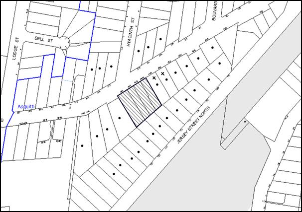
|
NOTIFICATION PLAN |
|
||
|
• PROPERTIES NOTIFIED
|
X SUBMISSIONS RECEIVED |
PROPERTY SUBJECT OF DEVELOPMENT |
|
|
1 SUBMISSION RECEIVED OUT OF MAP RANGE |
|||
Three submissions objected to the development, generally on the grounds that the development would result in:
· A 6 storey development that is contrary to the 5 storey height permitted;
· Unacceptable privacy and overshadowing impacts on the adjacent dwelling house;
· Inadequate landscaping along the north-eastern (side) boundary;
· Unacceptable traffic impacts and a loss of on-street car parking;
· Unacceptable impacts during construction including noise, safety impacts from overhead cranes and trucks on local streets;
The merits of the matters raised in community submissions have been addressed in the body of the report with the exception of the following:
5.1.1 Building Height of 6 Storeys
Concerns were raised that the development is 6 storeys, rather than 5 storeys as required by the Hornsby DCP. The development includes a mezzanine in the 5th floor which is not counted as a storey in accordance with the definitions within the Hornsby LEP 2013 and DCP 2013 that defines as storey as:
storey means a space within a building that is situated between one floor level and the floor level next above, or if there is no floor above, the ceiling or roof above, but does not include:
(a) a space that contains only a lift shaft, stairway or meter room, or
(b) a mezzanine, or
(c) an attic.
5.1.2 Privacy and Overshadowing
Concerns were raised that the development includes windows and balconies that overlook the side north-eastern boundary that would impact on the privacy of the adjacent dwelling house. The adjacent site to the north-east is zoned for 5 storey residential apartment development and is capable of being redeveloped in the future for this land use. Accordingly, the design of this building is required to take into account the desired future character of the precinct when considering potential privacy conflicts. The development is generally setback at 6m which complies with half of the building separation provisions within the Hornsby DCP and RFDC. Where the development is elevated and setback between 4m and 6m, privacy screens or high sills are provided to habitable rooms and balconies.
Concerns were raised that overshadowing of the adjacent property to the north-east would be unacceptable. In particular, concerns were raised that the overshadowing in summer would be worse than that indicated on the mid-winter plans submitted. The extent of overshadowing is the most extreme in mid-winter which is why this is used by the Council and the RFDC as the sunlight access plan to consider. Overshadowing in summer is not as significant as the sun is higher in the sky.
5.1.3 Landscaping along North-Eastern Side Boundary
Concerns were initially raised by the resident adjoining the site’s NE (side) boundary that the extent of landscaping was significantly compromised by encroachments including the driveway. The amended plans now locate the driveway on the opposite side boundary adjacent to ABHS and accordingly, extensive landscaping can be achieved along this NE boundary. The amended landscape plan indicates a number of small trees along this NE boundary including 13x 6m high Lilly Pilli trees.
5.1.4 Traffic Generation, Safety and Parking
Concerns are raised that Peats Ferry Road does not have adequate capacity to accommodate the traffic generated by this development. The suitability of the locality for high density residential development was considered by the Council and the Department of Planning during the recent rezoning of the precinct. As previously discussed, the location of the proposed driveway is in the preferred location by the Traffic Branch and the RMS to facilitate traffic and pedestrian safety and the traffic volumes on Peats Ferry Road is currently in the order of 27% of the capacity.
Concerns were raised that the new residents would decrease the amount of on-street parking currently available. The volume of on-site parking provided is consistent with that required by the Hornsby DCP.
5.1.5 Construction Impacts
Concerns were raised that ongoing construction noise would impact on the adjacent elderly residents. A recommended condition of consent has been included to limit the hours of construction noise.
Concerns were raised about the safety hazard caused by cranes swinging over adjacent residential properties. The possibility that the developer may install and utilise a crane on the development site is not a matter for consideration pursuant to this application. NSW WorkCover provides guidance on the utilisation of cranes under Work Health and Safety Legislation in NSW.
5.2 Public Agencies
The development application was referred to the Roads and Maritime Service for comment. The RMS provided comments on this application on 24 October 2014 raising concern with the initial proposal that located the driveway adjacent to the NE (side) boundary due to the potential conflict with an existing pedestrian crossing that is utilised by many Asquith Boys High School students. The application was subsequently amended on 29 October 2014 relocating the driveway to the opposite SW (side) boundary.
6. THE PUBLIC INTEREST
Section 79C(1)(e) of the Act requires Council to consider “the public interest”.
The public interest is an overarching requirement, which includes the consideration of the matters discussed in this report. Implicit to the public interest is the achievement of future built outcomes adequately responding to and respecting the future desired outcomes expressed in environmental planning instruments and development control plans.
The application is considered to have satisfactorily addressed Council’s and relevant agencies’ criteria and would provide a development outcome that, on balance, would result in a positive impact for the community. Accordingly, it is considered that the approval of the proposed development would be in the public interest.
CONCLUSION
The application seeks approval for the demolition of existing structures and construction of a five storey residential flat buildings comprising 58 units and basement car parking.
The proposed development is generally in accordance with the development controls for the ‘Jersey Street North, Asquith’ Precinct of the Hornsby DCP and would contribute to the future desired five storey residential character of the precinct. The proposed excess of the 17.5m building height control by 0.325m is minor and the Clause 4.6 submission to vary the development standard is supported. The proposal complies with the design principles of SEPP 65 and the Residential Flat Design Code. With conditions, the minor non-compliances with prescriptive measures for setbacks, landscaping, private open space, sunlight access, minimum dwelling size, maximum kitchen distance and storage areas is considered acceptable.
The proposal would result in a development that would be in keeping with the desired future character of the precinct.
Note: At the time of the completion of this planning report, no persons have made a Political Donations Disclosure Statement pursuant to Section 147 of the Environmental Planning and Assessment Act 1979 in respect of the subject planning application.
RESPONSIBLE OFFICER
The officer responsible for the preparation of this Report is the Manager – Development Assessments, Rodney Pickles, who can be contacted on 9847 6731.
|
Rod Pickles Manager - Development Assessment Planning Division |
James Farrington Group Manager Planning Division |
|
1.View |
Locality Map |
|
|
|
2.View |
Floor Plans |
|
|
|
3.View |
Elevations |
|
|
|
4.View |
Shadow Diagrams |
|
|
|
5.View |
Landscape Plan |
|
|
File Reference: DA/690/2014
Document Number: D03940100
SCHEDULE 1
GENERAL CONDITIONS
The conditions of consent within this notice of determination have been applied to ensure that the use of the land and/or building is carried out in such a manner that is consistent with the aims and objectives of the relevant legislation, planning instruments and council policies affecting the land and does not disrupt the amenity of the neighbourhood or impact upon the environment.
Note: For the purpose of this consent, the term ‘applicant’ means any person who has the authority to act on or the benefit of the development consent.
Note: For the purpose of this consent, any reference to an Act, Regulation, Australian Standard or publication by a public authority shall be taken to mean the gazetted Act or Regulation, or adopted Australian Standard or publication as in force on the date that the application for a construction certificate is made.
1. Approved Plans and Supporting Documentation
The development must be carried out in accordance with the plans and documentation listed below and endorsed with Council’s stamp, except where amended by Council and/or other conditions of this consent:
|
Plan No. |
Plan Title |
Drawn by |
Dated |
|
12878 Rev A |
Survey Plan |
Survey Plus |
8.01.14 |
|
A0.02 DA Rev D |
Calculations |
MASQ Architects |
17.11.14 |
|
A0.03 DA Rev B |
Calculations |
MASQ Architects |
6.10.14 |
|
A1.01 DA Rev B |
Basement 2 |
MASQ Architects |
22.10.14 |
|
A1.02 DA Rev E |
Basement 1 |
MASQ Architects |
22.10.14 |
|
A1.03 DA Rev F |
Ground Floor Plan |
MASQ Architects |
17.11.14 |
|
A1.04 DA Rev F |
Typical Floor Plan |
MASQ Architects |
17.11.14 |
|
A1.07 DA Rev D |
Fourth Floor Plan |
MASQ Architects |
17.11.14 |
|
A1.08 DA Rev D |
Mezzanine Floor Plan |
MASQ Architects |
17.11.14 |
|
A1.09 DA Rev B |
Roof Plan |
MASQ Architects |
17.11.14 |
|
A2.01 DA Rev B |
Section A |
MASQ Architects |
21.9.14 |
|
A2.02 DA Rev C |
Section B |
MASQ Architects |
22.10.14 |
|
A3.01 DA Rev D |
North West Elevation (front) |
MASQ Architects |
17.11.14 |
|
A3.02 DA Rev C |
South East Elevation (rear) |
MASQ Architects |
17.11.14 |
|
A3.03 DA Rev C |
North East Elevation |
MASQ Architects |
17.11.14 |
|
A3.04 DA Rev C |
South West Elevation |
MASQ Architects |
17.11.14 |
|
A4.01, A4.02, A4.03 DA Rev B |
Shadows – 22 June 9am, 12pm, 3pm |
MASQ Architects |
17.11.14 |
|
F1.01 DA Rev A Sheets 1-3/3 |
Exterior Finishes |
MASQ Architects |
6.6.14 |
|
LP/01 Rev A |
Landscape Plan |
ATC |
Received 29.10.2014 |
|
SW01 Rev 01 |
Lower Basement Stormwater Plan |
Demlakian |
24.10.2014 |
|
SW02 Rev 01 |
Upper Basement Stormwater Plan |
Demlakian |
24.10.2014 |
|
SW02 Rev 02 |
Ground Floor Stormwater Plan |
Demlakian |
27.10.2014 |
|
SW04 |
Roof Stormwater Plan |
Demlakian |
24.10.2014 |
|
Document Title |
Prepared By |
Date |
|
Basix Certificate No.556586M_02 |
Damian O’Toole Town Planning |
28 Oct 2014 |
|
Clause 4.6 Exceptions to Development Standards |
Caladines Town Planning |
Received 29 Oct 2014 |
|
Waste Management Plan Rev C |
Elephants Foot |
June 2014 |
|
Access Report |
Accessibility Solutions |
23 June 2014 |
2. Amendment of Plans
The approved plans are to be amended as follows:
a) Plans A3.01 and A3.02 being the front and rear elevations are to be amended to reflect the roof plan that has a lower roof adjacent to the 4x4m indentations;
b) Units L4.01 and L4.06 are to be amended to provide a minimum balcony depth of 2m for an area of 10m2 (as indicated in red on the plans);
c) Unit L4.04 is to be amended to provide a 1 metre setback from the external enclosing walls below (as indicated in red on the plans);
d) Modify the basement to:
i) Delete the 2 bike spaces in front of the wheel stop (as indicated in red on the plans);
ii) Provide 6 disabled parking spaces on the middle basement level that complies with AS2890.6:2009;
iii) Provide 2 motorcycle parking spaces that complies with AS2890.5:1993;
iv) Provide 18 bicycle parking spaces that complies with AS2890.3:1993, part or all of which may be sited below ground and behind the disabled parking spaces indicated in red on the plans;
v) Provide a minimum of 69 car parking spaces.
Details of amended plans must be submitted with the Construction Certificate plans.
3. Removal of Existing Trees
This development consent permits the removal of all the trees on the site.
4. Construction Certificate
A Construction Certificate is required to be approved by Council or a Private Certifying Authority prior to the commencement of any works under this consent.
5. Section 94 Development Contributions
In accordance with Section 80A(1) of the Environmental Planning and Assessment Act 1979 and the Hornsby Shire Council Section 94 Development Contributions Plan 2012-2021, the following monetary contributions shall be paid to Council to cater for the increased demand for community infrastructure resulting from the development:
|
Description |
Contribution (4) |
|
Roads |
$ 66,623.50 |
|
Open Space and Recreation |
$ 698,563.00 |
|
Community Facilities |
$ 97,374.80 |
|
Plan Preparation and Administration |
$ 2,913.85 |
|
TOTAL |
$865,475.15 |
being for 11 x 1 bedroom units, 35 x 2 bedroom units and 12 x 3 bedroom units and including a credit for 4 existing allotments.
a) The value of this contribution is current as at 19 November 2014. If the contributions are not paid within the financial quarter that this condition was generated, the contributions payable will be adjusted in accordance with the provisions of the Hornsby Shire Council Section 94 Development Contributions Plan and the amount payable will be calculated at the time of payment in the following manner:
$CPY = $CDC x CPIPY
CPIDC
Where:
$CPY is the amount of the contribution at the date of Payment
$CDC is the amount of the contribution as set out in this Development Consent
CPIPY is the latest release of the Consumer Price Index (Sydney – All Groups) at the date of Payment as published by the ABS.
CPIDC is the Consumer Price Index (Sydney – All Groups) for the financial quarter at the date applicable in this Development Consent Condition.
b) The monetary contributions shall be paid to Council:
i) prior to the issue of the Subdivision Certificate where the development is for subdivision; or
ii) prior to the issue of the first Construction Certificate where the development is for building work; or
iii) prior to issue of the Subdivision Certificate or first Construction Certificate, whichever occurs first, where the development involves both subdivision and building work; or
iv) prior to the works commencing where the development does not require a Construction Certificate or Subdivision Certificate.
It is the professional responsibility of the Principal Certifying Authority to ensure that the monetary contributions have been paid to Council in accordance with the above timeframes.
Council’s Development Contributions Plan may be viewed at www.hornsby.nsw.gov.au or a copy may be inspected at Council’s Administration Centre during normal business hours.
REQUIREMENTS PRIOR TO THE ISSUE OF A CONSTRUCTION CERTIFICATE
6. Building Code of Australia
All building work must be carried out in accordance with the relevant requirements of the Building Code of Australia.
7. Contract of Insurance (Residential Building Work)
In the case of residential building work for which the Home Building Act 1989 requires there to be a contract of insurance in force in accordance with Part 6 of that Act, that such a contract of insurance is in force before any building work authorised to be carried out by the consent commences.
8. Water/Electricity Utility Services
The applicant must submit written evidence of the following service provider requirements:
a) Ausgrid (formerly Energy Australia) – a letter of consent demonstrating that satisfactory arrangements have been made to service the proposed development.
b) Sydney Water – the submission of a ‘Notice of Requirements’ under s73 of the Sydney Water Act 1994.
Note: Sydney Water requires that s73 applications are to be made through an authorised Sydney Water Servicing Coordinator. Refer to www.sydneywater.com.au or telephone 13 20 92 for assistance.
9. Accessible Units
The development is required to provide 18 units designed as adaptable housing pursuant to the requirements of 1C.2.2 of the Hornsby Development Control Plan. In this regard six (6) car parking spaces are to be designed for people with a disability and allocated to 6 adaptable units. The details of all adaptable units must be provided with the Construction Certificate plans.
10. Letterboxes
The details of letter boxes and meter enclosures must be provided with the Construction Certificate Plans. The letter boxes and meter enclosures must be provided with a minimum setback of 2 metres from all boundaries and must be suitably screened.
11. Dilapidation Report
A ‘Dilapidation Report’ is to be prepared by a ‘chartered structural engineer’ detailing the structural condition of all adjoining properties.
12. Preservation of Survey Infrastructure
Prior to the issue of a construction certificate, a registered surveyor shall identify all survey marks in the vicinity of the proposed development. Any survey marks required to be removed or displaced as a result of the proposed development shall be undertaken by a registered surveyor in accordance with Section 24 (1) of the Surveying and Spatial Information Act 2002 and following the Surveyor General’s Directions No. 11 – “Preservation of Survey Infrastructure”.
13. Construction Vehicles
All construction vehicles associated with the proposed development are to be contained on site as not construction zones will be permitted on Peats Ferry Road in the vicinity of the site.
14. Construction Management Plan
A Construction Management Plan detailing construction vehicle routes, number of trucks, hours of operation, access arrangements and traffic control should be submitted to Council prior to the issue of a Construction Certificate.
15. Driveway Signalisation Details
Details of the proposed method of signalising the one-lane driveway ramp is to be submitted to Council for approval prior to the issue of a Construction Certificate. This is to include details of:
a) The location and type of signals;
b) A priority system for cars entering the site from Peats Ferry Road, to avoid queuing onto the public road; and
c) A back up battery system in the event of mains power failure.
16. Waste Design
The space available for each waste facility adjacent to each lift on each residential level must be sufficient for the garbage chute (including chute entry hopper, noise insulation etc.) and the 240 L recycling bin. Details must be submitted with the Construction Certificate plans.
17. Storage
Each dwelling within the development must have a minimum area for storage (not including kitchen and bedroom cupboards) of 6m³ for one bedroom units, 8m³ for two bedroom units and 10m³ for three bedroom units, where 50% is required to be located within the apartment and accessible from either the hall or living area. Details must be submitted with the Construction Certificate plans.
18. Basix
Amend Basix Certificate No.556586m_02 to reflect the approved DA plans. Details must be submitted with the Construction Certificate Plans.
19. Exterior Finishes
Amend the approved Exterior Finishes plans F1.01 DA Rev A Sheets 1 -3/3 to reflect the concepts indicated in the approved coloured Elevations. Details must be submitted to Council for approval prior to issue of a Construction Certificate.
REQUIREMENTS PRIOR TO THE COMMENCEMENT OF ANY WORKS
20. Erection of Construction Sign
A sign must be erected in a prominent position on any site on which building work, subdivision work or demolition work is being carried out:
a) Showing the name, address and telephone number of the principal certifying authority for the work;
b) Showing the name of the principal contractor (if any) for any demolition or building work and a telephone number on which that person may be contacted outside working hours; and
c) Stating that unauthorised entry to the work site is prohibited.
Note: Any such sign is to be maintained while the building work, subdivision work or demolition work is being carried out, but must be removed when the work has been completed.
21. Protection of Adjoining Areas
A temporary hoarding, fence or awning must be erected between the work site and adjoining lands before the works begin and must be kept in place until after the completion of the works if the works:
a) Could cause a danger, obstruction or inconvenience to pedestrian or vehicular traffic.
b) Could cause damage to adjoining lands by falling objects.
c) Involve the enclosure of a public place or part of a public place.
Note: Notwithstanding the above, Council’s separate written approval is required prior to the erection of any structure or other obstruction on public land.
22. Toilet Facilities
Toilet facilities must be available or provided at the works site before works begin and must be maintained until the works are completed at a ratio of one toilet for every 20 persons employed at the site. Each toilet must:
a) be a standard flushing toilet connected to a public sewer; or
b) be a temporary chemical closet approved under the Local Government Act 1993; or
c) have an on-site effluent disposal system approved under the Local Government Act 1993.
23. Erosion and Sediment Control
Erosion and sediment control measures must be provided and maintained throughout the construction period in accordance with the manual ‘Soils and Construction 2004 (Bluebook)’, the approved plans, Council specifications and to the satisfaction of the principal certifying authority. The erosion and sediment control devices must remain in place until the site has been stabilised and revegetated.
Note: On the spot penalties up to $1,500 may be issued for any non-compliance with this requirement without any further notification or warning.
REQUIREMENTS DURING CONSTRUCTION
24. Construction Work Hours
All work on site (including demolition and earth works) must only occur between 7am and 5pm Monday to Saturday. No work is to be undertaken on Sundays or public holidays.
25. Demolition
All demolition work must be carried out in accordance with “Australian Standard 2601-2001 – The Demolition of Structures” and the following requirements:
a) Demolition material must be disposed of to an authorised recycling and/or waste disposal site and/or in accordance with an approved waste management plan;
b) Demolition works, where asbestos material is being removed, must be undertaken by a contractor that holds an appropriate licence issued by WorkCover NSW in accordance with Chapter 10 of the Occupational Health and Safety Regulation 2001 and Clause 29 of the Protection of the Environment Operations (Waste) Regulation 2005 ;and
c) On construction sites where buildings contain asbestos material, a standard commercially manufactured sign containing the words ‘DANGER ASBESTOS REMOVAL IN PROGRESS’ measuring not less than 400mm x 300mm must be erected in a prominent position visible from the street.
26. Environmental Management
The site must be managed in accordance with the publication ‘Managing Urban Stormwater – Landcom (March 2004) and the Protection of the Environment Operations Act 1997 by way of implementing appropriate measures to prevent sediment run-off, excessive dust, noise or odour emanating from the site during the construction of the development.
27. Street Sweeping
Street sweeping must be undertaken following sediment tracking from the site along Peats Ferry Road during works and until the site is established.
28. Council Property
During construction works, no building materials, waste, machinery or related matter is to be stored on the road or footpath. The public reserve must be kept in a clean, tidy and safe condition at all times.
29. Disturbance of Existing Site
During construction works, the existing ground levels of open space areas and natural landscape features, (including natural rock-outcrops, vegetation, soil and watercourses) must not be altered unless otherwise nominated on the approved plans.
30. Landfill
Landfill must be constructed in accordance with Council’s ‘Construction Specification 2005’ and the following requirements:
a) All fill material imported to the site is to wholly consist of Virgin Excavated Natural Material (VENM) as defined in Schedule 1 of the Protection of the Environment Operations Act 1997 or a material approved under the Department of Environment and Climate Change’s general resource recovery exemption.
b) A compaction certificate is to be obtained from a geotechnical engineer verifying that the specified compaction requirements have been met.
31. Excavated Material
All excavated material removed from the site must be classified in accordance with the Department of Environment, Climate Change and Water NSW Waste Classification Guidelines prior to disposal to an approved waste management facility and reported to the principal certifying authority.
32. Survey Report – Finished Floor Level
A report(s) must be prepared by a registered surveyor and submitted to the principal certifying authority prior to the pouring of concrete at each level of the building certifying that:
a) The building, retaining walls and the like have been correctly positioned on the site; and
b) The finished floor level(s) are in accordance with the approved plans.
33. Waste Management Details
Waste management during the demolition and construction phase of the development must be undertaken in accordance with the approved Waste Management Plan. Additionally written record of the following items must be maintained during the removal of any waste from the site and such information submitted to the Principal Certifying Authority within fourteen days of the date of completion of the works;
a) The identity of the person removing the waste.
b) The waste carrier vehicle registration.
c) Date and time of waste collection.
d) A description of the waste (type of waste and estimated quantity).
e) Details of the site to which the waste is to be taken.
f) The corresponding tip docket/receipt from the site to which the waste is transferred (noting date and time of delivery, description (type and quantity) of waste).
g) Whether the waste is expected to be reused, recycled or go to landfill.
Note: In accordance with the Protection of the Environment Operations Act 1997, the definition of waste includes any unwanted substance, regardless of whether it is reused, recycled or disposed to landfill.
REQUIREMENTS PRIOR TO THE ISSUE OF AN OCCUPATION CERTIFICATE
Note: For the purpose of this consent, a reference to ‘occupation certificate’ shall not be taken to mean an ‘interim occupation certificate’ unless otherwise stated.
34. Fulfilment of BASIX Commitments
The applicant must demonstrate the fulfilment of BASIX commitments pertaining to the development.
35. Sydney Water – s73 Certificate
An s73 Certificate must be obtained from Sydney Water.
36. Stormwater Drainage
The stormwater drainage system for the development must be designed and constructed for an average recurrence interval of 20 years and be gravity drained in accordance with the following requirements:
a) Connected directly to Council drainage system/ street gutter via an onsite detention system;
b) Be designed by a Chartered Professional Engineer/ Civil Engineer of the Institution of Engineers, Australia.
37. On Site Stormwater Detention
An on-site stormwater detention system must be designed by a chartered civil engineer and constructed in accordance with the following requirements:
a) Storage capacity to accommodate volume from up to 20 years ARI (average recurrence interval) and a maximum discharge (when full) limited to 5 years pre development rate.
b) Have a surcharge/inspection grate located directly above the outlet.
c) Discharge from the detention system to be controlled via 1 metre length of pipe, not less than 50 millimetres diameter or via a stainless plate with sharply drilled orifice bolted over the face of the outlet discharging into a larger diameter pipe capable of carrying the design flow to an approved Council system.
d) Where above ground and the average depth is greater than 0.3 metres, a ‘pool type’ safety fence and warning signs to be installed.
e) Not be constructed in a location that would impact upon the visual or recreational amenity of residents.
f) Detail calculations are to be shown in construction certificate plan.
38. Vehicular Crossing
A separate application under the Local Government Act 1993 and the Roads Act 1993 must be submitted to Council for the installation of a new vehicular crossing and the removal of the redundant crossing. The vehicular crossing must be constructed in accordance with Council’s Civil Works Design 2005 and the following requirements:
a) Any redundant crossings must be replaced with integral kerb and gutter;
b) The footway area must be restored by turfing;
c) Approval must be obtained from all relevant utility providers that all necessary conduits be provided and protected under the crossing.
Note: An application for a vehicular crossing can only be made to one of Council’s Authorised Vehicular Crossing Contractors. You are advised to contact Council on 02 9847 6940 to obtain a list of contractors.
39. Internal Driveway/Vehicular Areas
The driveway and parking areas on site must be designed in accordance with Australian Standards 2890.1, 2890.2, 3727 and the following requirements:
a) Design levels at the front boundary must be obtained from Council;
b) The driveway must be a rigid pavement;
c) Parking in the basement is to be allocated to the units in accordance with the following minimum parking rates:
i) 1 bed units - 0.75 car spaces/ unit (average)
ii) 2 bed units – 1 car space/ unit
iii) 3 bed units – 1.5 car spaces/ unit (average)
iv) Visitors – 8 car spaces and 2 motorcycle spaces
d) Storage cages in the basement are to be allocated to the units in accordance with Condition No.17.
40. Footpath and Nature Strip
Existing old footpath/damaged during construction works fronting the development must be removed and must be constructed in accordance Council’s Civil Works Design and Construction Specification 2005 and the following requirements:
a) The land adjoining the footpath to be fully turfed.
b) Any public utility adjustments to be carried out at the cost of the applicant and to the requirements of the relevant public authority.
c) A construction certificate is to be submitted to Council.
Note: Council is the only authority to approve works within Council roads.
41. Traffic Control Plan
A Traffic Control Plan (TCP) must be prepared by a qualified traffic controller in accordance with the Roads & Traffic Authority’s Traffic Control at Worksites Manual 1998 and Australian Standard 1742.3 for all work on a public road and be submitted to Council. The TCP must detail the following:
a) Arrangements for public notification of the works.
b) Temporary construction signage.
c) Permanent post-construction signage.
d) Vehicle movement plans.
e) Traffic management plans.
f) Pedestrian and cyclist access/safety.
42. Damage to Council Assets
Any damage caused to Council’s assets as a result of the construction of the development must be rectified in accordance with Council’s Civil Works Specifications. Council’s Restorations Supervision must be notified for a formwork inspection prior to pouring concrete.
43. Creation of Easements
The following matter(s) must be nominated on the plan of subdivision under s88B of the Conveyancing Act 1919:
a) The creation of an appropriate "Positive Covenant" and "Restriction as to User" over the constructed on-site detention/retention systems and outlet works, within the lots in favour of Council in accordance with Council’s prescribed wording. The position of the on-site detention system is to be clearly indicated on the title.
b) To register the OSD easement, the restriction on the use of land “works-as-executed” details of the on-site-detention system must be submitted verifying that the required storage and discharge rates have been constructed in accordance with the design requirements. The details must show the invert levels of the on site system together with pipe sizes and grades. Any variations to the approved plans must be shown in red on the “works-as-executed” plan and supported by calculations.
Note: Council must be nominated as the authority to release, vary or modify any easement, restriction or covenant.
44. Certificate of Preservation of Survey Marks
A certificate by a Registered Surveyor shall be submitted to the Principal Certifying Authority, certifying that there has been no removal, damage, destruction, displacement or defacing of the existing survey marks in the vicinity of the proposed development or otherwise the re-establishment of damaged, removed or displaced survey marks has been undertaken in accordance with the Surveyor General’s Direction No.11 – “Preservation of Survey Infrastructure”.
45. Retaining Walls
All required retaining walls must be constructed as part of the development.
46. Boundary Fencing
Fencing must be erected along all property boundaries behind the front building alignment to a height of 1.8 metres above existing ground level. Fences to the primary frontage in front of the building alignment are to retain visual transparency (not lapped / solid) and be 1.2 metres in height.
Note: Alternative fencing behind the front building line may be erected subject to the written consent of the adjoining property owner(s).
47. Planter Boxes/On Slab Planting
On slab planter boxes must include waterproofing, subsoil drainage (proprietary drainage cell, 50mm sand and filter fabric) automatic irrigation, minimum 500mm planting soil for shrubs and minimum 1000mm planting soil for trees and palms and 75mm mulch to ensure sustainable landscape is achieved.
48. Tree Planting
Tree planting to the front Peats Ferry Road landscape setback area must include:
a) Three locally indigenous canopy trees capable of reaching more than 10 metres height at maturity.
Tree planting to the rear landscape setback area must include:
b) Three Angophora costata (Sydney Red Gum) or other locally indigenous trees capable of reaching more than 10 metres height at maturity.
Tree planting to the north-eastern side boundary must include:
c) Seven locally indigenous trees capable of reaching a mature height in excess of 6 metres
Tree planting to the south-western side boundary must include:
d) Five locally indigenous trees capable of reaching more than 6 metres height at maturity. These are not to be located in the 2m wide area between the ramp and fence;
Planting to the side (SW) boundary between the fence and the ramp must include:
e) Bamboo or hedge is to be used along the boundary, which can be maintained to occupy a maximum 1 metres of width from the fence line and achieve a minimum 5 metres in height. Any Bamboo including ‘clumping’ forms will require root barrier control with details to be submitted to describe the type and methodology to be employed that will establish effective control wherever Bamboo is proposed in the planting scheme.
49. Communal Open Space
a) A principal Communal Open Space area is to be provided in the front setback that has a minimum area of 50 metres squared with a minimum dimension of 4 metres;
b) The area is to adjoin the main pedestrian walkway, be setback 2m from the front boundary to provide for shrubs and tree planting and be an unencumbered space including grass and seating to encourage social interaction.
c) Where the Communal Open Space is sited adjacent to ground floor private open space areas, a means of screening / separation is to be provided.
50. Street Tree Plantings
a) Planting to the verge along the Peats Ferry Road frontage is to include Three Lophostemon confertus (Brush Box), to be installed at minimum 200 Litre pot size.
b) Prepare ground for planting, including excavate and replenish soils (also as per detail on Landscape Plan, to ensure appropriate volume of excavation and soil improvement).
c) Provide a mulched bed with minimum 1 metre radius clear of turf and weeds, which is to be mulched to 75mm depth.
d) Install trees with two hardwood stakes and hessian ties to secure and protect until firmly established.
51. Completion of Landscaping
A certificate must be provided by a practicing landscape architect, horticulturalist or person with similar qualifications and experience certifying that all required landscaping works have been satisfactorily completed in accordance with the approved landscape plans.
Note: Advice on suitable species for landscaping can be obtained from Council’s planting guide ‘Indigenous Plants for the Bushland Shire’, available at www.hornsby.nsw.gov.au.
52. Installation of Privacy Devices
The following device(s) must be installed to maintain an element of privacy towards the adjoining property:
a) The bedroom and living room windows that adjoin the internal courtyard void are to be provided with a 1.5m high sill or a fixed 1.5m high privacy screen;
b) All habitable room windows located less than 6m from the NE (side) boundary on the lower 4 floors, where the finished floor level is more than 0.5m above ground, are to be provided with a 1.5m high sill;
c) All habitable room windows located less than 9m from the NE (side) boundary on the 5th floor are to be provided with a 1.5m high sill;
d) All balconies located less than 6m from the NE (side) boundary, where the finished floor level is more than 0.5m above ground, are to be provide a fixed 1.5m high privacy screen;
e) Plan A1.04 DA Typical Floor is to be amended to provide a fixed 1.5m high privacy screen on the sides of the balconies between adjacent units, including between:
i) Units L1.01,L2.01,L3.01 and Units L1.02,L2.02,L3.02
ii) Units L1.08,2.08,3.08 and Units L1.07.L2.07,L3.07
iii) Units L1.08,2.08,3.08 and Units L1.09, L2.09,L3.09
f) Any required privacy screen must have no individual openings more than 30mm wide and have a total of all openings less than 30% of the surface area of the screen.
53. External Lighting
All external lighting must be designed and installed in accordance with Australian Standard AS 4282 – Control of the Obtrusive Effects of Outdoor Lighting. Certification of compliance with the Standard must be obtained from a suitably qualified person.
54. Garbage Collection Easement
For the purpose of waste collection, an easement entitling Council, its servants and agents and persons authorised by it to enter upon the subject land and to operate thereon, vehicles and other equipment for the purposes of garbage collection must be granted to Council by the owner of the land.
Note: The easement must be in a form prescribed by Council and must include covenants to the effect that parties will not be liable for any damage caused to the subject land or any part thereof or to any property located therein or thereon by reason of the operation thereon of any vehicle or other equipment used in connection with the collection of garbage and to the effect that the owner for the time being of the subject land shall indemnify the Council, its servants, agents and persons authorised by it to collect garbage against liability in respect of any such claims made by any person whomsoever.
55. Waste Management
The following waste management requirements must be complied with:
a) The garbage rooms at the basement level must include water or a hose for cleaning, graded floors with drainage to sewer, a robust door, sealed and impervious surface, adequate lighting and ventilation, and must be lockable. The waste facility at each residential level must include sealed and impervious surface, adequate lighting and ventilation.
b) A report must be prepared by an appropriately qualified person, certifying the following:
i) A comparison of the estimated quantities of each waste type against the actual quantities of each waste type. Note: Explanations of any deviations to the approved Waste Management Plan is required to be included in this report
ii) That at least 60% of the waste generated during the demolition and construction phase of the development was reused or recycled. Note: If the 60% diversion from landfill cannot be achieved in the Construction Stage, the Report is to include the reasons why this occurred and certify that appropriate work practices were employed to implement the approved Waste Management Plan. The Report must be based on documentary evidence such as tipping dockets/receipts from recycling depots, transfer stations and landfills, audits of procedures etc. which are to be attached to the report.
iii) All waste was taken to site(s) that were lawfully permitted to accept that waste.
c) A report(s) must be prepared by a registered surveyor and submitted to the principal certifying authority prior to the issue of the Subdivision/Occupation Certificate, certifying that the finished access way (including ramp, loading bay and site entry/exit) to be used by waste collection vehicles, complies with Australian Standard AS2890.2-2002 Parking Facilities Part 2: Off-street Commercial Vehicle Facilities for small rigid vehicles.
d) Each unit must be provided with an indoor waste/recycling cupboard for the interim storage of a minimum one day’s waste generation with separate containers for general waste and recyclable materials.
e) Space must be provided for either individual compost containers for each unit or a communal compost container;
Note: The location of the compost containers should have regard for potential amenity impacts.
f) The bin carting routes must be devoid of any steps.
Note: Ramps between different levels are acceptable.
g) Access to the waste volume handling equipment by unauthorised persons (including residents and waste collectors) must be prevented.
Note: Caging of the volume handling equipment is acceptable.
h) “No Parking” signs must be installed to prevent cars parking in the loading bay.
i) The 3.5 metre vertical clearance height within the truck travel path must not be reduced by ducting, pipes or anything else.
j) In addition to the bin/chute rooms, an 8sqm bulky item waste storage room with a minimum dimension of 2m is to be provided in the basement.
56. Unit Numbering
The allocation of unit numbering must be authorised by Council prior to the numbering of each unit in the development.
57. Consolidation of Allotments
All allotments the subject of this consent must be consolidated into one allotment.
Note: The applicant is recommended to submit the plan of subdivision to consolidate allotments to the NSW Department of Lands at least 4-6 weeks prior to seeking an occupation certificate.
58. Safety and Security
This site must include the following elements:
a) An intercom system must be installed at gate locations to ensure screening of persons entering the units.
b) The entry doors to the pedestrian foyer is to be constructed of safety rated glass to enable residents a clear line of site before entering or exiting the residential apartments.
c) Lighting is to be provided to pathways, building foyer entries, driveways and common external spaces.
d) Security gate access is to be provided to the car parking areas allowing residents-only access to private car spaces.
e) The communal open space, at the rear and north of the site must be illuminated with high luminance by motion sensor lighting.
f) The driveway and basement car parking must be illuminated with low luminance at all times.
g) Security deadlocks are to be provided to each apartment door.
h) Peep holes are to be provided to individual apartment doors to promote resident safety.
OPERATIONAL CONDITIONS
59. Landscape Establishment
The landscape works must be maintained into the future to ensure the establishment and successful growth of plant material to meet the intent of the landscape design. This must include but not limited to watering, weeding, replacement of failed plant material and promoting the growth of plants through standard industry practices.
60. Car Parking
All car parking must be constructed and operated in accordance with Australian Standard AS/NZS 2890.1:2004 – Off-street car parking and Australian Standard AS 2890.2:2002 – Off-street commercial vehicle facilities and,
a) All parking areas and driveways are to be sealed to an all-weather standard, line marked and signposted;
b) Car parking, loading and manoeuvring areas to be used solely for nominated purposes;
c) Vehicles awaiting loading, unloading or servicing shall be parked on site and not on adjacent or nearby public roads;
d) Residential parking spaces are to be secure spaces with access controlled by card or numeric pad;
e) Visitors are to have access to the parking area at all times. Visitors are to be able to access the basement car park by an audio/visual intercom system located at the top of the ramped driveway.
61. Sight Lines
Minimum sight lines for pedestrian safety are to be provided at the driveway. Any proposed landscaping and/or fencing must not restrict sight distance to pedestrians and cyclists travelling along the footpath.
62. Disabled Parking
All parking spaces for people with disabilities must be constructed and operated in accordance with Australian Standard AS/NZS 2890.6:2009 – Off-street parking for people with disabilities
63. Bicycle Parking
a) All bicycle parking spaces are to be designed in accordance with Australian Standard 2890.3-1993 – Bicycle parking facilities.
b) 12 resident and 6 visitor bicycle parking spaces are to be provided in the basement.
64. Motorcycle Parking Spaces
Two motorcycle parking spaces are to be provided in accordance with AS 2890.5-1993
65. Waste Management
The waste management on site must be in accordance with the following requirements:
a) A site caretaker must be employed and be responsible for moving bins where and when necessary, washing bins and maintaining waste storage areas, ensuring the chute system and related devices are maintained in effective and efficient working order, managing the communal composting area, managing the bulky item storage area, arranging the prompt removal of dumped rubbish, and ensuring cars do not park in the loading bay and that all residents are informed of the use of the waste management system.
b) Site security measures implemented on the property, including electronic gates, must not prevent access to the bin room/collection point by waste removal services.
66. Noise
All noise generated by the proposed development must be attenuated to prevent levels of noise being emitted to adjacent premises which possess tonal, beating and similar characteristics or which exceeds background noise levels by more than 5dB(A).
67. Fire Safety Statement - Annual
On at least one occasion in every 12 month period following the date of the first ‘Fire Safety Certificate’ issued for the property, the owner must provide Council with an annual ‘Fire Safety Certificate’ to each essential service installed in the building.
- END OF CONDITIONS -
ADVISORY NOTES
The following information is provided for your assistance to ensure compliance with the Environmental Planning and Assessment Act, 1979, Environmental Planning and Assessment Regulation 2000, other relevant legislation and Council’s policies and specifications. This information does not form part of the conditions of development consent pursuant to Section 80a of the Act.
Environmental Planning and Assessment Act 1979 Requirements
The Environmental Planning and Assessment Act 1979 requires:
· The issue of a construction certificate prior to the commencement of any works. Enquiries can be made to Council’s Customer Services Branch on 9847 6760.
· A principal certifying authority to be nominated and Council notified of that appointment prior to the commencement of any works.
· Council to be given at least two days written notice prior to the commencement of any works.
· Mandatory inspections of nominated stages of the construction inspected.
· An occupation certificate to be issued before occupying any building or commencing the use of the land.
Long Service Levy
In accordance with Section 34 of the Building and Construction Industry Long Service Payments Act 1986, a ‘Long Service Levy’ must be paid to the Long Service Payments Corporation or Hornsby Council.
Note: The rate of the Long Service Levy is 0.35% of the total cost of the work.
Note: Hornsby Council requires the payment of the Long Service Levy prior to the issue of a construction certificate.
Tree and Vegetation Preservation
In accordance with Clause 5.9 of the Hornsby Local Environmental Plan 2013 a person must not ringbark, cut down, top, lop, remove, injure or wilfully destroy any tree or other vegetation protected under the Hornsby Development Control Plan 2013 without the authority conferred by a development consent or a permit granted by Council.
Notes: A tree is defined as a long lived, woody perennial plant with one or relatively few main stems with the potential to grow to a height greater than three metres (3M). (HDCP 1B.6.1.c).
Tree protection measures and distances are determined using the Australian Standard AS 4970:2009, “Protection of Trees on Development Sites”.
Fines may be imposed for non-compliance with both the Hornsby Local Environmental Plan 2013 and the Hornsby Development Control Plan 2013.
Disability Discrimination Act
The applicant’s attention is drawn to the existence of the Disability Discrimination Act. A construction certificate is required to be obtained for the proposed building/s, which will provide consideration under the Building Code of Australia, however, the development may not comply with the requirements of the Disability Discrimination Act. This is the sole responsibility of the applicant.
Covenants
The land upon which the subject building is to be constructed may be affected by restrictive covenants. Council issues this approval without enquiry as to whether any restrictive covenant affecting the land would be breached by the construction of the building, the subject of this consent. Applicants must rely on their own enquiries as to whether or not the building breaches any such covenant.
Dial Before You Dig
Prior to commencing any works, the applicant is encouraged to contact Dial Before You Dig on 1100 or www.dialbeforeyoudig.com.au for free information on potential underground pipes and cables within the vicinity of the development site.
Telecommunications Act 1997 (Commonwealth)
If you are aware of any works or proposed works which may affect or impact on Telstra’s assets in any way, you are required to contact: Telstra’s Network Integrity Team on Phone Number 1800810443.
House Numbering
House numbering can only be authorised by Council. Before proceeding to number each premise in the development, the allocation of numbers is required to be obtained from Council's Planning Division prior to the issue of a Subdivision Certificate. The authorised numbers are required to comply with Council’s Property Numbering Policy and be displayed in a clear manner at or near the main entrance to each premise.
Rain Water Tank
It is recommended that water collected within any rainwater tank as part of the development be limited to non-potable uses. NSW Health recommends that the use of rainwater tanks for drinking purposes not occur where a reticulated potable water supply is available.
Group Manager’s Report No. PL86/14
Planning Division
Date of Meeting: 10/12/2014
10 DEVELOPMENT APPLICATION - FIVE STOREY RESIDENTIAL FLAT BUILDING COMPRISING 41 UNITS - 1-3 WEROMBI ROAD, MOUNT COLAH
EXECUTIVE SUMMARY
|
DA No: |
DA/629/2014 (lodged 11 June 2014) |
|
Description: |
Construction of a five storey residential flat building containing 41 units with basement car parking |
|
Property: |
Lot A and B DP 361646, Nos. 1-3 Werombi Road, Mount Colah |
|
Applicant: |
MacKenzie Architects International |
|
Owner: |
Mr Anthony Koch, Mr Scott Burcham and Mrs Carolyn Burcham |
|
Estimated Value: |
$7,830,000 |
|
Ward: |
A |
· The application involves the demolition of existing structures and construction of a five storey residential flat building containing 41 units with basement car parking.
· The proposal generally complies with the Hornsby Local Environmental Plan 2013, State Environmental Planning Policy No. 65 – Design Quality Residential Flat Building and the Hornsby Development Control Plan 2013.
· The original application was placed on public exhibition between 26 June 2014 and 10 July 2014, during which time Council received four submissions. The application was amended and placed on public exhibition between 6 November 2014 and 21 November 2014, during which time one submission was received.
· It is recommended that the application be approved as a deferred commencement in accordance with the recommended consent conditions from RailCorp.
|
THAT Development Application No. DA/629/2014 for the demolition of existing structures and construction of a five storey residential flat building containing 41 units with basement car parking at Lot A and B DP 361646, Nos. 1 - 3 Werombi Road, Mount Colah be approved as a deferred commencement pursuant to Section 80(3) of the Environmental Planning and Assessment Act, 1979 subject to the conditions of consent detailed in Schedule 1 of Group Manager’s Report No. PL86/14. |
BACKGROUND
The subject land was rezoned from Residential A (Low Density) to Residential C (Medium-High Density) on 2 September 2011 as part of Council’s Housing Strategy.
The subject application for demolition of existing structures and construction of a five storey residential flat building containing 41 units with basement car parking was lodged on 11 June 2014.
A meeting was held with the applicant on 1 August 2014 where Council raised a number of concerns with the proposed development including building setbacks and articulation. Amended plans were submitted to Council on 3 November 2014 to address the issues raised, which were renotified to neighbours and objectors. Further amended plans were submitted to Council on 21 November 2014 that reduced the roof height by 0.25m and corrected some minor plan errors.
SITE
The site comprises two allotments, Nos. 1 and 3 Werombi Road, Mount Colah. The site is a regular shaped parcel of land with a 40.2 metre frontage to Werombi Road and a total site area of 1,903.04 square metres. The site is located on the northern side of Werombi Road at the end of the residential cul-de-sac, approximately 75 metres east of the intersection of Werombi Road and Pacific Highway. The site adjoins a rail corridor on the eastern boundary of the site.
The site contains two dwelling-houses with associated access arrangements and landscaping. The site experiences a minor fall from the north-western (rear) corner to the front south-eastern (front) corner of the site with an average grade of 6%. The site contains a number of exotic, native and locally indigenous trees.
The site is located within walking distance of Mount Colah Train Station, which is approximately 400 metres north-east of the site. Bus stops with regular services to Hornsby are located 240 metres north and 300 metres south of the site.
The site is located within an established residential area that is characterised by a mix of 1 and 2 storey residential dwellings. The site forms part of a redevelopment precinct which is zoned for five storey development.
PROPOSAL
The proposal involves the demolition of the existing structures and construction of a five storey residential flat building comprising 41 units with two levels of basement car parking and associated landscaping works.
The unit mix would comprise of 24 x 1 bedroom; 12 x 2 bedroom units; and 5 x 3 bedroom units.
The development would be accessed from Werombi Road via a driveway located in the south-eastern corner of the site. A separate pedestrian entry would provide access to all levels from the foyer. A total of 49 car spaces, including 6 visitor parking spaces are proposed over two basement levels.
ASSESSMENT
The development application has been assessed having regard to the ‘Metropolitan Plan for Sydney 2031’, the ‘North Subregion (Draft) Subregional Strategy’ and the matters for consideration prescribed under Section 79C of the Environmental Planning and Assessment Act 1979 (the Act). The following issues have been identified for further consideration.
1. STRATEGIC CONTEXT
1.1 Metropolitan Plan for Sydney and (Draft) North Subregional Strategy
The (Draft) Metropolitan Strategy for Sydney 2031 is a broad framework to provide for Sydney’s growth to help plan for housing, employment, transport, infrastructure, the environment and open space. It outlines a vision for Sydney to 2031; the challenges faced, and the directions to follow to address these challenges and achieve the vision.
The North Subregion comprises Hornsby, Kuring-gai, Manly, Warringah and Pittwater Local Government Areas. The Draft North Subregional Strategy acted as a framework for Council in the preparation of the Hornsby LEP 2013.
Within the North Subregion, the Draft Metropolitan Strategy proposes:
· Population growth of 81,000 from the current 2011 baseline of 529,000
· Housing growth of 37,000 from the current 2011 baseline of 204,000
· Employment growth of 39,000 from the current 2011 baseline of 186,000
The proposed development would be consistent with the Metropolitan Plan for Sydney 2031 by providing an additional 39 dwellings and would contribute to housing choice in the locality.
2. STATUTORY CONTROLS
Section 79C(1)(a) requires Council to consider “any relevant environmental planning instruments, draft environmental planning instruments, development control plans, planning agreements and regulations”.
2.1 Hornsby Local Environmental Plan 2013
The subject land is zoned R4 (High Density Residential) under the Hornsby Local Environmental Plan 2013 (HLEP). The objectives of the zone are:
· To provide for the housing needs of the community within a high density residential environment.
· To promote a variety of housing types within a high density residential environment.
· To enable other land uses that provide facilities or services to meet the day to day needs of residents.
The proposed development is defined as a ‘residential flat building’ under the HLEP and is permissible in the zone with Council’s consent.
2.1.1 Height of Buildings
Clause 4.3 of the HLEP provides that the height of a building on any land is not to exceed the maximum height shown for the land on the Height of Buildings Map. The maximum permissible height for the subject site is 17.5 metres. The proposal complies with this provision.
2.1.2 Heritage Conservation
Clause 5.10 of the HLEP sets out heritage conservation provisions for Hornsby Shire. The site does not include any heritage item and is not located within a heritage conservation area. The site is located within the vicinity of property No. 534 Pacific Highway which is identified as a heritage item (House) of local significance under Schedule 5 (Environmental Heritage) of the HLEP. The proposed development would not impact on the heritage significance of the item as the heritage item fronts the Pacific Highway and is separated from the subject site by existing residential development and landscaping.
2.1.3 Earthworks
Clause 6.2 of the HLEP states that consent is required for earthworks on site. Before granting consent for earthworks, Council is required to assess the impacts of the works on adjoining properties, drainage patterns and soil stability of the locality. The site adjoins residential properties to the west and north of the site and a rail corridor to the east. The application was referred to RailCorp who requested construction details to demonstrate that the excavation works required for the development would not adversely impact on RailCorp infrastructure. RailCorp has agreed to apply this requirement as a deferred commencement condition.
Council’s assessment of the proposed earthworks and excavation concludes that the proposal is satisfactory subject to conditions regarding submission of a dilapidation report to identify any impact of excavation on adjoining properties.
2.2 State Environmental Planning Policy No. 65 – Design Quality of Residential Flat Development
The Policy provides for design principles to improve the design quality of residential flat development and for consistency in planning controls across the State.
The applicant has submitted a “Design Verification Statement” prepared by a qualified designer stating that the proposed development achieves the design principles of SEPP 65. The design principles of SEPP 65 are addressed below:
2.2.1 Principle 1 – Context
Design Principle 1 is as follows:
Good design responds and contributes to its context. Context can be defined as the key natural and built features of an area.
Responding to context involves identifying the desirable elements of a location’s current character or, in the case of precincts undergoing a transition, the desired future character as stated in planning and design policies. New buildings will thereby contribute to the quality and identity of the area.
The site is located within a planned five storey residential flat building precinct in close proximity to Mount Colah Railway Station. The proposal responds to the desired future character of the precinct as envisaged by Council. Once the development of the precinct is completed, the proposal would integrate with the surrounding sites and would be in keeping with the future urban form. It is considered that the proposed building would contribute to the identity and future character of the precinct.
The development responds suitably to the “context” principle of SEPP 65, considering the desired future character of the area.
2.2.2 Principle 2 – Scale
Design Principle 2 is as follows:
Good design provides an appropriate scale in terms of the bulk and height that suits the scale of the street and the surrounding buildings.
Establishing an appropriate scale requires a considered response to the scale of existing development. In precincts undergoing a transition, proposed bulk and height needs to achieve the scale identified for the desired future character of the area.
The scale of the development is in accordance with the height control and setbacks for the precinct prescribed within the Hornsby DCP 2013. The building footprints also comply with the maximum floorplate of 35m. The development achieves a scale consistent with the desired future character of the precinct of residential flat buildings in landscape settings with underground car parking.
2.2.3 Principle 3 – Built Form
Design Principle 3 is as follows:
Good design achieves an appropriate built form for a site and the building’s purpose, in terms of building alignments, proportions, building type and the manipulation of building elements.
Appropriate built form defines the public domain, contributes to the character of streetscape and parks, including their views and vistas, and provides internal amenity and outlook.
The proposed buildings are appropriately articulated to minimise the perceived scale and the chosen materials add to the visual interest of the development. Flat roof forms have been adopted with an increased top storey setback on the external facades to minimise bulk and height of the building as required by the Hornsby DCP. The proposal complies with the built form principle of SEPP 65.
2.2.4 Principle 4 – Density
Design Principle 4 is as follows:
Good design has a density appropriate for a site and its context, in terms of floor space yields (or number of units or residents).
Appropriate densities are sustainable and consistent with the existing density in an area or in precincts undergoing a transition, are consistent with the stated desired future density. Sustainable densities respond to the regional context, availability of infrastructure, public transport, community facilities and environmental quality.
The HLEP does not incorporate floor space ratio requirements for the site. The density of the development is governed by the height of the building and the required setbacks. The proposed density is considered to be sustainable as it responds to the regional context, availability of infrastructure, public transport, community facilities and environmental quality and is considered acceptable in terms of density.
2.2.5 Principle 5 – Resource, Energy and Water Efficiency
Design Principle 5 is as follows:
Good design makes efficient use of natural resources, energy and water throughout its full life cycle, including construction.
Sustainability is integral to the design process. Aspects include demolition of existing structures, recycling of materials, selection of appropriate and sustainable materials, adaptability and reuse of buildings, layouts and built form, passive solar design principles, efficient appliances and mechanical services, soil zones for vegetation and reuse of water.
The applicant has submitted a BASIX Certificate for the proposed development. In achieving the required BASIX targets for sustainable water use, thermal comfort and energy efficiency, the proposed development achieves the design criteria and is considered acceptable in this regard.
2.2.6 Principle 6 – Landscape
Design Principle 6 is as follows:
Good design recognises that together landscape and buildings operate as an integral and sustainable system, resulting in greater aesthetic quality and amenity for both occupants and the adjoining public domain.
Landscape design builds on the existing site’s natural and cultural features in responsible and creative ways. It enhances the development’s natural environmental performance by co-ordinating water and soil management, solar access, micro-climate, tree canopy and habitat values. It contributes to the positive image and contextual fit of development through respect for streetscape and neighbourhood character, or desired future character.
Landscape design should optimise useability, privacy and social opportunity, equitable access and respect for neighbour’s amenity, and provide for practical establishment and long term management.
The application includes a landscape concept plan which provides landscaping along the street frontages, side and rear boundaries. Deep soil areas that incorporate canopy trees are provided around the building envelope which would enhance the development’s natural environmental performance and provide an appropriate landscaped setting. Given the above, the proposal satisfies the intent of the ‘Landscaping’ principle of SEPP 65.
2.2.7 Principle 7 – Amenity
Design Principle 7 is as follows:
Good design provides amenity through the physical, spatial and environmental quality of a development.
Optimising amenity requires appropriate room dimensions and shapes, access to sunlight, natural ventilation, visual and acoustic privacy, storage, indoor and outdoor space, efficient layouts and service areas, outlook and ease of access for all age groups and degrees of mobility.
The proposed units are designed to achieve natural ventilation, solar access and acoustic privacy. All units incorporate balconies accessible from living areas and privacy has been achieved through appropriate design and orientation of balconies and living areas. Storage areas have been provided within each unit and in the basement levels. The proposal would provide convenient and safe access via a central lift in each building connecting the basement and all other levels. The proposal satisfies the ‘Amenity principle of SEPP 65.
2.2.8 Principle 8 – Safety and Security
Design Principle 8 is as follows:
Good design optimises safety and security, both internal to the development and for the public domain.
This is achieved by maximising overlooking of public and communal spaces while maintaining internal privacy, avoiding dark and non-visible areas, maximising activity on streets, providing clear, safe access points, providing quality public spaces that cater for desired recreational uses, providing lighting appropriate to the location and desired activities, and clear definition between public and private spaces.
The design orientates the balconies and windows of individual apartments towards the street, rear and side boundaries, providing passive surveillance of the public domain and communal open space areas. Both the pedestrian and vehicular entry points are secured and visibly prominent from Werombi Road. Appropriate conditions of consent for building security are recommended for the safety and security of the proposed development. Subject to conditions, the proposal is supported in respect of safety and security.
2.2.9 Principle 9 – Social Dimensions and Housing Affordability
Design Principle 9 is as follows:
Good design responds to the social context and needs of the local community in terms of lifestyles, affordability, and access to social facilities.
New development should optimise the provision of housing to suit the social mix and needs in the neighbourhood or, in the case of precincts undergoing transition, provide for the desired future community.
New development should address housing affordability by optimising the provision of economic housing choices and providing a mix of housing types to cater for different budgets and housing needs.
The site is located in close proximity to Mount Colah railway station and shops. The location of the site allows direct access to services and facilities.
The proposed development includes a mix of dwelling types and sizes which complies with the requirement within the RFDC to improve housing choice in the locality. In this regard, the development is considered acceptable in terms of social dimensions.
2.2.10 Principle 10 – Aesthetics
Design Principle 10 is as follows:
Quality aesthetics require the appropriate composition of building elements, textures, materials and colours and reflect the use, internal design and structure of the development. Aesthetics should respond to the environment and context, particularly to desirable elements of the existing streetscape or, in precincts undergoing transition, contribute to the desired future character of the area.
The architectural treatment of the building is generally consistent with the design principles contained within the Residential Flat Design Code and the Council’s Hornsby Development Control Plan. It is considered that the aesthetic quality of the building would contribute to the desired future character of the precinct. The details of the assessment of the built form and the aesthetics of the development are contained in Section 2.10 of this report.
2.3 SEPP 65 – Residential Flat Design Code
SEPP 65 also requires consideration of the Residential Flat Design Code, NSW Planning Department 2002. The Code includes development controls and best practice benchmarks for achieving the design principles of SEPP 65. The following table sets out the proposal’s compliance with the Code:
|
Residential Flat Design Code |
|||
|
Control |
Proposal |
Requirement |
Compliance |
|
Deep Soil Zone |
32% |
Min 25% |
Yes |
|
Communal Open Space |
39% |
25-30% |
Yes |
|
Ground Level Private Open Space |
<25m2(Units 1,2,6,7,8 and 9) Min Dimension <4m (Units1,3,6,7 and 9) |
25m2
Min Dimension 4m |
No
No |
|
Dwelling Size |
1 br - 50.14m2 to 73.25m2 2 br - 72.73m2 to 85.43m2 3 br – 94.4 m2 to 119.96m2 |
1 br – 50m2 min.
2 br – 70m2 min.
3 br – 95 m2 min. |
Yes
Yes
No |
|
Unit Depth and Maximum Kitchen Distance |
9.5m (Units 5,14,23,32) 11.5m (Units 6,15,24,33) 9m (Unit 38) |
8m |
No |
|
Minimum Balcony Depth |
2m |
2m |
Yes |
|
Ceiling Heights - Residential Floors |
2.7m |
2.7m (Min) |
Yes |
|
Total Storage Area
|
1br – >6m3 2br - >8m3 3br - >10m3 50% accessible from the apartments |
6m3 (Min) 8m3 (Min) 10 m3 (Min) 50% accessible from the apartments |
Yes |
|
Dual Aspect & Cross Ventilation |
60 % |
60% |
Yes |
|
Adaptable Housing |
29% (12/41) |
10% |
Yes |
As detailed in the above table, the proposed development complies with the prescriptive measures within the Residential Flat Design Code (RFDC) other than the minimum dimensions of the ground floor open space, maximum unit depth and dwelling size. Below is a brief discussion regarding the relevant development controls and best practice guidelines.
2.3.1 Building Separation
The RFDC requires a building separation of 12m between the unscreened habitable areas or balconies increasing to 18m from the fifth level, for two residential buildings on adjoining sites. Whilst the balconies on the western facade of the proposed development do not comply with this requirement, the building separation generally accords with the HDCP. The matter is discussed in section 2.10 of this report.
2.3.2 Ground Floor Apartments and Private Open Space
Of the 9 units located on the ground floor, 3 units have been provided with greater than 25m2 of courtyard space. Furthermore, many of the ground floor courtyards have a minimum dimension of 3m rather than the RFDC minimum 4m dimension. The proposed ground floor unit open space areas include recessed balconies and courtyards contained within the building envelope. The provision of additional private courtyard area within the setback areas would compromise the communal open space provisions for the site. Notwithstanding the non-compliance with the RFDC, the private open space areas for all units are able to comply with the minimum area requirement of the Hornsby DCP. The development would provide courtyard areas that are useable and provide a high level of amenity for future occupants of the apartments.
2.3.3 Dwelling Size
The RFDC prescribes that units should have a minimum internal area of 50m2 for 1 bedroom units, 70m2 for 2 bedroom units and 95m2 for 3 bedroom units. Unit 38 has a proposed floor area of 94.40m2 which is slightly under the minimum requirement for 3 bedroom units by 0.6m2. The unit is cross ventilated, receives daylight access and incorporates a terrace with an area of 33.22m2 providing generous open space for the occupants. The minor non-compliance would have no significant impact on user amenity and is supported. All other units comply with the minimum area specified by the RFDC.
2.3.4 Apartment Layout
The layout of the proposed apartments includes a combination of single aspect units and dual aspect corner units. The unit layouts would provide for housing choice and a range of household types.
The RFDC requires that the back of a kitchen should be no greater than 8m from a window. Of the 41 units proposed, 9 units contain kitchens where the back wall is greater than 8m from a window. These units offer an open layout with natural ventilation and accordingly, the minor non-compliance is acceptable with respect to residential amenity.
The proposed apartment layouts are functional and satisfy the RFDC objectives for internal privacy, access to sunlight, natural ventilation and acoustic privacy. It is considered that the apartment layout and mix achieve the intent of the best practice requirements of the RFDC and is acceptable in this regard.
2.3.5 Internal Circulation
The RFDC prescribes that units accessible from a single core/corridor should be limited to eight. Nine units are located on each level, from ground level up to Level 3. Five units are located on Level 4. The non-compliance is attributable to the high proportion of 1 bedroom units, which represents 58% of the total units. The non-compliance would have no significant impact on internal circulation and the amenity of occupants and is acceptable.
2.3.6 Acoustic Privacy
The internal layout of the residential units is designed such that noise generating areas would adjoin each other wherever possible. Circulation zones, communal services or fire stairs would act as a buffer between units. Bedrooms and service areas such as kitchens, bathrooms and laundries would be grouped together wherever possible. As the site adjoins the Railway Corridor, the application includes an acoustic report recommending acoustic mitigation measures to comply with the acoustic aims of SEPP Infrastructure. The consent conditions require the installation of acoustic attenuation measures to achieve the standards in the SEPP. The proposal is consistent with the RFDC for acoustic privacy.
2.3.7 Storage
The proposed building includes resident storage areas for all units within the apartments and storage rooms in the basement. The applicant has indicated that the total storage volume is to comply with the provisions of the Residential Flat Design Code. A condition is recommended that each dwelling within the development must have a minimum area for storage of 6m³ for one bedroom units, 8m³ for two bedroom units and 10m³ for three bedroom units, where 50% is required to be located within the apartment and accessible from either the hall or living area. A condition is also recommended that the basement storage areas be allocated in accordance with the size requirements of the Code for the respective units. With conditions, the proposal is acceptable with respect to the requirements of the RFDC for storage.
In summary, the proposed residential flat buildings have been designed in accordance with the design principles of SEPP 65 and generally comply in respect to the Residential Flat Design Code subject to the imposition of appropriate conditions of consent. It is considered the proposal would achieve good residential amenity and contribute to the desired future character of the precinct.
2.4 State Environmental Planning Policy (Infrastructure) 2007
The application has been assessed against the requirements of State Environmental Planning Policy (Infrastructure) 2007. This Policy contains State-wide planning controls for developments adjoining rail corridors and busy roads. The development is located immediately adjacent to a rail corridor and is located 75 metres from a classified road corridor (Pacific Highway). The following matters are required to be considered pursuant to the SEPP.
2.4.1 Excavation Adjacent to Rail Corridors
Clause 86 of the SEPP Infrastructure applies to the development as the proposal involves the penetration of ground to a depth of at least 2 metres within 25 metres of a rail corridor. The application was referred to RailCorp for concurrence in accordance with the provisions of this clause. RailCorp requested additional geotechnical and structural details to ensure the development would not adversely impact on the structural integrity of existing rail infrastructure. Following discussions between RailCorp and the applicant, RailCorp agreed to apply a deferred commencement condition to address this requirement. Subject to the fulfilment of this condition, the proposal is acceptable with respect to this clause.
2.4.2 Impact of Rail Noise
Assessment of the impact of rail noise on a residential use is required pursuant to Clause 87 of SEPP Infrastructure. A Noise and Vibration Assessment was submitted with the application demonstrating that the amenity for residents would be below the criteria set out in Clause 87(3). Council’s assessment in this regard concludes that suitable noise mitigation measures can be implemented to ensure compliance with the Policy. A condition has been recommended for the development to comply with the recommendations of the acoustic report submitted with the development application and the requirements of the Department of Planning’s Development Near Rail Corridors and Busy Roads – Interim Guideline and RailCorp’s Interim Guidelines for Applicants.
2.4.3 Impact of Road Noise
Assessment of the impact of road noise on a residential use is required pursuant to Clause 102 of SEPP Infrastructure where a development fronts a road with an annual average daily traffic volume of more than 40,000 vehicles. The subject site has frontage to Werombi Road and is located more 75 metres from the Pacific Highway. Furthermore, the average daily traffic volume on the Pacific Highway in the vicinity of the site does not exceed 40,000 vehicles and therefore, this clause does not apply to the proposal. Notwithstanding, the Noise and Vibration Assessment submitted with the application demonstrates that the development is capable to achieving reasonable amenity and acoustic privacy. The application was referred to the Roads and Maritime Service (RMS) who recommend a condition for the development to incorporate measures to mitigate against noise to habitable rooms in accordance with the criteria set out within clause 102(3) of the SEPP.
2.4.4 Traffic Generating Developments
The development is not classified as a Traffic Generating Development in accordance with Clause 104 and Schedule 3 of SEPP (Infrastructure) as it would not result in more than 75 dwellings fronting a classified road. No objections are raised by RMS with regard to traffic generation.
2.5 State Environmental Planning Policy (Building Sustainability Index – BASIX) – 2004
The application has been assessed against the requirements of State Environmental Planning Policy (Building Sustainability Index: BASIX) 2004. The proposal includes a BASIX Certificate for the proposed units and is considered to be satisfactory. The consent conditions require the Certificate to be updated to reflect the latest amended plans.
2.6 State Environmental Planning Policy No. 32 - Urban Consolidation (Redevelopment of Urban Land) (SEPP 32)
The application has been assessed against the requirements of SEPP 32, which requires Council to implement the aims and objectives of this Policy to the fullest extent practicable when considering development applications relating to redevelopment of urban land. The application complies with the objectives of the Policy as it would promote social and economic welfare of the locality and would result in the orderly and economic use of underutilised land within the Shire.
2.7 State Environmental Planning Policy No. 55 – Remediation of Land
State Environmental Planning Policy No. 55 (SEPP 55) requires that Council must not consent to the carrying out of any development on land unless it has considered whether the land is contaminated or requires remediation for the proposed use.
The site has been used for residential purposes and is unlikely to be contaminated. No further assessment is considered necessary in this regard. A condition is recommended should any contamination be found during construction requiring that Council or the Private Certifying Authority be notified.
2.8 Sydney Regional Environmental Plan No. 20 – Hawkesbury – Nepean River
The site is located within the catchment of the Hawkesbury Nepean River. Part 2 of this Plan contains general planning considerations and strategies requiring Council to consider the impacts of development on water quality, aquaculture, recreation and tourism.
Subject to the implementation of sediment and erosion control measures and stormwater management to protect water quality, the proposal would comply with the requirements of the Policy.
2.9 Clause 74BA Environmental Planning and Assessment Act, 1979 - Purpose and Status of Development Control Plans
On 1 March 2013, the Environmental Planning and Assessment Act, 1979 was amended so that a DCP provision will have no effect if it has the practical effect of “preventing or unreasonably restricting development” that is otherwise permitted and complies with the development standards set out in relevant Local Environmental Plans and State Environmental Planning Policies.
The principal purpose of a development control plan is to provide guidance on the aims of any environmental planning instrument that applies to the development; facilitating development that is permissible under any such instrument; and achieving the objectives of land zones under any such instrument. The provisions of a development control plan made for that purpose are not statutory requirements.
2.10 Hornsby Development Control Plan 2013
The proposed development has been assessed having regard to the relevant performance and prescriptive requirements within Hornsby Development Control Plan 2013 (HDCP). The development controls within “Section 3.4-Residential Flat Building (5 storeys)” of the HDCP applies to the site in addition to the general controls within Part 1 of the document. The following table sets out the proposal’s compliance with the relevant provisions of the Plan:
|
Hornsby Development Control Plan |
|||
|
Control |
Proposal |
Requirement |
Compliance |
|
Site Width |
40.02m
|
30m
|
Yes |
|
Height |
5 storeys including mezzanines – 17.5m |
5 storeys – 17.5m |
Yes |
|
Lowest Residential Floor Above Ground |
1.8m (SE corner) |
Max - 1.5m
|
No |
|
Maximum Floorplate Dimension |
31m (east – west) 32m (north – south) |
35m 35m
|
Yes Yes |
|
Building Indentation |
4m x 4m |
4m x 4m |
Yes |
|
Height of Basement Above Ground |
1.2m (west elevation) |
1m (max)
|
No |
|
Front Setback (Werombi Road) |
10m 8m (for 9m) <1/3 frontage 7m balconies |
10m 8m < 1/3 of frontage 7m (balconies) |
Yes Yes Yes |
|
Rear Setback
|
10m 8m (for 4.2m length) <1/3 frontage 7m balconies |
10m 8m < 1/3 of frontage
7m (balconies) |
Yes Yes
Yes |
|
East Side Setback |
6m 4m (for 9.7m length) <1/3 frontage 3.6m |
6m 4m < 1/3 frontage
4m (balconies) |
Yes Yes
No |
|
West Side Setback |
6m 4m (for 10.4m length) <1/3 3m |
6m 4m < 1/3 building width 4m (balconies) |
Yes Yes No |
|
Top Storey Setback From Ground Floor |
3m setback, except for parts of the elevations where the setback is reduced to 1 metre. |
3m additional
|
No
|
|
Underground Parking Setback |
7m front 7m rear 4m side (east) 4m side (west) |
7m front 7m rear 4m side 4m side |
Yes Yes Yes Yes |
|
Basement Ramp Setback |
3.6m – 4m |
2m |
Yes |
|
Deep soil Landscaped Areas |
7m front and rear 4m side (east) 3m side (west) |
7m front and rear 4m sides
|
Yes Yes No |
|
Private Open Space with Min Width 2.5m |
1 br units > 10m2 2 br units > 12m2 3 br units > 16m² |
1 br units 10m2 (min) 2 br units 12m2 (min) 3 br units 16m2 (min) |
Yes Yes Yes |
|
Communal Open Space with Minimum Dimension 4m |
39% |
25%
|
Yes |
|
Parking (Site within 800m of Railway Station)
|
43 resident spaces 6 visitor spaces 8 bicycle racks 4 visitor bicycle tacks 1 motorbike space |
38 resident spaces 6 visitor spaces 9 bicycle racks 5 visitor bicycle racks 1 motorbike space |
Yes Yes No No Yes |
|
Solar Access |
70.7% |
70% units receive 2 hours 2 hours to Communal Open Space |
Yes |
|
Housing Choice |
1b – units – 59% 2b – units – 29% 3b – units – 12% |
10% of each type (min) 10% of each type (min) 10% of each type (min) |
Yes Yes Yes |
|
Adaptable Units |
29.2% (12/41) |
30% |
No |
As detailed in the above table, the proposed development does not comply with the prescriptive measures within HDCP regarding height of lowest residential floor above ground level, setbacks, bicycle parking and adaptable units. The matters of non-compliance are detailed below, as well as a brief discussion regarding the desired outcomes and the prescriptive measures.
2.10.1 Desired Future Character
The site is included in the Pacific Highway, Mount Colah precinct which was rezoned from Residential A (Low Density) to R4 (High Density Residential) as part of Council’s Housing Strategy.
The proposed building is in accordance with required key principles for the future character of the precinct for well-articulated five storey residential flat buildings in garden settings with basement car parking. The proposal complies with the desired outcome for the precinct.
2.10.2 Design Quality – SEPP 65
The proposed development is designed in accordance with the design principles of SEPP 65 except for building separation on the western side, ground floor open space and apartment depth. Refer to discussion in Sections 2.3 and 2.4.
2.10.3 Site Requirements
The HDCP requires sites to have a minimum frontage of 30 metres. The subject site has a frontage of 40.2m to the Werombi Road and complies with this requirement. The proposal would not result in the isolation of any site for future development.
2.10.4 Height Requirements
The proposed five storey building complies with the maximum 17.5m building height. The proposed building involves excavation works for the basement car park and for finished ground levels. Accordingly, the proposed development is considered satisfactory in respect to five storey built form.
2.10.5 Setbacks
As noted in the table above, the proposal generally complies with most of the building setback controls. There are some encroachments into the setbacks which are addressed as follows:
East Side Setback
The HDCP requires that the minimum side setback for all buildings and structures to the side boundaries is 6m, which can be reduced to 4m for a maximum 1/3 of the building width. The proposal generally complies with the setback requirements. However, a portion of the balconies serving Units 11, 20 and 29 which are located within the south-eastern corner of the site are proposed with a setback of 3.5m from the eastern boundary. The units include wrap around balconies that are orientated towards Werombi Road to the south of the site. The site adjoins a rail corridor to the east and therefore, there would be no adverse impact on the privacy or amenity of adjoining properties as a result of this non-compliance. It is considered that the proposal complies with the intent of the prescriptive measures which is to provide for landscaping, open space and separation between buildings.
West Side Setback
The balconies serving Units 16, 25 and 34 which are located in the north-western corner of the site are proposed with a setback of 3m from the side western boundary. The units include wrap around balconies that are orientated towards the northern rear boundary of the site. The incorporation of wrap around balconies breaks up the built form and is consistent with the articulation controls of the HDCP. Privacy screens have been included on the balconies of Units 16 and 25 to minimise privacy conflicts with the western adjoining property. A condition is recommended for the balcony of unit 34 to include a privacy screen on the western elevation as indicated in red on the floor plans. Subject to this condition the proposal would not have an unreasonable impact on the privacy of adjoining properties and the setback is supported.
Top Storey Setback
The HDCP requires 5 storey residential flat buildings to incorporate a 3m additional setback for the top storey on all elevations. The majority of the development complies with the top storey setback requirement. However, there are minor sections on the north, west and east elevations where the setback is less than the 3m requirement. The location and design of the encroaching floor space does not raise concerns in relation to open space and separation between buildings. Furthermore, the intent of the planning control to provide for a top storey that steps back from the walls below is achieved.
It is considered that the overall intent of the setbacks provision is achieved given that the proposal includes a well-articulated built form that is set back to facilitate landscaping and common open space.
2.10.6 Building Form and Separation
The RFDC and HDCP require a building separation of 12m between unscreened habitable areas or balconies increasing to 18m from the fifth level, for two residential buildings on adjoining sites.
The proposed residential flat building’s eastern and northern elevations face future undeveloped residential flat building sites. Along the western facade, wrap around balconies serving corner units contain a 3m – 5m side setback which does not comply with the minimum separation requirements. However, as these wrap-around balconies provide articulation and privacy mitigation measures, the minor non-compliance is considered appropriate.
Unit 40, located on level 4, includes a balcony that is setback 4 metres from the western side boundary. This is inconsistent with the separation requirements of the RFDC and the HDCP that prescribes buildings up to 5 storeys (over 12m) are required to be setback 9m from side boundaries to achieve an 18m separation from a future residential flat building on the adjoining property. Notwithstanding, the RFDC states that where buildings step back in response to minimum building separations, the building separation on the floor below applies to encourage habitable outdoor use. In this regard, a 6 metre building separation applies to the level 4 balcony. A condition is recommended for the area of the balcony between 4m and 6m from the side boundary to be a non-trafficable area, as indicated in red on the floor plans. This condition would result in the usable balcony area to be reduced from 49.5m² to 37.5 m², which retains sufficient open space area for the residential unit.
2.10.7 Landscaping
The landscaping provisions of the HDCP prescribe that a 7m wide landscaped area is to be provided at the front and rear and a 4m wide landscaped area provided along the side boundaries. The proposed development incorporates a basement that achieves the front and rear deep soil landscaped setback. Three balconies in the NW corner are setback 3m from the western side boundary and are cantilevered over the deep soil area, being a minimum of 1.8m above the existing ground level. However the total extent of the deep soil landscaping around the building is supported and is in excess of the minimum required by the RFDC. The development will achieve a landscape setting consistent with the desired future character of the precinct.
The proposed development would provide suitable landscaped areas for the presentation of the building in the streetscape, for the provision of active and passive open space areas and for screen planting. The landscaping would include planting of locally indigenous trees in suitable locations that would contribute to the streetscape setting and the local tree canopy.
2.10.8 Floorplates and Separations
Indentation
The proposed building has a maximum floorplate of 32m which complies with the required maximum floorplate length of 35m in the HDCP. The proposal includes a 4m x 4m indentation on the western and eastern facades of the building. To improve user amenity and daylight access to Units 17, 26 and 35 a condition is recommended for the wall adjoining the balcony that forms part of indentation be deleted. Furthermore, the 4m x 4m indentation on the eastern elevation should be amended to delete the protruding wall, as indicated in red on the plans.
The nominated amendments would not detract from the built form and would maintain the appearance of two separate building pavilions in accordance with the prescriptive measures of the HDCP.
Articulation
The proposed buildings are articulated with the façade treatment, size and placement of windows, wrap-around balconies, vertical panels, indentations and setback variations to minimise the bulk and scale of the buildings. The proposed facades include a mix of contrasting materials, finishes and fenestration that contribute to the building articulation. Each façade is designed to appear as two separate pavilions with a central 4m wide indentation. The proposed buildings comply with the Hornsby DCP and meet the desired outcome for development of a scale and bulk which enhances the streetscape character.
2.10.9 Privacy
The proposed development is appropriately designed for privacy with all of the units having an external outlook. The northern and western boundaries of the site adjoin land capable of being redeveloped in the future for 5 storey buildings. The proposal is generally consistent with the separation requirements of the HDCP with conditions requiring screens where appropriate. As a result the development would not compromise the privacy of future occupants or adjoining neighbours.
2.10.10 Open Space
The proposed private open space areas generally comply with the prescriptive area requirements, include a range of layouts with access off living areas and would provide for a range of outdoor activities. All units comply with the minimum open space areas prescribed by the HDCP.
The proposed communal open space areas comply with the prescriptive area requirements and would provide for larger gatherings. It is considered the proposed open space provision would provide for a range of outdoor activities and encourage active living.
2.10.11 Sunlight and Ventilation
The proposed development complies with the Hornsby DCP prescriptive measure for at least 70% of dwellings to receive 2 or more hours of sunlight to living room windows and private open space. The proposal complies with the requirement for at least 60% of dwellings to have dual aspect and natural cross ventilation.
The applicant has submitted solar access diagrams demonstrating compliance of individual units with solar access requirements. As the site is located within a redevelopment precinct, the solar access analysis has taken into account the overshadowing impacts from future five storey developments on adjoining sites. 70.7% (29/41) of the units would receive a minimum 2 hours of unobstructed sunlight access between 9am and 3pm on June 22. Council’s assessment in this regard concludes that the proposal is satisfactory in providing solar access for future occupants of the units.
The proposal complies with the requirements of Part 3.4 of HDCP in terms of sunlight access.
2.10.12 Housing Choice
Of the proposed dwellings, 59% are one bedroom, 29% two bedroom and 12% three bedroom dwellings. The proposed housing mix complies with the HDCP requirement for at least 10% of each dwelling type.
Twelve of the 41 units (29.2%) are proposed as adaptable which is slightly under the 30% requirement of the HDCP. The percentage is generally compliant with the HDCP and the minor variation does not warrant refusal of the application.
2.10.13 Vehicle Access and Parking
The proposed basement car park is over two levels and is accessed via a 6.1m wide driveway from the Werombi Road. The basement level includes storage areas for residents and a bicycle parking area.
The basement includes a total of 49 car parking spaces, including 6 visitor car spaces and 5 disabled parking spaces. Provision for 12 bicycle spaces and one motor cycle space has been included. Based on the number of units proposed, a total of 14 bicycle racks are required, comprising 9 resident and 5 visitor bicycle racks. A condition is recommended for 14 bicycle racks to be provided in accordance with the requirements of the HDCP. Subject to conditions, the proposal satisfies the vehicular access and parking provisions of the HDCP.
The basement includes resident storage spaces. A condition is recommended for storage provision to meet the minimum requirements of the SEPP 65 Code, for 6m2 – one bedroom units, 8m2 – two bedroom units, and 10m2 – three bedroom units, with 50% provided in the basement and the balance within the units.
2.10.14 Stormwater Management
The development proposes to connect to Council’s drainage system in Werombi Road via an on-site detention system (OSD) to control the discharge of water from the site. Council’s storm water pipe from Werombi Road discharges into the rail corridor to the east of the site. This matter was brought to the attention of RailCorp who raises no objections to the development. Conditions are recommended for stormwater drainage to satisfy Council standards and for sediment and erosion controls to be implemented on site during construction. Subject to conditions, the proposal would comply with the desired outcomes of the HDCP.
2.10.15 Pacific Highway Mount Colah Precinct
The strategy for redevelopment of this precinct is to incorporate five storey residential flat buildings in garden settings with parking in basements. The development would provide for a landscaped setting and a built form that is consistent with the desired outcome for the Pacific Highway Mount Colah precinct. The development is consistent with the servicing strategy to promote access from local streets. The scheme is also consistent with the residential amenity principle to minimise the width of facades and communal recreation areas that directly face or adjoin the railway.
The proposal maintains setbacks generally in accordance with the Hornsby DCP. The development would provide a landscaped setting and a built form that is consistent with the desired future outcome for the precinct.
3. ENVIRONMENTAL IMPACTS
Section 79C(1)(b) of the Act requires Council to consider “the likely impacts of that development, including environmental impacts on both the natural and built environments, and social and economic impacts in the locality”.
3.1 Natural Environment
The site comprises a number of exotic, native planted trees and locally indigenous specimens. The application is supported by an arborist report that assesses existing trees on site. 45 trees have been identified either on, or at the front of, the proposed site. There are 3 trees on the site that are proposed to be retained, 2 of which are native species. All other trees on the site are exotic species. The proposal would necessitate the removal of 41 trees. None of the trees to be removed have been identified as significant.
A tree located in the road reserve, an Araucaria heterophylla (Norfolk Island Pine) is a large healthy tree but does not meet Council’s criteria for a significant tree. The redevelopment of the site and the precinct requires the removal of this tree taking into account that the part of Werombi Road where the tree is sited is unformed and is to be constructed pursuant in accordance with the recommended road work conditions.
A landscape plan has been submitted with the application that includes a range of locally native plant species including 54 small trees and 27 medium sized canopy trees, shrub layer and ground covers. Subject to conditions and on-going maintenance of the landscaped area, the development would achieve a landscape setting and would be acceptable with respect to the natural environment.
3.2 Built Environment
3.2.1 Built Form
The buildings would be located within a precinct identified with a future character of five storey residential flat buildings in a landscaped setting with underground car parking. The built form of the proposal would be consistent with the desired future character of the precinct.
3.2.2 Traffic
A Traffic and Parking Impact Assessment submitted with the proposal has estimated traffic generation of the existing site and proposed development using RMS traffic generation rates. The net traffic generation is estimated to be 8 vehicle trips per hour in the AM and PM peak hours, which is negligible when compared with the traffic volumes on the adjacent road network for this development alone.
In the vicinity of the development site, the Pacific Highway has two travel lanes per direction. In terms of carriageway capacity, this equates to 3,800 vehicles per hour. Based on the observed traffic flows, the estimated V/C ratio or Volume to Capacity Ratio (the degree of congestion) of the Pacific Highway has been established to be less than 0.50 which is less than 50% of nominal capacity.
Council has undertaken an assessment of the overall traffic impact of the redeveloped precinct on the locality. Council’s traffic assessment notes that if all sites in the precinct are redeveloped for future housing, the existing traffic management facilities provided at the intersections of the Pacific Highway with Cowan Road and Werombi Road will require replacement with an alternative traffic management solution. Any works to the Pacific Highway to improve the intersections would be required to be reported to the Local Traffic Committee for approval and inclusion in Council’s Section 94 Contributions Plan.
3.3 Social Impacts
The residential development would improve housing choice in the locality by providing a range of house hold types. The location of the development is in close proximity to Mount Colah Railway Station and shops allowing direct access to retail facilities and transportation.
3.4 Economic Impacts
The proposal would have a minor positive impact on the local economy in conjunction with other new low density residential development in the locality by generating an increase in demand for local services.
4. SITE SUITABILITY
Section 79C(1)(c) of the Act requires Council to consider “the suitability of the site for the development”.
The subject site has not been identified as bushfire prone or flood prone land. The site is considered to be capable of accommodating the proposed development. The scale of the proposed development is consistent with the capability of the site and is considered acceptable.
5. PUBLIC PARTICIPATION
Section 79C(1)(d) of the Act requires Council to consider “any submissions made in accordance with this Act”.
5.1 Community Consultation
The proposed development was placed on public exhibition and was notified to adjoining and nearby landowners between 26 June 2014 and 10 July 2014 in accordance with the HDCP. During this period, Council received four submissions. Subsequently, the applicant lodged amended plans and the application was re-notified to adjoining and nearby landowners between 6 November 2014 and 21 November 2014. During this period, Council received one submission.
The map below illustrates the location of those nearby landowners who made a submission that are in close proximity to the development site.
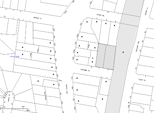
|
NOTIFICATION PLAN |
|
||
|
• PROPERTIES NOTIFIED
|
X SUBMISSIONS RECEIVED |
PROPERTY SUBJECT OF DEVELOPMENT |
|
|
4 SUBMISSIONS RECEIVED OUT OF MAP RANGE |
|||
Five submissions objected to the development, generally on the grounds that the development would result in:
· A 6 storey development that is contrary to the 5 storey height permitted;
· Unacceptable traffic volumes;
· Inadequate infrastructure to support an increase in population;
· Cumulative impacts of high rise developments on bush fire safety and emergency evacuation;
· The traffic survey submitted with the proposal is inadequate as it does not address the effects of emergency incidents on the Pacific Highway, including road accidents or bushfires;
· Unacceptable impact on on-street parking availability;
· Poor architectural merit, including poor use of colours and adoption of flat roofs that is inconsistent with the established residential character;
· Impact on residential amenity including noise, visual impact and privacy;
· Asbestos impacts during the demolition phase; and
· An excessive dwelling yield, that would cumulatively, with other developments in the Mount Colah precinct, exceed the predicted dwelling yield under the Housing Strategy.
The merits of the matters raised in community submissions have been addressed in the body of the report with the exception of the following:
5.1.1 Building Height of 6 Storeys
Concerns were raised that the development is 6 storeys, rather than 5 storeys as required by the Hornsby DCP. The development includes a mezzanine in the 5th floor which is not counted as a storey in accordance with the definitions within the Hornsby LEP 2013 and DCP 2013 that defines a storey as:
storey means a space within a building that is situated between one floor level and the floor level next above, or if there is no floor above, the ceiling or roof above, but does not include:
(a) a space that contains only a lift shaft, stairway or meter room, or
(b) a mezzanine, or
(c) an attic.
Concerns were also raised that the roof design should be amended to have pitched roof treatments to permit attic construction within the roof. This suggestion is contrary to the planning controls adopted for the precinct which requires flat roofs to minimise the perceived height, bulk and scale of developments.
5.1.2 Inadequate Infrastructure
Concerns are raised that existing infrastructure is inadequate to cater for an increased population. In particular, the traffic assessment did not consider the impact of the additional units when there was an emergency/ closure on the M1 and traffic was rerouted to the Pacific Highway. In addition, concerns were raised that additional units would increase noise, additional on-street parking and traffic congestion.
The suitability of the locality for high density residential development was considered by Council and the Department of Planning during the rezoning of the precinct. Weight must be given to the applicable zoning of the land in the resolution of a dispute as to the appropriate development of any site.
Concerns were raised that the new residents would decrease the amount of on-street parking currently available. The volume of on-site parking provided is consistent with that required by the Hornsby DCP for the proposed unit mix.
5.1.3 Development Inconsistent with the Existing Character of the Area
Concerns are raised that the development’s built form is not consistent with the existing village character of the area. The Land and Environment Court planning principle regarding the “assessment of height and bulk” as described in Veloshin v Randwick Council [2007] NSWLEC 428 advises that the appropriateness of a proposal’s height and bulk is most usefully assessed against planning controls related to these attributes, such as maximum height, floor space ratio, site coverage and setbacks. The planning controls for the 5 storey precinct are aimed at creating a new character for the precinct. Therefore, the planning principle requires that the development be consistent with the bulk and character intended by the planning controls. As previously discussed, the development is consistent with the desired future character for the precinct identified in the Hornsby Development Control Plan.
5.1.4 Privacy
A concern was raised that the development would impact on the privacy and amenity adjoining and nearby properties. The design of this building is required to take into account the desired future character of the precinct when considering potential privacy conflicts. The development generally provides a 6m setback to adjoining property boundaries which complies with half of the building separation provisions within the Hornsby DCP and RFDC.
5.1.5 Dwelling Yield / Bushfire Safety
Concern is raised that the density of the development achieved development applications submitted for the area already exceeds the yields planned for the precinct. It is contended that the safety of residents living in the area is jeopardised by the additional population in the event of an emergency.
The dwelling targets within Council’s Housing Strategy for the precinct are not development controls for the purpose of development assessment. These targets were based on indicative yields developed in consultation with the Department of Planning and based on densities achieved for this form of development in other local government areas. The indicative dwelling yields were a mechanism to demonstrate that Council’s dwelling target would be achieved. The yield is not included as a development control in Council’s planning instruments. The proposed number of units is subject to merit assessment in accordance with the requirements of the Hornsby Development Control Plan and impacts on the built environment. The density of the proposed development is guided by the Hornsby DCP requirements for building height, setbacks, landscaping, floorplates and separations, open space and dwelling mix.
During the rezoning process, Council consulted with the NSW RFS on a number of occasions. The RFS raised concerns regarding future development north of the Yirra Road overpass, in particular the Berowra and Mt Colah commercial centre precincts, after the exhibited plan had been referred to the Department of Planning for determination and gazettal. The Department of Planning deleted the precincts of concern to the RFS prior to gazetting the Housing Strategy. The subject site is not designated as bushfire prone.
5.1.6 Health and Safety of Neighbours During Demolition
A concern is raised regarding the health and safety of residents during the demolition of existing structures. A recommended condition of consent is included under Schedule 1 which requires that all demolition work must be carried out in accordance with “Australian Standards 2601-2001- Demolition of Structures” and that where asbestos material is being removed, must be undertaken by a contractor that holds an appropriate license issued by WorkCover NSW in accordance with Work Health and Safety legislation and signage must be erected in a prominent position visible from the street.
5.2 Public Agencies
The development application was referred to the following Agencies for comment:
5.2.1 RailCorp
The application was referred to RailCorp pursuant to the provisions of SEPP Infrastructure as the development involves excavation of land adjacent to a railway corridor. As addressed under Section 2.5.1 of this report, a deferred commencement condition is recommended to address the requirements of RailCorp.
6. THE PUBLIC INTEREST
Section 79C(1)(e) of the Act requires Council to consider “the public interest”.
The public interest is an overarching requirement, which includes the consideration of the matters discussed in this report. Implicit to the public interest is the achievement of future built outcomes adequately responding to and respecting the future desired outcomes expressed in environmental planning instruments and development control plans.
The application is considered to have satisfactorily addressed Council’s and relevant agencies’ criteria and would provide a development outcome that, on balance, would result in a positive impact for the community. Accordingly, it is considered that the approval of the proposed development as a deferred commencement would be in the public interest.
CONCLUSION
The application seeks approval for the demolition of existing structures and construction of a five storey residential flat buildings comprising 41 units and basement car parking.
The proposed development is generally in accordance with the development controls for the ‘Pacific Highway, Mount Colah’ Precinct of the Hornsby DCP and would contribute to the future desired five storey residential character of the precinct. With conditions, the minor non-compliance with prescriptive measures for setbacks, building separation and housing choice are considered acceptable. The proposal complies with the design principles of SEPP 65 and the Residential Flat Design Code.
The proposal would result in a development that would be in keeping with the desired future character of the precinct.
Approval of the application as a deferred commencement is recommended.
Note: At the time of the completion of this planning report, no persons have made a Political Donations Disclosure Statement pursuant to Section 147 of the Environmental Planning and Assessment Act 1979 in respect of the subject planning application.
RESPONSIBLE OFFICER
The officer responsible for the preparation of this Report is the Manager – Development Assessment – Rodney Pickles, who can be contacted on 9847 6731.
|
Rod Pickles Manager - Development Assessment Planning Division |
James Farrington Group Manager Planning Division |
|
1.View |
Locality Map |
|
|
|
2.View |
Site Plan |
|
|
|
3.View |
Floor Plans |
|
|
|
4.View |
Elevations |
|
|
|
5.View |
Landscape Plan |
|
|
|
6.View |
Shadow Plans |
|
|
File Reference: DA/629/2014
Document Number: D03944825
SCHEDULE 1
GENERAL CONDITIONS
The conditions of consent within this notice of determination have been applied to ensure that the use of the land and/or building is carried out in such a manner that is consistent with the aims and objectives of the relevant legislation, planning instruments and council policies affecting the land and does not disrupt the amenity of the neighbourhood or impact upon the environment.
Note: For the purpose of this consent, the term ‘applicant’ means any person who has the authority to act on or the benefit of the development consent.
Note: For the purpose of this consent, any reference to an Act, Regulation, Australian Standard or publication by a public authority shall be taken to mean the gazetted Act or Regulation, or adopted Australian Standard or publication as in force on the date that the application for a construction certificate is made.
1. Deferred Commencement
Pursuant to Section 80(3) of the Environmental Planning and Assessment Act 1979, this consent does not operate until the following information is submitted to Council:
Approval/Certification from Sydney Trains that the following items have been satisfied by the applicant:
a) Detailed design for the shoring wall This should include design parameters assumed including earth pressure co-efficient, the surcharges considered, details of any temporary/permanent anchors, predicted wall deflections and forces on the wall.
b) Shoring Plan & Details drawing 1809-S800 is to be amended to include other relevant rail structures such as railway power lines, overheard wiring structures etc.
c) Foundation layout plan for the development.
d) Final Geotechnical Report based on additional boreholes to enable the undertaking of impact assessment, detailed retaining wall design etc.
e) An Impact assessment report based on the Final Geotechnical Report. The report should include assessment of anticipated ground movements, anticipated vibration during activities such as excavation/piling/demolition etc. and mitigation measures.
f) Details as to how ground water will be managed during temporary excavation stage as well as at permanent stage. The effect of construction induced settlement due to groundwater drawdown potentially leading to track settlement is to be avoided at all times.
Such information shall be submitted within 12 months of the date of this notice.
Any conditions issued as part of the Sydney Trains (RailCorp) approval/certification of the above documents will also form part of the consent conditions that the Applicant is required to comply with.
Upon Council’s written satisfaction of the above information, the following conditions of development consent will apply:
2. Approved Plans and Supporting Documentation
The development must be carried out in accordance with the plans and documentation listed below and endorsed with Council’s stamp, except where amended by Council and/or other conditions of this consent:
|
Plan No. |
Plan Title |
Drawn by |
Dated |
|
Plan 1563 |
Survey Plan |
Richard & Lotus |
Feb 2014 |
|
A100 Issue C |
Site Plan |
Mackenzie Architects |
21-11-2014 |
|
A101 Issue B |
Car Parking Basement Plan 1 |
Mackenzie Architects |
3-11-2014 |
|
A102 Issue B |
Car Parking Basement Plan 2 |
Mackenzie Architects |
3-11-2014 |
|
A103 Issue C |
Ground Floor Plan |
Mackenzie Architects |
21-11-2014 |
|
A104 Issue C |
First Floor Plan |
Mackenzie Architects |
21-11-2014 |
|
A105 Issue C |
Second Floor Plan |
Mackenzie Architects |
21-11-2014 |
|
A106 Issue C |
Third Floor Plan |
Mackenzie Architects |
21-11-2014 |
|
A107 Issue C |
Fourth Floor Plan |
Mackenzie Architects |
21-11-2014 |
|
A108 Issue B |
Fifth Floor Plan |
Mackenzie Architects |
21-6-2014 |
|
A109 Issue B |
Roof Plan |
Mackenzie Architects |
21-6-2014 |
|
A200 Issue C |
Sections |
Mackenzie Architects |
21-11-2014 |
|
A300 Issue C |
Elevations South and East |
Mackenzie Architects |
21-11-2014 |
|
A301 Issue C |
Elevations North and West |
Mackenzie Architects |
21-11-2014 |
|
A401 Issue A |
Top Floor Setback |
Mackenzie Architects |
2-6-2014 |
|
A600 Issue A |
Adaptable Units |
Mackenzie Architects |
2-6-2014 |
|
A700 Issue A |
Schedule of Finishes |
Mackenzie Architects |
2-6-2014 |
|
SW01 to SW05 Rev B |
Stormwater Drainage Plans |
Cam Consulting |
6-6-14 |
|
Plan 6260 A1 |
Detail and Level Survey |
SDG |
29-04-14 |
|
1809-S800 A |
Shoring Plan & Details |
HKMA Engineers |
11-07-14 |
|
LPDA 14-378/1 Issue B |
Landscape Plan |
Conzept Landscape Architects |
June 2014 |
|
Plan No. |
Prepared by |
Dated |
|
Statement of Environmental Effects |
Think Planners |
6-6-2014 |
|
BASIX Certificate No. 551751M |
Greenview Consulting |
6-6-2014 |
|
Preliminary Geotechnical Assessment (P1404244JR01V01) |
Martens Consulting Engineers |
September 2014 |
|
Arborist Report |
Advanced Treescape Consulting |
6-6-2014 |
|
Traffic and Parking Assessment Report |
Terraffic – Traffic and Parking Consultants |
6-6-2014 |
|
Acoustic Report |
Acoustic Solutions |
2-6-2014 |
|
Waste Management Plan |
Mackenzie Architects |
10-6-2014 |
3. Amendment of Plans
The approved plans are to be amended as follows:
a) The landscape plan and stormwater drainage plans are to be amended to be consistent with the amended architectural plans A100-A109 Issue C, dated 21 November 2014.
b) The usable area of the balcony for Unit 40 is not to encroach within 6 metres of the side western boundary. The area of the balcony proposed with a setback between 4m – 6m is to be a non trafficable area as indicated in red on the approved plans.
c) The balcony for unit 34 is include a privacy screen on part of the western elevation as indicated in red on the approved plans.
d) The floor plans are to be amended to delete the wall adjacent to Unit 17, 26 and 35 that forms part of the 4m x 4m indentation on the western elevation, as indicated in red on the approved plans.
e) The floor plans are to be amended to delete the protruding wall that forms part of the 4m x 4m indentation on the eastern elevation, as indicated in red on the approved plans.
4. Removal of Existing Trees
This development consent permits the removal of 41 trees numbered 1, 2, 4, 5, 6, 7, 8, 9, 10, 13, 14, 15, 16, 17, 18, 19, 20, 21, 22, 23, 24, 25, 26, 27, 28, 29, 30, 31, 33, 34, 35, 36, 37, 38, 39, 40, 41, 42, 43, 44, 45 as identified in the Arboricultural Impact Assessment prepared by Advanced Treescape Consulting dated 6 June 2014. The removal of any other trees requires separate approval in accordance with the Tree and Vegetation Chapter 1B.6 Hornsby Development Control Plan (HDCP).
5. Construction Certificate
A Construction Certificate is required to be approved by Council or a Private Certifying Authority prior to the commencement of any works under this consent.
REQUIREMENTS PRIOR TO THE ISSUE OF A CONSTRUCTION CERTIFICATE
6. Section 94 Development Contributions
In accordance with Section 80A(1) of the Environmental Planning and Assessment Act 1979 and the Hornsby Shire Council Section 94 Development Contributions Plan 2012-2021, the following monetary contributions shall be paid to Council to cater for the increased demand for community infrastructure resulting from the development:
|
Description |
Contribution (4) |
|
Roads |
$18,523.80 |
|
Open Space and Recreation |
$414,465.80 |
|
Community Facilities |
$57,768.85 |
|
Plan Preparation and Administration |
$1,718.10 |
|
TOTAL |
$492,476.55 |
being for 24 x 1 bedroom units, 12 x 2 bedroom units and 5 x 3 bedroom units in lieu of two existing dwelling houses.
a) The value of this contribution is current as at 24 November 2014. If the contributions are not paid within the financial quarter that this condition was generated, the contributions payable will be adjusted in accordance with the provisions of the Hornsby Shire Council Section 94 Development Contributions Plan and the amount payable will be calculated at the time of payment in the following manner:
$CPY = $CDC x CPIPY
CPIDC
Where:
$CPY is the amount of the contribution at the date of Payment
$CDC is the amount of the contribution as set out in this Development Consent
CPIPY is the latest release of the Consumer Price Index (Sydney – All Groups) at the date of Payment as published by the ABS.
CPIDC is the Consumer Price Index (Sydney – All Groups) for the financial quarter at the date applicable in this Development Consent Condition.
b) The monetary contributions shall be paid to Council:
i) prior to the issue of the Subdivision Certificate where the development is for subdivision; or
ii) prior to the issue of the first Construction Certificate where the development is for building work; or
iii) prior to issue of the Subdivision Certificate or first Construction Certificate, whichever occurs first, where the development involves both subdivision and building work; or
iv) prior to the works commencing where the development does not require a Construction Certificate or Subdivision Certificate.
It is the professional responsibility of the Principal Certifying Authority to ensure that the monetary contributions have been paid to Council in accordance with the above timeframes.
Council’s Development Contributions Plan may be viewed at www.hornsby.nsw.gov.au or a copy may be inspected at Council’s Administration Centre during normal business hours.
7. Building Code of Australia
All building work must be carried out in accordance with the relevant requirements of the Building Code of Australia.
8. Contract of Insurance (Residential Building Work)
In the case of residential building work for which the Home Building Act 1989 requires there to be a contract of insurance in force in accordance with Part 6 of that Act, that such a contract of insurance is in force before any building work authorised to be carried out by the consent commences.
9. Notification of Home Building Act, 1989 Requirements
Residential building work within the meaning of the Home Building Act 1989 must not be carried out unless the principal certifying authority for the development to which the work relates (not being Council) has given Council written notice of the following information:
a) In the case of work for which a principal contractor is required to be appointed:
i) The name and licence number of the principal contractor; and
ii) The name of the insurer by which the work is insured under Part 6 of that Act.
b) In the case of work to be done by an owner-builder:
i) The name of the owner-builder; and
ii) If the owner-builder is required to hold an owner-builder’s permit under that Act, the number of the owner-builder’s permit.
Note: If arrangements for doing the residential building work are changed while the work is in progress so that the information notified becomes out of date, further work must not be carried out unless the principal certifying authority for the development to which the work relates (not being Council) has given Council written notification of the updated information.
10. Water/Electricity Utility Services
The applicant must submit written evidence of the following service provider requirements:
a) Ausgrid (formerly Energy Australia) – a letter of consent demonstrating that satisfactory arrangements have been made to service the proposed development.
b) Sydney Water – the submission of a ‘Notice of Requirements’ under s73 of the Sydney Water Act 1994.
Note: Sydney Water requires that s73 applications are to be made through an authorised Sydney Water Servicing Coordinator. Refer to www.sydneywater.com.au or telephone 13 20 92 for assistance.
11. Construction Traffic Management Plan
A Construction Traffic Management Plan detailing construction vehicle routes, number of trucks, hours of operation, access arrangements and traffic control should be submitted to Council prior to the issue of a construction certificate.
12. Accessible Units
The development is required to provide 12 units designed as adaptable housing pursuant to the requirements of 1C.2.2 of the Hornsby Development Control Plan. In this regard four (4) car parking spaces are to be designed for people with a disability and allocated to 4 adaptable units. The details of all adaptable units must be provided with the Construction Certificate plans.
13. Dilapidation Report
A ‘Dilapidation Report’ is to be prepared by a ‘chartered structural engineer’ detailing the structural condition of all adjoining properties.
14. Noise – Rail Corridor
The development must be carried out in accordance with the recommendations contained within the acoustic report submitted with the development application, prepared by Acoustic Solutions dated 2 June 2014 and the requirements of the Department of Planning’s Development Near Rail Corridors and Busy Roads – Interim Guideline and RailCorp’s Interim Guidelines for Applicants.
Note: The Department of Planning’s document is available at www.planning.nsw.gov.au (development assessments). The RailCorp document is available at www.railcorp.nsw.gov.au/publications.
15. Waste Management Details
The following waste management requirements must be complied with:
a) The garbage chute system must include volume handling equipment fitted with at least 2 of 660 L bins.
Note: The volume handling equipment is to automatically change the bin under the chute when it becomes full. It does not include a compactor.
16. Preservation of Survey Infrastructure
Prior to the issue of a construction certificate, a registered surveyor shall identify all survey marks in the vicinity of the proposed development. Any survey marks required to be removed or displaced as a result of the proposed development shall be undertaken by a registered surveyor in accordance with Section 24 (1) of the Surveying and Spatial Information Act 2002 and following the Surveyor General’s Directions No.11 – "Preservation of Survey Infrastructure".
17. Storage
Each dwelling within the development must have a minimum area for storage (not including kitchen and bedroom cupboards) of 6m³ for one bedroom units, 8m³ for two bedroom units and 10m³ for three bedroom units, where 50% is required to be located within the apartment and accessible from either the hall or living area. Details must be submitted with the Construction Certificate plans.
18. Basix
Amend Basix Certificate No.551751M to reflect the approved DA plans. Details must be submitted with the Construction Certificate Plans.
REQUIREMENTS PRIOR TO THE COMMENCEMENT OF ANY WORKS
19. Erection of Construction Sign
A sign must be erected in a prominent position on any site on which building work, subdivision work or demolition work is being carried out:
a) Showing the name, address and telephone number of the principal certifying authority for the work;
b) Showing the name of the principal contractor (if any) for any demolition or building work and a telephone number on which that person may be contacted outside working hours; and
c) Stating that unauthorised entry to the work site is prohibited.
Note: Any such sign is to be maintained while the building work, subdivision work or demolition work is being carried out, but must be removed when the work has been completed.
20. Protection of Adjoining Areas
A temporary hoarding, fence or awning must be erected between the work site and adjoining lands before the works begin and must be kept in place until after the completion of the works if the works:
a) Could cause a danger, obstruction or inconvenience to pedestrian or vehicular traffic.
b) Could cause damage to adjoining lands by falling objects.
c) Involve the enclosure of a public place or part of a public place.
Note: Notwithstanding the above, Council’s separate written approval is required prior to the erection of any structure or other obstruction on public land.
21. Toilet Facilities
Toilet facilities must be available or provided at the works site before works begin and must be maintained until the works are completed at a ratio of one toilet for every 20 persons employed at the site. Each toilet must:
a) be a standard flushing toilet connected to a public sewer; or
b) be a temporary chemical closet approved under the Local Government Act 1993; or
c) have an on-site effluent disposal system approved under the Local Government Act 1993.
22. Erosion and Sediment Control
Erosion and sediment control measures must be provided and maintained throughout the construction period in accordance with the manual ‘Soils and Construction 2004 (Bluebook)’, the approved plans, Council specifications and to the satisfaction of the principal certifying authority. The erosion and sediment control devices must remain in place until the site has been stabilised and revegetated.
Note: On the spot penalties up to $1,500 may be issued for any non-compliance with this requirement without any further notification or warning.
23. Tree Protection Barriers
Tree protection fencing must be erected around trees numbered 3, 11, 12 and 32 to be retained at the following metre setbacks in accordance with the Arboricultural report provided by Advanced Treescape Consulting.
|
Tree No. |
Tree Species |
Tree Protection Zone (TPZ) |
Structural Root Zone (SRZ) |
|
#3 |
Corymbia gummifera (Red Bloodwood) |
7.5 metres |
3.3 metres |
|
#11 |
T.plicata (Western Red Cedar) |
3.6 metres |
2.4 metres |
|
#12 |
Syzygium austral (Brush Cherry) |
9.6 metres |
3.1 metres |
|
#32 |
Macadamia tetraphylla (Rough-leaved Queensland Nut) |
7.2 metres |
2.7 metres |
Note: Tree No.3 is located within the centre median strip of Werombi Road. The existing road on either side would form part of the TPZ however no parking or storage of materials would be permitted within that central aisle. The area within the TPZ must be mulched at a minimum depth of 150mm to protect roots.
The tree fencing must be constructed of 1.8 metre ‘cyclone chainmesh fence’ or star pickets spaced at 2 metre intervals, connected by a continuous high-visibility barrier/hazard mesh at a height of 1 metre.
REQUIREMENTS DURING CONSTRUCTION
24. Construction Work Hours
All work on site (including demolition and earth works) must only occur between 7am and 5pm Monday to Saturday. No work is to be undertaken on Sundays or public holidays.
25. Demolition
All demolition work must be carried out in accordance with “Australian Standard 2601-2001 – The Demolition of Structures” and the following requirements:
a) Demolition material must be disposed of to an authorised recycling and/or waste disposal site and/or in accordance with an approved waste management plan;
b) Demolition works, where asbestos material is being removed, must be undertaken by a contractor that holds an appropriate licence issued by WorkCover NSW in accordance with Chapter 10 of the Occupational Health and Safety Regulation 2001 and Clause 29 of the Protection of the Environment Operations (Waste) Regulation 2005 ;and
c) On construction sites where buildings contain asbestos material, a standard commercially manufactured sign containing the words ‘DANGER ASBESTOS REMOVAL IN PROGRESS’ measuring not less than 400mm x 300mm must be erected in a prominent position visible from the street.
26. Environmental Management
The site must be managed in accordance with the publication ‘Managing Urban Stormwater – Landcom (March 2004) and the Protection of the Environment Operations Act 1997 by way of implementing appropriate measures to prevent sediment run-off, excessive dust, noise or odour emanating from the site during the construction of the development.
27. Works Near Trees
All required tree protection measures are to be maintained in good condition for the duration of the construction period.
All works (including driveways and retaining walls) within the designated tree protection zones of any trees required to be retained (whether or not on the subject property, and pursuant to this consent or the Tree Preservation Order), must be carried out under the supervision of an ‘AQF Level 5 Arborist’ and a certificate submitted to the principal certifying authority detailing the method(s) used to preserve the tree(s).
Note: Except as provided above, the applicant is to ensure that no excavation, filling or stockpiling of building materials, parking of vehicles or plant, disposal of cement slurry, waste water or other contaminants is to occur within 4 metres of any tree to be retained.
28. Council Property
During construction works, no building materials, waste, machinery or related matter is to be stored on the road or footpath. The public reserve must be kept in a clean, tidy and safe condition at all times.
29. Street Sweeping
Street sweeping must be undertaken following sediment tracking from the site along Werombi Road during works and until the site is established.
30. Disturbance of Existing Site
During construction works, the existing ground levels of open space areas and natural landscape features, (including natural rock-outcrops, vegetation, soil and watercourses) must not be altered unless otherwise nominated on the approved plans.
31. Landfill
Landfill must be constructed in accordance with Council’s ‘Construction Specification 2005’ and the following requirements:
a) All fill material imported to the site is to wholly consist of Virgin Excavated Natural Material (VENM) as defined in Schedule 1 of the Protection of the Environment Operations Act 1997 or a material approved under the Department of Environment and Climate Change’s general resource recovery exemption.
b) A compaction certificate is to be obtained from a geotechnical engineer verifying that the specified compaction requirements have been met.
32. Excavated Material
All excavated material removed from the site must be classified in accordance with the Department of Environment, Climate Change and Water NSW Waste Classification Guidelines prior to disposal to an approved waste management facility and reported to the principal certifying authority.
33. Contamination During Construction Works
Should the presence of asbestos or soil contamination, not recognised during the application process be identified during demolition, the applicant must immediately notify the Principal Certifying Authority and Council.
34. Survey Report – Finished Floor Level
A report(s) must be prepared by a registered surveyor and submitted to the principal certifying authority prior to the pouring of concrete at each level of the building certifying that:
a) The building, retaining walls and the like have been correctly positioned on the site; and
b) The finished floor level(s) are in accordance with the approved plans.
35. Waste Management Details
Waste management during the demolition and construction phase of the development must be undertaken in accordance with the approved Waste Management Plan. Additionally written record of the following items must be maintained during the removal of any waste from the site and such information submitted to the Principal Certifying Authority within fourteen days of the date of completion of the works;
a) The identity of the person removing the waste.
b) The waste carrier vehicle registration.
c) Date and time of waste collection.
d) A description of the waste (type of waste and estimated quantity).
e) Details of the site to which the waste is to be taken.
f) The corresponding tip docket/receipt from the site to which the waste is transferred (noting date and time of delivery, description (type and quantity) of waste).
g) Whether the waste is expected to be reused, recycled or go to landfill.
Note: In accordance with the Protection of the Environment Operations Act 1997, the definition of waste includes any unwanted substance, regardless of whether it is reused, recycled or disposed to landfill.
REQUIREMENTS PRIOR TO THE ISSUE OF AN OCCUPATION CERTIFICATE
Note: For the purpose of this consent, a reference to ‘occupation certificate’ shall not be taken to mean an ‘interim occupation certificate’ unless otherwise stated.
36. Fulfilment of BASIX Commitments
The applicant must demonstrate the fulfilment of BASIX commitments pertaining to the development.
37. External Lighting
All external lighting must be designed and installed in accordance with Australian Standard AS 4282 – Control of the Obtrusive Effects of Outdoor Lighting. Certification of compliance with the Standard must be obtained from a suitably qualified person.
38. Consolidation of Allotments
All allotments the subject of this consent must be consolidated into one allotment prior to the issue of the Occupation Certificate.
Note: The applicant is recommended to submit the plan of subdivision to consolidate allotments to the NSW Department of Lands at least 4-6 weeks prior to seeking an occupation certificate.
39. Sydney Water – s73 Certificate
An s73 Certificate must be obtained from Sydney Water.
40. Stormwater Drainage
The stormwater drainage system for the development must be designed and constructed for an average recurrence interval of 20 years and be gravity drained in accordance with the following requirements:
a) Connected to an existing Council drainage system via an on-site detention system.
b) Be designed by a Chartered Professional Engineer/ Civil Engineer of the Institution of Engineers, Australia.
c) A construction certificate is to be submitted to Council for construction of stormwater pipe from the development site to the Council system on opposite side of Werombi Road in accordance with Council‘s Civil works Specifications 2005. The minimum size of the pipe within Council’s road reserve is to be 375mm in diameter.
Note: Council is the only authority to approve works within Road Reserve.
41. On Site Stormwater Detention
An on-site stormwater detention system must be designed by a chartered civil engineer and constructed in accordance with the following requirements:
a) Storage capacity to accommodate volume from up to 20 years ARI (average recurrence interval) and a maximum discharge (when full) limited to 5 years pre development rate.
b) Have a surcharge/inspection grate located directly above the outlet.
c) Discharge from the detention system to be controlled via 1 metre length of pipe, not less than 50 millimetres diameter or via a stainless plate with sharply drilled orifice bolted over the face of the outlet discharging into a larger diameter pipe capable of carrying the design flow to an approved Council system.
d) Where above ground and the average depth is greater than 0.3 metres, a ‘pool type’ safety fence and warning signs to be installed.
e) Not be constructed in a location that would impact upon the visual or recreational amenity of residents.
f) Detail calculations are to be shown in construction certificate plan.
42. Vehicular Crossing
A separate application under the Local Government Act 1993 and the Roads Act 1993 must be submitted to Council for the installation of a new vehicular crossing and the removal of the redundant crossing. The vehicular crossing must be constructed in accordance with Council’s Civil Works Design 2005 and the following requirements:
a) Any redundant crossings must be replaced with integral kerb and gutter;
b) The footway area must be restored by turfing;
c) Approval must be obtained from all relevant utility providers that all necessary conduits be provided and protected under the crossing.
Note: An application for a vehicular crossing can only be made to one of Council’s Authorised Vehicular Crossing Contractors. You are advised to contact Council on 02 9847 6940 to obtain a list of contractors.
43. Internal Driveway/Vehicular Areas
The driveway and parking areas on site must be designed in accordance with Australian Standards 2890.1, 2890.2, 3727 and the following requirements:
a) Design levels at the front boundary must be obtained from Council;
b) The driveway must be a rigid pavement.
c) Parking in the basement is to be allocated to the units in accordance with the following minimum parking rates:
i) 1 bed units - 0.75 car spaces/ unit (average)
ii) 2 bed units – 1 car space/ unit
iii) 3 bed units – 1.5 car spaces/ unit (average)
iv) Visitors – 5 car spaces and 1 motorcycle space
d) Storage cages in the basement are to be allocated to the units in accordance with Condition No.17.
44. Bicycle Parking
A total of 14 bicycle parking spaces are to be provided within the basement, including 9 spaces and 5 visitor spaces.
45. Road Works
All road works approved under this consent must be constructed in accordance with Council’s Civil Works Design and Construction Specification 2005 and the following requirements:
a) Werombi Road fronting the development site is to be reconstructed/upgraded to the following standards:
i) Half width of 11m carriageway from kerb to kerb is to be constructed, centred between road boundaries.
ii) Half of 15m diameter cul de sac is to be constructed.
iii) The existing road pavement to be saw cut a minimum of 300mm from the existing edge of the bitumen and reconstructed.
iv) Existing pavement must be replaced where inadequate.
v) New kerb and gutter and footpath are to be constructed replacing the old.
vi) Proper transition must be made to adjoining kerb and gutter.
b) A construction certificate is to be submitted to Council for approval.
Note: Council is the only authority to approve works within Council roads.
46. Traffic Control Plan
A Traffic Control Plan (TCP) must be prepared by a qualified traffic controller in accordance with the Roads & Traffic Authority’s Traffic Control at Worksites Manual 1998 and Australian Standard 1742.3 for all work on a public road and be submitted to Council. The TCP must detail the following:
a) Arrangements for public notification of the works.
b) Temporary construction signage.
c) Permanent post-construction signage.
d) Vehicle movement plans.
e) Traffic management plans.
f) Pedestrian and cyclist access/safety.
47. Works as Executed Plan
A works-as-executed plan(s) must be prepared by a registered surveyor and submitted to Council for completed road pavement, kerb & gutter, public drainage systems, driveways and on-site detention system.
48. Creation of Easements
The following matter(s) must be nominated on the plan of subdivision under s88B of the Conveyancing Act 1919:
a) A right of access or the creation of an appropriate "Positive Covenant" and "Restriction as to User" over the constructed on-site detention/retention systems and outlet works, within the lots in favour of Council in accordance with Council’s prescribed wording. The position of the on-site detention system is to be clearly indicated on the title.
b) To register the OSD easement, the restriction on the use of land “works-as-executed” details of the on-site-detention system must be submitted verifying that the required storage and discharge rates have been constructed in accordance with the design requirements. The details must show the invert levels of the onsite system together with pipe sizes and grades. Any variations to the approved plans must be shown in red on the “works-as-executed” plan and supported by calculations.
Note: Council must be nominated as the authority to release, vary or modify any easement, restriction or covenant.
49. Installation of Air Conditioner
To protect the amenity of adjacent properties, the condenser unit for the air conditioner must be sited a minimum of 3 metres from the property boundary of any adjoining residential premises unless a certificate has been prepared by a suitably qualified person confirming that the unit has been tested for heating and cooling on the highest settings and that the noise levels generated do not exceed 5 dB(A) above background noise levels when tested at the property boundary between 8 pm and 10 pm.
50. Car Parking
All car parking must be constructed and operated in accordance with Australian Standard AS/NZS 2890.1:2004 – Off-street car parking and Australian Standard AS 2890.2:2002 – Off-street commercial vehicle facilities.
a) All parking areas and driveways are to be sealed to an all-weather standard, line marked and signposted;
b) Car parking, loading and manoeuvring areas to be used solely for nominated purposes;
c) Vehicles awaiting loading, unloading or servicing shall be parked on site and not on adjacent or nearby public roads;
d) All vehicular entry on to the site and egress from the site shall be made in a forward direction.
51. Safety and Security
This site must include the following elements:
a) An intercom system must be installed at gate locations to ensure screening of persons entering the units.
b) The entry doors to the pedestrian foyer is to be constructed of safety rated glass to enable residents a clear line of site before entering or exiting the residential apartments.
c) Lighting is to be provided to pathways, building foyer entries, driveways and common external spaces.
d) Security gate access is to be provided to the car parking areas allowing residents-only access to private car spaces.
e) The communal open space, at the rear of the site must be illuminated with high luminance by motion sensor lighting.
f) The driveway and basement car parking must be illuminated with low luminance at all times.
g) Security deadlocks are to be provided to each apartment door.
h) Peep holes are to be provided to individual apartment doors to promote resident safety.
52. Installation of Privacy Devices
The following device(s) must be installed to maintain an element of privacy towards the adjoining property:
a) All habitable room windows located less than 6m from the western boundary on the lower 4 floors, where the finished floor level is more than 0.5m above ground, are to be provided with a 1.5m high sill;
b) All habitable room windows located less than 9m from the western on the 5th storey (Plan A107) are to be provided with a 1.5m high sill or privacy screen;
c) All balconies located less than 6m from the western boundary, where the finished floor level is more than 0.5m above ground, are to be provide a fixed 1.5m high privacy screen;
d) Any required privacy screen must have no individual openings more than 30mm wide and have a total of all openings less than 30% of the surface area of the screen.
53. Waste Management
The following waste management requirements must be complied with:
a) The garbage rooms at the basement level must include water or a hose for cleaning, graded floors with drainage to sewer, a robust door, sealed and impervious surface, adequate lighting and ventilation, and must be lockable. The waste facility at each residential level must include sealed and impervious surface, adequate lighting and ventilation.
b) A report must be prepared by an appropriately qualified person, certifying the following:
i) A comparison of the estimated quantities of each waste type against the actual quantities of each waste type. Note: Explanations of any deviations to the approved Waste Management Plan is required to be included in this report
ii) That at least 60% of the waste generated during the demolition and construction phase of the development was reused or recycled. Note: If the 60% diversion from landfill cannot be achieved in the Construction Stage, the Report is to include the reasons why this occurred and certify that appropriate work practices were employed to implement the approved Waste Management Plan. The Report must be based on documentary evidence such as tipping dockets/receipts from recycling depots, transfer stations and landfills, audits of procedures etc. which are to be attached to the report.
iii) All waste was taken to site(s) that were lawfully permitted to accept that waste.
c) A report(s) must be prepared by a registered surveyor and submitted to the principal certifying authority prior to the issue of the Subdivision/Occupation Certificate, certifying that the finished access way (including ramp, loading bay and site entry/exit) to be used by waste collection vehicles, complies with Australian Standard AS2890.2-2002 Parking Facilities Part 2: Off-street Commercial Vehicle Facilities for small rigid vehicles.
d) Each unit must be provided with an indoor waste/recycling cupboard for the interim storage of a minimum one day’s waste generation with separate containers for general waste and recyclable materials.
e) Space must be provided for either individual compost containers for each unit or a communal compost container;
Note: The location of the compost containers should have regard for potential amenity impacts.
f) The bin carting routes must be devoid of any steps.
Note: Ramps between different levels are acceptable.
g) Access to the waste volume handling equipment by unauthorised persons (including residents and waste collectors) must be prevented.
Note: Caging of the volume handling equipment is acceptable.
h) No Parking” signs must be installed to prevent cars parking in the loading bay.
i) The 3.5 metre vertical clearance height within the truck travel path must not be reduced by ducting, pipes or anything else.
54. Garbage Collection Easement
For the purpose of waste collection, an easement entitling Council, its servants and agents and persons authorised by it to enter upon the subject land and to operate thereon, vehicles and other equipment for the purposes of garbage collection must be granted to Council by the owner of the land.
Note: The easement must be in a form prescribed by Council and must include covenants to the effect that parties will not be liable for any damage caused to the subject land or any part thereof or to any property located therein or thereon by reason of the operation thereon of any vehicle or other equipment used in connection with the collection of garbage and to the effect that the owner for the time being of the subject land shall indemnify the Council, its servants, agents and persons authorised by it to collect garbage against liability in respect of any such claims made by any person whomsoever.
55. Certificate of Preservation of Survey Marks
A certificate by a Registered Surveyor shall be submitted to the Principal Certifying Authority, certifying that there has been no removal, damage, destruction, displacement or defacing of the existing survey marks in the vicinity of the proposed development or otherwise the re-establishment of damaged, removed or displaced survey marks has been undertaken in accordance with the Surveyor General’s Direction No.11 – “Preservation of Survey Infrastructure”.
56. Unit Numbering
The allocation of unit numbering must be authorised by Council prior to the numbering of each unit in the development.
57. Retaining Walls
All required retaining walls must be constructed as part of the development.
58. Boundary Fencing
Fencing must be erected along all property boundaries behind the front building alignment to a height of 1.8 metres above existing ground level. Fences to the primary frontage in front of the building alignment are to retain visual transparency (not lapped / solid) and be 1.2 metres in height.
Note: Alternative fencing behind the front building line may be erected subject to the written consent of the adjoining property owner(s).
59. Planter Boxes/On Slab Planting
On slab planter boxes must include waterproofing, subsoil drainage (proprietary drainage cell, 50mm sand and filter fabric) automatic irrigation, minimum 500mm planting soil for shrubs and minimum 1000mm planting soil for trees and palms and 75mm mulch to ensure sustainable landscape is achieved.
60. Completion of Landscaping
A certificate must be provided by a practicing landscape architect, horticulturalist or person with similar qualifications and experience certifying that all required landscaping works have been satisfactorily completed in accordance with the approved landscape plans.
Note: Advice on suitable species for landscaping can be obtained from Council’s planting guide ‘Indigenous Plants for the Bushland Shire’, available at www.hornsby.nsw.gov.au.
OPERATIONAL CONDITIONS
61. Landscape Establishment
The landscape works must be maintained into the future to ensure the establishment and successful growth of plant material to meet the intent of the landscape design. This must include but not limited to watering, weeding, replacement of failed plant material and promoting the growth of plants through standard industry practices.
62. Waste Management
The waste management on site must be in accordance with the following requirements:
a) A site caretaker must be employed and be responsible for moving bins where and when necessary, washing bins and maintaining waste storage areas, ensuring the chute system and related devices are maintained in effective and efficient working order, managing the communal composting area, managing the bulky item storage area, arranging the prompt removal of dumped rubbish, and ensuring cars do not park in the loading bay and that all residents are informed of the use of the waste management system.
b) Site security measures implemented on the property, including electronic gates, must not prevent access to the bin room/collection point by waste removal services.
63. Car Park
The operation of the basement car park must be in accordance with the following requirements:
a) Any proposed landscaping and/or fencing must not restrict sight distance to pedestrians and cyclists travelling along the footpath.
b) Residential parking spaces are to be secure spaces with access controlled by card or numeric pad.
c) Visitors must be able to access the visitor parking spaces in the basement car park at all times.
d) All parking for people with disabilities is to comply with AS/NZS 2890.6:2009 Off-street parking for people with disabilities.
e) Bicycle parking spaces are to be designed in accordance with AS 2890.3-1993 Bicycle parking facilities
f) One motorcycle parking space be provided and are to be designed in accordance with AS 2890.5-1993.
64. Noise
All noise generated by the proposed development must be attenuated to prevent levels of noise being emitted to adjacent premises which possess tonal, beating and similar characteristics or which exceeds background noise levels by more than 5dB(A).
65. Fire Safety Statement - Annual
On at least one occasion in every 12 month period following the date of the first ‘Fire Safety Certificate’ issued for the property, the owner must provide Council with an annual ‘Fire Safety Certificate’ to each essential service installed in the building.
CONDITIONS OF CONCURRENCE – ROADS AND MARITIME SERVICES
The following conditions of consent are from the nominated state agency pursuant to section 79b of the Environmental Planning and Assessment Act 1979 and must be complied with to the satisfaction of that agency.
66. GTA1 – Car Parking
The layout of the proposed car parking areas associated with the subject development (including driveways, grades, turn paths. Sight distance requirements, aisle widths, aisle lengths and parking bay dimensions) should be in accordance with AS 2890.1 – 2004 and AS 2890.2 – 2002 for heavy vehicle usage.
67. GTA2 – Traffic Noise
The proposed development should be designed so that road traffic noise from the Pacific Highway is mitigated by durable materials in order to satisfy the requirements for habitable rooms under Clause 102 (3) of the State Environmental Planning Policy (Infrastructure) 2007.
CONDITIONS OF CONCURRENCE – SYDNEY TRAINS (RAILCORP)
The following conditions of consent are from the nominated state agency pursuant to Section 79b of the Environmental Planning and Assessment Act 1979 and must be complied with to the satisfaction of that agency.
68. Sydney Trains (RailCorp)
The proposal must comply with the following conditions prescribed by Sydney Trains:
B1. All excavation, shoring and piling works with 25m of the rail corridor are to be supervised by a geotechnical engineer experienced with such excavation projects.
B2. No rock anchors/bolts are to be installed into Sydney Trains property.
B3. The following items are to be submitted to Sydney Trains for review and endorsement prior to the issuing of a Construction Certificate:
Ø Machinery to be used during excavation/construction.
Ø If required by Sydney Trains, track monitoring plan detailing the proposed method of track monitoring during excavation and construction phases.
Ø If required by Sydney Trains, a rail safety plan including instrumentation and the monitoring regime.
The Principal Certifying Authority is not to issue the Construction Certificate until it has received written confirmation from Sydney Trains that this condition has been complied with.
B4. No modifications may be made to that approved design without the consent of Sydney Trains.
B5. No work is permitted within the rail corridor, or rail easements, at any time unless prior approval or an Agreement has been entered into with Sydney Trains.
B6. Prior to the commencement of works and prior to the issue of the Occupation Certificate, a joint inspection of the rail infrastructure and property in the vicinity of the project (especially the retaining wall and rail track formation) is to be carried out by representatives from Sydney Trains and the Applicant. These dilapidation surveys will establish the extent of any existing damage and enable any deterioration during construction to be observed. The submission of a detailed dilapidation report will be required unless otherwise notified by Sydney Trains.
B7. Prior to the commencement of works, the Applicant shall peg-out the common boundary with the rail corridor and/or rail easement to ensure that there is no encroachment. This work is to be undertaken by a registered surveyor.
B8. An acoustic assessment is to be submitted to Council prior to the issue of a construction certificate demonstrating how the proposed development will comply with the Department of Planning’s document titled “Development Near Rail Corridors and Busy Roads- Interim Guidelines”. The Applicant must incorporate in the development all the measures recommended in the report.
B9. Prior to the issue of a Construction Certificate the Applicant is to engage an Electrolysis Expert to prepare a report on the Electrolysis Risk to the development from stray currents. The Applicant must incorporate in the development all the measures recommended in the report to control that risk. A copy of the report is to be provided to the Principal Certifying Authority with the application for a Construction Certificate.
B10. Given the possible likelihood of objects being dropped or thrown onto the rail corridor from balconies, windows and other external features (e.g. roof terraces and external fire escapes) that are within 20m and face the rail corridor, the Applicant is required to install measures (e.g. awning windows, louvres, enclosed balconies, window restrictors etc.) which prevent the throwing of objects onto the rail corridor. These measures are to comply with Sydney Trains requirements. The Principal Certifying Authority is not to issue the Construction Certificate until it has confirmed that these measures are to be installed and have been indicated on the Construction Drawings.
B11. The design, installation and use of lights, signs and reflective materials, whether permanent or temporary, which are (or from which reflected light might be) visible from the rail corridor must limit glare and reflectivity to the satisfaction of Sydney Trains.
The Principal Certifying Authority is not to issue the Construction Certificate until written confirmation has been received from Sydney Trains confirming that this condition has been satisfied.
B12. Prior to the issue of a Construction Certificate a Risk Assessment/Management Plan and detailed Safe Work Method Statements (SWMS) for the proposed works are to be submitted to Sydney Trains for review and comment on the impacts on rail corridor. The Principal Certifying Authority is not to issue the Construction Certificate until written confirmation has been received from Sydney Trains confirming that this condition has been satisfied.
B13. No metal ladders, tapes and plant/machinery, or conductive material are to be used within 6 horizontal metres of any live electrical equipment. This applies to the train pantographs and 1500V catenary, contact and pull-off wires of the adjacent tracks, and to any high voltage aerial supplies within or adjacent to the rail corridor.
B14. Prior to the issuing of a Construction Certificate the Applicant is to submit to Sydney Trains a plan showing all craneage and other aerial operations for the development and must comply with all Sydney Trains requirements. The Principal Certifying Authority is not to issue the Construction Certificate until written confirmation has been received from the Sydney Trains confirming that this condition has been satisfied.
B15. The Applicant is to obtain Sydney Trains endorsement prior to the installation of any hoarding or scaffolding facing the common boundary with the rail corridor.
B16. Prior to the issuing of an Occupation Certificate the Applicant is to submit the as-built drawings to Sydney Trains and Council.
The Principal Certifying Authority is not to issue the Occupation Certificate until written confirmation has been received from Sydney Trains confirming that this condition has been satisfied.
- END OF CONDITIONS –
ADVISORY NOTES
The following information is provided for your assistance to ensure compliance with the Environmental Planning and Assessment Act, 1979, Environmental Planning and Assessment Regulation 2000, other relevant legislation and Council’s policies and specifications. This information does not form part of the conditions of development consent pursuant to Section 80a of the Act.
Environmental Planning and Assessment Act 1979 Requirements
The Environmental Planning and Assessment Act 1979 requires:
· The issue of a construction certificate prior to the commencement of any works. Enquiries can be made to Council’s Customer Services Branch on 9847 6760.
· A principal certifying authority to be nominated and Council notified of that appointment prior to the commencement of any works.
· Council to be given at least two days written notice prior to the commencement of any works.
· Mandatory inspections of nominated stages of the construction inspected.
· An occupation certificate to be issued before occupying any building or commencing the use of the land.
Long Service Levy
In accordance with Section 34 of the Building and Construction Industry Long Service Payments Act 1986, a ‘Long Service Levy’ must be paid to the Long Service Payments Corporation or Hornsby Council.
Note: The rate of the Long Service Levy is 0.35% of the total cost of the work.
Note: Hornsby Council requires the payment of the Long Service Levy prior to the issue of a construction certificate.
Tree and Vegetation Preservation
In accordance with Clause 5.9 of the Hornsby Local Environmental Plan 2013 a person must not ringbark, cut down, top, lop, remove, injure or wilfully destroy any tree or other vegetation protected under the Hornsby Development Control Plan 2013 without the authority conferred by a development consent or a permit granted by Council.
Notes: A tree is defined as a long lived, woody perennial plant with one or relatively few main stems with the potential to grow to a height greater than three metres (3M). (HDCP 1B.6.1.c).
Tree protection measures and distances are determined using the Australian Standard AS 4970:2009, “Protection of Trees on Development Sites”.
Fines may be imposed for non-compliance with both the Hornsby Local Environmental Plan 2013 and the Hornsby Development Control Plan 2013.
Disability Discrimination Act
The applicant’s attention is drawn to the existence of the Disability Discrimination Act. A construction certificate is required to be obtained for the proposed building/s, which will provide consideration under the Building Code of Australia, however, the development may not comply with the requirements of the Disability Discrimination Act. This is the sole responsibility of the applicant.
Dial Before You Dig
Prior to commencing any works, the applicant is encouraged to contact Dial Before You Dig on 1100 or www.dialbeforeyoudig.com.au for free information on potential underground pipes and cables within the vicinity of the development site.
Telecommunications Act 1997 (Commonwealth)
If you are aware of any works or proposed works which may affect or impact on Telstra’s assets in any way, you are required to contact: Telstra’s Network Integrity Team on Phone Number 1800810443.
Asbestos Warning
Should asbestos or asbestos products be encountered during demolition or construction works, you are advised to seek advice and information prior to disturbing this material. It is recommended that a contractor holding an asbestos-handling permit (issued by WorkCover NSW)be engaged to manage the proper handling of this material. Further information regarding the safe handling and removal of asbestos can be found at:
Alternatively, telephone the WorkCover Asbestos and Demolition Team on 8260 5885.
House Numbering
House numbering can only be authorised by Council. Before proceeding to number each premise in the development, the allocation of numbers is required to be obtained from Council's Planning Division prior to the issue of a Subdivision Certificate. The authorised numbers are required to comply with Council’s Property Numbering Policy and be displayed in a clear manner at or near the main entrance to each premise.
Group Manager’s Report No. PL89/14
Planning Division
Date of Meeting: 10/12/2014
11 DEVELOPMENT APPLICATION - SUBDIVISION OF TWO ALLOTMENTS INTO FOUR LOTS - 7 AND 9 WELHAM STREET, BEECROFT
EXECUTIVE SUMMARY
|
DA No: |
DA/1442/2013 (Lodged 24 December 2013) |
|
Description: |
Subdivision of two allotments into four lots |
|
Properties: |
Lots 10 and 11, Sec 1, DP 758074, Nos. 7 and 9 Welham Street, Beecroft |
|
Applicant: |
P S Graham and Associates |
|
Owners: |
Carnarvon 81 Pty Limited Mr Jeffrey Chien-Hong Yeh Ms Sze En Feng |
|
Estimated Value: |
$290,000 |
|
Ward: |
C |
· The application proposes the subdivision of two allotments into four lots.
· The proposal generally complies with the Hornsby Local Environmental Plan 2013 and the Hornsby Development Control Plan 2013.
· A total of 55 submissions were received in respect of the application.
· A Red Sticker has been placed on the application requiring that it be determined at a Council meeting.
· It is recommended that the application be approved as a deferred commencement subject to the registration of an easement over downstream land.
|
THAT Development Application No. DA/1442/2013 for subdivision of two allotments into four lots at Lot 10, Sec 1, DP 758074 and Lot 11, Sec 1, DP 758074, Nos. 7 and 9 Welham Street, Beecroft be approved as a deferred commencement pursuant to Section 80(3) of the Environmental Planning and Assessment Act, 1979 subject to the conditions of consent detailed in Schedule 1 of Group Manager’s Report No. PL89/14. |
BACKGROUND
The application was lodged on 24 December 2013 for the subdivision of two allotments into four lots and demolition of the dwelling house at No. 7 Welham Street. The access handle was proposed to be located on the shared boundary between No. 7 and No. 9 Welham Street.
On 1 April 2014, amended plans were submitted at Council’s request to retain the dwelling house identified as a contributory item to the Heritage Conservation Area at No. 7 Welham Street, and the relocation of the access handle to the northern boundary of No. 7.
Councils engineering assessment determined that the subdivision could not adequately drain stormwater to Welham Street. Therefore, on 29 October 2014, amended plans were submitted to Council proposing to create an easement to drain stormwater through the adjoining properties, No. 8 and 8A Kirkham Street, Beecroft.
SITE
The site is located on the south-eastern side of Welham Street, Beecroft and has a total site area of 3,237.5m2. Property No. 7 Welham Street contains a single storey, brick dwelling house with a detached garage located at the rear. Property No. 9 Welham Street contains a part 1 and part 2 storey dwelling house with a detached garage and an inground swimming pool located to the rear of the dwelling house.
The sites experience an average fall of 6% to the southern rear boundary corner.
The site is not located with bushfire prone land and is not flood prone.
The site does not contain a heritage listed item under Schedule 5 of the Hornsby Local Environmental Plan 2013. However, the site is located within the Beecroft/Cheltenham Heritage Conservation Area. The dwelling house at No. 7 Welham Street is assessed as a contributory item within the Beecroft/Cheltenham Heritage Conservation Area.
The site is in the vicinity of six heritage listed items of local significance, namely the house and gardens at No. 110 Beecroft Road, the house and gardens at No. 112 Beecroft Road, “Ravenhurst” and gardens at No. 114 Beecroft Road, the garden, fence and hedge at No. 116 Beecroft, the house at No. 118 Beecroft Road, and the house at No. 8 Kirkham Street, Beecroft.
The surrounding developments consist predominantly of single dwelling houses on residential lots.
PROPOSAL
The application proposes the subdivision of two allotments into four lots and the retention of both dwelling houses in the following configuration:
The northern lot (Lot No. 1) fronting Welham Street would have an area of 713.2m2 and would contain the existing dwelling house at No. 7 Welham Street.
The eastern lot (Lot No. 2) would have an area of 756.3m2 (620.3m2 excluding the access handle).
The southern lot (Lot No. 3) would have an area of 765.5m2 (667m2 excluding the access handle).
The western lot (Lot No. 4) fronting Welham Street would have an area of 1002.5m2 and would contain the existing dwelling house at No. 9 Welham Street.
The access handle for Lots No. 1, No. 2 and No. 3 would have a total area of 234.5m2 and is located adjacent to the northern side boundary of No. 7 Welham Street.
ASSESSMENT
The development application has been assessed having regard to the ‘Metropolitan Plan for Sydney 2031’, the ‘North Subregion (Draft) Subregional Strategy’ and the matters for consideration prescribed under Section 79C of the Environmental Planning and Assessment Act 1979 (the Act). The following issues have been identified for further consideration.
1. STRATEGIC CONTEXT
1.1 Metropolitan Plan for Sydney and (Draft) North Subregional Strategy
The (Draft) Metropolitan Strategy for Sydney 2031 is a broad framework to provide for Sydney’s growth to help plan for housing, employment, transport, infrastructure, the environment and open space. It outlines a vision for Sydney to 2031; the challenges faced, and the directions to follow to address these challenges and achieve the vision.
The North Subregion comprises Hornsby, Kuring-gai, Manly, Warringah and Pittwater Local Government Areas. The Draft North Subregional Strategy provided a framework for Council in its preparation of the Hornsby Local Environmental Plan 2013.
Within the North Subregion, the Draft Metropolitan Strategy proposes:
· Population growth of 81,000 from the current 2011 baseline of 529,000
· Housing growth of 37,000 from the current 2011 baseline of 204,000
· Employment growth of 39,000 from the current 2011 baseline of 186,000
The proposed development would be consistent with the Metropolitan Plan for Sydney 2031 by providing an additional two residential allotments capable of accommodating dwelling-houses.
2. STATUTORY CONTROLS
Section 79C(1)(a) requires Council to consider “any relevant environmental planning instruments, draft environmental planning instruments, development control plans, planning agreements and regulations”.
2.1 Hornsby Local Environmental Plan 2013
The subject land is zoned R2 Low Density Residential under the Hornsby Local Environmental Plan 2013 (HLEP). The objectives of the R2 zone are:
(a) To provide for the housing needs of the community within a low density residential environment.
(b) To enable other land uses that provide facilities or services to meet the day to day needs of residents.
The proposed development is defined as ‘Subdivision’ under the HLEP and is permissible in the zone with Council’s consent.
2.1.1 Clause 4.1 - Minimum Lot Size
Clause 4.1 of the HLEP prescribes that the minimum lot size applicable to the site is 600m2 (excluding the area of the access handle). The proposal complies with the minimum lot size development standard.
2.1.2 Clause 5.10 - Heritage Conservation
The objectives of Clause 5.10 of HLEP are as follows:
(a) to conserve the environmental heritage of Hornsby,
(b) to conserve the heritage significance of heritage items and heritage conservation areas, including associated fabric, settings and views,
(c) to conserve archaeological sites,
(d) to conserve Aboriginal objects and Aboriginal places of heritage significance.
On 24 January 2014, the application was referred to Council’s Heritage Advisory Committee (HAC) for consideration and objections were raised to the demolition of the dwelling house at No. 7 Welham Street. The Committee assessed the dwelling house as a contributory item to the Beecroft/Cheltenham Heritage Conservation Area being a 1925 Federation style dwelling house representative and sympathetic to the nearby dwelling houses within Welham Street.
On 1 April 2014, following the advice of the Heritage Advisory Committee, the application submitted a revised heritage impact assessment and amended plans proposing the retention of the dwelling house at No. 7 Welham Street.
The amended proposal was considered by the HAC at its meeting on 15 July 2014, and further objections were raised that the future construction of dwelling houses on Lots No. 2 and No. 3 would have “unacceptable impacts on the natural environmental contribution to the character of the surrounding heritage conservation area”.
The proposal would require the removal of 11 trees. Council’s tree assessment notes that 2 trees are significant however, no objections are raised to the removal of these trees as they fall within the indicative building envelope on Lot 2 and the accessway for Lot 3. The proposed subdivision pattern would minimise the removal of significant trees from the site and maintain the landscape character of the Heritage Conservation Area.
Although it is acknowledged that the subdivision would result in removal of a number of trees on the site, a number of trees would be retained that contribute to the landscape character of the Heritage Conservation Area. Accordingly, it is considered that the proposal represents an appropriate balance between heritage objectives through the retention of a contributory item and trees and the objectives of the R2 Zone to provide for the housing needs of the community.
2.2 Sydney Regional Environmental Plan (Sydney Harbour Catchment) 2005
The site is located within the catchment of Sydney Harbour. Sydney Regional Environmental Plan (Sydney Harbour Catchment) 2005 aims to protect the environment of the Sydney Harbour Catchment by ensuring that the impacts of future land uses are considered in a regional context.
The proposal would be subject to a deferred commencement for the creation of a drainage easement to adequately drain the stormwater from the subdivision to a Council controlled system.
Subject to the implementation of sediment and erosion control measures and stormwater management to protect water quality, the proposal would comply with the requirements of the Policy.
2.3 Hornsby Shire Council Section 94 Development Contribution Plan 2012 - 2021
A Section 94 contribution levy would be applicable as the proposed development would result in two additional lots. A condition is recommended in Schedule 1.
2.4 Clause 74BA Environmental Planning and Assessment Act, 1979 - Purpose and Status of Development Control Plans
On 1 March 2013, the Environmental Planning and Assessment Act, 1979 was amended so that a DCP provision will have no effect if it has the practical effect of “preventing or unreasonably restricting development” that is otherwise permitted and complies with the development standards set out in relevant Local Environmental Plans and State Environmental Planning Policies.
The principal purpose of a development control plan is to provide guidance on the aims of any environmental planning instrument that applies to the development; facilitating development that is permissible under any such instrument; and achieving the objectives of land zones under any such instrument. The provisions of a development control plan made for that purpose are not statutory requirements.
2.5 Hornsby Development Control Plan 2013
The proposed development has been assessed having regard to the relevant performance and prescriptive requirements within the Hornsby Development Control Plan 2013 (HDCP). The following table sets out the proposal’s compliance with the prescriptive requirements of the Plan:
|
Hornsby Development Control Plan 2013 – Parts 3 and 6 |
|||
|
Control |
Proposal |
Requirement |
Complies |
|
Density
Allotment sizes (excluding the accessway)
Lot No. 1 Lot No. 2 Lot No. 3 Lot No. 4 |
713.2 m2 620.3 m2 667 m2 1002.5 m2 |
600 m2 600 m2 600 m2 600 m2 |
Yes Yes Yes Yes |
|
Existing Dwelling on Proposed Lot No. 1 |
|||
|
Lot Width |
16.615 m |
16 m |
Yes |
|
Floor Area |
277 m2 |
Max. 380m2 |
Yes |
|
Site Cover |
46% |
<50% |
Yes |
|
Private Open Space |
25 m2 |
24 m2 |
Yes |
|
Setbacks - Front (Welham Street) - North-eastern side - South-western side - Rear |
9 m 0.9 m 1.6 m 2.7 m |
7.6 m 0.9 m 0.9 m 5 m |
Yes Yes Yes No |
|
Landscaping |
42.5% |
>30% |
Yes |
|
Car Parking |
2 spaces |
2 spaces |
Yes |
|
Building Envelope on Proposed Lot No. 2 |
|||
|
Lot Width |
18.885 m |
16 m |
Yes |
|
Building Envelope Area |
200 m2 |
200 m2 |
Yes |
|
Private Open Space |
>24 m2 |
24 m2 |
Yes |
|
Setbacks - Front (north-western) - North-eastern side - South-western side - Rear (south-eastern) |
1.6 m 1.5 m 3 m 9.4 m |
0.9 m 0.9 m 0.9 m 5 m |
Yes Yes Yes Yes |
|
Landscaping |
61% |
>30% |
Yes |
|
Car Parking |
2 spaces |
2 spaces |
Yes |
|
Building Envelope on Proposed Lot No. 3 |
|||
|
Lot Width |
21.38 m |
16 m |
Yes |
|
Building Envelope Area |
200 m2 |
200 m2 |
Yes |
|
Private Open Space |
>24 m2 |
24 m2 |
Yes |
|
Setbacks - Front (north-western) - North-eastern side - South-western side - Rear (south-eastern) |
4.1 m 2.7 m 4.6 m 5.45 m |
0.9 m 0.9 m 0.9 m 5 m |
Yes Yes Yes Yes |
|
Landscaping |
64% |
>30% |
Yes |
|
Car Parking |
2 spaces |
2 spaces |
Yes |
|
Existing Dwelling on Proposed Lot No. 4 |
|||
|
Lot Width |
20.115 m |
16 m |
Yes |
|
Floor Area |
335 m2 |
Max. 380 m2 |
Yes |
|
Site Cover |
46% |
<50% |
Yes |
|
Private Open Space |
>24 m2 |
24 m2 |
Yes |
|
Setbacks - Front (Welham Street) - North-eastern side - South-western side - Rear |
9.4 m 2.8 m 1.1 m 4.2 m |
7.6 m 0.9 m 0.9 m 5 m |
Yes Yes Yes No |
|
Landscaping |
42.5% |
>30% |
Yes |
|
Car Parking |
2 spaces |
2 spaces |
Yes |
As detailed in the above table, the proposed development generally complies with the prescriptive requirements within the HDCP other than the rear setbacks of the existing dwelling houses. The matters of non-compliance are detailed below, as well as a brief discussion on compliance with relevant performance requirements.
2.5.1 Design
The proposed subdivision would provide four regular shaped lots which comply with the minimum lot size requirements of the HLEP and can accommodate a 200m2 building envelope with a 24m2 principal private open space area and car parking for 2 cars behind the building line.
The indicative building envelopes on Lot 2 and Lot 3 comply with the prescriptive measures of the HDCP with respect to setbacks and landscaping.
The subdivision pattern on Welham Street is primarily large subdivided, battle-axe allotments. It is considered that the proposed subdivision would be in keeping with the established pattern in the locality and would not detract from the streetscape as the accessway would be constructed within an existing driveway and new dwelling houses on the rear lots would not be readily visible from the public domain.
2.5.2 Setbacks
The existing dwelling houses would not comply with the prescriptive measure of Part 6.2.1(h) of HDCP which requires a minimum rear setback of 5 metres for dwelling houses as part of a subdivision.
In this instance, the extent of the non-compliance is entirely within the footprint of the detached garages behind the dwelling houses. The habitable spaces of the dwelling houses are fully compliant with the prescriptive setback requirements.
It is considered that the non-compliance is minimal and would not impact on the privacy of, or solar access to, adjoining properties and would provide appropriate separation between the existing dwelling houses and the indicative building envelopes.
2.5.3 Landscaping
The proposal would necessitate the removal of 11 trees from the site for the construction of the access handle and indicative building envelopes. These trees are identified as two Rhododendron spp. (Rhododendron), a Magnolia soulangiana (Saucer Magnolia), a Citrinus lemon (Lemon Tree), a Xcupressocyparis leylandii (Leyland Cypress), a Grevillea robusta (Silky Oak), a Jacaranda mimosifolia (Jacaranda), a Liquidambar styraciflua (Liquidambar), a Brachychiton acerifolius (Illawarra Flame), a Eucalyptus pilularis (Blackbutt), and an Angophora costata (Sydney Red Gum).
Council’s tree assessment has assessed that two of the trees proposes to be removed as significant, namely Tree No. 19 (Sydney Red Gum) and Tree No. 28 (Blackbutt). On balance, the removal of these two significant trees is considered acceptable as they are within the indicative building envelope of Lot 2 and the accessway to Lot 3 and any alterative subdivision design would result in the removal of additional significant and indigenous trees that are worthy of retention and contribute to the landscape character of the Heritage Conservation Area.
The indicative building envelopes on Lot 2 and Lot 3 and recommended conditions of consent allow for the retention and protection of the remaining trees on site, including other indigenous trees, in particular Tree No. 25, No. 26, No. 29, No. 30 and No. 41 identified as four Syncarpia glomulifera (Turpentine) and a Eucalyptus paniculata (Grey Ironbark).
To offset the removal of the 11 trees, conditions of consent are recommended for a total of 4 indigenous trees to be replanted on Lot 2 and Lot 3 and for an AQF Level 5 Arborist be present on site to supervise and certify all works within 5 metres of any tree to be retained.
Council’s tree assessment has considered the removal of the trees is acceptable subject to conditions of consent.
2.5.4 Stormwater Management
The application originally proposed for stormwater from the subdivision to drain to Welham Street by means of an easement on the south-western boundary of No. 9 Welham Street. Council’s engineering assessment determined that the proposed lots could not adequately drain to the Council controlled stormwater system unless unacceptable earthworks were undertaken on site.
The amended application proposes the creation of an interallotment drainage easement through the adjoining properties at Nos. 8 and 8A Kirkham Street, Beecroft to appropriately drain the proposed four lots to the Council controlled system.
Owners consent from Nos. 8 and 8A Kirkham Street has not been provided as part of this application. Therefore, a condition of consent is recommended for deferred commencement subject to the creation of an interallotment drainage easement over Nos. 8 and 8A Kirkham Street, Beecroft. In addition, conditions of consent are recommended for the existing dwelling houses to connect to this interallotment drainage system and for any new dwelling house on Lot 2 and Lot 3 to initially connect to an on-site detention system before draining to the interallotment drainage system.
2.5.5 Transport and Parking
The application proposes for Lot 1, Lot 2 and Lot 3 to be accessed via a single accessway forming an extension to the existing driveway servicing No. 7 Welham Street. The dwelling house on Lot 4 would utilise the existing, independent access from Welham Street.
The accessway would serve three lots and is proposed to be a total of 3.5 metres wide including a 3 metre carriageway and 0.5 metre landscape verge on one side in accordance with the prescriptive measures of the HDCP.
The proposal provides sufficient space for vehicles to manoeuvre, enter and leave in a forward direction from Welham Street.
To ensure simple, safe and direct vehicular access for Lot 3, a condition of consent is recommended for a positive covenant requiring any future dwelling house to be designed to allow for vehicles to manoeuvre on site to leave the site in a forward direction.
3. ENVIRONMENTAL IMPACTS
Section 79C(1)(b) of the Act requires Council to consider “the likely impacts of that development, including environmental impacts on both the natural and built environments, and social and economic impacts in the locality”.
3.1 Natural Environment
The proposed development would necessitate the removal of 11 trees from the site. Two trees are identified as indigenous to Hornsby Shire, namely Tree No. 19 Angophora costata (Sydney Red Gum) and Tree No. 28; Eucalyptus pilularis (Blackbutt). The remaining 9 trees are not identified as indigenous to Hornsby Shire and with appropriate replanting of indigenous trees, removal of the trees is considered acceptable.
Council’s tree assessment has considered that, on balance, the removal of the two indigenous trees is acceptable with the appropriate protection of the remaining trees on site.
Two trees located at the front of No. 7 Welham Street, identified as a Corymbia citiodora (Lemon-scented Gum) and a Callistemon viminalis (Weeping Bottlebrush) have been removed since the lodgement of the application. The applicant has confirmed the removal of these trees using the NSW Rural Fire Service 10/50 Vegetation Clearing Code prior to the review of the entitlement area on 27 November 2014.
Subject to conditions of consent requiring the retention of trees and sensitive construction methods be undertaken on the site, the proposal would have minimal impacts on the natural environment.
3.2 Built Environment
The application proposes the retention of the dwelling houses at No. 7 and 9 Welham Street. The proposed access handle would utilise the existing driveway for No. 7 Welham Street and would not alter the existing access to the streetscape.
The subdivision design is consistent with the established pattern of subdivision of battle-axe allotments in the street. Furthermore, the design facilitates the retention of a dwelling house that is contributory to the Heritage Conservation Area. Each proposed rear allotment is of sufficient size and shape to accommodate a future dwelling house with appropriate setbacks, landscaping, private open space and car parking in accordance with the requirements of the HDCP.
A condition of consent is recommended for a Traffic Control Plan to be prepared prior to the commencement of any works to minimise the impact of the construction works on neighbourhood traffic movements.
3.3 Social Impacts
The proposal would not result in a social impact.
3.4 Economic Impacts
The proposal would have a minor positive impact on the local economy in conjunction with other new low density residential development in the locality by generating an increase in demand for local services.
4. SITE SUITABILITY
Section 79C(1)(c) of the Act requires Council to consider “the suitability of the site for the development”.
The site has an area of 3,237.5m2 which is sufficient space to accommodate the subdivision in accordance with the minimum lot size development standard under HLEP 2013 while retaining both existing dwelling houses and utilising an existing driveway to access the rear lots. The subdivision design and attributes of the site would facilitate to enable development of the newly created allotments that is compatible with the surrounding low density environment.
The site is considered suitable for the proposed development.
5. PUBLIC PARTICIPATION
Section 79C(1)(d) of the Act requires Council to consider “any submissions made in accordance with this Act”.
5.1 Community Consultation
The original application was placed on public exhibition and was notified to adjoining and nearby landowners between 14 January 2014 and 29 January 2014 in accordance with the HDCP. During this period, Council received 41 submissions.
The amended application was placed on public exhibition and was notified to adjoining and nearby landowners and anyone who had lodged a submission previously between 4 April 2014 and 22 April 2014 in accordance with the HDCP. During this period, Council received 11 submissions.
The subject application was placed on public exhibition and was notified to adjoining and nearby landowners and anyone who had lodged a submission previously between 4 November 2014 and 19 November 2014 in accordance with the HDCP. During this period, Council received 3 submissions.
The map below illustrates the location of those nearby landowners who made a submission in any of the notification periods.
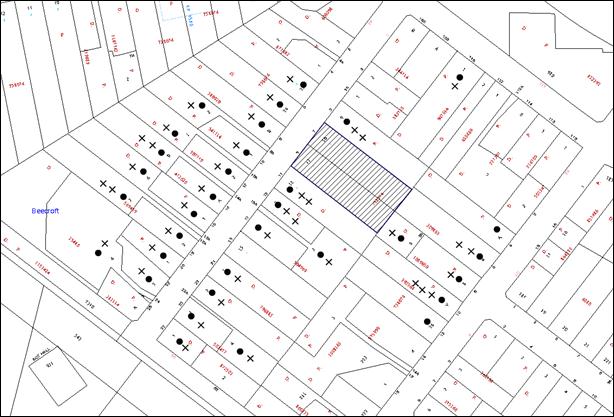
|
NOTIFICATION PLAN |
|||
|
• PROPERTIES NOTIFIED
|
X SUBMISSIONS RECEIVED |
PROPERTY SUBJECT OF DEVELOPMENT |
|
|
16 SUBMISSIONS RECEIVED OUT OF MAP RANGE |
|||
The submissions object to the development, generally on the following grounds:
· Demolition of the dwelling house at No. 7 Welham Street;
· Unacceptable loss of vegetation;
· Future fencing of the driveway adjacent to Lot 1 would detract from the heritage significance of the dwelling house;
· Inappropriate lot sizes for the immediate locality;
· The proposal would detract from the Heritage Conservation Area;
· Inappropriate driveway location and future design;
· Subdivision and future dwelling houses would be unable to appropriately connect to Sydney Water infrastructure;
· Unacceptable increase in traffic and parking issues on Welham Street;
· Potential for the removal of vegetation using 10/50 Vegetation Clearing Code.
The merits of the matters raised in community submissions have been addressed in the body of the report with the exception of the following:
5.1.1 Demolition of the Dwelling-House at No. 7 Welham Street
On 1 April 2014, Council received amended plans proposing to retain the dwelling house at No. 7 Welham Street and relocating the right-of-carriageway along the north-eastern side boundary.
5.1.2 Unacceptable Loss of Vegetation
Submissions raise concerns that the works associated with the subdivision and future dwelling houses on Lot 2 and Lot 3 would result in the unacceptable loss of vegetation that is characteristic of the Beecroft/Cheltenham Heritage Conservation Area.
The application was accompanied by an Arboricultural Assessment Report prepared by Jackson Nature Works. The report identifies all trees on site and their Safe Useful Life Expectancy (SULE). The report also recommends a number of trees to be retained or removed as part of the subdivision. Council’s tree assessment of the proposal concurs with the findings of the arborist report and raises no concerns with respect to the identification of the trees on site or their SULE.
A submission was accompanied by a Tree Report prepared by Stuart Pittendrigh raising concerns that the applicant’s arborist report was incorrect in identifying many of the trees on site as exempt from Part 1B.6 - Tree and Vegetation Preservation of the HDCP (formerly Tree Preservation Order) as the site is located within the Beecroft/Cheltenham Heritage Conservation Area. The arborist report also contests the removal of Tree No. 28, a Eucalyptus pilularis (Blackbutt) as it “contributes to the landscape amenity of the immediate neighbourhood and provides valuable habitat for native fauna”. Council’s tree assessment has considered the arborist report and agrees that Tree No. 28 is a healthy specimen. However, on balance, the removal of the Blackbutt is acceptable as the subdivision layout allows for the retention of four Syncarpia glomulifera (Turpentine) and a Eucalyptus paniculata (Grey Ironbark). A condition of consent is recommended requiring for four replacement trees be planted on site to compensate for the loss of Trees No. 19 and No. 28.
Council’s tree assessment considered that any new dwelling house on Lot 2 and Lot 3 could be developed subject to sensitive construction techniques generally within the indicative building envelopes and ensure the longevity of the remaining significant trees on site.
5.1.3 The Proposal would Detract from the Character of the Heritage Conservation Area
Submissions raise objections that the subdivision would not be in keeping with the Beecroft/Cheltenham Heritage Conservation Area.
Welham Street, Kirkham Street and the nearby section of Beecroft Road contain a number of hatchet-shaped lots. The access for the rear lots for these subdivisions is typically separate from the access to the front lot.
The proposed lots would comply with the minimum subdivision lot size requirements of the HLEP and would utilise the existing driveway at No. 7 Welham Street. It is considered that the proposal is not out of character with the subdivision pattern in the immediate vicinity.
5.1.4 Inappropriate Lot Sizes for the Immediate Locality
A number of submissions raise objections on the grounds that the proposed lot sizes are inappropriate in the area.
The Beecroft-Cheltenham Heritage Conservation Area, and in particular Welham Street is typified by larger residential lots. The HLEP acknowledges the larger lot sizes within the Heritage Conservation Area by establishing 600m2 minimum lot size requirement for subdivisions. In instances where a curtilage around a heritage listed item is required, larger lot sizes may be recommended. In the circumstances of this case, the dwelling houses at No. 7 and No. 9 Welham Street are not heritage listed items and it would be unreasonable for Council to require a larger lot size than that specified in the HLEP 2013.
5.1.5 Unacceptable Increase in Traffic and Parking Issues on Welham Street
Submissions raise concerns that the subdivision would result in unacceptable additional traffic movements on Welham Street.
The development would result in two additional lots. In accordance with the NSW Roads and Maritime Services (RMS) – Guide to Traffic Generating Developments the proposal would result in an additional generation of 18 vehicle trips per day and 1.7 vehicular trips during peak hour. Welham Street is a no-through road and has an environmental capacity of 1000-2000 vehicles per day. Council’s traffic assessment concludes that the traffic generation due to this development would have negligible impact on the capacity of the road system in the locality.
5.1.6 Increased Stormwater Runoff
Submissions raise concerns that stormwater from the subdivision could not be adequately drained to Welham Street.
The applicant submitted additional amended plans on 29 October 2014, indicating the intent to secure a drainage easement through Nos. 8 and No. 8A Kirkham Street to drain the four lots in the subdivision.
As the site experiences natural fall to the rear of the site, a condition is recommended to remove all reference to the timber retaining wall located at the side and rear of Lot 3 which was proposed to achieve drainage to Welham Street.
Council’s tree assessment has considered the impact of the proposed stormwater easements through Nos. 8 and 8A Kirkham Street and raises no objections subject to conditions of consent requiring the easement and all associate stormwater piping of the subdivision to be tunnel bored at a minimum depth of 600mm to avoid damage to trees on the site and adjoining properties.
Council’s engineering assessment is satisfied that the site could adequately drain to a Council controlled stormwater system through the adjoining properties to Kirkham Street.
5.1.7 Inappropriate Driveway Location and Future Design
Submissions raise concerns that the accessway is in an inappropriate location that would require the demolition of the dwelling house at No. 7 Welham Street.
The applicant has since submitted amended plans that propose to relocate the accessway to the existing driveway adjacent to the northern boundary of No. 7 Welham Street and the retention of both dwelling houses.
A submission requests that the driveway should be constructed as separate wheel strips with landscaping rather than fully paved. The prescriptive measures of Part 9 of the HDCP states “new driveways should be constructed as two wheel strips where characteristics of the conservation area or appropriate to the site context”. Driveways in Welham Street feature a variety of materials and finishes. Wheel strips are not a consistent feature within the streetscape.
Furthermore, wheel strips are only considered appropriate in circumstances where a driveway services a single dwelling house. In this situation, the driveway would service three lots therefore, to ensure the longevity of the access handle, it is considered appropriate that the access handle should be fully paved.
5.1.8 The Subdivision and Future Dwelling-Houses would be Unable to Appropriately Connect to Sydney Water Infrastructure
Submissions raise concerns with respect to the inability for any future dwelling house on Lot 2 and Lot 3 to connect to the existing Sydney Water infrastructure located at the rear of the existing dwelling houses on Lot 1 and Lot 4.
Any future dwelling house on Lot 2 and Lot 3 would be subject to Sydney Water certification to ensure the dwelling houses could connect appropriately to the sewer infrastructure.
Further concerns are raised with respect to the extent of impact on vegetation that the connection to Sydney Water infrastructure would result in. Council’s tree assessment has considered the application and the impact the subdivision and all associated works would have on the vegetation location on the site. Subject to sensitive construction methods and tree protection measures, no objection is raised to the installation of drainage or sewerage infrastructure.
5.1.9 Future Fencing of the Driveway Adjacent to Lot 1 would Detract from the Heritage Significance of the Dwelling-House
A submission raises concerns that future occupants of Lot 1 would be able to erect a 1.8 metre high fence adjacent to the access handle and adjacent to the open verandah at the front of the dwelling house. The submission contends that this would “destroy the proper relationship of this open verandah to the house and the front garden, and therefore reduce its potential contributory value to the Heritage Conservation Area”.
In this circumstance, the NSW Housing Code would allow for the erection of fencing behind the building line up to 1.8 metres in height without consent. However, fencing in front of the building line in a heritage conservation area requires consent irrespective of its size or design.
To address this, a condition of consent is recommended for a 1.2 metre high fence to be constructed on the north-eastern boundary of Lot 1 adjacent to the accessway.
5.1.10 Removal of Vegetation Using the 10/50 Code
A submission raises concerns that future dwelling houses on the rear lots would be granted the entitlement to remove all trees within 10 metres of any future dwelling house on the sites under Section 100R of the Rural Fires Act 1997.
On 27 November 2014, the NSW Rural Fire Service reviewed the entitlement area for the 10/50 Vegetation Clearing Code, reducing the entitlement area to 100 metres for Category One and 30 metres for Category Two vegetation.
Beecroft Park, located at the end of Welham Street, is classified as Category One vegetation and is located approximately 180 metres south of the subject site. As a result, Nos. 7 and 9 Welham Street are no longer within the 10/50 Code entitlement area.
The removal of any additional trees on site, whether as part of this subdivision or subsequent dwelling houses would be subject to Council’s assessment.
6. THE PUBLIC INTEREST
Section 79C(1)(e) of the Act requires Council to consider “the public interest”.
The public interest is an overarching requirement, which includes the consideration of the matters discussed in this report. Implicit to the public interest is the achievement of future built outcomes adequately responding to and respecting the future desired outcomes expressed in environmental planning instruments and development control plans.
The application is considered to have satisfactorily addressed Council’s and relevant agencies’ criteria and would provide a development outcome that, on balance, would result in a positive impact for the community. Accordingly, it is considered that the approval of the proposed development would be in the public interest.
CONCLUSION
The application proposes the subdivision of two allotments into four lots.
The development generally meets the desired outcomes of Council’s planning controls and is satisfactory having regard to the matters for consideration under Section 79C of the Environmental Planning and Assessment Act, 1979.
Council received 41 submissions objecting to the original, 11 submissions to the revised, and a further 3 submissions to the current plans during the public notification periods. These matters have been addressed in the body of the report and appropriate conditions are recommended to minimise disruption to residential amenity.
Note: At the time of the completion of this planning report, no persons have made a Political Donations Disclosure Statement pursuant to Section 147 of the Environmental Planning and Assessment Act 1979 in respect of the subject planning application.
RESPONSIBLE OFFICER
The officer responsible for the preparation of this Report is the Manager – Development Assessments, Rodney Pickles, who can be contacted on 9847 6731.
|
Rod Pickles Manager - Development Assessment Planning Division |
James Farrington Group Manager Planning Division |
|
1.View |
Locality Map |
|
|
|
2.View |
Survey Plan |
|
|
|
3.View |
Subdivision Plan |
|
|
|
4.View |
Drainage Plan |
|
|
|
5.View |
Erosion and Sediment Plan |
|
|
File Reference: DA/1442/2013
Document Number: D03951537
SCHEDULE 1
GENERAL CONDITIONS
The conditions of consent within this notice of determination have been applied to ensure that the use of the land and/or building is carried out in such a manner that is consistent with the aims and objectives of the relevant legislation, planning instruments and council policies affecting the land and does not disrupt the amenity of the neighbourhood or impact upon the environment.
Note: For the purpose of this consent, the term ‘applicant’ means any person who has the authority to act on or the benefit of the development consent.
Note: For the purpose of this consent, any reference to an Act, Regulation, Australian Standard or publication by a public authority shall be taken to mean the gazetted Act or Regulation, or adopted Australian Standard or publication as in force on the date that the application for a construction certificate is made.
1. Deferred Commencement
Pursuant to Section 80(3) of the Environmental Planning and Assessment Act 1979, this consent does not operate until the following information is submitted to Council:
a) A stormwater management plan must be submitted to Council showing the proposed method of drainage for the proposed development to Council’s drainage system. The plan is to show the existing drainage pipelines and pits (if any) and the proposed pipe alignment and connection points to Council system with invert and surface levels.
b) Hydrological and hydraulic calculations shall be submitted to Council demonstrating that all existing and proposed interallotment drainage systems have sufficient capacity to convey stormwater for all storms up to the 1 in 20 year ARI event assuming uncontrolled flows (i.e. on-site detention system fully blocked).
c) The registration and creation of an easement to drain water from the development site over Lot 8 and Lot 9 in DP 1089650 – Nos. 8 and 8A Kirkham Street.
Upon Council’s written satisfaction of the above information, the following conditions of development consent will apply:
2. Approved Plans and Supporting Documentation
The development must be carried out in accordance with the plans and documentation listed below and endorsed with Council’s stamp, except where amended by Council and/or other conditions of this consent:
Approved Plans
|
Plan No. |
Plan Title |
Drawn by |
Dated |
|
S.15153A Sheet 1 of 1 |
Plan of proposed subdivision |
P. S. Graham & Associates |
18 December 2013 |
|
S.15153A Sheet 1 of 1 |
Erosion & Sediment Control Plan |
P. S. Graham & Associates |
18 December 2013 |
|
No reference |
Plan showing proposed easement to drain water |
P. S. Graham & Associates |
No date |
|
S.15153 Sheet 1 of 1 |
Detail Survey |
P. S. Graham & Associates |
20 November 2013 |
Supporting Documentation
|
Document Title |
Prepared By |
Dated |
|
Heritage Impact Assessment |
Andrew Starr and Associates Heritage Consultants |
May 2014 |
|
Arboricultural Assessment Report |
Jacksons Nature Works |
7 December 2013 |
3. Amendment of Plans
The approved plans must be amended to delete all reference to the timber retaining wall located in the southern corner of Lot 3.
4. Section 94 Development Contributions
In accordance with Section 80A(1) of the Environmental Planning and Assessment Act 1979 and the Hornsby Shire Council Section 94 Development Contributions Plan 2012-2021, the following monetary contributions shall be paid to Council to cater for the increased demand for community infrastructure resulting from the development:
|
Description |
Contribution (4) |
|
Roads |
$2,280 |
|
Open Space and Recreation |
$32,960 |
|
Community Facilities |
$4,600 |
|
Plan Preparation and Administration |
$160 |
|
TOTAL |
$40,000 |
being for two additional allotments.
a) The value of this contribution is current as at 19 November 2014. If the contributions are not paid within the financial quarter that this condition was generated, the contributions payable will be adjusted in accordance with the provisions of the Hornsby Shire Council Section 94 Development Contributions Plan and the amount payable will be calculated at the time of payment in the following manner:
$CPY = $CDC x CPIPY
CPIDC
Where:
$CPY is the amount of the contribution at the date of Payment
$CDC is the amount of the contribution as set out in this Development Consent
CPIPY is the latest release of the Consumer Price Index (Sydney – All Groups) at the date of Payment as published by the ABS.
CPIDC is the Consumer Price Index (Sydney – All Groups) for the financial quarter at the date applicable in this Development Consent Condition.
b) The monetary contributions shall be paid to Council:
i) prior to the issue of the Subdivision Certificate where the development is for subdivision; or
ii) prior to the issue of the first Construction Certificate where the development is for building work; or
iii) prior to issue of the Subdivision Certificate or first Construction Certificate, whichever occurs first, where the development involves both subdivision and building work; or
iv) prior to the works commencing where the development does not require a Construction Certificate or Subdivision Certificate.
It is the professional responsibility of the Principal Certifying Authority to ensure that the monetary contributions have been paid to Council in accordance with the above timeframes.
Council’s Development Contributions Plan may be viewed at www.hornsby.nsw.gov.au or a copy may be inspected at Council’s Administration Centre during normal business hours.
5. Removal of Existing Trees
This development consent only permits the removal of trees numbered 13, 14, 15, 16, 17, 19, 20, 22, 23, 24 and 28, as identified in the Arboricultural Report prepared by Jacksons Nature Works dated 7th December 2013. The removal of any other trees requires separate approval under Council’s Tree and Vegetation Preservation requirements.
REQUIREMENTS PRIOR TO THE ISSUE OF A CONSTRUCTION CERTIFICATE
6. Building Code of Australia
All building work must be carried out in accordance with the relevant requirements of the Building Code of Australia.
7. Water/Electricity Utility Services
The applicant must submit written evidence of the following service provider requirements:
a) Energy Australia – a letter of consent demonstrating that satisfactory arrangements have been made to service the proposed development.
8. Stormwater Drainage
The stormwater drainage system for the development must be designed and constructed in accordance with Council’s Civil Works – Design and Construction Specification 2005 and the following requirements:
a) Connected to an existing Council piped drainage system.
b) An inter-allotment stormwater drainage system to service the proposed subdivision with pits being cast in situ or pre-cast concrete pits being used.
c) The roof and stormwater drainage system from the existing dwellings is to be connected to the proposed inter-allotment drainage system.
Note: A separate Construction Certificate is required to be submitted and approval obtained prior to the commencement of these works.
9. Internal Driveway/Vehicular Areas
The driveway and parking areas on site must be designed in accordance with Australian Standards 2890.1, 2890.2, 3727 and the following requirements:
a) Design levels at the front boundary must be obtained from Council;
b) The driveway must be a rigid pavement;
c) The driveway grade must not exceed 25 percent and changes in grade must not exceed 8 percent per plan metre;
d) The driveway pavement must be a minimum 3 metres wide, 0.15 metres thick reinforced concrete with F72 steel reinforcing fabric and a 0.15 metre sub-base;
e) The existing driveway must be removed unless a chartered structural engineer certifies that it is capable of remaining stable under an 8 tonne traffic loading;
f) The pavement must have a kerb to one side and a one-way cross fall with a minimum gradient of 2 percent and a lintel and pit provided at the low point;
g) Retaining walls required to support the carriageway and the compaction of all fill batters must be in accordance with the requirements of a chartered structural engineer;
h) Landscaping strips must be planted 0.5 metres wide along both sides of the length of the driveway;
i) Any structure including eaves gutters encroaching over the access driveway shall be removed;
j) A common turning area to service the proposed subdivision in accordance with Australian Standards AS 2890.1 to ensure vehicles can enter and leave the site in a forward direction. A right of access shall be created over the turning area to ensure access is maintained at all times; and
k) Conduit for utility services including electricity, water, gas and telephone must be provided. All existing overhead assets including electricity and telecommunications cabling shall be relocated underground at no cost to Council.
Note: A separate Construction Certificate is required to be submitted and approval obtained prior to the commencement of these works.
10. Vehicular Crossing
A separate application under the Local Government Act 1993 and the Roads Act 1993 must be submitted to Council for the installation of a new vehicular crossing and the removal of the redundant crossing. The vehicular crossing must be constructed in accordance with Council’s Civil Works Design 2005 and the following requirements:
a) Any redundant crossings must be replaced with integral kerb and gutter;
b) The footway area must be restored by turfing;
c) Approval must be obtained from all relevant utility providers that all necessary conduits be provided and protected under the crossing.
Note: An application for a vehicular crossing can only be made to one of Council’s Authorised Vehicular Crossing Contractors. You are advised to contact Council on 02 9847 6940 to obtain a list of contractors.
REQUIREMENTS PRIOR TO THE COMMENCEMENT OF ANY WORKS
11. Erection of Construction Sign
A sign must be erected in a prominent position on any site on which building work, subdivision work or demolition work is being carried out:
a) Showing the name, address and telephone number of the principal certifying authority for the work;
b) Showing the name of the principal contractor (if any) for any demolition or building work and a telephone number on which that person may be contacted outside working hours; and
c) Stating that unauthorised entry to the work site is prohibited.
Note: Any such sign is to be maintained while the building work, subdivision work or demolition work is being carried out, but must be removed when the work has been completed.
12. Protection of Adjoining Areas
A temporary hoarding, fence or awning must be erected between the work site and adjoining lands before the works begin and must be kept in place until after the completion of the works if the works:
a) Could cause a danger, obstruction or inconvenience to pedestrian or vehicular traffic.
b) Could cause damage to adjoining lands by falling objects.
c) Involve the enclosure of a public place or part of a public place.
Note: Notwithstanding the above, Council’s separate written approval is required prior to the erection of any structure or other obstruction on public land.
13. Toilet Facilities
Toilet facilities must be available or provided at the works site before works begin and must be maintained until the works are completed at a ratio of one toilet for every 20 persons employed at the site. Each toilet must:
a) be a standard flushing toilet connected to a public sewer; or
b) be a temporary chemical closet approved under the Local Government Act 1993; or
c) have an on-site effluent disposal system approved under the Local Government Act 1993.
14. Erosion and Sediment Control
Erosion and sediment control measures must be provided and maintained throughout the construction period in accordance with the manual ‘Soils and Construction 2004 (Bluebook)’, the approved plans, Council specifications and to the satisfaction of the principal certifying authority. The erosion and sediment control devices must remain in place until the site has been stabilised and revegetated.
Note: On the spot penalties up to $1,500 may be issued for any non-compliance with this requirement without any further notification or warning.
15. Traffic Control Plan
A Traffic Control Plan (TCP) must be prepared by a qualified traffic controller in accordance with the Roads & Traffic Authority’s Traffic Control at Worksites Manual 1998 and Australian Standard 1742.3 for all work on a public road and be submitted to Council. The TCP must detail the following:
a) Arrangements for public notification of the works.
b) Temporary construction signage.
c) Permanent post-construction signage.
d) Vehicle movement plans.
e) Traffic management plans.
f) Pedestrian and cyclist access/safety.
REQUIREMENTS DURING CONSTRUCTION
16. Construction Work Hours
All work on site (including demolition and earth works) must only occur between 7am and 5pm Monday to Saturday. No work is to be undertaken on Sundays or public holidays.
17. Council Property
During construction works, no building materials, waste, machinery or related matter is to be stored on the road or footpath. The public reserve must be kept in a clean, tidy and safe condition at all times.
Note: This consent does not give right of access to the site via Council’s park or reserve. Should such access be required, separate written approval is to be obtained from Council.
18. Disturbance of Existing Site
During construction works, the existing ground levels of open space areas and natural landscape features, (including natural rock-outcrops, vegetation, soil and watercourses) must not be altered unless otherwise nominated on the approved plans.
19. Works Near Trees
a) All works (including driveways and retaining walls) within 5 metres of any trees required to be retained (whether or not on the subject property, and pursuant to this consent or the Tree and Vegetation Preservation requirements), must be carried out under the supervision of an ‘AQF Level 5 Arborist’ and a certificate submitted to the principal certifying authority detailing the method(s) used to preserve the tree(s).
b) Excavation for the installation of underground services on Lot 2 and Lot 3 and the adjoining properties Nos. 8 and 8A Kirkham Street, Beecroft must be carried out by hand or by using the thrust boring method.
c) Tunnel boring must be carried out at least 600mm beneath natural ground surface at the trees to minimise damage to the tree root systems.
Note: Except as provided above, the applicant is to ensure that no excavation, filling or stockpiling of building materials, parking of vehicles or plant, disposal of cement slurry, waste water or other contaminants is to occur within 4 metres of any tree to be retained.
REQUIREMENTS PRIOR TO THE ISSUE OF A SUBDIVISION CERTIFICATE
Note: For the purpose of this consent, a reference to ‘occupation certificate’ shall not be taken to mean an ‘interim occupation certificate’ unless otherwise stated.
20. Sydney Water – s73 Certificate
An s73 Certificate must be obtained from Sydney Water.
21. Creation of Easements
The following matter(s) must be nominated on the plan of subdivision under s88B of the Conveyancing Act 1919:
a) A right of access and easement for services over the access corridor.
b) An inter-allotment drainage easement(s) over each of the burdened lots.
c) An easement for letterboxes shall be created over lot 3 benefiting lot 2. The 88b instrument shall be worded to reflect the obligations and responsibilities of the benefiting and burdening parties.
d) The creation of a “Positive Covenant” over the proposed Lot 3 requiring that any future development is to provide a turning area wholly located within the subject lot in accordance with Australian Standards AS 2890.1 to enable vehicles to enter and leave the lot in a forward direction.
e) The creation of a “Positive Covenant” over the proposed Lot 2 and 3 requiring that any future development is to provide an on-site detention system. The on-site detention system is to have a storage capacity of 5 cubic metres and a maximum discharge of 8 litres per second into Council’s drainage system in accordance with Council’s prescribed wording.
Note: Council must be nominated as the authority to release, vary or modify any easement, restriction or covenant.
22. Preservation of Survey Marks
A certificate by a Registered Surveyor shall be submitted to the Principal Certifying Authority, certifying that there has been no removal, damage, destruction, displacement or defacing of the existing survey marks in the vicinity of the proposed development or otherwise the re-establishment of damaged, removed or displaced survey marks has been undertaken in accordance with the Surveyor General’s Direction No.11 – “Preservation of Survey Infrastructure”.
23. Damage to Council Assets
Any damage caused to Council’s assets including the removal, damage, destruction, displacement or defacing of the existing survey marks as a result of the construction of the development must be rectified in accordance with Council’s Civil Works Specifications. Council’s Restorations Supervision must be notified for a formwork inspection prior to pouring concrete.
24. Works as Executed Plan
A works-as-executed plan(s) must be prepared by a registered surveyor and submitted to Council for completed driveways, interallotment drainage and service conduits. The plan(s) must be accompanied by a certificate from a registered surveyor certifying that all pipelines and associated structures lie wholly within any relevant easements. The location of all necessary service conduits provided to facilitate the proposed subdivision shall be clearly indicated on the works as executed plan.
25. Boundary Fencing
A 1.2 metre high fence must be erecting along the north-eastern boundary of Lot 1 adjacent to the access way.
26. Maintain Canopy Cover
a) A minimum of 2 medium to large trees selected from Council’s booklet ‘Indigenous Plants for the Bushland Shire’ such as Syncarpia glomulifera, Eucalyptus paniculata, Eucalyptus punctata are to be planted in the rear setbacks of both Lot 2 and Lot 3;
b) The planting location shall not be within 4 metres of the foundation walls of a dwelling or in-ground pool;
c) The pot size is to be a minimum 25 litres and the tree(s) must be maintained until they reach the height of 3 metres; and
d) Trees must be native to Hornsby Shire and reach a mature height greater than 20 metres.
ADVISORY NOTES
The following information is provided for your assistance to ensure compliance with the Environmental Planning and Assessment Act, 1979, Environmental Planning and Assessment Regulation 2000, other relevant legislation and Council’s policies and specifications. This information does not form part of the conditions of development consent pursuant to Section 80a of the Act.
Environmental Planning and Assessment Act 1979 Requirements
The Environmental Planning and Assessment Act 1979 requires:
· The issue of a construction certificate prior to the commencement of any works. Enquiries can be made to Council’s Customer Services Branch on 9847 6760.
· A principal certifying authority to be nominated and Council notified of that appointment prior to the commencement of any works.
· Council to be given at least two days written notice prior to the commencement of any works.
· Mandatory inspections of nominated stages of the construction inspected.
· An occupation certificate to be issued before occupying any building or commencing the use of the land.
Long Service Levy
In accordance with Section 34 of the Building and Construction Industry Long Service Payments Act 1986, a ‘Long Service Levy’ must be paid to the Long Service Payments Corporation or Hornsby Council.
Note: The rate of the Long Service Levy is 0.35% of the total cost of the work.
Note: Hornsby Council requires the payment of the Long Service Levy prior to the issue of a construction certificate.
Tree and Vegetation Preservation
In accordance with Clause 5.9 of the Hornsby Local Environmental Plan 2013 a person must not ringbark, cut down, top, lop, remove, injure or wilfully destroy any tree or other vegetation protected under the Hornsby Development Control Plan 2013 without the authority conferred by a development consent or a permit granted by Council.
Notes: A tree is defined as a long lived, woody perennial plant with one or relatively few main stems with the potential to grow to a height greater than three metres (3M). (HDCP 1B.6.1.c).
Tree protection measures and distances are determined using the Australian Standard AS 4970:2009, “Protection of Trees on Development Sites”.
Fines may be imposed for non-compliance with both the Hornsby Local Environmental Plan 2013 and the Hornsby Development Control Plan 2013.
Subdivision Certificate Requirements
A subdivision certificate application is required to be lodged with Council containing the following information:
· A surveyor’s certificate certifying that all structures within the subject land comply with the development consent in regard to the setbacks from the new boundaries.
· A surveyor’s certificate certifying that all services, drainage lines or access are located wholly within the property boundaries. Where services encroach over the new boundaries, easements are to be created.
· Certification that the requirements of relevant utility authorities have been met.
· A surveyor’s certificate certifying finished ground levels are in accordance with the approved plans.
Note: Council will not issue a subdivision certificate until all conditions of the development consent have been completed.
Fees and Charges – Subdivision
All fees payable to Council as part of any construction, compliance or subdivision certificate or inspection associated with the development (including the registration of privately issued certificates) are required to be paid in full prior to the issue of the subdivision certificate. Any additional Council inspections beyond the scope of any compliance certificate required to verify compliance with the terms of this consent will be charged at the individual inspection rate nominated in Council's Fees and Charges Schedule.
Dial Before You Dig
Prior to commencing any works, the applicant is encouraged to contact Dial Before You Dig on 1100 or www.dialbeforeyoudig.com.au for free information on potential underground pipes and cables within the vicinity of the development site.
Telecommunications Act 1997 (Commonwealth)
If you are aware of any works or proposed works which may affect or impact on Telstra’s assets in any way, you are required to contact: Telstra’s Network Integrity Team on Phone Number 1800810443.
House Numbering
House numbering can only be authorised by Council. Before proceeding to number each premise in the development, the allocation of numbers is required to be obtained from Council's Planning Division prior to the issue of a Subdivision Certificate. The authorised numbers are required to comply with Council’s Property Numbering Policy and be displayed in a clear manner at or near the main entrance to each premise.
Group Manager’s Report No. PL87/14
Planning Division
Date of Meeting: 10/12/2014
12 DEVELOPMENT APPLICATION - SUBDIVISION OF ONE ALLOTMENT INTO SIX LOTS - 79-87 MALTON ROAD BEECROFT
EXECUTIVE SUMMARY
|
DA No: |
DA/94/2013 (Lodged on 7 February 2013) |
|
Description: |
Subdivision of one allotment into six lots |
|
Property: |
Lot 2 DP 847605, Nos. 79-87 Malton Road, Beecroft |
|
Applicant: |
Henlong Property Group Pty Ltd C/- Glendinning Minto and Associates Pty Ltd |
|
Owner: |
Henlong Property Group Pty Ltd |
|
Estimated Value: |
N/A |
|
Ward: |
C |
· The application proposes subdivision of one allotment into six lots.
· The application involves a draft Voluntary Planning Agreement for the dedication of proposed Lot 6 which is zoned RE1 Public Recreation under the Hornsby Local Environmental Plan (HLEP) 2013, in lieu of the payment of Section 94 Contributions. In accordance with Council’s adopted Policy, ‘Proposed Council Developments’ an independent assessment of the development application has been undertaken by Nexus Environmental Planning Pty Ltd.
· A total of 24 submissions have been received in respect of the application.
· The report by Nexus Environmental Planning is attached to this report for consideration. The independent consultant’s report recommends approval of the application as a deferred commencement to enable Council’s resolution of the Planning Agreement proposed by the applicant.
|
THAT Development Application No. DA/94/2013 for subdivision of one allotment into six and dedication of proposed Lot 6 at Lot 2 DP 847605, Nos. 79 - 87 Malton Road, Beecroft be approved as a deferred commencement pursuant to Section 80(3) of the Environmental Planning and Assessment Act, 1979 subject to the conditions of consent detailed in Schedule 1 of Group Manager’s Report No. PL87/14. |
ASSESSMENT
In accordance with Council’s adopted Policy ‘Proposed Council Developments’, the assessment of the development application has been referred to an independent town planning consultant. The report by Nexus Environmental Planning is held at Attachment 5 of this report.
CONCLUSION
The application proposes the subdivision of one allotment into six lots.
Council has referred the application to an independent planning consultancy to carry out an assessment of the application and to consider the public submissions. The assessment concludes that the application should be approved as a deferred commencement to enable Council’s resolution of the Planning Agreement proposed by the applicant.
It is recommended that Council approve the application in accordance with the recommendation in the report prepared by Nexus Environmental Planning Pty Ltd and the conditions of consent held at Schedule 1.
Note: At the time of the completion of this planning report, no persons have made a Political Donations Disclosure Statement pursuant to Section 147 of the Environmental Planning and Assessment Act 1979 in respect of the subject planning application.
RESPONSIBLE OFFICER
The officer responsible for the preparation of this Report is the Manager – Development Assessments, Rodney Pickles, who can be contacted on 9847 6731.
|
Rod Pickles Manager - Development Assessment Planning Division |
James Farrington Group Manager Planning Division |
|
1.View |
Locality Map |
|
|
|
2.View |
Subdivision Plan |
|
|
|
3.View |
Driveway Plan |
|
|
|
4.View |
Stormwater Management Plan |
|
|
|
5.View |
Consultant's Report |
|
|
File Reference: DA/94/2013
Document Number: D03945496
SCHEDULE 1
GENERAL CONDITIONS
The conditions of consent within this notice of determination have been applied to ensure that the use of the land and/or building is carried out in such a manner that is consistent with the aims and objectives of the relevant legislation, planning instruments and council policies affecting the land and does not disrupt the amenity of the neighbourhood or impact upon the environment.
Note: for the purpose of this consent, the term ‘applicant’ means any person who has the authority to act on or the benefit of the development consent.
Note: for the purpose of this consent, any reference to an act, regulation, Australian standard or publication by a public authority shall be taken to mean the gazetted act or regulation, or adopted Australian standard or publication as in force on the date that the application for a construction certificate is made.
1. Deferred Commencement
Pursuant to Section 80(3) of the Environmental Planning and Assessment Act 1979, this consent does not operate until the following information is submitted to Council:
1A. Voluntary Planning Agreement
Pursuant to section 93F of the Environmental Planning and Assessment Act 1979, the applicant must prepare and enter into a Voluntary Planning Agreement (VPA) with Hornsby Shire Council for the dedication of proposed Lot 6.
The terms of the VPA must include but not be limited to the following:
a) The land is to be dedicated free of cost to Council;
b) The reason for the VPA is to offer a public benefit by providing an opportunity to progress the establishment of the network of Council owned open space in Byles Creek;
c) This VPA excludes the application of Section 94 contribution to the development; and
d) The applicant agrees to pay all costs (including Council’s costs) associated with the preparation, public notification, legal costs and administration costs of the VPA.
1B. Integrated Vegetation and Bushfire Management Plan
a) An Integrated Vegetation and Bushfire Management Plan for the management of the native vegetation along Malton Road and within the Asset Protection Zone (as specified in Condition 34). The Plan will apply to each of the newly created allotments where a future dwelling will occur (5 lots);
b) The Plan must be prepared by a suitably qualified bush regenerator or restoration ecologist who is a vegetation management specialist and has at least 5 years’ experience in the management of native bushland and at least a TAFE Certificate III in Bush Regeneration or Conservation and Land Management – Natural Area Restoration qualifications;
c) The Plan must be prepared in consultation with a Bushfire Management Consultant and include strategies for management of the Asset Protection Zones in a manner that has the least impact on the natural environment and maintains indigenous vegetation for the benefit of the Byles Creek corridor function and include, but not be limited to, the following:
i) The appointment of a Project bush regenerator or restoration ecologist to oversee the implementation of the Plan;
ii) Consideration of the recommendations of the Environmental Assessment (Flora & Fauna) Report prepared by Ecological Surveys & Planning, January 2014 and the Assessment of Proposed Development at Lot 2 DP 847605, 79-87 Malton Road Beecroft on Threatened Species of Fauna Report prepared by Gaia Research Pty Ltd, October 2012;
iii) Consideration of the recommendations of the Amended Bushfire Assessment Report (Reference No. 2013/15A) prepared by Bushfire Safety Solutions, February 2013;
iv) Weed control and suppression using bush regeneration methods;
v) Habitat protection including hollow-bearing tree retention and the potential population of threatened Leptospermum deanei habitat; and
vi) The restoration of all disturbed areas using bush regeneration techniques.
1C. Fauna Management Plan
A Fauna Management Plan to manage the loss of habitat resources for tree dependent fauna prepared by a qualified and experienced ecologist.
The Plan must include, but not be limited to, the following:
d) The appointment of a Project Ecologist to oversee the implementation of the Fauna Management Plan;
e) Installation of a total of thirty (30) nest boxes in the “Restricted Development Area” being the area between the northern boundary of the easement for right-of-way, services and drainage and the southern boundary of proposed Lot 6;
f) The nesting boxes shall include ten for microchiropteran bats, ten for possums/gliders and ten for birds particularly Gang-gang Cockatoos;
g) Tree hollows to be salvaged from trees within the development area and placed within the bushland areas within the Restricted Development Area and areas of Byles Creek dedicated to Council in consultation with Council’s Natural Resources Branch;
h) A requirement for the Project Ecologist to be onsite during any tree removal and/or earthworks that will impact the rock escarpment or rock outcrops to re-locate displaced fauna that may be disturbed during this activity.
Upon Council’s written satisfaction of the above information, the following conditions of development consent will apply:
2. Approved Plans and Supporting Documentation
The development must be carried out in accordance with the plans and documentation listed below and endorsed with Council’s stamp, except where amended by Council and/or other conditions of this consent:
|
Plan Title |
Revision |
Drawn by |
Dated |
|
Plan of Proposed Torrens Title Subdivision (Reference No. 75633) |
E |
Rygate Surveyors |
3.11.2014 |
Driveway Plans prepared by Acor Appleyard Consultants Pty Ltd
|
Plan No. |
Issue |
Plan Title |
Dated |
|
D1 |
3 |
Cover Sheet and Notes |
10/2014 |
|
D2 |
5 |
Driveway Plan |
10/2014 |
|
D3 |
4 |
Driveway Long Sections |
10/2014 |
|
D4 |
5 |
Driveway Cross Sections MC01 – Sheet No. 1 |
10/2014 |
|
D5 |
5 |
Driveway Cross Sections Sheet No. 2 |
10/2014 |
Stormwater Management Plans prepared by Acor Appleyard Consultants Pty Ltd
|
Plan No. |
Issue |
Plan Title |
Dated |
|
C1 |
2 |
Cover Sheet and Notes |
11/2014 |
|
C2 |
4 |
Stormwater Management Plan |
11/2014 |
|
C3 |
2 |
Drainage Longitudinal Section |
11/2014 |
|
C4 |
1 |
Stormwater Management Details |
11/2014 |
Supporting Documents
|
Document Title |
Prepared by |
Dated |
|
Erosion & Sediment Control Plan (Drawing reference No. C5 Issue 2) |
Acor Appleyard Consultants Pty Ltd |
11/2014 |
|
Erosion & Sediment Control Notes & Details (Drawing reference No. C6 Issue 2) |
Acor Appleyard Consultants Pty Ltd |
11/2014 |
|
Plan Showing Details and Levels (Reference No. 74128, Sheet 1, Revision B) |
Rygate Surveyors |
10/8/2011 |
|
Plan Showing Details and Levels (Reference No. 74128, Sheet 2, Revision B) |
Rygate Surveyors |
10/8/2011 |
|
Plan Showing Details and Levels (Reference No. 74128, Sheet 3, Revision B) |
Rygate Surveyors |
10/8/2011 |
3. Amendment of Plans
The Stormwater Management Plans prepared by Acor Appleyard Consultants Pty Ltd and dated 11/2014 are to be amended as follows:
a) The portion of the stormwater line from pit 1 to pit 5 shall be relocated 10 metres to the south.
b) The installation of any services within the nominated Tree Root Zone (TRZ) of any tree to be retained must utilise the thrust boring method or alternative sensitive construction method approved by Council. Thrust boring must be carried out so that ‘top of pipe’ is a minimum 700mm depth beneath existing ground level.
c) All detention and inspection pits must be located outside the TRZ of any tree to be retained.
d) Onsite stormwater flow must be directed to an existing piped stormwater drainage system.
REQUIREMENTS PRIOR TO THE ISSUE OF A CONSTRUCTION CERTIFICATE
4. Water/Electricity Utility Services
The applicant must submit written evidence of the following service provider requirements:
a) Ausgrid (formerly Energy Australia) – a letter of consent demonstrating that satisfactory arrangements have been made to service the proposed development.
b) Sydney Water – the submission of a ‘Notice of Requirements’ under s73 of the Sydney Water Act 1994.
Note: Sydney Water requires that s73 applications are to be made through an authorised Sydney Water Servicing Coordinator. Refer to www.sydneywater.com.au or telephone 13 20 92 for assistance.
5. Road Works
All road works approved under this consent must be designed and constructed in accordance with Council’s Civil Works Design and Construction Specification 2005 and the following requirements:
a) The existing paved width of the Malton Road sealed road across the frontage of the site must be maintained to be at least 5.0m, with suitable provision for splays to match existing pavements at either end of the work;
b) A standard concrete rolltop kerb or other kerb type as required by Council shall be designed and constructed across the Malton Road frontage of the site, in line with the existing edge of seal and Council controlled drainage pipe system;
c) The Malton Road shoulder pavement seal must be graded between 2% and 4% to the gutter invert;
d) The existing road to be saw cut a minimum of 1.0m from the proposed lip of kerb and reconstructed as full depth 300 mm flexible pavement;
e) Council standard kerb inlet pits and grates shall be designed and constructed in the gutter invert to drain runoff from Malton Road to the road piped drainage system;
f) All existing assets within the road reserve, including utility poles, services, road shoulder pavements, dense graded base layers, junction pits, shall be adjusted at the Applicant’s cost in order to effect the required works. Details to be provided on construction plans;
g) The submission of a compaction certificates from a geotechnical engineer for any fill work, subgrade and base material within the road formation; and
h) Pursuant to Section 138 Roads Act 1993, a Construction Certificate application for these works must be made to Hornsby Council for assessment and approval prior to the commencement of any work. The Applicant must pay Council’s fee for application assessment and compliance inspections prior to Construction Certificate approval.
6. Vehicular Crossing
An application under the Local Government Act 1993 and the Roads Act 1993 must be submitted to Council for the installation of a new concrete vehicular crossing and the removal of any redundant crossing. The vehicular crossing must be constructed in accordance with Council’s Civil Works Design 2005 and the following requirements:
a) The crossing must be designed and constructed for two-way movement of vehicles on the crossing allowing for the swept-out manoeuvring of vehicles accessing the crossing;
b) The crossing ramps grades must be designed and constructed in accordance with AS2890.1-2004;
c) A longitudinal section of the crossing must be provided with Construction Certificate plans; and
d) Approval must be obtained from all relevant utility providers that all necessary conduits be provided and protected under the crossing.
Note: An application for a vehicular crossing can only be made to one of Council’s Authorised Vehicular Crossing Contractors, or be the subject of a Construction Certificate Application to Hornsby Council as Roads Authority. You are advised to contact Council on 02 9847 6940 to obtain a list of contractors.
7. Traffic Control Plan
A Traffic Control Plan (TCP) must be prepared by a qualified traffic controller in accordance with the Roads & Traffic Authority’s Traffic Control at Worksites Manual 1998 and Australian Standard 1742.3 for all work on a public road and be submitted to Council for approval. The TCP must detail the following:
a) Arrangements for public notification of the works.
b) Temporary construction signage.
c) Vehicle movement plans.
d) Traffic management plans.
e) Pedestrian and cyclist access/safety.
8. Parking Restriction
Pursuant to Section 138 Roads Act 1993, to control parking across the Malton Road frontage of the site and improve safety, a separate Application must be made to Council’s Traffic and Road Safe:
a) Application shall take the form required by T&RSB, with scaled Plans prepared by a suitably qualified person showing drawing number, RMS Standard sign detail, sign directional arrows, dimensions between signs, street name, north point and location of driveways.
b) The Applicant shall pay T&RSB’s fee as required for assessment of the parking control proposal.
c) Council’s Local Traffic Committee shall consider and approve signage plans prior to any signage’s construction.
d) Approved signage construction shall be arranged by the Applicant and constructed at the Applicant’s cost prior to release of the Subdivision Certificate.
The required Traffic Control Plan (TCP) must be submitted and approved by Hornsby Council.
9. Internal Driveway/Vehicular Areas
The driveway and parking areas on site must be designed in accordance with the approved plans, Australian Standards 2890.1, 3727 and the following requirements:
a) Design levels at the front boundary must be obtained from Council;
b) The driveway width must provide for two-way movement of vehicles in proposed Lots 4 and 5 to the crossing;
c) The driveway grade must not exceed 25 percent and transitions for changes in grade must not exceed 8 percent per plan metre;
d) The driveway pavement must be a minimum 3 metres wide, 0.15 metres thick reinforced concrete with SL72 steel reinforcing fabric and a 0.15 metre sub-base;
e) Retaining walls must have a setback of at least 300 mm from kerb lines and drop edges of the minimum 3.0m carriageway;
f) The pavement must have a kerb to one side and a one-way cross fall with a minimum gradient of 2 percent with kerb inlet pits provided on grade and at low points;
g) Retaining walls required to support the carriageway and the compaction of all fill batters must be in accordance with the requirements of a chartered structural engineer;
h) Safety rails must be provided where there is a level difference more than 0.3 metres and a 1V:4H batter cannot be achieved. Details to be provided on construction plans;
i) Conduit for utility services including electricity, water, gas and telephone must be provided.
10. Stormwater Drainage
The stormwater drainage system for the development must be designed and constructed in accordance with Council’s Civil Works – Design and Construction Specification 2005 and the following requirements:
a) Connected to an existing Council controlled natural watercourse;
b) Method of water disposal to the watercourse shall use water sensitive dissipation methods or other methods as required by Council’s Natural Resources Branch or a controlled activity approval;
c) The driveway and interallotment drainage system be piped to contain the 20 year Average Recurrence Interval storm event with an overland flow provided above it where required;
d) An inter-allotment stormwater drainage system to service the proposed subdivision with pits being cast in situ or pre-cast concrete pits being used.
11. Erosion and Sediment Control
Erosion and sediment control measures must be provided and maintained throughout the construction period in accordance with the manual ‘Soils and Construction 2004 (Bluebook)’, the approved plans, Council specifications and to the satisfaction of the principal certifying authority. The erosion and sediment control devices must remain in place until the site has been stabilised and revegetated.
REQUIREMENTS PRIOR TO THE COMMENCEMENT OF ANY WORKS
12. Project Ecologist, Bush Regeneration Consultant
The name and contact details of the consultants engaged to oversee the implementation of the Fauna Management Plan and the Integrated Vegetation and Bushfire Management Plan are to be submitted to Council.
13. Project Arborist
a) The name and contact details are to be submitted to Council of a Project Arborist engaged to supervise the construction works with respect to ensuring that all trees required to be retained are protected;
b) The project arborist shall have a level 5 AQF accreditation and be a member of the Tree Contractors of Australia or similar professional body.
14. Removal of Existing Trees
This development consent only permits the removal of trees numbered 4, 9, 11, 18, 24, 25, 30, 31, 32, 33, 34, 35, 36, 37, 38, 39, 40, 41, 42, 43, 44, 45, 46, 47, 48, 49, 50, 51, 58, 59, 62, 63, 64, 65, 66 and 68 as identified on the approved Driveway Plan Revision 5, prepared by Acor Appleyard Consultants Pty Ltd, dated 10/2014.
15. Erection of Construction Sign
A sign must be erected in a prominent position on any site on which building work, subdivision work or demolition work is being carried out:
a) Showing the name, address and telephone number of the principal certifying authority for the work;
b) Showing the name of the principal contractor (if any) for any demolition or building work and a telephone number on which that person may be contacted outside working hours; and
c) Stating that unauthorised entry to the work site is prohibited.
Note: Any such sign is to be maintained while the building work, subdivision work or demolition work is being carried out, but must be removed when the work has been completed.
16. Toilet Facilities
Toilet facilities must be available or provided at the works site before works begin and must be maintained until the works are completed at a ratio of one toilet for every 20 persons employed at the site. Each toilet must:
a) be a standard flushing toilet connected to a public sewer; or
b) be a temporary chemical closet approved under the Local Government Act 1993; or
c) have an on-site effluent disposal system approved under the Local Government Act 1993.
17. Tree Protection Barriers
Tree protection fencing must be erected onsite around trees numbered 1, 2, 3, 10, 23, 27 and 29 to the satisfaction of Project Arborist.
REQUIREMENTS DURING CONSTRUCTION
18. Construction Work Hours
All work on site (including demolition and earth works) must only occur between 7am and 5pm Monday to Saturday. No work is to be undertaken on Sundays or public holidays.
19. Project Arborist
The Project Arborist, as required to be appointed by this consent, must be present on the site whenever trees are being removed as permitted under this consent and during excavation works within 10m of any tree required to be retained to ensure:
a) All pruning is undertaken as specified in the Australian Standard ‘Pruning of Amenity Trees’ (AS 4373-2007); and
b) Protection of trees on development sites as specified in Australian Standard AS 4970-2009.
20. Project Ecologist – Fauna Management Plan
The Project Ecologist must supervise the works required to be undertaken under the Fauna Management Plan.
21. Project Ecologist, Bush Regeneration Consultant
The Project Ecologist, Bush Regeneration Consultant must supervise the works required to be undertaken under the Integrated Vegetation and Bushfire Management Plan.
22. Council Property
During construction works, no building materials, waste, machinery or related matter is to be stored on the road or footpath. The public reserve must be kept in a clean, tidy and safe condition at all times.
Note: This consent does not give right of access to the site via Council’s park or reserve. Should such access be required, separate written approval is to be obtained from Council.
23. Disturbance of Existing Site
During construction works, the existing ground levels of open space areas and natural landscape features, (including natural rock-outcrops, vegetation, soil and watercourses) must not be altered unless otherwise nominated on the approved plans or as approved by Council.
24. Excavated Material
All excavated material removed from the site must be classified in accordance with the Department of Environment, Climate Change and Water NSW Waste Classification Guidelines prior to disposal to an approved waste management facility and reported to the principal certifying authority.
25. Erosion and Sediment Control
Erosion and sediment control measures must be provided and maintained throughout the construction period and remain in place until the site has been stabilised and revegetated.
REQUIREMENTS PRIOR TO THE ISSUE OF A SUBDIVISION CERTIFICATE
26. Project Arborist - Final Certification
Certification by the project arborist shall be submitted to Council confirming that the works undertaken on site have been completed in accordance with Condition 19.
27. Project Ecologist, Bush Regeneration Consultant - Final Certification
Certification by the project ecologist, bush regeneration consultant shall be submitted to Council confirming that works have been completed on site in accordance with the Integrated Vegetation and Bushfire Management Plan.
28. Project Ecologist – Fauna Management Plan – Final Certification
Certification by the project ecologist, shall be submitted to Council confirming that works have been completed on site in accordance with the Fauna Management Plan.
29. Sydney Water – s73 Certificate
An s73 Certificate must be obtained from Sydney Water.
30. Damage to Council Assets
Any damage caused to Council’s assets as a result of the construction of the development must be rectified in accordance with Council’s Civil Works Specifications. Council’s Restorations Supervision must be notified for a formwork inspection prior to pouring concrete.
31. Creation of Easements
The following matter(s) must be nominated on the plan of subdivision under s88B of the Conveyancing Act 1919:
a) A right of access and easement for services over the access corridor.
b) An inter-allotment drainage easement(s) over each of the burdened lots.
c) The creation of a “Positive Covenant” over the proposed Lots 1 to 4 inclusive requiring that any future development is to provide an on-site detention system. The on-site detention system is to have a storage capacity of 5 cubic metres and a maximum discharge of 8 litres per second into the interallotment/natural drainage system in accordance with Council’s prescribed wording.
Note: Council must be nominated as the authority to release, vary or modify any easement, restriction or covenant.
32. Works as Executed Plan
A works-as-executed plan(s) must be prepared by a registered surveyor and submitted to Council for completed road works, utility works, kerb & gutter, public drainage systems, driveways, internal drainage systems, services and service conduits.
33. Restriction as to User – Protection of Land from Future Development
To inform current and future owners that the areas of rock outcrops, native vegetation and habitat on the site is to be protected from future development, a Restriction as to User must be created under Section 88B of the Conveyancing Act 1919 for each of the Lots 1-5 identifying that the bushland area between the northern boundary of the 11m wide easement for right-of-way, services and drainage and the southern boundary of proposed Lot 6 is restricted from future development or disturbance of any kind.
34. Placement of a Positive Covenant - Integrated Vegetation and Bushfire Management Plan
A positive covenant must be created under Section 88E of The Conveyancing Act 1919 for each of the Lots 1-5 to provide for the ongoing management of the Asset Protection Zone on each allotment in accordance with the requirements of the Integrated Vegetation and Bushfire Management Plan. The Asset Protection Zone is the area of land located between the northern boundary of the easement for right-of-way, services and drainage and the southern (Malton Road) boundary of the site.
35. Asset Protection Zone Boundary
To ensure that the Asset Protection Zone requiring treatment is clearly defined as an area separate to retained native vegetation, the boundary of the Asset Protection Zone for bushfire protection must be marked with permanent metal stakes to prevent fuel reduction activities and vegetation clearing from encroaching into native bushland.
GENERAL TERMS OF APPROVAL – RURAL FIRE SERVICE
The following conditions of consent are General Terms of Approval from the nominated State Agency pursuant to Section 91A of the Environmental Planning and Assessment Act 1979 and must be complied with to the satisfaction of that Agency.
36. Asset Protection Zones
The intent of measures is to minimise the risk of bush fire attack and provide protection for emergency services personnel, residents and others assisting fire fighting activities. To achieve this, the following condition must apply:
a) At the issue of subdivision certificate and in perpetuity the land from the north eastern boundary of the right of way to the south western (Malton Road) boundary for the width of the property shall be managed as an inner protection area (IPA) as outlined within section 4.1.3 and Appendix 5 of 'Planning for Bush Fire Protection 2006' and the NSW Rural Fire Service's document 'Standards for asset protection zones'.
37. Water and Utilities
The intent of measures is to minimise the risk of bush fire attack and provide protection for emergency services personnel, residents and others assisting fire fighting activities. To achieve this, the following condition must apply:
a) Water, electricity and gas are to comply with section 4.1.3 of 'Planning for Bush Fire Protection 2006'.
38. Access
The intent of measures for property access is to provide safe access to/from the public road system for fire fighters providing property protection during a bush fire and for occupants faced with evacuation. To achieve this, the following condition must apply:
a) The right of way must be constructed as a property access road and must comply with section 4.1.3 (2) of 'Planning for Bush Fire Protection 2006'.
GENERAL TERMS OF APPROVAL – NSW OFFICE OF WATER
The following conditions of consent are General Terms of Approval from the nominated State Agency pursuant to Section 91A of the Environmental Planning and Assessment Act 1979 and must be complied with to the satisfaction of that Agency.
39. NSW Office of Water (Condition No. 1)
These General Terms of Approval (GTA) only apply to the controlled activities described in the plans and associated documentation relating to DA/94/2013 and provided by Council:
a) Site plan, map and/or surveys
Any amendments or modifications to the proposed controlled activities may render these GTA invalid. If the proposed controlled activities are amended ore modified the NSW Office of Water must be notified to determine if any variations to these GTA will be required.
40. NSW Office of Water (Condition No. 2)
Prior to the commencement of any controlled activity (works) on waterfront land, the consent holder must obtain a Controlled Activity Approval (CAA) under the Water Management Act from the NSW Office of Water. Waterfront land for the purposes of this DA is land and material in or within 40 metres of the top of the bank or shore of the river identified.
41. NSW Office of Water (Condition No. 3)
The consent holder must prepare or commission the preparation of:
a) Vegetation Management Plan.
b) Erosion and Sediment Control Plan.
c) Soil and Water Management Plan.
d) Amendments – stormwater outlet plans to be supplied in accordance with NOW Guidelines.
42. NSW Office of Water (Condition No. 4)
All plans must be prepared by a suitably qualified person and submitted to the NSW Office of water for approval prior to any controlled activity commencing. The following plans must be prepared in accordance with the NSW Office of Water guidelines located at www.water.nsw.gov.au/Water-licensing/Approvals/default.aspx
a) Vegetation Management Plans.
b) Riparian Corridors.
c) Outlet Structures.
43. NSW Office of Water (Condition No. 5)
The consent holder must (i) carry out any controlled activity in accordance with approved plans and (ii) construct and/or implant any controlled activity by or under the direct supervision of a suitably qualified professional and (ii) when required, provide a certificate of completion to the NSW Office of Water.
44. NSW Office of Water (Condition No. 6)
The consent holder must carry out maintenance period of two (2) years after practical completion of all controlled activities, rehabilitation and vegetation management in accordance with a plan approved by the NSW Office of Water.
45. NSW Office of Water (Condition No. 7)
The consent holder must reinstate waterfront land affected by the carrying out of any controlled activity in accordance with a plan or design approved by the Office of Water.
46. NSW Office of Water (Condition No. 8)
The consent holder must use a suitably qualified person to monitor the progress, completion, performance of works, rehabilitation and maintenance and report to the NSW Office of Water as required.
47. NSW Office of Water (Condition No. 9)
The consent holder must provide a security deposit to monitor the progress, completion, performance of works, rehabilitation and maintenance and report to the NSW Office of Water as required.
48. NSW Office of Water (Condition No. 11)
The consent holder must not locate ramps, stairs, accessways, cycle paths, pedestrian paths or any other non-vehicular form of accessway in a riparian corridor other than in accordance with a plan approved by the NSW Office of Water.
49. NSW Office of Water (Condition No. 14)
The consent holder must ensure that no materials or cleared vegetation that may (i) obstruct flow, (ii) wash into the water body, or (iii) cause damage to river banks: are left on the waterfront land other than in accordance with a plan approved by the NSW Office of Water.
50. NSW Office of Water (Condition No. 15)
The consent holder is to ensure that all drainage works (i) capture and convey runoffs discharges and flood flows to low flow water level in accordance with a plan approved by the NSW Office of Water; and (ii) do not obstruct the flow of water other than in accordance with a plan approved by the NSW Office of Water.
51. NSW Office of Water (Condition No. 16)
The consent holder must stabilise drain discharge points to prevent erosion in accordance with a plan approved by the NSW Office of Water.
52. NSW Office of Water (Condition No. 17)
The consent holder must establish all erosion and sediment control works and water diversion structures in accordance with a plan approved by the NSW Office of Water. These works and structures must be inspected and maintained throughout the working period and must not be removed until the site has been fully stabilised.
53. NSW Office of Water (Condition No. 18)
The consent holder must ensure that no excavation is undertaken on waterfront land other than in accordance with a plan approved by the NSW Office of Water.
- END OF CONDITIONS -
ADVISORY NOTES
The following information is provided for your assistance to ensure compliance with the Environmental Planning and Assessment Act, 1979, Environmental Planning and Assessment Regulation 2000, other relevant legislation and Council’s policies and specifications. This information does not form part of the conditions of development consent pursuant to Section 80a of the Act.
Environmental Planning and Assessment Act 1979 Requirements
The Environmental Planning and Assessment Act 1979 requires:
· The issue of a construction certificate prior to the commencement of any works. Enquiries can be made to Council’s Customer Services Branch on 9847 6760.
· A principal certifying authority to be nominated and Council notified of that appointment prior to the commencement of any works.
· Council to be given at least two days written notice prior to the commencement of any works.
· Mandatory inspections of nominated stages of the construction inspected.
· An occupation certificate to be issued before occupying any building or commencing the use of the land.
Tree and Vegetation Preservation
Hornsby Development Control Plan (HDCP) Tree Root Zones:
|
HDCP Section 1B.6.1 (i). |
TRZ |
|
Trees with a diameter at breast height greater than 800mm |
9m |
|
Trees with a diameter at breast height greater between 400mm & 800mm |
7m |
|
Trees with a diameter at breast height greater less than 400mm |
4m |
Note: Diameter at Breast Height (DBH) for trees is in accordance with the Arboricultural Impact Assessment prepared by Allied Trees dated 15 January 2013.
A tree is defined as a long lived, woody perennial plant with one or relatively few main stems with the potential to grow to a height greater than three metres (3m). (HDCP 1B.6.1.c)
Tree protection measures and distances are determined using the Australian Standard AS 4970:2009, “Protection of Trees on Development Sites”.
In accordance with Clause 5.9 Hornsby Local Environment Plan (HLEP) a person must not ring bark, cut down, top, lop, remove, injure or wilfully destroy any tree or other vegetation to which any such development control plan applies without the authority conferred by a development consent or a permit granted by Council.
Subdivision Certificate Requirements
A subdivision certificate application is required to be lodged with Council containing the following information:
· A certificate by a Registered Surveyor certifying that all services, drainage lines or access are located wholly within the property boundaries. Where services encroach over new boundaries, easements are to be created.
· A certificate by a Registered Surveyor shall be submitted to the Principal Certifying Authority, certifying that there has been no removal, damage, destruction, displacement or defacing of the existing survey marks in the vicinity of the proposed development, or otherwise certifying that the necessary re-establishment of any damaged, removed or displaced survey marks has been undertaken in accordance with the Surveyor General’s Direction No. 11 – “Preservation of Survey Infrastructure”.
· Certification that the requirements of relevant utility authorities - such as Ausgrid and Telstra - have been met.
Note: Council will not issue a subdivision certificate until all conditions of the development consent have been completed.
Fees and Charges – Subdivision
All fees payable to Council as part of any construction, compliance or subdivision certificate or inspection associated with the development (including the registration of privately issued certificates) are required to be paid in full prior to the issue of the subdivision certificate. Any additional Council inspections beyond the scope of any compliance certificate required to verify compliance with the terms of this consent will be charged at the individual inspection rate nominated in Council's Fees and Charges Schedule.
Dial Before You Dig
Prior to commencing any works, the applicant is encouraged to contact Dial Before You Dig on 1100 or www.dialbeforeyoudig.com.au for free information on potential underground pipes and cables within the vicinity of the development site.
Telecommunications Act 1997 (Commonwealth)
If you are aware of any works or proposed works which may affect or impact on Telstra’s assets in any way, you are required to contact: Telstra’s Network Integrity Team on Phone Number 1800810443.
House/Unit Numbering
House numbering can only be authorised by Council. Before proceeding to number each premise in the development, the allocation of numbers is required to be obtained from Council's Planning Division prior to the issue of a Subdivision Certificate. The authorised numbers are required to comply with Council’s Property Numbering Policy and be displayed in a clear manner at or near the main entrance to each premise.
Group Manager's Report No. PL75/14
Planning Division
Date of Meeting: 10/12/2014
13 REPORT ON SUBMISSIONS - DRAFT VOLUNTARY PLANNING AGREEMENT - 79-87 MALTON ROAD, BEECROFT
EXECUTIVE SUMMARY
· A draft Voluntary Planning Agreement (VPA) has been submitted on behalf of the owners of land in relation to Development Application DA/94/2013 for Torrens title subdivision of one allotment into six at property Nos. 79-87 Malton Road, Beecroft.
· The draft VPA proposes the dedication of part of property Nos. 79-87 Malton Road, Beecroft which is zoned RE1 Public Recreation under the Hornsby Local Environmental Plan (HLEP) 2013, in lieu of the payment of Section 94 Contributions.
· Council has an obligation to acquire the land pursuant to the Land Acquisition (Just Terms Compensation) Act 1991 as the land is reserved for public recreation under the HLEP 2013.
· The land proposed to be dedicated forms part of a network of open space in the Byles Creek Catchment. Council has already purchased other land within Byles Creek and the draft VPA provides an opportunity to progress the establishment of this network.
· At its meeting on 9 July 2014, Council considered a report presenting the draft VPA and endorsed the exhibition material which was placed on public exhibition from 13 August 2014 to 12 September 2014.
· Nine submissions raising objections to the draft Agreement were received during the exhibition period and are addressed in this report.
· It is recommended that Council adopt and execute the Voluntary Planning Agreement.
|
THAT: 1. Council adopt and execute the Voluntary Planning Agreement attached to Group Manager’s Report No. PL75/14 to dedicate land zoned RE1 Public Recreation under the Hornsby Local Environmental Plan (HLEP) 2013, in lieu of the payment of Section 94 Contributions. 2. Should Council be of a mind to approve Development Application DA/94/2013, the Mayor and General Manager be authorised to sign the Agreement on behalf of Council. 3. Submitters be advised of Council’s resolution. |
PURPOSE
The purpose of this Report is to review submissions received in response to the exhibition of the draft Voluntary Planning Agreement and to recommend that Council adopt and execute the Agreement.
BACKGROUND
Property Nos. 79-87 Malton Road, Beecroft forms part of the Byles Creek catchment which was identified as part of a 350 hectare area of publicly and privately owned land in the Byles Creek Environmental Study 1995. The Study and the Open Space Review 2007 sought to retain the open space zoning and protect the Byles Creek catchment and the bushland within it.
Development Application DA/94/2013 is for Torrens title subdivision of one allotment into six. Proposed Lot 6 is to comprise all the lands zoned open space and is subject to dedication to Council under the draft Agreement. The application has been assessed by an independent external planning consultant and is also listed for determination on the agenda for the 10 December 2014 Council meeting (Group Manager’s Report No. PL87/14). Assessment of the draft Agreement has been considered separately to the evaluation of the Development Application and would not be progressed if the Development Application is not approved.
Proposed Lot 6 is zoned RE1 Public Recreation under the Hornsby Local Environmental Plan (HLEP) 2013. The land is also identified on the HLEP 2013 Land Acquisition Map which formalises Council’s obligation to acquire the land.
Council does not presently have a financial strategy or timeframe for acquisition of the land. Council’s current Section 94 Development Contributions Plan 2012 – 2021 lists the extension and upgrade of bushwalking tracks in the Byles Creek area (OS-024) in the Works Schedule. Over time, Council has acquired some land within Byles Creek. However, there are a number of missing links in the network of open space, including the subject property.
Timing for the dedication of the land is proposed upon the registration of the first plan of subdivision at the Land and Property Information Office of NSW pursuant to the granting of development consent for DA/94/2013.
The draft Agreement excludes the application of Section 94. Therefore, monetary contributions valued at $80,000 would not be required to be paid to Council in exchange for the land dedication. An independent property valuation commissioned by Council indicates that the financial liability for Council to purchase the part of the site zoned RE1 would be greater than $80,000.
Council at its meeting on 9 July 2014, considered Group Manager’s Report No. PL49/14 concerning the draft Voluntary Planning Agreement and resolved that:
1. The draft Voluntary Planning Agreement attached to Group Manager’s Report No. PL49/14 be exhibited for 28 days in accordance with the Environmental Planning and Assessment Act 1979.
2. The General Manager be given delegated authority to endorse the exhibition material.
3. Following the exhibition, a report on submissions be presented to Council.
In accordance with Council’s resolution, the draft Voluntary Planning Agreement was placed on public exhibition from 13 August 2014 to 12 September 2014.
DISCUSSION
This report discusses the exhibition of the draft Voluntary Planning Agreement and submissions received during the exhibition period.
Exhibition and Review of Submissions
In accordance with Section 25D (Public notice of planning agreements) of the Environmental Planning and Assessment Regulation 2000, the draft VPA was exhibited from 13 August 2014 to 12 September 2014. Advertisements were placed in the local newspaper, Council’s website and letters were sent to affected property owners. The draft Agreement was also displayed at Council’s Administration Centre.
Nine submissions raising objections to the draft Agreement were received during the exhibition period and are addressed below.
Value of the Land
A number of submissions raise concerns that the land proposed to be dedicated in lieu of the payment of Section 94 Contributions will be a financial liability to Council with the constraints of the site (open space zoning and overhead transmission power lines) affecting the market value and the costs of maintaining the proposed walking track.
Comment: Monetary Contributions which would be applicable to the Development Application, if approved, would be $80,000. The applicant has offered, through the VPA, to dedicate the portion of land zoned RE1 Public Recreation to Council in lieu of being charged Section 94 Development Contributions.
As part of the review of open space zoned land in 2006, independent property valuations were obtained for all open space zoned land in private ownership. This valuation assisted Council in determining that the draft Agreement meets the acceptability test, as the valuation indicates that the financial liability for Council to purchase the part of the site zoned RE1 would be greater than $80,000.
Subsequent to Council resolving to place the draft Agreement on exhibition, an updated independent valuation has been obtained. The updated valuation considers the sites limited potential uses due to its physical constraints and characteristics, namely lack of access, transmission lines and easement. The valuation report indicates that the financial liability for Council to purchase the part of the site zoned RE1 would be greater than $80,000 and concludes that the proposal to offset Section 94 contributions with the dedication of land offers very good value to Council. Valuation details are presented as a confidential attachment to this report.
The constraints of the site do not prevent Council’s intended use of the site which is the continuation of the network of Council owned open space in Byles Creek. This would assist in achieving the project identified in the Section 94 Contributions Plan to upgrade and extend walking tracks in Byles Creek.
Regardless of any Development Application or Voluntary Planning Agreement, Council currently has a financial liability to purchase the rear portion of the site which is zoned RE1 Public Recreation for which Council is the acquisition authority. The RE1 zoning indicates Council’s intention to purchase that part of the site at some point in the future for a community purpose.
Consultant Fees
One submission raises concerns that the VPA would result in a financial loss to Council with doubts that the applicant would absorb the consultant fees if the Agreement and Development Application are not approved.
Comment: The applicant agreed to meet Council’s solicitor’s costs for reviewing the draft Voluntary Planning Agreement which is standard practice. In July 2014, Council issued an invoice to the applicant to recoup the solicitor’s costs and Council received payment in August 2014.
Conflict of Interest
One submission raises concern that a conflict of interest may arise due to the fact that the dedication of proposed Lot 6 is only offered if the subdivision application is approved
Comment: The draft Agreement which was publicly exhibited makes it clear that Council has a statutory role as consent authority for development and the draft Agreement is not intended to unlawfully influence the exercise of its regulatory functions, ensuring that Council will act consistently and without bias. The assessment of the Development Application has been undertaken by an independent external planning consultant to ensure that the offer of a VPA does not compromise Council’s functions under the Environmental Planning and Assessment Act 1979.
Review Process
One submission raises concern that the VPA does not include a mechanism or provision to be reviewed periodically with the involvement of all parties.
Comment: Council’s lawyer has reviewed the draft Agreement and holds the view that the provisions of the Agreement provide a reasonable means of providing public amenities and public services and protecting the biodiversity values of the bushland and endangered ecological communities within its environment. The land dedication is a one-off transfer and once completed, the draft Agreement does not require review as there are no ongoing provisions.
Consultation Process
One submission raises concerns about a lack of notification.
Comment: The draft Agreement was exhibited for 31 days in accordance with Section 25D (Public notice of planning agreements) of the Environmental Planning and Assessment Regulation 2000. Advertisements were placed in the local newspaper, Council’s website and letters were sent to adjoining property owners. The draft Agreement was also displayed at Council’s Administration Centre.
Byles Creek Walking Track
A number of submissions question the value of acquiring Lot 6 for the development of the Byles Creek walking track with a lack of access to the site from adjoining Council owned sites. Some submissions also raise concerns about Council’s ability to fund the purchase of adjoining land to extend, construct and maintain the walking track.
Comment: Council owns properties adjacent to the subject site to the southeast and northwest. However, there are a number of missing links in the network of open space, including the subject property. A walking track is currently located on the southern side of the creek on residential zoned land. However, ownership of proposed Lot 6 would provide the opportunity to improve access and create a track on the northern side of the creek on the dedicated land. This would be funded by Council’s Section 94 Contributions Plan, which identifies the Byles Creek project in the Works Schedule of the plan.
Environmental Impacts of the Proposed Development
All submissions raise concerns that the proposed development would have unacceptable environmental impacts, including a loss of fauna and flora and traffic impacts. Some submissions also raise concern that the bushfire risk of the site and overhead transmission power lines render it unsuitable for the development of dwellings.
Comment: The environmental impacts of the proposed development have been assessed as part of the Development Application. The application has been evaluated by an independent external planning consultant and the assessment report is listed for determination on the agenda for the 10 December 2014 Council meeting (Group Manager’s Report PL87/14).
In summary, the issues raised in submissions to the draft Agreement do not raise any new matters which require amendments to the exhibited draft Agreement.
CONSULTATION
The draft Agreement was exhibited for 31 days, exceeding the minimum period of 28 days. It was also reviewed by Council’s panel solicitor (Marsdens Law Group) in June 2014 to ensure the draft Agreement provides a reasonable means of achieving and securing dedication of the open space. No amendments have been made since Council’s panel solicitor reviewed the draft Agreement.
BUDGET
There are no budgetary implications associated with this Report.
POLICY
There are no policy implications associated with this Report.
CONCLUSION
The draft Voluntary Planning Agreement proposes the dedication of part of property Nos. 79-87 Malton Road, Beecroft which is zoned RE1 Public Recreation under the HLEP 2013, in lieu of the payment of monetary contributions. The draft Agreement was exhibited from 13 August 2014 to 12 September 2014.
Nine submissions raising objections to the draft Agreement were received in response to the exhibition. In relation to concerns regarding land value and the offset of monetary contributions (valued at $80,000), independent valuations obtained in 2006 and 2014 confirm that that the proposal offers good value to Council.
The plan offers a public benefit by providing an opportunity to progress the establishment of the network of Council owned land in Byles Creek. This would assist upgrading and extending walking tracks in Byles Creek as outlined in the Section 94 Contributions Plan.
Accordingly, it is recommended that Council adopt and execute the draft Agreement with the Mayor and General Manager authorised to sign the draft Agreement on behalf of Council.
RESPONSIBLE OFFICER
The officer responsible for the preparation of this Report is the Manager, Strategic Planning – Fletcher Rayner, who can be contacted on 9847 6744.
|
Fletcher Rayner Manager - Strategic Planning Planning Division |
James Farrington Group Manager Planning Division |
|
1.View |
Voluntary Planning Agreement and Explanatory Note |
|
|
|
CONFIDENTIAL - Valuation Information - This attachment should be dealt with in confidential session, under Section 10A (2) (c) of the Local Government Act, 1993. This report contains information that would, if disclosed, confer a commercial advantage on a person with whom the council is conducting (or proposes to conduct) business. (Property Valuation Information ) |
|
|
File Reference: DA/94/2013
Document Number: D03789643
Group Manager's Report No. PL90/14
Planning Division
Date of Meeting: 10/12/2014
14 SUBMISSION REPORT - PROPOSED AMENDMENTS TO STATE ENVIRONMENTAL PLANNING POLICY (HOUSING FOR SENIORS OR PEOPLE WITH A DISABILITY) 2004
EXECUTIVE SUMMARY
· The Department of Planning and Environment (DP&E) is exhibiting an amendment to State Environmental Planning Policy (Housing for Seniors or People with a Disability) 2004 (‘the SEPP’) for public comment that proposes to restore the application of the policy to property Nos. 589-593 and 599-607 Old Northern Road.
· Application of the SEPP to the site and surrounding properties adjoining Old Northern Road was inadvertently excluded upon the making of The Hills LEP 2012 on 5 October 2012. The LEP amended the zoning of adjoining properties on the western side of Old Northern Road from a Residential 2(d) (protected) zone to an E4 Environmental Living zone.
· Existing approvals for 154 independent living units, community facility and ancillary works has been issued in accordance with the SEPP for property Nos. 599-607 Old Northern Road, Glenhaven.
· The retirement village is owned and operated by Anglican Retirement Villages (ARV) who also owns property Nos. 589-593 Old Northern Road which have potential to be further developed, subject to Council approval.
· On the grounds of procedural fairness, it is recommended that Council forward a submission to the DP&E advising that no objection would be raised should the SEPP be amended to restore its application to property Nos. 589-593 and 599-607 Old Northern Road, Glenhaven. It is also recommended that property Nos. 595-597 Old Northern Road which are not owned by ARV, be identified by the SEPP to permit the future orderly development of the land.
|
THAT Council write to the Department of Planning and Environment advising that: 1. No objection would be raised should State Environmental Planning Policy (Housing for Seniors or People with a Disability) 2004 be amended to restore the application of the SEPP to property Nos. 589-593 and 599-607 Old Northern Road, Glenhaven. 2. The Department should also consider including property Nos. 595-597 Old Northern Road in the SEPP amendment to provide for the future orderly development of this land. |
PURPOSE
The purpose of this report is to outline a proposed amendment to State Environmental Planning Policy (Housing for Seniors or People with a Disability) 2004 (“the SEPP”) in relation to property Nos. 589-593 and 599-607 Old Northern Road, Glenhaven. The amendment proposes to restore the permissibility of senior living development that existed prior to the making of The Hills Local Environmental Plan 2012 as provided in Attachment 1.
BACKGROUND
On 1 April 2003, the Land and Environment Court approved Development Application No.753/2002 for the erection of 130 self-care dwellings under SEPP No.5 (Housing for Older People or People with a Disability) on property Nos. 599 - 601 Old Northern Road. The property is owned by Anglican Retirement Villages (ARV) with four approvals for self-care dwellings, known as DA/753/2002, DA/539/2003, DA/2450/2003 and DA/1709/2007.
On 17 December 2008, Council approved DA/1709/2007 for Seniors Living Development (Glenhaven Green) comprising 154 independent living units, community facility and ancillary works. This application resulted in rationalising and redesigning the three previously approved developments on the site.
The application has been subsequently modified via eight Section 96 applications and is now approved to accommodate 135 units. Stages 1 – 6 have been constructed providing for 152 units (DA753/2002 + Stages 1 – 6 of DA1709/2008). Stages 6 and 7 comprising 33 villas has commenced construction and is due for completion in 2015.
Approvals for the first 7 stages were issued prior to the making of The Hills LEP 2012, which was notified on 5 October 2012. The Hills LEP 2012 is a Standard Instrument translation of the previous residential zoning (Residential 2(d)(Protected)) for land on the western side of Old Northern Road and was re-zoned E4 Environmental Living. As the application of the SEPP is dependent on the site adjoining land zoned for urban development, the amendment inadvertently excluded application of the SEPP.
ARV proposes that the development (Glenhaven Green), when complete, will comprise of 11 stages and accommodate 450 residents in 300 dwellings and will employ 13 staff. A development application for the final 4 stages is proposed and lodgement with Council is dependent upon restoring the permissibility of the development.
Accordingly, following a request from ARV, the Department of Planning and Environment now proposes to restore the application of the SEPP to the site which existed prior to the making of The Hills LEP 2012. The Department is seeking feedback on the proposed SEPP amendment during the exhibition period which commenced on 20 November 2014 and will close on 17 December 2014.
DISCUSSION
This report outlines the proposed amendment to State Environment Planning Policy (Housing for Seniors or People with a Disability) 2004 and identifies the implications for Hornsby Shire.
1. SEPP Amendment
The SEPP amendment proposes to restore permissibility to the sites by an amendment to Clause 4 (Land to which Policy applies) and Clause 53 (Savings and Transitional Arrangements).
The amendment to Clause 4(11) proposes that the following properties are taken as land that adjoins land zoned for urban purposes:
a) 599-607 Old Northern Road, Glenhaven (being Lot 2, DP 1123753)
b) 589-593 Old Northern Road, Glenhaven (being Lot 1, DP 135398 and Lots 2 and 3, DP 225754)
The amendment to Clause 53 is an administrative update to preserve the permissibility of serviced self-care housing in accordance with DA/753/2002 which was made pursuant to the requirements of the now repealed SEPP No.5 (Housing for Older People or People with a Disability).
2. Suitability of the Site
Property Nos. 589-593 and 599-607 Old Northern Road, Glenhaven are irregular in shape comprising an area of approximately 17.5 hectares as shown in Attachment 2. The site excludes property Nos. 595 and 597 which both have occupied dwellings totalling approximately 2.3 hectares.
In accordance with previous approvals, significant works have been undertaken on the site including road widening, installation of traffic signals and provision of sewer and water in anticipation of the site supporting 300 independent living villas and the restoration of vegetation on the site. The development currently contains approximately 190 residents in 152 independent living villas.
Issues in relation to the Court approval of the original consent (DA753/2002) are summarised in the Land and Environment Court judgement for M & R Civil Pty Ltd v Hornsby Shire Council (2003). Council’s main concerns at the time related to:
· Visual impact on the streetscape and rural character of the surrounding area
· Quality of stormwater discharge
· Impact on Blue Gum High Forest
· Loss of agricultural land
· Arrangements for sewer and water
Since this time, the development has successfully operated in accordance with the conditions of consent and provides a valuable housing resource for persons seeking affordable seniors living accommodation within the local area. Accordingly, no concern is raised concerning the suitability of the site for potential future expansion subject to the granting of development consent.
3. South Dural Precinct
The site is also located within the South Dural precinct which has been the subject of applications in accordance with the NSW Government’s 2012 Potential Home Sites (PHS) Program and a Planning Proposal made on behalf of the South Dural Resident and Ratepayers Association.
In March 2013, the Minister for Planning and Infrastructure announced that immediate action would be taken to support development of new homes for 7 sites nominated through the PHS Program. South Dural was not included on the list of sites.
On 18 December 2013, Council considered Group Manager’s Report No. PL117/13 concerning the South Dural Planning Proposal. Council resolved (in part) to seek a conditional Gateway Determination subject to:
· the proponent funding a Business Plan to confirm the feasibility of the project being delivered with all necessary infrastructure at no net cost to government,
· subject to the Regional Director, Sydney West Region, being satisfied with the Business Plan, the necessary studies be prepared to justify the proposal.
Gateway Authorisation was subsequently issued by the Department on 7 March 2014 with the timeframe for completion being 24 months.
Whilst little progress has been made in relation to the Planning Proposal, the future context of the site and surrounds is likely to change in the future. Accordingly, the key issue in relation to the SEPP amendments now relates to how the development would integrate and contribute towards the future urbanisation of the precinct.
The proposal to expand Glenhaven Green with the inclusion of property Nos. 589 to 593 may impact the feasibility of rezoning the South Dural Precinct due to infrastructure costs associated with upgrades to New Line Road and Old Northern Road. The feasibility of releasing the precinct at no net cost to government is likely to require monetary contributions well above the existing rate required by Council’s Section 94 Development Contributions Plan. Accordingly, the exclusion of these properties from a future infrastructure plan would place increased financial demand on remaining sites to fund the required works.
Notwithstanding, ARV has provided significant infrastructure on site to support the development with capacity to expand. The purchase of property Nos. 589 to 593 (which occurred in 2008) would have occurred based on expectation that the SEPP would continue to apply and future expansion would be permissible subject to the issuing of development consent. Accordingly, on the grounds of procedural fairness, no objection is raised to the amendment.
4. Isolation of Property Nos. 595 – 597 Old Northern Road
The proposed SEPP amendment excludes property Nos. 595 – 597 Old Northern Road which may impact upon their orderly development should the rezoning of South Dural proceed. Council’s records indicate these lands are separately owned and if developed independently of the ARV site, would not be able to integrate into a future masterplan for South Dural. Rather, a site specific plan with limited connectivity to future open space, facilities and services would burden the future residents of this land. An improved outcome would be achieved if provision for amalgamation of the site into the ARV development was accommodated by the SEPP.
BUDGET
There are no budgetary implications associated with this Report.
POLICY
There are no policy implications associated with this Report.
CONCLUSION
Anglican Retirement Villages owns the subject land which has been partially developed to accommodate 152 independent living units with a further 33 units due for completion in 2015. Future expansion of the development (Stage 8 – 11) is proposed on property Nos. 595 - 597 Old Northern Road subject to the permissibility of the development being restored and the issuing of development consent. On the grounds of procedural fairness, it is recommended that Council forward a submission to the DP&E advising that no objection would be raised should the SEPP be amended to restore the permissibility of independent living villas on the site. The submission should also recommend that the Department consider including property Nos. 595 – 597 Old Northern Road in the SEPP amendment to provide for the future orderly development of this land.
RESPONSIBLE OFFICER
The officer responsible for the preparation of this Report is the Manager, Strategic Planning – Fletcher Rayner, who can be contacted on 9847 6744.
|
Fletcher Rayner Manager - Strategic Planning Planning Division |
James Farrington Group Manager Planning Division |
|
1.View |
Attachment 1 - Draft Amendment - SEPP (Housing for Seniors or People with a Disability) |
|
|
|
2.View |
Attachment 2 - Subject Site |
|
|
File Reference: F2004/07602
Document Number: D03952414
Group Manager's Report No. PL88/14
Planning Division
Date of Meeting: 10/12/2014
15 NORTH WEST RAIL LINK URBAN RENEWAL - MEMORANDUM OF UNDERSTANDING AND PROJECT PLAN
EXECUTIVE SUMMARY
· In October 2013, the Department of Planning and Environment (DP&E) published the final North West Rail Link (NWRL) Corridor Strategy. Council accepted an invitation from Urban Growth NSW (UGNSW) to participate in the NWRL urban renewal program, including the urban transformation of the Cherrybrook Station Precinct.
· Council staff held meetings with UGNSW and The Hills Shire Council (THSC) to prepare a Memorandum of Understanding (MOU) and Project Plan. Councillor briefings were also held. UGNSW was advised of key issues that should be addressed to enable finalisation of the documents.
· Council is in receipt of the latest draft MOU from UGNSW for Council’s endorsement. UGNSW has advised that it is still refining the draft Project Plan having regard to outstanding Council issues but would like to secure Council’s in principle support for the framework for co-operation to facilitate urban renewal in the Cherrybrook Station Precinct.
· It is recommended that Council authorise the Mayor and General Manager to enter into a MOU for the NWRL Urban Renewal Program and agree to a final Project Plan for the urban transformation of the Cherrybrook Station Precinct. It is also recommended that the Mayor and three additional Councillors be elected as the Hornsby Shire Council Councillor representatives on the Planning and Local Government Reference Group.
|
THAT: 1. The Mayor and General Manager be authorised to enter into a Memorandum of Understanding for the North West Rail Link Urban Renewal Program that is consistent with the terms as attached to Group Manager’s Report No. PL88/2014 and agree to a final Project Plan for the urban transformation of the Cherrybrook Station Precinct. 2. The Mayor and three additional Councillors (Council to nominate three Councillors from Wards B and/or C) be nominated as the Hornsby Shire Council Councillor representative on the Planning and Local Government Reference Group of the North West Rail Link Urban Renewal Program. |
PURPOSE
The purpose of this Report is to seek Council’s authorisation to enter into a MOU and Project Plan to participate in the NWRL Urban Renewal Program.
BACKGROUND
In October 2013, the DP&E published the final North West Rail Link Corridor Strategy. The Corridor Strategy promotes urban renewal, transforming the low density residential corridor for the NWRL into a series of activity centres based around eight new railway stations, including the Cherrybrook Station Precinct.
The Cherrybrook Station Precinct includes land in both Hornsby and The Hills Shire LGAs, is based on an 800m radius from the Station, covers 187 hectares and includes an established low density residential area with two schools and the IBM Business Park. The Corridor Strategy and associated Cherrybrook Station Structure Plan identify the Precinct as having the potential to yield approximately 3,200 additional low to medium density residential dwellings by 2036, ranging in height from 2-3 storey town houses to 3-6 storey residential flat buildings with higher density located closest to the Station.
At its meeting on 12 March 2014, Council considered Group Manager’s Report No. PL15/14 outlining a request from UGNSW to participate on a Precinct Working Group for the urban renewal of land surrounding the proposed Cherrybrook Station. Council resolved to accept the invitation to participate on the Working Group and to request that a Project Plan be prepared for Council endorsement that addresses:
· Actions, responsibility, timing, community consultation, infrastructure and delivery;
· Opportunity to review the boundary of the Precinct in response to community concerns; and
· Councillor representation on the Committee to provide guidance on overall strategic direction.
Council also resolved that the General Manager or his nominee be delegated authority to participate on the Project Working Group.
In accordance with Council’s resolution, Council wrote to UGNSW and accepted the invitation to participate in the urban renewal strategy program. Between July 2014 and November 2014, Council staff have attended meetings with UGNSW and the Hills Shire Council (THSC) to prepare a MOU and Project Plan.
In October 2014, a Councillor briefing was held and included a discussion on progress made in the preparation of the MOU and Project Plan, including the key issues for finalising the documents. Councillors provided advice for resolving a number of the key issues, including that they considered the proposed three tier governance model would only provide limited opportunity for Councillor involvement. Councillors advised that they would prefer a two tier model with Councillor representation on the Planning Reference Group. Councillors also advised that they would be comfortable with UGNSW chairing the meetings.
UGNSW was subsequently advised of Council’s position on the key issues for finalising the documents. Council is now in receipt of the latest draft MOU from UGNSW for endorsement. UGNSW has advised that it is still refining the draft Project Plan having regard to outstanding Council issues.
DISCUSSION
This report presents a draft MOU for the NWRL Urban Renewal Program and draft Project Plan for the urban transformation of the Cherrybrook Station Precinct.
1. NWRL Urban Renewal Project MOU
The latest draft MOU (copy attached) establishes the framework for co-operation between UGNSW and the three councils (Hornsby, The Hills and Blacktown) in which the eight NWRL stations are identified to facilitate urban renewal in the surrounding precincts. The draft MOU contains the following key elements:
Program Description: The Program seeks to deliver urban renewal, transforming the low density residential corridor for the NWRL into a series of activity centres based around eight new railway stations, including Cherrybrook.
Program Timing: The Program has two main timing phases, Program Development between 2014 and 2019 and Program Implementation between 2016 and 2035. Program Development involves undertaking technical studies and stakeholder consultation, and developing an Urban Renewal Strategy, including statutory plans and an infrastructure delivery program. Program Implementation involves working with councils and other State Government agencies to facilitate urban renewal opportunities in the precincts, including delivering infrastructure, services and public domain packages to promote early activation around the stations.
Purpose: The purpose of the MOU is to define how Hornsby, The Hills and Blacktown Councils and UGNSW will work together to deliver urban transformation within the eight NWRL Station Precincts.
Vision, Objectives and Principles: The MOU identifies a shared vision, partnering objectives, guiding principles by which the parties will undertake the planning and delivery of the urban transformation outcomes.
Governance Structures: The MOU identifies governance structures that have been established between State Government Agencies and between UGNSW and Councils to ensure all parties work collaboratively to deliver world class urban renewal outcomes. The MOU identifies that Transport for NSW (TNSW), the Department of Planning and the Environment (DP&E) and UGNSW will manage and coordinate the Program. The MOU also proposes the following two tier collaborative partnering model between UGNSW and Councils:
· Planning and Local Government Reference Groups: The purpose of the Group is to provide a platform for strategic planning, infrastructure and place management issues to be resolved. The Group will consist of Mayors, a maximum of three additional Councillors, Council’s Directors of Planning and executive level representatives of relevant State Government agencies. The Group will be chaired by UGNSW and will meet quarterly; and
· Precinct Project Working Groups: The purpose of the Cherrybrook Precinct Project Working Group is to guide detailed precinct planning and implementation. The Group will consist of relevant Council officers and executive level representatives of relevant State Government agencies as required. The Group will be chaired by UGNSW or relevant Council Director of Planning (based on the Agenda) and will meet fortnightly.
General Understandings: The key matters of the General Understandings include that:
· UGNSW will work with councils and other State Government agencies to facilitate urban renewal opportunities in the precincts adjacent the stations when they open in 2019 and beyond;
· The parties will prepare an infrastructure needs analysis and work together to develop a funding model and delivery plan for infrastructure to support urban renewal;
· Councils will align infrastructure and capital investment to complement delivery of urban renewal;
· A consultation strategy will be developed in collaboration based on the philosophy identified in the draft MOU; and
· The MOU is a firm commitment but not a legally binding contract.
Finance and Procurement: UGNSW will generally be the lead agency for co-ordinating, procuring and project managing studies that are identified in the draft Project Plan. However, Councils will be responsible for funding and project managing any additional local studies.
Councils will also be responsible for providing staff resources to work in consultation with UGNSW to deliver new planning controls and infrastructure plans. The MOU identifies that the allocation of costs which could be used to fund an additional staff resource would be agreed to separately by the parties and confirmed through the Project Plan or an exchange of letters.
The MOU also identifies UGNSW will be the lead agency in securing funding and co-ordinating infrastructure to promote urban renewal.
2. Cherrybrook Station Precinct Project Plan
While a single MOU has been prepared to cover all of the Urban Renewal Precincts, each Precinct will have its own Project Plan. The draft Cherrybrook Precinct Project Plan outlines the scope of the project, planning context, community consultation approach, key deliverables, and responsibilities and timeframes for delivery. The draft Project Plan contains the following key elements:
Project Scope: The Project Plan identifies that the project involves developing a predominantly residential precinct around a mixed use local centre with safe and walkable connections. The Project Plan also identifies that the project will deliver an additional 3,200 dwellings and 50 new jobs in the Precinct and that there are a number of key opportunities and challenges that will need to be addressed as part of the project, including:
· Ensure precinct activation around Cherrybrook Station on rail opening;
· Deliver land use patterns that are well integrated with public transport and options for walking and cycling; and
· Accommodate changing housing preferences to provide a wider variety of housing types to accommodate demographic needs.
Planning Context: The Project Plan identifies the planning context, including that it will be necessary for Local Environmental Plans, Development Control Plans and Contribution Plans to be amended.
Community Consultation: The Project Plan identifies the approach to stakeholder engagement and communication, including that a community consultation firm will be engaged to develop a strategy with the councils to ensure final planning policy reflects community standards and attitudes.
Project Deliverables: The Project Plan identifies that the Cherrybrook Precinct Project Working Group will confirm the scope of the investigation required but will include the following project deliverables.
· Stakeholder engagement plan
· Strategy for renewal/early activation
· Urban Design and Landscape Masterplans
· Transport and Infrastructure Plans
· Environmental Studies (e.g. Stormwater, Open Space, Social Infrastructure and Biodiversity)
Key Matters for Finalisation: Notwithstanding that the MOU has been updated to reflect Council’s comments, there are a number of matters to be addressed prior to the draft Project Plan being finalised, including:
· Project Scope and Project Deliverables to specify that the traffic generation and capacity of the road network to accommodate additional dwellings should be identified as the first step in the planning process. Detailed traffic modelling of the local and surrounding regional road network must be undertaken to confirm the number of dwellings that may be accommodated and the necessary improvements to the road network to support the growth;
· Project Plan is too focused on the preparation of studies and not implementation through the amendment of Council planning policies;
· Governance model should reflect the two tier elected, executive and officer approach contained in the draft MOU;
· Project scope needs to be tailored to the State Government budget, which is still unknown;
· Planning context for both the Hornsby and The Hills Councils need to be addressed, including that the Hornsby Local Environmental Plan 2013, Hornsby Development Control Plan 2013 and Council’s Contribution Plans need to be amended;
· Minimum delivery mechanisms of any Communications Strategy be specified (e.g. Letters to owners, website and newspaper notices and community drop in sessions); and
· Project Plan to recognise that provision of infrastructure and modification of the existing urban framework to facilitate world class urban renewal outcomes are the priority project outcomes, including that the State Government are committed to funding major infrastructure upgrades that S94 Development Contributions cannot cover.
CONSULTATION
The NWRL Urban Renewal Project MOU has been prepared by UGNSW in consultation with the NWRL Councils. The draft Cherrybrook Station Precinct Project Plan is still being refined by UGNSW having regard to a number of outstanding issues identified by the Councils.
The MOU identifies that Council elected representatives will be consulted on strategic planning, infrastructure and place management issues through their involvement in the Planning and Local Government Reference Group. It is proposed that the Group will include the Mayors and a maximum of three additional Councillors and that any meetings will be structured so that matters relating to the Cherrybrook Station Precinct will only need be attended by Hornsby and The Hills Shire Councils.
The Cherrybrook Station Precinct is located within both Wards B and C of Hornsby Shire which is serviced by six Councillors. However, in accordance with the draft MOU and to ensure equal representation between Hornsby and the Hills Councils, Hornsby Council’s elected representation is proposed to comprise the Mayor and three additional Councillors. It will therefore be necessary for Council to nominate three Councillors for participation on the Planning and Local Government Reference Group, it being noted that Mayors/Councillors may delegate attendance of this Group to another Councillor.
FINANCIAL
Council will be responsible for providing staff resources to work in consultation with UGNSW to deliver new planning controls and infrastructure plans. The draft MOU identifies that the allocation of costs will be agreed to separately by the parties and confirmed through the Project Plan or an exchange of letters.
Council’s adopted Strategic Planning Program already includes Council’s participation on the Cherrybrook Station Precinct - Project Working Group. Whilst existing staff resources have been sufficient to-date, the commencement of detailed investigations may require an additional resource and would form part of the agreement to costs outlined above.
POLICY
The MOU and Project Plan identify that the Hornsby Local Environmental Plan 2013, Hornsby Development Control Plan 2013 and Council’s Section 94 Contribution Plans will require amendment to facilitate urban renewal in the Cherrybrook Station Precinct as envisaged by the North West Rail Link Corridor Strategy and Cherrybrook Station Structure Plan.
CONCLUSION
In March 2014, Council accepted an invitation from Urban Growth NSW (UGNSW) to participate in the NWRL urban renewal program, including the urban transformation of the Cherrybrook Station Precinct.
Council staff attended meetings with UGNSW and THSC to prepare a MOU and Project Plan. Council is in receipt of the latest draft MOU from UGNSW for Council’s endorsement but is awaiting the final draft Project Plan addressing issues identified by NWRL Councils. The MOU addresses the majority of NWRL Council issues including adopting a two tier Governance Structure to provide appropriate representation from Council’s elected, executive and officer level.
It is recommended that Council authorise the Mayor and General Manager to enter into a MOU for the NWRL Urban Renewal Program and agree to a final Project Plan for the urban transformation of the Cherrybrook Station Precinct. It is also recommended that the Mayor and three additional Councillors be elected as the Hornsby Shire Council Councillor representative on the Planning and Local Government Reference Group.
RESPONSIBLE OFFICER
The officer responsible for the preparation of this Report is the Manager – Strategic Planning, Fletcher Rayner, who can be contacted on 9847 6744.
|
Fletcher Rayner Manager - Strategic Planning Planning Division |
James Farrington Group Manager Planning Division |
|
1.View |
Memorandum of Understanding |
|
|
File Reference: F2012/00597
Document Number: D03948326
Group Manager's Report No. PL91/14
Planning Division
Date of Meeting: 10/12/2014
16 FUTURE CITIES PROGRAM
EXECUTIVE SUMMARY
· Council was one of six cities that participated in the Future Cities Program 2014, an initiative of the Future Cities Collaborative at the United States Studies Centre focused on supporting local government leaders from regional and metropolitan cities in building sustainable and liveable communities.
· The Program involved a Mayors Forum and United States Study Tour attended by the Mayor and senior management, during which invaluable advice and insights were obtained. Lessons and critical issues observed throughout the US study tour are summarised in this report.
· The Future Cities Program has given Council the confidence to move forward with its vision for ensuring revitalisation of the Hornsby West Side and has stimulated discussion within Council about opportunities to build on the work for application in other projects and centres across the Shire.
· Council is now eligible to join the Future Cities Collaborative, a forum which brings together policy, best practice and research to inform our city leaders into inspired action to build great cities. By joining the Collaborative, Council will have access to leading professionals and academics to assist Council in continuing planning for its town centres.
· It is recommended that Council subscribe to the Future Cities Collaborative for an initial 12 month period, with the cost met within the existing Annual Operating Budget for the Planning Division.
|
THAT: 1. Council note the contents of Group Manager’s Report No. PL91/14 and the outcomes of the Future Cities Program 2014. 2. Council subscribe to the Future Cities Collaborative for an initial 12 month period, with the cost met within the existing Annual Operating Budget for the Planning Division. |
PURPOSE
The purpose of this Report is to present the findings of the 2014 Future Cities Program.
BACKGROUND
The Future Cities Program is an initiative of the Future Cities Collaborative at the United States Studies Centre partnered by the NSW Government, the University of Sydney’s Faculty of Architecture, Design and Planning; local and international partners and local government leaders. The Program is focused on supporting local government leaders from regional and metropolitan cities in building sustainable and liveable communities.
At its meeting on 9 April 2014, Council considered Group Manager’s Report No. PL29/14 concerning the Future Cities Program and resolved to register its interest in participating in the Program. On 11 June 2014, Council considered Group Manager’s Report No. PL44/14 advising of its successful application. Council resolved to accept the nomination of Westfield to join Council’s delegation to participate in the Future Cities Program.
In accordance with Council’s resolution, Council’s delegation of senior management, the Mayor and a representative from Westfield, participated in the Program which was conducted from June 2014 to November 2014.
DISCUSSION
Council was one of six cities that participated in the Future Cities Program 2014. Representatives from the City of Canada Bay, Gosford City Council, Marrickville Council, Pittwater Council and Wollongong Council worked together to gain skills in sustainable and strategic urban development. The Program involved a three-day Mayors Forum in Sydney and a study tour of sites and cities in the United States, as outlined below.
1. Mayors Forum
The three-day Mayors Forum involved intensive workshops at the United States Studies Centre at the University of Sydney. The workshops were led by Australian and international experts in urban design and sustainable development, including Professor Ed Blakely (Honorary Professor in Urban Policy at the US Studies Centre), Peter Park (international urban design and city planning expert), Colin Cathcart (Associate Professor in Urban Studies at Fordham University) and Rod Simpson (Associate Professor in Urban Design at the University of Sydney).
Elected leaders, senior Council staff and community representatives from each city worked through various scenarios and models that addressed the key challenges each city faces. Hornsby Town Centre, in particular the Hornsby West Side, was thoroughly assessed, with advice and insights offered to give confidence to Council’s vision to transform the precinct into a liveable city, “the northern gateway where the city lifestyle meets the bush.”
2. United States Study Tour
The Mayor and senior management of each city attended a seven-day study tour, which involved visits to innovative sites and cities in the US states of California, Connecticut, New York and New Jersey. In New York City, the tour group was given access to the New York City Department of City Planning, New York City Economic Development Corporation and New York Department of Parks and Recreation.
The study tour allowed all participating city leaders to examine outstanding examples of sustainability and liveability transformations in American cities. The focus of the tour was revitalisation of districts and neighbourhoods within cities, sustainable and workable precinct management and business and community improvement and development. A number of lessons and critical issues were observed throughout the US study tour which are summarised below.
a) Strategic Precinct Planning
Planning that successfully delivers for our communities requires a holistic approach that considers the specific needs of local people and places and integrates with the surrounding region. Many US cities had suffered from industrial decline and needed to generate new development to support economic revival and healthy thriving communities. Consistently, this was achieved by taking a strategic and long-term approach to all elements of creating thriving communities namely, mixed land use, housing, infrastructure, economic development, resource use and places for people. Partnerships, a range of financial levers and a strong evidence base were key to making informed planning decisions. Support by substantial capital injection from government or private sources were also essential to achieving the goals for each city.
b) Urban Renewal
In the current planning environment, financing urban renewal initiatives poses a significant challenge for local government. In many instances, councils are reluctant to move beyond the creation of a vision and typically fall back to establishing zoning controls or modest public domain improvements. This is a stark contrast to cities in the US, where local governments have access to, and actively use, a range of financial mechanisms to stimulate urban renewal.
Local land taxes are based on the improved value of land enabling local government to capture the increase in value and providing a powerful incentive for local government to proactively drive urban renewal initiatives. Federal tax credits drive private sector investment in vital projects such as affordable housing and use of eminent domain powers enables cities to compulsorily acquire land for key public infrastructure to address urban blight and advance economic growth. These finance mechanism demonstrate that a strong commitment and partnership between federal, state and local governments can actively drive private sector participation to ensure that urban renewal initiatives are achieved.
c) Activation
Delivering services to meet community needs is a constant challenge for state and local governments alike. Throughout the US, Business Improvement Districts (BIDS) have provided a mechanism to share the financial burden of local service delivery. These structures are founded on a public-private partnership where property and business owners make an annual contribution to the management, maintenance and marketing of a commercial district or neighbourhood.
d) Urban Living
As our population grows and changes, there are generational impacts on community needs and consumer behaviour. Our cities and towns need to reflect and accommodate these changes by embracing the benefits of urban life or urbanity. Diverse, mixed urban environments with reduced car dependency, greater pedestrian movement, active transport and a focus on people and experience creation can facilitate economic efficiency, productivity, lower environmental impact and access to goods and services for all groups in the community. Experiences from the US highlight the need to focus on the detail, on the street and on the people of the place using a bottom up approach to planning and engagement.
e) Housing Affordability
The delivery of housing to first homebuyers, renters, key workers and the disadvantaged poses a significant issue across NSW. For local government there are currently limited meaningful ways to respond to this challenge to deliver both housing that is affordable relative to household incomes and financially assisted “affordable housing”. In the US, cities have addressed housing affordability and affordable housing through a number of levers created at a local, state and federal government level including the provision of tax incentives for corporations to assist in affordable housing projects, affordable housing targets, inclusionary zoning and increased diversity of housing products (e.g. decoupling car parking requirements).
f) Partnerships
The challenge has been to move beyond the planning process to implementation and delivery. To meet this challenge, there needs to be a cultural shift within the broader planning framework that enables local government to lead through facilitation and partnerships. Councils need to develop the capability and capacity to identify and engage key strategic partners to implement projects and initiatives that brings local business, community groups and delivery partners along the journey and in doing so, find ways in which the community can work together to achieve mutual benefit.
g) Placemaking
The management of the public places and spaces for people to thrive in these communities is a key challenge for local government. In the US, it was evident that the priority was on people and their experience, particularly in the public domain. Streets and sidewalks are considered places to experience the city not primarily for traffic. Public spaces were leveraged and “owned” by the community stimulating a multiplier effect across the neighbourhood. Strategically placed and arranged elements such as seating, planters and food trucks enhanced the connectivity between spaces and stimulated social interaction. A range of funding sources provide the financial support for these improvements and activities including taxation incentives, private sector investment and sponsorship and state and local government subsidies.
3. Implications for Hornsby Shire
The Future Cities Program has been an exciting and inspiring journey for Council. The Program has identified potential benefits that go beyond the Hornsby West Side Project to include other initiatives as outlined below.
a) Hornsby West Side
The Future Cities Program has demonstrated the benefits of identifying a clear vision and certainty for town centre development and given Council the confidence to move forward with the vision for ensuring revitalisation of the Hornsby West Side through the following initiatives:
· The preparation of new planning controls to promote mixed retail/commercial development;
· Opportunities for over 1,000 additional dwellings;
· 30,000sqm of employment generating development;
· Inclusion of a Design Excellence Clause in the Hornsby Local Environmental Plan 2013 for development 10 storeys and higher;
· Engagement of a panel of urban designers/architects to assist Council in ensuring high quality design of new buildings; and
· New development controls encouraging green walls and roofs and requiring Travel Plans.
The Planning Proposal to implement changes to the planning controls for the Hornsby West Side is currently awaiting finalisation by the Department of Planning and Environment. A report on amendments to the Hornsby Development Control Plan 2013 to supplement the Planning Proposal is the subject of a separate report to Council for consideration at the 10 December 2014 meeting (PL77/14).
b) Town Centre Improvements
A strong theme from the study tour has been the way pleasant streetscapes and careful planning of the public domain significantly enhance the attractiveness of town centres as places to live, work and relax. Careful attention to the relationship between public and private spaces is required, and streetscape improvements are necessary, to make streets within centres more beautiful. With this in mind, Council has established a Streetscape Improvements Committee for priority Town Centres. In accordance with the recommendations of the Committee, a proposal for public domain improvements in the Hornsby West Side, initially focusing on Peats Ferry Road, is listed on the agenda for the 10 December 2014 Council meeting (Report No. IR33/14).
c) Strategic Planning Program
The lessons learned through the Future Cities Program have stimulated discussion within Council about opportunities to build on the work as follows:
· Review the east side mixed use precinct and masterplan;
· Review the housing opportunities above industrial development to the north of the Town Centre;
· Investigate development opportunities on key Council sites;
· Investigate the relocation of the bus interchange to the eastern side of Hornsby railway to improve pedestrian connections and public domain improvements;
· Review car parking capacity and development opportunities on car park sites; and
· Engage with the community about future planning for Brooklyn.
The above projects are at various stages of progression and, in the case of the review of planning controls for the east side of the Hornsby Town Centre, will require the allocation of resources in the next review of the Strategic Planning Program.
To assist with future planning, Council has the opportunity to become part of the Future Cities Collaborative. The Collaborative is an initiative of the United States Studies Centre at the University of Sydney and continues the work of the Future Cities Program by providing ongoing support, education, resources and advice. Its primary role is to support city leaders with leadership and strategic management tools, creating a forum in which mayors and elected officials can share ideas and information, and develop skills and knowledge in building sustainable cities.
As an eligible city, Council may subscribe to be part of the Collaborative, which brings together policy, practice and research. The subscription is $20,000 per annum and allows city leaders, elected officials, General Managers and business leaders to participate in, or obtain services, such as:
· Quarterly forums for collaborative exchanges with cities, experts, industry and government stakeholders;
· International experts brought in to provide advice on local issues; and
· Online resources and publications and strategic advisory services.
It is recommended that Council subscribe to the Future Cities Collaborative. The United States Studies Centre is a leading think-tank in research and educational programs and the Collaborative offers Council the chance to utilise the valuable resources, experts and insights of the US Studies Centre, along with Australian and US Collaborative partners. The Future Cities Program has been invaluable and being part of the Collaborative will assist Council to continue with the work and ideas inspired by the Program to create prosperous, sustainable, vibrant and liveable town centres across the Shire.
BUDGET
The cost of the subscription to the Future Cities Collaborative is $20,000 per annum, which can be met within the existing Annual Operating Budget for the Planning Division.
CONCLUSION
The Future Cities Program has demonstrated the benefits of identifying a clear vision and certainty for town centre development. The Program has given Council the confidence to move forward with its vision for ensuring revitalisation of the Hornsby West Side and has stimulated discussion within Council about opportunities to build on the work.
It is recommended that Council subscribe to the Future Cities Collaborative for 12 months. Being part of the Collaborative offers Council the chance to utilise the valuable resources, experts and insights of the US Studies Centre, along with Australian and US Collaborative partners and will assist Council to continue with the ideas inspired by the Program to create prosperous, sustainable, vibrant and liveable town centres across the Shire.
RESPONSIBLE OFFICER
The officer responsible for the preparation of this Report is the Group Manager, Planning Division – James Farrington, who can be contacted on 9847 6750.
|
James Farrington Group Manager Planning Division |
Scott Phillips General Manager Office of the General Manager |
There are no attachments for this report.
File Reference: F2014/00162
Document Number: D04003877
Group Manager's Report No. PL77/14
Planning Division
Date of Meeting: 10/12/2014
17 HORNSBY WEST SIDE DEVELOPMENT CONTROL PLAN AMENDMENTS
EXECUTIVE SUMMARY
· Draft planning controls to support the redevelopment of Hornsby West Side were exhibited from 4 September to 8 November 2013 and again with amendments from 24 July 2014 to 29 August 2014.
· Six submissions were received in relation to the re-exhibition of the Development Control Plan (DCP) amendments.
· One submission is supportive of the proposed development controls. Two submissions raise objections to height limits that have been endorsed by Council through the Hornsby West Side Planning Proposal which is currently awaiting finalisation by the Minister for Planning. Comments and queries raised in other submissions are addressed in this report.
· Issues raised in submissions do not introduce any additional matters that would require changes to the DCP amendments.
· Council’s planning, traffic and sustainability evaluation has led to minor amendments relating to the removal of the site width requirement, refining the Green Travel Plan requirement and administrative changes including identification of Peats Ferry Road.
· The amendments are minor and therefore do not require re-exhibition. Accordingly, it is recommended that Council adopt the Hornsby West Side DCP amendments for incorporation into the Hornsby DCP.
|
THAT: 1. The amendments to Part 1 – General, Part 4 – Business and Part 9 – Heritage of the Hornsby Development Control Plan 2013, available for viewing on Council’s website, hornsby.nsw.gov.au/council/major-projects/hornsby-west-side (Trim Reference: D03952518) be adopted and notified in the local newspaper. 2. All persons who made a submission be advised of Council’s decision. |
PURPOSE
The purpose of this Report is to review submissions received in response to the re-exhibition of the draft Hornsby West Side amendments to the Hornsby DCP 2013.
BACKGROUND
At its meeting on 11 June 2014, Council considered Executive Manager’s Report No. PL41/14 concerning the exhibition of the Hornsby West Side Planning Proposal and resolved to forward the Planning Proposal to the Minister for Planning for finalisation. Council also resolved that revised DCP amendments be re-exhibited incorporating the following changes:
· Sustainability requirements such as car share schemes, green walls and roofs and thermal efficiency;
· A requirement for a wind effects report for buildings over 13 storeys in height;
· Provisions addressing SEPP 65;
· A minimum site frontage of 40m for development over 10 storeys in height;
· An increase in the podium height for the Odeon Cinema from 2 storeys to 3 storeys; and
· Administrative amendments including labelling Gateway sites, confirming that the western RSL car park in Ashley Street is included in the Planning Proposal and updated diagrams to reflect traffic modelling recommendations.
In accordance with Council’s resolution, the Hornsby West Side Planning Proposal has been sent to the Minister for Planning and is awaiting finalisation. The DCP amendments, incorporating the above changes, were re-exhibited for public comment from 24 July 2014 to 29 August 2014.
DISCUSSION
This report presents a summary of submissions received in response to the re-exhibition of the Hornsby West Side DCP amendments and the results of the planning, traffic and sustainability evaluation of the revised controls.
1. Exhibition
The revised DCP amendments were exhibited from 24 July 2014 to 29 August 2014. The exhibition included displays at the Council Administration Building and all libraries, an advertisement in the Hornsby Advocate and on Council’s website and letters to submitters and others who had previously registered contact details with Council.
A total of six submissions were received during the exhibition period. One submission is supportive of the DCP amendments, two raise objections to the heights proposed and three have comments or queries. The major issues in the five submissions raising objections or queries are discussed below.
1.1 Height
Two submissions raise objections to the overall heights adopted under the Planning Proposal, in particular the sites that are identified for 20 storeys and the site identified for 25 storeys. The issues raised in regards to height do not specifically relate to the DCP amendments. Another submission queries height restrictions in relation to aeroplanes in the Sydney flight path.
Comment: The Planning Proposal and proposed height limits were subject to public exhibition between September and November 2013. The proposed heights of buildings were considered within the context of the hierarchy of centres identified by the Department of Planning and Environment. Hornsby is a Major Centre and the northern gateway to Sydney with excellent transport links. The taller buildings are focussed in the centre of the West Side precinct to minimise impacts on nearby existing residential development and concentrate increased densities within the precinct rather than being spread throughout surrounding neighbourhoods. Council has endorsed the Planning Proposal and forwarded it to the Minister for Planning for finalisation.
In relation to building heights and flight paths, Hornsby is not within the Obstacle Limitation Surface for Sydney airport. Therefore, the proposed height limits will not infringe prescribed airspace.
Recommendation: No change to the DCP amendments as a result of submissions objecting to, or commenting on, height.
1.2 Cycling
One submission comments that with the development of Hornsby West Side and new development occurring in Asquith, an off-road cycling path should be provided between Asquith and Hornsby, specifically to Hornsby Aquatic Centre and to Westfield.
Comment: The Pacific Highway through Hornsby Town Centre has been downgraded to a local road. Council has renamed the Pacific Highway between Hornsby and Asquith to Peats Ferry Road to reflect the local character of the area. Traffic calming works recently provided in Peats Ferry Road through the Hornsby Town Centre will be shortly complemented with 40 km/h High Pedestrian Activity Area signage installed by the Roads and Maritime Services. These changes are designed to reduce traffic volumes and speeds in the town centre and make it easier for cyclists to share Peats Ferry Road. The cycling connections into the Hornsby Town Centre are still under development.
Recommendation: No change to the DCP amendments as a result of submission commenting on cycle paths.
1.3 Heritage Provisions
One submission comments that the wording of the DCP amendments needs to be stronger to ensure that the heritage character at street level is preserved. The submission states that all buildings and facades should be retained, and the wording should change from “should” to “must”.
Comment: The Planning Proposal seeks to incorporate locally important heritage buildings and high quality facades into any new building to retain a connection to the past. This is a key principle of the Structure Plan. However, a balance of historical preservation and an openness to creative adaptive reuse of existing heritage structures is required to avoid sterilising development potential. Council would have difficulty enforcing a policy that all existing buildings and facades be retained if they are not heritage listed. Further, it is appropriate that where the original fabric and internal elements of heritage items have been altered, only external features and facades be retained where possible to reflect the history of the commercial streetscape.
The wording of the Heritage provisions using “should” instead of “will” is consistent with the wording of all controls within the Hornsby DCP, which is a development guideline. The heritage listings have statutory weight through the Hornsby Local Environmental Plan 2013.
Recommendation: No change to the DCP amendments as a result of submission commenting on the wording of the heritage provisions.
2. Evaluation
Council’s planning, traffic and sustainability evaluation of the draft DCP amendments has resulted in a number of changes to address issues or better achieve Council’s vision for the area. These minor changes are discussed below.
2.1 Site Width
The site width requirement has been reviewed with respect to potential development sites and the fact that the entire precinct has a business zoning with fine grain retail frontages which contribute to the streetscape character. Site width controls are considered unnecessary for the West Side given that building design controls (such as floor plates and setbacks) already inform site requirements, and a separate site requirement provision seeks to minimise the isolation of small sites. Accordingly, the minimum site width control has been deleted.
2.2 References to Pacific Highway
On 20 June 2014, the Pacific Highway through Hornsby West Side was changed to Peats Ferry Road, to reflect the historical and cultural significance of the road. The DCP amendments have been updated to reflect this by changing any references to the Pacific Highway to Peats Ferry Road.
2.3 Travel Plan Requirements
Additional sustainability requirements including car share schemes and green walls and roofs were inserted into the DCP amendments. A clause was included which requires a Travel Plan to be provided for development within the West Side precinct. This is a document which sets out how specific measures to encourage sustainable travel to and from the site will be applied, along with an explanation of how persuasion, publicity, advice and promotion techniques will be deployed to ensure new residents understand and take advantage of these measures.
In conjunction with advice from a consultant transport planner, this clause has been refined consistent with best practice to acknowledge the difference between a Framework Travel Plan (i.e. prior to the owner/tenant being known during Development Application stage) and a Travel Plan (i.e. after the owner/tenant is known and the Occupation Certificate is issued).
2.4 Administrative Changes
The DCP amendments have been updated to include revised figure and page numbers, correct typographical errors and generally ensure that the new controls are consistent or compatible with the existing DCP controls.
In summary, issues raised in submissions do not introduce any additional matters that would require changes to the DCP amendments. However, Council’s evaluation has led to minor amendments relating to the removal of the site width requirement, refining the Green Travel Plan requirement and administrative changes including identification of Peats Ferry Road. As these amendments are minor in nature they do not require re-exhibition.
BUDGET
There are no budgetary implications associated with this report
Statutory considerations
The draft Hornsby West Side DCP amendments were exhibited in accordance with the requirements of the Environmental Planning and Assessment Regulation. Should Council be of a mind to adopt the amendments, the Hornsby DCP would be revised to incorporate the amendments which would come into force upon notification in a local newspaper. The revised DCP is likely to be in force prior to the finalisation of the Hornsby West Side Planning Proposal by the Minister for Planning.
NEXT STEPS
Council’s adopted Strategic Planning Program identifies a project for review of the Section 94 Development Contributions Plan 2012 – 2021 to include additional essential community infrastructure to support the future population of the Hornsby West Side. This project has commenced and a report presenting proposed works and an amended contribution rate will be presented to Council in early 2015.
A Public Domain Plan for Hornsby West Side is not included in the current Strategic Planning Program and there is no funding allocated to such a project. The State Government has provided grant money under the Precinct Support Scheme for the preparation of a Public Domain Plan for Epping UAP. Once completed, this document could be replicated and updated to suit the requirements of the Hornsby West Side public domain upgrade. Funding would be required to be allocated in a future budget for the preparation of such a document.
CONCLUSION
The DCP amendments to support the development of the Hornsby West Side were exhibited from 4 September 2013 to 8 November 2013. Following a review of submissions a number of changes were incorporated and the DCP amendments were re-exhibited from 24 July 2014 to 29 August 2014.
A total of six submissions were received in response to the re-exhibition. Issues raised in submissions do not introduce any additional matters that would require changes to the DCP amendments. However, Council’s evaluation has led to minor amendments relating to the removal of the site width requirement, refining the Green Travel Plan requirement and administrative changes including identification of Peats Ferry Road.
It is recommended that the DCP controls which are available for viewing on Council’s website: http://www.hornsby.nsw.gov.au/council/major-projects/hornsby-west-side (Trim Reference: D03952518) be adopted and incorporated into the Hornsby DCP with amendments as detailed within this report.
RESPONSIBLE OFFICER
The officer responsible for the preparation of this Report is the Manager, Strategic Planning – Fletcher Rayner, who can be contacted on 9847 6744.
|
Fletcher Rayner Manager - Strategic Planning Planning Division |
James Farrington Group Manager Planning Division |
There are no attachments for this report.
File Reference: F2011/00441-02
Document Number: D03821032
Deputy General Manager's Report No. IR33/14
Infrastructure and Recreation Division
Date of Meeting: 10/12/2014
18 TOWN CENTRE IMPROVEMENTS - HORNSBY WESTSIDE
EXECUTIVE SUMMARY
· The adoption of new planning controls for Hornsby Westside suggest that it is timely to review the desired outcomes for the treatment of the public domain and to suggest a strategy for the implementation of an improved streetscape for the precinct.
· Hornsby Westside lacks key elements of a quality public domain – a unified streetscape, a suite of attractive street furniture, appropriate footpath widths, a consistent palette of paving, pedestrian amenity and opportunities for seating/dining, street vendors and public activities.
· Some broad conceptual planning has been carried out as part of the formulation of the new planning controls for Hornsby Westside, but more work is required to develop the scheme to a level that would inform applicants lodging plans for the redevelopment of the private landholdings.
· It is possible to implement some changes to Peats Ferry Road in advance of any redevelopment of the precinct. Such an approach would send a positive message of change. Other character areas – including Cenotaph Park and Southern Gateway, Station Street, Dural lane and the Northern Gateway are best left until after redevelopment as occurred.
· It has been estimated that it would cost about $4M to construct a full suite of streetscape improvements in Hornsby Westside. An initial Stage 1 involving the planting of stand-alone trees in Peats Ferry Road is estimated to range in cost from $200K to $400K. Opportunities are possible to recover some of the cost of these works from developer contributions.
|
THAT: 1. Council authorise the preparation of a detailed design for the public realm within the Hornsby Westside Precinct with an initial emphasis on Peats Ferry Road. 2. That street trees and associated road works be put in place along Peats Ferry Road within the Westside Planning Proposal Precinct by the end of 2015. 3. A further report be presented to Council by June 2015 outlining opportunities for the implementation of long term streetscape and quality public domain improvements for Hornsby Westside. 4. Planning for the implementation of a long term streetscape and public domain improvement program for Pennant Hills, Beecroft, Asquith and Epping be completed and reported to Council by the June 2015. |
PURPOSE
The purpose of this Report is to:
· Outline a proposal to refine a scheme for public domain improvements in Hornsby Westside, initially focusing on Peats Ferry Road.
· Seek Council’s support to undertake the necessary investigations to enable commencement of works in mid-2015 with the first stage works completed by end of 2015.
BACKGROUND
Briefings have occurred about the state of the public domain in town centres throughout the Shire - Hornsby Westside, Pennant Hills, Beecroft, Asquith and Epping - and there is a general view that Council should have a reasonable strategy to improve the streetscape of these centres.
Hornsby Council has recently adopted new planning controls to facilitate the rejuvenation of the Hornsby Westside precinct, which is generally bounded by the Main Northern Railway, Coronation Street, Ashley Street and Council’s car parks in Dural and William Streets. These provisions are informed by the Hornsby Westside Urban Structure Plan (Structure Plan), prepared by JBA, which shapes the future built form and public domain for the precinct.
Improvements to the streetscape in the Hornsby Westside Precinct have been contemplated since the 1990s, and culminated in the adoption of the Hornsby Westside Revitalisation Master Plan (Revitalisation Master Plan) in 2008. Parts of this plan have been implemented - enlargement of Cenotaph Park and the establishment of a dining precinct in Coronation Street. The Coronation Street solution includes removable bollards and clay brick paving, a dish drain and street tree planting. It has been designed to control vehicle access and allow for a widened footpath zone for outdoor dining as demand warrants. This design solution does not address street furniture (seats, bins, cycle racks, banners, planters, lights, signage, and public art).
Recently street trees have been planted along the northern section of Peats Ferry Road between the TAFE precinct and Coronation Street as well as in Dural, William and Ashley Streets in accordance with the adopted Revitalisation Master Plan. The trees have been planted in blister islands located in the roadway.
DISCUSSION
It is timely given the adoption of new planning controls for Hornsby Westside to review desired outcomes for the public domain and to suggest a suitable strategy for the implementation of an improved streetscape for Peats Ferry Road. Currently Peats Ferry Road lacks key elements of a quality public domain – a unified streetscape, a suite of attractive street furniture, appropriate footpath widths, a consistent palette of paving, pedestrian amenity and opportunities for seating/dining, street vendors and public activities.
The JBA Structure Plan contends that a high quality public domain is an important consideration in the rejuvenation of Hornsby Westside and identifies five distinct public domain character areas:
· Cenotaph Plaza and Southern Gateway
· Station Street
· Main street (Peats Ferry Road)
· Dural Lane
· Northern Gateway
These character areas are set out in the attached JBA Structure Plan.
This Report focuses on the opportunities for implementing a quality public domain for Peats Ferry Road, between the Council Chambers and Station Street. Some work has already been carried out, but has yet to be completed. It is considered that the section of the Hornsby Westside public domain along Peats Ferry Road could be constructed in advance of the redevelopment of the existing private landholdings. Construction traffic could access the private landholdings via the surrounding street network, which includes Station, William and Dural Streets. Such an approach would minimise any damage to a newly constructed public domain in Peats Ferry Road and moreover reinforce a positive message of change. The other public domain character areas would be constructed either following or associated with redevelopment of the private landholdings.
Discussions with JBA have concluded that Council’s Revitalisation Master Plan provides a suitable design solution for Peats Ferry Road and subject to further enhancements is a good basis for the detailed design process. Typical enhancements include the creation of a street furniture zone and design of a suite of streetscape elements along with lighting, signage, public art and selected planted areas to add diversity and vibrancy to the streetscape. These discussions have also canvassed the possibility of extending the clay brick pavers in Coronation Street along Peats Ferry Road within the parking and dining areas. Opportunities would still exist to introduce an alternative paving solution in the future, particularly in the Cenotaph Precinct. The Cenotaph Precinct is arguably the key public domain element in the Hornsby Westside scheme that will unite Hornsby Westside with the Railway Station and the eastern part of the Hornsby Town Centre off George Street. It becomes a destination and civic space that would be large enough to accommodate community gatherings, cater for a wide range of users, and integrate feature elements and treatments such as iconic built form features, landscape, special public domain furniture and lighting, consistent flush paving and landscape art.
The establishment of a regular tree planting is an important component of any streetscape scheme. Currently much of this tree planting would need to occur in the roadway, due to the space occupied by awnings limiting planting opportunities. This means that to achieve the planting it will need to take space which is currently being used for parking. This option was canvassed in the 2008 Revitalisation Master Plan and Council officers are of the view that there is sufficient car parking available nearby – Dural and William Streets car parks, additional angle parking and Aquatic Centre parking, as well as the potential to increase the number of time limited parking spaces in Jersey Street south - to offset any parking loss. The amount of parking to be displaced will be determined during the refinement of the streetscape scheme developed for Peats Ferry Road.
There has been a suggestion that trees should be planted early and civil works undertaken at a later date. It is feasible to plant trees in the roadway similar to the approach adopted outside the Council Chambers, but there is an obvious cost saving if both civil and landscape works associated with a broader streetscape scheme are undertaken concurrently. The approach also reinforces the positive message of change advocated by councillors. The final location of stand-alone tree planting will be influenced by the refinement of the streetscape plan for Peats Ferry Road.
It is appropriate to refine the design of the streetscape for Peats Ferry Road. These improvements would acknowledge and compliment possible solutions for the other character areas and address the enhancements suggested by JBA. The solution would be discussed with various stakeholders, including councillors, interested landlords and tenants prior to implementation of the scheme. A refreshed streetscape scheme coupled with the Public Domain Guidelines currently being finalised for the Epping Urban Activation Precinct would also be useful in discussions with developers of the Hornsby Westside Precinct.
It is feasible for the design work for the larger project to be completed in 2015 to enable construction of the preferred long term streetscape scheme to commence in February 2016. A decision to defer the construction of the civil works, but proceed with a tree planting program consistent with the refined design would enable planting to occur in 2015. At the moment there is an expectation that tree planting should occur in 2015, ahead of any civil works and this has been reflected in the recommendations to this Report.
BUDGET
The scope of the budget required for the delivery of a streetscape scheme is dependent on the extent and quality of the adopted streetscape improvements. These improvements will be confirmed following the review of the current Revitalisation Master Plan proposed in this Report. Nonetheless some estimated costs for the various components of a streetscape scheme are provided below.
Detail and documentation design of a long term solution incorporating new road design, pavements furniture placement, planting zones, signage, banner, lighting design resolution is estimated to cost $200K.
A preliminary analysis suggests that the cost of a suite of improvements as outlined in this Report could cost up to $4M, but these works could be staged.
The cost of initially planting trees only in Peats Ferry Road has been estimated at between $200K and $400K. The lower figure assumes no drainage and the upper figure includes drainage. The preferred method of construction will be determined as part of the design process.
The source of the budget has yet to be determined. Opportunities to reprioritise existing projects and the extent to which s94 could be allocated to the project will be investigated.
POLICY
There are no policy implications associated with this Report.
CONCLUSION
The introduction of new planning controls for the Hornsby Westside Precinct has provided an opportunity to review the streetscape and public domain improvements. The streetscape is an important element in the redevelopment of an area and adds to the experiences often sought by an incoming community. It is proposed that the current suite of streetscape plans be reviewed and refined to reflect the latest thinking in respect of these matters. There is an opportunity to make an initial impact by planting trees along Peats Ferry Road and this is worth considering, particularly if Council isn’t of a mind to commit to the full suite of improvements within the current term of the Council.
RESPONSIBLE OFFICER
The officer responsible for the preparation of this Report is the Deputy General Manager, Infrastructure and Recreation Division – Robert Stephens, who can be contacted on 9847 6665.
|
Robert Stephens Deputy General Manager Infrastructure and Recreation Division |
|
|
1.View |
Final Draft Structure Plan and Public Domain Plan - Hornsby West Side Planning Proposal - JBA Planning |
|
|
File Reference: F2004/09134
Document Number: D04022153
Deputy General Manager's Report No. IR29/14
Infrastructure and Recreation Division
Date of Meeting: 10/12/2014
19 WEST EPPING PARK - PLAN OF MANAGEMENT
EXECUTIVE SUMMARY
· Council received a report at its 3 September 2014 General Meeting and endorsed a West Epping Park draft Plan of Management (PoM) for exhibition. The draft PoM was exhibited in accordance with the requirements of the Local Government Act 1993. The exhibition occurred from 8 September to 28 October 2014 and a Public Hearing was held on 24 October 2014.
· There were 42 submissions received during the exhibition period. Most came from neighbours to the park and raised issues about changes to the proposed parking arrangements. A number of key stakeholders including the Epping West Public School and West Epping Pre-school indicated support for key aspects of the proposal, including proposals to improve sporting and informal recreation facilities in the park and improving safety around the car parking areas.
· An amended draft Plan of Management is attached to this report incorporating minor amendments in response to issues and points raised in submissions, during public information sessions and at the Public Hearing.
· The report highlights that many of the issues raised in the submissions can be addressed at detail design stage and when a Review of Environmental Factors for the construction works is exhibited.
· It is recommended that the attached amended draft Plan of Management is adopted by Council.
· It is also recommended that Council continue to engage with the school community and the Department of Education to address traffic management issues in the vicinity of Epping West Public School.
|
THAT Council: 1. Adopt the amended West Epping Park draft Plan of Management as set out in Deputy General Manager’s Report No. IR29/14. 2. Continue to engage the School Community and the Department of Education and Communities about traffic management issues in the vicinity of Epping West Public School. |
PURPOSE
The purpose of this Report is to seek adoption of the draft Plan of Management for West Epping Park following exhibition in accordance with the requirements of the Local Government Act 1993.
BACKGROUND
At the 3 September 2014 General Meeting, Council considered Deputy General Manager’s Report No. IR14/14 and resolved:
“THAT:
1. Council endorse the exhibition of the West Epping Park draft Plan of Management as set out in Deputy General Manager’s Report No. IR14/14.
2. A further report be submitted to Council following receipt of submissions with a view to seeking adoption of the Plan.”
This report advises on the findings of the exhibition which occurred in September and October 2014.
Earlier this year Council gained funding support of $2.3 million from the State Government to prepare a Plan of Management (PoM) for West Epping Park and to undertake development of a first stage of park construction. Under the program of works agreed with the State Government, it is intended to move to construction of the Stage 1 park improvements around the middle of 2015.
DISCUSSION
Plan of Management Exhibition
The draft PoM was exhibited in accordance with the requirements of the Local Government Act 1993 (LGA). The LGA requires exhibition of the document for not less than 28 days and for Council to accept submissions for a period of not less than 42 days from the date the draft plan was placed on public exhibition.
The PoM was placed on exhibition from 8 September to 28 October 2014 (48 days).
Advertisements were placed in local newspapers. The draft PoM was available for viewing on Council’s Website. Neighbours and nearby residents were advised of the exhibition via direct letters that were distributed to properties within the local area.
Community Information Sessions were held on Friday 10 and Saturday 11 October at the park, in the community hall and YMCA Indoor Centre.
In accordance with the requirements of the LGA, a Public Hearing was held on 24 October, chaired by an independent consultant. A copy of the consultant’s report, summarising the results of the Public Hearing was placed on exhibition within four working days of receipt, as required by the LGA. Attachment 1 is a copy of this report.
Issues Raised by the Community
Issues were raised via submissions, the Public Hearing and discussions with residents at the Community Information Sessions. The issues focused on elements of the Indicative Master plan as well as certain written sections contained in the PoM.
Council received 42 written submissions and one petition with 55 signatures. An on-line petition was also forwarded directly to a number of Councillors.
Summary of Issues Raised and a Response
A document summarising the issues raised and providing a detailed response can be found in Attachment 2. The following is a brief summary of the issues raised and Council’s response:
· Issue: Objection to a new car park along the western boundary of the park, providing a vehicle link between Mountain and Downing Streets. Loss of an attractive green corridor of open space. Impact on adjoining properties. Potential for unsociable behaviour.
Response: The proposed car park of approximately 115 spaces replaces two existing car parks that do not meet current Australian standards for parking and provide approximately 178 parking spaces in the western side of the park. The non-compliant car parks will be replaced with one car park that will also provide a vehicular link between Mountain and Downing Streets, ensuring a more effective management of congestion at peak visitation times and more effective utilisation of available parking. The parking arrangement also enables the sportsground to be shifted to the north and a significantly larger informal parkland area to be established adjacent to the YMCA, pre-school and school that can be developed with a range of outdoor recreation facilities as a key focal point to the park. Noise and traffic management issues can be addressed at detail design stage.
It is recommended that no change is made to the draft PoM to respond to this issue.
· Issue: Objection to the scale and location of parking proposed in the Grant Close area of the park, loss of existing tennis courts and likely vehicle congestion in Grant Close.
Response: The proposed car park will provide up to approximately 85 off-street parking spaces to replace an existing car park with approximately 15 spaces and other parking spaces being removed from the western side of the park. A review of the design of the park has determined that it is appropriate to relocate this car park to a more central position, nearer to the oval and the end of Grant Close, as shown in the amended draft PoM. The amended position will ensure that the eastern edge of the park can be developed as informal parkland, a flood detention structure and water quality control device. The relocation of the car parking will provide more effective access to the adjacent playing field, developed informal park facilities and YMCA Indoor Centre as well as reducing impact on adjoining properties to the east. The existing tennis courts do not receive adequate levels of use to warrant their retention. Congestion, noise and traffic management issues can be addressed at detail design stage.
It is recommended that a change is made to the draft PoM prior to its adoption to incorporate relocation of the proposed Grant Close car park.
· Issue: Objection to moving the sportsground north into the former bowling club site due to concerns with noise and light spill impacts.
Response: The proposal to relocate the sportsground to the north is driven by a decision to create a park focal point in the south of the park for informal activities, adjacent to the YMCA Indoor Centre, pre-school and school area. The informal park space is required to be large enough to accommodate a wide range of facilities in a plaza environment. Noise and light management issues associated with moving the sportsground can be addressed at detail design stage.
It is recommended that no change is made to the draft PoM to respond to this issue.
· Issue: Support for improving the safety of children at drop off and pick up times for the school and pre-school in the Downing Street area. Objection to moving the pre-school car park too far away from the school and pre-school. Requests for improvements to Lilli Pilli and Ward Streets to improve traffic flow.
Response: The master plan proposes removal of the existing car park that operates as a key pick-up and drop off area for school and pre-school children. This follows representations particularly from the school highlighting the congestion in this area at peak use times during the week and concerns for the safety of children associated with the current parking arrangements in the park. As the intent of the plan is to increase available land for recreation use, it is considered appropriate to move the parking further away and incorporate it into a through way that will contribute to reduce vehicular congestion and enable more effective use of available parking. It will also encourage park users to walk through the park to reach their destinations providing safe pedestrian access to the school and pre-school. New pedestrian paths will also form a part of a pedestrian circuit that links to other parts of the park, generally improving pedestrian accessibility in the area. It is considered reasonable to require park users to walk to the park to reach facilities. Service access for the pre-school and community hall will need to be considered at detail design stage. The traffic management report attached to the PoM identifies a number of works to surrounding streets aimed at improving traffic circulation. It is recognised that this may include removal or modification of the existing traffic calming devices in Lilli Pilli Street.
It is recommended that no change is made to the draft PoM to respond to this issue.
· Issue: Support for increasing informal play opportunities and creating a community focal point in the southern end of the park. The school has highlighted that a significant proportion of the community is now residing in apartments and that there is a real need to create places where the community may gather and meet as well as opportunities for children to experience nature play.
Response: The park master plan proposes the creation of a large informal plaza area that is intended to become a park focal point where park users can gather and children can play. It also responds to projected significant growth in the local population and the need to provide places where this population can gather and enjoy outdoor activities. These works are expected to form a part of the Stage 1 construction works and are a key component of the redevelopment of this large park.
It is recommended that no change is made to the draft PoM to respond to this issue.
· Issue: Pre-school concerns that the PoM does not make any commitment to their long term tenure beyond the current lease when it expires in December 2019. Pre-school representation that they provide an important alternative choice to long day care in the local area.
Response: The POM is not the mechanism by which Council renews lease agreements. The current POM provides the opportunity for Council to renew the lease at the end of the lease period. Council will be asked to consider the renewal of the lease for this site in due course. The master plan identifies a long term plan to enable the extension and possible redevelopment of indoor recreation facilities in the park. Given the proximity of the pre-school it is appropriate for Council to consider options for this potential major building development to consider possible redevelopment of the pre-school site.
It is recommended that no change is made to the draft PoM to respond to this issue.
· Issue: Concerns that the synthetic sportsground surface may have high maintenance requirements, will contribute to downstream flooding issues and may be unattractive to use in hot weather and will limit opportunities for informal use of the park for activities such as dog walking and informal play.
Response: The proposed synthetic sportsground will provide for existing sports club use to continue, while enabling increased levels of use enabling Council to respond to growing demands for sports grounds. Synthetic fields do require specific seasonal maintenance regimes that are focused on ensuring a good return on investment. Current use levels on the oval demonstrate that a more durable surface is required. The creation of a large informal parkland area to the south of the sportsground and also in the Grant Close portion of the park as well as the introduction of a paved circuit pathway will enable informal use of the park to continue and expand.
It is recommended that no change is made to the draft PoM to respond to this issue.
· Issue: Objections to the size and scale of the proposed YMCA centre. Concern that one leaseholder is dictating the layout of the entire site.
Response: Council has identified a need for additional indoor recreation facilities in the Epping area and has looked carefully at the proposals put forward by the YMCA for the expansion of the existing indoor recreation centre. It is noted that there is an inherent logic in extending this building rather than developing a separate freestanding structure elsewhere. The master plan indicates a building extension to the north and retention of the pre-school in its existing location, however, the specific footprint of an indoor centre development will be the subject of more detailed design when the project funding source is identified.
It is recommended that no change is made to the draft PoM to respond to this issue.
· Issue: Request for a leash free dog park in the informal parkland adjacent to Grant Close.
Response: The draft PoM makes no specific proposal for a leash free dog park. It is recognised that a leash free park could be developed in the informal parkland adjacent to Grant Close. It is recommended that the PoM is amended to include reference to a possible leash free dog park in the Grant Close area, subject to further consultation with the community through the exhibition of a Review of Environmental Factors.
It is recommended that a minor change is made to the draft PoM to respond to this issue.
· Issue: Request to improve pedestrian and cycle connections to and from Epping Town Centre.
Response: It is recognised that it is appropriate to improve pedestrian and cycle linkages between the park, Epping Town Centre and other community facilities in the locality. While strictly outside of the area covered by the PoM it is noted that the PoM supports these works taking place.
It is recommended that no change is made to the draft PoM to respond to this issue.
In summary, it is considered that many of the issues raised in the submissions can be dealt with at the detail design stage and the community can be further consulted on the solutions to these issues via the exhibition of a Review of Environmental Factors that will be prepared with approval sought in accordance with the provisions of State Environmental Planning Policy (Infrastructure) 2007. A number of minor amendments to the exhibited draft PoM are proposed as outlined below.
Other General Issues
General concerns about traffic management and congestion in the broader area, particularly around the school have been raised. In response to this it is recommended that Council continue to engage with the Department of Education and the School Community about traffic management in the vicinity of Epping West Public School.
Amendments to the Draft PoM Following Consideration of Submissions
It is recommended that, following consideration of the issues raised during the PoM exhibition, the following minor amendments are incorporated into the document.
· Move the car park in Grant Close.
· Make reference to the possibility of a leash free dog park being developed in Grant Close.
· Other minor amendments to the words in the document.
Attachment 3 identifies the changes made to the exhibited draft PoM.
As the above amendments are considered minor, it is noted that in accordance with the requirements of the LGA, Council may adopt Attachment 4, the amended draft Plan of Management West Epping Park without re-exhibition.
CONSULTATION
In the preparation of this Report there was consultation with the community that comply with the requirements of the Local Government Act 1993.
BUDGET
The first stage of development of West Epping Park will be partly funded from $2.3 million from the State Government’s UAP funding scheme to be spent on preparation of a Plan of Management and design and construction of Stage 1 of the park that includes major earthworks, a synthetic sports field, car park works and if funds permit a small amenities building. The UAP funding is required to be spent by January 2016. It is anticipated that additional funding of up to $2.0 million is required from Council for the Stage 1 park improvements. It is proposed the Council funding will be sourced from proposed amendments to the current s94 Contributions Plan.
POLICY
The Local Government Act 1993 requires that all Plans of Management covering community land are placed on public display for a minimum period of 28 days. A minimum period of 42 days after the draft is placed on exhibition is allowed for written submissions to be made to Council (s.38). A Public Hearing is required to be held and chaired by an independent consultant with the report prepared by the consultant placed on public exhibition within 4 days of Council receiving it. Council is required to consider the issues raised in the Public Hearing and submissions received during exhibition. Once these requirements have been met, Council may adopt the PoM.
CONCLUSION
The draft PoM was exhibited and the requirements for a Public Hearing in the LGA were complied with. Following evaluation of submissions received there have been minor amendments incorporated into the document and these are reflected in the attached revised draft PoM.
The PoM identifies the scope of a range of future improvements that aim to provide a return on Council’s recent investment in purchasing the former West Epping Bowling Club as well as creating a key focal point for the growing Epping community. Adoption of the PoM is a key step towards the construction of the improvements identified in the indicative master plan.
It is recommended that Council adopt the attached amended draft PoM.
RESPONSIBLE OFFICER
The officer responsible for the preparation of this Report is the Landscape Coordinator – Parks and Recreation – Kurt Henkel, who can be contacted on 9847 6887.
|
Robert Stephens Deputy General Manager Infrastructure and Recreation Division |
|
|
1.View |
Attachment 1 - Public Hearing Report - West Epping Park - Draft Plan of Management |
|
|
|
2.View |
Attachment 2 - West Epping Park Draft Plan of Management - Summary of Submissions |
|
|
|
3.View |
Attachment 3 - List of Amendments - West Epping Park Draft Plan of Management - December Issue |
|
|
|
4.View |
Attachment 4 - West Epping Park - Draft Plan of Management with Amendments - December Issue |
|
|
File Reference: F2014/00342
Document Number: D03945939
Deputy General Manager's Report No. IR31/14
Infrastructure and Recreation Division
Date of Meeting: 10/12/2014
20 TENDER RFT5/2014 – CLEARING AND CLEANING OF COUNCIL STORMWATER DRAINAGE PITS
EXECUTIVE SUMMARY
· The proposed contract for “Clearing and Cleaning of Council Stormwater Drainage Pits” is required to service Council’s needs in the maintenance of its stormwater drainage system.
· Open tenders have been called in accordance with the Local Government Act.
· The proposed contract will be for 2 years duration with an option to extend the contract for a further 12 month period. Jason Tripousis Services has been recommended for acceptance for the tender.
|
THAT Council accept the tender from Jason Tripousis Services in respect of Request for Tender No. RFT5/2014 – Clearing and Cleaning of Council Stormwater Drainage Pits. |
PURPOSE
The purpose of this Report is to provide a recommendation for the acceptance of Tender RFT5/2014: Clearing and Cleaning of Council Stormwater Drainage Pits.
BACKGROUND
The clearing and cleaning of stormwater drainage pits is an essential maintenance strategy to ensure that the stormwater drainage system is able to achieve its operational capacity. The drainage pits must be cleared and cleaned to prevent the accumulation of leaf and stick debris inhibiting the free flow of water into the drainage system. The work is currently being carried out by Jason Tripousis Services.
DISCUSSION
Tender RFT5/2014 is a Schedule of Rates tender. A summary, together with full evaluation details are in Folder F2013/00760. Excepting this report, the summary and details of the tenders received are to be treated as confidential in accordance with the Local Government Act.
The objective of the tender is to determine a suitable contractor that will provide Council value for money for clearing and cleaning of Council’s stormwater drainage pits.
Public open tenders were called in August 2014 with the tender period closing on 17 September 2014.
A total of 13 tenders were received prior to the closing time from the following companies:
· Aqua-Assets Pty Ltd
· Earthcorp Pty Ltd
· ISC Services Pty Ltd
· Jason Tripousis Services
· Online Pipe & Cable Locating Pty Ltd
· Renew Solutions Pty Ltd
· Sewer Services Pty Ltd
· The Trustee for Bellivan Unit Trust
· Total Drain Cleaning
· Toxfree
· Utility Locating Pty Ltd
· Viking Waste Pty Ltd
· Worth Recycling Pty Ltd.
Tender Evaluation
As part of the evaluation process weighted criteria were scored by the evaluation panel. The criteria included:
· Schedule of Rates
· Past performance and Experience
· Skills, Qualifications & Experience of the Project team
· Local Business and Industry
· Availability – Emergency Callout
· Vehicle Fit-out
· Equipment to be utilised
· Contingency Plans
· Method of Clearing and Cleaning
· Tender WHS Management Systems
· Any other information.
The tendered Schedule of rates were evaluated by applying them to estimated annual quantities for the main items of work that would normally be expected for the proposed contract.
The other criteria were assessed based on information submitted with the tender, information gained from the tenderer’s nominated referees and past performance with Hornsby Shire Council where applicable.
The results of the evaluation indicate that the tender from Jason Tripousis Services is the most advantageous tender for the clearing and cleaning of Council stormwater drainage pits.
The total estimated work under this contract is in the order of $280,000 per annum.
The attached Confidential Tender Evaluation Report provides a summary of the evaluation. Full details of the tender evaluation are on Folder F2013/00760.
BUDGET
There are no budgetary implications associated with this Report.
POLICY
There are no policy implications associated with this Report.
CONCLUSION
Based on the evaluation, the tender from Jason Tripousis Services was found to be the most advantageous to Council. The evaluation panel has recommended that the tender from Jason Tripousis Services be accepted for the clearing and cleaning of Council stormwater drainage pits.
RESPONSIBLE OFFICER
The officer responsible for the preparation of this Report is the Manager Asset Management and Maintenance – Mr Peter Powell, who can be contacted on 9847 4803.
|
Robert Stephens Deputy General Manager Infrastructure and Recreation Division |
|
|
Tender Evaluation Report (Confidential) - This attachment should be dealt with in confidential session, under Section 10A (2) (d) of the Local Government Act, 1993. This report contains commercial information of a confidential nature that would, if disclosed (i) prejudice the commercial position of the person who supplied it; or (ii) confer a commercial advantage on a competitor of the council; or (iii) reveal a trade secret. |
|
|
File Reference: F2013/00760
Document Number: D03951974
Deputy General Manager's Report No. IR32/14
Infrastructure and Recreation Division
Date of Meeting: 10/12/2014
21 TENDER RFT18/2014 - TREE SERVICES AND ASSOCIATED ACTIVITIES
EXECUTIVE SUMMARY
· The proposed contract provides for tree maintenance and associated services throughout the Hornsby Shire area and includes nature strips, median strips, parks and bushland areas.
· A total of nine submissions were received for RFT18/2014 – Tree Services and Associated Activities. It is recommended that Council accept tenders from a range of contractors who will be placed on a panel of preferred suppliers. These suppliers will be approached to provide quotations for designated works to ensure best value for Council.
· The Evaluation Team has recommended that the tender be awarded to Active Tree Services, Plateau Tree Services, Hornsby Tree Service and Simply Stumps.
· It is proposed that the new contracts be for a period of two years concluding on January 2017, with two, one year extension options.
|
THAT Council: 1. Accept Tenders received from Active Tree Services, Plateau Tree Services, Hornsby Tree Service and Simply Stumps for the provision of Tree Services and Associated Activities - Tender RFT18/2014. 2. The new contracts are for a period of two years concluding on 31 January 2017, with two one year extension options. |
PURPOSE
The purpose of this Report is to provide information to Council in respect to Tender RFT18/2014 – Tree Services and Associated Activities.
BACKGROUND
Tender RFT18/2014 is a schedule of rates tender with indicative pricing. A summary of tenders, together with full evaluation details are in folder F2014/00149. Excepting this report, the summary and details of the tenders received are to be treated as confidential in accordance with the Local Government Act 1993.
The previous tender contract expired on 31 March 2014. Council is currently utilising the previous tender suppliers to undertake necessary tree maintenance.
DISCUSSION
Open Tenders were invited for the provision of tree services and associated activities within the Hornsby Local Government Area (LGA) on the 9 September 2014 with a closing date of 1 October 2014.
The scope of work for T18/2014 consists of tree maintenance including pruning, removal and stump grinding and weed treatment.
The tenders provide for a variable tree maintenance schedule on a range of sites throughout the LGA through the course of the year on the basis of a Schedule of Rates.
A total of nine tender submissions were received for RFT18/2014.
An evaluation of the tenders is attached for information (Attachment 1).
Tender Evaluation
As part of the evaluation process weighted non-price and price selection criteria were developed and considered by the evaluation team. This was assessed based on the returnable schedules submitted by each tender applicant, information gained from their nominated referees and past performance with Hornsby Shire Council where applicable.
The criteria included:
· Price
· Past Performance and Experience
· Current Contracts
· Local Business and Industry
· Quality Assurance Systems
· Any Other Information (provided by the tenderer)
· Tender WH&S Management Systems
· Proposed Program of the Works
· Equipment to be used.
The Evaluation Team has recommended acceptance of tenders from four companies including Active Tree Services, Plateau Tree Services, Hornsby Tree Services and Simply Stumps.
BUDGET
The works to be completed under these contracts is estimated at $229,000 per annum and this has been allowed for in the 2014-15 budget.
POLICY
The tender process has been undertaken in accordance with Council’s tendering policy.
CONCLUSION
The Evaluation Team considers it to be most advantageous for Council to accept the tender from Active Tree Services, Plateau Tree Services, Hornsby Tree Services and Simply Stumps.
RESPONSIBLE OFFICER
The officer responsible for the preparation of this Report is the Acting Manager, Parks and Recreation – Kurt Henkel, who can be contacted on 9847 6792.
|
Robert Stephens Deputy General Manager Infrastructure and Recreation Division |
|
|
Tender RFT18/2014-Tree Services and Associated Activities Confidential Evaluation Report - This attachment should be dealt with in confidential session, under Section 10A (2) (d) of the Local Government Act, 1993. This report contains commercial information of a confidential nature that would, if disclosed (i) prejudice the commercial position of the person who supplied it; or (ii) confer a commercial advantage on a competitor of the council; or (iii) reveal a trade secret. |
|
|
|
|
IR32_14 - Attachment - Confidential Memo - Tender 18_14 - Tree Services - This attachment should be dealt with in confidential session, under Section 10A (2) (d) of the Local Government Act, 1993. This report contains commercial information of a confidential nature that would, if disclosed (i) prejudice the commercial position of the person who supplied it; or (ii) confer a commercial advantage on a competitor of the council; or (iii) reveal a trade secret. |
|
|
File Reference: F2014/00149
Document Number: D03952011
Deputy General Manager's Report No. IR25/14
Infrastructure and Recreation Division
Date of Meeting: 10/12/2014
22 REQUEST TO REMOVE TREE - 34 DEAN STREET, WEST PENNANT HILLS
EXECUTIVE SUMMARY
· The owners of 34 Dean Street, West Pennant Hills have sought Council approval to remove one Eucalyptus saligna (Sydney Blue Gum) located at the front of the property.
· The property owners have a history of requests to remove the Sydney Blue Gum Tree dating back to 2004. Previously, the application has been considered at a meeting of Council where consent was ultimately refused.
· The subject Blue Gum is considered to be part of a surrounding Blue Gum High Forest (BGHF) vegetation community. This community is listed as a critically endangered ecological community by the NSW Scientific Committee.
· An arborist commissioned by the property owners found the tree to have a retention value, with high environmental and landscape significance.
· The property at 34 Dean Street, West Pennant Hills does not have access to the 10/50 vegetation clearing entitlement.
· This report recommends that Council refuse the application for consent to remove one Eucalyptus saligna (Sydney Blue Gum) at 34 Dean Street West Pennant Hills.
|
THAT Council refuse the application for consent to remove one Eucalyptus saligna (Sydney Blue Gum) located at the front of the property at 34 Dean Street, West Pennant Hills. |
PURPOSE
The purpose of this report is to provide Council with the information required to consider an application by the owner of 34 Dean Street, West Pennant Hills to remove one Eucalyptus saligna (Sydney Blue Gum), located in the front yard of the property..
BACKGROUND
This matter was previously considered by Council on several occasions since 2004 in relation to concerns of safety and damage to property.
In April 2004, Council received the initial application from the owner of 34 Dean Street, West Pennant Hills to remove one Eucalyptus saligna (Sydney Blue Gum) located at the front of the property on the grounds that the tree poses a danger to the owner and neighbour’s property. This application was refused under delegated authority on the basis insufficient information had been provided to approve removal of the tree. However Council did authorise pruning works to assist in managing the tree.
A letter was submitted by the owner in November 2005 (See D00305288) requesting another inspection of the tree, claiming damage to the adjoining property. Again, there was insufficient evidence to support the tree’s removal resulting in consent being denied again under delegated authority.
In December 2007 the owner submitted another application (TA/1413/2007) to remove the Blue Gum tree. The applicants cited the fact that several branch failures had occurred. Again, approval to remove the tree was denied under delegated authority, however pruning works were authorised.
In October 2009 following a further approach by the owners, a report was considered by Council outlining the history of Council’s inspections of the Blue Gum and resulting outcomes. Based on this information the decision to remove the tree was deferred pending the owner supplying additional information. Subsequently the owner supplied an arborist report which did not provide sufficient evidence to support the tree’s removal. A further report was considered by Council who resolved not to permit the tree’s removal.
The owner has applied to Council in October 2014 (TA/710/2014) seeking approval to remove the tree on the grounds that the tree poses a danger to the owner and neighbour’s property. The owner has supplied an arborist report as supporting evidence to the application.
On 28 October 2014 a Council Tree Management Officer found the tree to be of good health, vitality and structure, requiring only minor canopy maintenance. These observations were consistent with the arborist report supplied by the resident as supporting evidence to having the tree removed. Based on these observations Council’s Tree Management have refused the application with approval for only minor canopy pruning.
DISCUSSION
Tree Details
Species: Eucalyptus saligna
Common Name: Sydney Blue Gum
Height: 24m
Age: Mature
Photographs taken of the tree have been included for Council’s information (Attachment 1).
The tree is of good health and condition with no structural defects observed to warrant its removal. However, should the tree cause damage, for example as a result of a storm, Council could be liable, especially if this occurred in the near future following refusal of consent.
This is always the situation which must be considered when assessing trees. Council’s guidelines allow a tree to be removed in the case of safety concerns if there are signs that the tree is diseased, dying or dangerous, but none of these signs were evident.
The subject tree is a locally indigenous remnant representative of the Blue Gum High Forest (BGHF), an Endangered Ecological Community (EEC). The tree is located on land mapped as EEC and is well within the Biodiversity buffer on the Hornsby Local Environmental Plan (HLEP) Biodiversity Map. The rear section of the property is mapped as a Critical Endangered Ecological Community (CEEC) - Blue Gum High Forest (BGHF).
Today BGHF is among the most threatened ecological communities in Australia. With less than 4.5% of its pre-1788 distribution remaining, and less than 1% in conservation reserves, it has been listed as a critically endangered ecological community under both the Environment Protection and Biodiversity Conservation Act 1999 (Commonwealth) and the Threatened Species Conservation Act 1995 (NSW).
The remaining remnants of BGHF are located in the local government areas of Ku‑ring‑gai, Ryde, Hornsby, Parramatta and Baulkham Hills. BGHF community consists of individual and small clumps of trees with no native understorey, such as the subject tree and nearby trees in Dean Street.
Resident Concerns and Arborist Report
The resident raises the issue of safety, but the report provided by the resident’s arborist, MacKay Tree Management (October 2013 and amended 22 July 2014) identifies a mid-range hazard rating. Council officers concur with this rating and using a methodology called Quantified Tree Risk Assessment (QTRA) found the tree to have a Risk of Harm (ROH) of 1/30,000. Generally a ROH of 1/10000 or less is regarded as the limit of acceptable risk - the higher the score the lower the risk.
The MacKay Tree Management Report describes a mature tree, with good habit, form, health, condition with no structural defects warranting the tree’s removal. The report found the tree to have a medium to long term retention value, with high environmental and landscape significance. The report also identifies the tree as a remnant of the BGHF.
The MacKay report does state that the tree’s removal could be supported if two replacement trees are planted, but this statement is inconsistent with the report’s observations and conclusions as described above. Should Council be of a mind to approve the removal of this tree consideration should be given to increasing the number of replacement trees in line with Council’s Green Offset Code. Currently the Code would require eight trees be planted to replace the subject tree. There is suitable space in the resident’s back yard to accommodate this number of trees.
NSW 10/50 Law
Since 1 August 2014, the NSW 10/50 law provides a vegetation clearing entitlement to a landowner to undertake tree removal within 10 metres of a dwelling house without consent if the land is within a mapped vegetation clearing entitlement area, and does not form part of an endangered ecological community under Commonwealth legislation.
The property at 34 Dean Street, West Pennant Hills is not in a vegetation clearing entitlement area.
BUDGET
There are no budgetary implications associated with this Report
POLICY
The Sydney Blue Gum in front to the applicant’s property is worthy of being retained and such a recommendation is consistent with Council’s Tree Preservation Policy (Hornsby Development Control Plan). The Policy only permits removal of a tree in the case of safety concerns if there are signs that the tree is diseased, dying or dangerous – none of these signs were evident.
CONCLUSION
It is recommended that Council refuse the application for consent to remove one Eucalyptus saligna (Sydney Blue Gum) at 34 Dean Street, West Pennant Hills on the basis that there is insufficient evidence to justify its removal.
RESPONSIBLE OFFICER
The officer responsible for the preparation of this Report is the Manager, Parks and Recreation – Peter Kemp, who can be contacted on 9847 6792.
|
Robert Stephens Deputy General Manager Infrastructure and Recreation Division |
|
|
1.View |
Attachment - Photo 1 - TA 710 2014 - 34 Dean Street West Pennant Hills |
|
|
|
2.View |
Attachment - Photo 2 - TA 710 2014 - 34 Dean Street West Pennant Hills |
|
|
|
3.View |
Attachment - Photo 3 - TA 710 2014 - 34 Dean Street West Pennant Hills |
|
|
|
4.View |
Attachment - Photo 4 - TA/710/2014 - 34 Dean Street West Pennant Hills |
|
|
|
5.View |
Attachment 2 - Tree Application and Report - 34 Dean Street - West Pennant Hills |
|
|
File Reference: TA/710/2014
Document Number: D03856734
Question of Which Notice Has Been Given No. QWNHBG1/14
Date of Meeting: 10/12/2014
24 BROTHEL REGULATIONS - NSW GOVERNMENT 2011
ASKED BY COUNCILLOR Berman
TO THE GROUP MANAGER – PLANNING DIVISION:
1. What feedback has Council received to date on brothel regulations promised by the NSW Government in 2011?
2. Can the Group Manager Planning report on the status of current action being taken against illegal brothels in the Shire?
ANSWER:
1. At its meeting on 14 May 2014, Council considered a Notice of Motion concerning the regulation of brothels in NSW. Council resolved to write to the Attorney General and the Minister for Local Government requesting an update on the NSW Government's progress in establishing a licensing regime for the better regulation of brothels in NSW following the release of its September 2012 Issues Paper titled “Regulation of Brothels in NSW”.
In accordance with Council’s resolution, letters were forwarded to the Attorney General and Minister for Local Government on 1 August 2014. Letters of reply were subsequently received from each office advising that the matter did not fall within their area of responsibility and that Council’s correspondence had been forwarded to the Minister for Resources and Energy, and Special Minister of State, the Hon Anthony Roberts MP as the responsible Minister.
A response has been received from the Hon Anthony Roberts MP acknowledging the release of the “Regulation of Brothels in NSW” Issues paper and stating that “the feedback from stakeholders is assisting the Government in considering the options for reform”.
A response has also been received from Mr David Elliot MP, Member for Baulkham Hills and Parliamentary Secretary to the Premier stating that he had been requested to reply on behalf of the Premier. Mr Elliot notes that, “I understand this is an issue the community is concerned about, which is why we are consulting with a wide range of stakeholders including industry employees, sex worker associations, and members of the community impacted by brothels and the sex industry”. Further, “currently, Local Governments have the power to close brothels, but we are examining further options”. Mr Elliot concludes that “we want to protect our community and that means not rushing something but rather making sure we do it right”.
2. Council is currently taking legal action against the owners of five businesses for operating illegal brothels in Hornsby Shire.
The owners of the two brothels located in Hornsby have pleaded not guilty in response to proceedings commenced by Council in the Local Court and Hearings have been set down for 19 January and 2 February 2015.
For the other three brothels, located in Pennant Hills and Epping, Council’s solicitor is preparing Court attendance notices to commence prosecution proceedings in the Local Court for the unauthorised brothels.
File Reference: F2004/07513
Document Number: D04033515
Mayor's Note No. MN12/14
Date of Meeting: 10/12/2014
25 MAYOR'S NOTES FROM 1 TO 30 NOVEMBER 2014
Saturday 1 November 2014 – The Mayor attended the Maronite Patriarch Visit at St George Maronite Church, Thornleigh.
Saturday 1 November 2014 – Councillor Tilbury, on the Mayor’s behalf, attended the Northern Suburbs Football Association 2014 President’s Dinner at Killara Golf Club.
Saturday 1 November 2014 – The Deputy Mayor Councillor Singh, on the Mayor’s behalf, attended the Lions Club of West Pennant Hills Fundraising Dinner Dance at Cherrybrook Community Centre.
Thursday 6 November 2014 – The Mayor attended the Friends of Redfield Evening at Redfield College.
Thursday 6 November 2014 – The Mayor attended the Community Relations Commission Inaugural Metropolitan Consultation Forum at Hornsby RSL Club.
Thursday 6 November 2014 – The Deputy Mayor Councillor Singh, on the Mayor’s behalf, attended the Hornsby Inn’s Launch of the 19th Hole Indoor Golf Experience.
Sunday 9 November 2014 – Councillor Tilbury, on the Mayor’s behalf, attended the Cricket NSW 2014/15 Annual Local Government Forum at Stadium Australia.
Tuesday 11 November 2014 – The Mayor, Deputy Mayor Councillor Singh and Councillor Gallagher hosted three Citizenship Ceremonies in the Council Chambers.
Tuesday 11 November 2014 – The Deputy Mayor Councillor Singh, on the Mayor’s behalf, attended the Hornsby RSL Sub Branch Commemoration of Remembrance Day at Hornsby Cenotaph.
Wednesday 12 November 2014 – The Mayor attended Kmart Hornsby’s 27th Annual Wishing Tree Launch.
Thursday 13 November 2014 – The Mayor hosted a visit by students of Abbotsleigh School in the Council Chambers.
Thursday 13 November 2014 – The Deputy Mayor Councillor Singh, on the Mayor’s behalf, attended the opening of the Lifeline Pennant Hills Opshop.
Monday 17 November 2014 – The Mayor visited students at St Patrick’s Catholic Primary School in Asquith.
Monday 17 November 2014 – Councillor Azizi, on the Mayor’s behalf, attended the Rotary Club of Epping John William Langston Epping Memorial Scholarship Presentation Dinner.
Wednesday 19 November 2014 – The Mayor visited Asquith Girls High School to view their Environment Assessments Tasks.
Friday 21 November 2014 – The Mayor attended the C3 Church Carlingford – Art on Loftus Exhibition 2014.
Saturday 22 November 2014 – The Mayor, Deputy Mayor Councillor Singh and Councillors welcomed The Hon. Tony Abbott MP, Prime Minister of Australia to officially open the Hornsby Aquatic Centre.
Saturday 22 November 2014 – The Mayor officiated at the Hornsby Art Prize Awards Night at Wallarobba Arts and Cultural Centre.
Sunday 23 November 2014 – Councillor Tilbury, on the Mayor’s behalf, attended the Berowra RSL Sub Branch Annual Christmas Lunch.
Tuesday 25 November 2014 – The Mayor visited students at Hornsby South Public School.
Tuesday 25 November 2014 – The Mayor attended the Dural Rotary Club Meeting.
Thursday 27 November 2014 – The Mayor attended the Hornsby Ku-ring-gai Rural Fire Districts 2014 Medal Presentation at Cowan.
Saturday 29 November 2014 – The Mayor attended the 25th Anniversary Bushcare Christmas Party at Asquith Golf Club.
Note: These are the functions that the Mayor, or his representative, has attended in addition to the normal Council Meetings, Workshops, Mayoral Interviews and other Council Committee Meetings.
File Reference: F2004/07053
Document Number: D04033836
Notice of Motion No. NOM7/14
Date of Meeting: 10/12/2014
26 2015 CHRISTMAS CELEBRATIONS
|
THAT: 1. Council consult with the community, including churches, schools and business owners, with respect to opportunities for facilitating activities and public domain decorations in the Shire. 2. A briefing be provided to Councillors by May 2015 on feedback received and support offered. 3. A report be prepared to determine Council’s contribution to Christmas activities and decorations in time for the festive season in 2015. |
There are no attachments for this report.
File Reference: F2014/00465
Document Number: D04033599
