
Hornsby Shire Council Table of Contents
Page 2
AGENDA AND SUMMARY OF RECOMMENDATIONS
Rescission Motions
Mayoral Minutes
ITEMS PASSED BY EXCEPTION / CALL FOR SPEAKERS ON AGENDA ITEMS
GENERAL BUSINESS
Office of the General Manager
Nil
Corporate Support Division
Item 1 CS7/15 Investments and Borrowings for 2014/15 - Status for Period Ending 31 January 2015 1
Item 2 CS8/15 Outstanding Council Resolutions - Period Until 30 November 2014.................... 4
Item 3 CS4/15 Council Property - 6 Dural Street, Hornsby....................................................... 7
Environment and Human Services Division
Item 4 EH2/15 Draft Community and Cultural Facilities Strategic Plan 2015-2025..................... 11
Planning Division
Item 5 PL4/15 Development Application - Residential Flat Building Comprising 32 Units - 7 and 9 Essex Street, Epping.......................................................................................................... 16
Item 6 PL12/15 Development Application - Child Care Centre - 109 Copeland Road, Beecroft. 56
Item 7 PL17/15 Development Application - Alterations and Additions to a Dwelling-House and Construction of a Shed - 226 Quarter Sessions Road, Westleigh..................................................... 91
Item 8 PL20/15 Further Report - Development Application - Subdivision of One Allotment into Six - 79-87 Malton Road, Beecroft ........................................................................................... 112
Item 9 PL21/15 Report on Submissions - Draft Voluntary Planning Agreement for Property Nos. 79-87 Malton Road, Beecroft - Further Report ................................................................... 131
Item 10 PL13/15 Epping Town Centre Memorandum of Understanding Between Parramatta City Council and Hornsby Shire Council ............................................................................................ 137
Item 11 PL18/15 Brooklyn's Future: A Community Survey - Summary of Responses............... 141
Item 12 PL15/15 Kangaroo Point - Nomination for State Heritage Listing................................ 146
Item 13 PL19/15 Strategic Planning Program for 2015/16....................................................... 154
Item 14 PL23/15 Scores on Doors - Food Safety Certificate Program.................................... 159
Item 15 PL16/15 Heritage Advisory Committee - Appointment of Voluntary Technical and Community Representatives...................................................................................................... 163
Infrastructure and Recreation Division
Item 16 IR8/15 Use of Hornsby Quarry for the Disposal of NorthConnex Tunnel Spoil............. 171
PUBLIC FORUM – NON AGENDA ITEMS
Questions of Which Notice Has Been Given
Mayor's Notes
Item 17 MN3/15 Mayor's Notes 1 to 28 February 2015........................................................... 176
Notices of Motion
SUPPLEMENTARY AGENDA
MATTERS OF URGENCY
QUESTIONS WITHOUT NOTICE
Hornsby Shire Council Agenda and Summary of Recommendations
Page 1
AGENDA AND SUMMARY OF RECOMMENDATIONS
PRESENT
NATIONAL ANTHEM
OPENING PRAYER/S
Reverend Rob Denham, from St Peter’s Anglican Church, Hornsby, will open the meeting in prayer.
Acknowledgement of RELIGIOUS DIVERSITY
Statement by the Chairperson:
"We recognise our Shire's rich cultural and religious diversity and we acknowledge and pay respect to the beliefs of all members of our community, regardless of creed or faith."
ABORIGINAL RECOGNITION
Statement by the Chairperson:
"We acknowledge we are on the traditional lands of the Darug and Guringai Peoples. We pay our respects to elders past and present."
AUDIO RECORDING OF COUNCIL MEETING
Statement by the Chairperson:
"I advise all present that tonight's meeting is being audio recorded for the purposes of providing a record of public comment at the meeting, supporting the democratic process, broadening knowledge and participation in community affairs, and demonstrating Council’s commitment to openness and accountability. The recordings of the non-confidential parts of the meeting will be made available on Council’s website once the Minutes have been finalised. All speakers are requested to ensure their comments are relevant to the issue at hand and to refrain from making personal comments or criticisms. No other persons are permitted to record the Meeting, unless specifically authorised by Council to do so."
APOLOGIES / LEAVE OF ABSENCE
political donations disclosure
Statement by the Chairperson:
“In accordance with Section 147 of the Environmental Planning and Assessment Act 1979, any person or organisation who has made a relevant planning application or a submission in respect of a relevant planning application which is on tonight’s agenda, and who has made a reportable political donation or gift to a Councillor or employee of the Council, must make a Political Donations Disclosure Statement.
If a Councillor or employee has received a reportable political donation or gift from a person or organisation who has made a relevant planning application or a submission in respect of a relevant planning application which is on tonight’s agenda, they must declare a non-pecuniary conflict of interests to the meeting, disclose the nature of the interest and manage the conflict of interests in accordance with Council’s Code of Conduct.”
declarations of interest
Clause 52 of Council’s Code of Meeting Practice (Section 451 of the Local Government Act, 1993) requires that a councillor or a member of a Council committee who has a pecuniary interest in a matter which is before the Council or committee and who is present at a meeting of the Council or committee at which the matter is being considered must disclose the nature of the interest to the meeting as soon as practicable. The disclosure is also to be submitted in writing (on the form titled “Declaration of Interest”).
The Councillor or member of a Council committee must not be present at, or in sight of, the meeting of the Council or committee:
(a) at any time during which the matter is being considered or discussed by the Council or committee.
(b) at any time during which the Council or committee is voting on any question in relation to the matter.
Clause 51A of Council’s Code of Meeting Practice provides that a Councillor, Council officer, or a member of a Council committee who has a non pecuniary interest in any matter with which the Council is concerned and who is present at a meeting of the Council or committee at which the matter is being considered must disclose the nature of the interest to the meeting as soon as practicable. The disclosure is also to be submitted in writing (on the form titled “Declaration of Interest”).
If the non-pecuniary interest is significant, the Councillor must:
a) remove the source of conflict, by relinquishing or divesting the interest that creates the conflict, or reallocating the conflicting duties to another Council official.
OR
b) have no involvement in the matter by absenting themself from and not taking part in any debate or voting on the issue as if the provisions of Section 451(2) of the Act apply.
If the non-pecuniary interest is less than significant, the Councillor must provide an explanation of why they consider that the interest does not require further action in the circumstances.
confirmation of minutes
THAT the Minutes of the General Meeting held on 11 February 2015 be confirmed; a copy having been distributed to all Councillors.
Petitions
presentations
Rescission Motions
Mayoral Minutes
ITEMS PASSED BY EXCEPTION / CALL FOR SPEAKERS ON AGENDA ITEMS
Note:
Persons wishing to address Council on matters which are on the Agenda are permitted to speak, prior to the item being discussed, and their names will be recorded in the Minutes in respect of that particular item.
Persons wishing to address Council on non agenda matters, are permitted to speak after all items on the agenda in respect of which there is a speaker from the public have been finalised by Council. Their names will be recorded in the Minutes under the heading "Public Forum for Non Agenda Items".
GENERAL BUSINESS
· Items for which there is a Public Forum Speaker
· Public Forum for non agenda items
· Balance of General Business items
Office of the General Manager
Nil
Corporate Support Division
Page Number 1
Item 1 CS7/15 Investments and Borrowings for 2014/15 - Status for Period Ending 31 January 2015
RECOMMENDATION
THAT the contents of Deputy General Manager’s Report No. CS7/15 be received and noted.
Page Number 4
Item 2 CS8/15 Outstanding Council Resolutions - Period Until 30 November 2014
RECOMMENDATION
THAT the contents of Deputy General Manager’s Report No. CS8/15 be received and noted.
Page Number 7
Item 3 CS4/15 Council Property - 6 Dural Street, Hornsby
RECOMMENDATION
THAT:
1. Council agree to the sale of Lot 9 DP 1880, known as 6 Dural Street, Hornsby, in accordance with the property strategy outlined in Deputy General Manager’s Report No. CS4/15.
2. The General Manager be authorised to determine the most appropriate method of sale of 6 Dural Street, Hornsby; to negotiate the detailed terms and conditions of the sale agreement, subject to the limitations outlined in Deputy General Manager’s Report No. CS4/15; and to execute documents in relation to the sale, as deemed appropriate by Council's legal advisers.
3. Council authorise the use of its Seal on the Contract for the Sale of Land or any legal or other documents directly related to the sale of 6 Dural Street, Hornsby as deemed appropriate by Council’s legal advisers.
4. Council issue one month’s notice to Hornsby Ku-Ring-Gai Montessori Society terminating the current lease and seek to enter into a new short term lease with the Society that provides for vacant possession from 1 March 2016.
5. If sold, the proceeds from the sale of 6 Dural Street, Hornsby be applied to the provision of multi-purpose community facilities in Hornsby.
Environment and Human Services Division
Page Number 11
Item 4 EH2/15 Draft Community and Cultural Facilities Strategic Plan 2015-2025
RECOMMENDATION
THAT Council adopt the draft Community and Cultural Facilities Strategic Plan for the purposes of public exhibition.
Planning Division
Page Number 16
Item 5 PL4/15 Development Application - Residential Flat Building Comprising 32 Units - 7 and 9 Essex Street, Epping
RECOMMENDATION
THAT Development Application No. DA/1110/2014 for demolition of existing structures and construction of a five storey residential flat building containing 32 units and basement car park at Lot 11 DP 850944, Lot E DP 331703, Nos. 7 and 9 Essex Street, Epping be approved as a deferred commencement pursuant to Section 80(3) of the Environmental Planning and Assessment Act 1979 subject to the conditions of consent detailed in Schedule 1 of Group Manager’s Report No. PL4/15.
Page Number 56
Item 6 PL12/15 Development Application - Child Care Centre - 109 Copeland Road, Beecroft
RECOMMENDATION
THAT Development Application No. DA/1049/2014 for construction of a single storey 57 place, purpose built child care centre with basement car park at Lot A and B DP 166377, No. 109 Copeland Road, Beecroft be approved subject to the conditions of consent detailed in Schedule 1 of Group Manager’s Report No. PL12/15.
Page Number 91
Item 7 PL17/15 Development Application - Alterations and Additions to a Dwelling-House and Construction of a Shed - 226 Quarter Sessions Road, Westleigh
RECOMMENDATION
THAT Development Application No. DA/1469/2014 for alterations and additions to a dwelling-house including the construction of a shed at Lot 44, DP 255430, No. 226 Quarter Sessions Road, Westleigh be approved subject to the conditions of consent detailed in Schedule 1 of Group Manager’s Report No. PL17/15.
Page Number 112
Item 8 PL20/15 Further Report - Development Application - Subdivision of One Allotment into Six - 79-87 Malton Road, Beecroft
RECOMMENDATION
THAT:
1. Development Application No. DA/94/2013 for subdivision of one allotment into six and dedication of proposed Lot 6 at Lot 2 DP 847605, Nos. 79-87 Malton Road, Beecroft be approved as a deferred commencement pursuant to Section 80(3) of the Environmental Planning and Assessment Act, 1979 subject to the conditions of consent detailed in Schedule 1 of Group Manager’s Report No. PL20/15.
2. The potential “saw pit” at the rear of properties Nos. 79-87 Malton Road, Beecroft be listed for evaluation to determine its precise location, extent, survival and significance as part of Heritage Review Stage 6.
Page Number 131
Item 9 PL21/15 Report on Submissions - Draft Voluntary Planning Agreement for Property Nos. 79-87 Malton Road, Beecroft - Further Report
RECOMMENDATION
THAT:
1. Council adopt and execute the Voluntary Planning Agreement attached to Group Manager’s Report No. PL21/15 to dedicate land zoned part RE1 Public Recreation and part R2 Low Density Residential under the Hornsby Local Environmental Plan (HLEP) 2013, in lieu of the payment of Section 94 Contributions.
2. Should Council be of a mind to approve Development Application DA/94/2013, the Mayor and General Manager be authorised to sign the Agreement on behalf of Council.
3. The resultant split zoning over Lot 6 be rectified in the first amendment to the Hornsby Local Environmental Plan 2013 to ensure that all of the dedicated land is zoned RE1 Public Recreation.
4. Submitters be advised of Council’s resolution.
Page Number 137
Item 10 PL13/15 Epping Town Centre Memorandum of Understanding Between Parramatta City Council and Hornsby Shire Council
RECOMMENDATION
THAT:
1. Council adopt the draft Epping Town Centre Urban Activation Precinct Memorandum of Understanding between Parramatta City Council and Hornsby Shire Council.
1. 2. The Mayor and General Manager be delegated authority to sign the Memorandum of Understanding subject to minor amendments by Parramatta City Council.
Page Number 141
Item 11 PL18/15 Brooklyn's Future: A Community Survey - Summary of Responses
RECOMMENDATION
THAT:
1. The Brooklyn’s Future – A Community Survey – Summary of Response Report (attached to Group Manager’s Report No. PL18/15) be received and noted.
2. The Summary of Response Report be made available for viewing on Council’s website to inform the community of the findings.
3. A project brief for a planning strategy for Brooklyn be prepared that addresses the key findings of the survey as well as project scope, issues, resources and governance arrangements including, but not limited to, key stakeholder and community reference groups.
4. The project brief be reported to Council by August 2015.
5. All persons who completed a Community Survey be advised of Council’s resolution.
Page Number 146
Item 12 PL15/15 Kangaroo Point - Nomination for State Heritage Listing
RECOMMENDATION
THAT Council write to the NSW Office of Environment and Heritage, Heritage Division advising that:
1. The proposal to list Kangaroo Point on the NSW State Heritage Register is not supported on the grounds that the existing management arrangement is appropriate for the future development and operation of the site.
2. No objection would be raised to the listing of the Brooklyn Bridge on the NSW State Heritage Register.
Page Number 154
Item 13 PL19/15 Strategic Planning Program for 2015/16
RECOMMENDATION
THAT the 2015/2016 Strategic Planning Program attached to Group Manager’s Report No. PL19/15 be adopted.
Page Number 159
Item 14 PL23/15 Scores on Doors - Food Safety Certificate Program
RECOMMENDATION
THAT:
1. Council invite community feedback on Council’s proposal to join the NSW Food Authority’s Scores on Doors Program, through Council’s website, the local newspapers and notifying eligible food business owners, over a 28 day period.
2. A further report be presented to Council on submissions received in response to the exhibition of the proposal to introduce the Program.
Page Number 163
Item 15 PL16/15 Heritage Advisory Committee - Appointment of Voluntary Technical and Community Representatives
RECOMMENDATION
THAT:
1. Council invite the following volunteers to participate on the Hornsby Shire Council Heritage Advisory Committee:
a) Anne Conway, Murray Ashby, David White and Surbjit Bhatti as technical specialists;
b) Maree Metzke and Margaret Sampson as community representatives.
2. The successful and unsuccessful applicants be advised of Council’s resolution.
3. Council endorse the amended Heritage Committee Constitution and Procedures Manual attached to Group Manager’s Report No. PL16/15.
Infrastructure and Recreation Division
Page Number 171
Item 16 IR8/15 Use of Hornsby Quarry for the Disposal of NorthConnex Tunnel Spoil
RECOMMENDATION
THAT Council:
1. Acknowledge that the Roads and Maritime Services’ (RMS) Offer provides a one-off opportunity for the quarry to be rapidly filled with virgin material (spoil) to enable the development high quality parklands on the site by 2021 and this opportunity is unlikely to be available in the foreseeable future and if not pursued would leave the quarry inaccessible to the public with little realistic prospect of achieving the recreation/cultural vision for the site.
2. Accept the RMS Offer to place one million cubic metres of spoil fill from the NorthConnex tunnel project in Hornsby Quarry, subject to the preparation of a Supplementary Environmental Impact Statement (EIS) prepared on behalf of the NorthConnex proponent.
3. Write to the RMS expressing its desire to contribute a maximum of $7.33M towards the project. The payment of the money will be conditional on the Proponent gaining NSW Planning and Environment approval for the modification to the existing consent; receipt of a cost breakdown; staged payments on the basis of agreed milestones; and agreement in line with the contents of this report being reached on the details associated with the Offer.
4. Authorise the Deputy General Manager, Infrastructure and Recreation to proceed with detailed investigations of works required to stabilise the various faces of the quarry.
PUBLIC FORUM – NON AGENDA ITEMS
Questions of Which Notice Has Been Given
Mayor's Notes
Page Number 176
Item 17 MN3/15 Mayor's Notes 1 to 28 February 2015
Notices of Motion
SUPPLEMENTARY AGENDA
MATTERS OF URGENCY
QUESTIONS WITHOUT NOTICE
Deputy General Manager's Report No. CS7/15
Corporate Support Division
Date of Meeting: 11/03/2015
1 INVESTMENTS AND BORROWINGS FOR 2014/15 - STATUS FOR PERIOD ENDING 31 JANUARY 2015
EXECUTIVE SUMMARY
· This report provides details of Council’s investment performance for the period ending 31 January 2015 and the extent of its borrowings at the end of the same period.
· Council may invest funds that are not, for the time being, required for any other purpose. The investments must be in accordance with relevant legislative requirements and Council’s policies and the Chief Financial Officer must report monthly to Council on the details of funds invested.
· All of Council’s investments have been made in accordance with the Local Government Act, the Local Government (General) Regulation and Council's Investment of Surplus Funds Policy and Investment Strategy.
· In respect of Council’s cash and term deposit investments, the annualised return for the month of January 2015 was 3.57% compared to the benchmark of 2.50%. The 2014/15 year to date annualised return for total investments for the period (including expired investments during the year) ending 31 January 2015 was 3.60% compared to the benchmark of 2.50%.
· In respect of Council borrowings, the weighted average interest rate payable on loans taken out from June 2005 to January 2015, based on the principal balances outstanding, is 6.03%.
|
THAT the contents of Deputy General Manager’s Report No. CS7/15 be received and noted. |
PURPOSE
The purpose of this Report is to advise Council of funds invested in accordance with Section 625 of the Local Government Act; to provide details as required by Clause 212(1) of the Local Government (General) Regulation and Council's Investment of Surplus Funds Policy; and to advise on the extent of Council’s current borrowings.
BACKGROUND
A report is required to be submitted for Council’s consideration each month detailing Council's investments and borrowings and highlighting the monthly and year to date performance of the investments. Initial investments and reallocation of funds are made, where appropriate, after consultation with Council's financial investment adviser and fund managers.
DISCUSSION
Council may invest funds which are not, for the time being, required for any other purpose. Such investment must be in accordance with relevant legislative requirements and Council Policies, and the Chief Financial Officer must report monthly to Council on the details of the funds invested.
Council’s investment performance for the month ending 31 January 2015 is detailed in the attached document and summarised below:
· The At-Call and Term Deposits achieved an annualised return of 3.57% for January 2015, compared to the benchmark of 2.50%.
· The 2014/15 year to date annualised return for total investments (including expired investments) for the period ending 31 January 2015 was 3.60%, compared to the benchmark of 2.50%.
In respect of Council borrowings, the weighted average interest rate payable on outstanding loans taken out from June 2005 to January 2015, based on the principal balances outstanding, was 6.03%. The Borrowings Schedule as at 31 January 2015 is also attached for Council’s information.
CONSULTATION
Appropriate consultation has occurred with Council's financial investment adviser and fund managers.
BUDGET
Budgeted investment income for 2014/15 is $1,764,000, with an average budgeted monthly income of $147,000. Actual 2014/15 year to date investment income for the period ended 31 January 2015 was $1,299,000 compared to the budget for the same period of $1,029,000. Approximately 40% of the investment income received by Council relates to externally restricted funds (e.g. Section 94 monies) and is required to be allocated to those funds. All investments have been made in accordance with the Local Government Act, the Local Government (General) Regulation and Council's Investment of Surplus Funds Policy and Investment Strategy.
CONCLUSION
The investment of Council funds and the extent of its borrowings as at 31 January 2015 are detailed in the documents attached to this Report. Council’s consideration of the Report and its attachments ensures that the relevant legislative requirements and Council protocols have been met in respect of those investments.
RESPONSIBLE OFFICER
The officer responsible for the preparation of this Report is the Chief Financial Officer – Glen Magus, who can be contacted on 9847 6635.
|
Glen Magus Chief Financial Officer - Financial Services Corporate Support Division |
Gary Bensley Deputy General Manager Corporate Support Division |
|
1.View |
HSC Investment Portfolio as at 31 Jan 2015 |
|
|
|
2.View |
HSC Borrowings Schedule as at 31 Jan 2015 |
|
|
File Reference: F2004/06987
Document Number: D04655926
Deputy General Manager's Report No. CS8/15
Corporate Support Division
Date of Meeting: 11/03/2015
2 OUTSTANDING COUNCIL RESOLUTIONS - PERIOD UNTIL 30 NOVEMBER 2014
EXECUTIVE SUMMARY
· Clause 32A of the Code of Meeting Practice deals with the implementation of Council resolutions.
· The Clause requires that a quarterly report be prepared for Council’s consideration detailing resolutions which have not been substantially implemented within two months of being adopted as well as any impediments to their finalisation.
· In accordance with the Code, each Division has carried out a review of any resolutions adopted by Council up until the end of November 2014 which have not been substantially implemented.
· Council should consider the comments provided in the attachment to this Report in respect of each of the outstanding resolutions and determine if any further action is required.
|
THAT the contents of Deputy General Manager’s Report No. CS8/15 be received and noted. |
PURPOSE
The purpose of this Report is to comply with Council’s Code of Meeting Practice and provide details in respect of resolutions adopted by Council up until the end of November 2014 which have not been substantially implemented.
BACKGROUND
Clause 32A of the Code of Meeting Practice deals with the implementation of Council resolutions and requires that a quarterly report be prepared detailing resolutions which have not been substantially implemented within two months of being adopted as well as any impediments to their finalisation. The reports are generally submitted for Council’s consideration at the General Meetings in March, June, September and December each year.
DISCUSSION
In accordance with the Code of Meeting Practice, each Division has carried out a review of any resolutions adopted by Council up until the end of November 2014 which have not been substantially implemented. This has resulted in the attached spreadsheet being prepared which shows a list of outstanding resolutions per Division. Details are provided about the:
· Report Number and Name
· Outstanding Resolution
· Latest Status
· Comment
In preparing Outstanding Council Resolutions reports, Divisional Managers give special consideration to any long outstanding resolutions and, where such resolutions exist, provide comments about whether further action may be unlikely or impractical. In these cases, Council may wish to determine whether or not the item should be removed from further reporting in the Outstanding Council Resolutions report.
BUDGET
Any budgetary implications are included in the relevant report or in the “Latest Status” column of the attached spreadsheet.
POLICY
The preparation of this Report meets the requirements of Clause 32A of the Code of Meeting Practice.
CONCLUSION
Council should consider the comments provided in the attachment in respect of each of the outstanding resolutions and, if necessary, determine if any further action is required.
RESPONSIBLE OFFICER
The officer responsible for the preparation of this Report is the Manager, Governance and Customer Service – Robyn Abicair, who can be contacted on 9847 6608.
|
Robyn Abicair Manager - Governance and Customer Service Corporate Support Division |
Gary Bensley Deputy General Manager Corporate Support Division |
|
1.View |
Table of Outstanding Resolutions - For Period Ending 30 November 2014 |
|
|
File Reference: F2005/00112
Document Number: D04756225
Deputy General Manager's Report No. CS4/15
Corporate Support Division
Date of Meeting: 11/03/2015
3 COUNCIL PROPERTY - 6 DURAL STREET, HORNSBY
EXECUTIVE SUMMARY
· Council’s heritage listed property at 6 Dural Street, Hornsby is leased to the Hornsby Ku‑Ring‑Gai Montessori Society who operate a childcare business from the premises. The property is on operational land and is managed as one of Council’s commercial properties.
· The property is in fair condition and the lease, currently expired and operating on holding over provisions, is set significantly below market rates and is insufficient to cover the maintenance costs associated with the property.
· The current arrangement is not sustainable and it is considered that there is no strategic or operational requirement for Council to retain the property. Correspondingly there is a strategic need for Council to develop multi-purpose community facilities in Hornsby. Accordingly, it is recommended that Council sell its property at 6 Dural Street, Hornsby and apply the proceeds toward the provision of multi-purpose community facilities in Hornsby.
· To minimise the impact upon Montessori and provide a level of certainty, it is recommended that the current holding over lease be terminated and replaced with a short term lease that would see Montessori remain in the property until at least March 2016.
|
THAT: 1. Council agree to the sale of Lot 9 DP 1880, known as 6 Dural Street, Hornsby, in accordance with the property strategy outlined in Deputy General Manager’s Report No. CS4/15. 2. The General Manager be authorised to determine the most appropriate method of sale of 6 Dural Street, Hornsby; to negotiate the detailed terms and conditions of the sale agreement, subject to the limitations outlined in Deputy General Manager’s Report No. CS4/15; and to execute documents in relation to the sale, as deemed appropriate by Council's legal advisers. 3. Council authorise the use of its Seal on the Contract for the Sale of Land or any legal or other documents directly related to the sale of 6 Dural Street, Hornsby as deemed appropriate by Council’s legal advisers. 4. Council issue one month’s notice to Hornsby Ku-Ring-Gai Montessori Society terminating the current lease and seek to enter into a new short term lease with the Society that provides for vacant possession from 1 March 2016. 5. If sold, the proceeds from the sale of 6 Dural Street, Hornsby be applied to the provision of multi-purpose community facilities in Hornsby. |
PURPOSE
The purpose of this Report is to draw Council’s attention to the lease arrangements and long term asset management costs associated with 6 Dural Street, Hornsby and to seek Council’s approval to sell the property.
BACKGROUND
Council’s property at 6 Dural Street, Hornsby is a federation bungalow building built circa 1914 which has been operated as a childhood education centre since its construction. The property temporarily ceased to be used as a children’s centre in July 1998.
In May 1998, the Uniting Church issued the Hornsby Ku-Ring-Gai Montessori Preschool (“Montessori”) a notice to quit the Uniting Church premises in nearby Frederick Street, Hornsby by 31 December 1998. Montessori expressed interest in occupying 6 Dural Street by letter dated 22 September 1998.
On 11 August 1999, Council considered Executive Manager’s Report No. WK76/99 and agreed to a new five plus five year lease to Montessori, rent free for the first five years (in consideration of Montessori carrying out the required building works, estimated at $70,000, at no cost to Council).
The property continues to be occupied by Montessori on the holding over provisions of the five year lease option that expired on 30 September 2012. The lease obligates Montessori to perform certain non-structural maintenance and repairs on the premises during the lease and to pay outgoings in respect of Council rates and water rates.
The current rent is $29,111 per annum (including GST), which is significantly below market rates. The lease also includes a first right of refusal provision for Montessori if the property is offered for sale.
DISCUSSION
Strategic Context
The property is classified as operational land and is managed as one of Council’s commercial landholdings.
The property is currently in fair condition and is projected to cost approximately $640,000 over the next 10 years for it to be maintained in its current state. Approximately half of this amount is attributable to Council, with the other half related to external playground areas and shade structures that are the responsibility of Montessori.
The lease, currently expired and operating on holding over provisions, is significantly below market rates and at $29,111 per annum is insufficient to cover the maintenance costs associated with the property. The current arrangement is not sustainable and results in Council providing a subsidy to the lessee.
Council’s draft Community and Cultural Facilities Strategic Plan (‘draft Plan’) has been prepared to provide Council with a strategic focus relating to the management and administration of Council’s community and cultural facilities property portfolio. Relevant findings contained within the draft Plan include the need to develop a co-located central library and multipurpose community centre within the Hornsby CBD, and to manage leased kindergartens such as the Montessori kindergarten on a commercial basis.
It is considered that there is no strategic or operational requirement for Council to retain the property at 6 Dural Street, Hornsby, whilst correspondingly there is a longer term strategic need to develop community facilities including a co-located library and multipurpose community centre in Hornsby. Accordingly, it is recommended that Council sell its property at 6 Dural Street, Hornsby and that the proceeds be held and applied to the provision of multi-purpose community facilities in Hornsby.
It is also recommended that the General Manager be delegated authority to determine the most appropriate method of sale and to negotiate details of the terms of any sale agreements, with the mandate to achieve the best possible financial outcomes for Council, based on current valuation advice (to be commissioned). Such delegated authority is to be limited to the sale price being agreed no more than six months after the date of valuation and at a figure that is no less than 95% of the lower end of the market valuation range. These limitations are in recognition of the inexact nature of valuation and potential market fluctuations.
Proposed New Short Term Lease
Having regard to the recommendation for Council to sell the property, Council officers have recently met with Montessori in order to understand their business needs. Montessori indicated that, in the event that they were unsuccessful in purchasing the property, they would require a minimum 12 month lease to provide certainty whilst they made preparations to relocate.
This request is considered to be reasonable and, in recognition of the business needs of Montessori, it is recommended that Council provide them with a new short term lease at the current rental amount, guaranteeing occupancy until 1 March 2016 and thereby vacant possession from that date.
Planning Context
The property is zoned B2 Local Centre and has a maximum height limit of 8.5m (two storeys) under the Hornsby Local Environmental Plan (HLEP) 2013. It is located within the Hornsby West Side precinct and adjacent to land which has potential for redevelopment of up to 12 storeys. However, the 6 Dural Street property is limited to two storeys in height in accordance with the Hornsby West Side Planning Proposal which aims to retain significant heritage items and ensure a transition in building height between sensitive interface areas adjacent to heritage items and residential areas outside the precinct boundaries.
It is important to note that sale of the property does not facilitate a change in the permissible height of development on the site.
Heritage
The property is listed as a heritage item under the HLEP 2013. The cottage was built on the site in circa 1914 and is historically and socially rare as being the earliest and only example in NSW of a private purpose built kindergarten constructed prior to circa 1930s. The building is substantially intact and has strong connections with the early prominent families in Hornsby.
Any application for development of the site would be assessed against the heritage provisions of the Hornsby Development Control Plan 2013 which states that Council does not generally support demolition of heritage items and that poor structural condition or costs associated with renovating are not sufficient justifications.
It is important to note that the sale of the property would not affect the heritage listing of the site.
CONSULTATION
Council officers have met with the current tenant and discussed the proposal to sell the property. The recommendation to offer a new short term lease until 1 March 2016 has been made in recognition of the business needs of the current tenant.
BUDGET
The sale of 6 Dural Street, Hornsby would result in a one-off capital improvement to Council’s budget position which is proposed to be applied to the planning and provision of multi-purpose community facilities in Hornsby.
POLICY
This Report has been prepared having regard to Council’s Policy - Disposal of Land (POL00207).
CONCLUSION
Council’s heritage listed property at 6 Dural Street, Hornsby is leased to Montessori who operate a childcare business from the premises. The lease is set well below market rates and provides a significant rental subsidy to the tenant, to the extent that the rent received is insufficient to cover the maintenance costs associated with the property.
The current arrangement is not sustainable and it is considered that there is no strategic or operational requirement for Council to retain the property. Correspondingly there is a strategic need for Council to develop community facilities including a co-located library and multipurpose community centre in Hornsby.
Accordingly, it is recommended that Council sell its property at 6 Dural Street, Hornsby and that the proceeds be applied toward the provision of multi-purpose community facilities in Hornsby. It is important to note that the sale of the property does not affect the heritage listing of the site and does not facilitate a change in the permissible height of development on the site
Having regard to the business needs of Montessori, it is also recommended that Council provide Montessori with a new short term lease at the current rental amount, guaranteeing occupancy until 1 March 2016 and thereby vacant possession from that date.
RESPONSIBLE OFFICER
The officer responsible for the preparation of this Report is the Manager, Land and Property Services – Peter Thompson, who can be contacted on 9847 6669.
|
Stephen Fedorow Group Manager Environment and Human Services Division |
Gary Bensley Deputy General Manager Corporate Support Division |
There are no attachments for this report.
File Reference: F2011/00759
Document Number: D04479893
Group Manager's Report No. EH2/15
Environment and Human Services Division
Date of Meeting: 11/03/2015
4 DRAFT COMMUNITY AND CULTURAL FACILITIES STRATEGIC PLAN 2015-2025
EXECUTIVE SUMMARY
· Council manages an extensive portfolio of community and cultural facilities including five libraries, 32 community and cultural centres, four childhood education and care centres, 12 leased kindergartens/preschools and a number of other leased facilities that are used as baby health centres, historical society halls, and to provide a range of social services. In addition there are 14 Scout and Guide Halls located within Council parks and open spaces.
· The draft Community and Cultural Facilities Strategic Plan (‘draft Plan’) has been prepared to provide Council with a strategic focus relating to the management and administration of Council’s community and cultural facilities property portfolio over the next 10 years, ensuring that facilities match the needs of the current and future population in a sustainable manner.
· Key principles that have informed the draft Plan include considering community facilities as a coordinated network; centrally locating facilities within districts and regions; ensuring that facilities serve identified social and cultural needs; making the best use of existing facilities; ensuring that facilities are financially sustainable; multipurpose and flexible; friendly and welcoming; accessible and near public space.
· The draft Plan is recommended for adoption by Council for the purposes of community consultation.
|
THAT Council adopt the draft Community and Cultural Facilities Strategic Plan for the purposes of public exhibition. |
PURPOSE
The purpose of this Report is to seek Council’s approval to publicly exhibit the draft Community and Cultural Facilities Strategic Plan.
BACKGROUND
In November 2009 Council adopted its first Community and Cultural Facilities Strategic Plan. The major recommendations and outcomes arising out of the 2009 plan were that:
|
Recommendation |
Outcome |
|
Council review the management model of community and cultural facilities to ascertain the efficacy of the Morrison Low Management Review of 2004. |
Review completed. Financial management arrangements now in compliance with the Local Government Act. |
|
Council review the provision of community facilities in rural areas to ascertain if all facilities are required. |
Review is considered in further detail through the draft (2015) Community and Cultural Facilities Strategic Plan. |
|
Council make available Leisure and Learning Centres for use by all community members regardless of their age, noting that people over the age of 50 should retain priority usage of these facilities and retain the current subsidised fee structure. |
Leisure and Learning Centres have been made available for use by all community groups. |
|
Council review the provision of community space offered under lease/licence arrangements to community groups with a view to rationalising these assets where appropriate. |
Council has reviewed the leasing arrangements of the Hornsby Art Society and Epping RSL Golden Kangaroos and resolved to rationalise these properties. These groups were reaccommodated in the Wallarobba Arts and Cultural Centre and the Beecroft Community Centre respectively. Council also called for expressions of interest to lease the property occupied by the Dural and Districts Historical Society and achieved an outcome whereby the facility became shared with another community group. |
|
A report be prepared for Council’s consideration in relation to funds allocated for asset maintenance and asset renewal with the view to addressing long term issues associated with the provision of community buildings. |
The draft (2015) Community and Cultural Facilities Strategic Plan takes into account the long term asset maintenance and renewal costs of all buildings within the property portfolio. |
DISCUSSION
Council manages an extensive portfolio of community and cultural facilities including five libraries, 32 community and cultural centres, four childhood education and care centres, 12 leased kindergartens/preschools and a number of other leased facilities that are used as baby health centres, historical society halls, and to provide a range of social services. In addition there are 14 Scout and Guide Halls located within Council parks and open spaces.
Elton Consulting were commissioned in early 2014 to assist Council in developing a draft Community and Cultural Facilities Strategic Plan that would provide Council with strategic direction in respect of the management and administration of Council’s community and cultural facilities property portfolio over the next 10 years. The draft Plan focuses on the following questions:
· What principles and directions should guide planning for facilities?
· Where should facilities be located?
· What spaces and services should they include?
· What size should facilities be?
· How could management of facilities, including leases and licences, be improved?
· What is a sustainable approach to fees and charges?
· What strategies should Council prioritise?
A series of nine principles has been used to guide the planning and provision of community facilities in the Shire. These include:
· A coordinated network
· Centrally located within districts and regions
· Serving identified social and cultural needs
· Making best use of existing facilities
· Financially sustainable
· Multipurpose and flexible
· Friendly and welcoming
· Accessible
· Near public space.
The draft Plan recommends 10 high level, long term directions for community and cultural facilities that have been summarised below:
1. Locate sub-regional community and cultural facilities in Hornsby.
2. Focus on multipurpose district hubs at Epping, Pennant Hills, Cherrybrook, Berowra and Galston.
3. Increase use of, and access to, village level facilities operated by other organisations and maintain village level facilities where market is thin. Rationalise other low performing facilities to fund improvements to district hubs.
4. Adopt a commercial approach to the offer of leased kindergartens and preschools such that market rental rates are adopted and asset rationalisation is considered when economic considerations warrant.
5. Work with Scouts NSW and Girl Guides NSW to review the location, provision and lease arrangements of these facilities in order to obtain the best utilisation and maximise community benefit.
6. Do not create new single purpose, stand-alone facilities or provide land for third parties to do so.
7. Review the support and assistance to volunteer management committees to better meet their needs.
8. Improve the current booking system to enhance usability for customers and staff, including online functionality.
9. Review the Lease/Licence of Council Land and Buildings to Community Groups Policy and associated conditions in leases and licences, focusing on addressing shortfalls in respect of asset management and exclusive use arrangements.
10. Increase the consistency and sustainability of fees and charges, including simplifying the structure and increasing fees and charges over time to reflect industry benchmarks.
It is noted that Council’s Community and Cultural Facilities have a combined forecast average asset management cost of $2.6 million per annum over the next ten years and that Council’s current funding levels for the maintenance of community facilities is significantly less than that required to maintain them at their current levels of service.
The recommendations contained within the draft Plan seek to move Council’s community facilities portfolio towards a more sustainable service provision model where the facilities meet the needs of the current and future population, and where Council can afford to appropriately maintain the facilities over time.
CONSULTATION
Key stakeholders including Volunteer Management Committees, Councillors and key stakeholder staff within Council have been consulted in the preparation of the draft Plan.
The purpose of this Report is for Council to adopt the draft Plan for wider public consultation including with Volunteer Management Committees, community centre user groups, tenants in leased facilities, scouts and guides, as well as the general community.
BUDGET
Whilst there are no direct budget implications arising from the adoption of this Report, the draft Plan notes the asset management and maintenance costs associated with the provision of Council’s community and cultural facilities portfolio and that there is a substantial gap between the funding currently made available and the forecast costs.
The draft Plan identifies a number of key directions including asset rationalisation and reviewing rentals, fees and charges to assist in addressing this issue and ensuring that the provision of community facilities is sustainable over time.
POLICY
This strategy document will set the policy framework for Council’s ongoing provision of community and cultural facilities. The immediate impacts of the recommendations within this strategy are that the rental subsidies inherent in Council’s leasing policies for exclusive use community floor space would be removed and a market rental would be applied. This would impact upon a number of the leased community preschools who are currently waiting to renegotiate their leases.
CONCLUSION
The draft Community and Cultural Facilities Strategic Plan 2015-2025 provides Council with a framework for the management and development of its community facility portfolio over the coming decade. It does this by mapping industry standards of service provision and balancing this with the unique local needs in Hornsby. Importantly, the draft strategy draws attention to the need to appropriately fund the long term maintenance of community infrastructure in order to ensure that Council can meet its commitments to the community both now and into the future.
It is recommended that the strategy be placed on public exhibition such that the community can comment on the approach proposed for ensuring the sustainable delivery of this important community service.
RESPONSIBLE OFFICER
The officer responsible for the preparation of this Report is the Manager, Community Services – David Johnston, who can be contacted on 9847 6800.
|
David Johnston Manager - Community Services Environment and Human Services Division |
Stephen Fedorow Group Manager Environment and Human Services Division |
|
1.View |
Draft Community and Cultural Facilities Strategic Plan |
|
|
File Reference: F2009/00391
Document Number: D04400042
Group Manager’s Report No. PL4/15
Planning Division
Date of Meeting: 11/03/2015
5 DEVELOPMENT APPLICATION - RESIDENTIAL FLAT BUILDING COMPRISING 32 UNITS - 7 AND 9 ESSEX STREET, EPPING
EXECUTIVE SUMMARY
|
DA No: |
DA/1110/2014 (Lodged 22 September 2014) |
|
Description: |
Demolition of existing structures and construction of a five storey residential flat building comprising 32 units |
|
Property: |
Lot 11 DP 850944, Lot E DP 331703, Nos. 7 and 9 Essex Street, Epping |
|
Applicant: |
Earlcore Pty Ltd |
|
Owner: |
Mrs J C Agostino, Mr D M Garrett |
|
Estimated Value: |
$7,523,000 |
|
Ward: |
C |
· The application proposes demolition of existing structures and construction of a five storey residential flat building containing 32 units and basement car park.
· The proposal generally complies with the Hornsby Local Environmental Plan 2013, State Environmental Planning Policy No. 65 – Design Quality Residential Flat Development, and is generally in accordance with the Residential Flat Design Code and Hornsby Development Control Plan 2013.
· A deferred consent commencement condition is recommended for adjoining owners consent to be obtained for stormwater drainage works within an existing easement benefiting the site.
· Six submissions have been received in respect of the application.
· It is recommended that the application be approved.
|
THAT Development Application No. DA/1110/2014 for demolition of existing structures and construction of a five storey residential flat building containing 32 units and basement car park at Lot 11 DP 850944, Lot E DP 331703, Nos. 7 and 9 Essex Street, Epping be approved as a deferred commencement pursuant to Section 80(3) of the Environmental Planning and Assessment Act 1979 subject to the conditions of consent detailed in Schedule 1 of Group Manager’s Report No. PL4/15. |
BACKGROUND
The subject land was rezoned from R2 Low Density Residential to R4 High Density Residential under State Environmental Planning Policy Amendment (Epping Town Centre) on 14 March 2014 which amended Hornsby Local Environmental Plan 2013. The rezoning followed the Epping Town Centre Study and inclusion of Epping in the State Government’s Urban Activation Precincts.
The rezoning permits residential flat buildings on the subject land and a maximum building height of 17.5 metres. The amendments also introduced a number of heritage items and heritage conservation areas.
SITE
The site is regular in shape with area of 1,672m2 and a frontage of 36.5m to the eastern side of Essex Street and a depth of 45.7m. The site includes two existing dwelling houses and has an average fall of 5% to the rear, north eastern corner of the site. An existing stormwater drainage easement adjoining the eastern rear boundary benefits the site.
The site is opposite three storey walk-up residential flat buildings on the western side of Essex Street development mainly since the 1980s. The northern side and rear boundaries of the site adjoin a cluster housing development comprising 33 townhouses (Rockleigh Way and Brenda Way) under community title, constructed in the 1990s. The southern side boundary adjoins a dwelling house. All the surrounding residential properties are within the R4 High Density Residential zone.
A public recreation area ‘Rockleigh Park’ is located 25m north of the site at No. 5x Sussex Street. The park is a heritage item of local significance. The site is in the vicinity of two houses also identified as items of heritage of local significance at No. 3 Essex Street and at No. 6 Essex Street.
The site is in the vicinity of the East Epping Heritage Conservation Area north of the site and ‘Rockleigh Park’.
The site is within the Essex Street, Epping Precinct of the Hornsby Development Control Plan 2013.
The site is located 360m north east of Epping Railway Station.
PROPOSAL
The proposal is for the demolition of existing structures and construction of a five storey residential flat building comprising 32 units and a basement car park over two levels. The proposed units include 5 x 1 bedroom, 24 x 2 bedroom and 3 x 3 bedroom units.
ASSESSMENT
The development application has been assessed having regard to the ‘A Plan for Growing Sydney’, the ‘North Subregion (Draft) Subregional Strategy’ and the matters for consideration prescribed under Section 79C of the Environmental Planning and Assessment Act 1979 (the Act). The following issues have been identified for further consideration.
1. STRATEGIC CONTEXT
1.1 A Plan for Growing Sydney and (Draft) North Subregional Strategy
A Plan for Growing Sydney has been prepared by the NSW State Government to guide land use planning decisions for the next 20 years. The Plan sets a strategy for accommodating Sydney’s future population growth and identifies the need to deliver 689,000 new jobs and 664,000 new homes by 2031. The Plan identifies that the most suitable areas for new housing are in locations close to jobs, public transport, community facilities and services.
The NSW Government will use the subregional planning process to define objectives and set goals for job creation, housing supply and choice in each subregion. Hornsby Shire has been grouped with Hunters Hill, Ku-ring-gai, Lane Cove, Manly, Mosman, North Sydney, Pittwater, Ryde, Warringah and Willoughby to form the North Subregion. The Draft North Subregional Strategy will be reviewed and the Government will set housing targets and monitor supply to ensure planning controls are in place to stimulate housing development.
The proposed development would be consistent with ‘A Plan for Growing Sydney’, by providing 30 additional dwellings and would contribute to housing choice in the locality.
2. STATUTORY CONTROLS
Section 79C(1)(a) requires Council to consider “any relevant environmental planning instruments, draft environmental planning instruments, development control plans, planning agreements and regulations”.
2.1 Hornsby Local Environmental Plan 2013
The proposed development has been assessed having regard to the provisions of the Hornsby Local Environmental Plan 2013 (HLEP).
2.1.1 Zoning of Land and Permissibility
The subject land is zoned R4 High Density Residential under the HLEP. The objectives of the zone are:
(a) To provide for the housing needs of the community within a high density residential environment.
(b) To provide a variety of housing types within a high density residential environment.
(c) To enable other land uses that provide facilities or services to meet the day to day needs of residents.
The proposed development is defined as ‘residential flat building’ and is permissible in the zone with Council’s consent.
2.1.2 Height of Building
Clause 4.3 of the HLEP provides that the height of a building on any land should not exceed the maximum height shown for land on the Height of Buildings Map. The maximum permissible height for the subject site is 17.5m. The proposed development has a height of 17.23m at the top of the lift over-run and complies with this provision.
2.1.3 Heritage Conservation
Clause 5.10 of the HLEP sets out heritage conservation provisions for Hornsby Shire.
The site is in the vicinity of the East Epping Heritage Conservation Area and a house at No. 3 Essex Street and a house at No. 6 Essex Street which are identified as heritage items of local significance.
Due to the separation of the site from the heritage items and conservation area, the proposal would not result in any visual impact in relation to the items and would not detract from heritage significance. The proposal is therefore acceptable pursuant to Clause 5.10 of the HLEP.
2.1.4 Earthworks
Clause 6.2 of the HLEP requires consideration of the impacts of earthworks on adjoining land.
The applicant submitted a Geotechnical Investigation Report prepared by SMEC Testing Services Pty Ltd. The investigation determined the site comprises topsoil and fill overlying silty clays and weathered sandstone. The report includes appropriate recommendations to limit vibrations to prevent damage to adjoining buildings during basement excavation works. A condition is recommended for further detailed geotechnical assessment for the design of the basement excavation and support, the ground water drainage and basement design and foundation.
A condition is recommended for a dilapidation report in respect to adjoining properties.
Refer also to discussion in Section 2.10.2.
2.2 State Environmental Planning Policy No. 55 – Remediation of Land
State Environmental Planning Policy No. 55 (SEPP 55) requires that consent must not be granted to the carrying out of any development on land unless it has considered whether the land is contaminated or requires remediation for the proposed use.
The site has been used for residential purposes and is unlikely to be the contaminated. Further assessment in this regard is not warranted.
2.3 State Environmental Planning Policy (Building Sustainability Index – BASIX) - 2004
The application has been assessed against the requirements of State Environmental Planning Policy (Building Sustainability Index: BASIX) 2004. The proposal includes a BASIX Certificate for the proposed units and is considered to be satisfactory.
2.4 Sydney Regional Environmental Plan (Sydney Harbour Catchment) 1995
The site is located within the catchment of the Lane Cove River, part of the Sydney Harbour Catchment. The aim of the plan is to protect and enhance the catchment, promote ecologically sustainable urban development, the protection of watercourses, riparian lands and remnant vegetation.
Subject to the implementation of sediment and erosion control measures and stormwater management to protect water quality, the proposed development would comply with the relevant requirements of the Plan.
2.5 State Environmental Planning Policy No. 32 - Urban Consolidation (Redevelopment of Urban Land) (SEPP 32)
The application has been assessed against the requirements of SEPP 32, which requires Council to implement the aims and objectives of this Policy to the fullest extent practicable when considering development applications relating to redevelopment of urban land. The application complies with the objectives of the Policy as it would promote the social and economic welfare of the locality and would result in the orderly and economic use of under-utilised land within the Shire.
2.6 Draft State Environmental Planning Policy No 65 – Design Quality of Residential Flat Development (Amendment No 3)
The draft amendment is to revise the Policy following review by the Department of Planning and Environment. The amendments include objectives to meet housing and population targets, affordable housing and to facilitate timely and efficient assessment of development applications. The amendments would replace the Residential Flat Design Guidelines with an Apartment Design Code which prevails in the event of any inconsistency with a Development Control Plan. The amendments would make further provision for design review panels, include additional provisions for the determination of development applications and for standards for ceiling height, apartment area and car parking, which cannot be used as grounds for refusal of development consent.
The proposed development would not be inconsistent with the provisions of the draft Policy and the requirements of the Apartment Design Code.
2.7 State Environmental Planning Policy No. 65 – Design Quality Residential Flat Development
The Policy provides for design principles to improve the design quality of residential flat development and for consistency in planning controls across the State.
The applicant has submitted a design verification statement prepared by a qualified designer stating how the proposed development achieves the design principles of SEPP 65.
The design principles of SEPP 65 and the submitted design verification statement are addressed below.
2.7.1 Principle 1 - Context
Design Principle 1 is as follows:
Good design responds and contributes to its context. Context can be defined as the key natural and built features of an area.
Responding to context involves identifying the desirable elements of a location’s current character or, in the case of precincts undergoing a transition, the desired future character as stated in planning and design policies. New buildings will thereby contribute to the quality and identity of the area.
The applicant states the development is in a residential precinct undergoing transition with close links to public transport to the Sydney CBD and proximity to Epping Town Centre. The proposed development would guarantee high aesthetic quality and amenity in accordance with the planning controls for the desired future character of the area.
The proposed development is in compliance with Council’s planning controls and would contribute to the desired future character of the Essex Street, Epping Precinct
The proposed development is supported in respect to this Principle.
2.7.2 Principle 2 - Scale
Design Principle 2 is as follows:
Good design provides an appropriate scale in terms of the bulk and height that suits the scale of the street and the surrounding buildings.
Establishing an appropriate scale requires a considered response to the scale of existing development. In precincts undergoing a transition, proposed bulk and height needs to achieve the scale identified for the desired future character of the area.
The applicant states the proposal is in accordance with the 5 storey residential flat building development controls and introduces architectural elements for a more contemporary built form.
The scale of the future built environment of the Essex Street Epping Precinct is commensurate with Council’s planning controls for five storey residential flat buildings having a maximum building height of 17.5 metres. The proposal is in accordance with the planning controls.
The proposed development is supported in respect to this Principle.
2.7.3 Principle 3 – Built Form
Design Principle 3 is as follows:
Good design achieves an appropriate built form for a site and the building’s purpose, in terms of building alignments, proportions, building type and the manipulation of building elements.
Appropriate built form defines the public domain, contributes to the character of streetscape and parks, including their views and vistas, and provides internal amenity and outlook.
The applicant states the proposed built form promotes an active relationship with the Essex Street public domain, includes elements and proportions forming base-middle-top that is of architectural interest and contributes to amenity.
The HDCP includes planning controls for height, setbacks, building footprints and articulation, which prescribe the future built form of the Essex Street Epping Precinct. The proposal is consistent with Council’s planning controls for five storey built form.
The proposed development is supported in respect to this Principle.
2.7.4 Principle 4 – Density
Design Principle 4 is as follows:
Good design has a density appropriate for a site and its context, in terms of floor space yields (or number of units or residents).
Appropriate densities are sustainable and consistent with the existing density in an area or in precincts undergoing a transition, are consistent with the stated desired future density. Sustainable densities respond to the regional context, availability of infrastructure, public transport, community facilities and environmental quality.
The applicant states that the proposal is consistent with the scale, bulk and form of development envisaged within the precinct and provides a mix of 1, 2 and 3 bedroom dwellings.
The site density for development in the precinct is regulated by the statutory height control of 17.5m and the controls for built form and housing mix. The proposal is in compliance with these controls and achieves a sustainable density.
The proposed development is supported in respect to this Principle.
2.7.5 Principle 5 – Resource, Energy and Water Efficiency
Design Principle 5 is as follows:
Good design makes efficient use of natural resources, energy and water throughout its full life cycle, including construction.
Sustainability is integral to the design process. Aspects include demolition of existing structures, recycling of materials, selection of appropriate and sustainable materials, adaptability and reuse of buildings, layouts and built form, passive solar design principles, efficient appliances and mechanical services, soil zones for vegetation and reuse of water.
The applicant states the masonry building construction, design for solar access and cross ventilation, minimise use of heating and cooling systems. The proposal includes water reuse for deep soil landscaping throughout the perimeter.
The energy efficiency of the proposed development is verified by the submitted BASIX Certificate. The submitted Waste Management Plan would achieve prescribed targets to minimise waste disposal.
The proposed development is supported in respect to this Principle.
2.7.6 Principle 6 – Landscape
Design Principle 6 is as follows:
Good design recognises that together landscape and buildings operate as an integral and sustainable system, resulting in greater aesthetic quality and amenity for both occupants and the adjoining public domain.
Landscape design builds on the existing site’s natural and cultural features in responsible and creative ways. It enhances the development’s natural environmental performance by co-ordinating water and soil management, solar access, micro-climate, tree canopy and habitat values. It contributes to the positive image and contextual fit of development through respect for streetscape and neighbourhood character, or desired future character.
Landscape design should optimise useability, privacy and social opportunity, equitable access and respect for neighbour’s amenity, and provide for practical establishment and long term management.
The applicant states the development is designed for deep soil landscaping to all boundary areas and open space. The landscaping provides privacy and defines separation between the public and private domain. The landscaping includes the retention of existing worthy trees and is designed for sustainability, maintenance and appropriate scale.
The proposed landscaping would complement the proposed development, the public domain and residential amenity.
The proposed development is supported in respect to this Principle.
2.7.7 Principle 7 – Amenity
Design Principle 7 is as follows:
Good design provides amenity through the physical, spatial and environmental quality of a development.
Optimising amenity requires appropriate room dimensions and shapes, access to sunlight, natural ventilation, visual and acoustic privacy, storage, indoor and outdoor space, efficient layouts and service areas, outlook and ease of access for all age groups and degrees of mobility.
The applicant states the proposed unit living areas are designed on an east-west and north-south axis to provide living areas and open space with a northern, eastern and western orientation and appropriate amenity. The units include adaptable apartments for people with a disability.
The proposed unit layouts create functional, useable spaces with separation between active and quiet areas providing good amenity.
The proposed development is supported in respect to this Principle.
2.7.8 Principle 8 – Safety and Security
Design Principle 8 is as follows:
Good design optimises safety and security, both internal to the development and for the public domain.
This is achieved by maximising overlooking of public and communal spaces while maintaining internal privacy, avoiding dark and non-visible areas, maximising activity on streets, providing clear, safe access points, providing quality public spaces that cater for desired recreational uses, providing lighting appropriate to the location and desired activities, and clear definition between public and private spaces.
The applicant states that the clearly defined pedestrian access point from Essex Street would be viewed from dwellings oriented towards the street. Surveillance of the public domain and open space is provided from balconies and courtyards.
The design of the proposed development promotes passive surveillance of access points and clearly delineates private and public domains. Appropriate conditions are recommended for safety and security with regard to Crime Prevention through Environmental Design (CPTED) principles. Refer to discussion in Section 2.11.8.
The proposed development is supported in respect to this Principle.
2.7.9 Principle 9 – Social Dimensions and Housing Affordability
Design Principle 9 is as follows:
Good design responds to the social context and needs of the local community in terms of lifestyles, affordability, and access to social facilities.
New development should optimise the provision of housing to suit the social mix and needs in the neighbourhood or, in the case of precincts undergoing transition, provide for the desired future community.
New development should address housing affordability by optimising the provision of economic housing choices and providing a mix of housing types to cater for different budgets and housing needs.
The applicant states the proposed 1, 2 and 3 bedroom apartments would have a high quality finish in a contemporary building form, in a residential precinct close to public transport, Epping Town Centre and open space.
The proposal complies with the planning control requirement for a minimum of 10% of units to be one, two and three bedroom units and would increase the range and diversity of housing types in the Epping area.
The proposed development is supported in respect to this Principle.
2.7.10 Principle 10 – Aesthetics
Design Principle 10 is as follows:
Quality aesthetics require the appropriate composition of building elements, textures, materials and colours and reflect the use, internal design and structure of the development. Aesthetics should respond to the environment and context, particularly to desirable elements of the existing streetscape or, in precincts undergoing transition, contribute to the desired future character of the area.
The applicant states the proposed built form responds to current building design expectation in terms of accommodation, external aesthetic context and streetscape. The proposed building would contribute to the desired future character of the area.
The proposed architectural treatment would establish an appropriate precedent for future residential flat development within the precinct.
The proposed development is supported in respect to this Principle.
2.8 SEPP 65 – Residential Flat Design Code (SEPP 65 Code)
SEPP 65 also requires consideration of the Residential Flat Design Code, NSW Planning Department 2002. The SEPP 65 Code includes development controls and best practice benchmarks for achieving the design principles of the SEPP 65. The following table sets out the proposal’s compliance with the Code:
|
Residential Flat Design Code |
|||
|
Control |
Proposal |
Requirement |
Compliance |
|
Deep Soil Zone |
25% |
25% |
Yes |
|
Communal Open Space |
30% |
25-30% |
Yes |
|
Gnd Level Private Open Space |
12m2 - 44m2 Min dimension 2.5m+ |
25m2 Min Dimension 4m |
No No |
|
Minimum Dwelling Size |
1 br – 50.5m2 – 52m2 2 br – 79m2 – 94m2 3 br – 97m2 – 103m2 |
1 br – 50m2 2 br – 70m2 3 br – 95m2 |
Yes Yes Yes |
|
Maximum Kitchen Distance (from a window) |
7m
|
8m |
Yes |
|
Minimum Balcony Depth |
2.5m |
2m |
Yes |
|
Dual Aspect and Cross Ventilation |
68% |
60% |
Yes |
|
Adaptable Housing |
31% |
10% |
Yes |
As detailed in the above table, the proposed development does not comply with the ground level open space requirements of the SEPP 65 Code. The matters of non-compliance are detailed below, as well as a brief discussion on best practice.
2.8.1 Apartment Layout and Mix
The proposal includes 32 dwellings comprising 5 x 1 bedroom units, 24 x 2 bedroom units and 3 x 3 bedroom units, which are acceptable in respect to Council’s planning controls for dwelling mix (refer discussion in Section 2.11.10).
The proposed apartment layouts meet the SEPP 65 Code better design practice for internal amenity and privacy. The proposed units include maisonette style units providing diversity in dwelling type.
2.8.2 Ground Floor Apartments
The proposed seven ground floor apartments include private courtyard open space areas ranging from 12m2 to 44m2 in size and located off the unit living areas. There are four apartments with courtyards less than the SEPP 65 Code best practice 25m2 open space area. The numerical non-compliance is minor and acceptable with regard to the proposed amenity of the integrated open space /living areas of the units. Further the Hornsby Development Control Plan 2013 requirement is for landscaping of the setback deep soil areas for common open space.
The proposed ground floor units are acceptable in respect to the SEPP 65 Code requirements.
2.8.3 Internal Circulation
The proposed building includes a central lift providing access to seven units on each level of the building in accordance with the SEPP 65 Code best practice for a maximum of eight units per lift. The proposed lift lobbies and corridors provide adequate circulation space for residents and social amenity.
The proposed internal circulation is acceptable in respect to the SEPP 65 Code objectives for creation of pleasant spaces for circulation of people and their possessions and to encourage interaction between residents.
2.8.4 Safety
The proposal provides effective passive surveillance, reinforcing the distinction between private and public space and minimising crime opportunities, through the location of the pedestrian accessways, the main entry and the position of private open space areas, which establish an appropriate interface between the public and private domain. In this regard, the proposal meets the safety objectives of the SEPP 65 Code, to ensure developments are safe and secure for residents and visitors and to contribute to the safety of the public domain.
Appropriate conditions are recommended for access control and crime prevention. Refer to discussion in Section 2.11.8.
2.8.5 Acoustic Privacy
The site is not in the vicinity of noise generation sources that would require the proposed development to be designed for noise mitigation.
The proposed floor plan layouts ensure effective grouping and separation of noise generating kitchen, bathroom and laundry areas from the quieter bedroom areas of the units.
To minimise noise impacts on neighbouring residents during construction of the development, a condition is recommended for compliance with the Interim Construction Noise Guidelines 2009 – NSW Department of Environment and Climate Change.
Subject to recommended conditions, the proposed development would meet the SEPP 65 Code’s best practice requirements for acoustic privacy.
2.8.6 Building Separation
The proposed setbacks would enable future developments of adjoining sites to meet the best practice requirements of the SEPP 65 Code for building separation.
2.8.7 Storage
The proposed units include built-in robes and linen cupboard storage. The basement includes residential storage areas of various sizes within each car parking space. The proposal would comply with the Codes best practice storage area requirements subject to a recommended condition for the allocation of equivalent storage area for size of dwelling (i.e. for a minimum of 6m3 of storage area for one bedroom units, 8m3 for two bedroom units and 10m3 for three bedroom units).
2.9 Clause 74BA Environmental Planning and Assessment Act, 1979 - Purpose and Status of Development Control Plans
Clause 74BA of the Environmental Planning and Assessment Act, 1979 states that a DCP provision will have no effect if it prevents or unreasonably restricts development that is otherwise permitted and complies with the development standards in relevant Local Environmental Plans and State Environmental Planning Policies.
The principal purpose of a development control plan is to provide guidance on the aims of any environmental planning instrument that applies to the development; facilitate development that is permissible under any such instrument; and achieve the objectives of land zones. The provisions contained in a DCP are not statutory requirements and are for guidance purposes only. Consent authorities have flexibility to consider innovative solutions when assessing development proposals, to assist achieve good planning outcomes.
2.10 Hornsby Development Control Plan 2013 (HDCP) – Part 1 General Controls
The following general provisions within the HDCP 2013 are relevant to consideration of the proposal.
2.10.1 Stormwater Management
The application includes a stormwater drainage concept plan for stormwater drainage via the existing stormwater drainage easement benefiting the site over the adjoining Rockleigh Way cluster housing development site, through to Council’s stormwater drainage system. The drainage concept would require works on the adjoining land within the easement for connection to Council’s system. Owner’s consent has not been obtained for works on the adjoining land. The required works within the easement are incidental for the purpose of stormwater drainage and acceptable in respect to amenity impacts subject to recommended conditions. A deferred consent commencement condition is recommended for owners consent to be obtained for works within the easement.
The stormwater drainage plan includes an on-site bio retention system to reduce urban stormwater pollution together with a stormwater detention system to minimise impacts on downstream waterways.
Appropriate conditions are recommended to ensure stormwater drainage design and the water quality requirements of HDCP are met by the proposal.
2.10.2 Earthworks and Slope
The applicant has submitted a Geotechnical Investigation Report prepared by SMEC Testing Services Pty Ltd dated September 2014.
The investigation report notes that the proposed development involves excavation works to 6m below existing ground levels. The investigation involved the subsurface profile to a depth of 3m which consists of fill overlying residual silty clay soils and weathered sandstone. The investigation did not encounter groundwater seepage.
The report includes recommendations to minimise impacts on adjoining property during excavation, and details design loading pressures for the foundation material and soil pH levels. The report recommends further investigation to 3m below basement level to further the loading design requirements.
A condition is recommended for a detailed geotechnical assessment by a chartered structural engineer for the basement excavation, excavation support, groundwater drainage and foundation design requirements.
A condition is recommended for a dilapidation assessment of adjoining properties.
2.10.3 Transport and Parking
The site is within 530m walking distance of Epping Railway Station.
The proposed car parking provision complies with the HDCP minimum car parking requirements in respect to proximity to a railway station as follows:
|
Parking Provision |
Proposed 35 resident spaces 5 visitor spaces Nil motor cycle spaces 9 bicycle spaces |
Required 33 resident spaces 5 visitor spaces 1 motor cycle spaces 9 bicycle spaces |
Complies Yes Yes No Yes |
A condition is recommended for a motor cycle parking space to be provided in the basement car park.
2.10.4 Waste Management
The submitted Waste Management Plans for the demolition stage and construction stage of the proposed development are acceptable subject to recommended conditions.
The site will require 3 x 660 L garbage bins serviced twice weekly plus 7 x 240 L comingled recycling bins serviced once per week, plus 1 x 660 L paper/cardboard recycling bins. The proposed waste management system can accommodate the required number of bins.
The proposed system will require a caretaker to convey the bins to the bin collection area in the basement for waste truck collection.
The proposed waste management system is satisfactory in respect to the HDCP controls subject to recommended conditions.
2.10.5 Services and Lighting
The proposed design for utilities includes fire hydrant booster assembly and utilities kiosk located at the Essex Street frontage, landscaped to minimise impacts on the streetscape.
A condition is recommended for external and security lighting in accordance with AS4282- Control of the Obtrusive Effects of Outdoor Lighting.
The proposal would meet the controls for services and lighting design to minimise impacts on the streetscape.
2.11 Hornsby Development Control Plan 2013 – Part 3.4 Residential Flat Buildings (Five Storeys)
The proposed development has been assessed having regard to the desired outcomes and prescriptive measures within Part 3.4 of Hornsby Development Control Plan 2013 (HDCP). The following table sets out the proposal’s compliance with the prescriptive requirements under HDCP Section 3.4 applicable to the subject site within the R4 High Density Residential zone:
|
HDCP – Residential Flat Buildings (5 Storeys) |
|||
|
Control |
Proposal |
Requirement |
Compliance |
|
Site Width |
36.5m |
30m |
Yes |
|
Height |
5 storeys – 17.5m |
5 storeys – 17.5m |
Yes |
|
Max. 5 storey incl basement 1m above gnd |
5 storeys |
5 storeys |
Yes |
|
Max. basement height above ground |
1.8m |
1.0m |
No |
|
Max. Floorplate Dimension |
28.5m |
35m |
Yes |
|
4m x 4m Indentation |
2m x 10m |
4m x 4m |
No |
|
Two Steps gnd flr & top flr |
No |
Yes |
No |
|
Front Setback – Essex Street |
10m 8m<1/3rd building Balc. 7m |
10m 8m<1/3rd building Balc. 7m |
Yes Yes Yes |
|
Rear Setback |
10m 8m<1/3rd building Balc. 7m |
10m 8m<1/3rd building Balc. 7m |
Yes Yes Yes |
|
North Side Setback |
6m-9m 4m<48% building |
6m 4m<1/3rd building |
Yes No |
|
South Side Setback |
5.0m-8.0m 4m < 45% building |
6m 4m < 1/3rd building |
No No |
|
Basement Setback |
6.5m-7m – Essex St 6.8m-7m - Rear 4m – North Side 4m – South Side |
7m 7m 4m 4m |
No No Yes Yes |
|
Top Storey Setback From Ground Floor |
3m
|
3m
|
Yes
|
|
Basement Ramp Setback |
2m |
2m |
Yes |
|
Deep Soil Landscaping |
Essex St – 6.5m-7m Rear – 6.8m-7m North Side - 4m South Side – 4m |
7m 7m 4m 4m |
No No Yes Yes |
|
Private Open Space Min Width 2.5m |
1 br units - > 10+m2 2 br units - > 12+m2 3 br units - > 16+m2 |
10m2 12m2 16m2 |
Yes Yes Yes |
|
Communal Open Space Min Dimension 4m & 50m2 |
30% |
25% |
Yes |
|
Sunlight Access |
72% |
70% |
Yes |
|
Housing Choice |
5 x 1 br units – 15% 24 x 2 br units - 75% 7 x 3 br units – 10% |
10% 10% 10% |
Yes Yes Yes |
|
Adaptable Units |
31% |
30% |
Yes |
As detailed in the above table, the proposed development complies with the prescriptive requirements within Council’s HDCP other than basement height above ground, 4m x 4m indentation, stepping, south side setback, basement setback and deep soil landscaping. The non-compliances are marginal and acceptable as discussed below, together with discussion on compliance with relevant performance requirements.
2.11.1 Desired Future Character
The proposed five storey residential flat development is of appropriate design in respect to the aspects of the site within the Essex Street, Epping Precinct. The three proposed buildings are sited over a basement car park in a landscaped garden setting. The proposed landscaping complements existing worthy trees to be retained.
The proposed built form, façade treatment, materials and finishes are in accordance with the prescriptive measures for the desired future character of the area.
2.11.2 Site Requirements
The proposed consolidated site is a regular shaped site with a frontage of 36.5m in compliance with the HDCP site requirements.
The potential isolation of adjoining sites has been considered in respect to the HDCP prescriptive measure ‘where a development proposal results in an adjoining site within the precinct with no street frontage or a primary street frontage of less than 30 metres’, as discussed as follows.
The northern boundary of the site adjoins Nos. 2, 4 and 6 Rockleigh Way with a combined frontage of 47m to that street. The adjoining properties fronting Rockleigh Way have a depth of 15m-25m and would accommodate a five storey residential flat building in accordance with HDCP and form a consolidated site. Similarly, the properties adjoining the eastern rear boundary at Nos. 8, 10 Rockleigh Way and 4 Brenda Way, together with Nos. 7, 8 and 9 Brenda Way, have frontages exceeding 30m and would meet the HDCP requirements for five storey residential flat development. Notwithstanding, these adjoining properties are within a community title scheme with frontages to private roads and consolidation of a site for residential flat development would involve the community lot (Lot 1 DP 285338) and not be at the discretion of individual owners.
The southern boundary of the site adjoins No. 11 Essex Street with a frontage of 18.5m. Since lodgement of the subject application, the adjacent properties at Nos. 15, 17 and 19 Essex Street south of the site have been included in a development application (DA/1440/2014) for five storey residential flat development, which would isolate No. 11 Essex Street (No. 13 does not form a property address in Essex Street). The potential isolation of No. 11 Essex Street was not known at the time of lodgement of the subject application. In this regard, the application was not required to include details of negotiations between the owners of the properties, in accordance with HDCP requirements for isolated sites and the Land and Environment Court planning principles. The potential isolation of No. 11 Essex Street is therefore a matter for consideration in the assessment of DA/1440/2014 which is yet to be determined.
The existing fencing of the site boundaries is partly outside the property boundaries as detailed on the submitted survey plan. The existing lapped and capped timber fencing is deteriorating and requires upgrading and repair. A condition is recommended for 1.8m high lapped and capped timber fencing of the site boundaries.
2.11.3 Height
The site topography falls away from the street with an average fall of 5% to the rear of the site.
The proposed basement would extend 0.5m - 1.5m above natural ground level at the east elevation and north elevation. The proposed extension above ground does not significantly contribute to the bulk and scale of the building and is acceptable.
The proposed building including roof features complies with the maximum building height of 17.5m.
The proposed building has a flat pitched roof in accordance with the HDCP roof design prescriptive measure.
2.11.4 Setbacks
The proposed front, rear and side setbacks generally comply with HDCP setbacks prescriptive measures other than the following encroachments.
The basement fire stairs would encroach on the south side setback and the front setback. The stairs would form a minor element within the setback, would not detract from common open space or the streetscape and are acceptable in respect to the non-compliance.
At the northern boundary the proposed basement forms an extension of the driveway to the extent necessary for vehicle access to the basement which is acceptable in respect to the required 4m basement setback.
At the south side elevation and the north side elevation the proposed building exceeds the extent of 4m encroachment permitted for 1/3rd of the building width. The encroachment involving wrap around balconies is generally acceptable on design merit for building separation and privacy, and together with the increased setback < 6m for sections of the elevations, provide greater articulation and architectural interest.
The proposed variation to the required setbacks is acceptable on design merit. In this regard, the proposal would meet the desired outcome of the HDCP for setbacks.
2.11.5 Building Form and Separation
The proposed building is well articulated in compliance with the HDCP prescriptive measures with a variety of setbacks, materials and finishes and elements to break the massing of the building.
The proposed building does not comply with the required 4m x 4m indentation where the building exceeds 25m in dimension at the side and rear elevations which have a dimension of 28m. The non-compliance is acceptable with regard to the proposed articulation achieved by the recessed balconies which provide greater setback, increased privacy and separation with future buildings.
The rear elevation also includes recessed balconies together with two maisonette style dwellings which provide effective break in the massing of the building and articulation. The maisonette style dwellings also reduce the extent of balconies at the rear elevation and potential amenity impacts for adjoining residents.
The proposed setbacks would allow development of adjoining sites in accordance with the HDCP setback requirements.
The proposed built form is satisfactory in meeting the desired outcome of the HDCP for building form and separation.
2.11.6 Landscaping
The site does not include any significant locally indigenous trees. The majority of vegetation on the site involves exotic species.
The submitted landscape plan includes a range of exotic and locally indigenous plant species, including four Angophora costata - Sydney Red Gum, and two Syncarpia glomulifera – Turpentine, which are suitable canopy trees. The landscape plan would comply with the landscaping prescriptive measures of the HDCP for canopy trees in front and rear setback areas, subject to condition for additional canopy tree planting.
A condition is recommended for replacement of an area of proposed landscaping within the rear setback to provide for useable common open space (refer to discussion in Section 2.11.7).
A damaged street tree is proposed for removal at the frontage (Tree No. 2 – Sapium sebiferum Tallowwood). To enhance the streetscape, a condition is recommended for the proposed street trees Callistemon viminalis – Bottlebrush trees, to be replaced with three Sapium sebiferum – Tallowwood, which would also complement the existing street tree (Tree No. 1 - Sapium sebiferum Tallowwood), at the frontage of No. 11 Essex Street.
Subject to recommended conditions, the proposed landscaping meets the HDCP desired outcome for landscaping.
2.11.7 Open Spaces
The proposed balcony open space areas are of adequate size and dimension and meet the prescriptive measure of the HDCP. The majority of balconies exceed minimum area requirements and would provide for screened outdoor clothes drying areas.
A condition is recommended for replacement of an area of proposed landscaping within the rear setback with a minimum 4m wide turfed area, contiguous with the proposed common area, to ensure provision of useable common open space. Subject to the recommended condition, the communal open space areas would comply with the HDCP common open space prescriptive measures.
2.11.8 Privacy and Security
The balconies of the proposed units are recessed or partly recessed which provides for privacy and mitigates overlooking of neighbouring residents. The proposed rear elevation minimises the extent of balconies and privacy impacts. The proposed balconies include louvered screens for privacy and shade. Conditions are recommended for the screens to be fully extendable and for translucent glass balustrades, to provide for increased privacy.
A condition is recommended for the Unit 2 open space area not to include deep soil landscaping and for a 1.5m high open space balustrade, to minimise privacy impacts on adjoining residents.
The proposed development would provide for casual surveillance of the public domain and communal open spaces areas. Appropriate conditions are recommended for security access, crime prevention and graffiti management.
Conditions area recommended for landscaping and for 1.8m high lapped and capped timber boundary fencing topped with 300mm lattice, for privacy of adjoining residents. Refer also to discussion in Section 3.2.1
Subject to recommended conditions the proposal would meet the HDCP desired outcome for privacy and security.
2.11.9 Sunlight and Ventilation
The site is generally advantaged by the north easterly aspect. The majority of proposed units have dual aspect to include either the north, west or easterly aspect (68% of units are designed for dual aspect and cross ventilation).
The communal courtyard and common open space area at the rear of the site would comply with the HDCP solar access requirement.
The applicant submitted a solar access analysis which demonstrates 72% of the proposed units would receive a minimum of 2 hours of sunlight to living areas and private open space on 22 June.
The proposed units would meet the HDCP desired outcome for sunlight and ventilation.
2.11.10 Housing Choice
The proposed dwelling mix includes 15% x 1 bedroom units, 75% x 2 bedroom units and 10% x 3 bedroom units. Of the 32 units, 30% are adaptable housing units.
The proposal is satisfactory in respect to the HDCP requirements for housing choice.
2.11.11 Vehicle Access and Parking
The proposed driveway and basement car parking area and bicycle parking areas are in accordance with the HDCP prescriptive measures subject to recommended conditions. A condition is recommended for provision of a motor cycle parking space.
The basement car park includes sufficient storage for residents subject to condition for storage spaces to meet the minimum area requirement according to unit size of the Residential Flat design Code.
2.11.12 Key Development Principles
The proposed development is satisfactory in meeting the Key Development Principles for the Essex Street, Epping Precinct in respect to strategy, landscape setting and built form.
3. ENVIRONMENTAL IMPACTS
Section 79C(1)(b) of the Act requires Council to consider “the likely impacts of that development, including environmental impacts on both the natural and built environments, and social and economic impacts in the locality”.
3.1 Natural Environment
The proposed development would necessitate the removal of 10 trees from the site. None of the trees to be removed are identified as significant and include a range of non-indigenous species including Chinese Tallowwood, Macadamia, Japanese Maple, Camellias, Walnut and Jacaranda.
The submitted landscape plan includes 25 locally indigenous trees including Angophora costata -Sydney Red Gum, Ceratopetalum apetalum – Coachwood, Elaeocarpus reticulatus – Blueberry Ash and Syncarpia glomulifera – Turpentine. Subject to recommended conditions for additional canopy tree planting (10 trees), the submitted landscape plan would enhance the local tree canopy and contribute to the natural environment.
3.2 Built Environment
3.2.1 Built Form
The site forms part of the Epping Activation Precinct recently rezoned for five storey residential flat development. The future built form envisaged by Council is provided for in Council’s planning controls as discussed in Section 2.11.
The proposed five storey residential flat building adjoins the ‘Rockleigh Park’ estate constructed in the 1990s and comprising 33 single and two storey semi-detached townhouses fronting private roads, Rockleigh Way and Brenda Way. Redevelopment within the estate for residential flat buildings pursuant to the R4 High Density Residential zoning would require the endorsement of all owners within the community title estate. Accordingly, redevelopment would not be likely in the short term.
The northern elevation of the proposed development is designed with regard to the interface with the adjoining town houses in respect to greater setbacks to recessed balconies, minimising overlooking of adjoining residents. At the eastern elevation, the site is elevated to the adjoining townhouses which are sited below the level of the site. The outlook from the proposed balconies would not directly interface with the adjoining townhouses.
The proposed development is acceptable in respect to the interface with the adjoining townhouse development subject to conditions for fencing and landscaping.
3.2.2 Traffic Generation and Road Safety
The applicant submitted a Traffic and Parking Assessment Report prepared by Winning Traffic Solutions.
The proposed development would generate 11 vehicle trips in the AM and PM peak hours. The additional traffic would not detract from the efficiency of the adjacent road network.
The cumulative traffic impacts of all redevelopment sites with the Epping Urban Activation Precinct (EUAP) would however be significant. The cumulative impact has been considered in the strategic transport model for the EUAP. The NSW Government has committed funding to address short term regional traffic growth to 2016. The traffic study acknowledged that although the works identified would assist traffic flows, strategies to manage demand by reducing car usage will be more critical than strategies to increase capacity of existing roads.
3.3 Social Impacts
The proposed development would increase the availability of housing in the locality including the provision of adaptable housing and would be of positive social impact.
3.4 Economic Impacts
The proposal would have a minor positive impact on the local economy in conjunction with other new residential development in the locality by generating an increase in demand for local services.
4. SITE SUITABILITY
Section 79C(1)(c) of the Act requires Council to consider “the suitability of the site for the development”.
The subject site has not been identified as bushfire prone or flood prone land. The site is considered to be capable of accommodating the proposed development. The scale of the proposed development is consistent with the capability of the site and is considered acceptable.
5. PUBLIC PARTICIPATION
Section 79C(1)(d) of the Act requires Council to consider “any submissions made in accordance with this Act”.
5.1 Community Consultation
The proposed development was placed on public exhibition and was notified to adjoining and nearby landowners between 8 October and 22 October 2014 in accordance with Council’s Notification and Exhibition Development Control Plan. During this period, Council received six submissions. The map below illustrates the location of those nearby landowners who made a submission that are in close proximity to the development site.
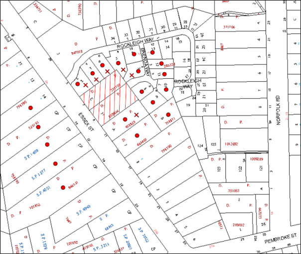
|
NOTIFICATION PLAN |
|
||
|
• PROPERTIES NOTIFIED
|
X SUBMISSIONS RECEIVED |
PROPERTY SUBJECT OF DEVELOPMENT |
|
Six submissions objected to the development. The grounds for objection are discussed as follows:
5.1.1 Unacceptable Overshadowing of Adjoining Properties
The proposed development would overshadow the adjoining property on the southern boundary.
The adjoining property is zoned for five storey residential flat development and includes an existing dwelling house. The overshadowing would occur over the western half of the property until midday and would extend over the remainder during the afternoon on June 22. The overshadowing is acknowledged but is commensurate with five storey development and the objectives of the R4 High Density Residential zone for a high density residential environment.
5.1.2 Unacceptable Noise from Driveway Operation
The proposed driveway would adjoin the rear of existing dwelling houses fronting Rockleigh Way. Noise from the driveway operation would be mitigated by the driveway ramp which is mainly underground.
5.1.3 Isolated Site Adjoining Properties
The potential isolation of adjoining properties as a result of the proposed development is the subject of discussion in Section 2.11.2 of this report.
5.1.4 Non-Compliance Floorplate and Setback Requirements
The proposed development does not comply with the 4m x 4m indentation required for floorplates exceeding 25m in dimension.
The non-compliance is acceptable with regard to the proposed articulation of the building as discussed in Section 2.11.5 of this report.
5.1.5 Unacceptable Landscaping and Screen Planting
The applicant submitted an amended landscape plan for additional deep soil planting including canopy trees and screen planting.
The amended landscape plan is acceptable subject to recommended condition for advanced plantings and additional canopy tree planting.
5.1.6 Unacceptable Visual and Privacy Impacts
The proposed five storey development would result in visual impact on the adjoining townhouse development which is consistent with the R4 High Density Residential zoning and acceptable with regard to compliance with the HDCP requirements for built form.
The proposed development is acceptable in respect to privacy of adjoining residents subject to conditions for landscaping, translucent glass balustrades and fencing.
5.1.7 Adjoining Owners Consent Required for Stormwater Drainage Works
The site has the benefit of a stormwater drainage easement over the adjoining ‘Rockleigh Park’ townhouse development site.
A deferred consent commencement condition is recommended for owners consent to be obtained for works required for stormwater drainage connection via the existing easement to Council’s stormwater drainage system.
6. THE PUBLIC INTEREST
Section 79C(1)(e) of the Act requires Council to consider “the public interest”.
The public interest is an overarching requirement, which includes the consideration of the matters discussed in this report. Implicit to the public interest is the achievement of future built outcomes adequately responding to and respecting the future desired outcomes expressed in environmental planning instruments and development control plans.
The application is considered to have satisfactorily addressed Council’s and relevant agencies’ criteria and would provide a development outcome that, on balance, would result in a positive impact for the community. Accordingly, it is considered that the approval of the proposed development would be in the public interest.
CONCLUSION
The application proposes demolition of existing structures and construction of a five storey residential flat building containing 32 units and basement car park.
The proposed development follows on rezoning of the land for high density residential use as part of the State government’s ‘Epping Urban Activation Precinct’.
The proposed five storey residential flat building complies with the provisions of HLEP and the SEPP 65 design principles. The proposal is generally in accordance with best practice requirements of the Residential Flat Design Code and would meet the requirements of HDCP subject to recommended conditions. The proposal is in accordance with the HDCP key development principles for the ‘Essex Street, Epping Precinct’.
A deferred consent commencement condition is recommended for owners consent to be obtained for works required for stormwater drainage connection to Council’s stormwater drainage system via the existing easement over the adjoining land.
Six submissions were received regarding the proposal, primarily concerning amenity impacts on residents of the adjoining ‘Rockleigh Park’ townhouse development. The concerns raised in the submissions would be addressed by the proposal subject to recommended conditions for landscaping and privacy.
The application is recommended for approval.
RESPONSIBLE OFFICER
The officer responsible for the preparation of this Report is the Manager – Development Assessment – Rodney Pickles, who can be contacted on 9847 6731.
|
Rod Pickles Manager - Development Assessment Planning Division |
James Farrington Group Manager Planning Division |
|
1.View |
Locality Map |
|
|
|
2.View |
Site Analysis Plan |
|
|
|
3.View |
Site Plan |
|
|
|
4.View |
Basement Plans |
|
|
|
5.View |
Floor Plans / Roof Plan |
|
|
|
6.View |
Elevations and Sections |
|
|
|
7.View |
Landscape Plan |
|
|
File Reference: DA/1110/2014
Document Number: D04413376
SCHEDULE 1
GENERAL CONDITIONS
The conditions of consent within this notice of determination have been applied to ensure that the use of the land and/or building is carried out in such a manner that is consistent with the aims and objectives of the relevant legislation, planning instruments and council policies affecting the land and does not disrupt the amenity of the neighbourhood or impact upon the environment.
Note: For the purpose of this consent, the term ‘applicant’ means any person who has the authority to act on or the benefit of the development consent.
Note: For the purpose of this consent, any reference to an Act, Regulation, Australian Standard or publication by a public authority shall be taken to mean the gazetted Act or Regulation, or adopted Australian Standard or publication as in force on the date that the application for a construction certificate is made.
1. Deferred Commencement
Pursuant to Section 80(3) of the Environmental Planning and Assessment Act 1979, this consent does not operate until the following information is submitted to Council:
a) Documentation of owners consent for works on the adjoining land required for stormwater drainage connection of the development to Council’s stormwater drainage system.
Such information shall be submitted within 12 months of the date of this notice.
Upon Council’s written satisfaction of the above information, the following conditions of development consent will apply:
2. Approved Plans and Supporting Documentation
The development must be carried out in accordance with the plans and documentation listed below and endorsed with Council’s stamp, except where amended by Council and/or other conditions of this consent:
|
Plan No. |
Plan Title |
Drawn by |
Dated |
|
4 B |
Site Plan |
Arvi Rannaste Architect |
14.01.15 |
|
5 |
Basement 2 |
Arvi Rannaste Architect |
20/09/2014 |
|
6 C |
Basement 1 |
Arvi Rannaste Architect |
11.02.15 |
|
7 C |
Ground Level |
Arvi Rannaste Architect |
11.02.15 |
|
8 C |
Level 1 |
Arvi Rannaste Architect |
11.02.15 |
|
9 C |
Level 2 |
Arvi Rannaste Architect |
11.02.15 |
|
10 C |
Level 3 |
Arvi Rannaste Architect |
11.02.15 |
|
11 C |
Level 4 |
Arvi Rannaste Architect |
11.02.15 |
|
12 C |
Roof |
Arvi Rannaste Architect |
11.02.15 |
|
13 C |
West Elevation |
Arvi Rannaste Architect |
11.02.15 |
|
14 C |
East Elevation |
Arvi Rannaste Architect |
11.02.15 |
|
15 C |
Section 1 |
Arvi Rannaste Architect |
11.02.15 |
|
16 C |
Section 2 |
Arvi Rannaste Architect |
11.02.15 |
|
14-036 Issue F |
Landscape Plan |
Jocelyn Ramsay & Assoc |
21.11.14 |
|
17 |
Construction Management Plan |
Arvi Rannaste Architect |
20/0/2014 |
|
Document Title |
Prepared by |
Dated |
|
BASIX Certificate No. 575277M |
Eco Certificates Pty Ltd |
19 September 2014 |
|
External Colour Selections |
Building Environments Pty Ltd |
Undated |
|
Traffic & Parking Assessment Report |
Winning Traffic Solutions |
September 2014 |
|
Arboricultural Implication Assessment and Arboricultural Method Statement |
Horticultural Resources Consulting Group |
19 September 2014 |
|
Design Verification Statement |
Building Environments Pty Ltd |
5 August 2014 |
|
Geotechnical Investigation |
SMEC Testing Services Pty Ltd |
September 2014 |
|
Waste Management Plan |
Earlcore Pty Ltd |
22/09/2014 |
|
Access/Compliance Report |
PSE Access Consulting |
5 June 2014 |
|
Stormwater Drainage Plans 140713-D01, 02, 06 |
iStruct |
20/11/2014 |
3. Amendment of Plans
The approved plans are to be amended as follows:
a) The Landscape Plan Drawing No. 14-036 Issue F is to be revised to address the location of the fire hydrant booster and the electrical sub-station detailed on the Ground Level Plan Drawing No. 7 C.
b) The Landscape Plan Drawing No. 14-036 Issue F is to be revised for the proposed common open space area to comprise a minimum of 25% of the site area and form a contiguous unencumbered area not less than 4m in dimension not including the Bioretention Area and to include appropriate furnishings to support use by residents.
c) The Landscape Plan Drawing No. 14-036 Issue F is to be revised to incorporate additional canopy trees as follows:
i) 3 x Angophora costata – Sydney Red Gum to be spaced across the width of the rear setback.
ii) 4 x Angophora costata – Sydney Red Gum to be spaced along the northern side setback.
iii) 3 x Syncarpia glomulifera – Turpentine within the northern and rear setback areas.
Note: Other canopy tree species derived from remnant forest communities ‘Peppermint-Angophora’ and ‘Blackbutt Gully Forest’ would also be acceptable in compliance with this condition.
d) The Landscape Plan Drawing No. 14-036 Issue F is to be revised for all large trees to be planted within the northern side and rear setback areas to be a minimum 200 litre pot size.
e) The Landscape Plan Drawing No. 14-036 Issue F is to be revised to delete the three proposed Callistemon viminalis – Weeping Bottlebrush within the street verge to be replaced with 3 x Sapium sebiferum – Tallowwood spaced evenly across the frontage each having a minimum size pot of 75 litres.
f) The basement car park is to include provision for one motor cycle parking space in accordance with AS 2890.5-1993.
g) The ‘Courtyard Unit 2’ area of deep soil landscaping is to be deleted and the area included in the common landscaped area. The Unit 2 open space area to be enclosed by 1.5m high translucent glass balustrade.
4. Removal of Existing Trees
This development consent only permits the removal of trees in accordance with the Arboricultural Implication Statement and Arboricultural Method Statement, prepared by V J Molyneaux, dated 19 September 2014 (Recommendation 1 – page 11).
5. Construction Certificate
A Construction Certificate is required to be approved by Council or a Private Certifying Authority prior to the commencement of any works under this consent.
6. Section 94 Development Contributions
a) In accordance with Section 80A(1) of the Environmental Planning and Assessment Act 1979 and the Hornsby Shire Council Section 94 Development Contributions Plan 2012-2021, the following monetary contributions shall be paid to Council to cater for the increased demand for community infrastructure resulting from the development:
|
Description |
Contribution (4) |
|
Roads |
$21,737.95 |
|
Open Space and Recreation |
$385,651.45 |
|
Community Facilities |
$53,775.95 |
|
Plan Preparation and Administration |
$1,594.45 |
|
TOTAL |
$462,759.80 |
being for 5 x 1 bedroom units, 24 x 2 bedroom units, 3 x 3 bedroom units and including a credit for two existing dwelling houses.
b) The value of this contribution is current as at 12 February 2015. If the contributions are not paid within the financial quarter that this condition was generated, the contributions payable will be adjusted in accordance with the provisions of the Hornsby Shire Council Section 94 Development Contributions Plan and the amount payable will be calculated at the time of payment in the following manner:
$CPY = $CDC x CPIPY
CPIDC
Where:
$CPY is the amount of the contribution at the date of Payment
$CDC is the amount of the contribution as set out in this Development Consent
CPIPY is the latest release of the Consumer Price Index (Sydney – All Groups) at the date of Payment as published by the ABS.
CPIDC is the Consumer Price Index (Sydney – All Groups) for the financial quarter at the date applicable in this Development Consent Condition.
c) The monetary contributions shall be paid to Council:
i) prior to the issue of the Subdivision Certificate where the development is for subdivision; or
ii) prior to the issue of the first Construction Certificate where the development is for building work; or
iii) prior to issue of the Subdivision Certificate or first Construction Certificate, whichever occurs first, where the development involves both subdivision and building work; or
iv) prior to the works commencing where the development does not require a Construction Certificate or Subdivision Certificate.
It is the professional responsibility of the Principal Certifying Authority to ensure that the monetary contributions have been paid to Council in accordance with the above timeframes.
Council’s Development Contributions Plan may be viewed at www.hornsby.nsw.gov.au or a copy may be inspected at Council’s Administration Centre during normal business hours.
REQUIREMENTS PRIOR TO THE ISSUE OF A CONSTRUCTION CERTIFICATE
7. Building Code of Australia
All building work must be carried out in accordance with the relevant requirements of the Building Code of Australia.
8. Contract of Insurance (Residential Building Work)
In the case of residential building work for which the Home Building Act 1989 requires there to be a contract of insurance in force in accordance with Part 6 of that Act, that such a contract of insurance is in force before any building work authorised to be carried out by the consent commences.
9. Notification of Home Building Act, 1989 Requirements
Residential building work within the meaning of the Home Building Act 1989 must not be carried out unless the principal certifying authority for the development to which the work relates (not being Council) has given Council written notice of the following information:
a) In the case of work for which a principal contractor is required to be appointed:
i) The name and licence number of the principal contractor; and
ii) The name of the insurer by which the work is insured under Part 6 of that Act.
b) In the case of work to be done by an owner-builder:
i) The name of the owner-builder; and
ii) If the owner-builder is required to hold an owner-builder’s permit under that Act, the number of the owner-builder’s permit.
Note: If arrangements for doing the residential building work are changed while the work is in progress so that the information notified becomes out of date, further work must not be carried out unless the principal certifying authority for the development to which the work relates (not being Council) has given Council written notification of the updated information.
10. Water/Electricity Utility Services
The applicant must submit written evidence of the following service provider requirements:
a) Ausgrid (formerly Energy Australia) – a letter of consent demonstrating that satisfactory arrangements have been made to service the proposed development.
b) Sydney Water – the submission of a ‘Notice of Requirements’ under s73 of the Sydney Water Act 1994.
Note: Sydney Water requires that s73 applications are to be made through an authorised Sydney Water Servicing Coordinator. Refer to www.sydneywater.com.au or telephone 13 20 92 for assistance.
11. Dilapidation Report
A ‘Dilapidation Report’ is to be prepared by a ‘chartered structural engineer’ detailing the structural condition of all adjoining properties including:
a) Nos. 2, 4, 6 and 8 Rockleigh Way, Epping
b) Nos. 4, 6 and 8 Brenda Way, Epping
c) No. 11 Essex Street, Epping
12. Excavation
A detailed geotechnical assessment of the site by a chartered structural engineer is to be undertaken for the design of the basement excavation and support, groundwater drainage, basement and foundation design.
13. Adaptable Units
The details of the adaptable units Nos 6, 8, 13, 15, 20, 22, 27, 29 and 30 must be provided with the Construction Certificate Plans.
14. Preservation of Survey Infrastructure
Prior to the issue of a construction certificate, a registered surveyor shall identify all survey marks in the vicinity of the proposed development. Any survey marks required to be removed or displaced as a result of the proposed development shall be undertaken by a registered surveyor in accordance with Section 24 (1) of the Surveying and Spatial Information Act 2002 and following the Surveyor General’s Directions No.11 – "Preservation of Survey Infrastructure".
15. Stormwater Drainage
The stormwater drainage system for the development must be designed and constructed in accordance with Council’s Civil Works – Design and Construction Specification 2005 and the following requirements:-
a) Connected to an existing Council piped drainage system directly to a Council pit, via an inter-allotment drainage system through downstream properties.
b) The drainage system be piped to contain at least the 20 year Average Recurrence Interval storm event on the undetained upstream catchment.
c) An inter-allotment stormwater drainage system to service the proposed development with pits being cast in situ or pre-cast concrete pits being used.
16. On Site Stormwater Detention and Water Quality System
An on-site stormwater detention system must be designed by a chartered civil engineer and constructed in accordance with the following requirements:-
a) Have a capacity of not less than 21.1 cubic metres, and a maximum discharge (when full) of 25 litres per second.
b) Have a 900 mm x 600 mm minimum size surcharge/inspection grate located directly above the outlet;
c) Discharge from the detention system to be controlled via 1 metre length of pipe, not less than 50 millimetres diameter or via a stainless plate with sharply drilled orifice bolted over the face of the outlet discharging into a larger diameter pipe capable of carrying the design flow to an approved Council system.
d) The system shall not be constructed in a location that would impact upon the visual or recreational amenity of residents.
e) The water treatment system shall be designed and constructed pursuant to Hornsby Development Control Plan 2013 Section 1C.1.2.i. Water Quality.
17. Internal Driveway/Vehicular Areas
The driveway and parking areas on site must be designed in accordance with Australian Standards 2890.1, 2890.2 and the following requirements:-
a) Design levels at the front boundary must be obtained from Council;
b) Curved ramps for cars only shall be designed and constructed in accordance with AS2890.1 s2.5.2.
18. Road Works
All road works approved under this consent must be constructed in accordance with Council’s Civil Works Design and Construction Specification 2005 and the following requirements:-
a) The existing kerb and gutter across the entire Essex Street frontage of the site shall be removed and Council’s standard 150mm integral kerb and gutter to be constructed, together with matching of the adjacent road shoulder pavement.
b) A concrete footpath to be constructed within the road verge with the remaining area turfed.
c) The existing road pavement to be saw cut a minimum of at least 600 mm from the existing edge of the bitumen and reconstructed.
d) The submission of a compaction certificate from a geotechnical engineer for any fill within road reserves, and all road sub-grade and road pavement materials.
e) Pursuant to s138 Roads Act 1993, Application shall be made to Hornsby Shire Council as Roads Authority for construction plan assessment, approval and compliance inspections of all works in the public road. The Applicant shall pay Council’s fee in regard to these requirements prior to release of the Construction Certificate for the road works.
19. Vehicular Crossing
A separate application under the Local Government Act 1993 and the Roads Act 1993 must be submitted to Council for the installation of a new vehicular crossing and the removal of the redundant crossing. The vehicular crossing must be constructed in accordance with Council’s Civil Works Design 2005 and the following requirements:-
a) The footway area must be restored by turfing;
Note: An application for a vehicular crossing can only be made to one of Council’s Authorised Vehicular Crossing Contractors, or be the subject of a Construction Certificate to Council as Roads Authority. You are advised to contact Council on 02 9847 6940 to obtain a list of contractors.
20. Traffic Control Plan
A Traffic Control Plan (TCP) must be prepared by a qualified traffic controller in accordance with the Roads & Traffic Authority’s Traffic Control at Worksites Manual 1998 and Australian Standard 1742.3 for all work on a public road and be submitted to Council. The TCP must detail the following:
a) Arrangements for public notification of the works.
b) Temporary construction signage.
c) Vehicle movement plans.
d) Traffic management plans.
e) Pedestrian and cyclist access/safety.
REQUIREMENTS PRIOR TO THE COMMENCEMENT OF ANY WORKS
21. Erection of Construction Sign
A sign must be erected in a prominent position on any site on which building work, subdivision work or demolition work is being carried out:
a) Showing the name, address and telephone number of the principal certifying authority for the work;
b) Showing the name of the principal contractor (if any) for any demolition or building work and a telephone number on which that person may be contacted outside working hours; and
c) Stating that unauthorised entry to the work site is prohibited.
Note: Any such sign is to be maintained while the building work, subdivision work or demolition work is being carried out, but must be removed when the work has been completed.
22. Protection of Adjoining Areas
A temporary hoarding, fence or awning must be erected between the work site and adjoining lands before the works begin and must be kept in place until after the completion of the works if the works:
a) Could cause a danger, obstruction or inconvenience to pedestrian or vehicular traffic.
b) Could cause damage to adjoining lands by falling objects.
c) Involve the enclosure of a public place or part of a public place.
Note: Notwithstanding the above, Council’s separate written approval is required prior to the erection of any structure or other obstruction on public land.
23. Toilet Facilities
Toilet facilities must be available or provided at the works site before works begin and must be maintained until the works are completed at a ratio of one toilet for every 20 persons employed at the site. Each toilet must:
a) be a standard flushing toilet connected to a public sewer; or
b) be a temporary chemical closet approved under the Local Government Act 1993; or
c) have an on-site effluent disposal system approved under the Local Government Act 1993.
24. Erosion and Sediment Control
Erosion and sediment control measures must be provided and maintained throughout the construction period in accordance with the manual ‘Soils and Construction 2004 (Bluebook)’, the approved plans, Council specifications and to the satisfaction of the principal certifying authority. The erosion and sediment control devices must remain in place until the site has been stabilised and revegetated.
Note: On the spot penalties up to $1,500 may be issued for any non-compliance with this requirement without any further notification or warning.
25. Tree Protection Barriers
Tree protection measures must be in accordance with Section 3 (Tree Management and Preservation) of the Arboricultural Implication Statement and Arboricultural Method Statement, prepared by V J Molyneaux, dated 19 September 2014.
REQUIREMENTS DURING CONSTRUCTION
26. Construction Work Hours
All work on site (including demolition and earth works) must only occur between 7am and 5pm Monday to Saturday, in accordance with Interim Construction Noise Guidelines 2009 – NSW Department of Environment and Climate Change.
No work is to be undertaken on Sundays or public holidays.
27. Demolition
All demolition work must be carried out in accordance with “Australian Standard 2601-2001 – The Demolition of Structures” and the following requirements:
a) Demolition material must be disposed of to an authorised recycling and/or waste disposal site and/or in accordance with an approved waste management plan;
b) Demolition works, where asbestos material is being removed, must be undertaken by a contractor that holds an appropriate licence issued by WorkCover NSW in accordance with Chapter 10 of the Occupational Health and Safety Regulation 2001 and Clause 29 of the Protection of the Environment Operations (Waste) Regulation 2005 ;and
c) On construction sites where buildings contain asbestos material, a standard commercially manufactured sign containing the words ‘DANGER ASBESTOS REMOVAL IN PROGRESS’ measuring not less than 400mm x 300mm must be erected in a prominent position visible from the street.
28. Environmental Management
The site must be managed in accordance with the publication ‘Managing Urban Stormwater – Landcom (March 2004) and the Protection of the Environment Operations Act 1997 by way of implementing appropriate measures to prevent sediment run-off, excessive dust, noise or odour emanating from the site during the construction of the development.
29. Street Sweeping
Street sweeping must be undertaken following sediment tracking from the site along Essex Street during works and until the site is established.
30. Council Property
During construction works, no building materials, waste, machinery or related matter is to be stored on the road or footpath. The public reserve must be kept in a clean, tidy and safe condition at all times.
Note: This consent does not give right of access to the site via Council’s park or reserve. Should such access be required, separate written approval is to be obtained from Council.
31. Landfill
Landfill must be constructed in accordance with Council’s ‘Construction Specification 2005’ and the following requirements:
a) All fill material imported to the site is to wholly consist of Virgin Excavated Natural Material (VENM) as defined in Schedule 1 of the Protection of the Environment Operations Act 1997 or a material approved under the Department of Environment and Climate Change’s general resource recovery exemption.
b) A compaction certificate is to be obtained from a geotechnical engineer verifying that the specified compaction requirements have been met.
32. Excavated Material
All excavated material removed from the site must be classified in accordance with the Department of Environment, Climate Change and Water NSW Waste Classification Guidelines prior to disposal to an approved waste management facility and reported to the principal certifying authority.
33. Survey Report – Finished Floor Level
A report(s) must be prepared by a registered surveyor and submitted to the principal certifying authority prior to the pouring of concrete at each level of the building certifying that:
a) The building, retaining walls and the like have been correctly positioned on the site; and
b) The finished floor level(s) are in accordance with the approved plans.
34. Works Near Trees
All personnel (the applicant, contractors, service providers, principle certifying authority) are to ensure that nor excavation, including sub-surface trenching for stormwater or other services or the filling or stockpiling of building materials, parking of vehicles or plant, the use of machinery other than hand held, disposal of cement slurry, waste water or other contaminants is to occur within the Tree Root Zone as prescribed in the Hornsby Development Control Plan 2013 Section 1B.6.1(i) of any tree to be retained.
35. Waste Management Details
Waste management during the demolition and construction phase of the development must be undertaken in accordance with the approved Waste Management Plan. Additionally written records of the following items must be maintained during the removal of any waste from the site and such information submitted to the Principal Certifying Authority within fourteen days of the date of completion of the works:
a) The identity of the person removing the waste.
b) The waste carrier vehicle registration.
c) Date and time of waste collection.
d) A description of the waste (type of waste and estimated quantity).
e) Details of the site to which the waste is to be taken.
f) The corresponding tip docket/receipt from the site to which the waste is transferred (noting date and time of delivery, description (type and quantity) of waste).
g) Whether the waste is expected to be reused, recycled or go to landfill.
Note: In accordance with the Protection of the Environment Operations Act 1997, the definition of waste includes any unwanted substance, regardless of whether it is reused, recycled or disposed to landfill.
REQUIREMENTS PRIOR TO THE ISSUE OF AN OCCUPATION CERTIFICATE
Note: For the purpose of this consent, a reference to ‘occupation certificate’ shall not be taken to mean an ‘interim occupation certificate’ unless otherwise stated.
36. Fulfilment of BASIX Commitments
The applicant must demonstrate the fulfilment of BASIX commitments pertaining to the development.
37. Damage to Council Assets
Any damage caused to Council’s assets as a result of the construction of the development must be rectified in accordance with Council’s Civil Works Specifications. Council’s Restorations Supervision must be notified for a formwork inspection prior to pouring concrete.
38. Creation of Easements
The following matter(s) must be nominated on the plan of subdivision under s88B of the Conveyancing Act 1919:
a) A right of access and easement for Council to facilitate waste and recycling removal, using terms available from Council.
b) The creation of an appropriate "Positive Covenant" and "Restriction as to User" over the constructed on-site detention/retention systems and outlet works, within the lots in favour of Council in accordance with Council’s prescribed wording. The position of the on-site detention system is to be clearly indicated on the title.
c) To register the OSD easement, the restriction on the use of land “works-as-executed” details of the on-site-detention system must be submitted verifying that the required storage and discharge rates have been constructed in accordance with the design requirements. The details must show the invert levels of the onsite system together with pipe sizes and grades. Any variations to the approved plans must be shown in red on the “works-as-executed” plan and supported by calculations.
Note: Council must be nominated as the authority to release, vary or modify any easement, restriction or covenant.
39. Installation of Privacy Devices
The following device(s) must be installed to maintain an element of privacy.
a) All privacy screens must be sliding stackable louvered metal screens extendable to the full width of the balconies;
b) All glass balustrades must be translucent glass;
c) Outdoor clothes drying area must screened from view of publicly accessible areas.
40. Storage Areas
Each dwelling within the development must have a minimum area for storage (not including built-in storage) of 6m3 for one bedroom units, 8m3 for two bedroom units and 10m3 for three bedroom units.
41. Safety and Security
a) Fire exist doors to the development must be fitted with single cylinder locksets (Australia and New Zealand Standard – Lock Sets) to restrict unauthorized access to the development.
b) Ground floor windows must be fitted with window locks that can be locked with a key.
c) A graffiti management plan must be incorporated into the maintenance plan for the development for graffiti to be removed within a forty-eight hour period.
d) The basement car park entry must be secured by security gates/roller shutters and controlled by secure access located at the top of the driveway. The access control to include an audio/visual intercom system to allow visitor access to the parking area.
e) Lighting of pedestrian pathways throughout the development must comply with Australia and New Zealand Lighting Standard 1158.1 – Pedestrian.
f) Front fencing to be designed to allow casual surveillance at the frontage.
g) Lobby access to be controlled by security card or similar.
42. Works as Executed Plan
A works-as-executed plan(s) must be prepared by a registered surveyor and submitted to Council for completed road pavement, kerb & gutter, public drainage systems, driveways and on-site detention system.
43. Consolidation of Allotments
All allotments the subject of this consent must be consolidated into one allotment.
Note: The applicant is recommended to submit the plan of subdivision to consolidate allotments to the NSW Department of Lands at least 4-6 weeks prior to seeking an occupation certificate.
44. Unit Numbering
The allocation of unit numbering must be authorised by Council prior to the numbering of each unit in the development.
45. Survey Marks
A certificate by a Registered Surveyor must be submitted to the Principal Certifying Authority, certifying that there has been no removal, damage, destruction, displacement or defacing of the existing survey marks in the vicinity of the proposed development, or otherwise certifying that the necessary re-establishment of any damaged, removed or displaced survey marks has been undertaken in accordance with the Surveyor General’s Direction No. 11 – “Preservation of Survey Infrastructure”.
46. Provision for National Broadband Network (NBN)
Provision must be made for fibre ready passive infrastructure (pits and pipes) generally in accordance with NBN Co's pit and pipe installation guidelines to service the proposed development. A certificate from NBN Co or Telstra must be submitted to the PCA that the fibre optic cabling provided for the development complies with MDU Building Design Guides for Development.
47. Completion of Landscaping
A certificate must be provided by a practicing landscape architect, horticulturalist or person with similar qualifications and experience certifying that all required landscaping works have been satisfactorily completed in accordance with the approved landscape plans.
Note: Advice on suitable species for landscaping can be obtained from Council’s planting guide ‘Indigenous Plants for the Bushland Shire’, available at www.hornsby.nsw.gov.au.
48. External Lighting
All external lighting must be designed and installed in accordance with Australian Standard AS 4282 – Control of the Obtrusive Effects of Outdoor Lighting. Certification of compliance with the Standard must be obtained from a suitably qualified person.
49. Boundary Fencing
Lapped and capped timber fencing must be erected along all property boundaries behind the front building alignment to a height of 1.8 metres, the fencing to be topped with 300mm high lattice.
Note: Alternative fencing may be erected subject to the written consent of the adjoining property owner(s).
50. Garbage Collection Easement
For the purpose of waste collection, an easement entitling Council, its servants and agents and persons authorised by it to enter upon the subject land and to operate thereon, vehicles and other equipment for the purposes of garbage collection must be granted to Council by the owner of the land.
Note: The easement must be in a form prescribed by Council and must include covenants to the effect that parties will not be liable for any damage caused to the subject land or any part thereof or to any property located therein or thereon by reason of the operation thereon of any vehicle or other equipment used in connection with the collection of garbage and to the effect that the owner for the time being of the subject land shall indemnify the Council, its servants, agents and persons authorised by it to collect garbage against liability in respect of any such claims made by any person whomsoever.
51. Waste Management
The following waste management requirements must be complied with:
a) The garbage rooms at the basement level must include water or a hose for cleaning, graded floors with drainage to sewer, a robust door, sealed and impervious surface, adequate lighting and ventilation, and must be lockable. The waste facility at each residential level must include sealed and impervious surface, adequate lighting and ventilation.
b) A report must be prepared by an appropriately qualified person, certifying the following:
i) A comparison of the estimated quantities of each waste type against the actual quantities of each waste type. Note: Explanations of any deviations to the approved Waste Management Plan is required to be included in this report
ii) That at least 60% of the waste generated during the demolition and construction phase of the development was reused or recycled. Note: If the 60% diversion from landfill cannot be achieved in the Construction Stage, the Report is to include the reasons why this occurred and certify that appropriate work practices were employed to implement the approved Waste Management Plan. The Report must be based on documentary evidence such as tipping dockets/receipts from recycling depots, transfer stations and landfills, audits of procedures etc. which are to be attached to the report.
iii) All waste was taken to site(s) that were lawfully permitted to accept that waste.
c) A report(s) must be prepared by a registered surveyor and submitted to the principal certifying authority prior to the issue of the Subdivision/Occupation Certificate, certifying that the finished access way (including ramp, loading bay and site entry/exit) to be used by waste collection vehicles, complies with Australian Standard AS2890.2-2002 Parking Facilities Part 2: Off-street Commercial Vehicle Facilities for small rigid vehicles.
d) Each unit must be provided with an indoor waste/recycling cupboard for the interim storage of a minimum one day’s waste generation with separate containers for general waste and recyclable materials.
e) Space must be provided for either individual compost containers for each unit or a communal compost container;
Note: The location of the compost containers should have regard for potential amenity impacts.
f) The bin carting routes must be devoid of any steps.
Note: Ramps between different levels are acceptable.
g) “No Parking” signs must be installed to prevent cars parking in the loading bay.
h) The 3.5 metre vertical clearance height within the truck travel path must not be reduced by ducting, lights, pipes or anything else.
i) Access to the automatic waste volume handling equipment by unauthorised persons (including residents and waste collectors) must be prevented.
j) A report(s) must be prepared by a registered surveyor and submitted to the principal certifying authority prior to the issue of the Subdivision/Occupation Certificate, certifying that: The finished access way (including ramp, vehicle turning area, loading bay and site entry/exit) to be used by waste collection vehicles, complies with Australian Standard AS2890.2-2002 Parking Facilities Part 2: Off-street Commercial Vehicle Facilities for small rigid vehicles with minimum design vehicle dimensions of 6.4 metres overall length, width of 2.3 metres, with maximum gradient of 1:6.5 and minimum 3.5 metre clearance height.
Note: Encroachments of the small rigid vehicle turning path and low speed manoeuvring clearance (300 mm both sides) into parking spaces cannot be tolerated.
OPERATIONAL CONDITIONS
52. Car Parking and Road Safety
a) All car parking must be constructed and operated in accordance with Australian Standard AS/NZS 2890.1:2004 – Off-street car parking and Australian Standard AS 2890.2:2002 – Off-street commercial vehicle facilities.
i) All parking areas and driveways are to be sealed to an all-weather standard, line marked and signposted;
ii) Car parking, loading and manoeuvring areas to be used solely for nominated purposes;
iii) Vehicles awaiting loading, unloading or servicing shall be parked on site and not on adjacent or nearby public roads;
b) Any proposed landscaping and/or fencing must not restrict sight distance to pedestrians and cyclists travelling along the footpath.
c) Residential parking spaces are to be secure spaces with access controlled by card or numeric pad.
d) Visitors must be able to access the visitor parking spaces in the basement car park at all times.
e) All parking for people with disabilities is to comply with AS/NZS 2890.6:2009 Off-street parking for people with disabilities.
f) Bicycle parking spaces are to be designed in accordance with AS 2890.3-1993 Bicycle parking facilities
g) Motorcycle parking spaces are to be designed in accordance with AS 2890.5-1993
53. Noise
All noise generated by the proposed development must be attenuated to prevent levels of noise being emitted to adjacent premises which possess tonal, beating and similar characteristics or which exceeds background noise levels by more than 5dB(A).
54. Fire Safety Statement - Annual
On at least one occasion in every 12 month period following the date of the first ‘Fire Safety Certificate’ issued for the property, the owner must provide Council with an annual ‘Fire Safety Certificate’ to each essential service installed in the building.
55. Landscape Establishment
The landscape works must be maintained into the future to ensure the establishment and successful growth of plant material to meet the intent of the landscape design. This must include but not be limited to watering, weeding, replacement of failed plant material and promoting the growth of plants through standard industry practices.
56. Waste Storage Area and Waste Management
The waste management on site must be in accordance with the following requirements:
a) Site security measures implemented on the property, including electronic gates, must not prevent access to the bin room/collection point by waste removal services.
b) Site security measures be implemented to prevent access to the waste volume handling equipment by unauthorised persons including residents.
c) A site caretaker must be employed and be responsible for moving bins where and when necessary, washing bins and maintaining waste storage areas, ensuring the chute system and related devices are maintained in effective and efficient working order, managing the communal composting area, arranging the prompt removal of dumped rubbish, and ensuring all residents are informed of the use of the waste management system.
- END OF CONDITIONS -
ADVISORY NOTES
The following information is provided for your assistance to ensure compliance with the Environmental Planning and Assessment Act, 1979, Environmental Planning and Assessment Regulation 2000, other relevant legislation and Council’s policies and specifications. This information does not form part of the conditions of development consent pursuant to Section 80a of the Act.
Environmental Planning and Assessment Act 1979 Requirements
The Environmental Planning and Assessment Act 1979 requires:
· The issue of a construction certificate prior to the commencement of any works. Enquiries can be made to Council’s Customer Services Branch on 9847 6760.
· A principal certifying authority to be nominated and Council notified of that appointment prior to the commencement of any works.
· Council to be given at least two days written notice prior to the commencement of any works.
· Mandatory inspections of nominated stages of the construction inspected.
· An occupation certificate to be issued before occupying any building or commencing the use of the land.
Long Service Levy
In accordance with Section 34 of the Building and Construction Industry Long Service Payments Act 1986, a ‘Long Service Levy’ must be paid to the Long Service Payments Corporation or Hornsby Council.
Note: The rate of the Long Service Levy is 0.35% of the total cost of the work.
Note: Hornsby Council requires the payment of the Long Service Levy prior to the issue of a construction certificate.
Tree and Vegetation Preservation
In accordance with Clause 5.9 of the Hornsby Local Environmental Plan 2013 a person must not ringbark, cut down, top, lop, remove, injure or wilfully destroy any tree or other vegetation protected under the Hornsby Development Control Plan 2013 without the authority conferred by a development consent or a permit granted by Council.
Notes: A tree is defined as a long lived, woody perennial plant with one or relatively few main stems with the potential to grow to a height greater than three metres (3M). (HDCP 1B.6.1.c).
Tree protection measures and distances are determined using the Australian Standard AS 4970:2009, “Protection of Trees on Development Sites”.
Fines may be imposed for non-compliance with both the Hornsby Local Environmental Plan 2013 and the Hornsby Development Control Plan 2013.
Disability Discrimination Act
The applicant’s attention is drawn to the existence of the Disability Discrimination Act. A construction certificate is required to be obtained for the proposed building/s, which will provide consideration under the Building Code of Australia, however, the development may not comply with the requirements of the Disability Discrimination Act. This is the sole responsibility of the applicant.
Dial Before You Dig
Prior to commencing any works, the applicant is encouraged to contact Dial Before You Dig on 1100 or www.dialbeforeyoudig.com.au for free information on potential underground pipes and cables within the vicinity of the development site.
Telecommunications Act 1997 (Commonwealth)
If you are aware of any works or proposed works which may affect or impact on Telstra’s assets in any way, you are required to contact: Telstra’s Network Integrity Team on Phone Number 1800810443.
Asbestos Warning
Should asbestos or asbestos products be encountered during demolition or construction works, you are advised to seek advice and information prior to disturbing this material. It is recommended that a contractor holding an asbestos-handling permit (issued by WorkCover NSW) be engaged to manage the proper handling of this material. Further information regarding the safe handling and removal of asbestos can be found at:
Alternatively, telephone the WorkCover Asbestos and Demolition Team on 8260 5885.
Group Manager’s Report No. PL12/15
Planning Division
Date of Meeting: 11/03/2015
6 DEVELOPMENT APPLICATION - CHILD CARE CENTRE - 109 COPELAND ROAD, BEECROFT
EXECUTIVE SUMMARY
|
DA No: |
DA/1049/2014 (Lodged on 11 September 2014) |
|
Description: |
Construction of a 57 place, purpose built child care centre with basement car park |
|
Property: |
Lot A and B DP 166377, No. 109 Copeland Road, Beecroft |
|
Applicant: |
Mr T J Kermani and Mrs H Kermani |
|
Owner: |
Mr T J Kermani and Mrs H Kermani |
|
Estimated Value: |
$ 650,000 |
|
Ward: |
C |
· The application involves the construction of a single storey 57 place, purpose built child care centre with basement car park.
· The proposal complies with the provisions of the Hornsby Local Environmental Plan 2013 and Hornsby Development Control Plan 2013.
· 30 submissions have been received in respect of the application from 23 residents.
· A Red Sticker has been placed on the application requiring that it be determined at a Council meeting.
· It is recommended that the application be approved.
|
THAT Development Application No. DA/1049/2014 for construction of a single storey 57 place, purpose built child care centre with basement car park at Lot A and B DP 166377, No. 109 Copeland Road, Beecroft be approved subject to the conditions of consent detailed in Schedule 1 of Group Manager’s Report No. PL12/15. |
BACKGROUND
The site has been used for residential purposes.
On 12 November 2013, DA/548/2013 was approved by Council for demolition of the existing dwelling house on the site.
On 11 September 2014, DA/1049/2014 was lodged with Council for the construction of a 60 place child care centre with basement car park. The proposal was subsequently amended by reducing the number of children to 57.
SITE
The site comprises two allotments located on the north-western corner of Copeland Road and York Street with a combined area of 1405m2. The site has a diagonal cross fall of 8.6% from the north-eastern corner (York Street) to the south-western corner (Copeland Road). The site is cleared of all structures. Vehicular access to the site is gained via an existing driveway fronting York Street.
A large number of trees are located at the north-eastern corner of the site extending to the adjoining property at No. 16 York Street and also along the York Street and Copeland Road frontages. The trees form part of a mapped Endangered Ecological Community, Sydney Turpentine Ironbark Forest (STIF).
The subject property is located in the immediate vicinity of two locally listed heritage items – No. 106 Copeland Road (Item No. 77) and No. 116 Copeland Road (Item No. 78). The site is also located within the Beecroft/Cheltenham Heritage Conservation Area.
A 2.5m high concrete block wall acts as the dividing fence for part of the northern boundary. The surrounding area is characterised by single and two storey dwelling houses with large gardens and remnant trees.
The site is located 500m west of Beecroft Railway Station and approximately 260m west of Beecroft Primary School.
PROPOSAL
The proposal (as amended) involves the construction of a 57 place, purpose built child care centre with basement car park and the play area fronting York Street. The child care centre would be a single level building over a basement car park following the slope of the land.
Proposed hours of operation would be 8am to 6pm Monday to Friday and will include a maximum of 9 staff members.
The details of the proposal are provided below:
Lower Ground Level
· Car park comprising 17 spaces with 1 disabled space and access via a two way driveway from Copeland Road in close proximity to the south-western corner; and
· Ramp along the Copeland Road frontage for access to the upper floor.
Upper Ground Floor
· Child care centre with the capacity for 57 spaces in the following categories:
o 0-2 years: 20 children
o 2-3 years: 8 children
o 3-4 years: 16 children
o 4-5 years: 13 children
· The child care centre comprises four separate indoor play rooms to cater for the age groups, office, children’s toilet, staff room, WC, laundry, kitchen, craft room, cot room, bottle preparation area, storage, reception and office; and
· A covered patio with a sand pit located within the yard fronting York Street.
Outdoor Play Area
· The outdoor play area would have access from the covered area and would be partly shaded with temporary canvas shades.
Fencing
· The existing concrete block wall is proposed to be retained along the northern boundary. A timber paling fence is proposed along the remaining section of this boundary;
· An 18m long awning is proposed along the northern edge of the outdoor play area, setback 2m from the northern boundary. The awning would comprise a cantilevered inclined roof over timber posts. The materials would constitute spaced timber slats with acoustic insulation.
· A timber paling fence is proposed along the western boundary of the site;
· A 1.4m high timber picket fence with transparent polycarbonate backing is proposed along the York Street frontage (eastern boundary). This would also act as an acoustic barrier; and
· Timber picket fence is proposed along the Copeland Road boundary.
ASSESSMENT
The development application has been assessed having regard to the ‘A Plan for Growing Sydney’, the ‘North Subregion (Draft) Subregional Strategy’ and the matters for consideration prescribed under Section 79C of the Environmental Planning and Assessment Act 1979 (the Act). The following issues have been identified for further consideration.
1. STRATEGIC CONTEXT
1.1 A Plan for Growing Sydney and (Draft) North Subregional Strategy
A Plan for Growing Sydney has been prepared by the NSW State Government to guide land use planning decisions for the next 20 years. The Plan sets a strategy for accommodating Sydney’s future population growth and identifies the need to deliver 689,000 new jobs and 664,000 new homes by 2031. The Plan identifies that the most suitable areas for new housing are in locations close to jobs, public transport, community facilities and services.
The NSW Government will use the subregional planning process to define objectives and set goals for job creation, housing supply and choice in each subregion. Hornsby Shire has been grouped with Hunters Hill, Ku-ring-gai, Lane Cove, Manly, Mosman, North Sydney, Pittwater, Ryde, Warringah and Willoughby to form the North Subregion. The Draft North Subregional Strategy will be reviewed and the Government will set housing targets and monitor supply to ensure planning controls are in place to stimulate housing development.
The proposed development would be consistent with ‘A Plan for Growing Sydney’, by providing additional services to support a growing population.
2. STATUTORY CONTROLS
Section 79C(1)(a) requires Council to consider “any relevant environmental planning instruments, draft environmental planning instruments, development control plans, planning agreements and regulations”.
2.1 Hornsby Local Environmental Plan 2013
The proposed development has been assessed having regard to the provisions of the Hornsby Local Environmental Plan 2013 (HLEP).
2.1.1 Zoning of Land and Permissibility
The subject land is zoned R2 Low Density Residential under the HLEP. The objectives of the zone are:
(a) To provide for the housing needs of the community within a low density residential environment.
(b) To enable other land uses that provide facilities or services to meet the day to day needs of residents.
The proposed development is defined as a “child care centre” and is permissible in the zone with Council’s consent.
2.1.2 Height of Buildings
Clause 4.3 of the HLEP provides that the height of a building on any land should not exceed the maximum height show for the land on the Height of Buildings Map. The maximum permissible height for the subject site is 8.5m. The proposal would comply with this provision.
2.1.3 Heritage Conservation
Clause 5.10 of the HLEP sets out heritage conservation provisions for Hornsby Shire. The site is located within the Beecroft-Cheltenham Heritage Conservation Area (HCA) – Beecroft Plateau Precinct, listed in Part 2, Schedule 5 (Environmental Heritage) of the HLEP and also in the immediate vicinity of two locally listed heritage items at No. 106 and No. 116 Copeland Road.
The proposal is supported by a Statement of Heritage Impact, prepared by Archnex Designs. The application was referred to Council’s Heritage Advisory Committee and the following comments were provided:
· The proposed child care centre would present itself as a single storey structure from York Street. A part two storey element would be visible at the Copeland Road frontage incorporating access to the basement car parking.
· Whilst the building would cover a substantially larger footprint than most structures in its vicinity, it is located on a double block.
· The building design includes a gabled and hipped roof form, verandahs and a variety of façade articulation measures.
· In combination, these elements along with the proposed landscaping and colour palette assist to minimise bulk and scale impacts when viewed from the street.
· The proposal includes an extended setback to the York Street frontage to provide outdoor play areas;
· Properties in the immediate vicinity along Copeland Road have a variety of building setbacks to the street, however, the streetscape is generally characterised by relatively deep, landscaped and treed property frontages. The proposed building footprint would have a relatively lesser setback from Copeland Road. Appropriate fencing and landscaping have been proposed to mitigate any negative impact on the streetscape, due to the reduced setbacks and the 5.5m – 6m wide concrete driveway.
· The proposed materials include face bricks and a combination of render, panelling and strapping to various roof and façade sections. This combination would assist in breaking up the bulk and result in a façade treatment which is consistent with the character of the Conservation Area. The aluminium garage roller door would have a neutral brown colour integrating it with the dark brown face brick proposed for the base-course.
· A solid paved driveway treatment is proposed to suit the proposed land use. This would have negligible impact on the Heritage Conservation Area.
· The proposal includes a low picket fence to both the Copeland Road and York Street boundaries, screen planting in garden beds behind the fencing and retention of a number of existing trees on the site. These elements would blend with the landscaped character of the surrounding area and screen the pedestrian/stroller ramp and outdoor play areas.
· The proposed acoustic screens/barriers are well designed and generally integrate with the proposed landscaping. The colour scheme of the proposed acoustic awning (to the north) should be dark toned and visually recessive. This requirement is recommended as a condition of consent.
· Conditions of consent recommend further screen planting along the York Street frontage. These measures, in combination with the design of the barriers, would result in minimal impact on the HCA and heritage items in the vicinity.
Council’s heritage assessment concludes that the impact of the proposal on the Heritage Conservation Area has been suitably addressed in the Statement of Heritage Impact. Accordingly, the proposal is assessed as satisfactory with regard to Clause 5.10 of the HLEP.
2.1.4 Earthworks
Clause 6.2 of the HLEP states that consent is required for proposed earthworks on site. Before granting consent for earthworks, Council is required to assess the impacts of the works on adjoining properties, drainage patterns and soil stability of the locality.
Council’s assessment concludes that the proposal would be satisfactory in regards to earthworks subject to appropriate conditions regarding the preparation of dilapidation reports assessing impacts of excavation on adjoining properties and earthwork management measures.
2.2 State Environmental Planning Policy No. 55 – Remediation of Land
The application has been assessed against the requirements of State Environmental Planning Policy No. 55 (SEPP 55). This Policy requires that Council must not consent to the carrying out of any development on land unless it has considered whether the land is contaminated or requires remediation for the proposed use.
The application is supported by a preliminary site contamination investigation report prepared by ADE Consulting Group. The report notes that the site has been used for residential purposes since 1951 and that no asbestos fibres were detected in the topsoil samples collected. Further, the topsoil meets the criteria for heavy metals assigned by the National Environmental Protection Measure (Assessment of Site Contamination) 1999, for residential properties and day care centres. Accordingly, no further investigation has been recommended.
Council’s assessment of the proposal concludes that, given the results and conclusions of the site contamination investigation report, the site would be suitable for the proposed use and no further assessment is required in this regard.
2.3 Children (Education and Care Services) Supplementary Provisions Regulation 2012
Compliance with the Regulation is required for the licensing of child care centres by the NSW Department of Community Services.
The proposed development has been designed in accordance with Clause 28 of the Regulation which requires the provision of 3.25 sqm of unencumbered indoor play area per child and 7 sqm of useable outdoor play area per child. The development also includes a separate sleeping area for under 2 year olds, administration/meeting room and staff room.
In addition to a covered patio in front of the child care centre, other shade structures are also proposed in the outdoor play areas which are considered adequate. Notwithstanding, a condition is recommended that the outdoor play space be adequately shaded in accordance with The Shade Handbook, published by the New South Wales Cancer Council in 2008 prior to the issue of the Occupation Certificate.
The Statement of Environmental Effects indicates that the proposed child care centre would employ 9 staff members distributed in 4 rooms in accordance with ‘Staff to Child Ratio’ requirements within the Regulation. A condition of consent is recommended requiring compliance with the provisions of Children (Education and Care Services) Supplementary Provisions Regulations 2012, in this regard.
2.4 Sydney Regional Environmental Plan (Sydney Harbour Catchment) 2005
The application has been assessed against the requirements of Sydney Regional Environmental Plan (Sydney Harbour Catchment) 2005. This Policy provides general planning considerations and strategies to ensure that the catchment, foreshores, waterways and islands of Sydney Harbour are recognised, protected, enhanced and maintained.
Subject to the implementation of installation of sediment and erosion control measures and stormwater management to protect water quality, the proposal would have minimal potential to impact on the Sydney Harbour Catchment.
2.5 Clause 74BA Environmental Planning and Assessment Act, 1979 - Purpose and Status of Development Control Plans
Clause 74BA of the Environmental Planning and Assessment Act, 1979 states that a DCP provision will have no effect if it prevents or unreasonably restricts development that is otherwise permitted and complies with the development standards in relevant Local Environmental Plans and State Environmental Planning Policies.
The principal purpose of a development control plan is to provide guidance on the aims of any environmental planning instrument that applies to the development; facilitate development that is permissible under any such instrument; and achieve the objectives of land zones. The provisions contained in a DCP are not statutory requirements and are for guidance purposes only. Consent authorities have flexibility to consider innovative solutions when assessing development proposals, to assist achieve good planning outcomes.
2.6 Hornsby Development Control Plan 2013
The proposed development has been assessed having regard to the relevant desired outcomes and prescriptive requirements within the Hornsby Development Control Plan 2013 (HDCP). The following table sets out the proposal’s compliance with the prescriptive requirements of the Plan:
|
Hornsby Development Control Plan 2013 |
|||
|
Control |
Proposal |
Requirement |
Compliance |
|
Floor Area
|
430m2
|
430m2 (site area >900 m2) |
Yes
|
|
Site Coverage |
39% |
40% |
Yes |
|
Height |
8.5m – 2 storey |
8.5m– 2 storey |
Yes |
|
Number of Children 0-2 age group (33% of total) Total number of children |
20 57 |
Min. 19 60 |
Yes Yes |
|
Recreation Space Outdoor (@ 7m2 per child + 15 m2 per child for over 40) Indoor (3.25m2 per child + 4.5) |
536m2
269m2 |
535m2
206m2 |
Yes
Yes |
|
Landscaping |
58% |
40% |
Yes |
|
Car Parking |
17 spaces |
15 spaces |
Yes |
|
Setbacks York Street (East) Copeland Road (Front) Rear (North) Side (West) |
15m 6m 3m – 8m 3m |
3m 6m 3m – 8m 900mm – 1.5m |
Yes Yes Yes Yes |
As detailed in the above table, the proposed development complies with the prescriptive requirements within the HDCP. The compliance of the proposal with relevant desired outcomes is discussed below.
2.6.1 Site Requirements
The HDCP encourages child care centres to be located on sites that are readily accessible to users, promote the health and safety of the future occupants of the facility and minimise potential land use conflicts. Corner sites with walking distance of 400m to a public transport facility and school are considered as preferred locations for establishment of child care centres.
The site, being at the intersection of Copeland Road and York Street, is located in close proximity to Beecroft Primary School and Beecroft Railway Station. The site is considered appropriate for use as a child care centre.
2.6.2 Scale
The building would present itself as a single storey structure, when viewed from York Street. Given the slope of the land, part of the basement would be 1m above the existing ground level. In accordance with the provisions of the HDCP, this section of the building is considered as two storeys. The building height of the two storey element complies with the 8.5m height limit applying to this site.
The design of the building is low key, the facades being articulated by proposing a verandah and a mix of gables and hips in the roof form. The maximum floor area complies with the requirements of the HDCP. A detailed assessment of the design and scale of the building is provided under Section 2.1.3 of this report. The style of the building would complement and be sympathetic to the existing character of the Beecroft-Cheltenham Heritage Conservation Area.
The HDCP states that child care centres within residential zones should be limited to 40 children. The size of a purpose built child care centre may be increased to 60 places only when the following requirements are met:
· A minimum of 33% of places are provided for 0-2 year olds; and
· A minimum of 4.5m2 of unencumbered indoor play space and a minimum of 15m2 of unencumbered outdoor place space is provided for each child above 40; and/or
· Where other children’s services are integrated into the development.
The development proposal involves a child centre for 57 child placements, includes 33% places for 0-2 year olds, and complies with the play space requirements as stated above.
The development proposal is of a scale, density and intensity that is compatibility with the low density residential character of the surrounding locality.
2.6.3 Setbacks and Landscaping
The HDCP requires that building setbacks should complement the streetscape. The proposed building is setback 15 metres from York Street, and accommodates the outdoor play area. The building and the play areas would be screened by appropriate landscaping and hedges.
Although the setback to Copeland Road complies with the requirements of the HDCP, the neighbouring dwellings along this street have larger setbacks with landscaped gardens. Therefore, the proposed building would be located in front of the existing building line along the street.
As discussed in Section 2.1.3 of this report, the building façade is well articulated to reduce any negative impact on the Copeland Road streetscape due to the lesser setback. The colour palette of the façade would blend with the colours of the surrounding developments. A landscape screen is proposed along the entire Copeland Road frontage to screen the ramp and the building. Given the above, the proposed setback would not have a negative impact on the streetscape and is reasonable, considering the proposed use of the site.
2.6.4 Open Space
The proposal complies with the requirements of Clause 28 (Space requirements) of the Children (Education and Care Services) Supplementary Provisions Regulation 2012. The indoor play areas are separated into four separate rooms in accordance with the age groups and include unencumbered play space. The outdoor play area comprises unencumbered open space suitable for larger centres. The proposed outdoor play area is useable and accessible by children of all age groups. The play area includes a covered patio and temporary shade sails over the open areas.
The HDCP provides that outdoor play areas should be located within the side or the rear setbacks, to limit conflict with the neighbouring properties. The proposed design incorporates the outdoor open area within the York Street frontage. Although this does not strictly comply with the desired outcome of the HDCP, the location is considered suitable in this instance for the following reasons:
· The site is a corner allotment and the location of the outdoor open space would have minimum conflict with the adjoining properties and reduce acoustic impacts to the residential property at No. 16 York Street;
· The location would allow the building to be appropriately setback from the York Street frontage and complement the existing character of the HCA;
· The design of the outdoor recreation space has been assessed as satisfactory in terms of area, configuration, useability and the connectivity with the indoor space.
2.6.5 Privacy and Security
The child care centre has been designed to retain the privacy of the neighbouring properties in the following ways:
· The service areas are located to the west and north, the outdoor play area and the play rooms being located on the eastern side;
· A 2.5m high existing concrete block wall would act as a buffer between the development and the adjoining property to the north at No. 16 York Street;
· A further acoustic barrier has been proposed along the northern side to alleviate any adverse impact on the first floor windows of the residence to the north.
The above privacy measures are assessed as satisfactory. The development would not result in a negative impact on the privacy of the adjoining residents.
2.6.6 Sunlight and Ventilation
The proposed development is generally a single storey structure and would not overshadow any adjoining residential development. The submitted shadow diagrams show that the property at No. 107 Copeland would be overshadowed partially during the morning hours. However, the midday and afternoon shadows would fall on Copeland Road and within the site. Accordingly the proposed development would allow 3 hours of direct sunlight access to all adjoining residential properties and is assessed as satisfactory in this regard.
2.6.7 Vehicular Access and Parking
2.6.7.1 Vehicular Access
The development proposes vehicular access off Copeland Road via a 5.5m – 6m wide driveway providing access to a basement car park which would accommodate 17 car spaces.
Council’s traffic assessment initially raised concerns regarding the proposed access. Council was concerned that during the AM peak period, there is a possibility of traffic queues across the driveway as the vehicles intending to turn right into the driveway from Copeland Road would block the westbound vehicles along the road. Therefore, a one-way system of traffic entry from York Street and an exit via Copeland Road was considered to be the preferred option. However, such a driveway system would have the following negative impacts on the site planning:
· The site and the surroundings comprise mapped Sydney Turpentine Ironbark Forest (STIF). Significant trees, remnant to the forest, are located at the north-eastern corner of the site and the neighbouring property. Any proposed driveway and excavation in this area would have a significant negative impact on the long term health and vigour of the trees;
· The site slopes towards the south-west and the current location of the driveway would require the least excavation for the construction of the driveway ramp; and
· Locating the driveway on York Street would compromise the location of the outdoor play area which, in its current location, would have the least impact on the neighbouring properties.
Council’s traffic assessment concludes that the proposed access would be accepted subject to limiting traffic to left in/left out only to avoid queuing across the roundabout at the intersection of Copeland Road and York Street. This can be enforced via construction of a central median across the Copeland Road frontage to prevent right-turn into the driveway. Additionally, it is recommended that a speed hump and a “GIVE WAY TO PEDESTRIANS” sign be installed at the boundary line to reduce exiting vehicle speed and make drivers aware of pedestrians.
To prevent parents parking on the York Street frontage to drop off and pick up children, “NO STOPPING, 7AM – 9AM, 2:30PM – 6PM, MON to FRI” restrictions are to be installed on York Street and the boundary of Nos. 115 and 117 Copeland Road, subject to approval by the Hornsby Local Traffic committee.
The above requirements are recommended as conditions of consent.
The matters in relation to traffic generation and the impact of the proposal on local road network are discussed in Section 3.2.2 of this report.
2.6.7.2 Parking
The proposed development includes 17 car spaces at the basement level and complies with the requirements of the HDCP. A pedestrian path has been provided on the eastern side of the car spaces leading to the pedestrian ramp.
Six visitor (drop off/pick up) parking spaces have been located on the western side of the car park requiring parents/carers to cross the driveway to access the ramp. The pedestrian movement would conflict with vehicles entering/exiting or reversing within the car park and is not acceptable.
Accordingly, a condition of consent is recommended requiring all pick up/set down parking spaces to be located on the eastern side of the car park and the pedestrian path be extended along the length of the basement car park. This would ensure safe ingress and egress of vehicles and pedestrian movements within the car park.
Council’s traffic assessment recommends that vehicles ingress and egress the site in a forward direction. The basement car park plan does not include a turning area to facilitate this. However, it is noted that 17 car spaces are provided in lieu of the required 15 spaces. Accordingly, a condition of consent is recommended requiring one of the car spaces on the western side to be a dedicated turning bay for vehicles accessing the site.
Subject to the implementation of the above condition, the proposal is assessed as satisfactory with regard to parking.
2.6.8 Acoustics
A Noise Intrusion and Emission Assessment Report for the proposed child care centre was submitted with the application. The report provides an assessment of external noise intrusion into the child care centre, as well contributed noise emission levels from noise sources associated with the development at nearby residential receivers. In this regard, impact on the residences adjoining the development to the north and west have been considered including the first floor windows for the house at No. 16 York Street. The report notes that an existing 2.5m high concrete block wall and a1.8m high paling fence provide acoustic screening to the north.
The report concludes that the following mitigation measures should be implemented on the site to ensure that the noise emission from the outdoor play area and internal activities do not exceed the required 45dB(A):
· The existing 2.5m high concrete block wall and the paling fence be retained along the northern boundary or replaced by a similar barrier;
· An 18m long awning be installed along the northern edge of the outdoor play area, setback 2m from the northern boundary. The awning would comprise a cantilevered inclined roof over timber posts;
· Solid fencing be installed along the western boundary;
· Transparent polycarbonate backing be installed behind the proposed picket fence along the York Street frontage;
· Outdoor play area times be limited to 8:30am – 12pm and 2:30pm - 5pm; and
· Air conditioning units be located within the basement car park or at specific locations recommended in the report.
The recommendations regarding fencing have been incorporated in the submitted plans. The outdoor play area times are recommended as a condition of consent.
Subject to compliance with the conditions of consent, the proposal is considered satisfactory with regard to potential acoustic impacts.
2.6.9 Waste Management
The applicant has submitted a waste management plan for the construction stage of the development in accordance with the requirements of the HDCP.
The development includes a bin room in front of the basement car park. The application proposes that bins be carted up to the street for kerbside collection.
Council’s assessment in this regard concludes that the size of the bin room is required to be increased to 4m x 2.9m. The requirement is recommended as a condition of consent. Council’s assessment of the waste management system also recommends that garbage trucks should reverse on to the driveway to collect the 660L bins from the bin room. This is a common practise in other high density areas within the town centre and can be achieved on the site. A condition of consent recommends that the driveway pavement be designed to withstand the load of a Heavy Rigid Vehicle.
No objections are raised regarding the proposed on-going waste management for the site subject to the implementation of recommended conditions.
2.6.10 Access and Mobility
The proposed development includes barrier free access and continuous paths of travel between all levels, being provided by ramps. Disabled parking spaces and toilets have also been incorporated into the development.
The application includes an Access Report which concludes that the proposal complies with all the relevant Acts with regard to accessibility and incorporates recommendations regarding construction of the building. Subject to the implementation of the recommendations, the application is assessed as satisfactory with regard to access.
2.6.11 Heritage
The relevant matters have been discussed in Section 2.1.3 of this report.
2.7 Section 94 Contributions Plans
Hornsby Shire Council Section 94A Contributions Plan 2012 – 2021 applies to the development as the estimated costs of works is greater than $100,000. Should the application be approved, an appropriate condition of consent is recommended requiring the payment of a contribution in accordance with the Plan.
3. ENVIRONMENTAL IMPACTS
Section 79C(1)(b) of the Act requires Council to consider “the likely impacts of that development, including environmental impacts on both the natural and built environments, and social and economic impacts in the locality”.
3.1 Natural Environment
3.1.1 Tree and Vegetation Preservation
The site and neighbouring properties contain a mix of locally indigenous, native and exotic tree species. The property is located in the Beecroft Cheltenham Conservation Area and therefore, all tree species are protected.
A large number of trees are located at the north-eastern corner of the site extending to the adjoining property at No. 16 York Street and also along the York Street and Copeland Road frontages. The trees form part of a mapped Endangered Ecological Community, Sydney Turpentine Ironbark Forest (STIF). The proposed building has been designed to minimise impact on the trees remnant to STIF located at the north-eastern corner. Additionally, the trees along the York Street frontage and the western boundary would also be retained. The development would result in the loss of six trees including two significant Eucalyptus trees at the Copeland Road frontage (T14 and T15).
T14 and T15 are required to be removed to locate the driveway. The applicant has submitted a Tree Assessment and Management Report for the site. The report identifies twenty-eight trees that would be potentially impacted upon by the development and recommends tree protection measures be implemented for the significant group of trees at the north-eastern corner of the site. The report also states that the T15 has poor health with a limited life expectancy. Accordingly, removal of T14 and T15 is recommended.
Council’s assessment in this regard concludes that the proposed development would result in orderly and economic development of underutilised land, whilst retaining the majority of the significant vegetation on the site. Given this, the loss of two trees at the Copeland Road frontage would be a reasonable design outcome for the site and is assessed as satisfactory subject to the implementation of recommendations contained within the tree assessment report.
3.1.2 Stormwater Management
The proposed development would be gravity drained to Council’s street drainage system located in Copeland Road, via an on-site detention system to control peak flow rates from the site.
Subject to recommended conditions, the proposal would not adversely impact on the natural water flow in the area.
3.2 Built Environment
3.2.1 Built Form
The proposed development is a single storey child care centre with an internal and outdoor play area of sufficient size in accordance with the Children (Education and Care Services) Supplementary Provisions Regulation 2012. The setbacks provide for sufficient landscape screening to retain the privacy of the adjoining properties. The architectural features of the building include a style which respects the existing character of Beecroft Cheltenham Heritage Conservation Area.
It is considered that the design is sympathetic to the existing streetscape and amenity of the locality and is acceptable in this regard.
3.2.2 Traffic
The proposed development would be located fronting Copeland Road and York Street.
The proposal would involve a 57 space purpose built child care and is not categorised as a traffic generating development pursuant to the provisions of State Environmental Planning Policy (Infrastructure) 2007. The Roads and Maritime Services publication “Guide to Traffic Generating Development” states that traffic speed limits are necessary on minor roads as pedestrian safety is of primary concern. The speed limits on Copeland Road and York Street are 50kms/hr, being appropriate for local roads.
The submitted Traffic Report states that the Annual Average Daily Traffic Volume at Copeland Road (East/West) in 2005 was 37,742 (as per Roads and Maritime Services Annual Average Daily Traffic Data published in 2005). Further, it includes the following results of traffic surveys at the Copeland Road/York Street intersection conducted during morning and afternoon commuter peak periods:
· 1300vph – 1500vph during AM and PM peak periods for Copeland Road; and
· 200vph – 100vph during AM and PM peak periods for York Street.
The Traffic Report states that the proposal would result in approximately 48 vehicular trips per hour during the commuter peak periods based on the Guide to Traffic Generating Developments, Section 3 – Landuse Traffic Generation (October 2002). The local road network has sufficient capacity to accommodate the additional traffic flow.
Council’s assessment in this regard concludes the following:
· The raw data provided in the Traffic Report indicates that the peak hour vehicular flows would be 628vph and 796vph in the AM and PM peak hours respectively;
· Council has undertaken a 7 day, 24 hour traffic count between York Street and Beecroft Road for the week starting 28 July 2014. The 5 day average AM peak was found to be 641vph between 7 to 8 AM and PM peak to be 854vph between 5 and 6 PM; and
· Council has undertaken a traffic generation survey of an existing 60 place child care centre and concluded that such a centre would generate 39 vehicle trips in the AM peak hour and 47 vehicle trips in the PM peak hour (agreeing with the Roads and Maritime Services Data).
Given the above, Council considers that the average daily traffic volume at the nearby intersection is less than that considered in the Traffic Report. Council’s traffic surveys and traffic generation estimation concludes that the projected increase in traffic activities is minimal when compared to the maximum number of vehicles that can be accommodated by the local road network surrounding the site. As discussed under the heading “Vehicular Access”, conditions of consent require the construction of a central median on Copeland Road to restrict right turn into the driveway from the road. This restriction would reduce queuing at the intersection during morning peak hours and vehicular conflict on the road.
Subject to the implementation of recommended conditions, the proposal would maintain a safe environment for pedestrians in the locality and would not have a negative impact on the local traffic network.
3.3 Social Impacts
The proposed child care centre would provide an extra 57 child care spaces in the locality. The development would make a positive social contribution to the local community by providing additional child care options in the 0-2 year age group.
3.4 Economic Impacts
The proposal would have a minor positive impact on the local economy by generating an increase in demand for local services.
4. SITE SUITABILITY
Section 79C(1)(c) of the Act requires Council to consider “the suitability of the site for the development”.
The subject site has not been identified as bushfire prone or flood prone land. The site is considered to be capable of accommodating the proposed development. The scale of the proposed development is consistent with the capability of the site and is considered acceptable.
5. PUBLIC PARTICIPATION
Section 79C(1)(d) of the Act requires Council to consider “any submissions made in accordance with this Act”.
5.1 Community Consultation
The proposed development was placed on public exhibition and was notified to adjoining and nearby landowners between 24 September 2014 and 8 October 2014 in accordance with the Notification and Exhibition requirements of the HDCP. During this period, Council received 23 submissions. The application was renotified between 13 November 2014 and 27 November 2014 whereby 4 submissions were received. Following lodgement of amended plans, the application was renotified between 5 January 2015 and 19 January 2015. During this period Council received 3 submissions. The map below illustrates the location of those nearby landowners who made a submission that are in close proximity to the development site.
|
NOTIFICATION PLAN |
|
||
|
• PROPERTIES NOTIFIED
|
X SUBMISSIONS RECEIVED |
PROPERTY SUBJECT OF DEVELOPMENT |
|
|
One Submission has no address. Note: No. 16 York Street comprises three allotments and No. 12 York Street comprises two allotments. |
|||
Thirty submissions from 23 residents object to the development, generally on the grounds that the development would result in:
· Unacceptable traffic on local streets as the centre would be located close to Beecroft Primary School and Copeland Road already accommodates heavy traffic flows;
· Insufficient car parking provision on the site;
· Unacceptable noise pollution due to the activities of the centre and the outdoor play area;
· Adverse impact on the characteristics of the Heritage Conservation Area;
· Reduction in the safety of pedestrians and increase in the number of accidents on the road; and
· Development that is excessive in bulk and scale and out of character with the area.
Additionally, the submissions made the following observations:
· The development would require basement parking which is not acceptable in the Heritage Conservation Area;
· The development is located in a dangerous location due to the round-about at the intersection of the two roads;
· The development does not include details of operating hours, number of children and staff members;
· The design of the development does not allow quick drop-offs;
· The distance of the child care centre from Beecroft Centre is incorrectly stated in the submitted report;
· Child care centre is not a permissible use in the area;
· The number of children should be reduced to 30;
· The building footprint should be further modified to retain trees;
· Access should be provided from York Street rather than Copeland Road with a turning circle provided within the site;
· The building footprint should be reduced and the setbacks to Copeland Road increased in accordance with the existing streetscape setbacks;
· Trees on the site have been removed in the past by poisoning and the proposal would result in further removal of trees;
· The plans do not include details of drop-offs and pick-ups;
· The submitted shadow diagrams do not adequately show the impact on the adjoining properties;
· The elevations are incorrectly labelled;
· The Traffic Report is not adequate and incorrectly states that there is an existing crossover on Copeland Road;
· The Traffic survey considers peak traffic hours to be after 4pm whereas the school traffic flows affect Copeland Road at 3:30pm;
· No on-street parking is available on York Street due to vehicles parked on both sides of the road;
· The Acoustic Report includes incorrect information including fencing details;
· The driveway location is inappropriate as Copeland Road is elevated;
· Right turn on to Copeland Road from the driveway should be restricted;
· The Heritage Report does not provide details of the coloured shade sail and the gazebo roof;
· Screen planting along York Street frontage should be higher than 2.6m to achieve privacy;
· The fencing should be setback 2m within the boundary to avoid accidents; and
· Replacement planting is not appropriate.
The merits of the matters raised in community submissions have been addressed in the body of the report with the exception of the following:
5.1.1 Incorrect Acoustic Report
It is noted that the Acoustic Report initially included incorrect information regarding fencing. The details have been corrected via submission of additional information and the recommendations have been incorporated in the amended plans.
The report includes incorrect information regarding the number of children occupying each room and property addresses. However, the noise monitoring locations and associated data have been provided correctly. Council’s assessment in this regard concludes that the incorrect data would have no impact on the Acoustic data and noise measurements. The report has been amended to include assessment of the impact of the development on the first floor windows of the property at No. 16 York Street and additional acoustic measures provided to mitigate any such impact. Accordingly, the results supplied in the report and the recommendations are considered acceptable.
5.1.2 Incorrect Traffic Report and Traffic Matters
The Traffic Report states that the there is an existing crossover at Copeland Road. This is correct. Further, Copeland Road is not elevated, but forms the lowest point of the site, being favourable for the location of the driveway.
The Traffic data and timings for commuter peak hours are provided in accordance with Roads and Maritime Services guidelines as standards. The report states that on street car parking is available on York Street as there are no parking restrictions on this street. The proposal provides sufficient off street parking spaces and would not require additional parking on York Street.
5.1.3 Drop Off and Pick Ups
The child care centre would operate for 0-6 year olds. The children are required to be signed in and out of such centres. Accordingly, a quick drop and pick up would not be required. Additional details of drop-offs and pick-ups are not required to be provided as parents would park in the car park and access the centre via the ramp.
5.1.4 Removal of Trees by Poisoning
This matter is not related to the current application and has been the subject of a separate investigation in the past.
5.1.5 Screen Planting
The screen planting along York Street is considered appropriate. The landscape buffer would restrict children accessing the fence directly and provide sufficient privacy to the outdoor play area.
5.2 Public Agencies
The development application was not required to be referred to any Public Agencies for comment.
6. THE PUBLIC INTEREST
Section 79C(1)(e) of the Act requires Council to consider “the public interest”.
The public interest is an overarching requirement, which includes the consideration of the matters discussed in this report. Implicit to the public interest is the achievement of future built outcomes adequately responding to and respecting the future desired outcomes expressed in environmental planning instruments and development control plans.
The application is considered to have satisfactorily addressed Council’s criteria and would provide a development outcome that, on balance, would result in a positive impact for the community. Accordingly, it is considered that the approval of the proposed development would be in the public interest.
CONCLUSION
The proposal involves the erection of a child care centre accommodating 57 child placements and basement car park within the Beecroft-Cheltenham Heritage Conservation Area. A total of 23 public submissions were received objecting to the proposal on the grounds of traffic, density, privacy, landscaping and noise. The issues raised are addressed in the body of the report and by relevant consent conditions under Schedule 1.
The proposed size of the child care centre (as amended) complies with the maximum permissible under Hornsby Development Control Plan. The built form respects the existing character of the area and retains significant vegetation on the site.
The proposal generally complies with the relevant provisions of the Hornsby Local Environmental Plan 2013, and the provisions of Hornsby Development Control Plan 2013. The development is permissible in the zone and is considered to be within the environmental capacity of the site.
Accordingly, the proposed development is recommended for approval.
Note: At the time of the completion of this planning report, no persons have made a Political Donations Disclosure Statement pursuant to Section 147 of the Environmental Planning and Assessment Act 1979 in respect of the subject planning application.
RESPONSIBLE OFFICER
The officer responsible for the preparation of this Report is the Manager – Development Assessment – Rodney Pickles, who can be contacted on 9847 6731.
|
Rod Pickles Manager - Development Assessment Planning Division |
James Farrington Group Manager Planning Division |
|
1.View |
Locality Map |
|
|
|
2.View |
Proposed Plant Schedule |
|
|
|
3.View |
Car Parking Plan |
|
|
|
4.View |
Floor Plan |
|
|
|
5.View |
Elevations and Sections |
|
|
|
6.View |
Shadow Plan |
|
|
File Reference: DA/1049/2014
Document Number: D04632593
SCHEDULE 1
GENERAL CONDITIONS
The conditions of consent within this notice of determination have been applied to ensure that the use of the land and/or building is carried out in such a manner that is consistent with the aims and objectives of the relevant legislation, planning instruments and council policies affecting the land and does not disrupt the amenity of the neighbourhood or impact upon the environment.
Note: For the purpose of this consent, the term ‘applicant’ means any person who has the authority to act on or the benefit of the development consent.
Note: For the purpose of this consent, any reference to an Act, Regulation, Australian Standard or publication by a public authority shall be taken to mean the gazetted Act or Regulation, or adopted Australian Standard or publication as in force on the date that the application for a construction certificate is made.
1. Approved Plans and Supporting Documentation
The development must be carried out in accordance with the plans and documentation listed below and endorsed with Council’s stamp, except where amended by Council and/or other conditions of this consent:
|
Plan No. |
Plan Title |
Drawn by |
Dated |
|
DA01 |
Car Parking Plan |
Paris John Spana Design |
4/09/2014 |
|
DA02 - B |
Ground Floor Plan |
Paris John Spana Design |
29/11/2014 |
|
DA03-B |
Elevations and Section 1 |
Paris John Spana Design |
29/11/2014 |
|
DA04-B |
Elevations and Section 2 |
Paris John Spana Design |
29/11/2014 |
|
DA05-A |
Roof Plan |
Paris John Spana Design |
27/11/2014 |
|
L_1 Issue D |
Landscape Concept Plan |
Wallman Partners Pty Ltd |
29/11/2014 |
|
Document Title |
Prepared by |
Dated |
|
Site Analysis Plan |
Paris John Spana Design |
4/09/2014 |
|
Stormwater Management Plans |
ALW Design |
11/07/2014 |
|
Mid-Winter Shadows – SD-1 |
Paris John Spana Design |
4/09/2014 |
|
Survey Plan |
MY Xu and Co |
24/04/2014 |
|
Tree Assessment and Management Report |
Growing My Way Tree Services |
April 2014 |
|
Traffic and Parking Assessment Report |
Varga Traffic Consulting |
9/05/2014 |
|
Statement of Heritage Impact |
Archnex Design |
May 2014 |
|
Noise Intrusion and Emission Assessment and the Addendum regarding Barrier |
Acoustic Dynamics |
5/06/2014 and 2/12/2014 |
|
Statement of Environmental Effects |
BTG Planning |
Received by Council on 11/19/2014 |
|
Access Review Report |
Paris John Spana Design |
28/07/2014 |
|
Waste Management Plan |
Paris John Spana Design |
11/09/2014 |
|
Schedule of Finishes |
Paris John Spana Design |
Received by Council on 11/19/2014 |
|
Phase 1 Preliminary Site Investigation Report |
ADE Consulting Group |
24/07/2014 |
2. Removal of Existing Trees
This development consent only permits the removal of tree(s) numbered T23, T10, T11, T17, T14, T15 as identified within the Tree Assessment and Management Report prepared by Growing My Way Tree Services dated April 2014.
The removal of any other trees requires separate approval in accordance with the Tree & Vegetation Chapter 1B.6 Hornsby Development Control Plan (HDCP).
3. Amendment of Plans
The approved plan DA01 (Car Parking Plan) prepared by Paris John Spana Design dated 4/09/14 is to be amended as follows:
a) The pedestrian path on the eastern side of the basement car park is to be extended along the entire length of the basement, as marked in red;
b) All the spaces on the eastern side of the car park be designed as “Visitor Parking”;
c) One car space on the western side be dedicated as turning bay as marked in red;
d) The garbage bin room is to be increased in size to have a clear dimension of 4m x 2.9m; and
e) The width of the door for the garbage storage area must be a minimum of 960mm.
The submitted Stormwater Management Plans prepared by ALW Design dated 11/07/14 is to be amended in accordance with the approved plans listed in Condition1 of this development consent.
4. Section 94A Development Contributions
a) In accordance with Section 80A(1) of the Environmental Planning and Assessment Act 1979 and the Hornsby Shire Council Section 94A Development Contributions Plan 2012-2021, $ 6,500.00 shall be paid to Council to cater for the increased demand for community infrastructure resulting from the development, based on development costs of $ 650,000.00
b) The value of this contribution is current as at 10/02/2015. If the contributions are not paid within the financial quarter that this condition was generated, the contributions payable will be adjusted in accordance with the provisions of the Hornsby Shire Council Section 94 Development Contributions Plan and the amount payable will be calculated at the time of payment in the following manner:
$CPY = $CDC x CPIPY
CPIDC
Where:
$CPY is the amount of the contribution at the date of Payment
$CDC is the amount of the contribution as set out in this Development Consent
CPIPY is the latest release of the Consumer Price Index (Sydney – All Groups) at the date of Payment as published by the ABS.
CPIDC is the Consumer Price Index (Sydney – All Groups) for the financial quarter at the date applicable in this Development Consent Condition.
c) The monetary contributions shall be paid to Council prior to the issue of the first Construction Certificate where the development is for building work.
It is the professional responsibility of the Principal Certifying Authority to ensure that the monetary contributions have been paid to Council in accordance with the above timeframes.
Council’s S94A Development Contributions Plan may be viewed at www.hornsby.nsw.gov.au or a copy may be inspected at Council’s Administration Centre during normal business hours.
REQUIREMENTS PRIOR TO THE ISSUE OF A CONSTRUCTION CERTIFICATE
5. Building Code of Australia
All building work must be carried out in accordance with the relevant requirements of the Building Code of Australia.
6. Water/Electricity Utility Services
The applicant must submit written evidence of the following service provider requirements:
a) Ausgrid (formerly Energy Australia) – a letter of consent demonstrating that satisfactory arrangements have been made to service the proposed development.
b) Sydney Water – the submission of a ‘Notice of Requirements’ under s73 of the Sydney Water Act 1994.
Note: Sydney Water requires that s73 applications are to be made through an authorised Sydney Water Servicing Coordinator. Refer to www.sydneywater.com.au or telephone 13 20 92 for assistance.
7. Dilapidation Report
A ‘Dilapidation Report’ is to be prepared by a ‘chartered structural engineer’ detailing the structural condition of adjoining properties at No. 16 York Street and No. 17 Copeland Road, Beecroft.
8. Internal Driveway/Vehicular Areas
The driveway and parking areas on site must be designed in accordance with Australian Standard AS 2890.1 – 2004 – Off Street Car Parking and Australian Standard 2890.2 - 2002 – Off Street Commercial and the following requirements:
a) Design levels at the front boundary must be obtained from Council;
b) The driveway must be a rigid pavement;
c) The driveway grade must not exceed 25 percent and changes in grade must not exceed 8 per cent; and
d) A dedicated turning bay be provided on the western side as marked on the approved plans;
e) The driveway pavement between the Copeland Road boundary and the entry to the basement car park must be built to withstand the load of Heavy Rigid Vehicles.
9. Vehicular Crossing Levels
A separate application under the Local Government Act 1993 and the Roads Act 1993 must be submitted to Council to obtain the design levels for the vehicular access crossing. These levels are to be used to design the entry driveway.
10. Road Works
A median strip is to be designed in Copeland Road to prohibit right turns from and into the proposed development, in accordance with Council’s Civil Works Design and Construction Specification 2005 and the following requirements:
a) The Median strip is to be 600mm wide and is to extend from 6m west of the western extremity of the proposed access way to 6m east of the eastern extremity of the proposed access way;
b) The design must include details of all adjustments to the existing line marking to maintain carriageway widths within Copeland Rd;
c) Details of Installation of any regulatory signs as a result of the median strip; and
d) The plans are to be submitted for written approval (Construction Certificate) from Hornsby Shire Council and the Local Traffic Committee under Section 138 of the Roads Act 1993.
11. Traffic Control Plan
A Traffic Control Plan (TCP) must be prepared by a qualified traffic controller in accordance with the Roads & Traffic Authority’s Traffic Control at Worksites Manual 1998 and Australian Standard 1742.3 for all work on a public road and be submitted to Council. The TCP must detail the following:
a) Arrangements for public notification of the works.
b) Temporary construction signage.
c) Permanent post-construction signage.
d) Vehicle movement plans.
e) Traffic management plans.
f) Pedestrian and cyclist access/safety
12. Waste Management Plan
A Waste Management Plan, covering the scope of this project and including the following details, is required to be submitted to Council for approval:
a) An estimate of the types and volumes of waste and recyclables to be generated;
b) A site plan showing sorting and storage areas for construction waste and the vehicle access to these areas;
c) How excavation and construction waste materials will be reused or recycled and where residual wastes will be disposed;
d) The total percentage (by weight) of construction waste that will be reused or recycled.
13. Construction Certificate Plans
The construction certificate plans must incorporate all the construction details recommended in the following reports:
|
Document No and Name |
Prepared by |
Dated |
|
Noise Intrusion and Emission Assessment and the Addendum regarding Barrier |
Acoustic Dynamics |
5/06/2014 and 2/12/2014 |
|
Access Review Report |
Paris John Spana Design |
28/07/2014 |
14. Colour Scheme
A dark tone colour scheme is to be used for the proposed Acoustic barrier, the gazebo roof and the shade sail cloth located within the York Street frontage. Details of the colour scheme is to be submitted to Hornsby Council for approval prior to the issue of the Construction Certificate.
REQUIREMENTS PRIOR TO THE COMMENCEMENT OF ANY WORKS
15. Project Arborist
A Project Arborist is to be appointed in accordance with AS 4970-2009 (1.4.4) to provide monitoring and certification throughout the development process.
16. Erection of Construction Sign
A sign must be erected in a prominent position on any site on which building work, subdivision work or demolition work is being carried out:
a) Showing the name, address and telephone number of the principal certifying authority for the work;
b) Showing the name of the principal contractor (if any) for any demolition or building work and a telephone number on which that person may be contacted outside working hours; and
c) Stating that unauthorised entry to the work site is prohibited.
Note: Any such sign is to be maintained while the building work, subdivision work or demolition work is being carried out, but must be removed when the work has been completed.
17. Protection of Adjoining Areas
A temporary hoarding, fence or awning must be erected between the work site and adjoining lands before the works begin and must be kept in place until after the completion of the works if the works:
a) Could cause a danger, obstruction or inconvenience to pedestrian or vehicular traffic.
b) Could cause damage to adjoining lands by falling objects.
c) Involve the enclosure of a public place or part of a public place.
Note: Notwithstanding the above, Council’s separate written approval is required prior to the erection of any structure or other obstruction on public land.
18. Toilet Facilities
Toilet facilities must be available or provided at the works site before works begin and must be maintained until the works are completed at a ratio of one toilet for every 20 persons employed at the site. Each toilet must:
a) be a standard flushing toilet connected to a public sewer; or
b) be a temporary chemical closet approved under the Local Government Act 1993; or
c) have an on-site effluent disposal system approved under the Local Government Act 1993.
19. Erosion and Sediment Control
Erosion and sediment control measures must be provided and maintained throughout the construction period in accordance with the manual ‘Soils and Construction 2004 (Bluebook)’, the approved plans, Council specifications and to the satisfaction of the principal certifying authority. The erosion and sediment control devices must remain in place until the site has been stabilised and revegetated.
Note: On the spot penalties up to $1,500 may be issued for any non-compliance with this requirement without any further notification or warning.
20. Tree Protection Barriers
a) Tree protection fencing must be erected onsite around trees numbered T4, T5, T12, T13 & T19, to be retained at the nominated Tree Protection Zones (TPZ) listed below.
Tree Protection Zones (TPZ)
|
TREE |
TPZ |
|
T4, T5, T12, T13 |
7m |
|
T19 |
15m |
|
T16, T18, T26, T21, T22, T24 |
4m |
b) The tree fencing must be contiguous and constructed of 1.8 metre ‘cyclone chainmesh fence’ and where necessary tree fencing must facilitate pedestrian thoroughfare.
c) Prior to works commencing and throughout construction, the area of the Tree Protection Zone (located on the property) of tree T19 is to be protected by the use of wood-chip mulch. Wood-chip mulch is to be installed on top of a geotextile landscape fabric, placed over the root zone of the tree. The mulch is to be maintained at a depth of 150mm – 300mm using material that complies with AS 4454.
Note: A certificate from the Project Arborist (AQF 5) is to be submitted to the Principal Certifying Authority stating that all tree protection measures are in accordance with the above and consistent with the intentions of the Australian Standard ‘Protection of Trees on Development Sites (AS 4970-2009) prior to commencement of works.
REQUIREMENTS DURING CONSTRUCTION
21. Construction Work Hours
All work on site (including demolition and earth works) must only occur between 7am and 5pm Monday to Saturday. No work is to be undertaken on Sundays or public holidays.
22. Environmental Management
The site must be managed in accordance with the publication ‘Managing Urban Stormwater – Landcom (March 2004) and the Protection of the Environment Operations Act 1997 by way of implementing appropriate measures to prevent sediment run-off, excessive dust, noise or odour emanating from the site during the construction of the development.
23. Street Sweeping
Street sweeping must be undertaken following sediment tracking from the site along Copeland Road and York Street during works and until the site is established.
24. Works Near Trees
All required tree protection measures are to be maintained in good condition for the duration of the construction period.
Existing soil grades within four metres of the trunk of any tree to be retained must be maintained.
Works within the nominated Tree Protection Zones of trees T13, T19 are to be carried out in accordance with the following requirements:
a) Works must not reduce the useful life expectancy of the tree and be carried out under the direct supervision of the Project Arborist. The project arborist must assess the condition of tree/s and the growing environment and make recommendations for, and if necessary carry out remedial action to ensure the health and vigour of the trees.
b) The installation of any services within the nominated Tree Protection Zone shall utilise the thrust boring method. Thrust boring shall be carried out so that ‘top of pipe’ is a minimum 700mm depth beneath existing ground level.
c) Excavation for the installation of piers within the nominated Tree Protection Zone of tree T19 shall be carried out by hand excavation ONLY.
d) No tree root greater than 30mm diameter located within the nominated Tree Protection Zone of any tree to be retained on or off-site shall be severed or injured in the process of any works during the entirety of the consent.
e) Tree roots less than 30mm diameter required to be severed for the purposes of this consent shall be cut cleanly by hand, by a qualified and experienced Arborist or Horticulturalist with minimum qualifications of Horticultural Certificate or Tree Surgery Certificate (AQF 3). All pruning shall be undertaken as specified in the Australian Standard ‘Pruning of Amenity Trees’ (AS 4373-2007).
Note: Except as provided above, the applicant is to ensure that no excavation, filling or stockpiling of building materials, parking of vehicles or plant, disposal of cement slurry, waste water or other contaminants is to occur within 4 metres of any tree to be retained.
25. Council Property
During construction works, no building materials, waste, machinery or related matter is to be stored on the road or footpath. The public reserve must be kept in a clean, tidy and safe condition at all times.
26. Disturbance of Existing Site
During construction works, the existing ground levels of open space areas and natural landscape features, (including natural rock-outcrops, vegetation, soil and watercourses) must not be altered unless otherwise nominated on the approved plans.
27. Landfill
Landfill must be constructed in accordance with Council’s ‘Construction Specification 2005’ and the following requirements:
a) All fill material imported to the site is to wholly consist of Virgin Excavated Natural Material (VENM) as defined in Schedule 1 of the Protection of the Environment Operations Act 1997 or a material approved under the Department of Environment and Climate Change’s general resource recovery exemption.
28. Excavated Material
All excavated material removed from the site must be classified in accordance with the Department of Environment, Climate Change and Water NSW Waste Classification Guidelines prior to disposal to an approved waste management facility and reported to the principal certifying authority.
29. Asbestos and Soil Contamination
Should the presence of asbestos or soil contamination, not recognised during the application process be identified during works, the applicant must immediately notify the principal certifying authority and Council.
30. Waste Management Details
Waste management during the construction phase of the development must be undertaken in accordance with the approved Waste Management Plan. Additionally written records of the following items must be maintained during the removal of any waste from the site and such information submitted to the Principal Certifying Authority within fourteen days of the date of completion of the works:
a) The identity of the person removing the waste
b) The waste carrier vehicle registration
c) Date and time of waste collection
d) A description of the waste (type of waste and estimated quantity)
e) Details of the site to which the waste is to be taken
f) The corresponding tip docket/receipt from the site to which the waste is transferred (noting date and time of delivery, description (type and quantity) of waste)
g) Whether the waste is expected to be reused, recycled or go to landfill
Note: In accordance with the Protection of the Environment Operations Act 1997, the definition of waste includes any unwanted substance, regardless of whether it is reused, recycled or disposed to landfill.
31. Protection from Soil Pathogens
To protect native flora and fauna from infection and infestation of pathogens and weeds all machinery shall be cleaned of soil and debris before entering the subject site to prevent the spread of weeds and fungal pathogens such as Cinnamon Fungus (Phytophthora cinnamomi) and Chytrid Fungus (Batrachochytrium dendrobatidis).
REQUIREMENTS PRIOR TO THE ISSUE OF AN OCCUPATION CERTIFICATE
Note: For the purpose of this consent, a reference to ‘occupation certificate’ shall not be taken to mean an ‘interim occupation certificate’ unless otherwise stated.
32. Sydney Water – s73 Certificate
An s73 Certificate must be obtained from Sydney Water.
33. Stormwater Drainage
The stormwater drainage system for the development must be constructed in accordance with Council’s Civil Works – Design and Construction Specification 2005 and the following requirements:
a) Connected directly to Council’s street drainage system in Copeland Road.
b) Details of the design be submitted with the Construction Certificate Plans.
34. Driveway Works
a) All internal driveway works are to be completed in accordance with Condition 8 of this development consent.
b) A speed hump and a “GIVE WAY TO PEDESTRIANS” sign must be installed on the southern boundary at the driveway entrance to reduce exiting vehicle speed and make drivers away of pedestrians.
c) One car space on the western side at the rear, as marked on the approved “Car Parking Plan”, must be dedicated as a turning bay for vehicles accessing the site.
d) “NO STOPPING, 7AM – 9AM, 2:30PM – 6PM, MON to FRI” restrictions are to be installed on York Street and the boundary of Nos. 115 and 117 Copeland Road, Beecroft.
Note: Installation of the signs requires approval by the Hornsby Local Traffic Committee.
35. Road Works
All road works be completed and signage installed in accordance with Condition 10 of this development consent.
Note: Approval by the Hornsby Local Traffic Committee is required prior to commencement of road works and installation of signs.
36. Damage to Council Assets
Any damage caused to Council’s assets as a result of the construction of the development must be rectified in accordance with Council’s Civil Works Specifications. Council’s Restorations Supervision must be notified for a formwork inspection prior to pouring concrete.
37. On Site Stormwater Detention
An on-site stormwater detention system must be designed by a chartered civil engineer and constructed in accordance with the following requirements:
a) Have a capacity of not less than 13.8 cubic metres, and a maximum discharge (when full) of 27 litres per second.
b) Have a surcharge/inspection grate located directly above the outlet.
c) Discharge from the detention system to be controlled via 1 metre length of pipe, not less than 50 millimetres diameter or via a stainless plate with sharply drilled orifice bolted over the face of the outlet discharging into a larger diameter pipe capable of carrying the design flow to an approved Council system.
d) Details submitted with the Construction Certificate Plans.
38. Vehicular Crossing
A separate application under the Local Government Act 1993 and the Roads Act 1993 must be submitted to Council for the installation of a new vehicular crossing and the removal of the redundant crossing. The vehicular crossing must be constructed in accordance with Council’s Civil Works Design 2005 and the following requirements:
a) Any redundant crossings must be replaced with integral kerb and gutter;
b) The footway area must be restored by turfing;
c) Details submitted with the Construction Certificate Plans;
Note: An application for a vehicular crossing can only be made to one of Council’s Authorised Vehicular Crossing Contractors. You are advised to contact Council on 02 9847 6940 to obtain a list of contractors.
39. Creation of Easements
The following matter(s) must be nominated on the plan of subdivision under s88B of the Conveyancing Act 1919:
a) The creation of an appropriate "Positive Covenant" and "Restriction as to User" over the constructed on-site detention/retention systems and outlet works, within the lots in favour of Council in accordance with Council’s prescribed wording. The position of the on-site detention system is to be clearly indicated on the title.
b) To register the OSD easement, the restriction on the use of land “works-as-executed” details of the on-site-detention system must be submitted verifying that the required storage and discharge rates have been constructed in accordance with the design requirements. The details must show the invert levels of the on-site system together with pipe sizes and grades. Any variations to the approved plans must be shown in red on the “works-as-executed” plan and supported by calculations.
Note: Council must be nominated as the authority to release, vary or modify any easement, restriction or covenant.
40. Consolidation of Allotments
Prior to the issue of the Occupation Certificate the allotments are to be consolidated into one allotment. Evidence of the consolidation is to be given to the Principal Certifying Authority.
41. Works as Executed Plan
A works-as-executed plan(s) must be prepared by a registered surveyor and submitted to Council for completed road pavement, kerb & gutter, public drainage systems, driveways and on-site detention system.
42. Landscaping of Site
All previous areas of the site and the road reserve adjoining the site must be appropriately landscaped with suitable (preferably indigenous) turf, trees and shrubs to complement the development and prevent erosion of soil in accordance with the approved Landscape Plan listed in Condition 1 of this development consent and the following requirements:
a) Replacement trees (as marked on the approved Landscape Plan), must be appropriately located outside the drip-line of existing trees and shall be in accordance with the specifications in the approved/stamped Landscape Plan.
b) Plantings that fail to survive or do not exhibit normal health and vigour growth characteristics for their species prior to reaching a height greater than three metres (3m), must be replaced at the expense of the property owner.
c) Dense screen planting reaching a minimum mature growth height of 4m, in front of the acoustic barrier, at the York Street frontage, as marked in red on the approved “Ground Floor Plan – DA02 – Amd B” prepared by Paris John Spana dated 27/11/2014.
Note: A certificate from suitably qualified and experienced Horticulturalist is to be submitted to the Principal Certifying Authority stating the above requirements have been met, that all plant stock meet the specifications outlined in ‘Specifying Trees’ (Ross Clark, NATSPEC Books) and that the planting methods are current, professional (best practice) industry standards at the time of planting.
Note: Advice on suitable species for landscaping can be obtained from Council’s planting guide ‘Indigenous Plants for the Bushland Shire’, available at www.hornsby.nsw.gov.au.
43. Final Certification
The Project Arborist must assess the condition of all trees and the growing environment, where works have been conducted within the nominated tree protection zones, and make recommendations for, and carry out remedial actions where necessary.
Following the final inspection and the completion of any remedial works, the Project Arborist must submit a report stating that the completed works have been carried out in compliance with the approved plans and specifications for tree protection as above and AS 4970-2009.
44. Waste Management
The following waste management requirements must be complied with:
a) The bin storage room must include water or a hose for cleaning, graded floors with drainage to sewer, robust doors, sealed and impervious surface, adequate lighting and ventilation, and must be lockable.
b) A report must be prepared by an appropriately qualified person, certifying the following:
i) A comparison of the estimated quantities of each waste type against the actual quantities of each waste type.
Note: Explanations of any deviations to the approved Waste Management Plan is required to be included in this report.
ii) That at least 60% of the waste generated during the demolition and construction phase of the development was reused or recycled.
Note: If the 60% diversion from landfill cannot be achieved in the Construction Stage, the Report is to include the reasons why this occurred and certify that appropriate work practices were employed to implement the approved Waste Management Plan. The Report must be based on documentary evidence such as tipping dockets/receipts from recycling depots, transfer stations and landfills, audits of procedures etc. which are to be attached to the report.
iii) All waste was taken to site(s) that were lawfully permitted to accept that waste.
c) The child care centre must be provided with an indoor waste/recycling cupboard for the interim storage of a minimum one day’s waste generation with separate containers for general waste and recyclable materials.
d) The bin carting routes must be devoid of any steps.
Note: Ramps between different levels are acceptable
45. External Lighting
All external lighting must be designed and installed in accordance with Australian Standard AS 4282 – Control of the Obtrusive Effects of Outdoor Lighting. Certification of compliance with the Standard must be obtained from a suitably qualified person.
46. Outdoor Play Area
The outdoor play space must be adequately shaded in accordance with The Shade Handbook, published by the New South Wales Cancer Council in 2008.
47. Acoustic Privacy/Fencing
The following devices/fences must be installed on site in accordance with the approved plans listed in Condition 1 of this development consent:
a) The existing 2.5m high concrete block wall be retained along the northern boundary;
b) A 1.8m high paling fence shall be provided along the remaining section of the northern boundary;
c) The acoustic awning shall be provided on the northern side of the allotment;
d) A 1.8m high timber paling fence shall be provided along the western boundary of the site;
e) A 1.4m high timber picket fence with transparent polycarbonate backing shall be provided along the York Street frontage (eastern boundary); and
f) Timber picket fence shall be provided along the Copeland Road boundary.
48. Food Premises
The fit out and operation of that part of the building to be used for the manufacture, preparation or storage of food for sale, must be in accordance with Australian Standard 4674-2004 – Design and fit out of food premises, the Food Act 2003, and the Food Regulation 20010 and the Food Standards Code developed by Food Standards Australia New Zealand. Food Standards 3.3.1. 3.2.2 and 3.2.3 are mandatory for all food businesses.
Note: Walls are to be of solid construction.
49. Kitchen Exhaust Installation
A kitchen exhaust system must be designed and installed to effectively prevent air pollution in accordance with the Protection of the Environment Operations Act 1997.
50. Retaining Walls
All required retaining walls must be constructed as part of the development.
51. Installation of Air Conditioner
To protect the amenity of adjacent properties, the condenser unit for the air conditioner must be sited in accordance with the submitted Noise Emission and Assessment Report,
OPERATIONAL CONDITIONS
52. Use of Premises
a) The development approved under this consent shall be used for ‘child care centre’ and not for any other purpose without Council’s separate written consent.
b) The child care centre shall accommodate a maximum of 57 children. The age mix of children as at 1 January of each calendar year shall be in accordance with the following:
i) 0-2 years: 20 children
ii) 2-3 years: 8 children
iii) 3-4 years: 16 children
iv) 4 – 5 years: 13 children
c) A maximum of 9 staff members shall be present at the centre at any one time;
d) The hours of operation of the “child care centre” are restricted to those times listed below:
i) Monday to Friday - 8:00 am to 6:00 pm
ii) Saturday, Sunday & Public Holidays - No work
e) All staff members are required to park on-site within the basement level car park.
f) The children using the child care centre are permitted to use the open to air outdoor play area only between 8:30am – 12pm and 2:30pm - 5pm (Monday to Friday).
53. Noise
All noise generated by the proposed development must be attenuated to prevent levels of noise being emitted to adjacent premises which possess tonal, beating and similar characteristics or which exceeds background noise levels by more than 5dB(A).
54. Waste Management
All commercial tenants must keep written evidence on site of a valid contract with a licensed waste contractor(s) for the regular collection and disposal of the waste and recyclables that are generated on site.
55. Car Parking and Deliveries
All car parking must be constructed and operated in accordance with Australian Standard AS 2890.1 – 2004 – Off Street Car Parking and Australian Standard 2890.2 - 2002 – Off Street Commercial and the following requirement:
a) All parking areas and driveways are to be sealed to an all-weather standard, line marked and signposted.
b) Car parking, loading and manoeuvring areas to be used solely for nominated purposes.
c) Vehicles awaiting loading, unloading or servicing shall be parked on site and not on adjacent or nearby public roads;
d) All vehicular entry on to the site and egress from the site shall be made in a forward direction.
e) A dedicated turning bay must be provided on the western side of the car park.
56. Fire Safety Statement - Annual
On at least one occasion in every 12 month period following the date of the first ‘Fire Safety Certificate’ issued for the property, the owner must provide Council with an annual ‘Fire Safety Certificate’ to each essential service installed in the building.
57. Landscape Establishment
The landscape works must be maintained into the future to ensure the establishment and successful growth of plant material to meet the intent of the landscape design. This must include but not be limited to watering, weeding, replacement of failed plant material and promoting the growth of plants through standard industry practices.
- END OF CONDITIONS -
ADVISORY NOTES
The following information is provided for your assistance to ensure compliance with the Environmental Planning and Assessment Act, 1979, Environmental Planning and Assessment Regulation 2000, other relevant legislation and Council’s policies and specifications. This information does not form part of the conditions of development consent pursuant to Section 80a of the Act.
Environmental Planning and Assessment Act 1979 Requirements
The Environmental Planning and Assessment Act 1979 requires:
· The issue of a construction certificate prior to the commencement of any works. Enquiries can be made to Council’s Customer Services Branch on 9847 6760.
· A principal certifying authority to be nominated and Council notified of that appointment prior to the commencement of any works.
· Council to be given at least two days written notice prior to the commencement of any works.
· Mandatory inspections of nominated stages of the construction inspected.
· An occupation certificate to be issued before occupying any building or commencing the use of the land.
Long Service Levy
In accordance with Section 34 of the Building and Construction Industry Long Service Payments Act 1986, a ‘Long Service Levy’ must be paid to the Long Service Payments Corporation or Hornsby Council.
Note: The rate of the Long Service Levy is 0.35% of the total cost of the work.
Note: Hornsby Council requires the payment of the Long Service Levy prior to the issue of a construction certificate.
Tree and Vegetation Preservation
In accordance with Clause 5.9 of the Hornsby Local Environmental Plan 2013 a person must not ringbark, cut down, top, lop, remove, injure or wilfully destroy any tree or other vegetation protected under the Hornsby Development Control Plan 2013 without the authority conferred by a development consent or a permit granted by Council.
Notes: A tree is defined as a long lived, woody perennial plant with one or relatively few main stems with the potential to grow to a height greater than three metres (3M). (HDCP 1B.6.1.c).
Tree protection measures and distances are determined using the Australian Standard AS 4970:2009, “Protection of Trees on Development Sites”.
Fines may be imposed for non-compliance with both the Hornsby Local Environmental Plan 2013 and the Hornsby Development Control Plan 2013.
Disability Discrimination Act
The applicant’s attention is drawn to the existence of the Disability Discrimination Act. A construction certificate is required to be obtained for the proposed building/s, which will provide consideration under the Building Code of Australia, however, the development may not comply with the requirements of the Disability Discrimination Act. This is the sole responsibility of the applicant.
Covenants
The land upon which the subject building is to be constructed may be affected by restrictive covenants. Council issues this approval without enquiry as to whether any restrictive covenant affecting the land would be breached by the construction of the building, the subject of this consent. Applicants must rely on their own enquiries as to whether or not the building breaches any such covenant.
Advertising Signage – Separate DA Required
This consent does not permit the erection or display of any advertising signs. Most advertising signs or structures require development consent. Applicants should make separate enquiries with Council prior to erecting or displaying any advertising signage.
Dial Before You Dig
Prior to commencing any works, the applicant is encouraged to contact Dial Before You Dig on 1100 or www.dialbeforeyoudig.com.au for free information on potential underground pipes and cables within the vicinity of the development site.
Telecommunications Act 1997 (Commonwealth)
If you are aware of any works or proposed works which may affect or impact on Telstra’s assets in any way, you are required to contact: Telstra’s Network Integrity Team on Phone Number 1800810443.
Asbestos Warning
Should asbestos or asbestos products be encountered during demolition or construction works, you are advised to seek advice and information prior to disturbing this material. It is recommended that a contractor holding an asbestos-handling permit (issued by WorkCover NSW) be engaged to manage the proper handling of this material. Further information regarding the safe handling and removal of asbestos can be found at:
Alternatively, telephone the WorkCover Asbestos and Demolition Team on 8260 5885.
Group Manager’s Report No. PL17/15
Planning Division
Date of Meeting: 11/03/2015
7 DEVELOPMENT APPLICATION - ALTERATIONS AND ADDITIONS TO A DWELLING-HOUSE AND CONSTRUCTION OF A SHED - 226 QUARTER SESSIONS ROAD, WESTLEIGH
EXECUTIVE SUMMARY
|
DA No: |
DA/1469/2014 (Lodged on 26 November 2014) |
|
Description: |
Alterations and additions to an existing dwelling-house and construction of a shed |
|
Property: |
Lot 44, DP 255430, No. 226 Quarter Sessions Road, Westleigh |
|
Applicant: |
Tregarthen Services Pty Ltd |
|
Owners: |
Mr Douglas John Cummings, Ms Haley Alice Thompson |
|
Estimated Value: |
$250,000 |
|
Ward: |
B |
· The application proposes alterations and additions to a dwelling house including the construction of a shed.
· The proposal generally complies with the Hornsby Local Environment Plan 2013 and the Hornsby Development Control Plan 2013.
· Four submissions have been received in respect of the application including two letters of objection and two letters of support.
· A Red Sticker has been placed on the application requiring that it be determined at a Council meeting.
· It is recommended that the application be approved.
|
THAT Development Application No. DA/1469/2014 for alterations and additions to a dwelling-house including the construction of a shed at Lot 44, DP 255430, No. 226 Quarter Sessions Road, Westleigh be approved subject to the conditions of consent detailed in Schedule 1 of Group Manager’s Report No. PL17/15. |
On 15 January 2015, Council requested additional information regarding the trees that would be removed or impacted by the development. Details regarding the relocation of the fireplace were also requested.
On 5 February 2015, the additional information was submitted, including a tree location plan and confirmation that the fireplace would not be relocated.
On 11 February 2015, the applicant submitted further amended plans, relocating the free-standing shed, to address concerns raised regarding its visual and environmental impacts on the adjoining property, No. 222 Quarter Sessions Road, Westleigh.
SITE
The irregular shaped, battle-axe site has an area of 1,219m2 and is located on the southern side of Quarter Sessions Road, Westleigh.
The site experiences a fall of 30% to the rear, eastern boundary and contains a single storey dwelling house, carport and garden shed.
The site is not burdened by any easements or restrictions.
Pedestrian and vehicular access to the site is via a 29 metre long driveway access handle from Quarter Sessions Road.
The site is bushfire prone but is not flood prone land.
The site is not a heritage listed item, is not in the vicinity of any heritage listed item and is not located in a heritage conservation area.
PROPOSAL
The application proposes alterations and additions to the dwelling house. The ground floor would be reconfigured and extended to create an open plan kitchen, dining and living room, rumpus room and extension of the existing deck, 3 bedrooms, 2 bathrooms, a double garage and stairs to the first floor extension. A covered verandah would be constructed on the eastern elevation.
The first floor extension would compromise a master bedroom, walk in robe and en-suite.
The concrete driveway would be extended to the proposed double garage and ancillary landscaping works would be carried out, including a retaining wall along the north-western side of the driveway.
The carport and garden shed would be demolished as part of the application.
A free-standing, 36m2 metal shed would be constructed in the western corner of the site.
Twenty-eight trees would be removed as part of the development.
ASSESSMENT
The development application has been assessed having regard to the ‘A Plan for Growing Sydney’, the ‘North Subregion (Draft) Subregional Strategy’ and the matters for consideration prescribed under Section 79C of the Environmental Planning and Assessment Act 1979 (the Act). The following issues have been identified for further consideration.
1. STRATEGIC CONTEXT
1.1 A Plan for Growing Sydney and (Draft) North Subregional Strategy
A Plan for Growing Sydney has been prepared by the NSW State Government to guide land use planning decisions for the next 20 years. The Plan sets a strategy for accommodating Sydney’s future population growth and identifies the need to deliver 689,000 new jobs and 664,000 new homes by 2031. The Plan identifies that the most suitable areas for new housing are in locations close to jobs, public transport, community facilities and services.
The NSW Government will use the subregional planning process to define objectives and set goals for job creation, housing supply and choice in each subregion. Hornsby Shire has been grouped with Hunters Hill, Ku-ring-gai, Lane Cove, Manly, Mosman, North Sydney, Pittwater, Ryde, Warringah and Willoughby to form the North Subregion. The Draft North Subregional Strategy will be reviewed and the Government will set housing targets and monitor supply to ensure planning controls are in place to stimulate housing development.
The proposed development would be consistent with ‘A Plan for Growing Sydney’, by providing renewed housing stock to support a growing population.
2. STATUTORY CONTROLS
Section 79C(1)(a) requires Council to consider “any relevant environmental planning instruments, draft environmental planning instruments, development control plans, planning agreements and regulations”.
2.1 Hornsby Local Environmental Plan 2013
The proposed development has been assessed having regard to the provisions of the Hornsby Local Environmental Plan 2013 (HLEP).
2.1.1 Zoning of Land and Permissibility
The subject land is zoned R2 (low density residential) under the HLEP. The objectives of the R2 zone are:
(a) To provide for the housing needs of the community within a low density residential environment.
(b) To enable other land uses that provide facilities or services to meet the day to day needs of residents.
The proposed development is defined as a “dwelling house” and is permissible in the zone with Council’s consent.
2.1.2 Heritage Conservation
Clause 5.10 of the HLEP sets out heritage conservation provisions for Hornsby Shire. The site does not include a heritage item, is not in the vicinity of any heritage listed item and is not located in a heritage conservation area. Accordingly, no further assessment regarding heritage is necessary.
2.1.3 Earthworks
Clause 6.2 of the HLEP states that consent is required for proposed earthworks on site. Before granting consent for earthworks, Council is required to assess the impacts of the works on adjoining properties, drainage patterns and soil stability of the locality.
Council’s assessment of the proposed works and excavation concludes that there would be no negative impacts on the adjoining properties as a result of the development. The erection of a retaining wall along the existing driveway would assist with the soil stability between the subject site and the adjoining property, No.224 Quarter Sessions Road, Westleigh. A letter of support for the construction of the retaining walls along the shared property boundary was received from the owner of No.224 Quarter Sessions Road.
2.2 State Environmental Planning Policy (Exempt and Complying Development Codes) 2008 – NSW Housing Code
The application has been assessed against the requirements of State Environmental Planning Policy (Exempt and Complying Development Codes) 2008 – NSW Housing Code. The Policy provides exempt and complying development codes that have State-wide application. The Policy identifies types of development that are of minimal environmental impact that may be carried out without the need for development consent and types of complying development (including dwelling houses) that may be carried out in accordance with a complying development certificate.
The proposed alteration and additions to the dwelling house may not be approved as complying development, as the subject site is mapped as being bush fire prone with a Bushfire Attack Level (BAL) of Flame Zone (FZ). This rating precludes the application from being assessed as complying development.
The proposal complies with the requirements of the NSW Housing Code. If this site did not have a FZ rating and did not require the removal of 5 trees which require Council consent, the proposed development could be approved as complying development.
2.3 State Environmental Planning Policy (Building Sustainability Index – BASIX) 2004
The application has been assessed against the requirements of State Environmental Planning Policy (Building Sustainability Index: BASIX) 2004.
BASIX Certificate No. A205049_02 has been submitted for the alterations and addition in compliance with the requirements of the SEPP.
2.4 Sydney Regional Environmental Plan No. 20 – Hawkesbury – Nepean River
The site is located within the catchment of the Hawkesbury Nepean River. Part 2 of this Plan contains general planning considerations and strategies requiring Council to consider the impacts of development on water quality, aquaculture, recreation and tourism.
Subject to the implementation of sediment and erosion control measures and stormwater management to protect water quality, the proposal would comply with the requirements of the Policy.
2.5 Clause 74BA Environmental Planning and Assessment Act, 1979 - Purpose and Status of Development Control Plans
Clause 74BA of the Environmental Planning and Assessment Act, 1979 states that a DCP provision will have no effect if it prevents or unreasonably restricts development that is otherwise permitted and complies with the development standards in relevant Local Environmental Plans and State Environmental Planning Policies.
The principal purpose of a development control plan is to provide guidance on the aims of any environmental planning instrument that applies to the development; facilitate development that is permissible under any such instrument; and achieve the objectives of land zones. The provisions contained in a DCP are not statutory requirements and are for guidance purposes only. Consent authorities have flexibility to consider innovative solutions when assessing development proposals, to assist achieve good planning outcomes.
2.6 Hornsby Development Control Plan 2013
The proposed development has been assessed having regard to the relevant desired outcomes and prescriptive requirements within the Hornsby Development Control Plan 2013 (HDCP). The following table sets out the proposal’s compliance with the prescriptive requirements of the Plan:
|
HDCP – Part 3.1 Dwelling Houses |
|||
|
Control |
Proposal |
Requirement |
Complies |
|
Site Area |
1,219m2 |
N/A |
N/A |
|
Building Height |
7.47m |
8.5m |
Yes |
|
No. storeys |
2 storeys |
max. 2 + attic |
Yes |
|
Site Coverage |
17% |
40% |
Yes |
|
Floor Area - Dwelling House |
264m2 |
430m2 |
Yes |
|
Floor Area - Outbuilding/Shed |
36m2 |
100m2 |
Yes |
|
Setbacks |
|
|
|
|
Front (Dwelling House) - |
16m |
6m |
Yes
|
|
Front (Outbuilding) |
3.725m |
6m |
No |
|
Side |
|
|
|
|
Ground Floor |
1.8m |
0.9m |
Yes |
|
First Floor |
13.5m |
1.5m |
Yes |
|
Side |
|
|
|
|
Ground Floor |
1.7m |
0.9m |
Yes |
|
First Floor |
1.7m |
1.5m |
Yes |
|
Outbuilding |
0.9m |
0.9m |
Yes |
|
Rear |
|
|
|
|
Ground Floor |
6m |
3m |
Yes |
|
First Floor |
8.2m |
8m |
Yes |
|
Landscaped Area (% of lot size) |
49% |
40% |
Yes |
|
Private Open Space - minimum area - minimum dimension |
>24m2 >3m |
16 or 24m2 3m |
Yes Yes |
|
Car Parking |
2 spaces |
2 spaces |
Yes |
As detailed in the above table, the proposed development complies with the prescriptive measures within the HDCP other than the front setback of the shed. A brief discussion on compliance with relevant performance requirements and Part 1C General Controls is provided below.
2.6.1 Scale and Design
The desired outcome of Part 3.1.1 Scale of the HDCP is to encourage “development with a height, bulk and scale that is compatible with a low density residential environment.” The desired outcome of Part 3.1.8 of the HDCP is to provide “development compatible with a low density residential environmental that complements the zone objectives”.
As shown in the table above, the application complies with the HDCP in relation to bulk and scale with the height, floor area and site coverage compliant with the prescriptive requirements.
The alterations and additions would be sympathetic to the existing dwelling house, with the proposed works utilising brick and ‘Colorbond’ roofing to match the existing style of the dwelling house whilst meeting the bush fire construction requirements for the site. The design would provide increased articulation and design details which would improve the aesthetic appeal of the dwelling house.
The proposed two storey dwelling-house would be consistent with the surrounding single and two-storey development orientated to maximise the bushland views at the rear of the site. The design allows generous front and rear setbacks to enable the retention of existing landscaping and private open space, with the window placement designed to retain the privacy of the subject site and adjoining properties.
The proposal would have minimal overshadowing impacts on the adjoining property at No.216C with shadows cast over a portion of the adjoining side boundary and not within the subject site or adjoining principal private open space.
The proposal would have minimal environmental and amenity impacts and is considered acceptable.
2.6.2 Setbacks
The desired outcomes of Part 3.1.2 Setbacks of the HDCP are to encourage “setbacks that are compatible with adjacent development and complement the streetscape” and “setbacks that allow for canopy trees to be retained and planted along the front and rear property boundaries.”
Table 3.1.2 (a) of the HDCP provides prescriptive measures for minimum boundary setbacks to all buildings and structures including a minimum of 6 metres for the front boundary.
The application proposes the construction of a shed, 3.725 metres from the front boundary adjoining No.222 Quarter Sessions Road which does not meet the minimum 6 metre requirement. The proposed outbuilding would be constructed in the western corner of the site to enable the retention of the existing open space area within the front setback of the site.
A submission was received raising concerns about the visual impact of the shed which is discussed in Section 5.1.2 of this report. The proposed setback is considered reasonable given that the site is a battle-axe allotment with an irregular shape.
It should be noted that if the site was not bush fire prone and the application was able to be determined as complying development, then the front boundary would be treated as a side boundary and a single storey structure or outbuilding would be permitted to be constructed 0.9 metres from the boundary.
The proposed setbacks of the shed and dwelling house would be compatible with adjoining development and would not impact upon the streetscape. Although four trees would be required to be removed as a result of the location of the shed, it is considered that the increased setback of 3.725 metres from the adjoining property boundary would provide adequate space for screen planting and have minimal impacts on the adjoining properties.
The proposal meets the desired outcomes of Part 3.1.2 Setbacks of the HDCP and is considered acceptable.
2.6.3 Privacy
The desired outcome of Part 3.1.6 Privacy of the HDCP is to encourage “development that is designed to provide reasonable privacy to adjacent properties.”
Concerns were raised in a submission received from the owner of the adjoining property at No.230 Quarter Sessions Road that the first floor addition would allow overlooking of their private open space and swimming pool area. The submission also raised concerns that the full length, fixed and sliding windows on the eastern elevation would allow overlooking of their open space area.
In addressing these concerns, it is noted that the first floor would comprise a master bedroom, walk in wardrobe and en-suite. None of these rooms are considered to be active-use rooms.
The proposed full height windows to serve the master bedroom are orientated to facilitate views of the adjoining bushland at the rear of the site and would not impact upon the privacy of the adjoining property No. 230 Quarter Sessions Road.
The remaining first floor level windows would be highlight, one on the northern elevation and one on the western elevation plus one larger window to provide light to the adjacent internal stairwell.
The first floor extension would have no detrimental privacy impacts on adjoining properties and has been designed to maximise views and amenity for the occupants without compromising the amenity of adjacent properties.
The proposal meets the desired outcomes of Part 3.1.6 Privacy of the HDCP and is considered acceptable.
2.7 Section 94A Contributions Plans
Hornsby Shire Council Section 94A Contributions Plan 2012 – 2021 applies to the development as the estimated costs of works is greater than $100,000. Should the application be approved, an appropriate condition of consent is recommended requiring the payment of a contribution in accordance with the Plan.
3. ENVIRONMENTAL IMPACTS
Section 79C(1)(b) of the Act requires Council to consider “the likely impacts of that development, including environmental impacts on both the natural and built environments, and social and economic impacts in the locality”.
3.1 Natural Environment
3.1.1 Tree and Vegetation Preservation
The desired outcomes of Part 3.1.3 Landscaping of the HDCP are to encourage “landscaping that integrates the built form with soft landscaping and retains and enhances tree canopy” and “development that retains existing landscape features.”
The application proposes the removal of 28 trees from the site. Twenty three trees are to be removed in accordance with the 10/50 Vegetation Clearing Entitlement. The remaining 5 trees have been determined to be in poor health and no objections have been raised to their removal.
Conditions of consent are recommended requiring compensatory tree plantings and to protect trees growing on adjoining properties.
The proposal meets the desired outcomes of Part 3.1.3 Landscaping of the HDCP and is considered acceptable.
3.1.2 Stormwater Management
As the site drains to Quarter Sessions Road, all stormwater collected from the alterations and additions would be required to connect to the existing stormwater pipes.
4. SITE SUITABILITY
Section 79C(1)(c) of the Act requires Council to consider “the suitability of the site for the development”.
4.1 Bushfire Risk
The land is bushfire prone and as a consequence, the applicant has submitted a Bushfire Assessment & Compliance Report prepared by Sydney Bushfire Consultants. This report has determined that the site has a Bushfire Attack Level (BAL) of Flame Zone (FZ).
The application was referred to the NSW Rural Fire Service (RFS) for comment. The RFS raised no objections to the proposal, subject to conditions of consent.
5. PUBLIC PARTICIPATION
Section 79C(1)(d) of the Act requires Council to consider “any submissions made in accordance with this Act”.
5.1 Community Consultation
The proposed development was placed on public exhibition and was notified to adjoining and nearby landowners between 28 November 2014 and 17 December 2014 in accordance with the Notification and Exhibition requirements of the HDCP. During this period, Council received two submissions. Following the exhibition period, Council received two submissions in support of the application. The map below illustrates the location of those nearby landowners who made a submission that are in close proximity to the development site.
|
NOTIFICATION PLAN |
|
||
|
• PROPERTIES NOTIFIED
|
X SUBMISSIONS RECEIVED |
PROPERTY SUBJECT OF DEVELOPMENT |
|
Two submissions object to the development, generally on the grounds that the development would result in:
· Unacceptable privacy impacts on the adjoining property, No. 230 Quarter Sessions Road;
· Unacceptable noise as a result of the shed;
· Detrimental visual impacts on the adjoining property, No. 222 Quarter Sessions Road; and
· Unwanted smoke from the relocated chimney being directed onto the neighbouring property at No.230 Quarter Sessions Road.
Two submissions were received in support of the application from the adjoining property owners at No.216C and No.224 Quarter Sessions Road.
The concerns raised with respect to privacy have been addressed in the body of the report. The concerns regarding noise, visual impacts and air pollution are addressed as follows:
5.1.1 Noise
Concerns were raised by the owner of the adjoining property No. 222 Quarter Sessions Road that the shed could be used to accommodate vehicles, which may create excessive noise that would impact on the amenity of the neighbourhood and native birds in the area.
In assessing this objection, it is noted that the shed is to be used for storage purposes only, is not served by a driveway and that a double garage is proposed within the envelope of the dwelling house to accommodate 2 motor vehicles.
Should the future use of the development result in excessive noise or noise at unreasonable hours, there is recourse for those affected under the Protection of the Environment Operations Act, 1997.
5.1.2 Visual Impact
The desired outcomes of Part 3.1.8 Design Details of the HDCP is to encourage “development compatible with a low density residential environment that complements the zone objectives”.
Concerns were raised by the owner of the adjoining property No.222 Quarter Sessions Road, that the 3.2 metre height, 900 millimetre side boundary setback and 36m2 area of the proposed shed would be “visually obstructive and not in keeping with the general ambience of the area”.
To address these concerns, the applicant submitted amended plans relocating the shed to a 3.7 metre setback which complies with the minimum 900 millimetre prescriptive measure.
It should be noted that an existing 10m2 metal shed at a 20 centimetre setback and a 25m2 carport at a 1.8 metre setback to the common boundary with No. 222 Quarter Sessions Road would be demolished as part of this application. The demolition of these structures would result in a reduced visual impact, which would improve the outlook from neighbouring properties.
It should also be noted that under the State Environmental Planning Policy (Exempt and Complying Development Codes) 2008, a 20m2 shed, 6 metres long and 3.2 metres high could be built 0.9 metres from the boundary as exempt development, without input from the owners of adjoining properties.
Notwithstanding compliance with the above prescriptive measures, a condition is recommended requiring screen planting to be established adjacent to the western elevation of the shed between the common boundary of 222 Quarter Sessions Road.
The proposal meets the desired outcomes of Part 3.1.8 Design Details of the H DCP and is considered acceptable.
5.1.3 Air Pollution
Concerns were raised by the owner of the adjoining property No. 230 Quarter Sessions Road with respect to smoke that would be generated by the proposed relocation of the fireplace.
To address this concern, the applicant submitted amended plans confirming that the fireplace would remain in its current position.
6. THE PUBLIC INTEREST
Section 79C(1)(e) of the Act requires Council to consider “the public interest”.
The public interest is an overarching requirement, which includes the consideration of the matters discussed in this report. Implicit to the public interest is the achievement of future built outcomes adequately responding to and respecting the future desired outcomes expressed in environmental planning instruments and development control plans.
The application is considered to have satisfactorily addressed Council’s and relevant agencies’ criteria and would provide a development outcome that, on balance, would result in a positive impact for the community. Accordingly, it is considered that the approval of the proposed development would be in the public interest.
CONCLUSION
The application proposes alterations and additions to a dwelling house.
The development generally meets the desired outcomes of Council’s planning controls and is satisfactory having regard to the matters for consideration under Section 79C of the Environmental Planning and Assessment Act 1979.
Council received two submissions during the public notification period. The matters raised have been addressed in the body of the report and conditions are recommended to minimise disruption to residential amenity.
Having regard to the circumstances of the case, approval of the application is recommended.
Note: At the time of the completion of this planning report, no persons have made a Political Donations Disclosure Statement pursuant to Section 147 of the Environmental Planning and Assessment Act, 1979 in respect of the subject planning application.
RESPONSIBLE OFFICER
The officer responsible for the preparation of this Report is the Manager – Development Assessment – Rodney Pickles, who can be contacted on 9847 6731.
|
Rod Pickles Manager - Development Assessment Planning Division |
James Farrington Group Manager Planning Division |
|
1.View |
Locality Map |
|
|
|
2.View |
Revised Shed - Location -Tree Layout Plan |
|
|
|
3.View |
Floor and Elevation Plan of Shed |
|
|
|
4.View |
Existing Floor Plan, Section, Elevation, Site Plan and Shadow Plan |
|
|
|
5.View |
Proposed Ground Floor and First Floor Plan |
|
|
|
6.View |
Elevations and Sections |
|
|
File Reference: DA/1469/2014
Document Number: D04703252
SCHEDULE 1
GENERAL CONDITIONS
The conditions of consent within this notice of determination have been applied to ensure that the use of the land and/or building is carried out in such a manner that is consistent with the aims and objectives of the relevant legislation, planning instruments and Council policies affecting the land and does not disrupt the amenity of the neighbourhood or impact upon the environment.
Note: For the purpose of this consent, the term ‘applicant’ means any person who has the authority to act on or the benefit of the development consent.
Note: For the purpose of this consent, any reference to an Act, Regulation, Australian Standard or publication by a public authority shall be taken to mean the gazetted Act or Regulation, or adopted Australian Standard or publication as in force on the date that the application for a construction certificate is made.
1. Approved Plans and Supporting Documentation
The development must be carried out in accordance with the plans and documentation listed below and endorsed with Council’s stamp, except where amended by Council and/or other conditions of this consent:
|
Plan No. |
Drawn by |
Dated |
|
Revised Location of Shed, Tree Layout Plan and Schedule, (1 Page) Drawing No. T-A01, Revision A |
Tregarthan Services |
JAN 2015 |
|
Existing Floor Plan, Section, Elevations, Site Plan and Shadows (amended in red), Proposed Ground Floor Plan with Site Underlaid Plus First Floor Plan, Elevations, Section and BASIX (3 pages) Drawing No. DA-A01, DA-A02 and DA-A03, Revision A |
Tregarthan Services |
FEB 2014 |
|
Floor Plan & Elevation of Shed Drawing No. DURAL3-4712 (1 page) |
Ranbuild |
Un-dated |
2. Project Arborist
A project arborist is to be appointed prior to commencement of any works in accordance with the AS 4970-2009 (1.4.4) to provide monitoring and certification of the trees to be retained throughout the development process.
3. Removal of Existing Trees
This development consent permits the removal of 28 trees numbered 1, 2, 3, 6, 7, 8, 9,10,11, 12, 13, 14, 14a, 15, 16, 17, 18, 19, 20, 21, 22, 23, 24, 25, 26, 38, 39 and 40 as identified on the Revised Tree Layout Plan and Schedule prepared by Tregarthen Services Pty Ltd (Dwg. No T - A01, Rev No. A) Dated JAN 2015. The removal of any other trees requires separate approval under Council’s Tree Preservation Chapter.
4. Section 94A Development Contributions
a) In accordance with Section 80A(1) of the Environmental Planning and Assessment Act 1979 and the Hornsby Shire Council Section 94A Development Contributions Plan 2012-2021, $2,500.00 must be paid to Council to cater for the increased demand for community infrastructure resulting from the development, based on development costs of $250,000.00.
b) The value of this contribution is current as at 12 February 2015. If the contributions are not paid within the financial quarter that this condition was generated, the contributions payable will be adjusted in accordance with the provisions of the Hornsby Shire Council Section 94 Development Contributions Plan and the amount payable will be calculated at the time of payment in the following manner:
$CPY = $CDC x CPIPY
CPIDC
Where:
$CPY is the amount of the contribution at the date of Payment
$CDC is the amount of the contribution as set out in this Development Consent
CPIPY is the latest release of the Consumer Price Index (Sydney – All Groups) at the date of Payment as published by the ABS.
CPIDC is the Consumer Price Index (Sydney – All Groups) for the financial quarter at the date applicable in this Development Consent Condition.
c) The monetary contributions shall be paid to Council:
i) prior to the issue of the Subdivision Certificate where the development is for subdivision; or
ii) prior to the issue of the first Construction Certificate where the development is for building work; or
iii) prior to issue of the Subdivision Certificate or first Construction Certificate, whichever occurs first, where the development involves both subdivision and building work; or
iv) prior to the works commencing where the development does not require a Construction Certificate or Subdivision Certificate.
It is the professional responsibility of the Principal Certifying Authority to ensure that the monetary contributions have been paid to Council in accordance with the above timeframes.
Council’s S94A Development Contributions Plan may be viewed at www.hornsby.nsw.gov.au or a copy may be inspected at Council’s Administration Centre during normal business hours.
5. Construction Certificate
A Construction Certificate is required to be approved by Council or a Private Certifying Authority prior to the commencement of any works under this consent.
REQUIREMENTS PRIOR TO THE ISSUE OF A CONSTRUCTION CERTIFICATE
6. Building Code of Australia
All building work must be carried out in accordance with the relevant requirements of the Building Code of Australia.
7. Contract of Insurance (Residential Building Work)
In the case of residential building work for which the Home Building Act 1989 requires there to be a contract of insurance in force in accordance with Part 6 of that Act, that such a contract of insurance is in force before any building work authorised to be carried out by the consent commences.
8. Notification of Home Building Act 1989 Requirements
Residential building work within the meaning of the Home Building Act 1989 must not be carried out unless the principal certifying authority for the development to which the work relates (not being Council) has given Council written notice of the following information:
a) In the case of work for which a principal contractor is required to be appointed:
i) The name and licence number of the principal contractor; and
ii) The name of the insurer by which the work is insured under Part 6 of that Act.
b) In the case of work to be done by an owner-builder:
i) The name of the owner-builder; and
ii) If the owner-builder is required to hold an owner-builder’s permit under that Act, the number of the owner-builder’s permit.
Note: If arrangements for doing the residential building work are changed while the work is in progress so that the information notified becomes out of date, further work must not be carried out unless the principal certifying authority for the development to which the work relates (not being Council) has given Council written notification of the updated information.
9. Sydney Water – Quick Check
This application must be submitted to a Sydney Water ‘Quick Check Agent’ or ‘Customer Centre’ for approval to determine whether the development would affect any Sydney Water infrastructure, and whether further requirements are to be met.
Note: Refer to www.sydneywater.com.au or telephone 13 20 92 for assistance.
10. Design and Construction - Bushfire Attack Category
a) New construction on the dwelling additions eastern, northern and southern elevations and roofing must comply with Sections 3 and 9 (BAL FZ) Australian Standard AS3959-2009 'Construction of buildings in bush fire-prone areas'. However, any material, element of construction or system when tested to the method described in Australian Standard AS1530.8.2
b) Methods for fire tests on building materials, components and structures Part 8.2: Tests on elements of construction for buildings exposed to simulated bushfire attack. Large flaming sources must comply with Clause 13.8 of that Standard except that flaming of the specimen is not permitted and there must be no exposed timber.
c) Window assemblies located on the dwelling addition’s eastern, northern and southern elevations must comply with modified Sections 3 and 9 of AS3959 (as above) or the following:
i) They must be completely protected by a non-combustible and non-perforated bushfire shutter that complies with Section 3.7 of AS3959 excluding parts (e) and (f); and ii.
ii) They must comply with the following:
a. Window frames and hardware must be metal;
b. Glazing must be toughened glass, minimum 6mm;
c. Seals to stiles, head and sills or thresholds must be manufactured from materials having a flammability index no greater than 5;
d. The openable portion of the window must be screened internally or externally with a mesh with a maximum aperture of 2mm, made from corrosion resistant steel or bronze. The frame supporting the mesh must be metal.
d) External doors (not including garage doors) located on the proposed additions eastern, northern and southern elevations must comply with modified Sections 3 and 9 of AS3959 (as above) or the following:
i) They must be completely protected by a non-combustible and non-perforated bushfire shutter that complies with Section 3.7 of AS3959 excluding parts (e) & (f); and
ii) They must comply with the following:
a. Doors must be non-combustible;
b. Externally fitted hardware that supports the panel in its function of opening and closing must be metal;
c. Where doors incorporate glazing, the glazing must be toughened glass minimum 6mm;
d. Seals to stiles, head and sills or thresholds must be manufactured from silicone;
e. Doorframes must be metal;
f. Doors must be tight fitting to the doorframe or an abutting door; and
g. Weather strips, draught excluders or draught seals must be installed if applicable.
e) New construction on the dwelling additions western elevation must comply with Sections 3 and 8 (BAL 40) Australian Standard AS3959-2009 'Construction of buildings in bush fire-prone areas' and section A3.7 Addendum Appendix 3 of 'Planning for Bush Fire Protection'.
f) There is to be no exposed timber on the proposed additions eastern, northern and southern elevations.
11. Water and Utilities
a) To provide adequate services of water for the protection of buildings during and after the passage of a bush fire and to locate gas and electricity so as not to contribute to the risk of fire to a building, the following conditions apply:
i) Water, electricity and gas are to comply with section 4.1.3 of 'Planning for Bush Fire Protection 2006';
ii) Where the rear or most distant part of the building is greater than 70 metres from the nearest hydrant, a new hydrant is required to be installed as per Australian Standard AS 2419.1– 2005 'Fire Hydrant Installations'. Locations of fire hydrants are to be delineated by blue pavement markers offset 150mm from the centre of the road;
iii) The direction of offset shall indicate on which side of the road the hydrant is located. Alternatively, an onsite 10000 litre water supply shall be provided for fire fighting purposes;
iv) The water source shall be made available or located within the inner protection area (IPA) and away from the structure;
v) A 65mm metal Storz outlet with a gate or ball valve shall be provided;
vi) A minimum 5hp or 3kW petrol or diesel powered pump shall be made available to the water supply;
vii) An 'SWS' marker shall be obtained from the local NSW Rural Fire Service and positioned for ease of identification by brigade personnel and other users of the SWS. In this regard;
viii) Markers must be fixed in a suitable location so as to be highly visible; and
ix) Markers should be positioned adjacent to the most appropriate access for the static water supply.
12. Landscaping
Landscaping to the site is to comply with the principles of Appendix 5 of 'Planning for Bush Fire Protection 2006'.
REQUIREMENTS PRIOR TO THE COMMENCEMENT OF ANY WORKS
13. Erection of Construction Sign
A sign must be erected in a prominent position on any site on which building work, subdivision work or demolition work is being carried out:
a) Showing the name, address and telephone number of the principal certifying authority for the work;
b) Showing the name of the principal contractor (if any) for any demolition or building work and a telephone number on which that person may be contacted outside working hours; and
c) Stating that unauthorised entry to the work site is prohibited.
Note: Any such sign is to be maintained while the building work, subdivision work or demolition work is being carried out, but must be removed when the work has been completed.
14. Toilet Facilities
Toilet facilities must be available or provided at the works site before works begin and must be maintained until the works are completed at a ratio of one toilet for every 20 persons employed at the site.
15. Tree Protection Barriers
a) Tree protection fencing must be erected around trees to be retained outside the Tree Root Zone (TRZ) HDCP Section 1B.6.1 (i).
b) Tree fencing must be constructed of 1.8 metre ‘cyclone chainmesh fence’.
Note: Measurement for fencing is taken from the edge of the trunk of the tree at breast height.
Tree Root Zones (TRZ)
|
HDCP Section 1B.6.1 (i). |
TRZ |
|
Trees with a diameter at breast height greater than 800mm |
9m |
|
Trees with a diameter at breast height greater between 400mm & 800mm |
7m |
|
Trees with a diameter at breast height greater less than 400mm |
4m |
c) Fencing is to be erected before any machinery or materials are brought onto the site and before the commencement of works. Once erected, protective fencing must not be removed or altered without approval by an ‘AQF Level 5 Arborist’ or consent authority.
Note: The Principal Certifying Authority is to ensure that all tree protection measures are in accordance with the above and consistent with the intentions of the Australian Standard ‘Protection of Trees on Development Sites (AS 4970-2009) prior to commencement and for the duration of works.
16. Erosion and Sediment Control
Erosion and sediment control measures must be provided and maintained throughout the construction period in accordance with the manual ‘Soils and Construction 2004 (Bluebook)’, the approved plans, Council specifications and to the satisfaction of the principal certifying authority. The erosion and sediment control devices must remain in place until the site has been stabilised and revegetated.
Note: On the spot penalties up to $1,500 may be issued for any non-compliance with this requirement without any further notification or warning.
17. Bushfire Management – Protection Zones
At the commencement of building works and in perpetuity, the entire property up to the site boundaries must be managed as an inner protection area (IPA) as outlined within section 4.1.3 and Appendix 5 of 'Planning for Bush Fire Protection 2006' and the NSW Rural Fire Service's document 'Standards for asset protection zones'.
Note: Further information concerning planning for bush fire protection can be found at: www.rfs.nsw.gov.au.
REQUIREMENTS DURING CONSTRUCTION
18. Construction Work Hours
All work on site (including demolition and earth works) must only occur between 7am and 5pm Monday to Saturday. No work is to be undertaken on Sundays or public holidays.
19. Works Near Trees
a) All required tree protection measures are to be maintained in good condition for the duration of the construction period.
b) All works (including driveways and retaining walls) within the TRZ of any trees required to be retained (whether or not on the subject property, and pursuant to this consent or the Tree Preservation Order), must be carried out under the supervision of an ‘AQF Level 5 Arborist’ and a certificate submitted to the principal certifying authority detailing the method(s) used to preserve the tree.
c) Should the excavation of any underground services (i.e. drainage/sewer/stormwater) be approved within TRZ of any tree to be retained, excavation by hand only shall be undertaken.
d) No tree root greater than 30mm diameter located within the nominated Tree Root Zone HDCP Section 1B.6.1 (i) of any tree to be retained on or off-site shall be severed or injured in the process of any works during the entirety of the consent.
e) Tree roots less than 30mm diameter required to be severed for the purposes of this consent shall be cut cleanly by hand, by a qualified and experienced arborist or horticulturalist with minimum qualifications of Horticultural Certificate or Tree Surgery Certificate (AQF 3).
Note: Except as provided above, the applicant is to ensure that no excavation, filling or stockpiling of building materials, parking of vehicles or plant, disposal of cement slurry, waste water or other contaminants is to occur within the TRZ of any tree to be retained.
20. Demolition
All demolition work must be carried out in accordance with “Australian Standard 2601-2001 – The Demolition of Structures”.
21. Council Property
During construction works, no building materials, waste, machinery or related matter is to be stored on the road or footpath. The public reserve must be kept in a clean, tidy and safe condition at all times.
Note: This consent does not give right of access to the site via Council’s park or reserve. Should such access be required, separate written approval is to be obtained from Council.
22. Disturbance of Existing Site
During construction works, the existing ground levels of open space areas and natural landscape features, (including natural rock-outcrops, vegetation, soil and watercourses) must not be altered unless otherwise nominated on the approved plans.
REQUIREMENTS PRIOR TO THE ISSUE OF AN OCCUPATION CERTIFICATE
Note: For the purpose of this consent, a reference to ‘occupation certificate’ shall not be taken to mean an ‘interim occupation certificate’ unless otherwise stated.
23. Fulfilment of BASIX Commitments
The applicant must demonstrate the fulfilment of BASIX commitments pertaining to the development.
24. Stormwater Drainage
The stormwater drainage system for the development including the shed must be designed and constructed for an average recurrence interval of 20 years and be gravity drained and connected to the existing internal drainage system.
25. Internal Driveway/Vehicular Areas
The driveway and parking areas on site must be designed in accordance with Australian Standards 2890.1, 2890.2, 3727.
26. Maintain Canopy Cover
a) To maintain canopy cover, 2 large trees selected from Council’s booklet ‘Indigenous Plants for the Bushland Shire’ are to be planted on the subject site.
b) The planning location must not be within 4 metres of the foundation walls of the approved development.
c) The pot size is to be a minimum 25 litres and the trees must be maintained until they reach the height of 3 metres.
d) Trees must be native to Hornsby Shire and reach a mature height greater than 10 metres.
27. Final Arborist Certification
a) The project arborist should assess the condition of the trees and replacement planting requirements, their growing environment and make recommendations on any necessary remedial actions.
b) Following the final inspection and completion of any remedial works, the project arborist must certify (as appropriate) that the completed works have been carried out in compliance with the approved plans and specification for tree protection and replacement planting.
c) Certification must include a statement on the condition of the retained trees, details of any deviations of the approved tree protection measures and their impacts on trees.
28. Damage to Council Assets
Any damage caused to Council’s assets as a result of the construction of the development must be rectified in accordance with Council’s written requirements and at the sole cost of the applicant.
29. Smoke Alarms
Smoke alarms must be installed in the existing building and the proposed additions in accordance with the requirements of the Building Code of Australia.
30. Retaining Walls
All required retaining walls must be constructed as part of the development.
31. Installation of Privacy Devices
To establish and maintain a reasonable element of privacy towards the adjoining property at No.222 Quarter Sessions Road Westleigh, a dense screen of trees or shrubs (minimum mature growth height of 3-4 metres), as listed in Council’s “Indigenous Plants for the Bushland Shire” publication, must to be planted in the location nominated in red on the approved plans.
- END OF CONDITIONS -
ADVISORY NOTES
The following information is provided for your assistance to ensure compliance with the Environmental Planning and Assessment Act 1979, Environmental Planning and Assessment Regulation 2000, other relevant legislation and Council’s policies and specifications. This information does not form part of the conditions of development consent pursuant to Section 80A of the Act.
Environmental Planning and Assessment Act 1979 Requirements
The Environmental Planning and Assessment Act 1979 requires:
· The issue of a construction certificate prior to the commencement of any works. Enquiries can be made to Council’s Customer Services Branch on 9847 6760;
· a principal certifying authority to be nominated and Council notified of that appointment prior to the commencement of any works;
· Council to be given at least two days written notice prior to the commencement of any works;
· mandatory inspections of nominated stages of the construction inspected; and
· an occupation certificate to be issued before occupying any building or commencing the use of the land.
Long Service Levy
In accordance with Section 34 of the Building and Construction Industry Long Service Payments Act 1986, a ‘Long Service Levy’ must be paid to the Long Service Payments Corporation or Hornsby Council.
Note: The rate of the Long Service Levy is 0.35% of the total cost of the work.
Note: Hornsby Council requires the payment of the Long Service Levy prior to the issue of a construction certificate.
Tree and Vegetation Preservation
In accordance with Clause 5.9 of the Hornsby Local Environmental Plan 2013 a person must not ringbark, cut down, top, lop, remove, injure or wilfully destroy any tree or other vegetation protected under the Hornsby Development Control Plan 2013 without the authority conferred by a development consent or a permit granted by Council.
Notes: A tree is defined as a long lived, woody perennial plant with one or relatively few main stems with the potential to grow to a height greater than three metres (3M). (HDCP 1B.6.1.c).
Tree protection measures and distances are determined using the Australian Standard AS 4970:2009, “Protection of Trees on Development Sites”.
Fines may be imposed for non-compliance with both the Hornsby Local Environmental Plan 2013 and the Hornsby Development Control Plan 2013.
Dial Before You Dig
Prior to commencing any works, the applicant is encouraged to contact Dial Before You Dig on 1100 or www.dialbeforeyoudig.com.au for free information on potential underground pipes and cables within the vicinity of the development site.
Asbestos Warning
Should asbestos or asbestos products be encountered during demolition or construction works, you are advised to seek advice and information prior to disturbing this material. It is recommended that a contractor holding an asbestos-handling permit (issued by WorkCover NSW) be engaged to manage the proper handling of this material. Further information regarding the safe handling and removal of asbestos can be found at:
Alternatively, telephone the WorkCover Asbestos and Demolition Team on 8260 5885.
Group Manager’s Report No. PL20/15
Planning Division
Date of Meeting: 11/03/2015
8 FURTHER REPORT - DEVELOPMENT APPLICATION - SUBDIVISION OF ONE ALLOTMENT INTO SIX - 79-87 MALTON ROAD, BEECROFT
EXECUTIVE SUMMARY
|
DA No: |
DA/94/2013 (Lodged 7 February 2013) |
|
Description: |
Torrens title subdivision of one lot into six |
|
Property: |
Lot 2 DP 847605, Nos.79-87 Malton Road, Beecroft |
|
Applicant: |
Henlong Property Group Pty Ltd C/- Glendinning Minto and Associates Pty Ltd |
|
Owners: |
Jian Hua Zhou, Zhong Hua Yuan and Kai Yuan |
|
Estimated Value: |
Nil |
|
Ward: |
C |
· The application proposes the Torrens title subdivision of one lot into six.
· On 10 December 2014, Council resolved to defer the matter to enable an onsite meeting with available Councillors and Council Officers. An onsite meeting was held on 4 February 2015.
· The application involves a draft Voluntary Planning Agreement for the dedication of proposed Lot 6 which is zoned RE1 Public Recreation under the Hornsby Local Environmental Plan (HLEP) 2013, in lieu of the payment of Section 94 Contributions. In accordance with Council’s adopted Policy, ‘Proposed Council Developments’ an independent assessment of the development application has been undertaken by Nexus Environmental Planning Pty Ltd.
· The report by Nexus Environmental Planning is attached to this report for consideration. The independent consultant’s report recommends approval of the application as a deferred commencement to enable Council’s resolution of the Planning Agreement proposed by the applicant.
|
THAT: 1. Development Application No. DA/94/2013 for subdivision of one allotment into six and dedication of proposed Lot 6 at Lot 2 DP 847605, Nos. 79-87 Malton Road, Beecroft be approved as a deferred commencement pursuant to Section 80(3) of the Environmental Planning and Assessment Act, 1979 subject to the conditions of consent detailed in Schedule 1 of Group Manager’s Report No. PL20/15. 2. The potential “saw pit” at the rear of properties Nos. 79-87 Malton Road, Beecroft be listed for evaluation to determine its precise location, extent, survival and significance as part of Heritage Review Stage 6. |
ASSESSMENT
In accordance with Council’s adopted Policy ‘Proposed Council Developments’, the assessment of the development application has been referred to an independent town planning consultant. The report by Nexus Environmental Planning is held at Attachment 2 of this report. However, the following additional matters are relevant to Council’s consideration of the application.
Site Meeting with Councillors
At its meeting on 10 December 2014, Council considered Group Manager’s Report No. PL87/14 with respect to the application and resolved to defer the matter to enable a site meeting to be arranged for Councillors and Council officers to discuss the implications of the proposal. Council also resolved to make representations to the State Government to acquire all, or part of, the site as part of its bio banking scheme.
In accordance with Council's resolution, on 4 February 2015, an onsite meeting was held to discuss the application. At the meeting, available Councillors viewed the area of land proposed to be dedicated in relation to the location of Byles Creek, the proposed building envelopes and vehicular access arrangements and trees proposed for removal. In response to submissions, Councillors and Council officers also viewed the location of a potential saw pit on the site.
Following the meeting, Council officers held further discussions with the applicant regarding arrangements for public access to the land proposed to be dedicated and opportunities to ensure all of Byles Creek and adjacent embankment are included in the dedicated allotment.
An amended subdivision plan has subsequently been submitted, increasing the dedication area by a further 826m2 to include Byles Creek and adjacent embankment. The amendment to the plan results in 39% of the site being within the allotment proposed to be dedicated to Council. The amended plan also proposes a 3 metre wide easement for public access from Malton Road to the allotment to be dedicated to facilitate public access. The merits of the revised plan of subdivision are addressed in the attached consultant’s report.
A preliminary assessment of the heritage significance of the potential saw pit notes that there are recorded examples of findings of log dragging rills in the area that are evidence of the early timber getting industry in Beecroft. However, preliminary investigations have not identified information relating to a "Saw Pit" near Malton Road.
It is noted that the proposed building envelopes are located at a significant distance from the potential saw pit location. Accordingly, it is recommended that, should the application be approved, a condition of consent be applied requiring that if any object having interest due to its age or association with the past is uncovered during the course of the work, all work must stop immediately in that area, and the Office of Environment and Heritage must be advised of the discovery. It is also recommended that the site be listed for further evaluation as part of the next stage of Council’s heritage review.
Response from the State Government
On 6 January 2015, representations were made to Transport for NSW advising of Council’s resolution to request the NSW Government acquire all, or part of, the site as part of its bio banking scheme. It was suggested that the site may be suitable for Transport for NSW to acquire and bio bank to offset the loss of vegetation associated with the North West Rail Link and the Epping to Thornleigh Third Track projects. It was also noted that the site may be considered under the NSW Biodiversity Offsets Policy for Major Projects.
On 12 February 2015, a response was received from Transport for NSW confirming that both the Epping to Thornleigh Third Track and North West Rail Line projects have achieved their respective offset obligations. Further, Transport for NSW is not responsible for projects seeking to offset the same or similar vegetation communities as exist on the subject site. However, the response notes that Transport for NSW is willing to work with Council regarding further potential biodiversity offsets if this position changes in the future.
Commission of Inquiry in 1988
A number of submissions have been received commenting on the inconsistency of the development application with the findings and recommendations of a 1988 Commission of Inquiry concerning the proposed subdivision of land within Byles Creek valley for residential purposes.
By way of background, in 1987, Council received an application for the subdivision of properties Nos. 65, 77-87 and 93 Malton Road into 19 residential allotments and the dedication of 13,480m2 of land as public reserve. The application was the subject of significant community opposition and Council resolved to request the then Minister for Planning and Environment to approve a Commissioner to be available to conduct a public hearing concerning the proposal.
Commissioner William Simpson was subsequently engaged to conduct a public inquiry and report to Council. Council remained the determining authority for the application.
The Commission of Inquiry was undertaken in 1988 and in July of that year, the report was handed down concluding that the land, as a remnant bush area, has fine stands of trees and other attractive vegetation which is important in the local context. However, the Inquiry noted that the land is not of regional significance. The Inquiry recommended that the application be refused and that (amongst many suggestions for the future development of the subject lands) Council explore options for the acquisition of the bushland for open space purposes.
In the course of the Inquiry, officers of the Department of Planning and Environment confirmed that State government funds were not available for the acquisition of the lands. Accordingly, Council resolved to seek valuations of the lands.
The outcomes of the valuation process were presented to Council in December 1988, at which time Council concluded it did not have the financial resources to acquire the properties for retention in their current state. Council also resolved to refuse the development application for subdivision and advise the applicant that Council would be prepared to consider an amended application for development of the residential zoned land fronting Malton Road.
In 1992 the Byles Creek Local Environmental Study (LES) was included on Council’s Strategic Planning Program and commenced in 1994 to review the planning issues relevant to the study area to enable development of an overall planning strategy. The preparation of the Study was seen as an appropriate mechanism to inform a planning strategy to provide greater planning certainty and direction for the area and to manage the pressure for change.
The Byles Creek LES was considered by Council in November 1995. The Study acknowledged that the study area has significant flora, fauna, recreational and visual qualities. However, the Study noted that the environmental attributes of the Byles Creek catchment are considered of local rather than State or regional significance. The Study recommended that Council retain the boundaries of the Open Space land that applied at the time under the Hornsby Shire Local Environmental Plan 1994.
In accordance with the recommendations of the Study, Council resolved to prepare a draft Local Environmental Plan introducing bushland protection provisions into Council’s planning controls. The LEP was gazetted on 1 May 1998.
In summary, the findings of the 1988 Commission of Inquiry were considered in the evaluation of the applicable development application. Since that time, Council has reviewed its planning strategies and planning controls relevant to the Byles Creek catchment. In this regard, Council has continued to acquire open space zoned lands in private ownership within the Byles Creek catchment as identified under the previous Hornsby Planning Scheme Ordinance 1977, Hornsby Shire Local Environmental Plan 1994 and Hornsby Local Environmental Plan 2013.
CONCLUSION
The application proposes the subdivision of one allotment into six lots.
Council has referred the application to an independent planning consultancy to carry out an assessment of the application and to consider the public submissions. The assessment concludes that the application should be approved as a deferred commencement to enable Council’s resolution of the Planning Agreement proposed by the applicant.
It is recommended that Council approve the application in accordance with the recommendation in the report prepared by Nexus Environmental Planning Pty Ltd and the conditions of consent held at Schedule 1.
Note: At the time of the completion of this planning report, no persons have made a Political Donations Disclosure Statement pursuant to Section 147 of the Environmental Planning and Assessment Act 1979 in respect of the subject planning application.
RESPONSIBLE OFFICER
The officer responsible for the preparation of this Report is the Manager – Development Assessment – Rodney Pickles, who can be contacted on 9847 6731.
|
Rod Pickles Manager - Development Assessment Planning Division |
James Farrington Group Manager Planning Division |
|
1.View |
Consultant's Report |
|
|
|
2.View |
Revised Plan |
|
|
File Reference: DA/94/2013
Document Number: D04757363
SCHEDULE 1
GENERAL CONDITIONS
The conditions of consent within this notice of determination have been applied to ensure that the use of the land and/or building is carried out in such a manner that is consistent with the aims and objectives of the relevant legislation, planning instruments and council policies affecting the land and does not disrupt the amenity of the neighbourhood or impact upon the environment.
Note: For the purpose of this consent, the term ‘applicant’ means any person who has the authority to act on or the benefit of the development consent.
Note: For the purpose of this consent, any reference to an Act, Regulation, Australian Standard or publication by a public authority shall be taken to mean the gazetted Act or Regulation, or adopted Australian Standard or publication as in force on the date that the application for a construction certificate is made.
1. Deferred Commencement
Pursuant to Section 80(3) of the Environmental Planning and Assessment Act 1979, this consent does not operate until the following information is submitted to Council:
1A. Voluntary Planning Agreement
Pursuant to section 93F of the Environmental Planning and Assessment Act 1979, the applicant must prepare and enter into a Voluntary Planning Agreement (VPA) with Hornsby Shire Council for the dedication of proposed Lot 6.
The terms of the VPA must include but not be limited to the following:
a) The land is to be dedicated free of cost to Council;
b) The reason for the VPA is to offer a public benefit by providing an opportunity to progress the establishment of the network of Council owned open space in Byles Creek;
c) This VPA excludes the application of Section 94 contribution to the development; and
d) The applicant agrees to pay all costs (including Council’s costs) associated with the preparation, public notification, legal costs and administration costs of the VPA.
1B. Integrated Vegetation and Bushfire Management Plan
a) An Integrated Vegetation and Bushfire Management Plan for the management of the native vegetation along Malton Road and within the Asset Protection Zone (as specified in Condition 35). The Plan will apply to each of the newly created allotments where a future dwelling will occur (5 lots);
b) The Plan must be prepared by a suitably qualified bush regenerator or restoration ecologist who is a vegetation management specialist and has at least 5 years’ experience in the management of native bushland and at least a TAFE Certificate III in Bush Regeneration or Conservation and Land Management – Natural Area Restoration qualifications;
c) The Plan must be prepared in consultation with a Bushfire Management Consultant and include strategies for management of the Asset Protection Zones in a manner that has the least impact on the natural environment and maintains indigenous vegetation for the benefit of the Byles Creek corridor function and include, but not be limited to, the following:
i) The appointment of a Project bush regenerator or restoration ecologist to oversee the implementation of the Plan;
ii) Consideration of the recommendations of the Environmental Assessment (Flora & Fauna) Report prepared by Ecological Surveys & Planning, January 2014 and the Assessment of Proposed Development at Lot 2 DP 847605, 79-87 Malton Road Beecroft on Threatened Species of Fauna Report prepared by Gaia Research Pty Ltd, October 2012;
iii) Consideration of the recommendations of the Amended Bushfire Assessment Report (Reference No. 2013/15A) prepared by Bushfire Safety Solutions, February 2013;
iv) Weed control and suppression using bush regeneration methods;
v) Habitat protection including hollow-bearing tree retention and the potential population of threatened Leptospermum deanei habitat; and
vi) The restoration of all disturbed areas using bush regeneration techniques.
1C. Fauna Management Plan
A Fauna Management Plan to manage the loss of habitat resources for tree dependent fauna prepared by a qualified and experienced ecologist.
The Plan must include, but not be limited to, the following:
a) The appointment of a Project Ecologist to oversee the implementation of the Fauna Management Plan;
b) Installation of a total of thirty (30) nest boxes in the “Restricted Development Area” being the area between the northern boundary of the easement for right-of-way, services and drainage and the southern boundary of proposed Lot 6;
c) The nesting boxes shall include ten for microchiropteran bats, ten for possums/gliders and ten for birds particularly Gang-gang Cockatoos;
d) Tree hollows to be salvaged from trees within the development area and placed within the bushland areas within the Restricted Development Area and areas of Byles Creek dedicated to Council in consultation with Council’s Natural Resources Branch;
e) A requirement for the Project Ecologist to be onsite during any tree removal and/or earthworks that will impact the rock escarpment or rock outcrops to re-locate displaced fauna that may be disturbed during this activity.
Upon Council’s written satisfaction of the above information, the following conditions of development consent will apply:
2. Approved Plans and Supporting Documentation
The development must be carried out in accordance with the plans and documentation listed below and endorsed with Council’s stamp, except where amended by Council and/or other conditions of this consent:
|
Plan No. |
Plan Title |
Revision |
Drawn by |
Dated |
|
75633 |
Plan of Proposed Torrens Title Subdivision |
F |
Rygate Surveyors |
10.02.2015 |
Driveway Plans prepared by Acor Appleyard Consultants Pty Ltd
|
Plan No. |
Issue |
Plan Title |
Dated |
|
D1 |
3 |
Cover Sheet and Notes |
10/2014 |
|
D2 |
5 |
Driveway Plan |
10/2014 |
|
D3 |
4 |
Driveway Long Sections |
10/2014 |
|
D4 |
5 |
Driveway Cross Sections MC01 – Sheet No. 1 |
10/2014 |
|
D5 |
5 |
Driveway Cross Sections Sheet No. 2 |
10/2014 |
Stormwater Management Plans prepared by Acor Appleyard Consultants Pty Ltd
|
Plan No. |
Issue |
Plan Title |
Dated |
|
C1 |
2 |
Cover Sheet and Notes |
11/2014 |
|
C2 |
4 |
Stormwater Management Plan |
11/2014 |
|
C3 |
2 |
Drainage Longitudinal Section |
11/2014 |
|
C4 |
1 |
Stormwater Management Details |
11/2014 |
Supporting Documents
|
Document Title |
Prepared by |
Dated |
|
Erosion & Sediment Control Plan (Drawing reference No. C5 Issue 2) |
Acor Appleyard Consultants Pty Ltd |
11/2014 |
|
Erosion & Sediment Control Notes & Details (Drawing reference No. C6 Issue 2) |
Acor Appleyard Consultants Pty Ltd |
11/2014 |
|
Plan Showing Details and Levels (Reference No. 74128, Sheet 1, Revision B) |
Rygate Surveyors |
10/8/2011 |
|
Plan Showing Details and Levels (Reference No. 74128, Sheet 2, Revision B) |
Rygate Surveyors |
10/8/2011 |
|
Plan Showing Details and Levels (Reference No. 74128, Sheet 3, Revision B) |
Rygate Surveyors |
10/8/2011 |
3. Amendment of Plans
a) The Stormwater Management Plans prepared by Acor Appleyard Consultants Pty Ltd and dated 11/2014 are to be amended as follows:
i) The portion of the stormwater line from pit 1 to pit 5 shall be relocated 10 metres to the south.
ii) The installation of any services within the nominated Tree Root Zone (TRZ) of any tree to be retained must utilise the thrust boring method or alternative sensitive construction method approved by Council. Thrust boring must be carried out so that ‘top of pipe’ is a minimum 700mm depth beneath existing ground level.
iii) All detention and inspection pits must be located outside the TRZ of any tree to be retained.
iv) Onsite stormwater flow must be directed to an existing piped stormwater drainage system.
b) The following plans are to be amended in accordance with the Plan of Proposed Torrens Title Subdivision (Drawing reference No. 75633) prepared by Rygate Surveyors and dated 10/2/2015:
|
Plan No. |
Plan Title |
Issue |
Drawn by |
Dated |
|
D2 |
Driveway Plan |
5 |
Acor Appleyard Consultants Pty Ltd |
10/2014 |
|
C2 |
Stormwater Management Plan |
4 |
Acor Appleyard Consultants Pty Ltd |
11/2014 |
|
C5 |
Erosion & Sediment Control Plan |
2 |
Acor Appleyard Consultants Pty Ltd |
11/2014 |
REQUIREMENTS PRIOR TO THE ISSUE OF A CONSTRUCTION CERTIFICATE
4. Water/Electricity Utility Services
The applicant must submit written evidence of the following service provider requirements:
a) Ausgrid (formerly Energy Australia) – a letter of consent demonstrating that satisfactory arrangements have been made to service the proposed development.
b) Sydney Water – the submission of a ‘Notice of Requirements’ under s73 of the Sydney Water Act 1994.
Note: Sydney Water requires that s73 applications are to be made through an authorised Sydney Water Servicing Coordinator. Refer to www.sydneywater.com.au or telephone 13 20 92 for assistance.
5. Road Works
All road works approved under this consent must be designed and constructed in accordance with Council’s Civil Works Design and Construction Specification 2005 and the following requirements:
a) The existing paved width of the Malton Road sealed road across the frontage of the site must be maintained to be at least 5.0m, with suitable provision for splays to match existing pavements at either end of the work;
b) A standard concrete rolltop kerb or other kerb type as required by Council shall be designed and constructed across the Malton Road frontage of the site, in line with the existing edge of seal and Council controlled drainage pipe system;
c) The Malton Road shoulder pavement seal must be graded between 2% and 4% to the gutter invert;
d) The existing road to be saw cut a minimum of 1.0m from the proposed lip of kerb and reconstructed as full depth 300 mm flexible pavement;
e) Council standard kerb inlet pits and grates shall be designed and constructed in the gutter invert to drain runoff from Malton Road to the road piped drainage system;
f) All existing assets within the road reserve, including utility poles, services, road shoulder pavements, dense graded base layers, junction pits, shall be adjusted at the Applicant’s cost in order to effect the required works. Details to be provided on construction plans;
g) The submission of a compaction certificates from a geotechnical engineer for any fill work, subgrade and base material within the road formation; and
h) Pursuant to Section 138 Roads Act 1993, a Construction Certificate application for these works must be made to Hornsby Council for assessment and approval prior to the commencement of any work. The Applicant must pay Council’s fee for application assessment and compliance inspections prior to Construction Certificate approval.
6. Vehicular Crossing
An application under the Local Government Act 1993 and the Roads Act 1993 must be submitted to Council for the installation of a new concrete vehicular crossing and the removal of any redundant crossing. The vehicular crossing must be constructed in accordance with Council’s Civil Works Design 2005 and the following requirements:
a) The crossing must be designed and constructed for two-way movement of vehicles on the crossing allowing for the swept-out manoeuvring of vehicles accessing the crossing;
b) The crossing ramps grades must be designed and constructed in accordance with AS2890.1-2004;
c) A longitudinal section of the crossing must be provided with Construction Certificate plans; and
d) Approval must be obtained from all relevant utility providers that all necessary conduits be provided and protected under the crossing.
Note: An application for a vehicular crossing can only be made to one of Council’s Authorised Vehicular Crossing Contractors, or be the subject of a Construction Certificate Application to Hornsby Council as Roads Authority. You are advised to contact Council on 02 9847 6940 to obtain a list of contractors.
7. Traffic Control Plan
A Traffic Control Plan (TCP) must be prepared by a qualified traffic controller in accordance with the Roads & Traffic Authority’s Traffic Control at Worksites Manual 1998 and Australian Standard 1742.3 for all work on a public road and be submitted to Council for approval. The TCP must detail the following:
a) Arrangements for public notification of the works.
b) Temporary construction signage.
c) Vehicle movement plans.
d) Traffic management plans.
e) Pedestrian and cyclist access/safety.
8. Parking Restriction
Pursuant to Section 138 Roads Act 1993, to control parking across the Malton Road frontage of the site and improve safety, a separate Application must be made to Council’s Traffic and Road Safe:
a) Application shall take the form required by T&RSB, with scaled Plans prepared by a suitably qualified person showing drawing number, RMS Standard sign detail, sign directional arrows, dimensions between signs, street name, north point and location of driveways.
b) The Applicant shall pay T&RSB’s fee as required for assessment of the parking control proposal.
c) Council’s Local Traffic Committee shall consider and approve signage plans prior to any signage’s construction.
d) Approved signage construction shall be arranged by the Applicant and constructed at the Applicant’s cost prior to release of the Subdivision Certificate.
The required Traffic Control Plan (TCP) must be submitted and approved by Hornsby Council.
9. Internal Driveway/Vehicular Areas
The driveway and parking areas on site must be designed in accordance with the approved plans, Australian Standards 2890.1, 3727 and the following requirements:
a) Design levels at the front boundary must be obtained from Council;
b) The driveway width must provide for two-way movement of vehicles in proposed Lots 4 and 5 to the crossing;
c) The driveway grade must not exceed 25 percent and transitions for changes in grade must not exceed 8 percent per plan metre;
d) The driveway pavement must be a minimum 3 metres wide, 0.15 metres thick reinforced concrete with SL72 steel reinforcing fabric and a 0.15 metre sub-base;
e) Retaining walls must have a setback of at least 300 mm from kerb lines and drop edges of the minimum 3.0m carriageway;
f) The pavement must have a kerb to one side and a one-way cross fall with a minimum gradient of 2 percent with kerb inlet pits provided on grade and at low points;
g) Retaining walls required to support the carriageway and the compaction of all fill batters must be in accordance with the requirements of a chartered structural engineer;
h) Safety rails must be provided where there is a level difference more than 0.3 metres and a 1V:4H batter cannot be achieved. Details to be provided on construction plans;
i) Conduit for utility services including electricity, water, gas and telephone must be provided.
10. Stormwater Drainage
The stormwater drainage system for the development must be designed and constructed in accordance with Council’s Civil Works – Design and Construction Specification 2005 and the following requirements:
a) Connected to an existing Council controlled natural watercourse;
b) Method of water disposal to the watercourse shall use water sensitive dissipation methods or other methods as required by Council’s Natural Resources Branch or a controlled activity approval;
c) The driveway and interallotment drainage system be piped to contain the 20 year Average Recurrence Interval storm event with an overland flow provided above it where required;
d) An inter-allotment stormwater drainage system to service the proposed subdivision with pits being cast in situ or pre-cast concrete pits being used.
11. Erosion and Sediment Control
Erosion and sediment control measures must be provided and maintained throughout the construction period in accordance with the manual ‘Soils and Construction 2004 (Bluebook)’, the approved plans, Council specifications and to the satisfaction of the principal certifying authority. The erosion and sediment control devices must remain in place until the site has been stabilised and revegetated.
REQUIREMENTS PRIOR TO THE COMMENCEMENT OF ANY WORKS
12. Project Ecologist, Bush Regeneration Consultant
The name and contact details of the consultants engaged to oversee the implementation of the Fauna Management Plan and the Integrated Vegetation and Bushfire Management Plan are to be submitted to Council.
13. Project Arborist
a) The name and contact details are to be submitted to Council of a Project Arborist engaged to supervise the construction works with respect to ensuring that all trees required to be retained are protected;
b) The project arborist shall have a level 5 AQF accreditation and be a member of the Tree Contractors of Australia or similar professional body.
14. Removal of Existing Trees
This development consent only permits the removal of trees numbered 4, 9, 11, 18, 24, 25, 30, 31, 32, 33, 34, 35, 36, 37, 38, 39, 40, 41, 42, 43, 44, 45, 46, 47, 48, 49, 50, 51, 58, 59, 62, 63, 64, 65, 66 and 68 as identified on the approved Driveway Plan Revision 5, prepared by Acor Appleyard Consultants Pty Ltd, dated 10/2014.
15. Erection of Construction Sign
A sign must be erected in a prominent position on any site on which building work, subdivision work or demolition work is being carried out:
a) Showing the name, address and telephone number of the principal certifying authority for the work;
b) Showing the name of the principal contractor (if any) for any demolition or building work and a telephone number on which that person may be contacted outside working hours; and
c) Stating that unauthorised entry to the work site is prohibited.
Note: Any such sign is to be maintained while the building work, subdivision work or demolition work is being carried out, but must be removed when the work has been completed.
16. Toilet Facilities
Toilet facilities must be available or provided at the works site before works begin and must be maintained until the works are completed at a ratio of one toilet for every 20 persons employed at the site. Each toilet must:
a) be a standard flushing toilet connected to a public sewer; or
b) be a temporary chemical closet approved under the Local Government Act 1993; or
c) have an on-site effluent disposal system approved under the Local Government Act 1993.
17. Tree Protection Barriers
Tree protection fencing must be erected onsite around trees numbered 1, 2, 3, 10, 23, 27 and 29 to the satisfaction of Project Arborist.
REQUIREMENTS DURING CONSTRUCTION
18. Construction Work Hours
All work on site (including demolition and earth works) must only occur between 7am and 5pm Monday to Saturday. No work is to be undertaken on Sundays or public holidays.
19. Project Arborist
The Project Arborist, as required to be appointed by this consent, must be present on the site whenever trees are being removed as permitted under this consent and during excavation works within 10m of any tree required to be retained to ensure:
a) All pruning is undertaken as specified in the Australian Standard ‘Pruning of Amenity Trees’ (AS 4373-2007); and
b) Protection of trees on development sites as specified in Australian Standard AS 4970-2009.
20. Project Ecologist – Fauna Management Plan
The Project Ecologist must supervise the works required to be undertaken under the Fauna Management Plan.
21. Project Ecologist, Bush Regeneration Consultant
The Project Ecologist, Bush Regeneration Consultant must supervise the works required to be undertaken under the Integrated Vegetation and Bushfire Management Plan.
22. Council Property
During construction works, no building materials, waste, machinery or related matter is to be stored on the road or footpath. The public reserve must be kept in a clean, tidy and safe condition at all times.
Note: This consent does not give right of access to the site via Council’s park or reserve. Should such access be required, separate written approval is to be obtained from Council.
23. Disturbance of Existing Site
During construction works, the existing ground levels of open space areas and natural landscape features, (including natural rock-outcrops, vegetation, soil and watercourses) must not be altered unless otherwise nominated on the approved plans or as approved by Council.
24. Excavated Material
All excavated material removed from the site must be classified in accordance with the Department of Environment, Climate Change and Water NSW Waste Classification Guidelines prior to disposal to an approved waste management facility and reported to the principal certifying authority.
25. Erosion and Sediment Control
Erosion and sediment control measures must be provided and maintained throughout the construction period and remain in place until the site has been stabilised and revegetated.
26. Archaeology Discovered During Excavation
If any object having interest due to its age or association with the past is uncovered during the course of the work:
a) all work must stop immediately in that area, and
b) the Office of Environment and Heritage must be advised of the discovery.
Note: Depending on the significance of the object uncovered, an archaeological assessment and excavation permit under the Heritage Act 1997 may be required before further the work can continue.
REQUIREMENTS PRIOR TO THE ISSUE OF A SUBDIVISION CERTIFICATE
27. Project Arborist - Final Certification
Certification by the project arborist shall be submitted to Council confirming that the works undertaken on site have been completed in accordance with Condition 19.
28. Project Ecologist, Bush Regeneration Consultant - Final Certification
Certification by the project ecologist, bush regeneration consultant shall be submitted to Council confirming that works have been completed on site in accordance with the Integrated Vegetation and Bushfire Management Plan.
29. Project Ecologist – Fauna Management Plan – Final Certification
Certification by the project ecologist, shall be submitted to Council confirming that works have been completed on site in accordance with the Fauna Management Plan.
30. Sydney Water – s73 Certificate
An s73 Certificate must be obtained from Sydney Water.
31. Damage to Council Assets
Any damage caused to Council’s assets as a result of the construction of the development must be rectified in accordance with Council’s Civil Works Specifications. Council’s Restorations Supervision must be notified for a formwork inspection prior to pouring concrete.
32. Creation of Easements
The following matter(s) must be nominated on the plan of subdivision under s88B of the Conveyancing Act 1919:
a) A right of access and easement for services over the access corridor.
b) An inter-allotment drainage easement(s) over each of the burdened lots.
c) The creation of a “Positive Covenant” over the proposed Lots 1 to 4 inclusive requiring that any future development is to provide an on-site detention system. The on-site detention system is to have a storage capacity of 5 cubic metres and a maximum discharge of 8 litres per second into the interallotment/natural drainage system in accordance with Council’s prescribed wording.
Note: Council must be nominated as the authority to release, vary or modify any easement, restriction or covenant.
33. Works as Executed Plan
A works-as-executed plan(s) must be prepared by a registered surveyor and submitted to Council for completed road works, utility works, kerb & gutter, public drainage systems, driveways, internal drainage systems, services and service conduits.
34. Restriction as to User – Protection of Land from Future Development
To inform current and future owners that the areas of rock outcrops, native vegetation and habitat on the site is to be protected from future development, a Restriction as to User must be created under Section 88B of the Conveyancing Act 1919 for each of the Lots 1-5 identifying that the bushland area between the northern boundary of the 11m wide easement for right-of-way, services and drainage and the southern boundary of proposed Lot 6 is restricted from future development or disturbance of any kind.
35. Placement of a Positive Covenant - Integrated Vegetation and Bushfire Management Plan
A positive covenant must be created under Section 88E of The Conveyancing Act 1919 for each of the Lots 1-5 to provide for the ongoing management of the Asset Protection Zone on each allotment in accordance with the requirements of the Integrated Vegetation and Bushfire Management Plan. The Asset Protection Zone is the area of land located between the northern boundary of the easement for right-of-way, services and drainage and the southern (Malton Road) boundary of the site.
36. Asset Protection Zone Boundary
To ensure that the Asset Protection Zone requiring treatment is clearly defined as an area separate to retained native vegetation, the boundary of the Asset Protection Zone for bushfire protection must be marked with permanent metal stakes to prevent fuel reduction activities and vegetation clearing from encroaching into native bushland.
GENERAL TERMS OF APPROVAL – RURAL FIRE SERVICE
The following conditions of consent are General Terms of Approval from the nominated State Agency pursuant to Section 91A of the Environmental Planning and Assessment Act 1979 and must be complied with to the satisfaction of that Agency.
37. Asset Protection Zones
The intent of measures is to minimise the risk of bush fire attack and provide protection for emergency services personnel, residents and others assisting fire fighting activities. To achieve this, the following condition must apply:
a) At the issue of subdivision certificate and in perpetuity the land from the north eastern boundary of the right of way to the south western (Malton Road) boundary for the width of the property shall be managed as an inner protection area (IPA) as outlined within section 4.1.3 and Appendix 5 of 'Planning for Bush Fire Protection 2006' and the NSW Rural Fire Service's document 'Standards for asset protection zones'.
38. Water and Utilities
The intent of measures is to minimise the risk of bush fire attack and provide protection for emergency services personnel, residents and others assisting fire fighting activities. To achieve this, the following condition must apply:
a) Water, electricity and gas are to comply with section 4.1.3 of 'Planning for Bush Fire Protection 2006'.
39. Access
The intent of measures for property access is to provide safe access to/from the public road system for fire fighters providing property protection during a bush fire and for occupants faced with evacuation. To achieve this, the following condition must apply:
a) The right of way must be constructed as a property access road and must comply with section 4.1.3 (2) of 'Planning for Bush Fire Protection 2006'.
GENERAL TERMS OF APPROVAL – NSW OFFICE OF WATER
The following conditions of consent are General Terms of Approval from the nominated State Agency pursuant to Section 91A of the Environmental Planning and Assessment Act 1979 and must be complied with to the satisfaction of that Agency.
40. NSW Office of Water (Condition No. 1)
These General Terms of Approval (GTA) only apply to the controlled activities described in the plans and associated documentation relating to DA/94/2013 and provided by Council:
a) Site plan, map and/or surveys
Any amendments or modifications to the proposed controlled activities may render these GTA invalid. If the proposed controlled activities are amended ore modified the NSW Office of Water must be notified to determine if any variations to these GTA will be required.
41. NSW Office of Water (Condition No. 2)
Prior to the commencement of any controlled activity (works) on waterfront land, the consent holder must obtain a Controlled Activity Approval (CAA) under the Water Management Act from the NSW Office of Water. Waterfront land for the purposes of this DA is land and material in or within 40 metres of the top of the bank or shore of the river identified.
42. NSW Office of Water (Condition No. 3)
The consent holder must prepare or commission the preparation of:
a) Vegetation Management Plan.
b) Erosion and Sediment Control Plan.
c) Soil and Water Management Plan.
d) Amendments – stormwater outlet plans to be supplied in accordance with NOW Guidelines.
43. NSW Office of Water (Condition No. 4)
All plans must be prepared by a suitably qualified person and submitted to the NSW Office of water for approval prior to any controlled activity commencing. The following plans must be prepared in accordance with the NSW Office of Water guidelines located at www.water.nsw.gov.au/Water-licensing/Approvals/default.aspx
a) Vegetation Management Plans.
b) Riparian Corridors.
c) Outlet Structures.
44. NSW Office of Water (Condition No. 5)
The consent holder must (i) carry out any controlled activity in accordance with approved plans and (ii) construct and/or implant any controlled activity by or under the direct supervision of a suitably qualified professional and (ii) when required, provide a certificate of completion to the NSW Office of Water.
45. NSW Office of Water (Condition No. 6)
The consent holder must carry out maintenance period of two (2) years after practical completion of all controlled activities, rehabilitation and vegetation management in accordance with a plan approved by the NSW Office of Water.
46. NSW Office of Water (Condition No. 7)
The consent holder must reinstate waterfront land affected by the carrying out of any controlled activity in accordance with a plan or design approved by the Office of Water.
47. NSW Office of Water (Condition No. 8)
The consent holder must use a suitably qualified person to monitor the progress, completion, performance of works, rehabilitation and maintenance and report to the NSW Office of Water as required.
48. NSW Office of Water (Condition No. 9)
The consent holder must provide a security deposit to monitor the progress, completion, performance of works, rehabilitation and maintenance and report to the NSW Office of Water as required.
49. NSW Office of Water (Condition No. 11)
The consent holder must not locate ramps, stairs, accessways, cycle paths, pedestrian paths or any other non-vehicular form of accessway in a riparian corridor other than in accordance with a plan approved by the NSW Office of Water.
50. NSW Office of Water (Condition No. 14)
The consent holder must ensure that no materials or cleared vegetation that may (i) obstruct flow, (ii) wash into the water body, or (iii) cause damage to river banks: are left on the waterfront land other than in accordance with a plan approved by the NSW Office of Water.
51. NSW Office of Water (Condition No. 15)
The consent holder is to ensure that all drainage works (i) capture and convey runoffs discharges and flood flows to low flow water level in accordance with a plan approved by the NSW Office of Water; and (ii) do not obstruct the flow of water other than in accordance with a plan approved by the NSW Office of Water.
52. NSW Office of Water (Condition No. 16)
The consent holder must stabilise drain discharge points to prevent erosion in accordance with a plan approved by the NSW Office of Water.
53. NSW Office of Water (Condition No. 17)
The consent holder must establish all erosion and sediment control works and water diversion structures in accordance with a plan approved by the NSW Office of Water. These works and structures must be inspected and maintained throughout the working period and must not be removed until the site has been fully stabilised.
54. NSW Office of Water (Condition No. 18)
The consent holder must ensure that no excavation is undertaken on waterfront land other than in accordance with a plan approved by the NSW Office of Water.
- END OF CONDITIONS -
ADVISORY NOTES
The following information is provided for your assistance to ensure compliance with the Environmental Planning and Assessment Act, 1979, Environmental Planning and Assessment Regulation 2000, other relevant legislation and Council’s policies and specifications. This information does not form part of the conditions of development consent pursuant to Section 80a of the Act.
Environmental Planning and Assessment Act 1979 Requirements
The Environmental Planning and Assessment Act 1979 requires:
· The issue of a construction certificate prior to the commencement of any works. Enquiries can be made to Council’s Customer Services Branch on 9847 6760.
· A principal certifying authority to be nominated and Council notified of that appointment prior to the commencement of any works.
· Council to be given at least two days written notice prior to the commencement of any works.
· Mandatory inspections of nominated stages of the construction inspected.
· An occupation certificate to be issued before occupying any building or commencing the use of the land.
Tree and Vegetation Preservation
Hornsby Development Control Plan (HDCP) Tree Root Zones:
|
HDCP Section 1B.6.1 (i). |
TRZ |
|
Trees with a diameter at breast height greater than 800mm |
9m |
|
Trees with a diameter at breast height greater between 400mm & 800mm |
7m |
|
Trees with a diameter at breast height greater less than 400mm |
4m |
Note: Diameter at Breast Height (DBH) for trees is in accordance with the Arboricultural Impact Assessment prepared by Allied Trees dated 15 January 2013.
A tree is defined as a long lived, woody perennial plant with one or relatively few main stems with the potential to grow to a height greater than three metres (3m). (HDCP 1B.6.1.c)
Tree protection measures and distances are determined using the Australian Standard AS 4970:2009, “Protection of Trees on Development Sites”.
In accordance with Clause 5.9 Hornsby Local Environment Plan (HLEP) a person must not ring bark, cut down, top, lop, remove, injure or wilfully destroy any tree or other vegetation to which any such development control plan applies without the authority conferred by a development consent or a permit granted by Council.
Subdivision Certificate Requirements
A subdivision certificate application is required to be lodged with Council containing the following information:
· A certificate by a Registered Surveyor certifying that all services, drainage lines or access are located wholly within the property boundaries. Where services encroach over new boundaries, easements are to be created.
· A certificate by a Registered Surveyor shall be submitted to the Principal Certifying Authority, certifying that there has been no removal, damage, destruction, displacement or defacing of the existing survey marks in the vicinity of the proposed development, or otherwise certifying that the necessary re-establishment of any damaged, removed or displaced survey marks has been undertaken in accordance with the Surveyor General’s Direction No. 11 – “Preservation of Survey Infrastructure”.
· Certification that the requirements of relevant utility authorities - such as Ausgrid and Telstra - have been met.
Note: Council will not issue a subdivision certificate until all conditions of the development consent have been completed.
Fees and Charges – Subdivision
All fees payable to Council as part of any construction, compliance or subdivision certificate or inspection associated with the development (including the registration of privately issued certificates) are required to be paid in full prior to the issue of the subdivision certificate. Any additional Council inspections beyond the scope of any compliance certificate required to verify compliance with the terms of this consent will be charged at the individual inspection rate nominated in Council's Fees and Charges Schedule.
Dial Before You Dig
Prior to commencing any works, the applicant is encouraged to contact Dial Before You Dig on 1100 or www.dialbeforeyoudig.com.au for free information on potential underground pipes and cables within the vicinity of the development site.
Telecommunications Act 1997 (Commonwealth)
If you are aware of any works or proposed works which may affect or impact on Telstra’s assets in any way, you are required to contact: Telstra’s Network Integrity Team on Phone Number 1800810443.
House/Unit Numbering
House numbering can only be authorised by Council. Before proceeding to number each premise in the development, the allocation of numbers is required to be obtained from Council's Planning Division prior to the issue of a Subdivision Certificate. The authorised numbers are required to comply with Council’s Property Numbering Policy and be displayed in a clear manner at or near the main entrance to each premise.
Group Manager's Report No. PL21/15
Planning Division
Date of Meeting: 11/03/2015
9 REPORT ON SUBMISSIONS - DRAFT VOLUNTARY PLANNING AGREEMENT FOR PROPERTY NOS. 79-87 MALTON ROAD, BEECROFT - FURTHER REPORT
EXECUTIVE SUMMARY
· A draft Voluntary Planning Agreement (VPA) has been submitted on behalf of the owners of land in relation to Development Application DA/94/2013 for Torrens title subdivision of one allotment into six at property Nos. 79-87 Malton Road, Beecroft.
· The draft VPA proposes the dedication of part of property Nos. 79-87 Malton Road, Beecroft which is zoned RE1 Public Recreation under the Hornsby Local Environmental Plan (HLEP) 2013, in lieu of the payment of Section 94 Contributions.
· On 10 December 2014, reports concerning the Development Application (Group Manager’s Report PL87/14) and the VPA (Group Manager’s Report PL75/14) were presented to Council. Council resolved to defer the matter to enable an onsite meeting with available Councillors and Council Officers.
· An onsite meeting was held on 4 February 2015.
· An amended plan of proposed subdivision and dedication has been submitted which re-configures proposed Lot 6 to incorporate all of Byles Creek to be dedicated as part of proposed Lot 6 (7,662sq.m). The dedication land now includes an additional 826sq.m of land zoned R2 Low Density Residential.
· It is recommended that Council adopt and execute the Voluntary Planning Agreement.
|
THAT: 1. Council adopt and execute the Voluntary Planning Agreement attached to Group Manager’s Report No. PL21/15 to dedicate land zoned part RE1 Public Recreation and part R2 Low Density Residential under the Hornsby Local Environmental Plan (HLEP) 2013, in lieu of the payment of Section 94 Contributions. 2. Should Council be of a mind to approve Development Application DA/94/2013, the Mayor and General Manager be authorised to sign the Agreement on behalf of Council. 3. The resultant split zoning over Lot 6 be rectified in the first amendment to the Hornsby Local Environmental Plan 2013 to ensure that all of the dedicated land is zoned RE1 Public Recreation. 4. Submitters be advised of Council’s resolution. |
PURPOSE
The purpose of this Report is to review submissions received in response to the exhibition of the draft Voluntary Planning Agreement and to recommend that Council adopt and execute the Agreement.
BACKGROUND
Property Nos. 79-87 Malton Road, Beecroft forms part of the Byles Creek catchment which was identified as part of a 350 hectare area of publicly and privately owned land in the Byles Creek Environmental Study 1995. The Study and the Open Space Review 2007 sought to retain the open space zoning and protect the Byles Creek catchment and the bushland within it.
Development Application DA/94/2013 is for Torrens title subdivision of one allotment into six. Proposed Lot 6 is subject to dedication to Council under the draft Agreement. Originally, proposed Lot 6 was to comprise all the lands zoned open space. However, to address concerns raised at the onsite meeting held on 4 February 2015, an amended subdivision plan has been submitted which re-configures proposed Lot 6 to incorporate a strip of land zoned R2 Low Density Residential to ensure that all of Byles Creek is included in the land to be dedicated as part of proposed Lot 6.
The development application has been assessed by an independent external planning consultant and is also listed for determination on the agenda for the 11 March 2015 Council General Meeting (Group Manager’s Report No. PL20/15). Assessment of the draft Agreement has been considered separately to the evaluation of the Development Application and would not be progressed if the Development Application is not approved.
The majority of proposed Lot 6 is zoned RE1 Public Recreation under the Hornsby Local Environmental Plan (HLEP) 2013, with a portion over Byles Creek zoned R2 Low Density Residential. The portion zoned RE1 is also identified on the HLEP 2013 Land Acquisition Map which formalises Council’s obligation to acquire the land.
Council does not presently have a financial strategy or timeframe for acquisition of the land. Council’s current Section 94 Development Contributions Plan 2012 – 2021 lists the extension and upgrade of bushwalking tracks in the Byles Creek area (OS-024) in the Works Schedule. Over time, Council has acquired some land within Byles Creek. However, there are a number of missing links in the network of open space, including the subject property.
Timing for the dedication of the land is proposed upon the registration of the first plan of subdivision at the Land and Property Information Office of NSW pursuant to the granting of development consent for DA/94/2013.
The draft Agreement excludes the application of Section 94. Therefore, monetary contributions valued at $80,000 would not be required to be paid to Council in exchange for the land dedication. An independent property valuation commissioned by Council indicates that the financial liability for Council to purchase the part of the site zoned RE1 would be greater than $80,000.
Council at its meeting on 9 July 2014, considered Group Manager’s Report No. PL49/14 concerning the draft Voluntary Planning Agreement and resolved that:
1. The draft Voluntary Planning Agreement attached to Group Manager’s Report No. PL49/14 be exhibited for 28 days in accordance with the Environmental Planning and Assessment Act 1979.
2. The General Manager be given delegated authority to endorse the exhibition material.
3. Following the exhibition, a report on submissions be presented to Council.
In accordance with Council’s resolution, the draft Voluntary Planning Agreement was placed on public exhibition from 13 August 2014 to 12 September 2014.
DISCUSSION
This report discusses the exhibition of the draft Voluntary Planning Agreement and submissions received during the exhibition period.
Exhibition and Review of Submissions
In accordance with Section 25D (Public notice of planning agreements) of the Environmental Planning and Assessment Regulation 2000, the draft VPA was exhibited from 13 August 2014 to 12 September 2014. Advertisements were placed in the local newspaper, Council’s website and letters were sent to affected property owners. The draft Agreement was also displayed at Council’s Administration Centre.
Nine submissions raising objections to the draft Agreement were received during the exhibition period and are addressed below.
Value of the Land
A number of submissions raise concerns that the land proposed to be dedicated in lieu of the payment of Section 94 Contributions will be a financial liability to Council with the constraints of the site (open space zoning and overhead transmission power lines) affecting the market value and the costs of maintaining the proposed walking track.
Comment: Monetary Contributions which would be applicable to the Development Application, if approved, would be $80,000. The applicant has offered, through the VPA, to dedicate the portion of land zoned part RE1 Public Recreation and part R2 Low Density Residential to Council in lieu of being charged Section 94 Development Contributions.
As part of the review of open space zoned land in 2006, independent property valuations were obtained for all open space zoned land in private ownership. This valuation assisted Council in determining that the draft Agreement meets the acceptability test, as the valuation indicates that the financial liability for Council to purchase the part of the site zoned RE1 would be greater than $80,000.
Subsequent to Council resolving to place the draft Agreement on exhibition, an updated independent valuation has been obtained. The updated valuation considers the sites limited potential uses due to its physical constraints and characteristics, namely lack of access, transmission lines and easement. The valuation report indicates that the financial liability for Council to purchase the part of the site zoned RE1 would be greater than $80,000 and concludes that the proposal to offset Section 94 contributions with the dedication of land offers very good value to Council. Valuation details are presented as a confidential attachment to this report which include the increased value of the site due to the addition of 826sq.m of R2 zoned lands.
The constraints of the site do not prevent Council’s intended use of the site which is the continuation of the network of Council owned open space in Byles Creek. This would assist in achieving the project identified in the Section 94 Contributions Plan to upgrade and extend walking tracks in Byles Creek. Furthermore, the revised plan of subdivision also proposes the establishment of an easement to facilitate access to the land to be dedicated.
Regardless of any Development Application or Voluntary Planning Agreement, Council currently has a financial liability to purchase the rear portion of the site which is zoned RE1 Public Recreation for which Council is the acquisition Authority. The RE1 zoning indicates Council’s intention to purchase that part of the site at some point in the future for a community purpose.
Consultant Fees
One submission raises concerns that the VPA would result in a financial loss to Council with doubts that the applicant would absorb the consultant fees if the Agreement and Development Application are not approved.
Comment: The applicant agreed to meet Council’s solicitor’s costs for reviewing the draft Voluntary Planning Agreement which is standard practice. In July 2014, Council issued an invoice to the applicant to recoup the solicitor’s costs and Council received payment in August 2014.
Conflict of Interest
One submission raises concern that a conflict of interest may arise due to the fact that the dedication of proposed Lot 6 is only offered if the subdivision application is approved.
Comment: The draft Agreement which was publicly exhibited makes it clear that Council has a statutory role as consent authority for development and the draft Agreement is not intended to unlawfully influence the exercise of its regulatory functions, ensuring that Council will act consistently and without bias. The assessment of the Development Application has been undertaken by an independent external planning consultant to ensure that the offer of a VPA does not compromise Council’s functions under the Environmental Planning and Assessment Act 1979.
Review Process
One submission raises concern that the VPA does not include a mechanism or provision to be reviewed periodically with the involvement of all parties.
Comment: Council’s lawyer has reviewed the draft Agreement and holds the view that the provisions of the Agreement provide a reasonable means of providing public amenities and public services and protecting the biodiversity values of the bushland and endangered ecological communities within its environment. The land dedication is a one-off transfer and once completed, the draft Agreement does not require review as there are no ongoing provisions.
Consultation Process
One submission raises concerns about a lack of notification.
Comment: The draft Agreement was exhibited for 31 days in accordance with Section 25D (Public notice of planning agreements) of the Environmental Planning and Assessment Regulation 2000. Advertisements were placed in the local newspaper, Council’s website and letters were sent to adjoining property owners. The draft Agreement was also displayed at Council’s Administration Centre.
Byles Creek Walking Track
A number of submissions question the value of acquiring Lot 6 for the development of the Byles Creek walking track with a lack of access to the site from adjoining Council owned sites. Some submissions also raise concerns about Council’s ability to fund the purchase of adjoining land to extend, construct and maintain the walking track.
Comment: Council owns properties adjacent to the subject site to the southeast and northwest. However, there are a number of missing links in the network of open space, including the subject property. A walking track is currently located on the southern side of the creek on residential zoned land. However, ownership of proposed Lot 6 would provide the opportunity to improve access and create a track on the northern side of the creek on the dedicated land. This would be funded by Council’s Section 94 Contributions Plan, which identifies the Byles Creek project in the Works Schedule of the plan. Access to the track from Malton Road would be provided by an easement over the proposed driveway and rear of proposed lot 5.
Environmental Impacts of the Proposed Development
All submissions raise concerns that the proposed development would have unacceptable environmental impacts, including a loss of fauna and flora and traffic impacts. Some submissions also raise concern that the bushfire risk of the site and overhead transmission power lines render it unsuitable for the development of dwellings.
Comment: The environmental impacts of the proposed development have been assessed as part of the Development Application. The application has been evaluated by an independent external planning consultant and the assessment report is listed for determination on the agenda for the 11 March 2015 Council meeting (Group Manager’s Report PL20/15).
In summary, the issues raised in submissions to the draft Agreement do not raise any new matters which require amendments to the exhibited draft Agreement.
CONSULTATION
The draft Agreement was exhibited for 31 days, exceeding the minimum period of 28 days. It was also reviewed by Council’s panel solicitor (Marsdens Law Group) in June 2014 to ensure the draft Agreement provides a reasonable means of achieving and securing dedication of the open space. No amendments have been made since Council’s panel solicitor reviewed the draft Agreement with the exception of the land dedication area.
An onsite meeting with available Councillors and Council Officers was held on 4 February 2015 to discuss concerns with the associated development application. At the conclusion of the meeting, it was agreed that Council would like to see all of Byles Creek dedicated to Council. As such, it would be necessary to increase the size of proposed Lot 6 to incorporate Byles Creek.
On 12 February, 2015, the applicant provided an amended plan of proposed subdivision which incorporates all of Byles Creek in proposed Lot 6. Should Council be of a mind to approve the development application and execute the draft Agreement, Lot 6 would have a split zoning of part RE1 Public Recreation and part R2 Low Density Residential. It is recommended that the zoning anomaly be rectified in the first amendment to the HLEP 2013 to ensure that the entire portion of land to be dedicated is zoned RE1 Public Recreation.
BUDGET
There are no budgetary implications associated with this Report.
POLICY
There are no policy implications associated with this Report.
CONCLUSION
The draft Voluntary Planning Agreement proposes the dedication of part of property Nos. 79-87 Malton Road, Beecroft which is zoned part RE1 Public Recreation and part R2 Low Density Residential under the HLEP 2013, in lieu of the payment of monetary contributions. The draft Agreement was exhibited from 13 August 2014 to 12 September 2014.
Nine submissions raising objections to the draft Agreement were received in response to the exhibition. In relation to concerns regarding land value and the offset of monetary contributions (valued at $80,000), independent valuations obtained in 2006 and 2014 confirm that that the proposal offers good value to Council.
The plan offers a public benefit by providing an opportunity to progress the establishment of the network of Council owned land in Byles Creek. This would assist upgrading and extending walking tracks in Byles Creek as outlined in the Section 94 Contributions Plan.
Accordingly, it is recommended that Council adopt and execute the draft Agreement with the Mayor and General Manager authorised to sign the draft Agreement on behalf of Council.
RESPONSIBLE OFFICER
The officer responsible for the preparation of this Report is the Manager, Strategic Planning – Fletcher Rayner, who can be contacted on 9847 6744.
|
Fletcher Rayner Manager - Strategic Planning Planning Division |
James Farrington Group Manager Planning Division |
|
1.View |
Voluntary Planning Agreement and Explanatory Note |
|
|
|
CONFIDENTIAL - Valuation Information - This attachment should be dealt with in confidential session, under Section 10A (2) (c) of the Local Government Act, 1993. This report contains information that would, if disclosed, confer a commercial advantage on a person with whom the council is conducting (or proposes to conduct) business. |
|
|
File Reference: DA/94/2013
Document Number: D04768520
Group Manager's Report No. PL13/15
Planning Division
Date of Meeting: 11/03/2015
10 EPPING TOWN CENTRE MEMORANDUM OF UNDERSTANDING BETWEEN PARRAMATTA CITY COUNCIL AND HORNSBY SHIRE COUNCIL
EXECUTIVE SUMMARY
· Parramatta City Council and Hornsby Shire Council are shared custodians of the Epping Town Centre Urban Activation Precinct as it includes land in both local government areas.
· On 8 October 2014, Council considered Group Manager’s Report No. PL73/14 and resolved to begin discussions about creating a formal Memorandum of Understanding (MOU) for the Epping Town Centre Urban Activation Precinct with Parramatta City Council to address both Councils’ concerns about the potential for differing approaches to managing and servicing the Precinct.
· A draft MOU has been prepared that takes a ‘Whole of Precinct’ approach and establishes governance, objectives, guiding principles and understandings for the joint management of the public domain, seeking resources, community programs, traffic and transport management and information sharing.
· The draft MOU has been prepared in consultation with Parramatta Council officers, however, a report seeking a formal resolution of Parramatta City Council will be presented to the next available meeting.
· It is recommended that Council adopt the draft Epping Town Centre Urban Activation Precinct Memorandum of Understanding between Parramatta City Council and Hornsby Shire Council and that the Mayor and General Manager be delegated authority to sign the MOU subject to minor amendments by Parramatta City Council.
|
THAT: 1. Council adopt the draft Epping Town Centre Urban Activation Precinct Memorandum of Understanding between Parramatta City Council and Hornsby Shire Council. 2. The Mayor and General Manager be delegated authority to sign the Memorandum of Understanding subject to minor amendments by Parramatta City Council. |
PURPOSE
The purpose of this report is to seek endorsement of the draft Epping Town Centre Urban Activation Precinct Memorandum of Understanding between Parramatta City Council and Hornsby Shire Council (the MOU).
BACKGROUND
The Epping Town Centre Urban Activation Precinct is split between two local government areas – land to the south-west of the railway station is in the Parramatta City Council area and land to the north-west and east of the railway station is in the Hornsby Shire Council area.
In October 2014, Council considered Group Manager’s Report No PL73/14 which considered Parramatta City Council’s resolution to begin discussions with Council about establishing a formal Memorandum of Understanding (MOU) for the Epping Town Centre. The purpose of the MOU was to address both Councils’ concerns about the potential for differing approaches to managing and servicing the public domain and community services in the Precinct.
Council resolved to begin discussions about creating a formal MOU for the Epping Town Centre with Parramatta City Council that should include, but not be limited to, formalised and agreed protocols and actions regarding the treatment of public domain, resources from state and federal governments, community programs and traffic and transport and circulation.
Meetings have since been held with officers from Parramatta City Council concerning local planning issues, public domain improvements and to discuss the scope and format of a draft MOU.
DISCUSSION
A draft Epping Town Centre MOU (copy attached) has been prepared. It takes a ‘Whole of Centre’ approach and aims to outline how Parramatta City Council and Hornsby Shire Council (the Parties to the MOU) will work together regarding the planning, development and management of the Epping Town Centre Urban Activation Precinct. It does this by establishing a governance structure to ensure the parties work collaboratively by defining objectives, agreed guiding principles and understandings.
The objectives of the MOU are to encourage and facilitate a coordinated approach to:
· Revitalising the public domain and creating an active town centre;
· Improving transport, traffic, pedestrian and cycling connections;
· Creating high quality built form and improved residential amenity;
· Delivering community programs and services; and
· Avoiding duplication and increasing effectiveness and efficiency.
These objectives would be achieved via agreement to the following guiding principles:
· Work collaboratively and openly share and exchange information;
· Share knowledge and experience;
· Communicate in an open, honest and timely manner;
· Recognise and respect the applicable plans and policies of each Party;
· Aim to meet the design and construction requirements of each Party;
· Work together to secure State and Federal resources;
· Holistically manage transport, traffic, parking, circulation and community programs; and
· Take a broad but consistent approach to strategic planning and resolving shared development issues.
The MOU also seeks to establish a Precinct Working Group to facilitate place management and provide a platform for sharing information and resolving cross boundary issues. The Working Group would include a management and officer level representative from each of the Parties to the MOU and would be coordinated and managed by each Party for 12 months in turn. The Working Group would not be a decision making forum and key recommendations of the Working Group would be forwarded to the respective Councils.
Consultation with Parramatta City Council officers concerning the MOU occurred over the December / January period. Whilst informal support for the MOU has been provided, formal support will not be provided pending a resolution of Parramatta City Council which is expected to occur shortly.
Accordingly, it is recommended that Council adopt the draft Epping Town Centre Urban Activation Precinct Memorandum of Understanding between Parramatta City Council and Hornsby Shire Council and that the Mayor and General Manager be delegated authority to sign the MOU subject to minor amendments by Parramatta City Council.
BUDGET
There are no budgetary implications associated with this Report.
POLICY
There are no policy implications associated with this Report.
CONCLUSION
A formal Memorandum of Understanding between Parramatta City Council and Hornsby Shire Council for the Epping Town Centre Urban Activation Precinct would provide a platform to address cross boundary issues or differing approaches to the management and servicing of the Precinct. The draft MOU takes a ‘Whole of Centre’ place management approach and establishes shared objectives, guiding principles and a governance structure for resolving issues.
It is recommended that Council adopt the draft Epping Town Centre Urban Activation Precinct Memorandum of Understanding between Parramatta City Council and Hornsby Shire Council and that the Mayor and General Manager be delegated authority to sign the MOU subject to minor amendments by Parramatta City Council.
RESPONSIBLE OFFICER
The officer responsible for the preparation of this Report is the Manager, Strategic Planning – Fletcher Rayner, who can be contacted on 9847 6744.
|
Fletcher Rayner Manager - Strategic Planning Planning Division |
James Farrington Group Manager Planning Division |
|
1.View |
Epping Town Centre Memorandum of Understanding |
|
|
File Reference: F2014/00222
Document Number: D04640666
Group Manager's Report No. PL18/15
Planning Division
Date of Meeting: 11/03/2015
11 BROOKLYN'S FUTURE: A COMMUNITY SURVEY - SUMMARY OF RESPONSES
EXECUTIVE SUMMARY
· Council invited over 700 landowners in Brooklyn and the Lower Hawkesbury River Settlements and over 700 randomly selected other landowners in the Shire to participate in an online survey to identify the community’s vision for Brooklyn and attitudes to a number of issues, constraints, values and opportunities.
· The survey was open from 3 November 2014 to 19 December 2014 and Council received a total of 257 valid survey responses. A separate visitor/tourist intercept survey resulted in 34 valid responses. The survey findings are summarised in the attached report entitled Brooklyn’s Future – A Community Survey – Summary of Response Report.
· Survey analysis indicates that most respondents highly value the village character and look of Brooklyn, the river and the surrounding natural environment.
· Many respondents recognised that some revitalisation of the town centre and public domain is needed as long as the values of the area are maintained. Additional parking, better traffic circulation and a commuter lift at the station were identified as priority infrastructure issues.
· The preparation of a project brief for a planning strategy for Brooklyn that addresses the key findings of the survey is recommended.
|
THAT: 1. The Brooklyn’s Future – A Community Survey – Summary of Response Report (attached to Group Manager’s Report No. PL18/15) be received and noted. 2. The Summary of Response Report be made available for viewing on Council’s website to inform the community of the findings. 3. A project brief for a planning strategy for Brooklyn be prepared that addresses the key findings of the survey as well as project scope, issues, resources and governance arrangements including, but not limited to, key stakeholder and community reference groups. 4. The project brief be reported to Council by August 2015. 5. All persons who completed a Community Survey be advised of Council’s resolution. |
PURPOSE
The purpose of this Report is to present the Brooklyn’s Future – A Community Survey – Summary of Response Report (the Summary Report) for Council’s consideration and to recommend that Council prepare a strategy that responds to the key findings of the survey.
BACKGROUND
At its meeting on 3 September 2014, Council considered Group Manager’s Report No. PL47/14 that sought endorsement of a community consultation methodology to inform the scope and terms of reference of a planning response for Brooklyn. The consultation methodology recommended an online survey and a visitor intercept survey to identify landowner and visitor attitudes, values and priorities with regards to a range of constraints, opportunities and planning options for Brooklyn.
Council resolved that:
1. Consultation be undertaken with the community in accordance with the consultation strategy outlined in Group Manager’s Report No. PL47/14.
2. The General Manager be authorised to approve any consultation material and/or additional consultation techniques recommended by Council’s community consultation specialist to engage with the community.
3. Council accept receipt of written submissions in addition to feedback provided in the survey.
4. Any responses to the survey and the written submissions received be evaluated and a report prepared for Council’s consideration.
An independent consultation specialist was engaged to draft and provide input into the development of the surveys and to undertake an evaluation of the survey responses. In November 2014, Council invited over 700 landowners of Brooklyn, the Lower Hawkesbury River Settlements and over 700 randomly selected landowners in other areas of Hornsby Shire, to participate in the survey. A number of randomly selected peak-time visitors to Brooklyn were also surveyed through visitor intercepts.
DISCUSSION
The Summary Report documents survey responses that were received online via Survey Monkey and in hard copy. It also includes a summary of responses to the visitor intercept surveys and other submissions received.
The Survey
The online landowner survey was open from 3 November 2014 to 19 December 2014 in accordance with Council’s adopted consultation strategy. A total of 257 responses were received which represented 17.5% of the landowners invited. The visitor intercepts resulted in 34 valid responses.
Council officers and the independent consultation specialist have reviewed the responses to the survey and prepared a summary report to provide an overview of the feedback received. The Report identifies the following key findings:
Who Responded?
Community Survey
The survey allowed respondents to provide multiple answers to a question that asked them about their relationship with the Brooklyn area. Several respondents provided more than one answer and this resulted in a total response rate of 107.97% of which:
· 71.2% answered that they best described themselves as a resident of Brooklyn, Kangaroo Point or the River Settlements and 8.95% best described themselves as having business interests in Brooklyn or the River Settlements;
· 22.57% answered that they best described themselves as a resident from another area of Hornsby Shire.
Ninety respondents (35% of the valid 257 respondents overall) identified that they had a direct or indirect business, professional, or investment property interest in Brooklyn or the River Settlements. Just over half of that group (55%) identified that their business interest was one or more investment properties.
Of the 257 respondents, 52% were from the 50-69 year age group and 18% were from the 70+ age group, totalling 70% in the over 50 age group. The majority of respondents (88.5%) identified themselves to be from the retired, professional, and manager or directors occupation categories and 46% have lived in the Shire for more than 20 years.
Visitor Survey
Most respondents to the visitor survey best described themselves as living in Sydney outside Hornsby Shire or living in Gosford (47.06%). Visitors from within Hornsby Shire made up 32.35% of the respondents while 14.71% were from regional NSW and 5.88% from interstate. No international tourists/visitors were surveyed.
The majority of visitors who responded to a question about their age identified that they were in the 50-69 years age group (44.12%) followed by 35-49 years (32.35%). Responses about principal occupation or job indicated that 29.41% identified themselves as professional, 26.47% were retired, and just under 15% had non-specified ‘something else’ occupations.
What Did They Say?
Community Survey
Over 80% of Community Survey respondents strongly agreed or agreed with the following statements:
· The public domain like parks and roads are a key part of Brooklyn’s amenity;
· Brooklyn’s heritage character needs to be protected;
· I think waterway health and environmental issues are priorities;
· Hornsby and Gosford Councils and State Government should jointly address commuter berthing and waterfront access;
· The State Government should fund local infrastructure because it’s also used by people outside Hornsby Shire; and
· Developers should contribute towards or provide new and improved local infrastructure
Over 60% of Community Survey respondents strongly agreed or agreed with the following statements:
· Public facilities and parking are a priority;
· Resolving traffic and parking issues would address Brooklyn’s major problem;
· A State Rail commuter parking area with mobility access is a priority;
· Parking problems occur mainly on week-ends and public holidays;
· There should be more focus on heritage conservation;
· Business growth would provide local employment and better services;
· More tourism and commercial activity would re-activate the town centre;
· Commuter berths should be paid for by the people who use them;
· More active management of waterfront facilities is needed at peak times; and
· Council should fund new and improved local infrastructure from its general funds.
When asked to rate ten issues from 1-10 (1 being the most important and 10 being the least important), 24.24% of respondents rated traffic, transport and parking followed by waterways and environmental health (18.5%) and amenity and character (17.12%) the most important to them. Issues rated the least important to respondents were communication infrastructure (27.65%), growth and development (21.03%) and commuter vessel berthing (18.14%).
Respondents were provided with the opportunity to provide comment about issues. When asked what they like about Brooklyn, a word frequency analysis indicated that respondents liked the accessibility of Brooklyn, the water/Hawkesbury River, the village atmosphere, the small community and the place.
When asked what they don’t like, the word frequency analysis indicated the roads, facilities, no lift access at the station, lack of parking and not enough/limited variety of restaurants and shops.
In summary, the survey indicates that most respondents highly value the small village character and look of Brooklyn, the river and the surrounding natural environment, and they want those value conserved. Most agreed that some commercial revitalisation of the town centre was needed as well as public domain and community improvements such as a lift at the station, addition and improved parking, traffic management and waterway access.
Visitor Survey
When asked to rate five issues from 1-5 (1 being the most important and 5 being the least important), the 3 most important issues to respondents were open space/public domain (x61.29%), amenity and character (31.03%) and traffic, transport and parking (31.25%). The least important to respondents was growth and development (39.39%).
When asked what they like about Brooklyn a word frequency analysis indicated that respondents liked the water/Hawkesbury River, access (to where they had travelled from), the quiet, the atmosphere and fish n’ chips. When asked what they don’t like, the word frequency analysis indicated boats (ramp and access facilities), poor/inadequate/not enough shops, no camping spots, lack of parking and Council maintenance.
Written Submissions
Two written submissions which are detailed in the attached Summary Report provided comment on the Community Survey. The values, issues and concerns raised in the submissions were generally consistent with those expressed in the online survey responses. One submission included concerns about local Section 94 contributions being held by Council, the purposes for which it was collected and consideration of a locality-specific development contributions plan.
Summary
Council received a total of 257 valid responses to the Brooklyn’s Future – A Community Survey and collected 34 valid visitor intercept survey responses. Two submissions were received.
The Summary Report contains key findings from the survey and indicates that respondents highly value the village character and look of Brooklyn, the river and the surrounding natural environment. The report also identifies that many respondents recognise that some revitalisation of the town centre and public domain is needed as long as the values of the area are maintained. Lift access to the railway station and traffic and parking improvements were identified as infrastructure priorities.
There was strong support for sharing infrastructure costs (rail lift, commuter berths, roads) with State Government and Gosford Council where facility demand is generated outside Hornsby Shire.
BUDGET
There are no budgetary implications associated with this report.
POLICY
There are no policy implications associated with this Report.
CONCLUSION
The Summary Report concludes that most respondents highly value the village character and look of Brooklyn, the river and the surrounding natural environment and support some revitalisation of the town centre as long as the values of the area are maintained.
Public domain improvements, more parking, better traffic circulation and a commuter lift at the station are identified as priority infrastructure issues.
The preparation of a project brief for a planning strategy for Brooklyn is an appropriate response to the survey findings. The brief should address the key findings of the survey as well as project scope, issues, resources and governance arrangements including, but limited to, key stakeholder and community reference groups.
RESPONSIBLE OFFICER
The officer responsible for the preparation of this Report is the Manager, Strategic Planning – Fletcher Rayner, who can be contacted on 9847 6744.
|
Fletcher Rayner Manager - Strategic Planning Planning Division |
James Farrington Group Manager Planning Division |
|
1.View |
Attachment 1: Brooklyn's Future - A Community Survey - Summary of Responses Report 2015 |
|
|
File Reference: F2014/00264
Document Number: D04730259
Group Manager's Report No. PL15/15
Planning Division
Date of Meeting: 11/03/2015
12 KANGAROO POINT - NOMINATION FOR STATE HERITAGE LISTING
EXECUTIVE SUMMARY
· The NSW Office of Environment and Heritage, Heritage Division is seeking Council’s support to reactivate a previous nomination to list Kangaroo Point on the State Heritage Register.
· Council nominated the site when it adopted the Kangaroo Point Community Masterplan in May 2005 as the site was assessed to meet the criteria for listing at the State level.
· Council has since formalised its management of Kangaroo Point via the adoption of a Plan of Management, Local heritage listing under the Hornsby Local Environmental Plan 2013 and development controls in the River Settlements Section of Council’s Hornsby Development Control Plan.
· In October 2007, the Heritage Council recommended the heritage listing to the Minister, who declined the listing with no reason or justification provided.
· A further resolution from Council is now required to provide Council’s views on reactivating the proposed State heritage listing and the possibility of expanding the curtilage to include the Brooklyn Bridge, both of which are now listed as environmental heritage items of Local significance under the provisions of Schedule 5 in the HLEP 2013.
· It is recommended that Council decline the offer to support the State heritage listing of Kangaroo Point as the item is now listed as a Local item under Council’s HLEP 2013 and significant progress towards implementing the recommendations of the Kangaroo Point Masterplan has been made.
· It is also recommended that no objection be raised concerning the State heritage listing of Brooklyn Bridge as this facility is under the care control and management of the Roads and Maritime Service.
|
THAT Council write to the NSW Office of Environment and Heritage, Heritage Division advising that: 1. The proposal to list Kangaroo Point on the NSW State Heritage Register is not supported on the grounds that the existing management arrangement is appropriate for the future development and operation of the site. 2. No objection would be raised to the listing of the Brooklyn Bridge on the NSW State Heritage Register. |
PURPOSE
The purpose of this Report is to discuss the benefits and implications of listing Kangaroo Point and Brooklyn Bridge on the NSW State Heritage Register.
BACKGROUND
The Heritage Division contacted Council in November 2014 seeking support to reactivate Council’s former nomination to list Kangaroo Point on the State Heritage Register. Officers from the Heritage Division have confirmed that the review of the heritage status of Kangaroo Point is being considered as part of a periodic review of items that have not been progressed. An initial position of Council is being sought to assist the Heritage Division to determine whether to proceed with more detailed evaluation and community consultation.
The former nomination was submitted to the NSW Heritage Office in July 2005 following a resolution of Council at its meeting on 18 May 2005. At the meeting, Council considered Executive Manager’s Report No. PLN127/05 which discussed the options of listing Kangaroo Point as a heritage item following the exhibition of the following documents:
· Heritage Review – by Godden Mackay Logan (September 2002) prepared to review the heritage significance of Kangaroo Point and provide advice regarding the management of the identified heritage values of the site; and
· Kangaroo Point Community Masterplan – by GHD (March 2005) prepared to provide a strategic framework for the future use and development of the site, determine its long-term role and function as a community area and promote the improvement of the land.
The Executive Manager’s Report noted Kangaroo Point was assessed to meet the criteria for heritage listing at a State level and recommended Council make a submission for the State Heritage Register prior to progressing heritage listing at a Local level within the HLEP.
The NSW Heritage Council, at its meeting in May 2006, resolved to recommend the State heritage listing of Kangaroo Point to the Minister for Planning, who in September 2008 determined not to list Kangaroo Point on the State Heritage Register. No justification or reason for the decision was provided at the time.
Kangaroo Point was subsequently listed as a Local heritage item within Schedule 5 of the Hornsby Local Environment Plan in September 2013, consistent with the recommendations of the Godden Mackay Logan Heritage Review 2002.
DISCUSSION
This report evaluates the implications of listing Kangaroo Point and Brooklyn Bridge on the NSW State Heritage Register and recommends that Council decline the offer to support the listing based on Council’s existing Plan of Management, Local listing under Schedule 5 of the HLEP 2013 and local planning controls which provide an appropriate management framework for the site.
The Site
Kangaroo Point consists of three parcels of land and two Crown leaseholds on the south-eastern foreshore of the Hawkesbury River immediately adjacent the Pacific Highway approach to the Brooklyn Bridge, namely:
|
Land Title |
Land Use |
Description |
|
Lot 7327 DP 1165601 |
Public Reserve |
Adjacent to the Pacific Highway, owned by the Commissioner for Main Roads, under the care, control and management of Hornsby Council (Gazette 19 September 1947). |
|
Lot 1 DP 740853 |
Public Recreation |
Owned by Hornsby Council and contains a telecommunications lease and an agreement for lease to the Estuary Restaurant |
|
DP 42000 |
Public Wharf |
Crown land under the care, control and management of Hornsby Council (Gazette 8 March 1957). Contains sheds and access to the pump out facility. |
|
L201707 |
Crown Lease |
Crown Land licenced to Carfan Pty Limited, Trading as Luxury Houseboats |
|
L201708 |
Crown Lease |
Crown Land licenced to, and under the care, control and management of, Hornsby Council |
The known land boundaries are identified on the map at attachment 1 (based on the first registered plan for the area, dated 8 March 1957 (P.57-3615) and gazettal notices).
Planning Framework
The management and approval framework for Kangaroo Point is provided by the following documents:
a) Plan of Management
Council’s management of Kangaroo Point is informed by the requirements of the Local Government Act 1991 which requires that councils have a plan of management for all Community Land. The Generic Plan of Management for Community and Crown Reserves for Planning District 5 and 7, covering the site was adopted by Council on 11 November 2009. The role of this plan is to identify important features of the land, issues affecting the land and strategies for managing, using and developing the land.
b) Hornsby Local Environmental Plan
Kangaroo Point is listed as a Local heritage item within Schedule 5 of the Hornsby LEP which came into force in September 2013. Local heritage listing requires consideration of Clause 5.10 (Heritage Conservation) when seeking to undertake an activity that requires development consent. Council’s Heritage Review and Masterplan form the basis for evaluating the impact of proposals on the heritage values of the site.
c) Development Control Plan
Part 8 – River Settlements of the Hornsby Development Control Plan came into force in September 2013 and provides local development controls for the site consistent with the Masterplan. Various design elements are addressed including the restaurant building, landscaping, public wharf, marina and commuter berthing.
Recent development works in accordance with this planning framework include the reconstruction of the seawall, maintenance of the pontoon, garden landscaping, provision of extra parking spaces and construction of the new Estuary Restaurant.
Levels of Heritage Significance
The heritage listing of an item or place depends on the level of the assessed heritage significance and importance to a particular geographical area. The levels of significance applying in NSW are:
|
Level of Significance |
Legislative Instrument |
Description |
|
Local |
Local Environmental Plan |
A list of places that have particular importance to the local area. Administered by local councils and protected under the Environmental Planning and Assessment Act 1979. |
|
State |
State Heritage Register |
A register of places that have particular importance to the people or cultural and natural history of NSW. Administered by the NSW Heritage Council, items listed by the Minister for the Environment and Heritage and protected by the NSW Heritage Act 1977. |
|
National |
National Heritage List |
Australia’s list of places with outstanding heritage value to the nation. Administered by the Australian Heritage Council, items listed by the Minister for the Department of the Environment and protected under Australian Government law. |
|
World |
World Heritage List |
A list of places of outstanding universal values that is important to all the peoples of the world. Administered by the World Heritage Committee and protected under Australian Government law. |
Under the Heritage Act 1977, a place or item will be considered to be of State or Local heritage significance if, in the opinion of the Heritage Council, it meets one or more of the seven NSW heritage assessment criteria. The Heritage Review undertaken by Godden Mackay Logan in 2002 identifies that Kangaroo Point meets six of the seven criteria for heritage listing at a State level:
|
Criterion A) Historical significance:
|
· shows evidence of significant human activity; · is associated with a significant activity or historical phase (natural and cultural heritage); and · maintains or shows continuity of a historical process or activity. |
|
Criterion B) Historical association: |
· is associated with a significant event, person or group of persons |
|
Criterion C) Aesthetic significance: |
· is aesthetically distinctive |
|
Criterion D) Social significance: |
· is important for its association with an identifiable group · is crucial to a community’s sense of place |
|
Criterion E) Research potential: |
· has the potential to yield information that will contribute to an understanding of the local area and NSW |
|
Criterion G) Representativeness: |
· is important in demonstrating principal water front and river crossing characteristics of the local area and NSW |
Items identified to be of State heritage significance should ideally be included on the State Heritage Register to be governed by the NSW Heritage Act 1977 and recognised as an item of State importance when considering the future use and development of the site. It was on this basis that Council made the original submission to the NSW Heritage Office for listing on the State Heritage Register in 2005.
State vs. Local Heritage Management
State or Local heritage listing is relevant in regard to the development assessment process and requirements of the NSW Heritage Act 1977 versus Council’s powers under the Environmental Planning and Assessment Act 1979.
Should a site be listed on the State Heritage Register, development work and activities require an integrated development approval by the NSW Heritage Council to provide additional comments and conditions on the future use and development of the site to protect the identified heritage values.
A comparison of the current heritage management and development approval process for Local versus State heritage items is outlined below:
|
Activity |
Local Heritage Listing |
State Heritage Listing |
|
Legal Protection |
The land and structures are legally protected as a heritage item under the Environmental Planning and Assessment Act 1979 |
The land and structures are legally protected as a heritage item under the Heritage Act 1977 (NSW) |
|
Heritage Significance |
As identified in the Heritage Review |
A Conservation Management Plan (CMP). A CMP is a heritage management document which identifies the heritage significance of an item and appropriate conservation policies to enable future use and development. |
|
Consent Authority
|
Hornsby Council (Excluding crown lease L201707, a temporary easement and a portion of reclaimed land owned by Crown Land and Brooklyn Bridge owned by RMS)
|
Hornsby Council and the NSW Heritage Council (for heritage considerations) (Excluding Crown lease L201707, a temporary easement and a portion of reclaimed land owned by Crown Land and Brooklyn Bridge owned by RMS) |
|
Care & Control |
Hornsby Council (Excluding crown lease L201707, a temporary easement and a portion of reclaimed land governed by Crown Land and Brooklyn Bridge governed by RMS) Care and control of the Public Reserve may be revoked at any given time. |
Hornsby Council and the NSW Heritage Council (for heritage considerations) (Excluding crown lease L201707, a temporary easement and a portion of reclaimed land owned by Crown Land and Brooklyn Bridge owned by RMS) Care and control of the Public Reserve may be revoked at any given time. |
|
Management Documents |
HLEP 2013, HDCP 2013, Kangaroo Point Masterplan, and Generic Plan of Management for Community and Crown Reserves |
HELP 2013, HDCP 2013, and a Site-Specific Management Plan. A Management Plan outlines the basic management functions of the site, roles and responsibilities of stakeholders and activities or development work that may or may not require development consent. |
|
General Maintenance |
Does not require development consent |
Does not require development consent |
|
Exempt and Complying Development |
Does not require development consent if identified in either the: · Infrastructure SEPP; · Exempt & Complying SEPP; or · HLEP 2013 May require an Environmental Assessment (Review of Environmental Factors) to evaluate likely impacts to significantly affect the environment. |
Does not require development consent if it is identified within either the: · Standard Exemptions for Works Requiring Heritage Council Approval; or · Site-Specific Management Plan May require a Notification Exemption form to be submitted to the Heritage Division and details of the work to Council. |
|
Development Work |
Requires development consent by Hornsby Council and approval from the land owner. |
Requires development consent by Hornsby Council and the NSW Heritage Council, and approval from the land owner. |
|
Financial Incentives |
Not eligible |
Eligible for financial incentives from the NSW and Commonwealth governments |
Should Kangaroo Point be listed as a State item, a Conservation Management Plan would be required prior to the determination of any future work and endorsed by the Minister for Planning. The making and funding of these documents is the responsibility of the landowners, land manager, and occupiers of the land to facilitate joint management decisions by the local council and state government authorities.
Once prepared, a Conservation Management Plan would set-out suitable activities and future development applications would require integrated development approval by the NSW Heritage Council.
Brooklyn Bridge
The Heritage Review covers only the physical land and associated structures on the site. The Heritage Council proposes to expand the curtilage of the item to include Brooklyn Bridge, as it is a significant part of the history and fabric of Kangaroo Point as transport interchange and example of changes in transport technology in the twentieth century.
Brooklyn Bridge is a NSW Regional Road owned by the Commissioner for Main Roads, under the care, control and management of Roads and Maritime Services. The inclusion of Brooklyn Bridge within the curtilage of the Kangaroo Point would have negligible impact on Council. The site is currently listed as an archaeological site (A22) of Local significance under the provisions of Schedule 5 in the Hornsby LEP 2013. Under the Infrastructure SEPP, consultation with Council is required for any development or activity. Listing of the bridge on the State Heritage Register listing would have no impact on Council.
Implications for Council
Consistent with Council’s vision for Kangaroo Point, recent development has included landscape and parkland works, restaurant / kiosk and parking improvements. The design and assessment process undertaken by Council to facilitate these works has demonstrated that the existing heritage framework is appropriate for the site. Furthermore, applications are currently awaiting determination by Council for commuter berthing facilities and regularisation of the house boat business. With the completion of these works and determination of the development applications, the built form outcomes envisaged in the masterplan will largely have been achieved.
State heritage listing would add another layer of ‘red tape’ to the development process which is unnecessary given the outcomes achieved to-date.
BUDGET
If listed as a State item, Council would be required to prepare a Conservation Management Plan to accompany applications for approval under the Heritage Act. The cost of preparation would be the responsibility of Council unless grant funding is obtained and typically cost $50,000 to $100,000. There is no provision with the Strategic Planning Program undertake this activity.
POLICY
There are no policy implications associated with this Report.
CONCLUSION
At its meeting in May 2005, Council recognised Kangaroo Point to be a significant site of intrinsic heritage value that required legal protection. Council has since formalised its management of the site via adoption of a Plan of Management and Masterplan, Local heritage listing under the HLEP 2013 and development controls in the River Settlements Section of Council’s HDCP.
This framework provides a suitable means of managing the heritage values of the site whilst retaining local planning power with Council as the consent authority. Accordingly, it is recommended that Council advise the NSW Heritage Division that the proposal to list Kangaroo Point on the NSW State Heritage Register is not supported on the grounds that exiting management arrangement is appropriate for the future development and operation of the site. It is also recommended that no objection be raised to the listing of Brooklyn Bridge as Council does not have care control or management of this facility.
RESPONSIBLE OFFICER
The officer responsible for the preparation of this Report is the Manager of Strategic Planning – Fletcher Rayner, who can be contacted on 9847 6744.
|
Fletcher Rayner Manager - Strategic Planning Planning Division |
James Farrington Group Manager Planning Division |
|
1.View |
Attachment 1 - Land Boundaries |
|
|
File Reference: F2004/07645
Document Number: D04656246
Group Manager's Report No. PL19/15
Planning Division
Date of Meeting: 11/03/2015
13 STRATEGIC PLANNING PROGRAM FOR 2015/16
EXECUTIVE SUMMARY
· At its meeting on 9 April 2014, Council adopted the current Strategic Planning Program. The majority of projects scheduled to be completed under the Program by 2014 have been completed, or are nearing completion.
· An annual review of the Program is required to ensure it is consistent with Council’s strategic planning priorities. An amended Strategic Planning Program is attached for Council’s consideration.
|
THAT the 2015/2016 Strategic Planning Program attached to Group Manager’s Report No. PL19/15 be adopted. |
PURPOSE
The purpose of this report is to review the Strategic Planning Program and seek endorsement of a revised Program for 2015.
BACKGROUND
The Strategic Planning Branch within the Planning Division of Council is responsible for strategic planning initiatives in accordance with the Strategic Planning Program. The Program is adopted by Council and sets out the major projects of the Branch.
At its meeting on 9 April 2014, Council considered Executive Manager’s Report No. PL23/14 on the Strategic Planning Program and resolved that the current Program be adopted. A summary of the projects under the Program is attached (Attachment 1).
This report enables Council to determine the priorities for strategic planning over the current Council term. The Program is reviewed annually to enable Council to reconsider priorities as issues evolve and to provide Council with an update on the achievements over the preceding year.
DISCUSSION
The remainder of this report considers the current Strategic Planning Program, other projects and a revised Program.
2014 Strategic Planning Program
The current Strategic Planning Program is divided into the following sections:
|
PROJECT CATEGORY |
MATTERS FOR COMPLETION IN 2014 |
|
Planning Proposals |
Five Planning Proposals, including: · 18X Water Street, Hornsby · Heritage Review Stage 5 · Epping Town Centre Urban Activation Precinct · 99 New Line Road · Hornsby West Side |
|
Development Control Plans |
Two DCP projects including the Hornsby West Side and Epping Town Centre Urban Activation Precinct. |
|
Contributions Plans |
Amendment to the Section 94 Contributions Plan 2012 – 2021 concerning Granny Flats (Secondary Dwellings). |
|
Studies |
Two studies including the Bushfire Fire Prone Land Map Review and Rural Land Planning Issues – Community Survey. |
|
Miscellaneous |
The Program includes four miscellaneous projects. These projects include the Cherrybrook Station Precinct – Project Working Group, web based interactive Hornsby LEP, and annual projects such as Heritage Events to coincide with the Bushland Festival and the Metropolitan Development Program. |
The following projects under the current Program have been completed:
· 18X Water Street, Hornsby Planning Proposal
· Heritage Review Stage 5 Planning Proposal
· Epping Town Centre Urban Activation Precinct and DCP Controls
· 99 New Line Road Planning Proposal
· Hornsby West Side Planning Proposal and DCP Controls
· Granny Flat (Secondary Dwelling) amendment to Section 94 Contributions Plan 2012 – 2021
· Bushfire Prone Land Map Review
· Rural Planning Issues – Community Survey
· Web based interactive Hornsby LEP
The following projects have been exhibited, adopted for exhibition, or have been prepared for endorsement for exhibition:
· South Dural Planning Proposal
· Brooklyn Masterplan – Community Survey
The other projects are in various states of preparation, exhibition or finalisation as summarised in Attachment 1.
Projects Outside the Strategic Planning Program
The Strategic Planning Branch has also undertaken a number of projects outside the Strategic Planning Program, including:
· Proponent lodged Planning Proposal for 42 – 54 Pacific Highway, Waitara
· Funding Agreement to join the Department of Planning and Environment’s Electronic Housing Code
Other Projects
A number of projects have arisen as a result of Council resolutions, Councillor strategic planning workshops, consideration of development applications, State Government initiatives or recommendations of planning studies. These projects should be incorporated into the Strategic Planning Program and include:
· Preparation of a planning strategy for Brooklyn (this is the subject of Group Manger’s Report No. PL18/15 to be considered by Council at its meeting on 11 March 2015);
· Memorandum of Understanding with Parramatta City Council concerning the Epping Town Centre Urban Activation Precinct; and
· Future Cities Program.
The timing of the above projects will be required to be determined having regard to the priority of other projects.
Revised Strategic Planning Program
A Revised Strategic Planning Program (Attachment 2) has been prepared on the basis of this report and is consistent with the outcome of the Councillors briefing held on 25 February 2015. At the briefing, Councillors were advised of the available resources to undertake new projects and priorities with respect to existing and new projects.
It is recommended that the program remain largely unchanged with the exception of adjustments of the timeframe to undertake Housekeeping Amendment 1 to the HLEP and HDCP, amendment to the Section 94 Contributions Plan for Epping and Hornsby West Side and investigation of opportunities for villas and town house development.
The Hornsby Town Centre East Commercial Floorspace Review is currently scheduled to commence in 2016. Given the recent findings of the Future Cities Program which focused on the Hornsby Town Centre, it is appropriate to commence early investigation which would assist to define the scope of the project and next steps.
Inclusion of the Electronic Housing Code (EHC) is a continuation of Council’s core values of innovation and customer service. Council has entered into a Funding Agreement between Council and the Department of Environment and Planning to facilitate the on-line lodgement of Complying Development Certificates. The EHC has been operating since October 2011 with 56 councils in NSW now on the system, including 7 of the 11 councils in the NSSROC and SHROC regions.
Strategic Planning Branch Resources
The Strategic Planning Branch is comprised of a Manager, five Town Planners, a Cartographer, an Administrative Assistant and a Section 149 Certificate Coordinator. In addition to providing strategic planning services to Council, the Branch is also responsible for heritage conservation, production of 149 (zoning) certificates, cartography and some aspects of the geographic and land information systems.
BUDGET
The Strategic Planning Program requires financial resources for staff in the Strategic Planning Branch and for consultancy fees. The recommended Program has been designed in accordance with the typical Strategic Planning Branch budget allocation, including salaries and consultant expenditure. The Program is considered in the preparation of Annual Operating Plans and does not commit to expenditure over that typically provided in the budget. The financial implications of the individual projects are also reviewed and reported to Council as a component of the project.
The consultant budget for the Strategic Planning Branch remains unchanged at $100,000 for the next financial year.
CONCLUSION
At its meeting on 9 April 2014, Council adopted the current Strategic Planning Program. The majority of projects scheduled to be completed under the Program by December 2014 have been completed or are nearing completion.
An annual review of the Program is required to ensure it is consistent with Council’s strategic planning priorities. An amended strategic planning Program is attached for Council’s consideration.
RESPONSIBLE OFFICER
The officer responsible for the preparation of this Report is the Manager Strategic Planning – Fletcher Rayner, who can be contacted on 9847 6744.
|
Fletcher Rayner Manager - Strategic Planning Planning Division |
James Farrington Group Manager Planning Division |
|
1.View |
Attachment 1 - Summary of Projects 2015 / 16 |
|
|
|
2.View |
Attachment 2 - Strategic Planning Program 2015 / 16 |
|
|
File Reference: F2004/10086
Document Number: D04730444
Group Manager's Report No. PL23/15
Planning Division
Date of Meeting: 11/03/2015
14 SCORES ON DOORS - FOOD SAFETY CERTIFICATE PROGRAM
EXECUTIVE SUMMARY
· Scores on Doors is a food safety program that enables the results of Council’s existing food premises inspections to be provided in the form of a certificate for public display. The Program is part of the Food Regulation Partnership between the NSW Food Authority and local government and has been operating in NSW since July 2010.
· The Program would allow the public to know how well local restaurants, takeaway shops, bakeries, pub bistros and cafes are complying with NSW hygiene and food safety requirements.
· The Program provides an incentive to businesses to improve their results and celebrates those businesses that have shown a commitment to food hygiene and safety.
· Implementation of the Program would not require further resources as the inspections would be undertaken during Council’s existing food premises inspection program.
· It is recommended that Council invite community feedback on Council’s proposal to join the NSW Food Authority’s Scores on Doors Program, through Council’s website, the local newspapers and notifying eligible food business owners, over a 28 day period.
|
THAT: 1. Council invite community feedback on Council’s proposal to join the NSW Food Authority’s Scores on Doors Program, through Council’s website, the local newspapers and notifying eligible food business owners, over a 28 day period. 2. A further report be presented to Council on submissions received in response to the exhibition of the proposal to introduce the Program. |
PURPOSE
The purpose of this report is to present the NSW Food Authority’s voluntary Scores on Doors Program and seek Council’s endorsement to engage the community with respect to joining the Program.
background
In 2010, the NSW Food Authority introduced a voluntary program that enables the results of a food premises inspection to be provided in the form of a certificate for public display.
Currently joining the Program is voluntary and there are 32 councils participating with 13 of these Sydney metropolitan councils. Sydney councils that have joined include Blacktown, Manly, Randwick, Ryde, Mosman and Sydney City.
DISCUSSION
This report outlines the Scores on Doors Program and implications of implementation for Hornsby Shire.
1. The Scores on Doors program
The Program is part of the Food Regulation partnership between the NSW Food Authority and local government. The Program is voluntary and operates as follows:
1.1 Eligible Food Service Businesses
Scores on Doors is aimed at food service businesses that process and sell food that is ready to eat, intended for immediate consumption and potentially hazardous, which means it may require special handling to be safe, such as temperature control. These businesses include restaurants, takeaways, cafes, bakeries and bistros. This is a similar group of businesses to those which are required to appoint a Food Safety Supervisor and there are approximately 360 eligible businesses in the Hornsby Shire. Scores on Doors is not intended for supermarkets, delicatessens, low risk food businesses and businesses which are licensed by the Food Authority.
1.2 Inspections
The Scores on Doors inspections would be undertaken by Council’s Health Officers during Council’s current annual unannounced periodic inspection program, using the standard Food Premises Assessment Report (FPAR) provided by the NSW Food Authority.
1.3 Scoring System
The scoring system is based on the accrual of points (effectively demerits) where food safety issues are identified. Therefore, the lower the points accrued, the higher the facility’s rating will be.
The FPAR takes into consideration the following food standards: food handling controls, health and hygiene, cleaning and sanitising, animals and pests, design and construction, and maintenance.
1.4 Certificates
After the Health Officer completes the FPAR inspection checklist, the points received by the business are tallied and based on the total score, a food, safety rating of excellent, very good or good is assigned. A certificate showing the rating is then provided, which can be displayed in the front window of the business. In the event that a pass mark is not achieved, the business is ineligible for a certificate.
1.5 Reinspection Requests
A reinspection of a food business can be requested at any time after the original inspection, subject to the payment of the appropriate reinspection fee. The unannounced review would be undertaken within 3 months. The review would be undertaken by a more senior officer.
1.6 Certain Instances May Result in the Removal of a Certificate
Council Health Officers often undertake inspections outside of the routine inspection program due to complaints and other information. In these circumstances, a new score can be calculated if the inspection is unannounced and all elements in the FPAR are covered by the inspection. If this results in a change to the businesses’ rating, the previous certificate would be removed and a new certificate may be issued. In the event that a pass mark is not achieved the businesses’ original certificate is withdrawn.
1.7 Participating is Voluntary
The Scores on Doors Program is currently voluntary.
1.8 Publicising the Scores
The scores resulting from the assessment would only be publicised on the premises. Council would not publish the score on its Website or other media.
1.9 Expiry Date for Certificates
Certificates would show an expiry date of 12 months after issue.
2. Implications for Hornsby Shire
Joining Scores on Doors would benefit Council’s existing food safety program. Council’s Health Officers already undertake food inspections to assess whether food businesses are operating in accordance with the food safety standards. Joining Scores on Doors would provide an incentive to businesses to improve and maintain their results, leading to improved levels of food safety.
Improving food safety levels would allow Council’s Health Officers more time to dedicate to the businesses that require the most attention. Additionally, although Council already invests resources for Council’s food safety program, consumers have little way to be aware of this work. Joining the Program is a way of changing this.
Several NSW councils that have joined the Program have reported that the Program improves public confidence in eating at restaurants and take away food premises, increases business for high scoring premises, businesses want to be inspected therefore, improving their results and businesses appreciate the recognition for their efforts.
These councils also reported that during the implementation stages, business owners were apprehensive about the consistency of the Health Officer’s assessment. This was addressed by ensuring reinspections were undertaken within 3 months of a reinspection request and undertaken by a more senior officer. Further, those food businesses that have low food hygiene standards are unlikely to participate in the Program.
Before joining the Scores on Doors Program, it is appropriate to seek feedback from the public and food business owners. This would be carried out by placing notices in the local newspapers, on Council’s Website and notifying eligible food business owners directly. A period of 28 days would be an appropriate time to receive comments.
CONSULTATION
In the preparation of this Report, consultation was undertaken with the NSW Food Authority, Blacktown Council, Holroyd Council, Hawkesbury Council and Manly Council.
BUDGET
There are no budgetary implications associated with this Report.
POLICY
There are no policy implications associated with this Report.
CONCLUSION
Research undertaken on the Scores on Doors Program has identified many positive outcomes from joining the initiative as outlined. The Program provides opportunities to reward food businesses who do the right thing and provides an incentive to raise standards. It would also enhance Council’s existing food premises inspection program. Public comment should be sought in relation to joining the Program and a further report presented to Council on the outcome.
RESPONSIBLE OFFICER
The officer responsible for the preparation of this Report is the Manager Compliance and Certifications – Simon Evans, who can be contacted on 9847 6780.
|
Simon Evans Manager - Compliance and Certification Planning Division |
James Farrington Group Manager Planning Division |
There are no attachments for this report.
File Reference: F2014/00540
Document Number: D04783008
Group Manager's Report No. PL16/15
Planning Division
Date of Meeting: 11/03/2015
15 HERITAGE ADVISORY COMMITTEE - APPOINTMENT OF VOLUNTARY TECHNICAL AND COMMUNITY REPRESENTATIVES
EXECUTIVE SUMMARY
· On 18 September 2013, Council considered Group Managers Report PL34/13 presenting options for a review of the Heritage Advisory Committee and resolved (in part) to advertise the technical and community positions on the Committee.
· Expressions of interest were advertised from 25 September 2014 to 7 November 2014 resulting in 9 submissions. The submissions have been evaluated against criteria including relevant professional experience in heritage matters and knowledge of local history.
· Based on feedback from the existing Committee members concerning the functions of the Committee and operation of the virtual meetings, it is proposed to amend the Constitution and Procedures Manual to reduce the number of development applications referred to the Committee to enable a focus on strategic planning matters with quarterly face to face meetings.
· It is recommended that Council endorse the amendments to the Constitution and Procedures Manual and invite Anne Conway, Murray Ashby, David White and Surbjit Bhatti to participate on the Committee as the preferred voluntary technical specialists and Maree Metzke and Margaret Sampson as the preferred community representatives.
|
THAT: 1. Council invite the following volunteers to participate on the Hornsby Shire Council Heritage Advisory Committee: a) Anne Conway, Murray Ashby, David White and Surbjit Bhatti as technical specialists; b) Maree Metzke and Margaret Sampson as community representatives. 2. The successful and unsuccessful applicants be advised of Council’s resolution. 3. Council endorse the amended Heritage Committee Constitution and Procedures Manual attached to Group Manager’s Report No. PL16/15. |
PURPOSE
The purpose of this report is to seek Council’s endorsement of nominees for the voluntary technical specialist and community representative positions on the Hornsby Heritage Advisory Committee (‘the Committee’) and to propose amendments to the Constitution and Procedures Manual arising from a review of the virtual meeting format.
BACKGROUND
Council’s Heritage Advisory Committee was formed in January 1994, under Section 377 of the Local Government Act, 1993. Members of the Committee are volunteers who provide comment on development applications affecting heritage items and heritage conservation areas, educating the community on the importance of heritage conservation, and having input into strategic heritage matters, including Heritage Reviews.
The committee currently comprises four Councillors (Councillors Browne, Hutchence, Azizi and Singh), three Council officers, one technical specialist and two community representatives (one being a representative from the Hornsby Historical Society). Council staff do not participate in voting, but provide technical and administrative support to the committee.
On 18 September 2013, Council considered Group Manager’s Report No. PL34/13 regarding the Heritage Committee Options Review and resolved that:
1. Council retain the Heritage Advisory Committee with amendments to the Constitution and Procedures Manual to facilitate virtual meetings and focus on strategic planning matters.
2. Council adopt the revised Constitution and Procedures Manual for the Committee attached to Group Manager’s Report No. PL34/13.
3. The technical and community positions on the Heritage Advisory Committee be advertised in accordance with Section 6 – Appointment of Members in the Procedures Manual.
Since this time, heritage referrals to the Committee have involved the preparation of summary reports outlining the heritage impact of development applications. The reports are distributed to the Committee via email with comments required within 14 days. A total of 52 heritage referrals have been issued to the Committee during this period and three face to face Extraordinary meetings held.
In October 2014, Council sought expression of interest for the technical specialist and community positions from industry groups, existing Committee members and local community. Expressions of interest were received from seven members of the public and two existing members of the Committee.
Finally, the Committee resolved at its Extraordinary meeting on 4 November 2014, that the Manager, Strategic Planning undertake a review of the effectiveness of the virtual meeting format to address the preference of Committee members for face to face meetings to provide feedback and the opportunity for involvement in strategic planning projects.
Generally, the virtual meeting format has been successful in addressing previous concerns regarding the length of meetings, documentation of assessments, recommendations and minutes. However, as over one year has elapsed since commencement of the virtual format, it is appropriate to review the format and operation of the Committee in light of the feedback provided.
DISCUSSION
This report evaluates expressions of interest received for the advertised technical specialist and community representative positions. The report also outlines proposed amendments to the Constitution and Procedures Manual arising from a review of the virtual meeting format.
1. Membership Expressions of Interest
Advertisement of the voluntary membership positions were placed in local newspapers, Council’s website, the NSW Heritage Advisors Network and letters were sent to industry groups. Letters were also sent to the existing Heritage Committee members inviting their continued representation on the Committee. The advertisements went out for the month of October and submissions for the positions closed on 7 November 2014.
Council received nine applications for membership on the Committee, including two existing members. A notice of discontinuation was received from Mr Michael Clark who has been a member since 2010 as a voluntary technical specialist.
A summary of the expressions of interest is provided below in alphabetical order.
|
Applicant |
Summary of Experience |
Community / Technical |
|
Aarons, Kymm
|
Ms Aarons is a resident of West Pennant Hills and is a Teacher with a Bachelor of Education (Art) and Masters of Art (History). Ms Aarons has 20 years of experience teaching in secondary schools and has an interest in heritage and volunteering. Ms Aarons has been involved with the Rouse Hill School House as a Victorian teacher guide. |
Community |
|
Ashby, Murray
|
Mr Ashby is a resident of Dangar Island and architect being a Director in the local firm McCullum Ashby Architects based in Wahroonga. Mr Ashby has a Bachelor of Architecture and has worked on projects involving the management of built and cultural heritage in Sydney, including archival recording. He has an interest in the heritage architecture of the area. |
Technical |
|
Bhatti, Surbjit
|
Ms Bhatti resides in Hunters Hill and is a Heritage Town Planner/Heritage Consultant, currently working for the State government. Ms Bhatti has a Degree in Urban Planning and post Graduate Degrees in Urban Planning and Heritage Conservation. Ms Bhatti has experience in town planning and heritage conservation both as a consultant and employee of local/state governments in NSW. |
Technical |
|
Kantawala, Shailesh
|
Mr Kantawala resides in Hunters Hill and is a computer consultant with a background in Industrial Engineering. Mr Kantawala has worked in Australia since 1986 as a consultant computer analyst/programmer and is a volunteer with the Hunters Hill Historical Society. |
Community |
|
Sampson, Margaret
|
Ms Sampson resides in Cherrybrook and is a History Teacher, with a Masters and PhD in Modern History. Ms Sampson is a Modern History lecturer at the University of Sydney. Ms Sampson has served on the NSW History Council to promote the study of history and has an avid interest in local heritage and history. |
Community |
|
Sarrafi, Behrang
|
Mr Sarrafi resides in Hornsby and is a Structural Design Engineer with a BSc. (Civil Engineering); MSc. and PhD (Civil Engineering – Earthquake Engineering), from Tehran, Iran. Mr Sarrafi has a background in the structural design of buildings, including industrial structures and the evaluation and rehabilitation of buildings. |
Technical |
|
Snelgrove, Leslie
|
Ms Snelgrove resides in Cheltenham and is a Visual Arts Teacher, with a Bachelor and Masters in Education, teaching at tertiary and secondary institutions. Ms Snelgrove is a member of the Hornsby Art Competition Committee, the National Trust of Australia, the Beecroft Cheltenham Civic Trust and involved in community programs. |
Community |
|
Conway, Anne
|
Ms Conway resides in Mount Colah and is an existing/continuing member of the Heritage Committee. Ms Conway has a background in environmental planning and heritage matters. Ms Conway has worked in senior positions in a number of government organisations, including Manager of Heritage Assessment within the then Department of Urban Affairs and Planning. Ms Conway has been involved in a number of environmental committees and has also served on the NSW Heritage Council. |
Technical / Community |
|
Metzke, Mari
|
Ms Metzke is a member of the Hornsby Historical Society and is an existing member of the Heritage Committee. Ms Metzke has advised that she wishes to continue in this role. |
Community |
|
David White |
Mr White is registered as a qualified architect, works as the Director of an architectural practice specialising in heritage architectural projects and is long term resident of Hornsby Shire. Mr White is currently a Hornsby Council community member of the Sydney West Joint Regional Planning Panel and has previously been a community representative on the Hornsby Housing Strategy Review Panel and member of the Executive Committee for the Beecroft/Cheltenham Civic Trust. |
Technical |
The Committee’s Constitution requires the Committee shall consist of a minimum of nine members namely:
· Four nominated Councillors;
· A minimum of three and a maximum of four technical specialists from the architectural/planning or other related profession with expertise in heritage;
· Two community representatives with a minimum of one representative from Hornsby Shire Historical Society.
Based on this structure, the evaluation and recommended appointments to the technical and community positions is summarised below.
Community Representation
Applications for the community representative category where received from four new candidates and an existing member. Ms Metzke has participated on the Committee since its inception in 1994 and has proven to be a valuable and reliable member. Given her membership of the Hornsby Historical Society, Ms Metzke is ideally suited for continuation on the Committee.
Of the remaining candidates, it is recommended that Ms Sampson be invited to participate on the Committee given her academic qualifications and achievements regarding the promotion of local heritage and history.
Technical Representation
Applications for the technical representative category were received from four candidates. Of these, three candidates, Mr Murray Ashby, Ms Serbjit Bhattai and Mr David White have good architectural/heritage conservation backgrounds and are currently working in the development industry. Mr David White is also Council’s local ‘expert’ member of the Sydney West Joint Regional Planning Panel.
Ms Anne Conway has been a community representative on the Committee since 2008 and has an extensive background in planning and heritage. Her experience at the Department of Planning and contribution to the Committee also make her ideally suited to a technical position.
2. Review of the Virtual Meeting Format
In response to concerns raised at the Committees’ Extraordinary Meeting on 4 November 2014, a review concerning the effectiveness of the virtual meeting format has been completed as summarised below:
2.1 Role and Function of the Committee
As outlined in the background section of this report, Council adopted a revised Constitution and Procedures Manual for the Committee at its meeting in September 2013. The objectives of the amendments were to facilitate virtual meetings, summary reports and re-defined role to increase the focus on strategic matters.
The objectives of the Committee are set out in the Constitution as follows:
· to provide technical heritage advice and recommendations in accordance with Council’s Development Control Plan to support the Manager of Strategic Planning commenting on proposals affecting heritage items and heritage conservation areas as determined by the Manager Strategic Planning;
· to provide advice and assistance to educate the community on the importance of heritage conservation;
· to assess and/or make nominations for the inclusion or removal of items from the heritage list;
· to make recommendations and/or support submissions to funding agencies for grants to help conserve heritage items;
· to provide advice and assistance with heritage programs, exhibitions, education and events;
· to acknowledge work undertaken on places of cultural heritage significance and efforts for the education and promotion of heritage within Hornsby Shire with the annual Heritage Awards; and
· to provide advice and assistance on strategic planning issues and projects in regard to heritage matters, to the Manager Strategic Planning.
Since the commencement of the virtual meeting format, 58 heritage referrals have been issued to the Committee for comment and 3 Extraordinary meetings held to discuss more complex applications. Evaluation of the annual heritage awards was also undertaken.
The referral process involves Council’s heritage planners undertaking a site visit, assessing plans and writing a summary report that details the proposal, heritage significance, assessment and recommendation. Heritage referrals are distributed on the first and third weeks of the month with all supporting documentation available for download via Council’s FTP site.
Feedback from the volunteer members of the Committee is that more regular meetings are required to address their concerns with the virtual meeting format. In particular, they are concerned with:
· loss of interpersonal relationships and verbal discussions on heritage matters;
· fears that Council has devalued the Committee’s input, voluntary time and expertise; and
· technical issues such as computer competence or access to hardware and software updates.
In response to these concerns, the Strategic Planning Branch has undertaken an evaluation of all virtual referrals to the Committee which identifies that:
· 1 of 58 heritage referrals was not supported by the Committee resulting in the preparation of a new recommendation.
· The timeframe to issue and obtain a recommendation from the Committee has not improved under the virtual system. Virtual referrals average 29 working days versus 15 working days for an internal heritage referral.
· Despite concern regarding response time, all feedback was accurately addressed via the re-issuing of a revised summary report or deferral for discussion at one of the 3 Extraordinary meetings held in 2014.
In summary, although the virtual meeting format has improved the quality of assessments, an improvement in referral timeframes has not been realised. With the Committee supporting the majority of referrals, it is recommended that applications referred to the Committee be rationalised to those where the complexity and / or severity of impact on the significance of an item or area warrants the Committee’s comment. To facilitate this outcome, amendments to the Procedures Manual are required as set-out below.
Recommendation:
· Referral of development applications to the Committee be limited only to applications if, in the opinion of the Manager, Strategic Planning, the projects complexity and / or severity of its impact on the significance of an item or area warrants the Committee’s comments via the virtual meeting format or to be discussed at one of the face-to-face meetings.
· A summary list of heritage referrals being assessed by the heritage planner be sent via email to the Committee for their information only.
2.2 Strategic Planning
The Strategic Planning Branch is responsible for the promotion and protection of heritage via the management of Council’s planning controls, heritage register and annual heritage awards. Recent projects include the Heritage Review Stage 5 amendment to Council’s HLEP 2013, on-line heritage register and 2014 Heritage Awards.
A desire for the Committee to contribute in strategic matters of Council was an outcome of the Heritage Committee review presented to Council in August 2013. At the time, the Procedures Manual and Constitution were amended to incorporate a more strategic role into the Committee’s core duties. Notwithstanding, the volume of heritage referrals and absence of scheduled meeting dates has limited the Committee’s focus, with little opportunity to consider other issues.
Research concerning heritage referrals to the Committee has demonstrated that the recommendations of Council’s heritage officers are largely supported. Therefore, to ensure the Committee’s input, voluntary time and expertise is better utilised, a reduced focus on development assessment in favour of a more strategic role is required. This could be facilitated by re-scheduling face to face meetings where the agenda primarily concerns reporting from Committee members on projects such as:
· Review of Heritage Inventory Sheets, Heritage Items and Conservation Areas;
· Local planning controls;
· Heritage fact sheets;
· Recording of historic plaques; and
· Heritage events.
Voluntary Committee members would be tasked to research and report on particular matters that would assist with maintaining Council’s heritage resources or informing future projects on the Strategic Planning Program. Voluntary members may also wish to recruit the resources of other interested volunteers when undertaking their research.
To facilitate a greater focus on strategic matters, amendments to the Constitution and Procedures Manual is recommended as set-out below.
Recommendation:
· Face to face Committee meetings are to be held 4 times per annum (March, June, September and December).
· Each meeting to take place at 6pm on the first Tuesday of the Month in Function Room 1, Council Chambers Building.
In summary, the proposed amendments to the Constitution and Procedures Manual would assist the Committee to focus on strategic matters whilst retaining the opportunity to utilise their knowledge and experience for complex or significant development applications. Re-instatement of scheduled meetings would also address concerns regarding the benefits of interpersonal and verbal discussion in recognition of the value afforded to Council by the voluntary efforts of the members.
BUDGET
There are no budgetary implications associated with this Report.
POLICY
Amendments are proposed to the Heritage Advisory Committee Constitution and Procedures Manual to assist the Committee focus on strategic heritage projects.
CONCLUSION
The Heritage Advisory Committee’s Constitution identifies that the Committee should consist of a minimum of nine members, four of which are technical specialists and two community representatives. Accordingly, in October 2014, expressions of interest were invited from suitability qualified and experienced members of the public for the positions on the Committee. Letters were sent to known industry groups and an advertisement was placed in the local press.
Nine submissions have been received. The submissions have been evaluated by Council’s Strategic Planning Branch on the basis of relevant professional experience in heritage matter and knowledge of local history. Anne Conway, Murray Ashby, David White and Surbjit Bhatti are recommended as the preferred voluntary technical specialists and Maree Metzke and Margaret Sampson as the preferred community representatives.
Proposed amendments to the Constitution and Procedures Manual would assist the Committee to focus on strategic matters retaining the opportunity to utilise their knowledge and experience for complex or significant proposals. Re-instatement of scheduled meetings would also address concerns regarding the benefits of interpersonal and verbal discussion in recognition of the value afforded to Council by the voluntary efforts of the members.
RESPONSIBLE OFFICER
The officer responsible for the preparation of this Report is the Manager, Strategic Planning – Fletcher Rayner, who can be contacted on 9847 6744.
|
Fletcher Rayner Manager - Strategic Planning Planning Division |
James Farrington Group Manager Planning Division |
|
1.View |
Procedures Manual |
|
|
File Reference: F2015/00004
Document Number: D04656933
Deputy General Manager's Report No. IR8/15
Infrastructure and Recreation Division
Date of Meeting: 11/03/2015
16 USE OF HORNSBY QUARRY FOR THE DISPOSAL OF NORTHCONNEX TUNNEL SPOIL
EXECUTIVE SUMMARY
· Council has received an offer from Roads and Maritime Services (the Offer) to use Hornsby Quarry for the disposal of one million cubic metres of NorthConnex tunnel spoil. The Offer is conditional on a number of matters including the proponent (NorthConnexCo.) receiving planning approval for a modification to the existing approval issued on 13 January 2015 by the NSW Department of Planning and Environment.
· An equal investment of $7.33M each is required by Council, the Commonwealth Government and the NSW Government to cover implementation of the Offer.
· The Offer provides a one-off opportunity to rapidly fill the quarry with virgin material, which will enable the development of high quality parklands accommodating a range of exciting recreation and cultural pursuits on the land by 2021. It is unlikely that this opportunity will be available in the foreseeable future. If not pursued would it would leave the quarry inaccessible to the public with little realistic prospect of achieving the recreation/cultural vision for the site.
|
THAT Council: 1. Acknowledge that the Roads and Maritime Services’ (RMS) Offer provides a one-off opportunity for the quarry to be rapidly filled with virgin material (spoil) to enable the development high quality parklands on the site by 2021 and this opportunity is unlikely to be available in the foreseeable future and if not pursued would leave the quarry inaccessible to the public with little realistic prospect of achieving the recreation/cultural vision for the site. 2. Accept the RMS Offer to place one million cubic metres of spoil fill from the NorthConnex tunnel project in Hornsby Quarry, subject to the preparation of a Supplementary Environmental Impact Statement (EIS) prepared on behalf of the NorthConnex proponent. 3. Write to the RMS expressing its desire to contribute a maximum of $7.33M towards the project. The payment of the money will be conditional on the Proponent gaining NSW Planning and Environment approval for the modification to the existing consent; receipt of a cost breakdown; staged payments on the basis of agreed milestones; and agreement in line with the contents of this report being reached on the details associated with the Offer. 4. Authorise the Deputy General Manager, Infrastructure and Recreation to proceed with detailed investigations of works required to stabilise the various faces of the quarry. |
PURPOSE
The purpose of this Report is to inform Council of a request from Roads and Maritime Services for:
1. Use of Hornsby Quarry for the disposal of NorthConnex tunnel spoils.
2. A financial contribution from Council towards infrastructure to facilitate the delivery of spoil to the quarry void and the spreading and compaction of the spoil.
BACKGROUND
Since the involuntary acquisition of the quarry lands in 2002 various options have been explored for developing the quarry and adjoining lands for a range of community purposes. The quarry has the potential to provide high quality parkland accommodating a range of exciting recreational and cultural pursuits that would act as a focal point for Hornsby Shire residents. The dramatic topography, stunning bushland setting, significant geological features and cultural heritage elements combine to create a setting unlike any other in Sydney.
For more than 10 years it has been a closed site due to geotechnical instability issues which make it unsafe for the public to enter. Hornsby residents have paid a high price for the quarry lands and at present it is inaccessible to the public.
Deputy General Manager’s Report No. IR13/14 identified that the achievement of desirable destination parkland would require the quarry void being raised to a level of approximately RL55 AHD and fill should be both imported and generated from certain areas of the site. It was identified that NorthConnex motorway project provided a rare opportunity for the relatively rapid delivery of the required volume of imported landfill. The required volume of fill could be delivered and placed in the quarry in only a two year timeframe, minimising disruption to residents. Previous solutions to address the geotechnical concerns have relied on the importation of extensive amounts of fill material by road, with consequent impacts on residential properties, over many years – certainly more than 10 years.
It was also acknowledged in Deputy General Manager’s Report No. IR13/14 that delivery of the fill was likely to be by road. Other methods such as the construction of a purpose-built tunnel or conveyor from outside of the quarry/Old Mans Valley (OMV) sites were not feasible due to excessive costs. The study, Hornsby Quarry Land Filling: Preliminary Impact Assessment (Cardno, 2013) identified a number of road access routes to the quarry, with the best environmental outcomes being achieved for options involving entry and exit via Bridge Road and entry via Quarry Road and exit via Bridge Road.
DISCUSSION
The NSW Department of Planning and Environment issued planning approval for the NorthConnex project on 13 January 2015.
The NorthConnex contract includes financing, design and construction of a $2.9 billion tolled nine kilometre tunnel, largely underneath Pennant Hills Road to join the M1 at Wahroonga with the M2. Part of the contract with the preferred tenderer – Lend Lease Bouygues (LLB) – is an option to use Hornsby Quarry for the disposal of virgin material (spoil) excavated from the NorthConnex tunnel.
The LLB option is valid until September 2015. Gaining the approval from the NSW Department of Planning and Environment for the modification of the existing approval and securing funding by no later than September 2015 is critical to allow the option to be exercised.
It is unlikely that such an opportunity will be available in the foreseeable future and if not pursued would leave the quarry inaccessible to the public with little realistic prospect of achieving the recreation/cultural vision for the site. Given the high price already paid for the quarry by Hornsby residents this would be an unacceptable outcome.
Council is required to develop the site following filling from NorthConnex. These works would include stabilisation of the remaining quarry and development of the quarry/OMV for recreational and cultural uses. These works would be required irrespective of the LLB option and should be commenced. Development of the parklands and stabilisation of the quarry faces would be carried out under a separate planning approval process by Council.
Lend Lease Bouygues Option
LLB has developed an option (the Offer) to fill the quarry with approximately one million cubic metres of tunnel spoil.
The option includes:
· The NorthConnex Company (NorthConnexCo) seeking a modification to the existing NSW Government planning approval. The modification to the approval would be supported by a Supplementary Environmental Impact Statement.
· Adaption of the existing road and fire trails in OMV to allow trucks into and out of the quarry lands.
· Installation of a conveyor belt system or other mechanism in OMV to deliver the spoil to the quarry bed.
· Establishment of a temporary spoil storage area in OMV, which will necessitate relocation of some existing mountain bike tracks.
· Delivering spoil over 18 months to two years with up to 25 trucks entering and 25 trucks exiting the quarry every hour.
· Compaction and placement of the spoil in the quarry to the agreed standard and landform set by Council.
Comments
Council can support the government’s conduct of a robust engagement process with residents who may be affected by this proposal. However, these impacts should be balanced against the unique opportunity to deliver high quality recreation facilities with benefits for the wider community.
Truck access to the quarry/OMV and other environmental matters would be addressed as part of the Supplementary EIS that would need to support a modification to the existing approval issued on 13 January 2015. Council’s preference is for truck movements to be directed to State roads with limited access to local roads. The local roads where truck traffic would be expected would be those closest to the quarry. In this respect access via Bridge Road would be the most desirable, although it is recognised that other factors may require access to the quarry via William/Quarry Road and exit via Bridge Road. These local roads would be accessed via the State Road system. No trucks associated with this project will be expected to traverse Hornsby Westside, between William Street and Bridge Road. (April, 2013) identified that the road network could accommodate the volumes suggested by the LLB option.
The fill in the quarry void would be required to be sufficiently compacted to permit recreational uses, notably extensive grassed areas, retaining walls, shelters and toilet facilities. Deputy General Manager’s Report IR 13/14 concluded that it was most advantageous to pursue a landform that involves the partial filling of the quarry void to approximately RL 55 AHD. This approach will create a landform that shall provide a large amphitheatre in the quarry and that creates a focal point on the visually interesting and heritage listed eastern face of the quarry. LLB would be required to place fill in a manner that conforms to this outcome.
It is anticipated that Council would hand over certain parts of OMV and the quarry lands to the proponent following the outcome of the planning modification. The site would be transferred back to Council following completion of the works to the agreed outcomes. The expectation is that LLB accept the risks associated with the filling of the quarry after the site has been handed over to them.
Council has recently constructed a highly regarded and popular mountain bike trail in Hornsby Park and Old Mans Valley. The trail is the only purpose built cross country mountain bike trail in the region and provides the cycling community with a much needed facility. Since its opening it is estimated that approximately 60,000 laps of the trail have been ridden and multiple community events have been held.
The LLB proposal to fill Hornsby Quarry with tunnel spoil using Old Mans Valley as a temporary spoil storage area will have a major impact upon the current use of the existing mountain bike trails and will necessitate their relocation.
Given the trails popularity, it is important that a solution is arrived at that would allow the Quarry filling proposal to continue unfettered, whilst also enabling the mountain bike trails to be used. This would require the construction of new trails to the North of the site away from the main spoil storage areas in Old Mans Valley and safe crossing points (either elevated or tunnel) for the access road (current fire trail) as it comes down from Bridge Road and at Quarry Road.
Cost of LLB Option
The estimated cost of exercising the above option is an approximated net cost of $22M which covers the cost of implementation of the LLB Option. The final cost will be subject to finalisation of the detailed design and planning approval to use the quarry for spoil disposal.
It is proposed the LLB option to use Hornsby Quarry for spoil disposal is exercised subject to agreement of equal funding split between the Australian Government, the NSW Government and Hornsby Shire Council. Based on the estimated $22M cost the contribution from each party will be $7.33M. The NSW Government has indicated it is willing to invest $7.33M on the basis of matching funds from the other parties.
Much of the cost associated with the LLB option involves the establishment of infrastructure required to deliver spoil to the quarry void. While the contribution may seem high, Council would in any event have needed to spend significant amounts of money on creating a sealed access road and platform levels in OMV to facilitate the development of OMV for recreation purposes.
CONSULTATION
A funding contribution to the LLB option to use spoil from the NothConnex project to fill Hornsby Quarry would be conditional on the outcomes of a Supplementary EIS and a planning modification to the existing State approval. The Supplementary EIS would be exhibited for public comment. The exhibition would be co-ordinated by the NSW Department of Planning and Environment.
BUDGET
There are significant budgetary implications associated with this Report. If Council accepts spoil from NorthConnex there will be additional major costs in quarry stabilisation, and the construction of recreational facilities that would be addressed in future reports. However, investigations have shown that accepting spoil from the NorthConnex project would result in cost savings compared to other methods of preparing the quarry for recreation.
Council has sufficient funds to cover the contribution sought from the NSW Government. Any payment would be conditional on:
· Gaining NSW Planning and Environment approval for the modification to the existing consent.
· Receipt of a detailed cost breakdown.
· Staged payments on the basis of agreed milestones.
· Agreement being reached on the details associated with the offer, including but not limited to the agreed landform, compaction rates and site reinstatement condition.
POLICY
The suggested preparation of the quarry for recreation purposes is consistent with Council’s prior resolutions, which include a resolution in October 2014 (IR13/14) that, subject to approval of a Supplementary EIS, Council commence preparation of a Plan of Management for the quarry, Old Mans Valley and Hornsby Park to allow recreation uses and facilities.
CONCLUSION
The Offer provides a one-off opportunity for the quarry to be rapidly filled with virgin material from the NorthConnex Project and for Council to move towards opening high quality parklands accommodating a range of exciting recreation and cultural pursuits by 2021. It is unlikely that this opportunity will be available in the foreseeable future and if not pursued would leave the quarry inaccessible to the public with little realistic prospect of achieving the recreation/cultural vision for the site. Given the high price already paid for the quarry by Hornsby residents this would be an unacceptable outcome.
Much of the cost associated with the LLB option involves the establishment of infrastructure required to deliver spoil to the quarry void. While the contribution may seem high, Council would in any event have needed to spend significant amounts of money on creating an access road and platform levels in OMV to facilitate the development of OMV for recreation purposes.
Conditional acceptance of the Offer is recommended.
RESPONSIBLE OFFICER
The officer responsible for the preparation of this Report is the Deputy General Manager Infrastructure and Recreation – Bob Stephens, who can be contacted on 9847 6665.
|
Robert Stephens Deputy General Manager Infrastructure and Recreation Division |
|
|
1.View |
Letter from RMS - Hornsby Quarry Filling Option from NorthConnex |
|
|
File Reference: F2013/00463
Document Number: D04842496
Mayor's Note No. MN3/15
Date of Meeting: 11/03/2015
17 MAYOR'S NOTES 1 TO 28 FEBRUARY 2015
Wednesday 4 February 2015 – The Mayor attended the Australia Day Volunteers Thank You Afternoon Tea at Lisgar Gardens.
Thursday 12 February 2015 – The Mayor attended the Cancer Council’s NSW Saving Life 2015 Hornsby Launch in Hornsby Mall.
Tuesday 17 February 2015 – The Mayor and Councillor Gallagher hosted three Citizenship Ceremonies in the Council Chambers.
Tuesday 24 February 2015 – The Mayor attended the St Leo’s Catholic College Academic Awards Ceremony.
Friday 27 February 2015 – The Mayor attended Inala’s Official Opening of their new facility at Wandana Centre, Cherrybrook.
Saturday 28 February 2015 – The Mayor attended the Willow Park Garden Party in Hornsby.
Saturday 28 February 2015 – The Mayor attended the Brooklyn Community Association General Meeting at Brooklyn.
Note: These are the functions that the Mayor, or his representative, has attended in addition to the normal Council Meetings, Workshops, Mayoral Interviews and other Council Committee Meetings.
File Reference: F2004/07053
Document Number: D04847132
