
Hornsby Shire Council Table of Contents
Page 1
AGENDA AND SUMMARY OF RECOMMENDATIONS
Rescission Motions
Mayoral Minutes
ITEMS PASSED BY EXCEPTION / CALL FOR SPEAKERS ON AGENDA ITEMS
GENERAL BUSINESS
Office of the General Manager
Nil
Corporate Support Division
Item 1 CS11/15 Investments and Borrowings for 2014/15 - Status for Period Ending 31 March 2015 1
Item 2 CS12/15 Delivery Program 2013-17 Including Operational Plan (Budget) for 2014/15 - March 2015 Quarter Review........................................................................................................... 4
Environment and Human Services Division
Item 3 EH7/15 Redevelopment of Storey Park Community Infrastructure.................................. 7
Item 4 EH6/15 Catchments Remediation Rate (CRR) Program Expenditure Review 31 December 2014 - Progress Report....................................................................................................... 11
Planning Division
Item 5 PL27/15 Development Application - Residential Flat Building Consisting of 39 Units and Joint Basement Carparking with an Approved Adjoining Residential Flat Development at Nos. 5-15 Balmoral Street, Waitara............................................................................................ 14
Item 6 PL30/15 Development Application - Residential Flat Building Comprising 36 Units - Nos. 18-22 Maida Road, Epping................................................................................................. 56
Item 7 PL32/15 Development Application - Residential Flat Building Comprising 37 Units - Nos. 9 and 11 Forest Grove, Epping................................................................................................ 96
Item 8 PL28/15 Further Report - Development Application - Child Care Centre - 109 Copeland Road, Beecroft................................................................................................................. 137
Item 9 PL29/15 Reporting Variations to Development Standards.......................................... 176
Item 10 PL34/15 Planning Proposal - Property Nos. 42-52 Pacific Highway, Waitara............... 179
Infrastructure and Recreation Division
Item 11 IR12/15 Tender RFT3/2015: Waste Disposal of Domestic, Trade, Clean-up, Street Sweeper and Green Waste........................................................................................................... 184
Item 12 IR13/15 Waitara Park Redevelopment....................................................................... 188
Confidential Items
Item 13 IR15/15 Acquisition of Property - Drainage Improvement Works
PUBLIC FORUM – NON AGENDA ITEMS
Questions of Which Notice Has Been Given
Mayor's Notes
Item 14 MN5/15 Mayor's Notes - 1 to 30 April 2015............................................................... 193
Notices of Motion
Item 15 NOM2/15 Parking in Galston Road, Galston.............................................................. 194
SUPPLEMENTARY AGENDA
MATTERS OF URGENCY
QUESTIONS WITHOUT NOTICE
Hornsby Shire Council Agenda and Summary of Recommendations
Page 1
AGENDA AND SUMMARY OF RECOMMENDATIONS
PRESENT
NATIONAL ANTHEM
OPENING PRAYER/S
Reverend Adam Lamb, from St Jude’s Anglican Church, Hornsby, will open the meeting in prayer.
Acknowledgement of RELIGIOUS DIVERSITY
Statement by the Chairperson:
"We recognise our Shire's rich cultural and religious diversity and we acknowledge and pay respect to the beliefs of all members of our community, regardless of creed or faith."
ABORIGINAL RECOGNITION
Statement by the Chairperson:
"We acknowledge we are on the traditional lands of the Darug and Guringai Peoples. We pay our respects to elders past and present."
AUDIO RECORDING OF COUNCIL MEETING
Statement by the Chairperson:
"I advise all present that tonight's meeting is being audio recorded for the purposes of providing a record of public comment at the meeting, supporting the democratic process, broadening knowledge and participation in community affairs, and demonstrating Council’s commitment to openness and accountability. The recordings of the non-confidential parts of the meeting will be made available on Council’s website once the Minutes have been finalised. All speakers are requested to ensure their comments are relevant to the issue at hand and to refrain from making personal comments or criticisms. No other persons are permitted to record the Meeting, unless specifically authorised by Council to do so."
APOLOGIES / LEAVE OF ABSENCE
political donations disclosure
Statement by the Chairperson:
“In accordance with Section 147 of the Environmental Planning and Assessment Act 1979, any person or organisation who has made a relevant planning application or a submission in respect of a relevant planning application which is on tonight’s agenda, and who has made a reportable political donation or gift to a Councillor or employee of the Council, must make a Political Donations Disclosure Statement.
If a Councillor or employee has received a reportable political donation or gift from a person or organisation who has made a relevant planning application or a submission in respect of a relevant planning application which is on tonight’s agenda, they must declare a non-pecuniary conflict of interests to the meeting, disclose the nature of the interest and manage the conflict of interests in accordance with Council’s Code of Conduct.”
declarations of interest
Clause 52 of Council’s Code of Meeting Practice (Section 451 of the Local Government Act, 1993) requires that a councillor or a member of a Council committee who has a pecuniary interest in a matter which is before the Council or committee and who is present at a meeting of the Council or committee at which the matter is being considered must disclose the nature of the interest to the meeting as soon as practicable. The disclosure is also to be submitted in writing (on the form titled “Declaration of Interest”).
The Councillor or member of a Council committee must not be present at, or in sight of, the meeting of the Council or committee:
(a) at any time during which the matter is being considered or discussed by the Council or committee.
(b) at any time during which the Council or committee is voting on any question in relation to the matter.
Clause 51A of Council’s Code of Meeting Practice provides that a Councillor, Council officer, or a member of a Council committee who has a non pecuniary interest in any matter with which the Council is concerned and who is present at a meeting of the Council or committee at which the matter is being considered must disclose the nature of the interest to the meeting as soon as practicable. The disclosure is also to be submitted in writing (on the form titled “Declaration of Interest”).
If the non-pecuniary interest is significant, the Councillor must:
a) remove the source of conflict, by relinquishing or divesting the interest that creates the conflict, or reallocating the conflicting duties to another Council official.
OR
b) have no involvement in the matter by absenting themself from and not taking part in any debate or voting on the issue as if the provisions of Section 451(2) of the Act apply.
If the non-pecuniary interest is less than significant, the Councillor must provide an explanation of why they consider that the interest does not require further action in the circumstances.
confirmation of minutes
THAT the Minutes of the General Meeting held on 8 April 2015 be confirmed; a copy having been distributed to all Councillors.
Petitions
presentations
Rescission Motions
Mayoral Minutes
ITEMS PASSED BY EXCEPTION / CALL FOR SPEAKERS ON AGENDA ITEMS
Note:
Persons wishing to address Council on matters which are on the Agenda are permitted to speak, prior to the item being discussed, and their names will be recorded in the Minutes in respect of that particular item.
Persons wishing to address Council on non agenda matters, are permitted to speak after all items on the agenda in respect of which there is a speaker from the public have been finalised by Council. Their names will be recorded in the Minutes under the heading "Public Forum for Non Agenda Items".
GENERAL BUSINESS
· Items for which there is a Public Forum Speaker
· Public Forum for non agenda items
· Balance of General Business items
Office of the General Manager
Nil
Corporate Support Division
Page Number 1
Item 1 CS11/15 Investments and Borrowings for 2014/15 - Status for Period Ending 31 March 2015
RECOMMENDATION
THAT the contents of Deputy General Manager’s Report No. CS11/15 be received and noted.
Page Number 4
Item 2 CS12/15 Delivery Program 2013-17 Including Operational Plan (Budget) for 2014/15 - March 2015 Quarter Review
RECOMMENDATION
THAT the March 2015 Quarter Review of the 2013-17 Delivery Program, including the Operational Plan (Budget) for 2014/15, be received and noted.
Environment and Human Services Division
Page Number 7
Item 3 EH7/15 Redevelopment of Storey Park Community Infrastructure
RECOMMENDATION
THAT Council:
1. Does not proceed with the scheme for the redevelopment of the Storey Park community facilities that received development approval from the Joint Regional Planning Panel in December 2013.
2. Authorise the preparation of a new design, development application and construction certificate for redeveloped community facilities at Storey Park including a village scale multipurpose community centre, carpark and playground.
3. Authorise the lodging of a development application and construction certificate for the redevelopment of the Storey Park community facilities.
4. Establishes appropriate communication and consultation strategies to both inform local residents of Council’s strategic direction and to seek meaningful input into the future design outcome at Storey Park.
Page Number 11
Item 4 EH6/15 Catchments Remediation Rate (CRR) Program Expenditure Review 31 December 2014 - Progress Report
RECOMMENDATION
THAT the contents of Group Manager’s Report No. EH6/15 be received and noted.
Planning Division
Page Number 14
Item 5 PL27/15 Development Application - Residential Flat Building Consisting of 39 Units and Joint Basement Carparking with an Approved Adjoining Residential Flat Development at Nos. 5-15 Balmoral Street, Waitara
RECOMMENDATION
THAT Development Application No. DA/453/2014 for the demolition of existing structures and construction of a five storey residential building (Building C) comprising 39 units with joint single basement car park to an approved five storey development in DA/1369/2012 (Buildings A and B) at Lots 4 and 5, DP 10738, Lots A and B, DP 343526 and Lot 1 DP315413, Nos. 5-15 Balmoral Street, Waitara be approved subject to the conditions of consent detailed in Schedule 1 of Group Manager’s Report No. PL27/15.
Page Number 56
Item 6 PL30/15 Development Application - Residential Flat Building Comprising 36 Units - Nos. 18-22 Maida Road, Epping
RECOMMENDATION
THAT Development Application No. DA/1491/2014 for demolition of existing structures and construction of a three storey residential flat building containing 36 units and basement car park at Lots 19, 20 and 21 DP 6719, Nos. 18-22 Maida Road, Epping be approved subject to the conditions of consent detailed in Schedule 1 of Group Manager’s Report No. PL30/15.
Page Number 96
Item 7 PL32/15 Development Application - Residential Flat Building Comprising 37 Units - Nos. 9 and 11 Forest Grove, Epping
RECOMMENDATION
THAT Development Application No. DA/963/2014 for demolition of existing structures and the erection of a five storey residential flat building comprising thirty-seven units with basement car parking at Lot 8 in DP 11533, Lot 9 in DP 11533, Nos. 9 and 11 Forest Grove, Epping be approved subject to the conditions of consent detailed in Schedule 1 of Group Manager’s Report No. PL32/15.
Page Number 137
Item 8 PL28/15 Further Report - Development Application - Child Care Centre - 109 Copeland Road, Beecroft
RECOMMENDATION
THAT Development Application No. DA/1049/2014 for construction of a single storey 57 place, purpose built child care centre with basement car park at Lot A and B DP 166377, No. 109 Copeland Road, Beecroft be approved subject to the conditions of consent detailed in Schedule 1 of Group Manager’s Report No. PL28/15.
Page Number 176
Item 9 PL29/15 Reporting Variations to Development Standards
RECOMMENDATION
THAT the contents of Group Manager’s Report No. PL29/15 be received and noted.
Page Number 179
Item 10 PL34/15 Planning Proposal - Property Nos. 42-52 Pacific Highway, Waitara
RECOMMENDATION
THAT:
1. Council not proceed with the Planning Proposal for the reasons detailed in the report by GLN Planning attached to Group Manager’s Report No. PL34/15.
2. Council consider the feasibility and impact of residential development as part of the Waitara Employment Floorspace Review and the priority of the Review be determined following finalisation of the North Subregional Plan.
3. Submitters be advised of Council’s resolution.
Infrastructure and Recreation Division
Page Number 184
Item 11 IR12/15 Tender RFT3/2015: Waste Disposal of Domestic, Trade, Clean-up, Street Sweeper and Green Waste
RECOMMENDATION
THAT:
1. Council accept the tender from Veolia Environmental Services (Australia) Pty Limited for all waste streams other than green waste in line with the terms set out in Tender RFT3/2015.
2. Council accept the tender from Kimbriki Environmental Enterprise Pty Ltd for green waste in line with the terms and conditions set out in Tender RFT3/2015.
3. The price to be made public upon formal acceptance of the Tender RFT3/2015.
Page Number 188
Item 12 IR13/15 Waitara Park Redevelopment
RECOMMENDATION
THAT Council:
1. Adopt the draft vision to redevelop Waitara Park in accordance with the principles set out in Deputy General Manager’s Report No. IR13/15.
2. Endorse the exhibition of a draft Plan of Management for Waitara Park and the former bowling club site with a response to the exhibition to be reported to Council.
Confidential Items
Item 13 IR15/15 Acquisition of Property - Drainage Improvement Works
This report should be dealt with in confidential session, under Section 10A (2) (c) of the Local Government Act, 1993. This report contains information that would, if disclosed, confer a commercial advantage on a person with whom the council is conducting (or proposes to conduct) business.
PUBLIC FORUM – NON AGENDA ITEMS
Questions of Which Notice Has Been Given
Mayor's Notes
Page Number 193
Item 14 MN5/15 Mayor's Notes - 1 to 30 April 2015
Notices of Motion
Page Number 194
Item 15 NOM2/15 Parking in Galston Road, Galston
COUNCILLOR Anisse To Move
THAT Council write to the Minister for Roads and Local State Members, seeking to have Roads and Maritime Services (RMS) provide a disabled parking space on Galston Road.
Note from Councillor:
It has recently been brought to my attention that there are no disabled parking spaces provided to visitors coming to shop in Galston. I am advised that Galston Road would be the preferred location to provide this facility however it is a State Road and therefore it is not within Council’s control to provide.
SUPPLEMENTARY AGENDA
MATTERS OF URGENCY
QUESTIONS WITHOUT NOTICE
Deputy General Manager's Report No. CS11/15
Corporate Support Division
Date of Meeting: 13/05/2015
1 INVESTMENTS AND BORROWINGS FOR 2014/15 - STATUS FOR PERIOD ENDING 31 MARCH 2015
EXECUTIVE SUMMARY
· Council may invest funds that are not, for the time being, required for any other purpose. The investments must be in accordance with relevant legislative requirements and Council’s policies and the Chief Financial Officer must report monthly to Council on the details of funds invested.
· This Report provides details of Council’s investment performance for the period ending 31 March 2015 as well as the extent of its borrowings at the end of the same period.
· All of the investments have been made in accordance with the Local Government Act, the Local Government (General) Regulation and Council's Investment of Surplus Funds Policy and Investment Strategy.
· In respect of cash and term deposit investments, the annualised return for the month of March 2015 was 3.38% compared to the benchmark of 2.25%. The 2014/15 year to date annualised return on total investments as at 31 March 2015 (including investments that expired during the year) was 3.56%, compared to the benchmark of 2.45%.
· In respect of Council borrowings, the weighted average interest rate payable on loans taken out from June 2005 to March 2015, based on the principal balances outstanding, is 5.99%.
|
THAT the contents of Deputy General Manager’s Report No. CS11/15 be received and noted. |
PURPOSE
The purpose of this Report is to advise Council of funds invested in accordance with Section 625 of the Local Government Act; to provide details as required by Clause 212(1) of the Local Government (General) Regulation and Council's Investment of Surplus Funds Policy; and to advise on the extent of Council’s current borrowings.
BACKGROUND
A report is required to be submitted for Council’s consideration each month detailing Council's investments and borrowings and highlighting the monthly and year to date performance of the investments. Initial investments and reallocation of funds are made, where appropriate, after consultation with Council's financial investment adviser and fund managers.
DISCUSSION
Council may invest funds which are not, for the time being, required for any other purpose. Such investment must be in accordance with relevant legislative requirements and Council Policies, and the Chief Financial Officer must report monthly to Council on the details of the funds invested.
Council’s investment performance for the month ending 31 March 2015 is detailed in the attached document. In summary:
· The At-Call and Term Deposits achieved an annualised return of 3.38% for March 2015, compared to the benchmark of 2.25%.
· The 2014/15 year to date annualised return for total investments (including expired investments) as at 31 March 2015 was 3.56%, compared to the benchmark of 2.45%.
In respect of Council borrowings, the weighted average interest rate payable on outstanding loans taken out from June 2005 to March 2015, based on the principal balances outstanding, was 5.99%. The Borrowings Schedule as at 31 March 2015 is also attached for Council’s information.
CONSULTATION
Appropriate consultation has occurred with Council's financial investment adviser and fund managers.
BUDGET
Budgeted investment income for 2014/15 is $1,764,000, with an average budgeted monthly income of $147,000. Actual 2014/15 year to date investment income for the period ended 31 March 2015 was $1,743,000 compared to the budget for the same period of $1,323,000. Approximately 40% of the investment income received by Council relates to externally restricted funds (e.g. Section 94 monies) and is required to be allocated to those funds. All investments have been made in accordance with the Local Government Act, the Local Government (General) Regulation and Council's Investment of Surplus Funds Policy and Investment Strategy.
CONCLUSION
The investment of Council funds and the extent of its borrowings as at 31 March 2015 are detailed in the documents attached to this Report. Council’s consideration of the Report and its attachments ensures that the relevant legislative requirements and Council protocols have been met in respect of those investments.
RESPONSIBLE OFFICER
The officer responsible for the preparation of this Report is the Chief Financial Officer – Glen Magus, who can be contacted on 9847-6635.
|
Glen Magus Chief Financial Officer - Financial Services Corporate Support Division |
Gary Bensley Deputy General Manager Corporate Support Division |
|
1.View |
HSC Investment Holdings Report - March 2015 |
|
|
|
2.View |
HSC Borrowings Schedule as at 31 March 2015 |
|
|
File Reference: F2004/06987
Document Number: D05230909
Deputy General Manager's Report No. CS12/15
Corporate Support Division
Date of Meeting: 13/05/2015
2 DELIVERY PROGRAM 2013-17 INCLUDING OPERATIONAL PLAN (BUDGET) FOR 2014/15 - MARCH 2015 QUARTER REVIEW
EXECUTIVE SUMMARY
· Accountable organisations like Council review their budget and operational performance at least each quarter. In this regard, the March 2015 Quarter Review of the 2013-17 Delivery Program including the 2014/15 Operational Plan and Budget is attached.
· The 2014/15 Original Budget forecast a surplus at 30 June 2015 of $143K. The September 2014 Review reduced the surplus by $65K whilst the December 2014 Review had no net budget changes. This March 2015 Review recommends no net budget changes that affect the bottom-line result therefore retaining a forecasted budget surplus at 30 June 2015 of $68K. The predicted budget result is satisfactory in maintaining Council’s existing liquidity levels.
· Progress against the adopted Delivery Program 2013-17 and the operational performance of the organisation has been in line with the service delivery standards adopted by Council.
|
THAT the March 2015 Quarter Review of the 2013-17 Delivery Program, including the Operational Plan (Budget) for 2014/15, be received and noted. |
PURPOSE
The purpose of this Report is to present for Council’s consideration the March 2015 Quarter Review of the Delivery Program 2013-17 including the 2014/15 Operational Plan.
BACKGROUND
On 19 June 2013, Council adopted its four year Delivery Program 2013-17. The annual Operational Plan and Fees and Charges for 2014/15 were adopted by Council on 11 June 2014. The Delivery Program and Operational Plan set out the manner in which Council intends to deliver services and measure performance.
In line with Office of Local Government requirements, a Quarterly Budget Review Statement (QBRS) must be submitted for Council’s consideration at the end of each quarter. The Statement must be based on key financial indicators and the estimate of income and expenditure set out in Council’s Operational Plan for the relevant year.
DISCUSSION
Operational Comment
Operational performance for the third quarter of 2014/15 has been satisfactory. The highlights achieved during the quarter include:
· Finalisation of a biobanking agreement for Dog Pound Road, Westleigh. The $1,275,273 in biodiversity credits will fund restoration works in perpetuity.
· Agreement between Council and the State and Federal Governments to partly fill the Hornsby Quarry with clean excavated material from the NorthConnex tunnel.
· Public exhibition of the draft Operational Plan for 2015/16. The document outlines key actions, services and over $35 million of capital projects proposed to be undertaken in 2015/16.
Other highlights are contained in Attachment 1.
Budget Comment
This Review includes the year to date third quarter results for 2014/15, comparing actual expenditure and income against the budget. The Net Operating and Capital result after internal funding movements showed a positive variance of $3.114 million as compared to the March 2015 year to date Budget. This positive variance is largely the result of timing differences associated with project related works and the initial phasing of the 2014/15 Budget.
The 2014/15 Original Budget forecast a surplus at 30 June 2014 of $143K. The September 2014 Review resulted in negative changes of $65K whilst the December 2014 Review had no net budget changes. This March 2015 Review recommends no net budget changes that affect the bottom-line result. A forecast budget surplus of $68K is, therefore, retained for the financial year. The predicted budget result is satisfactory in maintaining Council’s existing liquidity levels.
BUDGET
This Report provides the March 2015 Quarter Review of the 2014/15 Operational Plan (Budget), which, if adopted, forecasts a surplus at 30 June 2015 of $68K.
POLICY
There are no policy implications associated with this Report.
CONCLUSION
Council’s consideration of this Report ensures that relevant statutory requirements have been met. The March 2015 Quarter Review demonstrates that Council remains in a strong position to deliver local services and facilities in a financially responsible and sustainable manner.
RESPONSIBLE OFFICER
The officers responsible for preparation of this Report are Julie Williams – Manager, Strategy and Communications and Glen Magus – Chief Financial Officer. They can be contacted on 9847 6790 and 9847 6635 respectively.
|
Gary Bensley Deputy General Manager Corporate Support Division |
Scott Phillips General Manager Office of the General Manager |
|
1.View |
March 2015 Quarter Review |
|
|
|
2.View |
Quarterly Review Budget Statement - March 2015 |
|
|
File Reference: F2014/00562
Document Number: D05281237
Group Manager's Report No. EH7/15
Environment and Human Services Division
Date of Meeting: 13/05/2015
3 REDEVELOPMENT OF STOREY PARK COMMUNITY INFRASTRUCTURE
EXECUTIVE SUMMARY
· Recent Council decisions regarding its long term involvement with the direct provision of childcare, along with the development of a new draft Community and Cultural Facilities Strategic Plan have provided a catalyst for Council to review the nature and scale of community facilities planned for Storey Park, Asquith.
· Noting that there has been a significant change in circumstances since these facilities were first conceived of, it is now recommended that Council does not proceed with the scheme that received development approval from the Joint Regional Planning Panel in December 2013.
· It is considered that a new design is required to provide multi-purpose community facilities to the Asquith community that are of an appropriate scale and that align with Council’s broader network of community and cultural facilities across the Shire.
· It is therefore recommended that Council prepare a fresh design for, and seek the required approvals for the construction of new community facilities at Storey Park including a village scale (approximately 300m2) multipurpose community centre, carpark and playground.
|
THAT Council: 1. Does not proceed with the scheme for the redevelopment of the Storey Park community facilities that received development approval from the Joint Regional Planning Panel in December 2013. 2. Authorise the preparation of a new design, development application and construction certificate for redeveloped community facilities at Storey Park including a village scale multipurpose community centre, carpark and playground. 3. Authorise the lodging of a development application and construction certificate for the redevelopment of the Storey Park community facilities. 4. Establishes appropriate communication and consultation strategies to both inform local residents of Council’s strategic direction and to seek meaningful input into the future design outcome at Storey Park. |
PURPOSE
The purpose of this Report is to seek Council’s approval to design and then prepare and submit a development application/construction certificate for a new village scale community facility and public playground at Storey Park, Asquith.
BACKGROUND
In December 2013 Council received development consent from the Joint Regional Planning Panel for the construction of a new 72 place child care centre, a 1077m2 community centre and community playground to be located at Storey Park, Asquith.
The scale and mix of facilities to be provided on the site aligned with the previous Council’s strategic direction to reduce its exposure to the direct provision of childcare by closing its existing centres at Lords Avenue, Asquith and Muriel Street, Hornsby and in their place constructing a new 72 place centre at Storey Park. The community centre was designed to operate as a district centre serving the local Asquith population as well as catering for demand arising from Hornsby itself.
DISCUSSION
Subsequent to receiving its 2013 development consent for the Storey Park facilities, Council has reviewed its childcare services and prepared a draft Community and Cultural Facilities Strategic Plan. The outcomes arising from both of these are relevant to the facilities planned for Storey Park and are discussed in further detail below.
Review of Childcare Services
Across the course of 2014, Council conducted a detailed review of its childcare services, culminating in a decision made in December 2014 that will effectively see Council cease to directly provide childcare services at Asquith. Associated with this decision, Council also resolved to sell its properties at 18-22 Lords Avenue and 421-425 Pacific Highway, Asquith (the site of the Asquith Nursery and Preschool, and Asquith Leisure and Learning Centre) with a portion of the proceeds used to fund new community infrastructure including a new multi-purpose community facility at Storey Park.
In light of Council’s decision to cease directly providing childcare services, it is considered that there is now no need to construct a new 72 place childcare centre at Storey Park.
Draft Community and Cultural Facilities Strategic Plan
Council has recently prepared a draft Community and Cultural Facilities Strategic Plan to provide a strategic focus relating to the management and administration of Council’s community and cultural facilities portfolio over the next 10 years, ensuring that facilities match the needs of the current and future population in a sustainable manner.
One of the key principles running through the draft Plan is its consideration of Council’s community facilities as a coordinated network operating across the Shire. Adopting this principle, the draft Plan recommends a hierarchy of facilities ranging from sub-regional facilities located within the Hornsby CBD, to district hubs at key population centres such as Epping, Pennant Hills, Cherrybrook, Berowra and Galston and then down to village level facilities.
It is noted that Council’s previous plans for the Storey Park site did not contemplate a community facility in Hornsby itself and therefore the proposed community centre at Asquith was sized to accommodate demand arising from Hornsby.
Given its proximity to Hornsby where a sub-regional facility is proposed, the draft Plan recommends that a village scale facility of approximately 300m2 be built in Asquith. Accordingly, it is considered that the 1077m2 community facility previously planned for Asquith is too large and that a new design for a village scale facility of approximately 300m2 should be prepared.
Next Steps
As described above, there has been a significant change in circumstances since Council received development consent for a new 72 place childcare centre, a 1077m2 community centre and associated playground at Storey Park. The changes are such that it is recommended that Council does not proceed to construct the childcare centre, the community centre or playground as approved.
Instead it is recommended that Council prepare a new design for and seek development approval/construction certificate for community facilities at Storey Park inclusive of the following:
· A village scale (approximately 300m2), multipurpose community centre presenting to the northeast of the site, allowing observation to the lower level playing fields at Storey Park.
· A suitable sized carpark located to the north of the site.
· A playground with features/equipment designed to engage a wide range of users.
CONSULTATION
Having regard to the planned sale of Council’s properties at 18-22 Lords Avenue and 421‑425 Pacific Highway, Hornsby, Council officers have been pro-actively working with community users of the Asquith Leisure and Learning Centre to identify alternate accommodation. This process is ongoing.
Modern best practice for community facilities is for them to be designed as flexible, multi-purpose spaces that are able to be used by a wide range of user groups. Any new village scale facility at Asquith will be designed as a modern, best practice facility able to accommodate a wide range of users.
BUDGET
Sufficient funds will be generated from the sale of Council’s properties at 18-22 Lords Avenue and 421-425 Pacific Highway, Hornsby to pay for the design, approvals and construction of the new community facilities at Storey Park.
POLICY
This Report and its recommendations have been prepared having regard to the strategic direction contained within Council’s draft Community and Cultural Facilities Strategic Plan.
CONCLUSION
Recent Council decisions regarding its long term involvement with the direct provision of childcare, along with the development of a new draft Community and Cultural Facilities Strategic Plan have provided a catalyst for Council to review the nature and scale of community facilities planned for Storey Park, Asquith.
Noting that there has been a significant change in circumstances since these facilities were first conceived of, it is now recommended that Council does not proceed with the scheme that received development approval from the Joint Regional Planning Panel in December 2013.
It is considered that a new design is required to provide multi-purpose community facilities to the Asquith community that are of an appropriate scale and that align with Council’s broader network of community and cultural facilities across the Shire.
It is therefore recommended that Council prepare a new design for, and seek the required approvals for the construction of new community facilities at Storey Park inclusive of the following:
· A village scale (approximately 300m2), multipurpose community centre presenting to the northeast of the site, allowing observation to the lower level playing fields at Storey Park.
· A suitable sized carpark located to the north of the site.
· A playground with features/equipment designed to engage a wide range of users.
RESPONSIBLE OFFICER
The officer responsible for the preparation of this Report is the Manager, Community Services – David Johnston, who can be contacted on 9847 6800.
|
David Johnston Manager - Community Services Environment and Human Services Division |
Stephen Fedorow Group Manager Environment and Human Services Division |
There are no attachments for this report.
File Reference: F2010/00659
Document Number: D05363573
Group Manager's Report No. EH6/15
Environment and Human Services Division
Date of Meeting: 13/05/2015
4 CATCHMENTS REMEDIATION RATE (CRR) PROGRAM EXPENDITURE REVIEW 31 DECEMBER 2014 - PROGRESS REPORT
EXECUTIVE SUMMARY
· Catchments Remediation Rate Program (‘CRR’) expenditure for the six months to December 2014 has been reviewed by the independent CRR Expenditure Review Panel (‘the Panel’) and is considered to be reasonable and acceptable.
· Budgeted CRR income for the 2014/15 financial year is $3,071,000. In addition a balance of $799,000 has been carried forward from the 2013/14 financial year.
· During the six months to 31 December 2014, $1,298,000 was spent on a range of capital and non-capital items including the construction of three large end-of-pipe biofilters.
· A cost summary of expenditure for the first half of 2014/15 and the CRR Expenditure Review Panel's report are provided in Attachments 1-3 of Group Manager’s Report No. EH6/15.
|
THAT the contents of Group Manager’s Report No. EH6/15 be received and noted. |
PURPOSE
The purpose of this Report is to inform Council about the expenditure of CRR funds for the first two quarters of 2014/15 financial year and to table the comments of the external CRR Expenditure Review Panel.
BACKGROUND
Council’s CRR Expenditure Review Panel was initially established in 1997 to provide public accountability and transparency to CRR expenditure and it continues to perform this function.
The Panel is comprised of five community members and two Councillors and meets bi-annually to review CRR expenditure.
DISCUSSION
Catchments Remediation Program Capital Works
For the six months to 31 December 2014, $458,000 has been spent on:
· Three end-of-pipe biofilters in Cherrybrook (x2) and Pennant Hills
Survey and design work was also undertaken for an additional two projects on the 2014/15 works schedule. Construction for these projects is scheduled to occur in 2015.
Non-Capital Expenditure
$840,000 was spent in non-capital expenditure during the first two quarters of 2014/2015 that supported various Council operations that contributed to improving water quality Shire-wide including:
· Pro-active maintenance of all stormwater improvement devices
· Water quality monitoring and research
· Street sweeping
· Riparian restoration works
· Community education and project support, e.g. Streamwatch and Bushcare
· Emergency response to spills
· Salaries, wages, overheads and associated administrative costs for project management.
CRR Expenditure Review Panel
On 24 March 2014, the Panel went on a catchment inspection of recently constructed CRR projects, including five biofilters in Pennant Hills, Cherrybrook and Epping.
During the inspection the Panel discussed issues such as site selection, project objectives, construction methods, material selection, performance, community perception and value for money. The Panel made a number of observations but in summary considered the works to be well designed and constructed, environmentally beneficial and represent good value for money.
Council Officers also provided the Panel with an overview of projects identified in the Lower Hawkesbury Estuary Management Plan that have been funded through the CRR. Other ongoing projects, including real time water quality monitoring in the Estuary were discussed. The Panel concurred that these ongoing funding arrangements were appropriate and consistent with the CRR’s objectives.
The Panel’s report is included as Attachment 1.
BUDGET
The relevant budget and incurred expenditure for the CRR is shown in Attachments 2 and 3.
POLICY
There are no policy implications arising as a result of this Report.
CONCLUSION
During the first two quarters of 2014/15, $1,298,000 in CRR funds was spent on a range of capital and non-capital projects designed to improve water quality across the Shire.
Through on-site inspections of capital works projects the Panel concluded that all were well designed and constructed, environmentally beneficial and represented good value for money.
RESPONSIBLE OFFICER
The officer responsible for the preparation of this Report is the Manager Natural Resources – Diane Campbell, who can be contacted on 9847 6903.
|
Diane Campbell Manager - Natural Resources Environment and Human Services Division |
Stephen Fedorow Group Manager Environment and Human Services Division |
|
1.View |
CRR Panel Report March 2015 |
|
|
|
2.View |
CRR Balance 1st and 2nd Quarter 2014/15 |
|
|
|
3.View |
CRR Expenditure Summary 1st and 2nd Quarter 2014/15 |
|
|
File Reference: F2005/00829-02
Document Number: D05292155
Group Manager’s Report No. PL27/15
Planning Division
Date of Meeting: 13/05/2015
5 DEVELOPMENT APPLICATION - RESIDENTIAL FLAT BUILDING CONSISTING OF 39 UNITS AND JOINT BASEMENT CARPARKING WITH AN APPROVED ADJOINING RESIDENTIAL FLAT DEVELOPMENT AT NOS. 5-15 BALMORAL STREET, WAITARA
EXECUTIVE SUMMARY
|
DA No: |
DA/453/2014 (Lodged 25 May 2014) |
|
Description: |
Five storey residential flat building (Building C) comprising 39 units and joint basement car parking with an approved five storey residential flat development DA/1369/2012 (Buildings A and B) consisting of 64 units. |
|
Property: |
Lots 4 and 5, DP 10738, Lots A and B, DP 343526 and Lot 1 DP315413, Nos. 5-15 Balmoral Street, Waitara |
|
Applicant: |
Balmoral Street Developments Pty Ltd |
|
Owner: |
Mr Peter Olive, Mrs Gweneth Tufrey and Balmoral Street Developments Pty Ltd |
|
Estimated Value: |
$5,700,000 |
|
Ward: |
B |
· The application proposes the demolition of existing structures and construction of a five storey residential flat building comprising 39 units with joint single basement car park to an approved adjoining five storey development (DA/1369/2012 ) (consisting of 64 units.
· The proposal generally complies with the Hornsby Local Environmental Plan 2013, State Environmental Planning Policy No. 65 – Design Quality Residential Flat Building and the Hornsby Development Control Plan 2013.
· 5 submissions have been received in respect of the application.
· It is recommended that the application be approved subject to a deferred commencement condition to address drainage of the site.
|
THAT Development Application No. DA/453/2014 for the demolition of existing structures and construction of a five storey residential building (Building C) comprising 39 units with joint single basement car park to an approved five storey development in DA/1369/2012 (Buildings A and B) at Lots 4 and 5, DP 10738, Lots A and B, DP 343526 and Lot 1 DP315413, Nos. 5-15 Balmoral Street, Waitara be approved subject to the conditions of consent detailed in Schedule 1 of Group Manager’s Report No. PL27/15. |
BACKGROUND
The subject land was rezoned from Residential A (Low Density) to R4 (High Density Residential) on 2 September 2011 as part of Council’s Housing Strategy.
On 19 June 2013, Council considered DA/1369/2012 at Nos. 9-15 Balmoral Street, Waitara for the demolition of structures and erection of two five storey residential flat buildings comprising 60 units and basement car parking and resolved to approve the application subject to deferred commencement conditions requiring information to be submitted regarding inter-allotment drainage for the site.
On 11 April 2014, Council approved Section 96 (2) modification DA/1369/2012/A at Nos. 9-15 Balmoral Street, Waitara, to relocate the stormwater easement from 2 Park Avenue through 4 Park Avenue.
On 24 April 2014, a letter was sent to the applicant advising that Council is satisfied that the deferred commencement condition has been achieved and that the applicant can act on the consent.
On 2 May 2014, DA/453/2014 at Nos. 5-7 Balmoral Street, Waitara for the demolition of structures and erection of a five storey residential flat building comprising 39 units and joint basement car parking with the residential flat development approved in DA/1369/2012 at Nos. 9-15 Balmoral Street, Waitara was lodged with Council. This is the subject of this report.
On 15 May 2014, a Section 96(1) modification was lodged for DA/1369/2012/C at 9-15 Balmoral Street, Waitara to restructure the consent by relocating condition number 10 from prior to the issue of a Construction Certificate to prior to the issue of an Occupation Certificate. Condition No. 10 requires the proposed inter-allotment drainage easement to connect the subject site to Council’s drainage system in Park Avenue to be registered in the Lands Title Office. This application was subsequently withdrawn.
On 12 June 2014, Council approved a Section 96 (2) modification to DA/1369/2012/B to increase the number of units from 60 to 63, increase the number of car parking spaces from 60 to 66, redesign of waste management system, redesign of basement car park and minor modification to floor plans, elevations, roof form and material schedule.
On 17 June 2014, the applicant submitted amended plans and associated documentation to correct the address for the subject application (DA/453/2014). The application was subsequently re-notified on 3 July 2014 to 17 July 2014.
On 26 August 2014, a meeting was held at Council to discuss the legal implications to link the subject application DA/453/2014 for Building C with approved DA/1369/2012 for Buildings A and B.
On 2 September 2014, Council requested additional information to address non-compliances with regard to building separation, privacy, articulation, setbacks, landscaping, private open space, housing choice, stormwater drainage and waste management.
On 18 January 2015, Council approved a Section 96(2) modification to DA/1369/2012/D to modify the roof form and addition of mezzanine level to Building A, increase the number of units from 63 to 64, redesign basement car park and deep soil zones, increase the number of car parking spaces to 76 and minor alterations within the approved building envelope of the five storey residential flat buildings. The subject application is required to be linked to this consent.
On 19 February 2015, amended plans were submitted for DA/453/2014 which addressed Council’s concerns and included the addition of a mezzanine level and change of unit mix. The application was renotified on 23 February 2015 to 9 March 2015.
On 9 April 2015, amended plans were submitted for DA/453/2014 to address landscaping and waste management concerns for the proposal.
The site for the whole development including Buildings A, B and C comprises five allotments, Nos. 5, 7, 9, 11 and 15 Balmoral Street, Waitara. The site has a total area of 4,921.79m² and is located on the western side of Balmoral Street. The site consists of two regular shaped areas with Lots 4 and 5 DP10738 forming a smaller rectangle with a frontage to Balmoral Street of 31.695 metres and a depth of 49.06 metres and Lots A and B, DP 343526 and Lot 1 DP315413 forming a larger rectangular area with a frontage to Balmoral Street of 49.99m and a depth of 67.35 metres. The site has a cross fall towards the rear, north western corner with an average grade of 4%.
Lots 4 and 5 DP10738 contain a dwelling-house of brick and tile roof construction. Construction is currently underway for Lots A and B, DP 343526 and Lot 1 DP315413 under DA/1369/2012. Four significant trees are located within close proximity to the site, either on the southern adjoining neighbour’s property or at the street frontage.
The site forms part of the Housing Strategy ‘Balmoral Street, Waitara precinct’ bounded by Balmoral Street, Alexandra Parade, Park Avenue and Edgeworth David Avenue.
The surrounding development within the rezoned precinct includes low density dwelling houses. The eastern side of Balmoral Street was not included in the Housing Strategy and remains as land zoned R2 Low Density Residential.
The site is located approximately 240m east of Waitara Railway Station and approximately 700m from Hornsby Town Centre. A small shopping centre is located in Edgeworth David Avenue, approximately 400m north of the site.
PROPOSAL
The proposal involves the demolition of existing structures and the construction of a five storey residential flat building (labelled Building C) comprising 39 units on Lots 4 and 5, DP 10738 and a single level basement car park on Lots 4 and 5, DP 10738, Lots A and B, DP 343526 and Lot 1 DP315413 that joins the basement car park of the approved five storey residential development comprising 64 units in DA/1369/2012 at Nos. 9-15 Balmoral Street for Buildings A and B. A total of 103 units would result from the overall development.
The unit mix for Building C would consist of 11 x 1 bedroom, 27 x 2 bedroom units and 1 x 3 bedroom units. The units would be accessed by a centrally located lift and include balconies that face the front, rear and side property boundaries. The total unit mix for Buildings A, B and C for the overall development would consist of 25 x 1 bedroom, 66 x 2 bedroom units and 12 x 3 bedroom units.
The development would be accessed from Balmoral Street, via a shared driveway in between Buildings A and C. A total of 103 residential car parking spaces, including 15 visitors parking spaces are proposed in a single basement level.
ASSESSMENT
The development application has been assessed having regard to the ‘A Plan for Growing Sydney’, the ‘North Subregion (Draft) Subregional Strategy’ and the matters for consideration prescribed under Section 79C of the Environmental Planning and Assessment Act 1979 (the Act). The following issues have been identified for further consideration.
1. STRATEGIC CONTEXT
1.1 A Plan for Growing Sydney and (Draft) North Subregional Strategy
A Plan for Growing Sydney has been prepared by the NSW State Government to guide land use planning decisions for the next 20 years. The Plan sets a strategy for accommodating Sydney’s future population growth and identifies the need to deliver 689,000 new jobs and 664,000 new homes by 2031. The Plan identifies that the most suitable areas for new housing are in locations close to jobs, public transport, community facilities and services.
The NSW Government will use the subregional planning process to define objectives and set goals for job creation, housing supply and choice in each subregion. Hornsby Shire has been grouped with Hunters Hill, Ku-ring-gai, Lane Cove, Manly, Mosman, North Sydney, Pittwater, Ryde, Warringah and Willoughby to form the North Subregion. The Draft North Subregional Strategy will be reviewed and the Government will set housing targets and monitor supply to ensure planning controls are in place to stimulate housing development.
The proposed development would be consistent with ‘A Plan for Growing Sydney’, by providing 37 additional dwellings and would contribute to housing choice in the locality.
2. STATUTORY CONTROLS
Section 79C(1)(a) requires Council to consider “any relevant environmental planning instruments, draft environmental planning instruments, development control plans, planning agreements and regulations”.
2.1 Hornsby Local Environmental Plan 2013
The proposed development has been assessed having regard to the provisions of the Hornsby Local Environmental Plan 2013 (HLEP).
2.1.1 Zoning of Land and Permissibility
The subject land is zoned R4 (High Density Residential) under the HLEP. The objectives of the zone are:
(a) To provide for the housing needs of the community within a high density residential environment.
(b) To promote a variety of housing types within a high density residential environment.
(c) To enable other land uses that provide facilities or services to meet the day to day needs of residents.
The proposed development is defined as a “Residential flat building” under the HLEP, complies with the zone objectives and is permissible in the zone with Council’s consent.
2.1.2 Height of Buildings
Clause 4.3 of the HLEP provides that the height of a building on any land should not exceed the maximum height show for the land on the Height of Buildings Map. The maximum permissible height for the subject site is 17.5 metres. The proposal complies with this provision.
2.1.3 Heritage Conservation
Clause 5.10 of the HLEP sets out heritage conservation provisions for Hornsby Shire. The site does not include a heritage item and is not located in a heritage conservation area. The proposal is within the vicinity of a heritage listed item of local significance at Nos. 5 - 7 Myra Street and the Wahroonga North Heritage Conservation Area. The heritage listed item and conservation area is zoned R2 Low Density Residential, whilst the site is located on the western side of Balmoral Street which are zoned for five storey residential development. The site is over 80 metres west of the item and over 160 metres west of the Heritage Conservation Area. As such, the proposal would pose minimal impacts to the heritage significance of the item or heritage conservation area. Accordingly, no further assessment regarding heritage is necessary.
2.1.4 Earthworks
Clause 6.2 of the HLEP states that consent is required for proposed earthworks on site. Before granting consent for earthworks, Council is required to assess the impacts of the works on adjoining properties, drainage patterns and soil stability of the locality.
Council’s assessment of the proposed earthworks and excavation concludes that the proposal is satisfactory subject to conditions regarding submission of a dilapidation report assessing the impact of the excavation on the adjoining properties.
2.2 State Environmental Planning Policy No. 55 – Remediation of Land
State Environmental Planning Policy No. 55 (SEPP 55) requires that consent must not be granted to the carrying out of any development on land unless it has considered whether the land is contaminated or requires remediation for the proposed use.
The site has been used for residential purposes and is unlikely to be contaminated. Further assessment in this regard is not required.
2.2.1 State Environmental Planning Policy (Building Sustainability Index – BASIX) 2004
The application has been assessed against the requirements of State Environmental Planning Policy (Building Sustainability Index – BASIX) 2004. The proposal includes a BASIX Certificate for the proposed units and is considered to be satisfactory.
2.2.2 State Environmental Planning Policy No. 32 – Urban Consolidation (Redevelopment of Urban Land)
The application has been assessed against the requirements of SEPP 32, which requires Council to implement the aims and objectives of this Policy to the fullest extent practical when considering development applications relating to redevelopment of urban land. The application complies with the objectives of the Policy as it would promote the social and economic welfare of the locality and would result in the orderly and economic use of under-utilised land within the Shire.
2.2.3 State Environmental Planning Policy No. 65 – Design Quality of Residential Flat Development
The Policy provides for design principles to improve the design quality of residential flat development and for consistency in planning controls across the State.
The applicant has submitted a “Design Verification Statement” prepared by a qualified Architect stating how the proposed development achieves the design principles of SEPP 65. The design principles of SEPP 65 and the submitted design verification statement are addressed in the following table.
|
Principle |
Compliance |
|
1. CONTEXT |
Yes |
|
Comment: The site is located within a precinct planned for five storey residential flat buildings in close proximity to Waitara Railway Station and the Hornsby commercial centre. The proposal responds to the desired future character of the precinct as envisaged by Council for residential flat buildings in landscaped settings with underground car parking. Once the development of the precinct is completed, the proposal would integrate with the surrounding sites and would be in keeping with the future urban form. The proposed building would contribute to the identity and future character of the precinct. |
|
|
2. SCALE |
Yes |
|
Comment: The scale of the development is in accordance with the height control and setbacks for the precinct prescribed within the HDCP. The building footprint also complies with the maximum floorplate of 35m prescribed within the HDCP. The development achieves a scale consistent with the desired outcome for well-articulated buildings that are set back to incorporate landscaping, open space and separation between buildings. |
|
|
3. BUILT FORM |
Yes |
|
Comment: The proposed building achieves an appropriate built form for the site and its purpose, in terms of building alignments, proportion, and the manipulation of building elements. The building would appropriately contribute to the character of the desired future streetscape and includes articulation to minimise the perceived scale. The proposed materials and finishes including the use of masonry walls and balustrades, steel frames and glass would add to the visual interest of the development. Low pitched roof forms have been adopted with an increased top storey setback on the external facades to minimise the bulk and height of the building as required by the HDCP. |
|
|
4. DENSITY |
Yes |
|
Comment: The HLEP does not incorporate floor space ratio requirements for the site. The density of the development is governed by the height of the building and the required setbacks. The proposed density is considered to be sustainable as it responds to the regional context, availability of infrastructure, public transport, community facilities and environmental quality and is acceptable in terms of density. |
|
|
5. RESOURCE, ENERGY AND WATER EFFICIENCY |
Yes |
|
Comment: The applicant has submitted a BASIX Certificate for the proposed development. In achieving the required BASIX targets for sustainable water use, thermal comfort and energy efficiency, the proposed development would achieve efficient use of natural resources, energy and water throughout its full life cycle, including demolition and construction. |
|
|
6. LANDSCAPE |
Yes |
|
Comment: The application includes a landscape concept plan which provides landscaping along the street frontages, side and rear boundaries and includes a 7m x 7m deep soil landscaped area between Building C and approved Buildings A and B. The proposal has been designed to facilitate the retention of four significant trees numbered 1, 2, 3 and 4. Trees numbered 1 Acar palmatum (Japanese Maple), 2 Jacaranda mimosifolia (Jacaranda) and 3 Tibouchina lepidota ‘Atstonville’ (Lasiandra) are located along the southern property boundary on the adjoining property known as No. 3 Balmoral Street. Tree numbered 4 Ceratopetalum gummiferum (NSW Christmas Bush) is located on the Balmoral Street frontage. Large trees are proposed along the street frontages intercepted by shrubs and hedges which would soften the appearance of the development when viewed from the street. Deep soil areas that incorporate canopy trees are provided around the building envelope which would enhance the development’s natural environmental performance and provide an appropriate landscaped setting. |
|
|
7. AMENITY |
Yes |
|
Comment: The proposed units are designed with appropriate room dimensions and layout to maximise amenity for future residents. The overall development proposal incorporates good design in terms of achieving natural ventilation, solar access and acoustic privacy. All units incorporate balconies accessible from living areas and privacy has been achieved through appropriate design and orientation of balconies and living areas. With appropriate conditions, storage areas will be provided within each unit and in the basement levels. The proposal would provide convenient and safe access via a central lift connecting the basement and all other levels. |
|
|
8. SAFETY AND SECURITY |
Yes |
|
Comment: The design orientates the balconies and windows of individual apartments towards the street, rear and side boundaries, providing passive surveillance of the public domain and communal open space areas. Both the pedestrian and vehicular entry points are secured and visibly prominent from Balmoral Street. The proposal includes an assessment of the development against crime prevention controls in the Statement of Environmental Effects (SEE). The SEE has regard to Crime Prevention Through Environmental Design Principles (CPTED) and includes details of surveillance, access control, territorial reinforcement and space management such as artificial lighting in public places; attractive landscaping whilst maintaining clear sight lines; security coded door lock or swipe card entry; physical or symbolic barriers to attract, channel or restrict the movement of people; security controlled access to basement car park; intercom access for pedestrians; and security cameras located at the entrance of the building. Appropriate conditions of consent are recommended to require compliance with the above matters. |
|
|
9. SOCIAL DIMENSIONS AND HOUSING AFFORDABILITY |
Yes |
|
Comment: The proposal incorporates a range of unit sizes to cater for different budgets and housing needs. The development complies with the housing choice requirements of the HDCP by providing a component of adaptable housing and a mix of 1, 2 and 3 bedroom dwellings. The proposal responds to the social context in terms of providing a range of dwelling sizes with good access to social facilities and services as the site is located in close proximity to Waitara railway station, Edgeworth David Road shops and Hornsby Town Centre. |
|
|
10. AESTHETICS |
Yes |
|
Comment: The architectural treatment of the building incorporates indentations and projections in the exterior walls with a variety of balcony projections to articulate the facades. The roof is low pitched to minimise building height and incorporates eaves which would cast shadows across the top storey wall. The articulation of the building, composition of building elements, textures, materials and colours would achieve a built form generally consistent with the design principles contained within the Residential Flat Design Code and the Hornsby DCP. |
|
2.3 State Environmental Planning Policy No. 65 – Residential Flat Design Code
SEPP 65 also requires consideration of the Residential Flat Design Code, NSW Planning Department 2002. The Code includes development controls and best practice benchmarks for achieving the design principles of SEPP 65. The following table sets out the proposal’s compliance with the Code:
|
Residential Flat Design Code |
|||
|
Control |
Proposal |
Requirement |
Compliance |
|
Deep Soil Zone |
25% |
25% |
Yes |
|
Communal Open Space |
30% |
25-30% |
Yes |
|
Ground Level Private Open Space |
11.26m2 to 30.50m2
Min Dimension 2.5m |
25m2
Min Dimension 4m |
No
No |
|
Minimum Dwelling Size |
1 br – 50.21m2 -72.62m2 2 br – 70.38m2 -87.79m2 3 br – 95.17m2 |
1 br – 50m2
2 br – 70m2
3 br – 95m2 |
Yes
Yes
Yes |
|
Maximum Kitchen Distance |
8m
|
8m |
Yes |
|
Minimum Balcony Depth |
2.5m |
2m |
Yes |
|
Minimum Ceiling Height |
2.7m |
2.7m |
Yes |
|
Total Storage Area |
1 bed - 0m3 (Min) 2 bed – 1.46m3 (Min) 3 bed – 1.3m3 (Min)
< 50% accessible from the apartments
Basement storage = 170m³
|
1 bed - 6m3 (Min) 2 bed - 8m3 (Min) 3 bed - 10m3 (Min)
50% accessible from the apartments
Basement storage = 290m³ |
No No No
No
No |
|
Dual Aspect and Cross Ventilation |
64% |
60% |
Yes |
|
Adaptable Housing |
29% |
10% |
Yes |
As detailed in the above table, the proposed development complies with the prescriptive measures within the Residential Flat Design Code (RFDC) other than ground level private open space, and total storage area. Below is a brief discussion regarding the relevant development controls and best practice guidelines.
2.3.1 Ground Floor Apartments and Private Open Space
The proposal does not comply with the Code’s best practice for the 4 metre minimum width dimension for ground floor open spaces and all of the ground floor units (except for unit 67) do not comply with the minimum 25m² area requirement. However, the proposed ground floor open space areas are appropriate for the respective ground floor units in respect to dwelling size, unit configuration and amenity with a number of private yards proposed at the rear of the development.
Furthermore, the private open space areas have been designed in accordance with the requirements of Council’s HDCP. The HDCP requires that the deep soil area within the setbacks of the development should be retained as communal open space. The objective of this control is to provide a landscape setting to the development. As such, the numerical non-compliance is considered minor and is acceptable.
2.3.2 Apartment Layout
The proposed architectural composition of Building C, along with the approved Buildings A and B includes a mix of single aspect and corner units including one, two and three bedroom apartments. The majority of units would be well ventilated and be provided with balconies that permit direct access from living areas that comply with the required private open space area requirements of the RFDC.
2.3.3 Internal Circulation
The proposed development includes access to all floors via a centrally located lift. The internal corridor meets the Code’s requirements for the number of units accessed and design for amenity. The ground floor corridors also provide level access to the communal open space. The proposal is acceptable with respect to the accessibility requirements of the RFDC.
2.3.4 Acoustic Privacy
The internal layout of the residential units is designed such that noise generating areas would adjoin each other wherever possible. Circulation zones, communal services or fire stairs would act as a buffer between units. Bedrooms and service areas such as kitchens, bathrooms and laundries would be grouped together wherever possible. The proposal is consistent with the RFDC for acoustic privacy.
2.3.5 Storage
The RFDC requires that 50% of storage areas are to be accessible from the apartments with a minimum of 6m³ for 1 bedroom units, 8m³ for 2 bedroom units and 10m³ for 3 bedroom units. The proposed development does not meet these requirements with some units containing no storage areas. To ensure that adequate storage areas are provided, a condition is recommended that all units are to provide storage areas which are accessible from either the hall or living area of at least 3m³ for 1 bedroom units, 4m³ for 2 bedroom units and 5m³ for 3 bedroom units. The balance of the required storage areas would be provided in the basement with conditions, the proposal is acceptable with regard to the storage requirements of the RFDC.
2.4 Sydney Regional Environmental Plan No. 20 – Hawkesbury – Nepean River
The site is located within the catchment of the Hawkesbury Nepean River. Part 2 of this Plan contains general planning considerations and strategies requiring Council to consider the impacts of development on water quality, aquaculture, recreation and tourism.
Subject to the implementation of sediment and erosion control measures and stormwater management to protect water quality, the proposal would comply with the requirements of the Policy.
2.5 Clause 74BA Environmental Planning and Assessment Act, 1979 - Purpose and Status of Development Control Plans
Clause 74BA of the Environmental Planning and Assessment Act, 1979 states that a DCP provision will have no effect if it prevents or unreasonably restricts development that is otherwise permitted and complies with the development standards in relevant Local Environmental Plans and State Environmental Planning Policies.
The principal purpose of a development control plan is to provide guidance on the aims of any environmental planning instrument that applies to the development; facilitate development that is permissible under any such instrument; and achieve the objectives of land zones. The provisions contained in a DCP are not statutory requirements and are for guidance purposes only. Consent authorities have flexibility to consider innovative solutions when assessing development proposals, to assist achieve good planning outcomes.
2.6 Hornsby Development Control Plan 2013
The proposed development has been assessed having regard to the relevant desired outcomes and prescriptive requirements within the Hornsby Development Control Plan 2013 (HDCP). The following table sets out the proposal’s compliance with the prescriptive requirements of the Plan:
|
Hornsby Development Control Plan 2013 |
|||
|
Control |
Proposal |
Requirement |
Compliance |
|
Site Width |
31.695m (for Building C) 81.685m (for overall site including Buildings A, B and C) |
30m |
Yes |
|
Height |
5 storeys + mezzanine – 17.5m |
5 storeys – 17.5m |
Yes |
|
Lowest Residential Floor Above Ground |
0.91m |
1m (max) |
Yes |
|
Maximum Floorplate Dimension |
E-W = 32m |
35m |
Yes |
|
Building Indentation |
4m x 4m (southern façade) 4m x 1.5m (northern façade) |
4m x 4m
4m x 4m |
Yes
No |
|
Height of Basement Above Ground |
0.3m (at rear) |
1m (max) |
Yes |
|
Front Setback Balmoral Street (E) |
8m – 10m 8m < 1/3 frontage 6m – 7m balconies |
10m 8m < 1/3 frontage 7m balconies |
Yes Yes No |
|
Rear Setback (W) |
8m - 10m 8m < 1/3 frontage 7m balconies |
10m 8m < 1/3 frontage 7m balconies |
Yes Yes Yes |
|
Side Setback (south) |
6m 4m < 1/3 frontage (10m) 3.5m balconies |
6m 4m < 1/3 frontage (11.3m) 4m balconies |
Yes Yes No |
|
Top Storey Setback from Ground Floor |
3m additional provided except for minor encroachments within the front, rear and southern side setbacks Front (E) – 1m for a building length of 1m Rear (W) – 1m for a building length of 1.5m Side (S) – 2m for a building length of 3m and 1.5m for a building length of 4m
|
3m |
Yes, with negligible encroachments to front, rear and southern side setbacks |
|
Underground Parking Setback |
7m-front 7m-rear 3m-4m - side (south)
|
7m-front 7m-rear 4m-side (east)
|
Yes Yes No |
|
Basement Ramp Setback |
N/A |
2m |
N/A |
|
Deep Soil Landscaped Areas |
6m to 7m - front 7m - rear 4m-side (south) |
7m-front 7m-rear 4m-sides |
No Yes Yes |
|
Private Open Space |
1 br units – 10m² to 53m² 2 br units – 12m² to 50m² 3 br units – 15.44m² |
1 br units – 10m² 2 br units – 12m² 3 br units – 16² |
Yes Yes Yes |
|
Communal Open Space with Minimum Dimensions 4m |
30% |
25% |
Yes |
|
Parking |
103 resident spaces (37 spaces proposed + 66 spaces required as per condition No. 57 under DA/1369/2012) 15 visitor spaces (5 spaces proposed + 10 spaces required as per condition No. 57 under DA/1369/2012) 21 bicycle racks (8 racks proposed + 13 racks approved under DA/1369/2012 on the ground floor) 11 visitor bicycle racks (4 racks proposed + 7 racks approved under DA/1369/2012 on the ground floor) 3 motorbike spaces (1 proposed + 2 motorbike spaces required as per condition No. 60 of consent No. 1369/2012) |
103 resident spaces
15 visitor spaces
21 bicycle tracks
11 visitor bicycle racks
3 Motorbike spaces |
Yes
Yes
Yes
Yes
Yes |
|
Solar Access |
Building C - 59% Buildings A, B & C - 70% |
70% |
No Yes |
|
Housing Choice |
Building C 11 x 1 br units - 28% 27 x 2 br units - 69% 1 x 3 br units - 3% Buildings A, B and C 25 x 1 br units - 24% 66 x 2 br units - 64% 12 x 3 br units – 12% |
10% of each type (min) |
Yes Yes No
Yes Yes Yes |
|
Adaptable Units |
29% |
30% |
No |
As detailed in the above table, the proposed development does not comply with a number of prescriptive requirements within the HDCP. The matters of non-compliance are detailed below, as well as a brief discussion on compliance with relevant desired outcomes.
2.6.1 Desired Future Character
The proposed five storey residential flat building would be sited within the Balmoral Street, Waitara housing precinct. The proposal is in accordance with the required key principles for the precinct which prescribes well-articulated five storey residential flat buildings in garden settings with basement car parking.
2.6.2 Site Requirements
The HDCP requires sites to have a minimum frontage of 30 metres. The subject site has a frontage of 31.695m for Nos. 5-7 Balmoral Street and a combined frontage of 81.685m for Nos. 5-15 Balmoral Street which complies with this requirement.
The potential isolation of adjoining sites has been considered in respect to the HDCP prescriptive measure ‘where a development proposal results in an adjoining site within the precinct with no street frontage or primary street frontage of less than 30 metres’ as discussed below.
Property Nos. 5-7 Balmoral Street and Nos. 9-15 Balmoral Street consist of regular shaped allotments. However, it is acknowledged that development of the site would result in an irregular shaped development site at the south western corner. Notwithstanding, No. 65A Alexandria Parade has the potential to amalgamate with Nos. 63, 63A and 65 Alexandria Parade to accommodate a five storey residential building in accordance with HDCP and form a consolidated site with a frontage of 43m and a depth of 51 metres to 83 metres.
The southern boundary of the site also adjoins Nos. 1 and 3 Balmoral Street with a combined frontage of approximately 46 metres on Balmoral Street and 50 metres on Alexandria Parade. These adjoining properties have a depth of approximately 48 metres and could accommodate a five storey residential flat building in accordance with HDCP and form a consolidated site.
The rear, western boundary of the site adjoins No. 4 Park Avenue. On 23 October 2014, Council approved DA/436/2014 at Nos. 4, 4A, 4B, 6 and 6A Park Avenue for 3 x five storey residential flat buildings comprising 73 units and basement car parking. The resultant lots, Nos. 2 and 2A Park Avenue and Nos. 57, 59 and 61 Alexandria Parade have the potential to accommodate a five storey residential flat development and form a consolidated site with a frontage of 70 metres to Park Avenue and 47 metres to Alexandria Parade.
In this regard, the approval of the subject application would not result in the isolation of any adjoining properties as there is scope for the amalgamation of adjoining undeveloped lots for five storey development.
2.6.3 Height
The proposed five storey building complies with the 17.5 metre maximum building height for five storey development. The proposed basement car park would not project more than 1m above finished ground level. Accordingly, the proposed development is satisfactory in respect to the five storey built form.
2.6.4 Setbacks
As noted in the above table, sections of the building do not comply with the setback requirements as follows:
Front Setback
The east facing ground floor balcony serving Unit 70 (ground level unit) is setback 6 metres from the front property boundary which does not comply with the required 7 metre front setback for balconies. The landscape plan submitted indicates that a Pyrus calleryana ‘Capital’ Ornamental Pear tree would be planted within the front setback of this balcony. Whilst the plan indicates that this tree would grow to a mature height of 11 metres, Council’s landscape assessment confirms that under local conditions, these trees would only grow to a mature height of 8 metres and is considered to be a medium sized canopy tree.
The HDCP requires a 7 metre deep soil zone within the front setback for the planting of large canopy trees which would grow to a mature height of 10 to 12 metres. To ensure that adequate deep soil landscaping and open space is provided, a condition is recommended that the private open space area of the east facing ground floor balcony serving Unit 70 is reduced to comply with the 7 metre front setback as required by the HDCP.
Southern Side Setback
The south facing ground floor balcony serving Unit 65 is setback 3.5 metres from the southern side property boundary which does not comply with the required 4 metre side setback for balconies within the side setback. To ensure that adequate deep soil landscaping and open space is provided, a condition is recommended that the private open space area of the south facing ground floor balcony serving Unit 65 is reduced to comply with the 4 metre front setback as required by the HDCP.
Basement Setback
The basement setbacks generally comply with the HDCP prescriptive measures apart from the 1 metre encroachment of the basement fire stairs which are located at the south western corner of the basement. The stairs would form a minor element within the setback, would not detract from common open space or the streetscape and is considered to be acceptable in respect to the non-compliance.
Top Storey Setback
The majority of the building incorporates a 3 metre building setback for the top storey on all sides. Minor encroachments exist within the front, rear and southern side setbacks. As the majority of these encroachments are not visible from the streetscape and the building design provides adequate articulation including a balanced juxtaposition of horizontal and vertical blade elements, interesting fenestration and wrap around balconies, the minor top storey non-compliance is considered to be acceptable.
2.6.5 Built Form and Separation
Proposed Building C is well articulated in compliance with the HDCP prescriptive measures with a variety of setbacks, materials, finishes and design elements to break up the massing of the building.
The building separation between proposed Building C and approved Buildings A and B range from 10.2 metres to 11.7 metres which complies with the 9 metre minimum building separation between buildings on larger sites. Whilst levels 1 to 3 do not comply with the minimum 12 metre building separation required by the RFDC for habitable rooms, privacy mitigation measures are proposed by approval of privacy screens serving the habitable room windows on the southern façade of Building A and highlight windows and movable privacy screens serving private open space areas on the northern façade of Building C.
Proposed Building C does not comply with the 4m x 4m indentation where the building exceeds 25 metres in dimension at the northern side internal elevation. However, the northern side facade achieves the required articulation by the incorporation of four smaller indentations. In addition, the driveway and access to the basement car park is located on the northern side of Building C and planting is proposed which incorporates 6 x 8m high Elaeocarpus eumundii (Smooth-leaved Quandong) and a 25m high Syncarpia glomulifera (Turpentine) which would act as a buffer to separate Building C with A and B when viewed from Balmoral Street. In this regard, the non-compliance is acceptable.
The proposal is satisfactory in achieving the desired outcome of the HDCP for building form and separation.
2.6.6 Landscaping
The site does not include any significant trees. However, there are a number of exotic, native planted trees and locally indigenous specimens along the southern property boundary, on the adjoining property at No. 3 Balmoral Street. The Arborist Report submitted indicates that trees numbered 1 Acar palmatum (Japanese Maple), 2 Jacaranda mimosifolia (Jacaranda) and 3 Tibouchina lepidota ‘Atstonville’ (Lasiandra) would be retained. A condition is recommended that tree protection fencing be erected around trees numbered 1, 2 and 3. In addition, tree numbered 4 Ceratopetalum gummiferum (NSW Christmas Bush) is a significant tree which is located on the Balmoral Street frontage. This tree is also proposed to be retained and a condition requiring tree protection fencing is also recommended as a consent condition.
The submitted landscape plans includes a range of exotic and locally indigenous plant species including Syncarpia glomulifera (Turpentine), Pyrus calleryana ‘Capital’ (Ornamental Pear), Elaeocarpus reticulatus (Blue berry ash) and Elaeocarpus eumundii (Smooth-leaved Quandong) which are suitable canopy trees. Subject to a condition requiring additional canopy tree planting, the landscaping would comply with the landscaping prescriptive measures which requires canopy trees that would reach a mature height of 10 to 12 metres within the front and rear setback and 6 to 7 metres in height within the side setbacks.
Subject to recommended conditions, the proposed landscaping meets the HDCP desired outcomes for landscaping.
2.6.7 Open Space
The proposed communal open space areas comply with the prescriptive area requirements and a principle communal open space area of at least 50 square metres with a minimum dimension of 4m has been provided at the rear of the site. The principle communal open space area would receive at least 2 hours of sunlight between 9am – 3pm during mid-winter and can be accessed from the foyer via the front entrance door centrally located on the southern side of the building which provides convenient access from all units. In addition, passive surveillance from rear facing balconies results in high visibility.
The proposed private open space areas comply with the required dimensions and areas in accordance with the HDCP. The majority of balconies exceed the minimum area requirements and would provide for adequate screened outdoor clothes drying areas.
2.6.8 Privacy and Security
The proposed development is appropriately designed for privacy with the majority of units having an orientation towards the front and rear boundaries. Appropriate privacy mitigation measures including movable privacy screens on balconies and highlight windows have been implemented on the northern façade where the building separation is less than the minimum 12 metres as required by the RFDC. However, minimal privacy mitigation measures have been provided on the southern façade for habitable rooms and balconies which encroach within the 6 metre setback required by the RFDC. To ensure that future occupants with the proposed development and adjoining properties maintain an appropriate level of privacy, privacy mitigation measures are recommended as a condition of consent requiring that all balconies and habitable rooms within the 6 metres southern side setback are to be provided with privacy screens or 1.5m high window sills.
The proposed development would provide for casual surveillance of the public domain and communal open space areas. Appropriate conditions are recommended for security access and crime prevention.
Subject to conditions, the proposal complies with the requirements of the HDCP.
2.6.9 Sunlight and Ventilation
Proposed Building C is located to the south of approved Buildings A and B which results in overshadowing to the northern facade. The solar access diagrams and tables submitted indicate that proposed Building C would not comply with the HDCP prescriptive measures for at least 70% of dwellings to receive 2 or more hours of solar access to living room windows and private open space. Notwithstanding, the overall development including Buildings A, B and C would provide the required 70% of units receiving a minimum of 2 hours of sunlight to living areas and private open space on 22 June. In this regard, the non-compliance is considered acceptable.
Shadow diagrams drawn for the winter solstice were submitted with the application which indicates that some overshadowing would occur to the southern and western adjoining properties at No. 3 Balmoral Street and 65A Alexandria Parade. However, these adjoining properties are included within the Balmoral Street, Waitara precinct rezoned for five storey residential development. In this regard, the future desired character of these adjoining lots would be for five storey residential development. As such, this has been taken into consideration with regard to the solar access assessment. As proposed Building C complies with the western rear and southern side setbacks as required by the HDCP, the proposed five storey residential flat building is considered to be acceptable within the desired future character of the precinct.
2.6.10 Housing Choice
The proposed dwelling mix for Building C includes 28% x 1 bedroom units, 69% x 2 bedroom units and 3% x 3 bedroom units. In this instance, the number of 3 bedroom units does not comply with the minimum 10% requirement as per the HDCP. Notwithstanding, the overall development including Buildings A, B and C provides 24% x 1 bedroom units, 64% x 2 bedroom units and 12% x 3 bedroom units.
Only 28% (11 units) within Building C are designated as adaptable units which does not comply with the controls requiring 30% of units to be adaptable housing. However, 30% (19 units) have been approved within Buildings A and B resulting in 29% of adaptable units for the overall development. To ensure that a range of dwelling types are provided to meet the needs of people who have limited physical mobility, an additional adaptable unit is to be provided within Building C to comply with the HDCP for the whole development.
With conditions, the non-compliance is considered acceptable as the overall development includes a range of 1, 2 and 3 bedroom dwellings complies with the desired outcome of the HDCP.
2.6.11 Vehicular Access and Parking
Vehicle access to Building C is proposed to the basement via a shared driveway off Balmoral Street with Buildings A and B.
The proposal includes 37 resident car spaces, 5 visitors car spaces, 8 resident bicycle racks, 4 visitor bicycle racks and 1 motorbike space for Building C and 66 resident spaces, 10 visitors spaces, 13 resident bicycle racks, 7 visitors bicycle racks and 2 motorbike spaces have been approved under consent No. 1369/2012. The HDCP requires 0.75 spaces for 1 bedroom units, 1 space for 2 bedroom units, 1.5 spaces for 3 bedroom units and 1 space per 7 dwellings for visitors parking for sites < 800m from a railway station. The parking requirement for the overall development including Buildings A, B and C complies with the 103 resident car spaces, 15 visitors car spaces, 21 resident bicycle racks, 11 visitor bicycle racks and 3 motorbike spaces as required by the HDCP and is considered to be acceptable.
2.6.12 Waste Management
The submitted Waste Management Plans for the demolition, construction stage and on-going use of the proposed development are acceptable subject to recommended conditions.
The proposed development amalgamates the waste management system for Building C with that of Buildings A and B. The combined bin requirement for Buildings A, B and C are 9 x 660 litre bins serviced twice per week, 22 x 240 litre recycling bins serviced weekly and 1 x 1100 litre cardboard/paper bin for flattened removalist boxes etc. serviced weekly.
In addition, proposed Building C would require 9 x 240 litre garbage bins for the waste facilities on each floor. The construction certificate plans for DA/1369/2012 indicate that the ground level bin rooms for Buildings A and B are significantly reduced in size and would no longer accommodate the garbage and recycling bins for those two buildings and the bulky waste storage area has been deleted.
The amalgamation of proposed Building C with Buildings A and B would result in all garbage bins and the bin lifter fitting comfortably in the Building A and B bin room. Similarly, the ground level collection area and basement storage area proposed in Building C would sufficiently accommodate all the recycling bins, provided the door is replaced by a roller door with the width of the room. This is recommended as a condition of consent. A bulky waste storage area and storage of the common paper/cardboard bin has been provided in the basement under Building C near the boundary to the site of Buildings A and B.
The proposed waste management system would require the Small Rigid Vehicle (SRV) waste collection vehicle to reverse in, park on the driveway while servicing the bins, then forward out of the site which is complementary to the approved system in DA/1369/2012. The proposed system would also require a site caretaker to transfer the bins with a motorised trolley or similar via a bin carting route from the basement and vehicular ramp to the ground floor bin collection area.
The proposed waste management system is satisfactory in respect to the HDCP controls subject to recommended conditions.
2.6.13 Heritage
The proposed development is not within a site that contains a heritage listed item or a heritage conservation area. A heritage listed item and heritage conservation area is within the vicinity of the site. This has been addressed in Section 2.1.3 Heritage Conservation of the report.
2.6.14 Balmoral Street, Waitara Housing Precinct
The site is within a five storey housing strategy precinct. The proposed development would provide for a landscaped setting and a built form that is consistent with the desired outcome for the Balmoral Street, Waitara Precinct.
2.7 Section 94 Contributions Plans
Hornsby Shire Council Section 94 Contributions Plan 2012-2021 applies to the development as it would result in an additional 37 residential dwellings in lieu of the 2 existing residences. Accordingly, the requirement for a monetary Section 94 contribution is recommended as a condition of consent.
3. ENVIRONMENTAL IMPACTS
Section 79C(1)(b) of the Act requires Council to consider “the likely impacts of that development, including environmental impacts on both the natural and built environments, and social and economic impacts in the locality”.
3.1 Natural Environment
3.1.1 Tree and Vegetation Preservation
The proposed development would necessitate the removal of eleven trees from the site. None of these trees to be removed are identified as significant and include a range of non-indigenous species.
The submitted landscape plan includes five locally indigenous trees including Syncarpia glomulifera (Turpentine), Pyrus calleryana ‘Capital’ (Ornamental Pear), Elaeocarpus reticulatus (Blue berry ash) and Elaeocarpus eumundii (Smooth-leaved Quandong) and incorporates a variety of groundcovers and low and tall shrubs. Subject to recommended conditions for additional canopy tree planting, (four trees), the submitted landscape plan would increase the local tree canopy and contribute to the natural environment.
3.1.2 Stormwater Management
The application includes a stormwater drainage concept plan for stormwater along the rear western property boundary via the proposed stormwater drainage easement benefiting the site approved under DA/1369/2012 for Buildings A and B. As the proposed drainage concept plan and approved drainage concept plan for DA/1369/2012 would require works on downstream adjoining properties, a deferred commencement condition is recommended requiring the registration and creation of an easement to drain water from the site over downstream properties. The easement is to benefit all properties within the proposed development.
In addition, as the site for Buildings A, B and C would be consolidated, the overall site area is greater than 2000m² which requires the design to achieve the water quality targets in Table 1C.1.2(b) of the HDCP. As this was not provided with the application, a deferred commencement condition is recommended, requiring the submission of a MUSIC model and engineering plans detailing the engineering works required to achieve the Water Quality targets as detailed in Councils DCP for the entire site i.e. Nos. 5-15 Balmoral Street.
Appropriate conditions are recommended to ensure stormwater drainage design and water quality requirements of the HDCP are met by the proposal.
3.2 Built Environment
3.2.1 Built Form
The buildings would be located within a precinct identified with a future character of five storey residential flat buildings in a landscaped setting with underground car parking. The built form would be consistent with the desired future character of the precinct.
3.2.2 Traffic
The cumulative traffic impacts of all redevelopment sites within the Balmoral Street, Waitara precinct has been considered in the preparation of Council’s Housing Strategy transport modelling. Traffic modelling and assessment for this precinct established that the additional traffic generated in the precinct would not have a significant impact on existing roadway conditions and intersection performance in the area. The most significant traffic increase is envisaged to occur on arterial routes such as Edgeworth David Avenue. These increases are mainly attributed to anticipated growth and development in other regions and to a greater extent to the re-distribution effect arising from the growth in through traffic.
A traffic and parking assessment has been submitted with the proposal which estimates that the proposed development would generate an additional 8.7 vehicular movements per day with peak movements of 10.4 vehicles trips in the AM and PM peak hours which is considered to be negligible.
Council’s engineering assessment of the traffic impacts of the development concludes that the proposal is satisfactory.
3.3 Social Impacts
The residential development would improve housing choice in the locality by providing a range of house hold types. This is consistent with Council’s Housing Strategy which identifies the need to provide a mix of housing options to meet future demographic needs in Hornsby Shire.
The location of the development is in close proximity to Waitara Railway station and the Hornsby Town Centre allowing direct access to retail, business, recreational, health and education facilities for future residents.
3.4 Economic Impacts
The proposal would result in a positive economic impact on the locality via employment generation during construction and minor increase in demand for local services following completion of the development.
4. SITE SUITABILITY
Section 79C(1)(c) of the Act requires Council to consider “the suitability of the site for the development”.
The subject site has not been identified as bushfire prone or flood prone land. The site is considered to be capable of accommodating the proposed development. The scale of the proposed development is consistent with the capability of the site and is considered acceptable.
5. PUBLIC PARTICIPATION
Section 79C(1)(d) of the Act requires Council to consider “any submissions made in accordance with this Act”.
5.1 Community Consultation
The proposed development was placed on public exhibition and was notified to adjoining and nearby landowners between 15 May 2015 and 29 May 2015 in accordance with the Notification and Exhibition requirements of the HDCP. During this period, Council received 3 submissions. During the exhibition period it was noted that the address prescribed on the application was incorrect as the application only indicated the proposal was for Nos. 5 – 7 Balmoral Street, rather than Nos. 5 - 15 Balmoral Street. On 17 June 2014, amended plans were submitted to correct this anomaly. The application was subsequently notified from 3 July 2014 to 17 July 2014. No submissions were received during this period. 2 additional submissions were received outside this notification period. These objections were submitted on behalf of the same constituent who objected within the initial notification period. On 19 February 2015, amended plans were submitted which included the addition of a mezzanine level. The application was renotified from 23 February 2015 to 9 March 2015. During this period, 1 submission was received from the same objector that had made a submission within the initial notification period.
The map below illustrates the location of those nearby landowners who made a submission that are in close proximity to the development site.
|
NOTIFICATION PLAN |
|
||
|
• PROPERTIES NOTIFIED
|
X SUBMISSIONS RECEIVED |
PROPERTY SUBJECT OF DEVELOPMENT |
|
|
2 SUBMISSIONS RECEIVED OUT OF MAP RANGE |
|||
Five submissions objected to the development, generally on the grounds that the development would result in:
· Isolation of sites to the south and west of the proposed development;
· Unacceptable privacy and amenity impacts on adjoining properties as a result of the proposed rear balconies;
· Insufficient rear setbacks;
· Devaluation of adjoining properties;
· Unacceptable overshadowing of adjoining properties; and
· Unacceptable noise and dust during construction phase of development.
Additionally, the submissions received made the following observations:
· Request that Council impose a condition of consent requiring the applicant to provide a privacy screen along the property boundaries during construction; and
· Request that Council impose a condition of consent requiring that no cranes from the construction of the development over hang adjoining properties.
The merits of the matters raised in community submissions have been addressed in the body of the report with the exception of the following:
5.1.1 Devaluation of Adjoining Properties
A concern was raised regarding the detrimental impacts to the economic value of adjoining properties.
It is acknowledged that there may be an adjustment to the development value of adjoining properties as a result of Council’s Housing Strategy. However, under the current freehold tenure system, landowners may redevelop land on the basis of individual decisions. The application has been assessed in accordance to Section 79C of the Environmental Planning and Assessment Act 1979 with regard to the economic impacts to the locality.
5.1.2 Unacceptable Noise and Dust During Construction
A concern was raised regarding the health and safety of adjoining neighbours during the demolition and construction phase and unacceptable construction noise on Saturday. A recommended condition of consent has been included under Schedule 1 which requires that all demolition work must be carried out in accordance with “Australian Standard 2601-2001 – The Demolition of Structures” and that where asbestos material is being removed, must be undertaken by a contractor that holds an appropriate licence issued by WorkCover NSW in accordance with Chapter 10 of the Occupational Health and Safety Regulation 2001 and Clause 29 of the Protection of the Environment Operations (Waste) Regulation 2005; and signage must be erected in a prominent position visible from the street. In addition, a condition of consent requiring all work on site to be undertaken between 7am and 5pm Monday to Saturday is recommended in accordance with Council’s Noise Control Policies.
5.1.3 Privacy Screen Along Property Boundaries and Construction Cranes Hanging Over Adjoining Properties During Construction
A concern was raised regarding privacy screening along the property boundaries and construction cranes hanging over adjoining properties during construction. A standard consent condition is recommended under Schedule 1 requiring a temporary hoarding, fence or awning to be erected between the work site and adjoining lands before the works begin and be kept in place until after the completion of the works.
5.2 Public Agencies
The development application was not required to be referred to any Public Agencies for comment.
6. THE PUBLIC INTEREST
Section 79C(1)(e) of the Act requires Council to consider “the public interest”.
The public interest is an overarching requirement, which includes the consideration of the matters discussed in this report. Implicit to the public interest is the achievement of future built outcomes adequately responding to and respecting the future desired outcomes expressed in environmental planning instruments and development control plans.
The application is considered to have satisfactorily addressed Council’s and relevant agencies’ criteria and would provide a development outcome that, on balance, would result in a positive impact for the community. Accordingly, it is considered that the approval of the proposed development would be in the public interest.
CONCLUSION
The application seeks approval for the demolition of existing structures and construction of a five storey residential flat building (Building C) comprising 39 units with joint single basement car park to an approved five storey development in DA/1369/2012 (Buildings A and B) at Nos. 9 - 15 Balmoral Street, Waitara.
The proposed development is generally in accordance with the development controls for the ‘Balmoral Street, Waitara’ Precinct of the Hornsby Development Control Plan and would contribute to the future desired five storey residential character of the precinct. With conditions, the minor non-compliances with prescriptive measures for setbacks, articulation, solar access, deep soil landscaping and housing choice are considered acceptable. The proposal complies with the design principles of SEPP 65 and the Residential Flat Design Code.
The proposal would result in a development that would be in keeping with the desired future character of the precinct.
A deferred commencement condition is recommended for the registration and creation of an easement to drain water from the site over downstream properties and the requirement for the submission of a MUSIC model and engineering plans detailing the engineering works required to achieve the Water Quality targets as detailed in Councils DCP.
Five submissions were received regarding the proposal, primarily concerning the isolation of adjoining properties. The concerns raised have been addressed in the body of the report.
The application is recommended for approval.
Note: At the time of the completion of this planning report, no persons have made a Political Donations Disclosure Statement pursuant to Section 147 of the Environmental Planning and Assessment Act 1979 in respect of the subject planning application.
RESPONSIBLE OFFICER
The officer responsible for the preparation of this Report is the Manager – Development Assessments – Rodney Pickles, who can be contacted on 9847 6731.
|
Rod Pickles Manager - Development Assessment Planning Division |
James Farrington Group Manager Planning Division |
|
1.View |
Locality Plan |
|
|
|
2.View |
Site Plan |
|
|
|
3.View |
Landscape Plan |
|
|
|
4.View |
Overall Floor Plans |
|
|
|
5.View |
Floor Plans |
|
|
|
6.View |
Elevations and Sections |
|
|
File Reference: DA/453/2014
Document Number: D05017509
SCHEDULE 1
GENERAL CONDITIONS
The conditions of consent within this notice of determination have been applied to ensure that the use of the land and/or building is carried out in such a manner that is consistent with the aims and objectives of the relevant legislation, planning instruments and council policies affecting the land and does not disrupt the amenity of the neighbourhood or impact upon the environment.
Note: For the purpose of this consent, the term ‘applicant’ means any person who has the authority to act on or the benefit of the development consent.
Note: For the purpose of this consent, any reference to an Act, Regulation, Australian Standard or publication by a public authority shall be taken to mean the gazetted Act or Regulation, or adopted Australian Standard or publication as in force on the date that the application for a construction certificate is made.
1. Deferred Commencement
Pursuant to Section 80(3) of the Environmental Planning and Assessment Act 1979, this consent does not operate until the following information is submitted to Council:
a) The registration and creation of an easement to drain water from the site over downstream properties. The easement is to benefit all properties within the proposed development. The Certificate of Title of all lots within the development site and the registered dealing form is to be submitted to Hornsby Shire Council confirming the registration.
b) Submission of a MUSIC model and engineering plans detailing the engineering works required to achieve the Water Quality targets as detailed in the Hornsby Development Control Plan 2013. The Water Quality targets are to apply to the entire site (i.e. property Nos. 5 – 15 Balmoral Street).
Such information shall be submitted within 12 months of the date of this notice.
Upon Council’s written satisfaction of the above information, the following conditions of development consent will apply:
2. Approved Plans and Supporting Documentation
The development must be carried out in accordance with the plans and documentation listed below and endorsed with Council’s stamp, except where amended by Council and/or other conditions of this consent:
|
Plan No. |
Plan Title |
Drawn by |
Dated |
|
8316 DA – E:01 Issue E |
Cover Page |
Zhinar Architects |
9/4/2015 |
|
8316 DA – E:04 Issue E |
Overall Site Plan |
Zhinar Architects |
9/4/2015 |
|
8316 DA – E:05 Issue E |
Basement Overall |
Zhinar Architects |
9/4/2015 |
|
8316 DA – E:06 Issue E |
Basement Plan – Building C |
Zhinar Architects |
9/4/2015 |
|
8316 DA – E:07 Issue E |
Ground Floor Overall |
Zhinar Architects |
9/4/2015 |
|
8316 DA – E:08 Issue E |
Building C Ground Floor Plan |
Zhinar Architects |
9/4/2015 |
|
8316 DA – E:09 Issue E |
Building C First Floor Plan |
Zhinar Architects |
9/4/2015 |
|
8316 DA – E:10 Issue E |
Building C Second Floor Plan |
Zhinar Architects |
9/4/2015 |
|
8316 DA – E:11 Issue E |
Building C Third Floor Plan |
Zhinar Architects |
9/4/2015 |
|
8316 DA – E:12 Issue E |
Building C Fourth Floor Plan |
Zhinar Architects |
9/4/2015 |
|
8316 DA – E:13 Issue E |
Building C Fourth Floor Plan (Upper) |
Zhinar Architects |
9/4/2015 |
|
8316 DA – E:14 Issue E |
Building C Roof Plan |
Zhinar Architects |
9/4/2015 |
|
8316 DA – E:15 Issue E |
East + North Elevations – Building C |
Zhinar Architects |
9/4/2015 |
|
8316 DA – E:16 Issue E |
West + South Elevations – Building C |
Zhinar Architects |
9/4/2015 |
|
8316 DA – E:17 Issue E |
Sections – Building C |
Zhinar Architects |
9/4/2015 |
|
8316 DA – E:14 Issue E |
Building C Roof Plan |
Zhinar Architects |
9/4/2015 |
|
8316 DA – E:18 Issue E |
Street + Fence Details |
Zhinar Architects |
9/4/2015 |
|
Unnumbered |
Materials Schedule |
Zhinar Architects |
9/4/2015 |
|
14035 DA 1 Rev. C |
Landscape Concept Plan |
Vision Dynamics P/L |
9/4/2015 |
|
8316 DA-D-24 Issue D |
Sun View Study |
Zhinar Architects |
22/3/2015 |
|
8316 DA-D-25 Issue D |
Sun View Study 2 |
Zhinar Architects |
22/3/2015 |
|
1790-C SW001 Issue B |
Stormwater Drainage Layout Drawing Basement Level |
HKMA Engineers |
23/5/2014 |
|
1790-C SW002 Issue B |
Stormwater Drainage Layout Drawing Ground Level |
HKMA Engineers |
23/5/2014 |
|
1790-C SW003 Issue B |
Easement Layout Drawings and other details |
HKMA Engineers |
23/5/2014 |
|
Ref 6124 Issue A |
Detail + Level Survey of Lot 4 – 5 in DP10738 |
SDG Land Development Solutions |
10/1/2014 |
|
8316 DA-E:18 Issue F |
Shadow Diagrams 9am – 12pm |
Zhinar Architects |
17/4/2015 |
|
8316 DA-E:19 Issue F |
Shadow Diagrams 3pm |
Zhinar Architects |
17/4/2015 |
|
Document Title |
Prepared by |
Dated |
|
Ref 14090 Traffic and Parking Assessment Report |
Varga Traffic Planning P/L |
23/5/2014 |
|
SEPP 65 Design Verification Statement Issue B |
Zhinar Architects |
May 2014 |
|
Ref 9202 Arboricultural Impact Assessment |
Redgum Horticultural |
9/4/2014 |
|
Report No. A402512 Access Compliance Assessment Report |
Certified Building Specialists |
26/5/2014 |
|
Waste Management Plan |
Balmoral Street Development P/L |
22/5/2014 |
|
BASIX Certificate No. 14911380 |
Building Sustainability Assessments |
April 2015 |
|
Statement of Environmental Effects |
Callandines Town Planning P/L |
May 2014 |
3. Amendment of Plans
The approved plans are to be amended as follows:
a) All units are to be provided with storage areas in accordance with the Residential Flat Design Code which requires 50% storage areas within the basement and storage areas within the units to be accessible from either the hall or living area with an area of at least 3m³ for 1 bedroom units, 4m³ for 2 bedroom units and 5m³ for 3 bedroom units.
b) To ensure that adequate deep soil landscaping and open space is provided, the private open space area of the east facing ground floor balcony serving Unit 70 is to be reduced to comply with the 7 metre front setback as required by the HDCP.
c) To ensure appropriate levels of privacy are maintained for future residents within the development and on the southern adjoining property, all balconies and habitable rooms within the 6 metres southern side setback are to be provided with 1.8m high privacy screens or 1.5m high window sills.
d) To ensure a range of dwelling types are provided to meet the needs of people who have limited physical mobility, one (1) additional adaptable unit is to be provided within Building C to comply with the requirements of the HDCP. This would result in a total of 12 adaptable units for Building C.
e) The door to the basement bin storage room is to be replaced by the widest possible roller door (minimum 2.5m width).
4. Removal of Existing Trees
This development consent does not permit the removal of tree(s) numbered 1-4 as identified in Appendix E - Site Plan A - Survey of Subject Trees as located in the supplied Aboricultural Impact Report prepared by Redgum Horticultural (D03148805) dated 9 April 2013. The removal of any trees requires separate approval under Council’s Tree Preservation Order.
The removal of any other trees requires separate approval in accordance with the Tree and Vegetation Chapter 1B.6 Hornsby Development Control Plan (HDCP).
5. Construction Certificate
A Construction Certificate is required to be approved by Council or a Private Certifying Authority prior to the commencement of any works under this consent.
6. Section 94 Development Contributions
a) In accordance with Section 80A(1) of the Environmental Planning and Assessment Act 1979 and the Hornsby Shire Council Section 94 Development Contributions Plan 2012-2021, the following monetary contributions shall be paid to Council to cater for the increased demand for community infrastructure resulting from the development:
|
Description |
Contribution (4) |
|
Roads |
$44,846.20 |
|
Open Space and Recreation |
$443,867.25 |
|
Community Facilities |
$61,877.65 |
|
Plan Preparation and Administration |
$1,853.50 |
|
TOTAL |
$552,444.60 |
being for 11 x 1 bedroom units, 27 x 2 bedroom units, 1 x 3 bedroom units and including a credit for two existing dwelling houses.
b) The value of this contribution is current as at 14 April 2015. If the contributions are not paid within the financial quarter that this condition was generated, the contributions payable will be adjusted in accordance with the provisions of the Hornsby Shire Council Section 94 Development Contributions Plan and the amount payable will be calculated at the time of payment in the following manner:
$CPY = $CDC x CPIPY
CPIDC
Where:
$CPY is the amount of the contribution at the date of Payment
$CDC is the amount of the contribution as set out in this Development Consent
CPIPY is the latest release of the Consumer Price Index (Sydney – All Groups) at the date of Payment as published by the ABS.
CPIDC is the Consumer Price Index (Sydney – All Groups) for the financial quarter at the date applicable in this Development Consent Condition.
c) The monetary contributions shall be paid to Council:
i) prior to the issue of the Subdivision Certificate where the development is for subdivision; or
ii) prior to the issue of the first Construction Certificate where the development is for building work; or
iii) prior to issue of the Subdivision Certificate or first Construction Certificate, whichever occurs first, where the development involves both subdivision and building work; or
iv) prior to the works commencing where the development does not require a Construction Certificate or Subdivision Certificate.
It is the professional responsibility of the Principal Certifying Authority to ensure that the monetary contributions have been paid to Council in accordance with the above timeframes.
Council’s Development Contributions Plan may be viewed at www.hornsby.nsw.gov.au or a copy may be inspected at Council’s Administration Centre during normal business hours.
REQUIREMENTS PRIOR TO THE ISSUE OF A CONSTRUCTION CERTIFICATE
7. Building Code of Australia
All building work must be carried out in accordance with the relevant requirements of the Building Code of Australia.
8. Contract of Insurance (Residential Building Work)
In the case of residential building work for which the Home Building Act 1989 requires there to be a contract of insurance in force in accordance with Part 6 of that Act, that such a contract of insurance is in force before any building work authorised to be carried out by the consent commences.
9. Notification of Home Building Act, 1989 Requirements
Residential building work within the meaning of the Home Building Act 1989 must not be carried out unless the principal certifying authority for the development to which the work relates (not being Council) has given Council written notice of the following information:
a) In the case of work for which a principal contractor is required to be appointed:
i) The name and licence number of the principal contractor; and
ii) The name of the insurer by which the work is insured under Part 6 of that Act.
b) In the case of work to be done by an owner-builder:
i) The name of the owner-builder; and
ii) If the owner-builder is required to hold an owner-builder’s permit under that Act, the number of the owner-builder’s permit.
Note: If arrangements for doing the residential building work are changed while the work is in progress so that the information notified becomes out of date, further work must not be carried out unless the principal certifying authority for the development to which the work relates (not being Council) has given Council written notification of the updated information.
10. Water/Electricity Utility Services
The applicant must submit written evidence of the following service provider requirements:
a) Ausgrid (formerly Energy Australia) – a letter of consent demonstrating that satisfactory arrangements have been made to service the proposed development.
b) Sydney Water – the submission of a ‘Notice of Requirements’ under s73 of the Sydney Water Act 1994.
Note: Sydney Water requires that s73 applications are to be made through an authorised Sydney Water Servicing Coordinator. Refer to www.sydneywater.com.au or telephone 13 20 92 for assistance.
11. Dilapidation Report
A ‘Dilapidation Report’ is to be prepared by a ‘chartered structural engineer’ detailing the structural condition of adjoining properties Nos. 65 and 65A Alexandria Parade, Waitara.
12. Adaptable Units
The details of all adaptable units must be provided with the Construction Certificate Plans.
13. Construction Vehicles
All construction vehicles associated with the proposed development are to be contained on site as no construction zones will be permitted on Balmoral Street in the vicinity of the site.
14. Construction Traffic Management Plan
Construction Traffic Management Plan detailing construction vehicle routes, number of trucks, hours of operation, access arrangements and traffic control should be submitted to Council prior to the issue of a construction certificate.
REQUIREMENTS PRIOR TO THE COMMENCEMENT OF ANY WORKS
15. Erection of Construction Sign
A sign must be erected in a prominent position on any site on which building work, subdivision work or demolition work is being carried out:
a) Showing the name, address and telephone number of the principal certifying authority for the work;
b) Showing the name of the principal contractor (if any) for any demolition or building work and a telephone number on which that person may be contacted outside working hours; and
c) Stating that unauthorised entry to the work site is prohibited.
Note: Any such sign is to be maintained while the building work, subdivision work or demolition work is being carried out, but must be removed when the work has been completed.
16. Protection of Adjoining Areas
A temporary hoarding, fence or awning must be erected between the work site and adjoining lands before the works begin and must be kept in place until after the completion of the works if the works:
a) Could cause a danger, obstruction or inconvenience to pedestrian or vehicular traffic.
b) Could cause damage to adjoining lands by falling objects.
c) Involve the enclosure of a public place or part of a public place.
Note: Notwithstanding the above, Council’s separate written approval is required prior to the erection of any structure or other obstruction on public land.
17. Toilet Facilities
Toilet facilities must be available or provided at the works site before works begin and must be maintained until the works are completed at a ratio of one toilet for every 20 persons employed at the site. Each toilet must:
a) be a standard flushing toilet connected to a public sewer; or
b) be a temporary chemical closet approved under the Local Government Act 1993; or
c) have an on-site effluent disposal system approved under the Local Government Act 1993.
18. Erosion and Sediment Control
Erosion and sediment control measures must be provided and maintained throughout the construction period in accordance with the manual ‘Soils and Construction 2004 (Bluebook)’, the approved plans, Council specifications and to the satisfaction of the principal certifying authority. The erosion and sediment control devices must remain in place until the site has been stabilised and revegetated.
Note: On the spot penalties may be issued for any non-compliance with this requirement without any further notification or warning.
19. Tree Protection Barriers
Tree protection fencing must be erected around trees numbered 1-4 to be retained at a 4 metre setback. The tree fencing must be constructed of 1.8 metre ‘cyclone chainmesh fence’ or star pickets spaced at 2 metre intervals, connected by a continuous high-visibility barrier/hazard mesh at a height of 1 metre.
To avoid injury or damage, trees numbered 1-4 must have trunks protected by 2 metre lengths of 75mm x 25mm hardwood timbers spaced at 80mm secured with galvanised wire (not fixed or nailed to the tree in any way).
REQUIREMENTS DURING CONSTRUCTION
20. Construction Work Hours
All work on site (including demolition and earth works) must only occur between 7am and 5pm Monday to Saturday. No work is to be undertaken on Sundays or public holidays.
21. Demolition
All demolition work must be carried out in accordance with “Australian Standard 2601-2001 – The Demolition of Structures” and the following requirements
a) Demolition material must be disposed of to an authorised recycling and/or waste disposal site and/or in accordance with an approved waste management plan;
b) Demolition works, where asbestos material is being removed, must be undertaken by a contractor that holds an appropriate licence issued by WorkCover NSW in accordance with Chapter 10 of the Occupational Health and Safety Regulation 2001 and Clause 29 of the Protection of the Environment Operations (Waste) Regulation 2005; and
c) On construction sites where buildings contain asbestos material, a standard commercially manufactured sign containing the words ‘DANGER ASBESTOS REMOVAL IN PROGRESS’ measuring not less than 400mm x 300mm must be erected in a prominent position visible from the street.
22. Environmental Management
The site must be managed in accordance with the publication ‘Managing Urban Stormwater – Landcom (March 2004) and the Protection of the Environment Operations Act 1997 by way of implementing appropriate measures to prevent sediment run-off, excessive dust, noise or odour emanating from the site during the construction of the development.
23. Street Sweeping
Street sweeping must be undertaken following sediment tracking from the site along Balmoral Street during works and until the site is established.
24. Council Property
During construction works, no building materials, waste, machinery or related matter is to be stored on the road or footpath. The public reserve must be kept in a clean, tidy and safe condition at all times.
Note: This consent does not give right of access to the site via Council’s park or reserve. Should such access be required, separate written approval is to be obtained from Council.
25. Landfill
Landfill must be constructed in accordance with Council’s ‘Construction Specification 2005’ and the following requirements:
a) All fill material imported to the site is to wholly consist of Virgin Excavated Natural Material (VENM) as defined in Schedule 1 of the Protection of the Environment Operations Act 1997 or a material approved under the Department of Environment and Climate Change’s general resource recovery exemption.
b) A compaction certificate is to be obtained from a geotechnical engineer verifying that the specified compaction requirements have been met.
26. Excavated Material
All excavated material removed from the site must be classified in accordance with the Department of Environment, Climate Change and Water NSW Waste Classification Guidelines prior to disposal to an approved waste management facility and reported to the principal certifying authority.
27. Survey Report – Finished Floor Level
A report(s) must be prepared by a registered surveyor and submitted to the principal certifying authority prior to the pouring of concrete at each level of the building certifying that:
a) The building, retaining walls and the like have been correctly positioned on the site; and
b) The finished floor level(s) are in accordance with the approved plans.
28. Works Near Trees
All required tree protection measures are to be maintained in good condition for the duration of the construction period.
All works (including driveways and retaining walls) within 4 metres of any trees required to be retained (whether or not on the subject property, and pursuant to this consent or the Tree Preservation Order), must be carried out under the supervision of an ‘AQF Level 5 Arborist’ and a certificate submitted to the principal certifying authority detailing the method(s) used to preserve the tree(s).
Note: Except as provided above, the applicant is to ensure that no excavation, filling or stockpiling of building materials, parking of vehicles or plant, disposal of cement slurry, waste water or other contaminants is to occur within 4 metres of any tree to be retained.
29. Waste Management Details
Waste management during the demolition and construction phase of the development must be undertaken in accordance with the approved Waste Management Plan. Additionally written records of the following items must be maintained during the removal of any waste from the site and such information submitted to the Principal Certifying Authority within fourteen days of the date of completion of the works:
a) The identity of the person removing the waste.
b) The waste carrier vehicle registration.
c) Date and time of waste collection.
d) A description of the waste (type of waste and estimated quantity).
e) Details of the site to which the waste is to be taken.
f) The corresponding tip docket/receipt from the site to which the waste is transferred (noting date and time of delivery, description (type and quantity) of waste).
g) Whether the waste is expected to be reused, recycled or go to landfill.
Note: In accordance with the Protection of the Environment Operations Act 1997, the definition of waste includes any unwanted substance, regardless of whether it is reused, recycled or disposed to landfill.
REQUIREMENTS PRIOR TO THE ISSUE OF AN OCCUPATION CERTIFICATE
Note: For the purpose of this consent, a reference to ‘occupation certificate’ shall not be taken to mean an ‘interim occupation certificate’ unless otherwise stated.
30. Fulfilment of BASIX Commitments
The applicant must demonstrate the fulfilment of BASIX commitments pertaining to the development.
31. Damage to Council Assets
Any damage caused to Council’s assets as a result of the construction of the development must be rectified in accordance with Council’s Civil Works Specifications. Council’s Restorations Supervision must be notified for a formwork inspection prior to pouring concrete.
32. Installation of Privacy Devices
The following device(s) must be installed to maintain an element of privacy towards the adjoining property:
a) A 1.8 metre high movable louvred privacy screen to be erected on all balconies within 6m of the southern side setback.
b) The sill heights of the windows to the living room(s) on the southern façade within the 6m southern side setback is to be increased to a minimum height of 1.5 metres above finished floor level.
33. Storage Areas
Each dwelling within the development must have a minimum storage area (not including built-in storage) of 6m³ for one bedroom units, 8m³ for two bedroom units and 10m³ for three bedroom units where 50% of the storage areas are required to be provided within the units and 50% is required within the basement.
34. Safety and Security
a) Fire exist doors to the development must be fitted with single cylinder locksets (Australia and New Zealand Standard – Lock Sets) to restrict unauthorized access to the development.
b) Ground floor windows must be fitted with window locks that can be locked with a key.
c) A graffiti management plan must be incorporated into the maintenance plan for the development for graffiti to be removed within a forty-eight hour period.
d) The basement car park entry must be secured by security gates/roller shutters and controlled by secure access located at the top of the driveway. The access control to include an audio/visual intercom system to allow visitor access to the parking area.
e) Lighting of pedestrian pathways throughout the development must comply with Australia and New Zealand Lighting Standard 1158.1 – Pedestrian.
f) Front fencing to be designed to allow casual surveillance at the frontage.
g) Lobby access to be controlled by security card or similar.
35. Works as Executed Plan
A works-as-executed plan(s) must be prepared by a registered surveyor and submitted to Council for completed road pavement, kerb & gutter, public drainage systems, driveways and on-site detention system. The plan(s) must be accompanied by a certificate from a registered surveyor certifying that all pipelines and associated structures lie wholly within any relevant easements.
36. Consolidation of Allotments
All allotments including Lots 4 and 5, DP 10738, Lots A and B, DP 343526 and Lot 1 DP315413, Nos. 5-15 Balmoral Street as approved in the subject consent and consent No. 1369/2012 must be consolidated into one allotment.
37. Development Consent DA/1369/2012 for Buildings A and B
Development consent DA/1369/2012/D is required to be modified in accordance with the subject development as described in the approved plans identified in condition No. 2 of this consent that detail changes to car access and waste management to that which was approved in DA/1369/2012.
38. Unit Numbering
The allocation of unit numbering must be authorised by Council prior to the numbering of each unit in the development.
39. Completion of Landscaping
A certificate must be provided by a practicing landscape architect, horticulturalist or person with similar qualifications and experience certifying that all required landscaping works have been satisfactorily completed in accordance with the approved landscape plans.
Note: Advice on suitable species for landscaping can be obtained from Council’s planting guide ‘Indigenous Plants for the Bushland Shire’, available at www.hornsby.nsw.gov.au.
40. External Lighting
All external lighting must be designed and installed in accordance with Australian Standard AS 4282 – Control of the Obtrusive Effects of Outdoor Lighting. Certification of compliance with the Standard must be obtained from a suitably qualified person.
41. Boundary Fencing
Fencing must be erected along the western rear and southern side property boundaries behind the front building alignment to a height of 1.8 metres.
Note: Alternative fencing may be erected subject to the written consent of the adjoining property owner(s).
42. Garbage Collection Easement
For the purpose of waste collection, an easement entitling Council, its servants and agents and persons authorised by it to enter upon the subject land and to operate thereon, vehicles and other equipment for the purposes of garbage collection must be granted to Council by the owner of the land.
Note: The easement must be in a form prescribed by Council and must include covenants to the effect that parties will not be liable for any damage caused to the subject land or any part thereof or to any property located therein or thereon by reason of the operation thereon of any vehicle or other equipment used in connection with the collection of garbage and to the effect that the owner for the time being of the subject land shall indemnify the Council, its servants, agents and persons authorised by it to collect garbage against liability in respect of any such claims made by any person whomsoever.
43. Waste Management
The following waste management requirements must be complied with:
a) The garbage rooms at the basement level must include water or a hose for cleaning, graded floors with drainage to sewer, a robust door, sealed and impervious surface, adequate lighting and ventilation, and must be lockable. The waste facility at each residential level must include sealed and impervious surface, adequate lighting and ventilation.
b) A report must be prepared by an appropriately qualified person, certifying the following:
i) A comparison of the estimated quantities of each waste type against the actual quantities of each waste type. Note: Explanations of any deviations to the approved Waste Management Plan is required to be included in this report
ii) That at least 60% of the waste generated during the demolition and construction phase of the development was reused or recycled. Note: If the 60% diversion from landfill cannot be achieved in the Construction Stage, the Report is to include the reasons why this occurred and certify that appropriate work practices were employed to implement the approved Waste Management Plan. The Report must be based on documentary evidence such as tipping dockets/receipts from recycling depots, transfer stations and landfills, audits of procedures etc. which are to be attached to the report.
iii) All waste was taken to site(s) that were lawfully permitted to accept that waste.
c) Each unit must be provided with an indoor waste/recycling cupboard for the interim storage of a minimum one day’s waste generation with separate containers for general waste and recyclable materials.
d) Space must be provided for either individual compost containers for each unit or a communal compost container;
Note: The location of the compost containers should have regard for potential amenity impacts.
e) The bin carting routes must be devoid of any steps.
Note: Ramps between different levels are acceptable.
44. Planter Boxes/On Slab Planting
On slab planter boxes must include waterproofing, subsoil drainage (proprietary drainage cell, 50mm sand and filter fabric) automatic irrigation, minimum 500mm planting soil for shrubs and minimum 1000mm planting soil for trees and palms and 75mm mulch to ensure sustainable landscape is achieved.
45. Maintain Canopy Cover
To maintain canopy cover, 4 medium to large trees selected from Council’s booklet ‘Indigenous Plants for the Bushland Shire’ such as Syncarpia glomulifera, Angophora floribunda, Angophora costata are to be planted within the front or rear setback of the subject site. The planting location shall not be within 4 metres of the foundation walls of a dwelling or in-ground pool. The pot size is to be a minimum 25 litres and the tree(s) must be maintained until they reach the height of 3 metres.
46. Additional Tree Planting
Additional tree planting to the on-grade landscape setback areas must include:
a) Southern side boundary – 3 x Waterhousia floribunda trees shall be installed at minimum 100 L pot size.
47. Street Tree Plantings
All existing street trees shall be removed from the front verge outside of 5-15 Balmoral Street. Replacement planting to this front verge shall be 12 x Tristaniopsis laurina ‘Luscious’ (Water gums) at 5m spacing. Trees are to be located in mulched planted beds 1,000mm long and min 600mm wide, have 3 x hardwood stakes and be installed at minimum 200L pot size. Trees are to be located to ensure sight lines for cars leaving the driveway are safe.
48. Completion of Landscaping
A certificate must be provided by a practicing landscape architect, horticulturalist or person with similar qualifications and experience certifying that all required landscaping works have been satisfactorily completed in accordance with the approved landscape plans.
Note: Advice on suitable species for landscaping can be obtained from Council’s planting guide ‘Indigenous Plants for the Bushland Shire’, available at www.hornsby.nsw.gov.au.
49. Stormwater Drainage
The stormwater drainage system including the bio retention system for the development must be designed and constructed in accordance with Council’s Civil Works – Design and Construction Specification 2005 and the following requirements:
a) An inter-allotment stormwater drainage system to service the proposed subdivision with pits being cast in situ or precast concrete pits being used.
50. On Site Stormwater Detention
An on-site stormwater detention system must be designed by a chartered civil engineer and constructed in accordance with the following requirements:
a) Have a capacity of not less than 17.5 cubic metres, and a maximum discharge (when full) of 37.6 litres per second.
b) Have a surcharge/inspection grate located directly above the outlet.
c) Discharge from the detention system to be controlled via 1 metre length of pipe, not less than 50 millimetres diameter or via a stainless plate with sharply drilled orifice bolted over the face of the outlet discharging into a larger diameter pipe capable of carrying the design flow to an approved Council system.
d) Not be constructed in a location that would impact upon the visual or recreational amenity of residents.
51. Internal Driveway/Vehicular Areas
The driveway and parking areas on site must be designed and constructed in accordance with Australian Standards 2890.1, 2890.2, 3727 and the following requirements:
a) Design levels at the front boundary must be obtained from Council;
b) The driveway must be a rigid pavement.
52. Footpath
A concrete footpath must be designed and constructed along the full frontage of the subject site in accordance Council’s Civil Works Design and Construction Specification 2005 and the following requirements:
a) The existing footpath being removed.
b) Pouring of the concrete footpath to the full frontage of the subject site.
c) The land adjoining the footpath to be fully turfed.
d) Any public utility adjustments to be carried out at the cost of the applicant and to the requirements of the relevant public authority.
53. Road Works
All road works approved under this consent must be designed and constructed in accordance with Council’s Civil Works Design and Construction Specification 2005 and the following requirements:
a) The existing kerb and gutter is to be removed and reconstructed across the frontage of the site (No 5-15 Balmoral St). No work is to commence on the road reserve until such time as an approval under the Roads Act 1993 is obtained by the way of a Construction Certificate issued by Hornsby Shire Council.
b) A concrete footpath to be constructed within the road verge with the remaining area turfed.
c) The existing road pavement to be saw cut a minimum of 300 mm from the existing edge of the bitumen and reconstructed.
54. Traffic Control Plan
A Traffic Control Plan (TCP) must be prepared by a qualified traffic controller in accordance with the Roads & Traffic Authority’s Traffic Control at Worksites Manual 1998 and Australian Standard 1742.3 for all work on a public road and be submitted to Council. The TCP must detail the following where required:
a) Arrangements for public notification of the works.
b) Temporary construction signage.
c) Permanent post-construction signage.
d) Vehicle movement plans.
e) Traffic management plans.
f) Pedestrian and cyclist access/safety.
55. Certification of the Bio Retention
An engineer’s certificate is required certifying that the constructed bio retention system will achieve the water quality targets as detailed in the Hornsby Development Control Plan 2013. The Certificate is to be issued prior to the issue of the Occupation Certificate.
56. Creation of Easements
The following easements are to be created on the title of the property in accordance with the Conveyancing Act 1919:
a) The creation of an appropriate "Positive Covenant" and "Restriction as to User" over the constructed on-site detention, bio retention areas and outlet works, within the development site in favour of Council in accordance with Council’s prescribed wording. The position of the on-site detention system and bio retention area is to be clearly indicated on the title.
b) To register the OSD and bio retention easement, the restriction on the use of land “works-as-executed” details of the on-site-detention system and bio retention area must be submitted verifying that the required storage and discharge rates have been constructed in accordance with the design requirements. The details must show the invert levels of the on-site system together with pipe sizes and grades. Any variations to the approved plans must be shown in red on the “works-as-executed” plan and supported by calculations.
Note: Council must be nominated as the authority to release, vary or modify any easement, restriction or covenant.
57. Provision for National Broadband Network (NBN)
Provision must be made for fibre ready passive infrastructure (pits and pipes) generally in accordance with NBN Co.'s pit and pipe installation guidelines to service the proposed development. A certificate from NBN Co. or Telstra must be submitted to the PCA that the fibre optic cabling provided for the development complies with MDU Building Design Guides for Development.
OPERATIONAL CONDITIONS
58. Waste Management
The waste management on site must be in accordance with the following requirements:
a) A site caretaker must be employed and be responsible for moving bins where and when necessary, decanting the 240L garbage bins into the 660L garbage bins, washing bins and maintaining waste storage areas, managing the communal composting area, managing the bulky item storage area, arranging the prompt removal of dumped rubbish, and ensuring all residents are informed of the use of the waste management system.
59. Landscape Establishment
The landscape works must be maintained into the future to ensure the establishment and successful growth of plant material to meet the intent of the landscape design. This must include but not be limited to watering, weeding, replacement of failed plant material and promoting the growth of plants through standard industry practices.
60. Car Parking
All car parking must be constructed and operated in accordance with Australian Standard AS/NZS 2890.1:2004 – Off-street car parking and Australian Standard AS 2890.2:2002 – Off-street commercial vehicle facilities.
a) All parking areas and driveways are to be sealed to an all-weather standard, line marked and signposted;
b) Car parking, loading and manoeuvring areas to be used solely for nominated purposes;
c) Vehicles awaiting loading, unloading or servicing shall be parked on site and not on adjacent or nearby public roads;
d) All vehicular entry on to the site and egress from the site shall be made in a forward direction.
61. Sight Distance to Pedestrians and Cyclists
Any proposed landscaping and/or fencing must not restrict sight distance to pedestrians and cyclists travelling along the footpath.
62. Residential Parking Spaces
Residential parking spaces are to be secure spaces with access controlled by card or numeric pad.
63. Visitors Access
Visitors must be able to access the visitor parking spaces in the basement car park at all times.
64. Parking for People with Disabilities
All parking for people with disabilities is to comply with AS/NZS 2890.6:2009 Off-street parking for people with disabilities.
65. Bicycle Parking Spaces
Bicycle parking spaces are to be designed in accordance with AS 2890.3-1993 Bicycle parking facilities.
66. Motorcycle Parking Spaces
Motorcycle parking spaces are to be designed in accordance with AS 2890.5-1993.
- END OF CONDITIONS -
ADVISORY NOTES
The following information is provided for your assistance to ensure compliance with the Environmental Planning and Assessment Act 1979, Environmental Planning and Assessment Regulation 2000, other relevant legislation and Council’s policies and specifications. This information does not form part of the conditions of development consent pursuant to Section 80a of the Act.
Environmental Planning and Assessment Act 1979 Requirements
The Environmental Planning and Assessment Act 1979 requires:
· The issue of a construction certificate prior to the commencement of any works. Enquiries can be made to Council’s Customer Services Branch on 9847 6760.
· A principal certifying authority to be nominated and Council notified of that appointment prior to the commencement of any works.
· Council to be given at least two days written notice prior to the commencement of any works.
· Mandatory inspections of nominated stages of the construction inspected.
· An occupation certificate to be issued before occupying any building or commencing the use of the land.
Long Service Levy
In accordance with Section 34 of the Building and Construction Industry Long Service Payments Act 1986, a ‘Long Service Levy’ must be paid to the Long Service Payments Corporation or Hornsby Council.
Note: The rate of the Long Service Levy is 0.35% of the total cost of the work.
Note: Hornsby Council requires the payment of the Long Service Levy prior to the issue of a construction certificate.
Tree and Vegetation Preservation
In accordance with Clause 5.9 of the Hornsby Local Environmental Plan 2013 a person must not ringbark, cut down, top, lop, remove, injure or wilfully destroy any tree or other vegetation protected under the Hornsby Development Control Plan 2013 without the authority conferred by a development consent or a permit granted by Council.
Notes: A tree is defined as a long lived, woody perennial plant with one or relatively few main stems with the potential to grow to a height greater than three metres (3M). (HDCP 1B.6.1.c).
Tree protection measures and distances are determined using the Australian Standard AS 4970:2009, “Protection of Trees on Development Sites”.
Fines may be imposed for non-compliance with both the Hornsby Local Environmental Plan 2013 and the Hornsby Development Control Plan 2013.
Disability Discrimination Act
The applicant’s attention is drawn to the existence of the Disability Discrimination Act. A construction certificate is required to be obtained for the proposed building/s, which will provide consideration under the Building Code of Australia, however, the development may not comply with the requirements of the Disability Discrimination Act. This is the sole responsibility of the applicant.
Dial Before You Dig
Prior to commencing any works, the applicant is encouraged to contact Dial Before You Dig on 1100 or www.dialbeforeyoudig.com.au for free information on potential underground pipes and cables within the vicinity of the development site.
Telecommunications Act 1997 (Commonwealth)
If you are aware of any works or proposed works which may affect or impact on Telstra’s assets in any way, you are required to contact: Telstra’s Network Integrity Team on Phone Number 1800810443.
Asbestos Warning
Should asbestos or asbestos products be encountered during demolition or construction works, you are advised to seek advice and information prior to disturbing this material. It is recommended that a contractor holding an asbestos-handling permit (issued by WorkCover NSW) be engaged to manage the proper handling of this material. Further information regarding the safe handling and removal of asbestos can be found at:
Alternatively, telephone the WorkCover Asbestos and Demolition Team on 8260 5885.
Group Manager’s Report No. PL30/15
Planning Division
Date of Meeting: 13/05/2015
6 DEVELOPMENT APPLICATION - RESIDENTIAL FLAT BUILDING COMPRISING 36 UNITS - NOS. 18-22 MAIDA ROAD, EPPING
EXECUTIVE SUMMARY
|
DA No: |
DA/1491/2014 (Lodged on 28 November 2014) |
|
Description: |
Demolition of existing structures and construction of a three storey residential flat building comprising 36 units |
|
Property: |
Lots 19, 20 and 21 DP 6719, Nos. 18-22 Maida Road, Epping |
|
Applicant: |
Romeciti Project Management |
|
Owner: |
Mr Michael James Hoban, Mrs Kay Evelyn Hoban, Ms Shilpa Kumar and Mr Cherukanoth Anil Kumar, Mr Zhi Cheng Wang and Mrs Ying Wang |
|
Estimated Value: |
$8,577,142 |
|
Ward: |
C |
· The application proposes demolition of existing structures and construction of a three storey residential flat building containing 36 units and basement car park.
· The proposal generally complies with the Hornsby Local Environmental Plan 2013, State Environmental Planning Policy No. 65 – Design Quality Residential Flat Development, and is generally in accordance with the Residential Flat Design Code and the Hornsby Development Control Plan 2013.
· Four submissions have been received in respect of the application.
· It is recommended that the application be approved.
|
THAT Development Application No. DA/1491/2014 for demolition of existing structures and construction of a three storey residential flat building containing 36 units and basement car park at Lots 19, 20 and 21 DP 6719, Nos. 18-22 Maida Road, Epping be approved subject to the conditions of consent detailed in Schedule 1 of Group Manager’s Report No. PL30/15. |
BACKGROUND
The subject land was rezoned from R2 Low Density Residential to R3 Medium Density Residential under State Environmental Planning Policy Amendment (Epping Town Centre) on 14 March 2014 which amended Hornsby Local Environmental Plan 2013. The rezoning followed the Epping Town Centre Study and inclusion of Epping in the State Government’s Urban Activation Precincts.
The rezoning permits residential flat buildings on the subject land and a maximum building height of 12 metres. The amendments also introduced a number of heritage items and heritage conservation areas.
SITE
The site is regular in shape with an area of 2,769m2, a frontage of 36.5m to the southern side of Maida Road and an average fall of 5.7% across, from west to east. The current improvements include three existing dwelling houses with outbuildings and swimming pools. An irregular open rock lined stormwater drain passes diagonally across the rear (south-eastern corner) of the property at No. 22 Maida Road. This open drain discharges into a 900mm diameter pipe at the downstream boundary of the site, passes through an adjoining reserve, crosses Maida Road and Essex Street before discharging into an open watercourse. The stormwater drain does not have sufficient capacity to convey the 100 year average recurrence interval (ARI) flood flow and as a result overland flows would pass across the south-eastern of the corner site.
The site contains a number of exotic, native planted trees and locally indigenous specimens. There are significant individual trees forming part of a significant group, located on the property and on adjoining lands.
The site is located in close proximity to the intersection with Essex Street, approximately 700m south-east of Epping Railway Station and at the southern end of the Epping Town Centre.
A pocket park adjoins the north-eastern corner of the site and low density residential developments with frontages to Essex Street, Brigg Road and Rose Street are located to the east and south respectively. The allotments on the opposite side of Maida Road constitute residential properties within the R4 High Density Residential zone and would potentially be developed as five storey residential flat buildings. A number of 3-storey older style residential flat buildings are located on the northern side of Maida Road, further west of the site.
The eastern boundary of the site adjoins the Essex Street Heritage Conservation Area.
The site is within the Epping Road/Forest Grove, Epping Precinct of the Hornsby Development Control Plan 2013.
PROPOSAL
The proposal is for the demolition of existing structures and construction of a three storey residential flat building with mezzanine comprising 36 units and one level of basement car park accommodating 46 cars. Access to the site is proposed via a driveway off Maida Road along the eastern boundary.
The proposed units include 11 x 1 bedroom, 20 x 2 bedroom and 5 x 3 bedroom units. The units are designed around an open courtyard. A lift provides access from the basement to all levels in addition to a separate pedestrian entry from Maida Road.
Landscaped areas are proposed along the western and southern boundaries. A garbage storage room and collection area is proposed at the north-western corner fronting Maida Road.
ASSESSMENT
The development application has been assessed having regard to the ‘A Plan for Growing Sydney’, the ‘North Subregion (Draft) Subregional Strategy’ and the matters for consideration prescribed under Section 79C of the Environmental Planning and Assessment Act 1979 (the Act). The following issues have been identified for further consideration.
1. STRATEGIC CONTEXT
1.1 A Plan for Growing Sydney and (Draft) North Subregional Strategy
A Plan for Growing Sydney has been prepared by the NSW State Government to guide land use planning decisions for the next 20 years. The Plan sets a strategy for accommodating Sydney’s future population growth and identifies the need to deliver 689,000 new jobs and 664,000 new homes by 2031. The Plan identifies that the most suitable areas for new housing are in locations close to jobs, public transport, community facilities and services.
The NSW Government will use the subregional planning process to define objectives and set goals for job creation, housing supply and choice in each subregion. Hornsby Shire has been grouped with Hunters Hill, Ku-ring-gai, Lane Cove, Manly, Mosman, North Sydney, Pittwater, Ryde, Warringah and Willoughby to form the North Subregion. The Draft North Subregional Strategy will be reviewed and the Government will set housing targets and monitor supply to ensure planning controls are in place to stimulate housing development.
The proposed development would be consistent with ‘A Plan for Growing Sydney’, by providing 33 additional dwellings and would contribute to housing choice in the locality.
2. STATUTORY CONTROLS
Section 79C(1)(a) requires Council to consider “any relevant environmental planning instruments, draft environmental planning instruments, development control plans, planning agreements and regulations”.
2.1 Hornsby Local Environmental Plan 2013
The proposed development has been assessed having regard to the provisions of the Hornsby Local Environmental Plan 2013 (HLEP).
2.1.1 Zoning of Land and Permissibility
The subject land is zoned R3 Medium Density Residential Zone under the HLEP. The objectives of the zone are:
(a) To provide for the housing needs of the community within a medium density residential environment.
(b) To provide a variety of housing types within a medium residential environment.
(c) To enable other land uses that provide facilities or services to meet the day to day needs of residents.
The proposed development is defined as ‘residential flat building’ and is permissible in the zone with Council’s consent.
2.1.2 Height of Buildings
Clause 4.3 of the HLEP provides that the height of a building on any land should not exceed the maximum height show for the land on the Height of Buildings Map. The maximum permissible height for the subject site is 12m. The proposal complies with this provision.
2.1.3 Heritage Conservation
Clause 5.10 of the HLEP sets out heritage conservation provisions for Hornsby Shire. The site does not include a heritage item but is located in the immediate vicinity of Essex Street (Epping) Heritage Conservation Area listed under the provisions of Schedule 5 (Environmental Heritage) of the HLEP. The eastern boundary of the site would adjoin a Council owned reserve, and the rear yards of dwelling houses fronting Essex Street.
The ‘Key Development Principles Diagram’ for the Epping Road/Forest Grove, Epping Precinct within the Hornsby Development Control Plan (HDCP) 2013 identifies Council’s vision for the locality and states that developments adjoining conservation areas should ensure garden setbacks. Further, building forms and design features should be compatible with the values that are specified in the Hornsby Shire Heritage Inventory.
A residential flat building is a permissible land use on the site. The proposed design provides a suitable curtilage and setting to the adjacent heritage conservation area. The setback of the building from the eastern boundary varies between 6m - 13m and is intercepted by a landscaped garden incorporating large canopy trees that would appropriately screen the development.
Whilst the proposed development will alter the visual back drop of the heritage conservation area; the proposed setbacks and landscaping would mitigate the heritage impact. The palette of materials and extended finishes would be complementary to the conservation area characteristics.
Given the above, the proposal is assessed as satisfactory with regard to its impact on the adjoining heritage conservation area.
2.1.4 Earthworks
Clause 6.2 of the HLEP states that consent is required for proposed earthworks on site. Before granting consent for earthworks, Council is required to assess the impacts of the works on adjoining properties, drainage patterns and soil stability of the locality.
Council’s assessment of the proposed earthworks and excavation concludes that the proposal is satisfactory subject to conditions regarding submission of a dilapidation report assessing the impact of the excavation on the adjoining properties.
2.2 State Environmental Planning Policy No. SEPP 55 – Remediation of Land
State Environmental Planning Policy No. 55 (SEPP 55) requires that consent must not be granted to the carrying out of any development on land unless it has considered whether the land is contaminated or requires remediation for the proposed use.
The site has been used for residential purposes and is unlikely to be the contaminated. Further assessment in this regard is not warranted.
2.3 State Environmental Planning Policy (Building Sustainability Index – BASIX) - 2004
The application has been assessed against the requirements of State Environmental Planning Policy (Building Sustainability Index: BASIX) 2004. The proposal includes a BASIX Certificate for the proposed units and is considered to be satisfactory.
2.4 State Environmental Planning Policy No. 32 - Urban Consolidation (Redevelopment of Urban Land) (SEPP 32)
The application has been assessed against the requirements of SEPP 32, which requires Council to implement the aims and objectives of this Policy to the fullest extent practicable when considering development applications relating to redevelopment of urban land. The application complies with the objectives of the Policy as it would promote the social and economic welfare of the locality and would result in the orderly and economic use of under-utilised land within the Shire.
2.5 State Environmental Planning Policy No. 65 – Design Quality of Residential Flat Development
The Policy provides for design principles to improve the design quality of residential flat development and for consistency in planning controls across the State.
The applicant has submitted a “Design Verification Statement” prepared by a qualified Architect stating how the proposed development achieves the design principles of SEPP 65. The design principles of SEPP 65 and the submitted design verification statement are addressed in the following table.
|
Principle |
Compliance |
|
1. CONTEXT |
Yes |
|
Comment: The site is located within a precinct planned for three and five storey residential flat buildings in close proximity to Epping Railway Station and Epping Town Centre. The site is located at the interface of the medium density zone with the low density residential zone to the south and with the heritage conservation area to the east. The site also constitutes flood prone land as the south-eastern corner is affected by an overland flow path. The proposal responds to the existing context and the desired future character of the precinct as envisaged by Council for residential flat buildings in landscaped settings with underground car parking. The development maintains appropriate landscaped setbacks from the adjoining sensitive areas and incorporates additional privacy measures on the southern façade to alleviate overlooking opportunities onto the low density areas. The building would be located clear of the overland flow path. Once the development of the precinct is completed, the proposal would integrate with the surrounding sites and would be in keeping with the future urban form whilst respecting the character of the low density developments and the conservation area values. The proposed building would contribute to the identity and future character of the precinct. |
|
|
2. SCALE |
Yes |
|
Comment: The scale of the development is in accordance with the height control and setbacks for the precinct prescribed within the HDCP. The development achieves a scale consistent with the desired outcome for well-articulated buildings that are set back to incorporate landscaping, open space and separation between buildings. |
|
|
3. BUILT FORM |
Yes |
|
Comment: The proposed built form incorporates a three storey development with a central courtyard, open style corridor and mezzanines on the uppermost level. The proposal achieves an appropriate built form for the site and its purpose, in terms of building alignments, proportions, and the manipulation of building elements. The building would appropriately contribute to the character of the desired future streetscape and includes articulation to minimise the perceived scale. The proposed materials and finishes would add to the visual interest of the development. Flat roof forms have been adopted with an increased top storey setback on the external facades to minimise bulk and height of the building as required by the HDCP. |
|
|
4. DENSITY |
Yes |
|
Comment: The HLEP does not incorporate floor space ratio requirements for the site. The density of the development is governed by the height of the building and the required setbacks. The proposed density is considered to be sustainable as it responds to the regional context, availability of infrastructure, public transport, community facilities and environmental quality and is acceptable in terms of density. |
|
|
5. RESOURCE, ENERGY AND WATER EFFICIENCY |
Yes |
|
Comment: The applicant has submitted a BASIX Certificate for the proposed development. In achieving the required BASIX targets for sustainable water use, thermal comfort and energy efficiency, the proposed development would achieve efficient use of natural resources, energy and water throughout its full life cycle, including demolition and construction. |
|
|
6. LANDSCAPE |
Yes |
|
Comment: The application includes a landscape concept plan which provides landscaping along the street frontage, side and rear boundaries. The open stormwater drainage channel and the large setback at the south-eastern corner of the site have been appropriately landscaped with canopy trees. The proposal would result in the removal of a significant remnant tree located at the south-eastern corner in close proximity to the drainage channel. The matter is discussed in Section 3.1 of this report. The applicant proposes to compensate the loss of vegetation by replacement planting with similar species. Large trees are proposed along the street frontages and at the interface with the sensitive areas intercepted by shrubs and hedges which would soften the appearance of the development when viewed from the streets and the adjoining heritage conservation area. Deep soil areas that incorporate canopy trees are provided around the building envelope and the overland flow path, which would enhance the development’s natural environmental performance and provide an appropriate landscaped setting. |
|
|
7. AMENITY |
Yes |
|
Comment: The proposed units are designed with appropriate room dimensions and layout to maximise amenity for future residents. The proposal incorporates good design in terms of achieving natural ventilation, solar access and acoustic privacy. All units incorporate balconies accessible from living areas and privacy has been achieved through appropriate design and orientation of balconies and living areas. Storage areas have been provided within each unit and in the basement levels. The proposal would provide convenient and safe access via a central lift connecting the basement and all other levels. |
|
|
8. SAFETY AND SECURITY |
Yes |
|
Comment: The design orientates the balconies and windows of individual apartments towards the street, rear and side boundaries, providing passive surveillance of the public domain and communal open space areas. Both the pedestrian and vehicular entry points are secured and visibly prominent from Maida Road. Further, the units are designed around a central courtyard which would provide further surveillance opportunities for the corridors. The proposal includes an assessment of the development against crime prevention controls in the Statement of Environmental Effects (SEE). The SEE has regard to Crime Prevention Through Environmental Design Principles (CPTED) and includes details of surveillance, access control, territorial reinforcement and space management such as artificial lighting in public places; attractive landscaping whilst maintaining clear sight lines; security coded door lock or swipe card entry; physical or symbolic barriers to attract, channel or restrict the movement of people; security controlled access to basement car park; intercom access for pedestrians; and security cameras located at the entrance of the building. Appropriate conditions of consent are recommended to require compliance with the above matters. |
|
|
9. SOCIAL DIMENSIONS AND HOUSING AFFORDABILITY |
Yes |
|
Comment: The proposal incorporates a range of unit sizes to cater for different budgets and housing needs. The development complies with the housing choice requirements of the HDCP by providing a component of adaptable housing and a mix of 1, 2 and 3 bedroom dwellings. The proposal responds to the social context in terms of providing a range of dwelling sizes with good access to social facilities and services as the site is located in close proximity to Epping railway station and shops. |
|
|
10. AESTHETICS |
Yes |
|
Comment: The architectural treatment of the building incorporates indentations and projections in the exterior walls with balcony projections to articulate the facades. The roof is flat to minimise building height and incorporates eaves which would cast shadows across the top storey wall. The articulation of the building, composition of building elements, textures, materials and colours would achieve a built form generally consistent with the design principles contained within the Residential Flat Design Code and the HDCP. |
|
2.6 State Environmental Planning Policy No. 65 – Residential Flat Design Code
SEPP 65 also requires consideration of the Residential Flat Design Code, NSW Planning Department 2002. The Code includes development controls and best practice benchmarks for achieving the design principles of SEPP 65. The following table sets out the proposal’s compliance with the Code:
|
Residential Flat Design Code |
|||
|
Control |
Proposal |
Requirement |
Compliance |
|
Deep Soil Zone |
46% |
25% |
Yes |
|
Communal Open Space |
25% |
25-30% |
Yes |
|
Ground Level Private Open Space |
<25m2
Min Dimension <4m |
25m2
Min Dimension 4m |
No
No |
|
Minimum Dwelling Size |
1 br – 50m2 -58m2 2 br – 70m2 -82m2 3 br – 95m2 -107m2 |
1 br – 50m2 2 br – 70m2 3 br – 95m2 |
Yes Yes Yes |
|
Maximum Kitchen Distance |
8m
|
8m |
Yes |
|
Minimum Balcony Depth |
2m |
2m |
Yes |
|
Minimum Ceiling Height |
2.7m |
2.7m |
Yes |
|
Total Storage Area |
1 bed - 6m3 (Min) 2 bed – 8m3 (Min) 3 bed - 10m3 (Min)
50% accessible from the apartments |
1 bed - 6m3 (Min) 2 bed - 8m3 (Min) 3 bed - 10m3 (Min)
50% accessible from the apartments |
Yes |
|
Dual Aspect and Cross Ventilation |
66% |
60% |
Yes |
|
Adaptable Housing |
30% |
10% |
Yes |
As detailed in the above table, the proposed development complies with the prescriptive measures within the Residential Flat Design Code (RFDC) except for ground floor private open space dimensions. Below is a brief discussion regarding the relevant development controls and best practice guidelines.
2.6.1 Ground Floor Apartments and Private Open Space
The proposal does not comply with the Code’s best practice of 25m² ground level private open space requirements for the ground floor units and all ground floor courtyards do not have a 4 metre minimum width dimension.
Notwithstanding, the proposed ground floor terraces and balconies are considered appropriate for the respective ground floor units in respect to dwelling size, aspect, unit configuration and amenity. Furthermore, the non-compliance is in response to the requirement of the HDCP for communal open space to provide a landscape setting for the development. The numerical non-compliance is considered minor and is acceptable.
2.6.2 Apartment Layout
The layout of the proposed apartments includes a combination of single aspect units and dual aspect corner units. The unit layouts would provide for housing choice and a range of household types.
The RFDC requires that not more than 10% of apartments be south facing single aspect units. The proposal complies with this requirement. Cross ventilation for a number of south facing units has been achieved by proposing highlight windows on the internal walls of the units facing the circulation corridor. These windows would provide dual aspect to the units whilst retaining privacy of the occupants due to the height and are considered satisfactory.
With consent conditions, the proposed apartment layouts are functional and satisfy the RFDC objectives for internal privacy, access to sunlight, natural ventilation and acoustic privacy. It is considered that the apartment layout and mix achieve the intent of the best practice requirements of the RFDC and are acceptable in this regard.
2.6.3 Internal Circulation
The RFDC prescribes that units accessible from a single core/corridor should be limited to eight. The proposed units are designed around a central courtyard and would be accessed via balcony style linked corridors. Whilst the total number of units accessed at each level would vary between 11 and 13, the design is considered acceptable, given the open plan. The proposal is acceptable with respect to the requirements of the RFDC for internal circulation.
2.6.4 Acoustic Privacy
The internal layout of the residential units is designed such that noise generating areas would adjoin each other wherever possible. Circulation zones, communal areas or fire stairs would act as a buffer between units. Bedrooms and service areas such as kitchens, bathrooms and laundries would be grouped together wherever possible. It is noted that bedrooms would adjoin the balcony of the adjoining dwelling in certain sections of the building. Solid walls have been proposed as buffers in these areas to retain acoustic privacy of the future occupants.
The proposal is assessed as satisfactory with regard to acoustic privacy.
2.6.5 Storage
The proposed building includes resident storage areas for the apartments accessed from a hall or living room. In addition, storage cages are provided in the basement for each unit. The total storage area for each unit complies with the requirement of RFDC. A condition is recommended that each dwelling within the development must have a minimum area for storage of 6m³ for one bedroom units, 8m³ for two bedroom units and 10m³ for three bedroom units, where at least 50% is required to be located within the apartment and provided in addition to bedroom and kitchen cupboards.
In summary, the proposed residential flat buildings have been designed in accordance with the design principles of SEPP 65 and generally comply in respect to the Residential Flat Design Code subject to the imposition of appropriate conditions of consent. It is considered the proposal would achieve good residential amenity and contribute to the desired future character of the precinct.
2.7 Draft State Environmental Planning Policy No 65 – Design Quality of Residential Flat Development (Amendment No 3)
The draft amendment is to revise the Policy following review by the Department of Planning and Environment. The amendments include objectives to meet housing and population targets, affordable housing and to facilitate timely and efficient assessment of development applications. The amendments would replace the Residential Flat Design Guidelines with an Apartment Design Code which prevails in the event of any inconsistency with a Development Control Plan. The amendments would make further provision for design review panels, include additional provisions for the determination of development applications and for standards for ceiling height, apartment area and car parking, which cannot be used as grounds for refusal of development consent.
The proposed development would not be inconsistent with the provisions of the draft Policy and the requirements of the Apartment Design Code.
2.8 Sydney Regional Environmental Plan (Sydney Harbour Catchment) 2005
The application has been assessed against the requirements of Sydney Regional Environmental Plan (Sydney Harbour Catchment) 2005. This Policy provides general planning considerations and strategies to ensure that the catchment, foreshores, waterways and islands of Sydney Harbour are recognised, protected, enhanced and maintained.
Subject to the implementation of installation of sediment and erosion control measures and stormwater management to protect water quality, the proposal would have minimal potential to impact on the Sydney Harbour Catchment.
2.9 Clause 74BA Environmental Planning and Assessment Act, 1979 - Purpose and Status of Development Control Plans
Clause 74BA of the Environmental Planning and Assessment Act, 1979 states that a DCP provision will have no effect if it prevents or unreasonably restricts development that is otherwise permitted and complies with the development standards in relevant Local Environmental Plans and State Environmental Planning Policies.
The principal purpose of a development control plan is to provide guidance on the aims of any environmental planning instrument that applies to the development; facilitate development that is permissible under any such instrument; and achieve the objectives of land zones. The provisions contained in a DCP are not statutory requirements and are for guidance purposes only. Consent authorities have flexibility to consider innovative solutions when assessing development proposals, to assist achieve good planning outcomes.
2.10 Hornsby Development Control Plan 2013
The proposed development has been assessed having regard to the relevant desired outcomes and prescriptive requirements within the Hornsby Development Control Plan 2013 (HDCP). The following table sets out the proposal’s compliance with the prescriptive requirements of the Plan:
|
Hornsby Development Control Plan 2013 |
|||
|
Control |
Proposal |
Requirement |
Compliance |
|
Site Width |
54m |
30m |
Yes |
|
Height |
3 storeys - 12m |
3 storeys - 12m |
Yes |
|
Maximum Floorplate Dimension |
35m |
35m |
Yes |
|
Height of Basement Above Ground |
1m |
1m (max) |
Yes |
|
Front Setback
Balconies |
9m 6m<1/3 frontage 6m |
9m 6m<1/3 frontage 6m |
Yes Yes Yes |
|
Rear Setback |
6m |
6m |
Yes |
|
Eastern Side Setback |
6m – 13m
|
6m 3m<1/3 frontage
|
Yes |
|
Western Side Setback |
6m-12m |
6m 3m<1/3 frontage
|
Yes |
|
Underground Parking Setback |
6m-front 6m-rear 12m-side (east) 4m-side (west) |
6m-front 4m-rear 4m-side (east) 4m-side (west) |
Yes Yes Yes Yes |
|
Basement Ramp Setback |
2m (min) |
2m (min) |
Yes |
|
Deep Soil Landscaped Areas |
6m-front and rear 8m-side (east) 3m-side (west) |
6m-front and rear 4m reduced to 3m<1/3 frontage sides |
Yes Yes Yes |
|
Private Open Space Min width 2.5m |
1 br units – 10m2 (min) 2 br units – 12m2(min) 3 br units – 16m2(min) <2.5m |
10m2 12m2 16m2 Min 2.5m wide |
Yes Yes Yes No |
|
Communal Open Space with Minimum Dimensions 4m |
85 m2 |
50 m2 |
Yes |
|
Parking |
40 resident spaces 6 visitor spaces 7 bicycle tracks 4 visitor bicycle racks 1 motorbike space |
36 resident spaces 6 visitor spaces 7 bicycle tracks 4 visitor bicycle racks 1 Motorbike space |
Yes Yes Yes Yes Yes |
|
3 hours Solar Access |
61% (22/36 units) |
70%(25/36units) |
No |
|
Housing Choice |
55.7% - 2 br 30.5% - 1br 13.8% - 3 br |
10% of each type (min) |
Yes |
|
Adaptable Units |
30% |
30% |
Yes |
As detailed in the above table, the proposed development complies with the prescriptive requirements within the HDCP other than the solar access provisions and the minimum dimension of private open space areas. The brief discussion on compliance of the proposal with the relevant desired outcomes is provided below.
2.10.1 Desired Future Character
The proposed three storey residential flat building would be sited at the southern end of the Epping Road/Forest Grove, Epping precinct and would form the interface between the proposed high density and the existing low density areas. The proposal would comply with the key principles for the precinct, namely for well-articulated facades responding to the visibility from all street frontages, generous setbacks from the conservation areas intercepted by landscape gardens, being compatible with the values that are specified by the Hornsby Shire Heritage Inventory.
The elevations would be rendered in white, light grey and a darker on the lower floors. A timber classing is proposed to blend with the rendered finish. The building is well articulated and incorporates a butterfly effect to the flat roof. The modern design of the building is in keeping with the desired future character of the area.
2.10.2 Site Requirements
The HDCP requires sites to have a minimum frontage of 30m. The subject site has a frontage of 54m to Maida Road and complies with this requirement. The development would not result in isolation of any site and is assessed as satisfactory in this regard.
2.10.3 Height Requirements
The proposed three storey building would have a maximum height of 12m above ground, complying with the maximum building height control. The roof design incorporates a flat pitched roof with wide eaves as required by the HDCP.
2.10.4 Setbacks/ Building Separation
The RFDC and HDCP require that a 12m separation should be provided between unscreened habitable areas/balconies of two adjoining buildings. Accordingly, half of the building separation requirement (6m setback) should be provided at the side and rear boundaries to achieve the objective. As noted in the table above, the proposal generally complies with the building setback and building separation controls required by the HDCP.
Whilst the rear and the eastern facade would fully comply with the above requirement, there would be encroachments into the setback on the western side which are addressed as follows:
Western Side
It is noted that one balcony at each level of the building on the western side would have a setback varying between 4m – 6m from the side boundary. The balcony at the ground level would encroach within 3m of the side boundary. This does not comply with the requirements of the HDCP and the building would not achieve the separation requirements stipulated by SEPP 65 in this section.
To address the above non-compliance, the applicant proposes to screen the western side of this balcony at each level with fixed vertical louvres that would allow sunlight access, but alleviate overlooking opportunities. The balcony would still receive direct sunlight as it has a northern aspect. Given that RFDC requires a 9m separation between screened and unscreened areas of two adjoining buildings, the proposal would achieve compliance via the proposed screening.
The balcony encroachment at the ground level is acceptable, given the 1.8m high boundary fence and the dense landscape buffer between the development and the adjoining site.
2.10.5 Building Form
The proposed building is limited in width and depth, the maximum floor plate dimension being 35m. The facades are divided into 8m - 12m wide vertical panels by including indentations in the alignment of the external walls and the inclusion of balconies that project forward of the walls. The façade treatment, size and placement of windows, wrap-around balconies, vertical panels, indentations and setback variations contribute to minimising the bulk and scale of the building. The proposed facades include a mix of contrasting materials, finishes and fenestration that contribute to the building articulation.
The proposed built form meets the desired outcome within the HDCP for development of a scale and bulk which enhances the streetscape character.
2.10.6 Landscaping
The design of the basement generally achieves the prescribed landscape setbacks along the boundaries. The area surrounding the overland flow path at the south-eastern corner would be appropriately landscaped replacing the loss of a significant tree at this location. The landscaping along the eastern boundary and the corner would screen the development from the adjoining Heritage Conservation Area.
Large canopy trees are also proposed along the 6m wide deep soil zone at the rear acting as a buffer between the proposed building and the adjoining low density areas. The communal open space with associated paving, seating areas are located within the western setback. This would provide an appropriate transition between the proposed building and a future three storey development on the adjoining allotment.
Landscaping along Maida Road frontage would include canopy trees intercepted by hedges and shrubs. The landscaping would include planting of locally indigenous trees in suitable locations that would contribute to the streetscape setting and the local tree canopy.
Subject to recommended conditions, the proposal is assessed as satisfactory in this regard.
2.10.7 Open Space
The proposed private open space areas for all dwellings generally comply with the prescriptive area requirements except unit 303. The subject dwelling is located at the uppermost level and includes a 3rd bedroom at the mezzanine level. The adjoining balcony has an area of 13m2 which does not comply with the minimum prescriptive requirement within the HDCP (16 m2). A large non-trafficable roof space is located at the mezzanine level associated with this unit, fronting Maida Road. A condition of consent is recommended requiring this roof space to be used as a terrace to comply with the minimum open space requirements for 3-br units within the HDCP.
It is also noted that a number of balconies would not comply with the minimum 2.5m width as required by the HDCP. However, the balconies include a range of layouts with access off living areas. Furniture layout has been provided for each dwelling to demonstrate that the proposed areas are suitable for a range of outdoor activities. Each balcony would comply with the minimum requirement (2m) stipulated by the RFDC.
Given the above, the numerical non-compliance is acceptable.
2.10.8 Privacy and Security
As discussed in this report, the site is located at the interface of a high density zone with heritage conservation to the east and a low density residential zone to the south. The proposal responds appropriately to these site constraints and incorporates appropriate privacy measures such as setbacks, landscaping, screens and high windows wherever possible. The proposed privacy measures are addressed below:
Eastern Side
The eastern façade of the building would face the rear yards of two properties, Nos. 70 and 72 Essex Street and a reserve (70X Essex Street) at the north-eastern corner. Given the location of the open drainage channel and the overland flow path, the building façade would have setbacks varying between 8.5m – 13m from this boundary. The resultant building separation would be in the order of 18m – 32m which is considered satisfactory.
Notwithstanding the generous separation, it is noted that two balconies at ground level and three balconies on the upper levels would face the rear yards of the properties at Nos. 70 and 72 Essex Street. Whilst the existing and proposed vegetation would act as an effective screen, it is recommended that translucent balustrades and operable louvers acting as privacy screens be installed on the upper level balconies of units 206 – 208 and 306 – 308 to alleviate any overlooking opportunities. The louvers would be operable, allowing solar access and natural ventilation to the units.
Rear (South)
The southern façade would face the rear yards of three properties fronting Brigg Road and one allotment fronting Rose Street. The existing dwelling houses fronting Brigg Road would have a separation ranging between 30m – 42m with the proposed development.
Subject to construction of a boundary fence and proposed screen planting, the privacy of these residences would be maintained. It is to be noted that the rear setback area forms a part of the overland flow path. Accordingly, access to this area would be restricted and no communal activities would be undertaken in close proximity to the low density dwellings.
The rear yard of the dwelling house at No. 4 Rose Street would directly adjoin the south-western corner of the subject site. The building setback at this location would be 6m. Two balconies at each level, on the western and southern facades, would overlook on to the private open space area of this dwelling house.
To alleviate any negative impact on the amenity of the adjoining residential property the following measures are proposed to be incorporated:
· A full height solid screen for the west facing balcony; and
· 1200mm high glass balustrades for the south facing balcony, comprising translucent glass.
Additionally, access to the rear setback area would be restricted due to the overland flow path and this area would be fenced with lockable gates. The submitted site sections include sight lines to demonstrate that the opportunity to overlook on to the living areas and private open spaces of the adjoining dwelling houses to the south would be minimal.
Internal Amenity
The design of the development includes a rectangular courtyard surrounded by balcony style covered corridors providing access to the individual units. Windows facing the circulation areas would have a minimum sill height of 1.8m to retain privacy of the occupants.
Subject to adherence to the recommended privacy measures, the proposal is assessed as satisfactory with regard to privacy.
2.10.9 Sunlight and Ventilation
The proposed development does not comply with the HDCP prescriptive measure for at least 70% of dwellings (25 out of 36) to receive 3 or more hours of sunlight to living room windows and private open space between 9am and 3 pm on 22 June. The applicant submits a detailed solar access analysis indicating that 22 out of 36 units would receive 3 hours of direct solar access to living room windows and private open space.
The RFDC states that 2 hours of sunlight to living room windows and private open space of 70% of the dwellings between 9am and 3 pm on 22 June is acceptable in dense urban areas. Whilst this development is located in ‘R3 Medium Density Zone’, the permitted form of development for Maida Road is a ‘3-storey residential flat building’ located on the opposite side of a precinct with future 5-storey residential flat buildings. The desired future character of the precinct would be that of a dense urban area and therefore it is considered that the rule of thumb within the RFDC, regarding the 2 hour solar access is applicable to Maida Road.
Twenty-six units, constituting 72% of the total yield, would receive minimum 2 hours solar access between 9am and 3 pm on 22 June.
Further staggering of the eastern elevation would have resulted in additional units receiving 3 hours solar access and achieving compliance with the HDCP requirements. However, the site is constrained on the eastern side due to the floodway and the adjoining conservation area. Accordingly, no further offsets can be provided to the eastern boundary, thereby restricting solar access to a number of living room windows and balconies.
Notwithstanding the above, the units have been designed to maximise solar access wherever possible. Two of the upper level south facing units (Unit 310 and 311) include north-facing terraces that provide 3 hour solar access to the private open space areas. A number of east facing units would receive 2.5 hours solar access between 9am and 12pm, resulting in marginal non-compliance with the 3 hours solar access requirement.
Given the above, the numerical non-compliance with the HDCP requirement with regard to solar access is acceptable. The development complies with the RFDC rule of thumb applicable to dense urban areas and is a reasonable design outcome for the site considering the constraints.
Hourly shadow diagrams have been submitted to demonstrate that the development would allow direct sunlight access to the north facing windows and 50% of the private open space area of the dwelling houses on the southern side.
The proposal complies with the requirement for at least 60% of dwellings to have dual aspect and natural cross ventilation.
2.10.10 Housing Choice
The proposed development includes a range of housing types and provision for people with disabilities and for aging in place in accordance HDCP prescriptive measures.
A condition is recommended for four units to be accessible for people with a disability and for twelve dwellings to be adaptable.
2.10.11 Vehicular Access and Parking
Vehicle access to the proposed basement car park is via a 6m wide driveway off Maida road. The parking provision within the basement is in accordance with the minimum number of car spaces prescribed by the HDCP. The driveway width, ramp gradients and aisle widths are assessed as satisfactory. The basement level includes storage areas for residents and bicycle/motor cycle parking areas.
Subject to recommended conditions, the proposal is considered satisfactory in respect to the HDCP requirements for vehicle access and parking.
2.10.12 Waste Management
The proposal includes a waste management plan with details of waste management during the demolition phase and the construction phase of building works. The site would require 9 x 240lt garbage bins serviced twice weekly and 8 x 240lt recycling bins serviced weekly.
The HDCP requires garbage collection areas to be within 50m of adaptable dwellings and 75m of all other dwellings. A common garbage bin bay is proposed to be located on the western boundary close to the street frontage. A pedestrian walkway connects the building to the garbage bin area. A platform lift has been proposed to provide barrier free access. All units, except Unit 105 (at the ground level) comply with the maximum distance requirements. Individual bins have been proposed for this unit, within the front courtyard. This is not acceptable as it would conflict with the centralised waste management system for the entire building. Accordingly, it is considered that the waste management for a single unit can be managed by the site caretaker during on-going waste management operations for the site.
Additionally a common bulky waste storage area has been proposed at the basement level. The bins would be carted by a site caretaker for kerbside collection by heavy rigid waste collection vehicles.
2.10.13 Epping Road/Forest Grove, Epping Precinct
The strategy for redevelopment of this precinct is to incorporate residential flat buildings of varying heights. Redevelopment along the southern side of Maida Road should be predominantly three storey townhouses or residential flat buildings. Additional strategies are provided for developments at the interface with Heritage Conservation Areas. The application proposes three storey residential flat building which is a permissible form of development in the precinct.
As discussed in this report, the proposed development respects the site constraints and the heritage values of the adjoining conservation area. The scheme is consistent with the built form controls to provide for design quality for all facades that are visible from the street frontages. The proposal maintains setbacks in accordance with the HDCP and provides for extensive tree planting and landscaping around the building.
The development would provide for a landscaped setting and a built-form that is consistent with the desired future outcome for the Epping Road/Forest Grove, Epping Precinct.
2.11 Section 94 Contributions Plans
Hornsby Shire Council Section 94 Contributions Plan 2012-2021 applies to the development as it would result in an additional 33 residential dwellings in lieu of the 3 existing residences. Accordingly, the requirement for a monetary Section 94 contribution is recommended as a condition of consent.
3. ENVIRONMENTAL IMPACTS
Section 79C(1)(b) of the Act requires Council to consider “the likely impacts of that development, including environmental impacts on both the natural and built environments, and social and economic impacts in the locality”.
3.1 Natural Environment
3.1.1 Tree and Vegetation Preservation
The site comprises a number of exotic, native planted trees and locally indigenous specimens. There are significant individual trees that form part of a significant group located at the south-east portion of the property and on adjoining lands.
The proposed development would necessitate the removal of 18 trees from the site including a remnant tree (Syncarpia glomulifera - Tree 18) located within the overland flow path at the south-eastern corner of the site. This tree grows adjacent to a significant, remnant specimen (Eucalyptus saligna – Tree 22) located on the adjoining property. The application is supported by a Tree Assessment Report which recommends removal of the tree due to the potential encroachment of the building on to the structural root zone and recommends replacement planting.
Council’s assessment of the proposal included a detailed examination of the existing trees on site and concludes that given the site constraints with regard to additional setbacks addressing transitional zones and flooding at the south-eastern section, the building is located in a reasonable position. Retention of Tree 18 would further compromise the proposed development on the site and result in underutilisation of land. Accordingly, removal of this tree is supported subject to replacement planting by indigenous species. The submitted landscape plan includes an appropriate planting plan including 3 x Syncarpia glomulifera and additional indigenous species to compensate the loss of the significant specimen on the site.
3.1.2 Stormwater Management
The development proposes to connect to Council’s drainage system located in Maida Road via below ground on-site detention (OSD) system to control the discharge of water from the site. Council’s engineering assessment concludes that the OSD system is satisfactory, subject to recommended conditions.
3.2 Built Environment
3.2.1 Built Form
The buildings would be located within a precinct identified with a future character of three storey residential flat buildings. The built form of the proposal would be consistent with the desired future character of the precinct.
3.2.2 Traffic
A Traffic and Parking Impact Assessment submitted with the proposal estimates traffic generation of the existing site and proposed development using RMS traffic generation rates. The net traffic generation is estimated to be 7 vehicle trips per hour in the AM and PM peak hours, which is negligible when compared with the traffic volumes on the adjacent road network.
Although this additional traffic may appear to be negligible when compared with the traffic volumes on the adjacent road network for this development alone, the cumulative traffic impacts of all sites earmarked for redevelopment in the precinct would be significant. The cumulative impact has been considered in the strategic transport model for Epping Town Centre Urban Activation Precinct (ETCUAP). The State Government has committed funding to address short term (to 2016) regional traffic growth. The traffic study acknowledged that although the works identified would assist traffic flows, strategies to manage demand by reducing car usage will be more critical than strategies to increase capacity of existing roads.
3.3 Social Impacts
The residential development would improve housing choice in the locality by providing a range of house hold types. This is consistent with Council’s Housing Strategy which identifies the need to provide a mix of housing options to meet future demographic needs in Hornsby Shire.
The location of the development is in close proximity to Epping Railway station, commercial centre, recreational, health and education facilities for future residents.
3.4 Economic Impacts
The proposal would have a minor positive impact on the local economy in conjunction with other new low density residential development in the locality by generating an increase in demand for local services.
4. SITE SUITABILITY
Section 79C(1)(c) of the Act requires Council to consider “the suitability of the site for the development”.
4.1 Flooding
An irregular open rock lined stormwater drain passes diagonally across the rear (south-eastern corner) of the property at No. 22 Maida Road. The stormwater drain does not have sufficient capacity to convey the 100 year average recurrence interval (ARI) flood flow and as a result overland flows would pass across the south-eastern corner of the site.
The application is supported by a flood study and catchment analysis. The Flood report recommends that no structures be permitted within the south-eastern corner which has a high flood risk. Further, the finished floor (FFL) of all units abutting the overland flow path would maintain a 500mm free board for free flow of flood waters.
The FFL of Unit 110 (76.35 AHD) would be below the required level at that location (76.9 AHD). The applicant has addressed this by proposing a perimeter wall with the top of wall at RL 77.5 m AHD. Access to the rear of the site, affected by the overland flow path would be restricted by a pool type fence with lockable gates.
Council has conducted a detailed assessment of the submitted flood report and considers the mitigation measures to be satisfactory subject to recommended conditions of consent.
The Landscape Plan proposes dense planting within the rear setback to compensate the loss of vegetation on site. Council’s assessment in this regard concludes that the number of large trees within the rear setback would impede water flow in the future and therefore should be reduced. Further, no understorey vegetation should also be permitted within the overland flow path. Conditions of consent recommend amendment to the landscape plan in accordance with this requirement.
5. PUBLIC PARTICIPATION
Section 79C(1)(d) of the Act requires Council to consider “any submissions made in accordance with this Act”.
5.1 Community Consultation
The proposed development was placed on public exhibition and was notified to adjoining and nearby landowners between 7/01/2015 and 21/01/2015 in accordance with the Notification and Exhibition requirements of the HDCP. During this period, Council received four submissions. The map below illustrates the location of those nearby landowners who made a submission that are in close proximity to the development site.
|
NOTIFICATION PLAN |
|
||
|
• PROPERTIES NOTIFIED
|
X SUBMISSIONS RECEIVED |
PROPERTY SUBJECT OF DEVELOPMENT |
|
Four submissions objected to the development, generally on the grounds that the development would result in:
· Unacceptable impact on the adjoining heritage conservation area;
· Unacceptable impact on the privacy of the adjoining low density residences to the east and south despite provision of louvers and screens;
· A four storey development due to the inclusion of mezzanines;
· Unacceptable traffic on local streets due to insufficient parking provisions on site;
· Unacceptable overshadowing of adjoining properties to the south; and
· Unacceptable impact on the local flora and fauna and trees within neighbouring properties.
Additionally the submissions made the following observations:
· The development would generate additional traffic in the Forest Park area, south of Epping Road and East of Blaxland Road;
· The owner of No. 16 Maida indicated that this development would result in the potential isolation of the adjoining property on the western side;
· No retaining walls have been provided within the flood affected area of the site;
· 1.8m high boundary fences should be proposed at the interface with the low density dwelling houses.
The merits of the matters raised in community submissions have been addressed in the body of the report with the exception of the following:
5.1.1 Mezzanines
The development includes mezzanines to 6 of the top storey units. Mezzanines are not a storey under the Hornsby Local Environmental Plan 2013 and are defined as follows:
“mezzanine means an intermediate floor within a room.”
The Building Code of Australia requires mezzanine floor areas to be no more than 1/3 of the total floor area of the unit below.
The proposed mezzanines do not include enclose habitable rooms and comply with the area requirements. Accordingly, the mezzanine floor is not considered to be a storey and the resultant development is 3-storeys with a 12m height limit.
5.1.2 Isolation of Site
The proposal would not result in isolation of any site. Council is currently assessing several development applications for 3 storey residential flat buildings fronting Maida Road. Nos. 14 and No. 16 Maida Road have the potential of being amalgamated and developed in the future.
5.1.3 Boundary Fence
A condition of consent is recommended requiring the installation of a 1.8m high boundary fence along all property boundaries behind the building line.
5.2 Public Agencies
5.2.1 NSW Police
The development application was referred to the NSW Police for consideration of Crime Prevention through Environmental Design and no objections are raised subject to recommended conditions of consent.
6. THE PUBLIC INTEREST
Section 79C(1)(e) of the Act requires Council to consider “the public interest”.
The public interest is an overarching requirement, which includes the consideration of the matters discussed in this report. Implicit to the public interest is the achievement of future built outcomes adequately responding to and respecting the future desired outcomes expressed in environmental planning instruments and development control plans.
The application is considered to have satisfactorily addressed Council’s criteria and would provide a development outcome that, on balance, would result in a positive impact for the community. Accordingly, it is considered that the approval of the proposed development would be in the public interest.
CONCLUSION
The application seeks approval for the demolition of existing structures and construction of a three storey residential flat building comprising 36 units and basement car parking.
The site is located at the interface of a high density precinct with a heritage conservation area to the east and a low density zone to the south. The site includes a flood affected area at the south-eastern corner. The design respects the site constraints and results in a reasonable outcome.
The proposed development is generally in accordance with the development controls for the ‘Epping Road/Forest Grove, Epping’ Precinct of the HDCP and would contribute to the future desired residential character of the precinct. The proposal complies with the design principles of SEPP 65 and the Residential Flat Design Code, subject to recommended conditions of consent.
The proposal would result in a development that would be in keeping with the desired future character of the precinct.
Note: At the time of the completion of this planning report, no persons have made a Political Donations Disclosure Statement pursuant to Section 147 of the Environmental Planning and Assessment Act 1979 in respect of the subject planning application.
RESPONSIBLE OFFICER
The officer responsible for the preparation of this Report is the Manager – Development Assessments – Rodney Pickles, who can be contacted on 9847 6731.
|
Rod Pickles Manager - Development Assessment Planning Division |
James Farrington Group Manager Planning Division |
|
1.View |
Locality Map |
|
|
|
2.View |
Floor Plans |
|
|
|
3.View |
Contour Plan |
|
|
|
4.View |
Landscape Plan |
|
|
|
5.View |
3D View Plan |
|
|
|
6.View |
Shadow Plans |
|
|
|
7.View |
Elevations |
|
|
|
8.View |
Sections |
|
|
File Reference: DA/1491/2014
Document Number: D05220666
SCHEDULE 1
GENERAL CONDITIONS
The conditions of consent within this notice of determination have been applied to ensure that the use of the land and/or building is carried out in such a manner that is consistent with the aims and objectives of the relevant legislation, planning instruments and council policies affecting the land and does not disrupt the amenity of the neighbourhood or impact upon the environment.
Note: For the purpose of this consent, the term ‘applicant’ means any person who has the authority to act on or the benefit of the development consent.
Note: For the purpose of this consent, any reference to an Act, Regulation, Australian Standard or publication by a public authority shall be taken to mean the gazetted Act or Regulation, or adopted Australian Standard or publication as in force on the date that the application for a construction certificate is made.
1. Approved Plans and Supporting Documentation
The development must be carried out in accordance with the plans and documentation listed below and endorsed with Council’s stamp, except where amended by Council and/or other conditions of this consent:
|
Plan No. |
Plan Title |
Drawn by |
Dated |
|
DA03 – Rev B |
Basement Plan |
RJK Architects |
March 2014 |
|
DA04 – Rev B |
Ground Floor Plan |
RJK Architects |
March 2014 |
|
DA05 – Rev B |
Level 1 Plan |
RJK Architects |
March 2014 |
|
DA06 – Rev B |
Level 2 Plan |
RJK Architects |
March 2014 |
|
DA07 – Rev B |
Mezzanine Plan |
RJK Architects |
March 2014 |
|
DA08 – Rev B |
Roof Plan |
RJK Architects |
March 2014 |
|
DA09 – Rev B |
Elevations |
RJK Architects |
March 2014 |
|
DA010 – Rev B |
Elevations |
RJK Architects |
March 2014 |
|
DA11 – Rev B |
Sections |
RJK Architects |
March 2014 |
|
DA12 – Rev B |
Sections |
RJK Architects |
March 2014 |
|
SK02 – Rev A |
Section B-B |
RJK Architects |
March 2014 |
|
SK03 – Rev A |
Section D-D |
RJK Architects |
March 2014 |
|
LP01/Issue C |
Landscape Plan |
Black Beetle Landscape Architecture and Design |
24/03/2015 |
|
Document Title and No. |
Prepared by |
Dated |
|
DA – Rev B Cover Page |
RJK Architects |
March 2014 |
|
DA02 – Rev B Site Plan |
RJK Architects |
March 2014 |
|
DA13– Rev B Height Limit Study |
RJK Architects |
March 2014 |
|
DA14– Rev B Shadow Diagrams |
RJK Architects |
March 2014 |
|
DA15 – 16– Rev B Solar Access Diagrams |
RJK Architects |
March 2014 |
|
DA17– Rev B Material Schedule |
RJK Architects |
March 2014 |
|
SK 01– Rev A 3D Views |
RJK Architects |
March 2014 |
|
Survey plan – Sheet 1 and 2 – 14-233A |
Chase Burke and Harvey |
25/07/2014 |
|
BASIX Certificate 59610M |
AGA Consultants |
27/11/2014 |
|
Nathers Thermal Performance Specifications 14750124 |
AGA Consultants |
20/11/2014 |
|
Waste Management Plan |
RJK Architects |
November 2014 |
|
Statement of Environmental Effects |
Planning Direction |
November 2014 |
|
Access Report |
Bio Building Design |
19/11/2014 |
|
Traffic and Parking Assessment Report |
Traffic Solutions |
25/11/2014 |
|
Flood Study Report |
Kozarovski and Partners |
24/09/2014 |
|
Preliminary Tree Inspection Report |
Treehaven Environscapes |
12/07/2013 |
|
Flood Study Drawing No. C-2627-02 Rev 4 |
Kozarovski and Partners |
16/04/2015 |
|
Stormwater Drainage Plans Drawing No C-2627-03 Rev 3 |
Kozarovski and Partners |
9/02/2015 |
|
Stormwater Drainage Sections Drawing No C-2627-04 Rev3 |
Kozarovski and Partners |
9/02/2015 |
2. Removal of Existing Trees
This development consent permits the removal of tree Nos. 1, 2, 4, 6, 7, 8, 9, 10, 11, 12, 13, 14, 15, 16, 17, 18, 19 & 20 as identified on the Site Survey Plan (Appendix.A) within the Preliminary Tree Inspection Report prepared by Treehaven Environscapes dated 12 July 2013. The removal of any other trees requires separate approval in accordance with the Tree and Vegetation Chapter 1B.6 Hornsby Development Control Plan (HDCP).
3. Amendment of Plans
The approved plan ‘DA07 – Rev B’ prepared by RJK Architects dated March 2014 is to be amended as follows:
a) The non-trafficable roof space adjoining Unit 33 is to be used as a terrace with 1m high glass balustrades fronting Maida Road (north) as marked in red.
4. Construction Certificate
A Construction Certificate is required to be approved by Council or a Private Certifying Authority prior to the commencement of any works under this consent.
5. Section 94 Development Contributions
a) In accordance with Section 80A(1) of the Environmental Planning and Assessment Act 1979 and the Hornsby Shire Council Section 94 Development Contributions Plan 2012-2021, the following monetary contributions shall be paid to Council to cater for the increased demand for community infrastructure resulting from the development:
|
Description |
Contribution (4) |
|
Roads |
$23,926.75 |
|
Open Space and Recreation |
$400,126.10 |
|
Community Facilities |
$55,792.50 |
|
Plan Preparation and Administration |
$1,644.15 |
|
TOTAL |
$481,489.50 |
being for 11 x 1-br, 20 x 2-br and 5 x 3-br dwellings
b) The value of this contribution is current as at 30/04/2015. If the contributions are not paid within the financial quarter that this condition was generated, the contributions payable will be adjusted in accordance with the provisions of the Hornsby Shire Council Section 94 Development Contributions Plan and the amount payable will be calculated at the time of payment in the following manner:
$CPY = $CDC x CPIPY
CPIDC
Where:
$CPY is the amount of the contribution at the date of Payment
$CDC is the amount of the contribution as set out in this Development Consent
CPIPY is the latest release of the Consumer Price Index (Sydney – All Groups) at the date of Payment as published by the ABS.
CPIDC is the Consumer Price Index (Sydney – All Groups) for the financial quarter at the date applicable in this Development Consent Condition.
c) The monetary contributions shall be paid to Council:
i) prior to the issue of the Subdivision Certificate where the development is for subdivision; or
ii) prior to the issue of the first Construction Certificate where the development is for building work; or
iii) prior to issue of the Subdivision Certificate or first Construction Certificate, whichever occurs first, where the development involves both subdivision and building work; or
iv) prior to the works commencing where the development does not require a Construction Certificate or Subdivision Certificate.
It is the professional responsibility of the Principal Certifying Authority to ensure that the monetary contributions have been paid to Council in accordance with the above timeframes.
Council’s Development Contributions Plan may be viewed at www.hornsby.nsw.gov.au or a copy may be inspected at Council’s Administration Centre during normal business hours.
REQUIREMENTS PRIOR TO THE ISSUE OF A CONSTRUCTION CERTIFICATE
6. Building Code of Australia
All building work must be carried out in accordance with the relevant requirements of the Building Code of Australia.
7. Contract of Insurance (Residential Building Work)
In the case of residential building work for which the Home Building Act 1989 requires there to be a contract of insurance in force in accordance with Part 6 of that Act, that such a contract of insurance is in force before any building work authorised to be carried out by the consent commences.
8. Notification of Home Building Act, 1989 Requirements
Residential building work within the meaning of the Home Building Act 1989 must not be carried out unless the principal certifying authority for the development to which the work relates (not being Council) has given Council written notice of the following information:
a) In the case of work for which a principal contractor is required to be appointed:
i) The name and licence number of the principal contractor; and
ii) The name of the insurer by which the work is insured under Part 6 of that Act.
b) In the case of work to be done by an owner-builder:
i) The name of the owner-builder; and
ii) If the owner-builder is required to hold an owner-builder’s permit under that Act, the number of the owner-builder’s permit.
Note: If arrangements for doing the residential building work are changed while the work is in progress so that the information notified becomes out of date, further work must not be carried out unless the principal certifying authority for the development to which the work relates (not being Council) has given Council written notification of the updated information.
9. Water/Electricity Utility Services
The applicant must submit written evidence of the following service provider requirements:
a) Ausgrid (formerly Energy Australia) – a letter of consent demonstrating that satisfactory arrangements have been made to service the proposed development.
b) Sydney Water – the submission of a ‘Notice of Requirements’ under s73 of the Sydney Water Act 1994.
Note: Sydney Water requires that s73 applications are to be made through an authorised Sydney Water Servicing Coordinator. Refer to www.sydneywater.com.au or telephone 13 20 92 for assistance.
10. Dilapidation Report
A ‘Dilapidation Report’ is to be prepared by a ‘chartered structural engineer’ detailing the structural condition of all adjoining properties excluding No. 70X Essex Street.
11. Traffic Control Plan
A Traffic Control Plan (TCP) must be prepared by a qualified traffic controller in accordance with the Roads & Traffic Authority’s Traffic Control at Worksites Manual 1998 and Australian Standard 1742.3 for all work on a public road and be submitted to Council. The TCP must detail the following:
a) Arrangements for public notification of the works.
b) Temporary construction signage.
c) Permanent post-construction signage.
d) Vehicle movement plans.
e) Traffic management plans.
f) Pedestrian and cyclist access/safety.
12. Preservation of Survey Infrastructure
Prior to the issue of a construction certificate, a registered surveyor shall identify all survey marks in the vicinity of the proposed development. Any survey marks required to be removed or displaced as a result of the proposed development shall be undertaken by a registered surveyor in accordance with Section 24 (1) of the Surveying and Spatial Information Act 2002 and following the Surveyor General’s Directions No.11 – "Preservation of Survey Infrastructure".
13. Internal Driveway/Vehicular Areas
The driveway and parking areas on site must be designed in accordance with Australian Standards 2890.1, 2890.2, 3727 and the following requirements:
a) Design levels at the front boundary must be obtained from Council;
b) The driveway must be a rigid pavement;
14. Accessible Units and Letter Boxes
The development is required to provide 12 units designed as adaptable housing pursuant to the requirements of 1C.2.2 of the Hornsby Development Control Plan. In this regard, four (4) car parking spaces are to be designed for people with a disability and allocated to 4 adaptable units. The details of all adaptable units must be provided with the Construction Certificate plans.
The letter boxes must be located as shown on the approved DA04-B. Details are to be included in the Construction Certificate Plans.
15. Storage
Each dwelling within the development must have a minimum area for storage (not including kitchen and bedroom cupboards) of 6m³ for one bedroom units, 8m³ for two bedroom units and 10m³ for three bedroom units, where 50% is required to be located within the apartment and accessible from either the hall or living area. Details must be submitted with the Construction Certificate plans.
16. Flood Levels
The following design details are to be submitted with the Construction Certificate plans:
a) Floor levels of habitable rooms of the development abutting the 100 year ARI overland flowpath be in accordance with the Drawing No C-2627-03 Rev 3, drawn by Kozavorski and Partners dated 9/02/2015; and
b) The finished ground level of the overland flowpath be in accordance with Drawing No C-2627-04 Rev 3, drawn by Kozavorski and Partners dated 9/02/2015.
17. Water Quality/Bio Retention System
Stormwater discharging from the development site is to be treated to achieve the quality specified in Hornsby Development Control Plan 2013 (table 1C.1.2(b) Urban Stormwater Quality Targets). Construction Certificate Plans must include the details of the designs required to achieve the target.
REQUIREMENTS PRIOR TO THE COMMENCEMENT OF ANY WORKS
18. Erection of Construction Sign
A sign must be erected in a prominent position on any site on which building work, subdivision work or demolition work is being carried out:
a) Showing the name, address and telephone number of the principal certifying authority for the work;
b) Showing the name of the principal contractor (if any) for any demolition or building work and a telephone number on which that person may be contacted outside working hours; and
c) Stating that unauthorised entry to the work site is prohibited.
Note: Any such sign is to be maintained while the building work, subdivision work or demolition work is being carried out, but must be removed when the work has been completed.
19. Protection of Adjoining Areas
A temporary hoarding, fence or awning must be erected between the work site and adjoining lands before the works begin and must be kept in place until after the completion of the works if the works:
a) Could cause a danger, obstruction or inconvenience to pedestrian or vehicular traffic.
b) Could cause damage to adjoining lands by falling objects.
c) Involve the enclosure of a public place or part of a public place.
Note: Notwithstanding the above, Council’s separate written approval is required prior to the erection of any structure or other obstruction on public land.
20. Toilet Facilities
Toilet facilities must be available or provided at the works site before works begin and must be maintained until the works are completed at a ratio of one toilet for every 20 persons employed at the site. Each toilet must:
a) be a standard flushing toilet connected to a public sewer; or
b) be a temporary chemical closet approved under the Local Government Act 1993; or
c) have an on-site effluent disposal system approved under the Local Government Act 1993.
21. Erosion and Sediment Control
Erosion and sediment control measures must be provided and maintained throughout the construction period in accordance with the manual ‘Soils and Construction 2004 (Bluebook)’, the approved plans, Council specifications and to the satisfaction of the principal certifying authority. The erosion and sediment control devices must remain in place until the site has been stabilised and revegetated.
Note: On the spot penalties may be issued for any non-compliance with this requirement without any further notification or warning.
22. Tree Protection Barriers
Tree protection fencing must be erected around tree numbered 22 to be retained at a 12 metre setback. The tree fencing must be constructed of 1.8 metre ‘cyclone chainmesh fence’ or star pickets spaced at 2 metre intervals, connected by a continuous high-visibility barrier/hazard mesh at a height of 1 metre.
23. Project Arborist
A Project Arborist is to be appointed in accordance with AS 4970-2009 (1.4.4) to provide monitoring and certification throughout the development process.
REQUIREMENTS DURING CONSTRUCTION
24. Construction Work Hours
All work on site (including demolition and earth works) must only occur between 7am and 5pm Monday to Saturday. No work is to be undertaken on Sundays or public holidays.
25. Demolition
All demolition work must be carried out in accordance with “Australian Standard 2601-2001 – The Demolition of Structures” and the following requirements:
a) Demolition material must be disposed of to an authorised recycling and/or waste disposal site and/or in accordance with an approved waste management plan;
b) Demolition works, where asbestos material is being removed, must be undertaken by a contractor that holds an appropriate licence issued by WorkCover NSW in accordance with Chapter 10 of the Occupational Health and Safety Regulation 2001 and Clause 29 of the Protection of the Environment Operations (Waste) Regulation 2005 ;and
c) On construction sites where buildings contain asbestos material, a standard commercially manufactured sign containing the words ‘DANGER ASBESTOS REMOVAL IN PROGRESS’ measuring not less than 400mm x 300mm must be erected in a prominent position visible from the street.
26. Environmental Management
The site must be managed in accordance with the publication ‘Managing Urban Stormwater – Landcom (March 2004) and the Protection of the Environment Operations Act 1997 by way of implementing appropriate measures to prevent sediment run-off, excessive dust, noise or odour emanating from the site during the construction of the development.
27. Street Sweeping
Street sweeping must be undertaken following sediment tracking from the site along Maida Road during works and until the site is established.
28. Works Near Trees
All required tree protection measures are to be maintained in good condition for the duration of the construction period.
Note: Except as provided above, the applicant is to ensure that no excavation, filling or stockpiling of building materials, parking of vehicles or plant, disposal of cement slurry, waste water or other contaminants is to occur within 4 metres of any tree to be retained.
29. Disturbance of Existing Site
During construction works, the existing ground levels of open space areas and natural landscape features, (including natural rock-outcrops, vegetation, soil and watercourses) must not be altered unless otherwise nominated on the approved plans.
30. Landfill
Landfill must be constructed in accordance with Council’s ‘Construction Specification 2005’ and the following requirements:
a) All fill material imported to the site is to wholly consist of Virgin Excavated Natural Material (VENM) as defined in Schedule 1 of the Protection of the Environment Operations Act 1997 or a material approved under the Department of Environment and Climate Change’s general resource recovery exemption.
31. Excavated Material
All excavated material removed from the site must be classified in accordance with the Department of Environment, Climate Change and Water NSW Waste Classification Guidelines prior to disposal to an approved waste management facility and reported to the principal certifying authority.
32. Survey Report – Finished Floor Level
A report(s) must be prepared by a registered surveyor and submitted to the principal certifying authority prior to the pouring of concrete at each level including the ground level of the building certifying that:
a) The building, retaining walls and the like have been correctly positioned on the site; and
b) The finished floor level(s) are in accordance with the approved plans/submitted flood study/stormwater drainage plans and conditions of this development consent.
33. Waste Management Details
Waste management during the demolition and construction phase of the development must be undertaken in accordance with the approved Waste Management Plan. Additionally written record of the following items must be maintained during the removal of any waste from the site and such information submitted to the Principal Certifying Authority within fourteen days of the date of completion of the works;
a) The identity of the person removing the waste.
b) The waste carrier vehicle registration.
c) Date and time of waste collection.
d) A description of the waste (type of waste and estimated quantity).
e) Details of the site to which the waste is to be taken.
f) The corresponding tip docket/receipt from the site to which the waste is transferred (noting date and time of delivery, description (type and quantity) of waste).
g) Whether the waste is expected to be reused, recycled or go to landfill.
Note: In accordance with the Protection of the Environment Operations Act 1997, the definition of waste includes any unwanted substance, regardless of whether it is reused, recycled or disposed to landfill.
REQUIREMENTS PRIOR TO THE ISSUE OF AN OCCUPATION CERTIFICATE
Note: For the purpose of this consent, a reference to ‘occupation certificate’ shall not be taken to mean an ‘interim occupation certificate’ unless otherwise stated.
34. Fulfilment of BASIX Commitments
The applicant must demonstrate the fulfilment of BASIX commitments pertaining to the development.
35. Sydney Water – s73 Certificate
An s73 Certificate must be obtained from Sydney Water.
36. Stormwater Drainage – Dwellings
The stormwater drainage system for the development must be designed by a Chartered Professional Engineer/ Civil Engineer of the Institution of Engineers, Australia, constructed for an average recurrence interval of 20 years and be gravity drained in accordance with the submitted stormwater drainage plans and the following requirements:
a) Connected directly to Council’s street drainage system via an on-site detention tank.
b) Details of the design submitted with the Construction Certificate Plans.
c) A separate Construction Certificate application submitted to Council for connection to the Council pit
37. On Site Stormwater Detention
An on-site stormwater detention system must be designed by a chartered civil engineer and constructed in accordance with the following requirements:
a) Have a storage capacity to accommodate volume from up to 20 years ARI (average recurrence interval) and a maximum discharge (when full) limited to 5 years pre development rate.
b) Have a surcharge/inspection grate located directly above the outlet.
c) Discharge from the detention system to be controlled via 1 metre length of pipe, not less than 50 millimetres diameter or via a stainless plate with sharply drilled orifice bolted over the face of the outlet discharging into a larger diameter pipe capable of carrying the design flow to an approved Council system.
d) Where above ground and the average depth is greater than 0.3 metres, a ‘pool type’ safety fence and warning signs to be installed.
e) Not be constructed in a location that would impact upon the visual or recreational amenity of residents.
f) Details of the design are to be submitted with the Construction Certificate Plans.
38. Flooding
a) Any structural wall abutting the overland flowpath must be flood proof in accordance with Floodplain Development Manual of New South Wales Government and Drawing No C-2627-03 Rev 3, drawn by Kozarovski and Partners dated 9/02/2015.
b) A certificate confirming that all flood proofing works has been conducted in accordance with the above requirements, is to be submitted by a qualified professional.
c) All finished floor levels of habitable rooms are to be in accordance with the approved stormwater plans and conditions of this development consent.
d) No structures, that would impede the flow of water, are to be erected within the overland flow path running through the rear of the site.
e) The trees within the overland flow path are to be planted in accordance with the approved landscape plan (as amended by Condition 44). No additional trees or shrubs are allowed to be planted in this area.
f) Fences across overland flowpath must be swimming pool type or hinged at 0.5m above the 100 ARI overland flow level.
39. Vehicular Crossing
A separate application under the Local Government Act 1993 and the Roads Act 1993 must be submitted to Council for the installation of a new vehicular crossing and the removal of the redundant crossing. The vehicular crossing must be constructed in accordance with Council’s Civil Works Design 2005 and the following requirements:
a) Details of the design to be submitted with the Construction Certificate Plans.
b) Any redundant crossings must be replaced with integral kerb and gutter;
c) The footway area must be restored by turfing;
d) Approval must be obtained from all relevant utility providers that all necessary conduits be provided and protected under the crossing.
Note: An application for a vehicular crossing can only be made to one of Council’s Authorised Vehicular Crossing Contractors. You are advised to contact Council on 02 9847 6940 to obtain a list of contractors.
40. Road Works
All road works approved under this consent must be constructed in accordance with Council’s Civil Works Design and Construction Specification 2005 and the following requirements:
a) Details of the design to be submitted with the Construction Certificate Plans.
b) A new concrete footpath to be constructed within the road verge with the remaining area turfed.
c) The existing kerb and gutter across the frontage of the development are to be replaced.
d) The existing road pavement to be saw cut a minimum of 300 mm from the existing edge of the bitumen and reconstructed.
e) A compaction certificate from a geotechnical engineer is to be submitted for approval.
41. Driveway/Vehicular Area Works
The driveway and car parking areas on site must be constructed in accordance with Australian Standards 2890.1, 2890.2, 3727 and the following requirements:
a) The driveway to be designed in accordance with Condition 13 of this development consent;
b) All parking areas and driveways are to be sealed to an all-weather standard, line marked and signposted;
c) Residential parking spaces are to be secure spaces with access controlled by card or numeric pad;
d) Visitors are to be able to access the basement car park by an audio/visual intercom system located at the top of the ramped driveway.
e) Eleven bicycle spaces (resident and visitor) are to be provided in the basement car park. Bicycle parking spaces are to be designed in accordance with AS 2890.3-1993;
f) The motorcycle parking space is to be designed in accordance with AS 2890.5-1993; and
g) All parking for people with disabilities is to comply with AS/NZS 2890.6:2009 Off-street parking for people with disabilities.
42. Damage to Council Assets
Any damage caused to Council’s assets as a result of the construction of the development must be rectified in accordance with Council’s Civil Works Specifications. Council’s Restorations Supervision must be notified for a formwork inspection prior to pouring concrete.
43. Creation of Easements
The following matter(s) must be nominated on the plan of subdivision under s88B of the Conveyancing Act 1919:
a) A restriction over the flow path for a 100 year average recurrence interval storm. The "Restriction on the Use of Land" over the affected lots is to prohibit the alteration of the final floodway shape and the erection of any structures, including fencing, in the floodway without the written permission of Council. The terms of this restriction must be obtained from Council.
b) The creation of an appropriate "Positive Covenant" and "Restriction as to User" over the constructed on-site detention and bio-retention systems and outlet works, within the lots in favour of Council in accordance with Council’s prescribed wording. The position of the on-site detention and bio-retention systems are to be clearly indicated on the title.
c) To register the OSD and the bio-retention easement, the restriction on the use of land “works-as-executed” details of the on-site-detention system must be submitted verifying that the required storage and discharge rates have been constructed in accordance with the design requirements and water quality targets have been met. The details must show the invert levels of the onsite system together with pipe sizes and grades. Any variations to the approved plans must be shown in red on the “works-as-executed” plan and supported by calculations.
Note: Council must be nominated as the authority to release, vary or modify any easement, restriction or covenant.
44. Completion of Landscaping
A certificate must be provided by a practicing landscape architect, horticulturalist or person with similar qualifications and experience certifying that all required landscaping works have been satisfactorily completed in accordance with the approved Landscape plan LP01/C Rev C prepared by Black Beetle dated 24/03/2015 and the following requirements:
a) The proposed number of trees within the overland flow path must be reduced by deleting 1 x Trisanlopsis laurina as marked in red;
b) No additional trees are to be included within the overland flow path;
c) Shrubs and hedges should not be planted within the overland flow path to avoid understorey vegetation;
d) Nature strip plantings should comprise 3 x Melaleuca bracteata (Black Tea Tree);
e) Plantings that fail to survive or do not exhibit normal health and vigour growth characteristics for their species prior to reaching a height greater than three metres (3m), must be replaced;
f) The bin enclosure fronting Maida Road must be appropriately screened.
g) On slab planter boxes must include waterproofing, subsoil drainage (proprietary drainage cell, 50mm sand and filter fabric) automatic irrigation, minimum 500mm planting soil for shrubs and minimum 1000mm planting soil for trees and palms and 75mm mulch to ensure sustainable landscape is achieved.
Note: Advice on suitable species for landscaping can be obtained from Council’s planting guide ‘Indigenous Plants for the Bushland Shire’, available at www.hornsby.nsw.gov.au.
45. Final Certification
Following the final inspection and the completion of any remedial works, the project arborist must submit to the Principal Certifying Authority, documentation stating that the completed works have been carried out in compliance with the approved plans and specifications for tree protection as above and AS 4970-2009.
46. Retaining Walls
All required retaining walls must be constructed as part of the development.
47. Boundary Fencing
Fencing must be erected along all property boundaries behind the front building alignment to a height of 1.8 metres.
Fences to the primary frontage in front of the building alignment are to retain visual transparency (not lapped / solid) and be 1.2 metres in height. The design is to be in accordance with DA12-Issue B prepared by RJK Architects dated March 14.
Note: Alternative fencing on the side and rear boundaries may be erected subject to the written consent of the adjoining property owner(s).
48. Works as Executed Plan
A works-as-executed plan(s) must be prepared by a registered surveyor and submitted to Council for completed road pavement, kerb & gutter, public drainage systems, driveways and on-site detention system.
A works-as-executed plan must be prepared by a Chartered Civil/Hydraulic Engineer of the Institution of Engineers, Australia to certify that works have been completed in accordance with the approved construction plan for the Bio Retention system and the applied measures achieve the targets specified in the conditions of this development consent.
49. Preservation of Survey Marks
A certificate by a Registered Surveyor shall be submitted to the Principal Certifying Authority, certifying that there has been no removal, damage, destruction, displacement or defacing of the existing survey marks in the vicinity of the proposed development or otherwise the re-establishment of damaged, removed or displaced survey marks has been undertaken in accordance with the Surveyor General’s Direction No.11 – “Preservation of Survey Infrastructure”.
50. Installation of Privacy Devices
The following devices proposed to maintain an element of privacy towards the adjoining properties must be installed:
a) A full height solid screen to the west facing balconies for Units 211 and 312
b) 1200mm high translucent glass balustrades for the south facing balconies to units 109, 210 and 311;
c) Translucent glass balustrades and 2m high operable louvers (stackable) to nits 206, 07, 08, 306, 307 and 308;
d) A privacy screen to the west facing balcony of unit 211 and 312 as marked on the approved plans; and
e) Highlight windows as marked on the approved plans.
51. External Lighting
All external lighting must be designed and installed in accordance with Australian Standard AS 4282 – Control of the Obtrusive Effects of Outdoor Lighting. Certification of compliance with the Standard must be obtained from a suitably qualified person.
52. Unit Numbering
The allocation of unit numbering must be authorised by Council prior to the numbering of each unit in the development.
53. Waste Management Details
The following waste management requirements must be complied with:
a) The garbage room at the ground level must include water or a hose for cleaning, graded floors with drainage to sewer, a robust door, sealed and impervious surface, adequate lighting and ventilation.
b) A report must be prepared by an appropriately qualified person, certifying the following:
i) A comparison of the estimated quantities of each waste type against the actual quantities of each waste type.
Note: Explanations of any deviations to the approved Waste Management Plan is required to be included in this report.
ii) That at least 60% of the waste generated during the demolition and construction phase of the development was reused or recycled.
Note: If the 60% diversion from landfill cannot be achieved in the Construction Stage, the Report is to include the reasons why this occurred and certify that appropriate work practices were employed to implement the approved Waste Management Plan. The Report must be based on documentary evidence such as tipping dockets/receipts from recycling depots, transfer stations and landfills, audits of procedures etc. which are to be attached to the report.
iii) All waste was taken to site(s) that were lawfully permitted to accept that waste.
c) Each unit must be provided with an indoor waste/recycling cupboard for the interim storage of a minimum one day’s waste generation with separate containers for general waste and recyclable materials.
d) Space must be provided for either individual compost containers for each unit or a communal compost container;
Note: The location of the compost containers should have regard for potential amenity impacts.
e) The bin carting routes must be devoid of any steps.
Note: Ramps between different levels are acceptable.
54. Consolidation of Allotments
All allotments the subject of this consent must be consolidated into one allotment.
Note: The applicant is recommended to submit the plan of subdivision to consolidate allotments to the NSW Department of Lands at least 4-6 weeks prior to seeking an occupation certificate.
55. Safety and Security
This site must include the following elements:
a) An intercom system must be installed at gate locations to ensure screening of persons entering the units.
b) The entry doors to the pedestrian foyer is to be constructed of safety rated glass to enable residents a clear line of site before entering or exiting the residential apartments.
c) Lighting is to be provided to pathways, building foyer entries, driveways and common external spaces.
d) Security gate access is to be provided to the car parking areas allowing residents-only access to private car spaces.
e) CCTV cameras must be installed at the entry and exit point and the around the mailbox.
f) The communal open space, at the rear, east and west of the site must be illuminated with high luminance by motion sensor lighting.
g) The driveway and basement car parking must be illuminated with low luminance at all times.
h) Security deadlocks are to be provided to each apartment door.
i) Peep holes are to be provided to individual apartment doors to promote resident safety.
OPERATIONAL CONDITIONS
56. Noise
All noise generated by the proposed development must be attenuated to prevent levels of noise being emitted to adjacent premises which possess tonal, beating and similar characteristics or which exceeds background noise levels by more than 5dB(A).
57. Landscape Establishment
The landscape works must be maintained into the future to ensure the establishment and successful growth of plant material to meet the intent of the landscape design. This must include but not limited to watering, weeding, replacement of failed plant material and promoting the growth of plants through standard industry practices.
58. Car Parking and Deliveries
All car parking must be constructed and operated in accordance with Australian Standard AS 2890.1 – 2004 – Off Street Car Parking and Australian Standard 2890.2 - 2002 – Off Street Commercial and the following requirements:
a) All parking areas and driveways are to be sealed to an all-weather standard, line marked and signposted at all times.
b) Car parking, loading and manoeuvring areas to be used solely for nominated purposes.
c) Vehicles awaiting loading, unloading or servicing shall be parked on site and not on adjacent or nearby public roads;
d) All vehicular entry on to the site and egress from the site shall be made in a forward direction.
59. Sight Lines
Minimum sight lines for pedestrian safety are to be provided at the driveway. Any proposed landscaping and/or fencing must not restrict sight distance to pedestrians and cyclists travelling along the footpath.
60. Waste Management
The waste management on site must be in accordance with the following requirements:
a) A site caretaker must be employed and be responsible for moving bins where and when necessary, washing bins and maintaining waste storage areas, ensuring the chute system and related devices are maintained in effective and efficient working order, managing the communal composting area, managing the bulky item storage area, arranging the prompt removal of dumped rubbish, and ensuring cars do not park in the loading bay and that all residents are informed of the use of the waste management system.
61. Fire Safety Statement - Annual
On at least one occasion in every 12 month period following the date of the first ‘Fire Safety Certificate’ issued for the property, the owner must provide Council with an annual ‘Fire Safety Certificate’ to each essential service installed in the building.
- END OF CONDITIONS -
ADVISORY NOTES
The following information is provided for your assistance to ensure compliance with the Environmental Planning and Assessment Act 1979, Environmental Planning and Assessment Regulation 2000, other relevant legislation and Council’s policies and specifications. This information does not form part of the conditions of development consent pursuant to Section 80a of the Act.
Environmental Planning and Assessment Act 1979 Requirements
The Environmental Planning and Assessment Act 1979 requires:
· The issue of a construction certificate prior to the commencement of any works. Enquiries can be made to Council’s Customer Services Branch on 9847 6760.
· A principal certifying authority to be nominated and Council notified of that appointment prior to the commencement of any works.
· Council to be given at least two days written notice prior to the commencement of any works.
· Mandatory inspections of nominated stages of the construction inspected.
· An occupation certificate to be issued before occupying any building or commencing the use of the land.
Long Service Levy
In accordance with Section 34 of the Building and Construction Industry Long Service Payments Act 1986, a ‘Long Service Levy’ must be paid to the Long Service Payments Corporation or Hornsby Council.
Note: The rate of the Long Service Levy is 0.35% of the total cost of the work.
Note: Hornsby Council requires the payment of the Long Service Levy prior to the issue of a construction certificate.
Tree and Vegetation Preservation
In accordance with Clause 5.9 of the Hornsby Local Environmental Plan 2013 a person must not ringbark, cut down, top, lop, remove, injure or wilfully destroy any tree or other vegetation protected under the Hornsby Development Control Plan 2013 without the authority conferred by a development consent or a permit granted by Council.
Notes: A tree is defined as a long lived, woody perennial plant with one or relatively few main stems with the potential to grow to a height greater than three metres (3M). (HDCP 1B.6.1.c).
Tree protection measures and distances are determined using the Australian Standard AS 4970:2009, “Protection of Trees on Development Sites”.
Fines may be imposed for non-compliance with both the Hornsby Local Environmental Plan 2013 and the Hornsby Development Control Plan 2013.
Disability Discrimination Act
The applicant’s attention is drawn to the existence of the Disability Discrimination Act. A construction certificate is required to be obtained for the proposed building/s, which will provide consideration under the Building Code of Australia, however, the development may not comply with the requirements of the Disability Discrimination Act. This is the sole responsibility of the applicant.
Covenants
The land upon which the subject building is to be constructed may be affected by restrictive covenants. Council issues this approval without enquiry as to whether any restrictive covenant affecting the land would be breached by the construction of the building, the subject of this consent. Applicants must rely on their own enquiries as to whether or not the building breaches any such covenant.
Dial Before You Dig
Prior to commencing any works, the applicant is encouraged to contact Dial Before You Dig on 1100 or www.dialbeforeyoudig.com.au for free information on potential underground pipes and cables within the vicinity of the development site.
Telecommunications Act 1997 (Commonwealth)
If you are aware of any works or proposed works which may affect or impact on Telstra’s assets in any way, you are required to contact: Telstra’s Network Integrity Team on Phone Number 1800810443.
House Numbering
House numbering can only be authorised by Council. Before proceeding to number each premise in the development, the allocation of numbers is required to be obtained from Council's Planning Division prior to the issue of a Subdivision Certificate. The authorised numbers are required to comply with Council’s Property Numbering Policy and be displayed in a clear manner at or near the main entrance to each premise.
Rain Water Tank
It is recommended that water collected within any rainwater tank as part of the development be limited to non-potable uses. NSW Health recommends that the use of rainwater tanks for drinking purposes not occur where a reticulated potable water supply is available.
Group Manager’s Report No. PL32/15
Planning Division
Date of Meeting: 13/05/2015
7 DEVELOPMENT APPLICATION - RESIDENTIAL FLAT BUILDING COMPRISING 37 UNITS - NOS. 9 AND 11 FOREST GROVE, EPPING
EXECUTIVE SUMMARY
|
DA No. |
DA/963/2014 (Lodged on 25 August 2014) |
|
Description: |
Demolition of existing structures and erection of a five storey residential flat building comprising 37 units with basement car parking. |
|
Property: |
Lot 8 and 9 DP 11533, Nos. 9 and 11 Forest Grove, Epping |
|
Applicant: |
Cloverland Epping Pty Ltd |
|
Owner: |
Mr Myooran Mahalingam |
|
Estimated Value: |
$12,000,000 |
|
Ward: |
C |
· The application proposes demolition of existing structures and the erection of a five storey residential flat building comprising thirty-seven units with basement car parking.
· The proposal generally complies with the Hornsby Local Environmental Plan 2013, State Environmental Planning Policy No. 65 – Design Quality of Residential Flat Building and the Hornsby Development Control Plan 2013.
· Five public submissions have been received in respect of the application.
· It is recommended that the application be approved, subject to conditions of consent.
|
THAT Development Application No. DA/963/2014 for demolition of existing structures and the erection of a five storey residential flat building comprising thirty-seven units with basement car parking at Lot 8 in DP 11533, Lot 9 in DP 11533, Nos. 9 and 11 Forest Grove, Epping be approved subject to the conditions of consent detailed in Schedule 1 of Group Manager’s Report No. PL32/15. |
BACKGROUND
The site forms part of the Epping Urban Activation Precinct (Epping UAP).
On 14 March 2014, the Department of Planning and Environment finalised amendments to the Hornsby Local Environmental Plan 2013 (HLEP 2013) to implement the Epping UAP via State Environmental Planning Policy (Epping Town Centre) 2013 (“the SEPP Amendment”).
The Epping Town Centre amendments to the HLEP 2013 involved rezoning of low density residential areas for the purpose of medium to high density residential and mixed use developments. The site is within the Forest Grove (Epping) Precinct, which was rezoned R4 (High Density Residential) to permit residential flat buildings to a height of 5 storeys.
Amendments to the HDCP were consequently prepared by Council to translate design controls recommended by the Department of Planning and Environment and provided planning controls to be read in conjunction with the HLEP 2013 amendments. The DCP amendments were exhibited and endorsed by Council on 8 October 2014.
A pre-lodgement meeting was held between Council officers and the applicant to discuss the design, prior to lodgement of the application. At the meeting, concerns were raised by Council regarding the proposed design in terms of building form, building separation, waste management, on-site detention and setbacks.
On 25 August 2014, Development Application No. 963/2014 was lodged for the demolition of the existing structures and construction of a five storey residential flat building comprising thirty-seven units with basement car parking.
On 22 December 2014, Council raised a number of planning concerns with respect to the application.
On 8 April 2015, the applicant forwarded the final set of amended plans addressing the matters raised by Council.
SITE
The site is located on the eastern side of Forest Grove and south of Epping Road. The site is relatively regular in shape and has an area of 1,916 square metres with a 33.8 metre frontage to Forest Grove and an average depth of 55.27 metres. The site comprises two allotments being one rectangular shaped lot (No. 11) and one irregular shaped (No. 9), both facing Forest Grove and Forest Park at Epping. The site has a gentle slope of 6% downwards from the north boundary. The site is located directly opposite Forest Park.
Existing improvements on the allotments include two dwelling-houses with their respective garages and carports. Vehicular access to the sites is via existing driveways from Forest Grove.
The site contains a number of exotic, native and local indigenous trees. A number of street trees are located on the road verge fronting the subject site. An Arboriculture Assessment and Impact Report has been provided, which identifies eleven trees on-site and adjoining properties that are to be retained and fourteen shrubs or small trees that will be removed.
The site forms part of a precinct, which is undergoing redevelopment. The surrounding developments currently include predominately single storey residential dwellings. The development site adjoins an R2 - Low Density Residential zone to the east.
The property is located in the vicinity of heritage listed Forest Park (to the west of site) and the Essex Street Heritage Conservation Area (HCA) to the east of the site.
The site is located approximately 400 metres from Epping Railway Station and approximately 553 metres to the south-east of Epping commercial town centre.
PROPOSAL
The proposal involves the demolition of existing structures on the site and construction of a five storey residential flat building comprising thirty-seven units with two levels of basement car parking and associated landscaping works.
The unit mix would comprise of the following:
· Four x 1 bedroom units,
· Twenty-six x 2 bedrooms units,
· Four x 3 bedrooms - dual key units; and
· Three x 3 bedrooms plus study units.
The units would be accessed via a lift centrally located in the building and would include balconies fronting the street, rear and side property boundaries.
The development would be accessed from Forest Grove via a driveway located towards the south-western boundary of the site. Pedestrian access to the development is positioned at the north-western corner of the site via the Forest Grove frontage. A total of 58 car parking spaces, including 6 visitors’ parking spaces are proposed in two basement levels.
The site would drain to a detention tank adjacent to the southern boundary of the property, and thereafter to the west towards a Council stormwater drainage pipeline.
ASSESSMENT
The development application has been assessed having regard to the ‘A Plan for Growing Sydney’, the ‘North Subregion (Draft) Subregional Strategy’ and the matters for consideration prescribed under Section 79C of the Environmental Planning and Assessment Act 1979 (the Act). The following issues have been identified for further consideration.
1. STRATEGIC CONTEXT
1.1 A Plan for Growing Sydney and (Draft) North Subregional Strategy
A Plan for Growing Sydney has been prepared by the NSW State Government to guide land use planning decisions for the next 20 years. The Plan sets a strategy for accommodating Sydney’s future population growth and identifies the need to deliver 689,000 new jobs and 664,000 new homes by 2031. The Plan identifies that the most suitable areas for new housing are in locations close to jobs, public transport, community facilities and services.
The NSW Government will use the subregional planning process to define objectives and set goals for job creation, housing supply and choice in each subregion. Hornsby Shire has been grouped with Hunters Hill, Ku-ring-gai, Lane Cove, Manly, Mosman, North Sydney, Pittwater, Ryde, Warringah and Willoughby to form the North Subregion. The Draft North Subregional Strategy will be reviewed and the Government will set housing targets and monitor supply to ensure planning controls are in place to stimulate housing development.
The proposed development would be consistent with ‘A Plan for Growing Sydney’, by providing 35 additional dwellings and would contribute to housing choice in the locality.
2. STATUTORY CONTROLS
Section 79C(1)(a) requires Council to consider “any relevant environmental planning instruments, draft environmental planning instruments, development control plans, planning agreements and regulations”.
2.1 Hornsby Local Environmental Plan 2013
The proposed development has been assessed having regard to the provisions of the Hornsby Local Environmental Plan 2013 (HLEP).
2.1.1 Zoning of Land and Permissibility
The subject land is zoned R4 (High Density Residential) under the Hornsby Local Environmental Plan 2013 (HLEP). The objectives of the zone are:
(a) To provide for the housing needs of the community within a high density residential environment.
(b) To promote a variety of housing types within a high density residential environment.
(c) To enable other land uses that provide facilities or services to meet the day to day needs of residents.
The development proposed is a high density residential development and complies with the zone objectives. The proposed development is defined as a “Residential flat building” under the HLEP and is permissible in the zone with Council’s consent.
2.1.2 Height of Buildings
Clause 4.3 of the HLEP provides that the height of a building on any land is not to exceed the maximum height shown for the land on the Height of Buildings Map. The maximum permissible height for the subject site is 17.5 metres. The proposed height of the building varies between 17.0 to 17.5 metres and complies with this provision.
2.1.3 Heritage Conservation
Clause 5.10 of the HLEP sets out heritage conservation provisions for Hornsby Shire. The development site is located in the vicinity of heritage listed Forest Park (west) and the Essex Street Heritage Conservation Area (HCA) (east) under Schedule 5 (Environmental Heritage) of the Hornsby Local Environmental Plan 2013 (HLEP).
The proposed development would not have any negative impact on the heritage significance of the heritage conservation area given its separation and setbacks from the heritage items and conservation area. The views to, and from within the HCA, are not considered to be adversely affected. However, it is acknowledged that the visual setting will be altered to varying degrees as the western HCA backdrop will be one of high rise buildings visible above the low density housing of the HCA.
The rear eastern elevation which is orientated to the HCA has stepped wall lengths and dark brick finishes proposed on some of the walls and mid-levels. The remainder is mainly rendered wall finishes. The eastern elevation could include a greater mix of dark brick material to rendered walls. The lighter brick areas on the eastern elevation should be darker toned, to be more visually recessive to the conservation area. This is subject to a condition of consent.
In addition it is noted that the subject site is located opposite the heritage listed park (Forest Park). The proposal is not considered to adversely impact the heritage significance of this item.
In summary, the proposed five storey high residential flat building will have a visual impact on the western backdrop to the Essex Street HCA. This impact may be reduced by strategically providing screen tree planting at the rear of the site; and provision of a greater mix of dark brick material on the eastern elevation. These requirements are recommended as conditions.
2.1.4 Earthworks
Clause 6.2 of the HLEP states that consent is required for proposed earthworks on site. Before granting consent for earthworks, Council is required to assess the impacts of the subject works on adjoining properties, drainage patterns and soil stability of the locality.
The proposal is satisfactory subject to conditions regarding submission of a ‘Dilapidation Report’ assessing the impact of the excavation on the adjoining properties and a ‘Environment Management’ to implement appropriate measures to prevent sediment run-off, excessive dust, noise and the like emanating from the site during the construction of the development.
2.2 State Environmental Planning Policy No. 55 – Remediation of Land
State Environmental Planning Policy No. 55 (SEPP 55) requires that Council must not consent to the carrying out of any development on land unless it has considered whether the land is contaminated or requires remediation for the proposed use.
The site has been used for residential purposes and is unlikely to be contaminated. Further assessment in this regard is not warranted.
2.3 State Environmental Planning Policy No. 65 – Design Quality of Residential Flat Development (Amendment No. 3)
The draft amendment is to revise the Policy following review by the Department of Planning and Environment. The amendments include objectives to meet housing and population targets, affordable housing and to facilitate timely and efficient assessment of development applications. The amendments would replace the Residential Flat Design Guidelines with an Apartment Design Code which prevails in the event of any inconsistency with a Development Control Plan.
The amendments would make further provision for design review panels; include additional provisions for the determination of development applications and for standards for ceiling height, apartment area and car parking, which cannot be used as grounds for refusal of development consent.
The proposed development would not be inconsistent with the provisions of the draft Policy and the requirements of the Apartment Design Code.
2.4 State Environmental Planning Policy No. 65 – Design Quality of Residential Flat Development
The Policy provides for design principles to improve the design quality of residential flat development and for consistency in planning controls across the State.
The applicant has submitted a “Design Verification Statement” prepared by a qualified Architect stating how the proposed development achieves the design principles of SEPP 65. The design principles of SEPP 65 and the submitted design verification statement are addressed in the following table:
|
State Environmental Planning Policy No. 65 |
|
|
Principle |
Compliance |
|
1. CONTEXT |
Yes |
|
Comment: The site is located within a planned five storey residential flat building precinct in close proximity to Epping Railway Station and the Epping Commercial Town Centre. The applicant’s ‘Design Verification Statement’ indicates that the proposal responds to the desired future character of the precinct as envisaged by Council. Once the development of the precinct is completed, the proposal would integrate with the surrounding sites and would be in keeping with the future urban form. It is considered that the proposed building would contribute to the identity and future character of the precinct. The development responds suitably to the “context” principle of SEPP 65, considering the desired future character of the area. |
|
|
2. SCALE |
Yes |
|
Comment: The scale of the development is in accordance with the height control and setbacks for the precinct prescribed under Part 3.4 of the Hornsby Development Control Plan (HDCP), being the applicable planning controls at the time the application was submitted. The building footprint along the east-west axis is 38.8 metres in length, which does not comply with the maximum floor-plate dimension of 35 metres prescribed within the Hornsby DCP. However, the building bulk along the north and south elevations (to which longer axis reflects) has been minimised by locating the additional footprint length away from the front and rear facades of the building along with the use of wrap-around balconies to soften the corners of the building. The length of the building relates to the length of the lots. The design provides proportional and compliant setbacks along all boundaries of the development. The development achieves a scale consistent with the desired future character of the precinct of residential flat buildings in landscaped settings with underground car parking. |
|
|
3. BUILT FORM |
Yes |
|
Comment: The proposed building achieves an appropriate built form for the site and its purpose, in terms of building alignments, proportions, and the manipulation of building elements. The building would appropriately contribute to the character of the desired future streetscape and includes articulation to minimise the perceived scale. The proposed materials and finishes would add to the visual interest of the development. Flat roof forms have been adopted with an increased top storey setback on the external facades to minimise bulk and height of the building as required by the HDCP. |
|
|
4. DENSITY |
Yes |
|
Comment: The HLEP does not incorporate floor space ratio requirements for the site. The density of the development is governed by the height of the building and the required setbacks. The proposed density is considered to be sustainable as it responds to the regional context, availability of infrastructure, public transport, community facilities and environmental quality and is acceptable in terms of density and complies with the HLEP. |
|
|
5. RESOURCE, ENERGY AND WATER EFFICIENCY |
Yes |
|
Comment: The applicant has submitted a BASIX Certificate for the proposed development. In achieving the required BASIX targets for sustainable water use, thermal comfort and energy efficiency, the proposed development would achieve efficient use of natural resources, energy and water throughout its full life cycle, including demolition and construction. |
|
|
6. LANDSCAPE |
Yes |
|
Comment: The application includes a Landscape Concept Plan, which provides landscaping along the street frontage, sides and rear boundaries. The proposal does not require the removal of any significant trees and seeks to retain large trees on site, where possible. Additionally, large trees are proposed along the street frontage intercepted by shrubs and hedges which would soften the appearance of the development when viewed from the street. A 1.2 metre high concrete render and metal fence is proposed along the front property boundary, which is complementary to the proposed landscaping. Deep soil zones are provided around the building envelope to the front, sides and rear which would enhance the natural environmental performance of the development and provide an appropriate landscaped setting. Given the above, the proposal satisfies the intent of the ‘Landscaping’ principle of SEPP 65. |
|
|
7. AMENITY |
Yes |
|
Comment: The proposed units are designed to achieve natural ventilation, solar access and acoustic privacy. All units incorporate balconies accessible from living areas and privacy has been achieved through appropriate design and orientation of balconies and living areas. Consent conditions are recommended to require balcony screens to further improve privacy. Storage areas have been provided within each unit and in the basement levels. The proposal would provide convenient and safe access via a central lift connecting the basement and all other levels. The proposal satisfies the ‘Amenity’ principle of SEPP 65. |
|
|
8. SAFETY AND SECURITY |
Yes |
|
Comment: The design orientates the balconies and windows of individual apartments towards the street, rear and side boundaries, providing passive surveillance of the public domain and communal open space areas. Both the pedestrian and vehicular entry points are secured and visibly prominent from Forest Grove. The proposal includes an assessment of the development against crime prevention controls in the Statement of Environmental Effects. The Statement of Environmental Effects has regard to Crime Prevention Through Environmental Design Principles (CPTED) and includes details of surveillance, access control, territorial reinforcement and space management such as an artificial lighting in public places, attractive landscaping whilst maintaining clear sight lines, security coded door lock or swipe card entry, physical or symbolic barriers to attract, channel or restrict the movement of people, security controlled access to basement car park; intercom access for pedestrians and design with clear transitions and boundaries between public and private space clear design cues on who is to use space and what it is to be used for its use and condition and security cameras located at the entrance of the building. The proposal is supported in respect of safety and security, subject to suitable conditions of consent. |
|
|
9. SOCIAL DIMENSIONS AND HOUSING AFFORDABILITY |
Yes |
|
Comment: The site is located in close proximity to Epping Railway Station and commercial precinct. The location of the site allows direct access to services and facilities. The proposed development includes a mix of dwelling types and sizes, which complies with the requirement within the RFDC to improve housing choice in the locality. Consent conditions require compliance with Council’s adaptable housing controls. In this regard, the development is considered acceptable in terms of social dimensions. |
|
|
10. AESTHETICS |
Yes |
|
Comment: The architectural treatments of the buildings are generally consistent with the design principles contained within the Residential Flat Design Code and the HDCP. It is considered that the aesthetic quality of the buildings would contribute to the desired future character of the precinct. The details of the assessment of the built form and the aesthetics of the development are contained in Section 2.11 of this report. |
|
2.5 State Environmental Planning Policy No. 65 – Residential Flat Design Code
SEPP 65 also requires consideration of the Residential Flat Design Code, NSW Planning Department 2002. The Code includes development controls and best practice benchmarks for achieving the design principles of SEPP 65. The following table sets out the proposal’s compliance with the Code:
|
Residential Flat Design Code |
|||
|
Control |
Proposal |
Requirement |
Compliance |
|
Deep Soil Zone |
40.19% |
25% |
Yes |
|
Communal Open Space |
25.3% |
25-30% |
Yes |
|
Ground Level Private Courtyards |
Unit 1 - 23.5m2 with a dimension of 1.15m-2.9m
Unit 2 – 12.25m2 with a dimension of 3.6m
Unit 3 – 11.9m2 with a dimension of 3.25m
Unit 4 – 29.8m2 with a dimension of 1.7m-2.5m
Unit 5 – 33.5m2 with a dimension of 0.6m-2.9m
Unit 6 – 22.4m2 with a dimension of 0.9m-2.95m
Unit 7 – 49.9m2 with a dimension of 0.95m-2.9m
Unit 8 – 11.5m2 with a dimension of 3m |
25m2 with a min. dimension of 4m |
No
|
|
Minimum Dwelling Size |
1 br – 60.56m2-61.32m2 2 br – 79.42m2-84.85m2
3 br – 88.2m2 - 118m2 |
1 br – 50m2 2 br – 70m2
3 br – 95m2 |
Yes Yes
No |
|
Maximum Kitchen Distance |
8.8m (Units 2, 5, 13, 21 and 29)
|
8m |
No |
|
Minimum Balcony Depth |
2m |
2m |
Yes |
|
Ceiling Heights - Residential Floors |
2.7m |
2.7m (Min) |
Yes |
|
Total Storage Area |
1 bed - 6m3 (Min) 2 bed - 8m3 (Min) 3 bed - 10m3 (Min)
|
1 bed - 6m3 (Min) 2 bed - 8m3 (Min) 3 bed - 10m3 (Min)
50% accessible from the apartments |
Yes |
|
Dual Aspect and Cross Ventilation |
100% |
60% |
Yes |
|
Adaptable Housing |
32% |
10% |
Yes |
As detailed in the above table, the proposed development complies with the prescriptive measures within the Residential Flat Design Code (RFDC) other than minimum dimension for ground level open space, maximum kitchen distance and unit floor area. Below is a brief discussion regarding the relevant development controls and best practice guidelines:
2.5.1 Ground Floor Apartments and Private Open Spaces
The Code encourages separate entries for ground floor apartments and private garden areas at the ground floor area.
The proposed ground floor unit open spaces include balconies/courtyards contained within the building’s footprint. These areas do not meet the stipulated prescriptive measures under the RFDC, however the unit open space areas are considered appropriate for the respective ground floor units in respect to dwelling size, aspect, function, unit configuration and amenity. The non-compliance with the best practice of 25 square metre open space area with a minimum dimension of 4 metres is considered acceptable in this regard, as larger open space areas would be lost to private use and not contribute to the overall landscaping with regard to the Hornsby Development Control Plan key principle for five storey residential flat buildings in garden settings. The units however, comply with the minimum requirements of the Hornsby Development Control Plan with regard to the private open space areas. The proposal is assessed as satisfactory in this regard.
In addition the adaptable dwellings benefit from convenient access via continuous paths of travel and lifts to common outdoor open space areas. It is considered that the design of the proposed ground floor units is satisfactory in meeting the objectives of the Code.
2.5.2 Apartment Layout
The layout of the proposed apartments includes a combination of single aspect units and dual aspect corner units. The unit layouts would provide for housing choice and a range of household types including four, 3 bedroom dual-key apartments, which have two separate doors in the entry foyer of the apartments. There are no planning controls regarding dual key-units however, it is considered that dual key (two-in one apartment) offers the opportunity to sublet or use rooms flexibly such as a home office or mode of granny flat.
The RFDC requires that not more than 10% of apartments (being 4 units) be south facing. The proposal is generally compliant with this requirement. The application provides four units, being Units 6, 14, 22 and 30, with a south facing aspect. The issue is acceptable as the overall proportion of floor space with a southern orientation has been minimised.
The RFDC requires that the back of a kitchen should be no greater than 8 metres from a window. Of the 37 units proposed, 5 units contain kitchens where the back wall is up to 8.8 metres from a window. However, these units offer an open layout with natural ventilation and accordingly, the minor non-compliance is acceptable with respect to residential amenity.
It is noted that Units 33 and 34 do not comply with the minimum floor area of 95 square metres required under the RFDC for three bedroom units. However, the variation is acceptable as:
· The apartments have been designed is such manner that wasted space such as ‘hallways’ has been avoided,
· The proposal presents a range of unit types and sizes that do not exclude affordable housing, noting that affordable housing is a type of housing that would be appropriate for the needs of a range of very low to moderate income households and priced so that these households are also able to meet other basic living costs (as a ‘rule of thumb’, housing is usually considered affordable if it costs less than 30 per cent of gross household income),
· Open floor plans are provided, which allow an efficient layout of furniture,
· Generous outdoor spaces have been provided to support residential activities and use,
· The units have dual aspects and mezzanine areas for an enjoyable outlook.
The proposed apartment layouts are overall functional and satisfy the RFDC objectives for internal privacy, access to sunlight, natural ventilation and acoustic privacy. It is considered that the apartment layout and mix achieve the intent of the best practice requirements of the RFDC and is acceptable in this regard.
2.5.3 Acoustic Privacy
The internal layout of the residential units is designed such that noise generating areas would adjoin each other wherever possible. Circulation zones, communal services or fire stairs would act as a buffer between units. Bedrooms and service areas such as kitchens, bathrooms and laundries would be grouped together wherever possible. As the site fronts Forest Grove, which is a local road, an acoustic report was not required to be provided in this instance. However, consent conditions would require that all noise generated by the proposed development be attenuated to prevent levels of noise emitted to adjacent premises exceeding background noise levels by more than more 5 dB(A). The proposal is overall consistent with the RFDC for acoustic privacy.
2.5.4 Storage
The proposed building includes resident storage areas for all units within the apartments. In addition, storage rooms are provided in the basement and the plans indicate storage cages over each of the resident parking spaces. The applicant has indicated that the total storage volume is to comply with the provisions of the Residential Flat Design Code. A condition is recommended that each dwelling within the development must have a minimum area for storage of 6 cubic metres for one bedroom units, 8 cubic metres for two bedroom units and 10 cubic metres for three bedroom units, where 50% is required to be located within the apartment and accessible from either the hall or living area. A condition is also recommended that the basement storage areas be allocated in accordance with the size requirements of the Code for the respective units. With conditions, the proposal is acceptable with respect to the requirements of the RFDC for storage.
In summary, the proposed residential flat buildings have been designed in accordance with the design principles of SEPP 65 and generally comply in respect to the Residential Flat Design Code subject to the imposition of appropriate conditions of consent. It is considered the proposal would achieve good residential amenity and contribute to the desired future character of the precinct.
2.6 State Environmental Planning Policy (Building Sustainability Index – BASIX) 2004
The application has been assessed against the requirements of State Environmental Planning Policy (Building Sustainability Index: BASIX) 2004. The proposal includes a BASIX Certificate for the proposed units and is considered to be satisfactory.
2.7 State Environmental Planning Policy No. 32 – Urban Consolidation (Redevelopment of Urban Land)
The application has been assessed against the requirements of SEPP 32, which requires Council to implement the aims and objectives of this Policy to the fullest extent practicable when considering development applications relating to redevelopment of urban land. The application complies with the objectives of the Policy as it would promote social and economic welfare of the locality and would result in the orderly and economic use of under-utilised land within the Shire.
2.8 Sydney Regional Environmental Plan (Infrastructure) 2007
The application has been assessed against the requirements of State Environmental Planning Policy (Infrastructure) 2007. This Policy contains State-wide planning controls for developments adjoining busy roads. The development is not categorized as a ‘Traffic Generating Development’ in accordance with Clause 104 and Schedule 3 of SEPP (Infrastructure).
2.9 Sydney Regional Environmental Plan (Sydney Harbour Catchment) 2005
The application has been assessed against the requirements of Sydney Regional Environmental Plan (Sydney Harbour Catchment) 2005. This Policy provides general planning considerations and strategies to ensure that the catchment, foreshores, waterways and islands of Sydney Harbour are recognised, protected, enhanced and maintained.
The proposal includes details of stormwater management of the site by providing an on-site detention system. Council’s assessment of the proposal in this regard concludes that the development is satisfactory subject to conditions, with respect to installation of sediment and erosion control measures prior to, and during, construction.
The proposed development would have minimal potential to impact on the Sydney Harbour Catchment.
2.10 Clause 74BA Environmental Planning and Assessment Act, 1979 - Purpose and Status of Development Control Plans
Clause 74BA of the Environmental Planning and Assessment Act, 1979 states that a DCP provision will have no effect if it prevents or unreasonably restricts development that is otherwise permitted and complies with the development standards in relevant Local Environmental Plans and State Environmental Planning Policies.
The principal purpose of a development control plan is to provide guidance on the aims of any environmental planning instrument that applies to the development; facilitate development that is permissible under any such instrument; and achieve the objectives of land zones. The provisions contained in a DCP are not statutory requirements and are for guidance purposes only. Consent authorities have flexibility to consider innovative solutions when assessing development proposals, to assist achieve good planning outcomes.
2.11 Hornsby Development Control Plan 2013
The proposed development has been assessed having regard to the relevant performance and prescriptive requirements within Council’s Hornsby Development Control Plan 2013 (HDCP). The development controls within “Section 3.4 – Residential Flat Building (5 storeys)” of the HDCP apply to the site in addition to the general controls within Part 1 of the document. The following table sets out the proposal’s compliance with the prescriptive requirements of the Plan:
|
Hornsby Development Control Plan 2013 |
|||
|
Control |
Proposal |
Requirement |
Compliance |
|
Site Width |
33.8m |
30m |
Yes |
|
Height |
5 storey including mezzanines – 17.5m |
5 storey – 17.5m |
Yes
|
|
Building Form and Separation |
|||
|
Lowest Residential Floor Above Ground |
1.5m (at southern elevation) |
Max 1.5m |
Yes |
|
Maximum Floor-Plate Dimension |
N-S – 25m E-W – 38.8m |
35m 35m |
Yes No |
|
Building Indentations |
N (side) – 38.8m S (side) – 36.6m E (rear) – 17.9m (however provided) W (Forrest Grove) – 23m |
4m x 4m 4m x 4m 4m x 4m
Not required |
Yes Yes Yes
Yes |
|
Height of Basement Above Ground |
1m (building footprint) |
1m (max.) |
Yes |
|
Setbacks |
|||
|
Front (Forrest Grove) (width of 23m) |
10m 8m (for a length of 8.2m)
7.35-9.5m (balconies) |
10m 8m <1/3rd of frontage being 7.6m 7m (balconies) |
Yes No
Yes |
|
Eastern Side (Rear) (width of 17.9m) |
10-11.6m No encroachments
7.10-9.15m (balconies) |
10m 8m <1/3rd building length being 6m 7m (balconies) |
Yes Yes
Yes |
|
Northern Side (width of 38.8m) |
6m 4m (for a length of 7.2m)
4m - 5m (balconies) |
6m 4m <1/3rd building length being 12.93m 4m balconies |
Yes Yes
Yes |
|
Southern Side (width of 36.6m) |
6m 8m (for a length of 8.3m)
4-5.15m (balconies) |
6m 8m <1/3rd building length being 12.2m 4m (balconies) |
Yes Yes
Yes |
|
Top Storey Setback From Ground Floor |
3m setback, except parts of the north and south elevations where the setback is reduced to 2m. |
3m |
No |
|
Underground Parking Setback |
Front – 7m East Side – 4m West Side – 4m Rear – 7m |
7m 4m 4m 7m |
Yes Yes Yes Yes |
|
Basement Ramp Side Setback |
2m |
2m |
Yes |
|
Landscaping |
|||
|
Deep Soil Landscaped Areas |
Front – 7m Northern Side – 4m Southern Side – 4m Rear – 2-4m (driveway) |
7m 4m 4m 2-4m |
Yes Yes Yes Yes |
|
Private Open Space with a minimum width of 2.5m |
1 br units - >10m2 2 br units – >12m2 3 br units - >16m2 |
10m2 12m2 16m2 |
Yes Yes Yes |
|
Communal Open Space with minimum dimension 2.5m |
25% |
25% |
Yes |
|
Parking |
|||
|
Parking in Basement (site within 800m of Railway Station) |
52 resident spaces 6 visitor spaces Rack for 12 bicycles 1 motorcycle space |
40 resident spaces 5 visitor spaces 10 bicycle 1 motorcycle space |
Yes Yes Yes Yes |
|
Sustainability |
|||
|
Sunlight Access |
89% (33 units) |
70% of the units |
Yes |
|
Cross Ventilation |
100% (37 units) |
60% of the units |
Yes |
|
Housing Choice |
4 x 1 br units – 11% 26 x 2 br units – 70% 7 x 3 br units – 19% |
10% 10% 10% |
Yes Yes Yes |
|
Adaptable Units |
12 units |
30% |
Yes |
As detailed in the above table, the proposed development presents minor variations with the prescriptive measures within the Council’s Hornsby DCP regarding the floor-plate and setbacks. The matters of non-compliance are detailed below, as well as a brief discussion regarding the desired outcomes and prescriptive measures:
2.11.1 Height Requirements
Concerns have been raised regarding the height of the proposed five storey building.
The proposed five storey building ranges in height from 17.0 metres to 17.5 metres above the natural ground level. The proposal complies with the maximum 17.5 metre building height. In addition the proposed building involves excavation works for the basement car park and for finished ground levels. The ground floor of the building is 1 metre to 1.5 metres above the existing natural ground level along the southern elevation to provide a cut and fill balance for the building footprint. Accordingly, the proposed development is considered satisfactory in respect to five storeys built form.
2.11.2 Floor-Plates
The subject development site comprises two elongated lots with a frontage of 33.8 metres to Forest Grove. The proposed building has a footprint of 38.8 metres, which does not comply with the maximum floor-plate of 35 metres prescribed within the Hornsby DCP 2013. The proposal however, incorporates a 4 metre by 4 metre building indentation of the north and southern elevations to achieve the appearance of two separate building pavilions. The development includes sufficient articulation, varied use of materials and wrap-around balconies to ‘break-up’ the perceived bulk and scale of the building. The building has adequate setbacks from Forest Grove and the rear low density interface.
The proposal presents sufficient deep-soil areas to ensure the establishment of canopy trees, which will soften the presentation of the building. The development achieves a scale consistent with the desired character of the precinct of residential flat buildings in landscaping settings with underground car parking facility in accordance with the desired outcomes of the HDCP 2013.
2.11.3 Setbacks
As noted in the above table, the proposal generally complies with most of the building setback controls, apart from minor variations on the north and southern side top storey elements.
The majority of the building incorporates a 3 metre building setback for the top storey on all sides. There are small sections within the north and southern side top storey setbacks, which are 2 metres for a building length of 3.4 metres respectively. These non-compliances are not visible when viewed from the street and would not detrimentally impact upon the visual amenity of the streetscape and adjoining development. Additionally, the building design provides appropriate building indentations on the front and rear elevations, a balanced juxtaposition of horizontal and vertical blade elements, a variety of materials and wrap around balconies. The overall building is considered to be well articulated. In this regard, the minor variation to the top storey setbacks is considered acceptable.
2.11.4 Building Form and Separation
The RFDC and HDCP require a building separation of 12 metres between unscreened habitable areas or balconies increasing to 18 metres from the fifth level.
The proposed residential flat building’s northern and southern elevations face future undeveloped residential flat building sites. Along these facades, wrap around balconies serving corner units provide 4 to 6 metre side setbacks, which comply with the minimum separation requirements to the boundary. It is noted that the wrap-around balconies provide articulation and privacy mitigation measures. The extent of overlooking should be addressed when future development applications are lodged for the adjoining sites.
2.11.5 Deep Soil Landscaping
The landscaping provisions for the HDCP prescribe that a 7 metres wide landscaped area is to be provided at the front and rear setback and a 4 metre side landscaped area is provided along the side boundaries. The design of the basement generally achieves the prescribed setbacks.
A total of 25.3% equivalent to 484.25 square metres of the development site has been provided for landscaping and communal open spaces. Tree planting (endemic canopy trees as indicated in the conceptual landscape plan) is provided within each setback to contribute to the quality of the streetscape and reduce the impact of the bulk and scale of the development. The setbacks include deep soil planting of a variety of medium to large sized native trees and shrubs to provide privacy and screen walls. Lower level planting is used to demarcate the front boundary with ornamental planting to highlight the main pedestrian entry to the site.
The pedestrian footpath along the southern perimeter of the building has been provided as part of the fire exit requirements under Section D1.6 ‘Dimensions of exits and paths of travel to exits’ of the Building Code of Australia. The extent of hard paved areas proposed are considered to be minimal, as reasonable provision has been made for deep soil areas to accommodate significant natural ornamentation, retain some of the trees and achieve landscape settings.
Primary access to Communal Open Space is facilitated via the north-western property corner. The Communal Open Space complies with the HDCP requirements for minimum dimensions and is embellished to support use and interaction within the space.
The on-site detention system (OSD) for the scheme is located in a southern side entry area, with 300 millimetres soil for planting above it, restricting screen tree planting and screening to this extent of the boundary. The tank has been located in an appropriate location considering the slope of the site, location of Council’s stormwater inlet pit on Forest Grove and the relevant engineering requirements.
For the rest of the boundary line, trees capable of reaching 6 metres at maturity are proposed. In addition, landscaping has been provided within the 4 metre by 4 metre indent to the rear of the site to further articulate the perceived bulk of the development. Landscaping also provides screening to the private open space areas that front the common open space to the rear. The proposal is considered acceptable in terms of the prescriptive measures of the landscaping element of the HDCP.
2.11.6 Open Space
The proposed communal open space areas comply with the prescriptive area of at least 50 square metres with a minimum dimension of 4 metres. The communal areas have been provided at the front and rear of the site. The eastern facing principle communal open spaces would receive more than 2 hours of sunlight between 9 am to 3 pm during mid-winter and would be accessed from the foyer via an entry door centrally located on the northern side of the building, which would provide convenient access from all units.
The western communal open space would also receive sufficient sunlight during winter times and the area will contribute to the aesthetics of the building sited on garden settings. It is considered the proposed open space provision would provide for a range of outdoor activities and encourage active living.
In addition, passive surveillance from rear facing balconies results in high visibility. All units would achieve the prescriptive open space area requirements of 10 square metres for 1 bedroom units, 12 square metres for 2 bedroom units and 16 square metres for 3 bedroom units.
It is considered that the proposed private and communal open space areas achieve the desired outcome for active recreation areas with privacy and access to sunlight.
2.11.7 Privacy and Security
All wrap around balconies would front the side boundaries. However, movable privacy louvers are proposed for the side facing balconies to maintain privacy and visual amenity. The ground floor private open space areas fronting the communal open spaces would be suitably screened by a 1 metre high fence and landscaping including “Dodonaea Viscosa” (Bronze Hopseed) trees, which grow to a mature height of 3 metres, “Doryanthes Excelsa” (Gymea Lily) with a mature height of 1 metre and “Westringia Fruticosa” (Coastal Rosemary), which grows to a mature height of 1.5 metres.
Concerns have been raised regarding visual and privacy impacts from the eastern elevation of the proposed building to the low density residential interface. It is acknowledged that the proposal would result in visual impact on the adjoining low density residential development to the east. However, the proposal is consistent with the objectives of the zone and is acceptable with regard to compliance with the HDCP for built form and setbacks. The proposed development would be acceptable in respect to privacy of adjoining residents, subject to conditions for obscure glassing on balconies, installation of stackable privacy screens, landscaping and fencing along the eastern section of the development.
In terms of security, the proposal comprises a safe, clear and direct pedestrian entrance to the foyer of the building from Forest Grove. Passive surveillance is achieved by the orientation of private open space and living room windows of units being oriented to the street and rear, communal open spaces on the site. The applicant provided a “Crime Prevention through Environmental Design Assessment”. This was referred to Ryde Local Police Area Command for perusal. The Police raised no objections to the proposal, subject to conditions to reduce criminal activity within the community and the property.
2.11.8 Sunlight and Ventilation
Solar access diagrams have been submitted demonstrating compliance of individual units with solar access requirements. As the site is located within a re-development precinct, the solar access analysis has taken into account the overshadowing impacts from future five storey development on adjoining sites. The proposal complies with the requirement for at least 60% of dwellings to have dual aspect and natural cross ventilation. Council’s assessment concludes that more than 70% of the units would receive a minimum 2 hours solar access between 9 am and 3 pm during the Winter Solstice.
The extent of overshadowing likely to occur would generally be consistent with that expected within the re-development precinct and the development generally complies with the height and setback controls.
2.11.9 Housing Choice
The proposal involves the erection of a five storey development comprising 37 units. The proposed building includes a mix of one, two and three bedroom units that range in size and style. The proposal is for 4 x 1 bedroom, 26 x 2 bedroom and 7 x 3 bedroom units. Some of the units include studies.
The proposed housing mix complies with the HDCP requirement for at least 10% of each dwelling type. Adaptable dwellings are able to comply with the 30% required by the HDCP.
2.11.10 Vehicle Access and Parking
Concerns have been raised regarding whether the number of car parking spaces provided is sufficient for the proposed development.
The HDCP permits a car parking reduction for developments located within 800 metres of a railway station. The proposed car parking complies with the required spaces for residents and visitor spaces and provides for 1 motor cycle space. The proposed basement car park is over two levels and is accessed via a 6.0 metre wide driveway from Forest Grove. The driveway width, ramp gradients and aisle widths have been assessed as satisfactory. The basement level includes sufficient storage areas for residents and bicycle parking areas and complies with the prescriptive measures of the HDCP.
2.11.11 Epping Urban Activation Precinct
The rezoning proposal for the Epping Town Centre Priority Precinct was finalised in March 2014.
The Department of Planning considered issues that were raised in the submissions and worked closely with Parramatta and Hornsby Councils, NSW Government agencies and other stakeholders to develop the plans for the precinct.
The strategy for redevelopment of this precinct is to incorporate five storey residential flat buildings in garden settings with parking in basements. The development would provide for a landscaped setting and a built form that is consistent with the desired outcome for the Epping Urban Activation Precinct. The scheme is consistent with the built form controls to provide for design quality for all facades that are visible from the street frontages.
The proposal maintains setbacks generally in accordance with the HDCP and provides for extensive tree planting and landscaping around the building. The development would provide a landscaped setting and a built form that is consistent with the desired future outcome for the precinct.
2.11.12 Waste Management
The proposal includes a waste management plan with details of waste management during the construction stage and use and on-going management of waste. However, further details are required prior to the issue of a Construction Certificate as addressed by a condition in Schedule 1 of this report.
The site will require four of 660 Litre garbage bins serviced twice weekly plus eight of 240 Litre recycling bins serviced weekly plus one - 660 Litre paper/cardboard bins serviced weekly.
Each residential level is provided with a garbage bin (instead of a chute) and recycling bin in a cupboard.
There is sufficient space within the basement to store the required garbage bins, recycling bins, a bin lifter and bin carting equipment. Additionally a bulky waste storage area has been provided next to the bin room. A waste collection point is provided next to the driveway.
A SRV waste collection vehicle would be able to reverse into the site and forward out, with parking on the driveway.
Subject to recommended conditions, the proposed development is satisfactory in respect to the waste management.
2.11.13 Accessible Design
The applicant provided an Access Compliance Assessment Report. The development proposes continuous barrier free access to all floors via a lift and provides access and egress for wheelchairs to the front and rear of the property. The proposal complies with the requirements of the HDCP with regard to the provision of adaptable and accessible units. The disabled car spaces within the basement levels are designed to comply with AS 2890.3-2009 Parking facilities – Off street parking for people with a disability.
Subject to recommended conditions, the application is assessed as satisfactory with regard to the HDCP.
2.11.14 Section 94 Contribution Plans
Hornsby Shire Council Section 94 Development Contributions Plan 2012-2021 applies to the development as it would result in the addition of thirty-seven residential units (this includes the dual key apartments as two units, being one - two bedroom unit plus one - one bedroom unit) in lieu of the two existing residences. Accordingly, the requirement for monetary Section 94 contribution has been recommended as a condition of development consent.
3. ENVIRONMENTAL IMPACTS
Section 79C(1)(b) of the Act requires Council to consider “the likely impacts of that development, including environmental impacts on both the natural and built environments, and social and economic impacts in the locality”.
3.1 Natural Environment
3.1.1 Tree and Vegetation Preservation
Concerns have been raised regarding tree removal from the development site.
The proposed development does not include the removal of any significant trees. Fourteen ‘minor’ trees, including shrubs are proposed to be removed as a result of the development. The applicant provided an Arboriculture Assessment and Impact Report. The report concludes that trees numbered 9, 10, 11, 12, 18, 20, 21, 22, 23, 24 and 25 are sufficiently distanced to be retained with no adverse impacts anticipated to these trees based upon the proposed development layout. The applicant proposes twenty-six large trees to be planted on the site with six of them placed along the eastern boundary (rear of the site).
Subject to conditions requiring replanting of trees, the proposal would provide adequate tree canopy areas required within the precinct.
3.1.2 Stormwater Management
Concerns have been raised regarding drainage of the site.
The development would connect to Council’s drainage system located in Forest Grove via an on-site detention tank (OSD). Council’s engineering assessment concludes that subject to conditions recommended in Schedule 1, the OSD and stormwater management system would minimise the effects of flooding and maintain natural environmental flows. Additionally, subject to sediment and erosion control measures being implemented on site during construction, the proposal would comply with the desired outcomes of the HDCP.
3.2 Built Environment
3.2.1 Built Form
The site forms part of the Epping Activation Precinct recently rezoned for five storey residential flat development. The future built form envisage by Council is provided for in Council’s planning controls as discussed in Section 2.11.
The eastern elevation of the proposed development has been designed with regard to the interface with the adjoining low density residential development in respect to compliant setbacks to habitable space and balconies and additional planting minimizing overlooking of adjoining residents.
The building would be located within a precinct identified with a future character of five storey residential flat buildings in a landscaped setting with underground car parking. The built form of the proposal would be consistent with the desired future character of the precinct.
3.2.2 Traffic
The applicant provided a ‘Traffic and Parking Study’ prepared by Transport and Traffic Planning Associates and dated August 2014. A Traffic and Parking Impact Assessment submitted with the proposal has estimated traffic generation of the existing site and proposed development using RMS traffic generation rates. The report concludes that the proposal will be consistent and compatible with intent of redevelopment in the area as the proposed vehicle arrangements will be:
· Suitable and appropriate;
· There will be not be any unsatisfactory traffic implications; and
· The proposed parking provision will be adequate and appropriate.
Council has undertaken an assessment of the overall traffic impact of the redeveloped precinct on the locality. Council’s traffic assessment notes that the TAPI has estimated traffic generation of the existing site and proposed development using RMS data. The net traffic generation is estimated to be 8 additional vehicle trips in the morning and afternoon peak hours.
Although this additional traffic may appear to be negligible when compared with the traffic volumes on the adjacent road network for this development alone, the cumulative traffic impacts of all sites earmarked for redevelopment in the precinct will be significant. The cumulative impact has been considered in the strategic transport model for ETCUAP. The NSW Government has committed funding to address short term (to 2016) regional traffic growth. The traffic study acknowledged that although the works identified would assist traffic flows, strategies to manage demand by reducing car usage will be more critical than strategies to increase capacity of existing roads.
Concerns have been raised regarding traffic congestion generated during the construction stage. A condition of consent will be imposed for the applicant to provide a ‘Traffic Control Plan’ prior to the commencement of any works to ensure that no pedestrian or vehicle circulation conflicts are generated during the construction stage.
3.3 Social Impacts
The residential development would improve housing choice in the locality by providing a range of household types. The location of the development is in close proximity to Epping Railway Station and shops allowing direct access to retail facilities and transportation.
3.4 Economic Impacts
The development would result in a positive economic impact on the locality via employment generation during construction and minor increase in demand for local services following completion of the development.
4. SITE SUITABILITY
Section 79C(1)(c) of the Act requires Council to consider “the suitability of the site for the development”.
The subject site is zoned for five storey apartment buildings and the proposal involves the erection of a five storey apartment building. The site is not identified as bushfire prone, flood prone or bushland. The scale of the proposed development is consistent with the capability of the site and is considered satisfactory.
5. PUBLIC PARTICIPATION
Section 79C(1)(d) of the Act requires Council to consider “any submissions made in accordance with this Act”.
5.1 Community Consultation
The proposed development was placed on public exhibition and was notified to adjoining and nearby landowners between 10 September 2014 and 24 September 2014 in accordance with the HDCP. During this period, Council received five public submissions. The map below illustrates the location of those nearby landowners who made a submission that are in close proximity to the development site.
|
NOTIFICATION PLAN |
|
||
|
• PROPERTIES NOTIFIED
|
X SUBMISSIONS RECEIVED |
PROPERTY SUBJECT OF DEVELOPMENT |
|
|
TWO PUBLIC SUBMISSIONS RECEIVED OUT OF MAP RANGE |
|||
Five public submissions objected to the development, generally on the grounds that the development would result in:
· Privacy particularly towards properties to the eastern side of the development;
· Car Parking;
· Traffic congestion during construction;
· Heritage conservation;
· Tree removal;
· Stormwater drainage;
· Compliant rear setback;
· Large level of excavation for the construction of a two level basement car park ;
· Noise and pollution during construction;
· Height of the proposed building; and
· Overshadowing.
The merits of the matters raised in community submissions have been addressed in the body of the report with the exception of the following:
5.1.1 Large Level of Excavation for the Construction of a Two Level Car Park
A condition is recommended for the applicant to provide a ‘Dilapidation Report’ prepared by a chartered structural engineer detailing the condition of all adjoining properties prior to the issue of a Construction Certificate.
In addition, a condition will be imposed for the protection of adjoining areas by temporary hoarding, fence or awning erected between the work site and adjoining lands before works begin and to be kept in place until the completion of works.
5.1.2 Noise and Pollution During Construction
A condition is recommended for an Environmental Management Plan where the site must be managed in accordance with the publication ‘Managing Urban Stormwater – Landcom (March 2004) and the Protection of the Environment Operations Act 1997 by way of implementing appropriate measures to prevent sediment run-off, excessive dust, noise or odour emanating from the site during the construction of the development.
5.1.3 Overshadowing
The proposed development would overshadow the adjoining property on the southern boundary. The adjoining property is zoned for five storey residential flat development and includes an existing dwelling-house. The overshadowing would occur over the eastern half of the property until midday and would extend over the reminder during the afternoon of June 22. The overshadowing is acknowledged but is commensurate with five storey development and the objectives of the R4 – High Density Residential Zone for a high density residential environment.
5.1.4 Heritage Conservation
The proposal is consistent with the objectives of Council’s DCP regarding heritage. At its meeting on 8 October 2014, Council considered Group Manager’s Report No. PL72/14 concerning submissions received to the exhibition of the draft Epping Town Centre amendments to the Hornsby Development Control Plan (HDCP) 2013. Council resolved (in part) to review the heritage significance of the Essex Street and Rosebank Avenue Heritage Conservation Areas in a future stage of Council’s Heritage Review to follow development of the adjacent five storey residential precincts.
6. THE PUBLIC INTEREST
Section 79C(1)(e) of the Act requires Council to consider “the public interest”.
The public interest is an overarching requirement, which includes the consideration of the matters discussed in this report. Implicit to the public interest is the achievement of future built outcomes adequately responding to and respecting the future desired outcomes expressed in environmental planning instruments and development control plans.
The application is considered to have satisfactorily addressed Council’s and State policies and would provide a development outcome that, on balance, would result in a positive impact for the community. Accordingly, it is considered that the approval of the proposed development would be in the public interest.
CONCLUSION
The application seeks approval for the demolition of existing structures and construction of a five storey residential flat buildings comprising thirty-seven units and basement car parking.
The proposed development is generally in accordance with the objectives for the ‘Epping Urban Activation’ Precinct and stipulated controls under the Hornsby DCP and would contribute to the future desired five storey residential character of the precinct. With conditions, the minor non-compliances with prescriptive measures for setbacks and floor-plate are considered acceptable. The proposal complies with the design principles of SEPP 65 and the Residential Flat Design Code.
The proposal would result in a development that would be in keeping with the desired future character of the precinct.
Note: At the time of the completion of this planning report, no persons have made a Political Donations Disclosure Statement pursuant to Section 147 of the Environmental Planning and Assessment Act 1979 in respect of the subject planning application.
RESPONSIBLE OFFICER
The officer responsible for the preparation of this Report is the Manager – Development Assessments – Rodney Pickles, who can be contacted on 9847 6731.
|
Rod Pickles Manager - Development Assessment Planning Division |
James Farrington Group Manager Planning Division |
|
1.View |
Locality Map |
|
|
|
2.View |
DA Plans |
|
|
|
3.View |
Elevations and Sections |
|
|
|
4.View |
Material Schedule |
|
|
|
5.View |
Stormwater Management Plans |
|
|
File Reference: DA/963/2014
Document Number: D05301790
SCHEDULE 1
GENERAL CONDITIONS
The conditions of consent within this notice of determination have been applied to ensure that the use of the land and/or building is carried out in such a manner that is consistent with the aims and objectives of the relevant legislation, planning instruments and council policies affecting the land and does not disrupt the amenity of the neighbourhood or impact upon the environment.
Note: For the purpose of this consent, the term ‘applicant’ means any person who has the authority to act on or the benefit of the development consent.
Note: For the purpose of this consent, any reference to an Act, Regulation, Australian Standard or publication by a public authority shall be taken to mean the gazetted Act or Regulation, or adopted Australian Standard or publication as in force on the date that the application for a construction certificate is made.
1. Approved Plans and Supporting Documentation
The development must be carried out in accordance with the plans and documentation listed below and endorsed with Council’s stamp, except where amended by Council and/or other conditions of this consent:
Stamped Approved Plans
|
Plan Number |
Plan Title |
Drawn by |
Dated |
|
2014.0804 DA1-1 and DA1-2 – Issue C |
Landscape Plan |
TGS Landscape Architects |
9 February 2015 |
|
08346 DA:01 – Issue C |
Cover Page |
Zhinar Architects |
April 2015 |
|
08346 DA:04 – Issue C |
Basement 2 Plan |
Zhinar Architects |
April 2015 |
|
08346 DA:05 – Issue C |
Basement 1 Plan |
Zhinar Architects |
April 2015 |
|
08346 DA:06 – Issue C |
Ground Floor plus Site Plan |
Zhinar Architects |
April 2015 |
|
08346 DA:07 – Issue C |
First Floor Plan |
Zhinar Architects |
April 2015 |
|
08346 DA:08 – Issue C |
Second Floor |
Zhinar Architects |
April 2015 |
|
08346 DA:09 – Issue C |
Third Floor |
Zhinar Architects |
April 2015 |
|
08346 DA:10 – Issue C |
Fourth Floor |
Zhinar Architects |
April 2015 |
|
08346 DA:11 – Issue C |
Fourth Floor (Upper) Plan |
Zhinar Architects |
April 2015 |
|
08346 DA:12 – Issue C |
Roof Plan |
Zhinar Architects |
April 2015 |
|
08346 DA:13 – Issue C |
North and East Elevations |
Zhinar Architects |
April 2015 |
|
08346 DA:14 – Issue C |
West Elevation (Forest Grove) and South Elevation plus Driveway Section |
Zhinar Architects |
April 2015 |
|
08346 DA:15 – Issue C |
Fence plus Street Elevation – Forest Grove |
Zhinar Architects |
April 2015 |
|
08346 DA:16 – Issue C |
Section A |
Zhinar Architects |
April 2015 |
|
08346 DA:17 – Issue C |
Sections C and D |
Zhinar Architects |
April 2015 |
|
08346 DA:19 – Issue C |
Material Schedule |
Zhinar Architects |
April 2015 |
Supporting Documentation
|
Document Title |
Prepared by |
Dated |
|
Stormwater Management Plan – Basement Level 2 – Revision B |
Donovan Associates |
06.02.2015 |
|
Stormwater Management Plan – Basement Level 1 – Revision B |
Donovan Associates |
06.02.2015 |
|
Stormwater Management Plan – Site/Ground Floor – Revision B |
Donovan Associates |
06.02.2015 |
|
Stormwater Details and Calculations |
Donovan Associates |
06.02.2015 |
|
OSD Details and Calculations – Revision B |
Donovan Associates |
06.02.2015 |
|
Sediment Control Plan – Revision B |
Donovan Associates |
06.02.2015 |
|
Sediment Control Details – Revision B |
Donovan Associates |
06.02.2015 |
|
Detail and Level Survey of Lots 8 and 9 in DP 11633 being 9-11 Forest Grove, Epping |
SDG – Land Development Solutions |
08/05/2013 |
|
Arboriculture Assessment and Impact Report |
Horticultural Management Services |
20 June 2014 |
|
DA Acoustic Assessment |
Acoustic Logic |
13/08/2014 |
|
Class 2 Building Project Certification |
Joe O’Connor – ABSA Association of Building Sustainability Assessors |
19/08/2014 |
|
Assessment of Traffic and Parking Implications |
Transport and Traffic Planning Associates |
August 2014 |
|
Access Compliance Assessment Report |
Certified Building Specialists |
18 August 2014 |
|
SEPP 65 Design Verification Statement |
Zhinar Architects |
August 2014 |
|
BASIX Certificate (Document No. D03594154) |
_ |
August 2014 |
2. Construction Certificate
A Construction Certificate is required to be approved by Council or a Private Certifying Authority prior to the commencement of any works under this consent.
3. Section 94 Development Contributions
a) In accordance with Section 80A(1) of the Environmental Planning and Assessment Act 1979 and the Hornsby Shire Council Section 94 Development Contributions Plan 2012-2021, the following monetary contributions shall be paid to Council to cater for the increased demand for community infrastructure resulting from the development:
|
Description |
Contribution (4) |
|
Roads |
$15,534.30 |
|
Open Space and Recreation |
$341,333.95 |
|
Community Facilities |
$47,595.85 |
|
Plan Preparation and Administration |
$1,408.65 |
|
TOTAL |
$405,872.75 |
being for 4 x 1 bedroom units, 26 x 2 bedroom units and 7 x 3 bedroom units (this includes the dual key units as two units in one being one – two bedroom unit plus one studio apartment) and including a credit for two existing dwelling-houses.
b) The value of this contribution is current as at 17 April 2015. If the contributions are not paid within the financial quarter that this condition was generated, the contributions payable will be adjusted in accordance with the provisions of the Hornsby Shire Council Section 94 Development Contributions Plan and the amount payable will be calculated at the time of payment in the following manner:
$CPY = $CDC x CPIPY
CPIDC
Where:
$CPY is the amount of the contribution at the date of Payment
$CDC is the amount of the contribution as set out in this Development Consent
CPIPY is the latest release of the Consumer Price Index (Sydney – All Groups) at the date of Payment as published by the ABS.
CPIDC is the Consumer Price Index (Sydney – All Groups) for the financial quarter at the date applicable in this Development Consent Condition.
c) The monetary contributions shall be paid to Council:
i) prior to the issue of the Subdivision Certificate where the development is for subdivision; or
ii) prior to the issue of the first Construction Certificate where the development is for building work; or
iii) prior to issue of the Subdivision Certificate or first Construction Certificate, whichever occurs first, where the development involves both subdivision and building work; or
iv) prior to the works commencing where the development does not require a Construction Certificate or Subdivision Certificate.
It is the professional responsibility of the Principal Certifying Authority to ensure that the monetary contributions have been paid to Council in accordance with the above timeframes.
Council’s Development Contributions Plan may be viewed at www.hornsby.nsw.gov.au or a copy may be inspected at Council’s Administration Centre during normal business hours.
4. Amendment of Plans
The approved plans are to be amended as follows:
a) Six trees with a pot size of 45 litres and minimum mature growth height of 15-18 metres, as listed in the submitted Landscape Plan prepared by TGS Landscaped Architects, are to be planted along the rear of the site (eastern boundary) to screen the proposed development from the Essex Street Heritage Conservation Area.
b) The eastern elevation is to incorporate a greater proportion of dark face brick in place of rendered walls. The proposed light toned bricks on the upper level are to be replaced with the dark toned bricks on the eastern elevation.
5. Removal of Existing Trees
This development permits the removal of 14 trees identified on the site. The removal of any other trees requires separate approval in accordance with the Tree and Vegetation Chapter 1B.6 Hornsby Development Control Plan (HDCP).
REQUIREMENTS PRIOR TO THE ISSUE OF A CONSTRUCTION CERTIFICATE
6. Building Code of Australia
All building work must be carried out in accordance with the relevant requirements of the Building Code of Australia.
7. Contract of Insurance (Residential Building Work)
In the case of residential building work for which the Home Building Act 1989 requires there to be a contract of insurance in force in accordance with Part 6 of that Act, that such a contract of insurance is in force before any building work authorised to be carried out by the consent commences.
8. Notification of Home Building Act, 1989 Requirements
Residential building work within the meaning of the Home Building Act 1989 must not be carried out unless the principal certifying authority for the development to which the work relates (not being Council) has given Council written notice of the following information:
a) In the case of work for which a principal contractor is required to be appointed:
i) The name and licence number of the principal contractor; and
ii) The name of the insurer by which the work is insured under Part 6 of that Act.
b) In the case of work to be done by an owner-builder:
i) The name of the owner-builder; and
ii) If the owner-builder is required to hold an owner-builder’s permit under that Act, the number of the owner-builder’s permit.
Note: If arrangements for doing the residential building work are changed while the work is in progress so that the information notified becomes out of date, further work must not be carried out unless the principal certifying authority for the development to which the work relates (not being Council) has given Council written notification of the updated information.
9. Water/Electricity Utility Services
The applicant must submit written evidence of the following service provider requirements:
a) Ausgrid (formerly Energy Australia) – a letter of consent demonstrating that satisfactory arrangements have been made to service the proposed development.
b) Sydney Water – the submission of a ‘Notice of Requirements’ under s73 of the Sydney Water Act 1994.
Note: Sydney Water requires that s73 applications are to be made through an authorised Sydney Water Servicing Coordinator. Refer to www.sydneywater.com.au or telephone 13 20 92 for assistance.
10. Sydney Water – Quick Check
This application must be submitted to a Sydney Water ‘Quick Check Agent’ or ‘Customer Centre’ for approval to determine whether the development would affect any Sydney Water infrastructure, and whether further requirements are to be met.
Note: Refer to www.sydneywater.com.au or telephone 13 20 92 for assistance.
11. Dilapidation Report
A ‘Dilapidation Report’ is to be prepared by a ‘chartered structural engineer’ detailing the structural condition of the adjoining properties to the east of the development site being Nos. 52, 54 and 56 Essex Street, Epping.
12. Construction Traffic Management Plan
A Construction Traffic Management Plan detailing construction vehicle routes, number of trucks, hours of operation, access arrangements and traffic control should be submitted to Council for their records prior to the issue of a Construction Certificate.
13. Preservation of Survey Infrastructure
Prior to the issue of a construction certificate, a registered surveyor shall identify all survey marks in the vicinity of the proposed development. Any survey marks required to be removed or displaced as a result of the proposed development shall be undertaken by a registered surveyor in accordance with Section 24 (1) of the Surveying and Spatial Information Act 2002 and following the Surveyor General’s Directions No.11 – "Preservation of Survey Infrastructure".
14. Excavation
A detailed geotechnical assessment of the site by a chartered structural engineer is to be undertaken for the design of the basement excavation and support, ground water drainage, basement and foundation design.
15. Adaptable Units
The details of the adaptable Units Nos. 2, 3, 8, 10, 11, 16, 18, 19, 24, 26, 27 and 32 must be provided with the Construction Certificate Plans.
REQUIREMENTS PRIOR TO THE COMMENCEMENT OF ANY WORKS
16. Erection of Construction Sign
A sign must be erected in a prominent position on any site on which building work, subdivision work or demolition work is being carried out:
a) Showing the name, address and telephone number of the principal certifying authority for the work;
b) Showing the name of the principal contractor (if any) for any demolition or building work and a telephone number on which that person may be contacted outside working hours; and
c) Stating that unauthorised entry to the work site is prohibited.
Note: Any such sign is to be maintained while the building work, subdivision work or demolition work is being carried out, but must be removed when the work has been completed.
17. Protection of Adjoining Areas
A temporary hoarding, fence or awning must be erected between the work site and adjoining lands before the works begin and must be kept in place until after the completion of the works if the works:
a) Could cause a danger, obstruction or inconvenience to pedestrian or vehicular traffic.
b) Could cause damage to adjoining lands by falling objects.
c) Involve the enclosure of a public place or part of a public place.
Note: Notwithstanding the above, Council’s separate written approval is required prior to the erection of any structure or other obstruction on public land.
18. Toilet Facilities
Toilet facilities must be available or provided at the works site before works begin and must be maintained until the works are completed at a ratio of one toilet for every 20 persons employed at the site. Each toilet must:
a) be a standard flushing toilet connected to a public sewer; or
b) be a temporary chemical closet approved under the Local Government Act 1993; or
c) have an on-site effluent disposal system approved under the Local Government Act 1993.
19. Tree Protection Barriers
Tree protection fencing must be erected around trees numbered 9, 10, 11, 12, 18, 20, 21, 22, 23, 24 and 25 to be retained at designated metre setbacks. The tree fencing must be constructed of 1.8 metre ‘cyclone chainmesh fence’ or star pickets spaced at 2 metre intervals, connected by a continuous high-visibility barrier/hazard mesh at a height of 1 metre.
REQUIREMENTS DURING CONSTRUCTION
20. Construction Work Hours
All work on site (including demolition and earth works) must only occur between 7am and 5pm Monday to Saturday. No work is to be undertaken on Sundays or public holidays.
21. Demolition
All demolition work must be carried out in accordance with “Australian Standard 2601-2001 – The Demolition of Structures” and the following requirements:
a) Demolition material must be disposed of to an authorised recycling and/or waste disposal site and/or in accordance with an approved waste management plan;
b) Demolition works, where asbestos material is being removed, must be undertaken by a contractor that holds an appropriate licence issued by WorkCover NSW in accordance with Chapter 10 of the Occupational Health and Safety Regulation 2001 and Clause 29 of the Protection of the Environment Operations (Waste) Regulation 2005 ;and
c) On construction sites where buildings contain asbestos material, a standard commercially manufactured sign containing the words ‘DANGER ASBESTOS REMOVAL IN PROGRESS’ measuring not less than 400mm x 300mm must be erected in a prominent position visible from the street.
22. Environmental Management Plan
The site must be managed in accordance with the publication ‘Managing Urban Stormwater – Landcom (March 2004) and the Protection of the Environment Operations Act 1997 by way of implementing appropriate measures to prevent sediment run-off, excessive dust, noise or odour emanating from the site during the construction of the development.
23. Street Sweeping
Street sweeping must be undertaken following sediment tracking from the site along Forest Grove during works and until the site is established.
24. Council Property
During construction works, no building materials, waste, machinery or related matter is to be stored on the road or footpath. The public reserve must be kept in a clean, tidy and safe condition at all times.
Note: This consent does not give right of access to the site via Council’s park or reserve. Should such access be required, separate written approval is to be obtained from Council.
25. Disturbance of Existing Site
During construction works, the existing ground levels of open space areas and natural landscape features, (including natural rock-outcrops, vegetation, soil and watercourses) must not be altered unless otherwise nominated on the approved plans.
26. Landfill
Landfill must be constructed in accordance with Council’s ‘Construction Specification 2005’ and the following requirements:
a) All fill material imported to the site is to wholly consist of Virgin Excavated Natural Material (VENM) as defined in Schedule 1 of the Protection of the Environment Operations Act 1997 or a material approved under the Department of Environment and Climate Change’s general resource recovery exemption.
b) A compaction certificate is to be obtained from a geotechnical engineer verifying that the specified compaction requirements have been met.
27. Excavated Material
All excavated material removed from the site must be classified in accordance with the Department of Environment, Climate Change and Water NSW Waste Classification Guidelines prior to disposal to an approved waste management facility and reported to the principal certifying authority.
28. Survey Report – Finished Floor Level
A report(s) must be prepared by a registered surveyor and submitted to the principal certifying authority prior to the pouring of concrete at each level of the building certifying that:
a) The building, retaining walls and the like have been correctly positioned on the site; and
b) The finished floor level(s) are in accordance with the approved plans.
29. Waste Management Details
Waste management during the demolition and construction phase of the development must be undertaken in accordance with the approved Waste Management Plan. Additionally written records of the following items must be maintained during the removal of any waste from the site and such information submitted to the Principal Certifying Authority within fourteen days of the date of completion of the works:
a) The identity of the person removing the waste.
b) The waste carrier vehicle registration.
c) Date and time of waste collection.
d) A description of the waste (type of waste and estimated quantity).
e) Details of the site to which the waste is to be taken.
f) The corresponding tip docket/receipt from the site to which the waste is transferred (noting date and time of delivery, description (type and quantity) of waste).
g) Whether the waste is expected to be reused, recycled or go to landfill.
Note: In accordance with the Protection of the Environment Operations Act 1997, the definition of waste includes any unwanted substance, regardless of whether it is reused, recycled or disposed to landfill.
30. Works Near Trees
All required tree protection measures are to be maintained in good condition for the duration of the construction period.
All works (including driveways and retaining walls) within the Tree Protection zones of any trees required to be retained (whether or not on the subject property, and pursuant to this consent or the Tree Preservation Order), must be carried out under the supervision of an ‘AQF Level 5 Arborist’ and a certificate submitted to the principal certifying authority detailing the method(s) used to preserve the tree(s).
Note: Except as provided above, the applicant is to ensure that no excavation, filling or stockpiling of building materials, parking of vehicles or plant, disposal of cement slurry, waste water or other contaminants is to occur within 4 metres of any tree to be retained.
REQUIREMENTS PRIOR TO THE ISSUE OF AN OCCUPATION CERTIFICATE
Note: For the purpose of this consent, a reference to ‘occupation certificate’ shall not be taken to mean an ‘interim occupation certificate’ unless otherwise stated.
31. Fulfilment of BASIX Commitments
The applicant must demonstrate the fulfilment of BASIX commitments pertaining to the development.
32. Sydney Water – s73 Certificate
An s73 Certificate must be obtained from Sydney Water.
33. Consolidation of Allotments
All allotments, the subject of this consent, must be consolidated into one allotment.
Note: The applicant is recommended to submit the plan of subdivision to consolidate allotments to the NSW Department of Lands at least 4-6 weeks prior to seeking an Occupation Certificate.
34. External Lighting
All external lighting must be designed and installed in accordance with the Australian Standard 4282 – Control of the Obtrusive Effects of Outdoor Lighting. Certification of compliance with the Standard must be obtained from a suitably qualified person.
35. Installation of Air Conditioner
To protect the amenity of adjacent properties, the condenser unit for the air conditioner must be sited a minimum of 3 metres from the property boundary of any adjoining residential premises unless a certificate has been prepared by a suitably qualified person confirming that the unit has been tested for heating and cooling on the highest settings and that the noise levels generated do not exceed 5 dB(A) above background noise levels when tested at the property boundary between 8 pm and 10 pm.
36. Boundary Fencing
Fencing must be erected along all property boundaries behind the front building alignment to a height of 1.8 metres.
Note: Alternative fencing may be erected subject to the written consent of the adjoining property owner(s).
37. Works as Executed Plan
A works-as-executed plan(s) must be prepared by a registered surveyor and submitted to Council for completed road pavement, kerb and gutter, public drainage systems, driveways and on-site detention system. The plan(s) must be accompanied by a certificate from a registered surveyor certifying that all pipelines and associated structures lie wholly within any relevant easements.
38. Planter Boxes / On Slab Planting
On slab planter boxes must include waterproofing, subsoil drainage (proprietary drainage cell, 50mm sand and filter fabric) automatic irrigation, minimum 500mm planting soil for shrubs and minimum 1000mm planting soil for trees and palms and 75mm mulch to ensure sustainable landscape is achieved.
39. Tree Planting
a) Northern Boundary
For tree planting to the northern boundary planter, substitute all proposed Eucalyptus Saligna with five smaller trees, Elaeocarpus Reticulatus and / or Tristaniopsis Laurina.
b) Southern Boundary
For tree planting to the southern boundary, provide an additional four smaller trees, using Elaeocarpus Reticulatus and / or Tristaniopsis Laurina.
c) Frontage
Within the front setback, substitute the Eucalyptus Saligna with Corymbia Maculata and provide an additional Corymbia Maculata in this deep soil zone.
40. Street Tree Plantings
Substitute the proposed shrub plantings to the front verge with three Lophostemon Confertus (Brush Box), installed at minimum 200 Litre pot size with mulch zone to be maintained around the base of the trees, and trees secured with staking and hessian ties.
41. Completion of Landscaping
A certificate must be provided by a practicing landscape architect, horticulturalist or person with similar qualifications and experience certifying that all required landscaping works have been satisfactorily completed in accordance with the approved landscape plans.
Note: Applicants are advised to pre-order plant material required in pot sizes 45 litre or larger to ensure Nurseries have stock available at the time of install.
42. Garbage Collection Easement
For the purpose of waste collection, an easement entitling Council, its servants and agents and persons authorised by it to enter upon the subject land and to operate thereon, vehicles and other equipment for the purposes of garbage collection must be granted to Council by the owner of the land.
Note: The easement must be in a form prescribed by Council and must include covenants to the effect that parties will not be liable for any damage caused to the subject land or any part thereof or to any property located therein or thereon by reason of the operation thereon of any vehicle or other equipment used in connection with the collection of garbage and to the effect that the owner for the time being of the subject land shall indemnify the Council, its servants, agents and persons authorised by it to collect garbage against liability in respect of any such claims made by any person whomsoever.
43. Waste Management Details
The following waste management requirements must be complied with:
a) The bin storage room at the basement level must include water or a hose for cleaning, graded floors with drainage to sewer, a robust door, sealed and impervious surface, adequate lighting and ventilation, and must be lockable. The waste facility rooms/cupboards at each residential level must include sealed and impervious surface, adequate lighting and ventilation.
i) A report must be prepared by an appropriately qualified person, certifying the following:
ii) A comparison of the estimated quantities of each waste type against the actual quantities of each waste type.
Note: Explanations of any deviations to the approved Waste Management Plan is required to be included in this report.
iii) That at least 60% of the waste generated during the demolition and construction phase of the development was reused or recycled.
Note: If the 60% diversion from landfill cannot be achieved in the Construction Stage, the Report is to include the reasons why this occurred and certify that appropriate work practices were employed to implement the approved Waste Management Plan. The Report must be based on documentary evidence such as tipping dockets/receipts from recycling depots, transfer stations and landfills, audits of procedures etc. which are to be attached to the report.
b) All waste was taken to site(s) that were lawfully permitted to accept that waste.
c) Each unit must be provided with an indoor waste/recycling cupboard for the interim storage of a minimum one day’s waste generation with separate containers for general waste and recyclable materials.
d) Space must be provided for either individual compost containers for each unit or a communal compost container.
Note: The location of the compost containers should have regard for potential amenity impacts.
e) The bin carting routes must be devoid of any steps.
Note: Ramps between different levels are acceptable.
44. Stormwater Drainage
The stormwater drainage system for the development must be designed and constructed for an average recurrence interval of 20 years and be gravity drained in accordance with the following requirements:
a) Connected to an existing Council drainage system/street gutter via an on- site detention system. Capacity of the street gutter is to be verified prior to discharging (to the gutter).
b) Be designed by a Chartered Professional Engineer/ Civil Engineer of the Institution of Engineers, Australia.
45. On-Site Stormwater Detention System
An on-site stormwater detention system must be designed by a chartered civil engineer and constructed in accordance with the following requirements:
a) Storage capacity to accommodate volume from up to 20 years ARI (average recurrence interval) and a maximum discharge (when full) limited to 5 years pre development rate.
b) Have a surcharge/inspection grate located directly above the outlet.
c) Discharge from the detention system to be controlled via 1 metre length of pipe, not less than 50 millimetres diameter or via a stainless plate with sharply drilled orifice bolted over the face of the outlet discharging into a larger diameter pipe capable of carrying the design flow to an approved Council system.
d) Where above ground and the average depth are greater than 0.3 metres, a ‘pool type’ safety fence and warning signs to be installed.
e) Not be constructed in a location that would impact upon the visual or recreational amenity of residents.
f) Detail calculations are to be shown in construction certificate plan.
46. Vehicular Crossing
A separate application under the Local Government Act, 1993 and the Roads Act, 1993 must be submitted to Council for the installation of a new vehicular crossing and the removal of the redundant crossing. The vehicular crossing must be constructed in accordance with Council’s Civil Works Design, 2005 and the following requirements
a) Any redundant crossings to be replaced with integral kerb and gutter.
b) The footway area to be restored by turfing.
c) Approval obtained from all relevant utility providers that all necessary conduits be provided and protected under the crossing.
Note: An application for a vehicular crossing can only be made to one of Council’s Authorised Vehicular Crossing Contractors. You are advised to contact Council on 02 9847 6940 to obtain a list of contractors.
47. Internal Driveway/Vehicular Areas
The driveway and parking areas on site must be designed in accordance with Australian Standards 2890.1, 2890.2, 3727 and the following requirements:
a) Design levels at the front boundary be obtained from Council.
b) The driveway be a rigid pavement.
48. Road Works
All road works approved under this consent must be constructed in accordance with Council’s Civil Works Design and Construction Specification, 2005 and the following requirements:
a) Concrete footpath, kerb and gutter along Forest Grove frontage of the development are to be replaced. The existing road pavement to be sawn cut a minimum of 300 mm from the existing edge of the bitumen and reconstructed.
b) A Construction Certificate is to be submitted to Council for approval.
Note: Council is the only authority to approve works within Council roads.
49. Traffic Control Plan
A Traffic Control Plan (TCP) must be prepared by a qualified traffic controller in accordance with the Roads & Traffic Authority’s Traffic Control at Worksites Manual 1998 and Australian Standard 1742.3 for all work on a public road and be submitted to the PCA. The TCP must detail the following:
a) Arrangements for public notification of the works.
b) Temporary construction signage.
c) Permanent post-construction signage.
d) Vehicle movement plans.
e) Traffic management plans.
f) Pedestrian and cyclist access/safety.
50. Creation of Easements
The following matter(s) must be nominated on the plan of subdivision under s88B of the Conveyancing Act 1919:
a) The creation of an appropriate "Positive Covenant" and "Restriction as to User" over the constructed on-site detention system and outlet works, within the lots in favour of Council in accordance with Council’s prescribed wording. The position of the on-site detention system is to be clearly indicated on the title.
b) To register the OSD easement, the restriction on the use of land, “works-as-executed” details of the on-site-detention system must be submitted verifying that the required storage area and discharge rates have been constructed in accordance with the design requirements. The details must show the invert levels of the on-site system together with pipe sizes and grades and details of bio retention system. Any variations to the approved plans must be shown in red on the “works-as-executed” plan and supported by calculations.
Note: Council must be nominated as the authority to release, vary or modify any easement, restriction or covenant.
51. Certificate of Preservation of Survey Marks
A certificate by a Registered Surveyor shall be submitted to the Principal Certifying Authority, certifying that there has been no removal, damage, destruction, displacement or defacing of the existing survey marks in the vicinity of the proposed development or otherwise the re-establishment of damaged, removed or displaced survey marks has been undertaken in accordance with the Surveyor General’s Direction No.11 – “Preservation of Survey Infrastructure”.
52. Installation of Privacy Devices
The following device(s) must be installed to maintain an element of privacy.
a) All privacy screens must be sliding stackable louvered metal screens extendable to the full width of the balconies;
b) All glass balustrades must be translucent glass;
c) Outdoor clothes drying area must be screened from view of publicly accessible areas.
53. Storage Areas
Each dwelling within the development must have a minimum area for storage (not including built-in storage) of 6m3 for one bedroom units, 8m3 for two bedroom units and 10m3 for three bedroom units.
54. Safety and Security
a) Fire exist doors to the development must be fitted with single cylinder locksets (Australia and New Zealand Standard – Lock Sets) to restrict unauthorized access to the development.
b) Ground floor windows must be fitted with window locks that can be locked with a key.
c) A graffiti management plan must be incorporated into the maintenance plan for the development for graffiti to be removed within a forty-eight hour period.
d) The basement car park entry must be secured by security gates/roller shutters and controlled by secure access located at the top of the driveway. The access control to include an audio/visual intercom system to allow visitor access to the parking area.
e) Lighting of pedestrian pathways throughout the development must comply with Australia and New Zealand Lighting Standard 1158.1 – Pedestrian.
f) Front fencing to be designed to allow casual surveillance at the frontage.
g) Lobby access to be controlled by security card or similar.
55. Provision for National Broadband Network (NBN)
Provision must be made for fibre ready passive infrastructure (pits and pipes) generally in accordance with NBN Co.’s pit and pipe installation guidelines to service the proposed development. A certificate from NBN Co. or Telstra must be submitted to the PCA that the fibre optic cabling provided for the development complies with MDU Building Design Guides for Development.
OPERATIONAL CONDITIONS
56. Noise
All noise generated by the proposed development must be attenuated to prevent levels of noise being emitted to adjacent premises which possess tonal, beating and similar characteristics or which exceeds background noise levels by more than 5dB(A).
57. Fire Safety Statement - Annual
On at least one occasion in every 12 month period following the date of the first ‘Fire Safety Certificate’ issued for the property, the owner must provide Council with an annual ‘Fire Safety Certificate’ to each essential service installed in the building.
58. Landscape Establishment
The landscape works must be maintained into the future to ensure the establishment and successful growth of plant material to meet the intent of the landscape design. This must include but not be limited to watering, weeding, replacement of failed plant material and promoting the growth of plants through standard industry practices.
59. Waste Management
A site caretaker must be employed and be responsible for moving bins where and when necessary, washing bins and maintaining waste storage areas, decanting the 240 L garbage bins into the 660 L garbage bins, managing the communal composting area, managing the bulky item storage area, arranging the prompt removal of dumped rubbish, and ensuring all residents and commercial tenants are informed of the use of the waste management system.
60. Car Parking and Road Safety
a) All car parking must be constructed and operated in accordance with Australian Standard AS/NZS 2890.1:2004 – Off-street car parking and Australian Standard AS 2890.2:2002 – Off-street commercial vehicle facilities.
i) All parking areas and driveways are to be sealed to an all-weather standard, line marked and signposted;
ii) Car parking, loading and manoeuvring areas to be used solely for nominated purposes;
iii) Vehicles awaiting loading, unloading or servicing shall be parked on site and not on adjacent or nearby public roads;
iv) All vehicular entry on to the site and egress from the site shall be made in a forward direction.
b) Any proposed landscaping and/or fencing must not restrict sight distance to pedestrians and cyclists travelling along the footpath.
c) Residential parking spaces are to be secure spaces with access controlled by card or numeric pad.
d) Visitors must be able to access the visitor parking spaces in the basement car park at all times.
e) All parking for people with disabilities is to comply with AS/NZS 2890.6:2009 Off-street parking for people with disabilities.
f) Twelve secure bicycle spaces are to be provided for residential bicycle parking.
g) Bicycle parking spaces are to be designed in accordance with AS 2890.3-1993 ‘Bicycle parking facilities’.
h) Motorcycle parking spaces are to be designed in accordance with AS 2890.5-1993.
- END OF CONDITIONS -
ADVISORY NOTES
The following information is provided for your assistance to ensure compliance with the Environmental Planning and Assessment Act, 1979, Environmental Planning and Assessment Regulation 2000, other relevant legislation and Council’s policies and specifications. This information does not form part of the conditions of development consent pursuant to Section 80a of the Act.
Environmental Planning and Assessment Act 1979 Requirements
· The issue of a construction certificate prior to the commencement of any works. Enquiries can be made to Council’s Customer Services Branch on 9847 6760.
· A principal certifying authority to be nominated and Council notified of that appointment prior to the commencement of any works.
· Council to be given at least two days written notice prior to the commencement of any works.
· Mandatory inspections of nominated stages of the construction inspected.
· An occupation certificate to be issued before occupying any building or commencing the use of the land.
Long Service Levy
In accordance with Section 34 of the Building and Construction Industry Long Service Payments Act 1986, a ‘Long Service Levy’ must be paid to the Long Service Payments Corporation or Hornsby Council.
Note: The rate of the Long Service Levy is 0.35% of the total cost of the work.
Note: Hornsby Council requires the payment of the Long Service Levy prior to the issue of a construction certificate.
Tree and Vegetation Preservation
In accordance with Clause 5.9 of the Hornsby Local Environmental Plan 2013 a person must not ringbark, cut down, top, lop, remove, injure or wilfully destroy any tree or other vegetation protected under the Hornsby Development Control Plan 2013 without the authority conferred by development consent or a permit granted by Council.
Notes: A tree is defined as a long lived, woody perennial plant with one or relatively few main stems with the potential to grow to a height greater than 3 metres. (HDCP 1B.6.1.c)
Tree protection measures and distances are determined using the Australian Standard AS 4970:2009, “Protection of Trees on Development Sites”.
Fines may be imposed for non-compliance with both the Hornsby Local Environmental Plan 2013 and the Hornsby Development Control Plan 2013.
Disability Discrimination Act
The applicant’s attention is drawn to the existence of the Disability Discrimination Act. A construction certificate is required to be obtained for the proposed building/s, which will provide consideration under the Building Code of Australia; however, the development may not comply with the requirements of the Disability Discrimination Act. This is the sole responsibility of the applicant.
Dial Before You Dig
Prior to commencing any works, the applicant is encouraged to contact Dial before You Dig on 1100 or www.dialbeforeyoudig.com.au for free information on potential underground pipes and cables within the vicinity of the development site.
Telecommunications Act 1997 (Commonwealth)
If you are aware of any works or proposed works which may affect or impact on Telstra’s assets in any way, you are required to contact: Telstra’s Network Integrity Team on Phone Number 1800810443.
Asbestos Warning
Should asbestos or asbestos products be encountered during demolition or construction works, you are advised to seek advice and information prior to disturbing this material. It is recommended that a contractor holding an asbestos-handling permit (issued by WorkCover NSW)be engaged to manage the proper handling of this material. Further information regarding the safe handling and removal of asbestos can be found at:
Alternatively, telephone the WorkCover Asbestos and Demolition Team on 8260 5885.
Group Manager’s Report No. PL28/15
Planning Division
Date of Meeting: 13/05/2015
8 FURTHER REPORT - DEVELOPMENT APPLICATION - CHILD CARE CENTRE - 109 COPELAND ROAD, BEECROFT
EXECUTIVE SUMMARY
|
DA No: |
DA/1049/2014 (Lodged on 11 September 2014) |
|
Description: |
Construction of a 57 place, purpose built child care centre with basement car park |
|
Property: |
Lot A and B DP 166377, No. 109 Copeland Road, Beecroft |
|
Applicant: |
Mr T J Kermani and Mrs H Kermani |
|
Owner: |
Mr T J Kermani and Mrs H Kermani |
|
Estimated Value: |
$ 650,000 |
|
Ward: |
C |
· The application involves the construction of a single storey 57 place, purpose built child care centre with basement car park.
· On 11 March 2015, Council resolved to defer the matter to enable an onsite meeting with available Councillors and Council Officers. An onsite meeting was held on 26 March 2015.
· The proposal complies with the provisions of the Hornsby Local Environmental Plan 2013 and Hornsby Development Control Plan 2013.
· 30 submissions have been received in respect of the application from 23 residents.
· A Red Sticker has been placed on the application requiring that it be determined at a Council meeting.
· It is recommended that the application be approved.
|
THAT Development Application No. DA/1049/2014 for construction of a single storey 57 place, purpose built child care centre with basement car park at Lot A and B DP 166377, No. 109 Copeland Road, Beecroft be approved subject to the conditions of consent detailed in Schedule 1 of Group Manager’s Report No. PL28/15. |
BACKGROUND
The site has been used for residential purposes.
On 12 November 2013, DA/548/2013 was approved by Council for demolition of the existing dwelling house on the site.
On 11 September 2014, DA/1049/2014 was lodged with Council for the construction of a 60 place child care centre with basement car park. Multiple sets of amended plans have been submitted to address concerns raised by Council officers and objectors during the assessment of the proposal. The proposal was subsequently amended by reducing the number of children to 57.
On 11 March 2015, Council considered the subject application and resolved the following:
“THAT Development Application No. DA/1049/2014 for construction of a single storey 57 place, purpose built child care centre with basement car park at Lot A and B DP 166377, No. 109 Copeland Road, Beecroft be deferred to allow an onsite meeting to be arranged for available Councillors and Council officers to discuss the implications of the Development Application including: vehicular access and parking; setbacks; impact on significant trees; and proposed acoustic treatments.”
In accordance with Council’s resolution, on 26 March 2015, an on-site meeting was held to discuss the application. The meeting was attended by available Councillors and Planning Division officers. At the onsite meeting, Council officers provided an overview of the application and outlined the concerns raised in the public submissions. Discussion included consideration of the following:
· Impacts of the removal of the two significant trees on the Copeland Road frontage;
· Installation of a “15 MINUTE PARKING” zone along the York Street frontage of the site to allow drop-off by parents in the morning, if needed; and
· Installation of a “NO U-TURN” sign at the western end of the proposed median along Copeland Road.
Prior to the on-site meeting, the owners of No. 107 Copeland Road were consulted by Council Officers to discuss their concerns regarding the proposal, the conditions of consent and the removal of trees. The matters discussed have been addressed in Section 5.1 of this report.
SITE
The site comprises two allotments located on the north-western corner of Copeland Road and York Street with a combined area of 1405m2. The site has a diagonal cross fall of 8.6% from the north-eastern corner (York Street) to the south-western corner (Copeland Road). The site is cleared of all structures. Vehicular access to the site is gained via an existing driveway fronting York Street.
A large number of trees are located at the north-eastern corner of the site extending to the adjoining property at No. 16 York Street and also along the York Street and Copeland Road frontages. The trees form part of a mapped Endangered Ecological Community (EEC).
The subject property is located in the immediate vicinity of two locally listed heritage items – No. 106 Copeland Road (Item No. 77) and No. 116 Copeland Road (Item No. 78). The site is also located within the Beecroft/Cheltenham Heritage Conservation Area.
A 2.5m high concrete block wall acts as the dividing fence for part of the northern boundary. The surrounding area is characterised by single and two storey dwelling houses with large gardens and remnant trees.
The site is located 500m west of Beecroft Railway Station and approximately 260m west of Beecroft Primary School.
PROPOSAL
The proposal (as amended) involves the construction of a 57 place, purpose built child care centre with basement car park and the play area fronting York Street. The child care centre would be a single level building over a basement car park following the slope of the land.
Proposed hours of operation would be 8am to 6pm Monday to Friday and will include a maximum of 9 staff members.
The details of the proposal are provided below:
Lower Ground Level
· Car park comprising 17 spaces with 1 disabled space and access via a two way driveway from Copeland Road in close proximity to the south-western corner; and
· Ramp along the Copeland Road frontage for access to the upper floor.
Upper Ground Floor
· Child care centre with the capacity for 57 spaces in the following categories:
o 0-2 years: 20 children
o 2-3 years: 8 children
o 3-4 years: 16 children
o 4-5 years: 13 children
· The child care centre comprises four separate indoor play rooms to cater for the age groups, office, children’s toilet, staff room, WC, laundry, kitchen, craft room, cot room, bottle preparation area, storage, reception and office; and
· A covered patio with a sand pit located within the yard fronting York Street.
Outdoor Play Area
· The outdoor play area would have access from the covered area and would be partly shaded with temporary canvas shades.
Fencing
· The existing concrete block wall is proposed to be retained along the northern boundary. A timber paling fence is proposed along the remaining section of this boundary;
· An 18m long awning is proposed along the northern edge of the outdoor play area, setback 2m from the northern boundary. The awning would comprise a cantilevered inclined roof over timber posts. The materials would constitute spaced timber slats with acoustic insulation;
· A timber paling fence is proposed along the western boundary of the site;
· A 1.4m high timber picket fence with transparent polycarbonate backing is proposed along the York Street frontage (eastern boundary). This would also act as an acoustic barrier; and
· Timber picket fence is proposed along the Copeland Road boundary.
ASSESSMENT
The development application has been assessed having regard to the ‘A Plan for Growing Sydney’, the ‘North Subregion (Draft) Subregional Strategy’ and the matters for consideration prescribed under Section 79C of the Environmental Planning and Assessment Act 1979 (the Act). The following issues have been identified for further consideration.
1. STRATEGIC CONTEXT
1.1 A Plan for Growing Sydney and (Draft) North Subregional Strategy
A Plan for Growing Sydney has been prepared by the NSW State Government to guide land use planning decisions for the next 20 years. The Plan sets a strategy for accommodating Sydney’s future population growth and identifies the need to deliver 689,000 new jobs and 664,000 new homes by 2031. The Plan identifies that the most suitable areas for new housing are in locations close to jobs, public transport, community facilities and services.
The NSW Government will use the subregional planning process to define objectives and set goals for job creation, housing supply and choice in each subregion. Hornsby Shire has been grouped with Hunters Hill, Ku-ring-gai, Lane Cove, Manly, Mosman, North Sydney, Pittwater, Ryde, Warringah and Willoughby to form the North Subregion. The Draft North Subregional Strategy will be reviewed and the Government will set housing targets and monitor supply to ensure planning controls are in place to stimulate housing development.
The proposed development would be consistent with ‘A Plan for Growing Sydney’, by providing additional services to support a growing population.
2. STATUTORY CONTROLS
Section 79C(1)(a) requires Council to consider “any relevant environmental planning instruments, draft environmental planning instruments, development control plans, planning agreements and regulations”.
2.1 Hornsby Local Environmental Plan 2013
The proposed development has been assessed having regard to the provisions of the Hornsby Local Environmental Plan 2013 (HLEP).
2.1.1 Zoning of Land and Permissibility
The subject land is zoned R2 Low Density Residential under the HLEP. The objectives of the zone are:
(a) To provide for the housing needs of the community within a low density residential environment.
(b) To enable other land uses that provide facilities or services to meet the day to day needs of residents.
The proposed development is defined as a “child care centre” and is permissible in the zone with Council’s consent.
2.1.2 Height of Buildings
Clause 4.3 of the HLEP provides that the height of a building on any land should not exceed the maximum height show for the land on the Height of Buildings Map. The maximum permissible height for the subject site is 8.5m. The proposal would comply with this provision.
2.1.3 Heritage Conservation
Clause 5.10 of the HLEP sets out heritage conservation provisions for Hornsby Shire. The site is located within the Beecroft-Cheltenham Heritage Conservation Area (HCA) – Beecroft Plateau Precinct, listed in Part 2, Schedule 5 (Environmental Heritage) of the HLEP and also in the immediate vicinity of two locally listed heritage items at No. 106 and No. 116 Copeland Road.
The proposal is supported by a Statement of Heritage Impact, prepared by Archnex Designs. The application was referred to Council’s Heritage Advisory Committee and the following comments were provided:
· The proposed child care centre would present itself as a single storey structure from York Street. A part two storey element would be visible at the Copeland Road frontage incorporating access to the basement car parking.
· Whilst the building would cover a substantially larger footprint than most structures in its vicinity, it is located on a double block.
· The building design includes a gabled and hipped roof form, verandahs and a variety of façade articulation measures.
· In combination, these elements along with the proposed landscaping and colour palette assist to minimise bulk and scale impacts when viewed from the street.
· The proposal includes an extended setback to the York Street frontage to provide outdoor play areas;
· Properties in the immediate vicinity along Copeland Road have a variety of building setbacks to the street, however, the streetscape is generally characterised by relatively deep, landscaped and treed property frontages. The proposed building footprint would have a relatively lesser setback from Copeland Road. Appropriate fencing and landscaping have been proposed to mitigate any negative impact on the streetscape, due to the reduced setbacks and the 5.5m – 6m wide concrete driveway.
· The proposed materials include face bricks and a combination of render, panelling and strapping to various roof and façade sections. This combination would assist in breaking up the bulk and result in a façade treatment which is consistent with the character of the Conservation Area. The aluminium garage roller door would have a neutral brown colour integrating it with the dark brown face brick proposed for the base-course.
· A solid paved driveway treatment is proposed to suit the proposed land use. This would have negligible impact on the Heritage Conservation Area.
· The proposal includes a low picket fence to both the Copeland Road and York Street boundaries, screen planting in garden beds behind the fencing and retention of a number of existing trees on the site. These elements would blend with the landscaped character of the surrounding area and screen the pedestrian/stroller ramp and outdoor play areas.
· The proposed acoustic screens/barriers are well designed and generally integrate with the proposed landscaping. The colour scheme of the proposed acoustic awning (to the north) should be dark toned and visually recessive. This requirement is recommended as a condition of consent.
· Conditions of consent recommend further screen planting along the York Street frontage. These measures, in combination with the design of the barriers, would result in minimal impact on the HCA and heritage items in the vicinity.
Council’s heritage assessment concludes that the impact of the proposal on the Heritage Conservation Area has been suitably addressed in the Statement of Heritage Impact. Accordingly, the proposal is assessed as satisfactory with regard to Clause 5.10 of the HLEP.
2.1.4 Earthworks
Clause 6.2 of the HLEP states that consent is required for proposed earthworks on site. Before granting consent for earthworks, Council is required to assess the impacts of the works on adjoining properties, drainage patterns and soil stability of the locality.
Council’s assessment concludes that the proposal would be satisfactory in regards to earthworks subject to appropriate conditions regarding the preparation of dilapidation reports assessing impacts of excavation on adjoining properties and earthwork management measures.
2.2 State Environmental Planning Policy No. 55 – Remediation of Land
The application has been assessed against the requirements of State Environmental Planning Policy No. 55 (SEPP 55). This Policy requires that Council must not consent to the carrying out of any development on land unless it has considered whether the land is contaminated or requires remediation for the proposed use.
The application is supported by a preliminary site contamination investigation report prepared by ADE Consulting Group. The report notes that the site has been used for residential purposes since 1951 and that no asbestos fibres were detected in the topsoil samples collected. Further, the topsoil meets the criteria for heavy metals assigned by the National Environmental Protection Measure (Assessment of Site Contamination) 1999, for residential properties and day care centres. Accordingly, no further investigation has been recommended.
Council’s assessment of the proposal concludes that, given the results and conclusions of the site contamination investigation report, the site would be suitable for the proposed use and no further assessment is required in this regard.
2.3 Children (Education and Care Services) Supplementary Provisions Regulation 2012
Compliance with the Regulation is required for the licensing of child care centres by the NSW Department of Community Services.
The proposed development has been designed in accordance with Clause 28 of the Regulation which requires the provision of 3.25 sqm of unencumbered indoor play area per child and 7 sqm of useable outdoor play area per child. The development also includes a separate sleeping area for under 2 year olds, administration/meeting room and staff room.
In addition to a covered patio in front of the child care centre, other shade structures are also proposed in the outdoor play areas which are considered adequate. Notwithstanding, a condition is recommended that the outdoor play space be adequately shaded in accordance with The Shade Handbook, published by the New South Wales Cancer Council in 2008 prior to the issue of the Occupation Certificate.
The Statement of Environmental Effects indicates that the proposed child care centre would employ 9 staff members distributed in 4 rooms in accordance with ‘Staff to Child Ratio’ requirements within the Regulation. A condition of consent is recommended requiring compliance with the provisions of Children (Education and Care Services) Supplementary Provisions Regulations 2012, in this regard.
2.4 Sydney Regional Environmental Plan (Sydney Harbour Catchment) 2005
The application has been assessed against the requirements of Sydney Regional Environmental Plan (Sydney Harbour Catchment) 2005. This Policy provides general planning considerations and strategies to ensure that the catchment, foreshores, waterways and islands of Sydney Harbour are recognised, protected, enhanced and maintained.
Subject to the implementation of installation of sediment and erosion control measures and stormwater management to protect water quality, the proposal would have minimal potential to impact on the Sydney Harbour Catchment.
2.5 Clause 74BA Environmental Planning and Assessment Act, 1979 - Purpose and Status of Development Control Plans
Clause 74BA of the Environmental Planning and Assessment Act, 1979 states that a DCP provision will have no effect if it prevents or unreasonably restricts development that is otherwise permitted and complies with the development standards in relevant Local Environmental Plans and State Environmental Planning Policies.
The principal purpose of a development control plan is to provide guidance on the aims of any environmental planning instrument that applies to the development; facilitate development that is permissible under any such instrument; and achieve the objectives of land zones. The provisions contained in a DCP are not statutory requirements and are for guidance purposes only. Consent authorities have flexibility to consider innovative solutions when assessing development proposals, to assist achieve good planning outcomes.
2.6 Hornsby Development Control Plan 2013
The proposed development has been assessed having regard to the relevant desired outcomes and prescriptive requirements within the Hornsby Development Control Plan 2013 (HDCP). The following table sets out the proposal’s compliance with the prescriptive requirements of the Plan:
|
Hornsby Development Control Plan 2013 |
|||
|
Control |
Proposal |
Requirement |
Compliance |
|
Floor Area
|
430m2
|
430m2 (site area >900 m2) |
Yes
|
|
Site Coverage |
39% |
40% |
Yes |
|
Height |
8.5m – 2 storey |
8.5m– 2 storey |
Yes |
|
Number of Children 0-2 age group (33% of total) Total number of children |
20 57 |
Min. 19 60 |
Yes Yes |
|
Recreation Space Outdoor (@ 7m2 per child + 15 m2 per child for over 40) Indoor (3.25m2 per child + 4.5) |
536m2
269m2 |
535m2
206m2 |
Yes
Yes |
|
Landscaping |
58% |
40% |
Yes |
|
Car Parking |
17 spaces |
15 spaces |
Yes |
|
Setbacks York Street (East) Copeland Road (Front) Rear (North) Side (West) |
15m 6m 3m – 8m 3m |
3m 6m 3m – 8m 900mm – 1.5m |
Yes Yes Yes Yes |
As detailed in the above table, the proposed development complies with the prescriptive requirements within the HDCP. The compliance of the proposal with relevant desired outcomes is discussed below.
2.6.1 Site Requirements
The HDCP encourages child care centres to be located on sites that are readily accessible to users, promote the health and safety of the future occupants of the facility and minimise potential land use conflicts. Corner sites with walking distance of 400m to a public transport facility and school are considered as preferred locations for establishment of child care centres.
The site, being at the intersection of Copeland Road and York Street, is located in close proximity to Beecroft Primary School and Beecroft Railway Station. The site is considered appropriate for use as a child care centre.
2.6.2 Scale
The building would present itself as a single storey structure, when viewed from York Street. Given the slope of the land, part of the basement would be 1m above the existing ground level. In accordance with the provisions of the HDCP, this section of the building is considered as two storeys. The building height of the two storey element complies with the 8.5m height limit applying to this site.
The design of the building is low key, the facades being articulated by proposing a verandah and a mix of gables and hips in the roof form. The maximum floor area complies with the requirements of the HDCP. A detailed assessment of the design and scale of the building is provided under Section 2.1.3 of this report. The style of the building would complement and be sympathetic to the existing character of the Beecroft-Cheltenham Heritage Conservation Area.
The HDCP states that child care centres within residential zones should be limited to 40 children. The size of a purpose built child care centre may be increased to 60 places only when the following requirements are met:
· A minimum of 33% of places are provided for 0-2 year olds; and
· A minimum of 4.5m2 of unencumbered indoor play space and a minimum of 15m2 of unencumbered outdoor place space is provided for each child above 40; and/or
· Where other children’s services are integrated into the development.
The development proposal involves a child centre for 57 child placements, includes 33% places for 0-2 year olds, and complies with the play space requirements as stated above.
The development proposal is of a scale, density and intensity that is compatibility with the low density residential character of the surrounding locality.
2.6.3 Setbacks and Landscaping
The HDCP requires that building setbacks should complement the streetscape. The proposed building is setback 15 metres from York Street, and accommodates the outdoor play area. The building and the play areas would be screened by appropriate landscaping and hedges.
Although the setback to Copeland Road complies with the requirements of the HDCP, the neighbouring dwellings along this street have larger setbacks with landscaped gardens. Therefore, the proposed building would be located in front of the existing building line along the street.
As discussed in Section 2.1.3 of this report, the building façade is well articulated to reduce any negative impact on the Copeland Road streetscape due to the lesser setback. The colour palette of the façade would blend with the colours of the surrounding developments. A landscape screen is proposed along the entire Copeland Road frontage to screen the ramp and the building. Given the above, the proposed setback would not have a negative impact on the streetscape and is reasonable, considering the proposed use of the site. Furthermore, the setback of the building is appropriate in facilitating a built form which locates the noise generating component of the outdoor play area towards Copeland Road and York Street and away from the dwellings on the adjoining residential properties.
2.6.4 Open Space
The proposal complies with the requirements of Clause 28 (Space requirements) of the Children (Education and Care Services) Supplementary Provisions Regulation 2012. The indoor play areas are separated into four separate rooms in accordance with the age groups and include unencumbered play space. The outdoor play area comprises unencumbered open space suitable for larger centres. The proposed outdoor play area is useable and accessible by children of all age groups. The play area includes a covered patio and temporary shade sails over the open areas.
The HDCP provides that outdoor play areas should be located within the side or the rear setbacks, to limit conflict with the neighbouring properties. The proposed design incorporates the outdoor open area within the York Street frontage. Although this does not strictly comply with the desired outcome of the HDCP, the location is considered suitable in this instance for the following reasons:
· The site is a corner allotment and the location of the outdoor open space would have minimum conflict with the adjoining properties and reduce acoustic impacts to the residential property at No. 16 York Street;
· The location would allow the building to be appropriately setback from the York Street frontage and complement the existing character of the HCA;
· The design of the outdoor recreation space has been assessed as satisfactory in terms of area, configuration, useability and the connectivity with the indoor space.
2.6.5 Privacy and Security
The child care centre has been designed to retain the privacy of the neighbouring properties in the following ways:
· The service areas are located to the west and north, the outdoor play area and the play rooms being located on the eastern side;
· A 2.5m high existing concrete block wall would act as a buffer between the development and the adjoining property to the north at No. 16 York Street;
· A further acoustic barrier has been proposed along the northern side to alleviate any adverse impact on the first floor windows of the residence to the north.
The above privacy measures are assessed as satisfactory. Council has received submissions raising concerns about the proposed fencing adjacent to No. 107 Copeland Road. The matter is assessed under Section 5.1 of this report.
2.6.6 Sunlight and Ventilation
The proposed development is generally a single storey structure and would not overshadow any adjoining residential development. The submitted shadow diagrams show that the property at No. 107 Copeland would be overshadowed partially during the morning hours. However, the midday and afternoon shadows would fall on Copeland Road and within the site. Accordingly the proposed development would allow 3 hours of direct sunlight access to all adjoining residential properties and is assessed as satisfactory in this regard.
2.6.7 Vehicular Access and Parking
2.6.7.1 Vehicular Access
The development proposes vehicular access off Copeland Road via a 5.5m – 6m wide driveway providing access to a basement car park which would accommodate 17 car spaces.
Council’s traffic assessment initially raised concerns regarding the proposed access. Council was concerned that during the AM peak period, there is a possibility of traffic queues across the driveway as the vehicles intending to turn right into the driveway from Copeland Road would block the westbound vehicles along the road. Therefore, a one-way system of traffic entry from York Street and an exit via Copeland Road was considered to be the preferred option. However, such a driveway system would have the following negative impacts on the site planning:
· The site and the surroundings comprise mapped EEC. Significant trees, remnant to the forest, are located at the north-eastern corner of the site and the neighbouring property. Any proposed driveway and excavation in this area would have a significant negative impact on the long term health and vigour of the trees;
· The site slopes towards the south-west and the current location of the driveway would require the least excavation for the construction of the driveway ramp; and
· Locating the driveway on York Street would compromise the location of the outdoor play area which, in its current location, would have the least impact on the neighbouring properties.
Council’s traffic assessment concludes that the proposed access would be accepted subject to limiting traffic to left in/left out only to avoid queuing across the roundabout at the intersection of Copeland Road and York Street. This can be enforced via construction of a central median across the Copeland Road frontage to prevent right-turn into the driveway. Additionally, it is recommended that a speed hump and a “GIVE WAY TO PEDESTRIANS” sign be installed at the boundary line to reduce exiting vehicle speed and make drivers aware of pedestrians.
The York Street frontage of the site currently allows on street parking. Additional parking restrictions along this frontage would have negligible impact on the proposed development as it already includes satisfactory on-site parking provisions in accordance with the HDCP. However, availability of on-street parking along York Street would provide the opportunity for short term parking and drop-offs, if required, in the morning and thus reduce the queuing on Copeland Road. In order to facilitate this, it is recommended that a “15 MINUTE PARKING, 7AM – 9AM, MON to FRI” be installed along the York Street frontage of the site.
To prevent parents parking along the Copeland Road frontage of the site to drop off and pick up children, “NO STOPPING, 7AM – 9AM, 2:30PM – 6PM, MON to FRI” restrictions are to be installed on the boundary of Nos. 107, 109, 115 and 117 Copeland Road, subject to approval by the Hornsby Local Traffic committee. As requested by the residents, a “NO U-TURN” sign is also proposed to be installed at the western end of the median.
The above requirements are recommended as conditions of consent.
The matters in relation to traffic generation and the impact of the proposal on local road network are discussed in Section 3.2.2 of this report.
2.6.7.2 Parking
The proposed development includes 17 car spaces at the basement level and complies with the requirements of the HDCP. A pedestrian path has been provided on the eastern side of the car spaces leading to the pedestrian ramp.
Six visitor (drop off/pick up) parking spaces have been located on the western side of the car park requiring parents/carers to cross the driveway to access the ramp. The pedestrian movement would conflict with vehicles entering/exiting or reversing within the car park and is not acceptable.
Accordingly, a condition of consent is recommended requiring all pick up/set down parking spaces to be located on the eastern side of the car park and the pedestrian path be extended along the length of the basement car park. This would ensure safe ingress and egress of vehicles and pedestrian movements within the car park.
Council’s traffic assessment recommends that vehicles ingress and egress the site in a forward direction. The basement car park plan does not include a turning area to facilitate this. However, it is noted that 17 car spaces are provided in lieu of the required 15 spaces. Accordingly, a condition of consent is recommended requiring one of the car spaces on the western side to be a dedicated turning bay for vehicles accessing the site.
Subject to the implementation of the above condition, the proposal is assessed as satisfactory with regard to parking.
2.6.8 Acoustics
A Noise Intrusion and Emission Assessment Report for the proposed child care centre was submitted with the application. The report provides an assessment of external noise intrusion into the child care centre, as well contributed noise emission levels from noise sources associated with the development at nearby residential receivers. In this regard, impact on the residences adjoining the development to the north and west have been considered including the first floor windows for the house at No. 16 York Street. The report notes that an existing 2.5m high concrete block wall and a 1.8m high paling fence provide acoustic screening to the north.
The report concludes that the following mitigation measures should be implemented on the site to ensure that the noise emission from the outdoor play area and internal activities do not exceed the required 45dB(A):
· The existing 2.5m high concrete block wall and the paling fence be retained along the northern boundary or replaced by a similar barrier;
· An 18m long awning be installed along the northern edge of the outdoor play area, setback 2m from the northern boundary. The awning would comprise a cantilevered inclined roof over timber posts;
· Solid fencing be installed along the western boundary;
· Transparent polycarbonate backing be installed behind the proposed picket fence along the York Street frontage;
· Outdoor play area times be limited to 8:30am – 12pm and 2:30pm - 5pm; and
· Air conditioning units be located within the basement car park or at specific locations recommended in the report.
The recommendations regarding fencing have been incorporated in the submitted plans. The outdoor play area times are recommended as a condition of consent.
Subject to compliance with the conditions of consent, the proposal is considered satisfactory with regard to potential acoustic impacts.
2.6.9 Waste Management
The applicant has submitted a waste management plan for the construction stage of the development in accordance with the requirements of the HDCP.
The development includes a bin room in front of the basement car park. The application proposes that bins be carted up to the street for kerbside collection.
Council’s assessment in this regard concludes that the size of the bin room is required to be increased to 4m x 2.9m. The requirement is recommended as a condition of consent. Council’s assessment of the waste management system also recommends that garbage trucks should reverse on to the driveway to collect the 660L bins from the bin room. This is a common practise in other high density areas within the town centre and can be achieved on the site. A condition of consent recommends that the driveway pavement be designed to withstand the load of a Heavy Rigid Vehicle.
No objections are raised regarding the proposed on-going waste management for the site subject to the implementation of recommended conditions.
2.6.10 Access and Mobility
The proposed development includes barrier free access and continuous paths of travel between all levels, being provided by ramps. Disabled parking spaces and toilets have also been incorporated into the development.
The application includes an Access Report which concludes that the proposal complies with all the relevant Acts with regard to accessibility and incorporates recommendations regarding construction of the building. Subject to the implementation of the recommendations, the application is assessed as satisfactory with regard to access.
2.6.11 Heritage
The relevant matters have been discussed in Section 2.1.3 of this report.
2.7 Section 94 Contributions Plans
Hornsby Shire Council Section 94A Contributions Plan 2012 – 2021 applies to the development as the estimated costs of works is greater than $100,000. Should the application be approved, an appropriate condition of consent is recommended requiring the payment of a contribution in accordance with the Plan.
3. ENVIRONMENTAL IMPACTS
Section 79C(1)(b) of the Act requires Council to consider “the likely impacts of that development, including environmental impacts on both the natural and built environments, and social and economic impacts in the locality”.
3.1 Natural Environment
3.1.1 Tree and Vegetation Preservation
The site and neighbouring properties contain a mix of locally indigenous, native and exotic tree species. The property is located in the Beecroft Cheltenham Conservation Area and therefore, all tree species are protected.
A large number of trees are located at the north-eastern corner of the site extending to the adjoining property at No. 16 York Street and also along the York Street and Copeland Road frontages. The trees form part of a mapped Endangered Ecological Community (EEC) listed under the Threatened Species Conservation Act 1995. Council’s ecologist has reassessed the site and considered the adjoining forest to be Blue Gum High Forest (BGHF) EEC.
The proposed building has been designed to minimise impact on the trees remnant to the EEC located at the north-eastern corner. Additionally, the trees along the York Street frontage and the western boundary would also be retained. The development would result in the loss of six trees including two significant Eucalyptus trees at the Copeland Road frontage (T14 and T15).
T14 and T15 are required to be removed to locate the driveway. The applicant has submitted a Tree Assessment and Management Report for the site. The report identifies twenty-eight trees that would be potentially impacted upon by the development and recommends tree protection measures be implemented for the significant group of trees at the north-eastern corner of the site. The report also states that the T15 has poor health with a limited life expectancy. Accordingly, removal of T14 and T15 is recommended.
Council’s assessment in this regard concludes that the proposed development would result in orderly and economic development of underutilised land, whilst retaining the majority of the significant vegetation on the site. The proposal would not have a significant impact upon threatened species, populations and endangered ecological communities listed under the Threatened Species Conservation Act 1995, subject to recommended conditions regarding tree protection measures and replacement planting. The landscape plan submitted by the applicant includes compensatory planting with Eucalyptus paniculata, Elaeocarpus reticulatus, Viola hederacea, Dichondra repens and Dianella caerulea which are consistent with the BGHF and Council’s Green Offsets Code 2013.
Given this, the loss of two trees at the Copeland Road frontage would be a reasonable design outcome for the site and is assessed as satisfactory.
3.1.2 Stormwater Management
The proposed development would be gravity drained to Council’s street drainage system located in Copeland Road, via an on-site detention system to control peak flow rates from the site.
Subject to recommended conditions, the proposal would not adversely impact on the natural water flow in the area.
3.2 Built Environment
3.2.1 Built Form
The proposed development is a single storey child care centre with an internal and outdoor play area of sufficient size in accordance with the Children (Education and Care Services) Supplementary Provisions Regulation 2012. The setbacks provide for sufficient landscape screening to retain the privacy of the adjoining properties. The architectural features of the building include a style which respects the existing character of Beecroft Cheltenham Heritage Conservation Area.
It is considered that the design is sympathetic to the existing streetscape and amenity of the locality and is acceptable in this regard.
3.2.2 Traffic
The proposed development would be located fronting Copeland Road and York Street.
The proposal would involve a 57 space purpose built child care and is not categorised as a traffic generating development pursuant to the provisions of State Environmental Planning Policy (Infrastructure) 2007. The Roads and Maritime Services publication “Guide to Traffic Generating Development” states that traffic speed limits are necessary on minor roads as pedestrian safety is of primary concern. The speed limits on Copeland Road and York Street are 50kms/hr, being appropriate for local roads.
The submitted Traffic Report states that the Annual Average Daily Traffic Volume at Copeland Road (East/West) in 2005 was 37,742 (as per Roads and Maritime Services Annual Average Daily Traffic Data published in 2005). Further, it includes the following results of traffic surveys at the Copeland Road/York Street intersection conducted during morning and afternoon commuter peak periods:
· 1300vph – 1500vph during AM and PM peak periods for Copeland Road; and
· 200vph – 100vph during AM and PM peak periods for York Street.
The Traffic Report states that the proposal would result in approximately 48 vehicular trips per hour during the commuter peak periods based on the Guide to Traffic Generating Developments, Section 3 – Landuse Traffic Generation (October 2002). The local road network has sufficient capacity to accommodate the additional traffic flow.
Council’s assessment in this regard concludes the following:
· The raw data provided in the Traffic Report indicates that the peak hour vehicular flows would be 628vph and 796vph in the AM and PM peak hours respectively;
· Council has undertaken a 7 day, 24 hour traffic count between York Street and Beecroft Road for the week starting 28 July 2014. The 5 day average AM peak was found to be 641vph between 7 to 8 AM and PM peak to be 854vph between 5 and 6 PM; and
· Council has undertaken a traffic generation survey of an existing 60 place child care centre and concluded that such a centre would generate 39 vehicle trips in the AM peak hour and 47 vehicle trips in the PM peak hour (agreeing with the Roads and Maritime Services Data).
Given the above, Council considers that the average daily traffic volume at the nearby intersection is less than that considered in the Traffic Report. Council’s traffic surveys and traffic generation estimation concludes that the projected increase in traffic activities is minimal when compared to the maximum number of vehicles that can be accommodated by the local road network surrounding the site. As discussed under the heading “Vehicular Access”, conditions of consent require the construction of a central median on Copeland Road to restrict right turn into the driveway from the road. This restriction would reduce queuing at the intersection during morning peak hours and vehicular conflict on the road.
Subject to the implementation of recommended conditions, the proposal would maintain a safe environment for pedestrians in the locality and would not have a negative impact on the local traffic network.
3.3 Social Impacts
The proposed child care centre would provide an extra 57 child care spaces in the locality. The development would make a positive social contribution to the local community by providing additional child care options in the 0-2 year age group.
3.4 Economic Impacts
The proposal would have a minor positive impact on the local economy by generating an increase in demand for local services.
4. SITE SUITABILITY
Section 79C(1)(c) of the Act requires Council to consider “the suitability of the site for the development”.
The subject site has not been identified as bushfire prone or flood prone land. The site is considered to be capable of accommodating the proposed development. The scale of the proposed development is consistent with the capability of the site and is considered acceptable.
5. PUBLIC PARTICIPATION
Section 79C(1)(d) of the Act requires Council to consider “any submissions made in accordance with this Act”.
5.1 Community Consultation
The proposed development was placed on public exhibition and was notified to adjoining and nearby landowners between 24 September 2014 and 8 October 2014 in accordance with the Notification and Exhibition requirements of the HDCP. During this period, Council received 23 submissions. The application was renotified between 13 November 2014 and 27 November 2014 whereby 4 submissions were received. Following lodgement of amended plans, the application was renotified between 5 January 2015 and 19 January 2015. During this period Council received 3 submissions. A further submission was received on behalf of the owner of 107 Copeland Road at the date of the Council meeting. The map below illustrates the location of those nearby landowners who made a submission that are in close proximity to the development site.
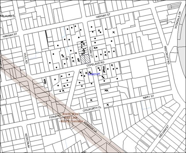
|
NOTIFICATION PLAN |
|
||
|
• PROPERTIES NOTIFIED
|
X SUBMISSIONS RECEIVED |
PROPERTY SUBJECT OF DEVELOPMENT |
|
|
One Submission has no address. Note: No. 16 York Street comprises three allotments and No. 12 York Street comprises two allotments. |
|||
Thirty submissions from 23 residents object to the development, generally on the grounds that the development would result in:
· Unacceptable traffic on local streets as the centre would be located close to Beecroft Primary School and Copeland Road already accommodates heavy traffic flows;
· Insufficient car parking provision on the site;
· Unacceptable noise pollution due to the activities of the centre and the outdoor play area;
· Adverse impact on the characteristics of the Heritage Conservation Area;
· Reduction in the safety of pedestrians and increase in the number of accidents on the road; and
· Development that is excessive in bulk and scale and out of character with the area.
Additionally, the submissions made the following observations:
· The development would require basement parking which is not acceptable in the Heritage Conservation Area;
· The development is located in a dangerous location due to the round-about at the intersection of the two roads;
· The development does not include details of operating hours, number of children and staff members;
· The design of the development does not allow quick drop-offs;
· The distance of the child care centre from Beecroft Centre is incorrectly stated in the submitted report;
· Child care centre is not a permissible use in the area;
· The number of children should be reduced to 30;
· The building footprint should be further modified to retain trees;
· Access should be provided from York Street rather than Copeland Road with a turning circle provided within the site;
· The building footprint should be reduced and the setbacks to Copeland Road increased in accordance with the existing streetscape setbacks;
· Trees on the site have been removed in the past by poisoning and the proposal would result in further removal of trees;
· The plans do not include details of drop-offs and pick-ups;
· The submitted shadow diagrams do not adequately show the impact on the adjoining properties;
· The elevations are incorrectly labelled;
· The Traffic Report is not adequate and incorrectly states that there is an existing crossover on Copeland Road;
· The Traffic survey considers peak traffic hours to be after 4pm whereas the school traffic flows affect Copeland Road at 3:30pm;
· No on-street parking is available on York Street due to vehicles parked on both sides of the road;
· The Acoustic Report includes incorrect information including fencing details;
· The driveway location is inappropriate as Copeland Road is elevated;
· Right turn on to Copeland Road from the driveway should be restricted;
· The Heritage Report does not provide details of the coloured shade sail and the gazebo roof;
· Screen planting along York Street frontage should be higher than 2.6m to achieve privacy;
· The fencing should be setback 2m within the boundary to avoid accidents; and
· Replacement planting is not appropriate.
As discussed in Section 5.1 of this report, Council received a further submission on behalf of the owners of No. 107 Copeland Road, at the Council Meeting on 11 March 2015. The following issues were raised in the letter:
· No. 107 Copeland Road was considered only during the assessment of overshadowing impacts and acoustic impacts;
· The planning report states that York Street is the primary frontage whereas the submitted plans indicate that Copeland Road is the primary frontage;
· The childcare capacity should be reduced to 40, which would then result in the reduction of the building footprint;
· Condition 47(d) of the Planning report requires the installation of 1.8m high timber paling fence along the western boundary of the site. This would have a negative impact on the streetscape. The proposed fence should comprise a 1.4m high timber picket fence lined with polycarbonate sheeting for a distance of 15m from the frontage and a 1.8m high timber paling fence for the remaining section of the boundary. Further, the hedge along the western boundary should be preserved;
· Acoustic testing should be undertaken on the 3rd, 6th and 9th month after the commencement of operation of the child care centre to assess the impact of the noise generated on No. 107 Copeland Road. If the noise levels exceed the relevant standards, then amelioration measures should be implemented.
· The kitchen exhaust should be designed to prevent noise and odour pollution in addition to air pollution.
· A “NO STOPPING” sign should be placed in front of No. 107 Copeland Road during peak hours to prevent parking for drop-offs and pick-ups.
· Condition No. 7 includes a typological error regarding the house numbers and should be corrected.
· A “NO U TURN” sign should be installed at the western end of the median.
· No Assessment of Significance has been considered prior to approving the removal of T14 and T15 in accordance with the requirements of the Environmental Planning and Assessment Act 1979 and Threatened Species Conservation Act 1995.
The owners of No.107 Copeland Road were contacted by Council Officers to discuss their concerns regarding the proposal and the impacts on their property. The following comments were received at the meeting:
· The dividing fence between No. 107 Copeland Road and No. 109 Copeland Road should be retained and an additional fence should be built within No. 109 Copeland Road.
· A Dilapidation report should be prepared to assess the condition of the property at No. 107 Copeland Road;
· The kitchen exhaust should be relocated.
· Appropriate “NO PARKING/NO STOPPING” and “NO U TURN” signs should be installed.
The merits of the matters raised in community submissions have been addressed in the body of the report with the exception of the following:
5.1.1 Assessment of Significance
One submission raises concerns that treesT14 and T15 are proposed to be removed and constitute part of the STIF, listed as an Endangered Ecological Community listed under the Threatened Species Conservation Act 1995. However, an Assessment of Significance (Seven Part Test) pursuant to Section 5A of the Environmental Planning and Assessment Act 1979 has not been requested by Council. Further, it has not been ascertained whether a Species Impact Statement would be required for the loss of flora. The removal of a vulnerable species such as Eucalyptus Scorparia would require approval from the Minister under Part 9 of the Environment Protection and Biodiversity Conservation Act 1999, a Commonwealth Act.
Council has conducted a detailed assessment in this regard and the following comments are provided:
Assessment of T14
Tree 14 is a Eucalyptus Scorparia (Wallangarra White Gum); a tree species that is locally indigenous to only three known locations in Northern New South Wales (Tenterfield) and not to the Beecroft area. It is likely that the tree was planted at the current location. There is a remote possibility that seed dispersal may have occurred via mobile vectors such as birds or Grey-headed Flying Fox to the subject site. This plant species is listed as Endangered under NSW Threatened Species Conservation Act 1995 and Vulnerable under the Commonwealth Environment Protection and Biodiversity Conservation Act 1999. However, it does not form part of the NSW Scientific Committee’s determination for Blue Gum High Forest Critically Endangered Ecological Community, and therefore, any Assessment of Significance (‘seven part test’) undertaken by the applicant or by Council would address the species only, and not the community.
Notwithstanding, an assessment was conducted to determine whether or not the removal of this species would have a significant impact upon the local population of Eucalyptus Scorparia (Wallangarra White Gum). It was concluded that the proposed removal of the tree would not have a significant impact on the local population as the species is not locally indigenous. Accordingly, a further ecological assessment by the applicant including a Seven Part test, a Species Impact Statement or referral to the Minister for the Environment is not required.
Assessment of T15
Tree 15 is an unidentified Stringybark. The only Stringybark species that forms part of BGHF is Eucalyptus Globoidea (White Mahogany). Both Council’s ecological assessment officer and tree officer confirmed that it is difficult to identify this tree to the species level due to its health and unavailability of fruits. Notwithstanding this, an assessment was conducted by Council in this regard and it was concluded that the tree does not form a part of the mapped EEC. Accordingly, a Seven Part Test would not be required.
5.1.2 Incorrect Acoustic Report
It is noted that the Acoustic Report initially included incorrect information regarding fencing. The details have been corrected via submission of additional information and the recommendations have been incorporated in the amended plans.
The report includes incorrect information regarding the number of children occupying each room and property addresses. However, the noise monitoring locations and associated data have been provided correctly. Council’s assessment in this regard concludes that the incorrect data would have no impact on the Acoustic data and noise measurements. The report has been amended to include assessment of the impact of the development on the first floor windows of the property at No. 16 York Street and additional acoustic measures provided to mitigate any such impact. Accordingly, the results supplied in the report and the recommendations are considered acceptable.
5.1.3 Incorrect Traffic Report and Traffic Matters
The Traffic Report states that the there is an existing crossover at Copeland Road. This is correct. Further, Copeland Road is not elevated, but forms the lowest point of the site, being favourable for the location of the driveway.
The Traffic data and timings for commuter peak hours are provided in accordance with Roads and Maritime Services guidelines as standards. The report states that on street car parking is available on York Street as there are no parking restrictions on this street. The proposal provides sufficient off street parking spaces and would not require additional parking on York Street.
5.1.4 Drop Off and Pick Ups
The child care centre would operate for 0-6 year olds. The children are required to be signed in and out of such centres. Accordingly, a quick drop and pick up would not be required. Additional details of drop-offs and pick-ups are not required to be provided as parents would park in the car park and access the centre via the ramp.
5.1.5 Removal of Trees by Poisoning
This matter is not related to the current application and has been the subject of a separate investigation in the past.
5.1.6 Conditions of Consent
As requested by the adjoining property owner, the following conditions are recommended:
· Installation of a fence within the subject site adjoining the western boundary;
· The fence would comprise a 15m long 1.4m high timber picket fence with polycarbonate lining and a 1.8m high timber paling fence for the remaining length of the boundary;
· Installation of appropriate “NO STOPPING” and “NO U TURN” signs, subject to the approval of the Hornsby Local Traffic Committee;
· Installation of a “15 MINUTE PARKING, 7AM – 9AM, MON to FRI” along the York Street frontage of the site;
· The kitchen exhausts system to address air, noise and odour pollution;
· A Noise Monitoring condition as follows:
o The level of total continuous noise emanating from operation of all the plant, including air conditioning units and processes in all buildings (LA10) (measured for at least 15 minutes) in or on the above premises, must not exceed the background level by more than 5dB(A) when measured at all property boundaries.
o An acoustic assessment is to be undertaken by a suitably qualified environmental consultant within 60 days of occupying the site in accordance with the Environment NSW Industrial Noise Policy (2000), Council’s Policy and Guidelines for Noise and Vibration Generating Development (Acoustic Guidelines V.5, 2000) and the DECC’s Noise Guide for Local Government (2004). The assessment must be submitted to Council for review. Should the assessment find that noise from the premise exceeds 5dB(A) appropriate measures must be employed to rectify excessive noise.
5.1.7 Screen Planting
The screen planting along York Street is considered appropriate. The landscape buffer would restrict children accessing the fence directly and provide sufficient privacy to the outdoor play area.
5.2 Public Agencies
The development application was not required to be referred to any Public Agencies for comment.
6. THE PUBLIC INTEREST
Section 79C(1)(e) of the Act requires Council to consider “the public interest”.
The public interest is an overarching requirement, which includes the consideration of the matters discussed in this report. Implicit to the public interest is the achievement of future built outcomes adequately responding to and respecting the future desired outcomes expressed in environmental planning instruments and development control plans.
The application is considered to have satisfactorily addressed Council’s criteria and would provide a development outcome that, on balance, would result in a positive impact for the community. Accordingly, it is considered that the approval of the proposed development would be in the public interest.
CONCLUSION
The proposal involves the erection of a child care centre accommodating 57 child placements and basement car park within the Beecroft-Cheltenham Heritage Conservation Area. A total of 23 public submissions were received objecting to the proposal on the grounds of traffic, density, privacy, landscaping and noise. The issues raised are addressed in the body of the report and by relevant consent conditions under Schedule 1.
The proposed size of the child care centre (as amended) complies with the maximum permissible under Hornsby Development Control Plan. The built form respects the existing character of the area and retains significant vegetation on the site.
The proposal generally complies with the relevant provisions of the Hornsby Local Environmental Plan 2013, and the provisions of Hornsby Development Control Plan 2013. The development is permissible in the zone and is considered to be within the environmental capacity of the site.
Accordingly, the proposed development is recommended for approval.
Note: At the time of the completion of this planning report, no persons have made a Political Donations Disclosure Statement pursuant to Section 147 of the Environmental Planning and Assessment Act 1979 in respect of the subject planning application.
RESPONSIBLE OFFICER
The officer responsible for the preparation of this Report is the Manager – Development Assessment – Rodney Pickles, who can be contacted on 9847 6731.
|
Rod Pickles Manager - Development Assessment Planning Division |
James Farrington Group Manager Planning Division |
|
1.View |
Locality Map |
|
|
|
2.View |
Proposed Plant Schedule |
|
|
|
3.View |
Car Parking Plan |
|
|
|
4.View |
Floor Plan |
|
|
|
5.View |
Elevations and Sections |
|
|
|
6.View |
Shadow Plan |
|
|
File Reference: DA/1049/2014
Document Number: D05134534
SCHEDULE 1
GENERAL CONDITIONS
The conditions of consent within this notice of determination have been applied to ensure that the use of the land and/or building is carried out in such a manner that is consistent with the aims and objectives of the relevant legislation, planning instruments and council policies affecting the land and does not disrupt the amenity of the neighbourhood or impact upon the environment.
Note: For the purpose of this consent, the term ‘applicant’ means any person who has the authority to act on or the benefit of the development consent.
Note: For the purpose of this consent, any reference to an Act, Regulation, Australian Standard or publication by a public authority shall be taken to mean the gazetted Act or Regulation, or adopted Australian Standard or publication as in force on the date that the application for a construction certificate is made.
1. Approved Plans and Supporting Documentation
The development must be carried out in accordance with the plans and documentation listed below and endorsed with Council’s stamp, except where amended by Council and/or other conditions of this consent:
|
Plan No. |
Plan Title |
Drawn by |
Dated |
|
DA01 |
Car Parking Plan |
Paris John Spana Design |
4/09/2014 |
|
DA02 - B |
Ground Floor Plan |
Paris John Spana Design |
29/11/2014 |
|
DA03-B |
Elevations and Section 1 |
Paris John Spana Design |
29/11/2014 |
|
DA04-B |
Elevations and Section 2 |
Paris John Spana Design |
29/11/2014 |
|
DA05-A |
Roof Plan |
Paris John Spana Design |
27/11/2014 |
|
L_1 Issue D |
Landscape Concept Plan |
Wallman Partners Pty Ltd |
29/11/2014 |
|
Document Title |
Prepared by |
Dated |
|
Site Analysis Plan |
Paris John Spana Design |
4/09/2014 |
|
Stormwater Management Plans |
ALW Design |
11/07/2014 |
|
Mid-Winter Shadows – SD-1 |
Paris John Spana Design |
4/09/2014 |
|
Survey Plan |
MY Xu and Co |
24/04/2014 |
|
Tree Assessment and Management Report |
Growing My Way Tree Services |
April 2014 |
|
Traffic and Parking Assessment Report |
Varga Traffic Consulting |
9/05/2014 |
|
Statement of Heritage Impact |
Archnex Design |
May 2014 |
|
Noise Intrusion and Emission Assessment and the Addendum regarding Barrier |
Acoustic Dynamics |
5/06/2014 and 2/12/2014 |
|
Statement of Environmental Effects |
BTG Planning |
Received by Council on 11/19/2014 |
|
Access Review Report |
Paris John Spana Design |
28/07/2014 |
|
Waste Management Plan |
Paris John Spana Design |
11/09/2014 |
|
Schedule of Finishes |
Paris John Spana Design |
Received by Council on 11/19/2014 |
|
Phase 1 Preliminary Site Investigation Report |
ADE Consulting Group |
24/07/2014 |
2. Removal of Existing Trees
This development consent only permits the removal of tree(s) numbered T23, T10, T11, T17, T14, T15 as identified within the Tree Assessment and Management Report prepared by Growing My Way Tree Services dated April 2014.
The removal of any other trees requires separate approval in accordance with the Tree & Vegetation Chapter 1B.6 Hornsby Development Control Plan (HDCP).
3. Amendment of Plans
The approved plan DA01 (Car Parking Plan) prepared by Paris John Spana Design dated 4/09/14 is to be amended as follows:
a) The pedestrian path on the eastern side of the basement car park is to be extended along the entire length of the basement, as marked in red;
b) All the spaces on the eastern side of the car park be designed as “Visitor Parking”;
c) One car space on the western side be dedicated as turning bay as marked in red;
d) The garbage bin room is to be increased in size to have a clear dimension of 4m x 2.9m; and
e) The width of the door for the garbage storage area must be a minimum of 960mm.
The submitted Stormwater Management Plans prepared by ALW Design dated 11/07/14 is to be amended in accordance with the approved plans listed in Condition1 of this development consent.
4. Section 94A Development Contributions
a) In accordance with Section 80A(1) of the Environmental Planning and Assessment Act 1979 and the Hornsby Shire Council Section 94A Development Contributions Plan 2012-2021, $ 6,500.00 shall be paid to Council to cater for the increased demand for community infrastructure resulting from the development, based on development costs of $ 650,000.00.
b) The value of this contribution is current as at 10/02/2015. If the contributions are not paid within the financial quarter that this condition was generated, the contributions payable will be adjusted in accordance with the provisions of the Hornsby Shire Council Section 94 Development Contributions Plan and the amount payable will be calculated at the time of payment in the following manner:
$CPY = $CDC x CPIPY
CPIDC
Where:
$CPY is the amount of the contribution at the date of Payment
$CDC is the amount of the contribution as set out in this Development Consent
CPIPY is the latest release of the Consumer Price Index (Sydney – All Groups) at the date of Payment as published by the ABS.
CPIDC is the Consumer Price Index (Sydney – All Groups) for the financial quarter at the date applicable in this Development Consent Condition.
c) The monetary contributions shall be paid to Council prior to the issue of the first Construction Certificate where the development is for building work.
It is the professional responsibility of the Principal Certifying Authority to ensure that the monetary contributions have been paid to Council in accordance with the above timeframes.
Council’s S94A Development Contributions Plan may be viewed at www.hornsby.nsw.gov.au or a copy may be inspected at Council’s Administration Centre during normal business hours.
REQUIREMENTS PRIOR TO THE ISSUE OF A CONSTRUCTION CERTIFICATE
5. Building Code of Australia
All building work must be carried out in accordance with the relevant requirements of the Building Code of Australia.
6. Water/Electricity Utility Services
The applicant must submit written evidence of the following service provider requirements:
a) Ausgrid (formerly Energy Australia) – a letter of consent demonstrating that satisfactory arrangements have been made to service the proposed development.
b) Sydney Water – the submission of a ‘Notice of Requirements’ under s73 of the Sydney Water Act 1994.
Note: Sydney Water requires that s73 applications are to be made through an authorised Sydney Water Servicing Coordinator. Refer to www.sydneywater.com.au or telephone 13 20 92 for assistance.
7. Dilapidation Report
A ‘Dilapidation Report’ is to be prepared by a ‘chartered structural engineer’ detailing the structural condition of adjoining properties at No. 16 York Street and No. 107 Copeland Road, Beecroft.
8. Internal Driveway/Vehicular Areas
The driveway and parking areas on site must be designed in accordance with Australian Standard AS 2890.1 – 2004 – Off Street Car Parking and Australian Standard 2890.2 - 2002 – Off Street Commercial and the following requirements:
a) Design levels at the front boundary must be obtained from Council;
b) The driveway must be a rigid pavement;
c) The driveway grade must not exceed 25 per cent and changes in grade must not exceed 8 per cent; and
d) A dedicated turning bay be provided on the western side as marked on the approved plans;
e) The driveway pavement between the Copeland Road boundary and the entry to the basement car park must be built to withstand the load of Heavy Rigid Vehicles.
9. Vehicular Crossing Levels
A separate application under the Local Government Act 1993 and the Roads Act 1993 must be submitted to Council to obtain the design levels for the vehicular access crossing. These levels are to be used to design the entry driveway.
10. Road Works
A median strip is to be designed in Copeland Road to prohibit right turns from and into the proposed development, in accordance with Council’s Civil Works Design and Construction Specification 2005 and the following requirements:
a) The Median strip is to be 600mm wide and is to extend from 6m west of the western extremity of the proposed access way to 6m east of the eastern extremity of the proposed access way;
b) The design must include details of all adjustments to the existing line marking to maintain carriageway widths within Copeland Rd;
c) Details of Installation of any regulatory signs as a result of the median strip; and
d) The plans are to be submitted for written approval (Construction Certificate) from Hornsby Shire Council and the Local Traffic Committee under Section 138 of the Roads Act 1993.
e) “NO STOPPING, 7AM – 9AM, 2:30PM – 6PM, MON to FRI” restrictions are to be installed on the boundary of Nos. 107, 109, 115 and 117 Copeland Road, Beecroft.
f) A “NO U TURN” sign be installed on the central median at its western end.
g) A “15 MINUTE PARKING, 7AM – 9AM, MON to FRI” sign installed along the York Street frontage of the site.
Note: Installation of the signs requires approval by the Hornsby Local Traffic Committee.
11. Traffic Control Plan
A Traffic Control Plan (TCP) must be prepared by a qualified traffic controller in accordance with the Roads & Traffic Authority’s Traffic Control at Worksites Manual 1998 and Australian Standard 1742.3 for all work on a public road and be submitted to Council. The TCP must detail the following:
a) Arrangements for public notification of the works.
b) Temporary construction signage.
c) Permanent post-construction signage.
d) Vehicle movement plans.
e) Traffic management plans.
f) Pedestrian and cyclist access/safety.
12. Waste Management Plan
A Waste Management Plan, covering the scope of this project and including the following details, is required to be submitted to Council for approval:
a) An estimate of the types and volumes of waste and recyclables to be generated;
b) A site plan showing sorting and storage areas for construction waste and the vehicle access to these areas;
c) How excavation and construction waste materials will be reused or recycled and where residual wastes will be disposed;
d) The total percentage (by weight) of construction waste that will be reused or recycled.
13. Construction Certificate Plans
The construction certificate plans must incorporate all the construction details recommended in the following reports:
|
Document No and Name |
Prepared by |
Dated |
|
Noise Intrusion and Emission Assessment and the Addendum regarding Barrier |
Acoustic Dynamics |
5/06/2014 and 2/12/2014 |
|
Access Review Report |
Paris John Spana Design |
28/07/2014 |
14. Colour Scheme
A dark tone colour scheme is to be used for the proposed Acoustic barrier, the gazebo roof and the shade sail cloth located within the York Street frontage. Details of the colour scheme is to be submitted to Hornsby Council for approval prior to the issue of the Construction Certificate.
REQUIREMENTS PRIOR TO THE COMMENCEMENT OF ANY WORKS
15. Project Arborist
A Project Arborist is to be appointed in accordance with AS 4970-2009 (1.4.4) to provide monitoring and certification throughout the development process.
16. Erection of Construction Sign
A sign must be erected in a prominent position on any site on which building work, subdivision work or demolition work is being carried out:
a) Showing the name, address and telephone number of the principal certifying authority for the work;
b) Showing the name of the principal contractor (if any) for any demolition or building work and a telephone number on which that person may be contacted outside working hours; and
c) Stating that unauthorised entry to the work site is prohibited.
Note: Any such sign is to be maintained while the building work, subdivision work or demolition work is being carried out, but must be removed when the work has been completed.
17. Protection of Adjoining Areas
A temporary hoarding, fence or awning must be erected between the work site and adjoining lands before the works begin and must be kept in place until after the completion of the works if the works:
a) Could cause a danger, obstruction or inconvenience to pedestrian or vehicular traffic.
b) Could cause damage to adjoining lands by falling objects.
c) Involve the enclosure of a public place or part of a public place.
Note: Notwithstanding the above, Council’s separate written approval is required prior to the erection of any structure or other obstruction on public land.
18. Toilet Facilities
Toilet facilities must be available or provided at the works site before works begin and must be maintained until the works are completed at a ratio of one toilet for every 20 persons employed at the site. Each toilet must:
a) be a standard flushing toilet connected to a public sewer; or
b) be a temporary chemical closet approved under the Local Government Act 1993; or
c) have an on-site effluent disposal system approved under the Local Government Act 1993.
19. Erosion and Sediment Control
Erosion and sediment control measures must be provided and maintained throughout the construction period in accordance with the manual ‘Soils and Construction 2004 (Bluebook)’, the approved plans, Council specifications and to the satisfaction of the principal certifying authority. The erosion and sediment control devices must remain in place until the site has been stabilised and revegetated.
Note: On the spot penalties up to $1,500 may be issued for any non-compliance with this requirement without any further notification or warning.
20. Tree Protection Barriers
a) Tree protection fencing must be erected onsite around trees numbered T4, T5, T12, T13 & T19, to be retained at the nominated Tree Protection Zones (TPZ) listed below.
Tree Protection Zones (TPZ)
|
TREE |
TPZ |
|
T4, T5, T12, T13 |
7m |
|
T19 |
15m |
|
T16, T18, T26, T21, T22, T24 |
4m |
b) The tree fencing must be contiguous and constructed of 1.8 metre ‘cyclone chainmesh fence’ and where necessary tree fencing must facilitate pedestrian thoroughfare.
c) Prior to works commencing and throughout construction, the area of the Tree Protection Zone (located on the property) of tree T19 is to be protected by the use of wood-chip mulch. Wood-chip mulch is to be installed on top of a geotextile landscape fabric, placed over the root zone of the tree. The mulch is to be maintained at a depth of 150mm – 300mm using material that complies with AS 4454.
Note: A certificate from the Project Arborist (AQF 5) is to be submitted to the Principal Certifying Authority stating that all tree protection measures are in accordance with the above and consistent with the intentions of the Australian Standard ‘Protection of Trees on Development Sites (AS 4970-2009) prior to commencement of works.
REQUIREMENTS DURING CONSTRUCTION
21. Construction Work Hours
All work on site (including demolition and earth works) must only occur between 7am and 5pm Monday to Saturday. No work is to be undertaken on Sundays or public holidays.
22. Environmental Management
The site must be managed in accordance with the publication ‘Managing Urban Stormwater – Landcom (March 2004) and the Protection of the Environment Operations Act 1997 by way of implementing appropriate measures to prevent sediment run-off, excessive dust, noise or odour emanating from the site during the construction of the development.
23. Street Sweeping
Street sweeping must be undertaken following sediment tracking from the site along Copeland Road and York Street during works and until the site is established.
24. Works Near Trees
All required tree protection measures are to be maintained in good condition for the duration of the construction period.
Existing soil grades within four metres of the trunk of any tree to be retained must be maintained.
Works within the nominated Tree Protection Zones of trees T13, T19 are to be carried out in accordance with the following requirements:
a) Works must not reduce the useful life expectancy of the tree and be carried out under the direct supervision of the Project Arborist. The project arborist must assess the condition of tree/s and the growing environment and make recommendations for, and if necessary carry out remedial action to ensure the health and vigour of the trees.
b) The installation of any services within the nominated Tree Protection Zone shall utilise the thrust boring method. Thrust boring shall be carried out so that ‘top of pipe’ is a minimum 700mm depth beneath existing ground level.
c) Excavation for the installation of piers within the nominated Tree Protection Zone of tree T19 shall be carried out by hand excavation ONLY.
d) No tree root greater than 30mm diameter located within the nominated Tree Protection Zone of any tree to be retained on or off-site shall be severed or injured in the process of any works during the entirety of the consent.
e) Tree roots less than 30mm diameter required to be severed for the purposes of this consent shall be cut cleanly by hand, by a qualified and experienced Arborist or Horticulturalist with minimum qualifications of Horticultural Certificate or Tree Surgery Certificate (AQF 3). All pruning shall be undertaken as specified in the Australian Standard ‘Pruning of Amenity Trees’ (AS 4373-2007).
Note: Except as provided above, the applicant is to ensure that no excavation, filling or stockpiling of building materials, parking of vehicles or plant, disposal of cement slurry, waste water or other contaminants is to occur within 4 metres of any tree to be retained.
25. Council Property
During construction works, no building materials, waste, machinery or related matter is to be stored on the road or footpath. The public reserve must be kept in a clean, tidy and safe condition at all times.
26. Disturbance of Existing Site
During construction works, the existing ground levels of open space areas and natural landscape features, (including natural rock-outcrops, vegetation, soil and watercourses) must not be altered unless otherwise nominated on the approved plans.
27. Landfill
Landfill must be constructed in accordance with Council’s ‘Construction Specification 2005’ and the following requirements:
a) All fill material imported to the site is to wholly consist of Virgin Excavated Natural Material (VENM) as defined in Schedule 1 of the Protection of the Environment Operations Act 1997 or a material approved under the Department of Environment and Climate Change’s general resource recovery exemption.
28. Excavated Material
All excavated material removed from the site must be classified in accordance with the Department of Environment, Climate Change and Water NSW Waste Classification Guidelines prior to disposal to an approved waste management facility and reported to the principal certifying authority.
29. Asbestos and Soil Contamination
Should the presence of asbestos or soil contamination, not recognised during the application process be identified during works, the applicant must immediately notify the principal certifying authority and Council.
30. Waste Management Details
Waste management during the construction phase of the development must be undertaken in accordance with the approved Waste Management Plan. Additionally written records of the following items must be maintained during the removal of any waste from the site and such information submitted to the Principal Certifying Authority within fourteen days of the date of completion of the works:
a) The identity of the person removing the waste
b) The waste carrier vehicle registration
c) Date and time of waste collection
d) A description of the waste (type of waste and estimated quantity)
e) Details of the site to which the waste is to be taken
f) The corresponding tip docket/receipt from the site to which the waste is transferred (noting date and time of delivery, description (type and quantity) of waste)
g) Whether the waste is expected to be reused, recycled or go to landfill
Note: In accordance with the Protection of the Environment Operations Act 1997, the definition of waste includes any unwanted substance, regardless of whether it is reused, recycled or disposed to landfill.
31. Protection from Soil Pathogens
To protect native flora and fauna from infection and infestation of pathogens and weeds all machinery shall be cleaned of soil and debris before entering the subject site to prevent the spread of weeds and fungal pathogens such as Cinnamon Fungus (Phytophthora cinnamomi) and Chytrid Fungus (Batrachochytrium dendrobatidis).
REQUIREMENTS PRIOR TO THE ISSUE OF AN OCCUPATION CERTIFICATE
Note: For the purpose of this consent, a reference to ‘occupation certificate’ shall not be taken to mean an ‘interim occupation certificate’ unless otherwise stated.
32. Sydney Water – s73 Certificate
An s73 Certificate must be obtained from Sydney Water.
33. Stormwater Drainage
The stormwater drainage system for the development must be constructed in accordance with Council’s Civil Works – Design and Construction Specification 2005 and the following requirements:
a) Connected directly to Council’s street drainage system in Copeland Road.
b) Details of the design be submitted with the Construction Certificate Plans.
34. Driveway Works
a) All internal driveway works are to be completed in accordance with Condition 8 of this development consent.
b) A speed hump and a “GIVE WAY TO PEDESTRIANS” sign must be installed on the southern boundary at the driveway entrance to reduce exiting vehicle speed and make drivers away of pedestrians.
c) One car space on the western side at the rear, as marked on the approved “Car Parking Plan”, must be dedicated as a turning bay for vehicles accessing the site.
35. Road Works
All road works be completed and signage installed in accordance with Condition 10 of this development consent.
Note: Approval by the Hornsby Local Traffic Committee is required prior to commencement of road works and installation of signs.
36. Damage to Council Assets
Any damage caused to Council’s assets as a result of the construction of the development must be rectified in accordance with Council’s Civil Works Specifications. Council’s Restorations Supervision must be notified for a formwork inspection prior to pouring concrete.
37. On Site Stormwater Detention
An on-site stormwater detention system must be designed by a chartered civil engineer and constructed in accordance with the following requirements:
a) Have a capacity of not less than 13.8 cubic metres, and a maximum discharge (when full) of 27 litres per second.
b) Have a surcharge/inspection grate located directly above the outlet.
c) Discharge from the detention system to be controlled via 1 metre length of pipe, not less than 50 millimetres diameter or via a stainless plate with sharply drilled orifice bolted over the face of the outlet discharging into a larger diameter pipe capable of carrying the design flow to an approved Council system.
d) Details submitted with the Construction Certificate Plans.
38. Vehicular Crossing
A separate application under the Local Government Act 1993 and the Roads Act 1993 must be submitted to Council for the installation of a new vehicular crossing and the removal of the redundant crossing. The vehicular crossing must be constructed in accordance with Council’s Civil Works Design 2005 and the following requirements:
a) Any redundant crossings must be replaced with integral kerb and gutter;
b) The footway area must be restored by turfing;
c) Details submitted with the Construction Certificate Plans;
Note: An application for a vehicular crossing can only be made to one of Council’s Authorised Vehicular Crossing Contractors. You are advised to contact Council on 02 9847 6940 to obtain a list of contractors.
39. Creation of Easements
The following matter(s) must be nominated on the plan of subdivision under s88B of the Conveyancing Act 1919:
a) The creation of an appropriate "Positive Covenant" and "Restriction as to User" over the constructed on-site detention/retention systems and outlet works, within the lots in favour of Council in accordance with Council’s prescribed wording. The position of the on-site detention system is to be clearly indicated on the title.
b) To register the OSD easement, the restriction on the use of land “works-as-executed” details of the on-site-detention system must be submitted verifying that the required storage and discharge rates have been constructed in accordance with the design requirements. The details must show the invert levels of the on-site system together with pipe sizes and grades. Any variations to the approved plans must be shown in red on the “works-as-executed” plan and supported by calculations.
Note: Council must be nominated as the authority to release, vary or modify any easement, restriction or covenant.
40. Consolidation of Allotments
Prior to the issue of the Occupation Certificate the allotments are to be consolidated into one allotment. Evidence of the consolidation is to be given to the Principal Certifying Authority.
41. Works as Executed Plan
A works-as-executed plan(s) must be prepared by a registered surveyor and submitted to Council for completed road pavement, kerb & gutter, public drainage systems, driveways and on-site detention system.
42. Landscaping of Site
All previous areas of the site and the road reserve adjoining the site must be appropriately landscaped with suitable (preferably indigenous) turf, trees and shrubs to complement the development and prevent erosion of soil in accordance with the approved Landscape Plan listed in Condition 1 of this development consent and the following requirements:
a) Replacement trees (as marked on the approved Landscape Plan), must be appropriately located outside the drip-line of existing trees and shall be in accordance with the specifications in the approved/stamped Landscape Plan.
b) Plantings that fail to survive or do not exhibit normal health and vigour growth characteristics for their species prior to reaching a height greater than three metres (3m), must be replaced at the expense of the property owner.
c) Dense screen planting reaching a minimum mature growth height of 4m, in front of the acoustic barrier, at the York Street frontage, as marked in red on the approved “Ground Floor Plan – DA02 – Amd B” prepared by Paris John Spana dated 27/11/2014.
Note: A certificate from suitably qualified and experienced Horticulturalist is to be submitted to the Principal Certifying Authority stating the above requirements have been met, that all plant stock meet the specifications outlined in ‘Specifying Trees’ (Ross Clark, NATSPEC Books) and that the planting methods are current, professional (best practice) industry standards at the time of planting.
Note: Advice on suitable species for landscaping can be obtained from Council’s planting guide ‘Indigenous Plants for the Bushland Shire’, available at www.hornsby.nsw.gov.au.
43. Final Certification
The Project Arborist must assess the condition of all trees and the growing environment, where works have been conducted within the nominated tree protection zones, and make recommendations for, and carry out remedial actions where necessary.
Following the final inspection and the completion of any remedial works, the Project Arborist must submit a report stating that the completed works have been carried out in compliance with the approved plans and specifications for tree protection as above and AS 4970-2009.
44. Waste Management
The following waste management requirements must be complied with:
a) The bin storage room must include water or a hose for cleaning, graded floors with drainage to sewer, robust doors, sealed and impervious surface, adequate lighting and ventilation, and must be lockable.
b) A report must be prepared by an appropriately qualified person, certifying the following:
i) A comparison of the estimated quantities of each waste type against the actual quantities of each waste type.
Note: Explanations of any deviations to the approved Waste Management Plan is required to be included in this report.
ii) That at least 60% of the waste generated during the demolition and construction phase of the development was reused or recycled.
Note: If the 60% diversion from landfill cannot be achieved in the Construction Stage, the Report is to include the reasons why this occurred and certify that appropriate work practices were employed to implement the approved Waste Management Plan. The Report must be based on documentary evidence such as tipping dockets/receipts from recycling depots, transfer stations and landfills, audits of procedures etc. which are to be attached to the report.
iii) All waste was taken to site(s) that were lawfully permitted to accept that waste.
c) The child care centre must be provided with an indoor waste/recycling cupboard for the interim storage of a minimum one day’s waste generation with separate containers for general waste and recyclable materials.
d) The bin carting routes must be devoid of any steps.
Note: Ramps between different levels are acceptable
45. External Lighting
All external lighting must be designed and installed in accordance with Australian Standard AS 4282 – Control of the Obtrusive Effects of Outdoor Lighting. Certification of compliance with the Standard must be obtained from a suitably qualified person.
46. Outdoor Play Area
The outdoor play space must be adequately shaded in accordance with The Shade Handbook, published by the New South Wales Cancer Council in 2008.
47. Acoustic Privacy/Fencing
The following devices/fences must be installed on site in accordance with the approved plans listed in Condition 1 of this development consent:
a) The existing 2.5m high concrete block wall be retained along the northern boundary;
b) A 1.8m high paling fence shall be provided along the remaining section of the northern boundary;
c) The acoustic awning shall be provided on the northern side of the allotment;
d) A solid fence is to be erected along the western boundary of the site adjoining the existing fence and retaining the existing hedges on this boundary. The fence would comprise a 15m long (measured from the Copeland Road frontage) and 1.4m high timber picket fence with polycarbonate lining and 1.8m high timber paling fence for the remaining section of the boundary;
e) A 1.4m high timber picket fence with transparent polycarbonate backing shall be provided along the York Street frontage (eastern boundary); and
f) Timber picket fence shall be provided along the Copeland Road boundary.
48. Food Premises
The fit out and operation of that part of the building to be used for the manufacture, preparation or storage of food for sale, must be in accordance with Australian Standard 4674-2004 – Design and fit out of food premises, the Food Act 2003, and the Food Regulation 20010 and the Food Standards Code developed by Food Standards Australia New Zealand. Food Standards 3.3.1. 3.2.2 and 3.2.3 are mandatory for all food businesses.
Note: Walls are to be of solid construction.
49. Kitchen Exhaust Installation
A kitchen exhaust system must be designed and installed to effectively prevent air pollution, noise pollution and odour pollution in accordance with the Protection of the Environment Operations Act 1997.
50. Retaining Walls
All required retaining walls must be constructed as part of the development.
51. Installation of Air Conditioner
To protect the amenity of adjacent properties, the condenser unit for the air conditioner must be sited in accordance with the submitted Noise Emission and Assessment Report,
OPERATIONAL CONDITIONS
52. Use of Premises
a) The development approved under this consent shall be used for ‘child care centre’ and not for any other purpose without Council’s separate written consent.
b) The child care centre shall accommodate a maximum of 57 children. The age mix of children as at 1 January of each calendar year shall be in accordance with the following:
i) 0-2 years: 20 children
ii) 2-3 years: 8 children
iii) 3-4 years: 16 children
iv) 4-5 years: 13 children
c) A maximum of 9 staff members shall be present at the centre at any one time.
d) The hours of operation of the “child care centre” are restricted to those times listed below:
i) Monday to Friday - 8:00 am to 6:00 pm
ii) Saturday, Sunday & Public Holidays - No work
e) All staff members are required to park on-site within the basement level car park.
f) The children using the child care centre are permitted to use the open to air outdoor play area only between 8:30am – 12pm and 2:30pm - 5pm (Monday to Friday).
53. Noise
All noise generated by the proposed development must be attenuated to prevent levels of noise being emitted to adjacent premises which possess tonal, beating and similar characteristics or which exceeds background noise levels by more than 5dB(A).
An acoustic assessment is to be undertaken by a suitably qualified environmental consultant within 60 days of occupying the site in accordance with the Environment NSW Industrial Noise Policy (2000), Council’s Policy and Guidelines for Noise and Vibration Generating Development (Acoustic Guidelines V.5, 2000) and the DECC’s Noise Guide for Local Government (2004). The assessment must be submitted to Council for review. Should the assessment find that noise from the premise exceeds 5dB(A) appropriate measures must be employed to rectify excessive noise.
54. Waste Management
All commercial tenants must keep written evidence on site of a valid contract with a licensed waste contractor(s) for the regular collection and disposal of the waste and recyclables that are generated on site.
55. Car Parking and Deliveries
All car parking must be constructed and operated in accordance with Australian Standard AS 2890.1 – 2004 – Off Street Car Parking and Australian Standard 2890.2 - 2002 – Off Street Commercial and the following requirement:
a) All parking areas and driveways are to be sealed to an all-weather standard, line marked and signposted.
b) Car parking, loading and manoeuvring areas to be used solely for nominated purposes.
c) Vehicles awaiting loading, unloading or servicing shall be parked on site and not on adjacent or nearby public roads;
d) All vehicular entry on to the site and egress from the site shall be made in a forward direction.
e) A dedicated turning bay must be provided on the western side of the car park.
56. Fire Safety Statement - Annual
On at least one occasion in every 12 month period following the date of the first ‘Fire Safety Certificate’ issued for the property, the owner must provide Council with an annual ‘Fire Safety Certificate’ to each essential service installed in the building.
57. Landscape Establishment
The landscape works must be maintained into the future to ensure the establishment and successful growth of plant material to meet the intent of the landscape design. This must include but not be limited to watering, weeding, replacement of failed plant material and promoting the growth of plants through standard industry practices.
- END OF CONDITIONS -
ADVISORY NOTES
The following information is provided for your assistance to ensure compliance with the Environmental Planning and Assessment Act 1979, Environmental Planning and Assessment Regulation 2000, other relevant legislation and Council’s policies and specifications. This information does not form part of the conditions of development consent pursuant to Section 80a of the Act.
Environmental Planning and Assessment Act 1979 Requirements
The Environmental Planning and Assessment Act 1979 requires:
· The issue of a construction certificate prior to the commencement of any works. Enquiries can be made to Council’s Customer Services Branch on 9847 6760.
· A principal certifying authority to be nominated and Council notified of that appointment prior to the commencement of any works.
· Council to be given at least two days written notice prior to the commencement of any works.
· Mandatory inspections of nominated stages of the construction inspected.
· An occupation certificate to be issued before occupying any building or commencing the use of the land.
Long Service Levy
In accordance with Section 34 of the Building and Construction Industry Long Service Payments Act 1986, a ‘Long Service Levy’ must be paid to the Long Service Payments Corporation or Hornsby Council.
Note: The rate of the Long Service Levy is 0.35% of the total cost of the work.
Note: Hornsby Council requires the payment of the Long Service Levy prior to the issue of a construction certificate.
Tree and Vegetation Preservation
In accordance with Clause 5.9 of the Hornsby Local Environmental Plan 2013 a person must not ringbark, cut down, top, lop, remove, injure or wilfully destroy any tree or other vegetation protected under the Hornsby Development Control Plan 2013 without the authority conferred by a development consent or a permit granted by Council.
Notes: A tree is defined as a long lived, woody perennial plant with one or relatively few main stems with the potential to grow to a height greater than three metres (3M). (HDCP 1B.6.1.c).
Tree protection measures and distances are determined using the Australian Standard AS 4970:2009, “Protection of Trees on Development Sites”.
Fines may be imposed for non-compliance with both the Hornsby Local Environmental Plan 2013 and the Hornsby Development Control Plan 2013.
Disability Discrimination Act
The applicant’s attention is drawn to the existence of the Disability Discrimination Act. A construction certificate is required to be obtained for the proposed building/s, which will provide consideration under the Building Code of Australia, however, the development may not comply with the requirements of the Disability Discrimination Act. This is the sole responsibility of the applicant.
Covenants
The land upon which the subject building is to be constructed may be affected by restrictive covenants. Council issues this approval without enquiry as to whether any restrictive covenant affecting the land would be breached by the construction of the building, the subject of this consent. Applicants must rely on their own enquiries as to whether or not the building breaches any such covenant.
Advertising Signage – Separate DA Required
This consent does not permit the erection or display of any advertising signs. Most advertising signs or structures require development consent. Applicants should make separate enquiries with Council prior to erecting or displaying any advertising signage.
Dial Before You Dig
Prior to commencing any works, the applicant is encouraged to contact Dial Before You Dig on 1100 or www.dialbeforeyoudig.com.au for free information on potential underground pipes and cables within the vicinity of the development site.
Telecommunications Act 1997 (Commonwealth)
If you are aware of any works or proposed works which may affect or impact on Telstra’s assets in any way, you are required to contact: Telstra’s Network Integrity Team on Phone Number 1800810443.
Asbestos Warning
Should asbestos or asbestos products be encountered during demolition or construction works, you are advised to seek advice and information prior to disturbing this material. It is recommended that a contractor holding an asbestos-handling permit (issued by WorkCover NSW) be engaged to manage the proper handling of this material. Further information regarding the safe handling and removal of asbestos can be found at:
Alternatively, telephone the WorkCover Asbestos and Demolition Team on 8260 5885.
Group Manager's Report No. PL29/15
Planning Division
Date of Meeting: 13/05/2015
9 REPORTING VARIATIONS TO DEVELOPMENT STANDARDS
EXECUTIVE SUMMARY
· In accordance with Department of Planning and Environment’s Planning Circular PS 08‑14, Council is required to report variations to development standards for development applications approved under delegated authority, which relied upon State Environmental Planning Policy No. 1 – Development Standards (SEPP 1) or Clause 4.6 of the Hornsby Local Environmental Plan - 2013 (HLEP).
· Council’s consideration of this report ensures Council’s obligation to monitor variations to development standards is complied with.
|
THAT the contents of Group Manager’s Report No. PL29/15 be received and noted. |
PURPOSE
The purpose of this report is to advise Council of determined development applications under delegated authority involving a SEPP 1 or Clause 4.6 variation to a development standard for the period 1 January 2015 to 31 March 2015.
DISCUSSION
Department of Planning and Environment’s Circular B1, issued in March 1989, requested that councils monitor the use of the Secretary’s assumed concurrence under SEPP 1 on a quarterly basis. This reporting requirement remains effective.
Monitoring of variations to development standards is important to provide the Department and councils with an overview of the manner in which established development standards are being varied and whether the assumed concurrence is being used as intended. This enables Council and the Department to determine whether development standards are appropriate, or whether changes are required.
The Department issued Circular PS 08–014 on 14 November 2008. The purpose of the Circular was to remind councils of their responsibilities to monitor the use of the Secretary’s assumed concurrence under SEPP 1. Councils were reminded of the need to keep accurate records of the use of SEPP 1 and to report on a quarterly basis.
The Circular also provides that councils are required to adopt the following four measures:
1. Establish a register of development applications determined with variations in standards under SEPP 1.
2. Require all development applications where there has been a variation greater than 10% in standards under SEPP 1 to be determined by full council (rather than General Manager or nominated staff member).
3. Provide a report to Council on the development applications determined where there had been a variation in standards under SEPP 1.
4. Make the register of development applications determined with variations in standards under SEPP 1 available to the public on the council’s website.
In accordance with Point 3 of Department Circular, attached is a list of development applications determined between 1 January 2015 and 31 March 2015.
A copy of the attachment to this report is also reproduced on Council’s website.
BUDGET
There are no budget implications.
POLICY
This report addresses Council’s reporting obligations for development applications determined where there has been a variation in standards under SEPP 1. Under the HLEP 2013, the application of the provisions of SEPP 1 has been replaced by Clause 4.6 (exceptions to development standards). The Department of Planning and Environment has advised that the current reporting practice for variation to development standards will continue to apply for applications involving a submission pursuant to Clause 4.6 of the HLEP 2013.
CONCLUSION
Council is required to monitor the manner in which development standards are being varied. This assists in determining whether changes are required to relevant standards. This report provides advice to Council on standards varied under delegated authority which relied upon SEPP 1 or Clause 4.6 of the HLEP during the reporting period from 1 January 2015 to 31 March 2015.
RESPONSIBLE OFFICER
The officer responsible for the preparation of this report is the Group Manager Planning Division – James Farrington, who can be contacted on 9847 6750.
|
James Farrington Group Manager Planning Division |
|
|
1.View |
SEPP 1 Returns Quarter - 1 January 2015 to 31 March 2015 |
|
|
File Reference: F2004/07599
Document Number: D05165778
Group Manager's Report No. PL34/15
Planning Division
Date of Meeting: 13/05/2015
10 PLANNING PROPOSAL - PROPERTY NOS. 42-52 PACIFIC HIGHWAY, WAITARA
EXECUTIVE SUMMARY
· A Planning Proposal has been submitted on behalf of LEFTA Corporation Pty Ltd for property Nos. 42-54 Pacific Highway, Waitara, which is occupied by the Phil McCarroll Toyota dealership.
· The Planning Proposal seeks to increase the maximum permitted building height from 10.5 to 70 metres and increase the maximum permitted floor space ratio control from 1:1 to 5.9:1.The amendments are sought to promote development comprising a two storey showroom podium, three high rise towers ranging in height between ten and eighteen storeys with associated parking.
· Council has received 121 submissions in response to the preliminary notification of the Planning Proposal. Two letters are in support and the remainder are in objection to the Proposal, including 85 form letters.
· GLN Planning has been engaged to undertake an independent review of the Planning Proposal. The evaluation recommends that the Planning Proposal not proceed on the grounds that there is little need to adjust Council’s planning controls to accommodate housing development beyond the opportunities identified by the Housing Strategy and other planning initiatives, would pre-empt the outcomes of the North Subregional Plan to be prepared in 2015, would be out of character with surrounding areas and would have cumulative impacts that extend beyond the site.
· It is recommended that Council not proceed with the Planning Proposal and investigate the feasibility and impact of mixed use residential development as part of Council’s Waitara Employment Floorspace Review to be progressed following finalisation of the North Subregional Plan.
|
THAT: 1. Council not proceed with the Planning Proposal for the reasons detailed in the report by GLN Planning attached to Group Manager’s Report No. PL34/15. 2. Council consider the feasibility and impact of residential development as part of the Waitara Employment Floorspace Review and the priority of the Review be determined following finalisation of the North Subregional Plan. 3. Submitters be advised of Council’s resolution. |
PURPOSE
The purpose of this Report is to present a Planning Proposal (as attached) submitted by LEFTA Corporation Pty Ltd for property Nos. 42 - 54 Pacific Highway, Waitara to increase the maximum permitted building height from 10.5 to 70 metres and increase the maximum permitted floor space ratio control from 1:1 to 5.9:1.
Supporting appendices to the Planning Proposal may be viewed in full using the ‘Application Tracking’ system on Council’s website (search PP/1/2015).
BACKGROUND
On 18 July 2014, Council officers met with the applicant, land owner and consultant planners to discuss their future vision for the site. The applicant presented a development concept generally consistent with their Planning Proposal and outlined the changing nature of the motor vehicle retail industry. Council officers expressed concern with proposal on the following grounds:
· Strategic context in relation to the Metropolitan Strategy and North Subregional Plan;
· Need for the proposal given Council’s existing Housing Strategy and other initiatives;
· Impact on the Waitara Enterprise Corridor in relation to employment, traffic and infrastructure;
· Public benefit of the proposal; and
· Would pre-empt the findings of Council’s Waitara Employment Floorspace Review.
The applicant advised they would reconsider the proposal and investigate a wider study area to determine the impact on the Waitara Enterprise Corridor and demonstrate a public benefit.
On 23 December 2014, the applicant provided Council with a copy of the draft Planning Proposal for comment prior to lodgement. The amended proposal included an Economic Assessment of the Waitara Enterprise Corridor, expanded Urban Design Analysis and site specific Traffic Assessment. On 8 January 2015, the Manager Strategic Planning provided a written response advising that consideration of the Planning Proposal in advance of the completion of North Subregional Plan and Waitara Employment Floorspace Review would unlikely be supported. Notwithstanding, the application was lodged on 9 January 2015 by payment of the prescribed fee in accordance with Council’s Fees and Charges.
On 5 February 2015, the applicant requested a further meeting to discuss Council’s assessment of the proposal. Council officers advised that preliminary consultation had commenced and assessment of the proposal would be referred to an external consultant.
Discussion
This report presents the findings of preliminary consultation and the assessment of the Planning Proposal which was referred to an independent town planning consultant. The report by GLN Planning is provided in Attachment 1 of this report.
1. Consultation
The Planning Proposal was informally exhibited from 5 February 2015 to 20 February 2015. The notification was not intended to fulfil the requirements of the relevant sections of the EP&A Act, but rather, to inform the local community and assist Council in deciding whether to support progression of the Planning Proposal.
The proposal was available to view online at Council’s website under major plans on exhibition, and in hard copy at the Council Administration Centre and Hornsby Shire Library. An advertisement for the exhibition appeared in the Hills News and Hornsby Advocates on 5 February 2015 and letters were sent top property owners within and adjoining the Waitara Enterprise Corridor.
A total of 121 submissions were received in response to the proposal. The submissions comprised 36 individual letters and 85 form letters. All but two of the submissions objected to or raised concerns with the proposal.
In summary, community submissions raise concerns regarding the cumulative impacts of increased traffic and car parking on the local road network, loss of residential amenity, concern that the urban design of the proposal is not suited to the local context, cumulative social impacts as a result of increased residential population pressures, and impacts relating to economic competition from outside Hornsby Town Centre. Submissions in support identify a preference for high density development within the Waitara Enterprise Corridor rather than ‘ad-hoc’ development throughout the Shire.
A submission was received on behalf of the owners of land containing the Mercedes and Mazda car dealerships to the north west of the subject site. This submission supports the Planning Proposal and indicates that separate Planning Proposals would be lodged seeking a similar outcome. The submission suggests a greater height limit of 75 metres for the entire eastern half of the Waitara Enterprise Corridor and recommended that the maximum commercial FSR should be restricted to 1:1 in order to retain the primacy of Hornsby town centre as the LGA’s premier commercial development location.
Subsequently, separate Planning Proposals have been submitted for the Mercedes Benz dealership at property Nos. 100-120 Pacific Highway, Waitara and the Mazda dealership at property Nos. 62-74 Pacific Highway, Waitara. The Proposals have been informally exhibited and will be the subject of separate reports to Council.
2. Independent Review
GLN Planning has been engaged to carry out an assessment of the Proposal and to consider public submissions. GMU Urban Design and Architecture and SGS Economics and Planning contributed to the urban design and economic feasibility components of the review.
The independent evaluation recommends that Council not proceed with the Planning Proposal on the following grounds:
· The Waitara Enterprise Corridor exhibits high business occupancy levels and there appears to be little justification to adjust the planning controls on this site.
· The site’s development controls should not result in development competing with other locations in Hornsby LGA that have already been nominated for higher density housing, and which have better access to urban services.
· There appears to be little need for Council to adjust its planning controls to accommodate housing development opportunities beyond those that have already been identified in the 2011 Housing Strategy and other Council planning initiatives.
· Despite the above, a subregional planning process is underway. Planning proposals for significantly increased housing opportunities should accord with the updated Subregional Plan. Proceeding with the proposal at this time may pre-empt the outcome of the North Subregional Plan, and prejudice the formulation of a more equitable and sustainable planning solution for the entire Waitara Enterprise Corridor.
· The proposed increase in development potential on the site is likely to have cumulative planning impacts, and planning solutions, that extend beyond the subject site.
· The scale, bulk and height of the proposed built form on the site is disproportionate to the existing or desired future character of the area, and does not appropriately respond to adjoining development.
The consultant recommends that the Planning Proposal should be considered as part of the Waitara Floorspace Review scheduled in the Strategic Planning Program for January 2016. This project was identified as a result of the Ku-ring-gai and Hornsby Subregional Employment Study (2008) which identified that there is a projected (2031) shortfall of 10,000 square metres of employment generating land in Waitara. It is recommended that Council consider the priority of the project following finalisation of the North Subregional Plan.
BUDGET
There are no budgetary implications associated with this report.
POLICY
There are no policy implications associated with this report.
CONCLUSION
This report presents the findings of an independent evaluation of the Planning Proposal to amend the development standards that apply to the property Nos. 42-52 Pacific Highway, Waitara.
It is recommended that Council not proceed with the Planning Proposal in accordance with the findings of the independent review by GLN Planning as attached to this report. To address whether increased residential density should be permitted with the Waitara Enterprise Corridor, the consultant recommends that the scope of Council’s Waitara Floorspace should be expanded to consider the appropriate commercial / residential land use mix and strategies to address the cumulative impact of residential development in this locality.
The Waitara Floorspace Review is identified in Council’s adopted Strategic Planning Program to commence in 2016. Notwithstanding, timing for commencement of the review should be informed by the release of revised dwelling targets under the future North Subregional Plan and subsequent need, if any, to adjust Council’s planning controls to meet this requirement in the future.
RESPONSIBLE OFFICER
The officer responsible for the preparation of this Report is the Manager, Strategic Planning – Fletcher Rayner, who can be contacted on 9847 6744.
|
Fletcher Rayner Manager - Strategic Planning Planning Division |
James Farrington Group Manager Planning Division |
|
1.View |
Independent Review of Planning Proposal by GLN Planning |
|
|
|
2.View |
Planning Proposal at Nos. 42-54 Pacific Highway, Waitara |
|
|
File Reference: PP/1/2015
Document Number: D05354340
Deputy General Manager's Report No. IR12/15
Infrastructure and Recreation Division
Date of Meeting: 13/05/2015
11 TENDER RFT3/2015: WASTE DISPOSAL OF DOMESTIC, TRADE, CLEAN-UP, STREET SWEEPER AND GREEN WASTE
EXECUTIVE SUMMARY
· Tender RFT3/2015 is for the disposal of domestic, trade, clean-up material, street sweeper and green waste collected from the services provided by Council. The contract period is for three years with four, six monthly extension periods if desired.
· Council recently called open tenders in accordance with the Local Government Act with four conforming tenders received.
· Veolia Environmental Services (Australia) Pty Limited has been assessed as providing the best overall outcome for the disposal of all waste outlined in the tender other than green waste.
· Kimbriki Environmental Enterprise Pty Ltd has been assessed as providing the best overall outcome for the disposal of green waste.
|
THAT: 1. Council accept the tender from Veolia Environmental Services (Australia) Pty Limited for all waste streams other than green waste in line with the terms set out in Tender RFT3/2015. 2. Council accept the tender from Kimbriki Environmental Enterprise Pty Ltd for green waste in line with the terms and conditions set out in Tender RFT3/2015. 3. The price to be made public upon formal acceptance of the Tender RFT3/2015. |
PURPOSE
The purpose of this Report is to provide a recommendation for the acceptance of Tender RFT3/3015: Waste Disposal of Domestic, Trade, Clean-up, Street Sweeper and Green Waste.
BACKGROUND
Council operates a domestic and commercial waste collection service which generates considerable amounts of waste to be disposed of annually. In addition to this service, other smaller volumes of waste material are also collected from the street sweeping services that are in place at various locations around the Shire.
In summary Council collects annually the following estimated quantities:
|
Domestic Waste |
33,000 tonnes sent to landfill |
|
Commercial Waste |
2,500 tonnes sent to landfill |
|
Clean-Up Waste |
6,000 tonnes partially sent to landfill |
|
Green Waste |
18,000 tonnes recycled/reprocessed |
|
Street Sweeper Waste |
1,000 tonnes landfill |
|
Litter Bin Waste |
400 tonnes landfill |
Council currently holds a number of contracts for the processing of these waste streams. These contracts have either come to the end of their term or approaching the end of the term.
DISCUSSION
Tender RFT3/2015 is a Schedule of Rates tender for a reasonably short period as part of a longer term strategy to secure long term waste processing and disposal that fits in with the EPA requirement to divert 70% of waste from landfill by 2021.
The short term tender will allow for a longer lead time for the longer term tender and was anticipated to provide more competitive rates.
Tenders were called in accordance with Council’s tendering procedures and policy. Four organisations submitted tenders providing a variety of options for facilities and mix of waste types.
A summary of tenders, together with full evaluation details are in folder F2014/00478.
Conforming tenders were received from:
· Kimbriki Environmental Enterprises (KEE)
· Veolia Environmental Services (VES)
· W2R Bringelly (W2R)
· SITA Environmental Solutions (SITA).
The tenders were evaluated in accordance with the following criteria as provided in the tender document:
· Price/Value for money
· Past performance and experience
· Skills, qualifications, experience and past performance of the proposed personnel
· Sustainability
· Quality Assurance Systems
· Occupational Health & Safety
· Financial capacity.
The tendered Schedule of Rates were evaluated for each tender in accordance with Council’s procedures by applying them to an estimated whole of contract term service level (including optional extension periods) and services required for the main work that would normally be expected for the proposed tender. The other criteria were assessed based on information submitted with each tender and information gained from the tenderer’s past performance.
The attached Confidential Memo provides the evaluated value of each tender and a summary of the evaluation.
The results of the evaluation indicate that the most advantageous outcome for Council was to split the Tender and award all waste other than green waste to Veolia Environmental Service and the Green Waste to Kimbriki Environmental Enterprises.
Transport costs and certainty of outcomes were significant factors in the determination of the preferred tenderers.
BUDGET
The total estimated work under this contract is in the order of $11,000,000 per annum adjustable periodically by the rise and fall provisions provided in the tender document. The amount has been budgeted.
POLICY
There are no policy implications associated with this Report.
CONCLUSION
Based on the evaluation, the tenders from Veolia Environmental Services and Kimbriki Environmental Enterprises are advantageous to Council. It is recommended that Veolia Environmental Services be awarded the contract for disposal of all waste outlined in the tender other than green waste. It is recommended that Kimbriki Environmental Enterprises be awarded the contract for the disposal of green waste.
RESPONSIBLE OFFICER
The officers responsible for the preparation of this Report are the Managers, Waste Management Services Branch – Rob Holliday and Narelle Bowly who can be contacted on 9847 4816.
|
Robert Stephens Deputy General Manager Infrastructure and Recreation Division |
|
|
Attachment to IR12/15 - Tender RFT3/15 - Waste Disposal - This attachment should be dealt with in confidential session, under Section 10A (2) (d) of the Local Government Act, 1993. This report contains commercial information of a confidential nature that would, if disclosed (i) prejudice the commercial position of the person who supplied it; or (ii) confer a commercial advantage on a competitor of the council; or (iii) reveal a trade secret. |
|
|
File Reference: F2014/00478
Document Number: D05280836
Deputy General Manager's Report No. IR13/15
Infrastructure and Recreation Division
Date of Meeting: 13/05/2015
12 WAITARA PARK REDEVELOPMENT
EXECUTIVE SUMMARY
· Investigations at Waitara Park have highlighted the potential of this site to become a much stronger community focal point that provides for a greater diversity of recreation opportunities.
· Together with the adjoining former bowling club site on Crown Land in which PCYC is appointed Reserve Trustee, there is an opportunity to expand the park and increase the recreation facilities in the area.
· The report outlines the benefits of a proposed vision for Waitara Park and the scope of new facilities that could be provided.
· PCYC and Kim Warwick Tennis Academy (KWTA) have interests in the land and have each indicated they would be willing to work with Council to achieve the draft vision.
· A draft Plan of Management (PoM) has been prepared that enables a higher level of use of the available parkland for recreation, in accordance with the draft vision.
|
THAT Council: 1. Adopt the draft vision to redevelop Waitara Park in accordance with the principles set out in Deputy General Manager’s Report No. IR13/15. 2. Endorse the exhibition of a draft Plan of Management for Waitara Park and the former bowling club site with a response to the exhibition to be reported to Council. |
PURPOSE
The purpose of this Report is to:
· Brief Councillors on opportunities for the redevelopment of Waitara Park aimed at delivering improved and expanded recreation opportunities.
· Explain the draft vision and outline the benefits of the proposal.
· Seek Council’s endorsement for the exhibition of a draft PoM to enable the redevelopment of Waitara Park.
BACKGROUND
Council officers have been in discussions with the PCYC regarding a potential redevelopment of both the Waitara bowling club site and the tennis courts located within Waitara Park.
PCYC initially approached Council indicating that they wished to redevelop the Waitara Bowling Club site utilising the proceeds of the sale of their George Street property to create a new indoor recreation and performing arts facility in Waitara. The funding available to PCYC allowed for the nominal development of a two court centre with the balance of the land offered to Council. Council officers responded indicating that the bowling club land is the subject of stormwater easements and is flood prone. A concept plan was subsequently prepared by Council involving redevelopment of the park and exploring possible opportunities for a PCYC building being relocated at the southern end of the park. Under the plan, new tennis courts would need to be constructed on the bowling club site in association with a flood detention structure.
PCYC wrote to Council in 2013 seeking in-principle support and indicating that they are interested in working collaboratively with Council to facilitate the land use outcomes proposed for Waitara Park. This involved the mechanisms to enable the development of their building in the southern end of the park and the development of tennis courts and flood infrastructure on the bowling club site. This letter can be found in Attachment 1. PCYC then deferred discussions with Council and has recently asked Council to progress the concept to the next stage.
Council officers have met with KWTA who have indicated a willingness to relocate to the former bowling club site, subject to them being offered a continuing lease for at least the balance of their existing lease term.
DISCUSSION
Waitara Park represents a valuable opportunity to deliver a new urban park that could be re-developed into a new community focal point.
The site:
· Is surrounded by zoned high density residential areas.
· Is located in an area where existing use of developed playgrounds including Willow Park is high and shows that there is a need for more playgrounds and park facilities that meet local needs.
· Provides an opportunity to optimise existing open space land in Waitara Park to create a greater focal point in this developing precinct.
This has led to the development of a draft vision for Waitara Park.
The draft vision was prepared by Council officers after exploring opportunities to meet the needs of a growing population and options for the delivery of new recreation facilities in the local area. This led to the realisation that a redevelopment of Waitara Park including developing a new indoor recreation building at the southern end of the park would be advantageous.
The draft vision therefore sets up an opportunity for:
· Council to create a strengthened community focal point in close proximity to the railway station, away from Edgeworth David Avenue and central to high density residential areas.
· A new indoor recreation centre that would link with an attractive new plaza area where people could gather for unstructured recreation, in close proximity to the sporting facilities, while retaining the essential functions of the oval.
· A flood detention structure in association with the tennis courts that could address downstream flooding in a cost effective manner.
· Reorganising the Park to provide an additional 6,500m2 of usable green space by replacing land presently occupied by car parking, with parkland. The proposal would facilitate an opportunity to expand parking opportunities in Park and Waitara Avenue and introduce time management of parking along some of the park frontage.
These are the key elements of the draft vision that would effectively lead to a major renovation of Waitara Park.
A range of social, cultural and economic benefits have been identified as set out below.
Social/Cultural
· The Park can become a strong focal point or ‘community hub’ for local residents.
· The PCYC centre would be located more centrally to high density residential and would be closer to the railway station. The PCYC building would be on community land and provide basement parking rather than at grade on surrounding land.
· The tennis courts would provide a buffer to the main road (Edgeworth David Ave) noise and traffic.
· A greater diversity of outdoor facilities would be provided for a changing, culturally diverse population.
Economic
· The draft vision offsets the need to acquire open space in the local area by increasing the area of Waitara Park that is available for local recreation use.
· Council would be able to facilitate incorporation of additional recreation facilities in Waitara Park through partnerships with external providers at a lower cost to Council.
· The co-location of a major flood detention structure in the proposed tennis courts would represent a financial saving on alternative flood detention options.
Possible Alternative Arrangements
Alternative options to the development of the Waitara Park draft vision include development of indoor recreation facilities, flood detention structures and open space elsewhere, as outlined below:
PCYC Developing on the Existing Bowling Club Site:
This would be constrained in scope due to the flood and stormwater constraints of the site. This would limit the size of the building, leading to fewer indoor courts and recreation rooms. It is also expected to mean that car parking would need to be provided on the surface, leading to a larger building and car park footprint. Council would not gain the opportunity to develop a flood detention structure within the bowling club site or utilise these lands for outdoor courts, playground or informal open space use.
Alternative Indoor Facility Sites:
Council could develop indoor recreation facilities elsewhere to serve the growing population of the Hornsby/Waitara precinct. An indoor facility is possible in Old Mans Valley but is unlikely to be achieved in the same timeframe. Other options would require the cost of land acquisition and embellishment and would be cost prohibitive. All of these options would take significantly longer to deliver.
Open Space Acquisition:
An alternative to the draft vision is for Council to investigate the acquisition and embellishment of other land in the locality for open space purposes. Issues with this approach are that it would be more expensive and would provide more limited recreation opportunities due to spatial limitations including the closer proximity of neighbouring properties.
Flood Detention Structures:
An alternative may be to develop below ground tanks under Park Avenue. Preliminary design investigations have found that this would be more expensive.
It is considered that it is in Council’s interests to continue to progress the draft vision for Waitara Park rather than the range of above alternative arrangements, which would have a higher cost and would not deliver the same outcome.
Draft Plan of Management for Waitara Park
Council has prepared a draft Plan of Management for Waitara Park (PoM) that includes the Council Community Land and the Crown Lands currently managed by PCYC. A copy of the draft PoM is included in Attachment 2. The PoM sets out the scope of Council’s draft vision to redevelop Waitara Park and outlines the proposed management framework to be set in place with PCYC, in accordance with the requirements of the Local Government Act 1993.
It is recommended that Council endorse exhibition of the PoM, while seeking further information from PCYC on the details of their proposed development and proposed agreement with Council.
Next Steps
It is noted that there has been preliminary consultation with key stakeholders and in particular PCYC regarding this matter. Correspondence received to date has however only outlined the framework for an agreement with PCYC and other stakeholders. It is noted that further details would need to be resolved, especially with respect to:
· The specific scope of the PCYC building development.
· The specific terms of a proposed Agreement for Lease that sets out how the relevant parties would gain legal access to Community Land and Crown Reserve.
· Details of any specific financial terms to be contained in the relevant agreements.
PCYC is proposing to submit a detailed proposal addressing these matters subject to Council’s endorsement of the draft vision. A further report will outline a range of specific detailed issues associated with the draft vision to redevelop Waitara Park, based on the PCYC submission. Until the details of PCYC’s submission are analysed and costed, Council can only provide ‘in principle’ support for their proposal.
CONSULTATION
In the preparation of this Report there was consultation with the PCYC, KWTA, Northern District Cricket Club and Council’s legal advisors.
BUDGET
Council has identified S94 funding for the expansion of recreation facilities at Waitara Park that will fund a range of recreation improvements across the Park. There is adequate S94 funding available for Council to implement the draft vision for Waitara Park.
POLICY
In the event that Council adopts the recommendations put forward in this report, the attached draft Plan of Management for Waitara Park will be placed on exhibition. If adopted following exhibition, the PoM would be a new policy.
CONCLUSION
Council officers have developed a draft vision to make Waitara Park a much stronger community focal point, providing a greater diversity of recreation opportunities to meet the demands of a growing local community.
This report seeks Council’s adoption of the draft vision and endorsement of a draft PoM for exhibition, as the first steps towards possibly entering into agreements with PCYC and KWTA and the realisation of the ultimate redevelopment of the Park.
RESPONSIBLE OFFICER
The officer responsible for the preparation of this Report is the Landscape Coordinator – Kurt Henkel, who can be contacted on 9847 6887.
|
Robert Stephens Deputy General Manager Infrastructure and Recreation Division |
|
|
1.View |
Letter from PCYC |
|
|
|
2.View |
Waitara Park Draft POM 30_04_15 |
|
|
File Reference: F2014/00341
Document Number: D05309442
Mayor's Note No. MN5/15
Date of Meeting: 13/05/2015
14 MAYOR'S NOTES - 1 TO 30 APRIL 2015
Sunday 12 April 2015 – The Mayor attended the Brooklyn RSL Sub-Branch Centenary of ANZAC Commemoration Service (Memorial in Brooklyn Park).
Friday 17 April 2015 – The Mayor and Councillors attended the West Side Vibe held at Dural Lane and William Street car park.
Sunday 19 April 2015 – Deputy Mayor Councillor Singh and Councillor Browne attended the RSL Sub-Branch ANZAC Sunday March at St Peter’s Church, Pacific Highway, Hornsby.
Sunday 19 April 2015 – The Mayor attended The Hills District Sub Branch ANZAC Commemoration Service at Galston Cenotaph.
Tuesday 21 April 2015 – The Mayor attended the ANZAC Day Assembly at Asquith Girls High School.
Friday 24 April 2015 – Deputy Mayor Councillor Singh attended the ANZAC Ceremony Service at Arcadia Public School.
Friday 24 April 2015 – The Mayor attended the ANZAC Ceremony Service at Waitara Public School.
Saturday 25 April 2015 – The Mayor, Deputy Mayor Councillor Singh, Councillor Browne and Councillor Cox attended the ANZAC Dawn Service at Hornsby Cenotaph.
Saturday 25 April 2015 – On behalf of the Mayor, Deputy Mayor Councillor Singh attended the ANZAC Day Service at the Lions Club Beecroft.
Tuesday 28 April 2015 – On behalf of the Mayor, Deputy Mayor Councillor Singh attended Galston High School ANZAC Day Ceremony.
Tuesday 28 April 2015 – The Mayor and Councillor Gallagher hosted three Citizenship Ceremonies in the Council Chambers, with Deputy Mayor Councillor Singh present at one of the ceremonies.
Thursday 30 April 2015 – The Mayor attended the Chinese Parent Seminar held in the Council Chambers.
Note: These are the functions that the Mayor, or his representative, has attended in addition to the normal Council Meetings, Workshops, Mayoral Interviews and other Council Committee Meetings.
File Reference: F2004/07053
Document Number: D05442735
Notice of Motion No. NOM2/15
Date of Meeting: 13/05/2015
15 PARKING IN GALSTON ROAD, GALSTON
|
THAT Council write to the Minister for Roads and Local State Members, seeking to have Roads and Maritime Services (RMS) provide a disabled parking space on Galston Road. Note from Councillor: It has recently been brought to my attention that there are no disabled parking spaces provided to visitors coming to shop in Galston. I am advised that Galston Road would be the preferred location to provide this facility however it is a State Road and therefore it is not within Council’s control to provide. |
There are no attachments for this report.
File Reference: F2004/09958
Document Number: D05443625
