Hornsby Shire Council Table of Contents
Page 1
AGENDA AND SUMMARY OF RECOMMENDATIONS
Rescission Motions
Mayoral Minutes
ITEMS PASSED BY EXCEPTION / CALL FOR SPEAKERS ON AGENDA ITEMS
GENERAL BUSINESS
Office of the General Manager
Nil
Corporate Support Division
Item 1 CS13/15 Local Government Reform - Fit for the Future (FFTF) - The Process Since 2011 and Council's Submission to IPART................................................................................... 1
Item 2 CS17/15 Local Government Remuneration Tribunal - 2015 Report and Determination - Mayor and Councillor Fees - 2015/16 Financial Year..................................................................... 70
Item 3 CS18/15 Adoption of 2015/16 Operational Plan Incorporating the Budget, Fees and Charges and Rating Structure for 2015/16...................................................................................... 73
Item 4 CS20/15 Investments and Borrowings for 2014/15 - Status for Period Ending 30 April 2015 86
Item 5 CS14/15 Pecuniary Interest and Other Matters Returns - Disclosures by Councillors and Designated Persons.................................................................................................................... 89
Item 6 CS15/15 Outstanding Council Resolutions - Period Until 28 February 2015................... 92
Item 7 CS21/15 Debts to be Written Off - 2014/15 Financial Year........................................... 95
Environment and Human Services Division
Item 8 EH5/15 Redevelopment of Council's Community Facilities in Epping .......................... 98
Item 9 EH9/15 Submission to Berowra Valley National and Regional Park Draft Plan of Management 107
Item 10 EH10/15 Register of Cultural Organisations and Register of Environmental Organisations 112
Item 11 EH11/15 Council's Contribution to Christmas 2015.................................................... 116
Item 12 EH12/15 Transfer of Open Space Land to Council..................................................... 120
Planning Division
Item 13 PL36/15 Development Application - Residential Flat Building Comprising 26 Units - 24 and 26 Lords Avenue, Asquith...................................................................................................... 125
Item 14 PL31/15 Development Application - Residential Flat Building Comprising 36 Units - No. 1 Forest Grove, Epping........................................................................................................ 161
Item 15 PL38/15 Development Application - Multi-Unit Housing Development Comprising 2 Attached Dwellings - Nos. 15-17 Bridge Street, Brooklyn......................................................... 205
Item 16 PL44/15 Development Application - Subdivision of One Allotment into Two Lots - 60 Hinemoa Avenue, Normanhurst.............................................................................................. 230
Item 17 PL46/15 Further Report - Residential Flat Building Consisting of 39 Units and Joint Basement Carparking with an Approved Adjoining Residential Flat Development at Nos. 5-15 Balmoral Street, Waitara................................................................................................................... 257
Item 18 PL47/15 Planning Proposal - After Exhibition - Property Nos. 2-4 Epping Road, Epping 299
Item 19 PL45/15 Hornsby Shire Scores on Doors Food Safety Program................................ 303
Infrastructure and Recreation Division
Item 20 IR19/15 Epping Aquatic Centre................................................................................. 307
Item 21 IR11/15 Draft Revised Generic Plan of Management for Community Land and Crown Reserves Planning Districts Five and Seven............................................................................ 317
Item 22 IR18/15 Tender RFT34/2014 - Cultivated Turf............................................................. 320
Item 23 IR17/15 Tender RFT6/2015 - Synthetic Grass Sportsground - Pennant Hills Park Oval No. 3 323
Item 24 IR21/15 Tender T14/2015: Construction of Vehicular Crossings and Footpaths............ 327
Item 25 IR16/15 Tender RFT1/2015 - Building Maintenance and Construction Contractors........ 331
PUBLIC FORUM – NON AGENDA ITEMS
Questions of Which Notice Has Been Given
Mayor's Notes
Item 26 MN6/15 Mayor's Notes - 1 to 31 May 2015................................................................ 338
Notices of Motion
SUPPLEMENTARY AGENDA
MATTERS OF URGENCY
QUESTIONS WITHOUT NOTICE
Hornsby Shire Council Agenda and Summary of Recommendations
Page 1
AGENDA AND SUMMARY OF RECOMMENDATIONS
PRESENT
NATIONAL ANTHEM
OPENING PRAYER/S
Pastor David Nathan, from The Hive Church, Hornsby, will open the meeting in prayer.
Acknowledgement of RELIGIOUS DIVERSITY
Statement by the Chairperson:
"We recognise our Shire's rich cultural and religious diversity and we acknowledge and pay respect to the beliefs of all members of our community, regardless of creed or faith."
ABORIGINAL RECOGNITION
Statement by the Chairperson:
"We acknowledge we are on the traditional lands of the Darug and Guringai Peoples. We pay our respects to elders past and present."
AUDIO RECORDING OF COUNCIL MEETING
Statement by the Chairperson:
"I advise all present that tonight's meeting is being audio recorded for the purposes of providing a record of public comment at the meeting, supporting the democratic process, broadening knowledge and participation in community affairs, and demonstrating Council’s commitment to openness and accountability. The recordings of the non-confidential parts of the meeting will be made available on Council’s website once the Minutes have been finalised. All speakers are requested to ensure their comments are relevant to the issue at hand and to refrain from making personal comments or criticisms. No other persons are permitted to record the Meeting, unless specifically authorised by Council to do so."
APOLOGIES / LEAVE OF ABSENCE
political donations disclosure
Statement by the Chairperson:
“In accordance with Section 147 of the Environmental Planning and Assessment Act 1979, any person or organisation who has made a relevant planning application or a submission in respect of a relevant planning application which is on tonight’s agenda, and who has made a reportable political donation or gift to a Councillor or employee of the Council, must make a Political Donations Disclosure Statement.
If a Councillor or employee has received a reportable political donation or gift from a person or organisation who has made a relevant planning application or a submission in respect of a relevant planning application which is on tonight’s agenda, they must declare a non-pecuniary conflict of interests to the meeting, disclose the nature of the interest and manage the conflict of interests in accordance with Council’s Code of Conduct.”
declarations of interest
Clause 52 of Council’s Code of Meeting Practice (Section 451 of the Local Government Act, 1993) requires that a councillor or a member of a Council committee who has a pecuniary interest in a matter which is before the Council or committee and who is present at a meeting of the Council or committee at which the matter is being considered must disclose the nature of the interest to the meeting as soon as practicable. The disclosure is also to be submitted in writing (on the form titled “Declaration of Interest”).
The Councillor or member of a Council committee must not be present at, or in sight of, the meeting of the Council or committee:
(a) at any time during which the matter is being considered or discussed by the Council or committee.
(b) at any time during which the Council or committee is voting on any question in relation to the matter.
Clause 51A of Council’s Code of Meeting Practice provides that a Councillor, Council officer, or a member of a Council committee who has a non pecuniary interest in any matter with which the Council is concerned and who is present at a meeting of the Council or committee at which the matter is being considered must disclose the nature of the interest to the meeting as soon as practicable. The disclosure is also to be submitted in writing (on the form titled “Declaration of Interest”).
If the non-pecuniary interest is significant, the Councillor must:
a) remove the source of conflict, by relinquishing or divesting the interest that creates the conflict, or reallocating the conflicting duties to another Council official.
OR
b) have no involvement in the matter by absenting themself from and not taking part in any debate or voting on the issue as if the provisions of Section 451(2) of the Act apply.
If the non-pecuniary interest is less than significant, the Councillor must provide an explanation of why they consider that the interest does not require further action in the circumstances.
confirmation of minutes
THAT the Minutes of the General Meeting held on 13 May 2015 be confirmed; a copy having been distributed to all Councillors.
Petitions
presentations
Rescission Motions
Mayoral Minutes
ITEMS PASSED BY EXCEPTION / CALL FOR SPEAKERS ON AGENDA ITEMS
Note:
Persons wishing to address Council on matters which are on the Agenda are permitted to speak, prior to the item being discussed, and their names will be recorded in the Minutes in respect of that particular item.
Persons wishing to address Council on non agenda matters, are permitted to speak after all items on the agenda in respect of which there is a speaker from the public have been finalised by Council. Their names will be recorded in the Minutes under the heading "Public Forum for Non Agenda Items".
GENERAL BUSINESS
· Items for which there is a Public Forum Speaker
· Public Forum for non agenda items
· Balance of General Business items
Office of the General Manager
Nil
Corporate Support Division
Page Number 1
Item 1 CS13/15 Local Government Reform - Fit for the Future (FFTF) - The Process Since 2011 and Council's Submission to IPART
RECOMMENDATION
THAT Council:
1. Advise IPART that it has proactively entered into discussions and undertaken research since 2011 which shows that Hornsby Shire would benefit from local government reform.
2. Advise IPART that it has discussed with its neighbouring councils the opportunity to commission the preparation of an independent merger business case which would incorporate joint community consultation and be used objectively and reasonably by the councils to consider amalgamation options and issues.
3. Advise IPART that as no neighbouring council has indicated a willingness to partner with Hornsby to commission a merger business case, Council is aware that it will be deemed “not fit” under the scale and capacity criteria of Fit for the Future (FFTF) but now has no choice but to complete a Council Improvement Proposal for IPART’s assessment.
4. Endorse the Council Improvement Proposal incorporated in Deputy General Manager’s Report No. CS13/15 for submission to IPART, noting that Council will meet all the financial sustainability, infrastructure and services and efficiency criteria under FFTF by 2018/19.
5. Encourage the State Government to remain committed to working with the industry to achieve local government reform in line with the FFTF package.
Page Number 70
Item 2 CS17/15 Local Government Remuneration Tribunal - 2015 Report and Determination - Mayor and Councillor Fees - 2015/16 Financial Year
RECOMMENDATION
THAT:
1. As a consequence of the 2015 Report and Determination of the Local Government Remuneration Tribunal, Council note that it remains in the Metropolitan Centre Category of NSW councils for the period 1 July 2015 to 30 June 2016.
2. In accordance with Section 248 of the Local Government Act, and having considered the 2015 Report and Determination of the Local Government Remuneration Tribunal, an annual fee of $23,370 be paid to each Councillor for the period 1 July 2015 to 30 June 2016.
3. In accordance with Section 249 of the Local Government Act, and having considered the 2015 Report and Determination of the Local Government Remuneration Tribunal, an additional annual fee of $62,090 be paid to the Mayor for the period 1 July 2015 to 30 June 2016.
Page Number 73
Item 3 CS18/15 Adoption of 2015/16 Operational Plan Incorporating the Budget, Fees and Charges and Rating Structure for 2015/16
RECOMMENDATION
THAT:
1. Subject to incorporation of the amendments detailed in Tables 1A and 1B and the Budget section of Deputy General Manager’s Report No. CS18/15, Council adopt the 2015/16 Operational Plan incorporating the Budget, Fees and Charges and Rating Structure for 2015/16.
2. Council make and levy the 2015/16 Ordinary Rates in accordance with Table 2 of Deputy General Manager’s Report No. CS18/15.
3. Council make and levy the 2015/16 Catchments Remediation Rate on all rateable land in the Shire in accordance with Table 3 of Deputy General Manager’s Report No. CS18/15.
Page Number 86
Item 4 CS20/15 Investments and Borrowings for 2014/15 - Status for Period Ending 30 April 2015
RECOMMENDATION
THAT the contents of Deputy General Manager’s Report No. CS20/15 be received and noted.
Page Number 89
Item 5 CS14/15 Pecuniary Interest and Other Matters Returns - Disclosures by Councillors and Designated Persons
RECOMMENDATION
THAT Council note the Disclosure of Pecuniary Interests and Other Matters Returns recently lodged with the General Manager have been tabled as required by the Local Government Act.
Page Number 92
Item 6 CS15/15 Outstanding Council Resolutions - Period Until 28 February 2015
RECOMMENDATION
THAT the contents of Deputy General Manager’s Report No. CS15/15 be received and noted.
Page Number 95
Item 7 CS21/15 Debts to be Written Off - 2014/15 Financial Year
RECOMMENDATION
THAT for 2014/15, and in accordance with Clause 213 of the Local Government (General) Regulation, Council:
1. Write off debts considered bad totalling $2,379 (as detailed in Schedule A attached to Deputy General Manager’s Report No. CS21/15).
2. Note debts considered bad totalling $1,876 which will be written off under the General Manager’s delegated authority (as detailed in Schedule B attached to Deputy General Manager’s Report No. CS21/15).
Environment and Human Services Division
Page Number 98
Item 8 EH5/15 Redevelopment of Council's Community Facilities in Epping
RECOMMENDATION
THAT:
1. Council provide in-principle support to the vision to create a new, multipurpose district hub at Epping comprised of library facilities, a community centre, supporting car parking and an urban plaza at 8-10 Pembroke Street, Epping.
2. A communication strategy be prepared that provides for a process of consultation with business and property owners and the broader community in respect of Council’s plans to redevelop its community facilities in Epping.
3. A Planning Proposal be prepared to amend the Hornsby Local Environmental Plan 2013 to enable ground floor community facilities as part of a mixed use residential flat building development at 10 Pembroke Street, Epping.
4. Council seek Expressions of Interest for the sale of 10 Pembroke Street, Epping and subject to successful road closure, the potential sale of part or all of Chambers Court, Epping including the purchase back of community facilities as outlined in Group Manager’s Report No. EH5/15.
5. Council confirm its commitment to maintaining library services in Epping throughout the course of any Expression of Interest and redevelopment process.
6. The results of the Expressions of Interest process be the subject of an Informal Briefing prior to Council proceeding further.
Page Number 107
Item 9 EH9/15 Submission to Berowra Valley National and Regional Park Draft Plan of Management
RECOMMENDATION
THAT Council:
1. Support the provision made within the draft Plan of Management for sporting facilities to be considered at Stringybark Ridge.
2. Endorse the draft points of submission to the draft Plan of Management for Berowra Valley National Park and Berowra Valley Regional Park as outlined in Attachment 2 to Group Manager’s Report No. EH9/15.
Page Number 112
Item 10 EH10/15 Register of Cultural Organisations and Register of Environmental Organisations
RECOMMENDATION
THAT Council:
1. Write to the Attorney General’s Department – Ministry for the Arts seeking to remove the Hornsby Shire Cultural Fund from the Register of Cultural Organisations.
2. Withdraw its application for the Hornsby Shire Natural Environment Fund with the Register of Environmental Organisations.
3. Authorise the General Manager to execute any legal documents required to wind up the funds as required by Council’s legal advisors.
Page Number 116
Item 11 EH11/15 Council's Contribution to Christmas 2015
RECOMMENDATION
THAT Council:
1. Expand its commitment to Christmas decorations and celebrations on the West Side of Hornsby and in Hornsby Mall as outlined in Group Manager’s Report No. EH11/15.
2. Extend its thanks to Community Church Hornsby for its long term partnership contribution to delivering the Christmas Spectacular.
3. Focus the remainder of its 2015 events schedule on the delivery of Christmas Spectacular.
Page Number 120
Item 12 EH12/15 Transfer of Open Space Land to Council
RECOMMENDATION
THAT:
1. Council accept the transfer of the land described in Attachment 1 to Group Manager’s Report No. EH12/15 from the Department of Planning and Environment.
2. On transfer Lot 102, DP 850797, being a portion of County Drive, Cherrybrook be dedicated as public road under the Roads Act 1993.
3. On transfer the remaining portions of land be classified as Community Land.
4. Council decline to accept the transfer of the land described in Attachment 2 to Group Manager’s Report No. EH12/15 from the Department of Planning and Environment.
5. The General Manager be authorised to execute any documents in relation to this matter deemed appropriate by Council’s legal advisors.
Planning Division
Page Number 125
Item 13 PL36/15 Development Application - Residential Flat Building Comprising 26 Units - 24 and 26 Lords Avenue, Asquith
RECOMMENDATION
THAT Development Application No. DA/1514/2014 for demolition of existing structures and construction of a five storey residential flat building containing 26 units and basement car park at Lot 26 DP 12901, Lot 25 DP 12901, Nos. 24 & 26 Lords Avenue, Asquith be approved as a deferred commencement pursuant to Section 80(3) of the Environmental Planning and Assessment Act 1979 subject to the conditions of consent detailed in Schedule 1 of Group Manager’s Report No. PL36/15.
Page Number 161
Item 14 PL31/15 Development Application - Residential Flat Building Comprising 36 Units - No. 1 Forest Grove, Epping
RECOMMENDATION
THAT Development Application No. DA/1606/2014 for demolition of existing structures and the erection of a five storey residential flat building comprising 36 units with basement car parking and strata subdivision at SP 51979, No. 1 Forest Grove, Epping be approved subject to the conditions of consent detailed in Schedule 1 of Group Manager’s Report No. PL31/15.
Page Number 205
Item 15 PL38/15 Development Application - Multi-Unit Housing Development Comprising 2 Attached Dwellings - Nos. 15-17 Bridge Street, Brooklyn
RECOMMENDATION
THAT Council assume the concurrence of the Secretary of the Department of Planning and Environment pursuant to State Environmental Planning Policy No. 1 and approve Development Application No. DA/913/2013 for demolition of two garages and construction of multi-unit housing comprising two attached dwellings at Lots 27 and 28, Sec B, DP 5043, Nos. 15 – 17 Bridge Street, Brooklyn subject to the conditions of consent detailed in Schedule 1 of Group Manager’s Report No. PL38/15.
Page Number 230
Item 16 PL44/15 Development Application - Subdivision of One Allotment into Two Lots - 60 Hinemoa Avenue, Normanhurst
RECOMMENDATION
THAT Council assume the concurrence of the Secretary of the Department of Planning and Environment pursuant to Clause 4.6 of the Hornsby Local Environmental Plan 2013 and approve Development Application No. DA/69/2014 for demolition of the existing carport and Torrens title subdivision of one allotment into two lots at Lot B DP 388023, No. 60 Hinemoa Avenue, Normanhurst subject to the conditions of consent detailed in Schedule 1 of Group Manager’s Report No. PL44/15.
Page Number 257
Item 17 PL46/15 Further Report - Residential Flat Building Consisting of 39 Units and Joint Basement Carparking with an Approved Adjoining Residential Flat Development at Nos. 5-15 Balmoral Street, Waitara
RECOMMENDATION
THAT Development Application No. DA/453/2014 for the demolition of existing structures and construction of a five storey residential building (Building C) comprising 39 units with joint single basement car park to an approved five storey development in DA/1369/2012 (Buildings A and B) at Lots 4 and 5, DP 10738, Lots A and B, DP 343526 and Lot 1 DP315413, Nos. 5-15 Balmoral Street, Waitara be approved subject to the conditions of consent detailed in Schedule 1 of Group Manager’s Report No. PL46/15.
Page Number 299
Item 18 PL47/15 Planning Proposal - After Exhibition - Property Nos. 2-4 Epping Road, Epping
RECOMMENDATION
THAT:
1. Council forward the Planning Proposal attached to Group Manager’s Report No. PL47/15 to the Minister for Planning for gazettal.
2. In accordance with the plan making powers delegated to Council, the General Manager exercise the functions of the Minister for Planning and proceed to make the Plan.
3. All persons who made submissions be advised of Council’s resolution.
Page Number 303
Item 19 PL45/15 Hornsby Shire Scores on Doors Food Safety Program
RECOMMENDATION
THAT Council implement the NSW Food Authority Scores on Doors Food Safety Program.
Infrastructure and Recreation Division
Page Number 307
Item 20 IR19/15 Epping Aquatic Centre
RECOMMENDATION
THAT:
1. Epping Aquatic Centre be permanently closed and (subject to development consent) demolished, and not reopened on 1 October 2015 following the current winter closure.
2. A masterplan for the future recreational use of Dence Park be developed by June 2016.
3. An investigation into the future need and business case for a replacement aquatic centre in Epping and reported to Council.
Page Number 317
Item 21 IR11/15 Draft Revised Generic Plan of Management for Community Land and Crown Reserves Planning Districts Five and Seven
RECOMMENDATION
THAT the draft revised Generic Plan of Management for Community Land and Crown Reserves (Planning Districts Five and Seven) be adopted.
Page Number 320
Item 22 IR18/15 Tender RFT34/2014 - Cultivated Turf
RECOMMENDATION
THAT Council accept tenders received from Evergreen Turf, High Quality Turf Pty Ltd and Qual Turf Pty Ltd for the provision of Cultivated Turf – Tender RFT34/2014.
Page Number 323
Item 23 IR17/15 Tender RFT6/2015 - Synthetic Grass Sportsground - Pennant Hills Park Oval No. 3
RECOMMENDATION
THAT:
1. Council accept the tender from Turf One Pty Ltd in relation to the RFT6/2015 Synthetic Grass Sportsground at Pennant Hills Park Oval No.3 in accordance with the attached confidential memo.
2. Council allocate Section 94 contributions collected for open space and recreation facility projects to meet the funding shortfall.
3. The price be made public upon formal acceptance of the Tender.
Page Number 327
Item 24 IR21/15 Tender T14/2015: Construction of Vehicular Crossings and Footpaths
RECOMMENDATION
THAT Council accept tenders of Aston and Bourke Pty Ltd., Pave-Rite Excavations, Foster Civil Contracting Construction Pty Ltd. and Kelbon Project Services Pty Ltd. for Tender T14/2015: Construction of Vehicular Crossings and Footpaths.
Page Number 331
Item 25 IR16/15 Tender RFT1/2015 - Building Maintenance and Construction Contractors
RECOMMENDATION
THAT Council, in respect of Request for Tender No. RFT1/2015 – Building Maintenance and Construction Contractors, accept the tenders for each of the categories as outlined in Deputy General Manager’s Report No. IR16/15.
PUBLIC FORUM – NON AGENDA ITEMS
Questions of Which Notice Has Been Given
Mayor's Notes
Page Number 338
Item 26 MN6/15 Mayor's Notes - 1 to 31 May 2015
Notices of Motion
SUPPLEMENTARY AGENDA
MATTERS OF URGENCY
QUESTIONS WITHOUT NOTICE
Deputy General Manager's Report No. CS13/15
Corporate Support Division
Date of Meeting: 10/06/2015
1 LOCAL GOVERNMENT REFORM - FIT FOR THE FUTURE (FFTF) - THE PROCESS SINCE 2011 AND COUNCIL'S SUBMISSION TO IPART
EXECUTIVE SUMMARY
· This Report provides details of the Destination 2036 local government reform exercise commenced by the State Government in 2011; the independent research commissioned by Council to assist in deliberations about reform; the research and findings of the Independent Panel in 2012 and 2013; the Government’s response in 2014 to the Panel’s findings in its FFTF package; and subsequent discussions Hornsby has had with its neighbouring councils about having an independent merger business case prepared which could be used by the councils to objectively and reasonably consider amalgamation options and issues.
· As no neighbouring council has indicated a willingness to partner with Hornsby to have a merger business case prepared, Council now has no choice but to complete a “Council Improvement Proposal” and submit such to IPART for formal assessment. Although Hornsby will be found by IPART to be “not fit” under the scale and capacity requirements of FFTF (as it is not merging in line with the recommendations of the Panel), the Proposal shows that Council has been a role model through the reform process and will meet all the financial sustainability, infrastructure and services and efficiency requirements of FFTF by 2018/19.
|
THAT Council: 1. Advise IPART that it has proactively entered into discussions and undertaken research since 2011 which shows that Hornsby Shire would benefit from local government reform. 2. Advise IPART that it has discussed with its neighbouring councils the opportunity to commission the preparation of an independent merger business case which would incorporate joint community consultation and be used objectively and reasonably by the councils to consider amalgamation options and issues. 3. Advise IPART that as no neighbouring council has indicated a willingness to partner with Hornsby to commission a merger business case, Council is aware that it will be deemed “not fit” under the scale and capacity criteria of Fit for the Future (FFTF) but now has no choice but to complete a Council Improvement Proposal for IPART’s assessment. 4. Endorse the Council Improvement Proposal incorporated in Deputy General Manager’s Report No. CS13/15 for submission to IPART, noting that Council will meet all the financial sustainability, infrastructure and services and efficiency criteria under FFTF by 2018/19. 5. Encourage the State Government to remain committed to working with the industry to achieve local government reform in line with the FFTF package. |
PURPOSE
The purpose of this Report is to provide Council with a complete record of the local government reform process that has been in train since 2011; to explain Council’s significant contribution to the reform process throughout which it has been prepared to take an industry-wide (rather than just a Hornsby-specific) view to proposals included in the State Government’s Destination 2036 and Fit for the Future (FFTF) initiatives; and, based on Ku-ring-gai Council’s recent advice that it is unwilling to participate in the appointment of an independent consultancy (50% funded by the State Government) to research and prepare a merger business case providing the advantages/disadvantages of a combined Hornsby/Ku-ring-gai Council for individual consideration by each of the Councils; to recommend that the “Council Improvement Proposal” for Hornsby Shire Council detailed in this Report be approved for submission to IPART by the deadline of 30 June 2015.
BACKGROUND
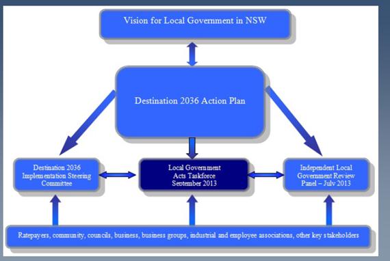
Destination 2036
In August 2011, the Mayors and General Managers of all 152 NSW councils and representatives of various local government industry groups met in Dubbo to discuss and plan the future of local government in NSW for the next 25 years. Following the Dubbo conference, the Division (now Office) of Local Government (OLG) released a Destination 2036 Outcomes Report and set out the proposed process and timeframe for consultation and preparation of a related Action Plan. This included the setting up of an Implementation Steering Committee (ISC) to oversee the process. When the ISC was set up, it comprised the Chief Executive of the OLG; the Presidents of the Local Government and Shires Associations (now Local Government NSW) (LGNSW); and the President of the NSW Local Government Managers’ (now Local Government Professionals Australia) (LGPA).
In December 2011, the ISC released a draft Destination 2036 Action Plan and sought comments from interested stakeholders. Following the public exhibition period, minor changes were made by the ISC to the Action Plan and it was approved by the Minister for Local Government. The Plan also referenced the Minister’s establishment of an Independent Local Government Review Panel (ILGRP) who would assume responsibility for some of the key actions.
The Destination 2036 key actions were grouped under the following initiatives: establish local government as an employer of choice; encourage and facilitate innovation; ensure the Local Government Act supports stronger local government; ensure strong and effective local governance; review the revenue system to ensure greater flexibility and self-reliance; develop strategies that maximise opportunities to secure funding from other levels of government; establish a range of funding models to enable the long term maintenance, replacement and creation of different classes of assets; develop a number of different structural models of local government; more clearly define the functions, roles and responsibilities of local and State Government; align State and local government planning frameworks; negotiate a new inter-governmental agreement; and recognise local government as a legitimate and important sphere of government
Each of the key actions, which were grouped under the above initiatives, had an expected completion date and a coordinating agency responsible for their achievement. Those agencies included the OLG, LGPA, LGNSW and the ILGRP. Progress updates for each of the key actions were reported quarterly on the OLG website. The ILGRP, which has since received the most press, was allocated responsibility for the following actions:
· Develop options and models to enhance collaboration on a regional basis through Regional Organisations of Councils (ROCs)
· Undertake research into innovation and better practice in local government in NSW, Australia and internationally
· Examine the current local government revenue system to ensure the system is contemporary, including rating provisions and other revenue options
· Examine the pros and cons of alternative governance models
· Research and develop alternative structural models, identifying their key features and assessing their applicability to NSW
· Identify barriers and incentives to encourage the voluntary amalgamation or boundary adjustment of councils
· Identify those functions that are clearly State or local government responsibility, those that cannot be readily defined and those that have been legislated/regulated as core functions
In August 2012, the Minister for Local Government also announced that the legislative framework for local government in NSW was to be rewritten and modernised. He appointed a Local Government Acts Taskforce to make recommendations in respect of this process. As a consequence, the Taskforce took on the key actions associated with the amendment of the Local Government Act and the City of Sydney Act.
![]()
Independent Local Government Review Panel (ILGRP)
The ILGRP, which was launched in May 2012, was originally scheduled to present its final report to the State Government in July 2013. That timeline was extended until September 2013 which was in line with the reporting requirements of the Local Government Acts Taskforce. The Panel was chaired by Professor Graham Sansom who was a previous Director of the Australian Centre for Excellence in Local Government. The other members of the Panel were Ms Jude Munro (a former CEO of four metropolitan councils across three states – including Brisbane City Council); and Mr Glenn Inglis (who had extensive experience as a Council General Manager in rural and regional NSW).
Apart from considering several actions from the Destination 2036 Action Plan; the Panel examined possible future arrangements for local governance and service delivery in the far western districts of NSW; and proposals to combine the existing 104 council-owned water utilities across non-metropolitan NSW into 32 larger regional operations. The ILGRP also closely followed the Government’s reform of the land use planning system, and the review of local government compliance and enforcement activities by IPART.
The Panel released an initial Consultation Paper in July 2012 and then held 32 consultation sessions during a Listening Tour around the State. More than 200 submissions were subsequently received by the ILGRP (including one from Hornsby). As part of its deliberations, the ILGRP also reviewed a wide range of already published research and reports of inquiries into various aspects of local government in NSW, across Australia and internationally. In November 2012, it released a paper titled “Better Stronger Local Government – The Case for Sustainable Change”. That paper set out the Panel’s thinking on some key aspects of local government and its relationship to the State that appeared to be in most need of fresh thinking and new ideas.
As part of “The Case for Sustainable Change” the ILGRP included “signposts for reform” under the headings of:
· The local government system and challenges faced – understanding the system and defining strategic capacity to deal with future challenges
· Fiscal responsibility and financial management – distribution of Financial Assistance Grants; rate pegging; etc.
· Services and infrastructure – whole of government responses; tackling infrastructure backlogs; greater efficiencies; regional collaboration
· Structures and boundaries – shared services models; benefits and drawbacks of amalgamation; consolidation of councils in Sydney; how to support amalgamation process
· Good governance – role and stature of Mayors; working relationships with GM’s; expanded benchmarking and performance reporting
· A compact for change and improvement – arrangements between State and local government
The ILGRP commissioned or was informed by further studies including: an examination of the scope to enhance regional collaboration through ROC’s; a cluster factor analysis to identify types of communities that have similar characteristics and are facing similar challenges; a review of the processes and outcomes of the 2004 amalgamations in NSW; an analysis of a range of opinion polls and resident satisfaction surveys to assess community attitudes towards local government; an examination of the effectiveness of the NSW rating system; an analysis of the financial sustainability of all 152 councils by the NSW Treasury Corporation (TCorp); and an assessment of each council’s infrastructure backlog by the DLG (now OLG).
In respect of the regional collaboration paper, two options were proposed by the Panel. The first was that if the current structure of local government is not changed much, there should be a strengthening of ROC’s and a greater commitment to collaboration between councils in the ROC’s. The second was that if there are extensive changes to the structure, there should be a Council of Mayors which would effectively be a streamlined County Council structure from which there would be a stronger requirement to engage in regional processes.
The main issues/themes that came out of the paper on previous amalgamations were: there needs to be clarity about what any boundary change aims to achieve; there needs to be a recognition about the importance of engaging and communicating with stakeholders at all stages of the process; there is a necessity for detailed planning; the successes of previous structural reforms have been as a result of the commitment of key people rather than the models of decision making at the time. They have been beneficial to communities but at a cost; and for amalgamation to be successful in the future, there needs to be:
· A partnering approach
· A fresh start
· Stakeholder involvement
· Sound planning and implementation
· Removal of barriers (and addition of incentives)
· Transitional arrangements for elected representation
· Independent monitoring and evaluation
The paper dealing with polls and surveys drew on a number of Statewide polls and 22 individual surveys undertaken by councils (one of which was for Hornsby in respect of its rate increase application a few years ago). The paper found that: NSW councils are good at running libraries, collecting waste and looking after parks and sportsgrounds; they are not so good at fixing roads and footpaths or processing development applications; ratepayers are probably willing to pay more rates if local services are maintained and local facilities are improved; local government rated much higher than Federal and State Governments in caring for the community, providing a voice for residents and an opportunity for involvement in decision making (N.B. Local government had a 70% satisfaction rating compared to a less than 16% satisfaction rating for other levels of government); and there has been general support in recent polls for consolidation of councils in the Sydney metropolitan area – but not on what the final or desired number of councils should be.
TCorp’s analysis of the financial sustainability of the 152 councils across NSW provided a Financial Sustainability Rating (FSR) and an Outlook Rating (OR) for each council. In respect of FSR’s, no councils were rated as very strong, two were rated as strong, 32 were rated as sound, 79 were rated as moderate, 34 were rated as weak and five were rated as very weak. For OR’s, five councils outlooks were positive, 74 were neutral and 73 were negative. Hornsby’s FSR rating was moderate and its OR was neutral. The seven key recommendations made by TCorp in respect of Hornsby Council were:
· Council should aim for at least breakeven operating positions each year
· Pricing paths are needed for the medium term
· Rate increases must meet underlying costs
· Asset management planning must be prioritised
· Councillor and management capacity must be developed
· There must be an improved use of restricted funds
· There should be an increased use of debt
The ILGRP subsequently released a further consultation paper titled “Future Directions for NSW Local Government – Twenty Essential Steps” which set out the Panel’s thinking as it entered the final three to four months of its work program. It built on the “Case for Sustainable Change” document released in November 2012. The Media Statement that accompanied the release of the Consultation Paper detailed a summary of the ILGRP’s thoughts at that time. That summary, particularly as it was applicable to Hornsby, is provided below:
· We have prepared a package of Future Directions for NSW Local Government aimed at transforming its culture, structures, finances and operations, as well as its relations with the State Government. The paper gives councils and the community another opportunity to have their say and inform our ideas before we complete our final report in September. 40 years ago, the Barnett Committee recommended some similar changes for NSW local government, including a reduction in the total number of councils to less than 100. Some of those changes have been implemented but many have not, and new challenges now have to be faced. NSW cannot afford to wait another 40 years for vital improvements to the local government system.
· The Panel’s goal is for a more sustainable system of democratic local government that has added capacity to address the needs of local and regional communities, and to be a valued partner of State and Federal governments. NSW needs more effective local government to harness the skills and resources of local communities, improve quality of life and advance State development. Many councils are performing very well. However, on the whole our investigations and consultations have revealed a local government sector that is weighed down with too many out-of-date ideas, attitudes and relationships. There are many factors involved, but at the heart of the problem we still have too many councils chasing too little revenue.
· As revealed in a TCorp report about the matter, it is “time to act”. TCorp’s results paint a disturbing picture and confirm the Panel’s view that underlying weaknesses in the financial position of NSW local government have been allowed to build up for far too long. In three years’ time, 48% of councils could have a weak or worse financial sustainability rating. There is no point in seeking to apportion blame: what is needed now is a healthy dose of reality-testing and an acceptance that there are no easy answers. It is clear that the financial base of NSW local government is in urgent need of repair, with many councils facing very serious problems that threaten their sustainability and ability to provide adequate services and infrastructure for their local communities. Addressing the issues will be uncomfortable for all concerned: politicians, senior managers, staff and ratepayers. As TCorp makes clear, a concerted, medium-long term strategy is required.
· Stronger regional and metropolitan governance must be a central plank of local government reform to make better use of scarce resources and to facilitate more efficient and effective State-local relations especially in strategic planning, economic development, infrastructure provision and service delivery. To achieve this in regional NSW, the Panel has proposed the establishment of around 20 “new look”, multi-purpose County Councils. These have been focused on existing or potential major regional centres, which could also be strengthened by some amalgamations with adjoining councils. The paper also proposes extensive restructuring of local government in the Sydney Metropolitan Area, Lower Hunter and Central Coast. This includes in particular:
o A new “global city” of Sydney, encompassing the whole area from the CBD east to the coast and south to Botany Bay. The Panel sees this as vital to create a capital city that, like those of Brisbane, Auckland and many other competitors around the world, will match Sydney’s international status.
o Reducing the unnecessary fragmentation of local government in Sydney’s southern suburbs and the inner west, on the north shore and along the northern beaches.
o Greatly expanded cities of Parramatta and Liverpool that will have the scale and resources needed to support the regional centres envisaged in the draft Metropolitan Strategy.
o A combined city of Newcastle-Lake Macquarie to drive development in the Lower Hunter.
o A merger of Gosford and Wyong to provide stronger local government in the Central Coast.
· Opponents of amalgamations rely heavily on the argument that local identity will be lost in bigger local government units. However, the Panel can find no evidence that loss of local identity is an inevitable consequence of creating larger local government areas. To assist the transition for councils considering voluntary amalgamation, the Panel proposes a range of ways to ensure local voices are heard. These include place management approaches, use of wards, citizen’s panels and modern customer service systems. We also propose the option of “Local Boards” – a new type of elected, community-based local government unit with limited responsibilities delegated from a local council or County Council. These could be used to replace small rural and remote councils that will not have the resources to continue in their current form, as well as to assist the transition to larger local government areas in the Sydney metropolitan area.
· Amalgamations and boundary changes are not the panacea for local government’s problems. However, many out of date boundaries and structures remain in place today and our terms of reference require that we provide options to address those issues. We believe that amalgamations and boundary changes are an essential element of a wider package of reforms. In doing so, the Panel has kept in mind the Government’s commitment to “no forced amalgamations” and understands that change will require councils and communities to accept the benefits of mergers. Detailed planning and business cases will be needed and further consultation will be required under the provisions of the Local Government Act. The Panel’s report proposes a wide-ranging package of financial and other incentives for voluntary mergers. But in the end, arguments about amalgamations are essentially a distraction from the core issue we need to face, which is how the role and capacity of NSW local government can best be strengthened in the interests of the communities it is expected to represent. We are faced with challenges that demand a fresh look at the system of local government and its relationship with the State, and a willingness to explore new options with an open mind. That is what we will be doing for the remaining four months of the review.
· The Consultation Paper provides a detailed progress report on the Panel’s work to date and provides a basis for further consultation. The Panel’s ideas are crystallising but are not set in concrete. A number of important research projects are still under way and the Panel wants to discuss the options included in the paper with councils and communities. The paper fulfils the Panel’s commitment to ensure that all concerned can discuss the options being considered for its final report, which is now due in September 2013, to give the Panel time to consider the expected significant feedback from the Future Directions stage of the review.
· The Panel’s Future Directions consultation will include visits to 29 regional cities and towns and eight locations in the Sydney metropolitan area from 9 May until 14 June 2013. Councils Workshops will provide the opportunity for Mayors, Councillors and senior staff to discuss the paper and explore the options put forward for their region. Community Hearings will also be held to provide the opportunity for local people and organisations to express their views directly to the Panel and discuss the various ideas and proposals set out in the paper.
Chapter 15 of the ILGRP’s paper dealt with the reshaping of metropolitan governance and had the most relevance to Hornsby Shire Council at the time. The Panel said that for Sydney to remain Australasia’s pre-eminent global city, very substantial changes are needed to the way the region is governed at both local and State levels. The Panel believed that without changes to council boundaries there will be an increasingly severe imbalance in the structures of local government between eastern and western Sydney and that this would be inequitable and impede sound strategic planning and effective State-local collaboration.
The ILGRP concluded that the number of local councils in the Sydney basin should be significantly reduced, especially in the inner and eastern suburbs, on the lower North Shore and around Parramatta and Liverpool. In this regard, the Panel’s objectives were to: create high capacity councils that can better represent and serve their local communities on metropolitan issues, and be true partners of State and Federal agencies; establish a more equitable pattern of local government across the metropolitan area, taking into account planned development; underpin Sydney’s status as a global city; and support implementation of the Metropolitan Strategy. The Panel’s view was that on balance, looking ahead to the mid-21st Century when Sydney’s population will reach about 7 million, having about 15 councils is appropriate.
The Metropolitan Strategy placed particular emphasis on the planning and development of a series of major centres. The ILGRP considered the lessons to be learned from the history of efforts over the past 40 years to establish Parramatta as Sydney’s “second CBD”. One of those lessons is that a strong, well-resourced local council is an essential factor: there is little doubt that Parramatta’s development has been hindered by the limited scale and narrow boundaries of the current local government area. The Panel therefore considered that major centres need to be managed by suitably large and capable councils. This requires:
· A major expansion of the City of Parramatta to include Auburn, Holroyd, most or all of Ryde, and areas of Hornsby and The Hills south of the M2. This will create a city with a broad socio-economic mix and with the resources needed to develop a “second CBD”.
· Amalgamation of the local government areas of Liverpool, Fairfield and perhaps Bankstown to support the planned Liverpool “regional city”.
· Amalgamation of local government areas on the lower North Shore, in the inner west, and in the St George area. These amalgamations are also needed to reduce excessive fragmentation into small or relatively small units.
The Panel saw considerable benefits in sharing the wealth and revenue base of the Sydney CBD across a much wider area. The new city would have the capacity to undertake major sub-regional projects, such as light rail and cycleway networks, from its own resources. It may also be able to assume responsibility for some State-managed facilities, such as Centennial Park and the Botanic Gardens, freeing-up funds for allocation to projects in more needy local government areas.
The Panel indicated that if there is little or no restructuring of existing boundaries in the metropolitan area, then as in the rest of NSW multi-purpose (but in this case sub-regional) County Councils should be established to undertake a wide range of functions on behalf of their members, thus ensuring effective and ongoing collaboration in shared services, strategic planning and advocacy, as well as a basis for partnership with State and Federal agencies. If restructuring takes place as preferred by the ILGRP, sub-regional groupings of councils would be set up for joint strategic planning and implementation with State agencies of proposed Delivery Plans under the Metropolitan Strategy, as well as Regional Action Plans under the State Plan. Sub-regional boundaries have been indicated in the draft Metropolitan Strategy, but may require adjustments in light of the Panel’s proposals.
The specific recommendation in respect of Hornsby Shire Council contained in Table 4 of the Consultation Paper was that Hornsby amalgamate with Ku-ring-gai Council. If this proposal was not acceptable to the State Government because of its current policy position of no forced amalgamations, the Panel recommended that the two Councils combine under a strong County Council model. Under this model, the County Council would undertake a broad range of strategic functions to support both Hornsby and Ku-ring-gai Councils. The County Council would replace the existing regional organisation (NSROC) with Hornsby and Ku-ring-gai remaining much as they are except that they would “own” and resource the County Council and refer some regional functions to the County Council. The Panel also recommended, in line with its proposed expansion of the Parramatta City Council boundaries, that Hornsby’s current boundary with Parramatta and/or Ryde Councils be shifted north to the M2.
Deputy General Manager’s Report No. CS22/13, which was submitted for Council’s consideration at the 19 June 2013 General Meeting, provided background details about the establishment of the ILGRP together with Council’s response to the Panel’s April 2013 consultation paper titled “Future Directions for NSW Local Government – Twenty Essential Steps”. Council’s submission, which was sent on 27 June 2013, was one of many that the ILGRP received and considered in developing its final report.
The ILGRP submitted its final report to the Minister for Local Government in October 2013 and it was subsequently released for public comment by the Minister in January 2014. Comments on the final report were originally due by 7 March 2014, but this date was extended by the Minister until 4 April 2014.
The Panel made a total of 65 recommendations which respond to the following 12 key themes that run throughout the report:
· The overarching imperative is to ensure the long-term sustainability and effectiveness of NSW local government. In its present form and under current policy settings the system as a whole will not remain sustainable and fit-for-purpose for much longer.
· The focus of policy should be on strengthening ‘strategic capacity’ – ensuring that local government has the right structures, governance models, skills and resources to discharge its responsibilities and realise its potential.
· Major new initiatives are required to tackle the underlying problems of financial weakness and infrastructure backlogs.
· In particular, a series of measures must be put in place to promote greater ‘fiscal responsibility’ within local government and to make associated improvements to local government’s efficiency, accountability and political governance.
· Changes to the rating system and rate-pegging are essential to generate the revenues needed to fund infrastructure and services, and – equally as important – to make the system more equitable.
· Given limited funds, the distribution of grants must change to direct more assistance to areas of greatest need.
· Stronger regional organisations are vital to ensure increased resource sharing and joint planning, and to support vulnerable rural-remote councils.
· Structural reform – including council amalgamations – is another essential component of reform, notably in metropolitan Sydney.
· The process for considering possible amalgamations and boundary changes needs to be overhauled, and a package of incentives introduced to encourage voluntary mergers.
· The particular issues and problems facing the Far West of NSW require special arrangements.
· Working relations between local government and State agencies need to be improved across the board, and regional coordination should be the centrepiece of this effort.
· Reforms must be pursued as an integrated package, not one-off measures.
The ILGRP’s principal recommendations in response to the above key themes can be summarised as follows (noting that the relevant section of the Panel’s report is shown in brackets for those interested in obtaining further information):
Fiscal Responsibility
· Establish an integrated Fiscal Responsibility Program, coordinated by the Division of Local Government (now OLG) and also involving the Treasury Corporation (TCorp), the Independent Pricing and Regulatory Tribunal (IPART) and Local Government NSW (LGNSW)… (5.1 and 5.3)
· Introduce more rigorous guidelines for Delivery Programs… (5.2)
· Place local government audits under the aegis of the Auditor General… (5.4)
Strengthening the Revenue Base
· Commission IPART to undertake a further review of the rating system focused on: options to reduce or remove excessive exemptions and concessions… (6.2); more equitable rating of apartments and other multi-unit dwellings… (6.3)
· Either replace rate-pegging with a new system of ‘rate benchmarking’ or streamline current arrangements to remove unwarranted complexity, costs, and constraints to sound financial management… (6.5)
· Subject to any legal constraints, seek to redistribute Federal Financial Assistance Grants and some State grants in order to channel additional support to councils and communities with the greatest needs… (6.6)
· Establish a State-wide borrowing facility to enable local government to make increased use of debt where appropriate… (6.7)
Meeting Infrastructure Needs
· Maintain the Local Infrastructure Renewal Scheme (LIRS) for at least five years, with a focus on councils facing the most severe infrastructure problems… (7.2)
· Pool a proportion of funds from the roads component of Federal Financial Assistance Grants and, if possible, the Roads to Recovery program in order to establish a Strategic Projects Fund for roads and bridges… (7.2)
· Adopt a similar model to Queensland’s of Regional Roads and Transport Groups… (7.4)
Improvement, Productivity and Accountability
· Commission IPART to undertake a whole-of-government review of the regulatory, compliance and reporting burden on councils… (8.2)
· Amend Integrated Planning and Reporting (IPR) Guidelines to require councils to incorporate regular service reviews in their Delivery Programs… (8.4)
· Strengthen requirements for internal and performance auditing as proposed in Box 17… (8.5)
Political Leadership and Good Governance
· Require councils to undertake regular Representation Reviews … (9.1)
· Amend the legislated role of councillors and mayors and introduce mandatory professional development programs… (9.2 and 9.3)
· Amend the legislated role and standard contract provisions of General Managers… (9.5)
· Develop a Good Governance Guide …(9.7)
Advancing Structural Reform
· Introduce additional options for local government structures, including regional Joint Organisations, ‘Rural Councils’ and Community Boards, to facilitate a better response to the needs and circumstances of different regions… (10.1)
· Legislate a revised process for considering potential amalgamations and boundary changes through a re-constituted and more independent Boundaries Commission… (10.3)
· Encourage voluntary mergers of councils through measures to lower barriers and provide professional and financial support… (10.4)
Regional Joint Organisations
· Establish new Joint Organisations (JOs) for each of the regions shown on Map 2 under new provisions of the Local Government Act that replace those for County Councils… (11.5)
· Establish Regional Water Alliances in each JO along the lines proposed in the 2009 Armstrong-Gellatly report… (11.3)
‘Rural Councils’ and Community Boards
· Establish a working party to further develop the concept of ‘Rural Councils’… (12.1)
· Include provisions for optional Community Boards… (12.2)
Metropolitan Sydney, Hunter and Central Coast
· Seek evidence-based responses from councils to the Panel’s proposals for mergers and major boundary changes… (13.3, 14.1, 14.2)
· Maximise utilisation of the local government revenue base in the eastern half of the Sydney region in order to free-up State resources…(13.6)
Non-Metropolitan Regions
· Progressively refer (non-metropolitan) councils to the reconstituted Boundaries Commission in accordance with Table 11 and the proposed timeline… (15.1)
The Far West
· Agree in principle to the establishment of a Far West Regional Authority… (16.3)
· Adopt the preferred new arrangements for local government set out in Box 40… (16.4)
State-Local Government Relations
· Introduce new arrangements for collaborative, whole-of-government strategic planning at a regional level… (17.3)
· Amend the State Constitution to strengthen recognition of elected local government… (17.4)
Chapter 13 of the ILGRP’s report deals with metropolitan Sydney and had the most relevance to Hornsby Shire Council. A summary of the matters raised by the Panel in Chapter 13 is provided below:
Reshaping metropolitan governance
· The Panel is convinced that for Sydney to remain Australasia’s pre-eminent global city, very substantial changes are needed to the way the region is governed at both local and State levels.
· Achieving more effective metropolitan governance requires a partnership approach involving State, local and, if possible, Federal governments.
Alternative futures for local government
· The Panel sees two distinct alternatives for the future structure of metropolitan local government:
o Retain more or less the current number and distribution of councils, and rely heavily on sub-regional Joint Organisations to contribute to metropolitan issues, engage with State agencies at a sub-regional level, undertake joint planning and projects, and promote increased delivery of shared services.
o Substantially reduce the number of councils so that each has the resources and credibility to be a player in metropolitan affairs in its own right, and so that they can all come together in a strong metropolitan-wide organisation such as a ‘Council of Mayors’.
· In considering these options the Panel took the following factors into account.
o With 41 councils in metropolitan Sydney (excluding the Central Coast) local government is fragmented (especially in the eastern half of the region) and lacks credibility as a significant player and partner in metropolitan planning and management.
o There is continuing unnecessary duplication between councils in planning and service delivery, and scarce expertise and resources are not being used to their full potential.
o Without changes to council boundaries there will be an increasingly severe imbalance in the structures of local government between eastern and western Sydney.
o Coordination and cooperation between councils would undoubtedly be improved by the establishment of robust sub-regional organisations.
o Enhanced capacity for local government to play a major role in strategic planning, delivery of major infrastructure and improvement projects, and partnering effectively with State and Federal agencies is more likely to be achieved if the basic building blocks – individual councils – are larger and more capable.
o There is an often expressed community concern that creating substantially larger local government areas will reduce local representation and destroy local identity. However, there are a number of ways in which local identity and representation can be maintained.
Options for mergers
· The Panel concluded that the number of local councils in the Sydney basin should be significantly reduced. This applies mainly to the inner and eastern suburbs, the lower North Shore and around Parramatta and Liverpool.
· The Panel’s proposals were amended in several key respects from those put forward in its earlier Future Directions Discussion Paper to take into account issues raised in submissions, as well as the opportunity to align sub-regional boundaries with those to be used for the State Plan and Metropolitan Strategy.
· In particular, the Metropolitan Strategy places particular emphasis on the planning and development of a series of regional centres. Looking ahead, it will be important to ensure that the centres of both Parramatta and Liverpool are governed by councils with considerably greater capacity and strength in sub-regional leadership than has been the case.
· The options put forward are far-reaching but not as radical as some might prefer. The Panel’s view is that on balance, looking ahead to the mid-21st Century when Sydney’s population will reach about 7 million, having about 15-18 councils is appropriate. A smaller number could tend to create several ‘mini-states’, which would not be helpful at this stage. The Panel’s proposals leave scope to make further structural changes in the future if required.
· Amalgamated councils should have the option of establishing Community Boards. This would help smooth the transition to much larger local government areas and enable ongoing representation of local communities of interest.
· Submissions to the Panel indicate intense opposition to mergers amongst some metropolitan councils, but also a significant degree of support for change. The same applies in the community, and analysis of polling suggests that initial ‘reflex’ opposition to amalgamations is not as firm as it might appear. At least three councils (including Hornsby) have commissioned studies to explore the potential benefits of mergers, and others have suggested substantial boundary changes.
· It is essential that any changes to boundaries in metropolitan Sydney occur within a consistent strategic framework designed to support strategic planning and infrastructure provision, and to complement State government efforts to improve metropolitan governance. The Panel therefore believes that the best way forward would be first, to seek evidence-based responses from councils to its proposals; then to refer both the proposals and responses to the proposed Ministerial Advisory Group; and then, if warranted, to the Boundaries Commission for further consideration. The Panel would caution against supporting any isolated voluntary amalgamations until there is a clear long-term strategy. Experience with the ‘semi-voluntary’ mergers that occurred in Adelaide in the mid-1990s indicates that, whilst some benefits are achieved, the overall outcome can be a very unsatisfactory ‘patchwork quilt’.
Sub-regional arrangements
· If the number of councils in the Sydney region is substantially reduced, then sub-regional arrangements would be focused primarily on working with the Department of Planning and Infrastructure (DPI) and the Department of Premier and Cabinet (DPC) to prepare and implement sub-regional Delivery Plans and Regional Action Plans.
· If there is little or no restructuring of existing council boundaries, then multi-purpose JOs should be established to undertake a wide range of functions on behalf of their members, as in the rest of NSW. Close collaboration in strategic planning, infrastructure provision and shared services would be especially important. The JOs would also be critical for strengthening partnerships with State and Federal agencies to bring about more effective metropolitan governance and growth management. Given the large number of councils in the inner and middle rings of Sydney, there may be a need to split some of the sub-regions shown on Map 3.
Maximising available resources
· Restructuring local government in the eastern half of metropolitan Sydney would maximise opportunities to make more use of the revenue potential from high land values and, in particular, the surge in medium and high-density residential development.
· 23 Sydney councils (including Hornsby) receive only the minimum general-purpose financial assistance grants (FAGs), suggesting little or no need for external support. Property owners in most of those areas pay relatively low rates as a proportion of land values. Preliminary calculations show that if they paid a similar percentage of land value as the metropolitan average, the councils concerned could collectively raise more than $150 million extra each year.
· Local councils in relatively affluent areas and with significant under-utilised revenue potential can and should contribute more to the task of managing metropolitan growth and change. This would free-up State resources to provide greater assistance to councils in western Sydney and elsewhere in NSW that are struggling to fund essential infrastructure and services.
A metropolitan Council of Mayors
· Sydney needs a metropolitan councils organisation that can provide a ‘voice’ for the region, and that can represent local government and local communities in high-level consultations with State and Federal governments, as well as internationally. With many fewer councils, there would be an opportunity – as well as a strong case – to establish a body similar to the South East Queensland Council of Mayors. If restructuring takes place along the lines suggested by the Panel, such a Council of Mayors would logically be chaired by the Lord Mayor of either Sydney or Parramatta.
· If the number of councils remains more or less as at present, then an alternative model would be several sub-regional Councils of Mayors that come together periodically as a metropolitan local government assembly.
The specific recommendation for Hornsby Shire Council detailed in Table 8 of the Panel’s report was that Hornsby amalgamate with Ku-ring-gai Council; or that Hornsby and Ku-ring-gai Councils combine as a strong Joint Organisation. The Panel also recommended, in line with its proposed expansion of the Parramatta City Council boundaries, that Hornsby’s current boundary with Parramatta and/or Ryde Councils be shifted north to the M2. Under the Joint Organisation (JO) model, the JO would undertake a broad range of strategic functions to support both Hornsby and Ku-ring-gai Councils e.g. strategic regional and sub-regional planning; inter-government relations and regional advocacy; road network planning and major projects; collaboration with State and Federal agencies in infrastructure and service provision; strategic procurement; high level corporate services or back office functions; etc. It is noted, however, that the Panel recommended that establishment of JO’s in metropolitan Sydney should be deferred pending further consideration of potential mergers by the State Government.
Research Undertaken by Council
Apart from responding to papers prepared by the ILGRP and the LGAT about local government reform (refer to Deputy General Manager’s Report Nos CS5/14 and CS6/14 – 12 March 2014 General Meeting), Council has been collecting and developing its own research about reform options.
Firstly, Hornsby and The Hills Councils jointly commissioned PWC to undertake a project to investigate potential mergers of Hornsby and The Hills with each other and/or with neighbouring councils. Secondly, Hornsby contracted Crosby Textor to undertake independent, scientifically robust and informative research to assist Council in understanding community opinion about the local government reform process as it affects the community.
Whilst the PWC research details the potential issues, benefits and disadvantages associated with Hornsby amalgamating with its neighbouring councils; Crosby Textor’s research provides insights into the community’s view about reforms proposed by the ILGRP in its April 2013 Discussion Paper and, in particular, council amalgamations and/or shared services.
The main messages emanating from the PWC research were:
· Strategic Capacity - access to a larger pool of financial and non-financial resources would enable a merged Hornsby/The Hills Council to undertake new functions and deliver new services.
· Lobbying - a larger Council would have greater weight in applying for State and Federal funding in addition to having a stronger negotiating position when discussing tenders and preferred supplier arrangements.
· Asset Utilisation and Rationalisation - there would be an increased ability to utilise assets by sharing resources and disposing of surplus or duplicated assets.
· Administrative Rationalisation - both Hornsby and The Hills operate through a similar organisational structure based on the configuration of functional expertise and the delivery of services. This would reduce the execution risk of removing duplicate functions.
· Increased Service Delivery – removing duplicate activities in multiple community centres, standardisation of services and increased scale of process would allow for more cost efficient delivery of services. Strategic location of newly developed infrastructure assets of a newly merged council would benefit a larger population, reducing the need to duplicate investment in infrastructure.
· Investment in Future Capital Assets – realisation of surplus assets may provide additional funds to reinvest in future capital projects, reduce the need to borrow or allow for the redeployment of reserves for new projects.
· Upgrade Existing Infrastructure – an amalgamation would allow for some facilities to be closed, delivering maintenance savings and income from property sales. An evaluation of the infrastructure requiring remediation would need to be undertaken to identify overlap and identify areas of potential savings.
· Re-calibrate Capital Structure – the loan funding levels of Hornsby and The Hills Councils are relatively low, with debt service ratios not exceeding 5%. There is capacity to increase borrowings to fund capital budgets and reduce backlogs in costs to bring assets to a satisfactory condition. There would also be an ability to refinance or repay existing debt to reduce borrowing costs given the stronger balance sheet position of the merged council.
· Strategic Alignment – there is an alignment of a number of strategic goals of Hornsby and The Hills. This alignment indicates that there are potential synergies to be gained in achieving these goals from an amalgamation of the two Councils e.g.
o Ecology and environment strategies in relation to climate change, bushland and natural areas, environmental education, development and water.
o Economy and infrastructure strategies in relation to transport, economic development, recreation, employment, assets and business development.
o Community strategies in relation to community engagement, service provision, cultural engagement and crime.
o Governance strategies in relation to reporting, internal policies, stakeholder management and risk management.
· In respect of financial benefits:
o The rationalisation of corporate support functions like information technology, financial services, records, and human resources would lead to significant expense reductions.
o Labour consolidation could also be applied to managerial staff, administrative support staff, property sections and strategy and communication groups.
o A review of the information system requirements of a combined council may result in reasonable savings in lease payments.
o Rationalisation of assets that on review are surplus to needs may present opportunities to improve cash-flow and address infrastructure backlogs. Reduced maintenance budgets may also be a side benefit.
o Reduced operating expenses due to labour consolidation and asset rationalisation to address infrastructure backlogs would improve a council’s strategic ability to manage reliance on rate pegging allowances.
Crosby Textor’s research indicated that:
· Local issues are low on the order of local residents’ issues. Issues concerning matters of State Government rank higher on the top-of-mind agenda for the local residents of Hornsby, The Hills, Parramatta and Ryde. These issues predominantly include the provision of better public and social infrastructure and traffic congestion.
· There is a low level of awareness of local council amalgamation. Total awareness of the current local government reform process sits around 53%.
· There is a high level of indecision – “soft” support/opposition for reform. The recommended option from the ILGRP to amalgamate councils has a “soft” position of approximately 60% of surveyed people. This finding is particularly important because it shows that community members are neither genuinely in support or opposed to the proposed reforms.
· The shared services model is preferred over amalgamation. Total support for a shared services model sits at 73% with minimal “strong” opposition at 9%. Of the reform options proposed, a shared services model was the most readily accepted. A reduction in council costs and improved service delivery were viewed as the primary reasons to support the model.
· There are disparate Hornsby Ward views about amalgamation. The results show that the views of residents in A, B and C wards are different. The geographical distances between these wards and the change of community landscape shows that there is not homogeneity in their views.
· Attitudes are consistent amongst residents from all surveyed councils. There appears to be relative levels of parity in the views expressed by community members surveyed in neighbouring council areas. The results showed that varying levels of awareness, opposition and support were only marginal if any at all.
· There is potential to convince those who are undecided on amalgamations by explaining the arguments which support lower costs and improved efficiencies.
Following the receipt and consideration of the Crosby Textor and PWC research at its 21 August 2013 General Meeting, Council unanimously resolved that:
1. The research undertaken for Council by Crosby Textor and PricewaterhouseCoopers be received and noted and briefings on the Crosby Textor research continue to be offered to the Independent Local Government Review Panel and the Minister for Local Government.
2. Due to public interest in this matter, copies of the PricewaterhouseCoopers and Crosby Textor quantitative research be made available with other relevant information on a “Local Government Reform” section of Council’s website.
3. Prior to formalising its position on local government reform, Council commission an independent, high level strategic and financial assessment of potential options for structural reform of local government in the northern Sydney area. Such assessment would be similar to assessments already undertaken by Randwick and Warringah Councils for the eastern suburbs and northern beaches areas respectively.
In respect of point 1 of the resolution, Council offered both the ILGRP and the Minister for Local Government briefings on the Crosby Textor findings to assist them in their continuing deliberations on local government reform. The ILGRP took the opportunity to be briefed on the Crosby Textor research and to then referred favourably to the research in its final report.
In line with point 2 of the resolution, copies of the PWC and Crosby Textor research were made available on Council’s website.
In respect of point 3 of the resolution, KPMG was commissioned to undertake the high level strategic and financial assessment of options for structural reform. The scope of Council’s engagement of KPMG was to:
· Develop up to seven local government reform options (including a base case) with reference to a predetermined set of local government reform principles.
· Conduct a financial strategic analysis of options, including:
o detailed financial statement analysis of Hornsby Shire Council data
o high level financial statement analysis of publicly available council data for neighbouring councils
o financial modelling and sensitivity testing of options
o internal stakeholder consultations and testing with up to three internal stakeholders at Hornsby Shire Council
o analysis of broader supporting strategies and mechanisms, including service delivery pathways, asset utilisation and renewal, socio-economic and cultural considerations, and governance structures
o multi-criteria analysis with up to five financial and non-financial criteria to determine the preferred option for Hornsby Shire Council
· Seek input to the analysis from neighbouring councils that may be impacted by local government reform options considered in KPMG’s report.
Following its appointment, KPMG worked with Council to develop the following set of local government reform principles to be used in its analysis.
|
Reform Principles |
Indicators |
Key Considerations |
|
Local Government Capacity - the ability of local government to maintain or enhance service delivery |
Quality of service delivery Quality of planning and infrastructure delivery Capacity to attract specialist skills |
With effective coordination and management, larger councils tend to have greater capacity than smaller councils to leverage financial and operational scale to: · better manage planning and infrastructure delivery · concurrently maintain or improve the quality and efficiency of services to residents |
|
Financial Sustainability - the ability of the council to sustainably fund adequate and effective services |
The capacity to secure economies of scale and scope Scope and scale of the resource base |
Continued or improved financial sustainability is crucial in maintaining the capacity to deliver services, and it is often a key motivation of pursuing boundary reforms. Ensuring that any boundary reforms increase the financial sustainability of council is vital, and this will be assessed through the financial statement analysis and cost benefit analysis. |
|
Local Representation - the ability of the local government authority to effectively represent ratepayers |
Quality of local representation Communities of interest Quality of stakeholder management |
Boundary reform options should be evaluated with respect to their impact on the effectiveness of local representation. The effectiveness of representation affects the quality of governance. Representation that is more reflective of the community is more likely to lead to outcomes aligned with the needs of the governed. Effective representation also helps manage the diverse (and sometimes competing) communities of interest that form a council locality. |
KPMG and Council also agreed that the following seven local government reform options were those to be investigated as part of this project:
|
Reform Options |
Description |
|
Option 1 - Base Case |
Option 1 is the base case – or “do nothing” option – in which the current structure of local government areas considered were assumed to remain constant. |
|
Amalgamation Options |
|
|
Option 2 - Hornsby and The Hills Councils |
Option 2 is an amalgamation option that would involve combining Hornsby and The Hills Councils, with minor adjustments to each Council’s southern boundaries. |
|
Option 3 - Hornsby and Ku-ring-gai Councils |
Option 3 is an amalgamation option that would involve combining Hornsby and Ku-ring-gai Councils, with a minor adjustment to the southern boundary of Hornsby Council. The specification of Option 3 is consistent with the recommendation made in the ILGRP’s Final Report. |
|
Option 4 - Hornsby, The Hills and Ku-ring-gai Councils |
Option 4 is an amalgamation option that would involve combining Hornsby, The Hills and Ku-ring-gai Councils, with an adjustment to the southern boundary of Hornsby and The Hills Councils. |
|
Shared Services Options |
|
|
Option 5 - Shared Infrastructure and Recreation Division between Hornsby and The Hills Councils |
Option 5 is a shared services model between Hornsby and The Hills Councils, where an Infrastructure and Recreation Division would be shared across the Councils. |
|
Option 6 - Shared Infrastructure and Recreation Division between Hornsby and Ku-ring-gai Councils |
Option 6 is a shared services model between Hornsby and Ku-ring-gai Councils, where an Infrastructure and Recreation Division would be shared across the Councils. |
|
Option 7 - Shared Infrastructure and Recreation Division between Hornsby, The Hills and Ku-ring-gai Councils |
Option 7 is a shared services model between Hornsby, The Hills and Ku-ring-gai Councils, where an Infrastructure and Recreation Division would be shared across the Councils. |
KPMG completed its research and provided Council with its final report (together with a summary version of the report which may be useful for interested members of the public). The key findings of KPMG’s research were that:
· Local governments in NSW perform crucial functions and are key platforms for local democracy and representation, however, their structure and functions have largely remained static despite structural changes in the economy.
· Financial sustainability is a key consideration for local government in NSW, with 46 percent of councils estimated to have a financial sustainability rating of “weak” or lower within three years.
· To support more sustainable local governments over the long term, there are a number of potential reform options, including – for example – amalgamations, boundary reform and shared services. The recent report by the ILGRP - Revitalising Local Government - provided a comprehensive analysis of these options in the NSW context.
· Although there are broader impacts associated with reform, a key consideration is the potential financial benefits. Evidence suggests that economies of scale can be achieved in Australia, as demonstrated by seven out of nine studies of domestic reform experience.
· Previous experience suggests that the quality of service delivery, financial sustainability and the effectiveness of local representation are consistently applied to develop and analyse the impacts of local government reform.
· The seven reform options were developed based on the common underlying principles of previous reform experience and consultations with Hornsby Council. Reform options included both amalgamations and shared services arrangements.
· Option 1 – Base Case Scenario
o Under Option 1, where Hornsby, The Hills and Ku-ring-gai Councils remain as separate entities, it is estimated that:
Ø Hornsby’s net operating result before capital items would be $23.0 million in 2017/18, and over the ten year period from 2013/14 to 2022/23 would show a cumulative net operating result before capital items of $209.0 million.
Ø The Hills’ net operating result before capital items would be $54.6 million in 2017/18, and over the ten year period from 2013/14 to 2022/23 would show a cumulative net operating result before capital items of $500.7 million.
Ø Ku-ring-gai’s net operating result before capital items would be $43.1 million in 2017/18, and over the ten year period from 2013/14 to 2022/23 would show a cumulative net operating result before capital items of $349.7 million.
· Options 2 and 5 - Amalgamation and Shared Services - Hornsby and The Hills
o An amalgamation of Hornsby and The Hills Councils – Option 2 - is estimated to achieve a net operating result of about $26.9 million in 2017/18 (for the Hornsby Shire entity – refer Table 7.13 on page 59 of KPMG’s report), representing about a 17 percent improvement to the current forecast net operating result in Option 1.
o Under Option 2, the cumulative net operating result over the period 2013/14 to 2022/23 for the aggregate Hornsby/The Hills entity is estimated to be $783.7 million (which is $74.0 million – or 10 percent - greater than what the Councils are estimated to achieve as separate entities in the same period) – see Table below.
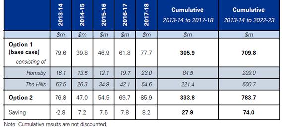
o A shared services model between Hornsby and The Hills Councils (where they would share an Infrastructure and Recreation Division) – Option 5 - is estimated to achieve a net operating result of around $24.0 million in 2017/18 (for the Hornsby Shire entity - refer Table 7.16 on page 62 of KPMG’s report), representing about a 4 percent improvement to the current forecast net operating result in Option 1.
o Under Option 5, the cumulative net operating result over the period to 2013/14 to 2022/23 for the Hornsby/The Hills shared services entity is estimated to be $725.1 million (which is $15.3 million – or 2 percent - greater than what the Councils are estimated to achieve as separate entities in the same period) – see Table below.
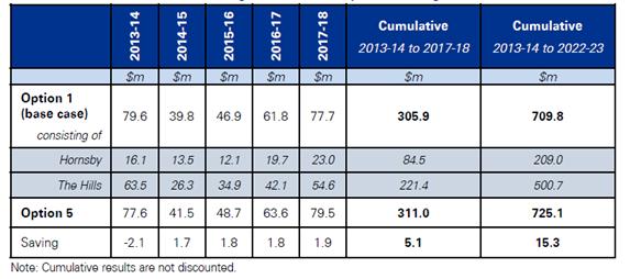
· Options 3 and 6 - Amalgamation and Shared Services - Hornsby and Ku-ring-gai
o An amalgamation of Hornsby and Ku-ring-gai Councils – Option 3 - is estimated to achieve a net operating result of about $26.2 million in 2017/18 (for the Hornsby Shire entity - refer Table 7.14 on page 60 of KPMG’s report), representing about a 14 percent improvement to the current forecast net operating result in Option 1.
o Under Option 3, the cumulative net operating result over the period 2013/14 to 2022/23 for the aggregate Hornsby/Ku-ring-gai entity is estimated to be $609.1 million (which is $50.4 million – or 9 percent - greater than what the Councils are estimated to achieve as separate entities in the same period) – see Table below.

o A shared services model between Hornsby and Ku-ring-gai Councils (where they would share an Infrastructure and Recreation Division) – Option 6 - is estimated to achieve a net operating result of around $23.9 million in 2017/18 (for the Hornsby Shire entity - refer Table 7.17 on page 63 of KPMG’s report), representing about a 3 percent improvement to the current forecast net operating result in Option 1.
o Under Option 6, the cumulative net operating result over the period 2013/14 to 2022/23 for the Hornsby/Ku-ring-gai shared services entity is estimated to be $569.2 million (which is $10.5 million – or 2 percent - greater than what the Councils are estimated to achieve as separate entities in the same period) – see Table below.
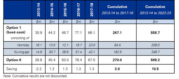
· Options 4 and 7 - Amalgamation and Shared Services – Hornsby, The Hills and Ku-ring-gai
o An amalgamation of Hornsby, The Hills and Ku-ring-gai Councils – Option 4 - is estimated to achieve a net operating result of about $29.0 million in 2017/18 (for the Hornsby Shire entity - refer Table 7.15 on page 61 of KPMG’s report), representing about a 26 percent improvement to the current forecast net operating result in Option 1.
o Under Option 4, the cumulative net operating result over the period 2013/14 to 2022/23 for the aggregate Hornsby/The Hills/Ku-ring-gai entity is estimated to be $1,222.6 million (which is $163.1 million – or 15 percent - greater than what the Councils are estimated to achieve as separate entities in the same period) – see Table below.
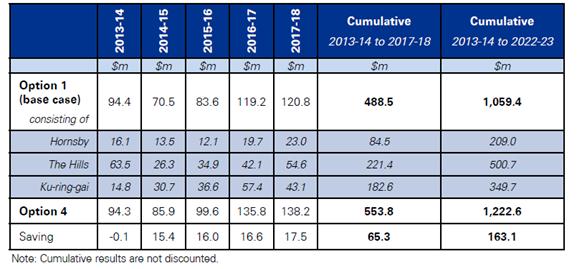
o A shared services model between Hornsby, The Hills and Ku-ring-gai Councils (where they would share an Infrastructure and Recreation Division) – Option 7 - is estimated to achieve a net operating result of around $24.2 million in 2017/18 (for the Hornsby Shire entity - refer Table 7.18 on page 64 of KPMG’s report), representing about a 5 percent improvement to the current forecast net operating result in Option 1.
o Under Option 7, the cumulative net operating result over the period 2013/14 to 2022/23 for the Hornsby/The Hills/Ku-ring-gai shared services entity is estimated to be $1,086.6 million (which is 27.2 million – or 3 percent - greater than what the Councils are estimated to achieve as separate entities in the same period) – see Table below.

KPMG stated that implementing local government reform, whether through boundary reform or shared services, requires consideration of a variety of supporting factors in addition to the expected financial impacts. The supporting strategies and mechanisms include:
· Asset utilisation, renewal and financial sustainability, including:
o valuation and stocktake of assets
o maintenance of infrastructure
· Service delivery pathways to promote quality provision of council services, including consideration of:
o service levels between councils
o human resource management across councils
o corporate support functions
· Governance structures of new council entities, including consideration of how governance may impact the effectiveness of local representation
· Transition measures to underpin the implementation of reforms
KPMG went on to say that Council’s preferred option for reform should be identified using multi-criteria analysis to recognise that broader supporting strategies need to be considered in conjunction with the projected financial impacts for different reform options. The framework for conducting a multi-criteria analysis should, therefore, consider a range of appropriate financial and non-financial criteria, for example:
· the expected financial impacts of options
· risks to financial sustainability over the longer term
· strategic risks
· risks to service quality and effectiveness
· risks to the effectiveness of local representation
· risk to effective implementation and management over time
KPMG provided a framework (see table below and Section 7.5 – pages 77-78 of KPMG’s report) which Council could use to undertake the multi-criteria analysis.
|
Financial Criteria |
|
|
The net financial benefits of the options |
Ranking of percentage point impacts relative to the base case net operating results. |
|
Risks to financial sustainability over the medium to long term |
Informed by the financial analysis and financial statement analysis of Hornsby Shire Council and neighbouring councils in the northern Sydney area. |
|
Non-Financial Criteria |
|
|
Strategic Risks |
Determined with respect to the analysis of supporting strategies and mechanisms and high level implementation considerations. |
|
Risks to service quality and effectiveness over time |
Determined with respect to the analysis of supporting strategies and mechanisms and high level implementation considerations. |
|
Risks to quality and effectiveness of local representation |
Determined with respect to the analysis of supporting strategies and mechanisms and high level implementation considerations. |
|
Risks to effective implementation and management over time |
Determined with respect to the analysis of supporting strategies and mechanisms and high level implementation considerations. |
KPMG did, however, indicate that further consultation and analysis is required to determine:
· the scoring for each criteria, particularly non-financial
· appropriate weightings for each criterion, to be determined by stakeholders
KPMG noted that there are a number of precursors to the finalisation and implementation of a preferred option by Council. These include, for example:
· Continued engagement in the broader local government reform debate in NSW, particularly when the NSW Government formalises its position to the Revitalising Local Government report recently released by the ILGRP.
· Further, more detailed, due diligence of reform options, particularly from the perspective of other councils in the reform process.
The approach recommended by KPMG was for Council to actively engage all relevant councils and the NSW Government concurrently to undertake a more comprehensive evaluation of the costs and benefits of all options. The approach to developing the analysis in KPMG’s report has the flexibility to be extended and refined over time should further, more detailed, data become available.
KPMG went on to say that following the completion of due diligence, stakeholder engagement and agreement of a preferred option, there should be detailed implementation planning to ensure successful delivery of reform over time. A structured and effectively communicated approach to implementation and management of the reform process is critical for its overall success, including the realisation of the potential benefits.
KPMG have provided a high level implementation plan for an amalgamation or shared services reform model (see Section 8 – pages 79-84 of KPMG’s report), however, they noted that a more complete implementation plan would be required following the completion of all required due diligence that provides:
· greater detail that is targeted to the specific option being considered
· target completion dates for actions
· accountabilities for those actions in agreed timeframes
Following its consideration of KPMG’s report at the 11 June 2014 General Meeting, Council resolved that:
1. KPMG’s “Analysis of local government reform options in the Northern Sydney area” report be made available on Council’s website and a copy sent to the Minister for Local Government and The Hills and Ku-ring-gai Councils.
2. The NSW Government be encouraged to facilitate local government reform having regard to the research undertaken for Council by KPMG, PWC and Crosby Textor; and the recommendations made by the ILGRP and the LGAT.
3. The Hills and Ku-ring-gai Councils be requested to provide their comments on the reform options outlined by KPMG.
4. When the NSW Government releases its responses to the recommendations made by the ILGRP and the LGAT, a further report be prepared for Council’s consideration incorporating any feedback received from The Hills and Ku-ring-gai Councils about the KPMG reports.
Following the Meeting, KPMG’s report was placed on Council’s website under the Local Government Reform tab; the Mayor provided a copy of the report to the Minister for Local Government and encouraged the NSW Government to commence reform of the local government industry; and the General Manager provided a copy of the report to the General Managers of The Hills and Ku-ring-gai Councils asking those Councils to provide any comments they may have on the reform options outlined in KPMG’s report.
Ku-ring-gai Council considered the KPMG report at its 12 August 2014 Ordinary Meeting and resolved that:
Council note that the report commissioned by Hornsby Council “Analysis of local government reform options in the Northern Sydney area – 22 May 2014” does not support the case for amalgamation of Ku-ring-gai and Hornsby Councils as the forecast saving is small compared to the risks involved, representing only 1.6% of the combined budgets over 10 years. This forecast:
i. Is based on simplistic assumptions derived from case studies of Council amalgamations of much larger scale and range of services offered
ii. Is likely to be optimistic and does not include an adequate allowance for transition costs
iii. Does not provide an adequate return for the substantial risks and disruption involved in an amalgamation
iv. Does not take into account the impact on Ku-ring-gai ratepayers in sharing in substantial costs to rehabilitate and stabilise the Hornsby Quarry
v. Does not take into account the impact of rates redistribution on Ku-ring-gai ratepayers due to higher land values, resulting in an increase in rates likely to be much greater than the forecast savings from amalgamation
vi. Does not address the loss of councillor representation, nor the operational difficulties, social challenges, town planning issues and political complexities in managing an amalgamation of two large, diverse council areas that stretch from the rural locality of Wisemans Ferry through to the urban suburb of Roseville, some 65 km to the south
vii. That Ku-ring-gai Council’s response to the report commissioned by Hornsby Council be sent to the State MPs for Ku-ring-gai, Davidson and Hornsby
Ku-ring-gai’s report on the matter states that it would be exposed to the following risks if there was an amalgamation of Ku-ring-gai and Hornsby Councils:
· Reduced representation and less say in decision making for the local area; the risk of decisions about the Ku-ring-gai area being made by a majority of councillors elected from the Hornsby area due to a larger population
· Increased rates for Ku-ring-gai ratepayers due to redistribution of the rates burden from areas of lower land value (Hornsby) to areas of higher land value (Ku-ring-gai)
· Unknown financial liabilities such as for rehabilitation of the Hornsby Quarry
· Impact on the composition, quality and quantity of services due to the rationalisation of facilities and services
· Disruption to service provision, loss of skilled workers, fall in staff morale and productivity loss
· Utilising simplistic assumptions based on anecdotal evidence from the KPMG report could lead to increased costs rather than savings
· Forecast financial savings are small in comparison to the substantial risks and disruption from amalgamation
NSW’s Fit for the Future Announcements
Deputy General Manager’s Report No. CS42/14 was considered by Council on 12 November 2014. It advised that on 10 September 2014, the NSW Government released its responses to the ILGRP and LGAT recommendations contained in their respective reports from 2013 titled “Revitalising Local Government” and “A New Local Government Act for New South Wales and Review of the Sydney of City Act 1988”. A copy of the Government’s responses to the recommendations from the ILGRP and LGAT reports is held in TRIM (refer Document No. D03932915) and is also available on the NSW Government’s website www.fitforthefuture.nsw.gov.au. The Government’s responses are in line with Council’s responses to the same recommendations.
The Government stated that more than one-third of the State’s councils are facing financial problems, infrastructure backlogs are overwhelming, many of our growing suburbs are being constrained by boundaries that date back to the horse and cart days, and councils are missing out on opportunities to take a more active role in regional and State planning because they lack the scale and structures to engage. The work of the ILGRP and the NSW Treasury Corporation (TCorp) has helped the Government to build a clearer picture of what they believe a sustainable council looks like.
Based on the above, the Government released a number of publications which outline in more detail how they intend to move down the local government reform path under the banner Fit for the Future. The publications include the following:
· Fit for the Future – A Roadmap for Stronger, Smarter Councils
· Fit for the Future – A Blueprint for the Future of Local Government
· Fit for the Future – Frequently Asked Questions
Copies of the documents are held in TRIM (refer Document Nos D03932917, D03932936 and D03932939 respectively) and are also available on www.fitforthefuture.nsw.gov.au.
The Government indicated that, in its view, a Fit for the Future council will have the following features which will ensure that the council has the strategic capacity to govern effectively and partner with industry and the Government to deliver key priorities:
· it will be sustainable
· it will be efficient
· it will effectively manage infrastructure and deliver services for communities
· it will have the scale and capacity to engage effectively across community, industry and government
Financial Sustainability
For councils to meet the service and infrastructure needs of their communities, they will need to be financially sustainable. TCorp has defined a sustainable council as one that, over the long term, is able to generate sufficient funds to provide the level and scope of services and infrastructure, agreed with the community through the Integrated Planning and Reporting (IP&R) process.
The criteria proposed to be used by the Government to determine if a council is Fit for the Future in terms of financial sustainability are:
· Operating Performance Ratio – a score greater than or equal to break-even averaged over a three year period is required
· Own Source Revenue Ratio – a score greater than 60% of total operating revenue is required
· Building and Infrastructure Asset Renewal Ratio – a score greater than 1 averaged over a three year period is required
Infrastructure and Services
In respect of effectively managing infrastructure and services, a Fit for the Future council will be one that:
· knows the current and future infrastructure needs of the community
· develops, maintains and renews infrastructure using the right mix of revenue and borrowing
· works with others to deliver cost effective services
· delivers services and infrastructure that meets the needs of communities as identified through the IP&R reporting process
· delivers services and infrastructure on time and on budget
The criteria proposed to be used by the Government to determine if a council is Fit for the Future in terms of infrastructure and services management are:
· Infrastructure Backlog Ratio – a score less than 2% is required
· Asset Maintenance Ratio – a score greater than 1 is required
· Debt Service Ratio – a score greater than 0% and less than 20% is required
Efficiency
The Government has indicated that an efficient Fit for the Future council will be able to:
· minimise unnecessary burden on business and the community
· provide value for money to the community
· manage resources well to deliver services and infrastructure
The criteria proposed to be used by the Government to determine if a council is Fit for the Future in terms of efficiency is:
· Movement in Real Operating Expenditure per Capita over a five year period
Scale and Capacity
The Government believes that scale is a key component of strategic capacity – both in creating individual councils with the resources and skills to provide leadership on regional planning and to advocate on behalf of communities by creating a system of local government where State and Local Government can work together effectively. As a consequence, a Fit for the Future council will be one that:
· saves money on bureaucracy and administration, freeing up funds for frontline services and community facilities
· can contribute to projects and tackle issues that impact on its residents and extend beyond the council boundary
· has credibility and influence across councils, across government and with industry
The criteria proposed to be used by the Government to determine if a council is Fit for the Future in terms of scale and capacity is:
· whether the scale and capacity of the local government area being assessed is consistent with the recommendations of the ILGRP
The Government believes that councils who have made the changes necessary to become Fit for the Future will have the capacity, strength, expertise and credibility to help shape the future of NSW. In recognition of that, the Government has indicated that it will give Fit for the Future councils:
· access to a streamlined IPART process for rate increases above the rate pegging limit, particularly focused on infrastructure funding needs, making it easier for councils to increase rates to fund services and infrastructure the community has said it wants and is willing to pay for
· access to a TCorp borrowing facility that will save NSW councils up to $600 million on the cost of borrowing, helping them to fund the crucial infrastructure that communities need
· priority access to other State funding and grants
· eligibility for additional devolved planning powers in relation to the making of local environmental plans and development decisions, and opportunities for devolving further planning powers
In respect of metropolitan Sydney, which has the most relevance to Hornsby, the Government commented that Sydney is the fastest growing capital city in Australia. In the next 20 years, a further two million people will make Sydney their home with most of them settling in the western suburbs. A new international airport will be established and major growth centres will be developed in the north-west and south-west regions. Some communities will quadruple their size. New motorways and freight hubs will be needed, as well as hospitals, schools and large scale sporting facilities. To cope with this growth and Sydney’s emerging role as a global city, NSW needs a modern, more connected system of local government.
There are currently 41 councils in Greater Sydney, all with their own rules and regulations. This means multiple licences, fees and approvals for small business and different development rules for people who want to build or renovate their homes. It also means people in different suburbs receive different levels of service. The Government believes everyone in Sydney deserves a strong future and that Sydney cannot continue to be constrained by boundaries that were set over 100 years ago. If governments are to deliver the housing, jobs and transport people will need in the next 20 years, a more connected system of local government must be created.
The Fit for the Future program was established to help councils and their communities take advantage of emerging opportunities. Fit for the Future councils will be provided with a seat at the table in planning Greater Sydney’s future, and will receive more local planning powers. They will also have access to cheaper finance to build and maintain the facilities that communities need, such as roads, parks, footpaths, sporting facilities and community centres. The Government intends to invest up to $1 billion to create a more connected Global city and a smarter system of local government that can provide the services our growing communities need.
In its document “Fit for the Future – A Blueprint for the Future of Local Government”, the Government requested that councils across NSW review their situation, prepare a submission and then transition to being Fit for the Future.
Reviewing the Current Situation
Each council was requested to look at its current situation and consider the future needs of its community and the recommendations of the ILGRP. The Government provided a self-assessment tool to help guide the discussion. The assessment helps councils to get a clear picture of how they are performing in financial management, service delivery and scale of operations. It also helps them to identify what they may need to do to ensure they are Fit for the Future. Councils were encouraged to discuss ideas and options with their community and neighbouring local government areas. The OLG helped with guidelines and templates and councils will be able to access support from their regional relationship manager through the OLG’s One Stop Shop.
Preparing a Submission
After considering their situation, councils were asked to submit a proposal by 30 June 2015 about how they intend to be/become Fit for the Future. The Government assisted by providing guidelines and templates. Councils were able to get support from their OLG relationship manager and also had access to expert assistance if they wanted to look at voluntary merger options. In this regard, the ILGRP’s recommendations were proposed as a good starting point for how councils can achieve the scale and capacity they require to become Fit for the Future. For some councils, joining forces with their neighbours may be the best option. The Government committed to providing generous support if councils wanted to pursue that path. Larger councils who are already performing well may develop strategies to strengthen their operations and improve efficiencies. The proposals will be assessed by an independent expert panel and councils will receive feedback. The panel will then make recommendations to the Minister for Local Government.
Making the Transition
Once councils have a plan in place to become Fit for the Future, they will receive assistance and support from the Government to implement their plan. For merging councils, this includes funding to support the transition process and establish their new Fit for the Future venture. When Fit for the Future councils have completed their transition, they will have access to a range of opportunities including cheaper finance options, simplified reporting requirements, priority access to State funding and grants and options for additional planning powers.
The Government proposed the following four stages in its Fit for the Future process:
Stage 1
Councils were provided with a self-assessment tool to help them review their current performance against the Fit for the Future criteria. Based on these results, councils progress to Stage 2 to prepare a roadmap demonstrating how they will move towards becoming Fit for the Future.
Stage 2
Councils need to prepare a roadmap for becoming Fit for the Future, taking account of their community’s needs and future outlook. Consideration of scale and capacity were the starting point and are based on the ILGRP’s recommendations for each council. Councils may submit proposals for scale and capacity that are different to the recommendations made by the ILGRP so long as they are broadly consistent with the recommendations. Councils will not need to address the other three criteria (i.e. sustainability, efficiency and effective services and infrastructure) until they have made the changes to have the right scale and capacity. Councils that already have the right scale and capacity based on the ILGRP’s recommendations will need to prepare a roadmap for how they will address the other three criteria. Fit for the Future roadmaps must be submitted by 30 June 2015 for review by a team of independent experts (the Expert Panel).
Stage 3
During this stage, the Expert Panel will review each Council’s roadmap. The Panel will make recommendations to the Minister for Local Government based on the Panel’s assessment.
Stage 4
In Stage 4, councils who are Fit for the Future will begin to implement their roadmaps and take advantage of the benefits of being a Fit for the Future council. Newly formed councils will provide a plan for how they will meet the sustainability, efficiency and effective services and infrastructure criteria.
Assistance in Preparing a Roadmap
The Government committed to supporting councils to develop their roadmap and to make the changes necessary to become Fit for the Future. The support and funding includes:
· A One Stop Shop, hosted by the OLG, giving councils access to Regional Relationship Managers to assist them explore options and access additional support.
· Access to fully funded skilled facilitators, to assist in bringing councils to the table to identify risks, benefits and options for voluntary mergers.
· Establishing a panel of technical experts, with skills in financial analysis, asset management and governance, to support councils gaining access to the information and skills they need.
· Access to a structural change expert panel for councils that commit to structural change, to provide affordable access to technical advice to undertake due diligence and community consultation to support voluntary merger proposals. The State will fund 50% of the cost to councils.
The Government’s recommendation for Hornsby Shire Council was that it voluntarily merge with Ku-ring-gai Council to form a new local government area with a population of approximately 280,000. If Council was supportive of such a recommendation, Council was eligible for the following support from the Government to progress the matter:
· Access to an OLG Relationship Manager to assist in exploring options and additional support which may be available.
· Access to fully funded skilled facilitators, to assist Hornsby and Ku-ring-gai to meet and to identify risks, benefits and options for such a merger.
· Access to a panel of technical experts to assist in gathering all the information required to make a decision.
· If there was agreement to the merger, access to a structural change expert panel who could provide affordable access (50% of cost covered by the Government) to technical advice to undertake due diligence and community consultation to support voluntary merger proposals.
If a merger was approved to take place, the new local government area would also be eligible for at least $10.5 million (and possibly up to $13.5 million if the total population estimate reached 300,000) from the Government to implement the merger. It would also be eligible for other components of the Government’s Fit for the Future package.
Having regard to all of the above, and in particular the requirement for Council to make a submission to the OLG by 30 June 2015 about how it will be Fit for the Future, Council needed to move down the following path or similar:
· October/November 2014 - undertake the self-assessment questionnaire distributed by the OLG to determine Council’s placement against the Fit for the Future criteria.
· November/December 2014 - continue discussions with Ku-ring-gai Council (and potentially other neighbouring councils) to formally determine their willingness to participate in discussions about the potential for merger opportunities – this may involve assistance from the OLG’s Relationship Manager and/or an experienced facilitator.
· January-June 2015 - depending on the response from Ku-ring-gai (or other neighbouring councils), commence preparation of a joint or single submission showing how a merged council, or Hornsby as a single entity, is Fit for the Future.
Following its consideration of Deputy General Manager’s Report No. CS42/14 – Local Government Reform – NSW Government’s “Fit for the Future” Announcements - at the 12 November 2014 General Meeting, Council unanimously resolved that:
1. The contents of Deputy General Manager’s Report No. CS42/14, which details the NSW Government’s response to the final reports of the Independent Local Government Review Panel (ILGRP) and the Local Government Acts Taskforce under the banner of “Fit for the Future”, be received and noted.
2. Council note that to be Fit for the Future under the Government’s criteria, a council firstly needs to have sufficient Scale and Capacity (broadly in line with the recommendations of the ILGRP) which the Government believes will equip the council to engage effectively across community, industry and government. A Fit for the Future council will then also need to be able to demonstrate against the Government’s criteria that it is sustainable, efficient and able to effectively manage infrastructure and deliver services for its community.
3. As Council does not have sufficient Scale and Capacity to be Fit for the Future under the Government’s requirements, a Steering Committee comprising the Mayor and Councillors Tilbury, Singh and Hutchence be established to undertake discussions with our neighbouring councils regarding the possibility of merging with one or a number of those councils to create a new entity which meets the Scale and Capacity requirements of the Government.
4. In respect of the Government’s Fit for the Future criteria for sustainability, efficiency and effectively managing infrastructure and services, it be noted that Hornsby Shire Council currently meets the Government’s requirements to be Fit for the Future in respect of:
· Operating Performance Ratio
· Own Source Revenue Ratio
· Infrastructure Backlog Ratio
· Debt Service Ratio
· Real Operating Expenditure per capita
but does not currently meet the requirements to be Fit for the Future in respect of:
· Building and Infrastructure Asset Renewal Ratio
· Asset Maintenance Ratio
5. The General Manager advise the Fit for the Future Regional Relationship Manager/s appointed by the Office of Local Government for northern Sydney councils of Council’s resolution and seek their support in providing access to skilled facilitator/s and technical experts who will be able to assist the discussions with our neighbouring councils.
6. The General Manager and members of Council’s Steering Committee provide regular briefings to all Councillors in respect of the progress of discussions with our neighbouring councils.
7. A further report be prepared for Council’s consideration in early 2015 which details how Council should progress the development of its Fit for the Future roadmap.
DISCUSSION
The remainder of this Report provides details of actions and events that have occurred since Council’s 12 November 2014 resolution in respect of Deputy General Manager’s Report No. CS42/14.
One matter that has only recently been announced by the NSW Government is that they have appointed the Independent Pricing and Regulatory Tribunal (IPART) to be the Expert Panel who will be responsible for assessing council submissions made by 30 June 2015.
Fit for the Future Criteria and Benchmarks
To be Fit for the Future under the Government’s criteria, Council is firstly required to have Scale and Capacity broadly in line with the recommendations of the ILGRP. As the ILGRP recommendation was for Hornsby to merge with Ku-ring-gai, to meet the Government’s requirements for Scale and Capacity, Council would need to have a population of about 280,000.
If Council was able to meet the Scale and Capacity benchmark on its own, it would also need to be able to demonstrate against the Government’s criteria that it is sustainable, efficient and able to effectively manage infrastructure and deliver services for its community. Using the Self-Assessment Tool provided by the OLG, staff have calculated Council’s scores against the Government’s Fit for the Future criteria. The calculation is for 2013/14 specifically and for a three year average of the years 2011/12 to 2013/14. Council currently meets those criteria which are shown in bold.
|
Criteria |
Benchmark |
Council Score 2013/14 |
Council Score Avg 11/12-13/14 |
|
Scale and Capacity |
|
|
|
|
· Population |
> 280,000 |
166,855 |
165,778 |
|
|
|
|
|
|
Financial Sustainability |
|
|
|
|
· Operating Performance Ratio |
> or = to 0 |
0.052 |
0.013 |
|
· Own Source Revenue Ratio |
> 60% |
83.7% |
85.0% |
|
· Building and Infrastructure Asset Renewal Ratio |
> 100% |
78.9% |
64.3% |
|
|
|
|
|
|
Infrastructure and Services |
|
|
|
|
· Infrastructure Backlog Ratio |
< 2% |
0.52% |
0.52% |
|
· Asset Maintenance Ratio |
> 100% |
79.1% |
85.7% |
|
· Debt Service Ratio |
> 0% and < 20% |
4.21% |
4.22% |
|
|
|
|
|
|
Efficiency |
|
|
|
|
· Real Operating Expenditure per Capita over time |
A reduction |
$630 |
$640 |
Discussions With and Positions of Adjoining Councils – Other than Ku-ring-gai
On 24 November 2014, the General Manager wrote to the General Managers of Ku-ring-gai, The Hills, Parramatta and Ryde Councils advising them of Hornsby’s resolution of 12 November 2014 in respect of the NSW Government’s Fit for the Future announcements. Advice was sought from the General Managers about their Council’s position in respect of participating in discussions to explore the possibility of merging with Hornsby Council to create a new entity which meets the scale and capacity requirements of the NSW Government’s Fit for the Future announcements.
On the same date, the General Manager wrote to the Acting Chief Executive Officer of the OLG advising of the letters he had written to Ku-ring-gai, The Hills, Parramatta and Ryde Councils and putting the OLG on notice that Hornsby may require support from the appointed Regional Relationship Manager to assist in accessing skilled facilitators and technical experts who will be able to assist any of Hornsby’s discussions with its neighbouring councils.
The following is a synopsis of discussions or known current positions of our neighbouring councils - The Hills, Parramatta, Ryde and Gosford Councils:
The Hills Council
· Hornsby’s Fit for the Future Steering Committee (FFTFSC) met with representatives of The Hills Council in late January 2015.
· It was noted that the ILGRP had recommended that The Hills had the scale and capacity to stand alone into the future.
· The Hills supports reform of the local government sector and more logical boundaries with its neighbours that will result in fewer councils throughout Sydney.
· The Hills advised that it has adopted a position that would see its existing boundaries expanded to incorporate parts of Hornsby, Parramatta and Hawkesbury local government areas. In respect of Hornsby, The Hills proposes that most of the rural areas and the suburbs of Cherrybrook, West Pennant Hills, Carlingford and Epping be incorporated into their local government area.
· Based on each Council’s position, no follow up meetings have occurred with The Hills to date.
Parramatta Council
· Hornsby’s FFTFSC met with representatives of Parramatta Council in early February 2015.
· It was noted that the ILGRP had recommended that the boundaries of Parramatta be expanded and that they were currently in discussions with The Hills, Auburn and Holroyd Councils in this regard.
· Although no follow up meetings have occurred with Parramatta, they have indicated an openness to further discussions about our joint boundary, particularly at Epping and Carlingford.
· It appears that Parramatta is favouring a possible Joint Organisation approach with their smaller neighbours.
Ryde Council
· Ryde considered Hornsby’s and other northern Sydney councils’ positions at its 17 February 2015 meeting and reaffirmed its rejection of the ILGRP’s proposal to split Ryde partly between Parramatta, Holroyd and Auburn Councils and amalgamate the balance with Hunters Hill, Lane Cove, Mosman, North Sydney and Willoughby.
· Ryde believes it is Fit for the Future in its own right and will complete a Council Improvement Proposal and submit such to IPART for consideration.
· Ryde will investigate a modified Joint Organisation (regional body) proposal with other interested councils in northern Sydney i.e. Hunters Hill and Lane Cove.
· Ryde has endorsed a business case being undertaken for potential amalgamation with Hunters Hill, Lane Cove, Mosman, North Sydney and Willoughby.
· Ryde declined Hornsby’s request to participate in discussions on merger opportunities.
Gosford Council
· Some of the river communities on the Gosford side of Hornsby’s Hawkesbury River boundary indicated a keenness for Council to explore a boundary adjustment which would see them become part of Hornsby.
· In 2009, the Local Government Boundaries Commission undertook a detailed examination of a very similar boundary proposal initiated by requests from local residents.
· The findings were that the proposal would not be in the public interest and the Commission recommended to the Minister of the day that the proposal not proceed. The Minister adopted the Commission’s recommendations.
· Gosford’s was contacted to see if it was interested in reopening the proposal.
· Advice was subsequently received that Gosford had no appetite to explore the issue as it was contrary to their Fit for the Future position and they did not see any utility in any further discussions with Hornsby.
Discussions With and Positions of NSROC Councils
The following is a synopsis of discussions or known current positions of NSROC councils – North Sydney, Lane Cove, Willoughby and Hunters Hill Councils:
North Sydney Council
· Believes it is Fit for the Future and opposes forced amalgamations.
· Is not prepared to participate in a joint organisation study, a cost benefit study or a combined community engagement strategy with Ryde, Lane Cove, Willoughby, Mosman and Hunters Hill Councils.
· Will continue with its own community engagement strategy as appropriate.
Lane Cove Council
· Is concerned there is no evidence-base for the claims of any service or rate benefits to their residents.
· Believe they are in a strong financial position with no debt and are the only north shore council that meets the Fit for the Future financial criteria.
· Will be consulting with their community to gauge feedback on options available including proposal for a joint organisation approach with neighbouring councils.
· Lane Cove will investigate a modified Joint Organisation (regional body) proposal with other interested councils in northern Sydney i.e. Hunters Hill and Ryde.
Willoughby Council
· Notes the positions of Hunters Hill, Lane Cove, Ryde and Mosman Councils in respect of mergers and joint organisations.
· Is not interested in proposed investigations for a modified joint organisation.
· Is not interested in merger conversations with Ku-ring-gai Council.
· Will be consulting with its residents about the following options – Willoughby Council stand alone; Willoughby and North Sydney Councils merger; Willoughby, North Sydney and Lane Cove Councils merger; Willoughby, Lane Cove, Hunters Hill, Mosman, North Sydney and eastern two-thirds of Ryde Councils merger.
· Agree to specific talks between Willoughby and North Sydney for creation of a new entity to further inform deliberations.
Hunters Hill Council
· Hunters Hill will investigate a modified Joint Organisation (regional body) proposal with other interested councils in northern Sydney i.e. Lane Cove and Ryde.
Discussions with Ku-ring-gai Council
· In November 2014, the General Manager wrote to Ku-ring-gai’s General Manager advising of Hornsby’s resolution in respect of Deputy General Manager’s Report No. CS42/14. Advice was sought about Ku-ring-gai’s position in respect of participating in discussions to explore the possibility of merging with Hornsby Council to create a new entity which meets the scale and capacity requirements of the NSW Government’s Fit for the Future announcements.
· Also in November 2014, Ku-ring-gai resolved in part that “….Council proactively begin discussions with surrounding Councils about Merger proposals, engaging facilitators and other consultants as necessary to enable a report to be brought back to Council in February 2015 with possible configuration options before proceeding to the next step in the Merger proposal process and preparing a detailed business case for consultation with the community….”.
· Following discussions between the General Managers, a joint approach was made by Hornsby and Ku-ring-gai to the OLG in January 2015 seeking the appointment and funding of an independent facilitator to assist merger discussions between the two Councils.
· In February 2015, the OLG advised that Morrison Low had been chosen to undertake the consultancy. Morrison Low subsequently advised that their Project Team would consist of Stephen Bunting as the facilitator and Tim McCarthy as the infrastructure expert. The Councils saw Morrison Low as a good choice for the consultancy as they had a good understanding of both Council’s infrastructure (condition, infrastructure backlog, renewals and capital works program, maintenance expenditure and practices, etc.). In this regard, Tim McCarthy had recently worked with both Councils in respect of infrastructure backlogs and consequently had an excellent understanding of their assets and issues.
· Mr Bunting met individually with Hornsby Councillors and senior staff (on 4 March 2015) and with Ku-ring-gai Councillors and staff (on 30 March 2015) to discuss benefits, opportunities and threats from a potential merger, as well as roadblocks, obstacles and key issues for the Council and its community
· In respect of the meeting with Hornsby, Mr Bunting advised that:
o Hornsby have commissioned a number of “due diligence” reports on the options and implications of a merger for Council.
o There is positive support from the elected members for a merger with Ku-ring-gai as proposed by the ILGRP, or another local government area. Council is of the view that mergers lead to improved local government.
o The key issues that a merger proposal would need to address are:
Ø the impact on rates
Ø the representation model
Ø the infrastructure gap
o The Council sees merit in moving to a business case in order to provide a better evidence base for later decision making.
· In respect of the meeting with Ku-ring-gai, Mr Bunting advised that:
o Ku-ring-gai have conducted their own investigations into a merger and elected members and staff developed informed views on the costs and benefits of a merger.
o While Ku-ring-gai is happy to discuss merger options they are unconvinced that a merger option is in the best interests of Ku-ring-gai residents.
o The key issues for Ku-ring-gai that a merger proposal would need to address are:
Ø the impact on rates
Ø representation and ward structures
Ø differences in services/service levels
Ø legacy issues with the Hornsby Quarry
Ø urban planning and development issues
· Mr Bunting then convened a joint workshop between Councillors and senior staff of the two Councils on 7 April 2015 to discuss the issues arising from the individual workshops, and in particular, similarities, issues, barriers and possible solutions. In order to generate agreement on moving to a merger business case, Mr Bunting sought a focused joint discussion on significant issues and how those issues may be resolved; and areas where the greatest commonality exists and those which also rate the highest.
· Mr Bunting’s report on the joint workshop indicated that:
o Both Councils had different views on their own ability to be Fit for the Future.
o A number of potential benefits of a merger were identified, however, there were differing views about whether these benefits were only available through a merger or could also be achieved by the Councils as standalone organisations.
o The key issues/barriers to a joint merger proposal were:
Ø The impact and distribution when merging rates – inequities unlikely to be resolved in merger without Government intervention.
Ø Representation and ward structure – difficult to resolve under current options.
Ø Hornsby Quarry – issues quantified by Hornsby and Hornsby offered separate briefing to Ku-ring-gai Councillors.
Ø Ku-ring-gai advised they had developed a strategy to address their infrastructure backlog within two years.
Ø Both Councils had different focuses for planning and development. These local priorities are likely to be able to be retained under a merger.
Ø Unresolved concerns from Ku-ring-gai about control over future decision making regarding planning and development.
Ø Differences in services/levels and community of interest can be addressed as part of merger investigation.
· At the conclusion of the joint workshop, both Councils agreed to discuss the matter at their respective Councils and resolve their positions about whether they should progress to the next step. That step would be the preparation of an independent merger business case to provide an evidence base for later decision making about whether or not the Councils should merge.
· Hornsby indicated that it would be briefing all its Councillors about the proposed merger case in the third week of April and, depending on Ku-ring-gai’s decision, would consider the matter formally at its 13 May 2015 General Meeting. Ku-ring-gai indicated that it would formally consider the matter at its Meeting on 28 April 2015.
· At its 28 April Meeting, Ku-ring-gai considered a report (Item GB.3) which provided details about the matter and concluded that it was not in Ku-ring-gai’s best interests to merge. The summary of their report stated that:
A detailed assessment of a merger with Hornsby Shire Council has identified the following impacts:
Representation:
· A merger is likely to result in 6 councillors elected from the former Ku-ring-gai area and 9 councillors from the former Hornsby Shire area.
· There would be an overall reduction in representation with the number of residents per councillor increasing from 11,903 currently for Ku-ring-gai to a minimum of 19,058 in the merged council.
Planning and Development:
· A merger may result in disproportionately increased development in the former Ku-ring-gai area, negatively impacting on the existing residential character, landscape and heritage values.
· Decisions about future development would be made by the merged council, with minority representation from councillors elected from the former Ku-ring-gai area.
· After a merger, there is a risk that s.94 developer contributions collected in the former Ku-ring-gai area may be spent in the former Hornsby Shire area.
Rates:
· Due to the higher land values in Ku-ring-gai, a merger would result in significantly increased rates in the former Ku-ring-gai area and a reduction in the former Hornsby Shire area.
· Hornsby Shire residents pay a greater percentage of property wealth in rates and therefore have less capacity to increase in the future if required. Any future additional rates income would be drawn disproportionately from the former Ku-ring-gai area due to higher land values.
· There would be greater volatility in rates (e.g. between different suburbs) in future years when land revaluations occur.
· Rural areas cover 60% of the rateable area of Hornsby Shire while only 1% of the total rates revenue is derived from farmland. Any cross subsidy of the rural areas would be shared with Ku-ring-gai ratepayers after a merger.
Hornsby Quarry:
· The latest scheme to remediate the Hornsby Quarry is to obtain fill from the NorthConnex project to part fill the Quarry (approximately one quarter) at an estimated cost of $22 million of which Hornsby Council’s share is $7.33 million. In addition, there are estimated costs of $15 to $20 million for quarry stabilisation and landform, and $10 million for recreational facilities. Hornsby Council have advised that all amounts are fully funded.
· As the estimated costs are at a concept level and detailed investigations have not yet commenced, there is uncertainty from Ku-ring-gai Council’s perspective as to the reliability of these current estimates. The potential liability associated with the Hornsby Quarry is significant in the context of any proposal to merge.
Service Levels:
· Ku-ring-gai Council has higher revenue per capita than Hornsby Shire, with greater capacity to provide services. A merger would require the equalisation of services, resulting in either a reduction of services for the former Ku-ring-gai area or increased rates to raise the Hornsby Shire service levels.
· The rates would need to increase in the former Ku-ring-gai area by between 18% and 35% to raise the same revenue per capita across the whole of the merged council area as currently enjoyed by Ku-ring-gai.
Overall Financial Health:
· Hornsby Shire Council has lower working capital and reserves than Ku-ring-gai. Hornsby reports a lower infrastructure backlog than Ku-ring-gai, however its ongoing asset maintenance and renewal indicators are inferior.
· Hornsby Shire Council’s overall financial position is weaker than that of Ku-ring-gai, a key consideration for a merger. T-Corp assessed Ku-ring-gai as being “Sound” with a “Neutral” outlook, while Hornsby was given the lower rating of “Moderate” with a “Neutral” outlook.
· Hornsby Shire does not need to merge with Ku-ring-gai to be Fit for the Future. It is a large council with an independent assessment from T-Corp as being Moderate. Hornsby Shire has advised that they are revising their Long Term Financial Plan to meet the Fit for the Future criteria.
Cost Savings and Efficiencies:
· A merged council would result in a larger bureaucracy and there are differing views about whether mergers lead to cost savings and greater efficiency. Academic studies indicate that predicted savings from mergers are optimistic and do not eventuate.
· Nine of the biggest Councils in NSW run large operating deficits. These councils have an average population of 207,000 and an average operating deficit of $8.7 million. By contrast, both Ku-ring-gai Council and Hornsby Shire Council run healthy operating surpluses.
Communities of Interest and Community Facilities:
· Hornsby Shire has a larger population than Ku-ring-gai that is more widely dispersed over an area more than five times the size. The merged council would be some 65 km in distance from the north to the south. The provision of services and facilities would be challenging, with likely conflict about the allocation of resources, service levels and cross subsidisation between different areas. A merger of Ku-ring-gai with the much larger area of Hornsby Shire would diminish current communities of interest and societal connectedness.
Environmental Issues:
· Ku-ring-gai and Hornsby have similar bushland environments, although Hornsby control of a much greater area. There is a concern that a large increase in the amount of overall bushland area managed could see a reduction in the service level for bushland management currently experienced in Ku-ring-gai.
· Ku-ring-gai Council has a special rates levy for the Environment, the continuation of which after a merger would require the support of the newly elected council. If it was not continued there would be an impact on both the environment and the community engagement due to the programs and funding it provides.
Workforce and Transition Costs:
· Transitioning to a merged council would take many years and be very costly. Based on the Queensland experience, it is expected that the costs would far exceed the funds being offered by the state government.
· During the transition, there would be disruption to service provision, loss of key staff, organisational knowledge and skills.
In conclusion, a merger with Hornsby Shire Council would be highly unfavourable for the residents and ratepayers of Ku-ring-gai.
Ku-ring-gai Council is already a large council that is a demonstrated industry leader, is in a sound financial position and can meet the Fit for the Future Benchmarks. Accordingly, it is recommended that Council prepare an Improvement Proposal to meet the requirements of Fit for the Future.
· Following its consideration of the report, Ku-ring-gai resolved:
THAT Council advise Hornsby Shire Council that a merger would be highly unfavourable for the residents and ratepayers of Ku-ring-gai and will not be further considered and that the Mayor write to Hornsby Shire Council thanking the Councillors and staff for their interest in pursuing a merger and explaining the reasons for Council’s decision and that Council prepare an Improvement Proposal to meet the requirements of Fit for the Future.
Council Improvement Proposal – Template 2
Whilst Hornsby has continually displayed a willingness over the period since 2011 to gather whatever evidence and independent and professional advice is required to make an informed decision about potential mergers with its neighbouring councils, Ku-ring-gai Council decided at its 28 April 2015 Meeting that it requires no further information than what it has already has to make its decision that a merger of Hornsby and Ku-ring-gai would not be in the best interests of its community.
As a consequence, and in the absence of any of its other neighbouring councils showing an interest in potentially merging, Hornsby Council now has no choice but to complete Template 2 – Council Improvement Proposal – which will show that apart from Scale and Capacity, Council is able to meet all the NSW Government’s FTF criteria over the coming years.
As such, staff have completed a draft Template 2 (see below) using the guidelines provided by the OLG. The draft requires endorsement by Council prior to being submitted to IPART (as the NSW Government’s Expert Panel) for formal assessment under the FFTF criteria.
________________________________
1.1 Executive Summary
|
Provide a summary (up to 500 words) of the key points of your Proposal including current performance, the issues facing your council and your planned improvement strategies and outcomes. Council has been a willing participant in the local government reform exercise commenced by the State Government in 2011 and has been prepared to commission its own independent research during the intervening period to assist in its deliberations about reform. Following the release of the ILGRP’s final report and the State Government’s response to that report in its FFTF announcements, Council has also proactively entered into discussions with its neighbouring councils about having an independent merger business case prepared which could be used to consider amalgamation options and issues for Hornsby and those councils. As no neighbouring council has indicated a willingness at this stage to even partner with Hornsby to have a merger business case prepared, Council now has no choice but to complete this Template 2 - Council Improvement Proposal - and submit it for formal assessment. Although Hornsby is aware that it will be found by IPART to be “not fit” under the scale and capacity requirements of FFTF (as it is not proposing to merge in line with the recommendations of the Panel or something similar), this document shows that Council has been a role model through the reform process and, because of all the hard work it has done over the past few years to review and enhance its own operations, is in a position to meet all the financial sustainability, infrastructure and services and efficiency requirements of FFTF over the coming years. In respect of the two FFTF criteria that Council currently does not meet (i.e. the Building and Infrastructure Asset Renewal Ratio; and the Asset Maintenance Ratio), Council has been proactively reviewing its asset management processes to ensure that sufficient and targeted funding is provided in the 2015/16 and future Budgets to improve the relevant Ratios to the required levels. These improvements are only expected to have minimal impact on the other Ratios. It should be noted that Council has had difficulty in completing some parts of this Template because it is not making the claim that it is fit for the future (which the Template has been designed to show). Council recognises that it does not have the scale and capacity required under the FFTF criteria, and through an assessment of the independent research it has commissioned over the past few years, can see the benefits of at least progressing through the preparation of an independent merger business case with one or more of its neighbouring councils. Once that work was done, Hornsby and the other councils would be in a much better position to consider in an objective and reasoned manner whether a merger is or is not in the best interests of the communities they currently represent. |
1.2 Scale and Capacity
|
Does your council have the scale and capacity broadly consistent with the recommendations of the Independent Local Government Review Panel? (i.e. the Panel did not recommend your council needed to merge or become a Rural Council). No
If No, please indicate why you are not proceeding with a voluntary merger or creation of a Rural Council as recommended by the Independent Panel and demonstrate how your council has scale and capacity (up to 500 words). Council has continually displayed a willingness to participate in voluntary merger discussions. It has gathered independent and professional advice in order to make an informed decision about potential mergers. The advice confirms the positive financial advantages of merger proposals. Council has also consistently supported consideration of a merger with Ku-ring-gai Council in line with the recommendations of the Independent Local Government Review Panel, and endorsed by the State Government. In January 2015, Hornsby and Ku-ring-gai sought the assistance of an independent facilitator from the Office of Local Government to explore the potential for a voluntary merger. The facilitator met individually with each Council to identify its perception of benefits, opportunities and roadblocks offered by a potential merger. The facilitator then convened a joint workshop with both Councils to discuss the issues arising from the individual workshops. Following that meeting, both Councils agreed to formalise their positions about whether or not the Councils should develop a business case regarding a proposed merger. On 28 April 2015, Ku-ring-gai Council concluded that a merger was not in their best interests and that development of a business case would not be considered. Essentially, Ku-ring-gai Council confirmed its opposition to any further consideration of a merger. As a consequence, and in the absence of any of its neighbouring councils showing an interest in potentially merging, Hornsby Shire Council has no choice but to complete this Template. Whilst it does not meet the scale and capacity requirements of FFTF, IPART may like to note that Hornsby Shire is one of the larger local government areas in metropolitan Sydney as evidenced by the Department of Planning and Environment population estimates provided below:
|
||||||||||||||||||||||||||||||||||||||||||||||||||||||||||||||||||||||||||||||||||||||||||||||||||||||||||||||||||||||||||||||||||||||||||||||||||||||||||||||||||||||||||||||||||||
2. Your council’s current position
2.1 About your local government area
|
Explain the key characteristics of your local government area, your community’s goals and priorities and the challenges you face in the future (up to 500 words). You should reference your Community Strategic Plan and any relevant demographic data for this section. Hornsby Shire is located in Sydney's northern suburbs - about 25 kilometres from the Sydney CBD. The Shire is characterised by large tracts of bushland, with approximately 10% of the Shire zoned and used for urban development, 15% for rural purposes, 5% for open space and the remaining 70% environmentally protected or National Park. The 2016 estimated population is 171,400. The lifestyles of the population range from rural living in the north of the Shire to inner urban apartment living in parts of the Shire’s south, and hence population density ranges from a low of 0.16 persons per hectare in Arcadia (north western rural) to a high of 63.04 persons per hectare in Waitara. The background of this population is equally diverse with 26% coming from countries where English is not the first language, including China, India, South Korea and Sri Lanka. Hornsby Shire is also home to over 15,000 businesses which provide 52,000 jobs. In 2014 the Shire’s gross regional product was estimated at $6.62 billion. Statistics and research indicate that members of the community choose to live in Hornsby Shire because of the bushland aspect of the Shire, the village like atmosphere, transport networks and housing and school options; and have a relatively high socio-economic advantage. They describe their dream for the future as a quality lifestyle in an area that is responsive to the wellbeing and needs of its residents, is well serviced, well designed, prosperous and equitable. There are aspects of living in the Shire that are affecting the quality of life of residents and impacting on work-life balance. These aspects include safety, transport, increase in both parents working, high density housing and the provision of adequate infrastructure. Hornsby Shire manages over $1.1 billion worth of major infrastructure assets and, like the rest of Sydney, has been under substantial and continued pressure to accommodate a rapidly growing population. Council has responded by developing a comprehensive Housing Strategy that encourages development along the railway line and other public transport. Council has also undertaken extensive research into recreational needs now and in the future via the Active Living Hornsby Strategy and the Community and Cultural Facilities study. Council has a proven track record of responding to the implementation of State Government planning objectives including the preparation of local planning strategies to meet Council’s urban consolidation and employment obligations under the framework within A Plan for Growing Sydney and any resulting Subregional planning strategies. The 2009 draft North Subregional Strategy set a target for Hornsby LGA to achieve an extra 11,000 dwellings by 2031. In response, the Hornsby Shire Housing Strategy (2011), the Epping Urban Activation precinct and Hornsby West Side precinct rezoning provide an opportunity for a total of 8,180 dwellings within Hornsby Shire, which are expected to be completed over the next 20 years. In addition, Council is currently investigating potential rezonings in the South Dural area and in Cherrybrook as part of the North West Rail Link Station Precinct. Collectively, the adopted strategies and potential future strategies will provide opportunities for additional housing in the order of 13,180 dwellings. This shows that Council is well placed to respond to any higher housing targets that might be set under the forthcoming North Subregional Plan. |
2.2 Key challenges and opportunities
|
|
Sustainability |
Assets/Service Management |
Efficiency |
|
Strengths Internal |
Improved financial performance Forward thinking Meet all but one FFTF criteria Stable competent workforce and low staff turnover Committed to staff learning and development Ratio of staff to resident population amongst the lowest in NSW |
Financially secure Able to take a proactive approach to opportunities e.g. NorthConnex and Hornsby Quarry. Also providing biodiversity offsets for state significant projects such as North West Rail Link (NWRL) and Epping to Thornleigh Third Track (ETTT). |
Strong financial and community research about FFTF Cultural change program and focus on innovation embedded in Council Been on incremental improvement path for past four years since IPART granted a Special rate Variation (SRV) |
|
Strengths External |
Excellent industry reputation Positive relationship with State Government Positive relationship with community Politically stable environment |
Manageable infrastructure backlog with documented and funded plans to adequately maintain infrastructure into the future Low debt service ratio |
Strong financial and community research about FFTF One of the larger councils - with 165,000 residents Positive reputation for efficient delivery of offsets for major infrastructure providers working on state significant transport projects |
|
Opportunities |
Level of local development increasing based on Housing Strategy and urban activation |
Improvements to State infrastructure (NWRL, ETTT, NorthConnex, Hornsby Hospital) |
Stable political environment and respected local representation |
|
Threats and Weaknesses |
Does not meet scale and capacity requirement Residents do not fit a homogenous profile (different needs - Beecroft to Brooklyn to Arcadia) Two speed economy (Epping versus Brooklyn) |
Geography and shape of the shire = requirement for more community assets Uneven population distribution Lack of employment opportunities in the Shire, = dormitory suburbs Potential loss of part of Epping to Parramatta City Council Grant income frozen or decreased |
Potential to be forced by State Government t to amalgamate with unwilling partners Improved knowledge of asset condition and documented and funded strategies to maintain community assets |
2.3 Performance against the Fit for the Future benchmarks
|
Sustainability |
||||
|
Measure/ benchmark |
2013/2014 performance |
Achieves FFTF benchmark? |
Forecast 2016 /2017 performance |
Achieves FFTF benchmark? |
|
Operating Performance Ratio - (greater than or equal to break-even average over 3 years)
Own Source Revenue Ratio - (greater than 60% average over 3 years)
Building and Infrastructure Asset Renewal Ratio - (greater than 100% average over 3 years)
|
0.052
83.7%
78.9% |
Yes
Yes
No |
0.043
74.7%
109.0% |
Yes
Yes
Yes |
|
If the Fit for the Future benchmarks are not being achieved, please indicate why. For example, historical constraints/context, one-off adjustments/factors, council policies and trade-offs between criteria.
Not applicable |
||||
|
Infrastructure and service management |
||||
|
Measure/ benchmark |
2013/2014 performance |
Achieves FFTF benchmark? |
Forecast 2016 /2017 performance |
Achieves FFTF benchmark? |
|
Infrastructure Backlog Ratio - (less than 2%)
Asset Maintenance Ratio - (greater than 100% average over 3 years)
Debt Service Ratio - (greater than 0% and less than or equal to 20% average over 3 years)
|
0.52%
79.1%
4.21% |
Yes
No
Yes |
0.56%
95.0%
1.45% |
Yes
No
Yes |
|
If the Fit for the Future benchmarks are not being achieved, please indicate why.
In respect of the Asset Maintenance Ratio, Council has been proactively reviewing its asset management processes to ensure that sufficient and targeted funding is provided in the 2015/16 and future Budgets to improve the Ratio to the required levels (see increase from 79.1% to 95.0% over the 2013/14 to 2016/17 period). It is noted that on current projections, Council will meet the benchmark of 100% in 2018/19 and maintain that level into the future. |
||||
|
Efficiency |
||||
|
Measure/ benchmark |
2013/2014 performance |
Achieves FFTF benchmark? |
Forecast 2016 /2017 performance |
Achieves FFTF benchmark? |
|
Real Operating Expenditure per capita – (a decrease in Real Operating Expenditure per capita over time)
|
$630 |
Yes |
$767 |
Yes
|
|
If the Fit for the Future benchmarks are not being achieved, please indicate why.
Not applicable |
||||
3. How will your council become/remain Fit for the Future?
|
3.1 Sustainability |
|
Summarise your council’s key strategies to improve performance against the Sustainability benchmarks in the 2016-20 period, including the outcomes you expect to achieve. Council recognises that it does not have the scale and capacity required under the FFTF criteria, and through an assessment of the independent research it has commissioned over the past few years (particularly that undertaken by KPMG titled “Analysis of Local Government Reform Options in the Northern Sydney Area”), can see the benefits of at least progressing through the preparation of an independent merger business case with one or more of its neighbouring councils. Once that work is done, Hornsby and the other councils would be in a much better position to consider in an objective and reasoned manner whether a merger is or is not in the best interests of the communities they currently represent. It should be noted that Council has undertaken reviews of all of its internal and external services over the past few years to ensure their sustainability into the future. These reviews, coupled with the reviews of asset management practices will see Council meet all the Sustainability benchmarks of Fit for the Future for 2016/17 and beyond. |
|
Explain the key assumptions that underpin your strategies and expected outcomes. For example the key assumptions that drive financial performance including the use of SRVs, growth in rates, wage increases, Financial Assistance or other operating grants, depreciation, and other essential or major expense or revenue items. When TCorp reviewed the financial sustainability of all NSW councils in 2012, Council achieved a short term rating of financially moderate with a neutral outlook, meaning that the short term rating was likely to remain unchanged. Following decisions emanating from the internal and external reviews referred to above, there was a marked improvement in Council’s income statement and projections in Council’s long term financial plan. As a consequence, Council requested TCorp to repeat its financial assessment using the updated data. When that exercise was completed by TCorp in 2014, it indicated that Council’s financial sustainability rating had been updated to financially sound with a neutral outlook. |
|
Outline your strategies and outcomes in the table below. |
||||
|
3.1 Sustainability |
||||
|
Objective |
Strategies |
Key milestones |
Outcome |
Impact on other measures |
|
Have an independent merger business case prepared which investigates all issues associated with Council merging with one or more of its neighbouring councils. |
Achieve agreement with a neighbouring council/s for the preparation of an independent merger business case. Commission the business case’s preparation. Review the recommendations of the merger business case. Take appropriate action. |
|
|
|
|
3.2 Infrastructure and service management |
|
Summarise your council’s key strategies to improve performance against the Infrastructure and service management benchmarks in the 2016-20 period, including the outcomes you expect to achieve. Council recognises that it does not have the scale and capacity required under the FFTF criteria, and through an assessment of the independent research it has commissioned over the past few years (particularly that undertaken by KPMG titled “Analysis of Local Government Reform Options in the Northern Sydney Area”), can see the benefits of at least progressing through the preparation of an independent merger business case with one or more of its neighbouring councils. Once that work is done, Hornsby and the other councils would be in a much better position to consider in an objective and reasoned manner whether a merger is or is not in the best interests of the communities they currently represent. It should be noted that Council has been proactively reviewing its asset management processes to ensure that sufficient and targeted funding is provided in the 2015/16 and future Budgets to improve the relevant Ratios to the required levels. These reviews will see Council meet all the Infrastructure and Service Management benchmarks of Fit for the Future for 2018/19 and beyond. |
|
Explain the key assumptions that underpin your strategies and expected outcomes. Over the past few years, Morrison Low has undertaken an assessment of Council’s asset management practices and an assessment of its infrastructure backlog. In respect of the asset management practices, Morrison Low stated that Council’s practices are”…..comprehensive and cover a detailed appreciation of building components and the O&M requirements for them. The roads asset register uses a detailed condition assessment prepared under contract on a regular basis to a consistent specification. The package provides predictive roads management information. Council has comprehensively considered the sustainability of its assets and introduced financial measures to ensure the appropriate funding is in place over the medium term. Council has a management structure which allocates overall asset management responsibility in a senior management position to facilitate consistent practices across all asset groups.” In respect of the infrastructure backlog, Morrison Low have stated that “It would appear from the data provided that Council’s overall asset backlog is under control and represents approximately 0.5% of value of Council’s asset portfolio and is well within acceptable limits and well below the TCorp benchmark of 2%”. Copies of the Morrison Low’s reports can be made available if required. |
|
Outline your strategies and outcomes in the table below. |
||||
|
3.2 Infrastructure and service management |
||||
|
Objective |
Strategies |
Key milestones |
Outcome |
Impact on other measures |
|
Have an independent merger business case prepared which investigates all issues associated with Council merging with one or more of its neighbouring councils. |
Achieve agreement with a neighbouring council/s for the preparation of an independent merger business case. Commission the business case’s preparation. Review the recommendations of the merger business case. Take appropriate action. |
|
|
|
|
3.3 Efficiency |
|
Summarise your council’s key strategies to improve performance against the Efficiency measures in the 2016-20 period, including the outcomes you expect to achieve. Council recognises that it does not have the scale and capacity required under the FFTF criteria, and through an assessment of the independent research it has commissioned over the past few years (particularly that undertaken by KPMG titled “Analysis of Local Government Reform Options in the Northern Sydney Area”), can see the benefits of at least progressing through the preparation of an independent merger business case with one or more of its neighbouring councils. Once that work is done, Hornsby and the other councils would be in a much better position to consider in an objective and reasoned manner whether a merger is or is not in the best interests of the communities they currently represent. It should be noted that Council has undertaken reviews of all of its internal and external services over the past few years to ensure their sustainability into the future. These reviews, coupled with the reviews of asset management practices will see Council meet the Efficiency benchmarks of Fit for the Future for 2016/17 and beyond. |
|
Explain the key assumptions that underpin your strategies and expected outcomes. When TCorp reviewed the financial sustainability of all NSW councils in 2012, Council achieved a short term rating of financially moderate with a neutral outlook, meaning that the short term rating was likely to remain unchanged. Following decisions emanating from the internal and external reviews referred to above, there was a marked improvement in Council’s income statement and projections in Council’s long term financial plan. As a consequence, Council requested TCorp to repeat its financial assessment using the updated data. When that exercise was completed by TCorp in 2014, it indicated that Council’s financial sustainability rating had been updated to financially sound with a neutral outlook. |
|
Outline your strategies and outcomes in the table below. |
||||
|
3.3 Efficiency |
||||
|
Objective |
Strategies |
Key milestones |
Outcome |
Impact on other measures |
|
Have an independent merger business case prepared which investigates all issues associated with Council merging with one or more of its neighbouring councils. |
Achieve agreement with a neighbouring council/s for the preparation of an independent merger business case. Commission the business case’s preparation. Review the recommendations of the merger business case. Take appropriate action. |
|
|
|
|
3.4 Improvement Action Plan |
|
|
|
Summarise the key improvement actions that will be achieved in the first year of your plan. Council has had difficulty in completing this part of this Template because it is not making the claim that it is fit for the future. Council recognises that it does not have the scale and capacity required under the FFTF criteria, and through an assessment of the independent research it has commissioned over the past few years, can see the benefits of at least progressing through the preparation of an independent merger business case with one or more of its neighbouring councils. Once that work was done, Hornsby and the other councils would be in a much better position to consider in an objective and reasoned manner whether a merger is or is not in the best interests of the communities they currently represent. |
|
|
|
|
|
|
|
Action Plan |
|
|
|
Actions |
Milestones |
|
|
Have an independent merger business case prepared which investigates all issues associated with Council merging with one or more of its neighbouring councils. |
|
|
|
|
|
|
|
*Please attach detailed action plan and supporting financial modelling |
See below |
|
|
Outline the process that underpinned the development of your Action Plan. For example, who was involved, any external assistance, consultation or collaboration, and how the council has reviewed and approved the plan. Hornsby Shire Council has commissioned a number of independent and authoritative research papers pertaining to the issues, benefits, and disadvantages relating to proposals flagged by the Independent Local Government Review Panel during its investigations. The research papers are: · Preliminary merger investigation with neighbouring councils – PricewaterhouseCoopers (PWC) · Attitudinal survey of Hornsby Shire residents and residents in surrounding local government areas – Crosby Textor · Strategic and financial assessment – KPMG Hornsby Shire Council has made all research findings publicly available and briefed the Independent Panel regarding the Crosby Textor findings. Below is a summary of the main messages from the research findings. PWC research – jointly commissioned by Hornsby Shire Council and The Hills Shire Council, indicated: · Strategic Capacity - access to a larger pool of financial and non-financial resources would enable a merged Hornsby/The Hills Council to undertake new functions and deliver new services. · Lobbying - a larger Council would have greater weight in applying for State and Federal funding in addition to having a stronger negotiating position when discussing tenders and preferred supplier arrangements. · Asset Utilisation and Rationalisation - there would be an increased ability to utilise assets by sharing resources and disposing of surplus or duplicated assets. · Administrative Rationalisation - both Hornsby and The Hills operate through a similar organisational structure based on the configuration of functional expertise and the delivery of services. This would reduce the execution risk of removing duplicate functions. · Increased Service Delivery – removing duplicate activities in multiple community centres, standardisation of services and increased scale of process would allow for more cost efficient delivery of services. Strategic location of newly developed infrastructure assets of a newly merged council would benefit a larger population, reducing the need to duplicate investment in infrastructure. · Investment in Future Capital Assets – realisation of surplus assets may provide additional funds to reinvest in future capital projects, reduce the need to borrow or allow for the redeployment of reserves for new projects. · Upgrade Existing Infrastructure – an amalgamation would allow for some facilities to be closed, delivering maintenance savings and income from property sales. An evaluation of the infrastructure requiring remediation would need to be undertaken to identify overlap and identify areas of potential savings. · Re-calibrate Capital Structure – the loan funding levels of Hornsby and The Hills Councils are relatively low, with debt service ratios not exceeding 5%. There is capacity to increase borrowings to fund capital budgets and reduce backlogs in costs to bring assets to a satisfactory condition. There would also be an ability to refinance or repay existing debt to reduce borrowing costs given the stronger balance sheet position of the merged council. · Strategic Alignment – there is an alignment of a number of strategic goals of Hornsby and The Hills. This alignment indicates that there are potential synergies to be gained in achieving these goals from an amalgamation of the two Councils e.g. o Ecology and environment strategies in relation to climate change, bushland and natural areas, environmental education, development and water. o Economy and infrastructure strategies in relation to transport, economic development, recreation, employment, assets and business development. o Community strategies in relation to community engagement, service provision, cultural engagement and crime. o Governance strategies in relation to reporting, internal policies, stakeholder management and risk management. · In respect of financial benefits: o The rationalisation of corporate support functions like information technology, financial services, records, and human resources would lead to significant expense reductions. o Labour consolidation could also be applied to managerial staff, administrative support staff, property sections and strategy and communication groups. o A review of the information system requirements of a combined council may result in reasonable savings in lease payments. o Rationalisation of assets that on review are surplus to needs may present opportunities to improve cash-flow and address infrastructure backlogs. Reduced maintenance budgets may also be a side benefit. o Reduced operating expenses due to labour consolidation and asset rationalisation to address infrastructure backlogs would improve a council’s strategic ability to manage reliance on rate pegging allowances.
Crosby Textor’s research indicated that: · Local issues are low on the order of local residents’ issues. Issues concerning matters of State Government rank higher on the top-of-mind agenda for the local residents of Hornsby, The Hills, Parramatta and Ryde. These issues predominantly include the provision of better public and social infrastructure and traffic congestion. · There is a low level of awareness of local council amalgamation. Total awareness of the current local government reform process sits around 53%. · There is a high level of indecision – “soft” support/opposition for reform. The recommended option from the ILGRP to amalgamate councils has a “soft” position of approximately 60% of surveyed people. This finding is particularly important because it shows that community members are neither genuinely in support or opposed to the proposed reforms. · The shared services model is preferred over amalgamation. Total support for a shared services model sits at 73% with minimal “strong” opposition at 9%. Of the reform options proposed, a shared services model was the most readily accepted. A reduction in council costs and improved service delivery were viewed as the primary reasons to support the model. · There are disparate Hornsby Ward views about amalgamation. The results show that the views of residents in A, B and C wards are different. The geographical distances between these wards and the change of community landscape shows that there is not homogeneity in their views. · Attitudes are consistent amongst residents from all surveyed councils. There appears to be relative levels of parity in the views expressed by community members surveyed in neighbouring council areas. The results showed that varying levels of awareness, opposition and support were only marginal if any at all. · There is potential to convince those who are undecided on amalgamations by explaining the arguments which support lower costs and improved efficiencies.
KPMG research – developed seven reform options including financial strategic analysis of those options. The overarching findings were that: · Local governments in NSW perform crucial functions and are key platforms for local democracy and representation, however, their structure and functions have largely remained static despite structural changes in the economy. · Financial sustainability is a key consideration for local government in NSW, with 46 percent of councils estimated to have a financial sustainability rating of “weak” or lower within three years. · To support more sustainable local governments over the long term, there are a number of potential reform options, including – for example – amalgamations, boundary reform and shared services. The recent report by the ILGRP - Revitalising Local Government - provided a comprehensive analysis of these options in the NSW context. · Although there are broader impacts associated with reform, a key consideration is the potential financial benefits. Evidence suggests that economies of scale can be achieved in Australia, as demonstrated by seven out of nine studies of domestic reform experience. · Previous experience suggests that the quality of service delivery, financial sustainability and the effectiveness of local representation are consistently applied to develop and analyse the impacts of local government reform. The seven reform options were developed based on the common underlying principles of previous reform experience and consultations with Hornsby Council. Reform options included both amalgamations and shared services arrangements. · Option 1 – Base Case Scenario o Under Option 1, where Hornsby, The Hills and Ku-ring-gai Councils remain as separate entities, it is estimated that: Ø Hornsby’s net operating result before capital items would be $23.0 million in 2017/18, and over the ten year period from 2013/14 to 2022/23 would show a cumulative net operating result before capital items of $209.0 million. Ø The Hills’ net operating result before capital items would be $54.6 million in 2017/18, and over the ten year period from 2013/14 to 2022/23 would show a cumulative net operating result before capital items of $500.7 million. Ø Ku-ring-gai’s net operating result before capital items would be $43.1 million in 2017/18, and over the ten year period from 2013/14 to 2022/23 would show a cumulative net operating result before capital items of $349.7 million. · Options 2 and 5 - Amalgamation and Shared Services - Hornsby and The Hills o An amalgamation of Hornsby and The Hills Councils – Option 2 - is estimated to achieve a net operating result of about $26.9 million in 2017/18 (for the Hornsby Shire entity – as per Table 7.13 on page 59 of KPMG’s report), representing about a 17 percent improvement to the current forecast net operating result in Option 1. o Under Option 2, the cumulative net operating result over the period 2013/14 to 2022/23 for the aggregate Hornsby/The Hills entity is estimated to be $783.7 million (which is $74.0 million – or 10 percent - greater than what the Councils are estimated to achieve as separate entities in the same period) o A shared services model between Hornsby and The Hills Councils (where they would share an Infrastructure and Recreation Division) – Option 5 - is estimated to achieve a net operating result of around $24.0 million in 2017/18 (for the Hornsby Shire entity - refer Table 7.16 on page 62 of KPMG’s report), representing about a 4 percent improvement to the current forecast net operating result in Option 1. o Under Option 5, the cumulative net operating result over the period to 2013/14 to 2022/23 for the Hornsby/The Hills shared services entity is estimated to be $725.1 million (which is $15.3 million – or 2 percent - greater than what the Councils are estimated to achieve as separate entities in the same period) – see Table below.
· Options 3 and 6 - Amalgamation and Shared Services - Hornsby and Ku-ring-gai o An amalgamation of Hornsby and Ku-ring-gai Councils – Option 3 - is estimated to achieve a net operating result of about $26.2 million in 2017/18 (for the Hornsby Shire entity - refer Table 7.14 on page 60 of KPMG’s report), representing about a 14 percent improvement to the current forecast net operating result in Option 1. o Under Option 3, the cumulative net operating result over the period 2013/14 to 2022/23 for the aggregate Hornsby/Ku-ring-gai entity is estimated to be $609.1 million (which is $50.4 million – or 9 percent - greater than what the Councils are estimated to achieve as separate entities in the same period) – see Table below.
o A shared services model between Hornsby and Ku-ring-gai Councils (where they would share an Infrastructure and Recreation Division) – Option 6 - is estimated to achieve a net operating result of around $23.9 million in 2017/18 (for the Hornsby Shire entity - refer Table 7.17 on page 63 of KPMG’s report), representing about a 3 percent improvement to the current forecast net operating result in Option 1. o Under Option 6, the cumulative net operating result over the period 2013/14 to 2022/23 for the Hornsby/Ku-ring-gai shared services entity is estimated to be $569.2 million (which is $10.5 million – or 2 percent - greater than what the Councils are estimated to achieve as separate entities in the same period) – see Table below.
· Options 4 and 7 - Amalgamation and Shared Services – Hornsby, The Hills and Ku-ring-gai o An amalgamation of Hornsby, The Hills and Ku-ring-gai Councils – Option 4 - is estimated to achieve a net operating result of about $29.0 million in 2017/18 (for the Hornsby Shire entity - refer Table 7.15 on page 61 of KPMG’s report), representing about a 26 percent improvement to the current forecast net operating result in Option 1. o Under Option 4, the cumulative net operating result over the period 2013/14 to 2022/23 for the aggregate Hornsby/The Hills/Ku-ring-gai entity is estimated to be $1,222.6 million (which is $163.1 million – or 15 percent - greater than what the Councils are estimated to achieve as separate entities in the same period) – see Table below.
o A shared services model between Hornsby, The Hills and Ku-ring-gai Councils (where they would share an Infrastructure and Recreation Division) – Option 7 - is estimated to achieve a net operating result of around $24.2 million in 2017/18 (for the Hornsby Shire entity - refer Table 7.18 on page 64 of KPMG’s report), representing about a 5 percent improvement to the current forecast net operating result in Option 1. o Under Option 7, the cumulative net operating result over the period 2013/14 to 2022/23 for the Hornsby/The Hills/Ku-ring-gai shared services entity is estimated to be $1,086.6 million (which is 27.2 million – or 3 percent - greater than what the Councils are estimated to achieve as separate entities in the same period) – see Table below.
KPMG stated that implementing local government reform, whether through boundary reform or shared services, requires consideration of a variety of supporting factors in addition to the expected financial impacts. The supporting strategies and mechanisms include: · Asset utilisation, renewal and financial sustainability, including: o valuation and stocktake of assets o maintenance of infrastructure · Service delivery pathways to promote quality provision of council services, including consideration of: o service levels between councils o human resource management across councils o corporate support functions · Governance structures of new council entities, including consideration of how governance may impact the effectiveness of local representation · Transition measures to underpin the implementation of reforms KPMG went on to say that Council’s preferred option for reform should be identified using multi-criteria analysis to recognise that broader supporting strategies need to be considered in conjunction with the projected financial impacts for different reform options. The framework for conducting a multi-criteria analysis should, therefore, consider a range of appropriate financial and non-financial criteria, for example: · the expected financial impacts of options · risks to financial sustainability over the longer term · strategic risks · risks to service quality and effectiveness · risks to the effectiveness of local representation · risk to effective implementation and management over time The approach recommended by KPMG was for Council to actively engage all relevant councils and the NSW Government concurrently to undertake a more comprehensive evaluation of the costs and benefits of all options. The approach to developing the analysis in KPMG’s report has the flexibility to be extended and refined over time should further, more detailed, data become available. KPMG went on to say that following the completion of due diligence, stakeholder engagement and agreement of a preferred option, there should be detailed implementation planning to ensure successful delivery of reform over time. A structured and effectively communicated approach to implementation and management of the reform process is critical for its overall success, including the realisation of the potential benefits. |
||
|
3.5 Other actions considered |
|
In preparing your Improvement Action Plan, you may have considered other strategies/actions but decided not to adopt them. Please identify what these strategies/actions were and explain why you chose not to pursue them. For example, neighbouring council did not want to pursue a merger, unable to increase rates or increase borrowing, changes in policy or service standards. On 24 November 2014, the General Manager wrote to the General Managers of Ku-ring-gai, The Hills, Parramatta and Ryde Councils advising them of Hornsby’s resolution of 12 November 2014 in respect of the NSW Government’s Fit for the Future announcements. Advice was sought from the General Managers about their Council’s position in respect of participating in discussions to explore the possibility of merging with Hornsby Council to create a new entity which meets the scale and capacity requirements of the NSW Government’s Fit for the Future announcements. On the same date, the General Manager wrote to the Acting Chief Executive Officer of the OLG advising of the letters he had written to Ku-ring-gai, The Hills, Parramatta and Ryde Councils and putting the OLG on notice that Hornsby may require support from the appointed Regional Relationship Manager to assist in accessing skilled facilitators and technical experts who will be able to assist any of Hornsby’s discussions with its neighbouring councils. The following is a synopsis of discussions or known current positions of our neighbouring councils - The Hills, Parramatta, Ryde and Gosford Councils: The Hills Council · Hornsby’s Fit for the Future Steering Committee (FFTFSC) met with representatives of The Hills Council in late January 2015. · It was noted that the ILGRP had recommended that The Hills had the scale and capacity to stand alone into the future. · The Hills supports reform of the local government sector and more logical boundaries with its neighbours that will result in fewer councils throughout Sydney. · The Hills advised that it has adopted a position that would see its existing boundaries expanded to incorporate parts of Hornsby, Parramatta and Hawkesbury local government areas. In respect of Hornsby, The Hills proposes that most of the rural areas and the suburbs of Cherrybrook, West Pennant Hills, Carlingford and Epping be incorporated into their local government area. · Based on each Council’s position, no follow up meetings have occurred with The Hills to date. Parramatta Council · Hornsby’s FFTFSC met with representatives of Parramatta Council in early February 2015. · It was noted that the ILGRP had recommended that the boundaries of Parramatta be expanded and that they were currently in discussions with The Hills, Auburn and Holroyd Councils in this regard. · Although no follow up meetings have occurred with Parramatta, they have indicated an openness to further discussions about our joint boundary, particularly at Epping and Carlingford. · It appears that Parramatta is favouring a possible Joint Organisation approach with their smaller neighbours. Ryde Council · Ryde considered Hornsby’s and other northern Sydney councils’ positions at its 17 February 2015 meeting and reaffirmed its rejection of the ILGRP’s proposal to split Ryde partly between Parramatta, Holroyd and Auburn Councils and amalgamate the balance with Hunters Hill, Lane Cove, Mosman, North Sydney and Willoughby. · Ryde believes it is Fit for the Future in its own right and will complete a Council Improvement Proposal and submit such to IPART for consideration. · Ryde will investigate a modified Joint Organisation (regional body) proposal with other interested councils in northern Sydney i.e. Hunters Hill and Lane Cove. · Ryde has endorsed a business case being undertaken for potential amalgamation with Hunters Hill, Lane Cove, Mosman, North Sydney and Willoughby. · Ryde declined Hornsby’s request to participate in discussions on merger opportunities. Gosford Council · Some of the river communities on the Gosford side of Hornsby’s Hawkesbury River boundary indicated a keenness for Council to explore a boundary adjustment which would see them become part of Hornsby. · In 2009, the Local Government Boundaries Commission undertook a detailed examination of a very similar boundary proposal initiated by requests from local residents. · The findings were that the proposal would not be in the public interest and the Commission recommended to the Minister of the day that the proposal not proceed. The Minister adopted the Commission’s recommendations. · Gosford’s was contacted to see if it was interested in reopening the proposal. · Advice was subsequently received that Gosford had no appetite to explore the issue as it was contrary to their Fit for the Future position and they did not see any utility in any further discussions with Hornsby. Discussions With and Positions of NSROC Councils The following is a synopsis of discussions or known current positions of NSROC councils – North Sydney, Lane Cove, Willoughby and Hunters Hill Councils: North Sydney Council · Believes it is Fit for the Future and opposes forced amalgamations. · Is not prepared to participate in a joint organisation study, a cost benefit study or a combined community engagement strategy with Ryde, Lane Cove, Willoughby, Mosman and Hunters Hill Councils. · Will continue with its own community engagement strategy as appropriate. Lane Cove Council · Is concerned there is no evidence-base for the claims of any service or rate benefits to their residents. · Believe they are in a strong financial position with no debt and are the only north shore council that meets the Fit for the Future financial criteria. · Will be consulting with their community to gauge feedback on options available including proposal for a joint organisation approach with neighbouring councils. · Lane Cove will investigate a modified Joint Organisation (regional body) proposal with other interested councils in northern Sydney i.e. Hunters Hill and Ryde. Willoughby Council · Notes the positions of Hunters Hill, Lane Cove, Ryde and Mosman Councils in respect of mergers and joint organisations. · Is not interested in proposed investigations for a modified joint organisation. · Is not interested in merger conversations with Ku-ring-gai Council. · Will be consulting with its residents about the following options – Willoughby Council stand alone; Willoughby and North Sydney Councils merger; Willoughby, North Sydney and Lane Cove Councils merger; Willoughby, Lane Cove, Hunters Hill, Mosman, North Sydney and eastern two-thirds of Ryde Councils merger. · Agree to specific talks between Willoughby and North Sydney for creation of a new entity to further inform deliberations. Hunters Hill Council · Hunters Hill will investigate a modified Joint Organisation (regional body) proposal with other interested councils in northern Sydney i.e. Lane Cove and Ryde. Discussions with Ku-ring-gai Council · In November 2014, the General Manager wrote to Ku-ring-gai’s General Manager advising of Hornsby’s resolution in respect of Deputy General Manager’s Report No. CS42/14. Advice was sought about Ku-ring-gai’s position in respect of participating in discussions to explore the possibility of merging with Hornsby Council to create a new entity which meets the scale and capacity requirements of the NSW Government’s Fit for the Future announcements. · Also in November 2014, Ku-ring-gai resolved in part that “….Council proactively begin discussions with surrounding Councils about Merger proposals, engaging facilitators and other consultants as necessary to enable a report to be brought back to Council in February 2015 with possible configuration options before proceeding to the next step in the Merger proposal process and preparing a detailed business case for consultation with the community….”. · Following discussions between the General Managers, a joint approach was made by Hornsby and Ku-ring-gai to the OLG in January 2015 seeking the appointment and funding of an independent facilitator to assist merger discussions between the two Councils. · In February 2015, the OLG advised that Morrison Low had been chosen to undertake the consultancy. Morrison Low subsequently advised that their Project Team would consist of Stephen Bunting as the facilitator and Tim McCarthy as the infrastructure expert. The Councils saw Morrison Low as a good choice for the consultancy as they had a good understanding of both Council’s infrastructure (condition, infrastructure backlog, renewals and capital works program, maintenance expenditure and practices, etc.). In this regard, Tim McCarthy had recently worked with both Councils in respect of infrastructure backlogs and consequently had an excellent understanding of their assets and issues. · Mr Bunting met individually with Hornsby Councillors and senior staff (on 4 March 2015) and with Ku-ring-gai Councillors and staff (on 30 March 2015) to discuss benefits, opportunities and threats from a potential merger, as well as roadblocks, obstacles and key issues for the Council and its community · In respect of the meeting with Hornsby, Mr Bunting advised that: o Hornsby have commissioned a number of “due diligence” reports on the options and implications of a merger for Council. o There is positive support from the elected members for a merger with Ku-ring-gai as proposed by the ILGRP, or another local government area. Council is of the view that mergers lead to improved local government. o The key issues that a merger proposal would need to address are: Ø the impact on rates Ø the representation model Ø the infrastructure gap o The Council sees merit in moving to a business case in order to provide a better evidence base for later decision making. · In respect of the meeting with Ku-ring-gai, Mr Bunting advised that: o Ku-ring-gai have conducted their own investigations into a merger and elected members and staff developed informed views on the costs and benefits of a merger. o While Ku-ring-gai is happy to discuss merger options they are unconvinced that a merger option is in the best interests of Ku-ring-gai residents. o The key issues for Ku-ring-gai that a merger proposal would need to address are: Ø the impact on rates Ø representation and ward structures Ø differences in services/service levels Ø legacy issues with the Hornsby Quarry Ø urban planning and development issues · Mr Bunting then convened a joint workshop between Councillors and senior staff of the two Councils on 7 April 2015 to discuss the issues arising from the individual workshops, and in particular, similarities, issues, barriers and possible solutions. In order to generate agreement on moving to a merger business case, Mr Bunting sought a focused joint discussion on significant issues and how those issues may be resolved; and areas where the greatest commonality exists and those which also rate the highest. · Mr Bunting’s report on the joint workshop indicated that: o Both Councils had different views on their own ability to be Fit for the Future. o A number of potential benefits of a merger were identified, however, there were differing views about whether these benefits were only available through a merger or could also be achieved by the Councils as standalone organisations. o The key issues/barriers to a joint merger proposal were: Ø The impact and distribution when merging rates – inequities unlikely to be resolved in merger without Government intervention. Ø Representation and ward structure – difficult to resolve under current options. Ø Hornsby Quarry – issues quantified by Hornsby and Hornsby offered separate briefing to Ku-ring-gai Councillors. Ø Ku-ring-gai advised they had developed a strategy to address their infrastructure backlog within two years. Ø Both Councils had different focuses for planning and development. These local priorities are likely to be able to be retained under a merger. Ø Unresolved concerns from Ku-ring-gai about control over future decision making regarding planning and development. Ø Differences in services/levels and community of interest can be addressed as part of merger investigation. · At the conclusion of the joint workshop, both Councils agreed to discuss the matter at their respective Councils and resolve their positions about whether they should progress to the next step. That step would be the preparation of an independent merger business case to provide an evidence base for later decision making about whether or not the Councils should merge. · Hornsby indicated that it would be briefing all its Councillors about the proposed merger case in the third week of April and, depending on Ku-ring-gai’s decision, would consider the matter formally at its 13 May 2015 General Meeting. Ku-ring-gai indicated that it would formally consider the matter at its Meeting on 28 April 2015. · At its 28 April Meeting, Ku-ring-gai considered a report (Item GB.3) which provided details about the matter and concluded that it was not in Ku-ring-gai’s best interests to merge. The summary of their report stated that: A detailed assessment of a merger with Hornsby Shire Council has identified the following impacts: Representation: · A merger is likely to result in 6 councillors elected from the former Ku-ring-gai area and 9 councillors from the former Hornsby Shire area. · There would be an overall reduction in representation with the number of residents per councillor increasing from 11,903 currently for Ku-ring-gai to a minimum of 19,058 in the merged council. Planning and Development: · A merger may result in disproportionately increased development in the former Ku-ring-gai area, negatively impacting on the existing residential character, landscape and heritage values. · Decisions about future development would be made by the merged council, with minority representation from councillors elected from the former Ku-ring-gai area. · After a merger, there is a risk that s.94 developer contributions collected in the former Ku-ring-gai area may be spent in the former Hornsby Shire area. Rates: · Due to the higher land values in Ku-ring-gai, a merger would result in significantly increased rates in the former Ku-ring-gai area and a reduction in the former Hornsby Shire area. · Hornsby Shire residents pay a greater percentage of property wealth in rates and therefore have less capacity to increase in the future if required. Any future additional rates income would be drawn disproportionately from the former Ku-ring-gai area due to higher land values. · There would be greater volatility in rates (e.g. between different suburbs) in future years when land revaluations occur. · Rural areas cover 60% of the rateable area of Hornsby Shire while only 1% of the total rates revenue is derived from farmland. Any cross subsidy of the rural areas would be shared with Ku-ring-gai ratepayers after a merger. Hornsby Quarry: · The latest scheme to remediate the Hornsby Quarry is to obtain fill from the NorthConnex project to part fill the Quarry (approximately one quarter) at an estimated cost of $22 million of which Hornsby Council’s share is $7.33 million. In addition, there are estimated costs of $15 to $20 million for quarry stabilisation and landform, and $10 million for recreational facilities. Hornsby Council have advised that all amounts are fully funded. · As the estimated costs are at a concept level and detailed investigations have not yet commenced, there is uncertainty from Ku-ring-gai Council’s perspective as to the reliability of these current estimates. The potential liability associated with the Hornsby Quarry is significant in the context of any proposal to merge. Service Levels: · Ku-ring-gai Council has higher revenue per capita than Hornsby Shire, with greater capacity to provide services. A merger would require the equalisation of services, resulting in either a reduction of services for the former Ku-ring-gai area or increased rates to raise the Hornsby Shire service levels. · The rates would need to increase in the former Ku-ring-gai area by between 18% and 35% to raise the same revenue per capita across the whole of the merged council area as currently enjoyed by Ku-ring-gai. Overall Financial Health: · Hornsby Shire Council has lower working capital and reserves than Ku-ring-gai. Hornsby reports a lower infrastructure backlog than Ku-ring-gai, however its ongoing asset maintenance and renewal indicators are inferior. · Hornsby Shire Council’s overall financial position is weaker than that of Ku-ring-gai, a key consideration for a merger. T-Corp assessed Ku-ring-gai as being “Sound” with a “Neutral” outlook, while Hornsby was given the lower rating of “Moderate” with a “Neutral” outlook. · Hornsby Shire does not need to merge with Ku-ring-gai to be Fit for the Future. It is a large council with an independent assessment from T-Corp as being Moderate. Hornsby Shire has advised that they are revising their Long Term Financial Plan to meet the Fit for the Future criteria. Cost Savings and Efficiencies: · A merged council would result in a larger bureaucracy and there are differing views about whether mergers lead to cost savings and greater efficiency. Academic studies indicate that predicted savings from mergers are optimistic and do not eventuate. · Nine of the biggest Councils in NSW run large operating deficits. These councils have an average population of 207,000 and an average operating deficit of $8.7 million. By contrast, both Ku-ring-gai Council and Hornsby Shire Council run healthy operating surpluses. Communities of Interest and Community Facilities: · Hornsby Shire has a larger population than Ku-ring-gai that is more widely dispersed over an area more than five times the size. The merged council would be some 65 km in distance from the north to the south. The provision of services and facilities would be challenging, with likely conflict about the allocation of resources, service levels and cross subsidisation between different areas. A merger of Ku-ring-gai with the much larger area of Hornsby Shire would diminish current communities of interest and societal connectedness. Environmental Issues: · Ku-ring-gai and Hornsby have similar bushland environments, although Hornsby control of a much greater area. There is a concern that a large increase in the amount of overall bushland area managed could see a reduction in the service level for bushland management currently experienced in Ku-ring-gai. · Ku-ring-gai Council has a special rates levy for the Environment, the continuation of which after a merger would require the support of the newly elected council. If it was not continued there would be an impact on both the environment and the community engagement due to the programs and funding it provides. Workforce and Transition Costs: · Transitioning to a merged council would take many years and be very costly. Based on the Queensland experience, it is expected that the costs would far exceed the funds being offered by the state government. · During the transition, there would be disruption to service provision, loss of key staff, organisational knowledge and skills. In conclusion, a merger with Hornsby Shire Council would be highly unfavourable for the residents and ratepayers of Ku-ring-gai. Ku-ring-gai Council is already a large council that is a demonstrated industry leader, is in a sound financial position and can meet the Fit for the Future Benchmarks. Accordingly, it is recommended that Council prepare an Improvement Proposal to meet the requirements of Fit for the Future. · Following its consideration of the report, Ku-ring-gai resolved: THAT Council advise Hornsby Shire Council that a merger would be highly unfavourable for the residents and ratepayers of Ku-ring-gai and will not be further considered and that the Mayor write to Hornsby Shire Council thanking the Councillors and staff for their interest in pursuing a merger and explaining the reasons for Council’s decision and that Council prepare an Improvement Proposal to meet the requirements of Fit for the Future. |
4. How will your plan improve performance?
|
4.1 Expected improvement in performance |
|||||
|
Measure/ benchmark |
2016/17 |
2017/18 |
2018/19 |
2019/20 |
Achieves FFTF benchmark? |
|
Operating Performance Ratio – (greater than or equal to break even average over 3 years) |
0.043 |
0.052
|
0.063 |
0.057 |
Yes |
|
Own Source Revenue Ratio - (greater than 60% average over 3 years) |
74.7% |
87.7% |
87.9% |
88.0% |
Yes |
|
Building and Infrastructure Asset Renewal Ratio - (greater than 100% average over 3 years) |
109.0%
|
109.1% |
109.6% |
103.6% |
Yes |
|
Infrastructure Backlog Ratio - (less than 2%) |
0.56% |
0.56% |
0.56% |
0.56% |
Yes |
|
Asset Maintenance Ratio - (greater than 100% average over 3 years) |
95% |
98% |
100% |
100% |
Yes |
|
Debt Service Ratio - (greater than 0% and less than or equal to 20% average over 3 years) |
1.45% |
1.32% |
0.70% |
0.48% |
Yes |
|
Real Operating Expenditure per capita – (a decrease in Real Operating Expenditure per capita over time) |
$767 |
$774 |
$790 |
$812 |
Yes |
|
If, after implementing your plan, your council may still not achieve all of the Fit for the Future benchmarks, please explain the likely reasons why. For example, historical constraints, trade-offs between criteria, longer time required. Not applicable |
|||||
5. Putting your plan into action
|
How will your council implement your Improvement Action Plan? For example, who is responsible, how the council will monitor and report progress against achieving the key strategies listed under Section 3. Council has had difficulty in completing this part of this Template because it is not making the claim that it is fit for the future. Council recognises that it does not have the scale and capacity required under the FFTF criteria, and through an assessment of the independent research it has commissioned over the past few years, can see the benefits of at least progressing through the preparation of an independent merger business case with one or more of its neighbouring councils. Once that work was done, Hornsby and the other councils would be in a much better position to consider in an objective and reasoned manner whether a merger is or is not in the best interests of the communities they currently represent. |
CONSULTATION
In the preparation of this Report there has been consultation with neighbouring councils and Morrison Low consultants. Council has also been represented at discussions and presentations about the NSW Government’s Fit for the Future program.
BUDGET
At this stage of the process there are no further budgetary implications. Depending on how the local government reform process progresses, Council may be eligible for funding from the Government e.g.
· Access to an OLG Relationship Manager to assist in exploring options and additional support which may be available.
· Access to fully funded skilled facilitators, to assist Hornsby and neighbouring council/s to meet and to identify risks, benefits and options for potential mergers.
· Access to a panel of technical experts to assist in gathering all the information required to make a decision about mergers.
· If there was agreement to the merger, access to a structural change expert panel who could provide affordable access (50% of cost covered by the Government) to technical advice to undertake due diligence and community consultation to support merger proposals.
· If a merger was approved to take place, the new local government area would be eligible for at least $10.5 million (and possibly up to $13.5 million if the total population estimate reached 300,000) from the Government to implement the merger. It would also be eligible for other components of the Government’s Fit for the Future package.
Details will be provided in future reports as necessary and included in quarterly budget reviews as appropriate.
POLICY
As a responsible local government authority, Council has and continues to be committed to participating in an ongoing discussion with the NSW Government and its neighbouring councils about reform of local government.
CONCLUSION
This Report shows that Council has been a willing participant in the local government reform exercise commenced by the State Government in 2011 and has been prepared to commission its own independent research during the intervening period to assist in its deliberations about reform. Following the release of the ILGRP’s final report and the State Government’s response to that report in its FFTF announcements, Council has also proactively entered into discussions with its neighbouring councils about having an independent merger business case prepared which could be used to objectively consider amalgamation options and issues for Hornsby and those councils.
As no neighbouring council has indicated a willingness to even partner with Hornsby to have a merger business case prepared, Council now has no choice but to complete a “Council Improvement Proposal” and submit the Proposal to IPART by 30 June 2015 for formal assessment. Although Hornsby will be found by IPART to be “not fit” under the scale and capacity requirements of FFTF (as it is not merging in line with the recommendations of the Panel), the Proposal shows that Council has been a role model through the reform process and is well placed in meeting all the financial sustainability, infrastructure and services and efficiency requirements of FFTF.
Apart from submitting the “Council Improvement Proposal” contained in this Report to IPART, it is also proposed that Council encourage the State Government to remain committed to working with the industry to achieve local government reform in line with the FFTF package.
RESPONSIBLE OFFICER
The officer responsible for the preparation of this Report is the Deputy General Manager, Corporate Support Division – Gary Bensley, who can be contacted on 9847 6605.
|
Gary Bensley Deputy General Manager Corporate Support Division |
Scott Phillips General Manager Office of the General Manager |
There are no attachments for this report.
File Reference: F2014/00494
Document Number: D05364402
Deputy General Manager's Report No. CS17/15
Corporate Support Division
Date of Meeting: 10/06/2015
2 LOCAL GOVERNMENT REMUNERATION TRIBUNAL - 2015 REPORT AND DETERMINATION - MAYOR AND COUNCILLOR FEES - 2015/16 FINANCIAL YEAR
EXECUTIVE SUMMARY
· Sections 248(2) and 249(3) of the Local Government Act provide respectively for Council to once each year fix the annual fee payable to Councillors and the additional annual fee payable to the Mayor.
· The annual fees must be fixed in accordance with the relevant annual determination of the Local Government Remuneration Tribunal.
· Based on the Tribunal’s 2015 Report and Determination, it is recommended that Council approve a 2.5% increase in Councillor and Mayoral fees for 2015/16.
· Acceptance of such recommendation would result in each Councillor receiving an annual fee of $23,370 and the Mayor receiving an additional annual fee of $62,090 for the 2015/16 financial year.
· Sufficient funds have been allocated in the 2015/16 Budget to cover a 2.5% increase in the fees payable to Councillors and the Mayor.
|
THAT: 1. As a consequence of the 2015 Report and Determination of the Local Government Remuneration Tribunal, Council note that it remains in the Metropolitan Centre Category of NSW councils for the period 1 July 2015 to 30 June 2016. 2. In accordance with Section 248 of the Local Government Act, and having considered the 2015 Report and Determination of the Local Government Remuneration Tribunal, an annual fee of $23,370 be paid to each Councillor for the period 1 July 2015 to 30 June 2016. 3. In accordance with Section 249 of the Local Government Act, and having considered the 2015 Report and Determination of the Local Government Remuneration Tribunal, an additional annual fee of $62,090 be paid to the Mayor for the period 1 July 2015 to 30 June 2016. |
PURPOSE
The purpose of this Report is to provide Council with the 2015 Report and Determination of the Local Government Remuneration Tribunal such that Council can determine the amount of the fee payable to each Councillor, and the additional fee payable to the Mayor, for the 2015/16 financial year.
BACKGROUND
The Local Government Remuneration Tribunal is established under Chapter 9, Part 2, Division 4 of the Local Government Act. In this regard, Section 239 of the Act states:
(1) The Remuneration Tribunal must, at least once every 3 years:
(a) determine categories for councils and mayoral offices, and
(b) place each council and mayoral office into one of the categories it has determined.
(2) The determination of categories by the Remuneration Tribunal is for the purpose of enabling the Remuneration Tribunal to determine the maximum and minimum amounts of fees to be paid to mayors and councillors in each of the categories so determined.
Section 241 of the Act states:
The Remuneration Tribunal must, not later than 1 May in each year, determine, in each of the categories determined under section 239, the maximum and minimum amounts of fees to be paid during the following year to councillors (other than mayors) and mayors.
The 1 May 2015 edition of the Local Government NSW (LGNSW) Weekly advised that the Tribunal had completed its 2015 Report and Determination recommending the fees payable to councillors and mayors for the 2015/16 financial year. A copy of the relevant page of the LGNSW Weekly and a copy of the Tribunal’s 2015 Report and Determination are attached.
DISCUSSION
On 4 March 2015, the Tribunal wrote to all NSW mayors advising of the commencement of its 2015 Annual Review. The Tribunal invited submissions about whether “Fit for the Future” councils should be recognised in any future or alternative categorisation model. This proposal was consistent with the Government’s response to the recommendations of the Independent Local Government Review Panel. The Tribunal received 15 submissions from individual councils and a submission from LGNSW and they are detailed in the Tribunal’s Report and Determination.
Having regard to the submissions received, the findings of previous reviews, and issues raised by LGNSW and the Office of Local Government, the Tribunal found that no change was warranted to the existing categorisation framework, or to the current categorisation of individual councils. As a consequence, Hornsby remains in the Metropolitan Centre category of NSW councils along with Bankstown, Campbelltown, Fairfield, Gosford, The Hills, Hurstville, Lake Macquarie, Liverpool, North Sydney, Randwick, Ryde, Sutherland, Warringah, Willoughby and Wyong Councils.
Having considered the Government’s wages policy, a number of key economic indicators including the Consumer Price Index and Wage Price Index, as well as the requirements of relevant legislation and the views of the Tribunal’s assessors, the Tribunal has determined that an increase of 2.5% in fees payable to councillors and mayors is appropriate for the 2015/16 financial year. The Tribunal has noted that such increase is the maximum increase that it was authorised by the NSW Government to determine.
Impact on Council
The fees determined by the Tribunal as being applicable to the Metropolitan Centre category of councils are:
|
Councillor |
Mayor |
|
Annual Fee Minimum - Maximum |
Additional Fee Minimum - Maximum |
|
$12,520 - $23,370 |
$26,600 - $62,090 |
In June 2014, when Council determined the fees payable to Councillors and the Mayor for the 2014/15 financial year, it resolved to pay fees at the maximum level which applied to Metropolitan Centre councils.
BUDGET
Sufficient funds have been allocated in the 2015/16 Budget to cover a 2.5% increase in the fees payable to Councillors and the Mayor.
POLICY
There are no policy implications associated with this Report.
CONCLUSION
It is considered appropriate that the maximum fee for the Metropolitan Centre category continue to be paid to Hornsby Shire Councillors and the Mayor for the period 1 July 2015 to 30 June 2016. This would result in each Councillor receiving an annual fee of $23,370 and the Mayor receiving an additional annual fee of $62,090 for the 2015/16 financial year.
RESPONSIBLE OFFICER
The officer responsible for the preparation of this Report is the Manager, Governance and Customer Service – Robyn Abicair, who can be contacted on 9847 6608.
|
Robyn Abicair Manager - Governance and Customer Service Corporate Support Division |
Gary Bensley Deputy General Manager Corporate Support Division |
|
1.View |
LGNSW Determination of Local Government Remuneration Tribunal |
|
|
|
2.View |
Local Government Remuneration Tribunal Annual Report |
|
|
File Reference: F2004/09552
Document Number: D05443701
Deputy General Manager's Report No. CS18/15
Corporate Support Division
Date of Meeting: 10/06/2015
3 ADOPTION OF 2015/16 OPERATIONAL PLAN INCORPORATING THE BUDGET, FEES AND CHARGES AND RATING STRUCTURE FOR 2015/16
EXECUTIVE SUMMARY
· Council adopted the draft 2015/16 Operational Plan for the purpose of public exhibition at its 8 April 2015 General Meeting. The draft Plan included the Budget, Fees and Charges and Rating Structure for 2015/16.
· The draft documents were publicly exhibited from 9 April until 8 May 2015 and submissions invited. Twelve submissions were received which are summarised in Table 1A of this Report. Table 1B of the Report contains a summary of administrative changes proposed by internal Divisions of Council.
· Following a review of all submissions by appropriate Council staff, no material changes to the publicly exhibited documents are recommended.
· Once adopted, the final 2015/16 Operational Plan (including the Budget and Fees and Charges for 2015/16) will be distributed electronically and in hard copy to Councillors, staff and interested persons.
|
THAT: 1. Subject to incorporation of the amendments detailed in Tables 1A and 1B and the Budget section of Deputy General Manager’s Report No. CS18/15, Council adopt the 2015/16 Operational Plan incorporating the Budget, Fees and Charges and Rating Structure for 2015/16. 2. Council make and levy the 2015/16 Ordinary Rates in accordance with Table 2 of Deputy General Manager’s Report No. CS18/15. 3. Council make and levy the 2015/16 Catchments Remediation Rate on all rateable land in the Shire in accordance with Table 3 of Deputy General Manager’s Report No. CS18/15. |
PURPOSE
The purpose of this Report is to provide Council with information and recommendations regarding the submissions received in respect of the public exhibition of the draft 2015/16 Operational Plan, which includes the Budget, Fees and Charges and Rating Structure for 2015/16.
BACKGROUND
By 30 June in the year following local government elections, all councils are required to develop a 10 year community strategic plan, a four year delivery program and a one year operational plan as well as a resourcing strategy aligned to an integrated planning framework. The purpose is to identify the main priorities and aspirations for the future of the council area and the resources required to move to that preferred future.
Your Community Plan 2013-2023, which is Hornsby Shire Council’s 10 year Community Strategic Plan, was adopted on 19 June 2013 together with a Delivery Program for 2013-17 and a 2013/14 Operational Plan. This year, the rolling four year program of major projects in the Delivery Program 2013-17 was reviewed. A structural change has been made which involves adding a further theme ‘My Property’ to better reflect the way the community perceives Council services, and details of major projects have been refined to align with services that Council carries out. This allows easier interpretation by the community of the Key Actions to be carried out during the financial year and the general costs of each service. These changes have also been rolled back into the Community Strategic Plan, which now includes the four year Delivery Program. They do not change the intent of the adopted documents.
At the General Meeting held on 8 April 2015, Council considered Deputy General Manager’s Report No. CS9/15 and it was resolved that:
1. Council adopt for public exhibition and make available for public comment from 9 April to 8 May 2015, the draft Operational Plan 2015/16 which includes the draft Budget, Fees and Charges and Rating Structure for 2015/16, as well as the revised capital works program for the remaining six years of the 10 year Independent Pricing and Regulatory Tribunal special rate variation infrastructure program.
2. Council note that the rating information contained in the draft Operational Plan 2015/16 is in line with the Independent Pricing and Regulatory Tribunal’s approval for NSW councils (i.e. a 2.4% rate increase for 2015/16).
3. Following the public exhibition period, and before 30 June 2015, a further report be prepared for Council’s consideration which provides details of any submissions received and recommends the adoption of a final Operational Plan 2015/16, including, the Budget, Fees and Charges and Rating Structure for that year.
DISCUSSION
Consultation on the Documents
During the exhibition period from 9 April to 8 May 2015, copies of the draft Operational Plan including Budget, Fees and Charges and Rating Structure for 2015/16 were on display at Council’s reception areas and five libraries and were available electronically on Council’s website. Advertisements advising of the availability of the documents were placed in the Council Column of three local newspapers, the ‘What’s On’ guide distributed to 47,000 households with the April 2015 rates instalment notices and the May monthly enewsletter database of 21,500.
Submissions
A total of 12 submissions were received during the formal exhibition period of the draft Plan. None of the submissions are considered to have any material impact on the Plan. Of the submissions:
· four relate to Key Actions within the Draft Operational Plan
· four relate to capital works within the Draft Operational Plan
· three relate to fees and charges
· one relates to maintenance issues at a Community Centre.
The submissions are summarised in Table 1A below, with staff comments/recommendations in italics.
Table 1A
|
No. |
Name |
About |
Summary of Issues |
Staff Comments and/or Recommendation |
|
1 |
Ailie Bruins |
Hornsby Quarry |
p41 Draft Operational Plan, Key Action 3B.1: 'Implement proposal for stabilising Hornsby Quarry'. Not possible to make comment on proposal for stabilising Hornsby Quarry as plan has not been presented to the community. |
In response Response sent to Ms Bruins on 6 May 2015 outlining quarry fill options, both by NorthConnex and sourcing on-site, and advising there will be community consultation when proceeding to development application. There are also budgetary items in the Operational Plan for investigation of stabilisation following NorthConnex fill. |
|
2 |
David Pullin Director GymbaROO Pennant Hills |
Pennant Hills Community Centre |
Main hall at Centre has maintenance issues which hinder his business: 1. Wooden floor tiles breaking free causing hazard. 2. Heavy rain still causes roof leaks - even though some maintenance has been done still required to place bins to stop slippery surface. 3. Where is plan of action for Pennant Hills Community Centre in proposed capital works? |
In response An Asset Management Plan has been prepared for the Pennant Hills Community Centre. The 2015/16 Budget provides funding to implement the Asset Management Plan. |
|
3 |
Jason Guest |
Local Road Improvements program |
Capital works pp90 and 97 Draft Operational Plan - Local Road Improvements for Flora Ave, Mount Colah in 2015/16 and 2016/17. When is remainder of Flora Ave (between Parklands Ave and Hillside Pde) scheduled? |
In response Page 97, 2016/17 Local Road Improvements program re Flora Ave is incorrect – it should be 'Stage 2 - Parklands Road to Hillside Parade'. Amended in final document. |
|
4 |
Warwick Rex Dundas |
Greenway Park Dog Off Leash area |
Capital works pp91 and 100 Draft Operational Plan - Wrote a letter including a petition with 40 signatures to Council December 2014 outlining urgent need for improvements to Greenway Dog Off Leash park and offering a prioritised list of requested enhancements. Mr Dundas wants this considered as a submission to the Operational Plan. |
Supported · Response sent on 14 January 2015 outlining works to be carried out as part of Council’s regular maintenance program in response to Mr Dundas’ priorities. · Further email sent 6 May 2015 stating that the $30,000 identified in the capital works program for 2015/16 is for potential fence extensions and possible use of synthetic grass, with final scope of works to be finalised after consultation with existing users of the facility. |
|
5 |
Gabriella Daidone |
Fee increase - Asquith Nursery and PreSchool Centre |
Objects to fees for Asquith Nursery and PreSchool increasing for 2015/16 as it is closing. Questioning whether funds are going to fund something else Council wants to achieve? |
Not supported The fee increases proposed for 2015/16 reflect CPI increases, increasing energy costs, and staff wage increases. Council has determined that fees for child care should reflect the full cost of delivering the service, including administrative and operating costs, and therefore all fees charged will be spent on the day to day running of the centre. |
|
6 |
Mike Barrett |
Tree Preservation Order |
p24 Draft Operational Plan re implementation of Tree Preservation Order. Suggesting that: 1. Council's Tree Preservation Order should be reviewed when outcome of 10/50 review released. 2. Council consider canopy monitoring every two years. 3. The CRR be maintained at existing rate. |
In response 1. Council will await outcome of NSW Government's 10/50 review. 2. Council is currently trialling a methodology to see if monitoring every two years is feasible. 3. Existing CRR rate will be maintained at current level. |
|
7 |
Helen Oakey |
Traffic roundabout |
Requesting Council construct a roundabout at intersection of Grevillea Crescent and Galston Road, Hornsby Heights. Very busy shopping centre and difficult to get out onto Galston Road. |
In response The operation of Galston Road and its intersections is a matter for Roads and Maritime Services who is the road manager for Galston Road. Will refer to RMS website 'Contact us" page. |
|
8 |
Grace Macpherson Bicycle Network NSW |
Bicycle infrastructure |
Positive recognition of three proposed bicycle infrastructure projects in Draft Operational Plan for $2.48m and asking if there are any more planned for 2015/16? |
In response The Berowra Waters Road, Berowra Heights - Stage 3 Local Road Improvement project incorporates continuation of an on-road cycleway to Turner Road, Berowra. |
|
9 |
Kirsty de Vallance |
Fee increase - Pennant Hills Oval #2 |
Proposed increase in ground fees for Pennant Hills Oval #2 (Ern Holmes) unreasonable and unjustified as there has been no improvement to the oval for some time. |
Not supported Proposed changes to fees at Pennant Hills #2 Oval: · Cricket – 5% increase · Soccer – $51 increase. Mid-week training and floodlight fees increased, weekend rates decreased to offset. · AFL – $874 decrease. · Athletics – $1,839 increase, due to fee structure changing on Sundays which impacts training. Rate could be reduced significantly if the long jump area only was used on Sundays, then would not incur full oval charge. Indicative invoices were sent to all sporting clubs prior to fees going on exhibition and no issues were raised from Little Athletics committee at Pennant Hills. |
|
10 |
Paul Vink (for Westbrook Junior AFL Club) |
Fee increase - Greenway Park |
Proposed ground and lighting fee increases for Greenway Park will mean a 31% increase for the club. |
Not supported · Greenway Park classified as Class 1 field under revised fee structure – weekday training fees have increased, weekend fees have decreased to offset. · Floodlight charges moved from daily to hourly rate which brings Council into line with other NSROC councils. · Whilst fees for Westbrook AFL Club will increase as part of the new fee structure, the rate of increase is exacerbated due to incorrect calculation of 2013 and 2014 fees resulting in the club being charged at a lower rate. · Fees proposed for 2015 season will bring rates back in line with what Club had been paying in 2012 season. |
|
11 |
Lee Kemp |
Aquatic and Leisure Centres and Hornsby Quarry |
Council failing to manage aquatic and leisure centres: 1. What projects has SRV money allocated to Epping pool been reallocated to? Council knew in 2010 that mechanical pumps at Epping pool needed replacing but neglected to do so. 2. Key Action 3A.8, p39 of Draft Operational Plan, 'Provide a capital renewal and maintenance service to Council's aquatic centres as per approved program'. Asks how can she comment when the program isn't outlined? 3. Section 94: Galston collected no S94 fees between 2005-2010 and is getting an extra program pool. Why isn't Epping pool redevelopment and Berowra pool included in the S94 Plan? 4. Why is Council commissioning more studies to progress future use of Hornsby Quarry (Key Action 3B.2, p41 of Operational Plan) when others have already been undertaken? |
In response 1. SRV money has been allocated to replacing the sand filter at Epping and carrying out repairs to the pool deck, sealing pool joints and replacing the program pool enclosure. 2. The program depends on whether Council decides to close Epping Aquatic Centre. If it closes, the program will help fund the facility’s demolition. If it remains open it will help fund major work that will be required there. 3. Section 94 funds cannot be used to fund new aquatic facilities because they serve mainly the existing population and not mainly the new population. 4. Council is yet to prepare a Plan of Management for the Quarry, Old Mans Valley and Hornsby Park, as it has resolved to do. Detailed investigations to refine the concepts for the specific recreational facilities need to be progressed. |
|
12 |
Margery Street |
Stringybark Ridge |
Wants Key Action 1E.5, p25 of Draft Operational Plan 'Advocate for the land at Stringybark Ridge to be nominated as high priority' removed from the Plan. Although site is modified natural area, does not want sporting facilities introduced, which will also necessitate sealed public access and car park and bush and creek degradation due to trash and pollutant runoff. |
Not supported Various studies have identified a severe shortage of sportsgrounds in Pennant Hills and adjoining suburbs. The modified site at Stringybark Ridge, used in the past by a horse riding club, seems to be suited to re-use for team sports facilities. It will be subject to a development application which will need to include steps to mitigate potential damage to the surrounding bush. |
There were also administrative issues identified by staff during the exhibition period regarding changes to wording for clarity and correction to an incorrectly advertised fee. These are summarised in Table 1B below.
Table 1B
|
No. |
Division |
Summary of Issues |
Recommendation |
|
1 |
Infrastructure and Recreation Division |
Capital works p90 Draft Operational Plan: · A project has been added to the Local Road Improvements program for 2015/16. This project will be done within the existing budget and the $ values of other projects have been adjusted. · There has also been an additional unsealed road maintenance project (Stages 1 and 2) added to 2016/17 and 2017/18, the flow-on effect being subsequent unsealed road maintenance projects have been rescheduled a year later. |
· Brooklyn Road, Brooklyn - Stage 3 (R2R funding), be added to Local Road Improvements program for 2015/16. · Crosslands Road, Galston – Stages 1 and 2 - upgrading of 2.7km of unsealed road, be added to the Local Road Improvements program for 2016/17 and 2017/18. |
|
2 |
Capital works pp95-96 Draft Operational Plan - A project has been added to the Local Footpath Improvement program for 2017/18. The flow-on effect means that one project in each of 2017/18, 2018/19 and 2019/20 has been rescheduled a year later, and a project has been deleted from 2020/21. |
· Duffy Avenue, Westleigh – south side – Quarter Sessions Road to Kentwell Avenue, be added to the Local Footpath Improvement program for 2017/18. · Sutherland Road, Beecroft – east side – Chapman Avenue to Tristania Way, be removed from the Local Footpath Improvement program for 2020/21. |
|
|
3 |
Capital Works p91 Draft Operational Plan - $350,000 proposed for amenity building renewal at Pennant Hills Park #1. Need for work originally raised by Beecroft Junior Rugby Club. Office of Environment & Heritage has since exhibited draft POM providing for development of new sportsground within Stringybark Ridge, with all costs being met by Council. New sportsground at Stringybark Ridge could mean relocation of Beecroft Junior Rugby Club from Pennant Hills #1. President of Beecroft Club agrees that building renewal at Pennant Hills #1 should be delayed until the outcome of Stringybark Ridge becomes clear. |
$350,000 proposed for amenity building renewal at Pennant Hills Park #1 to be reallocated: · $120,000 Pennant Hills Park #1 oval - drainage, surface rehabilitation and erosion control. · $25,000 Pennant Hills Park – footpath construction. · $90,000 - Greenway Park, Mike Kenny Oval - decompaction and levelling of oval surface. · $70,000 (extra) - Roselea Oval - oval surface drainage, levelling and fencing. · $45,000 (extra) - Campbell Park – irrigation renewal. |
|
|
4 |
Environment and Human Services Division |
p26 Draft Fees and Charges - Home Modification Services - hourly fee for maintenance is $35. From 1 July 2015, the Australian Government will launch the Commonwealth Home Support Programme (CHSP), transitioning four Commonwealth-funded home support programmes into one streamlined and simplified programme. Under the new CHSP, depending on the client’s income, the client will be expected to pay either: · The standard fee (aimed at ensuring that those who can afford to pay for the cost of their care do so. The standard fee represents an amount up to the full cost of the service delivered to the client as determined by the service provider) · The part pensioner discount fee, or · The full pensioner discount fee. Fees are to be disclosed to the client prior to services being delivered. The National Fees Policy Consultation Paper was on exhibition until 15 April 2015 proposing a new fee structure to take effect from 1 July 2015. |
"$35" hourly fee for Home Modification Services maintenance be amended to "Variable" to cover CHSP National Fees Policy 1 July 2015. |
|
5 |
Corporate Support Division |
Capital works pp90 and 92 Draft Operational Plan: · A review of asset management plans has meant that special rate variation (SRV) funding for Galston Aquatic and Leisure Centre and capital renewal works at community centres and libraries has been transferred to the asset maintenance budget. SRV funds will continue to be assigned to these asset classes in accordance with the requirements of asset management plans annually |
· SRV funding of $170,000 for capital works at Galston Aquatic and Leisure Centre be transferred to cover asset maintenance funding gap · SRV funding of $250,000 for capital renewal works at community centres and libraries be transferred to cover asset maintenance funding gap |
During the exhibition period, there were further minor changes suggested by Council staff to improve clarity of the information contained in the documents, and those changes have been incorporated in the final versions of the documents.
Rates Structure
The rates structure included in the draft 2015/16 Operational Plan was based on the general increase determined by IPART i.e. a 2.4% increase to apply to the Ordinary and Catchments Remediation Rates. The Ordinary and Catchments Remediation Rates tables (Tables 2 and 3 below) have been updated to take into account adjustments due to recategorisation of properties and supplementary rates since exhibition. This has affected the ‘Rate in the $ (based on land value)’, ‘% of Total Rate’, ‘Yield $’ columns and the overall totals, increasing the total rates levied to $72,451,623. No submissions were received regarding the proposed rates or rating structure.
Table 2 – Ordinary Rates
|
Category |
Rate in the $ |
Minimum |
Base |
Base |
% of |
Yield $ |
|
Residential |
0.120104 |
|
509 |
46 |
87.62 |
60,461,062 |
|
Farmland |
0.120046 |
|
509 |
28 |
0.80 |
552,028 |
|
Business |
0.438365 |
538 |
|
|
6.85 |
4,726,754 |
|
Business - |
0.965167 |
538 |
|
|
4.73 |
3,263,877 |
|
Total |
|
|
|
|
100 |
69,003,722 |
Table 3 – Catchments Remediation Rate
(NB. There are no minimum or base amounts in respect of this rate)
|
Category |
Rate in the $ |
Yield $ |
|
Residential |
0.011125 |
3,021,035 |
|
Farmland |
0.008378 |
27,585 |
|
Business |
0.023133 |
236,192 |
|
Business – Hornsby CBD |
0.048395 |
163,089 |
|
Total |
|
3,447,901 |
Total Rates Levied $72,451,623
Rate Reductions for Eligible Pensioners
Eligible pensioners across NSW are entitled to a $250 reduction in the ordinary rates and domestic waste management services. During the operation of the Hornsby Quarry Loan Rate and the Special Rate Variation for Infrastructure, Council provided eligible pensioners with an additional rebate of $30 to ameliorate the financial impact of those rates. The additional rebate comprised $10 for the Hornsby Quarry Loan Rate and $20 for the IPART approved Special Rate for Infrastructure which increased the rate above the rate peg amount.
The Budget for 2015/16 takes account of the discontinuation of the Hornsby Quarry Loan Rate and the cessation of the Special Rate Variation above the rate peg last year by removing the additional rebate of $30. Eligible pensioners will continue to receive the $250 reduction in their rates. Details regarding the pensioner rebate are available in the Rating Information section of the Operational Plan 2015/16 and no submissions were received regarding the discontinuation of the rebates during the exhibition period.
The $250 rebate may require consideration in the future due to the Commonwealth Government’s removal of support for pensioner rebates as part of its 2014/15 budget. To date the NSW State Government has covered the funding shortfall due to the removal of Commonwealth funding, but this is not guaranteed in the future.
CONSULTATION
Council engaged its community in discussing a preferred future for the Shire which resulted in Council’s first Community Strategic Plan being adopted in 2010. The 2015/16 Operational Plan (including the Budget and Fees and Charges) responds to the Community Strategic Plan and has been prepared after detailed discussions with relevant staff, consideration by Council and public exhibition of draft proposals. Councillors were provided with a briefing on the contents of the draft documents on 18 March 2015. Draft documents were placed on public exhibition from 9 April to 8 May 2015. All users of Council’s child care services, regular hirers of Council’s community centres and sporting associations were advised of the proposed fee increases for 2015/16.
BUDGET
The publicly displayed draft 2015/16 Annual Budget included an estimated surplus of $5,647 after allowing for a transfer of $5.985 million towards funding a Section 94 funding gap (of approximately $19 million) identified in Council’s 2012-2021 Section 94 Development Contributions Plan. This is consistent with Council’s goal to maintain prudent financial management of its finances and to allocate financial surpluses towards key strategic issues. This estimated surplus has been achieved without the need to undertake external loan borrowing.
Over the past five years, considerable savings have been made by not providing for any increase in non-salary related operating budgets, i.e. no increases in the costs associated with plant, materials, etc. Any increases in these areas have needed to be met by efficiency and other gains across Council in those years. Further changes to the budget while on public display have been made towards a number of functions. These budget changes are as follows:
Asset Maintenance – Additional $805K
Deputy General Manager’s Report No. CS9/15 – Draft Operational Plan 2015/16 made reference to a review underway in respect to asset maintenance requirements. This involved external consultants undertaking a physical inspection on a range of asset classes. The outcome from these inspections has resulted in updates to asset management plans for a range of asset classes that determine funding requirements over the next ten years. An additional $805K has been allocated to the 2015/16 Budget to meet maintenance requirements.
A number of Council leisure facilities are still awaiting finalisation of their asset management plans. In order to finalise additional funding as part of the adoption of the 2015/16 Budget an estimate has been provided in instances where an asset management plan has not been finalised. Any variation to this estimate will be considered during the first quarter review of the 2015/16 Budget.
An amount of $520K is allocated annually from special rate funds towards maintaining council buildings and aquatic centres which now have updated asset management plans. Annual special rate variation funds will continue to be assigned to these asset classes in accordance with the requirements of these plans.
Hornsby Quarry Fill
The NorthConnex Project has been identified as being able to provide one million cubic metres of spoil to be disposed in the Hornsby Quarry. While this will not fill the Quarry it will provide the necessary volume to enhance the site. An amount of $7.33 million has been provided for in the 2015/16 Budget with this figure offset fully by restricted asset funding set aside for this purpose.
Depreciation
Australian accounting standards requires the useful life of assets to be reviewed annually to ensure it reflects the period over which assets are expected to be available for use. A review of useful lives has been undertaken in preparation for the 2015/16 financial year. This has resulted in the depreciation expense for 2015/16 being able to be reduced by $1.868 million when compared to the draft budget estimate. This is a non-cash expense and has a nil impact on the budgeted cash position for the 2015/16 financial year.
Other Budget Changes
Other changes relate to projected additional rate income which will be achieved due to growth in the number of assessable properties ($250K); savings achieved due to reduction of the pensioner rate concessions detailed above ($147K); and use of a restricted asset account to partly fund the additional asset management requirements referred to above. The impact of the changes made to the exhibited draft budget results in a forecast budget surplus for the 2015/16 financial year of $237K.
POLICY
The four year Delivery Program is Council’s principal instruction to the organisation and the underlying annual Operational Plans allocate resources and contain the detail on what will be done to implement the Delivery Program.
CONCLUSION
The 2015/16 Operational Plan including the Budget and Fees and Charges for that year encompass the priorities and expected levels of service voiced by the community. Council will respond by providing services in a prudent and financially viable manner. Once adopted, the 2015/16 Operational Plan (including the Budget and Fees and Charges for 2015/16) will be distributed electronically and in hard copy to Councillors, staff and interested persons.
RESPONSIBLE OFFICER
The officers responsible for the preparation of this Report are the Chief Financial Officer – Glen Magus and the Manager Strategy – Julie Williams, who can be contacted on 9847 6635 and 9847 6790 respectively.
|
Gary Bensley Deputy General Manager Corporate Support Division |
Scott Phillips General Manager Office of the General Manager |
There are no attachments for this report.
File Reference: F2014/00562
Document Number: D05507962
Deputy General Manager's Report No. CS20/15
Corporate Support Division
Date of Meeting: 10/06/2015
4 INVESTMENTS AND BORROWINGS FOR 2014/15 - STATUS FOR PERIOD ENDING 30 APRIL 2015
EXECUTIVE SUMMARY
· Council may invest funds that are not, for the time being, required for any other purpose. The investments must be in accordance with relevant legislative requirements and Council’s policies and the Chief Financial Officer must report monthly to Council on the details of funds invested.
· This Report provides details of Council’s investment performance for the period ending 30 April 2015 as well as the extent of its borrowings at the end of the same period.
· All of the investments have been made in accordance with the Local Government Act, the Local Government (General) Regulation and Council's Investment of Surplus Funds Policy and Investment Strategy.
· In respect of cash and term deposit investments, the annualised return for the month of April 2015 was 3.36% compared to the benchmark of 2.25%. The 2014/15 year to date annualised return on total investments as at 30 April 2015 (including investments that expired during the year) was 3.54%, compared to the benchmark of 2.43%.
· In respect of Council borrowings, the weighted average interest rate payable on loans taken out from June 2005 to April 2015, based on the principal balances outstanding, is 5.99%.
|
THAT the contents of Deputy General Manager’s Report No. CS20/15 be received and noted. |
PURPOSE
The purpose of this Report is to advise Council of funds invested in accordance with Section 625 of the Local Government Act; to provide details as required by Clause 212(1) of the Local Government (General) Regulation and Council's Investment of Surplus Funds Policy; and to advise on the extent of Council’s current borrowings.
BACKGROUND
A report is required to be submitted for Council’s consideration each month detailing Council's investments and borrowings and highlighting the monthly and year to date performance of the investments. Initial investments and reallocation of funds are made, where appropriate, after consultation with Council's financial investment adviser and fund managers.
DISCUSSION
Council may invest funds which are not, for the time being, required for any other purpose. Such investment must be in accordance with relevant legislative requirements and Council Policies, and the Chief Financial Officer must report monthly to Council on the details of the funds invested.
Council’s investment performance for the month ending 30 April 2015 is detailed in the attached document. In summary:
· The At-Call and Term Deposits achieved an annualised return of 3.36% for April 2015, compared to the benchmark of 2.25%.
· The 2014/15 year to date annualised return for total investments (including expired investments) as at 30 April 2015 was 3.54%, compared to the benchmark of 2.43%.
In respect of Council borrowings, the weighted average interest rate payable on outstanding loans taken out from June 2005 to April 2015, based on the principal balances outstanding, was 5.99%. The Borrowings Schedule as at 30 April 2015 is also attached for Council’s information.
CONSULTATION
Appropriate consultation has occurred with Council's financial investment adviser and fund managers.
BUDGET
Budgeted investment income for 2014/15 is $1,764,000, with an average budgeted monthly income of $147,000. Actual 2014/15 year to date investment income for the period ended 30 April 2015 was $1,964,000 compared to the budget for the same period of $1,470,000. Approximately 45% of the investment income received by Council relates to externally restricted funds (e.g. Section 94 monies) and is required to be allocated to those funds. All investments have been made in accordance with the Local Government Act, the Local Government (General) Regulation and Council's Investment of Surplus Funds Policy and Investment Strategy.
CONCLUSION
The investment of Council funds and the extent of its borrowings as at 30 April 2015 are detailed in the documents attached to this Report. Council’s consideration of the Report and its attachments ensures that the relevant legislative requirements and Council protocols have been met in respect of those investments.
RESPONSIBLE OFFICER
The officer responsible for the preparation of this Report is the Chief Financial Officer – Glen Magus, who can be contacted on 9847 6635.
|
Glen Magus Chief Financial Officer - Financial Services Corporate Support Division |
Gary Bensley Deputy General Manager Corporate Support Division |
|
1.View |
HSC Investment Holdings Report - as at 30 April 2015 |
|
|
|
2.View |
HSC Borrowings Schedule - as at 30 April 2015 |
|
|
File Reference: F2004/06987
Document Number: D05536410
Deputy General Manager's Report No. CS14/15
Corporate Support Division
Date of Meeting: 10/06/2015
5 PECUNIARY INTEREST AND OTHER MATTERS RETURNS - DISCLOSURES BY COUNCILLORS AND DESIGNATED PERSONS
EXECUTIVE SUMMARY
· Section 449 of the Local Government Act (the Act) details the statutory requirements in respect of the lodgement of Disclosure of Pecuniary Interests and Other Matters Return/s by Councillors and Designated Persons.
· Section 450A(2) of the Act requires that Returns lodged under Section 449 are to be tabled at the next available Council meeting.
· In line with Section 450A(2), this Report seeks to table the Return/s recently lodged with the General Manager.
|
THAT Council note the Disclosure of Pecuniary Interests and Other Matters Returns recently lodged with the General Manager have been tabled as required by the Local Government Act. |
PURPOSE
The purpose of this Report is to table the Disclosure of Pecuniary Interests and Other Matters Returns lodged by Councillors/Designated Persons who have left, commenced with, or internally transferred to a relevant position within Council.
BACKGROUND
Section 449(1) of the Act requires a Councillor or Designated Person to complete and lodge with the General Manager a Disclosure of Pecuniary Interests and Other Matters Return within three months after becoming a Councillor or a Designated Person. Section 449(3) requires a Councillor or Designated Person holding that position at 30 June in any year to complete and lodge with the General Manager a Return within three months after that date. Section 449(5) states that nothing prevents a Councillor or Designated Person from lodging more than one Return in any year.
Section 450A(2) of the Act requires that Returns lodged under Section 449 are to be tabled at a meeting of Council. Returns lodged under Sections 449(1) and 449(3) are to be tabled at the first meeting held after the last day for lodgement under those Sections; and Returns lodged for any other reason are to be tabled at the first meeting after their lodgement.
Council's procedures in respect of the disclosing of interests have been developed to cater for the election/appointment/employment/retirement/resignation/etc. of Councillors or Designated Persons. These procedures:
· Require all Councillors and Designated Persons who hold that position at 30 June in any year to submit Returns to the General Manager by 30 September in that year (i.e. they are lodged under S449(3)). These Returns are tabled at Council’s October or November General Meeting for that year.
· Require newly elected Councillors or newly appointed Designated Persons to lodge Returns to the General Manager within three months of their election/appointment (i.e. they are lodged under S449(1)). These Returns are tabled at the next available General Meeting of Council.
· Require those Councillors or Designated Persons who are leaving Council (because of retirement, resignation, etc.) to lodge Returns to the General Manager by their last day with Council. These Returns are tabled at the next available General Meeting of Council.
DISCUSSION
Returns Lodged in Accordance with Sections 449(1) and/or 449(5) of the Act and Council's Procedures
Council last considered the tabling of Disclosure of Pecuniary Interests and Other Matters Returns under Sections 449(1) and (5) of the Act at the General Meeting held on 11 February 2015 (see Deputy General Manager’s Report No. CS2/15). Since that time, three additional Returns have been lodged with the General Manager and are now tabled as required by the Act.
|
Date Lodged |
Councillor/Designated Person (Position) |
Reason for Lodgement |
|
30 April 2015 |
Senior Town Planner |
New Appointment |
|
28 April 2015 |
Corporate Accounting Manager |
New Appointment |
|
28 April 2015 |
Team Leader Health |
New Appointment |
BUDGET
There are no budgetary implications associated with this Report.
POLICY
There are no policy implications associated with this Report.
CONCLUSION
Council’s consideration of this Report satisfies the requirements of the Act regarding the lodgement of Disclosure of Pecuniary Interests and Other Matters Return/s by Councillors and Designated Persons.
RESPONSIBLE OFFICER
The officer responsible for the preparation of this Report is the Manager Governance and Customer Service – Robyn Abicair, who can be contacted on 9847 6608.
|
Robyn Abicair Manager - Governance and Customer Service Corporate Support Division |
Gary Bensley Deputy General Manager Corporate Support Division |
There are no attachments for this report.
File Reference: F2013/00386
Document Number: D05410909
Deputy General Manager's Report No. CS15/15
Corporate Support Division
Date of Meeting: 10/06/2015
6 OUTSTANDING COUNCIL RESOLUTIONS - PERIOD UNTIL 28 FEBRUARY 2015
EXECUTIVE SUMMARY
· Clause 32A of the Code of Meeting Practice deals with the implementation of Council resolutions.
· The Clause requires that a quarterly report be prepared for Council’s consideration detailing resolutions which have not been substantially implemented within two months of being adopted as well as any impediments to their finalisation.
· In accordance with the Code, each Division has carried out a review of any resolutions adopted by Council up until the end of February 2015 which have not been substantially implemented.
· Council should consider the comments provided in the attachment to this Report in respect of each of the outstanding resolutions and determine if any further action is required.
|
THAT the contents of Deputy General Manager’s Report No. CS15/15 be received and noted. |
PURPOSE
The purpose of this Report is to comply with Council’s Code of Meeting Practice and provide details in respect of resolutions adopted by Council up until the end of February 2015 which have not been substantially implemented.
BACKGROUND
Clause 32A of the Code of Meeting Practice deals with the implementation of Council resolutions and requires that a quarterly report be prepared detailing resolutions which have not been substantially implemented within two months of being adopted as well as any impediments to their finalisation. The reports are generally submitted for Council’s consideration at the General Meetings in March, June, September and December each year.
DISCUSSION
In accordance with the Code of Meeting Practice, each Division has carried out a review of any resolutions adopted by Council up until the end of February 2015 which have not been substantially implemented. This has resulted in the attached table being prepared which shows a list of outstanding resolutions per Division. Details are provided about the:
· Report Number and Name
· Outstanding Resolution
· Latest Status
· Comment
In preparing Outstanding Council Resolutions reports, Divisional Managers give special consideration to any long outstanding resolutions and, where such resolutions exist, provide comments about whether further action may be unlikely or impractical. In these cases, Council may wish to determine whether or not the item should be removed from further reporting in the Outstanding Council Resolutions report.
BUDGET
Any budgetary implications are included in the relevant report or in the “Latest Status” column of the attached spreadsheet.
POLICY
The preparation of this Report meets the requirements of Clause 32A of the Code of Meeting Practice.
CONCLUSION
Council should consider the comments provided in the attachment in respect of each of the outstanding resolutions and, if necessary, determine if any further action is required.
RESPONSIBLE OFFICER
The officer responsible for the preparation of this Report is the Manager Governance and Customer Service – Robyn Abicair, who can be contacted on 9847 6608.
|
Robyn Abicair Manager - Governance and Customer Service Corporate Support Division |
Gary Bensley Deputy General Manager Corporate Support Division |
|
1.View |
Outstanding Council Resolutions for Period Ending 28 February 2015 |
|
|
File Reference: F2005/00112
Document Number: D05410980
Deputy General Manager's Report No. CS21/15
Corporate Support Division
Date of Meeting: 10/06/2015
7 DEBTS TO BE WRITTEN OFF - 2014/15 FINANCIAL YEAR
EXECUTIVE SUMMARY
· The Financial Services Branch is responsible for assessing Council’s outstanding debtors on a regular basis to determine those debts which are bad, doubtful or recoverable.
· For 2014/15, it is recommended that Council write off debts considered bad totalling $2,379 (see Schedule A); and note debts considered bad totalling $1,876 (see Schedule B) which will be written off under the General Manager's delegated authority.
· Council’s consideration of this Report ensures that the relevant legislative requirements and Council protocols have been met in respect of those debts to be written off.
· The write-off of debts for 2014/15 is able to be met from the budget allocated for this purpose.
|
THAT for 2014/15, and in accordance with Clause 213 of the Local Government (General) Regulation, Council: 1. Write off debts considered bad totalling $2,379 (as detailed in Schedule A attached to Deputy General Manager’s Report No. CS21/15). 2. Note debts considered bad totalling $1,876 which will be written off under the General Manager’s delegated authority (as detailed in Schedule B attached to Deputy General Manager’s Report No. CS21/15). |
PURPOSE
The purpose of this Report is to seek Council approval, in accordance with Clause 213 of the Local Government (General) Regulation, to write off debts considered bad for the 2014/15 financial year.
BACKGROUND
Each year, the Financial Services Branch assesses the status of outstanding debtors to determine those debts which are bad, doubtful or recoverable. Debts considered bad are either recommended for write off by the General Manager under delegated authority or submitted to Council for approval to write off. (N.B. Doubtful debts are provided for in the financial records in contrast to bad debts which are written off)
DISCUSSION
The writing off of debts by Council is undertaken in accordance with Clause 213 of the Local Government (General) Regulation. At the Ordinary Meeting held on 10 July 1996, Council resolved that the General Manager be delegated authority to write off individual debts up to $1,000 which are considered irrecoverable. Debts over $1,000 may only be written off by resolution of Council. The amount of bad debts written off by Council in accordance with Clause 213 of the Regulation over the last three financial years has been:
2011/12 $28,634
2012/13 $75,430
2013/14 $7,477
For 2014/15, it is recommended that Council write off debts considered bad totalling $2,379 (see details in Schedule A); and note debts considered bad totalling $1,876 which will be written off under the General Manager's delegated authority (see details in Schedule B). It should be noted that even if a debt is written off, Council is not prevented from taking future legal proceedings to recover the debt.
The level of debt to be written off in the 2014/15 financial year has decreased when compared to prior years. In respect of the rates related debt in Schedule A, the Crown, as the property owner for this Crown lease, is not liable for any debt (in this case for rates and accrued interest) that was due and payable to Council by the lessee. For any other property owner, a rates debt would be able to be secured against the property.
CONSULTATION
This Report has been prepared in consultation with Council’s debt collection agency – Recoveries and Reconstruction (Australia) Pty Ltd; Council’s Operations Accounting Manager and other relevant Council staff.
BUDGET
The 2014/15 budget for bad debts written off is $3,000. The allocated budget is able to be applied to the actual bad debt write-off and will be supplemented by minor budget savings in Divisional budgets across the organisation.
POLICY
There are no policy implications associated with this Report.
CONCLUSION
The write-off of bad debts for the 2014/15 financial year is detailed in the documents attached to this Report. Council’s consideration of the Report and its attachments ensures that the relevant legislative requirements and Council protocols have been met in respect of those debts to be written off.
RESPONSIBLE OFFICER
The officer responsible for the preparation of this Report is the Chief Financial Officer – Glen Magus, who can be contacted on 9847 6635.
|
Glen Magus Chief Financial Officer - Financial Services Corporate Support Division |
Gary Bensley Deputy General Manager Corporate Support Division |
|
1.View |
Bad Debt Write-Off 2014_15 |
|
|
File Reference: F2004/06978-02
Document Number: D05687277
Group Manager's Report No. EH5/15
Environment and Human Services Division
Date of Meeting: 10/06/2015
8 REDEVELOPMENT OF COUNCIL'S COMMUNITY FACILITIES IN EPPING
EXECUTIVE SUMMARY
· Council’s draft Community and Cultural Facilities Strategic Plan proposes the creation of a multi-purpose community hub associated with a new town square that is centred on the current library site in Epping. The rezoning of Council’s library and community centre site properties for high density shop top housing have added significant value to Council’s assets, providing a funding source to deliver this outcome.
· Council’s planning controls will need to be amended to enable ground floor community facilities as part of a mixed use residential flat building development at 10 Pembroke Street.
· It is recommended that Council seek Expressions of Interest (EOI) for the sale of the library site at 10 Pembroke Street, and subject to successful road closure, the potential sale of part or all of Chambers Court including the purchase back of community facilities comprising a library of 1,500 square metres, a community centre of approximately 2,000 to 2,500 square metres, supporting car parking and an urban plaza of 2,000 square metres.
|
THAT: 1. Council provide in-principle support to the vision to create a new, multipurpose district hub at Epping comprised of library facilities, a community centre, supporting car parking and an urban plaza at 8-10 Pembroke Street, Epping. 2. A communication strategy be prepared that provides for a process of consultation with business and property owners and the broader community in respect of Council’s plans to redevelop its community facilities in Epping. 3. A Planning Proposal be prepared to amend the Hornsby Local Environmental Plan 2013 to enable ground floor community facilities as part of a mixed use residential flat building development at 10 Pembroke Street, Epping. 4. Council seek Expressions of Interest for the sale of 10 Pembroke Street, Epping and subject to successful road closure, the potential sale of part or all of Chambers Court, Epping including the purchase back of community facilities as outlined in Group Manager’s Report No. EH5/15. 5. Council confirm its commitment to maintaining library services in Epping throughout the course of any Expression of Interest and redevelopment process. 6. The results of the Expressions of Interest process be the subject of an Informal Briefing prior to Council proceeding further. |
PURPOSE
The purpose of this Report is to advise Council on the development of a masterplan and property asset management strategy for its community and cultural facilities in Epping, and to seek Council’s approval to seek Expressions of Interest for the sale and partial purchase back of its property located at 10 Pembroke Street, Epping and subject to successful road closure, the potential sale of part or all of the adjoining Council owned public road known as Chambers Court.
BACKGROUND
Council provides a range of community and cultural facilities in Epping including the following:
· 8 Pembroke Street - Pembroke Street Park
· 10 Pembroke Street - Epping Library and Epping Leisure and Learning Centre
· 9 Oxford Street - Epping Community Centre
· Dence Park - Epping Creative Centre
In March 2014, the Epping Town Centre Urban Activation Precinct (UAP) Amendments to the Hornsby Local Environmental Plan (HLEP) 2013 came into force. These amendments provided for significant increases in density for properties located within and surrounding the Epping CBD. These were supported in turn by amendments to the Hornsby Development Control Plan 2013 that came into force in October 2014. Council’s properties at 8 and 10 Pembroke Street and 9 Oxford Street both fall within the UAP boundaries.
At the November 2014 General Meeting, Council considered Group Manager’s Report No. CS48/14 and resolved to approve the appointment of specialist consultancy services to assist Council with the development of a masterplan and a property asset management strategy for its community and cultural facilities in Epping. The Treadstone Company Pty Ltd (Treadstone) was subsequently appointed to assist Council in identifying proposals for the redevelopment of its high value, strategic property holdings located in Epping.
Throughout 2014, Elton Consulting has been assisting Council in the preparation of a Community and Cultural Facilities Strategic Plan to provide a clear strategic direction for the future planning and management of Council’s community and cultural facilities. At the March 2015 General Meeting, Council considered Group Manager’s Report No. EH2/15 and resolved to adopt and place on public exhibition its draft Community and Cultural Facilities Strategic Plan (the draft Plan).
Concurrently over the course of 2014, Clouston Associates have prepared a strategic plan ‘Active Living Hornsby’ to provide Council with strategic direction in its provision and management of open space. At the April 2015 General Meeting, Council considered Deputy General Manager’s Report No. IR10/15 and resolved to adopt and place on public exhibition its draft Active Living Hornsby Strategy (the draft Strategy).
DISCUSSION
Site Context
The site is located on the southern side of Pembroke Street and north of Epping Road and is home to community facilities including the Epping Branch Library, Epping Leisure and Learning Centre and a public park known as Pembroke Street Reserve. The site comprises two allotments being No. 8 and 10 Pembroke Street along with the public road known as Chambers Court.
No. 8 Pembroke Street (Lot 1 DP 946027) is classified as “community land” under the Local Government Act 1993 and is zoned RE1 for public recreation. It has an area of 929.5m2 and functions as a pocket park with existing improvements such as seating, a picnic shelter and a playground piece of equipment.
No. 10 Pembroke Street (Lot 5 DP 249822) is classified as operational land under the Local Government Act 1993 and is zoned B2 Local Centre with a building height limit of 48 metres, which is around 15 storeys. It has an area of 2,873m2 with existing improvements including the Epping Library and Leisure and Learning Centre.
Chambers Court is a short cul-de-sac off Pembroke Street that provides access to the Epping Library, Leisure and Learning Centre and an office building at 12-22 Langston Place, Epping. The roadway has an area of approximately 1,258m2 and is zoned B2 Local Centre with a building height limit of 48 metres (around 15 storeys). In November 2014, Council resolved to make application to NSW Trade & Investment, Crown Lands to close the road to provide Council with a future option to consolidate the land with adjoining land should the opportunity arise, to facilitate orderly redevelopment of the area and further capitalise on any “value adding” opportunities that may arise. Upon closure the roadway would be classified as operational land.
The site is located approximately 130 metres from the Epping Railway Station and is located within the Epping commercial town centre that is undergoing redevelopment as part of the Epping Urban Activation Precinct.
Draft Community and Cultural Facilities Strategic Plan
The draft Plan has been developed to provide Council with a strategic focus relating to the management and administration of its community and cultural facilities portfolio over the coming decade, ensuring that facilities match the needs of the current and future population in a sustainable manner. A key recommendation arising from the draft Plan is its focus on providing a network of facilities anchored by multipurpose district hubs at major population/transport centres. The draft Plan identified that whilst Council currently owns multiple community facilities in Epping, they are located in ageing buildings that provide limited flexibility for users and attract significant asset management costs for Council.
Having regard to the above, the draft Plan recommends that Council seek to redevelop 8‑10 Pembroke Street to create a co-located district library and multipurpose community and cultural centre, supported by an area of well-designed public open space.
Active Living Hornsby Strategy
The draft Strategy has been developed to provide Council with strategic direction in its provision and management of open space. Included amongst its recommendations is recognition of the need for civic and urban spaces within high density town centres. The draft strategy identifies that there are relatively few civic and urban spaces in the Shire and that as density increases in many urban centres there will be a need for more such multi-use spaces to meet population needs for events, markets, celebration and day to day informal recreation close to home and transport nodes.
Specific analysis of open space opportunities in the Epping Town Centre highlight that there is a significant under-provision of open space, particularly in the area east of Epping Station and north of Epping Road. It is considered that creating a new urban plaza at the Chambers Court area that is accessible to the high density development area would assist in addressing this shortfall and significantly improve the amenity of the area.
Epping Town Centre Urban Activation Precinct Structure Plan
The Epping Town Centre Urban Activation Precinct Structure Plan (March 2013) developed for the NSW Government, identifies the Town Square as a ‘significant place-making opportunity’ which will transform Epping Town Centre from a ‘shopping centre’ to a true “Town Centre’ with its focus on civic functions in the form of a forecourt to the library, with opportunities for active edges for retail and outdoor dining, community gathering, performances, events etc.
The Draft Epping Town Centre Public Domain Guidelines, which are currently being developed, also recommend the establishment of the town square (urban plaza) as a key place and space for the future - a civic space which creates a cultural hub offering recreation, play, learning and cultural events supported by an expanded community facility. A 10km/h ‘Shared Traffic Zone’ along Pembroke Street is also proposed to provide a direct pedestrian link from the urban plaza to Epping Train Station.
Social, Urban Design and Financial Value Analysis
Noting that the various strategic plans have identified the opportunity to create a new urban plaza in Epping, it is important that Council give consideration to the appropriate size/scale for such a plaza.
A social, urban design and financial value analysis in respect of the urban plaza has indicated that there is significant community benefit in the provision of additional open space in the form of an urban plaza in Pembroke Street, Epping. The analysis has identified a preferred size of 2,000 square metres for the urban plaza that would provide a flexible space for civic functions or large community events such as movies under the stars or multicultural festivals. The social, urban design and financial analysis has been included as Confidential Attachment 1 to Group Manager’s Report No. EH5/15.
An urban plaza of this size is not able to be accommodated on the current open space portion of the site (929.5m2), and would require the addition of approximately 1,100m2 of developable land to be used for this purpose. This outcome would present an estimated “opportunity cost” to Council of approximately $10 million in foregone revenue associated with any sale of the site. Whilst this is a considerable opportunity cost, it should be balanced against the public benefit that the urban plaza would provide to Epping.
Site Vision
Having regard to the recommendations contained within the draft Community and Cultural Facilities Strategic Plan, the draft Active Living Hornsby Strategy, and associated strategic documents it is recommended that the following facilities should be provided as part of a redevelopment of Council’s properties at 8 and 10 Pembroke Street, and Chambers Court:
· Co-located public library and community centre. It is envisaged that the library would be approximately 1,500 square metres in size and the Community Centre approximately 2,000-2,500 square metres, noting that some efficiencies may be able to be achieved as a result of their co-location.
· An urban plaza adjoining the library/community centre. It is envisaged that the urban plaza would be 2,000 square metres in size.
It is considered that the inclusion of an urban plaza in the site vision for Pembroke Street would provide significant community benefit by:
· Enhancing the flexibility of the proposed community hub facility by enabling both indoor and outdoor activities to occur.
· Acting as an additional draw and attractor to the community hub.
· Providing an important location for community activities and events linked to the community hub or held independently
· Providing valuable outdoor public space in an environment zoned for high density living with little private open space provision.
· Promoting social connection and sense of place through the provision of a community meeting space and focal point for informal community activity.
To achieve a successful outcome, an integrated solution to the creation of an urban plaza space that is closely associated with the proposed library/community spaces and also has active business/shop front uses fronting the urban plaza is recommended.
Planning Proposal – Hornsby Local Environmental Plan
As noted earlier, Chambers Court and 10 Pembroke Street are zoned B2 Local Centre in the Hornsby Local Environmental Plan. The objectives of this zone are to:
· Provide a range of retail, business, entertainment and community uses that serve the needs of people who live in, work in and visit the local area.
· Encourage employment opportunities in accessible locations
· To maximise public transport patronage and encourage walking and cycling.
In light of the above objectives, residential development is only permitted in the form of Shop Top Housing. The current definition of shop top housing contained in the Standard Instrument means one or more dwellings located above ground floor retail premises or business premises.
In respect of Council’s vision for its library site, this would result in retail/business uses being provided at ground floor with a new library and community centre provided above this, likely at the first and second floors. Situating the library and community centre away from the ground floor would take away from the residential yield of the site and have implications for the proposed redevelopment’s funding model.
The requirement for retail/business use to be located on the ground floor would also serve to physically separate the library/community facilities from the proposed town square. A guiding principle in planning for community and cultural facilities is to make them readily accessible (preferably at ground level), well exposed and identifiable and to locate them adjacent to public space including plazas, town squares and parks. This enhances the flexibility and responsiveness of community facilities enabling the range of activities that can occur in and around the facilities to be expanded.
Concerns regarding the limitation posed by the shop top housing definition in the Standard Instrument extend beyond Hornsby Shire Council, and The Northern Planners Group made up of planning professionals from NSROC/SHOROC Council’s along with LGNSW have recently written to the Department of Planning and Environment highlighting the issue and seeking to have the definition amended to broaden the range of ground floor uses to include other uses such as community facilities, medical centres, child care centres etc.
Notwithstanding, to provide certainty in respect of the redevelopment of the Epping library site, it is recommended that Council seek to amend its planning controls for the site to substitute the ground level commercial uses for community facilities. This may be achieved by preparing an amendment to the Hornsby Local Environmental Plan 2013 (HLEP). As Shop Top Housing is defined by the Standard Instrument and cannot be amended, an alternative approach would be to permit ‘Residential Flat Buildings’ as a permissible land use. This would enable a mixed use development with community facilities at the ground floor and residential uses above.
The procedure for amending the HLEP is to prepare a Planning Proposal and seek Gateway Authorisation from the Department of Planning and Environment. Depending on whether Authorisation is issued, the Planning Proposal would be publicly exhibited and a further report presented to Council on the outcome of submissions. Council may then choose to proceed with the amendment and request that the Minister for Planning finalise the plan. This process can take a minimum of 9 – 12 months. It is considered that this process is able to be run concurrently and can be accommodated with the EOI processes, without any significant compromising of the EOI.
Property Asset Management Strategy
The adoption of the Epping UAP amendments to the HELP 2013, providing for increased density and redevelopment, has provided land owners within the precinct with significant increase in property values.
Council’s Epping Library site has significantly benefitted from the increase in value and now represents an ideal opportunity to capitalise on the increased value to fund the renewal, consolidation and expansion of Council’s community facilities and assets in a single location, while leveraging off Council’s long history with that site. These new and expanded community facilities would be provided in accordance with the vision of Council’s draft Community and Cultural Facilities Strategic Plan.
Subject to the aforementioned proposed amendment to Council’s planning controls, Council has the opportunity to sell the site to a developer and then buy-back the retail/commercial space for a new library and community facilities and associated car parking. Council may also purchase back any additional land required for the urban plaza.
Council has already received some unsolicited approaches from a range of potential proponents. This off market activity demonstrates the very strong market interest and demand for apartment sites from developers in the Epping UAP area. The current high level of activity in the market has been driven by the current very strong market for ‘off the plan’ apartment sales in Sydney generally. This market strength is being driven by a combination of lower interest rates, pent up demand after a decade of under building in Sydney, changing buyer preferences, investor interest and overseas buyers. This would suggest that now is an ideal time for Council to best capitalise on the high property values to then seek to renew and centralise its community facilities in Epping as part of a redevelopment of the site, funded (in whole or in part) by the net proceeds of the sale of its asset.
While private-public joint ventures are often proposed for projects of this type, they can become difficult to manage as they are effectively ‘an agreement to agree’ and require considerable project governance from a public entity. Joint ventures can take up considerable resources and can be subject to renegotiation in changing market conditions and other (unforeseen) circumstances, producing an uncertain outcome. Also, Council’s role in the approval process on its own joint venture project can create some public perceptions that are difficult to manage. As such, the recommended action for this Council project is to minimise risk by simply selling the overall site to a developer and then purchasing back the community facilities, library and associated car parking and additional land for the urban plaza at an agreed price with guaranteed facilities.
It is recommended that Council engage a suitable real estate agency to conduct a public Expression of Interest (EOI) process stating Council’s preference for the sale and purchase back deal structure but also inviting alternative proposals that may not fully comply, but may potentially deliver superior outcomes. Council would reserve its rights to have a one stage selection process (EOI) or it could conduct a further Request for Detailed Proposals (RFDP) to a selected short list if the EOI doesn’t provide the desired outcome. Any EOI would be conducted in accordance with the Probity Plan that has been specifically prepared for the project. The Probity Plan sets out the principles, practical procedures and protocols for conducting the EOI and communicating with proponents. This Probity Plan details the obligations on all participants in the process to behave in a manner consistent with the requirement for Procedural Fairness whilst maintaining accountability, transparency and the control of conflict of interests and confidentiality.
Continued Operation of Epping Library
Any redevelopment of 8-10 Pembroke Street would temporarily impact upon the current operations of the facilities located at this site, namely Epping Library, the Epping Leisure and Learning Centre and the public park. The continued operation of the Library during any redevelopment is considered to be important. The main hall of the Epping Community Centre at 9 Oxford Street has been identified as a temporary location whilst the new facilities are constructed.
There are a number of advantages associated with temporarily relocating the Library to the Community Centre in Oxford Street including:
· It is owned by Council meaning that Council does not need to factor in lease costs in the redevelopment process.
· It is of a sufficient size to maintain a reasonable library presence.
· It is located within close walking distance to public transport.
· It is in a highly visible location on the main street.
It is, however, acknowledged that temporarily relocating the library to the Community Centre would adversely impact some existing hirers and where possible Council would seek to reaccommodate users in nearby centres such as Beecroft and Roselea Community Centres. In this scenario, Council would prioritise reaccommodating community groups with limited income generating capacity, followed by commercial hirers.
CONSULTATION
Recognising that Epping falls partly into the local government areas of both Hornsby Shire and Parramatta City, in March 2015 Council resolved to enter into a Memorandum of Understanding (MoU) with Parramatta City Council regarding the Epping Town Centre Urban Activation Precinct.
The MoU is designed to address concerns about the potential for differing approaches to managing and servicing the Precinct and seeks to encourage a ‘Whole of Centre’ approach to:
· Revitalising the public domain and creating an active town centre;
· Improving transport, traffic, pedestrian and cycling connections;
· Creating high quality built form and improved residential amenity;
· Delivering community programs and services; and
· Avoiding duplication and increasing effectiveness and efficiency
The key community facilities presently servicing Epping residents (irrespective of Council area), namely the library, community centre, leisure and learning centre and creative centre are provided by Hornsby Council.
It should be noted that whilst the signed MoU is yet to be returned, staff of each Council are liaising to ensure consistency of approach. It is understood that Parramatta currently does not have any active plans regarding the provision of community facilities for the area, rather is considering a plaza associated with their Rawson Street carpark site.
Redeveloped community facilities will form an important part of the social fabric of the growing Epping community and as such it is recommended that Council continue to liaise with Parramatta Council to ensure that a whole of centre approach is taken.
The Treadstone Company Pty Ltd and Neil Adams Consulting and Training respectively have assisted Council with the development of the property asset management strategy and probity plan discussed in this Report.
BUDGET
It is intended that the redevelopment of the site is funded by the net proceeds of the sale and purchase back of the Epping Library site and the closed Chambers Court public road, supplemented, as appropriate by funding identified under Council’s Section 94 Plan. Up-front costs will require short term funding in the order of $110,000, based on cost estimates for the asset management planning, probity plan, legal and disbursements, marketing and incidentals. These costs are able to be met from existing budgets.
Whilst significant, the cost of the commission associated with the appointment of a real estate agent to conduct the marketing and the EOI process is normally deducted from the deposit on settlement of the Contract for the Sale of the Land and is, therefore, funded from the sale proceeds. It is anticipated that a highly competitive rate of commission can be negotiated, below Council’s tender threshold.
POLICY
The proposal to redevelop Council’s Community and Cultural Facilities in Epping has been prepared having regard to Council’s draft Community and Cultural Facilities Strategic Plan, draft Active Living Hornsby Strategy, Epping Town Centre Structure Plan, draft Epping Town Centre Public Domain Guidelines and Council’s Disposal of Land Policy.
CONCLUSION
The rezoning of Council’s properties as part of the Epping UAP has provided an opportunity for Council to expand and improve its community facilities in Epping in line with the strategic direction outlined in the draft Community and Cultural Facilities Strategic Plan.
Significant value has been added to Council’s assets as a result of the rezoning, providing a funding source to deliver the desired improvements. As such, a property strategy has been developed to capitalise on the current market opportunities. It recommends that Council seek Expressions of Interest for the sale of the library site at 10 Pembroke Street and subject to successful road closure, the potential sale of part or all of Chambers Court including the purchase back of community facilities comprising a library of 1,500 square metres, a community centre of 2,000 to 2,500 square metres, associated parking, and an urban plaza of 2,000 square metres.
Council’s library services in Epping would be relocated to the Epping Community Centre at 9 Oxford Street during any subsequent redevelopment providing continuity of this important community function.
RESPONSIBLE OFFICER
The officer responsible for the preparation of this Report is the Manager Property Services – Peter Thompson, who can be contacted on 9847 6669.
|
Gary Bensley Deputy General Manager Corporate Support Division |
Stephen Fedorow Group Manager Environment and Human Services Division |
|
Pembroke Street Town Square - Social, Urban Design and Financial Value Analysis - This attachment should be dealt with in confidential session, under Section 10A (2) (c) of the Local Government Act, 1993. This report contains information that would, if disclosed, confer a commercial advantage on a person with whom the council is conducting (or proposes to conduct) business. |
|
|
File Reference: F2014/00499
Document Number: D05167178
Group Manager's Report No. EH9/15
Environment and Human Services Division
Date of Meeting: 10/06/2015
9 SUBMISSION TO BEROWRA VALLEY NATIONAL AND REGIONAL PARK DRAFT PLAN OF MANAGEMENT
EXECUTIVE SUMMARY
· The National Parks and Wildlife Service of NSW (NPWS) has prepared and is currently seeking comment on a draft Plan of Management for Berowra Valley National Park and Berowra Valley Regional Park (the draft Plan).
· The draft Plan considers that the cleared area at Stringybark Ridge (the former Hornsby Pony Club site) is not suitable for rehabilitation and identifies that it could be used for activities of a recreational, sporting, educational or cultural nature; as a designated camping area for users of the Great North Walk; or for community group activities.
· The draft Plan notes Hornsby Shire Council’s expressed interest in developing sporting facilities on the cleared area at Stringybark Ridge and notes that if provided such sporting facilities may be considered for management under a future lease or licence arrangement in accordance with section 151A of the National Parks and Wildlife Act.
· The development of a precinct plan by NPWS that will dictate the specific activities and facilities to occur at Stringybark Ridge has been identified as a high priority and will be prepared following adoption of the draft Plan. It is recommended that Council actively participate in the development of the precinct plan.
· In spite of the NPWS Sustainable Mountain Biking Strategy that aims to guide the provision of high quality mountain biking experiences for riders of all levels and the continued growth of the sport, the draft Plan proposes to limit mountain biking to designated management trails within Berowra Valley National Park (BVNP).
· It is recommended that Council prepare a submission to the draft Plan supporting the establishment of sporting facilities at Stringybark Ridge and advocating for amendments to the draft Plan to encourage sustainable mountain biking within the BVNP.
|
THAT Council: 1. Support the provision made within the draft Plan of Management for sporting facilities to be considered at Stringybark Ridge. 2. Endorse the draft points of submission to the draft Plan of Management for Berowra Valley National Park and Berowra Valley Regional Park as outlined in Attachment 2 to Group Manager’s Report No. EH9/15. |
PURPOSE
The purpose of this Report is for Council to consider and endorse a submission to the draft BVNP Plan of Management.
BACKGROUND
The National Parks and Wildlife Amendment (Adjustment of Areas) Bill 2012 was introduced to the NSW Parliament in May 2012, which sought to change the reservation of part of BVRP to BVNP.
At the Ordinary Meeting of 16 May 2012 Council considered a Notice of Motion 3/12 and resolved that:
“Council defer further consideration on its position concerning the potential future use of the former pony club site at Stringybark Ridge for one month pending a briefing to Councillors regarding the environmental, social and economic impacts of various land use options including: active sports, passive recreation and/or reservation for conservation purposes; and to clarify with the State Government as to the status of this parcel in terms of it being included in the national park.”
At the 20 June 2012 Ordinary Meeting, Council considered Executive Manager’s Report No. EN34/12 and resolved that:
1. The contents of Executive Manager’s Report No. EN29/12 be received and noted.
2. A report be prepared for Council’s consideration detailing future use options and any consequent budget impacts when the NSW State Government has reached a decision on the future use of the former Hornsby Pony Club site, and Council formally request care control and management of the site should it be excised from the currently proposed National Parks and Wildlife Amendment (Adjustment of Areas) Bill 2012.
3. Council request the State Government consult with all relevant stakeholders in determining the future of the former Pony Club site in Pennant Hills.
4. In the meantime Council officers be requested to identify a range of other options to address the shortage of training and playing facilities within the southern part of the Shire. This is to also include working with relevant State authorities to investigate alternative sites which may not currently be under the care control and management of Council. Such sites to include but not be limited to public schools, land owned by the Department of Planning and Infrastructure and any other cleared or degraded lands.
5. That any options presented to address the shortage of sportsgrounds within the southern part of the Shire be mindful of any environmentally sensitive lands.
6. Council request the State Members advise Sydney Water to enter into negotiations with Hornsby Council for the transfer to Council of the land known as the Sydney Water site, Quarter Sessions Road, Westleigh to enable the creation of recreational and community facilities on that site.
7. The General Manager write to relevant State Members and relevant Ministers advising of Council’s determination and support for further investigations.
DISCUSSION
Stringybark Ridge
In November 2012 the majority of the former BVRP was reserved as BVNP. This required the preparation of a new Plan of Management which is currently on exhibition as a draft, and the public has been invited to make submissions.
The draft Plan notes that as a result of previous uses (including as a former Pony club site), some parts of Stringybark Ridge have experienced substantial native vegetation modification and removal. These lands comprise two open grassed areas, approximately 2 hectares in size that are considered to be modified natural areas in accordance with the National Parks and Wildlife Act that are not appropriate for rehabilitation.
The draft Plan identifies that the cleared areas could be used for a range of purposes as follows:
· Activities of a recreational, sporting, educational or cultural nature;
· A designated camping area for users of the Great North Walk
· Community group activities.
Upon adoption of the Plan, a precinct plan will be developed by NPWS in consultation with the community and Council as a high priority that will articulate the specific activities and visitor uses to occur at the site. The precinct plan will examine in more detail the physical constraints and resourcing implications associated with possible future uses, including recreational and sporting facilities.
Council’s Bushland Management Advisory Committee (BMAC) discussed the NPWS draft Plan at its May meeting and formed the view that the potential development of sporting facilities at Stringybark Ridge should not be supported. This view relates to concerns regarding the environmental impacts associated with their development and operation, the cost to establish and maintain appropriate environmental controls and the legal precedent regarding future leases within NSW National Parks.
BMAC hold the view that instead Council should seek better utilisation of all its existing sports facilities and work with community owned facilities such as schools before reclaiming more natural landscapes for the purpose of sporting fields. The BMAC advice to Council is included as Attachment 1.
Council has a long standing shortage of sportsgrounds in the southern area of the LGA – an area where the highest demand is experienced. Over time Council has sought to alleviate these pressures by embellishing existing fields and making arrangements for community access to school ovals.
Despite this, existing fields in Pennant Hills and surrounding suburbs are at capacity, with usage including training up to four nights per week, Saturday and Sunday usage, as well as use by schools mid-week for organised and unstructured sport.
Coordination is required to enable several sporting codes to be able to operate out of a venue. This includes use by three separate sporting codes of the one field, and often at least two of these codes operating on the same day.
Sporting participation continues to grow with access to suitable facilities a limiting factor. To place this in context local soccer associations alone report over 2,400 registered players with Rugby Union, AFL, Baseball, Rugby League, Little Athletics, Baseball and Cricket also using Council’s facilities.
It is clear that whilst Council has proactively sought to improve the utilisation of its existing sporting facilities and gain community access to school grounds and the like, the level of demand exceeds the capacity and additional facilities are required to service this demand. To ensure that Council can meet demand into the future, it is considered that additional land to develop new facilities is required.
Accessing land that is already in public ownership is considered to be the only cost effective way of realising this outcome and in addition to its interest in Stringybark Ridge Council has actively sought to engage with Sydney Water regarding its land at Quarter Sessions Road
Noting that NPWS consider that the disturbed areas at Stringybark Ridge are not appropriate for rehabilitation and that the areas could be used for recreational and sporting activities, it is recommended that Council’s submission to the draft Plan supports the use of these areas for recreational/sporting facilities.
It is noted that upon adoption of the Plan of Management, in consultation with Council a precinct plan would be developed by NPWS as a high priority that will articulate the specific activities and visitor uses to occur at the site. The precinct plan will examine in further detail the environmental and physical constraints and resourcing implications associated with possible future uses, including recreational and sporting facilities.
Mountain Biking
The draft Plan limits cycling in BVNP to designated management trails and public roads. BMAC supports this approach, holding the view that the construction of a mountain bike track near Stringybark Ridge or anywhere else in the park should be opposed on the basis that mountain biking will cause environmental damage and is not compatible with the objectives of the National Parks and Wildlife Act.
The position taken in the draft Plan appears not to reflect the intent of the NPWS Sustainable Mountain Biking Strategy (2011) that is designed to guide the provision of high quality mountain biking experiences in appropriate locations that meet environmental standards. Of note, one of the key actions arising out of the strategy is for NPWS to consider opportunities for creating longer tracks that can contribute to regional tourism as well as 1-4 hour single-track loops situated near urban centres.
In this regard, Stringybark Ridge was one of three potential options considered in the Metropolitan North East Region for the potential construction of a mountain bike facility. It is understood that the NPWS environmental review of the site found that it was suitable for the construction of a mountain bike trail.
In light of the above, it is of concern that the draft Plan restricts cycling to designated management trails and public roads and appears to rely on the existing Hornsby and Ku-ring-gai Council mountain bike tracks to justify this position. Heavily utilised, both the Hornsby and Ku-ring-gai Council tracks are constrained in size due to land availability and there is significant demand within the region for additional facilities to be provided – particularly ones offering a longer riding experience.
The draft Plan does not appear to reflect the vision of the NPWS Sustainable Mountain Biking Strategy that sees excellence in mountain biking as a normal part of recreation management in NSW National parks and reserves and where high quality mountain biking experiences are provided in an ecologically sustainable manner, and NPWS as a key land manager to assist in meeting regional demand.
As such it is recommended that Council’s submission to the draft Plan advocates for amendments to encourage sustainable mountain biking within BVNP.
Other Issues for Comment
A number of other minor issues have been raised in the draft submission. These are largely administrative in nature and are outlined in the draft points of submission that is provided as Attachment 2 to Group Manager’s Report No. EH9/15.
BUDGET
There are no budgetary implications associated with this Report. Should the draft Plan be adopted and Council subsequently obtain approval for a sportsground at Stringybark Ridge, Council would incur all costs associated with its design, construction, operation and ongoing environmental controls.
POLICY
There are no policy implications associated with this Report.
CONCLUSION
As a result of the reservation in November 2012 of the majority of BVRP as BVNP, a new Plan of Management has been required. NPWS have prepared and are consulting on a draft Plan designed to guide the activities to occur within BVNP and inform the operational management of the Park.
It is recommended that Council endorse the draft points of submission shown in Attachment 2 to Group Manager’s Report No. EH9/15 supporting the establishment of sporting facilities at Stringybark Ridge and advocating for amendments to the draft Plan to encourage sustainable mountain biking within the Park.
RESPONSIBLE OFFICER
The officer responsible for the preparation of this Report is the Group Manager Environment and Human Services – Steve Fedorow, who can be contacted on 9847 6541.
|
Stephen Fedorow Group Manager Environment and Human Services Division |
|
|
1.View |
BMAC Advice in Respect of Draft Plan of Management |
|
|
|
2.View |
Draft Points of Submission to Berowra Valley National Park Plan of Management |
|
|
File Reference: F2004/07809
Document Number: D05502337
Group Manager's Report No. EH10/15
Environment and Human Services Division
Date of Meeting: 10/06/2015
10 REGISTER OF CULTURAL ORGANISATIONS AND REGISTER OF ENVIRONMENTAL ORGANISATIONS
EXECUTIVE SUMMARY
· Council resolved in 2010 to investigate and establish mechanisms that would allow people making a donation to Council to receive tax deductions for gifts of money or property relating to cultural and environmental matters.
· In 2011 Council set up two public funds, the Hornsby Shire Natural Environment Fund (HSNEF) and the Hornsby Shire Cultural Fund (HSCF). Applications were made in 2011 for registration of the HSNEF on the Register of Environmental Organisations and for registration of the HSCF on the Register of Cultural Organisations, both of which included an application for Deductible Gift Recipient status.
· In 2013 the HSCF was included on the Register of Cultural Organisations and became eligible to receive tax deductable donations with a governance structure placing Council as the trustee. In light of difficulties posed by this governance structure and a lack of activity associated with the HSCF it is questionable whether there is value in maintaining the HSCF.
· In 2012 the Register of Environmental Organisations contacted Council regarding issues with the structure of the Trust Deed establishing the HSNEF and its Public Fund Management Committee. These concerns are ongoing. To date the HSNEF has not been registered on the Register of Environmental Organisations and is not eligible to receive tax deductable donations.
· In view of the above it is recommended that Council seek to close both the HSCF and the HSNEF and advise the Register of Cultural Organisations and Register of Environmental Organisations accordingly.
|
THAT Council: 1. Write to the Attorney General’s Department – Ministry for the Arts seeking to remove the Hornsby Shire Cultural Fund from the Register of Cultural Organisations. 2. Withdraw its application for the Hornsby Shire Natural Environment Fund with the Register of Environmental Organisations. 3. Authorise the General Manager to execute any legal documents required to wind up the funds as required by Council’s legal advisors. |
PURPOSE
The purpose of this Report is to inform Council of the status of the HSNEF and the HSCF and for Council to determine a way forward with respect to the two public funds.
BACKGROUND
At the July 2010 Ordinary Meeting, Council considered General Manager’s Report No. GM15/10 and resolved that Council:
· Establish a public fund whose principal purposes are the protection and enhancement of the natural environment and the provision of information or education, or the carrying on of research about the natural environment and then seek registration on the Register of Environmental Organisations.
· Establish a public fund with the purpose of the promotion of literature, music, performing arts, visual arts, craft, design, film, video, television, radio, community arts, aboriginal arts and moveable cultural heritage and seek registration on the Register of Cultural Organisations.
· Make application to be endorsed as a Deductible Gift Recipient or a fund, authority or institution within the categories of environmental organisations as a public fund on the Register of Environmental Organisations.
· Make application to be endorsed as a Deductible Gift Recipient as a public fund on the Register of Cultural Organisations, a public library, a public museum, a public art gallery, or as an institution consisting of a public library, public museum, public art gallery, or any two of them.
· Authorise the General Manager to execute any documents necessary as may be recommended by Council’s Solicitors to implement this resolution.
· Approve, in respect of any Trust Deeds required to be executed, that the Council be appointed as Trustee.
DISCUSSION
Hornsby Shire Cultural Fund
The Register of Cultural Organisations assists cultural organisations to attract private support through a tax deduction incentive and aims to strengthen private sector support for the arts by encouraging contributions. Cultural bodies listed on the Register are able to receive tax deductible donations to fund a wide range of activities in arts and culture.
The HSCF was created in 2011 as a separate entity to Council with its own ABN and bank account to:
‘receive donations and bequests to assist in the promotion of literature, music, performing arts, crafts, design, video, television, community arts and moveable cultural heritage and the provision of public libraries, museums, public art gallery or any two of them’.
The HSCF was approved and registered on the Register of Cultural Organisations and by the Australian Tax Office in 2013 and is eligible to receive tax deductible donations.
Administration of the HSCF
Council is the Trustee of the HSCF with an obligation to act in accordance with the objects of the HSCF, the Register of Cultural Organisational Guidelines and the Income Tax Assessment Act and not otherwise in accordance with the dictates of the Local Government Act.
In respect of the HSCF, this presents a difficulty where the interests of the HSCF may not necessarily align with the general interest of Council. To mitigate this issue, the Deed establishing the Trust provides for the appointment of an Advisory Committee by the Trustee. This is yet to occur.
The HSCF is designed as a public fund which means that it must satisfy the following requirements:
· The Public contribute to the fund
· The Public participates in the administration of the fund
· The Fund must be promoted to the Public and be receiving Public donations.
To date the HSCF has not been actively promoted and no donations have been received. The HSCF is required to submit a six-monthly report on its activities to the Register of Cultural Organisations – so far these reports have reported NIL activity.
Removal from the Register
It is questionable whether the HSCF is meeting the original intentions of Council or whether its current structure is best suited to the continued operation of the HSCF. This is demonstrated by the lack of activity associated with the HSCF.
As such it is recommended that Council close the HSCF and advise the Register of Cultural Organisations so that it can be removed from the register.
Hornsby Shire Natural Environment Fund
The Register of Environmental Organisations assists environmental organisations to obtain financial support from the community for use in the conservation and protection of the natural environment, by providing a tax incentive mechanism for the community to donate to those organisations.
The HSNEF was created in 2011 as a separate entity to Council with its own ABN and bank account to:
‘receive donations and bequests to assist in the protection and enhancement of the natural environment; and to provide information or education, or to carry out research about the natural environment’.
An application was submitted to the Register of Environmental Organisations in 2011 for the HSNEF to be listed the Register of Environmental Organisations and for Deductible Gift Recipient status.
Despite using a similar Deed structure to the HSCF which received approval from the Register of Cultural Organisations, the HSNEF has not received approval or registration on the Register of Environmental Organisations nor for Deductible Gift Recipient status due to concerns that the structure of the Deed of Trust for the HSNEF does not comply with the ‘Register of Environmental Organisations Guidelines – A Commonwealth Tax Deductibility Scheme for Environmental Organisations’.
The administrative requirements for the HSNEF are similar to that of the HSCF, however, in addition there is the requirement to a separate Management Committee in addition to the Advisory Committee appointed by the Trustee, neither of which has occurred.
Council should note that the due to the structural issues with HSNEF and its lack of Deductible Gift Recipient status, it has not been promoted. In light of the above issues, it is recommended that Council close the HSNEF and advise the Register of Environmental Organisations accordingly.
BUDGET
There are no budgetary implications associated with this Report as no donations have been made to the HSCF or the HSNEF.
POLICY
There are no policy implications associated with this Report.
CONCLUSION
The HSCF and HSNEF were established as separate entities for the purpose of receiving tax deductible donations that could then be used to further cultural and environmental initiatives. Whilst the HSCF has received tax deductible status, it has not been promoted nor have any donations been received. In light of the lack of activity associated with the HSCF and the difficulties posed by its structure, it is questionable whether there is value in maintaining the HSCF.
Despite using a similar Deed structure to the HSCF, the HSNEF is yet to receive tax deductible status due to concerns that the structure of the Deed of Trust does not comply with the ‘Register of Environmental Organisations Guidelines – A Commonwealth Tax Deductibility Scheme for Environmental Organisations.
In view of the above it is recommended that Council seek to close both the HSCF and the HSNEF and advise the Register of Cultural Organisations and Register of Environmental Organisations accordingly.
RESPONSIBLE OFFICER
The officer responsible for the preparation of this Report is the Manager Natural Resources – Diane Campbell, who can be contacted on 9847 6903.
|
Diane Campbell Manager - Natural Resources Environment and Human Services Division |
Stephen Fedorow Group Manager Environment and Human Services Division |
There are no attachments for this report.
File Reference: F2010/00069
Document Number: D05510245
Group Manager's Report No. EH11/15
Environment and Human Services Division
Date of Meeting: 10/06/2015
11 COUNCIL'S CONTRIBUTION TO CHRISTMAS 2015
EXECUTIVE SUMMARY
· In December 2014, Council resolved to further consider options in relation to themed public domain improvements and activities associated with Christmas celebrations.
· Community consultation has been undertaken and Councillors briefed on options to enhance Christmas celebrations.
· It is recommended that Council re-confirm and enhance its commitment to focusing its Christmas celebrations on the Hornsby West Side government precinct, including retaining the ‘Mayors Christmas Tree’ outside of the Council Chambers on the West Side of Hornsby.
· It is recommended that Council continue to work with Westfield on ensuring that the public domain in the Hornsby Mall is decorated for the festive season but that the Mall is available for celebrations and not encumbered by a large Christmas tree.
· Due to the withdrawal of Council’s community partner who assisted in the delivery of the annual Christmas Spectacular event, it is recommended that Council commit to the delivery of this event in 2015 as its major event in the second half of 2015. Further options will be explored in 2016 for new community partners to assist in the delivery of the Christmas Spectacular.
· If the recommended public domain improvements are approved, initiatives can be delivered in time for Christmas 2015.
|
THAT Council: 1. Expand its commitment to Christmas decorations and celebrations on the West Side of Hornsby and in Hornsby Mall as outlined in Group Manager’s Report No. EH11/15. 2. Extend its thanks to Community Church Hornsby for its long term partnership contribution to delivering the Christmas Spectacular. 3. Focus the remainder of its 2015 events schedule on the delivery of Christmas Spectacular. |
PURPOSE
The purpose of this Report is to respond to Council’s request to consider options for Christmas related activities, events and infrastructure.
BACKGROUND
At the December 2014 General Meeting, Council considered Notice of Motion No. NOM7/14 and resolved that:
1. Council consult with the community, including churches, schools and business owners, with respect to opportunities for facilitating activities and public domain decorations in the Shire.
2. A briefing be provided to Councillors by May 2015 on feedback received and support offered.
3. A report be prepared to determine Council’s contribution to Christmas activities and decorations in time for the festive season in 2015.
Community consultation was undertaken during the first quarter of 2015 and an informal briefing for Councillors was held on 1 April 2015.
DISCUSSION
Promotion of Community Christmas Initiatives
Community research has indicated that there is a wide range of activities occurring across the Shire during the Christmas period including Council supported events, church and community group run activities, Christmas light displays and street parties, and fundraising activities such as Christmas tree sales etc.
Christmas is often a busy time of the year and the consultation undertaken by Council suggests that rather than add to an already crowded calendar, the major area where Council can support the community is in promotional support for existing community events. It is considered that this support can be cost effectively provided through promotion on Council’s website and social media channels.
Council has recently transitioned the focus of its community events/place making activities towards working with interested local communities to support and develop local initiatives. In this regard, specific feedback received during the consultation period sought Council support for community driven public domain improvements/decorations in Beecroft. It is noted that no budget allocation is requested for this initiative but that staff time would be allocated to working with interested local groups.
Council Christmas Tree
Prior to 2013, Westfield annually erected a large Christmas tree in Hornsby Mall. Council historically supported the placement of a tree in this location by funding the installation costs associated with the tree. Due to the size of the tree and the physical layout of the Mall, the delivery of any major community event in the Mall was impeded.
In recent years Council and Westfield have shifted the Christmas focus in the Mall away from a large static tree to more widespread decorations throughout the Mall (including synthetic turf), and live community events such as Christmas Carols in the Mall and children’s concerts by The Wiggles. This approach has been well received with thousands of residents participating and enjoying the live events.
Council has also sought to bring a focus to the West Side of Hornsby by decorating the “Mayor’s Christmas Tree” a Cedar outside the Council Chambers.
In light of the success of this approach, it is recommended that Council reaffirm its commitment to focusing Council’s Christmas celebrations on the “Mayor’s Christmas Tree” and the surrounding precinct on Hornsby’s West Side. In 2015, it is proposed that this include additional fairy lights and Christmas themed signage to be installed on Council infrastructure extending down Peats Ferry Road towards the retail precinct. These additional initiatives are estimated to cost $20,000 per annum.
Hornsby Mall
As noted above, for the past two years Westfield have focussed on activating the Mall at Christmas with live events rather than the static tree. Supporting this, Council has redirected the funds that would ordinarily be used to install the Westfield tree to decorate the living trees in the Mall.
It is considered that there is scope for Council to undertake further place making activities in the Hornsby Mall by installing additional Christmas decorations along Florence Street such that the Christmas theme is enhanced during the day and evening. Such decorations would include ribbons, green garlands and additional fairy lights and are estimated to cost an additional $20,000 per annum.
Christmas Spectacular
Council has recently been advised by our long term community partner, Community Church Hornsby, who drove the delivery of Christmas Spectacular that it has decided to refocus its Christmas efforts on providing support to the needy in the local community. Delivering Christmas Spectacular is a major undertaking that takes months of planning and it is considered unlikely that Council would be able to engage a new community partner in time for the 2015 event.
Council is able to deliver Christmas Spectacular in 2015 however it will require Council to focus its events schedule for the remainder of the year on this event then seek a new community partner in 2016. Practically, this means that there will be no other large Council delivered event for the remainder of 2015.
CONSULTATION
In the preparation of this Report there was consultation with local community groups who host or could potentially host Christmas celebration events.
BUDGET
Council has historically allocated $10,000 per annum to the installation of the Westfield Christmas tree in the Hornsby Mall. The additional decorations described above are estimated to cost an additional $40,000 per annum. To remain within existing budget allocations and expand its commitment to Christmas decorations and celebrations, Council will need to find savings and reprioritise its community events and place making activities. In this regard, it is recommended that Council’s community events and place making schedule be the subject of a forthcoming informal briefing.
POLICY
There are no policy implications associated with this Report.
CONCLUSION
Over the past two years Council’s Christmas focus has expanded beyond the Mall and now includes the ‘Mayor’s Christmas Tree’ outside of the Council Chambers. It is recommended that Council reaffirm its commitment to retaining the tree in this location.
Council also has the opportunity to further improve the public domain on both side of Hornsby by installing additional Christmas decorations both in the Mall and on the West Side of Hornsby on an annual basis. To achieve this outcome and remain within existing budget allocations, Council will need to find savings and reprioritise its community events and place making activities.
Council can also provide additional support to the community who coordinate and deliver Christmas events through assisting with promoting those events. This support could be provided at little cost via inclusion of community based Christmas events on Council’s web page and promotion via social media channels.
Finally, due to the withdrawal of Council’s community partner who assisted in the delivery of the annual Christmas Spectacular event, it is recommended that Council commit to the delivery of this event in 2015 as its major event in the second half of 2015. Further options will be explored in 2016 for new community partners to assist in the delivery of the Christmas Spectacular.
RESPONSIBLE OFFICER
The officer responsible for the preparation of this Report is the Manager Community Services Branch – David Johnston, who can be contacted on 9847 6800.
|
David Johnston Manager - Community Services Environment and Human Services Division |
Stephen Fedorow Group Manager Environment and Human Services Division |
There are no attachments for this report.
File Reference: F2014/00465
Document Number: D05538879
Group Manager's Report No. EH12/15
Environment and Human Services Division
Date of Meeting: 10/06/2015
12 TRANSFER OF OPEN SPACE LAND TO COUNCIL
EXECUTIVE SUMMARY
· The Department of Planning and Environment’s Office of Strategic Lands acquires open space land as part of Sydney’s Green Grid, later transferring the land to councils as part of their open space networks. Thirty three parcels of land throughout the Hornsby Shire have been approved for transfer to Council by the Minister for Planning and Environment. Twenty five of the subject parcels of land have been under the care, control and management of Council for a significant period of time.
· The majority of the parcels are bushland and are contiguous with other bushland managed by Council. Transfer of the land will consolidate boundaries of the reserves, provide improved opportunities for parkland, bushland conservation and recreational trails, and enhance security of management under the Local Government Act. Transfer of the land is consistent with the open space zoning and objectives of the Generic Plans of Management for Council and Community Land.
· It is considered that the transfer of the land would not impose an unacceptable maintenance burden or risk liability to Council, with the management costs associated with acceptance of this land able to be accommodated within existing budgets. Transfer would provide future opportunities for Council to enter into potential Biobanking agreements in respect of the land.
· Two parcels located at 1328 Pacific Highway, Brooklyn, that form a hardstand turning area alongside the Pacific Highway are not considered to offer any benefit to Council from an open space perspective and impose potential maintenance liabilities. It is recommended that Council decline to accept the transfer of these parcels.
|
THAT: 1. Council accept the transfer of the land described in Attachment 1 to Group Manager’s Report No. EH12/15 from the Department of Planning and Environment. 2. On transfer Lot 102, DP 850797, being a portion of County Drive, Cherrybrook be dedicated as public road under the Roads Act 1993. 3. On transfer the remaining portions of land be classified as Community Land. 4. Council decline to accept the transfer of the land described in Attachment 2 to Group Manager’s Report No. EH12/15 from the Department of Planning and Environment. 5. The General Manager be authorised to execute any documents in relation to this matter deemed appropriate by Council’s legal advisors. |
PURPOSE
The purpose of this Report is for Council to consider accepting the transfer to its ownership of 31 parcels of open space land for the purposes of bushland conservation, parkland and community infrastructure from the Department of Planning and Environment valued at over $22 million.
BACKGROUND
The land proposed to be transferred to Council was acquired by the NSW Government from 1964 to 2004 under the County Open Space Scheme as part of Sydney’s green belt.
Twenty five of the thirty three parcels were previously gazetted as being under Council’s care, control and management, with Hornsby Council having undertaken this function for up to 43 years. All land holdings have been previously zoned for regional open space purposes under previous planning instruments and public recreation under the Hornsby Local Environment Plan 2013, with discussions occurring between Council and Department of Planning and Environment staff on these matters for many years.
Council has previously resolved to accept transfer of the land at Cowan and Galston. In relation to acquisition of 2 parcels of land at Cowan for future sportsground use, at the 8 August 2007 Ordinary Meeting, Council considered Executive Manager’s Report No. 32/07 and resolved that:
1. Council agree to the transfer of Lots A and B, DP 3465, 1065 Pacific Highway, Cowan, from The Department of Planning to Council's ownership, subject to a review of land contamination investigations of the site.
2. The General Manager be authorised to execute any documents in relation to the transfer deemed appropriate by Council's legal advisors.
In relation to acquisition of parcels of land at Galston, at the 16 October 2013 General Meeting, Council considered Group Manager’s Report No. 21/13 and resolved that:
1. Subject to the approval of the Minister administering the Environmental Planning and Assessment Act 1979, Council accept the transfer of Lot 1 DP 567189, Lot 1 DP 568238 and Lot 7 DP 240287 from the Department of Planning and Infrastructure for open space purposes.
2. The General Manager be authorised to execute any documents in relation to this matter deemed appropriate by Council’s legal advisors.
DISCUSSION
In response to Council’s interest expressed in potential biobanking of land at Galston in 2013, discussions were held with the NSW Office of Strategic Lands (OSL) regarding transfer of the land to Council and the approval of the Minister for Planning was sought. In addition to seeking the Minister for Planning’s approval for transfer of the land at Galston, OSL obtained the Minister’s approval to transfer all of the land in Hornsby Shire acquired as part of the County Open Space Scheme.
The County Open Space Scheme evolved into the Sydney Region Development Fund whereby OSL identifies, acquires, manages (on an interim basis) and transfers to Councils, land that is required for open space throughout Sydney Region. Land is acquired to provide for regional open space and conservation, infrastructure, parklands and biodiversity corridors to deliver Sydney’s Green Grid, under the NSW Government’s Plan for Growing Sydney (2014).
Thirty three parcels proposed to be transferred are described in Attachments 1 and 2. Land parcels proposed to be transferred to Council occur in 6 locations in Hornsby Shire, namely Epping, Beecroft, Castle Hill, Galston, Cowan and Brooklyn.
Epping Parcels
The land at Epping proposed for transfer occurs in two areas – Terrys Creek Bushland and near Devlins Creek.
Twelve parcels of land occur within Terrys Creek Bushland, located off Gloucester Road, Essex Street and Donald Avenue. All twelve lots had previously been gazetted as being under Council’s care, control and management in Government Gazettes dated from 1976 – 1983. Transfer of this land would have no impact on Council’s management or costs. It would consolidate Council’s management of Terrys Creek Bushland as it adjoins land already owned by Council and Crown land managed by Council. The land is also currently being restored by 9 Bushcare Groups and transfer of ownership would improve security under the Local Government Act. Terrys Creek is an important habitat and corridor for wildlife, and provides opportunities for bushwalking as identified in the Epping Open Space Strategy. Transfer of the land to Council’s ownership would allow Council to consider entering into future biobanking agreements on the land.
Four parcels of land are located at Epping near Devlins Creek off Wycombe Street and Kerry Avenue and one parcel was previously been gazetted as being under Council’s care, control and management in the Government Gazettes in 1976. These parcels create a bushland corridor that links with Beecroft Reserve South near the M2 and create opportunity for future cycling and walking tracks, identified in the Epping Open Space Strategy.
Beecroft Parcels
Four parcels of land are proposed for transfer in Beecroft off Austral Avenue. The parcels adjoin Beecroft and Chilworth Reserves which are bushland reserves and transfer of the land would consolidate ownership and management of the reserves, and allow for expansion of Bushcare activities. The bushland has value for nature conservation and bushwalking, containing vegetation of local conservation significance and potential habitat for several species of threatened fauna.
Castle Hill Parcel
One parcel of land is proposed for transfer in Castle Hill. The parcel is a 300m section of County Drive, which is already under Council management.
Galston Parcels
The four parcels of land at Matthew Close Galston are steep bushland on the north eastern side of Galston Gorge and features native vegetation in very good condition with many threatened species. They are already under Council’s management and adjoin freehold sections of Galston Park Bushland.
Cowan Parcels
Two areas of land are proposed at Cowan. The first area of land off the Pacific Highway includes three parcels and has been identified as suitable for a future sportsground and mountain bike trail. A fourth adjoining parcel is also included in the attachment, but is proposed for future transfer due to complex lease issues requiring resolution.
The second area of land also off the Pacific Highway includes two bushland lots already gazetted as being under Council’s care, control and management and occurring adjacent to reserves that are managed for bushland and nature conservation purposes.
Brooklyn Parcels
Two areas of land are proposed at Brooklyn. One lot is off Hawkesbury Crescent which is bushland.
The second area of land includes two lots off the Pacific Highway at 1328 Pacific Highway. This land forms a hardstand turning area alongside the Pacific Highway that is not considered to offer any benefit to Council from an open space perspective and impose potential maintenance liabilities. Accordingly, it is recommended that Council decline to accept the transfer of these parcels.
CONSULTATION
In the preparation of this Report there was consultation with the Department of Planning and Environment.
BUDGET
There is no cost to Council associated with the land transfer apart from legal costs which would be borne by each party. Sufficient funds are available within the budget to meet this cost.
The majority of sites are already under the care, control and management of Council, with the remainder adjoining Council land, it is considered that their acceptance would not impose an unacceptable maintenance burden or risk liability to Council. The management costs associated with acceptance of this land can be accommodated within existing budgets.
POLICY
The proposed transfer of ownership of the land from the Department of Planning and Infrastructure to Council is consistent with the Generic Plan of Management for Community and Crown Land for District 6. The land would be classified as ‘community land’.
CONCLUSION
Council has assumed responsibility for the care, control and management of 25 of the parcels of land for over 26 years managing it as part of its open space network.
The proposal for ownership to transfer from the Department of Planning and Environment to Council is consistent with its zoning and the objectives of the Generic Plans of Management for Council and Community Land.
The proposed transfer of ownership would also enable Council to enter into Biobanking agreements across the land that would provide funding for management of the land in perpetuity.
Transfer of the land will consolidate boundaries of the reserves, provide improved opportunities for parkland, bushland conservation and recreational trails, and enhance security of management under the Local Government Act
RESPONSIBLE OFFICER
The officer responsible for the preparation of this Report is the Manager Natural Resources – Diane Campbell, who can be contacted on 9847 6903.
|
Diane Campbell Manager - Natural Resources Environment and Human Services Division |
Stephen Fedorow Group Manager Environment and Human Services Division |
|
1.View |
Description of Land Recommended for Transfer from OSL to Council |
|
|
|
2.View |
Description of Land Not Recommended for Transfer from OSL to Council |
|
|
File Reference: F2007/00946
Document Number: D05558511
Group Manager’s Report No. PL36/15
Planning Division
Date of Meeting: 10/06/2015
13 DEVELOPMENT APPLICATION - RESIDENTIAL FLAT BUILDING COMPRISING 26 UNITS - 24 AND 26 LORDS AVENUE, ASQUITH
EXECUTIVE SUMMARY
|
DA No: |
DA/1514/2014 (Lodged on 4 December 2014) |
|
Description: |
Demolition of existing structures and construction of a five storey residential flat building comprising 26 units and basement car park. |
|
Property: |
Lot 26 DP 12901, Lot 25 DP 12901, Nos. 24 and 26 Lords Avenue, Asquith |
|
Applicant: |
Lords Development Pty Ltd |
|
Owner: |
Mrs S M Andrew, Mr C E Onslow and Mrs D Onslow |
|
Estimated Value: |
$6,763,333 |
|
Ward: |
A |
· The application involves construction of a five storey residential flat building comprising 26 units with basement car parking.
· The proposal complies with State Environmental Planning Policy No. 65 – Design Quality Residential Flat Development and Hornsby Local Environmental Plan 2013. The proposal is generally in accordance with the requirements of the Residential Flat Design Code and the Hornsby Development Control Plan 2013 subject to recommended conditions.
· The proposal relies on the creation of a stormwater drainage easement over downstream properties. A deferred consent commencement condition is recommended for registration of the easement.
· Three submissions have been received in respect of the application.
· It is recommended that the application be approved.
|
THAT Development Application No. DA/1514/2014 for demolition of existing structures and construction of a five storey residential flat building containing 26 units and basement car park at Lot 26 DP 12901, Lot 25 DP 12901, Nos. 24 & 26 Lords Avenue, Asquith be approved as a deferred commencement pursuant to Section 80(3) of the Environmental Planning and Assessment Act 1979 subject to the conditions of consent detailed in Schedule 1 of Group Manager’s Report No. PL36/15. |
BACKGROUND
The subject land was rezoned from Residential A (Low Density) to R4 (High Density Residential) on 2 September 2011 as part of Council’s Housing Strategy.
SITE
The site has an area of 1,505.1m2 with a frontage of 31.6m to the eastern side of Lords Avenue. The site is generally regular in shape with a depth of 49m.
The site has an average fall of 8% to the north-eastern corner of the site and has a northerly aspect.
The site is located 290m south of Asquith Park which includes an oval and sporting facilities.
Surrounding developments include a community centre and a 70 place child care centre adjoining the southern boundary, with frontage to Lords Avenue and the Pacific Highway. The community use site has an area of 4,071m2 and is owned by Council. The developments to the east and north include dwelling houses on similar sites zoned for high density residential development. The western side of Lords Avenue is a low density residential area with single and two storey dwelling houses.
The site is located 300m north of Asquith Railway Station and Commercial centre.
PROPOSAL
The proposal is for the demolition of existing structures and construction of a five storey residential flat building comprising 26 units and basement car park over two levels.
The proposed units include 3 x 1 bedroom units, 16 x 2 bedroom units and 7 x 3 bedroom units.
ASSESSMENT
The development application has been assessed having regard to the ‘A Plan for Growing Sydney’, the ‘North Subregion (Draft) Subregional Strategy’ and the matters for consideration prescribed under Section 79C of the Environmental Planning and Assessment Act 1979 (the Act). The following issues have been identified for further consideration.
1. STRATEGIC CONTEXT
1.1 A Plan for Growing Sydney and (Draft) North Subregional Strategy
A Plan for Growing Sydney has been prepared by the NSW State Government to guide land use planning decisions for the next 20 years. The Plan sets a strategy for accommodating Sydney’s future population growth and identifies the need to deliver 689,000 new jobs and 664,000 new homes by 2031. The Plan identifies that the most suitable areas for new housing are in locations close to jobs, public transport, community facilities and services.
The NSW Government will use the subregional planning process to define objectives and set goals for job creation, housing supply and choice in each subregion. Hornsby Shire has been grouped with Hunters Hill, Ku-ring-gai, Lane Cove, Manly, Mosman, North Sydney, Pittwater, Ryde, Warringah and Willoughby to form the North Subregion. The Draft North Subregional Strategy will be reviewed and the Government will set housing targets and monitor supply to ensure planning controls are in place to stimulate housing development.
The proposed development would be consistent with ‘A Plan for Growing Sydney’, by providing additional dwellings and would contribute to housing choice in the locality.
2. STATUTORY CONTROLS
Section 79C(1)(a) requires Council to consider “any relevant environmental planning instruments, draft environmental planning instruments, development control plans, planning agreements and regulations”.
2.1 Hornsby Local Environmental Plan 2013
The proposed development has been assessed having regard to the provisions of the Hornsby Local Environmental Plan 2013 (HLEP).
2.1.1 Zoning of Land and Permissibility
The subject land is zoned R4 High Density Residential under the HLEP. The objectives of the R4 zone are:
(a) To provide for the housing needs of the community within a high density residential environment.
(b) To provide a variety of housing types within a high density residential environment.
(c) To enable other land uses that provide facilities or services to meet the day to day needs of residents.
The proposed development is defined as ‘residential flat building’ and is permissible in the zone with Council’s consent.
2.1.2 Height of Buildings
Clause 4.3 of the HLEP provides that the height of a building on any land should not exceed the maximum height show for the land on the Height of Buildings Map. The maximum permissible height for the subject site is 17.5m. The proposal complies with this provision.
2.1.3 Heritage Conservation
Clause 5.10 of the HLEP sets out heritage conservation provisions for Hornsby Shire. The site does not include a heritage item and is not located in a heritage conservation area. Accordingly, no further assessment regarding heritage is necessary.
2.1.4 Earthworks
Clause 6.2 of the HLEP states that consent is required for proposed earthworks on site. Before granting consent for earthworks, Council is required to assess the impacts of the works on adjoining properties, drainage patterns and soil stability of the locality.
The site has a gradual fall and comprises the Wianamatta Group Shales soil type. The proposed excavation works are unlikely to result in impacts on adjoining properties or the surrounding environment subject to recommended safeguards.
Appropriate conditions are recommended to address site stability, downstream water quality, fill quality and amenity of adjoining properties.
Subject to recommended conditions, the proposal is satisfactory in addressing the provisions under HLEP Clause 6.2.
2.2 State Environmental Planning Policy No. 55 – Remediation of Land
The application has been assessed against the requirements of State Environmental Planning Policy No. 55 – Remediation of Land under which consent must not be granted to the carrying out of any development on land unless the consent authority has considered whether the land is contaminated or requires remediation for the proposed use.
The land use history of the subject site is for residential use purposes. The site is unlikely to be contaminated.
The proposed development includes the demolition of existing buildings and substantial excavation works which would remove any potential for contamination. A condition of consent is recommended regarding the disposal of demolished building waste. No further assessment is considered necessary in this regard.
2.3 State Environmental Planning Policy No. 65 – Design Quality Residential Flat Development
The Policy provides for design principles to improve the design quality of residential flat development and for consistency in planning controls across the State.
The applicant has submitted a “Design Verification Statement” prepared by a qualified Architect stating that the proposed development achieves the design principles of SEPP 65. The design principles of SEPP 65 in respect to the proposed development are addressed in the following table.
|
Principle |
Compliance |
|
1. CONTEXT |
Yes |
|
Comment: The site is located within a precinct planned for five storey residential flat buildings in proximity to Asquith Railway Station and commercial centre. The proposal responds to the desired future character of the precinct as envisaged by Council for residential flat buildings in landscaped settings with underground car parking. Once the development of the precinct is completed, the proposal would integrate with the surrounding sites and would be in keeping with the future urban form. The proposed building would contribute to the identity and future character of the precinct. |
|
|
2. SCALE |
Yes |
|
Comment: The scale of the development is generally in accordance with the height control and setbacks for the precinct prescribed within the Hornsby DCP and with regard to the site aspects. The development achieves a scale consistent with the desired outcome for well-articulated buildings that are set back to incorporate landscaping, open space and separation between buildings. |
|
|
3. BUILT FORM |
Yes |
|
Comment: The proposed building achieves an appropriate built form for the site and its purpose, in terms of building alignments, proportions, and the manipulation of building elements. The building would appropriately contribute to the character of the desired future streetscape and includes articulation to minimise the perceived scale. The proposed materials and finishes would add to the visual interest of the development. Flat roof forms have been adopted with an increased top storey setback on the external facades to minimise bulk and height of the building as required by the Hornsby DCP. |
|
|
4. DENSITY |
Yes |
|
Comment: The HLEP does not incorporate floor space ratio requirements for the site. The density of the development is governed by the height of the building and the required setbacks. The proposed density is considered to be sustainable as it responds to the regional context, availability of infrastructure, public transport, community facilities and environmental quality and is acceptable in terms of density. |
|
|
5. RESOURCE, ENERGY AND WATER EFFICIENCY |
Yes |
|
Comment: The applicant has submitted a BASIX Certificate for the proposed development. In achieving the required BASIX targets for sustainable water use, thermal comfort and energy efficiency, the proposed development would achieve efficient use of natural resources, energy and water throughout its full life cycle, including demolition and construction. |
|
|
6. LANDSCAPE |
Yes |
|
Comment: The application includes a landscape concept plan which provides landscaping along the street frontage, side and rear boundaries. Large trees are proposed along the street frontages intercepted by shrubs and hedges which would soften the appearance of the development when viewed from the street. Deep soil areas that incorporate canopy trees are provided around the building envelope which would enhance the development’s natural environmental performance and provide an appropriate landscaped setting. |
|
|
7. AMENITY |
Yes |
|
Comment: The proposed units are designed with appropriate room dimensions and layout to maximise amenity for future residents. The proposal incorporates good design in terms of achieving natural ventilation, solar access and acoustic privacy. All units incorporate balconies accessible from living areas and privacy has been achieved through appropriate design and orientation of balconies and living areas. Storage areas have been provided within each unit and in the basement levels. The proposal would provide convenient and safe access via a central lift connecting the basement and all other levels. |
|
|
8. SAFETY AND SECURITY |
Yes |
|
Comment: The submitted Statement of Environmental Effects includes an assessment of the development against Crime Prevention Through Environmental Design Principles (CPTED) and includes recommendations to ensure surveillance, access control, territorial reinforcement and space management such as artificial lighting in public places; attractive landscaping whilst maintaining clear sight lines; security coded door lock or swipe card entry; physical or symbolic barriers to attract, channel or restrict the movement of people; security controlled access to basement car park and intercom access for pedestrians. Appropriate conditions of consent are recommended to require compliance with the above matters. |
|
|
9. SOCIAL DIMENSIONS AND HOUSING AFFORDABILITY |
Yes |
|
Comment: The proposal incorporates a range of unit sizes to cater for different budgets and housing needs. The development complies with the housing choice requirements of the Hornsby DCP by providing a component of adaptable housing and a mix of 1, 2 and 3 bedroom dwellings. The proposal responds to the social context in terms of providing a range of dwelling sizes with good access to social facilities and services as the site is located in proximity to Asquith Railway Station and Commercial centre. |
|
|
10. AESTHETICS |
Yes |
|
Comment: The architectural treatment of the building incorporates indentations and projections in the exterior walls with balcony projections to articulate the facades. The roof is flat to minimise building height and incorporates eaves which would cast shadows across the top storey wall. The articulation of the building, composition of building elements, textures, materials and colours would achieve a built form generally consistent with the design principles contained within the Residential Flat Design Code and the Hornsby DCP. |
|
2.4 SEPP 65 – Residential Flat Design Code
SEPP 65 also requires consideration of the Residential Flat Design Code, NSW Planning Department 2002. The Code includes development controls and best practice benchmarks for achieving the design principles of the SEPP 65. The following table sets out the proposal’s compliance with the Code:
|
Residential Flat Design Code |
|||
|
Control |
Proposal |
Requirement |
Compliance |
|
Deep Soil Zone |
38% |
25% |
Yes |
|
Communal Open Space |
25% |
25-30% |
Yes |
|
Ground Level Private Open Space |
12m2- 27m2 Min dimension 2.5m+ |
25m2 Min Dimension 4m2 |
No No |
|
Minimum Dwelling Size |
1 br – 54.7m2 2 br – 75.8m2-93.6m2 3 br – 95.0m2-105.9m2 |
1 br – 50m2 2 br – 70m2 3 br – 95m2 |
Yes Yes Yes |
|
Maximum Kitchen Distance |
10m (Units 2, 8, 14, 20) |
8m |
No |
|
Minimum Balcony Depth |
2.5m |
2m |
Yes |
|
Minimum Ceiling Height |
2.7m |
2.7m |
Yes |
|
Total Storage Area |
1 bed – 6m3 (Min) 2 bed – 8m3 (Min) 3 bed – 10m3 (Min) 50% accessible from the apartments |
1 bed – 6m3 (Min) 2 bed – 8m3 (Min) 3 bed – 10m3 (Min) 50% accessible from the apartments |
Yes |
|
Dual Aspect and Cross Ventilation |
85% |
60% |
Yes |
|
Adaptable Housing |
30% |
10% |
Yes |
As detailed in the above table, the proposed development complies with the prescriptive measures within the Residential Flat Design Code other than the ground floor open space areas and kitchen distance requirement. Below is a brief discussion regarding the relevant development controls and best practice guidelines.
2.4.1 Apartment Layout and Mix
The proposed floor plans include a range of apartment layouts with a mix of dwelling sizes including adaptable units.
The kitchens for unit Nos. 2,8,14 and 20 are further from a window than the Code’s best practice. The non-compliance is acceptable with regard to kitchen integration with the larger living/dining room.
The proposal would provide a range of unit sizes and layouts which are appropriately designed for internal privacy and amenity. The range of unit sizes proposed would address the objectives of the Code to provide a mix of both well-proportioned and affordable dwellings.
2.4.2 Ground Floor Apartments
The Code encourages separate entries for ground floor apartments and private gardens areas at ground level.
The proposed ground floor unit open space areas are designed with regard the Hornsby Development Control Plan 2013 (HDCP) key development principle of the Lords Avenue, Asquith Precinct for five storey residential flat buildings in garden settings. The proposed setback areas adjoining ground floor units would form common open space landscaped areas in accordance with this principle.
A number of units do not comply with the Code’s best practice for ground floor open space minimum area of 25m2 and dimension of 4m. The private open space areas have been designed in accordance with the requirements of the HDCP. The HDCP states that the deep soil area with the setbacks of the development should provide communal open space and landscaping. The objective of this control is to provide a landscape setting to the development. As such, the non-compliance is considered acceptable with regard to the submitted landscape plan and the area made available for deep soil landscaping.
2.4.3 Internal Circulation
The proposed building includes a central lift providing access to up to six units on each level of the building in accordance with the SEPP 65 Code best practice for a maximum of eight units per lift. The proposed lift lobbies and corridors provide adequate circulation space and appropriate social amenity for residents.
The proposed internal circulation is acceptable in respect to the SEPP 65 Code objectives for creation of pleasant spaces for circulation of people and their possessions and to encourage interaction between residents.
2.4.4 Acoustic Privacy
The site is not in close proximity to road or rail noise impacts that would require noise mitigation measures.
The bedroom windows of Unit 1 would be affected by noise from the driveway operation. A condition is recommended for acoustic measures to mitigate noise impacts in accordance with the recommendations of an acoustic consultant.
The internal layout of the proposed units is satisfactory for acoustic privacy to ensure separation of activity areas from bedroom areas.
2.4.5 Building Separation
The proposed setbacks would enable future developments of adjoining sites to meet the best practice requirements of the SEPP 65 Code for building separation.
2.4.6 Storage
The proposed units include built-in robes and linen cupboard storage. The basement includes residential storage areas of various sizes. The proposal would comply with the Codes best practice storage area requirements subject to a recommended condition for the allocation of equivalent storage area for size of dwelling (i.e. for a minimum of 6m3 of storage area for one bedroom units, 8m3 for two bedroom units and 10m3 for three bedroom units).
2.5 State Environmental Planning Policy (Building Sustainability Index – BASIX)
The application has been assessed against the requirements of State Environmental Planning Policy (Building Sustainability Index: BASIX) 2004. The submitted BASIX Certificate for the proposed units is satisfactory.
2.6 State Environmental Planning Policy No. 32 - Urban Consolidation (Redevelopment of Urban Land) (SEPP 32)
The application has been assessed against the requirements of SEPP 32, which requires Council to implement the aims and objectives of this Policy to the fullest extent practicable when considering development applications relating to redevelopment of urban land. The application complies with the objectives of the Policy as it would promote the social and economic welfare of the locality and would result in the orderly and economic use of underutilised land within the Shire.
2.7 Sydney Regional Environmental Plan No. 20 – Hawkesbury – Nepean River
The site is located within the catchment of the Hawkesbury Nepean River. Part 2 of this Plan contains general planning considerations and strategies requiring Council to consider the impacts of development on water quality, aquaculture, recreation and tourism:
Subject to the implementation of sediment and erosion control measures and stormwater management to protect water quality, the proposal would comply with the requirements of the Policy.
2.8 State Environmental Planning Policy (Infrastructure) 2007
The proposed development is not adjacent to a State road or rail corridor and therefore, is not subject to consideration under the provisions of this Policy in respect to infrastructure.
2.9 Draft State Environmental Planning Policy No 65 – Design Quality of Residential Flat Development (Amendment No 3)
The draft amendment is to revise the Policy following review by the Department of Planning and Environment. The amendments include objectives to meet housing and population targets, affordable housing and to facilitate timely and efficient assessment of development applications. The amendments would replace the Residential Flat Design Guidelines with an Apartment Design Code which prevails to the event of any inconsistency with a Development Control Plan. The amendments would make further provision for design review panels, include additional provisions for the determination of development applications and for standards for ceiling height, apartment area and car parking, which cannot be used as grounds for refusal of development consent.
The proposed development would not be inconsistent with the provisions of the draft Policy and the requirements of the Apartment Design Code.
2.10 Clause 74BA Environmental Planning and Assessment Act, 1979 - Purpose and Status of Development Control Plans
Clause 74BA of the Environmental Planning and Assessment Act, 1979 states that a DCP provision will have no effect if it prevents or unreasonably restricts development that is otherwise permitted and complies with the development standards in relevant Local Environmental Plans and State Environmental Planning Policies.
The principal purpose of a development control plan is to provide guidance on the aims of any environmental planning instrument that applies to the development; facilitate development that is permissible under any such instrument; and achieve the objectives of land zones. The provisions contained in a DCP are not statutory requirements and are for guidance purposes only. Consent authorities have flexibility to consider innovative solutions when assessing development proposals, to assist in achieving good planning outcomes.
2.11 Hornsby Development Control Plan 2013
The proposed development has been assessed having regard to the relevant desired outcomes and prescriptive requirements within the Hornsby Development Control Plan 2013 (HDCP). The following table sets out the proposal’s compliance with the prescriptive requirements of the Plan:
|
Hornsby Development Control Plan 2013 |
|||
|
Control |
Proposal |
Requirement |
Compliance |
|
Site Width |
31.8m |
30m |
Yes |
|
Height |
5 storeys – 16.7m |
5 storeys – 17.5m |
Yes |
|
Lowest Residential Floor Above Ground |
N/A |
N/A |
N/A |
|
Maximum Floorplate Dimension |
30.7m |
35m |
Yes |
|
Building Indentation |
4m x 4m |
4m x 4m |
Yes |
|
Height of Basement Above Ground |
1.5m |
1m (max) |
No |
|
Front Setback |
10m 8m < 1/3rd bldg Balc 8m |
10m 8m < 1/3rd bldg. Balc 7m |
Yes Yes Yes |
|
Rear Setback |
10m 8m < 1/3rd bldg Balc 7m |
10m 8m < 1/3rd bldg Balc 7m |
Yes Yes Yes |
|
North Side Setback |
6m 4m < 1/2 bldg |
6m 4m < 1/3rd bldg |
Yes No |
|
South Side Setback |
6m 4m < 1/2 bldg |
6m 4m < 1/3rd bldg |
Yes No |
|
Top Storey Setback from Ground Floor |
3m-8m |
3m |
Yes |
|
Underground Parking Setback |
6.7m-7.2m-front 7.3m-rear 2m-4m-side (north) 4m-side (south) |
7m-front 7m-rear 4m-side (east) 4m-side (south) |
No Yes No Yes |
|
Basement Ramp Setback |
2m |
2m |
Yes |
|
Deep Soil Landscaped Areas |
7m-front and rear 4m-side (north) 4m-side (south) |
7m-front and rear 4m sides |
Yes Yes Yes |
|
Private Open Space |
1 bed – 8.7m (Units 7, 13, 19) 2 bed – 12m 3 bed – 17.5m |
1 bed - 10m
2 bed – 12m 3 bed – 16m |
No
Yes Yes |
|
Communal Open Space with Minimum Dimensions 4m |
25% |
25% |
Yes |
|
Parking |
30 spaces 3 visitor spaces 9 bicycle racks 3 visitor bicycle racks 0 motorbike space |
29 spaces 4 visitor spaces 5 bicycle racks 3 visitor bicycle racks 1 motorbike space |
Yes No Yes Yes
No |
|
Solar Access |
69% |
70% |
No |
|
Housing Choice |
1 bed – 3 (12%) 2 bed – 16 (61%) 3 bed – 7 (27%) |
10% of each type (min) |
Yes |
|
Adaptable Units |
30% |
30% |
Yes |
As detailed in the above table, the proposed development does not comply with a number of prescriptive requirements within the HDCP. The matters of non-compliance are detailed below, as well as a brief discussion on compliance with relevant desired outcomes.
2.11.1 Desired Future Character
The proposed five storey residential flat development is of appropriate design in respect to the aspects of the site within the Lords Avenue, Asquith Precinct. The proposed building is sited over a basement car park in a garden setting.
The proposed built form, façade treatment, materials and finishes are in accordance with the prescriptive measures for the desired future character of the area.
2.11.2 Site Requirements
The consolidated site comprising two existing allotments is generally of regular shape with a width of 31.8m in compliance with the HDCP minimum 30m site width requirement.
The proposed development would maintain an orderly pattern of development for adjoining properties in accordance with the HDCP site requirements and would not result in an isolated site.
2.11.3 Height
The proposed five storey building has a maximum height of 16.7m in compliance with HDCP height requirement for five storey buildings with a maximum height of 17.5m.
The proposed basement would extend 1.5m above ground in non-compliance with the maximum 1m above ground requirement of HDCP. The non-compliance, which is at the north east corner of the building is warranted in respect to the site topography. As the overall height of the development complies with the 17.5 maximum building height control, the height of the basement is supported in this instance.
2.11.4 Setbacks
The proposed building is stepped to the angular front and rear boundaries and complies with the HDCP front and rear setback requirements.
The proposed north and south elevations exceed the HDCP maximum 1/3rd encroachment to 4m. The non-compliances involving narrow width wrap around balconies are acceptable in respect to the articulation of the building, the minimal impacts on privacy and the angular shaped site. The proposal includes balcony screening for Units Nos. 7, 8, 13, 14, 19 and 20 in accordance with the HDCP requirements.
The south eastern corner of the building at the southern elevation is setback 5m. To bring the building into compliance with the required 6m setback and building separation requirements, a condition is recommended for a setback of 6m for Units Nos. 10, 16 and 22 (living/dining section) and a balcony setback of 5m. A condition is also recommended for a balcony setback of 5m for Units Nos. 9, 15 and 21.
Subject to recommended conditions the proposed setbacks would meet the desired outcome of HDCP for setbacks.
2.11.5 Built Form and Separation
The proposed building is well articulated in compliance with the HDCP prescriptive measures with appropriate façade treatment and elements to break the massing of the building.
The proposed building complies with the required 4m x 4m indentation where the building exceeds 25m in dimension and includes appropriate treatment to create the appearance of separate building pavilions.
The proposed building is designed with regard to the angular shape of the site. The proposed setbacks would allow development of adjoining sites in accordance with the HDCP setback requirements.
The proposed built form is satisfactory in meeting the desired outcome of the HDCP for building form and separation.
2.11.6 Landscaping
The existing site is essentially cleared of locally indigenous vegetation and comprises mainly shrubs and lawn areas for the existing dwellings.
The proposed deep soil landscaping areas comply with HDCP requirements within the setback areas other than the northern side setback where basement level 2 is setback 2m instead of 4m. In this regard, the 4m setback of Basement 1 above would allow sufficient depth of soil for canopy tree planting. The non-compliance is therefore acceptable.
The proposal incorporates adequate setbacks to ensure the development would not impact on trees on adjoining sites including Council’s land at Nos. 18-22 Lords Avenue.
The submitted landscape plan should be updated to incorporate the relocated stormwater detention system from the frontage to the north-east corner of the site. The system involves an above ground soft engineering design suitable for landscaping and open space use. A condition is recommended for the landscaping plan to be amended to show the amended detention system. A condition is also recommended for additional canopy tree planting around the perimeter of the building and for street tree planting at the frontage.
Subject to recommended conditions the proposed landscaping is acceptable.
2.11.7 Open Space
The proposed unit private open space areas include angular balconies for Units 6, 11, 12, 17, 18 and 23 that reduce from 3.0m to less than 2.5m in width but include sufficient area to comply with the minimum area private open space requirement and are acceptable.
The proposed 8.72m2 open space areas of units, 7, 13 and 19 (1 bedroom) is less than the required 10m2 of HDCP. The applicant submits the open space area for the 1 bedroom units is in compliance with the Residential Flat Design Code which is acknowledged. The minor non-compliance does not warrant refusal of the application.
The proposed communal open space area at the rear of the proposed building is readily accessible for residents and complies with the required minimum of 25% of the site area and minimum 2 hours sunlight during mid-winter.
The proposed private and communal open space areas meet the HDCP desired outcome.
2.11.8 Privacy and Security
The proposed units are primarily oriented to the front and rear boundaries and are satisfactory in respect to privacy. The balconies of proposed Units 8, 14 and 20 at the northern elevation are setback 4m from the northern boundary and include privacy screens in compliance with the HDCP requirement concerning building separation. A condition is recommended privacy screening and for glass balconies to be translucent.
The proposed building would enable passive surveillance of the pedestrian entry off Lords Avenue and common open space areas. The proposal includes appropriate fencing of the frontage and landscaping for privacy and security of private open space areas of ground floor units. Appropriate conditions are recommended for security access, crime prevention and graffiti management.
Subject to recommended conditions the proposal would meet the HDCP desired outcome for privacy and security.
2.11.9 Sunlight and Ventilation
The site is generally advantaged by the northerly aspect however, the proposed units are oriented primarily to the east and the west. There are no units oriented to the south. The proposed units would achieve 69% solar access for 2 hours between 9am and 3pm 22 June. To increase solar access to unit living areas, a condition is recommended for a highlight window at the northern elevation of living areas to Units 9, 15 and 21. Subject to the recommended condition, the proposal is acceptable in respect to solar access.
The proposed units would comply with the HDCP minimum requirement for 60% of units to be designed for cross ventilation and dual aspect.
2.11.10 Housing Choice
The proposed dwelling mix complies with the HDCP prescriptive measure for a minimum of 10% of 1, 2 and 3 bedroom units and for a minimum of 30% of units to be adaptable for access for people with a disability.
2.11.11 Vehicular Access and Parking
The proposed driveway and basement parking areas are in accordance with the HDCP prescriptive measures subject to recommended condition for provision of a minimum of 29 resident car parking spaces, 4 visitor car parking spaces and one motorcycle space.
The basement car park includes separate provision for resident storage areas. A condition for storage spaces to meet the minimum area requirement according to unit size as prescribed by the Residential Flat Design Code.
2.11.12 Waste Management
The submitted Waste Management Plans for the demolition and construction stage of the proposed development are acceptable subject to recommended conditions.
The site will require 6 x 240 litre garbage bins serviced twice weekly, plus 6 x 240 litre recycling bins serviced weekly, plus 1 x 660 litre bin for paper/cardboard recycling. The proposed waste management system including facilities on each residential level and the basement chute service room/bin storage area can accommodate the required number of bins subject to recommended conditions.
The proposal is for waste collection at the driveway frontage of the site. The proposed 1.5m x 4.9m waste collection point facility along the northern side boundary of the driveway is acceptable in the streetscape. A condition is recommended for deletion of the proposed bi-fold doors for ease of manoeuvring the bins and replacement with sliding doors.
The proposed waste management system is satisfactory in respect to the HDCP controls subject to recommended conditions.
2.12 Section 94 Contributions Plans
Hornsby Shire Council Section 94 Contributions Plan 2012-2021 applies to the development as it would result in an additional 24 residential dwellings in lieu of the 2 existing residences. Accordingly, the requirement for a monetary Section 94 contribution is recommended as a condition of consent.
3. ENVIRONMENTAL IMPACTS
Section 79C(1)(b) of the Act requires Council to consider “the likely impacts of that development, including environmental impacts on both the natural and built environments, and social and economic impacts in the locality”.
3.1 Natural Environment
3.1.1 Tree and Vegetation Preservation
The site and adjoining properties contain exotic and non-locally indigenous tree species. The proposed building setbacks would ensure the development would not impact on any trees on adjoining sites.
The proposed landscaping and recommended conditions for additional locally indigenous tree planting would contribute to the natural environment.
3.1.2 Stormwater Management
The proposed stormwater drainage is subject to creation of an easement over a downstream property for connection to Council’s stormwater drainage system. The downstream property owner has granted consent to the creation of an easement. A deferred consent commencement condition is recommended for registration of the easement with the NSW Department of Lands.
The proposal includes an above ground soft engineering designed stormwater detention system within the landscaped open space area in the north-east corner of the site. The proposed system has a top of wall height along the boundary of 1.6m above existing ground level. To minimise amenity impacts on adjoining residents, a condition is recommended for the system’s retaining wall along the site boundary not to exceed 600mm.
The proposal includes stormwater water harvesting integrated with the stormwater drainage system.
Subject to recommended conditions the proposed stormwater drainage system is in accordance with the requirements of the HDCP for water hydrology and quality.
3.2 Built Environment
3.2.1 Built Form
The site forms part of the Asquith urban area recently rezoned for five storey residential flat development. The future built form envisaged by Council is provided for in Council’s planning controls as discussed in Section 2.11.
The proposed development is consistent with the built form envisaged for the area.
3.2.2 Traffic
A traffic and parking assessment has been submitted with the proposal. The estimated traffic generation of the existing site and proposed development has been determined using Roads and Maritime Services traffic generation rates with the Guide to Traffic Generating Developments – Technical Direction TDT 2013-04 (May 2013). The net traffic generation of the proposed development is estimated to be 9 vehicle trips in the AM and PM peak periods.
Although peak hour traffic generation may appear negligible when compared with the traffic volumes on the adjacent road network, the cumulative traffic impacts for all sites within the Lords Avenue Asquith Precinct will be significant. The cumulative impact has been considered in the strategic transport model for the Housing Strategy. The required traffic management improvements have been included in the Section 94 Development Contributions Plan 2012-2021.
The location and design of the proposed driveway provides for servicing by waste collection vehicle and access for residents and visitors and would not detract from road safety.
3.3 Social Impacts
The proposed development would increase the availability of housing in the locality including the provision of adaptable housing and be of positive social impact.
3.4 Economic Impacts
The proposal would have a minor positive impact on the local economy in conjunction with other new residential development in the locality by generating an increase in demand for local services.
4. SITE SUITABILITY
Section 79C(1)(c) of the Act requires Council to consider “the suitability of the site for the development”.
The subject site has not been identified as bushfire prone or flood prone land. The site is considered to be capable of accommodating the proposed development. The scale of the proposed development is consistent with the capability of the site and is considered acceptable.
5. PUBLIC PARTICIPATION
Section 79C(1)(d) of the Act requires Council to consider “any submissions made in accordance with this Act”.
5.1 Community Consultation
The proposed development was placed on public exhibition and was notified to adjoining and nearby landowners between 8 January and 22 January 2015 in accordance with the Notification and Exhibition requirements of the HDCP. During this period, Council received three submissions. The map below illustrates the location of those nearby landowners who made a submission.
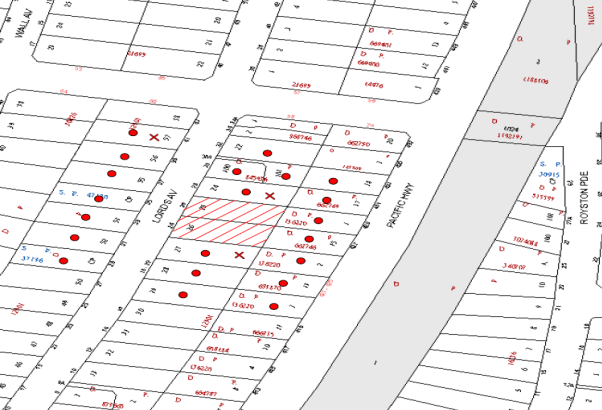
|
NOTIFICATION PLAN |
|
||
|
• PROPERTIES NOTIFIED
|
X SUBMISSIONS RECEIVED |
PROPERTY SUBJECT OF DEVELOPMENT |
|
Three submissions objected to the development, generally on the grounds that the development would result in:
5.1.1 Demolition and Construction Impacts on Adjoining Child Care Centre
The site adjoins a 70 place child care centre and community centre.
To address impacts of the development on the adjoining child care centre during excavation and construction work, the applicant submitted a ‘Construction & Excavation Air Quality, Noise & Vibration Management Plan’. The plan is satisfactory in addressing dust and air emissions, noise and vibration during excavation and construction, and in establishing an Asquith Nursery and Preschool Centre Community Management liaison procedure.
The applicant also submitted a ‘Fence Management Plan’ to address the existing retaining wall and fence on the boundary with the child care centre, during construction of the proposed development. The plan is satisfactory in ensuring the safety and stability of the boundary during construction of the proposed development. A condition is recommended for implementation of the management plan.
To ensure appropriate management of the child care centre during demolition works a condition is recommended for 14 day notification prior to the demolition works commencing. A condition is also recommended for temporary hoarding over the existing fence along the boundary of the child care centre.
5.1.2 Unacceptable Traffic and Parking on Lords Avenue
The proposed development complies with Council’s requirements for off street parking for residents and visitors and is acceptable in respect to traffic generation.
5.1.3 Unacceptable Change in Residential Character of Lords Avenue
The streetscape will change with high density housing development on the eastern side of the street and the existing low density housing on the western side. The proposed high density built form has regard to the pattern of low density development in the street and is considered acceptable in meeting the key development principles of HDCP for the Lords Avenue Asquith Precinct.
5.1.4 Unacceptable Privacy Impacts on Adjoining Dwelling-House
The proposed building is designed in accordance with the HDCP controls for five storey residential flat buildings in respect to setbacks and location of balconies, subject to recommended conditions. Appropriate conditions are recommended for privacy screening and translucent glass balustrades.
The proposal includes landscaping for trees and shrubs along the boundary with the adjoining dwelling house and subject to condition for 1.8m high lapped and capped timber fencing along the boundary, the proposal is acceptable in respect to privacy.
6. THE PUBLIC INTEREST
Section 79C(1)(e) of the Act requires Council to consider “the public interest”.
The public interest is an overarching requirement, which includes the consideration of the matters discussed in this report. Implicit to the public interest is the achievement of future built outcomes adequately responding to and respecting the future desired outcomes expressed in environmental planning instruments and development control plans.
The application is considered to have satisfactorily addressed Council’s and relevant agencies’ criteria and would provide a development outcome that, on balance, would result in a positive impact for the community. Accordingly, it is considered that the approval of the proposed development would be in the public interest.
CONCLUSION
The proposed development is for demolition of existing structures and construction of a five storey residential flat building containing 26 units and basement car park over two levels.
The proposed development complies with HLEP and is generally satisfactory in respect to the design principles of SEPP 65 and the requirements of the Residential Flat Design Code. The proposal is generally in accordance with the requirements of the HDCP subject to condition for amendment of the submitted plans to increase a side setback and for solar access. A deferred consent commencement condition is recommended for registration of a stormwater drainage easement.
Four submissions have been received in response to notification of the proposed development. Appropriate conditions are recommended to safeguard the adjoining child care centre during construction of the proposed development.
The application is recommended for approval subject to conditions in Schedule 1 of this report.
RESPONSIBLE OFFICER
The officer responsible for the preparation of this Report is the Manager – Development Assessments – Rodney Pickles, who can be contacted on 9847 6731.
|
Rod Pickles Manager - Development Assessment Planning Division |
James Farrington Group Manager Planning Division |
|
1.View |
Locality Plan |
|
|
|
2.View |
Site Plan |
|
|
|
3.View |
Landscape Plan |
|
|
|
4.View |
Floor Plan |
|
|
|
5.View |
Elevations |
|
|
|
6.View |
Shadow Plan |
|
|
|
7.View |
Stormwater Plan |
|
|
File Reference: DA/1514/2014
Document Number: D05366223
SCHEDULE 1
GENERAL CONDITIONS
The conditions of consent within this notice of determination have been applied to ensure that the use of the land and/or building is carried out in such a manner that is consistent with the aims and objectives of the relevant legislation, planning instruments and council policies affecting the land and does not disrupt the amenity of the neighbourhood or impact upon the environment.
Note: For the purpose of this consent, the term ‘applicant’ means any person who has the authority to act on or the benefit of the development consent.
Note: For the purpose of this consent, any reference to an Act, Regulation, Australian Standard or publication by a public authority shall be taken to mean the gazetted Act or Regulation, or adopted Australian Standard or publication as in force on the date that the application for a construction certificate is made.
1. Deferred Commencement
Pursuant to Section 80(3) of the Environmental Planning and Assessment Act 1979, this consent does not operate until the following information is submitted to Council:
a) The registration and creation of an easement to drain water from the site over downstream properties.
Such information shall be submitted within 12 months of the date of this notice.
Upon Council’s written satisfaction of the above information, the following conditions of development consent will apply:
2. Approved Plans and Supporting Documentation
The development must be carried out in accordance with the plans and documentation listed below and endorsed with Council’s stamp, except where amended by Council and/or other conditions of this consent:
|
Plan No. |
Plan Title |
Drawn by |
Dated |
|
DA 1 Issue D |
Cover Sheet |
Design Effect Pty Ltd |
5 March 2015 |
|
DA 2 Issue D |
GA Site Plan |
Design Effect Pty Ltd |
8 April 2015 |
|
DA 3 Issue D |
GA Basement |
Design Effect Pty Ltd |
8 April 2015 |
|
DA 4 Issue D |
GA Ground |
Design Effect Pty Ltd |
8 April 2015 |
|
DA 5 Issue D |
GA First (2nd & 3rd) |
Design Effect Pty Ltd |
8 April 2015 |
|
DA 6 Issue D |
GA Fourth/Roof Plans |
Design Effect Pty Ltd |
8 April 2015 |
|
DA 7 Issue D |
GA Urban Context Analysis |
Design Effect Pty Ltd |
8 April 2015 |
|
DA 8 Issue D |
S/04 Ramp to Basement Section |
Design Effect Pty Ltd |
8 April 2015 |
|
DA 9 Issue D |
Elevations |
Design Effect Pty Ltd |
8 April 2015 |
|
DA 11 Issue B |
External Finishes |
Design Effect Pty Ltd |
10 Aug 2014 |
|
0954.L.01 Issue A |
Landscape Plan |
Greenland Design Pty Ltd |
27.11.14 |
|
0567.L.02 Issue A |
Landscape Details & Specification |
Greenland Design Pty Ltd |
27.11.14 |
|
Document Title |
Prepared by |
Dated |
|
Construction & Excavation Air Quality, Noise & Vibration Management Plan |
Lords Group Pty Ltd |
13/2/15 |
|
Asquith Nursery & Preschool Centre Fence Management Plan |
Lords Group Pty Ltd |
23/02/15 |
|
Waste Management Plan |
Lords Development Pty Ltd |
17.11.2014 |
|
Design Verification Statement |
Vladimir Hripac |
1.12.2014 |
|
Traffic and Parking Assessment |
Traffic Solutions Pty Ltd |
3 Dec 2014 |
|
Access Report |
PSE Access Consulting |
24 Nov 2014 |
|
BASIX Certificate No. 590903M |
ESD Synergy |
30 Nov 2014 |
3. Amendment of Plans
The approved plans are to be amended as follows:
a) The basement car park must include a minimum of 29 resident car parking spaces, 4 visitor car parking spaces, 5 resident bicycle racks, 3 visitor bicycle racks and 1 motorcycle parking space.
b) The south east elevation of the building involving Units 10, 16 and 22 is to comply with the required setbacks for 6m (living/dining section) and 5m (balconies).
c) The northern elevation is to include highlight windows to the living areas of Units 9, 15 and 21.
d) The balconies of Units 9, 15 and 21 are to be setback 5m from the northern boundary.
e) The landscape plan is to be amended for the relocation of the stormwater detention system in the north east corner of the site (refer also Conditions 47, 48 and 49).
4. Construction Certificate
A Construction Certificate is required to be approved by Council or a Private Certifying Authority prior to the commencement of any works under this consent.
5. Section 94 Development Contributions
a) In accordance with Section 80A(1) of the Environmental Planning and Assessment Act 1979 and the Hornsby Shire Council Section 94 Development Contributions Plan 2012-2021, the following monetary contributions shall be paid to Council to cater for the increased demand for community infrastructure resulting from the development:
|
Description |
Contribution (4) |
|
Roads |
$29,950.20 |
|
Open Space and Recreation |
$325,982.40 |
|
Community Facilities |
$45,438.35 |
|
Plan Preparation and Administration |
$1,359.35 |
|
TOTAL |
$402,730.30 |
being for 3 x 1 bedroom units, 16 x 2 bedroom units, 7 x 3 bedroom units and a credit for two existing lots.
b) The value of this contribution is current as at 14 May 2015. If the contributions are not paid within the financial quarter that this condition was generated, the contributions payable will be adjusted in accordance with the provisions of the Hornsby Shire Council Section 94 Development Contributions Plan and the amount payable will be calculated at the time of payment in the following manner:
$CPY = $CDC x CPIPY
CPIDC
Where:
$CPY is the amount of the contribution at the date of Payment
$CDC is the amount of the contribution as set out in this Development Consent
CPIPY is the latest release of the Consumer Price Index (Sydney – All Groups) at the date of Payment as published by the ABS.
CPIDC is the Consumer Price Index (Sydney – All Groups) for the financial quarter at the date applicable in this Development Consent Condition.
c) The monetary contributions shall be paid to Council:
i) prior to the issue of the Subdivision Certificate where the development is for subdivision; or
ii) prior to the issue of the first Construction Certificate where the development is for building work; or
iii) prior to issue of the Subdivision Certificate or first Construction Certificate, whichever occurs first, where the development involves both subdivision and building work; or
iv) prior to the works commencing where the development does not require a Construction Certificate or Subdivision Certificate.
It is the professional responsibility of the Principal Certifying Authority to ensure that the monetary contributions have been paid to Council in accordance with the above timeframes.
Council’s Development Contributions Plan may be viewed at www.hornsby.nsw.gov.au or a copy may be inspected at Council’s Administration Centre during normal business hours.
6. Demolition Existing Dwelling Houses
a) For safety and security the existing dwelling houses when vacated must be demolished.
b) To enable appropriate management of the adjoining child care centre operation during demolition works, the applicant is to give written notice to Council’s General Manager 14 days prior to the demolition works commencing.
REQUIREMENTS PRIOR TO THE ISSUE OF A CONSTRUCTION CERTIFICATE
7. Building Code of Australia
All building work must be carried out in accordance with the relevant requirements of the Building Code of Australia.
8. Contract of Insurance (Residential Building Work)
In the case of residential building work for which the Home Building Act 1989 requires there to be a contract of insurance in force in accordance with Part 6 of that Act, that such a contract of insurance is in force before any building work authorised to be carried out by the consent commences.
9. Notification of Home Building Act, 1989 Requirements
Residential building work within the meaning of the Home Building Act 1989 must not be carried out unless the principal certifying authority for the development to which the work relates (not being Council) has given Council written notice of the following information:
a) In the case of work for which a principal contractor is required to be appointed:
i) The name and licence number of the principal contractor; and
ii) The name of the insurer by which the work is insured under Part 6 of that Act.
b) In the case of work to be done by an owner-builder:
i) The name of the owner-builder; and
ii) If the owner-builder is required to hold an owner-builder’s permit under that Act, the number of the owner-builder’s permit.
Note: If arrangements for doing the residential building work are changed while the work is in progress so that the information notified becomes out of date, further work must not be carried out unless the principal certifying authority for the development to which the work relates (not being Council) has given Council written notification of the updated information.
10. Water/Electricity Utility Services
The applicant must submit written evidence of the following service provider requirements:
a) Ausgrid (formerly Energy Australia) – a letter of consent demonstrating that satisfactory arrangements have been made to service the proposed development.
b) Sydney Water – the submission of a ‘Notice of Requirements’ under s73 of the Sydney Water Act 1994.
Note: Sydney Water requires that s73 applications are to be made through an authorised Sydney Water Servicing Coordinator. Refer to www.sydneywater.com.au or telephone 13 20 92 for assistance.
11. Dilapidation Report
A ‘Dilapidation Report’ is to be prepared by a ‘chartered structural engineer’ detailing the structural condition of the adjoining properties:
a) Nos. 18-22 Lords Avenue, Asquith (Asquith Leisure and Learning/Nursery and Preschool); and
b) No. 28 Lords Avenue, Asquith.
12. Excavation
A detailed geotechnical assessment of the site by a chartered structural engineer is to be undertaken for the design of the basement excavation and support, groundwater drainage, basement and foundation design.
13. Adaptable Units
The details of the adaptable units Nos 4, 5, 10, 11, 16, 17, 22, and 23 must be provided with the Construction Certificate Plans.
14. Preservation of Survey Infrastructure
Prior to the issue of a construction certificate, a registered surveyor shall identify all survey marks in the vicinity of the proposed development. Any survey marks required to be removed or displaced as a result of the proposed development shall be undertaken by a registered surveyor in accordance with Section 24 (1) of the Surveying and Spatial Information Act 2002 and following the Surveyor General’s Directions No.11 – "Preservation of Survey Infrastructure".
15. Road Works
All road works approved under this consent must be constructed in accordance with Council’s Civil Works Design and Construction Specification 2005 and the following requirements: -
a) Removal of existing kerb and gutter along the Lords Avenue frontage of the development and reconstruction of Council standard 150 mm integral kerb and gutter on the alignment and level of the existing kerb and gutter.
b) A concrete footpath to be constructed within the road verge on the Lords Avenue frontage with the remaining area turfed.
c) The existing road pavement to be saw cut a minimum of 600 mm from the existing edge of the bitumen and reconstructed.
d) The submission of a compaction certificate from a geotechnical engineer for any fill within road reserves, and all road sub-grade and road pavement materials.
e) Pursuant to s138 Roads Act 1993, application shall be made to Council for consideration and approval of all road works. The Applicant shall pay the Roads Authority’s fees for plan assessment and compliance inspections. Early application shall be made to Roads Authority in to order to permit reasonable assessment time prior to proposed construction.
16. Vehicular Crossing
A separate application under the Local Government Act 1993 and the Roads Act 1993 must be submitted to Council for the installation of a new vehicular crossing and the removal of the redundant crossing. The vehicular crossing must be constructed in accordance with Council’s Civil Works Design 2005 and the following requirements: -
a) Any redundant crossings must be replaced with integral kerb and gutter;
b) The footway area must be restored by turfing;
c) The crossing levels shall be provided by Council prior to construction of the crossing, or the basement ramp.
Note: An application for a vehicular crossing can only be made to one of Council’s Authorised Vehicular Crossing Contractors. Or be the subject of a Construction Certificate Application to Hornsby Council as Roads Authority. You are advised to contact Council on 02 9847 6940 to obtain a list of contractors.
17. Construction Vehicles
a) All construction vehicles associated with the proposed development are to be contained on site or in an approved ‘Work Zone’ in Lords Avenue.
b) A Construction Traffic Management Plan (CTMP) detailing construction vehicle routes, number of trucks, hours of operation, access arrangements and traffic control must be submitted to Council. Council will review the CTMP, agree any modifications with the proponent and enforce the CTMP during construction.
18. Traffic Control Plan
A Traffic Control Plan (TCP) must be prepared by a qualified traffic controller in accordance with the Roads & Traffic Authority’s Traffic Control at Worksites Manual 1998 and Australian Standard 1742.3 for all work on a public road and be submitted to Roads Authorities. The TCP must detail the following:
a) Arrangements for public notification of the works.
b) Temporary construction signage.
c) Vehicle movement plans.
d) Traffic management plans.
e) Pedestrian and cyclist access/safety.
19. Internal Driveway/Vehicular Areas
The driveway and parking areas on site must be designed in accordance with Australian Standards 2890.1, 2890.2, 2890.6 and the following requirements:
a) Design levels for the front boundary crossing must be obtained from Council.
20. Stormwater Drainage
The stormwater drainage system for the development must be designed and constructed in accordance with Council’s Civil Works – Design and Construction Specification 2005 and the following requirements:
a) Connected directly to Council’s street drainage system via an interallotment drainage system.
b) The development is to provide water harvesting system in accordance with Council’s HDCP s1C.1.2.j. Details of the harvesting system are to be shown on the Engineer’s drainage plans.
c) In regard to a) above and pursuant to s68 Local Government Act 1993, an Application shall be made to Hornsby Shire Council for the connection of the internal drainage system to the Council-controlled drainage system in Pacific Highway. The Applicant shall pay Council’s fee for compliance inspections and approvals prior to release of the Occupation Certificate.
21. On Site Stormwater Detention
An on-site stormwater detention system must be designed by a chartered civil engineer and constructed in accordance with the following requirements:
a) Have a capacity of not less than 18 cubic metres, and a maximum discharge (when full) of 30 litres per second;
b) Have a 900 x 900 mm surcharge/inspection grate located directly above the outlet;
c) Discharge from the detention system to be controlled via 1 metre length of pipe, not less than 50 millimetres diameter or via a stainless plate with sharply drilled orifice bolted over the face of the outlet discharging into a larger diameter pipe capable of carrying the design flow to an approved Council system. An overflow weir shall also be incorporated into the discharge control pit system.
d) Where above ground and the average depth is greater than 0.3 metres, a ‘pool type’ safety fence and warning signs to be installed.
e) Not be constructed in a manner that would impact upon the visual or recreational amenity of neighbouring residents.
f) To ensure amenity of neighbouring residents any retailing wall for the detention system must not be more than 600mm in height.
22. Waste Management Details
The following waste management requirements must be complied with:
a) The bi-fold doors on the waste collection area (bin holding area) on the driveway are to be replaced with sliding doors.
b) The internal dimensions of the recycling bin cupboards on each residential level are to be no less than 750 mm wide by 900 mm deep.
c) The internal dimensions of the garbage chute cupboard must comply with the chute manufacturer’s specifications.
d) The automatic volume handling equipment (carousel) must be caged to prevent access by unauthorised persons.
e) Instead of being a separate room within the bin storage room, the walls and door between bulky waste storage area and the bin storage room need to be deleted and the bulky waste storage area marked by paint and signage.
f) The door opening width for the bin storage rooms is to be no less than 920 mm.
Note: it is recommended that the door opening to the recycling bin storage room be increased to a minimum 1300 mm.
g) Vehicle turning paths are to be provided demonstrating that the small rigid vehicle is able to reverse into the site, park on the driveway and forward out.
23. Acoustic Report
An acoustic report prepared by a suitably qualified acoustic consultant is to identify noise mitigation measures necessary for the bedrooms Unit 1 to address noise form the use of the driveway. The necessary measures are to be implemented prior to the issue of the Construction Certificate.
REQUIREMENTS PRIOR TO THE COMMENCEMENT OF ANY WORKS
24. Erection of Construction Sign
A sign must be erected in a prominent position on any site on which building work, subdivision work or demolition work is being carried out:
a) Showing the name, address and telephone number of the principal certifying authority for the work;
b) Showing the name of the principal contractor (if any) for any demolition or building work and a telephone number on which that person may be contacted outside working hours; and
c) Stating that unauthorised entry to the work site is prohibited.
Note: Any such sign is to be maintained while the building work, subdivision work or demolition work is being carried out, but must be removed when the work has been completed.
25. Protection of Adjoining Areas
a) A temporary hoarding, fence or awning must be erected between the work site and adjoining lands before the works begin and must be kept in place until after the completion of the works if the works:
i) Could cause a danger, obstruction or inconvenience to pedestrian or vehicular traffic.
ii) Could cause damage to adjoining lands by falling objects.
iii) Involve the enclosure of a public place or part of a public place.
Note: Notwithstanding the above, Council’s separate written approval is required prior to the erection of any structure or other obstruction on public land.
b) The adjoining child care centre must be protected by temporary hoarding erected above the existing fence for the duration of the building construction.
26. Toilet Facilities
Toilet facilities must be available or provided at the works site before works begin and must be maintained until the works are completed at a ratio of one toilet for every 20 persons employed at the site. Each toilet must:
a) be a standard flushing toilet connected to a public sewer; or
b) be a temporary chemical closet approved under the Local Government Act 1993; or
c) have an on-site effluent disposal system approved under the Local Government Act 1993.
27. Erosion and Sediment Control
Erosion and sediment control measures must be provided and maintained throughout the construction period in accordance with the manual ‘Soils and Construction 2004 (Bluebook)’, the approved plans, Council specifications and to the satisfaction of the principal certifying authority. The erosion and sediment control devices must remain in place until the site has been stabilised and revegetated.
Note: On the spot penalties may be issued for any non-compliance with this requirement without any further notification or warning.
REQUIREMENTS DURING CONSTRUCTION
28. Construction Work Hours
All work on site (including demolition and earth works) must only occur between 7am and 5pm Monday to Saturday. No work is to be undertaken on Sundays or public holidays. No excavation or rock sawing/breaking is to occur on Saturdays or between the hours of 12 pm and 1 pm weekdays.
29. Demolition
All demolition work must be carried out in accordance with “Australian Standard 2601-2001 – The Demolition of Structures” and the following requirements:
a) Demolition material must be disposed of to an authorised recycling and/or waste disposal site and/or in accordance with an approved waste management plan;
b) Demolition works, where asbestos material is being removed, must be undertaken by a contractor that holds an appropriate licence issued by WorkCover NSW in accordance with Chapter 10 of the Occupational Health and Safety Regulation 2001 and Clause 29 of the Protection of the Environment Operations (Waste) Regulation 2005 ;and
c) On construction sites where buildings contain asbestos material, a standard commercially manufactured sign containing the words ‘DANGER ASBESTOS REMOVAL IN PROGRESS’ measuring not less than 400mm x 300mm must be erected in a prominent position visible from the street.
30. Environmental Management
a) The site must be managed in accordance with the publication ‘Managing Urban Stormwater – Landcom (March 2004) and the Protection of the Environment Operations Act 1997 by way of implementing appropriate measures to prevent sediment run-off, excessive dust, noise or odour emanating from the site during the construction of the development.
b) The site must be managed to address the adjoining sensitive site comprising a child care centre at Nos. 18-22 Lords Avenue, Asquith in accordance with the submitted ‘Construction & Excavation Air Quality, Noise & Vibration Management Plan’ and ‘Fence Management Plan’.
31. Street Sweeping
Street sweeping must be undertaken following sediment tracking from the site along Lords Avenue during works and until the site is established.
32. Council Property
During construction works, no building materials, waste, machinery or related matter is to be stored on the road or footpath. The public reserve must be kept in a clean, tidy and safe condition at all times.
Note: This consent does not give right of access to the site via Council’s park or reserve. Should such access be required, separate written approval is to be obtained from Council.
33. Landfill
Landfill must be constructed in accordance with Council’s ‘Construction Specification 2005’ and the following requirements:
a) All fill material imported to the site is to wholly consist of Virgin Excavated Natural Material (VENM) as defined in Schedule 1 of the Protection of the Environment Operations Act 1997 or a material approved under the Department of Environment and Climate Change’s general resource recovery exemption.
b) A compaction certificate is to be obtained from a geotechnical engineer verifying that the specified compaction requirements have been met.
34. Excavated Material
All excavated material removed from the site must be classified in accordance with the Department of Environment, Climate Change and Water NSW Waste Classification Guidelines prior to disposal to an approved waste management facility and reported to the principal certifying authority.
35. Survey Report – Finished Floor Level
A report(s) must be prepared by a registered surveyor and submitted to the principal certifying authority prior to the pouring of concrete at each level of the building certifying that:
a) The building, retaining walls and the like have been correctly positioned on the site; and
b) The finished floor level(s) are in accordance with the approved plans.
36. Waste Management Details
Waste management during the demolition and construction phase of the development must be undertaken in accordance with the approved Waste Management Plan. Additionally written records of the following items must be maintained during the removal of any waste from the site and such information submitted to the Principal Certifying Authority within fourteen days of the date of completion of the works:
a) The identity of the person removing the waste.
b) The waste carrier vehicle registration.
c) Date and time of waste collection.
d) A description of the waste (type of waste and estimated quantity).
e) Details of the site to which the waste is to be taken.
f) The corresponding tip docket/receipt from the site to which the waste is transferred (noting date and time of delivery, description (type and quantity) of waste).
g) Whether the waste is expected to be reused, recycled or go to landfill.
Note: In accordance with the Protection of the Environment Operations Act 1997, the definition of waste includes any unwanted substance, regardless of whether it is reused, recycled or disposed to landfill.
REQUIREMENTS PRIOR TO THE ISSUE OF AN OCCUPATION OR SUBDIVISION CERTIFICATE
Note: For the purpose of this consent, a reference to ‘occupation certificate’ shall not be taken to mean an ‘interim occupation certificate’ unless otherwise stated.
37. Fulfilment of BASIX Commitments
The applicant must demonstrate the fulfilment of BASIX commitments pertaining to the development.
38. Sydney Water – s73 Certificate
An s73 Certificate must be obtained from Sydney Water.
39. Damage to Council Assets
Any damage caused to Council’s assets as a result of the construction of the development must be rectified in accordance with Council’s Civil Works Specifications. Council’s Restorations Supervision must be notified for a formwork inspection prior to pouring concrete.
40. Creation of Easements
The following matter(s) must be nominated on a plan under s88B or s88E of the Conveyancing Act 1919: -
a) Consolidation of the subject lots;
b) The creation of an appropriate "Positive Covenant" and "Restriction as to User" over the constructed on-site detention/retention systems and outlet works, within the lots in favour of Council in accordance with Council’s prescribed wording. The position of the on-site detention system is to be clearly indicated on the title.
c) To register the OSD easement, the restriction on the use of land “works-as-executed” details of the on-site-detention system must be submitted verifying that the required storage and discharge rates have been constructed in accordance with the design requirements. The details must show the invert levels of the on-site detention system together with pipe sizes and grades. Any variations to the approved plans must be shown in red on the “works-as-executed” plan and supported by calculations.
Note: Council must be nominated as the authority to release, vary or modify any easement, restriction or covenant.
41. Works as Executed Plan
A works-as-executed plan(s) must be prepared by a registered surveyor and submitted to Council for completed road pavement, kerb & gutter, public drainage systems, driveways and on-site detention systems.
42. Garbage Collection Easement
For the purpose of waste collection, an easement entitling Council, its servants and agents and persons authorised by it to enter upon the subject land and to operate thereon, vehicles and other equipment for the purposes of garbage collection must be granted to Council by the owner of the land.
Note: The easement must be in a form prescribed by Council and must include covenants to the effect that parties will not be liable for any damage caused to the subject land or any part thereof or to any property located therein or thereon by reason of the operation thereon of any vehicle or other equipment used in connection with the collection of garbage and to the effect that the owner for the time being of the subject land shall indemnify the Council, its servants, agents and persons authorised by it to collect garbage against liability in respect of any such claims made by any person whomsoever.
43. Installation of Privacy Devices
The following device(s) must be installed to maintain an element of privacy.
a) All privacy screens must be sliding stackable louvered metal screens extendable to the full width of the balconies;
b) All glass balustrades must be translucent glass;
c) Outdoor clothes drying area must be screened from view of publicly accessible areas.
44. Storage Areas
Each dwelling within the development must have an area for storage (not including built-in storage) not less than 6m3 for one bedroom units, 8m3 for two bedroom units and 10m3 for three bedroom units.
45. Safety and Security
a) Fire exist doors to the development must be fitted with single cylinder locksets (Australia and New Zealand Standard – Lock Sets) to restrict unauthorized access to the development.
b) Ground floor windows must be fitted with window locks that can be locked with a key.
c) A graffiti management plan must be incorporated into the maintenance plan for the development for graffiti to be removed within a forty-eight hour period.
d) The basement car park entry must be secured by security gates/roller shutters and controlled by secure access located at the top of the driveway. The access control to include an audio/visual intercom system to allow visitor access to the parking area.
e) In order to prevent tail-gating on entry to the basement car park the timing of the security door closing is to be a maximum of 10 seconds. Signage is to be erected instructing drivers to wait until the roller door fully closes prior to proceeding.
f) Lighting of pedestrian pathways throughout the development must comply with Australia and New Zealand Lighting Standard 1158.1 – Pedestrian.
g) Front fencing to be designed to allow casual surveillance at the frontage.
h) The entry foyer door is to be a security door with access being restricted to an intercom, code or card lock system.
i) The street number of the building is to be readily identifiable from Lords Avenue.
j) Quality mail box doors and non-tamper proof locks must be fitted to the mail boxes.
k) The bicycle racks are to have secure locking loops bolted into the concrete flooring.
l) Storage cages are to be constructed of quality steel mesh, welded to a sturdy metal frame and provided with a total of 3 hinges and 3 locking points. A secure locking loop bolted into the concrete floor is also required to be provided to enable use of padlocks.
m) The internal portions of the basement are to be illuminated in accordance with the AS1158.1, AS1680 and AS2890.1.
n) The ceiling of each basement level shall be painted white or a like colour to increase visibility and reflective light throughout each basement level.
46. Planter Boxes / On Slab Planting
On slab planter boxes must include waterproofing, subsoil drainage (proprietary drainage cell, 50mm sand and filter fabric) automatic irrigation, minimum 500mm planting soil for shrubs and minimum 1000mm planting soil for trees and palms and 75mm mulch to ensure sustainable landscape is achieved.
47. Boundary Planting
Supplementary plantings (preferably selected from Council’s booklet ‘Indigenous Plants for the Bushland Shire’) to boundary setbacks as follow:
a) Southern side setback – 5 trees capable of reaching a mature height of 6 metres;
b) Eastern rear setback – 2 additional trees capable of reaching a mature height in excess of 10 metres, installed at minimum 25 litre pot size;
c) Front setback – 2 additional trees capable of reaching a mature height in excess of 10 metres, installed at minimum 25 litre pot size.
Note: Trees are required to be installed at a minimum 25 Litre pot size but larger sizes within the mix and up to 200 Litre are preferable where screening may be desirable in the shorter-term.
48. Street Tree Plantings
Street tree planting to the front verge to include 3 x Tristaniopsis laurina (‘Water Gum’), installed at minimum 200 Litre pot size with mulched areas maintained at base and HWD staking and hessian ties. Staking and ties are to be maintained for a period of establishment of not less than 1 year.
49. Communal Open Space
The Communal Open Space must be furnished with seating and landscape treatment that will encourage use of the space by residents and guests for active and / or passive recreation.
50. Completion of Landscape Works
A certificate must be provided by a practicing landscape architect, horticulturalist or person with similar qualifications and experience certifying that all required landscape works have been satisfactorily completed in accordance with the approved Landscape Plans.
Note: Applicants are advised to pre-order plant material required in pot sizes 45 litre or larger to ensure Nurseries have stock available at the time of install.
51. Works as Executed Plan
A works-as-executed plan(s) must be prepared by a registered surveyor and submitted to Council for completed road pavement, kerb & gutter, public drainage systems, driveways and on-site detention system.
52. Consolidation of Allotments
All allotments the subject of this consent must be consolidated into one allotment.
Note: The applicant is recommended to submit the plan of subdivision to consolidate allotments to the NSW Department of Lands at least 4-6 weeks prior to seeking an occupation certificate.
53. Unit Numbering
The allocation of unit numbering must be authorised by Council prior to the numbering of each unit in the development.
54. Survey Marks
A certificate by a Registered Surveyor must be submitted to the Principal Certifying Authority, certifying that there has been no removal, damage, destruction, displacement or defacing of the existing survey marks in the vicinity of the proposed development, or otherwise certifying that the necessary re-establishment of any damaged, removed or displaced survey marks has been undertaken in accordance with the Surveyor General’s Direction No. 11 – “Preservation of Survey Infrastructure”.
55. Provision for National Broadband Network (NBN)
Provision must be made for fibre ready passive infrastructure (pits and pipes) generally in accordance with NBN Co.'s pit and pipe installation guidelines to service the proposed development. A certificate from NBN Co or Telstra must be submitted to the PCA that the fibre optic cabling provided for the development complies with MDU Building Design Guides for Development.
56. Completion of Landscaping
A certificate must be provided by a practicing landscape architect, horticulturalist or person with similar qualifications and experience certifying that all required landscaping works have been satisfactorily completed in accordance with the approved landscape plans.
Note: Advice on suitable species for landscaping can be obtained from Council’s planting guide ‘Indigenous Plants for the Bushland Shire’, available at www.hornsby.nsw.gov.au.
57. External Lighting
All external lighting must be designed and installed in accordance with Australian Standard AS 4282 – Control of the Obtrusive Effects of Outdoor Lighting. Certification of compliance with the Standard must be obtained from a suitably qualified person.
58. Boundary Fencing
Lapped and capped timber fencing must be erected along all property boundaries behind the front building alignment to a height of 1.8 metres.
Note: Alternative fencing may be erected subject to the written consent of the adjoining property owner(s).
OPERATIONAL CONDITIONS
59. Waste Management
A site caretaker must be employed and be responsible for moving bins where and when necessary, washing bins and maintaining waste storage areas, ensuring the chute system and related devices are maintained in effective and efficient working order, managing the communal composting area, managing the bulky item storage area, arranging the prompt removal of dumped rubbish, and ensuring all residents are informed of the use of the waste management system. The site caretaker must be employed for a sufficient number of hours each week to allow all waste management responsibilities to be carried out to a satisfactory standard.
60. Car Parking and Road Safety
a) All car parking must be constructed and operated in accordance with Australian Standard AS/NZS 2890.1:2004 – Off-street car parking and Australian Standard AS 2890.2:2002 – Off-street commercial vehicle facilities.
i) All parking areas and driveways are to be sealed to an all-weather standard, line marked and signposted;
ii) Car parking, loading and manoeuvring areas to be used solely for nominated purposes;
iii) Vehicles awaiting loading, unloading or servicing shall be parked on site and not on adjacent or nearby public roads;
b) Any proposed landscaping and/or fencing must not restrict sight distance to pedestrians and cyclists travelling along the footpath.
c) Residential parking spaces are to be secure spaces with access controlled by card or numeric pad.
d) Visitors must be able to access the visitor parking spaces in the basement car park at all times.
e) All parking for people with disabilities is to comply with AS/NZS 2890.6:2009 Off-street parking for people with disabilities.
f) Bicycle parking spaces are to be designed in accordance with AS 2890.3-1993 Bicycle parking facilities
g) Motorcycle parking spaces are to be designed in accordance with AS 2890.5-1993
61. Noise
All noise generated by the proposed development must be attenuated to prevent levels of noise being emitted to adjacent premises which possess tonal, beating and similar characteristics or which exceeds background noise levels by more than 5dB(A).
62. Fire Safety Statement - Annual
On at least one occasion in every 12 month period following the date of the first ‘Fire Safety Certificate’ issued for the property, the owner must provide Council with an annual ‘Fire Safety Certificate’ to each essential service installed in the building.
63. Landscape Establishment
The landscape works must be maintained into the future to ensure the establishment and successful growth of plant material to meet the intent of the landscape design. This must include but not be limited to watering, weeding, replacement of failed plant material and promoting the growth of plants through standard industry practices.
- END OF CONDITIONS -
ADVISORY NOTES
The following information is provided for your assistance to ensure compliance with the Environmental Planning and Assessment Act, 1979, Environmental Planning and Assessment Regulation 2000, other relevant legislation and Council’s policies and specifications. This information does not form part of the conditions of development consent pursuant to Section 80a of the Act.
Environmental Planning and Assessment Act 1979 Requirements
The Environmental Planning and Assessment Act 1979 requires:
· The issue of a construction certificate prior to the commencement of any works. Enquiries can be made to Council’s Customer Services Branch on 9847 6760.
· A principal certifying authority to be nominated and Council notified of that appointment prior to the commencement of any works.
· Council to be given at least two days written notice prior to the commencement of any works.
· Mandatory inspections of nominated stages of the construction inspected.
· An occupation certificate to be issued before occupying any building or commencing the use of the land.
Long Service Levy
In accordance with Section 34 of the Building and Construction Industry Long Service Payments Act 1986, a ‘Long Service Levy’ must be paid to the Long Service Payments Corporation or Hornsby Council.
Note: The rate of the Long Service Levy is 0.35% of the total cost of the work.
Note: Hornsby Council requires the payment of the Long Service Levy prior to the issue of a construction certificate.
Tree and Vegetation Preservation
In accordance with Clause 5.9 of the Hornsby Local Environmental Plan 2013 a person must not ringbark, cut down, top, lop, remove, injure or wilfully destroy any tree or other vegetation protected under the Hornsby Development Control Plan 2013 without the authority conferred by a development consent or a permit granted by Council.
Notes: A tree is defined as a long lived, woody perennial plant with one or relatively few main stems with the potential to grow to a height greater than three metres (3M). (HDCP 1B.6.1.c).
Tree protection measures and distances are determined using the Australian Standard AS 4970:2009, “Protection of Trees on Development Sites”.
Fines may be imposed for non-compliance with both the Hornsby Local Environmental Plan 2013 and the Hornsby Development Control Plan 2013.
Disability Discrimination Act
The applicant’s attention is drawn to the existence of the Disability Discrimination Act. A construction certificate is required to be obtained for the proposed building/s, which will provide consideration under the Building Code of Australia, however, the development may not comply with the requirements of the Disability Discrimination Act. This is the sole responsibility of the applicant.
Dial Before You Dig
Prior to commencing any works, the applicant is encouraged to contact Dial Before You Dig on 1100 or www.dialbeforeyoudig.com.au for free information on potential underground pipes and cables within the vicinity of the development site.
Telecommunications Act 1997 (Commonwealth)
If you are aware of any works or proposed works which may affect or impact on Telstra’s assets in any way, you are required to contact: Telstra’s Network Integrity Team on Phone Number 1800810443.
Asbestos Warning
Should asbestos or asbestos products be encountered during demolition or construction works, you are advised to seek advice and information prior to disturbing this material. It is recommended that a contractor holding an asbestos-handling permit (issued by WorkCover NSW) be engaged to manage the proper handling of this material. Further information regarding the safe handling and removal of asbestos can be found at:
Alternatively, telephone the WorkCover Asbestos and Demolition Team on 8260 5885.
House Numbering
House numbering can only be authorised by Council. Before proceeding to number each premise in the development, the allocation of numbers is required to be obtained from Council's Planning Division prior to the issue of a Subdivision Certificate. The authorised numbers are required to comply with Council’s Property Numbering Policy and be displayed in a clear manner at or near the main entrance to each premise.
Group Manager’s Report No. PL31/15
Planning Division
Date of Meeting: 10/06/2015
14 DEVELOPMENT APPLICATION - RESIDENTIAL FLAT BUILDING COMPRISING 36 UNITS - NO. 1 FOREST GROVE, EPPING
EXECUTIVE SUMMARY
|
DA No: |
DA/1606/2014 (Lodged on 22 December 2014) |
|
Description: |
Demolition of existing structures and erection of a five storey residential flat building comprising 36 units with basement car parking and strata subdivision. |
|
Property: |
Lots 1-4 SP 51979, No. 1 Forest Grove, Epping |
|
Applicant: |
Forest Grove Project Pty Ltd |
|
Owner: |
Owners Corporation – SP 51979 |
|
Estimated Value: |
$8,569,838 |
|
Ward: |
C |
· The application involves demolition of existing structures and the erection of a five storey residential flat building comprising 36 units with basement parking.
· The proposal complies with the Hornsby Local Environmental Plan 2013, State Environmental Planning Policy No. 65 – Design Quality Residential Flat Building and is generally satisfactory in respect of the requirements of the Residential Flat Design Code and the Hornsby Development Control Plan 2013.
· Three submissions have been received in respect of the application.
· It is recommended that the application be approved.
|
THAT Development Application No. DA/1606/2014 for demolition of existing structures and the erection of a five storey residential flat building comprising 36 units with basement car parking and strata subdivision at SP 51979, No. 1 Forest Grove, Epping be approved subject to the conditions of consent detailed in Schedule 1 of Group Manager’s Report No. PL31/15. |
BACKGROUND
On 20 December 1993, the Land and Environment Court approved development application DA/874/1993 for the erection of two duplexes to create a cluster development comprising 4 dwellings and strata title subdivision on the subject site.
The site forms part of the Epping Urban Activation Precinct (Epping UAP).
On 14 March 2014, the Department of Planning and Environment finalised amendments to the Hornsby Local Environmental Plan 2013 (HLEP 2013) to implement the Epping UAP via State Environmental Planning Policy (Epping Town Centre) 2013 (“the SEPP Amendment”).
The Epping Town Centre amendments to the HLEP 2013 involved rezoning of low density residential areas for the purpose of medium to high density residential and mixed use developments. The site is within the Forest Grove (Epping) Precinct, which was rezoned R4 (High Density Residential) to permit residential flat buildings to a height of 5 storeys.
Amendments to the HDCP were consequently prepared by Council to translate design controls recommended by the Department of Planning and Environment and provided planning controls to be read in conjunction with the HLEP 2013 amendments. The DCP amendments were exhibited and endorsed by Council on 8 October 2014.
On the 24 October 2014, a pre-Lodgement application (PL/143/2014) for a five storey residential flat building was submitted to Council. Advice was provided by Council dated 19 November 2014.
On 2 December 2014, Development Application No. 1606/2014 was lodged for the demolition of the existing structures and construction of a five storey residential flat development comprising 36 units with basement car parking.
SITE
The site is located on the eastern side of Forest Grove and contains a duplex development comprising 4 dwellings. The site is regular in shape and has an area of 1,667 square metres with a 30.075 metre frontage to Forest Grove and a depth of 55.435 metres. The site has a gentle slope of 6% downwards from the north to south boundary.
The site contains a number of exotic, native and local indigenous trees. A number of street trees are located on the road verge fronting the subject site.
To the east, the site borders the Essex Street Heritage Conservation Area and properties at Nos.44 and 46 Essex Street. To the north-east of the site at No.42 Essex Street, is a locally listed Federation period timber weatherboard house.
On the opposite side of the street at Nos.2-4 Forest Grove are properties zoned for 5 storey residential flat development. To the north at Nos.20-24 Epping Road, the site bounds 3 residential properties. These properties have been subject to a pre-lodgement enquiry for re-development (PL/156 and 49/ 2014). To the south, the property bounds a residential property at 3 Forest Grove. This property has been subject to a development application (DA/358/2015) for re-development of 3, 5 and 7 Forest Grove. The application is currently under assessment.
PROPOSAL
The proposal involves the demolition of existing structures on the site and construction of a five storey residential flat building comprising thirty six units with two levels of basement car parking and associated landscaping works. The unit mix would comprise (5 x 1 bedroom, 27 x 2 bedroom and 4 x 3 bedroom). The development includes 8 split level units on the second, third, fourth and upper levels. The development would be accessed from Forest Grove via a driveway located adjacent to the southern boundary.
The development would be serviced by a garbage truck reversing into the driveway for collection from the Forest Grove.
The site would drain to a detention tank located close to existing ground level in the south-western corner front setback area that would thereafter drain to Forest Grove.
ASSESSMENT
The development application has been assessed having regard to the ‘A Plan for Growing Sydney’, the ‘North Subregion (Draft) Subregional Strategy’ and the matters for consideration prescribed under Section 79C of the Environmental Planning and Assessment Act 1979 (the Act). The following issues have been identified for further consideration.
1. STRATEGIC CONTEXT
1.1 A Plan for Growing Sydney and (Draft) North Subregional Strategy
A Plan for Growing Sydney has been prepared by the NSW State Government to guide land use planning decisions for the next 20 years. The Plan sets a strategy for accommodating Sydney’s future population growth and identifies the need to deliver 689,000 new jobs and 664,000 new homes by 2031. The Plan identifies that the most suitable areas for new housing are in locations close to jobs, public transport, community facilities and services.
The NSW Government will use the subregional planning process to define objectives and set goals for job creation, housing supply and choice in each subregion. Hornsby Shire has been grouped with Hunters Hill, Ku-ring-gai, Lane Cove, Manly, Mosman, North Sydney, Pittwater, Ryde, Warringah and Willoughby to form the North Subregion. The Draft North Subregional Strategy will be reviewed and the Government will set housing targets and monitor supply to ensure planning controls are in place to stimulate housing development.
The proposed development would be consistent with ‘A Plan for Growing Sydney’, by providing 32 additional dwellings and would contribute to housing choice in the locality.
2. STATUTORY CONTROLS
Section 79C(1)(a) requires Council to consider “any relevant environmental planning instruments, draft environmental planning instruments, development control plans, planning agreements and regulations”.
2.1 Hornsby Local Environmental Plan 2013
The proposed development has been assessed having regard to the provisions of the Hornsby Local Environmental Plan 2013 (HLEP).
2.1.1 Zoning of Land and Permissibility
The subject land is zoned R4 (High Density Residential) under the Hornsby Local Environmental Plan 2013 (HLEP). The objectives of the zone are:
(a) To provide for the housing needs of the community within a high density residential environment.
(b) To provide a variety of housing types within a high density residential environment.
(c) To enable other land uses that provide facilities or services to meet the day to day needs of residents.
The development proposed is a high density residential development and complies with the zone objectives. The proposed development is defined as a “Residential flat building” under the HLEP and is permissible in the zone with Council’s consent.
2.1.2 Height of Buildings
Clause 4.3 of the HLEP provides that the height of a building on any land should not exceed the maximum height show for the land on the Height of Buildings Map. The maximum permissible height for the subject site is 17.5m. The proposal complies with this provision.
2.1.3 Heritage Conservation
Clause 5.10 of the HLEP sets out heritage conservation provisions for Hornsby Shire. The development site adjoins the Essex Street Heritage Conservation Area (HCA) (east) under Schedule 5 (Environmental Heritage) of the Hornsby Local Environmental Plan 2013 (HLEP).
The proposed development would have minimal negative impact on the heritage significance of the heritage conservation area given its separation and setbacks from the heritage items and conservation area. The views to, and from within the HCA, are not considered to be adversely affected. However, it is acknowledged that the visual setting will be altered to varying degrees as the western HCA backdrop will be one of high rise buildings visible above the low density housing of the HCA.
2.1.4 Earthworks
Clause 6.2 of the HLEP states that consent is required for proposed earthworks on site. Before granting consent for earthworks, Council is required to assess the impacts of the subject works on adjoining properties, drainage patterns and soil stability of the locality.
The proposal is satisfactory subject to conditions regarding submission of a ‘Dilapidation Report’ assessing the impact of the excavation on the adjoining properties and a ‘Environment Management’ to implement appropriate measures to prevent sediment run-off, excessive dust, noise and the like emanating from the site during the construction of the development.
2.2 State Environmental Planning Policy No. 55 – Remediation of Land
State Environmental Planning Policy No. 55 (SEPP 55) requires that Council must not consent to the carrying out of any development on land unless it has considered whether the land is contaminated or requires remediation for the proposed use.
The site has been used for residential purposes and is unlikely to be contaminated. No further assessment is considered necessary in this regard.
2.3 State Environmental Planning Policy No. 65 – Design Quality of Residential Flat Development (Amendment No. 3)
The draft amendment is to revise the Policy following review by the Department of Planning and Environment. The amendments include objectives to meet housing and population targets, affordable housing and to facilitate timely and efficient assessment of development applications. The amendments would replace the Residential Flat Design Guidelines with an Apartment Design Code which prevails in the event of any inconsistency with a Development Control Plan.
The amendments would make further provision for design review panels; include additional provisions for the determination of development applications and for standards for ceiling height, apartment area and car parking, which cannot be used as grounds for refusal of development consent.
The proposed development would not be inconsistent with the provisions of the draft Policy and the requirements of the Apartment Design Code.
2.4 State Environmental Planning Policy No. 65 – Design Quality of Residential Flat Development
The Policy provides for design principles to improve the design quality of residential flat development and for consistency in planning controls across the State.
The applicant has submitted a “Design Verification Statement” prepared by a qualified Architect stating how the proposed development achieves the design principles of SEPP 65. The design principles of SEPP 65 and the submitted design verification statement are addressed in the following table.
|
Principle |
Compliance |
|
1. CONTEXT |
Yes |
|
Comment: The site is located within a planned five storey residential flat building precinct in close proximity to Epping Railway Station and the Epping Commercial Town Centre. The applicant’s ‘Design Verification Statement’ indicates that the proposal responds to the desired future character of the precinct as envisaged by Council. Once the development of the precinct is completed, the proposal would integrate with the surrounding sites and would be in keeping with the future urban form. It is considered that the proposed building would contribute to the identity and future character of the precinct. The development responds suitably to the “context” principle of SEPP 65, considering the desired future character of the area. |
|
|
2. SCALE |
Yes |
|
Comment: The scale of the development is generally in accordance with the height control and setbacks for the precinct prescribed under Part 3.4 of the Hornsby Development Control Plan (HDCP). The building footprint along the east-west axis is 38.5 metres in length, which does not comply with the maximum floor-plate dimension of 35 metres prescribed within the Hornsby DCP. However, the building bulk along the north and south elevations (to which longer axis reflects) has been minimised by locating the additional footprint length away from the front and rear facades of the building along with the use of wrap-around balconies to soften the corners of the building. The length of the building relates to the length of the lots. The design provides proportional and compliant setbacks along all boundaries of the development. The development achieves a scale consistent with the desired future character of the precinct of residential flat buildings in landscaped settings with underground car parking. |
|
|
3. BUILT FORM |
Yes |
|
Comment: The proposed building achieves an appropriate built form for the site and its purpose, in terms of building alignments, proportions, and the manipulation of building elements. The building would appropriately contribute to the character of the desired future streetscape and includes articulation to minimise the perceived scale. The proposed materials and finishes would add to the visual interest of the development. Flat roof forms have been adopted with an increased top storey setback on the external facades to minimise the bulk and height of the building as required by the HDCP. |
|
|
4. DENSITY |
Yes |
|
Comment: The HLEP does not incorporate floor space ratio requirements for the site. The density of the development is governed by the height of the building and the required setbacks. The proposed density is considered to be sustainable as it responds to the regional context, availability of infrastructure, public transport, community facilities and environmental quality and is acceptable in terms of density. |
|
|
5. RESOURCE, ENERGY AND WATER EFFICIENCY |
Yes |
|
Comment: The applicant has submitted a BASIX Certificate for the proposed development. In achieving the required BASIX targets for sustainable water use, thermal comfort and energy efficiency, the proposed development would achieve efficient use of natural resources, energy and water throughout its full life cycle, including demolition and construction. |
|
|
6. LANDSCAPE |
Yes |
|
Comment: The application includes a landscape concept plan which provides landscaping along the street frontages, side and rear boundaries. The proposal has been designed to facilitate the retention of 17 significant trees on the site and 9 street trees / neighbouring trees. Large trees are proposed along the street frontage and to the rear of the site, and medium trees (to northern and southern boundaries) intercepted by shrubs and hedges which would soften the appearance of the development when viewed from the street. Deep soil areas that incorporate canopy trees are provided around the building envelope which would enhance the development’s natural environmental performance and provide an appropriate landscaped setting. |
|
|
7. AMENITY |
Yes |
|
Comment: The proposed units are designed to achieve natural ventilation, solar access and acoustic privacy. All units incorporate balconies accessible from living areas and privacy has been achieved through appropriate design and orientation of balconies and living areas. Consent conditions recommending obscure / frosted glazing would further improve privacy. Storage areas have been provided within each unit and in the basement levels. The proposal would provide convenient and safe access via a central lift in each building connecting the basement and all other levels. The proposal satisfies the ‘Amenity’ principle of SEPP 65. |
|
|
8. SAFETY AND SECURITY |
Yes |
|
Comment: The design orientates the balconies and windows of individual apartments towards the street, rear and side boundaries, providing passive surveillance of the public domain and communal open space areas. Both the pedestrian and vehicular entry points are secured and visibly prominent from Forest Grove. The proposal includes an assessment of the development against crime prevention controls in the Statement of Environmental Effects. The Statement of Environmental Effects has regard to Crime Prevention Through Environmental Design Principles (CPTED) and includes details of: · surveillance; · access control; · territorial reinforcement and space management such as an artificial lighting in public places; · attractive landscaping whilst maintaining clear sight lines; · security coded door lock or swipe card entry; · physical or symbolic barriers to attract, channel or restrict the movement of people and security controlled access to basement car park; · intercom access for pedestrians; and · design with clear transitions and boundaries between public and private space, clear design cues on who is to use space and what it is to be used for its use and condition and security cameras located at the entrance of the building. The proposal is supported in respect of safety and security, subject to conditions of consent requiring compliance with the above matters. |
|
|
9. SOCIAL DIMENSIONS AND HOUSING AFFORDABILITY |
Yes |
|
Comment: The site is located in close proximity to Epping Railway Station and commercial precinct. The location of the site allows direct access to services and facilities. The proposed development includes a mix of dwelling types and sizes, which complies with the requirement within the RFDC to improve housing choice in the locality. Consent conditions require compliance with Council’s adaptable housing controls. In this regard, the development is considered acceptable in terms of social dimensions. |
|
|
10. AESTHETICS |
Yes |
|
Comment: The architectural treatment of the building incorporates indentations and projections in the exterior walls with balcony projections to articulate the facades. The roof is flat to minimise building height and incorporates eaves which would cast shadows across the top storey wall. The articulation of the building, composition of building elements, textures, materials and colours would achieve a built form generally consistent with the design principles contained within the Residential Flat Design Code and the Hornsby DCP. |
|
2.5 State Environmental Planning Policy No. 65 – Design of Residential Flat Development
SEPP 65 also requires consideration of the Residential Flat Design Code, NSW Planning Department 2002. The Code includes development controls and best practice benchmarks for achieving the design principles of SEPP 65. The following table sets out the proposal’s compliance with the Code:
|
SEPP 65 |
|||
|
Control |
Proposal |
Requirement |
Compliance |
|
Deep Soil Zone |
31% |
25% |
Yes |
|
Communal Open Space |
31% |
25-30% |
Yes |
|
Ground Level Private Courtyards |
Courtyards range from 10.8m2 – 20.32m2 with a minimum dimension <4m |
25m2 with a min. dimension of 4m |
No
|
|
Minimum Dwelling Size |
1 br – 50.31m2 -52.62m2 2 br – 70.04m2 -84.58m2 3 br –95.10m2 -99.56m2 |
1 br – 50m2
2 br – 70m2
3 br – 95m2 |
Yes
Yes
Yes |
|
Maximum Kitchen Distance |
8.5m (Units 2,10,18 26) 9m (Units 3,11,19,27) |
8m |
No |
|
Minimum Balcony Depth |
2m |
2m |
Yes |
|
Minimum Ceiling Height |
2.7m |
2.7m |
Yes |
|
Total Storage Area |
1 bed - >6m3 (Min) 2 bed - >8m3 (Min) 3 bed - >10m3 (Min)
|
1 bed - 6m3 (Min) 2 bed - 8m3 (Min) 3 bed - 10m3 (Min)
50% accessible from the apartments |
Yes
No |
|
Dual Aspect and Cross Ventilation |
55% |
60% |
No |
|
Adaptable Housing |
27% |
10% |
Yes |
As detailed in the above table, the proposed development generally complies with the prescriptive measures within the Residential Flat Design Code (RFDC). Below is a brief discussion regarding the relevant development controls and best practice guidelines.
2.5.1 Ground Floor Apartments and Private Open Space
The Code encourages separate entries for ground floor apartments and private garden areas at the ground floor area.
The proposed ground floor unit open spaces include balconies/courtyards contained within the building’s footprint. These areas do not meet the stipulated prescriptive measures under the RFDC. However, the unit open space areas are considered appropriate for the respective ground floor units in respect to dwelling size, aspect, function, unit configuration and amenity. The non-compliance with the best practice of 25 square metre open space area with a minimum dimension of 4 metres is considered acceptable in this regard, as larger open space areas would reduce the area available for communal landscaping around the development as encouraged by the Hornsby Development Control Plan key principle for five storey residential flat buildings in garden settings. The units however, comply with the minimum requirements of the Hornsby Development Control Plan with regard to the private open space areas. The proposal is assessed as satisfactory in this regard.
In addition the adaptable dwellings benefit from convenient access via continuous paths of travel and lifts to common outdoor open space areas. It is considered that the design of the proposed ground floor units is satisfactory in meeting the objectives of the Code.
2.5.2 Apartment Layout
The layout of the proposed apartments includes a combination of single aspect units and dual aspect corner units. The unit layouts would provide for housing choice and a range of household types.
The RFDC prescribes minimum dwelling sizes to promote good design as well as affordable housing. The proposed units are provided with a reasonable sized living area, internal circulation space and balcony in accordance with RFDC requirements. A range of unit sizes is proposed, addressing both the objectives of good design and affordability.
The RFDC requires that the back of a kitchen should be no greater than 8m from a window. Of the 30 units proposed, 8 units contain kitchens where the back wall is between 8.5 – 9m from a window. All units offer an open layout with natural ventilation. Therefore, this minor non-compliance is considered acceptable.
With consent conditions, the proposed apartment layouts are functional and satisfy the RFDC objectives for internal privacy, access to sunlight, natural ventilation and acoustic privacy. It is considered that the apartment layout and mix achieve the intent of the best practice requirements of the RFDC and are acceptable in this regard.
The RFDC requires that 60% of units are dual aspect and have cross ventilation to achieve a satisfactory living environment for occupants. The development provides for 55% dual aspect units, representing a shortfall of two units. The site has specific constraints given its limited frontage which necessitates a greater proportion of units oriented only to the north and south and therefore, this shortfall is considered justified.
2.5.3 Internal Circulation
The RFDC prescribes that units accessible from a single core/corridor should be limited to eight. The number of units per floor ranges from 6 to 8 apartments. The proposal is acceptable with respect to the requirements of the RFDC for internal circulation.
2.5.4 Acoustic Privacy
The internal layout of the residential units is designed such that noise generating areas would adjoin each other wherever possible. Circulation zones, communal areas or fire stairs would act as a buffer between units. Bedrooms and service areas such as kitchens, bathrooms and laundries would be grouped together wherever possible.
The application includes an acoustic report as the site is located in close proximity to Epping Road. The noise impact assessment report recommends treatment to windows and doors in affected facades to ameliorate the effects of traffic noise and to achieve recommended internal noise levels. Compliance with the recommendations of the report is addressed as a condition of consent.
2.5.5 Storage
The proposed building includes resident storage areas for the apartments ranging from, 1.6m3 to 6.1m3 accessed from a hall or living room. In addition, storage cages are provided in the basement for each unit ranging in size from 4.2m3 to 10m3. A condition is recommended that each dwelling within the development must have a minimum area for storage of 6m³ for one bedroom units, 8m³ for two bedroom units and 10m³ for three bedroom units where at least 50% is required to be located within the apartment and provided in addition to bedroom and kitchen cupboards.
In summary, the proposed residential flat buildings have been designed in accordance with the design principles of SEPP 65 and generally comply in respect to the Residential Flat Design Code subject to the imposition of appropriate conditions of consent. It is considered the proposal would achieve good residential amenity and contribute to the desired future character of the precinct.
2.6 Sydney Regional Environmental Plan (Sydney Harbour Catchment) 2005
The application has been assessed against the requirements of Sydney Regional Environmental Plan (Sydney Harbour Catchment) 2005. This Policy provides general planning considerations and strategies to ensure that the catchment, foreshores, waterways and islands of Sydney Harbour are recognised, protected, enhanced and maintained.
Subject to the implementation of installation of sediment and erosion control measures and stormwater management to protect water quality, the proposal would have minimal potential to impact on the Sydney Harbour Catchment.
2.7 Sydney Regional Environmental Plan (Infrastructure) 2007
The application has been assessed against the requirements of State Environmental Planning Policy (Infrastructure) 2007. This Policy contains State-wide planning controls for developments adjoining busy roads. The development is not categorized as a ‘Traffic Generating Development’ in accordance with Clause 104 and Schedule 3 of SEPP (Infrastructure).
2.8 State Environmental Planning Policy (Building Sustainability Index – BASIX) 2004
The application has been assessed against the requirements of State Environmental Planning Policy (Building Sustainability Index: BASIX) 2004. The proposal includes a BASIX Certificate for the proposed units and is considered to be satisfactory.
2.9 State Environmental Planning Policy No. 32 – Urban Consolidation (Redevelopment of Urban Land)
The application has been assessed against the requirements of SEPP 32, which requires Council to implement the aims and objectives of this Policy to the fullest extent practicable when considering development applications relating to redevelopment of urban land. The application complies with the objectives of the Policy as it would promote social and economic welfare of the locality and would result in the orderly and economic use of under-utilised land within the Shire.
2.10 Clause 74BA Environmental Planning and Assessment Act, 1979 - Purpose and Status of Development Control Plans
Clause 74BA of the Environmental Planning and Assessment Act, 1979 states that a DCP provision will have no effect if it prevents or unreasonably restricts development that is otherwise permitted and complies with the development standards in relevant Local Environmental Plans and State Environmental Planning Policies.
The principal purpose of a development control plan is to provide guidance on the aims of any environmental planning instrument that applies to the development; facilitate development that is permissible under any such instrument; and achieve the objectives of land zones. The provisions contained in a DCP are not statutory requirements and are for guidance purposes only. Consent authorities have flexibility to consider innovative solutions when assessing development proposals, to assist achieve good planning outcomes.
2.11 Hornsby Development Control Plan 2013
The proposed development has been assessed having regard to the relevant desired outcomes and prescriptive requirements within the Hornsby Development Control Plan 2013 (HDCP). The following table sets out the proposal’s compliance with the prescriptive requirements of the Plan:
|
Hornsby Development Control Plan 2013 |
|||
|
Control |
Proposal |
Requirement |
Compliance |
|
Site Width |
30.075m |
30m |
Yes |
|
Height |
5 storeys - including mezzanines 17.5m |
5 storeys – 17.5m |
Yes |
|
Lowest Residential Floor Above Ground |
0.33m |
1.5m |
Yes |
|
Maximum Floorplate Dimension |
38.5m E-W 21.5m N-S |
35m 35m |
No Yes |
|
Building Indentation |
4m x 4m N 4m x 4m S |
4m x 4m |
Yes |
|
Height of Basement Above Ground |
0m |
1m (max) |
Yes |
|
Front Setback (Forest Grove) (width of 21.77m) |
10m 18% at 8m |
10m 8m <1/3rd of frontage being 7.6m 7m (balconies) |
Yes |
|
Rear Setback (East) (width of 21.77m) |
10m 33% at 8m |
10m 8m <1/3rd of frontage being 7.6m 7m (balconies) |
Yes |
|
Side Setback (North) (width 38.5m) |
6m 31% at 4m |
6m 4m <1/3rd building length being 12.93m 4m balconies |
Yes |
|
Side Setback (South) (width 38.5m) |
6m 31% at 4m |
6m 4m <1/3rd building length being 12.93m 4m balconies |
Yes |
|
Top Storey Setback from Ground Floor |
3m |
3m |
Yes |
|
Underground Parking Setback |
7.8m-front 7.8m-rear 4m-side (east) 4m-side (west) |
7m-front 7m-rear 4m-side (north) 4m-side (south) |
Yes Yes Yes Yes |
|
Basement Ramp Setback |
1.72m |
2m |
No |
|
Deep Soil Landscaped Areas |
11.4 (Front) 7m (Rear) 4m-side (North) 4m-side (South) |
7m-front and rear 4m-sides |
Yes Yes Yes |
|
Private Open Space |
1 br units - >10m2 2 br units - >12m2 3 br units - >16m2 |
10m² 12m² 16m² |
Yes |
|
Communal Open Space with Minimum Dimensions 4m |
31% |
25% of site area |
Yes |
|
Parking |
36 resident spaces
6 visitor spaces 6 bicycle spaces 4 visitor bicycle racks 1 motorbike space |
36 resident spaces 5 visitor spaces 6 bicycle spaces 4 visitor bicycle racks 1 motorbike space |
Yes
Yes Yes
Yes
Yes |
|
Solar Access |
80% |
70% |
Yes |
|
Cross Ventilation |
52% |
60% of the units |
No |
|
Housing Choice |
5 x 1 bed - 14% 27 x 2 bed - 75% 4 x 3 bed - 11% |
10% of each type (min) |
Yes |
|
Adaptable Units |
27.7% |
30% |
No |
As detailed in the above table, the proposed development does not comply with maximum floor plate, cross ventilation and ramp setback requirements within the HDCP. The matters of non-compliance are detailed below, as well as a brief discussion on compliance with relevant desired outcomes.
2.11.1 Desired Future Character
The proposed 5 storey residential flat building would be sited within the Epping Road / Forest Grove housing precinct in accordance with required key principles for the precinct, namely for well-articulated five storey residential flat buildings in garden settings with basement car parking.
The elevations indicate face brickwork in dark brown tones and grey, white, black and beige colour bond panels. The building is articulated into two pavilions along the north- south axis and incorporates a flat roof. The modern design of the building is in keeping with the desired future character of the area.
2.11.2 Site Requirements
The Housing Strategy DCP requires sites to have a minimum frontage of 30 metres. The subject site has a frontage of 30.075m to Forest Grove and complies with this requirement. The proposed development would be unlikely to result in the isolation of any sites. In particular, there have been two pre-lodgement applications and Nos. 20 - 24 Epping Road for 64 Units (PL/49/2014) and (PL/156/2014) and a Development Application for Nos. 3 - 7 Forest Grove, Epping (DA/358/2015) which demonstrate that the redevelopment of these sites is imminent.
2.11.3 Height
The proposed five storey building ranges in height from 16.5m to 17.5m above ground level complying with the maximum building height control. The roof design incorporates a flat roof without parapets and wide eaves as required by the HDCP. The basement is entirely positioned below ground level.
The proposed development is satisfactory in respect to five storey built form.
2.10.4 Floor-Plates
The subject site has a maximum floor-plate depth of 38.5m maximum floor-plate exceeding the maximum of 35m prescribed within the Hornsby DCP. The site is characterised by its minimum width and relatively long side frontages. Although the floor-plate exceeds HDCP controls, it fully realises the development potential of the site and complies with other key DCP controls particularly setbacks, and this variation is considered acceptable.
In addition, the proposal incorporates the use of wrap-around balconies, pavilions within the north and south elevation and variation in horizontal and vertical articulation which has the effect of reducing the bulk and scale of the building by breaking up the built form. Accordingly, the minor non-compliance with the building length and does not warrant refusal of the application in this instance.
2.11.5 Setbacks
As noted in the table above, the proposal complies with the building setback controls prescribed within the Hornsby DCP.
2.11.6 Built Form and Separation
The RFDC and HDCP require a building separation of 12 metres between unscreened habitable areas or balconies increasing to 18 metres from the fifth level. This separation has not been achieved to a future adjoining development at Nos. 3 - 7 Forest Grove and due to privacy issues raised (below) it is proposed that additional obscure glazing is required to mitigate privacy issues between both buildings.
2.11.7 Landscaping
The landscaping provisions of the Hornsby DCP prescribe that a 7m wide landscaped area is to be provided at the front and rear and a 4m wide landscaped area provided along the side boundaries.
The proposed development would provide suitable landscaped areas for the presentation of the proposed buildings in the streetscape, for the provision of active and passive open space areas and for screen planting. The landscaping would include planting of locally indigenous trees in suitable locations that would contribute to the streetscape setting and the local tree canopy, with consent conditions.
Subject to recommended conditions, the proposed landscaping complies with the landscaping prescriptive measures.
2.11.8 Open Space
The proposed private open space areas generally comply with the prescriptive area requirements, include a range of layouts with access off living areas and would provide for a range of outdoor activities.
2.11.9 Privacy and Security
The proposed development is appropriately designed for privacy with the majority of units having an orientation towards the front or rear boundaries.
The proposed building would have the potential to impact upon adjoining residents at Nos.44 and 46 Essex Street to the East. The adjoining dwellings are set close to the rear boundary and there is minimal landscaping to provide privacy screening within these sites.
There are 3 balconies and 2 windows that would face east towards the rear yards of Nos.44 and 46 Essex Street. The balconies are screened which would mitigate overlooking issues to adjoining residents. However, the eastern elevation includes bedroom and living room windows (units 12, 13, 20, 21, 28) which could give rise to privacy issues. It is recommended that the first, second and third floor windows be provided with obscure / frosted glazing or 1.5m highlight windows. As part of an amended landscaping scheme, mature tree planting up to 12 - 15m in height would assist screen the windows.
The north facing balconies and windows would be orientated towards a future 5 storey residential flat building at Nos. 20-24 Epping Road. Future development of this site would need to address setback and building separation controls.
In anticipation of privacy issues, the applicant has indicated moveable privacy screens to Units 2, 3, 10, 11, 18 and 19. A future development application for a 5 storey development to the north would need to address privacy issues and its impact on the subject property. Existing and proposed mature tree planting at the subject property would assist screen the building from the north, and there would be a requirement for mature tree planting as part of any approval for the redevelopment of the properties for a RFB at Nos. 20-24 Epping Road.
South facing balconies and windows would look onto a future 5 storey residential flat building at Nos. 3 - 7 Forest Grove and a development application has been submitted for this site. There would be a separation of at least 8 - 12m between both buildings. There are a number of balconies and windows proposed as part of the development at Nos. 3 - 7 Forest Grove facing north onto the subject property. All balconies have screens which mitigate privacy impacts. However, there are a number of bedroom windows facing north, set back from the boundary 6m for a separation of 10-12m between respective windows.
To prevent overlooking into proposed windows of the development at Nos. 3 - 7 Forest Grove, it is recommended that the south facing bedroom windows at the first, second and third storey be highlight windows 1.5m above finished floor level. In addition, there is a drop in levels of 0.8m from the proposed buildings at No. 1 and Nos. 3 - 7 Forest Grove. This would assist offset facing windows and balconies and mitigate some overlooking and privacy impacts.
Existing and proposed mature tree planting at the subject property would likely mitigate privacy issues, and there would be a requirement for mature tree planting to assist screen the building as part of any approval for Nos. 3 - 7 Forest Grove.
In terms of security, the proposal comprises a safe, clear and direct pedestrian entrance to the foyer of the building from Forest Grove. Passive surveillance is achieved by the orientation of private open space and living room windows of units being oriented to the street and rear, communal open spaces on the site. The applicant addressed the “Crime Prevention through Environmental Design Assessment” issues in the Statement of Environmental Effects. This was referred to Ryde Local Police Area Command for perusal. No comments were received. However, it is considered expedient to recommend standard conditions to ensure a high standard of safety and security for occupants.
2.11.10 Sunlight and Ventilation
The proposed development complies with the Hornsby DCP prescriptive measure for at least 70% of dwellings to receive 2 or more hours of sunlight to living room windows and private open space. There is a shortfall of 5% (2 units) with the requirement for at least 60% of dwellings to have dual aspect and natural cross ventilation. However, this minor non-compliance does not warrant refusal of the application given that the proposal generally complies with the balance of controls in the RFDC and HDCP.
The solar access diagrams submitted indicate the overshadowing impacts of the development to adjoining properties at 9am, 12pm and 3pm on June 22. The extent of overshadowing likely to occur would generally be consistent with that expected within the redevelopment precinct.
2.11.11 Articulation
The proposed building is articulated with the façade treatment, size and placement of windows, wrap-around balconies, vertical panels, indentations and setback variations to minimise the bulk and scale of the building. The proposed facades include a mix of contrasting materials including face red brickwork and Colorbond panels, finishes and fenestration that contribute to the building articulation.
The northern and southern façades are designed to appear as two separate pavilions with a central 4m wide indentation. The building is divided into vertical panels by including indentations in the alignment of the external walls and the inclusion of balconies that project forward of the walls. The maximum sheer vertical rise of the building is limited to 4 storeys and the facades are expressed as 2 or 3 distinct levels.
The southern elevation includes some façade elements slightly wider (8.8m) than the 8m width prescribed in the Hornsby DCP. However, this façade has varied windows and contrasting materials, and has been articulated to provide interest and variation, and would have an acceptable appearance.
The proposed buildings comply with the Hornsby DCP and meet the desired outcome for development of a scale and bulk which enhances the streetscape character.
2.11.12 Housing Choice
The proposed building includes a mix of one, two and three bedroom units that range in size and style. The proposal is for 5 x 1 bed, 27 x 2 bed and 4 x 3 bed units. The proposed housing mix complies with the HDCP requirement for at least 10% of each dwelling type. It is proposed to provide 27% (10) adaptable dwellings, a shortfall of 3% from the required HDCP provision of 30%. A condition of consent is recommended requiring compliance with the minimum 30% adaptable dwellings.
2.11.13 Vehicular Access and Parking
Vehicle access to the proposed basement car park is via a driveway off Forest Grove. The driveway is designed to accommodate Council’s SRV garbage truck to collect waste at the front and complies with the Australian Standard in terms of gradients and widths.
The basement includes 42 car parking spaces including 4 accessible parking spaces and 12 bicycle spaces and 1 motorcycle space.
Subject to recommended conditions, the proposal is considered satisfactory in respect to the Hornsby DCP requirements for vehicle access and parking.
2.11.14 Waste Management
The proposal includes a waste management plan with details of waste management during the Construction Stage and Use and on-going management of waste. However, further details are required prior to the issue of a Construction Certificate as addressed by a condition in Schedule 1 of this report.
Further modifications are required to the drawings to ensure the following amendments to the scheme:
· The door opening for bins on the ground floor needs to be increased to 1400 mm;
· The door opening for bins on the first and second floor needs to be increased to 2100 mm;
· Within the basement bin storage room, the divide between garbage and recycling bins are to be removed; and
· The doors to the basement bin storage room are to be increased to 1300mm in width.
An operational condition is recommended to ensure:
· All bin transfers between the waste facility on each level, the chute service rooms, bin storage area(s) and the bin collection point(s) are to be carried out by the site caretaker; and
· All of the bin cupboards are accessible by persons with a disability.
Subject to recommended conditions, the proposed development is satisfactory in respect to the HDCP.
2.11.15 Accessible Design
The applicant provided an Access Compliance Assessment Report. The development proposes continuous barrier free access to all floors via a lift and provides access and egress for wheelchairs to the front and rear of the property. The proposal includes a shortfall of one unit with the requirements of the HDCP with regard to the provision of adaptable and accessible units. It is recommended that an additional unit be provided subject to conditions of consent. The disabled car spaces within the basement levels are designed to comply with AS 2890.3-2009 Parking facilities – Off street parking for people with a disability.
Subject to recommended conditions, the application is assessed as satisfactory with regard to the HDCP.
2.11.16 Section 94 Contributions Plans
Hornsby Shire Council Section 94 Contributions Plan 2012-2021 applies to the development as it would result in an additional 32 residential dwellings in lieu of the 4 existing residences. Accordingly, the requirement for a monetary Section 94 contribution is recommended as a condition of consent.
3. ENVIRONMENTAL IMPACTS
Section 79C(1)(b) of the Act requires Council to consider “the likely impacts of that development, including environmental impacts on both the natural and built environments, and social and economic impacts in the locality”.
3.1 Natural Environment
3.1.1 Tree and Vegetation Preservation
The site comprises a number of exotic, native planted trees and locally indigenous specimens. The application is supported by an Arborist report that assesses 12 existing trees on site and 12 trees on neighbouring properties.
Vegetation on the site comprises an Illawarra Flame Tree, Bookleaf Conifer, Brunnings Golden Cypress, 3 Date Palms, Camphor Laurel, Chinese Palm, Olive, Nettle Tree and a Lilly Pilli tree. The development includes the removal of 1 European Nettle Tree, 7 Weeping Bottlebrush, 1 Camellia, 1 Chinese Palm, 1 Bangalow Palm, 6 Weeping Lilly Pilli and 1 Date Palm. None of the trees are protected pursuant to Clause 5.9 of the HLEP.
The development does not include the removal of any off site trees.
A landscape plan has been submitted with the application that includes a range of locally native plant species including 3 medium and 6 large sized canopy trees, shrub layer and ground covers. Subject to conditions and on-going maintenance of the landscaped area, the development would achieve a landscape setting and would be acceptable with respect to the natural environment.
3.1.2 Stormwater Management
The development would connect to Council’s drainage system located in Forest Grove via an on-site detention tank (OSD) and rainwater tank located along the western side of the site to control the discharge of water from the site. Council’s engineering assessment concludes that subject to conditions recommended in Schedule 1, the OSD and stormwater management system would minimise the effects of flooding and maintain natural environmental flows. Additionally, subject to sediment and erosion control measures being implemented on site during construction, the proposal would comply with the desired outcomes of the HDCP.
3.2 Built Environment
3.2.1 Built Form
The site forms part of the Epping Activation Precinct recently rezoned for five storey residential flat development. The future built form envisage by Council is provided for in Council’s planning controls as discussed in Section 2.11.
The eastern elevation of the proposed development has been designed with regard to the interface with the adjoining low density residential development in respect to compliant setbacks to habitable space and balconies and additional planting minimizing overlooking of adjoining residents.
The building would be located within a precinct identified with a future character of five storey residential flat buildings in a landscaped setting with underground car parking. The built form of the proposal would be consistent with the desired future character of the precinct.
3.2.2 Traffic
The applicant provided a ‘Traffic and Parking Study’ prepared by Transport and Traffic Planning Associates. A Traffic and Parking Impact Assessment submitted with the proposal has estimated traffic generation of the existing site and proposed development using RMS traffic generation rates. The report concluded that the proposal will be consistent and compatible with intent of redevelopment in the area as the proposed vehicle arrangements will be:
· Suitable and appropriate;
· There will be not be any unsatisfactory traffic implications; and
· The proposed parking provision will be adequate and appropriate.
Concerns have been raised regarding the widening of Epping road and traffic flows in Forest Grove. Council has undertaken an assessment of the overall traffic impact of the redeveloped precinct on the locality. Council’s traffic assessment notes that the TAPI has estimated traffic generation of the existing site and proposed development using RMS data. The net traffic generation is estimated to be 8 additional vehicle trips in the morning and afternoon peak hours.
Although this additional traffic may appear to be negligible when compared with the traffic volumes on the adjacent road network for this development alone, the cumulative traffic impacts of all sites earmarked for redevelopment in the precinct will be significant. The cumulative impact has been considered in the strategic transport model for ETCUAP. The NSW Government has committed funding to address short term (to 2016) regional traffic growth. The traffic study acknowledged that although the works identified would assist traffic flows, strategies to manage demand by reducing car usage will be more critical than strategies to increase capacity of existing roads.
3.3 Social Impacts
The residential development would improve housing choice in the locality by providing a range of household types. The location of the development is in close proximity to Epping Railway Station and shops allowing direct access to retail facilities and transportation.
3.4 Economic Impacts
The development would result in a positive economic impact on the locality via employment generation during construction and minor increase in demand for local services following completion of the development.
4. SITE SUITABILITY
Section 79C(1)(c) of the Act requires Council to consider “the suitability of the site for the development”.
The subject site is zoned for five storey apartment buildings and the proposal involves the erection of a five storey apartment building. The site is not identified as bushfire prone, flood prone or bushland. The scale of the proposed development is consistent with the capability of the site and is considered satisfactory.
5. PUBLIC PARTICIPATION
Section 79C(1)(d) of the Act requires Council to consider “any submissions made in accordance with this Act”.
5.1 Community Consultation
The proposed development was placed on public exhibition and was notified to adjoining and nearby landowners between 14 January 2015 and 28 January 2015 in accordance with the Notification and Exhibition requirements of the Hornsby Development Control Plan. During this period, Council received three submissions. The map below illustrates the location of those nearby landowners who made a submission that are in close proximity to the development site.
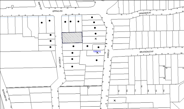
|
NOTIFICATION PLAN |
|
||
|
• PROPERTIES NOTIFIED
|
X SUBMISSIONS RECEIVED |
PROPERTY SUBJECT OF DEVELOPMENT |
|
Three submissions objected to the development, generally on the grounds that the development would result in:
· The cumulative impact of extra traffic in the area leading to further traffic congestion;
· The impact upon the proposed Epping Road Widening and Essex Street Project;
· Noise abatement to neighbouring area;
· Overshadowing of property (No. 46 Essex Street);
· Suitable planting to screen building (No. 46 Essex Street); and
· A lighter colour scheme would assist reduce visual impact.
5.1.1 Inadequate Infrastructure
Concerns are raised that existing infrastructure is inadequate to cater for an increased population. In particular, there is traffic congestion and, inadequate on-street parking. It is suggested that an additional passenger foot bridge should be constructed over Epping Road.
The suitability of the locality for high density residential development was considered by the Department of Planning and Environment during the rezoning of the precinct. Weight must be given to the applicable zoning of the land in the resolution of a dispute as to the appropriate development of any site.
As part of the Epping UAP, detailed traffic modelling was undertaken to confirm the capacity of the road network to accommodate the anticipated increase in traffic volumes associated with development. The modelling confirmed the need for traffic improvements including works to the intersection of Essex Street and Epping Road and widening of the Epping Railway Bridge. The State Government has allocated funds to deliver these works in association with development within the precinct and the projects are at various stages of design and implementation.
The volume of on-site parking provided is consistent with that required by the Hornsby DCP for the proposed unit mix and a payment of S94 contributions is also required towards the provision of local facilities to cater for a growing population.
5.1.2 Noise to Neighbouring Properties
The applicant has provided building and balcony / terrace setbacks that comply with Hornsby DCP requirements. These setbacks are generally considered sufficient to protect the amenity of neighbouring residential occupiers from noise disturbance.
The principal communal open space area is located on the eastern boundary with neighbours at Nos. 44 and 46 Essex Street. Noise will be softened by the use of extensive planting at the boundary and a condition is recommended to provide fencing at least 1.8m in height to be erected along the boundary. Noise from apartments will be softened by screens to balconies.
A condition is recommended for an Environmental Management Plan where the site must be managed in accordance with the publication ‘Managing Urban Stormwater – Landcom (March 2004) and the Protection of the Environment Operations Act 1997 by way of implementing appropriate measures to prevent sediment run-off, excessive dust, noise or odour emanating from the site during the construction of the development.
5.1.3 Overshadowing of No. 46 Essex Street
An overshadowing assessment has been submitted which indicates that the impact to No.46 Essex Street is within acceptable parameters. In particular, the rear garden at that property would receive 3 hours of sunlight in mid-winter, exceeding compliance with the Hornsby DCP.
5.1.4 Suitable Planting to Screen Building to No. 46 Essex Street
An amended landscape plan has been submitted to provide 2 mature trees with a height of 12-15m, to be planted on the eastern boundary. This would provide sufficient landscape screening of the building from the east in compliance with the Hornsby DCP.
5.1.5 Colour Scheme
The external colour scheme has been amended to lighten the type of materials used in the building construction. In particular, the black rendered Colorbond panels have been replaced with red brick, grey panels with light beige, and light browns with white. This lends the building a less bulky appearance particularly at upper levels in compliance with the Hornsby DCP.
5.2 Public Agencies
The development application was referred to the following Agency for comment:
5.2.1 NSW Police
The development application was referred to the NSW Police for consideration of Crime Prevention Through Environmental Design. No comments were received although it is recommended that conditions be applied to require compliance with the recommendations of the submitted Crime Through Environmental Design Assessment.
6. THE PUBLIC INTEREST
Section 79C(1)(e) of the Act requires Council to consider “the public interest”.
The public interest is an overarching requirement, which includes the consideration of the matters discussed in this report. Implicit to the public interest is the achievement of future built outcomes adequately responding to and respecting the future desired outcomes expressed in environmental planning instruments and development control plans.
The application is considered to have satisfactorily addressed Council’s and relevant agencies’ criteria and would provide a development outcome that, on balance, would result in a positive impact for the community. Accordingly, it is considered that the approval of the proposed development would be in the public interest.
CONCLUSION
The application seeks approval for the demolition of existing structures and construction of a five storey residential flat building comprising 36 units with basement car parking and strata subdivision.
The proposed development is generally in accordance with the development controls for the ‘Epping Road Street, Forest Grove’ Precinct of the Hornsby DCP and would contribute to the future desired five storey residential character of the precinct. The proposal generally complies with the design principles of SEPP 65 and the Residential Flat Design Code. With conditions, the minor non-compliances with prescriptive measures for setbacks, height of basement, landscaping, minimum dwelling size, maximum kitchen distance and storage areas is considered acceptable.
The proposal would result in a development that would be in keeping with the desired future character of the precinct.
Note: At the time of the completion of this planning report, no persons have made a Political Donations Disclosure Statement pursuant to Section 147 of the Environmental Planning and Assessment Act 1979 in respect of the subject planning application.
RESPONSIBLE OFFICER
The officer responsible for the preparation of this Report is the Manager – Development Assessments, Rodney Pickles, who can be contacted on 9847 6731.
|
Rod Pickles Manager - Development Assessment Planning Division |
James Farrington Group Manager Planning Division |
|
1.View |
Locality Map |
|
|
|
2.View |
Site Plan |
|
|
|
3.View |
Survey Plan |
|
|
|
4.View |
Basement Plans |
|
|
|
5.View |
DA Plans |
|
|
|
6.View |
Elevations and Sections |
|
|
|
7.View |
Shadow Diagram |
|
|
|
8.View |
Landscape Plans |
|
|
File Reference: DA/1606/2014
Document Number: D05300986
SCHEDULE 1
GENERAL CONDITIONS
The conditions of consent within this notice of determination have been applied to ensure that the use of the land and/or building is carried out in such a manner that is consistent with the aims and objectives of the relevant legislation, planning instruments and council policies affecting the land and does not disrupt the amenity of the neighbourhood or impact upon the environment.
Note: For the purpose of this consent, the term ‘applicant’ means any person who has the authority to act on or the benefit of the development consent.
Note: For the purpose of this consent, any reference to an Act, Regulation, Australian Standard or publication by a public authority shall be taken to mean the gazetted Act or Regulation, or adopted Australian Standard or publication as in force on the date that the application for a construction certificate is made.
1. Approved Plans and Supporting Documentation
The development must be carried out in accordance with the plans and documentation listed below and endorsed with Council’s stamp, except where amended by Council and/or other conditions of this consent:
|
Plan No. |
Plan Title |
Drawn by |
Dated |
|
6424 |
Detail Survey |
SDG |
23.09.2014 |
|
8368 C - 00 |
Cover Sheet |
Zhinar |
08.05.2015 |
|
8368 A - 01 A |
Site Analysis |
Zhinar |
18.12.2014 |
|
8368 A - 02 A |
Urban Context |
Zhinar |
18.12.2014 |
|
8368 C - 03 C |
Basement 2 |
Zhinar |
08.05.2015 |
|
8368 C - 04 C |
Basement 1 |
Zhinar |
08.05.2015 |
|
8368 C - 05 C |
Ground Floor |
Zhinar |
08.05.2015 |
|
8368 C - 06 C |
First Floor |
Zhinar |
08.05.2015 |
|
8368 C - 07 C |
Second Floor |
Zhinar |
08.05.2015 |
|
8368 C - 08 C |
Third Floor |
Zhinar |
08.05.2015 |
|
8368 C - 09 C |
Fourth Floor |
Zhinar |
08.05.2015 |
|
8368 C - 10 C |
Fourth (Upper) Floor |
Zhinar |
08.05.2015 |
|
8368 C - 11 C |
Roof |
Zhinar |
08.05.2015 |
|
8368 C - 12 C |
Section 1 |
Zhinar |
08.05.2015 |
|
8368 C - 13 C |
Section 2 |
Zhinar |
08.05.2015 |
|
8368 C - 14 C |
Elevations – East & North |
Zhinar |
08.05.2015 |
|
8368 C - 15 C |
Elevations – West & South |
Zhinar |
08.05.2015 |
|
8368 C - 16 C |
Street Elevation |
Zhinar |
08.05.2015 |
|
8368 B - 17 B |
Shadow Study |
Zhinar |
09.04.2015 |
|
8368 B - 18 B |
Material Schedule |
Zhinar |
08.05.2015 |
|
1 of 2 |
Landscape Site Plan |
Paul Scrivener |
02.4.2014 |
|
2 of 2 |
Planting Plan |
Paul Scrivener |
02.4.2014 |
|
Document Title |
Prepared by |
Dated |
|
BASIX Certificate |
Newpeake |
17.12.2014 |
|
Acoustic Assessment |
Acoustic Logic |
08.12.2014 |
|
Assessment of Traffic and Parking Implications |
Transport and Traffic Planning Associates |
December 2014 |
|
Statement of Environmental Effects |
Caladines |
December 2014 |
|
SEPP 65 Design Verification Statement |
Zhinar |
December 2014 |
|
Arboricultural Assessment and Impact Report |
Horticultural Management Services |
28.11.2014 |
|
Registered Quantity Surveyors Cost Report |
QPC & C Pty Limited |
17.12.2014 |
|
Access Compliance Assessment Report |
Certified Building Specialists |
17.12.2014 |
|
Details Notes and Legends (Stormwater) - D1 - B |
Donovan Associates |
16.12.2014 |
|
Stormwater Management – Basement Level 2 Floor Plan - D2 - B |
Donovan Associates |
16.12.2014 |
|
Stormwater Management – Basement Level 1 Floor Plan - D3 - B |
Donovan Associates |
16.12.2014 |
|
Stormwater Management – Ground Floor - D4 - B |
Donovan Associates |
16.12.2014 |
|
OSD Details and Calculations - D5 - B |
Donovan Associates |
16.12.2014 |
|
Sediment Control Plan - D6 – B |
Donovan Associates |
16.12.2014 |
|
Stormwater and Sediment Control Details – D7 - B |
Donovan Associates |
16.12.2014 |
|
Waste Management Plan |
|
16.12.2014 |
|
Photomontage 8368 B - 19 |
Zhinar |
09.04.2015 |
|
Material Schedule 8368 B - 19 |
Zhinar |
09.04.2015 |
2. Amendment of Plans
The approved plans are to be amended as follows:
a) The door opening for bins on the ground floor needs to be increased to 1400 mm.
b) The door opening for bins on the first and second floor needs to be increased to 2100 mm.
c) Within the basement bin storage room, the divide between garbage and recycling bins are to be removed.
d) The doors to the basement bin storage room are to be increased to 1300mm in width.
e) An additional adaptable unit shall be provided.
3. Removal of Existing Trees
This development consent only permits the removal of tree(s) numbered 4, 5, 6, 7, 19, 20, 21, 22, 23, 24, 25, 26, 27, 28, 29, 30, 31, & 41 as identified on the Tree Proposed to be Retained or Removed Plan within the Arboricultural Assessment and Impact Report provided by Horticultural Management Services, dated 28-11-14.
The removal of any other trees requires separate approval in accordance with the Tree & Vegetation Chapter 1B.6 Hornsby Development Control Plan (HDCP).
4. Obscure Glazing
The bedroom and living room windows of units 12, 13, 20, 21, 28 (excluding balcony windows/glass doors) facing the eastern rear boundary are to be highlight windows 1.5m above finished floor level.
The first to third floor bedroom windows facing south are to be highlight windows 1.5m above finished floor level where located within 6m of the side boundary.
5. Construction Certificate
A Construction Certificate is required to be approved by Council or a Private Certifying Authority prior to the commencement of any works under this consent.
6. Section 94 Development Contributions
a) In accordance with Section 80A(1) of the Environmental Planning and Assessment Act 1979 and the Hornsby Shire Council Section 94 Development Contributions Plan 2012-2021, the following monetary contributions shall be paid to Council to cater for the increased demand for community infrastructure resulting from the development:
|
Description |
Contribution (4) |
|
Roads |
$22,542.30 |
|
Open Space and Recreation |
$410,249.65 |
|
Community Facilities |
$57.202.55 |
|
Plan Preparation and Administration |
$1,675.65 |
|
TOTAL |
$491,670.15 |
being for 5 x 1 bedroom units, 27 x 2 bedroom units and 4 x 3 bedroom units and including a credit for 4 existing townhouses
b) The value of this contribution is current as at 12 January 2015. If the contributions are not paid within the financial quarter that this condition was generated, the contributions payable will be adjusted in accordance with the provisions of the Hornsby Shire Council Section 94 Development Contributions Plan and the amount payable will be calculated at the time of payment in the following manner:
$CPY = $CDC x CPIPY
CPIDC
Where:
$CPY is the amount of the contribution at the date of Payment
$CDC is the amount of the contribution as set out in this Development Consent
CPIPY is the latest release of the Consumer Price Index (Sydney – All Groups) at the date of Payment as published by the ABS.
CPIDC is the Consumer Price Index (Sydney – All Groups) for the financial quarter at the date applicable in this Development Consent Condition.
c) The monetary contributions shall be paid to Council:
i) prior to the issue of the Subdivision Certificate where the development is for subdivision; or
ii) prior to the issue of the first Construction Certificate where the development is for building work; or
iii) prior to issue of the Subdivision Certificate or first Construction Certificate, whichever occurs first, where the development involves both subdivision and building work; or
iv) prior to the works commencing where the development does not require a Construction Certificate or Subdivision Certificate.
It is the professional responsibility of the Principal Certifying Authority to ensure that the monetary contributions have been paid to Council in accordance with the above timeframes.
Council’s Development Contributions Plan may be viewed at www.hornsby.nsw.gov.au or a copy may be inspected at Council’s Administration Centre during normal business hours.
REQUIREMENTS PRIOR TO THE ISSUE OF A CONSTRUCTION CERTIFICATE
7. Building Code of Australia
All building work must be carried out in accordance with the relevant requirements of the Building Code of Australia.
8. Contract of Insurance (Residential Building Work)
In the case of residential building work for which the Home Building Act 1989 requires there to be a contract of insurance in force in accordance with Part 6 of that Act, that such a contract of insurance is in force before any building work authorised to be carried out by the consent commences.
9. Notification of Home Building Act, 1989 Requirements
Residential building work within the meaning of the Home Building Act 1989 must not be carried out unless the principal certifying authority for the development to which the work relates (not being Council) has given Council written notice of the following information:
a) In the case of work for which a principal contractor is required to be appointed:
i) The name and licence number of the principal contractor; and
ii) The name of the insurer by which the work is insured under Part 6 of that Act.
b) In the case of work to be done by an owner-builder:
i) The name of the owner-builder; and
ii) If the owner-builder is required to hold an owner-builder’s permit under that Act, the number of the owner-builder’s permit.
Note: If arrangements for doing the residential building work are changed while the work is in progress so that the information notified becomes out of date, further work must not be carried out unless the principal certifying authority for the development to which the work relates (not being Council) has given Council written notification of the updated information.
10. Water/Electricity Utility Services
The applicant must submit written evidence of the following service provider requirements:
a) Ausgrid (formerly Energy Australia) – a letter of consent demonstrating that satisfactory arrangements have been made to service the proposed development.
b) Sydney Water – the submission of a ‘Notice of Requirements’ under s73 of the Sydney Water Act 1994.
Note: Sydney Water requires that s73 applications are to be made through an authorised Sydney Water Servicing Coordinator. Refer to www.sydneywater.com.au or telephone 13 20 92 for assistance.
11. Dilapidation Report
A ‘Dilapidation Report’ is to be prepared by a ‘chartered structural engineer’ detailing the structural condition of the adjoining properties at Nos. 44 and 46 Essex Street, Epping.
12. Traffic Control Plan
A Traffic Control Plan (TCP) must be prepared by a qualified traffic controller in accordance with the Roads & Traffic Authority’s Traffic Control at Worksites Manual 1998 and Australian Standard 1742.3 for all work on a public road and be submitted to Council for approval. The TCP must detail the following:
a) Arrangements for public notification of the works.
b) Temporary construction signage.
c) Permanent post-construction signage.
d) Vehicle movement plans.
e) Traffic management plans.
f) Pedestrian and cyclist access/safety.
13. Storage
Each dwelling within the development must have a minimum area for storage (not including kitchen and bedroom cupboards) of 6m³ for one bedroom units, 8m³ for two bedroom units and 10m³ for three bedroom units, where 50% is required to be located within the apartment and accessible from either the hall or living area. Details must be submitted with the Construction Certificate plans.
14. Noise – Epping Road Corridor
The development must be carried out in accordance with the recommendations contained within the acoustic report submitted with the development application, titled, prepared by Acoustic Logic and dated 08.12.2014 and the requirements of the Department of Planning’s Development Near Rail Corridors and Busy Roads – Interim Guideline and RailCorp’s Interim Guidelines for Applicants.
Note: The Department of Planning’s document is available at www.planning.nsw.gov.au (development assessments).
15. Adaptable Units
The development is required to provide 11 units designed as adaptable housing pursuant to the requirements of 1C.2.2 of the Hornsby Development Control Plan. In this regard, (4) car parking spaces are to be designed for people with a disability and allocated to 4 adaptable units. The details of all adaptable units must be provided with the Construction Certificate plans.
16. Letterboxes
The details of letter boxes and meter enclosures must be provided with the Construction Certificate Plans. The letter boxes and meter enclosures must be provided with a minimum setback of 2 metres from all boundaries and must be suitably screened.
17. Preservation of Survey Infrastructure
Prior to the issue of a Construction Certificate, a registered surveyor shall identify all survey marks in the vicinity of the proposed development. Any survey marks required to be removed or displaced as a result of the proposed development shall be undertaken by a registered surveyor in accordance with Section 24 (1) of the Surveying and Spatial Information Act 2002 and following the Surveyor General’s Directions No.11 – "Preservation of Survey Infrastructure".
REQUIREMENTS PRIOR TO THE COMMENCEMENT OF ANY WORKS
18. Project Arborist
A Project Arborist is to be appointed in accordance with AS 4970-2009 (1.4.4) to provide monitoring and certification throughout the development process.
19. Tree Protection Barriers
Tree protection fencing must be erected around trees to be retained at the nominated Tree Protection Zones (TPZ) listed below.
The tree fencing must be contiguous and constructed of 1.8 metre ‘cyclone chain mesh fence’ or star pickets spaced at 2 metre intervals, connected by a continuous high-visibility barrier/hazard mesh at a height of 1 metre. Where necessary, tree fencing must facilitate public vehicle and pedestrian thoroughfare.
Tree Protection Zones (TPZ)
|
TREE |
TPZ |
|
1, 2, 3, 8, 9, 11, 12, 13 ,14, 15, 16, 32, 33, 34, 35, 36, 37, 38, 39, 40, 42, 43, 44 ,45 ,46 |
4m |
|
17, 18 |
7m |
20. Tree Ground Protection
Prior to works commencing and throughout construction, the area of the Tree Protection Zone (located on the property) of trees 8, 9, 17 and 18 is to be protected by the use of wood-chip mulch. Wood-chip mulch is to be installed on top of a geotextile landscape fabric, placed over the root zone of the tree. The mulch is to be maintained at a depth of 150mm – 300mm using material that complies with AS 4454.
Note: A certificate from the Project Arborist (AQF 5) is to be submitted to the Principal Certifying Authority stating that all tree protection measures are in accordance with the above and consistent with the intentions of the Australian Standard ‘Protection of Trees on Development Sites (AS 4970-2009) prior to commencement of works.
21. Erection of Construction Sign
A sign must be erected in a prominent position on any site on which building work, subdivision work or demolition work is being carried out:
a) Showing the name, address and telephone number of the principal certifying authority for the work;
b) Showing the name of the principal contractor (if any) for any demolition or building work and a telephone number on which that person may be contacted outside working hours; and
c) Stating that unauthorised entry to the work site is prohibited.
Note: Any such sign is to be maintained while the building work, subdivision work or demolition work is being carried out, but must be removed when the work has been completed.
22. Protection of Adjoining Areas
A temporary hoarding, fence or awning must be erected between the work site and adjoining lands before the works begin and must be kept in place until after the completion of the works if the works:
a) Could cause a danger, obstruction or inconvenience to pedestrian or vehicular traffic.
b) Could cause damage to adjoining lands by falling objects.
c) Involve the enclosure of a public place or part of a public place.
Note: Notwithstanding the above, Council’s separate written approval is required prior to the erection of any structure or other obstruction on public land.
23. Toilet Facilities
Toilet facilities must be available or provided at the works site before works begin and must be maintained until the works are completed at a ratio of one toilet for every 20 persons employed at the site. Each toilet must:
a) be a standard flushing toilet connected to a public sewer; or
b) be a temporary chemical closet approved under the Local Government Act 1993; or
c) have an on-site effluent disposal system approved under the Local Government Act 1993.
REQUIREMENTS DURING CONSTRUCTION
24. Erosion and Sediment Control
Erosion and sediment control measures must be provided and maintained throughout the construction period in accordance with the manual ‘Soils and Construction 2004 (Bluebook)’, the approved plans, Council specifications and to the satisfaction of the principal certifying authority. The erosion and sediment control devices must remain in place until the site has been stabilised and revegetated.
Note: On the spot penalties may be issued for any non-compliance with this requirement without any further notification or warning.
25. Construction Work Hours
All work on site (including demolition and earth works) must only occur between 7am and 5pm Monday to Saturday. No work is to be undertaken on Sundays or public holidays.
26. Demolition
All demolition work must be carried out in accordance with “Australian Standard 2601-2001 – The Demolition of Structures” and the following requirements:
a) Demolition material must be disposed of to an authorised recycling and/or waste disposal site and/or in accordance with an approved waste management plan;
b) Demolition works, where asbestos material is being removed, must be undertaken by a contractor that holds an appropriate licence issued by WorkCover NSW in accordance with Chapter 10 of the Occupational Health and Safety Regulation 2001 and Clause 29 of the Protection of the Environment Operations (Waste) Regulation 2005 ;and
c) On construction sites where buildings contain asbestos material, a standard commercially manufactured sign containing the words ‘DANGER ASBESTOS REMOVAL IN PROGRESS’ measuring not less than 400mm x 300mm must be erected in a prominent position visible from the street.
27. Environmental Management
The site must be managed in accordance with the publication ‘Managing Urban Stormwater – Landcom (March 2004) and the Protection of the Environment Operations Act 1997 by way of implementing appropriate measures to prevent sediment run-off, excessive dust, noise or odour emanating from the site during the construction of the development.
28. Street Sweeping
Street sweeping must be undertaken following sediment tracking from the site along Essex Street during works and until the site is established.
29. Works Near Trees
All required tree protection measures are to be maintained in good condition for the duration of the construction period.
Consent is granted to undertake works within the Tree Protection Zone of trees 8, 9, 11, 13, 14, 15, 17, 18, 42 & 43 only, with the following conditions:
a) Project Arborist
i) Works must not reduce the useful life expectancy of the tree and be carried out under the direct supervision of the Project Arborist. The project Arborist must assess the condition of tree and the growing environment and make recommendations for, and if necessary carry out remedial action to ensure the health and vigour of the tree.
b) Excavation
i) Excavation to a depth of one metre (1m) to facilitate the construction of the basement and the stormwater shall be carried out by hand excavation ONLY. Excavation must not exceed 15% of the TPZ and is to occur at a distance greater than 3m from the trunk of any tree.
c) Root Pruning
i) Where tree roots are required to be severed for the purposes of this consent all pruning shall be undertaken as specified in AS 4970-2009 Sections 3.3.4, 4.5.4 and 4.5.5. A certificate must be submitted by the Project Arborist to the principal certifying authority detailing the methods used to preserve the trees.
d) Drilling/ Boring
i) The installation of any services within the nominated Tree Protection Zone of any tree to be retained shall utilise the thrust boring method. Thrust boring shall be carried out so that ‘top of pipe’ is a minimum 600mm depth beneath existing ground level.
Note: Except as provided above all personnel (the applicant, contractors, service providers, principal certifying authority) involved with this development are to ensure that no excavation, including sub-surface trenching for stormwater or other services or the filling or stockpiling of building materials, parking of vehicles or plant, the use of machinery other than hand held, disposal of cement slurry, waste water or other contaminants is to occur within the Tree Root Zone as prescribed in the HDCP Section 1B.6.1(i) of any tree to be retained.
30. Council Property
During construction works, no building materials, waste, machinery or related matter is to be stored on the road or footpath. The public reserve must be kept in a clean, tidy and safe condition at all times.
31. Disturbance of Existing Site
During construction works, the existing ground levels of open space areas and natural landscape features, (including natural rock-outcrops, vegetation, soil and watercourses) must not be altered unless otherwise nominated on the approved plans.
32. Landfill
Landfill must be constructed in accordance with Council’s ‘Construction Specification 2005’ and the following requirements:
a) All fill material imported to the site is to wholly consist of Virgin Excavated Natural Material (VENM) as defined in Schedule 1 of the Protection of the Environment Operations Act 1997 or a material approved under the Department of Environment and Climate Change’s general resource recovery exemption.
33. Excavated Material
All excavated material removed from the site must be classified in accordance with the Department of Environment, Climate Change and Water NSW Waste Classification Guidelines prior to disposal to an approved waste management facility and reported to the principal certifying authority.
34. Work Zone
All construction vehicles associated with the proposed development are to be contained on site or in a Local Traffic Committee (LTC) approved “Work Zone”.
35. Final Certification
Where works have been undertaken within the Tree Protection Zone of a tree the project Arborist must assess the condition of tree(s) and the growing environment and make recommendations for, and carry out remedial actions where necessary.
Following the final inspection and the completion of any remedial works, the project Arborist must submit to the Principal Certifying Authority documentation stating that the completed works have been carried out in compliance with the approved plans and specifications for tree protection as above and AS 4970-2009.
36. Survey Report – Finished Floor Level
A report(s) must be prepared by a registered surveyor and submitted to the principal certifying authority prior to the pouring of concrete at each level of the building certifying that:
a) The building, retaining walls and the like have been correctly positioned on the site; and
b) The finished floor level(s) are in accordance with the approved plans.
37. Waste Management Details
Waste management during the demolition and construction phase of the development must be undertaken in accordance with the approved Waste Management Plan. Additionally written record of the following items must be maintained during the removal of any waste from the site and such information submitted to the Principal Certifying Authority within fourteen days of the date of completion of the works;
a) The identity of the person removing the waste.
b) The waste carrier vehicle registration.
c) Date and time of waste collection.
d) A description of the waste (type of waste and estimated quantity).
e) Details of the site to which the waste is to be taken.
f) The corresponding tip docket/receipt from the site to which the waste is transferred (noting date and time of delivery, description (type and quantity) of waste).
g) Whether the waste is expected to be reused, recycled or go to landfill.
Note: In accordance with the Protection of the Environment Operations Act 1997, the definition of waste includes any unwanted substance, regardless of whether it is reused, recycled or disposed to landfill.
REQUIREMENTS PRIOR TO THE ISSUE OF AN OCCUPATION CERTIFICATE
Note: For the purpose of this consent, a reference to ‘occupation certificate’ shall not be taken to mean an ‘interim occupation certificate’ unless otherwise stated.
38. Noise – Epping Road Corridor
Provide to Council a Certificate from a Noise Consultant in compliance with condition 14.
39. Fulfilment of BASIX Commitments
The applicant must demonstrate the fulfilment of BASIX commitments pertaining to the development.
40. Sydney Water – s73 Certificate
An s73 Certificate must be obtained from Sydney Water.
41. Damage to Council Assets
Any damage caused to Council’s assets as a result of the construction of the development must be rectified in accordance with Council’s Civil Works Specifications. Council’s Restorations Supervision must be notified for a formwork inspection prior to pouring concrete.
42. Works as Executed Plan
A works-as-executed plan(s) must be prepared by a registered surveyor and submitted to Council for completed road pavement, kerb & gutter, public drainage systems, driveways and on-site detention and harvesting systems.
43. Creation of Easements
The following matter(s) must be nominated on the title under s88B or s88E of the Conveyancing Act 1919:
a) An easement for access for Council’s waste and recycling vehicles, using terms available from Council, over that part of the land required for SRV service.
b) The creation of an appropriate "Positive Covenant" and "Restriction as to User" over the constructed on-site detention/retention systems and outlet works, within the lots in favour of Council in accordance with Council’s prescribed wording. The position of the on-site detention system must be clearly marked on the Registered Surveyor’s documentation.
c) To register the OSD easement, the restriction on the use of land “works-as-executed” details of the on-site-detention system must be submitted verifying that the required storage and discharge rates have been constructed in accordance with the design requirements. The details must show the invert levels of the on-site system together with pipe sizes and grades. Any variations to the approved plans must be shown in red on the “works-as-executed” plan and supported by calculations.
Note: Council must be nominated as the authority to release, vary or modify any easement, restriction or covenant.
44. Certificate of Tree Protection
Where works have been undertaken within the Tree Protection Zone of a tree, the project Arborist must assess the condition of tree(s) and the growing environment and make recommendations for, and carry out remedial actions where necessary.
Following the final inspection and the completion of any remedial works, the project Arborist must submit to the Principal Certifying Authority documentation stating that the completed works have been carried out in compliance with the approved plans and specifications for tree
45. Boundary Fencing
Fencing must be erected along all property boundaries behind the front building alignment to a height of 1.8 metres above existing ground level. Fences to the primary frontage in front of the building alignment are to retain visual transparency (not lapped / solid) and be 1.2 metres in height.
Note: Alternative fencing behind the front building line may be erected subject to the written consent of the adjoining property owner(s).
46. Planter Boxes/On Slab Planting
On slab planter boxes must include waterproofing, subsoil drainage (proprietary drainage cell, 50mm sand and filter fabric) automatic irrigation, minimum 500mm planting soil for shrubs and minimum 1000mm planting soil for trees and palms and 75mm mulch to ensure sustainable landscape is achieved.
47. Completion of Landscaping
A certificate must be provided by a practicing landscape architect, horticulturalist or person with similar qualifications and experience certifying that all required landscaping works have been satisfactorily completed in accordance with the approved landscape plans.
Note: Advice on suitable species for landscaping can be obtained from Council’s planting guide ‘Indigenous Plants for the Bushland Shire’, available at www.hornsby.nsw.gov.au.
48. External Lighting
All external lighting must be designed and installed in accordance with Australian Standard AS 4282 – Control of the Obtrusive Effects of Outdoor Lighting. Certification of compliance with the Standard must be obtained from a suitably qualified person.
49. Garbage Collection Easement
For the purpose of waste collection, an easement entitling Council, its servants and agents and persons authorised by it to enter upon the subject land and to operate thereon, vehicles and other equipment for the purposes of garbage collection must be granted to Council by the owner of the land.
Note: The easement must be in a form prescribed by Council and must include covenants to the effect that parties will not be liable for any damage caused to the subject land or any part thereof or to any property located therein or thereon by reason of the operation thereon of any vehicle or other equipment used in connection with the collection of garbage and to the effect that the owner for the time being of the subject land shall indemnify the Council, its servants, agents and persons authorised by it to collect garbage against liability in respect of any such claims made by any person whomsoever.
50. Waste Management
The following waste management requirements must be complied with:
a) The garbage rooms at the basement level must include water or a hose for cleaning, graded floors with drainage to sewer, a robust door, sealed and impervious surface, adequate lighting and ventilation, and must be lockable. The waste facility at each residential level must include sealed and impervious surface, adequate lighting and ventilation.
b) A report must be prepared by an appropriately qualified person, certifying the following:
i) A comparison of the estimated quantities of each waste type against the actual quantities of each waste type. Note: Explanations of any deviations to the approved Waste Management Plan is required to be included in this report
ii) That at least 60% of the waste generated during the demolition and construction phase of the development was reused or recycled. Note: If the 60% diversion from landfill cannot be achieved in the Construction Stage, the Report is to include the reasons why this occurred and certify that appropriate work practices were employed to implement the approved Waste Management Plan. The Report must be based on documentary evidence such as tipping dockets/receipts from recycling depots, transfer stations and landfills, audits of procedures etc. which are to be attached to the report.
iii) All waste was taken to site(s) that were lawfully permitted to accept that waste.
c) A report(s) must be prepared by a registered surveyor and submitted to the principal certifying authority prior to the issue of the Subdivision/Occupation Certificate, certifying that the finished access way (including ramp, loading bay and site entry/exit) to be used by waste collection vehicles, complies with Australian Standard AS2890.2-2002 Parking Facilities Part 2: Off-street Commercial Vehicle Facilities for small rigid vehicles.
d) Each unit must be provided with an indoor waste/recycling cupboard for the interim storage of a minimum one day’s waste generation with separate containers for general waste and recyclable materials.
e) Space must be provided for either individual compost containers for each unit or a communal compost container;
Note: The location of the compost containers should have regard for potential amenity impacts.
f) The bin carting routes must be devoid of any steps.
Note: Ramps between different levels are acceptable.
g) “No Parking” signs must be installed to prevent cars parking in the loading bay.
h) The 3.5 metre vertical clearance height within the truck travel path must not be reduced by ducting, lights, pipes or any part of the building.
i) Access to the automatic waste volume handling equipment by unauthorised persons (including residents and waste collectors) must be prevented.
j) A report(s) must be prepared by a registered surveyor and submitted to the principal certifying authority prior to the issue of the Subdivision/Occupation Certificate, certifying that: The finished access way (including ramp, vehicle turning area, loading bay and site entry/exit) to be used by waste collection vehicles, complies with Australian Standard AS2890.2-2002 Parking Facilities Part 2: Off-street Commercial Vehicle Facilities for small rigid vehicles with minimum design vehicle dimensions of 6.4 metres overall length, width of 2.3 metres, with maximum gradient of 1:6.5 and minimum 3.5 metre clearance height.
Note: Encroachments of the small rigid vehicle turning path and low speed manoeuvring clearance (300 mm both sides) into parking spaces are not permitted.
51. Unit Numbering
The allocation of unit numbering must be authorised by Council prior to the numbering of each unit in the development.
52. Consolidation of Allotments
All allotments the subject of this consent must be consolidated into one allotment.
Note: The applicant is recommended to submit the plan of subdivision to consolidate allotments to the NSW Department of Lands at least 4-6 weeks prior to seeking an Occupation Certificate.
53. Safety and Security
This site must include the following elements:
a) An intercom system must be installed at gate locations to ensure screening of persons entering the units.
b) The entry doors to the pedestrian foyer is to be constructed of safety rated glass to enable residents a clear line of site before entering or exiting the residential apartments.
c) Lighting is to be provided to pathways, building foyer entries, driveways and common external spaces.
d) Security gate access is to be provided to the car parking areas allowing residents-only access to private car spaces.
e) The communal open space, at the rear and north of the site must be illuminated with high luminance by motion sensor lighting.
f) The driveway and basement car parking must be illuminated with low luminance at all times.
g) Security deadlocks are to be provided to each apartment door.
h) Peep holes are to be provided to individual apartment doors to promote resident safety.
54. Provision for National Broadband Network (NBN)
Provision must be made for fibre ready passive infrastructure (pits and pipes) generally in accordance with NBN Co.'s pit and pipe installation guidelines to service the proposed development. A certificate from NBN Co. or Telstra must be submitted to the PCA that the fibre optic cabling provided for the development complies with MDU Building Design Guides for Development.
55. Internal Driveway/Vehicular Areas
The driveway and parking areas on site must be designed in accordance with Australian Standards 2890.1, 2890.2, and the following requirements:
a) Design levels at the front boundary must be obtained from Council;
b) The driveway must be a rigid pavement;
c) The driveway grade for SRV access must not exceed 15.4 per cent and changes in grade must not exceed 8.3 per cent per 4.0m of travel, with provision of 3.5m of SRV clearance in servicing and manoeuvring areas;
d) The driveway ramp shall have suitable provision for drainage; and
e) Retaining walls required to support the basement ramp and the compaction of all fill batters must be in accordance with the requirements of a chartered structural engineer.
56. Stormwater Drainage
The stormwater drainage system for the development must be designed and constructed for an average recurrence interval of 20 years and be gravity drained in accordance with the following requirements:
a) Connected to an existing Council drainage system/street gutter via an on-site detention system. Capacity of the street gutter is to be verified prior to discharging to the gutter.
b) Be designed by a Chartered Professional Engineer/ Civil Engineer of the Institution of Engineers, Australia.
57. On Site Stormwater Detention
On on-site stormwater detention system must be designed by a chartered civil engineer and constructed in accordance with the following requirements:
a) Storage capacity to accommodate volume from up to 20 years ARI (average recurrence interval) and a maximum discharge (when full) limited to 5 years pre development rate.
b) Have a surcharge/inspection grate located directly above the outlet.
c) Discharge from the detention system to be controlled via 1 metre length of pipe, not less than 50 millimetres diameter or via a stainless plate with sharply drilled orifice bolted over the face of the outlet discharging into a larger diameter pipe capable of carrying the design flow to an approved Council system.
d) Where above ground and the average depth is greater than 0.3 metres, a ‘pool type’ safety fence and warning signs to be installed.
e) Not be constructed in a location that would impact upon the visual or recreational amenity of residents.
f) Detail calculations are to be shown on the Construction Certificate plans.
58. Water Quality
Stormwater leaving the premises is to be treated to achieve the quality specified in Council’s Development Control Plan 2012 (table 1C.1.2(b) Urban Stormwater Quality Targets).
59. Vehicular Crossing
A separate application under the Local Government Act, 1993 and the Roads Act, 1993 must be submitted to Council for the installation of a new vehicular crossing and the removal of the redundant crossing. The vehicular crossing must be constructed in accordance with Council’s Civil Works Design, 2005 and the following requirements:
a) Any redundant crossings to be replaced with integral kerb and gutter.
b) The footway area to be restored by turfing.
c) Approval obtained from all relevant utility providers that all necessary conduits be provided and protected under the crossing.
Note: An application for a vehicular crossing can only be made to one of Council’s Authorised Vehicular Crossing Contractors. You are advised to contact Council on 02 9847 6940 to obtain a list of contractors.
60. Internal Driveway/Vehicular Areas
The driveway and parking areas on site must be designed in accordance with Australian Standards 2890.1, 2890.2, 3727 and the following requirements:
a) Design levels at the front boundary be obtained from Council.
b) The driveway be a rigid pavement.
61. Road Works
All road works approved under this consent must be constructed in accordance with Council’s Civil Works Design and Construction Specification, 2005 and the following requirements:
a) Concrete footpath, kerb and gutter along Forest Grove frontage of the development are to be replaced. The existing road pavement to be saw cut a minimum of 300 mm from the existing edge of the bitumen and reconstructed.
b) A Construction Certificate is to be submitted to Council for approval.
Note: Council is the only authority to approve works within Council roads.
62. Creation of Easements
The following matter(s) must be nominated on the plan of subdivision under s88B of the Conveyancing Act 1919:
a) The creation of an appropriate "Positive Covenant" and "Restriction as to User" over the constructed on-site detention/retention systems and outlet works, within the lots in favour of Council in accordance with Council’s prescribed wording. The position of the on-site detention system is to be clearly indicated on the title.
b) To register the OSD easement, the restriction on the use of land “works-as-executed” details of the on-site-detention system must be submitted verifying that the required storage and discharge rates have been constructed in accordance with the design requirements. The details must show the invert levels of the on-site system together with pipe sizes and grades. Any variations to the approved plans must be shown in red on the “works-as-executed” plan and supported by calculations.
Note: Council must be nominated as the authority to release, vary or modify any easement, restriction or covenant.
63. Retaining Walls
All required retaining walls must be constructed as part of the development.
OPERATIONAL CONDITIONS
64. Landscape Establishment
The landscape works must be maintained into the future to ensure the establishment and successful growth of plant material to meet the intent of the landscape design. This must include but not limited to watering, weeding, replacement of failed plant material and promoting the growth of plants through standard industry practices.
65. Replacement Planting
Replacement planting shall be in accordance with the stamped, approved Landscape Plan.
Plantings that fail to survive or do not exhibit normal health and vigour growth characteristics for their species prior to reaching a height greater than 3 metres , must be replaced at the expense of the property owner.
Note: A certificate from suitably qualified and experienced Horticulturalist is to be submitted to the Principal Certifying Authority stating the above requirements have been met, that all plant stock meet the specifications outlined in ‘Specifying Trees’ (Ross Clark, NATSPEC Books) and that the planting methods are current, professional (best practice) industry standards at the time of planting.
66. Car Parking
All car parking must be constructed and operated in accordance with Australian Standard AS/NZS 2890.1:2004 – Off-street car parking and Australian Standard AS 2890.2:2002 – Off-street commercial vehicle facilities and,
a) All parking areas and driveways are to be sealed to an all-weather standard, line marked and signposted;
b) Car parking, loading and manoeuvring areas to be used solely for nominated purposes;
c) Vehicles awaiting loading, unloading or servicing shall be parked on site and not on adjacent or nearby public roads;
d) Residential parking spaces are to be secure spaces with access controlled by card or numeric pad;
e) Visitors are to have access to the parking area at all times. Visitors are to be able to access the basement car park by an audio/visual intercom system located at the top of the ramped driveway.
f) All vehicular entry on to the site and egress from the site shall be made in a forward direction.
67. Sight Lines
Minimum sight lines for pedestrian safety are to be provided at the driveway. Any proposed landscaping and/or fencing must not restrict sight distance to pedestrians and cyclists travelling along the footpath.
68. Disabled Parking
All parking spaces for people with disabilities must be constructed and operated in accordance with Australian Standard AS/NZS 2890.6:2009 – Off-street parking for people with disabilities
69. Bicycle Parking
a) All bicycle parking spaces are to be designed in accordance with Australian Standard 2890.3-1993 – Bicycle parking facilities.
b) 6 resident and 3 visitor bicycle parking spaces are to be provided in the basement.
70. Motorcycle Parking Spaces
One motorcycle parking space is to be provided in accordance with AS 2890.5-1993
71. Waste Management
The waste management on site must be in accordance with the following requirements:
a) A site caretaker must be employed and be responsible for moving bins where and when necessary, washing bins and maintaining waste storage areas, ensuring the chute system and related devices are maintained in effective and efficient working order, managing the communal composting area, managing the bulky item storage area, arranging the prompt removal of dumped rubbish, and ensuring cars do not park in the loading bay and that all residents are informed of the use of the waste management system.
b) Site security measures implemented on the property, including electronic gates, must not prevent access to the bin room/collection point by waste removal services.
c) All of the bin cupboards are accessible by persons with a disability.
72. Noise
All noise generated by the proposed development must be attenuated to prevent levels of noise being emitted to adjacent premises which possess tonal, beating and similar characteristics or which exceeds background noise levels by more than 5dB(A).
73. Fire Safety Statement - Annual
On at least one occasion in every 12 month period following the date of the first ‘Fire Safety Certificate’ issued for the property, the owner must provide Council with an annual ‘Fire Safety Certificate’ to each essential service installed in the building.
- END OF CONDITIONS -
ADVISORY NOTES
The following information is provided for your assistance to ensure compliance with the Environmental Planning and Assessment Act 1979, Environmental Planning and Assessment Regulation 2000, other relevant legislation and Council’s policies and specifications. This information does not form part of the conditions of development consent pursuant to Section 80a of the Act.
Environmental Planning and Assessment Act 1979 Requirements
The Environmental Planning and Assessment Act 1979 requires:
· The issue of a construction certificate prior to the commencement of any works. Enquiries can be made to Council’s Customer Services Branch on 9847 6760.
· A principal certifying authority to be nominated and Council notified of that appointment prior to the commencement of any works.
· Council to be given at least two days written notice prior to the commencement of any works.
· Mandatory inspections of nominated stages of the construction inspected.
· An occupation certificate to be issued before occupying any building or commencing the use of the land.
Long Service Levy
In accordance with Section 34 of the Building and Construction Industry Long Service Payments Act 1986, a ‘Long Service Levy’ must be paid to the Long Service Payments Corporation or Hornsby Council.
Note: The rate of the Long Service Levy is 0.35% of the total cost of the work.
Note: Hornsby Council requires the payment of the Long Service Levy prior to the issue of a construction certificate.
Tree and Vegetation Preservation
In accordance with Clause 5.9 of the Hornsby Local Environmental Plan 2013 a person must not ringbark, cut down, top, lop, remove, injure or wilfully destroy any tree or other vegetation protected under the Hornsby Development Control Plan 2013 without the authority conferred by development consent or a permit granted by Council.
Notes: A tree is defined as a long lived, woody perennial plant with one or relatively few main stems with the potential to grow to a height greater than 3 metres. (HDCP 1B.6.1.c)
Tree protection measures and distances are determined using the Australian Standard AS 4970:2009, “Protection of Trees on Development Sites”.
Fines may be imposed for non-compliance with both the Hornsby Local Environmental Plan 2013 and the Hornsby Development Control Plan 2013.
Tree Root Zones (TRZ)
|
HDCP Section 1B.6.1 (i). |
TRZ |
|
Trees with a diameter at breast height greater than 800mm |
9m |
|
Trees with a diameter at breast height between 400mm & 800mm |
7m |
|
Trees with a diameter at breast height less than 400mm |
4m |
In accordance with Clause 5.9 Hornsby Local Environment Plan (HLEP) a person must not ringbark, cut down, top, lop, remove, injure or wilfully destroy any tree or other vegetation to which any such development control plan applies without the authority conferred by a development consent or a permit granted by Council.
Note: A tree is defined as a long lived, woody perennial plant with one or relatively few main stems with the potential to grow to a height greater than three metres (3m). (HDCP 1B.6.1.c).
Tree protection measures and distances are determined using the Australian Standard AS 4970:2009, “Protection of Trees on Development Sites”.
Disability Discrimination Act
The applicant’s attention is drawn to the existence of the Disability Discrimination Act. A construction certificate is required to be obtained for the proposed building/s, which will provide consideration under the Building Code of Australia; however, the development may not comply with the requirements of the Disability Discrimination Act. This is the sole responsibility of the applicant.
Dial Before You Dig
Prior to commencing any works, the applicant is encouraged to contact Dial before You Dig on 1100 or www.dialbeforeyoudig.com.au for free information on potential underground pipes and cables within the vicinity of the development site.
Telecommunications Act 1997 (Commonwealth)
If you are aware of any works or proposed works which may affect or impact on Telstra’s assets in any way, you are required to contact: Telstra’s Network Integrity Team on Phone Number 1800810443.
Asbestos Warning
Should asbestos or asbestos products be encountered during demolition or construction works, you are advised to seek advice and information prior to disturbing this material. It is recommended that a contractor holding an asbestos-handling permit (issued by WorkCover NSW) be engaged to manage the proper handling of this material. Further information regarding the safe handling and removal of asbestos can be found at:
Alternatively, telephone the WorkCover Asbestos and Demolition Team on 8260 5885.
Group Manager’s Report No. PL38/15
Planning Division
Date of Meeting: 10/06/2015
15 DEVELOPMENT APPLICATION - MULTI-UNIT HOUSING DEVELOPMENT COMPRISING 2 ATTACHED DWELLINGS - NOS. 15-17 BRIDGE STREET, BROOKLYN
EXECUTIVE SUMMARY
|
DA No: |
DA/913/2013 (Lodged 6 September 2013) |
|
Description: |
Demolition of two garages and construction of a multi-unit housing development comprising two attached dwellings |
|
Property: |
Lots 27 and 28, Sec B, DP 5043, Nos. 15 – 17 Bridge Street, Brooklyn |
|
Applicant: |
Happy 2 Trust |
|
Owner: |
4bears Pty Limited |
|
Estimated Value: |
$730,000 |
|
Ward: |
A |
· The application involves the demolition of two, multi-car garages and the construction of a multi-unit housing development comprising two attached dwellings.
· The proposal does not comply with the Hornsby Shire Local Environmental Plan 1994 with regard to Clause 15 (Floor Space Ratio). The applicant has made a submission pursuant to State Environmental Planning Policy No. 1 (Development Standards) to vary the development standard. The submission is considered well-founded and is supported.
· One submission has been received in respect of the application.
· It is recommended that the application be approved.
|
THAT Council assume the concurrence of the Secretary of the Department of Planning and Environment pursuant to State Environmental Planning Policy No. 1 and approve Development Application No. DA/913/2013 for demolition of two garages and construction of multi-unit housing comprising two attached dwellings at Lots 27 and 28, Sec B, DP 5043, Nos. 15 – 17 Bridge Street, Brooklyn subject to the conditions of consent detailed in Schedule 1 of Group Manager’s Report No. PL38/15. |
BACKGROUND
The application was lodged on 6 September 2013, prior to the commencement of Hornsby Local Environmental Plan 2013.
On 28 October 2013, Council requested that the applicant submit owners consent from the adjoining property, No. 13 Bridge Street, Brooklyn for the removal of a (Glochindion ferdinandii) Cheese Tree located adjacent to the northern boundary of the subject site.
On 5 March 2015, the applicant submitted a statement by Earthscape Horticultural Services which states: “An inspection of the subject tree was undertaken on 3 March 2015. I wish to confirm that at the time of inspection the tree was completely dead”.
SITES
The subject site comprises two equal-sized lots totalling 371.6m2 in area. The sites are located on the eastern side of Bridge Street, Brooklyn and contain two, multi-car, timber garages with metal roofs.
The site does not contain a heritage listed item, however is in the vicinity of four heritage items, namely:
· Brooklyn Police Station at No. 11 Bridge Street, Brooklyn (Item No. 200);
· Brooklyn Post Office and residence at No. 13 Bridge Street, Brooklyn (Item No. 201);
· House at No. 19 Bridge Street, Brooklyn (Item No. 202); and
· Telephone exchange located at No. 8 William Street, Brooklyn (Item No. 250).
The site is located within bushfire prone land.
The site is not burdened by any easements or restrictions.
PROPOSAL
The application proposes the demolition of two timber garages and the construction of multi-unit housing development comprising two attached dwellings.
The ground floor of each dwelling would comprise a study room, toilet, kitchen, and meals/family room.
The first floor would include the master bedroom with an en-suite, two additional bedrooms and a bathroom.
The application also includes a 1.2 metre high, brick and timber fence on the front boundary.
ASSESSMENT
The development application has been assessed having regard to the ‘A Plan for Growing Sydney’, the ‘North Subregion (Draft) Subregional Strategy’ and the matters for consideration prescribed under Section 79C of the Environmental Planning and Assessment Act 1979 (the Act). The following issues have been identified for further consideration.
1. STRATEGIC CONTEXT
1.1 A Plan for Growing Sydney and (Draft) North Subregional Strategy
A Plan for Growing Sydney has been prepared by the NSW State Government to guide land use planning decisions for the next 20 years. The Plan sets a strategy for accommodating Sydney’s future population growth and identifies the need to deliver 689,000 new jobs and 664,000 new homes by 2031. The Plan identifies that the most suitable areas for new housing are in locations close to jobs, public transport, community facilities and services.
The NSW Government will use the subregional planning process to define objectives and set goals for job creation, housing supply and choice in each subregion. Hornsby Shire has been grouped with Hunters Hill, Ku-ring-gai, Lane Cove, Manly, Mosman, North Sydney, Pittwater, Ryde, Warringah and Willoughby to form the North Subregion. The Draft North Subregional Strategy will be reviewed and the Government will set housing targets and monitor supply to ensure planning controls are in place to stimulate housing development.
The proposed development would be consistent with ‘A Plan for Growing Sydney’, by providing additional dwellings and would contribute to housing choice in the locality.
2. STATUTORY CONTROLS
Section 79C(1)(a) requires Council to consider “any relevant environmental planning instruments, draft environmental planning instruments, development control plans, planning agreements and regulations”.
2.1 Hornsby Shire Local Environmental Plan 1994
The subject land is zoned Residential A (Low Density) under the Hornsby Shire Local Environmental Plan 1994 (HSLEP). The objectives of the Residential A zone are:
(a) to provide for the housing needs of the population of the Hornsby area.
(b) to promote a variety of housing types and other land uses compatible with a low density residential environment.
(c) to provide for development that is within the environmental capacity of a low density residential environment.
The proposed development is defined as ‘multi-unit housing’ under the HSLEP and is permissible in the zone with Council’s consent.
2.1.1 Clause 14 – Density
Clause 14 of the HSLEP prescribes that the maximum density for multi-unit housing within the Residential A zone is 1 dwelling per 350m2. The proposal would result in a density of 1 dwelling per 185.8m2. The non-compliance is discussed below in Section 2.3 of this report.
2.1.2 Clause 15 – Floor Space Ratio
Clause 15 of the HSLEP prescribes that the maximum floor space ratio (FSR) of development within the Residential A zone is 0.4:1. The proposed FSR of the dwelling-house is 0.85:1.
The applicant has submitted a State Environmental Planning Policy No. 1 (SEPP 1) objection to the development standard. Refer to Section 2.3 for consideration of the applicant’s objection to the standard.
2.1.3 Heritage
Clause 18 of the HSLEP states “the Council must take into consideration the likely effects of the proposed development on the heritage significance of a heritage item and its setting, and on the heritage significance of a heritage conservation area, archaeological site or potential archaeological site, when determining an application for consent to carry out development on land in its vicinity”.
The subject site is located in the vicinity of four heritage listed items, namely:
· Brooklyn Police Station at No. 11 Bridge Street, Brooklyn (Item No. 200);
· Brooklyn Post Office and residence at No. 13 Bridge Street, Brooklyn (Item No. 201);
· House at No. 19 Bridge Street, Brooklyn (Item No. 202); and
· Telephone exchange located at No. 8 William Street, Brooklyn (Item No. 250).
The applicant has submitted a heritage report prepared by NBRS+Partners in support of the proposal. The report concludes that “the new development will not visually dominate either of the adjoining heritage items and is recessive in its visual presentation as a result of the roof form and the setback from the front boundary. The former Post Office will retain its visual dominance in the street while the adjoining dwelling house to the south will not be affected by the presence of the new development”.
Council’s heritage assessment raises no objection to the design of the dwellings as it would be “in keeping with the existing scale, siting, materials and general architectural character of the surrounding buildings”. However, concerns were raised with respect to the landscaping at the front of the site.
The application was accompanied by a landscape plan indicating soft landscaping elements at the front site including:
· 2 Pyrus calleryana (Ornamental Pear) with a mature height 10 metres,
· 4 Banksia spinulosa (Hairpin Banksia) with a mature height of 1.5 metres,
· 4 Lambertia Formosa (Mountain Devil) with a mature height of 1.5 metres, and
· Lamondra ‘Seascape’ (Seascape Lamondra) and Dianella caerulea (Paroo lily) for ground cover.
The proposal also includes landscaping elements at the rear of the site, including a Banksia serrate (Old Man Banksia), a Tristaniopsis laurina (Water Gum) and a number of other native shrubs listed under Hornsby Council’s Indigenous Planting Guide.
The site is constrained by the size of the multi-unit housing development and the depth of each allotment. It is considered that the proposal would provide reasonable soft landscaping at the front and rear of the site with consideration to the constrained size.
Subject to conditions of consent requiring the establishment of the landscaping as per the submitted landscape plan, the proposal would not have a detrimental impact on the heritage value of any adjoining property and meets the requirement of Clause 18.
2.2 Hornsby Local Environmental Plan 2013
The Hornsby Local Environmental Plan 2013 (HLEP) was made on 27 September 2013 and came into effect on 11 October 2013. The HLEP includes a savings provision stating that if a development application is made and not finally determined before the commencement of the HLEP 2013, the application must be determined as if the Plan had been exhibited but not commenced. The relevant provisions of the HLEP are addressed below.
Under the HLEP, the subject land is zoned R2 (Low Density Residential) and a “semi-detached dwelling” is prohibited within the zone. The HLEP also indicates a maximum building height control of 8.5m applicable to the site. The proposed semi-detached dwelling would have a building height of 7.54 metres and complies with this standard.
2.3 State Environmental Planning Policy No. 1 – Development Standards
The application has been assessed against the requirements of SEPP1. This Policy provides flexibility in the application of development standards in circumstances where strict compliance with those standards would, in any particular case, be unreasonable or unnecessary or tend to hinder the attainment of the objectives specified in section 5(a) (i) and (ii) of the Environmental Planning and Assessment Act which states:
‘The objectives of this Act are:
(a) to encourage:
(i) the proper management, development and conservation of natural and artificial resources, including agricultural land, natural areas, forests, minerals, water, cities, towns and villages for the purpose of promoting the social and economic welfare of the community and a better environment,
(ii) the promotion and co-ordination of the orderly and economic use and development of land,’
Where development could, but for any development standard, be carried out under the Act (either with or without the necessity for consent under the Act being obtained) the person intending to carry out that development may make a development application supported by a written objection that compliance with that development standard is unreasonable or unnecessary in the circumstances of the case, and specifying the grounds of that objection.
The Land and Environment Court has expressed the view that there are 5 different ways in which an objection pursuant to SEPP 1 may be well founded and that approval of the objection may be consistent with the aims of the policy as follows:
1. The objectives of the standard are achieved notwithstanding non-compliance with the standard;
2. The underlying objective or purpose of the standard is not relevant to the development and therefore compliance is unnecessary;
3. The underlying object or purpose would be defeated or thwarted if compliance was required and therefore compliance is unreasonable;
4. The development standard has been virtually abandoned or destroyed by the Council's own actions in granting consents departing from the standard and hence compliance with the standard is unnecessary and unreasonable;
5. The zoning of the particular land is unreasonable or inappropriate so that a development standard appropriate for that zoning is also unreasonable and unnecessary as it applies to the land and compliance with the standard would be unreasonable or unnecessary. That is, the particular parcel of land should not have been included in the particular zone.
The proposal is supported by a SEPP 1 objection seeking variation to the Density and Floor Space Ratio development standards under the HSLEP as addressed below.
2.3.1 Clause 14 – Density
The proposed multi-unit dwellings would be constructed on two sites with an area of 185.8m2 each. The site area does not meet the 350m2 minimum lot size development standard for multi-unit dwellings under the HSLEP 1994.
In regard to whether the objection may be well founded, the applicant contends that:
1. The subject site comprises two lots, each of which is considered to have a dwelling entitlement.
2. The proposal does not involve or require the further subdivision of land.
3. The proposal adopts a single built form so as to make the most efficient use of the land.
4. The issue only arises as a result of the proposed dwellings being attached and would not arise were the dwellings to be detached.
5. The proposal will not result in any unreasonable environmental impacts
It is acknowledged that the subject site comprises two existing under-sized allotments. The proposal does not seek further subdivision that would alter the existing density entitlement for a dwelling to be constructed on each allotment. Accordingly, compliance with the density development standard is considered unreasonable. Accordingly, the SEPP 1 submission is supported in this instance.
2.3.2 Clause 15 – Floor Space Ratio
The proposed multi-unit dwellings have a gross floor area of 159m2 each resulting in a floor space ratio (FSR) of 0.855:1. The FSR exceeds the applicable 0.4:1 FSR development standard under the HSLEP 1994.
In regard to whether the objection may be well founded, the applicant contends that:
1. Strict compliance with the standard would limit the floor area of each dwelling to 74m2 which is considered neither practical nor reasonable.
2. It is submitted that a compliant dwelling would not provide for the orderly and economic development of the land.
3. It fails to recognise that a maximum permissible FSR of 0.4:1 is inconsistent with current planning practices including State Environmental Planning Policy (Exempt & Complying Development Codes) 2008 which permits an FSR of up to 0.9:1 for an allotment with an area of 200m2. It is considered that given the subject sites have an area of 185.8m2 that an FSR of 0.85:1 is comparable.
4. It is inconsistent with Council’s Draft Local Environmental Plan under which Council proposes to abandon the FSR control for the low density residential zone, and
5. The proposal does not result in any unreasonable environmental impacts.
The following has been taken into consideration in assessing the merits of the SEPP 1 objection:
· State Environmental Planning Policy (Exempt and Complying Development) 2008 provides floor area controls for dwelling houses on lots with a site area greater than 200m2 as summarised in the following table .
|
Lot Size |
Maximum Floor Area of a Dwelling-House, Detached Studio, Basement and Any Secondary Dwelling |
|
200m2 to 250m2 |
90% |
|
250m2 to 300m2 |
80% |
|
300m2 to 450m2 |
270m2 |
|
450m2 to 600m2 |
330m2 |
|
600m2 to 900m2 |
380m2 |
|
More than 900m2 |
430m2 |
Using “floor area of a dwelling house” as defined in the Policy, the proposed development would have a floor area of 82% of the lot size which is in keeping with the intent of Part 3, Division 2, Subdivision 3, Clause 3.10 of the Policy which allows for an increased proportion of floor area to site area as the site decreases in size. It would not be unreasonable to consider a floor space equal to 90% of the site area. This equates to a gross floor area of 167m2 for each of the subject allotments.
· The dwellings have been designed to present as a single structure to the streetscape and would be consistent with the established streetscape of the Brooklyn area which is characterised by single dwelling houses over a number of lots.
· Strict compliance with the FSR development standard would limit the dwellings to 74.32m2 each which would be an unreasonable size restriction for a principal dwelling.
In this instance, compliance with the FSR development standard is considered unreasonable. Accordingly, the SEPP 1 submission is supported in this instance.
2.4 State Environmental Planning Policy (Building Sustainability Index – BASIX) 2004
The application has been assessed against the requirements of State Environmental Planning Policy (Building Sustainability Index: BASIX) 2004. The proposal includes BASIX Certificate No. 501923S for the proposed dwelling houses and is considered to be satisfactory with respect to SEPP BASIX.
2.5 State Environmental Planning Policy (Exempt and Complying Development Codes) 2008 – NSW Housing Code
The application has been assessed against the requirements of State Environmental Planning Policy (Exempt and Complying Development Codes) 2008 – NSW Housing Code. The policy provides exempt and complying development codes that have State-wide application, identifying, in the General Exempt Development Code, types of development that are of minimal environmental impact that may be carried out without the need for development consent; and, in the General Housing Code, types of complying development that may be carried out in accordance with a complying development certificate as defined in the Environmental Planning and Assessment Act 1979.
The NSW Housing Code does not provide controls for lots with a site area of less than 200m2. As a result, no assessment under the NSW Housing Code can be undertaken for this development. Notwithstanding, it is noted that under the Code, the maximum floor area for dwelling houses on allotments of 200m2 to 250m2 is 90% of the lot size. Using this calculation as a guide, a dwelling with a floor area of 167m2 would be permissible on each allotment. The proposed dwellings have a floor area of 159m2 each which is less than the size of a dwelling that the State policy identifies as being appropriate for small lots.
2.6 Sydney Regional Environmental Plan No. 20 – Hawkesbury – Nepean River
The site is located within the catchment of the Hawkesbury Nepean River. Part 2 of this Plan contains general planning considerations and strategies requiring Council to consider the impacts of development on water quality, aquaculture, recreation and tourism.
Subject to the implementation of sediment and erosion control measures and stormwater management to protect water quality, the proposal would comply with the requirements of the Policy.
2.7 Section 94A Environmental Planning and Assessment Act, 1979 – Fixed Development Consent Levies
Section 94A contribution fees are payable as the development is for residential accommodation with a cost of works greater than $100,001. Should the application be approved, an appropriate condition of consent is recommended requiring the payment of a contribution in accordance with Council’s Contributions Plan.
2.8 Clause 74BA Environmental Planning and Assessment Act, 1979 - Purpose and Status of Development Control Plans
Clause 74BA of the Environmental Planning and Assessment Act, 1979 states that a DCP provision will have no effect if it prevents or unreasonably restricts development that is otherwise permitted and complies with the development standards in relevant Local Environmental Plans and State Environmental Planning Policies.
The principal purpose of a development control plan is to provide guidance on the aims of any environmental planning instrument that applies to the development; facilitate development that is permissible under any such instrument; and achieve the objectives of land zones. The provisions contained in a DCP are not statutory requirements and are for guidance purposes only. Consent authorities have flexibility to consider innovative solutions when assessing development proposals, to assist achieve good planning outcomes.
2.9 Low Density Multi-Unit Housing Development Control Plan
The proposed development has been assessed having regard to the relevant desired outcomes and prescriptive requirements within the Low Density Multi-Unit Housing (MUH DCP). The following table sets out the proposal’s compliance with the prescriptive requirements of the Plan:
Low Density Multi-Unit Housing DCP |
|||
|
Control |
Proposal |
Requirement |
Complies |
|
Bulk and Scale |
|||
|
Site Area No. 15 No. 17 |
185.8m2 185.8m2 |
N/A |
N/A |
|
Gross Floor Area No. 15 No. 17 |
159m2 159m2 |
74.32m2 74.32m2 |
No No |
|
Floor space ratio |
0.85:1 |
0.4:1 |
No |
|
Density |
1/185.8m2 |
1/350m2 |
No |
|
Site cover |
51% |
40% |
No |
|
Setbacks - No. 15 |
|||
|
Front |
6.3m |
6m |
Yes |
|
Side (northern) |
0.92m |
1m |
No |
|
Side (southern) |
0m |
1m |
No |
|
Rear (eastern) |
6.3m |
3m |
Yes |
|
Setbacks - No. 17 |
|||
|
Front |
6.3m |
6m |
Yes |
|
Side (northern) |
0m |
1m |
No |
|
Side (southern) |
0.92m |
1m |
No |
|
Rear (eastern) |
6.3m |
3m |
Yes |
|
Design |
|||
|
Height |
7.54m |
9m |
Yes |
|
No. of storeys |
2 storeys |
2 storeys |
Yes |
|
Unbroken Wall length |
5.89m |
10m |
Yes |
|
Building length |
18.9m |
24m |
Yes |
|
Cut and fill |
<1m |
1m |
Yes |
|
Private Open Space No. 15 No. 17 |
38.7m² 38.7m² |
120m² 120m² |
No No |
|
Landscaping |
|||
|
Landscaped area No. 15 No. 17 |
41% 41% |
45% 45% |
No No |
|
Car Parking |
|||
|
Spaces No. 15 No. 17 |
1 space 1 space |
2 spaces 2 spaces |
No No |
|
Solar Access |
|||
|
Windows to north-facing living rooms on adjoining development |
0 hours on 22 June |
3 hours on 22 June |
No |
|
Private open space on adjoining land |
4 hours on 22 June |
4 hours on 22 June |
Yes |
As detailed in the above table, the proposed development does not comply with a number of prescriptive requirements within the MUH DCP. The matters of non-compliance are detailed below, as well as a brief discussion on compliance with relevant desired outcomes.
2.9.1 Floor Space Ratio
The proposal does not comply with the 0.4:1 prescriptive measure of the MUH DCP. However, the dwelling-house is not considered to be excessive in bulk and scale for the site and is in keeping with similar developments in the immediate surrounding area. The matter has been discussed under Section 2.3 of this report.
The proposal meets the objective of the Scale element and is considered acceptable.
2.9.2 Site Coverage
The objective of the Scale element is to encourage “development of a scale compatible with the low density residential environment”.
The dwellings would have site coverage of 51% of the total site area. This does not comply with the 40% site cover prescriptive measure of the MUH DCP. In this instance, the development proposes similar setbacks to surrounding low density developments and would not be significantly larger than single dwellings nearby.
SEPP (Exempt and Complying Development) provides site coverage controls for dwelling houses as summarised in the table below:
|
Lot Size |
Maximum Site Coverage of the Dwelling-House, and All Ancillary Development |
|
200m2 to 250m2 |
65% |
|
250m2 to 300m2 |
60% |
|
300m2 to 450m2 |
55% |
|
450m2 to 900m2 |
50% |
|
900m2 to 1500m2 |
40% |
|
More than 1500m2 |
30% |
Although not directly applicable to the subject application, the Policy gives a guide as to what level of landscaping the State government considers is appropriate for developments on small allotments. Based on the above table, total site coverage of 65% would not be considered unreasonable.
The proposed development would have a site coverage of 51% which is in keeping with the intent of the Policy which allows for increased site coverage as the site decreases in size.
The proposal meets the objective of the Scale element and is considered acceptable.
2.9.3 Setbacks
The objective of the Setbacks element is to encourage “setbacks that complement the streetscape, provide for landscaping and protect the privacy of and sunlight to neighbouring properties”.
The northern, side setback of the dwelling at No. 15 and the southern, side setback of the dwelling at No. 17 do not comply with the prescriptive measure of the MUH DCP which requires a minimum side setback of 1 metre.
The application proposes a minimum 920mm side setback for both dwellings. In this instance, the non-compliance is minimal and would be towards the rear of the dwellings. The front portions of the dwellings provide setbacks of 1.27 metres from the side boundaries which is similar to the adjoining dwelling at No. 19 Bridge Street, Brooklyn.
In this instance, strict compliance with the prescriptive measures of the Setbacks element would not significantly improve the solar access to the adjoining property, No. 19 Bridge Street, Brooklyn, as discussed in Part 2.9.6 below.
The proposal meets the objective of the Setbacks element and is considered acceptable.
2.9.4 Private Open Space
The objective of the Private Open Space element is to encourage “development that provides adequate useable private open space to support residential outdoor activities and use”.
The prescriptive measures of the Private Open Space element require a minimum of 120m2 of private open space for a dwelling house with a floor area greater than 150m2.
The proposal includes 38m2 of private open space for each dwelling house. Strict compliance with the 120m2 private open space prescriptive measure would be unreasonable in this circumstance as it would cover 64.5% of the site. The NSW Housing Code allows for the construction of a dwelling house with a minimum of 24m2 of private open space irrespective of the size of the dwelling house.
The proposed open space provides usable private open space accessed directly from the living areas of the dwelling houses.
The proposal meets the objective of the Private Open Space element and is considered acceptable.
2.9.5 Landscaping
The objectives of the Landscaping element are to encourage “landscaping that reinforces the function of a street and enhances the amenity of dwelling-houses” and “the conservation of significant trees, groups of trees and trees that add to the environmental character of the area or natural vegetation”.
The application proposes 41% soft landscaping over the site. This does not comply with the prescriptive measure of the Landscaping element which requires 45% landscaping for residential developments. In this instance, the non-compliance is considered minimal and would not result in a detrimental impact to the stormwater runoff from the site.
SEPP (Exempt and Complying Development) provides landscaping controls for dwelling houses as summarised in the table below:
|
Lot Size |
Minimum Landscaped Area of the Site |
|
200m2 to 300m2 |
10% |
|
300m2 to 450m2 |
15% |
|
450m2 to 600m2 |
20% |
|
600m2 to 900m2 |
30% |
|
900m2 to 1500m2 |
40% |
|
More than 1500m2 |
45% |
The proposed development would have 41% landscaping which is in keeping with the intent of the Policy which allows for decreased landscaping as the site decreases in size. Furthermore, the proposed landscaping is well in excess of the 10% promoted by the SEPP as being appropriate for larger allotments 200m2 to 300m2 in size.
The application proposed the removal of three trees located on the adjoining properties, identified as T2, T5 and T6 on the submitted site plan. Council does not have the authority to grant consent to the removal of trees located on the adjoining property.
Council’s tree assessment acknowledges that T5 and T6, located adjacent to the southern boundary, have been removed since the time this application was lodged.
At the time that the application was lodged, Councils tree assessment raised concerns with respect to T2, a Glochidion ferdinandii (Cheese Tree), located on the adjoining property, adjacent to the northern boundary. On 5 March 2015, the applicant submitted a statement by Earthscape Horticultural Services which states: “An inspection of the subject tree (T2) was undertaken on 3 March 2015. I wish to confirm that at the time of inspection the tree was completely dead”. Despite this tree being identified as dead, approval of the subject application would have necessitated the removal of this tree to allow development to occur.
To offset the removal of this tree, a condition of consent is recommended for two Cheese Trees to be replanted on the adjoining property, No. 13 Bridge Street at the applicant’s expense. The adjoining property owner has agreed to the proposed replanting.
It is noted that trees identified as T7 and T8 on the site plan have been removed since the lodgement of this application.
Council’s tree assessment raises further concerns with respect to the impact of the development on trees identified as T1 (Ulmus spp.) and T3 (exotic spp.). These trees are exotic species to Hornsby Shire and are not significant species worthy of retention.
The encroachment into the Tree Protection Zone of T1 is approximately 8% which is acceptable under Australian Standard AS 4970 – 2009 Protection of trees on development sites which considers a ‘minor encroachment’ of 10% into the Tree Protection Zone of the tree without a detrimental impact on the health of the tree. T3 is identified as an exotic shrub and would not be impacted by the development of the proposal.
Subject to conditions requiring replacement planting, the proposal meets the objectives of the Landscaping element and is acceptable.
2.9.6 Solar Access
The objective of the Solar Access element is to encourage “development that ensures reasonable solar access to living areas within dwellings and to open space around dwellings”.
The shadow diagrams submitted with the application indicate that the adjoining property, No. 19 Bridge Street, Brooklyn would receive no direct sunlight between 9am and 3pm to the north facing windows during the winter solstice.
The orientation of the site (east-west) dictates that the property to the south will be most affected by the construction of any dwelling house. In this instance, the proposed dwelling houses are not excessive in bulk and scale and the constraints of the site do not lend the dwelling houses to be designed for greater articulation in the footprint. Specifically it is noted that the proposed two storey development is 0.3 metres higher than the single storey dwelling house at No. 21 Bridge Street and 1.8 metres higher than the single storey dwelling at No. 13 Bridge Street. Retaining solar access to the adjoining dwelling would unreasonably limit the opportunity for development on the subject sites which is permissible in accordance with the zone objectives.
The proposal meets the objective of the Solar Access element and is considered acceptable.
2.9.7 Vehicular Access and Parking
The objectives of the Vehicle Access and Parking element are to encourage “development that provides vehicular access to dwellings that is simple, safe and direct and maintains the amenity of adjoining properties” and “the provision of sufficient and convenient parking for residents and visitors to maintain the amenity of adjoining properties and the efficiency of the road network”.
The proposal includes a single, open car parking space at the front of the dwellings. The MUH DCP requires two parking spaces provided behind the building line for dwelling houses with a floor area greater than 100m2.
The dwelling houses in the surrounding area provide vehicle access from the street to the site, typically to garages located adjacent to the side or rear boundaries of each lot. In this instance, there is insufficient space for vehicle access to the rear of the site for parking and two double garages at the front of the allotments would have a significant detrimental impact on the streetscape.
Notwithstanding the non-compliance, compliance with the Vehicle Access and Parking element would result in an undesirable built form for dwelling houses situated between heritage listed items.
2.9.8 Heritage
The objective of the Heritage element is to encourage “the retention of heritage items and conservation of the heritage values in heritage conservation areas to provide continuity with the past”.
The application was accompanied by a Statement of Heritage Impact prepared by NBRS & PARTNERS Pty Ltd. which concludes “the new development will not visually dominate either of the adjoining heritage items and is recessive in its visual presentation as a result of the roof form and the setback from the front boundary. The former Post Office will retain its visual dominance in the street while the adjoining dwelling house to the south will not be affected by the presence of the new development”.
Council’s heritage assessment considered the heritage impact statement and raises no objections to the proposal subject to additional landscaping elements within the front façade.
The application also included a landscape plan which includes the planting of native tree at the front and rear of the sites. The submitted landscape plan is considered acceptable and no further conditions requiring additional planting are recommended.
3. ENVIRONMENTAL IMPACTS
Section 79C(1)(b) of the Act requires Council to consider “the likely impacts of that development, including environmental impacts on both the natural and built environments, and social and economic impacts in the locality”.
3.1 Natural Environment
3.1.1 Tree and Vegetation Preservation
The proposed development would necessitate the removal of 1 tree from the adjoining property; a Glochidion ferdinandii (Cheese Tree) located on the adjoining property, No. 13 Bridge Street, Brooklyn.
On 5 March 2015, the applicant submitted a statement by Earthscape Horticultural Services which states: “An inspection of the subject tree was undertaken on 3rd March 2015. I wish to confirm that at the time of inspection the tree was completely dead”. To offset the removal of this tree, a condition of consent is recommended for two Cheese trees to be replanted on the adjoining property.
The proposal would not have a detrimental impact on the longevity of any remaining tree.
3.1.2 Stormwater Management
Council’s engineering assessment determined that the dwelling houses can adequately drain to Council’s street drainage system without the need for an on-site detention system. A condition of consent is recommended to this effect.
3.2 Built Environment
The dwellings would be 7.54 metres high and surrounded by heritage items listed under Schedule 5 of the HSLEP.
To reduce the visual impact of the dwellings, the design has incorporated both dwellings into a single structure and would appear as a single dwelling house when viewed from the public domain.
3.3 Social Impacts
The residential development would improve housing choice in the locality by providing a range of household types. This is consistent with Council’s Housing Strategy which identifies the need to provide a mix of housing options to meet future demographic needs in Hornsby Shire.
The location of the development is in close proximity to Brooklyn Railway station and Brooklyn Town Centre, recreational, and education facilities for future residents.
3.4 Economic Impacts
The proposal would have a minor positive impact on the local economy in conjunction with other new low density residential development in the locality by generating an increase in demand for local services.
4. SITE SUITABILITY
Section 79C(1)(c) of the Act requires Council to consider “the suitability of the site for the development”.
4.1 Bushfire Prone Land
The subject site is identified as bushfire prone. The application is accompanied by a Bushfire Hazard Assessment Report prepared by Building Code & Bushfire Hazard Solutions Pty Ltd. The report concludes that the site and development is at a low bushfire risk and recommends conditions of consent for appropriate materials to be used in the construction of the multi-unit housing.
The site is considered to be capable of accommodating the proposed development.
5. PUBLIC PARTICIPATION
Section 79C(1)(d) of the Act requires Council to consider “any submissions made in accordance with this Act”.
5.1 Community Consultation
The proposed development was placed on public exhibition and was notified to adjoining and nearby landowners between 16 September 2013 and 10 October 2013 in accordance with the Notification and Exhibition Development Control Plan. During this period, Council received one submission. The map below illustrates the location of those nearby landowners who were notified and who made a submission.
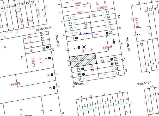
|
NOTIFICATION PLAN |
|
||
|
• PROPERTIES NOTIFIED
|
X SUBMISSIONS RECEIVED |
PROPERTY SUBJECT OF DEVELOPMENT |
|
The submissions objected to the development, generally on the following grounds:
· The removal of a tree located on the adjoining property, No. 13 Bridge Street, Brooklyn; and
· Excessive site coverage.
These issues have been discussed in the body of this report (see Section 2.9.2 – Site Coverage, and Section 2.9.5 – Landscaping).
6. THE PUBLIC INTEREST
Section 79C(1)(e) of the Act requires Council to consider “the public interest”.
The public interest is an overarching requirement, which includes the consideration of the matters discussed in this report. Implicit to the public interest is the achievement of future built outcomes adequately responding to and respecting the future desired outcomes expressed in environmental planning instruments and development control plans.
The application is considered to have satisfactorily addressed Council’s and relevant agencies’ criteria and would provide a development outcome that, on balance, would result in a positive impact for the community. Accordingly, it is considered that the approval of the proposed development would be in the public interest.
CONCLUSION
The application proposes the erection of a multi-unit housing development comprising two attached dwellings.
The application does not comply with the Hornsby Shire Council Local Environmental Plan 1994 in respect to Clause 14 ‘Density’ and Clause 15 ‘Floor Space Ratio’. The applicant has made a submission in accordance with State Environmental Planning Policy No. 1 to vary the development standards. The variations are considered well-founded with regard to the existing development and the principles established by the Land and Environment Court.
One submission was received in response to notification of the proposed development raising concerns about the scale of the development and the impact on a tree.
Having regard to the circumstances of the case and consideration of the SEPP 1 objection, approval of the application is recommended.
Note: At the time of the completion of this planning report, no persons have made a Political Donations Disclosure Statement pursuant to Section 147 of the Environmental Planning and Assessment Act 1979 in respect of the subject planning application.
RESPONSIBLE OFFICER
The officer responsible for the preparation of this Report is the Manager – Development Assessments – Rodney Pickles, who can be contacted on 9847 6731.
|
Rod Pickles Manager - Development Assessment Planning Division |
James Farrington Group Manager Planning Division |
|
1.View |
Locality Map |
|
|
|
2.View |
Architectural Plan and Floor Plan |
|
|
|
3.View |
Site Plan |
|
|
|
4.View |
Stormwater Plan |
|
|
|
5.View |
Schedule of Finishes |
|
|
|
6.View |
Landscape Plan |
|
|
|
7.View |
Shadow Plans |
|
|
File Reference: DA/913/2013
Document Number: D05468612
SCHEDULE 1
GENERAL CONDITIONS
The conditions of consent within this notice of determination have been applied to ensure that the use of the land and/or building is carried out in such a manner that is consistent with the aims and objectives of the relevant legislation, planning instruments and council policies affecting the land and does not disrupt the amenity of the neighbourhood or impact upon the environment.
Note: For the purpose of this consent, the term ‘applicant’ means any person who has the authority to act on or the benefit of the development consent.
Note: For the purpose of this consent, any reference to an Act, Regulation, Australian Standard or publication by a public authority shall be taken to mean the gazetted Act or Regulation, or adopted Australian Standard or publication as in force on the date that the application for a construction certificate is made.
1. Approved Plans and Supporting Documentation
The development must be carried out in accordance with the plans and documentation listed below and endorsed with Council’s stamp, except where amended by Council and/or other conditions of this consent:
Approved Plans
|
Plan No. |
Plan Title |
Drawn by |
Dated |
|
2257/01 |
Site Plan & Site Analysis Plan |
Rob Crump Design |
2 September 2013 |
|
2257/02 |
Floor Plans, Elevations and Section |
Rob Crump Design |
2 September 2013 |
|
157.13/391 |
Landscape Plan |
iScape |
August 2013 |
|
GO130432 Dwg No. C2 Issue 2 |
Stormwater Management Plan |
ACOR Consultants Pty Ltd. |
August 2013 |
|
---- |
Schedule of Finishes |
No name |
No date |
Supporting Plans and Documents
|
Plan or Document Title |
Prepared by |
Dated |
|
Site Survey Drawing No. 7202DU |
True North Surveys |
25/07/2013 |
|
Statement of Heritage Impact |
NBRS & PARTNERS Pty Ltd |
August 2013 |
|
Bushfire Assessment Report Reference Number: 140251 |
Building Code & Bushfire Hazard Solutions Pty Ltd. |
4 September 2013 |
|
Statement of Environmental Effects |
Glendinning Minto & Associates Pty Ltd. |
September 2013 |
|
Inspection of Cheese Tree |
Earthscape Horticultural Services |
4 March 2015 |
|
BASIX Certificate No: 501923S |
Archidoc Pty Ltd |
2 September 2013 |
|
Waste Management Plan |
No name |
No date |
2. Removal of Existing Trees
a) The application shall remove T2 as identified on the approved site plan prior to the release of the construction certificate or otherwise as negotiated with the adjacent property owner;
b) This development consent does not permit the removal of trees on the site. The removal of any other trees requires separate approval in accordance with the Tree and Vegetation Chapter 1B.6 Hornsby Development Control Plan (HDCP).
3. Construction Certificate
A Construction Certificate is required to be approved by Council or a Private Certifying Authority prior to the commencement of any works under this consent.
4. Section 94A Development Contributions
a) In accordance with Section 80A(1) of the Environmental Planning and Assessment Act 1979 and the Hornsby Shire Council Section 94A Development Contributions Plan 2012-2021, $7,300 shall be paid to Council to cater for the increased demand for community infrastructure resulting from the development, based on development costs of $730,000.
b) The value of this contribution is current as at 10 June 2015 If the contributions are not paid within the financial quarter that this condition was generated, the contributions payable will be adjusted in accordance with the provisions of the Hornsby Shire Council Section 94 Development Contributions Plan and the amount payable will be calculated at the time of payment in the following manner:
$CPY = $CDC x CPIPY
CPIDC
Where:
$CPY is the amount of the contribution at the date of Payment
$CDC is the amount of the contribution as set out in this Development Consent
CPIPY is the latest release of the Consumer Price Index (Sydney – All Groups) at the date of Payment as published by the ABS.
CPIDC is the Consumer Price Index (Sydney – All Groups) for the financial quarter at the date applicable in this Development Consent Condition.
c) The monetary contributions shall be paid to Council:
i) prior to the issue of the Subdivision Certificate where the development is for subdivision; or
ii) prior to the issue of the first Construction Certificate where the development is for building work; or
iii) prior to issue of the Subdivision Certificate or first Construction Certificate, whichever occurs first, where the development involves both subdivision and building work; or
iv) prior to the works commencing where the development does not require a Construction Certificate or Subdivision Certificate.
It is the professional responsibility of the Principal Certifying Authority to ensure that the monetary contributions have been paid to Council in accordance with the above timeframes.
Council’s S94A Development Contributions Plan may be viewed at www.hornsby.nsw.gov.au or a copy may be inspected at Council’s Administration Centre during normal business hours.
REQUIREMENTS PRIOR TO THE ISSUE OF A CONSTRUCTION CERTIFICATE
5. Building Code of Australia
All building work must be carried out in accordance with the relevant requirements of the Building Code of Australia.
6. Contract of Insurance (Residential Building Work)
In the case of residential building work for which the Home Building Act 1989 requires there to be a contract of insurance in force in accordance with Part 6 of that Act, that such a contract of insurance is in force before any building work authorised to be carried out by the consent commences.
7. Notification of Home Building Act 1989 Requirements
Residential building work within the meaning of the Home Building Act 1989 must not be carried out unless the principal certifying authority for the development to which the work relates (not being Council) has given Council written notice of the following information:
a) In the case of work for which a principal contractor is required to be appointed:
i) The name and licence number of the principal contractor; and
ii) The name of the insurer by which the work is insured under Part 6 of that Act.
b) In the case of work to be done by an owner-builder:
i) The name of the owner-builder; and
ii) If the owner-builder is required to hold an owner-builder’s permit under that Act, the number of the owner-builder’s permit.
Note: If arrangements for doing the residential building work are changed while the work is in progress so that the information notified becomes out of date, further work must not be carried out unless the principal certifying authority for the development to which the work relates (not being Council) has given Council written notification of the updated information.
8. Sydney Water – Quick Check
This application must be submitted to a Sydney Water ‘Quick Check Agent’ or ‘Customer Centre’ for approval to determine whether the development would affect any Sydney Water infrastructure, and whether further requirements are to be met.
Note: Refer to www.sydneywater.com.au or telephone 13 20 92 for assistance.
9. Design and Construction - Bushfire Attack Category
New construction must comply with the current Australian Standard AS3959 ‘Construction of buildings in bush fire-prone areas’ section 5 (BAL 12.5) and section A3.7 Addendum Appendix 3 of Planning for Bushfire Protection.
REQUIREMENTS PRIOR TO THE COMMENCEMENT OF ANY WORKS
10. Erection of Construction Sign
A sign must be erected in a prominent position on any site on which building work, subdivision work or demolition work is being carried out:
a) Showing the name, address and telephone number of the principal certifying authority for the work;
b) Showing the name of the principal contractor (if any) for any demolition or building work and a telephone number on which that person may be contacted outside working hours; and
c) Stating that unauthorised entry to the work site is prohibited.
Note: Any such sign is to be maintained while the building work, subdivision work or demolition work is being carried out, but must be removed when the work has been completed.
11. Toilet Facilities
Toilet facilities must be available or provided at the works site before works begin and must be maintained until the works are completed at a ratio of one toilet for every 20 persons employed at the site. Each toilet must:
a) be a standard flushing toilet connected to a public sewer; or
b) be a temporary chemical closet approved under the Local Government Act 1993; or
c) have an on-site effluent disposal system approved under the Local Government Act 1993.
12. Erosion and Sediment Control
Erosion and sediment control measures must be provided and maintained throughout the construction period in accordance with the manual ‘Soils and Construction 2004 (Bluebook)’, the approved plans, Council specifications and to the satisfaction of the principal certifying authority. The erosion and sediment control devices must remain in place until the site has been stabilised and revegetated.
Note: On the spot penalties up to $1,500 may be issued for any non-compliance with this requirement without any further notification or warning.
REQUIREMENTS DURING CONSTRUCTION
13. Construction Work Hours
All work on site (including demolition and earth works) must only occur between 7am and 5pm Monday to Saturday. No work is to be undertaken on Sundays or public holidays.
14. Demolition
All demolition work must be carried out in accordance with “Australian Standard 2601-2001 – The Demolition of Structures” and the following requirements:
a) Demolition material must be disposed of to an authorised recycling and/or waste disposal site and/or in accordance with an approved waste management plan;
b) Demolition works, where asbestos material is being removed, must be undertaken by a contractor that holds an appropriate licence issued by WorkCover NSW in accordance with Chapter 10 of the Occupational Health and Safety Regulation 2001 and Clause 29 of the Protection of the Environment Operations (Waste) Regulation 2005; and
c) On construction sites where buildings contain asbestos material, a standard commercially manufactured sign containing the words ‘DANGER ASBESTOS REMOVAL IN PROGRESS’ measuring not less than 400mm x 300mm must be erected in a prominent position visible from the street.
15. Council Property
During construction works, no building materials, waste, machinery or related matter is to be stored on the road or footpath. The public reserve must be kept in a clean, tidy and safe condition at all times.
Note: This consent does not give right of access to the site via Council’s park or reserve. Should such access be required, separate written approval is to be obtained from Council.
16. Disturbance of Existing Site
During construction works, the existing ground levels of open space areas and natural landscape features, (including natural rock-outcrops, vegetation, soil and watercourses) must not be altered unless otherwise nominated on the approved plans.
17. Survey Report – Finished Floor Level
A report(s) must be prepared by a registered surveyor and submitted to the principal certifying authority prior to the pouring of concrete at each level of the building certifying that:
a) The building, retaining walls and the like have been correctly positioned on the site; and
b) The finished floor level(s) are in accordance with the approved plans.
REQUIREMENTS PRIOR TO THE ISSUE OF AN OCCUPATION CERTIFICATE
Note: For the purpose of this consent, a reference to ‘occupation certificate’ shall not be taken to mean an ‘interim occupation certificate’ unless otherwise stated.
18. Fulfilment of BASIX Commitments
The applicant must demonstrate the fulfilment of BASIX commitments pertaining to the development.
19. Stormwater Drainage
The stormwater drainage system for the development must be designed and constructed for an average recurrence interval of 20 years, be gravity drained and connected directly to Council’s street drainage system.
20. Vehicular Crossing
A separate application under the Local Government Act, 1993 and the Roads Act, 1993 must be submitted to Council for the installation of a new vehicular crossing and the removal of the redundant crossing. The vehicular crossing must be constructed in accordance with Council’s Civil Works Design, 2005 and the following requirements:
a) Any redundant crossings must be replaced with integral kerb and gutter;
b) Approval must be obtained from all relevant utility providers that all necessary conduits be provided and protected under the crossing.
Note: An application for a vehicular crossing can only be made to one of Council’s Authorised Vehicular Crossing Contractors. You are advised to contact Council on 02 9847 6940 to obtain a list of contractors.
21. Internal Driveway/Vehicular Areas
The driveway and parking areas on site must be designed in accordance with Australian Standards 2890.1, 3727 and the following requirements:
a) Design levels at the front boundary must be obtained from Council;
b) The driveway must be bitumen sealed or concreted; and
c) The driveway grade must not exceed 25 percent and changes in grade must not exceed 8 per cent.
22. Replacement Planting
a) To offset the removal of the Glochidion ferdinandii (Cheese Tree) located on the adjoining property, No. 13 Bridge Street, Brooklyn, and two Glochidion ferdinandii (Cheese Tree) must be replanted at No. 13 Bridge Street at the applicant’s cost.
b) The planning location must not be within 4 metres of the foundation walls of a dwelling or in-ground pool; and
c) The pot size is to be a minimum 25 litres and the tree(s) must be maintained until they reach the height of 3 metres.
- END OF CONDITIONS -
ADVISORY NOTES
The following information is provided for your assistance to ensure compliance with the Environmental Planning and Assessment Act, 1979, Environmental Planning and Assessment Regulation 2000, other relevant legislation and Council’s policies and specifications. This information does not form part of the conditions of development consent pursuant to Section 80a of the Act.
Environmental Planning and Assessment Act 1979 Requirements
The Environmental Planning and Assessment Act 1979 requires:
· The issue of a construction certificate prior to the commencement of any works. Enquiries can be made to Council’s Customer Services Branch on 9847 6760;
· a principal certifying authority to be nominated and Council notified of that appointment prior to the commencement of any works;
· Council to be given at least two days written notice prior to the commencement of any works;
· mandatory inspections of nominated stages of the construction inspected; and
· an occupation certificate to be issued before occupying any building or commencing the use of the land.
Long Service Levy
In accordance with Section 34 of the Building and Construction Industry Long Service Payments Act 1986, a ‘Long Service Levy’ must be paid to the Long Service Payments Corporation or Hornsby Council.
Note: The rate of the Long Service Levy is 0.35% of the total cost of the work.
Note: Hornsby Council requires the payment of the Long Service Levy prior to the issue of a construction certificate.
Tree and Vegetation Preservation
In accordance with Clause 5.9 of the Hornsby Local Environmental Plan 2013 a person must not ringbark, cut down, top, lop, remove, injure or wilfully destroy any tree or other vegetation protected under the Hornsby Development Control Plan 2013 without the authority conferred by a development consent or a permit granted by Council.
Notes: A tree is defined as a long lived, woody perennial plant with one or relatively few main stems with the potential to grow to a height greater than three metres (3M). (HDCP 1B.6.1.c).
Tree protection measures and distances are determined using the Australian Standard AS 4970:2009, “Protection of Trees on Development Sites”.
Fines may be imposed for non-compliance with both the Hornsby Local Environmental Plan 2013 and the Hornsby Development Control Plan 2013.
Dial Before You Dig
Prior to commencing any works, the applicant is encouraged to contact Dial Before You Dig on 1100 or www.dialbeforeyoudig.com.au for free information on potential underground pipes and cables within the vicinity of the development site.
Asbestos Warning
Should asbestos or asbestos products be encountered during demolition or construction works, you are advised to seek advice and information prior to disturbing this material. It is recommended that a contractor holding an asbestos-handling permit (issued by WorkCover NSW) be engaged to manage the proper handling of this material. Further information regarding the safe handling and removal of asbestos can be found at:
Alternatively, telephone the WorkCover Asbestos and Demolition Team on 8260 5885.
Group Manager’s Report No. PL44/15
Planning Division
Date of Meeting: 10/06/2015
16 DEVELOPMENT APPLICATION - SUBDIVISION OF ONE ALLOTMENT INTO TWO LOTS - 60 HINEMOA AVENUE, NORMANHURST
EXECUTIVE SUMMARY
|
DA No: |
DA/69/2014 (Lodged 3 February 2014) |
|
Description: |
Demolition of existing carport and Torrens title subdivision of one allotment into two lots |
|
Property: |
Lot B DP 388023, No. 60 Hinemoa Avenue, Normanhurst |
|
Applicant: |
Ms Justine Medin |
|
Owner: |
Ms Justine Medin |
|
Estimated Value: |
$5,000 |
|
Ward: |
B |
· The application involves demolition of the existing carport and Torrens title subdivision of one allotment into two lots.
· The proposal does not comply with the minimum lot size development standard under Clause 4.1 of the Hornsby Local Environmental Plan 2013. The applicant has made a submission in accordance with Clause 4.6 ‘Exceptions to development standards’ of the Hornsby Local Environmental Plan 2013 to vary the minimum lot size development standard. The submission is considered well founded and is supported.
· Three submissions have been received in respect of the application.
· It is recommended that the application be approved.
|
THAT Council assume the concurrence of the Secretary of the Department of Planning and Environment pursuant to Clause 4.6 of the Hornsby Local Environmental Plan 2013 and approve Development Application No. DA/69/2014 for demolition of the existing carport and Torrens title subdivision of one allotment into two lots at Lot B DP 388023, No. 60 Hinemoa Avenue, Normanhurst subject to the conditions of consent detailed in Schedule 1 of Group Manager’s Report No. PL44/15. |
BACKGROUND
On 23 November 2010, Council refused DA/1080/2010 for demolition of a carport and Torrens title subdivision of one allotment into two lots at the subject property, generally on grounds of environmental impacts of the proposed development on significant group of trees, insufficient information provided regarding drainage, and the applicant had not obtained the approval of the NSW Office of Water for the proposed development within 40m of a watercourse, pursuant to the Water Management Act 2000 and Section 91A of the Environmental Planning and Assessment Act 1979.
On 3 July 2012, Council refused DA/1392/2011 for demolition of a carport and Torrens title subdivision of one allotment into two lots at the subject property, generally on the same grounds as DA/1080/2010.
On 3 February 2014, the current application DA/69/2014 was lodged with Council. On 17 April 2014, Council requested additional information with regards to lot size and accessway width non-compliances and proposed stormwater disposal.
On 11 June 2014, the applicant requested additional time to provide the information and negotiate with the adjoining neighbouring for vehicular access on their land.
On 5 January 2015, the applicant submitted the requested information, with the exception of a cheque for referral to the NSW Office of Water (OW). The cheque was submitted 30 March 2015 and referred to OW for comment.
The current application has addressed the issues raised in the previous applications with respect to insufficient information submitted and the impacts of the proposed development on a significant group of trees.
SITE
The site is a rectangular shaped lot with an area of 1394m2 located on the western side of Hinemoa Avenue. The site has an average fall of 15% to the rear boundary. A watercourse through adjoining land to the rear flows north-south and forms a tributary of the Lane Cove River.
An existing weatherboard and tile dwelling is sited on the land. The site includes several large remnant trees of which eight have been identified as significant trees. The trees form part of a corridor of Blackbutt Gully Forest along the watercourse which links with Lane Cove National Park.
The surrounding area is characterised by low density residential development, mainly post war with more recent battle-axe subdivisions.
The site is 500m south of Pennant Hills Road and 850m south east of Normanhurst shops and Railway station. Loreto Catholic College is 400m west of the site.
PROPOSAL
The application proposes demolition of the existing 2 carports and subdivision of one allotment into two lots as follows:
· Proposed Lot 1 has an area of 433.9m2 (excluding the ROW), and has a road frontage of 18.05m, a southern boundary of 27.7m and a rear boundary of 18.05m. The lot would have an average fall of 15% to the rear boundary. It is proposed to retain the existing dwelling on this lot.
· Proposed Lot 2 has an area of 835.7m2 (excluding the ROW) with a front boundary of 19.05m, a southern boundary of 45.45m and a rear boundary of 19.05m. The lot has an average fall of 13% to the rear boundary. The lot includes a number of trees identified as a significant group of trees.
ASSESSMENT
The development application has been assessed having regard to the ‘A Plan for Growing Sydney’, the ‘North Subregion (Draft) Subregional Strategy’ and the matters for consideration prescribed under Section 79C of the Environmental Planning and Assessment Act 1979 (the Act). The following issues have been identified for further consideration.
1. STRATEGIC CONTEXT
1.1 A Plan for Growing Sydney and (Draft) North Subregional Strategy
A Plan for Growing Sydney has been prepared by the NSW State Government to guide land use planning decisions for the next 20 years. The Plan sets a strategy for accommodating Sydney’s future population growth and identifies the need to deliver 689,000 new jobs and 664,000 new homes by 2031. The Plan identifies that the most suitable areas for new housing are in locations close to jobs, public transport, community facilities and services.
The NSW Government will use the subregional planning process to define objectives and set goals for job creation, housing supply and choice in each subregion. Hornsby Shire has been grouped with Hunters Hill, Ku-ring-gai, Lane Cove, Manly, Mosman, North Sydney, Pittwater, Ryde, Warringah and Willoughby to form the North Subregion. The Draft North Subregional Strategy will be reviewed and the Government will set housing targets and monitor supply to ensure planning controls are in place to stimulate housing development.
The proposed development would be consistent with ‘A Plan for Growing Sydney’, by providing an additional allotment capable of accommodating a dwelling house.
2. STATUTORY CONTROLS
Section 79C(1)(a) requires Council to consider “any relevant environmental planning instruments, draft environmental planning instruments, development control plans, planning agreements and regulations”.
2.1 Hornsby Local Environmental Plan 2013
The proposed development has been assessed having regard to the provisions of the Hornsby Local Environmental Plan 2013 (HLEP).
2.1.1 Zoning of Land and Permissibility
The subject land is zoned R2 Low Density Residential under the HLEP. The objectives of the R2 zone are:
(a) To provide for the housing needs of the community within a low density residential environment.
(b) To enable other land uses that provide facilities or services to meet the day to day needs of residents.
The proposed development is defined as ‘subdivision’ and is permissible in the zone with Council’s consent.
2.1.2 Minimum Subdivision Lot Size
Clause 4.1 of the HLEP prescribes that the minimum area per allotment within the R2 Low Density Residential zone is 500m2. Proposed Lot 1 does not comply with the minimum lot area requirement. In this regard, the application is supported by a submission pursuant to Clause 4.6 of the HLEP to vary the minimum allotment size development standard. This matter is addressed below in Section 2.1.4 of this report.
2.1.3 Height of Buildings
Clause 4.3 of the HLEP provides that the height of a building on any land should not exceed the maximum height shown for the land on the Height of Buildings Map. The maximum permissible height for the subject site is 8.5 metres. The proposal includes the retention of the existing dwelling and complies with this provision.
2.1.4 Exceptions to Development Standards
The application has been assessed against the requirements of Clause 4.6 of the HLEP. This clause provides flexibility in the application of the development standards in circumstances where strict compliance with those standards would, in any particular case, be unreasonable or unnecessary or tender to hinder the attainment of the objectives of the zone.
The proposal does not comply with the minimum 500m2 lot size development standard under Clause 4.1 of the HLEP, for proposed Lot 1 with a lot size of 433.9m2.
The objectives of Clause 4.1 of the HLEP are:
(a) To provide for the subdivision of land at a density that is appropriate for the site constraints, development potential and infrastructure capacity of the land,
(b) To ensure that lots are of a sufficient size to accommodate development.
The applicant has made a submission in support of a variation to the development standard in accordance with Clause 4.6 of the HLEP. The development application seeks to vary the development standard for proposed Lot 1 by 13.2%. The applicant states the proposed variation is considered to be consistent with the objectives of the control and is justified as follows:
· The proposed subdivision at the subject site is considered appropriate and reasonable in the context of the locality and the possible future residential development which is permissible on the subject property.
· If the minimum lot size was enforced it would force the development to severely impact on the trees on the subject site.
· The smaller lot size will allow the trees to be retained on the correspondingly larger rear property.
· The development and subdivision will create new lots compatible with the character of the surrounding land and does not compromise existing development or amenity.
State Government Guidelines on varying development standards recommend considering the provisions of Clause 4.6 of the LEP and the ‘five part test’ established by the Land and Environment Court as follows:
1. the objectives of the standard are achieved notwithstanding noncompliance with the standard;
2. the underlying objective or purpose of the standard is not relevant to the development and therefore compliance is unnecessary;
3. the underlying object of purpose would be defeated or thwarted if compliance was required and therefore compliance is unreasonable;
4. the development standard has been virtually abandoned or destroyed by the council’s own actions in granting consents departing from the standard and hence compliance with the standard is unnecessary and unreasonable;
5. the compliance with development standard is unreasonable or inappropriate due to existing use of land and current environmental character of the particular parcel of land. That is, the particular parcel of land should not have been included in the zone.
The applicant’s submission to vary the 500m2 minimum lot size development standard is considered well founded for the following reasons:
· Although one allotment would be undersized, the overall density of development on the subject land would be 1 dwelling per 634m2 (excluding the ROW);
· The subdivision results in a development within the environmental capacity of the land and would not result in any major non-compliance with the prescriptive controls within the HDCP;
· The proposal would not have a negative impact upon the residential environment of the locality and the proposal is not inconsistent with the objectives contained within section 5(a) (i) and (ii) of the Environmental Planning and Assessment Act 1979 as it facilitates orderly and economic development of land;
· The proposed subdivision is considered to be compatible with the existing surrounding subdivision pattern which contains lots of similar or smaller size; and
· The proposal would not result in a precedent given the unique circumstances of the case involving a design that aims to maximise opportunity for the retention of significant trees on the site.
Based on this assessment, it is considered that compliance with the development standard would be unreasonable and unnecessary in the circumstances of the case. Accordingly, the Clause 4.6 submission is supported.
2.1.5 Heritage Conservation
Clause 5.10 of the HLEP sets out heritage conservation provisions for Hornsby Shire. The site does not include a heritage item and is not located in a heritage conservation area. Accordingly, no further assessment regarding heritage is necessary.
2.2 State Environmental Planning Policy No. 55 - Remediation of Land
Clause 7 of State Environmental Planning Policy No. 55 - Remediation of Land (SEPP 55) requires Council to consider whether land is contaminated prior to granting consent to the carrying out of any development on that land.
Should the land be contaminated, Council must be satisfied that the land is suitable in a contaminated state for the proposed use. If the land requires remediation to be undertaken to make the land suitable for the proposed use, Council must be satisfied that the land will be remediated before the land is used for that purpose.
Given the historical use of the site for residential purposes, it is not likely that the site has experienced any significant contamination, and further reporting is not considered warranted.
2.3 Sydney Regional Environmental Plan (Sydney Harbour Catchment) 2005
The application has been assessed against the requirements of Sydney Regional Environmental Plan (Sydney Harbour Catchment) 2005. This Policy provides general planning considerations and strategies to ensure that the catchment, foreshores, waterways and islands of Sydney Harbour are recognised, protected, enhanced and maintained.
Subject to the implementation of installation of sediment and erosion control measures and stormwater management to protect water quality, the proposal would have minimal potential to impact on the Sydney Harbour Catchment.
2.4 Clause 74BA Environmental Planning and Assessment Act, 1979 - Purpose and Status of Development Control Plans
Clause 74BA of the Environmental Planning and Assessment Act, 1979 states that a DCP provision will have no effect if it prevents or unreasonably restricts development that is otherwise permitted and complies with the development standards in relevant Local Environmental Plans and State Environmental Planning Policies.
The principal purpose of a development control plan is to provide guidance on the aims of any environmental planning instrument that applies to the development; facilitate development that is permissible under any such instrument; and achieve the objectives of land zones. The provisions contained in a DCP are not statutory requirements and are for guidance purposes only. Consent authorities have flexibility to consider innovative solutions when assessing development proposals, to assist achieve good planning outcomes.
2.5 Hornsby Development Control Plan 2013
The proposed development has been assessed having regard to the relevant desired outcomes and prescriptive requirements within the Hornsby Development Control Plan 2013 (HDCP). The following table sets out the proposal’s compliance with the prescriptive requirements of the Plan:
|
Hornsby Development Control Plan 2013 |
|||
|
Control |
Proposal |
Requirement |
Complies |
|
Part 6 Subdivision |
|||
|
Lot Size |
|
|
|
|
- Lot 1 |
433.9m2 (ex. ROW) |
min. 500m2 |
No |
|
- Lot 2 |
835.7m2(ex. ROW) |
min. 500m2 |
Yes |
|
Minimum Lot Width |
|
|
|
|
- Lot 1 |
15m |
12m |
Yes |
|
- Lot 2 |
15m |
12m |
Yes |
|
Accessway Width |
3m |
3.5m |
No |
|
Building Envelope |
|
|
|
|
- Lot 1 |
Existing dwelling retained |
N/A |
N/A |
|
- Lot 2 |
182m2 |
200m2 |
No |
|
Setbacks Lot 2 - Building Envelope |
|
|
|
|
- Front |
10m |
6m |
Yes |
|
- Side (north) |
9.5m |
900m |
Yes |
|
- Side (south) |
1m |
900mm |
Yes |
|
- Rear |
12m |
3m |
Yes |
|
Part 3.1 Dwelling Houses (Existing Dwelling on Proposed Lot 1) |
|||
|
Floor Area |
115m2 |
270m2 |
Yes |
|
Building Height |
<8.5m |
8.5m |
Yes |
|
Number of storeys |
Single storey |
2 storey + attic |
Yes |
|
Site Coverage |
26.5% |
max. 55% |
Yes |
|
Setbacks Lot 1 - existing dwelling |
|
|
|
|
- Front |
7m |
6m |
Yes |
|
- Side (north) |
3m |
900mm |
Yes |
|
- Side (south) |
2.5m |
900mm |
Yes |
|
- Rear |
10m |
3m |
Yes |
|
Landscaped Area (% of lot size) |
>100m2 |
65m2 |
Yes |
|
Private Open Space |
|
|
|
|
- minimum area |
>100m2 |
24m2 |
Yes |
|
- minimum dimension |
8m |
3m |
Yes |
|
Car Parking |
2 spaces |
2 spaces |
Yes |
As detailed in the above table, the proposed development does not comply with a number of prescriptive requirements within the HDCP. The matters of non-compliance are detailed below, as well as a brief discussion on compliance with relevant desired outcomes and Part 1C General Controls.
2.5.1 Minimum Lot Size
The proposed development will result in Lot 1 being undersized. This matter has been addressed in Sections 2.1.2 and 2.1.4 of the report. In addition the proposed development is consistent with surrounding subdivisions at Nos. 48, 50 and 54 which include undersized lots with a minimum area excluding ROW varying from 475.9m2 - 485.84m2.
Notwithstanding, submissions raised concerns that the area of Lot 1 should be greater than the minimum 500m2 due to the topography of the site. However, given the proposed allotment would provide for an existing dwelling where private open space and landscaped areas are already established, the proposed allotment size is considered acceptable in this instance, as it satisfies the relevant element objectives of the HDCP.
2.5.2 Building Envelope
The application includes an indicative building design with a floor area of 182m2 on proposed Lot 2 which would be capable of accommodating a fully compliant future dwelling house in respect to setbacks, floor area, height, private open space, landscaping and parking whilst retaining the significant trees on the site. The layout and location of the dwelling have been designed to retain the significant trees on the site.
2.5.3 Accessway Design
The prescriptive measures of Part 6.4.1(e) Accessway Design of the HDCP for lots serving 1-3 dwellings states that ‘the dimensions of an accessway width should be 3.5 metres’.
The proposed accessway between the existing dwelling-house and the boundary fence would be 3m wide. The accessway does not comply with the 3.5m minimum standards within the HDCP for driveways serving rear allotments.
The applicant sought consent from the adjoining owner of No. 58 Hinemoa Avenue to use part of their land to provide a compliant access handle, which was rejected. Therefore, compliance with the minimum width standard would require the substantial removal of part of the existing dwelling-house. Approval of a 3m wide accessway would only require the removal of the eaves of the dwelling to ensure a 4.5m height clearance is obtained.
Given that the width of a commercial vehicle under Australian Standards 2890.2 is 2.5m, the accessway at this point would provide a clearance of 250mm on each side of the vehicle. In circumstances such as these, the non-compliance for a portion of the access-way would have minimal environmental or amenity impacts. It is considered that the minor non-compliance does not warrant refusal of the application.
The proposal meets the desired outcomes of Part 6.4.1 Accessway Design and is considered acceptable.
2.5.4 Parking
The HDCP requires the provision of 2 car parking spaces for dwellings with 3 or more bedrooms. Council’s engineering assessment concludes that there is sufficient area for 2 tandem spaces for each of the proposed lots clear of the turning area and right of carriageway and that a vehicle from the proposed lots will be able to enter and exit in a forward direction.
2.5.5 Open Space and Landscaping
Submissions raised concerns that there would be insufficient area for private open space for the existing dwelling on proposed Lot 1. The rear of Lot 1 provides in excess of the required 24m2 of private open space and in conjunction with the existing rear deck would service the needs of the residents.
2.6 Section 94 Contributions Plans
Hornsby Shire Council Section 94 Contributions Plan 2012-2021 applies to the development as it would result in 1 additional lot. Accordingly, the requirement for a monetary Section 94 contribution is recommended as a condition of consent.
3. ENVIRONMENTAL IMPACTS
Section 79C(1)(b) of the Act requires Council to consider “the likely impacts of that development, including environmental impacts on both the natural and built environments, and social and economic impacts in the locality”.
3.1 Natural Environment
3.1.1 Tree and Vegetation Preservation
There are a number of remnant locally indigenous specimens on the subject and adjoining properties considered significant according to Council’s standard assessment procedures for trees on development sites.
The trees on the site and adjoining property have been identified as Blackbutt Gully Forest (Smith and Smith 2008), which is considered a locally significant vegetation community within Hornsby Shire.
The proposed development would necessitate the removal of 4 trees from the site (T1, T3, T10 and T11) and T2 may be adversely affected by the proposed development.
Council’s assessment of the proposal included a detailed examination of the existing trees on site which noted that the proposed development within the Tree Protection Zone (TPZ) of T2, will incur a total encroachment of 27.5% which is considered a major encroachment under Australian Standard (AS-4970, 2009). A major encroachment within the TPZ of trees is considered acceptable under Australian Standard AS 4970-2009, “Protection of trees on development sites” subject to tree sensitive construction measures, including investigative excavation for pier and beam, cantilevered building sections, construction at existing grade, tunnel boring, excavation by hand and compaction control. Construction of the driveway access handle and any future dwelling on Lot 2 can be achieved by using these tree sensitive construction measures within the TPZ of T2 to be retained.
As only 1 of the trees to be removed is indigenous to the area, it is considered that the removal of the trees for construction of the access handle and the future dwelling is acceptable subject to the recommended conditions with respect to tree protection, sensitive construction techniques and replacement tree planting. As a result of these measures, retention of T2 and other significant trees on the site can be achieved.
3.1.2 Stormwater Management
The application includes the provision of a stormwater drainage easement connected to the watercourse on the adjoining lot to the rear of the site. Subject to compliance with the recommended conditions, the proposed development is satisfactory with respect to stormwater management.
3.2 Built Environment
The proposal is consistent with the pattern of residential subdivision occurring in the locality involving battle-axe lots.
3.3 Social Impacts
The residential development would provide an additional allotment for a dwelling house in a location that is in close proximity to Normanhurst Railway Station and local shops and education facilities for future residents.
3.4 Economic Impacts
The proposal would have a minor positive impact on the local economy in conjunction with other new low density residential development in the locality by generating a minor increase in demand for local services.
4. SITE SUITABILITY
Section 79C(1)(c) of the Act requires Council to consider “the suitability of the site for the development”.
The subject site has not been identified as bushfire prone or flood prone land. The site is considered to be capable of accommodating the proposed development. The scale of the proposed development is consistent with the capability of the site and is considered acceptable.
5. PUBLIC PARTICIPATION
Section 79C(1)(d) of the Act requires Council to consider “any submissions made in accordance with this Act”.
5.1 Community Consultation
The proposed development was placed on public exhibition and was notified to adjoining and nearby landowners between 24 February 2014 and 13 March 2014 in accordance with the Notification and Exhibition requirements of the HDCP. During this period, Council received 3 submissions. The map below illustrates the location of those nearby landowners who made a submission that are in close proximity to the development site.
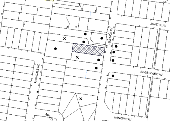
|
NOTIFICATION PLAN |
|
||
|
• PROPERTIES NOTIFIED |
X SUBMISSIONS RECEIVED |
PROPERTY SUBJECT OF DEVELOPMENT |
|
Three submissions object to the development, generally on the basis of concerns regarding the following:
· Lot size and provision of private open space to proposed Lot 1;
· Construction of car parking for the existing dwelling;
· Shared accessway;
· Drainage and stormwater control;
· Impact of development on significant trees on the site and potential for further tree removal in the future.
The merits of the matters raised in community submissions have been addressed in the body of the report.
5.2 Public Agencies
The development application was referred to the following Agency for comment:
5.2.1 Office of Water
The proposed subdivision is within 40m of a watercourse identified on the 1:25,000 CMA topographical map and is subject to ‘integrated development’ approval of the NSW Office of Water for the issue of a ‘controlled activity permit’.
The NSW Office of Water provided General Terms of Approval for the proposed development which are included in Schedule 1.
6. THE PUBLIC INTEREST
Section 79C(1)(e) of the Act requires Council to consider “the public interest”.
The public interest is an overarching requirement, which includes the consideration of the matters discussed in this report. Implicit to the public interest is the achievement of future built outcomes adequately responding to and respecting the future desired outcomes expressed in environmental planning instruments and development control plans.
The application is considered to have satisfactorily addressed Council’s and relevant agencies’ criteria and would provide a development outcome that, on balance, would result in a positive impact for the community. Accordingly, it is considered that the approval of the proposed development would be in the public interest.
CONCLUSION
The application proposes the subdivision of one allotment into two lots and retention of the existing dwelling house on proposed Lot 1.
The application does not comply with the Hornsby Shire Council Local Environmental Plan 2013 in respect to Clause 4.1 ‘Minimum Subdivision Lot Size’. The applicant has submitted a Clause 4.6 ‘Exception to Development Standard’ to vary the development standard. The objection is considered well-founded with regard to the existing development and the principles established by the Land and Environment Court on the basis that the subdivision would maximise tree retention on the site.
Council received 3 submissions during the public notification period. The matters raised have been addressed in the body of the report and conditions are recommended to minimise disruption to residential amenity.
Having regard to the circumstances of the case, approval of the application is recommended.
Note: At the time of the completion of this planning report, no persons have made a Political Donations Disclosure Statement pursuant to Section 147 of the Environmental Planning and Assessment Act 1979 in respect of the subject planning application.
RESPONSIBLE OFFICER
The officer responsible for the preparation of this Report is the Manager – Development Assessments – Rodney Pickles, who can be contacted on 9847 6731.
|
Rod Pickles Manager - Development Assessment Planning Division |
James Farrington Group Manager Planning Division |
|
1.View |
Locality Plan |
|
|
|
2.View |
Stormwater Plans - Additional Info |
|
|
|
3.View |
Tree Location Plan |
|
|
File Reference: DA/69/2014
Document Number: D05548133
SCHEDULE 1
GENERAL CONDITIONS
The conditions of consent within this notice of determination have been applied to ensure that the use of the land and/or building is carried out in such a manner that is consistent with the aims and objectives of the relevant legislation, planning instruments and council policies affecting the land and does not disrupt the amenity of the neighbourhood or impact upon the environment.
Note: For the purpose of this consent, the term ‘applicant’ means any person who has the authority to act on or the benefit of the development consent.
Note: For the purpose of this consent, any reference to an Act, Regulation, Australian Standard or publication by a public authority shall be taken to mean the gazetted Act or Regulation, or adopted Australian Standard or publication as in force on the date that the application for a construction certificate is made.
1. Approved Plans and Supporting Documentation
The development must be carried out in accordance with the plans and documentation listed below and endorsed with Council’s stamp, except where amended by Council and/or other conditions of this consent:
|
Plan No. |
Plan Title |
Drawn by |
Dated |
|
1538-C DW01 Issue A |
Proposed Lot Subdivision |
HKMA |
19 March 2013 |
|
1538-C DW02 Issue A |
Proposed Lot Subdivision Drainage Long Section |
HKMA |
19 March 2013 |
|
Document Title |
Prepared by |
Dated |
|
General Terms of Approval |
NSW Office of Water |
6 May 2015 |
|
Tree Report |
Stuart Pittendrigh |
November 2013 |
|
Site Tree Location Plan |
HSC |
28 March 2014 |
2. Removal of Existing Trees
This development consent permits the removal of trees numbered 1, 3, 10 and 11 as identified on the Site Tree Location Plan prepared by HSC, dated 28 March 2014. The removal of any other trees requires separate approval in accordance with the Tree and Vegetation Chapter 1B.6 Hornsby Development Control Plan (HDCP).
3. Project Arborist
A Project Arborist is to be appointed in accordance with AS4970-2009 (1.4.4) to provide monitoring and certification throughout the development process. The project arborist must assess the condition of tree/s and the growing environment and make recommendations for, and if necessary carry out remedial action to ensure the health and vigour of the tree(s).
4. Construction Certificate
A Construction Certificate is required to be approved by Council or a Private Certifying Authority prior to the commencement of any works under this consent.
5. Section 94 Development Contributions
a) In accordance with Section 80A(1) of the Environmental Planning and Assessment Act 1979 and the Hornsby Shire Council Section 94 Development Contributions Plan 2012-2021, the following monetary contributions shall be paid to Council to cater for the increased demand for community infrastructure resulting from the development:
|
Description |
Contribution (4) |
|
Roads |
$1,140 |
|
Open Space and Recreation |
$16,480 |
|
Community Facilities |
$2,300 |
|
Plan Preparation and Administration |
$80 |
|
TOTAL |
$20,000 |
being for one additional lot.
b) The value of this contribution is current as at 14 May 2015. If the contributions are not paid within the financial quarter that this condition was generated, the contributions payable will be adjusted in accordance with the provisions of the Hornsby Shire Council Section 94 Development Contributions Plan and the amount payable will be calculated at the time of payment in the following manner:
$CPY = $CDC x CPIPY
CPIDC
Where:
$CPY is the amount of the contribution at the date of Payment
$CDC is the amount of the contribution as set out in this Development Consent
CPIPY is the latest release of the Consumer Price Index (Sydney – All Groups) at the date of Payment as published by the ABS.
CPIDC is the Consumer Price Index (Sydney – All Groups) for the financial quarter at the date applicable in this Development Consent Condition.
c) The monetary contributions shall be paid to Council:
i) prior to the issue of the Subdivision Certificate where the development is for subdivision; or
ii) prior to the issue of the first Construction Certificate where the development is for building work; or
iii) prior to issue of the Subdivision Certificate or first Construction Certificate, whichever occurs first, where the development involves both subdivision and building work; or
iv) prior to the works commencing where the development does not require a Construction Certificate or Subdivision Certificate.
It is the professional responsibility of the Principal Certifying Authority to ensure that the monetary contributions have been paid to Council in accordance with the above timeframes.
Council’s Development Contributions Plan may be viewed at www.hornsby.nsw.gov.au or a copy may be inspected at Council’s Administration Centre during normal business hours.
REQUIREMENTS PRIOR TO THE ISSUE OF A CONSTRUCTION CERTIFICATE
6. Controlled Activity Approval
The Construction Certificate must not be issued over any part of the site requiring a controlled activity approval until a copy of the approval has been provided to Council.
7. Building Code of Australia
All building work must be carried out in accordance with the relevant requirements of the Building Code of Australia.
8. Utility Services
The applicant must submit written evidence of the following service provider requirements:
a) Ausgrid (formerly Energy Australia) – a letter of consent demonstrating that satisfactory arrangements have been made to service the proposed development.
b) Telstra - a letter of consent demonstrating that satisfactory arrangements have been made to service the proposed development.
9. Easement Over Downstream Land
The proposed drainage easement over the downstream property at Lot C DP 388023, No. 17 Ferndale Road must be registered with the NSW Department of Lands. A copy of the Registered Transfer Form and Easement Plan shall be submitted to the Principal Certifying Authority for information and confirmation.
10. Stormwater Drainage
The stormwater drainage system for the development must be designed and constructed in accordance with Council’s Civil Works – Design and Construction Specification 2005 and the following requirements:
a) Connected to the natural watercourse on Lot C DP 388023, No. 17 Ferndale Road via a headwall and piped drainage easement.
b) The proposed driveway and parking areas shall have drainage kerb inlet pits designed and constructed and connected to the drainage system.
c) An inter-allotment stormwater drainage system to service the proposed subdivision with pits being cast in situ or pre-cast concrete pits being used.
d) The roof and stormwater drainage system from the existing dwelling to be connected to the proposed inter-allotment drainage system.
11. Internal Driveway/Vehicular Areas
The driveway and parking areas on site must be designed in accordance with Australian Standards 2890.1, 3727 and the following requirements:
a) Design levels at the front boundary must be obtained from Council;
b) The driveway must be a rigid pavement;
c) A longitudinal section design of the driveway prepared by the civil or hydraulic engineer must be prepared. The driveway grade must not exceed 25 percent and transitions for changes in grade must not exceed 8 percent per plan metre.
d) The driveway pavement must be a minimum 3 metres wide, 0.15 metres thick reinforced concrete with SL72 steel reinforcing fabric and a 0.15 metre sub-base;
e) The driveway must be provided on the access handle to proposed Lot 2, and service car accommodation requirements and also efficient car turning area requirements of Lot 1 vehicles;
f) The pavement must have a kerb to one side and a one-way cross fall with a minimum gradient of 2 percent and kerb inlet pits provided on-grade and at the low point.
g) Retaining walls required to support the carriageway and the compaction of all fill batters must be in accordance with the requirements of a chartered structural engineer;
h) Safety rails must be provided where there is a level difference more than 0.3 metres and a 1:4 batter cannot be achieved;
i) Conduit for utility services including electricity, water, gas and telephone must be provided and shown on construction plans.
12. Modification of Dwelling
The driveway clear width shall be 3 metres with no eaves overhang. Any modification necessary to the existing dwelling to achieve the clear width requirement shall be the subject of a separate Construction Certificate to Council or an appropriate A-Category Certifying Authority. The Certifier shall issue an Occupation Certificate for the modifications prior to release of the Subdivision Certificate.
13. Vehicular Crossing
A separate application under the Local Government Act 1993 and the Roads Act 1993 must be submitted to Council for the installation of a new vehicular crossing and the removal of the redundant crossing. The vehicular crossing must be constructed in accordance with Council’s Civil Works Design Specification 2005 and the following requirements:
a) Any redundant crossings must be replaced with integral kerb and gutter;
b) The footway area must be restored by turfing;
c) Any existing and accidental damage to public areas and assets shall be fully restored to requirements of Council.
Note: An application for a vehicular crossing can only be made to one of Council’s Authorised Vehicular Crossing Contractors, or be the subject of an SCC Application to Council as Roads Authority. You are advised to contact Council on 02 9847 6940 to obtain a list of contractors.
14. Traffic Control Plan
A Traffic Control Plan (TCP) must be prepared by a qualified traffic controller in accordance with the Roads & Traffic Authority’s Traffic Control at Worksites Manual 1998 and Australian Standard 1742.3 for all work on a public road and be submitted to Council. The TCP must detail the following:
a) Arrangements for public notification of the works.
b) Temporary construction signage.
c) Vehicle movement plans.
d) Traffic management plans.
e) Pedestrian and cyclist access/safety.
REQUIREMENTS PRIOR TO THE COMMENCEMENT OF ANY WORKS
15. Erection of Construction Sign
A sign must be erected in a prominent position on any site on which building work, subdivision work or demolition work is being carried out:
a) Showing the name, address and telephone number of the principal certifying authority for the work;
b) Showing the name of the principal contractor (if any) for any demolition or building work and a telephone number on which that person may be contacted outside working hours; and
c) Stating that unauthorised entry to the work site is prohibited.
Note: Any such sign is to be maintained while the building work, subdivision work or demolition work is being carried out, but must be removed when the work has been completed.
16. Protection of Adjoining Areas
A temporary hoarding, fence or awning must be erected between the work site and adjoining lands before the works begin and must be kept in place until after the completion of the works if the works:
a) Could cause a danger, obstruction or inconvenience to pedestrian or vehicular traffic.
b) Could cause damage to adjoining lands by falling objects.
c) Involve the enclosure of a public place or part of a public place.
Note: Notwithstanding the above, Council’s separate written approval is required prior to the erection of any structure or other obstruction on public land.
17. Toilet Facilities
Toilet facilities must be available or provided at the works site before works begin and must be maintained until the works are completed at a ratio of one toilet for every 20 persons employed at the site. Each toilet must:
a) be a standard flushing toilet connected to a public sewer; or
b) be a temporary chemical closet approved under the Local Government Act 1993; or
c) have an on-site effluent disposal system approved under the Local Government Act 1993.
18. Erosion and Sediment Control
Erosion and sediment control measures must be provided and maintained throughout the construction period in accordance with the manual ‘Soils and Construction 2004 (Bluebook)’, the approved plans, Council specifications and to the satisfaction of the principal certifying authority. The erosion and sediment control devices must remain in place until the site has been stabilised and revegetated.
Note: On the spot penalties may be issued for any non-compliance with this requirement without any further notification or warning.
19. Tree Protection Barriers
Tree Protection Zones (TPZ) shall be fenced in accordance with AS 4970-2009 (Section 4) at the following distance and the fencing must be constructed of 1.8 metre ‘cyclone chainmesh fence’:
|
TREE No. |
TPZ |
|
T2 |
10.5m |
|
T4 |
5.9m |
|
T5 |
6.5m |
|
T6 |
9.3m |
|
T7 |
11.4m |
|
T8 |
8.4m |
|
T14 |
4.8m |
Note: Where the tree to be protected is located on a neighbouring property, tree protection fences are to be located wholly within the subject site.
Fencing is to be erected before any machinery or materials are brought onto the site and before the commencement of works. Once erected, protective fencing must not be removed or altered without approval by the project arborist.
A certificate from the project Arborist (AQF 5) is to be submitted to the Principal Certifying Authority stating that all tree protection measures are in accordance with the above table and AS 4970-2009 (Section 4) prior to commencement of works.
REQUIREMENTS DURING DEMOLTION AND CONSTRUCTION
20. Construction Work Hours
All work on site (including demolition and earth works) must only occur between 7am and 5pm Monday to Saturday. No work is to be undertaken on Sundays or public holidays.
21. Demolition
All demolition work must be carried out in accordance with “Australian Standard 2601-2001 – The Demolition of Structures” and the following requirements:
a) Demolition material must be disposed of to an authorised recycling and/or waste disposal site and/or in accordance with an approved waste management plan;
b) Demolition works, where asbestos material is being removed, must be undertaken by a contractor that holds an appropriate licence issued by WorkCover NSW in accordance with Chapter 10 of the Occupational Health and Safety Regulation 2001 and Clause 29 of the Protection of the Environment Operations (Waste) Regulation 2005 ;and
c) On construction sites where buildings contain asbestos material, a standard commercially manufactured sign containing the words ‘DANGER ASBESTOS REMOVAL IN PROGRESS’ measuring not less than 400mm x 300mm must be erected in a prominent position visible from the street.
22. Environmental Management
The site must be managed in accordance with the publication ‘Managing Urban Stormwater – Landcom (March 2004) and the Protection of the Environment Operations Act 1997 by way of implementing appropriate measures to prevent sediment run-off, excessive dust, noise or odour emanating from the site during the construction of the development.
23. Works Near Trees
a) All required tree protection measures are to be maintained in good condition for the duration of the construction period.
b) All works (including driveways and retaining walls) within the measured Tree Root Zone (TRZ) of any trees required to be retained (whether or not on the subject property, and pursuant to this consent or the Tree Preservation Order), must be carried out under the supervision of an ‘AQF Level 5 Arborist’ and a certificate submitted to the principal certifying authority detailing the method(s) used to preserve the tree(s).
c) To ensure any work undertaken will not adversely affect the longevity of trees to be retained, tree sensitive construction techniques such pier and beam construction within the TPZ of tree 2 shall be used for the construction of the driveway and dwelling with piers being located no closer than 3 metres to the trunk of the tree. The excavation for the piers within the measured TPZ shall be hand dug to reveal the presence of any roots.
d) Root mapping will be required to ascertain the positioning of any roots prior to the construction of the proposed driveway and any future dwelling for the excavation of piers to determine the extent of the root system of tree numbered 2. If roots are evident, hand excavation will be required within the measured TPZ for the construction of the piers for the proposed driveway and any future dwelling construction.
e) Excavation for the installation of any underground services (i.e. drainage/sewer/stormwater) within the measured TPZ shall be carried out using the thrust boring method. Tunnel boring shall be carried out at least 600mm beneath natural ground surface at the trees to minimise damage to the trees root systems.
f) Ground protection shall be installed around trees adjacent to tunnel boring for the installation of services and the stormwater line. Wood-chip mulch is to be installed on top of a geotextile landscape fabric, placed over the root zone of the trees. The mulch is to be maintained at a depth of 100mm using material that complies with AS4454. The ground protection shall comply with Section 4 AS4970-2009 ‘Protection of Trees on Development Sites’.
g) No tree roots of 30mm or greater in diameter located within the measured TPZ, shall be severed or injured in the process of any site works during the construction period. Tree roots between 10mm and 30mm diameter, severed during excavation, shall be cut cleanly by hand. A qualified and experienced arborist is to be on-site overseeing the work to ensure that the roots are cut cleanly and that the works will not adversely affect the longevity of trees.
h) Prior to works commencing and throughout construction, the area of TPZ of trees 2, 4, 5, 6, 7, 8, 9 and 14 is to be protected by the use of wood-chip mulch. The mulch is to be maintained at a depth of 150mm using material that complies with AS 4454.
Note: Where the tree to be protected is located on a neighbouring property, wood chip mulch is to be located within the subject site only.
i) All pipe installation work with TRZ’s must be undertaken using tunnel boring. Excavation for the installation of underground services within the TPZ must be carried out using hand tools. Tunnel boring must be carried out at a depth of 600mm from top of pipe. The project arborist shall assess the likely impacts of boring on retained trees during the installation process.
j) The construction of the stormwater drainage pits within the TPZ of any tree required to be retained is to be undertaken by hand excavation only.
k) No trenching is to occur within the measured TRZ of any tree to be retained.
Note: Except as provided above, the applicant is to ensure that no excavation, filling or stockpiling of building materials, parking of vehicles or plant, disposal of cement slurry, waste water or other contaminants is to occur within 4 metres of any tree to be retained.
24. Council Property
During construction works, no building materials, waste, machinery or related matter is to be stored on the road or footpath. The public reserve must be kept in a clean, tidy and safe condition at all times.
25. Disturbance of Existing Site
During construction works, the existing ground levels of open space areas and natural landscape features, (including natural rock-outcrops, vegetation, soil and watercourses) must not be altered unless otherwise nominated on the approved plans.
26. Traffic Control Plan Compliance
The development must be carried out in accordance with the submitted Traffic Control Plan (TCP).
REQUIREMENTS PRIOR TO THE ISSUE OF A SUBDIVISION CERTIFICATE
27. Sydney Water – s73 Certificate
An s73 Certificate must be obtained from Sydney Water.
Note: Sydney Water requires that s73 applications are to be made through an authorised Sydney Water Servicing Coordinator. Refer to www.sydneywater.com.au or telephone 13 20 92 for assistance.
28. Occupation Certificate
Any modification works to the existing dwelling required as part of this consent must obtain a Final Occupation Certificate prior to the release of the Subdivision Certificate.
29. Damage to Council Assets
Any damage caused to Council’s assets as a result of the construction or demolition of the development must be rectified in accordance with Council’s Civil Works Specifications. Council’s Restorations Supervision must be notified for a formwork inspection prior to pouring concrete
30. Creation of Easements
The following matter(s) must be nominated on the plan of subdivision under s88B of the Conveyancing Act 1919:
a) A right of access over the driveway and turning areas, easement for services and letterboxes over the access corridor.
b) An inter-allotment drainage easement(s) over each of the burdened lots.
c) The creation of a “Positive Covenant” over the proposed Lot 2 requiring that any future development is to provide an on-site detention system. The on-site detention system is to have a storage capacity of 5 cubic metres and a maximum discharge of 8 litres per second into Council’s drainage system in accordance with Council’s prescribed wording.
d) “Works-as-executed” details of the driveway and drainage systems. The details must show the invert levels of the on system together with pipe sizes and grades. Any variations to the approved plans must be shown in red on the “works-as-executed” plan and supported by calculations.
Note: Council must be nominated as the authority to release, vary or modify any easement, restriction or covenant.
31. Retaining Walls
All required retaining walls must be constructed as part of the development.
32. Maintain Canopy Cover
Four trees selected from Council’s booklet ‘Indigenous Plants for the Bushland Shire’ (http://www.hornsby.nsw.gov.au/services/trees/indigenous-trees) must be planted within the property. The pot size is to be a minimum 25 litres and the trees must be maintained until it reaches the height of 3 metres. Trees must be native to Hornsby Shire and reach a mature height greater than 8 metres. The planting location shall not be within 4m of the foundation walls of a dwelling or in-ground pool.
Note: A certificate from suitably qualified and experienced Horticulturalist is to be submitted to the Principal Certifying Authority stating that all plant stock meet the specifications outlined in Specifying Trees’ (Ross Clark, NATSPEC Books) and that the planting methods were current professional (best practice) industry standards at the time of planting.
33. Final Certification
The project arborist must assess the condition of trees and their growing environment and make recommendations for, and if necessary carry out remedial actions.
Following the final inspection and the completion of any remedial works, the project arborist must submit to the Principal Certifying Authority documentation stating that the completed works have been carried out in compliance with the approved plans and specifications for tree protection as above and AS 4970-2009.
GENERAL TERMS OF APPROVAL - NSW OFFICE OF WATER
The following conditions of consent are General Terms of Approval from the nominated State Agency pursuant to Section 91A of the Environmental Planning and Assessment Act 1979 and must be complied with to the satisfaction of that Agency.
34. GTA 1
These General Terms of Approval (GTA) only apply to the controlled activities described in the plans and associated documentation relating to DA2014/69 and provided by Council:
a) Site plan, map and/or surveys
Any amendments or modifications to the proposed controlled activities may render these GTA invalid. If the proposed controlled activities are amended or modified the NSW Office of Water must be notified to determine if any variations to these GTA will be required.
35. GTA 2
Prior to the commencement of any controlled activity (works) on waterfront land, the consent holder must obtain a Controlled Activity Approval (CAA) under the Water Management Act from the NSW Office of Water. Waterfront land for the purposes of this DA is land and material in or within 40 metres of the top of the bank or shore of the river identified.
36. GTA 3
The consent holder must prepare or commission the preparation of
a) Erosion and Sediment Control Plan
b) Soil and Water Management Plan
37. GTA 4
All plans must be prepared by a suitably qualified person and submitted to the NSW Office of Water for approval prior to any controlled activity commencing. The following plans must be prepared in accordance with the NSW Office of Water’s guideline located at www.water.nsw.gov.au/Water-Licensign/Approvals/default.aspx
a) Outlet structures
38. GTA 5
The consent holder must:
a) Carry out any controlled activity in accordance with approved plans; and
b) Construct and/or implement any controlled activity by or under direct supervision of a suitably qualified professional; and
c) When required, provide a certificate of completion to the NSW Office of Water.
39. GTA 7
The consent holder must reinstate waterfront land affected by the carrying out of any controlled activity in accordance with a plan or design approved by the NSW Office of Water.
40. GTA 8
The consent holder must use a suitably qualified person to monitor the progress, completion, performance of works, rehabilitation and maintenance and report to the NSW Office of Water as required.
41. GTA 14
The consent holder must ensure that no materials or cleared vegetation that may:
a) Obstruct flow,
b) Wash into the water body, or
c) Cause damage to river banks;
are left on waterfront land other than in accordance with a plan approved by the NSW Office of Water.
42. GTA 15
The consent holder is to ensure that all drainage works:
a) Capture and convey runoffs, discharges and flood flows to low flow water level in accordance with a plan approved by the NSW Office of Water; and
b) Do not obstruct the flow of water other than in accordance with a plan approved by the NSW Office of Water.
43. GTA 16
The consent holder must stabilise drain discharge points to prevent erosion in accordance with a plan approved by the NSW Office of Water.
44. GTA 17
The consent holder must establish all erosion and sediment control works and water diversion structures in accordance with a plan approved by the NSW Office of Water. These works and structures must be inspected and maintained throughout the working period and must not be removed until the site has been full stabilised.
45. GTA 18
The consent holder must ensure that no excavation is undertaken on waterfront land other than in accordance with a plan approved by the NSW Office of Water.
- END OF CONDITIONS -
ADVISORY NOTES
The following information is provided for your assistance to ensure compliance with the Environmental Planning and Assessment Act, 1979, Environmental Planning and Assessment Regulation 2000, other relevant legislation and Council’s policies and specifications. This information does not form part of the conditions of development consent pursuant to Section 80a of the Act.
Environmental Planning and Assessment Act 1979 Requirements
The Environmental Planning and Assessment Act 1979 requires:
· The issue of a construction certificate prior to the commencement of any works. Enquiries can be made to Council’s Customer Services Branch on 9847 6760.
· A principal certifying authority to be nominated and Council notified of that appointment prior to the commencement of any works.
· Council to be given at least two days written notice prior to the commencement of any works.
· Mandatory inspections of nominated stages of the construction inspected.
· An occupation certificate to be issued before occupying any building or commencing the use of the land.
Tree and Vegetation Preservation
In accordance with Clause 5.9 of the Hornsby Local Environmental Plan 2013 a person must not ringbark, cut down, top, lop, remove, injure or wilfully destroy any tree or other vegetation protected under the Hornsby Development Control Plan 2013 without the authority conferred by a development consent or a permit granted by Council.
Notes: A tree is defined as a long lived, woody perennial plant with one or relatively few main stems with the potential to grow to a height greater than three metres (3M). (HDCP 1B.6.1.c).
Tree protection measures and distances are determined using the Australian Standard AS 4970:2009, “Protection of Trees on Development Sites”.
Fines may be imposed for non-compliance with both the Hornsby Local Environmental Plan 2013 and the Hornsby Development Control Plan 2013.
Covenants
The land upon which the subject building is to be constructed may be affected by restrictive covenants. Council issues this approval without enquiry as to whether any restrictive covenant affecting the land would be breached by the construction of the building, the subject of this consent. Applicants must rely on their own enquiries as to whether or not the building breaches any such covenant.
Subdivision Certificate Requirements
A subdivision certificate application is required to be lodged with Council containing the following information:
· A surveyor’s certificate certifying that all structures within the subject land comply with the development consent in regard to the setbacks from the new boundaries.
· A surveyor’s certificate certifying that all services, drainage lines or access are located wholly within the property boundaries. Where services encroach over the new boundaries, easements are to be created.
· Certification that the requirements of relevant utility authorities have been met.
· A surveyor’s certificate certifying finished ground levels are in accordance with the approved plans.
Note: Council will not issue a subdivision certificate until all conditions of the development consent have been completed.
Fees and Charges – Subdivision
All fees payable to Council as part of any construction, compliance or subdivision certificate or inspection associated with the development (including the registration of privately issued certificates) are required to be paid in full prior to the issue of the subdivision certificate. Any additional Council inspections beyond the scope of any compliance certificate required to verify compliance with the terms of this consent will be charged at the individual inspection rate nominated in Council's Fees and Charges Schedule.
Dial Before You Dig
Prior to commencing any works, the applicant is encouraged to contact Dial Before You Dig on 1100 or www.dialbeforeyoudig.com.au for free information on potential underground pipes and cables within the vicinity of the development site.
Telecommunications Act 1997 (Commonwealth)
If you are aware of any works or proposed works which may affect or impact on Telstra’s assets in any way, you are required to contact: Telstra’s Network Integrity Team on Phone Number 1800810443.
Asbestos Warning
Should asbestos or asbestos products be encountered during demolition or construction works, you are advised to seek advice and information prior to disturbing this material. It is recommended that a contractor holding an asbestos-handling permit (issued by WorkCover NSW)be engaged to manage the proper handling of this material. Further information regarding the safe handling and removal of asbestos can be found at:
Alternatively, telephone the WorkCover Asbestos and Demolition Team on 8260 5885.
House Numbering
House numbering can only be authorised by Council. Before proceeding to number each premise in the development, the allocation of numbers is required to be obtained from Council's Planning Division prior to the issue of a Subdivision Certificate. The authorised numbers are required to comply with Council’s Property Numbering Policy and be displayed in a clear manner at or near the main entrance to each premise.
Group Manager’s Report No. PL46/15
Planning Division
Date of Meeting: 10/06/2015
17 FURTHER REPORT - RESIDENTIAL FLAT BUILDING CONSISTING OF 39 UNITS AND JOINT BASEMENT CARPARKING WITH AN APPROVED ADJOINING RESIDENTIAL FLAT DEVELOPMENT AT NOS. 5-15 BALMORAL STREET, WAITARA
EXECUTIVE SUMMARY
|
DA No: |
DA/453/2014 (Lodged 25 May 2014) |
|
Description: |
Five storey residential flat building comprising 39 units and joint basement car parking with an adjacent approved residential flat development. |
|
Property: |
Lots 4 and 5, DP 10738, Lots A and B, DP 343526 and Lot 1 DP315413, Nos. 5-15 Balmoral Street, Waitara |
|
Applicant: |
Balmoral Street Developments Pty Ltd |
|
Owner: |
Mr Peter Olive, Mrs Gweneth Tufrey, Balmoral Street Developments Pty Ltd |
|
Estimated Value: |
$5,700,000 |
|
Ward: |
B |
· The application proposes the demolition of existing structures and construction of a five storey residential flat building comprising 39 units with joint single basement car park to an approved adjoining five storey development (DA/1369/2012 ) consisting of 64 units.
· On 13 May 2015, Council resolved to defer the matter to enable an onsite meeting with available Councillors, Council officers and affected residents. An onsite meeting was held on 21 May 2015.
· The proposal generally complies with the Hornsby Local Environmental Plan 2013, State Environmental Planning Policy No. 65 – Design Quality Residential Flat Building and the Hornsby Development Control Plan 2013.
· 5 submissions have been received in respect of the application.
· It is recommended that the application be approved subject to a deferred commencement condition to address drainage of the site.
|
THAT Development Application No. DA/453/2014 for the demolition of existing structures and construction of a five storey residential building (Building C) comprising 39 units with joint single basement car park to an approved five storey development in DA/1369/2012 (Buildings A and B) at Lots 4 and 5, DP 10738, Lots A and B, DP 343526 and Lot 1 DP315413, Nos. 5-15 Balmoral Street, Waitara be approved subject to the conditions of consent detailed in Schedule 1 of Group Manager’s Report No. PL46/15. |
BACKGROUND
The subject land was rezoned from Residential A (Low Density) to R4 (High Density Residential) on 2 September 2011 as part of Council’s Housing Strategy.
On 19 June 2013, Council considered DA/1369/2012 at Nos. 9-15 Balmoral Street, Waitara for the demolition of structures and erection of two five storey residential flat buildings comprising 60 units and basement car parking and resolved to approve the application subject to deferred commencement conditions requiring information to be submitted regarding inter-allotment drainage for the site.
On 11 April 2014, Council approved Section 96 (2) modification DA/1369/2012/A at Nos. 9-15 Balmoral Street, Waitara, to relocate the stormwater easement from 2 Park Avenue through 4 Park Avenue.
On 24 April 2014, a letter was sent to the applicant advising that Council is satisfied that the deferred commencement condition has been achieved and that the applicant can act on the consent.
On 2 May 2014, DA/453/2014 at Nos. 5-7 Balmoral Street, Waitara for the demolition of structures and erection of a five storey residential flat building comprising 39 units and joint basement car parking with the residential flat development approved in DA/1369/2012 at Nos. 9-15 Balmoral Street, Waitara was lodged with Council. This is the subject of this report.
On 15 May 2014, a Section 96(1) modification was lodged for DA/1369/2012/C at 9-15 Balmoral Street, Waitara to restructure the consent by relocating condition number 10 from prior to the issue of a Construction Certificate to prior to the issue of an Occupation Certificate. Condition No. 10 requires the proposed inter-allotment drainage easement to connect the subject site to Council’s drainage system in Park Avenue to be registered in the Lands Title Office. This application was subsequently withdrawn.
On 12 June 2014, Council approved a Section 96 (2) modification to DA/1369/2012/B to increase the number of units from 60 to 63, increase the number of car parking spaces from 60 to 66, redesign of waste management system, redesign of basement car park and minor modification to floor plans, elevations, roof form and material schedule.
On 17 June 2014, the applicant submitted amended plans and associated documentation to correct the address for the subject application (DA/453/2014). The application was subsequently re-notified on 3 July 2014 to 17 July 2014.
On 26 August 2014, a meeting was held at Council to discuss the legal implications to link the subject application DA/453/2014 for Building C with approved DA/1369/2012 for Buildings A and B.
On 2 September 2014, Council requested additional information to address non-compliances with regard to building separation, privacy, articulation, setbacks, landscaping, private open space, housing choice, stormwater drainage and waste management.
On 18 January 2015, Council approved a Section 96(2) modification to DA/1369/2012/D to modify the roof form and addition of mezzanine level to Building A, increase the number of units from 63 to 64, redesign basement car park and deep soil zones, increase the number of car parking spaces to 76 and minor alterations within the approved building envelope of the five storey residential flat buildings. The subject application is required to be linked to this consent.
On 19 February 2015, amended plans were submitted for DA/453/2014 which addressed Council’s concerns and included the addition of a mezzanine level and change of unit mix. The application was renotified on 23 February 2015 to 9 March 2015.
On 9 April 2015, amended plans were submitted for DA/453/2014 to address landscaping and waste management concerns for the proposal.
On 13 May 2015, Council considered the subject application and resolved that:
Consideration of this matter be deferred to allow an on-site meeting between Councillors, relevant Council Staff and affected residents.
In accordance with Council’s resolution, on 21 May 2015 an on-site meeting was held to discuss the application. The meeting was attended by two adjoining property owners and persons who made submissions on the application, available Councillors and Planning Division officers.
At the onsite meeting, Council officers provided an overview of the application and residents outlined their concerns. Discussion included consideration of the following:
· Potential isolation of sites
· Privacy and Solar Access Impacts
At the conclusion of the meeting, it was noted that the application would be reported back to Council at its meeting on 10 June 2015 for Council’s consideration.
The site for the whole development including Buildings A, B and C comprises five allotments, Nos. 5, 7, 9, 11 and 15 Balmoral Street, Waitara. The site has a total area of 4,921.79m² and is located on the western side of Balmoral Street. The site consists of two regular shaped areas with Lots 4 and 5 DP10738 forming a smaller rectangle with a frontage to Balmoral Street of 31.695 metres and a depth of 49.06 metres and Lots A and B, DP 343526 and Lot 1 DP315413 forming a larger rectangular area with a frontage to Balmoral Street of 49.99m and a depth of 67.35 metres. The site has a cross fall towards the rear, north western corner with an average grade of 4%.
Lots 4 and 5 DP10738 contain a dwelling-house of brick and tile roof construction. Construction is currently underway for Lots A and B, DP 343526 and Lot 1 DP315413 under DA/1369/2012. Four significant trees are located within close proximity to the site, either on the southern adjoining neighbour’s property or at the street frontage.
The site forms part of the Housing Strategy ‘Balmoral Street, Waitara precinct’ bounded by Balmoral Street, Alexandra Parade, Park Avenue and Edgeworth David Avenue.
The surrounding development within the rezoned precinct includes low density dwelling houses. The eastern side of Balmoral Street was not included in the Housing Strategy and remains as land zoned R2 Low Density Residential.
The site is located approximately 240m east of Waitara Railway Station and approximately 700m from Hornsby Town Centre. A small shopping centre is located in Edgeworth David Avenue, approximately 400m north of the site.
PROPOSAL
The proposal involves the demolition of existing structures and the construction of a five storey residential flat building (labelled Building C) comprising 39 units on Lots 4 and 5, DP 10738 and a single level basement car park on Lots 4 and 5, DP 10738, Lots A and B, DP 343526 and Lot 1 DP315413 that joins the basement car park of the approved five storey residential development comprising 64 units in DA/1369/2012 at Nos. 9-15 Balmoral Street for Buildings A and B. A total of 103 units would result from the overall development.
The unit mix for Building C would consist of 11 x 1 bedroom, 27 x 2 bedroom units and 1 x 3 bedroom units. The units would be accessed by a centrally located lift and include balconies that face the front, rear and side property boundaries. The total unit mix for Buildings A, B and C for the overall development would consist of 25 x 1 bedroom, 66 x 2 bedroom units and 12 x 3 bedroom units.
The development would be accessed from Balmoral Street, via a shared driveway in between Buildings A and C. A total of 103 residential car parking spaces, including 15 visitors parking spaces are proposed in a single basement level.
ASSESSMENT
The development application has been assessed having regard to the ‘A Plan for Growing Sydney’, the ‘North Subregion (Draft) Subregional Strategy’ and the matters for consideration prescribed under Section 79C of the Environmental Planning and Assessment Act 1979 (the Act). The following issues have been identified for further consideration.
1. STRATEGIC CONTEXT
1.1 A Plan for Growing Sydney and (Draft) North Subregional Strategy
A Plan for Growing Sydney has been prepared by the NSW State Government to guide land use planning decisions for the next 20 years. The Plan sets a strategy for accommodating Sydney’s future population growth and identifies the need to deliver 689,000 new jobs and 664,000 new homes by 2031. The Plan identifies that the most suitable areas for new housing are in locations close to jobs, public transport, community facilities and services.
The NSW Government will use the subregional planning process to define objectives and set goals for job creation, housing supply and choice in each subregion. Hornsby Shire has been grouped with Hunters Hill, Ku-ring-gai, Lane Cove, Manly, Mosman, North Sydney, Pittwater, Ryde, Warringah and Willoughby to form the North Subregion. The Draft North Subregional Strategy will be reviewed and the Government will set housing targets and monitor supply to ensure planning controls are in place to stimulate housing development.
The proposed development would be consistent with ‘A Plan for Growing Sydney’, by providing 37 additional dwellings and would contribute to housing choice in the locality.
2. STATUTORY CONTROLS
Section 79C(1)(a) requires Council to consider “any relevant environmental planning instruments, draft environmental planning instruments, development control plans, planning agreements and regulations”.
2.1 Hornsby Local Environmental Plan 2013
The proposed development has been assessed having regard to the provisions of the Hornsby Local Environmental Plan 2013 (HLEP).
2.1.1 Zoning of Land and Permissibility
The subject land is zoned R4 (High Density Residential) under the HLEP. The objectives of the zone are:
(a) To provide for the housing needs of the community within a high density residential environment.
(b) To promote a variety of housing types within a high density residential environment.
(c) To enable other land uses that provide facilities or services to meet the day to day needs of residents.
The proposed development is defined as a “Residential flat building” under the HLEP, complies with the zone objectives and is permissible in the zone with Council’s consent.
2.1.2 Height of Buildings
Clause 4.3 of the HLEP provides that the height of a building on any land should not exceed the maximum height show for the land on the Height of Buildings Map. The maximum permissible height for the subject site is 17.5 metres. The proposal complies with this provision.
2.1.3 Heritage Conservation
Clause 5.10 of the HLEP sets out heritage conservation provisions for Hornsby Shire. The site does not include a heritage item and is not located in a heritage conservation area. The proposal is within the vicinity of a heritage listed item of local significance at Nos. 5 - 7 Myra Street and the Wahroonga North Heritage Conservation Area. The heritage listed item and conservation area is zoned R2 Low Density Residential, whilst the site is located on the western side of Balmoral Street which are zoned for five storey residential development. The site is over 80 metres west of the item and over 160 metres west of the Heritage Conservation Area. As such, the proposal would pose minimal impacts to the heritage significance of the item or heritage conservation area. Accordingly, no further assessment regarding heritage is necessary.
2.1.4 Earthworks
Clause 6.2 of the HLEP states that consent is required for proposed earthworks on site. Before granting consent for earthworks, Council is required to assess the impacts of the works on adjoining properties, drainage patterns and soil stability of the locality.
Council’s assessment of the proposed earthworks and excavation concludes that the proposal is satisfactory subject to conditions regarding submission of a dilapidation report assessing the impact of the excavation on the adjoining properties.
2.2 State Environmental Planning Policy No. 55 – Remediation of Land
State Environmental Planning Policy No. 55 (SEPP 55) requires that consent must not be granted to the carrying out of any development on land unless it has considered whether the land is contaminated or requires remediation for the proposed use.
The site has been used for residential purposes and is unlikely to be contaminated. Further assessment in this regard is not required.
2.2.1 State Environmental Planning Policy (Building Sustainability Index – BASIX) 2004
The application has been assessed against the requirements of State Environmental Planning Policy (Building Sustainability Index – BASIX) 2004. The proposal includes a BASIX Certificate for the proposed units and is considered to be satisfactory.
2.2.2 State Environmental Planning Policy No. 32 – Urban Consolidation (Redevelopment of Urban Land)
The application has been assessed against the requirements of SEPP 32, which requires Council to implement the aims and objectives of this Policy to the fullest extent practical when considering development applications relating to redevelopment of urban land. The application complies with the objectives of the Policy as it would promote the social and economic welfare of the locality and would result in the orderly and economic use of under-utilised land within the Shire.
2.2.3 State Environmental Planning Policy No. 65 – Design Quality of Residential Flat Development
The Policy provides for design principles to improve the design quality of residential flat development and for consistency in planning controls across the State.
The applicant has submitted a “Design Verification Statement” prepared by a qualified Architect stating how the proposed development achieves the design principles of SEPP 65. The design principles of SEPP 65 and the submitted design verification statement are addressed in the following table.
|
Principle |
Compliance |
|
1. CONTEXT |
Yes |
|
Comment: The site is located within a precinct planned for five storey residential flat buildings in close proximity to Waitara Railway Station and the Hornsby commercial centre. The proposal responds to the desired future character of the precinct as envisaged by Council for residential flat buildings in landscaped settings with underground car parking. Once the development of the precinct is completed, the proposal would integrate with the surrounding sites and would be in keeping with the future urban form. The proposed building would contribute to the identity and future character of the precinct. |
|
|
2. SCALE |
Yes |
|
Comment: The scale of the development is in accordance with the height control and setbacks for the precinct prescribed within the HDCP. The building footprint also complies with the maximum floorplate of 35m prescribed within the HDCP. The development achieves a scale consistent with the desired outcome for well-articulated buildings that are set back to incorporate landscaping, open space and separation between buildings. |
|
|
3. BUILT FORM |
Yes |
|
Comment: The proposed building achieves an appropriate built form for the site and its purpose, in terms of building alignments, proportion, and the manipulation of building elements. The building would appropriately contribute to the character of the desired future streetscape and includes articulation to minimise the perceived scale. The proposed materials and finishes including the use of masonry walls and balustrades, steel frames and glass would add to the visual interest of the development. Low pitched roof forms have been adopted with an increased top storey setback on the external facades to minimise the bulk and height of the building as required by the HDCP. |
|
|
4. DENSITY |
Yes |
|
Comment: The HLEP does not incorporate floor space ratio requirements for the site. The density of the development is governed by the height of the building and the required setbacks. The proposed density is considered to be sustainable as it responds to the regional context, availability of infrastructure, public transport, community facilities and environmental quality and is acceptable in terms of density. |
|
|
5. RESOURCE, ENERGY AND WATER EFFICIENCY |
Yes |
|
Comment: The applicant has submitted a BASIX Certificate for the proposed development. In achieving the required BASIX targets for sustainable water use, thermal comfort and energy efficiency, the proposed development would achieve efficient use of natural resources, energy and water throughout its full life cycle, including demolition and construction. |
|
|
6. LANDSCAPE |
Yes |
|
Comment: The application includes a landscape concept plan which provides landscaping along the street frontages, side and rear boundaries and includes a 7m x 7m deep soil landscaped area between Building C and approved Buildings A and B. The proposal has been designed to facilitate the retention of four significant trees numbered 1, 2, 3 and 4. Trees numbered 1 Acar palmatum (Japanese Maple), 2 Jacaranda mimosifolia (Jacaranda) and 3 Tibouchina lepidota ‘Atstonville’ (Lasiandra) are located along the southern property boundary on the adjoining property known as No. 3 Balmoral Street. Tree numbered 4 Ceratopetalum gummiferum (NSW Christmas Bush) is located on the Balmoral Street frontage. Large trees are proposed along the street frontages intercepted by shrubs and hedges which would soften the appearance of the development when viewed from the street. Deep soil areas that incorporate canopy trees are provided around the building envelope which would enhance the development’s natural environmental performance and provide an appropriate landscaped setting. |
|
|
7. AMENITY |
Yes |
|
Comment: The proposed units are designed with appropriate room dimensions and layout to maximise amenity for future residents. The overall development proposal incorporates good design in terms of achieving natural ventilation, solar access and acoustic privacy. All units incorporate balconies accessible from living areas and privacy has been achieved through appropriate design and orientation of balconies and living areas. With appropriate conditions, storage areas will be provided within each unit and in the basement levels. The proposal would provide convenient and safe access via a central lift connecting the basement and all other levels. |
|
|
8. SAFETY AND SECURITY |
Yes |
|
Comment: The design orientates the balconies and windows of individual apartments towards the street, rear and side boundaries, providing passive surveillance of the public domain and communal open space areas. Both the pedestrian and vehicular entry points are secured and visibly prominent from Balmoral Street. The proposal includes an assessment of the development against crime prevention controls in the Statement of Environmental Effects (SEE). The SEE has regard to Crime Prevention Through Environmental Design Principles (CPTED) and includes details of surveillance, access control, territorial reinforcement and space management such as artificial lighting in public places; attractive landscaping whilst maintaining clear sight lines; security coded door lock or swipe card entry; physical or symbolic barriers to attract, channel or restrict the movement of people; security controlled access to basement car park; intercom access for pedestrians; and security cameras located at the entrance of the building. Appropriate conditions of consent are recommended to require compliance with the above matters. |
|
|
9. SOCIAL DIMENSIONS AND HOUSING AFFORDABILITY |
Yes |
|
Comment: The proposal incorporates a range of unit sizes to cater for different budgets and housing needs. The development complies with the housing choice requirements of the HDCP by providing a component of adaptable housing and a mix of 1, 2 and 3 bedroom dwellings. The proposal responds to the social context in terms of providing a range of dwelling sizes with good access to social facilities and services as the site is located in close proximity to Waitara railway station, Edgeworth David Road shops and Hornsby Town Centre. |
|
|
10. AESTHETICS |
Yes |
|
Comment: The architectural treatment of the building incorporates indentations and projections in the exterior walls with a variety of balcony projections to articulate the facades. The roof is low pitched to minimise building height and incorporates eaves which would cast shadows across the top storey wall. The articulation of the building, composition of building elements, textures, materials and colours would achieve a built form generally consistent with the design principles contained within the Residential Flat Design Code and the Hornsby DCP. |
|
2.3 State Environmental Planning Policy No. 65 – Residential Flat Design Code
SEPP 65 also requires consideration of the Residential Flat Design Code, NSW Planning Department 2002. The Code includes development controls and best practice benchmarks for achieving the design principles of SEPP 65. The following table sets out the proposal’s compliance with the Code:
|
Residential Flat Design Code |
|||
|
Control |
Proposal |
Requirement |
Compliance |
|
Deep Soil Zone |
25% |
25% |
Yes |
|
Communal Open Space |
30% |
25-30% |
Yes |
|
Ground Level Private Open Space |
11.26m2 to 30.50m2
Min Dimension 2.5m |
25m2
Min Dimension 4m |
No
No |
|
Minimum Dwelling Size |
1 br – 50.21m2 -72.62m2 2 br – 70.38m2 -87.79m2 3 br – 95.17m2 |
1 br – 50m2
2 br – 70m2
3 br – 95m2 |
Yes
Yes
Yes |
|
Maximum Kitchen Distance |
8m
|
8m |
Yes |
|
Minimum Balcony Depth |
2.5m |
2m |
Yes |
|
Minimum Ceiling Height |
2.7m |
2.7m |
Yes |
|
Total Storage Area |
1 bed - 0m3 (Min) 2 bed – 1.46m3 (Min) 3 bed – 1.3m3 (Min)
< 50% accessible from the apartments
Basement storage = 170m³
|
1 bed - 6m3 (Min) 2 bed - 8m3 (Min) 3 bed - 10m3 (Min)
50% accessible from the apartments
Basement storage = 290m³ |
No No No
No
No |
|
Dual Aspect and Cross Ventilation |
64% |
60% |
Yes |
|
Adaptable Housing |
29% |
10% |
Yes |
As detailed in the above table, the proposed development complies with the prescriptive measures within the Residential Flat Design Code (RFDC) other than ground level private open space, and total storage area. Below is a brief discussion regarding the relevant development controls and best practice guidelines.
2.3.1 Ground Floor Apartments and Private Open Space
The proposal does not comply with the Code’s best practice for the 4 metre minimum width dimension for ground floor open spaces and all of the ground floor units (except for unit 67) do not comply with the minimum 25m² area requirement. However, the proposed ground floor open space areas are appropriate for the respective ground floor units in respect to dwelling size, unit configuration and amenity with a number of private yards proposed at the rear of the development.
Furthermore, the private open space areas have been designed in accordance with the requirements of Council’s HDCP. The HDCP requires that the deep soil area within the setbacks of the development should be retained as communal open space. The objective of this control is to provide a landscape setting to the development. As such, the numerical non-compliance is considered minor and is acceptable.
2.3.2 Apartment Layout
The proposed architectural composition of Building C, along with the approved Buildings A and B includes a mix of single aspect and corner units including one, two and three bedroom apartments. The majority of units would be well ventilated and be provided with balconies that permit direct access from living areas that comply with the required private open space area requirements of the RFDC.
2.3.3 Internal Circulation
The proposed development includes access to all floors via a centrally located lift. The internal corridor meets the Code’s requirements for the number of units accessed and design for amenity. The ground floor corridors also provide level access to the communal open space. The proposal is acceptable with respect to the accessibility requirements of the RFDC.
2.3.4 Acoustic Privacy
The internal layout of the residential units is designed such that noise generating areas would adjoin each other wherever possible. Circulation zones, communal services or fire stairs would act as a buffer between units. Bedrooms and service areas such as kitchens, bathrooms and laundries would be grouped together wherever possible. The proposal is consistent with the RFDC for acoustic privacy.
2.3.5 Storage
The RFDC requires that 50% of storage areas are to be accessible from the apartments with a minimum of 6m³ for 1 bedroom units, 8m³ for 2 bedroom units and 10m³ for 3 bedroom units. The proposed development does not meet these requirements with some units containing no storage areas. To ensure that adequate storage areas are provided, a condition is recommended that all units are to provide storage areas which are accessible from either the hall or living area of at least 3m³ for 1 bedroom units, 4m³ for 2 bedroom units and 5m³ for 3 bedroom units. The balance of the required storage areas would be provided in the basement with conditions, the proposal is acceptable with regard to the storage requirements of the RFDC.
2.4 Sydney Regional Environmental Plan No. 20 – Hawkesbury – Nepean River
The site is located within the catchment of the Hawkesbury Nepean River. Part 2 of this Plan contains general planning considerations and strategies requiring Council to consider the impacts of development on water quality, aquaculture, recreation and tourism.
Subject to the implementation of sediment and erosion control measures and stormwater management to protect water quality, the proposal would comply with the requirements of the Policy.
2.5 Clause 74BA Environmental Planning and Assessment Act, 1979 - Purpose and Status of Development Control Plans
Clause 74BA of the Environmental Planning and Assessment Act, 1979 states that a DCP provision will have no effect if it prevents or unreasonably restricts development that is otherwise permitted and complies with the development standards in relevant Local Environmental Plans and State Environmental Planning Policies.
The principal purpose of a development control plan is to provide guidance on the aims of any environmental planning instrument that applies to the development; facilitate development that is permissible under any such instrument; and achieve the objectives of land zones. The provisions contained in a DCP are not statutory requirements and are for guidance purposes only. Consent authorities have flexibility to consider innovative solutions when assessing development proposals, to assist achieve good planning outcomes.
2.6 Hornsby Development Control Plan 2013
The proposed development has been assessed having regard to the relevant desired outcomes and prescriptive requirements within the Hornsby Development Control Plan 2013 (HDCP). The following table sets out the proposal’s compliance with the prescriptive requirements of the Plan:
|
Hornsby Development Control Plan 2013 |
|||
|
Control |
Proposal |
Requirement |
Compliance |
|
Site Width |
31.695m (for Building C) 81.685m (for overall site including Buildings A, B and C) |
30m |
Yes |
|
Height |
5 storeys + mezzanine – 17.5m |
5 storeys – 17.5m |
Yes |
|
Lowest Residential Floor Above Ground |
0.91m |
1m (max) |
Yes |
|
Maximum Floorplate Dimension |
E-W = 32m |
35m |
Yes |
|
Building Indentation |
4m x 4m (southern façade) 4m x 1.5m (northern façade) |
4m x 4m
4m x 4m |
Yes
No |
|
Height of Basement Above Ground |
0.3m (at rear) |
1m (max) |
Yes |
|
Front Setback Balmoral Street (E) |
8m – 10m 8m < 1/3 frontage 6m – 7m balconies |
10m 8m < 1/3 frontage 7m balconies |
Yes Yes No |
|
Rear Setback (W) |
8m - 10m 8m < 1/3 frontage 7m balconies |
10m 8m < 1/3 frontage 7m balconies |
Yes Yes Yes |
|
Side Setback (south) |
6m 4m < 1/3 frontage (10m) 3.5m balconies |
6m 4m < 1/3 frontage (11.3m) 4m balconies |
Yes Yes No |
|
Top Storey Setback from Ground Floor |
3m additional provided except for minor encroachments within the front, rear and southern side setbacks Front (E) – 1m for a building length of 1m Rear (W) – 1m for a building length of 1.5m Side (S) – 2m for a building length of 3m and 1.5m for a building length of 4m
|
3m |
Yes, with negligible encroachments to front, rear and southern side setbacks |
|
Underground Parking Setback |
7m-front 7m-rear 3m-4m - side (south)
|
7m-front 7m-rear 4m-side (east)
|
Yes Yes No |
|
Basement Ramp Setback |
N/A |
2m |
N/A |
|
Deep Soil Landscaped Areas |
6m to 7m - front 7m - rear 4m-side (south) |
7m-front 7m-rear 4m-sides |
No Yes Yes |
|
Private Open Space |
1 br units – 10m² to 53m² 2 br units – 12m² to 50m² 3 br units – 15.44m² |
1 br units – 10m² 2 br units – 12m² 3 br units – 16² |
Yes Yes Yes |
|
Communal Open Space with Minimum Dimensions 4m |
30% |
25% |
Yes |
|
Parking |
103 resident spaces (37 spaces proposed + 66 spaces required as per condition No. 57 under DA/1369/2012) 15 visitor spaces (5 spaces proposed + 10 spaces required as per condition No. 57 under DA/1369/2012) 21 bicycle racks (8 racks proposed + 13 racks approved under DA/1369/2012 on the ground floor) 11 visitor bicycle racks (4 racks proposed + 7 racks approved under DA/1369/2012 on the ground floor) 3 motorbike spaces (1 proposed + 2 motorbike spaces required as per condition No. 60 of consent No. 1369/2012) |
103 resident spaces
15 visitor spaces
21 bicycle tracks
11 visitor bicycle racks
3 Motorbike spaces |
Yes
Yes
Yes
Yes
Yes |
|
Solar Access |
Building C - 59% Buildings A, B & C - 70% |
70% |
No Yes |
|
Housing Choice |
Building C 11 x 1 br units - 28% 27 x 2 br units - 69% 1 x 3 br units - 3% Buildings A, B and C 25 x 1 br units - 24% 66 x 2 br units - 64% 12 x 3 br units – 12% |
10% of each type (min) |
Yes Yes No
Yes Yes Yes |
|
Adaptable Units |
29% |
30% |
No |
As detailed in the above table, the proposed development does not comply with a number of prescriptive requirements within the HDCP. The matters of non-compliance are detailed below, as well as a brief discussion on compliance with relevant desired outcomes.
2.6.1 Desired Future Character
The proposed five storey residential flat building would be sited within the Balmoral Street, Waitara housing precinct. The proposal is in accordance with the required key principles for the precinct which prescribes well-articulated five storey residential flat buildings in garden settings with basement car parking.
2.6.2 Site Requirements
The HDCP requires sites to have a minimum frontage of 30 metres. The subject site has a frontage of 31.695m for Nos. 5-7 Balmoral Street and a combined frontage of 81.685m for Nos. 5-15 Balmoral Street which complies with this requirement.
The potential isolation of adjoining sites has been considered in respect to the HDCP prescriptive measure ‘where a development proposal results in an adjoining site within the precinct with no street frontage or primary street frontage of less than 30 metres’ as discussed below.
Property Nos. 5-7 Balmoral Street and Nos. 9-15 Balmoral Street consist of regular shaped allotments. However, it is acknowledged that development of the site would result in an irregular shaped development site at the south western corner. Notwithstanding, No. 65A Alexandria Parade has the potential to amalgamate with Nos. 63, 63A and 65 Alexandria Parade to accommodate a five storey residential building in accordance with HDCP and form a consolidated site with a frontage of 43m and a depth of 51 metres to 83 metres.
The southern boundary of the site also adjoins Nos. 1 and 3 Balmoral Street with a combined frontage of approximately 46 metres on Balmoral Street and 50 metres on Alexandria Parade. These adjoining properties have a depth of approximately 48 metres and could accommodate a five storey residential flat building in accordance with HDCP and form a consolidated site.
The rear, western boundary of the site adjoins No. 4 Park Avenue. On 23 October 2014, Council approved DA/436/2014 at Nos. 4, 4A, 4B, 6 and 6A Park Avenue for 3 x five storey residential flat buildings comprising 73 units and basement car parking. The resultant lots, Nos. 2 and 2A Park Avenue and Nos. 57, 59 and 61 Alexandria Parade have the potential to accommodate a five storey residential flat development and form a consolidated site with a frontage of 70 metres to Park Avenue and 47 metres to Alexandria Parade.
In this regard, the approval of the subject application would not result in the isolation of any adjoining properties as there is scope for the amalgamation of adjoining undeveloped lots for five storey development.
2.6.3 Height
The proposed five storey building complies with the 17.5 metre maximum building height for five storey development. The proposed basement car park would not project more than 1m above finished ground level. Accordingly, the proposed development is satisfactory in respect to the five storey built form.
2.6.4 Setbacks
As noted in the above table, sections of the building do not comply with the setback requirements as follows:
Front Setback
The east facing ground floor balcony serving Unit 70 (ground level unit) is setback 6 metres from the front property boundary which does not comply with the required 7 metre front setback for balconies. The landscape plan submitted indicates that a Pyrus calleryana ‘Capital’ Ornamental Pear tree would be planted within the front setback of this balcony. Whilst the plan indicates that this tree would grow to a mature height of 11 metres, Council’s landscape assessment confirms that under local conditions, these trees would only grow to a mature height of 8 metres and is considered to be a medium sized canopy tree.
The HDCP requires a 7 metre deep soil zone within the front setback for the planting of large canopy trees which would grow to a mature height of 10 to 12 metres. To ensure that adequate deep soil landscaping and open space is provided, a condition is recommended that the private open space area of the east facing ground floor balcony serving Unit 70 is reduced to comply with the 7 metre front setback as required by the HDCP.
Southern Side Setback
The south facing ground floor balcony serving Unit 65 is setback 3.5 metres from the southern side property boundary which does not comply with the required 4 metre side setback for balconies within the side setback. To ensure that adequate deep soil landscaping and open space is provided, a condition is recommended that the private open space area of the south facing ground floor balcony serving Unit 65 is reduced to comply with the 4 metre front setback as required by the HDCP.
Basement Setback
The basement setbacks generally comply with the HDCP prescriptive measures apart from the 1 metre encroachment of the basement fire stairs which are located at the south western corner of the basement. The stairs would form a minor element within the setback, would not detract from common open space or the streetscape and is considered to be acceptable in respect to the non-compliance.
Top Storey Setback
The majority of the building incorporates a 3 metre building setback for the top storey on all sides. Minor encroachments exist within the front, rear and southern side setbacks. As the majority of these encroachments are not visible from the streetscape and the building design provides adequate articulation including a balanced juxtaposition of horizontal and vertical blade elements, interesting fenestration and wrap around balconies, the minor top storey non-compliance is considered to be acceptable.
2.6.5 Built Form and Separation
Proposed Building C is well articulated in compliance with the HDCP prescriptive measures with a variety of setbacks, materials, finishes and design elements to break up the massing of the building.
The building separation between proposed Building C and approved Buildings A and B range from 10.2 metres to 11.7 metres which complies with the 9 metre minimum building separation between buildings on larger sites. Whilst levels 1 to 3 do not comply with the minimum 12 metre building separation required by the RFDC for habitable rooms, privacy mitigation measures are proposed by approval of privacy screens serving the habitable room windows on the southern façade of Building A and highlight windows and movable privacy screens serving private open space areas on the northern façade of Building C.
Proposed Building C does not comply with the 4m x 4m indentation where the building exceeds 25 metres in dimension at the northern side internal elevation. However, the northern side facade achieves the required articulation by the incorporation of four smaller indentations. In addition, the driveway and access to the basement car park is located on the northern side of Building C and planting is proposed which incorporates 6 x 8m high Elaeocarpus eumundii (Smooth-leaved Quandong) and a 25m high Syncarpia glomulifera (Turpentine) which would act as a buffer to separate Building C with A and B when viewed from Balmoral Street. In this regard, the non-compliance is acceptable.
The proposal is satisfactory in achieving the desired outcome of the HDCP for building form and separation.
2.6.6 Landscaping
The site does not include any significant trees. However, there are a number of exotic, native planted trees and locally indigenous specimens along the southern property boundary, on the adjoining property at No. 3 Balmoral Street. The Arborist Report submitted indicates that trees numbered 1 Acar palmatum (Japanese Maple), 2 Jacaranda mimosifolia (Jacaranda) and 3 Tibouchina lepidota ‘Atstonville’ (Lasiandra) would be retained. A condition is recommended that tree protection fencing be erected around trees numbered 1, 2 and 3. In addition, tree numbered 4 Ceratopetalum gummiferum (NSW Christmas Bush) is a significant tree which is located on the Balmoral Street frontage. This tree is also proposed to be retained and a condition requiring tree protection fencing is also recommended as a consent condition.
The submitted landscape plans includes a range of exotic and locally indigenous plant species including Syncarpia glomulifera (Turpentine), Pyrus calleryana ‘Capital’ (Ornamental Pear), Elaeocarpus reticulatus (Blue berry ash) and Elaeocarpus eumundii (Smooth-leaved Quandong) which are suitable canopy trees. Subject to a condition requiring additional canopy tree planting, the landscaping would comply with the landscaping prescriptive measures which requires canopy trees that would reach a mature height of 10 to 12 metres within the front and rear setback and 6 to 7 metres in height within the side setbacks.
Subject to recommended conditions, the proposed landscaping meets the HDCP desired outcomes for landscaping.
2.6.7 Open Space
The proposed communal open space areas comply with the prescriptive area requirements and a principle communal open space area of at least 50 square metres with a minimum dimension of 4m has been provided at the rear of the site. The principle communal open space area would receive at least 2 hours of sunlight between 9am – 3pm during mid-winter and can be accessed from the foyer via the front entrance door centrally located on the southern side of the building which provides convenient access from all units. In addition, passive surveillance from rear facing balconies results in high visibility.
The proposed private open space areas comply with the required dimensions and areas in accordance with the HDCP. The majority of balconies exceed the minimum area requirements and would provide for adequate screened outdoor clothes drying areas.
2.6.8 Privacy and Security
The proposed development is appropriately designed for privacy with the majority of units having an orientation towards the front and rear boundaries. Appropriate privacy mitigation measures including movable privacy screens on balconies and highlight windows have been implemented on the northern façade where the building separation is less than the minimum 12 metres as required by the RFDC. However, minimal privacy mitigation measures have been provided on the southern façade for habitable rooms and balconies which encroach within the 6 metre setback required by the RFDC. To ensure that future occupants with the proposed development and adjoining properties maintain an appropriate level of privacy, privacy mitigation measures are recommended as a condition of consent requiring that all balconies and habitable rooms within the 6 metres southern side setback are to be provided with privacy screens or 1.5m high window sills.
The proposed development would provide for casual surveillance of the public domain and communal open space areas. Appropriate conditions are recommended for security access and crime prevention.
Subject to conditions, the proposal complies with the requirements of the HDCP.
2.6.9 Sunlight and Ventilation
Proposed Building C is located to the south of approved Buildings A and B which results in overshadowing to the northern facade. The solar access diagrams and tables submitted indicate that proposed Building C would not comply with the HDCP prescriptive measures for at least 70% of dwellings to receive 2 or more hours of solar access to living room windows and private open space. Notwithstanding, the overall development including Buildings A, B and C would provide the required 70% of units receiving a minimum of 2 hours of sunlight to living areas and private open space on 22 June. In this regard, the non-compliance is considered acceptable.
Shadow diagrams drawn for the winter solstice were submitted with the application which indicates that some overshadowing would occur to the southern and western adjoining properties at No. 3 Balmoral Street and 65A Alexandria Parade. However, these adjoining properties are included within the Balmoral Street, Waitara precinct rezoned for five storey residential development. In this regard, the future desired character of these adjoining lots would be for five storey residential development. As such, this has been taken into consideration with regard to the solar access assessment. As proposed Building C complies with the western rear and southern side setbacks as required by the HDCP, the proposed five storey residential flat building is considered to be acceptable within the desired future character of the precinct.
2.6.10 Housing Choice
The proposed dwelling mix for Building C includes 28% x 1 bedroom units, 69% x 2 bedroom units and 3% x 3 bedroom units. In this instance, the number of 3 bedroom units does not comply with the minimum 10% requirement as per the HDCP. Notwithstanding, the overall development including Buildings A, B and C provides 24% x 1 bedroom units, 64% x 2 bedroom units and 12% x 3 bedroom units.
Only 28% (11 units) within Building C are designated as adaptable units which does not comply with the controls requiring 30% of units to be adaptable housing. However, 30% (19 units) have been approved within Buildings A and B resulting in 29% of adaptable units for the overall development. To ensure that a range of dwelling types are provided to meet the needs of people who have limited physical mobility, an additional adaptable unit is to be provided within Building C to comply with the HDCP for the whole development.
With conditions, the non-compliance is considered acceptable as the overall development includes a range of 1, 2 and 3 bedroom dwellings complies with the desired outcome of the HDCP.
2.6.11 Vehicular Access and Parking
Vehicle access to Building C is proposed to the basement via a shared driveway off Balmoral Street with Buildings A and B.
The proposal includes 37 resident car spaces, 5 visitors car spaces, 8 resident bicycle racks, 4 visitor bicycle racks and 1 motorbike space for Building C and 66 resident spaces, 10 visitors spaces, 13 resident bicycle racks, 7 visitors bicycle racks and 2 motorbike spaces have been approved under consent No. 1369/2012. The HDCP requires 0.75 spaces for 1 bedroom units, 1 space for 2 bedroom units, 1.5 spaces for 3 bedroom units and 1 space per 7 dwellings for visitors parking for sites < 800m from a railway station. The parking requirement for the overall development including Buildings A, B and C complies with the 103 resident car spaces, 15 visitors car spaces, 21 resident bicycle racks, 11 visitor bicycle racks and 3 motorbike spaces as required by the HDCP and is considered to be acceptable.
2.6.12 Waste Management
The submitted Waste Management Plans for the demolition, construction stage and on-going use of the proposed development are acceptable subject to recommended conditions.
The proposed development amalgamates the waste management system for Building C with that of Buildings A and B. The combined bin requirement for Buildings A, B and C are 9 x 660 litre bins serviced twice per week, 22 x 240 litre recycling bins serviced weekly and 1 x 1100 litre cardboard/paper bin for flattened removalist boxes etc. serviced weekly.
In addition, proposed Building C would require 9 x 240 litre garbage bins for the waste facilities on each floor. The construction certificate plans for DA/1369/2012 indicate that the ground level bin rooms for Buildings A and B are significantly reduced in size and would no longer accommodate the garbage and recycling bins for those two buildings and the bulky waste storage area has been deleted.
The amalgamation of proposed Building C with Buildings A and B would result in all garbage bins and the bin lifter fitting comfortably in the Building A and B bin room. Similarly, the ground level collection area and basement storage area proposed in Building C would sufficiently accommodate all the recycling bins, provided the door is replaced by a roller door with the width of the room. This is recommended as a condition of consent. A bulky waste storage area and storage of the common paper/cardboard bin has been provided in the basement under Building C near the boundary to the site of Buildings A and B.
The proposed waste management system would require the Small Rigid Vehicle (SRV) waste collection vehicle to reverse in, park on the driveway while servicing the bins, then forward out of the site which is complementary to the approved system in DA/1369/2012. The proposed system would also require a site caretaker to transfer the bins with a motorised trolley or similar via a bin carting route from the basement and vehicular ramp to the ground floor bin collection area.
The proposed waste management system is satisfactory in respect to the HDCP controls subject to recommended conditions.
2.6.13 Heritage
The proposed development is not within a site that contains a heritage listed item or a heritage conservation area. A heritage listed item and heritage conservation area is within the vicinity of the site. This has been addressed in Section 2.1.3 Heritage Conservation of the report.
2.6.14 Balmoral Street, Waitara Housing Precinct
The site is within a five storey housing strategy precinct. The proposed development would provide for a landscaped setting and a built form that is consistent with the desired outcome for the Balmoral Street, Waitara Precinct.
2.7 Section 94 Contributions Plans
Hornsby Shire Council Section 94 Contributions Plan 2012-2021 applies to the development as it would result in an additional 37 residential dwellings in lieu of the 2 existing residences. Accordingly, the requirement for a monetary Section 94 contribution is recommended as a condition of consent.
3. ENVIRONMENTAL IMPACTS
Section 79C(1)(b) of the Act requires Council to consider “the likely impacts of that development, including environmental impacts on both the natural and built environments, and social and economic impacts in the locality”.
3.1 Natural Environment
3.1.1 Tree and Vegetation Preservation
The proposed development would necessitate the removal of eleven trees from the site. None of these trees to be removed are identified as significant and include a range of non-indigenous species.
The submitted landscape plan includes five locally indigenous trees including Syncarpia glomulifera (Turpentine), Pyrus calleryana ‘Capital’ (Ornamental Pear), Elaeocarpus reticulatus (Blue berry ash) and Elaeocarpus eumundii (Smooth-leaved Quandong) and incorporates a variety of groundcovers and low and tall shrubs. Subject to recommended conditions for additional canopy tree planting, (four trees), the submitted landscape plan would increase the local tree canopy and contribute to the natural environment.
3.1.2 Stormwater Management
The application includes a stormwater drainage concept plan for stormwater along the rear western property boundary via the proposed stormwater drainage easement benefiting the site approved under DA/1369/2012 for Buildings A and B. As the proposed drainage concept plan and approved drainage concept plan for DA/1369/2012 would require works on downstream adjoining properties, a deferred commencement condition is recommended requiring the registration and creation of an easement to drain water from the site over downstream properties. The easement is to benefit all properties within the proposed development.
In addition, as the site for Buildings A, B and C would be consolidated, the overall site area is greater than 2000m² which requires the design to achieve the water quality targets in Table 1C.1.2(b) of the HDCP. As this was not provided with the application, a deferred commencement condition is recommended, requiring the submission of a MUSIC model and engineering plans detailing the engineering works required to achieve the Water Quality targets as detailed in Councils DCP for the entire site i.e. Nos. 5-15 Balmoral Street.
Appropriate conditions are recommended to ensure stormwater drainage design and water quality requirements of the HDCP are met by the proposal.
3.2 Built Environment
3.2.1 Built Form
The buildings would be located within a precinct identified with a future character of five storey residential flat buildings in a landscaped setting with underground car parking. The built form would be consistent with the desired future character of the precinct.
3.2.2 Traffic
The cumulative traffic impacts of all redevelopment sites within the Balmoral Street, Waitara precinct has been considered in the preparation of Council’s Housing Strategy transport modelling. Traffic modelling and assessment for this precinct established that the additional traffic generated in the precinct would not have a significant impact on existing roadway conditions and intersection performance in the area. The most significant traffic increase is envisaged to occur on arterial routes such as Edgeworth David Avenue. These increases are mainly attributed to anticipated growth and development in other regions and to a greater extent to the re-distribution effect arising from the growth in through traffic.
A traffic and parking assessment has been submitted with the proposal which estimates that the proposed development would generate an additional 8.7 vehicular movements per day with peak movements of 10.4 vehicles trips in the AM and PM peak hours which is considered to be negligible.
Council’s engineering assessment of the traffic impacts of the development concludes that the proposal is satisfactory.
3.3 Social Impacts
The residential development would improve housing choice in the locality by providing a range of house hold types. This is consistent with Council’s Housing Strategy which identifies the need to provide a mix of housing options to meet future demographic needs in Hornsby Shire.
The location of the development is in close proximity to Waitara Railway station and the Hornsby Town Centre allowing direct access to retail, business, recreational, health and education facilities for future residents.
3.4 Economic Impacts
The proposal would result in a positive economic impact on the locality via employment generation during construction and minor increase in demand for local services following completion of the development.
4. SITE SUITABILITY
Section 79C(1)(c) of the Act requires Council to consider “the suitability of the site for the development”.
The subject site has not been identified as bushfire prone or flood prone land. The site is considered to be capable of accommodating the proposed development. The scale of the proposed development is consistent with the capability of the site and is considered acceptable.
5. PUBLIC PARTICIPATION
Section 79C(1)(d) of the Act requires Council to consider “any submissions made in accordance with this Act”.
5.1 Community Consultation
The proposed development was placed on public exhibition and was notified to adjoining and nearby landowners between 15 May 2015 and 29 May 2015 in accordance with the Notification and Exhibition requirements of the HDCP. During this period, Council received 3 submissions. During the exhibition period it was noted that the address prescribed on the application was incorrect as the application only indicated the proposal was for Nos. 5 – 7 Balmoral Street, rather than Nos. 5 - 15 Balmoral Street. On 17 June 2014, amended plans were submitted to correct this anomaly. The application was subsequently notified from 3 July 2014 to 17 July 2014. No submissions were received during this period. 2 additional submissions were received outside this notification period. These objections were submitted on behalf of the same constituent who objected within the initial notification period. On 19 February 2015, amended plans were submitted which included the addition of a mezzanine level. The application was renotified from 23 February 2015 to 9 March 2015. During this period, 1 submission was received from the same objector that had made a submission within the initial notification period.
The map below illustrates the location of those nearby landowners who made a submission that are in close proximity to the development site.
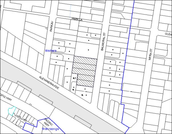
|
NOTIFICATION PLAN |
|
||
|
• PROPERTIES NOTIFIED
|
X SUBMISSIONS RECEIVED |
PROPERTY SUBJECT OF DEVELOPMENT |
|
|
2 SUBMISSIONS RECEIVED OUT OF MAP RANGE |
|||
Five submissions objected to the development, generally on the grounds that the development would result in:
· Isolation of sites to the south and west of the proposed development;
· Unacceptable privacy and amenity impacts on adjoining properties as a result of the proposed rear balconies;
· Insufficient rear setbacks;
· Devaluation of adjoining properties;
· Unacceptable overshadowing of adjoining properties; and
· Unacceptable noise and dust during construction phase of development.
Additionally, the submissions received made the following observations:
· Request that Council impose a condition of consent requiring the applicant to provide a privacy screen along the property boundaries during construction; and
· Request that Council impose a condition of consent requiring that no cranes from the construction of the development over hang adjoining properties.
The merits of the matters raised in community submissions have been addressed in the body of the report with the exception of the following:
5.1.1 Devaluation of Adjoining Properties
A concern was raised regarding the detrimental impacts to the economic value of adjoining properties.
It is acknowledged that there may be an adjustment to the development value of adjoining properties as a result of Council’s Housing Strategy. However, under the current freehold tenure system, landowners may redevelop land on the basis of individual decisions. The application has been assessed in accordance to Section 79C of the Environmental Planning and Assessment Act 1979 with regard to the economic impacts to the locality.
5.1.2 Unacceptable Noise and Dust During Construction
A concern was raised regarding the health and safety of adjoining neighbours during the demolition and construction phase and unacceptable construction noise on Saturday. A recommended condition of consent has been included under Schedule 1 which requires that all demolition work must be carried out in accordance with “Australian Standard 2601-2001 – The Demolition of Structures” and that where asbestos material is being removed, must be undertaken by a contractor that holds an appropriate licence issued by WorkCover NSW in accordance with Chapter 10 of the Occupational Health and Safety Regulation 2001 and Clause 29 of the Protection of the Environment Operations (Waste) Regulation 2005; and signage must be erected in a prominent position visible from the street. In addition, a condition of consent requiring all work on site to be undertaken between 7am and 5pm Monday to Saturday is recommended in accordance with Council’s Noise Control Policies.
5.1.3 Privacy Screen Along Property Boundaries and Construction Cranes Hanging Over Adjoining Properties During Construction
A concern was raised regarding privacy screening along the property boundaries and construction cranes hanging over adjoining properties during construction. A standard consent condition is recommended under Schedule 1 requiring a temporary hoarding, fence or awning to be erected between the work site and adjoining lands before the works begin and be kept in place until after the completion of the works.
5.2 Public Agencies
The development application was not required to be referred to any Public Agencies for comment.
6. THE PUBLIC INTEREST
Section 79C(1)(e) of the Act requires Council to consider “the public interest”.
The public interest is an overarching requirement, which includes the consideration of the matters discussed in this report. Implicit to the public interest is the achievement of future built outcomes adequately responding to and respecting the future desired outcomes expressed in environmental planning instruments and development control plans.
The application is considered to have satisfactorily addressed Council’s and relevant agencies’ criteria and would provide a development outcome that, on balance, would result in a positive impact for the community. Accordingly, it is considered that the approval of the proposed development would be in the public interest.
CONCLUSION
The application seeks approval for the demolition of existing structures and construction of a five storey residential flat building (Building C) comprising 39 units with joint single basement car park to an approved five storey development in DA/1369/2012 (Buildings A and B) at Nos. 9 - 15 Balmoral Street, Waitara.
The proposed development is generally in accordance with the development controls for the ‘Balmoral Street, Waitara’ Precinct of the Hornsby Development Control Plan and would contribute to the future desired five storey residential character of the precinct. With conditions, the minor non-compliances with prescriptive measures for setbacks, articulation, solar access, deep soil landscaping and housing choice are considered acceptable. The proposal complies with the design principles of SEPP 65 and the Residential Flat Design Code.
The proposal would result in a development that would be in keeping with the desired future character of the precinct.
A deferred commencement condition is recommended for the registration and creation of an easement to drain water from the site over downstream properties and the requirement for the submission of a MUSIC model and engineering plans detailing the engineering works required to achieve the Water Quality targets as detailed in Councils DCP.
Five submissions were received regarding the proposal, primarily concerning the isolation of adjoining properties. The concerns raised have been addressed in the body of the report.
The application is recommended for approval.
Note: At the time of the completion of this planning report, no persons have made a Political Donations Disclosure Statement pursuant to Section 147 of the Environmental Planning and Assessment Act 1979 in respect of the subject planning application.
RESPONSIBLE OFFICER
The officer responsible for the preparation of this Report is the Manager – Development Assessments – Rodney Pickles, who can be contacted on 9847 6731.
|
Rod Pickles Manager - Development Assessment Planning Division |
James Farrington Group Manager Planning Division |
|
1.View |
Locality Plan |
|
|
|
2.View |
Site Plan |
|
|
|
3.View |
Landscape Plan |
|
|
|
4.View |
Overall Floor Plans |
|
|
|
5.View |
Floor Plans |
|
|
|
6.View |
Elevations and Sections |
|
|
File Reference: DA/453/2014
Document Number: D05566911
SCHEDULE 1
GENERAL CONDITIONS
The conditions of consent within this notice of determination have been applied to ensure that the use of the land and/or building is carried out in such a manner that is consistent with the aims and objectives of the relevant legislation, planning instruments and council policies affecting the land and does not disrupt the amenity of the neighbourhood or impact upon the environment.
Note: For the purpose of this consent, the term ‘applicant’ means any person who has the authority to act on or the benefit of the development consent.
Note: For the purpose of this consent, any reference to an Act, Regulation, Australian Standard or publication by a public authority shall be taken to mean the gazetted Act or Regulation, or adopted Australian Standard or publication as in force on the date that the application for a construction certificate is made.
1. Deferred Commencement
Pursuant to Section 80(3) of the Environmental Planning and Assessment Act 1979, this consent does not operate until the following information is submitted to Council:
a) The registration and creation of an easement to drain water from the site over downstream properties. The easement is to benefit all properties within the proposed development. The Certificate of Title of all lots within the development site and the registered dealing form is to be submitted to Hornsby Shire Council confirming the registration.
b) Submission of a MUSIC model and engineering plans detailing the engineering works required to achieve the Water Quality targets as detailed in the Hornsby Development Control Plan 2013. The Water Quality targets are to apply to the entire site (i.e. property Nos. 5 – 15 Balmoral Street).
Such information shall be submitted within 12 months of the date of this notice.
Upon Council’s written satisfaction of the above information, the following conditions of development consent will apply:
2. Approved Plans and Supporting Documentation
The development must be carried out in accordance with the plans and documentation listed below and endorsed with Council’s stamp, except where amended by Council and/or other conditions of this consent:
|
Plan No. |
Plan Title |
Drawn by |
Dated |
|
8316 DA – E:01 Issue E |
Cover Page |
Zhinar Architects |
9/4/2015 |
|
8316 DA – E:04 Issue E |
Overall Site Plan |
Zhinar Architects |
9/4/2015 |
|
8316 DA – E:05 Issue E |
Basement Overall |
Zhinar Architects |
9/4/2015 |
|
8316 DA – E:06 Issue E |
Basement Plan – Building C |
Zhinar Architects |
9/4/2015 |
|
8316 DA – E:07 Issue E |
Ground Floor Overall |
Zhinar Architects |
9/4/2015 |
|
8316 DA – E:08 Issue E |
Building C Ground Floor Plan |
Zhinar Architects |
9/4/2015 |
|
8316 DA – E:09 Issue E |
Building C First Floor Plan |
Zhinar Architects |
9/4/2015 |
|
8316 DA – E:10 Issue E |
Building C Second Floor Plan |
Zhinar Architects |
9/4/2015 |
|
8316 DA – E:11 Issue E |
Building C Third Floor Plan |
Zhinar Architects |
9/4/2015 |
|
8316 DA – E:12 Issue E |
Building C Fourth Floor Plan |
Zhinar Architects |
9/4/2015 |
|
8316 DA – E:13 Issue E |
Building C Fourth Floor Plan (Upper) |
Zhinar Architects |
9/4/2015 |
|
8316 DA – E:14 Issue E |
Building C Roof Plan |
Zhinar Architects |
9/4/2015 |
|
8316 DA – E:15 Issue E |
East + North Elevations – Building C |
Zhinar Architects |
9/4/2015 |
|
8316 DA – E:16 Issue E |
West + South Elevations – Building C |
Zhinar Architects |
9/4/2015 |
|
8316 DA – E:17 Issue E |
Sections – Building C |
Zhinar Architects |
9/4/2015 |
|
8316 DA – E:14 Issue E |
Building C Roof Plan |
Zhinar Architects |
9/4/2015 |
|
8316 DA – E:18 Issue E |
Street + Fence Details |
Zhinar Architects |
9/4/2015 |
|
Unnumbered |
Materials Schedule |
Zhinar Architects |
9/4/2015 |
|
14035 DA 1 Rev. C |
Landscape Concept Plan |
Vision Dynamics P/L |
9/4/2015 |
|
8316 DA-D-24 Issue D |
Sun View Study |
Zhinar Architects |
22/3/2015 |
|
8316 DA-D-25 Issue D |
Sun View Study 2 |
Zhinar Architects |
22/3/2015 |
|
1790-C SW001 Issue B |
Stormwater Drainage Layout Drawing Basement Level |
HKMA Engineers |
23/5/2014 |
|
1790-C SW002 Issue B |
Stormwater Drainage Layout Drawing Ground Level |
HKMA Engineers |
23/5/2014 |
|
1790-C SW003 Issue B |
Easement Layout Drawings and other details |
HKMA Engineers |
23/5/2014 |
|
Ref 6124 Issue A |
Detail + Level Survey of Lot 4 – 5 in DP10738 |
SDG Land Development Solutions |
10/1/2014 |
|
8316 DA-E:18 Issue F |
Shadow Diagrams 9am – 12pm |
Zhinar Architects |
17/4/2015 |
|
8316 DA-E:19 Issue F |
Shadow Diagrams 3pm |
Zhinar Architects |
17/4/2015 |
|
Document Title |
Prepared by |
Dated |
|
Ref 14090 Traffic and Parking Assessment Report |
Varga Traffic Planning P/L |
23/5/2014 |
|
SEPP 65 Design Verification Statement Issue B |
Zhinar Architects |
May 2014 |
|
Ref 9202 Arboricultural Impact Assessment |
Redgum Horticultural |
9/4/2014 |
|
Report No. A402512 Access Compliance Assessment Report |
Certified Building Specialists |
26/5/2014 |
|
Waste Management Plan |
Balmoral Street Development P/L |
22/5/2014 |
|
BASIX Certificate No. 14911380 |
Building Sustainability Assessments |
April 2015 |
|
Statement of Environmental Effects |
Callandines Town Planning P/L |
May 2014 |
3. Amendment of Plans
The approved plans are to be amended as follows:
a) All units are to be provided with storage areas in accordance with the Residential Flat Design Code which requires 50% storage areas within the basement and storage areas within the units to be accessible from either the hall or living area with an area of at least 3m³ for 1 bedroom units, 4m³ for 2 bedroom units and 5m³ for 3 bedroom units.
b) To ensure that adequate deep soil landscaping and open space is provided, the private open space area of the east facing ground floor balcony serving Unit 70 is to be reduced to comply with the 7 metre front setback as required by the HDCP.
c) To ensure appropriate levels of privacy are maintained for future residents within the development and on the southern adjoining property, all balconies and habitable rooms within the 6 metres southern side setback are to be provided with 1.8m high privacy screens or 1.5m high window sills.
d) To ensure a range of dwelling types are provided to meet the needs of people who have limited physical mobility, one (1) additional adaptable unit is to be provided within Building C to comply with the requirements of the HDCP. This would result in a total of 12 adaptable units for Building C.
e) The door to the basement bin storage room is to be replaced by the widest possible roller door (minimum 2.5m width).
4. Removal of Existing Trees
This development consent does not permit the removal of tree(s) numbered 1-4 as identified in Appendix E - Site Plan A - Survey of Subject Trees as located in the supplied Aboricultural Impact Report prepared by Redgum Horticultural (D03148805) dated 9 April 2013. The removal of any trees requires separate approval under Council’s Tree Preservation Order.
The removal of any other trees requires separate approval in accordance with the Tree and Vegetation Chapter 1B.6 Hornsby Development Control Plan (HDCP).
5. Construction Certificate
A Construction Certificate is required to be approved by Council or a Private Certifying Authority prior to the commencement of any works under this consent.
6. Section 94 Development Contributions
a) In accordance with Section 80A(1) of the Environmental Planning and Assessment Act 1979 and the Hornsby Shire Council Section 94 Development Contributions Plan 2012-2021, the following monetary contributions shall be paid to Council to cater for the increased demand for community infrastructure resulting from the development:
|
Description |
Contribution (4) |
|
Roads |
$44,846.20 |
|
Open Space and Recreation |
$443,867.25 |
|
Community Facilities |
$61,877.65 |
|
Plan Preparation and Administration |
$1,853.50 |
|
TOTAL |
$552,444.60 |
being for 11 x 1 bedroom units, 27 x 2 bedroom units, 1 x 3 bedroom units and including a credit for two existing dwelling houses.
b) The value of this contribution is current as at 14 April 2015. If the contributions are not paid within the financial quarter that this condition was generated, the contributions payable will be adjusted in accordance with the provisions of the Hornsby Shire Council Section 94 Development Contributions Plan and the amount payable will be calculated at the time of payment in the following manner:
$CPY = $CDC x CPIPY
CPIDC
Where:
$CPY is the amount of the contribution at the date of Payment
$CDC is the amount of the contribution as set out in this Development Consent
CPIPY is the latest release of the Consumer Price Index (Sydney – All Groups) at the date of Payment as published by the ABS.
CPIDC is the Consumer Price Index (Sydney – All Groups) for the financial quarter at the date applicable in this Development Consent Condition.
c) The monetary contributions shall be paid to Council:
i) prior to the issue of the Subdivision Certificate where the development is for subdivision; or
ii) prior to the issue of the first Construction Certificate where the development is for building work; or
iii) prior to issue of the Subdivision Certificate or first Construction Certificate, whichever occurs first, where the development involves both subdivision and building work; or
iv) prior to the works commencing where the development does not require a Construction Certificate or Subdivision Certificate.
It is the professional responsibility of the Principal Certifying Authority to ensure that the monetary contributions have been paid to Council in accordance with the above timeframes.
Council’s Development Contributions Plan may be viewed at www.hornsby.nsw.gov.au or a copy may be inspected at Council’s Administration Centre during normal business hours.
REQUIREMENTS PRIOR TO THE ISSUE OF A CONSTRUCTION CERTIFICATE
7. Building Code of Australia
All building work must be carried out in accordance with the relevant requirements of the Building Code of Australia.
8. Contract of Insurance (Residential Building Work)
In the case of residential building work for which the Home Building Act 1989 requires there to be a contract of insurance in force in accordance with Part 6 of that Act, that such a contract of insurance is in force before any building work authorised to be carried out by the consent commences.
9. Notification of Home Building Act, 1989 Requirements
Residential building work within the meaning of the Home Building Act 1989 must not be carried out unless the principal certifying authority for the development to which the work relates (not being Council) has given Council written notice of the following information:
a) In the case of work for which a principal contractor is required to be appointed:
i) The name and licence number of the principal contractor; and
ii) The name of the insurer by which the work is insured under Part 6 of that Act.
b) In the case of work to be done by an owner-builder:
i) The name of the owner-builder; and
ii) If the owner-builder is required to hold an owner-builder’s permit under that Act, the number of the owner-builder’s permit.
Note: If arrangements for doing the residential building work are changed while the work is in progress so that the information notified becomes out of date, further work must not be carried out unless the principal certifying authority for the development to which the work relates (not being Council) has given Council written notification of the updated information.
10. Water/Electricity Utility Services
The applicant must submit written evidence of the following service provider requirements:
a) Ausgrid (formerly Energy Australia) – a letter of consent demonstrating that satisfactory arrangements have been made to service the proposed development.
b) Sydney Water – the submission of a ‘Notice of Requirements’ under s73 of the Sydney Water Act 1994.
Note: Sydney Water requires that s73 applications are to be made through an authorised Sydney Water Servicing Coordinator. Refer to www.sydneywater.com.au or telephone 13 20 92 for assistance.
11. Dilapidation Report
A ‘Dilapidation Report’ is to be prepared by a ‘chartered structural engineer’ detailing the structural condition of adjoining properties Nos. 65 and 65A Alexandria Parade, Waitara.
12. Adaptable Units
The details of all adaptable units must be provided with the Construction Certificate Plans.
13. Construction Vehicles
All construction vehicles associated with the proposed development are to be contained on site as no construction zones will be permitted on Balmoral Street in the vicinity of the site.
14. Construction Traffic Management Plan
Construction Traffic Management Plan detailing construction vehicle routes, number of trucks, hours of operation, access arrangements and traffic control should be submitted to Council prior to the issue of a construction certificate.
REQUIREMENTS PRIOR TO THE COMMENCEMENT OF ANY WORKS
15. Erection of Construction Sign
A sign must be erected in a prominent position on any site on which building work, subdivision work or demolition work is being carried out:
a) Showing the name, address and telephone number of the principal certifying authority for the work;
b) Showing the name of the principal contractor (if any) for any demolition or building work and a telephone number on which that person may be contacted outside working hours; and
c) Stating that unauthorised entry to the work site is prohibited.
Note: Any such sign is to be maintained while the building work, subdivision work or demolition work is being carried out, but must be removed when the work has been completed.
16. Protection of Adjoining Areas
A temporary hoarding, fence or awning must be erected between the work site and adjoining lands before the works begin and must be kept in place until after the completion of the works if the works:
a) Could cause a danger, obstruction or inconvenience to pedestrian or vehicular traffic.
b) Could cause damage to adjoining lands by falling objects.
c) Involve the enclosure of a public place or part of a public place.
Note: Notwithstanding the above, Council’s separate written approval is required prior to the erection of any structure or other obstruction on public land.
17. Toilet Facilities
Toilet facilities must be available or provided at the works site before works begin and must be maintained until the works are completed at a ratio of one toilet for every 20 persons employed at the site. Each toilet must:
a) be a standard flushing toilet connected to a public sewer; or
b) be a temporary chemical closet approved under the Local Government Act 1993; or
c) have an on-site effluent disposal system approved under the Local Government Act 1993.
18. Erosion and Sediment Control
Erosion and sediment control measures must be provided and maintained throughout the construction period in accordance with the manual ‘Soils and Construction 2004 (Bluebook)’, the approved plans, Council specifications and to the satisfaction of the principal certifying authority. The erosion and sediment control devices must remain in place until the site has been stabilised and revegetated.
Note: On the spot penalties may be issued for any non-compliance with this requirement without any further notification or warning.
19. Tree Protection Barriers
Tree protection fencing must be erected around trees numbered 1-4 to be retained at a 4 metre setback. The tree fencing must be constructed of 1.8 metre ‘cyclone chainmesh fence’ or star pickets spaced at 2 metre intervals, connected by a continuous high-visibility barrier/hazard mesh at a height of 1 metre.
To avoid injury or damage, trees numbered 1-4 must have trunks protected by 2 metre lengths of 75mm x 25mm hardwood timbers spaced at 80mm secured with galvanised wire (not fixed or nailed to the tree in any way).
20. Traffic Control Plan Compliance
The development must be carried out in accordance with the submitted Traffic Control Plan (TCP).
REQUIREMENTS DURING DEMOLITION AND CONSTRUCTION
21. Construction Work Hours
All work on site (including demolition and earth works) must only occur between 7am and 5pm Monday to Saturday. No work is to be undertaken on Sundays or public holidays.
22. Demolition
All demolition work must be carried out in accordance with “Australian Standard 2601-2001 – The Demolition of Structures” and the following requirements
a) Demolition material must be disposed of to an authorised recycling and/or waste disposal site and/or in accordance with an approved waste management plan;
b) Demolition works, where asbestos material is being removed, must be undertaken by a contractor that holds an appropriate licence issued by WorkCover NSW in accordance with Chapter 10 of the Occupational Health and Safety Regulation 2001 and Clause 29 of the Protection of the Environment Operations (Waste) Regulation 2005; and
c) On construction sites where buildings contain asbestos material, a standard commercially manufactured sign containing the words ‘DANGER ASBESTOS REMOVAL IN PROGRESS’ measuring not less than 400mm x 300mm must be erected in a prominent position visible from the street.
23. Environmental Management
The site must be managed in accordance with the publication ‘Managing Urban Stormwater – Landcom (March 2004) and the Protection of the Environment Operations Act 1997 by way of implementing appropriate measures to prevent sediment run-off, excessive dust, noise or odour emanating from the site during the construction of the development.
24. Street Sweeping
Street sweeping must be undertaken following sediment tracking from the site along Balmoral Street during works and until the site is established.
25. Council Property
During construction works, no building materials, waste, machinery or related matter is to be stored on the road or footpath. The public reserve must be kept in a clean, tidy and safe condition at all times.
Note: This consent does not give right of access to the site via Council’s park or reserve. Should such access be required, separate written approval is to be obtained from Council.
26. Landfill
Landfill must be constructed in accordance with Council’s ‘Construction Specification 2005’ and the following requirements:
a) All fill material imported to the site is to wholly consist of Virgin Excavated Natural Material (VENM) as defined in Schedule 1 of the Protection of the Environment Operations Act 1997 or a material approved under the Department of Environment and Climate Change’s general resource recovery exemption.
b) A compaction certificate is to be obtained from a geotechnical engineer verifying that the specified compaction requirements have been met.
27. Excavated Material
All excavated material removed from the site must be classified in accordance with the Department of Environment, Climate Change and Water NSW Waste Classification Guidelines prior to disposal to an approved waste management facility and reported to the principal certifying authority.
28. Survey Report – Finished Floor Level
A report(s) must be prepared by a registered surveyor and submitted to the principal certifying authority prior to the pouring of concrete at each level of the building certifying that:
a) The building, retaining walls and the like have been correctly positioned on the site; and
b) The finished floor level(s) are in accordance with the approved plans.
29. Works Near Trees
All required tree protection measures are to be maintained in good condition for the duration of the construction period.
All works (including driveways and retaining walls) within 4 metres of any trees required to be retained (whether or not on the subject property, and pursuant to this consent or the Tree Preservation Order), must be carried out under the supervision of an ‘AQF Level 5 Arborist’ and a certificate submitted to the principal certifying authority detailing the method(s) used to preserve the tree(s).
Note: Except as provided above, the applicant is to ensure that no excavation, filling or stockpiling of building materials, parking of vehicles or plant, disposal of cement slurry, waste water or other contaminants is to occur within 4 metres of any tree to be retained.
30. Waste Management Details
Waste management during the demolition and construction phase of the development must be undertaken in accordance with the approved Waste Management Plan. Additionally written records of the following items must be maintained during the removal of any waste from the site and such information submitted to the Principal Certifying Authority within fourteen days of the date of completion of the works:
a) The identity of the person removing the waste.
b) The waste carrier vehicle registration.
c) Date and time of waste collection.
d) A description of the waste (type of waste and estimated quantity).
e) Details of the site to which the waste is to be taken.
f) The corresponding tip docket/receipt from the site to which the waste is transferred (noting date and time of delivery, description (type and quantity) of waste).
g) Whether the waste is expected to be reused, recycled or go to landfill.
Note: In accordance with the Protection of the Environment Operations Act 1997, the definition of waste includes any unwanted substance, regardless of whether it is reused, recycled or disposed to landfill.
REQUIREMENTS PRIOR TO THE ISSUE OF AN OCCUPATION CERTIFICATE
Note: For the purpose of this consent, a reference to ‘occupation certificate’ shall not be taken to mean an ‘interim occupation certificate’ unless otherwise stated.
31. Fulfilment of BASIX Commitments
The applicant must demonstrate the fulfilment of BASIX commitments pertaining to the development.
32. Damage to Council Assets
Any damage caused to Council’s assets as a result of the construction of the development must be rectified in accordance with Council’s Civil Works Specifications. Council’s Restorations Supervision must be notified for a formwork inspection prior to pouring concrete.
33. Installation of Privacy Devices
The following device(s) must be installed to maintain an element of privacy towards the adjoining property:
a) A 1.8 metre high movable louvred privacy screen to be erected on all balconies within 6m of the southern side setback.
b) The sill heights of the windows to the living room(s) on the southern façade within the 6m southern side setback is to be increased to a minimum height of 1.5 metres above finished floor level.
34. Storage Areas
Each dwelling within the development must have a minimum storage area (not including built-in storage) of 6m³ for one bedroom units, 8m³ for two bedroom units and 10m³ for three bedroom units where 50% of the storage areas are required to be provided within the units and 50% is required within the basement.
35. Safety and Security
a) Fire exist doors to the development must be fitted with single cylinder locksets (Australia and New Zealand Standard – Lock Sets) to restrict unauthorized access to the development.
b) Ground floor windows must be fitted with window locks that can be locked with a key.
c) A graffiti management plan must be incorporated into the maintenance plan for the development for graffiti to be removed within a forty-eight hour period.
d) The basement car park entry must be secured by security gates/roller shutters and controlled by secure access located at the top of the driveway. The access control to include an audio/visual intercom system to allow visitor access to the parking area.
e) Lighting of pedestrian pathways throughout the development must comply with Australia and New Zealand Lighting Standard 1158.1 – Pedestrian.
f) Front fencing to be designed to allow casual surveillance at the frontage.
g) Lobby access to be controlled by security card or similar.
36. Works as Executed Plan
A works-as-executed plan(s) must be prepared by a registered surveyor and submitted to Council for completed road pavement, kerb & gutter, public drainage systems, driveways and on-site detention system. The plan(s) must be accompanied by a certificate from a registered surveyor certifying that all pipelines and associated structures lie wholly within any relevant easements.
37. Consolidation of Allotments
All allotments including Lots 4 and 5, DP 10738, Lots A and B, DP 343526 and Lot 1 DP315413, Nos. 5-15 Balmoral Street as approved in the subject consent and consent No. 1369/2012 must be consolidated into one allotment.
38. Development Consent DA/1369/2012 for Buildings A and B
Development consent DA/1369/2012/D is required to be modified in accordance with the subject development as described in the approved plans identified in condition No. 2 of this consent that detail changes to car access and waste management to that which was approved in DA/1369/2012.
39. Unit Numbering
The allocation of unit numbering must be authorised by Council prior to the numbering of each unit in the development.
40. Completion of Landscaping
A certificate must be provided by a practicing landscape architect, horticulturalist or person with similar qualifications and experience certifying that all required landscaping works have been satisfactorily completed in accordance with the approved landscape plans.
Note: Advice on suitable species for landscaping can be obtained from Council’s planting guide ‘Indigenous Plants for the Bushland Shire’, available at www.hornsby.nsw.gov.au.
41. External Lighting
All external lighting must be designed and installed in accordance with Australian Standard AS 4282 – Control of the Obtrusive Effects of Outdoor Lighting. Certification of compliance with the Standard must be obtained from a suitably qualified person.
42. Boundary Fencing
Fencing must be erected along the western rear and southern side property boundaries behind the front building alignment to a height of 1.8 metres.
Note: Alternative fencing may be erected subject to the written consent of the adjoining property owner(s).
43. Garbage Collection Easement
For the purpose of waste collection, an easement entitling Council, its servants and agents and persons authorised by it to enter upon the subject land and to operate thereon, vehicles and other equipment for the purposes of garbage collection must be granted to Council by the owner of the land.
Note: The easement must be in a form prescribed by Council and must include covenants to the effect that parties will not be liable for any damage caused to the subject land or any part thereof or to any property located therein or thereon by reason of the operation thereon of any vehicle or other equipment used in connection with the collection of garbage and to the effect that the owner for the time being of the subject land shall indemnify the Council, its servants, agents and persons authorised by it to collect garbage against liability in respect of any such claims made by any person whomsoever.
44. Waste Management
The following waste management requirements must be complied with:
a) The garbage rooms at the basement level must include water or a hose for cleaning, graded floors with drainage to sewer, a robust door, sealed and impervious surface, adequate lighting and ventilation, and must be lockable. The waste facility at each residential level must include sealed and impervious surface, adequate lighting and ventilation.
b) A report must be prepared by an appropriately qualified person, certifying the following:
i) A comparison of the estimated quantities of each waste type against the actual quantities of each waste type. Note: Explanations of any deviations to the approved Waste Management Plan is required to be included in this report
ii) That at least 60% of the waste generated during the demolition and construction phase of the development was reused or recycled. Note: If the 60% diversion from landfill cannot be achieved in the Construction Stage, the Report is to include the reasons why this occurred and certify that appropriate work practices were employed to implement the approved Waste Management Plan. The Report must be based on documentary evidence such as tipping dockets/receipts from recycling depots, transfer stations and landfills, audits of procedures etc. which are to be attached to the report.
iii) All waste was taken to site(s) that were lawfully permitted to accept that waste.
c) Each unit must be provided with an indoor waste/recycling cupboard for the interim storage of a minimum one day’s waste generation with separate containers for general waste and recyclable materials.
d) Space must be provided for either individual compost containers for each unit or a communal compost container;
Note: The location of the compost containers should have regard for potential amenity impacts.
e) The bin carting routes must be devoid of any steps.
Note: Ramps between different levels are acceptable.
45. Planter Boxes/On Slab Planting
On slab planter boxes must include waterproofing, subsoil drainage (proprietary drainage cell, 50mm sand and filter fabric) automatic irrigation, minimum 500mm planting soil for shrubs and minimum 1000mm planting soil for trees and palms and 75mm mulch to ensure sustainable landscape is achieved.
46. Maintain Canopy Cover
To maintain canopy cover, 4 medium to large trees selected from Council’s booklet ‘Indigenous Plants for the Bushland Shire’ such as Syncarpia glomulifera, Angophora floribunda, Angophora costata are to be planted within the front or rear setback of the subject site. The planting location shall not be within 4 metres of the foundation walls of a dwelling or in-ground pool. The pot size is to be a minimum 25 litres and the tree(s) must be maintained until they reach the height of 3 metres.
47. Additional Tree Planting
Additional tree planting to the on-grade landscape setback areas must include:
a) Southern side boundary – 3 x Waterhousia floribunda trees shall be installed at minimum 100 L pot size.
48. Street Tree Plantings
All existing street trees shall be removed from the front verge outside of 5-15 Balmoral Street. Replacement planting to this front verge shall be 12 x Tristaniopsis laurina ‘Luscious’ (Water gums) at 5m spacing. Trees are to be located in mulched planted beds 1,000mm long and min 600mm wide, have 3 x hardwood stakes and be installed at minimum 200L pot size. Trees are to be located to ensure sight lines for cars leaving the driveway are safe.
49. Completion of Landscaping
A certificate must be provided by a practicing landscape architect, horticulturalist or person with similar qualifications and experience certifying that all required landscaping works have been satisfactorily completed in accordance with the approved landscape plans.
Note: Advice on suitable species for landscaping can be obtained from Council’s planting guide ‘Indigenous Plants for the Bushland Shire’, available at www.hornsby.nsw.gov.au.
50. Stormwater Drainage
The stormwater drainage system including the bio retention system for the development must be designed and constructed in accordance with Council’s Civil Works – Design and Construction Specification 2005 and the following requirements:
a) An inter-allotment stormwater drainage system to service the proposed subdivision with pits being cast in situ or precast concrete pits being used.
51. On Site Stormwater Detention
An on-site stormwater detention system must be designed by a chartered civil engineer and constructed in accordance with the following requirements:
a) Have a capacity of not less than 17.5 cubic metres, and a maximum discharge (when full) of 37.6 litres per second.
b) Have a surcharge/inspection grate located directly above the outlet.
c) Discharge from the detention system to be controlled via 1 metre length of pipe, not less than 50 millimetres diameter or via a stainless plate with sharply drilled orifice bolted over the face of the outlet discharging into a larger diameter pipe capable of carrying the design flow to an approved Council system.
d) Not be constructed in a location that would impact upon the visual or recreational amenity of residents.
52. Internal Driveway/Vehicular Areas
The driveway and parking areas on site must be designed and constructed in accordance with Australian Standards 2890.1, 2890.2, 3727 and the following requirements:
a) Design levels at the front boundary must be obtained from Council;
b) The driveway must be a rigid pavement.
53. Footpath
A concrete footpath must be designed and constructed along the full frontage of the subject site in accordance Council’s Civil Works Design and Construction Specification 2005 and the following requirements:
a) The existing footpath being removed.
b) Pouring of the concrete footpath to the full frontage of the subject site.
c) The land adjoining the footpath to be fully turfed.
d) Any public utility adjustments to be carried out at the cost of the applicant and to the requirements of the relevant public authority.
54. Road Works
All road works approved under this consent must be designed and constructed in accordance with Council’s Civil Works Design and Construction Specification 2005 and the following requirements:
a) The existing kerb and gutter is to be removed and reconstructed across the frontage of the site (No 5-15 Balmoral St). No work is to commence on the road reserve until such time as an approval under the Roads Act 1993 is obtained by the way of a Construction Certificate issued by Hornsby Shire Council.
b) A concrete footpath to be constructed within the road verge with the remaining area turfed.
c) The existing road pavement to be saw cut a minimum of 300 mm from the existing edge of the bitumen and reconstructed.
55. Traffic Control Plan
A Traffic Control Plan (TCP) must be prepared by a qualified traffic controller in accordance with the Roads & Traffic Authority’s Traffic Control at Worksites Manual 1998 and Australian Standard 1742.3 for all work on a public road and be submitted to Council. The TCP must detail the following where required:
a) Arrangements for public notification of the works.
b) Temporary construction signage.
c) Permanent post-construction signage.
d) Vehicle movement plans.
e) Traffic management plans.
f) Pedestrian and cyclist access/safety.
56. Certification of the Bio Retention
An engineer’s certificate is required certifying that the constructed bio retention system will achieve the water quality targets as detailed in the Hornsby Development Control Plan 2013. The Certificate is to be issued prior to the issue of the Occupation Certificate.
57. Creation of Easements
The following easements are to be created on the title of the property in accordance with the Conveyancing Act 1919:
a) The creation of an appropriate "Positive Covenant" and "Restriction as to User" over the constructed on-site detention, bio retention areas and outlet works, within the development site in favour of Council in accordance with Council’s prescribed wording. The position of the on-site detention system and bio retention area is to be clearly indicated on the title.
b) To register the OSD and bio retention easement, the restriction on the use of land “works-as-executed” details of the on-site-detention system and bio retention area must be submitted verifying that the required storage and discharge rates have been constructed in accordance with the design requirements. The details must show the invert levels of the on-site system together with pipe sizes and grades. Any variations to the approved plans must be shown in red on the “works-as-executed” plan and supported by calculations.
Note: Council must be nominated as the authority to release, vary or modify any easement, restriction or covenant.
58. Provision for National Broadband Network (NBN)
Provision must be made for fibre ready passive infrastructure (pits and pipes) generally in accordance with NBN Co.'s pit and pipe installation guidelines to service the proposed development. A certificate from NBN Co. or Telstra must be submitted to the PCA that the fibre optic cabling provided for the development complies with MDU Building Design Guides for Development.
OPERATIONAL CONDITIONS
59. Waste Management
The waste management on site must be in accordance with the following requirements:
a) A site caretaker must be employed and be responsible for moving bins where and when necessary, decanting the 240L garbage bins into the 660L garbage bins, washing bins and maintaining waste storage areas, managing the communal composting area, managing the bulky item storage area, arranging the prompt removal of dumped rubbish, and ensuring all residents are informed of the use of the waste management system.
60. Landscape Establishment
The landscape works must be maintained into the future to ensure the establishment and successful growth of plant material to meet the intent of the landscape design. This must include but not be limited to watering, weeding, replacement of failed plant material and promoting the growth of plants through standard industry practices.
61. Car Parking
All car parking must be constructed and operated in accordance with Australian Standard AS/NZS 2890.1:2004 – Off-street car parking and Australian Standard AS 2890.2:2002 – Off-street commercial vehicle facilities.
a) All parking areas and driveways are to be sealed to an all-weather standard, line marked and signposted;
b) Car parking, loading and manoeuvring areas to be used solely for nominated purposes;
c) Vehicles awaiting loading, unloading or servicing shall be parked on site and not on adjacent or nearby public roads;
d) All vehicular entry on to the site and egress from the site shall be made in a forward direction.
62. Sight Distance to Pedestrians and Cyclists
Any proposed landscaping and/or fencing must not restrict sight distance to pedestrians and cyclists travelling along the footpath.
63. Residential Parking Spaces
Residential parking spaces are to be secure spaces with access controlled by card or numeric pad.
64. Visitors Access
Visitors must be able to access the visitor parking spaces in the basement car park at all times.
65. Parking for People with Disabilities
All parking for people with disabilities is to comply with AS/NZS 2890.6:2009 Off-street parking for people with disabilities.
66. Bicycle Parking Spaces
Bicycle parking spaces are to be designed in accordance with AS 2890.3-1993 Bicycle parking facilities.
67. Motorcycle Parking Spaces
Motorcycle parking spaces are to be designed in accordance with AS 2890.5-1993.
- END OF CONDITIONS -
ADVISORY NOTES
The following information is provided for your assistance to ensure compliance with the Environmental Planning and Assessment Act 1979, Environmental Planning and Assessment Regulation 2000, other relevant legislation and Council’s policies and specifications. This information does not form part of the conditions of development consent pursuant to Section 80a of the Act.
Environmental Planning and Assessment Act 1979 Requirements
The Environmental Planning and Assessment Act 1979 requires:
· The issue of a construction certificate prior to the commencement of any works. Enquiries can be made to Council’s Customer Services Branch on 9847 6760.
· A principal certifying authority to be nominated and Council notified of that appointment prior to the commencement of any works.
· Council to be given at least two days written notice prior to the commencement of any works.
· Mandatory inspections of nominated stages of the construction inspected.
· An occupation certificate to be issued before occupying any building or commencing the use of the land.
Long Service Levy
In accordance with Section 34 of the Building and Construction Industry Long Service Payments Act 1986, a ‘Long Service Levy’ must be paid to the Long Service Payments Corporation or Hornsby Council.
Note: The rate of the Long Service Levy is 0.35% of the total cost of the work.
Note: Hornsby Council requires the payment of the Long Service Levy prior to the issue of a construction certificate.
Tree and Vegetation Preservation
In accordance with Clause 5.9 of the Hornsby Local Environmental Plan 2013 a person must not ringbark, cut down, top, lop, remove, injure or wilfully destroy any tree or other vegetation protected under the Hornsby Development Control Plan 2013 without the authority conferred by a development consent or a permit granted by Council.
Notes: A tree is defined as a long lived, woody perennial plant with one or relatively few main stems with the potential to grow to a height greater than three metres (3M). (HDCP 1B.6.1.c).
Tree protection measures and distances are determined using the Australian Standard AS 4970:2009, “Protection of Trees on Development Sites”.
Fines may be imposed for non-compliance with both the Hornsby Local Environmental Plan 2013 and the Hornsby Development Control Plan 2013.
Disability Discrimination Act
The applicant’s attention is drawn to the existence of the Disability Discrimination Act. A construction certificate is required to be obtained for the proposed building/s, which will provide consideration under the Building Code of Australia, however, the development may not comply with the requirements of the Disability Discrimination Act. This is the sole responsibility of the applicant.
Dial Before You Dig
Prior to commencing any works, the applicant is encouraged to contact Dial Before You Dig on 1100 or www.dialbeforeyoudig.com.au for free information on potential underground pipes and cables within the vicinity of the development site.
Telecommunications Act 1997 (Commonwealth)
If you are aware of any works or proposed works which may affect or impact on Telstra’s assets in any way, you are required to contact: Telstra’s Network Integrity Team on Phone Number 1800810443.
Asbestos Warning
Should asbestos or asbestos products be encountered during demolition or construction works, you are advised to seek advice and information prior to disturbing this material. It is recommended that a contractor holding an asbestos-handling permit (issued by WorkCover NSW) be engaged to manage the proper handling of this material. Further information regarding the safe handling and removal of asbestos can be found at:
Alternatively, telephone the WorkCover Asbestos and Demolition Team on 8260 5885.
Group Manager's Report No. PL47/15
Planning Division
Date of Meeting: 10/06/2015
18 PLANNING PROPOSAL - AFTER EXHIBITION - PROPERTY NOS. 2-4 EPPING ROAD, EPPING
EXECUTIVE SUMMARY
· On 20 March 2015, the Department of Planning and Environment issued a Gateway Determination to proceed with a Planning Proposal to increase the maximum permissible building height for property Nos. 2-4 Epping Road, Epping from 17.5 metres to 26.5 metres.
· The Department also issued a written authorisation for Council to exercise the delegated functions of the Minister for Planning to make an LEP to give effect to the Planning Proposal.
· The aim of the Planning Proposal is to resolve a maximum building height planning anomaly that arose from the final Epping Town Centre Urban Activation Precinct Structure Plan and subsequent amendment to the Hornsby Local Environmental Plan 2013.
· The Planning Proposal will facilitate development on the subject lands to a height consistent with adjacent 8 storey building heights to achieve a better urban design outcome.
· The Planning Proposal was exhibited from 8 April 2015 to 8 May 2015. Two submissions of support have been received in response to the exhibition.
· It is recommended that Council adopt the Planning Proposal attached to Group Manager’s Report PL47/15 and proceed under delegation to make a Draft Local Environmental Plan to apply a maximum building height of 26.5 metres to property Nos. 2-4 Epping Road, Epping.
|
THAT: 1. Council forward the Planning Proposal attached to Group Manager’s Report No. PL47/15 to the Minister for Planning for gazettal. 2. In accordance with the plan making powers delegated to Council, the General Manager exercise the functions of the Minister for Planning and proceed to make the Plan. 3. All persons who made submissions be advised of Council’s resolution. |
PURPOSE
The purpose of this Report is to review submissions received in response the exhibition of the Planning Proposal for property Nos. 2-4 Epping Road, Epping and to recommend that Council proceed with the making of the Plan.
BACKGROUND
On 11 February 2015, Council considered Group Manager’s Report No. PL6/15 concerning a Planning Proposal to increase the permissible height of building for property Nos. 2-4 Epping Road from 17.5 metres (five storeys) to 26.5 metres (eight storeys) and resolved that:
1. Council forward the Planning Proposal for property Nos. 2-4 Epping Road, Epping attached to Group Manager’s Report No. PL6/15 to the Department of Planning and Environment seeking endorsement for exhibition.
2. In accordance with the plan making powers delegated to Council, Council exercise Authorisation to prepare and make the Planning Proposal following the receipt of Gateway Authorisation.
3. The General Manager be given delegated authority to endorse the exhibition material.
4. Following the exhibition, a report on submissions be presented to Council.
In accordance with Council’s resolution, the Planning Proposal was forwarded to the Minister for Planning requesting a Gateway Determination. A Gateway Determination was issued on 20 March 2015 authorising progression of the Planning Proposal subject to conditions. The Planning Proposal was required to be amended to include Lot and DP numbers, to ensure that the height of buildings is expressed in metres (with the number of storeys identified as an approximation only) and to clarify the consistency of the proposal with the newly released Metropolitan Strategy - ‘A Plan for Growing Sydney’.
A written authorisation for Council to exercise its delegated plan making functions of the Minister for Planning under Section 59 of the Environmental Planning and Assessment Act 1979 with respect to the planning proposal was also issued.
DISCUSSION
This report discusses the exhibition of the Planning Proposal for property Nos. 2-4 Epping Road, Epping and submissions received during the exhibition period.
The aim of the Planning Proposal is to resolve a maximum building height planning anomaly that arose from the final Epping Town Centre Urban Activation Precinct Structure Plan and subsequent amendment to the Hornsby Local Environmental Plan 2013.
The Planning Proposal will facilitate development on the subject lands to a height consistent with adjacent 8 storey building heights to achieve a better urban design outcome.
Exhibition and Review of Submissions
In accordance with the Consultation Strategy outlined in the Planning Proposal, the documents were exhibited for a minimum of 28 days from 8 April 2015 to 8 May 2015. The exhibition included letters to affected property owners including Roads and Maritime Services, an advertisement in the Northern District Times, a notice on Council’s website and displays at the Administration Centre and Epping library.
Submissions of support have been received from a strata owner of property No. 4 Epping Road and Roads and Maritime Services which are discussed below.
Issue
Roads and Maritime Services
The frontage of property Nos. 2-4 Epping Road is subject to acquisition by Roads and Maritime Services (RMS) for road widening. On 15 May 2015, RMS advised that they had reviewed the Planning Proposal and raise no objection to the increase in building height.
Strata Owner
The submission from the strata owner of property No. 4 Epping Road supports the Planning Proposal. However, the submission raised concern about the omission of information prepared by HillPDA (on behalf of the strata owners) concerning the feasibility of a 10 storey option.
The submission also raised concern in relation to the consistency of building heights identified for the subject sites in Council’s Epping Town Centre Study of 2011 and the Department’s Epping Urban Activation Area Structure Plan which was exhibited in 2013. The concern relates to confusion caused by the variety of building heights that were exhibited which ranged from 3 to 15 storeys.
Comment
As outlined in Group Manager’s Report PL6/15, the purpose of the Planning Proposal is to resolve a planning anomaly and provide for 8 storey development for property Nos. 2-4 Epping Road, consistent with adjoining properties along Epping Road. Consideration of a 10 storey option, whilst more feasible, would require submission of a separate Planning Proposal and supporting studies to confirm urban design and traffic impacts.
It is acknowledged that a variety of draft building heights were applied to certain locations as plans for the Epping Urban Activation Area were prepared. The Department’s Epping Urban Activation Area Structure Plan exhibited in 2013 contained an inaccurate illustration of building height at property Nos. 2-4 Epping Road which may have caused confusion. However, all remaining information within the Structure Plan was a true reflection of the exhibited plan.
STATUTORY CONSIDERATIONS
As part of the Gateway Authorisation, Council was granted delegated authority to request the making of the LEP amendment. Section 23 of the Act allows the Minister and the Secretary to delegate functions to a council and/or an officer or employee of a council. Under Section 59 of the Act, the Minister has delegated the plan making powers with respect to the Planning Proposal to Council.
At its meeting on 19 December 2012, Council resolved to formally accept the plan making delegations and delegate the plan making functions to the General Manager. Acknowledgement of Council’s resolution was received from the then DP&I on 3 March 2013.
Should Council resolve to adopt the Planning Proposal, the next step involves the forwarding of all relevant documentation, including a copy of Council’s assessment report (i.e. details of community consultation, responses to submissions, maps, a copy of the Opinion from Parliamentary Counsel Office, any other relevant material, and the completed delegation reporting template) to the Department.
The Department will then arrange for the Plan to be notified on the NSW Government legislation website.
CONSULTATION
In accordance with the Gateway Determination, the Planning Proposal was exhibited for a minimum period of 28 days in accordance with the Consultation Strategy outlined in the Planning Proposal. The exhibition included letters to affected property owners, an advertisement in the Northern District Times, a notice on Council’s website and displays at the Administration Centre and Epping library.
BUDGET
There are no budgetary implications associated with this Report.
POLICY
There are no policy implications associated with this Report.
CONCLUSION
The Planning Proposal for property Nos. 2-4 Epping Road, Epping was exhibited from 8 April 2015 to 8 May 2015. Two submissions of support has been received.
The Planning Proposal aims to resolve the maximum building height planning anomaly for property Nos. 2-4 Epping Road that arose from the final Epping Town Centre Urban Activation Precinct Structure Plan and subsequent Epping Town Centre SEPP Amendment to the Hornsby Local Environmental Plan 2013. Accordingly, it is recommended that Council adopt the exhibited Planning Proposal and proceed with the making of the plan.
RESPONSIBLE OFFICER
The officer responsible for the preparation of this Report is the Manager, Strategic Planning – Fletcher Rayner, who can be contacted on 9847 6744.
|
Fletcher Rayner Manager - Strategic Planning Planning Division |
James Farrington Group Manager Planning Division |
|
1.View |
Planning Proposal Property Nos. 2-4 Epping Road, Epping |
|
|
File Reference: F2015/00012
Document Number: D05567950
Group Manager's Report No. PL45/15
Planning Division
Date of Meeting: 10/06/2015
19 HORNSBY SHIRE SCORES ON DOORS FOOD SAFETY PROGRAM
EXECUTIVE SUMMARY
· At its meeting on 11 March 2015, Council resolved to invite community feedback on Council’s proposal to join the NSW Food Authority’s Food Safety Program known as Scores on Doors.
· Scores on Doors is a voluntary food safety program that enables the results of Council’s existing food premises inspections to be provided in the form of a certificate for public display. The Program is part of the Food Regulation Partnership between the NSW Food Authority and local government and has been operating in NSW since July 2010.
· The Council’s intention to join the Program was notified from 15 April 2015 to 4 May 2015 with a letter sent to all food premises, a notification appearing in local newspapers and on Council’s website.
· Three submissions have been received.
· It is recommended that Council consider the community feedback and adopt the NSW Food Authority’s Scores on Doors food safety program.
|
THAT Council implement the NSW Food Authority Scores on Doors Food Safety Program. |
PURPOSE
The purpose of this report is to review submissions received in response to Council’s proposal to join the NSW Food Authority’s Scores on Doors food safety program and to recommend that Council proceed to implement the Program.
BACKGROUND
At its meeting on 11 March 2015, Council considered Group Manager’s Report No. PL20/15 presenting the NSW Food Authority’s ‘Scores on Doors Food Safety Program’. In summary, the report acknowledged that there would be significant community benefits by joining the Program. Accordingly, Council resolved to exhibit the Program inviting community feedback over a 28 day period.
DISCUSSION
1. The Scores on Doors Food Safety Program
The Program is part of the Food Regulation partnership between the NSW Food Authority and local government. The Program is voluntary and operates as follows:
1.1 Eligible Food Service Businesses
Scores on Doors is aimed at food service businesses that process and sell food that is ready to eat, intended for immediate consumption and potentially hazardous, which means it may require special handling to be safe, such as temperature control. These businesses include restaurants, takeaways, cafes, bakeries and bistros. This is a similar group of businesses to those which are required to appoint a Food Safety Supervisor and there are approximately 360 eligible businesses in the Hornsby Shire. Scores on Doors is not intended for supermarkets, delicatessens, low risk food businesses and businesses which are licensed by the Food Authority.
1.2 Inspections
The Scores on Doors inspections would be undertaken by Council’s Health Officers during Council’s current annual unannounced periodic inspection program, using the standard Food Premises Assessment Report (FPAR) provided by the NSW Food Authority.
1.3 Scoring System
The scoring system is based on the accrual of points (effectively demerits) where food safety issues are identified. Therefore, the lower the points accrued, the higher the facility’s rating will be.
The FPAR takes into consideration the following food standards: food handling controls, health and hygiene, cleaning and sanitising, animals and pests, design and construction, and maintenance.
1.4 Certificates
After the Health Officer completes the FPAR inspection checklist, the points received by the business are tallied and based on the total score, a food, safety rating of excellent, very good or good is assigned. A certificate showing the rating is then provided, which can be displayed in the front window of the business. In the event that a pass mark is not achieved, the business is ineligible for a certificate.
1.5 Reinspection Requests
A reinspection of a food business can be requested at any time after the original inspection, subject to the payment of the appropriate reinspection fee. The unannounced review would be undertaken within 3 months. The review would be undertaken by a more senior officer.
1.6 Certain Instances May Result in the Removal of a Certificate
Council Health Officers often undertake inspections outside of the routine inspection program due to complaints and other information. In these circumstances, a new score can be calculated if the inspection is unannounced and all elements in the FPAR are covered by the inspection. If this results in a change to the businesses’ rating, the previous certificate would be removed and a new certificate may be issued. In the event that a pass mark is not achieved, the businesses’ original certificate is withdrawn.
1.7 Participating is Voluntary
The Scores on Doors Program is currently voluntary.
1.8 Publicising the Scores
The scores resulting from the assessment would only be publicised on the premises. Council would not publish the score on its Website or other media.
1.9 Expiry Date for Certificates
Certificates would show an expiry date of 12 months after issue.
2. Exhibition and Review of Submissions
In accordance with Council’s resolution, the Program was publicly exhibited for 28 days from 15 April 2015 to 4 May 2015 with a letter sent to the owners of all food premises eligible to participate in the Program. A notice was also placed in the Hornsby Advocate and on Council’s website.
In response, three submissions have been received. Two submissions support the Program and one collective submission from a reported 20 food premises owners raises concern with respect to consistency in the assessment process.
The NSW Food Authority has addressed this concern by making the program voluntary, by requiring that food safety inspections be undertaken by authorised officers and through the use of a standard checklist with in-built scores that assists to standardise ratings and maximise reliability. The checklist is considered to a reliable tool because it has been developed in consultation with Councils and is based on legislative requirements of the Food Standards Code. Further, a review can also be requested which would be undertaken within 3 months of the request and by a senior officer.
BUDGET
There are no additional budgetary implications associated with this Report.
CONCLUSION
The proposal for Council to implement the NSW Food Authority Scores on Doors Food Safety Program was exhibited from 15 April 2015 to 4 May 2015. Two submissions were received in support of the Program and one collective submission from a reported 20 food premises owners raising concern with respect to consistency in the assessment process. The issues raised in submissions do not introduce any additional matters that have not been considered by the NSW Food Authority in the establishment of the program.
The Program would allow the public to know how well local restaurants, takeaway shops, bakeries, pub bistros and cafes are complying with NSW hygiene and food safety requirements. It provides an incentive to businesses to improve their results and celebrates those businesses that have shown a commitment to food hygiene and safety.
Accordingly, it is recommended that Council adopt the NSW Food Authority Scores on Doors Food Safety Program.
RESPONSIBLE OFFICER
The officer responsible for the preparation of this Report is the Manager Compliance and Certifications – Simon Evans, who can be contacted on 9847 6780.
|
Simon Evans Manager - Compliance and Certification Planning Division |
James Farrington Group Manager Planning Division |
There are no attachments for this report.
File Reference: F2014/00540
Document Number: D05555617
Deputy General Manager's Report No. IR19/15
Infrastructure and Recreation Division
Date of Meeting: 10/06/2015
20 EPPING AQUATIC CENTRE
EXECUTIVE SUMMARY
· Epping Aquatic Centre (EAC) is a 55 year old facility in near-original condition located in Dence Park, Epping. EAC has no major indoor component, is sited at the bottom of a steep slope with less than ideal public access, and does not match modern standards for successful public aquatic centres.
· The condition of the main pool is dilapidated, with major leaks. The pool and associated plant have arguably reached the end of their useful lives. Costly repairs may be possible but these could still leave an aged and uneconomic aquatic centre with uncertain structural durability.
· EAC has been operating at a financial loss for decades and these losses can be expected to continue and probably increase should it remain operating.
· The report recommends closing the pool permanently during its scheduled seasonal closure in 2015, demolishing it, and making the site safe while considering future uses of Dence Park.
· It is recommended a park masterplan be prepared that will determine the future recreation use of this land, and that an investigation into the future need and business case for a new aquatic centre in or near Epping be conducted.
|
THAT: 1. Epping Aquatic Centre be permanently closed and (subject to development consent) demolished, and not reopened on 1 October 2015 following the current winter closure. 2. A masterplan for the future recreational use of Dence Park be developed by June 2016. 3. An investigation into the future need and business case for a replacement aquatic centre in Epping and reported to Council. |
PURPOSE
The purpose of this Report is to allow Council to determine the immediate future of the Epping Aquatic Centre (EAC).
BACKGROUND
At the 8 April 2015 General Meeting, Council considered Executive Manager’s Report No IR5/15. It was resolved:
“THAT:
1. Council note the structural issues described in Deputy General Manager’s Report No. IR5/15 leading to the likely permanent closure of Dence Park Pool.
2. Council note that the land known as Dence Park was obtained and developed into an aquatic facility by Council with community support.
3. Council note that the land has a restriction on title which requires the site to only ever be used for public recreation.
4. Council confirm its commitment for the site to only be used for public recreation.
5. Council defer consideration of the recommendation in Deputy General Manager’s Report No. IR5/15 until the 10 June 2015 General Meeting to allow the community more time to read and respond to the content contained within the Report and attachments.
6. The Deputy General Manager Infrastructure and Recreation prepare a report for Council’s consideration at the 10 June 2015 General Meeting addressing:
a) The implications (including cost) of keeping Epping Pool open from October 2015 to March 2016 inclusive until a decision on a new aquatic facility is made and discussed with the community.
b) Confirmation of the capacity of nearby swimming pools to accommodate groups displaced by a closure of Epping Pool.
c) Confirmation of travel times by various modes to each of the other nearby aquatic facilities.
d) How Council would work with the key user groups to find alternative options in the event of a closure of Epping Pool.”
EAC, located in Dence Park off Stanley Street, Epping, was opened in 1960, and has operated continuously, either all year round or for summer season only, ever since. The pool was named the Epping War Memorial Pool. It was funded substantially (£94,000) from a rate levy imposed on the residents of the then C Riding area. Other contributions (£12,000) came from residents and the Eastwood Epping War Memorial Pool Committee.
Dence Park was acquired on the proviso that it be used for public recreation and this is a restriction on the land title. The park, including the pool structures, is listed as an item of local heritage significance in the Hornsby Local Environment Plan 2013. A development application accompanied by a heritage conservation report would need to be submitted for the demolition of the pool structures to be considered for consent.
Pleasantly situated in parkland and a bushland valley, EAC is in near-original condition. However, concerns about the age and condition of the main pool and filtration equipment, supported by expert opinion, indicate that the aquatic centre is nearing the end of its useful life. Although there are suggestions for repairs that may extend its life, it would still be unattractive and uneconomic compared to other aquatic centres in the district.
In 2013, Council invited tenders for the operation of its three aquatic centres including EAC. Tender bids were received from the staff team, who offered to operate the centre from October to March only, and from two other tenderers. All tenderers required a Council subsidy to operate EAC. The successful staff tender requires a subsidy of $200,000-$300,000 per annum to cover operating losses projected by the tenderer for each of the three years of the tender. This subsidy does not include asset management and maintenance of the pool infrastructure that remains Council’s responsibility to fund in addition.
As a result of the tender being for half year operation only, EAC closed in 2014 between 31 March and 1 October. The pool is currently in the same winter closure period, scheduled to reopen on 1 October 2015. Significant water leakage cause by faults in the pool structure meant that the operational cost savings from the 2014 closure period were substantially less than anticipated. This has led to a review of the asset condition and remaining asset life of EAC.
The facilities at EAC were described in detail in Deputy General Manager’s Report No. IR5/15 considered by Council at the 8 April 2015 General Meeting. Council engaged Ninnes Fong, a structural engineering consultancy firm with extensive experience with aquatic recreation infrastructure, to report on the pool’s condition and possible remedies in accordance with Part 6a of the resolution of this item by Council (Attachment 1).
Following the General Meeting, a group of residents commissioned Stevenson and Associates, an engineering consultant also with extensive experience with aquatic recreation infrastructure to report to them on the condition of the pool and repairs that may be undertaken. Residents subsequently made a submission to Council asking for the report’s findings and outstanding questions to be addressed prior to Council further considering the future of the EAC. Council engaged structural engineers, Partridge Structural Pty Ltd to review the Stevenson report.
DISCUSSION
Structural Issues in the Main Pool
Structural defects were observed at the centre in 2012 whilst carrying out maintenance works. An excessive amount of water leakage of pool water, damaged sewer pipes, cracks of movement of concrete apron slabs, retaining walls and tiling were all noted as potentially significant to the structural integrity of the 50 metre swimming pool.
Structural Report – Emeritus Professor Bakoss
Council engaged Dr Steve Bakoss, Emeritus Professor of Civil Engineering, to prepare a scoping report for the assessment of the structural condition of the pool and if necessary and feasible, based on the available information, to recommend appropriate remedial actions Dr Bakoss’s report was attached to Deputy General Manager’s Report No. IR5/15.
The report identified four probable causes for the excessive water loss:
1. Deterioration of the expansion joints have visibly deteriorated with indications of displacements of the tiling in the vicinity of the expansion joints and require remediation
2. Possible small cracks in the pool base slab
3. Cracking and deterioration of the central water return channel running the length of the pool
4. Corrosion of the 200mm cast-iron hydraulic return pipe located underground.
Dr Bakoss concluded that the source of the leakage of the pool water loss is currently not known and could be difficult and costly to reliably identify with at least four distinct potential sources of water loss. He advised that the sealing of the expansion joints should be the first priority however if the remediation of these joints does not alleviate the water loss, the location and remediation of the leakages can be expected to be difficult, costly and may even prove to be intractable.
Structural Report – Partridge Structural Pty Ltd
To validate the accuracy of the Bakoss report, Council engaged structural engineers, Partridge Structural Pty Ltd to provide an opinion on Council’s observations and the information presented in Dr Bakoss’s report which was attached to the report considered on 8 April.
Partridge Structural Pty Ltd reported that their experience with similarly aged concrete structures around Sydney is that concrete cancer and other defects brought about by concrete movement and deterioration requires ongoing remediation and repair techniques which are slow, tedious, and expensive.
Their biggest concern associated with the swimming pool is the extent of the unknown leakage and structural problems. They consider that too little is known about the pool, and too little can be meaningfully and economically established.
Partridge concludes that they cannot support or make any recommendation for repair. The current unknowns are too great, and the cost of investigative work to answer just some of these unknowns is a major project itself – all with the realistic probability of learning that the pool cannot economically be salvaged.
Structural Report – Ninnes Fong
Council engaged experienced consulting structural engineers Ninnes Fong to provide a report (Attachment 1) on the EAC in accordance with Part 6a of the resolution of Council at its 8 April 2015 General Meeting.
Ninnes Fong has concluded:
· The 50m pool is leaking approximately 35,000 litres per day and the major sources of leakage that have been identified are pool expansion joints, pipework to and from the balance tank and centre return trench.
· Recent survey of the lip of the scum gutter appear to indicate a general settlement of the pool toward the north eastern end (deep end of the pool toward the brick retaining walls).
· No major cracking in the structure could be observed, however further investigations including geotechnical investigations, concrete testing for chloride ion ingress and voids under the pool and concourses are required to determine the stability of the pool structure and its remaining life. Further investigation costs are likely to be in the order of $47,000 + GST.
· The pool concourses have displayed considerable settlement adjacent to the balance tank in the north east corner, likely to be caused by leakage of water eroding the fill under the slabs.
· The pool needs to be emptied for the investigations to proceed and for the pool joints to be repaired.
· The existing tiles are in poor condition and will likely become loose when the pool is emptied and will need to be replaced.
· The minimum structural works required for a minimum of 10 year lift (subject to additional investigations and not involving major structural works) would be to seal the pool expansion joints, remove and replace tiles, install new UPVC centre return line and encase in concrete, renew surfaces of gutters, replace perimeter concourse for 2.4m width and construct a new balance tank. Indicative cost - $1million + GST.
· The minimum pool water treatment works required for an expected life of 5 to 10 years would be to retain the existing filter (subject to its internal condition), replace recirculation pump, chemical controller, filter upgrade work, replace reticulation pipework and plant room clean-up. Indicate cost - $260,000 + GST.
· If the pool is to be maintained for a longer term the structural works would be subject to the results of the investigations. An indicative cost for a new 50m x 15.4m pool is $2.04million and new compliant pool water treatment plant $860,000 + GST.
The Ninnes Fong report provides details and estimated costing of the structural investigations that are required to be carried out, totalling $47,000.
The report also provides details and estimated costing for the minimum repairs required to keep the pool operational and provides options for filtration and water treatment.
It should be noted however that the estimated costs do not include the cost of any structural repairs that may be revealed following the structural investigations.
Structural Report – Stevenson and Associates
Stevenson and Associates were engaged by a group of residents to provide a preliminary report into the pool condition and the abovementioned issues, and to propose repairs (Attachment 2). Stevenson also examined the previous consultant reports obtained by Council.
Stevenson concluded ‘It is clear in my view that there is currently not enough evidence on the table to know if this pool can be successfully refurbished or not.’ Stevenson suggested there may be other causes of the leak beyond those identified by Bakoss.
A number of investigative and structural repair steps were recommended by Stevenson, at an estimated cost of $1.18million to $1.58 million depending on the type of filtration system selected and the need to retile the pool.
Stevenson has estimated the cost of the investigative work outlined in his report to be $15,000, including:
· Fit a separate water meter to the pool balance tank and monitor that
· Carry out a dye test within the pool. This will help identify joint or crack leaks
· Where possible pressure test filtration lines
· Remove sand from the sand filter bed and test and repair any damaged lines.
Among the suggested remedies for the refurbishment of the pool were:
· Repair the supply trench/central water return channel by lining with PVC pipe and concreting over it
· Repair the eroded edge gutter trenches
· Replace the pool movement (expansion) joints
· Re-tile the pool below waterline if required
· Reconstruction of the pool concourses that appear to be affected by ground movement
· Replace the plant (pumps and filtration system).
The Stevenson and Associates report has been reviewed by structural engineers, Partridge Structural Pty Ltd (Attachment 3). Partridge advises that they do not disagree with the overall thrust and approach presented in the Stevenson report however were unable to provide comment as to the accuracy of the cost estimates presented in the report. Partridge recommended that Council contact Stevenson and Associates previous client base to check and ascertain that:
· Repairs and refurbishments undertaken were successful and have remained successful since their completion
· Additional costs or maintenance expenses are not being incurred
· Costs did not “blow out” or repair scopes did not expand or creep once repair projects were mobilised.
Epping Aquatic Centre Patronage
The patronage of the EAC was 45,323 visits during 2014/15 including gym, squads, Learn to Swim, school groups and general recreational swimming.
EAC is home to three swim clubs:
· Epping Bullets Swim Club uses the pool on Friday nights, with up to 100 participants
· Eastwood-Epping Swim Club uses the pool on Saturday mornings, with an observed participation of fewer than 20 members
· Epping RSL Swim Club uses the pool on Sundays, with an observed participation of about 20 members.
Learn to swim (LTS) operations provide the highest participation numbers and best source of revenue for any aquatic centre. LTS operates best in the indoor area of modern aquatic centres, with water heated to a higher temperature than water used for squads or recreational swimming. LTS at EAC operated under sub-optimal conditions, especially in winter. The program pool is semi-enclosed and offers limited weather protection for carers of the children, who also have to cope with the unfavourable access to EAC if accompanied by younger children in prams.
LTS revenue has declined over the past decade, with a continuing drop in revenue in 2007/08 that correlated to the opening of nearby Macquarie University Aquatic Centre. Squad training participation over the same period held up or declined only slightly, and this is attributed to the presence at EAC of a head swim coach with a good reputation (since moved on).
Total revenue at EAC has not increased over the past decade despite small occasional increases in entry and program fees (these are in line with other aquatic centres). This indicates a long term trend of falling patronage.
School Swimming Programs and Carnivals
Cheltenham Girls High School and Epping Boys High School dominate use of EAC during Term Four, when they run various swimming programs.
Epping Boys High is within walking distance of Macquarie University Aquatic Centre and could reasonably locate activities to that venue. Cheltenham Girls High could utilise the Hornsby Aquatic and Leisure Centre during Term Four, as they could travel by train since Cheltenham Station is located 550 metres from the school.
Eighteen schools use EAC for their annual swimming carnivals. Of these, seven schools are located in Hornsby Shire. A further two (Epping Boys High School and Carlingford Public School) are close to the Shire boundaries and would have a high proportion of Hornsby Shire residents among the school community. The remainder are schools within Ryde or Ku-Ring-Gai Council areas.
The annual school carnival season extends through February until mid-March. The timing is determined by the combined schools zone carnival, which is a pathway to representative swimming.
Investigations have confirmed that there is sufficient capacity for the schools located within the Shire to hold their swimming carnivals at other venues such as Hornsby Aquatic and Leisure Centre, Knox Grammar School Aquatic Centre and Ku-Ring-Gai Fitness and Aquatic Centre. These schools could be assisted to find alternative venues if EAC closes in 2015.
Capacity of Other Aquatic Centres
There are a number of other modern public aquatic centres with 50 metre pools within 12 kilometres of EAC. These include:
· Macquarie University Aquatic Centre (MUAC) is about three kilometres to the east, accessible from Epping by train, car, bicycle or on foot. By public transport MUAC is about 20 minutes from Epping (if timed to predetermined destination arrival schedules for LTS, programs etc.) while the car journey takes about seven minutes. There is lane space for recreational swimming most of the time.
· Ryde Aquatic Centre is eight kilometres by road to the south, accessible by car or bus from Epping. The journey by public transport takes up to 35 minutes, and by car, 22 minutes or less.
· West Pymble Aquatic Centre is about five kilometres to the north east, accessible by car or bus on an 8 kilometre trip. The bus trip takes 25 to 31 minutes, the car journey 19 minutes or less. All the LTS and program activities are conducted in the new indoor section of the facility, leaving the 6 lane outdoor 50 metre pool free for recreational swimming most of the time.
· Hornsby Aquatic Centre is 10 kilometres to the north, accessible by car (by road, 13 km) and train. Car trips take 18-22 minutes and the train trip up to 26 minutes (but may be as little as 14 minutes). Lane space for recreational swimming is available at most times.
Ryde-Eastwood Leagues Club is situated in West Ryde, closer to Epping, and quickly accessible from Epping by car or train. It has an all-indoor aquatic centre including a 25 metre pool and a program pool for learn to swim. The aquatic centre has a lot of capacity for programs and recreational swimming that would be displaced by the closure of EAC.
Larger private schools like Knox Grammar, Abbotsleigh and Loreto Normanhurst operate aquatic facilities that are open for some public use, and in some cases, other schools hold carnivals at these venues. These facilities operate learn to swim centres and other programs.
Assessment has concluded that there is probably adequate capacity across a range of nearby centres to accommodate patrons displaced by a closure of EAC.
Possible Replacement Aquatic Centre
Council’s investigations, and a discussion paper from SGL Consulting working with Strategic Leisure Group (Attachment 4), have indicated that other aquatic centres could probably absorb the organised group and program booking demand for aquatic facilities that would be created by the permanent closure of EAC.
The SGL discussion paper advises that due to a lack of existing data, there is a need to undertake a household telephone survey to confirm that there is sufficient current supply of aquatic facilities for general recreation use near to Epping to absorb demand created if EAC closes. Council has authorised undertaking the survey and it is anticipated that preliminary results will be available prior to the Council meeting on June 10.
The next task of the consultancy is to advise on the way forward to respond to the needs of a growing population for aquatic recreation. To this end, SGL have been contracted to advise on the future need for an aquatic centre in or near Epping, given population projections. Should SGL advise that there may be future unmet demand for aquatic recreation facilities; they have been asked to advise on the scale and type of the aquatic centre, the optimum operating model, and to identify and evaluate potential sites. SGL has also been asked to advise on the best method of community engagement with key user groups for the next phase of moving towards decisions on a replacement facility.
Implications of Continuing Operations from October 2015 to March 2016
If the pool reopens on schedule in October for the summer season, the swim clubs, squads, LTS classes and school users can be expected to return, and they won’t need to relocate.
However, if the structural problems and leaks were not repaired, and the ageing filtration plant system not replaced, the pool is at risk of closure without notice due to a major failure. This risk must increase each year of operation unless major remedial work and plant replacement is undertaken.
In fairness to the program users of EAC such as the schools, they should be advised of this risk if EAC reopens for terms four and one.
Subject to no major repair works EAC can be expected to operate at a loss of around $270,000 between October and March, a figure that may vary according to patronage and weather conditions. The attached discussion paper prepared by SGL Consulting shows a falling revenue trend since 2008/09, which, placed against rising operational costs (not including capital costs) points to increasing financial losses.
Future Use of Dence Park
A decision to close and demolish the EAC gives rise to questions about the future of this site. Given its space and proximity to Epping Town Centre there is a clear potential for new recreation opportunities to meet the needs of the existing and future population of Epping and nearby areas.
The possible relocation of the Epping Leisure and Learning Centre to a new facility elsewhere in Epping opens possibilities for a creative adaption of the heritage building it currently occupies in Dence Park.
These matters should be resolved by preparing a masterplan for the park in consultation with the community.
CONSULTATION
In preparation of this report there has been consultation with operators of other aquatic centres and with residents who are concerned about the potential closure of EAC.
BUDGET
There are significant budgetary implications associated with this Report.
Further investigation works estimated by Ninnes Fong at $47,000 need to be carried out to determine the structural integrity of the pool and its remaining life.
Minimum structural works and minimum pool treatment works to enable a 5 to 10 year life of the EAC have been estimated by Council consultant, Ninnes Fong, at $1.26 million dollars. However this cost does not include any major structural repairs that may be required as a result of the above investigation.
Alternatively, Ninnes Fong has advised an indicative cost of $2.9 million for a new 50m pool and new compliant pool water treatment plan, although it must be noted that any capital improvement works to the amenities building, toddlers pool, program pool, lighting have not been included in this estimate of cost.
In addition, should the centre remain open with the minimum required repairs or alternative replacement pool, operating losses could be expected to rise each year if, as appears likely, patronage continues to fall due to the lesser attractiveness of the mainly outdoor facility with poor visitor access at EAC compared to other modern and substantially indoor facilities nearby.
Should the decision be taken to close EAC in 2015 then (subject to development consent) demolition of the existing facility is likely to be in the order of $500,000.
POLICY
There are no policy implications associated with this Report.
CONCLUSION
Epping Aquatic Centre has become dilapidated and arguably has reached the end of its useful life. Council has sought the advice of suitable structural consultants. The advice has detailed known defects with the pool and offered indicative costs for short term repair albeit noting that further investigations are first necessary and may reveal additional costs associated with the structural integrity of the pool. Other advice offered by members of the community discusses repairs and plant replacements that could be carried out.
Even if the further investigations reveal no major structural integrity defects with the pool, and repairs could be effected and the aged plant be remediated for the minimum cost of $1.26 million, EAC would still be seen as an ageing facility, lacking indoor comfort and a range of attractions available at competing facilities, difficult to access and running at an increasing operational loss.
It is concluded that it would be prudent to close and seek development consent to demolish EAC. This could be followed by the preparation of a masterplan for Dence Park which examined the future use of this area for public recreation. Council should also continue to investigate a possible replacement aquatic facility for Epping or nearby suburbs.
RESPONSIBLE OFFICER
The officer responsible for the preparation of this Report is the Manager, Parks and Recreation – Peter Kemp, who can be contacted on 9847 6792.
|
Robert Stephens Deputy General Manager Infrastructure and Recreation Division |
|
|
1.View |
Attachment 1 - Ninnes Fong - Epping Aquatic Centre Report |
|
|
|
2.View |
Attachment 2 - Stevenson and Associates Consulting - Inspection Report - Epping Aquatic Centre - May 2015 |
|
|
|
3.View |
Attachment 3 - Review of Report and Submission of Stevenson and Associates - Partridge Structural Pty Ltd |
|
|
|
4.View |
Attachment 4 - Investigation into the Need to Replace Epping Aquatic Centre |
|
|
File Reference: F2004/08950-02
Document Number: D05567907
Deputy General Manager's Report No. IR11/15
Infrastructure and Recreation Division
Date of Meeting: 10/06/2015
21 DRAFT REVISED GENERIC PLAN OF MANAGEMENT FOR COMMUNITY LAND AND CROWN RESERVES PLANNING DISTRICTS FIVE AND SEVEN
EXECUTIVE SUMMARY
· Berowra RSL Sub-Branch has expressed interest in using the refurbished and expanded amenities building at Warrina Oval in Berowra for meetings and possibly storage of property and display.
· The Generic Plan of Management (PoM) for Community Land and Crown Reserves for Districts Five and Seven (covering public reserves from Berowra to Brooklyn) in its adopted form did not allow for this use, therefore a draft revised plan has been exhibited to encompass it.
· The PoM was publicly exhibited and only one submission was received.
· The adoption of the draft POM as amended is recommended.
|
THAT the draft revised Generic Plan of Management for Community Land and Crown Reserves (Planning Districts Five and Seven) be adopted. |
PURPOSE
The purpose of this Report is to allow Council to adopt an amended Plan of Management for Community Land and Crown Reserves covering Districts Five and Seven (Berowra to Brooklyn).
BACKGROUND
Earlier this year an amended PoM was placed on public exhibition. The amendment concerned proposed changes to the use of the amenities building that has been undergoing renovation and extension at Warrina Oval in Berowra.
The amendment will allow the Berowra RSL Sub-Branch to use the completed amenities building for meetings and the display of memorabilia.
DISCUSSION
The Berowra RSL Sub-Branch has expressed interest in possibly using the main amenities building at Warrina Oval for the purposes of meetings and the display and storage of records and Branch memorabilia. The adopted generic PoM covering the park is open to a restrictive interpretation that might prevent this use.
Warrina Oval is classified as community land. As required by the NSW Local Government Act 1993, its use is governed by a PoM that was adopted by Council in 2009 and amended in 2013. The PoM is a generic one that covers all the public reserves (including community and crown land) from Berowra to Brooklyn.
The Act requires that a change to use of community land be specified in an amendment to the adopted PoM. It also requires that leases and licences are expressly authorised by a PoM.
The amendments to the draft PoM are contained on pages 17-18, 31 and 115-118. They deal with the proposed change of use and authorises a lease or licence to be granted to the Berowra RSL Sub-Branch to allow it to use the amenities building. (Attachments 1 to 3).
The PoM was placed on exhibition on Council’s web page and through notices posted at the park. Sports clubs licensed to use the park were notified of the exhibition.
Only one submission was received, on behalf of the Berowra Football Club, seeking a further amendment so that the photograph in the PoM of the second amenities building be described as for both netball and football (instead of netball only). The plan has been further amended to state that this building may be used by netball and soccer clubs and other sport and community use.
BUDGET
There are no budgetary implications associated with this Report.
POLICY
There are no policy implications associated with this Report.
CONCLUSION
The draft PoM should be adopted with the further amendment proposed by the Berowra Football Club to recognise the second amenities building at Warrina Oval to be for both netball and football.
RESPONSIBLE OFFICER
The officer responsible for the preparation of this Report is the Manager, Parks and Recreation – Peter Kemp, who can be contacted on 9847 6792.
|
Robert Stephens Deputy General Manager Infrastructure and Recreation Division |
|
|
1.View |
Attachment 1 - Final Draft - Amended Plan of Management - District 5 and 7 - Pages 17 to 18 |
|
|
|
2.View |
Attachment 2 - Final Draft - Amended Plan of Management - Districts 5 and 7 - Page 31 |
|
|
|
3.View |
Attachment 3 - Final Draft Amendment - Plan of Management - Districts 5 and 7 - Pages 115-119 |
|
|
File Reference: F2004/07806
Document Number: D05230966
Deputy General Manager's Report No. IR18/15
Infrastructure and Recreation Division
Date of Meeting: 10/06/2015
22 TENDER RFT34/2014 - CULTIVATED TURF
EXECUTIVE SUMMARY
· The proposed contract provides for the supply, delivery and laying of cultivated turf.
· Open tenders have been called in accordance with the Local Government Act.
· Three conforming tenders were received and all three are recommended for acceptance.
· The proposed contracts will be for a period of two (2) years duration with an option to extend the contract for a further 12 month period.
|
THAT Council accept tenders received from Evergreen Turf, High Quality Turf Pty Ltd and Qual Turf Pty Ltd for the provision of Cultivated Turf – Tender RFT34/2014. |
PURPOSE
The purpose of this Report is to provide a recommendation to Council in respect of Tender RFT34/2014.
BACKGROUND
Tender RFT34/2014 is a schedule of rates tender with indicative pricing. A summary of tenders, together with full evaluation details are in folder F2014/00420. Excepting this report, the summary and details of the tenders are to be treated as confidential in accordance with the Local Government Act 1993.
The previous contract was held with NSROC and expired in September 2014. Council is currently utilising the previous contract suppliers to undertake necessary turf requirements.
DISCUSSION
Open tenders were invited for the supply, delivery and lay of cultivated turf within the Hornsby Local Government Area (LGA) in November 2014 with the tender period closing on 26 November 2014.
A total of three tenders were received prior to the closing time:
· Evergreen Turf
· High Quality Turf Pty Ltd
· Qual Turf Pty Ltd
Tender Evaluation
As part of the evaluation process weighted non-price and price selection criteria were developed and considered by the evaluation team. This was assessed based on the returnable schedules submitted by each tenderer and past performance with Hornsby Shire Council where applicable.
The evaluation criteria were:
· Price
· Past performance and experience
· Skills, qualification and experience of the project team
· Quality assurance systems
· Any other information
· Tender WHS management systems
· Delivery and lead times
· Cultivation process and Environmental sustainability.
The confidential tender evaluation report is available in the related TRIM folder.
BUDGET
There are no budgetary implications associated with this Report.
POLICY
There are no policy implications associated with this Report.
CONCLUSION
The evaluation team considers it to be most advantageous for Council to accept all three tenders from Evergreen Turf; High Quality Turf Pty Ltd and Qual Turf Pty Ltd.
RESPONSIBLE OFFICER
The officer responsible for the preparation of this Report is the Parks Service Unit Coordinator – Geoff Witt, who can be contacted on 9847 4811.
|
Robert Stephens Deputy General Manager Infrastructure and Recreation Division |
|
|
Signed Tender Evaluation Report (Confidential) - RFT34/2014 - Cultivated Turf - This attachment should be dealt with in confidential session, under Section 10A (2) (d) of the Local Government Act, 1993. This report contains commercial information of a confidential nature that would, if disclosed (i) prejudice the commercial position of the person who supplied it; or (ii) confer a commercial advantage on a competitor of the council; or (iii) reveal a trade secret. |
|
|
File Reference: F2014/00420
Document Number: D05500635
Deputy General Manager's Report No. IR17/15
Infrastructure and Recreation Division
Date of Meeting: 10/06/2015
23 TENDER RFT6/2015 - SYNTHETIC GRASS SPORTSGROUND - PENNANT HILLS PARK OVAL NO. 3
EXECUTIVE SUMMARY
· The contract is for construction of a new synthetic grass sportsground at Pennant Hills Park Oval No.3. This surface type is necessary to manage the repair required each season, due to damage on the ground, to cater for the demand required and ensure that they are safe for use in competition matches.
· Council recently called open tenders in accordance with the Local Government Act and seven tenders were received.
· The tender from Turf One Pty Ltd was the most advantageous to Council however additional funding needs to be allocated to ensure the full scope of works can be completed.
· The proposed contract will be a lump sum contract.
|
THAT: 1. Council accept the tender from Turf One Pty Ltd in relation to the RFT6/2015 Synthetic Grass Sportsground at Pennant Hills Park Oval No.3 in accordance with the attached confidential memo. 2. Council allocate Section 94 contributions collected for open space and recreation facility projects to meet the funding shortfall. 3. The price be made public upon formal acceptance of the Tender. |
PURPOSE
The purpose of this Report is to provide a recommendation for Tender RFT6/2015 – Synthetic Grass Sportsground at Pennant Hills Park Oval No. 3.
BACKGROUND
Council has a commitment under the Plans of Management for Community Land and Crown Reserves to ensure sporting facilities are maintained in a useable and safe condition.
They also have a commitment under the Community Strategic Plan to increase opportunities to participate in sporting and recreational activities.
The current soccer field at Pennant Hills Park is in a state where it requires extensive reconstruction on a seasonal basis to ensure that the above commitments are met. It was determined that the construction of synthetic grass sportsground was the most appropriate way to manage the long term care of the field and to enable the demand for the field to be met.
The project for the creation of a synthetic soccer field at Pennant Hills Park Oval No. 3 are identified in Council’s Delivery Plan 2013-17, Council’s Operational Plan 2014/15 and Draft Operational Plan 2015/16 and Council’s Section 94 Plan 2012-2021.
The work will be completed in accordance with requirements for approval under State Environmental Planning Policy (Infrastructure) 2007.
Council does not have the specialist personnel or equipment to undertake this work and open tenders were called in accordance with the Local Government Act and Regulation.
DISCUSSION
The Tender is for a contract to provide a synthetic grass soccer field to the Pennant Hills Park Oval No.3. The tender provided an option for tenderers to price two synthetic grass alternatives and two grass infill options.
The tender includes removal and transporting of the existing site topsoil to other sportsgrounds within the Shire for reuse, establishment of drainage and an on-site concrete water storage tank, construction of the new synthetic grass field, fencing, and maintenance for a period of four years. The works also involve the construction of the adjacent roadway, footpaths and car park within the Park.
The underground concrete storage tank will have 500,000 litres capacity to enable water harvesting from the synthetic field to contribute to irrigation on ovals No.1 and 2 at Pennant Hills Park. The tank aligns with Council’s water conservation policy.
Tender RFT6/2015 is a lump sum tender. A summary of tenders, together with full evaluation details, are on file (Trim Folder F2014/00336). Excepting this report, the summary and details of the tenders received are to be treated as confidential in accordance with the Local Government Act.
Tenders were received from the following seven companies:
· Civil Constructions Pty Ltd (Synthetic grass supplier Polytan/STI)
· Court Craft (Aust) Pty Ltd (Synthetic grass supplier Grassman and alternate Shawe Systems)
· Turf One Pty Ltd (Synthetic grass supplier Field Turf)
· McMahons Pty Ltd (Synthetic grass supplier Polytan/STI and alternate Limonta)
· North Shore Paving Pty Ltd (Synthetic grass supplier Tiger Turf)
· Northern Contracting Pty Ltd (Synthetic grass supplier Tiger Turf and alternate Polytan/STI)
· P & C Fencing Pty Ltd.
The tenders were evaluated based on the stipulated criteria namely:
· Price / value for money
· Past performance and experience
· Synthetic grass systems proposed to be used
· Project management and methodology
· Skills, qualifications and licences of the project team including subcontractors
· Fencing and ancillary equipment
· Project program
· Work Health Safety and management systems.
Two tenders were deemed to be non-conforming due to not providing sufficient information in the tender submitted.
Following the evaluation, the current available budget was insufficient to complete the project as scoped, based on the price submitted by the preferred tenderer.
To ensure the best outcome for Council, the community and environment, it is considered that additional funds should be allocated for the project to ensure the tender can be accepted.
CONSULTATION
In the preparation of this Report there was consultation with Council’s Design and Construction Branch and Natural Resources Branch.
BUDGET
The work has been allocated within the Parks and Recreation Capital Works Program in the Draft Operational Plan 2015/16.
Based on the tender prices received there is insufficient funding allocated to the project to enable the scope of works to be completed. Additional funding of $432,000 will be required to complete the project. The additional funding is primarily associated with building the concrete storage tank for water harvesting. A further additional amount of $220,000 is required to cover project management and any contingencies that may arise during the course of the project.
It is proposed that this total funding be sourced from Section 94 Contribution Funds collected for open space and recreation facility projects.
POLICY
The completion of this project will enable Council to deliver on a commitment in the Community Strategic Plan.
CONCLUSION
The evaluation of tenders has concluded that Turf One Pty Ltd is the most advantageous to Council however to enable the project to proceed, additional funding needs to be allocated to the project.
RESPONSIBLE OFFICER
The officer responsible for the preparation of this Report is the Manager, Parks and Recreation – Peter Kemp, who can be contacted on 9847 6792.
|
Robert Stephens Deputy General Manager Infrastructure and Recreation Division |
|
|
Attachment 1 - Tender Evaluation Report RFT6/2015 - This attachment should be dealt with in confidential session, under Section 10A (2) (d) of the Local Government Act, 1993. This report contains commercial information of a confidential nature that would, if disclosed (i) prejudice the commercial position of the person who supplied it; or (ii) confer a commercial advantage on a competitor of the council; or (iii) reveal a trade secret. |
|
|
|
|
Attachment 2 - Confidential Memo - Tender RFT6/15 - This attachment should be dealt with in confidential session, under Section 10A (2) (d) of the Local Government Act, 1993. This report contains commercial information of a confidential nature that would, if disclosed (i) prejudice the commercial position of the person who supplied it; or (ii) confer a commercial advantage on a competitor of the council; or (iii) reveal a trade secret. |
|
|
File Reference: F2014/00336
Document Number: D05491123
Deputy General Manager's Report No. IR21/15
Infrastructure and Recreation Division
Date of Meeting: 10/06/2015
24 TENDER T14/2015: CONSTRUCTION OF VEHICULAR CROSSINGS AND FOOTPATHS
EXECUTIVE SUMMARY
· The proposed contract for “Construction of Vehicular Crossings and Footpaths” is required for construction, maintenance and restoration of concrete footpaths and vehicular crossings and associated works.
· Council does not have the specialist personnel and equipment required to carry out these works and therefore open tenders have recently been called in accordance with the Local Government Act.
· The proposed contract will be for 12 months duration with an option to extend the contract for a further 12 month period. Aston and Bourke Pty Ltd, Pave-Rite Excavations, Foster Civil Contracting Construction Pty Ltd and Kelbon Project Services Pty Ltd. have been recommended for acceptance for this tender.
|
THAT Council accept tenders of Aston and Bourke Pty Ltd., Pave-Rite Excavations, Foster Civil Contracting Construction Pty Ltd. and Kelbon Project Services Pty Ltd. for Tender T14/2015: Construction of Vehicular Crossings and Footpaths. |
PURPOSE
The purpose of this Report is to provide a recommendation for the acceptance of Tender No.T14/2015: Construction of Vehicular Crossings and Footpaths.
BACKGROUND
Construction of vehicular crossings and footpaths is a specialised service and currently the works are being carried out by contract. The term of the current contract expires soon and the purpose of this tender is to renew the contract through a public tender process. Council tenders for these works every two years to ensure competitive pricing.
DISCUSSION
Tender No. T14/2015 is a Schedule of Rates tender. A summary, together with full evaluation details are in Folder F2015/00085. Excepting this report, the summary and details of the tenders received are to be treated as confidential in accordance with the Local Government Act.
The objective of the tender is to determine suitable contractors who will provide Council value for money for construction and restoration of concrete footpaths and vehicular crossings.
A public tender notice was advertised in the Sydney Morning Herald, relevant local newspapers together with Tenderlink. The tender was issued in March 2015 with a closing date of 23 April 2015.
Twelve (12) tenders were received for Tender No. T14/2015 from the following companies:
· Aston and Bourke Pty Ltd.
· CW Concrete Pty Ltd.
· Foster Civil Contracting Construction Pty Ltd.
· Kelbon Project Services Pty Ltd.
· Mack Civil Pty Ltd.
· Mansour Paving (Aust) Pty Ltd.
· N.A. (Aust) Group Pty Ltd.
· Ozgroup Constructions Pty Ltd.
· Pave-Rite Excavations
· Performance Concrete Pty Ltd.
· Roadlink Asphalt Pty Ltd.
· TGB & Son Pty Ltd.
Tender Evaluation
As part of the evaluation process weighted and non-weighted evaluation criteria were developed and scored by the evaluation panel.
The criteria included:
· Cost of the Works
· Past performance and experience in similar types of works
· Plant and equipment resources
· Labour and subcontractor resources
· Traffic control systems
· Work Health and Safety Systems
· Sustainability
The tendered Schedule of Rates were evaluated by applying them to estimated annual quantities for the main items of work that would normally be expected for the proposed contract. The other criteria were assessed based on information submitted with the tender, information gained from the tenderer’s nominated referees and past performance with Hornsby Shire Council where applicable.
It is considered that the work available under this contract will require four contractors to provide greater flexibility and efficiency for Council.
The results of the evaluation indicate that the following tenders are the most advantageous:
1. Aston and Bourke Pty Ltd.
2. Pave-Rite Excavations
3. Foster Civil Contracting Construction Pty Ltd.
4. Kelbon Project Services Pty Ltd.
The total estimated work under this contract is in the order of $900,000 per annum. The attached Confidential Memo provides the evaluated value for a period of 12 months and a summary of the evaluation. Full details of the tender evaluation are on folder F2015/00085.
BUDGET
There are no budgetary implications associated with this Report.
POLICY
There are no policy implications associated with this Report.
CONCLUSION
Based on the evaluation, the tenders from Aston and Bourke Pty Ltd., Pave-Rite Excavations, Foster Civil Contracting Construction Pty Ltd. and Kelbon Project Services Pty Ltd. are advantageous to Council. It is recommended that these tenders be accepted for construction of concrete footpaths and crossings.
RESPONSIBLE OFFICER
The officer responsible for the preparation of this Report is the Manager Design and Construction – Rob Rajca, who can be contacted on 9847 6675.
|
Robert Stephens Deputy General Manager Infrastructure and Recreation Division |
|
|
Tender Evaluation Report - This attachment should be dealt with in confidential session, under Section 10A (2) (d) of the Local Government Act, 1993. This report contains commercial information of a confidential nature that would, if disclosed (i) prejudice the commercial position of the person who supplied it; or (ii) confer a commercial advantage on a competitor of the council; or (iii) reveal a trade secret. |
|
|
|
|
Confidential Memo Dated 14 May 2015 - This attachment should be dealt with in confidential session, under Section 10A (2) (d) of the Local Government Act, 1993. This report contains commercial information of a confidential nature that would, if disclosed (i) prejudice the commercial position of the person who supplied it; or (ii) confer a commercial advantage on a competitor of the council; or (iii) reveal a trade secret. |
|
|
File Reference: F2015/00085
Document Number: D05573954
Deputy General Manager's Report No. IR16/15
Infrastructure and Recreation Division
Date of Meeting: 10/06/2015
25 TENDER RFT1/2015 - BUILDING MAINTENANCE AND CONSTRUCTION CONTRACTORS
EXECUTIVE SUMMARY
· The purpose of this tender “Building Maintenance and Construction Contractors” is to form a panel of contractors that are able to perform building maintenance and construction for Hornsby Shire Council properties.
· Open tenders have been called in accordance with the Local Government Act.
· The proposed contract will be for one (1) year duration with an option to extend the contract for a further 12 month period with two additional one (1) year extensions available subject to satisfactory performance.
|
THAT Council, in respect of Request for Tender No. RFT1/2015 – Building Maintenance and Construction Contractors, accept the tenders for each of the categories as outlined in Deputy General Manager’s Report No. IR16/15. |
PURPOSE
The purpose of this Report is to provide a recommendation for the acceptance of Tender RFT1/2015: Building Maintenance and Construction Contractors.
BACKGROUND
Building Services provide a number of maintenance and construction services to all branches of Council including emergency maintenance, scheduled maintenance and construction of new works. The Building Services Supervisors oversee the determination of the most appropriate tender for each request on the basis of suitability and price. An eligibility list is to be established from the tenders received and maintained for a period of one (1) year with the view to a further two one year options.
· Emergency Works: Works to be allocated by an authorised emergency officer to an appropriate contractor.
· Scheduled Works: Works will be allocated by a Building Services Supervisor to a proven contractor. A proven contractor will have demonstrated thorough knowledge of Council’s facilities and processes to ensure continuity of service.
· Quoted Works: Opportunity for quoted works will be allocated by Administration Support Staff from an alphabetical list of all tendered contractors. Quotes will be assessed by Building Services Supervisors and then awarded to the successful tenderer.
Building Services have developed and will implement an on-going performance management process to ensure that all contractors will provide a quality and cost effective service.
DISCUSSION
Tender RFT1/2015 is a Schedule of Rates tender. A summary, together with full evaluation details are in Folder F2015/00014. Excepting this report, the summary and details of the tenders received are to be treated as confidential in accordance with the Local Government Act.
The objective of the tender is to engage a panel of contractors that are able to perform building maintenance and construction for Hornsby Shire Council properties in the categories of:
· Carpentry and Construction
· Handyman Services
· Painting
· Gutter Cleaning
· Roofing
· Glazing
· Timber Flooring
· Floor Coverings – Supply and Installation
· Graffiti Removal
Public open tenders were called in January 2015 with the tender period closing on 19 February 2015. A total of 32 tenders were received prior to the closing time.
Tenders were received from:
|
Received Tenders |
|
|
1 |
A & J Floor Sanding Pty Ltd |
|
2 |
Acron Building Services |
|
3 |
Action Roofing Pty Ltd |
|
4 |
Auscorp Constructions |
|
5 |
Bayteck Pty Ltd |
|
6 |
Brian Cummins Group |
|
7 |
Chris Hobson Consultancy Pty Ltd |
|
8 |
City Clean NSW |
|
9 |
Dukes Painting Services Pty Ltd |
|
10 |
Elmasri Carpet Pty Ltd |
|
11 |
Fields Glass and Glazing Pty Ltd |
|
12 |
Florin Constructions Pty Ltd |
|
13 |
Graffiti Clean Pty Ltd |
|
14 |
Higgins Coatings Pty Ltd |
|
15 |
Lazaro Pty Ltd |
|
16 |
O’Briens Glass |
|
17 |
Omega Paints Pty Ltd |
|
18 |
Outdoor Cleaning Specialists |
|
19 |
Pioneer Facility Services |
|
20 |
Pro-Asset Painting Maintenance Pty Ltd |
|
21 |
Programmed Group (Corporate) |
|
22 |
Puch Construction and Building Pty Ltd |
|
23 |
Ross Mitchell and Associates |
|
24 |
Royal Contractors |
|
25 |
SFS Projects Australia Pty Ltd |
|
26 |
SCG Constructions Pty Ltd |
|
27 |
Structor Pty Ltd |
|
28 |
Sudiro Constructions Pty Ltd |
|
29 |
TJS Services Group Pty Ltd |
|
30 |
Urban Maintenance Systems Pty Ltd |
|
31 |
Van Mal Group Construction Pty Ltd |
|
32 |
Westbury Constructions Pty Ltd |
Tender Evaluation
As part of the evaluation process weighted criteria were scored by the evaluation panel. The criteria included:
· Hourly Rates
· Past performance and Experience
· Skills, Qualifications & Experience of the Project team
· Any other information.
The following companies have been assessed as the preferred tenderers in each category:
· Carpentry and Construction
o Acron Building Services
o Auscorp Constructions
o Bayteck Pty Ltd
o Florin Constructions Pty Ltd
o Pioneer Facility Services
o Programmed Group (Corporate)
o Royal Contractors
o SGC Constructions Pty Ltd
o Structor Pty Ltd
o Sudiro Constructions Pty Ltd
o Westbury Constructions
· Handyman Services
o Auscorp Constructions
o City Clean NSW
o Florin Constructions Pty Ltd
o Omega Paints Pty Ltd
o Programmed Group (Corporate)
o Royal Contractors
o Sudiro Constructions Pty Ltd
o Urban Maintenance Systems Pty Ltd
· Painting
o Dukes Painting Services Pty Ltd
o Higgins Coatings Pty Ltd
o Omega Paints Pty Ltd
o Pro-Asset Painting Maintenance Pty Ltd
o Programmed Group (Corporate)
o Royal Contractors
o Structor Pty Ltd
o Westbury Constructions
· Gutter Cleaning
o Auscorp Constructions
o City Clean NSW
o Florin Constructions Pty Ltd
o Omega Paints Pty Ltd
o Royal Contractors
o Sudiro Constructions Pty Ltd
· Roofing
o Auscorp Constructions
o Pioneer Facility Services
o Royal Contractors
o Structor Pty Ltd
o Sudiro Constructions Pty Ltd
o TJS Services Group Pty Ltd
o Westbury Constructions
· Glazing
o Acron Building Services
o Auscorp Constructions
o Fields Glass & Glazing Pty Ltd
o Pioneer Facility Services
o Royal Contractors
o SGC Constructions Pty Ltd
o Sudiro Constructions Pty Ltd
· Timber Flooring
o A & J Floor Sanding Pty Ltd
o Elmasri Carpet Pty Ltd
o Florin Constructions Pty Ltd
o Pioneer Facility Services
o Sudiro Constructions Pty Ltd
o Westbury Constructions
· Floor Coverings – Supply and Installation
o Elmasri Carpet Pty Ltd
o Florin Constructions Pty Ltd
o Pioneer Facility Services
o Royal Contractors
o Structor Pty Ltd
o TJS Services Group Pty Ltd
o Westbury Constructions
· Graffiti Removal
o Auscorp Constructions
o Chris Hobson Consultancy Pty Ltd
o City Clean NSW
o Graffiti Clean Pty Ltd
o Omega Paints Pty Ltd
o Royal Contractors
o Urban Maintenance Systems Pty Ltd
The attached Confidential Tender Evaluation Report provides a summary of the evaluation. Full details of the tender evaluation are in Folder F2015/00014.
BUDGET
There are no budgetary implications associated with this Report.
POLICY
There are no policy implications associated with this Report.
CONCLUSION
The evaluation panel has recommended that the preferred tenderers in each category be accepted for the Building Maintenance and Construction Contractors tender.
RESPONSIBLE OFFICER
The officer responsible for the preparation of this Report is the Manager Asset Management and Maintenance – Peter Powell, who can be contacted on 9847 4803.
|
Robert Stephens Deputy General Manager Infrastructure and Recreation Division |
|
|
Tender Evaluation Report - RFT1/2015 - Building Maintenance and Construction Contractors - This attachment should be dealt with in confidential session, under Section 10A (2) (d) of the Local Government Act, 1993. This report contains commercial information of a confidential nature that would, if disclosed (i) prejudice the commercial position of the person who supplied it; or (ii) confer a commercial advantage on a competitor of the council; or (iii) reveal a trade secret. |
|
|
File Reference: F2015/00014
Document Number: D05481144
Mayor's Note No. MN6/15
Date of Meeting: 10/06/2015
26 MAYOR'S NOTES - 1 TO 31 MAY 2015
Tuesday 5 May 2015 – The Mayor and Councillor Gallagher hosted three Citizenship Ceremonies in the Council Chambers.
Wednesday 6 May 2015 – The Mayor and Councillor Gallagher attended the 55th anniversary celebration of the Hornsby/Ku-ring-gai Meals on Wheels at Turramurra Uniting Church.
Thursday 7 May 2015 – The Mayor attended a Cocktail Reception to celebrate Israel’s 67th Independence Day at the Four Seasons Hotel, Sydney.
Friday 8 May 2015 – On behalf of the Mayor, Deputy Mayor Councillor Singh attended the School Musical “Hairspray” at the Pacific Hills Christian School.
Saturday 9 May 2015 – The Mayor attended the Hornsby Heights Rural Fire Brigade 50th Anniversary Dinner at Asquith Bowling Club.
Monday 11 May 2015 – The Mayor attended the Hornsby Business Alliance/Chamber "Break the Rules and Make More Sales" function at the Aroma Catering and Function Centre, Hornsby.
Wednesday 13 May 2015 – The Mayor attended the National Volunteers Week function at Roselea Community Centre, Beecroft.
Saturday 16 May 2015 – On behalf of the Mayor, Deputy Mayor Councillor Singh attended ‘Hornsby Relay for Life’ at Rofe Park, Hornsby Heights.
Tuesday 19 May 2015 – The Mayor and Councillor Gallagher hosted three Citizenship Ceremonies in the Council Chambers.
Friday 22 May 2015 – The Mayor attended the Floral Art Seminar and Show – Royal Horticultural Society NSW at Beecroft Bowling Club.
Saturday 23 May 2015 – On behalf of the Mayor, Councillor Jerome Cox attended the Pennant Hills Photographic Club 50th Anniversary at West Pennant Hills Sports Club.
Monday 25 May 2015 – The Mayor attended the Launch of Library and Information Week at Hornsby Library.
Tuesday 26 May 2015 – The Mayor attended the Biggest Morning Tea at Hornsby Aquatic and Leisure Centre.
Friday 29 May 2015 – The Mayor attended the Children’s Voices for Reconciliation – Muddi Mittiar (Darug for Young Friends) held at Florence Street in Hornsby Mall, Hornsby.
Friday 29 May 2015 – The Mayor attended the Photography Exhibition Opening Night: Faces, Places, Races: Migrant Stories from the Hornsby Shire and A Kid's Life in Hornsby Shire, at Wallarobba Arts and Cultural Centre, Hornsby.
Note: These are the functions that the Mayor, or his representative, has attended in addition to the normal Council Meetings, Workshops, Mayoral Interviews and other Council Committee Meetings.
File Reference: F2004/07053
Document Number: D05707918