
Hornsby Shire Council Table of Contents
Page 1
AGENDA AND SUMMARY OF RECOMMENDATIONS
Rescission Motions
Mayoral Minutes
ITEMS PASSED BY EXCEPTION / CALL FOR SPEAKERS ON AGENDA ITEMS
GENERAL BUSINESS
Office of the General Manager
Nil
Corporate Support Division
Item 1 CS30/15 Election of Deputy Mayor.............................................................................. 1
Item 2 CS31/15 Schedule of Council Meetings and Order of Business to Apply at Those Meetings - October 2015 to September 2016................................................................................ 5
Item 3 CS32/15 Councillor Representation on Committees, Working Parties and Other Relevant Groups - October 2015 to September 2016................................................................................ 8
Item 4 CS29/15 Delivery Program 2013-17 Including Operational Plan (Budget) for 2014/15 - June 2015 Quarter Review.......................................................................................................... 11
Item 5 CS28/15 Investments and Borrowings for 2015/16 - Status for Period Ending 31 July 2015 14
Item 6 CS39/15 General Purpose and Special Purpose Financial Reports - 2014/15 Financial Year 17
Item 7 CS35/15 Outstanding Council Resolutions - Period Until 31 May 2015.......................... 20
Item 8 CS36/15 Tender No. RFT8/2015 - Corporate Systems Replacement ............................ 23
Environment and Human Services Division
Item 9 EH8/15 Review of Policies - Environment and Human Services Division....................... 27
Item 10 EH23/15 Review of Council's Contribution to Christmas Decorations and Celebrations. 31
Planning Division
Item 11 PL55/15 Development Application - Five Storey Residential Flat Building Comprising 45 Units - 2 Cowan Road and 540A-542 Pacific Highway, Mount Colah ......................................... 35
Item 12 PL41/15 Development Application - Residential Flat Building Comprising 37 Units - 15 and 17 Forest Grove, Epping.......................................................................................................... 77
Item 13 PL67/15 Development Application - Residential Flat Building Comprising 27 Units - 2 and 4 Maida Road, Epping......................................................................................................... 121
Item 14 PL69/15 Development Application - Demolition - Two, Three Storey Residential Flat Buildings - 6-12 Maida Road, Epping............................................................................................... 163
Item 15 PL66/15 Development Application - Subdivision of One Allotment into Two Lots - 45 Hull Road, Beecroft................................................................................................................. 182
Item 16 PL70/15 Development Application - 24 Hour Gymnasium - 25-29 Turner Road, Berowra Heights 206
Item 17 PL68/15 Development Application - Multi-Purpose Courts and Carpark - 130, 130A, 130X, 132 and 132A Boundary Road, North Epping......................................................................... 233
Item 18 PL65/15 Development Application - Dwelling House - 6A Ida Street, Hornsby............. 247
Item 19 PL71/15 Rural Lands Planning Strategy.................................................................... 264
Infrastructure and Recreation Division
Item 20 IR28/15 Waitara Park Draft Plan of Management....................................................... 276
Item 21 IR27/15 Review of Policies and Codes - Infrastructure and Recreation........................ 284
Confidential Items
Item 22 CS37/15 Proposed Disposal of Operational Land in Hornsby
PUBLIC FORUM – NON AGENDA ITEMS
Questions of Which Notice Has Been Given
Mayor's Notes
Item 23 MN9/15 Mayor's Notes - 1 to 31 August 2015............................................................ 289
Notices of Motion
SUPPLEMENTARY AGENDA
MATTERS OF URGENCY
QUESTIONS WITHOUT NOTICE
Hornsby Shire Council Agenda and Summary of Recommendations
Page 1
AGENDA AND SUMMARY OF RECOMMENDATIONS
PRESENT
NATIONAL ANTHEM
OPENING PRAYER/S
Father Robert Borg, from Our Lady of the Rosary Cathedral, Waitara, will open the meeting in prayer.
Acknowledgement of RELIGIOUS DIVERSITY
Statement by the Chairperson:
"We recognise our Shire's rich cultural and religious diversity and we acknowledge and pay respect to the beliefs of all members of our community, regardless of creed or faith."
ABORIGINAL RECOGNITION
Statement by the Chairperson:
"We acknowledge we are on the traditional lands of the Darug and Guringai Peoples. We pay our respects to elders past and present."
AUDIO RECORDING OF COUNCIL MEETING
Statement by the Chairperson:
"I advise all present that tonight's meeting is being audio recorded for the purposes of providing a record of public comment at the meeting, supporting the democratic process, broadening knowledge and participation in community affairs, and demonstrating Council’s commitment to openness and accountability. The recordings of the non-confidential parts of the meeting will be made available on Council’s website once the Minutes have been finalised. All speakers are requested to ensure their comments are relevant to the issue at hand and to refrain from making personal comments or criticisms. No other persons are permitted to record the Meeting, unless specifically authorised by Council to do so."
APOLOGIES / LEAVE OF ABSENCE
political donations disclosure
Statement by the Chairperson:
“In accordance with Section 147 of the Environmental Planning and Assessment Act 1979, any person or organisation who has made a relevant planning application or a submission in respect of a relevant planning application which is on tonight’s agenda, and who has made a reportable political donation or gift to a Councillor or employee of the Council, must make a Political Donations Disclosure Statement.
If a Councillor or employee has received a reportable political donation or gift from a person or organisation who has made a relevant planning application or a submission in respect of a relevant planning application which is on tonight’s agenda, they must declare a non-pecuniary conflict of interests to the meeting, disclose the nature of the interest and manage the conflict of interests in accordance with Council’s Code of Conduct.”
declarations of interest
Clause 52 of Council’s Code of Meeting Practice (Section 451 of the Local Government Act, 1993) requires that a councillor or a member of a Council committee who has a pecuniary interest in a matter which is before the Council or committee and who is present at a meeting of the Council or committee at which the matter is being considered must disclose the nature of the interest to the meeting as soon as practicable. The disclosure is also to be submitted in writing (on the form titled “Declaration of Interest”).
The Councillor or member of a Council committee must not be present at, or in sight of, the meeting of the Council or committee:
(a) at any time during which the matter is being considered or discussed by the Council or committee.
(b) at any time during which the Council or committee is voting on any question in relation to the matter.
Clause 51A of Council’s Code of Meeting Practice provides that a Councillor, Council officer, or a member of a Council committee who has a non pecuniary interest in any matter with which the Council is concerned and who is present at a meeting of the Council or committee at which the matter is being considered must disclose the nature of the interest to the meeting as soon as practicable. The disclosure is also to be submitted in writing (on the form titled “Declaration of Interest”).
If the non-pecuniary interest is significant, the Councillor must:
a) remove the source of conflict, by relinquishing or divesting the interest that creates the conflict, or reallocating the conflicting duties to another Council official.
OR
b) have no involvement in the matter by absenting themself from and not taking part in any debate or voting on the issue as if the provisions of Section 451(2) of the Act apply.
If the non-pecuniary interest is less than significant, the Councillor must provide an explanation of why they consider that the interest does not require further action in the circumstances.
confirmation of minutes
THAT the Minutes of the General Meeting held on 12 August 2015 be confirmed; a copy having been distributed to all Councillors.
Petitions
presentations
Rescission Motions
Mayoral Minutes
ITEMS PASSED BY EXCEPTION / CALL FOR SPEAKERS ON AGENDA ITEMS
Note:
Persons wishing to address Council on matters which are on the Agenda are permitted to speak, prior to the item being discussed, and their names will be recorded in the Minutes in respect of that particular item.
Persons wishing to address Council on non agenda matters, are permitted to speak after all items on the agenda in respect of which there is a speaker from the public have been finalised by Council. Their names will be recorded in the Minutes under the heading "Public Forum for Non Agenda Items".
GENERAL BUSINESS
· Items for which there is a Public Forum Speaker
· Public Forum for non agenda items
· Balance of General Business items
Office of the General Manager
Nil
Corporate Support Division
Page Number 1
Item 1 CS30/15 Election of Deputy Mayor
RECOMMENDATION
THAT:
1. Council determine if it wishes to elect a Deputy Mayor.
2. If a Deputy Mayor is to be elected, Council:
a) Determine the period for which the Deputy Mayor is to be elected;
b) Determine if the election of the Deputy Mayor is to be by preferential ballot, ordinary ballot or open voting; and
c) Request the Returning Officer to conduct the election, using the election method determined in b) above.
3. If a Deputy Mayoral election is held, the ballot papers (if any) be destroyed following the declaration of the election.
Page Number 5
Item 2 CS31/15 Schedule of Council Meetings and Order of Business to Apply at Those Meetings - October 2015 to September 2016
RECOMMENDATION
THAT Council:
1. Adopt the schedule of ordinary Council meetings for the period October 2015 to September 2016 as set out in Attachment 1 of Deputy General Manager’s Report No. CS31/15.
2. Adopt the order of business for the ordinary Council meetings to be held in the period October 2015 to September 2016 as set out in Attachment 2 of Deputy General Manager’s Report No. CS31/15.
Page Number 8
Item 3 CS32/15 Councillor Representation on Committees, Working Parties and Other Relevant Groups - October 2015 to September 2016
RECOMMENDATION
THAT Council review the list of Committees, Working Parties and other relevant groups included in the attachment to Deputy General Manager’s Report No. CS32/15 and determine Councillor representation as appropriate for the period October 2015 to September 2016.
Page Number 11
Item 4 CS29/15 Delivery Program 2013-17 Including Operational Plan (Budget) for 2014/15 - June 2015 Quarter Review
RECOMMENDATION
THAT the June 2015 Quarter Review of the Delivery Program, including the 2014/15 Operational Plan and Budget, be received and noted.
Page Number 14
Item 5 CS28/15 Investments and Borrowings for 2015/16 - Status for Period Ending 31 July 2015
RECOMMENDATION
THAT the contents of Deputy General Manager’s Report No. CS28/15 be received and noted.
Page Number 17
Item 6 CS39/15 General Purpose and Special Purpose Financial Reports - 2014/15 Financial Year
RECOMMENDATION
THAT:
1. The 2014/15 General Purpose and Special Purpose Financial Reports be received and noted and referred for audit.
2. The Mayor and Deputy Mayor be authorised to sign the Statutory Statements in connection with the 2014/15 Financial Reports.
3. The 2014/15 Financial Reports be authorised for “presentation to the public” on receipt of the Auditor’s Report.
4. The General Manager be delegated authority to fix the date of the General Meeting at which the 2014/15 Financial Reports and Auditor’s Report will be formally “presented to the public”.
Page Number 20
Item 7 CS35/15 Outstanding Council Resolutions - Period Until 31 May 2015
RECOMMENDATION
THAT the contents of Deputy General Manager’s Report No. CS35/15 be received and noted.
Page Number 23
Item 8 CS36/15 Tender No. RFT8/2015 - Corporate Systems Replacement
RECOMMENDATION
THAT:
1. Council accept the tender of Technology One Limited as the preferred contractor for all work under Tender No. RFT8/2015 – Corporate Systems Replacement.
2. The Acting General Manager be authorised to finalise contract negotiations with Technology One Limited prior to final contract signing.
Environment and Human Services Division
Page Number 27
Item 9 EH8/15 Review of Policies - Environment and Human Services Division
RECOMMENDATION
THAT Council adopt the recommendations contained in the table in Group Manager’s Report No. EH8/15 in respect of each of the current policies under the jurisdiction of the Environment and Human Services Division.
Page Number 31
Item 10 EH23/15 Review of Council's Contribution to Christmas Decorations and Celebrations
RECOMMENDATION
THAT Council determine whether, in addition to the living Christmas tree outside of the Council Chambers, it also wishes to place a Christmas tree in Hornsby Mall.
Planning Division
Page Number 35
Item 11 PL55/15 Development Application - Five Storey Residential Flat Building Comprising 45 Units - 2 Cowan Road and 540A-542 Pacific Highway, Mount Colah
RECOMMENDATION
THAT Development Application No. DA/176/2015 for demolition of existing structures and construction of a five storey residential flat building comprising 45 units at Lot 101 and 102 DP 620766, Lot 1 DP 580371 No. 2 Cowan Road and 540A and 542 Pacific Highway, Mount Colah be approved as a deferred commencement pursuant to Section 80(3) of the Environmental Planning and Assessment Act 1979 subject to the conditions of consent detailed in Schedule 1 of Group Manager’s Report No. PL55/15.
Page Number 77
Item 12 PL41/15 Development Application - Residential Flat Building Comprising 37 Units - 15 and 17 Forest Grove, Epping
RECOMMENDATION
THAT Development Application No. DA/346/2015 for demolition of existing structures and the construction of a five storey residential flat building comprising 37 units with basement car parking at Lot 6 and Lot 7, DP 11533, Nos. 15-17 Forest Grove, Epping be approved subject to the conditions of consent detailed in Schedule 1 of Group Manager’s Report No. PL41/15.
Page Number 121
Item 13 PL67/15 Development Application - Residential Flat Building Comprising 27 Units - 2 and 4 Maida Road, Epping
RECOMMENDATION
THAT Development Application No. DA/167/2015 for demolition of existing structures and construction of a three storey residential flat building comprising twenty-seven units and basement car parking at Lot 2 DP 1044308 and Lot 2 DP 9693, Nos. 2 and 4 Maida Road, Epping be approved as a deferred commencement pursuant to Section 80(3) of the Environmental Planning and Assessment Act 1979 subject to the conditions of consent detailed in Schedule 1 of Group Manager’s Report No. PL67/15.
Page Number 163
Item 14 PL69/15 Development Application - Demolition - Two, Three Storey Residential Flat Buildings - 6-12 Maida Road, Epping
RECOMMENDATION
THAT Development Application No. DA/982/2014 for demolition of existing structures and construction of two, three storey residential flat buildings comprising 62 units with basement car parking at Lot A DP 314102, Lot C DP 314 102, Lots 5 - 6 DP 9693, Nos. 6-12 Maida Road, Epping be refused for the reasons detailed in Schedule 1 of Group Manager’s Report No. PL69/15.
Page Number 182
Item 15 PL66/15 Development Application - Subdivision of One Allotment into Two Lots - 45 Hull Road, Beecroft
RECOMMENDATION
THAT Development Application No. DA/296/2015 for Torrens title subdivision of one allotment into two lots at Lot C DP 360413, No. 45 Hull Road, Beecroft be approved subject to the conditions of consent detailed in Schedule 1 of Group Manager’s Report No. PL66/15.
Page Number 206
Item 16 PL70/15 Development Application - 24 Hour Gymnasium - 25-29 Turner Road, Berowra Heights
RECOMMENDATION
THAT Development Application No. DA/419/2015 for fit-out and first occupation of an existing commercial premise for the purpose of a 24 hour gymnasium and erection of three business identification signs at PT 13, 14, 15 and 18 SP 89840, Nos. 25-29 Turner Road, Berowra Heights be approved subject to the conditions of consent detailed in Schedule 1 of Group Manager’s Report No. PL70/15.
Page Number 233
Item 17 PL68/15 Development Application - Multi-Purpose Courts and Carpark - 130, 130A, 130X, 132 and 132A Boundary Road, North Epping
RECOMMENDATION
THAT Development Application No. DA/1566/2014 for addition of a multi-purpose court facility adjoining the North-Epping Bowling Club and carpark upgrade at Lots 913, 1034, 1070 and 1073 DP 752053 and Lot 7304 DP 1131925 Nos. 130, 130A, 130X, 132 and 132A Boundary Road, North Epping be approved in accordance with the recommendation of the independent town planning consultant’s report – Nexus Environmental Planning Pty Ltd and the conditions of consent detailed in Schedule 1 of Group Manager’s Report No. PL68/15.
Page Number 247
Item 18 PL65/15 Development Application - Dwelling House - 6A Ida Street, Hornsby
RECOMMENDATION
THAT Development Application No. DA/677/2015 for the construction of a two storey dwelling house at Lot 141, DP 1201482, No. 6A Ida Street, Hornsby be approved subject to the conditions of consent detailed in Schedule 1 of Group Manager’s Report No. PL65/15.
Page Number 264
Item 19 PL71/15 Rural Lands Planning Strategy
RECOMMENDATION
THAT:
1. Council endorse progression of the Rural Lands Planning Proposal attached to Executive Manager’s Report No. PL71/15 and forward the Proposal to the Department of Planning and Environment seeking a Gateway Determination.
2. Council defer consideration of whether to progress investigation of any further options for review of allotment sizes until the release of the North Subregional Strategy which may identify key directions for development, including a rural resource lands strategy and housing targets.
3. In accordance with delegated plan making powers, Council exercise Authorisation to prepare and make the Planning Proposal following receipt of Gateway Authorisation and the General Manager be given delegation to endorse the exhibition material.
4. Should the Minister determine under Section 56(2) of the Environmental Planning and Assessment Act 1979 that the Planning Proposal may proceed without significant amendment, Council publicly exhibit the Proposal in accordance with the Gateway Determination.
5. Council endorse the draft Hornsby Development Control Plan 2013 amendments attached to Group Manager’s Report No. PL71/15 for exhibition concurrently with the Planning Proposal.
6. Following exhibition, a report on submissions be presented to Council.
Infrastructure and Recreation Division
Page Number 276
Item 20 IR28/15 Waitara Park Draft Plan of Management
RECOMMENDATION
THAT Council:
1. Note the submissions received and findings of the Public Hearing contained in Deputy General Manager’s Report No. IR28/15.
2. Adopt the Amended Draft Plan of Management for Waitara Park.
3. Write to the Minister for Local Government seeking consent for Council entering into a 30 year lease with PCYC.
4. Note that Crown Lands have written to Council indicating support of the transfer of the management of Crown Reserve 1036828 to Council.
5. Support the terms of a replacement agreement with Kim Warwick Tennis Academy (KWTA) to operate tennis courts on Crown Land. This shall include extending the licence term to cover any abatement period and allowing KWTA to operate the proposed café for the remainder of their licence term.
Page Number 284
Item 21 IR27/15 Review of Policies and Codes - Infrastructure and Recreation
RECOMMENDATION
THAT Council adopt the recommendations contained in the table in Deputy General Manager’s Report No. IR27/15 in respect of each of the current policies and codes under the jurisdiction of the Infrastructure and Recreation Division.
Confidential Items
Item 22 CS37/15 Proposed Disposal of Operational Land in Hornsby
This report should be dealt with in confidential session, under Section 10A (2) (c) of the Local Government Act, 1993. This report contains information that would, if disclosed, confer a commercial advantage on a person with whom the council is conducting (or proposes to conduct) business.
PUBLIC FORUM – NON AGENDA ITEMS
Questions of Which Notice Has Been Given
Mayor's Notes
Page Number 289
Item 23 MN9/15 Mayor's Notes - 1 to 31 August 2015
Notices of Motion
SUPPLEMENTARY AGENDA
MATTERS OF URGENCY
QUESTIONS WITHOUT NOTICE
Deputy General Manager's Report No. CS30/15
Corporate Support Division
Date of Meeting: 9/09/2015
1 ELECTION OF DEPUTY MAYOR
EXECUTIVE SUMMARY
· In accordance with Section 231 of the Local Government Act, Councillors may elect a person from among their number to be the Deputy Mayor, with the term of such office being either equal to that of the Mayoral term or for a shorter period.
· This Report provides details about the role of a Deputy Mayor and the choices that Council has about the period and method of election to such office.
· If Council decides to elect a Deputy Mayor, it will need to determine the term for which the Deputy Mayor will serve and the method of voting to be used for electing the Deputy Mayor. It will also need to appoint the General Manager (or his delegate) to conduct the election.
|
THAT: 1. Council determine if it wishes to elect a Deputy Mayor. 2. If a Deputy Mayor is to be elected, Council: a) Determine the period for which the Deputy Mayor is to be elected; b) Determine if the election of the Deputy Mayor is to be by preferential ballot, ordinary ballot or open voting; and c) Request the Returning Officer to conduct the election, using the election method determined in b) above. 3. If a Deputy Mayoral election is held, the ballot papers (if any) be destroyed following the declaration of the election. |
PURPOSE
The purpose of this Report is to provide Council with the opportunity to consider whether or not it wishes to elect a Deputy Mayor. The Report includes information about the role of the Deputy Mayor and the different methods of voting which can be used to elect a Deputy Mayor.
BACKGROUND
In accordance with Section 231 of the Local Government Act, Councillors may elect a person from among their number to be the Deputy Mayor, with such term of office being either equal to that of the Mayoral term or for a shorter period.
Prior to the March 2004 local government elections, Hornsby Council’s Mayor was elected annually by the Councillors. It was also Council’s practice to annually elect a Deputy Mayor. At the 2004 election, the method of electing Hornsby’s Mayor was changed to be by the residents/ratepayers across the Shire for the term of the elected Council i.e. a popularly elected Mayor, rather than by the elected Councillors on an annual basis.
Although Councillors no longer have the responsibility of electing the Mayor, it is still necessary for Council to decide whether or not to elect a Deputy Mayor and, if so, to determine the period of the term to be served by the Deputy Mayor. Council’s latest decision in this regard was at the General Meeting held on 3 September 2014, when it considered Deputy General Manager’s Report No. CS25/14 and elected Councillor Singh as Deputy Mayor for the period to September 2015.
DISCUSSION
The Role of Deputy Mayor
The Deputy Mayor may exercise any function of the Mayor, at the request of the Mayor, if the Mayor is prevented by illness, absence or otherwise from exercising the function, or if there is a casual vacancy in the office of Mayor. If there was to be a casual vacancy in the office of Mayor, a by-election for the position of Mayor would need to be conducted in accordance with a timetable set by the Local Government Act. The Deputy Mayor would usually fulfil the duties of Mayor during this period, until a new Mayor was elected.
Period of Election of the Deputy Mayor
Under Section 231 of the Local Government Act, Councillors may elect a Deputy Mayor for the same period as the Mayoral term or for a shorter period. As Council’s Mayor is popularly elected, the current Mayoral term is until the next local government elections are held in September 2016. Council may, therefore, determine that a Deputy Mayor be elected for the period until September 2016 or for some shorter period e.g. six months, 12 months, etc. The practice at Hornsby Council has been to elect a Deputy Mayor for a 12 month period.
Method of Election
If a Deputy Mayor is to be elected, the method of election is in accordance with Schedule 7 of the Local Government (General) Regulation 2005. A Councillor may be nominated without notice for election as Deputy Mayor provided the nomination is made in writing by two or more Councillors (one of whom may be the nominee) and the nominee consents to the nomination in writing. The nomination is to be delivered or sent to the Returning Officer. A nomination form in respect of a Deputy Mayoral Election is included as an attachment to this Report.
If only one Councillor is nominated for election as Deputy Mayor, that Councillor is elected. If more than one Councillor is nominated, an election shall be held at which the General Manager (or his nominee) is the Returning Officer. The Council must resolve whether the election is to proceed by preferential ballot, by ordinary ballot or by open voting. To ensure probity of the election process, the counting of votes where necessary is undertaken in the presence of the Returning Officer and at least one other staff member.
It should be noted that any recommendation on the method of election (if any) is dependant to some extent on the number of candidates – see below.
Preferential Ballot
Preferential ballot would only normally be used if there are three or more candidates. Under this system, Councillors indicate their order of preference for all candidates. If a candidate receives more than half the first preference votes (i.e. an absolute majority), he or she is declared elected. If no candidate has an absolute majority, the candidate with the lowest number of votes is excluded and his or her preferences are allocated to the other candidates and so on, until one candidate has more than half the votes. A preference for each candidate standing for election must be indicated on a ballot paper, or the ballot paper will be declared invalid.
Ordinary Ballot
Ordinary ballot would normally apply where there are two or more candidates and Council decides to proceed by secret ballot. If there are only two candidates, the candidate with the higher number of votes is elected. If the two candidates are tied, the one elected is chosen by lot. If there are three or more candidates, the candidate with the lowest number of votes is excluded and a fresh vote is taken and so on, until there are only two candidates. A final vote between the two candidates is then taken and the candidate with the higher number of votes is declared elected. If at any stage during a count up until two candidates are remaining, there is a tie on the lowest number of votes, the one excluded is chosen by lot.
Open Voting
Open voting uses the same system as ordinary ballot, except that voting is by a show of hands or similar means and not by secret ballot.
Choosing by Lot
To choose a candidate by lot, the names of the candidates who have equal numbers of votes are written on similar slips of paper by the Returning Officer, folded, so as to prevent the names being seen, mixed and then drawn at random by the Returning Officer. The candidate whose name is on the drawn slip is chosen.
Appointment of Scrutineers and Inspection of Ballot Papers and Progress of Count
Council has previously sought legal advice about the ability of Councillors to inspect ballot papers and the progress of the count as well as the ability of election candidates to appoint scrutineers. In summary, the advice was that candidates are not entitled to appoint scrutineers; an inspection of the ballot papers should not be permitted; the progress of the count should not be revealed; and the ballot papers (if any) for the Deputy Mayoral election should be destroyed after the election has been declared.
BUDGET
There are no budgetary implications associated with this Report.
POLICY
There are no policy implications associated with this Report.
CONCLUSION
Council needs to consider the contents of this Report and determine whether or not it wishes to elect a Deputy Mayor. If it does decide to elect a Deputy Mayor, Council will also need to determine the term of office and method of voting to be used to elect the Deputy Mayor. It will also need to request the General Manager, or his nominee, to conduct the election.
RESPONSIBLE OFFICER
The officer responsible for the preparation of this Report is the Manager, Governance and Customer Service – Robyn Abicair, who can be contacted on 9847 6608.
|
Robyn Abicair Manager - Governance and Customer Service Corporate Support Division |
Glen Magus Acting Deputy General Manager Corporate Support Division |
|
1.View |
Nomination Form - Deputy Mayoral Election - September 2015 |
|
|
File Reference: F2004/07075
Document Number: D06373646
Deputy General Manager's Report No. CS31/15
Corporate Support Division
Date of Meeting: 9/09/2015
2 SCHEDULE OF COUNCIL MEETINGS AND ORDER OF BUSINESS TO APPLY AT THOSE MEETINGS - OCTOBER 2015 TO SEPTEMBER 2016
EXECUTIVE SUMMARY
· In accordance with Clauses 5 and 15 of its Code of Meeting Practice, Council annually determines a schedule of meeting dates for the following year and the order of business to apply at those meetings.
· It is proposed that the practice of holding one General Meeting per month be maintained for 2015/16, with that Meeting to be held on the second Wednesday of each month (excluding January); and that Workshop Meetings and Councillor briefing sessions continue to be held on other Wednesdays of the month, with appropriate notice being provided as required.
· It is also proposed that the existing order of business be maintained for 2015/16.
|
THAT Council: 1. Adopt the schedule of ordinary Council meetings for the period October 2015 to September 2016 as set out in Attachment 1 of Deputy General Manager’s Report No. CS31/15. 2. Adopt the order of business for the ordinary Council meetings to be held in the period October 2015 to September 2016 as set out in Attachment 2 of Deputy General Manager’s Report No. CS31/15. |
PURPOSE
The purpose of this Report is to recommend a proposed schedule of ordinary meeting dates for the period October 2015 to September 2016, and the order of business to apply at those meetings.
BACKGROUND
Council last considered its schedule of meetings and order of business at those meetings at the 3 September 2014 General Meeting – refer Deputy General Manager’s Report No. CS32/14. At the Meeting, Council decided to maintain the practice of holding one General Meeting per month with that Meeting to be held on the second Wednesday of each month (excluding January) and that Workshop Meetings and Councillor briefing sessions continue to be held on other Wednesdays of the month, with appropriate notice being provided as required – i.e. a General Meeting being held on the second Wednesday of each month (except January) and Workshop Meetings/Councillor briefing sessions being held (as required) on the first, third, fourth and/or fifth Wednesdays of each month (except January).
DISCUSSION
Schedule of Meetings
In accordance with Clauses 5 and 15 of the Code of Meeting Practice, Council annually determines a schedule of ordinary meeting dates for the following year and the order of business to apply at those meetings. Such determinations generally occur in September of each year, at the same meeting at which the Deputy Mayor is elected.
Section 2(1) of Council’s current Code of Meeting Practice states the following in respect of ordinary meetings:
Ordinary Meetings are meetings of Council, other than extraordinary meetings, held during each year on such regular days and at such regular times as Council may appoint. They include:
General Meetings which are held at 6.30pm on the second Wednesday of each month (excluding January) to consider all relevant matters.
Workshop Meetings which are held at 6.30pm on the first, third, fourth and/or fifth Wednesdays of each month as required (excluding January) to consider all relevant matters, especially those where a presentation by Council staff or an external person or organisation is required.
It is noted that Informal Briefings of Councillors are also held as required, generally on Wednesdays where a General or Workshop Meeting has not been scheduled.
A proposed schedule of General Meeting and Workshop Meeting dates for the period from October 2015 to September 2016 has now been drafted and is attached to this Report. The draft schedule of Meetings maintains the existing structure of one General Meeting per month which considers both planning and other matters, as well as providing for Workshop meetings and informal Councillor briefing sessions as required.
Order of Business
In respect of the order of business to apply at General and Workshop Meetings, a proposed order of business of General Meetings and Workshop Meetings for the period from October 2015 to September 2016 has now been drafted and is attached to this Report. The draft order of business maintains the existing structure with no changes proposed.
BUDGET
There are no budgetary implications associated with this Report.
POLICY
This Report has been prepared in accordance with the requirements of Council's Code of Meeting Practice and the Local Government Act and Regulations.
CONCLUSION
The existing schedule of holding one monthly General Meeting on the second Wednesday of the month (except for January) is working well and the Council Meetings process appears to be running smoothly and efficiently. As such, no changes are proposed to the meeting schedule or to the order of business for the next 12 months.
RESPONSIBLE OFFICER
The officer responsible for the preparation of this Report is the Manager, Governance and Customer Service – Robyn Abicair, who can be contacted on 9847 6608.
|
Robyn Abicair Manager - Governance and Customer Service Corporate Support Division |
Glen Magus Acting Deputy General Manager Corporate Support Division |
|
1.View |
Schedule of Council Meetings October 2015 - September 2016 |
|
|
|
2.View |
Council Meetings Order of Business - October 2015 - September 2016 |
|
|
File Reference: F2004/07032
Document Number: D06373701
Deputy General Manager's Report No. CS32/15
Corporate Support Division
Date of Meeting: 9/09/2015
3 COUNCILLOR REPRESENTATION ON COMMITTEES, WORKING PARTIES AND OTHER RELEVANT GROUPS - OCTOBER 2015 TO SEPTEMBER 2016
EXECUTIVE SUMMARY
· Each year, Council reviews the need for Councillor Representation on Committees, Working Parties and other relevant groups and makes a determination about the appointment of Councillors for the ensuing 12 months.
· This Report provides up to date information about each of the 2015/16 Committees, Working Parties and other groups and seeks a Council determination in respect of the appointment of Councillors for the period October 2015 to September 2016.
|
THAT Council review the list of Committees, Working Parties and other relevant groups included in the attachment to Deputy General Manager’s Report No. CS32/15 and determine Councillor representation as appropriate for the period October 2015 to September 2016. |
PURPOSE
The purpose of this Report is to enable Council to review Councillor representation on Committees, Working Parties and other relevant groups and appoint Councillor representatives, as considered appropriate, for the period October 2015 to September 2016.
BACKGROUND
At the 3 September 2014 General Meeting, Council considered Deputy General Manager’s Report No. CS30/14 and appointed Councillor representatives to Committees, Working Parties and other relevant groups for the period October 2014 to September 2015. As that period of appointment will shortly expire, Council needs to determine relevant Councillor representation for the 2015/16 period.
DISCUSSION
The 2014/15 list of Committees, Working Parties and other groups (also now incorporating any Committees, Working Parties and other groups that have been formed by Council since the 3 September 2014 General Meeting – i.e. those shown in track changes) has been reviewed by the relevant Divisions and is included as an attachment to this Report. Where appropriate, a comment about the operation of the Committee, Working Party or group and/or whether Councillor representation is still required has been provided by the Divisional Manager.
To assist Council in determining Councillor representation for the 2015/16 period, the 2014/15 Councillor representatives on each Committee, Working Party and group are included in the column titled “Councillor Representation 2014/15” and a blank column has been left in respect of “Councillor Representation 2015/16”.
BUDGET
Any budgetary implications are detailed in the comment column of the attachment to this Report.
POLICY
There are no policy implications associated with this Report.
CONCLUSION
Council’s consideration of this Report will allow it to determine Councillor representation on relevant Committees, Working Parties and other groups for the period October 2015 to September 2016.
RESPONSIBLE OFFICER
The officer responsible for the preparation of this Report is the Manager, Governance and Customer Service – Robyn Abicair, who can be contacted on 9847 6608.
|
Robyn Abicair Manager - Governance and Customer Service Corporate Support Division |
Glen Magus Acting Deputy General Manager Corporate Support Division |
|
1.View |
Councillor Representation on Committees - October 2015 - September 2016 |
|
|
File Reference: F2004/07056
Document Number: D06373720
Deputy General Manager's Report No. CS29/15
Corporate Support Division
Date of Meeting: 9/09/2015
4 DELIVERY PROGRAM 2013-17 INCLUDING OPERATIONAL PLAN (BUDGET) FOR 2014/15 - JUNE 2015 QUARTER REVIEW
EXECUTIVE SUMMARY
· Accountable organisations like Council review their budget and operational performance at least each quarter. In this regard, the June 2015 Quarter Review of the Delivery Program including the 2014/15 Operational Plan and Budget is attached for Council’s consideration.
· Based on an inflow and outflow of funds as at 30 June 2015, the actual result for 2014/15 is a surplus of $182K. This result is satisfactory in maintaining Council’s existing level of working funds available.
· Progress against the adopted Delivery Program, including the 2014/15 Operational Plan and Budget, and the operational performance of the organisation has been in line with the service delivery standards adopted by Council.
|
THAT the June 2015 Quarter Review of the Delivery Program, including the 2014/15 Operational Plan and Budget, be received and noted. |
PURPOSE
The purpose of this Report is to present for Council’s consideration the June 2015 Quarter Review of the 2013-17 Delivery Program, including the 2014/15 Operational Plan.
BACKGROUND
On 19 June 2013, Council adopted a new four year Delivery Program which included the 2014/15 Operational Plan and the 2014/15 Fees and Charges. The Delivery Program and Operational Plan set out the manner in which Council intends to deliver services and measure performance.
In line with Office of Local Government requirements, a Quarterly Budget Review Statement (QBRS) must be submitted for Council’s consideration at the end of each quarter. The Statement must be based on key financial indicators and the estimate of income and expenditure set out in Council’s Operational Plan for the relevant year.
DISCUSSION
During 2014/15, service delivery standards have been maintained and 83% of actions have been completed for the year. The highlights for 2014/15 include:
· Over $22 million being spent on infrastructure - including park/playground and sporting facility upgrades at 16 facilities.
· The approval of development applications with a construction value of $716 million, which is an increase of over $400 million on 2012/13. Compared to 2012/13, this increase in economic activity has realised a $1.8 million increase in income from development applications and a $26.9 million increase in income from Section 94 contributions.
· The increasing use of social media which has proved to be an excellent communication tool - Council’s Facebook page has reached more than 11,000 followers and Council’s eNewsletter is being delivered monthly to more than 21,000 subscribers.
Other highlights are contained in Attachment 1 to this Report.
Budget Comment
This Review includes the full year results for 2014/15, comparing actual expenditure, income and funding sources against the budget. Based on this inflow and outflow of funds as at 30 June 2015, the actual result for 2014/15 is a surplus of $182K. This result is satisfactory in maintaining Council’s existing level of working funds available. Included in the surplus is an amount of $8 million that was set aside to the restricted asset account – Section 94 Gap, to assist in funding infrastructure work that has been identified in Council’s Section 94 Development Contribution Plan.
It is noted that the Hornsby Aquatic Centre achieved a more favourable return compared to the first year of the tender budget. The Aquatic Centres, on consolidation, were able to meet financial expectations outlined in the relevant tender for these Centres.
BUDGET
This Report provides the June 2015 Quarter Review of the Delivery Program 2013-17 including the Operational Plan 2014/15. The Review results in a budget surplus at 30 June 2015 of $182K.
POLICY
There are no policy implications associated with this Report.
CONCLUSION
This Report provides the June 2015 Quarter Review of the Delivery Program 2013-17 including the Operational Plan 2014/15. The Review results in a budget surplus at 30 June 2015 of $182K.
RESPONSIBLE OFFICER
The officers responsible for preparation of this Report are Julie Williams – Manager, Strategy and Communications and Duncan Chell – Acting Chief Financial Officer. They can be contacted on 9847 6790 and 9847 6822 respectively.
|
Glen Magus Acting Deputy General Manager Corporate Support Division |
Gary Bensley Acting General Manager Office of the General Manager |
|
1.View |
4th Quarter Review - June 2015 |
|
|
|
2.View |
Quarterly Budget Review Statement - June 2015 |
|
|
File Reference: F2013/00651
Document Number: D06373332
Deputy General Manager's Report No. CS28/15
Corporate Support Division
Date of Meeting: 9/09/2015
5 INVESTMENTS AND BORROWINGS FOR 2015/16 - STATUS FOR PERIOD ENDING 31 JULY 2015
EXECUTIVE SUMMARY
· Council may invest funds that are not, for the time being, required for any other purpose. The investments must be in accordance with relevant legislative requirements and Council’s policies and the Chief Financial Officer must report monthly to Council on the details of funds invested.
· This Report provides details of Council’s investment performance for the period ending 31 July 2015 as well as the extent of its borrowings at the end of the same period.
· All of the investments have been made in accordance with the Local Government Act, the Local Government (General) Regulation and Council's Investment of Surplus Funds Policy and Investment Strategy.
· In respect of cash and term deposit investments, the annualised return for the month of July 2015 was 3.06% compared to the benchmark of 2.00%.
· In respect of Council borrowings, the weighted average interest rate payable on loans taken out from June 2006 to July 2015, based on the principal balances outstanding, is 5.77%.
|
THAT the contents of Deputy General Manager’s Report No. CS28/15 be received and noted. |
PURPOSE
The purpose of this Report is to advise Council of funds invested in accordance with Section 625 of the Local Government Act; to provide details as required by Clause 212(1) of the Local Government (General) Regulation and Council's Investment of Surplus Funds Policy; and to advise on the extent of Council’s current borrowings.
BACKGROUND
A report is required to be submitted for Council’s consideration each month detailing Council's investments and borrowings and highlighting the monthly and year to date performance of the investments. Initial investments and reallocation of funds are made, where appropriate, after consultation with Council's financial investment adviser and fund managers.
DISCUSSION
Council may invest funds which are not, for the time being, required for any other purpose. Such investment must be in accordance with relevant legislative requirements and Council Policies, and the Chief Financial Officer must report monthly to Council on the details of the funds invested.
Council’s investment performance for the month ending 31 July 2015 is detailed in the attached document. In summary:
· The At-Call and Term Deposits achieved an annualised return of 3.06% for July 2015, compared to the benchmark of 2.00%.
In respect of Council borrowings, the weighted average interest rate payable on outstanding loans taken out from June 2006 to July 2015, based on the principal balances outstanding, was 5.77%. The Borrowings Schedule as at 31 July 2015 is also attached for Council’s information.
CONSULTATION
Appropriate consultation has occurred with Council's financial investment adviser and fund managers.
BUDGET
Budgeted investment income for 2015/16 is $1,607,000, with an average budgeted monthly income of $134,000. Investment income for the month of July was $241,000. Approximately 45% of the investment income received by Council relates to externally restricted funds (e.g. Section 94 monies) and is required to be allocated to those funds. All investments have been made in accordance with the Local Government Act, the Local Government (General) Regulation and Council's Investment of Surplus Funds Policy and Investment Strategy.
CONCLUSION
The investment of Council funds and the extent of its borrowings as at 31 July 2015 are detailed in the documents attached to this Report. Council’s consideration of the Report and its attachments ensures that the relevant legislative requirements and Council protocols have been met in respect of those investments.
RESPONSIBLE OFFICER
The officer responsible for the preparation of this Report is the Acting Chief Financial Officer – Duncan Chell, who can be contacted on 9847 6822.
|
Duncan Chell Acting Chief Financial Officer - Financial Services Corporate Support Division |
Glen Magus Acting Deputy General Manager Corporate Support Division |
|
1.View |
HSC Investment Holdings Report - July 2015 |
|
|
|
2.View |
HSC Borrowings Schedule - July 2015 |
|
|
File Reference: F2004/06987-01
Document Number: D06340198
Deputy General Manager's Report No. CS39/15
Corporate Support Division
Date of Meeting: 9/09/2015
6 GENERAL PURPOSE AND SPECIAL PURPOSE FINANCIAL REPORTS - 2014/15 FINANCIAL YEAR
EXECUTIVE SUMMARY
· Council’s General Purpose and Special Purpose Financial Reports for the year ended 30 June 2015 (the Financial Reports) have been completed by staff in accordance with the requirements of the Local Government Act, the Local Government Code of Accounting Practice and relevant Accounting Standards.
· Subject to Council’s approval, the Financial Reports now need to be referred for audit.
· Following receipt of the Auditor’s Reports, it is proposed that the Financial Reports and Auditor’s Report be "presented to the public" at the 11 November 2015 General Meeting.
|
THAT: 1. The 2014/15 General Purpose and Special Purpose Financial Reports be received and noted and referred for audit. 2. The Mayor and Deputy Mayor be authorised to sign the Statutory Statements in connection with the 2014/15 Financial Reports. 3. The 2014/15 Financial Reports be authorised for “presentation to the public” on receipt of the Auditor’s Report. 4. The General Manager be delegated authority to fix the date of the General Meeting at which the 2014/15 Financial Reports and Auditor’s Report will be formally “presented to the public”. |
PURPOSE
The purpose of this Report is to recommend that Council’s 2014/15 Financial Reports be received and noted and referred for audit.
BACKGROUND
In accordance with Section 413 of the Local Government Act, Council must prepare a set of Financial Reports for each year, and must refer them for external audit as soon as practicable after the end of that year.
DISCUSSION
Council’s Financial Reports for 2014/15 have been completed by staff in accordance with the requirements of the Local Government Act, the Local Government Code of Accounting Practice and relevant Accounting Standards. It is recommended that they be referred to Council’s external auditors for review. The unaudited Financial Reports (a copy of which has been provided to Councillors under separate cover) are not for distribution to the public at this stage. The audited Reports are those that will be made available to the public in accordance with Local Government Act requirements.
Council is required to give notice as to the Meeting at which the Financial Reports (including the Auditor's Reports) will be formally "presented to the public". The proposed date for this Meeting will be set as soon as possible after the Auditor's Reports have been received. At this stage, it is anticipated that the Reports will be "presented to the public" at the 11 November 2015 General Meeting. Council's external auditor, Mr Dennis Banicevic of PricewaterhouseCoopers, is expected to be available to make a presentation on the Reports at that General Meeting.
Following presentation of the Reports to the public, any person may make a submission concerning the Reports within a period of seven days after the 11 November 2015 General Meeting.
BUDGET
There are no budgetary implications associated with this Report.
POLICY
The Financial Reports have been compiled in accordance with the Local Government Act, the Local Government (General) Regulation 2005 and the Local Government Code of Accounting Practice issued by the Office of Local Government.
CONCLUSION
Council’s referral of the 2014/15 Financial Reports for audit, and ultimately the presentation of the Financial and Auditor’s Report to the public at the 11 November 2015 General Meeting, will ensure that the requirements of the Local Government Act have been met.
RESPONSIBLE OFFICER
The officer responsible for the preparation of this Report is the Acting Chief Financial Officer – Duncan Chell, who can be contacted on 9847 6822.
|
Glen Magus Acting Deputy General Manager Corporate Support Division |
Gary Bensley Acting General Manager Office of the General Manager |
There are no attachments for this report.
File Reference: F2015/00022
Document Number: D06502444
Deputy General Manager's Report No. CS35/15
Corporate Support Division
Date of Meeting: 9/09/2015
7 OUTSTANDING COUNCIL RESOLUTIONS - PERIOD UNTIL 31 MAY 2015
EXECUTIVE SUMMARY
· Clause 32A of the Code of Meeting Practice deals with the implementation of Council resolutions.
· The Clause requires that a quarterly report be prepared for Council’s consideration detailing resolutions which have not been substantially implemented within two months of being adopted as well as any impediments to their finalisation.
· In accordance with the Code, each Division has carried out a review of any resolutions adopted by Council up until the end of May 2015 which have not been substantially implemented.
· Council should consider the comments provided in the attachment to this Report in respect of each of the outstanding resolutions and determine if any further action is required.
|
THAT the contents of Deputy General Manager’s Report No. CS35/15 be received and noted. |
PURPOSE
The purpose of this Report is to comply with Council’s Code of Meeting Practice and provide details in respect of resolutions adopted by Council up until the end of May 2015 which have not been substantially implemented.
BACKGROUND
Clause 32A of the Code of Meeting Practice deals with the implementation of Council resolutions and requires that a quarterly report be prepared detailing resolutions which have not been substantially implemented within two months of being adopted as well as any impediments to their finalisation. The reports are generally submitted for Council’s consideration at the General Meetings in March, June, September and December each year.
DISCUSSION
In accordance with the Code of Meeting Practice, each Division has carried out a review of any resolutions adopted by Council up until the end of May 2015 which have not been substantially implemented. This has resulted in the attached table being prepared which shows a list of outstanding resolutions per Division. Details are provided about the:
· Report Number and Name
· Outstanding Resolution
· Latest Status
· Comment
In preparing Outstanding Council Resolutions reports, Divisional Managers give special consideration to any long outstanding resolutions and, where such resolutions exist, provide comments about whether further action may be unlikely or impractical. In these cases, Council may wish to determine whether or not the item should be removed from further reporting in the Outstanding Council Resolutions report.
BUDGET
Any budgetary implications are included in the relevant report or in the “Latest Status” column of the attached spreadsheet.
POLICY
The preparation of this Report meets the requirements of Clause 32A of the Code of Meeting Practice.
CONCLUSION
Council should consider the comments provided in the attachment in respect of each of the outstanding resolutions and, if necessary, determine if any further action is required.
RESPONSIBLE OFFICER
The officer responsible for the preparation of this Report is the Manager Governance and Customer Service – Robyn Abicair, who can be contacted on 9847 6608.
|
Robyn Abicair Manager - Governance and Customer Service Corporate Support Division |
Glen Magus Acting Deputy General Manager Corporate Support Division |
|
1.View |
Outstanding Council Resolutions for Period Ending 31 May 2015 |
|
|
File Reference: F2005/00112
Document Number: D06442882
Deputy General Manager's Report No. CS36/15
Corporate Support Division
Date of Meeting: 9/09/2015
8 TENDER NO. RFT8/2015 - CORPORATE SYSTEMS REPLACEMENT
EXECUTIVE SUMMARY
· Council’s current Corporate Computer Systems are approximately 12 years old and are struggling to meet current functional and customer requirements.
· Due to the expiry of the contract term for the System in the near future, Council advertised Tender No. RFT8/2015 - Corporate Systems Replacement in February 2015.
· Following assessment against a range of price and non-price criteria of the tender responses received, the Tender Evaluation Panel considers that the submission from Technology One Limited is the most beneficial to Council.
· Accordingly, the Tender Panel has recommended that the tender from Technology One Limited be accepted with a proposed contract period of five years.
|
THAT: 1. Council accept the tender of Technology One Limited as the preferred contractor for all work under Tender No. RFT8/2015 – Corporate Systems Replacement. 2. The Acting General Manager be authorised to finalise contract negotiations with Technology One Limited prior to final contract signing. |
PURPOSE
The purpose of this Report is to provide a recommendation for the acceptance of a preferred supplier in respect of Tender No. RFT8/2015 – Corporate Systems Replacement, consisting of the Financial, Human Resources, Payroll, Assets and Strategic Planning systems.
BACKGROUND
Council’s current investment and contract in a Corporate Computer Systems Solution (known as Councils Online) includes the provision of a Financial, Human Resources, Payroll, Assets and Strategic Planning systems. The overall Corporate Solution, which commenced in December 2002, was originally provided by CapGemini Pty Ltd as part of a managed service provision for a syndicate comprising Lake Macquarie, Wyong, Parramatta, Randwick and Hornsby Councils. A further contract with CapGemini commenced in February 2012 for a syndicate comprising Hornsby, Lake Macquarie and Wyong Councils. The contract expires in January 2017.
DISCUSSION
Tender No. RFT8/2015 – Corporate Systems Replacement was advertised in the Sydney Morning Herald and on Tender Link as a public tender with a closing date of 23 March 2015. The objective of the tender was to determine a suitable contractor that could deliver a Corporate Systems Replacement (via a hosted or cloud solution) and associated implementation and operational services over the next five years. Four tender submissions were received from the following companies:
· Technology One Limited
· Civica Pty Ltd
· Pinpoint Communications (Asset Management only)
· Capgemini Australia P/L
Initial evaluation of all four tenders was undertaken to establish compliance with the mandatory (hurdle) tender criteria. Two tenders failed to meet these criteria and did not proceed to the full desktop evaluation. The two tenders who progressed to desktop evaluation were:
· Technology One Limited
· Civica Pty Ltd
Tender Evaluation
As part of the evaluation process, weighted and non-weighted evaluation criteria were developed and scored by the Tender Evaluation Panel. The criteria included:
· compliance with functional requirements
· compliance with conditions of contract
· experience and demonstrated track record
· previous experience in performing similar services
· demonstrated capability to provide services of comparable complexity and size
· implementation approach
· technical fit
· overall value for money of the solution
· financial viability of the tenderer
· compliance with the conditions of tender and the Procure IT agreement
· risk assessment of the proposed solution and vendor.
The results of the evaluation indicate that the tender from Technology One Limited is the most advantageous to Council because:
· TechnologyOne presents the best fit for Council’s current requirements, with an 18% better fit for the requirements than Civica, as assessed via the evaluation methodology
· In particular, Technology One’s mobile and self-service functionality are much more advanced and complete than Civica’s offering
· Technology One’s solution, being more technologically advanced than Civica’s, also positions Council better for future changes to business requirements
· TechnologyOne is the largest local government solution provider in Australia, with over 150 Councils; and has an excellent track record
· TechnologyOne offers a cloud-based solution with disaster recovery; allowing Council to continue with the hosted deployment that has been in place for over a decade. (N.B. Civica did not offer a viable cloud-based deployment model)
· There is a significant cost saving when compared to the current Councils Online contract.
Detailed information on the tender evaluation process, final scoring and overall costs are contained in the confidential tender evaluation report attached.
CONSULTATION
Votar Partners Pty Ltd, an external information technology consulting company, prepared the detailed evaluation report following in depth consultation with key staff and the Contract Panel. The Tender Contract Panel consisted of the Deputy General Manager, Corporate Support; Chief Financial Officer; Manager, People and Culture; Manager, Asset Management and Infrastructure; Manager, Information, Communications and Technology; and the Business Systems Manager.
BUDGET
Sufficient funding is available in the Corporate Systems Replacement Restricted Asset Account and Council’s operational budget to fund the replacement and ongoing operation of the preferred Financial, Human Resources, Payroll, Assets and Strategic Planning systems.
POLICY
There are no policy implications associated with this Report.
CONCLUSION
Council’s current Corporate Systems (Financial, Human Resources, Payroll, Assets and Strategic Planning systems) is approximately 12 years old and struggles to meet the organisational functional, user and technical requirements. Following an evaluation of the tender responses received for a replacement System, the tender panel considers Technology One Limited’s tender to be the most beneficial to Council.
RESPONSIBLE OFFICER
The officer responsible for the preparation of this Report is the Manager Information, Communication and Technology – Craig Munns who can be contacted on 9847 6983.
|
Craig Munns Manager - Information, Communication and Technology Corporate Support Division |
Glen Magus Acting Deputy General Manager Corporate Support Division |
|
RFT8/2015 - Evaluation and Recommendation Report - This attachment should be dealt with in confidential session, under Section 10A (2) (d) of the Local Government Act, 1993. This report contains commercial information of a confidential nature that would, if disclosed (i) prejudice the commercial position of the person who supplied it; or (ii) confer a commercial advantage on a competitor of the council; or (iii) reveal a trade secret. |
|
|
File Reference: F2015/00024
Document Number: D06468631
Group Manager's Report No. EH8/15
Environment and Human Services Division
Date of Meeting: 9/09/2015
9 REVIEW OF POLICIES - ENVIRONMENT AND HUMAN SERVICES DIVISION
EXECUTIVE SUMMARY
· Council’s Policy – “Adoption, Alteration and Review of Policies and Codes” – states that each Division of Council has a two month period in the first and third year of each term of Council to review all policies and codes under their control and recommend any changes to Council.
· The policies pertaining to the Environment and Human Services Division have now been reviewed and recommendations have been made for each Policy/Code based on current service needs and legislative changes.
|
THAT Council adopt the recommendations contained in the table in Group Manager’s Report No. EH8/15 in respect of each of the current policies under the jurisdiction of the Environment and Human Services Division. |
PURPOSE
The purpose of this Report is to present to Council the outcomes of the review of policies under the jurisdiction of the Environment and Human Services Division, and to seek Council’s endorsement of the recommended actions in response to the review of those policies.
BACKGROUND
Council’s Policy – “Adoption, Alteration and Review of Policies and Codes” – states that each Division of Council has a two month period in the first and third year of each term of Council to review all policies and codes under their control and recommend any changes to Council.
The policies under the jurisdiction of the Environment and Human Services Division were last reviewed in May 2013.
ExCo decided at its 11 March 2013 meeting to combine then current policies and codes into one category called policies, and that the following definition applies in respect of the term Policy.
A “Policy” is a document which is:
1. Required or allowed by legislation to be determined by resolution of Council;
2. A broad statement of objectives, protocols or principles in relation to specific activities/issues of Council, the merits of which require it to be determined by resolution of Council;
3. A collection of rules, regulations, codes and standards relating to a particular subject and designed to provide guidance to Council staff and external parties about how business is done with Council, the merits of which require it to be determined by resolution of Council.
DISCUSSION
A review of the current policies under the jurisdiction
of the Environment and Human Services Division has been undertaken and a
listing, together with a summary of proposed amendments, is contained below.
The policies which are proposed to be amended are attached. Where amendments
are proposed, they are shown on the attached copy of each document, with
deletions shown by strikethrough and additions shown by underlining.
|
Policy |
Comment and Recommendation |
|
Community Services Branch |
|
|
Aboriginal Reconciliation Statement of Commitment POL00165 |
The content and intent of this document remains relevant and should be retained. Recommendation – That this Policy be retained as is. |
|
Donation and Grants – Council Cash and Non-Cash POL00209 |
This Policy has been reviewed and substantial changes are recommended to focus its intent on providing seed funding to encourage the development of sustainable community delivered events. Recommendation – That the Donations and Grants – Council Cash and Non-Cash Policy be deleted and replaced with a new Community Grants and Sponsorship Policy as shown in the copy attached to this report. |
|
Lease/Licence of Council Land and Buildings to Community Groups POL00174 |
Council resolved to adopt the Community and Cultural Facilities Strategic Plan at the August General Meeting. This strategic plan requires a further review of this Policy which will be undertaken under separate cover at a later date. Recommendation – That this Policy be retained at present, noting that it will subject to review under separate cover at a later point. |
|
Council Buildings - Use by Kindergartens POL00197 |
At the August 2015 General Meeting Council resolved to defer consideration of its Kindergarten Policy to allow further consultation. Recommendation – That this Policy be retained at present, noting that it will be subject to review under separate cover at a later point. |
|
Sponsorship and In-Kind Support – Council’s Involvement POL00107 |
Minor amendments made to the policy, with reference made to ICAC Guidelines to assist in better determining when a sponsorship should be accepted. Recommendation – That this Policy be amended as outlined above and shown in the copy attached to this Report. |
|
Natural Resources Branch |
|
|
Policy – Green Offsets POL00169 |
The content and intent of this document remains relevant and should be retained, however an amendment is being sought to include offsetting to allow for green roofs and walls. Recommendation - That this Policy be amended as outlined above and shown in the copy attached to this Report. |
|
Policy – Sustainable Energy for New Council Assets POL00167 |
The content and intent of this Policy remains relevant and should be retained, however minor amendments are required to clarify building targets and update changes to Fringe Benefit Taxes for vehicles. Recommendation - That this Policy be amended as outlined above and shown in the copy attached to this Report. |
|
Policy – Water Conservation POL00270 |
The content and intent of this document remains relevant and should be retained. Recommendation – That this Policy be retained as is. |
BUDGET
There are no budgetary implications associated with this Report.
POLICY
Details of the review that has been undertaken of each current Policy are summarised within this Report.
CONCLUSION
The review of policies under the jurisdiction of the Environment and Human Services Division has been undertaken with the view to amend and retain documents as policies if they add value to Council’s operations and to ensure that policies are not simply a restatement of legislation, standards, etc. that Council is otherwise expected to follow.
RESPONSIBLE OFFICER
The officer responsible for the preparation of this Report is the Group Manager – Environment and Human Services Division – Steve Fedorow, who can be contacted on 9847 6541.
|
Stephen Fedorow Group Manager Environment and Human Services Division |
|
|
1.View |
Policy - Aboriginal Reconciliation Statement of Commitment |
|
|
|
2.View |
Policy - Donations and Grants - Council Cash and Non-Cash (recommended to be deleted) |
|
|
|
3.View |
Policy - Community Grants and Sponsorship |
|
|
|
4.View |
Policy - Lease Licence of Council Land and Buildings to Community Groups |
|
|
|
5.View |
Policy - Council Buildings - Use by Kindergartens |
|
|
|
6.View |
Policy - Sponsorship and In-Kind Support - Council's Involvement |
|
|
|
7.View |
Policy - Green Offsets |
|
|
|
8.View |
Policy - Sustainable Energy for New Council Assets |
|
|
|
9.View |
Policy - Water Conservation |
|
|
File Reference: F2013/00129
Document Number: D05491642
Group Manager's Report No. EH23/15
Environment and Human Services Division
Date of Meeting: 9/09/2015
10 REVIEW OF COUNCIL'S CONTRIBUTION TO CHRISTMAS DECORATIONS AND CELEBRATIONS
EXECUTIVE SUMMARY
· In 2015, Council will expand its commitment to Christmas through the improved decoration of a living Christmas tree outside of Council Chambers; the installation of additional Christmas themed decorations in both Hornsby’s West Side and Hornsby Mall; the delivery of the Christmas Spectacular event and providing Council promotional support of Community Christmas Initiatives.
· Council also requested information to assist it in deciding whether, in addition to the living Christmas tree outside of the Council Chambers, to place another Council Christmas tree in Hornsby Mall.
· Should Council decide to proceed with a tree in Hornsby Mall, Council would need to enter into a three year contract with a commercial supplier at $15,000 per annum.
· A subsequent opportunity may exist for Council to recover some or all of these funds through potential sponsorship arrangements with local business or community sponsorship. Upon Council indicating its preferred direction, avenues in this vein would be pursued.
|
THAT Council determine whether, in addition to the living Christmas tree outside of the Council Chambers, it also wishes to place a Christmas tree in Hornsby Mall. |
PURPOSE
The purpose of this Report is to provide Council with the information required to determine whether it wishes to expand its focus on Christmas decorations and celebrations by erecting a Christmas tree in Hornsby Mall in addition to its current commitment to the Christmas tree located outside the Council Chambers.
BACKGROUND
At the June 2015 General Meeting, Council considered Group Manager’s Report No. EH/11/15 and resolved:
THAT:
1. Council expand its commitment to Christmas decorations and celebrations on the West Side of Hornsby and in Hornsby Mall as outlined in Group Manager’s Report No. EH11/15.
2. Council extend its thanks to Community Church Hornsby for its long term partnership contribution to delivering the Christmas Spectacular.
3. Council focus the remainder of its 2015 events schedule on the delivery of Christmas Spectacular.
4. A report be brought back to Council outlining options to erect a Christmas tree in the Hornsby Mall in December 2015. This report should include:
a) costs
b) safety measures and insurance
c) opportunities for community groups, schools, churches, businesses and other stakeholder groups to support this initiative.
DISCUSSION
In June 2015 Council resolved to expand its commitment to Christmas in 2015 through the following measures:
· Improved decoration of a living Christmas tree outside of Council Chambers
· Additional Christmas themed decorations installed in both Hornsby’s West Side and Hornsby Mall
· Delivery of the Christmas Spectacular event
· Council promotional support of Community Christmas Initiatives.
In addition to the above, Council also sought further information to enable it to consider the option of a tree in Hornsby Mall.
Enquiries by Council officers with commercial suppliers have identified that should Council decide to proceed with a tree in Hornsby Mall, Council would need to enter into a three year contract at $15,000 per annum.
The tree would be six metres in height and have a narrow base. A tree of this size, whilst smaller than the Westfield tree would provide greater flexibility in respect of where it could be located within the Mall.
In this regard, there is capacity for a tree to be located immediately to the south of the Hornsby Water Clock on the flat area of land to the north of the Westfield Glass Sky Bridge. This location has been identified in order to preserve the opportunity for larger scale activation activities.
Safety and insurance considerations are able to be satisfactorily addressed should Council decide to proceed with a tree in this location.
In the event that Council elects to install a tree in the Mall, Council would need to allocate the required funding upfront to secure a tree and guarantee its installation in time for Christmas. Following this an opportunity would exist for Council to seek business and community sponsorship for the installation of this second tree in accordance with Council’s Sponsorship and In-Kind Support Policy.
BUDGET
Should Council wish to proceed with the installation of a Christmas tree in Hornsby Mall, Council would need to commit an additional $15,000 per annum for the next three years. This allocation would be required in order to commit to the order of the Christmas tree such that it is available for installation for Christmas.
A subsequent opportunity may exist for Council to recover some or all of these funds through sponsorship arrangements.
POLICY
Should Council elect to proceed with the installation of a Christmas tree in Hornsby Mall, any subsequent call for sponsorships would be undertaken in accordance with Council’s Sponsorship and In-Kind Support – Council’s Involvement Policy.
CONCLUSION
At the June 2015 General Meeting Council resolved to enhance its commitment to Christmas through the improved decoration of a living Christmas tree outside of Council Chambers; the installation of additional Christmas themed decorations in both Hornsby’s West Side and Hornsby Mall; the delivery of the Christmas Spectacular event and providing Council promotional support of Community Christmas Initiatives.
Council also sought additional information to enable it consider whether to install a Christmas tree in Hornsby Mall. Should Council wish to proceed in this direction, an additional funding commitment of $15,000 per annum for a three year period would be required.
Subject to this commitment, community and business support may be sought to offset the costs to Council.
RESPONSIBLE OFFICER
The officer responsible for the preparation of this Report is the Manager Community Services – David Johnston, who can be contacted on 9847 6800.
|
David Johnston Manager - Community Services Environment and Human Services Division |
Stephen Fedorow Group Manager Environment and Human Services Division |
There are no attachments for this report.
File Reference: F2014/00465
Document Number: D06458845
Group Manager’s Report No. PL55/15
Planning Division
Date of Meeting: 9/09/2015
11 DEVELOPMENT APPLICATION - FIVE STOREY RESIDENTIAL FLAT BUILDING COMPRISING 45 UNITS - 2 COWAN ROAD AND 540A-542 PACIFIC HIGHWAY, MOUNT COLAH
EXECUTIVE SUMMARY
|
DA No: |
DA/176/2015 (Lodged on 17 February 2015) |
|
Description: |
Demolition of existing structures and construction of a five storey residential flat building comprising 45 units |
|
Property: |
Lot 101 and 102 DP 620766, Lot 1 DP 580371 No. 2 Cowan Road and Nos. 540A and 542 Pacific Highway, Mount Colah |
|
Applicant: |
Longshi Group Pty Ltd |
|
Owner: |
Mr K Badin and Mrs H H Badin Mr P H W Chan and Ms S C Cheng Mr G J Payne and Mrs K J Payne |
|
Estimated Value: |
$10,180,000 |
|
Ward: |
A |
· The application proposes demolition of existing structures and construction of a five storey residential flat building containing 45 units and basement car park.
· The proposal generally complies with the Hornsby Local Environmental Plan 2013, State Environmental Planning Policy No. 65 – Design Quality Residential Flat Development, and is generally in accordance with the Residential Flat Design Code and the Hornsby Development Control Plan 2013.
· One submission has been received in respect of the application.
· It is recommended that the application be approved as a deferred commencement to enable creation of an easement for stormwater to drain to Council’s stormwater drainage system.
|
THAT Development Application No. DA/176/2015 for demolition of existing structures and construction of a five storey residential flat building comprising 45 units at Lot 101 and 102 DP 620766, Lot 1 DP 580371 No. 2 Cowan Road and 540A and 542 Pacific Highway, Mount Colah be approved as a deferred commencement pursuant to Section 80(3) of the Environmental Planning and Assessment Act 1979 subject to the conditions of consent detailed in Schedule 1 of Group Manager’s Report No. PL55/15. |
BACKGROUND
The subject land was rezoned from Residential A (Low Density) to R4 (High Density Residential) on 2 September 2011 as part of Council’s Housing Strategy.
The application was submitted on 17 February 2015.
On 2 June 2015, Council received additional information and amended plans that included minor modifications to the development including additional setbacks and screening along the southern façade.
On 30 July 2015, Council received a stormwater drainage concept plan that provides two options to drain the storm water from the site into Council’s drainage system via a future drainage easement.
SITE
The site comprises three allotments, No. 2 Cowan Road and Nos. 540A and 542 Pacific Highway, Mount Colah. The site is a regular shaped parcel of land of 2090m2 with a 32.36 metre frontage to Cowan Road and a 41.82 metre frontage to the Pacific Highway. The site is located on the south eastern corner of the intersection of the Pacific Highway and Cowan Road.
The site contains three dwelling-houses with associated access arrangements and landscaping. The site experiences a minor fall from west to east across the lot with an average grade of 5%. The site contains a number of exotic, native and locally indigenous trees.
The site forms part of the Housing Strategy ‘Pacific Highway Mount Colah Precinct’ within the Hornsby Development Control Plan 2013.
The adjacent land to the east, being Nos. 6 to 8 Cowan Road, is subject to an approved 5 storey residential flat building pursuant to DA/1214/2014. The land on the northern side of Cowan Road is subject to an approved 5 storey residential flat building pursuant to DA/1096/2013. The adjacent land to the south is zoned for 5 storey apartment buildings and currently comprises low density dwelling houses.
The site is located within walking distance of Mount Colah Train Station, which is approximately 350 metres to the north east of the site.
PROPOSAL
The proposal is for the demolition of existing structures and construction of a five storey residential flat building with mezzanine comprising 45 units and two levels of basement car park accommodating 51 cars. Vehicle access to the site is proposed via a driveway off Cowan Road along the northern boundary.
The proposed units include 17 x 1 bedroom, 23 x 2 bedroom and 5 x 3 bedroom units. The building is arranged around two separate cores, each serving 3 to 5 units per floor. Pedestrian access is provided to the building via the Pacific Highway frontage to the two cores that service the building.
Landscaped areas are proposed along the property boundaries. A garbage collection room is proposed behind the building line in the north-east corner fronting Cowan Road.
ASSESSMENT
The development application has been assessed having regard to ‘A Plan for Growing Sydney’, the ‘North Subregion (Draft) Subregional Strategy’ and the matters for consideration prescribed under Section 79C of the Environmental Planning and Assessment Act 1979 (the Act). The following issues have been identified for further consideration.
1. STRATEGIC CONTEXT
1.1 A Plan for Growing Sydney and (Draft) North Subregional Strategy
A Plan for Growing Sydney has been prepared by the NSW State Government to guide land use planning decisions for the next 20 years. The Plan sets a strategy for accommodating Sydney’s future population growth and identifies the need to deliver 689,000 new jobs and 664,000 new homes by 2031. The Plan identifies that the most suitable areas for new housing are in locations close to jobs, public transport, community facilities and services.
The NSW Government will use the subregional planning process to define objectives and set goals for job creation, housing supply and choice in each subregion. Hornsby Shire has been grouped with Hunters Hill, Ku-ring-gai, Lane Cove, Manly, Mosman, North Sydney, Pittwater, Ryde, Warringah and Willoughby to form the North Subregion. The Draft North Subregional Strategy will be reviewed and the Government will set housing targets and monitor supply to ensure planning controls are in place to stimulate housing development.
The proposed development would be consistent with ‘A Plan for Growing Sydney’, by providing additional dwellings and would contribute to housing choice in the locality.
2. STATUTORY CONTROLS
Section 79C(1)(a) requires Council to consider “any relevant environmental planning instruments, draft environmental planning instruments, development control plans, planning agreements and regulations”.
2.1 Hornsby Local Environmental Plan 2013
The proposed development has been assessed having regard to the provisions of the Hornsby Local Environmental Plan 2013 (HLEP).
2.1.1 Zoning of Land and Permissibility
The subject land is zoned R4 (High Density Residential) under the HLEP. The objectives of the R4 zone are:
(a) To provide for the housing needs of the community within a high density residential environment.
(b) To promote a variety of housing types within a high density residential environment.
(c) To enable other land uses that provide facilities or services to meet the day to day needs of residents.
The proposed development is defined as a “Residential flat building” under the HLEP, complies with the zone objectives and is permissible in the zone with Council’s consent.
2.1.2 Height of Buildings
Clause 4.3 of the HLEP provides that the height of a building on any land should not exceed the maximum height show for the land on the Height of Buildings Map. The maximum permissible height for the subject site is 17.5m. The proposal complies with this provision.
2.1.3 Earthworks
Clause 6.2 of the HLEP states that consent is required for proposed earthworks on site. Before granting consent for earthworks, Council is required to assess the impacts of the works on adjoining properties, drainage patterns and soil stability of the locality.
Council’s assessment of the proposed earthworks and excavation concludes that the proposal is satisfactory subject to conditions regarding submission of a dilapidation report assessing the impact of the excavation on the adjoining properties.
2.2 State Environmental Planning Policy No. 55 – Remediation of Land
State Environmental Planning Policy No. 55 (SEPP 55) requires that consent must not be granted to the carrying out of any development on land unless it has considered whether the land is contaminated or requires remediation for the proposed use.
The site has been used for residential purposes and is unlikely to be contaminated. Further assessment in this regard is not required.
2.3 State Environmental Planning Policy (Building Sustainability Index – BASIX) 2004
The application has been assessed against the requirements of State Environmental Planning Policy (Building Sustainability Index – BASIX) 2004. The proposal includes a BASIX Certificate for the proposed units and is considered to be satisfactory.
2.4 State Environmental Planning Policy No. 32 – Urban Consolidation (Redevelopment of Urban Land)
The application has been assessed against the requirements of SEPP 32, which requires Council to implement the aims and objectives of this Policy to the fullest extent practical when considering development applications relating to redevelopment of urban land. The application complies with the objectives of the Policy as it would promote the social and economic welfare of the locality and would result in the orderly and economic use of under-utilised land within the Shire.
2.5 State Environmental Planning Policy No. 65 – Design Quality of Residential Flat Development
The Policy provides for design principles to improve the design quality of residential flat development and for consistency in planning controls across the State.
2.5.1 State Environmental Planning Policy No. 65 – Design Quality of Residential Flat Development – Amendment No. 3
SEPP 65 was amended on 19 June 2015 following review of the policy by the Department of Planning and Environment. The amendments replace the Residential Flat Design Guidelines with the Apartment Design Guide which prevails in the event of any inconsistency with a Development Control Plan. The amendments include objectives to meet housing and population targets, affordable housing and to facilitate timely and efficient assessment of development applications. The amendments make further provision for design review panels; include additional provisions for the determination of development application and for standards for ceiling height, apartment area and car parking, which cannot be used as grounds for refusal of development consent.
Clause 31 (Transitional provisions for SEPP 65 – Amendment No. 3) states that “If a development application or an application for the modification of a development consent has been made before the notification on the NSW legislation website of the making of State Environmental Planning Policy No 65—Design Quality of Residential Flat Development (Amendment No 3) and the application has not been finally determined before the commencement of that amendment, the application must be determined as if the amendment had not commenced.”
Pursuant to the above provision, this amendment does not apply to the subject application and the previous version (Amendment 2) of the SEPP is required to be considered.
The applicant has submitted a “Design Verification Statement” prepared by a qualified Architect stating how the proposed development achieves the design principles of SEPP 65. The design principles of SEPP 65 and the submitted design verification statement are addressed in the following table.
|
Principle |
Compliance |
|
1. CONTEXT |
Yes |
|
Comment: The site is located within a precinct planned for five storey residential flat buildings in close proximity to Mount Colah Railway Station and the Mount Colah commercial centre. The proposal responds to the desired future character of the precinct as envisaged by Council for residential flat buildings in landscaped settings with underground car parking. Once the development of the precinct is completed, the proposal would integrate with the surrounding sites and would be in keeping with the future urban form. The proposed building would contribute to the identity and future character of the precinct. |
|
|
2. SCALE |
Yes |
|
Comment: The scale of the development is in accordance with the height control and setbacks for the precinct prescribed within the Hornsby DCP. The building footprint also complies with the maximum floorplate of 35m prescribed within the DCP. The development achieves a scale consistent with the desired outcome for well-articulated buildings that are set back to incorporate landscaping, open space and separation between buildings. |
|
|
3. BUILT FORM |
Yes |
|
Comment: The proposed building achieves an appropriate built form for the site and its purpose, in terms of building alignments, proportions, and the manipulation of building elements. The building would appropriately contribute to the character of the desired future streetscape and includes articulation to minimise the perceived scale. The proposed materials and finishes would add to the visual interest of the development. Flat roof forms have been adopted with an increased top storey setback on the external facades to minimise bulk and height of the building as required by the Hornsby DCP. |
|
|
4. DENSITY |
Yes |
|
Comment: The HLEP does not incorporate floor space ratio requirements for the site. The density of the development is governed by the height of the building and the required setbacks. The proposed density is considered to be sustainable as it responds to the regional context, availability of infrastructure, public transport, community facilities and environmental quality and is acceptable in terms of density. |
|
|
5. RESOURCE, ENERGY AND WATER EFFICIENCY |
Yes |
|
Comment: The applicant has submitted a BASIX Certificate for the proposed development. In achieving the required BASIX targets for sustainable water use, thermal comfort and energy efficiency, the proposed development would achieve efficient use of natural resources, energy and water throughout its full life cycle, including demolition and construction. |
|
|
6. LANDSCAPE |
Yes |
|
Comment: The application includes a landscape concept plan which provides landscaping along the street frontages, side and rear boundaries. The proposal has been designed to facilitate the retention of two trees on the corner of the Pacific Highway and Cowan Road. Large trees are proposed along the street frontages intercepted by shrubs and hedges which would soften the appearance of the development when viewed from the streets. Deep soil areas that incorporate canopy trees are provided around the building envelope which would enhance the development’s natural environmental performance and provide an appropriate landscaped setting. |
|
|
7. AMENITY |
Yes |
|
Comment: The proposed units are designed with appropriate room dimensions and layout to maximise amenity for future residents. The proposal incorporates good design in terms of achieving natural ventilation, solar access and acoustic privacy. All units incorporate balconies accessible from living areas and privacy has been achieved through appropriate design and orientation of balconies and living areas. Storage areas have been provided within each unit and in the basement levels. The proposal would provide convenient and safe access via a central lift connecting the basement and all other levels. |
|
|
8. SAFETY AND SECURITY |
Yes |
|
Comment: The design orientates the balconies and windows of individual apartments towards the street, rear and side boundaries, providing passive surveillance of the public domain and communal open space areas. Both the pedestrian and vehicular entry points are secured and visibly prominent from the Pacific Highway and Cowan Road. The proposal includes an assessment of the development against crime prevention controls in the Statement of Environmental Effects (SEE). The SEE has regard to Crime Prevention Through Environmental Design Principles (CPTED) and includes details of surveillance, access control, territorial reinforcement and space management such as artificial lighting in public places; attractive landscaping whilst maintaining clear sight lines; security coded door lock or swipe card entry; physical or symbolic barriers to attract, channel or restrict the movement of people; security controlled access to basement car park; intercom access for pedestrians; and security cameras located at the entrance of the building. Appropriate conditions of consent are recommended to require compliance with the above matters. |
|
|
9. SOCIAL DIMENSIONS AND HOUSING AFFORDABILITY |
Yes |
|
Comment: The proposal incorporates a range of unit sizes to cater for different budgets and housing needs. The development complies with the housing choice requirements of the Hornsby DCP by providing a component of adaptable housing and a mix of 1, 2 and 3 bedroom dwellings. The proposal responds to the social context in terms of providing a range of dwelling sizes with good access to social facilities and services as the site is located in close proximity to Mount Colah railway station and shops. |
|
|
10. AESTHETICS |
Yes |
|
Comment: The architectural treatment of the building incorporates indentations and projections in the exterior walls with balcony projections to articulate the facades. The roof is flat to minimise building height and incorporates eaves which would cast shadows across the top storey wall. The articulation of the building, composition of building elements, textures, materials and colours would achieve a built form generally consistent with the design principles contained within the Residential Flat Design Code and the Hornsby DCP. |
|
2.6 State Environmental Planning Policy No. 65 – Residential Flat Design Code
SEPP 65 also requires consideration of the Residential Flat Design Code, NSW Planning Department 2002. The Code includes development controls and best practice benchmarks for achieving the design principles of SEPP 65. The following table sets out the proposal’s compliance with the Code:
|
Residential Flat Design Code |
|||
|
Control |
Proposal |
Requirement |
Compliance |
|
Deep Soil Zone |
32% |
25% |
Yes |
|
Communal Open Space |
32% |
25-30% |
Yes |
|
Ground Level Private Open Space |
10-26m2
Min Dimension 2.5m |
25m2
Min Dimension 4m |
No
No |
|
Minimum Dwelling Size |
1 br – 50m2 to 56m2 2 br – 70m2 to 93m2 3 br – 95m2 to 99m2 |
1 br – 50m2 2 br – 70m2 3 br – 95m2 |
Yes Yes Yes |
|
Maximum Kitchen Distance |
8-9m (14/ 45 units) |
8m |
No -minor |
|
Minimum Balcony Depth |
2m |
2m |
Yes |
|
Minimum Ceiling Height |
2.7m |
2.7m |
Yes |
|
Total Storage Area |
1 bed - 6m3 (Min) 2 bed - 8m3 (Min) 3 bed - 10m3 (Min)
|
1 bed - 6m3 (Min) 2 bed - 8m3 (Min) 3 bed - 10m3 (Min)
50% accessible from the apartments |
Yes
Yes |
|
Dual Aspect and Cross Ventilation |
66% |
60% |
Yes |
|
Adaptable Housing |
31% |
10% |
Yes |
As detailed in the above table, the proposed development complies with the prescriptive measures within the Residential Flat Design Code (RFDC) other than ground floor private open space areas and apartment layout. Below is a brief discussion regarding the relevant development controls and best practice guidelines.
2.6.1 Ground Floor Apartments and Private Open Space
The proposal does not comply with the Code’s best practice for the 4 metre minimum width dimension for ground floor open spaces and all of the ground floor units do not comply with the minimum 25m² area requirement. However, the proposed ground floor open space areas are appropriate for the respective ground floor units in respect to dwelling size, unit configuration and amenity.
Furthermore, the private open space areas have been designed in accordance with the requirements of Council’s HDCP. The HDCP requires that the deep soil area within the setbacks of the development should be retained as communal open space. The objective of this control is to provide a landscape setting to the development. As such, the numerical non-compliance is considered minor and is acceptable.
2.6.2 Apartment Layout
The proposed architectural composition of the building includes a mix of single aspect, cross-through and corner units including one, two and three bedroom apartments.
The RFDC “Better Design Practice” guidelines indicates minimum unit sizes required to achieve high quality apartments. The proposed development provides 30% of units with an internal area that complies with the high quality control. At the smaller affordable housing size, the development provides 31% of units at the minimum size. The development provides an appropriate mix of unit types and sizes.
The width of the cross-though apartments are at least 4 meters wide, and the single aspect units are limited in depth to 8 metres from a window that complies with the RFDC rules of thumb for these apartment types.
The RFDC requires that the back of a kitchen should be no greater than 8m from a window. Of the 45 units proposed, 14 units contain kitchens where the back wall is marginally greater than 8m from a window. These units offer an open layout with natural ventilation and accordingly, the minor non-compliance is acceptable with respect to residential amenity.
The proposed apartment layouts are functional and satisfy the RFDC objectives for internal privacy, access to sunlight, natural ventilation, acoustic privacy and adequate storage. It is considered that the apartment layout and mix achieve the intent of the best practice requirements of the RFDC and is acceptable in this regard.
2.6.3 Internal Circulation
The proposed development includes access to all floors via two centrally located lifts. The internal corridors meet the Code’s requirements for the number of units accessed and design for amenity. The proposal is acceptable with respect to the accessibility requirements of the RFDC.
2.6.4 Acoustic Privacy
The internal layout of the residential units is designed such that noise generating areas would adjoin each other wherever possible. Circulation zones, communal services or fire stairs would act as a buffer between units. Bedrooms and service areas such as kitchens, bathrooms and laundries would be grouped together wherever possible. As the site is in proximity to the Pacific Highway and the Railway Corridor, the application includes an acoustic report recommending acoustic mitigation measures to comply with the acoustic aims of SEPP Infrastructure. The consent conditions require the installation of acoustic attenuation measures to achieve the standards in the SEPP. The proposal is consistent with the RFDC for acoustic privacy.
2.7 Sydney Regional Environmental Plan No. 20 – Hawkesbury – Nepean River
The site is located within the catchment of the Hawkesbury Nepean River. Part 2 of this Plan contains general planning considerations and strategies requiring Council to consider the impacts of development on water quality, aquaculture, recreation and tourism.
Subject to the implementation of sediment and erosion control measures and stormwater management to protect water quality, the proposal would comply with the requirements of the Policy.
2.8 State Environmental Planning Policy (Infrastructure) 2007
The application has been assessed against the requirements of State Environmental Planning Policy (Infrastructure) 2007. This Policy contains State-wide planning controls for developments adjoining rail corridors and busy roads. The development is located immediately adjacent to a classified road corridor (Pacific Highway) and within 40 metres of a Railway corridor. The following matters are required to be considered pursuant to the SEPP.
2.8.1 Excavation Adjacent to Rail Corridors
Clause 86 of SEPP Infrastructure applies to development that involves the penetration of ground to a depth of at least 2 metres within 25 metres of a rail corridor. The application involves excavation approximately 42 metres from the rail corridor and therefore does not require concurrence from RailCorp.
2.8.2 Impact of Rail Noise
Clause 87 of SEPP Infrastructure applies to development that is adjacent to a railway corridor. While the property does not immediately adjoin the corridor, the applicant has submitted an acoustic assessment report that takes into consideration noise and vibration from the train line. The report recommends measures to reduce noise impact on the internal occupants.
2.8.3 Impact of Road Noise
Assessment of the impact of road noise on a residential use is required pursuant to Clause 102 of SEPP Infrastructure where a development fronts a road with an annual average daily traffic volume of more than 40,000 vehicles. The average daily traffic volume on the Pacific Highway in the vicinity of the site does not exceed 40,000 vehicles and therefore, this clause does not apply to the proposal. Notwithstanding, the Noise and Vibration Assessment submitted with the application demonstrates that the development is capable to achieving reasonable amenity and acoustic privacy. The application was referred to the Roads and Maritime Service (RMS) who has not raised any concerns in this regard.
2.8.4 Traffic Generating Developments
The development is not classified as a Traffic Generating Development in accordance with Clause 104 and Schedule 3 of SEPP (Infrastructure) as it would not result in more than 75 dwellings fronting a classified road. The RMS has provided consent conditions for the development in accordance with its concurrence role under the Roads Act.
2.9 Clause 74BA Environmental Planning and Assessment Act, 1979 - Purpose and Status of Development Control Plans
Clause 74BA of the Environmental Planning and Assessment Act, 1979 states that a DCP provision will have no effect if it prevents or unreasonably restricts development that is otherwise permitted and complies with the development standards in relevant Local Environmental Plans and State Environmental Planning Policies.
The principal purpose of a development control plan is to provide guidance on the aims of any environmental planning instrument that applies to the development; facilitate development that is permissible under any such instrument; and achieve the objectives of land zones. The provisions contained in a DCP are not statutory requirements and are for guidance purposes only. Consent authorities have flexibility to consider innovative solutions when assessing development proposals, to assist achieve good planning outcomes.
2.10 Hornsby Development Control Plan 2013
The proposed development has been assessed having regard to the relevant desired outcomes and prescriptive requirements within the Hornsby Development Control Plan 2013 (HDCP). The following table sets out the proposal’s compliance with the prescriptive requirements of the Plan:
|
Hornsby Development Control Plan 2013 |
|||
|
Control |
Proposal |
Requirement |
Compliance |
|
Site Width |
32m (Cowan Rd) 42m (Pacific Hwy) |
30m |
Yes |
|
Height |
5 storeys + mezzanine – 17.5m |
5 storeys – 17.5m |
Yes Yes |
|
Lowest Residential Floor Above Ground |
+0.25m |
1.5m |
Yes |
|
Maximum Floorplate Dimension |
35m – north-south 31m – east-west |
35m |
Yes |
|
Building Indentations |
Cowan Road – 4x4 East façade – 4x4m(+) South facade– 4x4m Pac Hwy – 4x4m |
4m x 4m |
Yes |
|
Height of Basement Above Ground |
0.3m |
1m (max) |
Yes |
|
Front Setback – Cowan Road |
10m 6.2m at 8m (20%) 7m balconies |
10m 8m < 1/3 frontage 7m balconies |
Yes Yes Yes |
|
Front Setback – Pacific Highway |
10m to 15.5m 13m at 8m (39%) 7-13m balconies |
10m 8m < 1/3 frontage 7m balconies |
Yes No-Minor Yes |
Side Setback – South boundary |
6m 4m < 1/3 build |
6m 4m < 1/3 build |
Yes Yes |
|
Side Setback – East boundary |
6-12m 18m at 4m (51%) |
6m 4m < 1/3 build |
Yes No |
|
Top Storey Setback from Ground Floor |
Mostly 3m provided except for minor encroachments within the front, southern and eastern setbacks Front (W) – 2.5m setback for a building length of 7m Side (S) – no setback for a building length of 3.5m Side (E) – 1m setback for a building length of 4m |
3m |
Yes with negligible encroachments to front, south and east side setbacks |
|
Underground Parking Setback |
7m-Cowan Rd 7m-Pacific Hwy 4m-side (east) 4m-side (south) |
7m-front 7m-front 4m-side (east) 4m-side (south) |
Yes Yes Yes Yes |
|
Basement Ramp Setback |
2m |
2m |
Yes |
|
Deep Soil Landscaped Areas |
7m-Cowan Rd 7m-Pacific Hwy 2-4m-side (east) 4m-side (south) |
7m-front 7m-front 4m-side (east) 4m-side (south) |
Yes Yes Yes Yes |
|
Private Open Space |
1 br units – 10m² to 19m2 2 br units – 12m² to 26m2 3 br units – 16m² to 39m2 |
1 br units – 10m² 2 br units – 12m² 3 br units – 16m² |
Yes Yes Yes |
|
Communal Open Space with Minimum Dimensions 4m |
28% |
25% |
Yes |
|
Parking |
44 resident spaces 7 visitor spaces 9 bicycle racks 5 visitor bicycle racks 2 motorbike space |
44 resident spaces 7 visitor spaces 9 bicycle racks 5 visitor bicycle racks 1 motorbike space |
Yes Yes Yes Yes Yes |
|
Solar Access |
71% |
70% |
Yes |
|
Housing Choice |
17 x 1 br units - 38% 23 x 2 br units - 51% 5 x 3 br units - 11% |
10% of each type (min) |
Yes |
|
Adaptable Units |
31% (14/45 units) |
30% |
Yes |
As detailed in the above table, the proposed development generally complies with the prescriptive requirements within the HDCP other than minor encroachments into setbacks. The matters of non-compliance are detailed below, as well as a brief discussion on compliance with relevant desired outcomes.
2.10.1 Desired Future Character
The proposed five storey residential flat building would be sited within the Pacific Highway, Mount Colah housing precinct. The proposal is in accordance with the required key principles for the precinct which prescribes well-articulated five storey residential flat buildings in garden settings with basement car parking.
2.10.2 Site Requirements
The HDCP requires sites to have a minimum frontage of 30 metres. The subject site has a frontage of 32m to Cowan Road and 42m to the Pacific Highway and complies with this requirement. The proposal would not result in the isolation of any site for future development.
2.10.3 Height
The proposed five storey building complies with the 17.5 metre maximum building height for five storey development. The proposed basement car park would not project more than 1m above finished ground level. Accordingly, the proposed development is satisfactory in respect to the five storey built form.
2.10.4 Setbacks
The site has two street frontages, being Cowan Road and the Pacific Highway. Taking into account the objectives of the R4 High Density Zone, and the preference to maintain a consistent streetscape with the developments to the north and east of the site, the application is assessed as having two frontage setbacks of 10 metres and two side setbacks of 6 metres along the eastern and southern boundaries. As noted in the table above, the proposal generally complies with most of these building setback controls. There are some encroachments into the setbacks which are addressed as follows:
Pacific Highway
The HDCP requires that requires that the minimum front setback for all buildings and structures to the front boundaries is 10m, which can be reduced to 8m for a maximum 1/3 of the building width, with balconies able to encroach to 7m. The proposal has a highly variable building setback adjacent to this boundary as a result of including cross-through apartments in the centre of the building. While the building line is at 8 metres for 39% of the building width, a substantial setback up to 12 metres in width is provided in the centre of the building. Furthermore, the majority of the balconies have a setback well in excess of the minimum of 7m permitted by the HDCP. Accordingly, on balance the building generally complies with the setback requirements.
East Side Setback
The HDCP requires that the minimum side setback for all buildings and structures to the front boundaries is 6m, which can be reduced to 4m for a maximum 1/3 of the building width. The proposal has a highly variable building setback adjacent to this boundary as a result of including cross-through apartments in the centre of the building. While the building line is at 4 metres for 1/2 of the building width, a substantial setback up to 12 metres in width is provided in this location. Accordingly, on balance the building generally complies with the setback requirements. It is considered that the proposal complies with the intent of the prescriptive measures which is to provide for landscaping, open space and separation between buildings.
Top Storey Setback
The top storey is mostly setback 3m with the exception of part of the front (Pacific highway), side (south) and side (east) facing facades.
Along the Pacific Highway the encroachment is indiscernible and comprises a 2.5m setback in two small locations adjacent to Units 5.03 and 5.04.
A 3m setback is not provided in the eastern setback adjacent to the large indent at Units 5.01 and 5.02. This non-complying setback and will not be readily visible to the public domain as it is setback behind Unit 5.06 that adjoins Cowan Road, and is also well setback from the adjoining property.
A 3m setback is not provided for part of Unit 5.02 adjacent to the balcony area of the Unit below. This minor non-compliance does not raise any significant concerns in relation to built form and building separation.
2.10.5 Building Separation
The RFDC and HDCP require that a 12m separation should be provided between unscreened habitable areas/balconies of two adjoining buildings. Accordingly, half of the building separation requirement (6m setback) should be provided at the side and rear boundaries to achieve the objective. As noted in the table above, the proposal generally complies with the building setback controls required by the HDCP. Within the side setbacks, the HDCP permits buildings to be setback at 4m for a portion of the façade. Where the building is setback at 4m, the application has included screening on the windows or balconies as required by the HDCP to provide adequate privacy to the adjacent sites.
The applicant proposes to screen the southern primary opening of the balcony to Units 2.04, 3.04 and 4.04 with louvres that would allow sunlight access, but alleviate overlooking opportunities. This balcony would still receive direct sunlight as it has a western aspect that does not directly overlook the neighbouring property to the south.
2.10.6 Building Form
The proposed building is limited in width and depth, the maximum floor plate dimension being 35m. The facades are divided into 8m - 12m wide vertical panels by including indentations in the alignment of the external walls and the inclusion of balconies that project forward of the walls. The façade treatment, size and placement of windows, wrap-around balconies, vertical panels, indentations and setback variations contribute to minimising the bulk and scale of the building. The proposed facades include a mix of contrasting materials, finishes and fenestration that contribute to the building articulation.
The proposed built form meets the desired outcome within the HDCP for development of a scale and bulk which enhances the streetscape character.
2.10.7 Landscaping
The design of the basement generally achieves the prescribed landscape setbacks along the boundaries.
Landscaping along the Pacific Highway and Cowan Road frontages would include canopy trees intercepted by hedges and shrubs. This includes the retention of one large street tree on the Council verge at the intersection of Cowan Road and the Pacific Highway. The landscaping would include planting of locally indigenous trees in suitable locations that would contribute to the streetscape setting and the local tree canopy.
A communal open space area with associated paving, seating areas are located within the western front setback area adjacent to the main entrance to the site. This would provide a communal space that is readily accessed by the residents with access to sunlight.
Screen planting including 50 small trees is proposed along the eastern and southern side boundaries to provide a strong landscape setting for the development at the interface with neighbouring properties.
Subject to recommended conditions, the proposal is assessed as satisfactory in this regard.
2.10.8 Open Space
The proposed private open space areas for all dwellings generally comply with the prescriptive area requirements within the HDCP. The balconies include a range of layouts with access off living areas and the proposed areas are suitable for a range of outdoor activities.
2.10.9 Privacy and Security
As discussed in this report, the site is located at the interface with an approved 5 storey residential apartment building to the east (DA/1214/2014) and low density housing to the south that is within a 5 storey redevelopment precinct. The proposal responds appropriately to the site context and incorporates appropriate privacy measures such as setbacks, landscaping, screens and high windows wherever possible. The proposed privacy measures are addressed below:
Eastern Side
The eastern façade of the building has a variable setback ranging from 4 to 12 metres. The portion of the building that is setback 4 metres is treated with high sills or screens to habitable rooms and screening to balconies. This facilitates the achievement of the separation controls in the HDCP of 12metres between unscreened habitable rooms and balconies.
Southern Side
The southern façade would face the side and rear yards of two properties accessed off the Pacific Highway, No.538B Pacific Highway and 540 Pacific Highway. The properties to the south are located within the redevelopment precinct, accordingly the development has been designed with appropriate setbacks and privacy treatment taking into account a future 5 storey building on the adjoining site.
2.10.10 Sunlight and Ventilation
The proposed development complies with the Housing Strategy DCP prescriptive measure for at least 70% of dwellings to receive 2 or more hours of sunlight to living room windows and private open space. The proposal complies with the requirement for at least 60% of dwellings to have dual aspect and natural cross ventilation.
The solar access diagrams submitted with the application indicate the overshadowing impacts of the development to adjoining properties at 9am, 12pm and 3pm on June 21. The proposed five storey development would overshadow the properties to the south in midwinter. A future development proposal for potential five storey development to the south would need to demonstrate compliance with the solar access requirements for five storey developments governed by the RFDC and Council’s DCP.
2.10.11 Housing Choice
The proposed buildings include a mix of one, two and three bedroom units range in size and style.
Of the proposed dwellings, 38% are one bedroom, 51% two bedroom and 11% three bedroom dwellings. The proposed housing mix complies with the Housing Strategy DCP requirement for at least 10% of each dwelling type and 30% adaptable units.
2.10.12 Vehicular Access and Parking
Vehicle access to the proposed basement car park is via a 6m wide driveway off Cowan Road. The parking provision within the basement is in accordance with the minimum number of car spaces prescribed by the HDCP. The driveway width, ramp gradients and aisle widths are assessed as satisfactory. The basement level includes storage areas for residents and bicycle/motor cycle parking areas.
Subject to recommended conditions, the proposal is considered satisfactory in respect to the HDCP requirements for vehicle access and parking.
2.10.13 Waste Management
The proposal includes a waste management plan with details of waste management during the demolition phase and the construction phase of building works. The site would require 4 x 660lt garbage bins serviced twice weekly and 10 x 240lt recycling bins serviced weekly, plus one 660L paper/cardboard bin.
The building incorporates garbage chutes adjacent to the two lifts, where waste is then transferred into a garbage room in the Basement Level B1. A site caretaker is then to transfer the bins from the basement room to a bin collection room located on the ground floor within the building footprint, adjacent to the driveway entrance off Cowan Road. In addition, a common bulky waste storage area has been proposed at the basement level.
2.10.14 Pacific Highway, Mount Colah Precinct
The strategy for redevelopment of this precinct is to incorporate 5 storey residential flat buildings in landscaped settings, and to limit vehicle access to the Pacific Highway. The scheme is consistent with the built form controls to provide for design quality for all facades that are visible from the street frontages. The proposal maintains a significant landscape setting and setbacks to the Pacific Highway and Cowan Road in accordance with the Key Principles Diagram and maintains a consistent streetscape with the approved developments to the north and east of the site. As a result, the development would provide for a landscaped setting and a built-form that is consistent with the desired future outcome for the Pacific Highway Mount Colah Precinct.
2.11 Section 94 Contributions Plans
Hornsby Shire Council Section 94 Contributions Plan 2012-2021 applies to the development as it would result in an additional 45 residential dwellings in lieu of the 3 existing residences. Accordingly, the requirement for a monetary Section 94 contribution is recommended as a condition of consent.
3. ENVIRONMENTAL IMPACTS
Section 79C(1)(b) of the Act requires Council to consider “the likely impacts of that development, including environmental impacts on both the natural and built environments, and social and economic impacts in the locality”.
3.1 Natural Environment
3.1.1 Tree and Vegetation Preservation
The proposed development would necessitate the removal of 29 trees from the site due to poor health and condition or that they are not indigenous and therefore not protected under the HDCP. Two trees on the site are identified as ‘indigenous trees’. The application is supported by an Arborist report that assesses these trees as Tree 5 (Ceratopetalum gummiferum – NSW Christmas Bush) and Tree 12 (Pittosporum undulatum – Sweet Pittosporum) as being of poor health and therefore, there are no objections to the removal of these trees.
There are 3 trees on the adjoining Council nature strip (Tree Nos 1, 2 and 14) that have been assessed as part of the application.
Tree No.14 is a substantial Eucalyptus cladocalyx (Sugar Gum) located at the intersection of the Pacific Highway and Cowan Road. The applicant’s Arborist assessment identifies this tree as being of high landscape significance and although it is in the very early stages of decline, it is recommended that this tree be retained and protected. Appropriate consent conditions are recommended to protect this tree.
Trees No.1 and 2 are a Bottlebrush and Jacaranda of 3 to 4 metres in height located on the nature strip at the Cowan Road frontage. These trees are identified as having low landscape significance and are identified for removal due to the location of the proposed driveway on Cowan Road. There is no objection to the removal of these 2 trees, subject to a consent condition requiring replacement planting with two Eucalyptus haemastoma (Scribbly Gum) trees.
3.1.2 Stormwater Management
Following advice that stormwater from the site could not drain to a future gutter in Cowan Road, the applicant submitted a stormwater drainage concept plan for stormwater drainage options over downstream lands to Council’s system.
The drainage concept would require works on the adjoining lands the subject of DA/1214/2014 and DA/629/2014 for construction of five storey residential flat buildings at Nos. 6 - 8 Cowan Road Mount Colah and Nos. 1-3 Werombi Road, Mount Colah (Option A) or alternatively for connection to the drainage system for the approved development to the north of the site, DA/1096/2013 for construction of a five storey residential flat building at Nos. 544-552 Pacific Highway and 1 and 1A Cowan Road, Mount Colah (Option B). The adjoining owner’s consent has not been obtained for granting a drainage easement or for the necessary works on the adjoining land. A deferred consent commencement condition is recommended for owner’s consent to be obtained for granting a drainage easement and for works within the easement.
The stormwater management plan includes an additional rainwater tank for harvesting of stormwater to reduce urban stormwater pollution together with a stormwater detention system to minimise impacts on downstream waterways.
Appropriate conditions are recommended to ensure stormwater drainage design and the water quality requirements of HDCP are met by the proposal.
3.2 Built Environment
3.2.1 Built Form
The site forms part of the Mount Colah urban area recently rezoned for five storey residential flat development. The future built form envisaged by Council is provided for in Council’s planning controls as discussed in Section 2.7.
The proposed development is consistent with the built form envisaged for the area.
3.2.2 Traffic
The Traffic and Parking Assessment prepared by Ason Group estimates the proposed development would generate additional 11 vehicles trips per hour in the AM and PM peak hours. The additional traffic generated by the proposal is acceptable in respect to impact on the efficiency of the adjacent road network. Although peak hour traffic generation may appear to be negligible when compared with the traffic volumes on the adjacent road network for this development alone, the cumulative traffic impacts of all sites earmarked for redevelopment in the precinct will be significant. The cumulative impact has been considered in the strategic transport model for the housing strategy. The required traffic management improvements have been included in the S94 Contributions Plan.
3.3 Social Impacts
The residential development would improve housing choice in the locality by providing a range of house hold types. This is consistent with Council’s Housing Strategy which identifies the need to provide a mix of housing options to meet future demographic needs in Hornsby Shire.
3.4 Economic Impacts
The proposal would have a minor positive impact on the local economy in conjunction with other new low density residential development in the locality by generating an increase in demand for local services.
4. SITE SUITABILITY
Section 79C(1)(c) of the Act requires Council to consider “the suitability of the site for the development”.
The subject site has not been identified as bushfire prone or flood prone land. The site is considered to be capable of accommodating the proposed development subject to noise mitigation measures to address the operation of the nearby rail corridor and the Pacific Highway. The scale of the proposed development is consistent with the capability of the site and is considered acceptable.
5. PUBLIC PARTICIPATION
Section 79C(1)(d) of the Act requires Council to consider “any submissions made in accordance with this Act”.
5.1 Community Consultation
The proposed development was placed on public exhibition and was notified to adjoining and nearby landowners between 5 March and 19 March 2015 in accordance with the Notification and Exhibition requirements of the HDCP. During this period, Council received 1 submission. The map below illustrates the location of the nearby landowners who made a submission.
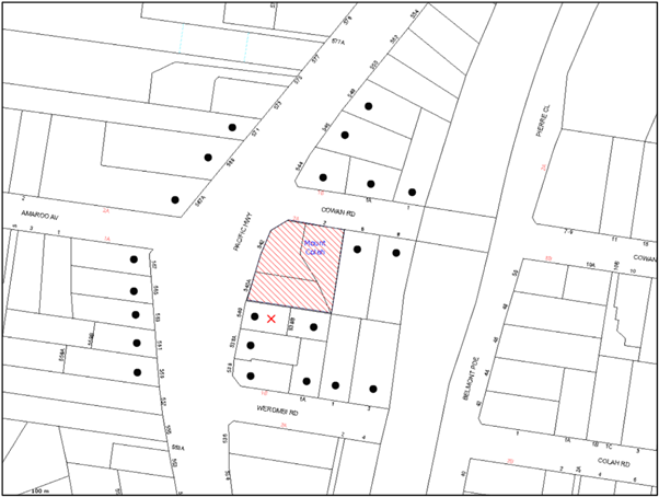
|
NOTIFICATION PLAN |
|
||
|
• PROPERTIES NOTIFIED
|
X SUBMISSION RECEIVED |
PROPERTY SUBJECT OF DEVELOPMENT |
|
One submission objected to the development. The grounds of objection are discussed as follows:
5.1.1 Overshadowing and Privacy Impacts
The impact of the proposed development on the amenity of an adjacent dwelling house including overshadowing and visual and acoustic privacy impacts were raised as a concern.
The proposed development would result in some overshadowing of the adjacent dwelling house to the south. However, the adjacent property to the south is zoned 5 storey residential flat buildings and therefore, the design of the proposal has regard for the Desired Future Character of the locality.
On the upper level on the building there are three units per floor adjoining the southern boundary. One unit is oriented to the street, a central unit has an outlook towards the south boundary however a privacy screen is located on the balcony and the eastern unit complies with the required 6 metre setback. Therefore, the building is designed to limit overlooking towards the southern boundary.
The proposal is in accordance with the objective of the subject R4 High Density Residential zone to provide for the housing needs of the community within a high density residential environment.
5.1.2 Traffic and Parking impacts
A submission raises concerns that the proposed development would impact on the amenity of the adjacent dwelling house by increasing demand for on-street parking, and generating additional traffic.
The proposed development complies with the car parking rates required by the HDCP. The cumulative traffic impacts of redeveloping this precinct has been considered in the strategic transport model for the Housing Strategy. The required traffic management improvements have been included in the Section 94 Contributions Plan.
5.1.3 Boundary Fence
The neighbouring property queried what would happen to the boundary fence to protect her property and amenity. The existing fence along the southern boundary comprises a variable 1.8m high fence constructed of brick forward of the building line and timber behind the building line. The landscape plan proposes to construct a 1.8m high timber fence along the property boundary. A condition of consent is recommended requiring the installation of a 1.8m high boundary fence along all property boundaries behind the building line.
5.1.4 Construction Phase Impacts
A submission raises concerns regarding the impact of the proposal on the adjacent dwelling during the construction phase including noise, construction worker parking, dust and pollution and safety.
The surrounding environment would be safeguarded from asbestos contamination by an appropriate condition to address the proposed demolition of the existing buildings on the site. In addition, consent conditions are recommended in relation to hours of construction, and environmental management during the construction phase.
5.2 Public Agencies
The development application was referred to Roads and Maritime Services for comment in accordance with the provisions of State Environmental Planning Policy (Infrastructure) 2007 in respect to the Pacific Highway adjoining the site and approvals required under the Roads Act. The RMS has raised no objections to the proposed development subject to recommended conditions.
6. THE PUBLIC INTEREST
Section 79C(1)(e) of the Act requires Council to consider “the public interest”.
The public interest is an overarching requirement, which includes the consideration of the matters discussed in this report. Implicit to the public interest is the achievement of future built outcomes adequately responding to and respecting the future desired outcomes expressed in environmental planning instruments and development control plans.
The application is considered to have satisfactorily addressed Council’s and relevant agencies’ criteria and would provide a development outcome that, on balance, would result in a positive impact for the community. Accordingly, it is considered that the approval of the proposed development would be in the public interest.
CONCLUSION
The application seeks approval for the demolition of existing structures and construction of a five storey residential flat building comprising 45 units and basement car parking.
The site is located in a high density residential precinct. The design respects the site constraints and results in a reasonable outcome.
The proposed development is generally in accordance with the development controls for the ‘Pacific Highway Mount Colah Precinct’ of the HDCP and would contribute to the future desired residential character of the precinct. The proposal complies with the design principles of SEPP 65 and the Residential Flat Design Code, subject to recommended conditions of consent.
The proposal would result in a development that would be in keeping with the desired future character of the precinct.
Note: At the time of the completion of this planning report, no persons have made a Political Donations Disclosure Statement pursuant to Section 147 of the Environmental Planning and Assessment Act 1979 in respect of the subject planning application.
RESPONSIBLE OFFICER
The officer responsible for the preparation of this Report is the Manager – Development Assessments – Rodney Pickles, who can be contacted on 9847 6731.
|
Rod Pickles Manager - Development Assessment Planning Division |
James Farrington Group Manager Planning Division |
|
1.View |
Locality Map |
|
|
|
2.View |
Site Plan |
|
|
|
3.View |
Shadow Plan |
|
|
|
4.View |
Elevations |
|
|
|
5.View |
Floor Plans |
|
|
|
6.View |
Landscape Plan |
|
|
File Reference: DA/176/2015
Document Number: D05963899
SCHEDULE 1
GENERAL CONDITIONS
The conditions of consent within this notice of determination have been applied to ensure that the use of the land and/or building is carried out in such a manner that is consistent with the aims and objectives of the relevant legislation, planning instruments and council policies affecting the land and does not disrupt the amenity of the neighbourhood or impact upon the environment.
Note: For the purpose of this consent, the term ‘applicant’ means any person who has the authority to act on or the benefit of the development consent.
Note: For the purpose of this consent, any reference to an Act, Regulation, Australian Standard or publication by a public authority shall be taken to mean the gazetted Act or Regulation, or adopted Australian Standard or publication as in force on the date that the application for a construction certificate is made.
1. Deferred Commencement
Pursuant to Section 80(3) of the Environmental Planning and Assessment Act 1979, this consent does not operate until the following information is submitted to Council:
a) The registration and creation of easements to drain water from the site over downstream properties in accordance with one of the options as shown in the Stormwater Drainage Easements Options Plan, Drawing No 14053-C06, Revision P1 by TLD Engineering Consultants, PTY LTD, Dated 14.07.15
b) Submission of a report by a Chartered Professional Engineer of the Institution of Engineers, Australia demonstrating that the downstream Council pipes to which the discharge from the site is proposed to be connected have adequate capacities. In absence, the downstream pipe(s) are to be upgraded with construction of the stormwater system.
c) Alternatively, consent from Sydney Trains to construct and permit discharge from, a Council drainage system onto the railway swale drain complying with the authority’s requirements. Consent letter from Sydney trains is to be submitted to Council.
Such information shall be submitted within 12 month of the date of this notice.
Upon Council’s written satisfaction of the above information, the following conditions of development consent will apply:
2. Approved Plans and Supporting Documentation
The development must be carried out in accordance with the plans and documentation listed below and endorsed with Council’s stamp, except where amended by Council and/or other conditions of this consent:
|
Plan No. |
Plan Title |
Drawn by |
Dated |
|
A105-A |
Site Analysis |
Mijollo International |
23.01.15 |
|
A201-A |
Plan Level B2 |
Mijollo International |
23.01.15 |
|
A202-B |
Plan Level B1 |
Mijollo International |
14.05.15 |
|
A203-B |
Plan Level 1 (Ground) |
Mijollo International |
14.05.15 |
|
A204-C |
Plan Level 2 & 3 |
Mijollo International |
04.08.15 |
|
A205-C |
Plan Level 4 |
Mijollo International |
04.08.15 |
|
A206-C |
Plan Level 5 |
Mijollo International |
04.08.15 |
|
A207-B |
Plan Level 6 |
Mijollo International |
14.05.15 |
|
A208-B |
Site Plan & Roof Plan |
Mijollo International |
04.08.15 |
|
A301-B |
Elevation North & West |
Mijollo International |
14.05.15 |
|
A302-C |
Elevation South & East |
Mijollo International |
04.08.15 |
|
A310-B |
Schedule of Finishes |
Mijollo International |
04.08.15 |
|
A401-B |
Section A-A |
Mijollo International |
04.08.15 |
|
A501-A |
Detail Plans Adaptable Units |
Mijollo International |
23.01.15 |
|
A600-B |
East and South Perspectives |
Mijollo International |
14.05.15 |
|
LPDA 15-270/1 Rev E |
Landscape Plan |
Conzept |
3.02.15 |
|
LPDA 15-270/2 Rev B |
Landscape Details |
Conzept |
2.02.15 |
|
LPDA 15-270/3 Rev B |
Landscape Plan (Levels 2,3&4) |
Conzept |
2.02.15 |
|
LPDA 15-270/4 Rev B |
Landscape Plan (Level 5) |
Conzept |
2.02.15 |
|
14053-C00 Rev P1 |
Stormwater Drainage Layout Level 1 |
TDL Engineering |
2.02.15 |
|
14053-C01 Rev P1 |
Stormwater Drainage Layout Basement Level 1 |
TDL Engineering |
2.02.15 |
|
14053-C02 Rev P1 |
Stormwater Drainage Layout Basement Level 2 |
TDL Engineering |
2.02.15 |
|
14053-C03 Rev P1 |
Stormwater Management Plan Detail Sheet |
TDL Engineering |
2.02.15 |
|
14053-C02 Rev P1 |
Erosion and Sediment Management Plan |
TDL Engineering |
2.02.15 |
|
14053-C03 Rev P1 |
Erosion and Sediment Management Plan Detail |
TDL Engineering |
2.02.15 |
|
14053-C06 Rev P1 |
Stormwater Drainage Easement Options |
TDL Engineering |
30.7.15 |
|
Document Title |
Prepared by |
Dated |
|
Basix Assessment Report |
Longshi Group |
5.02.14 |
|
Basix Certificate No.606240M |
ESD Synergy Pty Ltd |
5.02.15 |
|
Acoustic DA Assessment |
Acouras Consultancy |
13.02.15 |
|
Access & Adaptability Assessment Report |
Access Mobility Solutions |
4.02.15 |
|
Traffic and Parking Assessment |
Ason Group |
28.01.15 |
|
Tree Health and Condition Assessment |
Bradshaw Tree Services |
30.1.15 |
|
Waste Management Plan |
Longshi Group |
Received 4.6.15 |
|
Safety Security and Crime Prevention Design Measures (as described in the Statement of Environmental Effects |
Caladines Town Planning |
Feb 2015 |
3. Removal of Existing Trees
This development consent permits the removal of all the trees located on the site. The development consent permits the removal of Trees No.1 and 2 located on the nature strip as identified in the Tree Health and Condition Assessment Report prepared by Bradshaw Tree Services, dated 30 January 2015. The removal of any other trees requires separate approval in accordance with the Tree and Vegetation Chapter 1B.6 Hornsby Development Control Plan (HDCP).
4. Construction Certificate
a) A Construction Certificate is required to be approved by Council or a Private Certifying Authority prior to the commencement of any works under this consent.
b) The Construction Certificate plans must not be inconsistent with the Development Consent plans.
5. Section 94 Development Contributions
a) In accordance with Section 80A(1) of the Environmental Planning and Assessment Act 1979 and the Hornsby Shire Council Section 94 Development Contributions Plan 2012-2021, the following monetary contributions shall be paid to Council to cater for the increased demand for community infrastructure resulting from the development:
|
Description |
Contribution (4) |
|
Roads |
$19,990.55 |
|
Open Space and Recreation |
$495,874.70 |
|
Community Facilities |
$69,106.90 |
|
Plan Preparation and Administration |
$2,049.75 |
|
TOTAL |
$587,021.90 |
being for 17 x 1 bedroom units, 23 x 2 bedroom units, 5 x 3 bedroom units and including credit for 3 existing allotments.
b) The value of this contribution is current as at 12 August 2015. If the contributions are not paid within the financial quarter that this condition was generated, the contributions payable will be adjusted in accordance with the provisions of the Hornsby Shire Council Section 94 Development Contributions Plan and the amount payable will be calculated at the time of payment in the following manner:
$CPY = $CDC x CPIPY
CPIDC
Where:
$CPY is the amount of the contribution at the date of Payment
$CDC is the amount of the contribution as set out in this Development Consent
CPIPY is the latest release of the Consumer Price Index (Sydney – All Groups) at the date of Payment as published by the ABS.
CPIDC is the Consumer Price Index (Sydney – All Groups) for the financial quarter at the date applicable in this Development Consent Condition.
c) The monetary contributions shall be paid to Council:
i) prior to the issue of the Subdivision Certificate where the development is for subdivision; or
ii) prior to the issue of the first Construction Certificate where the development is for building work; or
iii) prior to issue of the Subdivision Certificate or first Construction Certificate, whichever occurs first, where the development involves both subdivision and building work; or
iv) prior to the works commencing where the development does not require a Construction Certificate or Subdivision Certificate.
It is the professional responsibility of the Principal Certifying Authority to ensure that the monetary contributions have been paid to Council in accordance with the above timeframes.
Council’s Development Contributions Plan may be viewed at www.hornsby.nsw.gov.au or a copy may be inspected at Council’s Administration Centre during normal business hours.
REQUIREMENTS PRIOR TO THE ISSUE OF A CONSTRUCTION CERTIFICATE
6. Building Code of Australia
All building work must be carried out in accordance with the relevant requirements of the Building Code of Australia.
7. Contract of Insurance (Residential Building Work)
In the case of residential building work for which the Home Building Act 1989 requires there to be a contract of insurance in force in accordance with Part 6 of that Act, that such a contract of insurance is in force before any building work authorised to be carried out by the consent commences.
8. Notification of Home Building Act, 1989 Requirements
Residential building work within the meaning of the Home Building Act 1989 must not be carried out unless the principal certifying authority for the development to which the work relates (not being Council) has given Council written notice of the following information:
a) In the case of work for which a principal contractor is required to be appointed:
i) The name and licence number of the principal contractor; and
ii) The name of the insurer by which the work is insured under Part 6 of that Act.
b) In the case of work to be done by an owner-builder:
i) The name of the owner-builder; and
ii) If the owner-builder is required to hold an owner-builder’s permit under that Act, the number of the owner-builder’s permit.
Note: If arrangements for doing the residential building work are changed while the work is in progress so that the information notified becomes out of date, further work must not be carried out unless the principal certifying authority for the development to which the work relates (not being Council) has given Council written notification of the updated information.
9. Utility Services
The applicant must submit written evidence of the following service provider requirements:
a) Ausgrid (formerly Energy Australia) – a letter of consent demonstrating that satisfactory arrangements have been made to service the proposed development.
b) Telstra - a letter of consent demonstrating that satisfactory arrangements have been made to service the proposed development.
10. Dilapidation Report
A ‘Dilapidation Report’ is to be prepared by a ‘chartered structural engineer’ detailing the structural condition of the adjoining properties, No.538B Pacific Highway Mount Colah and No.540 Pacific Highway Mount Colah.
11. Adaptable Units
The development is required to provide 14 units designed as adaptable housing pursuant to the requirements of 1C.2.2 of the Hornsby Development Control Plan. In this regard five (5) car parking spaces are to be designed for people with a disability and allocated to 5 adaptable units. The details of all adaptable units must be provided with the Construction Certificate plans.
12. Waste Management Details
The following waste management requirements must be complied with:
a) Both garbage chutes are to be fitted with volume handling equipment to automatically change the bin into which the garbage falls when it becomes full. Note: a 2 x 600L bin linear carousel or diversion splitter is acceptable;
b) The approved on-going waste management system must not be amended without the written consent of Council.
13. Noise – Rail Corridor and Pacific Highway
The development must be carried out in accordance with the recommendations contained within the acoustic report submitted with the development application, titled ‘Acoustic DA Assessment’, prepared by Acouras Consultancy and dated 13/2/2015 and the requirements of the Department of Planning’s Development Near Rail Corridors and Busy Roads – Interim Guideline and RailCorp’s Interim Guidelines for Applicants.
Note: The Department of Planning’s document is available at www.planning.nsw.gov.au (development assessments). The RailCorp document is available at www.railcorp.nsw.gov.au/publications.
14. Stormwater Drainage
The stormwater drainage system for the development must be designed and constructed for an average recurrence interval of 20 years and be gravity drained via an onsite detention and water quality treaty systems to the following requirements:
a) Connected to an existing Council piped drainage system that is to be connected in accordance with one of the options as shown in the Stormwater Drainage Easements Options Plan, Drawing No 14053-C06, Revision P1 by TLD Engineering Consultants, PTY LTD, Dated 14.07.15
b) All drainage works that requires laying of pipe within Council road reserve or becomes part of Council’s network must be constructed in accordance with Council‘s Civil works Specifications and a construction certificate application is to be submitted to Council for approval. An overland flowpath is to be provided over any proposed drainage line that is to become part of Council pipe system through private properties
c) Where RailCorp’s consent is obtained for discharge to railway swale/open drain all works are to be constructed in accordance with requirements of the authority. Stamped copy of the approval is to be submitted to Council prior to issue of a construction certificate.
Any stormwater pipe from the development site that is to be located within Cowan Road reserve to discharge to the railway swale/open drain shall be constructed in accordance with Council’s Civil Works Specifications. A construction certificate is to be submitted to Council for approval.
d) Be designed by a Chartered Professional Civil/ Hydraulic Engineer of the Institution of Engineers, Australia
15. Connection to Council Pit
a) The connection to any Council pit shall be inspected by a Council Engineer in the Planning Division. Prior to the connection, an application shall be made to Council and all fees paid. An inspection booking can be made by calling 98476787.
b) Prior to the issue of an occupation permit, a compliance certificate shall be obtained from Council for the connection to Council pit.
16. On-Site Stormwater Detention
An on-site stormwater detention system must be designed by a chartered civil engineer and constructed in accordance with the following requirements:
a) Storage capacity to accommodate volume from up to 20 years ARI (average recurrence interval) and a maximum discharge (when full) limited to 5 years pre development rate.
b) Have a surcharge/inspection grate located directly above the outlet.
c) Discharge from the detention system to be controlled via 1 metre length of pipe, not less than 50 millimetres diameter or via a stainless plate with sharply drilled orifice bolted over the face of the outlet discharging into a larger diameter pipe capable of carrying the design flow to an approved Council system.
d) Where above ground and the average depth is greater than 0.3 metres, a ‘pool type’ safety fence and warning signs to be installed.
e) Not be constructed in a location that would impact upon the visual or recreational amenity of residents.
f) Detail calculations are to be shown in construction certificate plan.
17. Urban Stormwater Quality
a) Stormwater discharging from the development site is to be treated to achieve the quality specified in Council’s Development Control Plan 2012 (table 1C.1.2(b) Urban Stormwater Quality Targets).
b) Prior to occupation of the premises, a Chartered Civil/Hydraulic Engineer of the Institution of Engineers, Australia is to certify that works have been completed in accordance with the approved construction plan and the measures will achieve the targets specified in the condition.
18. Vehicular Crossing
A separate application under the Local Government Act, 1993 and the Roads Act, 1993 must be submitted to Council for the installation of a new vehicular crossing and the removal of the redundant crossing. The vehicular crossing must be constructed in accordance with Council’s Civil Works Design, 2005 and the following requirements:
a) Any redundant crossings to be replaced with integral kerb and gutter.
b) The footway area to be restored by turfing.
c) Approval obtained from all relevant utility providers that all necessary conduits be provided and protected under the crossing.
Note: An application for a vehicular crossing can only be made to one of Council’s Authorised Vehicular Crossing Contractors. You are advised to contact Council on 02 9847 6940 to obtain a list of contractors.
19. Internal Driveway/Vehicular Areas
The driveway and parking areas on site must be designed in accordance with Australian Standards 2890.1, 2890.2, 3727 and the following requirements:
a) Design levels at the front boundary be obtained from Council.
b) All parking areas and driveways are to be sealed to an all-weather standard, line marked and signposted;
c) Car parking, loading and unloading areas to be used solely for nominated purposes.
20. Footpath
Concrete footpaths must be constructed along the full frontage of the subject site in Pacific Highway and Cowan Road in accordance Council’s Civil Works Design and Construction Specification 2005 and the following requirements:
a) The land adjoining the footpath to be fully turfed.
b) Any public utility adjustments to be carried out at the cost of the applicant and to the requirements of the relevant public authority
c) A construction certificate application is to be submitted to Council. .
21. Road Works
All road works approved under this consent must be constructed in accordance with Council’s Civil Works Design and Construction Specification, 2005 and the following requirements:
a) The existing kerb and gutter (including the kerb return) in Cowan Road fronting the development is to be removed and a new kerb and gutter (including kerb return) is to be constructed. The new kerb and gutter is to be located centrally within the road reserve and is to provide for an 11m width between the face of kerbs
b) Kerb and gutter is to be constructed along the Pacific Highway frontage of the development. All works are to be carried out in accordance with the requirements of RMS and stamped approved plans from the authority are to be submitted for issue of a construction certificate by Council.
c) The existing intersection kerb return between Pacific Highway and Cowan Road fronting the property is to be removed and upgraded to RMS’s requirements. Approved plan by RMS is to be submitted to Council for issue of a construction certificate by Council.
d) The existing road pavement to be saw cut a minimum of 300 mm from the existing edge of the bitumen and reconstructed for kerb and gutter construction works.
e) The submission of a compaction certificate from a geotechnical engineer for any fill within road reserves, and all road sub-grade and road pavement materials.
f) No work is to commence within the road reserve until approval under Section 138 of the Roads Act is obtained from Hornsby Shire Council. In this regard a construction certificate application is to be submitted to Council
g) Road Occupancy permit shall be obtained from RMS for carrying out works within Pacific Highway road reserve.
22. Preservation of Survey Infrastructure
Prior to the issue of a construction certificate, a registered surveyor shall identify all survey marks in the vicinity of the proposed development. Any survey marks required to be removed or displaced as a result of the proposed development shall be undertaken by a registered surveyor in accordance with Section 24 (1) of the Surveying and Spatial Information Act 2002 and following the Surveyor General’s Directions No.11 – "Preservation of Survey Infrastructure".
23. Traffic Control Plan
A Traffic Control Plan (TCP) must be prepared by a qualified traffic controller in accordance with the Roads & Traffic Authority’s Traffic Control at Worksites Manual 1998 and Australian Standard 1742.3 for all work on a public road. The Traffic Management Plan shall be submitted and approved by Council’s Manager Traffic and Road Safety prior to the issue of a construction certificate. The TCP must detail the following:
a) Arrangements for public notification of the works.
b) Temporary construction signage.
c) Permanent post-construction signage.
d) Vehicle movement plans.
e) Traffic management plans.
f) Pedestrian and cyclist access/safety.
The Traffic Control plan is to be submitted to Council for approval prior to the issue of a Construction Certificate.
REQUIREMENTS PRIOR TO THE COMMENCEMENT OF ANY WORKS
24. Erection of Construction Sign
A sign must be erected in a prominent position on any site on which building work, subdivision work or demolition work is being carried out:
a) Showing the name, address and telephone number of the principal certifying authority for the work;
b) Showing the name of the principal contractor (if any) for any demolition or building work and a telephone number on which that person may be contacted outside working hours; and
c) Stating that unauthorised entry to the work site is prohibited.
Note: Any such sign is to be maintained while the building work, subdivision work or demolition work is being carried out, but must be removed when the work has been completed.
25. Protection of Adjoining Areas
A temporary hoarding, fence or awning must be erected between the work site and adjoining lands before the works begin and must be kept in place until after the completion of the works if the works:
a) Could cause a danger, obstruction or inconvenience to pedestrian or vehicular traffic.
b) Could cause damage to adjoining lands by falling objects.
c) Involve the enclosure of a public place or part of a public place.
Note: Notwithstanding the above, Council’s separate written approval is required prior to the erection of any structure or other obstruction on public land.
26. Toilet Facilities
Toilet facilities must be available or provided at the works site before works begin and must be maintained until the works are completed at a ratio of one toilet for every 20 persons employed at the site. Each toilet must:
a) be a standard flushing toilet connected to a public sewer; or
b) be a temporary chemical closet approved under the Local Government Act 1993; or
c) have an on-site effluent disposal system approved under the Local Government Act 1993.
27. Erosion and Sediment Control
Erosion and sediment control measures must be provided and maintained throughout the construction period in accordance with the manual ‘Soils and Construction 2004 (Bluebook)’, the approved plans, Council specifications and to the satisfaction of the principal certifying authority. The erosion and sediment control devices must remain in place until the site has been stabilised and revegetated.
Note: On the spot penalties may be issued for any non-compliance with this requirement without any further notification or warning.
28. Project Arborist
A Project Arborist (AQF5 qualified) must be appointed for the installation of tree trunk protection and fencing required to protect the tree root zone of Tree No.14. The project Arborist must provide tree protection zone monitoring, including recording of any modifications or alterations to tree protection zone fencing.
29. Tree Protection Barriers
Tree protection fencing must be erected around trees numbered 14 Eucalyptus cladocalyx (Sugar Gum) to be retained at a 9 metre setback. The tree fencing must be constructed of 1.8 metre ‘cyclone chainmesh fence’ or star pickets spaced at 2 metre intervals, connected by a continuous high-visibility barrier/hazard mesh at a height of 1 metre. Installation of fencing must be in accordance with AS 4970-2009 (1.4.4).
The Project Arborist (AQF 5) must submit to the Principal Certifying Authority a certification/statement stating that all installed tree protection measures are in accordance Council conditions and are consistent with the intentions of the Australian Standard ‘Protection of Trees on Development Sites (AS 4970-2009) prior to commencement of works.
REQUIREMENTS DURING CONSTRUCTION
30. Construction Work Hours
All work on site (including demolition and earth works) must only occur between 7am and 5pm Monday to Saturday (unless otherwise approved in writing by Council, due to extenuating circumstances). No work is to be undertaken on Sundays or public holidays.
31. Demolition
All demolition work must be carried out in accordance with “Australian Standard 2601-2001 – The Demolition of Structures” and the following requirements:
a) Demolition material must be disposed of to an authorised recycling and/or waste disposal site and/or in accordance with an approved waste management plan;
b) Demolition works, where asbestos material is being removed, must be undertaken by a contractor that holds an appropriate licence issued by WorkCover NSW in accordance with Chapter 10 of the Occupational Health and Safety Regulation 2001 and Clause 29 of the Protection of the Environment Operations (Waste) Regulation 2005 ;and
c) On construction sites where buildings contain asbestos material, a standard commercially manufactured sign containing the words ‘DANGER ASBESTOS REMOVAL IN PROGRESS’ measuring not less than 400mm x 300mm must be erected in a prominent position visible from the street.
32. Environmental Management
The site must be managed in accordance with the publication ‘Managing Urban Stormwater – Landcom (March 2004) and the Protection of the Environment Operations Act 1997 by way of implementing appropriate measures to prevent sediment run-off, excessive dust, noise or odour emanating from the site during the construction of the development.
33. Construction Vehicles
All construction vehicles associated with the development are to be contained on site or in an approved “Work Zone” in Cowan Road.
34. Waste Management Details
Waste management during the demolition and construction phase of the development must be undertaken in accordance with the approved Waste Management Plan. Additionally written records of the following items must be maintained during the removal of any waste from the site and such information submitted to the Principal Certifying Authority within fourteen days of the date of completion of the works:
a) The identity of the person removing the waste.
b) The waste carrier vehicle registration.
c) Date and time of waste collection.
d) A description of the waste (type of waste and estimated quantity).
e) Details of the site to which the waste is to be taken.
f) The corresponding tip docket/receipt from the site to which the waste is transferred (noting date and time of delivery, description (type and quantity) of waste).
g) Whether the waste is expected to be reused, recycled or go to landfill.
Note: In accordance with the Protection of the Environment Operations Act 1997, the definition of waste includes any unwanted substance, regardless of whether it is reused, recycled or disposed to landfill.
35. Street Sweeping
Street sweeping must be undertaken following sediment tracking from the site along Cowan Road during works and until the site is established.
The street cleaning services must undertake a street ‘scrub and dry’ method of service and not a dry sweeping service that may cause sediment tracking to spread or cause a dust nuisance.
36. Works Near Trees
All required tree protection measures around Tree No.14 are to be maintained in good condition for the duration of the construction period.
All work within the tree protection zone (TPZ) of trees to be retained is to be undertaken under the supervision of the Project Arborist. The project Arborist is to make recommendations for maintaining tree health/condition and if necessary carry out remedial action to ensure the health and vigour of the tree in accordance with AS 4970.
37. Council Property
During construction works, no building materials, waste, machinery or related matter is to be stored on the road or footpath. The public reserve must be kept in a clean, tidy and safe condition at all times.
Note: This consent does not give right of access to the site via Council’s park or reserve. Should such access be required, separate written approval is to be obtained from Council.
38. Disturbance of Existing Site
During construction works, the existing ground levels of open space areas and natural landscape features, (including natural rock-outcrops, vegetation, soil and watercourses) must not be altered unless otherwise nominated on the approved plans.
39. Landfill
Landfill must be constructed in accordance with Council’s ‘Construction Specification 2005’ and the following requirements:
a) All fill material imported to the site is to wholly consist of Virgin Excavated Natural Material (VENM) as defined in Schedule 1 of the Protection of the Environment Operations Act 1997 or a material approved under the Department of Environment and Climate Change’s general resource recovery exemption.
b) A compaction certificate is to be obtained from a geotechnical engineer verifying that the specified compaction requirements have been met.
40. Excavated Material
All excavated material removed from the site must be classified in accordance with the Department of Environment, Climate Change and Water NSW Waste Classification Guidelines prior to disposal to an approved waste management facility and reported to the principal certifying authority.
41. Survey Report – Finished Floor Level
A report(s) must be prepared by a registered surveyor and submitted to the principal certifying authority;
a) Prior to the pouring of concrete at each level of the building certifying that:
i) The building, retaining walls and the like have been correctly positioned on the site; and
ii) The finished floor level(s) are in accordance with the approved plans.
b) Confirming that the waste collection vehicle turning area complies with AS2890.1 – 2004 and AS20890.2 – 2002 for small rigid vehicles (SRV).
REQUIREMENTS PRIOR TO THE ISSUE OF AN OCCUPATION CERTIFICATE
Note: For the purpose of this consent, a reference to ‘occupation certificate’ shall not be taken to mean an ‘interim occupation certificate’ unless otherwise stated.
42. Sydney Water – s73 Certificate
An s73 Certificate must be obtained from Sydney Water.
43. Works as Executed Plan
Works-as-executed plans must be prepared by a registered surveyor and submitted to Council for completed road works, drainage, driveway, on-site detention and water quality treatment systems.
44. Creation of Easements
The following matter(s) must be nominated on the plan of subdivision under s88B of the Conveyancing Act 1919:
a) An inter–allotment easement(s) to drain water over each of the burdened lot.
b) The creation of an appropriate "Positive Covenant" and "Restriction as to User" over the constructed on-site detention and water quality treatment systems and outlet works, within the lots in favour of Council in accordance with Council’s prescribed wording. The position of the on-site detention system and water quality treatment system is to be clearly indicated on the title.
c) To register the positive covenant and the restriction on the use of land, “works-as-executed” details of the on-site-detention system and water quality system must be submitted verifying that the required storage and discharge rates and water quality treatment measures have been constructed in accordance with the design requirements. The details must show the invert levels of the on-site system together with pipe sizes and grades and details of water quality treatment measures. Any variations to the approved plans must be shown in red on the “works-as-executed” plan and supported by calculations.
d) The creation of a drainage easement over private properties in accordance with Council’s Civil works Association over any stormwater pipe that is to become a part of Council pipe network with a minimum width of 3m.
Note: Council must be nominated as the authority to release, vary or modify any easement, restriction or covenant.
45. Certificate of Preservation of Survey Marks
A certificate by a Registered Surveyor shall be submitted to the Principal Certifying Authority, certifying that there has been no removal, damage, destruction, displacement or defacing of the existing survey marks in the vicinity of the proposed development or otherwise the re-establishment of damaged, removed or displaced survey marks has been undertaken in accordance with the Surveyor General’s Direction No.11 – “Preservation of Survey Infrastructure”.
46. Waste Management
a) The bin storage room at the basement level must include water or a hose for cleaning, graded floors with drainage to sewer, a robust door, sealed and impervious surface, adequate lighting and ventilation, and must be lockable. The waste facility rooms/cupboards at each residential level must include sealed and impervious surface, adequate lighting and ventilation.
b) A report must be prepared by an appropriately qualified person, certifying the following:
i) A comparison of the estimated quantities of each waste type against the actual quantities of each waste type.
Note: Explanations of any deviations to the approved Waste Management Plan is required to be included in this report.
ii) That at least 60% of the waste generated during the demolition and construction phase of the development was reused or recycled.
Note: If the 60% diversion from landfill cannot be achieved in the Construction Stage, the Report is to include the reasons why this occurred and certify that appropriate work practices were employed to implement the approved Waste Management Plan. The Report must be based on documentary evidence such as tipping dockets/receipts from recycling depots, transfer stations and landfills, audits of procedures etc. which are to be attached to the report.
iii) All waste was taken to site(s) that were lawfully permitted to accept that waste.
c) Each unit must be provided with an indoor waste/recycling cupboard for the interim storage of a minimum one day’s waste generation with separate containers for general waste and recyclable materials.
d) Space must be provided for either individual compost containers for each unit or a communal compost container;
Note: The location of the compost containers should have regard for potential amenity impacts.
e) The bin carting routes must be devoid of any steps.
Note: Ramps between different levels are acceptable.
f) Access to the automatic waste volume handling equipment by unauthorised persons (including residents and waste collectors) must be prevented.
Note: Caging of the automatic volume handling equipment is acceptable.
47. Planter Boxes / On Slab Planting
On slab planter boxes must include waterproofing, subsoil drainage (proprietary drainage cell, 50mm sand and filter fabric) automatic irrigation, minimum 500mm planting soil for shrubs and minimum 1000mm planting soil for trees and palms and 75mm mulch to ensure sustainable landscape is achieved.
48. Street Tree Plantings
Planting in the front verge to Cowan Road is to include 2 x Eucalyptus haemastoma (Scribbly Gum) installed at minimum 100 litre pot size. All replacement trees must be maintained until they reach the height of 3 metres. Preparations must involve ground cultivation plus imported soils for planting, finished with mulch surrounds to base, plus hardwood staking and hessian ties for a period of establishment.
All plant stock must meet the specifications outlined in ‘Specifying Trees’ (Ross Clark, NATSPEC Books) and that the planting methods are current, professional (best practice) industry standards at the time of planting
49. Completion of Landscaping
A certificate must be provided by a practicing landscape architect, horticulturalist or person with similar qualifications and experience testifying that all required landscaping works have been satisfactorily completed in accordance with the approved landscape plans.
Note: Applicants are advised to pre-order plant material required in pot sizes 45 litre or larger to ensure nurseries have stock available at the time of installation.
50. Project Arborist Certification
Final Certification – A certificate from the Project Arborist must be submitted to the Principal Certifying Authority stating compliance with the provided conditions of this consent.
51. Boundary Fencing
Fencing must be erected along all property boundaries behind the front building alignment to a height of 1.8 metres.
Fences to the primary and secondary frontages (along the Pacific Highway and Cowan Road) are to retain visual transparency (not lapped / solid) and be 1.2 metres in height.
Note: Alternative fencing may be erected subject to the written consent of the adjoining property owner(s).
52. External Lighting
All external lighting must be designed and installed in accordance with Australian Standard AS 4282 – Control of the Obtrusive Effects of Outdoor Lighting. Certification of compliance with the Standard must be obtained from a suitably qualified person.
53. Acoustic Environment
A certificate must be provided by a qualified acoustic consultant certifying that all required noise mitigation measures have been satisfactorily implemented in accordance with the conditions of this consent.
54. Unit/Allotment Numbering
The allocation of unit/allotment numbering must be authorised by Council prior to the numbering of each unit/allotment in the development.
OPERATIONAL CONDITIONS
55. Traffic and Road Safety
a) Any proposed landscaping and/or fencing must not restrict sight distance to pedestrians and cyclists travelling along the footpath.
b) Residential parking spaces are to be secure spaces with access controlled by card or numeric pad.
c) Visitors must be able to access the visitor parking spaces in the basement car park at all times.
d) All parking for people with disabilities is to comply with AS/NZS 2890.6:2009 Off-street parking for people with disabilities.
e) Bicycle parking spaces are to be designed in accordance with AS 2890.3-1993 Bicycle parking facilities.
f) Motorcycle parking spaces are to be designed in accordance with AS 2890.5-1993.
56. Storage Areas
Each dwelling within the development must have a minimum area for storage (not including built-in storage in kitchens and bedrooms) of 6m3 for one bedroom units, 8m3 for two bedroom units and 10m3 for three bedroom units.
57. Safety and Security
a) Fire exit doors to the development must be fitted with single cylinder locksets (Australia and New Zealand Standard – Lock Sets) to restrict unauthorized access to the development.
b) Ground floor windows must be fitted with window locks that can be locked with a key.
c) A graffiti management plan must be incorporated into the maintenance plan for the development for graffiti to be removed within a forty-eight hour period.
d) The basement car park entry must be secured by security gates/roller shutters and controlled by secure access located at the top of the driveway. The access control is to include an audio/visual intercom system to allow visitor access to the parking area.
e) In order to prevent vehicle tail-gating on entry the timing of the security door closing is to be a maximum of 10 seconds. Signage is to be erected instructing drivers to wait until the roller door fully closes prior to proceeding.
f) Lighting of pedestrian pathways throughout the development must comply with Australia and New Zealand Lighting Standard 1158.1 – Pedestrian.
g) Front fencing to be designed to allow casual surveillance at the frontage.
h) The entry foyer door is to be a security door with access being restricted to an intercom, code or card lock system.
i) The street number of the building is to be readily identifiable from Cowan Road.
j) Quality mail box doors and non-tamper proof locks must be fitted to mail boxes.
k) The bicycle racks are to have secure locking loops bolted into the concrete flooring.
l) Storage cages are to be constructed of quality steel mesh, welded to a sturdy metal frame and provided with a total of 3 hinges and 3 locking points. A secure locking loop bolted into the concrete floor is also required to be provided to enable use of padlocks.
m) The internal portions of the basement are to be illuminated in accordance with the AS1158.1, AS1680 and AS2890.1.
n) The ceiling of each basement level shall be painted white or a like colour to increase visibility and reflective light throughout each basement level.
o) Landscape vegetation located within the common circulation areas and at the street frontage is to be routinely maintained to ensure that vegetation does not obstruct sight lines from the street frontage.
p) Each pedestrian entry and associated common areas are to be sufficiently illuminated during the evenings to facilitate lines of sight from common areas and private open space areas to the secured entry door.
58. Works as Executed Plan
A works-as-executed plan(s) must be prepared by a registered surveyor and submitted to Council for completed road pavement, kerb & gutter, public drainage systems, driveways and on-site detention system.
59. Consolidation of Allotments
All allotments the subject of this consent must be consolidated into one allotment.
Note: The applicant is recommended to submit the plan of subdivision to consolidate allotments to the NSW Department of Lands at least 4-6 weeks prior to seeking an occupation certificate.
60. Provision for National Broadband Network (NBN)
Provision must be made for fibre ready passive infrastructure (pits and pipes) generally in accordance with NBN Co.'s pit and pipe installation guidelines to service the proposed development. A certificate from NBN Co or Telstra must be submitted to the PCA that the fibre optic cabling provided for the development complies with MDU Building Design Guides for Development.
61. Garbage Collection Easement
For the purpose of waste collection, an easement entitling Council, its servants and agents and persons authorised by it to enter upon the subject land and to operate thereon, vehicles and other equipment for the purposes of garbage collection must be granted to Council by the owner of the land.
Note: The easement must be in a form prescribed by Council and must include covenants to the effect that parties will not be liable for any damage caused to the subject land or any part thereof or to any property located therein or thereon by reason of the operation thereon of any vehicle or other equipment used in connection with the collection of garbage and to the effect that the owner for the time being of the subject land shall indemnify the Council, its servants, agents and persons authorised by it to collect garbage against liability in respect of any such claims made by any person whomsoever.
62. Waste Management
The waste management on site must be in accordance with the following requirements:
a) A site caretaker must be employed and be responsible for moving bins where and when necessary, washing bins and maintaining waste storage areas, ensuring the chute system and related devices are maintained in effective and efficient working order, managing the communal composting area, managing the bulky item storage area, arranging the prompt removal of dumped rubbish, and ensuring all residents and commercial tenants are informed of the use of the waste management system. The site caretaker must be employed for a sufficient number of hours each week to allow all waste management responsibilities to be carried out to a satisfactory standard.
63. Landscape Establishment
The landscape works must be maintained into the future to ensure the establishment and successful growth of plant material to meet the intent of the landscape design. This must include but not be limited to watering, weeding, removing turf from around the base of street trees, re-mulching, replacement of failed plant material and promoting the growth of plants through standard industry practices.
64. Noise
All noise generated by the proposed development must be attenuated to prevent levels of noise being emitted to adjacent premises which possess tonal, beating and similar characteristics or which exceeds background noise levels by more than 5dB(A).
65. Maintenance of Wastewater Device
All wastewater and stormwater treatment devices (including drainage systems, sumps and traps) must be regularly maintained in order to remain effective. All solid and liquid wastes collected from the device must be disposed of in accordance with the Protection of the Environment Operations Act 1997.
66. Fire Safety Statement - Annual
On at least one occasion in every 12 month period following the date of the first ‘Fire Safety Certificate’ issued for the property, the owner must provide Council with an annual ‘Fire Safety Certificate’ to each essential service installed in the building.
CONDITIONS OF CONCURRENCE – ROADS AND MARITIME SERVICES
67. The redundant driveways on Pacific Highway shall be removed and replaced with kerb and gutter to match existing. The design and construction of the kerb and gutter on Pacific Highway shall be in accordance with Roads and Maritime requirements. Details of these requirements should be obtained from Roads and Maritime Services, Manager Developer Works, Statewide Delivery, Parramatta (telephone 8849 2138).
Detailed design plans of the proposed gutter crossing are to be submitted to Roads and Maritime for approval prior to the issue of a Construction Certificate and commencement of any road works.
A plan checking fee (amount to be advised) and lodgement of a performance bond may be required from the applicant prior to the release of the approved road design plans by Roads and Maritime.
68. A construction zone will not be permitted on Pacific Highway.
69. The developer is to submit design drawings relating to the excavation of the site and support structures to Roads and Maritime for assessment, in accordance with Technical Direction GTD2012/001.
The developer is to submit all documentation at least six (6) weeks prior to commencement of construction and is to meet the full cost of the assessment by Roads and Maritime.
The report and any enquiries should be forwarded to:
Project Engineer, External Works
Sydney Asset Management
Roads and Maritime Services
PO Box 973 Parramatta CBD 2124
Telephone 8849 2114
Fax 8849 2766
If it is necessary to excavate below the level of the base of the footings of the adjoining roadways, the person acting on the consent shall ensure that the owner/s of the roadway is/are given at least seven (7) days’ notice of the intention to excavate below the base of the footings. The notice is to include complete details of the work.
70. Detailed design plans and hydraulic calculations of any changes to the stormwater drainage system are to be submitted to Rods and Maritime for approval, prior to the commencement of any works.
Details should be forwarded to:
Sydney Asset Management
Roads and Maritime Services
PO Box 973 Parramatta CBD 2124
A plan checking fee will be payable and a performance bond may be required before Roads and Maritime approval is issued. With regard to the civil works requirement please contact the Roads and Maritime Project Engineer, External Works Ph: 8849 2114 or Fax 8849 2766.
71. The layout of the proposed car parking areas associated with the subject development (including, driveways, grades, turn paths, sight distance, aisle widths, aisle lengths, and parking bay dimensions) should be in accordance with As2890.1-2004, AS2890.6-2009 and AS2890.2-2002 for heavy vehicle usage.
- END OF CONDITIONS -
ADVISORY NOTES
The following information is provided for your assistance to ensure compliance with the Environmental Planning and Assessment Act, 1979, Environmental Planning and Assessment Regulation 2000, other relevant legislation and Council’s policies and specifications. This information does not form part of the conditions of development consent pursuant to Section 80a of the Act.
Environmental Planning and Assessment Act 1979 Requirements
The Environmental Planning and Assessment Act 1979 requires:
· The issue of a construction certificate prior to the commencement of any works. Enquiries can be made to Council’s Customer Services Branch on 9847 6760.
· A principal certifying authority to be nominated and Council notified of that appointment prior to the commencement of any works.
· Council to be given at least two days written notice prior to the commencement of any works.
· Mandatory inspections of nominated stages of the construction inspected.
· An occupation certificate to be issued before occupying any building or commencing the use of the land.
Long Service Levy
In accordance with Section 34 of the Building and Construction Industry Long Service Payments Act 1986, a ‘Long Service Levy’ must be paid to the Long Service Payments Corporation or Hornsby Council.
Note: The rate of the Long Service Levy is 0.35% of the total cost of the work.
Note: Hornsby Council requires the payment of the Long Service Levy prior to the issue of a construction certificate.
Tree and Vegetation Preservation
In accordance with Clause 5.9 of the Hornsby Local Environmental Plan 2013 a person must not ringbark, cut down, top, lop, remove, injure or wilfully destroy any tree or other vegetation protected under the Hornsby Development Control Plan 2013 without the authority conferred by a development consent or a permit granted by Council.
Notes: A tree is defined as a long lived, woody perennial plant with one or relatively few main stems with the potential to grow to a height greater than three metres (3M). (HDCP 1B.6.1.c).
Tree protection measures and distances are determined using the Australian Standard AS 4970:2009, “Protection of Trees on Development Sites”.
Fines may be imposed for non-compliance with both the Hornsby Local Environmental Plan 2013 and the Hornsby Development Control Plan 2013
Disability Discrimination Act
The applicant’s attention is drawn to the existence of the Disability Discrimination Act. A construction certificate is required to be obtained for the proposed building/s, which will provide consideration under the Building Code of Australia, however, the development may not comply with the requirements of the Disability Discrimination Act. This is the sole responsibility of the applicant.
Dial Before You Dig
Prior to commencing any works, the applicant is encouraged to contact Dial Before You Dig on 1100 or www.dialbeforeyoudig.com.au for free information on potential underground pipes and cables within the vicinity of the development site.
Telecommunications Act 1997 (Commonwealth)
If you are aware of any works or proposed works which may affect or impact on Telstra’s assets in any way, you are required to contact: Telstra’s Network Integrity Team on Phone Number 1800810443.
Asbestos Warning
Should asbestos or asbestos products be encountered during demolition or construction works, you are advised to seek advice and information prior to disturbing this material. It is recommended that a contractor holding an asbestos-handling permit (issued by WorkCover NSW) be engaged to manage the proper handling of this material. Further information regarding the safe handling and removal of asbestos can be found at:
Alternatively, telephone the WorkCover Asbestos and Demolition Team on 8260 5885.
Group Manager’s Report No. PL41/15
Planning Division
Date of Meeting: 9/09/2015
12 DEVELOPMENT APPLICATION - RESIDENTIAL FLAT BUILDING COMPRISING 37 UNITS - 15 AND 17 FOREST GROVE, EPPING
EXECUTIVE SUMMARY
|
DA No: |
DA/346/2015 (Lodged on 1 April 2015) |
|
Description: |
Demolition of existing structures and construction of a 5 storey residential flat building containing 8 x 1 bedroom, 25 x 2 bedroom and 4 x 3 bedroom units above two basement parking levels. |
|
Property: |
Lot 6 and Lot 7, DP 11533, (Nos. 15 – 17) Forest Grove, Epping |
|
Applicant: |
Whole Sun Constructions Pty Ltd |
|
Owner: |
Ms P L Ong and Mr X P Zhang Ms F Zhang |
|
Estimated Value: |
$8,300,000 |
|
Ward: |
C |
· The application proposes demolition of the existing dwelling houses and other site improvements and construction of a 5 storey residential flat building containing 8 x 1 bedroom, 25 x 2 bedroom and 4 x 3 bedroom units above two basement parking levels.
· The proposal generally complies with the State Environmental Planning Policy No. 65 – Design Quality of Residential Flat Development, the Hornsby Local Environmental Plan No. 2013 and is generally in accordance with the Residential Flat Design Code and Hornsby Development Control Plan 2013.
· Three submissions have been received in respect of the application.
· It is recommended that the application be approved, subject to conditions of consent.
|
THAT Development Application No. DA/346/2015 for demolition of existing structures and the construction of a five storey residential flat building comprising 37 units with basement car parking at Lot 6 and Lot 7, DP 11533, Nos. 15-17 Forest Grove, Epping be approved subject to the conditions of consent detailed in Schedule 1 of Group Manager’s Report No. PL41/15. |
BACKGROUND
The site forms part of the Epping Urban Activation Precinct (Epping UAP).
On 14 March 2014, the Department of Planning and Environment finalised amendments to the Hornsby Local Environmental Plan 2013 (HLEP) to implement the Epping UAP via State Environmental Planning Policy (Epping Town Centre) 2013 (“the SEPP Amendment”).
Amendments to the Hornsby Development Control Plan 2013 (HDCP) were consequently prepared by Council to translate design controls recommended by the Department of Planning and Environment and provided that the planning controls be read in conjunction with the HLEP amendments. The DCP amendments were exhibited and endorsed by Council on 8 October 2014.
A pre-lodgement meeting was held between Council officers and the applicant to discuss the design, prior to lodgement of the application. At the meeting, design concerns were raised by Council staff in terms of building form, building separation, waste management, on-site detention and setbacks.
On 1 April 2015, Development Application No. 346/2015 was lodged for the demolition of the existing dwelling houses and associated structures and construction of a five storey residential flat building comprising thirty seven units above basement parking.
On 22 May 2015, Council raised a number of planning concerns with respect to the application. On 19 June 2015, a meeting to discuss the concerns was held.
On 7 August 2015, the applicant forwarded a final set of amended plans addressing the matters raised by Council.
SITE
The site is located on the eastern side of Forest Grove and south of Epping Road. The site has an area of 1720.2 square metres, a 37.765 metre frontage to Forest Grove, and an average depth of 61.052 metres. The site comprises two allotments being one rectangular shaped lot (No. 15) and one irregular shaped (No. 17). The site slopes away from the north boundary. The site is located directly opposite Forest Park.
Existing improvements on the allotments include two dwelling-houses with their respective outbuildings. Vehicular access to the sites is via existing driveways from Forest Grove.
The site contains a number of exotic, native and local indigenous trees.
The site forms part of a precinct which is undergoing redevelopment. Development consents have been granted for five storey residential flat buildings at Nos. 9-11 Forest Grove (DA/963/2014), at No. 1 Forest Grove (DA/1606/2014) and at Nos. 27, 29 and 31 Forest Grove (DA/153/2015).
The surrounding developments currently include predominately single storey residential dwellings. The development site adjoins land to the east that is zoned R2 - Low Density Residential. The property is located in the vicinity of heritage-listed Forest Park (to the west of site) and the Essex Street Heritage Conservation Area (HCA) to the east of the site.
The site is located approximately 400 metres from Epping Railway Station and approximately 550 metres to the south-east of Epping commercial town centre.
PROPOSAL
It is proposed to demolish the existing structures and construct a five storey residential flat building comprising thirty-seven units with two levels of basement car parking and associated landscaping works.
The unit mix is 8 x 1 bedroom units, 25 x 2 bedrooms units, and 4 x 3 bedrooms.
The units would be accessed via a lift centrally located in the building and would include balconies fronting the property boundaries. The development would be accessed from Forest Grove via a driveway located towards the south-western boundary of the site. Pedestrian access to the development from Forest Grove is positioned in the centre of the site.
A total of 43 car parking spaces, including 6 visitors’ parking spaces are proposed in two basement levels.
The site would drain to a detention tank at the rear of the building and then to a second detention tank adjacent to the southern side of the building, and thereafter to the west towards Council’s stormwater drainage pipeline.
ASSESSMENT
The development application has been assessed having regard to A Plan for Growing Sydney, the North Subregion (Draft) Subregional Strategy and the matters for consideration prescribed under Section 79C of the Environmental Planning and Assessment Act 1979 (the Act). The following issues have been identified for further consideration.
1. STRATEGIC CONTEXT
1.1 A Plan for Growing Sydney and (Draft) North Subregional Strategy
A Plan for Growing Sydney has been prepared by the NSW Government to guide land use planning decisions for the next 20 years. The Plan sets a strategy for accommodating Sydney’s future population growth and identifies the need to deliver 689,000 new jobs and 664,000 new homes by 2031. The Plan identifies that the most suitable areas for new housing are in locations close to jobs, public transport, community facilities and services.
The NSW Government will use the subregional planning process to define objectives and set goals for job creation, housing supply and choice in each subregion. Hornsby Shire has been grouped with Hunters Hill, Ku-ring-gai, Lane Cove, Manly, Mosman, North Sydney, Pittwater, Ryde, Warringah and Willoughby to form the North Subregion. The Draft North Subregional Strategy will be reviewed and the Government will set housing targets and monitor supply to ensure planning controls are in place to stimulate housing development.
The proposed development would be consistent with A Plan for Growing Sydney, by providing 37 additional dwellings and would contribute to housing choice in the locality.
2. STATUTORY CONTROLS
Section 79C(1)(a) requires Council to consider “any relevant environmental planning instruments, draft environmental planning instruments, development control plans, planning agreements and regulations”.
2.1 Hornsby Local Environmental Plan 2013
The proposed development has been assessed having regard to the provisions of the Hornsby Local Environmental Plan 2013 (HLEP).
2.1.1 Zoning of Land and Permissibility
The subject land is zoned R4 (High Density Residential) under the HLEP. The objectives of the zone are as follows:
(a) To provide for the housing needs of the community within a high density residential environment.
(b) To promote a variety of housing types within a high density residential environment.
(c) To enable other land uses that provide facilities or services to meet the day to day needs of residents. The proposed development is defined as and is permissible in the zone with Council’s consent.
The proposed development is defined as a ‘residential flat building’ under the HLEP and is permissible in the zone with the consent of Council.
2.1.2 Height of Buildings
Clause 4.3 of the HLEP provides that the height of a building on any land should not exceed the maximum height show for the land on the Height of Buildings Map. The maximum permissible height for the subject site is 17.5 metres. The height of the proposed building varies between 15.7 to 17.5 metres and complies with this provision.
2.1.3 Heritage Conservation
Clause 5.10 of the HLEP sets out heritage conservation provisions for Hornsby Shire. The development site is located in the vicinity of heritage listed Forest Park (west) and the Essex Street Heritage Conservation Area (HCA) (east) under Schedule 5 (Environmental Heritage) of the HLEP.
The proposed development would not have any negative impact on the heritage significance of the HCA given its separation and setbacks from the heritage items and conservation area. The views to, and from within, the HCA would not be adversely affected. However, it is acknowledged that the visual setting will be altered to varying degrees as the western HCA backdrop will be one of medium rise buildings visible above the HCA’s low density housing.
The rear eastern elevation which is orientated to the HCA has stepped wall lengths. The original submitted plans indicated areas of light brick and render. The initial assessment identified the proposed materials as a matter requiring further consideration. The proposed materials and colours have been amended to include a greater mix of dark brick and rendered walls, and will be more visually recessive to the conservation area than the original submission. The amended materials and colours now meet the objective of providing a satisfactory visual interface with the HCA.
The subject site is also located opposite the heritage listed park (Forest Park), however it is unlikely to adversely impact on the heritage significance of Forest Park.
In summary, the proposed five storey high residential flat building will have a visual impact on the western backdrop to the Essex Street HCA. The impact would be reduced by appropriate tree planting at the rear of the site and the provision of a greater mix of dark brick material on the eastern elevation as proposed. A condition is recommended requiring suitable screen planting.
2.1.4 Earthworks
Clause 6.2 of the HLEP states that consent is required for proposed earthworks on site. Before granting consent for earthworks, Council is required to assess the impacts of the subject works on adjoining properties, drainage patterns and soil stability of the locality. The proposal is satisfactory subject to conditions regarding submission of a ‘Dilapidation Report’ assessing the impact of the excavation on the adjoining properties and the implementation of appropriate measures to prevent sediment run-off, excessive dust, noise and the like emanating from the site during the construction of the development.
2.2 State Environmental Planning Policy No. 32 – Urban Consolidation (Redevelopment of Urban Land) (SEPP 32)
The application has been assessed against the requirements of SEPP 32, which requires Council to implement the aims and objectives of this Policy to the fullest extent practicable when considering development applications relating to redevelopment of urban land. The application complies with the objectives of the Policy as it would promote social and economic welfare of the locality and would result in the orderly and economic use of under-utilised land within the Shire.
2.3 State Environmental Planning Policy No. 55 – Remediation of Land
State Environmental Planning Policy No. 55 – Remediation of Land requires that Council must not consent to the carrying out of any development on land unless it has considered whether the land is contaminated or requires remediation for the proposed use.
The site has been used for residential purposes and is unlikely to be contaminated. Further assessment in this regard is not warranted.
2.4 State Environmental Planning Policy (Building Sustainability Index – BASIX)
The application has been assessed against the requirements of State Environmental Planning Policy (Building Sustainability Index: BASIX) 2004. The proposal includes a BASIX Certificate for the proposed units and is considered to be satisfactory.
2.5 State Environmental Planning Policy No. 65 – Design Quality of Residential Flat Development (SEPP 65)
The Policy provides for design principles to improve the design quality of residential flat development and for consistency in planning controls across the State.
SEPP 65 was amended on 19 June 2015 (Amendment No. 3) following review of the policy by the Department of Planning and Environment. The amendments replace the Residential Flat Design Guidelines with the Apartment Design Guide which prevails in the event of any inconsistency with a Development Control Plan.
Clause 31 (Transitional provisions for SEPP 65 – Amendment No. 3) states that “If a development application or an application for the modification of a development consent has been made before the notification on the NSW legislation website of the making of State Environmental Planning Policy No 65—Design Quality of Residential Flat Development (Amendment No 3) and the application has not been finally determined before the commencement of that amendment, the application must be determined as if the amendment had not commenced.”
Pursuant to the above provision, this amendment would not apply to the subject application and the previous version (Amendment 2) of SEPP 65 is required to be considered.
2.5.1 Design Principles
The applicant has submitted a ‘Design Verification Statement’ prepared by a qualified Architect stating how the proposed development achieves the design principles of SEPP 65. The design principles of SEPP 65 and the submitted design verification statement are addressed in the following table.
|
Principle |
Compliance |
|
1. CONTEXT |
Yes |
|
Comment: The site is located in close proximity to Epping Railway Station and the Epping Commercial Town Centre in a precinct that has been planned to accommodate five storey residential flat buildings. The applicant’s ‘Design Verification Statement’ indicates that the proposal responds to the desired future character of the precinct as envisaged by Council. Once the development of the precinct is completed, the proposal would integrate with the surrounding sites and would be in keeping with the future urban form. It is considered that the proposed building would contribute to the identity and future character of the precinct. The development responds suitably to the “context” principle of SEPP 65, considering the desired future character of the area. |
|
|
2. SCALE |
Yes |
|
Comment: The scale of the development is in accordance with the height and setbacks controls for the precinct specified under Part 3.4 of the HDCP, being the applicable planning controls at the time the application was submitted. The building length along its east-west axis varies between 31 and 38 metres, which does not comply with the maximum floor-plate dimension of 35 metres specified in the HDCP. However, the building bulk along the north and south elevations (to which longer axis reflects) has been minimised. The proposed articulation of the building and use of wrap-around balconies to soften the corners of the building ensures the scale of the building is appropriate. The length of the building relates to the length of the lots. The design provides proportional and compliant setbacks along all boundaries of the development. The development would achieve a scale consistent with the desired future precinct character being one of residential flat buildings in landscaped settings with underground car parking. |
|
|
3. BUILT FORM |
Yes |
|
Comment: The proposed building achieves an appropriate built form for the site and its purpose, in terms of building alignments, proportions and the manipulation of building elements. The building would positively contribute to the character of the desired future streetscape and includes articulation to minimise the perceived scale. The proposed materials and finishes would add to the visual interest of the development. Flat roof forms have been adopted, with an increased top storey setback incorporated into the external facades to minimise bulk and height of the building as required by the HDCP. |
|
|
4. DENSITY |
Yes |
|
Comment: There is no floor space ratio control applying to the site. The density of the development is governed by the HLEP’s height control and the required setbacks in the HDCP. The development complies with the density controls. These density controls, set in consultation with the local community, means that the development of the site adequately responds to the regional context, availability of infrastructure, public transport, community facilities and environmental quality of the area. |
|
|
5. RESOURCE, ENERGY AND WATER EFFICIENCY |
Yes |
|
Comment: The applicant has submitted a BASIX Certificate for the proposed development. In achieving the required BASIX targets for sustainable water use, thermal comfort and energy efficiency, the proposed development would achieve efficient use of natural resources, energy and water throughout its full life cycle, including demolition and construction. |
|
|
6. LANDSCAPE |
Yes |
|
Comment: The application includes a landscape concept plan which provides landscaping along the street frontages, side and rear boundaries and includes a 7m x 7m deep soil landscaped area at the rear of the building. The proposal has been designed to facilitate the retention of 3 significant trees, two of these being on the street frontage and the third centrally located in the rear yard of the property. Large trees are proposed along the street frontages interspersed with shrubs and hedges which would soften the appearance of the development when viewed from the street. Deep soil areas that incorporate canopy trees are provided around the building envelope which would enhance the development’s natural environmental performance and provide an appropriate landscaped setting. The proposed development meets the intent of the “Landscape” principle of SEPP 65. |
|
|
7. AMENITY |
Yes |
|
Comment: The proposed units are designed with appropriate room dimensions and layout to maximise amenity for future residents. The proposal incorporates good design in terms of achieving natural ventilation, solar access and acoustic privacy. All units incorporate balconies accessible from living areas and privacy has been achieved through appropriate design and orientation of balconies and living areas. Storage areas have been provided within each unit and in the basement levels. The proposal would provide convenient and safe access via a central lift connecting the basement and all other levels. The proposed development meets the intent of the “Amenity” principle of SEPP 65. |
|
|
8. SAFETY AND SECURITY |
Yes |
|
Comment: The design orientates the balconies and windows of individual apartments towards the street, rear and side boundaries, providing passive surveillance of the public domain and communal open space areas. Both the pedestrian and vehicular entry points are secured and visibly prominent from Forest Grove. The proposal includes an assessment of the development against crime prevention controls in the Statement of Environmental Effects (SEE). The SEE has regard to Crime Prevention Through Environmental Design (CPTED) principles and includes details of surveillance, access control, territorial reinforcement and space management such as artificial lighting in public places; attractive landscaping whilst maintaining clear sight lines; security coded door lock or swipe card entry; physical or symbolic barriers to attract, channel or restrict the movement of people; security controlled access to basement car park; intercom access for pedestrians; and security cameras located at the entrance of the building. Appropriate conditions of consent are recommended to require compliance with the above matters. |
|
|
9. SOCIAL DIMENSIONS AND HOUSING AFFORDABILITY |
Yes |
|
Comment: The proposal incorporates a range of unit sizes to cater for different budgets and housing needs. The development complies with the housing choice requirements of the HDCP by meeting the minimum component of adaptable housing and minimum mix of 1, 2 and 3 bedroom dwellings. The site is located in close proximity to Epping railway station and shops. The proposal therefore responds to the social context in terms of providing a range of dwelling sizes with good access to social facilities and services. |
|
|
10. AESTHETICS |
Yes |
|
Comment: The architectural treatment of the building incorporates indentations and projections in the exterior walls with balcony projections to articulate the facades. The roof is flat or low pitched to minimise building height and incorporates eaves which would cast shadows across the top storey wall. The articulation of the building, composition of building elements, textures, materials and colours would achieve a built form generally consistent with the design principles contained within the Residential Flat Design Code and the HDCP. The details of the assessment of the built form and the aesthetics of the development are contained in Section 2.10 of this report. |
|
2.6 State Environmental Planning Policy No. 65 – Residential Flat Design Code
SEPP 65 requires consideration of the Residential Flat Design Code, NSW Planning Department 2002 (the ‘Code’). The Code includes development controls and best practice benchmarks for achieving the design principles of SEPP 65. The following table sets out the proposal’s compliance with the Code:
|
Residential Flat Design Code |
|||
|
Control |
Proposal |
Requirement |
Compliance |
|
Deep Soil Zone |
37% |
25% |
Yes |
|
Communal Open Space |
34% |
25-30% |
Yes |
|
Ground Level Private Open Space |
Unit 1 – 15.57m2 with a min dimension of 2m Unit 2 – 18.18m2 with a min dimension of 3m Unit 3 – 18.18m2 with a min dimension of 3m Unit 4 – 22.89m2 with a min dimension of 2m Unit 5 – 10.01m2 with a min dimension of 2.5m Unit 6 – 12.25m2 with a min dimension of 2.5m Unit 7 – 12.44m2 with a min dimension of 2m Unit 8 – 14.25m2 with a min dimension of 3m |
Minimum area 25m2 Minimum dimension 4m |
No No |
|
Minimum Dwelling Size |
1 br – 50.06m2 -53.23m2 2 br – 71.23m2- 83.64m2 3 br –99.8m2-111.98m2 |
1 br – 50m2 2 br – 70m2 3 br – 95m2 |
Yes Yes Yes |
|
Maximum Kitchen Distance |
8.8m (Units 4,9,12, 21 and 22) 8.5m (Units 16,17,20,24 and 31) |
8m |
No |
|
Minimum Balcony Depth |
2m |
2m |
Yes |
|
Minimum Ceiling Height |
2.7m |
2.7m |
Yes |
|
Total Storage Area |
1 bed - 6m3 (Min) 2 bed - 8m3 (Min) 3 bed - 10m3 (Min)
|
1 bed - 6m3 (Min) 2 bed - 8m3 (Min) 3 bed - 10m3 (Min)
50% accessible from the apartments |
Yes |
|
Dual Aspect and Cross Ventilation |
78% |
60% |
Yes |
|
Adaptable Housing |
30% |
10% |
Yes |
As detailed in the above table, the proposed development complies with most of the prescriptive measures within the Code. Below is a brief discussion regarding the relevant development controls and best practice guidelines.
2.6.1 Ground Floor Apartments and Private Open Space
The Code encourages separate entries for ground floor apartments and private garden areas at the ground floor area.
The proposed ground floor unit open spaces include balconies/courtyards contained within the building’s footprint. These areas do not meet the prescriptive measures under the Code, however the unit open space areas are considered appropriate for the respective ground floor units in respect to dwelling size, aspect, function, unit configuration and amenity. The non-compliance with the best practice of 25 square metre open space area with a minimum dimension of 4 metres is considered acceptable as larger open space areas, if they were provided, would be lost to private use and not contribute as effectively to achieving the HDCP’s key principle for five storey residential flat buildings to be in garden settings. The units however comply with the HDCP’s minimum requirements for private open space areas, and the overall private open space provision is considered satisfactory.
In addition the adaptable dwellings benefit from convenient access via continuous paths of travel and lifts to common outdoor open space areas. It is considered that the design of the proposed ground floor units is satisfactory in meeting the objectives of the Code.
2.6.2 Maximum Kitchen Distance
The Code requires that the back of a kitchen should be no greater than 8 metres from a window. Of the 37 units proposed, 10 units contain kitchens where the back wall is up to 8.8 metres from a window. However, these units offer an open layout with natural ventilation and, accordingly, the minor non-compliance is acceptable with respect to residential amenity.
2.6.3 Apartment Layout
The layout of the proposed apartments includes a combination of single aspect units and dual aspect corner units. The unit layouts would provide for housing choice and a range of household types.
The Code requires that not more than 10% of apartments (being 4 units) be south facing. The proposal is generally compliant with this requirement. The application provides four units, being Units 6, 14, 22 and 30, with a south facing aspect. The issue is acceptable as the overall proportion of floor space with a southern orientation has been minimised.
All units comply with the minimum floor area requirements of the Code.
The proposed apartment layouts satisfy the Code objectives for internal privacy, access to sunlight, natural ventilation and acoustic privacy. It is considered that the apartment layout and mix achieve the intent of the best practice requirements of the Code and is acceptable.
2.6.4 Internal Circulation
The proposed development includes access to all floors via a lift. The internal corridors meet the Code’s requirements for the maximum number of units accessed (no more than 8 on a floor). The ground floor foyer also provides direct, level access to communal open space at the eastern side (rear) of the site.
The proposal is acceptable with the requirements of the Code in respect to internal circulation.
2.6.5 Acoustic Privacy
The internal layout of the residential units is designed such that noise generating areas would adjoin each other wherever possible. Circulation zones, communal services or fire stairs would act as a buffer between units. Bedrooms and service areas such as kitchens, bathrooms and laundries are grouped together wherever possible.
As the site fronts Forest Grove, which is a local road, an acoustic report was not required to be provided. However, consent conditions would require that all noise generated by the proposed development be attenuated to prevent levels of noise emitted to adjacent premises exceeding background noise levels by more than more 5 dB(A).
The proposal is overall consistent with the Code for acoustic privacy.
2.6.6 Storage
The proposed building includes resident storage areas for the apartments, accessed from a hall or living room. In addition, storage cages are indicated in the basement. A condition is recommended to ensure that each dwelling within the development must have a minimum area for storage of 6m³ for one bedroom units, 8m³ for two bedroom units and 10m³ for three bedroom units, where at least 50% is required to be located within the apartment and provided in addition to bedroom and kitchen cupboards.
2.6.7 Summary
In summary, the proposed residential flat buildings have been designed in accordance with the design principles of SEPP 65 and generally comply with the Residential Flat Design Code. It is considered the proposal would achieve good residential amenity and contribute to the desired future character of the precinct.
2.7 Sydney Regional Environmental Plan (Sydney Harbour Catchment) 2005
The application has been assessed against the requirements of Sydney Regional Environmental Plan (Sydney Harbour Catchment) 2005. This Policy provides general planning considerations and strategies to ensure that the catchment, foreshores, waterways and islands of Sydney Harbour are recognised, protected, enhanced and maintained.
Subject to the implementation of installation of sediment and erosion control measures and stormwater management to protect water quality, the proposal would have minimal potential to impact on the Sydney Harbour Catchment.
2.8 Clause 74BA Environmental Planning and Assessment Act, 1979 - Purpose and Status of Development Control Plans (DCP)
Clause 74BA of the Act states that a DCP provision will have no effect if it prevents or unreasonably restricts development that is otherwise permitted and complies with the development standards in relevant Local Environmental Plans and State Environmental Planning Policies.
The principal purpose of a development control plan is to provide guidance on the aims of any environmental planning instrument that applies to the development; facilitate development that is permissible under any such instrument; and achieve the objectives of land zones. The provisions contained in a DCP are not statutory requirements and are for guidance purposes only. Consent authorities have flexibility to consider innovative solutions when assessing development proposals, to assist in achieving good planning outcomes.
2.9 Hornsby Development Control Plan 2013 (HDCP)
The proposed development has been assessed having regard to the relevant desired outcomes and prescriptive requirements within the HDCP. The following table sets out the proposal’s compliance with the prescriptive requirements of the Plan:
|
Hornsby Development Control Plan 2013 |
|||
|
Control |
Proposal |
Requirement |
Compliance |
|
Site Width |
29.8m 37m Frontage |
Min 30m |
No |
|
Height |
5 storeys + Mezzanine – 17.5m |
Max 5 storeys /17.5m |
Yes |
|
Lowest Residential Floor Above Ground |
0m |
Max 1.5m |
Yes |
|
Floorplate Dimension |
N-S – 27m E-W - 37m |
Max 35m Max 35m |
Yes No |
|
Building Indentation |
N (side) 37m S (side) 34m E (rear) 21m W (Forest Grove) 22m |
4m x 4m 4m x 4m Not required Not required |
Yes Yes Yes Yes |
|
Height of Basement Above Ground |
0m |
Max 1m |
Yes |
|
Front Setback (Forest Grove) (width of 22m) |
6.5m ->10m |
10m Min 8m <1/3rd of building width being 7.3m Min 7m (balconies) |
No |
|
Eastern Rear Setback (width of 21m) |
10m 8m for <6m |
Min 10m Min 8m <1/3rd of frontage being 10.2m Min 7m (balconies) |
Yes Yes
Yes |
|
Northern Side Setback (width of 37m) |
6m 4m for 13m
5m (balconies) |
Min 6m Min 4m <1/3rd building length being 12.3m Min 4m balconies |
Yes
No Yes |
|
Southern Side Setback (width of 34m) |
6m 4m for 13m
|
Min 6m Min 4m for no more than 1/3rd of the building length (i.e. 11.3m) Min 4m for balconies |
Yes Yes, if measured to centreline of pathway adjoining.
Yes |
|
Top Storey Setback from Ground Floor |
3m except for 2m on southern elevation at Forest Grove |
Min 3m |
No |
|
Underground Parking Setback |
6-18m (front) 6.5-9.8m (rear) 4m (north-side) 3.5m (south-side) |
Min 7m (front) Min 7m (rear) 4m (side) 4m (side)
|
No No Yes Yes, if measured to centreline of pathway adjoining. |
|
Basement Ramp Setback |
1.5m |
Min 2m |
Yes, if measured to centreline of pathway adjoining. |
|
Deep Soil Landscaped Areas |
6-18m (front) 6.5-9.8m (rear) 4m (north-side) 3.5m (south-side) |
Min 7m (front) Min 7m (rear) 4m (side) 4m (side)
|
No No Yes Yes, if measured to centreline of pathway adjoining |
|
Private Open Space |
1 br units - >10m2 2 br units – >12m2 3 br units - >16m2 |
Min 10m2 Min 12m2 Min 16m2 |
Yes Yes Yes |
|
Communal Open Space with Minimum Dimensions 4m |
>25% |
Min 25% |
Yes |
|
Parking
|
37 resident spaces 6 visitor spaces 11 bicycle racks 1 motorbike space |
37 resident spaces 6 visitor spaces 11 bicycle racks 1 motorbike space |
Yes Yes Yes Yes |
|
Solar Access |
89% |
Min 70% |
Yes |
|
Housing Choice |
21% - 1 Bed 67% - 2 Bed 12% - 3 Bed |
Min 10% of each type |
Yes |
|
Adaptable Units |
30% |
Min 30% |
Yes |
As detailed in the above table, the proposed development does not comply with a number of prescriptive requirements within the HDCP. The matters of non-compliance are detailed below, as well as a brief discussion on compliance with relevant desired outcomes.
2.9.1 Desired Future Character
The site is included in the Epping Precinct which in recent years was rezoned from R2 (Low Density Residential) to R4 (High Density Residential) Zone.
The proposed building is in accordance with required key principles for the future character of the precinct for well-articulated five storey residential flat buildings in garden settings with underground car parking. The proposal complies with the desired outcome for the precinct.
2.9.2 Site Requirements
The HDCP requires sites to have a minimum width of 30m. The subject site has an irregular frontage with an overall dimension of 37m. The width of the consolidated site is 29.8m. However, the proposal is satisfactory for the following reasons:
The extent of the variation is minor (200mm) and has no impact upon the ability to provide sufficient setbacks and accommodate vehicle manoeuvring within the site.
The proposal amalgamates two sites. Further amalgamation is limited by the approval of DA/963/2014 (Nos 9-11 Forest Grove) adjoining the northern boundary and the pathway adjoining the site to the south.
The proposal would not result in an isolated site as the two properties south of the pathway at Nos 19-21 Forest Grove would form a consolidated site.
The proposal is therefore satisfactory in respect to the HDCP site requirements.
2.9.3 Floor-Plates
The proposed building footprint has a maximum length of 37 metres along the northern and southern elevations, which does not comply with the maximum floor-plate of 35 metres prescribed within the HDCP.
The proposal however, incorporates a 4 metre by 4 metre building indentation on each of these elevations to achieve the appearance of two separate building pavilions. The development includes sufficient articulation, varied use of materials and wrap-around balconies to ‘break-up’ the perceived bulk and scale of the building. The building has adequate setbacks from Forest Grove and the rear low density interface. The proposal presents sufficient deep-soil areas to ensure the establishment of canopy trees, which will soften the presentation of the building. The development achieves a scale consistent with the desired character of the precinct of residential flat buildings in landscaped settings with underground car parking facility in accordance with the desired outcomes of the HDCP.
Accordingly, the development’s proposed floor-plate is satisfactory.
2.9.4 Height
The proposed building complies with the 17.5 metre maximum height limit. The proposed basement car park would not project more than 1m above finished ground level. Accordingly, the proposed development is satisfactory with regard to five storey built form.
2.9.5 Setbacks
Minor variations are sought to the required setbacks for the proposed development. The development complies with the required rear setbacks. The areas of non-compliance are addressed as follows:
Front Setback Forest Grove
The subject site has an irregular boundary to Forest Grove. The building has been located on a consistent setback with the recently approved development to the north. As a result of the angle of the front boundary relative to the side boundaries there is a minor encroachment, however the remainder of the building is then located on a greater setback.
The fire stair access from the basement was originally proposed on a lesser setback. Amended plans show the relocation of the stair access adjacent to the building.
The setbacks are considered an acceptable approach for transition of setbacks of development along Forest Grove relative to the street alignment.
Northern Side Setback
The development complies with the intent of the provisions, the extent of the non-compliance being an additional 70mm of the 1/3 of the building located on the minimum setback. The building provides for appropriate indentations and articulation such that this minor variation is acceptable and will not impact on resident amenity.
Southern Side Setback
The site is adjoined by a pathway to the south. For the purposes of determining setbacks, the centre line of the pathway has been adopted as the pathway will form part of the building separation to the development to the south. The proposal complies when setbacks are measured to the centreline of the pathway.
Top Storey Setback
The building generally incorporates a 3m building setback for the top storey on all sides. However, there is a small non-compliance to 2m on the Forest Grove frontage. This portion of the building is located on the greatest setback to Forest Grove and in combination with the proposed architectural form is unlikely to have any adverse impacts and would not detrimentally impact upon the visual amenity of the streetscape and adjoining development. Additionally, the building design provides appropriate building indentations on the front and rear elevations, a balanced juxtaposition of horizontal and vertical elements, a variety of materials, and wrap-around balconies. The overall building is considered to be well articulated. In this regard, the minor variation to the top storey setback is considered acceptable.
Basement Parking Setback
There are minor intrusions on the required setbacks. The variations are largely the result of the irregular front boundary and the angle of the rear boundary relative to the side boundaries. The non-compliance is considered acceptable as the greater than minimum setbacks are provided offsetting the minor non-compliances. It is considered that the development achieves a scale consistent with the desired character of the precinct of residential flat buildings in landscaped settings with underground car parking facility in accordance with the desired outcomes of the HDCP.
2.9.6 Built Form and Separation
The Code and HDCP require a building separation of 12 metres between unscreened habitable areas or balconies increasing to 18 metres from the fifth level.
The proposed residential flat building’s northern elevation would face approved residential flat building at 9-11 Forest Grove (DA/963/2014). The elevation provides for wrap-around balconies serving corner units, and 4 to 6 metre side setbacks which is consistent the intent of the with the minimum separation requirements to the boundary.
To the south, the subject site is adjoined by the public pathway. The side boundary setbacks are met when measured to the centre line of the pathway.
The proposal would meet the HDCP desired outcome for built form and separation.
2.9.7 Landscaping
The landscaping provisions for the HDCP prescribe that a 7 metre wide landscaped area be provided in both the front and rear setbacks, and a 4 metre side landscaped area be provided along the side boundaries. As a result of the irregular boundaries there is a minor variation to the prescribed setbacks, however the design of the basement generally achieves the objective to provide for deep soil planting to the perimeters of the site.
A total of 37%, equivalent to 636 square metres, of the development site comprises landscaping and communal open spaces. Tree planting (endemic canopy trees as indicated in the conceptual landscape plan) is provided within each setback to contribute to the quality of the streetscape and reduce the apparent bulk and scale of the development.
The setbacks include deep soil planting of a variety of medium to large sized native trees and shrubs to provide privacy and screen walls.
The fire stair access from the basement level has been relocated to reduce the intrusion of the built form into the landscaped front setback. The extent of hard paved areas proposed are considered to be appropriate, as reasonable provision has been made for deep soil areas to accommodate, retaining some of the trees and achieve landscape settings.
Due to the fall of the site from the north to south across the width of the site, excavation of the northern portion of the site is proposed. The greatest excavation being proposed is in the rear northern corner of the building. To reduce the amount of excavation would increase the height at the southern elevation, which is located at natural ground level and would result in non-compliance with the height control. The amenity of the units located adjacent to the excavation is reasonable given the northerly aspect afforded and acceptable balanced against the increase in height and change from natural ground levels that would occur on the southern side of the building if there was a lesser excavation.
Primary access to communal open space is facilitated via a corridor at the southern elevation. The communal open space complies with the HDCP requirements for minimum dimensions and is embellished to support use and interaction within the space.
The on-site detention system for the development is located in a southern side setback area and rear setback of the building, with 300 millimetres soil for planting above it, restricting planting above. The tank has been located in an appropriate location considering the slope of the site, location of Council’s stormwater inlet pit on Forest Grove, and the relevant engineering requirements.
Landscaping also provides screening to the private open space areas that front the common open space to the rear. The proposal is considered acceptable in terms of the landscaping element of the HDCP subject to recommended conditions.
2.9.8 Open Space
The proposed communal open space areas comply with the prescriptive area of at least 50 square metres with a minimum dimension of 4 metres. The communal areas are to be provided at the rear of the site. The communal areas would receive at least 2 hours of sunlight between 9 am to 3 pm during mid-winter. The areas would be accessed from the foyer via an entry door centrally located on the southern side of the building, which would provide convenient access from all units.
The proposed communal open space areas are likely to provide for a range of outdoor activities and encourage active living.
In addition, passive surveillance from rear facing balconies is likely to result in high visibility of these areas. All units would achieve the minimum private open space area requirements of 10 square metres for 1 bedroom units, 12 square metres for 2 bedroom units and 16 square metres for 3 bedroom units.
It is considered that the proposed private and communal open space areas achieve the desired outcome for active recreation areas with privacy and access to sunlight.
2.9.9 Privacy and Security
Wrap-around balconies are proposed on the side boundaries with movable privacy louvers to maintain privacy and visual amenity. The ground floor private open space areas fronting the communal open spaces would be suitably screened by a 1 metre high fence and landscaping.
Concerns have been raised regarding visual and privacy impacts from the eastern elevation of the proposed building to the low density residential interface. Upper floor units would result in overlooking of the adjoining low density residential development to the east. However, the proposal is consistent with the objectives of the zone and is acceptable with regard to compliance with the HDCP for built form and setbacks. Mitigation measures to safeguard the privacy of adjoining residents that could be implemented via conditions of consent include obscure glassing on balconies, installation of stackable privacy screens, and suitable screen landscaping and fencing along the eastern section of the development.
In terms of security, the proposal provides a safe, clear and direct pedestrian entrance to the foyer of the building from Forest Grove. Passive surveillance is achieved by the orientation of private open space and living room windows of units being to the street and to the rear communal open space. The applicant has prepared a Crime Prevention through Environmental Design Assessment, which was referred to Ryde Local Police Area Command for review. The Police raised no objections to the proposal, subject to conditions to reduce criminal activity within the community and the property.
2.9.10 Sunlight and Ventilation
The development generally complies with the height and setback controls. Diagrams have been submitted demonstrating compliance of individual units with solar access requirements. As the site is located within a redevelopment precinct, the solar access analysis accounted for the overshadowing impacts from future five storey development on adjoining sites, 89% of the units would receive a minimum 2 hours solar access between 9 am and 3 pm on the mid-winter day, where the minimum requirement is 70%.
The proposal also complies with the requirement for at least 60% of dwellings to have dual aspect and natural cross ventilation.
The extent of overshadowing likely to occur would generally be consistent with that expected within the redevelopment precinct.
2.9.11 Housing Choice
The proposed development includes a range of housing types and provision for people with disabilities in accordance with the requirements of the HDCP. Eleven (30%) are designed as adaptable units which complies with the requirement of both the HDCP and Code.
2.9.12 Vehicular Access and Parking
The proposal provides 37 resident car parking spaces, 6 visitor car spaces, 11 bicycle racks and 1 motorbike space. This meets the requirements of the HDCP for developments located within 800 metres of a railway station.
The proposed basement car park is over two levels, accessed via a 6 metre wide driveway from Forest Grove. All driveway widths, gradients and aisle widths have been assessed as satisfactory. There is sufficient area within the basements to accommodate storage areas. Vehicular access and parking complies with the prescriptive measures of HDCP.
2.9.13 Key Development Principles
The proposal is within the Epping Road / Forest Grove, Epping Precinct. The key principle is for the redevelopment of the precinct to incorporate five storey residential flat buildings in garden settings with parking in basements. The development will provide for a landscaped setting and a built form that is consistent with the desired outcome for the Epping Road / Forest Grove, Epping Precinct.
2.9.14 Waste Management
The proposal includes a waste management plan with details of waste management during the construction stage and use and on-going management of waste. However, further details are required prior to the issue of a Construction Certificate as addressed by a condition in Schedule 1 of this report. The site will require four of 660 Litre garbage bins serviced twice weekly, plus eight of 240 Litre recycling bins serviced weekly, plus one - 660 Litre paper/cardboard bins serviced weekly. Each residential level is provided with a garbage bin (instead of a chute) and recycling bin in a cupboard. There is sufficient space within the basement to store the required garbage bins, recycling bins, a bin lifter and bin carting equipment. Additionally a bulky waste storage area has been provided next to the bin room. A waste collection point is provided next to the driveway. A SRV waste collection vehicle would be able to reverse into the site and forward out, with parking on the driveway.
Subject to recommended conditions, the proposed development is satisfactory in respect to the waste management.
2.10 Section 94 Contributions Plans
Hornsby Shire Council Section 94 Contributions Plan 2012-2021 applies to the development as it would result in an additional 35 residential dwellings in lieu of the 2 existing residences. Accordingly, the requirement for a monetary Section 94 contribution is recommended as a condition of consent.
3. ENVIRONMENTAL IMPACTS
Section 79C(1)(b) of the Act requires Council to consider “the likely impacts of that development, including environmental impacts on both the natural and built environments, and social and economic impacts in the locality”.
3.1 Natural Environment
3.1.1 Tree and Vegetation Preservation
Five trees are considered in the Arborist’s report submitted with the application, three of which are located within the adjacent footpath. Trees 2 and 4 being a NSW Christmas Bush and Kings Park Bottlebrush are to be removed as they will be directly impacted upon by building works. The proposed development does not include the removal of any significant trees. Measures are proposed to protect Trees 1 and 5 during building works. Tree 3 is located within the adjacent footpath and building works will not result in any impacts to this tree.
Subject to conditions requiring replanting of trees, the proposal would provide adequate tree canopy areas as required within the precinct.
3.1.2 Stormwater Management
The development would connect to council’s drainage system located in Forest Grove via an on-site detention tank (OSD). Council’s engineering assessment concludes that subject to conditions recommended in Schedule 1, the OSD and stormwater management system would minimise the effects of flooding and maintain natural environmental flows. Additionally, subject to sediment and erosion control measures being implemented on site during construction, the proposal would comply with the desired outcomes of the HDCP.
3.2 Built Environment
3.2.1 Built Form
The previous sections of this report have described the development’s built form and its compliance with the relevant planning controls.
The proposed built form, despite some minor non-compliance with controls, is considered acceptable.
3.2.2 Traffic
Concerns have been raised regarding traffic generation. A traffic and parking assessment has been submitted with the proposal. The estimated traffic generation of the existing site and proposed development has been determined using Roads and Maritime Services traffic generation rates contained in the Guide to Traffic Generating Developments – Technical Direction TDT 2013-04 (May 2013). The net traffic generation of the proposed development is estimated to be 9 vehicle trips in peak periods.
Although this additional traffic may appear to be negligible when compared with the traffic volumes on the adjacent road network for this development alone, the cumulative traffic impacts of all sites earmarked for redevelopment in the precinct will be significant. The cumulative impact has been considered in the strategic transport model for Epping Town Centre Urban Activation Precinct (ETCUAP). The NSW Government has committed over $16 million in funds to address regional traffic growth to assist traffic flows. Planned works include realignment of the Essex Street / Epping Road intersection and widening of the bridge over the railway line.
3.3 Social Impacts
The residential development would improve housing choice in the locality by providing a range of dwelling types. The location of the development is in close proximity to Epping Railway Station and shops allowing direct access to retail facilities and transportation. It is considered that the development would result in a net positive social impact on the locality.
3.4 Economic Impacts
The development would result in a positive economic impact on the locality via employment generation during construction and minor increase in demand for local services following completion of the development.
4. SITE SUITABILITY
Section 79C(1)(c) of the Act requires Council to consider “the suitability of the site for the development”.
The subject site is zoned for five storey apartment buildings and the proposal involves the erection of a five storey apartment building. The site is not identified as bushfire prone, flood prone or bushland.
The scale of the proposed development is consistent with the capability of the site and is considered satisfactory.
5. PUBLIC PARTICIPATION
Section 79C(1)(d) of the Act requires Council to consider “any submissions made in accordance with this Act”.
5.1 Community Consultation
The proposed development was placed on public exhibition and was notified to adjoining and nearby landowners between 14 April and 29 April 2015 in accordance with the Notification and Exhibition requirements of the HDCP. During this period Council received 3 submissions. The map below illustrates the location of those nearby landowners who made a submission that are in close proximity to the development site.
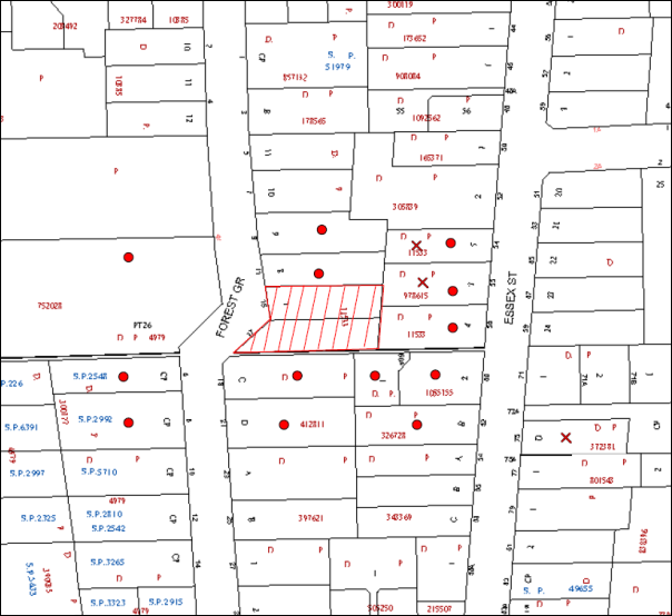
|
NOTIFICATION PLAN |
|
||
|
• PROPERTIES NOTIFIED
|
X SUBMISSIONS RECEIVED |
PROPERTY SUBJECT OF DEVELOPMENT |
|
|
Three public submissions objected to the development on the following grounds:
· Number of properties notified;
· Unacceptable traffic on local streets;
· Inadequate car parking;
· Safety of pedestrians using pathway;
· Cumulative impact of recent development applications;
· Heritage conservation;
· Building height;
· Rear setback does not comply with the HDCP;
· Impact of excavation on adjoining buildings;
· Establishment of tree canopy to screen building from adjoining heritage conservation area;
· Unacceptable loss of privacy of adjoining residents; and
· Impact upon existing infrastructure.
The merits of the matters raised in community submissions have been addressed in the body of the report with the exception of the following:
5.1.1 Extent of Notification
The application was notified in accordance with the provisions of HDCP and a notice advising of the development was erected on the site. All relevant procedures for the notification of the application were satisfied.
5.1.2 Heritage Conservation
The proposal is consistent with the objectives of Council’s HDCP regarding heritage. At is meeting on 8 October 2014, Council considered Group Manager’s Report No PL72/14 concerning submissions received to the exhibition of the draft Epping Town Centre amendments to the HDCP. Council resolved (in part) to review the heritage significance of the Essex Street and Rosebank Avenue Heritage Conservation Areas in a future stage of Council’s Heritage Review to follow development of the adjacent five storey residential precincts.
5.1.3 Safety of Pedestrians Using Pathway
The redevelopment of the area with residential flat buildings will increase the use of the pathway and enable casual surveillance of the pathway.
5.1.4 Impact Upon Existing Infrastructure
The proposed development is capable of being provided with standard urban services. The proposed means of stormwater disposal is appropriate. As discussed above, the additional traffic generated is minimal, but when considered in the context of the extent of development occurring within the precinct results in the need for improvement works which are proposed to be undertaken. Similarly, the increase in demand for services provided by Council will be met by the development making reasonable section 94 contributions under Council’s contributions plan.
5.1.5 Impact of Excavation on Adjoining Buildings
A condition is recommended for the submission of a ‘Dilapidation Report’ prepared by a qualified structural engineer detailing the condition of all adjoining properties to the rear of the subject site prior to the issue of a Construction Certificate.
In addition, a condition will be imposed for the protection of adjoining areas by temporary hoarding, fence or awning erected between the work site and adjoining lands before works begin and to be kept in place until the completion of works.
6. THE PUBLIC INTEREST
Section 79C(1)(e) of the Act requires Council to consider “the public interest”.
The public interest is an overarching requirement, which includes the consideration of the matters discussed in this report. Implicit to the public interest is the achievement of future built outcomes adequately responding to and respecting the future desired outcomes expressed in environmental planning instruments and development control plans.
The application is considered to have satisfactorily addressed Council’s and relevant agencies’ criteria and would provide a development outcome that, on balance, would result in a positive impact for the community. Accordingly, it is considered that the approval of the proposed development would be in the public interest.
CONCLUSION
The application seeks approval for the demolition of existing structures and construction of a five storey residential flat building comprising 37 units and basement car parking.
The proposed development is generally in accordance with the design principles of SEPP 65 and the Residential Flat Design Code. The proposal complies with HLEP and generally meets the HDCP desired outcomes for five storey residential flat development within the Epping Road / Forest Grove, Epping Precinct. The minor non-compliances with the prescriptive controls for frontage, setbacks and floor-plate, are considered acceptable.
The proposal would result in a development that would be in keeping with the desired future character of the precinct.
Three submissions were received in response to notification of the proposal.
The application is recommended for approval.
RESPONSIBLE OFFICER
The officer responsible for the preparation of this Report is the Manager – Development Assessments – Rodney Pickles, who can be contacted on 9847 6731.
|
ROD PICKLES Manager - Development Assessment Planning Division |
JAMES FARRINGTON Group Manager Planning Division |
|
1.View |
Locality Map |
|
|
|
2.View |
Survey Plan |
|
|
|
3.View |
Landscape Plan |
|
|
|
4.View |
Floor Plans |
|
|
|
5.View |
Elevations |
|
|
|
6.View |
Roof Plan |
|
|
|
7.View |
Materials and Finishes |
|
|
File Reference: DA/346/2015
Document Number: D05507897
SCHEDULE 1
GENERAL CONDITIONS
The conditions of consent within this notice of determination have been applied to ensure that the use of the land and/or building is carried out in such a manner that is consistent with the aims and objectives of the relevant legislation, planning instruments and council policies affecting the land and does not disrupt the amenity of the neighbourhood or impact upon the environment.
Note: For the purpose of this consent, the term ‘applicant’ means any person who has the authority to act on or the benefit of the development consent.
Note: For the purpose of this consent, any reference to an Act, Regulation, Australian Standard or publication by a public authority shall be taken to mean the gazetted Act or Regulation, or adopted Australian Standard or publication as in force on the date that the application for a construction certificate is made.
1. Approved Plans and Supporting Documentation
The development must be carried out in accordance with the plans and documentation listed below and endorsed with Council’s stamp, except where amended by Council and/or other conditions of this consent:
|
Plan No. |
Plan Title |
Drawn by |
Dated |
|
6453 |
Survey Plan |
SDG |
31 Oct 2014 |
|
8380 DA: C 00 Issue C |
Cover Sheet |
Zhinar Architects |
August 2015 |
|
8380 DA: C 03 Issue C |
Basement 2 Plan |
Zhinar Architects |
August 2015 |
|
8380 DA: C 04 Issue C |
Basement 1 Plan |
Zhinar Architects |
August 2015 |
|
8380 DA: C 05 Issue C |
Ground Floor Plan |
Zhinar Architects |
August 2015 |
|
8380 DA: C 06 Issue C |
First Floor Plan |
Zhinar Architects |
August 2015 |
|
8380 DA: C 07 Issue C |
Second Floor Plan |
Zhinar Architects |
August 2015 |
|
8380 DA: C 08 Issue C |
Third Floor Plan |
Zhinar Architects |
August 2015 |
|
8380 DA: C 09 Issue C |
Fourth Floor Plan |
Zhinar Architects |
August 2015 |
|
8380 DA: C 10 Issue C |
Fourth (Upper) Floor Plan |
Zhinar Architects |
August 2015 |
|
8380 DA: C 11 Issue C |
Roof Plan |
Zhinar Architects |
August 2015 |
|
8380 DA: C 12 Issue C |
Section 1 |
Zhinar Architects |
August 2015 |
|
8380 DA: C 13 Issue C |
Section 2 |
Zhinar Architects |
August 2015 |
|
8380 DA: C 14 Issue C |
Elevations – East and North |
Zhinar Architects |
August 2015 |
|
8380 DA: C 15 Issue C |
Elevations – West and South |
Zhinar Architects |
August 2015 |
|
8380 DA: C 16 Issue C |
Street Elevation |
Zhinar Architects |
August 2015 |
|
8380 DA: C 17 Issue C |
N & E Materials Schedule |
Zhinar Architects |
August 2015 |
|
8380 DA: C 18 Issue C |
S & W Materials Schedule |
Zhinar Architects |
August 2015 |
|
Document Title |
Prepared by |
Dated |
|
Statement of Environmental Effects |
Caladines Town Planning P/L |
April 2015 |
|
Traffic and Parking Report |
Varga Traffic Planning |
17 March 2015 |
|
Arboricultural Impact Assessment |
Redgum Horticultural |
2 Dec 2014 |
|
Accessibility |
Certified |
24 Mar 2015 |
|
BASIX (Document No 618560M) |
Building Sustainability |
24 Mar 2015 |
|
Landscape Plan 15/1776 Sheets 1 and 2 |
Paul Scrivener Landscape Architect |
27 Mar 2015 |
|
SEPP 65 Certification |
Zhinar Architects |
Mar 2015 |
|
Acoustic Assessment |
Acoustic Logic |
10 Mar 2015 |
|
Survey Plan 6453 |
SDG |
31 Oct 2014 |
|
E277287 D2 - Stormwater Management Plan – Basement Level 2 |
Donovan Associates |
30 Mar 2015 |
|
E277287 D3 - Stormwater Management Plan – Basement Level 1 |
Donovan Associates |
30 Mar 2015 |
|
E277287 D4 - Management Plan – Site Ground Floor |
Donovan Associates |
30 Mar 2015 |
|
E277287 D5 Roof Drainage Plan and Stormwater Details |
Donovan Associates |
30 Mar 2015 |
|
E277287 D6 OSD Details and Calculations |
Donovan Associates |
30 Mar 2015 |
|
E277287 D7 Upstream Catchment Analysis |
Donovan Associates |
30 Mar 2015 |
|
E277287 D8 Sediment Control Plan |
Donovan Associates |
30 Mar 2015 |
|
E277287 D9 Sediment Control Details |
Donovan Associates |
30 Mar 2015 |
2. Construction Certificate
a) A Construction Certificate is required to be approved by Council or a Private Certifying Authority prior to the commencement of any works under this consent.
b) The Construction Certificate plans must not be inconsistent with the Development Consent plans.
3. Section 94 Development Contributions
a) In accordance with Section 80A(1) of the Environmental Planning and Assessment Act 1979 and the Hornsby Shire Council Section 94 Development Contributions Plan 2012-2021, the following monetary contributions shall be paid to Council to cater for the increased demand for community infrastructure resulting from the development:
|
Description |
Contribution |
|
Roads |
25,897.80 |
|
Open Space and Recreation |
446,691.70 |
|
Community Facilities |
62,287.95 |
|
Plan Preparation and Administration |
1,850.25 |
|
TOTAL |
$536,727.70 |
being for 8 x 1 bedroom units, 25 x 2 bedroom units, 4 x 3 bedroom units and including a credit for two existing lots.
b) The value of this contribution is current as at 16 July 2015. If the contributions are not paid within the financial quarter that this condition was generated, the contributions payable will be adjusted in accordance with the provisions of the Hornsby Shire Council Section 94 Development Contributions Plan and the amount payable will be calculated at the time of payment in the following manner:
$CPY = $CDC x CPIPY
CPIDC
Where:
$CPY is the amount of the contribution at the date of Payment
$CDC is the amount of the contribution as set out in this Development Consent
CPIPY is the latest release of the Consumer Price Index (Sydney – All Groups) at the date of Payment as published by the ABS.
CPIDC is the Consumer Price Index (Sydney – All Groups) for the financial quarter at the date applicable in this Development Consent Condition.
c) The monetary contributions shall be paid to Council:
i) prior to the issue of the Subdivision Certificate where the development is for subdivision; or
ii) prior to the issue of the first Construction Certificate where the development is for building work; or
iii) prior to issue of the Subdivision Certificate or first Construction Certificate, whichever occurs first, where the development involves both subdivision and building work; or
iv) prior to the works commencing where the development does not require a Construction Certificate or Subdivision Certificate.
It is the professional responsibility of the Principal Certifying Authority to ensure that the monetary contributions have been paid to Council in accordance with the above timeframes.
Council’s Development Contributions Plan may be viewed at www.hornsby.nsw.gov.au or a copy may be inspected at Council’s Administration Centre during normal business hours.
4. Removal of Existing Trees
This development permits the removal of 2 trees identified as Tree No. 2 and Tree No. 4 in the Arboricultural Impact Assessment prepared by Redgum Horticultural and dated 2 December 2014. The removal of any other trees requires separate approval in accordance with the Tree and Vegetation Chapter 1B.6 Hornsby Development Control Plan 2013 (HDCP).
REQUIREMENTS PRIOR TO THE ISSUE OF A CONSTRUCTION CERTIFICATE
5. Building Code of Australia
All building work must be carried out in accordance with the relevant requirements of the Building Code of Australia.
6. Contract of Insurance (Residential Building Work)
In the case of residential building work for which the Home Building Act 1989 requires there to be a contract of insurance in force in accordance with Part 6 of that Act, that such a contract of insurance is in force before any building work authorised to be carried out by the consent commences.
7. Notification of Home Building Act, 1989 Requirements
Residential building work within the meaning of the Home Building Act 1989 must not be carried out unless the principal certifying authority for the development to which the work relates (not being Council) has given Council written notice of the following information:
a) In the case of work for which a principal contractor is required to be appointed:
i) The name and licence number of the principal contractor; and
ii) The name of the insurer by which the work is insured under Part 6 of that Act.
b) In the case of work to be done by an owner-builder:
i) The name of the owner-builder; and
ii) If the owner-builder is required to hold an owner-builder’s permit under that Act, the number of the owner-builder’s permit.
Note: If arrangements for doing the residential building work are changed while the work is in progress so that the information notified becomes out of date, further work must not be carried out unless the principal certifying authority for the development to which the work relates (not being Council) has given Council written notification of the updated information.
8. Water/Electricity Utility Services
The applicant must submit written evidence of the following service provider requirements:
a) Ausgrid (formerly Energy Australia) – a letter of consent demonstrating that satisfactory arrangements have been made to service the proposed development.
b) Sydney Water – the submission of a ‘Notice of Requirements’ under s73 of the Sydney Water Act 1994.
Note: Sydney Water requires that s73 applications are to be made through an authorised Sydney Water Servicing Coordinator. Refer to www.sydneywater.com.au or telephone 13 20 92 for assistance.
9. Dilapidation Report
A ‘Dilapidation Report’ is to be prepared by a ‘chartered structural engineer’ detailing the structural condition of the following adjoining properties:
a) No. 19 Forest Grove, Epping
b) No. 54 Essex Street, Epping
c) No. 56 Essex Street, Epping
d) No. 58 Essex Street, Epping
e) No. 60 Essex Street, Epping
f) No. 60A Essex Street, Epping
10. Adaptable Units
The details of the adaptable units Nos 2, 3, 6, 7, 8, 10, 11, 18, 19, 26 and 27 must be provided with the Construction Certificate Plans.
11. Noise Mitigation
The development must be carried out in accordance with the recommendations contained within the acoustic report submitted with the development application, titled ‘Acoustic Assessment’, prepared by Acoustic Logic and dated 10 March 2015 and the requirements of the Department of Planning’s Development Near Rail Corridors and Busy Roads – Interim Guideline and RailCorp’s Interim Guidelines for Applicants.
Note: The Department of Planning’s document is available at www.planning.nsw.gov.au (development assessments). The RailCorp document is available at www.railcorp.nsw.gov.au/publications.
12. Stormwater Drainage
The stormwater drainage system for the development must be designed for an average recurrence interval of 20 years and be gravity drained via an on- site detention and rain water tank and the following requirements:
a) Constructed generally in accordance with Stormwater Management Plan, Drawings Nos D1-D9, Job Reference E277287, Dated 30.03.2015;
b) Connected directly to Council’s street drainage system;
c) The rate of discharge to Council gutter at any point shall not exceed the capacity of the gutter; and
d) Be designed by a chartered professional Civil/Hydraulic Engineer of the Institution of Engineers, Australia.
13. On Site Stormwater Detention
An on-site stormwater detention system must be designed by a chartered civil engineer and constructed in accordance with the following requirements:
a) Storage capacity to accommodate volume from up to 20 years ARI (average recurrence interval) storms and a maximum discharge (when full) limited to 5 years pre development rate.
b) Have a surcharge/inspection grate located directly above the outlet. Discharge from the detention system to be controlled via 1 metre length of pipe, not less than 50 millimetres diameter or via a stainless plate with sharply drilled orifice bolted over the face of the outlet discharging into a larger diameter pipe capable of carrying the design flow to an approved Council system.
c) Where above ground system is proposed and the average depth is greater than 0.3 metres, a ‘pool type’ safety fence and warning signs to be installed.
d) Not be constructed in a location that would impact upon the visual or recreational amenity of residents.
e) Detail calculations are to be shown in construction certificate plan.
14. Rain Water Tank
80% of the roof area of the development is to drain to a tank (s) that has capacity of 3,000 litres per 100m2 of the roof area of the development. The tanks(s) is to be connected to the communal water system, and to all units for toilet flushing and laundry.
15. Vehicular Crossing
A separate application under the Local Government Act 1993 and the Roads Act 1993 must be submitted to Council for the installation of a new vehicular crossing and the removal of the redundant crossing. The vehicular crossing must be constructed in accordance with Council’s Civil Works Design 2005 and the following requirements:
a) Any redundant crossings must be replaced with integral kerb and gutter;
b) The footway area must be restored by turfing;
c) Approval must be obtained from all relevant utility providers that all necessary conduits be provided and protected under the crossing.
Note: An application for a vehicular crossing can only be made to one of Council’s Authorised Vehicular Crossing Contractors. You are advised to contact Council on 02 9847 6940 to obtain a list of contractors.
16. Internal Driveway/Vehicular Areas
The driveway and parking areas on site must be designed in accordance with Australian Standards 2890.1, 2890.2, 3727 and the following requirements:
a) Design levels at the front boundary must be obtained from Council;
b) The driveway must be a rigid pavement.
17. Footpath
The existing concrete footpath must be removed and constructed along the full frontage of the subject site in accordance Council’s Civil Works Design and Construction Specification 2005 and the following requirements:
a) The land adjoining the footpath to be fully turfed.
b) Any public utility adjustments to be carried out at the cost of the applicant and to the requirements of the relevant public authority.
c) A construction certificate application is to be submitted to Council.
18. Road Works
All road works approved under this consent must be constructed in accordance with Council’s Civil Works Design and Construction Specification 2005 and the following requirements:
a) The existing kerb and gutter fronting the development is to be removed and a new kerb and gutter is to be constructed.
b) The existing road pavement to be saw cut a minimum of 300 mm from the existing edge of the bitumen and reconstructed for kerb and gutter construction works.
c) The submission of a compaction certificate from a geotechnical engineer for any fill within road reserves, and all road sub-grade and road pavement materials.
d) No work is to commence within the road reserve until approval under Section 138 of the Roads Act is obtained from Hornsby Shire Council. In this regard a construction certificate application is to be submitted to Council.
19. Storage
Each dwelling within the development must have a minimum area for storage (not including kitchen and bedroom cupboards) for 6m3 for one bedroom units, 8m3 for two bedroom units and 10m3 for three bedroom units, where 50% is required to be located within the apartment and accessible from either the hall or living area. Details must be submitted with the Construction Certificate plans.
20. Identification of Survey Infrastructure
Prior to the issue of a construction certificate, a registered surveyor shall identify all survey marks in the vicinity of the proposed development. Any survey marks required to be removed or displaced as a result of the proposed development shall be undertaken by a registered surveyor in accordance with Section 24 (1) of the Surveying and Spatial Information Act 2002 and following the Surveyor General’s Directions No.11 – "Preservation of Survey Infrastructure".
21. Traffic Control Plan
A Traffic Control Plan (TCP) must be prepared by a qualified traffic controller in accordance with the Roads & Traffic Authority’s Traffic Control at Worksites Manual 1998 and Australian Standard 1742.3 for all work on a public road. The Traffic Management Plan shall be submitted and approved by Council’s Manager Traffic and Road Safety prior to the issue of a construction certificate. The TCP must detail the following:
a) Arrangements for public notification of the works;
b) Temporary construction signage;
c) Permanent post-construction signage;
d) Vehicle movement plans;
e) Traffic management plans; and
f) Pedestrian and cyclist access/safety.
22. Waste Management Plan
Waste Management Plan Section One – Demolition Stage and Section Three – Construction Stage, covering the scope of this project and including the following details, is required to be submitted to Council:
a) An estimate of the types and volumes of waste and recyclables to be generated;
b) A site plan showing sorting and storage areas for demolition and construction waste and the vehicle access to these areas;
c) How excavation, demolition and construction waste materials will be reused or recycled and where residual wastes will be disposed; and
d) The total percentage (by weight) of demolition and construction waste that will be reused or recycled.
23. Driveway Longitudinal Sections
Longitudinal sections along both sides of the access driveway shall be submitted to the principal certifying authority in accordance with the relevant sections of AS 2890.1 and the following requirements:
a) The maximum grade shall not exceed 1 in 4 (25%) with the maximum changes of 1 in 8 (12.5%) for summit grades and 1 in 6.7 (15%) for sag grades. Any transition grades shall have a minimum length of 2 metres. The longitudinal sections shall incorporate the design levels obtained by Council.
Note: A construction certificate shall be obtained prior to the commencement of these works and are to be completed prior to the issue of an occupation certificate.
REQUIREMENTS PRIOR TO THE COMMENCEMENT OF ANY WORKS
24. Erection of Construction Sign
A sign must be erected in a prominent position on any site on which building work, subdivision work or demolition work is being carried out:
a) Showing the name, address and telephone number of the principal certifying authority for the work;
b) Showing the name of the principal contractor (if any) for any demolition or building work and a telephone number on which that person may be contacted outside working hours; and
c) Stating that unauthorised entry to the work site is prohibited. Note: Any such sign is to be maintained while the building work, subdivision work or demolition work is being carried out, but must be removed when the work has been completed.
25. Protection of Adjoining Areas
A temporary hoarding, fence or awning must be erected between the work site and adjoining lands before the works begin and must be kept in place until after the completion of the works if the works:
a) Could cause a danger, obstruction or inconvenience to pedestrian or vehicular traffic.
b) Could cause damage to adjoining lands by falling objects.
c) Involve the enclosure of a public place or part of a public place.
Note: Notwithstanding the above, Council’s separate written approval is required prior to the erection of any structure or other obstruction on public land.
26. Toilet Facilities
Toilet facilities must be available or provided at the works site before works begin and must be maintained until the works are completed at a ratio of one toilet for every 20 persons employed at the site. Each toilet must:
a) be a standard flushing toilet connected to a public sewer; or
b) be a temporary chemical closet approved under the Local Government Act 1993; or
c) have an on-site effluent disposal system approved under the Local Government Act 1993.
27. Erosion and Sediment Control
Erosion and sediment control measures must be provided and maintained throughout the construction period in accordance with the manual ‘Soils and Construction 2004 (Bluebook)’, the approved plans, Council specifications and to the satisfaction of the principal certifying authority. The erosion and sediment control devices must remain in place until the site has been stabilised and revegetated.
Note: On the spot penalties may be issued for any non-compliance with this requirement without any further notification or warning.
28. Tree Protection Barriers
Tree protection fencing must be erected around trees numbered 1, 3 and 5 to be retained at designated metre setbacks. The tree fencing must be constructed of 1.8 metre ‘cyclone chainmesh fence’ or star pickets spaced at 2 metre intervals, connected by a continuous high-visibility barrier/hazard mesh at a height of 1 metre.
REQUIREMENTS DURING CONSTRUCTION
29. Construction Work Hours
All work on site (including demolition and earth works) must only occur between 7am and 5pm Monday to Saturday. No work is to be undertaken on Sundays or public holidays. No excavation or rock sawing/breaking is to occur on Saturdays.
30. Environmental Management
The site must be managed in accordance with the publication ‘Managing Urban Stormwater – Landcom (March 2004) and the Protection of the Environment Operations Act 1997 by way of implementing appropriate measures to prevent sediment run-off, excessive dust, noise or odour emanating from the site during the construction of the development.
31. Demolition
All demolition work must be carried out in accordance with “Australian Standard 2601-2001 – The Demolition of Structures” and the following requirements:
a) Demolition material must be disposed of to an authorised recycling and/or waste disposal site and/or in accordance with an approved waste management plan;
b) Demolition works, where asbestos material is being removed, must be undertaken by a contractor that holds an appropriate licence issued by WorkCover NSW in accordance with Chapter 10 of the Occupational Health and Safety Regulation 2001 and Clause 29 of the Protection of the Environment Operations (Waste) Regulation 2005 ;and
c) On construction sites where buildings contain asbestos material, a standard commercially manufactured sign containing the words ‘DANGER ASBESTOS REMOVAL IN PROGRESS’ measuring not less than 400mm x 300mm must be erected in a prominent position visible from the street. 29. Environmental Management The site must be managed in accordance with the publication ‘Managing Urban Stormwater – Landcom (March 2004) and the Protection of the Environment Operations Act 1997 by way of implementing appropriate measures to prevent sediment run-off, excessive dust, noise or odour emanating from the site during the construction of the development. 30. Asbestos and Soil Contamination Should the presence of asbestos or soil contamination, not recognised during the application process be identified during works, the applicant must immediately notify the principal certifying authority and Council.
32. Street Sweeping
Street sweeping must be undertaken following sediment tracking from the site along Forest Grove during works and until the site is established. The street cleaning services must undertake a street ‘scrub and dry’ method of service and not a dry sweeping service that may cause sediment tracking to spread or cause a dust nuisance.
33. Works Near Trees
a) All required tree protection measures are to be maintained in good condition for the duration of the construction period.
b) All works (including driveways and retaining walls) within the specified Tree Protection Zones any trees required to be retained (whether or not on the subject property, and pursuant to this consent or the Tree Preservation Order), must be carried out under the supervision of an ‘AQF Level 5 Arborist’ and a certificate submitted to the principal certifying authority detailing the method(s) used to preserve the tree(s).
c) All personnel (the applicant, contractors, service providers, principal certifying authority) involved with this development are to ensure that no excavation, including sub-surface trenching for stormwater or other services or the filling or stockpiling of building materials, parking of vehicles or plant, the use of machinery other than hand held, disposal of cement slurry, waste water or other contaminants is to occur within the Tree Root Zones as prescribed in the HDCP Section 1B.6.1(i) of any tree to be retained.
34. Project Arborist
During the construction phase of the development the Project Arborist must regularly (monthly) assess the condition of trees and the growing environment and make recommendations for, and if necessary carry out remedial action to ensure the health and vigour of the trees. A certificate must be submitted by the Project Arborist to the principal certifying authority detailing why remedial action is being undertaken and the methods used to preserve the trees.
35. Council Property
During construction works, no building materials, waste, machinery or related matter is to be stored on the road or footpath. The public reserve is to be kept in a clean, tidy and safe condition at all times.
Note: This consent does not give right of access to the site via Council’s park or reserve. Should such access be required, separate written approval is to be obtained from Council.
36. Disturbance of Existing Site
During construction works, the existing ground levels of open space areas and natural landscape features, (including natural rock-outcrops, vegetation, soil and watercourses) must not be altered unless otherwise nominated on the approved plans.
37. Landfill
Landfill must be constructed in accordance with Council’s ‘Construction Specification 2005’ and the following requirements:
a) All fill material imported to the site is to wholly consist of Virgin Excavated Natural Material (VENM) as defined in Schedule 1 of the Protection of the Environment Operations Act 1997 or a material approved under the Department of Environment and Climate Change’s general resource recovery exemption.
b) A compaction certificate is to be obtained from a geotechnical engineer verifying that the specified compaction requirements have been met.
38. Excavated Material
All excavated material removed from the site must be classified in accordance with the Department of Environment, Climate Change and Water NSW Waste Classification Guidelines prior to disposal to an approved waste management facility and reported to the principal certifying authority.
39. Work Zone
All construction vehicles associated with the proposed development are to be contained on site or in a Local Traffic Committee (LTC) approved “Work Zone”.
40. Survey Report
A report(s) must be prepared by a registered surveyor and submitted to the principal certifying authority:
a) Prior to the pouring of concrete at each level of the building certifying that:
i) The building, retaining walls and the like have been correctly positioned on the site; and
ii) The finished floor level(s) are in accordance with the approved plans.
b) Confirming that the waste collection vehicle turning area complies with AS2890.1 – 2004 and AS20890.2 – 2002 for small rigid vehicles (SRV).
41. Waste Management Details
Waste management during the demolition and construction phase of the development must be undertaken in accordance with the approved Waste Management Plan. Additionally written records of the following items must be maintained during the removal of any waste from the site and such information submitted to the Principal Certifying Authority within fourteen days of the date of completion of the works:
a) The identity of the person removing the waste.
b) The waste carrier vehicle registration.
c) Date and time of waste collection.
d) A description of the waste (type of waste and estimated quantity).
e) Details of the site to which the waste is to be taken.
f) The corresponding tip docket/receipt from the site to which the waste is transferred (noting date and time of delivery, description (type and quantity) of waste).
g) Whether the waste is expected to be reused, recycled or go to landfill.
Note: In accordance with the Protection of the Environment Operations Act 1997, the definition of waste includes any unwanted substance, regardless of whether it is reused, recycled or disposed to landfill.
REQUIREMENTS PRIOR TO THE ISSUE OF AN OCCUPATION CERTIFICATE
Note: For the purpose of this consent, a reference to ‘occupation certificate’ shall not be taken to mean an ‘interim occupation certificate’ unless otherwise stated.
42. Fulfilment of BASIX Commitments
The applicant must demonstrate the fulfilment of BASIX commitments pertaining to the development.
43. Sydney Water – s73 Certificate
An s73 Certificate must be obtained from Sydney Water
Note: Sydney Water requires that s73 applications are to be made through an authorised Sydney Water Servicing Coordinator. Refer to www.sydneywater.com.au or telephone 13 20 92 for assistance.
44. Consolidation of Allotments
All allotments, the subject of this consent, must be consolidated into one allotment.
Note: The applicant is recommended to submit the plan of subdivisions to consolidate allotments to the NSW Department of Lands at least 4 – 6 weeks prior to seeking an Occupation Certificate.
45. Planter Boxes / On Slab Planting
On slab planter boxes must include waterproofing, subsoil drainage (proprietary drainage cell, 50mm sand and filter fabric) automatic irrigation, minimum 500mm planting soil for shrubs and minimum 1000mm planting soil for trees and palms and 75mm mulch to ensure sustainable landscape is achieved.
46. Planting within the Rear Setback
Including retention of the existing Eucalyptus robusta (Swamp Mahogany) tree, a minimum of 2 large trees capable of exceeding 10 metres height at maturity are required to be sited in the rear setback area. These should be selected from Councils’ indigenous species list but should not include forest giants such as Eucalyptus saligna (Blue Gum). Larger pot sizes are acceptable but a minimum 25 Litre pot size for trees is required.
47. Street Tree Plantings
The existing Callistemon shrub is to be removed and replaced with a new street tree. Planting to the front verge is to include one Lophostemon confertus (Brush Box), to be installed at minimum 100 Litre pot size and provided with staking and hessian ties for a period of establishment.
An area with a minimum 1.5 metre diameter around the base of the tree is to be cultivated and mulched. The mulch area is to be kept free of weeds and turf as part of the regular ongoing site maintenance.
48. Completion of Landscaping
A certificate must be provided by a practicing landscape architect, horticulturalist or person with similar qualifications and experience certifying that all required landscaping works have been satisfactorily completed in accordance with the approved landscape plans.
Note: Applicants are advised to pre-order plant material required in pot sizes 45 litre or larger to ensure nurseries have stock available at the time of installation.
49. Works as Executed Plan
Works-as-executed plans must be prepared by a registered surveyor and submitted to Council for completed footpath, road works and drainage with on-site detention and rain water tank.
50. Creation of Easements
The following matter(s) must be nominated on the plan of subdivision under s88B of the Conveyancing Act 1919:
a) The creation of an appropriate "Positive Covenant" and "Restriction as to User" over the constructed on-site detention and rain water tank and outlet works, within the lots in favour of Council in accordance with Council’s prescribed wording. The position of the on-site detention system and the rain water tank is to be clearly indicated on the title.
b) To register the positive covenant and the restriction on the use of land, “works-as-executed” details of the on-site-detention system and rain water tank must be submitted verifying that the required storage and discharge rates and rain water volume have been achieved. The details must show the invert levels of the on-site system together with pipe sizes and grades. Any variations to the approved plans must be shown in red on the “works-as-executed” plan and supported by calculations.
Note: Council must be nominated as the authority to release, vary or modify any easement, restriction or covenant.
51. Certificate of Preservation of Survey Marks
A certificate by a Registered Surveyor shall be submitted to the Principal Certifying Authority, certifying that there has been no removal, damage, destruction, displacement or defacing of the existing survey marks in the vicinity of the proposed development or otherwise the re-establishment of damaged, removed or displaced survey marks has been undertaken in accordance with the Surveyor General’s Direction No.11 – “Preservation of Survey Infrastructure”.
52. Waste Management
a) The bin storage room at the basement level must include water or a hose for cleaning, graded floors with drainage to sewer, a robust door, sealed and impervious surface, adequate lighting and ventilation, and must be lockable. The waste facility rooms/cupboards at each residential level must include sealed and impervious surface, adequate lighting and ventilation.
b) A report must be prepared by an appropriately qualified person, certifying the following:
i) A comparison of the estimated quantities of each waste type against the actual quantities of each waste type.
Note: Explanations of any deviations to the approved Waste Management Plan is required to be included in this report.
ii) That at least 60% of the waste generated during the demolition and construction phase of the development was reused or recycled.
Note: If the 60% diversion from landfill cannot be achieved in the Construction Stage, the Report is to include the reasons why this occurred and certify that appropriate work practices were employed to implement the approved Waste Management Plan. The Report must be based on documentary evidence such as tipping dockets/receipts from recycling depots, transfer stations and landfills, audits of procedures etc. which are to be attached to the report.
iii) All waste was taken to site(s) that were lawfully permitted to accept that waste.
c) Each unit must be provided with an indoor waste/recycling cupboard for the interim storage of a minimum one day’s waste generation with separate containers for general waste and recyclable materials.
d) Space must be provided for either individual compost containers for each unit or a communal compost container;
Note: The location of the compost containers should have regard for potential amenity impacts.
e) The bin carting routes must be devoid of any steps.
Note: Ramps between different levels are acceptable.
f) “No parking” signs must be erected to prohibit parking in the waste collection loading bay.
OPERATIONAL CONDITIONS
53. Landscape Establishment
The landscape works must be maintained into the future to ensure the establishment and successful growth of plant material to meet the intent of the landscape design. This must include but not be limited to watering, weeding, replacement of failed plant material and promoting the growth of plants through standard industry practices.
54. Noise
All noise generated by the proposed development must be attenuated to prevent levels of noise being emitted to adjacent premises which possess tonal, beating and similar characteristics or which exceeds background noise levels by more than 5dB(A).
55. Fire Safety Statement - Annual
On at least one occasion in every 12 month period following the date of the first ‘Fire Safety Certificate’ issued for the property, the owner must provide Council with an annual ‘Fire Safety Certificate’ to each essential service installed in the building.
56. Waste Management
A site caretaker must be employed and be responsible for moving bins where and when necessary, washing bins and maintaining waste storage areas, decanting the 240 L garbage bins into the 660 L garbage bins, managing the communal composting area, managing the bulky item storage area, arranging the prompt removal of dumped rubbish, and ensuring all residents and commercial tenants are informed of the use of the waste management system.
57. Car Parking and Road Safety
a) All car parking must be constructed and operated in accordance with Australian Standard AS/NZS 2890.1:2004 – Off-street car parking and Australian Standard AS 2890.2:2002 – Off-street commercial vehicle facilities.
i) All parking areas and driveways are to be sealed to an all-weather standard, line marked and signposted;
ii) Car parking, loading and manoeuvring areas to be used solely for nominated purposes;
iii) Vehicles awaiting loading, unloading or servicing shall be parked on site and not on adjacent or nearby public roads; and
iv) All vehicular entry on to the site and egress from the site shall be made in a forward direction.
b) Any proposed landscaping and/or fencing must not restrict sight distance to pedestrians and cyclists travelling along the footpath.
c) Residential parking spaces are to be secure spaces with access controlled by card or numeric pad.
d) Visitors must be able to access the visitor parking spaces in the basement car park at all times.
e) All parking for people with disabilities is to comply with AS/NZS 2890.6:2009 Off-street parking for people with disabilities.
f) Eleven secure bicycle spaces are to be provided for residential bicycle parking.
g) Bicycle parking spaces are to be designed in accordance with AS 2890.3-1993 ‘Bicycle parking facilities’.
h) Motorcycle parking spaces are to be designed in accordance with AS 2890.5-1993.
58. Traffic and Road Safety
a) Any proposed landscaping and/or fencing must not restrict sight distance to pedestrians and cyclists travelling along the footpath.
b) Residential parking spaces are to be secure spaces with access controlled by card or numeric pad.
c) Visitors must be able to access the visitor parking spaces in the basement car park at all times.
d) All parking for people with disabilities is to comply with AS/NZS 2890.6:2009 Off-street parking for people with disabilities.
e) Bicycle parking spaces are to be designed in accordance with AS 2890.3-1993 Bicycle parking facilities.
f) Motorcycle parking spaces are to be designed in accordance with AS 2890.5-1993.
59. Installation of Privacy Devices
The following device(s) must be installed to maintain an element of privacy.
a) All privacy screens must be sliding stackable louvered metal screens extendable to the full width of the balconies;
b) All glass balustrades must be translucent glass;
c) Outdoor clothes drying area must screened from view of publicly accessible areas.
60. Storage Areas
Each dwelling within the development must have a minimum area for storage (not including built-in storage) of 6m3 for one bedroom units, 8m3 for two bedroom units and 10m3 for three bedroom units.
61. Safety and Security
a) Fire exit doors to the development must be fitted with single cylinder locksets (Australia and New Zealand Standard – Lock Sets) to restrict unauthorized access to the development.
b) Ground floor windows must be fitted with window locks that can be locked with a key.
c) A graffiti management plan must be incorporated into the maintenance plan for the development for graffiti to be removed within a forty-eight hour period.
d) The basement car park entry must be secured by security gates/roller shutters and controlled by secure access located at the top of the driveway. The access control is to include an audio/visual intercom system to allow visitor access to the parking area.
e) In order to prevent vehicle tail-gating on entry the timing of the security door closing is to be a maximum of 10 seconds. Signage is to be erected instructing drivers to wait until the roller door fully closes prior to proceeding.
f) Lighting of pedestrian pathways throughout the development must comply with Australia and New Zealand Lighting Standard 1158.1 – Pedestrian.
g) Front fencing to be designed to allow casual surveillance at the frontage.
h) The entry foyer door is to be a security door with access being restricted to an intercom, code or card lock system.
i) The street number of the building is to be readily identifiable from Forest Grove.
j) Quality mail box doors and non-tamper proof locks must be fitted to mail boxes.
k) The bicycle racks are to have secure locking loops bolted into the concrete flooring.
l) Storage cages are to be constructed of quality steel mesh, welded to a sturdy metal frame and provided with a total of 3 hinges and 3 locking points. A secure locking loop bolted into the concrete floor is also required to be provided to enable use of padlocks.
m) The internal portions of the basement are to be illuminated in accordance with the AS1158.1, AS1680 and AS2890.1.
n) The ceiling of each basement level shall be painted white or a like colour to increase visibility and reflective light throughout each basement level.
o) Landscape vegetation located within the common circulation areas and at the street frontage is to be routinely maintained to ensure that vegetation does not obstruct sight lines from the street frontage.
p) Each pedestrian entry and associated common areas are to be sufficiently illuminated during the evenings to facilitate lines of sight from common areas and private open space areas to the secured entry door.
62. Works as Executed Plan
A works-as-executed plan(s) must be prepared by a registered surveyor and submitted to Council for completed road pavement, kerb & gutter, public drainage systems, driveways and on-site detention system.
63. Consolidation of Allotments
All allotments the subject of this consent must be consolidated into one allotment.
Note: The applicant is recommended to submit the plan of subdivision to consolidate allotments to the NSW Department of Lands at least 4-6 weeks prior to seeking an occupation certificate.
64. Unit Numbering
The allocation of unit numbering must be authorised by Council prior to the numbering of each unit in the development.
65. Provision for National Broadband Network (NBN)
Provision must be made for fibre ready passive infrastructure (pits and pipes) generally in accordance with NBN Co.'s pit and pipe installation guidelines to service the proposed development. A certificate from NBN Co or Telstra must be submitted to the PCA that the fibre optic cabling provided for the development complies with MDU Building Design Guides for Development.
66. External Lighting
All external lighting must be designed and installed in accordance with Australian Standard AS 4282 – Control of the Obtrusive Effects of Outdoor Lighting. Certification of compliance with the Standard must be obtained from a suitably qualified person.
67. Boundary Fencing
Lapped and capped timber fencing must be erected along all property boundaries (other than the rail corridor – Refer Condition Nos. 63.17 and 63.18) behind the front building alignment to a height of 1.8 metres.
Note: Alternative fencing may be erected subject to the written consent of the adjoining property owner(s).
68. Garbage Collection Easement
For the purpose of waste collection, an easement entitling Council, its servants and agents and persons authorised by it to enter upon the subject land and to operate thereon, vehicles and other equipment for the purposes of garbage collection must be granted to Council by the owner of the land.
Note: The easement must be in a form prescribed by Council and must include covenants to the effect that parties will not be liable for any damage caused to the subject land or any part thereof or to any property located therein or thereon by reason of the operation thereon of any vehicle or other equipment used in connection with the collection of garbage and to the effect that the owner for the time being of the subject land shall indemnify the Council, its servants, agents and persons authorised by it to collect garbage against liability in respect of any such claims made by any person whomsoever.
69. Waste Management
A site caretaker must be employed and be responsible for moving bins where and when necessary, washing bins and maintaining waste storage areas, ensuring the chute system and related devices are maintained in effective and efficient working order, managing the communal composting area, managing the bulky item storage area, arranging the prompt removal of dumped rubbish, and ensuring all residents and commercial tenants are informed of the use of the waste management system.
70. Noise
All noise generated by the proposed development must be attenuated to prevent levels of noise being emitted to adjacent premises which possess tonal, beating and similar characteristics or which exceeds background noise levels by more than 5dB(A).
- END OF CONDITIONS -
ADVISORY NOTES
The following information is provided for your assistance to ensure compliance with the Environmental Planning and Assessment Act, 1979, Environmental Planning and Assessment Regulation 2000, other relevant legislation and Council’s policies and specifications. This information does not form part of the conditions of development consent pursuant to Section 80a of the Act.
Environmental Planning and Assessment Act 1979 Requirements
Environmental Planning and Assessment Act 1979 requires:
· The issue of a construction certificate prior to the commencement of any works. Enquiries can be made to Council’s Customer Services Branch on 9847 6760.
· A principal certifying authority to be nominated and Council notified of that appointment prior to the commencement of any works.
· Council to be given at least two days written notice prior to the commencement of any works.
· Mandatory inspections of nominated stages of the construction inspected.
· An occupation certificate to be issued before occupying any building or commencing the use of the land.
Long Service Levy
In accordance with Section 34 of the Building and Construction Industry Long Service Payments Act 1986, a ‘Long Service Levy’ must be paid to the Long Service Payments Corporation or Hornsby Council. Note: The rate of the Long Service Levy is 0.35% of the total cost of the work. Note: Hornsby Council requires the payment of the Long Service Levy prior to the issue of a construction certificate.
Tree and Vegetation Preservation
In accordance with Clause 5.9 of the Hornsby Local Environmental Plan 2013 a person must not ringbark, cut down, top, lop, remove, injure or wilfully destroy any tree or other vegetation protected under the Hornsby Development Control Plan 2013 without the authority conferred by a development consent or a permit granted by Council.
Notes: A tree is defined as a long lived, woody perennial plant with one or relatively few main stems with the potential to grow to a height greater than three metres (3M). (HDCP 1B.6.1.c). Tree protection measures and distances are determined using the Australian Standard AS 4970:2009, “Protection of Trees on Development Sites”. Fines may be imposed for non-compliance with both the Hornsby Local Environmental Plan 2013 and the Hornsby Development Control Plan 2013.
Disability Discrimination Act
The applicant’s attention is drawn to the existence of the Disability Discrimination Act. A construction certificate is required to be obtained for the proposed building/s, which will provide consideration under the Building Code of Australia, however, the development may not comply with the requirements of the Disability Discrimination Act. This is the sole responsibility of the applicant.
Covenants
The land upon which the subject building is to be constructed may be affected by restrictive covenants. Council issues this approval without enquiry as to whether any restrictive covenant affecting the land would be breached by the construction of the building, the subject of this consent. Applicants must rely on their own enquiries as to whether or not the building breaches any such covenant.
Dial Before You Dig
Prior to commencing any works, the applicant is encouraged to contact Dial Before You Dig on 1100 or www.dialbeforeyoudig.com.au for free information on potential underground pipes and cables within the vicinity of the development site.
Telecommunications Act 1997 (Commonwealth)
If you are aware of any works or proposed works which may affect or impact on Telstra’s assets in any way, you are required to contact: Telstra’s Network Integrity Team on Phone Number 1800810443.
House Numbering
House numbering can only be authorised by Council. Before proceeding to number each premise in the development, the allocation of numbers is required to be obtained from Council's Planning Division prior to the issue of a Subdivision Certificate. The authorised numbers are required to comply with Council’s Property Numbering Policy and be displayed in a clear manner at or near the main entrance to each premise.
Group Manager’s Report No. PL67/15
Planning Division
Date of Meeting: 9/09/2015
13 DEVELOPMENT APPLICATION - RESIDENTIAL FLAT BUILDING COMPRISING 27 UNITS - 2 AND 4 MAIDA ROAD, EPPING
EXECUTIVE SUMMARY
|
DA No: |
DA/167/2015 (Lodged 16 February 2015) |
|
Description: |
Demolition of existing structures and construction of a three storey residential flat building comprising twenty-seven units and basement car parking |
|
Property: |
Lot 2 DP 1044308 and Lot 2 DP 9693, Nos. 2 and 4 Maida Road, Epping |
|
Applicant: |
Oatlands Properties Pty Ltd |
|
Owner: |
Mr Ming-His Chen, Ms Veronica Tjhai, Mr Guo Fa Fang and Ms Li Lan Weng |
|
Estimated Value: |
$4,764,000 |
|
Ward: |
C |
· The application proposes demolition of existing structures and construction of a three storey residential flat building containing 27 units and basement car park.
· The proposal generally complies with the Hornsby Local Environmental Plan 2013, State Environmental Planning Policy No. 65 – Design Quality Residential Flat Development, and is generally in accordance with the Residential Flat Design Code and the Hornsby Development Control Plan 2013.
· One submission has been received in respect of the application.
· It is recommended that the application be approved as deferred commencement to enable creation of an easement for stormwater to drain to Council’s stormwater drainage system.
|
THAT Development Application No. DA/167/2015 for demolition of existing structures and construction of a three storey residential flat building comprising twenty-seven units and basement car parking at Lot 2 DP 1044308 and Lot 2 DP 9693, Nos. 2 and 4 Maida Road, Epping be approved as a deferred commencement pursuant to Section 80(3) of the Environmental Planning and Assessment Act 1979 subject to the conditions of consent detailed in Schedule 1 of Group Manager’s Report No. PL67/15. |
BACKGROUND
The subject land was rezoned from R2 Low Density Residential to R3 Medium Density Residential under State Environmental Planning Policy Amendment (Epping Town Centre) on 14 March 2014 which amended the Hornsby Local Environmental Plan 2013. The rezoning followed the Epping Town Centre Study and inclusion of Epping in the State Government’s Urban Activation Precincts.
The rezoning permits residential flat buildings on the subject land and a maximum building height of 12 metres. The amendments also introduced a number of heritage items and heritage conservation areas.
On 30 October 2014, a pre-lodgement (PL/146/2014) meeting was held for the demolition of existing structures and construction of a three storey residential flat building with basement car parking.
SITE
The site comprises two allotments, Nos. 2 and 4 Maida Road, Epping. The site has a total area of 1,679.5m2 and is located on the south eastern corner of Maida Road and Blaxland Road, Epping. The site consists of two regular shaped areas with a combined Maida street frontage of 35.025m and depth of 50.29m.
The site experiences a fall of 5% from the front, north western corner towards the rear, southern eastern section.
Both lots contain a single storey brick dwelling house and garages.
The site adjoins low density residential development at the rear and residential flat buildings on the opposite site of Maida Road.
The site forms part of the Epping Urban Activation Precinct. The surrounding development within the rezoned precinct includes dwelling houses.
The site is located approximately 550 metres south of Epping Railway Station and Epping Town Centre.
PROPOSAL
The proposal involves the demolition of existing structures and construction of a three storey residential flat building comprising of 27 units and one level of basement car parking consisting of 32 car parking spaces, including 4 visitors’ parking spaces.
The unit mix for the development would consist of:
4 x 1 bedrooms;
20 x 2 bedrooms; and
3 x 3 bedrooms
The units would be accessed by a centrally located lift and include balconies that face the front, rear and side property boundaries.
Vehicular access and a separate pedestrian entry would be from Maida Road.
Landscaped areas are proposed along the northern, western and southern boundaries. A garbage storage room and collection area is proposed at the northern side of property, fronting Maida Road.
One tree would be required to be removed to facilitate the development.
ASSESSMENT
The development application has been assessed having regard to the ‘A Plan for Growing Sydney’, the ‘North Subregion (Draft) Subregional Strategy’ and the matters for consideration prescribed under Section 79C of the Environmental Planning and Assessment Act 1979 (the Act). The following issues have been identified for further consideration.
1. STRATEGIC CONTEXT
1.1 A Plan for Growing Sydney and (Draft) North Subregional Strategy
A Plan for Growing Sydney has been prepared by the NSW State Government to guide land use planning decisions for the next 20 years. The Plan sets a strategy for accommodating Sydney’s future population growth and identifies the need to deliver 689,000 new jobs and 664,000 new homes by 2031. The Plan identifies that the most suitable areas for new housing are in locations close to jobs, public transport, community facilities and services.
The NSW Government will use the subregional planning process to define objectives and set goals for job creation, housing supply and choice in each subregion. Hornsby Shire has been grouped with Hunters Hill, Ku-ring-gai, Lane Cove, Manly, Mosman, North Sydney, Pittwater, Ryde, Warringah and Willoughby to form the North Subregion. The Draft North Subregional Strategy will be reviewed and the Government will set housing targets and monitor supply to ensure planning controls are in place to stimulate housing development.
The proposed development would be consistent with ‘A Plan for Growing Sydney’, by providing additional dwellings and would contribute to housing choice in the locality.
2. STATUTORY CONTROLS
Section 79C(1)(a) requires Council to consider “any relevant environmental planning instruments, draft environmental planning instruments, development control plans, planning agreements and regulations”.
2.1 Hornsby Local Environmental Plan 2013
The proposed development has been assessed having regard to the provisions of the Hornsby Local Environmental Plan 2013 (HLEP).
2.1.1 Zoning of Land and Permissibility
The subject land is zoned R3 (Medium Density Residential) under the HLEP. The objectives of the zone are:
(a) To provide for the housing needs of the community within a medium density residential environmental.
(b) To provide a variety of housing types within a medium density residential environment.
(c) To enable other land uses that provide facilities or services to meet the day to day needs of residents.
The proposed development is defined as a “Residential flat building” under HLEP, complies with the zone objectives and is permissible in the zone with Council’s consent.
2.1.2 Height of Buildings
Clause 4.3 of the HLEP provides that the height of a building on any land should not exceed the maximum height show for the land on the Height of Buildings Map. The maximum permissible height for the subject site is 12 metres. The proposal complies with this provision.
2.1.3 Heritage Conservation
Clause 5.10 of the HLEP sets out heritage conservation provisions for Hornsby Shire. The site does not include a heritage item and is not located in a heritage conservation area. The proposal is within the vicinity of a heritage listed item namely ‘Forest Park’ of local significance at No. 723X Blaxland Road, Epping under HLEP zoned RE1 Private Recreation. The site is over 180 metres south of the item. As such, the proposal would pose minimal impacts to the heritage significance of the item. Accordingly, no further assessment regarding heritage is necessary.
2.1.4 Earthworks
Clause 6.2 of the HLEP states that consent is required for proposed earthworks on site. Before granting consent for earthworks, Council is required to assess the impacts of the works on adjoining properties, drainage patterns and soil stability of the locality.
Council’s assessment of the proposed earthworks and excavation concludes that the proposal is satisfactory subject to conditions regarding submission of a dilapidation report assessing the impact of the excavation on the adjoining properties.
2.2 State Environmental Planning Policy No. 55 – Remediation of Land
State Environmental Planning Policy No. 55 (SEPP 55) requires that consent must not be granted to the carrying out of any development on land unless it has considered whether the land is contaminated or requires remediation for the proposed use.
The site has been used for residential purposes and is unlikely to be contaminated. Further assessment in this regard is not required.
2.3 State Environmental Planning Policy (Building Sustainability Index – BASIX) 2004
The application has been assessed against the requirements of State Environmental Planning Policy (Building Sustainability Index – BASIX) 2004. The proposal includes a BASIX Certificate for the proposed units and is considered to be satisfactory.
2.4 State Environmental Planning Policy No. 32 – Urban Consolidation (Redevelopment of Urban Land)
The application has been assessed against the requirements of SEPP 32, which requires Council to implement the aims and objectives of this Policy to the fullest extent practical when considering development applications relating to redevelopment of urban land. The application complies with the objectives of the Policy as it would promote the social and economic welfare of the locality and would result in the orderly and economic use of under-utilised land within the Shire.
2.5 State Environmental Planning Policy (Infrastructure) 2007
The application has been assessed against the requirements of State Environmental Planning Policy (Infrastructure) 2007. This Policy contains State-wide planning controls for developments adjoining busy roads and railways. The development is located immediately adjacent to an existing and a proposed rail corridor. The following matters are required to be considered pursuant to the SEPP.
2.5.1 Excavation Adjacent to Rail Corridors
Clause 86 of the SEPP Infrastructure applies to the development as the proposal involves the penetration of ground to a depth of at least 2 metres within 25 metres of a rail corridor. The application was referred to RailCorp for concurrence in accordance with the provisions of this clause. RailCorp agreed to grant concurrence subject to conditions.
Subject to the fulfilment of this condition, the proposal is acceptable with respect to this clause.
2.6 State Environmental Planning Policy No. 65 – Design Quality of Residential Flat Development
The Policy provides for design principles to improve the design quality of residential flat development and for consistency in planning controls across the state.
2.6.1 State Environmental Planning Policy No. 65 – Design Quality of Residential Flat Development Amendment 3
SEPP 65 was amended on 19 June 2015 following review of the policy by the Department of Planning and Environment. The amendments replace the Residential Flat Design Guidelines with the Apartment Design Guide which prevails in the event of any inconsistency with a Development Control Plan.
Clause 31 (Transitional provisions for SEPP 65 – Amendment No. 3) states that “If a development application or an application for the modification of a development consent has been made before the notification on the NSW legislation website of the making of State Environmental Planning Policy No 65—Design Quality of Residential Flat Development (Amendment No 3) and the application has not been finally determined before the commencement of that amendment, the application must be determined as if the amendment had not commenced.”
Pursuant to the above provision, this amendment would not apply to the subject application and the previous version (Amendment 2) of the SEPP is required to be considered.
2.6.2 Design Principles
The applicant has submitted a “Design Verification Statement” prepared by a qualified architect stating how the proposed development achieves the design principles of SEPP 65. The design principles of SEPP 65 and the submitted design verification statement are addressed in the following table.
|
Principle |
Compliance |
|
1. CONTEXT |
Yes |
|
Comment: The site is located within a precinct planned for three storey residential flat buildings in close proximity to Epping Railway Station and the Epping commercial centre. The site is located at the interface of the medium density zone with the low density residential zone to the south. The proposal responds to the desired future character of the precinct as envisaged by Council for residential flat buildings in landscaped settings with underground car parking. The development maintains appropriate landscaped setbacks from the adjoining sensitive areas and incorporates additional privacy measures on the southern façade to alleviate overlooking opportunities onto the low density areas. Once the development of the precinct is completed, the proposal would integrate with the surrounding sites and would be in keeping with the future urban form whilst respecting the character of the low density developments and the conservation area values. The proposed building would contribute to the identity and future character of the precinct. |
|
|
2. SCALE |
Yes |
|
Comment: The scale of the development is in accordance with the height control and setbacks for the precinct prescribed within the HDCP. The building footprints also comply with the maximum floorplate of 35m prescribed within the HDCP. The development achieves a scale consistent with the desired outcome for well-articulated buildings that are set back to incorporate landscaping, open space and separation between buildings. |
|
|
3. BUILT FORM |
Yes |
|
Comment: The proposed building achieves an appropriate built form for the site and its purpose, in terms of building alignments, proportions, and the manipulation of building elements. The building would appropriately contribute to the character of the desired future streetscape and includes articulation to minimise the perceived scale. The built form includes appropriate stepping down in height adjacent to the low density residential zone to the south. The proposed materials and finishes would add to the visual interest of the development. Flat roof forms have been adopted with an increased top storey setback on the external facades to minimise bulk and height of the building as required by the HDCP. |
|
|
4. DENSITY |
Yes |
|
Comment: The HLEP does not incorporate floor space ratio requirements for the site. The density of the development is governed by the height of the building and the required setbacks. The proposed density is considered to be sustainable as it responds to the regional context, availability of infrastructure, public transport, community facilities and environmental quality and is acceptable in terms of density. |
|
|
5. RESOURCE, ENERGY AND WATER EFFICIENCY |
Yes |
|
Comment: The applicant has submitted a BASIX Certificate for the proposed development. In achieving the required BASIX targets for sustainable water use, thermal comfort and energy efficiency, the proposed development would achieve efficient use of natural resources, energy and water throughout its full life cycle, including demolition and construction. |
|
|
6. LANDSCAPE |
Yes |
|
Comment: The application includes a landscape concept plan which provides landscaping along the street frontages, side and rear boundaries. The proposal would result in the removal of one indigenous species identified as Eucalyptus saligna (Sydney Blue Gum). The matter is discussed in Section 3.1 of this report. The applicant proposes to compensate the loss of vegetation by replacement planting with similar species. Large canopy trees are proposed along the rear acting as a buffer between the proposed building and the adjoining low density areas. Medium canopy trees are proposed along street frontages intercepted by shrubs and hedges which would soften the appearance of the development when viewed from the streets. Deep soil areas that incorporate canopy trees are provided around the building envelope which would enhance the development’s natural environmental performance and provide an appropriate landscaped setting. |
|
|
7. AMENITY |
Yes |
|
Comment: The proposed units are designed with appropriate room dimensions and layout to maximise amenity for future residents. The proposal incorporates good design in terms of achieving natural ventilation, solar access and acoustic privacy. All units incorporate balconies accessible from living areas and privacy has been achieved through appropriate design and orientation of balconies and living areas. Storage areas have been provided within each unit and in the basement levels. The proposal would provide convenient and safe access via a central lift connecting the basement and all other levels. |
|
|
8. SAFETY AND SECURITY |
Yes |
|
Comment: The design orientates the balconies and windows of individual apartments towards the street, rear and side boundaries, providing passive surveillance of the public domain and communal open space areas. Both the pedestrian and vehicular entry points are secured and visibly prominent from Maida Road. The proposal includes an assessment of the development against crime prevention controls in the Statement of Environmental Effects (SEE). The SEE has regard to Crime Prevention Through Environmental Design Principles (CPTED) and includes details of surveillance, access control, territorial reinforcement and space management such as artificial lighting in public places; attractive landscaping whilst maintaining clear sight lines; security coded door lock or swipe card entry; physical or symbolic barriers to attract, channel or restrict the movement of people; security controlled access to basement car park; intercom access for pedestrians; and security cameras located at the entrance of the building. Appropriate conditions of consent are recommended to require compliance with the above matters. |
|
|
9. SOCIAL DIMENSIONS AND HOUSING AFFORDABILITY |
Yes |
|
Comment: The proposal incorporates a range of unit sizes to cater for different budgets and housing needs. The development complies with the housing choice requirements of the Hornsby DCP by providing a component of adaptable housing and a mix of 1, 2 and 3 bedroom dwellings. The proposal responds to the social context in terms of providing a range of dwelling sizes with good access to social facilities and services as the site is located in close proximity to Epping railway station and shops. |
|
|
10. AESTHETICS |
Yes |
|
Comment: The architectural treatment of the building incorporates indentations and projections in the exterior walls with balcony projections to articulate the facades. The roof is low pitched to minimise building height and incorporates eaves which would cast shadows across the top storey wall. The articulation of the building, composition of building elements, textures, materials and colours would achieve a built form generally consistent with the design principles contained within the Residential Flat Design Code and the Hornsby DCP. |
|
2.7 State Environmental Planning Policy No. 65 – Residential Flat Design Code
SEPP 65 (Amendment 2) requires consideration of the Residential Flat Design Code, NSW Planning Department 2002. The Code includes development controls and best practice benchmarks for achieving the design principles of SEPP 65. The following table sets out the proposal’s compliance with the Code:
|
Residential Flat Design Code |
|||
|
Control |
Proposal |
Requirement |
Compliance |
|
Deep Soil Zone |
29% |
25% |
Yes |
|
Communal Open Space |
29% |
25-30% |
Yes |
|
Ground Level Private Open Space |
<25m2
Min Dimension <4m |
25m2
Min Dimension 4m |
No
No |
|
Minimum Dwelling Size |
1 br – 50.12 -65.92 2 br – 70.12 -101.2m2 3 br – 95.4m2 – 98.6m2 |
1 br – 50m2 2 br – 70m2 3 br – 95m2 |
Yes Yes Yes |
|
Maximum Kitchen Distance |
8m
|
8m |
Yes |
|
Minimum Balcony Depth |
2m |
2m |
Yes |
|
Minimum Ceiling Height |
2.7m |
2.7m |
Yes |
|
Total Storage Area |
1 bed - 6m3 (Min) 2 bed - 8m3 (Min) 3 bed - 10m3 (Min)
|
1 bed - 6m3 (Min) 2 bed - 8m3 (Min) 3 bed - 10m3 (Min)
50% accessible from the apartments |
Yes Yes Yes
Yes |
|
Dual Aspect and Cross Ventilation |
70% |
60% |
Yes |
|
Adaptable Housing |
33% |
10% |
Yes |
As detailed in the above table, the proposed development complies with the prescriptive measures within the Residential Flat Design Code (RFDC) other than ground level private open space. Below is a brief discussion regarding the relevant development controls and best practice guidelines.
2.7.1 Ground Floor Apartments and Private Open Space
The proposal does not comply with the Code’s best practice of 25m² ground level private open space requirements for the ground floor units and all ground floor courtyards do not have a 4 metre minimum width dimension.
Notwithstanding, the proposed ground floor terraces and balconies are considered appropriate for the respective ground floor units in respect to dwelling size, aspect, unit configuration and amenity. Furthermore, the non-compliance is in response to the requirement of the HDCP for communal open space to provide a landscape setting for the development. The numerical non-compliance is considered minor and is acceptable.
2.7.2 Apartment Layout
The layout of the proposed apartments includes a combination of single aspect units and dual aspect corner units. The unit layouts would provide for housing choice and a range of household types.
The RFDC requires that not more than 10% of apartments be south facing single aspect units. The proposal complies with this requirement. The majority of units would be well ventilated and be provided with balconies that permit direct access from living areas that comply with the required private open space area requirements of the RFDC.
2.7.3 Internal Circulation
The proposed development includes access to all floors via a centrally located lift. The internal corridor meets the Code’s requirements for the number of units accessed and design for amenity. The ground floor corridors also provide level access to the communal open space. The proposal is acceptable with respect to the accessibility requirements of the RFDC.
2.7.4 Acoustic Privacy
The internal layout of the residential units is designed such that noise generating areas would adjoin each other wherever possible. Circulation zones, communal areas or fire stairs would act as a buffer between units. Bedrooms and service areas such as kitchens, bathrooms and laundries would be grouped together wherever possible. It is noted that bedrooms would adjoin the balcony of the adjoining dwelling in certain sections of the building. Solid walls have been proposed as buffers in these areas to retain acoustic privacy of the future occupants.
The proposal is assessed as satisfactory with regard to acoustic privacy.
2.7.5 Storage
The proposed building includes resident storage areas for the apartments accessed from a hall or living room. In addition, some storage areas are provided in the basement. The total storage area for each unit generally complies with the requirement of RFDC. A condition is recommended that each dwelling within the development must have a minimum area for storage of 6m³ for one bedroom units, 8m³ for two bedroom units and 10m³ for three bedroom units, where at least 50% is required to be located within the apartment and provided in addition to bedroom and kitchen cupboards and 50% storage areas within the basement.
In summary, the proposed residential flat buildings have been designed in accordance with the design principles of SEPP 65 and generally comply in respect to the Residential Flat Design Code subject to the imposition of appropriate conditions of consent. It is considered the proposal would achieve good residential amenity and contribute to the desired future character of the precinct.
2.8 Sydney Regional Environmental Plan (Sydney Harbour Catchment) 2005
The application has been assessed against the requirements of Sydney Regional Environmental Plan (Sydney Harbour Catchment) 2005. This Policy provides general planning considerations and strategies to ensure that the catchment, foreshores, waterways and islands of Sydney Harbour are recognised, protected, enhanced and maintained.
Subject to the implementation of installation of sediment and erosion control measures and stormwater management to protect water quality, the proposal would have minimal potential to impact on the Sydney Harbour Catchment.
2.9 Clause 74BA Environmental Planning and Assessment Act, 1979 - Purpose and Status of Development Control Plans
Clause 74BA of the Environmental Planning and Assessment Act, 1979 states that a DCP provision will have no effect if it prevents or unreasonably restricts development that is otherwise permitted and complies with the development standards in relevant Local Environmental Plans and State Environmental Planning Policies.
The principal purpose of a development control plan is to provide guidance on the aims of any environmental planning instrument that applies to the development; facilitate development that is permissible under any such instrument; and achieve the objectives of land zones. The provisions contained in a DCP are not statutory requirements and are for guidance purposes only. Consent authorities have flexibility to consider innovative solutions when assessing development proposals, to assist achieve good planning outcomes.
2.10 Hornsby Development Control Plan 2013
The proposed development has been assessed having regard to the relevant desired outcomes and prescriptive requirements within the Hornsby Development Control Plan 2013 (HDCP). The following table sets out the proposal’s compliance with the prescriptive requirements of the Plan:
|
Hornsby Development Control Plan 2013 |
|||
|
Control |
Proposal |
Requirement |
Compliance |
|
Site Width |
35.025m – Maida Road 50.39m – Blaxland Road |
30m |
Yes Yes |
|
Height |
3 storeys + mezzanine - 12m |
3 storeys + mezzanine - 12m |
Yes |
|
Lowest Residential Floor Above Ground |
1.22m |
1.5m (max) |
Yes |
|
Maximum Floorplate Dimension |
N-S = 35m |
35m |
Yes |
|
Height of Basement Above Ground |
1.5m |
1m (max) |
No |
|
Front Setback
Balconies |
9m 6m <1/3 frontage 6m |
9m 6m <1/3 frontage 6m |
Yes
Yes |
|
Rear Setback |
6m |
6m |
Yes |
|
Western Side Setback (Secondary boundary – Blaxland) |
6m 3m>1/3 frontage (13.2m) |
6m 3m<1/3 frontage (11.6m) |
Yes No |
|
Eastern Side Setback |
6m 3m>1/3 frontage (14.5m) |
6m 3m<1/3 frontage (11.6m) |
Yes No |
|
Underground Parking Setback |
6m-front 4m-rear 4m-side (east) 4m-side (west) |
6m-front 4m-rear 4m-side (east) 4m-side (west) |
Yes Yes Yes Yes |
|
Basement Ramp Setback |
2m |
2m(min) |
Yes |
|
Deep Soil Landscaped Areas |
6m-front 4m-side (east) 4m-side (west) 4m rear |
6m-front 4m side 4m side 4m side |
Yes Yes Yes Yes |
|
Private Open Space Min width 4m |
1 br units – 10m2 (min) 2 br units – 12m2(min) 3 br units – 16m2(min) <2.5m |
10m2 12m2 16m2 Min 2.5m wide |
Yes Yes Yes Yes |
|
Communal Open Space with Minimum Dimensions 4m |
54.7m2 |
50m2 |
Yes |
|
Parking |
28 resident spaces 4 visitor spaces 9 bicycle tracks + visitor bicycle racks
1 motorbike space |
28 resident spaces 4 visitor spaces 5.4 bicycle tracks 2.7 visitor bicycle racks 1 Motorbike space |
Yes Yes Yes Yes Yes |
|
Solar Access |
74.1% |
70% |
Yes |
|
Housing Choice |
14.8% - 1br 74% - 2br 11.1% - 3br |
10% of each type (min) |
Yes |
|
Adaptable Units |
30% |
30% |
Yes |
As detailed in the above table, the proposed development generally complies with the prescriptive requirements within the HDCP. The matters of non-compliance are detailed below, as well as a brief discussion on compliance with relevant desired outcomes.
2.10.1 Desired Future Character
The proposed three storey residential flat building would be sited at the southern end of the Epping Road/Forest Grove, Epping precinct and would form the interface with the adjacent low density areas. The proposal would comply with the key principles for the precinct, namely for well-articulated facades responding to the visibility from street frontage, generous setbacks and landscaping.
The elevations would be rendered in white, brown, black and red. An opaque and white balustrade is proposed to blend with the rendered finish. The building is well articulated and incorporates a flat roof. The modern design of the building is in keeping with the desired future character of the area.
2.10.2 Site Requirements
The HDCP requires sites to have a minimum frontage of 30m. The subject site has a frontage of 35.025m to Maida Road and 50.39m on Blaxland Road, which complies with the requirement. The development would not result in isolation of any site and is assessed as satisfactory in this regard.
2.10.3 Height
The proposed three storey building would have a maximum height of 12m above ground, complying with the maximum building height control.
As stated in the above table, the basement would project up to 1.5m above the natural ground level at the south-eastern corner of the site. The non-compliance has resulted due to the slope of the land. However, the overall height of the building at this point is within the 12m height limit and does not incorporate any additional levels. Being located at the rear, this non-compliance would be imperceptible from the public domain and is considered acceptable.
The roof design incorporates a low pitched roof as required by the HDCP. Furthermore, the mezzanine level is limited to the Maida Road frontage with stepping down in height to the southern boundary adjacent to the low density residential area.
2.10.4 Setbacks/Separation
As noted in the table above, the proposal generally complies with the building setback and building separation controls required by the HDCP.
The RFDC and HDCP require that a 12m separation should be provided between unscreened habitable areas/balconies of two adjoining buildings. Accordingly, half of the building separation requirement (6m setback) should be provided at the side and rear boundaries to achieve this objective.
Whilst, the adjoining dwelling at No. 7 Rose Street Epping (711 Blaxland Road) does not have a 6 metre side setback on the northern elevation, the applicant indicates that all the living areas (including kitchen, dining and living rooms) and private open space is located on the eastern elevation of the dwelling and hence, there are no living areas and private open space located on the northern elevation of the dwelling house. Therefore, the proposed development would provide appropriate separation and setback so the development would not be overlooking into the living areas/private open space of the adjoining dwelling house.
As noted in the table above, the proposal generally complies with the building setback and building separation controls required by the HDCP.
Whilst the rear and the front facade would fully comply with the above requirement, there would be encroachments into the setback on the eastern and western sides which are addressed as follows:
Eastern Side
Balconies on each level, except the ground floor, would have a setback of 6m from the side boundary. The balcony at the ground floor would encroach within 3m of the side boundary. The balcony encroachment at the ground level is acceptable, given the 1.8m high boundary fence and the dense landscape buffer between the development and the adjoining site.
Some of the rooms on the first floor and second floor would encroach within 3m of the side boundary. This does not comply with the requirements of the HDCP and the building would not achieve the separation requirements stipulated by SEPP 65 in this section. To address the non-compliance, the applicant proposes highlight windows and small sized windows, which would allow sunlight but alleviate overlooking opportunities.
Western Side
Some of the balconies on the first floor and second floor would encroach within 3m of the side boundary. This does not comply with the requirements of the HDCP and the building would not achieve the separation requirements stipulated by SEPP 65 in this section. The balcony encroachment is considered minor and would be screened from the proposed dense landscaping. The western side adjoins Blaxland Road and therefore, the balcony encroachment would not create any privacy impact whilst providing articulation.
The proposed development meets the desired outcome within the HDCP and is considered acceptable.
2.10.5 Built Form
The proposed building is limited in width and depth, the maximum floor plate dimension being 35m. The facades are divided into 8m - 12m wide vertical panels by including indentations in the alignment of the external walls and the inclusion of balconies that project forward of the walls. The façade treatment, size and placement of windows, wrap-around balconies, vertical panels, indentations and setback variations contribute to minimising the bulk and scale of the building. The proposed facades include a mix of contrasting materials, finishes and fenestration that contribute to the building articulation.
The proposed built form meets the desired outcome within the HDCP for development of a scale and bulk which enhances the streetscape character.
2.10.6 Landscaping
The landscaping provisions of the HDCP prescribe that a 7m wide landscaped area is to be provided at the front and a 4m wide landscaped area provided along the side boundaries. The design of the basement generally achieves the prescribed setbacks.
Large canopy trees are proposed along the deep soil zone at the rear acting as a buffer between the proposed building and the adjoining low density areas. Medium canopy trees are proposed along the eastern side boundary are proposed, which would provide an appropriate transition between the proposed building and a future three storey development on the adjoining allotment.
Landscaping along Blaxland Road and Maida Road include canopy trees, shrubs and hedges, and groundcover. The landscaping would include planting of locally indigenous trees in suitable locations that would contribute to the streetscape setting and the local tree canopy.
Subject to recommended conditions, the proposal is assessed as satisfactory in this regard.
2.10.7 Open Space
The proposed communal open space areas comply with the prescriptive area of at least 50 square metres with a minimum dimension of 4 metres. The communal areas have been provided at the front of the site. The northern facing principle communal open spaces would receive more than 2 hours of sunlight between 9 am to 3 pm during mid-winter and would be accessed from the foyer via an entry door centrally located on the northern side of the building, which would provide convenient access from all units.
All units would achieve the prescriptive open space area requirements of 10 square metres for 1 bedroom units, 12 square metres for 2 bedroom units and 16 square metres for 3 bedroom units with the minimum 2.5m dimension width. Also these unit’s open space areas provides direct access from the living areas and given its size, it would provide for a range of outdoor activities and encourage active living.
It is considered that the proposed private and communal open space areas achieve the desired outcome for active recreation areas with privacy and access to sunlight.
2.10.8 Privacy and Security
The proposed development is appropriately designed for privacy with the majority of units having an orientation towards the front and rear boundaries. Appropriate privacy mitigation measures including fixed privacy screens on balconies and highlight windows have been implemented on the eastern, western and southern side façades where the building separation is less than the minimum 12 metres as required by the RFDC.
In terms of security, the proposal comprises a safe, clear and direct pedestrian entrance to the foyer of the building from Maida Road. Passive surveillance is achieved by the orientation of private open space and living room windows of units being oriented to the street and rear, communal open spaces on the site.
2.10.9 Sunlight and Ventilation
The prescriptive measure of the HDCP requires at least 70% of the dwellings (19 out of 27) to received 3 or more hours of sunlight to living room windows and private open space between 9am and 3pm on 22 June. The applicant submitted a detailed solar access analysis indicating that 20 out of 27 units (74.1%) would receive 3 hours of direct solar access to living room windows and private open space.
The proposal complies with the requirement for at least 60% of dwellings to have dual aspect and natural cross ventilation.
The application is assessed as satisfactory with regard to sunlight access and natural ventilation.
2.10.10 Housing Choice
The proposal involves the erection of a five storey development comprising 36 units. The proposed building includes a mix of one, two and three bedroom units that range in size and style. The proposal is for 4 x 1 bedroom, 20 x 2 bedroom and 3 x 3 bedroom units. Some of the units include studies.
The proposed housing mix complies with the HDCP requirement for at least 10% of each dwelling type. Adaptable dwellings are able to comply with the 30% required by the HDCP.
2.10.11 Vehicular Access and Parking
Vehicle access to the proposed basement car park is via a 6m wide driveway off Maida road. The parking provision within the basement is in accordance with the minimum number of car spaces prescribed by the HDCP. The driveway width, ramp gradients and aisle widths are assessed as satisfactory. The basement level includes storage areas for residents and bicycle/motor cycle parking areas.
Subject to recommended conditions, the proposal is considered satisfactory in respect to the HDCP requirements for vehicle access and parking.
2.10.12 Waste Management
The proposal includes a waste management plan with details of waste management during the demolition phase and the construction phase of building works. The site would require 7 x 240lt garbage bins serviced twice weekly and 6 x 240lt recycling bins serviced weekly.
The HDCP requires garbage collection areas to be within 50m of adaptable dwellings and 75m of all other dwellings. A common garbage bin bay and bulky waste storage area is proposed to be located on the northern boundary close to the street frontage. A pedestrian walkway connects the building to the garbage bin area. The site will be serviced by heavy rigid waste collection vehicles which would park on the street.
Subject to conditions of consent, the proposed development is assessed as satisfactory with regard to on-going waste management operations on site and service vehicles access.
2.10.13 Epping Road/Forest Grove, Epping Precinct
The strategy for redevelopment of this precinct is to incorporate residential flat buildings of varying heights. Redevelopment along the southern side of Maida Road should be predominantly three storey townhouses or residential flat buildings. Additional strategies are provided for developments at the interface with Heritage Conservation Areas. The application proposes three storey residential flat building which is a permissible form of development in the precinct.
As discussed in this report, the proposed development respects the site constraints and the adjoining low density area. The scheme is consistent with the built form controls to provide for design quality for all facades that are visible from the street frontages. The proposal generally maintains setbacks in accordance with the HDCP and provides for tree planting and landscaping around the building.
The development would provide for a landscaped setting and a built-form that is consistent with the desired future outcome for the Epping Road/Forest Grove, Epping Precinct.
2.11 Section 94 Contributions Plans
Hornsby Shire Council Section 94 Contributions Plan 2012-2021 applies to the development as it would result in an additional 25 residential dwellings in lieu of the 2 existing residences. Accordingly, the requirement for a monetary Section 94 contribution is recommended as a condition of consent.
3. ENVIRONMENTAL IMPACTS
Section 79C(1)(b) of the Act requires Council to consider “the likely impacts of that development, including environmental impacts on both the natural and built environments, and social and economic impacts in the locality”.
3.1 Natural Environment
3.1.1 Tree and Vegetation Preservation
The proposed development would necessitate the removal of one tree (tree no.1) from the site. The tree to be removed is identified as Eucalyptus saligna (Sydney Blue Gum) a locally indigenous species in accordance with the Tree and Vegetation provisions of the HDCP. The application is supported by an Arboricultural Impact Assessment prepared by Redgum Arboricultural and Horticultural Consultants dated 19 January 2015.
The report concludes that this tree is in decline due to poor pruning techniques over time. It is also within the proposed building envelope and is not able to be retained.
Council’s assessment of the proposal included a detailed examination of the existing trees on site and permits the removal of tree 1 and the protection of tree 2, 3 (on the nature strip on Blaxland Road) and 4 (neighbouring property).
It is considered that the removal of the tree is acceptable in the circumstances of the case due to the low retention value.
The submitted landscape plan includes planting of trees incorporating a variety of groundcovers and low and tall shrubs. Subject to recommended conditions for additional canopy tree planting, the submitted landscape plan would increase the local tree canopy and contribute to the natural environment.
3.1.2 Stormwater Management
The development proposes to connect to Council’s drainage system located in Rose Street via below ground on-site detention (OSD) system to control the discharge of water from the site. The application proposes to create a drainage easement over No. 7 Rose Street (711 Blaxland Road) and No. 14 Maida Road. The applicant has only obtained owners consent from No. 711 Blaxland Road. Therefore, a deferred commencement is recommended for owner’s consent from No. 14 Maida Road for the creation of the drainage easement. Council’s engineering assessment concludes that the OSD system and the drainage easement is satisfactory, subject to recommended conditions.
3.2 Built Environment
3.2.1 Built Form
The site forms part of the Epping Activation Precinct recently rezoned for three storey residential flat development. The future built form envisage by Council is provided for in Council’s planning controls as discussed in Section 2.10.
The southern elevation of the proposed development has been designed with regard to the interface with the adjoining low density residential development in respect to compliant setbacks to habitable space and balconies, and additional planting and highlight windows minimising overlooking of adjoining residents.
The building would be located within a precinct identified with a future character of three storey residential flat buildings in a landscaped setting with underground car parking. The built form of the proposal would be consistent with the desired future character of the precinct.
3.2.2 Traffic
The applicant provided a ‘Traffic and parking assessment report’ (TPAR) prepared by Varga Traffic Planning Pty Ltd dated 10 February 2015. The TPAR has estimated traffic generation of the existing site and proposed development using RMS data. The net traffic generation is estimated to be 12 vehicle trips in the peak hours.
Although this additional traffic may appear to be negligible when compared with the traffic volumes on the adjacent road network for this development alone, the cumulative traffic impacts of all sites earmarked for redevelopment in the precinct will be significant. The cumulative impact has been considered in the strategic transport model for Epping Town Centre Urban Activation Precinct (ETCUAP). The NSW Government has committed funding to address short term (to 2016) regional traffic growth. The traffic study acknowledged that although the works identified would assist traffic flows, strategies to manage demand by reducing car usage will be more critical than strategies to increase capacity of existing roads.
3.3 Social Impacts
The residential development would improve housing choice in the locality by providing a range of household types. The location of the development is in close proximity to Epping Railway Station and shops allowing direct access to retail facilities and transportation.
3.4 Economic Impacts
The development would result in a positive economic impact on the locality via employment generation during construction and minor increase in demand for local services following completion of the development.
4. SITE SUITABILITY
Section 79C(1)(c) of the Act requires Council to consider “the suitability of the site for the development”.
The subject site is zoned for three storey apartment buildings and the proposal involves the erection of a five storey apartment building. The site is not identified as bushfire prone, flood prone or bushland. The scale of the proposed development is consistent with the capability of the site and is considered satisfactory.
5. PUBLIC PARTICIPATION
Section 79C(1)(d) of the Act requires Council to consider “any submissions made in accordance with this Act”.
5.1 Community Consultation
The proposed development was placed on public exhibition and was notified to adjoining and nearby landowners between 2 March 2015 and 18 March 2015 in accordance with the Notification and Exhibition requirements of the HDCP. During this period, Council received one submission. The map below illustrates the location of those nearby landowners who made a submission that are in close proximity to the development site.
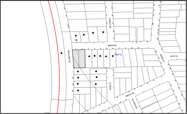
|
NOTIFICATION PLAN |
|
||
|
• PROPERTIES NOTIFIED
|
X SUBMISSIONS RECEIVED |
PROPERTY SUBJECT OF DEVELOPMENT |
|
One submission objected to the development, generally on the grounds that the development would result in:
· A poor building design;
· Exceedance of building height controls; and
· Excessive bulk and scale.
The merits of the matters raised in community submissions have been addressed in the body of the report with the exception of the following:
· Notification sign – Council has received one submission questioning when the yellow notification sign was put up on site. The applicant has submitted photo evidence of the yellow notification sign placed at the site during the notification period.
5.2 Public Agencies
5.2.1 RailCorp
The development application was referred to RailCorp for consideration of the proposed underground Parramatta-Epping Railway and no objections are raised subject to recommended conditions of consent.
6. THE PUBLIC INTEREST
Section 79C(1)(e) of the Act requires Council to consider “the public interest”.
The public interest is an overarching requirement, which includes the consideration of the matters discussed in this report. Implicit to the public interest is the achievement of future built outcomes adequately responding to and respecting the future desired outcomes expressed in environmental planning instruments and development control plans.
The application is considered to have satisfactorily addressed Council’s and relevant agencies’ criteria and would provide a development outcome that, on balance, would result in a positive impact for the community. Accordingly, it is considered that the approval of the proposed development would be in the public interest.
CONCLUSION
The application seeks approval for the demolition of existing structures and construction of a three storey residential flat building comprising 27 units and basement car parking.
The site is located at the interface of a high density precinct to the north and a low density zone to the south.
The proposed development is generally in accordance with the development controls for the ‘Epping Road/Forest Grove, Epping’ Precinct of the HDCP and would contribute to the future desired residential character of the precinct. The proposal complies with the design principles of SEPP 65 and the Residential Flat Design Code, subject to recommended conditions of consent.
The proposal would result in a development that would be in keeping with the desired future character of the precinct.
Note: At the time of the completion of this planning report, no persons have made a Political Donations Disclosure Statement pursuant to Section 147 of the Environmental Planning and Assessment Act 1979 in respect of the subject planning application.
RESPONSIBLE OFFICER
The officer responsible for the preparation of this Report is the Manager – Development Assessments – Rodney Pickles, who can be contacted on 9847 6731.
|
Rod Pickles Manager - Development Assessment Planning Division |
James Farrington Group Manager Planning Division |
|
1.View |
Locality Map |
|
|
|
2.View |
Street Perspective Plan |
|
|
|
3.View |
DA Plans |
|
|
|
4.View |
Elevations and Sections |
|
|
|
5.View |
Material Schedule Plan |
|
|
|
6.View |
Landscape Plans |
|
|
|
7.View |
Detail Survey Plan |
|
|
File Reference: DA/167/2015
Document Number: D06312577
SCHEDULE 1
GENERAL CONDITIONS
The conditions of consent within this notice of determination have been applied to ensure that the use of the land and/or building is carried out in such a manner that is consistent with the aims and objectives of the relevant legislation, planning instruments and council policies affecting the land and does not disrupt the amenity of the neighbourhood or impact upon the environment.
Note: For the purpose of this consent, the term ‘applicant’ means any person who has the authority to act on or the benefit of the development consent.
Note: For the purpose of this consent, any reference to an Act, Regulation, Australian Standard or publication by a public authority shall be taken to mean the gazetted Act or Regulation, or adopted Australian Standard or publication as in force on the date that the application for a construction certificate is made.
1. Deferred Commencement
Pursuant to Section 80(3) of the Environmental Planning and Assessment Act 1979, this consent does not operate until the following information is submitted to Council:
a) The registration of an easement to drain water from the site over all downstream properties being Lot 3 DP 1044308, 7 Rose Street Epping and SP 35970, 14 Maida Road, Epping.
Such information shall be submitted within 12 months of the date of this notice.
Upon Council’s written satisfaction of the above information, the following conditions of development consent will apply:
2. Approved Plans and Supporting Documentation
The development must be carried out in accordance with the plans and documentation listed below and endorsed with Council’s stamp, except where amended by Council and/or other conditions of this consent:
Approved Plans:
|
Plan No. |
Plan Title |
Drawn by |
Dated |
|
DA:C_04 C |
Basement 1 |
Zhinar Architects |
10/08/2015 |
|
DA:C_05 C |
Ground Floor |
Zhinar Architects |
10/08/2015 |
|
DA:C_06 C |
First Floor |
Zhinar Architects |
10/08/2015 |
|
DA:C_07 C |
Second Floor |
Zhinar Architects |
10/08/2015 |
|
DA:C_08 C |
Second Floor (Upper) |
Zhinar Architects |
10/08/2015 |
|
DA:C_09 C |
Roof |
Zhinar Architects |
10/08/2015 |
|
DA:C_10 C |
Section 1 |
Zhinar Architects |
10/08/2015 |
|
DA:C_11 C |
Section 2 |
Zhinar Architects |
10/08/2015 |
|
DA:C_12 C |
Elevations – East & North |
Zhinar Architects |
10/08/2015 |
|
DA:C_13 C |
Elevations – West & South |
Zhinar Architects |
10/08/2015 |
|
DA:C_16 C |
Material Schedule |
Zhinar Architects |
10/08/2015 |
|
2015.0202DA1-1 & 2015.0202DA1-2 – issue B |
Landscape Plan |
TGS Landscape Architects |
2 July 2015 |
|
Job No. SW15015 Drawing No. SW15015 – S1 – Rev E |
Site Stormwater Management Layouts |
Alw design |
02/07/2015 |
|
File. 2-4MAIDA |
Plan of Detail Survey |
MXM Survey Pty Ltd |
23/04/14 |
Supporting Documentation:
|
Document Title |
Prepared by |
Dated |
|
Waste Management Plan – Job No. 8379 |
Oatlands Properties Pty Ltd |
28/01/2014 |
|
Cover Sheet DA:C_01 C |
Zhinar Architects |
10/08/2015 |
|
Shadow Study – DA-B_14 B |
Zhinar Architects |
03/07/2015 |
|
Sun Study 22 June – DA-B_15 B |
Zhinar Architects |
03/07/2015 |
|
BASIX Certificate No. 608567M |
Newpeake |
13 February 2015 |
|
SEPP 65 Design Verification Statement |
Zhinar Architects |
February 2015 |
|
Rail Noise and Vibration Impact Assessment – Report 13983R0 |
Rodney Stevens Acoustics Pty Ltd |
22 January 2015 |
|
Arboricultural Impact Assessment – Ref 1236 |
Redgum Arboriculture & Horticulture Consultants |
19 January 2015 |
|
Statement of Environmental Effects |
Caladines Town Planning Pty Ltd |
February 2015 |
|
Access Compliance Assessment Report – A5U010A1 |
Certified Building Specialists |
13 February 2015 |
|
Traffic and Parking Assessment Report – Ref 14884 |
Varga traffic Planning Pty Ltd |
10 February 2015 |
|
Stage 1 Geotechnical Investigation – Ref R/14-060.A_final |
Davies Geotechnical Consulting Engineers |
31 March 2015 |
|
Design Certificate – Ref ST15147.DC1 |
Capital Engineering Consultants |
17 April 2015 |
|
Footing Plan/Tunnel Location Plan - Project No. ST15147, S200 - A |
Capital Engineering Consultants |
16.04.2015 |
|
Footing Sections & Details Tunnel Cross Section - Project No. ST15147, S201 - A |
Capital Engineering Consultants |
16.04.2015 |
3. Removal of Existing Trees
This development consent permits the removal of tree numbered 1 as identified on Site Plan A (Appendix E) Survey of Subject Trees within the Arboricultural Impact Assessment prepared by Redgum Arboricultural and Horticultural Consultants, dated 19 January 2015. The removal of any other trees requires separate approval in accordance with the Tree and Vegetation Chapter 1B.6 Hornsby Development Control Plan (HDCP).
4. Amendment of Plans
The approved plans are to be amended as follows:
a) All units are to be provided with storage areas in accordance with the Residential Flat Design Code which requires 50% storage areas within the basement and storage areas within the units to be accessible from either the hall or living area with an area of at least 3m3 for 1 bedroom units, 4m3 for 2 bedroom units and 5m3 for 3 bedroom units.
b) The approved waste storage area on Ground Floor plan DA:C_05 C must be amended by adding an additional bin, equating to a total of 13 bins (7 x 240L garbage bins and 6 x 240L recycling bins).
c) The Landscape Plans - 2015.0202DA1-1 & 2015.0202DA1-2 – issue B prepared by TGS Landscape Architects dated 2 July 2015 is to be amended as per the approved Ground Floor Plan - DA:C_05 C prepared by Zhinar Architects dated 10/08/2015.
5. Construction Certificate
a) A Construction Certificate is required to be approved by Council or a Private Certifying Authority prior to the commencement of any works under this consent.
b) The Construction Certificate plans must not be inconsistent with the Development Consent plans.
6. Section 94 Development Contributions
a) In accordance with Section 80A(1) of the Environmental Planning and Assessment Act 1979 and the Hornsby Shire Council Section 94 Development Contributions Plan 2012-2021, the following monetary contributions shall be paid to Council to cater for the increased demand for community infrastructure resulting from the development:
|
Description |
Contribution (4) |
|
Roads |
$18,292.00 |
|
Open Space and Recreation |
$327,081.95 |
|
Community Facilities |
$45,608.25 |
|
Plan Preparation and Administration |
$1,348.95 |
|
TOTAL |
$392,331.15 |
being for 4 x 1 bedroom, 20 x 2 bedroom and 3 x 3 bedroom dwellings and including a credit for two existing dwelling houses.
b) The value of this contribution is current as at 13/08/2015. If the contributions are not paid within the financial quarter that this condition was generated, the contributions payable will be adjusted in accordance with the provisions of the Hornsby Shire Council Section 94 Development Contributions Plan and the amount payable will be calculated at the time of payment in the following manner:
$CPY = $CDC x CPIPY
CPIDC
Where:
$CPY is the amount of the contribution at the date of Payment
$CDC is the amount of the contribution as set out in this Development Consent
CPIPY is the latest release of the Consumer Price Index (Sydney – All Groups) at the date of Payment as published by the ABS.
CPIDC is the Consumer Price Index (Sydney – All Groups) for the financial quarter at the date applicable in this Development Consent Condition.
c) The monetary contributions shall be paid to Council:
i) prior to the issue of the Subdivision Certificate where the development is for subdivision; or
ii) prior to the issue of the first Construction Certificate where the development is for building work; or
iii) prior to issue of the Subdivision Certificate or first Construction Certificate, whichever occurs first, where the development involves both subdivision and building work; or
iv) prior to the works commencing where the development does not require a Construction Certificate or Subdivision Certificate.
It is the professional responsibility of the Principal Certifying Authority to ensure that the monetary contributions have been paid to Council in accordance with the above timeframes.
Council’s Development Contributions Plan may be viewed at www.hornsby.nsw.gov.au or a copy may be inspected at Council’s Administration Centre during normal business hours.
REQUIREMENTS PRIOR TO THE ISSUE OF A CONSTRUCTION CERTIFICATE
7. Building Code of Australia
All building work must be carried out in accordance with the relevant requirements of the Building Code of Australia.
8. Contract of Insurance (Residential Building Work)
In the case of residential building work for which the Home Building Act 1989 requires there to be a contract of insurance in force in accordance with Part 6 of that Act, that such a contract of insurance is in force before any building work authorised to be carried out by the consent commences.
9. Notification of Home Building Act, 1989 Requirements
Residential building work within the meaning of the Home Building Act 1989 must not be carried out unless the principal certifying authority for the development to which the work relates (not being Council) has given Council written notice of the following information:
a) In the case of work for which a principal contractor is required to be appointed:
i) The name and licence number of the principal contractor; and
ii) The name of the insurer by which the work is insured under Part 6 of that Act.
b) In the case of work to be done by an owner-builder:
i) The name of the owner-builder; and
ii) If the owner-builder is required to hold an owner-builder’s permit under that Act, the number of the owner-builder’s permit.
Note: If arrangements for doing the residential building work are changed while the work is in progress so that the information notified becomes out of date, further work must not be carried out unless the principal certifying authority for the development to which the work relates (not being Council) has given Council written notification of the updated information.
10. Utility Services
The applicant must submit written evidence of the following service provider requirements:
a) Ausgrid (formerly Energy Australia) – a letter of consent demonstrating that satisfactory arrangements have been made to service the proposed development.
b) Telstra - a letter of consent demonstrating that satisfactory arrangements have been made to service the proposed development.
11. Dilapidation Report
A ‘Dilapidation Report’ is to be prepared by a ‘chartered structural engineer’ detailing the structural condition of No. 7 Rose Street and 6 Maida Road, Epping.
12. Stormwater Drainage
The stormwater drainage system for the development must be designed and constructed in accordance with Council’s Civil Works – Design and Construction Specification 2005 and the following requirements:
a) Generally in accordance with the stormwater concept plan Drawing No. SW15015-S1 Issue E dated 2/7/2015 by ALW Design.
b) Connected directly to street drainage system in Rose Street, via an inter-allotment drainage system.
c) An inter-allotment stormwater drainage system to service the proposed development with pits being a minimum 600 x 600 mm cast in situ or pre-cast concrete pits being used.
Note: A construction certificate must be obtained prior to the commencement of these works and are to be completed prior to the issue of an occupation certificate.
13. Rainwater Reuse Tank
In order to meet the water quality targets specified in Part 1C.1.2 – Stormwater Drainage in Council’s Development Control Pl an 2013 the following must be provided:
a) A minimum 80% of the roof water must be connected to a rainwater tank having a minimum capacity of 3,000 litres per 100m2 of roof area of the development. The tank is to be connected to the communal water system and to all dwellings for toilet flushing and laundry. The overflow from the rainwater tank and collected surface water must be discharged to the on-site detention system.
Note: A construction certificate must be obtained prior to the commencement of these works and are to be completed prior to the issue of an occupation certificate.
14. On Site Stormwater Detention
An on-site stormwater detention system must be designed by a chartered civil engineer and constructed in accordance with the following requirements:
a) Generally in accordance with the stormwater concept plan Drawing No. SW15015-S1 Issue E dated 2/7/2015 by ALW Design.
b) Have a capacity of not less than 20.3 cubic metres, and a maximum discharge (when full) of 35 litres per second.
c) Have a surcharge/inspection grate located directly above the outlet.
d) Discharge from the detention system to be controlled via 1 metre length of pipe, not less than 50 millimetres diameter or via a stainless plate with sharply drilled orifice bolted over the face of the outlet discharging into a larger diameter pipe capable of carrying the design flow to an approved Council system.
e) Where above ground and the average depth is greater than 0.3 metres, a ‘pool type’ safety fence and warning signs to be installed.
f) Not be constructed in a location that would impact upon the visual or recreational amenity of residents.
Note: A construction certificate must be obtained prior to the commencement of these works and are to be completed prior to the issue of an occupation certificate.
15. Internal Driveway/Vehicular Areas
The driveway and parking areas on site must be designed in accordance with Australian Standards 2890.1, 2890.2, 3727 and the following requirements:
a) Design levels at the front boundary must be obtained from Council;
b) The driveway must be a rigid pavement;
c) Prior to the issue if a construction certificate, a certificate from a qualified engineer must be submitted to the principle certifying authority certifying that the access driveway, parking and services areas have been designed in accordance with Australian Standards AS 2890.1 and AS 2890.2.
Note: A construction certificate must be obtained prior to the commencement of these works and area to be completed prior to the issue of an occupation certificate.
16. Driveway Longitudinal Sections
Longitudinal sections along both sides of the access driveway must be submitted to the principle certifying authority in accordance with the relevant sections of AS 2890.1 and the following requirements:
The maximum grade must not exceed 1 in 4 (25%) with the maximum changes of grade of 1 in 8 (12.5%) for summit grades and 1 in 6.7 (15%) for sag grades. Any transition grades must have a minimum length of 2 metres. The longitudinal sections must incorporate the design levels obtained by Council.
Note: A construction certificate must be obtained prior to the commencement of these works and area to be completed prior to the issue of an occupation certificate.
17. Vehicular Crossing
A separate application under the Local Government Act 1993 and the Roads Act 1993 must be submitted to Council for the installation of a new vehicular crossing and the removal of the redundant crossing. The vehicular crossing must be constructed in accordance with Council’s Civil Works Design 2005 and the following requirements:
a) Any redundant crossings must be replaced with integral kerb and gutter;
b) The footway area must be restored by turfing;
c) Approval must be obtained from all relevant utility providers that all necessary conduits be provided and protected under the crossing.
Note: An application for a vehicular crossing can only be made to one of Council’s Authorised Vehicular Crossing Contractors. You are advised to contact Council on 02 9847 6940 to obtain a list of contractors.
18. Road Works
A separate application under the Local Government Act 1993 and the Roads Act 1993 must be submitted to Council for approval of all works within the public road reserve. All road works approved under this consent must be constructed in accordance with Council’s Civil Works Design and Construction Specification 2005 and the following requirements:
a) A concrete footpath to be constructed along the full frontage of the development site is Maida Road and the existing concrete footpath in Blaxland Road must be removed and reconstructed within the road verge with the remaining area turfed.
b) An existing kerb and gutter and pavement along the full frontage of the development site in Maida Road and Blaxland Road must be removed and reconstructed.
c) The existing road pavement to be saw cut a minimum of 300 mm from the existing edge of the bitumen and reconstructed.
d) The design and construction of the kerb and gutter in Blaxland Road must be in accordance with the Roads and Maritime Services requirements. The design must be submitted to the Roads and Maritime Services Sydney Project Section for approval prior to construction.
e) A Road Occupancy Permit must be obtained from the Roads and Maritime Services for any proposed lane closures required to undertake the works.
f) Detailed design drawings by a qualified engineer must be submitted to Council for approval with the construction certificate application for public road works.
Note: A separate Construction Certificate is required to be submitted and approval obtained by Hornsby Shire Council prior to the commencement of these works.
19. Traffic Control Plan
A Traffic Control Plan (TCP) must be prepared by a qualified traffic controller in accordance with the Roads & Traffic Authority’s Traffic Control at Worksites Manual 1998 and Australian Standard 1742.3 for all work on a public road. The Traffic Management Plan must be submitted and approved by Council’s Manager Traffic and Road Safety prior to the issue of a construction certificate. The TCP must detail the following:
a) Arrangements for public notification of the works.
b) Temporary construction signage.
c) Permanent post-construction signage.
d) Vehicle movement plans.
e) Traffic management plans.
f) Pedestrian and cyclist access/safety.
20. Construction and Traffic Management Plan
In order to enable unencumbered movement of traffic in the public road during construction works, a Construction Management Plan, including a Traffic Management Plan and scaled construction plan prepared by a suitably Chartered and Qualified Chartered Engineer and Qualified Worksite Traffic Controller must be prepared and submitted with the Construction Certificate according to the following requirements:
a) A copy of the plans must be submitted for consideration and written approval by Hornsby Shire Council’s Manager of Traffic & Road Safety Branch prior to the release of the Construction Certificate.
b) The plans must detail the order of construction works and arrangement of all construction machines and vehicles being used at the same time during all stages.
c) In order to prevent injury, accident and loss of property, no building materials, work sheds, vehicles, machines or the like must be allowed to remain in the road reserve area without written consent of Hornsby Shire Council.
d) The Plan must be generally in compliance with the requirements of the Road and Traffic Authority’s “Traffic Control at Worksites manual 1998” and detailing:
i) Public notification of proposed works;
ii) Long term signage requirements;
iii) Short term (during actual works) signage;
iv) Vehicle Movement Plans, where applicable;
v) Traffic Management Plans;
vi) Pedestrian and Cyclist access and safety.
e) The plans must indicate traffic controls including those used during non-working hours and must provide pedestrian access and two-way traffic in the public road to be facilitated at all times.
f) The applicant and all employees of contractors on the site must obey and direction or notice from the Prescribed Certifying Authority or Hornsby Shire Council in order to ensure the above.
21. Accessible Units/Letter Boxes/Acoustics
The following details must be provided with the Construction Certificate plans.
a) The development is required to provide 9 units designed as adaptable housing pursuant to the requirements of 1C.2.2 of the Hornsby Development Control Plan 2013. In this regard, eight 3 car parking spaces are to be designed for people with a disability and allocated to 3 adaptable units.
b) The waste facility provided must be accessible by persons with a disability.
c) The letter boxes must be located as shown on the approved DA:C_12 Issue C.
d) The recommendations within the Rail Noise and Vibration Impact Assessment Report 13983R0 prepared by Rodney Stevens Acoustics Pty Ltd dated 22 January 2015 must be incorporated.
22. Noise – Rail Corridor
The development must be carried out in accordance with the recommendations contained within the acoustic report submitted with the development application, Rail Noise and Vibration Impact Assessment Report 13983R0, prepared by Rodney Stevens Acoustics Pty Ltd and dated 22 January 2015 and the requirements of the Department of Planning’s Development Near Rail Corridors and Busy Roads – Interim Guideline and RailCorp’s Interim Guidelines for Applicants.
Note: The Department of Planning’s document is available at www.planning.nsw.gov.au (development assessments). The RailCorp document is available at www.railcorp.nsw.gov.au/publications.
23. Sydney Water – Quick Check
This application must be submitted to a Sydney Water ‘Quick Check Agent’ or ‘Customer Centre’ for approval to determine whether the development would affect any Sydney Water infrastructure, and whether further requirements are to be met.
Note: Refer to www.sydneywater.com.au or telephone 13 20 92 for assistance.
REQUIREMENTS PRIOR TO THE COMMENCEMENT OF ANY WORKS
24. Erection of Construction Sign
A sign must be erected in a prominent position on any site on which building work, subdivision work or demolition work is being carried out:
a) Showing the name, address and telephone number of the principal certifying authority for the work;
b) Showing the name of the principal contractor (if any) for any demolition or building work and a telephone number on which that person may be contacted outside working hours; and
c) Stating that unauthorised entry to the work site is prohibited.
Note: Any such sign is to be maintained while the building work, subdivision work or demolition work is being carried out, but must be removed when the work has been completed.
25. Protection of Adjoining Areas
A temporary hoarding, fence or awning must be erected between the work site and adjoining lands before the works begin and must be kept in place until after the completion of the works if the works:
a) Could cause a danger, obstruction or inconvenience to pedestrian or vehicular traffic.
b) Could cause damage to adjoining lands by falling objects.
c) Involve the enclosure of a public place or part of a public place.
Note: Notwithstanding the above, Council’s separate written approval is required prior to the erection of any structure or other obstruction on public land.
26. Toilet Facilities
Toilet facilities must be available or provided at the works site before works begin and must be maintained until the works are completed at a ratio of one toilet for every 20 persons employed at the site. Each toilet must:
a) be a standard flushing toilet connected to a public sewer; or
b) be a temporary chemical closet approved under the Local Government Act 1993; or
c) have an on-site effluent disposal system approved under the Local Government Act 1993.
27. Erosion and Sediment Control
Erosion and sediment control measures must be provided and maintained throughout the construction period in accordance with the manual ‘Soils and Construction 2004 (Bluebook)’, the approved plans, Council specifications and to the satisfaction of the principal certifying authority. The erosion and sediment control devices must remain in place until the site has been stabilised and revegetated.
Note: On the spot penalties may be issued for any non-compliance with this requirement without any further notification or warning.
28. Project Arborist
A Project Arborist is to be appointed in accordance with AS 4970-2009 (1.4.4) to provide monitoring and certification throughout the development process.
29. Tree Protection Barriers
a) Tree protection fencing must be erected around tree numbered 2, 3 & 4 to be retained at a 5 metre setback.
b) The tree fencing must be contiguous and constructed of 1.8 metre ‘cyclone chainmesh fence’ in accordance with AS 4970-2009 (4.3 – Fig. 3) and Site Plan B (Appendix F) – Tree Protection Plan within the Arboricultural Impact Assessment prepared by Redgum Arboricultural and Horticultural Consultants, dated 19 January 2015.
30. Tree Root Protection
Prior to works commencing and throughout construction, the area of the Tree protection Zone (located on the property) of trees 2, 3 & 4 is to be protected by the use of wood-chip mulch. Wood-chip mulch is to be installed on top of a geotextile landscape fabric, placed over the root zone of the tree. The mulch is to be maintained at a depth of 150mm-300mm using material that complies with AS 4454.
Note: A certificate from the Project Arborist (AQF 5) is to be submitted to the Principle Certifying Authority stating that all tree protection measures are in accordance with the above and consistent with the intentions of the Australian Standard ‘Protection of Trees on Development Sites (AS 4970-2009) prior to commencement of works.
REQUIREMENTS DURING CONSTRUCTION
31. Construction Work Hours
All work on site (including demolition and earth works) must only occur between 7am and 5pm Monday to Saturday. No work is to be undertaken on Sundays or public holidays.
32. Demolition
All demolition work must be carried out in accordance with “Australian Standard 2601-2001 – The Demolition of Structures” and the following requirements:
a) Demolition material must be disposed of to an authorised recycling and/or waste disposal site and/or in accordance with an approved waste management plan;
b) Demolition works, where asbestos material is being removed, must be undertaken by a contractor that holds an appropriate licence issued by WorkCover NSW in accordance with Chapter 10 of the Occupational Health and Safety Regulation 2001 and Clause 29 of the Protection of the Environment Operations (Waste) Regulation 2005 ;and
c) On construction sites where buildings contain asbestos material, a standard commercially manufactured sign containing the words ‘DANGER ASBESTOS REMOVAL IN PROGRESS’ measuring not less than 400mm x 300mm must be erected in a prominent position visible from the street.
33. Environmental Management
The site must be managed in accordance with the publication ‘Managing Urban Stormwater – Landcom (March 2004) and the Protection of the Environment Operations Act 1997 by way of implementing appropriate measures to prevent sediment run-off, excessive dust, noise or odour emanating from the site during the construction of the development.
34. Asbestos and Soil Contamination
Should the presence of asbestos or soil contamination, not recognised during the application process be identified during works, the applicant must immediately notify the principal certifying authority and Council.
35. Street Sweeping
Street sweeping must be undertaken following sediment tracking from the site along Maida Road during works and until the site is established.
36. Works Near Trees
a) All required tree protection measures are to be maintained in good condition for the duration of the construction period.
b) Existing soil grades within the Tree Protection Zone of trees to be retained must be maintained.
c) All personnel (the applicant, contractors, service providers, principal certifying authority) involved with this development are to ensure that no excavation, including sub-surface trenching for stormwater or other services or the filling or stockpiling of building materials, parking of vehicles or plant, the use of machinery other than hand held, disposal of cement slurry, waste water or other contaminants is to occur within the Tree Root Zone (see Advisory Notes) as prescribed in the HDCP Section 1B.6.1(i) of any tree to be retained.
37. Council Property
During construction works, no building materials, waste, machinery or related matter is to be stored on the road or footpath. The public reserve must be kept in a clean, tidy and safe condition at all times.
38. Disturbance of Existing Site
During construction works, the existing ground levels of open space areas and natural landscape features, (including natural rock-outcrops, vegetation, soil and watercourses) must not be altered unless otherwise nominated on the approved plans.
39. Landfill
Landfill must be constructed in accordance with Council’s ‘Construction Specification 2005’ and the following requirements:
a) All fill material imported to the site is to wholly consist of Virgin Excavated Natural Material (VENM) as defined in Schedule 1 of the Protection of the Environment Operations Act 1997 or a material approved under the Department of Environment and Climate Change’s general resource recovery exemption.
b) A compaction certificate is to be obtained from a geotechnical engineer verifying that the specified compaction requirements have been met.
40. Excavated Material
All excavated material removed from the site must be classified in accordance with the Department of Environment, Climate Change and Water NSW Waste Classification Guidelines prior to disposal to an approved waste management facility and reported to the principal certifying authority.
41. Survey Report
A report(s) must be prepared by a registered surveyor and submitted to the principal certifying authority;
a) Prior to the pouring of concrete at each level of the building certifying that:
i) The building, retaining walls and the like have been correctly positioned on the site; and
ii) The finished floor level(s) are in accordance with the approved plans.
42. Waste Management Details
Waste management during the demolition and construction phase of the development must be undertaken in accordance with the approved Waste Management Plan. Additionally written records of the following items must be maintained during the removal of any waste from the site and such information submitted to the Principal Certifying Authority within fourteen days of the date of completion of the works:
a) The identity of the person removing the waste.
b) The waste carrier vehicle registration.
c) Date and time of waste collection.
d) A description of the waste (type of waste and estimated quantity).
e) Details of the site to which the waste is to be taken.
f) The corresponding tip docket/receipt from the site to which the waste is transferred (noting date and time of delivery, description (type and quantity) of waste).
g) Whether the waste is expected to be reused, recycled or go to landfill.
Note: In accordance with the Protection of the Environment Operations Act 1997, the definition of waste includes any unwanted substance, regardless of whether it is reused, recycled or disposed to landfill.
REQUIREMENTS PRIOR TO THE ISSUE OF AN OCCUPATION CERTIFICATE
Note: For the purpose of this consent, a reference to ‘occupation certificate’ shall not be taken to mean an ‘interim occupation certificate’ unless otherwise stated.
43. Fulfilment of BASIX Commitments
The applicant must demonstrate the fulfilment of BASIX commitments pertaining to the development.
44. Sydney Water – s73 Certificate
An s73 Certificate must be obtained from Sydney Water.
Note: Sydney Water requires that s73 applications are to be made through an authorised Sydney Water Servicing Coordinator. Refer to www.sydneywater.com.au or telephone 13 20 92 for assistance.
45. Waste Management Details
The following waste management requirements must be complied with:
a) The garbage room at the ground level must include water or a hose for cleaning, graded floors with drainage to sewer, a robust door, sealed and impervious surface, adequate lighting and ventilation.
b) A report must be prepared by an appropriately qualified person, certifying the following:
i) A comparison of the estimated quantities of each waste type against the actual quantities of each waste type.
Note: Explanations of any deviations to the approved Waste Management Plan is required to be included in this report.
ii) That at least 60% of the waste generated during the demolition and construction phase of the development was reused or recycled.
Note: If the 60% diversion from landfill cannot be achieved in the Construction Stage, the Report is to include the reasons why this occurred and certify that appropriate work practices were employed to implement the approved Waste Management Plan. The Report must be based on documentary evidence such as tipping dockets/receipts from recycling depots, transfer stations and landfills, audits of procedures etc. which are to be attached to the report.
iii) All waste was taken to site(s) that were lawfully permitted to accept that waste.
c) Each unit must be provided with an indoor waste/recycling cupboard for the interim storage of a minimum one day’s waste generation with separate containers for general waste and recyclable materials.
d) Space must be provided for either individual compost containers for each unit or a communal compost container;
Note: The location of the compost containers should have regard for potential amenity impacts.
e) The bin carting routes must be devoid of any steps.
Note: Ramps between different levels are acceptable.
46. Damage to Council Assets
Any damage caused to Council’s assets including the removal, damage, destruction, displacement or defacing of the existing survey marks as a result of the construction or demolition of the development must be rectified in accordance with Council’s Civil Works Specifications. Council’s Restorations Supervision must be notified for a formwork inspection prior to pouring concrete
47. Preservation of Survey Marks
Prior to the issue of an occupation certificate, a certificate by a Registered Surveyor must be submitted to the Principle Certifying Authority, certifying that there has been no removal, damage, destruction, displacement or defacing of the existing survey marks in the vicinity of the proposed development or otherwise the re-establishment of damaged, removed or displaced survey marks has been undertaken in accordance with the Surveyor General’s Direction No. 11 – “Preservation of Survey Infrastructure”.
48. Creation of Easements
The following matter(s) must be nominated on the plan of subdivision under s88B of the Conveyancing Act 1919:
a) The creation of an appropriate "Positive Covenant" and "Restriction as to User" over the constructed on-site detention/retention systems and outlet works, within the lots in favour of Council in accordance with Council’s prescribed wording. The position of the on-site detention system is to be clearly indicated on the title.
b) To register the OSD easement, the restriction on the use of land “works-as-executed” details of the on-site-detention system must be submitted verifying that the required storage and discharge rates have been constructed in accordance with the design requirements. The details must show the invert levels of the on-site system together with pipe sizes and grades. Any variations to the approved plans must be shown in red on the “works-as-executed” plan and supported by calculations.
Note: Council must be nominated as the authority to release, vary or modify any easement, restriction or covenant.
49. Replacement Planting
a) Replacement Planting must be in accordance with the approved Landscape Plan.
b) Plantings that fail to survive or do not exhibit normal health and vigour growth characteristics for their species prior to reaching a height greater than three metres, must be replaced at the expense of the property owner.
Note: A certificate from suitably qualified and experienced Horticulturalist is to be submitted to the Principle Certifying Authority stating the above requirements have been met, that all plant stock meet the specifications outlined in ‘Specifying Trees’ (Ross Clark, NATSPEC Books) and that the planting methods are current, professional (best practice) industry standards at the time of planting.
50. Final Certification
Following the final inspection and the completion of any remedial works, the project Arborist must submit to the Principle Certifying Authority documentation stating that the completed works have been carried out in compliance with the approved plans, conditions of this consent and AS 4970-2009.
51. External Lighting
All external lighting must be designed and installed in accordance with Australian Standard AS 4282 – Control of the Obtrusive Effects of Outdoor Lighting. Certification of compliance with the Standard must be obtained from a suitably qualified person.
52. Unit Numbering
The allocation of unit numbering must be authorised by Council prior to the numbering of each unit in the development.
53. Safety and Security
This site must include the following elements:
a) An intercom system must be installed at gate locations to ensure screening of persons entering the units.
b) The entry doors to the pedestrian foyer is to be constructed of safety rated glass to enable residents a clear line of site before entering or exiting the residential apartments.
c) Lighting is to be provided to pathways, building foyer entries, driveways and common external spaces.
d) Security gate access is to be provided to the car parking areas allowing residents-only access to private car spaces.
e) CCTV cameras must be installed at the entry and exit point and the around the mailbox.
f) The communal open spaces within the site must be illuminated with high luminance by motion sensor lighting.
g) The driveway and basement car parking must be illuminated with low luminance at all times.
h) Security deadlocks are to be provided to each apartment door.
i) Peep holes are to be provided to individual apartment doors to promote resident safety.
54. Retaining Walls
All required retaining walls must be constructed as part of the development.
55. Provision for National Broadband Network (NBN)
Provision must be made for fibre ready passive infrastructure (pits and pipes) generally in accordance with NBN Co's pit and pipe installation guidelines to service the proposed development. A certificate from NBN Co or Telstra must be submitted to the PCA that the fibre optic cabling provided for the development complies with MDU Building Design Guides for Development.
56. Boundary Fencing
Fencing must be erected along all property boundaries behind the front building alignment to a height of 1.8 metres.
Fences to the primary frontage in front of the building alignment are to retain visual transparency (not lapped / solid) and be 1.2 metres in height.
57. Completion of Landscaping
A certificate must be provided by a practicing landscape architect, horticulturalist or person with similar qualifications and experience certifying that all required landscaping works have been satisfactorily completed in accordance with the approved landscape plans.
Note: Advice on suitable species for landscaping can be obtained from Council’s planting guide ‘Indigenous Plants for the Bushland Shire’, available at www.hornsby.nsw.gov.au.
58. Final Certification Acoustic Consultant
A final certificate must be provided by the Acoustic Consultant stating that the recommended measures within the approved Acoustic Report, have been complied with.
59. Consolidation of Allotments
All allotments the subject of this consent must be consolidated into one allotment.
Note: The applicant is recommended to submit the plan of subdivision to consolidate allotments to the NSW Department of Lands at least 4-6 weeks prior to seeking an occupation certificate.
OPERATIONAL CONDITIONS
60. Noise
All noise generated by the proposed development must be attenuated to prevent levels of noise being emitted to adjacent premises which possess tonal, beating and similar characteristics or which exceeds background noise levels by more than 5dB(A).
61. Landscape Establishment
The landscape works must be maintained into the future to ensure the establishment and successful growth of plant material to meet the intent of the landscape design. This must include but not limited to watering, weeding, replacement of failed plant material and promoting the growth of plants through standard industry practices.
62. Car Parking and Deliveries
All car parking must be operated in accordance with Australian Standard AS 2890.1 – 2004 – Off Street Car Parking and Australian Standard 2890.2 - 2002 – Off Street Commercial and the following requirements:
a) All parking areas and driveways are to be sealed to an all-weather standard, line marked and signposted at all times.
b) Car parking, loading and manoeuvring areas to be used solely for nominated purposes.
c) Vehicles awaiting loading, unloading or servicing shall be parked on site and not on adjacent or nearby public roads;
d) All vehicular entry on to the site and egress from the site shall be made in a forward direction.
63. Sight Lines
Minimum sight lines for pedestrian safety are to be provided at the driveway. Any proposed landscaping and/or fencing must not restrict sight distance to pedestrians and cyclists travelling along the footpath.
64. Waste Management
The waste management on site must be in accordance with the following requirements:
a) A site caretaker must be employed and be responsible for moving bins where and when necessary, washing bins and maintaining waste storage areas, ensuring the chute system and related devices are maintained in effective and efficient working order, managing the communal composting area, managing the bulky item storage area, arranging the prompt removal of dumped rubbish, and ensuring cars do not park in the loading bay and that all residents are informed of the use of the waste management system.
65. Fire Safety Statement - Annual
On at least one occasion in every 12 month period following the date of the first ‘Fire Safety Certificate’ issued for the property, the owner must provide Council with an annual ‘Fire Safety Certificate’ to each essential service installed in the building.
GENERAL TERMS OF APPROVAL – SYDNEY TRAINS
The following conditions of consent are General Terms of Approval from the nominated State Agency pursuant to Section 91A of the Environmental Planning and Assessment Act 1979 and must be complied with to the satisfaction of that Agency.
66. Operational Conditions
a) The applicant shall comply with the requirements contained in the RailCorp land owner’s consent dated 20 July 2015.
b) The following are to be submitted to Sydney Trains for review and endorsement prior to the issuing of a Construction Certificate:
i) Revised Drawing S200 containing the following:
a. All rail assets within 25m (i.e. up/down tunnels, at grade rails etc.)
b. Appropriate legends for tunnel centrelines, 1st reverse and 2nd reserve lines.
ii) Revised Drawing S201 containing the following:
a. Correct location of the railway easement (based on actual survey), tunnel support zones, 1st and 2nd reserve lines in accordance with the ECRL Underground Infrastructure Protection Guidelines, dated 16 May 2008.
b. Anticipated pile toe levels
c. Reduced level for the existing ground, geometry of battered excavation etc.
iii) Drawing S200 suggests that piers are only required when pad footings are not founded on Class III sandstone, clarification is required as to whether this is applicable to piers shown along the perimeter as well.
iv) Details regarding the worst case pile toe level in metres AHD, should Class III sandstone not be encountered (i.e. to ascertain whether they would encroach into the tunnel support zone).
v) Revised Geotechnical Investigation Report containing and/or addressing the following:
a. Investigation into the induced vibration from excavation and construction works for the proposed development and their impact on the railway tunnel wall linings.
vi) Documentation addressing the requirements of the ECRL Underground Infrastructure Protection Guidelines, dated 16 May 2008, in particular:
a. As the guidelines call for an impact assessment in instances where excavation depth in more than 3m in depth and deep footings are placed within the 1st reserve, an impact assessment quantifying stress changes in tunnel lining due to excavation/subsequent building loadings and associated tunnel lining movements is required.
b. Requirements as outlined in Sections 4.2 and 5.6 of Guideline
The Principal Certifying Authority is not to issue the Construction Certificate until it has received written confirmation from Sydney Trains that these conditions have been complied with:
c) The following are to be submitted to Sydney Trains for review and endorsement prior to the issuing of a Construction Certificate:
i) Machinery to be used during excavation/construction.
ii) Construction and Demolition plan listing the vibration generating equipment, anticipated levels of vibration and proposed method of monitoring
iii) A vibration monitoring plan containing (but not limited) details of the vibration generating equipment to be used, location of monitoring equipment, anticipated vibrations at tunnel level, threshold values for vibration, a data distribution list to disseminate data and to inform alarm level breaches, and a Sydney Train contact in the list for notification in the event of alarm level breach.
d) All piling and excavation works with 25m of the rail corridor are to be supervised by a geotechnical engineer experience with such excavation projects.
e) No rock anchors/bolts are to be installed into Sydney Trains property or easements.
f) Sydney Trains and Transport for NSW, or any persons authorised by them for this purpose, are entitled to inspect the site of the approved development and all structures to enable it to consider whether those structures on that site have been or are being constructed and maintained in accordance with these conditions of consent, on giving reasonable notice to the principle contractor for the approved development or the owner or occupier of the part of the site to which access is sought.
g) Prior to the commencement of works and prior to the issue of the Occupation Certificate, a joint inspection of the rail infrastructure and property in the vicinity of the project is to be carried out by representatives from Sydney Trains and the Applicant. These dilapidation surveys will establish the extent of any existing damage and enable any deterioration during construction to be observed. The submission of a detailed dilapidation report will be required unless otherwise notified by Sydney Trains.
h) An acoustic assessment is to be submitted to Council prior to the issue of a construction certificate demonstrating how the proposed development will comply with the Department of Planning’s document titled “Development Near Rail Corridors and Busy Roads –Interim Guidelines”.
i) Prior to the issue of a Construction Certificate the applicant is to engage an Electrolysis Expert to prepare a report on the Electrolysis Risk to the development from stray currents. The applicant must incorporate in the development all the measures recommended in the report to control that risk. A copy of the report is to be provided to the Principle Certifying Authority with the application for a Construction Certificate.
j) Prior to the issue of a Construction Certificate a Risk Assessment, Rail Safety Management Plan, and detailed Safe work Method Statements (SWMS) for the proposed works are to be submitted to Sydney Trains for review and comment on the impacts on rail. The Principle Certifying Authority shall not issue the Construction Certificate until written confirmation has been received from Sydney trains confirming that this condition has been satisfied.
k) Prior to the issuing of a Construction Certificate the Applicant is to submit to Sydney Trains a plan showing all craneage and other aerial operations for the development and must comply with all Sydney Trains requirements. The Principle Certifying Authority shall not issue the Construction Certificate until written confirmation has been received from Sydney Trains confirming that this condition has been satisfied.
l) Prior to the issue of a Construction Certificate the Applicant must hold current public liability insurance cover for a sum to be determined by Sydney Trains. This insurance shall not contain any exclusion in relation to works on or near the rail corridor, rail infrastructure. The applicant is to contact Sydney Trains Rail Corridor Management Group to obtain the level of insurance required for this particular proposal. Prior to issuing the Construction Certificate the Principle Certifying Authority must witness written proof of this insurance in conjunction with Sydney Trains written advise to the Applicant on the level of insurance required.
m) Prior to the issuing of an Occupation Certificate the Applicant is to submit the as-built drawings to Sydney Trains and Council. The as-built drawings are to be endorsed by a Registered Surveyor confirming that there has been no encroachment into Sydney Trains property or easement.
The Principal Certifying Authority is not to issue the Occupation Certificate until written confirmation has been received from Sydney Trains confirming that this condition has been satisfied.
- END OF CONDITIONS -
ADVISORY NOTES
The following information is provided for your assistance to ensure compliance with the Environmental Planning and Assessment Act, 1979, Environmental Planning and Assessment Regulation 2000, other relevant legislation and Council’s policies and specifications. This information does not form part of the conditions of development consent pursuant to Section 80a of the Act.
Environmental Planning and Assessment Act 1979 Requirements
The Environmental Planning and Assessment Act 1979 requires:
· The issue of a construction certificate prior to the commencement of any works. Enquiries can be made to Council’s Customer Services Branch on 9847 6760.
· A principal certifying authority to be nominated and Council notified of that appointment prior to the commencement of any works.
· Council to be given at least two days written notice prior to the commencement of any works.
· Mandatory inspections of nominated stages of the construction inspected.
· An occupation certificate to be issued before occupying any building or commencing the use of the land.
Long Service Levy
In accordance with Section 34 of the Building and Construction Industry Long Service Payments Act 1986, a ‘Long Service Levy’ must be paid to the Long Service Payments Corporation or Hornsby Council.
Note: The rate of the Long Service Levy is 0.35% of the total cost of the work.
Note: Hornsby Council requires the payment of the Long Service Levy prior to the issue of a construction certificate.
Tree and Vegetation Preservation
In accordance with Clause 5.9 of the Hornsby Local Environmental Plan 2013 a person must not ringbark, cut down, top, lop, remove, injure or wilfully destroy any tree or other vegetation protected under the Hornsby Development Control Plan 2013 without the authority conferred by a development consent or a permit granted by Council.
Notes: A tree is defined as a long lived, woody perennial plant with one or relatively few main stems with the potential to grow to a height greater than three metres (3M). (HDCP 1B.6.1.c).
Tree protection measures and distances are determined using the Australian Standard AS 4970:2009, “Protection of Trees on Development Sites”.
Fines may be imposed for non-compliance with both the Hornsby Local Environmental Plan 2013 and the Hornsby Development Control Plan 2013.
Tree Root Zones (TRZ)
|
HDCP Section 1B.6.1 (i). |
TRZ |
|
Trees with a diameter at breast height greater than 800mm |
9m |
|
Trees with a diameter at breast height between 400mm and 800mm |
7m |
|
Trees with a diameter at breast height less than 400mm |
4m |
Disability Discrimination Act
The applicant’s attention is drawn to the existence of the Disability Discrimination Act. A construction certificate is required to be obtained for the proposed building/s, which will provide consideration under the Building Code of Australia, however, the development may not comply with the requirements of the Disability Discrimination Act. This is the sole responsibility of the applicant.
Covenants
The land upon which the subject building is to be constructed may be affected by restrictive covenants. Council issues this approval without enquiry as to whether any restrictive covenant affecting the land would be breached by the construction of the building, the subject of this consent. Applicants must rely on their own enquiries as to whether or not the building breaches any such covenant.
Dial Before You Dig
Prior to commencing any works, the applicant is encouraged to contact Dial Before You Dig on 1100 or www.dialbeforeyoudig.com.au for free information on potential underground pipes and cables within the vicinity of the development site.
Telecommunications Act 1997 (Commonwealth)
If you are aware of any works or proposed works which may affect or impact on Telstra’s assets in any way, you are required to contact: Telstra’s Network Integrity Team on Phone Number 1800810443.
House Numbering
House numbering can only be authorised by Council. Before proceeding to number each premise in the development, the allocation of numbers is required to be obtained from Council's Planning Division prior to the issue of a Subdivision Certificate. The authorised numbers are required to comply with Council’s Property Numbering Policy and be displayed in a clear manner at or near the main entrance to each premise.
Rain Water Tank
It is recommended that water collected within any rainwater tank as part of the development be limited to non-potable uses. NSW Health recommends that the use of rainwater tanks for drinking purposes not occur where a reticulated potable water supply is available.
Group Manager’s Report No. PL69/15
Planning Division
Date of Meeting: 9/09/2015
14 DEVELOPMENT APPLICATION - DEMOLITION - TWO, THREE STOREY RESIDENTIAL FLAT BUILDINGS - 6-12 MAIDA ROAD, EPPING
EXECUTIVE SUMMARY
|
DA No: |
DA/982/2014 (Lodged on 28 August 2014) |
|
Description: |
Demolition of existing structures and construction of two, three storey residential flat buildings comprising 62 units with basement car parking |
|
Property: |
Lot A DP 314102, Lot C DP 314102, Lots 5-6 DP 9693, Nos. 6 - 12 Maida Road, Epping |
|
Applicant: |
Maida Group Developments |
|
Owners: |
Mr S. J. McNaught and Ms S. M. Lockwood, Ms A. L. Finley, Maida Group Developments |
|
Estimated Value: |
$11,000,000 |
|
Ward: |
C |
· The application involves demolition of existing structures and construction of two, three storey residential flat buildings comprising 62 units with basement car parking.
· The proposal does not comply with the provisions of State Environmental Planning Policy No. 65, the Residential Flat Design Code, Apartment Design Guide and Hornsby Development Control Plan 2013. The proposal generally complies with the Hornsby Local Environmental Plan 2013.
· Six submissions have been received in respect of the application.
· A Red Sticker has been placed on the application requiring that it be determined at a Council meeting.
· It is recommended that the application be refused.
|
THAT Development Application No. DA/982/2014 for demolition of existing structures and construction of two, three storey residential flat buildings comprising 62 units with basement car parking at Lot A DP 314102, Lot C DP 314 102, Lots 5 - 6 DP 9693, Nos. 6-12 Maida Road, Epping be refused for the reasons detailed in Schedule 1 of Group Manager’s Report No. PL69/15. |
BACKGROUND
The subject land was rezoned from R2 Low Density Residential to R3 Medium Density Residential under State Environmental Planning Policy Amendment (Epping Town Centre) on 14 March 2014 which amended the Hornsby Local Environmental Plan 2013. The rezoning followed the Epping Town Centre Study and inclusion of Epping in the State Government’s Urban Activation Precincts.
The rezoning permits residential flat buildings on the subject land and a maximum building height of 12 metres. The amendments also introduced a number of heritage items and heritage conservation areas.
A pre-lodgement meeting was held between Council officers and the applicant to discuss the design, prior to lodgement of the application. At the meeting, concerns were raised by Council regarding the proposed design, impact on adjoining properties and waste management facilities.
On 28 August 2014, Development Application No. DA/982/2014 was lodged for demolition of existing structures and construction of two, three storey residential flat buildings comprising 68 units. The application is the subject of this report.
On 24 September 2014, the applicant was requested to submit additional information in response to Sydney Trains.
On 15 October 2014, Council sent a letter to the applicant outlining planning concerns. The proposal did not comply with the requirements of the Hornsby Development Control Plan 2013 and Residential Flat Design Code with respect to setbacks, separation between the buildings, landscaping, balconies, unit sizes and depths, parking, housing choice, privacy and solar access.
On 8 December 2014, Council sent a letter to the applicant outlining concerns with respect to the design and location of the garbage storage rooms.
On 11 March 2015 and 15 April 2015, the applicant submitted revised plans to address Council’s concerns. A number of meetings were subsequently held with the applicant to discuss opportunities to amend the proposal to address concerns with respect to amenity, apartment layout, building separation, solar access and privacy.
On 3 July 2015, the applicant submitted a final set of amended plans. The revised layouts reduced the total yield from 63 to 62 units.
SITE
The site is regular in shape with an area of 3,433.6m2, a frontage of 68.28m to the southern side of Maida Road and an average fall of 8% across, from west to east.
The current improvements onsite include four existing dwelling houses with outbuildings and swimming pools
The site contains a number of exotic, native planted trees and locally indigenous specimens. There are three significant trees located on the property.
The site is located in close proximity to the intersection with Essex Street, approximately 700m south-east of Epping Railway Station and at the southern end of the Epping Town Centre.
The eastern boundary of the site adjoins low density residential developments with frontages to Rose Street. The allotments on the opposite side of Maida Road constitute residential properties within the R4 High Density Residential zone and would potentially be developed as five storey residential flat buildings. A number of two storey older style residential flat buildings are located on the northern side of Maida Road, further west of the site.
The site is within the Epping Road/Forest Grove, Epping Precinct of the Hornsby Development Control Plan 2013.
PROPOSAL
The proposal is for the demolition of existing structures and construction of two, three storey residential flat buildings with mezzanines comprising 62 units and one level of basement car park accommodating 75 cars. Access to the site is proposed via a driveway off Maida Road adjacent to the eastern boundary.
The proposed units include 24 x 1 bedroom, 30 x 2 bedroom and 8 x 3 bedroom units. A chairlift platform provides access from the basement to the ground floor level. Separate pedestrian entry is provided to each building from Maida Road.
Two garbage storage rooms are proposed adjacent to each building located centrally on the site.
ASSESSMENT
The development application has been assessed having regard to ‘A Plan for Growing Sydney’, the ‘North Subregion (Draft) Subregional Strategy’ and the matters for consideration prescribed under Section 79C of the Environmental Planning and Assessment Act 1979 (the Act). The following issues have been identified for further consideration.
1. STRATEGIC CONTEXT
1.1 A Plan for Growing Sydney and (Draft) North Subregional Strategy
A Plan for Growing Sydney has been prepared by the NSW State Government to guide land use planning decisions for the next 20 years. The Plan sets a strategy for accommodating Sydney’s future population growth and identifies the need to deliver 689,000 new jobs and 664,000 new homes by 2031. The Plan identifies that the most suitable areas for new housing are in locations close to jobs, public transport, community facilities and services.
The NSW Government will use the subregional planning process to define objectives and set goals for job creation, housing supply and choice in each subregion. Hornsby Shire has been grouped with Hunters Hill, Ku-ring-gai, Lane Cove, Manly, Mosman, North Sydney, Pittwater, Ryde, Warringah and Willoughby to form the North Subregion. The Draft North Subregional Strategy will be reviewed and the Government will set housing targets and monitor supply to ensure planning controls are in place to stimulate housing development.
The proposed development would be consistent with ‘A Plan for Growing Sydney’, by providing additional dwellings and would contribute to housing choice in the locality.
2. STATUTORY CONTROLS
Section 79C(1)(a) requires Council to consider “any relevant environmental planning instruments, draft environmental planning instruments, development control plans, planning agreements and regulations”.
2.1 Hornsby Local Environmental Plan 2013
The proposed development has been assessed having regard to the provisions of the Hornsby Local Environmental Plan 2013 (HLEP).
2.1.1 Zoning of Land and Permissibility
The subject land is zoned R3 Medium Density Residential Zone under the HLEP. The objectives of the zone are:
(a) To provide for the housing needs of the community within a medium density residential environment.
(b) To provide a variety of housing types within a medium residential environment.
(c) To enable other land uses that provide facilities or services to meet the day to day needs of residents.
The proposed development is defined as ‘residential flat building’ and is permissible in the zone with Council’s consent.
2.1.2 Height of Buildings
Clause 4.3 of the HLEP provides that the height of a building on any land should not exceed the maximum height show for the land on the Height of Buildings Map. The maximum permissible height for the subject site is 12m. The proposal complies with this provision.
2.1.3 Heritage Conservation
Clause 5.10 of the HLEP sets out heritage conservation provisions for Hornsby Shire. The site does not include a heritage item and is not located in a heritage conservation area.
Essex Street (Epping) Heritage Conservation Area is identified under the provisions of Schedule 5 (Environmental Heritage) of the HLEP. However, the site does not immediately adjoin the conservation area and would be separated by future three and five storey residential flat buildings. Accordingly, no further assessment regarding heritage is necessary.
2.1.4 Earthworks
Clause 6.2 of the HLEP states that consent is required for proposed earthworks on site. Before granting consent for earthworks, Council is required to assess the impacts of the works on adjoining properties, drainage patterns and soil stability of the locality.
Council’s assessment of the proposed earthworks and excavation concludes that the proposal is satisfactory subject to conditions regarding submission of a dilapidation report assessing the impact of the excavation on the adjoining properties.
2.2 State Environmental Planning Policy No. SEPP 55 – Remediation of Land
State Environmental Planning Policy No. 55 (SEPP 55) requires that Council must not consent to the carrying out of any development on land unless it has considered whether the land is contaminated or requires remediation for the proposed use.
The site has been used for residential purposes and is unlikely to be contaminated. No further assessment is considered necessary in this regard.
2.3 State Environmental Planning Policy (Building Sustainability Index – BASIX) - 2004
The application has been assessed against the requirements of State Environmental Planning Policy (Building Sustainability Index: BASIX) 2004. A revised BASIX Certificate has not been submitted for amended proposed development.
2.4 State Environmental Planning Policy No. 65 – Design Quality of Residential Flat Development
The Policy provides for design principles to improve the design quality of residential flat development and for consistency in planning controls across the State.
SEPP 65 was amended on 19 June 2015 (Amendment No. 3) following review of the policy by the Department of Planning and Environment. The amendments replace the Residential Flat Design Guidelines with the Apartment Design Guide which prevails in the event of any inconsistency with a Development Control Plan.
Clause 31 (Transitional provisions for SEPP 65 – Amendment No. 3) states that “If a development application or an application for the modification of a development consent has been made before the notification on the NSW legislation website of the making of State Environmental Planning Policy No 65—Design Quality of Residential Flat Development (Amendment No 3) and the application has not been finally determined before the commencement of that amendment, the application must be determined as if the amendment had not commenced.”
Pursuant to the above provision, this amendment would not apply to the subject application and the previous version (Amendment 2) of SEPP 65 is required to be considered.
The applicant has submitted a “Design Verification Statement” prepared by a qualified Architect stating how the proposed development achieves the design principles of SEPP 65. The design principles of SEPP 65 and the submitted design verification statement are addressed in the following table.
|
Principle |
Compliance |
|
1. CONTEXT |
No |
|
Comment: The site is located within a precinct planned for three and five storey residential flat buildings in close proximity to Epping Railway Station and Epping Town Centre. The proposal, being a three storey residential flat building, is consistent with the character envisaged for the precinct. However, the proposal does not adequately respond to the existing context being bounded to the south by low density residential development. The development does not incorporate additional privacy measures on the southern façade to alleviate overlooking opportunities onto the adjoining low density area. |
|
|
2. SCALE |
No |
|
Comment: The scale of the development is generally in accordance with the numerical height control and setbacks for the precinct prescribed under the Hornsby Development Control Plan (HDCP). However, the height and scale of the development at the rear does not respond to the interface with the adjoining low density area. The scale of both buildings is accentuated by the proposed mezzanines at the rear. |
|
|
3. BUILT FORM |
No |
|
Comment: The proposal does not comply with the built form principle of SEPP 65. The matter is assessed in detail against the applicable prescriptive measures within the HDCP as outlined in Section 2.8 of this report. |
|
|
4. DENSITY |
No |
|
Comment: The HLEP does not incorporate floor space ratio requirements for the site. The density of the development is governed by the height of the building and the required setbacks. Given that the proposal does not comply with the amenity, apartment layout, building separation, solar access and privacy requirements, the proposed density would not be appropriate for the precinct. |
|
|
5. RESOURCE, ENERGY AND WATER EFFICIENCY |
No |
|
Comment: The applicant has not submitted a BASIX Certificate for the amended proposed development. However, subject to the submission of an amended BASIX certificate, it is considered that this Principle would be appropriately addressed. |
|
|
6. LANDSCAPE |
Yes |
|
Comment: The application includes a landscape concept plan which provides landscaping along the street frontages, side and rear boundaries and includes a 7m x 7m deep soil landscaped area between the buildings at the rear. The proposed landscaping would generally meet the landscaping design principle. |
|
|
7. AMENITY |
No |
|
Comment: The proposal would result in numerous non-compliances with the Residential Flat Design Code (RFDC) which provides development controls and best practice benchmarks for achieving the design principles of SEPP 65. An assessment of the proposal against the requirements of the Code is included in Section 2.4 of this report. The proposal does not comply with the ‘Amenity’ principle of SEPP 65. |
|
|
8. SAFETY AND SECURITY |
Yes |
|
Comment: The design orientates the balconies and windows of individual apartments towards the street, rear and side boundaries, providing passive surveillance of the public domain and communal open space areas. Both the pedestrian and vehicular entry points are secured and visibly prominent from Maida Road. Appropriate conditions of consent would be required to be imposed to ensure compliance with RFDC best practice for access control and space management for safety and security of residents. |
|
|
9. SOCIAL DIMENSIONS AND HOUSING AFFORDABILITY |
Yes |
|
Comment: The HDCP includes prescriptive measures for housing choice and for adaptable housing provisions. The proposal provides a varied housing mix and adaptable housing and is supported in respect to this Principle. |
|
|
10. AESTHETICS |
Yes |
|
Comment: The architectural treatment of the building incorporates indentations and projections in the exterior walls with balcony projections to articulate the facades. The articulation of the building and materials and colours would generally achieve a built form generally consistent with the design principles contained within the RFDC and the HDCP. |
|
2.5 State Environmental Planning Policy No. 65 – Residential Flat Design Code
SEPP 65 also requires consideration of the Residential Flat Design Code, NSW Planning Department 2002. The Code includes development controls and best practice benchmarks for achieving the design principles of SEPP 65. The following table sets out the proposal’s compliance with the Code:
|
Residential Flat Design Code |
|||
|
Control |
Proposal |
Requirement |
Compliance |
|
Deep Soil Zone |
25% |
25% |
Yes |
|
Communal Open Space |
27% |
25-30% |
Yes |
|
Ground Level Private Open Space |
<25m2
Min Dimension <4m |
25m2
Min Dimension 4m |
No
No |
|
Minimum Dwelling Size |
1 br – 50.1m2 -72.9m2 2 br – 66.6m2 -81.5m2 3 br – 93m2 -110.6m2 |
1 br – 50m2 2 br – 70m2 3 br – 95m2 |
Yes No No |
|
Maximum Kitchen Distance |
8m
|
8m |
Yes |
|
Minimum Balcony Depth |
2.5m |
2m |
Yes |
|
Minimum Ceiling Height |
2.7m |
2.7m |
Yes |
|
Total Storage Area |
1 bed - 7m3 (Min) 2 bed - 8m3 (Min) 3 bed - 10m3 (Min)
|
1 bed - 6m3 (Min) 2 bed - 8m3 (Min) 3 bed - 10m3 (Min)
50% accessible from the apartments |
Yes |
|
Dual Aspect and Cross Ventilation |
61.2% |
60% |
Yes |
|
Adaptable Housing |
30% |
10% |
Yes |
As detailed in the above table, the proposed development does not comply with the prescriptive measures within the Residential Flat Design Code (RFDC) with respect to ground floor open space and apartments layouts. Below is a brief discussion regarding the relevant development controls and best practice guidelines.
2.5.1 Ground Floor Apartments
The proposal does not comply with the Code’s best practice for 25m2 ground floor open space areas with a 4 metre minimum width dimension. However, the proposed ground floor terraces and balconies are considered appropriate for the respective ground floor units. The non-compliance is in response to the requirement of the HDCP for communal open space to provide a landscape setting for the development. Therefore, no objections are raised regarding this non-compliance.
2.5.2 Apartment Layout
The applicant submitted amended plans proposing a total of 62 dwellings. The sizes of the revised apartments are based on the Apartment Design Guide (ADG) and the recent amendments to SEPP 65. However, the development would result in the following non-compliances with the RFDC and ADG:
· Two units do not meet the minimum unit size requirement of the ADG including units A30 and B12. Unit A30 is a two bedroom unit and would have an area less than 70m2. Unit B12 is a three bedroom unit with an area less than 95m2. In both instances, these units incorporate mezzanines. Therefore, when the area of the stairs is removed, the useable area would be further reduced.
· A number of two and three bedroom units have been provided with windows that are not visible from all parts of the room. Whilst these units have been redesigned to allow for access from the bedroom to the balcony, the amenity of these units would still be significantly compromised. In particular, concern is raised with regard to the windows provided to units A18, A23, B20 and B25.
· The privacy of units A29, A30, B29 and B30 would be compromised due to the layout and orientation of the units. The proposal involves the provision of a low height partition between the balconies of these units.
· The bathroom of unit B30 does not include an entry door. This would be a drafting error.
In summary, the proposal seeks to rely on the smaller unit sizes under the ADG which is acceptable as it is consistent with the State Government’s adopted position for residential flat buildings. However, the proposal includes non-compliances with the new apartment size controls and other design requirements including access to sunlight. These design issues could be resolved by reducing the yield, amending the unit mix and redesigning the units. The proposal is not supported in its current form with respect to the design and layout of the units.
2.5.3 Building Depth and Separation
The RFDC requires a building separation of 12m between the unscreened habitable areas or balconies increasing to 18m from the fifth level, for two adjoining residential flat buildings. The proposal would achieve these requirements except for between the building and the adjoining low density zone. Building setbacks and separation are addressed further in Section 2.8.
2.5.4 Internal Circulation
The proposed development includes a chairlift from the basement to the ground floor level. The internal corridors, meet the Code’s requirements of no more than 8 units to be accessed from one corridor. It is considered the building’s internal circulation meets the RFDC best practice requirements.
2.5.5 Acoustic Privacy
The internal layout of the residential units is designed so that noise generating areas would adjoin each other wherever possible. Circulation zones would act as a buffer between units. Bedrooms and service areas such as kitchens, bathrooms and laundries would be grouped together wherever possible.
It is noted that balconies of four units would be separated by a low height partition. To retain acoustic privacy of the future occupants, a solid high wall would be required. The proposal is assessed as unsatisfactory with regard to acoustic privacy between these units.
2.6 Sydney Regional Environmental Plan (Sydney Harbour Catchment) 2005
The application has been assessed against the requirements of Sydney Regional Environmental Plan (Sydney Harbour Catchment) 2005. This Policy provides general planning considerations and strategies to ensure that the catchment, foreshores, waterways and islands of Sydney Harbour are recognised, protected, enhanced and maintained.
Subject to the implementation of installation of sediment and erosion control measures and stormwater management to protect water quality, the proposal would have minimal potential to impact on the Sydney Harbour Catchment.
2.7 Clause 74BA Environmental Planning and Assessment Act, 1979 - Purpose and Status of Development Control Plans
Clause 74BA of the Environmental Planning and Assessment Act, 1979 states that a DCP provision will have no effect if it prevents or unreasonably restricts development that is otherwise permitted and complies with the development standards in relevant Local Environmental Plans and State Environmental Planning Policies.
The principal purpose of a development control plan is to provide guidance on the aims of any environmental planning instrument that applies to the development; facilitate development that is permissible under any such instrument; and achieve the objectives of land zones. The provisions contained in a DCP are not statutory requirements and are for guidance purposes only. Consent authorities have flexibility to consider innovative solutions when assessing development proposals, to assist achieve good planning outcomes.
2.8 Hornsby Development Control Plan 2013
The proposed development has been assessed having regard to the relevant desired outcomes and prescriptive requirements within the Hornsby Development Control Plan 2013 (HDCP). The following table sets out the proposal’s compliance with the prescriptive requirements of the Plan:
|
Hornsby Development Control Plan 2013 |
|||
|
Control |
Proposal |
Requirement |
Compliance |
|
Site Width |
68.28m |
30m |
Yes |
|
Height |
3 storeys - 12m |
3 storeys - 12m |
Yes |
|
Lowest Residential Floor Above Ground |
<1m |
1m |
Yes |
|
Maximum Floorplate Dimension |
37m (North-South) 26m (East-West) |
35m 35m |
No Yes |
|
Front Setback |
9m 6m<1/3 frontage 6m |
9m 6m<1/3 frontage 6m |
Yes |
|
Rear Setback |
6m |
6m |
Yes |
|
Eastern Side Setback |
6m 3m<1/3 frontage |
6m 3m<1/3 frontage |
Yes |
|
Western Side Setback |
6m 3m<1/3 frontage |
6m 3m<1/3 frontage |
Yes |
|
Underground Parking Setback |
6m-front 6m-rear 4m-side (east) 4m-side (west) |
6m-front 4m-rear 4m-side (east) 4m-side (west) |
Yes Yes Yes Yes |
|
Basement Ramp Setback |
2m |
2m |
Yes |
|
Deep Soil Landscaped Areas |
6m-front 4m-rear 3m-4m side
|
6m-front 4m-rear 4m sides reduced to 3m <1/3 frontage |
Yes Yes Yes |
|
Private Open Space |
1 br units – 10 m2(min) 2 br units – 12 m2(min) 3 br units – 16 m2(min) 2.5m wide (min) |
10m2 12m2 16m2 Min 2.5m wide |
Yes Yes Yes Yes |
|
Communal Open Space with Minimum Dimensions 4m |
72m2 |
50m2 |
Yes |
|
Parking |
66 resident spaces 9 visitor spaces 21 bicycle racks 2 motorbike space |
60 resident spaces 9 visitor spaces 19 bicycle racks 2 motorbike space |
Yes Yes Yes Yes |
|
3 hours Solar Access |
53% (33/62 units) |
70% |
No |
|
Housing Choice |
10% of each type (min) |
10% of each type (min) |
Yes |
|
Adaptable Units |
30% |
30% |
Yes |
As detailed in the above table, the proposed development does not comply with the floorplate and solar access prescriptive requirements within the HDCP. The matters of non-compliance are detailed below, as well as a brief discussion on compliance with relevant desired outcomes.
2.8.1 Desired Future Character
The proposed three storey residential flat building would be sited at the southern end of the Epping Road/Forest Grove, Epping precinct and would form the interface between the proposed high density and the existing low density areas to the rear. The proposal would not be in keeping with desired future character of the area, namely for a building form that retains reasonable sunlight and privacy of existing neighbours. Concern is raised that the proposed units located on the southern elevation of both buildings would overlook onto the adjoining dwelling houses and result in adverse privacy impacts. In addition, sufficient information has not been submitted to demonstrate that the adjoining dwellings would receive 3 hours of unobstructed sunlight access to at least 50% of the living room windows and private open space area between 9.00am to 3.00pm.
2.8.2 Site Requirements
The HDCP requires sites to have a minimum frontage of 30m. The subject site has a frontage of 68.28m to Maida Road and complies with this requirement. The development would not result in isolation of any site and is assessed as satisfactory in this regard.
2.8.3 Height
The proposed three storey buildings would have a maximum height of 12m above ground, complying with the maximum building height control. The Building Code of Australia requires mezzanine floor areas to be no more than 1/3 of the total floor area of the unit below. Concern is raised that the mezzanine levels for units A11, A26 and A29 are more than 1/3 of the unit area below.
The HDCP requires that a transition in building height be provided in the circumstances where high density developments adjoin sensitive areas such as low density residential areas. Whilst a 6m setback has been provided at the rear, the mezzanines are located along this façade increasing the building height.
Council has received submissions from adjoining residents raising concerns about adverse impact on the privacy of the adjoining dwelling houses and the scale of the development. The mezzanines at the rear add to the scale of the building and the single aspect balconies and the habitable room windows would have an adverse impact on the neighbouring properties, both visually and with respect to privacy. These concerns would be addressed by removing the mezzanine from the southern component of the development and re-orientating the units towards the side boundaries. This is the approach that has been taken for the other approved and proposed developments in the precinct.
2.8.4 Floorplates
The proposed buildings have a footprint of 37 metres, which does not comply with the maximum floor-plate of 35 metres prescribed within the HDCP. It is considered that the proposed minor non-compliance with the maximum 35 metre floorplate dimension by 2m for both buildings is acceptable given the level of articulation and the varied use of materials.
2.8.5 Setbacks/Building Separation/Privacy
The RFDC and HDCP require that a 12m separation should be provided between unscreened habitable areas/balconies of two adjoining buildings. Whilst the eastern façade of Block A and the western facade of Block B would comply with the side setback requirements, there would be non-compliances between the buildings and existing development to the rear as discussed as follows:
Between the Buildings
To address the privacy concerns between the buildings, the living room windows and the balconies separated by less than 12m have been provided with screens extending up to 1.5 above the floor. The screens have been provided on the western elevation of Building A. However, due to the level difference between Building A and Building B, the future occupants of Building B would be able to overlook some living room and balconies of Building A. It would not be appropriate to increase the height of the screens, as the screen would have an impact on sunlight access and would result in a poor level of amenity for the units.
Rear (South Elevation)
The southern façade of Building B would face the rear yards of two properties fronting Rose Street. The proposed building setbacks at this location would be 6m. Two balconies at each level and the habitable room windows, on the southern facade, would overlook the private open space areas of the adjoining dwelling houses at Nos. 5 and 7 Rose Street. Whilst privacy measures could be incorporated such as fixed screens and high light windows, these measures would compromise amenity of the units. Opportunity exists to minimise privacy impacts on the adjoining low density residential area by orientating units towards the side boundaries.
Internal
A low height partition is proposed between the balconies of units A29-A30and units B29-B30. Concern is raised that adequate privacy of the units has not been achieved through appropriate design and orientation of balconies and living areas.
The proposal is assessed as unsatisfactory with regard to privacy and building separation.
2.8.6 Sunlight
The proposed development does not comply with the HDCP prescriptive measure for at least 70% of dwellings to receive 3 or more hours of sunlight to living room windows and private open space between 9am and 3 pm on 22 June. The applicant has submitted a detailed solar access analysis indicating that 30 out of 62 units would receive 3 hours of direct solar access to living room windows and private open space.
The RFDC states that 2 hours of sunlight to living room windows and private open space of 70% of the dwellings between 9am and 3 pm on 22 June is acceptable in dense urban areas. Whilst this development is located in ‘R3 Medium Density Zone’, the permitted form of development for Maida Road is a ‘3-storey residential flat building’ located on the opposite side of a precinct with future 5-storey residential flat buildings. The desired future character of the precinct would be that of a dense urban area and therefore, it is considered that the rule of thumb within the RFDC, regarding the 2 hour solar access is applicable to Maida Road.
Forty-seven units, constituting 75.8% of the total yield, would receive a minimum 2 hours solar access between 9am and 3 pm on 22 June. A number of units would receive 2.5 hours solar access between 9am and 3pm. The development complies with the RFDC rule of thumb applicable to dense urban areas.
The application includes hourly shadow diagrams showing the shadows cast to the adjoining dwellings houses on the southern side. However, the application does not include detailed solar access analysis to demonstrate that the development would allow direct sunlight access to the north facing windows and 50% of the private open space area of the dwelling houses on the southern side. Insufficient information has been provided to enable further assessment in this regard.
2.8.7 Housing Choice
The proposed development includes a mix of dwelling types and adaptable units in accordance with the requirements of the HDCP.
2.8.8 Vehicular Access and Parking
Vehicle access to the proposed basement car park is via an 8m wide driveway off Maida road. The parking provision within the basement is in accordance with the minimum number of car spaces prescribed by the HDCP. The basement level includes storage areas for residents and bicycle/motor cycle parking areas.
The proposal is considered satisfactory in respect to the HDCP requirements for vehicle access and parking.
2.8.9 Waste Management
Two separate bin storage rooms are proposed to be located adjacent to each building. Pedestrian walkways connect the buildings to the garbage bin areas. Both bin storage rooms are not large enough to accommodate the required number of bins and a bulky waste area.
The bin carting route from the bin storage room of Building A to the truck would be excessively long via a ramp or impractical via steps. A bin carting route to the boundary is required to be no longer than 6 m and no steeper than 1:14.
The garbage storage rooms and the ground floor area including the pedestrian walkways would require a redesign to accommodate compliant bin storage rooms and bin carting route. The proposal is not supported in its current form as it would not provide appropriate waste collection services for the future occupants.
2.9 Section 94 Contributions Plans
Hornsby Shire Council Section 94 Contributions Plan 2012-2021 applies to the development as it would result in an additional 58 residential dwellings. Should the application be approved, Section 94 contributions would be levied as a condition of consent.
3. ENVIRONMENTAL IMPACTS
Section 79C(1)(b) of the Act requires Council to consider “the likely impacts of that development, including environmental impacts on both the natural and built environments, and social and economic impacts in the locality”.
3.1 Natural Environment
3.1.1 Tree and Vegetation Preservation
The site comprises a number of exotic, native planted trees and locally indigenous specimens.
The proposed development would necessitate the removal of 1 significant tree from the site. This tree is a Lilly Pilly and is located centrally on the site. The applicant is supported by an Arboricultural Impact Assessment which recommends removal of this tree due to the location of the tree and recommends replacement planting.
Council’s assessment of the proposal included a detailed examination of the existing trees on site and concludes that the removal of the tree is supported subject to replacement planting with indigenous species. The submitted landscape plan includes a planting schedule which lists 3 x Angophora floribunda and additional indigenous species to compensate the loss of the significant tree.
3.1.2 Stormwater Management
A concept stormwater plan, prepared by Donovan Associates, was submitted as part of the application. The stormwater management plan has been prepared to satisfy the stormwater and drainage objectives outlined in the HDCP.
The development proposes to connect to Council’s drainage system located in Maida Road via a below ground on-site detention (OSD) system to control the discharge of water from the site. Council’s engineering assessment concludes that insufficient information has been submitted to demonstrate that the proposed on-site detention system would not be affected by backwater effects.
3.2 Built Environment
3.2.1 Built Form
The building would be located within a precinct identified for future three storey residential flat buildings. As discussed in the report, although the proposed built form would generally be consistent with the desired future character of the precinct for three storey residential flat buildings in garden settings, the proposal is not assessed as satisfactory with regard to its impact on the built environment of the locality.
3.2.2 Traffic
A Traffic and Parking Impact Assessment submitted with the proposal estimates traffic generation of the existing site and proposed development using RMS traffic generation rates. The net traffic generation is estimated to be 16.7 vehicle trips per hour in the AM and PM peak hours, which is negligible when compared with the traffic volumes on the adjacent road network.
Although this additional traffic may appear to be negligible when compared with the traffic volumes on the adjacent road network for this development alone, the cumulative traffic impacts of all sites earmarked for redevelopment in the precinct would be significant. The cumulative impact has been considered in the strategic transport model for Epping Town Centre Urban Activation Precinct (ETCUAP). The State Government has committed funding to address short term (to 2016) regional traffic growth. Planned works include realignment of the Essex Street / Epping Road intersection and widening of the Bridge over the railway line.
3.3 Social Impacts
The residential development would improve housing choice in the locality by providing a range of house hold types. The location of the development is in close proximity to Epping Railway station, a commercial centre, recreational, health and education facilities for future residents.
3.4 Economic Impacts
The proposal would have a minor positive impact on the local economy in conjunction with other new low density residential development in the locality by generating an increase in demand for local services.
4. SITE SUITABILITY
Section 79C(1)(c) of the Act requires Council to consider “the suitability of the site for the development”.
There is no known hazard or risk associated with respect to landslip, subsidence, flooding and bushfire that would preclude the development.
However, given that the development would result in a built form which does not respond appropriately to the adjoining properties and would have unacceptable on-site waste management facilities, it is considered that the development is not appropriate for the site in its current form.
5. PUBLIC PARTICIPATION
Section 79C(1)(d) of the Act requires Council to consider “any submissions made in accordance with this Act”.
5.1 Community Consultation
The proposed development was placed on public exhibition and was originally notified to adjoining and nearby landowners between 16 September 2014 and 1 October 2014 in accordance with the Notification and Exhibition requirements of the HDCP. During this period, Council received 4 submissions.
The amended plans were renotified between 9 July 2015 and 27 July 2015 and Council received 2 submissions.
The map below illustrates the location of those nearby landowners who made a submission that are in close proximity to the development site.
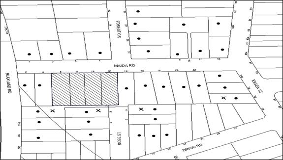
|
NOTIFICATION PLAN |
|
||
|
• PROPERTIES NOTIFIED |
X SUBMISSIONS RECEIVED |
PROPERTY SUBJECT OF DEVELOPMENT |
|
Six submissions objected to the development, generally on the grounds that the development would result in:
· Unacceptable impact on the privacy of the adjoining low density residences to the south;
· Unacceptable overshadowing of adjoining properties to the south;
· Unacceptable impact on the adjoining heritage conservation area;
· The removal of trees from the site;
· Unacceptable traffic on local streets; and
· Development that is excessive in bulk and scale.
Additionally the submissions made the following observations:
· The owner of No. 7 Rose Street requested the retention of the existing boundary fence and hedge. The property owner has requested mature screen planting be planted if the hedge is to be removed and the existing fence be replaced with a lapped and capped fence.
The merits of the matters raised in community submissions have been addressed in the body of the report with the exception of the following:
5.1.1 Boundary Fence and Screen Planting
Should the application be approved, a condition of consent would be imposed requiring a 1.8m lapped and capped fence along all property boundaries behind the building line. An additional condition would be imposed requiring the retention of the existing hedge or replacement with the appropriate screen planting along the south western boundary.
5.2 Public Agencies
The development application was referred to the following Agencies for comment:
5.2.1 RailCorp
The development application was referred to RailCorp for consideration of the proposed underground Parramatta-Epping Railway and no objections are raised subject to recommended conditions of consent.
6. THE PUBLIC INTEREST
Section 79C(1)(e) of the Act requires Council to consider “the public interest”.
The public interest is an overarching requirement, which includes the consideration of the matters discussed in this report. Implicit to the public interest is the achievement of future built outcomes adequately responding to and respecting the future desired outcomes expressed in environmental planning instruments and development control plans.
The application is considered not to have satisfactorily addressed Council’s and relevant agencies’ criteria and would not provide a development outcome that, on balance, would result in a positive impact for the community. Accordingly, it is considered that the approval of the proposed development would not be in the public interest.
CONCLUSION
The application seeks approval for the demolition of existing structures and construction of two, three storey residential flat buildings comprising 62 units and basement car parking.
The site is located at the interface of a high density precinct to the north and a low density zone to the south.
The proposed development does not comply with a number of key controls relating to the design and scale of development, and as a result the proposal would result in over-development of the site. The development is not in accordance with the planning objectives for the locality, or sympathetic to the adjoining low density residential properties. The main concerns with respect to proposal relate to amenity, apartment layout, building separation, solar access and privacy. It is considered that, should the applicant be willing to make further amendments to the design of the development, the concerns raised could be addressed. However, in its current form it is recommended that the application be refused.
Note: At the time of the completion of this planning report, no persons have made a Political Donations Disclosure Statement pursuant to Section 147 of the Environmental Planning and Assessment Act 1979 in respect of the subject planning application.
RESPONSIBLE OFFICER
The officer responsible for the preparation of this Report is the Manager – Development Assessments – Rodney Pickles, who can be contacted on 9847 6731.
|
Rod Pickles Manager - Development Assessment Planning Division |
James Farrington Group Manager Planning Division |
|
1.View |
Locality Map |
|
|
|
2.View |
Site Plan |
|
|
|
3.View |
Floor Plans |
|
|
|
4.View |
Elevation Plans |
|
|
|
5.View |
Shadow Diagram |
|
|
|
6.View |
Landscape Plan |
|
|
File Reference: DA/982/2014
Document Number: D06377616
SCHEDULE 1
1. The proposed development is unsatisfactory in respect to Section 79C(a)(i) of the Environmental Planning and Assessment Act, 1979 and provisions of applicable environmental planning instruments.
1.1 The proposed development does not have adequate regard to the design principles pursuant to State Environmental Planning Policy No. 65 – Design Quality Residential Flat Development for context, scale, built form, density, amenity and resource, energy and water efficiency.
1.2 The proposal development does not include a BASIX Certificate for the proposed units in accordance with the State Environmental Planning Policy (Building Sustainability Index: BASIX) 2004.
2. The proposed development does not meet design best practice benchmarks of the Residential Flat Design Code for unit size, building separation, visual and acoustic privacy and the Apartment Design Guide for apartment layout.
3. The proposed development is unsatisfactory in respect to Section 79C(a)(iii) of the Environmental Planning and Assessment Act, 1979 and the requirements of a development control plan.
3.1 The proposed development does not meet desired outcomes and prescriptive measures of the Hornsby Development Control Plan 2013 for desired future character, height, setbacks, building separations, privacy, waste management and the key development principles.
4. The proposal has provided insufficient information to demonstrate the following:
4.1 The proposed on-site detention system would not be affected by backwater effects.
4.2 The solar access of the adjoining low density residential properties to the south would not be comprised.
5. The proposed development is unsatisfactory in respect to Section 79C(e) of the Environmental Planning and Assessment Act, 1979 in that the proposal is not in the public interest.
- END OF REASONS FOR REFUSAL -
Group Manager’s Report No. PL66/15
Planning Division
Date of Meeting: 9/09/2015
15 DEVELOPMENT APPLICATION - SUBDIVISION OF ONE ALLOTMENT INTO TWO LOTS - 45 HULL ROAD, BEECROFT
EXECUTIVE SUMMARY
|
DA No: |
DA/296/2015 (Lodged 19 March 2015) |
|
Description: |
Torrens title subdivision of one allotment into two lots |
|
Property: |
Lot C DP 360413, No. 45 Hull Road, Beecroft |
|
Applicant: |
P S Graham and Associates |
|
Owner: |
Mr J Scaccianoce and Mrs B Scaccianoce |
|
Estimated Value: |
Nil |
|
Ward: |
C |
· The application includes demolition of an existing carport and swimming pool and Torrens title subdivision of one allotment into two lots.
· The proposal generally complies with the Hornsby Local Environment Plan (HLEP) 2013 and the Hornsby Development Control Plan (HDCP) 2013.
· Two submissions have been received in respect of the application.
· A Red Sticker has been placed on the application requiring that it be determined at a Council meeting.
· It is recommended that the application be approved.
|
THAT Development Application No. DA/296/2015 for Torrens title subdivision of one allotment into two lots at Lot C DP 360413, No. 45 Hull Road, Beecroft be approved subject to the conditions of consent detailed in Schedule 1 of Group Manager’s Report No. PL66/15. |
SITE
The site is located on the western side of Hull Road, Beecroft and has a total site area of 1684.6m2. The site contains an existing single storey brick and tile dwelling house and an in-ground swimming pool located to the rear of the dwelling house. The surrounding developments consist predominantly of single dwelling houses on residential lots.
The site experiences an average fall of 2 metres towards the front, eastern boundary.
An open watercourse traverses through the rear of the property.
The site is mapped as containing remnant trees of the Blue Gum Shale Forest located towards the western side of the watercourse at the rear of the site which are listed as Endangered Ecological Communities under the NSW Threatened Species Conservation Act 1995.
Although the site is not a heritage item, it is located in the immediate vicinity of the heritage listed street trees within Hull Road, Beecroft listed under the provisions of Schedule 5 of the Hornsby Local Environmental Plan 2013 (HLEP). Also, the site is located opposite the western boundary of the Beecroft-Cheltenham Heritage Conservation Area.
PROPOSAL
The application proposes the Torrens title subdivision of one allotment into two lots and the retention of the dwelling house on No.45 Hull Road. The subdivision would require the removal of the in-ground swimming pool and metal carport.
Lot 1 would have an area of 1011m2 (856m2 excluding the access handle).
Lot 2 fronting Hull Road would have an area of 673.6m2 and contain the existing dwelling house at No.45 Hull Road.
The access handle for Lot 1 would have a total area of 155m2 and is located adjacent to the southern side boundary of No.45 Hull Road.
Thirty four (34) trees have been identified for removal on the plans submitted with the development application to accommodate the access way, vehicle turning circle and building footprint.
ASSESSMENT
The development application has been assessed having regard to ‘A Plan for Growing Sydney’, the ‘North Subregion (Draft) Subregional Strategy’ and the matters for consideration prescribed under Section 79C of the Environmental Planning and Assessment Act 1979 (the Act). The following issues have been identified for further consideration.
1. STRATEGIC CONTEXT
1.1 A Plan for Growing Sydney and (Draft) North Subregional Strategy
A Plan for Growing Sydney has been prepared by the NSW State Government to guide land use planning decisions for the next 20 years. The Plan sets a strategy for accommodating Sydney’s future population growth and identifies the need to deliver 689,000 new jobs and 664,000 new homes by 2031. The Plan identifies that the most suitable areas for new housing are in locations close to jobs, public transport, community facilities and services.
The NSW Government will use the subregional planning process to define objectives and set goals for job creation, housing supply and choice in each subregion. Hornsby Shire has been grouped with Hunters Hill, Ku-ring-gai, Lane Cove, Manly, Mosman, North Sydney, Pittwater, Ryde, Warringah and Willoughby to form the North Subregion. The Draft North Subregional Strategy will be reviewed and the Government will set housing targets and monitor supply to ensure planning controls are in place to stimulate housing development.
The proposed development would be consistent with ‘A Plan for Growing Sydney’, by providing an additional residential allotment capable of accommodating a future dwelling house.
2. STATUTORY CONTROLS
Section 79C(1)(a) requires Council to consider “any relevant environmental planning instruments, draft environmental planning instruments, development control plans, planning agreements and regulations”.
2.1 Hornsby Local Environmental Plan 2013
The proposed development has been assessed having regard to the provisions of the Hornsby Local Environmental Plan 2013 (HLEP).
2.1.1 Zoning of Land and Permissibility
The subject land is zoned R2 (Low Density-Residential) under the Hornsby Local Environmental Plan 2013 (HLEP). The objectives of the R2 zone are:
(a) To provide for the housing needs of the community within a low density residential environment; and
(b) To enable other land uses that provide facilities or services to meet the day to day needs of residents.
The proposed development is defined as a “Subdivision” and is permissible in the zone with Council’s consent.
2.1.2 Clause 4.1 - Minimum Lot Size
Clause 4.1 of the HLEP prescribes that the minimum lot size applicable to the site is 600m2 (excluding the area of the access handle). The proposal complies with the minimum lot size development standard.
2.2 Sydney Regional Environmental Plan (Sydney Harbour Catchment) 2005
The site is located within the catchment of Sydney Harbour. Sydney Regional Environmental Plan (Sydney Harbour Catchment) 2005 aims to protect the environment of the Sydney Harbour Catchment by ensuring that the impacts of future land uses are considered in a regional context.
Subject to the implementation of sediment and erosion control measures and stormwater management to protect water quality, the proposal would comply with the requirements of the Policy.
2.3 State Environmental Planning Policy No. 55 Remediation of Land
The Policy provides guidelines for the remediation of contaminated land for the purpose of reducing the risk of harm to human health or any other aspect of the environment.
Clause 7 requires Council to consider whether land is contaminated prior to granting consent to the carrying out of any development on that land.
Should the land be contaminated, Council must be satisfied that the land is suitable in a contaminated state for the proposed use. If the land requires remediation to be undertaken to make the land suitable for the proposed use, Council must be satisfied that the land will be remediated before the land is used for that purpose.
Given the site has a history of residential use, it is not likely that the site has experienced any significant contamination, and further assessment under SEPP 55 is not required.
2.4 Hornsby Shire Council Section 94 Development Contribution Plan 2012 - 2021
A Section 94 contribution levy would be applicable as the proposed development would result in one additional lot. A condition is recommended in Schedule 1.
2.5 Clause 74BA Environmental Planning and Assessment Act, 1979 - Purpose and Status of Development Control Plans
Clause 74BA of the Environmental Planning and Assessment Act, 1979 states that a DCP provision will have no effect if it prevents or unreasonably restricts development that is otherwise permitted and complies with the development standards in relevant Local Environmental Plans and State Environmental Planning Policies.
The principal purpose of a development control plan is to provide guidance on the aims of any environmental planning instrument that applies to the development; facilitate development that is permissible under any such instrument; and achieve the objectives of land zones. The provisions contained in a DCP are not statutory requirements and are for guidance purposes only. Consent authorities have flexibility to consider innovative solutions when assessing development proposals, to assist achieve good planning outcomes.
2.6 Hornsby Development Control Plan 2013
The proposed development has been assessed having regard to the relevant desired outcomes and prescriptive requirements within the Hornsby Development Control Plan 2013 (HDCP). The following table sets out the proposal’s compliance with the prescriptive requirements of the Plan:
|
Hornsby Development Control Plan 2013 – Parts 3 and 6 |
|||
|
Control |
Proposal |
Requirement |
Complies |
|
Density Allotment sizes (excluding the access handle) Lot No. 1 Lot No. 2 |
856 m2 673.6 m2 |
600 m2 600 m2 |
Yes Yes |
|
Building Envelope on Proposed Lot No. 1 |
|||
|
Lot Width |
18.29 m |
15 m |
Yes |
|
Building Envelope Area |
200 m2 |
200 m2 |
Yes |
|
Private Open Space |
>24 m2 |
24 m2 |
Yes |
|
Setbacks - Front (Battle-axe - North - South - Rear (western) |
9.6 m 1 m 1 m 23 m |
0.9 m 0.9 m 0.9 m 5 m |
Yes Yes Yes Yes |
|
Landscaping |
64% |
>30% |
Yes |
|
Car Parking |
2 spaces |
2 spaces |
Yes |
|
Existing Dwelling on Proposed Lot No. 2 |
|||
|
Lot Width |
14.5 m |
15 m |
No |
|
Floor Area |
158m2 |
Max. 380 m2 |
Yes |
|
Site Cover |
46% |
<50% |
Yes |
|
Private Open Space |
>24 m2 |
24 m2 |
Yes |
|
Setbacks - Front (Hull Road) - North - South - Rear |
22 m 1 m 0 m 5 m |
7.6 m 0.9 m 0.9 m 5 m |
Yes Yes No Yes |
|
Landscaping |
47% |
>30% |
Yes |
|
Car Parking |
2 spaces |
2 spaces |
Yes |
As detailed in the above table, the proposed development does not comply with the minimum setback and Lot width provisions of the HDCP. The matters of non-compliance are detailed below, as well as a brief discussion on compliance with relevant desired outcomes.
2.6.1 Lot Design
The proposed subdivision would provide two regular shaped lots which comply with the minimum lot size requirements of the HLEP and can accommodate a 200m2 building envelope with a 24m2 principal private open space area and car parking for 2 cars behind the building line.
The indicative building envelope on Lot 1 complies with the prescriptive measures of the HDCP with respect to setbacks and landscaping.
The proposed lot width of Lot 2 would be 14.5 metres which does not comply with the prescriptive measures of the HDCP which require 15 metres. Despite this non-compliance, the existing dwelling would comply with the minimum requirements for private open space, landscaping and site coverage and allows for a compliant 3.5 metre wide access handle with a 0.5 metre landscape verge.
It is considered that the layout and design of the proposed subdivision is considered satisfactory in retaining the existing dwelling in the heritage streetscape and would be in keeping with the established pattern in the locality. The minor non-compliance with the setback from the accessway does not warrant refusal of the application.
2.6.2 Setbacks
The southern side setback of the existing dwelling on proposed lot 2 would be setback 0 metres which does not comply with the HDCP Setback requirements.
The non-compliance of the southern side setback is a result of providing an access handle for proposed Lot 1. Although the southern side setback of the existing dwelling would not comply with the minimum HDCP requirements, the dwelling would maintain a 3.5 metre separation to the southern side boundary adjoining No.43 Hull Road, would provide opportunity for a landscaped verge along the access handle and would not be out of character with similar setbacks of dwellings to access handles along Hull Road, most notably the adjoining properties at Nos. 43 and 47 Hull Road.
It is considered that the proposed setbacks of the dwelling would maintain the visual and acoustic amenities to neighbouring properties and are compatible with adjacent development. As a consequence the non-compliance is considered acceptable.
2.6.3 Heritage
The property is located in the immediate vicinity of the heritage listed street trees within Hull Road, Beecroft and opposite the western boundary of the Beecroft-Cheltenham Heritage Conservation Area under the provisions of Schedule 5 HLEP.
In Council’s heritage assessment, concerns were raised that the construction of a new driveway may impact on heritage listed street trees within Hull Road. To address this concern, the applicant provided additional details to demonstrate that the driveway would not impact on the heritage listed street trees. Council’s heritage assessment concludes that the proposed subdivision would not detract from the heritage significance of the heritage item or the adjoining conservation area and is acceptable.
2.6.4 Building Envelope
The application includes an indicative building envelope with an area of 200m2 on proposed Lot 1. The indicative building envelope has been sited clear of the significant bushland and watercourse at the rear of the site and significant trees near the eastern boundary. The site is capable of accommodating a future dwelling-house that is consistent with Council’s planning controls and respects the site’s environmental attributes.
2.6.5 Accessway Design
The prescriptive measures of Part 6.4.1(e) Accessway Design of the HDCP for lots serving 1-3 dwellings states that ‘the dimensions of an accessway width should be 3.5 metres.’
To accommodate the 3.5 metre driveway width, the application proposes the removal of the eaves and gutters of the existing dwelling on proposed Lot 2. Subject to conditions for driveway construction, the accessway would provide vehicular access that is simple, safe and direct and consistent with the desired outcomes of Part 6.4.1 Accessway Design.
2.6.6 Parking
The HDCP requires the provision of 2 car parking spaces for dwellings with 3 or more bedrooms. The parking area on proposed Lot 2 would be within the existing detached brick carport which includes 2 car spaces. An indicative parking area for 2 vehicles for proposed Lot 1 is demonstrated on the plan of subdivision. The parking provision on the site complies with the requirements of the HDCP and is acceptable.
2.6.7 Open Space and Landscaping
A principal private open space area of 24m2 is shown to the rear of the indicative building envelope on proposed Lot 1. A 24m2 principal private open space are is retained at the rear of the existing dwelling within proposed Lot 2. Both allotments satisfy the minimum 30% landscaped areas under the HDCP.
The proposal demonstrates sufficient principle private open space and landscaping areas in accordance with the HDCP and is acceptable.
3. ENVIRONMENTAL IMPACTS
Section 79C(1)(b) of the Act requires Council to consider “the likely impacts of that development, including environmental impacts on both the natural and built environments, and social and economic impacts in the locality”.
3.1 Natural Environment
3.1.1 Biodiversity
The desired outcomes of Section 1C.1.1 Biodiversity of the HDCP encourages “development that provides for the conservation of biodiversity including threatened species and populations, endangered ecological communities, remnant indigenous trees, regionally and locally significant vegetation.
The rear of the site, west of the watercourse contains native remnant trees that form part of Blue Gum High Forest Critically Endangered Ecological Community listed under the NSW Threatened Species Conservation Act 1995.
An Arboricultural Impact Assessment prepared by Australis Tree Management was submitted with the application addressing the proposal’s impact on trees. The report identifies that the rear portion of the site containing the Blue Gum High Forest would not be impacted by the proposal.
The Arboricultural Impacts Assessment recommends the removal of trees within the building footprint, driveway and vehicular turning area, the majority of which are non-locally indigenous species. A total of 18 trees on site, many of which are significant, are identified for retention. The report includes recommendations for tree protection measures to ensure the health and longevity of the significant trees to be retained. Further assessment with respect to the impacts on individual trees is addressed in Section 3.1.3 of this report.
In Council’s bushland assessment, consideration was made to the proposed subdivision and the recommendations within the Arboricultural Impact Assessment. Considering that no works are proposed within the vicinity of the bushland and the open watercourse that traverses through the rear of the site, no objections were raised to the proposal. The location of the watercourse, 7 metres to the west of the indicative building envelope, provides an acceptable buffer to the Blue Gum High Forest within the rear western portion of the site. Furthermore, conditions for tree protection fencing across the rear portion of the site would ensure that the area of the site containing the Blue Gum High Forest remains undisturbed during construction.
The proposed subdivision meets the desired outcomes of Section 1C.1.1 Biodiversity of the HDCP as it provides for the conservation of the Blue Gum High Forest and is considered acceptable.
3.1.2 Watercourses
The site is traversed by a watercourse/ drainage channel at the western rear of the site.
The prescriptive measures of Section 1C.1.3 Watercourses of the HDCP requires a vegetated buffer that protects the core riparian zone of 10 metres.
The proposed building envelope would encroach into the 10 metre prescribed core riparian zone and was subsequently referred for bushland assessment.
The bank adjoining the eastern side of the water course comprises an unnatural sandstone retaining wall which stabilises the bank which does not comprise any riparian vegetation. As a consequence, no objections are raised to the proposed building envelope being located within the 10 metre riparian zone.
The proposed subdivision meets the desired outcomes of Section 1C.1.3 Watercourses of the HDCP and is considered acceptable.
3.1.3 Tree and Vegetation Preservation
The desired outcomes of Part 3.1.3 Landscaping of the HDCP is to encourage “landscaping that integrates the built form with soft landscaping and retains and enhances tree canopy” and “development that retains existing landscape features.”
The prescriptive measures of the Landscaping element state that “The proposed building, ancillary structures, driveways, drainage and service trenches should be set back in accordance with AS 4970 for significant trees to be retained.”
The site comprises a number of exotic, native planted trees and locally indigenous specimens and includes a group of predominantly locally indigenous trees determined as significant under Hornsby Councils’ Assessment of a Significant Group of Trees.
Council’s assessment of the proposal included a detailed examination of the existing trees on site in conjunction with the submitted Arboricultural Impact Assessment prepared by Australis Tree Management dated 24 July 2015.
The submitted Arboricultural Impact Assessment supports the removal of 34 trees from the site to accommodate the building envelope, driveway and vehicular turning area. The report identifies that 18 trees, a number of which are significant, would be retained and protected through recommended conditions. Of the 34 trees identified for removal, only 3 trees are locally indigenous (numbered T23, T27 and T54). As the site is not within heritage conservation area, the 31 non indigenous trees identified for removal, which include mostly palms, can be removed without development consent independent of the proposal.
Council’s tree assessment, supports the recommendations within the Arboricultural Assessment. However, it is considered that T27, identified as a Turpentine (Angophora costata), located to the east of the building envelope, could be retained if a future dwelling incorporates sensitive design and construction techniques to ensure the tree’s protection. In this regard, consent for the removal of T27 is not recommended. The removal of T23, also identified as a Turpentine, is located within the required turning area and therefore, removal is considered necessary to facilitate the subdivision. No objections are raised to the removal of T54, known as Smooth Barked Apple (Angophora costata) located near Hull Rd, as the tree is identified to be in poor health and condition.
Conditions are recommended in Schedule 1 that require the implementation of appropriate tree sensitive construction techniques, the appointment of an Arborist to oversee any construction works and to carry out remedial action to ensure the health and protection of trees to be retained.
Subject to conditions, the proposal, on balance has an acceptable impact on the natural environment and achieves an outcome that retains a number of significant trees whilst facilitating the provision of additional housing consistent with the objectives of the residential zone. The proposal meets the desired outcomes of Part 3.1.3 Landscaping of the HDCP and is considered acceptable.
3.1.4 Stormwater Management
The application proposes to discharge stormwater generated from Lot 1 to the existing street drainage system via an on-site detention system. The proposed stormwater management solution is considered satisfactory and the development would not have any adverse impact on the existing street drainage system nor adjoining properties, subject to the recommended conditions.
3.2 Flooding
Part of site is identified as being below the 1:100 year flood level. A flood study prepared by Diversi Consulting was submitted with the application which addresses the flooding impact and supports the proposal. Council’s engineering assessment of the application, including the submitted flood study concludes that the proposal is acceptable subject to conditions. Such conditions, as applied in Schedule 1, require a Restriction as to User to be created on the Title that prohibits the floodway from being altered; and for the finished floor level of any habitable room to be not less than 500mm and the garage 300mm above the 100 year average recurrence interval storm level. Subject to these conditions, the subdivision would be acceptable as the site can accommodate a dwelling that is protected against flood events.
3.3 Built Environment
The application proposes the retention of the dwelling houses at No. 45 Hull Road.
The subdivision design is consistent with the established pattern of subdivision of battle-axe allotments in the street. The proposed rear allotment is of sufficient size and shape to accommodate a future dwelling house with appropriate setbacks, landscaping, private open space and car parking in accordance with the requirements of the HDCP.
3.4 Social Impacts
The proposal would not result in a social impact.
3.5 Economic Impacts
The proposal would have a minor positive impact on the local economy in conjunction with other new low density residential development in the locality by generating an increase in demand for local services.
4. SITE SUITABILITY
Section 79C(1)(c) of the Act requires Council to consider “the suitability of the site for the development”.
The site has an area of 1684.6m2 which is sufficient space to accommodate the subdivision in accordance with the minimum lot size development standard under HLEP 2013 whilst retaining the existing dwelling house at No.45 Hull Road. The subdivision design and attributes of the site would enable development of the newly created allotments that is compatible with the surrounding low density environment.
The site is considered suitable for the proposed development.
5. PUBLIC PARTICIPATION
Section 79C(1)(d) of the Act requires Council to consider “any submissions made in accordance with this Act”.
5.1 Community Consultation
The proposed development was placed on public exhibition and was notified to adjoining and nearby landowners between 1 April 2015 and 1 May 2015 in accordance with the Notification and Exhibition requirements of the HDCP. During this period, Council received two submissions. The map below illustrates the location of those nearby landowners who made a submission that are in close proximity to the development site.
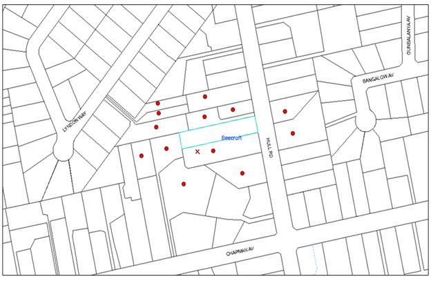
|
NOTIFICATION PLAN |
|
||
|
• PROPERTIES NOTIFIED
|
2 SUBMISSIONS RECEIVED |
PROPERTY SUBJECT OF DEVELOPMENT |
|
|
One submission received out of map range from the Beecroft / Cheltenham Civic Trust |
|||
Two submissions objected to the development, generally on the grounds that the development would result in:
· Removal of eaves of the existing dwelling-house;
· Drainage to watercourse;
· Shadowing;
· Removal of trees and no tree report; and
· Biodiversity impacts.
The merits of the matters raised in community submissions have been addressed in the body of the report with the exception of the following.
5.1.1 Overshadowing
A submission raises concerns that the proposed subdivision would create increased overshadowing on the adjoining properties. The application proposes the subdivision of one allotment into two and not the erection of a dwelling house. Any overshadowing cast by a proposed dwelling house would be assessed when an application is lodged with Council.
5.1.2 Eaves
An objection raises concerns about the removal of eaves. The removal of eaves from the dwelling would result in a complaint 3.5 metre wide accessway which would provide adequate clearance to service vehicles to Lot 1. Furthermore, the dwelling is not a heritage listed item and is not located within a conservation area and no objections are raised to the removal of these eaves to facilitate the subdivision.
5.2 Public Agencies
The development application is Integrated Development under the Act. Accordingly, the application was referred to the following Agency for comment:
5.2.1 Water Management Act 2000 – Integrated Development
Pursuant to Section 66 of the Environmental Planning and Assessment Regulations 2000, the proposal constitutes an integrated development and required approval under the Water Management Act 2000.
The application was forwarded to the NSW Office of Water who issued general terms of approval for the proposed works requiring a ‘Controlled Activity Approval’ under the Water Management Act 2000 (WMA), as detailed in the conditions. (Refer to Schedule 1).
6. THE PUBLIC INTEREST
Section 79C(1)(e) of the Act requires Council to consider “the public interest”.
The public interest is an overarching requirement, which includes the consideration of the matters discussed in this report. Implicit to the public interest is the achievement of future built outcomes adequately responding to and respecting the future desired outcomes expressed in environmental planning instruments and development control plans.
The application is considered to have satisfactorily addressed Council’s and relevant agencies’ criteria and would provide a development outcome that, on balance, would result in a positive impact for the community. Accordingly, it is considered that the approval of the proposed development would be in the public interest.
CONCLUSION
The application proposes the subdivision of one allotment into two lots.
The development generally meets the desired outcomes of Council’s planning controls and is satisfactory having regard to the matters for consideration under Section 79C of the Environmental Planning and Assessment Act, 1979.
Council received two submissions objecting to the proposal during the public notification period. These matters have been addressed in the body of the report and appropriate conditions are recommended to minimise disruption to residential amenity.
Having regard to the circumstances of the case, approval of the application is recommended.
Note: At the time of the completion of this planning report, no persons have made a Political Donations Disclosure Statement pursuant to Section 147 of the Environmental Planning and Assessment Act 1979 in respect of the subject planning application.
RESPONSIBLE OFFICER
The officer responsible for the preparation of this Report is the Manager – Development Assessments – Rodney Pickles, who can be contacted on 9847 6731.
|
Rod Pickles Manager - Development Assessment Planning Division |
James Farrington Group Manager Planning Division |
|
1.View |
Locality Map |
|
|
|
2.View |
Subdivision Plan |
|
|
File Reference: DA/296/2015
Document Number: D06259818
SCHEDULE 1
GENERAL CONDITIONS
The conditions of consent within this notice of determination have been applied to ensure that the use of the land and/or building is carried out in such a manner that is consistent with the aims and objectives of the relevant legislation, planning instruments and Council policies affecting the land and does not disrupt the amenity of the neighbourhood or impact upon the environment.
Note: For the purpose of this consent, the term ‘applicant’ means any person who has the authority to act on or the benefit of the development consent.
Note: For the purpose of this consent, any reference to an Act, Regulation, Australian Standard or publication by a public authority shall be taken to mean the gazetted Act or Regulation, or adopted Australian Standard or publication as in force on the date that the application for a construction certificate is made.
1. Approved Plans and Supporting Documentation
The development must be carried out in accordance with the plans and documentation listed below and endorsed with Council’s stamp, except where amended by Council and/or other conditions of this consent:
|
Plan No. |
Drawn by |
Dated |
|
Plan of proposed subdivision, Sheet 1 of 1, Ref No. S.15267C |
P.S. Graham & Associates |
17/02/2015 |
|
Supporting Document No. |
Prepared by |
Dated |
|
Arboricultural Impact Assessment |
Australis Tree Management |
24 July 2015 |
|
Erosion & Sediment Control Plan, Sheet 1 of 1, Ref No. S.15267 |
P. S. Graham & Associates |
17 February 2015 |
2. Removal of Existing Trees
a) This development consent permits the removal of trees numbered T13 - T21, T23- T26, T33-T41, T49, T49.1 & T51-T59 as identified on Plan of proposed subdivision, Sheet 1 of 1, Ref No. S.15267B, prepared by P.S. Graham & Associates, dated 17/02/2015.
b) The removal of any other trees from the site requires separate approval by Council in accordance with Part 1B.6 Tree and Vegetation Preservation of the Hornsby Development Control Plan, 2013 (HDCP).
3. Section 94 Development Contributions
a) In accordance with Section 80A(1) of the Environmental Planning and Assessment Act 1979 and the Hornsby Shire Council Section 94 Development Contributions Plan 2012-2021, the following monetary contributions shall be paid to Council to cater for the increased demand for community infrastructure resulting from the development:
|
Description |
Contribution (4) |
|
Roads |
$1,140.00 |
|
Open Space and Recreation |
$16,480.00 |
|
Community Facilities |
$2,300.00 |
|
Plan Preparation and Administration |
$80.00 |
|
TOTAL |
$20,000.00 |
being for one additional lot.
b) The value of this contribution is current as at 13 August 2015. If the contributions are not paid within the financial quarter that this condition was generated, the contributions payable will be adjusted in accordance with the provisions of the Hornsby Shire Council Section 94 Development Contributions Plan and the amount payable will be calculated at the time of payment in the following manner:
$CPY = $CDC x CPIPY
CPIDC
Where:
$CPY is the amount of the contribution at the date of Payment
$CDC is the amount of the contribution as set out in this Development Consent
CPIPY is the latest release of the Consumer Price Index (Sydney – All Groups) at the date of Payment as published by the ABS.
CPIDC is the Consumer Price Index (Sydney – All Groups) for the financial quarter at the date applicable in this Development Consent Condition.
c) The monetary contributions shall be paid to Council:
i) prior to the issue of the Subdivision Certificate where the development is for subdivision; or
ii) prior to the issue of the first Construction Certificate where the development is for building work; or
iii) prior to issue of the Subdivision Certificate or first Construction Certificate, whichever occurs first, where the development involves both subdivision and building work; or
iv) prior to the works commencing where the development does not require a Construction Certificate or Subdivision Certificate.
It is the professional responsibility of the Principal Certifying Authority to ensure that the monetary contributions have been paid to Council in accordance with the above timeframes.
Council’s Development Contributions Plan may be viewed at www.hornsby.nsw.gov.au or a copy may be inspected at Council’s Administration Centre during normal business hours.
4. Construction Certificate
a) A Construction Certificate is required to be approved by Council or a Private Certifying Authority prior to the commencement of any works under this consent.
b) The Construction Certificate plans must not be inconsistent with the Development Consent plans.
5. Works on Waterfront Land
Works on waterfront land are to be undertaken in accordance with NSW Office of Water General Terms of Approval and Controlled Activity Approval issued under the Water Management Act 2000.
6. NSW Office of Water Requirement
The Construction Certificate will not be issued over any part of the site requiring a controlled activity approval until a copy of the approval has been provided to Council.
REQUIREMENTS PRIOR TO THE ISSUE OF A CONSTRUCTION CERTIFICATE
7. Building Code of Australia
All building work must be carried out in accordance with the relevant requirements of the Building Code of Australia.
8. Utility Services
The applicant must submit written evidence of the following service provider requirements:
a) Ausgrid (formerly Energy Australia) – a letter of consent demonstrating that satisfactory arrangements have been made to service the proposed development.
b) Telstra - a letter of consent demonstrating that satisfactory arrangements have been made to service the proposed development.
REQUIREMENTS PRIOR TO THE COMMENCEMENT OF ANY WORKS
9. Erection of Construction Sign
A sign must be erected in a prominent position on any site on which building work, subdivision work or demolition work is being carried out:
a) Showing the name, address and telephone number of the principal certifying authority for the work;
b) Showing the name of the principal contractor (if any) for any demolition or building work and a telephone number on which that person may be contacted outside working hours; and
c) Stating that unauthorised entry to the work site is prohibited.
Note: Any such sign is to be maintained while the building work, subdivision work or demolition work is being carried out, but must be removed when the work has been completed.
10. Toilet Facilities
Toilet facilities must be available or provided at the works site before works begin and must be maintained until the works are completed at a ratio of one toilet for every 20 persons employed at the site.
11. Erosion and Sediment Control
Erosion and sediment control measures must be provided and maintained throughout the construction period in accordance with the manual ‘Soils and Construction 2004 (Bluebook)’, the approved plans, Council specifications and to the satisfaction of the principal certifying authority. The erosion and sediment control devices must remain in place until the site has been stabilised and revegetated.
Note: On the spot penalties up to $1,500 may be issued for any non-compliance with this requirement without any further notification or warning.
12. Appointment of a Project Arborist
a) A Project Arborist (AQF5 qualified) must be appointed to oversee the installation of tree protection and fencing required to protect the tree root zones. Details of the Arborist must be submitted to Council prior to the commencement of works.
b) The installation and maintenance of tree protection fencing must be in accordance with Australian Standard AS 4970-2009 (1.4.4). Tree protection fencing must be erected around trees numbered T27, T28, T29, and T31 in accordance with required tree protection zones as identified on pages 42 of Appendix E contained in the Supplied Aboricultural Impact Assessment provided by Australis Tree Management dated 24 July 2015.
c) The Project Arborist (AQF5 qualified) must monitor the integrity of the tree protection methods, recording any modifications or alterations to the tree protection zone fencing for the duration of the construction period.
d) The Project Arborist (AQF5 qualified) must submit to the Principal Certifying Authority (PCA) a certification/statement confirming that all tree protection measures have been installed in accordance with this consent and the specific requirements of Australian Standard ”Protection of Trees on Development Sites” (AS 4970-2009).
e) All Tree Protection Zones must have a layer of wood-chip mulch installed prior to works commencing and must be maintained throughout the period of construction at a depth of 150mm – 300mm using material that complies with Australian Standard AS 4454.
REQUIREMENTS DURING CONSTRUCTION
13. Construction Work Hours
All work on site (including demolition and earth works) must only occur between 7am and 5pm Monday to Saturday. No work is to be undertaken on Sundays or public holidays.
14. Demolition
All demolition work must be carried out in accordance with “Australian Standard 2601-2001 – The Demolition of Structures”.
15. Council Property
During construction works, no building materials, waste, machinery or related matter is to be stored on the road or footpath. The public reserve must be kept in a clean, tidy and safe condition at all times.
Note: This consent does not give right of access to the site via Council’s park or reserve. Should such access be required, separate written approval is to be obtained from Council.
16. Disturbance of Existing Site
During construction works, the existing ground levels of open space areas and natural landscape features, (including natural rock-outcrops, vegetation, soil and watercourses) must not be altered unless otherwise nominated on the approved plans.
17. Environmental Management
The site must be managed in accordance with the publication ‘Managing Urban Stormwater – Landcom (March 2004) and the Protection of the Environment Operations Act 1997 by way of implementing appropriate measures to prevent sediment run-off, excessive dust, noise or odour emanating from the site during the construction of the development.
18. Bushland Protection During Construction
To ensure the protection of bushland during construction, the applicant must ensure the following:
a) The installation of 1.8 metre high chain wire fencing (or similar) 4 metres from the significant bushland occurring within the riparian zone identified on the approved plan;
b) All machinery to be cleaned of soil and debris before entering the site to prevent the spread of weeds and fungal pathogens.
Note: The site contains Blue Gum High Forest which is listed as an ‘Endangered Ecological Community’ under the ‘Threatened Species Conservation Act 1995’. The Act prohibits the disturbance to threatened species, endangered populations and endangered ecological communities, or their habitat, without the approval of the ‘Department of Environment and Climate Change’ where such activities are not authorised by a development consent under the ‘Environmental Planning and Assessment Act 1979’.
Actions such as tree removal, understorey slashing or mowing, removal of dead trees within this vegetation would likely impact upon this endangered ecological community. Such action would qualify as illegally picking or disturbing the habitat and could render any person who carried out such action as LIABLE FOR PROSECUTION.
19. Landfill
Landfill must be constructed in accordance with Council’s ‘Construction Specification 2005’ and the following requirements:
a) All fill material imported to the site is to wholly consist of Virgin Excavated Natural Material (VENM) as defined in Schedule 1 of the Protection of the Environment Operations Act 1997 or a material approved under the Department of Environment and Climate Change’s general resource recovery exemption.
20. Excavated Material
All excavated material removed from the site must be classified in accordance with the Department of Environment, Climate Change and Water NSW Waste Classification Guidelines prior to disposal to an approved waste management facility and reported to the principal certifying authority.
21. Discharge of Swimming Pool Water
Water from the pool is to be discharged to sewer in accordance with the Protection of the Environment Operations Act 1997. Discharged pool water is not to flow onto adjoining properties or into the creek.
22. Consenting to Works within Tree Protection Zones
Consent is granted to undertake works within the Tree Protection Zone of specified trees T27, T28, T29, T30, T31 and T65 where the works are undertaken under the supervision of the Project Arborist and the following conditions:
a) Tree protection fencing must only be adjusted to facilitate the installation of the driveway.
b) The driveway must be built on grade, with the use of piers to provide support to minimise compaction with the tree protection zone.
c) Driveway aprons, layback must be installed with minimal excavation. All work must be under taken by hand.
d) Material being imported to the site to create level grade for driveway must be distributed by hand within the tree protection zone.
e) Where the driveway foundation encroaches within the tree protection zone (of any retained tree), that portion of the foundation must be on piers or of a canter lever design.
23. Root Pruning
a) Where tree roots are required to be severed for the purposes of this consent, all pruning must be undertaken under the supervision of the Project Arborist and as specified in Australian Standard AS 4970-2009 Sections 3.3.4, 4.5.4 and 4.5.5.
b) Where a tree root 50mm or greater in diameter intersects the location of a pier, the pier must be relocated a minimum 200mm away from the root.
24. Drilling/Boring to Install Underground Services
a) The installation of any services within the nominated tree protection zone of any tree to be retained must utilise the thrust boring method.
b) Thrust boring must be carried out so that ‘top of pipe’ is a minimum 600mm depth beneath existing ground level.
25. Building Materials and Site Waste
The filling or stockpiling of building materials, parking of vehicles or plant, disposal of cement slurry, waste water or other contaminants must be located outside the tree protection zones.
REQUIREMENTS PRIOR TO THE ISSUE OF AN SUBDIVISION CERTIFICATE
Note: For the purpose of this consent, a reference to ‘occupation certificate’ shall not be taken to mean an ‘interim occupation certificate’ unless otherwise stated.
26. Sydney Water – s73 Certificate
An s73 Certificate must be obtained from Sydney Water.
27. Stormwater Drainage
The stormwater drainage system for the development must be designed and constructed in accordance with Council’s Civil Works – Design and Construction Specification 2005 and the following requirements:
a) Connected directly to Council’s street drainage system.
b) An inter-allotment stormwater drainage system to service the proposed subdivision with pits being cast in situ or pre-cast concrete pits being used.
28. Internal Driveway/Vehicular Areas
The driveway and parking areas on site must be designed in accordance with Australian Standards 2890.1, 2890.2, 3727 and the following requirements:
a) Design levels at the front boundary must be obtained from Council.
b) The driveway must be a rigid pavement.
c) The driveway grade must not exceed 25 percent and changes in grade must not exceed 8 percent.
d) The driveway pavement must be a minimum 3 metres wide, 0.15 metres thick reinforced concrete with F72 steel reinforcing fabric and a 0.15 metre sub-base.
e) The pavement must have a kerb to one side and a one-way cross fall with a minimum gradient of 2 percent and a lintel and pit provided at the low point.
f) Retaining walls required to support the carriageway and the compaction of all fill batters must be in accordance with the requirements of a chartered structural engineer.
g) Longitudinal sections along both sides of the access driveway shall be submitted to the principal certifying authority in accordance with the relevant sections of AS 2890.1. The maximum grade shall not exceed 1 in 4 (25%) with the maximum changes of grade of 1 in 8 (12.5%) for summit grades and 1 in 6.7 (15%) for sag grades. Any transition grades shall have a minimum length of 2 metres.
h) Any structure including eaves gutters encroaching over the proposed Right of Access with a clearance of less than 4.5 metres above the finished driveway level shall be removed.
i) A certificate from a qualified structural engineer shall be provided to the principal certifying authority certifying that the excavation for the proposed access driveway and retaining walls will not have a detrimental impact on the structural stability of the existing dwelling house.
j) Conduit for utility services including electricity, water, gas and telephone must be provided. All existing overhead assets including electricity and telecommunications cabling shall be relocated underground at no cost to Council. A certificate from an appropriately licensed contractor shall be submitted to the principal certifying authority certifying that the service conduits have been installed in accordance with the relevant utility provider and Australian Standards.
29. Vehicular Crossing
A separate application under the Local Government Act 1993 and the Roads Act 1993 must be submitted to Council for the installation of a new vehicular crossing and the removal of the redundant crossing. The vehicular crossing must be constructed in accordance with Council’s Civil Works Design 2005 and the following requirements:
a) Any redundant crossings must be replaced with integral kerb and gutter;
b) Approval must be obtained from all relevant utility providers that all necessary conduits be provided and protected under the crossing.
Note: An application for a vehicular crossing can only be made to one of Council’s Authorised Vehicular Crossing Contractors. You are advised to contact Council on 02 9847 6940 to obtain a list of contractors.
30. Road Works
Prior to the issue of a Construction Certificate for these works a separate application under the Local Government Act, 1993 and the Roads Act, 1993 must be submitted to Council for all works in the public road reserve in accordance with Council’s Civil Works Design and Construction Specification 2005 and the following requirements:
a) A concrete footpath must be constructed along the full frontage of the development site with the remaining area turfed.
Note: A separate Construction Certificate is required to be submitted and approval obtained by Hornsby Shire Council prior to the commencement of these works.
31. Creation of Easements
The following matter(s) must be nominated on the plan of subdivision under s88B of the Conveyancing Act 1919:
a) A right of access and easement for services over the access corridor.
b) An inter-allotment drainage easement(s) over each of the burdened lots.
c) A drainage easement over the burdened Lot 1 in favour of Council and in accordance with the terms set out in Memorandum B5341305V filed with the NSW Department of Lands.
d) A restriction over the flow path for a 100 year average recurrence interval storm. The "Restriction on the Use of Land" over the affected lots is to prohibit the alteration of the final floodway shape and the erection of any structures, including fencing, in the floodway without the written permission of Council. The terms of this restriction must be obtained from Council.
e) A "Restriction on the Use of Land" for any lot adjacent to the floodway, requiring the finished floor level of any habitable room to be not less than 500mm and the garage 300mm above the 100 year average recurrence interval storm level. The levels must be related to Australian Height Datum.
f) The creation of a “Positive Covenant” over the proposed Lot 1 requiring that any future development is to provide an on-site detention system. The on-site detention system is to have a storage capacity of 5 cubic metres and a maximum discharge of 8 litres per second into Council’s drainage system in accordance with Council’s prescribed wording.
Note: Council must be nominated as the authority to release, vary or modify any easement, restriction or covenant.
32. Works as Executed Plan
A works-as-executed plan(s) must be prepared by a registered surveyor and submitted to Council for completed road pavement, kerb & gutter, public drainage systems, driveways and on-site detention system. The plan(s) must be accompanied by a certificate from a registered surveyor certifying that all pipelines and associated structures lie wholly within any relevant easements. The location of all necessary service conduits provided to facilitate the proposed subdivision shall be clearly indicated on the works as executed plan.
33. Damage to Council Assets
Any damage caused to Council’s assets including the removal, damage, destruction, displacement or defacing of the existing survey marks as a result of the construction or demolition of the development must be rectified in accordance with Council’s Civil Works Specifications. Council’s Restorations Supervision must be notified for a formwork inspection.
34. Preservation of Survey Marks
A certificate by a Registered Surveyor shall be submitted to the Principal Certifying Authority, certifying that there has been no removal, damage, destruction, displacement or defacing of the existing survey marks in the vicinity of the proposed development or otherwise the re-establishment of damaged, removed or displaced survey marks has been undertaken in accordance with the Surveyor General’s Direction No.11 – “Preservation of Survey Infrastructure”.
35. Final Certification
A certificate from the appointed Project Arborist must be submitted with the application for the subdivision certificate stating compliance with the relevant conditions of consent for tree protection.
OPERATIONAL CONDITIONS
36. Ongoing Protection of Bushland
The natural bushland area of the site identified on the approved plans must remain undisturbed and be protected in perpetuity in accordance with the following requirements:
a) The bushland area is to be fenced off with post and wire (or similar) fencing to prevent vehicular access;
b) The bushland area is to be kept free of noxious weeds using recognised bush regeneration methods in accordance with ‘Recovering bushland on the Cumberland Plain: Best practice guidelines for the management and restoration of bushland – Department of Conservation 2005’; and
c) Machinery and fertilizer must not be used in the bushland area for maintenance purposes.
GENERAL TERMS OF APPROVAL – NSW OFFICE OF WATER
The following conditions of consent are General Terms of Approval from the nominated State Agency pursuant to Section 91A of the Environmental Planning and Assessment Act 1979 and must be complied with to the satisfaction of that Agency.
37. These General Terms of Approval (GTA) only apply to the controlled activities described in the plans and associated documentation relating to DA/296/2015 and provided by Council:
(i) Site plan, map and/or surveys
Any amendments or modifications to the proposed controlled activities may render these GTA invalid. If the proposed controlled activities are amended or modified the NSW Office of Water must be notified to determine if any variations to these GTA will be required.
38. Prior to the commencement of any controlled activity (works) on waterfront land, the consent holder must obtain a Controlled Activity Approval (CAA) under the Water Management Act from the NSW Office of Water. Waterfront land for the purposes of this DA is land and material in or within 40 metres of the top of the bank or shore of the river identified.
39. The consent holder must prepare or commission the preparation of:
(i) Erosion and Sediment Control Plan
(ii) Soil and Water Management Plan
40. All plans must be prepared by a suitably qualified person and submitted to the NSW Office of Water for approval prior to any controlled activity commencing. The following plans must be prepared in accordance with the NSW Office of Water's guidelines located at www.water.nsw.gov.au/Water-Licensing/Approvals/default.aspx
(i) Outlet structures
41. The consent holder must (i) carry out any controlled activity in accordance with approved plans and (ii) construct and/or implement any controlled activity by or under the direct supervision of a suitably qualified professional and (iii) when required, provide a certificate of completion to the NSW Office of Water.
42. The consent holder must use a suitably qualified person to monitor the progress, completion, performance of works, rehabilitation and maintenance and report to the NSW Office of Water as required.
43. The consent holder must ensure that no materials or cleared vegetation that may (i) obstruct flow, (ii) wash into the water body, or (iii) cause damage to river banks; are left on waterfront land other than in accordance with a plan approved by the NSW Office of Water.
44. The consent holder must establish all erosion and sediment control works and water diversion structures in accordance with a plan approved by the NSW Office of Water. These works and structures must be inspected and maintained throughout the working period and must not be removed until the site has been fully stabilised.
45. The consent holder must ensure that no excavation is undertaken on waterfront land other than in accordance with a plan approved by the NSW Office of Water.
- END OF CONDITIONS -
ADVISORY NOTES
The following information is provided for your assistance to ensure compliance with the Environmental Planning and Assessment Act 1979, Environmental Planning and Assessment Regulation 2000, other relevant legislation and Council’s policies and specifications. This information does not form part of the conditions of development consent pursuant to Section 80A of the Act.
Environmental Planning and Assessment Act 1979 Requirements
The Environmental Planning and Assessment Act 1979 requires:
· The issue of a construction certificate prior to the commencement of any works. Enquiries can be made to Council’s Customer Services Branch on 9847 6760;
· a principal certifying authority to be nominated and Council notified of that appointment prior to the commencement of any works;
· Council to be given at least two days written notice prior to the commencement of any works;
· mandatory inspections of nominated stages of the construction inspected; and
· an occupation certificate to be issued before occupying any building or commencing the use of the land.
Tree and Vegetation Preservation
In accordance with Clause 5.9 of the Hornsby Local Environmental Plan 2013 a person must not ringbark, cut down, top, lop, remove, injure or wilfully destroy any tree or other vegetation protected under the Hornsby Development Control Plan 2013 without the authority conferred by a development consent or a permit granted by Council.
Notes: A tree is defined as a long lived, woody perennial plant with one or relatively few main stems with the potential to grow to a height greater than three metres (3M). (HDCP 1B.6.1.c).
Tree protection measures and distances are determined using the Australian Standard AS 4970:2009, “Protection of Trees on Development Sites”.
Fines may be imposed for non-compliance with both the Hornsby Local Environmental Plan 2013 and the Hornsby Development Control Plan 2013.
Dial Before You Dig
Prior to commencing any works, the applicant is encouraged to contact Dial Before You Dig on 1100 or www.dialbeforeyoudig.com.au for free information on potential underground pipes and cables within the vicinity of the development site.
Asbestos Warning
Should asbestos or asbestos products be encountered during demolition or construction works, you are advised to seek advice and information prior to disturbing this material. It is recommended that a contractor holding an asbestos-handling permit (issued by WorkCover NSW) be engaged to manage the proper handling of this material. Further information regarding the safe handling and removal of asbestos can be found at:
Alternatively, telephone the WorkCover Asbestos and Demolition Team on 8260 5885.
Group Manager’s Report No. PL70/15
Planning Division
Date of Meeting: 9/09/2015
16 DEVELOPMENT APPLICATION - 24 HOUR GYMNASIUM - 25-29 TURNER ROAD, BEROWRA HEIGHTS
EXECUTIVE SUMMARY
|
DA No: |
DA/419/2015 (Lodged 16 April 2015) |
|
Description: |
Fit-out and first occupation of an existing premise for a 24 hour gymnasium and erection of three business identification signs |
|
Property: |
PT 13, 14, 15 and 18 SP 89840, Nos. 25-29 Turner Road, Berowra Heights |
|
Applicant: |
Commplan Pty Ltd |
|
Owner: |
Owners Corporation - SP 89840 |
|
Estimated Value: |
$48,000 |
|
Ward: |
A |
· The application involves fit-out and first occupation of an existing commercial premise for the purpose of an indoor recreational facility (24 hour gymnasium) and erection of three business identification signs.
· The proposal generally complies with the provisions of the State Environmental Planning Policy No. 65 (Advertising and Signage) and the Hornsby Local Environmental Plan 2013. The proposal does not comply with the car parking provisions within the Hornsby Development Control Plan 2013.
· Fifteen submissions from the residents of nine properties and from Mr Matt Kean, MP on behalf of a resident have been received in respect of the application.
· It is recommended that the application be approved.
|
THAT Development Application No. DA/419/2015 for fit-out and first occupation of an existing commercial premise for the purpose of a 24 hour gymnasium and erection of three business identification signs at PT 13, 14, 15 and 18 SP 89840, Nos. 25-29 Turner Road, Berowra Heights be approved subject to the conditions of consent detailed in Schedule 1 of Group Manager’s Report No. PL70/15. |
BACKGROUND
On 16 May 2012, Council approved DA/1384/2011 for the construction of a two storey mixed-use development comprising six commercial and retail units on the ground floor, twelve residential units and basement car parking with strata subdivision on the subject site.
On 13 March 2013, a Section 96(1A) application to modify DA/1384/2011 was approved by Council. The modification amended the gross leasable commercial area for the development to be 740 sqm and amended the car parking layout within the basement level.
On 5 November 2013, a further Section 96(1A) modification was approved by Council. The application involved minor modifications to the approved plans and included direct entry to two commercial units from Turner Road.
The strata subdivision of the development was approved under SC/27/2014 and the commercial floor space at the ground level was subdivided into six tenancies (Pt 13, 14, 15, 16, 17 and 18).
SITE
The site has an area of 2458sqm and is located on the south-western side of Turner Road at its intersection with Kita Road and Cambewarra Crescent. The site is ‘L’ shaped, with frontages of 88 metres and 51 metres to Turner and Kita Roads, respectively. The allotment slopes gradually (2.9% slope) towards the northern corner at the junction of the three roads.
Current improvements on the site include a two-storey mixed used development comprising ground floor commercial/retail space and twelve residential units, being constructed pursuant to DA/1384/2011. The building includes 740sqm of gross leasable commercial floor space and associated service areas at the ground level with frontage to Turner Road. The commercial units are currently vacant with direct access from Turner Road. Two residential units are located on the ground floor, at the rear of the commercial tenancies. The remaining ten residential units are located on the upper floor.
The basement carpark includes 22 residential car spaces, 3 visitors’ spaces and 22 car spaces for commercial use. An additional 13 commercial car spaces are located at the ground level at the rear of the building. A paved open space area is located at the corner of Turner Road and Kita Road with direct access to two commercial units.
A right-of-carriageway burdens the south-eastern and south-western section of the site benefitting the shopping centre (Lot 101 DP 1043150 and CP/SP47866) at the rear. The right-of-carriageway is 11.5 metres wide along the south-eastern boundary narrowing to 6.2 metres across part of the south-western boundary. This right-of-way provides access to the site, the hardware store (Lot 101) and the basement carpark of the shopping centre (CP/SP47866) at the rear.
The site is surrounded by single and two storey dwellings located on Kita Road and on the opposite side of Turner Road. The Berowra Village Centre and Marketplace shopping centre are in close proximity and the site is adjoined to the rear by a retail hardware store. Commercial developments in the business precinct comprise a mixture of one and two storey buildings.
PROPOSAL
The application seeks consent for the consolidation of the commercial tenancies, Pt 13, 14, 15 and 18 in SP 89840, use as a 24 hour gymnasium for “Anytime Fitness”, associated fit-outs and installation of business identification signs. The facility would have two pedestrian entries from Turner Road. Disabled access would be provided via the corridor at the rear. Details of the proposal are summarised below.
Fit-out and Use
· The gymnasium would utilise 402sqm of existing commercial floor space and include an additional mezzanine floor (48sqm) within the unit;
· The gymnasium floor includes separate areas accommodating a range of activities. The mezzanine floor includes a stretch area;
· Internal alterations and fit-outs include partition walls for construction of the various training areas, foyer, ancillary office space and toilets;
· The proposed facility seeks consent to operate for 24 hours, Monday to Sunday;
· The proposed facility would operate with one full time manager plus a maximum off three casual staff. The facility would be staffed approximately 50 hours a week;
· CCTV cameras would monitor the premises at all times and a security system would be installed to detect ‘tail-gating’ of non-members; and
· No “traditional” gymnasium classes would be conducted.
Parking
A total of 8 car spaces at the ground floor are allocated to Part 13, 14, 15 and 18 in the strata plan. The proposal seeks to utilise the allocated car spaces and 4 additional parking spaces (not allocated to any unit) within the basement level for the purpose of the proposed use.
Business Identification Signs
Three business signs are proposed as follows:
· 1 x Top Hamper Sign
One illuminated LED sign (3.5m x 0.8m) with the “Anytime Fitness” logo would be mounted on a 3.7m x 1.24m boxed base over the entry point fronting Turner Road.
· 2 x Under Awning Signs
Two illuminated light boxes, 1.35m x 0.45m each, are proposed under the awning at the Turner Road frontage. The light box would project 300mm off the front façade.
ASSESSMENT
The development application has been assessed having regard to ‘A Plan for Growing Sydney’, the ‘North Subregion (Draft) Subregional Strategy’ and the matters for consideration prescribed under Section 79C of the Environmental Planning and Assessment Act 1979 (the Act). The following issues have been identified for further consideration.
1. STRATEGIC CONTEXT
1.1 A Plan for Growing Sydney and (Draft) North Subregional Strategy
A Plan for Growing Sydney has been prepared by the NSW State Government to guide land use planning decisions for the next 20 years. The Plan sets a strategy for accommodating Sydney’s future population growth and identifies the need to deliver 689,000 new jobs and 664,000 new homes by 2031. The Plan identifies that the most suitable areas for new housing are in locations close to jobs, public transport, community facilities and services.
The NSW Government will use the subregional planning process to define objectives and set goals for job creation, housing supply and choice in each subregion. Hornsby Shire has been grouped with Hunters Hill, Ku-ring-gai, Lane Cove, Manly, Mosman, North Sydney, Pittwater, Ryde, Warringah and Willoughby to form the North Subregion. The Draft North Subregional Strategy will be reviewed and the Government will set housing targets and monitor supply to ensure planning controls are in place to stimulate housing development.
The proposed development would be consistent with ‘A Plan for Growing Sydney’, by providing additional services to support a growing population.
2. STATUTORY CONTROLS
Section 79C(1)(a) requires Council to consider “any relevant environmental planning instruments, draft environmental planning instruments, development control plans, planning agreements and regulations”.
2.1 Hornsby Local Environmental Plan 2013
The proposed development has been assessed having regard to the provisions of the Hornsby Local Environmental Plan 2013 (HLEP).
2.1.1 Zoning of Land and Permissibility
The subject land is zoned B2 Local Centre under the HLEP. The objectives of the zone are:
(a) To provide a range of retail, business, entertainment and community uses that serve the needs of people who live in, work in and visit the local area.
(b) To encourage employment opportunities in accessible locations.
(c) To maximise public transport patronage and encourage walking and cycling.
The proposed development is defined as “Recreational facilities” (indoor) and is permissible in the zone with Council’s consent.
2.1.2 Height of Buildings
Clause 4.3 of the HLEP provides that the height of a building on any land should not exceed the maximum height shown for the land on the Height of Buildings Map. The proposal does not involve any change to the height of the existing building. No further assessment is required in this regard.
2.1.3 Floor Space Ratio
Clause 4.4(2) of the HLEP provides that the floor space ratio of a building on any land should not exceed the maximum floor space ratio show for the land on the Floor Space Ratio (FSR) Map. The maximum permissible FSR for the precinct in accordance with the map is 1:1.
Clause 4.4(2C) states that ‘Despite subclause (2), the floor space ratio for residential accommodation on land identified as “Area 6” on the Floor Space Ratio Map must not exceed 0.6:1’.
The subject site is located within “Area 5” on the Floor Space Ratio Map. DA/1384/2011 approved the following Floor Space Ratio (FSR) for the site:
· FSR for the entire development: 0.93:1
· FSR for the residential component: 0.58:1
The proposal would not alter the residential component of the development. However, 48sqm of additional mezzanine floor area would result in 788sqm of commercial floor space within the site. The resultant FSR for the entire development would be 0.94:1 which complies with the provisions of the HLEP.
2.1.4 Heritage Conservation
Clause 5.10 of the HLEP sets out heritage conservation provisions for Hornsby Shire. The site does not include a heritage item and is not located in a heritage conservation area. Accordingly, no further assessment regarding heritage is necessary.
2.2 State Environmental Planning Policy No. 64 – Advertising and Signage
The application has been assessed against the requirements of State Environmental Planning Policy No. 64 - Advertising and Signage (SEPP 64). The aim of the Policy is to improve the amenity of urban and natural settings by managing the impact of outdoor advertising.
In accordance with Part 3, Clause 9 of SEPP 64, the proposed signage is defined as ‘business identification signs’ and the provisions of Part 3 of the Policy do not apply. However, the Policy does require consideration of the following design considerations pertaining to Schedule 1, as discussed below:
|
Criteria |
Yes/No
|
|
Character of the Area
Is the proposal compatible with the existing or desired future character of the area or locality in which it is proposed to be located?
Is the proposal consistent with a particular theme for outdoor advertising in the area or locality?
|
Yes The subject site forms a part of the Turner Road Commercial Centre. The building includes an active commercial frontage and the provision of signage would be consistent with the desired future character for a commercial area. Adjoining shopping centres with frontage to Turner Road include similar illuminated signs along the frontage of the street and as pole signs.
The proposed signage on the awning and the window would be required for business identification and would suit the character of the locality and the surrounding uses subject to conditions requiring control of the illumination.
No
There is no particular theme for advertising within the locality. |
|
Special Areas
Does the proposal detract from the amenity or visual quality of any environmentally sensitive areas, heritage areas, natural or other conservation areas, open space areas, waterways, rural landscapes or residential areas?
|
No The erection of business identification signs are integral to commercial uses and are common within a business zone. The proposed signage would not significantly impact on the residential properties on the opposite side of Turner Road, subject to recommended conditions of consent. |
|
Views and Vistas
Does the proposal obscure or compromise important views?
Does the proposal dominate the skyline and reduce the quality of vistas?
Does the proposal respect the viewing rights of other advertisers? |
No
No
Yes |
|
Streetscape, Setting or Landscape
Is the scale, proportion and form of the proposal appropriate for the streetscape, setting or landscape?
Does the proposal contribute to the visual interest of the streetscape, setting or landscape?
Does the proposal reduce clutter by rationalising and simplifying existing advertising?
Does the proposal screen unsightliness?
Does the proposal protrude above buildings, structures or tree canopies in the area or locality?
Does the proposal require ongoing vegetation management? |
Yes
Yes
N/A - Signage associated with first occupation.
No
No
No |
|
Site and Building
Is the proposal compatible with the scale, proportion and other characteristics of the site or building, or both, on which the proposed signage is to be located?
Does the proposal respect important features of the site or building, or both?
Does the proposal show innovation and imagination in its relationship to the site or building, or both? |
Yes
Yes
No The signs include the business identification for the premise and the associated logo. This is considered to be a standard signage for a commercial premise. |
|
Associated Devices and Logos
Have any safety devices, platforms, lighting devices or logos been designed as an integral part of the signage or structure on which it is to be displayed?
|
Yes
The sign includes the “Anytime Fitness” logo which forms an integral part of the signage. |
|
Illumination
Would illumination result in unacceptable glare?
Would illumination affect safety for pedestrians, vehicles or aircraft?
Would illumination detract from the amenity of any residence or other form of accommodation?
Can the intensity of the illumination be adjusted, if necessary?
Is the illumination subject to a curfew?
|
No The illuminated signs would not result in unacceptable glare subject to recommended conditions requiring compliance with Australian Standard AS 4282 – Control of the Obtrusive Effects of Outdoor Lighting.
No
No The illuminated boxes are at the ground level of the building and would be primarily visible from the dwellings on the opposite side of Turner Road. The signs would include programmable timer to control the duration of illumination. A condition of consent recommends that all illumination be switched off after 9pm on all days to maintain the amenity of the residential properties.
Yes Yes The illuminated signs are controlled by a time clock. Conditions of consent would ensure that the signs are not illuminated after 9 pm. |
|
Safety
Would the proposal reduce the safety for any public road?
Would the proposal reduce the safety for pedestrians or bicyclists?
Would the proposal reduce the safety for pedestrians, particularly children, by obscuring sightlines from public areas? |
No
No
No |
2.3 Sydney Regional Environmental Plan No. 20 – Hawkesbury – Nepean River
The site is located within the catchment of the Hawkesbury Nepean River. Part 2 of this Plan contains general planning considerations and strategies requiring Council to consider the impacts of development on water quality, aquaculture, recreation and tourism.
The proposal involves internal alterations and fit-outs only and would comply with the requirements of the Policy, subject to recommended conditions of consent.
2.4 Clause 74BA Environmental Planning and Assessment Act, 1979 - Purpose and Status of Development Control Plans
Clause 74BA of the Environmental Planning and Assessment Act, 1979 states that a DCP provision will have no effect if it prevents or unreasonably restricts development that is otherwise permitted and complies with the development standards in relevant Local Environmental Plans and State Environmental Planning Policies.
The principal purpose of a development control plan is to provide guidance on the aims of any environmental planning instrument that applies to the development; facilitate development that is permissible under any such instrument; and achieve the objectives of land zones. The provisions contained in a DCP are not statutory requirements and are for guidance purposes only. Consent authorities have flexibility to consider innovative solutions when assessing development proposals, to assist achieve good planning outcomes.
2.5 Hornsby Development Control Plan 2013
The proposed development has been assessed having regard to the relevant desired outcomes and prescriptive requirements within the Hornsby Development Control Plan 2013 (HDCP). The proposed development seeks consent for the fit-out, internal alterations and use of an existing commercial premise as a 24 hour gymnasium. Accordingly, it would not alter the existing built form in relation to building design, setbacks, height, solar access and landscaping. The following table sets out the proposal’s compliance with the relevant requirements of the Plan:
|
Hornsby Development Control Plan 2013 |
|||
|
Control |
Proposal |
Requirement |
Compliance |
|
Parking |
12 spaces |
20 spaces |
No |
|
Under awning sign
Vertical height
Width
Height above footpath |
0.45m
0.15m
2.6m (min) |
0.5m
0.4m
2.6m (min) |
Yes
Yes
Yes |
A brief discussion on the compliance of the proposal with the relevant sections of the HDCP is provided below:
2.5.1 Vehicular Access and Parking
The proposed development would utilise the existing vehicular access to the building off Turner Road. A total of 8 car spaces are allocated to the commercial tenancy under the strata plan. Additionally, the development would also utilise four unallocated parking spaces within the basement. The HDCP does not include any parking requirements for gymnasiums.
The Roads and Maritime Services (RMS) publication, Guide to Traffic Generating Developments recommends the provision of 4.5 spaces per 100sqm (gross floor area), which results in a requirement for 20 spaces for the proposed gymnasium. The site includes 12 spaces for the exclusive use of the gymnasium patrons, which does not comply with this requirement. The submitted Statement of Environmental Effects includes details of traffic generation for the proposed use. The data obtained from traffic/usage surveys conducted at seven of the “Anytime fitness” gymnasium facilities at other locations indicates the following:
· Less than 10 people would occupy the facility during AM peak period and less than 20 people would occupy the gymnasium during PM peak at any one time;
· The length of individual visits to the gymnasium varies between 45 – 60 mins;
· The number of people using the gymnasium between 10pm and 6am is usually less than 5 at any time;
· A maximum of 9 people (average) would use the gymnasium between 5pm – 6pm on any particular day;
· Research on travel behaviour of ‘Anytime Fitness’ members reveals that a high proportion of users access the gymnasium using alternative modes of transport rather than a car;
· A high proportion of the patrons are local users that walk, run or cycle to the gymnasium; and
· The site adjoins a bus stop on Turner Road that would enable people to utilise public transport, if needed.
Based on the above, the applicant submits the following:
· The RMS rates for parking are based on traditional use of the gymnasiums that include large group activities accommodating up to 100 people at any one time. Traffic Studies conducted by ‘Anytime Fitness’, include surveys regarding usage rates for such gymnasiums in various parts of New South Wales. The studies conclude that the 24 hour model of operation and deletion of the large group classes does not warrant compliance with the RMS rates. A maximum of 9 people (average) is expected to use this gymnasium between 5pm – 6pm on any particular day. Given this, the 12 car spaces on the site are considered adequate for the proposed use.
· The gymnasiums forming part of the “Anytime Fitness” chain which operates for 24 hours on all days to cater for individual exercise needs using a range of gym equipment. Therefore, large group exercise classes, resulting in cumulative traffic generation at certain times of the day, would not be applicable to this use. Furthermore, the gymnasium would typically attract local users that live and work in close proximity to the centre. Such users would walk or use a bike to access the facility. Bike parking provisions are available on-site to accommodate such users and reduce the off street parking needed.
· Approximately 50% of the users would use alternative modes of transport rather than a car.
· The location of the site is in close proximity to a bus stop on Turner Road. It is anticipated that users would utilise the bus services to access the facility during daytime peak hours.
Council’s assessment in this regard concludes that the shortfall of car spaces is considered acceptable due to the reasons above and the following:
· Although the gross floor area of the premises is 450sqm, the useable area for the gymnasium activities is 350sqm which would result in the requirement for 15 car spaces. The service areas such as toilets, stairs, circulation, lobby and office would occupy 100sqm of the gross floor area.
· The Roads and Maritime Services (RMS) publication, Guide to Traffic Generating Developments defines gymnasiums as follows:
A gymnasium is a building, room or a number of rooms, used for organised or instructed indoor exercise, typically including aerobics, weight / circuit training, etc. Ancillary facilities such as health care services, spa / sauna and a small apparel sales area are commonly provided within gymnasiums. Specialised facilities such as squash and tennis courts are auxiliary to the gymnasium usage.
The peak activity period for gymnasiums generally occurs between 5.30 and 6.30pm on week days. The peak parking accumulation is usually characterised by a short pronounced peak just prior to the commencement of the main evening class.
If a gymnasium is located within a commercial or retail complex, appropriate allowance must be made for dual and complementary usage of the common off-street parking area.
The parking rate has been fixed based on the above definition to be 4.5 spaces per 100sqm of Gross Floor Area.
· As submitted by the applicant, the proposal does not strictly comply with the above definition as organised or structured classes/spa/sauna facility or auxiliary facilities have not been proposed. Therefore, the parking generation would be less than that of a traditional gymnasium use.
· The criteria for peak period, being before the commencement of evening classes also does not apply to this facility. As per the usage data supplied by the applicant, a maximum of 9 people would likely use the premises between 5pm and 6pm (considered to be the peak time of gym usage).
· There are 35 commercial spaces within the site. Given the nature of the use, it is evident that the peak usage period for the gymnasium would be outside of 9am – 5pm business hours relevant to the other commercial and retail uses. Therefore, a number of spaces can be shared during off-peak hours (nights) by the gymnasium users. Further, the proposed gymnasium is located within a commercial centre adjoining two supermarkets and speciality retail uses. Therefore, dual or complementary usage should be considered. This would further reduce the parking requirement within the site.
· The use of the unit for a commercial or retail use may generate more traffic than a gymnasium depending on the tenant.
The proposed on-site parking is considered adequate for the use and the application is assessed as satisfactory in this regard.
2.5.2 Security
The gymnasium would operate for 24 hours. The unit would front Turner Road and the users at night would access the site from the at grade car park located at the rear and also from the road. It is anticipated that the underground car park would be locked at such times or be access controlled to minimise the opportunities for crime. The application includes a Crime Prevention Report with the details of the security systems to be installed within the premises including the following:
· Typical entry procedures and access control including a tailgate detention system;
· Remote monitoring system including CCTV and DVR;
· A multi zoned security alarm system internally within the unit; and
· Emergency equipment.
The report also includes details of maintenance of the system, insurances and letter from a local police office endorsing the system used elsewhere in New South Wales.
Council has approved DA/434/2011 and DA/540/2011 in Dural for 24 hour fitness studios based on the same security monitoring system. The previous applications were referred to NSW Police for comments and the following comments were received for DA/540/2011:
“Police do not have any objections to the implementation of the 24 hour Gymnasium. Police recommend that if the Hornsby Council approves the development application, then this should be based on a trial period of 12 months. After the 12 month trial period, the council should consult with the Eastwood Crime Prevention Officer and the local residents to ascertain whether or not there has been any adverse effect on the community particularly in relation to crime.”
During the assessment of DA/540/2011, Council considered that the facility was located within a commercial premise and that a 12 month trial period was not warranted. Accordingly, the development consent granted permission for the use permanently on the site. Council has also approved a 24 hour fitness studio at Pennant Hills Road, Beecroft (DA/419/2012) based on a similar security system. The subject site for this application adjoins residential properties on Pennant Hills and the 12 month trial period condition was not imposed. Council has not received any objections from the Police regarding the 24 hour gymnasiums since the uses commenced. Given the above, the proposed security system is considered suitable for the current use and a 12 month trial period is not warranted. The application is assessed as satisfactory with regard to security.
3. ENVIRONMENTAL IMPACTS
Section 79C(1)(b) of the Act requires Council to consider “the likely impacts of that development, including environmental impacts on both the natural and built environments, and social and economic impacts in the locality”.
3.1 Natural Environment
The development proposes internal alterations only and would not impact on the natural environment of the locality.
3.2 Built Environment
3.2.1 Traffic
In the assessment of DA/1384/2011, it was anticipated that the total traffic to be generated by the mixed-use development at full capacity (considering retail uses at ground level) during the peak periods would be 37 vehicle trips. Council’s traffic assessment concluded that the generation of 37 vehicle trips during the peak periods would not have a major impact on the existing road network and the application was assessed as satisfactory in this regard.
As stated in Section 2.5.1 of this report, it is anticipated that 50% of the users accessing the gymnasium would not drive. Accordingly, the traffic generated during the AM and PM peak periods due to the proposed use may be less than any other commercial or retail use occupying the commercial tenancies depending on the nature of the tenancies. It is considered that the proposed use would not result in additional traffic generation when compared to the approved use on the site. The application is assessed as satisfactory in this regard.
3.2.2 Noise
The proposed operating hours of the premises would be 24 hours on all seven days. The application is supported by a Noise Emission Assessment Report which includes a comprehensive assessment of the impact of noise from the development due to the extended operating hours, on the sensitive receivers surrounding the site such as the residential developments. The report uses the daytime and night-time criteria stipulated by the Industrial Noise Policy and includes the following recommendations to ensure that the noise emission criteria comply with the Protection of Environment Operations Act 1997:
· Ensuring that the glass windows and doors are closed at all times (except when patrons enter or leave the premises);
· Erection of clear signage at all entry and exit points alerting patrons not to generate excessive noise when entering or leaving the premises;
· Staff monitoring the behaviour of patrons within the subject premises and as patrons egress to ensure noise emission of patrons is kept to a minimum when entering and leaving the premises;
· The noise level of background music within the gym should be kept to an appropriate level to enable speech intelligibility within the gym and to ensure patrons are not required to raise their voices within the gym; and
· The implementation of an appropriate management policy regarding dropping of weights.
Council ‘s noise assessment notes that the site forms a part of the Turner Road commercial centre and is located in close proximity to other commercial uses including the Coles and IGA supermarkets. The distance of the nearest residence on the opposite side of Turner Road is about 27m. Further, the gymnasium is expected to accommodate less than 5 patrons between 10pm and 6am. Given this, Council’s noise assessment concurs with the recommendations of the Noise Emission report that the noise emitted from the gymnasium would not have an adverse impact on the built environment of the locality subject to the implementation of the above recommendations and the following conditions:
· No fixing of exercise equipment to common/adjoining walls with other building occupants;
· Provision of ‘Pin Loaded’ instead of ‘Free’ weights wherever possible;
· Use of rubber coated weights/dumbbells;
· Provision of minimum 10mm compressed rubber flooring under the weight areas;
· No amplified music;
· Background music from television be set controlled to a volume that is typical of that in a domestic dwelling and controlled from a lockable room without access to gym members;
· An appropriate management policy advising gym member that stereo and loudspeaker sound systems will not be provided and that members are encouraged to bring personal music devices such as MP3 players and iPods;
· No provision of structured classes to minimise noise and vibration group activities;
· Fitting of time clocks to the air-conditioning systems to limit their operations day time only (i.e. between 7 am and 10 pm);
· Outdoor air-conditioning condenser units selected with low noise emission levels and located away from noise sensitive receivers;
· The L10 noise level emitted from the use must not exceed the background noise level (L90) in any Octave Band Centre Frequency (31.5 Hz to 8 kHz inclusive) by more than 3dB when assessed indoors at any affected commercial premises.
· The use of the premise must be controlled so that any emitted noise is at a level so as not to create an “offensive noise” as defined in the Protection of the Environment Operations Act 1997 to any affected receiver.
The above conditions have been recommended by Council for other 24 hours gymnasiums within the Hornsby Local Government Area and have been implemented successfully. Given that the facility will not be staffed during a considerable hours of the week, the noise generated by the patrons cannot be monitored by staff at all times. To ensure that the patrons abide by noise requirements, appropriate signs would be displayed at the entry and exit points. Notwithstanding, the following condition is recommended:
“An acoustic assessment is to be undertaken by a suitably qualified environmental consultant within 60 days of occupying the site in accordance with the Environment NSW Industrial Noise Policy (2000), Council’s Policy and Guidelines for Noise and Vibration Generating Development (Acoustic Guidelines V.5, 2000) and the DECC’s Noise Guide for Local Government (2004). The assessment must be submitted to Council for review. Should the assessment find that noise from the premise exceeds the above recommended noise levels, appropriate measures must be employed to rectify excessive noise.”
Subject to the implementation of the above condition, it is not considered that the appropriateness of proposed use and the operating hours can be monitored by Council within a reasonable period of time. Given the above, the application is assessed as satisfactory with regard to noise generation.
3.3 Social Impacts
The development would have a positive social impact by providing an additional recreational facility for the community.
3.4 Economic Impacts
The proposal would have a minor positive impact on the local economy by generating an increase in demand for local services.
4. SITE SUITABILITY
Section 79C(1)(c) of the Act requires Council to consider “the suitability of the site for the development”.
The subject site has not been identified as bushfire prone or flood prone land. The site is considered to be capable of accommodating the proposed development. The scale of the proposed development is consistent with the capability of the site and is considered acceptable.
5. PUBLIC PARTICIPATION
Section 79C(1)(d) of the Act requires Council to consider “any submissions made in accordance with this Act”.
5.1 Community Consultation
The proposed development was placed on public exhibition and was notified to adjoining and nearby landowners between 30/04/2015 and 29/05/2015 and then between 3/06/2015 to 3/07/2015 in accordance with the Notification and Exhibition requirements of the HDCP. During this period, Council received fifteen submissions from residents of nine properties and from Mr Matt Kean MP, on behalf of a resident. The map below illustrates the location of those nearby landowners who made a submission that are in close proximity to the development site.
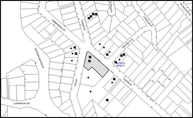
|
NOTIFICATION PLAN |
|
||
|
• PROPERTIES NOTIFIED
|
X SUBMISSIONS RECEIVED |
PROPERTY SUBJECT OF DEVELOPMENT |
|
|
ONE SUBMISSION RECEIVED OUT OF MAP RANGE |
|||
Fifteen submissions objected to the development, generally on the following grounds:
· The development would result in excessive noise pollution due to the high volume background music during exercise classes, use of weights between 9pm and 7am, patrons and cars ingressing and egressing the site during odd hours;
· The proposed night time use would cause unacceptable impact of light spill due to the illuminated signage;
· The use that is out of character with the residential use of the area;
· There are other gymnasiums in close proximity to this facility. Therefore, it is not needed in the area;
· The gymnasium would be unstaffed for 120 - 168 hours per week. There are not methods of contacting the operators during this time. The patrons would be at risk during the unstaffed hours.
· The proposal does not indicate the total number of patrons. Therefore, the parking and service requirements for the premises cannot be determined. Further, the proposed number of toilets appear to be inadequate;
· Currently the residents of the premises park on the ground level spots allocated to this unit. Should this practice continue, the patrons of the facility would park within the nearby shopping complex increasing the traffic congestion in the area;
· The submitted documentation states that there would be three external signs on the building facing the Pacific Highway rather than Turner Road. Therefore, the document does not refer to the correct location;
· There are severe water leakage problems associated with the building works that need to be resolved prior to granting consent to a gymnasium within the premises;
· The DA states that the facility is nearby major transport links such as Hornsby Railway Station and a bus terminal at the front door. This statement is not correct;
· The appropriateness of the proposed security system is questionable;
· The toilets within the gymnasium adjoin Unit 2 on the ground floor of the premises. Use of showers during night-time would adversely impact on the residents due to noise;
· The external lights to the existing premises, specifically the garbage bin area, are obtrusive;
· The existing building is not painted and the appearance is not appropriate;
· The proposed operating hours do not comply with that approved under DA/1384/2011;
· The yellow notice has not been erected during the notification period;
· No privacy screens are proposed along the full frontage of the facility. Therefore, the users would be visible from Turner Road, which is unacceptable;
· Majority of the patrons would drive to the facility rather than using alternate modes of transport as mentioned in the submitted documentation; and
· Advertising signs in relation to the gymnasium have been displayed and pamphlets sold prior to the approval of the development application.
The merits of the matters raised in community submissions have been addressed in the body of the report with the exception of the following:
5.1.1 Noise
The proposed use would not include any traditional exercise classes. Further, conditions of consent would exclude the use of high volume music within the premises. As discussed in Section 3.2.2 of this report, the proposal would be acceptable with regard to noise, subject to the implementation of recommended conditions of consent.
5.1.2 Light Spill
The objections refer to the existing external lights installed within the premises. The proposed use would be internal and the lighting would be similar to a typical commercial premise. The residential properties on Turner Road are located within a commercial area. It is expected that the shop/commercial uses would be illuminated at night to activate the street frontage. The illuminated signs include programmable timers that control the intensity of the lights and would be fitted with a time clock to switch off illumination after 9pm. The use would not include any additional lighting and the application is assessed as satisfactory with regard to light spill subject to recommended conditions of consent.
5.1.3 Location of Bedroom for Unit 2
The submitted ground floor plan indicates that the residential unit No. 2 is sufficiently separated from the proposed use by the service core, the corridor and the car parking area. Therefore, the facility would have minimal impact on the occupants of this unit due to the use of showers at night.
5.1.4 Privacy Screens
Privacy screens are not required to be provided along the street frontage for commercial uses. Accordingly, this is not considered necessary in this instance.
5.1.5 The Existing Building
A number of submissions from the occupants of the building on the site raise issues regarding water leakage problems and appearance of the building. These are not matters for consideration under Section 79C of the Act and should be resolved by the Owners’ Corporation for the premises.
5.1.6 Compliance with Operating Hours
The proposed operating hours are outside of that approved under DA/1384/2011. The application has lodged this development application to seek consent for the extended operating hours. Should the application be approved, this development consent would supersede the approved operating hours for the premises within the building.
5.1.7 Inadequate Parking
The matter has been assessed in detail under Section 2.5.1 of this report. The proposed parking within the premises would satisfactorily cater for the use. The problem arising due to residents parking on the ground level commercial spots can be managed by Strata by-laws.
5.1.8 Incorrect Documentation
The summary of Statement accompanying the notification plans mention that the three business identification signs face Pacific Highway rather than Turner Road. This is a typing error. The submitted Statement of Environmental Effects and the plans correctly identify the location as Turner Road. The application is considered acceptable in this regard.
5.1.9 Contacting Staff
The submissions raise concerns regarding the hours of operation when the premises would be not be staffed. As discussed in this report, the proposed development includes an appropriate security and alarm system that would alarms in case of emergency events and would include a contact number, displayed at the premises (as per the Security systems report).
5.1.10 Need for a Gymnasium
The site is zoned for commercial developments pursuant to Hornsby Local Environmental Plan 2013 and the proposal is a permissible use subject to Council’s consent. The demand for the facility is not a matter for consideration in assessment of the application under the EPA Act.
5.1.11 Yellow Notice
During the assessment of the application, several objections raised concerns that the yellow notice was not installed in a timely manner and therefore, the application did not comply with Council’s notification policy regarding the location of display of the notice. The chronology of notification process is provided below:
· Notification period: 30/04/2015 to 14/05/2015;
· Extended period: Up to 29/05/2015 upon receipt of objections;
· Council officers contacted the applicant regarding installation of the yellow sign and the applicant confirmed that the sign was placed on the site. A photo of the yellow notice was emailed on 3/06/2015;
· Given the timing of submission of the photo, the application was re-notified by sending letters to the adjoining owners between 3/06/2015 and 19/06/2015;
· During this period the applicant confirmed that the yellow notice was displayed at a prominent location and a photo was sent to Council on 17/06/2015;
· Submissions were received raising concerns that the yellow notice was not displayed on 3/06/2015;
· Accordingly, Council granted a further 2 weeks extension of notification time commencing on 19/06/2015;
As stated above, Council received fifteen submissions during the notification period. The matters have been addressed in Section 5 of this report.
5.1.12 Unauthorised Advertising Signs
In addition to the submissions regarding the proposed development, Council also received complaints regarding unauthorised display of “Anytime Fitness” advertising signs. The complaints were referred to the Compliance Officers for investigation. The advertising signs were removed as instructed by Council Officers.
5.1.13 Owner’s Consent
It is noted that the Owner’s Corporation of SP 89840, sent a letter to Council granting owners’ consent for lodgement of the application. However, the letter sought clarification regarding issues raised by some residents.
Council officer’s contacted the Owner’s Corporation to address the issues raised by residents and an amended owners’ consent was subsequently submitted. The matters raised and Council’s comments are discussed below.
· The use would have adverse noise impact on the residents of the premises due to the operation and the activation of alarms at night during an emergency. No supporting documentation has been submitted in this regard. Noise generated due to activation of alarms as a result of failure of electricity within the complex;
Comment: The applicant has submitted an Acoustic report addressing matters in relation to noise generation. The Noise Report provides details of possible noise intrusions and the mitigation measures. Alarms are activated in case of emergency to make the residents alert. Impact of noise due to emergency alarms is not a matter of consideration during assessment of development applications.
· A gymnasium is not needed in the area;
Comment: The use is permissible in the zone. The need is to be ascertained by the applicant.
· Water leakage problems of the existing building would have adverse impacts the operation of the unit;
· The cleaning responsibilities for the public toilets on the ground floor have not been ascertained. The gymnasium users would utilise these toilets as well.
· The water pump is not being positioned correctly and has adverse impacts on the residents due to noise.
Comment: These issues are related to the existing building and are to be resolved by the Owners’ Corporation.
· Water Bills for the entire building would be raised due to the use of showers within gymnasium;
Comment: Each owner is required to pay utility bills separately. Therefore, use of showers within the gym would be subject to a separate water bill, to be paid by the tenant/user.
5.2 Public Agencies
The development application was not referred to any Public Agencies for comment.
6. THE PUBLIC INTEREST
Section 79C(1)(e) of the Act requires Council to consider “the public interest”.
The public interest is an overarching requirement, which includes the consideration of the matters discussed in this report. Implicit to the public interest is the achievement of future built outcomes adequately responding to and respecting the future desired outcomes expressed in environmental planning instruments and development control plans.
The application is considered to have satisfactorily addressed Council’s criteria and would provide a development outcome that, on balance, would result in a positive impact for the community. Accordingly, it is considered that the approval of the proposed development would be in the public interest.
CONCLUSION
The application proposes the first occupation of an existing commercial premise to a recreational facility (24 hour gymnasium), internal fit-out and erection of three business identification signs.
The development generally complies with the provisions of the Hornsby Local Environmental Control Plan 2013 and Hornsby Development Control Plan 2013.
Council received submissions during the public notification period and appropriate controls and conditions have been imposed to minimise disruption to residential amenity.
Approval of the application is recommended.
Note: At the time of the completion of this planning report, no persons have made a Political Donations Disclosure Statement pursuant to Section 147 of the Environmental Planning and Assessment Act 1979 in respect of the subject planning application.
RESPONSIBLE OFFICER
The officer responsible for the preparation of this Report is the Manager – Development Assessments – Rodney Pickles, who can be contacted on 9847 6731.
|
Rod Pickles Manager - Development Assessment Planning Division |
James Farrington Group Manager Planning Division |
|
1.View |
Locality Map |
|
|
|
2.View |
Floor Plans |
|
|
|
3.View |
Section and Elevation Plan |
|
|
File Reference: DA/419/2015
Document Number: D06382119
SCHEDULE 1
GENERAL CONDITIONS
The conditions of consent within this notice of determination have been applied to ensure that the use of the land and/or building is carried out in such a manner that is consistent with the aims and objectives of the relevant legislation, planning instruments and council policies affecting the land and does not disrupt the amenity of the neighbourhood or impact upon the environment.
Note: For the purpose of this consent, the term ‘applicant’ means any person who has the authority to act on or the benefit of the development consent.
Note: For the purpose of this consent, any reference to an Act, Regulation, Australian Standard or publication by a public authority shall be taken to mean the gazetted Act or Regulation, or adopted Australian Standard or publication as in force on the date that the application for a construction certificate is made.
1. Approved Plans and Supporting Documentation
The development must be carried out in accordance with the plans and documentation listed below and endorsed with Council’s stamp, except where amended by Council and/or other conditions of this consent:
|
Plan No. |
Plan Title |
Drawn by |
Dated |
|
- |
Ground Floor Plan |
- |
Received by Council on 16/04/2015 |
|
- |
Basement Plan |
- |
Received by Council on 16/04/2015 |
|
A3 01 A |
Concept Plan Ground Floor |
Archi Spectrum |
Received by Council on 16/04/2015 |
|
A3 02 A |
Concept Plan Mezzanine |
Archi Spectrum |
Received by Council on 16/04/2015 |
|
A3 03 A |
Floor Finishes Plan -Ground Floor |
Archi Spectrum |
Received by Council on 16/04/2015 |
|
A3 04 A |
Floor Finishes Plan Mezzanine |
Archi Spectrum |
Received by Council on 16/04/2015 |
|
A3 05 A |
Wall Finishes Plan -Ground Floor |
Archi Spectrum |
Received by Council on 16/04/2015 |
|
A3 06 A |
Wall Finishes Plan - Mezzanine |
Archi Spectrum |
Received by Council on 16/04/2015 |
|
A3 07 |
Section AA and Elevation 1 |
Archi Spectrum |
12/08/2015 |
|
- |
Details of Signage |
- |
Received by Council on 16/04/2015 |
|
- |
Details of Signage |
- |
Received by Council on 16/04/2015 |
|
Document Title |
Prepared by |
Dated |
|
Statement of Environmental Effects |
CommPlan Pty Ltd |
April 2015 |
|
Details of Security System |
Anytime Fitness |
Received by Council on 16/04/2015 |
|
Monthly Usage Data |
Anytime Fitness |
Received by Council on 16/04/2015 |
|
Noise Emission Assessment Report |
Acoustic Dynamics |
30/07/2015 |
2. Construction Certificate
a) A Construction Certificate is required to be approved by Council or a Private Certifying Authority prior to the commencement of any works under this consent.
b) The Construction Certificate plans must not be inconsistent with the Development Consent plans.
REQUIREMENTS PRIOR TO THE ISSUE OF A CONSTRUCTION CERTIFICATE
3. Building Code of Australia
All building work must be carried out in accordance with the relevant requirements of the Building Code of Australia.
4. Noise Mitigation Measures
a) The Construction Certificate Plans must provide details of the 10mm (minimum) compressed rubber flooring under the weight areas.
b) The specifications for the Air conditioning unit must comply with the recommendations of the Noise Emission Assessment Report prepared by Acoustic Dynamics dated 30/07/2015.
REQUIREMENTS PRIOR TO THE COMMENCEMENT OF ANY WORKS
5. Erection of Construction Sign
A sign must be erected in a prominent position on any site on which building work, subdivision work or demolition work is being carried out:
a) Showing the name, address and telephone number of the principal certifying authority for the work;
b) Showing the name of the principal contractor (if any) for any demolition or building work and a telephone number on which that person may be contacted outside working hours; and
c) Stating that unauthorised entry to the work site is prohibited.
Note: Any such sign is to be maintained while the building work, subdivision work or demolition work is being carried out, but must be removed when the work has been completed.
6. Protection of Adjoining Areas
A temporary hoarding, fence or awning must be erected between the work site and adjoining lands before the works begin and must be kept in place until after the completion of the works if the works:
a) Could cause a danger, obstruction or inconvenience to pedestrian or vehicular traffic.
b) Could cause damage to adjoining lands by falling objects.
c) Involve the enclosure of a public place or part of a public place.
Note: Notwithstanding the above, Council’s separate written approval is required prior to the erection of any structure or other obstruction on public land.
7. Toilet Facilities
Toilet facilities must be available or provided at the works site before works begin and must be maintained until the works are completed at a ratio of one toilet for every 20 persons employed at the site. Each toilet must:
a) be a standard flushing toilet connected to a public sewer; or
b) be a temporary chemical closet approved under the Local Government Act 1993; or
c) have an on-site effluent disposal system approved under the Local Government Act 1993.
REQUIREMENTS DURING CONSTRUCTION
8. Construction Work Hours
All work on site (including demolition and earth works) must only occur between 7am and 5pm Monday to Saturday. No work is to be undertaken on Sundays or public holidays.
9. Demolition
All demolition work must be carried out in accordance with “Australian Standard 2601-2001 – The Demolition of Structures” and the following requirements:
10. Environmental Management
The site must be managed in accordance with the publication ‘Managing Urban Stormwater – Landcom (March 2004) and the Protection of the Environment Operations Act 1997 by way of implementing appropriate measures to prevent sediment run-off, excessive dust, noise or odour emanating from the site during the construction of the development.
11. Council Property
During construction works, no building materials, waste, machinery or related matter is to be stored on the road or footpath. The public reserve must be kept in a clean, tidy and safe condition at all times.
REQUIREMENTS PRIOR TO THE ISSUE OF AN OCCUPATION CERTIFICATE
Note: For the purpose of this consent, a reference to ‘occupation certificate’ shall not be taken to mean an ‘interim occupation certificate’ unless otherwise stated.
12. Damage to Council Assets
Any damage caused to Council’s assets as a result of the construction or demolition of the development must be rectified in accordance with Council’s Civil Works Specifications. Council’s Restorations Supervision must be notified for a formwork inspection prior to pouring concrete.
13. External Lighting
All external lighting must be designed and installed in accordance with Australian Standard AS 4282 – Control of the Obtrusive Effects of Outdoor Lighting. Certification of compliance with the Standard must be obtained from a suitably qualified person.
14. Gymnasium Management
A ‘Gymnasium Management Plan’ must be prepared and include the following details:
a) Policies ensuring compliance with the recommendations within Section 6 of the submitted Noise Emission Assessment Report prepared by Acoustic Dynamics dated 30/07/2015;
b) The following noise mitigation policies:
i) No amplified music/announcements are permitted within the gym;
ii) Background music from any television be set controlled to a volume that is typical of that in a domestic dwelling and controlled from a lockable room without access to gym members;
iii) An appropriate management policy advising gym member that stereo and loudspeaker sound systems will not be provided and that members are encouraged to bring personal music devices such as MP3 players and iPods;
iv) No provision of structured classes to minimise noise and vibration group activities;
v) A statement indicating that Glass windows and doors are to be closed at all times (except when patrons enter or leave the premises); and
vi) Details of methods of staff monitoring the behaviour of patrons within the subject premises to ensure that noise emission is kept to a minimum when patrons are entering and leaving the premises.
c) Policies regarding weights and equipment requiring the following:
i) Provision of ‘Pin Loaded’ instead of ‘Free’ weights wherever possible;
ii) Use of rubber coated weights/dumbbells; and
iii) No fixing of exercise equipment to common/adjoining walls with other building occupants; and
iv) Policies regarding dropping of weights.
d) Policies regarding switching off all illuminated signs after 9pm on all days.
e) Policies regarding resolution of noise complaints by the Duty Manager.
f) A copy of the Management Plan is to be submitted to Council prior to the issue of the construction certificate.
15. Erection of Signage
Signs must be posted at the entry/exits points to the gymnasium stating: “CONSIDER OUR NEIGHBOURS. PLEASE KEEP NOISE TO A MINIMUM.”
16. Noise for Air Conditioning Unit
Outdoor air-conditioning condenser units must have low noise emission levels and located away from noise sensitive receivers. Time clocks are to be fitted to the air-conditioning systems to prohibit their operations between 10pm and 7am.
17. Acoustic Certification
A certificate is to be provided by a qualified Acoustic engineer/consultant certifying that all works including installation of air conditioning units have been completed in accordance with the recommendations contained in the report prepared by Acoustic Dynamics dated 30/07/2015 and the conditions listed in this development consent.
18. Security System
The security system and alarms must be appropriately placed in accordance with the “Details of Security System” report provided by Anytime Fitness.
OPERATIONAL CONDITIONS
19. Advertising Signs
The advertising signage approved under this consent must not be flash, move or display electronic images. The illumination of the advertising signs must only be turned on between 5:00pm and 9pm on all days.
20. Use of Premises
a) The development approved under this consent shall be used for “24 hour gymnasium” and not for any other purpose without Council’s separate written consent.
b) No fitness classes are to be held at the gymnasium;
c) The number of patrons during the peak hours must not exceed 30;
d) The number of employees within the premises must be restricted to a maximum of four staff members at any one time; and
e) The use must be conducted in accordance with the approved “Gymnasium Management Plan” as listed in the development consent.
f) A sign must be displayed in prominent location displaying the emergency contact number when the premise is unstaffed.
21. Hours of Operation
The hours of operation of the premise are 24 hours a day (Monday to Sunday).
22. Car Parking and Deliveries
All car parking must be operated in accordance with Australian Standard AS 2890.1 – 2004 – Off Street Car Parking and Australian Standard 2890.2 - 2002 – Off Street Commercial and the following requirement:
a) A total of 12 car spaces must be available for the proposed use at all times;
b) Car parking, loading and manoeuvring areas to be used solely for nominated purposes;
c) Patrons are to be provided with access to the basement level at all times; and
d) Vehicles awaiting loading, unloading or servicing shall be parked on site and not on adjacent or nearby public roads.
23. Acoustic Matters
a) The L10 noise level emitted from the use must not exceed the background noise level (L90) in any Octave Band Centre Frequency (31.5 Hz to 8 kHz inclusive) by more than 3dB when assessed indoors at any affected commercial premises.
b) The use of the premise must be controlled so that any emitted noise is at a level so as not to create an “offensive noise” as defined in the Protection of the Environment Operations Act 1997 to any affected receiver.
c) No amplified music/announcements are permitted within the gym.
d) All noise complaints must be recorded by the Duty Manager and must be dealt with immediately.
24. Noise
An acoustic assessment is to be undertaken by a suitably qualified environmental consultant within 60 days of occupying the site in accordance with the Environment NSW Industrial Noise Policy (2000), Council’s Policy and Guidelines for Noise and Vibration Generating Development (Acoustic Guidelines V.5, 2000) and the DECC’s Noise Guide for Local Government (2004). The assessment must be submitted to Council for review. Should the assessment find that noise from the premise exceeds the levels specified in Conditions 23 (a) – (c), appropriate measures must be employed to rectify excessive noise.
25. Fire Safety Statement - Annual
On at least one occasion in every 12 month period following the date of the first ‘Fire Safety Certificate’ issued for the property, the owner must provide Council with an annual ‘Fire Safety Certificate’ to each essential service installed in the building.
- END OF CONDITIONS -
ADVISORY NOTES
The following information is provided for your assistance to ensure compliance with the Environmental Planning and Assessment Act, 1979, Environmental Planning and Assessment Regulation 2000, other relevant legislation and Council’s policies and specifications. This information does not form part of the conditions of development consent pursuant to Section 80a of the Act.
Environmental Planning and Assessment Act 1979 Requirements
The Environmental Planning and Assessment Act 1979 requires:
· The issue of a construction certificate prior to the commencement of any works. Enquiries can be made to Council’s Customer Services Branch on 9847 6760.
· A principal certifying authority to be nominated and Council notified of that appointment prior to the commencement of any works.
· Council to be given at least two days written notice prior to the commencement of any works.
· Mandatory inspections of nominated stages of the construction inspected.
· An occupation certificate to be issued before occupying any building or commencing the use of the land.
Long Service Levy
In accordance with Section 34 of the Building and Construction Industry Long Service Payments Act 1986, a ‘Long Service Levy’ must be paid to the Long Service Payments Corporation or Hornsby Council.
Note: The rate of the Long Service Levy is 0.35% of the total cost of the work.
Note: Hornsby Council requires the payment of the Long Service Levy prior to the issue of a construction certificate.
Disability Discrimination Act
The applicant’s attention is drawn to the existence of the Disability Discrimination Act. A construction certificate is required to be obtained for the proposed building/s, which will provide consideration under the Building Code of Australia, however, the development may not comply with the requirements of the Disability Discrimination Act. This is the sole responsibility of the applicant.
Group Manager’s Report No. PL68/15
Planning Division
Date of Meeting: 9/09/2015
17 DEVELOPMENT APPLICATION - MULTI-PURPOSE COURTS AND CARPARK - 130, 130A, 130X, 132 AND 132A BOUNDARY ROAD, NORTH EPPING
EXECUTIVE SUMMARY
|
DA No: |
DA/1566/2014 (Lodged 15 December 2014) |
|
Description: |
Multi-purpose court facility adjoining the North-Epping Bowling Club and carpark upgrade |
|
Property: |
Lots 913, 1034, 1070 and 1073 DP 752053 and Lot 7304 DP 1131925 Nos. 130, 130A, 130X, 132 and 132A Boundary Road, North Epping |
|
Applicant: |
North Epping Bowling and Community Club |
|
Owner: |
The State of New South Wales - North Epping Bowling and Community Club |
|
Estimated Value: |
$ 190,700 |
|
Ward: |
C |
· The application involves addition of a multi-purpose court facility adjoining the North Epping Bowling Club and upgrading the carpark.
· The development involves land managed by Council. In accordance with Council’s adopted Policy ‘Proposed Council Developments’ an independent assessment of the development application has been undertaken by Nexus Environmental Planning Pty Ltd.
· The proposal generally complies with the provisions of the Hornsby Local Environmental Plan 2013 and Hornsby Development Control Plan 2013.
· Sixty-two (62) submissions have been received including 36 objections from residents of 23 properties, 24 letters of support, and 2 petitions with 122 signatures in support of the development.
· A Red Sticker has been placed on the application requiring that it be determined at a Council meeting.
· The report prepared by Nexus Environmental Planning is attached for consideration. The independent consultant’s report recommends approval of the application.
|
THAT Development Application No. DA/1566/2014 for addition of a multi-purpose court facility adjoining the North-Epping Bowling Club and carpark upgrade at Lots 913, 1034, 1070 and 1073 DP 752053 and Lot 7304 DP 1131925 Nos. 130, 130A, 130X, 132 and 132A Boundary Road, North Epping be approved in accordance with the recommendation of the independent town planning consultant’s report – Nexus Environmental Planning Pty Ltd and the conditions of consent detailed in Schedule 1 of Group Manager’s Report No. PL68/15. |
ASSESSMENT
In accordance with Council’s adopted Policy ‘Proposed Council Developments’, the development application has been referred to an independent town planning consultant. The report by Nexus Environmental Planning is attached to this report for consideration. The report recommends that the application be approved subject to conditions.
CONCLUSION
The application proposes the addition of a multi-purpose court facility adjoining the North-Epping Bowling Club and upgrade the carpark adjoining the Guides Hall.
Council has referred the application to an independent planning consultancy to carry out an assessment of the application and to consider the public submissions. The assessment concludes that the application should be approved.
It is recommended that Council approve the application in accordance with the recommendation in the report prepared by Nexus Environmental Planning Pty Ltd and the conditions of consent detailed in Schedule 1 of this report.
Note: At the time of the completion of this planning report, no persons have made a Political Donations Disclosure Statement pursuant to Section 147 of the Environmental Planning and Assessment Act 1979 in respect of the subject planning application.
RESPONSIBLE OFFICER
The officer responsible for the preparation of this Report is the Manager – Development Assessments – Rodney Pickles, who can be contacted on 9847 6731.
|
Rod Pickles Manager - Development Assessment Planning Division |
James Farrington Group Manager Planning Division |
|
1.View |
Locality Plan |
|
|
|
2.View |
Independent Consultant Report - Nexus Environmental Planning Pty Ltd |
|
|
|
3.View |
Plans and Details |
|
|
File Reference: DA/1566/2014
Document Number: D06330975
SCHEDULE 1
GENERAL CONDITIONS
The conditions of consent within this notice of determination have been applied to ensure that the use of the land and/or building is carried out in such a manner that is consistent with the aims and objectives of the relevant legislation, planning instruments and council policies affecting the land and does not disrupt the amenity of the neighbourhood or impact upon the environment.
Note: For the purpose of this consent, the term ‘applicant’ means any person who has the authority to act on or the benefit of the development consent.
Note: For the purpose of this consent, any reference to an Act, Regulation, Australian Standard or publication by a public authority shall be taken to mean the gazetted Act or Regulation, or adopted Australian Standard or publication as in force on the date that the application for a construction certificate is made.
1. Approved Plans and Supporting Documentation
The development must be carried out in accordance with the plans and documentation listed below and endorsed with Council’s stamp, except where amended by Council and/or other conditions of this consent:
|
Plan No. |
Plan Title |
Drawn by |
Dated |
|
LP – 01 D |
Landscape Plan |
Hornsby Shire Council |
12/11/2014 |
|
LP-02 D |
Landscape Sections |
Hornsby Shire Council |
12/11/2014 |
|
LP – 03 D |
Sediment Erosion Control/Tree Protection Plan |
Hornsby Shire Council |
12/11/2014 |
|
LP – 04 D |
Sediment Erosion Control Details |
Hornsby Shire Council |
12/11/2014 |
|
34.13 Issue 1 |
Stormwater Management/Services and Driveway Sections Sheets 1 - 14 |
Hornsby Shire Council |
Received by Council on 17/06/2015 |
|
LIAS_0148_1.01 |
Lighting Plan |
Philips |
1/10/2014 |
|
LIAS_0148_1.02 |
Lighting Details |
Philips |
1/10/2014 |
|
Document Title |
Prepared by |
Dated |
|
Statement of Environmental Effects |
Key Urban Planning |
November 2014 |
|
Geotechnical Investigation and Soil Classification Report |
SMEC Testing Services |
October 2014 |
|
Noise Impact Assessment |
SLR Global Environmental Solutions |
13/11/2014 |
|
Traffic and Car Parking Assessment |
GTK Consulting |
November 2014 |
|
Addendum to Traffic Report |
GTK Consulting |
16/04/2015 |
2. Removal of Existing Trees
This development consent permits the removal of trees numbered 1, 2, 3, 4, 5, 6, 9 and 10 as identified on plan number LP – 03 Issue D Sediment Erosion Control/Tree Protection Plan prepared by Hornsby Shire Council dated 12/11/2014. The removal of any other trees requires separate approval in accordance with the Tree and Vegetation Chapter 1B.6 Hornsby Development Control Plan (HDCP).
3. Construction Certificate
a) A Construction Certificate is required to be approved by Council or a Private Certifying Authority prior to the commencement of any works under this consent.
b) The Construction Certificate plans must not be inconsistent with the Development Consent plans.
REQUIREMENTS PRIOR TO THE ISSUE OF A CONSTRUCTION CERTIFICATE
4. Building Code of Australia
All building work must be carried out in accordance with the relevant requirements of the Building Code of Australia.
5. Traffic Control Plan
A Traffic Control Plan (TCP) must be prepared by a qualified traffic controller in accordance with the Roads & Traffic Authority’s Traffic Control at Worksites Manual 1998 and Australian Standard 1742.3 for all work on a public road. The Traffic Management Plan shall be submitted and approved by Council’s Manager Traffic and Road Safety prior to the issue of a construction certificate. The TCP must detail the following:
a) Arrangements for public notification of the works;
b) Temporary construction signage;
c) Permanent post-construction signage;
d) Vehicle movement plans;
e) Traffic management plans;
f) Pedestrian and cyclist access/safety.
6. Noise
The details of the construction materials for 1.8m high noise mitigation fence as recommended within the Noise Impact Assessment Report prepared by SLR Global Environmental Solutions dated 13/11/2014 must be submitted for approval.
7. Utility Services
The applicant must submit written evidence of the following service provider requirements:
a) Ausgrid (formerly Energy Australia) – a letter of consent demonstrating that satisfactory arrangements have been made to service the proposed development.
b) Telstra – a letter of consent demonstrating that satisfactory arrangements have been made to service the proposed development.
8. Internal Driveway/Vehicular Areas
The driveway and parking areas on site must be designed in accordance with Australian Standards 2890.1, 2890.2, 3727 and the following requirements:
a) The driveway (access crossing) must be a rigid pavement;
b) The internal parking is to be constructed with 45mm Asphalt AC10;
c) The driveway grade is to comply with AS 2890.1 and AS 2890.2;
d) Retaining walls required to support the carriageway and the compaction of all fill batters must be in accordance with the requirements of a chartered structural engineer; and
e) All bicycle racks are to be marked on the plans.
9. On-Site Stormwater Detention
An on-site stormwater detention system must be designed by a chartered civil engineer in accordance with the following requirements:
a) Have a capacity of not less than 20 cubic metres, and a maximum discharge (when full) of 16.7 litres per second.
b) Have a surcharge/inspection grate located directly above the outlet.
c) Discharge from the detention system to be controlled via 1 metre length of pipe, not less than 50 millimetres diameter or via a stainless plate with sharply drilled orifice bolted over the face of the outlet discharging into a larger diameter pipe capable of carrying the design flow to an approved Council system.
d) Not be constructed in a location that would impact upon the visual or recreational amenity of users of the site.
10. Stormwater Drainage
The stormwater drainage system for the development must be designed in accordance with Council’s Civil Works – Design and Construction Specification 2005 and the following requirements:
a) Connected directly to Council’s street drainage system via the on-site detention tank.
b) The roof and stormwater drainage system from the existing building to be connected to the proposed drainage system.
c) All stormwater from the development site is to be directed to the bio-retention area.
REQUIREMENTS PRIOR TO THE COMMENCEMENT OF ANY WORKS
11. Erection of Construction Sign
A sign must be erected in a prominent position on any site on which building work, subdivision work or demolition work is being carried out:
a) Showing the name, address and telephone number of the principal certifying authority for the work;
b) Showing the name of the principal contractor (if any) for any demolition or building work and a telephone number on which that person may be contacted outside working hours; and
c) Stating that unauthorised entry to the work site is prohibited.
Note: Any such sign is to be maintained while the building work, subdivision work or demolition work is being carried out, but must be removed when the work has been completed.
12. Protection of Adjoining Areas
A temporary hoarding, fence or awning must be erected between the work site and adjoining lands before the works begin and must be kept in place until after the completion of the works if the works:
a) Could cause a danger, obstruction or inconvenience to pedestrian or vehicular traffic.
b) Could cause damage to adjoining lands by falling objects.
c) Involve the enclosure of a public place or part of a public place.
Note: Notwithstanding the above, Council’s separate written approval is required prior to the erection of any structure or other obstruction on public land.
13. Toilet Facilities
Toilet facilities must be available or provided at the works site before works begin and must be maintained until the works are completed at a ratio of one toilet for every 20 persons employed at the site. Each toilet must:
a) be a standard flushing toilet connected to a public sewer; or
b) be a temporary chemical closet approved under the Local Government Act 1993; or
c) have an on-site effluent disposal system approved under the Local Government Act 1993.
14. Erosion and Sediment Control
Erosion and sediment control measures must be provided and maintained throughout the construction period in accordance with the manual ‘Soils and Construction 2004 (Bluebook)’, the approved plans, Council specifications and to the satisfaction of the principal certifying authority. The erosion and sediment control devices must remain in place until the site has been stabilised and revegetated.
Note: On the spot penalties may be issued for any non-compliance with this requirement without any further notification or warning.
15. Project Arborist
A Project Arborist is to be appointed in accordance with AS 4970-2009 (1.4.4) to provide monitoring and certification throughout the development process.
16. Tree Protection Barriers
Tree protection fencing must be erected around trees numbered T8, T11, T12, T13, T14, T16, T17 & T18 as identified on the approved plan LP - 03 D, to be retained at the nominated Tree Protection Zones (TPZ) listed below:
|
Tree No. |
Tree Protection Zone |
|
T8, T11, T12, T14, T18 |
7m |
|
T13, T16, T17 |
4m |
The tree fencing must be contiguous and constructed of 1.8 metre ‘cyclone chainmesh fence’ and must be erected in accordance with AS 4970-2009 (4.3 - Fig.3).
Tree fencing for trees T8, T12, T13, & T14 may be repositioned in accordance with Section 4 (AS 4970), under the direction of the Project Arborist.
Note: A certificate from the Project Arborist (AQF 5) is to be submitted to the Principal Certifying Authority stating that all tree protection measures are in accordance with the above and consistent with the intentions of the Australian Standard ‘Protection of Trees on Development Sites (AS 4970-2009) prior to commencement of works.
17. Bushfire Management – Fence Installation
To ensure the protection of bushland during construction, the applicant must ensure the following:
a) The 1.8 metre high chain wire fence (or similar) must be installed along the bottom of the western embankment as identified on the approved plans;
b) The fencing must not encroach within the Lane Cove National Park;
c) All machinery must be cleaned of soil and debris before entering the site to prevent the spread of weeds and fungal pathogens;
d) No material stock piles, no changes to soil aeration or hydrological capacity, no preparation of chemicals in adjoining areas, no open cut trenching, no placement of temporary buildings, no parking or movement of machinery, no spillage/disposal of building waste is to occur within the fenced off bushland;
e) The fencing shall allow access gate (with security locks) to allow bushland maintenance or other specific personnel to access environmentally sensitive areas; and
f) The fencing must include a ‘NO ENTRY’ signage to inform the purpose of the fence to the construction personnel.
18. Removal of Hollow Bearing Trees
Prior to works commencing in relation to removal of hollow bearing trees the following requirements are to be complied with:
a) The project ecologist must undertake pre-clearance surveys, capture any wildlife from the hollows with traps set at a minimum of two nights and relocate into a nesting box; and
b) Trees are to be removed in sections, by a qualified tree surgeon, in the presence of a ‘Wildlife Carers’ organisation to assist in the event of fauna injury.
Note: ‘WIRES’ (Wildlife Rescue) volunteers can be contacted on 8977 3333. ‘Wildlife Services Sydney Metropolitan’ volunteers can be contacted on 9413 4300. Information on animal nesting boxes can be obtained from WIRES, Kalkari Information Centre in Ku-Ring-Gai Chase National Park or Birds Australia www.birdsaustralia.com.au.
REQUIREMENTS DURING CONSTRUCTION
19. Construction Work Hours
All work on site (including demolition and earth works) must only occur between 7am and 5pm Monday to Saturday (unless otherwise approved in writing by Council due to extenuating circumstances). No work is to be undertaken on Sundays or public holidays.
20. Demolition
All demolition work must be carried out in accordance with “Australian Standard 2601-2001 – The Demolition of Structures” and the following requirements:
a) Demolition material must be disposed of to an authorised recycling and/or waste disposal site and/or in accordance with an approved waste management plan;
21. Environmental Management
The site must be managed in accordance with the publication ‘Managing Urban Stormwater – Landcom (March 2004) and the Protection of the Environment Operations Act 1997 by way of implementing appropriate measures to prevent sediment run-off, excessive dust, noise or odour emanating from the site during the construction of the development.
22. Street Sweeping
Street sweeping must be undertaken following sediment tracking from the site along Boundary Road during works and until the site is established.
The street cleaning services must undertake a street ‘scrub and dry’ method of service and not a dry sweeping service that may cause sediment tracking to spread or cause a dust nuisance.
23. Bushland Protection During Construction
To ensure the protection of bushland during construction, the applicant must ensure the following:
a) Maintain the 1.8 metre high chain wire fence (or similar) along the bottom of the western embankment;
b) No material stock piles, no changes to soil aeration or hydrological capacity, no open cut trenching, no placement of temporary buildings, no parking or movement of machinery, no spillage/disposal of building waste are to occur against the protection fencing; and
c) Maintain the signage to inform construction personnel of the purpose of the fence.
Note: Unauthorised access is not permitted within the Lane Cove National Park without consent from the Office of Environment and Heritage.
24. Protection from Soil Pathogens
To protect native flora and fauna from infection and infestation of pathogens and weeds all machinery shall be cleaned of soil and debris before entering the subject site to prevent the spread of weeds and fungal pathogens such as Cinnamon Fungus (Phytophthora cinnamomi) and Chytrid Fungus (Batrachochytrium dendrobatidis).
25. Works Near Trees
All required tree protection measures are to be maintained in good condition for the duration of the construction period.
All works within the Tree Protection Zones of trees T8, T11, T12, T14, T14, T15 & T16 are to be conducted in accordance with the following conditions:
a) Works must not reduce the useful life expectancy of the tree and be carried out under the direct supervision of the Project Arborist. The Project Arborist must assess the condition of the trees and the growing environment and make recommendations for, and if necessary carry out remedial action to ensure the health and vigour of the trees.
b) Excavation within the nominated Tree Protection Zones shall be carried out by hand excavation ONLY.
c) Excavation must not exceed 15% of a TPZ and is to occur at a minimum distance of 3m from the trunk of any tree.
d) Pruning of tree roots (if required) shall be undertaken as specified in AS 4970-2009 (Sections 3.3.4, 4.5.4 and 4.5.5). A certificate must be submitted by the Project Arborist to the principal certifying authority detailing the methods used to preserve the trees.
e) To ensure longevity of the tree T14, the driveway is to be laid on/above existing grade. The driveway edge must remain at a distance greater than 500mm from the edge of the trunk of any tree.
Note: Except as provided above all personnel (the applicant, contractors, service providers, principal certifying authority) involved with this development are to ensure that no excavation, including sub-surface trenching for stormwater or other services or the filling or stockpiling of building materials, parking of vehicles or plant, the use of machinery other than hand held, disposal of cement slurry, waste water or other contaminants is to occur within the Tree Root Zone as prescribed in the HDCP Section 1B.6.1(i) of any tree to be retained.
26. Council Property
During construction works, no building materials, waste, machinery or related matter is to be stored on the road or footpath. The public reserve must be kept in a clean, tidy and safe condition at all times.
27. Disturbance of Existing Site
During construction works, the existing ground levels of open space areas and natural landscape features, (including natural rock-outcrops, vegetation, soil and watercourses) must not be altered unless otherwise nominated on the approved plans.
28. Landfill
Landfill must be constructed in accordance with Council’s ‘Construction Specification 2005’ and the following requirements:
a) All fill material imported to the site is to wholly consist of Virgin Excavated Natural Material (VENM) as defined in Schedule 1 of the Protection of the Environment Operations Act 1997 or a material approved under the Department of Environment and Climate Change’s general resource recovery exemption.
29. Excavated Material
All excavated material removed from the site must be classified in accordance with the Department of Environment, Climate Change and Water NSW Waste Classification Guidelines prior to disposal to an approved waste management facility and reported to the principal certifying authority.
30. Asbestos and Soil Contamination
Should the presence of asbestos or soil contamination, not recognised during the application process be identified during works, the applicant must immediately notify the principal certifying authority and Council.
31. Traffic Control Plan Compliance
The development must be carried out in accordance with the submitted Traffic Control Plan (TCP).
REQUIREMENTS PRIOR TO THE ISSUE OF AN OCCUPATION CERTIFICATE
Note: For the purpose of this consent, a reference to ‘occupation certificate’ shall not be taken to mean an ‘interim occupation certificate’ unless otherwise stated.
32. Stormwater Drainage
The stormwater drainage system and on-site detention system for the development must be constructed in accordance with Council’s Civil Works – Design and Construction Specification 2005 and the requirements within condition nos. 9 and 10.
33. Internal Driveway/Vehicular Areas
All car-parking areas are to be constructed in accordance with Australian Standard AS/NZS 2890.1:2004 – Off-street car parking and Australian Standard AS 2890.2:2002 – Off-street commercial vehicle facilities and the following requirements:
a) All internal driveway works are to be completed in accordance with Condition 8 of this development consent.
b) All parking spaces and driveways are to be sealed to all weather standards, line marked and signposted.
c) All parking for people with disabilities is to comply with AS/NZS 2890.6:2009 Off-street parking for people with disabilities.
d) Any proposed landscaping and/or fencing must not restrict sight distance to pedestrians and cyclists travelling along the footpath
34. Footpath
A sealed concrete footpath must be constructed along the full frontage of the subject site in Boundary Road from the cul-de-sac end to the driveway for No. 128 Boundary Road, as detailed in the approved plans in accordance Council’s Civil Works Design and Construction Specification 2005 and the following requirements:
a) The land adjoining the footpath to be fully turfed.
b) Any public utility adjustments to be carried out at the cost of the applicant and to the requirements of the relevant public authority.
35. Road Works
The following signage is to be installed in relation to the development:
a) “NO STOPPING” signs to be installed at the intersection of Boundary Road and Braidwood Avenue, to create the statutory 10m “No stopping zone”;
b) “NO STOPPING” signs are to be installed at the intersection of Boundary Road and Norfolk Road, to create the statutory 10m “No stopping zone”;
c) “A GIVE WAY sign” and line marking to be installed on Norfolk Road at its intersection with Boundary Road;
d) The frontage of the bus stop on the western side on Norfolk Road (at its intersection with Boundary Road) is to be upgraded to a ‘BUS ZONE’; and
e) “NO PARKING” signs are to be installed at the turning head of the cul-de-sac in Boundary Road.
Note: Installation of the signs requires approval by the Hornsby Local Traffic Committee.
36. Damage to Council Assets
Any damage caused to Council’s assets as a result of the construction of the development must be rectified in accordance with Council’s Civil Works Specifications.
37. Creation of Easements
The following matter(s) must be nominated on the plan of subdivision under s88B of the Conveyancing Act 1919:
a) The creation of an appropriate "Positive Covenant" and "Restriction as to User" over the constructed on-site detention/retention systems and outlet works, within the lots in favour of Council in accordance with Council’s prescribed wording. The position of the on-site detention system is to be clearly indicated on the title.
b) To register the OSD easement, the restriction on the use of land “works-as-executed” details of the on-site-detention system must be submitted verifying that the required storage and discharge rates have been constructed in accordance with the design requirements. The details must show the invert levels of the on-site system together with pipe sizes and grades. Any variations to the approved plans must be shown in red on the “works-as-executed” plan and supported by calculations.
Note: Council must be nominated as the authority to release, vary or modify any easement, restriction or covenant.
38. Retaining Walls
All required retaining walls must be constructed as part of the development. The retaining walls are to be designed by a structural engineer.
39. Final Certification Acoustic Consultant
A final certificate must be provided by the Acoustic Consultant stating that the recommended measures within the Acoustic Report including the 1.8m high acoustic fence identified in the approved plans, have been complied with.
40. External Lighting
All external lighting must be designed and installed in accordance with Australian Standard AS 4282 – Control of the Obtrusive Effects of Outdoor Lighting and the approved Lighting Plan listed in Condition 1 of this development consent. The impact of light spill on to Lane Cove National Park must be minimised. Certification of compliance with the Standard must be obtained from a suitably qualified person.
41. Landscaping
The development area of the adjoining the site must be appropriately landscaped in accordance with the approved Landscape Plan LP - 01 listed in Condition 1 of this development consent and the following requirements:
a) Replacement planting locations and species must be in accordance with the approved LP-01D;
b) Locally native ground cover species must be planted at a density of 3 per square metre, along the top of edge of the western facing embankment that adjoins Lane Cove River National Park;
c) Plantings that fail to survive or do not exhibit normal health and vigour growth characteristics for their species prior to reaching a height greater than three metres (3m), must be replaced at the expense of the property owner.
d) Primary and follow up weed control is to be undertaken prior to planting of tube stock.
e) All environmental and noxious weeds must be removed and suppressed using recognised bush regeneration methods. The works are to be undertaken by a qualified and experienced bush regeneration contractor.
f) A 4.2m high chainmesh fence must be installed on three sides of the proposed court as approved in LP – 01 D, to minimise disturbance to and littering of the Lane Cove National Park.
Note: A certificate from suitably qualified and experienced Horticulturalist is to be submitted to the Principal Certifying Authority stating that all plant stock meet the specifications outlined in ‘Specifying Trees’ (Ross Clark, NATSPEC Books) and that the planting methods are current, professional (best practice) industry standards at the time of planting.
The plant species should be selected and positioned so that at maturity the tree is protected under the Hornsby Development Control Plan 2013.
42. Final Certification
a) The Project Arborist must assess the condition of all trees and the growing environment, where works have been conducted within the nominated tree protection zones, and make recommendations for, and carry out remedial actions where necessary.
b) Following the final inspection and the completion of any remedial works, the Project Arborist must submit a report stating that the completed works have been carried out in compliance with the approved plans and specifications for tree protection as above and AS 4970-2009.
c) A certificate must be provided by a practicing landscape architect, horticulturalist or person with similar qualifications and experience certifying that all required landscaping works have been satisfactorily completed in accordance with the approved landscape plans and the requirements of Condition no. 41.
OPERATIONAL CONDITIONS
43. Car Parking and Deliveries
All car parking must be constructed and operated in accordance with Australian Standard AS 2890.1 – 2004 – Off Street Car Parking and Australian Standard 2890.2 - 2002 – Off Street Commercial and the following requirement:
a) Car parking, loading and manoeuvring areas to be used solely for nominated purposes;
b) All bicycle racks are to be provided and maintained on site;
c) Vehicles awaiting loading, unloading or servicing shall be parked on site and not on adjacent or nearby public roads; and
d) All vehicular entry on to the site and egress from the site shall be made in a forward direction.
44. Noise
All noise generated by the proposed development must be attenuated to prevent levels of noise being emitted to adjacent premises which possess tonal, beating and similar characteristics or which exceeds background noise levels by more than 5dB(A).
45. Landscape Establishment
The landscape works must be maintained into the future to ensure the establishment and successful growth of plant material to meet the intent of the landscape design. This must include but not be limited to watering, weeding, replacement of failed plant material and promoting the growth of plants through standard industry practices.
GENERAL CONDITIONS OF CONCURRENCE – NSW RURAL FIRE SERVICE
The following conditions of consent are from the nominated State Agency pursuant to Section 79B of the Environmental Planning and Assessment Act 1979 and must be complied with to the satisfaction of that Agency.
46. Asset Protection Zones
At the commencement of building works (encompassing the new Multi-Purpose Courts and car park and the upgraded Girl Guides Hall car park) an in perpetuity the entire property up to the site boundaries, shall be managed as an inner protection area (IPA) as outlined within section 4.1.3 and Appendix 5 of 'Planning for Bush Fire Protection 2006' and the NSW Rural Fire Service's document 'Standards for asset protection zones'.
Note: The intent of measures is to minimise the risk of bush fire attack and provide protection for emergency services personnel, residents and others assisting fire fighting activities.
47. Water and Utilities
Water, electricity and gas are to comply with section 4.1.3 of 'Planning for Bush Fire Protection 2006'.
Note: The intent of measures is to provide adequate services of water for the protection of buildings during and after the passage of a bush fire, and to locate gas and electricity so as not to contribute to the risk of fire to a building.
48. Access
Public road access from Boundary Road to the new Multi-Purpose Court car park and upgraded Girl Guides Hall car park shall comply with section 4.1.3 (1) of 'Planning for Bush Fire Protection 2006'.
Note: The intent of measures for public roads is to provide safe operational access to structures and water supply for emergency services, while residents are seeking to evacuate from an area.
- END OF CONDITIONS -
ADVISORY NOTES
The following information is provided for your assistance to ensure compliance with the Environmental Planning and Assessment Act, 1979, Environmental Planning and Assessment Regulation 2000, other relevant legislation and Council’s policies and specifications. This information does not form part of the conditions of development consent pursuant to Section 80a of the Act.
Group Manager’s Report No. PL65/15
Planning Division
Date of Meeting: 9/09/2015
18 DEVELOPMENT APPLICATION - DWELLING HOUSE - 6A IDA STREET, HORNSBY
EXECUTIVE SUMMARY
|
DA No: |
DA/677/2015 (Lodged 10 June 2015) |
|
Description: |
Erection of a dwelling house |
|
Property: |
Lot 141 DP 1201482, No. 6A Ida Street, Hornsby |
|
Applicant: |
Companion Homes Pty Ltd |
|
Owner: |
Companion Homes Pty Ltd |
|
Estimated Value: |
$350,000 |
|
Ward: |
A |
· The application is for the construction of a two storey dwelling house on a vacant allotment.
· The proposal generally complies with the Hornsby Local Environment Plan (HLEP) 2013 and the Hornsby Development Control Plan (HDCP) 2013.
· Two submissions have been received in respect of the application.
· A Red Sticker has been placed on the application requiring that it be determined at a Council meeting.
· It is recommended that the application be approved.
|
THAT Development Application No. DA/677/2015 for the construction of a two storey dwelling house at Lot 141, DP 1201482, No. 6A Ida Street, Hornsby be approved subject to the conditions of consent detailed in Schedule 1 of Group Manager’s Report No. PL65/15. |
BACKGROUND
On 6 October 2009, Council approved DA/535/2009 for the subdivision of No.6 Ida Street into two allotments. The subject site was created as part of the subdivision.
SITE
The vacant, 552m2 battle-axe allotment is located on the eastern side of Ida Street, Hornsby.
The site experiences a fall of 1 metre towards the front, western boundary.
The site is bush fire prone but is not flood prone.
The site is not benefitted or burdened by any easements or restrictions.
Although the site does not contain a heritage listed item and is not within a heritage conservation area, it is located within the vicinity of two heritage listed items, namely the dwellings at No. 27 and 29 Old Berowra Road, Hornsby, listed under the provisions of Schedule 5, of the Hornsby Local Environmental Plan 2013 (HLEP).
PROPOSAL
The application proposes the construction of a two storey dwelling house. The ground floor would comprise a bedroom, ensuite, walk-in-wardrobe, living area, water closet, bathroom, living room, kitchen, pantry, dining room, lounge room, deck and double garage.
The first floor would comprise 3 bedrooms, walk-in-robe, ensuite, bathroom, landing, deck and study.
Two trees would be removed to accommodate the development.
ASSESSMENT
The development application has been assessed having regard to ‘A Plan for Growing Sydney’, the ‘North Subregion (Draft) Subregional Strategy’ and the matters for consideration prescribed under Section 79C of the Environmental Planning and Assessment Act 1979 (the Act). The following issues have been identified for further consideration.
1. STRATEGIC CONTEXT
1.1 A Plan for Growing Sydney and (Draft) North Subregional Strategy
A Plan for Growing Sydney has been prepared by the NSW State Government to guide land use planning decisions for the next 20 years. The Plan sets a strategy for accommodating Sydney’s future population growth and identifies the need to deliver 689,000 new jobs and 664,000 new homes by 2031. The Plan identifies that the most suitable areas for new housing are in locations close to jobs, public transport, community facilities and services.
The NSW Government will use the subregional planning process to define objectives and set goals for job creation, housing supply and choice in each subregion. Hornsby Shire has been grouped with Hunters Hill, Ku-ring-gai, Lane Cove, Manly, Mosman, North Sydney, Pittwater, Ryde, Warringah and Willoughby to form the North Subregion. The Draft North Subregional Strategy will be reviewed and the Government will set housing targets and monitor supply to ensure planning controls are in place to stimulate housing development.
The proposed development would be consistent with ‘A Plan for Growing Sydney’ by providing an additional dwelling contributing towards Council’s housing target.
2. STATUTORY CONTROLS
Section 79C(1)(a) requires Council to consider “any relevant environmental planning instruments, draft environmental planning instruments, development control plans, planning agreements and regulations”.
2.1 Hornsby Local Environmental Plan 2013
The subject land is zoned R2 (Low Density-Residential) under the Hornsby Local Environmental Plan 2013 (HLEP). The objectives of the R2 zone are:
(a) To provide for the housing needs of the community within a low density residential environment; and
(b) To enable other land uses that provide facilities or services to meet the day to day needs of residents.
The proposed development is defined as a “dwelling house” under the HLEP and is permissible in the zone with Council’s consent.
2.1.1. Height of Buildings
Clause 4.3 of the HLEP provides that the height of a building on any land is not to exceed the maximum height shown for the land on the Height of Buildings Map. The maximum permissible height for the site is 8.5 metres. The 6.8 metre height of the proposal complies with this provision.
2.2 State Environmental Planning Policy (Exempt and Complying Development Codes) 2008 – NSW Housing Code
The application has been assessed against the requirements of State Environmental Planning Policy (Exempt and Complying Development Codes) 2008 – NSW Housing Code. The Policy provides exempt and complying development codes that have State-wide application. The Policy also identifies types of development that are of minimal environmental impact that may be carried out without the need for development consent and types of complying development (including dwelling houses) that may be carried out in accordance with a complying development certificate.
The proposed dwelling house may not be approved as complying development, as the 6.5 metre rear setback for the upper level does not comply with the minimum 8 metre requirement.
The proposal complies with the requirements of the NSW Housing Code in all other aspects.
2.2.1. Sydney Regional Environmental Plan No. 20 – Hawkesbury – Nepean River
The site is located within the catchment of the Hawkesbury Nepean River. Part 2 of this Plan contains general planning considerations and strategies requiring Council to consider the impacts of development on water quality, aquaculture, recreation and tourism.
Subject to the implementation of sediment and erosion control measures and stormwater management to protect water quality, the proposal would comply with the requirements of the Policy.
2.3 State Environmental Planning Policy (Building Sustainability Index – BASIX) 2004
The application has been assessed against the requirements of State Environmental Planning Policy (Building Sustainability Index: BASIX) 2004.
BASIX Certificate No. 608782S has been submitted for the dwelling house in compliance with the requirements of the SEPP.
2.4 Clause 74BA Environmental Planning and Assessment Act, 1979 - Purpose and Status of Development Control Plans
On 1 March 2013, the Environmental Planning and Assessment Act, 1979 was amended so that a DCP provision will have no effect if it has the practical effect of “preventing or unreasonably restricting development” that is otherwise permitted and complies with the development standards set out in relevant Local Environmental Plans and State Environmental Planning Policies.
The principal purpose of a development control plan is to provide guidance on the aims of any environmental planning instrument that applies to the development; facilitating development that is permissible under any such instrument and achieving the objectives of land zones under any such instrument. The provisions of a development control plan made for that purpose are not statutory requirements.
2.5 Hornsby Development Control Plan
The proposed development has been assessed having regard to the desired outcomes and prescriptive requirements within the Hornsby Development Control Plan (HDCP). The following table sets out the proposal’s compliance with the prescriptive requirements of the Plan:
|
Hornsby Development Control Plan |
|||
|
Control |
Proposal |
Requirement |
Complies |
|
Site Area |
552.4m² |
N/A |
N/A |
|
Height |
6.8m |
8.5m |
Yes |
|
Site coverage |
40% |
50% |
Yes |
|
Floor Area |
319m² |
380m2 |
Yes |
|
Setbacks Ground Floor |
|||
|
Front (Battle-axe) |
1.2m |
0.9m |
Yes |
|
Side (North) |
0.9m |
0.9m |
Yes |
|
Side (South) |
3m |
0.9m |
Yes |
|
Rear |
3m |
3m |
Yes |
|
Setbacks First Floor |
|||
|
Front (Battle-axe) |
3m |
1.5m |
Yes |
|
Side (North) |
3m |
1.5m |
Yes |
|
Side (South) |
1.65m |
1.5m |
Yes |
|
Rear |
6.59m |
8m |
No |
|
Landscaping |
29% |
20% |
Yes |
|
|
|
|
|
|
Minimum area Minimum width |
125m2 3m |
24m2 3m |
Yes Yes |
|
Car Parking |
2 spaces |
2 spaces |
Yes |
As detailed in the above table, the proposed development generally complies with the prescriptive requirements within the HDCP other than the rear boundary setback. This matter of non-compliance is addressed below together with a brief discussion on compliance with relevant performance requirements.
2.5.1. Setbacks
The desired outcomes of Part 3.1.2 Setbacks of the HDCP are to encourage “setbacks that are compatible with adjacent development and complement the streetscape” and “setbacks that allow for canopy trees to be retained and planted along the front and rear property boundaries.”
A portion of the north-east corner of the first floor would be setback 6.59 metres which does not comply with the 8 metre prescriptive measure.
In support of this 1.4 metre variation to the setback controls, it is noted that the non-compliance relates to a 2.7m2 portion of the north east-corner of the dwelling and would create negligible adverse privacy or overshadowing impacts to adjoining properties.
The proposal meets the desired outcomes of Part 3.1.2 Setbacks of the HDCP and is considered acceptable.
2.5.2. Privacy
The desired outcome of Part 3.1.6 Privacy of the HDCP is to encourage “development that is designed to provide reasonable privacy to adjacent properties.”
An objection raises concerns that the proposed deck will cause direct overlooking into the adjoining residence at No. 6 Ida Street and that windows along the southern and western elevation on the first floor will face into the residences at No.4A and No. 6 Ida Street.
The application proposes a 3.3 metre high deck within the northern elevation of the dwelling house which does not comply with the prescriptive measures of the Privacy element which states that “A deck, balcony, terrace or the like should be located within 600mm of existing ground level”.
In support of this variation, it is noted that the deck would be located off the master bedroom which is considered a non-active room, would be screened by a solid wall along the western, front elevation, would be orientated towards the courtyard of the subject site and would be limited to 5m2 in area.
To minimise privacy impacts generated by this structure, a condition is recommended that the glass balustrade be frosted glass and increased to 1.5 metres high.
The application proposes windows within the first floor which may allow overlooking into adjoining residences private open space. However, these windows on the upper level of the dwelling serve non-active use rooms in accordance with the prescriptive measures of Part 3.1.6 Privacy of the HDCP.
To ensure that an acceptable level of privacy is established and maintained in relation to the open space of the adjoining residence at No. 4A Ida Street, a condition is recommended that windows along the southern elevation (identified as W15, W16 and W17) have frosted glass and that the sill height of window (W14) be increased to 1.5metres.
In regards to concerns raised about windows along the western elevation, these windows adjoin a hallway and would result in minimal privacy impacts to the adjoining property at No.6 Ida Street.
It is important to note that the evaluation of privacy is generally merit-based and that any assessment of a proposal seeks to ensure that residents can enjoy reasonable privacy in their own home. This does not necessarily mean that, in all instances, neighbours will not be able to see into each other’s yards. In this instance, the subject property is located within a battle-axe allotment and a certain level of overlooking from adjacent dwelling houses is both inevitable and unavoidable.
The proposal has acceptable amenity impacts on adjacent properties, meets the desired outcomes of Part 3.1.6 Privacy of the HDCP and is considered acceptable
2.5.3. Design
The desired outcome of Part 3.1.8 Design Details of the HDCP encourage development “compatible with a low density residential environment that complements the zone objectives.”
An objection raises concerns that the proposed dwelling will have an impact on the streetscape.
The prescriptive measures of Part 3.1.8(a) of the HDCP state that “dwelling houses should be orientated primarily towards the street and the rear boundary”.
The streetscape is characterised by a mixture of single and double storey detached dwellings.
The dwelling-house is primarily orientated towards the street and rear boundary in accordance with the HDCP and will not impact upon the streetscape character of the area as the dwelling-house is situated on a battle axe allotment and setback approximately 38metres from Ida Street and is consistent with surrounding double storey dwellings on Ida Street.
The proposal meets the desired outcomes of Part 3.1.8 Design Details of the HDCP and is considered acceptable.
2.5.4. Scale
The desired outcome of Part 3.1.1 Scale of the HDCP is to encourage “development with a height, bulk and scale that is compatible with a low density residential environment.”
An objection raises concerns about the scale of the development.
The streetscape is characterised by a mixture of single and double storey detached dwellings.
The proposed two storey element of the dwelling house would be consistent with surrounding dwellings on Ida Street, would be compatible within the low density residential environment, would complement the zone objectives, proposes materials and colours that would complement the streetscape and would be in keeping with the anticipated revitalisation of Ida Street.
The 6.8 metre building height of the proposal complies with the 8.5 metre prescriptive measure.
The 319m2 maximum floor area of the proposal complies with the 380m2 prescriptive measure in relation to the 552.4m2 allotment size.
The 40% site coverage of the proposal complies with the 50% prescriptive measure.
The development would result in an outcome that, on balance, is consistent with the desired future character of the area, meets the desired outcomes of the Scale element and is considered acceptable.
2.5.5. Sunlight Access
The desired outcomes of Part 3.1.5 Sunlight Access of the HDCP are to encourage “dwelling houses designed to provide solar access to open space areas” and “development designed to provide reasonable sunlight to adjacent properties.”
The prescriptive measures state that on “22 June, 50% of the required principal private open space should receive 3 hours of unobstructed sunlight between 9am and 3pm.” The prescriptive measures also state that on “22 June, 50% of the required principal open space of an adjoining property should receive 3 hours of unobstructed sunlight between 9am and 3pm.”
An objection raises concerns that the design and orientation of the proposed dwelling house would cause overshadowing of the adjacent property, No. 4 and 4A Ida Street.
An assessment of the shadow diagrams has confirmed that the shadows cast at 9am, 12 noon and 3pm on 22 June (the winter solstice) would provide more than 50% sunlight access to the principal private open space on the site and on the neighbouring principal private open space for 6 hours.
The proposal meets the desired outcomes of Part 3.1.5 Sunlight Access of the HDCP and is considered acceptable.
2.5.6. Heritage
The desired outcome of Part 9.4 Heritage of the HDCP as it relates to development in the vicinity of heritage items is to encourage “new work that is sympathetic to the heritage significance of nearby heritage items, or adjoining heritage conservation area, and their settings”.
The design and siting of the proposal on a battle-axe allotment would have no detrimental impacts on the heritage qualities of the heritage items in the vicinity or streetscape and would complement the surrounding development in terms of bulk, scale, height, roof form, materials and finishes. Accordingly, the proposal is consistent with the heritage provisions of the HLEP.
The proposal meets the desired outcome of Part 9.3.1 General Design Provisions of the HDCP and is considered acceptable.
2.5.7. Hornsby Shire Council Section 94A Development Contributions Plan 2012 – 2021
The approved subdivision DA/535/2009 paid $21,806.00 in Section 94 contributions for the subdivision of one allotment into two lots and as a consequence the subject application is exempt from Section 94A Contributions.
3. ENVIRONMENTAL IMPACTS
Section 79C(1)(b) of the Act requires Council to consider “the likely impacts of that development, including environmental impacts on both the natural and built environments, and social and economic impacts in the locality”.
3.1 Tree and Vegetation Preservation
The desired outcomes of Part 3.1.3 Landscaping of the HDCP is to encourage “landscaping that integrates the built form with soft landscaping and retains and enhances tree canopy” and “development that retains existing landscape features.”
The prescriptive measures of the Landscaping element state that “The proposed building, ancillary structures, driveways, drainage and service trenches should be set back in accordance with AS 4970 for significant trees to be retained.”
The proposed development would necessitate the removal of two trees from the site, namely a locally indigenous native tree, Scribbly Gum (Eucalyptus haemastoma) and a non-native Mulberry tree (Morus nigra) which are located within the proposed building envelope of the dwelling.
Council’s tree assessment also notes that two trees, a Turpentine (Syncarpia glomulifera) at No. 29 Old Berowra Road and a Sydney Red Gum (Angophora costata) and No. 8 Ida Street may be affected by the proposal.
Council’s assessment raises no objections to the proposal, subject to conditions requiring the implementation of appropriate tree sensitive construction techniques, the planting of two replacement native trees and the appointment of an Arborist to oversee the construction of the dwelling house and to carry out remedial action to ensure the health and protection of these trees.
The proposal meets the desired outcomes of Part 3.1.3 Landscaping of the HDCP and is considered acceptable.
3.2 Built Environment
The development would have reasonable and acceptable impacts on the character and amenity of the surrounding built environment. The proposal is consistent with the established character of the area of detached dwellings on landscaped allotments.
3.3 Social and Economic impacts
The proposal would have a minimal additional impact on the local economy and the local community. The dwelling house would provide a single residential occupancy which would generate a marginal increase in demand for local services.
4. SITE SUITABILITY
Section 79C(1)(c) of the Act requires Council to consider “the suitability of the site for the development”.
The site is capable of accommodating the proposed development. The scale of the proposed development is consistent with the capability of the site and is considered acceptable.
5. PUBLIC PARTICIPATION
Section 79C(1)(d) of the Act requires Council to consider “any submissions made in accordance with this Act”.
5.1 Community Consultation
The proposed development was placed on public exhibition and was notified to adjoining and nearby landowners between 18 June and 2 July 2015 in accordance with the notification requirements of the HDCP. During this period, Council received two submissions.
The map below illustrates the location of the nearby landowners who made a submission.
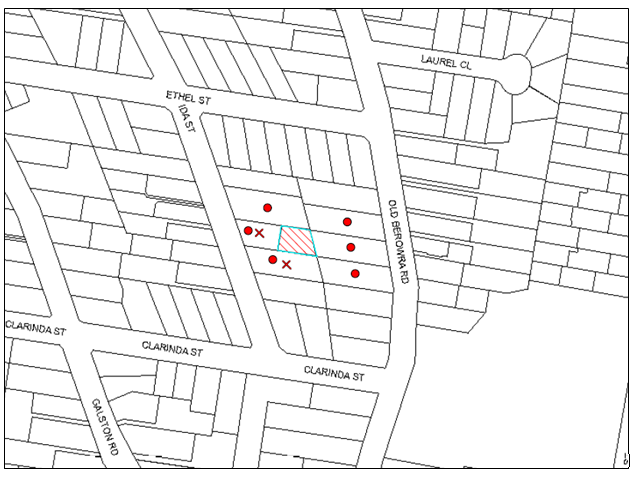
|
NOTIFICATION PLAN |
|
||
|
• PROPERTIES NOTIFIED
|
2 SUBMISSIONS RECEIVED |
PROPERTY SUBJECT OF DEVELOPMENT |
|
The submissions object to the development, generally on the following grounds:
· Privacy loss;
· Design and orientation of dwelling-house;
· Overshadowing;
· Bulk and Scale.
The merits of the matters raised in the submissions have been addressed in the body of the report.
6. THE PUBLIC INTEREST
Section 79C(1)(e) of the Act requires Council to consider “the public interest”.
The public interest is an overarching requirement, which includes the consideration of the matters discussed in this report. Implicit to the public interest is the achievement of future built outcomes adequately responding to and respecting the future desired outcomes expressed in environmental planning instruments and development control plans.
The application is considered to have satisfactorily addressed Council’s and relevant agencies’ criteria and would provide a development outcome that, on balance, would result in a positive impact for the community. Accordingly, it is considered that the approval of the proposed development would be in the public interest.
CONCLUSION
The application proposes a two storey dwelling house.
The development meets the desired outcomes of Council’s planning controls and is satisfactory having regard to the matters for consideration under Section 79C of the Environmental Planning and Assessment Act, 1979.
Council received two submissions during the public notification period. The matters raised have been addressed in the body of the report and conditions are recommended to minimise disruption to residential amenity.
Having regard to the circumstances of the case, approval is recommended of the application.
Note: At the time of the completion of this planning report, no persons have made a Political Donations Disclosure Statement pursuant to Section 147 of the Environmental Planning and Assessment Act, 1979 in respect of the subject planning application.
RESPONSIBLE OFFICER
The officer responsible for the preparation of this Report is the Manager – Development Assessments – Rodney Pickles, who can be contacted on 9847 6731.
|
Rod Pickles Manager - Development Assessment Planning Division |
James Farrington Group Manager Planning Division |
|
1.View |
Locality Map |
|
|
|
2.View |
Site Plan |
|
|
|
3.View |
Floor Plans |
|
|
|
4.View |
Elevations and Sections |
|
|
|
5.View |
Stormwater Plan |
|
|
|
6.View |
Shadow Plan |
|
|
|
7.View |
Tree Plan |
|
|
File Reference: DA/677/2015
Document Number: D06226844
SCHEDULE 1
GENERAL CONDITIONS
The conditions of consent within this notice of determination have been applied to ensure that the use of the land and/or building is carried out in such a manner that is consistent with the aims and objectives of the relevant legislation, planning instruments and Council policies affecting the land and does not disrupt the amenity of the neighbourhood or impact upon the environment.
Note: For the purpose of this consent, the term ‘applicant’ means any person who has the authority to act on or the benefit of the development consent.
Note: For the purpose of this consent, any reference to an Act, Regulation, Australian Standard or publication by a public authority shall be taken to mean the gazetted Act or Regulation, or adopted Australian Standard or publication as in force on the date that the application for a construction certificate is made.
1. Approved Plans and Supporting Documentation
The development must be carried out in accordance with the plans and documentation listed below and endorsed with Council’s stamp, except where amended by Council and/or other conditions of this consent:
|
Plan No. |
Drawn by |
Dated |
|
Proposed site plan & roof plan, Ground floor plan, First floor plan, Elevations, Section A.A, Section B.B, Environmental site management plan, Shadow diagram, Sheet No.01-09 |
Am Designs |
03 May 2015 |
|
Tree location plan |
Hornsby Council |
7/8/15 |
|
Document No. |
Prepared by |
Dated |
|
BASIX Certificate No.608782S |
Ashley Menegon |
13 February 2015 |
2. Amendment of Plans
The plans are to be amended as follows:
a) The “new selected metal handrails and glass balusters” along the upper level deck along the northern elevation must be increased to a minimum height of 1.5metres above finished floor level and be fixed frosted glazing.
b) The sill height of window W14 within the master bedroom must be increased to a minimum height of 1.5metres above finished floor level.
c) Fixed frosted glazing must be installed in the windows W14, W15 W16 and W17.
These amended plans must be submitted with the application for a construction certificate.
3. Removal of Existing Trees
a) This development consent permits the removal of trees numbered T5 and T6 as identified in the Site Tree Location Plan provided by Council’s Tree Management Team dated 7 August 2015.
b) The removal of any other trees from the site requires separate approval by Council in accordance with Part 1B.6 Tree and Vegetation Preservation of the Hornsby Development Control Plan, 2013 (HDCP).
4. Construction Certificate
a) A Construction Certificate is required to be approved by Council or a Private Certifying Authority prior to the commencement of any works under this consent.
b) The Construction Certificate plans must not be inconsistent with the Development Consent plans.
REQUIREMENTS PRIOR TO THE ISSUE OF A CONSTRUCTION CERTIFICATE
5. Building Code of Australia
All building work must be carried out in accordance with the relevant requirements of the Building Code of Australia.
6. Contract of Insurance (Residential Building Work)
In the case of residential building work for which the Home Building Act 1989 requires there to be a contract of insurance in force in accordance with Part 6 of that Act, that such a contract of insurance is in force before any building work authorised to be carried out by the consent commences.
7. Notification of Home Building Act 1989 Requirements
Residential building work within the meaning of the Home Building Act 1989 must not be carried out unless the principal certifying authority for the development to which the work relates (not being Council) has given Council written notice of the following information:
a) In the case of work for which a principal contractor is required to be appointed:
i) The name and licence number of the principal contractor; and
ii) The name of the insurer by which the work is insured under Part 6 of that Act.
b) In the case of work to be done by an owner-builder:
i) The name of the owner-builder; and
ii) If the owner-builder is required to hold an owner-builder’s permit under that Act, the number of the owner-builder’s permit.
Note: If arrangements for doing the residential building work are changed while the work is in progress so that the information notified becomes out of date, further work must not be carried out unless the principal certifying authority for the development to which the work relates (not being Council) has given Council written notification of the updated information.
8. Sydney Water – Quick Check
This application must be submitted to a Sydney Water ‘Quick Check Agent’ or ‘Customer Centre’ for approval to determine whether the development would affect any Sydney Water infrastructure, and whether further requirements are to be met.
Note: Refer to www.sydneywater.com.au or telephone 13 20 92 for assistance.
9. Appointment of a Project Arborist
a) A project Arborist (AQF5 qualified) must be appointed to oversee works within the tree protection zone of significant trees and the installation of fencing required to protect the tree root zones.
b) Details of the project Arborist are to be forwarded to Council prior to the issue of the construction certificate.
REQUIREMENTS PRIOR TO THE COMMENCEMENT OF ANY WORKS
10. Erection of Construction Sign
A sign must be erected in a prominent position on any site on which building work, subdivision work or demolition work is being carried out:
a) Showing the name, address and telephone number of the principal certifying authority for the work;
b) Showing the name of the principal contractor (if any) for any demolition or building work and a telephone number on which that person may be contacted outside working hours; and
c) Stating that unauthorised entry to the work site is prohibited.
Note: Any such sign is to be maintained while the building work, subdivision work or demolition work is being carried out, but must be removed when the work has been completed.
11. Toilet Facilities
Toilet facilities must be available or provided at the works site before works begin and must be maintained until the works are completed at a ratio of one toilet for every 20 persons employed at the site.
12. Erosion and Sediment Control
Erosion and sediment control measures must be provided and maintained throughout the construction period in accordance with the manual ‘Soils and Construction 2004 (Bluebook)’, the approved plans, Council specifications and to the satisfaction of the principal certifying authority. The erosion and sediment control devices must remain in place until the site has been stabilised and revegetated.
Note: On the spot penalties up to $1,500 may be issued for any non-compliance with this requirement without any further notification or warning.
13. Tree Protection Barriers
a) All trees retained on site must have trunk protection and tree protection zone fencing installed in accordance with the Australian Standard ‘Protection of Trees on Development Sites (AS 4970-2009).
b) Tree protection zone fencing must be installed prior to the commencement of any works on the site and must also be installed to protect the root zone of trees T7 and T8 on adjoining properties.
14. Tree Ground Protection
Tree Protection Zones for T7 and T8 must have a layer of wood-chip mulch installed prior to works commencing and must be maintained throughout the period of construction at a depth of 150mm – 300mm using material that complies with Australian Standard AS 4454.
REQUIREMENTS DURING CONSTRUCTION
15. Construction Work Hours
All work on site (including demolition and earth works) must only occur between 7am and 5pm Monday to Saturday. No work is to be undertaken on Sundays or public holidays.
16. Council Property
During construction works, no building materials, waste, machinery or related matter is to be stored on the road or footpath. The public reserve must be kept in a clean, tidy and safe condition at all times.
Note: This consent does not give right of access to the site via Council’s park or reserve. Should such access be required, separate written approval is to be obtained from Council.
17. Disturbance of Existing Site
During construction works, the existing ground levels of open space areas and natural landscape features, (including natural rock-outcrops, vegetation, soil and watercourses) must not be altered unless otherwise nominated on the approved plans.
18. Survey Report – Finished Floor Level
A report(s) must be prepared by a registered surveyor and submitted to the principal certifying authority prior to the pouring of concrete at each level of the building certifying that:
a) The building, retaining walls and the like have been correctly positioned on the site; and
b) The finished floor level(s) are in accordance with the approved plans.
19. Maintenance and Monitoring of Tree Protection
a) All required tree protection measures must be monitored by the appointed project Arborist to ensure that they are maintained in good condition for the duration of the construction period.
b) The project Arborist must supervise and record all works, including driveways and retaining walls, on the subject or adjoining properties within 10 metres of any trees required to be retained.
c) The project Arborist must record the method(s) used to preserve the tree(s) for the duration of the proposed works and forms part of final certification documentation.
20. Drilling/Boring to Install Underground Services
a) The installation of any services within the nominated tree protection zone of any tree to be retained must utilise the thrust boring method.
b) Thrust boring must be carried out so that ‘top of pipe’ is a minimum 600mm depth beneath existing ground level.
REQUIREMENTS PRIOR TO THE ISSUE OF AN OCCUPATION CERTIFICATE
Note: For the purpose of this consent, a reference to ‘occupation certificate’ shall not be taken to mean an ‘interim occupation certificate’ unless otherwise stated.
21. Final Certification
A certificate from the appointed project Arborist must be submitted with the application for the occupation certificate to the principal certifying authority stating compliance with the relevant conditions of this consent.
22. Fulfilment of BASIX Commitments
The applicant must demonstrate the fulfilment of BASIX commitments pertaining to the development.
23. Stormwater Drainage
The stormwater drainage system for the development must be designed and constructed for an average recurrence interval of 20 years and be gravity drained to connect to Council’s street drainage system.
24. Internal Driveway/Vehicular Areas
The driveway and parking areas on site must be designed in accordance with Australian Standards 2890.1, 2890.2, 3727 and the following requirements:
a) The driveway must be a rigid pavement;
b) The driveway grade must not exceed 25 percent and changes in grade must not exceed 8 percent;
c) Any damage caused to Council’s assets as a result of the construction of the development must be rectified in accordance with Council’s written requirements and at the sole cost of the applicant.
25. Replacement Tree Planting
a) To offset the loss of trees removed under this consent, two (2) replacement trees must be planted.
b) The replacement planting must be species selected from the selected from Council’s booklet ‘Indigenous Plants for the Bushland Shire’ such as: Ceratopetalum apetalum, Banksia integrifolia.
c) The replacement trees must be located 4 metres from the foundation walls of the approved development and reach a mature height greater than 9 metres.
d) The pot size of the replacement trees must be a minimum 25 litres.
e) The replacement trees must be maintained until they reach the height of 3 metres.
f) Planting methods must meet professional (best practice) industry standards.
- END OF CONDITIONS -
ADVISORY NOTES
The following information is provided for your assistance to ensure compliance with the Environmental Planning and Assessment Act 1979, Environmental Planning and Assessment Regulation 2000, other relevant legislation and Council’s policies and specifications. This information does not form part of the conditions of development consent pursuant to Section 80A of the Act.
Environmental Planning and Assessment Act 1979 Requirements
The Environmental Planning and Assessment Act 1979 requires:
· The issue of a construction certificate prior to the commencement of any works. Enquiries can be made to Council’s Customer Services Branch on 9847 6760;
· A principal certifying authority to be nominated and Council notified of that appointment prior to the commencement of any works;
· Council to be given at least two days written notice prior to the commencement of any works;
· Mandatory inspections of nominated stages of the construction inspected; and
· An occupation certificate to be issued before occupying any building or commencing the use of the land.
Long Service Levy
In accordance with Section 34 of the Building and Construction Industry Long Service Payments Act 1986, a ‘Long Service Levy’ must be paid to the Long Service Payments Corporation or Hornsby Council.
Note: The rate of the Long Service Levy is 0.35% of the total cost of the work.
Note: Hornsby Council requires the payment of the Long Service Levy prior to the issue of a construction certificate.
Tree and Vegetation Preservation
In accordance with Clause 5.9 of the Hornsby Local Environmental Plan 2013 a person must not ringbark, cut down, top, lop, remove, injure or wilfully destroy any tree or other vegetation protected under the Hornsby Development Control Plan 2013 without the authority conferred by a development consent or a permit granted by Council.
Notes: A tree is defined as a long lived, woody perennial plant with one or relatively few main stems with the potential to grow to a height greater than three metres (3M). (HDCP 1B.6.1.c).
Tree protection measures and distances are determined using the Australian Standard AS 4970:2009, “Protection of Trees on Development Sites”.
Fines may be imposed for non-compliance with both the Hornsby Local Environmental Plan 2013 and the Hornsby Development Control Plan 2013.
Dial Before You Dig
Prior to commencing any works, the applicant is encouraged to contact Dial Before You Dig on 1100 or www.dialbeforeyoudig.com.au for free information on potential underground pipes and cables within the vicinity of the development site.
Asbestos Warning
Should asbestos or asbestos products be encountered during demolition or construction works, you are advised to seek advice and information prior to disturbing this material. It is recommended that a contractor holding an asbestos-handling permit (issued by WorkCover NSW) be engaged to manage the proper handling of this material. Further information regarding the safe handling and removal of asbestos can be found at:
Alternatively, telephone the WorkCover Asbestos and Demolition Team on 8260 5885.
Group Manager's Report No. PL71/15
Planning Division
Date of Meeting: 9/09/2015
19 RURAL LANDS PLANNING STRATEGY
EXECUTIVE SUMMARY
· In November 2014, Council considered a report on the Rural Lands Planning Issues Survey and resolved to hold a Councillor briefing to discuss the preparation of a strategy that responds to the Survey findings.
· In April and June 2015, Councillors were briefed and it was agreed that a Planning Proposal and Hornsby Development Control Plan 2013 (HDCP) amendments which propose new development opportunities in the rural lands be presented for Council’s consideration.
· The draft Plans seek to provide the opportunity for secondary dwellings up to 33% of the size of the principal dwelling, attached dual occupancy up to 200m2, roadside stalls up to 40m2, and split zone lots with a component of rural zoned land equal to or greater than 20% of the lot size for that land.
· It is recommended that Council endorse the Rural Lands Planning Proposal for forwarding to the Department of Planning and Environment (DP&E) for Gateway Determination and that draft HDCP amendments be exhibited concurrently with the Proposal.
|
THAT: 1. Council endorse progression of the Rural Lands Planning Proposal attached to Executive Manager’s Report No. PL71/15 and forward the Proposal to the Department of Planning and Environment seeking a Gateway Determination. 2. Council defer consideration of whether to progress investigation of any further options for review of allotment sizes until the release of the North Subregional Strategy which may identify key directions for development, including a rural resource lands strategy and housing targets. 3. In accordance with delegated plan making powers, Council exercise Authorisation to prepare and make the Planning Proposal following receipt of Gateway Authorisation and the General Manager be given delegation to endorse the exhibition material. 4. Should the Minister determine under Section 56(2) of the Environmental Planning and Assessment Act 1979 that the Planning Proposal may proceed without significant amendment, Council publicly exhibit the Proposal in accordance with the Gateway Determination. 5. Council endorse the draft Hornsby Development Control Plan 2013 amendments attached to Group Manager’s Report No. PL71/15 for exhibition concurrently with the Planning Proposal. 6. Following exhibition, a report on submissions be presented to Council. |
PURPOSE
The purpose of this report is to present a Planning Proposal that seeks to introduce new development opportunities in the rural lands consistent with the findings of the Rural Lands Planning Issues Survey.
BACKGROUND
At its meeting on 9 April 2014, Council considered Group Manager’s Report No. PL26/14 discussing Council’s previous resolution to consult the community on options for a review of minimum allotment sizes in the Galston and Glenorie areas. Council resolved to undertake a survey to identify the community’s vision for the rural areas and attitudes to a number of planning controls and development opportunities. Accordingly, in June 2014, Council invited a total of 6,430 landowners in the Shire (comprising 3,215 landowners in the suburbs that comprise the rural areas and the equivalent number of randomly selected landowners in the urban areas) to participate in an on-line survey. Council received a total of 1,398 responses.
An analysis of the responses to the Rural Lands Planning Issues Survey was undertaken and summarised in a report. The Summary of Responses Report identified the following key results relating to the development opportunities surveyed.
· Larger Secondary Dwellings: Support (75.2%) for larger secondary dwellings, with a combined preference (62.2%) for the size limit to be increased to between 30% and 50% of principal dwelling size.
· Attached Dual Occupancy: Support (75.8%) for the introduction of attached dual occupancy. There is no clear preferred size limit.
· Roadside Stalls: Support for larger roadside stalls (65.4%) that sell local produce (91.9%) rather than being restricted to selling produce from the property. There is no clear preferred size limit.
· Rural Cluster Subdivision: Support for introducing rural cluster subdivision (62.5%) throughout all rural lands (47.6%) to permit a smaller lot size on those parts of the land with a greater capacity to support development as an offset for the conservation of environmentally sensitive land. There is a need to define the development type, including identifying minimum rural zone lot size and density.
· Reduced Lot Sizes: Generally, there is equal support for (48.3%) and against (46.6%) reducing lot size at the Shire-wide level based on satisfaction with current controls.
However, when asked specific questions about the preferred lot size (i.e. various lot size options were provided ranging from maintaining existing lot size down to 1 acre), there is some support for reducing lot size. There is 66% support for a reduction of the 10 hectare lot size (currently applied to land north of Glenorie Village), with 2 hectare lots being the preferred lot size (40.1%). There is 58.1% support for a reduction of the 2 hectare lot size (currently applied to land south of Glenorie Village), with 1 acre lots being the preferred lot size (34.6%).
The level of support for reducing lot size across all survey questions increases when analysis is undertaken at the rural area and rural zone levels. However, when asked the question on the preferred location for reduced lot size (i.e. within specific suburbs, 1km of various rural villages and/or the suburban/rural boundary), there was no one clear preferred location.
· Split Zone Lots: There is support (59.0%) for the inclusion of the environmental zoned land when calculating lot size for the subdivision of split zoned land throughout all rural lands (61.8%). There is also a need to define the minimum rural zone lot size.
At its meeting on 12 November 2014, Council considered Group Manager’s Report No. PL82/14 in relation to the Summary of Responses Report. Council resolved that:
1. The Rural Lands Planning Issues Survey – Summary of Response Report (attached to Group Manager’s Report No. PL82/14) be received and noted.
2. The Summary of Response Report be made available for viewing on Council’s website to inform the community of the findings.
3. A Councillor Briefing be held to discuss the preparation of a strategy that responds to the findings of the survey prior to a report being presented for Council’s consideration.
4. All persons who responded to the survey be advised of Council’s resolution.
In November 2014, the Summary of Response Report was made available for viewing on Council’s website and all persons who responded to the survey were advised of Council’s resolution.
In April and June 2015, Councillor briefings were held to discuss the survey results and options for progressing a planning response. It was agreed that a report presenting a planning proposal and HDCP amendments should be presented for Council’s consideration.
DISCUSSION
This report presents a Planning Proposal to amend the Hornsby Local Environmental Plan 2013 (HLEP) for endorsement for forwarding to the DP&E for Gateway Determination and draft amendments to the HDCP for public exhibition. This report also addresses the development opportunities identified in the Rural Lands Planning Issues Survey but not included in the Planning Proposal.
A. Rural Lands Planning Proposal
A Rural Lands Planning Proposal has been prepared that seeks to amend the HLEP to provide new development opportunities in the rural lands of the Shire consistent with the findings of the Rural Lands Planning Issues Survey for the following development types:
· Larger secondary dwellings;
· Introduction of attached dual occupancy;
· Larger roadside stalls; and
· Revised split zone lot controls.
Details of the current planning controls, proposed amendments and community benefits are detailed in this report.
Larger Secondary Dwellings
Secondary Dwellings are permitted with consent in all rural zones under the HLEP as part of a strategy to promote affordable housing in the Shire. The Standard Instrument identifies that the inclusion of a development control relating to the maximum floor area of a Secondary Dwelling, as expressed as a percentage of the size of the principal dwelling, is mandatory. When Council prepared the HLEP, 110m2 was considered an appropriate maximum size as it was the same size as a “rural workers dwelling” permitted by the Hornsby Shire Local Environmental Plan (HSLEP) 1994. Accordingly, when expressed as a percentage, it was determined that a secondary dwelling up to 20% of the total floor area of the principal dwelling would be an appropriate size restriction considering the size of new dwelling houses which are common in the rural areas (i.e. 500m2).
To reflect the role of secondary dwellings in accommodating extended families, or to provide rental accommodation, it is proposed to permit with development consent, Secondary Dwellings up to 33% the size of the principal dwelling. Larger Secondary Dwellings would be more consistent with market demand for housing in the rural area and may provide environmental and economic benefits as it would provide opportunity for the retention of existing dwellings as a Secondary Dwelling.
This approach would maintain the primacy of the principal dwelling and, on the basis of a 500m2 principal dwelling, would provide the opportunity for a Secondary Dwelling with a floor space of 165m2. This equates to a standard 3 bedroom, 2 bathroom and 2 car space dwelling which would be consistent with the rural character of the area. A floor space of 165m2 is the approximate average Australian dwelling size in circa 1985. A dwelling of this era still has good life expectancy and could be retained as the Secondary Dwelling. A 33% size limit is the average maximum size of Secondary Dwellings in the Hunter group of councils, which comprises 11 LGAs.
Introduction of Attached Dual Occupancy
The RU1 zone (north of Glenorie Village), RU2 zone (south of Galston Village) and the RU4 zone (north of Galston Village) already permit Secondary Dwellings and a have minimum lot size requirement of either 2 or 10 hectares. To compliment this existing strategy, it is proposed to permit with development consent, Attached Dual Occupancies up to 200m2 by amending the HLEP.
To ensure Attached Dual Occupancies only occur on existing lots of a suitable size, a special provision is proposed that requires the existing lot be equal or greater than the existing minimum lot size over the land (i.e. 2 or 10 hectares).
There a number of councils in the Sydney Metropolitan Area with rural lands that include maximum floor space controls for Attached Dual Occupancies ranging from 60m2 to 400m2. A 200m2 floor space limit is considered appropriate as it is the same size as the minimum required building envelope in an urban area of Hornsby Shire and generally equates to a standard 4 bedroom, 2 bathroom and 2 car space dwelling. It is also only slightly larger than the likely maximum expected size of a Secondary Dwelling (i.e. 165m2) based on the 33% size limit proposed by the Planning Proposal and common principal dwelling size in a rural area of 500m2.
Permitting Attached Dual Occupancies as an alternate housing form to that of a Secondary Dwelling would provide the opportunity for an alternate affordable housing option. As they would not be limited in size based on the principal dwelling they would suit larger families or provide rental accommodation in the rural areas of the Shire. This housing form would also be restricted to the area of a site already occupied, therefore maintaining significant plots for agriculture.
Larger Roadside Stalls
Roadside stalls are permitted with consent in the RU1, RU2, RU4, B1, B2, B3 and B4 zones under the HLEP. The Standard Instrument mandates that Roadside Stalls are restricted to selling agricultural or hand crafted goods produced on the property on which the stall is situated or from an adjacent property. The Standard Instrument also mandates the inclusion of development controls to restrict their size. The definition of Roadside Stalls in the HSLEP 1994 included a size limitation of 20m2. As the HLEP was principally a translation of the former planning instrument, the 20m2 limit was included.
To address the role of roadside stalls in promoting agriculture and tourism, it is proposed to amend the HLEP to permit with development consent, Roadside Stalls up to 40m2. This size would be equivalent to a double garage which would still maintain rural character. The size restriction would also only be slightly larger than the average size restriction applied in other Sydney Metropolitan and Sydney Surrounds LGAs with rural zoned lands but considerably smaller than the 75m2 limit applied in The Hills, Hawkesbury and Wollondilly LGAs.
Permitting the expansion of goods available for sale at a Roadside Stall to those produced in the local area would require the State Government to modify the definition of Roadside Stalls in the Standard Instrument and would apply to all LGAs in the State. Accordingly, it does not form part of this Planning Proposal.
Should Council be of a mind to change the definition, it may request the NSW State Government change its policy position. Although an expansion to the definition may support locally produced agriculture and hand crafted goods, the term ‘local area’ is amorphous and may create significant difficulties for Council in undertaking its duties both in the interpretation of the land use and confirming whether the goods sold are in fact produced in the local area. Roadside stalls could resell produce purchased in other Sydney markets and this could compete with shops in nearby commercial centres.
The current definition is easily monitored as it only requires Council officers to survey the property on which the roadside stall is located and adjoining properties to confirm the agriculture or hand craft is produced on one of the properties. Therefore, it is not recommended that Council make representations to amend the current definition.
Revised Split Zone Lot Controls
Rural zoned properties that also include Environmental zoned land are called split zoned lots. Environmental zoned land, which is applied to sensitive land, is excluded from the lot size calculation for split zone properties to protect the land from fragmentation. Unfortunately, the introduction of split lot controls has reduced the potential to subdivide otherwise suitable land and even where subdivision is achieved, led to the inequity of the existing lot retaining the burden of maintaining the entire environmentally zoned parcel.
To address this issue, it is proposed to amend the HLEP, by modifying the split zone lot controls to require lots to have a:
· total area which is equal to, or greater than, the existing 2 or 10 hectare minimum rural zone lot size over the land; and
· a component of rural zoned land equal to, or greater than, 20% of the minimum lot size.
Maintaining lots with a total area equal to, or greater than, the existing minimum rural lot sizes would maintain the rural landscape character. The requirement to include a component of rural zoned land equal to, or greater than, 20% of the minimum lot size would result in at least 2 hectares of rural zoned land (which could support viable agricultural undertakings) for 10 hectare lots and at least 1 acre of rural zoned land (which could support rural/residential living) for 2 hectare lots.
Including environmental zoned land for the purpose of calculating lot sizes on split zone properties may result in 100 additional lots.
This lot yield can be accommodated as progressing the Planning Proposal would restore the development potential removed from the rural lands in 1985 when an Environmental Protection zone was applied to steep lands as part of an amendment to the then governing Hornsby Planning Scheme Ordinance 1977. The original purpose of the control was to minimise the fragmentation of the environmentally sensitive land and potential for the erection of additional fences along property boundaries which could impede the movement of fauna. Any potential for fragmentation of properties by erection of fences is more than adequately offset by sharing the burden of managing the environmentally sensitive land amongst a number of property owners. Further, the E3 land use zoning strategy would still apply and provide adequate protection over environmentally sensitive lands by restricting permissible development to low intensity land uses.
B. Draft Hornsby Development Control Plan Amendments
Draft amendments to the HDCP have been prepared to supplement the Planning Proposal. Details of the current planning controls, planning issue, proposed amendments and the community benefits are detailed in the following table.
|
|
Current Controls |
Planning Issue |
Proposed Amendments |
Community Benefits |
|
Larger Secondary Dwellings |
The HDCP includes a Secondary Dwellings element. |
Recent applications have highlighted a trend towards including an oversized garage or attaching the Secondary Dwelling to farm/outbuildings. This provides opportunity for retrofitting to form a much larger non-complying Secondary Dwelling. |
The element be amended to require Secondary Dwellings to: · have a maximum of 2 car parking spaces; and · not be attached to farm/out buildings.
|
Secondary Dwellings do not covertly evolve into a larger dwelling.
|
|
Introduction of Attached Dual Occupancies |
The HDCP does not currently include provisions for Attached Dual Occupancies.
|
Good practice planning controls should be prepared. Attached Dual Occupancies should: · have appearance of a dwelling-house when viewed from the primary street frontage; and · be limited in bulk and scale. |
An Attached Dual Occupancies element be inserted to require the: · front elevation of attached dual occupancies to be not greater than 50% of the property width; · dwelling walls of attached dual occupancies to be no greater than 6 metres apart where they are only attached by a roof; · vehicular access to both dwellings to be from a single common driveway or access road; · second dwelling to be consistent with existing dwelling architecture and materials; and · attached dual occupancy to not be of mirror reversed design. |
Attached Dual Occupancies are of an appropriate bulk and scale and have an integrated appearance which gives the impression of a single dwelling house.
|
|
Larger Roadside Stalls |
The HDCP does not currently include provisions for Roadside Stalls but includes a Rural Buildings element.
|
Good practice planning controls should be prepared to ensure Roadside Stalls are compatible with the rural character. |
Roadside stall provisions be inserted into the Rural Buildings element to require that a roadside stall is constructed in a form and of materials that are of a rural idiom. |
Roadside stalls are compatible with the rural character.
|
|
Revised Split Zone Lot Controls |
The HDCP includes a “Rural Lands Subdivision” element. |
The element contains special provisions for split zone subdivisions, including a figure to illustrate complying and non-complying subdivision examples. The provisions are inconsistent with the planning proposal. |
The Rural Lands Subdivision element be amended to be consistent with the Planning Proposal and so that subdivision layout generally provides for equal sized split zone lots with regular division lines. |
Orderly subdivision where the burden of managing the environmentally sensitive land is shared amongst a number of property owners. |
C. Other Development Opportunities
The Rural Lands Planning Proposal has been prepared to provide a number of new development opportunities in the rural lands of the Shire. Other development opportunities identified in the Rural Lands Planning Issues Survey or in community submissions subsequently received but not included in the planning proposal are:
· Introduction of rural cluster subdivision;
· Reduced minimum lot sizes; and
· Extension of Galston Village.
The Metropolitan Strategy – A Plan for Growing Sydney identifies the rural area of Hornsby Shire as part of the “Metropolitan Rural Area” and part of an “agricultural cluster”. The following goals, directions and actions from the Metropolitan Strategy are of particular relevance:
· Action 2.4.2 identifies that the Government will develop a framework for the identification of new Growth Centres that considers a range of matters, including the sustainability of Sydney’s agricultural and resource sectors. The Action states that the framework will be prepared in tandem with the preparation of a strategic framework for the Metropolitan Rural Area and it is anticipated to provide a new methodology for evaluating rural land for its suitability for urban subdivision; and
· Action 4.1.2 identifies that the Government will prepare a strategic framework for the Metropolitan Rural Area to enhance and protect its broad range of environmental, economic and social assets. The framework will assist decision making by establishing a range of criteria, including criteria to minimise the adverse economic impacts on existing primary industry and productive agriculture.
The Metropolitan Strategy will be supported by a series of subregional strategies that are currently being prepared, including one for the North Subregion that will provide more detailed strategic direction for eleven LGAs, including Hornsby. It is anticipated that the draft Plan will include a rural resource lands strategy, housing targets and address the above mentioned Metropolitan Strategy actions.
The DP&E has advised that the release of the draft North Subregional Plan is likely to occur in late 2015. On the grounds that the above issues have the potential to result in significant lot yields which may not be consistent with the Metropolitan Strategy and North Subregional Plan, it is recommended that consideration not proceed at this time. Upon release of the North Subregional Strategy, it would be appropriate to revisit the above issues so that their impact may be evaluated in relation to the Government’s rural resource lands strategy.
D. Feedback on Summary of Submissions Report
Council received 13 submissions in response to the Summary of Response Report which was placed on Council’s website in November 2014. A summary of the issues raised are provided below.
Support Development Options: Two submissions from the Hornsby Rural Areas Association Inc. (HRAA) support the development options identified in the Survey, specifically:
· Expanding Galston and Glenorie villages;
· Possibly establishing new villages in Arcadia and Dural;
· Reducing the minimum lot size for all existing 10 hectare lots to 2 hectares;
· Reducing the minimum lot size for all existing 2 hectare lots to 1 acre to a radius of at least 1km from the villages; and
· Providing strategically located rural cluster subdivision throughout the balance of the rural area where 10 hectare lots can be subdivided to accommodate up to 30 dwellings.
Oppose Development Options: Submissions from the Sydney Agricultural Rural and Public Lands Trust (SARAPLT) and the Galston Area Residents Association (GARA) oppose the development options. The submission from SARAPLT suggested that the:
· Research method, sampling and construction of the Survey was flawed;
· Explanation of planning concepts and implications was inadequate resulting in inconsistent responses;
· Distribution of the survey questions and misleading information in advance invalidates the Survey;
· Survey had a bias to residents with a computer as availability of hard copies was limited;
· Survey findings should not be used to validate rural rezoning; and
· Previous results from the 2003 Survey should be enforced.
The submission from GARA also suggests the distribution of survey questions and misleading information invalidates the Survey.
Support Extension of Galston Village: Eight submissions note that Sydney Water is nearing completion of the Galston and Glenorie sewer program and Council’s previous resolution to reconsider extending the Village to School and Johnson Roads when the matter of effluent disposal has been resolved. The submissions request that Council reconsider the extension of Galston Village as part of the preparation of the Rural Lands Planning Strategy.
Comment: The Rural Lands Planning Issues Survey findings provide a cross section of community views and are of value in assisting Council to prepare the Rural Lands Planning Strategy.
At its meeting on 9 April 2014, Council resolved to undertake a survey in accordance with a community consultation brief to identify the community’s vision for the rural areas and attitudes to a number of planning controls and development opportunities. Accordingly, the Survey was prepared, facilitated and reported on in accordance with Council’s brief and with the assistance of an independent consultation expert. The survey provides community feedback to assist Council in preparing the Rural Lands Planning Strategy.
At its meeting its meeting on 17 February 1999, Council considered Executive Manager’s Report No. PLN30/99 reviewing the submissions received to the Rural Lands Study in relation to all the rural village areas, including Galston Village. Council resolved that:
“A final decision concerning the proposed expansion of Galston Village (School and Johnson Roads) be deferred until Council has considered the findings of a flora and fauna survey and determined the most appropriate means of disposing effluent from the village following the review of the ‘Assessment of sewage treatment and reuse options in the Galston Village area’ report.”
Any extension to Galston Village would result in additional lot yields and would require evaluation having regard to the State Government’s Metropolitan Strategy, any relevant recommendations from the North Subregional Plan and consultation with relevant infrastructure providers, including Sydney Water. Although Sydney Water has commenced the sewer program, it would be appropriate to group this issue with the review of subdivision controls as outlined in Section C of this report.
Recommendation: It is recommended that no amendment be made to Council’s strategy in response to the submissions received that support or object to the development opportunities identified.
Consultation Strategy
Should Council resolve to proceed with the Planning Proposal, and Gateway Authorisation is issued by the DP&E, the Plan would be formally exhibited in accordance with the Consultation Strategy contained within the attached Planning Proposal and in accordance with “A guide to preparing local environmental plans” prepared by the Department of Planning and Infrastructure (2009). The Planning Proposal and associated draft HDCP amendments would be exhibited for a period of 28 days and, at a minimum would include the following:
· Notification letters and a copy of the Planning Proposal and draft HDCP amendments would be sent to relevant public authorities (if any) outlined in the Gateway Determination;
· An advertisement would be placed in local newspapers that identify the purpose of the Planning Proposal and draft HDCP amendments and where they can be viewed;
· The Planning Proposal and draft HDCP amendments would be exhibited on the Council website under On Exhibition (www.hornsby.nsw.gov.au/onexhibition). Council’s libraries have access to the website;
· A letter would be sent to affected land owners, previous survey respondents and relevant community industry groups including those referenced in this report advising them of the exhibition and how to make a submission; and
· The Planning Proposal will be displayed at the Council Administration Centre, 296 Peats Road, Hornsby, Galston, Berowra and Pennant Hills Libraries.
A report outlining the outcomes of public agency consultation and submissions received during public exhibition would be presented to Council for its consideration at the conclusion of the exhibition period.
Statutory Considerations
The Planning Proposal has been prepared having regard to the applicable State Environmental Planning Policies and s117 Ministerial Directions, it being noted that the following Directions are relevant:
1.2 Rural Zones
1.3 Mining, Petroleum and Extractive Industries
1.5 Rural Lands
2.1 Environmental Protection Zones
2.3 Heritage Conservation
4.3 Flood Prone Land
4.4 Planning for Bushfire Protection
7.1 Implementation of a Plan for Growing Sydney
To progress the Planning Proposal, it would be necessary to seek Gateway Determination from the DP&E prior to public exhibition. Gateway Determination must be provided by the DP&E prior to progression of the Planning Proposal to public exhibition.
As part of the Gateway Authorisation process, Section 23 of the Environmental Planning and Assessment Act 1979 allows the Minister and the Secretary to delegate functions to a council and/or an officer or employee of a council. When submitting a planning proposal, Council is required to identify whether it wishes to Exercise Delegation (the Authorisation). Authorisation delegates the following plan making powers to Council:
· to make and determine not to make an LEP;
· to defer inclusion of certain matters; and
· to identify which matters must be considered and which stages of the plan making process must be carried out again.
At its meeting on 12 December 2012, Council resolved to formally accept the plan making delegations and delegate the plan making functions to the General Manager. Acknowledgement of Council’s resolution was received from (then) Department of Planning and Infrastructure (now the DP&E), on 3 March 2013.
On the grounds that the Planning Proposal is consistent with the types of draft LEPs to be routinely delegated, it is recommended that Council exercise the Authorisation in this instance.
To progress the draft HDCP amendments, it would be necessary to exhibit them for community comment concurrent with the Planning Proposal for a minimum period of 28 days.
BUDGET
There are no budgetary implications associated with this Report.
POLICY
There are no policy implications associated with this Report.
CONCLUSION
The purpose of the attached planning proposal and draft HDCP amendments is to implement new planning controls that respond to the findings of the Rural Lands Planning Issues Survey. The Rural Lands Planning Proposal seeks to amend the HLEP to provide the opportunity for:
· Secondary dwellings up to 33% of the size of the principal dwelling;
· Attached dual occupancy up to 200m2;
· Roadside stalls up to 40m2; and
· Split zone lots with a total area that complies with the rural zone lot size and have a component of rural zoned land equal to or greater than 20% of the lot size for that land.
The draft HDCP amendments supplement the Planning Proposal by revising existing or introducing new planning controls to the Rural and Subdivision chapters. Accordingly, it is recommended that Council endorse the Rural Lands Planning Proposal for forwarding to the DP&E for Gateway Determination. It is also recommended that the associated draft HDCP amendments be endorsed for public exhibition concurrent with the Planning Proposal.
RESPONSIBLE OFFICER
The officer responsible for the preparation of this Report is the Manager – Strategic Planning – Fletcher Rayner, who can be contacted on 9847 6744.
|
Fletcher Rayner Manager - Strategic Planning Planning Division |
James Farrington Group Manager Planning Division |
|
1.View |
Rural Lands Planning Proposal - August 2015 |
|
|
|
2.View |
Draft Hornsby Development Control Plan Amendments |
|
|
File Reference: F2014/00279-02
Document Number: D06432901
Deputy General Manager's Report No. IR28/15
Infrastructure and Recreation Division
Date of Meeting: 9/09/2015
20 WAITARA PARK DRAFT PLAN OF MANAGEMENT
EXECUTIVE SUMMARY
· Council received a report at its 13 May 2015 General Meeting and endorsed a Waitara Park draft Plan of Management (PoM) for exhibition. The draft PoM was exhibited in accordance with the requirements of the Local Government Act 1993. The exhibition occurred from 5 June to 21 July 2015 and a Public Hearing was held on 16 July 2015.
· There were 91 submissions received.
· The submissions seek changes to the draft PoM, particularly proposed changes to parking in the Park; retention of the former bowling club building for sport, church and performing arts use; and proximity to and impact of the proposed PCYC centre on existing apartments to the south.
· The proposed PoM aims to deliver an increase in the area of park land that is available for local recreation use, offsetting Council’s need to acquire open space land elsewhere to meet the needs of the growing population of Waitara. No significant amendments are proposed to the draft PoM. However, minor wording changes are proposed that acknowledge the rugby clubs as long standing users of Waitara Park.
· It is recommended that the attached amended draft Plan of Management be adopted by Council.
|
THAT Council: 1. Note the submissions received and findings of the Public Hearing contained in Deputy General Manager’s Report No. IR28/15. 2. Adopt the Amended Draft Plan of Management for Waitara Park. 3. Write to the Minister for Local Government seeking consent for Council entering into a 30 year lease with PCYC. 4. Note that Crown Lands have written to Council indicating support of the transfer of the management of Crown Reserve 1036828 to Council. 5. Support the terms of a replacement agreement with Kim Warwick Tennis Academy (KWTA) to operate tennis courts on Crown Land. This shall include extending the licence term to cover any abatement period and allowing KWTA to operate the proposed café for the remainder of their licence term. |
PURPOSE
The purpose of this Report is to:
· Inform Council of the exhibition of the Waitara Park Draft Plan of Management
· Advise Council on submissions received and the findings of the Public Hearing
· Seek adoption of the Waitara Park Amended Draft Plan of Management (Attachment 1).
BACKGROUND
In May 2015, Council received a report (IR13/15) setting out a vision to redevelop Waitara Park in accordance with plans contained in a Waitara Park Draft PoM. The report identified an opportunity to expand the Park to include Crown Land to the north of the park that is currently managed by PCYC, outlined a proposal to enter into an agreement with PCYC to build and operate an indoor recreation facility and performing arts centre on community land at the south of Waitara Park. It was noted that this would increase the recreation facilities available locally.
The resolution of the May meeting was that Council:
“1. Adopt the draft vision to redevelop Waitara Park in accordance with the principles set out in Deputy General Manager’s Report No. IR13/15.
2. Endorse the exhibition of a draft Plan of Management for Waitara Park and the former bowling club site with a response to the exhibition to be reported to Council.
3. Write to the Crown Lands Division of the Department of Trade and Investment seeking the Minister’s consent to appointing Hornsby Shire Council as trust manager of Reserve R1036828 (Lot 1020 DP 752053) at Waitara.”
Council considered a further report at the July Ordinary Meeting, where it was resolved that Council:
“1. Support the proposal from PCYC to lease Council land at Waitara Park to develop and operate a recreation facility accessible to the community in return for supporting Council access to Crown land at the former Hornsby Bowling Club.
2. Support making a capital contribution towards the proposal.
3. Delegate to the General Manager to negotiate:
a) the terms of a Deed of Agreement for Lease and a specific lease between Council and PCYC NSW, based on the terms identified in Deputy General Manager’s Report No. IR22/15;
b) the terms of a new agreement with Kim Warwick Tennis Academy for use of new tennis courts on the Crown Land; and
c) the value of the contribution to PCYC based on an independent quantity survey of the proposed PCYC facility.
4. Write to the Minister for Local Government seeking consent for Council entering into a 30 year lease with PCYC, subject to adoption of the draft Plan of Management for Waitara Park.
5. Provide owner’s consent to PCYC NSW for the submission of a Development Application for the building.”
Since these meetings, Council has written to Crown Lands and has received a reply indicating support for Council gaining Reserve Trust management responsibility for the Crown Land that is occupied by the PCYC (Attachment 2). In response to the request in the letter, it is proposed that the name of the Reserve Trust is changed to “Waitara Park Reserve Trust”.
There have been further negotiations with PCYC and Kim Warwick Tennis Academy (KWTA) regarding the terms of proposed agreements with Council. PCYC submitted a development Application on 9 July 2015.
This report advises on the findings of the exhibition of the draft PoM and the Public Hearing which occurred in June and July 2015.
DISCUSSION
Plan of Management Exhibition
The draft PoM was exhibited in accordance with the requirements of the Local Government Act 1993 (LGA). The LGA requires exhibition of the document for not less than 28 days and for Council to accept submissions for a period of not less than 42 days from the date the draft plan was placed on public exhibition.
The PoM was placed on exhibition from 5 June to 21 July 2015 (46 days).
Advertisements were placed in local newspapers. The draft PoM was available for viewing on Council’s Website. Neighbours and nearby residents were advised of the exhibition via direct letters that were distributed to properties within the local area.
A Community Information Session was held on Thursday 7 July at the Hornsby Bowling Club, 22 Waitara Avenue, Waitara.
In accordance with the requirements of the LGA, a Public Hearing was held on 16 July, chaired by an independent consultant. A copy of the consultant’s report, summarising the results of the Public Hearing was placed on exhibition on 31 July, within four working days of receipt, as required by the LGA. Attachment 3 is a copy of this report.
Issues Raised by the Community
Issues were raised via written submissions, the Public Hearing and discussions with residents at the Community Information Session. The issues focused on elements of the Indicative Masterplan, sections of the PoM, the supporting Parking and Traffic Management Study and details contained in the Public Hearing report.
Council received 91 written submissions, 54 of which were variations of a form letter from Hornsby Rugby, seeking greater recognition for rugby and a clubhouse facility. A small number of submissions were received from residents, park users and commuters about parking issues; neighbours with concerns about negative impacts from the proposed PCYC building; residents and park users concerned about the tennis court proposals; and the Breakthrough Church - an existing tenant of the PCYC who is seeking ongoing use of the former bowling club building.
The following is a brief summary of the issues raised and Council’s response. Attachment 5 provides further details of the submissions received and Council’s response.
Issue: Parking
Objections relate to the proposal to remove parking from within the park and introduce time limits to parking on Waitara and Park Avenues. There were requests for the introduction of a parking permit scheme. The objections were received from commuters, residents and some sports club participants of Waitara who rely on available parking in the area.
Response:
The PoM proposes to remove approximately 90 existing parking spaces from within the Park and the seven spaces from Park Lane.
Approximately 43 of these spaces are restricted to short stay park uses that are underutilised during the week.
The Indicative Masterplan proposes formalising parking on Park Avenue, providing an extra 20 spaces.
This leads to a net loss in the locality of 77 parking spaces.
The proposed PCYC building is expected to provide 94 parking spaces to meet all of the parking requirements of this building and will be the subject of a separate Development Application and detailed assessment process. This will replace parking demand currently generated by PCYC activities at the former bowling club.
Council has in the past considered introducing a parking permit scheme; however this has not been implemented due to the need to offset the cost of administering this scheme. It is noted that all of the recently completed developments in Waitara have met current requirements for the provision of on-site parking.
Surveys have found that peak use times for park users are weekday evenings and weekends when many of the on-street parking spaces were found to be vacant.
The draft PoM recognises there is an opportunity for park users to gain greater use of the on-street parking through the introduction of time limited parking. The demand for short stay parking is expected to be carefully monitored to ensure an appropriate number of spaces are restricted and use of park facilities is not limited by parking availability. The monitoring will also seek to ensure high levels of long stay utilisation.
On the basis of the above evaluation it is recommended that no changes are made to the draft PoM following consideration of parking issues raised in the exhibition period.
Issue: Hornsby Rugby Clubs
Hornsby Junior Rugby Union Club (HRJU) and Hornsby Rugby Union Club (HRU) seeking use of the existing bowling club building or other facilities in the park as a clubhouse facility. They seek a facility that could accommodate various club functions for up to approximately 150-200 people and preferably in the former Hornsby Bowling Club building.
Response:
There are no examples within the Hornsby Council area of Council providing exclusive clubhouse facilities of the scale sought in these submissions. Council officers have met with representatives of the clubs and have discussed options for accommodating their needs, which include use of the new PCYC building or possibly adapting and reusing the existing cricket and rugby grandstand, or perhaps waiting to occupy facilities that Council has proposed to build at Old Mans Valley, probably within a few years.
The option of retaining the former bowling club building is further discussed below. It is understood that the clubs may put a proposal to Council, to adapt and reuse the existing cricket and rugby grandstand to provide a room that is able to be used for club functions. However at the time of writing this report, the clubs have not committed any resources or funding. In this context it is not considered appropriate for Council to enter into a long term lease agreement or to commit capital expenditure for the benefit of rugby.
It is recommended that no changes are made to the draft PoM following consideration of this issue.
Issue: Proximity of PCYC to Units South of Waitara Park
Issues include concerns with noise and exhaust pollution from the vehicle access to the basement, loss of natural light, loss of views. There was also objection to Park Lane becoming a one-way road and/or a share way.
Response:
The proposal to locate the PCYC building in the southern portion of the site is driven by positioning the PCYC building outside of flood prone Crown Land and Council gaining trusteeship of Crown Reserve 1036828 in exchange. There is insufficient space to move it slightly northwards in response to the objections without drastically reducing usable open space proposed through the creation of an outdoor plaza around the western and northern sides of the PCYC building. Another key factor in the siting of the building is the desire to retain existing trees on the southern, western and eastern sides of the PCYC building. The Development Application for the PCYC building will be the subject of a detailed assessment which is currently underway and is expected to be determined by the Joint Regional Planning Panel in the near future, following adoption of the PoM. This assessment will include consideration of noise, light, traffic, parking and setback requirements and is the appropriate forum for considering these detailed issues.
The proposals to change the traffic arrangements in Park Lane will be subject to more detailed consideration when the design of the plaza area is further developed by Council. It has not at this stage been determined whether it is advantageous to introduce one-way traffic flow or a share-way. The issues raised in submissions will be considered further at a later date.
It is recommended that no change is made to the draft PoM to respond to these issues.
Issue: Retention of the Existing Bowling Club Building
Issues include retaining the existing bowling club building and making it available for use by the Breakthrough Church, Hornsby Rugby and Kim Warwick Tennis Academy (KWTA); and continual to use the building as a performing arts centre. Breakthrough Church, an existing tenant of the PCYC, has sought a five year lease of the use of this building and is prepared to maintain it for this period.
Response:
The PoM proposes a significant reduction in the size of this existing building, or its replacement with a new purpose built building to accommodate a tennis clubhouse and café that complements a new playground area. Retaining the entire building to accommodate a combination of community and sporting uses for tennis, rugby, performing arts and the Breakthrough Church would be effectively expanding Council’s building assets at the expense of providing new parkland.
The large new children’s playground area proposed in this area is intended to take pressure off the heavily used and overcrowded neighbouring Willow Park, while also contributing to the open space needs of new residents of Waitara. If a decision were taken to retain the building as it is there would need to be acquisition of lands locally, to meet the open space needs of this community at significant cost.
Council understands that the PCYC can accommodate the major Friday and Sunday activities of the Breakthrough Church in the new PCYC building, however PCYC have not offered to continue access to fulltime office space that they currently have under an existing lease.
Council’s community facilities strategy does not propose the development or retention of community facilities in Waitara Park. The proposal to enter into a lease agreement enabling exclusive use of a Council managed building by a church on this Crown Land would be unprecedented in the shire and would also require the concurrence of Crown Lands. A tennis clubhouse is required to meet existing lease obligations to KWTA and is consistent with the use of this land for sporting purposes, follows a public tender process undertaken in 2011 for the operation of the existing tennis courts and is in accordance with the Categorisation of this land in the PoM. The use of this building for a performing arts centre (PAC) is not considered necessary as the new PCYC building will accommodate these activities.
Retaining the entire building to accommodate a combination of community and sporting uses for tennis, rugby, performing arts and the Breakthrough Church would be effectively expanding Council’s building assets at the expense of providing new parkland.
It is recommended that no change is made to the draft PoM to respond to this issue. With respect to agreements with PCYC, it is recommended that Council seek undertakings from PCYC that they will accommodate the Breakthrough Church in their new building, and the existing bowling club building will be delivered to Council as vacant possession.
Issue: Tennis Courts
Issues include a claim that Council does not need to honour the existing lease agreement with Kim Warwick Tennis Academy (KWTA) and should make the area proposed for the proposed replacement courts available instead for other park uses. It is claimed that the tennis courts are not well used. Alternative tennis sites at Hornsby Girls High School and Asquith (Mills Park) could be provided for tennis instead, ensuring Council does not need to develop 6 tennis courts that dominate this part of the park at considerable expense.
Response:
Council has an existing lease agreement with KWTA that continues through to July 2022, which provides an income opportunity to Council. If an alternative site is not made available for KWTA then Council would be liable to pay compensation to KWTA for the lost business opportunity. There may be reputational damage to Council if it unilaterally terminates an agreement with a private sector operator of Council facilities early in the period.
The proposal as set out in the draft PoM is that Council develops new tennis courts on the Crown Land. The courts would be developed to provide flood mitigation infrastructure addressing issues with downstream flooding. Council investigations have confirmed that the siting of flood infrastructure in this location will result in the best outcome for addressing flood issues at relatively low cost.
Although it appears that other sites are available for tennis, Council is unable to link the availability of these sites to an opportunity to relinquish the existing agreement with KWTA. It is therefore not considered in Council’s interest to pursue compensation to KWTA for discontinuing the existing lease. It is also considered appropriate to develop the six courts with the view that later following the conclusion of agreements with KWTA, that Council may look at making the courts available for mixed or informal use that is not limited to tennis.
It should be noted that in order for Council to avoid being liable for compensation, it is critical agreement is reached with KWTA to relocate to the new courts. Council’s negotiations with KWTA have highlighted that a new Licence agreement with KWTA shall be extended by a period equivalent to the abatement period where no tennis courts are available in Waitara Park and when Council will be constructing new courts on the Crown Land. Council should also provide a right to KWTA to operate the proposed café on Crown Land for the remainder of their license term to offset the impacts of other disruptions to their current lease agreement.
It is recommended that no change is made to the draft PoM to respond to this issue. Council should however extend the new licence agreement to allow it to cover any abatement period and to allow KWTA to operate the proposed café for the remainder of their term.
Issue: Minor Amendments
Requests for minor amendments to the Draft Plan of Management to more accurately reflect the role and function of Hornsby Junior Rugby Union Club and Hornsby Rugby Union Club use of Waitara Park.
Response:
The draft PoM as exhibited identifies ‘Hornsby Rugby’ as a seasonal user of the oval but fails to identify that there are actually two rugby clubs who are licenced users, Hornsby Junior Rugby Union Club and Hornsby Rugby Union Club.
It is recommended that minor changes are incorporated into the draft PoM to respond to this issue. These changes have been incorporated into the Amended Draft PoM that is attached to this report.
CONSULTATION
In the preparation of this Report there was consultation with the PCYC, Kim Warwick Tennis Academy, Hornsby Junior Rugby Union Club and Hornsby Rugby Union Club.
BUDGET
Council has identified funding sources for the expansion of recreation facilities at Waitara Park that will fund a range of recreation improvements across the Park. There is adequate funding available for Council to implement the draft vision for Waitara Park.
POLICY
Adoption of the Amended Draft Plan of Management as attached to this report would implement a new policy with respect to the management of Waitara Park.
CONCLUSION
The Waitara Park PoM has been drafted and exhibited in accordance with the requirements of the LGA. Submissions and comments received at various forums including via written forums, information sessions and a Public Hearing have been considered and following consideration of the issues raised, it is recommended that only minor amendments are made to the draft PoM. The scope of the amendments is scheduled in Attachment 4. An amended draft PoM taking into account the submissions received is attached.
Adoption of the PoM is a key step towards the redevelopment of this parkland, which includes incorporation of the Crown Reserve 1036828 (the former Hornsby Bowling Club) into the park under Council trusteeship, the development of a new and expanded PCYC recreation centre, development of new park facilities and flood infrastructure.
The combined proposal will provide significant benefits in making existing open space resources more accessible and attractive to local residents. The indoor recreation facility provides additional facilities that Council has recognised are needed. It is therefore recommended that Council adopt the PoM.
RESPONSIBLE OFFICER
The officer responsible for the preparation of this Report is Council’s Landscape Coordinator – Kurt Henkel, who can be contacted on 9847 6887.
|
Robert Stephens Deputy General Manager Infrastructure and Recreation Division |
|
|
1.View |
Attachment 1 - Amended Waitara Park Draft Plan of Management |
|
|
|
2.View |
Attachment 2 - Letter from Crown Lands - Change of Reserve Trust Manager |
|
|
|
3.View |
Attachment 3 - Public Hearing Report - Waitara Park Draft Plan of Management |
|
|
|
4.View |
Attachment 4 - Schedule of Amendments - Waitara Park Amended Draft Plan of Management August Issue |
|
|
|
5.View |
Attachment 5 - Summary of Submissions |
|
|
File Reference: F2014/00341
Document Number: D06340721
Deputy General Manager's Report No. IR27/15
Infrastructure and Recreation Division
Date of Meeting: 9/09/2015
21 REVIEW OF POLICIES AND CODES - INFRASTRUCTURE AND RECREATION
EXECUTIVE SUMMARY
· Council’s Policy – “Adoption, Alteration and Review of Policies and Codes” – states that each Division of Council has a two month period in the first and third year of each term of Council to review all policies and codes under their control and recommend any changes to Council.
· The current policies and codes pertaining to the Infrastructure and Recreation Division have now been reviewed and recommendations have been made for each policy/code based on current service needs and legislative changes.
|
THAT Council adopt the recommendations contained in the table in Deputy General Manager’s Report No. IR27/15 in respect of each of the current policies and codes under the jurisdiction of the Infrastructure and Recreation Division. |
PURPOSE
The purpose of this Report is to present to Council the outcomes of the review of policies and codes under the jurisdiction of the Infrastructure and Recreation Division, and to seek Council’s endorsement of the recommended actions in response to the review of those policies and codes.
BACKGROUND
Council’s Policy – “Adoption, Alteration and Review of Policies and Codes” – states that each Division of Council has a two month period in the first and third year of each term of Council to review all policies and codes under their control and recommend any changes to Council.
The policies and codes under the jurisdiction of the Infrastructure and Recreation Division have not been reviewed for two years.
ExCo has decided that current policies and codes should be combined into one category called policies, and that the following definitions should apply in respect of the terms Policy, Determination, Guideline and Procedure.
A “Policy” is a document which is:
1. required or allowed by legislation to be determined by resolution of Council
2. a broad statement of objectives, protocols or principles in relation to specific activities/issues of Council, the merits of which require it to be determined by resolution of Council
3. a collection of rules, regulations, codes and standards relating to a particular subject and designed to provide guidance to Council staff and external parties about how business is done with Council, the merits of which require it to be determined by resolution of Council.
A “Determination” is a document which has the same characteristics as a Policy but the merits of which do not require it to be determined by formal resolution of Council. A Determination is made effective by decision of the General Manager and/or ExCo.
A “Guideline” or “Procedure” is a document which provides more specific direction on how a Policy or Determination is to be implemented or applied, or which outlines specific work tasks within the organisation. A Guideline or Procedure can be made effective by decision of a Branch Manager, Divisional Manager, General Manager or ExCo.
DISCUSSION
Infrastructure and Recreation Division Policies and Codes
A
review of the current policies and codes under the jurisdiction of the
Infrastructure and Recreation Division has been undertaken
and a listing, together with a summary of proposed amendments, is contained
below. The policies and codes, incorporating amendments where they are
proposed, are attached. Deletions
are shown in the attachments by strikethrough and additions by bold
italics.
|
Current Policy or Code Title |
Comment and Recommendation |
|
Assets Management and Maintenance Branch |
|
|
Policy - Asset Management D01365870
|
The content and intent of this document remains relevant and should be retained, subject to minor amendments, as shown in the attached policy Recommendation – That this Policy be retained, subject to minor amendments. |
|
Policy – Stormwater Management POL00144 |
The content and intent of this document remains relevant and should be retained, subject to minor amendments as shown in the attached policy. Recommendation – That this Policy be retained subject to amendments that reflect Council’s current position in relation to stormwater management. |
|
Policy – Footpath Levels - Alterations POL00114 |
The content and intent of this document remains relevant and should be retained. Recommendation – That this Policy be retained as is. |
|
Policy – Street Signs POL00123 |
The content and intent of this document remains relevant and should be retained, subject to minor amendments as shown in the attached policy. Recommendation – That this Policy be retained subject to amendments that reflect Council’s current position in relation to street signs. |
|
Policy - Street Lighting POL00122 |
The content and intent of this document remains relevant and should be retained, subject to minor amendments as shown in the attached policy. Recommendation – That this Policy be retained subject to minor amendments. |
|
Design and Construction Branch |
|
|
Policy - Vehicular Crossings POL00124 |
The content and intent of this document remains relevant and should be retained, subject to minor amendments as shown in the attached policy. Recommendation – That this Policy be retained, subject to minor amendments. |
Parks and Recreation Team |
|
|
Code - Landscape - Development and Building Approval POL00150 |
This policy is expected to be replaced by proposed amendments to the Hornsby DCP which are currently expected to be reported to the 9 September Council General Meeting. The draft DCP will then be exhibited and subsequently adopted in November or December 2015. Recommendation – That this Code be deleted following the adoption of the revised DCP in November or December 2015. |
Traffic and Road Safety |
|
|
Policy - Parking Restrictions near Driveways and Laneways POL00405 |
The content and intent of this document remains relevant and should be retained. Recommendation – That this Policy be retained as is. |
Policy - Parking Restrictions - Council Car Parks POL00116 |
The content and intent of this document remains relevant and should be retained. Recommendation – That this Policy be retained as is. |
|
Waste Management Branch |
|
|
Policy – Waste Containers POL00151 |
The content and intent of this document remains relevant and should be retained. Recommendation – That this Policy be retained as is. |
|
Policy – Waste Services to Infirmed Households – Provision of POL00350 |
The content and intent of this document remains relevant and should be retained. Recommendation – That this Policy be retained as is. |
|
Policy - Litter Bins - Design and Location in Public Places POL00070 |
The content and intent of this document remains relevant and should be retained, subject to a minor amendment as shown in the attached policy. Recommendation – That this Policy be retained subject to a minor amendment. |
BUDGET
There are no budgetary implications associated with this Report.
POLICY
Details of the review that has been undertaken of each current Policy and Code within the Division is summarised within this Report.
CONCLUSION
The review of policies and code under the jurisdiction of the Infrastructure and Recreation Division has been undertaken and updated where necessary. It is proposed that the Landscape-Development and Building Approval Code be deleted following the adoption of the revised Hornsby DCP in November or December 2015. It is recommended that the remaining policies be retained.
RESPONSIBLE OFFICER
The officer responsible for the preparation of this Report is the Deputy General Manager, Infrastructure and Recreation Division – Robert Stephens, who can be contacted on 9847 6665.
|
Robert Stephens Deputy General Manager Infrastructure and Recreation Division |
|
|
1.View |
Draft Policies for Review - Infrastructure and Recreation Division |
|
|
File Reference: F2013/00454
Document Number: D06263155
Mayor's Note No. MN9/15
Date of Meeting: 9/09/2015
23 MAYOR'S NOTES - 1 TO 31 AUGUST 2015
Monday 3 August 2015 – The Mayor officially opened the Mount Kuring-Gai Medical Centre.
Wednesday 12 August 2015 – The Mayor attended the Apprenticeship and Traineeship Expo at Hornsby War Memorial Hall.
Thursday 13 August 2015 – The Mayor attended the 'Fit to Drive' forum hosted by The National Roads and Motorists Association (NRMA) as a Panel Speaker.
Friday 14 August 2015 – The Mayor attended the Cheltenham Girls High School "Visual Arts Exhibition 2015.
Saturday 15 August 2015 – The Mayor attended the Lions Club Gala Event – Fundraiser for the Hornsby Ku-ring-gai Women's Shelter.
Sunday 16 August 2015 – On behalf of the Mayor, Councillor Gallagher attended the Berowra RSL Sub Branch – Victory in the Pacific and Vietnam Veterans Day Commemorative Service.
Tuesday 18 August 2015 – The Mayor and Councillor Gallagher officiated at three Citizenship Ceremonies in the Council Chambers.
Wednesday 19 August 2015 – The Mayor attended the Kuring-gai Neighbourhood Centre Berowra Morning Tea.
Monday 24 August 2015 – On behalf of the Mayor, Councillor Browne attended the West Pennant Hills Sports clubGRANTS Community Support Presentation Evening.
Tuesday 25 August 2015 – The Mayor attended a Public Speaking Competition at St Patrick's Catholic School, Asquith.
Thursday 27 August 2015 – The Mayor attended the NSW Fire Service "2015 Medal Presentation" at Cowan.
Saturday 29 August 2015 – The Mayor attended St Stephens Normanhurst Pre-School Fete.
Saturday 29 August 2015 – The Mayor attended the Northern Suburbs Football Association Gala Day at Mountview Oval, Hornsby Heights.
Monday 31 August 2015 – The Mayor attended the Asquith Boys High School Welcome Luncheon for 2016 Creative Arts and Band Scholarships.
Monday 31 August 2015 – The Mayor attended and presented at the Presentation of the Annual Hornsby Shire Trophy at West Pennant Hills Bowling Club.
Note: These are the functions that the Mayor, or his representative, has attended in addition to the normal Council Meetings, Workshops, Mayoral Interviews and other Council Committee Meetings.
File Reference: F2004/07053
Document Number: D06501881
