
Hornsby Shire Council Table of Contents
Page 1
AGENDA AND SUMMARY OF RECOMMENDATIONS
Rescission Motions
ITEMS PASSED BY EXCEPTION / CALL FOR SPEAKERS ON AGENDA ITEMS
GENERAL BUSINESS
Office of the General Manager
Item 1 GM3/15 Local Government Reform - Fit for the Future Update....................................... 1
Item 2 GM1/15 Code Of Conduct Complaints - Annual Report................................................. 8
Item 3 GM2/15 Contractual Conditions of Senior Staff.......................................................... 11
Corporate Support Division
Item 4 CS46/15 2014/15 Audited Financial Statements - Presentation to the Public................. 14
Item 5 CS44/15 Hornsby Shire Council Annual Report 2014/15............................................... 17
Item 6 CS45/15 Delivery Program for 2013-17 and Operational Plan (Budget) for 2015/16 - September 2015 Quarter Review.......................................................................................................... 20
Item 7 CS43/15 Investments and Borrowings for 2015/16 - Status for Period Ending 30 September 2015................................................................................................................................ 24
Item 8 CS42/15 Classification of Land - 19 Lyndelle Place, Carlingford.................................. 27
Environment and Human Services Division
Item 9 EH25/15 Beecroft/Cheltenham Community Survey...................................................... 31
Planning Division
Item 10 PL90/15 Development Application - Five Storey Residential Flat Building Comprising 57 Units and Strata Subdivision - 20-24 Epping Road, Epping........................................................ 37
Item 11 PL73/15 Development Application - Five Storey Residential Flat Building Comprising 34 Units - 12 and 14 Bouvardia Street, Asquith............................................................................... 83
Item 12 PL86/15 Development Application - Five Storey Residential Flat Building Comprising 24 Units - 139-141 Jersey Street North, Asquith.............................................................................. 129
Item 13 PL78/15 Development Application - Expansion to Mt Wilga Private Hospital - 66 Rosamond Street, Hornsby.................................................................................................................. 177
Item 14 PL89/15 Development Application - Subdivision of One Allotment into Two Lots - 2 Arrionga Place, Hornsby.................................................................................................................. 204
Item 15 PL88/15 Draft Voluntary Planning Agreement - 2 Arrionga Place, Hornsby.................. 218
Item 16 PL87/15 Report on Submissions - Updated Section 94 and 94A Development Contributions Plans.............................................................................................................................. 223
Item 17 PL91/15 Reporting Variations to Development Standards.......................................... 234
Infrastructure and Recreation Division
Item 18 IR33/15 Draft Plan of Management - Hornsby Park, Old Mans Valley and Hornsby Quarry 237
Item 19 IR32/15 Variation to Lease for Part of Public Wharf and Licence of Compound within Road Reserve at Kangaroo Point .................................................................................................. 242
PUBLIC FORUM – NON AGENDA ITEMS
Questions of Which Notice Has Been Given
Mayor's Notes
Item 20 MN11/15 Mayor's Notes - 1 to 31 October 2015........................................................ 250
SUPPLEMENTARY AGENDA
MATTERS OF URGENCY
QUESTIONS WITHOUT NOTICE
Hornsby Shire Council Agenda and Summary of Recommendations
Page 1
AGENDA AND SUMMARY OF RECOMMENDATIONS
PRESENT
NATIONAL ANTHEM
OPENING PRAYER/S
Pastor Jonathan Bradford, from Community Life Church, Cherrybrook, will open the meeting in prayer.
Acknowledgement of RELIGIOUS DIVERSITY
Statement by the Chairperson:
"We recognise our Shire's rich cultural and religious diversity and we acknowledge and pay respect to the beliefs of all members of our community, regardless of creed or faith."
ABORIGINAL RECOGNITION
Statement by the Chairperson:
"We acknowledge we are on the traditional lands of the Darug and Guringai Peoples. We pay our respects to elders past and present."
AUDIO RECORDING OF COUNCIL MEETING
Statement by the Chairperson:
"I advise all present that tonight's meeting is being audio recorded for the purposes of providing a record of public comment at the meeting, supporting the democratic process, broadening knowledge and participation in community affairs, and demonstrating Council’s commitment to openness and accountability. The recordings of the non-confidential parts of the meeting will be made available on Council’s website once the Minutes have been finalised. All speakers are requested to ensure their comments are relevant to the issue at hand and to refrain from making personal comments or criticisms. No other persons are permitted to record the Meeting, unless specifically authorised by Council to do so."
APOLOGIES / LEAVE OF ABSENCE
political donations disclosure
Statement by the Chairperson:
“In accordance with Section 147 of the Environmental Planning and Assessment Act 1979, any person or organisation who has made a relevant planning application or a submission in respect of a relevant planning application which is on tonight’s agenda, and who has made a reportable political donation or gift to a Councillor or employee of the Council, must make a Political Donations Disclosure Statement.
If a Councillor or employee has received a reportable political donation or gift from a person or organisation who has made a relevant planning application or a submission in respect of a relevant planning application which is on tonight’s agenda, they must declare a non-pecuniary conflict of interests to the meeting, disclose the nature of the interest and manage the conflict of interests in accordance with Council’s Code of Conduct.”
declarations of interest
Clause 52 of Council’s Code of Meeting Practice (Section 451 of the Local Government Act, 1993) requires that a councillor or a member of a Council committee who has a pecuniary interest in a matter which is before the Council or committee and who is present at a meeting of the Council or committee at which the matter is being considered must disclose the nature of the interest to the meeting as soon as practicable. The disclosure is also to be submitted in writing (on the form titled “Declaration of Interest”).
The Councillor or member of a Council committee must not be present at, or in sight of, the meeting of the Council or committee:
(a) at any time during which the matter is being considered or discussed by the Council or committee.
(b) at any time during which the Council or committee is voting on any question in relation to the matter.
Clause 51A of Council’s Code of Meeting Practice provides that a Councillor, Council officer, or a member of a Council committee who has a non pecuniary interest in any matter with which the Council is concerned and who is present at a meeting of the Council or committee at which the matter is being considered must disclose the nature of the interest to the meeting as soon as practicable. The disclosure is also to be submitted in writing (on the form titled “Declaration of Interest”).
If the non-pecuniary interest is significant, the Councillor must:
a) remove the source of conflict, by relinquishing or divesting the interest that creates the conflict, or reallocating the conflicting duties to another Council official.
OR
b) have no involvement in the matter by absenting themself from and not taking part in any debate or voting on the issue as if the provisions of Section 451(2) of the Act apply.
If the non-pecuniary interest is less than significant, the Councillor must provide an explanation of why they consider that the interest does not require further action in the circumstances.
confirmation of minutes
THAT the Minutes of the General Meeting held on 14 October 2015 be confirmed; a copy having been distributed to all Councillors.
Petitions
presentations
Rescission Motions
Mayoral Minutes
ITEMS PASSED BY EXCEPTION / CALL FOR SPEAKERS ON AGENDA ITEMS
Note:
Persons wishing to address Council on matters which are on the Agenda are permitted to speak, prior to the item being discussed, and their names will be recorded in the Minutes in respect of that particular item.
Persons wishing to address Council on non agenda matters, are permitted to speak after all items on the agenda in respect of which there is a speaker from the public have been finalised by Council. Their names will be recorded in the Minutes under the heading "Public Forum for Non Agenda Items".
GENERAL BUSINESS
· Items for which there is a Public Forum Speaker
· Public Forum for non agenda items
· Balance of General Business items
Office of the General Manager
Page Number 1
Item 1 GM3/15 Local Government Reform - Fit for the Future Update
RECOMMENDATION
THAT in the apparent absence of any interest from our neighbouring councils to investigate a voluntary merger with Hornsby, and in line with its adopted position from the 10 June 2015 General Meeting, Council provide the following responses (shown in italics) to the Department of Premier and Cabinet in respect of the NSW Government’s release of the Independent Pricing and Regulatory Tribunal’s (IPART) report titled Assessment of Council Fit for the Future Proposals:
· In respect of IPART’s assessment of Council’s submission
o IPART’s assessment of Council’s submission was in line with Council’s expectations and understanding of the process.
· In respect of preference/s for merger partner/s
o Preference 1 – A merger of the whole of Hornsby and Ku-ring-gai Councils together with changes to Hornsby’s existing boundaries at Carlingford, Eastwood, Epping, Marsfield and Macquarie Park as proposed in Council’s letter to the Minister for Local Government dated 30 June 2015.
o Preference 2 – A merger of the whole of Hornsby and Ku-ring-gai Councils.
Page Number 8
Item 2 GM1/15 Code Of Conduct Complaints - Annual Report
RECOMMENDATION
THAT the contents of General Manager’s Report No. GM1/15 be received and noted.
Page Number 11
Item 3 GM2/15 Contractual Conditions of Senior Staff
RECOMMENDATION
THAT the contractual conditions of current Senior Staff as set out in General Manager’s Report No. GM2/15 be noted.
Corporate Support Division
Page Number 14
Item 4 CS46/15 2014/15 Audited Financial Statements - Presentation to the Public
RECOMMENDATION
THAT the 2014/15 General Purpose and Special Purpose Financial Statements and associated Auditor's Report, as presented to the public on 11 November 2015, be adopted.
Page Number 17
Item 5 CS44/15 Hornsby Shire Council Annual Report 2014/15
RECOMMENDATION
THAT:
1. The Hornsby Shire Council Annual Report 2014/15, which has been made available on Council’s website, be received and noted.
2. The Annual Report be supplemented by Council’s 2014/15 Audited Financial Statements once they are “presented to the public” at the 11 November 2015 General Meeting.
3. A copy of the final Annual Report 2014/15 be submitted to the Office of Local Government by 30 November 2015.
Page Number 20
Item 6 CS45/15 Delivery Program for 2013-17 and Operational Plan (Budget) for 2015/16 - September 2015 Quarter Review
RECOMMENDATION
THAT the September 2015 Quarter Review of the 2013-17 Delivery Program and the Operational Plan (Budget) for 2015/16 be received and noted.
Page Number 24
Item 7 CS43/15 Investments and Borrowings for 2015/16 - Status for Period Ending 30 September 2015
RECOMMENDATION
THAT the contents of Deputy General Manager’s Report No. CS43/15 be received and noted.
Page Number 27
Item 8 CS42/15 Classification of Land - 19 Lyndelle Place, Carlingford
RECOMMENDATION
THAT:
1. Pursuant to Section 31 of the Local Government Act 1993, Lot 101 DP 831310 being 19 Lyndelle Place, Carlingford be classified as “Operational Land”.
2. Council agree to the sale of the residue vacant land not required for drainage improvement works.
3. The Acting General Manager be authorised to determine the most appropriate method of sale, negotiate detailed terms and conditions of the sale agreement subject to limitations outlined in Deputy General Manager’s Report No. CS42/15; and to execute documents in relation to the sale, as deemed appropriate by Council’s legal advisors.
Environment and Human Services Division
Page Number 31
Item 9 EH25/15 Beecroft/Cheltenham Community Survey
RECOMMENDATION
THAT the contents of Group Manager’s Report No. EH25/15 be received and noted.
Planning Division
Page Number 37
Item 10 PL90/15 Development Application - Five Storey Residential Flat Building Comprising 57 Units and Strata Subdivision - 20-24 Epping Road, Epping
RECOMMENDATION
THAT Development Application No. DA/327/2015 for demolition of existing structures and construction of a five storey residential flat building containing 21 x 1 bedroom, 31 x 2 bedroom and 5 x 3 bedroom units above two basement parking levels at Lots 16, 17 and 18 DP 10385, Nos. 20-24 Epping Road, Epping be approved subject to the conditions of consent detailed in Schedule 1 of Group Manager’s Report No. PL90/15.
Page Number 83
Item 11 PL73/15 Development Application - Five Storey Residential Flat Building Comprising 34 Units - 12 and 14 Bouvardia Street, Asquith
RECOMMENDATION
THAT Council assume the concurrence of the Secretary of the Department of Planning and Environment pursuant to Clause 4.6 of the Hornsby Local Environmental Plan 2013 and approve Development Application No. DA/745/2015 for demolition of existing structures and the construction of a five storey residential flat building comprising 34 units and basement car parking at Lot 55 DP 8437, Nos. 12 and 14 Bouvardia Street, Asquith subject to the conditions of consent detailed in Schedule 1 of Group Manager’s Report No. PL73/15.
Page Number 129
Item 12 PL86/15 Development Application - Five Storey Residential Flat Building Comprising 24 Units - 139-141 Jersey Street North, Asquith
RECOMMENDATION
THAT Development Application No. DA/1275/2013 for demolition of existing structures and construction of a five storey residential flat building comprising 24 units at Lot 19 and 20 DP 23965, Nos.139-141 Jersey Street North, Asquith be approved as a deferred commencement pursuant to Section 80(3) of the Environmental Planning and Assessment Act 1979 subject to the conditions of consent detailed in Schedule 1 of Group Manager’s Report No. PL86/15.
Page Number 177
Item 13 PL78/15 Development Application - Expansion to Mt Wilga Private Hospital - 66 Rosamond Street, Hornsby
RECOMMENDATION
THAT Development Application No. DA/813/2015 for alterations and additions to Mt Wilga Private Hospital at Lot 100 DP 1166007, No. 66 Rosamond Street, Hornsby be approved subject to the conditions of consent detailed in Schedule 1 of Group Manager’s Report No. PL78/15.
Page Number 204
Item 14 PL89/15 Development Application - Subdivision of One Allotment into Two Lots - 2 Arrionga Place, Hornsby
RECOMMENDATION
THAT Development Application No. DA/1480/2014 for Torrens Title subdivision of one allotment into two lots at Lot 11 DP 1178405 No. 2 Arrionga Place, Hornsby be approved as a deferred commencement pursuant to Section 80(3) of the Environmental Planning and Assessment Act 1979 subject to the conditions of consent detailed in Schedule 1 of Group Manager’s Report No. PL89/15.
Page Number 218
Item 15 PL88/15 Draft Voluntary Planning Agreement - 2 Arrionga Place, Hornsby
RECOMMENDATION
THAT:
1. The draft Voluntary Planning Agreement attached to Group Manager’s Report No. PL88/15 be exhibited for 28 days in accordance with the Environmental Planning and Assessment Act 1979.
2. Following the exhibition, a report on submissions be presented to Council.
Page Number 223
Item 16 PL87/15 Report on Submissions - Updated Section 94 and 94A Development Contributions Plans
RECOMMENDATION
THAT Council adopt the Hornsby Shire Council Section 94 Development Contributions Plan 2014 – 2024 and the Hornsby Shire Council Section 94A Development Contributions Plan 2014 – 2024 which can be viewed on Council’s website www.hornsby.nsw.gov.au/property/development-applications/section-94-contributions
Page Number 234
Item 17 PL91/15 Reporting Variations to Development Standards
RECOMMENDATION
THAT the contents of Group Manager’s Report No. PL91/15 be received and noted.
Infrastructure and Recreation Division
Page Number 237
Item 18 IR33/15 Draft Plan of Management - Hornsby Park, Old Mans Valley and Hornsby Quarry
RECOMMENDATION
THAT:
1. The draft Plan of Management for Hornsby Park, Old Mans Valley and Hornsby Quarry, with amendments made following exhibition that are considered not substantial, be adopted without further exhibition.
2. Public notice of the adoption of the Plan of Management and the terms of its amendments be provided.
3. The name ‘Hornsby Park’ be adopted as the formal name for the public recreation lands covered by the Plan of Management and the undertaking of all necessary steps to formalise this name be authorised.
Page Number 242
Item 19 IR32/15 Variation to Lease for Part of Public Wharf and Licence of Compound within Road Reserve at Kangaroo Point
RECOMMENDATION
THAT:
1. Subject to the fulfilment of requirements of the Crown Lands Act 1989, including the creation of a Reserve Trust governing the land above mean high water mark and Council’s appointment as Trust Manager, Council acting as Trust Manager, agree to a new long-term lease with Luxury Afloat Hawkesbury River & Brooklyn Pty Ltd from 12 May 2021 on the condition that capital improvements outlined in Deputy General Manager’s Report No. IR32/15 have been completed prior to 31 December 2020.
2. Expressions of Interest be invited for a licence over the fenced compound located within Lot 8 DP 740853 being a public road adjoining the Pacific Highway at Kangaroo Point subject to the terms and conditions outlined in Deputy General Manager’s Report No. IR32/15.
3. The Acting General Manager be authorised to negotiate the detailed terms and conditions of an Agreement to Lease, Lease and Licence subject to the limitations outlined in Deputy General Manager’s Report No. IR32/15, and to execute documents in relation to the tenancies as deemed appropriate by Council’s legal advisers.
PUBLIC FORUM – NON AGENDA ITEMS
Questions of Which Notice Has Been Given
Mayor's Notes
Page Number 250
Item 20 MN11/15 Mayor's Notes - 1 to 31 October 2015
Notices of Motion
SUPPLEMENTARY AGENDA
MATTERS OF URGENCY
QUESTIONS WITHOUT NOTICE
General Manager's Report No. GM3/15
Office of the General Manager
Date of Meeting: 11/11/2015
1 LOCAL GOVERNMENT REFORM - FIT FOR THE FUTURE UPDATE
EXECUTIVE SUMMARY
· In June 2015, Council made a submission to the Independent Pricing and Regulatory Tribunal (IPART) under the NSW Government’s Fit for the Future (FFTF) requirements. As expected, Hornsby was found by IPART to be “not fit” under the scale and capacity requirements of FFTF although it was recognised that Council was well placed in meeting all the financial sustainability, infrastructure and services and efficiency requirements of FFTF.
· As a council assessed as “not fit”, Hornsby now has the opportunity to comment on the IPART assessment as well as indicating to the Government by 18 November 2015 our preference/s for merger partner/s. From briefings provided by the Government since the release of the IPART report it is understood that whole council mergers are favoured at this stage, although preferences involving boundary adjustments will also be given consideration.
· In line with Council’s position on FFTF emanating from the June 2015 General Meeting, it is proposed that two merger option preferences be submitted to the Government for consideration. The first is for a merger of the whole of the existing Hornsby and Ku-ring-gai Councils together with changes to Hornsby’s existing boundaries at Carlingford, Eastwood, Epping, Marsfield and Macquarie Park; and the second is a merger of the whole of Hornsby and Ku-ring-gai Councils with no other boundary adjustments.
|
THAT in the apparent absence of any interest from our neighbouring councils to investigate a voluntary merger with Hornsby, and in line with its adopted position from the 10 June 2015 General Meeting, Council provide the following responses (shown in italics) to the Department of Premier and Cabinet in respect of the NSW Government’s release of the Independent Pricing and Regulatory Tribunal’s (IPART) report titled Assessment of Council Fit for the Future Proposals: · In respect of IPART’s assessment of Council’s submission o IPART’s assessment of Council’s submission was in line with Council’s expectations and understanding of the process. · In respect of preference/s for merger partner/s o Preference 1 – A merger of the whole of Hornsby and Ku-ring-gai Councils together with changes to Hornsby’s existing boundaries at Carlingford, Eastwood, Epping, Marsfield and Macquarie Park as proposed in Council’s letter to the Minister for Local Government dated 30 June 2015. o Preference 2 – A merger of the whole of Hornsby and Ku-ring-gai Councils. |
PURPOSE
The purpose of this Report is to provide Council with details of the NSW Government’s release of the IPART report titled Assessment of Council Fit for the Future Proposals; to explain the next stage of the FFTF process; and to propose a response to the Government.
BACKGROUND
At the 10 June 2015 General Meeting, Council considered Deputy General Manager’s Report No. CS13/15 – Local Government Reform – Fit for the Future (FFTF) – The Process Since 2011 and Council’s Submission to IPART – and unanimously resolved that Council:
1. Advise IPART that it has proactively entered into discussions and undertaken research since 2011 which shows that Hornsby Shire would benefit from local government reform.
2. Advise IPART that it has discussed with its neighbouring councils the opportunity to commission the preparation of an independent merger business case which would incorporate joint community consultation and be used objectively and reasonably by the councils to consider amalgamation options and issues.
3. Advise IPART that as no neighbouring council has indicated a willingness to partner with Hornsby to commission a merger business case, Council is aware that it will be deemed “not fit” under the scale and capacity criteria of Fit for the Future (FFTF) but now has no choice but to complete a Council Improvement Proposal for IPART’s assessment.
4. Endorse the Council Improvement Proposal incorporated in Deputy General Manager’s Report No. CS13/15 for submission to IPART, noting that Council will meet all the financial sustainability, infrastructure and services and efficiency criteria under FFTF by 2018/19.
5. Encourage the State Government to remain committed to working with the industry to achieve local government reform in line with the FFTF package.
6. Write to the Minster for Local Government and IPART requesting that if the State Government decides to pursue a merger option for Hornsby with Ku-ring-gai (or another council/s) because Hornsby has been deemed “not fit” for the future by IPART, that the Government take the opportunity to also consider the following changes to Hornsby’s existing boundaries as part of the process:
a) That part of the suburb of Carlingford, east of Marsden Road, currently with the Parramatta City Local Government Area (LGA), be transferred to the Hornsby Shire LGA
b) That part of the suburb of Eastwood currently within the Parramatta City LGA be transferred to the Hornsby Shire LGA
c) That part of the suburb of Epping currently within the Parramatta City LGA be transferred to the Hornsby Shire LGA
d) That part of the suburb of Eastwood currently within the City of Ryde LGA be transferred to the Hornsby Shire LGA
e) The suburb of Marsfield, currently within the City of Ryde LGA, be transferred to the Hornsby Shire LGA
f) The suburb of Macquarie Park, currently within the City of Ryde LGA, be transferred to the Hornsby Shire LGA
7. Make a submission to the NSW Legislative Council’s General Purpose Standing Committee No. 6 – Inquiry into local government in New South Wales in terms consistent with the contents of Deputy General Manager’s Report No. CS13/15 and Council’s resolution.
8. Write to the Chair of the NSW Legislative Council’s General Purpose Standing Committee No. 6 – Inquiry into local government reform in New South Wales requesting that the Mayor appear as a witness before the Inquiry on behalf of Hornsby Shire Council.
In line with the above resolution, the following has occurred:
· The Council Improvement Proposal attached to Deputy General Manager’s Report No. CS13/15 was submitted to IPART for assessment on 30 June 2015
· The General Manager wrote letters to the Minister for Local Government and the Chairman of IPART on 30 June 2015 advising that if IPART determines that Hornsby Shire Council is “not fit” for the future following a formal assessment of the Council Improvement Proposal, that any decisions that the State Government makes about Hornsby’s future should take account of the boundary adjustments proposed in points 6 a) - f) of Council’s resolution
· The General Manager wrote to the Director of General Purpose Standing Committee No. 6 on 29 June 2015 providing details of Council’s submission to IPART and seeking an invitation for the Mayor to appear as a witness at one of the Standing Committee’s Inquiry into Local Government in NSW hearings
· The Mayor appeared as a witness at the Standing Committee’s Inquiry into Local Government in NSW hearing on 10 August 2015 at Parliament House. He explained and took questions about Council’s position in respect of local government reform and the extensive research that Council has undertaken on the matter.
DISCUSSION
Release of IPART Report – Assessment of Council Fit for the Future Proposals
On 16 October 2015, IPART handed its assessment of council proposals under the FFTF reforms to the NSW Government. In its media release of that date, IPART advised that all proposals received from councils were assessed as either “fit” or “not fit” against the FFTF criteria established by the Government in 2014. They also stated that the council proposals to either stand-alone or merge were assessed according to whether they delivered the scale and capacity, financial sustainability, efficiency and the ability to effectively manage infrastructure and services for the community as required by the criteria.
On 20 October 2015, the Premier and Minister for Local Government released the IPART Report to the public (Final Report - Assessment of Council Fit for the Future Proposals - October 2015). The Premier and Minister indicated that the Report had found that 71% of metropolitan Sydney councils are “not fit”, primarily because councils did not propose a merger despite clear benefits. In this regard, IPART found that reducing waste and red tape through local government mergers could free up to $2 billion over the next 20 years for NSW ratepayers, which could stabilise council rates and fund better services and new infrastructure for communities. A copy of a letter and supporting documents from the Premier, Minister and Department of Premier and Cabinet are attached to this Report.
As part of the release of IPART’s Report, the Government announced a new Stronger Communities Fund, providing each new council up to $15 million to invest in community infrastructure projects such as sporting fields, libraries and parks; as well as funding of up to $10 million for each new council to ensure ratepayers do not pay for the up-front costs of merging. That funding will be available to those mergers which are agreed to by the relevant councils and the NSW Government.
When releasing the IPART Report, the Government advised that there would be a final 30 day consultation period opportunity for councils to respond to the IPART findings. Councils have until 18 November 2015 to provide feedback through the online portal on the Department of Premier and Cabinet’s website. For those councils assessed as “not fit” due to scale and capacity, or who neighbour a council that was assessed as “not fit” due to scale and capacity, there is an opportunity through the portal to indicate their merger preferences.
The Government has advised that, following the conclusion of the 30 day consultation period, it will make its final decisions about council amalgamations and has committed to advising all councils of those decisions by the end of this year.
IPART’s Assessment of Hornsby
The assessment of Hornsby against the FFTF criteria is included on the attached copy of pages 237 and 238 of the IPART Report. The assessment, which shows that Hornsby is “not fit” for the future, is as expected and in line with advice provided to Council in Deputy General Manager’s Report No. CS13/15. IPART’s summary for Hornsby is that:
· Council does not satisfy the scale and capacity criterion
· Council satisfies the financial criteria overall. It also satisfies the sustainability, infrastructure and service management and efficiency criteria.
· Scale and capacity is a threshold criterion which councils must meet to be fit for the future, therefore, Council is “not fit” for the future
Next Steps
By 18 November 2015, Council has the opportunity to provide feedback to the Department of Premier and Cabinet in respect of:
· IPART’s assessment of Council’s submission
· Preference/s for merger partner/s
As the IPART assessment of Council’s submission is what was expected in Deputy General Manager’s Report No. CS13/15, it is appropriate that any feedback to the Department should confirm that IPART’s assessment is in line with Council’s expectations and understanding of the process.
In respect of merger partner/s, Council has already expressed its preferred option to the Government when, following its resolution of 10 June 2015, it wrote to the Minster for Local Government requesting that if the Government decides to pursue a merger option for Hornsby with Ku-ring-gai (or another council/s) because Hornsby has been deemed “not fit” for the future by IPART, that the Government take the opportunity to also consider the following changes to Hornsby’s existing boundaries as part of the process:
a) That part of the suburb of Carlingford, east of Marsden Road, currently with the Parramatta City Local Government Area (LGA), be transferred to the Hornsby Shire LGA
b) That part of the suburb of Eastwood currently within the Parramatta City LGA be transferred to the Hornsby Shire LGA
c) That part of the suburb of Epping currently within the Parramatta City LGA be transferred to the Hornsby Shire LGA
d) That part of the suburb of Eastwood currently within the City of Ryde LGA be transferred to the Hornsby Shire LGA
e) The suburb of Marsfield, currently within the City of Ryde LGA, be transferred to the Hornsby Shire LGA
f) The suburb of Macquarie Park, currently within the City of Ryde LGA, be transferred to the Hornsby Shire LGA
To ensure that all voluntary merger opportunities for Hornsby are canvassed prior to the 18 November 2015 deadline for nominating preferred merger partner/s, the Mayor wrote to the Mayors of our neighbouring councils (Ku-ring-gai, The Hills, Parramatta and Ryde) on 21 October 2015 asking whether representatives of those Councils would be available to meet as soon as possible with Hornsby’s FFTF Steering Committee to discuss the current positions of the Councils. In this regard, it is understood from briefings given to the Mayor and General Manager that the Government is particularly interested in whole council mergers although it has made provision on the Department of Premier and Cabinet’s portal for boundary adjustment proposals.
At the time of preparation of this Report, a reply has only been received to the Mayor’s letter from the Mayor of Ku-ring-gai (dated 22 October 2015) stating “At this stage I am still evaluating the report and Council’s options and think it is premature to meet. I will therefore not take you up on your offer of a meeting at this time. I am however not altogether ruling out a meeting before 18 November.”
If other responses are received to the Mayor’s letter and/or Council’s FFTF Steering Committee meets with representatives of other councils, details will be provided to Council via a Late Items Memo.
It is noted that on 27 October 2015, both Ku-ring-gai and Ryde Councils had meetings and formulated interim resolutions in respect of FFTF. Those resolutions are:
Ku-ring-gai Council
1. That Council note that IPART assessed Ku-ring-gai Council as meeting all financial benchmarks and was only considered by them to be “unfit” as it did not meet the State Government target for size (known as scale and capacity).
2. That Council note that its reasons for forming the view that the interests of the residents and ratepayers of Ku-ring-gai were best served by remaining stand alone have not changed with the findings of the IPART report.
3. That Council delegate to the General Manager the authority to finalise and submit comments to the State Government on IPART’s findings, consistent with the draft submission provided in Attachment E.
4. That a further report be submitted to Council to determine a final position on mergers, prior to the deadline of 18 November 2015.
5. That further information be obtained regarding the confidential attachment to GB.12 and reported back to Council.
Ryde Council
1. That Council continue to work with its JRA partners Lane Cove and Hunter’s Hill Councils in responding to the NSW Government’s template.
2. That Council seek LGNSW, as the peak local government organisation in NSW, to lead and coordinate a campaign on behalf of local government in opposition to forced mergers.
It appears from the response received to date in respect of the Mayor’s 21 October 2015 letter and the resolutions adopted by our neighbouring councils since the release of the IPART report that it is unlikely that meetings will be held with those councils prior to Hornsby formalising its response to the NSW Government at the 11 November 2015 General Meeting.
As such, and in line with Council’s existing position on FFTF, it is proposed that the following (shown in italics) are appropriate responses to the Government by 18 November 2015:
· In respect of IPART’s assessment of Council’s submission
o IPART’s assessment of Council’s submission is in line with Council’s expectations and understanding of the process.
· In respect of preference/s for merger partner/s
o Preference 1 – A merger of the whole of Hornsby and Ku-ring-gai Councils together with changes to Hornsby’s existing boundaries at Carlingford, Eastwood, Epping, Marsfield and Macquarie Park as proposed in Council’s letter to the Minister for Local Government dated 30 June 2015.
o Preference 2 – A merger of the whole of Hornsby and Ku-ring-gai Councils.
CONSULTATION
As part of the preparation of this Report, the Mayor and General Manager were involved in telephone conferences involving the Premier, Minister for Local Government, Chair of IPART and senior members of staff from the Department of Premier and Cabinet. There have also been some discussions with some of our neighbouring councils.
BUDGET
As part of the release of the IPART Report, the Government announced a new Stronger Communities Fund. Under that Fund, each new council will be provided with up to $15 million to invest in community infrastructure projects such as sporting fields, libraries and parks; as well as funding of up to $10 million for each new council to ensure ratepayers do not pay for the up-front costs of merging. It is noted that a Hornsby/Ku-ring-gai merger would be eligible for $10 million under the Stronger Communities Fund and $10 million to assist with up-front merger costs. The funding will be available to those mergers which are agreed to by the relevant councils by 18 November 2015 and are subsequently supported by the NSW Government.
POLICY
As a responsible local government authority, Council has and continues to be committed to participating in an ongoing discussion with the NSW Government and its neighbouring councils about the reform of local government.
CONCLUSION
Council has been a willing participant in the local government reform exercise commenced by the State Government in 2011 and has been prepared to commission its own independent research during the intervening period to assist in its deliberations about reform. Council also proactively entered into discussions with its neighbouring councils about having an independent merger business case prepared which could be used to objectively consider amalgamation options and issues for Hornsby and those councils. As no neighbouring council indicated a willingness to even partner with Hornsby to have a merger business case prepared, Council had no choice but to complete a “Council Improvement Proposal” and submit the Proposal to IPART by 30 June 2015 for formal assessment.
Although Hornsby was, as expected, found by IPART to be “not fit” under the scale and capacity requirements of FFTF, the Proposal did show that Council has been a role model through the reform process and was well placed in meeting all the financial sustainability, infrastructure and services and efficiency requirements of FFTF. As a council assessed as “not fit”, Hornsby has the opportunity up until 18 November 2015 to comment on the IPART assessment as well as indicating our preference/s for merger partner/s. It is noted that Council has again sought to have discussions with its neighbouring councils since the release of the IPART report, in particular Ku-ring-gai, but at this stage no meetings have been held.
In line with Council’s existing position on Fit for the Future, it is proposed that two merger option preferences be submitted to the NSW Government for consideration. The first is for a merger of the whole of Hornsby and Ku-ring-gai Councils together with changes to Hornsby’s existing boundaries at Carlingford, Eastwood, Epping, Marsfield and Macquarie Park as proposed in Council’s letter to the Minister for Local Government dated 30 June 2015; and the second is a merger of the whole of Hornsby and Ku-ring-gai Councils with no other boundary adjustments.
RESPONSIBLE OFFICER
The officer responsible for the preparation of this Report is the Acting General Manager – Gary Bensley, who can be contacted on 9847 6604.
|
Gary Bensley Acting General Manager Office of the General Manager |
|
|
1.View |
Supporting Documents - Fit for the Future |
|
|
File Reference: F2014/00494
Document Number: D06740964
General Manager's Report No. GM1/15
Office of the General Manager
Date of Meeting: 11/11/2015
2 CODE OF CONDUCT COMPLAINTS - ANNUAL REPORT
EXECUTIVE SUMMARY
· Clause 12.1 of Council’s Procedures for the Administration of the Code of Conduct requires the Complaints Coordinator to report annually to Council on Code of Conduct complaints made about Councillors and/or the General Manager.
· As no Code of Conduct complaints were received by Council during the reporting period of 30 September 2014 to 30 September 2015, the only action required is for Council to receive and note this Report.
|
THAT the contents of General Manager’s Report No. GM1/15 be received and noted. |
PURPOSE
The purpose of this Report is to meet the requirements of Council’s Procedures for the Administration of the Code of Conduct in respect of the receipt of Code of Conduct complaints during the period 30 September 2014 to 30 September 2015.
BACKGROUND
Clause 12.1 of Council’s Procedures for the Administration of the Code of Conduct states:
The Complaints Coordinator must arrange for the following statistics to be reported to the Council within 3 months of the end of September of each year:
a) the total number of code of conduct complaints made about Councillors and the General Manager under the code of conduct in the year to September,
b) the number of code of conduct complaints referred to a conduct reviewer,
c) the number of code of conduct complaints finalised by a conduct reviewer at the preliminary assessment stage and the outcome of those complaints,
d) the number of code of conduct complaints investigated by a conduct reviewer,
e) the number of code of conduct complaints investigated by a conduct review committee,
f) without identifying particular matters, the outcome of code of conduct complaints investigated by a conduct reviewer or conduct review committee under these procedures,
g) the number of matters reviewed by the Division and, without identifying particular matters, the outcome of the reviews, and
h) the total cost of dealing with code of conduct complaints made about Councillors and the General Manager in the year to September, including staff costs.
DISCUSSION
There were no Code of Conduct complaints made against Councillors or the General Manager in the period from 30 September 2014 to 30 September 2015.
BUDGET
There are no budgetary implications associated with this Report.
POLICY
There are no policy implications associated with this Report.
CONCLUSION
Council’s consideration of this Report ensures the requirements of Council’s Procedures for the Administration of the Code of Conduct are met. As no Code of Conduct complaints were received during the period, the only action required is for Council to receive and note this Report.
RESPONSIBLE OFFICER
The officer responsible for the preparation of this Report is the Risk and Audit Manager (and Council’s Complaints Coordinator) – Scott Allen, who can be contacted on 9847 6609.
|
Gary Bensley Acting General Manager Office of the General Manager |
|
There are no attachments for this report.
File Reference: F2006/00554
Document Number: D06693518
General Manager's Report No. GM2/15
Office of the General Manager
Date of Meeting: 11/11/2015
3 CONTRACTUAL CONDITIONS OF SENIOR STAFF
EXECUTIVE SUMMARY
· Section 339 of the Local Government Act requires that the General Manager report to Council on the contractual conditions of Senior Staff at least annually.
· On 16 May 2012 Council resolved that, apart from the General Manager’s position which is legislated as a Senior Staff position, the following Senior Staff positions exist in the Organisation Structure – Deputy General Manager, Corporate Support Division; Deputy General Manager, Infrastructure and Recreation Division; Group Manager, Environment and Human Services Division; and Group Manager, Planning Division.
· The Senior Staff positions, which were last re-determined by Council in November 2014, have operated successfully since 4 June 2012 and no changes are considered necessary. It is noted that all current Senior Staff contracts are in accordance with standard contracts issued by the Office of Local Government (OLG).
· It is recommended that the current contractual conditions in respect of the current Senior Staff positions be noted.
|
THAT the contractual conditions of current Senior Staff as set out in General Manager’s Report No. GM2/15 be noted. |
PURPOSE
The purpose of this Report is to meet legislative requirements associated with Council’s Senior Staff positions.
BACKGROUND
Section 339 of the Local Government Act requires that the General Manager report to Council on the contractual conditions of Senior Staff at least annually.
DISCUSSION
Organisation Structure
Following a review by independent consultants of Council’s Internal Services (in 2011) and External Services (in 2012), the previous Council adopted a new Organisation Structure which became effective from 4 June 2012 (refer General Manager’s Report No. GM10/12 considered at the 14 March 2012 Workshop Meeting). The new Structure comprises the Office of the General Manager and four Divisions - Corporate Support; Infrastructure and Recreation; Environment and Human Services; and Planning.
In the period from 4 June 2012 until now, the adopted Structure has operated successfully. It is noted that as a consequence of ceasing to provide child care services at Hornsby, Greenway Park and Somerville Park in October 2015 (and at Asquith from the end of 2015), there has been a need to look at how an appropriate balance of Branch responsibilities could be achieved across the Council Divisions. That process led to management responsibility for the Waste Management Branch being transferred on 5 October 2015 from the Infrastructure and Recreation Division to the Environment and Human Services Division. No relocations of staff were required as a consequence of that change as it was simply a change in reporting lines for Waste Management.
No further changes to the Structure are considered necessary at this point in time.
Senior Staff Positions
At its Ordinary Meeting on 16 May 2012 (refer Mayoral Minute No. MM5/12) Council resolved that, apart from the General Manager’s position which is legislated as a Senior Staff position, the following be determined as Senior Staff Positions in the Organisation Structure - Deputy General Manager, Corporate Support Division; Deputy General Manager, Infrastructure and Recreation Division; Group Manager, Environment and Human Services Division; and Group Manager, Planning Division.
The Senior Staff positions were most recently re-determined by Council at its General Meeting on 12 November 2014 (refer General Manager’s Report No. GM3/14). The Senior Staff Positions have continued to operate successfully since that time and no changes are considered necessary. As a consequence, it is recommended that the existing Senior Staff Positions again be re-determined by Council.
Contractual Conditions of Senior Staff
Current appointments to Council’s Senior Staff Positions took effect on the following dates for the periods shown:
Senior Staff Position Appointment Date Period
General Manager (*) (*)
Deputy General Manager, Corporate Support 1 July 2015 5 years
Deputy General Manager, Infrastructure and Recreation 1 July 2015 5 years
Group Manager, Environment and Human Services 1 July 2015 5 years
Group Manager, Planning 1 July 2015 5 years
(*) The Deputy General Manager, Corporate Support – Mr Gary Bensley – has been appointed as Council’s Acting General Manager until 1 April 2016 (as per Council’s resolution on 8 July 2015 in respect of Mayoral Minute No. MM5/15). As a consequence, and in line with that appointment, Council’s Chief Financial Officer will act as Deputy General Manager, Corporate Support for the same period.
It is noted that all Senior Staff contracts are in accordance with standard contracts issued by the OLG.
BUDGET
There are no budgetary implications associated with this Report.
POLICY
There are no policy implications associated with this Report.
CONCLUSION
Council’s consideration of this Report ensures that relevant legislative requirements have been met in respect of Senior Staff positions.
RESPONSIBLE OFFICER
The officer responsible for the preparation of this Report is the Risk and Audit Manager – Scott Allen, who can be contacted on 9847 6609.
|
Gary Bensley Acting General Manager Office of the General Manager |
|
There are no attachments for this report.
File Reference: F2005/00481
Document Number: D06693535
Deputy General Manager's Report No. CS46/15
Corporate Support Division
Date of Meeting: 11/11/2015
4 2014/15 AUDITED FINANCIAL STATEMENTS - PRESENTATION TO THE PUBLIC
EXECUTIVE SUMMARY
· In accordance with Sections 413, 415, 416 and 417 of the Local Government Act, Council must prepare and have audited its General Purpose and Special Purpose Financial Statements within four months of the end of each financial year.
· At the 9 September 2015 General Meeting, Council received and noted the 2014/15 Financial Statements and resolved to refer them for audit. Council also delegated authority to the General Manager to fix the date at which the Financial Statements and Auditor’s Report would be presented to the public. Following receipt of the Auditor’s Report, the Acting General Manager determined that such presentation would occur at the 11 November 2015 General Meeting.
· Following formal presentation of the Financial Statements and Auditor's Reports to the public at the 11 November 2015 General Meeting, members of the public, in accordance with Section 420 of the Local Government Act, have seven days, i.e. until 18 November 2015, to make submissions about the Statements.
|
THAT the 2014/15 General Purpose and Special Purpose Financial Statements and associated Auditor's Report, as presented to the public on 11 November 2015, be adopted. |
PURPOSE
The purpose of this Report is to allow Council's 2014/15 General Purpose and Special Purpose Financial Statements and associated Auditor's Reports to be presented to the public in accordance with Section 419(1) of the Local Government Act.
BACKGROUND
In accordance with Sections 413, 415, 416 and 417 of the Local Government Act, Council must prepare and have audited its General Purpose and Special Purpose Financial Statements within four months of the end of each financial year.
At the 9 September 2015 General Meeting, Council considered Deputy General Manager’s Report No. CS39/15 – General Purpose and Special Purpose Financial Reports – 2014/15 Financial Year – and resolved that:
1. The 2014/15 General Purpose and Special Purpose Financial Reports be received and noted and referred for audit.
2. The Mayor and Deputy Mayor be authorised to sign the Statutory Statements in connection with the 2014/15 Financial Reports.
3. The 2014/15 Financial Reports be authorised for “presentation to the public” on receipt of the Auditor’s Report.
4. The General Manager be delegated authority to fix the date of the General Meeting at which the 2014/15 Financial Reports and Auditor’s Report are formally “presented to the public”.
DISCUSSION
Following the 9 September 2015 General Meeting, the 2014/15 General Purpose and Special Purpose Financial Statements were signed and referred to PricewaterhouseCoopers for audit. PricewaterhouseCoopers have subsequently issued an Auditor’s Report and identified no issues, other than minor presentation matters, which required changes to the Financial Statements.
Following receipt of the Auditor's Report, the Acting General Manager authorised, in accordance with Council’s resolution of 9 September 2015, that presentation of the Financial Statements and Auditor’s Report to the public would occur at the 11 November 2015 General Meeting. As a result, public notices have been placed in local newspapers and on Council's website in accordance with Section 418 of the Act.
Hard copies of the Financial Statements and Auditor's Report are available for viewing by members of the public at Council's Administration Centre and Branch Libraries. An electronic copy of the Financial Statements and Auditor's Reports has also been placed on Council's website at http://www.hornsby.nsw.gov.au/council/about-council/corporate-documents-and-reports/financial-statements and is available in TRIM (refer Document No. D06716867).
Following formal presentation of the Financial Statements and Auditor's Report to the public at the 11 November 2015 General Meeting, members of the public, in accordance with Section 420 of the Local Government Act have seven days, i.e. until 18 November 2015, to make submissions about the documents. Such submissions must be in writing and must be referred by Council to the Auditor for his response.
It is noted that Council's external auditor, Dennis Banicevic of PricewaterhouseCoopers, has indicated his availability to make a presentation about the Financial Statements, Auditor’s Report and Council's financial position at the 11 November 2015 General Meeting.
CONSULTATION
In the preparation of this Report there was consultation with Council’s External Auditor.
BUDGET
The Income Statement result for 2014/15 is a surplus of $17.142 million before capital items. That surplus, together with other forecast Income Statement surpluses over the coming years, are to be used to assist in funding infrastructure works identified in Council’s Section 94 Development Contribution Plan and the embellishment of the Hornsby Quarry site (refer Council’s Long Term Financial Plan for 2014/15 to 2023/24).
POLICY
There are no policy implications associated with this Report.
CONCLUSION
The presentation of the 2014/15 Financial Statements and Auditor’s Report to the public at the 11 November 2015 General Meeting will ensure that the requirements of the Local Government Act have been met and that the public have an opportunity to make any relevant submissions to Council about the documents.
RESPONSIBLE OFFICER
The officer responsible for the preparation of this Report is the Acting Chief Financial Officer – Duncan Chell, who can be contacted on 9847 6822.
|
Glen Magus Acting Deputy General Manager Corporate Support Division |
Gary Bensley Acting General Manager Office of the General Manager |
There are no attachments for this report.
File Reference: F2015/00022
Document Number: D06716922
Deputy General Manager's Report No. CS44/15
Corporate Support Division
Date of Meeting: 11/11/2015
5 HORNSBY SHIRE COUNCIL ANNUAL REPORT 2014/15
EXECUTIVE SUMMARY
· An annual report is one of the key points of accountability between a council and its community. In this regard, NSW councils are required to prepare an annual report within five months of the end of the financial year, place the report on their website and submit the report to the Office of Local Government (OLG).
· The Hornsby Shire Council Annual Report 2014/15 has been prepared in accordance with the requirements of the legislation (Local Government Act and Regulation) and the OLG. The Annual Report also includes information which ensures that annual reporting requirements imposed on Council by other legislation or statutory bodies are met.
· The 2014/15 Annual Report focuses on Council’s achievements in implementation of its Delivery Program. Council’s 2014/15 audited Financial Statements are to form part of the Annual Report once they are “presented to the public” at the 11 November 2015 General Meeting.
|
THAT: 1. The Hornsby Shire Council Annual Report 2014/15, which has been made available on Council’s website, be received and noted. 2. The Annual Report be supplemented by Council’s 2014/15 Audited Financial Statements once they are “presented to the public” at the 11 November 2015 General Meeting. 3. A copy of the final Annual Report 2014/15 be submitted to the Office of Local Government by 30 November 2015. |
PURPOSE
The purpose of this Report is to present the 2014/15 Annual Report for Council’s consideration.
BACKGROUND
Section 428 of the Local Government Act requires that a council prepare an annual report within five months of the end of the financial year. The council is required to place the report on its website and submit a copy to the OLG. The annual report must contain information required by the Act and the Local Government (General) Regulation as well as the Integrated Planning and Reporting guidelines developed by the OLG in line with section 406 of the Act.
DISCUSSION
The Hornsby Shire Council Annual Report 2014/15 has been prepared in accordance with the requirements of the Local Government Act, the Local Government (General) Regulation and the OLG’s Integrated Planning and Reporting Guidelines. The Annual Report also includes information to meet requirements imposed by other legislation and statutory bodies, including information on Voluntary Planning Agreements required by the Independent Commission Against Corruption and a report on implementation of recovery plans required under the Threatened Species Conservation Act 1995. A copy of the Annual Report is held in TRIM (refer Document No. PUB000243) and is also available for viewing on Council’s website at hornsby.nsw.gov.au/council/about-council/corporate-documents-and-reports/annual-report.
The Annual Report will formally be supplemented by Council’s audited financial statements once Council has considered Deputy General Manager’s Report No. CS46/15 – 2014/15 Audited Financial Statements – Presentation to the Public (at the 11 November 2015 General Meeting). A copy of the final Annual Report for 2014/15, including the 2014/15 Financial Statements, will then be provided to the OLG by 30 November 2015.
BUDGET
There are no budgetary implications associated with this Report.
POLICY
There are no policy implications associated with this Report.
CONCLUSION
Council’s consideration of this Report will ensure that the Hornsby Shire Council Annual Report 204/15 is submitted to the OLG in line with statutory requirements.
RESPONSIBLE OFFICER
The officer responsible for the preparation of this Report is the Manager, Strategy and Communications – Julie Williams, who can be contacted on 9847 6790.
|
Glen Magus Acting Deputy General Manager Corporate Support Division |
Gary Bensley Acting General Manager Office of the General Manager |
There are no attachments for this report.
File Reference: F2013/00651
Document Number: D06695994
Deputy General Manager's Report No. CS45/15
Corporate Support Division
Date of Meeting: 11/11/2015
6 DELIVERY PROGRAM FOR 2013-17 AND OPERATIONAL PLAN (BUDGET) FOR 2015/16 - SEPTEMBER 2015 QUARTER REVIEW
EXECUTIVE SUMMARY
· Accountable organisations like Council review their budget and operational performance at least each quarter. In this regard, the September 2015 Quarter Review of the 2013-17 Delivery Program including the 2015/16 Operational Plan and Budget is attached.
· The 2015/16 Original Budget forecast a surplus at 30 June 2016 of $236K. This September 2015 Review recommends budget changes that contra out to zero thus retaining the forecast surplus at 30 June 2016 of $236K.
· Progress against the adopted Delivery Program 2013-17 and the operational performance of the organisation has been in line with the service delivery standards adopted by Council.
|
THAT the September 2015 Quarter Review of the 2013-17 Delivery Program and the Operational Plan (Budget) for 2015/16 be received and noted. |
PURPOSE
The purpose of this Report is to present for Council’s consideration the September 2015 Quarter Review of the 2013-17 Delivery Program and the 2015/16 Operational Plan.
BACKGROUND
On 19 June 2013, Council adopted its four year Delivery Program 2013-17. The annual Operational Plan and Fees and Charges for 2015/16 were adopted by Council on 10 June 2015. The Delivery Program and Operational Plan set out the manner in which Council intends to deliver services and measure performance.
In line with Office of Local Government requirements, a Quarterly Budget Review Statement (QBRS) must be submitted for Council’s consideration at the end of each quarter. The Statement must be based on key financial indicators and the estimate of income and expenditure set out in Council’s Operational Plan for the relevant year.
DISCUSSION
Operational Comment
Operational performance for the first quarter of 2015/16 has been satisfactory. The highlights achieved during the quarter include:
· The free guided bushwalks program has been expanded by 50% to meet community demand through the introduction of ‘winter walks’.
· Construction has commenced off-site for the new Hornsby Station Footbridge. A video has been developed to showcase the works in progress.
· A mini-tourism website called ‘Discover Hornsby’ has been launched which features a selection of bushwalks, bike tracks, parks and waterways.
Other highlights are contained in Attachment 1.
Budget Comment
This Review includes the first quarter results for 2015/16, comparing actual expenditure and income for the first quarter against the Budget. The Net Operating and Capital result after internal funding movements showed a positive variance of $1.277 million as compared to the September 2015 Quarter Budget. This positive variance is largely the result of timing differences associated with project related works and the initial phasing of the 2015/16 Budget.
The 2015/16 Original Budget forecast a surplus at 30 June 2015 of $236K. As this Review recommends net Budget changes that contra out to zero, the forecast Budget surplus position at 30 June 2016 is retained at $236K. The predicted budget result is satisfactory in maintaining Council’s existing liquidity levels.
Significant changes in the September 2015 Quarter Review include:
· Receipt of funds from the tender of childcare operations which are offset by their placement in restricted funds.
· Payment of employee entitlements associated with the exit of childcare which are offset by the release of restricted asset funds set aside previously for this purpose.
· $230K – refund of childcare bonds.
· ($266K) – reduction in street lighting expenses.
· ($165K) – increased income from community facilities.
· $65K – increased capital expenditure towards improvement of ‘old dairy’ site at Brooklyn.
· $1.7M – Lyndelle Place, Carlingford drainage expenditure.
· ($1.7M) – allocation of special rate variation funding and general fund drainage budgets towards capital project.
· $93K – increased software expense for library management system.
· $43K – other increased expenses.
Due to an internal reorganisation, the budgets associated with the Waste Management Branch have been transferred from the Infrastructure and Recreation Division to the Environment and Human Services Division.
BUDGET
This Report provides the September 2015 Quarter Review of the 2015/16 Operational Plan (Budget), which, if adopted, will retain the forecast surplus at 30 June 2016 of $236K.
POLICY
There are no policy implications associated with this Report.
CONCLUSION
Council’s consideration of this Report ensures that relevant statutory requirements have been met. The September 2015 Quarter Review demonstrates that Council remains in a strong position to deliver local services and facilities in a financially responsible manner.
RESPONSIBLE OFFICER
The officers responsible for preparation of this Report are Julie Williams – Manager, Strategy and Communications and Duncan Chell – Acting Chief Financial Officer. They can be contacted on 9847 6790 and 9847 6822 respectively.
|
Duncan Chell Acting Chief Financial Officer - Financial Services Corporate Support Division |
Julie Williams Manager - Strategy and Communications Corporate Support Division |
|
Glen Magus Acting Deputy General Manager Corporate Support Division |
|
|
1.View |
1st Quarter Review - September 2015 |
|
|
|
2.View |
Quarterly Budget Review Statement - September Quarter 2015 |
|
|
File Reference: F2014/00562
Document Number: D06696058
Deputy General Manager's Report No. CS43/15
Corporate Support Division
Date of Meeting: 11/11/2015
7 INVESTMENTS AND BORROWINGS FOR 2015/16 - STATUS FOR PERIOD ENDING 30 SEPTEMBER 2015
EXECUTIVE SUMMARY
· Council may invest funds that are not, for the time being, required for any other purpose. The investments must be in accordance with relevant legislative requirements and Council’s policies and the Chief Financial Officer must report monthly to Council on the details of funds invested.
· This Report provides details of Council’s investment performance for the period ending 30 September 2015 as well as the extent of its borrowings at the end of the same period.
· All of the Council may invest funds that are not, for the time being, required for any other purpose. The investments have been made in accordance with the Local Government Act, the Local Government (General) Regulation and Council's Investment of Surplus Funds Policy and Investment Strategy.
· In respect of cash and term deposit investments, the annualised return for the month of September 2015 was 2.99% compared to the benchmark of 2.00%.
· In respect of Council borrowings, the weighted average interest rate payable on loans taken out from June 2006 to September 2015, based on the principal balances outstanding, is 6.08%.
|
THAT the contents of Deputy General Manager’s Report No. CS43/15 be received and noted. |
PURPOSE
The purpose of this Report is to advise Council of funds invested in accordance with Section 625 of the Local Government Act; to provide details as required by Clause 212(1) of the Local Government (General) Regulation and Council's Investment of Surplus Funds Policy; and to advise on the extent of Council’s current borrowings.
BACKGROUND
A report is required to be submitted for Council’s consideration each month detailing Council's investments and borrowings and highlighting the monthly and year to date performance of the investments. Initial investments and reallocation of funds are made, where appropriate, after consultation with Council's financial investment adviser and fund managers.
DISCUSSION
Council may invest funds which are not, for the time being, required for any other purpose. Such investment must be in accordance with relevant legislative requirements and Council Policies, and the Chief Financial Officer must report monthly to Council on the details of the funds invested.
Council’s investment performance for the month ending 30 September 2015 is detailed in the attached document. In summary; the At-Call and Term Deposits achieved an annualised return of 2.99% for September 2015, compared to the benchmark of 2.00%.
In respect of Council borrowings, the weighted average interest rate payable on outstanding loans taken out from June 2006 to September 2015, based on the principal balances outstanding, was 6.08%. The Borrowings Schedule as at 30 September 2015 is also attached for Council’s information.
CONSULTATION
Appropriate consultation has occurred with Council's financial investment adviser and fund managers.
BUDGET
Budgeted investment income for 2015/16 is $2,418,000, with an average budgeted monthly income of $201,000. Investment income for the period ended 30 September was $772,000 compared to the budget income of $604,000. Approximately 46% of the investment income received by Council relates to externally restricted funds (e.g. Section 94 monies) and is required to be allocated to those funds. All investments have been made in accordance with the Local Government Act, the Local Government (General) Regulation and Council's Investment of Surplus Funds Policy and Investment Strategy.
CONCLUSION
The investment of Council funds and the extent of its borrowings as at 30 September 2015 are detailed in the documents attached to this Report. Council’s consideration of the Report and its attachments ensures that the relevant legislative requirements and Council protocols have been met in respect of those investments.
RESPONSIBLE OFFICER
The officer responsible for the preparation of this Report is the Acting Chief Financial Officer – Duncan Chell, who can be contacted on 9847 6822.
|
Duncan Chell Acting Chief Financial Officer - Financial Services Corporate Support Division |
Glen Magus Acting Deputy General Manager Corporate Support Division |
|
1.View |
HSC Investment Holdings - September 2015 |
|
|
|
2.View |
HSC Borrowings Schedule - September 2015 |
|
|
File Reference: F2004/06987-02
Document Number: D06693356
Deputy General Manager's Report No. CS42/15
Corporate Support Division
Date of Meeting: 11/11/2015
8 CLASSIFICATION OF LAND - 19 LYNDELLE PLACE, CARLINGFORD
EXECUTIVE SUMMARY
· Council’s purchase of Lot 101 DP 831310 being 19 Lyndelle Place, Carlingford for drainage improvement works was completed on 21 August 2015.
· After demolition of the existing residence and completion of drainage construction a residue vacant lot will be created for sale by Council.
· To facilitate this resale, the property must be classified as “Operational Land”.
· The residue vacant land will be surplus to the operational needs of Council and has the potential to provide a significant financial return to offset costs of the drainage project.
|
THAT: 1. Pursuant to Section 31 of the Local Government Act 1993, Lot 101 DP 831310 being 19 Lyndelle Place, Carlingford be classified as “Operational Land”. 2. Council agree to the sale of the residue vacant land not required for drainage improvement works. 3. The Acting General Manager be authorised to determine the most appropriate method of sale, negotiate detailed terms and conditions of the sale agreement subject to limitations outlined in Deputy General Manager’s Report No. CS42/15; and to execute documents in relation to the sale, as deemed appropriate by Council’s legal advisors. |
PURPOSE
The purpose of this Report is to obtain Council support and resolution to:
· the classification of Lot 101 DP 831310 as “Operational Land”; and
· the future sale of residue vacant land not required for drainage improvement works.
BACKGROUND
At the General Meeting on 13 May 2015, Council considered Deputy General Manager’s Report No. IR15/15 and resolved that:
1. Council approve the purchase either by agreement or compulsory process of the property referred to in Deputy General Manager’s Report No. IR15/15 and delegate to the General Manager power to negotiate and conclude the acquisition of that property at a price not in excess of the maximum amount noted within the Deputy General Manager’s Report No. IR15/15.
2. The General Manager be authorised to apply, if necessary, for the consent of the Minister for Local Government to the compulsory acquisition of the property so that a Proposed Acquisition Notice can be given to the owner of the property.
3. Upon completion of the acquisition of the property, the principal structures upon it be demolished, drainage improvement works be constructed upon it and the property then be resold on the open market subject to the excision of any part of it permanently required for the drainage works and/or the creation of any appropriate easements, positive covenants or restrictions to protect Council's drainage works.
4. A further report be provided to Council before contracts are entered into for the re-sale of the property or the residue of it.
5. Council officers prepare and publish a public notice under s34 (1) of the Local Government Act that upon acquisition it is intended that the property be classified as operational land.
6. Council authorise the use of Council's Seal for the purpose of any contract of sale for the purchase of the property and associated with any subdivision or creation of easements, positive covenants and/or restrictions to facilitate the re-sale of the property or the residue of it and other associated documents as are deemed appropriate by Council's solicitor.
At the General Meeting on 8 July 2015, Council considered a further Deputy General Manager’s Report No. IR23/15 updating progress in negotiations for purchase of the property and resolved that:
1. Council approve the purchase of the property referred to in Deputy General Manager’s Report No. IR23/15 and delegate to the General Manager power to conclude the acquisition of that property for the price and subject to the special conditions noted within the Deputy General Manager’s Report No. IR23/15.
2. Council authorise the use of Council’s Seal for the purpose of the contract of sale for the purchase of the property and other associated documents as are deemed appropriate by Council’s solicitor.
DISCUSSION
Purchase:
Contracts for Council’s purchase of Lot 101 DP 831310 being 19 Lyndelle Place, Carlingford were exchanged on 3 August 2015 and the sale was completed on 21 August 2015. Vacant possession of the property is expected in November 2015. The residence, swimming pool and outbuildings will then be demolished. The property has a total area of 874.4m2.
Drainage Improvement Works:
Part of this property will be added to an adjoining drainage reserve on lot 102 DP 831310 with an existing area of 186.3m2. The size of the drainage reserve will be increased by approximately 219m2 making a total area of approximately 405m2.
Residue Vacant Land:
After completion of drainage improvement works, vacant land with an area of approximately 655m2 will be available for resale by Council. Property No. 19 Lyndelle Place is zoned R2 – Low Density Residential under the Hornsby Local Environmental Plan 2013 (HLEP) and subdivision is permissible within the zone with consent. In accordance, with the provisions of the LEP, the minimum allotment size for subdivision is 500m2. When the exact area of land is known a subdivision application will be lodged to extend the drainage reserve and create a separate title for the vacant land.
At that time, Council’s valuer will be instructed to assess the market value of this residue and to recommend the most appropriate method of sale. Proceeds from the resale will be used to offset costs of the drainage improvement project.
It is proposed that the Acting General Manager will then determine the most appropriate method of sale and negotiate the final sale price, which in accordance with usual practice, will not be less than 95% of the lower end of the range recommended by Council’s valuer.
Land Classification:
Section 31 of the Local Government Act 1993 requires Council to classify land within three months of purchase or the property is deemed to be “Community Land” and cannot be sold.
However, prior to classification as “Operational Land”, Section 34 of the Act requires Council to give public notice of the proposed resolution for a period of not less than 28 days.
The required public notice was given in local newspapers from 10 September 2015 with submissions invited until Friday, 9 October 2015. Plans of the land were on public exhibition during this period.
No submissions were received and Council is now able to formally resolve to classify the property as “Operational Land”.
BUDGET
The drainage improvement project will be funded from the Special Rate Variation (SRV) fund and there has been no change to the total net cost of $3.45million as previously reported to Council.
POLICY
This report has been prepared having regard to the following Council Policy – Disposal of Land (POL00207).
CONCLUSION
Classification of Lot 101 DP 831310 as “Operational Land” will permit Council to sell the residue vacant land after completion of drainage improvement works on the property. Sale of this property will be undertaken as soon as possible to take advantage of the buoyant property market. The sale is expected to be completed in the first half of 2016 and proceeds will be used to offset costs of the drainage improvement project.
RESPONSIBLE OFFICER
The officer responsible for the preparation of this Report is the Property Asset Manager – Stewart Bates, who can be contacted on 9847 6725.
|
Robert Stephens Deputy General Manager Infrastructure and Recreation Division |
Glen Magus Acting Deputy General Manager Corporate Support Division |
There are no attachments for this report.
File Reference: F2014/00520
Document Number: D06668083
Group Manager's Report No. EH25/15
Environment and Human Services Division
Date of Meeting: 11/11/2015
9 BEECROFT/CHELTENHAM COMMUNITY SURVEY
EXECUTIVE SUMMARY
· Between 1 and 30 September 2015, the Beecroft and Cheltenham communities were asked to respond to a short five question survey regarding local infrastructure priorities.
· The survey was provided in two forms, an online survey and a mail out survey sent to 1868 randomly selected households in Beecroft and Cheltenham.
· The survey was advertised in the Northern District Times (Wednesday, 2 September 2015), Council’s September e-newsletter and website. The survey link was also provided to the Beecroft Cheltenham Civic Trust.
· 209 responses from Beecroft and Cheltenham were received to the online survey and 646 responses were received to the mail out survey. This provides a 6.6% and 3.51% error rate respectively at a 95% confidence level.
· Survey analysis indicates that top five projects in order of community preference are as follows:
o Purchase of bushland at 79-87 Malton Road, Beecroft
o Beecroft Station Park
o Local road and footpath improvements
o Beecroft Community Centre
o Various open space improvements.
· Feedback received through the survey also indicates that there are significant pressures on local parking, primarily centred on Beecroft Village.
|
THAT the contents of Group Manager’s Report No. EH25/15 be received and noted. |
PURPOSE
The purpose of this Report is to present Council with the results of a recent community survey regarding community infrastructure priorities for Beecroft and Cheltenham.
BACKGROUND
At its 11 February 2015 General Meeting, Council considered a Matter of Urgency in respect of the planned sale of 179 Beecroft Road, Cheltenham and resolved in part that:
1. Any proceeds from the sale of 179 Beecroft Road, Cheltenham be used to fund community and cultural facilities used by the Beecroft and Cheltenham communities.
2. Prior to the allocation of any funds from the sale of 179 Beecroft Road, Cheltenham being expended, the General Manager bring a report to Council that outlines opportunities for the Beecroft/Cheltenham community to provide Councillors with ideas on the best use of the funds for local community infrastructure projects. The report should outline an effective consultation strategy and provide a list of projects that Council could undertake to enhance the amenity of Beecroft/Cheltenham and compensate for the loss of this property.
At the 12 August 2015 General Meeting, Council considered Group Manager’s Report No. EH20/15 and resolved that:
1. Council conduct a targeted consultation process regarding community infrastructure priorities supporting Beecroft and Cheltenham.
2. The consultation process include, but not be limited to, discussion of the following items:
· Epping Community Hub
· Pennant Hills Community Hub
· Beecroft Community Centre
· Beecroft Station Park
· West Epping Oval
· Cheltenham Oval
· Local road and footpath improvements
· Bushland walking track improvements
· Purchase of bushland at 79-87 Malton Road, Beecroft.
DISCUSSION
Between 1 and 30 September 2015, the Beecroft and Cheltenham communities were asked to respond to a short five question survey regarding local infrastructure priorities. The survey instrument was based upon Council’s August resolution, with the inclusion of one additional category related to open space improvement projects.
The survey was advertised in the Northern District Times (Wednesday, 2 September 2015), Council’s September e-newsletter and website. The survey link was also provided to the Beecroft Cheltenham Civic Trust with the aim of them locally promoting the survey; however the Trust elected not to promote the survey.
In addition, a random selection of 1868 households (representing 49.5% of all residential properties) in Beecroft and Cheltenham were mailed a letter, with a short five question survey. Included with the letter was a reply paid envelope. Samples of the letter and survey instrument are included as Attachments 1 and 2 respectively.
Question one of the survey detailed a selection of 10 pre-selected projects with a brief description of each project. As noted earlier these projects were selected from Council’s suite of strategic plans and assessed as being likely to be used by the Beecroft and Cheltenham communities. Survey respondents were asked to rank their choice of projects in order of priority, selecting up to five projects.
Question two of the survey was designed as a free field response and provided community members with the opportunity to nominate another priority of their own.
Questions three, four and five were designed to capture post code (to enable online results to be filtered to the Beecroft and Cheltenham communities), and general demographics such as age group and gender.
Survey Results
At the close of the survey period, 209 responses had been received to the online survey and 646 responses had been received to the mail out survey. 21 additional responses were received for the online survey however as they were from respondents who did not live in Beecroft and Cheltenham were not considered further.
This response rate demonstrates a high level of community engagement in the issue and provides the following error rates at a 95% confidence level.
· Online survey – 6.6% error rate
· Mail out survey – 3.51% error rate
Mail out surveys were separately keyed into online survey software Survey Monkey to enable both separate and consolidated analysis. The results were then analysed to determine both priority one responses, and to provide a ranking average.
Table one below provides an analysis of the priority one responses received included is the count and relative percentage.
|
Table 1: Beecroft/Cheltenham Survey – Priority One Responses |
|||
|
Project Description |
Mail Out Survey |
Online Survey |
Consolidated Results |
|
Purchase of bushland at 79-87 Malton Road, Beecroft |
181 (29.9%) |
89 (43.8%) |
270 (33.4%) |
|
Local road and footpath improvements |
104 (17.2%) |
21 (10.3%) |
125 (15.5%) |
|
Beecroft Station Park |
102 (16.9%) |
15 (7.4%) |
117 (14.5%) |
|
Beecroft Community Centre |
87 (14.4%) |
19 (9.4%) |
106 (13.1%) |
|
Various open space improvement projects |
47 (7.8%) |
29 (14.3%) |
76 (9.4%) |
|
Epping community hub |
29 (4.8%) |
2 (1%) |
31 (3.8%) |
|
Cheltenham Oval |
24 (3.9%) |
18 (8.9%) |
42 (5.2%) |
|
Bushland walking track improvements |
15 (2.5%) |
7 (3.4%) |
22 (2.7%) |
|
Pennant Hills community hub |
8 (1.3%) |
2 (1%) |
10 (1.2%) |
|
West Epping Oval |
8 (1.3%) |
1 (0.5%) |
9 (1.1%) |
Whilst the purchase of bushland at 79-87 Malton Road, Beecroft came across consistently as the highest priority irrespective of survey collection method, there was some variation between the mail out survey and online survey in the order of preference for some subsequent projects.
Noting that respondents were randomly selected, and a 34.6% response rate was achieved that consequently translated into a very low error rate of 3.51%, it is suggested that the mail out survey provides Council with a representative view from the Beecroft and Cheltenham communities.
The survey results were also analysed on a ranking average basis that took into account the various priorities respondents accorded to different projects. Table two below provides a ranking average analysis of responses received. The answer choice with the highest ranking average is the most preferred choice.
|
Table 2: Beecroft/Cheltenham Survey - Ranking Average |
|||
|
Project Description |
Mail Out Survey |
Online Survey |
Consolidated Results |
|
Purchase of bushland at 79-87 Malton Road, Beecroft |
3.81 |
4.23 |
3.93 |
|
Beecroft Station Park |
3.35 |
3.06 |
3.30 |
|
Local road and footpath improvements |
3.21 |
3.13 |
3.20 |
|
Beecroft Community Centre |
3.16 |
2.98 |
3.13 |
|
Various open space improvements |
3.00 |
3.48 |
3.12 |
|
Epping community hub |
2.72 |
2.67 |
2.71 |
|
Cheltenham Oval |
2.60 |
2.82 |
2.66 |
|
Pennant Hills community hub |
2.49 |
2.58 |
2.51 |
|
West Epping Oval |
2.44 |
2.25 |
2.39 |
|
Bushland walking track improvements |
2.39 |
2.93 |
2.53 |
When assessed on a ranking average basis, the purchase of bushland at 79-87 Malton Road, Beecroft was the preferred choice of the community, followed by works to Beecroft Station Park, local road and footpath improvements, various open space improvements and works to the Beecroft Community Centre.
Question two provided respondents with the option to nominate another priority of their own in a free text field. These responses were reviewed and coded into categories to provide the following summary.
|
Table 3: Summary of Free Field Responses |
|
|
Project Description |
Number of Responses |
|
Parking improvements |
105 |
|
Local road and footpath improvements |
83 |
|
Various open space improvements |
67 |
|
Lift/ramp at Beecroft Station |
56 |
|
Natural environment |
38 |
|
Epping Pool/Dence Park |
27 |
|
Purchase of bushland at 79-87 Malton Road, Beecroft |
26 |
|
Beecroft Community Centre |
6 |
|
Beecroft Station Park |
4 |
|
West Epping Oval |
2 |
|
Bushland walking tracks |
7 |
|
Improved street lighting |
6 |
|
Sports/teenage/scouts |
20 |
|
Planning |
12 |
|
State issues |
4 |
|
Other |
49 |
The results to question two show that parking is seen as a major issue presently impacting on the Beecroft and Cheltenham communities. The majority of responses nominated parking in the Beecroft village as being their primary concern, with a number of comments also reflecting on the need for improved commuter parking at Cheltenham Station.
The need for accessible access to Beecroft Station was another project to receive community support.
Free field responses relating to local road and footpath improvements and open space improvements whilst highly represented, primarily provided specific detail about where respondents would prefer works undertaken and are considered likely meant to support a related selection provided in question one.
Detailed responses to question two can be found in Attachment 3.
BUDGET
Council holds $2.8 million in proceeds from the sale of 179 Beecroft Road, Cheltenham. Council’s February 2015 resolution nominated that it intended for the proceeds to be used to fund community and cultural facilities used by the Beecroft and Cheltenham communities.
Any commitment to a project(s) that exceed the $2.8 million amount, would impact on Council’s budget and ability to deliver on other projects identified in its strategic plans.
POLICY
There are no policy implications associated with this Report.
CONCLUSION
The results of the recent survey found the purchase of bushland at 79-87 Malton Road, Beecroft to be the single project with the highest community priority with approximately 30% of respondents nominating this project as their first priority.
Other projects nominated by the community as also being important local priorities include Beecroft Station Park, local road and footpath improvements, Beecroft Community Centre and various open space improvements.
Feedback received through the survey also indicates that there are significant pressures on local parking, primarily centred on Beecroft Village.
RESPONSIBLE OFFICER
The officer responsible for the preparation of this Report is the Group Manager, Environment and Human Services – Steve Fedorow, who can be contacted on 9847 6541.
|
Stephen Fedorow Group Manager Environment and Human Services Division |
|
|
1.View |
Survey Letter - Beecroft and Cheltenham |
|
|
|
2.View |
Survey - Beecroft-Cheltenham |
|
|
|
3.View |
Question 2 Responses - Survey - Community Infrastructure Supporting Beecroft and Cheltenham |
|
|
File Reference: F2011/00854
Document Number: D06727125
Group Manager’s Report No. PL90/15
Planning Division
Date of Meeting: 11/11/2015
10 DEVELOPMENT APPLICATION - FIVE STOREY RESIDENTIAL FLAT BUILDING COMPRISING 57 UNITS AND STRATA SUBDIVISION - 20-24 EPPING ROAD, EPPING
EXECUTIVE SUMMARY
|
DA No: |
DA/327/2015 (Lodged on 26 March 2015) |
|
Description: |
Demolition of existing structures and construction of a 5 storey residential flat building containing 57 units above two basement parking levels and strata subdivision |
|
Property: |
Lots 16, 17 and 18, DP 10385, Nos. 20 - 24 Epping Road, Epping |
|
Applicant: |
Land Corp Investments Epping Pty Limited |
|
Owner: |
Land Corp Investments Epping Pty Limited |
|
Estimated Value: |
$12,497,000 |
|
Ward: |
C |
· The application proposes demolition of the existing structures and construction of a 5 storey residential flat building containing 21 x 1 bedroom, 31 x 2 bedroom and 5 x 3 bedroom units above two basement parking levels and strata subdivision.
· An independent assessment of the application has been undertaken by GLN Planning.
· The proposal generally complies with the Hornsby Local Environmental Plan 2013, State Environmental Planning Policy 65 – Design Quality of Residential Flat Development, and is generally in accordance with the Residential Flat Design Code and the Hornsby Development Control Plan 2013.
· Two submissions have been received in respect of the application.
· It is recommended that the application be approved, subject to conditions of consent.
|
THAT Development Application No. DA/327/2015 for demolition of existing structures and construction of a five storey residential flat building containing 21 x 1 bedroom, 31 x 2 bedroom and 5 x 3 bedroom units above two basement parking levels at Lots 16, 17 and 18 DP 10385, Nos. 20-24 Epping Road, Epping be approved subject to the conditions of consent detailed in Schedule 1 of Group Manager’s Report No. PL90/15. |
BACKGROUND
The site forms part of the Epping Urban Activation Precinct (Epping UAP).
On 14 March 2014, the Department of Planning and Environment finalised amendments to the Hornsby Local Environmental Plan 2013 (HLEP) to implement the Epping UAP via State Environmental Planning Policy (Epping Town Centre) 2013 (“the SEPP Amendment”).
Amendments to the Hornsby Development Control Plan 2013 (HDCP) were consequently prepared by Council to translate design controls recommended by the Department of Planning and Environment and provided the planning controls to be read in conjunction with the HLEP amendments. The DCP amendments were exhibited and endorsed by Council on 8 October 2014.
A pre-lodgement meeting was held between Council officers and the applicant to discuss the design, prior to lodgement of the application. At the meeting, design concerns were raised by Council staff in terms of building form, building separation, waste management, on-site detention and setbacks.
On 26 March 2015, Development Application No. 327/2015 was lodged for the demolition of the existing dwelling houses and associated structures and construction of a five storey residential flat building comprising fifty eight units above basement parking.
On 2 June 2015, a meeting to discuss planning concerns with respect to the application was held. A further meeting was held with Council staff on 22 June 2015 to discuss the issues raised.
On 7 July 2015, the applicant forwarded a set of amended plans, which included reducing the number of units proposed to 57, changes to the façade materials, building indentations and setbacks from Epping Road.
A further meeting to discuss the proposal was held with the Applicant on 12 August 2015. Final amended plans and supporting information was submitted on 7 September 2015. The amended plans included minor changes to setbacks, landscaping and addressed outstanding matters relating to waste management and stormwater.
SITE
The site is located on the south- eastern corner of Epping Road and Forest Grove. The site is subject to road acquisition by the Department of Roads and Maritime Services along the Epping Road frontage. The site has a total site area of 2489m2 after acquisition. The site has a frontage to Epping Road of 52.99m and a frontage to Forest Grove of 42.68m. The site comprises three rectangular shaped allotments. The site slopes away from the south western corner to the north eastern corner.
Existing improvements on the allotments include a dwelling house and associated outbuildings on each of the allotments. There is a swimming pool located on the rear of No. 22 Epping Road.
The site contains predominately exotic trees, which are not subject Council’s Tree Preservation Order. An Arboriculture Assessment and Impact Report submitted with the application indicates measures will be employed to ensure the protection of trees on the adjoining properties adjacent to the boundary. Seven trees within the road widening to Epping Road will be maintained until such time that the road widening works are undertaken. One tree subject to Council’s Tree Preservation Order will be removed as a result of building works. Replacement planting is proposed and appropriate conditions included.
The site forms part of a precinct which is undergoing redevelopment. The surrounding developments currently include predominately single storey residential dwellings. The development site adjoins an area of land to the east that is zoned R2 - Low Density Residential. Development consent has been granted for the development of a five storey residential flat building containing 36 units for 1 Forest Grove which adjoins the site to the south.
The property is located in the vicinity of heritage-listed Forest Park (to the west of site) and the Essex Street Heritage Conservation Area (HCA) to the east of the site.
The site is located approximately 400 metres from Epping Railway Station and approximately 550 metres to the south-east of Epping commercial town centre
PROPOSAL
It is proposed to demolish the existing structures and construct a five storey residential flat building comprising fifty-seven units with two levels of basement car parking and associated landscaping works.
The unit mix is 21 x 1 bedroom units, 31 x 2 bedroom units, and 5 x 3 bedroom units.
The units would be accessed via a centrally located lift and include balconies fronting the road frontages and property boundaries. The development would be accessed from Forest Grove via a driveway located towards the south-western boundary of the site. Pedestrian access to the development from Forest Grove is positioned in the centre of the site.
A total of 64 car parking spaces, including 9 visitors’ parking spaces are proposed in two basement levels.
The site would drain to a detention tank adjacent to the northern side of the building, and thereafter to the east towards a Council stormwater drainage pipeline.
ASSESSMENT
The development application has been assessed having regard to ‘A Plan for Growing Sydney’, the ‘North Subregion (Draft) Subregional Strategy’ and the matters for consideration prescribed under Section 79C of the Environmental Planning and Assessment Act 1979 (the Act). The following issues have been identified for further consideration.
1. STRATEGIC CONTEXT
1.1 A Plan for Growing Sydney and (Draft) North Subregional Strategy
A Plan for Growing Sydney has been prepared by the NSW State Government to guide land use planning decisions for the next 20 years. The Plan sets a strategy for accommodating Sydney’s future population growth and identifies the need to deliver 689,000 new jobs and 664,000 new homes by 2031. The Plan identifies that the most suitable areas for new housing are in locations close to jobs, public transport, community facilities and services.
The NSW Government will use the subregional planning process to define objectives and set goals for job creation, housing supply and choice in each subregion. Hornsby Shire has been grouped with Hunters Hill, Ku-ring-gai, Lane Cove, Manly, Mosman, North Sydney, Pittwater, Ryde, Warringah and Willoughby to form the North Subregion. The Draft North Subregional Strategy will be reviewed and the Government will set housing targets and monitor supply to ensure planning controls are in place to stimulate housing development.
The proposed development would be consistent with ‘A Plan for Growing Sydney’, by providing additional dwellings and would contribute to housing choice in the locality.
2. STATUTORY CONTROLS
Section 79C(1)(a) requires Council to consider “any relevant environmental planning instruments, draft environmental planning instruments, development control plans, planning agreements and regulations”.
2.1 Hornsby Local Environmental Plan 2013
The proposed development has been assessed having regard to the provisions of the Hornsby Local Environmental Plan 2013 (HLEP).
2.1.1 Zoning of Land and Permissibility
The subject land is zoned R4 (High Density Residential) under the HLEP. The objectives of the zone are as follows:
(a) To provide for the housing needs of the community within a high density residential environment.
(b) To promote a variety of housing types within a high density residential environment.
(c) To enable other land uses that provide facilities or services to meet the day to day needs of residents. The proposed development is defined as and is permissible in the zone with Council’s consent.
The proposed development is a high density residential development and complies with the zone objectives. The proposed development is defined as a ‘residential flat building’ under the HLEP and is permissible in the zone with the consent of Council.
2.1.2 Height of Buildings
Clause 4.3 of the HLEP provides that the height of a building on any land should not exceed the maximum height shown for the land on the Height of Buildings Map. The maximum permissible height for the subject site is 17.5 metres. The height of the proposed building varies between 15.7 to 17.5 metres and complies with this provision.
2.1.3 Heritage Conservation
Clause 5.10 of the HLEP sets out heritage conservation provisions for Hornsby Shire. The development site is located in the vicinity of heritage listed Forest Park (west) and the Essex Street Heritage Conservation Area (HCA) (east) under Schedule 5 (Environmental Heritage) of the HLEP.
The proposed development would have limited adverse impact on the heritage significance of the HCA given its separation and setbacks from the heritage items and Conservation Area. The views to, and from within, the HCA would not be adversely affected. However, it is acknowledged that the visual setting will be altered to varying degrees as the western HCA backdrop will be one of 5 storey buildings visible above the HCA’s low density housing.
The rear eastern elevation which is orientated to the HCA has stepped wall lengths. The proposed materials and colours include a greater mix of dark brick and rendered walls, and will be more visually recessive to the Conservation Area than the original submission. The proposed materials and colours meet the objective of providing an appropriate visual interface with the HCA and are satisfactory.
The subject site is also located nearby to the heritage listed park (Forest Park), however it is unlikely to adversely impact on the heritage significance of Forest Park give the road separation.
In summary, the proposed five storey high residential flat building will have a visual impact on the western backdrop to the Essex Street HCA. This impact may be reduced by strategically providing screen tree planting at the rear of the site. A condition requiring suitable screen planting is recommended as a condition of consent.
2.1.4 Earthworks
Clause 6.2 of the HLEP states that consent is required for proposed earthworks on site. Before granting consent for earthworks, Council is required to assess the impacts of the subject works on adjoining properties, drainage patterns and soil stability of the locality.
The proposal is satisfactory subject to conditions regarding submission of a ‘Dilapidation Report’ assessing the impact of the excavation on the adjoining properties and the implementation of appropriate measures to prevent sediment run-off, excessive dust, noise and the like emanating from the site during the construction of the development.
2.2 State Environmental Planning Policy No. 32 – Urban Consolidation (Redevelopment of Urban Land) (SEPP 32)
The application has been assessed against the requirements of SEPP 32, which requires Council to implement the aims and objectives of this Policy to the fullest extent practicable when considering development applications relating to redevelopment of urban land. The application complies with the objectives of the Policy as it would promote social and economic welfare of the locality and would result in the orderly and economic use of under-utilised land within the Shire.
2.3 State Environmental Planning Policy No. 55 – Remediation of Land
State Environmental Planning Policy No. 55 (SEPP 55) requires that Council must not consent to the carrying out of any development on land unless it has considered whether the land is contaminated or requires remediation for the proposed use.
The site has been used for residential purposes and is unlikely to be contaminated. Further assessment in this regard is not warranted.
2.4 State Environmental Planning Policy (Building Sustainability Index – BASIX)
The application has been assessed against the requirements of State Environmental Planning Policy (Building Sustainability Index: BASIX) 2004. The proposal includes a BASIX Certificate for the proposed units and is considered to be satisfactory.
2.5 State Environmental Planning Policy No. 65 – Design Quality of Residential Flat Development
The Policy provides for design principles to improve the design quality of residential flat development and for consistency in planning controls across the State.
SEPP 65 was amended on 19 June 2015 (Amendment No. 3) following review of the policy by the Department of Planning and Environment. The amendments replace the Residential Flat Design Guidelines with the Apartment Design Guide which prevails in the event of any inconsistency with a Development Control Plan.
Clause 31 (Transitional provisions for SEPP 65 – Amendment No. 3) states that “If a development application or an application for the modification of a development consent has been made before the notification on the NSW legislation website of the making of State Environmental Planning Policy No 65—Design Quality of Residential Flat Development (Amendment No 3) and the application has not been finally determined before the commencement of that amendment, the application must be determined as if the amendment had not commenced.” Pursuant to the above provision, this amendment would not apply to the subject application and the previous version (Amendment 2) of SEPP 65 is required to be considered.
2.5.1 Design Principles
The applicant has submitted a “Design Verification Statement” prepared by a qualified Architect stating how the proposed development achieves the design principles of SEPP 65. The design principles of SEPP 65 and the submitted design verification statement are addressed in the following table.
|
Principle |
Compliance |
|
1. CONTEXT |
Yes |
|
Comment: The site is located within a precinct planned for five storey residential flat buildings in close proximity to Epping Railway Station and the Epping commercial centre. The proposal responds to the desired future character of the precinct as envisaged by Council for residential flat buildings in landscaped settings with underground car parking. Once the development of the precinct is completed, the proposal would integrate with the surrounding sites and would be in keeping with the future urban form. The proposed building would contribute to the identity and future character of the precinct. The development responds suitably to the “context” principle of SEPP 65, considering the desired future character of the area. |
|
|
2. SCALE |
Yes |
|
Comment: The scale of the development is in accordance with the height control for the precinct specified under Part 3.4 of the HDCP, being the applicable planning controls at the time the application was submitted. Variations are sought to the setbacks as a result of the affectation of two street frontages, the proposed setbacks are stepped and assist in reducing the apparent scale of the building. In addition, the proposed articulation of the building and use of wrap-around balconies to soften the corners of the building, ensures the scale of the building is appropriate. The building length along its east-west axis varies between 35 and 41 metres, which does not comply with the maximum floor-plate dimension of 35 metres specified in the HDCP. However, the building bulk along the east and west elevations (to which longer axis reflects) has been minimised, by the pavilion style of the elevations. The length of the building relates to the length of the lots. The development would achieve a scale consistent with the desired future precinct character being one of residential flat buildings in landscaped settings. |
|
|
3. BUILT FORM |
Yes |
|
Comment. The proposed building achieves an appropriate built form for the site and its purpose, in terms of building alignments, proportions, and the manipulation of building elements. The building would appropriately contribute to the character of the desired future streetscape and includes articulation to minimise the perceived scale. The proposed materials and finishes would add to the visual interest of the development. Flat roof forms have been adopted with an increased top storey setback on the external facades to minimise bulk and height of the building as required by the HDCP. |
|
|
4. DENSITY |
Yes |
|
Comment: The HLEP does not incorporate floor space ratio requirements for the site. The density of the development is governed by the height of the building and the required setbacks. The proposed density is considered to be sustainable as it responds to the regional context, availability of infrastructure, public transport, community facilities and environmental quality and is acceptable in terms of density. |
|
|
5. RESOURCE, ENERGY AND WATER EFFICIENCY |
Yes |
|
Comment: The applicant has submitted a BASIX Certificate for the proposed development. In achieving the required BASIX targets for sustainable water use, thermal comfort and energy efficiency, the proposed development would achieve efficient use of natural resources, energy and water throughout its full life cycle, including demolition and construction. |
|
|
6. LANDSCAPE |
Yes |
|
Comment: The application includes a landscape concept plan which provides landscaping along the street frontages, side and rear boundaries. The proposal has been designed to allow for additional plantings to ensure trees are of a sufficient height relative to the proposed building. Large trees are proposed along the street frontages intercepted by shrubs and hedges which would soften the appearance of the development when viewed from the streets. Deep soil areas that incorporate canopy trees are provided around the building envelope which would enhance the development’s natural environmental performance and provide an appropriate landscaped setting. Suitable conditions for additional plantings have been imposed to ensure appropriate landscaping is provided. |
|
|
7. AMENITY |
Yes |
|
Comment: The proposed units are designed with appropriate room dimensions and layout to maximise amenity for future residents. The proposal incorporates good design in terms of achieving natural ventilation, solar access and acoustic privacy. All units incorporate balconies accessible from living areas and privacy has been achieved through appropriate design and orientation of balconies and living areas. Storage areas have been provided within each unit and in the basement levels. The proposal would provide convenient and safe access via a central lift connecting the basement and all other levels. |
|
|
8. SAFETY AND SECURITY |
Yes |
|
Comment: The design orientates the balconies and windows of individual apartments towards the street, rear and side boundaries, providing passive surveillance of the public domain and communal open space areas. Both the pedestrian and vehicular entry points are secured and visibly prominent from Forest Grove. The proposal includes an assessment of the development against crime prevention controls in the Statement of Environmental Effects (SEE). The SEE has regard to Crime Prevention Through Environmental Design Principles (CPTED) and includes details of surveillance, access control, territorial reinforcement and space management such as artificial lighting in public places; attractive landscaping whilst maintaining clear sight lines; security coded door lock or swipe card entry; physical or symbolic barriers to attract, channel or restrict the movement of people; security controlled access to basement car park; intercom access for pedestrians; and security cameras located at the entrance of the building. Appropriate conditions of consent are recommended to require compliance with the above matters. |
|
|
9. SOCIAL DIMENSIONS AND HOUSING AFFORDABILITY |
Yes |
|
Comment: The proposal incorporates a range of unit sizes to cater for different budgets and housing needs. The development complies with the housing choice requirements of the Hornsby DCP by providing a component of adaptable housing and a mix of 1, 2 and 3 bedroom dwellings. The proposal responds to the social context in terms of providing a range of dwelling sizes with good access to social facilities and services as the site is located in close proximity to Epping Railway station and shops. |
|
|
10. AESTHETICS |
Yes |
|
Comment: The architectural treatment of the building incorporates indentations and projections in the exterior walls with balcony projections to articulate the facades. The roof is flat to minimise building height. The articulation of the building, composition of building elements, textures, materials and colours would achieve a built form generally consistent with the design principles contained within the Residential Flat Design Code and the Hornsby DCP. |
|
2.6 State Environmental Planning Policy No. 65 – Residential Flat Design Code
SEPP 65 also requires consideration of the Residential Flat Design Code, NSW Planning Department 2002. The Code includes development controls and best practice benchmarks for achieving the design principles of SEPP 65. The following table sets out the proposal’s compliance with the Code:
|
Residential Flat Design Code |
|||
|
Control |
Proposal |
Requirement |
Compliance |
|
Deep Soil Zone |
32% |
25% |
Yes |
|
Communal Open Space |
28% |
25-30% |
Yes |
|
Ground Level Private Open Space |
Unit 203– 22.5m2 with a min dimension of 3m Unit 204 – 20.8m2 with a min dimension of 4m Unit 205 – 19.9m2 with a min dimension of 4m Unit 207 – 21.9m2 with a min dimension of 4m
|
25m2
Min Dimension 4m |
No |
|
Minimum Dwelling Size |
1 br – 51.36m2 -65.4m2 2 br – 70.5m2- 86.9m2 3 br –95.5m2-126m2 |
1 br – 50m2 2 br – 70m2 3 br – 95m2 |
Yes Yes Yes |
|
Maximum Kitchen Distance |
8m |
8m |
Yes |
|
Minimum Balcony Depth |
2m |
2m |
Yes |
|
Minimum Ceiling Height |
2.7m |
2.7m |
Yes |
|
Total Storage Area |
Storage areas for all units indicated
|
1 bed - 6m3 (Min) 2 bed - 8m3 (Min) 3 bed - 10m3 (Min)
50% accessible from the apartments |
Yes |
|
Dual Aspect and Cross Ventilation |
70% |
60% |
Yes |
|
Adaptable Housing |
30% |
10% |
Yes |
As detailed in the above table, the proposed development complies with the prescriptive measures within the Residential Flat Design Code (RFDC) other than ground level private open space. Below is a brief discussion regarding the relevant development controls and best practice guidelines.
2.6.1 Ground Floor Apartments and Private Open Space
The Code encourages separate entries for ground floor apartments and private garden areas at the ground floor area. The proposed ground floor unit open spaces include balconies/courtyards contained within the building’s footprint. These areas do not meet the prescriptive measures under the Code, however the unit open space areas are considered appropriate for the respective ground floor units in respect to dwelling size, aspect, function, unit configuration and amenity.
The non-compliance with the best practice of 25 square metre open space area with a minimum dimension of 4 metres is considered acceptable as larger open space areas, if they were provided, would be lost to private use and not contribute as effectively to achieving the HDCP’s key principle for five storey residential flat buildings to be in garden settings. The units however, comply with the HDCP’s minimum requirements for private open space areas, and the overall private open space provision is considered satisfactory.
In addition, the adaptable dwellings benefit from convenient access via continuous paths of travel and lifts to common outdoor open space areas. It is considered that the design of the proposed ground floor units is satisfactory in meeting the objectives of the Code.
2.6.2 Apartment Layout
The layout of the proposed apartments includes a combination of single aspect units and dual aspect corner units.
The Code requires that not more than 10% of apartments (being 6 units) be south facing. The proposal is generally compliant with this requirement. The application provides 9 units, being units 204, 205, 306, 307, 406, 407, 506, 507 and 604 with a south facing aspect. The issue is acceptable as the overall proportion of floor space with a southern orientation has been minimised and building indentations have been provided to allow for cross ventilation.
All units comply with the minimum floor area requirements of the Code.
The proposed apartment layouts satisfy the Code objectives for internal privacy, access to sunlight, natural ventilation and acoustic privacy. It is considered that the apartment layout and mix achieve the intent of the best practice requirements of the Code and is acceptable.
2.6.3 Internal Circulation
The proposed development includes access to all floors via a lift. The internal corridors exceed the Code’s requirements for the maximum number of units accessed (no more than 8 on a floor) from a lift. The proposal is acceptable due to the design which provides for the corridors to be provided as “wings” and there being no direct access to units adjacent to the lift. The ground floor foyer also provides direct, level access to communal open space on the northern and eastern sides of the building.
The proposal is acceptable with the requirements of the Code in respect to internal circulation.
2.6.4 Acoustic Privacy
The internal layout of the residential units is designed such that noise generating areas would adjoin each other wherever possible. Circulation zones, communal services or fire stairs would act as a buffer between units. Bedrooms and service areas such as kitchens, bathrooms and laundries are grouped together wherever possible.
The site fronts Epping Road and an acoustic report was submitted in accordance with the requirements of SEPP (Infrastructure). The report recommends treatment to windows and doors in affected facades to ameliorate the effects of traffic noise and to achieve recommended internal noise levels. Subject to compliance with the recommendations of the report, the proposal would provide reasonable acoustic privacy for future occupants and is consistent with the RFDC for acoustic privacy.
2.6.5 Storage
The proposed building includes resident storage areas for the apartments, accessed from a hall or living room. In addition, storage cages are indicated in the basement. A condition is recommended to ensure that each dwelling within the development must have a minimum area for storage of 6m³ for one bedroom units, 8m³ for two bedroom units and 10m³ for three bedroom units, where at least 50% is required to be located within the apartment and provided in addition to bedroom and kitchen cupboards.
2.7 Sydney Regional Environmental Plan (Sydney Harbour Catchment) 2005
The application has been assessed against the requirements of Sydney Regional Environmental Plan (Sydney Harbour Catchment) 2005. This Policy provides general planning considerations and strategies to ensure that the catchment, foreshores, waterways and islands of Sydney Harbour are recognised, protected, enhanced and maintained.
Subject to the implementation of installation of sediment and erosion control measures and stormwater management to protect water quality, the proposal would have minimal potential to impact on the Sydney Harbour Catchment.
2.8 Clause 74BA Environmental Planning and Assessment Act, 1979 - Purpose and Status of Development Control Plans
Clause 74BA of the Environmental Planning and Assessment Act, 1979 states that a DCP provision will have no effect if it prevents or unreasonably restricts development that is otherwise permitted and complies with the development standards in relevant Local Environmental Plans and State Environmental Planning Policies.
The principal purpose of a development control plan is to provide guidance on the aims of any environmental planning instrument that applies to the development; facilitate development that is permissible under any such instrument; and achieve the objectives of land zones. The provisions contained in a DCP are not statutory requirements and are for guidance purposes only. Consent authorities have flexibility to consider innovative solutions when assessing development proposals, to assist achieve good planning outcomes.
2.7 Sydney Regional Environmental Plan (Infrastructure) 2007
The application has been assessed against the requirements of State Environmental Planning Policy (Infrastructure) 2007. This Policy contains State-wide planning controls for developments adjoining busy roads and railways. The development is located immediately adjacent a classified road (Epping Road). The following matters are required to be considered pursuant to the SEPP.
2.7.1 Development with Frontage to a Classified Road
The proposal has been assessed against the requirements of Clause 101 of SEPP (Infrastructure) as the site has frontage to the Epping Road. The objective of this Clause is:
(a) to ensure that new development does not compromise the effective and ongoing operation and function of classified roads, and
(b) to prevent or reduce the potential impact of traffic noise and vehicle emission on development adjacent to classified roads.
The compliance of the proposal with the objectives of this Clause is discussed below.
2.7.1.1 Frontage to Classified Road
The subject site has frontage to Epping Road, which is a four land divided State Road which is dedicated for road widening. The traffic volume on Epping Road is currently in the order of 40,000 – 48,000 vehicles on weekdays.
The Roads and Maritime Services publication ‘Guide to Traffic Generating Development’ states that the typical one-way mid-block land capacities for a 4-lane divided urban arterial road under interrupted flow conditions are 1,900 vehicles/hour/lane assuming Clearway conditions. The applicant has submitted a Traffic Assessment Report estimating traffic generating of the proposed development using Roads and Maritime Service (RMS) traffic generating rates. The report concludes that the proposed development would result in a net increase of 14 vehicle trips during commuter peak periods. The projected increase in traffic activities is minimal when compared to the maximum number of vehicles that can be accommodated by Epping Road, in the vicinity of the site. Furthermore, the development proposes access off Forest Grove which complies with the intent of Clause 101.
RMS has reviewed the proposal having regard to its impact on Epping Road and the future road widening and raises no objections subject to conditions of consent. It is considered that the proposed development would not have any adverse impact on the safety, efficient and ongoing operation of Epping road.
2.7.1.2 Impact of Vehicle Emission
The proposed development would have frontages to Epping Road and the impact of vehicle emission on the development is required to be considered.
The current improvements on the site include dwelling houses that are impacted upon by vehicle emission and airborne dust particles due to the current traffic flow. The rezoning of the land to R4 High Density Residential pursuant to Council’s Housing Strategy has been the subject of consultation with the RMS and endorsed by the Department of Planning, who have not raised concern with regard to air quality in this area. The proposed development includes setbacks, landscaping, deep soil zones generally in accordance with the requirements of the HDCP which would ameliorate the impacts of noise and emissions.
As such, the design of the development responds to the site context, being in the vicinity of a busy road and is designed in accordance with the recommendations with the document “Development Near Rail Corridors and Busy Roads – Interim Guidelines 2008”. This includes setbacks, landscaping and deep soil zones that would ameliorate the impacts of noise and emission related impacts.
The application is assessed as satisfactory in this regard.
2.7.2 Impact of Noise
Assessment of the impact of road noise on a residential use is required pursuant to Clause 102 of SEPP (Infrastructure) where a development fronts a road with an annual average daily traffic volume of more than 40,000 vehicles. The daily traffic volume on Epping Road, in the vicinity of the site exceeds 40,000 vehicles and therefore, this clause applies to the proposal.
The application is supported by an Acoustic Assessment Report. The report demonstrates that the development is capable of achieving reasonable amenity and acoustic privacy subject to the implementation of recommended specifications for glazing, construction materials and finishes.
The application was referred to the RMS who recommends a condition for the development to incorporate measures to mitigate against noise to habitable rooms in accordance with the criteria set out within clause 102(3) of the SEPP.
2.7.3 Traffic Generating Developments
The development is not classified as a Traffic Generating Development in accordance with Clause 104 and Schedule 3 of SEPP (Infrastructure) as it would not result in more than 75 dwellings fronting a classified road. No objections are raised by RMS with regard to traffic generation.
2.8 Hornsby Development Control Plan 2013
The proposed development has been assessed having regard to the relevant desired outcomes and prescriptive requirements within the Hornsby Development Control Plan 2013 (HDCP). The following table sets out the proposal’s compliance with the prescriptive requirements of the Plan:
|
Hornsby Development Control Plan 2013 |
|||
|
Control |
Proposal |
Requirement |
Compliance |
|
Site Width |
52.99m Epping Road 42.685m Forest Grove |
30m |
Yes |
|
Height |
Part 6 storeys
17.5m |
5 storeys
17.5m |
No
Yes |
|
Lowest Residential Floor Above Ground |
0m |
1.5m |
Yes |
|
Maximum Floorplate Dimension |
Epping Road - 41m Forest Grove – 35m
|
35m 35m |
No Yes |
|
Building Indentation |
3m x 6m |
4m x 4m 3m x 8m 2m x 12m |
No
|
|
Height of Basement Above Ground |
Below natural ground level |
1m (max) |
Yes |
|
Front Setback (Forest Grove) (width of 35m) |
6m-10m 10m for 11m building width 8m for 17m building length 6m for 7m building length
|
10m
8m <1/3rd of building width being 11.6m
|
No
|
|
Eastern Rear Setback (width of 30m) |
6m-10m 6m for 7m building length 8m for 4m building length
|
10m
8m <1/3rd of frontage being 10.2m
|
No
|
|
Northern Side Setback (Epping Rd) (width of 41m) |
4m to 10m 4m for 11m building length 8m for 15m building length 10m for 11m building length |
10m 8m <1/3rd of building width being 11.6m 7m (balconies) |
No
|
|
Southern Side Setback (width of 38m) |
6m 4m for 19m
|
6m 4m <1/3rd building length being 12.6m
|
No
|
|
Top Storey Setback from Ground Floor |
3m |
3m |
Yes |
|
Underground Parking Setback |
4m-Epping Road 7m Forest Grove 4m-rear (east) 4m-side (south) |
4m-side 7m-front 7m-rear 4m-side |
Yes Yes No Yes |
|
Basement Ramp Setback |
4.5m Used for bin storage |
2m |
Yes |
|
Deep Soil Landscaped Areas |
4m-Epping Rd 7m Forest Grove 7m-rear (east) 4m-side (south) |
7m-front and rear
4m sides |
Yes Yes No Yes |
|
Private Open Space |
1 br units - >10m2 2 br units – >12m2 3 br units - >16m2 |
10m2 12m2 16m2 |
Yes
|
|
Communal Open Space with Minimum Dimensions 4m |
32% |
25% |
Yes |
|
Parking
|
55 resident spaces 9 visitor spaces 22 bicycle racks 3 motorbike spaces |
54 resident spaces 8 visitor spaces 18 bicycle racks 2 bike spaces |
Yes Yes Yes Yes |
|
Solar Access |
86% |
70% |
Yes |
|
Housing Choice |
37% - 1 Bed 58% - 2 Bed 8.7% - 3 Bed |
10% of each type (min) |
No |
|
Adaptable Units |
30% |
30% |
Yes |
As detailed in the above table, the proposed development does not comply with a number of prescriptive requirements within the HDCP. The matters of non-compliance are detailed below, as well as a brief discussion on compliance with relevant desired outcomes.
2.8.1 Desired Future Character
The site is included in the Epping Precinct which in recent years was rezoned from R2 (Low Density Residential) to R4 (High Density Residential) Zone.
The proposed building is in accordance with required key principles for the future character of the precinct for well-articulated five storey residential flat buildings in garden settings with underground car parking. The proposal complies with the desired outcome for the precinct.
2.8.2 Site Requirements
The HDCP requires sites to have a minimum frontage of 30 metres. The subject site has a frontage of in excess of 30 metres to both Epping Road and Forest Grove and complies with this requirement. The development would not result in isolation of any site.
2.8.3 Setbacks
As detailed in the table above, the proposal seeks variation to the setback provisions of HDCP. The setbacks proposed are the result of considerable consultation due to the specific constraints of the subject site.
The site is corner allotment. In accordance with HDCP, the setbacks have been interpreted as follows:
Front: Western boundary to Forest Grove
Side: Northern (Epping Rd) and Southern
Rear: Eastern boundary
The site is subject to road widening, which is likely to be undertaken in the near future. All setbacks to Epping Road have been measured from the boundary following the road widening being implemented.
In addition, the site is adjoined by a heritage item and a Heritage Conservation Area (HCA) which is the interface with the R2 Low Density Residential zone.
Amendments to the plans have been made to increase the setbacks adjacent to the dwelling and the HCA to the rear and variations provided where there will be no resulting privacy impacts to future residents of the building or adjoining properties. The architectural treatment of the building, which provides for a pavilion design with indentations, reduces the apparent bulk and scale of the building.
The overall design of the building would be complimentary to future development in the precinct.
The proposal complies with the intent of the prescriptive measures which is to provide for landscaping, open space and separation between buildings.
2.8.4 Number of Storeys
The proposed building is designed as a 5 storey building with mezzanine levels, in accordance with HDCP. The building presents to all facades as a 5 storey building with mezzanine levels. However, in the area of Unit 510 which is a two level unit, the building is 6 storeys in accordance with the definition of storeys under the HLEP.
The area of non-compliance is approximately 21m2 and is not discernible from the elevations due to the fall of the site. Compliance with the number of storeys control is not considered necessary as the overall design and appearance of the building achieves the objective of a 5 storey building with mezzanine levels.
2.8.5 Floor-Plates
The proposed building footprint has a maximum length of 41 metres along northern and southern elevations, which does not comply with the maximum floor-plate of 35 metres prescribed within the HDCP.
Instead of a single 4m x 4m indent applied to the northern elevation fronting Epping Road, 3m x 6m and 3m x 8m indents have been applied to achieve the appearance of three separate building pavilions. The southern elevation is provided within a 2m x 12m indentation which would adjoin a five storey development approved on No. 1 Forest Grove. Whilst the indentations are not strictly compliant with the 4m x 4m indentation requirement of the HDCP, the varied design provides sufficient articulation to create the appearance of three separate building pavilions when viewed from Epping Road. The development includes sufficient articulation, varied use of materials and wrap-around balconies to ‘break-up’ the perceived bulk and scale of the building. The building has adequate setbacks from Forest Grove and the rear low density interface. The proposal presents sufficient deep-soil areas to ensure the establishment of canopy trees, which would soften the presentation of the building. The development achieves a scale consistent with the desired character of the precinct of residential flat buildings in landscaped settings with underground car parking facility in accordance with the desired outcomes of the HDCP.
Accordingly, the development’s proposed floor-plate is satisfactory.
2.8.6 Built Form and Separation
The Code and HDCP require a building separation of 12 metres between unscreened habitable areas and balconies increasing to 18 metres from the fifth level.
The proposed residential flat building’s southern elevation faces an approved residential flat building. The elevation provides for wrap-around balconies serving corner units, with 4 to 6 metre side setbacks which is consistent the intent of the minimum separation requirements to the boundary.
The building has been designed to limit potential privacy impacts by locating bedrooms on lesser setbacks and living rooms on greater than minimum setbacks.
To further limit the potential overlooking of adjoining development, a condition of development consent is suggested to require the provision of opaque glass balcony treatments, in accordance with other approvals granted in the precinct.
2.8.7 Landscaping
The landscaping provisions for the HDCP prescribe that a 7 metre wide landscaped area be provided to both the front and rear setbacks, and a 4 metre side landscaped area be provided along the side boundaries. As a result of the site being a corner allotment, there is a minor variation to the prescribed setbacks. However, the design of the basement generally achieves the objective to provide for deep soil planting to the perimeters of the site.
A total of 32%, equivalent to 874 square metres, of the development site comprises landscaping and communal open spaces. Tree planting (endemic canopy trees as indicated in the conceptual landscape plan and required by conditions of consent) is provided within each setback to contribute to the quality of the streetscape and reduce the apparent bulk and scale of the development.
The setbacks include deep soil planting of a variety of medium to large sized native trees and shrubs to provide privacy and screen walls.
Primary access to communal open space is facilitated via the southern boundary. The communal open space complies with the HDCP requirements for minimum dimensions and is embellished to support use and interaction within the space.
The on-site detention system for the development is located on the northern boundary area with 300 millimetres soil for planting above it (restricting planting). There is sufficient area for planting within the remainder of the setback. The OSD tank has been located in an appropriate location considering the slope of the site, location of Council’s stormwater inlet pit on Epping Road, and the relevant engineering requirements.
Landscaping also provides screening to the private open space areas that front the common open space to the rear. The proposal is considered acceptable in terms of the landscaping element of the HDCP.
2.8.8 Open Space
The proposed communal open space areas comply with the prescriptive area for at least 50 square metres with a minimum dimension of 4 metres. The communal areas are to be provided at the rear of the site. The communal areas would receive at least 2 hours of sunlight between 9 am to 3 pm during mid-winter. The areas would be accessed from the foyer via an entry door centrally located on the southern side of the building, which would provide convenient access from all units.
The proposed communal open space areas would provide for a range of outdoor activities and encourage active living.
In addition, passive surveillance from rear facing balconies is likely to result in high visibility of these areas. All units would achieve the minimum private open space area requirements of 10 square metres for 1 bedroom units, 12 square metres for 2 bedroom units and 16 square metres for 3 bedroom units.
It is considered that the proposed private and communal open space areas achieve the desired outcome for active recreation areas with privacy and access to sunlight.
2.8.9 Privacy and Security
Wrap-around balconies are proposed on the side boundaries with fixed screens on all elevations to maintain privacy and visual amenity. The ground floor private open space areas fronting the communal open spaces would be suitably screened by a 1.8 metre high fence and landscaping.
Concerns have been raised regarding visual and privacy impacts from the eastern elevation of the proposed building to the low density residential interface. Upper floor units have the potential for overlooking to the adjoining low density residential development to the east. The placement of fixed screens, the establishment of screen planting in accordance with the landscape plan, together with the greater than minimum setbacks to living areas, would minimise any privacy impact on the adjoining low density development. Further, a condition has been recommended for the balustrades on the eastern elevation to include obscure glazing to minimise the opportunity for overlooking. The proposal is consistent with the objectives of the zone and is acceptable with regard to compliance with the HDCP for built form and setbacks. Having regard to the design and the privacy measures, the proposal would provide a reasonable level of privacy for residents and is acceptable.
In considering the internal privacy of the development, there is a privacy conflict resulting from windows serving common corridors and the windows serving bedrooms within the building indentations. Whilst external planter boxes have been incorporated on some levels which would ameliorate the privacy conflict to a degree, it is considered that the addition of opaque widows or obscure glazing would provide a more permanent and adequate means to address this privacy issue. A condition is recommended for details to be submitted prior to the issue of a Construction Certificate of the glazing or opaque windows to be installed.
In terms of security, the proposal provides a safe, clear and direct pedestrian entrance to the foyer of the building from Forest Grove. Passive surveillance of the site, Epping Road and Forest Grove is achieved by the orientation of private open space and living room windows of units being to the street and to the rear communal open space. The applicant has prepared a Crime Prevention through Environmental Design Assessment, which was referred to Ryde Local Police Area Command for review. The Police raised no objections to the proposal, subject to conditions to reduce criminal activity within the community and the property.
2.8.10 Sunlight and Ventilation
Diagrams have been submitted demonstrating compliance of individual units with solar access requirements. As the site is located within a redevelopment precinct, the solar access analysis accounted for the overshadowing impacts from future five storey development on adjoining sites. 86% of the units would receive a minimum 2 hours solar access between 9 am and 3 pm on the mid-winter day, where the minimum requirement is 70%. The proposal also complies with the requirement for at least 60% of dwellings to have dual aspect and natural cross ventilation. The extent of overshadowing likely to occur would generally be consistent with that expected within the redevelopment precinct.
2.8.11 Housing Choice
The proposed development includes a range of housing types and provision for people with disabilities in accordance with the requirements of the HDCP.
The development provides a mixture of one, two and three bedroom units. Whilst the 10% minimum of three bedroom units is not complied with strictly, 8.7% of the units are 3 bedroom and represent an appropriate mix of units. The minor non-compliance does not warrant refusal of the application.
Seventeen units (30%) are designed as adaptable which complies with the requirement of both the HDCP and Code.
2.8.12 Vehicular Access and Parking
The development provides 55 resident car parking spaces, 9 visitor car spaces, 22 bicycle racks and 4 motorcycle spaces. This meets the requirements of the HDCP for developments located within 800 metres of a railway station. The proposed basement car park is over two levels, accessed via a 6 metre wide driveway from Forest Grove. All driveway widths, gradients and aisle widths have been assessed as satisfactory. There is sufficient area within the basements to accommodate storage areas. Vehicular access and parking complies with the prescriptive measures of HDCP.
2.8.13 Key Development Principles
The proposal is within the Epping Road / Forest Grove, Epping Precinct. The key principle is for the redevelopment of the precinct to incorporate five storey residential flat buildings in garden settings with parking in basements. The development will provide for a landscaped setting and a built form that is consistent with the desired outcome for the Epping Road / Forest Grove, Epping Precinct.
2.8.14 Waste Management
The proposal includes a waste management plan with details of waste management during the construction stage and use and on-going management of waste. However, further details are required prior to the issue of a Construction Certificate as addressed by a condition in Schedule 1 of this report. The site will require five of 660 Litre garbage bins serviced twice weekly, plus twelve of 240 Litre recycling bins serviced weekly, plus one - 660 Litre paper/cardboard bins serviced weekly. Each residential level is provided with a garbage chute and recycling bin in a cupboard. There is sufficient space within the basement to store the required garbage bins, recycling bins, a bin lifter and bin carting equipment. Additionally, a bulky waste storage area has been provided next to the bin room. A waste collection point is provided next to the driveway. A SRV waste collection vehicle would be able to reverse into the site and forward out, with parking on the driveway, without any impact on the amount of parking available on Forest Grove.
Subject to recommended conditions, the proposed development is satisfactory in respect to the waste management.
2.8.15 Heritage
The subject site is located within an R4 zoning which permits 5 storey residential flat buildings (RFB) up to a height of 17.5 metres. The Hornsby Development Control Plan 2013 (DCP), Section 9.4 provides a number of guidelines for RFBs in the vicinity of heritage conservation areas, as discussed below.
Curtilage and Setting of the HCA and Heritage Item
The visual setting of the HCA would be altered as five storey buildings become visible to the west above the trees. However, the setbacks proposed at the rear (eastern side) of the site enable trees to be planted to provide a screen/backdrop to the HCA and to the rear of the heritage house. Dense screen trees should be planted on the rear (eastern) boundary to provide a visual buffer.
Characteristics and Heritage Values of the HCA
The primary characteristics of the Essex Street Conservation Area are good and largely intact examples of housing styles, mainly single storey in appearance from the Federation and Inter-war periods. Face brick work is also characteristic of the area. Consistent with these characteristics, the eastern elevation of the proposed development should include mainly dark brick material to provide a sympathetic, visually recessive backdrop to the Conservation Area.
Construction Impact Report
The proposal is adjacent to a Conservation Area and a Construction Impact Report is required. This is recommended as a condition of consent.
Development in the Vicinity of a Heritage Item
The subject site is located to the west of heritage listed No. 42 Essex Street. The site is separated from the heritage item by large setbacks from the house to the new building. Additional screen planting proposed at the rear of the site would also provide a visual buffer between the development and the item.
In summary, it is acknowledged that the proposed five storey high residential flat building would have a visual impact on the western backdrop to the Essex Street HCA and heritage item. This impact would be reduced by the provision of screen tree planting at the rear of the site; and provision of a greater mix of dark brick material on the eastern elevation. These requirements are recommended as conditions of consent.
2.9 Section 94 Contributions Plans
Hornsby Shire Council Section 94 Contributions Plan 2012-2021 applies to the development as it would result in an additional 57 residential dwellings in lieu of the 3 existing residences. Accordingly, the requirement for a monetary Section 94 contribution is recommended as a condition of consent.
3. ENVIRONMENTAL IMPACTS
Section 79C(1)(b) of the Act requires Council to consider “the likely impacts of that development, including environmental impacts on both the natural and built environments, and social and economic impacts in the locality”.
3.1 Natural Environment
3.1.1 Tree and Vegetation Preservation
The site contains a number of exotic, native planted trees and locally indigenous species.
The applicant submitted an Arboricultural Impact Report which identifies 41 trees on, or adjacent to the site, including street trees along the frontages. The development would require the removal of 28 trees from the site. None of the trees identified for removal are assessed as significant and all have been identified as having low retention value. With the exception of Tree 10, all trees identified for removal are exempt under Council’s Tree Preservation Order. Tree 10 is a Pittosporum undulatum (Native Daphne) species, which is identified by in the Arborist report as having low retention value. The removal of this tree is acceptable in the circumstances of the case to facilitate a five storey residential development that is consistent with the desired future character of the precinct.
A landscape plan has been submitted with the application that includes replacement planting with a range of locally native plant species with a mix of small, medium and large canopy trees (22 in total), shrub layers and ground covers. A condition has been recommended for the planting of further 10 (resulting in a total of 32 replacement trees) which would be located along the north, east, southern boundaries and the public verge of Forest Grove. Subject to the replacement planting specified in the landscape plan and Council’s conditions, the development would achieve a landscape setting and would be acceptable with respect to the natural environment.
3.1.2 Stormwater Management
The development would connect to council’s drainage system located in Epping Rd via an on-site detention tank (OSD). Council’s engineering assessment concludes that subject to conditions recommended in Schedule 1, the OSD and stormwater management system would minimise the effects of flooding and maintain natural environmental flows. Additionally, subject to sediment and erosion control measures being implemented on site during construction, the proposal would comply with the desired outcomes of the HDCP.
3.2 Built Environment
3.2.1 Built Form
The previous sections of this report have described the development’s built form and its compliance with the intent with the relevant planning controls. The proposed built form, despite some minor non-compliance with controls, is considered acceptable.
3.2.2 Traffic
A traffic and parking assessment has been submitted with the proposal which estimates that the proposed development would generate an additional 14.2 vehicle trips in peak periods. The estimated traffic generation of the existing site and proposed development has been determined using Roads and Maritime Services traffic generation rates contained in the Guide to Traffic Generating Developments – Technical Direction TDT 2013-04 (May 2013).
Although this additional traffic may appear to be negligible when compared with the traffic volumes on the adjacent road network for this development alone, the cumulative traffic impacts of all sites earmarked for redevelopment in the precinct will be significant. The cumulative impact has been considered in the strategic transport model for Epping Town Centre Urban Activation Precinct (ETCUAP). The NSW Government has committed over $16 million in funds to address regional traffic growth to assist traffic flows. Planned works include realignment of the Essex Street / Epping Road intersection and widening of the bridge over the railway line.
3.3 Social Impacts
The residential development would improve housing choice in the locality by providing a range of dwelling types. The location of the development is in close proximity to Epping Railway Station and shops allowing direct access to retail facilities and transportation. It is considered that the development would result in a net positive social impact on the locality.
3.4 Economic Impacts
The development would result in a positive economic impact on the locality via employment generation during construction and minor increase in demand for local services following completion of the development.
4. SITE SUITABILITY
Section 79C(1)(c) of the Act requires Council to consider “the suitability of the site for the development”.
The subject site is zoned for five storey apartment buildings and the proposal involves the erection of a five storey apartment building. The site is not identified as bushfire prone, flood prone or bushland.
The scale of the proposed development is consistent with the capability of the site and is considered acceptable.
5. PUBLIC PARTICIPATION
Section 79C(1)(d) of the Act requires Council to consider “any submissions made in accordance with this Act”.
5.1 Community Consultation
The proposed development was placed on public exhibition and was notified to adjoining and nearby landowners between 8 April 2015 and 22 April 2015 in accordance with the Notification and Exhibition requirements of the HDCP. During this period, Council received two submissions. The map below illustrates the location of those nearby landowners who made a submission that are in close proximity to the development site.

|
NOTIFICATION PLAN |
|
||
|
• PROPERTIES NOTIFIED
|
X SUBMISSIONS RECEIVED |
PROPERTY SUBJECT OF DEVELOPMENT |
|
|
ONE SUBMISSION RECEIVED OUT OF MAP RANGE |
|||
Following the submission of amended plans, the proposed development was further notified for a period of 14 days between 16 September 2015 and 30 September 2015 and no further objections were received.
Two submissions objected to the development, generally on the grounds that the development would result in:
· Unacceptable traffic on local streets;
· Cumulative impact of recent development applications; and
· Consideration of removal of HCA to Essex Street.
The merits of the matters raised in community submissions have been addressed in the body of the report with the exception of the following:
5.1.1 Heritage Conservation
The proposal is consistent with the objectives of Council’s HDCP regarding heritage. At its meeting on 8 October 2014, Council considered Group Manager’s Report No PL72/14 concerning submissions received to the exhibition of the draft Epping Town Centre amendments to the HDCP. Council resolved (in part) to review the heritage significance of the Essex Street and Rosebank Avenue Heritage Conservation Areas in a future stage of Council’s Heritage Review to follow development of the adjacent five storey residential precincts.
5.2 Public Agencies
The development application was referred to the following Agencies for comment:
5.2.1 Roads and Maritime Services
The application was referred to the RMS for concurrence in accordance with Section 138 of the Roads Act, 1993. The RMS has provided its concurrence subject to conditions as contained within Schedule 1 of this report.
5.2.2 NSW Police
The application was referred to NSW Police Force for comments. No objections were raised to the proposal subject to conditions for safety and security as contained in Schedule 1 of this report.
6. THE PUBLIC INTEREST
Section 79C(1)(e) of the Act requires Council to consider “the public interest”.
The public interest is an overarching requirement, which includes the consideration of the matters discussed in this report. Implicit to the public interest is the achievement of future built outcomes adequately responding to and respecting the future desired outcomes expressed in environmental planning instruments and development control plans.
The application is considered to have satisfactorily addressed Council’s and relevant agencies’ criteria and would provide a development outcome that, on balance, would result in a positive impact for the community. Accordingly, it is considered that the approval of the proposed development would be in the public interest.
CONCLUSION
The application seeks approval for the demolition of existing structures and construction of a five storey residential flat building comprising 57 units and basement car parking.
The proposed development is generally in accordance with the design principles of SEPP 65 and the Residential Flat Design Code. The proposal complies with HLEP and generally meets the HDCP desired outcomes for five storey residential flat development within the Epping Road / Forest Grove, Epping Precinct. The minor non-compliances with the prescriptive controls for frontage, setbacks and floor-plate, are considered acceptable.
The proposal would result in a development that would be in keeping with the desired future character of the precinct. Two submissions were received in response to notification of the proposal. The application is recommended for approval.
Note: At the time of the completion of this planning report, no persons have made a Political Donations Disclosure Statement pursuant to Section 147 of the Environmental Planning and Assessment Act 1979 in respect of the subject planning application.
RESPONSIBLE OFFICER
The officer responsible for the preparation of this Report is the Manager – Development Assessments – Rodney Pickles, who can be contacted on 9847 6731.
|
Rod Pickles Manager - Development Assessment Planning Division |
James Farrington Group Manager Planning Division |
|
1.View |
Locality Map |
|
|
|
2.View |
Site Plan |
|
|
|
3.View |
Floor Plans |
|
|
|
4.View |
Elevations and Sections |
|
|
|
5.View |
Shadow Diagram |
|
|
|
6.View |
Materials Legend |
|
|
|
7.View |
Photomontage |
|
|
File Reference: DA/327/2015
Document Number: D06727205
SCHEDULE 1
GENERAL CONDITIONS
The conditions of consent within this notice of determination have been applied to ensure that the use of the land and/or building is carried out in such a manner that is consistent with the aims and objectives of the relevant legislation, planning instruments and council policies affecting the land and does not disrupt the amenity of the neighbourhood or impact upon the environment.
Note: For the purpose of this consent, the term ‘applicant’ means any person who has the authority to act on or the benefit of the development consent.
Note: For the purpose of this consent, any reference to an Act, Regulation, Australian Standard or publication by a public authority shall be taken to mean the gazetted Act or Regulation, or adopted Australian Standard or publication as in force on the date that the application for a construction certificate is made.
1. Approved Plans and Supporting Documentation
The development must be carried out in accordance with the plans and documentation listed below and endorsed with Council’s stamp, except where amended by Council and/or other conditions of this consent:
|
Plan No. |
Rev. |
Plan Title |
Drawn by |
Dated |
|
11143/DA/0003 |
C |
Site Plan |
DKO Architecture |
20/08/2015 |
|
11143/DA/1001 |
D |
Basement 2 |
DKO Architecture |
28/09/2015 |
|
11143/DA/1002 |
D |
Basement 1 |
DKO Architecture |
28/09/2015 |
|
11143/DA/1003 |
D |
Ground Level |
DKO Architecture |
28/09/2015 |
|
11143/DA/1004 |
D |
Level 1 |
DKO Architecture |
29/09/2015 |
|
11143/DA/1005 |
D |
Level 2 |
DKO Architecture |
29/09/2015 |
|
11143/DA/1006 |
D |
Level 3 |
DKO Architecture |
29/09/2015 |
|
11143/DA/1007 |
D |
Level 4 |
DKO Architecture |
29/09/2015 |
|
11143/DA/1008 |
D |
Roof Plan |
DKO Architecture |
29/09/2015 |
|
11143/DA/1009 |
C |
Adaptable units Plan 1 |
DKO Architecture |
20/08/2015 |
|
11143/DA/2001 |
C |
Elevation |
DKO Architecture |
20/08/2015 |
|
11143/DA/2002 |
C |
East Elevation |
DKO Architecture |
20/08/2015 |
|
11143/DA/2003 |
C |
West Elevation |
DKO Architecture |
20/08/2015 |
|
11143/DA/2004 |
C |
South Elevation |
DKO Architecture |
20/08/2015 |
|
11143/DA/3001 |
C |
Section A |
DKO Architecture |
20/08/2015 |
|
11143/DA/3002 |
C |
Section B |
DKO Architecture |
20/08/2015 |
|
11143/DA/3003 |
C |
Section C |
DKO Architecture |
20/08/2015 |
|
11143/DA/4009 |
D |
Materials Legend |
DKO Architecture |
28/09/2015 |
|
11143/DA/4010 |
D |
Perspectives |
DKO Architecture |
28/09/2015 |
|
11143/DA/4011 |
D |
Photomontage |
DKO Architecture |
28/09/2015 |
|
11143/DA/4008 |
C |
Waste Management Plan |
DKO Architecture |
28/09/2015 |
|
0215-0605:DA 001 – DA 003 |
0 |
Landscape Plan |
Tract |
03/09/2015 |
|
20150016 / SW01 |
E |
OSD Plan |
S&G Consultants |
01/10/2015 |
|
Document Title |
Prepared by |
Dated |
|
Statement of Environmental Effects – Amended |
Willana Associates |
Sept 2015 |
|
SEPP 65 Design Verification |
DKO Architecture |
14 Sept 2015 |
|
Acoustic DA Assessment |
Acouras Consultancy |
30/9/2015 |
|
Heritage Impact Statement |
FORM Architects |
Feb 2015 |
|
Arboricultural Impact Assessment Report |
Earthscape Horticultural Services |
March 2015 |
|
Traffic and Parking Assessment Report |
Varga Traffic Planning |
6 March 2015
|
|
Preliminary Geotechnical Investigation Report |
Environmental Investigations |
24 Feb 2015 |
|
BASIX Certificate No 609146M_02 |
Greater Metro Pty Ltd |
2 March 2015 |
|
Access Report |
PSE Access Consulting |
20 Feb 2015 |
|
WSUD Strategy Issue B |
S&G Consultants |
1 Oct 2015 |
2. Construction Certificate
a) A Construction Certificate is required to be approved by Council or a Private Certifying Authority prior to the commencement of any works under this consent.
b) The Construction Certificate plans must not be inconsistent with the Development Consent plans
3. Section 94 Development Contributions
a) In accordance with Section 80A(1) of the Environmental Planning and Assessment Act 1979 and the Hornsby Shire Council Section 94 Development Contributions Plan 2012-2021, the following monetary contributions shall be paid to Council to cater for the increased demand for community infrastructure resulting from the development:
|
Description |
Contribution |
|
Roads |
$39,848.30 |
|
Open Space and Recreation |
$639,872.05 |
|
Community Facilities |
$89,225.25 |
|
Plan Preparation and Administration |
$2,649.00 |
|
TOTAL |
$771,594.60 |
being for 21 x 1 bedroom units, 31 x 2 bedroom units, 5 x 3 bedroom units and including a credit for three existing dwelling houses.
b) The value of this contribution is current as at 16 July 2015. If the contributions are not paid within the financial quarter that this condition was generated, the contributions payable will be adjusted in accordance with the provisions of the Hornsby Shire Council Section 94 Development Contributions Plan and the amount payable will be calculated at the time of payment in the following manner:
$CPY = $CDC x CPIPY
CPIDC
Where:
$CPY is the amount of the contribution at the date of Payment
$CDC is the amount of the contribution as set out in this Development Consent
CPIPY is the latest release of the Consumer Price Index (Sydney – All Groups) at the date of Payment as published by the ABS.
CPIDC is the Consumer Price Index (Sydney – All Groups) for the financial quarter at the date applicable in this Development Consent Condition.
c) The monetary contributions shall be paid to Council:
i) prior to the issue of the Subdivision Certificate where the development is for subdivision; or
ii) prior to the issue of the first Construction Certificate where the development is for building work; or
iii) prior to issue of the Subdivision Certificate or first Construction Certificate, whichever occurs first, where the development involves both subdivision and building work; or
iv) prior to the works commencing where the development does not require a Construction Certificate or Subdivision Certificate.
It is the professional responsibility of the Principal Certifying Authority to ensure that the monetary contributions have been paid to Council in accordance with the above timeframes.
Council’s Development Contributions Plan may be viewed at www.hornsby.nsw.gov.au or a copy may be inspected at Council’s Administration Centre during normal business hours.
4. Amendment of Plans
The approved plans are to be amended as follows:
a) The Landscape Plan is to be amended to include:
i) in the northern setback, the addition of 3 deciduous trees such as Media Azerderach (White Cedar) or Faxinus Exclesor (Common Ash) that have been nominated in the landscape plan, capable of reaching more than 6 metres at maturity.
ii) in the southern setback, the planting of 4 x Ceratopetalum gummiferum (NSW Christmas Bush).
iii) in the eastern setback, the addition of 1 x Angophora costata (Sydney Red Gum) to achieve a dense screen of trees along the eastern boundary.
iv) in the Forest Grove road reserve, the addition of 2 x Lophostemon confertus (Brushbox) with a minimum 100 litre pot size with stakes and ties. The street trees are to be sited in a 1.2 metre long mulch bed with timber edges extending from path to kerb in the other dimension. The existing Callistemon shrub is to be removed.
b) Opaque glazing is to be provided to balcony balustrades on the eastern elevation of the development.
c) The Architectural Plans are to be amended to remove the replication of Units Nos. 306 and 307 on levels 2 and 3.
d) Directional film or opaque windows are to be provided in the corridors adjacent to Units 211 and 210 to prevent overlooking from corridors into units.
e) Where directional film is indicated on the plans to protect privacy, the windows are to be fixed or awning style to ensure the effectiveness of the directional film as a privacy measure. Fixed opaque/obscure glass could be used in place of directional film.
f) The motorcycle parking is to be amended to address the following:
i) Accessibility – 2.5m by 1.2m parking module for motorcycles, AS/NZS 2890.1:2004, is the minimum provision for motorcycles and is based on 90 degree parking module (Cl 2.4.7). Motorcycles can weigh in excess of 350kg making manoeuvring difficult.
ii) Vulnerability – Cl 4.2.7 also states that “Motorcycle parking areas should not be located so that parked motorcycles are vulnerable to being struck by a manoeuvring car.” The spaces as shown are vulnerable to vehicles reversing out of parking space R11
g) The eastern elevation is to incorporate a greater proportion of dark face brick in place of rendered walls.
5. Removal of Existing Trees
This development permits the removal of 1 tree identified as Tree 10 on the site. The removal of any other trees requires separate approval in accordance with the Tree and Vegetation Chapter 1B.6 Hornsby Development Control Plan (HDCP).
REQUIREMENTS PRIOR TO THE ISSUE OF A CONSTRUCTION CERTIFICATE
6. Dilapidation Report
A ‘Dilapidation Report’ is to be prepared by a ‘chartered structural engineer’ detailing the structural conditions of the adjoining eastern properties at No. 38, 40, 42 and 44 Essex Street, Epping.
7. Building Code of Australia
All building work must be carried out in accordance with the relevant requirements of the Building Code of Australia. 6. Contract of Insurance (Residential Building Work) In the case of residential building work for which the Home Building Act 1989 requires there to be a contract of insurance in force in accordance with Part 6 of that Act, that such a contract of insurance is in force before any building work authorised to be carried out by the consent commences.
8. Notification of Home Building Act, 1989 Requirements
Residential building work within the meaning of the Home Building Act 1989 must not be carried out unless the principal certifying authority for the development to which the work relates (not being Council) has given Council written notice of the following information:
a) In the case of work for which a principal contractor is required to be appointed:
i) The name and licence number of the principal contractor; and
ii) The name of the insurer by which the work is insured under Part 6 of that Act.
b) In the case of work to be done by an owner-builder:
i) The name of the owner-builder; and
ii) If the owner-builder is required to hold an owner-builder’s permit under that Act, the number of the owner-builder’s permit.
Note: If arrangements for doing the residential building work are changed while the work is in progress so that the information notified becomes out of date, further work must not be carried out unless the principal certifying authority for the development to which the work relates (not being Council) has given Council written notification of the updated information.
9. Water/Electricity Utility Services
The applicant must submit written evidence of the following service provider requirements:
a) Ausgrid (formerly Energy Australia) – a letter of consent demonstrating that satisfactory arrangements have been made to service the proposed development.
b) Sydney Water – the submission of a ‘Notice of Requirements’ under s73 of the Sydney Water Act 1994. Note: Sydney Water requires that s73 applications are to be made through an authorised Sydney Water Servicing Coordinator. Refer to www.sydneywater.com.au or telephone 13 20 92 for assistance.
10. Adaptable Units
The details of the 17 adaptable units must be provided with the Construction Certificate Plans.
11. Noise Mitigation
The development must be carried out in accordance with the recommendations contained within the acoustic report submitted with the development application, titled ‘Acoustic Assessment’, prepared by Acouras Consulting and dated 30/9/2015 and the requirements of the Department of Planning’s Development Near Rail Corridors and Busy Roads – Interim Guideline and RailCorp’s Interim Guidelines for Applicants. Note: The Department of Planning’s document is available at www.planning.nsw.gov.au (development assessments). The RailCorp document is available at www.railcorp.nsw.gov.au/publications.
12. Stormwater Drainage
The stormwater drainage system for the development must be designed and constructed in accordance with Council’s Civil Works – Design and Construction Specification 2005 and the following requirements:
a) Connected directly to Council’s street drainage system.
b) Water Quality treatment processes shall be designed and constructed generally in accordance with the WSUD Plan Issue B prepared by S&G Consultants Pty Ltd.
13. On-Site Stormwater Detention
An on-site stormwater detention system must be designed by a chartered civil engineer and constructed in accordance with the following requirements:-
a) Have a capacity of not less than 45 cubic metres, and a maximum discharge (when full) of 50 litres per second.
b) Have a surcharge/inspection grate located directly above the outlet.
c) Discharge from the detention system to be controlled via 1 metre length of pipe, not less than 50 millimetres diameter or via a stainless plate with sharply drilled orifice bolted over the face of the outlet discharging into a larger diameter pipe capable of carrying the design flow to an approved Council system.
d) Not be constructed in a location that would impact upon the visual or recreational amenity of residents.
14. Rain Water Tank
80% of the roof area of the development is to drain to a tank(s) that has capacity of 3,000 litres per 100m2 of the roof area of the development. The tank(s) must be connected to the communal water system, and to all units for toilet flushing and laundry.
15. Vehicular Crossing
A separate application under the Local Government Act 1993 and the Roads Act 1993 must be submitted to Council for the installation of a new vehicular crossing and the removal of the redundant crossing. The vehicular crossing must be constructed in accordance with Council’s Civil Works Design 2005 and the following requirements:-
a) Any redundant crossings must be replaced with integral kerb and gutter;
b) The footway area must be restored by standard footpath construction and turfing; and
c) Approval must be obtained from all relevant utility providers that all necessary conduits be provided and protected under the crossing.
Note: An application for a vehicular crossing can only be made to one of Council’s Authorised Vehicular Crossing Contractors, or otherwise be the subject of a Construction Certificate Application to Hornsby Shire Council as Roads Authority. You are advised to contact Council.
16. Internal Driveway/Vehicular Areas
The driveway and parking areas on site must be designed in accordance with Australian Standards 2890.1, 2890.2, 3727 and the following requirements:
a) Design levels at the front boundary must be obtained from Council by separate application to Council for crossing levels. The approved levels shall be incorporated into the construction plan;
b) Safety rails must be provided where there is a level difference more than 0.3 metres and a 1:4 batter cannot be achieved.
17. Footpath
The existing concrete footpath must be removed and constructed along the full frontage of the subject site in accordance Council’s Civil Works Design and Construction Specification 2005 and the following requirements:
a) The land adjoining the footpath to be fully turfed;
b) Any public utility adjustments to be carried out at the cost of the applicant and to the requirements of the relevant public authority;
c) A construction certificate application is to be submitted to Council.
18. Road Works
All road works approved under this consent must be constructed in accordance with Council’s Civil Works Design and Construction Specification 2005 and the following requirements:-
a) Council’s standard 150mm integral kerb and gutter to be constructed across the Forest Grove frontage of the development with a minimum road shoulder pavement width of 1.0m, and incorporating Council’s street drainage system with a standard kerb inlet pit;
b) RMS standard SA kerb and gutter to be constructed across the Epping Road frontage of the development with 8.0m radius kerb return to match the proposed Forest Grove kerb and gutter alignment with construction of Council’s standard perambulator ramp;
c) Council’s standard 80 mm thick concrete footpath to be constructed within the Epping Road and Forest Grove road verges with the remaining area turfed;
d) The submission of a compaction certificate from a geotechnical engineer for any fill within road reserves, and all road sub-grade and road pavement materials;
e) Pursuant to s138 Roads Act 1993, Construction Certificate applications shall be made to Hornsby Shire Council and Roads and Maritime Authority’s (RMS) Statewide Delivery Branch for road works in the respective road frontages. The applicant shall pay Road Authorities’ fees in regard to Construction Certificate assessment and compliance inspections with lodgement of applications. Applications to RMS may require the entering into a Works Deed in accordance with RMS requirements.
19. Storage
Each dwelling within the development must have a minimum area for storage (not including kitchen and bedroom cupboards) for 6m3 for one bedroom units, 8m3 for two bedroom units and 10m3 for three bedroom units, where 50% is required to be located within the apartment and accessible from either the hall or living area. Details must be submitted with the Construction Certificate plans.
20. Identification of Survey Infrastructure
Prior to the issue of a construction certificate, a registered surveyor shall identify all survey marks in the vicinity of the proposed development. Any survey marks required to be removed or displaced as a result of the proposed development shall be undertaken by a registered surveyor in accordance with Section 24 (1) of the Surveying and Spatial Information Act 2002 and following the Surveyor General’s Directions No.11 – "Preservation of Survey Infrastructure".
21. Traffic Control Plan
In order to enable unencumbered movement of traffic in the public road during construction works, a Construction Management Plan, including a Traffic Management Plan and scaled construction plans prepared by a suitably Chartered and Qualified Chartered Civil Engineer and Qualified Worksite Traffic Controller shall be prepared and submitted to Hornsby Shire Council for approval according to the following requirements:-
a) A copy of the plans shall be submitted for consideration and written approval by Hornsby Shire Council prior to the release of the Construction Certificate
b) The plans shall detail the order of construction works and arrangement of all construction machines and vehicles being used at the same time during all stages.
c) The CTMP plans shall be in accordance with the approved Development Application plans and the Development Consent conditions.
d) In order to prevent injury, accident and loss of property, no building materials, work sheds, vehicles, machines or the like shall be allowed to remain in the road reserve area without the written consent of Hornsby Shire Council.
e) The Plan shall be generally in compliance with the requirements of the Road and Traffic Authority’s “Traffic Control at Worksites Manual 1998” and detailing:-
i) Public notification of proposed works;
ii) Long term signage requirements;
iii) Short term (during actual works) signage;
iv) Vehicle Movement Plans, where applicable;
v) Traffic Management Plans;
vi) Pedestrian and Cyclist access and safety;
f) The plans shall indicate traffic controls including those used during non-working hours and shall provide pedestrian access to be facilitated at all times.
g) The plans shall include the proposed truck routes to and from the site including details of the frequency of truck movements at the different stages of the development. The plan shall include details of parking arrangements for all employees and contractors.
h) The Applicant and all employees of contractors on the site must obey any direction or notice from the Prescribed Certifying Authority or Hornsby Shire Council in order to ensure the above.
i) If there is a requirement to obtain a Work Zone, partial Road Closure or Crane Permit an application to Hornsby Shire Council is to be made prior to the issue the Construction Certificate. Due to traffic volumes and nearby traffic signals, separate applications shall be made for Road Occupation Licenses, to be obtained prior to start of road works and a copy forwarded to Hornsby Council.
22. Driveway Longitudinal Sections
Longitudinal sections along both sides of the access driveway shall be submitted to the principal certifying authority in accordance with the relevant sections of AS 2890.1 and the following requirements:
a) The maximum grade shall not exceed 1 in 4 (25%) with the maximum changes of 1 in 8 (12.5%) for summit grades and 1 in 6.7 (15%) for sag grades. Any transition grades shall have a minimum length of 2 metres. The longitudinal sections shall incorporate the design levels obtained by Council.
Note: A construction certificate shall be obtained prior to the commencement of these works and are to be completed prior to the issue of an occupation certificate.
23. Waste Management Details
The following waste management requirements must be complied with:
a) The approved on-going waste management system must not be amended without the written consent of Council.
b) A bulky waste storage area of at least 8 square metres must be provided at the basement level
c) The waste facility on the lower ground level must be a cupboard with internal dimensions no less than 1400mm wide by 900 mm deep with double doors and a door opening of no less than 1400 mm.
d) The waste facilities on the other residential levels must be accessible by persons with a disability while comfortably housing the garbage chute and one 240 L recycling bin. (Note: a 240 L recycling bin is 600 mm wide by 750 mm deep; allow for ease around the bin – 75 mm is recommended).
e) The chute system must include volume handling equipment (carousel or linear) fitted with at least 3 of 660L bins (and no compaction). Volume handling equipment automatically changes the bin under the chute when it becomes full.
f) All areas of the lower ground level bin room must be accessible after the volume handling equipment has been installed. Note: this will most likely require a door into the room on each side of the volume handling equipment. Any additional door will need to be sufficiently wide to fit a 660 L bin through.
g) The internal dimensions of the ground level waste collection area/bin holding area must be no less than 3.2 m by 10.2 m.
h) A Waste Management Plan Section One – Demolition Stage and Section Three – Construction Stage, covering the scope of this project and including the following details, is required to be submitted to Council:
i) An estimate of the types and volumes of waste and recyclables to be generated.
ii) A site plan showing sorting and storage areas for demolition and construction waste and the vehicle access to these areas;
iii) How excavation, demolition and construction waste materials will be reused or recycled and where residual wastes will be disposed;
iv) The total percentage (by weight) of demolition and construction waste that will be reused or recycled.
REQUIREMENTS PRIOR TO THE COMMENCEMENT OF ANY WORKS
24. Erection of Construction Sign
A sign must be erected in a prominent position on any site on which building work, subdivision work or demolition work is being carried out:
a) Showing the name, address and telephone number of the principal certifying authority for the work;
b) Showing the name of the principal contractor (if any) for any demolition or building work and a telephone number on which that person may be contacted outside working hours; and
c) Stating that unauthorised entry to the work site is prohibited. Note: Any such sign is to be maintained while the building work, subdivision work or demolition work is being carried out, but must be removed when the work has been completed...
25. Protection of Adjoining Areas
A temporary hoarding, fence or awning must be erected between the work site and adjoining lands before the works begin and must be kept in place until after the completion of the works if the works:
a) Could cause a danger, obstruction or inconvenience to pedestrian or vehicular traffic.
b) Could cause damage to adjoining lands by falling objects.
c) Involve the enclosure of a public place or part of a public place.
Note: Notwithstanding the above, Council’s separate written approval is required prior to the erection of any structure or other obstruction on public land.
26. Toilet Facilities
Toilet facilities must be available or provided at the works site before works begin and must be maintained until the works are completed at a ratio of one toilet for every 20 persons employed at the site. Each toilet must:
a) be a standard flushing toilet connected to a public sewer; or
b) be a temporary chemical closet approved under the Local Government Act 1993; or
c) have an on-site effluent disposal system approved under the Local Government Act 1993.
27. Erosion and Sediment Control
Erosion and sediment control measures must be provided and maintained throughout the construction period in accordance with the manual ‘Soils and Construction 2004 (Bluebook)’, the approved plans, Council specifications and to the satisfaction of the principal certifying authority. The erosion and sediment control devices must remain in place until the site has been stabilised and revegetated.
Note: On the spot penalties may be issued for any non-compliance with this requirement without any further notification or warning.
28. Tree Protection Barriers
Tree protection fencing must be erected around trees identified to be retained at designated metre setbacks. The tree fencing must be constructed of 1.8 metre ‘cyclone chainmesh fence’ or star pickets spaced at 2 metre intervals, connected by a continuous high-visibility barrier/hazard mesh at a height of 1 metre.
REQUIREMENTS DURING CONSTRUCTION
29. Construction Work Hours
All work on site (including demolition and earth works) must only occur between 7am and 5pm Monday to Saturday. No work is to be undertaken on Sundays or public holidays. No excavation or rock sawing/breaking is to occur on Saturdays.
30. Environmental Management
The site must be managed in accordance with the publication ‘Managing Urban Stormwater – Landcom (March 2004) and the Protection of the Environment Operations Act 1997 by way of implementing appropriate measures to prevent sediment run-off, excessive dust, noise or odour emanating from the site during the construction of the development.
31. Demolition
All demolition work must be carried out in accordance with “Australian Standard 2601-2001 – The Demolition of Structures” and the following requirements:
a) Demolition material must be disposed of to an authorised recycling and/or waste disposal site and/or in accordance with an approved waste management plan;
b) Demolition works, where asbestos material is being removed, must be undertaken by a contractor that holds an appropriate licence issued by WorkCover NSW in accordance with Chapter 10 of the Occupational Health and Safety Regulation 2001 and Clause 29 of the Protection of the Environment Operations (Waste) Regulation 2005 ;and
c) On construction sites where buildings contain asbestos material, a standard commercially manufactured sign containing the words ‘DANGER ASBESTOS REMOVAL IN PROGRESS’ measuring not less than 400mm x 300mm must be erected in a prominent position visible from the street. 29. Environmental Management The site must be managed in accordance with the publication ‘Managing Urban Stormwater – Landcom (March 2004) and the Protection of the Environment Operations Act 1997 by way of implementing appropriate measures to prevent sediment run-off, excessive dust, noise or odour emanating from the site during the construction of the development. 30. Asbestos and Soil Contamination Should the presence of asbestos or soil contamination, not recognised during the application process be identified during works, the applicant must immediately notify the principal certifying authority and Council.
32. Street Sweeping
Street sweeping must be undertaken following sediment tracking from the site along the Forest Grove and Epping Road frontages during works and until the site is established. The street cleaning services must undertake a street ‘scrub and dry’ method of service and not a dry sweeping service that may cause sediment tracking to spread or cause a dust nuisance.
33. Works Near Trees
a) All required tree protection measures are to be maintained in good condition for the duration of the construction period.
b) All works (including driveways and retaining walls) within the specified Tree Protection zones any trees required to be retained (whether or not on the subject property, and pursuant to this consent or the Tree Preservation Order), must be carried out under the supervision of an ‘AQF Level 5 Arborist’ and a certificate submitted to the principal certifying authority detailing the method(s) used to preserve the tree(s).
c) All personnel (the applicant, contractors, service providers, principal certifying authority) involved with this development are to ensure that no excavation, including sub-surface trenching for stormwater or other services or the filling or stockpiling of building materials, parking of vehicles or plant, the use of machinery other than hand held, disposal of cement slurry, waste water or other contaminants is to occur within the Tree Root Zones as prescribed in the HDCP Section 1B.6.1(i) of any tree to be retained.
34. Council Property
During construction works, no building materials, waste, machinery or related matter is to be stored on the road or footpath. The public reserve is to be kept in a clean, tidy and safe condition at all times.
35. Disturbance of Existing Site
During construction works, the existing ground levels of open space areas and natural landscape features, (including natural rock-outcrops, vegetation, soil and watercourses) must not be altered unless otherwise nominated on the approved plans.
36. Landfill
Landfill must be constructed in accordance with Council’s ‘Construction Specification 2005’ and the following requirements:
a) All fill material imported to the site is to wholly consist of Virgin Excavated Natural Material (VENM) as defined in Schedule 1 of the Protection of the Environment Operations Act 1997 or a material approved under the Department of Environment and Climate Change’s general resource recovery exemption.
b) A compaction certificate is to be obtained from a geotechnical engineer verifying that the specified compaction requirements have been met.
37. Excavated Material
All excavated material removed from the site must be classified in accordance with the Department of Environment, Climate Change and Water NSW Waste Classification Guidelines prior to disposal to an approved waste management facility and reported to the principal certifying authority.
38. Work Zone
All construction vehicles associated with the proposed development are to be contained on site in a Local Traffic Committee (LTC) approved “Work Zone”.
39. Survey Report
A report(s) must be prepared by a registered surveyor and submitted to the principal certifying authority:
a) Prior to the pouring of concrete at each level of the building certifying that:
i) The building, retaining walls and the like have been correctly positioned on the site; and
ii) The finished floor level(s) are in accordance with the approved plans
b) Confirming that the waste collection vehicle turning area complies with AS2890.1 – 2004 and AS20890.2 – 2002 for small rigid vehicles (SRV).
40. Waste Management Details
Waste management during the demolition and construction phase of the development must be undertaken in accordance with the approved Waste Management Plan. Additionally written records of the following items must be maintained during the removal of any waste from the site and such information submitted to the Principal Certifying Authority within fourteen days of the date of completion of the works:
a) The identity of the person removing the waste.
b) The waste carrier vehicle registration.
c) Date and time of waste collection.
d) A description of the waste (type of waste and estimated quantity).
e) Details of the site to which the waste is to be taken.
f) The corresponding tip docket/receipt from the site to which the waste is transferred (noting date and time of delivery, description (type and quantity) of waste).
g) Whether the waste is expected to be reused, recycled or go to landfill.
Note: In accordance with the Protection of the Environment Operations Act 1997, the definition of waste includes any unwanted substance, regardless of whether it is reused, recycled or disposed to landfill.
REQUIREMENTS PRIOR TO THE ISSUE OF AN OCCUPATION CERTIFICATE
Note: For the purpose of this consent, a reference to ‘occupation certificate’ shall not be taken to mean an ‘interim occupation certificate’ unless otherwise stated.
41. Fulfilment of BASIX Commitments
The applicant must demonstrate the fulfilment of BASIX commitments pertaining to the development. An amended BASIX certificate must be submitted prepared on the approved plans.
42. Sydney Water – s73 Certificate
An s73 Certificate must be obtained from Sydney Water.
Note: Sydney Water requires that s73 applications are to be made through an authorised Sydney Water Servicing Coordinator. Refer to www.sydneywater.com.au or telephone 13 20 92 for assistance.
43. Consolidation of Allotments
All allotments, the subject of this consent, must be consolidated into one allotment.
Note: The applicant is recommended to submit the plan of subdivisions to consolidate allotments to the NSW Department of Lands at least 4-6 weeks prior to seeking an Occupation Certificate.
44. Completion of Landscaping
A certificate must be provided by a practicing landscape architect, horticulturalist or person with similar qualifications and experience certifying that all required landscaping works have been satisfactorily completed in accordance with the landscape plan, with the additional plantings required by condition 4(a) and the following requirements:
a) Tree plantings must be located at least 4 metres or greater from the foundation walls of the building;
b) The pot size of trees must be a minimum 25 litres;
c) The trees must be maintained until they reach the height of 3 metres;
d) All tree stock must meet the specifications outlined in ‘Specifying Trees’ (Ross Clark, NATSPEC Books);
e) Planting methods must meet professional (best practice) industry standards; and
f) On slab planter boxes must include waterproofing, subsoil drainage (proprietary drainage cell, 50mm sand and filter fabric) automatic irrigation, minimum 500mm planting soil for shrubs and minimum 1000mm planting soil for trees and palms and 75mm mulch to ensure sustainable landscape is achieved.
Note: Advice on suitable species for landscaping can be obtained from Council’s planting guide ‘Indigenous Plants for the Bushland Shire’, available at www.hornsby.nsw.gov.au.
45. Works as Executed Plan
Works-as-executed plans must be prepared by a registered surveyor and submitted to Council for completed footpath, road works and drainage with on-site detention and rain water tank.
46. Creation of Easements
The following matter(s) must be nominated on the plan of subdivision under s88B, or by dealing pursuant to s88E of the Conveyancing Act 1919:
a) The creation of an appropriate "Positive Covenant" and "Restriction as to User" over the constructed on-site detention/retention systems and outlet works, within the lots in favour of Council in accordance with Council’s prescribed wording. The position of the on-site detention system is to be clearly indicated on the title.
b) To register the OSD easement, the restriction on the use of land “works-as-executed” details of the on-site-detention system must be submitted verifying that the required storage and discharge rates have been constructed in accordance with the design requirements. The details must show the invert levels of the on-site system together with pipe sizes and grades. Any variations to the approved plans must be shown in red on the “works-as-executed” plan and supported by calculations.
Note: Council must be nominated as the authority to release, vary or modify any easement, restriction or covenant.
47. Damage to Council Assets
Any damage caused to Council’s assets as a result of the construction or demolition of the development must be rectified in accordance with Council’s Civil Works Specifications. Council’s Restorations Supervision must be notified for a formwork inspection prior to pouring concrete.
48. Certificate of Preservation of Survey Marks
A certificate by a Registered Surveyor shall be submitted to the Principal Certifying Authority, certifying that there has been no removal, damage, destruction, displacement or defacing of the existing survey marks in the vicinity of the proposed development or otherwise the re-establishment of damaged, removed or displaced survey marks has been undertaken in accordance with the Surveyor General’s Direction No.11 – “Preservation of Survey Infrastructure”.
49. Waste Management Details
The following waste management requirements must be complied with:
a) Prior to an Occupation Certificate being issued or the use commencing, whichever is earlier, the Principal Certifying Authority must obtain Council’s approval of the waste and recycling management facilities provided in the development and ensure arrangements are in place for domestic waste collection by Council.
Note: Waste and recycling management facilities includes everything required for on-going waste management on the site. For example the garbage chute system, volume handling equipment, bin lifter, motorised bin trolley or similar, recycling bin storage on each residential level, bin storage areas, bulky waste storage area, bin collection area, waste collection vehicle access, doors wide enough to fit the bin through, etc.
b) The garbage room at the basement level must include water or a hose for cleaning, graded floors with drainage to sewer, a robust door, sealed and impervious surface, adequate lighting and ventilation, and must be lockable. The waste facility rooms/cupboards at each residential level must include sealed and impervious surface, adequate lighting and ventilation.
c) A report must be prepared by an appropriately qualified person, certifying the following:
i) A comparison of the estimated quantities of each waste type against the actual quantities of each waste type.
Note: Explanations of any deviations to the approved Waste Management Plan is required to be included in this report.
ii) That at least 60% of the waste generated during the demolition and construction phase of the development was reused or recycled.
Note: If the 60% diversion from landfill cannot be achieved in the Construction Stage, the Report is to include the reasons why this occurred and certify that appropriate work practices were employed to implement the approved Waste Management Plan. The Report must be based on documentary evidence such as tipping dockets/receipts from recycling depots, transfer stations and landfills, audits of procedures etc. which are to be attached to the report.
iii) All waste was taken to site(s) that were lawfully permitted to accept that waste.
d) Each unit must be provided with an indoor waste/recycling cupboard for the interim storage of a minimum one day’s waste generation with separate containers for general waste and recyclable materials.
e) Space must be provided for either individual compost containers for each unit or a communal compost container;
Note: The location of the compost containers should have regard for potential amenity impacts.
f) The bin carting routes must be devoid of any steps.
Note: Ramps between different levels are acceptable.
g) Access to the automatic waste volume handling equipment by unauthorised persons (including residents and waste collectors) must be prevented.
Note: Caging of the automatic volume handling equipment is acceptable.
h) Motorised bin carting equipment must be provided to assist the site caretaker in the safe transfer of bins between the basement and ground levels.
50. Garbage Collection Easement
For the purpose of waste collection, an easement entitling Council, its servants and agents and persons authorised by it to enter upon the subject land and to operate thereon, vehicles and other equipment for the purposes of garbage collection must be granted to Council by the owner of the land. Note: The easement must be in a form prescribed by Council and must include covenants to the effect that parties will not be liable for any damage caused to the subject land or any part thereof or to any property located therein or thereon by reason of the operation thereon of any vehicle or other equipment used in connection with the collection of garbage and to the effect that the owner for the time being of the subject land shall indemnify the Council, its servants, agents and persons authorised by it to collect garbage against liability in respect of any such claims made by any person whomsoever.
51. Safety and Security
The site must include the following elements:
a) An intercom system must be installed at gate locations to ensure screening of persons entering the units.
b) The entry doors to the pedestrian foyer is to be constructed of safety rated glass to enable residents a clear line of site before entering or exiting the residential apartments.
c) Lighting is to be provided to pathways, building foyer entries, driveways and common external spaces.
d) Security gate access is to be provided to the car parking areas allowing residents-only access to private car spaces.
e) CCTV cameras must be installed at the entry and exit point and the around the mailbox.
f) The communal open spaces within the site must be illuminated with high luminance by motion sensor lighting.
g) The driveway and basement car parking must be illuminated with low luminance at all times.
h) Security deadlocks are to be provided to each apartment door.
i) Peep holes are to be provided to individual apartment doors to promote resident safety.
52. Strata Plan
The strata plan is to appropriately allocate car spaces and storage areas to units.
OPERATIONAL CONDITIONS
53. Landscape Establishment
The landscape works must be maintained into the future to ensure the establishment and successful growth of plant material to meet the intent of the landscape design. This must include but not be limited to watering, weeding, replacement of failed plant material and promoting the growth of plants through standard industry practices.
54. Noise
All noise generated by the proposed development must be attenuated to prevent levels of noise being emitted to adjacent premises which possess tonal, beating and similar characteristics or which exceeds background noise levels by more than 5dB(A).
55. Fire Safety Statement - Annual
On at least one occasion in every 12 month period following the date of the first ‘Fire Safety Certificate’ issued for the property, the owner must provide Council with an annual ‘Fire Safety Certificate’ to each essential service installed in the building.
56. Waste Management
A site caretaker must be employed and be responsible for moving bins where and when necessary, washing bins and maintaining waste storage areas, decanting the 240 L garbage bins into the 660 L garbage bins, managing the communal composting area, managing the bulky item storage area, arranging the prompt removal of dumped rubbish, and ensuring all residents are informed of the use of the waste management system. The site caretaker must be employed for a sufficient number of hours each week to allow all waste management responsibilities to be carried out to a satisfactory standard.
57. Car Parking and Road Safety
All car parking must be constructed and operated in accordance with Australian Standard AS/NZS 2890.1:2004 – Off-street car parking and Australian Standard AS 2890.2:2002 – Off-street commercial vehicle facilities and,
a) All parking areas and driveways are to be sealed to an all-weather standard, line marked and signposted;
b) Car parking, loading and manoeuvring areas to be used solely for nominated purposes;
c) All vehicular entry on to the site and egress from the site shall be made in a forward direction.
d) Vehicles awaiting loading, unloading or servicing shall be parked on site and not on adjacent or nearby public roads;
e) Residential parking spaces are to be secure spaces with access controlled by card or numeric pad;
f) Visitors are to have access to the parking area at all times. Visitors are to be able to access the basement car park by an audio/visual intercom system located at the top of the ramped driveway.
g) Any landscaping and/or fencing must not restrict sight distance to pedestrians and cyclists travelling along the footpath.
h) Residential parking spaces are to be secure spaces with access controlled by card or numeric pad.
i) All parking for people with disabilities is to comply with AS/NZS 2890.6:2009 Off-street parking for people with disabilities.
j) Eleven secure bicycle spaces are to be provided for residential bicycle parking.
k) Bicycle parking spaces are to be designed in accordance with AS 2890.3-1993 ‘Bicycle parking facilities’.
l) Motorcycle parking spaces are to be designed in accordance with AS 2890.5-1993.
m) A SRV must be able to reverse onto the site without requiring any parking restrictions to Forrest Grove.
58. Installation of Privacy Devices
The following device(s) must be installed to maintain an element of privacy.
a) All glass balustrades on the eastern elevation must be translucent glass;
b) All privacy screens must be erected in accordance with the approved plans;
c) Outdoor clothes drying area must screened from view of publicly accessible areas.
59. Storage Areas
Each dwelling within the development must have a minimum area for storage (not including built-in storage) of 6m3 for one bedroom units, 8m3 for two bedroom units and 10m3 for three bedroom units.
60. Works as Executed Plan
A works-as-executed plan(s) must be prepared by a registered surveyor and submitted to Council for completed road pavement, kerb & gutter, public drainage systems, driveways and on-site detention system.
61. Unit Numbering
All units are to be numbered consecutively commencing at No. 1. The Strata plan lot number is to coincide with the unit number, e.g. Unit 1 = Lot 1. The allocation of unit numbering must be authorised by Council prior to the numbering of each units in the development.
62. Provision for National Broadband Network (NBN)
Provision must be made for fibre ready passive infrastructure (pits and pipes) generally in accordance with NBN Co.'s pit and pipe installation guidelines to service the proposed development. A certificate from NBN Co or Telstra must be submitted to the PCA that the fibre optic cabling provided for the development complies with MDU Building Design Guides for Development.
63. External Lighting
All external lighting must be designed and installed in accordance with Australian Standard AS 4282 – Control of the Obtrusive Effects of Outdoor Lighting. Certification of compliance with the Standard must be obtained from a suitably qualified person. 67. Boundary Fencing Lapped and capped timber fencing must be erected along all property boundaries (other than the rail corridor – Refer Condition Nos. 63.17 and 63.18) behind the front building alignment to a height of 1.8 metres. Note: Alternative fencing may be erected subject to the written consent of the adjoining property owner(s).
CONDITIONS OF CONCURRENCE – ROADS AND MARITIME SERVICES
The following conditions of consent are from the nominated State Agency pursuant to Section 79B of the Environmental Planning and Assessment Act 1979 and must be complied with to the satisfaction of that Agency.
64. Roads and Maritime Services Conditions
a) The subject property is affected in the manner shown in pink colour on the attached plan by a Road Widening Order under Section 25 of the Roads Act, 1993 – See attached Sketches SR 900 & 901 and Lots 15 & 16 DP 226068
All buildings and structures, together with any improvements integral to the future use of the site are to be clear of the land required for road (unlimited in height or depth)
b) The area required for road should be identified as a separate lot/part of the common property in any plan of subdivision.
c) The redundant driveway on the Epping Road must be removed and replaced with kerb and gutter to match existing. The design and construction of the kerb and gutter on Epping Road must be in accordance with Roads and Maritime requirements. Details of these requirements should be obtained from Roads and Maritime services, Manager Developer Works, Statewide Delivery, Parramatta (ph. 8849 2138)
d) Detailed design plans of the proposed gutter crossing are to be submitted to Roads and Maritime for approval prior to the issue of a Construction Certificate and commencement of any road works
e) A plan checking fee (amount to be advised) and lodgement of a performance bond may be required from the applicant prior to the release of the approved road design plans by Roads and Maritime.
f) Detailed design plans and hydraulic calculations of any changes to stormwater drainage system are to be submitted to Road and Maritime for approval, prior to the commencement of any works.
Details should be forwarded to:
Sydney Asset Management
Roads and Maritime Services
PO BOX 973 PARRAMATTA CBD 2124
A plan checking fee will be payable and a performance bond may be required before Roads and Maritime approval is issued. With regard to the Civil Works requirement please contact the Roads and Maritime Project Engineer, External Works. PH 8849 2114 or Fax: 8849 2766.
g) The proposed development should be designed such that road traffic noise from Epping Road is mitigated by durable materials in order to satisfy the requirements for habitable rooms under Clause 102(3) of State Environmental Planning Policy (Infrastructure) 2007.
h) The developer is to submit design drawings and documents relating to the excavation of the site and support structures to Roads and Maritime for assessment, in accordance with Technical Direction GTD 2012/001.
The developer is to submit all documentation at least six (6) weeks prior to commencement of construction and is to meet the full cost of the assessment by Roads and Maritime.
The report and any enquiries should be forwarded to:
Project Engineer, External Works
Sydney Asset Management
Roads and Maritime Services
PO Box 973 Parramatta CBD 2124
PH 8849 2114
Fax 88492766
If it is necessary to excavate below the level of the base of the footings of the adjoining roadways, the person acting on the consent shall ensure that the owner/s of the roadway is/are given at least seven (7) days’ notice of the intention to excavate below the base of the footings. The notice is to include complete details of the work.
- END OF CONDITIONS -
ADVISORY NOTES
The following information is provided for your assistance to ensure compliance with the Environmental Planning and Assessment Act, 1979, Environmental Planning and Assessment Regulation 2000, other relevant legislation and Council’s policies and specifications. This information does not form part of the conditions of development consent pursuant to Section 80a of the Act.
Environmental Planning and Assessment Act 1979 Requirements
Environmental Planning and Assessment Act 1979 requires:
· The issue of a construction certificate prior to the commencement of any works. Enquiries can be made to Council’s Customer Services Branch on 9847 6760.
· A principal certifying authority to be nominated and Council notified of that appointment prior to the commencement of any works.
· Council to be given at least two days written notice prior to the commencement of any works.
· Mandatory inspections of nominated stages of the construction inspected.
· An occupation certificate to be issued before occupying any building or commencing the use of the land.
Occupation Certificate Requirements
An Occupation Certificate application is required to be lodged with the Principal Certifying Authority containing the following information:
· A certificate by a Registered Surveyor shall be submitted to the Principal Certifying Authority, certifying that there has been no removal, damage, destruction, displacement or defacing of the existing survey marks in the vicinity of the proposed development, or otherwise certifying that the necessary re-establishment of any damaged, removed or displaced survey marks has been undertaken in accordance with the Surveyor General’s Direction No. 11 – “Preservation of Survey Infrastructure”.
Long Service Levy
In accordance with Section 34 of the Building and Construction Industry Long Service Payments Act 1986, a ‘Long Service Levy’ must be paid to the Long Service Payments Corporation or Hornsby Council. Note: The rate of the Long Service Levy is 0.35% of the total cost of the work. Note: Hornsby Council requires the payment of the Long Service Levy prior to the issue of a construction certificate.
Tree and Vegetation Preservation
In accordance with Clause 5.9 of the Hornsby Local Environmental Plan 2013 a person must not ringbark, cut down, top, lop, remove, injure or wilfully destroy any tree or other vegetation protected under the Hornsby Development Control Plan 2013 without the authority conferred by development consent or a permit granted by Council.
Notes: A tree is defined as a long lived, woody perennial plant with one or relatively few main stems with the potential to grow to a height greater than three metres (3M). (HDCP 1B.6.1.c). Tree protection measures and distances are determined using the Australian Standard AS 4970:2009, “Protection of Trees on Development Sites”. Fines may be imposed for non-compliance with both the Hornsby Local Environmental Plan 2013 and the Hornsby Development Control Plan 2013.
Disability Discrimination Act
The applicant’s attention is drawn to the existence of the Disability Discrimination Act. A construction certificate is required to be obtained for the proposed building/s, which will provide consideration under the Building Code of Australia, however, the development may not comply with the requirements of the Disability Discrimination Act. This is the sole responsibility of the applicant.
Covenants
The land upon which the subject building is to be constructed may be affected by restrictive covenants. Council issues this approval without enquiry as to whether any restrictive covenant affecting the land would be breached by the construction of the building, the subject of this consent. Applicants must rely on their own enquiries as to whether or not the building breaches any such covenant.
Dial Before You Dig
Prior to commencing any works, the applicant is encouraged to contact Dial Before You Dig on 1100 or www.dialbeforeyoudig.com.au for free information on potential underground pipes and cables within the vicinity of the development site.
Telecommunications Act 1997 (Commonwealth)
If you are aware of any works or proposed works which may affect or impact on Telstra’s assets in any way, you are required to contact: Telstra’s Network Integrity Team on Phone Number 1800810443.
Unit Numbering
Unit numbering can only be authorised by Council. Before proceeding to number each premise in the development, the allocation of numbers is required to be obtained from Council's Planning Division prior to the issue of a Subdivision Certificate. The authorised numbers are required to comply with Council’s Property Numbering Policy and be displayed in a clear manner at or near the main entrance to each premise.
Group Manager’s Report No. PL73/15
Planning Division
Date of Meeting: 11/11/2015
11 DEVELOPMENT APPLICATION - FIVE STOREY RESIDENTIAL FLAT BUILDING COMPRISING 34 UNITS - 12 AND 14 BOUVARDIA STREET, ASQUITH
EXECUTIVE SUMMARY
|
DA No: |
DA/745/2015 (Lodged 23 June 2015) |
|
Description: |
Demolition of existing structures and construction of a five storey residential flat building comprising 34 units |
|
Property: |
Lot 54 and 55 DP 8437, Nos. 12 and 14 Bouvardia Street, Asquith |
|
Applicant: |
Mr Steve Fadel |
|
Owner: |
Asquith Development Holdings Pty Ltd |
|
Estimated Value: |
$6.997 million |
|
Ward: |
A |
· The application involves demolition of existing structures and the construction of a five storey residential flat building comprising 34 units and basement car parking.
· The proposal complies with State Environmental Planning Policy No. 65 – Design Quality Residential Flat Development, and is generally in accordance with the Apartment Design Guide and the Hornsby Development Control Plan 2013.
· The applicant has made a submission in accordance with Clause 4.6 ‘Exceptions to development standards’ of the Hornsby Local Environmental Plan 2013 to vary Clause 4.3 Height of buildings. The submission is considered well founded and is supported.
· One submission has been received in respect of the application.
· It is recommended that the application be approved.
|
THAT Council assume the concurrence of the Secretary of the Department of Planning and Environment pursuant to Clause 4.6 of the Hornsby Local Environmental Plan 2013 and approve Development Application No. DA/745/2015 for demolition of existing structures and the construction of a five storey residential flat building comprising 34 units and basement car parking at Lot 55 DP 8437, Nos. 12 and 14 Bouvardia Street, Asquith subject to the conditions of consent detailed in Schedule 1 of Group Manager’s Report No. PL73/15. |
BACKGROUND
The subject land was rezoned from Residential A (Low Density) to R4 (High Density Residential) on 2 September 2011 as part of Council’s Housing Strategy.
On 23 June 2015, the application was lodged with Council.
On 28 July 2015, Council officers raised concerns regarding isolation of the adjoining property at No. 10 Bouvardia Street, building form and separation, stormwater drainage, unit mix and landscaping.
Following discussions with Council, the applicant submitted amended plans and documentation on 25 August 2015 responding to the concerns raised by Council.
Further amended plans were lodged on 22 September 2015, to address compliance matters in relation to the Apartment Design Guide.
SITE
The site comprises two allotments, Nos. 12 and 14 Bouvardia Street, Asquith. The site is irregular in shape with a total site area of 1668m² and 35.8m frontage to Bouvardia Street.
The site experiences a minor fall from the southern property boundary to the middle section of the northern property boundary with an average grade of 5%. Existing improvements on the site include two single level weatherboard and fibro dwelling-houses and associated outbuildings. The site contains a variety of locally indigenous and exotic tree specimens.
The site forms part of a redevelopment precinct zoned for five storey residential development. A number of similar developments have either been approved or are currently under assessment. These include DA/971/2013 at Nos. 16-18 Bouvardia Street for construction of a five storey residential flat building comprising 35 units with basement car parking, DA/390/2014 at Nos. 9-19 Amor Street and No. 20 Bouvardia Street for construction of two five-storey residential flat buildings comprising 87 units and basement car parking and DA/270/2015 at Nos. 4-8 Bouvardia Street for construction of a five storey residential flat building comprising 47 units and basement car parking.
The site is approximately 150m east of Asquith Railway Station which is within walking distance. The site is also within close proximity to regular bus services on Peats Ferry Road to the Hornsby Town Centre. The western, rear boundary of the site adjoins a Coles Supermarket retail premises which is part of the Asquith Commercial Centre. The western side of Bouvardia Street is zoned R2 Low Density Residential comprising established gardens and one and two storey dwelling-houses.
PROPOSAL
The proposal involves the demolition of existing structures and construction of a five storey residential flat building comprising 34 units with two levels of basement car parking.
The unit mix would comprise of 18 x 1 bedroom, 13 x 2 bedroom and 3 x 3 bedroom units which include a number of single and dual aspect units with balconies fronting the street, rear and side boundaries. The units are directly accessible via a lift centrally located in the building.
The design concept for the development incorporates environmental sustainable design principles such as the use of photovoltaic panels, a grey water system via rainwater tanks and green roof and walls. The green roof incorporates an herb garden which aims to facilitate interaction between residents. Another herb garden is located on ground level at the rear of the property.
Vehicular access to the site is via a 6m wide driveway located along the northern property boundary of the site. A total of 37 residential car parking spaces including 5 visitors car parking spaces are provided in the basement levels.
ASSESSMENT
The development application has been assessed having regard to ‘A Plan for Growing Sydney’, the ‘North Subregion (Draft) Subregional Strategy’ and the matters for consideration prescribed under Section 79C of the Environmental Planning and Assessment Act 1979 (the Act). The following issues have been identified for further consideration.
1. STRATEGIC CONTEXT
1.1 A Plan for Growing Sydney and (Draft) North Subregional Strategy
A Plan for Growing Sydney has been prepared by the NSW State Government to guide land use planning decisions for the next 20 years. The Plan sets a strategy for accommodating Sydney’s future population growth and identifies the need to deliver 689,000 new jobs and 664,000 new homes by 2031. The Plan identifies that the most suitable areas for new housing are in locations close to jobs, public transport, community facilities and services.
The NSW Government will use the subregional planning process to define objectives and set goals for job creation, housing supply and choice in each subregion. Hornsby Shire has been grouped with Hunters Hill, Ku-ring-gai, Lane Cove, Manly, Mosman, North Sydney, Pittwater, Ryde, Warringah and Willoughby to form the North Subregion. The Draft North Subregional Strategy will be reviewed and the Government will set housing targets and monitor supply to ensure planning controls are in place to stimulate housing development.
The proposed development would be consistent with ‘A Plan for Growing Sydney’, by providing 32 additional dwellings and would contribute to housing choice in the locality.
2. STATUTORY CONTROLS
Section 79C(1)(a) requires Council to consider “any relevant environmental planning instruments, draft environmental planning instruments, development control plans, planning agreements and regulations”.
2.1 Hornsby Local Environmental Plan 2013
The proposed development has been assessed having regard to the provisions of the Hornsby Local Environmental Plan 2013 (HLEP).
2.1.1 Zoning of Land and Permissibility
The subject land is zoned R4 (High Density Residential) zone under the HLEP. The objectives of the R4 (High Density Residential) zone are:
(a) To provide for the housing needs of the community within a high density residential environment.
(b) To provide a variety of housing types within a high density residential environment.
(c) To enable other land uses that provides facilities or services to meet the day to day needs of residents.
The proposed development is defined as a ‘residential flat building’ and is permissible in the zone with Council’s consent.
2.1.2 Height of Buildings
Clause 4.3 of the HLEP provides that the height of a building on any land should not exceed the maximum height for the land on the Height of Buildings Map. The maximum permissible height for the subject site is 17.5 metres. The proposed development includes a lift overrun and roof shelter that results in a maximum height of 20.18 metres and does not comply with this provision. Notwithstanding, the applicant has made a submission in accordance with Clause 4.6 ‘Exceptions to development standards’ of the HLEP to vary Clause 4.3 ‘Height of Buildings’ as discussed below.
2.1.3 Exceptions to Development Standards
The application has been assessed against the requirements of Clause 4.6 of the HLEP. This clause provides flexibility in the application of the development standards in circumstances where strict compliance with those standards would, in any particular case, be unreasonable or unnecessary or tender to hinder the attainment of the objectives of the zone.
The proposal exceeds the 17.5 metre maximum building height prescribed under Clause 4.3 of the HLEP. The objective of the development standard is “to permit building heights that are appropriate for the site constraints, development potential and infrastructure capacity of the locality”.
The applicant has made a submission in support of a variation to the development standard in accordance with Clause 4.6 of the HLEP. The development would vary the development standard by 2.68m. The applicant states the proposed variation is considered to be consistent with the objectives of the control and is justified as follows:
· The departure is only for the lift overrun and roof shelter.
· The height control breach by the roof projection only occupies 15m² of the roof area. It is slim lined and will not be a discernible item to the built form. The roof projection assists in the environmentally sensitive design features of the subject development and enables residents to use the facilities more often.
· The departure from the development standard is minor and will not hinder the maintenance of the height control objective.
· The proposed building is of good design and architectural merit and the minor breach does not impact on the design.
· The proposal is in accordance with the objectives of the Environmental Planning and Assessment Act in providing for orderly and economic use of a scarce land resource.
· The proposal meets the objectives for development in the R4 high density residential zone.
State Government Guidelines on varying development standards recommend considering the provisions of Clause 4.6 of the LEP and the ‘five part test’ established by the Land and Environment Court as follows:
1. the objectives of the standard are achieved notwithstanding noncompliance with the standard;
2. the underlying objective or purpose of the standard is not relevant to the development and therefore compliance is unnecessary;
3. the underlying object of purpose would be defeated or thwarted if compliance was required and therefore compliance is unreasonable;
4. the development standard has been virtually abandoned or destroyed by the council’s own actions in granting consents departing from the standard and hence compliance with the standard is unnecessary and unreasonable;
5. the compliance with development standard is unreasonable or inappropriate due to existing use of land and current environmental character of the particular parcel of land. That is, the particular parcel of land should not have been included in the zone.
The applicant’s submission to vary the Height of Buildings development standard is considered well founded for the following reasons:
· The bulk of the building is contained within the 17.5m height limit with the roof terrace level having a height of between 14.35m to 16.89m. The non-compliance is restricted to a 2.5m wide x 2.2m length lift overrun that exceeds the height limit by 2.68m and approximately 50% of the roof shelter that exceeds the height limit by up to 1.5m. The total area that exceeds the height limit is only approximately 5% of the total building envelope when measured from the roof terrace level.
· The proposal achieves a reasonable design outcome for the site and the built form generally follows the slope of the site.
· Due to the topography of the site, the height non-compliance is located in the centre of the building and would not be readily visible from Bouvardia Street. Given the overall height of the development in the future context of the redeveloped precinct, this non-compliance would be imperceptible.
· There would be no undue environmental impacts to adjoining properties that arise from the proposed non-compliance. In fact, the design concept of the building incorporates environmental sustainable design principles including planting on structures such as a feature sheltered rooftop herb garden which provides for amenity, improves air quality and microclimate, and reduce direct energy use and stormwater runoff.
· The lift overrun and sheltered structure allows access for people with disabilities and other residents to use the rooftop facilities.
· The proposal is considered to be in the public interest as it achieves consistency with the objectives of the R4 High Density Residential Zone and the objective of the Height of Buildings development standard.
Following the lodgement of this application, Commissioner Pearson of the Land & Environment Court passed a judgement in the case of Four2Five Pty Ltd v Ashfield Council [2015] NSWLEC 2009, which established that ‘to accept a departure from the development standard, the context of the site should be considered and it should be demonstrated that the development promotes the proper and orderly development of land as contemplated by the controls applicable to the zone of the land, which is an objective of the Act (s 5 (a)(ii)) and which it can be assumed is within the scope of the “environmental planning grounds” referred to in cl 4.6(4)(a)(i) of the LEP”.
The judgement addressed that the environmental planning grounds, such as the public benefits arising from the additional housing and employment opportunities identified in a written request are not considered to be particular to the circumstances of a proposed development on a site. In accordance with the views expressed in this decision, sufficient environmental planning grounds, unique to a site, must be demonstrated by the applicant, for the Clause 4.6 variation request to be upheld.
The submitted Clause 4.6 request demonstrates that the development is consistent with the objectives of this Clause and the environmental sustainable design concept of the building with an accessible rooftop garden and shelter with a non-compliance which only makes up 5% of the overall building envelope is considered to be sufficient environmental planning grounds. In addition, the development application and accompanying Clause 4.6 variation was lodged with Council prior to the legal advice received regarding this above mentioned judgement.
Based on this assessment, the Clause 4.6 submission is supported.
2.1.4 Heritage Conservation
Clause 5.10 of the HLEP sets out heritage conservation provisions for Hornsby Shire. The site does not include a heritage item and is not located in a heritage conservation area. Accordingly, no further assessment regarding heritage is necessary.
2.1.5 Earthworks
Clause 6.2 of the HLEP states that consent is required for proposed earthworks on site. Before granting consent for earthworks, Council is required to assess the impacts of the works on adjoining properties, drainage patterns and soil stability of the locality. The application includes the submission of a Preliminary Site Investigation Contamination Report that recommends that no remedial action is required as there is no contamination found within the natural soils on site. Council’s assessment of the proposed works and excavation concludes that the proposal is satisfactory subject to conditions regarding submission of a dilapidation report to identify any impact of excavation on adjoining properties.
2.2 State Environmental Planning Policy No. 55 – Remediation of Land
State Environmental Planning Policy No. 55 requires that Council must not consent to the carrying out of any development on land unless it has considered whether the land is contaminated or requires remediation for the proposed use.
The site has been used for residential purposes and is unlikely to be contaminated. No further assessment is considered necessary in this regard. A condition is recommended should any contamination be found during construction requiring that the Principle Certifying Authority be notified.
2.3 State Environmental Planning Policy (Building Sustainability Index – BASIX)
The application has been assessed against the requirements of State Environmental Planning Policy (Building Sustainability Index – BASIX) 2004. The proposal includes a BASIX Certificate for the proposed units and is considered to be satisfactory.
2.4 State Environmental Planning Policy No 32 – Urban Consolidation (Redevelopment of Urban Land (SEPP 32)
The application has been assessed against the requirements of SEPP 32, which requires Council to implement the aims and objectives of this Policy to the fullest extent practical when considering development application relating to redevelopment of urban land. The application complies with the objectives of the Policy as it would promote the social and economic welfare of the locality and would result in the orderly and economic use of under-utilised land within the Shire.
2.5 State Environmental Planning Policy No. 65 – Design Quality of Residential Flat Development
The Policy provides for design principles to improve the design quality of residential flat development and for consistency in planning controls across the State.
SEPP 65 has been amended on 19 June 2015 following review of the policy by the Department of Planning and Environment. The amendments replace the Residential Flat Design Guidelines with the Apartment Design Guide which prevails in the event of any inconsistency with a Development Control Plan. The amendments include objectives to meet housing and population targets, affordable housing and to facilitate timely and efficient assessment of development application. The amendments make further provision for design review panels; include additional provisions for the determination of development application and for standards for car parking, visual privacy, solar and daylight access, common circulation and spaces, apartment size and layout, ceiling heights, private open space and balconies, natural ventilation and storage, which cannot be used as grounds for refusal of development consent.
Clause 31 (Transitional provisions for SEPP 65 – Amendment No. 3) states that “If a development application or an application for the modification of a development consent has been made after the notification on the NSW legislation website of the making of State Environmental Planning Policy No 65—Design Quality of Residential Flat Development (Amendment No 3) and the application has not been finally determined before the commencement of that amendment, the application must be determined under this Policy as amended by that amendment.”
Pursuant to the above provision, this amendment is required to be applied to the subject application as it was lodged on 23 June 2015.
2.5.1 Design Principles
The design principles of SEPP 65 are addressed in the following table.
|
Principle |
Compliance |
|
1. CONTEXT AND NEIGHBOURHOOD CHARACTER |
Yes |
|
Comment: The site is located within a precinct planned for five storey residential flat buildings in close proximity to Asquith Railway Station, Asquith commercial centre and Hornsby Town Centre. The proposal responds to the desired future character of the precinct as envisaged by Council for residential flat buildings in landscaped settings with underground car parking. Once the development of the precinct is completed, the proposal would integrate with the surrounding sites and would be in keeping with the future urban form. The proposed building would respond and contribute to the identity and future character of the precinct and its context. |
|
|
2. BUILT FORM AND SCALE |
Yes |
|
Comment: The scale, bulk and height of the development is appropriate for the desired future character of five storey development within the precinct. The proposed building complies with the height, setbacks, maximum floor-plate dimension prescribed within the DCP. The development achieves a scale consistent with the desired outcome for well-articulated buildings that are set back to incorporate landscaping, open space and separation between buildings. The proposal incorporates high quality facades with a balanced composition of varied building elements including a defined base, middle and top of the building and achieves an appropriate built form for the site and its purpose, in terms of building alignments, proportions, and the manipulation of building elements. Flat roof forms have been adopted with an increased top storey setback on the external facades to minimise bulk and height of the building as required by the Hornsby DCP. |
|
|
3. DENSITY |
Yes |
|
Comment: The HLEP does not incorporate floor space ratio requirements for the site. The density of the development is governed by the height of the building and the required setbacks. The proposed density is considered to be sustainable as it responds to the regional context, availability of infrastructure, public transport, community facilities and environmental quality and is acceptable in terms of density. |
|
|
4. SUSTAINABILITY |
Yes |
|
Comment: The application includes good sustainable design including the use of natural cross ventilation and sunlight for amenity, liveability of residents and passive thermal design including the use of photovoltaic panels located on the rooftop. In addition, the proposed development incorporates the use of environmentally sustainable materials including recycled timber and brick. The applicant has also submitted a BASIX Certificate for the proposed development. In achieving the required BASIX targets for sustainable water use, thermal comfort and energy efficiency, the proposed development would achieve efficient use of natural resources, energy and water throughout its full life cycle, including demolition and construction. |
|
|
5. LANDSCAPE |
Yes |
|
Comment: The application includes a landscape concept plan which provides landscaping along the street frontages, side and rear boundaries, residential floors and rooftop. The proposal has been designed to facilitate the retention of 7 locally indigenous trees which are located along the existing property boundaries. Medium to large trees are proposed along the street frontages intercepted by shrubs and hedges which would soften the appearance of the development when viewed from the streets. Deep soil areas that incorporate canopy trees are provided around the building envelope which would enhance the development’s natural environmental performance and provide an appropriate landscaped setting. In addition, herb gardens are located on ground level and the building’s rooftop and green walls are proposed on the Bouvardia Street façade which would contribute to the development’s environmental performance and optimises usability, privacy and opportunities for social interaction and equitable access. |
|
|
6. AMENITY |
Yes |
|
Comment: The proposed units are designed with appropriate room dimensions and shapes to maximise amenity for future residents of all age groups and degrees of mobility. The proposal incorporates good design in terms of achieving natural ventilation, solar access, visual and acoustic privacy. All units incorporate adequate indoor and outdoor spaces with balconies accessible from living areas and privacy has been achieved through appropriate design and orientation of balconies and living areas. Storage areas have been provided within each unit and in the basement levels. The proposal would provide efficient and safe access to service areas and all residential units via a central lift connecting the basement and all other levels. |
|
|
7. SAFETY |
Yes |
|
Comment: The design orientates the balconies and windows of individual apartments towards the street, rear and side boundaries, providing passive surveillance of the public domain and communal open space areas. Both the pedestrian and vehicular entry points are secured and visually prominent from Bouvardia Street. The proposal includes an assessment of the development against crime prevention controls in the Statement of Environmental Effects (SEE). The SEE has regard to Crime Prevention Through Environmental Design Principles (CPTED) and includes details of surveillance, access control, territorial reinforcement and space management such as artificial lighting in public places; attractive landscaping whilst maintaining clear sight lines; security coded door lock or swipe card entry; physical or symbolic barriers to attract, channel or restrict the movement of people; security controlled access to basement car park; intercom access for pedestrians; and security cameras located at the entrance of the building. Appropriate conditions of consent are recommended to ensure that there is a positive relationship between public and private spaces achieved through clearly defined secure access points and well lit and visible areas that are easily maintained. |
|
|
8. HOUSING DIVERSITY AND SOCIAL INTERACTION |
Yes |
|
Comment: The proposal incorporates a range of unit sizes to cater for different demographics, living needs and household budgets. The development complies with the housing choice requirements of the Hornsby DCP by providing a component of adaptable housing and a mix of 1, 2 and 3 bedroom dwellings. The proposal responds to the social context in terms of providing a range of dwelling sizes with good access to social facilities and services as the site is located in close proximity to Asquith railway station and shops. A variety of communal spaces including barbeque facilities and herb gardens provide opportunities for social interaction amongst residents. |
|
|
9. AESTHETICS |
Yes |
|
Comment: The architectural treatment of the building incorporates indentations and projections in the exterior walls with balcony projections to articulate the facades and green walls and roofs to soften the appearance of the building. The roof is flat and incorporates eaves which would cast shadows across the top storey wall. The articulation of the building, composition of building elements, textures, recycled materials and colours would achieve a built form generally consistent with the design principles contained within the Apartment Design Guideline and the Hornsby DCP. |
|
2.6 State Environmental Planning Policy No. 65 – Apartment Design Guide
Amendment No. 3 of the SEPP 65 also requires consideration of the Apartment Design Guide, NSW Department of Planning and Environment 2015. The Guide includes development controls and best practice benchmarks for achieving the design principles of SEPP 65. The following table sets out the proposal’s compliance with the Guide:
|
Apartment Design Guide |
|||
|
Control |
Proposal |
Requirement |
Compliance |
|
Deep Soil Zone |
28% |
7% of site area |
Yes |
|
Communal Open Space |
30% |
25% |
Yes |
|
Ground Level Private Open Space |
>15m2 Min Depth of 2m |
15m2 Min Depth of 3m |
Yes No |
|
Solar Access (Living rooms and private open space areas) |
73.5% |
2 hours for 70% of units |
Yes |
|
No Solar Access allowable for units |
8/34 = 23.5% |
0 hours for 15% of units |
No |
|
Natural Cross Ventilation |
76% |
60% |
Yes |
|
Minimum Dwelling Size |
1 br – 50m2 -66m2 2 br – 70m2 -83m2 3 br – 96m2 -106m2 |
1 br – 50m2 2 br – 70m2 3 br – 90m2 |
Yes Yes Yes |
|
Habitable room depth from a window for open plan layout |
3.7m to 8m |
8m from a window (max) |
Yes |
|
Minimum Ceiling Height |
2.7m |
2.7m (habitable rooms) 2.4m (non-habitable rooms) |
Yes |
|
Minimum Balcony Size |
1 bedroom 8m² (min. depth 2m) 2 bedroom 10m² (min. depth 2m) 3 bedroom 12m² (min. depth 2.5m)
|
1 bedroom 8m² (min. depth 2m) 2 bedroom 10m² (min. depth 2m) 3 bedroom 12m² (min. depth 2.4m)
|
Yes
Yes
Yes |
|
Maximum Number of Units on a Single Level |
8 units |
8 units off a circulation core |
Yes |
|
Total Storage Area |
1 bed > 3m3 Unit 401 (Min)
2 bed > 4m3 (Min) except 3.24m³ for Unit G6
3 bed – 3.7m3 Unit G2 to 4.3m³ for Units 100 and 200
Basement storage – 267.5m³
|
1 bed - 6m3 (Min) with 50% accessible from apartments
2 bed - 8m3 (Min) with 50% accessible from apartments
3 bed - 10m3 (Min) with 50% accessible from apartments
Basement storage – 150m³ |
Yes
No
No
Yes |
As detailed in the above table, the proposed development complies with the prescriptive measures within the Apartment Design Guide (ADG) other than solar access, minimum depth for ground level private open space and storage. Below is a brief discussion regarding the relevant development controls and best practice guidelines.
2.6.1 Solar and Daylight Access
The proposal demonstrates that 73.5% of units would receive at least 2 hours of solar access during the winter solstice which complies with the minimum 70% requirement under the ADG. The ADG also requires that not more than 15% of apartments receive no solar access. The proposal does not comply with this requirement as 23.5% of units (8/34) receive no solar access. To achieve the minimum 15% compliance, 3 additional units would have to receive solar access. Notwithstanding, the applicant has provided the following planning justification for the non-compliance:
“We acknowledge there is a shortfall on one aspect in the numerical criteria (15%). We do achieve however 74% overall solar access and feel that the option we currently have is the best for a site of this east west orientation. The roof terrace offers great amenity. We consider our preferred solution is the best design outcome. It promotes efficient planning by avoiding a long corridor of approximately 8m² which would be required if we were required to swap the two x 1 bedroom units for the 3 bedroom unit facing the street. We feel that the current planning layouts, which has been extensively developed, in combination with the communal roof terrace will combine to produce a building with excellent amenity for users and provide a benchmark for future developments in the immediate precinct and beyond.”
In addition, the applicant provided an alternative concept sketch that demonstrates full compliance with regard to solar access. This sketch substituted the north western 3 bedroom corner units with the two south facing single aspect one bedroom units on levels 1- 3. However, this scheme resulted in a design that comprised long, 8m² corridor spaces for the north western one bedroom corner units. The units in the compliant scheme provided an inferior layout, design and amenity.
In addition, the compliant scheme exacerbated non-compliances with side setbacks and privacy controls under the Hornsby Development Control Plan with a longer building length encroaching within the 4-6m setback. As the proposed design achieves better design and amenity, the non-compliance to the solar access requirement is supported.
2.6.2 Apartment Size and Layout
The proposed residential flat building incorporates a mix of single aspect and corner units comprising of one, two and three bedroom apartments. The majority of apartments would be well ventilated with some corner units provided with dual aspect balconies.
The proposed layout of all units consist of open plan living/dining rooms that have a minimum width of 3.6m for one bedroom units and a minimum width of 4m for two and three bedroom units and all window areas in habitable rooms are greater than 10%. This complies with the controls of the ADG. As the majority of units have also been designed for adequate cross ventilation, it is considered that these layouts are well designed and functional with generous unit sizes for a majority of units.
The ADG also prescribes that master bedrooms have a minimum size of 10m² with a minimum dimension of 3 metres excluding wardrobes and all other bedrooms to have a minimum size of 9m². The proposed residential flat building incorporate units that include master bedroom floor areas of 9m² and bedrooms that are between 8.4m² - 8.95m² within a minimum dimension of 2.8 metres which does not technically comply with the ADG control. However, this shortfall of up to 1m² is considered negligible and would not warrant refusal of the application.
2.6.3 Ground Floor Apartments and Private Open Space
The proposal does not comply with the Guide’s design criteria for the 3 metre minimum width dimension for open space for ground floor apartments. However, the private open space areas for the proposed ground floor apartments comply the minimum 15m² area requirement and would be capable of accommodating a table with 2-4 chairs for one and two bedroom apartments and a table with 4-6 chairs for two and three bedroom apartments. In addition, the proposed ground floor open space areas are appropriate for the respective ground floor units in respect to dwelling size, unit layout and amenity and have been designed in accordance with the requirements of Council’s HDCP. As such, the numerical non-compliance is considered minor and is acceptable.
2.6.4 Acoustic Privacy
The internal layout of the residential units is designed such that noise generating areas would adjoin each other wherever possible. Storage or circulation zones would act as a buffer between units and wardrobes in bedrooms are co-located to act as sound buffers where possible. Bedroom and service areas such as kitchens, bathrooms and laundries would be grouped together wherever possible. The proposal is consistent with the ADG with regard to acoustic privacy.
2.6.5 Storage
The proposed residential flat building includes storage areas within the apartments, accessed from either circulation or living areas and within the basement levels. However, these storage areas do not comply with the ADG requirement that at least 50% of the required storage is to be located within the apartment. Of the 34 units proposed, 6 units (Units G1, G2, G5, G6, 100 and 200) have less than 50% of storage areas proposed within the apartment. To ensure that the storage provided is proportional to the size of the apartment, a condition is recommended that each dwelling within the development has a minimum storage area of 6m³ for one bedroom units, 8m³ for two bedroom units and 10m³ for three bedroom units, where at least 50% is required to be located within the apartment and provided in addition to storage in kitchens, bathrooms and bedrooms.
2.6.6 Facades
The proposed residential flat building incorporates high quality facades with a balanced composition of varied building elements including a defined base, middle and top of the building. The facades are well composed with horizontal and vertical elements with varied textures and environmentally sustainable materials including recycled timber and brick that provide visual interest along the street while respecting the character of the local area. The proposal is consistent with the ADG with regard to facades.
2.6.7 Landscape Design and Planting on Structures
The proposal incorporates a landscape design that is viable and sustainable with the implementation of green walls within the front façade and herb gardens which are located on the roof and rear, ground level of the site which conforms with the design guidance of the ADG.
To ensure that the landscape design of the green walls and herb garden are viable, a condition is recommended that details of the green walls and roof including waterproofing, structural certification, growing medium including soil depth, species and number of plants to be used and safety features (if applicable) are to be submitted to the PCA prior to the issue of the Construction Certificate. To ensure that the green walls and roofs are maintained, a condition is recommended that the landscape works must be maintained into the future to ensure the establishment and successful growth of plant material to meet the intent of the landscape design. This must include but not be limited to watering, weeding, replacement of failed plant material and promoting the growth of plants through standard industry practices.
With conditions, the proposal is consistent with the ADG with regard to Landscape Design and Planting on Structures.
2.7 Sydney Regional Environmental Plan No. 20 – Hawkesbury – Nepean River
The site is located within the catchment of the Hawkesbury Nepean River. Part 2 of this Plan contains general planning considerations and strategies requiring Council to consider the impacts of development on water quality, aquaculture, recreation and tourism.
Subject to the implementation of sediment and erosion control measures and stormwater management to protect water quality, the proposal would comply with the requirements of the Policy.
2.8 Clause 74BA Environmental Planning and Assessment Act, 1979 - Purpose and Status of Development Control Plans
Clause 74BA of the Environmental Planning and Assessment Act, 1979 states that a DCP provision will have no effect if it prevents or unreasonably restricts development that is otherwise permitted and complies with the development standards in relevant Local Environmental Plans and State Environmental Planning Policies.
The principal purpose of a development control plan is to provide guidance on the aims of any environmental planning instrument that applies to the development; facilitate development that is permissible under any such instrument; and achieve the objectives of land zones. The provisions contained in a DCP are not statutory requirements and are for guidance purposes only. Consent authorities have flexibility to consider innovative solutions when assessing development proposals, to assist achieve good planning outcomes.
2.9 Hornsby Development Control Plan 2013
The proposed development has been assessed having regard to the relevant desired outcomes and prescriptive requirements within the Hornsby Development Control Plan 2013 (HDCP). The following table sets out the proposal’s compliance with the prescriptive requirements of the Plan:
|
Hornsby Development Control Plan 2013 |
|||
|
Control |
Proposal |
Requirement |
Compliance |
|
Site Width |
36.685m |
30m |
Yes |
|
Height |
5 storeys – 17.5m Roof overrun -20.18m Roof shelter – 19m |
5 storeys – 17.5m |
Yes No
|
|
Lowest Residential Floor Above Ground |
NW +0.5m NE -0.8m |
1m (max) |
Yes |
|
Maximum Floorplate Dimension |
34.5m |
35m |
Yes |
|
Building Indentation |
1.5m x 4m (north) 2m x 8m (south) |
4m x 4m |
No No |
|
Height of Basement Above Ground |
<1m |
1m (max) |
Yes |
|
Front Setback (Bouvardia Street) |
10m 8m (for 10.2m)
7m (balconies) |
10m 8m < 1/3 building width (max 8.7m) 7m (balconies) |
Yes No
Yes |
|
Rear Setback |
10m 8m (for 10.2m)
7m (balconies) |
10m 8m < 1/3 building width (max 8.7m) 7m (balconies) |
Yes No
Yes |
|
Side Setback (north) |
6m 4m – 6m (for 18m)
4 - 6m (balconies) |
6m 4m <1/3 building width (for 12.2m) 6m (balconies) |
Yes No
No |
|
Side Setback (south) |
6m 4m (for 8m)
6m (balconies) |
6m 4m <1/3 building width (for 12.2m) 6m (balconies) |
Yes Yes
Yes |
|
Top Storey Setback from Ground Floor |
3m additional provided except for minor encroachments |
3m |
Yes, with negligible encroachments |
|
Underground Parking Setback |
7m-front (except 4m setback for fire stairs) 7m-rear 2m-side (north) 4m-side (south) except 1.2m setback for fire stairs) |
7m-front
7m-rear 4m-side (north) 4m-side (south) |
Yes
Yes No Yes |
|
Basement Ramp Setback |
2.5m |
2m |
Yes |
|
Deep Soil Landscaped Areas |
7m-front and rear 3m-side (north) 4m-side (south) |
7m-front and rear 4m sides |
Yes No Yes |
|
Private Open Space |
1BR- 8m² (units 101,102,105, 106, 201, 202, 205, 206, 301,302, 305, 306) 2BR - 11m² (unit 104, 204 and 304) 3BR- 26m² - 55m² (units 100 and 200) |
1 BR units – 10m²
2 BR units – 12m²
3 BR units – 16m² |
No
No
Yes |
|
Communal Open Space with Minimum Dimensions 4m |
>100m² 30% |
50m² (min) 25% |
Yes |
|
Parking |
32 resident spaces 5 visitor spaces 7 bicycle tracks 4 visitor bicycle racks 1 motorbike space |
32 resident spaces 5 visitor spaces 7 bicycle tracks 4 visitor bicycle racks 1 Motorbike space |
Yes Yes Yes Yes Yes |
|
Solar Access |
73.5% |
70% |
Yes |
|
Housing Choice |
1BR - 56% (19/34) 2BR – 35% (12/34) 3BR – 9% (3/34) |
10% of each type (min) |
Yes Yes No |
|
Adaptable Units |
30% |
30% |
Yes |
As detailed in the above table, the proposed development does not comply with a number of prescriptive requirements within the HDCP. The matters of non-compliance are detailed below, as well as a brief discussion on compliance with relevant desired outcomes.
2.9.1 Desired Future Character
The site is included in the Bouvardia Street, Asquith precinct which was rezoned from Residential A (Low Density) to R4 (High Density Residential) as part of Council’s Housing Strategy.
The proposed building is in accordance with the key principles for the future character of the precinct for well-articulated five storey residential flat buildings in garden settings with basement car parking.
2.9.2 Site Requirements
The HDCP requires sites to have a minimum frontage of 30 metres to Bouvardia Street. The subject site complies with this requirement. The HDCP also requires the following:
Where a development proposal results in an adjoining site within the precinct with no street frontage or a primary street frontage of less than 30m, proponents should demonstrate that orderly and economic development of the site can be achieved under this DCP.
Where a property is likely to be isolated by a proposed development and it cannot be demonstrated that orderly and economic development (isolated) site can be achieved, applicants should provide documentary evidence that genuine and reasonable attempt has been made to purchase an isolated site based on a fair market value.
Approval has been granted for a five storey residential flat development at Nos. 4-8 Bouvardia Street under DA/270/2015. Approval of the proposed development would result in the isolation of No. 10 Bouvardia Street for future five storey development as the primary street frontage is 18 metres which is less than the required 30 metre minimum frontage requirement under the HDCP.
In accordance with the provisions of the HDCP, the Applicant sought to resolve the isolation of No. 10 by making genuine and reasonable attempts to acquire the site at a fair market value. Offers between $1.4 million to $1.85 million were made to the adjoining owner. Details of the attempts made to acquire No. 10 were submitted with the Application and include a statutory declaration outlining the offers made by the landowner to purchase No. 10 and a letter of offer sent by the landowner’s property agent. These attempts to acquire No. 10 were unsuccessful.
Further to the above, the landowners at Nos. 4-8 Bouvardia Street provided evidence under DA/270/2015 indicating offers made to the adjoining landowner and provided an independent valuation of the property at No. 10 Bouvardia Street. The independent valuation concluded that the property value for No. 10 Bouvardia Street was between $845, 000 to $1.1 million. These attempts to acquire No. 10 were also unsuccessful.
No submissions were received from the owner of No. 10 Bouvardia Street opposing the subject development.
The adjoining site at No. 10 Bouvardia Street has a frontage of 18 metres and a depth of 50 metres which results in an area of 900m². Whilst the subject application did not include the submission of indicative building envelopes for the adjoining isolated site, residential flat development has been approved on similar sized sites within the Hornsby Shire. For example, a five storey residential flat building comprising 15 units and a single level of basement car parking was approved at No. 229 Carlingford Road under DA/644/2013. The site at No. 229 Carlingford Road has a frontage of 17.1 metres, depth of 53.5 metres and an area of 915m². The approved development comprised a two way aisle (5.8 metre wide), perpendicular parking (5.4 metres) for 12 vehicles and parallel parking (2.4 metres) for an additional 6 vehicles (total width 13.6 metres) and turning area. The remaining 3.5 metre site width was proportioned along the side boundaries for landscaping. As the site at No. 10 Bouvardia Street is of a similar size, the subject site would be capable of accommodating a residential flat development.
Based on the above, the Applicant has made reasonable attempts to acquire the adjoining site in accordance with the Land and Environment Court principles and the adjoining site is assessed as being capable of being developed. The proposal is considered to be acceptable in respect to the HDCP prescriptive measures for site requirements.
2.9.3 Height
The proposed building would not comply with the maximum permissible height limit applicable to the site. As discussed in Section 2.1.3 of this report, the applicant has made a submission in accordance with Clause 4.6 ‘Exceptions to development standards’ of the HLEP to vary Clause 4.3 “Height of Buildings”. The submission is considered well founded and is supported.
2.9.4 Setbacks
As noted in the above table, sections of the building do not comply with the setback requirements as follows:
Front and Rear Setbacks
The front and rear setback is 10 metres with a reduced 8 metre setback for a building length of 10.5 metres. This does not technically comply with the HDCP requirement that only 1/3 of the building width (8.7 metres) can be reduced to an 8 metre front setback. However, the front and rear façades consist of a balanced composition of varied building elements with varied textures, finishes and landscaping that provide articulation and visual interest along the street. The design also incorporates sufficient open space and landscaping within the front and rear setback.
As the proposal achieves the desired outcome of well-articulated building forms that are set back to incorporate landscaping, open space and separation between buildings, the encroachment of 1.8 metres is considered negligible and the non-compliance is assessed as satisfactory.
Northern Side Setback
The northern side setback is 6 metres with a reduced varying setback of up to 4 metres for a building length of 18 metres which does not technically comply with the HDCP which requires only 1/3 of the building width (12.2 metres) to be reduced to a 4 metre setback. However, this is a result of the irregular shape of the site with the northern property boundary forming an acute angle with the street frontage. The northern side façade consists of varying setbacks, indentations and the buildings have been designed to achieve the required ‘pavilion’ effect as required by the HDCP. The northern side façade presents as a well-articulated form when viewed from the northern adjoining property and the Bouvardia Street. In this regard, the numerical non-compliance is assessed as satisfactory.
Underground Parking Setback
The northern underground basement setback is only 2 metres from the northern property boundary which does not comply with the minimum 4m side setback as required by the HDCP. However, vehicular entrances to the basement car park are permitted to encroach 2 metres to the side property boundary. As the entry ramp to the basement extends to the middle of the plan, the provision of a 4 metre basement setback is not viable for vehicle movements. With conditions, the proposed landscape plan indicates that adequate deep soil is provided within the northern setback of the ground floor. In this regard, the non-compliance is assessed as satisfactory.
2.9.5 Built Form and Separation
The HDCP requires a 4 metre x 4metre building indentation to be provided on all buildings with a floor-plate dimension of 25 metres. The proposal incorporates a floor-plate dimension of 34.5 metres along the east west axis which requires the 4 metre x 4 metre building indentations to be provided on the northern and southern facades. The proposed northern 1.5 metre x 4 metres and southern 2 metre x 8 metre building indentations do not full comply with this measure. However, balconies are located either adjoining or within the building indentation which would enhance depth to the overall form, resulting in a 4 metre x 4 metre indentation for the northern façade and 4 metre x 8 metre for the southern façade. In addition, varying setbacks and additional indentations have resulted in modulation to the facades and the building has been designed to achieve the required ‘pavilion’ effect as required by the HDCP. In this regard, the non-compliance is considered satisfactory.
2.9.6 Landscaping
The proposal includes the retention of seven indigenous trees (numbered 7, 12, 17, 18, 22, 38 and 39) and the removal of fifteen indigenous trees (numbered 2, 8, 11, 13, 15, 16, 19, 20, 21, 24, 30, 31, 34, 37, 40). However, none of these trees are assessed as significant. An Arborist Report was submitted with the application that concludes that the trees to be removed are poor to average specimens or unsuitable for retention. Council’s Tree Assessment concurs with this report and does not object to their removal. The landscape plan submitted indicates that whilst there are adequate large canopy trees retained within the rear setbacks and medium canopy trees provided along the side boundaries, there are insufficient large canopy trees provided along the Bouvardia Street frontage. In this regard, a condition is recommended that two additional native trees are to be planted within the front setback and two additional native Tristaniospsis laurina ‘Luscious’ (Water Gum) street trees are required to be planted within the front verge.
The HDCP requires that a 7m wide deep soil area be provided within the front and rear setbacks and a 4m wide deep soil area be provided within the side setbacks. Whilst this is achieved for the front, rear and southern side setback, the proposed paved terraces adjoining Units G2 and G3 result in a 3m setback for deep soil which does not comply with the controls. To ensure that adequate deep soil is provided along the northern property boundary, a condition is recommended that the terrace pavement adjoining Units G2 and G3 is to be deleted within the 4m side setback.
With conditions, the large canopy trees provided along the front and rear boundaries and medium canopy trees provided along the side boundaries interspersed with ground covers, shrubs and adequate deep soil area would achieve a residential flat development within a landscaped setting. The proposal complies with the intent of the Landscaping provision and is considered satisfactory.
2.9.7 Open Space
The proposed communal open space areas comply with the prescriptive area requirements and a principle open space area of at least 50 square metres with a minimum dimension of 4m has been provided at the rear, north eastern corner of the site. The principle communal open space areas would receive at least 2 hours of sunlight between 9am to 3pm during mid-winter and can be accessed from the foyer of the building. In addition, passive surveillance from side and rear facing balconies results in high visibility.
The HDCP also prescribes that “communal open space should be provided at ground level, equivalent to a minimum of 25% of the site area”. A herb garden is proposed on the roof terrace which does not technically comply with the ground level control. However, ground level communal open space is already provided for 30% of the site area and the principle communal open space area is provided on ground level at the rear, north eastern corner of the site. The roof top herb garden is a landscaping concept for environmental sustainability and provides optimal outcomes for residential apartments by incorporating areas for residents to plant herbs. The roof top herb garden is considered to be a “common circulation space” in accordance with the ADG as the space provides opportunities for casual social interaction among residents. The landscaping concept is also included as a design element under the recently adopted ADG. The common circulation space on the rooftop proposes two bench seats at either side of the rooftop. To ensure that the herb garden is not used as a communal open space area, a condition is recommended that no additional seating is permitted on the rooftop. With this recommended condition, the rooftop herb garden is supported.
The HDCP prescribes that the minimum private open space area for 1 bedroom units is 10m², 12m² for 2 bedroom units and 16m² for 3 bedroom units with a minimum dimension of 2.5m. The proposed development consists of private open space areas that do not comply with this control. 12 x 1 bedroom units have private open spaces areas of 8m² and 3 x 2 bedroom units have a private open space area of 11m². Notwithstanding, these private open space areas comply with the requirements of the ADG which prescribes that the minimum private open space area for 1 bedroom units is 8m², 10m² for 2 bedroom units and 12m² for 3 bedroom units with a minimum dimension of 2m for 1 and 2 bedroom units and 2.4m for 3 bedroom units. All proposed private open space areas for 1 and 2 bedroom units comply with the minimum depth required to accommodate a table and 2-4 chairs. In addition, the majority of these private open space areas adjoin planter boxes which would enhance liveability and amenity for residents. In this regard, the non-compliance is considered to be acceptable.
2.9.8 Privacy and Security
The proposed development is appropriately designed for privacy with the majority of units having an orientation to the street or rear boundary. Habitable rooms and balconies have been strategically located to provide adequate building separation with the same approved for the residential flat building on the northern adjoining property. Appropriate privacy mitigation measures including movable privacy screens on balconies have been implemented on the northern facades where the building separation is less than the minimum 12 metres as required by the ADG.
The proposed development would provide for casual surveillance of the public domain and communal open space areas. Appropriate conditions are recommended for security access and crime prevention.
Subject to conditions, the proposal complies with the requirements of the HDCP.
2.9.9 Sunlight and Ventilation
The applicant has submitted solar access diagrams demonstrating compliance of individual units with solar access requirements. As the site is located within a redevelopment precinct, the solar access analysis has taken into consideration the overshadowing impacts from the approved five storey development on the northern adjoining site. The solar access diagrams submitted indicate that 73.5% of dwellings would receive at least 2 hours of sunlight to living room windows and private open space areas on 22 June. Council’s assessment concludes that the proposal is satisfactory in providing solar access for future occupants of the units.
The applicant submits that 76% of units would provide for dual aspect and natural cross ventilation. The proposed development is considered to be satisfactory with regard to providing natural ventilation for future occupants of the units.
2.9.10 Housing Choice
The proposed development incorporates a 9% unit mix for 3 bedroom units which does not comply with the minimum 10% unit mix for each dwelling type as required under the HDCP. However, the proposed development includes a range of housing types and 30% of units are designed as adaptable units which meet the intent of the control. The minor variation of 1% is minor in nature and does not warrant refusal of the application.
2.9.11 Vehicular Access and Parking
The proposed basement car park is over two levels and is accessed via a 6 metre wide driveway from Bouvardia Street. The proposal includes 32 residential car spaces, 5 visitors car spaces, 7 residential bicycle spaces, 4 visitor bicycle spaces and 1 motor bicycle spaces which complies with the requirements of the HDCP. Subject to recommended conditions, the proposal is considered satisfactory with regard to Vehicle Access and Parking.
2.9.12 Waste Management
The submitted Waste Management Plans for the demolition, construction stage and on-going use of the proposed development are acceptable subject to recommended conditions. The site would require 8 x 240L garbage bins serviced twice a week, 8 x 240L recycling bins serviced once a week and 1 x 660L paper/cardboard bin serviced weekly.
An accessible garbage room with a chute and recycling bin has been proposed on each residential level. A garbage room is proposed at the basement level under the chute. The room is of sufficient size for bin storage and the 5 x 240L carousel. No bulky waste storage area has been provided. In this regard, a condition is recommended that there must be a bulky waste storage area of at least 8m² at the basement level.
A separate bin collection area is proposed at the ground level along the northern side property boundary, facing the driveway. The small rigid waste collection vehicle would reverse onto the driveway for garbage collection and leave in a forward direction. The turning path analysis submitted in the traffic and parking assessment demonstrates that this can be achieved. In addition, Council assessed the turning paths with static turning templates and concludes that a small rigid vehicle can reverse in and forward out with parking allowable on both sides of Bouvardia Street. The location of the bin collection area would not have adverse impacts on the amenity of the residents due to odour or noise and is adequately screened by a timber slatted structure and a 4 metre x 3.3 metre landscape area within the front setback which complements the overall design of the residential development.
Subject to recommended conditions of consent, the proposed development is assessed as satisfactory with regard to waste management.
2.9.13 Bouvardia Street, Asquith Precinct
The strategy for redevelopment of this precinct is to incorporate five storey residential flat buildings in garden settings with parking in basements. The development would provide for a landscaped setting and a built form that is consistent with the desired future outcome for the Bouvardia Street, Asquith Precinct.
2.9.14 Heritage
The proposed development is not within a site that contains a heritage listed item or a heritage conservation area. No heritage listed items are located within the vicinity of the site. The proposed development complies with the Heritage requirements of the HDCP.
2.9.15 Accessible Design
The applicant has submitted an Access Report which demonstrates that the units are capable of being adapted for people with a disability in accordance with AS1429.1 – Design for Access and Mobility. The development provides for continuous, barrier free access to all floors via two lifts for each building and complies with the Accessible Design requirements of the HDCP.
2.10 Section 94 Contributions Plans
Hornsby Shire Council Section 94 Contributions Plan 2012-2021 applies to the development as it would result in an additional 32 residential dwellings in lieu of the 2 existing residences. Accordingly, the requirement for a monetary Section 94 contribution is recommended as a condition of consent.
3. ENVIRONMENTAL IMPACTS
Section 79C(1)(b) of the Act requires Council to consider “the likely impacts of that development, including environmental impacts on both the natural and built environments, and social and economic impacts in the locality”.
3.1 Natural Environment
3.1.1 Tree and Vegetation Preservation
The subject site and adjoining land contains exotic, native (exempt species) trees. The proposed development would necessitate the removal of 15 native trees from the site. None of these trees are considered to be ‘significant trees’ in accordance with the Tree and Vegetation provisions of the HDCP. Council’s assessment in this regard is satisfactory subject to the retention of trees numbered 7 Acmena smithii (Lilly Pilly), 12 Syzygium austral (Brush Cherry), 17 Grevillea robusta (Silky Oak), 18 Corymbia citriodora (Lemon-scented Gum), 22 Grevillea robusta (Silky Oak), 38 Cupressus sp (Cypress Pine) and 39 Liquidambar styraciflua (Liquidamber).
A landscape plan has been submitted with the application that includes planting with a range of locally native plant species with a mix of small, medium canopy trees, shrub layers and ground covers. Whilst sufficient planting is proposed within the side and rear setbacks, only one large canopy tree (Angophora costata) is proposed within the front setback. To compensate for the loss of the large canopy trees proposed to be removed within the front setback, a condition is recommended that two additional large native canopy trees are required to be planted within the front setback and two large native street trees are required to be planted within the front verge.
Subject to conditions and on-going maintenance of the landscape areas, the development would achieve a landscape setting and would be acceptable with respect to the natural environment.
3.1.2 Stormwater Management
The development would connect to Council’s drainage system located on Bouvardia Street via below ground on-site detention (OSD) system within the front communal landscape area to control the discharge of water from the site. Council’s engineering assessment concludes that the OSD system is satisfactory, subject to conditions recommended in Schedule 1.
3.2 Built Environment
3.2.1 Built Form
The buildings would be located within a precinct identified with a future character of five storey residential flat buildings in a landscaped setting with basement car parking. The built form would be consistent with the desired future character of the precinct.
3.2.2 Traffic
A traffic and parking assessment has been submitted with the proposal which estimates the traffic generation of the existing site and proposed development using the RMS Guide to Traffic Generating Development Updated Traffic Surveys – Technical Direction 04a. The net traffic generation is estimated to be 6 vehicle trips per hour in the AM and PM peak hours, which is negligible when compared with the traffic volumes on the adjacent road network. It is considered that the adjoining Pacific Highway is capable of facilitating the additional traffic.
A Traffic Management Improvement Plan for the Asquith precincts is included in the HDCP. The Plan includes the extension of Wattle Street to Amor Street, construction of a new roundabout at the junction of Wattle Street, Amor Street and Lords Avenue and restriction of left in, left out movements from Amor Street to Pacific Highway. These improvements have been included in the Works Schedule under Council’s Section 94 Development Contribution Plan 2012-2021 for implementation. These works would provide for the increase in traffic in the area and ease of traffic flow within the existing network. The proposal is in keep with the key principles diagram and desired future outcome for the precinct.
Notwithstanding, a condition of consent requires the submission of a Construction Traffic Management Plan for review and approval by Council prior to the issue of the Construction Certificate, to mitigate any adverse impacts on local roads during construction of the development.
3.3 Social Impacts
The residential development would improve housing choice in the locality by providing a range of house hold types. This is consistent with Council’s Housing Strategy which identifies the need to provide a mix of housing options to meet future demographic needs in Hornsby Shire.
The location of the development is in close proximity to Asquith Railway station, Asquith shops and Hornsby Town Centre and would provide for the commercial, recreational, health and education facilities for future residents.
3.4 Economic Impacts
The proposal would have a minor positive impact on the local economy in conjunction with other new low density residential development in the locality by generating an increase in demand for local services.
4. SITE SUITABILITY
Section 79C(1)(c) of the Act requires Council to consider “the suitability of the site for the development”.
The subject site has not been identified as bushfire prone or flood prone land. The site is considered to be capable of accommodating the proposed development. The scale of the proposed development is consistent with the capability of the site and is considered acceptable.
5. PUBLIC PARTICIPATION
Section 79C(1)(d) of the Act requires Council to consider “any submissions made in accordance with this Act”.
5.1 Community Consultation
The proposed development was placed on public exhibition and was notified to adjoining and nearby landowners between 9 July 2015 and 23 July 2015 in accordance with the Notification and Exhibition requirements of the HDCP. During this period, Council received one submission. The map below illustrates the location of the nearby landowners who made a submission.

|
NOTIFICATION PLAN |
|
||
|
• PROPERTIES NOTIFIED
|
X SUBMISSIONS RECEIVED |
PROPERTY SUBJECT OF DEVELOPMENT |
|
One submission objected to the development, generally on the grounds that the development would result in:
· Excessive height of the building;
· Unacceptable housing choice/unit mix;
· Unacceptable unit sizes and layouts;
· Unacceptable space provided for garbage collection on local streets; and
· Unacceptable traffic congestion and traffic noise resulting from the increase in density of development.
The merits of the matters raised in community submissions have been addressed in the body of the report.
5.2 Public Agencies
The development application was not referred to any Public Agencies for comment.
6. THE PUBLIC INTEREST
Section 79C(1)(e) of the Act requires Council to consider “the public interest”.
The public interest is an overarching requirement, which includes the consideration of the matters discussed in this report. Implicit to the public interest is the achievement of future built outcomes adequately responding to and respecting the future desired outcomes expressed in environmental planning instruments and development control plans.
The application is considered to have satisfactorily addressed Council’s and relevant agencies’ criteria and would provide a development outcome that, on balance, would result in a positive impact for the community. Accordingly, it is considered that the approval of the proposed development would be in the public interest.
CONCLUSION
The application seeks consent for the demolition of existing structures and construction of a five storey residential flat building comprising 34 units and basement car parking.
The proposed development is generally in accordance with the development controls for the ‘Bouvardia Street Asquith precinct’ of the Hornsby Development Control Plan and would contribute to the future desired five storey residential character of the precinct. The proposal complies with the design principles of SEPP 65 and the Apartment Design Guide.
The development would result in a maximum height of 20.18m and does not comply with the Height of Buildings development standard of the Hornsby Local Environmental Plan 2013. The applicant has made a submission in accordance with Clause 4.6 ‘Exceptions to development standards’ of the Hornsby Local Environmental Plan 2013 to vary Clause 4.3 ‘Height of Buildings’. The submission is considered well founded and is supported.
The proposal would result in a development that would be in keeping with the desired future character of the precinct. Approval of the application is recommended.
Note: At the time of the completion of this planning report, no persons have made a Political Donations Disclosure Statement pursuant to Section 147 of the Environmental Planning and Assessment Act 1979 in respect of the subject planning application.
RESPONSIBLE OFFICER
The officer responsible for the preparation of this Report is the Manager – Development Assessments – Rodney Pickles, who can be contacted on 9847 6731.
|
Rod Pickles Manager - Development Assessment Planning Division |
James Farrington Group Manager Planning Division |
|
1.View |
Locality Map |
|
|
|
2.View |
Site Plan |
|
|
|
3.View |
Floor Plans |
|
|
|
4.View |
Elevation Plans |
|
|
|
5.View |
Landscape Plans |
|
|
|
6.View |
Shadow Plan |
|
|
|
7.View |
Finishes Schedule Plan |
|
|
|
8.View |
Perspectives Plan |
|
|
File Reference: DA/745/2015
Document Number: D06521992
SCHEDULE 1
GENERAL CONDITIONS
The conditions of consent within this notice of determination have been applied to ensure that the use of the land and/or building is carried out in such a manner that is consistent with the aims and objectives of the relevant legislation, planning instruments and council policies affecting the land and does not disrupt the amenity of the neighbourhood or impact upon the environment.
Note: For the purpose of this consent, the term ‘applicant’ means any person who has the authority to act on or the benefit of the development consent.
Note: For the purpose of this consent, any reference to an Act, Regulation, Australian Standard or publication by a public authority shall be taken to mean the gazetted Act or Regulation, or adopted Australian Standard or publication as in force on the date that the application for a construction certificate is made.
1. Approved Plans and Supporting Documentation
The development must be carried out in accordance with the plans and documentation listed below and endorsed with Council’s stamp, except where amended by Council and/or other conditions of this consent:
|
Plan No. |
Plan Title |
Drawn by |
Dated |
|
Ref13352 |
Plan Showing Details and Levels (Survey Plan) |
Sydney Surveyors |
4/6/2014 |
|
DA101C |
Site Analysis and Site Plan |
BKA Architecture |
3/8/2015 |
|
DA102B |
Demolition Plan |
BKA Architecture |
10/6/2015 |
|
DA110D |
Lower Basement Plan |
BKA Architecture |
8/10/2015 |
|
DA111E |
Basement Plan |
BKA Architecture |
8/10/2015 |
|
DA112F |
Ground Floor Plan |
BKA Architecture |
17/9/2015 |
|
DA113D |
Level 1 and 2 |
BKA Architecture |
17/9/2015 |
|
DA114D |
Level 3 |
BKA Architecture |
17/9/2015 |
|
DA115E |
Level 4 |
BKA Architecture |
17/9/2015 |
|
DA116D |
Roof |
BKA Architecture |
3/8/2015 |
|
DA200E |
West and North Elevations |
BKA Architecture |
17/9/2015 |
|
DA201E |
East and South Elevations |
BKA Architecture |
17/9/2015 |
|
DA301D |
Section B |
BKA Architecture |
21/9/2015 |
|
DA850C |
Shadow Analysis |
BKA Architecture |
10/6/2015 |
|
DA860D |
Perspectives |
BKA Architecture |
17/9/2015 |
|
DA900B |
Schedule of Finishes |
BKA Architecture |
10/6/2015 |
|
LP01B |
Landscape Plan |
Site Design + Studios |
27/5/2015 |
|
LP02B |
Landscape Plan Level 1-2 |
Site Design + Studios |
27/5/2015 |
|
LP03B |
Landscape Plan Level 3 |
Site Design + Studios |
27/5/2015 |
|
LP04B |
Landscape Plan Level 4 |
Site Design + Studios |
27/5/2015 |
|
LP05B |
Landscape Roof Plan |
Site Design + Studios |
27/5/2015 |
|
14MB6149/D01-D04 (4 pages) |
Site and Roof Drainage Plan and Details |
United Consulting Engineers P/L |
11/8/2015 |
|
SK450A |
Mesh Screen Details |
BKA Architecture |
19/8/2015 |
|
Document Title |
Prepared by |
Dated |
|
BASIX Certificate No. 609837M_02 |
Damian O’Toole Town Planning P/L |
20/10/2015 |
|
Statement of Environmental Effects |
Glendinning Minto & Associates P/L |
June 2015 |
|
SEPP 65 Design Verification Statement |
BKA Architecture |
11/6/2015 |
|
Revised Preliminary Site Investigation |
Aargus |
1/9/2015 |
|
Arborist Report |
TLC Tree Solution |
16/2/2015 |
|
Acoustic Report |
Acoustic Logic |
2/3/2015 |
|
Ref14133 Traffic & Parking Report |
Transport and Traffic Planning Associates |
May 2015 |
|
Access Report |
Ergon Consulting |
18/5/2015 |
|
Registered Quantity Surveyor’s Cost Report |
QPC & C Quantity Surveyors |
24/2/2015 |
2. Amendment of Plans
The approved plans are to be amended as follows:
a) The approved ground floor plan DA112F drawn by BKA Architecture dated 17/9/2015 and LP01B Landscape Plan drawn by Site Design + Studio dated 27/5/2015 is to be amended to reduce the paved terrace area for units G2 and G3 to provide a 4m deep soil landscaped area along the northern property boundary.
b) A bulky waste storage area of 8m² must be included in the basement level.
3. Removal of Existing Trees
This development consent permits the removal of trees numbered 1, 2, 3, 4, 5, 6, 8, 9, 10, 11, 13, 14, 15, 16, 19, 20, 21, 23, 24, 25, 26, 27, 28, 29, 30, 31, 34, 35, 36, 37 and 40 as identified on in Appendix 1 contained in the supplied Arborist Report provided by TLC Tree Solutions dated 16 February 2015. The removal of any other trees requires separate approval in accordance with the Tree and Vegetation Chapter 1B.6 Hornsby Development Control Plan (HDCP).
4. Construction Certificate
a) A Construction Certificate is required to be approved by Council or a Private Certifying Authority prior to the commencement of any works under this consent.
b) The Construction Certificate plans must not be inconsistent with the Development Consent plans.
5. Section 94 Development Contributions
a) In accordance with Section 80A(1) of the Environmental Planning and Assessment Act 1979 and the Hornsby Shire Council Section 94 Development Contributions Plan 2012-2021, the following monetary contributions shall be paid to Council to cater for the increased demand for community infrastructure resulting from the development:
|
Description |
Contribution (4) |
|
Roads |
$39,547.60 |
|
Open Space and Recreation |
$348,845.40 |
|
Community Facilities |
$48,626.55 |
|
Plan Preparation and Administration |
$1,455.25 |
|
TOTAL |
$438,474.80 |
being for 34 units comprising 18 x 1 bedroom units, 13 x 2 bedroom units and 3 x 3 bedroom units and 2 lots to credit.
b) The value of this contribution is current as at 13 October 2015. If the contributions are not paid within the financial quarter that this condition was generated, the contributions payable will be adjusted in accordance with the provisions of the Hornsby Shire Council Section 94 Development Contributions Plan and the amount payable will be calculated at the time of payment in the following manner:
$CPY = $CDC x CPIPY
CPIDC
Where:
$CPY is the amount of the contribution at the date of Payment
$CDC is the amount of the contribution as set out in this Development Consent
CPIPY is the latest release of the Consumer Price Index (Sydney – All Groups) at the date of Payment as published by the ABS.
CPIDC is the Consumer Price Index (Sydney – All Groups) for the financial quarter at the date applicable in this Development Consent Condition.
c) The monetary contributions shall be paid to Council:
i) prior to the issue of the Subdivision Certificate where the development is for subdivision; or
ii) prior to the issue of the first Construction Certificate where the development is for building work; or
iii) prior to issue of the Subdivision Certificate or first Construction Certificate, whichever occurs first, where the development involves both subdivision and building work; or
iv) prior to the works commencing where the development does not require a Construction Certificate or Subdivision Certificate.
It is the professional responsibility of the Principal Certifying Authority to ensure that the monetary contributions have been paid to Council in accordance with the above timeframes.
Council’s Development Contributions Plan may be viewed at www.hornsby.nsw.gov.au or a copy may be inspected at Council’s Administration Centre during normal business hours.
6. Project Arborist
A Project Arborist (AQF5 qualified) is to be appointed in accordance with AS 4970-2009 (1.4.4) to oversee installation of trunk protection measures, monitor the integrity of the tree protection methods, supervise and record all works (including driveways and retaining walls) within 7 metres of any trees required to be retained, record any modifications or alterations to the tree protection zone fencing for the duration of the construction period and provide all required certification throughout the development process. Details of the Project Arborist are to be submitted to Council and the PCA prior to the issue of a Construction Certificate.
REQUIREMENTS PRIOR TO THE ISSUE OF A CONSTRUCTION CERTIFICATE
7. Building Code of Australia
All building work must be carried out in accordance with the relevant requirements of the Building Code of Australia.
8. Contract of Insurance (Residential Building Work)
In the case of residential building work for which the Home Building Act 1989 requires there to be a contract of insurance in force in accordance with Part 6 of that Act, that such a contract of insurance is in force before any building work authorised to be carried out by the consent commences.
9. Notification of Home Building Act, 1989 Requirements
Residential building work within the meaning of the Home Building Act 1989 must not be carried out unless the principal certifying authority for the development to which the work relates (not being Council) has given Council written notice of the following information:
a) In the case of work for which a principal contractor is required to be appointed:
i) The name and licence number of the principal contractor; and
ii) The name of the insurer by which the work is insured under Part 6 of that Act.
b) In the case of work to be done by an owner-builder:
i) The name of the owner-builder; and
ii) If the owner-builder is required to hold an owner-builder’s permit under that Act, the number of the owner-builder’s permit.
Note: If arrangements for doing the residential building work are changed while the work is in progress so that the information notified becomes out of date, further work must not be carried out unless the principal certifying authority for the development to which the work relates (not being Council) has given Council written notification of the updated information.
10. Utility Services
The applicant must submit written evidence of the following service provider requirements:
a) Ausgrid (formerly Energy Australia) – a letter of consent demonstrating that satisfactory arrangements have been made to service the proposed development.
b) Telstra – a letter of consent demonstrating that satisfactory arrangements have been made to service the proposed development.
11. Sydney Water – Quick Check
This application must be submitted to a Sydney Water ‘Quick Check Agent’ or ‘Customer Centre’ for approval to determine whether the development would affect any Sydney Water infrastructure, and whether further requirements are to be met.
Note: Refer to www.sydneywater.com.au or telephone 13 20 92 for assistance.
12. Dilapidation Report
A ‘Dilapidation Report’ is to be prepared by a ‘chartered structural engineer’ detailing the structural condition of the adjoining property at No. 10 Bouvardia Street, Asquith and the adjoining eastern property at Nos. 1-9A Wattle Street, Asquith (Coles Supermarket complex).
13. Storage
Each dwelling within the development must have a minimum storage area of 6m³ for one bedroom units, 8m³ for two bedroom units and 10m³ for three bedroom units, where at least 50% is required to be located within the apartment and provided in addition to storage in kitchens, bathrooms and bedrooms.
14. Green Walls and Roof
Details of the green walls and roof including structural certification, waterproofing, growing medium including soil depth, species and number of plants to be used and safety features (if applicable) are to be submitted to the PCA prior to the issue of the Construction Certificate.
15. Traffic Control Plan
A Traffic Control Plan (TCP) must be prepared by a qualified traffic controller in accordance with the Roads & Traffic Authority’s Traffic Control at Worksites Manual 1998 and Australian Standard 1742.3 for all work on a public road. The Traffic Management Plan shall be submitted and approved by Council’s Manager Traffic and Road Safety prior to the issue of a construction certificate. The TCP must detail the following:
a) Arrangements for public notification of the works;
b) Temporary construction signage;
c) Permanent post-construction signage;
d) Vehicle movement plans;
e) Traffic management plans; and
f) Pedestrian and cyclist access/safety.
16. Construction Management Plan
A Construction Management Plan (CMP), prepared by a suitably qualified consultant, must be submitted for approval by Council. The CMP must be include, but not be limited, details of the following:
a) Noise attenuation measures are to be implemented along the Bell Street property boundary of the site including a hoarding height not less than 3m from the existing ground level.
b) During excavation works, rock removal must be undertaken by sawing instead of rock hammering, wherever practicable;
c) The construction works must be undertaken in accordance with the “Interim Construction Noise Guidelines – 2009” published by DECCW and achieve compliance with the relevant noise levels; and
d) The delivery times and vehicular movements related to demolition, excavation and construction works must be restricted to the construction hours only.
17. Adaptable Units
The details of the fit-outs of all accessible and adaptable units must be provided with the Construction Certificate Plans.
18. Waste Management
The following waste management requirements must be complied with:
a) The approved on-going waste management system must not be amended without the written consent of Council.
b) There must be a direct (straight line) travel path between the waste collection area (ground level temporary bin storage) and the driveways of no less than 2 metre wide smooth hard surface and must not include any steps.
c) The first 6 metres of the driveway (as measured from the boundary) must have a gradient no steeper than 1:20. For this section of driveway, land separation must not be by raised median (line marking and/or rumble bars are acceptable). The car park security access point must not be located within this section of the driveway.
d) The waste facilities on each residential level must be accessible by persons with a disability while comfortably housing the garbage chute and one 240 litre recycling bin (Note: a 240 litre recycling bin is 600 mm wide by 750 mm deep; allow for ease around the bin – 75 mm is recommended).
e) There must be a bulky waste storage area of at least 8m² at the basement level.
f) A Waste Management Plan Section One – Demolition Stage and Section Three – Construction Stage, covering the scope of this project and including the following details, is required to be submitted to Council:
i) An estimate of the types and volumes of waste and recyclables to be generated;
ii) A site plan showing sorting and storage areas for demolition and construction waste and the vehicle access to these areas;
iii) How excavation, demolition and construction waste materials will be reused or recycled and where residual wastes will be disposed; and
iv) The total percentage (by weight) of demolition and construction waste that will be reused or recycled.
19. Construction Vehicles in Work Zone
All construction vehicle associated with the proposed development are to be contained on site or in an approved “Work Zone”.
20. Construction Traffic Management Plan (CTMP)
In order to enable unencumbered movement of traffic in the public road during construction works, a Construction Management Plan, including a Traffic Management Plan and scaled construction plans prepared by a suitably Chartered and Qualified Chartered Civil Engineer and Qualified Worksite Traffic Controller shall be prepared and submitted to Hornsby Shire Council for approval according to the following requirements:
a) A copy of the plans shall be submitted for consideration and written approval by Hornsby Shire Council prior to the release of the Construction Certificate.
b) The plans shall detail the order of construction works and arrangement of all construction machines and vehicles being used at the same time during all stages.
c) The CTMP plans shall be in accordance with the approved Development Application plans and the Development Consent conditions.
d) In order to prevent injury, accident and loss of property, no building materials, work sheds, vehicles, machines or the like shall be allowed to remain in the road reserve area without the written consent of Hornsby Shire Council.
e) The Plan shall be generally in compliance with the requirements of the Road and Traffic Authority’s “Traffic Control at Worksites Manual 1998” and detailing:
i) Public notification of proposed works;
ii) Long term signage requirements;
iii) Short term (during actual works) signage;
iv) Vehicle Movement Plans, where applicable;
v) Traffic Management Plans;
vi) Pedestrian and Cyclist access and safety.
f) The plans shall indicate traffic controls including those used during non-working hours and shall provide pedestrian access and two-way traffic in the public road to be facilitated at all times.
g) The plans shall include the proposed truck routes to and from the site including details of the frequency of truck movements at the different stages of the development. The plan shall also include details of parking arrangements for all employees and contractors.
h) The Applicant and all employees of contractors on the site must obey any direction or notice from the Prescribed Certifying Authority or Hornsby Shire Council in order to ensure the above.
i) If there is a requirement to obtain a Work Zone, partial Road Closure or Crane Permit an application to Hornsby Shire Council is to be made prior to the issue the Construction Certificate.
21. Driveway Levels
Prior to the approval of the Construction Certificate design levels for the driveway are to be obtained. These levels are to be incorporated into the design of the driveway.
REQUIREMENTS PRIOR TO THE COMMENCEMENT OF ANY WORKS, INCLUDING DEMOLITION
22. Erection of Construction Sign
A sign must be erected in a prominent position on any site on which building work, subdivision work or demolition work is being carried out:
a) Showing the name, address and telephone number of the principal certifying authority for the work;
b) Showing the name of the principal contractor (if any) for any demolition or building work and a telephone number on which that person may be contacted outside working hours; and
c) Stating that unauthorised entry to the work site is prohibited.
Note: Any such sign is to be maintained while the building work, subdivision work or demolition work is being carried out, but must be removed when the work has been completed.
23. Protection of Adjoining Areas
A temporary hoarding, fence or awning must be erected between the work site and adjoining lands before the works begin and must be kept in place until after the completion of the works if the works:
a) Could cause a danger, obstruction or inconvenience to pedestrian or vehicular traffic.
b) Could cause damage to adjoining lands by falling objects.
c) Involve the enclosure of a public place or part of a public place.
Note: Notwithstanding the above, Council’s separate written approval is required prior to the erection of any structure or other obstruction on public land.
24. Toilet Facilities
Toilet facilities must be available or provided at the works site before works begin and must be maintained until the works are completed at a ratio of one toilet for every 20 persons employed at the site. Each toilet must:
a) be a standard flushing toilet connected to a public sewer; or
b) be a temporary chemical closet approved under the Local Government Act 1993; or
c) have an on-site effluent disposal system approved under the Local Government Act 1993.
25. Erosion and Sediment Control
Erosion and sediment control measures must be provided and maintained throughout the construction period in accordance with the manual ‘Soils and Construction 2004 (Bluebook)’, the approved plans, Council specifications and to the satisfaction of the principal certifying authority. The erosion and sediment control devices must remain in place until the site has been stabilised and revegetated.
Note: On the spot penalties may be issued for any non-compliance with this requirement without any further notification or warning.
26. Tree Protection Barriers
a) Tree protection fencing must be erected around trees numbered 7, 12, 17, 18, 22, 38 and 39 in accordance with the HDCP. The fencing must be retained at the following setbacks:
|
HDCP Section 1B.6.1 (i). |
Tree Root Zones |
|
Trees with a diameter at breast height greater than 800mm |
9m |
|
Trees with a diameter at breast height between 400mm & 800mm |
7m |
|
Trees with a diameter at breast height less than 400mm |
4m |
b) The tree fencing must be continuous and constructed of either 1.8 metre ‘cyclone chainmesh fence’ or star pickets spaced at 2 metre intervals, connected by a continuous high-visibility barrier/hazard mesh at a height of 1 metre.
c) Once erected, the tree protection fencing must not be removed or altered without the prior approval of the Project Arborist.
d) To avoid injury or damage, trees numbered 7, 12, 17, 18, 22, 38 and 39 must have their trunks protected by 2 metre lengths of 75mm x 25mm hardwood timbers spaced at 80mm and secured around the trunk with galvanised wire (not fixed or nailed to the tree).
e) All Tree Protection Zones must have a layer of wood-chip mulch installed prior to works commencing and must be maintained throughout the period of construction at a depth of 150mm – 300mm using material that complies with Australian Standard AS 4454.
27. Root Mapping
a) Where any excavation is proposed within the TPZ of trees numbered 7, 12, 17, 18, 22, 38 and 39; root mapping must be undertaken to determine the presence, size and depth of the root system within this area of TPZ. The roof mapping must be determined using non-destructive exploratory techniques. Such as air knife, vacu-dig or by hand.
b) Where tree roots are identified in the root mapping process that are required to be severed, all pruning must be undertaken as specified in Australian Standard AS 4970-2009 Sections 3.3.4, 4.5.4 and 4.5.5.
c) Tree roots between 10mm and 30mm in diameter, severed during excavation, must be cut cleanly by hand by a qualified and experienced Arborist or horticulturalist with minimum qualifications of Horticultural Certificate or Tree Surgery Certificate (AQF 3).
d) Excavation to facilitate the construction of the basement must be carried out at completion of root pruning as identified in the root mapping process conditions.
28. Drilling/Boring to Install Underground Services
a) The installation of any services within the nominated tree protection zone of any tree to be retained must utilised the thrust boring method.
b) Thrust boring must be carried out so that ‘top of pipe’ is a minimum 600mm depth beneath existing ground level.
29. Building Materials and Site Waste
The filling or stockpiling of building materials, the parking of vehicles or plant, the disposal of cement slurry, waste water or other contaminants must be located outside the tree protection zones as prescribed in the conditions of this consent or the prescriptive measures of Part 1B.6.1 Tree Preservation of the HDCP 2013 of any tree to be retained.
REQUIREMENTS DURING DEMOLITION AND CONSTRUCTION
30. Construction Work Hours
All work on site (including demolition and earth works) must only occur between 7am and 5pm Monday to Saturday. No work is to be undertaken on Sundays or public holidays.
31. Demolition
All demolition work must be carried out in accordance with “Australian Standard 2601-2001 – The Demolition of Structures” and the following requirements:
a) Demolition material must be disposed of to an authorised recycling and/or waste disposal site and/or in accordance with an approved waste management plan;
b) Demolition works, where asbestos material is being removed, must be undertaken by a contractor that holds an appropriate licence issued by WorkCover NSW in accordance with Chapter 10 of the Occupational Health and Safety Regulation 2001 and Clause 29 of the Protection of the Environment Operations (Waste) Regulation 2005 ;and
c) On construction sites where buildings contain asbestos material, a standard commercially manufactured sign containing the words ‘DANGER ASBESTOS REMOVAL IN PROGRESS’ measuring not less than 400mm x 300mm must be erected in a prominent position visible from the street.
32. Environmental Management
The site must be managed in accordance with the publication ‘Managing Urban Stormwater – Landcom (March 2004) and the Protection of the Environment Operations Act 1997 by way of implementing appropriate measures to prevent sediment run-off, excessive dust, noise or odour emanating from the site during the construction of the development.
33. Asbestos and Soil Contamination
Should the presence of asbestos or soil contamination, not recognised during the application process by identified during works, the applicant must immediately notify the principal certifying authority or Council.
34. Street Sweeping
Street sweeping must be undertaken following sediment tracking from the site along Bouvardia Street during works and until the site is established.
The street cleaning services must undertake a street ‘scrub and dry’ method of service and not a dry sweeping service that may cause sediment tracking to spread or cause a dust nuisance.
35. Council Property
During construction works, no building materials, waste, machinery or related matter is to be stored on the road or footpath. The public reserve must be kept in a clean, tidy and safe condition at all times.
36. Disturbance of Existing Site
During construction works, the existing ground levels of open space areas and natural landscape features, (including natural rock-outcrops, vegetation, soil and watercourses) must not be altered unless otherwise nominated on the approved plans.
37. Landfill
Landfill must be constructed in accordance with Council’s ‘Construction Specification 2005’ and the following requirements:
a) All fill material imported to the site is to wholly consist of Virgin Excavated Natural Material (VENM) as defined in Schedule 1 of the Protection of the Environment Operations Act 1997 or a material approved under the Department of Environment and Climate Change’s general resource recovery exemption.
b) A compaction certificate is to be obtained from a geotechnical engineer verifying that the specified compaction requirements have been met.
38. Excavated Material
All excavated material removed from the site must be classified in accordance with the Department of Environment, Climate Change and Water NSW Waste Classification Guidelines prior to disposal to an approved waste management facility and reported to the principal certifying authority.
39. Waste Management
Waste management during the demolition and construction phase of the development must be undertaken in accordance with the approved Waste Management Plan. Additionally written records of the following items must be maintained during the removal of any waste from the site and such information submitted to the Principal Certifying Authority within fourteen days of the date of completion of the works:
a) The identity of the person removing the waste.
b) The waste carrier vehicle registration.
c) Date and time of waste collection.
d) A description of the waste (type of waste and estimated quantity).
e) Details of the site to which the waste is to be taken.
f) The corresponding tip docket/receipt from the site to which the waste is transferred (noting date and time of delivery, description (type and quantity) of waste).
g) Whether the waste is expected to be reused, recycled or go to landfill.
Note: In accordance with the Protection of the Environment Operations Act 1997, the definition of waste includes any unwanted substance, regardless of whether it is reused, recycled or disposed to landfill.
REQUIREMENTS PRIOR TO THE ISSUE OF AN OCCUPATION CERTIFICATE
Note: For the purpose of this consent, a reference to ‘occupation certificate’ shall not be taken to mean an ‘interim occupation certificate’ unless otherwise stated.
40. Fulfilment of BASIX Commitments
The applicant must demonstrate the fulfilment of BASIX commitments pertaining to the development.
41. Sydney Water – s73 Certificate
An s73 Certificate must be obtained from Sydney Water.
Note: Sydney Water requires that s73 applications are to be made through an authorised Sydney Water Servicing Coordinator. Refer to www.sydneywater.com.au or telephone 13 20 92 for assistance.
42. External Lighting
All external lighting must be designed and installed in accordance with Australian Standard AS 4282 – Control of the Obtrusive Effects of Outdoor Lighting. Certification of compliance with the Standard must be obtained from a suitably qualified person.
43. Unit Numbering
All units are to be numbered consecutively commencing at No.1. The strata plan lot number is to coincide with the unit number, e.g. unit 1 = lot 1. The allocation of unit numbering must be authorised by Council prior to the numbering of each unit in the development.
44. Safety and Security
Prior to the issue of an Occupation Certificate, the site must include the following elements:
a) An intercom system be installed at gate locations to ensure screening of persons entering the units;
b) The entryway to the site be illuminated in high luminance at all times;
c) The communal open space areas are to be illuminated with high luminance by motion sensor lighting;
d) The service areas of the ground floor and the garbage room at the basement be illuminated with low luminance at all times;
e) The driveway and the basement car park is to be illuminated with low luminance at all times;
f) Robust materials which cannot be forced or breached with minimised maintenance requirements are to be used for construction work in the common areas;
g) Effective signage be provided to guide visitors to the main areas and parking areas;
h) A street sign be prominently displayed in front of the site in accordance with Order No. 8, Section 124 Local Government Act 1993;
i) The communal area must include a clear sign to restrict access for non-residents;
j) Unit numbers, entry and exit signs must be legible and clear;
k) Fire exit doors to be fitted with single cylinder locksets (Australia New Zealand Standard – Locksets);
l) The entry doors to the pedestrian foyers are to be constructed of safety rated glass to enable residents a clear line of site before entering or exiting the residential apartments;
m) Security deadlocks are to be provided to each apartment door;
n) Peep holes are to be provided to individual apartment doors to promote resident safety; and
o) Residential parking spaces are to be secure spaces with access controlled by card or numeric pad.
45. Garbage Collection Easement
For the purpose of waste collection, an easement entitling Council, its servants and agents and persons authorised by it to enter upon the subject land and to operate thereon, vehicles and other equipment for the purposes of garbage collection must be granted to Council by the owner of the land.
Note: The easement must be in a form prescribed by Council and must include covenants to the effect that parties will not be liable for any damage caused to the subject land or any part thereof or to any property located therein or thereon by reason of the operation thereon of any vehicle or other equipment used in connection with the collection of garbage and to the effect that the owner for the time being of the subject land shall indemnify the Council, its servants, agents and persons authorised by it to collect garbage against liability in respect of any such claims made by any person whomsoever.
46. Stormwater Drainage
The stormwater drainage system for the development must be designed and constructed in accordance with Council’s Civil Works – Design and Construction Specification 2005 and the following requirements:
a) Connected directly to the kerb line in Bouvardia Street.
47. On-Site Stormwater Detention
An on-site stormwater detention (OSD) system and WSUD must be designed by a chartered civil engineer and constructed in accordance with the following requirements:
a) The OSD is to have a capacity of not less than 35 cubic metres, and a maximum discharge (when full) of 32 litres per second.
b) Have a surcharge/inspection grate located directly above the outlet.
c) Discharge from the detention system to be controlled via 1 metre length of pipe, not less than 50 millimetres diameter or via a stainless plate with sharply drilled orifice bolted over the face of the outlet discharging into a larger diameter pipe capable of carrying the design flow to an approved Council system.
d) Not be constructed in a location that would impact upon the visual or recreational amenity of residents.
48. Internal Driveway/Vehicular Areas
The driveway and parking areas on site must be designed in accordance with Australian Standards 2890.1, 2890.2, 3727 and the following requirements:
a) Design levels at the front boundary must be obtained from Council;
b) The driveway must be a rigid pavement.
49. Road Works
All road works approved under this consent must be constructed in accordance with Council’s Civil Works Design and Construction Specification 2005 and the following requirements:
a) The existing kerb and gutter and footpath are to be removed and reconstructed
b) The existing road pavement to be saw cut a minimum of 300 mm from the existing edge of the bitumen and reconstructed.
c) No works is to commence within the road reserve of Bouvardia St until such time as an approval under Sec138 of the Roads Act is issued by Hornsby Shire Council.
50. Damage to Council Assets
Any damage caused to Council’s assets as a result of the construction or demolition of the development must be rectified in accordance with Council’s Civil Works Specifications. Council’s Restorations Supervision must be notified for a formwork inspection prior to pouring concrete.
51. Certification of Water Saving Urban Design
Prior to the issue of an Occupation Certificate a certificate from a practising civil engineer is required certifying that the constructed Water Saving Urban Design measures will achieve the water saving targets contained within Councils DCP.
52. Creation of Easements
The following matter(s) must be created on the title of the property in accordance with the Conveyancing Act 1919:
a) The creation of an appropriate "Positive Covenant" and "Restriction as to User" over the constructed on-site detention/WSUD systems and outlet works, within the lots in favour of Council in accordance with Council’s prescribed wording. The position of the on-site detention system is to be clearly indicated on the title.
b) To register the OSD and WSUD easement, the restriction on the use of land “works-as-executed” details of the on-site-detention and WSUD systems must be submitted verifying that the required storage and discharge rates have been constructed in accordance with the design requirements. The details must show the invert levels of the on-site system together with pipe sizes and grades. Any variations to the approved plans must be shown in red on the “works-as-executed” plan and supported by calculations.
Note: Council must be nominated as the authority to release, vary or modify any easement, restriction or covenant.
53. Waste Management Details
The following waste management requirements must be complied with:
a) Prior to an Occupation Certificate being issued or the use commencing, whichever is earlier, the Principal Certifying Authority must obtain Council’s approval of the waste and recycling management facilities provided in the development and ensure arrangements are in place for domestic waste collection by Council.
Note: Waste and recycling management facilities includes everything required for on-going waste management on the site. For example, the garbage chute system, volume handling equipment, bin lifter, motorised bin trolley or similar, recycling bin storage on each residential level, bin storage areas, bulky waste storage area, bin collection area, waste collection vehicle access, doors wide enough to fit the bin through, etc.
b) The garbage room at the basement level must include water or a hose for cleaning, graded floors with drainage to sewer, robust doors, sealed and impervious surface, adequate lighting and ventilation, and must be lockable. The waste facility rooms/cupboards at each residential level must include sealed and impervious surface, adequate lighting and ventilation.
c) A report must be prepared by an appropriately qualified person, certifying the following:
i) A comparison of the estimated quantities of each waste type against the actual quantities of each waste type.
Note: Explanations of any deviations to the approved Waste Management Plan is required to be included in this report.
ii) That at least 60% of the waste generated during the demolition and construction phase of the development was reused or recycled.
Note: If the 60% diversion from landfill cannot be achieved in the Construction Stage, the Report is to include the reasons why this occurred and certify that appropriate work practices were employed to implement the approved Waste Management Plan. The Report must be based on documentary evidence such as tipping dockets/receipts from recycling depots, transfer stations and landfills, audits of procedures etc. which are to be attached to the report.
iii) All waste was taken to site(s) that were lawfully permitted to accept that waste.
d) Each unit must be provided with an indoor waste/recycling cupboard for the interim storage of a minimum one day’s waste generation with separate containers for general waste and recyclable materials.
e) Space must be provided for either individual compost containers for each unit or a communal compost container.
Note: The location of the compost containers should have regard for potential amenity impacts.
f) A bulky waste storage area of at least 8m2 is to be identified and marked with paint and signage.
g) The bin carting routes must be devoid of any steps.
Note: Ramps between different levels are acceptable.
h) Access to the automatic waste volume handling equipment by unauthorised persons (including residents and waste collectors) must be prevented.
Note: Caging of the automatic volume handling equipment is acceptable.
i) Motorised bin carting equipment is to be provided to assist the site caretaker in the safe transfer of bins between the basement and ground levels.
54. Retaining Walls
All required retaining walls must be constructed as part of the development.
55. Planter Boxes/On Slab Planting
On slab planter boxes must include waterproofing, subsoil drainage (proprietary drainage cell, 50mm sand and filter fabric) automatic irrigation, minimum 500mm planting soil for shrubs and minimum 1000mm planting soil for trees and palms and 75mm mulch.
56. On-Site Detention (OSD) and Rainwater Tanks
The OSD is to be concealed beneath pavement and/or designed to achieve planting over. Any above OSD planter requires waterproofing, subsoil drainage, irrigation, and a minimum 300mm planting soil for grasses and groundcovers, 500mm for shrubs, plus 75mm mulch. Rainwater tanks are to be relocated to ensure they do not impact on existing trees to be retained or limit planting at the boundary as proposed in the landscape plan.
57. Compensatory Planting – Front Setback and Public Verge
Additional planting is required within the front setback to include 2 x native trees, such as Angophora costata (Red Gum) and/or Syncarpia glomulifera (Syncarpia), installed at no smaller pot size than 25 litre.
Street tree plantings of 2 x Tristaniopsis laurina ‘Luscious’ (Water Gum) is required to the front verge, 200 litre pot size, in mulch beds with staking and ties for a period of establishment.
58. Provision for National Broadband Network (NBN)
Provision must be made for fibre ready passive infrastructure (pits and pipes) generally in accordance with NBN Co.’s pit and pipe installation guidelines to service the proposed development. A certificate from NBN Co or the provider must be submitted to the PCA that the fibre optic cabling provided for the development complies with MDU Building Design Guides for Development.
59. Boundary Fencing
Fencing must be erected along all property boundaries behind the front building alignment to a height of 1.8 metres.
Note: Alternative fencing may be erected subject to the written consent of the adjoining property owner(s).
60. Completion of Landscaping
A certificate must be provided by a practicing landscape architect, horticulturalist or person with similar qualifications and experience certifying that all required landscaping works have been satisfactorily completed in accordance with the approved landscape plans.
Note: Applicants are advised to pre-order plant material required in pot sizes 45 litre or larger to ensure Nurseries have stock available at the time of install.
61. Final Certification - Arborist
Where works have been undertaken within the Tree Root Zone of a tree the Project Arborist must assess the condition of tree(s) and the growing environment and make recommendations for, and carry out remedial actions where necessary.
Following the final inspection and the completion of any remedial works, the Project Arborist must submit to the Principal Certifying Authority documentation stating that the completed works have been carried out in compliance with the approved plans and specifications for tree protection as above and AS 4970-2009, and relevant conditions of consent.
62. Consolidation of Allotments
All allotments in the subject of this consent must be consolidated into one allotment.
Note: The applicant is recommended to submit the plan of subdivision to consolidate allotments to the NSW Departments of Lands at least 4-6 weeks prior to seeking an occupation certificate.
OPERATIONAL CONDITIONS
63. Noise
All noise generated by the proposed development must be attenuated to prevent levels of noise being emitted to adjacent premises which possess tonal, beating and similar characteristics or which exceeds background noise levels by more than 5dB(A).
64. Fire Safety Statement - Annual
On at least one occasion in every 12 month period following the date of the first ‘Fire Safety Certificate’ issued for the property, the owner must provide Council with an annual ‘Fire Safety Certificate’ to each essential service installed in the building.
65. Landscape Establishment
The landscape works must be maintained into the future to ensure the establishment and successful growth of plant material to meet the intent of the landscape design. This must include but not be limited to watering, weeding, replacement of failed plant material and promoting the growth of plants through standard industry practices.
66. Waste Management
A site caretaker must be employed and be responsible for moving bins where and when necessary, washing bins and maintaining waste storage areas, ensuring the chute system and related devices are maintained in effective and efficient working order, managing the communal composting area, managing the bulky item storage area, arranging the prompt removal of dumped rubbish, and ensuring cars do not park in the loading bay and that all residents are informed of the use of the waste management system.
67. Car Parking
All car parking must be constructed and operated in accordance with Australian Standard AS/NZS 2890.1:2004 – Off-street car parking and Australian Standard AS 2890.2:2002 – Off-street commercial vehicle facilities as follows:
a) All parking areas and driveways are to be sealed to an all-weather standard, line marked and signposted;
b) Car parking, loading and manoeuvring areas to be used solely for nominated purposes;
c) Vehicles awaiting loading, unloading or servicing shall be parked on site and not on adjacent or nearby public roads; and
d) All vehicular entry on to the site and egress from the site shall be made in a forward direction.
68. Rooftop Seating
No additional seating is permitted on the rooftop level, other than what is shown on the approved plans.
69. Sight Distance to Pedestrians and Cyclists
Any proposed landscaping and/or fencing must not restrict sight distance to pedestrians and cyclists travelling along the footpath.
70. Residential Parking Spaces
Residential parking spaces are to be secure spaces with access controlled by card or numeric pad.
71. Visitors Access
Visitors must be able to access the visitor parking spaces in the basement car park at all times.
72. Parking for People with Disabilities
All parking for people with disabilities is to comply with AS/NZS 2890.6:2009 Off-street parking for people with disabilities. In particular note that clearance height 2500 min. is to be maintained from entry to parking space. Refer to Figure 2.7 of AS/NZS 2890.6:2009.
73. Bicycle Parking Spaces
Bicycle parking spaces are to be designed in accordance with AS 2890.3-1993 Bicycle parking facilities.
74. Motorcycle Parking Spaces
Motorcycle parking spaces are to be designed in accordance with AS 2890.5-1993.
- END OF CONDITIONS -
ADVISORY NOTES
The following information is provided for your assistance to ensure compliance with the Environmental Planning and Assessment Act 1979, Environmental Planning and Assessment Regulation 2000, other relevant legislation and Council’s policies and specifications. This information does not form part of the conditions of development consent pursuant to Section 80a of the Act.
Environmental Planning and Assessment Act 1979 Requirements
The Environmental Planning and Assessment Act 1979 requires:
· The issue of a construction certificate prior to the commencement of any works. Enquiries can be made to Council’s Customer Services Branch on 9847 6760.
· A principal certifying authority to be nominated and Council notified of that appointment prior to the commencement of any works.
· Council to be given at least two days written notice prior to the commencement of any works.
· Mandatory inspections of nominated stages of the construction inspected.
· An occupation certificate to be issued before occupying any building or commencing the use of the land.
Long Service Levy
In accordance with Section 34 of the Building and Construction Industry Long Service Payments Act 1986, a ‘Long Service Levy’ must be paid to the Long Service Payments Corporation or Hornsby Council.
Note: The rate of the Long Service Levy is 0.35% of the total cost of the work.
Note: Hornsby Council requires the payment of the Long Service Levy prior to the issue of a construction certificate.
Tree and Vegetation Preservation
In accordance with Clause 5.9 of the Hornsby Local Environmental Plan 2013 a person must not ringbark, cut down, top, lop, remove, injure or wilfully destroy any tree or other vegetation protected under the Hornsby Development Control Plan 2013 without the authority conferred by a development consent or a permit granted by Council.
Notes: A tree is defined as a long lived, woody perennial plant with one or relatively few main stems with the potential to grow to a height greater than three metres (3M). (HDCP 1B.6.1.c).
Tree protection measures and distances are determined using the Australian Standard AS 4970:2009, “Protection of Trees on Development Sites”.
Fines may be imposed for non-compliance with both the Hornsby Local Environmental Plan 2013 and the Hornsby Development Control Plan 2013.
Disability Discrimination Act
The applicant’s attention is drawn to the existence of the Disability Discrimination Act. A construction certificate is required to be obtained for the proposed building/s, which will provide consideration under the Building Code of Australia, however, the development may not comply with the requirements of the Disability Discrimination Act. This is the sole responsibility of the applicant.
Covenants
The land upon which the subject building is to be constructed may be affected by restrictive covenants. Council issues this approval without enquiry as to whether any restrictive covenant affecting the land would be breached by the construction of the building, the subject of this consent. Applicants must rely on their own enquiries as to whether or not the building breaches any such covenant.
Dial Before You Dig
Prior to commencing any works, the applicant is encouraged to contact Dial Before You Dig on 1100 or www.dialbeforeyoudig.com.au for free information on potential underground pipes and cables within the vicinity of the development site.
Telecommunications Act 1997 (Commonwealth)
If you are aware of any works or proposed works which may affect or impact on Telstra’s assets in any way, you are required to contact: Telstra’s Network Integrity Team on Phone Number 1800810443.
House Numbering
House numbering can only be authorised by Council. Before proceeding to number each premise in the development, the allocation of numbers is required to be obtained from Council's Planning Division prior to the issue of a Subdivision Certificate. The authorised numbers are required to comply with Council’s Property Numbering Policy and be displayed in a clear manner at or near the main entrance to each premise.
Subdivision Certificate Requirements
A subdivision certificate application is required to be lodged with Council containing the following information:
· A surveyor’s certificate certifying that all structures within the subject land comply with the development consent in regard to the setbacks from the new boundaries.
· A surveyor’s certificate certifying that all services, drainage lines or access are located wholly within the property boundaries. Where services encroach over the new boundaries, easements are to be created.
· Certification that the requirements of relevant utility authorities have been met.
· A surveyor’s certificate certifying finished ground levels are in accordance with the approved plans.
Note: Council will not issue a subdivision certificate until all conditions of the development consent have been completed.
Group Manager’s Report No. PL86/15
Planning Division
Date of Meeting: 11/11/2015
12 DEVELOPMENT APPLICATION - FIVE STOREY RESIDENTIAL FLAT BUILDING COMPRISING 24 UNITS - 139-141 JERSEY STREET NORTH, ASQUITH
EXECUTIVE SUMMARY
|
DA No: |
DA/1275/2013 (Lodged on 18 November 2013) |
|
Description: |
Demolition of existing structures and construction of a five storey residential flat building comprising 24 units |
|
Property: |
Lot 19 and 20 DP 23965, Nos. 139-141 Jersey Street North, Asquith |
|
Applicant: |
Brayside Group Pty Ltd |
|
Owner: |
Brayside Group Pty Ltd |
|
Estimated Value: |
$6,052,386 |
|
Ward: |
A |
· The application proposes demolition of existing structures and construction of a five storey residential flat building containing 24 units and basement car park.
· The proposal generally complies with the Hornsby Local Environmental Plan 2013, State Environmental Planning Policy No. 65 – Design Quality Residential Flat Development, and is generally in accordance with the Residential Flat Design Code and the Hornsby Development Control Plan 2013.
· One submission has been received in respect of the application.
· It is recommended that the application be approved as a deferred commencement to satisfy the concurrence requirements of Sydney Trains.
|
THAT Development Application No. DA/1275/2013 for demolition of existing structures and construction of a five storey residential flat building comprising 24 units at Lot 19 and 20 DP 23965, Nos.139-141 Jersey Street North, Asquith be approved as a deferred commencement pursuant to Section 80(3) of the Environmental Planning and Assessment Act 1979 subject to the conditions of consent detailed in Schedule 1 of Group Manager’s Report No. PL86/15. |
BACKGROUND
The subject land was rezoned from Residential A (Low Density) to R4 (High Density Residential) on 2 September 2011 as part of Council’s Housing Strategy.
The application was submitted on 18 November 2013.
On 5 February 2014, Council advised the applicant of significant concerns with the proposal in relation to the potential isolation of adjacent sites, building design, setbacks and driveway design.
On 20 February 2014, Council met with the applicant and it was agreed that Council ‘stop the clock’ on the assessment of the application to provide an opportunity to resolve the significant issues raised.
On 30 June 2014, Council requested the application be withdrawn as no amended plans or documents had been provided by the applicant.
On 3 July 2014, Council was advised that the property was sold to a new developer and they requested additional time to address the matters raised in February 2014.
From July to December 2014, the new applicant addressed the isolated site issue raised by making offers to the adjacent landowners.
From March to June 2015, the new applicant submitted concept plans for discussion purposes.
On 5 August 2015, the applicant formally lodged amended plans for assessment.
SITE
The site comprises two allotments, Nos. 139 and 141 Jersey Street North, Asquith. The site is an irregular shaped parcel of land of 1,700.9m2 with a 45.15 metre frontage to Jersey Street North. The site is located on the north western side of Jersey Street North, opposite the railway corridor and in close proximity to the BP Service Station.
The site contains two dwelling-houses with associated access arrangements and landscaping. The site experiences a minor fall from west to east across the lot with an average grade of 5%. The site contains a number of exotic, native and locally indigenous trees.
The site forms part of the Housing Strategy ‘Jersey Street Nth, Asquith Precinct’ within the Hornsby Development Control Plan 2013.
The adjacent land to the southwest, being Nos. 135 to 137 Jersey Street North is subject to an approved 5 storey residential flat building pursuant to DA/1416/2013. The adjacent land to the north-west fronting Peats Ferry Road is zoned for 5 storey apartment buildings and currently comprises low density dwelling houses. The eastern corner of the site adjoins a Service Station.
The site is located within walking distance of Asquith Train Station, which is approximately 300 metres north of the site.
PROPOSAL
The proposal is for the demolition of existing structures and construction of a five storey residential flat building comprising 24 units and two levels of basement car park accommodating 32 cars. Vehicle access to the site is proposed via a driveway off Jersey Street North along the south western boundary.
The proposed units include 6 x 1 bedroom, 12 x 2 bedroom and 6 x 3 bedroom units. The building is arranged into two pavilions, with a central pedestrian access and lift core serving a maximum of 5 units per floor.
Landscaped areas are proposed along the property boundaries. A garbage collection room is proposed in the basement.
ASSESSMENT
The development application has been assessed having regard to ‘A Plan for Growing Sydney’, the ‘North Subregion (Draft) Subregional Strategy’ and the matters for consideration prescribed under Section 79C of the Environmental Planning and Assessment Act 1979 (the Act). The following issues have been identified for further consideration.
1. STRATEGIC CONTEXT
1.1 A Plan for Growing Sydney and (Draft) North Subregional Strategy
A Plan for Growing Sydney has been prepared by the NSW State Government to guide land use planning decisions for the next 20 years. The Plan sets a strategy for accommodating Sydney’s future population growth and identifies the need to deliver 689,000 new jobs and 664,000 new homes by 2031. The Plan identifies that the most suitable areas for new housing are in locations close to jobs, public transport, community facilities and services.
The NSW Government will use the subregional planning process to define objectives and set goals for job creation, housing supply and choice in each subregion. Hornsby Shire has been grouped with Hunters Hill, Ku-ring-gai, Lane Cove, Manly, Mosman, North Sydney, Pittwater, Ryde, Warringah and Willoughby to form the North Subregion. The Draft North Subregional Strategy will be reviewed and the Government will set housing targets and monitor supply to ensure planning controls are in place to stimulate housing development.
The proposed development would be consistent with ‘A Plan for Growing Sydney’, by providing additional dwellings and would contribute to housing choice in the locality.
2. STATUTORY CONTROLS
Section 79C(1)(a) requires Council to consider “any relevant environmental planning instruments, draft environmental planning instruments, development control plans, planning agreements and regulations”.
2.1 Hornsby Local Environmental Plan 2013
The proposed development has been assessed having regard to the provisions of the Hornsby Local Environmental Plan 2013 (HLEP).
2.1.1 Zoning of Land and Permissibility
The subject land is zoned R4 (High Density Residential) under the HLEP. The objectives of the R4 zone are:
(a) To provide for the housing needs of the community within a high density residential environment.
(b) To promote a variety of housing types within a high density residential environment.
(c) To enable other land uses that provide facilities or services to meet the day to day needs of residents.
The proposed development is defined as a “Residential flat building” under the HLEP, complies with the zone objectives and is permissible in the zone with Council’s consent.
2.1.2 Height of Buildings
Clause 4.3 of the HLEP provides that the height of a building on any land should not exceed the maximum height shown for the land on the Height of Buildings Map. The maximum permissible height for the subject site is 17.5 metres. The proposal complies with this provision.
2.1.3 Earthworks
Clause 6.2 of the HLEP states that consent is required for proposed earthworks on site. Before granting consent for earthworks, Council is required to assess the impacts of the works on adjoining properties, drainage patterns and soil stability of the locality.
Council’s assessment of the proposed earthworks and excavation concludes that the proposal is satisfactory subject to conditions regarding submission of a dilapidation report assessing the impact of the excavation on the adjoining properties.
2.2 State Environmental Planning Policy No. 55 – Remediation of Land
State Environmental Planning Policy No. 55 (SEPP 55) requires that consent must not be granted to the carrying out of any development on land unless it has considered whether the land is contaminated or requires remediation for the proposed use.
The site has been used for residential purposes and is unlikely to be contaminated. Further assessment in this regard is not required.
2.3 State Environmental Planning Policy (Building Sustainability Index – BASIX) 2004
The application has been assessed against the requirements of State Environmental Planning Policy (Building Sustainability Index – BASIX) 2004. The proposal includes a BASIX Certificate for the proposed units and is considered to be satisfactory.
2.4 State Environmental Planning Policy No. 32 – Urban Consolidation (Redevelopment of Urban Land)
The application has been assessed against the requirements of SEPP 32, which requires Council to implement the aims and objectives of this Policy to the fullest extent practical when considering development applications relating to redevelopment of urban land. The application complies with the objectives of the Policy as it would promote the social and economic welfare of the locality and would result in the orderly and economic use of under-utilised land within the Shire.
2.5 State Environmental Planning Policy (Infrastructure) 2007
The application has been assessed against the requirements of State Environmental Planning Policy (Infrastructure) 2007. This Policy contains State-wide planning controls for developments adjoining rail corridors and busy roads. The development is located immediately adjacent to a classified road corridor (Pacific Highway) and within 40 metres of a Railway corridor. The following matters are required to be considered pursuant to the SEPP.
2.5.1 Excavation Adjacent to Rail Corridors
Clause 86 of SEPP Infrastructure applies to development that involves the penetration of ground to a depth of at least 2 metres within 25 metres of a rail corridor. Sydney Trains was consulted and advised that the application involves excavation approximately 24 metres from the rail corridor and therefore requires concurrence from RailCorp. RailCorp has provided deferred commencement conditions that are included in the report recommendations.
2.5.2 Impact of Rail Noise
Clause 87 of SEPP Infrastructure applies to development that is adjacent to a railway corridor. While the property does not immediately adjoin the corridor, the applicant has submitted an acoustic assessment report that takes into consideration noise from the train line. The report recommends measures to reduce noise impact on the internal occupants.
2.5.3 Impact of Road Noise
Assessment of the impact of road noise on a residential use is required pursuant to Clause 102 of SEPP Infrastructure where a development fronts a road with an annual average daily traffic volume of more than 40,000 vehicles. The average daily traffic volume on Peats Ferry Road in the vicinity of the site does not exceed 40,000 vehicles and therefore, this clause does not apply to the proposal. Notwithstanding, the Noise Assessment submitted with the application demonstrates that the development is capable to achieving reasonable amenity and acoustic privacy. The application was referred to the Roads and Maritime Service (RMS) who has not raised any concerns in this regard.
2.5.4 Traffic Generating Developments
The development is not classified as a Traffic Generating Development in accordance with Clause 104 and Schedule 3 of SEPP (Infrastructure) as it would not result in more than 75 dwellings fronting a classified road. The RMS has provided consent conditions for the development in accordance with its concurrence role under the Roads Act.
2.6 State Environmental Planning Policy No. 65 – Design Quality of Residential Flat Development
The Policy provides for design principles to improve the design quality of residential flat development and for consistency in planning controls across the State.
2.6.1 State Environmental Planning Policy No. 65 – Design Quality of Residential Flat Development – Amendment No. 3
SEPP 65 was amended on 19 June 2015 following review of the policy by the Department of Planning and Environment. The amendments replace the Residential Flat Design Guidelines with the Apartment Design Guide which prevails in the event of any inconsistency with a Development Control Plan. The amendments include objectives to meet housing and population targets, affordable housing and to facilitate timely and efficient assessment of development applications. The amendments make further provision for design review panels; include additional provisions for the determination of development application and for standards for ceiling height, apartment area and car parking, which cannot be used as grounds for refusal of development consent.
Clause 31 (Transitional provisions for SEPP 65 – Amendment No. 3) states that “If a development application or an application for the modification of a development consent has been made before the notification on the NSW legislation website of the making of State Environmental Planning Policy No 65—Design Quality of Residential Flat Development (Amendment No. 3) and the application has not been finally determined before the commencement of that amendment, the application must be determined as if the amendment had not commenced.”
Pursuant to the above provision, this amendment does not apply to the subject application and the previous version (Amendment 2) of the SEPP is required to be considered.
The applicant has submitted a “Design Verification Statement” prepared by a qualified Architect stating how the proposed development achieves the design principles of SEPP 65. The design principles of SEPP 65 and the submitted design verification statement are addressed in the following table.
|
Principle |
Compliance |
|
1. CONTEXT |
Yes |
|
Comment: The site is located within a precinct planned for five storey residential flat buildings in close proximity to Asquith Railway Station and the Asquith commercial centre. The proposal responds to the desired future character of the precinct as envisaged by Council for residential flat buildings in landscaped settings with underground car parking. The site is located near the northern end of the Jersey Street North precinct where the allotments are becoming progressively narrower. The site has a long frontage to Jersey Street North that complies with the minimum site width control, however, the development site and the properties to the rear are relatively narrow. The preferred site amalgamation pattern would be for the development site to be amalgamated with the land to the rear to provide for greater lot depth to facilitate a more compliant development scheme. The applicant has attempted to amalgamate the site with the land to the rear and has not been successful. The applicant has also demonstrated that the development potential of the adjoining land would not be necessarily thwarted by the proposed development, albeit reduced. Once the development of the precinct is completed, the proposal would integrate with the surrounding sites and would be in keeping with the future urban form. The proposed building would contribute to the identity and future character of the precinct. |
|
|
2. SCALE |
Yes |
|
Comment: The scale of the development is in accordance with the height control and front setbacks for the precinct prescribed within the Hornsby DCP. As the site is an unusual shape, to facilitate a redevelopment on this site, the development does not comply with the rear setback controls in the Hornsby DCP but does comply with the separations in the Residential Flat Design Code. As a result of the elongated and narrow shape of the allotment, the building is 40 metres wide which exceeds the maximum floorplate of 35 metres prescribed within the DCP, but provides for greater side setbacks. The development achieves a scale consistent with the desired outcome for well-articulated buildings that are set back to incorporate landscaping, open space and separation between buildings. |
|
|
3. BUILT FORM |
Yes |
|
Comment: The proposed building achieves an appropriate built form for the site and its purpose, in terms of building alignments, proportions, and the manipulation of building elements. The building would appropriately contribute to the character of the desired future streetscape and includes articulation to minimise the perceived scale. The proposed materials and finishes would add to the visual interest of the development. Flat roof forms have been adopted with an increased top storey setback on the external facades to minimise bulk and height of the building as required by the Hornsby DCP. |
|
|
4. DENSITY |
Yes |
|
Comment: The HLEP does not incorporate floor space ratio requirements for the site. The density of the development is governed by the height of the building and the required setbacks. The development does not comply with the rear setback control in the Hornsby DCP. However, the overall unit density achieved on this site remains relatively low in comparison with other approved 5 storey developments. The proposed density is considered to be sustainable as it responds to the regional context, availability of infrastructure, public transport, community facilities and environmental quality and is acceptable in terms of density. |
|
|
5. RESOURCE, ENERGY AND WATER EFFICIENCY |
Yes |
|
Comment: The applicant has submitted a BASIX Certificate for the proposed development. In achieving the required BASIX targets for sustainable water use, thermal comfort and energy efficiency, the proposed development would achieve efficient use of natural resources, energy and water throughout its full life cycle, including demolition and construction. |
|
|
6. LANDSCAPE |
Yes |
|
Comment: The application includes a landscape concept plan which provides landscaping along the street frontages, side and rear boundaries. Large trees are proposed along the street frontages intercepted by shrubs and hedges which would soften the appearance of the development when viewed from the streets. Deep soil areas that incorporate canopy trees are provided around the building envelope which would enhance the development’s natural environmental performance and provide an appropriate landscaped setting. |
|
|
7. AMENITY |
Yes |
|
Comment: The proposed units are designed with appropriate room dimensions and layout to maximise amenity for future residents. The proposal incorporates good design in terms of achieving natural ventilation, solar access and acoustic privacy. All units incorporate balconies accessible from living areas and privacy has been achieved through appropriate design and orientation of balconies and living areas. Storage areas have been provided within each unit and in the basement levels. The proposal would provide convenient and safe access via a central lift connecting the basement and all other levels. |
|
|
8. SAFETY AND SECURITY |
Yes |
|
Comment: The design orientates the balconies and windows of individual apartments towards the street, rear and side boundaries, providing passive surveillance of the public domain and communal open space areas. Both the pedestrian and vehicular entry points are secured and visibly prominent from Jersey Street North. The proposal includes an assessment of the development against crime prevention controls in the Statement of Environmental Effects (SEE). The SEE has regard to Crime Prevention Through Environmental Design Principles (CPTED) and includes details of surveillance, access control, territorial reinforcement and space management such as artificial lighting in public places; attractive landscaping whilst maintaining clear sight lines; security coded door lock or swipe card entry; physical or symbolic barriers to attract, channel or restrict the movement of people; security controlled access to basement car park; intercom access for pedestrians; and security cameras located at the entrance of the building. Appropriate conditions of consent are recommended to require compliance with the above matters. |
|
|
9. SOCIAL DIMENSIONS AND HOUSING AFFORDABILITY |
Yes |
|
Comment: The proposal incorporates a range of unit sizes to cater for different budgets and housing needs. The development complies with the housing choice requirements of the Hornsby DCP by providing a component of adaptable housing and a mix of 1, 2 and 3 bedroom dwellings. The proposal responds to the social context in terms of providing a range of dwelling sizes with good access to social facilities and services as the site is located in close proximity to Asquith Railway Station and shops. |
|
|
10. AESTHETICS |
Yes |
|
Comment: The architectural treatment of the building incorporates indentations and projections in the exterior walls with balcony projections to articulate the facades. The roof is low pitched to minimise building height and incorporates eaves which would cast shadows across the top storey wall. The articulation of the building, composition of building elements, textures, materials and colours would achieve a built form generally consistent with the design principles contained within the Residential Flat Design Code and the Hornsby DCP. |
|
2.7 State Environmental Planning Policy No. 65 – Residential Flat Design Code
SEPP 65 also requires consideration of the Residential Flat Design Code, NSW Planning Department 2002. The Code includes development controls and best practice benchmarks for achieving the design principles of SEPP 65. The following table sets out the proposal’s compliance with the Code:
|
Residential Flat Design Code |
|||
|
Control |
Proposal |
Requirement |
Compliance |
|
Deep Soil Zone |
41% |
25% |
Yes |
|
Communal Open Space |
48% |
25-30% |
Yes |
|
Ground Level Private Open Space |
13-72m2
Min Dimension 2m |
25m2
Min Dimension 4m |
No
No |
|
Minimum Dwelling Size |
1 br – 52m2 to 62m2 2 br – 76m2 to 100m2 3 br – 106m2 to 110m2 |
1 br – 50m2 2 br – 70m2 3 br – 95m2 |
Yes Yes Yes |
|
Maximum Kitchen Distance |
8-9m (3/ 24 units) |
8m |
No -minor |
|
Minimum Balcony Depth |
2m |
2m |
Yes |
|
Minimum Ceiling Height |
2.7m |
2.7m |
Yes |
|
Total Storage Area |
1 bed - 6m3 (Min) 2 bed - 8m3 (Min) 3 bed - 10m3 (Min)
14/24 units have internal storage less than the 50% required |
1 bed - 6m3 (Min) 2 bed - 8m3 (Min) 3 bed - 10m3 (Min)
50% accessible from the apartments |
Yes
No - minor |
|
Dual Aspect and Cross Ventilation |
67% |
60% |
Yes |
|
Adaptable Housing |
20% |
10% |
Yes |
As detailed in the above table, the proposed development complies with the prescriptive measures within the Residential Flat Design Code (RFDC) other than ground floor private open space areas and apartment layout. Below is a brief discussion regarding the relevant development controls and best practice guidelines.
2.7.1 Ground Floor Apartments and Private Open Space
The proposal does not comply with the Code’s best practice for the 4 metre minimum width dimension for ground floor open spaces and all of the ground floor units do not comply with the minimum 25m² area requirement. However, the proposed ground floor open space areas are appropriate for the respective ground floor units in respect to dwelling size, unit configuration and amenity.
Furthermore, the private open space areas have been designed in accordance with the requirements of Council’s HDCP. The HDCP requires that the deep soil area within the setbacks of the development should be retained as communal open space. The objective of this control is to provide a landscape setting to the development. As such, the numerical non-compliance is considered minor and is acceptable.
2.7.2 Apartment Layout
The proposed architectural composition of the building includes a mix of single aspect and corner units including one, two and three bedroom apartments.
The RFDC “Better Design Practice” guidelines indicates minimum unit sizes required to achieve high quality apartments. The proposed development provides 37% of units with an internal area that complies with the high quality control. All of the units exceed the minimum requirement for affordable housing. The development provides an appropriate mix of unit types and sizes.
The RFDC requires that the back of a kitchen should be no greater than 8m from a window. Of the 24 units proposed, 3 units contain kitchens where the back wall is marginally greater than 8m from a window. These units offer an open layout with natural ventilation and accordingly, the minor non-compliance is acceptable with respect to residential amenity.
The proposed apartment layouts are functional and satisfy the RFDC objectives for internal privacy, access to sunlight, natural ventilation, acoustic privacy and adequate storage. It is considered that the apartment layout and mix achieve the intent of the best practice requirements of the RFDC and is acceptable in this regard.
2.7.3 Internal Circulation
The proposed development includes access to all floors via a centrally located lift. The internal corridors meet the Code’s requirements for the number of units accessed and design for amenity. The proposal is acceptable with respect to the accessibility requirements of the RFDC.
2.7.4 Acoustic Privacy
The internal layout of the residential units is designed such that noise generating areas would adjoin each other wherever possible. Circulation zones, communal services or fire stairs would act as a buffer between units. Bedrooms and service areas such as kitchens, bathrooms and laundries would be grouped together wherever possible. As the site is in proximity to Jersey Street North and the Railway Corridor, the application includes an acoustic report recommending acoustic mitigation measures to comply with the acoustic aims of SEPP Infrastructure. The consent conditions require the installation of acoustic attenuation measures to achieve the standards in the SEPP. The proposal is consistent with the RFDC for acoustic privacy.
2.7.5 Storage
Each of the units is provided with storage within the units and the basement to comply with the total minimum amount required in accordance with the RFDC. The storage provided within some of the units is marginally less than required by the RFDC, and this is proposed to be addressed as a condition of development consent.
2.8 Sydney Regional Environmental Plan No. 20 – Hawkesbury – Nepean River
The site is located within the catchment of the Hawkesbury Nepean River. Part 2 of this Plan contains general planning considerations and strategies requiring Council to consider the impacts of development on water quality, aquaculture, recreation and tourism.
Subject to the implementation of sediment and erosion control measures and stormwater management to protect water quality, the proposal would comply with the requirements of the Policy.
2.9 Clause 74BA Environmental Planning and Assessment Act, 1979 - Purpose and Status of Development Control Plans
Clause 74BA of the Environmental Planning and Assessment Act, 1979 states that a DCP provision will have no effect if it prevents or unreasonably restricts development that is otherwise permitted and complies with the development standards in relevant Local Environmental Plans and State Environmental Planning Policies.
The principal purpose of a development control plan is to provide guidance on the aims of any environmental planning instrument that applies to the development; facilitate development that is permissible under any such instrument; and achieve the objectives of land zones. The provisions contained in a DCP are not statutory requirements and are for guidance purposes only. Consent authorities have flexibility to consider innovative solutions when assessing development proposals, to assist achieve good planning outcomes.
2.10 Hornsby Development Control Plan 2013
The proposed development has been assessed having regard to the relevant desired outcomes and prescriptive requirements within the Hornsby Development Control Plan 2013 (HDCP). The following table sets out the proposal’s compliance with the prescriptive requirements of the Plan:
|
Hornsby Development Control Plan 2013 |
|||
|
Control |
Proposal |
Requirement |
Compliance |
|
Site Width |
45m |
30m |
Yes |
|
Height |
5 storeys – 16.6m |
5 storeys – 17.5m |
Yes |
|
Lowest Residential Floor Above Ground |
0.8m |
1.5m |
Yes |
|
Maximum Floorplate Dimension |
40.5m |
35m |
No |
|
Building Indentation |
4m x 4m (front and rear) |
4m x 4m |
Yes |
|
Height of Basement Above Ground |
0.8m |
1m (max) |
Yes |
|
Front Setback – Jersey Street Nth |
10m 15m at 8m (38%) 7m balconies |
10m 8m < 1/3 frontage 7m balconies |
Yes No - minor Yes |
|
Rear Setback |
8m 11m at 6m (28%) 6m balconies |
10m 8m < 1/3 frontage 7m balconies |
No No No |
|
Side Setback – NE |
6m 4m < 1/3 build |
6m 4m < 1/3 build |
Yes Yes |
|
Side Setback - SW |
6m Nil less than 6m |
6m 4m < 1/3 build |
Yes Yes |
|
Top Storey Setback from Ground Floor |
Setback varies from 1m to 3m. There is no setback adjacent to the 4m x4m indents or at the fire stairs. |
3m |
No |
|
Underground Parking Setback |
4m to 7m-front 6m-rear 4m - 8m-side (NE) 2m-side (SW) |
7m-front 7m-rear 4m-side (east) 4m-side (west) |
No No Yes Yes (ramp) |
|
Basement Ramp Setback |
2m |
2m |
Yes |
|
Deep Soil Landscaped Areas |
4m to 7m-front 4m to 6m-rear 4m - 8m-side (NE) 2m - 4m-side (SW) |
7m-front 7m-rear 4m-side 4m-side |
No No Yes Yes |
|
Private Open Space |
1 br units – 13m² to 19m2 2 br units – 12m² to 72m2 3 br units – 19m² to 20m2 |
1 br units – 10m² 2 br units – 12m² 3 br units – 16m² |
Yes Yes Yes |
|
Communal Open Space with Minimum Dimensions 4m |
>30% |
25%% |
Yes |
|
Parking |
28 resident spaces 4 visitor spaces 12 bicycle racks 1 motorbike space 3 disabled spaces |
26 resident spaces 4 visitor spaces 8 bicycle racks 1 Motorbike space 3 disabled spaces |
Yes Yes Yes Yes Yes |
|
Solar Access |
70% |
70% |
Yes |
|
Housing Choice |
6 x 1 br units - 25% 12 x 2 br units - 50% 6 x 3 br units - 25% |
10% of each type (min) |
Yes |
|
Adaptable Units |
20% (5/24 units) |
30% |
No |
As detailed in the above table, the proposed development does not comply with a number of prescriptive requirements within the HDCP. The matters of non-compliance are detailed below, as well as a brief discussion on compliance with relevant desired outcomes.
2.10.1 Desired Future Character
The proposed five storey residential flat building would be sited within the Jersey Street North, Asquith housing precinct. The proposal is in accordance with the required key principles for the precinct which prescribes well-articulated five storey residential flat buildings in garden settings with basement car parking.
2.10.2 Site Requirements
The site has a long frontage to Jersey Street North of 45 metres that complies with the minimum site width control of 30metres. However, the lot and the properties to the rear are relatively narrow. The subject site has not been amalgamated with the land to the rear, including No.456 and No.458 Peats Ferry Road. The development has potential of the adjoining properties could be limited because of the lot depth. The land to the rear has a lot depth in the order of 28m. An additional 5 metres of land could be added to the allotment depth subject to an applicant acquiring land from Council that has been rescinded for future road widening.
The Hornsby DCP controls define an Isolated Site as meaning a site whose size and location could significantly limit development as a result of not being included in an adjoining development proposal. The applicant has submitted documentation in respect to the Clause 1C.2.12 Avoiding Isolated Sites in the Hornsby DCP to establish that a genuine and reasonable attempt has been made to purchase the adjoining land at No.456 and No. 458 Peats Ferry Road.
The applicant’s submitted documentation includes the following evidence:
In March 2014, the applicant via their real estate agent made an offer of $1.1M each to purchase No. 456 Peats Ferry Road and No. 458 Peats Ferry Road, under an option.
On 1 May 2014, the owner of No. 458 Peats Ferry Road advised that the offer is too low.
On 2 May 2014, the owner of No. 456 Peats Ferry Road advised that the offer is too low.
On 16 July 2014, the applicant engaged a registered valuer Diamond Property Consultancy to prepare a valuation report for No. 456 and No. 458 Peats Ferry Road as the basis of any offer. The report advised that the value of the properties was somewhat less than what was being offered by the applicant.
On 24 July 2014, the applicant via their real estate agent again made an offer of $1.1M to No. 456 Peats Ferry Road and $1.1M to No. 458 Peats Ferry Road.
On 24 July 2014, the owner of No. 458 Peats Ferry Road rejected the offer by the applicant to purchase the property and advised that the property is already under contract with another party.
In response to the above, the following actions were initiated by Council:
On 19 August 2014, Council wrote to the owners of No. 456 and No. 458 Peats Ferry Road to gain a direct understanding of their position in relation to the proposed offers to purchase the land. The letter advised that one of the matters of concern in Council’s assessment is that if the subject DA site is not amalgamated with the land to the rear, the development potential of the land could be limited because of the lot depth.
On 19 August 2014, the owner of No. 458 Peats Ferry Road advised Council that they were willing to sell the property but that a reasonable offer to purchase the land was not made. It was suggested that higher offers had been made by other developers. It was advised that the applicant’s valuation report is incorrect and did not value the property as a consolidated redevelopment site. They also advised that they were interested in a joint venture development between their developer and the applicant, but that the applicant was not interested in this option.
On 1 September 2014, the owner of No. 456 Peats Ferry Road advised the Council that they were willing to sell the property but that a reasonable offer to purchase the land was not made. It was advised that the applicant’s valuation report is incorrect and relied on sales of residential properties in the low density zone, not the 5 storey redevelopment precinct.
On 5 September 2014, Council engaged an independent Property Valuer to review the offers made and advise Council if a reasonable offer was made in accordance with the Land and Environment Court’s established Planning Principles for isolated sites. BEM Property Consultants advised on 24 September 2014 that the requirement to pay Fair Market Value as per Clause 3.4.3 of the Hornsby Development Control Plan 2013, means paying a figure that is higher than the property’s value in isolation but not necessarily representing the full value which may result from another party’s effort and risk to consolidate and obtain a DA for a larger site. The assessment concluded that the fair market value of No. 456 Pacific Highway to be $1,200,000, and the fair market value of 458 Pacific Highway to be $1,300,000.
On 25 September 2014, Council referred the report by BEM Property Consultants to the applicant and advised that based on this report, a reasonable offer to purchase No. 456 and No. 458 Peats Ferry Road Asquith was not made.
On 2 October 2014, the applicant via their real estate agent made an offer of $1.2M to purchase No. 456 Peats Ferry Road and $1.3M to purchase No. 458 Peats Ferry Road.
On 13 October 2014, the owner of No. 456 Peats Ferry Road rejected the offer of $1.2M.
On 16 October 2014, Council spoke to and e-mailed the owner of No. 456 Peats Ferry Road and provided a copy of the independent valuation sought by Council to obtain advice on what is a reasonable offer for the properties at Nos. 456 - 458 Peats Ferry Road. Council advised that should the owners wish to challenge the fair market value recommendation attached, they should submit documentation for Council’s consideration.
On 10 November, the owner of No. 456 Peats Ferry Road advised that they were seeking to confirm if another developer was still interested in their property for a higher value. No further advice was provided.
On 10 November 2014, as no response was received from the owner of No. 458 Peats Ferry Road to the amended offer, Council emailed the owner of No. 458 Peats Ferry Road and provided a copy of the independent valuation sought by Council.
On 9 December 2014, the owner of No. 458 Peats Ferry Road rejected the offer of $1.3M and advised Brayside that they had no interest in dealing further with them.
On 12 August 2015, the applicant submitted amended DA plans including concept plans for Nos. 456 to 460 Peats Ferry Road indicating how the orderly and economic development of the isolated sites to the north could be achieved. The concept plans have not taken into account that No. 454 Peats Ferry Road may also need to be included as part of any redevelopment to the north, as it is not included as part of the undetermined DA/689/2015 that adjoins further to the west. In addition, the BP Service Station site to the east is also zoned for 5 storey redevelopment. Notwithstanding, the building envelopes provided by the applicant demonstrate that while the development sites to the north are sufficiently wide, the buildings may require a variation to the rear setback controls. Therefore, for orderly and economic redevelopment to occur on the properties to the north, the rear setback of a new 5 storey building may need to be in the order of 6m to 8m, as proposed for this application.
In summary, the proposed development would result in isolated sites at No. 456 and No. 458 Peats Ferry Road as their development potential would be limited as a result of not being included in this development site. Notwithstanding, it is considered that the applicant has made a reasonable attempt to purchase the properties. The applicant has also demonstrated that the development potential of the adjoining land would not be necessarily thwarted by the proposed development, albeit possibly reduced.
In accordance with the principles established by the Land and Environment Court, although agreement has not been reached on the purchase of the isolated site, reasonable endeavours have been made by the applicant. Furthermore, the adjoining property owners have been made aware of the implications of agreement not being reached.
In respect to the Hornsby DCP it is considered the applicant has satisfied the requirements in relation to isolated sites.
2.10.3 Height
The proposed five storey building complies with the 17.5 metre maximum building height for five storey development. The proposed basement car park would not project more than 1m above finished ground level. Accordingly, the proposed development is satisfactory in respect to the five storey built form.
2.10.4 Setbacks
As this site is wide and narrow, the site’s development potential is limited by not being consolidated with the adjacent properties to the north. As a result, the applicant has proposed significant variations to the setback controls to achieve a 5 storey redevelopment on the site as discussed in the following.
Front and Rear Setbacks
The HDCP requires that the minimum front and rear setback for all buildings and structures to the boundary is 10m, which can be reduced to 8m for a maximum 1/3 of the building width, with balconies able to encroach to 7m. The proposed front setback is reasonably compliant with a predominant setback of 10m, with building line at 8 metres for 38% of the building width. However, the application proposes a significant variation to the rear setback with a predominant setback of 8m, with encroachments to 6m.
The original architectural plans submitted to Council in 2013 in order to achieve a 5 storey development on the site. The façade adjacent to the street had a dominant 6m building wall for 21m (54%) of the building which is inconsistent with the 8-10 building line planned for this redevelopment precinct.
In responding to the above concerns, the amended concept plans prepared by the applicant in August 2015 have relocated the building to provide a more compliant front setback to Jersey Street North. This has resulted in the variation to the rear setback. The proposed rear setback is supported taking into account the isolated site status of this development, the limited development potential achieved, the limited external impacts of the proposal, the inclusion of articulation in the rear façade, and the achievement of the RFDC building separation provisions. As addressed above, the efforts to consolidate with the land to the rear have failed that would have allowed for more compliant building envelopes.
Top Storey Setback
The top storey is predominantly setback, but does not comply with the 3m setback control. This is a result of the site being isolated and constrained. The extent of the non-compliance is described below.
Along the Jersey Street North frontage, the building has a zero setback in the centre of the building adjacent to the fire stairs and building core. The top storey has a 1 to 2m setback for 36% of the façade, and a compliant 3m setback for 32% of the length of the facade.
Along the side boundaries, the building has a variable setback ranging from 1m to 3m.
Along the rear façade, the building has a zero setback in the centre of the building near the lift. The top storey has a 1 to 2m setback for 63% of the façade, and a compliant 3m setback for 26% of the length of the facade.
The extent of the non-compliance is acceptable taking into account that this is a constrained site, a mezzanine floor has not been provided which limits the bulkiness of the top floor, and the photomontage demonstrates that the top floor will appear predominately setback.
2.10.5 Building Separation
The RFDC and HDCP require that a 12m separation should be provided between unscreened habitable areas/balconies of two adjoining buildings for the lower 4 storeys. Accordingly, half of the building separation requirement (6m setback) should be provided at the side and rear boundaries to achieve the objective. The building is predominantly setback 6m from the side and rear boundaries. Within the side setbacks, the HDCP permits buildings to encroach to 4m for a portion of the façade. There is a minor encroachment of a balcony in the eastern corner of the building to a 4.5m setback which is a result of an unusual splay in the lot boundary and is unlikely to result in a future privacy conflict.
On the fifth floor, the external enclosing walls of the building are predominately setback 9m from the side and rear boundary which complies with the building separation provisions in the RFDC and HDCP.
2.10.6 Building Form
The site is an irregular shaped lot, with a site width at the building line to Jersey Street North of 53m. Given the width of the site and taking into consideration minimum side boundary setbacks, a building foot plate 40m in length is proposed at the rear of the building, which does not comply with the maximum floor plate of 35m prescribed within the Hornsby DCP. However, at the front streetscape, the building length is reduced to 38m.
The proposal also incorporates the use of wrap-around balconies which has the effect of reducing the bulk and scale of the building by breaking up the built form. While the development exceeds the 35m floor plate control, it also provides for greater side setbacks than ordinarily could be achieved under the HDCP. For example, the external walls are setback 6m to 8.5m to the side boundaries. Taking into account the site constraints and the additional side setbacks provided, the variation to the building floor plate control is supported. The development achieves a scale consistent with the desired future character of the precinct of residential flat buildings in landscape settings.
The building is separated into 2 pavilions, demarcated by the 4m x 4m indents located in the centre of the building. Two separate roof forms are provided over each pavilion, each incorporating a butterfly design.
The facades are expressed as 2 or 3 distinct levels and incorporate vertical steps. Parts of the building include a sheer vertical rise of 5 storeys, which departs from the HDCP control that limits vertical rises to 4 storeys. This non-compliance is evident at the fire stairs located in the front elevation. It is difficult to relocate the stairs elsewhere due to the constrained site width and basement arrangement. Therefore, the applicant proposes to utilise this prominent element as an architectural feature, including windows in the stairwell and incorporating sandstone cladding.
The facades are divided into 8m wide vertical panels by including indentations in the alignment of the external walls and the inclusion of balconies. The balconies along the rear façade do not project forward of the walls, resulting in a relatively flat elevation. This is a result of the development complying with the 6m rear setback to achieve the separation requirements of the RFDC while still providing for orderly and economic redevelopment on this constrained site. The proposal mitigates the potential impact by incorporating a mixture of glass and masonry on the balcony balustrades and framing elements to provide articulation to the façade. The façade treatment, size and placement of windows, wrap-around balconies, vertical panels, indentations and setback variations contribute to minimising the bulk and scale of the building. The proposed facades include a mix of contrasting materials, finishes and fenestration that contribute to the building articulation.
The proposed built form meets the desired outcome within the HDCP for development of a scale and bulk which enhances the streetscape character.
2.10.7 Landscaping
The landscaping provisions of the Hornsby DCP prescribe that a 7m wide landscaped area is to be provided at the front and rear and a 4m wide landscaped area provided along the side boundaries. The development does not comply with these prescriptive controls as a result of the site being isolated and constrained. The extent of the non-compliance is described below.
Along the Jersey Street North frontage, the basement has a variable setback of 4m to 8m that is required to construct a basement with truck access, a circulation aisle and one row of car parking. The part of the basement setback 4m will be predominately below ground allowing for shrubs and plants to be sited above, with canopy trees located within the deep soil setback adjacent to the boundary. The basement increases to a compliant setback in the north-east of the site where the natural ground levels are falling. This facilitates the orderly and economic development of land and achieves the objective of a compatible landscape setting for the development. Landscaping along the Jersey Street North frontage would include canopy trees intercepted by hedges and shrubs.
Along the rear boundary, the basement has a variable setback of 4m to 6m. The 4m setback is required to secure access to the basement for a garbage truck. The driveway ramp is long and curved as it enters the site at the high side of the property given the irregular and narrow lot shape on the lower north-eastern side boundary. The 6m rear setback reflects the reduced rear setback, as previously addressed at 2.10.4. The landscape plan proposes to retain a number of existing trees along the rear boundary. Council’s assessment has found that most of these trees are non-indigenous and are limited in height. The recommended consent conditions require the replacement of these 2m to 5m high exotic trees with indigenous canopy trees.
Along the north-eastern side boundary the basement is well setback.
Along the south-western side boundary the basement ramp is setback 2m from the boundary which complies with the HDCP controls. This results in the removal of the only significant indigenous tree on the site, a Lilly Pilly 10m in height. The removal of this tree is necessary to facilitate the construction of driveway access to the basement on this constrained site.
A communal open space area is located within the north-western rear setback area and accessed via the building foyer. This would provide a communal space that is readily accessed by the residents with access to sunlight.
The landscaping would include planting of locally indigenous trees and shrubs in suitable locations that would contribute to the streetscape setting and the local tree canopy. Subject to recommended conditions, the proposal is assessed as satisfactory in this regard.
2.10.8 Open Space
The proposed private open space areas for all dwellings generally comply with the prescriptive area requirements within the HDCP. The balconies include a range of layouts with access off living areas and the proposed areas are suitable for a range of outdoor activities.
2.10.9 Privacy and Security
As discussed in this report, the site is located at the interface with an approved 5 storey residential apartment building to the southwest (DA/1416/2013) and low density housing to the north that is within a 5 storey redevelopment precinct. A service station adjoins a small portion of the north-eastern side boundary, which is also zoned for 5 storey redevelopment precinct. The proposal responds appropriately to the site context and incorporates appropriate privacy measures such as setbacks and landscaping.
2.10.10 Sunlight and Ventilation
The proposed development complies with the Hornsby DCP prescriptive measure for at least 70% of dwellings to receive 2 or more hours of sunlight to living room windows and private open space. The proposal complies with the requirement for at least 60% of dwellings to have dual aspect and natural cross ventilation.
The solar access diagrams submitted with the application indicate the overshadowing impacts of the development to adjoining properties at 9am, 12pm and 3pm on June 21. The proposed five storey development would overshadow the approved 5 storey apartment building to the southwest in midwinter at 9am, with overshadowing decreasing significantly by 12pm. The extent of overshadowing is acceptable and anticipated in this redevelopment precinct. Furthermore, the extent of overshadowing is less than anticipated as the building has a greater side setback and reduced height in comparison to the maximums permitted by the HDCP.
2.10.11 Housing Choice
The proposed buildings include a mix of one, two and three bedroom units range in size and style.
Of the proposed dwellings, 25% are one bedroom, 50% two bedroom and 25% three bedroom dwellings. The proposed housing mix complies with the HDCP DCP requirement for at least 10% of each dwelling type. The plans do not indicate 30% adaptable units, and this is proposed to be addressed via consent condition.
2.10.12 Vehicular Access and Parking
Vehicle access to the proposed basement car park is via a 4m to 6m wide driveway off Jersey Street North. As the driveway narrows to a single lane width, a priority signalised system is required to be installed. The parking provision within the basement is in accordance with the minimum number of car spaces prescribed by the HDCP. The driveway width, ramp gradients and aisle widths are assessed as satisfactory. The basement level includes storage areas for residents and bicycle parking areas. The basement does not include a motorcycle space, which is required to be provided via consent condition.
Subject to recommended conditions, the proposal is considered satisfactory in respect to the HDCP requirements for vehicle access and parking.
2.10.13 Waste Management
The proposal includes a waste management plan with details of waste management during the demolition phase and the construction phase of building works.
The building incorporates a garbage chute and bin room adjacent to the lift, where waste is transferred into a garbage room in the Basement level 1. The development is designed for a Council waste vehicle to enter the basement to undertake waste collection. In addition, a common bulky waste storage area has been proposed at Basement level 2.
2.10.14 Jersey Street North, Asquith Precinct
The strategy for redevelopment of this precinct is to incorporate 5 storey residential flat buildings in landscaped settings. The scheme is consistent with the built form controls to provide for design quality for all facades that are visible from the street frontages. The proposal maintains a significant landscape setting and setbacks to Jersey Street North in accordance with the Key Principles Diagram and maintains a consistent streetscape with the approved developments to the south-west. The development is also consistent with the principle to provide wide setbacks and appropriate orientations for new dwellings that would face the existing service station. As a result, the development would provide for a landscaped setting and a built-form that is consistent with the desired future outcome for the Jersey Street North, Asquith Precinct.
2.11 Section 94 Contributions Plans
Hornsby Shire Council Section 94 Contributions Plan 2012-2021 applies to the development as it would result in an additional 24 residential dwellings in lieu of the 2 existing residences. Accordingly, the requirement for a monetary Section 94 contribution is recommended as a condition of consent.
3. ENVIRONMENTAL IMPACTS
Section 79C(1)(b) of the Act requires Council to consider “the likely impacts of that development, including environmental impacts on both the natural and built environments, and social and economic impacts in the locality”.
3.1 Natural Environment
3.1.1 Tree and Vegetation Preservation
There are 25 trees on the site, of which 23 trees are not indigenous and therefore not protected under the HDCP. Two trees on the site are identified as ‘indigenous trees’, being Tree 2 (a 10m high Acemna Smithii – Lilly Pilly), and Tree 19 (a 3m high Ceratopetalum gummiferum – NSW Christmas Bush).
The Council’s assessment of the trees on the site has found that the only significant tree is Tree 2 which is required to be removed to construct the proposed driveway. Given the irregular lot shape and long driveway required for SRV access, it is not possible to relocate the driveway to the north-eastern side boundary to retain the tree.
The applicant’s landscape plan has proposed to retain a number of the existing exotic trees on the site. The Council’s assessment of the remaining exotic trees on the site notes that only two of the trees, numbered T6 (Palm) and T21 (Magnolia) are good and worthy of retention. Along the rear boundary, the landscape plan proposes to retain a number of small exotic trees. It is recommended that indigenous canopy tree planting be provided along the rear boundary in place of the small trees that are proposed to be retained.
3.1.2 Stormwater Management
The development would connect to the existing drainage system located on Jersey Street North via an above ground detention system located in the eastern front setback area to control the discharge of water from the site.
The stormwater concept plan incorporates a water quality treatment system by proposing an additional rainwater tank beneath the driveway in accordance with the deemed to comply provisions within the HDCP. The details of the system have been submitted and assessed as satisfactory by Council, subject to the implementation of recommended conditions of consent.
3.2 Built Environment
3.2.1 Built Form
The building would be located within a precinct identified with a future character of five storey residential flat buildings in a garden setting with underground car parking. The built form of the proposal would be consistent with the desired future character of the precinct.
3.2.2 Traffic
The site has frontage to Jersey Street North, which is a state road. The application was referred to the RMS for concurrence conditions under the Roads Act. The RMS has raised no objection subject to the application of recommended conditions. The consent conditions require that all vehicles enter and exit the site in a forward direction. The original plans submitted in 2013 proposed that a Council waste vehicle reverse onto the site. The amended plans submitted in August 2015 provide for a waste vehicle to enter and manoeuvre within the basement.
3.3 Social Impacts
The residential development would improve housing choice in the locality by providing a range of house hold types. This is consistent with Council’s Housing Strategy which identifies the need to provide a mix of housing options to meet future demographic needs in Hornsby Shire.
The location of the development is in close proximity to Asquith Railway Station and commercial centre, recreational, health and education facilities for future residents.
3.4 Economic Impacts
The proposal would have a positive impact on the local economy in conjunction with other new high density residential development in the locality by generating an increase in demand for local services.
4. SITE SUITABILITY
Section 79C(1)(c) of the Act requires Council to consider “the suitability of the site for the development”.
The subject site has not been identified as bushfire prone or flood prone land. The site is considered to be capable of accommodating the proposed development. The scale of the proposed development is consistent with the capability of the site and is considered acceptable.
5. PUBLIC PARTICIPATION
Section 79C(1)(d) of the Act requires Council to consider “any submissions made in accordance with this Act”.
5.1 Community Consultation
The proposed development was placed on public exhibition and was notified to adjoining and nearby landowners between 29 November 2013 and 19 December 2013 in accordance with the Notification and Exhibition requirements of the HDCP. During this period, Council received no submissions. The amended plans submitted in August 2015 were renotified between 27 August 2015 and 10 September 2015, during this period Council received one submission. The map below illustrates the location of those nearby landowners who made a submission.
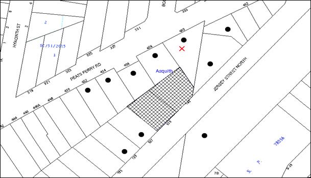
|
NOTIFICATION PLAN |
|
||
|
• PROPERTIES NOTIFIED
|
X SUBMISSIONS RECEIVED |
PROPERTY SUBJECT OF DEVELOPMENT |
|
One submission objected to the development. The grounds of objection are discussed as follows:
5.1.1 Privacy and Noise Impacts
The impact of the proposed development on the amenity of an adjacent dwelling house to the north including visual and acoustic privacy impacts were raised as a concern.
The development has been designed to limit overlooking and privacy impacts in the north-east of the site. On the typical floor plan, one unit adjoins the north-eastern boundary and is provided with a principal open space area adjacent to the living room that overlooks Jersey Street North. Furthermore, the setback of the building to the north-eastern side boundary with No.460 Peats Ferry Road exceeds the HDCP requirements.
The objection has requested that permanent fixed privacy screens be erected on all elevations with an aspect over their property. The adjoining property is also zoned for 5 storey residential apartments, and is capable of being redeveloped in the future. The building setbacks provided will ensure that building separations are able to comply with the HDCP and RFDC controls. Weight must be given to the applicable zoning of the land in the resolution of a dispute as to the appropriate development of any site. Notwithstanding this, the application proposes to erect full height moveable privacy screens on the north eastern elevation balconies.
5.1.2 Fire Safety
Concerns were raised that the proposed setback of the apartment building may result in fire to spread to the adjoining dwelling house. The development is required to comply with the Building Code of Australia which includes measures in relation to fire safety.
5.1.3 Construction Phase Impacts
The submission raises concerns regarding the impact of the proposal on the adjacent dwelling during the construction phase including impacts on air quality from asbestos removal.
The surrounding environment would be safeguarded from asbestos contamination by an appropriate condition to address the proposed demolition of the existing buildings on the site. In addition, consent conditions are recommended in relation to hours of construction, and environmental management during the construction phase.
5.2 Public Agencies
The application was referred the following agencies for comment.
5.2.1 Roads and Maritime Services
The proposal was referred to the Roads and Maritime Services for comments pursuant to the provisions of Section 138 of the Roads Act 1993. No objections were raised subject to recommended conditions of consent.
5.2.2 RailCorp
The application was referred to RailCorp pursuant to the provisions of SEPP Infrastructure as the development involves excavation of land opposite a railway corridor. RailCorp raised no objections subject to the recommendation of a deferred commencement condition requiring the submission of the following information:
· Detailed Geotechnical Report and Structural Drawings;
· Detailed Survey Plans; and
· Detailed cross-sectional drawings showing relationship of the land and the railway infrastructure.
6. THE PUBLIC INTEREST
Section 79C(1)(e) of the Act requires Council to consider “the public interest”.
The public interest is an overarching requirement, which includes the consideration of the matters discussed in this report. Implicit to the public interest is the achievement of future built outcomes adequately responding to and respecting the future desired outcomes expressed in environmental planning instruments and development control plans.
The application is considered to have satisfactorily addressed Council’s and relevant agencies’ criteria and would provide a development outcome that, on balance, would result in a positive impact for the community. Accordingly, it is considered that the approval of the proposed development would be in the public interest.
CONCLUSION
The application seeks approval for the demolition of existing structures and construction of a five storey residential flat building comprising 24 units and basement car parking.
The proposed development is generally in accordance with the development controls for the ‘Jersey Street North, Asquith’ Precinct of the HDCP and would contribute to the future desired five storey residential character of the precinct. The proposal complies with the design principles of SEPP 65 and the Residential Flat Design Code.
The proposal would result in a development that would be in keeping with the desired future character of the precinct. Approval of the application as a deferred commencement is recommended.
Note: At the time of the completion of this planning report, no persons have made a Political Donations Disclosure Statement pursuant to Section 147 of the Environmental Planning and Assessment Act 1979 in respect of the subject planning application.
RESPONSIBLE OFFICER
The officer responsible for the preparation of this Report is the Manager – Development Assessments – Rodney Pickles, who can be contacted on 9847 6731.
|
Rod Pickles Manager - Development Assessment Planning Division |
James Farrington Group Manager Planning Division |
|
1.View |
Locality Map |
|
|
|
2.View |
Site Plan |
|
|
|
3.View |
Landscape Plan |
|
|
|
4.View |
Floor Plans |
|
|
|
5.View |
Elevations |
|
|
|
6.View |
Shadow Diagram |
|
|
|
7.View |
Photomontage |
|
|
|
8.View |
Concept Plans for Adjacent Land |
|
|
File Reference: DA/1275/2013
Document Number: D06696799
SCHEDULE 1
GENERAL CONDITIONS
The conditions of consent within this notice of determination have been applied to ensure that the use of the land and/or building is carried out in such a manner that is consistent with the aims and objectives of the relevant legislation, planning instruments and council policies affecting the land and does not disrupt the amenity of the neighbourhood or impact upon the environment.
Note: For the purpose of this consent, the term ‘applicant’ means any person who has the authority to act on or the benefit of the development consent.
Note: For the purpose of this consent, any reference to an Act, Regulation, Australian Standard or publication by a public authority shall be taken to mean the gazetted Act or Regulation, or adopted Australian Standard or publication as in force on the date that the application for a construction certificate is made.
1. Deferred Commencement
Pursuant to Section 80(3) of the Environmental Planning and Assessment Act 1979, this consent does not operate until the applicant satisfies the Council that it has obtained approval/certification from Sydney Trains as to the following matters:
a) Final Geotechnical and Structural report/drawings: The Geotechnical Report must be based on actual borehole testing conducting on the site closest to the rail corridor.
b) Final Construction methodology with construction details pertaining to structural support during excavation.
c) Final cross sectional drawings showing ground surface, rail tracks, sub soil profile, proposed basement excavation and structural design of sub ground support adjacent to the Rail Corridor. All measurements are to be verified by a Registered Surveyor.
d) Detailed Survey Plan showing the relationship of the proposed developed with respect to Sydney Trains land and infrastructure.
If required by Sydney Trains, an FE analysis which assesses the different staged of loading-unloading of the site and its effect on the rock mass surrounding the rail corridor.
Note: Any conditions issued by part of Sydney Trains approval/certification of the above documents will also form part of the consent conditions that the Applicant is required to comply with.
Such information shall be submitted within 24 months of the date of this notice.
Upon Council’s written satisfaction of the above information, the following conditions of development consent will apply:
2. Approved Plans and Supporting Documentation
The development must be carried out in accordance with the plans and documentation listed below and endorsed with Council’s stamp, except where amended by Council and/or other conditions of this consent:
|
Plan No. |
Plan Title |
Drawn by |
Dated |
|
D000 |
Cover Sheet |
Design Cubicle |
2.10.15 |
|
DA 200 Rev E |
Site Plan Fence Detail |
Design Cubicle |
2.10.15 |
|
DA 201 Rev F |
Basement 2 Plan |
Design Cubicle |
19.10.15 |
|
DA 202 Rev E |
Basement 1 Plan |
Design Cubicle |
2.10.15 |
|
DA 203 Rev E |
Ground Floor Plan |
Design Cubicle |
2.10.15 |
|
DA 204 Rev E |
Typical Floor Plan |
Design Cubicle |
2.10.15 |
|
DA207 Rev A |
Fourth Floor Plan |
Design Cubicle |
2.10.15 |
|
DA208 Rev E |
Roof Plan |
Design Cubicle |
2.10.15 |
|
DA 301 Rev E |
Elevations 1/2 |
Design Cubicle |
2.10.15 |
|
DA302 Rev E |
Elevations 2/2 |
Design Cubicle |
2.10.15 |
|
DA303 Rev E |
Sections |
Design Cubicle |
2.10.15 |
|
Dwg 13131 DA1 Rev E |
Landscape Concept Plan |
Vision Dynamics |
24.7.15 |
|
D00 Rev B |
Cover Sheet |
Smart Engineering Solutions |
30.6.15 |
|
D01 Rev D |
Basement 2 |
Smart Engineering Solutions |
1.07.15 |
|
D02 Rev C |
Basement 1 |
Smart Engineering Solutions |
11.11.13 |
|
D03 Rev A |
Basement stormwater drainage details |
Smart Engineering Solutions |
1.07.15 |
|
D04 Rev D |
Ground Floor Stormwater Drainage Plan |
Smart Engineering Solutions |
24.07.15 |
|
D05 Rev B |
Stormwater Drainage Details |
Smart Engineering Solutions |
30.06.15 |
|
D06 Rev B |
Erosion and Sediment Control Plan |
Smart Engineering Solutions |
1.07.15 |
|
Document Title |
Prepared by |
Dated |
|
Basix Certificate 669702M |
Green Star Energy Solutions |
2.10.15 |
|
External Materials and Finishes D06374208 |
Design Cubicle |
Rec 10.08.15 |
|
Waste Management Plan D06374202 |
Design Cubicle |
June 2015 |
|
Traffic/Rail Noise Assessment Report |
Rodney Stevens |
Nov 2013 |
3. Removal of Existing Trees
This development consent permits the removal of Tree 2 (Lilly Pilly) and Tree 19 (Christmas Bush) located on the site. The removal of any other trees requires separate approval in accordance with the Tree and Vegetation Chapter 1B.6 Hornsby Development Control Plan (HDCP).
4. Construction Certificate
a) A Construction Certificate is required to be approved by Council or a Private Certifying Authority prior to the commencement of any works under this consent.
b) The Construction Certificate plans must not be inconsistent with the Development Consent plans.
5. Section 94 Development Contributions
a) In accordance with Section 80A(1) of the Environmental Planning and Assessment Act 1979 and the Hornsby Shire Council Section 94 Development Contributions Plan 2012-2021, the following monetary contributions shall be paid to Council to cater for the increased demand for community infrastructure resulting from the development:
|
Description |
Contribution (4) |
|
Roads |
$27,484.75 |
|
Open Space and Recreation |
$282,118.50 |
|
Community Facilities |
$39,321.50 |
|
Plan Preparation and Administration |
$1,175.55 |
|
TOTAL |
$350,100.30 |
being for 6 x 1 bedroom, 12 x 2 bedroom and 6 x 3 bedroom units with a credit of 2 lots.
b) The value of this contribution is current as at 20 October 2015. If the contributions are not paid within the financial quarter that this condition was generated, the contributions payable will be adjusted in accordance with the provisions of the Hornsby Shire Council Section 94 Development Contributions Plan and the amount payable will be calculated at the time of payment in the following manner:
$CPY = $CDC x CPIPY
CPIDC
Where:
$CPY is the amount of the contribution at the date of Payment
$CDC is the amount of the contribution as set out in this Development Consent
CPIPY is the latest release of the Consumer Price Index (Sydney – All Groups) at the date of Payment as published by the ABS.
CPIDC is the Consumer Price Index (Sydney – All Groups) for the financial quarter at the date applicable in this Development Consent Condition.
c) The monetary contributions shall be paid to Council:
i) prior to the issue of the Subdivision Certificate where the development is for subdivision; or
ii) prior to the issue of the first Construction Certificate where the development is for building work; or
iii) prior to issue of the Subdivision Certificate or first Construction Certificate, whichever occurs first, where the development involves both subdivision and building work; or
iv) prior to the works commencing where the development does not require a Construction Certificate or Subdivision Certificate.
It is the professional responsibility of the Principal Certifying Authority to ensure that the monetary contributions have been paid to Council in accordance with the above timeframes.
Council’s Development Contributions Plan may be viewed at www.hornsby.nsw.gov.au or a copy may be inspected at Council’s Administration Centre during normal business hours.
REQUIREMENTS PRIOR TO THE ISSUE OF A CONSTRUCTION CERTIFICATE
6. Building Code of Australia
All building work must be carried out in accordance with the relevant requirements of the Building Code of Australia.
7. Contract of Insurance (Residential Building Work)
In the case of residential building work for which the Home Building Act 1989 requires there to be a contract of insurance in force in accordance with Part 6 of that Act, that such a contract of insurance is in force before any building work authorised to be carried out by the consent commences.
8. Notification of Home Building Act, 1989 Requirements
Residential building work within the meaning of the Home Building Act 1989 must not be carried out unless the principal certifying authority for the development to which the work relates (not being Council) has given Council written notice of the following information:
a) In the case of work for which a principal contractor is required to be appointed:
i) The name and licence number of the principal contractor; and
ii) The name of the insurer by which the work is insured under Part 6 of that Act.
b) In the case of work to be done by an owner-builder:
i) The name of the owner-builder; and
ii) If the owner-builder is required to hold an owner-builder’s permit under that Act, the number of the owner-builder’s permit.
Note: If arrangements for doing the residential building work are changed while the work is in progress so that the information notified becomes out of date, further work must not be carried out unless the principal certifying authority for the development to which the work relates (not being Council) has given Council written notification of the updated information.
9. Utility Services
The applicant must submit written evidence of the following service provider requirements:
a) Ausgrid (formerly Energy Australia) – a letter of consent demonstrating that satisfactory arrangements have been made to service the proposed development.
b) Telstra – a letter of consent demonstrating that satisfactory arrangements have been made to service the proposed development.
10. Dilapidation Report
A ‘Dilapidation Report’ is to be prepared by a ‘chartered structural engineer’ detailing the structural condition of the adjoining northern properties at Nos. 454 to 460 Peats Ferry Road Asquith.
11. Noise
The development must be carried out in accordance with the recommendations contained within the Acoustic Noise and Vibration Report prepared by Acoustic Noise and Vibration Solutions Pty Ltd dated 6/05/2015 and the requirements of the Department of Planning’s Development Near Rail Corridors and Busy Roads – Interim Guideline and RailCorp’s Interim Guidelines for Applicants. Details must be submitted with the Construction Certificate plans
Note: The Department of Planning’s document is available at www.planning.nsw.gov.au (development assessments).
12. Adaptable Units
The development is required to provide 8 units designed as adaptable housing pursuant to the requirements of 1C.2.2 of the Hornsby Development Control Plan 2013. In this regard, three (3) car parking spaces are to be designed for people with a disability and allocated to 3 accessible units. Details must be submitted with the Construction Certificate plans.
13. Letter Boxes
The details of letter boxes must be provided with the Construction Certificate Plans. The letter boxes and meter enclosures must be provided with a minimum setback of 2 metres from all boundaries and must be suitably screened
14. Storage
Each dwelling within the development must have a minimum area for storage (not including kitchen and bedroom cupboards) for 6m3 for one bedroom units, 8m3 for two bedroom units and 10m3 for three bedroom units, where 50% is required to be located within the apartment and accessible from either the hall or living area. Details must be submitted with the Construction Certificate plans.
15. Driveway Signalisation Details
Details of the proposed method of signalising the one-lane driveway ramp is to be submitted to Council for approval prior to the issue of a Construction Certificate. This is to include details of:
a) The location and type of signals;
b) A priority system for cars entering the site from Jersey Street North, to avoid queuing onto the public road; and
c) A back up battery system in the event of mains power failure.
16. Traffic Control Plan
In order to enable unencumbered movement of traffic in the public road during construction works, a Construction Management Plan, including a Traffic Management Plan and scaled construction plans prepared by a suitably Chartered and Qualified Chartered Civil Engineer and Qualified Worksite Traffic Controller shall be prepared and submitted to Hornsby Shire Council for approval according to the following requirements:-
a) A copy of the plans shall be submitted for consideration and written approval by Hornsby Shire Council prior to the release of the Construction Certificate
b) The plans shall detail the order of construction works and arrangement of all construction machines and vehicles being used at the same time during all stages.
c) The CTMP plans shall be in accordance with the approved Development Application plans and the Development Consent conditions.
d) In order to prevent injury, accident and loss of property, no building materials, work sheds, vehicles, machines or the like shall be allowed to remain in the road reserve area without the written consent of Hornsby Shire Council.
e) The Plan shall be generally in compliance with the requirements of the Road and Traffic Authority’s “Traffic Control at Worksites Manual 1998” and detailing:
i) Public notification of proposed works;
ii) Long term signage requirements;
iii) Short term (during actual works) signage;
iv) Vehicle Movement Plans, where applicable;
v) Traffic Management Plans;
vi) Pedestrian and Cyclist access and safety;
f) The plans shall indicate traffic controls including those used during non-working hours and shall provide pedestrian access to be facilitated at all times.
g) The plans shall include the proposed truck routes to and from the site including details of the frequency of truck movements at the different stages of the development. The plan shall include details of parking arrangements for all employees and contractors.
h) The Applicant and all employees of contractors on the site must obey any direction or notice from the Prescribed Certifying Authority or Hornsby Shire Council in order to ensure the above.
i) If there is a requirement to obtain a Work Zone, partial Road Closure or Crane Permit an application to Hornsby Shire Council is to be made prior to the issue the Construction Certificate. Due to traffic volumes and nearby traffic signals, separate applications shall be made for Road Occupation Licenses, to be obtained prior to start of road works and a copy forwarded to Hornsby Council.
17. Construction Management Plan
A Construction Management Plan (CMP), prepared by a suitably qualified consultant, must be submitted for approval by Council. The CMP must be include, but not be limited, details of the following:
a) During excavation works, rock removal must be undertaken by sawing instead of rock hammering, wherever practicable;
b) All construction vehicles associated with the proposed development are to be contained on site as no construction zones will be permitted on Jersey Street North in the vicinity of the site.
c) The construction works must be undertaken in accordance with the “Interim Construction Noise Guidelines – 2009” published by DECCW and achieve compliance with the relevant noise levels; and
d) The delivery times and vehicular movements related to demolition, excavation and construction works must be restricted to the construction hours only.
18. Waste Management Details
The following waste management requirements must be complied with:
a) The approved on-going waste management system must not be amended without the written consent of Council.
b) The recycling bin cupboard on each residential level must comfortably house one 240 L recycling bin. (Note: a 240 L recycling bin is 600 mm wide by 750 mm deep; allow for ease around the bin – 75 mm is recommended).
c) The waste facility on each residential level (garbage chute and recycling bin in a small room/cupboard) must be accessible by persons with a disability.
19. Certification of Traffic Engineer
Prior to the issue of a Construction Certificate, a Certificate from an appropriate qualified Traffic Engineer is to be submitted to the Principal Certifying Authority (PCA) certifying that the parking modules, loading areas and garbage collection areas comply with AS 2890.1, AS 2890.2 and the approved Development Consent plans and conditions.
20. Stormwater Drainage
The stormwater drainage system for the development must be designed and constructed in accordance with Council’s Civil Works – Design and Construction Specification 2005 and the following requirements:
a) Connected directly to Council’s street drainage system, or
b) Connected to an existing Council piped drainage pit system.
21. On Site Stormwater Detention and Water Quality
An on-site stormwater detention system must be designed by a chartered civil engineer and constructed in accordance with the following requirements:
a) Have a capacity of not less than 24 cubic metres, and a maximum discharge (when full) of 35 litres per second.
b) Have a surcharge/inspection grate located directly above the outlet. An overflow drainage inlet shall be incorporated into the system.
c) Discharge from the detention system to be controlled via 1 metre length of pipe, not less than 50 millimetres diameter or via a stainless plate with sharply drilled orifice bolted over the face of the outlet discharging into a larger diameter pipe capable of carrying the design flow to an approved Council system.
d) Where above ground and the average depth is greater than 0.3 metres, a ‘pool type’ safety fence and warning signs to be installed.
e) Not be constructed in a location that would impact upon the visual or recreational amenity of residents.
f) A water quality treatment system shall be designed in accordance with HDCP2013 Section 1C.1.2.j. Details shall be prepared by a suitably qualified Engineer and included on construction plans.
22. Internal Driveway/Vehicular Areas
The driveway and parking areas on site must be designed in accordance with Australian Standards 2890.1, 2890.2, 3727 and the following requirements:
a) Design levels at the front boundary must be obtained from Council by a separate application to Council footpath levels;
b) The driveway must be a rigid pavement;
c) Safety rails must be provided where there is a level difference more than 0.3 metres and a 1:4 batter cannot be achieved;
23. Road Works
All road works approved under this consent must be constructed in accordance with Council’s Civil Works Design and Construction Specification 2005 and the following requirements:
a) Roads and Maritime Services (RMS) standard SA kerb and gutter shall be removed and reconstructed across the frontage of the Jersey Street North street boundary.
b) Council’s standard 80 mm thick concrete footpath to be constructed within the footpath verge to match adjoining footpath work, with the remaining area turfed.
c) The existing road pavement to be saw cut a minimum of 600 mm from the existing edge of the bitumen and reconstructed.
d) The submission of a compaction certificate from a geotechnical engineer for any fill within road reserves, and all road sub-grade and road pavement materials.
e) Pursuant to s138 Roads Act 1993, a separate Construction Certificate (CC) application must be made to Hornsby Shire Council as Roads Authority for road works. The Applicant must pay Council’s fees for CC assessment and compliance inspections with lodgement of the application.
24. Vehicular Crossing
A separate application under the Local Government Act 1993 and the Roads Act 1993 must be submitted to Council for the installation of a new vehicular crossing and the removal of the redundant crossing. The vehicular crossing must be constructed in accordance with Council’s Civil Works Design 2005 and the following requirements:
a) The crossing levels supplied by Council are to be used in the design of the crossing;
b) Any redundant crossings must be removed;
c) The footway area must be restored by turfing;
Note: An application for a vehicular crossing can only be made to one of Council’s Authorised Vehicular Crossing Contractors, or be the subject of a Construction Certificate application to Hornsby Shire Council as Roads Authority. You are advised to contact Council on 02 9847 6940 to obtain a list of contractors.
25. Sydney Water – Quick Check
This application must be submitted to a Sydney Water ‘Quick Check Agent’ or ‘Customer Centre’ for approval to determine whether the development would affect any Sydney Water infrastructure, and whether further requirements are to be met.
Note: Refer to www.sydneywater.com.au or telephone 13 20 92 for assistance.
26. Identification of Survey Infrastructure
Prior to the issue of a construction certificate, a registered surveyor shall identify all survey marks in the vicinity of the proposed development. Any survey marks required to be removed or displaced as a result of the proposed development shall be undertaken by a registered surveyor in accordance with Section 24 (1) of the Surveying and Spatial Information Act 2002 and following the Surveyor General’s Directions No.11 – "Preservation of Survey Infrastructure".
REQUIREMENTS PRIOR TO THE COMMENCEMENT OF ANY WORKS
27. Erection of Construction Sign
A sign must be erected in a prominent position on any site on which building work, subdivision work or demolition work is being carried out:
a) Showing the name, address and telephone number of the principal certifying authority for the work;
b) Showing the name of the principal contractor (if any) for any demolition or building work and a telephone number on which that person may be contacted outside working hours; and
c) Stating that unauthorised entry to the work site is prohibited.
Note: Any such sign is to be maintained while the building work, subdivision work or demolition work is being carried out, but must be removed when the work has been completed.
28. Protection of Adjoining Areas
A temporary hoarding, fence or awning must be erected between the work site and adjoining lands before the works begin and must be kept in place until after the completion of the works if the works:
a) Could cause a danger, obstruction or inconvenience to pedestrian or vehicular traffic.
b) Could cause damage to adjoining lands by falling objects.
c) Involve the enclosure of a public place or part of a public place.
Note: Notwithstanding the above, Council’s separate written approval is required prior to the erection of any structure or other obstruction on public land.
29. Toilet Facilities
Toilet facilities must be available or provided at the works site before works begin and must be maintained until the works are completed at a ratio of one toilet for every 20 persons employed at the site. Each toilet must:
a) be a standard flushing toilet connected to a public sewer; or
b) be a temporary chemical closet approved under the Local Government Act 1993; or
c) have an on-site effluent disposal system approved under the Local Government Act 1993.
30. Erosion and Sediment Control
Erosion and sediment control measures must be provided and maintained throughout the construction period in accordance with the manual ‘Soils and Construction 2004 (Bluebook)’, the approved plans, Council specifications and to the satisfaction of the principal certifying authority. The erosion and sediment control devices must remain in place until the site has been stabilised and revegetated.
Note: On the spot penalties may be issued for any non-compliance with this requirement without any further notification or warning.
31. Tree Protection Barriers
Tree 21 which is an exotic tree proposed to be retained, must have tree protection zone fencing installed in accordance with the Australian Standard ‘Protection of Trees on Development Sites’ - AS 4970-2009.
REQUIREMENTS DURING CONSTRUCTION
32. Construction Work Hours
All work on site (including demolition and earth works) must only occur between 7am and 5pm Monday to Saturday. No work is to be undertaken on Sundays or public holidays. No excavation or rock sawing/breaking is to occur on Saturdays.
33. Demolition
All demolition work must be carried out in accordance with “Australian Standard 2601-2001 – The Demolition of Structures” and the following requirements:
a) Demolition material must be disposed of to an authorised recycling and/or waste disposal site and/or in accordance with an approved waste management plan;
b) Demolition works, where asbestos material is being removed, must be undertaken by a contractor that holds an appropriate licence issued by WorkCover NSW in accordance with Chapter 10 of the Occupational Health and Safety Regulation 2001 and Clause 29 of the Protection of the Environment Operations (Waste) Regulation 2005 ;and
c) On construction sites where buildings contain asbestos material, a standard commercially manufactured sign containing the words ‘DANGER ASBESTOS REMOVAL IN PROGRESS’ measuring not less than 400mm x 300mm must be erected in a prominent position visible from the street.
34. Environmental Management
The site must be managed in accordance with the publication ‘Managing Urban Stormwater – Landcom (March 2004) and the Protection of the Environment Operations Act 1997 by way of implementing appropriate measures to prevent sediment run-off, excessive dust, noise or odour emanating from the site during the construction of the development.
35. Asbestos and Soil Contamination
Should the presence of asbestos or soil contamination, not recognised during the application process be identified during works, the applicant must immediately notify the principal certifying authority and Council.
36. Street Sweeping
Street sweeping must be undertaken following sediment tracking from the site along Jersey Street North and until the site is established.
The street cleaning services must undertake a street ‘scrub and dry’ method of service and not a dry sweeping service that may cause sediment tracking to spread or cause a dust nuisance.
37. Works Near Trees
All required tree protection measures are to be maintained in good condition for the duration of the construction period.
38. Council Property
During construction works, no building materials, waste, machinery or related matter is to be stored on the road or footpath. The public reserve must be kept in a clean, tidy and safe condition at all times.
39. Disturbance of Existing Site
During construction works, the existing ground levels of open space areas and natural landscape features, (including natural rock-outcrops, vegetation, soil and watercourses) must not be altered unless otherwise nominated on the approved plans.
40. Landfill
Landfill must be constructed in accordance with Council’s ‘Construction Specification 2005’ and the following requirements:
a) All fill material imported to the site is to wholly consist of Virgin Excavated Natural Material (VENM) as defined in Schedule 1 of the Protection of the Environment Operations Act 1997 or a material approved under the Department of Environment and Climate Change’s general resource recovery exemption.
b) A compaction certificate is to be obtained from a geotechnical engineer verifying that the specified compaction requirements have been met.
41. Excavated Material
All excavated material removed from the site must be classified in accordance with the Department of Environment, Climate Change and Water NSW Waste Classification Guidelines prior to disposal to an approved waste management facility and reported to the principal certifying authority.
42. Survey Report
A report(s) must be prepared by a registered surveyor and submitted to the principal certifying authority;
a) Prior to the pouring of concrete at each level of the building certifying that:
i) The building, retaining walls and the like have been correctly positioned on the site; and
ii) The finished floor level(s) are in accordance with the approved plans.
b) Confirming that the waste collection vehicle turning area complies with AS2890.1 – 2004 and AS20890.2 – 2002 for small rigid vehicles (SRV).
43. Waste Management Details
Waste management during the demolition and construction phase of the development must be undertaken in accordance with the approved Waste Management Plan. Additionally written records of the following items must be maintained during the removal of any waste from the site and such information submitted to the Principal Certifying Authority within fourteen days of the date of completion of the works:
a) The identity of the person removing the waste.
b) The waste carrier vehicle registration.
c) Date and time of waste collection.
d) A description of the waste (type of waste and estimated quantity).
e) Details of the site to which the waste is to be taken.
f) The corresponding tip docket/receipt from the site to which the waste is transferred (noting date and time of delivery, description (type and quantity) of waste).
g) Whether the waste is expected to be reused, recycled or go to landfill.
Note: In accordance with the Protection of the Environment Operations Act 1997, the definition of waste includes any unwanted substance, regardless of whether it is reused, recycled or disposed to landfill.
REQUIREMENTS PRIOR TO THE ISSUE OF AN OCCUPATION CERTIFICATE
Note: For the purpose of this consent, a reference to ‘occupation certificate’ shall not be taken to mean an ‘interim occupation certificate’ unless otherwise stated.
44. Fulfilment of BASIX Commitments
The applicant must demonstrate the fulfilment of BASIX commitments pertaining to the development.
45. Sydney Water – s73 Certificate
An s73 Certificate must be obtained from Sydney Water.
Note: Sydney Water requires that s73 applications are to be made through an authorised Sydney Water Servicing Coordinator. Refer to www.sydneywater.com.au or telephone 13 20 92 for assistance.
46. Damage to Council Assets
Any damage caused to Council’s assets as a result of the construction or demolition of the development must be rectified in accordance with Council’s Civil Works Specifications. Council’s Restorations Supervision must be notified for a formwork inspection prior to pouring concrete
47. Creation of Easements
The following matter(s) must be nominated on the plan of subdivision under s88B of the Conveyancing Act 1919:
a) The creation of an appropriate "Positive Covenant" and "Restriction as to User" over the constructed on-site detention/retention systems and outlet works, within the lots in favour of Council in accordance with Council’s prescribed wording. The position of the on-site detention system is to be clearly indicated on the title.
b) To register the OSD easement, the restriction on the use of land “works-as-executed” details of the on-site-detention system must be submitted verifying that the required storage and discharge rates have been constructed in accordance with the design requirements. The details must show the invert levels of the on-site system together with pipe sizes and grades. Any variations to the approved plans must be shown in red on the “works-as-executed” plan and supported by calculations.
Note: Council must be nominated as the authority to release, vary or modify any easement, restriction or covenant.
48. Internal Driveway/Vehicular Areas
The driveway and parking areas on site must be designed in accordance with Australian Standards 2890.1, 2890.2, 3727 and the following requirements:
a) All parking areas and driveways are to be sealed to an all-weather standard, line marked and signposted;
b) Residential parking spaces are to be secure spaces with access controlled by card or numeric pad;
c) Visitors are to be able to access the basement car park by an audio/visual intercom system located at the top of the ramped driveway.
d) Eight bicycle spaces (resident and visitor) are to be provided in the basement car park. Bicycle parking spaces are to be designed in accordance with AS 2890.3-1993;
e) One motorcycle parking spaces are to be provided within the basement car park, designed in accordance with AS 2890.5-1993;
f) All parking for people with disabilities is to comply with AS/NZS 2890.6:2009 Off-street parking for people with disabilities; and
g) SRV garbage truck access to the site be provided in accordance with the approved plans.
h) The location of the driveway must maintain sight lines for pedestrians.
49. Works as Executed Plan
A works-as-executed plan(s) must be prepared by a registered surveyor and submitted to Council for completed road pavement, kerb & gutter, public drainage systems with water quality measures, driveways and on-site detention system.
50. Damage to Council Assets
Any damage caused to Council’s assets as a result of the construction or demolition of the development must be rectified in accordance with Council’s Civil Works Specifications. Council’s Restorations Supervision must be notified for a formwork inspection prior to pouring concrete.
51. Garbage Collection Easement
For the purpose of waste collection, an easement entitling Council, its servants and agents and persons authorised by it to enter upon the subject land and to operate thereon, vehicles and other equipment for the purposes of garbage collection must be granted to Council by the owner of the land.
Note: The easement must be in a form prescribed by Council and must include covenants to the effect that parties will not be liable for any damage caused to the subject land or any part thereof or to any property located therein or thereon by reason of the operation thereon of any vehicle or other equipment used in connection with the collection of garbage and to the effect that the owner for the time being of the subject land shall indemnify the Council, its servants, agents and persons authorised by it to collect garbage against liability in respect of any such claims made by any person whomsoever.
52. Waste Management
The following waste management requirements must be complied with:
a) Prior to an Occupation Certificate being issued or the use commencing, whichever is earlier, the Principal Certifying Authority must obtain Council’s approval of the waste and recycling management facilities provided in the development and ensure arrangements are in place for domestic waste collection by Council.
Note: Waste and recycling management facilities includes everything required for on-going waste management on the site. For example the garbage chute system, volume handling equipment, bin lifter, motorised bin trolley or similar, recycling bin storage on each residential level, bin storage areas, bulky waste storage area, bin collection area, waste collection vehicle access, doors wide enough to fit the bin through, etc.
b) The garbage room at the basement levels must include water or a hose for cleaning, graded floors with drainage to sewer, a robust door, sealed and impervious surface, adequate lighting and ventilation, and must be lockable. The waste facility rooms/cupboards at each residential level must include sealed and impervious surface, adequate lighting and ventilation.
c) A report must be prepared by an appropriately qualified person, certifying the following:
i) A comparison of the estimated quantities of each waste type against the actual quantities of each waste type.
Note: Explanations of any deviations to the approved Waste Management Plan is required to be included in this report.
ii) That at least 60% of the waste generated during the demolition and construction phase of the development was reused or recycled.
Note: If the 60% diversion from landfill cannot be achieved in the Construction Stage, the Report is to include the reasons why this occurred and certify that appropriate work practices were employed to implement the approved Waste Management Plan. The Report must be based on documentary evidence such as tipping dockets/receipts from recycling depots, transfer stations and landfills, audits of procedures etc. which are to be attached to the report.
iii) All waste was taken to site(s) that were lawfully permitted to accept that waste.
d) Each unit must be provided with an indoor waste/recycling cupboard for the interim storage of a minimum one day’s waste generation with separate containers for general waste and recyclable materials.
e) Space must be provided for either individual compost containers for each unit or a communal compost container.
Note: The location of the compost containers should have regard for potential amenity impacts.
f) The bin carting routes must be devoid of any steps.
Note: Ramps between different levels are acceptable.
g) Access to the automatic waste volume handling equipment by unauthorised persons (including residents and waste collectors) must be prevented.
Note: Caging of the automatic volume handling equipment is acceptable.
h) The 3.5 metre clearance height within the waste collection vehicle travel path must not be reduced by ducting, lights, pipes or anything else.
i) Site security measures implemented on the property, including electronic gates, must not prevent access to the collection point by waste removal services.
53. External Lighting
All external lighting must be designed and installed in accordance with Australian Standard AS 4282 – Control of the Obtrusive Effects of Outdoor Lighting. Certification of compliance with the Standard must be obtained from a suitably qualified person.
54. Safety and Security
This site must include the following elements:
a) An intercom system must be installed at gate locations to ensure screening of persons entering the units.
b) The entry doors to the pedestrian foyer is to be constructed of safety rated glass to enable residents a clear line of site before entering or exiting the residential apartments.
c) Lighting is to be provided to pathways, building foyer entries, driveways and common external spaces.
d) Security gate access is to be provided to the car parking areas allowing residents-only access to private car spaces.
e) CCTV cameras must be installed at the entry and exit point and the around the mailbox.
f) The communal open spaces within the site must be illuminated with high luminance by motion sensor lighting.
g) The driveway and basement car parking must be illuminated with low luminance at all times.
h) Security deadlocks are to be provided to each apartment door.
i) Peep holes are to be provided to individual apartment doors to promote resident safety.
55. Retaining Walls
All required retaining walls must be constructed as part of the development.
56. Unit Numbering
All units are to be numbered consecutively commencing at No.1. The strata plan lot number is to coincide with the unit number, e.g. unit 1 = lot 1. The allocation of unit numbering must be authorised by Council prior to the numbering of each unit in the development.
57. Provision for National Broadband Network (NBN)
Provision must be made for fibre ready passive infrastructure (pits and pipes) generally in accordance with NBN Co.'s pit and pipe installation guidelines to service the proposed development. A certificate from NBN Co or the provider must be submitted to the PCA that the fibre optic cabling provided for the development complies with MDU Building Design Guides for Development.
58. Boundary Fencing
Fencing must be erected along all property boundaries behind the front building alignment to a height of 1.8 metres.
Note: Alternative fencing on the side and rear boundaries may be erected subject to the written consent of the adjoining property owner(s).
59. Maintain Canopy Cover
The approved Landscape plan is to be amended as follows to provide medium to large indigenous trees along the rear property boundary:
a) Trees numbered T4, T15 and T16 be removed and replaced with three (3) Acmena smithii (Lilly Pilly);
b) Tree T7 be removed and replaced with one (1) Elaeocarpus reticulatus (Blueberry Ash).
60. Completion of Landscaping
A certificate must be provided by a practicing landscape architect, horticulturalist or person with similar qualifications and experience certifying that all required landscaping works have been satisfactorily completed in accordance with the approved Landscape plans and the following requirements:
a) Tree plantings for must be located at least 4 metres or greater from the foundation walls of the building;
b) The pot size of the replacement trees must be a minimum 25 litres;
c) The replacement trees must be maintained until they reach the height of 3 metres;
d) All tree stock must meet the specifications outlined in ‘Specifying Trees’ (Ross Clark, NATSPEC Books);
e) Planting methods must meet professional (best practice) industry standards; and
f) On slab planter boxes must include waterproofing, subsoil drainage (proprietary drainage cell, 50mm sand and filter fabric) automatic irrigation, minimum 500mm planting soil for shrubs and minimum 1000mm planting soil for trees and palms and 75mm mulch to ensure sustainable landscape is achieved.
Note: Advice on suitable species for landscaping can be obtained from Council’s planting guide ‘Indigenous Plants for the Bushland Shire’, available at www.hornsby.nsw.gov.au.
61. Final Certification Acoustic Consultant
A final certificate must be provided by the Acoustic Consultant stating that the recommended measures within the approved Acoustic Report have been complied with.
62. Consolidation of Allotments
All allotments the subject of this consent must be consolidated into one allotment.
Note: The applicant is recommended to submit the plan of subdivision to consolidate allotments to the NSW Department of Lands at least 4-6 weeks prior to seeking an occupation certificate.
63. Certification of Preservation of Survey Infrastructure
A certificate by a Registered Surveyor shall be submitted to the Principal Certifying Authority, certifying that there has been no removal, damage, destruction, displacement or defacing of the existing survey marks in the vicinity of the proposed development or otherwise the re-establishment of damaged, removed or displaced survey marks has been undertaken in accordance with the Surveyor General’s Direction No.11 – “Preservation of Survey Infrastructure”.
OPERATIONAL CONDITIONS
64. Landscape Establishment
The landscape works must be maintained into the future to ensure the establishment and successful growth of plant material to meet the intent of the landscape design. This must include but not limited to watering, weeding, replacement of failed plant material and promoting the growth of plants through standard industry practices.
65. Car Parking and Deliveries
All car parking must be operated in accordance with Australian Standard AS 2890.1 – 2004 – Off Street Car Parking and Australian Standard 2890.2 - 2002 – Off Street Commercial and the following requirements:
a) All parking areas and driveways are to be sealed to an all-weather standard, line marked and signposted at all times.
b) Car parking, loading and manoeuvring areas to be used solely for nominated purposes.
c) Vehicles awaiting loading, unloading or servicing shall be parked on site and not on adjacent or nearby public roads;
d) All vehicular entry on to the site and egress from the site shall be made in a forward direction.
66. Sight Lines
Minimum sight lines for pedestrian safety are to be provided at the driveway. Any proposed landscaping and/or fencing must not restrict sight distance to pedestrians and cyclists travelling along the footpath.
67. Waste Management
A site caretaker must be employed and be responsible for moving bins where and when necessary, washing bins and maintaining waste storage areas, ensuring the chute system and related devices are maintained in effective and efficient working order, managing the communal composting area, managing the bulky item storage area, arranging the prompt removal of dumped rubbish, and ensuring all residents are informed of the use of the waste management system. The site caretaker must be employed for a sufficient number of hours each week to allow all waste management responsibilities to be carried out to a satisfactory standard.
68. Fire Safety Statement - Annual
On at least one occasion in every 12 month period following the date of the first ‘Fire Safety Certificate’ issued for the property, the owner must provide Council with an annual ‘Fire Safety Certificate’ to each essential service installed in the building.
69. Noise
All noise generated by the proposed development must be attenuated to prevent levels of noise being emitted to adjacent premises which possess tonal, beating and similar characteristics or which exceeds background noise levels by more than 5dB(A).
GENERAL TERMS OF APPROVAL – SYDNEY TRAINS
The following conditions of consent are General Terms of Approval from the nominated State Agency pursuant to Section 91A of the Environmental Planning and Assessment Act 1979 and must be complied with to the satisfaction of that Agency.
70. Operational Conditions
a) Prior to the issuing of an Occupation Certificate the Applicant is to submit as-built drawings to Sydney Trains and Council. The as-built drawings are to be endorsed by a Registered Surveyor confirming that there has been no encroachment into Sydney Trains property or easements, unless agreed to be these authorities.
b) The Principal Certifying Authority is not to issue the final Occupation Certificate until written confirmation has been received from Sydney Trains confirming that this condition has been satisfied
c) No rock anchors/bolts are to be installed into RailCorp's property.
d) Sydney Trains or Transport for NSW (TfNSW), and persons authorised by those entities for the purpose of this condition, are entitled to inspect the site of the development and all structures to enable it to consider whether those structures have been or are being constructed and maintained in accordance with the approved plans and these conditions of consent, on giving reasonable notice to the principal contractor for the development or the owner or occupier of the part of the site to which access is sought.
e) If required by Sydney Trains, prior to the commencement of works, prior to the issue of the Occupation Certificate, or at any time during the excavation and construction period deemed necessary by Sydney Trains, a joint inspection of the rail infrastructure and property in the vicinity of the project is to be carried out by representatives from Sydney Trains and the Applicant. These dilapidation surveys will establish the extent of any existing damage and enable any deterioration during construction to be observed. The submission of a detailed dilapidation report will be required unless otherwise notified by Sydney Trains.
f) An acoustic assessment is to be submitted to Council prior to the issue of a construction certificate demonstrating how the proposed development will comply with the Department of Planning’s document titled “Development Near Rail Corridors and Busy Roads- Interim Guidelines”.
g) Prior to the issue of a Construction Certificate the Applicant is to engage an Electrolysis Expert to prepare a report on the Electrolysis Risk to the development from stray currents. The Applicant must incorporate in the development all the measures recommended in the report to control that risk. A copy of the report is to be provided to the Principal Certifying Authority with the application for a Construction Certificate.
h) If required by Sydney Trains, prior to the issue of a Construction Certificate a Risk Assessment/Management Plan and detailed Safe Work Method Statements (SWMS) for the proposed works are to be submitted to Sydney Trains for review and comment on the impacts on rail corridor. The Principal Certifying Authority is not to issue the Construction Certificate until written confirmation has been received from Sydney Trains confirming that this condition has been satisfied.
i) Prior to the issuing of a Construction Certificate the Applicant is to submit to Sydney Trains a plan showing all craneage and other aerial operations for the development and must comply with all Sydney Trains requirements. It should be noted that craneage and other aerial operations will not be permitted over or in close proximity of the adjacent Sydney Trains high voltage power line. If required by Sydney Trains, the Applicant must amend the plan showing all craneage and other aerial operations to comply with all Sydney Trains requirements. The Principal Certifying Authority is not to issue the Construction Certificate until written confirmation has been received from the Sydney Trains confirming that this condition has been satisfied.
j) Copies of any certificates, drawings, approvals/certification or documents endorsed by, given to or issued by Sydney Trains must be submitted to Council for its records prior to the issuing of a Construction Certificate.
CONDITIONS OF CONCURRENCE – ROADS AND MARITIME SERVICES
The following conditions of consent are from the nominated State Agency pursuant to Section 79B of the Environmental Planning and Assessment Act 1979 and must be complied with to the satisfaction of that Agency.
71. Driveway Design
a) The access driveway width is to be a minimum 5.5 metres for at least 6 metres from the property line as per AS2890.1:2004.
b) The design and construction of the vehicular crossing on Jersey Street North shall be in accordance with RMS’s requirements. Details of these requirements should be obtained from RMS’s Project Services Manager, Traffic Projects Section, Parramatta (Telephone 8849-2496).
c) Detailed design plans of the proposed vehicular crossing are to be submitted to RMS for approval prior to the commencement of any road works.
d) A plan checking fee (amount to be advised) and the lodgement of a performance bond may be required from the applicant prior to the release of the approved road design plans by RMS.
72. Construction Work Zone
All construction activity associated with the proposed development is to be contained on site as no construction zones will be permitted on Jersey Street North in the vicinity of the site.
73. Road Occupancy License
A Road Occupancy License should be obtained from TMC for any works that may impact on traffic flows on Jersey Street North during construction activities.
74. Construction Traffic Management Plan
A Construction Traffic Management Plan detailing construction vehicle routes, number of trucks, hours of operation, access arrangements and traffic control should be submitted to RMS for determination prior to the issue of a construction certificate.
75. Swept Path
The swept path of the longest vehicle (to service the site) entering and exiting the subject site, as well as manoeuvrability through the site, shall be in accordance with AUSTROADS.
76. Stormwater
Should the post development storm water discharge from the subject site into the RMS system exceed the pre-development discharge, detailed design plans and hydraulic calculations of any charges are to be submitted to the RMS for approval, prior to the commencement of works.
Details should be forwarded to
Sydney Asset Management
Roads and Maritime Services
PO BOX 973 Parramatta CBD 2124
77. Car Park Design
The layout of the proposed car parking areas associated with the subject development (including driveways, grades, turn paths, sight distance requirements, aisle widths, aisle lengths and parking bay dimensions) should be in accordance with AS2890.1-2004.
78. Road Traffic Noise
The proposed development should be designed such that road traffic noise from adjacent public roads us mitigated by durable materials, in accordance with EPA criteria for new land use developments (The Environmental Criteria for Road Traffic Noise, May 1999). The RMS’s Environmental Noise Management Manual provides practical advice in selecting mitigation treatments.
79. Site Excavation and Support
The developer is to submit design drawings and documents relating to the excavation of the site and support structures to RMS for assessment, in accordance with Technical Direction GTD2012/001.
The developer is to submit all documentation at least six (6) weeks prior to commencement of construction and is to meet the full cost of assessment by RMS.
The report and any enquiries should be forwarded to:
Project Engineer, External Works
Sydney Asset Management
Roads and Maritime Services
PO Box 973 Parramatta CBD 2124
Telephone 8849 2114
Fax 8849 2766
If it is necessary to excavate below the level of the base of the footings of the adjoining roadways, the person acting on the consent shall ensure that the owner/s of the roadway is/are given at least seven (7) day notice of intention to excavate below the base of the footings. The notice is to include complete details of the work.
80. All works/ regulatory signposting associated with the proposed development are to be at no cost to the RMS
81. Any proposed landscaping and/or fencing must not restrict sight distances to pedestrians and cyclists travelling along the footpath.
82. All redundant driveways shall be removed and replaced with kerb and gutter to RMS requirements.
83. All vehicles are to enter and exit the site in a forward direction.
- END OF CONDITIONS -
ADVISORY NOTES
The following information is provided for your assistance to ensure compliance with the Environmental Planning and Assessment Act, 1979, Environmental Planning and Assessment Regulation 2000, other relevant legislation and Council’s policies and specifications. This information does not form part of the conditions of development consent pursuant to Section 80a of the Act.
Environmental Planning and Assessment Act 1979 Requirements
The Environmental Planning and Assessment Act 1979 requires:
· The issue of a construction certificate prior to the commencement of any works. Enquiries can be made to Council’s Customer Services Branch on 9847 6760.
· A principal certifying authority to be nominated and Council notified of that appointment prior to the commencement of any works.
· Council to be given at least two days written notice prior to the commencement of any works.
· Mandatory inspections of nominated stages of the construction inspected.
· An occupation certificate to be issued before occupying any building or commencing the use of the land.
Long Service Levy
In accordance with Section 34 of the Building and Construction Industry Long Service Payments Act 1986, a ‘Long Service Levy’ must be paid to the Long Service Payments Corporation or Hornsby Council.
Note: The rate of the Long Service Levy is 0.35% of the total cost of the work.
Note: Hornsby Council requires the payment of the Long Service Levy prior to the issue of a construction certificate.
Tree and Vegetation Preservation
In accordance with Clause 5.9 of the Hornsby Local Environmental Plan 2013 a person must not ringbark, cut down, top, lop, remove, injure or wilfully destroy any tree or other vegetation protected under the Hornsby Development Control Plan 2013 without the authority conferred by a development consent or a permit granted by Council.
Notes: A tree is defined as a long lived, woody perennial plant with one or relatively few main stems with the potential to grow to a height greater than three metres (3M). (HDCP 1B.6.1.c).
Tree protection measures and distances are determined using the Australian Standard AS 4970:2009, “Protection of Trees on Development Sites”.
Fines may be imposed for non-compliance with both the Hornsby Local Environmental Plan 2013 and the Hornsby Development Control Plan 2013.
Disability Discrimination Act
The applicant’s attention is drawn to the existence of the Disability Discrimination Act. A construction certificate is required to be obtained for the proposed building/s, which will provide consideration under the Building Code of Australia, however, the development may not comply with the requirements of the Disability Discrimination Act. This is the sole responsibility of the applicant.
Covenants
The land upon which the subject building is to be constructed may be affected by restrictive covenants. Council issues this approval without enquiry as to whether any restrictive covenant affecting the land would be breached by the construction of the building, the subject of this consent. Applicants must rely on their own enquiries as to whether or not the building breaches any such covenant.
Dial Before You Dig
Prior to commencing any works, the applicant is encouraged to contact Dial Before You Dig on 1100 or www.dialbeforeyoudig.com.au for free information on potential underground pipes and cables within the vicinity of the development site.
Telecommunications Act 1997 (Commonwealth)
If you are aware of any works or proposed works which may affect or impact on Telstra’s assets in any way, you are required to contact: Telstra’s Network Integrity Team on Phone Number 1800810443.
Unit Numbering
Unit numbering can only be authorised by Council. Before proceeding to number each premise in the development, the allocation of numbers is required to be obtained from Council's Planning Division prior to the issue of a Subdivision Certificate. The authorised numbers are required to comply with Council’s Property Numbering Policy and be displayed in a clear manner at or near the main entrance to each premise.
Occupation Certificate Requirements
An Occupation Certificate application is required to be lodged with the Principal Certifying Authority containing the following information:
· A certificate by a Registered Surveyor shall be submitted to the Principal Certifying Authority, certifying that there has been no removal, damage, destruction, displacement or defacing of the existing survey marks in the vicinity of the proposed development, or otherwise certifying that the necessary re-establishment of any damaged, removed or displaced survey marks has been undertaken in accordance with the Surveyor General’s Direction No. 11 – “Preservation of Survey Infrastructure”.
Note: The PCA will not issue an Occupation Certificate until all conditions of the development consent
Group Manager’s Report No. PL78/15
Planning Division
Date of Meeting: 11/11/2015
13 DEVELOPMENT APPLICATION - EXPANSION TO MT WILGA PRIVATE HOSPITAL - 66 ROSAMOND STREET, HORNSBY
EXECUTIVE SUMMARY
|
DA No: |
DA/813/2015 (Lodged on 3 July 2015) |
|
Description: |
Alterations and additions to Mt Wilga Private Hospital |
|
Property: |
Lot 100 DP 1166007, No. 66 Rosamond Street Hornsby |
|
Applicant: |
Mt Wilga Pty Ltd |
|
Owner: |
Mt Wilga Pty Ltd |
|
Estimated Value: |
$7,295,492 |
|
Ward: |
A |
· The application involves alterations and additions to Mt Wilga Private Hospital including an additional 38 patient rooms.
· The use of the property benefits from Existing Use Rights subject to the provisions of the Environmental Planning and Assessment Act 1979. The proposal has been sensitively designed to respect the heritage significance of the site and the adjacent State heritage listed property. The new building, car parking arrangements and landscaping would also complement the existing facilities and plantings within the site. The provision of on-site car parking complies with RMS guidelines.
· Seven submissions have been received in respect of the application.
· It is recommended that the application be approved.
|
THAT Development Application No. DA/813/2015 for alterations and additions to Mt Wilga Private Hospital at Lot 100 DP 1166007, No. 66 Rosamond Street, Hornsby be approved subject to the conditions of consent detailed in Schedule 1 of Group Manager’s Report No. PL78/15. |
BACKGROUND
Between 1907 and 1925, the Marcus Clark Family developed the Mt Wilga property as a residential homestead.
In 1952, the property was sold to the Commonwealth Government and was subsequently developed and used as a rehabilitation hospital until 1987. Over the 35 years of occupation by the Commonwealth, the grounds surrounding the house were developed with an array of buildings to house the hospital.
On 9 January 1989, Council approved Development Application No. DA/391/1988 for the subdivision of the land into two allotments. The southern area (Lot 2 DP 792198) that comprised Mt Wilga house was to be sold and the northern lot (Lot 1 DP 792198) would continue to house the operations of Mt Wilga Private Hospital. The land previously known as Lot 2 incorporates the land the subject of the current application.
On 9 January 1992, Council approved Development Application No. DA/419/1991 for “the conservation and use of Mt Wilga house for administration purposes and meetings, and refurbishment of existing caretaker’s residence.” The consent applied to the southern lot (Lot 2). These works were known as Stage 1 of the Buddhist Temple and Administration Centre (Soka Gakkai).
On 22 February 1994, Development Application No. DA/689/1993 for “the refurbishment of Building 4 for worship and meetings, use of Building 1A for main switchboard and fire pump rooms and site works and services” was approved by Council. This consent applied to the southern lot (Lot 2). These works were Stage 2 of the Buddhist Temple and Administration Centre.
On 24 February 2000, Council approved Development Application No. DA/2355/1999 for an 81 unit aged housing development on the southern lot.
On 17 December 2008, Council approved Development Application No. DA/928/2007 for a 91 unit aged housing development as a deferred commencement consent on the southern lot.
On 23 May 2011, Development Application No. DA/1619/2010 was approved to subdivide the southern lot into two lots. The application created a separate allotment for the heritage listed building Mt Wilga. The residual lot to the west was consolidated with the Mt Wilga Private Hospital facility on the northern lot.
On 7 September 2011, Council approved Development Application No. DA/224/2011 for alterations and additions to Mt Wilga Private Hospital to provide additional patient wards and associated facilities within a new single storey building wing in the south of the site. The development comprised thirty single bed patient rooms, nurse station, group therapy room/s, gymnasium, three offices and associated utility and storage rooms.
On 16 November 2011, a Section 96(2) application to Development Application No. DA/224/2011 was approved to increase the number of new patient beds from 30 to 39, minor internal reconfiguration and provision of additional parking.
On 21 March 2012, a Section 96(2) application to Development Application No. DA/224/2011 was approved to modify the approved parking arrangement.
SITE
The site of Mt Wilga Private Hospital is identified as Lot 100 DP 1166007 and known as No. 66 Rosamond Street, Hornsby. The site is bounded by Manor Road and Rosamond Street to the south and east. The land has a moderate slope from the north east to the south western boundary. A significant stand of trees is located on the southern side of the site adjoining Manor Road.
Mt Wilga Hospital comprises a series of one and two storey buildings accommodating a total of 119 patient beds, comprising the original 80 bed facility (60 single rooms and 10 shared rooms) plus the new 39 bed facility approved via DA/224/2011. The current day-time staffing is 150 persons.
Access to the site is via a driveway from Rosamond Street to a 105 space car park in the north of the site. A secondary driveway is provided via Manor Road to a 55 space car park in the south of the site.
Adjacent to the site, at No. 2A Manor Road, is Mt Wilga House, which is listed on the State Heritage register (SHR). The grounds around Mt Wilga House are landscaped with grassed lawns, interspersed with mature trees and lower vegetation.
PROPOSAL
The proposal seeks approval for the extension of the existing Mount Wilga Private Hospital to provide additional patient wards and associated facilities within a new single storey building wing. The building is to be constructed of face brickwork and cladding in a colour scheme to match the recent ward building. The lower ground structure is to be concrete blockwork in a sandstone colour and the roof is to be green Colorbond to match the existing ward building.
The proposed development is comprised of the following components:
· 38 single bed patient rooms;
· Nurse stations;
· Two offices;
· Multi-purpose room;
· Utility rooms, staff tea room, storeroom and toilet.
Although the proposal plans show 40 new rooms, the proposal requires two existing rooms from the hospital to be removed to facilitate the extension, providing a net increase of 38 patient rooms.
The proposal includes an additional 17 car spaces via a small extension to the existing car park adjacent to Manor Road.
Staffing for the new ward would involve 10 morning staff, 9 evening staff and 3 night time staff.
ASSESSMENT
The development application has been assessed having regard to ‘A Plan for Growing Sydney’, the ‘North Subregion (Draft) Subregional Strategy’ and the matters for consideration prescribed under Section 79C of the Environmental Planning and Assessment Act 1979 (the Act). The following issues have been identified for further consideration.
1. STRATEGIC CONTEXT
1.1 A Plan for Growing Sydney and (Draft) North Subregional Strategy
A Plan for Growing Sydney has been prepared by the NSW State Government to guide land use planning decisions for the next 20 years. The Plan sets a strategy for accommodating Sydney’s future population growth and identifies the need to deliver 689,000 new jobs and 664,000 new homes by 2031. The Plan identifies that the most suitable areas for new housing are in locations close to jobs, public transport, community facilities and services.
The NSW Government will use the subregional planning process to define objectives and set goals for job creation, housing supply and choice in each subregion. Hornsby Shire has been grouped with Hunters Hill, Ku-ring-gai, Lane Cove, Manly, Mosman, North Sydney, Pittwater, Ryde, Warringah and Willoughby to form the North Subregion. The Draft North Subregional Strategy will be reviewed and the Government will set housing targets and monitor supply to ensure planning controls are in place to stimulate housing development.
The proposed development would be consistent with ‘A Plan for Growing Sydney’, by providing additional services to support a growing population.
2. STATUTORY CONTROLS
Section 79C(1)(a) requires Council to consider “any relevant environmental planning instruments, draft environmental planning instruments, development control plans, planning agreements and regulations”.
2.1 Hornsby Local Environmental Plan 2013
The proposed development has been assessed having regard to the provisions of the Hornsby Local Environmental Plan 2013 (HLEP).
2.1.1 Zoning of Land and Permissibility
The subject land is zoned SP2 Health Services Facility and R2 Low Density Residential under the HLEP. The proposed works are located on the portion of the site zoned R2. The objectives of the R2 Low Density Residential zone are:
(a) To provide for the housing needs of the community within a low density residential environment.
(b) To enable other land uses that provide facilities or services to meet the day to day needs of residents.
The proposed development is defined as a ‘hospital’ under HLEP and is not a permissible land use in the R2 zone. Accordingly, the application has been assessed pursuant to Clause 106 of the Environmental Planning and Assessment Act. Development Application No. DA/224/2011 was approved on 7 September 2011 to extend the hospital over the southern portion of the site. This provides existing use rights for the property as discussed below.
2.1.2 Clauses 106 – 109b of the Environmental Planning and Assessment Act 1979
Clause 106 of the Environmental Planning and Assessment Act 1979 states that an ‘existing use’ means:
The use of a building, work or land for a lawful purpose immediately before the coming into force of an environmental planning instrument which would, but for Division 4 of this Part, have the effect of prohibiting that use, and
the use of a building, work or land:
i) for which development consent was granted before the commencement of a provision of an environmental planning instrument having the effect of prohibiting the use, and
ii) that has been carried out, within one year after the date on which that provision commenced, in accordance with the terms of the consent and to such an extent as to ensure (apart from that provision) that the development consent would not lapse.
Section 107 of the EP&A Act (Continuance of and limitations on existing use) authorises:
“a use is to be presumed, unless the contrary is established, to be abandoned if it ceases to be actually so used for a continuous period of 12 months.”
Under Clause 41(1) of the Environmental Planning and Assessment Regulations 2000 an existing use may be:
(1) An existing use may, subject to this Division:
(a) be enlarged, expanded or intensified, or
(b) be altered or extended, or
(c) be rebuilt, or
(d) be changed to another use, but only if that other use is a use that may be carried out with or without development consent under the Act, or
if it is a commercial use - be changed to another commercial use (including a commercial use that would otherwise be prohibited under the Act), or
if it is a light industrial use—be changed to another light industrial use or a commercial use (including a light industrial use or commercial use that would otherwise be prohibited under the Act).
The current use of the site is a hospital approved under Development Application No. DA/224/2011.
Pursuant to Clause 42 of the Environmental Planning and Assessment Regulations 2000, development consent is required for the enlargement of the existing use that is to be limited as follows:
(a) must be for the existing use and for no other use, and
(b) must be carried out only on the land on which the existing use was carried out immediately before the relevant date.
In relation to the provisions of Clause 42(2)(a), the proposed expansion of the development is for the existing use approved under DA/224/2011, and for no other use. In relation to the provisions of Clause 42(2)(b), the proposed works are located on land that is approved for the subject use. Furthermore, the approved plans for DA/224/2011 had indicated that a future ward building was envisaged for this locality, subject to Council approval.
2.1.3 Height of Buildings
Clause 4.3 of the HLEP provides that the height of a building on any land should not exceed the maximum height show for the land on the Height of Buildings Map. The maximum permissible height for the subject site is 8.5m. The proposal complies with this provision.
2.1.4 Heritage Conservation
Clause 5.10 of the HLEP sets out heritage conservation provisions for Hornsby Shire.
The property is listed as heritage item No. 495 (“Mount Wilga” and grounds) of State significance under Schedule 5 (Environmental heritage) of the HLEP.
The property is also located within the vicinity of:
· Landscape item (No.494) – street tree planting on Manor Road listed under Schedule 5 (Environmental Heritage) of the HLEP 2013; and
· Stage Heritage item Mount Wilga House located on the adjacent property, 2A Manor Road listed under the Heritage Act 1977 (NSW).
The land to which the application applies does not fall within the curtilage of the State listing of Mount Wilga House under the Heritage Act 1977. The application was referred to the NSW Heritage Office as a courtesy and no comments or concerns were raised.
The proposal seeks to build an additional wing to attach to the existing hospital building and expand the existing car park in the south-east corner of the site.
The additional wing will fit within the surrounds of the existing building. The building height, bulk, scale, colours and materials are complementary to the existing hospital buildings. An 11 metre setback is provided between the building and the significant row of Brush Box trees along the southern boundary associated with the original grounds of Mount Wilga House to protect their health and longevity.
The additional car parking has been sensitively amalgamated within the site by rearrangement and expansion of the existing car park at the south east corner and is to be surrounded by new tree plantings to mitigate the visual impacts.
Limited views of the new building and car-parking would be seen from Mount Wilga House due to the existing timber paling fence and recently planted Photinia hedge (when grown to maturity). The proposed landscaping and new planting schedule will complement the existing features within the site and provide an appropriate screen of the proposed works. The proposed planting of 6 additional Brush Box (Lophostumon) trees in the south-east corner would strengthen the existing row of significant trees and provide appropriate screening of the car park from the street.
2.1.5 Earthworks
Clause 6.2 of the HLEP states that consent is required for proposed earthworks on site. Before granting consent for earthworks, Council is required to assess the impacts of the works on adjoining properties, drainage patterns and soil stability of the locality. In addition, the clause requires Council to consider the likelihood of disturbing relics.
The ground area to be impacted by construction of the new wing has a low to moderate likelihood that archaeological evidence survives. A high likelihood of evidence is located over the car park area to be disturbed. The application proposes to include archaeological monitoring and recording for the duration of ground disturbance works, which is required in the recommendation conditions of consent.
2.2 State Environmental Planning Policy No 55 - Remediation of Land
Clause 7 of State Environmental Planning Policy No. 55 - Remediation of Land (SEPP 55) requires Council to consider whether land is contaminated prior to granting consent to the carrying out of any development on that land.
Should the land be contaminated, Council must be satisfied that the land is suitable in a contaminated state for the proposed use. If the land requires remediation to be undertaken to make the land suitable for the proposed use, Council must be satisfied that the land will be remediated before the land is used for that purpose.
The hospital submitted an environmental site assessment as part of DA No. DA/224/2011 which concludes that the site is suitable for the proposed development.
2.3 State Environmental Planning Policy No. 44 – Koala Habitat
The application has been assessed against the requirements of State Environmental Planning Policy No 44 as the area of the site is greater than 1 ha. The Policy requires an assessment of whether the site is a “potential koala habitat” which is defined as areas of native vegetation where at least 15% of the trees on site constitute koala feed trees. A “core koala habitat” is defined as an area of land with a resident population of koalas, evidenced by attributes such as breeding females and recent sightings of and historical records of a population.
The development is proposed within a cleared section of the site and does not involve any clearing of native bushland. Therefore, no further assessment in this regard is required.
2.4 Sydney Regional Environmental Plan No. 20 – Hawkesbury – Nepean River
The site is located within the catchment of the Hawkesbury Nepean River. Part 2 of this Plan contains general planning considerations and strategies requiring Council to consider the impacts of development on water quality, aquaculture, recreation and tourism.
Subject to the implementation of sediment and erosion control measures and stormwater management to protect water quality, the proposal would comply with the requirements of the Policy.
2.5 Clause 74BA Environmental Planning and Assessment Act, 1979 - Purpose and Status of Development Control Plans
Clause 74BA of the Environmental Planning and Assessment Act, 1979 states that a DCP provision will have no effect if it prevents or unreasonably restricts development that is otherwise permitted and complies with the development standards in relevant Local Environmental Plans and State Environmental Planning Policies.
The principal purpose of a development control plan is to provide guidance on the aims of any environmental planning instrument that applies to the development; facilitate development that is permissible under any such instrument; and achieve the objectives of land zones. The provisions contained in a DCP are not statutory requirements and are for guidance purposes only. Consent authorities have flexibility to consider innovative solutions when assessing development proposals, to assist achieve good planning outcomes.
2.6 Hornsby Development Control Plan 2013
The proposed development has been assessed having regard to the relevant desired outcomes and prescriptive requirements within the Hornsby Development Control Plan 2013 (HDCP). As the site is subject to the Existing Use Right provisions of the Act, the provisions in the Hornsby DCP do not apply to the application. However, the controls that apply to Community Uses developments in the R2 Low Density Residential zone have been taken into account in the following merit assessment of the application.
2.6.1 Height and Bulk
The single storey hospital building provides a pitched roof with eaves consistent with the existing built form on the site. The building height to the roof ridge is 6.1 metres above the finished floor level. A consistent finished floor level is proposed through the hospital building to facilitate disabled access. This has resulted in the building being elevated above the existing ground level in the south-western corner, with a maximum building height of 8.2 metres and an undercroft area up to 3 metres high. To mitigate the potential visual impact from the street to the undercroft, the development proposes a landscaped terrace between the building and the property boundaries. The building height reflects the existing character of the hospital buildings and is below the maximum building height of 8.5 metres identified for this area in the HLEP Height of Buildings map.
Concerns were raised in submissions that the length of the building is excessive resulting in a bulky building that is not compatible with the local area. The proposed hospital wing is 82m in length, measured parallel to Manor Road. This is 9% longer than the existing building to the rear that is 75m in length. The Planning Principles in Project Venture Developments v Pittwater Council [2005] advises that for a new development to be visually compatible with its context, it should contain, or at least respond to, the essential elements that make up the character of the surrounding urban environment. “The most important contributor to urban character is the relationship of built form to surrounding space, a relationship that is created by building height, setbacks and landscaping.” As detailed in this report, the development complies with the maximum building height, site coverage, and landscaped area controls that apply to the surrounding R2 zone and the setbacks provided are well in excess of the minimums prescribed in the HDCP. The Heritage assessment undertaken concludes that the development is compatible with the context.
2.6.2 Setbacks
The hospital building is setback 14 to 15 metres to Manor Road, with a setback of 11 metres to the significant Brushbox trees along the property boundary. The landscaped terraces adjacent to the building are setback 8 to 10 metres to the Brushbox trees. The proposed building setbacks are significantly greater than the 7.6 metre front setback and 2 metre side setback that typically applies to community use developments in the R2 Low Density Residential zone.
The enlarged car park adjacent to the eastern side boundary has a variable setback of 2m to 7m to the side boundary and a 10m setback to the street. The parking is setback behind the building line, facilitating the provision of an extensive soft landscaped setting adjacent to the street.
The setbacks are consistent with the adjacent development and compatible with the streetscape.
2.6.3 Site Coverage and Landscaping
The development integrates the hospital buildings into a landscaped setting compatible with the character of the local area and facilitates the retention of significant trees. The portion of the hospital property that is zoned R2 Low Density Residential has a site coverage of 30% with a soft landscaped area of 47%. This proportion of site coverage and landscaped area is comparable to the prescriptive controls that apply to community use developments on large allotments in the R2 zone.
2.6.4 Privacy and Security
Sufficient setbacks and the retention and enhancement of boundary plantings maintains the privacy of the adjoining residential properties. There is an existing 1.8m high timber fence along the eastern boundary between the enlarged car park and the residential properties to the east that would provide acoustic and visual privacy between the land uses. Recommended consent conditions require that any external lighting complies with the Australian Standard for the Obtrusive Effects of Outdoor Lighting.
2.6.5 Overshadowing
Shadow diagrams submitted demonstrate that the new building would not overshadow any adjacent residential properties in mid-winter.
2.6.6 Vehicular Access and Parking
Vehicle access to the new 17 space car park would be from the existing driveway off Manor Road. The access to the new car park is satisfactory.
The RTA Guide to Traffic Generating Developments has a formula to estimate parking required at private hospitals. Using the RTA formula, the additional parking required for the proposed 38 bed ward with 10 staff is 15.4 spaces. Therefore, the proposed provision of 17 additional spaces exceeds the parking required by the RTA.
A number of submissions raise concerns that the existing hospital currently results in an overflow of parking onto Manor Road, and the proposed expansion of the hospital will exacerbate this existing situation. Some submissions suggest that on-street parking is unsafe and hospital staff and visitors should be banned from parking in local roads. Council’s traffic and road safety assessment notes that streets that are subject to on-street parking generally operate at lower speeds and on-street parking on local roads should be retained where possible. Experience on roads in urban areas generally has shown that excessive removal of parking encourages motorists to drive faster, increasing the likelihood of severe crashes. This is of special concern near medical precincts where there is a mix of pedestrians and vehicle traffic, and at intersections where pedestrians cross. The retention of parking in urban areas is endorsed by the Roads and Maritime Services and Police who work closely with Council to ensure the local road network is efficiently managed.
2.6.7 Access and Mobility
The building is required to be designed for disabled access in accordance with the requirements of the Building Code of Australia that incorporates the Disability Access to Premises Standard. The primary entrance to the new ward building is via the existing main pedestrian entrance adjacent to the northern car park. An additional at grade entry is to be provided on the eastern elevation of the proposed building.
The additional 17 car parking spaces do not incorporate disabled parking. The enlarged car park would provide a total of 177 car parking spaces, of which 9 (5%) are disabled parking spaces, which complies with the minimum of 3-4% of total parking spaces required by the HDCP.
2.6.8 Waste Management
The servicing requirements of the new ward would be absorbed into the current servicing arrangements for the existing hospital.
2.7 Section 94 Contributions Plans
Hornsby Shire Council Section 94A Contributions Plan 2012-2021 applies to the development as the estimated costs of works is greater than $100,000. Should the application be approved, an appropriate condition of consent is recommended requiring the payment of a contribution in accordance with the Plan.
3. ENVIRONMENTAL IMPACTS
Section 79C(1)(b) of the Act requires Council to consider “the likely impacts of that development, including environmental impacts on both the natural and built environments, and social and economic impacts in the locality”.
3.1 Natural Environment
3.1.1 Tree and Vegetation Preservation
Twenty nine (29) trees are located on-site in proximity to the proposed development, including indigenous trees and a row of significant Brushbox Trees that contribute to the setting of Mt Wilga house. The development would necessitate the removal of three (3) trees. One of the trees (Tree 18) is a dead Brushbox tree adjacent to Manor Road and two trees (Trees 28 and 29) are young Sydney Red Gum trees that are impacted by the proposed building works. The building has been sited to provide an 11 metre setback to the stand of significant Brushbox Trees along the southern and western property boundaries. This substantial setback results in a negligible to minimal impact on the Tree Protection Zone of the trees to be retained. Council’s assessment of the proposal included a detailed examination of the existing trees on site. On balance, it is considered that the removal of the 3 trees is acceptable given the retention of the Brushbox Trees and subject to consent conditions requiring suitable replacement planting.
3.1.2 Stormwater Management
The development would connect to an on-site detention (OSD) tank located beneath the building footprint in the south-western corner of the development. The stormwater concept plan also incorporates a water quality treatment system comprising a bioretention area adjacent to the OSD tank in accordance with the water quality provisions of the HDCP. The details of the system have been submitted and assessed as satisfactory by Council, subject to the implementation of recommended conditions of consent.
3.2 Built Environment
3.2.1 Built Form
The proposal has been sensitively designed to respect the heritage significance of the site and the adjacent State heritage listed property. The new building, car-parking arrangements and landscaping would also complement the existing facilities and plantings within the site.
3.2.2 Traffic
A traffic and parking assessment has been submitted with the proposal which estimates that the proposed development would generate an additional 15 vehicle trips per hour in accordance with the Roads and Maritime Services (RMS) Guide to Traffic Generating Developments.
Council is currently working on a number of traffic projects in the area aimed at improving traffic access and safety including:
· Signalising intersection of Peats Ferry Road/Watson Avenue/Mildred Avenue;
· Signalising intersection of Galston Road/Ethel Street; and
· ‘No right turn’ from Carrington Road into Galston Road – buses excepted.
It is anticipated that the above works would be implemented in mid to late 2016. In general, traffic generation is not considered a significant constraint to the proposed development with the implementation of the planned intersection improvements.
3.3 Social Impacts
The development would make a positive social contribution to the local community by providing additional rehabilitation services for an increasing and aging population.
3.4 Economic Impacts
The proposal would have a minor positive impact on the local economy by generating an increase in demand for local services.
4. SITE SUITABILITY
Section 79C(1)(c) of the Act requires Council to consider “the suitability of the site for the development”.
4.1 Bushfire Risk
Part of the hospital site is within a bush fire prone area and was referred to the NSW Rural Fire Service as discussed at 5.2 of this report.
5. PUBLIC PARTICIPATION
Section 79C(1)(d) of the Act requires Council to consider “any submissions made in accordance with this Act”.
5.1 Community Consultation
The proposed development was placed on public exhibition and was notified to adjoining and nearby landowners between 14 July 2015 and 16 August 2015 and an extended period between 14 September to 14 October 2015 to an enlarged notification area in accordance with the Notification and Exhibition requirements of the HDCP. During these periods, Council received seven submissions. The map below illustrates the location of those nearby landowners who made a submission that are in close proximity to the development site.
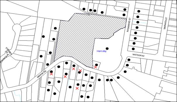
|
NOTIFICATION PLAN |
|
||
|
• PROPERTIES NOTIFIED
|
X SUBMISSIONS RECEIVED |
PROPERTY SUBJECT OF DEVELOPMENT |
|
|
One submission had no address provided |
|||
Seven submissions objected to the development, generally on the grounds that the development would result in:
· Detrimental impact on the streetscape from the building bulk, setback and car park;
· Traffic congestion and safety impacts;
· Additional on-street parking, resulting in difficulty for residents accessing their driveways;
· Privacy impacts;
· Noise;
· Impacts on significant trees;
· Safety risks in a bushfire emergency;
· Glare from the large Colorbond roof;
· Stormwater impacts on downstream properties; and
· Construction phase impacts including construction traffic, parking, noise, blocked footpaths.
The merits of the matters raised in community submissions have been addressed in the body of the report with the exception of the following:
5.1.1 Safety Risk in a Bushfire
Concerns were raised that the additional hospital patients and traffic would create a bottle neck in the event of a bushfire evacuation emergency. Concerns also queried if the Hospital has a Bushfire Emergency Plan in place. The existing consent conditions to expand the hospital under DA/224/2011 requires arrangements for emergency and evacuation from the hospital to comply with section 4.2.7 of Planning for Bush Fire Protection 2006. The current application was referred to the NSW Rural Fire Service. The Service raised no concerns with the proposal.
5.1.2 Glare from Roof Materials
Concerns were raised that the existing hospital roof creates glare, particularly when the deciduous trees lose their leaves. The significant trees along the property boundary are Queensland Brushbox trees which are evergreen. The building materials chosen are complementary to the existing hospital buildings. The Heritage assessment supports the proposed building material and the proposed roofing is compatible with the locality.
5.1.3 Construction Phase Impacts
A submission raises concerns regarding the impact of the construction noise, traffic and parking including the potential for footpaths to be blocked. Consent conditions are recommended in relation to hours of construction, a construction traffic management plan and environmental management during the construction phase.
5.2 Public Agencies
The proposal was forwarded to the Rural Fire Service for comment.
Part of the hospital site is within a bush fire prone area. The proposed hospital is a ‘special protection purpose’ under Section 100B of the Rural Fires Act 1997 and is subject to the concurrence of the NSW Rural Fire Service.
The bushfire assessment report concludes that the new building is more than 100 metres from unmanaged vegetation and is therefore in the range for which BAL-LOW construction is prescribed under AS3959. The application was referred to the NSW Rural Fire Service. The service has issued a Bushfire Safety Authority without any specific conditions.
6. THE PUBLIC INTEREST
Section 79C(1)(e) of the Act requires Council to consider “the public interest”.
The public interest is an overarching requirement, which includes the consideration of the matters discussed in this report. Implicit to the public interest is the achievement of future built outcomes adequately responding to and respecting the future desired outcomes expressed in environmental planning instruments and development control plans.
The application is considered to have satisfactorily addressed Council’s and relevant agencies’ criteria and would provide a development outcome that, on balance, would result in a positive impact for the community. Accordingly, it is considered that the approval of the proposed development would be in the public interest.
CONCLUSION
The application proposes alterations and additions to Mt Wilga Private Hospital.
The use of the property benefits from existing use rights subject to the provisions of the Environmental Planning and Assessment Act 1979. The proposal has been sensitively designed to respect the heritage significance of the site and the adjacent State heritage listed property. The new building, car parking arrangements and landscaping would also complement the existing facilities and plantings within the site. The provision of on-site car parking complies with RMS guidelines.
The application is therefore recommended for approval.
Note: At the time of the completion of this planning report, no persons have made a Political Donations Disclosure Statement pursuant to Section 147 of the Environmental Planning and Assessment Act 1979 in respect of the subject planning application.
RESPONSIBLE OFFICER
The officer responsible for the preparation of this Report is the Manager – Development Assessments – Rodney Pickles, who can be contacted on 9847 6731.
|
Rod Pickles Manager - Development Assessment Planning Division |
James Farrington Group Manager Planning Division |
|
1.View |
Locality Map |
|
|
|
2.View |
Site Plan |
|
|
|
3.View |
Landscape Plan |
|
|
|
4.View |
Tree Location Plan |
|
|
|
5.View |
Floor Plan |
|
|
|
6.View |
Elevations and Sections |
|
|
File Reference: DA/813/2015
Document Number: D06586694
SCHEDULE 1
GENERAL CONDITIONS
The conditions of consent within this notice of determination have been applied to ensure that the use of the land and/or building is carried out in such a manner that is consistent with the aims and objectives of the relevant legislation, planning instruments and council policies affecting the land and does not disrupt the amenity of the neighbourhood or impact upon the environment.
Note: For the purpose of this consent, the term ‘applicant’ means any person who has the authority to act on or the benefit of the development consent.
Note: For the purpose of this consent, any reference to an Act, Regulation, Australian Standard or publication by a public authority shall be taken to mean the gazetted Act or Regulation, or adopted Australian Standard or publication as in force on the date that the application for a construction certificate is made.
1. Approved Plans and Supporting Documentation
The development must be carried out in accordance with the plans and documentation listed below and endorsed with Council’s stamp, except where amended by Council and/or other conditions of this consent:
|
Plan No. |
Plan Title |
Drawn by |
Dated |
|
AR-DA-02 Rev C |
Site Plan |
Silver Thomas Hanley |
17.06.15 |
|
AR-DA-09 Rev C |
Roof Plan and External Works |
Silver Thomas Hanley |
17.06.15 |
|
AR-DA-10 Rev C |
Ground Floor Plan |
Silver Thomas Hanley |
17.06.15 |
|
AR-DA-20 Rev C |
Elevations |
Silver Thomas Hanley |
17.06.15 |
|
AR-DA-30 Rev C |
Sections |
Silver Thomas Hanley |
17.06.15 |
|
C1.01, C6.01, C6.02, |
Stormwater Drainage Management Plan |
ACOR Consultants |
15.06.15 |
|
C4.01, C4.02, |
Stormwater Drainage Management Plan |
ACOR Consultants |
9.10.15 |
|
LP 01 |
Landscape Plan |
Site Design+ Studios |
17.06.15 |
|
Document Title |
Prepared by |
Dated |
|
Ar-SCH-0001 Rev C Materials Schedule |
Silver Thomas Hanley |
17.06.15 |
|
Retaining wall materials (D06586106) |
Akalan |
07.09.15 |
|
Stormwater Quality Report |
ACOR Consultants |
9.10.15 |
|
Waste Management Plan |
Akalan |
June 2015 |
|
Arboricultural Assessment |
rainTree Consulting |
22 June 2015 |
|
Heritage Impact Assessment |
GML Heritage |
June 2015 |
2. Removal of Existing Trees
This development consent permits the removal of trees numbered T18, T28 and T29 as identified on page 8 in the Arboricultural Impact Assessment provided by rainTree consulting dated 22 June 2015 (D06076541).The removal of any other trees from the site requires separate approval by Council in accordance with Part 1B.6 Tree and Vegetation Preservation of the Hornsby Development Control Plan 2013 (HDCP).
3. Construction Certificate
a) A Construction Certificate is required to be approved by Council or a Private Certifying Authority prior to the commencement of any works under this consent.
b) The Construction Certificate plans must not be inconsistent with the Development Consent plans.
4. Section 94A Development Contributions
a) In accordance with Section 80A(1) of the Environmental Planning and Assessment Act 1979 and the Hornsby Shire Council Section 94A Development Contributions Plan 2012-2021, $72,954.90 shall be paid to Council to cater for the increased demand for community infrastructure resulting from the development, based on development costs of $7,295,492.
b) The value of this contribution is current as at 16 October 2015. If the contributions are not paid within the financial quarter that this condition was generated, the contributions payable will be adjusted in accordance with the provisions of the Hornsby Shire Council Section 94 Development Contributions Plan and the amount payable will be calculated at the time of payment in the following manner:
$CPY = $CDC x CPIPY
CPIDC
Where:
$CPY is the amount of the contribution at the date of Payment
$CDC is the amount of the contribution as set out in this Development Consent
CPIPY is the latest release of the Consumer Price Index (Sydney – All Groups) at the date of Payment as published by the ABS.
CPIDC is the Consumer Price Index (Sydney – All Groups) for the financial quarter at the date applicable in this Development Consent Condition.
c) The monetary contributions shall be paid to Council:
i) prior to the issue of the Subdivision Certificate where the development is for subdivision; or
ii) prior to the issue of the first Construction Certificate where the development is for building work; or
iii) prior to issue of the Subdivision Certificate or first Construction Certificate, whichever occurs first, where the development involves both subdivision and building work; or
iv) prior to the works commencing where the development does not require a Construction Certificate or Subdivision Certificate.
It is the professional responsibility of the Principal Certifying Authority to ensure that the monetary contributions have been paid to Council in accordance with the above timeframes.
Council’s S94A Development Contributions Plan may be viewed at www.hornsby.nsw.gov.au or a copy may be inspected at Council’s Administration Centre during normal business hours.
REQUIREMENTS PRIOR TO THE ISSUE OF A CONSTRUCTION CERTIFICATE
5. Building Code of Australia
All building work must be carried out in accordance with the relevant requirements of the Building Code of Australia.
6. Construction Traffic Management Plan
To enable unencumbered movement of traffic in the public road during construction works, a Construction Management Plan, including a Traffic Management Plan and scaled construction plans prepared by a suitably Chartered and Qualified Chartered Civil Engineer and Qualified Worksite Traffic Controller shall be prepared and submitted to Hornsby Shire Council for approval according to the following requirements:-
a) A copy of the plans shall be submitted for consideration and written approval by Hornsby Shire Council prior to the release of the Construction Certificate.
b) The plans shall detail the order of construction works and arrangement of all construction machines and vehicles being used at the same time during all stages.
c) The CTMP plans shall be in accordance with the approved Development Application plans and the Development Consent conditions.
d) To prevent injury, accident and loss of property, no building materials, work sheds, vehicles, machines or the like shall be allowed to remain in the road reserve area without the written consent of Hornsby Shire Council.
e) The Plan shall be generally in compliance with the requirements of the Road and Traffic Authority’s “Traffic Control at Worksites Manual 1998” and detailing:-
i) Public notification of proposed works;
ii) Long term signage requirements;
iii) Short term (during actual works) signage;
iv) Vehicle Movement Plans, where applicable;
v) Traffic Management Plans;
vi) Pedestrian and Cyclist access and safety;
vii) The plans shall indicate traffic controls including those used during non-working hours and shall provide pedestrian access and two-way traffic in the public road to be facilitated at all times.
f) The plans shall include the proposed truck routes to and from the site including details of the frequency of truck movements at the different stages of the development. The plan shall also include details of parking arrangements for all employees and contractors.
g) The Applicant and all employees of contractors on the site must obey any direction or notice from the Prescribed Certifying Authority or Hornsby Shire Council in order to ensure the above.
h) Hours of operation.
i) If there is a requirement to obtain a Work Zone, partial Road Closure or Crane Permit an application to Hornsby Shire Council is to be made prior to the issue the Construction Certificate.
7. Design and Construction - Bushfire Attack Category
New construction must comply with the current Australian Standard AS3959 ‘Construction of buildings in bush fire-prone areas’ section 4 (BAL Low).
REQUIREMENTS PRIOR TO THE COMMENCEMENT OF ANY WORKS
8. Erection of Construction Sign
A sign must be erected in a prominent position on any site on which building work, subdivision work or demolition work is being carried out:
a) Showing the name, address and telephone number of the principal certifying authority for the work;
b) Showing the name of the principal contractor (if any) for any demolition or building work and a telephone number on which that person may be contacted outside working hours; and
c) Stating that unauthorised entry to the work site is prohibited.
Note: Any such sign is to be maintained while the building work, subdivision work or demolition work is being carried out, but must be removed when the work has been completed.
9. Protection of Adjoining Areas
A temporary hoarding, fence or awning must be erected between the work site and adjoining lands before the works begin and must be kept in place until after the completion of the works if the works:
a) Could cause a danger, obstruction or inconvenience to pedestrian or vehicular traffic.
b) Could cause damage to adjoining lands by falling objects.
c) Involve the enclosure of a public place or part of a public place.
Note: Notwithstanding the above, Council’s separate written approval is required prior to the erection of any structure or other obstruction on public land.
10. Toilet Facilities
Toilet facilities must be available or provided at the works site before works begin and must be maintained until the works are completed at a ratio of one toilet for every 20 persons employed at the site. Each toilet must:
a) be a standard flushing toilet connected to a public sewer; or
b) be a temporary chemical closet approved under the Local Government Act 1993; or
c) have an on-site effluent disposal system approved under the Local Government Act 1993.
11. Erosion and Sediment Control
Erosion and sediment control measures must be provided and maintained throughout the construction period in accordance with the manual ‘Soils and Construction 2004 (Bluebook)’, the approved plans, Council specifications and to the satisfaction of the principal certifying authority. The erosion and sediment control devices must remain in place until the site has been stabilised and revegetated.
Note: On the spot penalties may be issued for any non-compliance with this requirement without any further notification or warning.
12. Appointment of a Heritage Architect
A heritage architect and an archaeologist must be nominated for the project. The name and experience of these heritage consultants must be submitted to Council and comply with the following requirements:
a) The building contract selected for the project must ensure that the nominated heritage architect has a contractual role as administrator of the contract for works, driveway and gardens, with the ability to issue instructions to the contractor.
b) Suitable clauses, prepared in consultation with the nominated heritage consultants, must be included in all contractor and subcontractor contracts to ensure that on-site personnel are aware of their statutory obligations in relation to the relics provisions of the NSW Heritage Act, 1977 and the National Parks and Wildlife Act, 1974 concerning Aboriginal archaeology in the event that any material is disturbed or exposed during site works.
c) All contractors and relevant personnel engaged in works on the site must be made aware of the existence of potential and historical archaeological remains at the site by way of an induction process undertaken by the nominated archaeologist. The induction must also make the personnel aware of the possibility that more as yet unidentified archaeological remains may still exist and of the requirements of the NSW Heritage Act, 1977 in relation to archaeological relics in the event that they are uncovered.
13. Excavation Permit
An application for an excavation permit under Section 140 of the Heritage Act should be submitted to the Office of Environment and Heritage, Heritage Division prior to commencement of ground works.
14. Archaeological Monitoring
Archaeological monitoring and recording should be undertaken by a suitably qualified archaeologist during construction works. An appropriate investigation methodology in the form of an Archaeological Research Design should be prepared prior to works commencing and the results of the investigations presented in a succinct excavation report.
15. Appointment of a Project Arborist
A Project Arborist (AQF5 qualified) must be appointed to oversee the installation of tree trunk protection and fencing required to protect the tree root zone of the trees to be retained and comply with the following requirements:
a) The Project Arborist (AQF5 qualified) must monitor the integrity of the tree protection methods, recording any modifications or alterations to the tree protection zone fencing for the duration of the construction period.
b) Project Arborist (AQF5 qualified) must submit to the Principal Certifying Authority (PCA) a certification/statement confirming that all tree protection measures have been installed in accordance with this consent and the specific requirements of Australian Standard ”Protection of Trees on Development Sites” (AS 4970-2009).
16. Tree Protection Barriers
a) All trees retained on site must have trunk protection and tree protection zone fencing installed in accordance with the Australian Standard ‘Protection of Trees on Development Sites (AS 4970-2009).
b) Tree protection fencing must be erected around trees numbered T1-T27 in accordance with required tree protection zones as identified on page 20 of section 3 Conclusions and Recommendations contained in the Supplied Arboricultural Impact Assessment provided by rainTree consulting dated 22 June 2015 (D06076541).
c) Tree protection zone fencing must be installed prior to the commencement of any works on the site.
d) Once erected, the tree protective fencing must not be removed or altered without the prior approval of project Arborist.
17. Tree Ground Protection
All Tree Protection Zones must have a layer of wood-chip mulch installed prior to works commencing and must be maintained throughout the period of construction at a depth of 150mm – 300mm using material that complies with Australian Standard AS 4454.
REQUIREMENTS DURING CONSTRUCTION
18. Construction Work Hours
All work on site (including demolition and earth works) must only occur between 7am and 5pm Monday to Saturday. No work is to be undertaken on Sundays or public holidays.
19. Demolition
All demolition work must be carried out in accordance with “Australian Standard 2601-2001 – The Demolition of Structures” and the following requirements:
a) Demolition material must be disposed of to an authorised recycling and/or waste disposal site and/or in accordance with an approved waste management plan;
b) Demolition works, where asbestos material is being removed, must be undertaken by a contractor that holds an appropriate licence issued by WorkCover NSW in accordance with Chapter 10 of the Occupational Health and Safety Regulation 2001 and Clause 29 of the Protection of the Environment Operations (Waste) Regulation 2005 ;and
c) On construction sites where buildings contain asbestos material, a standard commercially manufactured sign containing the words ‘DANGER ASBESTOS REMOVAL IN PROGRESS’ measuring not less than 400mm x 300mm must be erected in a prominent position visible from the street.
20. Environmental Management
The site must be managed in accordance with the publication ‘Managing Urban Stormwater – Landcom (March 2004) and the Protection of the Environment Operations Act 1997 by way of implementing appropriate measures to prevent sediment run-off, excessive dust, noise or odour emanating from the site during the construction of the development.
21. Street Sweeping
Street sweeping must be undertaken following sediment tracking from the site along Manor Road during works and until the site is established.
The street cleaning services must undertake a street ‘scrub and dry’ method of service and not a dry sweeping service that may cause sediment tracking to spread or cause a dust nuisance.
22. Council Property
During construction works, no building materials, waste, machinery or related matter is to be stored on the road or footpath. The public reserve must be kept in a clean, tidy and safe condition at all times.
23. Disturbance of Existing Site
During construction works, the existing ground levels of open space areas and natural landscape features, (including natural rock-outcrops, vegetation, soil and watercourses) must not be altered unless otherwise nominated on the approved plans.
24. Landfill
Landfill must be constructed in accordance with Council’s ‘Construction Specification 2005’ and the following requirements:
a) All fill material imported to the site is to wholly consist of Virgin Excavated Natural Material (VENM) as defined in Schedule 1 of the Protection of the Environment Operations Act 1997 or a material approved under the Department of Environment and Climate Change’s general resource recovery exemption.
b) A compaction certificate is to be obtained from a geotechnical engineer verifying that the specified compaction requirements have been met.
25. Excavated Material
All excavated material removed from the site must be classified in accordance with the Department of Environment, Climate Change and Water NSW Waste Classification Guidelines prior to disposal to an approved waste management facility and reported to the principal certifying authority.
26. Waste Management
All work must be carried out in accordance with the approved waste management plan and the following requirements:
a) Stockpiling, cutting and sanding must be performed a minimum of 10 metres from the shoreline and screened by sediment fencing.
27. Survey Report – Finished Floor Level
A report(s) must be prepared by a registered surveyor and submitted to the principal certifying authority prior to the pouring of concrete at each level of the building certifying that:
a) The building, retaining walls and the like have been correctly positioned on the site; and
b) The finished floor level(s) are in accordance with the approved plans.
28. Works Near Trees
a) Maintenance and Monitoring of Tree Protection
i) All required tree protection measures must be monitored by the appointed project Arborist to ensure that they are maintained in good condition for the duration of the construction period.
ii) The project Arborist must record the method(s) used to preserve the tree(s) T1-T27 for the duration of the proposed works and forms part of final certification documentation.
b) Root Pruning
i) Where there a root is required (outside the TPZ) to be severed for the purposes of this consent, all pruning must be undertaken as specified in Australian Standard AS 4970-2009 Sections 3.3.4, 4.5.4 and 4.5.5.
ii) The project Arborist must monitor and assess the necessary tree pruning.
c) Drilling/Boring to Install Underground Services
i) The installation of any services within the nominated tree protection zone of any tree to be retained must utilise the thrust boring method.
ii) Thrust boring must be carried out so that ‘top of pipe’ is a minimum 600mm depth beneath existing ground level.
d) Building Materials and Site Waste
i) The filling or stockpiling of building materials, the parking of vehicles or plant, the disposal of cement slurry, waste water or other contaminants must be located outside the tree protection zones.
REQUIREMENTS PRIOR TO THE ISSUE OF AN OCCUPATION CERTIFICATE
Note: For the purpose of this consent, a reference to ‘occupation certificate’ shall not be taken to mean an ‘interim occupation certificate’ unless otherwise stated.
29. Final Certification - Arborist
A certificate from the appointed Project Arborist must be submitted with the application for the occupation certificate to the principal certifying authority stating compliance with the relevant conditions of this consent.
30. Stormwater Drainage
The stormwater drainage system for the development must be designed and constructed in accordance with Council’s Civil Works – Design and Construction Specification 2005 and the following requirements:
a) Be generally in accordance with plans prepared by ACOR Consultants Pty Ltd project No SY150050.
31. On-Site Stormwater Detention/Bio Retention
An on-site stormwater detention system and bio retention system must be designed by a chartered civil engineer and constructed in accordance with the following requirements:
a) The OSD system have a capacity of not less than 36.4 cubic metres, and a maximum discharge (when full) of 31 litres per second.
b) The Water Saving Urban Design (WSUD) requirements are to be designed and constructed generally in accordance with the WSUD report prepared by ACOR Consultants Pty Ltd project No SY150050.
c) The detention system is to have a surcharge/inspection grate located directly above the outlet.
d) Discharge from the detention system to be controlled via 1 metre length of pipe, not less than 50 millimetres diameter or via a stainless plate with sharply drilled orifice bolted over the face of the outlet discharging into a larger diameter pipe capable of carrying the design flow to an approved Council system.
e) Not be constructed in a location that would impact upon the visual or recreational amenity of residents.
32. Internal Driveway/Vehicular Areas
The driveway and parking areas on site must be designed in accordance with Australian Standards 2890.1, 3727 and the following requirements:
a) The driveway and parking areas must be a rigid pavement; and
b) All car parking spaces are to be marked.
33. Certification of WSUD
Prior to the issue of the Occupation Certificate a certificate is to be issued by a practising Civil Engineer that the following water saving targets have been met:
a) Gross pollutants – 90% reduction
b) Total Suspended Solids – 80% reduction.
c) Total phosphorus – 60% reduction.
d) Total nitrogen – 45% reduction
34. Damage to Council Assets
Any damage caused to Council’s assets as a result of the construction or demolition of the development must be rectified in accordance with Council’s Civil Works Specifications.
35. Creation of Easements
The following matter(s) must be nominated on the plan of subdivision under s88B of the Conveyancing Act 1919:
a) The creation of an appropriate "Positive Covenant" and "Restriction as to User" over the constructed on-site detention/retention systems and bio retention system, within the property in favour of Council in accordance with Council’s prescribed wording. The position of the on-site detention system and bio retention system is to be clearly indicated on the title.
b) To register the OSD and bio retention easement, the restriction on the use of land “works-as-executed” details of the on-site-detention and bio retention systems must be submitted verifying that the required storage and discharge rates have been constructed in accordance with the design requirements. The details must show the invert levels of the on-site system together with pipe sizes and grades. Any variations to the approved plans must be shown in red on the “works-as-executed” plan and supported by calculations.
Note: Council must be nominated as the authority to release, vary or modify any easement, restriction or covenant.
36. Completion of Landscaping
A certificate must be provided by a practicing landscape architect, horticulturalist or person with similar qualifications and experience certifying that all required landscaping works have been satisfactorily completed in accordance with the approved landscape plans.
Note: Advice on suitable species for landscaping can be obtained from Council’s planting guide ‘Indigenous Plants for the Bushland Shire’, available at www.hornsby.nsw.gov.au.
37. External Lighting
All external lighting must be designed and installed in accordance with Australian Standard AS 4282 – Control of the Obtrusive Effects of Outdoor Lighting. Certification of compliance with the Standard must be obtained from a suitably qualified person.
38. Heritage Interpretation
Historic photographs of Mount Wilga house and grounds and any potential archaeological relics found during the works or evidence of the historical arrangement of buildings and structures within the site should be incorporated within the additional wing as a means of interpretation of the heritage listed site.
39. Maintain Canopy Cover
Green Offset Replacement Planting
a) To offset the loss of trees removed under this consent, three (3) trees must be planted on site.
b) The replacement planting must be species selected from the selected from Council’s booklet ‘Indigenous Plants for the Bushland Shire’ such as: Syncarpia glomulifera, Eucalyptus saligna, Eucalyptus pilularis with a mature growth height of 15 metres or greater.
c) Replacement of T18 must be of same species to maintain the linear planting of Lophostemon confertus (Brushbox)
Location and Size of Plantings
d) Tree plantings must be located 4 metres or greater from the foundation walls of the approved development.
e) The pot size of the replacement tree(s) must be a minimum 25 litres.
f) The replacement tree(s) must be maintained until they reach the height of 3 metres.
g) Planting methods must meet professional (best practice) industry standards
OPERATIONAL CONDITIONS
40. Use of Premises
The development approved under this consent shall be used for a hospital and not for any other purpose without Council’s separate written consent.
41. Noise – Plant and Machinery
The level of total continuous noise emanating from operation of all the plant, including air conditioning units and processes in all buildings (LA10) (measured for at least 15 minutes) in or on the above premises, must not exceed the background level by more than 5dB(A) when measured at all property boundaries.
42. Car Parking
a) All car parking must be constructed and operated in accordance with Australian Standard AS 2890.1 – 2004 – Off Street Car Parking
b) All parking areas and driveways are to be sealed to an all-weather standard, line marked and signposted.
c) Car parking, loading and manoeuvring areas to be used solely for nominated purposes.
d) Vehicles awaiting loading, unloading or servicing shall be parked on site and not on adjacent or nearby public roads;
e) All vehicular entry on to the site and egress from the site shall be made in a forward direction.
- END OF CONDITIONS -
ADVISORY NOTES
The following information is provided for your assistance to ensure compliance with the Environmental Planning and Assessment Act, 1979, Environmental Planning and Assessment Regulation 2000, other relevant legislation and Council’s policies and specifications. This information does not form part of the conditions of development consent pursuant to Section 80a of the Act.
Environmental Planning and Assessment Act 1979 Requirements
The Environmental Planning and Assessment Act 1979 requires:
· The issue of a construction certificate prior to the commencement of any works. Enquiries can be made to Council’s Customer Services Branch on 9847 6760.
· A principal certifying authority to be nominated and Council notified of that appointment prior to the commencement of any works.
· Council to be given at least two days written notice prior to the commencement of any works.
· Mandatory inspections of nominated stages of the construction inspected.
· An occupation certificate to be issued before occupying any building or commencing the use of the land.
Long Service Levy
In accordance with Section 34 of the Building and Construction Industry Long Service Payments Act 1986, a ‘Long Service Levy’ must be paid to the Long Service Payments Corporation or Hornsby Council.
Note: The rate of the Long Service Levy is 0.35% of the total cost of the work.
Note: Hornsby Council requires the payment of the Long Service Levy prior to the issue of a construction certificate.
Tree and Vegetation Preservation
In accordance with Clause 5.9 of the Hornsby Local Environmental Plan 2013 a person must not ringbark, cut down, top, lop, remove, injure or wilfully destroy any tree or other vegetation protected under the Hornsby Development Control Plan 2013 without the authority conferred by a development consent or a permit granted by Council.
Notes: A tree is defined as a long lived, woody perennial plant with one or relatively few main stems with the potential to grow to a height greater than three metres (3M). (HDCP 1B.6.1.c).
Tree protection measures and distances are determined using the Australian Standard AS 4970:2009, “Protection of Trees on Development Sites”.
Fines may be imposed for non-compliance with both the Hornsby Local Environmental Plan 2013 and the Hornsby Development Control Plan 2013.
Disability Discrimination Act
The applicant’s attention is drawn to the existence of the Disability Discrimination Act. A construction certificate is required to be obtained for the proposed building/s, which will provide consideration under the Building Code of Australia, however, the development may not comply with the requirements of the Disability Discrimination Act. This is the sole responsibility of the applicant.
Covenants
The land upon which the subject building is to be constructed may be affected by restrictive covenants. Council issues this approval without enquiry as to whether any restrictive covenant affecting the land would be breached by the construction of the building, the subject of this consent. Applicants must rely on their own enquiries as to whether or not the building breaches any such covenant.
Dial Before You Dig
Prior to commencing any works, the applicant is encouraged to contact Dial Before You Dig on 1100 or www.dialbeforeyoudig.com.au for free information on potential underground pipes and cables within the vicinity of the development site.
Telecommunications Act 1997 (Commonwealth)
If you are aware of any works or proposed works which may affect or impact on Telstra’s assets in any way, you are required to contact: Telstra’s Network Integrity Team on Phone Number 1800810443.
Group Manager’s Report No. PL89/15
Planning Division
Date of Meeting: 11/11/2015
14 DEVELOPMENT APPLICATION - SUBDIVISION OF ONE ALLOTMENT INTO TWO LOTS - 2 ARRIONGA PLACE, HORNSBY
EXECUTIVE SUMMARY
|
DA No: |
DA/1480/2014 (Lodged on 27 November 2014) |
|
Description: |
Subdivision of one allotment into two lots |
|
Property: |
Lot 11 DP 1178405, No. 2 Arrionga Place Hornsby |
|
Applicant: |
P S Graham & Associates |
|
Owner: |
E Graiche and S Graiche |
|
Estimated Value: |
N/A |
|
Ward: |
A |
· The application involves the Torrens Title Subdivision of one allotment into two lots.
· The development involves land owned by a relative of a ‘Designated Person’. In accordance with Council’s adopted Policy ‘Proposed Council Developments’ an independent assessment of the development application has been undertaken by Key Urban Planning.
· The proposal generally complies with the Hornsby Local Environmental Plan 2013 and the Hornsby Development Control Plan. The applicant seeks to enter into a Voluntary Planning Agreement with Council to offset the loss of locally native Blackbutt Gully Forest in accordance with Council’s Green Offset Code.
· One submission has been received in respect of the application.
· The report prepared by Key Urban Planning is attached for consideration. The independent consultant’s report recommends approval of the application as a deferred commencement subject to the applicant entering into a Voluntary Planning Agreement with Council.
|
THAT Development Application No. DA/1480/2014 for Torrens Title subdivision of one allotment into two lots at Lot 11 DP 1178405 No. 2 Arrionga Place, Hornsby be approved as a deferred commencement pursuant to Section 80(3) of the Environmental Planning and Assessment Act 1979 subject to the conditions of consent detailed in Schedule 1 of Group Manager’s Report No. PL89/15. |
ASSESSMENT
The application proposes the Torrens Title subdivision of one allotment into two. The proposed lots have an area of 780m2 and 1,429m2, which exceeds the minimum allotment size for subdivision in the Hornsby Local Environmental Plan 2013 of 500m2.
The application includes a proposed Voluntary Planning Agreement to offset the loss of Blackbutt Gully Forest on the site. The VPA includes a monetary contribution of $21,945 to offset the loss of bushland and enable Council, through its Bushcare programme, to rehabilitate and regenerate bushland on an area of Council land. The proposed VPA is documented separately in Group Manager’s Report PL88/15 which is also to be considered by Council at its meeting on 11 November 2015.
In accordance with Council’s adopted Policy ‘Proposed Council Developments’, the development application has been referred to an independent town planning consultant. The report by Key Urban Planning is attached to this report for consideration.
The report by Key Urban Planning recommends that the application be approved as a deferred commencement consent, subject to the applicant entering into a VPA with Council to offset the loss of locally native Blackbutt Gully Forest in accordance with Council’s Green Offset Code.
CONCLUSION
Council has referred the application to an independent planning consultancy to carry out an assessment of the application and to consider the public submissions. The assessment concludes that the application should be approved.
It is recommended that Council approve the application in accordance with the recommendation in the report prepared by Key Urban Planning and the conditions of consent detailed in Schedule 1 of this report.
Note: At the time of the completion of this planning report, no persons have made a Political Donations Disclosure Statement pursuant to Section 147 of the Environmental Planning and Assessment Act 1979 in respect of the subject planning application.
RESPONSIBLE OFFICER
The officer responsible for the preparation of this Report is the Manager – Development Assessments – Rodney Pickles, who can be contacted on 9847 6731.
|
Rod Pickles Manager - Development Assessment Planning Division |
James Farrington Group Manager Planning Division |
|
1.View |
Locality Map |
|
|
|
2.View |
Independent Consultant Report |
|
|
|
3.View |
Subdivision Plan |
|
|
File Reference: DA/1480/2014
Document Number: D06716227
SCHEDULE 1
GENERAL CONDITIONS
The conditions of consent within this notice of determination have been applied to ensure that the use of the land and/or building is carried out in such a manner that is consistent with the aims and objectives of the relevant legislation, planning instruments and Council policies affecting the land and does not disrupt the amenity of the neighbourhood or impact upon the environment.
Note: For the purpose of this consent, the term ‘applicant’ means any person who has the authority to act on or the benefit of the development consent.
Note: For the purpose of this consent, any reference to an Act, Regulation, Australian Standard or publication by a public authority shall be taken to mean the gazetted Act or Regulation, or adopted Australian Standard or publication as in force on the date that the application for a construction certificate is made.
1. Deferred Commencement
Pursuant to Section 80(3) of the Environmental Planning and Assessment Act 1979, this consent does not operate until the following information is submitted to Council:
Pursuant to section 93F of the Environmental Planning and Assessment Act 1979, the applicant must prepare and enter into a Voluntary Planning Agreement (VPA) with Hornsby Shire Council to offset the loss of native Blackbutt Gully Forest (BGF) under Council’s Green Offset Code (2012).
The terms of the VPA must include, but not be limited to, the following:
a) The Applicant agrees to pay Council a monetary contribution of $21,945 towards the replacement of 525m2 of native BGF lost from the site as result of the development.
b) The applicant agrees to pay all costs (including Council’s costs) associated with the preparation, public notification, legal costs and administration costs of the VPA.
Such information shall be submitted within 12 months of the date of this notice.
Upon Council’s written satisfaction of the above information, the following conditions of development consent will apply:
2. Approved Plans and Supporting Documentation
The development must be carried out in accordance with the plans and documentation listed below and endorsed with Council’s stamp, except where amended by Council and/or other conditions of this consent:
|
Plan No./ Title |
Drawn by |
Dated |
|
Plan No. S15175A |
PS Graham & Assoc. |
Received 5 August 2015 |
|
Document Title / No. |
Prepared by |
Dated |
|
Arboricultural Assessment Report |
Earthscape Horticultural Services |
October 2014 |
|
Bushfire Hazard Assessment Report |
Building Code & Bushfire Hazard Solutions Pty Limited |
21 November 2014 |
3. Removal of Existing Trees
This development consent permits the removal of tree(s) numbered T2-T6, T8, T10, T12-T15, T17, T25-T36, T50-T52, T54 and T57 as identified on page 23 contained in the Supplied Arboricultural Impact Assessment provided by Earthscape Horticultural Services dated 27 October 2015 (D04793675). The removal of any other trees from the site requires separate approval by Council in accordance with Part 1B.6 Tree and Vegetation Preservation of the Hornsby Development Control Plan, 2013 (HDCP).
4. Appointment of a Project Arborist
A Project Arborist is to be appointment in accordance with AS4970-2009 (1.4.4) to provide monitoring and certification throughout the development process. Details of the Project Arborist are to be forwarded to Council and the private certifier prior to the use of the Construction Certificate.
5. Amendment of Plans
The approved plans are to be amended as follows:
a) The driveway on Lot 112 is required to be constructed as part of this application. The driveway on Lot 111 is not approved or required to be constructed as part of this application.
6. Construction Certificate
a) A Construction Certificate is required to be approved by Council or a Private Certifying Authority prior to the commencement of any works under this consent.
b) The Construction Certificate plans must not be inconsistent with the Development Consent plans.
7. Section 94 Development Contributions
a) In accordance with Section 80A(1) of the Environmental Planning and Assessment Act 1979 and the Hornsby Shire Council Section 94 Development Contributions Plan 2012-2021, the following monetary contributions shall be paid to Council to cater for the increased demand for community infrastructure resulting from the development:
|
Description |
Contribution (4) |
|
Roads |
$1,814.00 |
|
Open Space and Recreation |
$15,890.00 |
|
Community Facilities |
$2,226.00 |
|
Plan Preparation and Administration |
$70.00 |
|
TOTAL |
$20,000.00 |
being for one additional lot.
b) The value of this contribution is current as at 15 October 2015. If the contributions are not paid within the financial quarter that this condition was generated, the contributions payable will be adjusted in accordance with the provisions of the Hornsby Shire Council Section 94 Development Contributions Plan and the amount payable will be calculated at the time of payment in the following manner:
$CPY = $CDC x CPIPY
CPIDC
Where:
$CPY is the amount of the contribution at the date of Payment
$CDC is the amount of the contribution as set out in this Development Consent
CPIPY is the latest release of the Consumer Price Index (Sydney – All Groups) at the date of Payment as published by the ABS.
CPIDC is the Consumer Price Index (Sydney – All Groups) for the financial quarter at the date applicable in this Development Consent Condition.
c) The monetary contributions shall be paid to Council:
i) prior to the issue of the Subdivision Certificate where the development is for subdivision; or
ii) prior to the issue of the first Construction Certificate where the development is for building work; or
iii) prior to issue of the Subdivision Certificate or first Construction Certificate, whichever occurs first, where the development involves both subdivision and building work; or
iv) prior to the works commencing where the development does not require a Construction Certificate or Subdivision Certificate.
It is the professional responsibility of the Principal Certifying Authority to ensure that the monetary contributions have been paid to Council in accordance with the above timeframes.
Council’s Development Contributions Plan may be viewed at www.hornsby.nsw.gov.au or a copy may be inspected at Council’s Administration Centre during normal business hours.
REQUIREMENTS PRIOR TO THE ISSUE OF A CONSTRUCTION CERTIFICATE
8. Utility Services
The applicant must submit written evidence of the following service provider requirements:
a) Ausgrid (formerly Energy Australia) – a letter of consent demonstrating that satisfactory arrangements have been made to service the proposed development.
b) Telstra – a letter of consent demonstrating that satisfactory arrangements have been made to service the proposed development.
9. Internal Driveway/Vehicular Areas
The driveway and parking areas on site must be designed in accordance with Australian Standards 2890.1, 2890.2, 3727 and the following requirements:
a) Design levels at the front boundary must be obtained from Council;
b) The driveway must be a rigid pavement;
c) The driveway grade must not exceed 25 percent and changes in grade must not exceed 8 percent;
d) The driveway pavement must be a minimum 3 metres wide, 0.15 metres thick reinforced concrete with F72 steel reinforcing fabric and a 0.15 metre sub-base;
e) The pavement must have a kerb to one side and a one-way cross fall with a minimum gradient of 2 percent and a lintel and pit provided at the low point;
f) Retaining walls required to support the carriageway and the compaction of all fill batters must be in accordance with the requirements of a chartered structural engineer;
g) Safety rails must be provided where there is a level difference more than 0.3 metres and a 1:4 batter cannot be achieved;
Note: A construction certificate shall be obtained prior to the commencement of these works and are to be completed prior to the issue of an occupation certificate.
10. Driveway Longitudinal Section
Longitudinal sections along both sides of the access driveway shall be submitted to the principal certifying authority in accordance with the relevant sections of AS 2890.1. The maximum grade shall not exceed 1 in 4 (25%) with the maximum changes of grade of 1 in 8 (12.5%) for summit grades and 1 in 6.7 (15%) for sag grades. Any transition grades shall have a minimum length of 2 metres. The longitudinal sections shall incorporate the design levels obtained by Council.
Prior to the issue of a construction certificate, a certificate by a qualified engineer shall be submitted to the principal certifying authority certifying that the longitudinal sections have been designed in accordance with AS2890.1 and Hornsby Council Civil Works Specifications
Note: A construction certificate shall be obtained prior to the commencement of these works and are to be completed prior to the issue of an occupation certificate.
11. Vehicular Crossing
A separate application under the Local Government Act 1993 and the Roads Act 1993 must be submitted to Council for the installation of a new vehicular crossing and the removal of the redundant crossing. The vehicular crossing must be constructed in accordance with Council’s Civil Works Design 2005 and the following requirements:
a) Any redundant crossings must be replaced with integral kerb and gutter;
b) The footway area must be restored by turfing;
c) Longitudinal sections in accordance with AS2890.1 and Hornsby Council Civil Works Specifications shall be submitted to Council.
d) Approval must be obtained from all relevant utility providers that all necessary conduits be provided and protected under the crossing.
Note: An application for a vehicular crossing can only be made to one of Council’s Authorised Vehicular Crossing Contractors. You are advised to contact Council on 02 9847 6940 to obtain a list of contractors.
REQUIREMENTS PRIOR TO THE COMMENCEMENT OF ANY WORKS
12. Erection of Construction Sign
A sign must be erected in a prominent position on any site on which building work, subdivision work or demolition work is being carried out:
a) Showing the name, address and telephone number of the principal certifying authority for the work;
b) Showing the name of the principal contractor (if any) for any demolition or building work and a telephone number on which that person may be contacted outside working hours; and
c) Stating that unauthorised entry to the work site is prohibited.
Note: Any such sign is to be maintained while the building work, subdivision work or demolition work is being carried out, but must be removed when the work has been completed.
13. Protection of Adjoining Areas
A temporary hoarding, fence or awning must be erected between the work site and adjoining lands before the works begin and must be kept in place until after the completion of the works if the works:
a) Could cause a danger, obstruction or inconvenience to pedestrian or vehicular traffic.
b) Could cause damage to adjoining lands by falling objects.
c) Involve the enclosure of a public place or part of a public place.
Note: Notwithstanding the above, Council’s separate written approval is required prior to the erection of any structure or other obstruction on public land.
14. Toilet Facilities
Toilet facilities must be available or provided at the works site before works begin and must be maintained until the works are completed at a ratio of one toilet for every 20 persons employed at the site. Each toilet must:
a) be a standard flushing toilet connected to a public sewer; or
b) be a temporary chemical closet approved under the Local Government Act 1993; or
c) have an on-site effluent disposal system approved under the Local Government Act 1993.
15. Tree Protection Barriers
a) All trees retained on site must have trunk protection and tree protection zone fencing installed in accordance with the Australian Standard ‘Protection of Trees on Development Sites (AS 4970-2009).
b) Once erected, the tree protective fencing must not be removed or altered without the prior approval of project Arborist or site supervisor.
16. Tree Protection Zone Fencing (TPZ)
Tree protection fencing must be erected around trees numbered T1, T9, T11 in accordance with required tree protection zones as identified in the Arboricultural Impact Assessment provided by Earthscape Horticultural Services dated 27 October 2015 (D04793675).
17. Erosion and Sediment Control
Erosion and sediment control measures must be provided and maintained throughout the construction period in accordance with the manual ‘Soils and Construction 2004 (Bluebook)’, the approved plans, Council specifications and to the satisfaction of the principal certifying authority. The erosion and sediment control devices must remain in place until the site has been stabilised and revegetated.
Note: On the spot penalties may be issued for any non-compliance with this requirement without any further notification or warning.
REQUIREMENTS DURING CONSTRUCTION
18. Construction Work Hours
All work on site (including demolition and earth works) must only occur between 7am and 5pm Monday to Saturday. No work is to be undertaken on Sundays or public holidays.
19. Demolition
All demolition work must be carried out in accordance with “Australian Standard 2601-2001 – The Demolition of Structures” and the following requirements:
a) Demolition material must be disposed of to an authorised recycling and/or waste disposal site and/or in accordance with an approved waste management plan;
b) Demolition works, where asbestos material is being removed, must be undertaken by a contractor that holds an appropriate licence issued by WorkCover NSW in accordance with Chapter 10 of the Occupational Health and Safety Regulation 2001 and Clause 29 of the Protection of the Environment Operations (Waste) Regulation 2005 ;and
c) On construction sites where buildings contain asbestos material, a standard commercially manufactured sign containing the words ‘DANGER ASBESTOS REMOVAL IN PROGRESS’ measuring not less than 400mm x 300mm must be erected in a prominent position visible from the street.
20. Maintenance and Monitoring of Tree Protection
a) All required tree protection measures must be monitored by the appointed Project Arborist to ensure that they are maintained in good condition for the duration of the construction period.
b) The Project Arborist must supervise and record all works, including driveways and retaining walls on the subject or adjoining properties within 4 metres of any trees required to be retained.
c) The Project Arborist must record the method(s) used to preserve the tree(s) T1, T9 and T11 for the duration of the proposed works and forms part of final certification documentation.
21. Consent to Works within Tree Protection Zones
Consent is granted to undertake works within the Tree Protection Zone of specified trees T1, T9 and T11 with the following conditions:
a) Project Arborist
i) The Project Arborist must monitor and assess all consented works within the tree protection zone.
ii) The Project Arborist must monitor and assess the condition of tree(s) within the growing environment and make recommendations for maintaining tree health/condition and if necessary carry out remedial action to ensure the health and vigour of the tree(s).
iii) The Project Arborist must keep a record of the method(s) used to preserve the tree(s).
b) Driveway/Concrete Slabs (No Strip-footing)
i) Tree protection fencing must only be adjusted to provide sufficient access from the trees structural root zone to facilitate the installation of the driveway.
ii) The driveway must be built on grade, with the use of piers to provide support to minimise compaction with the tree protection zone.
iii) Material being imported to the site to create level grade for driveway must be distributed by hand within the tree protection zone.
22. Root Pruning
The Project Arborist must be appointed to monitor and assess the necessary tree root pruning, all pruning must be undertaken as specified in Australian Standard AS 4970-2009 Sections 3.3.4, 4.5.4 and 4.5.5.
23. Building Materials and Site Waste
The filling or stockpiling of building materials, the parking of vehicles or plant, the disposal of cement slurry, waste water or other contaminants must be located outside the tree protection zones as prescribed in the conditions of this consent or the prescriptive measures of Part 1B.6.1 Tree Preservation of the Hornsby Development Control Plan, 2013 of any tree to be retained.
24. Traffic Control Plan
A Traffic Control Plan (TCP) must be prepared by a qualified traffic controller in accordance with the Roads & Traffic Authority’s Traffic Control at Worksites Manual 1998 and Australian Standard 1742.3 for all work on a public road. The Traffic Management Plan shall be submitted and approved by Council’s Manager Traffic and Road Safety prior to the issue of a construction certificate. The TCP must detail the following:
a) Arrangements for public notification of the works;
b) Temporary construction signage;
c) Permanent post-construction signage;
d) Vehicle movement plans;
e) Traffic management plans;
f) Pedestrian and cyclist access/safety.
REQUIREMENTS PRIOR TO THE ISSUE OF A SUBDIVISION CERTIFICATE
25. Sydney Water – s73 Certificate
An s73 Certificate must be obtained from Sydney Water.
Note: Sydney Water requires that s73 applications are to be made through an authorised Sydney Water Servicing Coordinator. Refer to www.sydneywater.com.au or telephone 13 20 92 for assistance.
26. Damage to Council Assets
Any damage caused to Council’s assets including the removal, damage, destruction, displacement or defacing of the existing survey marks as a result of the construction or demolition of the development must be rectified in accordance with Council’s Civil Works Specifications. Council’s Restorations Supervision must be notified for a formwork inspection prior to pouring concrete.
27. Arborist Final Certification
a) A certificate from the appointed project Arborist must be submitted with the application for the subdivision certificate to the principal certifying authority stating compliance with the relevant conditions of this consent.
b) The final certification submitted by the project Arborist to the principal certifying authority must detail the methods used to preserve the trees e.g. application of nutrients/root development stimulants (fish emulsion).
28. Preservation of Survey Marks
A certificate by a Registered Surveyor shall be submitted to the Principal Certifying Authority, certifying that there has been no removal, damage, destruction, displacement or defacing of the existing survey marks in the vicinity of the proposed development or otherwise the re-establishment of damaged, removed or displaced survey marks has been undertaken in accordance with the Surveyor General’s Direction No.11 – “Preservation of Survey Infrastructure”.
29. Creation of Easements
The following matter(s) must be nominated on the plan of subdivision under s88B of the Conveyancing Act 1919:
a) The creation of a “Positive Covenant” over the proposed Lot 111 and 112 requiring that any future development is to provide an on-site detention system. The on-site detention system is to have a storage capacity of 5 cubic metres and a maximum discharge of 8 litres per second into Council’s drainage system in accordance with Council’s prescribed wording.
Note: Council must be nominated as the authority to release, vary or modify any easement, restriction or covenant.
30. Restriction as to User – Protection of Land from Future Development
A Restriction as to User must be created under Section 88B of the Conveyancing Act 1919 to identify a “Restricted Development Area” (RDA) to protect significant clusters of trees as annotated in red on the approved plan S15175 prepared by P.S Graham & Associates. The RDA is where no building work including paving, excavation or construction, no removal of native vegetation (trees, shrubs and groundcovers) except those trees identified in the conditions of consent, no stock piles, no changes to soil aeration or hydrological capacity, no open cut trenching, no placement of temporary buildings, no parking or movement of machinery, no spillage/disposal of building waste is to occur within Tree Protection Zones of the identified trees on the approved plans.
Note: The wording of the Restriction as to User must be to Council’s satisfaction and Council must be nominated as the authority to release, vary or modify the Restriction.
31. Works as Executed Plan
A works-as-executed plan(s) must be prepared by a registered surveyor and submitted to Council for completed driveway. The plan(s) must be accompanied by a certificate from a registered surveyor certifying that all pipelines and associated structures lie wholly within any relevant easements.
GENERAL TERMS OF APPROVAL – RURAL FIRE SERVICE
The following conditions of consent are General Terms of Approval from the nominated State Agency pursuant to Section 91A of the Environmental Planning and Assessment Act 1979 and must be complied with to the satisfaction of that Agency.
32. Asset Protection Zone
At the issue of subdivision certificate and in perpetuity the entire property shall be managed as an outer protection area (OPA) as outlined within section 4.1.3 and Appendix 5 of 'Planning for Bush Fire Protection 2006' and the NSW Rural Fire Service's document 'Standards for asset protection zones'
- END OF CONDITIONS -
ADVISORY NOTES
The following information is provided for your assistance to ensure compliance with the Environmental Planning and Assessment Act 1979, Environmental Planning and Assessment Regulation 2000, other relevant legislation and Council’s policies and specifications. This information does not form part of the conditions of development consent pursuant to Section 80A of the Act.
Environmental Planning and Assessment Act 1979 Requirements
The Environmental Planning and Assessment Act 1979 requires:
· The issue of a construction certificate prior to the commencement of any works. Enquiries can be made to Council’s Customer Services Branch on 9847 6760.
· A principal certifying authority to be nominated and Council notified of that appointment prior to the commencement of any works.
· Council to be given at least two days written notice prior to the commencement of any works.
· Mandatory inspections of nominated stages of the construction inspected.
· An occupation certificate to be issued before occupying any building or commencing the use of the land.
Long Service Levy
In accordance with Section 34 of the Building and Construction Industry Long Service Payments Act 1986, a ‘Long Service Levy’ must be paid to the Long Service Payments Corporation or Hornsby Council.
Note: The rate of the Long Service Levy is 0.35% of the total cost of the work.
Note: Hornsby Council requires the payment of the Long Service Levy prior to the issue of a construction certificate.
Tree and Vegetation Preservation
In accordance with Clause 5.9 of the Hornsby Local Environmental Plan 2013 a person must not ringbark, cut down, top, lop, remove, injure or wilfully destroy any tree or other vegetation protected under the Hornsby Development Control Plan 2013 without the authority conferred by a development consent or a permit granted by Council.
Notes: A tree is defined as a long lived, woody perennial plant with one or relatively few main stems with the potential to grow to a height greater than three metres (3M). (HDCP 1B.6.1.c).
Tree protection measures and distances are determined using the Australian Standard AS 4970:2009, “Protection of Trees on Development Sites”.
Fines may be imposed for non-compliance with both the Hornsby Local Environmental Plan 2013 and the Hornsby Development Control Plan 2013.
Subdivision Certificate Requirements
A subdivision certificate application is required to be lodged with Council containing the following information:
· A surveyor’s certificate certifying that all structures within the subject land comply with the development consent in regard to the setbacks from the new boundaries.
· A surveyor’s certificate certifying that all services, drainage lines or access are located wholly within the property boundaries. Where services encroach over the new boundaries, easements are to be created.
· Certification that the requirements of relevant utility authorities have been met.
· A surveyor’s certificate certifying finished ground levels are in accordance with the approved plans.
Note: Council will not issue a subdivision certificate until all conditions of the development consent have been completed.
Fees and Charges – Subdivision
All fees payable to Council as part of any construction, compliance or subdivision certificate or inspection associated with the development (including the registration of privately issued certificates) are required to be paid in full prior to the issue of the subdivision certificate. Any additional Council inspections beyond the scope of any compliance certificate required to verify compliance with the terms of this consent will be charged at the individual inspection rate nominated in Council's Fees and Charges Schedule.
Dial Before You Dig
Prior to commencing any works, the applicant is encouraged to contact Dial Before You Dig on 1100 or www.dialbeforeyoudig.com.au for free information on potential underground pipes and cables within the vicinity of the development site.
Asbestos Warning
Should asbestos or asbestos products be encountered during demolition or construction works you are advised to seek advice and information should be prior to disturbing the material. It is recommended that a contractor holding an asbestos-handling permit (issued by WorkCover NSW)be engaged to manage the proper handling of the material. Further information regarding the safe handling and removal of asbestos can be found at:
Alternatively, telephone the WorkCover Asbestos and Demolition Team on 8260 5885.
House Numbering
House numbering can only be authorised by Council. Before proceeding to number each premise in the development, the allocation of numbers is required to be obtained from Council's Planning Division prior to the issue of a Subdivision Certificate. The authorised numbers are required to comply with Council’s Property Numbering Policy and be displayed in a clear manner at or near the main entrance to each premise.
Group Manager's Report No. PL88/15
Planning Division
Date of Meeting: 11/11/2015
15 DRAFT VOLUNTARY PLANNING AGREEMENT - 2 ARRIONGA PLACE, HORNSBY
EXECUTIVE SUMMARY
· A draft Voluntary Planning Agreement (‘the draft Agreement’) has been submitted on behalf of the owners of land in relation to DA/1480/2014 for property No. 2 Arrionga Place, Hornsby.
· The draft Agreement proposes that the Developer make a monetary contribution of $21,945 towards replacement of 525m2 of native vegetation and remnant trees that would be lost from the land as a result of the proposed development in accordance with Council’s Green Offset Code.
· The draft Agreement proposes to offset the loss of native Blackbutt Gully Forest (BGF) and enable Council, through its Bushcare Program, to rehabilitate and regenerate bushland on land owned by Council.
· The draft Agreement requires that Council provide an area of 2,625m2 for the revegetation, restoration and enhancement of the other native vegetation and remnant trees specifically to replace the Blackbutt Gully Forest in one of the Council owned bushland reserves as part of the Bushcare Program. This will be within one of the 278 Council owned or operated natural areas guided by the Biodiversity Conservation Strategy.
· It is recommended that Council exhibit the draft Agreement for public comment.
|
THAT: 1. The draft Voluntary Planning Agreement attached to Group Manager’s Report No. PL88/15 be exhibited for 28 days in accordance with the Environmental Planning and Assessment Act 1979. 2. Following the exhibition, a report on submissions be presented to Council. |
PURPOSE
The purpose of this Report is to present to Council a draft Voluntary Planning Agreement (‘the draft Agreement’) which proposes that the Developer of No. 2 Arrionga Place, Hornsby pay council a monetary contribution toward replacement of native vegetation and remnant trees that would be lost from the site as a result of the development of the property.
BACKGROUND
On 13 August 2012, Council approved DA/420/2012 for the subdivision of Nos. 34 - 36 Manor Road, Hornsby into two lots. The approved subdivision resulted in the creation of Lots 11 and 12. Lot 11 is the subject of the current Development application and draft Agreement.
On 8 November 2012, a Section 96(1A) modification for realignment of the boundary between lots 11 and 12 of the development consent for residential subdivision was approved by Council.
On 17 November 2014, the applicant lodged development application DA/1480/2014 proposing the subdivision of Lot 11, No. 2 Arrionga Place, Hornsby into two lots. The original plans were considered inconsistent with the Hornsby Shire Council Biodiversity Conservation Strategy 2006. As a consequence of the concerns raised in regard to the proposal, the applicant has amended the scheme and sought to enter into a Voluntary Planning Agreement with Council to offset the loss of twelve (12) individually significant trees on the site.
DISCUSSION
This report outlines the draft Agreement which proposes a monetary contribution toward the cost of replacing lost trees and native vegetation at No. 2 Arrionga Place, Hornsby. Section 93F of the Environmental Planning and Assessment Act (“the Act”) 1979 defines a planning agreement as:
A voluntary agreement or other arrangement between a planning authority and a person such as a developer:
· who has made, or proposes to make, a Development Application, or
· who has entered into an agreement with, or is otherwise associated with, a person to whom has made the Development Application to Council,
under which the developer is required to dedicate land free of cost, pay a monetary contribution, or provide any other public benefit, or any combination of them, to be used for or applied towards a public purpose.
The Act prescribes the content, form, subject matter and procedures for making planning agreements. The draft Agreement submitted by the applicant has been made in accordance with the Act as discussed below:
1. Proposed Development
Development Application 1480/2014 has been submitted for the subdivision of property No.2 Arrionga Place, Hornsby. Assessment of the Development Application was referred to an independent planning consultant who has recommended approval as a deferred commencement subject to the adoption of the Voluntary Planning Agreement. This application will be considered at the November Council Meeting.
The application is for Torrens Title subdivision of one allotment into two. The building envelopes for future dwellings on the proposed lots will result in the loss of a number of trees on the lot.
The site is located on the eastern side of Arrionga Place and has a frontage of 69.925 metres to Arrionga Place with a total site area of 2209 m2.
There are sixty-three (63) trees identified on the site. A number of trees (12 in total) were identified in the Arboricultural Assessment Report accompanying the development application as having a ‘high retention value’.
The site is identified as being bushfire prone land. The land falls steeply from the eastern boundary to lot 12 to the west of the site.
The streetscape is characterised by two and three storey dwelling houses on large and steep blocks.
2. Voluntary Planning Agreement
Council’s Green Offset Code was implemented, and most recently updated in 2013, to assist in providing an offset where there is no possibility of a development avoiding an impact on native vegetation. Using this code enables land owners to offset the loss by providing practical, managerial and financial offsets through a legally binding agreement.
On 19 August 2015, the applicant submitted a draft Voluntary Planning Agreement pursuant to Section 93I(3) of the Act.
The draft Agreement proposes the voluntary contribution of $21,945 toward the replacement of 525 square metres of native vegetation and remnant trees under Council’s Green Offset Code, for which Council agrees to provide an area of 2,625 square metres within one of its bushland reserves for the re-vegetation, restoration and enhancement of the other native vegetation and remnant trees. This will be within one of the 278 Council owned or operated natural areas guided by the Biodiversity Conservation Strategy.
This is calculated as follows:
Offset required = Area to be cleared (in hectares) x offset multiplier x $190,000 + 10% management fee
E.g. for 525sqm of ‘other native vegetation and remnant trees’
0.0525ha x 2 (offset multiplier) = 0.105ha x 190,000 = $19,950 plus $1,995 = $21,945 contribution to the Bushland Restoration Offset Program
Development Application DA/1480/2014, if approved, would include a condition of consent in relation to the execution of the draft Agreement. Payment of the monetary contribution would occur upon execution of the Agreement.
The draft Agreement is consistent with previous executed agreements, Council’s Policy on Planning Agreements and Section 93F of the Act. Notwithstanding, the draft Agreement would be reviewed by a solicitor from Council’s Legal Panel during exhibition.
3. Acceptability Test
Council’s Policy on Planning Agreements provides that Planning Agreements should meet the acceptability test to ensure that Agreements:
· Are directed towards proper or legitimate planning purposes, ordinarily ascertainable from the statutory planning controls and other adopted planning policies applying to development.
Comment: The proposal generally complies with the Hornsby Shire Local Environmental Plan 2013 and is generally consistent with Part 6 – Subdivision of the Hornsby Development Control Plan 2013. The inclusion of a Voluntary Planning Agreement to offset the loss of trees would be consistent with the Council’s Green Offset Code in relation to meeting requirements for the development and Council’s Policy on Planning Agreements.
· Provide for public benefits that bear a relationship to development that are not wholly unrelated to the development.
Comment: Under Council’s Policy on Planning Agreements, bushland regeneration works are listed as an appropriate benefit for a planning agreement.
· Produce outcomes that meet the general values and expectations of the public and protect the overall public interest.
Comment: The draft Agreement balances the opportunity for sustainable development against the environmental attributes of the locality.
· Provide for a reasonable means of achieving the relevant purposes and outcomes and securing the benefits.
Comment: The draft Agreement provides a reasonable means of achieving and securing the benefits of bushland regeneration by provision of a monetary contribution of $21,945 to offset the loss of native vegetation under Council’s Green Offset Code.
· Protect the community against harm.
Comment: The draft Agreement provides for interested persons to consider and comment on the merits of the proposal through a public exhibition process.
CONSULTATION
Should Council endorse the exhibition of the draft Agreement, it would be exhibited for a minimum period of 28 days for public comment in accordance with Section 93G(1) of the Environmental Planning and Assessment Act, 1979 and adjoining land owners would be notified by letter. Following the exhibition, an assessment of submissions would be undertaken and a further report prepared detailing any recommended amendments to the draft Agreement. The draft Agreement could then be adopted and executed.
BUDGET
There are no budgetary implications associated with this Report.
POLICY
There are no policy implications associated with this Report.
CONCLUSION
The proposal to enter an agreement is consistent with Council’s current Policy on Planning Agreements and satisfies the acceptability test of a proper planning purpose. The collection of a monetary contribution serves the purpose of offsetting the loss of native Blackbutt Gully Forest (BGF) in accordance with Council’s Bushcare program and Green Offset Code which aims to protect, enhance, manage and create habitat on receiving land that is ecologically suitable and appropriate. Accordingly, it is recommended that Council exhibit the draft Agreement for public comment.
RESPONSIBLE OFFICER
The officer responsible for the preparation of this Report is the Manager, Strategic Planning – Fletcher Rayner, who can be contacted on 9847 6744.
|
Fletcher Rayner Manager - Strategic Planning Planning Division |
James Farrington Group Manager Planning Division |
|
1.View |
Voluntary Planning Agreement - 2 Arrionga Place, Hornsby |
|
|
|
2.View |
Explanatory Note - Draft VPA - 2 Arrionga Place, Hornsby |
|
|
File Reference: DA/1480/2014
Document Number: D06708280
Group Manager's Report No. PL87/15
Planning Division
Date of Meeting: 11/11/2015
16 REPORT ON SUBMISSIONS - UPDATED SECTION 94 AND 94A DEVELOPMENT CONTRIBUTIONS PLANS
EXECUTIVE SUMMARY
· At its meeting on 12 August 2015, Council resolved to exhibit amendments to the Section 94 and Section 94A Contributions Plans based on increased dwelling and population forecasts and corresponding updated works schedules.
· The amendments were exhibited from 3 September 2015 to 2 October 2015 with notification appearing in local newspapers and on Council’s website.
· Six public submissions were received, including submissions from the Epping Civic Trust and Save Epping Pool Group.
· Minor updates to the amended Section 94 Plan are recommended based on a review of submissions and other minor administrative amendments.
· The amendments result in changes to the contributions rates. However, the changes are not significant and do not change the manner in which the contributions are set.
· It is recommended that Council adopt the Hornsby Shire Council Section 94 Development Contributions Plan 2014 – 2024 and the Hornsby Shire Council Section 94A Development Contributions Plan 2014 – 2024.
|
THAT Council adopt the Hornsby Shire Council Section 94 Development Contributions Plan 2014 – 2024 and the Hornsby Shire Council Section 94A Development Contributions Plan 2014 – 2024 which can be viewed on Council’s website www.hornsby.nsw.gov.au/property/development-applications/section-94-contributions |
PURPOSE
The purpose of this report is to present the outcome of the exhibition of draft amendments to Council’s Section 94 and Section 94A Development Contributions Plans.
BACKGROUND
At its meeting on 12 August 2015, Council considered Group Manager’s Report No. PL61/15 presenting draft amendments to Council’s Section 94 and Section 94A Development Contributions Plans. The amendments were based on dwelling and population forecasts completed since the finalisation of the Epping Urban Activation Precinct, the Hornsby West Side Planning Proposal and development approvals in Council’s Housing Strategy precincts. To cater for the revised growth forecast, the works schedules for each plan were updated.
The updated works schedule within the Section 94 Plan continues to be based on the provision of local road improvements, new and embellished open space and recreation facilities and library and community centres. However, the value of works attributable to the new population has increased from $79 Million to $126 Million. The updated works schedule within the Section 94A Plan was amended to focus on a reduced number of high priority projects with associated allocation of funds to deliver the works.
Council resolved to exhibit the draft amended Section 94 and Section 94A Contributions Plans.
DISCUSSION
In accordance with Council’s resolution, the draft amended Section 94 and Section 94A Plans were publicly exhibited for 28 days from 3 September 2015 to 2 October 2015, to meet the requirements of the Environmental Planning and Assessment (EP&A) Act 1979. A notice was placed in the Hornsby Advocate, Hills News and on Council’s website. Copies of the draft Plans were made available for inspection at Council’s Administration Building and Council libraries. Electronic copies were placed on Council’s website.
1. Public Submissions
Six public submissions, including submissions from Epping Civic Trust and Save Epping Pool Group, were received in response to the exhibition and are addressed below.
Calculation of Works Schedule
One submission questions the mathematical calculation under the Local Open Space and Recreation Facilities category in the Section 94 Plan works schedule. The Sub-Total for Local Open Space and Recreation projects does not match the sum of each project.
Comment: In the exhibited draft Section 94 Plan, the Sub-Total for Local Open Space and Recreation projects is $81,239,478. The Sub-Total should be $79,739,478. An error has occurred in transcribing the mathematical spreadsheet into the PDF document.
Recommendation: The Section 94 Plan works schedule be amended to correctly reflect the Sub-Total for Local Open Space and Recreation projects.
Comparison of Existing Open Space and Recreation Facilities
One submission questions the difference in the amount of categorised open space in the existing Section 94 Plan and the amended Plan as there appears to be a loss of public open space between the two plans.
Comment: Section 4.3 of the Section 94 Plan discusses the type and quantity of existing open space and recreation facilities. The current Plan references Council’s Land Register to identify 478 hectares of categorised open space land within Hornsby Shire. Some of these lands include natural or bushland areas. However, since the current Section 94 Plan came into force, the Active Living Hornsby Strategy (ALHS) was prepared. The preparation of the ALHS included a comprehensive inventory of all existing public open space within Hornsby Shire categorised in terms of hierarchy, setting types, quantum and size. The inventory identified that natural areas within the Shire are extensive and that some of Council’s parks have bushland and natural areas integrated within them. Due to the detailed nature of the inventory, the ALHS is able to break down the total developed open space area to exclude natural areas in the Shire, which equates to 300 hectares.
The amended Section 94 Plan references the ALHS figure of 300 hectares of open space excluding natural areas to better reflect open space infrastructure which can be provided by Council. Natural areas, whilst important for nature appreciation and bush walking, are not types of infrastructure that can readily be increased by Council and therefore have been excluded when determining current standards of provision of parks, playgrounds, ovals and recreation facilities. The Plan separately identifies bushland walking tracks and the increased demand for additional or embellished tracks through natural areas based on the current standard of provision.
Recommendation: No change to the amended Section 94 Contributions Plan as a result of submissions concerning the comparison of open space provision.
Formatting
One submission objects to the format of the draft Section 94 Plan, including the listing of the projects in an appendix and claims there is no justification, prioritisation or table indicating the origin of Section 94 funds.
Comment: The format of the amended Section 94 Plan has not changed from the current Section 94 Plan. The format is consistent with the Development Contributions Practice Notes issued by the State Government. A summary of the works schedule by facility category is provided in the Executive Summary. However, due to the number of individual projects within each facility category, projects are specified in the full works schedule attached as an Appendix. The works schedule includes a column indicating the priority/timing for each project.
The works schedule projects were selected based on Council’s strategy for the provision of infrastructure for each facility category which is discussed in Section 4 of the Plan. Table 10 in the amended Plan indicates the origin of Section 94 funds for local road projects. All other categories are funded across all sub catchments.
Recommendation: No change to the amended Section 94 Contributions Plan as a result of submissions concerning the format of the Plan.
Distribution of Funds
A number of submissions raise concerns with why funds collected in Epping (south catchment) would be spent on projects in other (north and central) catchments.
Comment: Most local road projects are attributed to the catchment within which the project is located, as they are specific to the area and the demand is created only by new development in that area. However, there are some road projects, along with the open space and community facility projects that are funded Shire-wide, by new development across all sub catchments. For road infrastructure, projects which relate to Hornsby Town Centre (Council’s major strategic centre), or which relate to regional traffic flow, are funded Shire-wide. Open space and community facility projects are also funded Shire-wide. Open space projects are part of a network of open space and/or represent regional facilities required as a result of new development. Community facility projects are also part of a network of facilities. Shire-wide funding across all catchments for open space and community facilities is consistent with the Development Contributions Practice Notes issued by the State Government which states that spatial nexus is not necessary provided that a connection can be made between the demand created and the facilities provided.
Recommendation: No change to the amended Section 94 Contributions Plan as a result of submissions concerning the distribution of funds.
Epping Pool
A number of submissions request the inclusion of an Epping Pool project within the works schedule.
Comment: One of the key considerations in the preparation of a Section 94 Contributions Plan is the apportionment of costs (the share borne by the future development). A facility may only be fully funded if the incoming population demands the facility. However, as Epping Pool is an existing facility with existing demand for its use and restoration, its cost could only be part funded through Section 94.
For example, only 8% of the cost of work (which is the ratio of the additional population under the proposed plan to the predicted future population of the LGA) could be funded by the S94 Plan and Council would be liable for the funding shortfall of the remaining 92%. As there is a $20,000 cap imposed by the Minister, Council would also need to remove an item of the same value from the works schedule to keep the total value of the works schedule the same, leaving a funding gap for the project that is removed.
Developer contributions are not the only source of income to fund new facilities. Other funding sources include voluntary contributions from developers, grants, rates, general funds and asset rationalisation which would be more appropriate in this instance.
Recommendation: No change to the amended Section 94 Contributions Plan as a result of submissions concerning Epping Pool.
Berowra Pool
A number of submissions request the inclusion of a Berowra Pool project within the works schedule.
Comment: Another key consideration in the preparation of a Section 94 Contributions Plan is nexus (the connection between additional development proposed within an area and the additional demand created). There is no nexus for additional demand for facilities in Berowra as there is no additional development forecast for Berowra. The demand for a pool in Berowra is based on existing demand and, like Epping Pool, would only be able to be part funded by Section 94 costs. The apportionment would be 8%. Council would be liable for the shortfall of funding the remaining 92% of the cost and would also need to remove an item of the same value from the works schedule
As discussed above, developer contributions are not the only source of income to fund new facilities. Other funding sources include voluntary contributions from developers, grants, rates, general funds and asset rationalisation which would be more appropriate in this instance.
Recommendation: No change to the amended Section 94 Contributions Plan as a result of submissions concerning Berowra Pool.
Deleted Projects
One submission states that a list of projects nominated for deletion was difficult to locate and raises objection to the major loss of those projects.
Comment: A summary of works proposed to be removed from the current Section 94 and Section 94A Plans was provided as an attachment to Group Manager’s Report No. PL61/15. Reasons for removal of projects include completion of the project, funding from other sources, deferral to the next 10 year planning horizon or a change in priority. A number of smaller open space projects are proposed to be removed to redirect funds to higher priority, large open space projects involving acquisition of land as recommended by Council’s adopted Active Living Hornsby Strategy.
Recommendation: No change to the amended Section 94 Contributions Plan as a result of submissions concerning deleted projects.
Apportionment
One submission questions the apportionment of projects and why the majority are apportioned 100% to new development.
Comment: If a project satisfies the nexus for demand created by new development and the project would not occur if additional development did not occur (i.e. if it is meeting future demand only, not existing demand), full cost recovery with 100% apportionment may be levied within a Section 94 Plan.
Recommendation: No change to the amended Section 94 Contributions Plan as a result of submissions concerning apportionment.
Byles Creek
One submission requests the acquisition of bushland in Byles Creek be included as a project within the works schedule and requests that bushwalking tracks be upgraded on the southern side of the creek in Beecroft.
Comment: A significant amount of bushland within Byles Creek is zoned RE1 Public Recreation under the Hornsby Local Environmental Plan (HLEP) 2013 and is in Council ownership. The remainder of the land in Byles Creek which is zoned RE1 is identified on the HLEP 2013 Land Acquisition Map which formalises Council’s intention and obligation to acquire the land. The land was identified in 1995 as part of the Byles Creek Environmental Study as having significant conservation value due to its vegetation community of local environmental significance, threatened species and an endangered fauna population. Council does not presently have a financial strategy or timeframe for acquisition of the remaining missing links in the network of open space. However, Section 94 cannot be used as a mechanism to fund acquisition within Byles Creek as the acquisition strategy dates back to 1995 and cannot be attributed to demand from new development.
The amended S94 Plan retains a project to extend and upgrade bushwalking tracks in Byles Creek, Thornleigh (facility reference OS-024). Parts of Byles Creek and the bushwalking tracks are located in Beecroft, with the suburb boundary falling in the middle of the bushland. The majority of Council owned land within Byles Creek is technically within the suburb of Pennant Hills.
Recommendation: No change to the amended Section 94 Contributions Plan as a result of submissions concerning Byles Creek.
Acquisition for Open Space
One submission claims that the draft amended Section 94 Plan has no reference to Council planning to acquire any natural open space areas.
Comment: Section 4.3 of the amended Plan discusses open space and recreation facilities, including Council’s strategy for the provision of open space infrastructure. The Plan acknowledges that opportunities to increase the quantum of outdoor settings in the Shire to meet growing demand are limited by the cost of acquisition and also geography. Therefore, the subregional approach to acquisition and open space provision established by the ALHS has been adopted in prioritising projects, with a shift in focus towards the development of major regional parks. Funding for acquisition of small parks in the current plan has been redirected to acquisition and embellishment of one large parcel of land (facility reference OS-047 – Sydney Water, Thornleigh) and the creation of destination parks (facility references OS- 045 – Waitara Park, OS-046 – Schofield Parade/Stringbark Ridge, OS-055 – West Epping Park and OS-057 – Pembroke Place Town Square).
Recommendation: No change to the amended Section 94 Contributions Plan as a result of submissions concerning acquisition for open space.
Perceived Savings
One submission states that savings in the shortfall of funds not attributed to new development should be put towards additional projects.
Comment: The amended works schedules in the draft Section 94 and Section 94A Plans produce a smaller funding shortfall for Council. Rather than providing a saving, the smaller funding shortfall means a reduced liability for Council when it comes to identifying the source of additional funds to complete the listed projects.
Recommendation: No change to the amended Section 94 Contributions Plan as a result of submissions concerning perceived savings.
Active Living Hornsby Strategy
One submission discusses the ALHS and raises issues including the grouping of Beecroft and Cheltenham and their listing in the central suburbs.
Comment: Comments on the ALHS are outside the scope of the exhibition of the Section 94 contributions plan. The ALHS has gone through a separate exhibition process and has been adopted by Council. The Section 94 Plan groups Beecroft and Cheltenham within the South Catchment for the purposes of the collection of Section 94 Contributions.
Recommendation: No change to the amended Section 94 Contributions Plan as a result of submissions concerning the Active Living Hornsby Strategy.
2. Other Amendments
Arising from a further review of administrative elements and the works list, the following post exhibition amendments are recommended:
Traffic Generation Rates
The Peak Vehicle Trips identified to determine contributions for local roads within the Section 94 Plan are based on Roads and Maritime Services (RMS) Guidelines. Since the current Section 94 Plan was adopted by Council, a Technical Direction (2013/04a) has been released by the RMS, which updates the Guide to Traffic Generating Developments based on recent survey data. The table below compares the rates.
|
Development Type |
PVTs in current Section 94 Plan |
Revised PVTs in RMS Technical Direction |
|
Dwelling House/New lot |
0.85 |
0.99 |
|
Residential Accommodation (townhouses, etc.) |
0.85 |
unchanged |
|
Secondary Dwelling |
0.15 |
0.4 (based on Seniors) |
|
1 bedroom unit |
0.45 |
0.19 |
|
2 bedroom unit |
0.45 |
0.19 |
|
3+ bedroom unit |
0.575 |
0.27 |
|
Seniors Housing |
0.15 |
0.4 |
|
Retail Premises |
7.0 |
unchanged |
|
Business and Office Premises |
2.0 |
1.6 |
As indicated in the table, the traffic generation rates for dwelling houses/new lots and seniors housing have increased. The rates for 1, 2 and 3 bedroom units and business and office premises have decreased. Since the exhibition of the amended Plan, further changes have been made to reflect the vehicle trips identified in the RMS Technical Direction. This has resulted in small change to the value of contributions rates (in most cases between -5% and 5%) due to the recalculation of contributions per peak vehicle trip to generate the same amount of income to meet the attributed total cost for projects in the works schedule.
Timing of Payments
Since the implementation of the Section 94 and Section 94A Plans in 2013, there has been some uncertainty concerning the timing of payments for subdivision that involves building work. The current plan requires that a contribution must be paid to Council prior to issue of the Subdivision Certificate or first Construction Certificate, whichever occurs first, where the development involves both subdivision and building work.
The Environmental Planning and Assessment Act (EP&A) 1979, provides that ‘building works’ means any physical activity involved in the erection of a building. This definition of building work has now been added to the amended contributions plans to clarify that for minor civil works involved in subdivision (such as retaining walls, driveways, etc.), a Construction Certificate may be released without the payment of monetary contributions.
Updates for Expenditure
Since the amended Plan was adopted by Council for exhibition, there has been some expenditure against items in the works schedule. Based on recent financial reconciliations, the costs of the following projects have been reduced to reflect recent expenditure.
|
Facility Ref |
Description |
Balance in Exhibited Draft |
Updated Balance After Recent Expenditure |
|
R-004 |
Signalisation of Bridge and Hunter |
$176,700 |
$143,701 |
|
R-007 |
Signalise Waitara Avenue and Alexandria Pde and replace marked foot crossing |
$330,769 |
$330,769 |
|
R-008 |
Traffic calming (Waitara precinct and Alexandria Pde) |
$205,023 |
$174,063 |
|
OS-012 |
Beecroft Village Green/Station Gardens local park improvement |
$348,539 |
$347,298 |
|
OS-023 |
Bluegum Forest, Hornsby – upgrade to bushwalking facilities |
$105,762 |
$37,103 |
|
OS-026 |
Hornsby Park and Old Mans Valley – Hornsby Heritage steps trail and walking trail construction Hopeville Park to Joes Mountain |
$436,748 |
$421,874 |
|
OS-034 |
Reddy Park, Hornsby – Embellish pedestrian link, interpretive link for Endangered Vegetation area |
$62,330 |
$20,000 |
|
OS-037 |
West Pennant Hills and Cherrybrook – Calicoma Track and associated walking track facility |
$209,545 |
$163,186 |
Orara Street Park
The Orara Street, Waitara precinct formed part of the 1994 Hornsby Shire Housing Strategy. The (now repealed) Hornsby Town Centre Development Control Plan (HTC DCP) required a central public open space area to be provided through the middle of the precinct. In accordance with the HTC DCP, the western half of the open space area has been dedicated to Council and some embellishment works have been carried out in accordance with Council’s previous Section 94 Plan 2007 (now repealed).
The final balance of this open space area is expected to be dedicated to Council in the near future, in accordance with a Voluntary Planning Agreement (VPA) entered into on 9 October 2014. The VPA was executed in association with the development consent for property Nos. 26-30 Orara Street and 39 Waitara Avenue, Waitara and requires the land to be dedicated to Council prior to the issue of an Occupation Certificate.
The population growth forecast in the amended Section 94 Plan justifies the embellishment of the soon-to-be dedicated area, as well as the partially developed western portion of the park which has already been dedicated. A project has therefore been added to the amended works schedule (facility reference OS-059) to provide a valuable new park for the growing population that will complement other parks in the local area providing improved links between Waitara Park, existing and proposed high density residential areas, Willow Park and Hornsby Town Centre. The embellishment has been costed at $1 Million.
Old Mans Valley Specialty Park and Sportsground
Facility references OS-002a and OS-002b refer to a specialty park and sportsground at Old Mans Valley, Hornsby. Old Mans Valley is the subject of a draft Plan of Management (POM) which is currently on exhibition and expected to be reported to Council seeking adoption in the coming months. Under the POM the Old Mans Valley parkland will become part of a larger park that includes Hornsby Quarry, Hornsby Park and Old Mans Valley. The POM proposes that these three parcels of land will be collectively called Hornsby Park. Accordingly, the title of projects OS-002a and OS-002b in the Section 94 Plan works schedule have been renamed Specialty Park, Hornsby Park Complex and Sportsground, Hornsby Park Complex respectively, to reflect the POM.
Updated Contribution Rates
Based on the amendments outlined above, a comparison between exhibited rates and updated rates are summarised below:
|
DEVELOPMENT TYPE |
LOCALITY |
|||||
|
North |
North % Change |
Central |
Central % Change |
South |
South % Change |
|
|
Dwelling House / Lot / Exhibition Home |
$25,395.79 ($20,000 capped) |
1% |
$25,639.69 ($20,000 capped) |
1% |
$25,525.96 ($20,000 capped) |
1% |
|
Residential Accommodation (attached, semi-detached dwellings, townhouses) |
$19,575.48 |
0.5% |
$19,784.89 |
0% |
$19,687.24 |
0.5% |
|
Granny Flats (Secondary Dwellings) |
$10,411.57 |
5% |
$10,510.12 |
5% |
$10,464.17 |
5% |
|
Residential Flat Buildings and Shop Top Housing with 1 bedroom / bedsit |
$9,899.14 |
-5% |
$9,945.95 |
-6% |
$10,464.17 |
-1% |
|
Residential Flat Buildings and Shop Top Housing with 2 bedrooms |
$15,834.39 |
-4% |
$15,881.20 |
-5% |
$15,859.37 |
-4% |
|
Residential Flat Buildings and Shop Top Housing with 3 or more bedrooms |
$21,203.92 ($20,000 capped) |
-4% |
$21,270.44 ($20,000 capped) |
-4% |
$21,239.42 ($20,000 capped) |
-4% |
|
Seniors Housing |
$12,998.73 |
4% |
$13,097.28 |
4% |
$13,051.33 |
4% |
|
Retail Premises |
$17,109.98 |
28% |
$18,834.51 |
21% |
$18,030.37 |
26% |
|
Business Premises |
$3,952.62 |
3% |
$4,346.79 |
-3% |
$4,162.99 |
1% |
In general, the rates change slightly across all categories and catchments. The change is due to the amended traffic generation rates which now reflect the RMS Technical Direction.
Rates for dwelling houses/new lots, granny flats and seniors housing have increased due to the increase in traffic generation rates and the increase of contributions per peak vehicle trip. The rates for residential accommodation, retail and business premises have increased due to the increase of contributions per peak vehicle trip. The rates for 1, 2 and 3 bedroom units and business and office premises have decreased due to the decrease in traffic generation rates. The increase for retail premises is largely due to the number of trips retail premises generate which remains unchanged, and the new contribution per peak vehicle trip.
CONSULTATION
The EP&A Regulation allows Council, after considering any submissions received concerning an exhibited draft Contributions Plan, to approve the plan with amendments. The Development Contributions Practice Notes issued by the Department of Planning and Infrastructure advises councils to consider the need for re-exhibition of a draft Contributions Plan where there are significant changes to the value of the contributions or the manner in which they are set. As discussed above, the amendments to the Works Schedule will result in changes to the value of contributions rates. However, the changes are not significant (representing a difference in most cases of less than 5% and in the worst case 28%) and the amendments will not affect the manner in which contributions are set. Therefore, re-exhibition of the draft Plans is not proposed.
BUDGET
A Ministerial Direction sets a maximum $20,000 levy for residential development. This means that when a development consent is issued, a condition of development consent cannot require payment of more than $20,000 per dwelling. Application of the cap would result in a shortfall of approximately $5 million (4%) over the 10 year plan period, meaning Council will have to fund approximately $500,000 per year to make up the shortfall from the cap.
As with the current plan, the updated Plan has been drafted to show uncapped contribution rates in the event that the cap is increased or removed.
POLICY
As discussed above, the EP&A Regulation allows Council, after considering any submissions received concerning an exhibited draft contributions plan, to approve the plan with amendments. Notice of Council’s decision must be made in a local newspaper within 28 days after the decision is made.
Should Council approve the amended Section 94 and Section 94A Plans, a notice would be placed in local newspapers. The Plans would come into effect from the date the public notice appears. The Hornsby Section 94 Development Contributions Plan 2014 - 2024 would repeal the existing Hornsby Section 94 Development Contributions Plan 2012-2014 and would apply to all relevant new development applications as well as any relevant undetermined development applications, irrespective of whether they were lodged before the Plan came into force. The Hornsby Section 94A Development Contributions Plan 2014 - 2024 would repeal the existing Hornsby Section 94A Development Contributions Plan 2012-2014 and would apply to all relevant new development applications as well as any relevant undetermined development applications, irrespective of whether they were lodged before the Plan came into force.
CONCLUSION
Council’s Section 94 and Section 94A Plans have been updated based on dwelling and population forecasts completed since the finalisation of the Epping Urban Activation Precinct, the Hornsby West Side Planning Proposal and development approvals in Council’s Housing Strategy precincts. Corresponding changes have also been made to the works schedules for each plan to cater for the revised growth. The amended plans were publicly exhibited in accordance with the requirements of the EP&A Act and Regulations.
Six public submissions were received. Minor amendments have been made to the Section 94 Plan which do not significantly impact on the contributions rates and do not change the manner in which the contributions are set. It is recommended that Council approve the amended Section 94 and Section 94A Plans, which are available for viewing on Council’s website at http://www.hornsby.nsw.gov.au/property/planning-legislation/section-94-contributions (Trim Ref No. D06748686 and D06748690).
RESPONSIBLE OFFICER
The officer responsible for the preparation of this Report is the Manager, Strategic Planning – Fletcher Rayner, who can be contacted on 9847 6744.
|
Fletcher Rayner Manager - Strategic Planning Planning Division |
James Farrington Group Manager Planning Division |
There are no attachments for this report.
File Reference: F2010/00015-03
Document Number: D06697049
Group Manager's Report No. PL91/15
Planning Division
Date of Meeting: 11/11/2015
17 REPORTING VARIATIONS TO DEVELOPMENT STANDARDS
EXECUTIVE SUMMARY
· In accordance with Department of Planning and Environment’s Planning Circular PS 08‑14, Council is required to report variations to development standards for development applications approved under delegated authority, which relied upon State Environmental Planning Policy No. 1 – Development Standards (SEPP 1) or Clause 4.6 of the Hornsby Local Environmental Plan - 2013 (HLEP).
· Council’s consideration of this report ensures Council’s obligation to monitor variations to development standards is complied with.
|
THAT the contents of Group Manager’s Report No. PL91/15 be received and noted. |
PURPOSE
The purpose of this report is to advise Council of determined development applications under delegated authority involving a SEPP 1 or Clause 4.6 variation to a development standard for the period 1 July 2015 to 30 September 2015.
DISCUSSION
Department of Planning and Environment’s Circular B1, issued in March 1989, requested that councils monitor the use of the Secretary’s assumed concurrence under SEPP 1 on a quarterly basis. This reporting requirement remains effective.
Monitoring of variations to development standards is important to provide the Department and councils with an overview of the manner in which established development standards are being varied and whether the assumed concurrence is being used as intended. This enables Council and the Department to determine whether development standards are appropriate, or whether changes are required.
The Department issued Circular PS 08–014 on 14 November 2008. The purpose of the Circular was to remind councils of their responsibilities to monitor the use of the Secretary’s assumed concurrence under SEPP 1. Councils were reminded of the need to keep accurate records of the use of SEPP 1 and to report on a quarterly basis.
The Circular also provides that councils are required to adopt the following four measures:
1. Establish a register of development applications determined with variations in standards under SEPP 1.
2. Require all development applications where there has been a variation greater than 10% in standards under SEPP 1 to be determined by full council (rather than General Manager or nominated staff member).
3. Provide a report to Council on the development applications determined where there had been a variation in standards under SEPP 1.
4. Make the register of development applications determined with variations in standards under SEPP 1 available to the public on the council’s website.
In accordance with Point 3 of Department Circular, attached is a list of development applications determined between 1 July 2015 and 30 September 2015.
A copy of the attachment to this report is also reproduced on Council’s website.
BUDGET
There are no budget implications.
POLICY
This report addresses Council’s reporting obligations for development applications determined where there has been a variation in standards under SEPP 1. Under the HLEP 2013, the application of the provisions of SEPP 1 has been replaced by Clause 4.6 (exceptions to development standards). The Department of Planning and Environment has advised that the current reporting practice for variation to development standards continues to apply for applications involving a submission pursuant to Clause 4.6 of the HLEP 2013.
CONCLUSION
Council is required to monitor the manner in which development standards are being varied. This assists in determining whether changes are required to relevant standards. This report provides advice to Council on standards varied under delegated authority which relied upon SEPP 1 or Clause 4.6 of the HLEP during the reporting period from 1 July 2015 to 30 September 2015.
RESPONSIBLE OFFICER
The officer responsible for the preparation of this report is the Group Manager Planning Division – James Farrington, who can be contacted on 9847 6750.
|
James Farrington Group Manager Planning Division |
|
|
1.View |
SEPP 1 Returns Quarter - 1 July 2015 to 30 September 2015 |
|
|
File Reference: F2004/07599
Document Number: D06727844
Deputy General Manager's Report No. IR33/15
Infrastructure and Recreation Division
Date of Meeting: 11/11/2015
18 DRAFT PLAN OF MANAGEMENT - HORNSBY PARK, OLD MANS VALLEY AND HORNSBY QUARRY
EXECUTIVE SUMMARY
· A draft Plan of Management (PoM) for the contiguous parcels of public recreation space to the west of Peats Ferry Road has been prepared and publicly exhibited.
· The PoM sets out the use and development of the land, containing a masterplan as a guide. It provides for leases, licences and other estates to be granted, including a crucial lease to allow the transfer of NorthConnex road spoil to Hornsby Quarry to prepare it for development as parkland.
· The PoM has received 11 submissions. The report recommends adoption of the draft POM (Attachment 1) with a number of amendments in response to comments received. The amendments reinforce the provisions and categorisation of the plan and do not warrant an exhibition of the amended draft PoM. Notwithstanding the terms of the amendments will be provided as part of the notification of the adopted PoM.
|
THAT: 1. The draft Plan of Management for Hornsby Park, Old Mans Valley and Hornsby Quarry, with amendments made following exhibition that are considered not substantial, be adopted without further exhibition. 2. Public notice of the adoption of the Plan of Management and the terms of its amendments be provided. 3. The name ‘Hornsby Park’ be adopted as the formal name for the public recreation lands covered by the Plan of Management and the undertaking of all necessary steps to formalise this name be authorised. |
PURPoSE
The purpose of this Report is to inform Council of the results of the exhibition of the draft Plan of Management (PoM) and to recommend its adoption with amendments.
BACKGROUND
The land occupied by the Hornsby Aquatic and Leisure Centre is known as Hornsby Park. It is a crown reserve under the trusteeship of Hornsby Council and extends from its Peats Ferry Road frontage in the east to the border of the Berowra Valley National Park in the west. To its immediate north are various adjoining parcels of community land that together form reserves known separately as Old Mans Valley and Hornsby Quarry. The draft PoM draws the separate land parcels together for the first time in one plan of management that covers the future use and management of this 40 hectare area of public recreation space right next to Hornsby town centre.
Hornsby Park and Old Mans Valley were covered by separate, previously adopted PoMs. The quarry lands have never previously been covered by a PoM, despite a requirement for this under the Local Government Act. Council’s plans for the development of the quarry for recreation use has been developing over several years, culminating in Council’s endorsement of a masterplan for the quarry in late 2014. This was given added impetus when Council reached agreement with Roads and Maritime Services to explore options to fill the quarry void with spoil from the NorthConnex tunnel. These investigations led to the exhibition of an environmental impact statement. The quarry filling is expected to commence in early 2016, subject to a determination from the NSW Department of Planning and Environment.
Occupation of the community land in Old Mans Valley for quarry filling purposes needs to be authorised by a PoM, hence the formulation of this draft PoM and its recommended adoption.
DISCUSSION
The Local Government Act requires that the use and development of community land be governed by a PoM. Leases, licences and other estates in community land must be authorised by the PoM. This is not required by the Crown Lands Act for crown reserves such as Hornsby Park, however it has been customary for Council to include crown reserves in plans of management that cover both crown and community land. This provides a consistent approach to the management of Council’s public recreation parks, regardless of ownership.
With this objective, the PoM was formulated by drawing together the previous PoMs for Hornsby Park and Old Mans Valley, and overlaying the adopted masterplan for the quarry lands to cover the entire area. The result is a comprehensive approach to the combined public recreation area.
The PoM expressly endorses a lease for the occupation of the land for quarry filling purposes and provides for the use of the land for quarry remediation and for subsequent recreation facilities and activities. The PoM describes the scale and intensity of the proposed recreation uses, and contains an action plan that sets out how the objectives of the PoM will be achieved and how the achievements will be measured.
The PoM categorises the community land in accordance with the requirements of the Local Government Act. The land is categorised variously as park, sportsground, natural area and area of cultural heritage significance.
Public Hearing
Because the quarry land had not been previously categorised, Council was required by the legislation to hold a public hearing. The public hearing was conducted by an independent person, Simon Haire, whose report of the public hearing forms Attachment 2.
The draft PoM was publicly exhibited in accordance with legal requirements and 42 days was allowed for the receipt of public submissions - 12 submissions were received. Most of the issues raised by public submissions were also raised in the public hearing. Most submissions were either supportive or raised matters that were not relevant to the PoM (such as potential noise and dust generation from quarry filling operations).
Written Submissions
The Roads and Maritime Services (RMS) commented in regard to a mention of the filling material for the quarry. The draft PoM referred to Virgin Excavated Natural Material being used. RMS requested that natural excavated material be also mentioned. This would not constitute a significant change to the PoM as it would be consistent with the statements in the exhibited EIS for the quarry filling operation.
Council officers reviewed the PoM and sought several amendments and corrections related to the natural area category of the land covered by the PoM, for example, errors in the description of the vegetation types or their conservation status, the inclusion of an action plan for land categorised as natural area and removal of the potential for tracks and trails to be constructed within Critically Endangered Ecological Communities. These matters have been addressed and reinforce the intent of the PoM.
An informal submission was received by the Rural Fire Service, questioning the lack of attention in the draft PoM relating to fuel management near the park boundaries. This can be addressed by amending the PoM to include the action plan for land categorised as natural area. One of the actions specifically addresses fuel management. The RFS would be satisfied with this amendment.
Council’s Heritage Advisory Committee also made a submission. Several amendments are proposed to address the concerns that were raised by the Committee in relation to additional detail on heritage items in the Park and strengthening actions to include a requirement to formulate a future heritage management plan for the park and to require interpretive signage for heritage items in the Park.
Northern Suburbs Football Association welcomed the proposal to construct a sportsground, a proposal carried forward from the 2012 PoM for Old Mans Valley community land. A private submission opposed the proposal on grounds of cost and major site modification. Council has had an intention to build a sportsground here for many decades and formed up an area for a smaller one in the 1980s. Recreation studies have established the need for additional sportsgrounds and identified the site as suitable for a sportsground. No amendment to the PoM is recommended in this regard.
Other submissions and responses are summarised in the submissions table that forms Attachment 3.
Naming of the Park
The PoM recommends extending the park name ‘Hornsby Park’ that has always applied to the crown reserve, to cover all the adjoining crown and community land covered by the POM. This would assist the aim of the PoM to take a consistent approach to the management of the entire 40 hectare public recreation space and reinforce its importance as Hornsby’s town park. The Heritage Committee objected to this proposal, pointing to the heritage significance of the name Old Mans Valley. However, Old Mans Valley describes a geographical feature, being the valley formed by Old Mans Creek. The name was informally applied to the recreation space within it but has never been formally adopted as the name of the park. If Hornsby Park was adopted as the park name as recommended in the draft PoM, Old Mans Valley would continue as the name for the geographical feature. This is similar to Galston Gorge, a geographical feature located within Berowra Valley National Park, no amendment to the PoM is recommended in this regard. It is recommended that ‘Hornsby Park’ be extended to cover all the subject land.
Non-significance of Proposed Amendments
The Local Government Act requires that should Council decide to amend the draft PoM in response to submissions received, it is required that the amended draft PoM be publicly exhibited prior to adoption, unless Council decides that the amendments are not substantial to warrant an exhibition of the amended PoM.
The recommended amendments are in line with previously adopted PoMs that covered most of the same area. They are consistent with the aims and objectives of the draft PoM as exhibited. They do not change the categorisation of community land as exhibited in the draft PoM or its use (except for some details in the masterplan) and would be consistent with the core objectives as prescribed in the Local Government Act for the various community land categories in the PoM. The amendments are thus not such to warrant an exhibition of the amended PoM. Further, the terms of the amendments will be provided as part of the notification of the adopted PoM.
CONSULTATION
The PoM was exhibited on Council’s website for the required 42 days. Adjoining neighbours were advised in writing and invited to the public hearing into the PoM. Government authorities and local sports clubs were notified.
BUDGET
There are no budgetary implications associated with this Report.
POLICY
The PoM, when adopted, will form Council’s policy for the management of the subject lands.
CONCLUSION
The draft Plan of Management has been prepared to cover the contiguous areas known as Hornsby Park, Old Mans Valley and Hornsby Quarry. The PoM brings together for the first time these parcels into one PoM. The PoM specifically includes a provision that would allow Council to enter into a lease or licence with Roads and Maritime Services for the use of part of the lands for the placement of spoil and the filling of Hornsby Quarry. Amendments to the exhibited PoM are proposed that reinforce the objectives and exhibited categorisation of land covered by the Plan. It is recommended that these amendments be adopted and that they do not warrant an exhibition of the amended PoM.
RESPONSIBLE OFFICER
The officer responsible for the preparation of this Report is the Manager, Parks and Recreation – Peter Kemp, who can be contacted on 9847 6792.
|
Robert Stephens Deputy General Manager Infrastructure and Recreation Division |
|
|
1.View |
Attachment 1 - Final Draft Plan of Management - Hornsby Park, Old Mans Valley and Hornsby Quarry |
|
|
|
2.View |
Attachment 2 - Public Hearing Report |
|
|
|
3.View |
Attachment 3 - Summary of Submissions Received Table |
|
|
File Reference: F2013/00463
Document Number: D06732632
Deputy General Manager's Report No. IR32/15
Infrastructure and Recreation Division
Date of Meeting: 11/11/2015
19 VARIATION TO LEASE FOR PART OF PUBLIC WHARF AND LICENCE OF COMPOUND WITHIN ROAD RESERVE AT KANGAROO POINT
EXECUTIVE SUMMARY
· Part of the Public Wharf at Kangaroo Point, Brooklyn is leased by Council to Luxury Afloat Hawkesbury River & Brooklyn Pty Ltd. A five (5) year lease exchanged with the company in June 2015 will expire on 11 May 2021. The adjoining pontoon, office and water rights are subject to a separate licence agreement with the Crown which is currently being renegotiated.
· The owners of the company (Michael and Kerry Jones) have lodged a development application proposing substantial capital improvements to the facilities and have requested security of tenure for the recovery of this expenditure through a long-term lease.
· In order to maximise administrative efficiency and the public benefit derived from capital investment in the site by the company, it is proposed that long-term tenure will be offered for land above the mean high water mark (to be administered by Council, subject to its appointment as Reserve Trust Manager, under the Crown Lands Act) and below mean high water mark (administered by the Department of Primary Industries – Lands, for the Crown).
· Owners of businesses operating from Kangaroo Point, including Luxury Afloat, have also separately requested approval to use a fenced compound in the road reserve adjoining the Pacific Highway, which is under the control of Council, for overflow car parking and storage.
|
THAT: 1. Subject to the fulfilment of requirements of the Crown Lands Act 1989, including the creation of a Reserve Trust governing the land above mean high water mark and Council’s appointment as Trust Manager, Council acting as Trust Manager, agree to a new long-term lease with Luxury Afloat Hawkesbury River & Brooklyn Pty Ltd from 12 May 2021 on the condition that capital improvements outlined in Deputy General Manager’s Report No. IR32/15 have been completed prior to 31 December 2020. 2. Expressions of Interest be invited for a licence over the fenced compound located within Lot 8 DP 740853 being a public road adjoining the Pacific Highway at Kangaroo Point subject to the terms and conditions outlined in Deputy General Manager’s Report No. IR32/15. 3. The Acting General Manager be authorised to negotiate the detailed terms and conditions of an Agreement to Lease, Lease and Licence subject to the limitations outlined in Deputy General Manager’s Report No. IR32/15, and to execute documents in relation to the tenancies as deemed appropriate by Council’s legal advisers. |
PURPOSE
The purpose of this Report is to obtain Council support and resolution to:
· A new long-term lease with Luxury Afloat Hawkesbury River & Brooklyn Pty Ltd over part of the public wharf at Kangaroo Point on expiry of the existing lease in 2021.
· Use of a vacant fenced compound within the road reserve adjoining the Pacific Highway at Kangaroo Point for car parking and storage.
BACKGROUND
Kangaroo Point has recently been embellished by Council including landscaping and the construction and sealing of roads and car parking spaces. It comprises the following land titles:
Lot 1 DP 740853 Owned by Council:
· Classified “Community Land” part of this Reserve is under a long term lease for “Estuary Restaurant”.
· There is an area of reclaimed land adjoining this Reserve which is now above mean high water mark.
· If the mean high water mark is redefined, that land could be incorporated into Council’s Reserve.
Lot 7327 DP 1165601 Owned by Roads & Maritime Services:
· Council has been appointed for the care, control and management of this public reserve.
· Parts of the Reserve are leased to Telstra & Optus for telecommunication facilities and site sheds.
Lot 100 DP 42000 (Council Plan Reference) Owned by the Crown:
· This is the public wharf controlled by Council with part (207m2) leased for “Luxury Afloat Houseboats”.
· Although in Crown ownership, the land must be declared to be Crown Land under section 138 of the Crown Lands Act 1989 to enable both its reservation under Part 5 of the Act and the subsequent appointment of Council as Manager of a Reserve Trust created in respect of the land.
· The Department of Primary Industries – Lands (DPI – Lands) will be asked to notify these arrangements in the Government Gazette. The actions proposed will facilitate improved administration of the wharf.
Lot 100 DP 865249 Owned by the Crown:
· This is 11.76 hectares of waterway with part licenced by the Crown to Luxury Afloat Hawkesbury River & Brooklyn Pty Ltd for the purpose of “Marina”. (Licence 531772)
· The licence is for approximately 1,550m2 and includes a landing, ramp, pontoon, office & water rights.
· DPI – Lands is negotiating renewal of the licence and propose that any future long-term tenure to recognise benefits from capital improvements to the Marina will reflect Council’s lease for the wharf.
· Council holds Crown land Licence 201708 over approximately 2,400m2 for a public boat ramp & sewage pump out facility.
Lot 8 DP 740853 Owned by Roads & Maritime Services:
· This public road has a fenced compound, adjoins the Pacific Highway and control is vested in Council
Note: An aerial photograph of Kangaroo Point is attached to this report.
There are four (4) main businesses operating from, or relying on, the facilities at Kangaroo Point being Luxury Afloat Houseboats, Estuary Restaurant, Pete’s Bite Restaurant and The River Boat Postman. While other businesses such as water taxis and charter operators visit Kangaroo Point these do not rely on the car parking facilities.
As Kangaroo Point is a popular recreation area for members of the public, the available car parking spaces are not always sufficient especially on weekends and public holidays. The operators of these four (4) businesses have jointly approached Council concerning provision of additional car parking.
DISCUSSION
There are two (2) issues for consideration in this report.
Firstly, security of tenure for the operator of Luxury Afloat Houseboats and secondly the allocation additional car parking areas.
1. Luxury Afloat Houseboats
The Crown vested control of the public wharf at Kangaroo Point in Council by Notice in a Government Gazette published on 8 March 1957. However, as noted, the land remains in Crown ownership.
Luxury Afloat Houseboats has operated from the wharf since the late 1980’s under a lease from Council for the public wharf and a licence from the Crown for areas below the mean high water mark.
In 2014, Carfan Pty Ltd (William and Gail Glover) sold the business to Luxury Afloat Hawkesbury River & Brooklyn Pty Ltd (Michael and Kerry Jones). After relevant credit and reference checks, assignment of the existing lease to new owners was approved. That lease will expire on 11 May 2016, as does Crown land Licence 531772 to the same company.
In June 2015 a new five (5) year lease, commencing from 12 May 2016 was executed by the General Manager under delegated authority from Council. The leased area was extended to include an adjoining vacant weatherboard garage and underground fuel tanks with the rent increased to reflect this change. The new operator therefore has security of tenure over that part of the site above the mean high water mark until 11 May 2021.
On 17 February 2015, Luxury Afloat Hawkesbury River & Brooklyn Pty Ltd lodged a development application (DA/170/2015) for “the upgrade and continued use of the existing houseboat hire business at Kangaroo Point.” The development value is disclosed as $801,349.00 and the proposed works are:
· Demolition of existing land based structures, concrete pontoons, water based structures, caretakers cottage and barge;
· Construction of a new office premises on land for the purposes of managing the mooring and hiring of houseboats;
· Construction of a fixed timber jetty;
· Construction of a floating pontoon network with associated piles, decking and gangways;
· Construction of mooring pens within the pontoons to facilitate ten (10) houseboats and four (4) tender boats; and
· Installation of a new refuelling facility and pump out facility.
Note: The business owner, Michael Jones, has advised that investigations have progressed since the DA was lodged and costs of the works have been revised to between $1 million and $1.5 million.
Preliminary assessment of the development application has been undertaken and correspondence was forwarded to the applicant on 1 April 2015 requesting additional information including owner’s consent from the Crown and Council.
DPI - Lands has withheld owner’s consent to the development application pending receipt of advice from the applicant that the lease term is “….sufficient to amortise and therefore warrant the capital expenditure contemplated…”
While Michael and Kerry Jones initially felt that a five (5) year extension to the existing lease expiring on 11 May 2016 would be sufficient tenure, revised costs of the works, and the time required to obtain development consent then construct the capital improvements, prevent amortisation of the expenditure before 11 May 2021. Long-term agreements with Council and DPI – Lands are needed.
DPI - Lands has indicated that, if the Licence over Crown land below the mean high water mark is extended, it will expire no later than Council’s lease. However, an extension will not be approved unless the Crown is satisfied that the capital expenditure can be amortised during that term.
Future Administration of the Public Wharf
The control by Council of the public wharf and lease of sections to the operators of Luxury Afloat Houseboats is complicated because, for some years, there has been confusion as to whether the administration of the wharf is pursuant to the Crown Lands Act 1989 or Local Government Act 1993.
The wharf is Crown land owned by the State of New South Wales but controlled by Council following the 1957 gazettal.
DPI – Lands are working co-operatively with Council to resolve this issue and to also determine requests from Luxury Afloat Hawkesbury River & Brooklyn Pty Ltd for security of tenure under the lease over part of the wharf from Council and Crown land Licence over areas of the marina below the mean high water mark.
Subject to the agreement of the Minister administering the Crown Lands Act 1989, it is proposed that the wharf will be declared Crown Land pursuant to Section 138 of the Act, reserved under Part 5 of that Act and a Reserve Trust created, of which Council will be appointed Manager. This will require publication of Notices in a Government Gazette and will formalise Council’s management and control of the wharf.
Should Council, acting as Trust Manager, agree to extend the current tenure beyond the approved five (5) year lease, then provisions of Section 102 the Crown Lands Act 1989 must be complied with in respect to giving public notice of the proposal and obtaining Ministerial consent to a new lease.
Section 102(1)(a) also provides that the Trust must not grant a lease over a Crown Reserve unless it has “decided that it is desirable to do so on the terms and conditions specified in the decision.” In this respect, a business case for Luxury Afloat Houseboats dated 6 February 2015 is included as a confidential attachment to this report together with a synopsis of existing lease terms & conditions.
Future Tenure for Lease and Licence
The current facilities built on this wharf are in a state of disrepair and there will be a public benefit from demolition of all these structures and rebuilding of the Marina particularly as these improvements will transfer to the proposed Trust and the Crown’s ownership when the future lease and licence expire.
It is understandable that the Lessee will not commit the substantial funds envisaged in the development application unless the capital expenditure can be amortised during the term of the lease.
From Council’s perspective, as controller of the wharf and Lessor, it is reasonable that any approval to extend the tenure beyond 11 May 2021 is conditional on completion of the proposed improvements. Discussions with DPI – Lands indicate that the Crown shares this view in respect of land below the mean high water mark.
Subject to proposed gazettals to declare the wharf Crown Land, create a Reserve Trust and appoint Council as Trust Manager, future administration of areas occupied for operations of Luxury Afloat Houseboats will be simplified because both the lease and licence will be held pursuant to the Crown Lands Act.
The provisions of the Crown Lands Act permit long-term leases and, as the owner of many marinas on Crown land throughout NSW waterways, DPI – Lands is experienced at determining the tenure required to amortise the significant capital expenditure required to construct this type of facility.
At this stage, DPI – Lands has not established an appropriate tenure, if any is offered, in connection with the proposed improvements to Luxury Afloat Houseboats at Kangaroo Point. However, by reference to Crown tenure practice elsewhere, a lease term of at least fifteen (15) years is envisaged.
This term is necessary to allow sufficient time for approval, demolition and construction of the new marina, amortisation of the capital expenditure and a further period to recognise both the risk and public benefit derived from the improvements provided by a private operator. On expiry of the approved term, the facilities will transfer to the ownership of the Reserve Trust and the Minister.
It is essential that terms and conditions, including tenure, of the lease for land above the mean high water mark (proposed to be administered by Council as Trust Manager) reflect and complement the licence or lease for Crown land below the mean high water mark (administered by DPI – Lands).
Recognising that DPI – Lands are yet to determine tenure for any future agreement that might be approved for the Crown Land, it is therefore not possible to specify a term beyond 12 May 2021 for the proposed new lease from Council for the public wharf at this time.
Should DPI – Lands approve a new long-term Licence (or Lease) over the Crown land then, subject to Council adopting the recommendation in this report, an identical term will be offered for the lease above the mean high water mark. However, any new lease over the public wharf will be conditional on the completion of capital improvements.
DPI – Lands has indicated that this will also be a requirement for the Crown land below mean high water mark.
Should the Minister elect to offer a licence or lease over land below mean high water mark then, to protect our respective interests, it is intended that both Council acting as Trust Manager and DPI – Lands will enter an “Agreement to Lease/Licence” with Luxury Afloat Hawkesbury River & Brooklyn Pty Ltd to ensure that capital works proposed in the development application are completed.
In the interim, any extension to tenure that might be approved by DPI – Lands to the existing Crown Licence L531772 will not extend beyond the Council’s lease expiry date of 11 May 2021.
After the capital works are completed, the new lease/licence will also contain provisions to require the company to maintain and repair these improvements to an acceptable standard throughout the lease/licence term.
2. Fenced Compound
On 26 August 1974, the then Department of Main Roads registered a survey of land to be resumed for widening of the Pacific Highway at Brooklyn as DP 247989 with Lot 19 in that plan adjoining Kangaroo Point. Situated within Lot 19 is a fenced compound which is currently vacant.
By Notice in a Government Gazette published on 23 June 1978, Lots 2 to 19 DP 247989 (inclusive), were declared as public road and placed under the control of Council.
While Lot 19 DP 247989 became Lot 8 DP 740853 by a subdivision registered on 16 March 1987 this did not impact on the 1978 gazettal. That subdivision was to facilitate resumption by the Crown of small areas of land at Kangaroo Point below and adjoining the mean high water mark.
A Plan of Management adopted by Council for Kangaroo Point on 11 November 2009 comments that:
“A parking compound exists behind the telecommunications tower, which has been associated with commercial operations from the wharf. Council are investigating the permissibility of the existing use of this area.”
Note: Vehicles and trailers within the compound were removed and a padlock installed on the gate.
While there have been significant recent improvements to recreation facilities, roads and car parking at Kangaroo Point, the demand for parking regularly exceeds available spaces. Time restrictions have been imposed on parking to assist with availability for visitors to the facilities and business customers.
There is a potential to create parking along the adjoining Pacific Highway and, while this option will be pursued, there are cost, safety and RMS approval considerations which make the proposal complex.
As a more immediate solution, local businesses operating at, or from, Kangaroo Point have identified the compound as suitable for stacked car parking by staff and long-stay customers. The compound has an area of approximately 450m2, is unsealed internally but is accessed by a concrete driveway.
The four (4) business owners who approached Council were representing Luxury Afloat Houseboats, Estuary Restaurant, Pete’s Bite Restaurant and The River Boat Postman. It is likely that either a consortium will apply for rights to use the compound or, if one operator is the licensee, a separate joint use arrangement will be agreed. It is also possible that multiple offers will be received.
Section 153 of the Roads Act permits Council to enter short-term leases of unused public roads to the owner or lessee of adjoining land. Section 154 requires public notice of the proposed lease and Section 157 limits the term to five (5) years and prevents the erection of permanent structures.
While Section 149 of the Roads Act permits long term leases to any interested party, it restricts the rights to either air-space or substratum and not the land surface.
Because none of these businesses either own or lease land adjoining the compound, legal advice on options available to Council was obtained.
The advice is that, as Roads Authority, Council could enter a licence for use of the compound but should restrict the term to five (5) years and consult with Roads & Maritime Services. As there are a number of businesses, it is proposed to invite “Expressions of Interest” on the basis that:
· No objections are raised by NSW Roads & Maritime Services
· Council will not contribute any funds for embellishment of the land.
· Approval for use of the land for car parking and storage are to be obtained.
· Storage is to be within approved temporary facilities/structures and not unsightly.
· The land within the compound is to be adequately screened from public view.
· The licence can be terminated at will if the compound is needed by Council and/or the RMS.
· Use of the compound is to be controlled by the Licensee and not Council.
· Proof is provided of suitable insurance coverage.
CONSULTATION
In the preparation of this Report there was consultation with NSW Department of Primary Industries – Lands. Advice of the proposed Licence was acknowledged by NSW Roads and Maritime Services and referred to the Asset Maintenance Area for consideration.
BUDGET
In view of the capital expenditure to be incurred by the Lessee, it is not proposed that current rental for the public wharf will be reviewed beyond the annual increases provided in the current lease. However, proposed rent provisions in any new lease will need to be approved by DPI – Lands and the Minister. This may require market reviews to reflect terms of the Licence for the adjoining marina.
On expiry of the current lease or, if approved, any new lease term, there will be a market review of the rent and, subject to Council directions, public expressions of interest invited for lease of the wharf.
Any licence for use of the compound for car parking will generate a rental revenue stream for Council.
POLICY
Apart from the Crown Lands Act 1989, Local Government Act 1993 and Roads Act 1993, Council’s Policy for “Land – Lease/Licence by Council” was relevant in the preparation of this report.
This policy delegates authority to the General Manager to grant leases/licences where the term of the agreement is no more than five (5) years including any option periods. Leases/licence proposals that do not fall into this category are to be subject of a report to Council.
The Policy also includes the following statement:
“4. The maximum length of the lease/licence of Council land, including option periods, will generally be five (5) years. Consideration may be given to granting an additional period of tenure where special circumstances warrant this occurring, or as provided under relevant legislation.”
CONCLUSION
Luxury Afloat Hawkesbury River & Brooklyn Pty Ltd has security of tenure above the mean high water mark under a lease which will not expire until 11 May 2021. The future public benefit from capital improvements to the public wharf managed and controlled by Council warrant a new long-term lease for a period to be determined in consultation with DPI – Lands as owner of both the Wharf & Marina.
Any new lease will be conditional on completion and satisfactory maintenance of the new facilities.
It is intended that DPI – Lands, on behalf of the Crown, will enter counterpart tenure arrangements for that part of the site below the mean high water mark.
Available short term car parking for the customers of businesses operating from Kangaroo Point and also members of the public visiting the recreation facilities is often not sufficient to satisfy the demand. A short term licence approving use of a vacant fenced compound in the adjoining road reserve for parking by staff of the businesses and long-stay customers will help to alleviate this problem.
RESPONSIBLE OFFICER
The officer responsible for the preparation of this Report is the Property Asset Manager – Stewart Bates, who can be contacted on 9847 6725.
|
Robert Stephens Deputy General Manager Infrastructure and Recreation Division |
|
|
1.View |
Aerial Photograph - Kangaroo Point, Brooklyn |
|
|
|
2.View |
Luxury Afloat Houseboats - Business Case - This attachment should be dealt with in confidential session, under Section 10A (2) (d) of the Local Government Act, 1993. This report contains commercial information of a confidential nature that would, if disclosed (i) prejudice the commercial position of the person who supplied it; or (ii) confer a commercial advantage on a competitor of the council; or (iii) reveal a trade secret. |
|
|
|
3.View |
Luxury Afloat Houseboats - Lease Synopsis - This attachment should be dealt with in confidential session, under Section 10A (2) (d) of the Local Government Act, 1993. This report contains commercial information of a confidential nature that would, if disclosed (i) prejudice the commercial position of the person who supplied it; or (ii) confer a commercial advantage on a competitor of the council; or (iii) reveal a trade secret. |
|
|
File Reference: F2004/08065
Document Number: D06718628
Mayor's Note No. MN11/15
Date of Meeting: 11/11/2015
20 MAYOR'S NOTES - 1 TO 31 OCTOBER 2015
Thursday 8 October 2015 – The Mayor attended the "It’s About Us" digital scrapbook launch for cancer patients hosted by the San Integrated Cancer Centre at the Sydney Adventist Hospital, Wahroonga.
Friday 9 October 2015 – The Mayor attended the NSW Rural Fire Service Cadets Graduation event at Northolm Grammar, Arcadia.
Saturday 17 October 2015 – The Mayor attended the Biannual Pet Show at Berowra Christian Community School.
Saturday 17 October 2015 – The Mayor officially opened the Spring Horticultural Show with Floral Art event at Galston Community Centre.
Saturday 17 October 2015 – The Mayor attended the 50 Year Celebration at Beecroft Nursing Home.
Tuesday 20 October 2015 – The Mayor and Councillor Singh officiated at three Citizenship Ceremonies in the Council Chambers.
Thursday 22 October 2015 – The Mayor conducted an information session about Council with students from Barker College, Hornsby.
Thursday 22 October 2015 – The Mayor attended an appreciation event hosted by Friends of Redfield at Redfield College, Dural.
Saturday 24 October 2015 – The Mayor attended the "Biennial School Fair" held at Epping North Public School.
Saturday 24 October 2015 – The Mayor attended the 1st Hornsby Heights Scout Group 50th Anniversary celebration at the 1st Hornsby Heights Scout Hall.
Saturday 24 October 2015 – Councillor Singh, on behalf of the Mayor, attended the Festival of Lights function hosted by the Australian Indian Cultural Council Inc. at Cherrybrook Community and Cultural facility.
Tuesday 27 October 2015 – The Mayor attended the Kuring-gai Local Area Command Awards Ceremony at Asquith Golf Club.
Thursday 29 October 2015 - The Mayor conducted an information session about Council with students from Abbotsleigh School for Girls, Wahroonga.
Saturday 31 October 2015 – The Mayor was the guest speaker at the Christophorus House Annual General Meeting at Hornsby.
Note: These are the functions that the Mayor, or his representative, has attended in addition to the normal Council Meetings, Workshops, Mayoral Interviews and other Council Committee Meetings.
File Reference: F2004/07053
