
Hornsby Shire Council Table of Contents
Page 1
AGENDA AND SUMMARY OF RECOMMENDATIONS
Rescission Motions
Mayoral Minutes
ITEMS PASSED BY EXCEPTION / CALL FOR SPEAKERS ON AGENDA ITEMS
GENERAL BUSINESS
Office of the General Manager
Nil
Corporate Support Division
Item 1 CS50/15 Licence Renewal to Northern Archers of Sydney Inc. - Pennant Hills Park (R45012), 21X Britannia Street, Pennant Hills...................................................................................... 1
Item 2 CS49/15 Investments and Borrowings for 2015/16 - Status for Period Ending 31 October 2015 6
Item 3 CS47/15 Pecuniary Interest and Other Matters Returns - Disclosures by Councillors and Designated Persons..................................................................................................................... 9
Item 4 CS48/15 Outstanding Council Resolutions - Period Until 31 August 2015...................... 12
Environment and Human Services Division
Item 5 EH26/15 Community Donations Program.................................................................... 15
Item 6 EH27/15 Catchments Remediation Rate (CRR) Annual Expenditure Report 2014/2015... 19
Planning Division
Item 7 PL72/15 Development Application - Five Storey Residential Flat Building Comprising 55 Units - 23 and 25 Forest Grove, Epping..................................................................................... 22
Item 8 PL85/15 Development Application - Five Storey Residential Flat Building Comprising 34 Units - 433-437 Pacific Highway, Asquith..................................................................................... 68
Item 9 PL100/15 Development Application - Five Storey Residential Flat Building Comprising 30 Units - 9 and 11 Crandon Road, Epping................................................................................. 122
Item 10 PL95/15 Development Application - Construction of 8 Multi Dwelling Housing Dwellings - 8 Galston Road, Hornsby........................................................................................................ 168
Item 11 PL14/15 Development Application - Child Care Centre - 19 Morshead Avenue, Carlingford 208
Item 12 PL98/15 Development Application - Boundary Adjustment - 43 Myson Drive, Cherrybrook 242
Item 13 PL92/15 Further Report - Development Application - Two, Three Storey Residential Flat Buildings - 6-12 Maida Road, Epping........................................................................................... 254
Item 14 PL96/15 Further Report - Development Application - Multi-Purpose Courts and Carpark - 130, 130A, 130X, 132 and 132A Boundary Road, North Epping.................................................. 296
Item 15 PL93/15 Brooklyn Improvement Master Plan - Community and Agency Reference Groups 314
Item 16 PL97/15 South Dural Planning Proposal .................................................................. 320
Item 17 PL94/15 Planning Proposal - After Exhibition - Property No. 10 Pembroke Street, Epping 327
Item 18 PL74/15 Planning Proposal - Rezoning of Property Nos. 7-9 Alexandria Parade, Waitara 331
Item 19 PL101/15 Review of Policies and Codes - Planning Division...................................... 343
Infrastructure and Recreation Division
Item 20 IR37/15 Investigation of the Need to Replace Epping Aquatic Centre......................... 347
Item 21 IR36/15 Further Report - Epping Town Centre Public Domain Guidelines..................... 353
Item 22 IR40/15 Request to Remove Tree - 4A Sutherland Road, Cheltenham......................... 358
Item 23 IR38/15 Tender T25/2015: Plumbing Services............................................................ 362
Item 24 IR35/15 Tender RFT26/2015 - Sportsground Lighting at Hayes Oval, Galston Oval - Stage 2 366
Confidential Items
Item 25 CS52/15 Expressions of Interest - Council Properties - Pembroke Street, Epping
Item 26 CS51/15 Proposed Disposal of Operational Land Being Former Road Widening Land at Asquith
PUBLIC FORUM – NON AGENDA ITEMS
Questions of Which Notice Has Been Given
Mayor's Notes
Item 27 MN12/15 Mayor's Notes from 1 to 30 November 2015............................................... 369
Notices of Motion
SUPPLEMENTARY AGENDA
MATTERS OF URGENCY
QUESTIONS WITHOUT NOTICE
Hornsby Shire Council Agenda and Summary of Recommendations
Page 3
AGENDA AND SUMMARY OF RECOMMENDATIONS
PRESENT
NATIONAL ANTHEM
OPENING PRAYER/S
Reverend Ann Hogan, from Hornsby Uniting Church, will open the meeting in prayer.
Acknowledgement of RELIGIOUS DIVERSITY
Statement by the Chairperson:
"We recognise our Shire's rich cultural and religious diversity and we acknowledge and pay respect to the beliefs of all members of our community, regardless of creed or faith."
ABORIGINAL RECOGNITION
Statement by the Chairperson:
"We acknowledge we are on the traditional lands of the Darug and Guringai Peoples. We pay our respects to elders past and present."
AUDIO RECORDING OF COUNCIL MEETING
Statement by the Chairperson:
"I advise all present that tonight's meeting is being audio recorded for the purposes of providing a record of public comment at the meeting, supporting the democratic process, broadening knowledge and participation in community affairs, and demonstrating Council’s commitment to openness and accountability. The recordings of the non-confidential parts of the meeting will be made available on Council’s website once the Minutes have been finalised. All speakers are requested to ensure their comments are relevant to the issue at hand and to refrain from making personal comments or criticisms. No other persons are permitted to record the Meeting, unless specifically authorised by Council to do so."
APOLOGIES / LEAVE OF ABSENCE
political donations disclosure
Statement by the Chairperson:
“In accordance with Section 147 of the Environmental Planning and Assessment Act 1979, any person or organisation who has made a relevant planning application or a submission in respect of a relevant planning application which is on tonight’s agenda, and who has made a reportable political donation or gift to a Councillor or employee of the Council, must make a Political Donations Disclosure Statement.
If a Councillor or employee has received a reportable political donation or gift from a person or organisation who has made a relevant planning application or a submission in respect of a relevant planning application which is on tonight’s agenda, they must declare a non-pecuniary conflict of interests to the meeting, disclose the nature of the interest and manage the conflict of interests in accordance with Council’s Code of Conduct.”
declarations of interest
Clause 52 of Council’s Code of Meeting Practice (Section 451 of the Local Government Act, 1993) requires that a councillor or a member of a Council committee who has a pecuniary interest in a matter which is before the Council or committee and who is present at a meeting of the Council or committee at which the matter is being considered must disclose the nature of the interest to the meeting as soon as practicable. The disclosure is also to be submitted in writing (on the form titled “Declaration of Interest”).
The Councillor or member of a Council committee must not be present at, or in sight of, the meeting of the Council or committee:
(a) at any time during which the matter is being considered or discussed by the Council or committee.
(b) at any time during which the Council or committee is voting on any question in relation to the matter.
Clause 51A of Council’s Code of Meeting Practice provides that a Councillor, Council officer, or a member of a Council committee who has a non pecuniary interest in any matter with which the Council is concerned and who is present at a meeting of the Council or committee at which the matter is being considered must disclose the nature of the interest to the meeting as soon as practicable. The disclosure is also to be submitted in writing (on the form titled “Declaration of Interest”).
If the non-pecuniary interest is significant, the Councillor must:
a) remove the source of conflict, by relinquishing or divesting the interest that creates the conflict, or reallocating the conflicting duties to another Council official.
OR
b) have no involvement in the matter by absenting themself from and not taking part in any debate or voting on the issue as if the provisions of Section 451(2) of the Act apply.
If the non-pecuniary interest is less than significant, the Councillor must provide an explanation of why they consider that the interest does not require further action in the circumstances.
confirmation of minutes
THAT the Minutes of the General Meeting held on 11 November 2015 be confirmed; a copy having been distributed to all Councillors.
Petitions
presentations
Rescission Motions
Mayoral Minutes
ITEMS PASSED BY EXCEPTION / CALL FOR SPEAKERS ON AGENDA ITEMS
Note:
Persons wishing to address Council on matters which are on the Agenda are permitted to speak, prior to the item being discussed, and their names will be recorded in the Minutes in respect of that particular item.
Persons wishing to address Council on non agenda matters, are permitted to speak after all items on the agenda in respect of which there is a speaker from the public have been finalised by Council. Their names will be recorded in the Minutes under the heading "Public Forum for Non Agenda Items".
GENERAL BUSINESS
· Items for which there is a Public Forum Speaker
· Public Forum for non agenda items
· Balance of General Business items
Office of the General Manager
Nil
Corporate Support Division
Page Number 1
Item 1 CS50/15 Licence Renewal to Northern Archers of Sydney Inc. - Pennant Hills Park (R45012), 21X Britannia Street, Pennant Hills
RECOMMENDATION
THAT:
1. Council agree to grant Northern Archers a non-exclusive ten year licence plus a ten year option to renew its existing sports facility on the subject land located within Pennant Hills Park (R45012), 21X Britannia Street, Pennant Hills, in accordance with the terms outlined in Deputy General Manager’s Report No. CS50/15.
2. The Acting General Manager be authorised to negotiate the detailed terms and conditions of the licence agreement; and to execute any documents in relation to the license, as deemed appropriate by Council’s legal advisers.
3. Council authorise the use of its Seal on the licence, or on any legal or other documents directly related to the licence to Northern Archers, of its existing sporting facilities on the subject land located within Pennant Hills Park (R45012), 21X Britannia Street, Pennant Hills, as deemed appropriate by Council’s legal advisers.
Page Number 6
Item 2 CS49/15 Investments and Borrowings for 2015/16 - Status for Period Ending 31 October 2015
RECOMMENDATION
THAT the contents of Deputy General Manager’s Report No. CS49/15 be received and noted.
Page Number 9
Item 3 CS47/15 Pecuniary Interest and Other Matters Returns - Disclosures by Councillors and Designated Persons
RECOMMENDATION
THAT Council note the Disclosure of Pecuniary Interests and Other Matters Returns recently lodged with the General Manager have been tabled as required by the Local Government Act.
Page Number 12
Item 4 CS48/15 Outstanding Council Resolutions - Period Until 31 August 2015
RECOMMENDATION
THAT the contents of Deputy General Manager’s Report No. CS48/15 be received and noted.
Environment and Human Services Division
Page Number 15
Item 5 EH26/15 Community Donations Program
RECOMMENDATION
THAT Council assist unsuccessful applicants to identify alternative funding opportunities for their programs.
Page Number 19
Item 6 EH27/15 Catchments Remediation Rate (CRR) Annual Expenditure Report 2014/2015
RECOMMENDATION
THAT the contents of Group Manager’s Report No. EH27/15 be received and noted.
Planning Division
Page Number 22
Item 7 PL72/15 Development Application - Five Storey Residential Flat Building Comprising 55 Units - 23 and 25 Forest Grove, Epping
RECOMMENDATION
THAT Development Application No. DA/304/2015 for demolition of existing structures and construction of a five storey residential flat building comprising 55 units and basement car parking at Lots A and B DP 397621, Nos. 23 and 25 Forest Grove, Epping be approved subject to the conditions of consent detailed in Schedule 1 of Group Manager’s Report No. PL72/15.
Page Number 68
Item 8 PL85/15 Development Application - Five Storey Residential Flat Building Comprising 34 Units - 433-437 Pacific Highway, Asquith
RECOMMENDATION
THAT Development Application No. DA/956/2014 for demolition of existing structures and erection of a five storey residential flat building comprising 34 units with basement car parking at Lot 18 DP 12901, Lot 1 DP 121868 and Lot 20 DP 662750, Nos. 433-437 Pacific Highway, Asquith be approved as a deferred commencement pursuant to Section 80(3) of the Environmental Planning and Assessment Act 1979 subject to the conditions of consent detailed in Schedule 1 of Group Manager’s Report No. PL85/2015.
Page Number 122
Item 9 PL100/15 Development Application - Five Storey Residential Flat Building Comprising 30 Units - 9 and 11 Crandon Road, Epping
RECOMMENDATION
THAT Council assume the concurrence of the Secretary of the Department of Planning and Environment pursuant to Clause 4.6 of the Hornsby Local Environmental Plan 2013 to vary the height of building development standard and approve Development Application No. DA/1608/2014 for demolition of existing structures and construction of a five storey residential flat building comprising 30 units at Lot 28 DP 15049 and Lot 1 DP 780054, Nos. 9 and 11 Crandon Road, Epping subject to the conditions of consent detailed in Schedule 1 of Group Manager’s Report No. PL100/15.
Page Number 168
Item 10 PL95/15 Development Application - Construction of 8 Multi Dwelling Housing Dwellings - 8 Galston Road, Hornsby
RECOMMENDATION
THAT Development Application No. DA/298/2015 for demolition of existing structures and construction of eight multi dwelling houses with basement car parking at Lot 1 DP 1003444, No. 8 Galston Road, Hornsby be approved as a deferred commencement pursuant to Section 80(3) of the Environmental Planning and Assessment Act 1979 subject to the conditions of consent detailed in Schedule 1 of Group Manager’s Report No. PL95/15.
Page Number 208
Item 11 PL14/15 Development Application - Child Care Centre - 19 Morshead Avenue, Carlingford
RECOMMENDATION
THAT Development Application No. DA/1475/2014 for construction of a 28 place purpose built child care centre at Lot 13 DP 28993, No. 19 Morshead Avenue, Carlingford be approved subject to the conditions of consent detailed in Schedule 1 of Group Manager’s Report No. PL14/15.
Page Number 242
Item 12 PL98/15 Development Application - Boundary Adjustment - 43 Myson Drive, Cherrybrook
RECOMMENDATION
THAT Council assume the concurrence of the Secretary of the Department of Planning and Environment pursuant to Clause 4.6 of the Hornsby Local Environmental Plan 2013 and approve Development Application No. DA/1227/2015 for amendment to the boundaries of two existing Strata allotments at SP 50700, No. 43 Myson Drive, Cherrybrook subject to the conditions of consent detailed in Schedule 1 of Group Manager’s Report No. PL98/15.
Page Number 254
Item 13 PL92/15 Further Report - Development Application - Two, Three Storey Residential Flat Buildings - 6-12 Maida Road, Epping
RECOMMENDATION
THAT Development Application No. DA/982/2014 for demolition of existing structures and construction of two, three storey residential flat buildings comprising 60 units with basement car parking at Lot A DP 314102, Lot C DP 314102, Lots 5-6 DP 9693, Nos. 6-12 Maida Road, Epping be approved subject to the conditions of consent detailed in Schedule 1 of Group Manager’s Report No. PL92/15.
Page Number 296
Item 14 PL96/15 Further Report - Development Application - Multi-Purpose Courts and Carpark - 130, 130A, 130X, 132 and 132A Boundary Road, North Epping
RECOMMENDATION
THAT Development Application No. DA/1566/2014 for addition of a multi-purpose court facility adjoining the North-Epping Bowling Club and carpark upgrade at Lots 913, 1034, 1070 and 1073 DP 752053 and Lot 7304 DP 1131925 Nos. 130, 130A, 130X, 132 and 132A Boundary Road, North Epping be approved in accordance with the recommendation of the independent consultant’s report and the conditions of consent detailed in Schedule 1 of Group Manager’s Report No. PL96/15.
Page Number 314
Item 15 PL93/15 Brooklyn Improvement Master Plan - Community and Agency Reference Groups
RECOMMENDATION
THAT:
1. Council endorse the individuals named in Table 1 – Expressions of Interest – Community Reference Group detailed within Group Manager’s Report No. PL93/15, as representatives on the Brooklyn Improvement Master Plan Community Reference Group and invite each to participate.
2. Council endorse the State Agencies named in Table 2 – Agency Reference Group detailed within Group Manager’s Report No. PL93/15, as representatives on the Agency Reference Group.
3. All community organisations, groups, individuals and Agencies identified in Table 1 and Table 2 be advised of Council’s resolution.
Page Number 320
Item 16 PL97/15 South Dural Planning Proposal
RECOMMENDATION
THAT Council:
1. Authorise the Acting General Manager to execute the Funding Agreement attached to Group Manager’s Report No. PL97/15 to secure the cost of Council resources throughout the Planning Proposal process.
2. Endorse the formation of a Control Group to prepare and submit to Council the necessary technical studies, precinct plan, business plan and infrastructure strategy for review by Council.
3. Write to the Department of Planning and Environment to request an extension of the Gateway Determination for a further 24 months.
4. Write to the proponent advising that Council’s ongoing support for the Planning Proposal is conditional upon securing the commitment of the NSW Government to funding its share of costs associated with the upgrade of State Road Network and other supporting infrastructure to support the Planning Proposal.
5. Authorise the Acting General Manager to finalise tender specifications and proceed to tender for a consultant to peer review submitted information.
Page Number 327
Item 17 PL94/15 Planning Proposal - After Exhibition - Property No. 10 Pembroke Street, Epping
RECOMMENDATION
THAT:
1. Council forward the Planning Proposal attached to Group Manager’s Report No. PL94/15 to the Minister for Planning with a request that the plan be finalised.
2. The submitters be advised of Council’s resolution.
Page Number 331
Item 18 PL74/15 Planning Proposal - Rezoning of Property Nos. 7-9 Alexandria Parade, Waitara
RECOMMENDATION
THAT:
1. Council not proceed with the Planning Proposal to rezone property Nos. 7-9 Alexandria Parade, Waitara to R3 Medium Density Residential to permit seniors housing, for the following reasons:
1.1 The Proposal is inconsistent with Council’s endorsed housing and employment strategies;
1.2 The Proposal is inconsistent with the R3 Medium Density Residential zone objectives;
1.3 Consideration of the Proposal prior to the release of the North District Plan and Council’s Waitara Floorspace Review is not appropriate;
1.4 State Environmental Planning Policy (Housing for Seniors or People with a Disability 2004) already provides for the housing format in other urban zones;
1.5 The Proposal would not facilitate a built form that would comply with Council’s controls;
1.6 The Proposal would also permit a range of inappropriate uses, including a residential flat building; and
1.7 The Proposal rezoning does not deliver a public benefit.
2. The proponent and submitters be advised of Council’s resolution.
Page Number 343
Item 19 PL101/15 Review of Policies and Codes - Planning Division
RECOMMENDATION
THAT Council adopt the recommendations contained in the table in Group Manager’s Report No. PL101/15 in respect of each of the current policies and codes under the jurisdiction of the Planning Division.
Infrastructure and Recreation Division
Page Number 347
Item 20 IR37/15 Investigation of the Need to Replace Epping Aquatic Centre
RECOMMENDATION
THAT:
1. The report tilted ‘Investigation of the Need to Replace Epping Aquatic Centre’ attached to Deputy General Manager’s Report No. IR37/15 be received and noted.
2. The identification of further steps and budget requirements in planning a new aquatic facility at Epping be addressed in a report to the 10 February 2016 General Meeting.
3. The report titled ‘Investigation of the Need to Replace Epping Aquatic Centre’ be placed on Council’s website and a communication strategy be prepared outlining key findings.
Page Number 353
Item 21 IR36/15 Further Report - Epping Town Centre Public Domain Guidelines
RECOMMENDATION
THAT Council adopt the amended Epping Town Centre Public Domain Guidelines contained in Deputy General Manager’s Report No. IR36/15.
Page Number 358
Item 22 IR40/15 Request to Remove Tree - 4A Sutherland Road, Cheltenham
RECOMMENDATION
THAT Council refuse the request to remove the Quercus palustris (Pin Oak) located on the western property boundary of 4a Sutherland Road, Cheltenham.
Page Number 362
Item 23 IR38/15 Tender T25/2015: Plumbing Services
RECOMMENDATION
THAT Council accept the tenders of Dolphin Plumbing, TJ Matthews Plumbing Services Pty Ltd, Spray Alive Irrigation Consultancy Pty Ltd and Watermatic Irrigation for Tender T25/2015: Plumbing Services for the works set out in Table 1 to Deputy General Manager’s Report No. IR38/15.
Page Number 366
Item 24 IR35/15 Tender RFT26/2015 - Sportsground Lighting at Hayes Oval, Galston Oval - Stage 2
RECOMMENDATION
THAT:
1. Council accept the tender from Premier Lighting and Electrical in respect of Request for Tender RFT26/2015 - Sportsground Lighting at Hayes Oval, Galston - Stage 2.
2. The price be made public upon formal acceptance of the Tender.
Confidential Items
Item 25 CS52/15 Expressions of Interest - Council Properties - Pembroke Street, Epping
This report should be dealt with in confidential session, under Section 10A (2) (d) of the Local Government Act, 1993. This report contains commercial information of a confidential nature that would, if disclosed (i) prejudice the commercial position of the person who supplied it; or (ii) confer a commercial advantage on a competitor of the council; or (iii) reveal a trade secret.
Item 26 CS51/15 Proposed Disposal of Operational Land Being Former Road Widening Land at Asquith
This report should be dealt with in confidential session, under Section 10A (2) (c) of the Local Government Act, 1993. This report contains information that would, if disclosed, confer a commercial advantage on a person with whom the council is conducting (or proposes to conduct) business.
PUBLIC FORUM – NON AGENDA ITEMS
Questions of Which Notice Has Been Given
Mayor's Notes
Page Number 369
Item 27 MN12/15 Mayor's Notes from 1 to 30 November 2015
Notices of Motion
SUPPLEMENTARY AGENDA
MATTERS OF URGENCY
QUESTIONS WITHOUT NOTICE
Deputy General Manager's Report No. CS50/15
Corporate Support Division
Date of Meeting: 9/12/2015
1 LICENCE RENEWAL TO NORTHERN ARCHERS OF SYDNEY INC. - PENNANT HILLS PARK (R45012), 21X BRITANNIA STREET, PENNANT HILLS
EXECUTIVE SUMMARY
· Northern Archers is one of the largest archery clubs in Sydney. It was formed in 1952 and for the past 53 years it has been continuously leasing from Council its archery range and clubhouse, within Pennant Hills Park.
· Northern Archers has continuously improved the facility over the period of their occupancy, at their cost, such that it represents one of the best archery facilities in the country.
· The lease to Northern Archers expired last year and it has requested renewal of its tenure for another twenty years.
· Northern Archers has agreed to Council’s plan to convert the facility for multi-purpose use and to share the facility with Pennant Hills Football Club.
· It is recommended that Council agree to convert the occupancy of the subject land to a non-exclusive licence and grant Northern Archers a ten year licence plus a ten year option to renew, in accordance with the terms outlined in this Report.
|
THAT: 1. Council agree to grant Northern Archers a non-exclusive ten year licence plus a ten year option to renew its existing sports facility on the subject land located within Pennant Hills Park (R45012), 21X Britannia Street, Pennant Hills, in accordance with the terms outlined in Deputy General Manager’s Report No. CS50/15. 2. The Acting General Manager be authorised to negotiate the detailed terms and conditions of the licence agreement; and to execute any documents in relation to the license, as deemed appropriate by Council’s legal advisers. 3. Council authorise the use of its Seal on the licence, or on any legal or other documents directly related to the licence to Northern Archers, of its existing sporting facilities on the subject land located within Pennant Hills Park (R45012), 21X Britannia Street, Pennant Hills, as deemed appropriate by Council’s legal advisers. |
PURPOSE
The purpose of this Report is to provide Council with information and seek its endorsement, as Reserve Trust Manager, to grant the existing lessee, Northern Archers, a renewal of its tenure of the existing archery sports facility located within Pennant Hills Park (R45012), 21X Britannia Street, Pennant Hills, under a non-exclusive licence for ten years plus an option for a further renewal of 10 years.
BACKGROUND
Pennant Hills Park, Pennant Hills, described as Crown Reserve No. R45012, was notified for public recreation on 15 June 1910, with Council appointed Reserve Trust Manager on 23 June 1933. The Crown Reserve is Lot 1 DP 883213 and is zoned RE1 Public Recreation in the Hornsby Local Environment Plan 2013. For the past 53 years, Northern Archers has exclusively operated an archery range on part of Pennant Hills Park under a number of consecutive lease agreements from Council. As indicated on the attached plan (refer attachment one), the archery range site contains an area of 2.37 hectares, located at the end of the internal access road through Pennant Hills Park.
Over the past 53 years Northern Archers has made a substantial investment, at its own cost, in the continuous improvement of its archery range and clubhouse, gaining an enviable reputation as the premier archery club in New South Wales. The range has 17 permanent targets that are deemed World Archery Federation compliant. The clubhouse is large with a covered area at the front that allows for comfortable viewing of the range. The facilities are accessible to its members seven days a week, 52 weeks of the year except for certain scheduled dates throughout the year when Northern Archers runs special tournaments.
Northern Archers runs a number of open tournaments for both junior and senior club members and members from other archery clubs. Its members compete at local, state and national level. It has 143 paid up members of which approximately 17% are junior members.
The existing lease agreement expired on 10 August 2014 and Northern Archers has submitted an application requesting a renewal of its tenancy for the site. Their application has been assessed as complying with the criteria set out in Council’s Code for the Lease/Licence of Council Land and Buildings to Community Groups, adopted on 9 September 2015.
Council Improvements to the Archery Range
In 2015, Council has worked with Northern Archers to convert the range to a multi-use purpose archery and football training facility. This was done with the concurrence of the Northern Archers and the Pennant Hills Football Club (PHFC). PHFC uses other grounds within Pennant Hills Park however these grounds are not large enough to provide for the club’s training needs. This situation was exacerbated in 2013 when Northern Districts Hockey Club converted the grass hockey field within Pennant Hills Park to a synthetic surface. The grass field had been used by PHFC for training however the synthetic hockey surface is unsuited to football use.
Using the principle of extending the capacity and use of sportsgrounds to accommodate unmet demand, conversion of the archery field for football training was negotiated, and the recommended licence renewal forms part of the agreement.
The work has involved the transfer and re-use of a substantial quantity of topsoil excavated from Number 3 Oval in Pennant Hills Park, as part of synthetic surface installation works there, to the archery field. This provides a level and more resilient sports surface than previously existed. A fence around the main range has also been provided. The archery field to the east of the main range has been improved and extended. Floodlights are planned for installation before the 2016 football season. All of this work has been funded by Council from the budget for the Number 3 Oval synthetic surface project.
The Northern Archers have provided new archery targets, necessitated by the change of ground levels brought about by the Council works.
Negotiated Licence Terms
By definition, tenancies under lease agreements reflect “exclusive” use of the leased property and tenancies under licence agreements are used when the use is “non-exclusive”.
As a consequence of Northern Archers and Council agreeing to the shared (non-exclusive) use of the subject facility within Pennant Hills Park, the proposed ongoing tenancy is therefore required to now be formalised under a licence agreement.
Northern Archers has agreed to the non-exclusive use of the site, sharing the sporting oval with football training on Tuesday, Wednesday and Thursday nights from 5pm to 9 pm from March to August (inclusive) each year.
Northern Archers acknowledges that part of the site contains the plant Darwinia biflora, a critically endangered or endangered ecological community pursuant to the Threatened Species Conservation Act 1995 (NSW) and the Environmental Protection Biodiversity and Conservation Act 1999 (Commonwealth). Northern Archers has agreed to comply with Darwinia biflora’s site environmental plan (Refer to attachment two for a copy of the Darwinia biflora’s site environmental plan).
License Terms
· Licensed areas: part of Pennant Hills Park (R45012), 21X Britannia Street, Pennant Hills.
· Commencement date: 1 January 2016
· Term: 10 years
· Option to Renew: 10 years
· Commencing Rental: $1,515.40 per annum excl GST or $138.90 incl GST monthly. Rental is payable monthly in advance.
· GST: Payable by Northern Archers
· Annual Rental Reviews: Increased annually on the anniversary date by CPI
· Use of Premises: Archery Range and Clubhouse
· Non-exclusive use of the Premises: Northern Archers acknowledges that Council will hire out that part of the Premises comprising the archery range but excluding the archery clubhouse building (or such part of it as is required) for football training on Tuesday, Wednesday and Thursday nights from 5pm to 9 pm from March to August (inclusive) each year. The archery range shall be available for archery at all other times.
· Council to prepare the archery range for football training at Council’s cost: Northern Archers acknowledges that Council will at its own cost prepare the archery range by levelling the main (front) range and supplying topsoil and turf to it, provide a fence along the northern and western boundary (position to be agreed between Council and the Northern Archers) and provide floodlights and irrigation at Council’s cost.
· Site environmental management plan: Northern Archers acknowledges that part of the site contains a plant Darwinia biflora that is a critically endangered or endangered ecological community pursuant to the Threatened Species Conservation Act 1995 (NSW) and the Environmental protection Biodiversity and Conservation Act 1999 (Commonwealth).
· Public Liability Insurance: $20 million
· Outgoings Payable: For usage only (water usage charges, electricity etc.) and/or any other utility services furnished to and/or provided to or used upon the Premises.
· Approvals: All approvals and development consents will be Northern Archers responsibility.
· Council not to be fettered: Northern Archers acknowledges that the Council is a governmental authority vested with statutory powers and acknowledges that nothing in the Licence will abrogate or fetter the lawful and statutory responsibilities as a governmental authority under any relevant laws whether in relation to this Licence or otherwise.
· Sub Licensing: Sub licensing or other such assignment of occupation rights is prohibited without Council’s consent. Such consent is not to be unreasonably withheld by Council.
· Assignment: Prohibited
· Costs: Under clause G (6) (iv) of the Lease/Licence of Council Land and Buildings to Community Groups adopted on 9 September 2015 Northern Archers is obliged to pay ½ of Council’s legal costs.
· Signage: Northern Archers is not permitted to erect signage on the premises without the authorisation of Council. All costs of and maintenance of any signage if permitted by Council is the responsibility of Northern Archers.
· Waste Removal: Northern Archers is responsible for the removal of all waste including food waste from the premises.
· Make Good: Northern Archers is required to return the premises to the condition at the date of the Licence’s commencement, fair wear and tear excepted.
· Bushfire Prone Land: Northern Archers acknowledges that the Premises is bushfire prone land and will meet its obligations to reduce fire hazards.
· Maintenance Responsibilities: Northern Archers agrees to the Special Conditions as detailed in the expired lease Schedule Four, apart from maintenance relating to football training. Concerning soccer field maintenance, Council will use its best endeavours to keep the areas of the archery range in good condition and free of undue wear and tear from football use. To this end, Council will undertake regular mowing, fertilising, irrigation, ground decompaction and maintenance of floodlight and irrigation systems at no cost to the Northern Archers.
· Special Conditions: Northern Archers agrees to the Special Conditions as detailed in the expired lease Schedule Three.
· Safety Management Plan: Both Council and Northern Archers agree to include in the Licence the Safety management Plan as detailed in the expired lease Schedule Seven.
CONSULTATION
In the preparation of this Report there was consultation with the Northern Archers of Sydney.
BUDGET
The non-exclusive use of the premises will generate income from night football training hire fees that will assist Parks maintenance expenditure.
POLICY
The relevant policy is, Lease/Licence of Council Land and Buildings to Community Groups (POL00174).
CONCLUSION
Following an assessment of the application received from Northern Archers (which meets the eligibility criteria set out in the Policy stated above), Council officers are of the opinion that Council’s interests would not be adversely affected if a further 20 years licence renewal for part of Crown Reserve R45012 Pennant Hills Park, Pennant Hills was granted to Northern Archers.
The non-exclusive use under the Licence renewal benefits the community by providing additional facilities for the ever increasing demand for open space.
The granting of a further licence renewal to Northern Archers will ensure the ongoing provision of a high class archery facility and clubhouse for the benefit of residents of Hornsby Shire. The sporting oval’s night usage with football training allows dual use and generates hire income for Parks to assist with its maintenance expenditure. Northern Archers has licence obligations relating to the plant Darwinia biflora as outlined in the site environmental management plan. These obligations will minimise any further impacts and ensure the long term protection of the plant Darwinia biflora.
RESPONSIBLE OFFICER
The officer responsible for the preparation of this Report is Peter Thompson, Manager – Land and Property Services who can be contacted on 9847 6669.
|
Glen Magus Acting Deputy General Manager Corporate Support Division |
Robert Stephens Deputy General Manager Infrastructure and Recreation Division |
|
1.View |
Licence Plan - Northern Archers of Sydney Inc. - Pennant Hills Park (R45012), 21X Britannia Street, Pennant Hills |
|
|
|
2.View |
Pennant Hills Archery Range - Environmental Management Plan |
|
|
File Reference: F2004/09485
Document Number: D06777365
Deputy General Manager's Report No. CS49/15
Corporate Support Division
Date of Meeting: 9/12/2015
2 INVESTMENTS AND BORROWINGS FOR 2015/16 - STATUS FOR PERIOD ENDING 31 OCTOBER 2015
EXECUTIVE SUMMARY
· This Report provides details of Council’s investment performance for the period ending 31 October 2015 as well as the extent of its borrowings at the end of the same period.
· Council may invest funds that are not, for the time being, required for any other purpose. The investments must be in accordance with relevant legislative requirements and Council’s policies and the Chief Financial Officer must report monthly to Council on the details of funds invested.
· All of Council’s investments have been made in accordance with the Local Government Act, the Local Government (General) Regulation and Council's Investment of Surplus Funds Policy and Investment Strategy.
· In respect of cash and term deposit investments, the annualised return for the month of October 2015 was 2.98% compared to the benchmark of 2.00%.
· In respect of Council borrowings, the weighted average interest rate payable on loans taken out from June 2006 to October 2015, based on the principal balances outstanding, is 6.08%.
|
THAT the contents of Deputy General Manager’s Report No. CS49/15 be received and noted. |
PURPOSE
The purpose of this Report is to advise Council of funds invested in accordance with Section 625 of the Local Government Act; to provide details as required by Clause 212(1) of the Local Government (General) Regulation and Council's Investment of Surplus Funds Policy; and to advise on the extent of Council’s current borrowings.
BACKGROUND
A report is required to be submitted for Council’s consideration each month detailing Council's investments and borrowings and highlighting the monthly and year to date performance of the investments. Initial investments and reallocation of funds are made, where appropriate, after consultation with Council's financial investment adviser and fund managers.
DISCUSSION
Council may invest funds which are not, for the time being, required for any other purpose. Such investment must be in accordance with relevant legislative requirements and Council Policies, and the Chief Financial Officer must report monthly to Council on the details of the funds invested.
Council’s investment performance for the month ending 31 October 2015 is detailed in the attached document. In summary; the At-Call and Term Deposits achieved an annualised return of 2.98% for October 2015, compared to the benchmark of 2.00%.
In respect of Council borrowings, the weighted average interest rate payable on outstanding loans taken out from June 2006 to October 2015, based on the principal balances outstanding, was 6.08%. The Borrowings Schedule as at 31 October 2015 is also attached for Council’s information.
CONSULTATION
Appropriate consultation has occurred with Council's financial investment adviser and fund managers.
BUDGET
Budgeted investment income for 2015/16 is $2,418,000, with an average budgeted monthly income of $201,000. Investment income for the period ended 31 October was $1,093,000 compared to the budget income of $806,000. Approximately 47% of the investment income received by Council relates to externally restricted funds (e.g. Section 94 monies) and is required to be allocated to those funds. All investments have been made in accordance with the Local Government Act, the Local Government (General) Regulation and Council's Investment of Surplus Funds Policy and Investment Strategy.
CONCLUSION
The investment of Council funds and the extent of its borrowings as at 31 October 2015 are detailed in the documents attached to this Report. Council’s consideration of the Report and its attachments ensures that the relevant legislative requirements and Council protocols have been met in respect of those investments.
RESPONSIBLE OFFICER
The officer responsible for the preparation of this Report is the Acting Chief Financial Officer – Duncan Chell, who can be contacted on 9847 6822.
|
Duncan Chell Acting Chief Financial Officer - Financial Services Corporate Support Division |
Glen Magus Acting Deputy General Manager Corporate Support Division |
|
1.View |
HSC Investment Holdings Report - October 2015 |
|
|
|
2.View |
HSC Borrowings Schedule - October 2015 |
|
|
File Reference: F2004/06987-02
Document Number: D06771100
Deputy General Manager's Report No. CS47/15
Corporate Support Division
Date of Meeting: 9/12/2015
3 PECUNIARY INTEREST AND OTHER MATTERS RETURNS - DISCLOSURES BY COUNCILLORS AND DESIGNATED PERSONS
EXECUTIVE SUMMARY
· Section 449 of the Local Government Act (the Act) details the statutory requirements in respect of the lodgement of Disclosure of Pecuniary Interests and Other Matters Return/s by Councillors and Designated Persons.
· Section 450A(2) of the Act requires that Returns lodged under Section 449 are to be tabled at the next available Council meeting.
· In line with Section 450A(2), this Report seeks to table the Return/s recently lodged with the General Manager.
|
THAT Council note the Disclosure of Pecuniary Interests and Other Matters Returns recently lodged with the General Manager have been tabled as required by the Local Government Act. |
PURPOSE
The purpose of this Report is to table the Disclosure of Pecuniary Interests and Other Matters Returns lodged by Councillors/Designated Persons who have left, commenced with, or internally transferred to a relevant position within Council.
BACKGROUND
Section 449(1) of the Act requires a Councillor or Designated Person to complete and lodge with the General Manager a Disclosure of Pecuniary Interests and Other Matters Return within three months after becoming a Councillor or a Designated Person. Section 449(3) requires a Councillor or Designated Person holding that position at 30 June in any year to complete and lodge with the General Manager a Return within three months after that date. Section 449(5) states that nothing prevents a Councillor or Designated Person from lodging more than one Return in any year.
Section 450A(2) of the Act requires that Returns lodged under Section 449 are to be tabled at a meeting of Council. Returns lodged under Sections 449(1) and 449(3) are to be tabled at the first meeting held after the last day for lodgement under those Sections; and Returns lodged for any other reason are to be tabled at the first meeting after their lodgement.
Council's procedures in respect of the disclosing of interests have been developed to cater for the election/appointment/employment/retirement/resignation/etc. of Councillors or Designated Persons. These procedures:
· Require all Councillors and Designated Persons who hold that position at 30 June in any year to submit Returns to the General Manager by 30 September in that year (i.e. they are lodged under S449(3)). These Returns are tabled at Council’s October or November General Meeting for that year.
· Require newly elected Councillors or newly appointed Designated Persons to lodge Returns to the General Manager within three months of their election/appointment (i.e. they are lodged under S449(1)). These Returns are tabled at the next available General Meeting of Council.
· Require those Councillors or Designated Persons who are leaving Council (because of retirement, resignation, etc.) to lodge Returns to the General Manager by their last day with Council. These Returns are tabled at the next available General Meeting of Council.
DISCUSSION
Returns Lodged in Accordance with Sections 449(1) and/or 449(5) of the Act and Council's Procedures
Council last considered the tabling of Disclosure of Pecuniary Interests and Other Matters Returns under Sections 449(1) and (5) of the Act at the General Meeting held on 14 October 2015 (see Deputy General Manager’s Report No. CS33/15). Since that time, two additional Returns have been lodged with the General Manager and are now tabled as required by the Act.
|
Date Lodged |
Councillor/Designated Person (Position) |
Reason for Lodgement |
|
4/11/2015 |
Environmental Compliance Officer |
New Employee |
|
10/11/2015 |
Environmental Compliance Officer |
New Employee |
Returns Lodged in Accordance with Section 449(3) of the Local Government Act
Council last considered the tabling of Disclosure of Pecuniary Interests and Other Matters Returns under Section 449(3) of the Act at the General Meeting held on 14 October 2015 (see Deputy General Manager’s Report No. CS33/15). Since then, the two Returns which were outstanding at the time of Council’s consideration of that Report have been lodged with the General Manager and are now tabled as required by the Act.
BUDGET
There are no budgetary implications associated with this Report.
POLICY
There are no policy implications associated with this Report.
CONCLUSION
Council’s consideration of this Report satisfies the requirements of the Act regarding the lodgement of Disclosure of Pecuniary Interests and Other Matters Return/s by Councillors and Designated Persons.
RESPONSIBLE OFFICER
The officer responsible for the preparation of this Report is the Manager Governance and Customer Service – Robyn Abicair, who can be contacted on 9847 6608.
|
Robyn Abicair Manager - Governance and Customer Service Corporate Support Division |
Glen Magus Acting Deputy General Manager Corporate Support Division |
There are no attachments for this report.
File Reference: F2015/00355
Document Number: D06733125
Deputy General Manager's Report No. CS48/15
Corporate Support Division
Date of Meeting: 9/12/2015
4 OUTSTANDING COUNCIL RESOLUTIONS - PERIOD UNTIL 31 AUGUST 2015
EXECUTIVE SUMMARY
· Clause 32A of the Code of Meeting Practice deals with the implementation of Council resolutions.
· The Clause requires that a quarterly report be prepared for Council’s consideration detailing resolutions which have not been substantially implemented within two months of being adopted as well as any impediments to their finalisation.
· In accordance with the Code, each Division has carried out a review of any resolutions adopted by Council up until the end of August 2015 which have not been substantially implemented.
· Council should consider the comments provided in the attachment to this Report in respect of each of the outstanding resolutions and determine if any further action is required.
|
THAT the contents of Deputy General Manager’s Report No. CS48/15 be received and noted. |
PURPOSE
The purpose of this Report is to comply with Council’s Code of Meeting Practice and provide details in respect of resolutions adopted by Council up until the end of August 2015 which have not been substantially implemented.
BACKGROUND
Clause 32A of the Code of Meeting Practice deals with the implementation of Council resolutions and requires that a quarterly report be prepared detailing resolutions which have not been substantially implemented within two months of being adopted as well as any impediments to their finalisation. The reports are generally submitted for Council’s consideration at the General Meetings in March, June, September and December each year.
DISCUSSION
In accordance with the Code of Meeting Practice, each Division has carried out a review of any resolutions adopted by Council up until the end of August 2015 which have not been substantially implemented. This has resulted in the attached table being prepared which shows a list of outstanding resolutions per Division. Details are provided about the:
· Report Number and Name
· Outstanding Resolution
· Latest Status
· Comment
In preparing Outstanding Council Resolutions reports, Divisional Managers give special consideration to any long outstanding resolutions and, where such resolutions exist, provide comments about whether further action may be unlikely or impractical. In these cases, Council may wish to determine whether or not the item should be removed from further reporting in the Outstanding Council Resolutions report.
BUDGET
Any budgetary implications are included in the relevant report or in the “Latest Status” column of the attached spreadsheet.
POLICY
The preparation of this Report meets the requirements of Clause 32A of the Code of Meeting Practice.
CONCLUSION
Council should consider the comments provided in the attachment in respect of each of the outstanding resolutions and, if necessary, determine if any further action is required.
RESPONSIBLE OFFICER
The officer responsible for the preparation of this Report is the Manager Governance and Customer Service – Robyn Abicair, who can be contacted on 9847 6608.
|
Robyn Abicair Manager - Governance and Customer Service Corporate Support Division |
Glen Magus Acting Deputy General Manager Corporate Support Division |
|
1.View |
Outstanding Council Resolutions for Period Ending 31 August 2015 |
|
|
File Reference: F2005/00112
Document Number: D06766362
Group Manager's Report No. EH26/15
Environment and Human Services Division
Date of Meeting: 9/12/2015
5 COMMUNITY DONATIONS PROGRAM
EXECUTIVE SUMMARY
· Council’s Community Donations Program provides financial assistance to local community groups or organisations to deliver projects that address identified needs and provide support to Hornsby Shire residents. This program has been substantially reviewed via the General Meeting of Council held on 9 September 2015. As a result, this will be the last round of funding assessed under Council’s Donations and Grants – Council Cash and Non-Cash Policy.
· A budget of $52,000 is allocated for the Community Donations Program and two applications for funding in the current round were received, totalling $8,000.
· The Pallister-Killian Syndrome (PKS) Foundation of Australia has requested funding assistance to run a Bollywood style fundraiser in an effort to raise not only awareness of the condition but also funds to support children and families affected by PKS. The assessment panel considered that whilst the funds raised were to support a registered charity, this particular style of fund raising (a ticketed event) was not in keeping with the intent of Council’s policy and funding is not recommended. Separately a fee waiver for use of Council’s community centre to host the event has been granted.
· The Australian Indian Cultural Council (AICC) has requested funding for a multicultural event designed to celebrate the “Festival of Lights” and encourage financial support to local schools and charity groups. The assessment panel considered this particular approach was not in keeping with the intent of Council’s policy and funding is not recommended.
· In addition to the Community Donations Program, Council provides significant annual support to community and sporting groups in areas such as foregone rental on the use of Council buildings and subsidies to sporting groups in respect of their use of sports grounds. During the 2014/15 financial year, such subsidies were estimated at approximately $3,000,000.
· Other Council initiatives to assist community groups include a Community Fundraising Barbeque Trailer that is available for use by community groups as part of their fundraising activities.
|
THAT Council assist unsuccessful applicants to identify alternative funding opportunities for their programs. |
PURPOSE
The purpose of this Report is to provide Council with the information required to allocate funds from the Community Donations Program.
BACKGROUND
Council’s Community Donations Program (the Donations Program) is designed to reflect Council’s commitment to its community development role and to encourage participation in creative and relevant community driven events and activities within the Shire that address the diverse needs identified in Council’s Community Plan.
It does this by providing financial assistance to local community groups or organisations in accordance with Council’s Donations and Grants – Council Cash and Non-Cash Policy (http://hsconline.hornsby.nsw.gov.au/appenquiry/user/policy).
The Donations Program policy objectives are:
· To create a vibrant culture within the Shire by supporting cultural and community based projects, events and activities occurring throughout the year. Priority will be given to groups that deliver an event within Council’s Healthy Living Festival and/or Festival of the Arts.
· To improve awareness and use of cultural and community services and resources within the Shire.
· To increase participation at local events and community development activities within the local community, building a sense of community and promoting social inclusion.
Two applications have been received in this funding round. Attachment 1 provides an overview of the applications and an officer recommendation.
DISCUSSION
Council officers with expertise in the relevant policy areas have assessed the community applications for financial assistance in accordance with Council’s Donations and Grants – Council Cash and Non Cash Policy and made recommendations for funding.
The Pallister-Killian Syndrome Foundation of Australia has sought $3,000 in funding support from Council to organise a Bollywood style fundraising event at the Ironbark Community Centre in Cherrybrook. The event will be used to generate awareness of the condition and foundation and funds raised will be used to support children and families affected by PKS. Whilst the notion of groups engaging in local fund raising is supported, it was considered by the grant assessment panel that this particular approach (a ticketed event) was not in keeping with the intent of this funding program and was not considered to have adequately satisfied the policy criteria. However, it is worth noting that Council have supported this event by providing a fee waiver for the use of Cherrybrook Community Centre, to the value of over $900.
The Australian Indian Cultural Council (AICC) has sought $5,000 to support a multicultural event designed to celebrate the “Festival of Lights” and encourage financial support to local schools and charity groups. Whilst the notion of groups engaging in local fund raising is supported, it was considered by the grant assessment panel that this particular approach was not in keeping with the intent of this funding program and was not considered to have adequately satisfied the policy criteria. In this circumstance, the event was raising money to donate an academic prize to a local school. This did not meet the criteria for a charitable donation.
Council staff remain available to assist the unsuccessful applicants to identify alternative funding opportunities that may better align with their proposed projects, or advise on how to revise their submissions to satisfy Council’s policy framework for future applications.
Other Council Donations to the Community
In 2006, Council resolved in respect of Report No. CC24/06, that:
“As part of its consideration of the annual donations program, Council be provided with relevant information regarding:
a) Foregone rental for community groups’ use of Council buildings.
b) Subsidies to sporting groups in respect of their use of sports grounds.
c) Any other financial assistance provided by Council to community groups.”
During the 2014/2015 financial year, Council subsidies to community and sporting groups were estimated at approximately $3,000,000.
Other Council initiatives to assist community groups include a Community Fundraising Barbeque Trailer that is available for use by community groups as part of their fundraising activities. Further details regarding the trailer including bookings can be found at http://www.hornsby.nsw.gov.au/my-lifestyle/events/community-barbeque-trailer.
BUDGET
A budget allocation of $52,000 is available for the Community Donations Program. However, this report does not recommend funding for either of the two applicant groups within this funding round.
POLICY
The 2015/16 Donations Program has been conducted in accordance with Council’s Donations and Grants – Council Cash and Non Cash Policy.
CONCLUSION
Two funding applications have been received in the current funding round of Council’s Community Donations Program and following assessment, neither of the applications are recommended for funding.
This program has been substantially reviewed via the General Meeting of Council held on 9 September 2015. As a result, this will be the last round of funding assessed under Council’s Donations and Grants – Council Cash and Non-Cash Policy.
Council staff are available to assist unsuccessful applicants to identify alternative funding opportunities that may better align with their proposed projects, or advise on how to revise their submissions in order to satisfy Council’s policy framework for future applications.
Other Council initiatives to assist community groups include a Community Fundraising Barbeque Trailer that is available for use by community groups as part of their fundraising activities.
RESPONSIBLE OFFICER
The officer responsible for the preparation of this Report is the Manager, Community Services – David Johnston, who can be contacted on 9847 6800.
|
David Johnston Manager - Community Services Environment and Human Services Division |
Stephen Fedorow Group Manager Environment and Human Services Division |
|
1.View |
Donations Program Recommendations - First Quarter 2015/16 |
|
|
File Reference: F2013/00283
Document Number: D06769302
Group Manager's Report No. EH27/15
Environment and Human Services Division
Date of Meeting: 9/12/2015
6 CATCHMENTS REMEDIATION RATE (CRR) ANNUAL EXPENDITURE REPORT 2014/2015
EXECUTIVE SUMMARY
· Revenue received for the Catchments Remediation Rate (CRR) in 2014/15 was $3,116,000 with the balance of funds at 30 June 2015 being $1,029,000. This was as a result of income generated, $3,116,000 plus $799,000 brought forward from 2013/14, less expenditure of $2,886,000.
· At the CRR Expenditure Review Panel (the Panel) meeting held on 21 October 2015, the Panel noted that it had sighted and discussed the financial details of CRR expenditure as of 30 June 2015 and considered all reports acceptable and reasonable.
· The Panel discussed the balance remaining as of 30 June 2015 and noted that the under spend in 2014/15 was due to a number of large projects being delayed. These projects have commenced since 1 July 2015.
· During 2015/16 a greater focus will be placed on delivering on-ground CRR works to improve water quality outcomes including increased use of contractors, street sweeping and device maintenance.
|
THAT the contents of Group Manager’s Report No. EH27/15 be received and noted. |
PURPOSE
The purpose of this Report is to inform Council about the expenditure of CRR funds for the 2014/15 financial year and to table the comments of the external CRR Expenditure Review Panel.
DISCUSSION
Catchments Remediation Capital Works
Capital works projects undertaken across the Shire during 2014/15 included the construction of large end-of-pipe biofilters, a biofilter/stormwater harvesting system and an underground gross pollutant trap.
As of 30 June 2015, $878,000 was spent on capital works with six catchments remediation projects being completed:
· Four end-of-pipe biofilters: Pennant Hills, Epping, Cherrybrook (x2)
· One biofilter/stormwater harvesting system: Dural
· One underground gross pollutant trap: Mount Colah
In addition:
· 9,700 native tube stock were planted at new and existing catchment remediation assets to replace weeds and facilitate the process of water quality treatment
· Four projects on the 2014/15 works schedule had survey and design work done
Non-Capital Expenditure
Non-capital expenditure during 2014/2015 supported various Council operations that contributed to improving water quality Shire-wide including:
· Pro-active maintenance of all stormwater improvement assets, including the removal of 1000 cubic metres of sediment, litter and organic matter
· Water quality monitoring and research
· Street sweeping
· Community project support, e.g. Bushcare, Streamwatch and various committees
· Implementation of a Geographic Information System (GIS)
· Emergency response to spills
· Riparian restoration works
· Salaries, wages, overheads and associated administrative costs for project management
CRR Expenditure Review Panel
Council’s CRR Expenditure Review Panel was initially established in 1997 to provide public accountability and transparency to CRR expenditure and it continues to perform this function.
On 21 October 2015, the CRR Expenditure Review Panel met to discuss expenditure for the 2014/15 financial year. The Panel noted that it had sighted and discussed the financial details of the CRR expenditure and considered all reports presented by council officers as acceptable and accountable.
The Panel discussed the 2014/15 capital works program with reference to the balance remaining in CRR funds at 30 June 2015. It was noted that three large projects, budgeted at approximately $400,000, did not proceed in 2014/15 due to delays outside the influence of the catchment remediation program. These projects have commenced since 1 July 2015.
During 2015/16 a greater focus will be placed on delivering on-ground CRR works to improve water quality outcomes including increased use of contractors, street sweeping and device maintenance.
The Panel’s report is included as Attachment 1.
BUDGET
The relevant budget and incurred expenditure for the CRR is shown in Attachments 2 and 3.
POLICY
There are no policy implications arising as a result of this Report.
CONCLUSION
$2,886,000 in CRR funds were spent throughout 2014/15 on a range of capital and non-capital projects designed to improve water quality across the Shire.
In line with its Charter, the CRR Expenditure Review Panel has sighted and discussed the financial details of CRR expenditure as of 30 June 2015, and considers all reports to be acceptable and reasonable.
RESPONSIBLE OFFICER
The officer responsible for the preparation of this Report is the Manager Natural Resources – Diane Campbell, who can be contacted on 9847 6903.
|
Diane Campbell Manager - Natural Resources Environment and Human Services Division |
Stephen Fedorow Group Manager Environment and Human Services Division |
|
1.View |
CRR Panel Report |
|
|
|
2.View |
CRR Balance |
|
|
|
3.View |
CRR Summary |
|
|
File Reference: F2005/00829-02
Document Number: D06786127
Group Manager’s Report No. PL72/15
Planning Division
Date of Meeting: 9/12/2015
7 DEVELOPMENT APPLICATION - FIVE STOREY RESIDENTIAL FLAT BUILDING COMPRISING 55 UNITS - 23 AND 25 FOREST GROVE, EPPING
EXECUTIVE SUMMARY
|
DA No: |
DA/304/2015 (Lodged 20 March 2015) |
|
Description: |
Demolition of existing structures and construction of a five storey residential flat building comprising 55 units and basement car parking |
|
Property: |
Lots A and B DP 397621, Nos. 23 and 25 Forest Grove, Epping |
|
Applicant: |
A+ Design Group |
|
Owner: |
Mr Louis Clive Wallace, Mr Mark Samuel Bartlett, Mr Ian Peter Shirtliff and Ms Xin Wang and Mr Zhiqing Cai |
|
Estimated Value: |
$12, 650, 000 |
|
Ward: |
C |
· The application proposes the demolition of existing structures and construction of a five storey residential buildings comprising 55 units and basement car parking.
· The proposal generally complies with the provisions of State Environmental Planning Policy No. 65, Residential Flat Design Code, Hornsby Local Environment Plan 2013 and the Hornsby Development Control Plan 2013.
· Nine submissions have been received in respect of the application.
· It is recommended that the application be approved.
|
THAT Development Application No. DA/304/2015 for demolition of existing structures and construction of a five storey residential flat building comprising 55 units and basement car parking at Lots A and B DP 397621, Nos. 23 and 25 Forest Grove, Epping be approved subject to the conditions of consent detailed in Schedule 1 of Group Manager’s Report No. PL72/15. |
BACKGROUND
The site forms part of the Epping Urban Activation Precinct (Epping UAP).
On 14 March 2014, the Department of Planning and Environment finalised amendments to the Hornsby Local Environmental Plan 2013 (HLEP 2013) to implement the Epping UAP via State Environmental Planning Policy (Epping Town Centre) 2013 (“the SEPP Amendment”).
The Epping Town Centre amendments to the HLEP 2013 involved rezoning of low density residential areas for the purpose of medium to high density residential and mixed use developments. The site is within the Epping Road/Forest Grove, Epping Precinct which was rezoned to R4 (High Density Residential) to permit five storey residential flat buildings.
Amendments to the HDCP were consequently prepared by Council to translate design controls recommended by the Department of Planning and Environment and provided planning controls to be read in conjunction with the HLEP 2013 amendments. The DCP amendments were exhibited and endorsed by Council on 8 October 2014.
On 20 March 2015, DA/304/2015 was lodged with Council for a five storey residential flat development comprising 55 units with a mezzanine floor and basement car parking. Council raised concerns in relation to the proposed building height, setbacks, unit sizes and functionality, articulation, and subterranean units. Following a meeting with Council on 21 May 2015, amended plans were submitted addressing the building height, unit sizes, façade articulation, the rear setback and provision of communal open space. The amended plans are the subject of this report.
SITE
The site has a consolidated area of 2,463m2 with a frontage of 42.66m to Forest Grove and a depth ranging from 58.84m on the northern boundary to 56.76m on the southern boundary. The site has a cross fall of approximately 5 - 6% from west to east across the site.
The subject site comprises two regular shaped allotments located on the eastern side of Forest Grove. Existing improvements on the site include two single storey dwelling houses and ancillary development.
A variety of coniferous, ornamental and one indigenous tree are located throughout the site and on the site boundaries. There is an existing drainage easement 2.44m wide that traverses the rear half of No. 23 Forest Grove.
Epping Railway Station is located approximately 400m to the north-west of the site. The immediate area surrounding the subject site is mainly characterised by low density residential dwellings. However, the site is part of a precinct undergoing development. A five storey residential flat development containing 55 units has been approved on the adjoining site to the south (Nos. 27-31 Forest Grove) and with the exception of Nos. 19-21 Forest Grove, development applications are under assessment or have been approved for all sites on the eastern side of Forest Grove. A similar pattern of development approvals is emerging in the area in line with the desired future outcome for the precinct.
The property is located in the vicinity of No. 723X Blaxland Road, Epping (Item No. 359 – Forest Park) and the Essex Street Heritage Conservation Area (HCA) of local heritage significance under the provisions of Schedule 5 (Environmental Heritage) of HLEP.
PROPOSAL
The proposal is for demolition of two existing dwellings and associated structures and construction of a five storey residential flat building comprising 55 units over one and a half levels of basement car park. Details of the residential flat development are provided below:
· The overall unit mix would consist of 10 x 1 bedroom, 39 x 2 bedroom and 6 x 3 bedroom units.
· The development would be accessed from Forest Grove via a driveway located adjacent to the southern boundary of the site. A total of 57 residential and 8 visitor car parking spaces are proposed over two split levels of basement parking.
· The proposal includes an integrated landscaping scheme linking the residential flat buildings with common open space areas to the rear and the centrally located street entry to the development.
· The proposed development would result in the removal of 21 existing trees on site. One of these trees is identified as an indigenous species.
· The proposal involves the relocation of the existing Council drainage easement to the northern boundary of the site.
ASSESSMENT
The development application has been assessed having regard to ‘A Plan for Growing Sydney’, the ‘North Subregion (Draft) Subregional Strategy’ and the matters for consideration prescribed under Section 79C of the Environmental Planning and Assessment Act 1979 (the Act). The following issues have been identified for further consideration.
1. STRATEGIC CONTEXT
1.1 A Plan for Growing Sydney and (Draft) North Subregional Strategy
A Plan for Growing Sydney has been prepared by the NSW State Government to guide land use planning decisions for the next 20 years. The Plan sets a strategy for accommodating Sydney’s future population growth and identifies the need to deliver 689,000 new jobs and 664,000 new homes by 2031. The Plan identifies that the most suitable areas for new housing are in locations close to jobs, public transport, community facilities and services.
The NSW Government will use the subregional planning process to define objectives and set goals for job creation, housing supply and choice in each subregion. Hornsby Shire has been grouped with Hunters Hill, Ku-ring-gai, Lane Cove, Manly, Mosman, North Sydney, Pittwater, Ryde, Warringah and Willoughby to form the North Subregion. The Draft North Subregional Strategy will be reviewed and the Government will set housing targets and monitor supply to ensure planning controls are in place to stimulate housing development.
The proposed development would be consistent with ‘A Plan for Growing Sydney’, by providing additional dwellings and would contribute to housing choice in the locality.
2. STATUTORY CONTROLS
Section 79C(1)(a) requires Council to consider “any relevant environmental planning instruments, draft environmental planning instruments, development control plans, planning agreements and regulations”.
2.1 Hornsby Local Environmental Plan 2013
The proposed development has been assessed having regard to the provisions of the Hornsby Local Environmental Plan 2013 (HLEP).
2.1.1 Zoning of Land and Permissibility
The subject land is zoned R4 (High Density Residential) under the HLEP. The objectives of the zone are:
(a) To provide for the housing needs of the community within a high density residential environment.
(b) To promote a variety of housing types within a high density residential environment.
(c) To enable other land uses that provide facilities or services to meet the day to day needs of residents.
The proposed development is defined as ‘residential flat building’ under the HLEP and is permissible in the zone with Council’s consent.
2.1.2 Height of Buildings
Clause 4.3 of the HLEP provides that the height of a building on any land should not exceed the maximum height shown for the land on the Height of Buildings Map. The maximum permissible height for the subject site is 17.5 metres. Seven submissions object to the proposed building height. The application originally proposed a height variation of 0.72m which would result in a building height of 18.22m. The submitted Clause 4.6 variation was not supported by Council and accordingly the proposal was reduced in height to comply with the 17.5m height limit. The height of the proposed building now reaches 17.5 metres and complies with Clause 4.3 of HLEP.
2.1.3 Heritage Conservation
Clause 5.10 of the HLEP sets out heritage conservation provisions for Hornsby Shire. The property is located in the vicinity of 723X Blaxland Road, Epping (Item No. 359 – Forest Park) and the Essex Street Heritage Conservation Area (HCA) of local heritage significance under the provisions of Schedule 5 (Environmental Heritage) of the HLEP.
Four submissions object to the proposal as it would have an impact on the significance of the HCA. It is acknowledged that the visual setting of the HCA would be altered as five storey buildings become visible to the west above the trees and houses. However, the proposed rear setback (eastern boundary) is 7 metres to the balcony line, which provides an element of separation from the low density zone. Furthermore, the elevation is stepped and articulated to reduce the perceived bulk of the building. The setback also facilitates screen trees to be planted to provide an additional visual buffer to the HCA.
The primary characteristics of the Essex Street Conservation Area are the good and largely intact examples of housing styles, mainly single storey in appearance from the Federation and Inter-war periods. Consistent with these values, the eastern elevation of the proposed development includes mainly dark face brick material to provide a sympathetic, visually recessive backdrop to the Conservation Area. A number of balconies on the eastern elevation include white rendered finishes. This would not complement the adjoining HCA and a condition is recommended requiring the finishing to be changed to a natural stone colour or dark coloured material.
The site is also located in close proximity to heritage listed Forest Park. The landscaping proposed at the front of the site would complement the planting in the park.
Three submissions object to the proposal and question the heritage listing of the Essex Street Conservation Area. At its meeting on 8 October 2014, Council considered Group Manager’s Report No. PL72/14 concerning submissions received to the exhibition of the draft Epping Town Centre amendments to the Hornsby Development Control Plan (HDCP) 2013. Council resolved in part to review the heritage significance of the Essex Street and Rosebank Avenue Heritage Conservation Areas in a future stage of Council’s Heritage Review to follow development of the adjacent five storey residential precincts.
In summary, the proposed five storey high residential flat building would have a visual impact on the western backdrop to the Essex Street HCA. The impact would be reduced by the inclusion of dark materials and finishes on the eastern elevation and appropriate tree planting at the rear of the site.
2.1.4 Earthworks
Clause 6.2 of the HLEP states that consent is required for proposed earthworks on site. Before granting consent for earthworks, Council is required to assess the impacts of the works on adjoining properties, drainage patterns and soil stability of the locality.
Council’s assessment of the proposed works and excavation concludes that the proposal is satisfactory subject to conditions regarding submission of a dilapidation report assessing the impact of the excavation on the adjoining properties.
2.2 State Environmental Planning Policy (Building Sustainability Index – BASIX) 2004
The application has been assessed against the requirements of State Environmental Planning Policy (Building Sustainability Index – BASIX) 2004. The proposal includes a BASIX Certificate for the proposed units and is considered to be satisfactory.
2.3 State Environmental Planning Policy No. 32 – Urban Consolidation (Redevelopment of Urban Land) (SEPP 32)
The application has been assessed against the requirements of State Environmental Planning Policy No. 32 (SEPP 32), which requires Council to implement the aims and objectives of this Policy to the fullest extent practical when considering development applications relating to redevelopment of urban land. The application complies with the objectives of the Policy as it would promote the social and economic welfare of the locality and would result in the orderly and economic use of under-utilised land within the Shire.
2.4 State Environmental Planning Policy No. 55 – Remediation of Land
The application has been assessed against the requirements of State Environmental Planning Policy No. 55 (SEPP 55). This Policy provides State-wide planning controls requiring that consent must not be granted to the carrying out of any development on land unless it has considered whether the land is contaminated or requires remediation for the proposed use.
A search of Council’s records and aerial images reveals that the property has been used exclusively for residential purposes with no record of any site contamination. Given this, the site would be suitable for the proposed use and no further assessment in relation to this SEPP is required.
It is also noted that due to the age of the existing weatherboard house, there is potential for the existing building to contain asbestos. Appropriate conditions are included to require all asbestos to be removed from the site appropriately. Furthermore, taking into account the significant excavation required to accommodate the proposed basement car park, much of the existing soil would be removed from the site in any event.
2.5 State Environmental Planning Policy No. 65 – Design Quality of Residential Flat Development
SEPP 65 was amended on 19 June 2015 following review of the policy by the Department of Planning and Environment. The amendments replace the Residential Flat Design Guidelines with the Apartment Design Guide which prevails in the event of any inconsistency with a Development Control Plan.
Clause 31 (Transitional provisions for SEPP 65 – Amendment No. 3) states that “If a development application or an application for the modification of a development consent has been made before the notification on the NSW legislation website of the making of State Environmental Planning Policy No 65—Design Quality of Residential Flat Development (Amendment No 3) and the application has not been finally determined before the commencement of that amendment, the application must be determined as if the amendment had not commenced.”
Pursuant to the above provision, this amendment does not apply to the subject application and the previous version (Amendment 2) of the SEPP is required to be considered.
The applicant has submitted a “Design Verification Statement” prepared by a qualified Architect stating how the proposed development achieves the design principles of SEPP 65. The design principles of SEPP 65 and the submitted design verification statement are addressed in the following table.
|
Principle |
Compliance |
|
1. CONTEXT |
Yes |
|
Comment: The site is located within a precinct planned for five storey residential flat buildings in close proximity to Epping Railway Station and the Epping Town Centre. The proposal responds to the desired future character of the precinct as envisaged by Council for residential flat buildings in landscaped settings with underground car parking. Once the development of the precinct is completed, the proposal would integrate with the surrounding sites and would be in keeping with the future urban form. The proposed building would contribute to the identity and future character of the precinct. |
|
|
2. SCALE |
Yes |
|
Comment: The scale of the development is in accordance with the height control and the setbacks for the precinct prescribed within the Hornsby DCP. Whilst the building footprint exceeds the maximum floor-plate of 35m as prescribed within the DCP, the proposed development provides well-articulated facades with compliant private open space areas and setbacks. The building bulk along the north and south elevations (to which longer axis reflects) has also been minimised. The length of the building relates to the length of the lots. The design provides proportional and compliant setbacks along all boundaries of the development. The development would achieve a scale consistent with the desired future precinct character being one of residential flat buildings in landscaped settings with underground car parking. |
|
|
3. BUILT FORM |
Yes |
|
Comment: The proposed building achieves an appropriate built form for the site and its purpose, in terms of building alignments, proportions and the manipulation of building elements. The building would appropriately contribute to the character of the desired future streetscape and includes articulation to minimise the perceived scale. The proposed materials and finishes incorporate dark brick and muted tones to harmonise with the existing HCA to the rear of the site and ensure minimal visual impact on the HCA. Flat roof forms have been adopted with an increased top storey setback on the external facades to minimise bulk and height of the building as required by the Hornsby DCP. |
|
|
4. DENSITY |
Yes |
|
Comment: The HLEP does not incorporate floor space ratio requirements for the site. The density of the development is governed by the height of the building and the required setbacks. The proposed density is considered to be sustainable as it responds to the regional context, availability of infrastructure, public transport, community facilities and environmental quality and is acceptable in terms of density. |
|
|
5. RESOURCE, ENERGY AND WATER EFFICIENCY |
Yes |
|
Comment: The applicant has submitted a BASIX Certificate for the proposed development. In achieving the required BASIX targets for sustainable water use, thermal comfort and energy efficiency, the proposed development would achieve efficient use of natural resources, energy and water throughout its full life cycle, including demolition and construction. |
|
|
6. LANDSCAPE |
Yes |
|
Comment: The application includes a landscape concept plan which provides landscaping along the street frontages, side and rear boundaries. Large trees are proposed along the street frontages intercepted by shrubs and hedges which would soften the appearance of the development when viewed from the street. Deep soil areas that incorporate canopy trees are provided around the building envelope which would enhance the development’s natural environmental performance and provide an appropriate landscaped setting. |
|
|
7. AMENITY |
Yes |
|
Comment: The proposed units are designed with appropriate room dimensions and layout to maximise amenity for future residents. The proposal incorporates good design in terms of achieving natural ventilation, solar access and acoustic privacy. All units incorporate balconies accessible from living areas and privacy has been achieved through appropriate design and orientation of balconies and living areas. Storage areas have been provided within each unit and in the basement levels. The proposal would provide convenient and safe access via two central lifts connecting the basement and all other levels. |
|
|
8. SAFETY AND SECURITY |
Yes |
|
Comment: The design orientates the balconies and windows of individual apartments towards the street, rear and side boundaries, providing passive surveillance of the public domain and communal open space areas. Both the pedestrian and vehicular entry points are secured and visibly prominent from Forest Grove. The proposal includes an assessment of the development against crime prevention controls in the Statement of Environmental Effects (SEE). The SEE has regard to Crime Prevention Through Environmental Design Principles (CPTED) and includes details of surveillance, access control, territorial reinforcement and space management such as artificial lighting in public places; attractive landscaping whilst maintaining clear sight lines; security coded door lock or swipe card entry; physical or symbolic barriers to attract, channel or restrict the movement of people; security controlled access to basement car park; intercom access for pedestrians; and security cameras located at the entrance of the building. Appropriate conditions of consent are recommended to require compliance with the above matters. |
|
|
9. SOCIAL DIMENSIONS AND HOUSING AFFORDABILITY |
Yes |
|
Comment: The proposal incorporates a range of unit sizes to cater for different budgets and housing needs. The development complies with the housing choice requirements of the Hornsby DCP by providing a component of adaptable housing and a mix of 1, 2 and 3 bedroom dwellings. The proposal responds to the social context in terms of providing a range of dwelling sizes with good access to social facilities and services as the site is located in close proximity to Epping railway station and shops within the Epping Town Centre. |
|
|
10. AESTHETICS |
Yes |
|
Comment: The architectural treatment of the building incorporates indentations and projections in the exterior walls with balcony projections to articulate the facades. The roof is flat to minimise building height and incorporates eaves which would cast shadows across the top storey wall. The articulation of the building, composition of building elements, textures, materials and colours would achieve a built form generally consistent with the design principles contained within the Residential Flat Design Code and the Hornsby DCP. |
|
2.6 State Environmental Planning Policy No. 65 – Residential Flat Design Code
SEPP 65 also requires consideration of the Residential Flat Design Code, NSW Planning Department 2002. The Code includes development controls and best practice benchmarks for achieving the design principles of SEPP 65. The following table sets out the proposal’s compliance with the Code:
|
Residential Flat Design Code |
|||
|
Control |
Proposal |
Requirement |
Compliance |
|
Deep Soil Zone |
25% |
25% |
Yes |
|
Communal Open Space |
25% |
25-30% |
Yes |
|
Ground Level Private Open Space |
8m2 - 22m2
Min Dimension 2m |
25m2
Min Dimension 4m |
No
No |
|
Minimum Dwelling Size |
1 bed – 50.1m2 – 69m2 2 bed – 70.8m2 – 86.5m2 3 bed - 90m2 – 102m2 |
1 br – 50m2 (min)
2 br – 70m2 (min)
3 br – 95m2 (min) |
Yes
Yes
No |
|
Maximum Kitchen Distance |
8.5m – 9m G01, G02, G10, G18, G20, 101, 102, 105, 106, 202, 205, 206, 301, 302, 305, 306 |
8m |
No |
|
Minimum Balcony Depth |
2m |
2m |
Yes |
|
Minimum Ceiling Height |
2.7m |
2.7m |
Yes |
|
Total Storage Area |
1 bed - 6m3 (Min) 2 bed - 8m3 (Min) 3 bed - 10m3 (Min)
50% accessible from the apartments |
1 bed - 6m3 (Min) 2 bed - 8m3 (Min) 3 bed - 10m3 (Min)
50% accessible from the apartments |
Yes |
|
Dual Aspect and Cross Ventilation |
60%
|
60% |
Yes |
|
Adaptable Housing |
30% |
10% |
Yes |
As detailed in the above table, the proposed development generally complies with the prescriptive measures within the Residential Flat Design Code (RFDC) with the exception of ground floor private open space and the maximum kitchen distance from a window. Below is a brief discussion regarding the relevant development controls and best practice guidelines.
2.6.1 Ground Floor Apartments and Private Open Space
The proposed ground floor unit open spaces include courtyards contained within the building footprints. These areas do not meet the stipulated prescriptive measures under the RFDC, however the unit open space areas are considered appropriate for the respective ground floor units in respect to dwelling size, aspect, function, unit configuration and amenity. The non-compliance with the best practice of 25 square metre open space area with a minimum dimension of 4 metres is considered acceptable in this regard, as larger open space areas would be lost to private use and not contribute to the overall landscaping with regard to the Hornsby Development Control Plan key principle for five storey residential flat buildings in garden settings. The units however, comply with the minimum requirements of the Hornsby Development Control Plan with regard to the private open space areas. The proposal is assessed as satisfactory in this regard.
In addition, the adaptable dwellings benefit from convenient access via continuous paths of travel and lifts to common outdoor open space areas. It is considered that the design of the proposed ground floor units is satisfactory in meeting the objectives of the Code.
2.6.2 Apartment Layout
The layout of the proposed apartments includes a combination of single aspect units and dual aspect corner units. The unit layouts would provide for housing choice and a range of household types. Unit G04 has an area of 90m2 which does not comply with the requirements of the Code. The unit also includes a balcony area which does not meet the requirements of HDCP. In this regard, a condition of consent is included in Schedule 1 requiring the deletion of one of the bedrooms and reconfiguration of the unit to a 2 bedroom unit with an appropriate balcony size.
The RFDC requires that the back of a kitchen should be no greater than 8 metres from a window. Of the 55 units proposed, 18 units contain kitchens where the back wall is 8.5m – 9m from a window. However, these units offer an open layout with natural ventilation and accordingly, the minor non-compliance is acceptable with respect to residential amenity.
It is also noted that windows have been omitted from the bedrooms of units G10, G20, 110 and 210. A condition of consent is recommended requiring windows be included as marked in red on the approved floor plans.
The proposed apartment layouts are overall functional and satisfy the RFDC objectives for internal privacy, access to sunlight, natural ventilation and acoustic privacy. It is considered that the apartment layout and mix achieve the intent of the best practice requirements of the RFDC and is acceptable in this regard.
2.6.3 Internal Circulation
The proposed development includes access to all floors via two lifts. The internal corridors meet the Code’s requirements for the number of units accessed (up to 8) and design for amenity. The ground floor foyer of the building would provide direct, level access to the communal open space area to the south of the building.
The proposal complies with the requirements of the RFDC with regard to internal circulation.
2.6.4 Acoustic Privacy
The internal layout of the residential units is designed such that noise generating areas would adjoin each other wherever possible. Storage or circulation zones would act as a buffer between units. Bedroom and service areas such as kitchens, bathrooms and laundries would be grouped together wherever possible. The proposal is consistent with the RFDC for acoustic privacy.
2.6.5 Storage
The proposed building includes resident storage areas for the apartments, accessed from a hall or living room. In addition, storage cages are provided in the basement and lower ground floor level for each unit. A condition is recommended to ensure that each dwelling within the development must have a minimum area for storage of 6m³ for one bedroom units, 8m³ for two bedroom units and 10m³ for three bedroom units, where at least 50% is required to be located within the apartment and provided in addition to bedroom and kitchen cupboards.
In summary, the proposed residential flat building has been designed in accordance with the design principles of SEPP 65 and generally complies in respect to the Residential Flat Design Code. It is considered the proposal would achieve good residential amenity and contribute to the desired future character of the precinct.
2.7 Sydney Regional Environmental Plan (Sydney Harbour Catchment) 2005
The application has been assessed against the requirements of Sydney Regional Environmental Plan (Sydney Harbour Catchment) 2005. This Policy provides general planning considerations and strategies to ensure that the catchment, foreshores, waterways and islands of Sydney Harbour are recognised, protected, enhanced and maintained.
Subject to the implementation of installation of sediment and erosion control measures and stormwater management to protect water quality, the proposal would have minimal potential to impact on the Sydney Harbour Catchment.
2.8 Clause 74BA Environmental Planning and Assessment Act, 1979 - Purpose and Status of Development Control Plans
Clause 74BA of the Environmental Planning and Assessment Act, 1979 states that a DCP provision will have no effect if it prevents or unreasonably restricts development that is otherwise permitted and complies with the development standards in relevant Local Environmental Plans and State Environmental Planning Policies.
The principal purpose of a development control plan is to provide guidance on the aims of any environmental planning instrument that applies to the development; facilitate development that is permissible under any such instrument; and achieve the objectives of land zones. The provisions contained in a DCP are not statutory requirements and are for guidance purposes only. Consent authorities have flexibility to consider innovative solutions when assessing development proposals, to assist achieve good planning outcomes.
2.9 Hornsby Development Control Plan 2013
The proposed development has been assessed having regard to the relevant desired outcomes and prescriptive requirements within the Hornsby Development Control Plan 2013 (HDCP). The following table sets out the proposal’s compliance with the prescriptive requirements of the Plan:
|
Hornsby Development Control Plan 2013 |
|||
|
Control |
Proposal |
Requirement |
Compliance |
|
Site Width |
42.66m |
30m |
Yes |
|
Height |
5 storeys – 17.5m |
5 storeys – 17.5m |
Yes |
|
Maximum Floorplate Dimension |
39.4m - 43m (E – W) 34.7m (N – S) |
35m 35m |
No Yes |
|
Building Indentation |
3.5m x 4.5m – south 3.5m x 4.5m – north 4m x 3.5m – rear 4m x 3m – front |
4m x 4m 4m x 4m
4m x 4m 4m x 4m |
No |
|
Height of Basement Above Ground |
0m |
1m (max) |
Yes |
|
Front Setback |
9.5m setback for 11m of building length |
1/3 of 34.7m =11.56m |
Yes |
|
Rear Setback |
8m for 9.5m building length |
1/3 of 34.7m =11.56m |
Yes |
|
Side Setback North |
4m setback for 10.2m of building length |
1/3 of 39.4m = 13.1m |
Yes |
|
Side Setback South |
4m – 4.5m setback for 11.5m of building length |
1/3 of 39.4m = 13.1m |
Yes |
|
Top Storey Setback from Ground Floor |
3m |
3m |
Yes |
|
Underground Parking Setback |
7m-front 7m-rear 4m-side (south) 4m-side (north) |
7m-front 7m-rear 4m-side (south) 4m-side (north) |
Yes Yes Yes Yes |
|
Basement Ramp Setback |
4m |
2m |
Yes |
|
Deep Soil Landscaped Areas |
7m – 7.4m – front 7m rear 4m-side (South) 4m-side (North) |
7m-front and rear 4m sides |
Yes Yes Yes Yes |
|
Private Open Space |
8m2 – G18 10m2 – 103, 203, 303. 11.7m2 – G04 |
10m2 12m2
16m2 |
No No
No |
|
Communal Open Space with Minimum Dimensions 4m |
25% |
25% |
Yes |
|
Parking |
57 resident spaces 8 visitor spaces 11 bicycle tracks 5 visitor bicycle racks 2 motorbike space |
56 resident spaces 8 visitor spaces 11 bicycle tracks 6 visitor bicycle racks 2 motorbike space |
Yes Yes Yes No
Yes |
|
Solar Access |
70% - (39 units) |
70% |
Yes |
|
Housing Choice |
18% (10 units) - 1 bedroom 72% (40 units) - 2 bedroom 9% (5 units) - 3 bedroom |
10% of each type (min) |
Yes Yes Yes – minor noncompliance |
|
Adaptable Units |
30% - 17 units |
30% |
Yes |
As detailed in the above table, the proposed development does not comply with a number of prescriptive requirements within the HDCP. The matters of non-compliance are detailed below, as well as a brief discussion on compliance with relevant desired outcomes.
2.9.1 Desired Future Character
The proposed five storey residential flat development would be sited within the Epping Road/Forest Grove, Epping Precinct in accordance with required key principles for the precinct, namely for well-articulated residential flat buildings of varying heights in garden settings with basement car parking.
2.9.2 Site Requirements
The HDCP requires sites to have a minimum frontage of 30 metres. The subject site has a frontage of 42.66m to Forest Grove and complies with this requirement. The proposed development would not result in an isolated site or compromise development in accordance with the HDCP. A five storey residential flat building containing 55 units has been approved on the adjoining site to the south (Nos. 27-31 Forest Grove). With the exception of the adjoining allotments Nos. 19 – 21 Forest Grove, development applications are under assessment or have been approved for all sites on the eastern side of Forest Grove. The amalgamation of the allotments is in keeping with the desired future character of the area.
2.9.3 Height
The maximum building height is 17.5m as per HDCP. As discussed in Section 2.1.2 the application originally exceeded the required height limit by 0.72m. Amended plans have been submitted reducing the building height to 17.5m. The proposal now complies with the requirements of the HDCP in terms of a built form not exceeding five storeys and 17.5m in height.
2.9.4 Setbacks
One submission raises concerns in relation to the building setbacks. As indicated in the table above, the proposal complies with the setback requirements of HDCP. The development would provide a well-articulated built form that is set back to incorporate landscaping, open space and separation from adjoining developments.
2.9.5 Built Form and Separation
Building Indentation
The proposal does not include indents of 4m x 4m which strictly comply with the requirements of the HDCP on the proposed facades. One submission objects to the width of the indents provided. The proposed indents measure 3.5m x 4.5m (north and south) and 4m x 3.5m (front and rear). The indents include the use of timber slatted screens to create a break in the built form. This, accompanied by the framing of the balconies with a solid finish creates interest on the facades and reduces the perceived bulk of the development. The non-compliance is considered minor in nature and does not warrant refusal of the application.
All facades include vertical articulation of the built form which breaks the bulk of the development. In conclusion, although the indents do not strictly comply with the numerical requirements, the buildings proposed include appropriate articulation, through the chosen materials, balcony placement and vertical definition. The design meets the intent of the development control.
Floor-plates
A building footprint 43m in length is proposed at the lower ground floor, this is reduced to 39.4m from the ground floor level to Level 4. The proposed floor-plate does not comply with the maximum requirement of 35m prescribed within the Hornsby DCP. One submission comments on the floor plate length.
The proposal incorporates a 3.5m x 4.5m building indentation on the northern and southern elevations to achieve the appearance of two separate building pavilions. A break in the roof form creating two separate pavilions has been incorporated at this point, coinciding with the building indent.
The development includes sufficient articulation and varied use of materials to break up the perceived bulk and scale of the buildings. The building is setback from all boundaries and includes sufficient deep soil areas to ensure the establishment of canopy trees which will soften the appearance of the buildings. The development achieves a scale consistent with the desired future character of the precinct of residential flat buildings in landscape settings with underground car parking in accordance with the desired outcomes of the HDCP.
Building Separation
Level 4 of the building (in part) is setback less than 9m from the boundary on the northern and southern side elevations. This applies to units Nos. 402 and 405. Both units are orientated toward the front and side boundaries. The balconies of both units extend to 4m from the boundary.
Accordingly, the bedrooms of the units are to include highlight windows and the balcony area adjoining the side boundaries is to be non-trafficable. A condition of consent is recommended to this effect in Schedule 1. Subject to compliance with recommended conditions, the proposal is acceptable in terms of building separation.
2.9.6 Landscaping
The landscaping provisions for the HDCP prescribe that a 7 metre wide landscaped area is to be provided at the front and rear setback and a 4 metre landscaped area is to be provided along the side boundaries. The design of the basement generally achieves the prescribed setbacks allowing for deep soil planting. However, the site is constrained on the northern and eastern boundaries by the relocation of the existing Council easement.
In this regard, the development has been designed to maintain a 6m setback from the boundary in the area adjoining the proposed Council easement on the northern elevation. The area of the easement is not suitable for planting. However, medium to large trees can be accommodated adjoining the building. The proposed setback on both the lower ground and ground levels has allowed for the provision of screen planting complementing the built form and providing separation between the development and future buildings on adjoining sites.
Four submissions raise concerns in relation to the provision of screen planting to the rear of the site. In this regard, 10 x Waterhousia floribunda (Weeping Lily Pilly) would be provided to the rear of the building which would reach a mature height of 15m. Once mature, the trees would provide screening and an added buffer between the site and the existing dwellings to the east. In addition, 2 x Tristaniopsis laurina ‘Luscious’ (Water Gum) would be provided in the rear south-eastern corner of the site. These trees would reach a mature height of 9m.
The communal open space complies with the HDCP requirements for minimum dimensions and is embellished to support use and interaction within the space.
The on-site detention system (OSD) for the scheme is located under the driveway. The tank has been located in an appropriate location considering the slope of the site and the relevant engineering requirements and would not impact on the landscaped areas.
The proposal is considered acceptable in terms of the prescriptive measures of the landscaping element of the HDCP.
2.9.7 Open Space
The proposed private open space areas generally comply with the prescriptive area requirements, include a range of layouts with access off living areas and would provide for a range of outdoor activities. Units G04, G18, 103, 203, and 303 do not comply with the requirements of the HDCP. A condition of consent is included in Schedule 1 requiring the reconfiguration of unit G04 and the proposed balcony to provide a minimum outdoor space of at least 12m2. Units G18, 103, 203 and 303 comply with the requirements of the Apartment Design Guideline in terms of balcony area. In this regard, the minor non-compliance is considered acceptable in this case.
It is considered that the proposed private and communal open space areas achieve the desired outcome for active recreation areas with privacy and access to sunlight.
2.9.8 Privacy and Security
Six submissions raise concerns regarding visual and privacy impacts from the eastern elevation of the proposed building to the low density residential interface. Upper floor units would result in overlooking of the adjoining low density residential development to the east. However, the proposal is consistent with the objectives of the zone and is acceptable with regard to compliance with the HDCP for built form and setbacks. Mitigation measures to safeguard the privacy of adjoining residents are implemented via conditions of consent including obscure glassing on balconies, installation of stackable privacy screens, and suitable screen landscaping and fencing along the eastern section of the development.
In terms of security, the proposal provides a safe, clear and direct pedestrian entrance to the foyer of the building from Forest Grove. Passive surveillance is achieved by the orientation of private open space and living room windows of units being to the street and to the rear communal open space. The applicant has prepared a Crime Prevention through Environmental Design Assessment and no objections are raised to the proposal, subject to conditions to reduce criminal activity within the community and the property.
2.9.9 Sunlight and Ventilation
The site is generally advantaged by the northerly aspect however, the proposed units are predominantly oriented to the east and the west. As a result 70% of the proposed units would achieve 2 hours of solar access between 9am and 3pm 22 June.
The proposed units would comply with the HDCP minimum requirement for 60% of units to be designed for cross ventilation and dual aspect.
2.9.10 Housing Choice
The proposed development includes a range of housing types and provision for people with disabilities in accordance with the requirements of the HDCP. It is noted that unit G04 is to be reduced to a 2 bedroom unit. This would alter the unit mix as per the table above. It would result in a minor noncompliance in the requirement for 10% of each unit type. 9% of the proposed units would be three bedroom apartments. The noncompliance is minor in nature and would not warrant refusal of the development. Seventeen units (30%) are designed as adaptable units which complies with the requirement of both the HDCP and Code.
2.9.11 Vehicular Access and Parking
Six submissions raise concerns in relation to the number of parking spaces provided for the development. The proposal provides 57 resident car parking spaces, 8 visitor car spaces and 2 motorbike spaces. This meets the requirements of the HDCP for developments located within 800 metres of a railway station.
It is noted that space no. 65 in basement 1, is a disabled parking space. A shared area is not provided for this space. The parking aisle cannot be used for a shared area as it is subject to vehicular traffic. Accordingly, a condition of consent requires the relocation of the space with the inclusion of an appropriate shared area. It is also noted that the development includes 16 bicycle racks which does not comply with the HDCP. A condition of consent requires the provision of an additional visitor bicycle rack. Subject to compliance with the above conditions, the proposal would comply with the requirements of HDCP.
The proposed basement car park is over one and a half levels, accessed via a 7 metre wide driveway from Forest Grove. All driveway widths, gradients and aisle widths have been assessed as satisfactory. There is sufficient area within the basements to accommodate storage areas. Vehicular access and parking complies with the prescriptive measures of HDCP.
2.9.12 Waste Management
Waste Management Plans for the demolition, construction stage and on-going use of the proposed development were submitted with the application. This has been assessed as satisfactory subject to recommended conditions of consent. Four submissions raise concerns in relation to waste storage and collection onsite.
A garbage chute and recycling bin has been provided accessed directly from the lobby of the ground floor through to levels 1-4. On the lower ground level, a garbage bin and a recycling bin are provided in a small room off the main garbage room/chute service room.
For 55 dwellings, the development would require 5 x 660 L garbage bins serviced twice weekly, 12 x 240 L recycling bins serviced weekly, plus 1 x 1100 L paper/cardboard bin for flattened removalist boxes etc. The development would also require spare bins to use while the full bins are awaiting collection (an additional 1 x 660L garbage bins and 5 x 240L recycling bins).
A bulky waste storage area is shown on the plans at ground floor level which complies with Council’s minimum requirement of at least 8m². All bin transfers between the waste facility on each level, the garbage area on the lower ground floor and the collection area are to be carried out by the site caretaker.
The submissions raise concerns in relation to odour from the collection area. The holding area would be used for collection only and bins would be stored in the lower ground storage rooms prior to collection. Details of the effective ventilation of this room are required to be provided to the principle certifying authority prior to the issue of a construction certificate.
A waste collection point is provided next to the driveway. A Small Rigid Vehicle (SRV) waste collection vehicle would be able to reverse into the site and forward out, with parking on the driveway.
The proposed waste management system is satisfactory in respect to the HDCP controls subject to recommended conditions.
2.10 Section 94 Contributions Plans
Hornsby Shire Council Section 94 Contributions Plan 2012-2021 applies to the development as it would result in an additional 53 residential dwellings in lieu of the two existing residences. Accordingly, the requirement for a monetary Section 94 contribution is recommended as a condition of consent.
3. ENVIRONMENTAL IMPACTS
Section 79C(1)(b) of the Act requires Council to consider “the likely impacts of that development, including environmental impacts on both the natural and built environments, and social and economic impacts in the locality”.
3.1 Natural Environment
3.1.1 Tree and Vegetation Preservation
The application is supported by an arborist report prepared by Landscape Matrix. All 21 trees onsite are proposed for removal. T10 is a significant species identified as pittosporum undulatum in accordance with the Tree and Vegetation provisions of the HDCP. The tree, 6m in height, is to the rear of the site and would be effected by the construction of the basement. The trees canopy development has been supressed and is considered a risk of failure in the long term. No objections are raised to the removal of the tree. 23 large trees would be planted onsite including, 3 x angophora costata, 3 x eucalyptus haemastoma in lieu of those to be removed. Furthermore, 3 x Tristaniopsis laurina (Water Gum) are required to be planted on the nature strip adjoining the front of the site.
Four submissions raise concerns in relation to the retention of the existing trees on the adjoining properties to the rear in the Heritage Conservation Area. In particular, the submissions raise concerns in relation to the retention of an Araucaria Heterophylla (Norfolk Island Pine, T26) at No. 64 Essex Street. The arborist report states the following in relation to the T26;
‘The retaining wall for the proposed culvert is located 5.4metres from the tree at the closest point and is calculated to encroach within 28.51m2 or 9.85% of the tree’s identified TPZ – this is a low level of encroachment and within an acceptable threshold.’
Council’s assessment of the proposal included a detailed examination of the existing trees on site and on the adjoining sites and concurs with the Arborist’s recommendation. Subject to recommended conditions in Schedule 1 of this report, there would be minimal impact on trees on the adjoining properties. The conditions require a project arborist onsite for any works in close proximity to the tree and that the structural root zone remain intact and be retained.
Subject to compliance with the recommended conditions of consent, the proposal is considered acceptable in terms of tree removal and protection of trees on adjoining sites.
3.1.2 Stormwater Management
A Council easement passes through the centre of the site. A 900 mm diameter stormwater pipe runs in an easterly direction diagonally from north-west to south-east and discharges via a headwall into a drainage depression on the neighbouring lot to the east. Due to the location of the existing pipe through the centre of the property, it would be necessary to relocate the easement to facilitate the development.
The easement would be relocated to the northern boundary of the site and would facilitate a 2m wide box culvert, at 0.5m setback from proposed easement boundary, modelled at 50% blockage. Five submissions raise concerns in relation to stormwater drainage onsite and in relation to the potential flooding of the basement. The submitted stormwater drainage plans demonstrate that in such an event, a pump out system is in place in the basement. This would connect to the OSD system (72.06m3) which would facilitate the dispersal of water from the site in a predetermined manner. The existing flow of water through the site, including any overland flow would be accommodated in the proposed culvert. The proposal is considered acceptable in terms of stormwater drainage subject to recommended conditions of consent included in Schedule 1 of this report.
3.2 Built Environment
3.2.1 Built Form
The site forms part of the Epping Activation Precinct recently rezoned for five storey residential flat development. The future built form envisaged by Council is provided for in Council’s planning controls as discussed in Section 2.9. The proposed development is consistent with the built form envisaged for the area.
3.2.2 Traffic
Eight submissions raise concerns regarding traffic generation. A traffic and parking assessment has been submitted with the proposal. The estimated traffic generation of the existing site and proposed development has been determined using Roads and Maritime Services traffic generation rates with the Guide to Traffic Generating Developments – Technical Direction TDT 2013-04 (May 2013). The net traffic generation of the proposed development is estimated to be 16 vehicle trips in the AM and PM peak periods. This would result in a net increase in traffic generation potential of approximately 14.3 vehicle trips.
Although this additional traffic may appear to be negligible when compared with the traffic volumes on the adjacent road network for this development alone, the cumulative traffic impacts of all sites earmarked for redevelopment in the precinct will be significant. The cumulative impact has been considered in the strategic transport model for Epping Town Centre Urban Activation Precinct (ETCUAP). The NSW Government has committed over $16 million in funds to address regional traffic growth to assist traffic flows. Planned works include realignment of the Essex Street / Epping Road intersection and widening of the Bridge over the railway line.
The location and design of the proposed driveway provides for servicing by waste collection vehicle and access for residents and visitors and would not detract from road safety.
3.3 Social Impacts
The residential development would improve housing choice in the locality by providing a range of house hold types. This is consistent with Council’s Housing Strategy which identifies the need to provide a mix of housing options to meet future demographic needs in Hornsby Shire.
The location of the development is in close proximity to Epping Railway Station and Epping Town Centre which would provide a mix of recreational, health and education facilities for future residents.
3.4 Economic Impacts
The proposal would have a minor positive impact on the local economy via employment generation during construction and by generating an increase in demand for local services following completion of the development.
4. SITE SUITABILITY
Section 79C(1)(c) of the Act requires Council to consider “the suitability of the site for the development”.
The subject site has not been identified as bushfire prone. The site is considered to be capable of accommodating the proposed development subject to conditions of consent relating to stormwater drainage for the site. The scale of the proposed development is consistent with the capability of the site and is considered acceptable.
5. PUBLIC PARTICIPATION
Section 79C(1)(d) of the Act requires Council to consider “any submissions made in accordance with this Act”.
5.1 Community Consultation
The proposed development was placed on public exhibition and was notified to adjoining and nearby landowners between 30 March and 15 April 2015 in accordance with the Notification and Exhibition requirements of the HDCP. During this period, Council received nine submissions including two submissions from the same property. The map below illustrates the location of those nearby landowners who made a submission that are in close proximity to the development site.
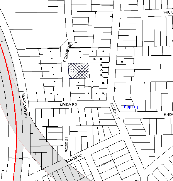
|
NOTIFICATION PLAN |
|
||
|
• PROPERTIES NOTIFIED
|
X SUBMISSIONS RECEIVED |
PROPERTY SUBJECT OF DEVELOPMENT |
|
|
One submission was received out of map range |
|||
Nine submissions (two submissions were received from the same property) objected to the development, generally on the grounds that the development would result in:
· Unacceptable traffic on local streets;
· Loss of commuter parking;
· Noise from the development;
· Waste collection/Storage;
· Privacy impacts;
· Building height;
· Building setbacks;
· Landscaping;
· Building length;
· Stormwater drainage;
· Protection of trees on the adjoining properties;
· Essex Street Heritage Conservation Area listing; and
· Impact on the significance of the HCA.
The concerns raised in the submissions have been addressed within the body of the report with the exception of the following:
5.1.1 Parking on Forest Grove
Six submissions raise concerns in relation to a lack of parking in the future on adjoining streets near Epping Station. The submissions also note that parking is already at capacity on the streets. The parking provision for the development will comply with Epping Town Centre Urban Activation Precinct and HDCP 2013. Council’s Traffic and Road Safety Branch is currently monitoring parking around Epping town centre. Although there are no immediate plans to implement parking management in streets south of Epping Road. A review of parking will be undertaken once the rezoned properties in the area are redeveloped and occupied.
5.1.2 Noise from the Development
A condition is recommended for an Environmental Management Plan where the site must be managed in accordance with the publication ‘Managing Urban Stormwater – Landcom (March 2004) and the Protection of the Environment Operations Act 1997 by way of implementing appropriate measures to prevent sediment run-off, excessive dust, noise or odour emanating from the site during the construction of the development.
A further condition is recommended in relation to the ongoing use of the development requiring that all noise generated by the development must be attenuated to prevent levels of noise being emitted to adjacent premises which possess tonal, beating and similar characteristics or which exceeds background noise levels by more than 5dB(A).
5.2 Public Agencies
The development application was not referred to any Public Agencies for comment.
6. THE PUBLIC INTEREST
Section 79C(1)(e) of the Act requires Council to consider “the public interest”.
The public interest is an overarching requirement, which includes the consideration of the matters discussed in this report. Implicit to the public interest is the achievement of future built outcomes adequately responding to and respecting the future desired outcomes expressed in environmental planning instruments and development control plans.
The application is considered to have satisfactorily addressed Council’s and relevant agencies’ criteria and would provide a development outcome that, on balance, would result in a positive impact for the community. Accordingly, it is considered that the approval of the proposed development would be in the public interest.
CONCLUSION
The application seeks approval for the demolition of the existing structures and the construction of a five storey residential flat building comprising 55 units with one and a half levels of basement car parking. The proposed development would be located on a site within a locality zoned as a high density residential precinct.
The proposed development is generally satisfactory in respect to the Hornsby Local Environmental Plan 2013, design principles under SEPP 65 and the best practice guidelines of the Residential Flat Design Code, subject to recommended conditions. The proposed development has regard to the requirements of the Hornsby DCP 2013 and is considered acceptable in respect to the desired future character of the Epping Road/Forest Grove, Epping Precinct.
Nine submissions were received in respect to the proposal raising concerns in relation to traffic, loss of privacy, impact on the heritage conservation area, stormwater drainage and impact on trees on neighbouring properties. Subject to compliance with recommended conditions, the proposed development is considered acceptable.
The application is recommended for approval.
Note: At the time of the completion of this planning report, no persons have made a Political Donations Disclosure Statement pursuant to Section 147 of the Environmental Planning and Assessment Act 1979 in respect of the subject planning application.
RESPONSIBLE OFFICER
The officer responsible for the preparation of this Report is the Manager – Development Assessments – Rodney Pickles, who can be contacted on 9847 6731.
|
Rod Pickles Manager - Development Assessment Planning Division |
James Farrington Group Manager Planning Division |
|
1.View |
Locality Map |
|
|
|
2.View |
Floor Plans |
|
|
|
3.View |
Elevations and Sections |
|
|
|
4.View |
Landscape Plans |
|
|
|
5.View |
Concept Drainage Plans |
|
|
File Reference: DA/304/2015
Document Number: D06475965
SCHEDULE 1
GENERAL CONDITIONS
The conditions of consent within this notice of determination have been applied to ensure that the use of the land and/or building is carried out in such a manner that is consistent with the aims and objectives of the relevant legislation, planning instruments and council policies affecting the land and does not disrupt the amenity of the neighbourhood or impact upon the environment.
Note: For the purpose of this consent, the term ‘applicant’ means any person who has the authority to act on or the benefit of the development consent.
Note: For the purpose of this consent, any reference to an Act, Regulation, Australian Standard or publication by a public authority shall be taken to mean the gazetted Act or Regulation, or adopted Australian Standard or publication as in force on the date that the application for a construction certificate is made.
1. Approved Plans and Supporting Documentation
The development must be carried out in accordance with the plans and documentation listed below and endorsed with Council’s stamp, except where amended by Council and/or other conditions of this consent:
|
Plan No. |
Plan Title |
Drawn by |
Dated |
|
A2.02 – Issue A |
Basement 1 – Issue A |
A+ Design |
20 March 2015 |
|
A2.01 – Issue A |
Basement 2 – Issue A |
A+ Design |
20 March 2015 |
|
A2.03 – Issue E |
Lower Ground Floor |
A+ Design |
6 November 2015 |
|
A2.04 – Issue E |
Ground Floor |
A+ Design |
6 November 2015 |
|
A2.05 – Issue D |
Level 1 |
A+ Design |
18 September 2015 |
|
A2.06 – Issue D |
Level 2 |
A+ Design |
18 September 2015 |
|
A2.07 – Issue E |
Level 3 |
A+ Design |
6 November 2015 |
|
A2.08 – Issue E |
Level 4 |
A+ Design |
6 November 2015 |
|
A2.09 – Issue D |
Roof |
A+ Design |
18 September 2015 |
|
A3.01 – Issue D |
North Elevation |
A+ Design |
18 September 2015 |
|
A3.02 – Issue D |
East Elevation |
A+ Design |
18 September 2015 |
|
A3.03 – Issue D |
South Elevation |
A+ Design |
18 September 2015 |
|
A3.04 – Issue D |
West Elevation |
A+ Design |
18 September 2015 |
|
A4.01 – Issue E |
Section 1 |
A+ Design |
6 November 2015 |
|
A4.02 – Issue C |
Section 2 |
A+ Design |
6 November 2015 |
|
A5.01 – Issue C |
Materials and Finishes – West Elevation |
A+ Design |
1 September 2015 |
|
A5.02 – Issue C |
Materials and Finishes – East Elevation |
A+ Design |
1 September 2015 |
|
101 – Issue D |
Landscape Plan – Lower Ground Floor |
Site Image Landscape Architects |
10 March 2015 |
|
102 – Issue D |
Landscape Plan – Ground Floor |
Site Image Landscape Architects |
10 March 2015 |
|
103 – D |
Landscape Plan – Level 3 |
Site Image Landscape Architects |
- |
|
104 – D |
Landscape Plan – Level 4 |
Site Image Landscape Architects |
- |
|
501 – D |
Landscape Details |
Site Image Landscape Architects |
- |
|
- |
Arboricultural Impact Report |
Landscape Matrix |
10 September 2015 |
|
- |
Arboricultural supporting letter |
Landscape Matrix |
19 October 2015 |
|
PS01 – Revision C |
Concept Drainage Plan - Ground Floor/Site |
Martens and Associates Pty. Ltd. |
19 October 2015 |
|
PS01 – D201 – Revision A |
Concept Drainage Plan Basement 1 |
Martens and Associates Pty. Ltd. |
20 March 2015 |
|
PS01 – D202 - Revision A |
Concept Drainage Plan Basement 2 |
Martens and Associates Pty. Ltd. |
20 March 2015 |
|
PS01 – D203 - Revision B |
Easement Realignment |
Martens and Associates Pty. Ltd. |
19 October 2015 |
|
PS01 – D400 - Revision A |
Drains Model Results |
Martens and Associates Pty. Ltd. |
20 March 2015 |
|
PS01 – D500 - Revision B |
Drainage Details Humes Jellyfish |
Martens and Associates Pty. Ltd. |
9 September 2015 |
|
PS01 – D501 - Revision A |
Headwall Details |
Martens and Associates Pty. Ltd. |
19 October 2015 |
|
PS01 – I100 - Revision C |
Water Quality Catchment Plan |
Martens and Associates Pty. Ltd. |
19 October 2015 |
|
PS01 – I101 - Revision C |
Water Quality Music Results |
Martens and Associates Pty. Ltd. |
20 March 2015 |
|
|
Additional Flood Study Report |
Martens and Associates Pty. Ltd. |
19 October 2015 |
Supporting Documentation
|
Document Title |
Prepared by |
Dated |
|
Survey Report – Issue A |
A+ Design |
20 March 2015 |
|
BASIX Certificate No. 615185M |
Wood and Grieve Engineers |
18 March 2015 |
|
Traffic and Parking Assessment |
Varga Traffic Planning Pty Ltd |
19 March 2015 |
|
Waste Management Plan |
A+ Design |
12 March 2015 |
|
Statement of Compliance for People with a Disability |
Accessible Building Solutions |
16 March 2015 |
2. Amendment of Plans
The approved plans are to be amended as follows:
a) The ground floor and lower ground floor landscape plans are to be amended to reflect the approved stormwater and architectural plans as follows; PS01 – D200 Concept Drainage Plan - Ground Floor Site, prepared by Martens Pty Ltd dated 19 October 2015 and A2.03 Issue E Lower Ground Floor and A2.04 Issue E Ground Floor prepared by A+ Design dated 6 November 2015.
b) The landscape plan is to be amended providing lapped and capped timber fencing 1.8m in height around the garbage holding area and metal palisade fencing 1.8m in height around the open channel on the northern elevation.
c) The finishing materials of balconies on the eastern elevation are to be changed to natural stone or dark coloured material as marked in red on the approved plans (Levels 1 and 2) to complement the adjoining Heritage Conservation Area.
d) Windows are to be provided in the bedroom of units G10, G20, 110 and 210 as marked in red on the approved floor plans.
e) The approved level 4 floor plan is to be amended as marked in red to include highlight windows in the bedrooms of unit nos. 402 and 405 orientated towards the northern and southern boundary. The balcony areas as marked in red are to be non-trafficable.
f) Unit G04 is to be reconfigured to a 2 bedroom unit with a balcony minimum size of 12m2.
3. Removal of Trees
This development consent permits the removal of tree(s) numbered T1, T2, T3, T4, T6, T7, T8, T9, T10, T12, T13, T14, T15, T16, T17, T18, T19, T20, T21, T22 & T23 as identified in the Arboricultural Impact Report, prepared by Landscape Matrix, dated 10 September 2015.
4. Project Arborist
A Project Arborist is to be appointed in accordance with AS 4970-2009 (1.4.4) to provide monitoring and certification throughout the development process.
Details of the Project Arborist are to be submitted to Council and the PCA prior to the issue of a Construction Certificate.
5. Section 94 Development Contributions
a) In accordance with Section 80A(1) of the Environmental Planning and Assessment Act 1979 and the Hornsby Shire Council Section 94 Development Contributions Plan 2012-2021, the following monetary contributions shall be paid to Council to cater for the increased demand for community infrastructure resulting from the development:
|
Description |
Contribution (4) |
|
Roads |
$39,600.85 |
|
Open Space and Recreation |
$689,202.55 |
|
Community Facilities |
$96,106.45 |
|
Plan Preparation and Administration |
$2,866.25 |
|
TOTAL |
$827,776.10 |
being for 53 additional dwellings in lieu of two existing dwellings.
b) The value of this contribution is current as at 18 November 2015. If the contributions are not paid within the financial quarter that this condition was generated, the contributions payable will be adjusted in accordance with the provisions of the Hornsby Shire Council Section 94 Development Contributions Plan and the amount payable will be calculated at the time of payment in the following manner:
$CPY = $CDC x CPIPY
CPIDC
Where:
$CPY is the amount of the contribution at the date of Payment
$CDC is the amount of the contribution as set out in this Development Consent
CPIPY is the latest release of the Consumer Price Index (Sydney – All Groups) at the date of Payment as published by the ABS.
CPIDC is the Consumer Price Index (Sydney – All Groups) for the financial quarter at the date applicable in this Development Consent Condition.
c) The monetary contributions shall be paid to Council:
i) prior to the issue of the Subdivision Certificate where the development is for subdivision; or
ii) prior to the issue of the first Construction Certificate where the development is for building work; or
iii) prior to issue of the Subdivision Certificate or first Construction Certificate, whichever occurs first, where the development involves both subdivision and building work; or
iv) prior to the works commencing where the development does not require a Construction Certificate or Subdivision Certificate.
Note: It is the professional responsibility of the Principal Certifying Authority to ensure that the monetary contributions have been paid to Council in accordance with the above timeframes.
Council’s Development Contributions Plan may be viewed at www.hornsby.nsw.gov.au or a copy may be inspected at Council’s Administration Centre during normal business hours.
6. Construction Certificate
a) A Construction Certificate is required to be approved by Council or a Private Certifying Authority prior to the commencement of any works under this consent.
b) The Construction Certificate plans must not be inconsistent with the Development Consent plans.
REQUIREMENTS PRIOR TO THE ISSUE OF A CONSTRUCTION CERTIFICATE
7. Building Code of Australia
All building work must be carried out in accordance with the relevant requirements of the Building Code of Australia.
8. Contract of Insurance (Residential Building Work)
In the case of residential building work for which the Home Building Act 1989 requires there to be a contract of insurance in force in accordance with Part 6 of that Act, that such a contract of insurance is in force before any building work authorised to be carried out by the consent commences.
9. Notification of Home Building Act, 1989 Requirements
Residential building work within the meaning of the Home Building Act 1989 must not be carried out unless the principal certifying authority for the development to which the work relates (not being Council) has given Council written notice of the following information:
a) In the case of work for which a principal contractor is required to be appointed:
i) The name and licence number of the principal contractor; and
ii) The name of the insurer by which the work is insured under Part 6 of that Act.
b) In the case of work to be done by an owner-builder:
i) The name of the owner-builder; and
ii) If the owner-builder is required to hold an owner-builder’s permit under that Act, the number of the owner-builder’s permit.
Note: If arrangements for doing the residential building work are changed while the work is in progress so that the information notified becomes out of date, further work must not be carried out unless the principal certifying authority for the development to which the work relates (not being Council) has given Council written notification of the updated information.
10. Utility Services
The applicant must submit written evidence of the following service provider requirements:
a) Ausgrid (formerly Energy Australia) – a letter of consent demonstrating that satisfactory arrangements have been made to service the proposed development.
b) Telstra – a letter of consent demonstrating that satisfactory arrangements have been made to service the proposed development.
11. Sydney Water – Quick Check
This application must be submitted to a Sydney Water ‘Quick Check Agent’ or ‘Customer Centre’ for approval to determine whether the development would affect any Sydney Water infrastructure, and whether further requirements are to be met.
Note: Refer to www.sydneywater.com.au or telephone 13 20 92 for assistance.
12. Dilapidation Report
A ‘Dilapidation Report’ is to be prepared by a ‘chartered structural engineer’ detailing the structural condition of the adjoining properties at Nos. 64, 66 and 68 Essex St, No. 21 Forest Grove and No. 9A Maida Road Epping.
13. Adaptable Units and Letter Boxes
a) The details of all adaptable units must be provided with the Construction Certificate Plans.
b) The details of all letter boxes must be provided with the Construction Certificate Plans.
14. Allocation of Resident Storage Areas
Storage areas are to be allocated internally to each unit to comply with the Residential Flat Design Code 6m3 (Min) for 1 bedroom unit, 8m3 (Min) for two bedroom units and 10 m3 (Min) for 3 bedroom units. 50% is to be accessible from the apartments.
15. Disabled Parking
All parking for people with disabilities is to comply with AS/NZS 2890.6:2009 Off-street parking for people with disabilities. Space no. 65 in basement 1 is to be relocated and provided with an appropriate shared area not including the aisle.
16. Bicycle Parking
Bicycle parking spaces are to be designed in accordance with AS 2890.3-1993 Bicycle parking facilities. One additional bike rack is to be provided for visitor use.
17. Motorcycle Parking
Two motorcycle spaces are required to be provided. Motorcycle parking spaces are to be designed in accordance with AS 2890.5-1993.
18. Construction Traffic Management Plan
A Construction Traffic Management Plan (CTMP) is to be submitted to Council and approval given prior to the issue of a Construction Certificate. The Plan should assess traffic impacts associated with construction works on public roads and must include:
a) Site location
b) Scope of works
c) Order of construction works
d) Identification of traffic hazards during all stages of works
e) Identification of potential risks during all stages of works
f) A map of the State and local roads in the proximity of the development
g) A map of truck routes to and from the development site during all stages of works
h) A map of existing parking restrictions in the proximity of the development
i) Hours of operation
j) Frequency of truck movements on a daily basis during all stages of works
k) A map of the access arrangements onto the development site during all stages of works
l) Swept path diagrams
m) Consideration of Work Zones for the development site
n) Consideration of mobile crane movements
o) Location of temporary hoardings, fencing or awning
p) Pedestrian and cyclist access and safety.
19. Construction Management Plan
A Construction Management Plan (CMP), prepared by a suitably qualified consultant, must be submitted for approval by Council. The CMP must be include, but not be limited, details of the following:
a) Noise attenuation measures be implemented along the eastern boundary of the site including a hoarding height not less than 3m from the existing ground level;
b) During excavation works, rock removal must be undertaken by sawing instead of rock hammering, wherever practicable;
c) The construction works must be undertaken in accordance with the “Interim Construction Noise Guidelines – 2009” published by DECCW and achieve compliance with the relevant noise levels; and
d) The delivery times and vehicular movements related to demolition, excavation and construction works must be restricted to the construction hours only.
20. Identification of Survey Marks
A registered surveyor must identify all survey marks in the vicinity of the proposed development. Any survey marks required to be removed or displaced as a result of the proposed development shall be undertaken by a registered surveyor in accordance with Section 24 (1) of the Surveying and Spatial Information Act 2002 and following the Surveyor General’s Directions No.11 – "Preservation of Survey Infrastructure".
21. Diversion of Council Stormwater Pipe
The existing Council’s drainage line passing through the development site is to be replaced by a reinforced concrete culvert of minimum 2m wide in accordance with Flood Report by Martens, Associates PTY Ltd, Dated 19th October 2015 Council document No D06727510 and the plans, Project No P1504642, Drawings SK A001 to A008 dated 19 October 2015 and Drawing PS01- D200-C Dated 19 October 2015 and adhere to the following conditions:
a) The construction of the culvert shall be carried out prior to commencement of any building works.
b) A construction certificate is to be submitted to Council for approval of the culvert construction.
c) The works are to be carried out in a manner so that no adverse impacts are created on neighbouring properties. Consents from neighbouring property owners are to be taken to carry out any works from those properties (if necessary).
d) No trees are to be planted within the easement.
Note: Council is the only authority that can issue a construction certificate for construction of a stormwater line that is to be maintained by Council.
22. Stormwater Drainage
The stormwater drainage system for the development must be designed for an average recurrence interval (ARI) of 20 years and be gravity drained in accordance with the following requirements:
a) Connected directly to a pit of Council’s drainage system.
b) Be designed by a Chartered Professional Civil/ Hydraulic Engineer of the Institution of Engineers, Australia.
23. On Site Stormwater Detention
An on-site stormwater detention system must be designed by a chartered civil engineer and constructed in accordance with the following requirements:
a) Storage capacity to accommodate volume from up to 20 years ARI (average recurrence interval) storms and a maximum discharge (when full) limited to 5 years pre development rate.
b) Have a surcharge/inspection grate located directly above the outlet. Discharge from the detention system to be controlled via 1 metre length of pipe, not less than 50 millimetres diameter or via a stainless plate with sharply drilled orifice bolted over the face of the outlet discharging into a larger diameter pipe capable of carrying the design flow to an approved Council system.
c) Where above ground system is proposed and the average depth is greater than 0.3 metres, a ‘pool type’ safety fence and warning signs to be installed
d) Not be constructed in a location that would impact upon the visual or recreational amenity of residents.
e) Detail calculations are to be shown in construction certificate plan.
f) An overflow/escape path shall be incorporated in the design.
24. Water Quality/Bio Retention System
a) Stormwater discharging from the development site is to be treated to achieve the quality specified in Council’s Development Control Plan 2012 (table 1C.1.2(b) Urban Stormwater Quality Targets) and a quality treatment system is to be constructed.
b) Prior to occupation of the premises, a Chartered Civil/Hydraulic Engineer of the Institution of Engineers, Australia is to certify that works have been completed in accordance with the approved construction plan and the measures will achieve the targets specified in the condition.
25. Vehicular Crossing
A separate application under the Local Government Act, 1993 and the Roads Act 1993 must be submitted to Council for the installation of a new vehicular crossing and the removal of the redundant crossing. The vehicular crossing must be constructed in accordance with Council’s Civil Works Design 2005 and the following requirements:
a) Design levels at the front boundary must be obtained from Council for the design on the internal driveway;
b) Any redundant crossings must be replaced with integral kerb and gutter;
c) The footway area must be restored by turfing;
d) Approval must be obtained from all relevant utility providers that all necessary conduits be provided and protected under the crossing.
Note: An application for a vehicular crossing can only be made to one of Council’s Authorised Vehicular Crossing Contractors. You are advised to contact Council on 02 9847 6940 to obtain a list of contractors.
26. Internal Driveway/Vehicular Areas
The driveway and parking areas on site must be designed, constructed and a Construction Certificate issued in accordance with Australian Standards 2890.1, 2890.2, 3727 and the following requirements:
a) Design levels at the front boundary shall be obtained from Council if a private accredited certifier is engaged to obtain a construction certificate for these works.
b) The driveway be a rigid pavement.
c) Conduit for utility services including electricity, water, gas and telephone be provided. All existing overhead assets including electricity and telecommunications cabling shall be relocated underground at no cost to Council. A certificate from an appropriately licensed contractor shall be submitted to the principal certifying authority certifying that the service conduits have been installed in accordance with the relevant utility provider and Australian Standards.
d) Longitudinal sections along both sides of the access driveway shall be submitted to the principal certifying authority in accordance with the relevant sections of AS 2890.1. The maximum grade shall not exceed 1 in 4 (25%) with the maximum changes of grade of 1 in 8 (12.5%) for summit grades and 1 in 6.7 (15%) for sag grades. Any transition grades shall have a minimum length of 2 metres. The longitudinal sections shall incorporate the design levels obtained by Council.
27. Road Works- Footpath and Kerb and Gutter
All road works approved under this consent must be designed in accordance with Council’s Civil Works Design and Construction Specification 2005 and the following requirements:
a) The existing concrete footpath is removed and a new concrete footpath constructed within the road verge with the remaining area turfed along the full frontage of the development.
b) The existing kerb and gutter along the frontage of the property shall be removed and a new concrete kerb and gutter constructed.
c) The existing road pavement to be saw cut a minimum of 300 mm from the existing edge of the bitumen and reconstructed.
d) The submission of a compaction certificate from a geotechnical engineer for any fill within road reserves, and all road sub-grade and road pavement materials.
28. Waste Management Details
The following waste management requirements must be complied with:
a) The approved on-going waste management system must not be amended without the written consent of Council.
b) The waste facilities on each residential level must comfortably house the garbage chute and one 240 L recycling bin. (Note: a 240 L recycling bin is 600 mm wide by 750 mm deep; allow for ease around the bin – 75 mm is recommended).
c) The waste facilities on each residential level must be accessible by persons with a disability.
d) The chute system must be fitted with a 4 x 660 L bin carousel to automatically change the bins under the chute when they become full. Compaction is not required.
e) The ventilation system for the bin room at the lower ground level must be designed to prevent air flow from the bin room to the lower ground lobby areas.
f) The door to the bulky waste storage room should open outwards.
g) The first 6 m of the driveway must have a gradient no steeper than 1:20. For the first 6 m of driveway, lane separation must not be by raised median (line marking and/or rumble bars are acceptable). The car park security access point must not be located within the first 6 m of the driveway.
h) The opening between the bin collection area and the driveway must be no less than 1.5 m wide smooth hard surface and must not include any steps.
i) A Waste Management Plan Section One – Demolition Stage and Section Three – Construction Stage, covering the scope of this project and including the following details, is required to be submitted to Council:
i) An estimate of the types and volumes of waste and recyclables to be generated;
ii) A site plan showing sorting and storage areas for demolition and construction waste and the vehicle access to these areas;
iii) How excavation, demolition and construction waste materials will be reused or recycled and where residual wastes will be disposed;
iv) The total percentage (by weight) of demolition and construction waste that will be reused or recycled.
29. Preservation of Survey Infrastructure
Prior to the issue of a construction certificate, a registered surveyor shall identify all survey marks in the vicinity of the proposed development. Any survey marks required to be removed or displaced as a result of the proposed development shall be undertaken by a registered surveyor in accordance with Section 24 (1) of the Surveying and Spatial Information Act 2002 and following the Surveyor General’s Directions No.11 – "Preservation of Survey Infrastructure".
REQUIREMENTS PRIOR TO THE COMMENCEMENT OF ANY WORKS
30. Erection of Construction Sign
A sign must be erected in a prominent position on any site on which building work, subdivision work or demolition work is being carried out:
a) Showing the name, address and telephone number of the principal certifying authority for the work;
b) Showing the name of the principal contractor (if any) for any demolition or building work and a telephone number on which that person may be contacted outside working hours; and
c) Stating that unauthorised entry to the work site is prohibited.
Note: Any such sign is to be maintained while the building work, subdivision work or demolition work is being carried out, but must be removed when the work has been completed.
31. Protection of Adjoining Areas
A temporary hoarding, fence or awning must be erected between the work site and adjoining lands before the works begin and must be kept in place until after the completion of the works if the works:
a) Could cause a danger, obstruction or inconvenience to pedestrian or vehicular traffic.
b) Could cause damage to adjoining lands by falling objects.
c) Involve the enclosure of a public place or part of a public place.
Note: Notwithstanding the above, Council’s separate written approval is required prior to the erection of any structure or other obstruction on public land.
32. Toilet Facilities
Toilet facilities must be available or provided at the works site before works begin and must be maintained until the works are completed at a ratio of one toilet for every 20 persons employed at the site. Each toilet must:
a) be a standard flushing toilet connected to a public sewer; or
b) be a temporary chemical closet approved under the Local Government Act 1993; or
c) have an on-site effluent disposal system approved under the Local Government Act 1993.
33. Erosion and Sediment Control
Erosion and sediment control measures must be provided and maintained throughout the construction period in accordance with the manual ‘Soils and Construction 2004 (Bluebook)’, the approved plans, Council specifications and to the satisfaction of the principal certifying authority. The erosion and sediment control devices must remain in place until the site has been stabilised and revegetated.
Note: On the spot penalties may be issued for any non-compliance with this requirement without any further notification or warning.
34. Tree Protection Requirements
a) The Project Arborist must oversee and provide certification for the installation of all tree protection measures as specified in this consent.
b) Certification must be provided by the Project Arborist to the Principal Certifying Authority stating that all required tree protection measures have been installed in accordance with AS 4970-2009 Section 5.3.2.
35. Tree Protection Zone Fencing (TPZ)
a) Tree protection fencing must be installed around trees numbered T11, T25, T26, T27 & T28 at the distances determined by AS 4970-2009 Section 3.
b) Where tree protection fencing cannot be located at the perimeter of the Tree Protection Zone, appropriate ground and crown protection must be provided in accordance with AS 4970-2009 Section 4.5 under the direction of the project arborist.
c) Tree Protective Fencing must be installed in accordance with AS 4970-2009 Sections 4.3 and 4.4
d) Maintenance of the Tree Protection Zones must be carried out in accordance with AS 4970-2009 Section 4.6 for the duration of this consent.
REQUIREMENTS DURING DEMOLITION AND CONSTRUCTION
36. Construction Work Hours
All work on site (including demolition and earth works) must only occur between 7am and 5pm Monday to Saturday (unless otherwise approved in writing by Council, due to extenuating circumstances). No work is to be undertaken on Sundays or public holidays. No excavation or rock sawing/breaking is to occur on Saturdays.
37. Demolition
All demolition work must be carried out in accordance with “Australian Standard 2601-2001 – The Demolition of Structures” and the following requirements:
a) Demolition material must be disposed of to an authorised recycling and/or waste disposal site and/or in accordance with an approved waste management plan;
b) Demolition works, where asbestos material is being removed, must be undertaken by a contractor that holds an appropriate licence issued by WorkCover NSW in accordance with Chapter 10 of the Occupational Health and Safety Regulation 2001 and Clause 29 of the Protection of the Environment Operations (Waste) Regulation 2005 ;and
c) On construction sites where buildings contain asbestos material, a standard commercially manufactured sign containing the words ‘DANGER ASBESTOS REMOVAL IN PROGRESS’ measuring not less than 400mm x 300mm must be erected in a prominent position visible from the street.
38. Environmental Management
The site must be managed in accordance with the publication ‘Managing Urban Stormwater – Landcom (March 2004) and the Protection of the Environment Operations Act 1997 by way of implementing appropriate measures to prevent sediment run-off, excessive dust, noise or odour emanating from the site during the construction of the development.
39. Asbestos and Soil Contamination
Should the presence of asbestos or soil contamination, not recognised during the application process be identified during works, the applicant must immediately notify the principal certifying authority and Council.
40. Street Sweeping
Street sweeping must be undertaken following sediment tracking from the site along Forest Grove, Epping during works and until the site is established.
The street cleaning services must undertake a street ‘scrub and dry’ method of service and not a dry sweeping service that may cause sediment tracking to spread or cause a dust nuisance.
41. Landfill
Landfill must be constructed in accordance with Council’s ‘Construction Specification 2005’ and the following requirements:
a) All fill material imported to the site is to wholly consist of Virgin Excavated Natural Material (VENM) as defined in Schedule 1 of the Protection of the Environment Operations Act 1997 or a material approved under the Department of Environment and Climate Change’s general resource recovery exemption.
b) A compaction certificate is to be obtained from a geotechnical engineer verifying that the specified compaction requirements have been met.
42. Excavated Material
All excavated material removed from the site must be classified in accordance with the Department of Environment, Climate Change and Water NSW Waste Classification Guidelines prior to disposal to an approved waste management facility and reported to the principal certifying authority.
43. Survey Report – Finished Floor Level
A report(s) must be prepared by a registered surveyor and submitted to the principal certifying authority prior to the pouring of concrete at each level of the building certifying that:
a) The building, retaining walls and the like have been correctly positioned on the site; and
b) The finished floor level(s) are in accordance with the approved plans.
c) Confirming that the waste collection vehicle turning area complies with AS2890.1 – 2004 and AS20890.2 – 2002 for small rigid vehicles (SRV).
44. Traffic Control Plan Compliance
The development must be carried out in accordance with the submitted Traffic Control Plan (TCP).
45. Council Property
During construction works, no building materials, waste, machinery or related matter is to be stored on the road or footpath. The public reserve must be kept in a clean, tidy and safe condition at all times.
Note: This consent does not give right of access to the site via Council’s park or reserve. Should such access be required, separate written approval is to be obtained from Council.
46. Waste Management Details
Waste management during the demolition and construction phase of the development must be undertaken in accordance with the approved Waste Management Plan. Additionally written records of the following items must be maintained during the removal of any waste from the site and such information submitted to the Principal Certifying Authority within fourteen days of the date of completion of the works:
a) The identity of the person removing the waste.
b) The waste carrier vehicle registration.
c) Date and time of waste collection.
d) A description of the waste (type of waste and estimated quantity).
e) Details of the site to which the waste is to be taken.
f) The corresponding tip docket/receipt from the site to which the waste is transferred (noting date and time of delivery, description (type and quantity) of waste).
g) Whether the waste is expected to be reused, recycled or go to landfill.
Note: In accordance with the Protection of the Environment Operations Act 1997, the definition of waste includes any unwanted substance, regardless of whether it is reused, recycled or disposed to landfill.
47. Maintenance and Monitoring of Tree Protection
All Tree Protection Zones must be monitored by the Project Arborist in accordance with AS 4970 2009 Section 5.4.
48. Works within Tree Protection Zones
a) All works must be approved by the Project Arborist.
b) Root/ground protection must be provided in accordance with AS 4970-2009 Section 4.5.4
c) Underground services must be installed in accordance with AS 4970-2009 Section 4.5.5.
d) All scaffolding must be installed in accordance with AS 4970-2009 Section 4.5.6.
e) Root pruning outside a trees Structural Root Zone must be carried out in accordance with AS 4970-2009 Sections 3.3.4, 4.5.4 and 4.5.5.
f) Activities within the Tree Protection Zone must comply with AS 4970-2009 Section 4.2.
g) Where works have been undertaken within the Tree Protection Zone of a tree the Project Arborist must assess the condition of tree(s) and the growing environment and make recommendations for, and carry out remedial actions where there is evidence of:
i) A general decline in health and vigour
ii) Damaged, crushed or dying roots
iii) Excessive (>10%) loss or dieback of roots, branches and foliage
iv) Mechanical damage or bruising of bark and timber of roots, trunks and branches
v) Yellowing of foliage of thinning of canopy uncharacteristic of the species
vi) An increase in the amount of deadwood not associated with normal growth
vii) Inappropriate increase in the development of epicormic growth and/or the presence of sucker growth on the trunk
viii) Branch drop, torn branches and stripped bark not associated with natural climate conditions.
REQUIREMENTS PRIOR TO THE ISSUE OF AN OCCUPATION CERTIFICATE
Note: For the purpose of this consent, a reference to ‘occupation certificate’ shall not be taken to mean an ‘interim occupation certificate’ unless otherwise stated.
49. Fulfilment of BASIX Commitments
The applicant must demonstrate the fulfilment of BASIX commitments pertaining to the development.
50. Installation of Privacy Devices at the Eastern Façade
The following devices must be installed on the eastern façade to maintain and element of privacy towards the adjoining properties:
a) All balconies on Levels 1-3 on the eastern façade are to include fully stackable louvered privacy screens for the full length of the balcony.
b) Any required privacy screen must have no individual openings more than 30mm wide and have a total of all openings less than 30% of the surface area of the screen.
c) All glass balustrade balconies on the eastern elevation are to include obscure glazing.
51. Retaining Walls
All required retaining walls must be constructed as part of the development.
52. Unit Numbering
All units are to be numbered consecutively commencing at No.1. The strata plan lot number is to coincide with the unit number, e.g. unit 1 = lot 1. The allocation of unit numbering must be authorised by Council prior to the numbering of each unit in the development.
53. Parking Allocation
The six groups of tandem parking is to be allocated to the six three bedroom units, G04, G05, 308, 309, 402 and 405 on the approved plans.
54. Sydney Water – s73 Certificate
An s73 Certificate must be obtained from Sydney Water.
Note: Sydney Water requires that s73 applications are to be made through an authorised Sydney Water Servicing Coordinator. Refer to www.sydneywater.com.au or telephone 13 20 92 for assistance.
55. Damage to Council Assets
Any damage caused to Council’s assets as a result of the construction or demolition of the development must be rectified in accordance with Council’s Civil Works Specifications. Council’s Restorations Supervision must be notified for a formwork inspection prior to pouring concrete.
56. Fencing
A 1.8m fence is to be provided around the proposed open channel on the northern boundary as marked in red on the approved Concept Drainage Plan PS01 – D200 Revision C prepared by Martens Pty Ld. dated 19 October 2015.
57. Planter Boxes / On Slab Planting
On slab planter boxes must include waterproofing, subsoil drainage (proprietary drainage cell, 50mm sand and filter fabric) automatic irrigation, minimum 500mm planting soil for shrubs and minimum 1000mm planting soil for trees and palms and 75mm mulch to ensure sustainable landscape is achieved.
58. Street Tree Plantings
Planting to the front verge is to include 3 x Tristaniopsis laurina (Water Gum). Street trees are to be installed in minimum 100 litre pot size, with stakes and ties for a period of establishment and set within a mulched bed, which is to be maintained into the future.
59. Completion of Landscape Works
A certificate must be provided by a practicing landscape architect, horticulturalist or person with similar qualifications and experience certifying that all required landscape works have been satisfactorily completed in accordance with the approved landscape plans.
Note: Applicants are advised to pre-order plant material required in pot sizes 45 litre or larger to ensure Nurseries have stock available at the time of install.
60. Certification
Following the final inspection and the completion of any remedial works, the Project Arborist must submit to the Principal Certifying Authority documentation stating that the completed works have been carried out in compliance with the approved plans and the relevant conditions of consent.
61. Safety and Security
This site must include the following elements:
a) An intercom system must be installed at gate locations to ensure screening of persons entering the units.
b) The entry doors to the pedestrian foyer is to be constructed of safety rated glass to enable residents a clear line of site before entering or exiting the residential apartments.
c) Lighting is to be provided to pathways, building foyer entries, driveways and common external spaces.
d) Security gate access is to be provided to the car parking areas allowing residents-only access to private car spaces.
e) CCTV cameras must be installed at the entry and exit point and the around the mailbox.
f) The communal open spaces within the site must be illuminated with high luminance by motion sensor lighting.
g) The driveway and basement car parking must be illuminated with low luminance at all times.
h) Security deadlocks are to be provided to each apartment door.
i) Peep holes are to be provided to individual apartment doors to promote resident safety.
62. External Lighting
All external lighting must be designed and installed in accordance with Australian Standard AS 4282 – Control of the Obtrusive Effects of Outdoor Lighting. Certification of compliance with the Standard must be obtained from a suitably qualified person.
63. Provision for National Broadband Network (NBN)
Provision must be made for fibre ready passive infrastructure (pits and pipes) generally in accordance with NBN Co.'s pit and pipe installation guidelines to service the proposed development. A certificate from NBN Co or the provider must be submitted to the PCA that the fibre optic cabling provided for the development complies with MDU Building Design Guides for Development.
64. Works as Executed Plan
A works-as-executed plan(s) must be prepared by a registered surveyor and submitted to Council for completed road pavement, kerb & gutter, culvert, driveways, on-site detention and water quality treatment systems. The plan(s) must be accompanied by a certificate from a registered surveyor certifying that all pipelines and associated structures lie wholly within any relevant easements.
65. Certificate of Preservation of Survey Marks
Prior to the issue of a construction certificate, a registered surveyor shall identify all survey marks in the vicinity of the proposed development. Any survey marks required to be removed or displaced as a result of the proposed development shall be undertaken by a registered surveyor in accordance with Section 24 (1) of the Surveying and Spatial Information Act 2002 and following the Surveyor General’s Directions No.11 – "Preservation of Survey Infrastructure".
66. Waste Management Details
The following waste management requirements must be complied with:
a) Prior to an Occupation Certificate being issued or the use commencing, whichever is earlier, the Principal Certifying Authority must obtain Council’s approval of the waste and recycling management facilities provided in the development and ensure arrangements are in place for domestic waste collection by Council.
Note: Waste and recycling management facilities includes everything required for on-going waste management on the site. For example the garbage chute system, volume handling equipment, bin lifter, motorised bin trolley or similar, recycling bin storage on each residential level, bin storage areas, bulky waste storage area, bin collection area, waste collection vehicle access, doors wide enough to fit the bin through, etc.
b) The garbage room at the lower ground levels must include water or a hose for cleaning, graded floors with drainage to sewer, a robust door, sealed and impervious surface, adequate lighting and ventilation, and must be lockable. The waste facility rooms/cupboards at each residential level must include sealed and impervious surface, adequate lighting and ventilation.
c) A report must be prepared by an appropriately qualified person, certifying the following:
i) A comparison of the estimated quantities of each waste type against the actual quantities of each waste type.
Note: Explanations of any deviations to the approved Waste Management Plan is required to be included in this report.
ii) That at least 60% of the waste generated during the demolition and construction phase of the development was reused or recycled.
Note: If the 60% diversion from landfill cannot be achieved in the Construction Stage, the Report is to include the reasons why this occurred and certify that appropriate work practices were employed to implement the approved Waste Management Plan. The Report must be based on documentary evidence such as tipping dockets/receipts from recycling depots, transfer stations and landfills, audits of procedures etc. which are to be attached to the report.
iii) All waste was taken to site(s) that were lawfully permitted to accept that waste.
d) Each unit must be provided with an indoor waste/recycling cupboard for the interim storage of a minimum one day’s waste generation with separate containers for general waste and recyclable materials.
e) Space must be provided for either individual compost containers for each unit or a communal compost container.
Note: The location of the compost containers should have regard for potential amenity impacts.
f) The bin carting routes must be devoid of any steps.
Note: Ramps between different levels are acceptable.
g) Access to the automatic waste volume handling equipment (4 x 660L bin carousel) by unauthorised persons (including residents and waste collectors) must be prevented.
Note: Caging of the automatic volume handling equipment is acceptable.
h) A bin lifter must be provided in the lower ground bin room to enable the site caretaker to safely decant the 240L garbage bins from the lower ground level waste facilities into the 660L garbage bins.
67. Creation of Easements
The following matter(s) must be nominated on the plan of subdivision under s88B of the Conveyancing Act, 1919:
a) A drainage easement 3 metres wide over the constructed culvert alignment in favour of Council and in accordance with the terms set out in Memorandum B5341305V filed with the NSW Department of Lands.
b) A restriction over the flow path for a 100 year average recurrence interval storm. The "Restriction on the Use of Land" over the affected lots is to prohibit the alteration of the final floodway shape and the erection of any structures, including fencing, in the floodway without the written permission of Council. The terms of this restriction must be obtained from Council.
c) The creation of an appropriate "Positive Covenant" and "Restriction as to User" over the constructed on-site detention and water quality treatment systems and outlet works, within the lots in favour of Council in accordance with Council’s prescribed wording. The position of the on-site detention system and water quality treatment system is to be clearly indicated on the title.
d) To register the positive covenant and the restriction on the use of land, “works-as-executed” details of the on-site-detention system and water quality treatment system must be submitted verifying that the required storage and discharge rates and water quality treatment measures have been constructed in accordance with the design requirements. The details must show the invert levels of the on- site system together with pipe sizes and grades and details of water quality treatment measures. Any variations to the approved plans must be shown in red on the “works-as-executed” plan and supported by calculations.
68. Garbage Collection Easement
For the purpose of waste collection, an easement entitling Council, its servants and agents and persons authorised by it to enter upon the subject land and to operate thereon, vehicles and other equipment for the purposes of garbage collection must be granted to Council by the owner of the land.
Note: The easement must be in a form prescribed by Council and must include covenants to the effect that parties will not be liable for any damage caused to the subject land or any part thereof or to any property located therein or thereon by reason of the operation thereon of any vehicle or other equipment used in connection with the collection of garbage and to the effect that the owner for the time being of the subject land shall indemnify the Council, its servants, agents and persons authorised by it to collect garbage against liability in respect of any such claims made by any person whomsoever.
69. Completion of Works and Compliance Certificate
All engineering works identified in this consent are to be completed and a Compliance Certificate issued prior to the release of occupation permit.
OPERATIONAL CONDITIONS
70. Fire Safety Statement – Annual
On at least one occasion in every 12 month period following the date of the first ‘Fire Safety Certificate’ issued for the property, the owner must provide Council with an annual ‘Fire Safety Certificate’ to each essential service installed in the building.
71. Noise
All noise generated by the proposed development must be attenuated to prevent levels of noise being emitted to adjacent premises which possess tonal, beating and similar characteristics or which exceeds background noise levels by more than 5dB(A).
72. Ongoing Car Parking Requirements
All car parking must be constructed and operated in accordance with Australian Standard AS/NZS 2890.1:2004 – Off Street Car Parking and Australian Standard AS 2890.2:2002 – Off Street Commercial Vehicle Facilities and the following requirements:
a) All parking areas and driveways are to be sealed to an all-weather standard, line marked and signposted;
b) Car parking, loading and manoeuvring areas to be solely for nominated purposes;
c) Vehicles awaiting loading, unloading or servicing shall be parked on site and not on adjacent or nearby public roads;
d) All vehicular entry to the site and egress from the site shall be made in a forward direction;
e) Any proposed landscaping and/or fencing must not restrict sight distance to pedestrians and cyclists travelling along the footpath;
f) Residential parking spaces are to be secure spaces with access controlled by card or numeric pad;
g) Visitors must be able to access the visitor parking spaces in the basement car park at all times;
h) All parking for people with disabilities is to comply with Australian Standard AS/NZS 2890.6:2009 – Off Street Parking for People with Disabilities;
i) Bicycle parking spaces are to be designed in accordance with Australian Standard AS 2890.3:1993 – Bicycle Parking Facilities;
j) Motorcycle parking spaces are to be designed in accordance with Australian Standard AS 2890.5:1993; and
k) Access for garbage vehicles is to satisfy the requirements of Council’s Waste Management Branch.
73. Waste Management
The waste management on site must be in accordance with the following requirements:
a) A site caretaker must be employed and be responsible for moving bins where and when necessary, washing bins and maintaining waste storage areas, ensuring the chute system and related devices are maintained in effective and efficient working order, decanting 240 L garbage bins into 660 L garbage bins, managing the communal composting area, managing the bulky item storage area, arranging the prompt removal of dumped rubbish, and ensuring all residents are informed of the use of the waste management system. The site caretaker must be employed for a sufficient number of hours each week to allow all waste management responsibilities to be carried out to a satisfactory standard.
74. Landscape Establishment
The landscape works must be maintained into the future to ensure the establishment and successful growth of plant material to meet the intent of the landscape design. This must include but not be limited to watering, weeding, replacement of failed plant material and promoting the growth of plants through standard industry practices.
- END OF CONDITIONS -
ADVISORY NOTES
The following information is provided for your assistance to ensure compliance with the Environmental Planning and Assessment Act 1979, Environmental Planning and Assessment Regulation 2000, other relevant legislation and Council’s policies and specifications. This information does not form part of the conditions of development consent pursuant to Section 80a of the Act.
Environmental Planning and Assessment Act 1979 Requirements
The Environmental Planning and Assessment Act 1979 requires:
· The issue of a construction certificate prior to the commencement of any works. Enquiries can be made to Council’s Customer Services Branch on 9847 6760.
· A principal certifying authority to be nominated and Council notified of that appointment prior to the commencement of any works.
· Council to be given at least two days written notice prior to the commencement of any works.
· Mandatory inspections of nominated stages of the construction inspected.
· An occupation certificate to be issued before occupying any building or commencing the use of the land.
Long Service Levy
In accordance with Section 34 of the Building and Construction Industry Long Service Payments Act 1986, a ‘Long Service Levy’ must be paid to the Long Service Payments Corporation or Hornsby Council.
Note: The rate of the Long Service Levy is 0.35% of the total cost of the work.
Note: Hornsby Council requires the payment of the Long Service Levy prior to the issue of a construction certificate.
Tree and Vegetation Preservation
In accordance with Clause 5.9 of the Hornsby Local Environmental Plan 2013 a person must not ringbark, cut down, top, lop, remove, injure or wilfully destroy any tree or other vegetation protected under the Hornsby Development Control Plan 2013 without the authority conferred by a development consent or a permit granted by Council.
Notes: A tree is defined as a long lived, woody perennial plant with one or relatively few main stems with the potential to grow to a height greater than three metres (3M). (HDCP 1B.6.1.c).
Tree protection measures and distances are determined using the Australian Standard AS 4970:2009, “Protection of Trees on Development Sites”.
Fines may be imposed for non-compliance with both the Hornsby Local Environmental Plan 2013 and the Hornsby Development Control Plan 2013.
Disability Discrimination Act
The applicant’s attention is drawn to the existence of the Disability Discrimination Act. A construction certificate is required to be obtained for the proposed building/s, which will provide consideration under the Building Code of Australia, however, the development may not comply with the requirements of the Disability Discrimination Act. This is the sole responsibility of the applicant.
Dial Before You Dig
Prior to commencing any works, the applicant is encouraged to contact Dial Before You Dig on 1100 or www.dialbeforeyoudig.com.au for free information on potential underground pipes and cables within the vicinity of the development site.
Telecommunications Act 1997 (Commonwealth)
If you are aware of any works or proposed works which may affect or impact on Telstra’s assets in any way, you are required to contact: Telstra’s Network Integrity Team on Phone Number 1800810443.
Asbestos Warning
Should asbestos or asbestos products be encountered during demolition or construction works, you are advised to seek advice and information prior to disturbing this material. It is recommended that a contractor holding an asbestos-handling permit (issued by WorkCover NSW) be engaged to manage the proper handling of this material. Further information regarding the safe handling and removal of asbestos can be found at:
Alternatively, telephone the WorkCover Asbestos and Demolition Team on 8260 5885.
House/Unit Numbering
House numbering can only be authorised by Council. Before proceeding to number each premise in the development, the allocation of numbers is required to be obtained from Council's Planning Division prior to the issue of a Subdivision Certificate. The authorised numbers are required to comply with Council’s Property Numbering Policy and be displayed in a clear manner at or near the main entrance to each premise.
Group Manager’s Report No. PL85/15
Planning Division
Date of Meeting: 9/12/2015
8 DEVELOPMENT APPLICATION - FIVE STOREY RESIDENTIAL FLAT BUILDING COMPRISING 34 UNITS - 433-437 PACIFIC HIGHWAY, ASQUITH
EXECUTIVE SUMMARY
|
DA No: |
DA/956/2014 (Lodged 25 August 2014) |
|
Description: |
Demolition of existing structures and erection of a five storey residential flat building comprising 34 units with basement car parking |
|
Property: |
Lot 18 DP 12901, Lot 1 DP 121868 and Lot 20 DP 662750, Nos. 433 - 437 Pacific Highway, Asquith |
|
Applicant: |
MacKenzie Architects International |
|
Owner: |
Pool Doctor Services Pty Ltd, Eagle Constructions Pty Ltd and Mitoba Pty Ltd |
|
Estimated Value: |
$6,751,200 |
|
Ward: |
A |
· The application involves demolition of existing structures and the erection of a five storey residential flat building comprising 34 units with basement car parking. The proposal involves road works and landscaping to Mittabah Road reserve and flood mitigation works in association with the development.
· The proposal generally complies with the Hornsby Local Environmental Plan 2013, State Environmental Planning Policy No. 65 – Design Quality Residential Flat Development, Residential Flat Design Code and the Hornsby Development Control Plan 2013.
· One submission has been received in respect of the application.
· It is recommended that the application be approved as a deferred commencement requiring owner’s consent for drainage works within the adjoining property to the west, submission of a Geotechnical report, structural drawings and survey plans to the satisfaction of RailCorp.
|
THAT Development Application No. DA/956/2014 for demolition of existing structures and erection of a five storey residential flat building comprising 34 units with basement car parking at Lot 18 DP 12901, Lot 1 DP 121868 and Lot 20 DP 662750, Nos. 433-437 Pacific Highway, Asquith be approved as a deferred commencement pursuant to Section 80(3) of the Environmental Planning and Assessment Act 1979 subject to the conditions of consent detailed in Schedule 1 of Group Manager’s Report No. PL85/2015. |
BACKGROUND
The subject land was rezoned from Residential A (Low Density) to R4 (High Density Residential) on 2 September 2011 as part of Council’s Housing Strategy.
The subject application was lodged with Council on 25 August 2014.
Council raised concerns regarding flooding impacts, catchment flows, access from Mittabah Road, setbacks and landscaping issues relating to the initial proposal and sent letters requesting additional information on 2 September 2014, 1 October 2014 and 15 October 2014.
On 3 December 2014, a meeting was held between the Council officers and the applicant to discuss the proposed access and the documentation required to address the flooding concerns.
Following the meeting, the applicant submitted concept plans for landscaping Mittabah Road and Council provided comments regarding the proposed landscaping works in January 2015. Council provided details of road work standards to the applicant in April 2015.
On 17 July 2015, amended plans were submitted to Council including details of Mittabah Road reserve road works, landscaping works and associated drainage works.
Further amended plans were lodged on 7 September 2015 addressing concerns regarding the design of the development including an amended flood study.
On 5 November 2015, a meeting was held between Council officers and the applicant to discuss concerns raised by Council regarding drainage and the submitted flood study. In response, the applicant submitted an amended flood study on 16 November 2015 that addressed Council’s concerns.
SITE
The corner site comprises three allotments, Nos. 433, 435 and 437 Pacific Highway located on the western side of the road at its intersection with an unformed section of Mittabah Road. The site is irregular in shape, has an area of 1873 m2 with a 44m frontage to the Pacific Highway and 38m frontage to Mittabah Road. The site has a slope of 3.7% from the south-eastern (front) corner to the north-western corner (Mittabah Road).
Existing improvements on the allotments include three dwelling-houses with associated garages and carports. Vehicular access to the site is via existing driveways from the Pacific Highway and Mittabah Road (No. 437).
The site contains a number of exotic trees.
The footpath in front of the site is at a lower level than the Pacific Highway carriageway and slopes downward to the north. A wide verge extends across both the frontages of the site. The section of Mittabah Road fronting the site is an informal road at a lower level than the Pacific Highway with a grass verge separating the two roads. Currently, No. 437 and No. 439 Pacific Highway are accessed from this road.
A 750mm diameter stormwater pipe runs diagonally across the site (expanding to 0.85m then 0.60m along the western boundary of 435 Pacific Highway) within an existing drainage easement which extends from the south eastern corner to the north western corner of the site connecting to the existing pipeline within Mittabah Road. This section of the site is affected by flooding.
The surrounding developments include single and two storey residential dwellings. However, the site forms part of a redevelopment precinct which is zoned for five storey development and is ongoing transition. The following development applications, relating to properties in the near vicinity of the site, have been approved or, are under assessment:
· DA/186/2014 for construction of a five storey residential flat buildings comprising 33 units with basement car parking at Nos. 427-431 Pacific Highway was approved by Council on 9 July 2014.
· DA/1114/2013 for construction of a five storey residential flat buildings comprising 25 units with 2 levels of basement car parking at Nos. 439-441 Pacific Highway (northern side of Mittabah Road) is currently under assessment.
The site is located in close proximity to Asquith Railway Station and the Asquith Commercial Centre.
PROPOSAL
The Development
The proposal involves the demolition of existing structures and construction of a five storey residential flat building with mezzanine comprising 34 units with 2 levels of basement car parking.
The unit mix would comprise 5 x 1 bedroom, 25 x 2 bedroom and 4 x 3 bedroom units. The units would be accessed via a lift centrally located in the building and would include balconies fronting the street, rear and side property boundaries.
The development would be accessed from Mittabah Road via a driveway entrance located on the northern boundary of the site. A separate pedestrian entry centrally located at the front of the property would provide access to all levels of the building via a landscaped pathway from the Pacific Highway. A total of 41 car parking spaces, including 5 visitors’ parking spaces, bicycle and motorbike parking spaces are proposed in two basement levels.
Drainage Works
The development proposes to relocate the existing pipeline and drainage easement along the southern and eastern boundaries of the site. The proposed pipeline, the associated easement and the re-graded area of the site along the southern and eastern boundaries would contain the 100 year ARI overland flow, clear of the building footprint. The pipeline would be upgraded to a 1200mm diameter pipe and connect to the existing easement within Nos. 34 and 34A Lords Avenue (Lots 1 and 2 DP 868746) at the northern boundary and then to the existing pit within Mittabah Road. Upgrading of pipelines within Nos. 34 and 34A Lords Avenue would be required.
The southern section of the building is located at a higher level to maintain a freeboard above the flood levels. This results in units at the south-eastern corner of the building to be at split-level.
Road Works
The development proposes access via Mittabah Road. The following works are proposed to facilitate access via the existing informal road reserve:
· Construction of the section of Mittabah Road between Lords Avenue and the Pacific Highway with a minimum carriageway width of 7.5m (from kerb to kerb);
· A public footpath to be constructed on one side of the road;
· A cul-de-sac end with a 15m diameter is to be provided in front of the site;
· Landscaping works at the eastern end of the cul-de-sac with planting, ground cover, seating and shelters; and
· Street lights on the road reserve.
ASSESSMENT
The development application has been assessed having regard to ‘A Plan for Growing Sydney’, the ‘North Subregion (Draft) Subregional Strategy’ and the matters for consideration prescribed under Section 79C of the Environmental Planning and Assessment Act 1979 (the Act). The following issues have been identified for further consideration.
1. STRATEGIC CONTEXT
1.1 A Plan for Growing Sydney and (Draft) North Subregional Strategy
A Plan for Growing Sydney has been prepared by the NSW State Government to guide land use planning decisions for the next 20 years. The Plan sets a strategy for accommodating Sydney’s future population growth and identifies the need to deliver 689,000 new jobs and 664,000 new homes by 2031. The Plan identifies that the most suitable areas for new housing are in locations close to jobs, public transport, community facilities and services.
The NSW Government will use the subregional planning process to define objectives and set goals for job creation, housing supply and choice in each subregion. Hornsby Shire has been grouped with Hunters Hill, Ku-ring-gai, Lane Cove, Manly, Mosman, North Sydney, Pittwater, Ryde, Warringah and Willoughby to form the North Subregion. The Draft North Subregional Strategy will be reviewed and the Government will set housing targets and monitor supply to ensure planning controls are in place to stimulate housing development.
The proposed development would be consistent with ‘A Plan for Growing Sydney’, by providing 31 additional dwellings and would contribute to housing choice in the locality.
2. STATUTORY CONTROLS
Section 79C(1)(a) requires Council to consider “any relevant environmental planning instruments, draft environmental planning instruments, development control plans, planning agreements and regulations”.
2.1 Hornsby Local Environmental Plan 2013
The proposed development has been assessed having regard to the provisions of the Hornsby Local Environmental Plan 2013 (HLEP).
2.1.1 Zoning of Land and Permissibility
The subject land is zoned R4 (High Density Residential) zone under the Hornsby Local Environmental Plan 2013 (HLEP). The objectives of the zone are:
(a) To provide for the housing needs of the community within a high density residential environment.
(b) To provide a variety of housing types within a high density residential environment.
(c) To enable other land uses that provide facilities or services to meet the day to day needs of residents.
The development proposed is a high density residential development and complies with the zone objectives. The proposed development is defined as a “Residential flat building” under the HLEP and is permissible in the zone with Council’s consent.
2.1.2 Height of Buildings
Clause 4.3 of the HLEP provides that the height of a building on any land should not exceed the maximum height shown for the land on the Height of Buildings Map. The maximum permissible height for the subject site is 17.5 metres. The proposal complies with this provision.
2.1.3 Heritage Conservation
Clause 5.10 of the HLEP sets out heritage conservation provisions for Hornsby Shire. The site does not include a heritage item and is not located in a heritage conservation area. Accordingly, no further assessment regarding heritage is necessary.
2.1.4 Earthworks
Clause 6.2 of the HLEP states that consent is required for proposed earthworks on site. Before granting consent for earthworks, Council is required to assess the impacts of the works on adjoining properties, drainage patterns and soil stability of the locality. The site adjoins residential properties to the west and south of the site and the Pacific Highway to the east. However, the proposal would involve excavation works within 25m of the rail corridor. RailCorp has agreed to apply a deferred commencement condition requiring the submission of a final Geotechnical Report based on actual borehole testing conducted on the site closest to the rail corridor.
The proposal is satisfactory subject to conditions regarding submission of a dilapidation report assessing the impact of the excavation on the adjoining properties to the west.
2.2 State Environmental Planning Policy No. 55 - Remediation of Land
The application has been assessed against the requirements of State Environmental Planning Policy No. 55 (SEPP 55). This Policy provides State-wide planning controls requiring that consent must not be granted to the carrying out of any development on land unless it has considered whether the land is contaminated or requires remediation for the proposed use.
A search of Council’s records and aerial images reveals that the property has been used exclusively for residential purposes with no record of any site contamination. Given this, the site would be suitable for the proposed use and no further assessment in relation to this SEPP is required.
It is also noted that due to the age of the existing fibro clad dwelling houses, there is potential for the existing building to contain asbestos. Appropriate conditions are included to require all asbestos to be removed from the site appropriately. Furthermore, taking into account the significant excavation required to accommodate the proposed basement car park, much of the existing soil would be removed from the site in any event.
2.3 State Environmental Planning Policy (Building Sustainability Index – BASIX)
The application has been assessed against the requirements of State Environmental Planning Policy (Building Sustainability Index: BASIX) 2004. The proposal includes a BASIX Certificate for the proposed units and is considered to be satisfactory.
2.4 State Environmental Planning Policy No. 32 – Urban Consolidation (Redevelopment of Urban Land) (SEPP 32)
The application has been assessed against the requirements of SEPP 32, which requires Council to implement the aims and objectives of this Policy to the fullest extent practicable when considering development applications relating to redevelopment of urban land. The application complies with the objectives of the Policy as it would promote the social and economic welfare of the locality and would result in the orderly and economic use of under-utilised land within the Shire.
2.5 State Environmental Planning Policy (Infrastructure) 2007
The application has been assessed against the requirements of State Environmental Planning Policy (Infrastructure) 2007. This Policy contains State-wide planning controls for developments adjoining busy roads and railways. The development is located within 25m of a rail corridor and has a frontage to a classified road corridor (Pacific Highway). The following matters are required to be considered pursuant to the SEPP.
2.5.1 Excavation Adjacent to Rail Corridors
Clause 86 of SEPP Infrastructure applies to the development as the proposal involves the penetration of ground to a depth of at least 2 metres within 25 metres of a rail corridor. The application was referred to RailCorp for concurrence in accordance with the provisions of this clause. RailCorp agreed to grant concurrence subject to a deferred commencement condition requiring the submission of the final structural drawings, geotechnical report, ground movement details and detailed survey plans.
Subject to the fulfilment of this condition, the proposal is acceptable with respect to this clause.
2.5.2 Development with Frontage to a Classified Road
The proposal has been assessed against the requirements of Clause 101 as the site has frontage to the Pacific Highway.
The objective of this Clause is:
(a) to ensure that new development does not compromise the effective and ongoing operation and function of classified roads, and
(b) to prevent or reduce the potential impact of traffic noise and vehicle emission on development adjacent to classified roads.
The compliance of the proposal with the objectives of this Clause is discussed below.
2.5.2.1 Frontage to Classified Road
The site has a frontage to the Pacific Highway. However, access to the site is provided off a local road. A Traffic and Parking Impact Assessment submitted with the proposal estimates the traffic generation from the existing site and proposed development using RMS traffic generation rates. The net traffic generation is estimated to be 9 vehicle trips per hour in the AM and PM peak hours, which is negligible when compared with the traffic volumes on the adjacent road network.
In the vicinity of the development site, the Pacific Highway has two travel lanes per direction. In terms of carriageway capacity, this equates to 3,800 vehicles per hour. Based on the observed traffic flows, the estimated volume to capacity ratio (the degree of congestion) of the Pacific Highway has been established to be less than 0.50 which is less than 50% of nominal capacity.
Given that the development does not propose direct access off the Pacific Highway, the application is not required to be referred to RMS. It is considered that the proposed development would not have any adverse impact on the safety, efficient and ongoing operation of the Pacific Highway.
2.5.2.2 Impact of Vehicle Emissions
The proposed development would have frontage to a State Road and the impact of vehicle emissions on sensitive land uses is required to be considered.
The current improvements on the site include dwelling houses that are impacted upon by vehicle emission and airborne dust particles due to the current traffic flow. The rezoning of the land to R4 High Density Residential pursuant to Council’s Housing Strategy has been the subject of consultation with the RMS and endorsed by the Department of Planning, who has not raised concern with regard to air quality in this area. The proposed development includes setbacks, landscaping, deep soil zones generally in accordance with the requirements of the HDCP which would ameliorate the impacts of noise and emissions. The proposed development would result in the net increase of 9 vehicles during peak hours and therefore, the additional impact due to vehicle emission would be negligible.
Given that the proposed development does not significantly alter the current traffic conditions, no further assessment in this regard is necessary.
As such, the design of the development responds to the site context, being in the vicinity of a busy road and is designed in accordance with the recommendations with the document “Development Near Rail Corridors and Busy Roads – Interim Guidelines 2008”. This includes setbacks, landscaping and deep soil zones that would ameliorate the impacts of noise and emission related impacts.
The application is assessed as satisfactory in this regard.
2.5.3 Impact of Noise
Assessment of the impact of road noise on a residential use is required pursuant to Clause 102 of SEPP Infrastructure where a development fronts a road with an annual average daily traffic volume of more than 40,000 vehicles. The subject site has a frontage to Pacific Highway. However, the average daily traffic volume on the Pacific Highway in the vicinity of the site does not exceed 40,000 vehicles and therefore, this clause does not apply to the proposal. Notwithstanding, the Noise and Vibration Assessment submitted with the application demonstrates that the development is capable of achieving reasonable amenity and acoustic privacy.
2.5.4 Traffic Generating Developments
The development is not classified as a Traffic Generating Development in accordance with Clause 104 and Schedule 3 of SEPP (Infrastructure) as it would not result in more than 75 dwellings fronting a classified road. Consequently, the proposal was not referred to RMS with regard to traffic generation.
2.6 State Environmental Planning Policy No. 65 – Design Quality of Residential Flat Development
The Policy provides for design principles to improve the design quality of residential flat development and for consistency in planning controls across the State.
2.6.1 State Environmental Planning Policy No. 65 – Design Quality of Residential Flat Development Amendment 3
SEPP 65 was amended on 19 June 2015 following review of the policy by the Department of Planning and Environment. The amendments replace the Residential Flat Design Guidelines with the Apartment Design Guide which prevails in the event of any inconsistency with a Development Control Plan.
Clause 31 (Transitional provisions for SEPP 65 – Amendment No. 3) states that “If a development application or an application for the modification of a development consent has been made before the notification on the NSW legislation website of the making of State Environmental Planning Policy No 65 – Design Quality of Residential Flat Development (Amendment No 3) and the application has not been finally determined before the commencement of that amendment, the application must be determined as if the amendment had not commenced.”
Pursuant to the above provision, this amendment would not apply to the subject application and the previous version (Amendment 2) of the SEPP is required to be considered.
2.6.2 Design Principles
The applicant has submitted a “Design Verification Statement” prepared by a qualified Architect stating how the proposed development achieves the design principles of SEPP 65. The design principles of SEPP 65 and the submitted design verification statement are addressed in the following table.
|
Principle |
Compliance |
|
1. CONTEXT |
Yes |
|
Comment: The site is located within a precinct planned for five storey residential flat buildings in close proximity to Asquith Railway Station. The proposal responds to the desired future character of the precinct as envisaged by Council for residential flat buildings in landscaped settings with underground car parking. Once the development of the precinct is complete, the proposal would integrate with the surrounding sites and would be in keeping with the future urban form. The proposed building would contribute to the identity and future character of the precinct. |
|
|
2. SCALE |
Yes |
|
Comment: The scale of the development is in accordance with the height control and setbacks for the precinct prescribed within the HDCP. The building footprint follows the irregular shape of the site and is clear of the overland flow path, whilst proposing two distinct pavilions and responds to the site constraints. The development achieves a scale consistent with the desired outcome for well-articulated buildings that are set back to incorporate landscaping, open space and separation between buildings. |
|
|
3. BUILT FORM |
Yes |
|
Comment: The proposed building achieves an appropriate built form for the site and its purpose, in terms of building alignments, proportions, and the manipulation of building elements. The building would appropriately contribute to the character of the desired future streetscape and includes articulation to minimise the perceived scale. The proposed materials and finishes would add to the visual interest of the development. Flat roof forms have been adopted with an increased top storey setback on the external facades to minimise the perceived bulk and height of the building as required by the HDCP. |
|
|
4. DENSITY |
Yes |
|
Comment: The HLEP does not incorporate floor space ratio requirements for the site. The density of the development is governed by the height of the building and the required setbacks. The proposed density is considered to be sustainable as it responds to the regional context, availability of infrastructure, public transport, community facilities and environmental quality and is acceptable in terms of density. |
|
|
5. RESOURCE, ENERGY AND WATER EFFICIENCY |
Yes |
|
Comment: The applicant has submitted a BASIX Certificate for the proposed development. In achieving the required BASIX targets for sustainable water use, thermal comfort and energy efficiency, the proposed development would achieve efficient use of natural resources, energy and water throughout its full life cycle, including demolition and construction. |
|
|
6. LANDSCAPE |
Yes |
|
Comment: The application includes a landscape concept plan which provides landscaping along the street frontages, side and rear boundaries. Large trees are proposed along the Pacific Highway frontage intercepted by shrubs and hedges which would soften the appearance of the development when viewed from the streets. Deep soil areas that incorporate canopy trees are provided around the building envelope that would enhance the development’s natural environmental performance and provide an appropriate landscaped setting. |
|
|
7. AMENITY |
Yes |
|
Comment: The proposed units are designed with appropriate room dimensions and layout to maximise amenity for future residents. The proposal incorporates good design in terms of achieving natural ventilation, solar access and acoustic privacy. All units incorporate balconies accessible from living areas and privacy has been achieved through appropriate design and orientation of balconies and living areas. Storage areas have been provided within each unit and in the basement levels. The proposal would provide convenient and safe access via a central lift connecting the basement and all other levels. |
|
|
8. SAFETY AND SECURITY |
Yes |
|
Comment: The design orientates the balconies and windows of individual apartments towards the street, rear and side boundaries, providing passive surveillance of the public domain and communal open space areas. Both the pedestrian and vehicular entry points are secured and visibly prominent from the Pacific Highway and Mittabah Road. The proposal includes an assessment of the development against crime prevention controls in the Statement of Environmental Effects (SEE). The SEE has regard to Crime Prevention Through Environmental Design Principles (CPTED) and includes details of surveillance, access control, territorial reinforcement and space management such as artificial lighting in public places; attractive landscaping whilst maintaining clear sight lines; security coded door lock or swipe card entry; physical or symbolic barriers to attract, channel or restrict the movement of people; security controlled access to basement car park; intercom access for pedestrians; and security cameras located at the entrance of the building. Appropriate conditions of consent are recommended to require compliance with the above matters. |
|
|
9. SOCIAL DIMENSIONS AND HOUSING AFFORDABILITY |
Yes |
|
Comment: The proposal incorporates a range of unit sizes to cater for different budgets and housing needs. The development complies with the housing choice requirements of the HDCP by providing a component of adaptable housing and a mix of 1, 2 and 3 bedroom dwellings. The proposal responds to the social context in terms of providing a range of dwelling sizes with good access to social facilities and services as the site is located in close proximity to Asquith Railway Station and shops. |
|
|
10. AESTHETICS |
Yes |
|
Comment: The architectural treatment of the building incorporates indentations and projections in the exterior walls with balcony projections to articulate the facades. The roof is flat to minimise building height and incorporates eaves which would cast shadows across the top storey wall. The articulation of the building, composition of building elements, textures, materials and colours would achieve a built form generally consistent with the design principles contained within the Residential Flat Design Code and the HDCP. |
|
2.7 State Environmental Planning Policy No. 65 – Residential Flat Design Code
SEPP 65 also requires consideration of the Residential Flat Design Code, NSW Planning Department 2002. The Code includes development controls and best practice benchmarks for achieving the design principles of SEPP 65. The following table sets out the proposal’s compliance with the Code:
|
Residential Flat Design Code |
|||
|
Control |
Proposal |
Requirement |
Compliance |
|
Deep Soil Zone |
26% |
25% |
Yes |
|
Communal Open Space |
10.6% |
25% |
No |
|
Ground Level Private Open Space |
25m2 Min Dimension 2m |
25m2 Min Dimension 4m |
Yes No |
|
Minimum Dwelling Size |
1 br – 50m2 -65m2 2 br – 71m2 -87m2 3 br – 98m2 -112m2 |
1 br – 50m2 2 br – 70m2 3 br – 95m2 |
Yes Yes Yes |
|
Maximum Kitchen Distance |
8m
|
8m |
Yes |
|
Minimum Balcony Depth |
2.5m |
2m |
Yes |
|
Minimum Ceiling Height |
2.8m |
2.7m |
Yes |
|
Total Storage Area |
1 bed - 6m3 (Min) 2 bed - 8m3 (Min) 3 bed - 10m3 (Min) 50% accessible from the apartments |
1 bed - 6m3 (Min) 2 bed - 8m3 (Min) 3 bed - 10m3 (Min) 50% accessible from the apartments |
Yes Yes Yes Yes |
|
Dual Aspect and Cross Ventilation |
70.5% |
60% |
Yes |
|
Adaptable Housing |
32.3% |
10% |
Yes |
As detailed in the above table, the proposed development generally complies with the prescriptive measures within the Residential Flat Design Code (RFDC) other than the area and minimum dimension of courtyards of ground floor apartments and the communal open space. Below is a brief discussion regarding the relevant development controls and best practice guidelines.
2.7.1 Ground Floor Apartments and Private Open Space
The proposal does not comply with the Code’s best practice for the 4 metre minimum width dimension to the ground level private open space of a number of units. The non-compliance is in response to the requirement of the HDCP for a 7m common landscaped area fronting the Pacific Highway, deep soil zone fronting Mittabah Road providing a landscape setting for the development and the overland flow path to the south. Notwithstanding, the proposed ground floor terraces and balconies are considered appropriate for the respective ground floor units in respect to dwelling size, aspect, unit configuration and amenity.
Whilst all the ground floor units include courtyards in excess of 25m2, they would encroach within the common landscaped areas to the rear (west) and Mittabah Road. The outcome is not considered ideal and conditions of consent recommend that the size of the courtyards be reduced. The matter is discussed in detail in Section 2.10 of this report.
2.7.2 Apartment Layout
The proposed development includes a mix of single aspect, corner and cross-over units including one, two and three bedroom apartments. The majority of units would be well ventilated and some corner units would be provided with dual aspect balconies. The RFDC requires that not more than 10% of apartments be south facing single aspect units. The proposal complies with this requirement.
As stated in the table, the development includes a varied range of unit sizes. Approximately 60% of the units would comply with the internal areas and unit configurations recommended by the RFDC guidelines. The balance of the units meets the requirements of the Code for affordable housing unit sizes.
With consent conditions, the apartment layouts of the amended proposal are functional and satisfy the RFDC objectives for internal privacy, access to sunlight, natural ventilation and acoustic privacy. It is considered that the apartment layout and mix achieve the intent of the best practice requirements of the RFDC and are acceptable in this regard.
2.7.3 Internal Circulation
The proposed development includes access to all floors via a lift. The internal corridors meet the Code’s requirements for the number of units accessed (up to 8) and design for amenity. The ground floor foyer would also provide direct, level access to communal open space located within the front setback of the site.
The proposal complies with the requirements of the RFDC with regard to internal circulation.
2.7.4 Acoustic Privacy
The internal layout of the residential units is designed such that noise generating areas would adjoin each other wherever possible. Storage or circulation zones would act as a buffer between units. Bedroom and service areas such as kitchens, bathrooms and laundries would be grouped together wherever possible. The proposal is consistent with the RFDC for acoustic privacy.
2.7.5 Communal Open Space
The non-compliance is discussed in Section 2.10 of this report.
2.7.6 Storage
The proposed building includes resident storage areas for the apartments, accessed from a hall or living room. In addition, storage cages are provided in the basement for each unit. A condition is recommended to ensure that each dwelling within the development must have a minimum area for storage of 6m³ for one bedroom units, 8m³ for two bedroom units and 10m³ for three bedroom units, where at least 50% is required to be located within the apartment and provided in addition to bedroom and kitchen cupboards.
In summary, the proposed residential flat buildings have been designed in accordance with the design principles of SEPP 65 and generally comply in respect to the Residential Flat Design Code. It is considered the proposal would achieve good residential amenity and contribute to the desired future character of the precinct.
2.8 Sydney Regional Environmental Plan No. 20 – Hawkesbury – Nepean River
The site is located within the catchment of the Hawkesbury Nepean River. Part 2 of this Plan contains general planning considerations and strategies requiring Council to consider the impacts of development on water quality, aquaculture, recreation and tourism.
Subject to the implementation of sediment and erosion control measures and stormwater management to protect water quality, the proposal would comply with the requirements of the Policy.
2.9 Clause 74BA Environmental Planning and Assessment Act, 1979 - Purpose and Status of Development Control Plans
Clause 74BA of the Environmental Planning and Assessment Act, 1979 states that a DCP provision will have no effect if it prevents or unreasonably restricts development that is otherwise permitted and complies with the development standards in relevant Local Environmental Plans and State Environmental Planning Policies.
The principal purpose of a development control plan is to provide guidance on the aims of any environmental planning instrument that applies to the development; facilitate development that is permissible under any such instrument; and achieve the objectives of land zones. The provisions contained in a DCP are not statutory requirements and are for guidance purposes only. Consent authorities have flexibility to consider innovative solutions when assessing development proposals, to achieve good planning outcomes.
2.10 Hornsby Development Control Plan 2013
The proposed development has been assessed having regard to the relevant desired outcomes and prescriptive requirements within the Hornsby Development Control Plan 2013 (HDCP). The following table sets out the proposal’s compliance with the prescriptive requirements of the Plan:
|
Hornsby Development Control Plan 2013 |
|||
|
Control |
Proposal |
Requirement |
Compliance |
|
Site Width |
44m – Pacific Highway 38m – Mittabah Road
|
30m |
Yes |
|
Height |
5 storeys including mezzanine – 17.5m |
5 storeys – 17.5m |
Yes |
|
Maximum Floorplate Dimension |
36m (N/S) 22m ( E/W) |
35m 35m |
No Yes |
|
Building Indentation |
4m x 4m |
4m x 4m |
Yes |
|
Height of Basement Above Ground |
1m – 1.2m |
1m (max) |
No |
|
Front Setback (Pacific Highway)
|
10m 8m (for 11.6m) < 1/3 frontage 7m (balconies) |
10m 8m (for 12m) < 1/3 frontage 7m (balconies) |
Yes Yes
Yes |
|
Side Setback (Mittabah Road) |
6m 4m (for 3m) < 1/3 frontage 4m (balconies) |
6m 4m (for 7.3m) < 1/3 frontage 4m (balconies) |
Yes Yes
Yes |
|
Rear |
10m 8m (for 7m) < 1/3 frontage
7m (balconies) |
10m 8m(for 12m) < 1/3 of frontage
7m (balconies) |
Yes Yes
Yes |
|
Side Setback (South) |
6m – 8m 4m (for 8m) < 1/3 frontage No balconies |
6m 4m (for 7.3m) < 1/3 frontage 6m (balconies) |
Yes No
N/A |
|
Top Storey Setback from Ground Floor |
3m |
3m |
Yes |
|
Underground Parking Setback |
7m-Pacific Highway 7m-rear 6m-Mittabah Road 4m – 6m-side (south) |
7m-front 7m-rear 4m-side 4m-side (south) |
Yes Yes Yes Yes |
|
Basement Ramp Setback |
3m |
2m |
Yes |
|
Deep Soil Landscaped Areas |
7m- Pacific Highway 3m – 7m - rear 6m - 4m - Mittabah Road 4m-side (west) |
7m-front 7m - rear 4m side |
Yes No Yes |
|
Private Open Space |
1br units >10m2 2 br units >12m2 3 br units >16m2 |
1br units 10m2 2 br units 12m2 3 br units 16m2 |
Yes
|
|
Communal Open Space with Minimum Dimensions 4m |
10.6% |
25% |
No |
|
Parking |
35 resident spaces 5 visitor spaces 7 bicycle racks 4 visitor bicycle racks 1 motorbike space |
36 resident spaces 5 visitor spaces 7 bicycle racks 4 visitor bicycle racks 1 Motorbike space |
Yes Yes Yes Yes Yes |
|
Solar Access |
71.4% |
70% |
Yes |
|
Housing Choice |
1br – units – 14.7% 2br – units – 73.5% 3br – units – 11.8% |
10% of each type (min) |
Yes |
|
Adaptable Units |
32.3% |
30% |
Yes |
As detailed in the above table, the proposed development does not comply with a number of prescriptive requirements within the HDCP. The matters of non-compliance are detailed below, as well as a brief discussion on compliance with relevant desired outcomes.
2.10.1 Desired Future Character
The site is included in the Lords Avenue, Asquith precinct which was rezoned from Residential A (Low Density) to R4 (High Density Residential) as part of Council’s Housing Strategy.
The proposed building is in accordance with the key principles for the precinct for well-articulated five storey residential flat buildings in garden settings with basement car parking.
2.10.2 Site Requirements
The HDCP requires sites to have a minimum frontage of 30 metres. The subject site complies with this requirement. The development would not result in isolation of any site.
2.10.3 Height
It is noted that a minor section of the ground floor (unit 6 courtyard) along the western elevation would be 1.2m above the natural ground to accommodate the flood levels and the free board. The non-compliance is minor and would not impact on the streetscape. Accordingly, it is acceptable.
2.10.4 Setbacks
As noted in the table above, the proposal generally complies with most of the building setback controls. The front setback requirements have been applied to the Pacific Highway frontage and the side setback requirements have been applied to the Mittabah Road frontage. This would ensure that the buildings along the Pacific Highway maintain similar setbacks to the road reserve. The compliance of the proposal with the setback prescriptive measures within the HDCP is discussed below.
Mittabah Road
The front setback requirements have not been applied to the unformed Mittabah Road frontage in accordance with the requirements of HDCP. However, the frontage of the site to Mittabah Road would adjoin the landscaped section of the reserve. Therefore, the front setback requirements would not strictly apply to this boundary as the encroachment would not have any adverse impact on the streetscape. The proposed setbacks would also have no adverse impact on the privacy or amenity of adjoining properties. The setbacks cannot be increased due to the location of the overland flow path along the southern boundary, which dictates the building footprint to the south and west. Generous landscaping with canopy trees intercepted by shrubs and hedges is proposed along the northern boundary to screen the development.
Southern Side Setback
As noted in the above table, more than 1/3 of the building length would encroach within the stipulated 4m setback. This is considered acceptable due to the following reasons:
· The numerical non-compliance is minor as an 8m building length encroachment is proposed instead of the required 7.3m building length;
· The additional building length would be along the side façade and cannot be perceived from the public domain;
· The building footprint along the southern boundary follows the overland flow path, being clear of the flood prone area. To achieve this, the building is irregular in shape with the southern setbacks varying between 4m – 8m. Given that the site is constrained by flooding, the minor encroachment is acceptable; and
· The encroachment would not have any adverse impacts on the privacy of the occupants of a future five storey development to the south of the site as no balconies or full height windows are proposed.
The proposal complies with the intent of the prescriptive measures of the HDCP which is to provide for landscaping, open space and separation between buildings.
Top Storey Setbacks
The HDCP requires 5 storey residential flat buildings to incorporate a 3m additional setback for the top storey on all elevations. The majority of the development complies with the top storey setback requirement except the sections of the building with the 4m x 4m indents. The non-compliance with the top storey setback relates to a minor section of the building when compared to the overall scale of the development. These sections of the building have a setback of 11m – 12m from the respective boundaries. Notwithstanding the non-compliances, the building appears as two pavilions, accentuated by the roof form.
2.10.5 Built Form and Separation
Built form is discussed below in terms of separation, floor-plates and articulation.
Building Separation
The RFDC and HDCP require a building separation of 12m between unscreened habitable areas or balconies increasing to 18m from the fifth level between residential buildings on adjoining sites. Accordingly, all proposed developments are required to provide half of the building separation, as setbacks from boundaries.
The southern and western facades of the building would potentially adjoin a five storey development in the future. The development complies with the building separation requirements along this boundary by proposing a minimum boundary setback of 6m for unscreened habitable areas up to the fourth level. Highlight windows and screens have been added to the habitable rooms with a 4m setback from the relevant boundaries.
Ground level courtyards for Unit 6, located above the driveway would have a setback of 3m from the western boundary. Conditions of consent require planter boxes along the western elevation of this courtyard to alleviate overlooking opportunities due to the encroachment of the private open space area within 6m of the side boundary.
Given the above privacy measures, the proposal is acceptable with regard to building separation.
Floor-Plates
The proposed building would have a maximum floor-plate of 36m fronting the Pacific Highway and 22m floor plates fronting Mittabah Road and the southern boundary. The floor plate dimensions fronting Pacific Highway do not comply with the HDCP. The non-compliance is acceptable for the following reasons:
· The non-compliance is minor when compared to the overall scale of the development. Strict compliance with the HDCP prescriptive measures would not achieve a superior design outcome for the site;
· The building envelope follows the shape of the site and proposes appropriate setbacks on the northern and southern sides;
· To reduce the visual impact, the façade is highly articulated including a 4m x 4m indent;
· The building is well articulated along this elevation by projecting balconies, wall offsets and corner windows; and
· The building design achieves the pavilion effect and is considered a reasonable design outcome for the site.
Once the precinct is redeveloped and the adjoining buildings on the northern side are constructed, the non-compliance would not be perceived from the public domain. Accordingly, the non-compliance is accepted.
Articulation
The articulation of the building facades has been achieved in the following ways:
· The facades have been divided into vertical ‘panels’.
· The inclusion of wrap around balconies, vertical and horizontal blade elements, stepped levels of the building, flat roof and large proportion of openings at the topmost storey.
· The building would incorporate a varied use of finishes including facebrick, acrylic render paint finishes, metal cladding, timber louvers and a dark toned colour palette with lightweight balconies.
The design of the floor-plate, the proposed indentations and the articulation of the facades are in accordance with the “Design” element of the HDCP.
2.10.6 Landscaping
The landscaping provisions of the HDCP prescribe that a 7m wide landscaped area is to be provided at the front and a 4m wide landscaped area provided along the side boundaries. The design of the basement generally achieves the prescribed setbacks along the two street frontages and the southern boundary. However, it is noted that the driveway ramp would encroach within the 7m rear setback on the western boundary. The width of the deep soil landscaped area along this boundary would be 3m along the entire building length.
The non-compliance has resulted due to the location of the driveway, being at the lowest point of the site. Accordingly, the reduction in the deep soil zone along this boundary is considered acceptable.
The submitted landscape plan proposes medium to large sized native trees and shrubs along the western boundary and the south-western corner. Council’s assessment in this regard concludes that the number of large trees within the rear setback would impede water flow in the future and therefore should be reduced. Further, no understorey vegetation should also be permitted within the overland flow path. Conditions of consent recommend that the landscape plan be amended in accordance with this requirement.
2.10.7 Open Space
The proposed private open space areas generally comply with the prescriptive area requirements, include a range of layouts with access off living areas and would provide for a range of outdoor activities. All units comply with the minimum open space areas prescribed by the HDCP. The relevant matters are discussed below.
· Ground level courtyard for Unit 3 would encroach into the common open space fronting Pacific highway, to achieve compliance with the requirements of RFDC (25m2 ground level private open space area). This is not consistent with the desired outcome within the HDCP that requires common landscaped areas fronting the street. Further, given the extent of regraded area to contain the overland flow, the additional courtyard area cannot be utilised and no access is permitted via stairs. Consequently, a condition of consent requires that the courtyard be setback 7m from the front boundary and no access be provided to the landscaped area.
· Courtyards for Units 4 and 5 also include extended areas within the overland flow paths connected via stairs. This is not considered acceptable and conditions of consent recommend deletion of the steps and the lower level courtyard areas.
· The courtyards fronting Mittabah Road (Units 1 and 7) would encroach within the common setback area between the building and the landscaped reserve. Conditions of consent recommend that these sections of the courtyards be excluded and common landscaped areas provided acting as a buffer between the units and the public reserve.
· Given the extent of the overland flow path to the south and east of the site, these areas are not suitable to be utilised as communal recreational spaces. The site cannot utilise the rear setback as a communal open space area due to the location of the easement and the driveway. As a result, the common open space is proposed to be located primarily within the north-eastern corner of the site, constituting 10.6% of the site area. Satisfactory peripheral planting has been proposed to retain the privacy of this space. Whilst this does not comply with the requirements of the RFDC and the HDCP, it is considered acceptable due to the site constraints. The site would adjoin the landscaped area of the Mittabah Road reserve which is readily accessible form the site. It is anticipated the residents could utilise this area for open space activities in the future, compensating the loss of communal area within the site.
2.10.8 Privacy and Security
The proposed development is appropriately designed for privacy with all of the units having an external outlook. The southern and western boundaries of the site adjoin land capable of being redeveloped in the future for a five-storey building. The proposal is generally consistent with the separation requirements of the HDCP. As a result, the development would not compromise the privacy of future occupants or adjoining neighbours.
In terms of security, the proposal comprises identity safe, clear and direct pedestrian entrances from the Pacific Highway. Passive surveillance is achieved by the orientation of private open space and living room windows of units being oriented to the street and side boundaries.
2.10.9 Sunlight and Ventilation
The HDCP requires that at least 70% of dwellings should receive 2 or more hours of sunlight to the living room windows and private open space. In this regard, the applicant has submitted hourly solar access diagrams demonstrating solar access for individual units. 71.4% of the units would receive 2 hours of direct sunlight to the living room windows and private open space and comply with the above requirement.
The proposal also complies with the requirement for at least 60% of dwellings to have dual aspect and natural cross ventilation.
2.10.10 Housing Choice
As stated in the above table, the proposed development includes a mix of one, two and three bedroom units including adaptable units complying with the prescriptive measures of the HDCP.
2.10.11 Vehicular Access and Parking
The proposed basement car park is over two levels and is accessed via a 6m wide driveway from Mittabah Road. The development proposes to extend Mittabah Road from Lords Avenue to the frontage of the site to facilitate access.
Parking provision within the basement levels is in accordance with the minimum number of car spaces prescribed by the HDCP. The basement level includes storage areas for residents, bicycle/motor cycle parking areas, visitors; parking spaces and four accessible car spaces.
Subject to recommended conditions, the proposal is considered satisfactory in respect to the HDCP requirements for vehicle access and parking.
2.10.12 Waste Management
The proposal includes a waste management plan with details of waste management during the demolition phase and the construction phase of building works. The site will require 3 x 660 litre garbage bins serviced two times per week, 8 x 240 litre recycling bins serviced weekly and 1 x 660 litre paper/cardboard bin.
An accessible garbage room with a chute and a recycling bin has been proposed at each residential level. A garbage room is proposed at the upper basement level below the chute. The garbage room would require a volume handling equipment being 5 x 250 litres bin carousel (equivalent of 2 x 660 litres). A bulky waste storage area (8 sqm) is proposed to adjoin the garbage room at the basement.
A separate ground level bin storage and collection area is proposed at the north-western corner of the site fronting Mittabah Road. A site caretaker would cart the bins up the ramp to the collection area. The waste collection vehicle (being a Small Rigid Vehicle) would reverse on to the truck standing area and egress in a forward direction. The collection area is sufficiently separated from the ground floor units and would not result in adverse amenity impacts due to noise and odour.
Subject to conditions of consent, the proposed development is assessed as satisfactory with regard to on-going waste management operations on site and service vehicle access.
2.10.13 Lords Avenue, Asquith Precinct
The strategy for redevelopment of this precinct is to incorporate five storey residential flat buildings in garden settings with parking in basements. Following redevelopment of properties along Mittabah Road, the street is to be closed to traffic and a park established.
The development would provide for a landscaped setting and a built-form that is consistent with the desired future outcome for the Lords Avenue, Asquith Precinct. However, access to the site is proposed off Mittabah Road which does not comply with the Key Development Principles Diagram for the precinct. The applicant submits the following with regard to the non-compliance:
· The site is at a lower level than the Pacific Highway, therefore the basement levels would be raised to achieve the appropriate gradient of driveway resulting in non-compliance with the 17.5 height control prescribed within the HLEP;
· The proposal facilitates access from a local street complying with the provisions of Clause 101 of the SEPP (Infrastructure);
· The applicant has pursued amalgamation with Nos. 34 and 34A Lords Avenue (to the west), to facilitate access from a local street. However, such negotiations have failed; and
· In lieu of proposing access from Mittabah Road, the applicant proposes to construct the road and also provide landscaping for the remaining section of the reserve. In this regard, a landscape plan has been submitted identifying the proposed works that would include planting, ground covers, concrete seats, timber pergolas and bbq facilities. Landscaping is also proposed along both sides of the carriageway including a pedestrian footpath and street lights.
Council has conducted a detailed assessment of the proposal with regard to access from Mittabah Road and concluded the following:
· Appropriate vehicular access cannot be provided from the Pacific Highway due to the existing levels of the site and the flooding concerns;
· Access from Mittabah Road would facilitate development on the site which is otherwise constrained;
· Currently, the road provides informal access to No. 437 Pacific Highway;
· The proposal to extend Mittabah Road is acceptable as it would provide a 7.5m wide carriageway facilitating access to Nos. 437 and Nos. 439 Pacific Highway pursuant to DA/1114/2013 and DA/956/2014. This is considered to be a reasonable outcome for the precinct without adverse impacts on the built environment of the locality. Conditions of consent recommend that the road be built to Council’s Civil Works Specifications.
· Council’s recreational needs assessment concludes that, given the size of the road reserve, it is not proposed to establish a future park at this location. Accordingly, no objections are raised regarding extension of the road and landscaping of the remaining section of the reserve, subject to conditions regarding the proposed planting, ground cover and seating. It is recommended that the bbq facilities and park shelters be deleted as this area is not to be used as a conventional park. The landscaped reserve would provide pedestrian access to Lords Avenue from the Pacific Highway and be maintained as an open space in the future.
· A condition of consent requires approval of the final landscape design by Council and completion of all works prior to the issue of an Occupation Certificate.
· It is noted that the development application DA/1114/2013 seeks approval to access the site via Mittabah Road as well. It is anticipated that the applicants for both the development sites would negotiate and share the cost of building the road and the landscaping works.
2.11 Section 94 Contributions Plans
Hornsby Shire Council Section 94 Contributions Plan 2012-2021 applies to the development as it would result in an additional 31 residential dwellings in lieu of the 3 existing residences. Accordingly, the requirement for a monetary Section 94 contribution is recommended as a condition of consent.
3. ENVIRONMENTAL IMPACTS
Section 79C(1)(b) of the Act requires Council to consider “the likely impacts of that development, including environmental impacts on both the natural and built environments, and social and economic impacts in the locality”.
3.1 Natural Environment
3.1.1 Tree and Vegetation Preservation
The subject site and adjoining land contains exotic (exempt species) species. The proposed development does not include the removal of any significant trees. An Arboricultural Impact Report prepared by Landscape Matrix was submitted with the application, which confirms five trees would be removed from the site to facilitate the development and the drainage works. The proposal would not impact on the trees within the neighbouring properties.
A landscape plan has been submitted with the application that includes replacement planting with a range of locally native plant species with a mix of small, medium and large canopy trees, shrub layers and ground covers. The north eastern corner of the site is landscaped with dense screening, canopy trees and shrub layers acting as a buffer between the communal open space and the road reserve. Conditions of consent recommend deletion of large trees or understorey vegetation within the overland flow path. Notwithstanding, the site would include 14 large canopy trees after completion of landscape works. Subject to conditions requiring the on-going maintenance of the landscaped areas, the development would achieve a landscape setting and would be acceptable with respect to the natural environment.
3.1.2 Stormwater Management
The development would connect to the existing drainage easement via an onsite detention tank located on the south-western side to control the discharge of water from the site.
The stormwater concept plan incorporates a water quality treatment system by proposing stormwater filters. The details of the system and the associated MUSIC model, prepared by an accredited person, have been submitted and assessed as satisfactory by Council, subject to the implementation of recommended conditions of consent.
3.2 Built Environment
3.2.1 Built Form
The building would be located within a precinct identified with a future character of five storey residential flat buildings in a garden setting with underground car parking. The built form of the proposal would be consistent with the desired future character of the precinct.
3.2.2 Traffic
The site has frontages to a state road, the Pacific Highway. The impact of the traffic generated due to this proposal, on the local road network has been discussed in Section 2.5.2 of this report. The application is assessed as satisfactory in this regard.
Council has undertaken an assessment of the overall traffic impact of the redeveloped precinct on the locality. A Traffic Management Improvement Plan is included in the HDCP relating to the Asquith precinct. This includes the extension of Wattle Street to Amor Street, construction of a new roundabout at the junction of Wattle Street, Amor Street and Lords Avenue and restriction of left in, left out movements from Amor Street to Pacific Highway. These improvements have been included in the Works Schedule in Council’s Section 94 Development Contribution Plan 2012 – 2021 for implementation. These works would provide for the increase in traffic in the area and ease of traffic flow within the existing network.
3.3 Social Impacts
The residential development would improve housing choice in the locality by providing a range of house hold types. This is consistent with Council’s Housing Strategy which identifies the need to provide a mix of housing options to meet future demographic needs in Hornsby Shire.
The location of the development is in close proximity to the Asquith Railway Station allowing direct access to commercial centres, recreational, health and education facilities for future residents.
3.4 Economic Impacts
The proposal would have a minor positive impact on the local economy in conjunction with other new low density residential development in the locality by generating an increase in demand for local services.
4. SITE SUITABILITY
Section 79C(1)(c) of the Act requires Council to consider “the suitability of the site for the development”.
4.1 Flooding
A 750mm diameter stormwater pipe runs diagonally across the site (expanding to 0.85m then 0.60m along the western boundary of 435 Pacific Highway) within an existing drainage easement which extends from the south eastern corner to the north western corner of the site connecting to the existing pipeline within Mittabah Road. This section of the site is affected by 1 in 100 year flooding.
The application is supported by a flood study and catchment analysis. The Flood report recommends that no structures be permitted within the south-eastern corner which has a high flood risk and proposes following flood mitigation works to facilitate development on the site as follows:
· Relocate the drainage easement along the southern and western boundaries of the site, clear of the building footprint;
· The proposed pipe to be upgraded to 1200mm and be contained within a 3m wide drainage easement;
· An overland flow path be provided along the southern and eastern boundaries to contain the 1 in 100 year flood waters;
· The finished floor (FFL) of all units abutting the overland flow path maintain a 500mm free board for free flow of flood waters. The southern part of the building would be higher than the northern part and the units would be split level to accommodate the required flood levels;
· The courtyards for units 3, 4, 5 and 6 be between 900mm – 1.5m above the natural ground level to maintain the freeboard; and
· A 200mm wide variable height waterproof retaining wall with a suitable flood fence on top be provided along the relevant boundaries to avoid adverse flooding impact on the neighbouring properties in the future.
Council has conducted a detailed assessment of the submitted flood report and considers the mitigation measures to be satisfactory subject to the following recommendations:
· The pipe within the site be upgraded to 1200mm;
· A deferred commencement condition be recommended requiring owner’s consent to undertake upgrading piping works within Nos. 34 and 34A Lords Avenue;
· Access to the area of the site accommodating the easement affected be restricted by a pool type fence with lockable gates; and
· Planting of large trees or understorey vegetation not be permitted within the overland flow path.
The above requirements are recommended as conditions of consent and consequently, the application is assessed as satisfactory with regard to flooding.
5. PUBLIC PARTICIPATION
Section 79C(1)(d) of the Act requires Council to consider “any submissions made in accordance with this Act”.
5.1 Community Consultation
The proposed development was placed on public exhibition and was notified to adjoining and nearby landowners between 11/09/2014 and 25/09/2014 in accordance with the Notification and Exhibition requirements of the HDCP. During this period, Council received one submission. The map below illustrates the location of those nearby landowners who made a submission.
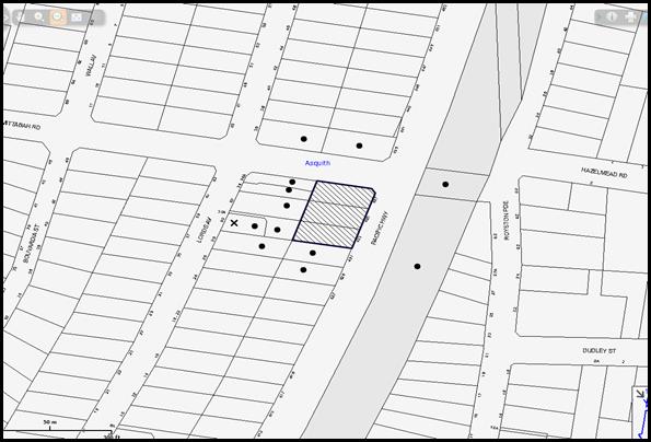
|
NOTIFICATION PLAN |
|
||
|
• PROPERTIES NOTIFIED
|
X SUBMISSIONS RECEIVED |
PROPERTY SUBJECT OF DEVELOPMENT |
|
One submission objected to the development, generally on the following grounds:
· Unacceptable traffic on local streets;
· Non-compliant setbacks to the boundaries, building height and building separation;
· Overshadowing impacts on properties fronting Lords Avenue;
· Impact on south-easterly winds to the houses within Lords Avenue;
· Overlooking impacts on the adjoining properties to the west;
· Impact on the adjoining properties due to excavation works; and
· Removal of significant trees with no compensatory planting proposed.
The submission also made the following observations:
· The proposed concrete retaining wall on the western boundary should be 2m in height to alleviate any noise generated due to the proposed development;
· The development proposes access from Mittabah Road which is contrary to the requirements within the HDCP;
· The Traffic Impact Statement does not take into account the cumulative traffic impacts due to redevelopment of the entire precinct. The local road network cannot accommodate the increased traffic flow;
· The cumulative impact of the developments within the precinct would adversely impact on the available public transport in the locality;
· Vehicular access along Mittabah Road would generate adverse noise impact on the adjoining properties;
· The application does not address impacts on the locality due to dust, noise and traffic disruptions during construction works; and
· Demolition works would result in adverse impact on the adjoining properties due to asbestos.
The merits of the matters raised in community submissions have been addressed in the body of the report with the exception of the following:
5.1.1 Privacy and Overlooking
The building complies with HDCP with regard to setbacks and building separation. Given that this is a redevelopment precinct, it is anticipated that the properties at the rear would also be developed for the purpose of 5-storey residential flat building in the future. The location of the balconies and windows would maintain appropriate levels of privacy for the future occupants of such developments.
5.1.2 Dust, Noise Control, Construction Traffic and Hazardous Materials
A Construction Traffic Management Plan has been submitted with the application addressing the impact of the development on the locality during construction works. The plan is assessed as satisfactory subject to additional conditions requiring truck access form Lords Avenue and Mittabah Road only. The final document would require approval by Council prior to the issue of the Construction Certificate.
Conditions of consent are recommended to ensure that dust suppression methods and noise control measures are undertaken during construction works. Disposal of any asbestos on site would be undertaken in accordance with recommended conditions of consent and WorkCover requirements.
5.1.3 Inadequate Infrastructure
The suitability of the locality for high density residential development was considered by Council and the Department of Planning during the rezoning of the precinct. Weight must be given to the applicable zoning of the land in the resolution of a dispute as to the appropriate development of any site.
The volume of on-site parking provided is in accordance with the HDCP and meets the demand of future residents plus visitors.
Cumulative impact of the redevelopment precinct on the traffic network of the locality was considered at the time of rezoning of the area. Accordingly, traffic management works have been proposed as discussed in Section 3.2 of this report. The submitted Construction Traffic Management Plan ensures that disruptions to the locality are minimised during construction works.
5.1.4 Access via Mittabah Road
Mittabah Road is currently utilised to access two properties and is a delineated road reserve. It is not considered that access via Mittabah Road would generate further significant noise impact on the adjoining properties.
5.1.5 Restriction to Wind Access
The building separation provisions allow wind access to all properties. Given that the building generally complies with the setback and building length requirements, no further assessment in this regard is necessary.
5.1.6 Fencing
The proposal includes a flood fence on top of the proposed retaining wall. A condition of consent recommends that the height of such fencing be 1.8m above ground, behind the building line. Given that the proposed use is residential, a 2m height acoustic wall is not considered necessary.
5.2 Public Agencies
5.2.1 RailCorp
The application was referred to RailCorp pursuant to the provisions of SEPP Infrastructure as the development involves excavation of land adjacent to a railway corridor. RailCorp raised no objections subject to the recommendation of a deferred commencement condition requiring the submission of the following information:
· Detailed Geotechnical Report and Structural Drawings;
· Detailed Survey Plans; and
· Detailed cross-sectional drawings showing relationship of the land and the railway infrastructure.
6. THE PUBLIC INTEREST
Section 79C(1)(e) of the Act requires Council to consider “the public interest”.
The public interest is an overarching requirement, which includes the consideration of the matters discussed in this report. Implicit to the public interest is the achievement of future built outcomes adequately responding to and respecting the future desired outcomes expressed in environmental planning instruments and development control plans.
The application is considered to have satisfactorily addressed Council’s and relevant agencies’ criteria and would provide a development outcome that, on balance, would result in a positive impact for the community. Accordingly, it is considered that the approval of the proposed development would be in the public interest.
CONCLUSION
The application seeks approval for the demolition of existing structures and construction of a five storey residential flat building comprising 34 units and basement car parking. The proposal also includes flood mitigation works by relocating a drainage easement associated road works and landscaping works within the Mittabah Road reserve.
The proposed development involves access from Mittabah Road that is not in accordance with the Key Principles of ‘Lords Avenue, Asquith Precinct of the HDCP. The proposed access is considered satisfactory subject to completion of the recommended road works and landscaping works. The proposal is generally in accordance with the prescriptive measures of the HDCP and would contribute to the future desired five storey residential character of the precinct. The proposal complies with the design principles of SEPP 65 and the Residential Flat Design Code.
The proposal would result in a development that would be in keeping with the desired future character of the precinct. Approval of the application as a deferred commencement is recommended.
Note: At the time of the completion of this planning report, no persons have made a Political Donations Disclosure Statement pursuant to Section 147 of the Environmental Planning and Assessment Act 1979 in respect of the subject planning application.
RESPONSIBLE OFFICER
The officer responsible for the preparation of this Report is the Manager – Development Assessments – Rodney Pickles, who can be contacted on 9847 6731.
|
Rod Pickles Manager - Development Assessment Planning Division |
James Farrington Group Manager Planning Division |
|
1.View |
Locality Map |
|
|
|
2.View |
Landscape Plan and Mittabah Road Works |
|
|
|
3.View |
Floor Plans |
|
|
|
4.View |
Elevations and Sections |
|
|
|
5.View |
Shadow Plans |
|
|
|
6.View |
Council Pipeline Upgrading Works |
|
|
|
7.View |
Photomontage |
|
|
File Reference: DA/956/2014
Document Number: D06694157
SCHEDULE 1
GENERAL CONDITIONS
The conditions of consent within this notice of determination have been applied to ensure that the use of the land and/or building is carried out in such a manner that is consistent with the aims and objectives of the relevant legislation, planning instruments and council policies affecting the land and does not disrupt the amenity of the neighbourhood or impact upon the environment.
Note: For the purpose of this consent, the term ‘applicant’ means any person who has the authority to act on or the benefit of the development consent.
Note: For the purpose of this consent, any reference to an Act, Regulation, Australian Standard or publication by a public authority shall be taken to mean the gazetted Act or Regulation, or adopted Australian Standard or publication as in force on the date that the application for a construction certificate is made.
1. Deferred Commencement
Pursuant to Section 80(3) of the Environmental Planning and Assessment Act 1979, this consent does not operate until the following information is submitted to Council:
a) Consent of the owners of Lots 1 and 2 DP 868746, Nos. 34 and 34A Lords Avenue, Asquith granting permission to undertake drainage works and upgrading of Council’s pipeline within the subject properties.
b) Approval/certification from Sydney Trains as to the following matters:
i) Geotechnical and Structural report/drawings that meet Sydney Train requirements: The Geotechnical Report must be based on actual borehole testing conducting on the site closest to the rail corridor.
ii) Construction methodology with construction details pertaining to structural support during excavation.
Note: The applicant is to be aware that Sydney Trains will not permit any rock anchors/bolts (whether temporary or permanent) within its land or easements.
iii) Cross sectional drawings showing the tunnel easement, tunnel location, sub soil profile, proposed basement excavation and structural design of sub ground support adjacent to rail tunnel. All measurements are to be verified by a Registered Surveyor.
iv) Detailed Survey Plan showing the relationship of the proposed developed with respect to Sydney Train easement and tunnel location.
v) An FE analysis which assesses the different stages of loading-unloading of the site and its effect on the rock mass surrounding the rail corridor (if required by Sydney Trains).
Such information must be submitted within 24 months of the date of this notice.
Upon Council’s written satisfaction of the above information, the following conditions of development consent apply:
2. Approved Plans and Supporting Documentation
The development must be carried out in accordance with the plans and documentation listed below and endorsed with Council’s stamp, except where amended by Council and/or other conditions of this consent:
|
Plan No. |
Plan Title |
Drawn by |
Dated |
|
A000 G |
Cover Sheet |
Mackenzie Architects International |
12/11/2015 |
|
DA100 G |
Site, Ground and Roof Plans |
Mackenzie Architects International |
12/11/2015 |
|
DA 101 G |
Carpark B1 + B2 |
Mackenzie Architects International |
12/11/2015 |
|
DA102 G |
First, Second and Third Level Plans |
Mackenzie Architects International |
12/11/2015 |
|
A103 G |
Fourth and Fifth |
Mackenzie Architects International |
12/11/2015 |
|
A200 G |
Elevations North and South |
Mackenzie Architects International |
12/11/2015 |
|
A201 G |
Elevations East and West |
Mackenzie Architects International |
12/11/2015 |
|
A300 G |
Section 01 |
Mackenzie Architects International |
12/11/2015 |
|
A301 G |
Section 02 |
Mackenzie Architects International |
12/11/2015 |
|
A401 D |
Adaptable units |
Mackenzie Architects International |
29/07/2015 |
|
SK000 - B |
Cover Sheet |
Martens and Associates |
24/08/2015 |
|
SK001 - B |
Ground Floor stormwater system |
Martens and Associates |
24/08/2015 |
|
SK002 - B |
Basement 1 stormwater system |
Martens and Associates |
24/08/2015 |
|
SK003 - B |
Basement 2 stormwater system |
Martens and Associates |
24/08/2015 |
|
SK004 - B |
OSD Plan Section |
Martens and Associates |
24/08/2015 |
|
SK005 - B |
OSD Section |
Martens and Associates |
24/08/2015 |
|
SK006 - B |
Drains Modelling |
Martens and Associates |
24/08/2015 |
|
SK007 - B |
Typical Drainage System |
Martens and Associates |
24/08/2015 |
|
104-A |
Stormwater Layout Ground Level – Mittabah Road |
Umbrella Civil Consulting Engineers |
05/08/2015 |
|
105-A |
Mittabah Road Longitudinal and Cross Sections |
Umbrella Civil Consulting Engineers |
05/08/2015 |
|
E20 A |
Erosion and Sediment Control Plan |
Australian Consulting Engineers |
05/05/2015 |
|
DA-L102 A |
Landscape Concept Masterplans: Community Park |
Canvas Landscape Architects |
17/07/2015 |
|
4128-01 E |
Landscape Plan |
Peter Glass and Associates |
28/08/2015 |
|
Document Title |
Prepared by |
Dated |
|
Plan showing levels and details |
H Ramsay and Co |
19/12/2013 |
|
Solar Access Study 01 – 02 C |
Mackenzie Architects International |
10/07/2015 |
|
DA402-A Demolition, Soil and Water Management |
Mackenzie Architects International |
19/08/2014 |
|
DA403-A Site analysis |
Mackenzie Architects International |
19/08/2014 |
|
DA500-A Shadow Diagrams |
Mackenzie Architects International |
19/08/2014 |
|
Revised Flood Study Rev3 |
Martens and Associates |
19/08/2015 |
|
Additional information regarding flooding |
Martens and Associates |
13/11/2015 |
|
Flood and Catchment analysis plans SKA000 – SKA010 Rev A |
Martens and Associates |
12/11/2015 |
|
Water Quality Assessment |
Martens and Associates |
24/08/2015 |
|
Construction Traffic Management Plan |
Auswide Traffic Engineers |
August 2015 |
|
Building Code of Australia Compliance Report |
Greenfield Certifiers |
28/05/2014 |
|
Traffic and Parking Assessment Report |
Hemanote Consultants |
June 2014 |
|
Traffic and Rail Noise Assessment |
Acoustic Solutions Pty Ltd |
6/06/2014 |
|
Arboricultural Impact Report |
Landscape Matrix |
21/08/2014 |
|
Waste Management Plan |
Mackenzie Architects International |
9/05/2014 |
|
Statement of Compliance Access for People with a Disability Issue A |
Accessible Building Solutions |
05/08/2014 |
|
Statement of Environmental Effects |
Think Planners |
21/08/2014 |
|
Design Verification Statement |
Mackenzie Architects International |
10/07/2014 |
|
BASIX Certificate 561314M |
Greenview Consulting Pty Ltd |
13/08/2014 |
|
Schedule of Materials and Finishes |
Mackenzie Architects International |
Received on 15/07/2015 |
3. Removal of Existing Trees
a) This development consent permits the removal of trees numbered T2, T5, T6 and T9 as identified on plan number DA100 - G prepared by Mackenzie Architects International dated 12/11/2015.
b) The removal of any other trees requires separate approval in accordance with the Tree and Vegetation Chapter 1B.6 Hornsby Development Control Plan (HDCP).
4. Amendment of Plans
a) To comply with Councils requirements in the approved Ground Floor Plan in “DA 100-G” is to be amended as follows:
i) Delete steps connecting the ground floor courtyards of Units 3, 4, 5 and 7 to the common open spaces;
ii) Reduce the size of the courtyards for units 1 and 7 so that no encroachment occurs within the common setback area to Mittabah Road reserve, as marked in red;
iii) Reduce the size of the courtyards for Units 3 and 5 as marked in red so that no encroachment within the overland flow path occurs;
iv) All communal open space areas within the overland flow path as marked in Appendix B of “Flood Study Rev 3” listed in Condition 2 of this consent, be deleted. These areas are to be utilised as common landscaped areas only;
v) A planter box with screen planting up to a height of 1.8m above the level of the courtyard be proposed for the western elevation of Unit 6 as marked in red to create a non-trafficable area.
b) To comply with Councils requirements in the approved Landscape Plan in “4128-01 E” is to be amended as follows:
i) Provide common landscape area between the courtyards of Units 1 and 7 and the Mittabah Road frontage;
ii) All large trees located within the overland flow path be deleted; and
iii) Shrubs and hedges within the overland flow path be deleted to avoid understorey vegetation.
c) To comply with Councils requirements in the approved Ground Level Stormwater Plan SK001 – Rev B dated 24/08/2015 is to be amended as follows:
i) Upgrade the proposed pipe to be 1200mmm in diameter instead of 900mm diameter; and
ii) Insert correct ground floor levels (FFL) as per the approved Ground Floor Plan in “DA 100-D”.
d) The approved plan A401 D Adaptable units, prepared by Mackenzie Architects International dated 29/07/2015 must be amended to include the correct units numbers listed in the approved plans A100 G, A102G and A103G prepared by Mackenzie Architects International dated 12/11/2015.
e) These amended plans listed in Condition 2(a), 2(b), 2(c) and 2(d) must be submitted with the application for the Construction Certificate.
f) The approved Landscape Concept Masterplan DA-L102 – A prepared by Canvas Landscape Architects dated 17/07/2015 must be amended in accordance with the requirements listed below and submitted to Council for approval prior to the issue of the Construction certificate:
i) The proposed bbq facility and timber park shelters be deleted from the public reserve;
ii) A pavement be proposed adjoining the existing footpath to formalise the pedestrian entry from Pacific Highway into the reserve; and
iii) Details of specifications and finishes for the street lamps, concrete seats, paving and other landscape elements be included in the final Landscape plan.
g) The submitted Construction Traffic Management Plan must be amended to include additional documentation listed below and submitted to Council for approval prior to the issue of the Construction Certificate:
i) Provision of access to all construction vehicles via Lords and Mittabah Road;
ii) A revised map of truck routes demonstrating that all construction vehicles will enter the site from Mittabah Road via Pacific Highway, Mills Street and Lords Avenue, Asquith. The trucks must exit the development in the same direction;
iii) No site access be permitted from Pacific Highway, other than pedestrian emergency egress
iv) Swept path diagrams for construction vehicles to demonstrate that sufficient space is available for parking and turning of vehicles on the site;
v) Location of temporary hoardings, fencing or awnings;
vi) No swing or hoisting of materials or the like are to occur from Pacific Highway, Asquith;
vii) All site fencing being located wholly within the site unless a Hoarding Permit has been obtained;
viii) All works are to take place from within the site boundaries, unless a Work Zone Permit for Mittabah Road, Asquith has been obtained;
ix) Details of the proposed locations of concrete pump(s) and construction cranes on site for each of the stages of construction. The plan should show the pump and crane with the support legs fully extended throughout the various stages of construction works. If unable to fit on site, the pumps and cranes should be shown to be located on Mittabah Road, Asquith, which would require Council Work Zone permits to be obtained; and
x) The revised Traffic Management Plan being signed by both AusWide Traffic Engineers and the Principal Building Contractor.
5. Construction Certificate
a) A Construction Certificate is required to be approved by Council or a Private Certifying Authority prior to the commencement of any works under this consent.
b) A separate Construction Certificate must be obtained from Council for all works within the public road reserve under S138 of the Roads Act.
c) A separate Construction Certificate must be obtained from Council for all works within drainage easements vested in Council.
d) The Construction Certificate plans must not be inconsistent with the Development Consent plans.
6. Section 94 Development Contributions
a) In accordance with Section 80A(1) of the Environmental Planning and Assessment Act, 1979 and the Hornsby Shire Council Section 94 Development Contributions Plan 2012-2021, the following monetary contributions must be paid to Council to cater for the increased demand for community infrastructure resulting from the development:
|
Description |
Contribution (4) |
|
Roads |
$ 37,991.20 |
|
Open Space and Recreation |
$ 405,631.35 |
|
Community Facilities |
$ 56,535.35 |
|
Plan Preparation and Administration |
$ 1,689.55 |
|
TOTAL |
$ 501,847.45 |
being for being for 5 x 1 bedroom, 25 x 2 bedroom and 4 x 3 bedroom units with a credit of 3 lots.
b) The value of this contribution is current as at 11 November 2015. If the contribution is not paid within the financial quarter that this condition was generated, the contribution payable will be adjusted in accordance with the provisions of the Hornsby Shire Council Section 94 Development Contributions Plan and the amount payable will be calculated at the time of payment in the following manner:
$CPY = $CDC x CPIPY
CPIDC
Where:
$CPY is the amount of the contribution at the date of Payment
$CDC is the amount of the contribution as set out in this Development Consent
CPIPY is the latest release of the Consumer Price Index (Sydney – All Groups) at the date of Payment as published by the ABS.
CPIDC is the Consumer Price Index (Sydney – All Groups) for the financial quarter at the date applicable in this Development Consent Condition.
c) The monetary contribution must be paid to Council:
i) prior to the issue of the Subdivision Certificate where the development is for subdivision; or
ii) prior to the issue of the first Construction Certificate where the development is for building work; or
iii) prior to issue of the Subdivision Certificate or first Construction Certificate, whichever occurs first, where the development involves both subdivision and building work; or
iv) prior to the works commencing where the development does not require a Construction Certificate or Subdivision Certificate.
Note: It is the professional responsibility of the Principal Certifying Authority to ensure that the monetary contributions have been paid to Council in accordance with the above timeframes.
Council’s Development Contributions Plan may be viewed at www.hornsby.nsw.gov.au or a copy may be inspected at Council’s Administration Centre during normal business hours.
7. Project Arborist
A Project Arborist (AQF5 qualified) is to be appointed in accordance with AS 4970-2009 (1.4.4) to oversee installation of trunk protection measures, monitor the integrity of the tree protection methods, record any modifications or alterations to the tree protection zone fencing for the duration of the construction period and provide all required certification throughout the development process. The details of the appointed Arborist are to be provided to Council and the PCA prior to the issue of the construction certificate.
REQUIREMENTS PRIOR TO THE ISSUE OF A CONSTRUCTION CERTIFICATE
8. Building Code of Australia
All approved building work must be carried out in accordance with the relevant requirements of the Building Code of Australia.
9. Contract of Insurance (Residential Building Work)
Where residential building work for which the Home Building Act, 1989 requires there to be a contract of insurance in force in accordance with Part 6 of that Act, this contract of insurance must be in force before any building work authorised to be carried out by the consent commences.
10. Notification of Home Building Act, 1989 Requirements
Residential building work within the meaning of the Home Building Act 1989 must not be carried out unless the principal certifying authority for the development to which the work relates (not being Council) has given Council written notice of the following information:
a) In the case of work for which a principal contractor is required to be appointed:
i) The name and licence number of the principal contractor; and
ii) The name of the insurer by which the work is insured under Part 6 of that Act.
b) In the case of work to be done by an owner-builder:
i) The name of the owner-builder; and
ii) If the owner-builder is required to hold an owner-builder’s permit under that Act, the number of the owner-builder’s permit.
Note: If arrangements for doing the residential building work are changed while the work is in progress so that the information notified becomes out of date, further work must not be carried out unless the principal certifying authority for the development to which the work relates (not being Council) has given Council written notification of the updated information.
11. Utility Services
The applicant must submit written evidence of the following service provider requirements:
a) Ausgrid (formerly Energy Australia) – a letter of consent demonstrating that satisfactory arrangements have been made to service the proposed development.
b) Telstra – a letter of consent demonstrating that satisfactory arrangements have been made to service the proposed development.
12. Sydney Water – Quick Check
This application must be submitted to a Sydney Water ‘Quick Check Agent’ or ‘Customer Centre’ for approval to determine whether the development would affect any Sydney Water infrastructure, and whether further requirements are to be met.
Note: Refer to www.sydneywater.com.au or telephone 13 20 92 for assistance.
13. Dilapidation Report
To record the structural condition of adjoining properties to the west of the approved development including Nos. 30, 34 and 34A Lords Avenue, Asquith, a Dilapidation report must be prepared by a suitably qualified structural engineer for inclusion with the application of the Construction Certificate.
14. Noise – Rail and Road Corridor
The development must be carried out in accordance with the recommendations contained within the acoustic report submitted with the development application, titled, ‘Traffic and Rail Noise Assessment’ prepared by Acoustic Solutions Pty Ltd and dated 6/06/2014 and the requirements of the Department of Planning’s Development Near Rail Corridors and Busy Roads – Interim Guideline and RailCorp’s Interim Guidelines for Applicants.
Note: The Department of Planning’s document is available at www.planning.nsw.gov.au (development assessments). The RailCorp document is available at www.railcorp.nsw.gov.au/publications.
15. Traffic Control Plan
A Traffic Control Plan (TCP) must be prepared by a qualified traffic controller in accordance with the Roads & Traffic Authority’s Traffic Control at Worksites Manual 1998 and Australian Standard 1742.3 for all work on a public road. The Traffic Management Plan shall be submitted and approved by Council’s Manager Traffic and Road Safety prior to the issue of a construction certificate. The TCP must detail the following:
a) Arrangements for public notification of the works;
b) Temporary construction signage;
c) Permanent post-construction signage;
d) Vehicle movement plans;
e) Traffic management plans; and
f) Pedestrian and cyclist access/safety.
16. Identification of Survey Marks
A registered surveyor must identify all survey marks in the vicinity of the proposed development. Any survey marks required to be removed or displaced as a result of the proposed development shall be undertaken by a registered surveyor in accordance with Section 24 (1) of the Surveying and Spatial Information Act 2002 and following the Surveyor General’s Directions No.11 – "Preservation of Survey Infrastructure".
17. Stormwater Drainage
The stormwater drainage system for the development must be designed in accordance with Council’s Civil Works – Design and Construction Specification 2005 and the following requirements:
a) Connected directly to Council’s street drainage system.
b) Be designed by a Chartered Professional Civil/ Hydraulic Engineer of the Institution of Engineers, Australia
18. Diversion and Upgrading of Council Stormwater Pipe and Overland Flow
The proposed diversion and upgrading of Council stormwater pipe and the overland flow path must be designed and a separate Construction Certificate submitted to Council for approval, in accordance with the following requirements:
a) The existing Council’s drainage line passing through the development site is to be replaced by a reinforced concrete pipe of minimum 1200mm diameter and with inlet and outlet pits
b) The 1 in 100 year ARI overland flow path must be designed generally in accordance with SKA000 – SKA010, prepared by Martens and Associated dated 12/11/2015 and listed in Condition 2 of this development consent.
c) The existing Council pipe, from the development site to Council Pit No. 9322 on Mittabah Road through properties 34 and 34a Lords Avenue must be removed and replaced by a 1200mm pipe.
d) An overland flow path is to be designed over the pipeline within the easement to contain the flow.
e) All flood protection walls at the boundary with neighbouring properties are to be designed to have a minimum height 0.5m above the 100 year ARI flow level.
f) The walls and the building abutting the flood way must be flood proofed in accordance with Floodplain Management Manual of NSW government.
g) An overland flow risk management plan is to be submitted with a construction certificate application.
h) All fences across the overland flow path shall be of swimming pool type fence or hinged at 0.5m above the 100 year ARI flood level.
i) A swimming pool type fence is to be shown along the northern and eastern edges of easement (towards the building) to prevent children entering the overland flow path.
j) Consents from neighbouring property owners are to be taken to carry out any works within those properties.
Note: Council is the only authority that can issue a construction certificate for construction of a stormwater line that is to be maintained by Council
19. On Site Stormwater Detention
An on-site stormwater detention system must be designed by a chartered civil engineer and constructed and detailed calculations shown, in accordance with the following requirements:
a) Storage capacity to accommodate volume from up to 20 years ARI (average recurrence interval) storms and a maximum discharge (when full) limited to 5 years pre development rate;
b) Have a surcharge/inspection grate located directly above the outlet. Discharge from the detention system to be controlled via 1 metre length of pipe, not less than 50 millimetres diameter or via a stainless plate with sharply drilled orifice bolted over the face of the outlet discharging into a larger diameter pipe capable of carrying the design flow to an approved Council system;
c) Details of water quality treatment system required to achieve the quality specified in Hornsby Development Control Plan 2012 (table 1C.1.2(b) Urban Stormwater Quality Targets), is to be provided;
d) Where above ground system is proposed and the average depth is greater than 0.3 metres, a ‘pool type’ safety fence and warning signs to be shown;
e) Not be proposed in a location that would impact upon the visual or recreational amenity of residents; and
f) An overflow/escape path must be incorporated in the design.
20. Internal Driveway/Vehicular Areas
The driveway and parking areas on site must be designed in accordance with Australian Standards 2890.1, 2890.2, 3727 and the following requirements:
a) Design levels at the front boundary shall be obtained from Council if a private accredited certifier is engaged to obtain a construction certificate for these works;
b) The driveway be a rigid pavement;
c) Conduit for utility services including electricity, water, gas and telephone be provided. All existing overhead assets including electricity and telecommunications cabling shall be relocated underground at no cost to Council. A certificate from an appropriately licensed contractor shall be submitted to the principal certifying authority certifying that the service conduits have been installed in accordance with the relevant utility provider and Australian Standards;
d) Longitudinal sections along both sides of the access driveway shall be submitted to the principal certifying authority in accordance with the relevant sections of AS 2890.1. The maximum grade shall not exceed 1 in 4 (25%) with the maximum changes of grade of 1 in 8 (12.5%) for summit grades and 1 in 6.7 (15%) for sag grades. Any transition grades shall have a minimum length of 2 metres. The longitudinal sections shall incorporate the design levels obtained by Hornsby Shire Council; and
e) For the first 2.5 m of the driveway from the northern boundary of the, the bin holding area is to be at the same level and slope as the driveway. There must be no raised median, wall, step or any other barrier between the driveway and the bin holding area at this location to ensure safe carting of the bins.
21. Vehicular Crossing
A separate application under the Local Government Act, 1993 and the Roads Act 1993 must be submitted to Council for the installation of a new vehicular crossing and the removal of the redundant crossing. The vehicular crossing must be constructed in accordance with Council’s Civil Works Design 2005 and the following requirements:
a) Design levels at the front boundary must be obtained from Council for the design on the internal driveway;
b) Any redundant crossings must be replaced with integral kerb and gutter;
c) The footway area must be restored by turfing; and
d) Approval must be obtained from all relevant utility providers that all necessary conduits be provided and protected under the crossing.
Note: An application for a vehicular crossing can only be made to one of Council’s Authorised Vehicular Crossing Contractors. You are advised to contact Council on 02 9847 6940 to obtain a list of contractors.
22. Road Works
A separate construction certificate application is to be submitted to Hornsby Shire Council, pursuant to Section 138 of the Roads Act, for the approval of the design of road work approved under this development consent. All road works approved under this consent must be designed in accordance with Council’s Civil Works Design and Construction Specification 2005 and the following requirements:
a) The eastern section of Mittabah Road between Lords Avenue and the frontage of the site, is to be upgraded with associated drainage works, in accordance with the following standards:
i) 7.5m wide carriageway with footpath and kerb and gutter on both sides;
ii) A cul-de-sac of end with 15m diameter;
iii) A roll kerb (not step kerb) be designed along the cul-de-sac end with no garden beds, trees or other raised landscaping features within 2 metres of the cul-de sac (grass/lawn/footpath is acceptable) to enable garbage trucks to manoeuvre effectively;
iv) Upgrading the intersection of Lords Avenue and Mittabah Road;
v) A concrete footpath designed along the northern side of the road reserve; and
vi) A footpath to be designed from the end of the cul-de-sac to the Pacific Highway, complying with Disability Access Standards (where the footpath meets the Pacific Highway).
b) If there is a requirement to obtain a Work Zone, partial Road Closure or Crane Permit an application to Hornsby Shire Council is to be made prior to the issue the Construction Certificate;
c) Kerb and gutter shall be constructed along the frontage of the Pacific Highway to the requirements of Roads and Maritime Services RMS);
d) The existing footpath along Pacific Highway is to be removed and a new footpath designed;
e) The open drain (swale) along Pacific Highway is to be covered by a piped system/any other to the requirements of RMS and the nature strip upgraded;
f) The existing road pavement to be saw cut a minimum of 300 mm from the existing edge of the bitumen and reconstructed;
g) RMS approval is required for road works along the Pacific Highway frontage of the site. All approved plans must be submitted to Hornsby Council with the Construction Certificate application;
h) All necessary road occupancy permits are to be obtained from RMS to carry out works within the Pacific Highway road reserve; and
i) If there is a requirement to obtain a Work Zone, partial Road Closure or Crane Permit, an application to Hornsby Shire Council is to be made prior to the issue the Construction Certificate.
23. Adaptable Units/Letter Boxes/Storage
The following details must be provided with the Construction Certificate plans.
a) The development is required to provide 11 units designed as adaptable housing pursuant to the requirements of 1C.2.2 of the Hornsby Development Control Plan 2013. In this regard, four (4) car parking spaces are to be designed for people with a disability and allocated to 4 accessible units;
b) The letter boxes must be located as shown on the approved DA100 –G; and
c) Each dwelling within the development must have a minimum area for storage (not including kitchen and bedroom cupboards) for 6m3 for one bedroom units, 8m3 for two bedroom units and 10m3 for three bedroom units, where 50% is required to be located within the apartment and accessible from either the hall or living area.
24. Waste Management Details
The following waste management details must be provided with the Construction Certificate Plans:
a) The chute system must include volume handling equipment (5x240L bin carousel or 2x660L linear or similar, with no compaction) to automatically change the bin under the chute when it becomes full; and
b) The waste facilities on each residential level (a garbage chute and recycling bin in a small room) must be accessible by persons with a disability while comfortably housing the garbage chute and one 240 L recycling bin.
Note: A 240 L recycling bin is 600 mm wide by 750 mm deep; allow for ease around the bin – 75 mm is recommended). The chute system supplier must be consulted for chute space requirements.
REQUIREMENTS PRIOR TO THE COMMENCEMENT OF ANY WORKS
25. Construction Traffic Management Plan
A document signed by the Principle Building Contractor is to be submitted to Hornsby Council to confirm the following:
a) The specified travel routes in the approved Construction Traffic Management Plan are to be complied with; and
b) The details of the truck routes are will be provided to the excavation and concrete contractors.
26. Erection of Construction Sign
a) A sign must be erected in a prominent position on any site on which any approved work is being carried out:
i) Showing the name, address and telephone number of the principal certifying authority for the work;
ii) Showing the name of the principal contractor (if any) for any demolition or building work and a telephone number on which that person may be contacted outside working hours; and
iii) Stating that unauthorised entry to the work site is prohibited.
b) The sign is to be maintained while the approved work is being carried out and must be removed when the work has been completed.
27. Protection of Adjoining Areas
A temporary hoarding, fence or awning must be erected between the work site and adjoining lands before the works begin and must be kept in place until after the completion of the works if the works:
a) Could cause a danger, obstruction or inconvenience to pedestrian or vehicular traffic;
b) Could cause damage to adjoining lands by falling objects; and/or
c) Involve the enclosure of a public place or part of a public place.
Note: Notwithstanding the above, Council’s separate written approval is required prior to the erection of any structure or other obstruction on public land.
28. Toilet Facilities
a) To provide a safe and hygienic workplace, toilet facilities must be available or be installed at the works site before works begin and must be maintained until the works are completed at a ratio of one toilet for every 20 persons employed at the site.
b) Each toilet must:
i) be a standard flushing toilet connected to a public sewer; or
ii) be a temporary chemical closet approved under the Local Government Act 1993; or
iii) have an on-site effluent disposal system approved under the Local Government Act 1993.
29. Erosion and Sediment Control
To protect the water quality of the downstream environment, erosion and sediment control measures must be provided and maintained throughout the construction period in accordance with the manual ‘Soils and Construction 2004 (Bluebook)’, the approved plans, Council specifications and to the satisfaction of the principal certifying authority. The erosion and sediment control devices must remain in place until the site has been stabilised and revegetated.
Note: On the spot penalties may be issued for any non-compliance with this requirement without any further notification or warning.
30. Tree Protection Barriers
a) To safeguard the natural environment during the approved development works, tree protection fencing must be erected around trees numbered T1, T3, T4, T7 and T8 in accordance with the recommendations within the Arboricultural Impact Report prepared by Landscape Matrix dated 21/08/2014.
b) The fencing must be constructed of 1.8 metre cyclone chainmesh fence or star pickets spaced at 2 metre intervals and connected by a continuous high-visibility barrier/hazard mesh at a height of 1 metre.
c) To avoid injury or damage, trees numbered T1, T3, T4, T7 and T8 must have trunks protected by 2 metre lengths of 75mm x 25mm hardwood timbers spaced at 80mm secured with galvanised wire, not fixed or nailed to the tree in any way.
d) The Project Arborist must submit a certificate to the Principal Certifying Authority (PCA) confirming that all tree protection measures have been installed in accordance with this consent and the specific requirements of Australian Standard ”Protection of Trees on Development Sites” (AS 4970-2009) and the Arborist Report.
31. Construction Work Zone
A “Construction Work Zone” within Mittabah Road is to be approved by Hornsby Council. The construction vehicles are to park within the site or within the approved work zone only.
REQUIREMENTS DURING DEMOLITON AND CONSTRUCTION
32. Construction Work Hours
All work on site (including demolition and earth works) must only occur between 7am and 5pm Monday to Saturday (unless otherwise approved in writing by Council due to extenuating circumstances). No work is to be undertaken on Sundays or public holidays.
33. Demolition
To protect the surrounding environment, all demolition work must be carried out in accordance with “Australian Standard 2601-2001 – The Demolition of Structures” and the following requirements:
a) Demolition material must be disposed of to an authorised recycling and/or waste disposal site and/or in accordance with an approved waste management plan;
b) Demolition works, where asbestos material is being removed, must be undertaken by a contractor that holds an appropriate licence issued by WorkCover NSW in accordance with Chapter 10 of the Occupational Health and Safety Regulation 2001 and Clause 29 of the Protection of the Environment Operations (Waste) Regulation 2005 ;and
c) On construction sites where any building contain asbestos material, a standard commercially manufactured sign containing the words ‘DANGER ASBESTOS REMOVAL IN PROGRESS’ and measuring not less than 400mm x 300mm must be displayed in a prominent position visible from the street.
34. Flood Mitigation Works and Upgrading of Council’s Pipeline
a) The proposed diversion and upgrading of Council stormwater pipe and the overland flow path must be completed prior to the commencement of construction works on the site including excavation for the basement, in accordance with the plans listed in Condition 2 and the requirements within Condition 18 of this development consent.
b) The upgrading of Council’s pipeline and all related works are to be carried out at the cost of the applicant.
c) A certificate from the Chartered Professional Civil/ Hydraulic Engineer of the Institution of Engineers must be provided to Council indicating that all works have been completed in accordance with the conditions of this development consent and to Council’s satisfaction.
d) The works are to be carried out in a manner so that no adverse impacts are created on neighbouring properties.
35. Environmental Management
The site must be managed in accordance with the publication ‘Managing Urban Stormwater – Landcom (March 2004) and the Protection of the Environment Operations Act 1997 by way of implementing appropriate measures. To prevent sediment run-off, excessive dust, noise or odour emanating from the site during the construction of the development.
36. Street Sweeping
To protect the surrounding environment, Street sweeping must be undertaken following sediment tracking from the site along Pacific Highway during works and until the site is established.
The street cleaning services must undertake a street ‘scrub and dry’ method of service and not a dry sweeping service that may cause sediment tracking to spread or cause a dust nuisance.
37. Works Near Trees
a) To protect trees to be retained, all required tree protection measures are to be maintained in good condition for the duration of the construction period.
b) All works, including driveways and retaining walls within 4 metres of any trees to be retained (whether or not on the subject property, and pursuant to this consent or the Tree Preservation Order), must be carried out under the supervision of the Project Arborist.
c) The Project Arborist must submit a certificate to the Principal Certifying Authority (PCA) detailing the methods used to preserve these trees during the course of demolition and construction.
Note: Except as provided above, the applicant is to ensure that no excavation, filling or stockpiling of building materials, parking of vehicles or plant, disposal of cement slurry, waste water or other contaminants occurs within 4 metres of any tree to be retained.
38. Council Property
To ensure that the public reserve is kept in a clean, tidy and safe condition during construction works, no building materials, waste, machinery or related matter is to be stored on the road or footpath.
39. Landfill
Landfill must be constructed in accordance with Council’s ‘Construction Specification 2005’ and the following requirements:
a) All fill material imported to the site is to wholly consist of Virgin Excavated Natural Material (VENM) as defined in Schedule 1 of the Protection of the Environment Operations Act, 1997 or a material approved under the Department of Environment and Climate Change’s general resource recovery exemption.
b) A compaction certificate is to be obtained from a suitably qualified geotechnical engineer verifying that the specified compaction requirements have been met.
c) A compaction certificate must be provided by a geotechnical engineer certifying any fill within road reserves, and all road sub-grade and road pavement materials.
d) The compaction certificates must be included with the application for an occupation certificate.
40. Excavated Material
All excavated material removed from the site must be classified by a suitably qualified person in accordance with the Department of Environment, Climate Change and Water NSW Waste Classification Guidelines prior to disposal to an approved waste management facility and be reported to the principal certifying authority prior to the issue of an Occupation Certificate.
41. Survey Report – Finished Floor Level
To ensure that the approved development has been located at the setbacks and levels shown on the relevant plans and elevations, a report(s) must be prepared by a registered surveyor and submitted to the principal certifying authority prior to the pouring of concrete at each level of the building certifying that:
a) The building, retaining walls and the like have been correctly positioned on the site;
b) The finished floor level(s) are in accordance with the approved plans; and
c) The height of the topmost level of the building including lift overruns and the roof overhang is a maximum of 1q7.5m above the natural ground level at that point.
42. Waste Management
Waste management during the demolition and construction phase of the development must be undertaken in accordance with the approved Waste Management Plan. Additionally written records of the following items must be maintained during the removal of any waste from the site and such information submitted to the Principal Certifying Authority within fourteen days of the date of completion of the works:
a) The identity of the person removing the waste.
b) The waste carrier vehicle registration.
c) Date and time of waste collection.
d) A description of the waste (type of waste and estimated quantity).
e) Details of the site to which the waste is to be taken.
f) The corresponding tip docket/receipt from the site to which the waste is transferred (noting date and time of delivery, description (type and quantity) of waste).
g) Whether the waste is expected to be reused, recycled or go to landfill.
Note: In accordance with the Protection of the Environment Operations Act 1997, the definition of waste includes any unwanted substance, regardless of whether it is reused, recycled or disposed to landfill.
43. Traffic Control Plan Compliance
The development must be carried out in accordance with the submitted Traffic Control Plan (TCP) and the Construction Traffic Management Plan including the truck access routes and parking of construction vehicles.
REQUIREMENTS PRIOR TO THE ISSUE OF AN OCCUPATION CERTIFICATE
Note: For the purpose of this consent, a reference to ‘occupation certificate’ shall not be taken to mean an ‘interim occupation certificate’ unless otherwise stated.
44. Fulfilment of BASIX Commitments
The applicant must demonstrate the fulfilment of BASIX commitments pertaining to the development.
45. Sydney Water – s73 Certificate
An s73 Certificate must be obtained from Sydney Water and submitted to the PCA..
Note: Sydney Water requires that s73 applications are to be made through an authorised Sydney Water Servicing Coordinator. Refer to www.sydneywater.com.au or telephone 13 20 92 for assistance.
46. Water Saving Urban Design
A Water Saving Urban Design (WSUD) is to be constructed generally in accordance with the submitted Water Quality Assessment Report and approved Stormwater Plans (SK000-SK006 Rev B) prepared by martens and Associates dated 24/08/2015. The Water Quality Targets as detailed within the report and Hornsby Shire Councils DCP are to be achieved in the design and supported by a MUSIC model.
47. Certification of WSUD Facilities
Prior to the issue of an Occupation Certificate a certificate from a Civil Engineer is to be obtained stating that the WSUD facilities have been constructed and will meet the water quality targets as specified in the Hornsby Shire Development Control Plan 2013.
48. Damage to Council Assets
To protect public property and infrastructure any damage caused to Council’s assets as a result of the construction or demolition of the development must be rectified by the applicant in accordance with Council’s Civil Works Specifications.
49. Car Parking and Vehicular Areas
All vehicular areas within the site and the car parking must be constructed in accordance with Australian Standard AS 2890.1 – 2004 – Off Street Car Parking and Australian Standard 2890.2 - 2002 – Off Street Commercial and the following requirements:
a) The driveway to be designed in accordance with Condition 20 of this development consent;
b) All parking areas and driveways are to be sealed to an all-weather standard, line marked and signposted;
c) Residential parking spaces are to be secure spaces with access controlled by card or numeric pad;
d) Visitors are to be able to access the basement car park by an audio/visual intercom system located at the top of the ramped driveway;
e) Eleven bicycle spaces (resident and visitor) are to be provided in the basement car park. Bicycle parking spaces are to be designed in accordance with AS 2890.3-1993;
f) One motorcycle parking spaces are to be provided within the basement car park, designed in accordance with AS 2890.5-1993;
g) All parking for people with disabilities is to comply with AS/NZS 2890.6:2009 Off-street parking for people with disabilities; and
h) The location of the driveway must maintain sight lines for the pedestrians.
50. Creation of Easements
The following matter(s) must be nominated on the plan of subdivision under s88B of the Conveyancing Act, 1919:
a) A 3m wide drainage easement over the constructed pipe alignment in favour of Council and in accordance with the terms set out in Memorandum B5341305V filed with the NSW Department of Lands;
b) A restriction over the flow path for a 100 year average recurrence interval storm. The "Restriction on the Use of Land" over the affected lots is to prohibit the alteration of the final floodway shape and the erection of any structures, including fencing, in the floodway without the written permission of Council. The terms of this restriction must be obtained from Council;
c) The creation of an appropriate "Positive Covenant" and "Restriction as to User" over the constructed on-site detention and water quality treatment systems and outlet works, within the development site in favour of Council in accordance with Council’s prescribed wording. The positions of the on-site detention system and water quality treatment system are to be clearly indicated on the plan of title.
d) To register the positive covenant and the restriction on the use of land, “works-as-executed” details of the on-site-detention system and water quality treatment system must be submitted verifying that the required storage and discharge rates and water quality treatment measures have been constructed in accordance with the design requirements. The details must show the invert levels of the on- site system together with pipe sizes and grades and details of water quality treatment measures. Any variations to the approved plans must be shown in red on the “works-as-executed” plan and supported by calculations.
Note: Council must be nominated as the authority to release, vary or modify any easement, restriction or covenant.
51. Completion of Landscaping
A certificate must be submitted to the PCA by a practicing landscape architect, horticulturalist or person with similar qualifications and experience certifying that all required landscaping works within the site and the Mittabah Road reserve including planting, ground covers, seats, fixtures, paving, street lighting and footpath have been satisfactorily completed in accordance with the approved landscape plans listed in Condition 2 of this development consent and the following requirements:
a) Tree planting within the Mittabah Road reserve must be selected from Council’s list of indigenous species, specifically Angophora costata and Syncarpia glomulifera.
b) Tree plantings for must be located at least 4 metres or greater from the foundation walls of the building;
c) All replacement tree planting within the site must be native to Hornsby Shire and must reach a mature height greater than 9 metres;
d) The replacement tree(s) must be maintained until they reach the height of 3 metres;
e) All tree stock must meet the specifications outlined in ‘Specifying Trees’ (Ross Clark, NATSPEC Books);
f) Planting methods must meet professional (best practice) industry standards;
g) The pot size of the replacement trees must be a minimum 25 litres; and
h) On slab planter boxes including the ground cover above the on-site detention tank must include waterproofing, subsoil drainage (proprietary drainage cell, 50mm sand and filter fabric) automatic irrigation, minimum 300mm planting soil for grasses and ground covers, 500mm planting soil for shrubs and minimum 1000mm planting soil for trees and palms and 75mm mulch to ensure sustainable landscape is achieved.
Note: Advice on suitable species for landscaping can be obtained from Council’s planting guide ‘Indigenous Plants for the Bushland Shire’, available at www.hornsby.nsw.gov.au.
Note: Applicants are advised to pre-order plant material required in pot sizes 45 litre or larger to ensure Nurseries have stock available at the time of install.
52. Retaining Walls
All required retaining walls must be constructed as part of the development.
53. Boundary Fencing
Fencing must be erected along all property boundaries behind the front building alignment to a height of 1.8 metres. This includes the concrete retaining wall adjoining the drainage easement and the flood suitable fence proposed in the submitted Flood Study.
The exact location, design and costing for the erection of boundary fencing are to be the subject of negotiation and agreement in accordance with the relevant requirements of the Building Fences Act, 1991.
Note: Alternative fencing may be erected subject to the written consent of the adjoining property owner(s).
54. Installation of Privacy Devices
To establish and maintain a reasonable level of privacy for the adjoining premises a 2m wide planter box with a dense screen of trees or shrubs (minimum mature growth height of 2 metres), as listed in Council’s “Indigenous Plants for the Bushland Shire” publication must be installed in the courtyard of Unit 6 nominated in red on the approved plans.
55. External Lighting
a) To protect the amenity of adjacent premises, all external lighting must be designed and installed in accordance with Australian Standard AS 4282 – Control of the Obtrusive Effects of Outdoor Lighting.
b) Certification of compliance with this Standard must be obtained from a suitably qualified person and submitted to the PCA with the application for the Construction Certificate.
56. Garbage Collection Easement
For the purpose of waste collection, an easement entitling Council, its servants and agents and persons authorised by it, to enter upon the subject land and to operate thereon, vehicles and other equipment for the purposes of garbage collection must be granted to Council by the owner of the land.
Note: The easement must be in a form prescribed by Council and must include covenants to the effect that parties will not be liable for any damage caused to the subject land or any part thereof or to any property located therein or thereon by reason of the operation thereon of any vehicle or other equipment used in connection with the collection of garbage and to the effect that the owner for the time being of the subject land shall indemnify the Council, its servants, agents and persons authorised by it to collect garbage against liability in respect of any such claims made by any person whomsoever.
57. Waste Management
The following waste management requirements must be complied with:
a) The bin storage room at the basement level must include water or a hose for cleaning, graded floors with drainage to sewer, robust doors, sealed and impervious surface, adequate lighting and ventilation, and must be lockable. The waste facility rooms/cupboards at each residential level must include sealed and impervious surface, adequate lighting and ventilation.
b) A report must be prepared by an appropriately qualified person, certifying the following:
i) A comparison of the estimated quantities of each waste type against the actual quantities of each waste type.
Note: Explanations of any deviations to the approved Waste Management Plan is required to be included in this report.
ii) That at least 60% of the waste generated during the demolition and construction phase of the development was reused or recycled.
Note: If the 60% diversion from landfill cannot be achieved in the Construction Stage, the Report is to include the reasons why this occurred and certify that appropriate work practices were employed to implement the approved Waste Management Plan. The Report must be based on documentary evidence such as tipping dockets/receipts from recycling depots, transfer stations and landfills, audits of procedures etc. which are to be attached to the report.
iii) All waste was taken to site(s) that were lawfully permitted to accept that waste.
c) Each unit must be provided with an indoor waste/recycling cupboard for the interim storage of a minimum one day’s waste generation with separate containers for general waste and recyclable materials.
d) Space must be provided for either individual compost containers for each unit or a communal compost container;
Note: The location of the compost containers should have regard for potential amenity impacts.
e) A bulky waste storage area of at least 8m2 is to be identified and marked with paint and signage.
f) The bin carting routes must be devoid of any steps.
Note: Ramps between different levels are acceptable.
g) Access to the automatic waste volume handling equipment by unauthorised persons (including residents and waste collectors) must be prevented.
Note: Caging of the automatic volume handling equipment is acceptable.
h) Prior to an Occupation Certificate being issued or the use commencing, whichever is earlier, the Principal Certifying Authority must obtain Council’s approval of the waste and recycling management facilities provided in the development and ensure arrangements are in place for domestic waste collection by Council.
i) Motorised bin carting equipment must be provided to assist the site caretaker in the safe transfer of bins between the basement and ground levels.
58. Unit Numbering
All units are to be numbered consecutively commencing at No.1. The strata plan lot number is to coincide with the unit number, e.g. Unit 1 = Lot 1. The allocated of unit numbering must be authorised by Council prior to the numbering of each units in the development.
59. Works as Executed Plan
A works-as-executed plan(s) must be prepared by a registered surveyor and submitted to Council for completed road pavement, kerb & gutter, public drainage systems, driveways and on-site detention system. The plan(s) must be accompanied by a certificate from a registered surveyor certifying that all pipelines and associated structures lie wholly within any relevant easements.
60. Consolidation of Allotments
All allotments the subject of this consent must be consolidated into one allotment.
Note: The applicant is recommended to submit the plan of subdivision to consolidate allotments to the NSW Department of Lands at least 4-6 weeks prior to seeking an occupation certificate.
61. Preservation of Survey Marks
A certificate by a Registered Surveyor must be submitted to the Principal Certifying Authority, certifying that there has been no removal, damage, destruction, displacement or defacing of the existing survey marks in the vicinity of the proposed development or otherwise the re-establishment of damaged, removed or displaced survey marks has been undertaken in accordance with the Surveyor General’s Direction No.11 – “Preservation of Survey Infrastructure”.
62. Construction of Engineering Works
All engineering works including but not be limited to the stormwater works, on-site detention system, diversion and flood mitigation works, construction of retaining walls and flood fences, construction of the swimming pool type fence and road works identified in this consent are to be completed and a Compliance Certificate issued prior to the release of the Occupation Certificate.
63. Provision for National Broadband Network (NBN)
Provision must be made for fibre ready passive infrastructure (pits and pipes) generally in accordance with NBN Co's pit and pipe installation guidelines to service the proposed development. A certificate from NBN Co or Telstra must be submitted to the PCA that the fibre optic cabling provided for the development complies with MDU Building Design Guides for Development.
64. Final Certification – Tree Protection
Following the final inspection and the completion of any remedial works, the project Arborist must submit to the Principal Certifying Authority documentation stating that the completed works have been carried out in compliance with the approved plans and specifications for tree protection as above and AS 4970-2009.
65. Final Certification Acoustic Consultant
A final certificate must be provided by the Acoustic Consultant stating that the recommended measures within the approved Acoustic Report have been complied with.
66. Safety and Security
a) This site must include the following elements:
b) An intercom system must be installed at gate locations to ensure screening of persons entering the units.
c) The entry doors to the pedestrian foyer is to be constructed of safety rated glass to enable residents a clear line of site before entering or exiting the residential apartments.
d) Lighting is to be provided to pathways, building foyer entries, driveways and common external spaces.
e) Security gate access is to be provided to the car parking areas allowing residents-only access to private car spaces.
f) CCTV cameras must be installed at the entry and exit point and the around the mailbox.
g) The communal open spaces within the site must be illuminated with high luminance by motion sensor lighting.
h) The driveway and basement car parking must be illuminated with low luminance at all times.
i) Security deadlocks are to be provided to each apartment door.
j) Peep holes are to be provided to individual apartment doors to promote resident safety.
OPERATIONAL CONDITIONS
67. Noise
All noise generated by the proposed development must be attenuated to prevent levels of noise being emitted to adjacent premises which possess tonal, beating and similar characteristics or which exceeds background noise levels by more than 5dB(A).
68. Fire Safety Statement - Annual
On at least one occasion in every 12 month period following the date of the first ‘Fire Safety Certificate’ issued for the property, the owner must provide Council with an annual ‘Fire Safety Certificate’ to each essential service installed in the building.
69. Landscape Establishment
The landscape works must be maintained into the future to ensure the establishment and successful growth of plant material to meet the intent of the landscape design. This must include but not limited to watering, weeding, replacement of failed plant material and promoting the growth of plants through standard industry practices.
70. Car Parking and Deliveries
All car parking must be operated in accordance with Australian Standard AS 2890.1 – 2004 – Off Street Car Parking and Australian Standard 2890.2 - 2002 – Off Street Commercial and the following requirements:
a) All parking areas and driveways are to be sealed to an all-weather standard, line marked and signposted at all times.
b) Car parking, loading and manoeuvring areas to be used solely for nominated purposes.
c) Vehicles awaiting loading, unloading or servicing shall be parked on site and not on adjacent or nearby public roads;
d) All vehicular entry on to the site and egress from the site shall be made in a forward direction.
71. Sight Lines
Minimum sight lines for pedestrian safety are to be provided at the driveway. Any proposed landscaping and/or fencing must not restrict sight distance to pedestrians and cyclists travelling along the footpath.
72. Waste Management
The waste management on site must be in accordance with the following requirements:
a) Access to the automatic waste volume handling equipment by unauthorised persons (including residents and waste collectors) must be prevented.
b) A site caretaker must be employed and be responsible for moving bins where and when necessary, washing bins and maintaining waste storage areas, ensuring the chute system and related devices are maintained in effective and efficient working order, managing the communal composting area, managing the bulky item storage area, arranging the prompt removal of dumped rubbish, and ensuring cars do not park in the loading bay and that all residents are informed of the use of the waste management system.
c) The approved on-going waste management practise for the site must not be amended without consent from Council.
CONDITIONS OF CONCURRENCE – SYDNEY TRAINS
The following conditions of consent are from the nominated State Agency pursuant to Section 79B of the Environmental Planning and Assessment Act 1979 and must be complied with to the satisfaction of that Agency.
73. Operational Conditions
a) Prior to the commencement of works and prior to the issue of the Occupation Certificate, a joint inspection of the rail infrastructure and property in the vicinity of the project is to be carried out by representatives from Sydney Trains and the Applicant (if required by Sydney Trains). These dilapidation surveys will establish the extent of any existing damage and enable any deterioration during construction to be observed. The submission of a detailed dilapidation report will be required unless otherwise notified by Sydney Trains.
b) An acoustic assessment is to be submitted to Council prior to the issue of a construction certificate demonstrating how the proposed development will comply with the Department of Planning’s document titled “Development Near Rail Corridors and Busy Roads- Interim Guidelines”.
c) Prior to the issue of a Construction Certificate the Applicant is to engage an Electrolysis Expert to prepare a report on the Electrolysis Risk to the development from stray currents. The Applicant must incorporate in the development all the measures recommended in the report to control that risk. A copy of the report is to be provided to the Principal Certifying Authority with the application for a Construction Certificate.
d) The design, installation and use of lights, signs and reflective materials, whether permanent or temporary, which are (or from which reflected light might be) visible from the rail corridor must limit glare and reflectivity to the satisfaction of Sydney Trains.
The Principal Certifying Authority is not to issue the Construction Certificate until written confirmation has been received from Sydney Trains confirming that this condition has been satisfied.
e) Prior to the issuing of a Construction Certificate the Applicant is to submit to Sydney Trains a plan showing all craneage and other aerial operations for the development and must comply with all Sydney Trains requirements. The Principal Certifying Authority is not to issue the Construction Certificate until written confirmation has been received from the Sydney Trains confirming that this condition has been satisfied.
f) Prior to the issue of a Construction Certificate a Risk Assessment/Management Plan and detailed Safe Work Method Statements (SWMS) for the proposed works are to be submitted to Sydney Trains for review and comment on the impacts on rail corridor. The Principal Certifying Authority is not to issue the Construction Certificate until written confirmation has been received from Sydney Trains confirming that this condition has been satisfied.
g) A track monitoring plan, including instrumentation and the monitoring regime during excavation and construction phase is to be submitted to Sydney Trains (if required) for review and endorsement prior to the issuing of a Construction Certificate until written confirmation has been received from Sydney Trains advising of the need to undertake the track monitoring plan, and that it has been endorsed, if needed.
- END OF CONDITIONS -
ADVISORY NOTES
The following information is provided for your assistance to ensure compliance with the Environmental Planning and Assessment Act 1979, Environmental Planning and Assessment Regulation 2000, other relevant legislation and Council’s policies and specifications. This information does not form part of the conditions of development consent pursuant to Section 80a of the Act.
Environmental Planning and Assessment Act 1979 Requirements
The Environmental Planning and Assessment Act 1979 require:
· The issue of a construction certificate prior to the commencement of any works. Enquiries can be made to Council’s Customer Services Branch on 9847 6760.
· A principal certifying authority to be nominated and Council notified of that appointment prior to the commencement of any works.
· Council to be given at least two days written notice prior to the commencement of any works.
· Mandatory inspections of nominated stages of the construction inspected.
· An occupation certificate to be issued before occupying any building or commencing the use of the land.
Long Service Levy
In accordance with Section 34 of the Building and Construction Industry Long Service Payments Act 1986, a ‘Long Service Levy’ must be paid to the Long Service Payments Corporation or Hornsby Council.
Note: The rate of the Long Service Levy is 0.35% of the total cost of the work.
Note: Hornsby Council requires the payment of the Long Service Levy prior to the issue of a construction certificate.
Tree and Vegetation Preservation
In accordance with Clause 5.9 of the Hornsby Local Environmental Plan 2013 a person must not ringbark, cut down, top, lop, remove, injure or wilfully destroy any tree or other vegetation protected under the Hornsby Development Control Plan 2013 without the authority conferred by development consent or a permit granted by Council.
Notes: A tree is defined as a long lived, woody perennial plant with one or relatively few main stems with the potential to grow to a height greater than three metres (3M). (HDCP 1B.6.1.c).
Tree protection measures and distances are determined using the Australian Standard AS 4970:2009, “Protection of Trees on Development Sites”.
Fines may be imposed for non-compliance with both the Hornsby Local Environmental Plan 2013 and the Hornsby Development Control Plan 2013.
Disability Discrimination Act
The applicant’s attention is drawn to the existence of the Disability Discrimination Act. A construction certificate is required to be obtained for the proposed building/s, which will provide consideration under the Building Code of Australia, however, the development may not comply with the requirements of the Disability Discrimination Act. This is the sole responsibility of the applicant.
Covenants
The land upon which the subject building is to be constructed may be affected by restrictive covenants. Council issues this approval without enquiry as to whether any restrictive covenant affecting the land would be breached by the construction of the building, the subject of this consent. Applicants must rely on their own enquiries as to whether or not the building breaches any such covenant.
Dial Before You Dig
Prior to commencing any works, the applicant is encouraged to contact Dial Before You Dig on 1100 or www.dialbeforeyoudig.com.au for free information on potential underground pipes and cables within the vicinity of the development site.
Telecommunications Act 1997 (Commonwealth)
If you are aware of any works or proposed works which may affect or impact on Telstra’s assets in any way, you are required to contact: Telstra’s Network Integrity Team on Phone Number 1800810443.
Asbestos Warning
Should asbestos or asbestos products be encountered during demolition or construction works, you are advised to seek advice and information prior to disturbing this material. It is recommended that a contractor holding an asbestos-handling permit (issued by WorkCover NSW)be engaged to manage the proper handling of this material. Further information regarding the safe handling and removal of asbestos can be found at:
Alternatively, telephone the WorkCover Asbestos and Demolition Team on 8260 5885.
Group Manager’s Report No. PL100/15
Planning Division
Date of Meeting: 9/12/2015
9 DEVELOPMENT APPLICATION - FIVE STOREY RESIDENTIAL FLAT BUILDING COMPRISING 30 UNITS - 9 AND 11 CRANDON ROAD, EPPING
EXECUTIVE SUMMARY
|
DA No: |
DA/1608/2014 (Lodged 22 December 2014) |
|
Description: |
Demolition of existing structures and construction of a five storey residential flat building comprising 30 units |
|
Property: |
Lot 28 DP 15049 and Lot 1 DP 780054, Nos. 9 and 11 Crandon Road, Epping |
|
Applicant: |
Australian Building Development Group Pty Ltd |
|
Owner: |
Australian Building Development Group Pty Ltd |
|
Estimated Value: |
$6,916,891 |
|
Ward: |
C |
· The application proposes demolition of existing structures and construction of a five storey residential flat building containing 30 units and basement car park.
· The proposal generally complies with the Hornsby Local Environmental Plan 2013, State Environmental Planning Policy No. 65 – Design Quality Residential Flat Development, and is generally in accordance with the Residential Flat Design Code and the Hornsby Development Control Plan 2013. The applicant has made a submission in accordance with Clause 4.6 ‘Exceptions to development standards’ of the Hornsby Local Environmental Plan 2013 to vary the Building Height development standard. The submission is considered well founded and is supported, subject to consent conditions requiring modification to the plans to delete a mezzanine room.
· One submission has been received in respect of the application.
· It is recommended that the application be approved.
|
THAT Council assume the concurrence of the Secretary of the Department of Planning and Environment pursuant to Clause 4.6 of the Hornsby Local Environmental Plan 2013 to vary the height of building development standard and approve Development Application No. DA/1608/2014 for demolition of existing structures and construction of a five storey residential flat building comprising 30 units at Lot 28 DP 15049 and Lot 1 DP 780054, Nos. 9 and 11 Crandon Road, Epping subject to the conditions of consent detailed in Schedule 1 of Group Manager’s Report No. PL100/15. |
BACKGROUND
The site forms part of the Epping Urban Activation Precinct (Epping UAP).
On 14 March 2014, the Department of Planning and Environment finalised amendments to the Hornsby Local Environmental Plan 2013 (HLEP 2013) to implement the Epping UAP via State Environmental Planning Policy (Epping Town Centre) 2013 (“the SEPP Amendment”).
The Epping Town Centre amendments to the HLEP 2013 involved rezoning of low density residential areas for the purpose of medium to high density residential and mixed use developments. The site is within the Essex/ Pembroke Street Epping Precinct which was rezoned to R4 (High Density Residential) to permit five storey residential flat buildings.
The application was submitted on 22 December 2014, and did not include a flood study which was identified as being required at the Pre-DA stage.
On 13 March 2015, Council advised the applicant of significant concerns with the proposal in relation to setbacks, design and the absence of a flood study.
On 22 May 2015, the applicant provided a flood study to Council, which identified significant conflicts with the proposed scheme requiring the finished floor level of the building to be raised.
On 21 July 2015, the applicant submitted amended plans to Council. The amended plans were renotified.
On 15 September 2015, Council advised the applicant of ongoing concerns with the design of the proposal.
On 27 September 2015, the applicant submitted amended plans to Council.
SITE
The site comprises two allotments, Nos. 9 and 11 Crandon Road, Epping. The site is an irregular shaped parcel of land of 1,571.63m2 with a 32m primary frontage to Crandon Road and a 42m secondary frontage to Epping Road.
The site contains two dwelling-houses with associated access arrangements and landscaping. The site experiences a fall from south to north, away from the Crandon Road frontage, with an average grade of 5%. The site contains two exotic Jacaranda trees, whilst on the adjacent land to the north are significant indigenous trees.
The site forms part of the ‘Essex/Pembroke Street Epping Precinct’ within the Hornsby Development Control Plan 2013.
The adjacent land to the north-east, being Nos. 46 to 50 Pembroke Street is subject to an undetermined application for a 5 storey residential flat building pursuant to DA/1273/2015. The adjacent land to the west is subject to an undetermined application for a 5 storey residential flat building pursuant to DA/1042/2015.
The site is located within walking distance of Epping Train Station, which is approximately 480 metres to the west of the site.
PROPOSAL
The proposal is for the demolition of existing structures and construction of a five storey residential flat building plus mezzanine comprising 30 units and two levels of basement car park accommodating 35 spaces. The building is a split level design with part of the basement on the lower ground floor elevated above ground level. Vehicle access to the site is proposed via a driveway off Crandon Road along the southern boundary.
The proposed units include 7 x 1 bedroom, 20 x 2 bedroom and 3 x 3 bedroom units.
Landscaped areas are proposed along the property boundaries. An on-site stormwater detention system is located in the side setback to Epping Road. A garbage collection room is proposed on the ground floor of the building, behind the building line.
ASSESSMENT
The development application has been assessed having regard to ‘A Plan for Growing Sydney’, the ‘North Subregion (Draft) Subregional Strategy’ and the matters for consideration prescribed under Section 79C of the Environmental Planning and Assessment Act 1979 (the Act). The following issues have been identified for further consideration.
1. STRATEGIC CONTEXT
1.1 A Plan for Growing Sydney and (Draft) North Subregional Strategy
A Plan for Growing Sydney has been prepared by the NSW State Government to guide land use planning decisions for the next 20 years. The Plan sets a strategy for accommodating Sydney’s future population growth and identifies the need to deliver 689,000 new jobs and 664,000 new homes by 2031. The Plan identifies that the most suitable areas for new housing are in locations close to jobs, public transport, community facilities and services.
The NSW Government will use the subregional planning process to define objectives and set goals for job creation, housing supply and choice in each subregion. Hornsby Shire has been grouped with Hunters Hill, Ku-ring-gai, Lane Cove, Manly, Mosman, North Sydney, Pittwater, Ryde, Warringah and Willoughby to form the North Subregion. The Draft North Subregional Strategy will be reviewed and the Government will set housing targets and monitor supply to ensure planning controls are in place to stimulate housing development.
The proposed development would be consistent with ‘A Plan for Growing Sydney’, by providing additional dwellings and would contribute to housing choice in the locality.
2. STATUTORY CONTROLS
Section 79C(1)(a) requires Council to consider “any relevant environmental planning instruments, draft environmental planning instruments, development control plans, planning agreements and regulations”.
2.1 Hornsby Local Environmental Plan 2013
The proposed development has been assessed having regard to the provisions of the Hornsby Local Environmental Plan 2013 (HLEP).
2.1.1 Zoning of Land and Permissibility
The subject land is zoned R4 (High Density Residential) under the HLEP. The objectives of the R4 zone are:
(a) To provide for the housing needs of the community within a high density residential environment.
(b) To promote a variety of housing types within a high density residential environment.
(c) To enable other land uses that provide facilities or services to meet the day to day needs of residents.
The proposed development is defined as a “Residential flat building” under the HLEP, complies with the zone objectives and is permissible in the zone with Council’s consent.
2.1.2 Height of Buildings
Clause 4.3 of the HLEP provides that the height of a building on any land should not exceed the maximum height show for the land on the Height of Buildings Map. The maximum permissible height for the subject site is 17.5m. The proposal has a height of 18.3m and does not comply with this provision as discussed below.
2.1.3 Exceptions to Development Standards
The application has been assessed against the requirements of Clause 4.6 of the HLEP. This clause provides flexibility in the application of the development standards in circumstances where strict compliance with those standards would, in any particular case, be unreasonable or unnecessary or tender to hinder the attainment of the objectives of the zone.
The proposal exceeds the Height of Buildings development standard.
The objective of the Height of Buildings control is to permit a height of building that is appropriate for the site constraints, development potential and infrastructure capacity of the locality.
The applicant has made a submission in support of a variation to the development standard in accordance with Clause 4.6 of the HLEP. The development application seeks to vary the development standard by up to 0.732m. The variation extends over 90sqm of the fifth residential floor and over 15sqm of the mezzanine roof at the rear of the site. The applicant states the proposed variation is consistent with the objectives of the control and is justified as follows:
· Because of the topography of the land and flooding constraints the proposed building design has required substantial sculpturing;
· The proposal offers a more balanced urban design and planning outcome for the streetscape;
· The development provides a transition in built form;
· The variation to the height control would not unreasonable impact upon the amenity of adjoining neighbours and does not block or interrupt any important view corridors or vistas;
· It is consistent with the objectives of the R4 High Density Residential zone objectives and State planning policies; and
· Compliance is unreasonable and unnecessary in the circumstances of this case.
State Government Guidelines on varying development standards recommend considering the provisions of Clause 4.6 of the LEP and the ‘five part test’ established by the Land and Environment Court as follows:
1. the objectives of the standard are achieved notwithstanding noncompliance with the standard;
2. the underlying objective or purpose of the standard is not relevant to the development and therefore compliance is unnecessary;
3. the underlying object of purpose would be defeated or thwarted if compliance was required and therefore compliance is unreasonable;
4. the development standard has been virtually abandoned or destroyed by the council’s own actions in granting consents departing from the standard and hence compliance with the standard is unnecessary and unreasonable;
5. the compliance with development standard is unreasonable or inappropriate due to existing use of land and current environmental character of the particular parcel of land. That is, the particular parcel of land should not have been included in the zone.
With the exception of the mezzanine room, the applicant’s submission to vary the Height of Building development standard is considered well founded for the following reasons:
· The proposal is limited to 5 residential storeys, with the deletion of the mezzanine room which is recommended as a condition of consent;
· The site contains particular constraints including the topography, stormwater overland flow path and frontage to a State road that are unique to the subject site;
· The height standard is exceeded as a result of the requirement to achieve a five storey residential development with appropriate free board from stormwater flooding at the rear of the site, and the requirement for the driveway to be located on the highest point of the site given the topography and location adjacent to Epping Road;
· The development satisfies Part 1 of the test as the objective of the Building Height standard to limit the scale of development is achieved notwithstanding non-compliance with the development standard;
· The proposal would not set an unacceptable precedent for the precinct, taking into account that the excess height is a result of a flooding constraint and driveway access limitations; and
· Notwithstanding the building height non-compliance, the application is a reasonable outcome for the site and achieves the aims of the HLEP and Hornsby DCP.
The building is a split level design with the eastern pavilion adjacent to Epping Road being 5 residential storeys plus a mezzanine and the western pavilion being 5 residential storeys above an elevated basement. The proposed mezzanine to Unit 28 exceeds the Height of Building development standard by 0.3m. Furthermore in an attempt to limit the exceedance of the height control, the ceiling of this room is less than 2.4m in part which does not comply with the RFDC. The inclusion of a mezzanine on the eastern pavilion adjacent to Epping Road adds to the bulk of the building and does not result in a better planning outcome and is not supported. The recommended consent conditions require the plans to be modified to delete the mezzanine bedroom of Unit 28, resulting in the conversion of a 2-bed unit into a 1-bed unit.
Based on this assessment, it is considered that compliance with the development standard would be unreasonable and unnecessary in the circumstances of the case. Accordingly, the Clause 4.6 submission is supported in relation to the western pavilion which is 5 residential storeys above a basement.
2.1.4 Heritage Conservation
Clause 5.10 of the HLEP sets out heritage conservation provisions for Hornsby Shire. The site does not include a heritage item and is not located in a heritage conservation area. Accordingly, no further assessment regarding heritage is necessary.
2.1.5 Earthworks
Clause 6.2 of the HLEP states that consent is required for proposed earthworks on site. Before granting consent for earthworks, Council is required to assess the impacts of the works on adjoining properties, drainage patterns and soil stability of the locality.
Council’s assessment of the proposed works and excavation concludes that the impact of the proposed work is acceptable.
2.2 State Environmental Planning Policy No. 55 - Remediation of Land
The application has been assessed against the requirements of State Environmental Planning Policy No. 55 (SEPP 55). This Policy provides State-wide planning controls requiring that consent must not be granted to the carrying out of any development on land unless it has considered whether the land is contaminated or requires remediation for the proposed use.
A search of Council’s records and aerial images reveals that the property has been used exclusively for residential purposes with no record of any site contamination. Given this, the site would be suitable for the proposed use and no further assessment in relation to this SEPP is required.
It is also noted that due to the age of the existing dwelling houses, there is potential for the existing buildings to contain asbestos. Appropriate conditions are included to require all asbestos to be removed from the site appropriately. Furthermore, taking into account the significant excavation required to accommodate the proposed basement car park, much of the existing soil would be removed from the site in any event.
2.3 State Environmental Planning Policy (Building Sustainability Index – BASIX)
The application has been assessed against the requirements of State Environmental Planning Policy (Building Sustainability Index: BASIX) 2004. The proposal includes a BASIX Certificate for the proposed units and is considered to be satisfactory.
2.4 State Environmental Planning Policy No. 32 – Urban Consolidation (Redevelopment of Urban Land) (SEPP 32)
The application has been assessed against the requirements of SEPP 32, which requires Council to implement the aims and objectives of this Policy to the fullest extent practicable when considering development applications relating to redevelopment of urban land. The application complies with the objectives of the Policy as it would promote the social and economic welfare of the locality and would result in the orderly and economic use of under-utilised land within the Shire.
2.5 State Environmental Planning Policy (Infrastructure) 2007
The application has been assessed against the requirements of State Environmental Planning Policy (Infrastructure) 2007. This Policy contains State-wide planning controls for developments adjoining busy roads and railways. The development has a frontage to a classified road corridor (Epping Road). The following matters are required to be considered pursuant to the SEPP.
2.5.1 Development with Frontage to a Classified Road
The proposal has been assessed against the requirements of Clause 101 as the site has frontage to Epping Road.
The objective of this Clause is:
(a) to ensure that new development does not compromise the effective and ongoing operation and function of classified roads, and
(b) to prevent or reduce the potential impact of traffic noise and vehicle emission on development adjacent to classified roads.
The compliance of the proposal with the objectives of this Clause is discussed below.
2.5.1.1 Frontage to Classified Road
The site has a secondary frontage to Epping Road. However, access to the site is provided off a local road. A Traffic and Parking Impact Assessment submitted with the proposal has estimated the traffic generation from the existing site and proposed development using RMS traffic generation rates. The net traffic generation is estimated to be 6 vehicle trips per hour in the AM and PM peak hours, which is negligible when compared with the traffic volumes on the adjacent road network.
The applicant was referred to the RMS which has not raised any concerns with the proposal, subject to recommended conditions of consent.
2.5.1.2 Impact of Vehicle Emission
The proposed development would have frontage to a State Road and the impact of vehicle emissions on sensitive land uses is required to be considered.
The current improvements on the site include dwelling houses that are impacted upon by vehicle emission and airborne dust particles due to the current traffic flow. The rezoning of the land to R4 High Density Residential by the Department of Planning has been the subject of consultation with the RMS that has not raised concern with regard to air quality in this area. The proposed development includes setbacks, landscaping, deep soil zones generally in accordance with the requirements of the HDCP which would ameliorate the impacts of noise and emissions.
The applicant submitted an Air Quality assessment report that advised that the building design with appropriate setbacks, as well as natural ventilation and cross ventilation are favourable factors in the mitigation of potential air quality impacts to the proposed development.
As such, the design of the development responds to the site context, being in the vicinity of Epping Road and is designed in accordance with the recommendations with the document “Development Near Rail Corridors and Busy Roads – Interim Guidelines 2008”. This includes setbacks, landscaping and deep soil zones that would ameliorate the impacts of noise and emission related impacts.
The application is assessed as satisfactory in this regard.
2.5.2 Impact of Noise
Assessment of the impact of road noise on a residential use is required pursuant to Clause 102 of SEPP Infrastructure where a development fronts a road with an annual average daily traffic volume of more than 40,000 vehicles. The RMS traffic volume maps have identified the location as requiring a noise assessment for building on land adjacent to a busy road.
A Noise Assessment report was submitted with the application. The assessment concluded that all habitable rooms along the northern, eastern and southern facades of the development will need to have their windows closed in order to meet acoustic requirements and that a mechanical engineer is to confirm if supplementary ventilation will be required. The Basix assessment has proposed air conditioning to the units, however the location of air conditioning plant has not been identified on the architectural plans. The recommended consent conditions require detailed acoustic review at the Construction Certificate stage. Consent conditions limit the location of air conditioning plant to the floor of balconies, with adjacent glass balustrades to be obscure glazing, to minimise their visual impact.
2.5.3 Traffic Generating Developments
The development is not classified as a Traffic Generating Development in accordance with Clause 104 and Schedule 3 of SEPP (Infrastructure) as it would not result in more than 75 dwellings fronting a classified road. Consequently, the proposal was not referred to RMS with regard to traffic generation.
2.6 State Environmental Planning Policy No. 65 – Design Quality of Residential Flat Development
The Policy provides for design principles to improve the design quality of residential flat development and for consistency in planning controls across the State.
2.6.1 State Environmental Planning Policy No. 65 – Design Quality of Residential Flat Development Amendment 3
SEPP 65 was amended on 19 June 2015 following review of the policy by the Department of Planning and Environment. The amendments replace the Residential Flat Design Guidelines with the Apartment Design Guide which prevails in the event of any inconsistency with a Development Control Plan.
Clause 31 (Transitional provisions for SEPP 65 – Amendment No. 3) states that “If a development application or an application for the modification of a development consent has been made before the notification on the NSW legislation website of the making of State Environmental Planning Policy No 65—Design Quality of Residential Flat Development (Amendment No 3) and the application has not been finally determined before the commencement of that amendment, the application must be determined as if the amendment had not commenced.”
Pursuant to the above provision, this amendment would not apply to the subject application and the previous version (Amendment 2) of the SEPP is required to be considered.
2.6.2 Design Principles
The applicant has submitted a “Design Verification Statement” prepared by a qualified Architect stating how the proposed development achieves the design principles of SEPP 65. The design principles of SEPP 65 and the submitted design verification statement are addressed in the following table.
|
Principle |
Compliance |
|
1. CONTEXT |
Yes |
|
Comment: The site is located within a precinct planned for five storey residential flat buildings in close proximity to Epping Station. The proposal responds to the desired future character of the precinct as envisaged by Council for residential flat buildings in landscaped settings with underground car parking. Once the development of the precinct is complete, the proposal would integrate with the surrounding sites and would be in keeping with the future urban form. The proposed building would contribute to the identity and future character of the precinct. |
|
|
2. SCALE |
Yes |
|
Comment: The scale of the development is generally in accordance with the height control and setbacks for the precinct prescribed within the HDCP. There is a proposed exceedance of the height control which is acceptable, subject to the removal of a mezzanine bedroom as previously discussed. The building footprint follows the irregular shape of the site and is clear of the overland flow path, whilst proposing two distinct pavilions along the northern facade and responds to the site constraints. The development achieves a scale consistent with the desired outcome for well-articulated buildings that are set back to incorporate landscaping, open space and separation between buildings. |
|
|
3. BUILT FORM |
Yes |
|
Comment: The proposed building achieves an appropriate built form for the site and its purpose, in terms of building alignments, proportions, and the manipulation of building elements. The building would appropriately contribute to the character of the desired future streetscape and include articulation to minimise the perceived scale. The proposed materials and finishes would add to the visual interest of the development. Flat roof forms have been adopted with an increased top storey setback on the external facades to minimise the perceived bulk and height of the building as required by the HDCP. |
|
|
4. DENSITY |
Yes |
|
Comment: The HLEP does not incorporate floor space ratio requirements for the site. The density of the development is governed by the height of the building and the required setbacks. The proposed density is considered to be sustainable as it responds to the regional context, availability of infrastructure, public transport, community facilities and environmental quality and is acceptable in terms of density. |
|
|
5. RESOURCE, ENERGY AND WATER EFFICIENCY |
Yes |
|
Comment: The applicant has submitted a BASIX Certificate for the proposed development. In achieving the required BASIX targets for sustainable water use, thermal comfort and energy efficiency, the proposed development would achieve efficient use of natural resources, energy and water throughout its full life cycle, including demolition and construction. |
|
|
6. LANDSCAPE |
Yes |
|
Comment: The application includes a landscape concept plan which provides landscaping along the street frontages, side and rear boundaries. Deep soil areas that incorporate canopy trees are provided around the building envelope that would enhance the development’s natural environmental performance and provide an appropriate landscaped setting. |
|
|
7. AMENITY |
Yes |
|
Comment: The proposed units are designed with appropriate room dimensions and layout to maximise amenity for future residents. The proposal incorporates good design in terms of achieving natural ventilation, solar access and acoustic privacy. All units incorporate balconies accessible from living areas and privacy has been achieved through appropriate design and orientation of balconies and living areas. Storage areas have been provided within each unit and in the basement levels. The proposal would provide convenient and safe access via a central lift connecting the basement and all other levels. |
|
|
8. SAFETY AND SECURITY |
Yes |
|
Comment: The design orientates the balconies and windows of individual apartments towards the street, rear and side boundaries, providing passive surveillance of the public domain and communal open space areas. Both the pedestrian and vehicular entry points are secured and visibly prominent from Crandon Road. The proposal includes an assessment of the development against crime prevention controls in the Statement of Environmental Effects (SEE). The SEE has regard to Crime Prevention Through Environmental Design Principles (CPTED) and includes details of surveillance, access control, territorial reinforcement and space management such as artificial lighting in public places; attractive landscaping whilst maintaining clear sight lines; security coded door lock or swipe card entry; physical or symbolic barriers to attract, channel or restrict the movement of people; security controlled access to basement car park; intercom access for pedestrians; and security cameras located at the entrance of the building. Appropriate conditions of consent are recommended to require compliance with the above matters. |
|
|
9. SOCIAL DIMENSIONS AND HOUSING AFFORDABILITY |
Yes |
|
Comment: The proposal incorporates a range of unit sizes to cater for different budgets and housing needs. The development complies with the housing choice requirements of the HDCP by providing a component of adaptable housing and a mix of 1, 2 and 3 bedroom dwellings. The proposal responds to the social context in terms of providing a range of dwelling sizes with good access to social facilities and services as the site is located in close proximity to Epping Railway Station and shops. |
|
|
10. AESTHETICS |
Yes |
|
Comment: The architectural treatment of the building incorporates indentations and projections in the exterior walls with balcony projections to articulate the facades. The roof is flat to minimise building height and incorporates eaves which would cast shadows across the top storey wall. The articulation of the building, composition of building elements, textures, materials and colours would achieve a built form generally consistent with the design principles contained within the Residential Flat Design Code and the HDCP. |
|
2.7 State Environmental Planning Policy No. 65 – Residential Flat Design Code
SEPP 65 also requires consideration of the Residential Flat Design Code, NSW Planning Department 2002. The Code includes development controls and best practice benchmarks for achieving the design principles of SEPP 65. The following table sets out the proposal’s compliance with the Code:
|
Residential Flat Design Code |
|||
|
Control |
Proposal |
Requirement |
Compliance |
|
Deep Soil Zone |
34% |
25% |
Yes |
|
Communal Open Space |
30% |
25% |
Yes |
|
Ground Level Private Open Space |
12-26m2 Min Dimension 2m |
25m2 Min Dimension 4m |
No No |
|
Minimum Dwelling Size |
1 br – 51m2 -54m2 2 br – 70m2 -85m2 3 br – 95m2 -97m2 |
1 br – 50m2 2 br – 70m2 3 br – 95m2 |
Yes Yes Yes |
|
Maximum Kitchen Distance |
8m |
8m |
Yes |
|
Minimum Balcony Depth |
2m |
2m |
Yes |
|
Minimum Ceiling Height |
2.7m 2.1m-2.4m (mezzanine) |
2.7m |
Yes No |
|
Total Storage Area |
1 bed - 6m3 (Min) 2 bed - 8m3 (Min) 3 bed - 10m3 (Min) 50% accessible from the apartments |
1 bed - 6m3 (Min) 2 bed - 8m3 (Min) 3 bed - 10m3 (Min) 50% accessible from the apartments |
Yes Yes Yes Yes |
|
Dual Aspect and Cross Ventilation |
60% |
60% |
Yes |
|
Adaptable Housing |
30% |
10% |
Yes |
As detailed in the above table, the proposed development generally complies with the prescriptive measures within the Residential Flat Design Code (RFDC) other than the area and minimum dimension of courtyards of ground floor apartments and the communal open space. Below is a brief discussion regarding the relevant development controls and best practice guidelines.
2.7.1 Ground Floor Apartments and Private Open Space
The proposal does not comply with the Code’s best practice for the 4 metre minimum width dimension to the ground level private open space of a number of units. The non-compliance is in response to the requirement of the HDCP for a 7m common landscaped area fronting Crandon Road, deep soil zone fronting Epping Road providing a landscape setting for the development and the overland flow path to the north. Notwithstanding, the proposed ground floor terraces and balconies are considered appropriate for the respective ground floor units in respect to dwelling size, aspect, unit configuration and amenity. The numerical non-compliance is considered minor and is acceptable.
2.7.2 Apartment Layout
The proposed development includes a mix of single aspect, corner and cross-over units including one, two and three bedroom apartments. The majority of units would be well ventilated and some corner units would be provided with dual aspect balconies. The RFDC requires that not more than 10% of apartments be south facing single aspect units. The proposal complies with this requirement.
As stated in the table, the development includes a varied range of unit sizes. Approximately 60% of the units would comply with the internal areas and unit configurations recommended by the RFDC guidelines. The balance of the units meet the requirements of the Code for affordable housing unit sizes.
With consent conditions, the apartment layouts of the amended proposal are functional and satisfy the RFDC objectives for internal privacy, access to sunlight, natural ventilation and acoustic privacy. It is considered that the apartment layout and mix achieve the intent of the best practice requirements of the RFDC and are acceptable in this regard.
2.7.3 Internal Circulation
The proposed development includes access to all floors via a lift. The internal corridors meet the Code’s requirements for the number of units accessed (up to 7) and design for amenity. Access to the communal open space at the rear of the site is constrained, however is made available via the lower ground level basement. The proposal complies with the requirements of the RFDC with regard to internal circulation.
2.7.4 Acoustic Privacy
The internal layout of the residential units is designed such that noise generating areas would adjoin each other wherever possible. Storage or circulation zones would act as a buffer between units. Bedroom and service areas such as kitchens, bathrooms and laundries would be grouped together wherever possible. The proposal is consistent with the RFDC for acoustic privacy.
2.7.5 Storage
The proposed building includes resident storage areas for the apartments, accessed from a hall or living room. In addition, storage cages are provided in the basement for each unit. A condition is recommended to ensure that each dwelling within the development must have a minimum area for storage of 6m³ for one bedroom units, 8m³ for two bedroom units and 10m³ for three bedroom units, where at least 50% is required to be located within the apartment and provided in addition to bedroom and kitchen cupboards.
In summary, the proposed residential flat buildings have been designed in accordance with the design principles of SEPP 65 and generally comply in respect to the Residential Flat Design Code. It is considered the proposal would achieve good residential amenity and contribute to the desired future character of the precinct.
2.8 Sydney Regional Environmental Plan (Sydney Harbour Catchment) 2005
The application has been assessed against the requirements of Sydney Regional Environmental Plan (Sydney Harbour Catchment) 2005. This Policy provides general planning considerations and strategies to ensure that the catchment, foreshores, waterways and islands of Sydney Harbour are recognised, protected, enhanced and maintained.
Subject to the implementation of installation of sediment and erosion control measures and stormwater management to protect water quality, the proposal would have minimal potential to impact on the Sydney Harbour Catchment.
2.9 Clause 74BA Environmental Planning and Assessment Act, 1979 - Purpose and Status of Development Control Plans
Clause 74BA of the Environmental Planning and Assessment Act, 1979 states that a DCP provision will have no effect if it prevents or unreasonably restricts development that is otherwise permitted and complies with the development standards in relevant Local Environmental Plans and State Environmental Planning Policies.
The principal purpose of a development control plan is to provide guidance on the aims of any environmental planning instrument that applies to the development; facilitate development that is permissible under any such instrument; and achieve the objectives of land zones. The provisions contained in a DCP are not statutory requirements and are for guidance purposes only. Consent authorities have flexibility to consider innovative solutions when assessing development proposals, to achieve good planning outcomes.
2.10 Hornsby Development Control Plan 2013
The proposed development has been assessed having regard to the relevant desired outcomes and prescriptive requirements within the Hornsby Development Control Plan 2013 (HDCP). The following table sets out the proposal’s compliance with the prescriptive requirements of the Plan:
|
Hornsby Development Control Plan 2013 |
|||
|
Control |
Proposal |
Requirement |
Compliance |
|
Site Width |
32m – Crandon Road 42m – Epping Road |
30m |
Yes |
|
Height |
5 storeys including mezzanine – 18.3m |
5 storeys – 17.5m |
No |
|
Maximum Floorplate Dimension |
28m (N/S) 29m ( E/W) |
35m 35m |
Yes Yes |
|
Building Indentation |
4m x 4m (rear) |
4m x 4m |
Yes |
|
Height of Basement Above Ground |
3.5m |
1m (max) |
No |
|
Front Setback (Crandon Road)
|
10m 8m (for 7.7m) < 1/3 frontage 7m (balconies) |
10m 8m (for 8m) < 1/3 frontage 7m (balconies) |
Yes Yes
Yes |
|
Secondary Setback (Epping Road) |
6m 4m (for 8.3m) < 1/3 frontage 4m (balconies) |
6m 4m (for 8.3m) < 1/3 frontage 4m (balconies) |
Yes Yes
Yes |
|
Rear |
10m 7m-10m (18m2) < 1/3 frontage
6.5m-8m (balconies) |
10m 8-10m (for 18.6m2) < 1/3 of frontage
7m (balconies) |
Yes No
No |
|
Side Setback (West) |
6m 4m (for 7.9m) < 1/3 frontage |
6m 4m (for 7.9m) < 1/3 frontage |
Yes Yes
|
|
Top Storey Setback from Ground Floor |
Mostly 3m provided except for minor encroachments Eastern Pavilion has a reduced setback of 1-2m for 37% of the façade length Western Pavilion – setback of 1-2m near Unit 29 for a length of 5m |
3m |
Yes with negligible encroachments |
|
Underground Parking Setback |
6-7m- Crandon Road 7m-rear 4m- Epping Road 2m-4m side (west) |
7m-front 7m-rear 4m-side 4m-side (west) |
No Yes Yes No |
|
Basement Ramp Setback |
2m |
2m |
Yes |
|
Deep Soil Landscaped Areas |
6-7m- Crandon Road 7m-rear 4m- Epping Road 2m-4m side (west) |
7m-front 7m - rear 4m side |
No Yes Yes No |
|
Private Open Space |
1br units >10m2 2 br units >12m2 3 br units >16m2 |
1br units 10m2 2 br units 12m2 3 br units 16m2 |
Yes Yes Yes |
|
Communal Open Space with Minimum Dimensions 4m |
30% |
25% |
Yes |
|
Parking |
31 resident spaces 4 visitor spaces 9 bicycle racks 1 motorbike space |
30 resident spaces 4 visitor spaces 9 bicycle racks 1 Motorbike space |
Yes Yes Yes Yes |
|
Solar Access |
70% |
70% |
Yes |
|
Housing Choice |
7 x 1 br units - 23% 20 x 2 br units - 67% 3 x 3 br units - 10% |
10% of each type (min) |
Yes |
|
Adaptable Units |
30% |
30% |
Yes |
As detailed in the above table, the proposed development does not comply with a number of prescriptive requirements within the HDCP. The matters of non-compliance are detailed below, as well as a brief discussion on compliance with relevant desired outcomes.
2.10.1 Desired Future Character
The proposed five storey residential flat building would be sited within the Essex/Pembroke Street Epping precinct. The proposal is in accordance with the required key principles for the precinct which prescribes well-articulated five storey residential flat buildings in garden settings with basement car parking.
2.10.2 Site Requirements
The HDCP requires sites to have a minimum frontage of 30 metres. The subject site complies with this requirement. There is a small triangular site located between the site and Epping Road that is zoned R4 High Density Residential and owned by Roads and Maritime Services (RMS). The RMS was contacted during the assessment of the application and clarified that the land is not available for sale. The development would not result in isolation of any site.
2.10.3 Height
The proposed five storey plus mezzanine building exceeds the 17.5 metre maximum building height for five storey development. The proposed basement car park projects more than 3.5m above finished ground level which does not comply with the HDCP controls. This partial basement level is sited in the west of the site and will not be readily visible from the public domain. As previously discussed at 2.1.3 of this report, the height exceedance is a result of a flooding constraint, topography and driveway access limitations to the site.
The proposed mezzanine bedroom to Unit 28 exceeds the Height of Building development standard by 0.3m. The inclusion of additional building bulk in the form of a mezzanine does not result in a better planning outcome and is not supported. The recommended consent conditions require the plans to be modified to delete the mezzanine bedroom.
2.10.4 Setbacks
As noted in the table above, the proposal generally complies with most of the building setback controls. The front setback requirements have been applied to the Crandon Road frontage and the side setback requirements have been applied to the Epping Road frontage. This is consistent with the controls within the HDCP where the shorter frontage is to be subject to the front setback provisions. Furthermore, applying the front setback to Crandon Road facilitates the application of the rear setback controls to the northern boundary which is subject to stormwater overland flow. The compliance of the proposal with the setback prescriptive measures within the HDCP is discussed below.
Epping Road
The building setbacks to Epping Road generally comply with the HDCP, with the exception of a number of wrap around corner balconies that have a 5m setback. These balconies are located adjacent to the public domain and contribute to the articulation of the building. These balconies improve the appearance of the development without significant external impacts and are therefore supported.
Northern Rear Setback
The subject site is an irregular shape which has contributed to a number of non-compliances with the rear setback control. At the lower ground floor, there is a partial encroachment to a 7m setback, comprising storage areas and part of the Bedroom to Unit 3. Similarly, on the upper level part of the building is setback 7m. The portion of the building that is setback 7m is offset by a setback in excess of 10m on parts of the floor due to the relationship of the building to this irregular shaped lot.
Top Storey Setback
The top storey is mostly setback 3m, with the exception of small parts of the façade along the rear (northern) and front (Crandon Road) frontage.
Along the Crandon Road frontage the encroachment in the vicinity of Unit 23 is indiscernible and comprises a 2.5m setback adjacent to the bedroom.
On the eastern pavilion, along the northern rear façade, there is a variable 1-2m setback for a length of 7m setback at Unit 27. In the western pavilion there is a variable 1-2m setback at Unit 29 for a length of 5m. A fifth floor setback is not provided adjacent to the 4x4 indent on the northern elevation. These non-complying setbacks will not be readily visible to the public domain and are also well setback from the adjoining property.
2.10.5 Built Form Separation
The proposed building is limited in width and depth, the maximum floor plate dimension being 29m. The facades are divided into 8m - 12m wide vertical panels by including indentations in the alignment of the external walls and the inclusion of balconies that project forward of the walls. The façade treatment, size and placement of windows, wrap-around balconies, vertical panels, indentations and setback variations contribute to minimising the bulk and scale of the building. The proposed facades include a mix of contrasting materials, finishes and fenestration that contribute to the building articulation. The proposed built form meets the desired outcome within the HDCP for development of a scale and bulk which enhances the streetscape character.
The RFDC and HDCP require that a 12m separation should be provided between unscreened habitable areas/balconies of two adjoining buildings. Accordingly, half of the building separation requirement (6m setback) should be provided at the side and rear boundaries to achieve the objective. As noted in the table above, the proposal generally complies with the building setback controls required by the HDCP. Within the side setbacks, the HDCP permits buildings to be setback at 4m for a portion of the façade. Where the building is setback at 4m, the application has included high sills on the windows as required by the HDCP to provide adequate privacy to the adjacent sites.
2.10.6 Landscaping
The design of the basement generally achieves the prescribed landscape setbacks along the boundaries.
Landscaping along the Crandon Road and Epping Road frontages would include canopy trees intercepted by hedges and shrubs. The landscaping would include planting of locally indigenous trees in suitable locations that would contribute to the streetscape setting and the local tree canopy.
A communal open space area with associated paving, seating areas are located within the northern rear setback area. This would provide a communal space that is readily accessed by the residents with access to sunlight.
Screen planting is proposed along the western side boundary to provide a strong landscape setting for the development at the interface with neighbouring properties. Canopy trees are provided in the rear setback. Subject to recommended conditions, the proposal is assessed as satisfactory in this regard.
2.10.7 Open Space
The proposed private open space areas for all dwellings generally comply with the prescriptive area requirements within the HDCP. The balconies include a range of layouts with access off living areas and the proposed areas are suitable for a range of outdoor activities.
2.10.8 Privacy and Security
As discussed in this report, the site is located at the interface with a proposed 5 storey residential apartment building to the west (DA/1214/2014) and low density housing to the north that is within a 5 storey redevelopment precinct. The proposal responds appropriately to the site context and incorporates appropriate privacy measures such as setbacks, landscaping, screens and high windows wherever appropriate.
2.10.9 Sunlight and Ventilation
The proposed development complies with the Housing Strategy DCP prescriptive measure for at least 70% of dwellings to receive 2 or more hours of sunlight to living room windows and private open space. A number of units achieve 2 hours of sunlight with extended hours from 8am to 4pm. This is appropriate taking into account the irregular shape of the property. The proposal complies with the requirement for at least 60% of dwellings to have dual aspect and natural cross ventilation.
Concerns were raised by a submitter that the development would overshadow the adjacent property to the west. The shadow diagrams submitted indicate that the building would partly overshadow the land to the west at 9am, with no overshadowing from 12 noon. The extent of overshadowing is consistent with what is expected in this 5 storey redevelopment precinct.
2.10.10 Housing Choice
The proposed buildings include a mix of one, two and three bedroom units range in size and style. The proposed housing mix complies with the Housing Strategy DCP requirement for at least 10% of each dwelling type and 30% adaptable units.
2.10.11 Vehicular Access and Parking
Vehicle access to the proposed basement car park is via a 6m wide driveway off Crandon Road. The parking provision within the basement is in accordance with the minimum number of car spaces prescribed by the HDCP. The driveway width, ramp gradients and aisle widths comply with the Australian Standards. The basement level includes storage areas for residents and bicycle/motor cycle parking areas.
Subject to recommended conditions, the proposal is considered satisfactory in respect to the HDCP requirements for vehicle access and parking.
2.10.12 Waste Management
The proposal includes a waste management plan with details of waste management during the demolition phase and the construction phase of building works. The site would require 3 x 660lt garbage bins serviced twice weekly and 7 x 240lt recycling bins serviced weekly, plus one 660L paper/cardboard bin. The site will have 240 L garbage bins on each floor instead of a garbage chute, so will also need 6 of 240 L garbage bins, and 6 of spare 240 L recycling bins so there is a recycling bin on each floor on waste collection days. The bin storage room is located on the ground level next to the driveway. It is behind the building line as required by the DCP. A site caretaker is to transfer the bins from the floors to the bin storage room on the ground floor within the building footprint, adjacent to the driveway entrance off Crandon Road. In addition, a common bulky waste storage area has been proposed at the basement level.
2.11 Section 94 Contributions Plans
Hornsby Shire Council Section 94 Contributions Plan 2012-2021 applies to the development as it would result in an additional 30 residential dwellings in lieu of the 2 existing residences. Accordingly, the requirement for a monetary Section 94 contribution is recommended as a condition of consent.
3. ENVIRONMENTAL IMPACTS
Section 79C(1)(b) of the Act requires Council to consider “the likely impacts of that development, including environmental impacts on both the natural and built environments, and social and economic impacts in the locality”.
3.1 Natural Environment
3.1.1 Tree and Vegetation Preservation
The proposed development would necessitate the removal of 2 non indigenous trees from the site that are not assessed as significant.
Council’s assessment of the proposal included a detailed examination of the existing trees on site and the adjacent property to the north. Consent conditions are recommended to minimise impacts on neighbouring trees.
A landscape plan has been submitted that proposes extensive landscaping around the site including 10 canopy trees along the Crandon Road and Epping Road frontage, 4 canopy trees to the rear and 9 blueberry ash trees adjacent to the driveway along the western side boundary. As a result, there will be a significant increase in indigenous trees on the site.
3.1.2 Stormwater Management
The property is subject to flooding from stormwater overland flow. The applicant submitted a flood assessment report that illustrates that overland flow traverses the front of the site along Crandon Road and the rear of the site over a Council stormwater drainage easement. In response to the flood assessment report, the applicant amended the plans to increase the finished floor level of the lower ground floor by 0.715m, from RL74.185m to RL74.9m. As a result, the development as amended complies with Council’s freeboard requirements for habitable rooms.
A stormwater management plan has been prepared which addresses the quality and quantity of water travelling through the site including the provision of an on-site stormwater detention (OSD) tank and a rainwater harvesting tank. The OSD tank is located in the side setback adjacent to Epping Road, as it was inappropriate to locate the tank in the path of the stormwater overland flow at the rear. The OSD tank is predominately below ground and provided with a 1.5m setback to Epping Road to provide for deep soil landscaping along the boundary.
3.2 Built Environment
3.2.1 Built Form
The site forms part of the Epping area recently rezoned for five storey residential flat development. The future built form envisaged by Council is provided for in Council’s planning controls as discussed in Section 2.10. The proposed development is consistent with the built form envisaged for the area.
3.2.2 Traffic
The Traffic and Parking Assessment prepared estimates the proposed development would generate an additional 4 vehicles trips per hour in the AM and PM peak hours. The additional traffic generated by the proposal is acceptable in respect to impact on the efficiency of the adjacent road network. Although peak hour traffic generation may appear to be negligible when compared with the traffic volumes on the adjacent road network for this development alone, the cumulative traffic impacts of all sites earmarked for redevelopment in the precinct will be significant. The cumulative impact has been considered in the strategic transport model for Epping. The required traffic management improvements have been included in the S94 Contributions Plan.
3.3 Social Impacts
The residential development would improve housing choice in the locality by providing a range of house hold types. This is consistent with Council’s controls which identifies the need to provide a mix of housing options to meet future demographic needs in Hornsby Shire.
3.4 Economic Impacts
The proposal would have a minor positive impact on the local economy in conjunction with other new residential development in the locality by generating an increase in demand for local services.
4. SITE SUITABILITY
Section 79C(1)(c) of the Act requires Council to consider “the suitability of the site for the development”.
4.1 Flooding
Part of the land the subject of the development is subject to stormwater overland flow flooding in a 1:100 year storm event. The applicant has submitted a flood study as previously discussed at 3.1.2 of this report. Subject to recommended conditions of consent, the site is suitable for 5 storey residential flat development and would not be affected by flooding.
5. PUBLIC PARTICIPATION
Section 79C(1)(d) of the Act requires Council to consider “any submissions made in accordance with this Act”.
5.1 Community Consultation
The proposed development was placed on public exhibition and was notified to adjoining and nearby landowners between 12 January 2015 and 28 January 2015 in accordance with the Notification and Exhibition requirements of the HDCP. During this period, Council received 2 submissions from two strata title dwellings at 7 Crandon Road. The application was then amended and renotified from 30 July 2015 to 14 August 2015. During this period, Council received no objections. The map below illustrates the location of those nearby landowners who made a submission that are in close proximity to the development site.
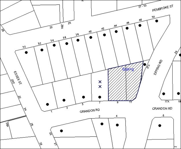
|
NOTIFICATION PLAN |
|
||
|
• PROPERTIES NOTIFIED
|
X SUBMISSIONS RECEIVED |
PROPERTY SUBJECT OF DEVELOPMENT |
|
After the application was originally exhibited in January 2015, the two adjacent strata properties at 7 Crandon were included in a development application to Council for the redevelopment of a 5 storey residential flat building, being DA No.1042/2015 which is currently under assessment. Council contacted the submitters to clarify if they maintained their objections lodged in January 2015. One of the objectors wrote to Council to advise that they have sold their property and therefore the development will not impact them. The other objector has not responded to Council’s request for clarification. The outstanding objection lodged in response to the plans exhibited in January 2015 objected to the development, generally on the grounds that the development would result in:
· Privacy impacts along the western interface;
· Unacceptable overshadowing of adjoining properties to the west;
· Inadequate building articulation; and
· An inadequate setback to Epping Road.
The merits of the matters raised in community submissions have been addressed in the body of the report.
5.2 Public Agencies
The development application was referred to the following Agencies for comment:
5.2.1 Roads and Maritime Services
The application was referred to the Roads and Maritime Services (RMS) for concurrence. No objections have been raised on traffic safety grounds subject to recommended conditions. The RMS requests the imposition of conditions upon any development consent issued. The conditions are included within Schedule 1 of this report.
6. THE PUBLIC INTEREST
Section 79C(1)(e) of the Act requires Council to consider “the public interest”.
The public interest is an overarching requirement, which includes the consideration of the matters discussed in this report. Implicit to the public interest is the achievement of future built outcomes adequately responding to and respecting the future desired outcomes expressed in environmental planning instruments and development control plans.
The application is considered to have satisfactorily addressed Council’s and relevant agencies’ criteria and would provide a development outcome that, on balance, would result in a positive impact for the community. Accordingly, it is considered that the approval of the proposed development would be in the public interest.
CONCLUSION
The application seeks approval for the demolition of existing structures and construction of a five storey residential flat building comprising 30 units and basement car parking.
The proposed development is generally in accordance with the development controls for the ‘Essex/Pembroke Street Epping Precinct’ of the HDCP and would contribute to the future desired five storey residential character of the precinct. The proposal complies with the design principles of SEPP 65 and the Residential Flat Design Code.
The proposal exceeds the 17.5m building height development standard by 0.732m. The variation is a result of the particular site constraints including the topography, stormwater overland flow path and frontage to a State road. The submission is considered well founded and is supported, subject to consent conditions requiring modification to the plans to delete a mezzanine room.
The proposal would result in a development that would be in keeping with the desired future character of the precinct. Approval of the application is recommended.
Note: At the time of the completion of this planning report, no persons have made a Political Donations Disclosure Statement pursuant to Section 147 of the Environmental Planning and Assessment Act 1979 in respect of the subject planning application.
RESPONSIBLE OFFICER
The officer responsible for the preparation of this Report is the Manager – Development Assessments – Rodney Pickles, who can be contacted on 9847 6731.
|
Rod Pickles Manager - Development Assessment Planning Division |
James Farrington Group Manager Planning Division |
|
1.View |
Locality Map |
|
|
|
2.View |
Site Plan |
|
|
|
3.View |
Floor Plans |
|
|
|
4.View |
Elevations and Sections |
|
|
|
5.View |
Landscape Plan |
|
|
|
6.View |
Shadow Diagrams |
|
|
File Reference: DA/1608/2014
Document Number: D06772083
SCHEDULE 1
GENERAL CONDITIONS
The conditions of consent within this notice of determination have been applied to ensure that the use of the land and/or building is carried out in such a manner that is consistent with the aims and objectives of the relevant legislation, planning instruments and council policies affecting the land and does not disrupt the amenity of the neighbourhood or impact upon the environment.
Note: For the purpose of this consent, the term ‘applicant’ means any person who has the authority to act on or the benefit of the development consent.
Note: For the purpose of this consent, any reference to an Act, Regulation, Australian Standard or publication by a public authority shall be taken to mean the gazetted Act or Regulation, or adopted Australian Standard or publication as in force on the date that the application for a construction certificate is made.
1. Approved Plans and Supporting Documentation
The development must be carried out in accordance with the plans and documentation listed below and endorsed with Council’s stamp, except where amended by Council and/or other conditions of this consent:
|
Plan No. |
Drawn by |
Dated |
|
8373 DA-C Cover Page |
Zhinar Architects |
24.11.15 |
|
8373 DA-C 01 Site Analysis |
Zhinar Architects |
18.09.15 |
|
8373 DA-C 02 Site Plan |
Zhinar Architects |
18.09.15 |
|
8373 DA-C 03 Basement -1 |
Zhinar Architects |
18.09.15 |
|
8373 DA-C 04 Lower Ground Floor |
Zhinar Architects |
24.11.15 |
|
8373 DA-C 05 Ground Floor |
Zhinar Architects |
18.09.15 |
|
8373 DA-C 06 First Floor |
Zhinar Architects |
18.09.15 |
|
8373 DA-C 07 Second Floor |
Zhinar Architects |
18.09.15 |
|
8373 DA-C 08 Third Floor |
Zhinar Architects |
18.09.15 |
|
8373 DA-C 09 Fourth Floor |
Zhinar Architects |
18.09.15 |
|
8373 DA-C 10 Roof Plan |
Zhinar Architects |
21.09.15 |
|
8373 DA-C 11 S+E Elevations |
Zhinar Architects |
25.09.15 |
|
8373 DA-C 12 N+W Elevations |
Zhinar Architects |
18.09.15 |
|
8373 DA-C 13 Section A & B |
Zhinar Architects |
18.09.15 |
|
8373 DA-C 14 Section C & SEPP65 Compliance Table |
Zhinar Architects |
25.09.15 |
|
8373 DA-C 21 Material Schedule 01 |
Zhinar Architects |
18.09.15 |
|
8373 DA-C 22 Material Schedule 02 |
Zhinar Architects |
18.09.15 |
|
Stormwater Management Plan Issue C Sheets 01 to 09 |
Quantum Engineers |
13.11.15 |
|
Landscape Plan Issue C Sheets 01 to 02 |
Paul Scrivener |
21.09.15 |
|
Document Title |
Prepared by |
Dated |
|
Basix Certificate 597088M_04 |
Newpeake |
24 Nov 2015 |
|
Waste Management Plan |
Zhinar |
1 July 2015 |
|
Flood Study Report |
ING Consulting Engineers |
4 May 2015 |
|
Acoustic Report |
Acoustic Logic |
11 Dec 2014 |
2. Amendment of Plans
a) To comply with Councils requirement in terms of Building Scale, the approved plans are to be amended as follows:
i) The mezzanine level to Unit 28 is to be deleted;
ii) The west facing living room window at Unit 254 is to be a 1500mm high sill;
iii) The Landscape Plan by Paul Scrivener dated 21.09.15 is to be amended to include a roof over part of the driveway ramp located between the rear façade and the security roller door, as indicated on the architectural plans by Zhinar Architects dated 18.09.15. This roof is to be landscaped with ground covers and shrubs in a planter box and may include a maintenance path. It is not to be designed or used as an active open space area.
b) These amended plans must be submitted with the application for the Construction Certificate.
The proposed development is not to exceed the building heights specified on the stamped approved plans specified herein and no consent is granted to additional or ancillary roof structures such as plant rooms, railings, stair wells or the like or for use of the roof top for recreational purposes.
4. Removal of Existing Trees
This development consent only permits the removal of tree(s) numbered 5 and 8 as identified on the Tree Location Plan provided by Hornsby Council dated 24-02-1015.
The removal of any other trees from the site requires separate approval by Council in accordance with Part 1B.6 Tree and Vegetation Preservation of the Hornsby Development Control Plan, 2013 (HDCP).
5. Project Arborist
A Project Arborist is to be appointed in accordance with AS 4970-2009 (1.4.4) to provide monitoring and certification throughout the development process.
Details of the Project Arborist are to be submitted to Council and the PCA prior to the issue of a Construction Certificate.
6. Construction Certificate
a) A Construction Certificate is required to be approved by Council or a Private Certifying Authority prior to the commencement of any works under this consent.
b) A separate Construction Certificate must be obtained from Council for all works within the public road reserve under S138 of the Roads Act.
c) A separate Construction Certificate must be obtained from Council for all works within drainage easements vested in Council.
d) The Construction Certificate plans must not be inconsistent with the Development Consent plans.
7. Section 94 Development Contributions
a) In accordance with Section 80A(1) of the Environmental Planning and Assessment Act, 1979 and the Hornsby Shire Council Section 94 Development Contributions Plan 2012-2021, the following monetary contributions must be paid to Council to cater for the increased demand for community infrastructure resulting from the development:
|
Description |
Contribution (4) |
|
Roads |
$20,596.55 |
|
Open Space and Recreation |
$348,138.00 |
|
Community Facilities |
$48,544.55 |
|
Plan Preparation and Administration |
$1,437.00 |
|
TOTAL |
$418,716.10 |
being for 8 x 1bed, 19 x 2bed and 3 x 3bed new units and credit for 2 existing residential lots
b) The value of this contribution is current as at 19 Nov. 15. If the contribution is not paid within the financial quarter that this condition was generated, the contribution payable will be adjusted in accordance with the provisions of the Hornsby Shire Council Section 94 Development Contributions Plan and the amount payable will be calculated at the time of payment in the following manner:
$CPY = $CDC x CPIPY
CPIDC
Where:
$CPY is the amount of the contribution at the date of Payment
$CDC is the amount of the contribution as set out in this Development Consent
CPIPY is the latest release of the Consumer Price Index (Sydney – All Groups) at the date of Payment as published by the ABS.
CPIDC is the Consumer Price Index (Sydney – All Groups) for the financial quarter at the date applicable in this Development Consent Condition.
c) The monetary contribution must be paid to Council:
i) prior to the issue of the Subdivision Certificate where the development is for subdivision; or
ii) prior to the issue of the first Construction Certificate where the development is for building work; or
iii) prior to issue of the Subdivision Certificate or first Construction Certificate, whichever occurs first, where the development involves both subdivision and building work; or
iv) prior to the works commencing where the development does not require a Construction Certificate or Subdivision Certificate.
Note: It is the professional responsibility of the Principal Certifying Authority to ensure that the monetary contributions have been paid to Council in accordance with the above timeframes.
Council’s Development Contributions Plan may be viewed at www.hornsby.nsw.gov.au or a copy may be inspected at Council’s Administration Centre during normal business hours.
REQUIREMENTS PRIOR TO THE ISSUE OF A CONSTRUCTION CERTIFICATE
8. Building Code of Australia
All building work must be carried out in accordance with the relevant requirements of the Building Code of Australia.
9. Contract of Insurance (Residential Building Work)
In the case of residential building work for which the Home Building Act 1989 requires there to be a contract of insurance in force in accordance with Part 6 of that Act, that such a contract of insurance is in force before any building work authorised to be carried out by the consent commences.
10. Notification of Home Building Act, 1989 Requirements
Residential building work within the meaning of the Home Building Act 1989 must not be carried out unless the principal certifying authority for the development to which the work relates (not being Council) has given Council written notice of the following information:
a) In the case of work for which a principal contractor is required to be appointed:
i) The name and licence number of the principal contractor; and
ii) The name of the insurer by which the work is insured under Part 6 of that Act.
b) In the case of work to be done by an owner-builder:
i) The name of the owner-builder; and
ii) If the owner-builder is required to hold an owner-builder’s permit under that Act, the number of the owner-builder’s permit.
Note: If arrangements for doing the residential building work are changed while the work is in progress so that the information notified becomes out of date, further work must not be carried out unless the principal certifying authority for the development to which the work relates (not being Council) has given Council written notification of the updated information.
11. Utility Services
The applicant must submit written evidence of the following service provider requirements:
a) Ausgrid (formerly Energy Australia) – a letter of consent demonstrating that satisfactory arrangements have been made to service the proposed development.
b) Telstra – a letter of consent demonstrating that satisfactory arrangements have been made to service the proposed development.
12. Sydney Water – Quick Check
This application must be submitted to a Sydney Water ‘Quick Check Agent’ or ‘Customer Centre’ for approval to determine whether the development would affect any Sydney Water infrastructure, and whether further requirements are to be met.
Note: Refer to www.sydneywater.com.au or telephone 13 20 92 for assistance.
13. Accessible Units
The development is required to provide 9 units designed as adaptable housing pursuant to the requirements of 1C.2.2 of the Hornsby Development Control Plan. In this regard, 3 car parking spaces are to be designed for people with a disability and allocated to 3 adaptable units. The details of all adaptable units must be provided with the Construction Certificate plans.
14. Letterboxes
The details of letter boxes and meter enclosures must be provided with the Construction Certificate Plans. The letter boxes and meter enclosures must be provided with a minimum setback of 2 metres from all boundaries and must be suitably screened.
Each dwelling within the development must have a minimum area for storage (not including kitchen and bedroom cupboards) of 6m³ for one bedroom units, 8m³ for two bedroom units and 10m³ for three bedroom units, where at least 50% is required to be located within the apartment and accessible from either the hall or living area except as otherwise indicated on the approved plans. Details must be submitted with the Construction Certificate plans.
16. Acoustic Report
The approved Acoustic Report by Acoustic Logic dated 11 December 2014 is to be updated to reflect the approved plans (as amended). The mitigation measures proposed within the report are to be applied to be development to ensure achievement of the noise goals prescribed in Clause 102 of SEPP Infrastructure, being that the following LAeq levels are not exceeded:
a) In any bedroom in the building – 35bD(A) at any time between 10pm and 7am.
b) Anywhere else in the building (other than a garage, kitchen, bathroom or hallway) – 40bD(A) at any time.
17. Air Conditioning Plant
One air conditioning plant unit may be provided for each apartment sited on the floor of the balcony. Where the approved adjacent balcony balustrade is glass, is to be constructed of opaque glass to obscure views to the plant from the property boundaries. Details must be submitted with the Construction Certificate plans.
18. Disabled Parking
All parking for people with disabilities is to comply with AS/NZS 2890.6:2009 Off-street parking for people with disabilities.
19. Bicycle Parking
Nine (9) bicycle parking spaces are to be designed in accordance with AS 2890.3-1993 Bicycle parking facilities.
20. Motorcycle Parking
One motorcycle space is required to be provided. Motorcycle parking spaces are to be designed in accordance with AS 2890.5-1993.
21. Construction Traffic Management Plan
A Construction Traffic Management Plan (CTMP) is to be submitted to Council and approval given prior to the issue of a Construction Certificate. The Plan should assess traffic impacts associated with construction works on public roads and must include:
a) Site location
b) Scope of works
c) Order of construction works
d) Identification of traffic hazards during all stages of works
e) Identification of potential risks during all stages of works
f) A map of the State and local roads in the proximity of the development
g) A map of truck routes to and from the development site during all stages of works
h) A map of existing parking restrictions in the proximity of the development
i) Hours of operation
j) Frequency of truck movements on a daily basis during all stages of works
k) A map of the access arrangements onto the development site during all stages of works
l) Swept path diagrams
m) Consideration of Work Zones for the development site
n) Consideration of mobile crane movements
o) Location of temporary hoardings, fencing or awning
p) Pedestrian and cyclist access and safety.
22. Pedestrian Access Management Plan
A Pedestrian Access Management Plan (PAMP) detailing how pedestrian movements will be changed and managed during various stages of development, particularly during any partial or total closure of footpaths on Epping Road and Crandon Road. Council will review the PAMP, agree any modifications with the proponent and enforce the PAMP during construction.
23. Traffic Control Plan
A Traffic Control Plan (TCP) must be prepared by a qualified traffic controller in accordance with the Roads & Traffic Authority’s Traffic Control at Worksites Manual 1998 and Australian Standard 1742.3 for all work on a public road. The Traffic Management Plan shall be submitted and approved by Council’s Manager Traffic and Road Safety prior to the issue of a construction certificate. The TCP must detail the following:
a) Arrangements for public notification of the works;
b) Temporary construction signage;
c) Permanent post-construction signage;
d) Vehicle movement plans;
e) Traffic management plans; and
f) Pedestrian and cyclist access/safety.
24. Construction Management Plan
A Construction Management Plan (CMP), prepared by a suitably qualified consultant, must be submitted for approval by Council. The CMP must be include, but not be limited, details of the following:
a) Noise attenuation measures be implemented along the eastern boundary of the site including a hoarding height not less than 3m from the existing ground level;
b) During excavation works, rock removal must be undertaken by sawing instead of rock hammering, wherever practicable;
c) The construction works must be undertaken in accordance with the “Interim Construction Noise Guidelines – 2009” published by DECCW and achieve compliance with the relevant noise levels; and
d) The delivery times and vehicular movements related to demolition, excavation and construction works must be restricted to the construction hours only.
25. Identification of Survey Marks
A registered surveyor must identify all survey marks in the vicinity of the proposed development. Any survey marks required to be removed or displaced as a result of the proposed development shall be undertaken by a registered surveyor in accordance with Section 24 (1) of the Surveying and Spatial Information Act 2002 and following the Surveyor General’s Directions No.11 – "Preservation of Survey Infrastructure".
26. Trunk Stormwater Drainage
The stormwater drainage system for the development must be designed in accordance with Council’s Civil Works – Design and Construction Specification 2005 and the following requirements:
a) In order to reduce risk of nuisance flooding of the site, the existing Council-controlled drainage system running along the northern boundary of the site shall be removed and a new drainage system be constructed in accordance with the following;-
i) The Council-controlled piped drainage system, hydraulic grade line analysis and drainage long section shall be designed by a civil or hydraulic engineer to convey the 20 year average recurrence interval (ARI) storm from the upstream catchment;
ii) Connection to the existing Council-controlled drainage system on the western and eastern boundaries of the site shall be provided via design and construction of Council’s standard junction pits;
iii) Pier and beam method construction adjacent to pipelines to the depth of the invert of proposed pipes;
iv) In accordance with Sections 59A and 68 of the Local Government Act 1993, application shall be made to Hornsby Shire Council for consideration and approval of the drainage works. Accredited Certifiers must not give consent for the work. The applicant shall obtain a quote for, and pay Council’s fee for plan approval and compliance inspections of the drainage system with lodgement of the application;
v) Approval and construction of the drainage system must be carried out whilst convenient access to the site is provided after demolition of pre-existing structures;
b) The land in the vicinity of the Council-controlled drainage system shall be landscaped in order to convey the design 100 year ARI storm flow in the catchment;
c) The design overland flow path must not be impacted by the location of existing or proposed buildings and landscaping;
d) Floor levels of habitable or lockable rooms shall be set at least 0.5m above the design surface water profile adjacent;
e) Private ground floor courtyard areas shall be protected and fenced with pool type fencing or suitable alternative wherever the 100 year ARI design flow exceeds 0.4 m2/s. Details to be shown on construction plans;
f) The proposed internal drainage system shall be connected to the constructed Council-controlled piped drainage system.
27. Internal Drainage and On Site Stormwater Detention
An on-site stormwater detention system must be designed by a chartered civil engineer and constructed in accordance with Council’s Civil Works – Design and Construction Specification 2005 the following requirements:
a) Have a capacity of not less than 23 cubic metres, and a maximum discharge (when full) of 32 litres per second;
b) Have a surcharge/inspection grate located directly above the outlet;
c) Discharge from the detention system must be controlled via 1 metre length of pipe, not less than 50 millimetres diameter or via a stainless plate with sharply drilled orifice bolted over the face of the outlet discharging into a larger diameter pipe capable of carrying the design flow to an approved Council system;
d) Provide 900 mm x 900 mm square access grates, and standard stepirons where tank depths exceed 1.2m;
e) Not be constructed in a location that would impact upon the visual or recreational amenity of residents;
f) The drainage system must incorporate a harvesting system in accordance with HDCP2013 Section 1C.1.2.j. Details to be provided on the construction plans.
28. Internal Driveway/Vehicular Areas
The driveway and parking areas on site must be designed, constructed and a Construction Certificate issued in accordance with Australian Standards 2890.1, 2890.2, 3727 and the following requirements:
a) Design levels at the front boundary shall be obtained from Council per separate application to Council for Crossing Levels;
b) Design levels at the front boundary provided by Council are to be used to design the driveway longitudinal section;
c) The driveway be a rigid pavement;
d) Drainage systems shall be provided for the driveway and internal parking areas.
29. Road Works
All road works approved under this consent must be designed in accordance with Council’s Civil Works Design and Construction Specification 2005 and the following requirements:-
a) Council’s standard 150 mm integral kerb and gutter to be removed and reconstructed across the Crandon Road frontage of the subject site with a minimum road shoulder pavement construction width of 0.7 metres;
b) Council’s standard 80 mm thick concrete footpath to be constructed within the road verge with the remaining area turfed.
c) The submission of a compaction certificate from a geotechnical engineer for any fill within road reserves, and all road sub-grade and road pavement materials.
d) In accordance with Section 138 Roads Act 1993, application shall be made to Hornsby Shire Council for consideration and approval of the Road works. Accredited Certifiers must not give consent for the work. The applicant shall obtain a quote for, and pay Council’s fee for plan approval and compliance inspections of the Road works with lodgement of the application;
30. Vehicular Crossing
A separate application under the Local Government Act, 1993 and the Roads Act 1993 must be submitted to Council for the installation of a new vehicular crossing and the removal of the redundant crossing. The vehicular crossing must be constructed in accordance with Council’s Civil Works Design 2005 and the following requirements:
a) Design levels at the front boundary must be obtained from Council for the design on the internal driveway;
b) Any redundant crossings must be replaced with integral kerb and gutter;
c) The footway area must be restored by turfing;
Note: An application for a vehicular crossing can only be made to one of Council’s Authorised Vehicular Crossing Contractors, or be the subject of a Construction Certificate Application to Hornsby Council as Roads Authority. You are advised to contact Council on 02 9847 6940 to obtain a list of contractors.
31. Waste Management Details
The following waste management requirements must be complied with:
a) The approved on-going waste management system must not be amended without the written consent of Council.
b) The ground level bin room is to be increased from 3.2m by 4.2m to 3.2m by 7.2m, with a minimum 2 m wide roller door.
c) The bin carting route between the ground level bin room and the driveway/truck parking location is to have a gradient no greater than 1:20, be at least 1.5 m wide and must not include any steps.
d) There must be a bulky waste storage area of no less than 8 m2 at the basement level.
e) The waste facilities on each residential level must be accessible by persons with a disability while comfortably housing one 240 L garbage bin and one 240 L recycling bin. (Note: a 240 L recycling bin is 600 mm wide by 750 mm deep; allow for ease around the bin – 75 mm is recommended).
f) A Waste Management Plan Section One – Demolition Stage and Section Three – Construction Stage, covering the scope of this project and including the following details, is required to be submitted to Council:
i) An estimate of the types and volumes of waste and recyclables to be generated;
ii) A site plan showing sorting and storage areas for demolition and construction waste and the vehicle access to these areas;
iii) How excavation, demolition and construction waste materials will be reused or recycled and where residual wastes will be disposed;
iv) The total percentage (by weight) of demolition and construction waste that will be reused or recycled.
32. Preservation of Survey Infrastructure
Prior to the issue of a construction certificate, a registered surveyor shall identify all survey marks in the vicinity of the proposed development. Any survey marks required to be removed or displaced as a result of the proposed development shall be undertaken by a registered surveyor in accordance with Section 24 (1) of the Surveying and Spatial Information Act 2002 and following the Surveyor General’s Directions No.11 – "Preservation of Survey Infrastructure".
REQUIREMENTS PRIOR TO THE COMMENCEMENT OF ANY WORKS
33. Erection of Construction Sign
A sign must be erected in a prominent position on any site on which building work, subdivision work or demolition work is being carried out:
a) Showing the name, address and telephone number of the principal certifying authority for the work;
b) Showing the name of the principal contractor (if any) for any demolition or building work and a telephone number on which that person may be contacted outside working hours; and
c) Stating that unauthorised entry to the work site is prohibited.
Note: Any such sign is to be maintained while the building work, subdivision work or demolition work is being carried out, but must be removed when the work has been completed.
34. Protection of Adjoining Areas
A temporary hoarding, fence or awning must be erected between the work site and adjoining lands before the works begin and must be kept in place until after the completion of the works if the works:
a) Could cause a danger, obstruction or inconvenience to pedestrian or vehicular traffic.
b) Could cause damage to adjoining lands by falling objects.
c) Involve the enclosure of a public place or part of a public place.
Note: Notwithstanding the above, Council’s separate written approval is required prior to the erection of any structure or other obstruction on public land.
35. Toilet Facilities
Toilet facilities must be available or provided at the works site before works begin and must be maintained until the works are completed at a ratio of one toilet for every 20 persons employed at the site. Each toilet must:
a) be a standard flushing toilet connected to a public sewer; or
b) be a temporary chemical closet approved under the Local Government Act 1993; or
c) have an on-site effluent disposal system approved under the Local Government Act 1993.
36. Erosion and Sediment Control
Erosion and sediment control measures must be provided and maintained throughout the construction period in accordance with the manual ‘Soils and Construction 2004 (Bluebook)’, the approved plans, Council specifications and to the satisfaction of the principal certifying authority. The erosion and sediment control devices must remain in place until the site has been stabilised and revegetated.
Note: On the spot penalties may be issued for any non-compliance with this requirement without any further notification or warning.
37. Tree Protection Zone Fencing (TPZ)
a) Tree protection fencing must be installed around trees numbered T1, T2, T3, T4, T6 & T7 Tree Location Plan provided by Hornsby Council dated 24-02-1015 at the distances determined by AS 4970-2009 Section 3.
b) Tree Protective Fencing must be installed in accordance with AS 4970-2009 Section 4.3 and 4.4.
c) Where tree protection fencing cannot be located at the perimeter of the Tree Protection Zone appropriate trunk, ground and crown protection must be provided in accordance with AS 4970-2009 Section 4.5 under the direction of the project arborist.
d) Maintenance of the Tree Protection Zones must be carried out in accordance with AS 4970-2009 Section 4.6 for the duration of this consent.
38. Tree Protection Requirements
a) The Project Arborist must oversee and provide certification for the installation of all tree protection measures as specified in this consent.
b) Certification must be provided by the Project Arborist to the Principal Certifying Authority stating that all required tree protection measures have been installed in accordance with AS 4970-2009 Section 5.3.2
REQUIREMENTS DURING DEMOLTION AND CONSTRUCTION
a) All work on site (including demolition and earth works) must only occur between 7am and 5pm Monday to Saturday (unless otherwise approved in writing by Council due to extenuating circumstances).
b) No Excavation or rock sawing/breaking is to occur on Saturdays or between the hours of 12 pm and 1 pm weekdays.
c) No work is to be undertaken on Sundays or public holidays.
All construction vehicles associated with the proposed development are to be contained on site or in a Local Traffic Committee (LTC) approved “Work Zone”.
41. Demolition
To protect the surrounding environment, all demolition work must be carried out in accordance with “Australian Standard 2601-2001 – The Demolition of Structures” and the following requirements:
a) Demolition material must be disposed of to an authorised recycling and/or waste disposal site and/or in accordance with an approved waste management plan;
b) Demolition works, where asbestos material is being removed, must be undertaken by a contractor that holds an appropriate licence issued by WorkCover NSW in accordance with Chapter 10 of the Occupational Health and Safety Regulation 2001 and Clause 29 of the Protection of the Environment Operations (Waste) Regulation 2005 ;and
c) On construction sites where any building contain asbestos material, a standard commercially manufactured sign containing the words ‘DANGER ASBESTOS REMOVAL IN PROGRESS’ and measuring not less than 400mm x 300mm must be displayed in a prominent position visible from the street.
42. Environmental Management
The site must be managed in accordance with the publication ‘Managing Urban Stormwater – Landcom (March 2004) and the Protection of the Environment Operations Act 1997 by way of implementing appropriate measures. To prevent sediment run-off, excessive dust, noise or odour emanating from the site during the construction of the development.
43. Street Sweeping
To protect the surrounding environment, Street sweeping must be undertaken following sediment tracking from the site along Crandon Road during works and until the site is established.
The street cleaning services must undertake a street ‘scrub and dry’ method of service and not a dry sweeping service that may cause sediment tracking to spread or cause a dust nuisance.
44. Maintenance and Monitoring of Tree Protection
All Tree Protection Zones must be monitored by the Project Arborist in accordance with AS 4970-2009 Section 5.4.
45. Consenting to Works within Tree Protection Zones
a) All works must be approved by the Project Arborist;
b) Root/ground protection must be provided in accordance with AS 4970-2009 Section 4.5.4
c) Underground services must be installed in accordance with AS 4970-2009 Section 4.5.5.
d) The Structural Root Zone of any tree required to be retained must remain intact/undisturbed
e) Root pruning must be carried out in accordance with AS 4970-2009 Sections 3.3.4 & 4.5.4
f) Activities within the Tree Protection Zone must comply with AS 4970-2009 Section 4.2.
46. Certification
The Project Arborist must provide to the Principal Certifying Authority certification for the monitoring and maintenance of Tree Protection Zones and documentation of the methods used to preserve the trees during construction.
47. Disturbance of Existing Site
During construction works, the existing ground levels of open space areas and natural landscape features, including natural rock-outcrops, vegetation, soil and watercourses must not be altered unless otherwise nominated on the approved plans.
48. Landfill
Landfill must be constructed in accordance with Council’s ‘Construction Specification 2005’ and the following requirements:
a) All fill material imported to the site is to wholly consist of Virgin Excavated Natural Material (VENM) as defined in Schedule 1 of the Protection of the Environment Operations Act, 1997 or a material approved under the Department of Environment and Climate Change’s general resource recovery exemption.
49. Excavated Material
All excavated material removed from the site must be classified by a suitably qualified person in accordance with the Department of Environment, Climate Change and Water NSW Waste Classification Guidelines prior to disposal to an approved waste management facility and be reported to the principal certifying authority prior to the issue of an Occupation Certificate.
50. Survey Report
A report(s) must be prepared by a registered surveyor and submitted to the principal certifying authority:
a) Prior to the pouring of concrete at each level of the building certifying that:
i) The building, retaining walls and the like have been correctly positioned on the site; and
ii) The finished floor level(s) are in accordance with the approved plans.
b) Confirming that the waste collection vehicle turning area complies with AS2890.1 – 2004 and AS20890.2 – 2002 for small rigid vehicles (SRV).
51. Traffic Control Plan Compliance
The development must be carried out in accordance with the submitted Traffic Control Plan (TCP).
52. Council Property
During construction works, no building materials, waste, machinery or related matter is to be stored on the road or footpath.
53. Waste Management
Waste management during the demolition and construction phase of the development must be undertaken in accordance with the approved Waste Management Plan. Additionally written record of the following items must be maintained during the removal of any waste from the site and such information submitted to the Principal Certifying Authority within fourteen days of the date of completion of the works;
a) The identity of the person removing the waste.
b) The waste carrier vehicle registration.
c) Date and time of waste collection.
d) A description of the waste (type of waste and estimated quantity).
e) Details of the site to which the waste is to be taken.
f) The corresponding tip docket/receipt from the site to which the waste is transferred (noting date and time of delivery, description (type and quantity) of waste).
g) Whether the waste is expected to be reused, recycled or go to landfill.
Note: In accordance with the Protection of the Environment Operations Act 1997, the definition of waste includes any unwanted substance, regardless of whether it is reused, recycled or disposed to landfill.
REQUIREMENTS PRIOR TO THE ISSUE OF AN OCCUPATION CERTIFICATE
Note: For the purpose of this consent, a reference to ‘occupation certificate’ shall not be taken to mean an ‘interim occupation certificate’ unless otherwise stated.
54. Fulfilment of BASIX Commitments
The applicant must demonstrate the fulfilment of BASIX commitments pertaining to the development.
55. Retaining Walls
All required retaining walls must be constructed as part of the development.
56. Unit Numbering
All units are to be numbered consecutively commencing at No.1. The strata plan lot number is to coincide with the unit number, e.g. unit 1 = lot 1. The allocation of unit numbering must be authorised by Council prior to the numbering of each unit in the development.
57. Parking Allocation
The three groups of tandem parking are to be allocated to the three x 3 bedroom units on the approved plans.
58. Sydney Water – s73 Certificate
An s73 Certificate must be obtained from Sydney Water.
Note: Sydney Water requires that s73 applications are to be made through an authorised Sydney Water Servicing Coordinator. Refer to www.sydneywater.com.au or telephone 13 20 92 for assistance.
59. Damage to Council Assets
Any damage caused to Council’s assets as a result of the construction or demolition of the development must be rectified in accordance with Council’s Civil Works Specifications. Council’s Restorations Supervision must be notified for a formwork inspection prior to pouring concrete.
60. Planter Boxes / On Slab Planting
On slab planter boxes must include waterproofing, subsoil drainage (proprietary drainage cell, 50mm sand and filter fabric) automatic irrigation, minimum 300mm planting soil for shrubs and minimum 1000mm planting soil for trees and palms and 75mm mulch to ensure sustainable landscape is achieved.
61. Completion of Landscape Works
A certificate must be provided by a practicing landscape architect, horticulturalist or person with similar qualifications and experience certifying that all required landscape works have been satisfactorily completed in accordance with the approved landscape plans.
Note: Applicants are advised to pre-order plant material required in pot sizes 45 litre or larger to ensure Nurseries have stock available at the time of install.
62. Certification – Project Arborist
Following the final inspection and the completion of any remedial works, the Project Arborist must submit to the Principal Certifying Authority documentation stating that the completed works have been carried out in compliance with the approved plans and the relevant conditions of consent.
63. Certification – Acoustic Engineer
An Acoustic Engineer must submit to the Principal Certifying Authority documentation stating that the completed works have been carried out in compliance with the approved plans and the relevant conditions of consent including Condition 16, 66 and 82.
64. Safety and Security
This site must include the following elements:
a) An intercom system must be installed at gate locations to ensure screening of persons entering the units.
b) The entry doors to the pedestrian foyer is to be constructed of safety rated glass to enable residents a clear line of site before entering or exiting the residential apartments.
c) Lighting is to be provided to pathways, building foyer entries, driveways and common external spaces.
d) Security gate access is to be provided to the car parking areas allowing residents-only access to private car spaces.
e) CCTV cameras must be installed at the entry and exit point and the around the mailbox.
f) The communal open spaces within the site must be illuminated with high luminance by motion sensor lighting.
g) The driveway and basement car parking must be illuminated with low luminance at all times.
h) Security deadlocks are to be provided to each apartment door.
i) Peep holes are to be provided to individual apartment doors to promote resident safety.
65. External Lighting
All external lighting must be designed and installed in accordance with Australian Standard AS 4282 – Control of the Obtrusive Effects of Outdoor Lighting. Certification of compliance with the Standard must be obtained from a suitably qualified person.
66. Installation of Air Conditioning
To protect the amenity of adjacent properties, the condenser unit for any air conditioner must be submitted to the PCA by a suitably qualified person confirming that the unit has been tested for heating and cooling on the highest settings and that the noise levels generated do not exceed 5 dB(A) above background noise levels when tested at the property boundary between 8 pm and 10 pm.
67. Provision for National Broadband Network (NBN)
Provision must be made for fibre ready passive infrastructure (pits and pipes) generally in accordance with NBN Co.'s pit and pipe installation guidelines to service the proposed development. A certificate from NBN Co or the provider must be submitted to the PCA that the fibre optic cabling provided for the development complies with MDU Building Design Guides for Development.
68. Works as Executed Plan
A works-as-executed plan(s) must be prepared by a registered surveyor and submitted to Council for completed road pavement, kerb & gutter, culvert, driveways, on-site detention and water quality treatment systems. The plan(s) must be accompanied by a certificate from a registered surveyor certifying that all pipelines and associated structures lie wholly within any relevant easements.
69. Certificate of Preservation of Survey Marks
Prior to the issue of a construction certificate, a registered surveyor shall identify all survey marks in the vicinity of the proposed development. Any survey marks required to be removed or displaced as a result of the proposed development shall be undertaken by a registered surveyor in accordance with Section 24 (1) of the Surveying and Spatial Information Act 2002 and following the Surveyor General’s Directions No.11 – "Preservation of Survey Infrastructure".
70. Waste Management Details
The following waste management requirements must be complied with:
a) Prior to an Occupation Certificate being issued or the use commencing, whichever is earlier, the Principal Certifying Authority must obtain Council’s approval of the waste and recycling management facilities provided in the development and ensure arrangements are in place for domestic waste collection by Council.
Note: Waste and recycling management facilities includes everything required for on-going waste management on the site. For example the garbage chute system, volume handling equipment, bin lifter, motorised bin trolley or similar, recycling bin storage on each residential level, bin storage areas, bulky waste storage area, bin collection area, waste collection vehicle access, doors wide enough to fit the bin through, etc.
b) The garbage room at the lower ground levels must include water or a hose for cleaning, graded floors with drainage to sewer, a robust door, sealed and impervious surface, adequate lighting and ventilation, and must be lockable. The waste facility rooms/cupboards at each residential level must include sealed and impervious surface, adequate lighting and ventilation.
c) A report must be prepared by an appropriately qualified person, certifying the following:
i) A comparison of the estimated quantities of each waste type against the actual quantities of each waste type.
Note: Explanations of any deviations to the approved Waste Management Plan is required to be included in this report.
ii) That at least 60% of the waste generated during the demolition and construction phase of the development was reused or recycled.
Note: If the 60% diversion from landfill cannot be achieved in the Construction Stage, the Report is to include the reasons why this occurred and certify that appropriate work practices were employed to implement the approved Waste Management Plan. The Report must be based on documentary evidence such as tipping dockets/receipts from recycling depots, transfer stations and landfills, audits of procedures etc. which are to be attached to the report.
iii) All waste was taken to site(s) that were lawfully permitted to accept that waste.
d) Each unit must be provided with an indoor waste/recycling cupboard for the interim storage of a minimum one day’s waste generation with separate containers for general waste and recyclable materials.
e) Space must be provided for either individual compost containers for each unit or a communal compost container;
Note: The location of the compost containers should have regard for potential amenity impacts.
f) The bin carting routes must be devoid of any steps.
Note: Ramps between different levels are acceptable.
g) The bin carting route between the garbage room and the driveway/truck parking position must be no less than 1.5m wide smooth, hard surface with a gradient no steeper than 1:20(5%).
71. Creation of Easements
The following matter(s) must be nominated on a deposited plan under s88B of the Conveyancing Act, 1919:
a) A drainage easement at least 3 metres wide (refer Design Specification 2005 Section D5.30.5), over the burdened lot in favour of Council and in accordance with the terms set out in Memorandum B5341305V filed with the NSW Department of Lands;
b) A restriction over the pipeline and the flow path for a 100 year average recurrence interval storm. The "Restriction on the Use of Land" over the affected lots is to prohibit the alteration of the final floodway shape and the erection of any structures, including fencing, in the floodway without the written permission of Council. The terms of this restriction must be obtained from Council;
c) A "Restriction on the Use of Land" for any lot adjacent to the floodway, requiring the finished floor level of any habitable room to be not less than 500mm and the garage 300mm above the 100 year average recurrence interval storm level. The levels must be related to Australian Height Datum;
d) The creation of an appropriate "Positive Covenant" and "Restriction as to User" over the constructed on-site detention/retention systems and outlet works, within the lots in favour of Council in accordance with Council’s prescribed wording. The position of the on-site detention system is to be clearly indicated on the title;
e) To register the OSD easement, the restriction on the use of land “works-as-executed” details of the on-site-detention system must be submitted verifying that the required storage and discharge rates have been constructed in accordance with the design requirements. The details must show the invert levels of the on-site system together with pipe sizes and grades. Any variations to the approved plans must be shown in red on the “works-as-executed” plan and supported by calculations;
Note: Council must be nominated as the authority to release, vary or modify any easement, restriction or covenant.
72. Garbage Collection Easement
For the purpose of waste collection, an easement entitling Council, its servants and agents and persons authorised by it to enter upon the subject land and to operate thereon, vehicles and other equipment for the purposes of garbage collection must be granted to Council by the owner of the land.
Note: The easement must be in a form prescribed by Council and must include covenants to the effect that parties will not be liable for any damage caused to the subject land or any part thereof or to any property located therein or thereon by reason of the operation thereon of any vehicle or other equipment used in connection with the collection of garbage and to the effect that the owner for the time being of the subject land shall indemnify the Council, its servants, agents and persons authorised by it to collect garbage against liability in respect of any such claims made by any person whomsoever.
73. Completion of Works and Compliance Certificate
All engineering works identified in this consent are to be completed and a Compliance Certificate issued prior to the release of occupation permit.
OPERATIONAL CONDITIONS
74. Ongoing Car Parking Requirements
All car parking must be constructed and operated in accordance with Australian Standard AS/NZS 2890.1:2004 – Off Street Car Parking and Australian Standard AS 2890.2:2002 – Off Street Commercial Vehicle Facilities and the following requirements:
a) All parking areas and driveways are to be sealed to an all-weather standard, line marked and signposted;
b) Car parking, loading and manoeuvring areas to be solely for nominated purposes;
c) Vehicles awaiting loading, unloading or servicing shall be parked on site and not on adjacent or nearby public roads;
d) All vehicular entry to the site and egress from the site shall be made in a forward direction;
e) Any proposed landscaping and/or fencing must not restrict sight distance to pedestrians and cyclists travelling along the footpath;
f) Residential parking spaces are to be secure spaces with access controlled by card or numeric pad;
g) Visitors must be able to access the visitor parking spaces in the basement car park at all times;
h) All parking for people with disabilities is to comply with Australian Standard AS/NZS 2890.6:2009 – Off Street Parking for People with Disabilities;
i) Bicycle parking spaces are to be designed in accordance with Australian Standard AS 2890.3:1993 – Bicycle Parking Facilities;
j) Motorcycle parking spaces are to be designed in accordance with Australian Standard AS 2890.5:1993
k) Access for garbage vehicles is to satisfy the requirements of Council’s Waste Management Branch.
75. Landscape Establishment
The landscape works must be maintained into the future to ensure the establishment and successful growth of plant material to meet the intent of the landscape design. This must include but not limited to watering, weeding, replacement of failed plant material and promoting the growth of plants through standard industry practices.
76. Waste Management
The waste management on site must be in accordance with the following requirements:
a) A site caretaker must be employed and be responsible for moving bins where and when necessary, washing bins and maintaining waste storage areas, decanting 240 L garbage bins into 660 L garbage bins, managing the communal composting area, managing the bulky item storage area, arranging the prompt removal of dumped rubbish, and ensuring all residents are informed of the use of the waste management system. The site caretaker must be employed for a sufficient number of hours each week to allow all waste management responsibilities to be carried out to a satisfactory standard.
77. Maintenance of Wastewater Device
All wastewater and stormwater treatment devices (including drainage systems, sumps and traps) must be regularly maintained in order to remain effective. All solid and liquid wastes collected from the device must be disposed of in accordance with the Protection of the Environment Operations Act 1997.
78. Noise
All noise generated by the proposed development must be attenuated to prevent levels of noise being emitted to adjacent premises which possess tonal, beating and similar characteristics or which exceeds background noise levels by more than 5dB(A).
79. Fire Safety Statement - Annual
On at least one occasion in every 12 month period following the date of the first ‘Fire Safety Certificate’ issued for the property, the owner must provide Council with an annual ‘Fire Safety Certificate’ to each essential service installed in the building.
CONDITIONS OF CONCURRENCE – ROADS AND MARITIME SERVICES
The following conditions of consent are from the nominated State Agency pursuant to Section 79B of the Environmental Planning and Assessment Act 1979 and must be complied with to the satisfaction of that Agency.
80. Site Excavation and Support
The developer is to submit design drawings and documents relating to the excavation of the site and support structures to RMS for assessment, in accordance with Technical Direction GTD2012/001.
The developer is to submit all documentation at least six (6) weeks prior to commencement of construction and is to meet the full cost of assessment by RMS.
The report and any enquiries should be forwarded to:
Project Engineer, External Works
Sydney Asset Management
Roads and Maritime Services
PO Box 973 Parramatta CBD 2124
Telephone 8849 2114
Fax 8849 2766
If it is necessary to excavate below the level of the base of the footings of the adjoining roadways, the person acting on the consent shall ensure that the owner/s of the roadway is/are given at least seven (7) day notice of intention to excavate below the base of the footings. The notice is to include complete details of the work.
81. Stormwater
Detailed design plans and hydraulic calculations of any changes to the stormwater drainage system are to be submitted to Rods and Maritime for approval, prior to the commencement of any works.
Details should be forwarded to:
Sydney Asset Management
Roads and Maritime Services
PO Box 973 Parramatta CBD 2124
A plan checking fee will be payable and a performance bond may be required before Roads and Maritime approval is issued. With regard to the Civil Works requirement please contact the Roads and Maritime Project Engineer, External Works Ph: 8849 2114 or Fax: 8849 2766
82. Traffic Noise
The development should be designed so that Road Traffic Noise from Epping Road is mitigated by durable materials in order to satisfy the requirements for habitable rooms under Clause 102(3) of SEPP Infrastructure 2007.
- END OF CONDITIONS -
ADVISORY NOTES
The following information is provided for your assistance to ensure compliance with the Environmental Planning and Assessment Act 1979, Environmental Planning and Assessment Regulation 2000, other relevant legislation and Council’s policies and specifications. This information does not form part of the conditions of development consent pursuant to Section 80a of the Act.
Environmental Planning and Assessment Act 1979 Requirements
The Environmental Planning and Assessment Act 1979 requires:
· The issue of a construction certificate prior to the commencement of any works. Enquiries can be made to Council’s Customer Services Branch on 9847 6760.
· A principal certifying authority to be nominated and Council notified of that appointment prior to the commencement of any works.
· Council to be given at least two days written notice prior to the commencement of any works.
· Mandatory inspections of nominated stages of the construction inspected.
· An occupation certificate to be issued before occupying any building or commencing the use of the land.
Long Service Levy
In accordance with Section 34 of the Building and Construction Industry Long Service Payments Act 1986, a ‘Long Service Levy’ must be paid to the Long Service Payments Corporation or Hornsby Council.
Note: The rate of the Long Service Levy is 0.35% of the total cost of the work.
Note: Hornsby Council requires the payment of the Long Service Levy prior to the issue of a construction certificate.
Tree and Vegetation Preservation
In accordance with Clause 5.9 of the Hornsby Local Environmental Plan 2013 a person must not ringbark, cut down, top, lop, remove, injure or wilfully destroy any tree or other vegetation protected under the Hornsby Development Control Plan 2013 without the authority conferred by a development consent or a permit granted by Council.
Notes: A tree is defined as a long lived, woody perennial plant with one or relatively few main stems with the potential to grow to a height greater than three metres (3M). (HDCP 1B.6.1.c).
Tree protection measures and distances are determined using the Australian Standard AS 4970:2009, “Protection of Trees on Development Sites”.
Fines may be imposed for non-compliance with both the Hornsby Local Environmental Plan 2013 and the Hornsby Development Control Plan 2013.
Disability Discrimination Act
The applicant’s attention is drawn to the existence of the Disability Discrimination Act. A construction certificate is required to be obtained for the proposed building/s, which will provide consideration under the Building Code of Australia, however, the development may not comply with the requirements of the Disability Discrimination Act. This is the sole responsibility of the applicant.
Covenants
The land upon which the subject building is to be constructed may be affected by restrictive covenants. Council issues this approval without enquiry as to whether any restrictive covenant affecting the land would be breached by the construction of the building, the subject of this consent. Applicants must rely on their own enquiries as to whether or not the building breaches any such covenant.
Dial Before You Dig
Prior to commencing any works, the applicant is encouraged to contact Dial Before You Dig on 1100 or www.dialbeforeyoudig.com.au for free information on potential underground pipes and cables within the vicinity of the development site.
Telecommunications Act 1997 (Commonwealth)
If you are aware of any works or proposed works which may affect or impact on Telstra’s assets in any way, you are required to contact: Telstra’s Network Integrity Team on Phone Number 1800810443.
Asbestos Warning
Should asbestos or asbestos products be encountered during demolition or construction works, you are advised to seek advice and information prior to disturbing this material. It is recommended that a contractor holding an asbestos-handling permit (issued by WorkCover NSW) be engaged to manage the proper handling of this material. Further information regarding the safe handling and removal of asbestos can be found at:
Alternatively, telephone the WorkCover Asbestos and Demolition Team on 8260 5885.
House Numbering
House numbering can only be authorised by Council. Before proceeding to number each premise in the development, the allocation of numbers is required to be obtained from Council's Planning Division prior to the issue of a Subdivision Certificate. The authorised numbers are required to comply with Council’s Property Numbering Policy and be displayed in a clear manner at or near the main entrance to each premise.
Occupation Certificate Requirements
An Occupation Certificate application is required to be lodged, with a copy to Council, containing the following information:
· A certificate by a Registered Surveyor shall be submitted to the Principal Certifying Authority, certifying that there has been no removal, damage, destruction, displacement or defacing of the existing survey marks in the vicinity of the proposed development, or otherwise certifying that the necessary re-establishment of any damaged, removed or displaced survey marks has been undertaken in accordance with the Surveyor General’s Direction No. 11 – “Preservation of Survey Infrastructure”.
Group Manager’s Report No. PL95/15
Planning Division
Date of Meeting: 9/12/2015
10 DEVELOPMENT APPLICATION - CONSTRUCTION OF 8 MULTI DWELLING HOUSING DWELLINGS - 8 GALSTON ROAD, HORNSBY
EXECUTIVE SUMMARY
|
DA No: |
DA/298/2015 (19 March 2015) |
|
Description: |
Demolition of existing structures and construction of eight multi dwelling houses (townhouses) with basement car parking |
|
Property: |
Lot 1 DP 1003444, No. 8 Galston Road, Hornsby |
|
Applicant: |
Karrich Property Group Pty Ltd |
|
Owner: |
Karrich Property Group Pty Ltd |
|
Estimated Value: |
$2,100,000 |
|
Ward: |
A |
· The application proposes demolition of existing structures and construction of eight townhouses with basement car parking.
· The proposal complies generally complies with the Hornsby Local Environmental Plan 2013 and Hornsby Development Control Plan 2013.
· Twelve submissions have been received in respect of the application.
· It is recommended that the application be approved as deferred commencement to enable creation of an easement for stormwater to drain to Council’s stormwater drainage system.
|
THAT Development Application No. DA/298/2015 for demolition of existing structures and construction of eight multi dwelling houses with basement car parking at Lot 1 DP 1003444, No. 8 Galston Road, Hornsby be approved as a deferred commencement pursuant to Section 80(3) of the Environmental Planning and Assessment Act 1979 subject to the conditions of consent detailed in Schedule 1 of Group Manager’s Report No. PL95/15. |
BACKGROUND
The subject land was rezoned from Residential A (Low Density) to Residential B (Medium Density) on 2 September 2011 as part of Council’s Housing Strategy.
On 19 March 2015, this subject application was lodged with Council.
On 28 July 2015, the applicant submitted additional information addressing Council’s concerns with respect to isolation of the adjoining site, setback variations, basement height, dormer width, bin store location, RMS requirements and stormwater drainage.
On 26 October 2015, the applicant submitted revised plans addressing Council’s concerns with respect to the garbage room dimensions and construction method to protect the adjoining trees, amended first floor windows in the southern elevation of the building to include glazing up to a height of 1.5m above floor level and relocation of the on-site detention.
On 2 November, the applicant submitted additional shadow diagrams providing an axonometric 3D view of the solar access received by the adjoining development at No. 2 Galston Road, Hornsby.
SITE
The 1,474m2 site is located on the eastern side of Galston Road, Hornsby and contains a single storey dwelling. There is also an industrial building at the rear of the site, which is made of concrete and metal clad. This industrial building has previously been occupied and used as a vehicle repair station.
The site has a 30.12 metre frontage to Galston Road.
The site does not contain a heritage listed item and is not in a heritage conservation area however, is located adjacent to a heritage item, namely the House at No. 10 Galston Road, Hornsby and is in the vicinity of the House at No. 9 Galston Road, Hornsby listed under Schedule 5 of the Hornsby Local environmental Plan 2013.
There is an existing townhouse development adjoining the southern side of the site at No. 2 Galston Road.
There is a 2 metre fall towards the northern western corner of the site.
PROPOSAL
The application proposes the demolition of the existing structures and the construction of eight multi dwelling houses (townhouses) with basement car parking.
The unit configuration includes 7 x 2 bedroom dwellings and 1 x 3 bedroom dwellings with ground level open space fronting the street, rear, centre and side setbacks.
A waste storage area is proposed on the southern side of the site.
The development would be accessed from Galston Road via a driveway located adjacent to the northern boundary of the site.
ASSESSMENT
The development application has been assessed having regard to ‘A Plan for Growing Sydney’, the ‘North Subregion (Draft) Subregional Strategy’ and the matters for consideration prescribed under Section 79C of the Environmental Planning and Assessment Act 1979 (the Act). The following issues have been identified for further consideration.
1. STRATEGIC CONTEXT
1.1 A Plan for Growing Sydney and (Draft) North Subregional Strategy
A Plan for Growing Sydney has been prepared by the NSW State Government to guide land use planning decisions for the next 20 years. The Plan sets a strategy for accommodating Sydney’s future population growth and identifies the need to deliver 689,000 new jobs and 664,000 new homes by 2031. The Plan identifies that the most suitable areas for new housing are in locations close to jobs, public transport, community facilities and services.
The NSW Government will use the subregional planning process to define objectives and set goals for job creation, housing supply and choice in each subregion. Hornsby Shire has been grouped with Hunters Hill, Ku-ring-gai, Lane Cove, Manly, Mosman, North Sydney, Pittwater, Ryde, Warringah and Willoughby to form the North Subregion. The Draft North Subregional Strategy will be reviewed and the Government will set housing targets and monitor supply to ensure planning controls are in place to stimulate housing development.
The proposed development would be consistent with ‘A Plan for Growing Sydney’, by providing additional dwellings and would contribute to housing choice in the locality.
2. STATUTORY CONTROLS
Section 79C(1)(a) requires Council to consider “any relevant environmental planning instruments, draft environmental planning instruments, development control plans, planning agreements and regulations”.
2.1 Hornsby Local Environmental Plan 2013
The proposed development has been assessed having regard to the provisions of the Hornsby Local Environmental Plan 2013 (HLEP).
2.1.1 Zoning of Land and Permissibility
The subject land is zoned R3 – Medium Density Residential under the HLEP. The objectives of the zone are:
(a) To provide for the housing needs of the community within a medium density residential environment.
(b) To provide a variety of housing types within a medium density residential environment.
(c) To enable other land uses that provide facilities or services to meet the day to day needs of residents.
The proposed development is defined as multi dwelling housing and is permissible in the zone with Council’s consent.
2.1.2 Height of Buildings
Clause 4.3 of the HLEP provides that the height of a building on any land should not exceed the maximum height shown for the land on the Height of Buildings Map. The maximum permissible building height for the subject site is 10.5 metres. The proposed building height is 10.4 metres and complies with this provision.
2.1.3 Heritage Conservation
The objectives of Clause 5.10 of HLEP are as follows:
(a) to conserve the environmental heritage of Hornsby,
(b) to conserve the heritage significance of heritage items and heritage conservation areas, including associated fabric, settings and views,
(c) to conserve archaeological sites,
(d) to conserve Aboriginal objects and Aboriginal places of heritage significance.
The site is located adjacent to a heritage listed items namely the house at No. 10 Galston Road, Hornsby and is in the vicinity of the House at No. 9 Galston Road, Hornsby (located on the opposite side of Galston Road). The item at No. 10 Galston Road is a good example of a Victorian Freestyle period cottage (c1890) of unusual design with symmetrical street façade of two bay windows enclosing a verandah, complex corrugated iron roof with good brick chimneys. The item at No. 9 Galston Road is a good example of Federation Bungalow (c1900) which includes an L-shaped plan with gabled projection and verandah beside, original corrugated iron roof, tall painted brick chimney with terracotta pot, bullnosed verandah with turned timber posts, paired double hung windows, bracketed hood to window on projection and painted brick base.
The heritage listed cottage at No.10 Galston Road is currently surrounded by vegetation and is not highly visible from the street. The heritage item at No. 9 Galston Road is located diagonally opposite the subject site and is visible in the street.
The front three townhouses are oriented to Galston Road and present as two storey terraces with a dormer window in each roof. The front townhouses are well setback from the street front and are located behind No. 10 Galston Road. The remaining five dwellings are located at the rear and would not be highly visible to the street. The driveway and basement requires significant excavation and the northern elevation of Townhouse 1 presents as a 10 metre high rendered wall. Council’s heritage assessment has concluded that the northern wall of Townhouse 1 should be screened by vegetation and finished in dark tones to reduce impact on the item at No. 10 Galston Road.
Council’s heritage assessment raised concerns with respect to the location of the bin storage areas. The bin storage area on the northern side of the driveway has been relocated to allow for landscaping and reduce the impact of the excavated driveway on the heritage item to the north. The original proposal involved the location of the garbage room adjacent to the heritage item.
The Arborist report indicates retention and protection of conifers on the northern boundary (located within the access handle of No. 8A Galston Road). This retention is supported on heritage grounds as it provides a further visual buffer between the new development and the heritage item at No. 10 Galston Road. The Turpentine tree located within the front yard is also proposed to be retained which would provide a partial screen to the new development and complement the existing tree canopy in the streetscape (in the vicinity of the heritage items). No original or significant landscape features associated with the heritage items are affected.
A condition of consent has been recommended to address the concern with respect to finishes and screen planting. Subject to these conditions the proposal meets the objectives of Clause 5.10 of the HLEP and is acceptable.
2.1.4 Earthworks
Clause 6.2 of the HLEP states that consent is required for proposed earthworks on the site. Before granting consent for earthworks, Council is required to assess the impacts of the works on adjoining properties, drainage patterns and soil stability of the locality.
Council’s assessment of the proposed earthworks and excavation concludes that the proposal is satisfactory subject to conditions regarding submission of a dilapidation report assessing the impact of the excavation on the adjoining properties.
2.2 State Environmental Planning Policy No. 55 – Remediation of Land
State Environmental Planning Policy No. 55 (SEPP 55) requires that consent must not be granted to carrying out of any development on land unless it has considered whether the land is contaminated or requires remediation for the proposed use.
The rear half of the site was previously used as a motor mechanic work shop for a number of years, and there are waste oil tanks present on the site. The applicant has submitted a Stage 1 Preliminary Site Investigation report. The report is based on a review of the available desktop search data and observations made during the site walkover. The report states that the potential for contamination to be present on the site as a result of past and current land use activities and is considered to be moderate.
The report also states, “that contamination that may be present within the proposed basement excavation area is expected to be excavated and disposed offsite, however, areas of potential contamination extend beyond the proposed extent of the basement. As such, any contamination that may be present outside of the proposed basement footprint is expected to remain following the proposed development. The site can be made suitable for the proposed residential development (townhouse and basement parking) from a land contamination prescriptive, subject to a further assessment and removal of any identified unacceptable levels of contamination”. The report recommends that a Stage 2 Detailed Site investigation be conducted, targeting the areas of environmental concern identified by the Stage 1 preliminary Site Investigation and suitable conditions of consent.
Council’s environmental assessment raised no objections to the proposal subject to conditions including a detailed site investigation to be carried out and a Remedial Action Plan is to be prepared should the detailed investigation reveal contamination exceeding criteria prescribed by the NSW Environmental Protection Authority’s Contaminated Sites – Guidelines for the NSW Site Auditor Scheme.
2.3 State Environmental Planning Policy (Building Sustainability Index – BASIX) 2004
The application has been assessed against the requirements of State Environmental Planning Policy (building Sustainability Index: BASIX) 2004. The proposal includes a BASIX Certificate for the proposed townhouses and is considered to be satisfactory.
2.4 State environmental Planning Policy No. 32 – Urban Consolidation (Redevelopment of Urban Land) (SEPP 32)
The application has been assessed against the requirements of SEPP 32, which requires Council to implement aims and objectives of this Policy to the fullest extent practicable when considering development applications relating redevelopment of urban land. The application complies with the objectives of the policy as it would promote the social and economic welfare of the locality and would result in the orderly and economic use of underutilised land within the Shire.
2.5 State Environmental Planning Policy 20 Hawkesbury-Nepean River (No. 2-1997)
The application has been assessed against the requirements of Sydney Regional Environmental Plan No. 20. This Policy provides controls to protect the environment of the Hawkesbury-Nepean system, including its water quality. The plan addresses matters related to water quality, significant vegetation habitats, extraction, environmental heritage and scenic quality, recreation and tourism, and agriculture.
A condition of consent includes sediment and erosion controls to be implemented before the commencement of construction works. Subject to conditions, the proposal would be consistent with the objectives of the Policy.
2.6 State Environmental Planning Policy (Infrastructure) 2007
The application has been assessed against the requirements of State Environmental Planning Policy (Infrastructure) 2007. This Policy contains State-wide planning controls for developments adjoining busy roads. The development is located immediately adjoining Galston Road. The following matters are required to be considered pursuant to the SEPP.
2.6.1 Development with Frontage to a Classified Road
The proposal has been assessed against the requirements of Clause 101 of SEPP (Infrastructure) as the proposal has frontage to Galston Road.
Vehicular access to the site is proposed via Galston Road. Council’s Traffic assessment of the proposal has concluded that the proposal is acceptable with respect to the safety, efficiency and ongoing operation of the classified road. Council’s planned future works includes installation of traffic signals at the intersection of Galston Road and Clarinda Street and installation of new medians along the Pacific Highway and Galston Road at the Old Berowra Road and Carrington Road intersections to manage an increase in traffic generated in the area.
The application was referred to Roads and Maritime Services (RMS) who raised no objections subject to conditions.
2.6.2 Impact of Road Noise
Assessment of the impact of road noise on a residential use is required pursuant to Clause 102 of SEPP (Infrastructure), where a development fronts a road with an annual average daily traffic volume of more than 40,000 vehicles. The RMS average daily traffic volume map indicates that the Galston Road would reach an annual average daily traffic volume of less than approximately 40,000 vehicles. Accordingly, this clause does not apply.
2.6.3 Traffic Generating Development
The development is not classified as a Traffic Generating Development in accordance with Clause 104 and Schedule 3 of SEPP (Infrastructure) as it would not result in more than 75 dwellings fronting a classified road.
2.7 Clause 74BA Environmental Planning and Assessment Act, 1979 - Purpose and Status of Development Control Plans
Clause 74BA of the Environmental Planning and Assessment Act, 1979 states that a DCP provision will have no effect if it prevents or unreasonably restricts development that is otherwise permitted and complies with the development standards in relevant Local Environmental Plans and State Environmental Planning Policies.
The principal purpose of a development control plan is to provide guidance on the aims of any environmental planning instrument that applies to the development; facilitate development that is permissible under any such instrument; and achieve the objectives of land zones. The provisions contained in a DCP are not statutory requirements and are for guidance purposes only. Consent authorities have flexibility to consider innovative solutions when assessing development proposals, to assist achieve good planning outcomes.
2.8 Hornsby Development Control Plan 2013
The proposed development has been assessed having regard to the relevant desired outcomes and prescriptive requirements within the Hornsby Development Control Plan 2013 (HDCP). The following table sets out the proposal’s compliance with the prescriptive requirements of the Plan:
|
Hornsby Development Control Plan 2013 |
|||
|
Control |
Proposal |
Requirement |
Compliance |
|
Site Width |
30.12m |
30m |
Yes |
|
Height |
10.4m |
10.5m |
Yes |
|
No. storeys |
2 storeys + attic |
2 storeys + attic |
Yes |
|
Height of Basement Above Ground |
1.1m |
1m (max) |
No |
|
Roof pitch |
25 degrees |
25 degrees (max) |
Yes |
|
Dormer Windows Max. width Min. separation |
2m 3m |
2m 2m |
Yes Yes |
|
Front Setback |
12-19m |
9m |
Yes |
|
Rear Setback |
6m |
6m |
Yes |
|
Side Setback (north) |
5m |
6m |
No |
|
Side Setback (south) |
5-5.2m |
6m |
No |
|
Underground Parking Setback |
7.7m-front 6m-rear 3m-side (east) 3m-side (west) |
6m-front 4m-rear 3m-side (north) 3m-side (south) |
Yes Yes Yes Yes |
|
Basement Ramp Setback |
2m |
2m |
Yes |
|
Maximum Panel Width Front Side (north) Side (south) |
5m 5m 6.7m (max) |
6m 8m 8m |
Yes Yes Yes |
|
Deep Soil Landscaped Areas |
6m-front 4.8m -rear 2m-side (north and south) |
6m-front 4m -rear 3m sides |
Yes Yes No |
|
Private Open Space |
>24m2 |
Min. 24m2 |
Yes |
|
Communal Open Space |
N/A as <10 units |
N/A |
N/A |
|
Parking |
12 resident spaces
4 visitor spaces Not shown Not shown |
11 resident spaces 2 visitor spaces 3 bicycle tracks 1 Motorbike space |
Yes
Yes No No
|
|
Solar Access |
75% |
70% receive 3 hours |
Yes |
|
Housing Choice |
N/A as <10 units |
N/A |
N/A |
|
Adaptable Units |
N/A as <10 units |
N/A |
N/A |
As detailed in the above table, the proposed development does not comply with a number of prescriptive requirements within the HDCP. The matters of non-compliance are detailed below, as well as a brief discussion on compliance with relevant desired outcomes.
2.8.1 Desired Future Character
The proposed development is in accordance with the desired future character of the area for well-articulated two-storey multi dwelling houses and residential flat buildings in garden settings with basement car parking, pitched roofs with wide eaves and additional floor area within the roof space.
The proposal complies with the desired future character for the area.
2.8.2 Site Requirements
The HDCP requires sites to have a minimum frontage of 30 metres to Galston Road. The subject site complies with this requirement. Whilst the site tapers down to 20.1 metres at the rear, the minimum site frontage is calculated at the front of the site where it adjoins the road. The HDCP also requires the following:
‘Where a development proposal results in an adjoining site within the precinct with no street frontage or a primary street frontage of less than 30m, proponents should demonstrate that orderly and economic development of the site can be achieved under this DCP.
Where a property is likely to be isolated by a proposed development and it cannot be demonstrated that the site can be developed to its full potential, applicants should provide documentary evidence that genuine and reasonable attempt has been made to purchase an isolated site based on a fair market value.’
On the southern side of the site, No. 2 Galston Road has been developed for 26 townhouses. The property located on the northern side of the adjoining access handle (No. 10 Galston Road) is a heritage listed property and may have limited potential for the purposes of multi- dwelling housing. Approval of the proposed development would result in No. 8A Galston Road (being a battle-axe allotment) having a primary street frontage less than the required 30 metres minimum frontage requirement under the HDCP.
Council wrote to the adjacent site owner at No. 8A Galston Road to confirm their position to the matter of site amalgamation with No. 8 Galston Road. The owner of No. 8A Galston Road provided a written response to Council stating that the they were prepared to negotiate sale of the property, an offer was made by the them which was rejected by the applicant, no counter offers were made by the applicant and subsequently they are no longer prepared to sell. With respect to this, Council requested a response from the applicant.
The applicant provided a written statement that a number of attempts were made to purchase the property at No. 8A Galston Road including correspondence by registered post and accompanying Statutory Declaration. The applicant also states that every reasonable effort was made to acquire the adjoining property in circumstances where such an acquisition is not required as the subject site meets the minimum allotment frontage requirement. Furthermore, the applicant states that negotiations with the owner of No. 8A Galston Road are continuing in relation to obtaining a drainage easement and potential purchase of the property for inclusion as part of a new development involving properties to the north.
In accordance with the provisions of the HDCP, it is acknowledged that the applicant sought to negotiate with the owners of No. 8A Galston Road by making genuine and reasonable attempts to acquire the site. An offer of $1.075 million was made to the adjoining owner. Details of the attempts made to acquire No. 8A were submitted with the application. These attempts to acquire No. 8A were unsuccessful.
The adjoining site at No. 8A has an approximately 4.5 metre wide site frontage in the form of an access handle and a total site area of 1130m2. Although the site has limited development potential on its own, there is potential to amalgamate the site with the properties north for redevelopment for multi dwellings.
Based on the above, the applicant has made reasonable attempts to acquire the adjoining site in accordance with the Land and Environment Court principles and the adjoining site is assessed as being capable of being development. The proposal is considered to be acceptable in respect to the HDCP prescriptive measures for site requirements.
2.8.3 Height
2.8.3.1 Building Height
The proposed building complies with the 10.5 metre maximum height limit. The basement would project up to 1.1 metre above the natural ground level at the south-western corner of the site. The non-compliance has resulted due to the slope of the land. However, the overall height of the building at this point would be within the 10.5 metre height limit and does not incorporate any additional levels.
2.8.3.2 Roof Design
The development incorporates pitched roofs with wide eaves extending to the front and rear of each unit. The roof pitches would be less than 25 degrees, in accordance with the requirements of HDCP. The attic level is contained wholly within the roof space.
Submissions have been received raising concerns with respect to privacy and solar access impact on the adjoining property at No. 2 Galston Road. To address these concerns, the applicant has submitted revised plans where the dormer windows on the southern elevation of the townhouses have been removed and the roof pitch reduced.
Dormer windows at the attic level on the northern elevations are set below the ridge level and provide additional articulation in the roof in particular within the rear elevation of the building. Dormer style windows are also provided to overlook the centre courtyard area between the units. These windows are integrated into the design of the roof and would not be readily visible from the public domain.
The design of the roof is in accordance with Council’s requirements and does not contribute to the bulk and scale of the building. Accordingly, the proposed development is satisfactory in respect to the two storey built form with attics.
2.8.4 Setbacks
The development proposes northern and southern side setbacks of 5 - 5.2 metres, which do not comply with the minimum setback of 6 metres. Notwithstanding, a greater front setback (in excess of the HDCP requirement) has been provided for the proposed development for the retention and protection of significant Sydney Iron Bark Turpentine Forest (STIF) located at the front of the subject site and on the adjoining site at No. 2 Galston Road.
Due to the provision of a greater front setback, the site is constrained in both width and depth. To provide reasonable compliance with the other HDCP requirements including building separation, private open space and solar access, compliance with the side setbacks would be unreasonable.
The applicant proposes obscure glazing for all the first bedroom windows on the southern elevation at 1.5m off the finished floor level for townhouses 4-8, which would allow sunlight to the dwellings but minimise overlooking opportunities. Townhouse No. 3 would have two small obscure glass bathroom windows orientated towards the south. Furthermore, the application proposes tree planting along the northern boundary to provide reasonable privacy to the heritage listed house and any future development at No. 8A Galston Road.
Given that the proposal incorporates appropriate privacy measures to minimise overlooking opportunities and maintain amenity of the adjoining properties, the proposal meets the desired outcome of the setbacks element.
2.8.5 Built Form and Separation
2.8.5.1 Separation
The proposal includes private open spaces located centrally between townhouse 1, 2, 3 and 4 and would not provide 9 metres of separation between these areas. Due to narrow depth of the site, private open space is not achievable elsewhere on the site and is most appropriate between the townhouses. The application includes extensive screen planting and privacy screens around the private open space areas to limit the potential for overlooking from the adjoining townhouse.
The development proposes a 5-5.2 metre building separation between the townhouses and the southern and northern property boundaries. The townhouses located on the southern side at No. 2 Galston that directly adjoining the subject site have setbacks of 3.5-4.4 metres from the site boundary. This provides an overall separation of 8.5- 9.6 metres.
Council received submissions from the owners of townhouses on the adjoining site at No. 2 Galston Road raising concerns with respect to separation on the southern side of the site and associated privacy and solar access impacts. To address these concerns, the applicant submitted amended plans realigning the townhouses to increase the southern side setback, remove dormer windows on the southern elevation and include obscure glazing for all the first bedroom windows at 1.5m off the finished floor level for townhouses 4-8 on the southern elevation.
The developments on the northern side include a heritage listed house and an undeveloped site. The application proposes tree planting along the northern boundary and would provide reasonable privacy to the heritage listed house and future development.
Given that the design incorporates appropriate privacy measures to alleviate overlooking opportunities and maintain amenity of the current and future occupants, the proposal complies with the intent of the “Building separation” control and would result in a reasonable design outcome for the site.
2.8.5.2 Articulation
Articulation has been achieved within the front façade by stepping the townhouses resulting in wall panels 5 metres wide with vertical detailing between the townhouses. The development proposes a maximum of 5 metre unbroken wall length on the northern elevation and 6.7 metre maximum unbroken wall length on the southern elevation, which complies with the maximum of 8 metre requirement.
The application is assessed as satisfactory in this regard.
2.8.6 Landscaping
The prescriptive measure of the HDCP requires deep soil landscaped areas around the proposal to allow for trees to be planted within these areas.
The proposal would allow for 2 metres of deep soil landscaping at the side of the site instead of the 3 metres. However, a greater front setback (in excess of the HDCP requirement) has been provided for the proposed development for the retention and protection of significant STIF trees located at the front the subject site and on the adjoining site at No. 2 Galston Road.
The 2 metre deep soil landscaping on the sides would still allow medium canopy trees.
The non-compliance in this instance is minimal and would not restrict landscaping within the side setbacks of the site.
2.8.7 Open Space
All the townhouses would achieve the prescriptive open space area requirement of 24m2. The open spaces areas can be directly accessed from the living areas.
It is considered that the proposed private open space areas achieve the desired outcome and are acceptable.
2.8.8 Privacy and Security
The HDCP encourages the location of primary living areas and private open space areas at the front or rear.
Council received submissions from the owners of townhouses on the adjoining site at No. 2 Galston Road raising concerns with respect to privacy impacts. To address these concerns, the applicant submitted amended plans realigning the townhouses to increase southern side setback, removing dormer windows on the southern elevation and including obscure glazing for all the first bedroom windows.
The development is designed to locate the first floor balconies and the ground level private open space areas at the front and rear of each townhouse. A 1.8 metre high solid privacy screen is provided between townhouses which would restrict overlooking opportunities.
The design orientates the balconies of the townhouses towards the street and communal open space areas, providing passive surveillance of the public domain. Both the pedestrian and vehicular entry points are secured and visibly prominent from Galston Road.
Subject to the imposition of conditions of consent with respect to additional privacy devices, the proposal is supported in respect of safety and security.
2.8.9 Sunlight and Ventilation
The applicant has provided shadow diagrams at 9am, 12 noon and 3pm, which indicates that 6 of the 8 dwellings receive at least 3 hours of unobstructed sunlight on 22 June.
Council received submissions from owners of No. 2 Galston Road raising concerns with respect to solar access impact. To address these concerns, the applicant has provided additional shadow diagrams including axonometric 3D view of shadows casted from the proposed development on the adjoining property at No. 2 Galston Road. These shadow diagrams indicate the current shadows cast from the existing buildings on the subject site and the existing boundary fence, and the shadows cast from the proposed development.
The difference in shadows between the pre-development and post-development is minimal and would still provide the minimum required sunlight access to the adjoining property, which is at least half of the dwellings principle living room windows and principle private open space area between 9am and 3pm on 22 June.
Furthermore, the applicant has submitted a solar access view diagram with the shadows cast from the proposed development and existing fences which demonstrate that the adjoining property would receive the minimum required sunlight access. This solar access view diagrams show that the there is an existing shadow cast on the courtyards on the adjoining property at No. 2 Galston Road due to the step down nature in design.
All the proposed townhouses have windows in two separate exterior walls to provide effective natural cross ventilation.
The proposal meets the prescriptive measures of the sunlight and ventilation and is considered acceptable.
2.8.10 Housing Choice
There are no requirements for housing mix for medium density developments where less than 10 units are proposed. Notwithstanding, the development proposes 7 x 2 bedroom dwellings and 1 x 3 bedroom dwelling.
2.8.11 Vehicular Access and Parking
The proposed single level basement car park is to be accessed via a 6.1 metre wide driveway from Galston Road. The parking provision is in accordance with the minimum number of car spaces prescribed by the HDCP. However, the submitted plans do not show bicycle parking and motorbike spaces. Notwithstanding, there is sufficient space in basement for bicycle and motorbike spaces. Accordingly, a condition has been recommended in this regard. The driveway width, ramp gradients and aisle widths are assessed as satisfactory. The basement level also includes storage areas for residents.
2.8.12 Waste Management
The townhouse development would require 4 x 240 L garbage bins serviced twice per week, plus 4 x 240 L recycling bins serviced weekly. A shared bin area is proposed on the southern side of the site.
The garbage collection for the site would be from Galston Road by a heavy ridged waste collection vehicle.
Subject to recommended conditions, the proposed development is satisfactory with regard to waste management and collection.
2.8.13 Heritage
As discussed in Section 2.1.3, the proposal is satisfactory on heritage grounds subject conditions.
2.9 Section 94 Contributions Plans
Hornsby Shire Council Section 94 Contributions Plan 2012-2021 applies to the development as it would result in an additional seven residential dwellings in lieu of the existing dwelling. Accordingly, the requirement for a monetary Section 94 contribution is recommended as a condition of consent.
3. ENVIRONMENTAL IMPACTS
Section 79C(1)(b) of the Act requires Council to consider “the likely impacts of that development, including environmental impacts on both the natural and built environments, and social and economic impacts in the locality”.
3.1 Natural Environment
3.1.1 Tree and Vegetation Preservation
There are two trees located on the subject site and 14 trees on the adjoining properties (Nos. 2, 8A and 10 Galston Road) The proposed development would necessitate the removal of one tree (tree No.16) from the site. The tree to be removed is a Jacaranda mimosifolia which is not identified as a ‘significant tree’ in accordance with the Tree and Vegetation provisions of the HDCP.
The application is supported by an Arboricultural Impact Assessment prepared by Australis Tree Management dated 15 March 2015. The report concludes that the tree is within the proposed building envelope and is not able to be retained. It is considered that the removal of the tree is acceptable in the circumstances of the case due to its low retention value.
Conditions are recommended to protect the trees on the adjoining property during construction. These conditions include a Project Arborist to supervise and monitor the integrity of the tree protection methods, tree protection fencing and works within tree protection zones, and the use of sensitive construction methods such as piers or screw pilings to minimise compaction within the tree protection zone.
The submitted landscape plan includes planting of trees incorporating a variety of groundcovers and low and tall shrubs. Subject to recommended conditions for an additional one canopy tree planting, the submitted landscape plan would increase the local tree canopy and contribute to the natural environment.
3.1.2 Stormwater Management
The development proposes to connect to Council’s drainage system located in Clarinda Street via below ground on-site detention (OSD) and a rainwater tank system to control discharge of water from the site. The application proposes to create a drainage easement over No. 8A Galston Road, Hornsby (Lot 2 DP 574472) and No. 3 Clarinda Street, Hornsby (Lot 3 DP 574472), therefore, a deferred commencement is recommended for the creation of an easement to drain water from the site over downstream properties at No. 8A Galston Road and 3 Clarinda Street.
Subject to recommended conditions, the proposal would be satisfactory.
3.2 Built Environment
3.2.1 Built Form
The built form responds to the existing streetscape and the slope of the site. The proportions, alignments and articulation provide an appropriate scale relationship between properties and create streetscape interest. The proposed external finishes would provide a variety in built form and blend with the existing developments in the street.
The proposal is acceptable in terms of the built form, scale and its relation to the existing built environment.
3.2.2 Traffic
The applicant provided a Traffic and Parking Assessment Report (TPAR) prepared by Varga Traffic Planning Pty Ltd dated 9 March 2015. The TPAR estimates the net increase in the traffic generation potential as a result of the redevelopment of the site, to be 4 vehicles per hour. The estimate is based on the traffic generation rates for medium density developments published by RMS in “Guide to Traffic Generating Developments, Section 3 – Landuse Traffic Generation (October 2002)”.
The TPAR states that traffic generation rates for 8 residential townhouses would generate approximately 4 vehicle trips per hour during commuter peak periods. Furthermore, the TPAR states that the existing motor repair workshop is capable of generating more than 5 vehicle trips during commuter peak periods. The projected traffic activity as a consequence of the development proposal would be similar or less compared to the former use. The proposed basement includes sufficient parking to cater for the development and would have minimal impact on street parking. The impact of the proposed development on the local traffic network is assessed as satisfactory.
3.3 Social Impacts
The residential development would improve housing choice in the locality by providing a range of house hold types. This is consistent with Council’s Housing Strategy which identifies the need to provide a mix of housing options to meet future demographic needs in Hornsby Shire.
3.4 Economic Impacts
The proposal would have a minor positive impact on the local economy in conjunction with other new low density residential development in the locality by generating an increase in demand for local services.
4. SITE SUITABILITY
Section 79C(1)(c) of the Act requires Council to consider “the suitability of the site for the development”.
The subject site has not been identified as bushfire prone or flood prone land. The site is considered to be capable of accommodating the proposed development. The scale of the proposed development is consistent with the capability of the site and is considered acceptable.
5. PUBLIC PARTICIPATION
Section 79C(1)(d) of the Act requires Council to consider “any submissions made in accordance with this Act”.
5.1 Community Consultation
The proposed development was placed on public exhibition and was notified to adjoining and nearby landowners between 1 April 2015 and 16 April 2015 in accordance with the Notification and Exhibition requirements of the HDCP. During this period, Council received 12 submissions. The map below illustrates the location of those nearby landowners who made a submission that are in close proximity to the development site.
|
NOTIFICATION PLAN |
|
||
|
• PROPERTIES NOTIFIED
|
X SUBMISSIONS RECEIVED |
PROPERTY SUBJECT OF DEVELOPMENT |
|
Twelve submissions objected to the development, generally on the grounds that the development would result in:
· Unacceptable site setback;
· Unacceptable roof pitch;
· Unacceptable overshadowing of adjoining properties;
· Privacy impact;
· Visual impact;
· Unacceptable site frontage width;
· Impact on trees/loss of trees;
· Unacceptable separation with buildings on the site;
· Contrary to DCP Key Development Principles Diagram;
· Insufficient parking;
· Isolation of a site – No.8a Galston Road;
· Unacceptable deep soil landscaping on northern boundary;
· No external clothes drying area;
· Mix of dwellings not provided;
· Construction impact report not provided;
· Landscape plan not provided;
· Waste management Plan not provided;
· Geo-technical report not provided;
· Acoustic report not provided;
· Heritage report not provided;
· Unacceptable density with respect to old FSR;
· Loss of light/view;
· Attic space is large and should not be considered as floor; and
· Building height.
The merits of the matters raised in community submissions have been addressed in the body of the report with the exception of the following:
5.1.1 Privacy Impacts
Council received 10 submissions raising concerns with respect to privacy impact from the proposed development towards existing townhouses on the southern side boundary at No. 2 Galston Road. The development proposes bedrooms and bathrooms on the first floor level. Townhouse No. 3 would have two small bathroom windows orientated towards the southern elevation and would not provide overlooking. Townhouse Nos. 4, 5, 6, 7 and 8 have windows that would orientate towards the southern elevation. Notwithstanding, these windows would provide obscure glazing to windows at 1.5m off the first floor level. This would reduce opportunity for overlooking into the adjoining property at No. 2 Galston Road.
5.1.2 Visual Impact
One submission has been received raising concerns with respect to visual impact. The proposed development meets the zone objective for medium density development and generally satisfies the prescriptive measures of the HDCP included bulk and scale. Whilst the proposal would change the visual setting of the site, it is considered that the proposal would be consistent with the future medium density character for the precinct and would not have negative impact on the streetscape.
5.1.3 No External Clothes Drying Area
Council has received two submissions raising concerns that the proposed development does not provide an area for external clothes drying. Each of the proposed townhouses include private open space areas in excess of the minimum requirement and clothes drying area can be provided within the nominated principle private open space areas.
5.1.4 Mix of Dwelling Not Provided
Two submissions have been received raising concerns that the proposal does not provide a mix of dwelling types. For developments within less than 10 dwellings, dwelling mix is not required under the HDCP.
5.1.5 Construction Impact Report Not Provided
Council has received two submissions raising concerns that the proposed development does not provide a construction impact report. A condition of consent is recommended that a Construction Traffic Management Plan be submitted to Council for approval prior to the issue of a construction certificate. This would include the order of construction works and arrangement of all construction machines and vehicles used.
5.1.6 Landscape Plan Not Provided
Two submissions have been received raising concerns that the proposal does not provided a landscape plan. The application has submitted a landscape plan and is considered satisfactory.
5.1.7 Waste Management Plan Not Provided
Two submissions have been received raising concerns that the proposed development does not provided a waste management plan with the application. A condition of consent is recommended that waste management details be submitted to Council prior to the issue of a construction certificate.
5.1.8 Geo-technical Report Not Provided
Council received two submissions raising concerns that the proposal does not provided a geo-technical report. Only developments on a sloping site with a gradient in excess of 20% require certification from a geotechnical engineer. The site does not have a slope in excess of 20%, therefore a geotechnical report is not required as part of the application. However a condition of consent is recommended for a dilapidation report.
5.1.9 Acoustic Report Not Provided
Two submissions have been received raising concerns that the proposed development does not include an acoustic report. Under Clause 102 of SEPP (Infrastructure), an acoustic report for this proposed development is not required as Galston Road would not reach an annual average traffic volume of over 40,000 vehicles as discussed in Section 2.6.2.
5.1.10 Heritage Report Not Provided
Council has received two submissions raising concerns that the proposed development has not submitted a heritage report. As the subject site is not heritage listed, a full heritage report is not required. The applicant however, has addressed heritage impact within the submitted Statement of Environmental Effects. Council’s heritage assessment raises no objection to the proposal subject to conditions.
5.1.11 Unacceptable Density with Respect to Superseded Hornsby DCP 1994
Three submissions were received raising concerns with the proposed density with respect to superseded Hornsby DCP 1994. The submissions made a comparison between the superseded DCP 1994 and the current HDCP 2013. Under the HLEP 2013, there are no savings provisions for applications lodged after the implementation of HDCP 2013. The application was lodged after the HDCP 2013 came into effect; therefore the application has been assessed against the current DCP controls. The application generally complies with the bulk and scale requirements under the HDCP 2013.
5.1.12 Loss of Light and View
Council received two submissions raising concerns with respect to loss of light and views. The application generally complies with the bulk and scale, setback and solar access controls. It is considered that reasonable solar light would be available for the townhouses on the southern boundary. No ‘iconic’ view would be lost from the proposed development. Furthermore, the proposed development complies with the maximum height requirement.
5.1.13 Attic Space is Large and Should Not be Considered as a Floor
One submission has been received raising concerns with respect to the attic space being large and should be considered as a floor. The proposed attic meets the definition of an attic under the HDCP and is not considered as a storey, as it is contained wholly within the roof above the ceiling line of the storey immediately below.
5.1.14 Contrary to DCP Key Developments Principles Diagram
Council received two submissions raising concerns with respect to the proposal not satisfying the HDCP Key Development Principles Diagram for the Galston Road, Hornsby Precinct. It is considered that the proposal generally meets the HDCP Key Developments Principles Diagram.
5.2 Public Agencies
5.2.1 Roads and Maritime Services
The development application was referred to Roads and maritime Services for consideration as the site is located on a classified road. No objections are raised subject to recommended conditions of consent.
6. THE PUBLIC INTEREST
Section 79C(1)(e) of the Act requires Council to consider “the public interest”.
The public interest is an overarching requirement, which includes the consideration of the matters discussed in this report. Implicit to the public interest is the achievement of future built outcomes adequately responding to and respecting the future desired outcomes expressed in environmental planning instruments and development control plans.
The application is considered to have satisfactorily addressed Council’s and relevant agencies’ criteria and would provide a development outcome that, on balance, would result in a positive impact for the community. Accordingly, it is considered that the approval of the proposed development would be in the public interest.
CONCLUSION
The application seeks approval for the demolition of existing structures and construction of eight townhouses and basement car parking.
The proposed development is generally in accordance with the development controls for the Galston Road Precinct of the HDCP and would contribute to the future desired residential character of the precinct, subject to recommended conditions of consent.
The proposal would result in a development that would be in keeping with the desired future character of the precinct.
Note: At the time of the completion of this planning report, no persons have made a Political Donations Disclosure Statement pursuant to Section 147 of the Environmental Planning and Assessment Act 1979 in respect of the subject planning application.
RESPONSIBLE OFFICER
The officer responsible for the preparation of this Report is the Manager – Development Assessments – Rodney Pickles, who can be contacted on 9847 6731.
|
Rod Pickles Manager - Development Assessment Planning Division |
James Farrington Group Manager Planning Division |
|
1.View |
Locality Map |
|
|
|
2.View |
Floor Plans |
|
|
|
3.View |
Site Analysis Plan |
|
|
|
4.View |
Basement Plan |
|
|
|
5.View |
Elevations |
|
|
|
6.View |
Stormwater Concept Plans |
|
|
|
7.View |
Landscape Plan |
|
|
|
8.View |
Shadow Diagram 3D View |
|
|
|
9.View |
Additional Shadow Diagrams |
|
|
File Reference: DA/298/2015
Document Number: D06762962
SCHEDULE 1
GENERAL CONDITIONS
The conditions of consent within this notice of determination have been applied to ensure that the use of the land and/or building is carried out in such a manner that is consistent with the aims and objectives of the relevant legislation, planning instruments and council policies affecting the land and does not disrupt the amenity of the neighbourhood or impact upon the environment.
Note: For the purpose of this consent, the term ‘applicant’ means any person who has the authority to act on or the benefit of the development consent.
Note: For the purpose of this consent, any reference to an Act, Regulation, Australian Standard or publication by a public authority shall be taken to mean the gazetted Act or Regulation, or adopted Australian Standard or publication as in force on the date that the application for a construction certificate is made.
1. Deferred Commencement
Pursuant to Section 80(3) of the Environmental Planning and Assessment Act 1979, this consent does not operate until the following information is submitted to Council:
a) The registration and creation of an easement to drain water from the site over downstream properties at Lot 2 DP 574472, 8A Galston Road, Hornsby and Lot 3 DP 574472, 3 Clarinda Street, Hornsby.
Such information must be submitted within 12 months of the date of this notice.
Upon Council’s written satisfaction of the above information, the following conditions of development consent apply:
2. Approved Plans and Supporting Documentation
The development must be carried out in accordance with the plans and documentation listed below and endorsed with Council’s stamp, except where amended by Council and/or other conditions of this consent:
|
Plan No. |
Plan Title |
Drawn by |
Dated |
|
Job No. 100/14 – Rev B |
Ground Floor Plan |
CBD Designer Homes |
07.10.2015 |
|
Job No. 100/14 – Rev B |
First Floor Plan |
CBD Designer Homes |
07.10.2015 |
|
Job No. 100/14 – Rev B |
Attic Floor Plan |
CBD Designer Homes |
07.10.2015 |
|
Job No. 100/14 – Rev B |
Site Analysis Plan |
CBD Designer Homes |
07.10.2015 |
|
Job No. 100/14 – Rev B |
Basement Floor Plan |
CBD Designer Homes |
07.10.2015 |
|
Job No. 100/14 – Rev B |
East Elevation, East Elevation, Section C, Galston Road Street View Elevation, West Elevation, Galston Road (west) Elevation |
CBD Designer Homes |
07.10.2015 |
|
Job No. 100/14 – Rev B |
South Elevation, North Elevation |
CBD Designer Homes |
07.10.2015 |
|
Job No. 100/14 – Rev B |
Section A, Section B |
CBD Designer Homes |
07.10.2015 |
|
Job No. 109316, Dwg No. C1 – Issue C |
Legend, Notes, Details |
StormCivil Engineering Solutions |
28.09.2015 |
|
Job No. 109316, Dwg No. C2 – Issue C |
Stormwater Detention Calculations |
StormCivil Engineering Solutions |
28.09.2015 |
|
Job No. 109316, Dwg No. C3 – Issue C |
Stormwater Management Plan – Ground Floor Level |
StormCivil Engineering Solutions |
28.09.2015 |
|
Job No. 109316, Dwg No. C4 – Issue C |
Stormwater Management Plan – Basement Level |
StormCivil Engineering Solutions |
28.09.2015 |
|
Project No. 14/2, Dwg 2 |
Landscape Concept Plan |
Flora and Fauna Garden Design |
14.10.2015 |
|
Document Title/No. |
Prepared by |
Dated |
|
610.14645-R1D1 Stage 1 Preliminary Site Investigation |
SLR Global Environmental Solutions |
28 November 2014 |
|
Schedule of External Materials & Colours |
Karrich Property Group |
Undated |
|
Arboricultural Impact Assessment |
Australis Tree Management |
15 March 2015 |
|
BASIX Certificate No. 609868M_02 |
Building Sustainability |
17 July 2015 |
|
Plan No. 18981T |
Vince Mergan |
19.05.14 |
|
Traffic and parking Assessment Report – ref 14730 |
Varga traffic Planning Pty Ltd |
9 March 2015 |
|
Job No. 100/14-1-9 (3 pages) |
CBD Designer Homes |
14 Feb 2015 |
|
Shadow Diagram Certification – SDS121001 (9 pages) |
Deneb Design |
03.07.15 |
|
Shadow Diagrams – 3D View Unit 7 |
CBD Designer Homes |
20.10.15 |
|
Shadow Diagrams – 3D View into Courtyards |
CBD Designer Homes |
20.10.15 |
3. Removal of Existing Trees
a) This development consent permits the removal of tree numbered T16 as identified on page 16 in the submitted Arboricultural Impact Assessment prepared by Australia Tree management dated 15 March 2015.
b) The removal of any other trees requires separate approval in accordance with the Tree and Vegetation Chapter 1B.6 Hornsby Development Control Plan (HDCP).
4. Amendment of Plans
a) The approved plans are to be amended as follows:
i) One motorcycle parking space and 3 bicycle tracks are to be provided in the basement designed in accordance with AS 2890.5-1993;
ii) The landscape plan is to include screen planting on the northern side of townhouse 1 to reach a height of 8-10m at maturity;
iii) The northern wall of Townhouse 1 should be finished in dark tones to be visually recessive to reduce scale; and
iv) The first floor plan is to show windows/doors in accordance with the elevation plans.
b) These amended plans must be submitted with the application for the Construction Certificate.
5. Section 94 Development Contributions
a) In accordance with Section 80A(1) of the Environmental Planning and Assessment Act, 1979 and the Hornsby Shire Council Section 94 Development Contributions Plan 2012-2021, the following monetary contributions must be paid to Council to cater for the increased demand for community infrastructure resulting from the development:
|
Description |
Contribution (4) |
|
Roads |
$16,853.20 |
|
Open Space and Recreation |
$107,639.45 |
|
Community Facilities |
$14,999.65 |
|
Plan Preparation and Administration |
$447.70 |
|
TOTAL |
$139,940.00 |
being for 7 townhouses and 1 credit dwelling.
b) The value of this contribution is current as at 11 November 2015. If the contribution is not paid within the financial quarter that this condition was generated, the contribution payable will be adjusted in accordance with the provisions of the Hornsby Shire Council Section 94 Development Contributions Plan and the amount payable will be calculated at the time of payment in the following manner:
$CPY = $CDC x CPIPY
CPIDC
Where:
$CPY is the amount of the contribution at the date of Payment
$CDC is the amount of the contribution as set out in this Development Consent
CPIPY is the latest release of the Consumer Price Index (Sydney – All Groups) at the date of Payment as published by the ABS.
CPIDC is the Consumer Price Index (Sydney – All Groups) for the financial quarter at the date applicable in this Development Consent Condition.
c) The monetary contribution must be paid to Council:
i) prior to the issue of the Subdivision Certificate where the development is for subdivision; or
ii) prior to the issue of the first Construction Certificate where the development is for building work; or
iii) prior to issue of the Subdivision Certificate or first Construction Certificate, whichever occurs first, where the development involves both subdivision and building work; or
iv) prior to the works commencing where the development does not require a Construction Certificate or Subdivision Certificate.
Note: It is the professional responsibility of the Principal Certifying Authority to ensure that the monetary contributions have been paid to Council in accordance with the above timeframes.
Council’s Development Contributions Plan may be viewed at www.hornsby.nsw.gov.au or a copy may be inspected at Council’s Administration Centre during normal business hours.
6. Construction Certificate
A Construction Certificate is required to be approved by Council or Private Certifying Authority prior to the commencement of any works under this consent.
REQUIREMENTS PRIOR TO THE ISSUE OF A CONSTRUCTION CERTIFICATE
7. Building Code of Australia
All approved building work must be carried out in accordance with the relevant requirements of the Building Code of Australia.
8. Contract of Insurance (Residential Building Work)
Where residential building work for which the Home Building Act, 1989 requires there to be a contract of insurance in force in accordance with Part 6 of that Act, this contract of insurance must be in force before any building work authorised to be carried out by the consent commences.
9. Notification of Home Building Act, 1989 Requirements
Residential building work within the meaning of the Home Building Act 1989 must not be carried out unless the principal certifying authority for the development to which the work relates (not being Council) has given Council written notice of the following information:
a) In the case of work for which a principal contractor is required to be appointed:
i) The name and licence number of the principal contractor; and
ii) The name of the insurer by which the work is insured under Part 6 of that Act.
b) In the case of work to be done by an owner-builder:
i) The name of the owner-builder; and
ii) If the owner-builder is required to hold an owner-builder’s permit under that Act, the number of the owner-builder’s permit.
Note: If arrangements for doing the residential building work are changed while the work is in progress so that the information notified becomes out of date, further work must not be carried out unless the principal certifying authority for the development to which the work relates (not being Council) has given Council written notification of the updated information.
10. Construction Traffic Management Plan
In order to enable unencumbered movement of traffic in the public road during construction works, a Construction Management Plan, including a Traffic Management Plan and scaled construction plans prepared by a suitably Chartered and Qualified Chartered Civil Engineer and Qualified Worksite Traffic Controller must be prepared and submitted to Hornsby Shire Council for approval according to the following requirements:
a) A copy of the plans must be submitted for consideration and written approval by Hornsby Shire Council prior to the release of the Construction Certificate.
b) The plans must detail the order of construction works and arrangement of all construction machines and vehicles being used at the same time during all stages.
c) The CTMP plans must be in accordance with the approved Development Application plans and the Development Consent conditions.
d) In order to prevent injury, accident and loss of property, no building materials, work sheds, vehicles, machines or the like must be allowed to remain in the road reserve area without the written consent of Hornsby Shire Council.
e) The Plan must be generally in compliance with the requirements of the Road and Traffic Authority’s “Traffic Control at Worksites Manual 1998” and detailing:
i) Public notification of proposed works;
ii) Long term signage requirements;
iii) Short term (during actual works) signage;
iv) Vehicle Movement plans, where applicable;
v) Traffic Management Plans; and
vi) Pedestrian and Cyclist access and safety.
f) The plans must indicate traffic controls including those used during non-working hours and must provide pedestrian access and two-way traffic in the public road to be facilitated at all times.
g) The plans must include the proposed truck routes to and from the site including details of the frequency of truck movements at the different stages of the development. The plan must also include details of parking arrangements for all employees and contractors.
h) The applicant and all employees of contractors on the site must obey any direction or notice from the Prescribed Certifying Authority or Hornsby Council in order to ensure the above.
i) Hours of operation.
j) If there is a requirement to obtain a Work Zone, partial Road Closure or Crane Permit an application to Hornsby Shire Council is to be made prior to the issue the Construction Certificate.
11. Traffic Control Plan
A Traffic Control plan (TCP) must be prepared by a qualified traffic controller in accordance with the Roads and Traffic Authority’s Traffic Control at Worksites manual 1998 and Australian Standard 1742.3 for all work on public road. The Traffic Management Plan must be submitted and approved by Council’s Manager Traffic and Road Safety prior to the issue of a construction certificate. The TCP must detail the following:
a) Arrangement for public notification of the works;
b) Temporary construction signage;
c) Permanent post-construction signage;
d) Vehicle movement plans;
e) Traffic management plans;
f) Pedestrian and cyclist access/safety.
12. Stormwater Drainage – Dwellings
The stormwater drainage system for the development must be designed for an average recurrence interval of 20 years and be gravity drained in accordance with the following requirements:
a) Connected to an existing Council piped drainage system in Clarinda Street in accordance with Job No. 109316 Dwg No. C4 Issue C dated 29.09.2015 by StormCivil Engineers and Hornsby Council’s Civil Works Design and Construction Specification.
Note: A construction certificate must be obtained prior to the commencement of these works and are to be completed prior to the issue of an occupation certificate.
13. On Site Stormwater Detention
An on-site stormwater detention system must be designed by a chartered civil engineer and construction in accordance with the following requirements:
a) Have a capacity of not less than 10.0 cubic metres, and a maximum discharge (when full) of 30 litres per second.
b) Have a surcharge/inspection grate located directly above the outlet.
c) Discharge from the detention system to be controlled via 1 metre length of pipe, not less than 50 millimetres diameter or via a stainless plate with sharply drilled orifice bolted over the face of the outlet discharging into a large diameter pipe capable of carrying the design flow to an approved Council system.
d) Where above ground and the average depth is greater than 0.3 metres, a ‘pool type’ safety fence and warning signs to be installed.
e) Not be constructed in a location that would impact upon the visual or recreational amenity of residents.
Note: A construction certificate must be obtained prior to the commencement of these works and are to be completed prior to the issue of an occupation certificate.
14. Internal Driveway/Vehicular Areas
The driveway and parking areas on site must be designed in accordance with Australian Standards 2890.1, 2890.2, 3727 and the following requirements:
a) Design levels at the front boundary must be obtained from Council; and
b) The driveway must be a rigid pavement.
Note: A construction certificate must be obtained prior to the commencement of these works and are to be completed prior to the issue of an occupation certificate.
15. Driveway Longitudinal Sections and Headroom Clearance
a) Longitudinal sections along both sides of the access driveway must be submitted to the principle certifying authority in accordance with the relevant sections of AS 2890.1. The maximum grade must not exceed 1 in 20 (5%) for the first 6 metres measured from the front boundary. For the remainder of the driveway the maximum grade must not exceed 1 in 4 (25%) at any point with the maximum charges of grade of 1 in 8 (12.5%) for summit grades and 1 in 6.7 (15%) for sag grades. Any transition grades must have a minimum length of 2 metres. The longitudinal sections must incorporate the design levels obtained by Council.
b) The minimum headroom required in clause 5.3 in Australian Standards AS 2890.1 must be provided along the full length of the driveway. The headroom must be measured in accordance with figure 5.3 in Australia Standards AS 2890.1.
c) Prior to the issue of a construction certificate, a certificate by a qualified engineer must be submitted to the principle certifying authority certifying that the longitudinal sections have been designed in accordance with AS2890.1 and Hornsby Council Civil Works Specifications.
Note: A construction certificate must be obtained prior to the commencement of these works and are to be completed prior to the issue of an occupation certificate.
16. Road Works
Prior to the issue of a Construction Certificate for these works a separate application under the Local Government Act 1993 and the Roads Act 1993 must be submitted to Council for all works within the road reserve. All road works approved under this consent must be constructed in accordance with Council’s Civil Works Design and Construction Specification 2005 and the following requirements:
a) The existing footpath must be removed and reconstructed with a concrete footpath within the road verge with the remaining area turfed.
b) The existing kerb and gutter must be removed and reconstructed for the full width of the development site in Galston Road together with footpath formation, necessary drainage and sealing of road pavement between the existing pavement and lip of the gutter.
c) The existing road pavement to be saw cut a minimum of 300 mm from the existing edge of the bitumen and reconstructed.
d) The design and construction of the kerb and gutter, gutter crossing must be in accordance with the Roads and maritime Services requirements. The design must be submitted to the Roads and Maritime Service Sydney Project Services Section for approval prior to the issue of the construction certificate for these works.
e) A Road Occupancy certificate must be obtained from the Roads and maritime Services for any proposal lane closures required for these works.
Note: A construction certificate must be obtained prior to the commencement of these works and are to be completed prior to the issue of an occupation certificate.
17. Vehicular Crossing
A separate application under the Local Government Act 1993 and the Roads Act 1993 must be submitted to Council for the installation of a new vehicular crossing and the removal of the redundant crossing. The vehicular crossing must be constructed in accordance with Council’s Civil Works Design 2005 and the following requirements:
a) Any redundant crossings must be replaced with integral kerb and gutter;
b) The footway area must be restored by turfing;
c) The design must be submitted to the Roads and Maritime Services Sydney Project Service Section for approval prior to the commencement of these works; and
d) Approval must be obtained from all relevant utility providers that all necessary conduits be provided and protected under the crossing.
Note: An application for a vehicular crossing can only be made to one of Council’s Authorised Vehicular Crossing Contractors. You are advised to contact Council on 02 9847 6940 to obtain a list of contractors.
18. Connection to Council Drainage Asset
Prior to the issue of a construction certificate, an application must be made to Council and all fees paid to connect to Council’s drainage asset.
a) The connection to Council’s pit / pipe must be in accordance with Council’s Civil Works Specification and inspected by a Council Engineer in the Planning Division. An inspection booking can be made by calling Council on 9847 6787.
Note: A construction certificate must be obtained prior to the commencement of these works and are to be completed prior to the issue of an occupation certificate.
19. Utility Services
The applicant must submit written evidence of the following service provider requirements:
a) Ausgrid (formerly Energy Australia) – a letter of consent demonstrating that satisfactory arrangements have been made to service the proposed development.
b) Telstra – a letter of consent demonstrating that satisfactory arrangements have been made to service the proposed development.
20. Dilapidation Report
A ‘Dilapidation Report’ is to be prepared by a ‘chartered structural engineer’ detailing the structural condition of the adjoining properties at No. 10 Galston Road and No. 2 Galston Road (specifically, Units 7, 8, 9, 19, 11, 12, 13 and common property along the northern boundary).
21. Waste Management Details
The following waste management requirements must be complied with:
a) The approved on-going waste management system must not be amended without the written consent of Council.
b) A bulky waste storage area of at least 8 square metres must be provided at the ground level. It must be screened to 1.8m height, and there must be gates along the whole side adjoining the driveway.
c) A Waste Management Plan Section One – Demolition Stage and Section Three – Construction Stage, covering the scope of this project and including the following details, is required to be submitted to Council:
i) An estimate of the types and volumes of waste and recyclables to be generated;
ii) A site plan showing sorting and storage areas for demolition and construction waste and the vehicle access to these areas;
iii) How excavation, demolition and construction waste materials will be reused or recycled and where residual wastes will be disposed;
iv) The total percentages (by weight) of demolition and construction waste that will be reused or recycled.
22. Tree Protection
Tree barriers and protection zone fencing must be installed prior to the commencement of any works on the site.
23. Appointment of a Project Arborist
A Project Arborist (AQF5 qualified) is to be appointed in accordance with AS 4970-2009 (1.4.4) to oversee installation of trunk protection measures, monitor the integrity of the tree trunk protection methods, and record any modifications or alterations to the tree protection zone fencing for the duration of the construction period and provide all required certification throughout the development process. The details of the appointed Arborist are to be provided to Council and the PCA prior to the issue of the construction certificate.
REQUIREMENTS PRIOR TO THE COMMENCEMENT OF ANY WORKS
24. Erection of Construction Sign
a) A sign must be erected in a prominent position on any site on which any approved work is being carried out:
i) Showing the name, address and telephone number of the principal certifying authority for the work;
ii) Showing the name of the principal contractor (if any) for any demolition or building work and a telephone number on which that person may be contacted outside working hours; and
iii) Stating that unauthorised entry to the work site is prohibited.
b) The sign is to be maintained while the approved work is being carried out and must be removed when the work has been completed.
25. Protection of Adjoining Areas
A temporary hoarding, fence or awning must be erected between the work site and adjoining lands before the works begin and must be kept in place until after the completion of the works if the works:
a) Could cause a danger, obstruction or inconvenience to pedestrian or vehicular traffic;
b) Could cause damage to adjoining lands by falling objects; and/or
c) Involve the enclosure of a public place or part of a public place.
Note: Notwithstanding the above, Council’s separate written approval is required prior to the erection of any structure or other obstruction on public land.
26. Toilet Facilities
a) To provide a safe and hygienic workplace, toilet facilities must be available or be installed at the works site before works begin and must be maintained until the works are completed at a ratio of one toilet for every 20 persons employed at the site.
b) Each toilet must:
i) be a standard flushing toilet connected to a public sewer; or
ii) be a temporary chemical closet approved under the Local Government Act 1993; or
iii) have an on-site effluent disposal system approved under the Local Government Act 1993.
27. Tree Protection Zone Fencing (TPZ)
Tree protection fencing must be erected around trees numbered T1, T11-T15 in accordance with the section 6 recommendations contained in the submitted Arboricultural Impact Assessment prepared by Australis Tree Management dated 15 March 2015.
28. Tree Ground Protection
All tree Protection Zones must have a layer of wood-chip mulch installed prior to works commencing and must be maintained throughout the period of construction at a depth of 150mm-300mm using material that complies with Australian Standard AS 4454.
29. Erosion and Sediment Control
To protect the water quality of the downstream environment, erosion and sediment control measures must be provided and maintained throughout the construction period in accordance with the manual ‘Soils and Construction 2004 (Bluebook)’, the approved plans, Council specifications and to the satisfaction of the principal certifying authority. The erosion and sediment control devices must remain in place until the site has been stabilised and revegetated.
Note: On the spot penalties may be issued for any non-compliance with this requirement without any further notification or warning.
REQUIREMENTS DURING CONSTRUCTION
30. Construction Work Hours
All works on site, including demolition and earth works, must only occur between 7am and 5pm Monday to Saturday.
No work is to be undertaken on Sundays or public holidays.
31. Waste Management Details
Waste management during the demolition and construction phase of the development must be undertaken in accordance with the approved Waste Management Plan. Additionally written records of the following items must be maintained during the removal of any waste from the site and such information submitted to the Principal Certifying Authority within fourteen days of the date of completion of the works:
a) The identity of the person removing the waste;
b) The waste carrier vehicle registration;
c) Date and time of waste collection;
d) A description of the waste (type of waste and estimated quality);
e) Details of the site to which the waste is to be taken;
f) The corresponding tip docket/receipt from the site to which the waste is transferred (noting date and time of delivery, description (type and quantity) of waste); and
g) Whether the waste is expected to be reused, recycled or go to landfill.
Note: In accordance with the Protection of the Environment Operations Act 1997, the definition of waste includes any unwanted substance, regardless of whether it is reused, recycled or disposed to landfill.
32. Demolition
To protect the surrounding environment, all demolition work must be carried out in accordance with “Australian Standard 2601-2001 – The Demolition of Structures” and the following requirements:
a) Demolition material must be disposed of to an authorised recycling and/or waste disposal site and/or in accordance with an approved waste management plan;
b) Demolition works, where asbestos material is being removed, must be undertaken by a contractor that holds an appropriate licence issued by WorkCover NSW in accordance with Chapter 10 of the Occupational Health and Safety Regulation 2001 and Clause 29 of the Protection of the Environment Operations (Waste) Regulation 2005 ;and
c) On construction sites where any building contain asbestos material, a standard commercially manufactured sign containing the words ‘DANGER ASBESTOS REMOVAL IN PROGRESS’ and measuring not less than 400mm x 300mm must be displayed in a prominent position visible from the street.
33. Environmental Management
The site must be managed in accordance with the publication ‘Managing Urban Stormwater – Landcom (March 2004) and the Protection of the Environment Operations Act 1997 by way of implementing appropriate measures. To prevent sediment run-off, excessive dust, noise or odour emanating from the site during the construction of the development.
34. Street Sweeping
Street sweeping must be undertaken following sediment tracking from the site along Galston Road, Hornsby during works and until the site is established.
35. Council Property
To ensure that the public reserve is kept in a clean, tidy and safe condition during construction works, no building materials, waste, machinery or related matter is to be stored on the road or footpath.
36. Disturbance of Existing Site
During construction works, the existing ground levels of open space areas and natural landscape features, including natural rock-outcrops, vegetation, soil and watercourses must not be altered unless otherwise nominated on the approved plans.
37. Landfill
Landfill must be constructed in accordance with Council’s ‘Construction Specification 2005’ and the following requirements:
a) All fill material imported to the site is to wholly consist of Virgin Excavated Natural Material (VENM) as defined in Schedule 1 of the Protection of the Environment Operations Act, 1997 or a material approved under the Department of Environment and Climate Change’s general resource recovery exemption.
38. Excavated Material
All excavated material removed from the site must be classified by a suitably qualified person in accordance with the Department of Environment, Climate Change and Water NSW Waste Classification Guidelines prior to disposal to an approved waste management facility and be reported to the principal certifying authority prior to the issue of an Occupation Certificate.
39. Detailed Site Investigation
A detailed investigation of the proposed development site must be prepared by a suitably qualified environmental consultant and submitted to Council after demolition of structures as proposed in the Stage 1 Preliminary Investigation prepared by SLR Global environmental Solutions, document number 610.14645-R1D1, dated 28 November 2014. Such investigation must be undertaken in accordance with NSW Environment Protection Authority’s Contamination Sites – Guidelines for Consultants reporting on Contamination Sites and Contamination Sites – Sampling Design Guidelines.
40. Remedial Action Plan
A Remedial Action Plan (RAP) must be prepared by a suitably qualified environmental consultant and submitted to Council should the detailed investigation reveal contamination exceeding criteria prescribed by the NSW Environment Protection Authority’s Contaminated Sites – Guidelines for the NSW Site Auditor Scheme.
41. Site Remediation Verification
The applicant must provide documentation from a suitably qualified environmental consultant verifying that the site has been remediated in accordance with the NSW Environment Protection Authority’s Contaminated Sites – Guidelines for Consultants Reporting on Contaminated Sites, the Contaminated Sites – Sampling Design Guidelines Contaminated Sites – Guidelines for the NSW Site Auditor Scheme and the recommendations of the Detailed Site Assessment or the approved Remedial Action Plan.
42. Works Near Trees
a) All required tree protection measures are to be maintained in good condition for the duration of the construction period.
b) Works within Tree Protection Zones of T1, T2, T3, T4, T5 and T6 with the following:
i) All root pruning must be undertaken as specified in Australian Standards AS 4970-2009 Sections 3.3.4, 4.5.4 and 4.5.5.
ii) No roots of 30mm or greater must be severed or injured in the process of any site works during the construction period.
iii) A record must be kept of all root pruning undertaken.
iv) New driveway must be constructed above grade using sensitive methods such as piers or screw pilings to minimise compaction within the tree protection zone.
v) All imported material must be distributed by hand.
vi) Foundation/ Footings must be sensitive construction techniques such as screw pilings or piers, cantilevered or suspended slab design.
vii) Fencing installation must be installed as per the section 6 recommendations contained in the submitted Arboricultural Impact Assessment provided by Australis Tree management dated 15 March 2015.
viii) Waste facility structure – the concrete slab must be constructed above grade using sensitive methods such as piers.
ix) Excavation – any necessary excavation for piers, crew piles, must be undertaken by hand to a depth of 1m, if no tree roots are encountered then machinery may be used.
c) All personnel (the applicant, contractors, service providers, principal certifying authority) involved with this development are to ensure that no excavation, including sub-surface trenching for stormwater or other services or the filling or stockpiling of building materials, parking of vehicles or plant, the use of machinery other than hand held, disposal of cement slurry, waste water or other contaminants is to occur within the Tree Root Zones as prescribed in the HDCP Section 1B.6.1(i) of any tree to be retained.
43. Survey Report – Finished Floor Level
To ensure that the approved development has been located at the setbacks and levels shown on the relevant plans and elevations, a report(s) must be prepared by a registered surveyor and submitted to the principal certifying authority prior to the pouring of concrete at each level of the building certifying that:
a) The building, retaining walls and the like have been correctly positioned on the site; and
b) The finished floor level(s) are in accordance with the approved plans.
REQUIREMENTS PRIOR TO THE ISSUE OF AN OCCUPATION CERTIFICATE
Note: For the purpose of this consent, a reference to ‘occupation certificate’ shall not be taken to mean an ‘interim occupation certificate’ unless otherwise stated.
44. Fulfilment of BASIX Commitments
The applicant must demonstrate the fulfilment of BASIX commitments pertaining to the development.
45. Waste Management Details
The following waste management requirements must be complied with:
a) Prior to an Occupation Certificate being issued or the use commencing, whichever is earlier, the principle Certifying Authority must obtain Council’s approval of the waste and recycling management facilities provided in the development and ensure arrangements are in place for domestic waste collection by Council.
Note: Waste and recycling management facilities includes everything required for on-going waste management on the site. For example any garbage chute system, volume handling equipment, bin lifter, motorised bin trolley or similar, recycling bin storage on each residential level, bin storage areas, bulky waste storage area, bin collection area, waste collection vehicle access, doors wide enough to fit the bin through, etc.
b) The bin storage room at the ground level must include water or a hose for cleaning, graded floors with drainage to sewer, a robust door, sealed and impervious surface, adequate lighting and ventilation, and must be lockable.
c) A report must be prepared by an appropriately qualified person, certifying the following:
i) A comparison of the estimated qualities of each waste type against the actual qualities of each waste type.
Note: Explanations of any deviations to the approved Waste Management Plan is required to be included in this report.
ii) That at least 60% of the waste generated during the demolition and construction phase of the development was reused or recycled.
Note: If the 60% diversion from landfill cannot be achieved in the Construction Stage, the Report is to include the reasons why this occurred and certify that appropriate work practices were employed to implement the approved Waste Management Plan. The Report must be based on documentary evidence such as tipping dockets/receipts from recycling depots, transfer stations and landfills, audits of procedures etc. which are to be attached to the report.
iii) All waste was taken to site(s) that were lawfully permitted to accept that waste.
d) Each unit must be provided with an indoor waste/recycling cupboard for the interim storage of a minimum two day’s waste generation with separate containers for general waste and recyclable materials.
e) Space must be provided for either individual compost containers for each unit or a communal compost container.
Note: The location of the compost containers must have regard for potential amenity impacts.
f) The bin carting routes must be devoid of any steps.
Note: Ramps between different levels are acceptable.
46. Unit Numbering
All units to be numbered consecutively commencing at No. 1. The strata plan lot number is to coincide with the unit number, e.g. unit 1 = lot 1. The allocation of unit numbering must be authorised by Council prior to the numbering of each unit in the development.
47. Parking Access
Residential parking spaces are to be secure spaces with access controlled by card or numeric pad.
48. Visitors Parking
Visitors must be able to access the visitors parking space in the basement car park at all times. These spaces are not to be used by residents as storage or parking spaces.
49. Maintain Canopy Cover
a) Replacement tree planting must be a minimum of 1 canopy tree and must be species selected from the Council’s Indigenous species listed located in the Hornsby Shire DCP Tree Preservation Measures 1B.6 table 1B.6(b) such as Angophora costata, Angophora floribunda, Eucalyptus elata.
b) Location and size of planting
i) Tree plantings must be located 4 metres or greater from the foundation walls of the approved development.
ii) The pot size of the replacement tree must be a minimum 25 litres and must be maintained until the height of 3 metres is achieved.
iii) The replacement trees must reach a mature height greater than 15 metre.
iv) All tree stock must meet the specifications outlined in ‘Specifying Trees’ (Ross Clark, NATSPEC books)
v) Planting methods must meet professional (best practice0 industry standards.
50. Final Certification – Tree Protection
Following the final inspection and the completion of any remedial works, the project Arborist must submit to the Principal Certifying Authority documentation stating that the completed works have been carried out in compliance with the approved plans and specifications for tree protection as above and AS 4970-2009.
51. Sydney Water – s73 Certificate
An s73 Certificate must be obtained from Sydney Water and submitted to the PCA.
Note: Sydney Water requires that s73 applications are to be made through an authorised Sydney Water Servicing Coordinator. Refer to www.sydneywater.com.au or telephone 13 20 92 for assistance.
52. Creation of Easements
The following matter(s) must be nominated on the plan of subdivision under s88B of the Conveyancing Act, 1919:
a) The creation of an appropriate "Positive Covenant" and "Restriction as to User" over the constructed on-site detention/retention systems and outlet works, within the lots in favour of Council in accordance with Council’s prescribed wording. The position of the on-site detention system is to be clearly indicated on the title;
b) To register the OSD easement, the restriction on the use of land “works-as-executed” details of the on-site-detention system must be submitted verifying that the required storage and discharge rates have been constructed in accordance with the design requirements. The details must show the invert levels of the on-site system together with pipe sizes and grades. Any variations to the approved plans must be shown in red on the “works-as-executed” plan and supported by calculations.
Note: Council must be nominated as the authority to release, vary or modify any easement, restriction or covenant.
53. Works as Executed Plan
A works-as-executed plan(s) must be prepared by a registered surveyor and submitted to Council for completed road pavement, kerb & gutter, public drainage systems, driveways and on-site detention system. The plan(s) must be accompanied by a certificate from a registered surveyor certifying that all pipelines and associated structures lie wholly within any relevant easements.
OPERATIONAL CONDITIONS
54. Use of Attic Floor
The attic floor levels within the townhouses are not to be used as a bedroom without the prior consent of Council.
55. Car Parking
All car parking must be constructed and operated in accordance with Australian Standard AS/NZS 2890.1:2004 – Off-street car parking and Australian Standard AS 2890.2:2002 – Off-street commercial vehicle facilities.
a) All parking areas and driveways are to be sealed to an all-weather standard, line marked and signposted;
b) Car parking, loading and manoeuvring areas to be used solely for nominated purposes;
c) Vehicles awaiting loading, unloading or servicing must be parked on site and not on adjacent or nearby public roads; and
d) All vehicles entry on to the site and egress from the site must be made in a forward direction.
56. Waste Storage and Management
A site caretaker must be employed and be responsible for washing bins and maintaining the waste storage area, managing the communal composting area, managing the bulky item storage area, arranging the prompt removal of dumped rubbish, and ensuring all residents are informed of the use of the waste management system.
57. Landscape Establishment
The landscape works must be maintained into the future to ensure the establishment and successful growth of plant material to meet the intent of the landscape design. This must include but not be limited to watering, weeding, replacement of failed plant material and promoting the growth of plants through standard industry practices.
58. Sight Distance
Any proposed landscaping and/or fencing must not restrict sight distance to pedestrians and cyclists travelling along the footpath.
59. Noise
The level of total continuous noise emanating from operation of the premises including all the plant, including air conditioning units and processes in all buildings (LA10) (measured for at least 15 minutes) in or on the above premises, must not exceed the background level by more than 5dB(A) when measured at all property boundaries.
CONDITIONS OF CONCURRENCE – ROADS AND MARITIME SERVICES
The following conditions of consent are from the nominated State Agency pursuant to Section 79B of the Environmental Planning and Assessment Act 1979 and must be complied with to the satisfaction of that Agency.
61. All redundant driveways are to be removed and replaced on Galston Road with kerb and gutter to Roads and Maritime requirements.
The design and construction of the kerb and gutter crossing on Galston Road shall be in accordance Roads and Maritime requirements. Details of these requirements should be obtained from Roads and Maritime Services, Manager Developer Works, Statewide Delivery, Parramatta (telephone 8849 2138).
Detailed design plans of the proposed gutter crossing are to be submitted to Roads and Maritime for approval prior to the issue of a Construction Certificate and commencement of any road works.
A plan check fee (amount to be advised) and lodgement of a performance bond may be required from the applicant prior to the release of the approved road design plans by Roads and Maritime.
62. A Construction Traffic Management Plan detailing construction vehicle routes, number of trucks, hours of operation, access arrangement and traffic control should be submitted to Council prior to the issue of a Construction Certificate.
63. The swept path of the longest vehicle (to service the site) entering and existing the subject site, as well as manoeuvrability through the site, shall be in accordance with AUSTROADS. In this regard, a plan shall be submitted to Roads and Maritime and Council for approval, which shows that the proposed development complies with this requirement.
64. All demolition and construction vehicles are to be contained wholly within the site and vehicles must enter the site before stopping. A construction zone will not permitted on Galston Road.
65. The developer is to submit design drawings and documents relating to the excavation of the site and support structures to Roads and Maritime for assessment, in accordance with Technical Direction GTD2012/001.
The developer is to submit all documentation at least six (6) weeks prior to commencement of construction and is to meet the full cost of the assessment by Roads and Maritime.
The report and any enquired should be forwarded to:
Project Engineer, External Works
Sydney Asset Management
Roads and maritime Services
PO Box 973 Parramatta CBD 2124.
Telephone 88492114
Fax 8849 2766
If it is necessary to excavated below the level of the base of the footings of the adjoining roadworks, the person acting on the consent shall ensure that the owner/s of the roadway is/are given at least seven (7) days’ notice of the intention to excavate below the base of the footings. The notice is to include complete details of the work.
66. Should the post development storm water discharge from the subject site into the Roads and Maritime system exceed the pre-development discharge, detailed design plans and hydraulic calculations of any charges are to be submitted to Roads and Maritime for approval, prior to the commencement of works on site.
Details should be forward to:
Sydney Asset Management
Roads and Maritime Services
PO BOX 973 Parramatta CBD 2124
A plan checking fee will be payable and a performance bond may be required before Roads and Maritime approval is issued. With regard to the Civil Works requirement please contact the Roads and Maritime project Engineer, External Works Ph: 8849 2114 or Fax: 8849 2766.
67. All vehicles are to enter and leave the site in a forward direction.
- END OF CONDITIONS -
ADVISORY NOTES
The following information is provided for your assistance to ensure compliance with the Environmental Planning and Assessment Act 1979, Environmental Planning and Assessment Regulation 2000, other relevant legislation and Council’s policies and specifications. This information does not form part of the conditions of development consent pursuant to Section 80a of the Act.
Environmental Planning and Assessment Act 1979 Requirements
The Environmental Planning and Assessment Act 1979 requires:
· The issue of a construction certificate prior to the commencement of any works. Enquiries can be made to Council’s Customer Services Branch on 9847 6760.
· A principal certifying authority to be nominated and Council notified of that appointment prior to the commencement of any works.
· Council to be given at least two days written notice prior to the commencement of any works.
· Mandatory inspections of nominated stages of the construction inspected.
· An occupation certificate to be issued before occupying any building or commencing the use of the land.
Long Service Levy
In accordance with Section 34 of the Building and Construction Industry Long Service Payments Act 1986, a ‘Long Service Levy’ must be paid to the Long Service Payments Corporation or Hornsby Council.
Note: The rate of the Long Service Levy is 0.35% of the total cost of the work.
Note: Hornsby Council requires the payment of the Long Service Levy prior to the issue of a construction certificate.
Tree and Vegetation Preservation
In accordance with Clause 5.9 of the Hornsby Local Environmental Plan 2013 a person must not ringbark, cut down, top, lop, remove, injure or wilfully destroy any tree or other vegetation protected under the Hornsby Development Control Plan 2013 without the authority conferred by a development consent or a permit granted by Council.
Notes: A tree is defined as a long lived, woody perennial plant with one or relatively few main stems with the potential to grow to a height greater than three metres (3M). (HDCP 1B.6.1.c).
Tree protection measures and distances are determined using the Australian Standard AS 4970:2009, “Protection of Trees on Development Sites”.
Fines may be imposed for non-compliance with both the Hornsby Local Environmental Plan 2013 and the Hornsby Development Control Plan 2013.
Dial Before You Dig
Prior to commencing any works, the applicant is encouraged to contact Dial Before You Dig on 1100 or www.dialbeforeyoudig.com.au for free information on potential underground pipes and cables within the vicinity of the development site.
Telecommunications Act 1997 (Commonwealth)
If you are aware of any works or proposed works which may affect or impact on Telstra’s assets in any way, you are required to contact: Telstra’s Network Integrity Team on Phone Number 1800810443.
Asbestos Warning
Should asbestos or asbestos products be encountered during demolition or construction works, you are advised to seek advice and information prior to disturbing this material. It is recommended that a contractor holding an asbestos-handling permit (issued by WorkCover NSW)be engaged to manage the proper handling of this material. Further information regarding the safe handling and removal of asbestos can be found at:
Alternatively, telephone the WorkCover Asbestos and Demolition Team on 8260 5885.
House Numbering
House numbering can only be authorised by Council Before proceeding to number each premise in the development, the allocation of numbers is required to be obtained from Council’s Planning Division prior to the issue of a Subdivision Certificate. The authorised numbers are required to comply with Council’s Property Numbering Policy and be displayed in a clear manner at or near the main entrance to each premise.
Group Manager’s Report No. PL14/15
Planning Division
Date of Meeting: 9/12/2015
11 DEVELOPMENT APPLICATION - CHILD CARE CENTRE - 19 MORSHEAD AVENUE, CARLINGFORD
EXECUTIVE SUMMARY
|
DA No: |
DA/1475/2014 (Lodged on 26 November 2014) |
|
Description: |
Construction of a 28 place purpose built child care centre |
|
Property: |
Lot 13 DP 28993, No.19 Morshead Avenue, Carlingford |
|
Applicant: |
Artmade Architectural |
|
Owner: |
Mr H Atta, Mrs M Atta |
|
Estimated Value: |
$704,000 |
|
Ward: |
C |
· The application proposes the construction of a single storey purpose built child care centre with basement car parking.
· The proposal generally complies with the provisions of the Hornsby Local Environmental Plan 2013 and Hornsby Development Control Plan 2013.
· 51 submissions have been received in respect of the application.
· A Red Sticker has been placed on the application requiring that it be determined at a Council meeting.
· It is recommended that the application be approved.
|
THAT Development Application No. DA/1475/2014 for construction of a 28 place purpose built child care centre at Lot 13 DP 28993, No. 19 Morshead Avenue, Carlingford be approved subject to the conditions of consent detailed in Schedule 1 of Group Manager’s Report No. PL14/15. |
BACKGROUND
The site has a history of use for residential purposes.
On 26 November 2014, DA/1475/2014 was lodged with Council for the construction of a two storey 40 place child care centre with parking in the front setback. The building was designed in a contemporary style with a flat roof. The development application was notified to residents between 19 December 2014 and 21 January 2015.
On 11 February 2015, Council wrote to the applicant identifying a number of concerns with the proposal and advised that the application could not be supported in its current form.
In May 2015, the applicant submitted amended plans including a reduction in the height of the proposal to provide a single storey childcare centre with basement parking and a decrease in the number of children to a 28 place centre. The amended application was renotified to residents.
On 27 August 2015, the applicant submitted further amended plans and additional information including details of the proposed acoustic fencing. This was renotified to residents.
On 23 September 2015, outstanding stormwater information was received.
SITE
The site is located on the eastern side of Morshead Avenue Carlingford. The site has an area of 745m2 with a frontage of 18.593m to the street. The site has cross fall of 10% across the width of the site, falling from the northern side boundary towards to southern side boundary. The property also has a gentle slope of 2% towards the street.
The site comprises a single storey dwelling house and a number of trees. Vehicular access to the site is via an existing driveway fronting Morshead Avenue.
Surrounding developments consist of one and two storey residential dwelling houses. The site is located 187m to the south of North Rocks Road and approximately 250m to the south of Roselea Public School.
PROPOSAL
The proposal involves the construction of a single storey 28 place purpose built child care centre with parking for 7 vehicles in a basement car park. The building is to be constructed of face brickwork with a low pitched roof constructed of Colorbond metal.
Proposed hours of operation would be 7.00am to 6.00pm Monday to Friday.
The details of the proposal are provided below:
Basement Level
· A car park comprising 7 spaces with 1 disabled space and access via a two way driveway ramp from Morshead Avenue;
· A 6m wide garage door is provided at the basement car park entry, that would remain closed after hours for security; and
· A store room and lift for access to the upper floor.
Ground Floor
· A child care centre with a capacity for 28 spaces in the following categories:
o 0-2 Years: 8 children
o 2-5 Years: 20 children
· The child care centre comprises two separate indoor play rooms to cater for the age groups, office, children’s toilet, staff room, WC, laundry, kitchen, cot room, bottle preparation area and storage; and
· A covered patio transition area along the north eastern elevation.
Outdoor Play Area
· The outdoor play area would have access from the covered patio; and
· The outdoor play area incorporates a sand pit and a store room and is located in the rear portion of the site.
ASSESSMENT
The development application has been assessed having regard to ‘A Plan for Growing Sydney’, the ‘North Subregion (Draft) Subregional Strategy’ and the matters for consideration prescribed under Section 79C of the Environmental Planning and Assessment Act 1979 (the Act). The following issues have been identified for further consideration.
1. STRATEGIC CONTEXT
1.1 A Plan for Growing Sydney and (Draft) North Subregional Strategy
A Plan for Growing Sydney has been prepared by the NSW State Government to guide land use planning decisions for the next 20 years. The Plan sets a strategy for accommodating Sydney’s future population growth and identifies the need to deliver 689,000 new jobs and 664,000 new homes by 2031. The Plan identifies that the most suitable areas for new housing are in locations close to jobs, public transport, community facilities and services.
The NSW Government will use the subregional planning process to define objectives and set goals for job creation, housing supply and choice in each subregion. Hornsby Shire has been grouped with Hunters Hill, Ku-ring-gai, Lane Cove, Manly, Mosman, North Sydney, Pittwater, Ryde, Warringah and Willoughby to form the North Subregion. The Draft North Subregional Strategy will be reviewed and the Government will set housing targets and monitor supply to ensure planning controls are in place to stimulate housing development.
The proposed development would be consistent with ‘A Plan for Growing Sydney’, by providing additional services to support a growing population.
2. STATUTORY CONTROLS
Section 79C(1)(a) requires Council to consider “any relevant environmental planning instruments, draft environmental planning instruments, development control plans, planning agreements and regulations”.
2.1 Hornsby Local Environmental Plan 2013
The proposed development has been assessed having regard to the provisions of the Hornsby Local Environmental Plan 2013 (HLEP).
2.1.1 Zoning of Land and Permissibility
The subject land is zoned R2 Low Density Residential under the HLEP. The objectives of the zone are:
(a) To provide for the housing needs of the community within a low density residential environment.
(b) To enable other land uses that provide facilities or services to meet the day to day needs of residents.
The proposed development is defined as a “Child care centre” and is permissible in the zone with Council’s consent.
2.1.2 Height of Buildings
Clause 4.3 of the HLEP provides that the height of a building on any land should not exceed the maximum height shown for the land on the Height of Buildings Map. The maximum permissible height for the subject site is 8.5m. The proposal would comply with this provision.
2.1.3 Heritage Conservation
Clause 5.10 of the HLEP sets out heritage conservation provisions for Hornsby Shire. The site does not include a heritage item and is not located in a heritage conservation area. Accordingly, no further assessment regarding heritage is necessary.
2.1.4 Earthworks
Clause 6.2 of the HLEP states that consent is required for proposed earthworks on site. Before granting consent for earthworks, Council is required to assess the impacts of the works on adjoining properties, drainage patterns and soil stability of the locality.
A retaining wall up to 0.5m in height is proposed along part of the north-eastern side boundary where the land is proposed to be excavated to provide a level pathway along this interface. A retaining wall is also proposed along part of the rear boundary with a height in the order of 0.2m to 0.3m. This complies with the controls in 1C.1.4 of the HDCP that limit excavation outside of the building envelope to a depth of 1m.
While a significant cut is proposed to accommodate the basement, the work is located so that it is setback from the property boundaries. At the rear of the site, the basement is below natural ground level so it will not be discernible to the neighbouring properties. This is consistent with the controls in 1C.1.4 of the HDCP that permit excavation outside of the building envelope where it provides for safe vehicular access to the site and maintains the amenity of the adjoining properties and the streetscape character.
The siting of the retaining wall and basement would not impact on any neighbouring trees and consent conditions recommend requiring a dilapidation report on neighbouring properties prior to the excavation works occurring. Council’s assessment of the proposed works and excavation concludes that the development has been designed to avoid, minimise or mitigate the impact of the development.
2.2 State Environmental Planning Policy No. 55 – Remediation of Land
The application has been assessed against the requirements of State Environmental Planning Policy No. 55 (SEPP 55). This Policy requires that Council must not consent to the carrying out of any development on land unless it has considered whether the land is contaminated or requires remediation for the proposed use. A search of Council’s records reveals that the property has been used exclusively for residential purposes with no record of any site contamination. Given this, the site would be suitable for the proposed use and no further assessment in relation to this SEPP is required.
Given the age of the existing single storey weatherboard house, there is potential for the existing building to contain asbestos. Appropriate conditions are included to require all asbestos to be removed from the site. Furthermore, taking into account the significant excavation required to accommodate the proposed basement car park, much of the existing soil would be removed from the rear outdoor play area in any event.
2.3 Sydney Regional Environmental Plan (Sydney Harbour Catchment) 2005
The application has been assessed against the requirements of Sydney Regional Environmental Plan (Sydney Harbour Catchment) 2005. This Policy provides general planning considerations and strategies to ensure that the catchment, foreshores, waterways and islands of Sydney Harbour are recognised, protected, enhanced and maintained.
Subject to the installation of sediment and erosion control measures and stormwater management to protect water quality, the proposal would have minimal potential to impact on the Sydney Harbour Catchment.
2.4 Education and Care Service National Regulations
Compliance with the Regulation is required for the licensing of child care centres by the NSW Department of Education and Communities.
The proposed development has been designed in accordance with Clauses 107 and 108 of the Regulation which requires the provision of 3.25 sqm of unencumbered indoor play area per child and 7 sqm of useable outdoor play area per child. The development also includes a separate sleeping area for under 2 year olds, administration/meeting room and a staff room. Apart from a covered patio at the rear of the child care centre, other shade structures are also proposed in the outdoor play areas which are considered to be adequate.
The applicant states that the proposed child care centre has been designed in accordance with the Regulation. The centre would employ 5 staff members distributed in 2 rooms to comply with the respective child ratios as follows:
· 1:4 for 0-2 year olds; (8 children = 2 staff); and
· 1:8 for 2 – 5 year olds (20 children = 3 staff).
Subject to conditions, the proposal complies with the Education and Care Service National Regulations.
2.5 Clause 74BA Environmental Planning and Assessment Act, 1979 - Purpose and Status of Development Control Plans
Clause 74BA of the Environmental Planning and Assessment Act, 1979 states that a DCP provision will have no effect if it prevents or unreasonably restricts development that is otherwise permitted and complies with the development standards in relevant Local Environmental Plans and State Environmental Planning Policies.
The principal purpose of a development control plan is to provide guidance on the aims of any environmental planning instrument that applies to the development; facilitate development that is permissible under any such instrument; and achieve the objectives of land zones. The provisions contained in a DCP are not statutory requirements and are for guidance purposes only. Consent authorities have flexibility to consider innovative solutions when assessing development proposals, to assist achieve good planning outcomes.
2.6 Hornsby Development Control Plan 2013
The proposed development has been assessed having regard to the relevant desired outcomes and prescriptive requirements within the Hornsby Development Control Plan 2013 (HDCP). The following table sets out the proposal’s compliance with the prescriptive requirements of the Plan:
|
Hornsby Development Control Plan 2013 – Part 7 Community |
|||
|
Control |
Proposal |
Requirement |
Compliance |
|
Site Area |
745m |
N/A |
N/A |
|
Height |
1 storey + basement 5.3m |
2 storeys 8.5m |
Yes |
|
Scale - Floor Area - Site Coverage |
302m2 35% |
380m2 50% |
Yes Yes |
|
Number of Children |
28 |
40 |
Yes |
|
Recreation Space - Indoor: 3.25m2 child - Outdoor: 7m2 per child |
91m2 196m2 |
91m2 196m2 |
Yes Yes |
|
Setbacks (ground floor) - Morshead Ave - Rear (NE) - Side (NW) - Side (SE) |
7.6m 7.6m 2m 2m |
7.6m 3m 2m 2m |
Yes Yes Yes Yes |
|
Setbacks (basement) - Morshead Ave - Rear (NE) - Side (NW) - Side (SE) |
7.6m 1.7m to 3m 0.4m 2m |
7.6m 3m 2m 2m |
Yes No No Yes |
|
Landscaped Area - Deep Soil - Planting/ soft fall on basement - Total |
29% 13% 42% |
30% |
Yes |
|
Parking (1 space per 4 children) |
7 spaces |
7 spaces |
Yes |
As detailed in the above table, the proposed development generally complies with the prescriptive requirements within the HDCP. The matters of non-compliance are detailed below, as well as a brief discussion on compliance with relevant desired outcomes.
2.6.1 Site Requirements
The Site Requirement element for Community Uses provides selection criteria that aim to encourage the location of community land uses on sites with the lowest potential social and environmental impacts. The proposed developed is located within a low density residential area within Hornsby Shire.
The DCP states that community uses should not be situated on battle-axe allotments or in a street ending in a cul-de-sac, and they should be separated from intensive, offensive and hazardous land uses. The proposed site complies with these controls. The site is within walking distance of a local public school, being sited approximately 250m to the south of Roselea Public School. Being located in a residential zone, the child care centre would service the population in the greater Carlingford catchment. Furthermore, the site is not environmentally constrained as it is not steeply sloping, bushfire prone or flood prone land.
The DCP also provides suggestions for the preferred location of community uses. This includes corner sites, sites adjacent to non-residential uses and sites with frontage to a park. The site does not comply with this preferred location criteria. A number of submissions received objecting to the application advise that a residential street is not an appropriate location for a child care centre and they should only be located next to the school, shops, or on North Rocks Road. However, as the HLEP permits child care centres throughout the Low Density Zone, pursuant to Clause 74BA of the Environmental Planning and Assessment Act 1979, a DCP provision has no effect if it prevents development that is otherwise permitted in the HLEP. Therefore, the DCP controls do not act to prohibit child care centres but rather require consideration of whether the siting of the centre is consistent with the objectives of the controls.
Concerns were initially raised with the applicant that the site was not suitable for the scale of development proposed. The applicant responded by decreasing the scale of the development with a reduction in the building height, modification of the built form and a corresponding reduction in the number of children accommodated from 40 to 28. The redesign also facilitates an improved landscape setting for the building and a reduction in the extent of acoustic fencing. As a result, the amended plans comply with the DCP’s desired outcome to locate community uses in a manner that contributes to the desired urban design outcomes for the zone, is readily accessible to users and minimises potential land use conflicts.
Accordingly, the attributes of the site are considered conducive to the proposed development.
2.6.2 Scale
The Scale element for Community Uses provides controls to limit the scale of development to have a height, scale and intensity that is compatible with the character of the area. The intent of the numerical controls is to ensure that child care centres in predominately residential areas are of a scale comparable to a dwelling house.
As detailed in the table above, the proposal complies with the applicable maximum building height, floor space and site coverage controls for the locality. Furthermore, the HDCP permits purpose built centres in Low Density Zones to be of a scale to accommodate 40 to 60 children, whereas this facility is a small scale centre that accommodates 28 children. The provision of a small scale centre is consistent with the intent of the planning controls.
Some submissions raise concerns that the floor level of lowest residential storey is greater than 1.5m above existing ground level, which does not comply with the HDCP. The floor level of the childcare centre in the southern corner is at RL117m, with an adjacent natural ground level of 115.6m on the survey plan. Therefore, the child care centre has a maximum height above natural ground of 1.4m. Furthermore, as this building is a single storey above a basement, the wall height along the south eastern elevation is 3.5m to 4.5m, which is significantly less than a 7m wall height that could occur with a complying 2 storey dwelling house under the NSW Housing Code.
Some submissions contend that the site coverage of the development is excessive, being 68% as compared to the maximum of 50% permitted by the HDCP. The development’s site coverage is 35% which is significantly less than the maximum permitted. The HDCP definition of site coverage does not include any basement, or unenclosed decks or pergolas.
The amended development proposal is of a scale, density and intensity that ensures compatibility with the low density residential character of the surrounding development.
2.6.3 Setbacks
The Setback element for Community Uses such as child care centres requires the application of setback controls for Dwelling Houses, except for side setbacks that are to increase to 2m.
As detailed in the table above, the building is setback 7.6m to Morshead Avenue which complies with the HDCP controls. The steps, ramp and entry porch to the building encroach into the front setback, however these encroachments are permitted by the controls. Concerns were raised that the building is set forward of the existing building line, as the adjacent dwellings have a 9m to 10m setback from the street. Morshead Avenue is an area where the housing stock is under renewal and includes a combination of older single storey houses that are set back from the street and new two storey buildings that are set further forward. A variation in the streetscape setback is consistent with what is occurring on the opposite side of the road when the housing stock is being renewed, for example, at No.18 Morshead Avenue the setback is 12.6m and No.20 Morshead Avenue the new building is setback 7.6m.
The building is setback 2m from the side boundaries which complies with the HDCP controls. The basement fire stairs encroach into the side setback, however they are located in an area that does not have a significant impact on the neighbouring property or the locality.
The single storey building has a height above natural ground of 3.6m at the rear of the site and is setback 7.6m from the rear boundary which exceeds the minimum 3m setback for single storey buildings. The basement is setback 1.7m to 3m from the rear boundary which encroaches into the rear setback control however, it does not result in a detrimental impact on bulk and scale as it is below ground level.
Other small encroachments in the rear setback include a small storage shed and a shade sail. The recommended consent conditions limit the height of the shed and shade sail to a maximum of 2.4m so that they do not protrude above the proposed acoustic fence.
2.6.4 Landscaping
The Landscaping element for Community Uses requires the provision of landscaping that is compatible with the character of the locality.
As detailed in the table above, the controls require 30% of the site to be landscaped, whereas this application provides for 42% of site for landscaping, taking into account the planting and soft fall areas proposed over the basement that is below ground level.
The proposed boundary fencing has been sited and designed to be compatible with the locality and provide for acoustic attenuation. Between the building line and the street, the boundary fencing would be 1m high that would increase to a height of 1.8m behind the building line. In the rear of the site adjacent to the outdoor play area, the boundary fencing would accommodate a 1.8m high lapped and capped timber fence with a 0.6m high Perspex extension to provide for acoustic mitigation from activities in the outdoor play space. The mix of materials is proposed to reduce the bulkiness of the fence structure. The 2.4m high acoustic fence would mitigate noise and privacy impacts to adjoining properties.
The submissions received raise concerns that there is no proposed screen planting to neighbours. The Landscape concept plan proposes to plant shrubs along part of each boundary. The recommended consent conditions require 13 new trees to be planted, including 5 medium sized trees (Blueberry Ash) along both the northern and southern side boundaries, 2 medium sized trees (Weeping Lilly Pilly) along the rear eastern boundary and one new street tree.
Subject to the recommended conditions, the proposal would provide an adequate landscaped setting for the development.
2.6.5 Recreation Space
The Open Space element for Community Uses requires the provision of outdoor play spaces that is safe and functional and is designed to limit land use conflicts with neighbouring properties.
As detailed in the table above, the child care centre complies with the unencumbered indoor and outdoor play space rates. The outdoor play space is suitably located in the rear setback, incorporates a transitional area, storage facilities and shade structures. The design of the indoor and outdoor recreation spaces have been assessed as satisfactory.
2.6.6 Vehicle Access and Parking
The Vehicle Access and Parking element for Community Uses requires the development to have simply, safe and direct vehicular and pedestrian access.
Parking is provided for 7 cars at the basement level with access via a 6m, wide two-way driveway ramp. Pedestrian access is via a separate walkway and ramp to the north of the driveway which connects to the entrance of the child care centre. A lift is proposed to provide barrier free access between the floors.
Some of the submissions raise concerns that there would be insufficient parking for parents as there are 7 parking spaces, and a maximum of 5 staff likely on the premises. However, as detailed in the traffic report, it is a typical situation for child care centres that the maximum number of staff is only present in the middle of the day, while this number is less in the morning and in the late afternoon, due to the normal pattern of children arrival and departure.
In accordance with the parking requirements of the DCP, 1 space is required to be provided per 4 children. This gives a parking requirement of 7 spaces which is proposed to be provided. It is noted that a turning area has not been provided within the basement car park area. Should all the car spaces be occupied, a vehicle would need to wait in the two-way aisle until a space becomes available from a parent leaving. Taking into account the small scale of the development, it is not envisaged that this would be a significant issue and would not result in off-site impacts.
Some of the submissions comment that the development should incorporate a set down/ pick up area. The HDCP does not require a set down/pick up area for a child care centre as the children are required to be signed in and out of the facility by an adult.
Subject to conditions, the proposed development is considered satisfactory in regards to car parking and access.
2.6.7 Acoustics
Many of the submissions raise concerns about noise from the premises including from the building, outdoor play area, cars in the basement, and parents parking on the street.
An acoustic report for the proposed child care centre was submitted with the application. The report concludes that the following mitigation measures are to be implemented on site to ensure that the noise emission from the outdoor play area and internal activities do not exceed the prescribed levels:
· Install a 2.4m high fence around the outdoor play area;
· The windows and doors of indoor playrooms be closed during noise generating activities indoors;
· Ensure that not more than 10 children are playing in the outdoor play area at any one time;
· Install air conditioning in the building and acoustically treat the mechanical plant; and
· Adults supervising appropriately manage and supervise the children.
To ensure that the activities at the centre comply with the Acoustic Rating guidelines, the recommendations have been included as a condition of consent. Consent conditions also require a review of the acoustic mitigation measures after 60 days.
2.6.8 Privacy, Security and Sunlight
The Privacy, Security and Sunlight element for Community Uses requires the development to provide reasonable privacy and sunlight to adjacent properties and high levels of security.
The building is a single storey structure with boundary fencing. The proposal also includes glass block windows in the side elevations. Accordingly, there would be no visual privacy impacts arising from the development.
The HDCP requires that 50% of the principle private open space on any adjoining residential property should receive 3 hours of unobstructed solar access between 9am and 3pm. The development has a limited building height of 3.5m to 5.3m that is well setback from the rear boundary. The overshadowing from the proposal over the adjacent land to the south, No. 21 Morshead Avenue, complies with the HDCP control. Furthermore, the extent of overshadowing from this development would be significantly less than what would be generated by a complying 8.5m two storey dwelling house under the NSW Housing Code.
The consent conditions include provisions related to crime prevention through environmental design. The conditions require the garage door to the basement to be closed outside of operating hours. Recommended consent conditions include controls on external lighting.
2.6.9 Waste Management
The applicant has submitted a Waste management plan for the demolition and construction phases of the development in accordance with the requirements of the HDCP. The development requires three 240L bins to be accommodated. The bins are proposed to be located behind the building line and would be screened from the street and side boundary by a fence. Alternatively, the bins could be located within the basement storage room and wheeled up the ramp for kerbside collection. The application is assessed as satisfactory with regard to waste management.
2.7 Section 94 Contributions Plans
Hornsby Shire Council Section 94A Contributions Plan 2012 – 2021 applies to the development as the estimated costs of works is greater than $100,000. Should the application be approved, an appropriate condition of consent is recommended requiring the payment of a contribution in accordance with the Plan.
3. ENVIRONMENTAL IMPACTS
Section 79C(1)(b) of the Act requires Council to consider “the likely impacts of that development, including environmental impacts on both the natural and built environments, and social and economic impacts in the locality”.
3.1 Natural Environment
3.1.1 Tree and Vegetation Preservation
The proposed development would necessitate the removal of 4 trees from the site and 1 street tree.
One tree (Tree No.2) is identified as a ‘significant tree’ in accordance with the Tree and Vegetation provisions of the HDCP. This is an 11m high bottle brush tree with a 12m wide canopy. The Arborist report advises that the tree is of reasonable health and form. This tree is located adjacent to the south-eastern side property boundary, requires a Tree Protection Zone (TPZ) radius of 12m and has a low tolerance to construction due to its age. As this tree is setback 10m from the rear property boundary in the side setback, retaining this tree would sterilise a large area of the site for development. Taking into account the location of the TPZ required, and the ability to provide replacement planting on-site, it is not reasonable to refuse the application on the basis of the loss of the tree.
An additional three trees on the site are proposed to be removed, being Trees No.7 and No.8 at the front property boundary and Tree 3 adjacent to the south-eastern side property boundary and are not assessed as significant.
A street tree, Tree No.4 being a 5m high willow bottle brush, is proposed to be removed as it conflicts with the location of the proposed driveway to the basement. The street tree is not a significant species and the proposed siting of the driveway on the low side of the road is in the most appropriate location.
There are three trees on the neighbouring properties to the rear that have been taken into account in the assessment, being Trees No.11, 12 and 13. The external storage shed associated with the development was previously located in the northern corner, within the Tree Protection Zone of Tree Nos, 11 and 12. The amended plans have relocated the storage shed away from the northern corner, and natural ground levels maintained. The applicant’s Arborist report has recommended that an Arborist be on site to monitor work within the vicinity of Tree 13. The recommended consent conditions require a project Arborist to be appointed to monitor work in the vicinity of the neighbour’s trees.
Council’s assessment with regard to the proposed extent of tree removal is satisfactory subject to the implementation of conditions requiring replacement planting. The recommended consent conditions require 12 new trees to be planted on the site and 1 new street tree.
3.1.2 Stormwater Management
The proposed development would be gravity drained to Council’s street drainage system located in Morshead Avenue, via an on-site detention system to control peak flow rates from the site. A condition of consent requiring the inclusion of an on-site stormwater detention system to be designed by a civil engineer is recommended in Schedule 1.
The location of the proposed driveway requires the stormwater inlet pit in Morshead Avenue to be relocated. Council’s assessment of the proposed works is satisfactory subject to the implementation of the recommended conditions.
3.2 Built Environment
3.2.1 Built Form
The original application proposed a two storey child care centre for 40 children with parking for 10 cars in the front setback. In response to concerns raised, the applicant has made significant modifications to the proposal. The modifications have involved decreasing the intensity of the land use from a 40 place to a 28 place centre, decreasing the height of the building from a two storey to a single storey structure, and modifying the design of the building from a contemporary modern building to a traditional dwelling house design with a pitched roof.
The amended development is a single storey child care centre and basement car park, with an outdoor play area at the rear of the site which is of sufficient size in accordance with the applicable Regulations. The proposed setbacks maintain the landscaped setting of the locality. The architectural features of the building are of a scale and design that is comparable to a dwelling house. It is considered that the design is sympathetic to the existing streetscape and amenity of the locality and is acceptable in this regard.
3.2.2 Traffic
The proposed development would be located on Morshead Avenue which is a local road.
The submitted Traffic Report is based on a child care centre of 40 places and states that the proposal would result in approximately 32 vehicle trips per hour in the morning commuter peak and 28 vehicle trips per hour in the afternoon peak. Assuming a 50/50 directional split in traffic, this represents 1 additional car every 4 minutes at the intersections of Morshead Avenue with North Rocks Road and Alamein Avenue. The amended proposal reduces the number of child care places to 28 which would further reduce the traffic generation associated with the proposed development.
Council’s assessment of the traffic impacts of the development concludes that the traffic volume on Morshead Avenue is less than the environmental capacity of a residential road as determined by the RMS. The last available 5 years of RMS crash data does not show any crashes at the intersection of Morshead Avenue with Alamein Avenue. The Traffic Report submitted advises that the nearby intersections operate at a good level of service. Traffic generation is not considered to be an issue with the proposed development.
A number of submissions raise concerns that the child care centre will result in an overflow of parking onto Morshead Avenue and exacerbate the existing situation where cars park on either side of the road resulting in the narrowing of the carriageway to a single lane. The application provides the required amount of on-site parking in accordance with the HDCP. Council’s traffic and road safety assessment notes that streets that are subject to on-street parking generally operate at lower speeds and on-street parking on local roads should be retained where possible. Experience on roads in urban areas generally has shown that removal of on-street parking can encourage motorists to drive faster, increasing the likelihood of severe crashes.
Council’s traffic assessment concludes that the proposal would not result in an unsafe environment and would not have a negative impact on the local traffic network.
3.3 Social Impacts
The proposed child care centre would provide an extra 28 child care spaces. The development would make a positive social contribution to the local community by providing additional care options in the 0-2 year age group.
3.4 Economic Impacts
The proposal would have a minor positive impact on the local economy by generating an increase in demand for local services.
4. SITE SUITABILITY
Section 79C(1)(c) of the Act requires Council to consider “the suitability of the site for the development”.
The subject site has not been identified as bushfire prone or flood prone land. The site is considered to be capable of accommodating the proposed development. The scale of the proposed development is consistent with the capability of the site and is considered acceptable.
5. PUBLIC PARTICIPATION
Section 79C(1)(d) of the Act requires Council to consider “any submissions made in accordance with this Act”.
5.1 Community Consultation
The proposed development was originally placed on public exhibition and was notified to adjoining and nearby landowners between 19 December 2014 and 21 January 2015 in accordance with the Notification and Exhibition requirements of the HDCP. During this period, Council received 35 submissions. The applicant then amended the plans to reduce the scale of the centre and the application was renotified from 4 June 2015 to 17 June 2015, and further minor amendments to the plans renotified from 28 August 2015 to 15 September 2015. During the notification of the amended plans, Council received 16 submissions. The map below illustrates the location of those nearby landowners who made a submission that are in close proximity to the development site.
|
NOTIFICATION PLAN |
|
||
|
• PROPERTIES NOTIFIED
|
X SUBMISSIONS RECEIVED |
PROPERTY SUBJECT OF DEVELOPMENT |
|
|
12 SUBMISSIONS RECEIVED OUT OF MAP RANGE |
|||
51 submissions from 35 properties objected to the development, generally on the grounds that the development would result in:
· Unacceptable traffic and parking on local streets;
· Parked cars blocking garbage trucks;
· Child care centre parents using neighbours driveways to manoeuvre stand or park;
· Loss of pedestrian safety on Morshead Avenue from cars parking and manoeuvring;
· Development that is excessive in bulk and scale;
· Incompatible boundary fencing;
· Unacceptable landscape setting;
· Privacy and overshadowing impacts;
· Unacceptable noise;
· An excessive number of child care centres in Carlingford;
· Extended operating hours in the future;
· An additional storey being built in the future;
· Glare from security lighting;
· Inadequate facilities within the building; and
· The amended plans should be a new DA.
The merits of the matters raised in community submissions have been addressed in the body of the report with the exception of the following:
5.1.1 Boundary Fencing
Some of the submissions raise concerns that the proposed 2.4m high acoustic fence is inconsistent with the HDCP controls that limit fence heights to 1.8m behind the building line. The original application proposed a 2.4m high Colorbond fence. Concerns were raised that this fence was inconsistent with existing boundary fences. The applicant has modified the proposal to have a 1.8m high lapped and capped timber fence with a Perspex extension to 2.4m. The extent of the acoustic fence has also been limited to the rear of the site. The height and location of the proposed fence is consistent with what has been previously approved by Council on other mid-block child care centre sites in low density residential zones.
5.1.2 Hours of Operation and Impact of Noise
The hours of operation for the child care centre are from 7:00am to 6:00pm Monday to Friday which are standard hours of operation for a purpose built child care centre. The application includes an acoustic report with recommendations regarding noise mitigation measures. Subject to implementation of such mitigation measures, it is considered that the hours of operation would have minimal detrimental impact on the amenity of the neighbouring properties. Noise from air conditioning plant is proposed to be conditioned to not exceed 5dB(A) above background noise levels. Concerns by the residents that the applicant may in the future apply for extended hours cannot be assessed as part of this application.
5.1.3 No Requirement for the Centre
Some of the submissions listed all the child care centres in the Carlingford area and then concluded that there was no requirement for an additional centre in the locality.
In accordance with Fabcot Pty Ltd –v- Hawkesbury CC (1997) the economic impact of a proposed development upon individual traders is not itself a planning consideration and what is instead required is a more general consideration of the impact in the locality. As detailed in this judgement, “…it is at least arguable from the fact that the Trade Practices Act now applies to local government councils, that if a local council were to refuse or to limit a proposal for development on the ground of competition with a trade competitor, it could be guilty of anti-competitive conduct.” It is not part of the assessment of a proposal under the Environmental Planning and Assessment Act for a consent authority to examine and determine the economic viability of a particular proposal. Taking into account the above, it is not open to the Council to refuse an application for a child care centre on the basis of the number of existing child care centres in Carlingford.
5.1.4 Inadequate Facilities within the Building
A number of submissions raise concerns that the size of facilities in the building are inadequate, including the size of the cot room, and size of the staff room. For example, some submissions note that only four cots are shown to be provided for the room accommodating eight 0-2 year old children. It is common in child care centres to provide moveable cots/ mattresses for older toddlers for their day sleep. The child care centre is required to be licensed by the NSW Government where detailed facilities are to be approved. The consent conditions limit the capacity of the centre to a maximum of 28 children.
5.1.5 Amended Plans Should Require a New Development Application
A number of submissions raise concerns that the amended concept plan should require a new Development Application. Council is able to accept amended plans and this is not a reason for refusal of an application. In accordance with the HDCP, as the amendments were significant, the amended application was renotified as if it was a new DA including a new advertisement in the paper and sign on the site. The benefit of assessing the amended plans under the existing application is that all the residents that objected were automatically renotified of the amended plans.
5.2 Public Agencies
The development application was not required to be referred to any Public Agencies for comment.
6. THE PUBLIC INTEREST
Section 79C(1)(e) of the Act requires Council to consider “the public interest”.
The public interest is an overarching requirement, which includes the consideration of the matters discussed in this report. Implicit to the public interest is the achievement of future built outcomes adequately responding to and respecting the future desired outcomes expressed in environmental planning instruments and development control plans.
The application is considered to have satisfactorily addressed Council’s and relevant agencies’ criteria and would provide a development outcome that, on balance, would result in a positive impact for the community. Accordingly, it is considered that the approval of the proposed development would be in the public interest.
CONCLUSION
The proposal involves the erection of a child care centre accommodating 28 child placements and basement car parking. A total of 51 submissions from the residents of 35 properties were received objecting to the proposal on the grounds of traffic, parking, bulk and scale, noise, landscaping, and privacy. The issues raised are addressed in the body of the report and by relevant consent conditions under Schedule 1.
The original application proposed a two storey child care centre for 40 children with parking for 10 cars in the front setback. In response to concerns raised, the applicant has made significant modifications to the proposal. The modifications have involved decreasing the intensity of the land use from a 40 place to a 28 place centre, decreasing the height of the building from a two storey to a single storey structure, and modifying the design of the building from a contemporary modern building to a traditional dwelling house design with a pitched roof.
The proposed size of the child care centre complies with the maximum permissible under Council’s HDCP controls. The development is permissible in the zone and is considered to be within the environmental capacity of the site.
Accordingly, the proposed development is recommended for approval.
Note: At the time of the completion of this planning report, no persons have made a Political Donations Disclosure Statement pursuant to Section 147 of the Environmental Planning and Assessment Act 1979 in respect of the subject planning application.
RESPONSIBLE OFFICER
The officer responsible for the preparation of this Report is the Manager – Development Assessments – Rodney Pickles, who can be contacted on 9847 6731.
|
Rod Pickles Manager - Development Assessment Planning Division |
James Farrington Group Manager Planning Division |
|
1.View |
Locality Map |
|
|
|
2.View |
Site Plan |
|
|
|
3.View |
Landscape Plan |
|
|
|
4.View |
DA Plans |
|
|
|
5.View |
Elevations and Sections |
|
|
|
6.View |
Shadow Diagrams |
|
|
File Reference: DA/1475/2014
Document Number: D04648373
SCHEDULE 1
GENERAL CONDITIONS
The conditions of consent within this notice of determination have been applied to ensure that the use of the land and/or building is carried out in such a manner that is consistent with the aims and objectives of the relevant legislation, planning instruments and council policies affecting the land and does not disrupt the amenity of the neighbourhood or impact upon the environment.
Note: For the purpose of this consent, the term ‘applicant’ means any person who has the authority to act on or the benefit of the development consent.
Note: For the purpose of this consent, any reference to an Act, Regulation, Australian Standard or publication by a public authority shall be taken to mean the gazetted Act or Regulation, or adopted Australian Standard or publication as in force on the date that the application for a construction certificate is made.
1. Approved Plans and Supporting Documentation
The development must be carried out in accordance with the plans and documentation listed below and endorsed with Council’s stamp, except where amended by Council and/or other conditions of this consent:
|
Plan No. |
Drawn by |
Dated |
|
Plan showing Detail and Levels |
Sydney Surveyors |
21.09.15 |
|
DA-A02.01 Rev C Site Plan |
Art Made Architectural |
20.08.15 |
|
DA-A301.01 Rev C Basement Floor Plan |
Art Made Architectural |
20.08.15 |
|
DA-A301.02 Rev C Ground Floor Plan |
Art Made Architectural |
20.08.15 |
|
DA-A401.02 Rev C Elevation |
Art Made Architectural |
20.08.15 |
|
DA-A401.02 Rev C Elevation |
Art Made Architectural |
20.08.15 |
|
DA-A501.02 Rev C Section B-B |
Art Made Architectural |
20.08.15 |
|
DA-A06.04 Landscape Concept Plan |
Art Made Architectural |
11.05.15 |
|
14MB6313/C01 Issue D - Pipe Long Section |
United Consulting Engineers |
23.09.15 |
|
14MB6313/D01 Issue D – Site and Roof Drainage Plan |
United Consulting Engineers |
23.09.15 |
|
Document Title |
Prepared by |
Dated |
|
Environmental Noise Assessment |
Day Design Pty Ltd |
11 May 2015 |
|
Addendum to Environmental Noise Assessment |
Day Design Pty Ltd |
24 August 2015 |
|
Waste Management Plan |
Art Made Architectural |
17.11.2014 |
|
Arboricultural Report |
NSW Tree Services |
11.11.2014 |
|
Addendum to Arboricultural Report |
NSW Tree Services |
22.06.2015 |
2. Removal of Existing Trees
This development consent permits the removal of trees numbered 2, 3, 4, 7 and 8 as identified in red on approved plan DA-A02.01 Rev C Site Plan by Art Made Architectural dated 20.08.15.
3. Amendment of Plans
a) To comply with Council requirements in terms of minimising impacts on neighbouring properties, the approved plans are to be amended as follows:
i) The shed and the sail shade structure in the rear setback are to have a height of not more than 2.4m above ground level so that they are not taller than the adjacent acoustic fence;
ii) The landscape plan is superseded by the architectural plans in the event of any inconsistency.
b) These amended plans must be submitted with the application for the Construction Certificate.
4. Construction Certificate
a) A Construction Certificate is required to be approved by Council or a Private Certifying Authority prior to the commencement of any works under this consent.
b) A separate Construction Certificate must be obtained from Council for all works within the public road reserve under S138 of the Roads Act.
c) A separate Construction Certificate must be obtained from Council for all works within drainage easements vested in Council.
d) The Construction Certificate plans must not be inconsistent with the Development Consent plans.
5. Section 94A Development Contributions
a) In accordance with Section 80A(1) of the Environmental Planning and Assessment Act, 1979 and the Hornsby Shire Council Section 94A Development Contributions Plan 2012-2021, $7,040.00 must be paid to Council to cater for the increased demand for community infrastructure resulting from the development, based on development costs of $704,000.
b) The value of this contribution is current as at 6 November 2015. If this contribution is not paid within the financial quarter that this condition was generated, the contribution payable will be adjusted in accordance with the provisions of the Hornsby Shire Council Section 94 Development Contributions Plan and the amount payable will be calculated at the time of payment in the following manner:
$CPY = $CDC x CPIPY
CPIDC
Where:
$CPY is the amount of the contribution at the date of Payment
$CDC is the amount of the contribution as set out in this Development Consent
CPIPY is the latest release of the Consumer Price Index (Sydney – All Groups) at the date of Payment as published by the ABS.
CPIDC is the Consumer Price Index (Sydney – All Groups) for the financial quarter at the date applicable in this Development Consent Condition.
c) The monetary contributions must be paid to Council:
i) prior to the issue of the Subdivision Certificate where the development is for subdivision; or
ii) prior to the issue of the first Construction Certificate where the development is for building work; or
iii) prior to issue of the Subdivision Certificate or first Construction Certificate, whichever occurs first, where the development involves both subdivision and building work; or
iv) prior to the works commencing where the development does not require a Construction Certificate or Subdivision Certificate.
Note: It is the professional responsibility of the Principal Certifying Authority to ensure that the monetary contributions have been paid to Council in accordance with the above timeframes.
Council’s S94A Development Contributions Plan may be viewed at www.hornsby.nsw.gov.au or a copy may be inspected at Council’s Administration Centre during normal business hours.
REQUIREMENTS PRIOR TO THE ISSUE OF A CONSTRUCTION CERTIFICATE
6. Building Code of Australia
All approved building work must be carried out in accordance with the relevant requirements of the Building Code of Australia.
7. Sydney Water – Quick Check
This application must be submitted to a Sydney Water ‘Quick Check Agent’ or ‘Customer Centre’ for approval to determine whether the development would affect any Sydney Water infrastructure, and whether further requirements are to be met.
Note: Refer to www.sydneywater.com.au or telephone 13 20 92 for assistance.
8. Dilapidation Report
A ‘Dilapidation Report’ is to be prepared by a ‘chartered structural engineer’ detailing the structural condition of Nos. 17 and 21 Morshead Avenue, Carlingford.
9. Preservation of Survey Infrastructure
Prior to the issue of a construction certificate, a registered surveyor shall identify all survey marks in the vicinity of the proposed development. Any survey marks required to be removed or displaced as a result of the proposed development shall be undertaken by a registered surveyor in accordance with Section 24 (1) of the Surveying and Spatial Information Act 2002 and following the Surveyor General’s Directions No.11 – "Preservation of Survey Infrastructure".
10. Appointment of a Project Arborist
A Project Arborist (AQF5 qualified) must be appointed to oversee the installation of tree protection zone fencing and all work within the Tree Protection Zone of trees to be retained on the site. Details of the Project Arborist are to be provided to Council and the PCA prior to the issuance of a construction certificate.
11. Traffic Control Plan
A Traffic Control Plan (TCP) must be prepared by a qualified traffic controller in accordance with the Roads & Traffic Authority’s Traffic Control at Worksites Manual 1998 and Australian Standard 1742.3 for all work on a public road. The Traffic Management Plan shall be submitted and approved by Council’s Manager Traffic and Road Safety prior to the issue of a construction certificate. The TCP must detail the following:
a) Arrangements for public notification of the works;
b) Temporary construction signage;
c) Permanent post-construction signage;
d) Vehicle movement plans;
e) Traffic management plans;
f) Pedestrian and cyclist access/safety.
12. Stormwater Drainage
The stormwater drainage system for the development must be designed and constructed in accordance with Council’s Civil Works – Design and Construction Specification 2005 and the following requirements:
a) Connected directly to Council’s street drainage system via an on-site detention system.
b) Be designed for an average recurrence interval of 20 years.
c) Be designed by a Chartered Professional Civil/Hydraulic Engineer of the Institution of Engineers, Australia.
Note: Details of the stormwater management system must be included in the construction certificate plans.
13. On-Site Stormwater Detention
An on-site stormwater detention system must be designed by a chartered civil engineer and constructed in accordance with the following requirements:
a) Storage capacity to accommodate from up to 20 years ARI (average recurrence interval) storms and to maximum discharge (when full) limited to 5 years pre development rate.
b) Have a surcharge/inspection grate located directly above the outlet.
c) Discharge from the detention system to be controlled via 1 metre length of pipe, not less than 50 millimetres diameter or via a stainless plate with sharply drilled orifice bolted over the face of the outlet discharging into a larger diameter pipe capable of carrying the design flow to an approved Council system.
d) Where above ground and the average depth is greater than 0.3 metres, a ‘pool type’ safety fence and warning signs to be installed.
Note: Details of the stormwater management system must be included in the construction certificate plans.
14. Vehicular Crossing
A separate application under the Local Government Act 1993 and the Roads Act 1993 must be submitted to Council for the installation of a new vehicular crossing and the removal of the redundant crossing. The vehicular crossing must be constructed in accordance with Council’s Civil Works Design 2005 and the following requirements:
a) Any redundant crossings must be replaced with integral kerb and gutter;
b) The footway area must be restored by turfing;
c) Approval must be obtained from all relevant utility providers that all necessary conduits be provided and protected under the crossing.
Note: An application for a vehicular crossing can only be made to one of Council’s Authorised Vehicular Crossing Contractors. You are advised to contact Council on 02 9847 6940 to obtain a list of contractors.
15. Internal Driveway/Vehicular Areas
The driveway and parking areas on site must be designed in accordance with Australian Standards 2890.1, 2890.2, 3727 and the following requirements:
a) Design levels at the front boundary must be obtained from Council; and
b) The driveway must be a rigid pavement.
16. Footpath
A concrete footpath must be constructed along the full frontage of the subject site in accordance Council’s Civil Works Design and Construction Specification 2005 and the following requirements:
a) The land adjoining the footpath to be fully turfed.
b) Any public utility adjustments to be carried out at the cost of the applicant and to the requirements of the relevant public authority.
c) A construction certificate application is to be submitted to Council.
17. Road Works
All road works approved under this consent must be designed and constructed in accordance with Council’s Civil Works – Design and Construction Specification 2005 and the following requirements:
a) The existing Council pit in front of the property shall be removed and a new pit constructed in accordance with drawing number 14MB6313/C01 Issue D by United Consulting Engineers Pty Ltd with a new pipe laid across the road to connect to the put on the other side of the road in front of property number 18 Morshead Avenue.
b) The existing road pavement to be saw cut a minimum of 300mm from the edge of the new pit gutter.
c) The submission of a compaction certificate from a geotechnical engineer for any fill within road reserves, and all road sub-grade and road pavement materials.
d) No work is to commence within the road reserve until approval under Section 138 of the Roads Act is obtained from Hornsby Shire Council. In this regard a construction certificate application is to be submitted to Council.
REQUIREMENTS PRIOR TO THE COMMENCEMENT OF ANY WORKS
18. Erection of Construction Sign
A sign must be erected in a prominent position on any site on which building work, subdivision work or demolition work is being carried out:
a) Showing the name, address and telephone number of the principal certifying authority for the work;
b) Showing the name of the principal contractor (if any) for any demolition or building work and a telephone number on which that person may be contacted outside working hours; and
c) Stating that unauthorised entry to the work site is prohibited.
Note: Any such sign is to be maintained while the building work, subdivision work or demolition work is being carried out, but must be removed when the work has been completed.
19. Protection of Adjoining Areas
A temporary hoarding, fence or awning must be erected between the work site and adjoining lands before the works begin and must be kept in place until after the completion of the works if the works:
a) Could cause a danger, obstruction or inconvenience to pedestrian or vehicular traffic.
b) Could cause damage to adjoining lands by falling objects.
c) Involve the enclosure of a public place or part of a public place.
Note: Notwithstanding the above, Council’s separate written approval is required prior to the erection of any structure or other obstruction on public land.
20. Toilet Facilities
Toilet facilities must be available or provided at the works site before works begin and must be maintained until the works are completed at a ratio of one toilet for every 20 persons employed at the site. Each toilet must:
a) be a standard flushing toilet connected to a public sewer; or
b) be a temporary chemical closet approved under the Local Government Act 1993; or
c) have an on-site effluent disposal system approved under the Local Government Act 1993.
21. Erosion and Sediment Control
Erosion and sediment control measures must be provided and maintained throughout the construction period in accordance with the manual ‘Soils and Construction 2004 (Bluebook)’, the approved plans, Council specifications and to the satisfaction of the principal certifying authority. The erosion and sediment control devices must remain in place until the site has been stabilised and revegetated.
Note: On the spot penalties may be issued for any non-compliance with this requirement without any further notification or warning.
22. Tree Protection Fencing
a) Tree protection zone fencing is to be installed on the site around trees numbered 5, 6, 9, 11, 12 and 13 identified in red on approved plan DA-A02.01 Rev C Site Plan by Art Made Architectural dated 20.08.15.
b) Tree protection zone fencing is to be erected prior to the commencement of any works on the site and located and designed in accordance with the Australian Standard ‘Protection of Trees on Development Sites (AS 4970-2009)
c) Once erected, the tree protective fencing must not be removed or altered without the prior approval of project Arborist.
d) Project Arborist (AQF5 qualified) must submit to the Principal Certifying Authority (PCA) a certification/statement confirming that all tree protection measures have been installed in accordance with this consent and the specific requirements of Australian Standard ”Protection of Trees on Development Sites” (AS 4970-2009).
REQUIREMENTS DURING CONSTRUCTION
23. Construction Work Hours
All work on site (including demolition and earth works) must only occur between 7am and 5pm Monday to Saturday. No work is to be undertaken on Sundays or public holidays.
24. Demolition
All demolition work must be carried out in accordance with “Australian Standard 2601-2001 – The Demolition of Structures” and the following requirements:
a) Demolition material must be disposed of to an authorised recycling and/or waste disposal site and/or in accordance with an approved waste management plan;
b) Demolition works, where asbestos material is being removed, must be undertaken by a contractor that holds an appropriate licence issued by WorkCover NSW in accordance with Chapter 10 of the Occupational Health and Safety Regulation 2001 and Clause 29 of the Protection of the Environment Operations (Waste) Regulation 2005 ;and
c) On construction sites where buildings contain asbestos material, a standard commercially manufactured sign containing the words ‘DANGER ASBESTOS REMOVAL IN PROGRESS’ measuring not less than 400mm x 300mm must be erected in a prominent position visible from the street.
25. Environmental Management
The site must be managed in accordance with the publication ‘Managing Urban Stormwater – Landcom (March 2004) and the Protection of the Environment Operations Act 1997 by way of implementing appropriate measures to prevent sediment run-off, excessive dust, noise or odour emanating from the site during the construction of the development.
26. Street Sweeping
Street sweeping must be undertaken following sediment tracking from the site along Morshead Avenue during works and until the site is established.
The street cleaning services must undertake a street ‘scrub and dry’ method of service and not a dry sweeping service that may cause sediment tracking to spread or cause a dust nuisance.
27. Works Near Trees
a) Maintenance and Monitoring of Tree Protection
i) All required tree protection measures must be monitored by the appointed project Arborist to ensure that they are maintained in good condition for the duration of the construction period.
b) Work Near Neighbours Trees – 11, 12 and 13
i) The project Arborist must monitor and supervise all work within 4 metres of the neighbours trees (Tree Nos 11, 12, 13).
ii) All work required within the tree protection zone of Trees 11, 12 and 13, including the severing of tree roots, must be in accordance with AS 4970-2009.
c) Building Materials and Site Waste
i) The filling or stockpiling of building materials, the parking of vehicles or plant, the disposal of cement slurry, waste water or other contaminants must be located outside the tree protection zones of all trees to be retained.
28. Council Property
During construction works, no building materials, waste, machinery or related matter is to be stored on the road or footpath. The public reserve must be kept in a clean, tidy and safe condition at all times.
29. Disturbance of Existing Site
During construction works, the existing ground levels of open space areas and natural landscape features, (including natural rock-outcrops, vegetation, soil and watercourses) must not be altered unless otherwise nominated on the approved plans.
30. Landfill
Landfill must be constructed in accordance with Council’s ‘Construction Specification 2005’ and the following requirements:
a) All fill material imported to the site is to wholly consist of Virgin Excavated Natural Material (VENM) as defined in Schedule 1 of the Protection of the Environment Operations Act 1997 or a material approved under the Department of Environment and Climate Change’s general resource recovery exemption.
b) A compaction certificate is to be obtained from a geotechnical engineer verifying that the specified compaction requirements have been met.
31. Excavated Material
All excavated material removed from the site must be classified in accordance with the Department of Environment, Climate Change and Water NSW Waste Classification Guidelines prior to disposal to an approved waste management facility and reported to the principal certifying authority.
32. Survey Report – Finished Floor Level
A report(s) must be prepared by a registered surveyor and submitted to the principal certifying authority prior to the pouring of concrete at each level of the building certifying that:
a) The building, retaining walls and the like have been correctly positioned on the site; and
b) The finished floor level(s) are in accordance with the approved plans.
33. Acoustic Treatment
Acoustic treatment must be provided to the proposed development in accordance with the recommendations contained in the Environmental Noise Assessment dated 11 May 2015 and Addendum Advice dated 24 August 2015 prepared by Day Design Pty Ltd as follows:
a) A 2.4m high acoustic fence is to be constructed in the locations depicted in the Addendum Advice dated 24 August 2015. The fence is to be constructed of a 3 rail solid capped and lapped timber fence. Sections of the fence above 1.8m high are to be constructed of 10mm polycarbonate or glass to allow light to pass through. The construction shall be free of visible air gaps to provide an impervious sound barrier; and
b) Install air conditioning in the building and acoustically treat the mechanical plant.
34. Waste Management
Waste management during the demolition and construction phase of the development must be undertaken in accordance with the approved Waste Management Plan. Additionally written records of the following items must be maintained during the removal of any waste from the site and such information submitted to the Principal Certifying Authority within fourteen days of the date of completion of the works:
a) The identity of the person removing the waste.
b) The waste carrier vehicle registration.
c) Date and time of waste collection.
d) A description of the waste (type of waste and estimated quantity).
e) Details of the site to which the waste is to be taken.
f) The corresponding tip docket/receipt from the site to which the waste is transferred (noting date and time of delivery, description (type and quantity) of waste).
g) Whether the waste is expected to be reused, recycled or go to landfill.
Note: In accordance with the Protection of the Environment Operations Act 1997, the definition of waste includes any unwanted substance, regardless of whether it is reused, recycled or disposed to landfill.
REQUIREMENTS PRIOR TO THE ISSUE OF AN OCCUPATION CERTIFICATE
Note: For the purpose of this consent, a reference to ‘occupation certificate’ shall not be taken to mean an ‘interim occupation certificate’ unless otherwise stated.
35. Works as Executed Plan
A works-as-executed plan(s) must be prepared by a registered surveyor and submitted to Council for completed road works, drainage, driveway, and on-site detention system.
36. Creation of Easements
The following matter(s) must be nominated on the plan of subdivision under s88B of the Conveyancing Act 1919:
a) The creation of an appropriate "Positive Covenant" and "Restriction as to User" over the constructed on-site detention systems and outlet works, within the lots in favour of Council in accordance with Council’s prescribed wording. The position of the on-site detention system is to be clearly indicated on the title.
b) To register the positive covenant and the restriction on the use of land, “works-as-executed” details of the on-site-detention system must be submitted verifying that the required storage and discharge rates have been constructed in accordance with the design requirements. The details must show the invert levels of the on-site system together with pipe sizes and grades. Any variations to the approved plans must be shown in red on the “works-as-executed” plan and supported by calculations.
Note: Council must be nominated as the authority to release, vary or modify any easement, restriction or covenant.
37. Certificate of Preservation of Survey Marks
A certificate by a Registered Surveyor shall be submitted to the Principal Certifying Authority, certifying that there has been no removal, damage, destruction, displacement or defacing of the existing survey marks in the vicinity of the proposed development or otherwise the re-establishment of damaged, removed or displaced survey marks has been undertaken in accordance with the Surveyor General’s Direction No.11 – “Preservation of Survey Infrastructure”.
38. Engineering Works Certification
All engineering works identified in this consent are to be completed and a Compliance Certificate issued prior to the release of occupation permit.
39. Arborist Final Certification
A certificate from the appointed Project Arborist must be submitted with the application for the occupation certificate to the principal certifying authority stating compliance with the relevant conditions of this consent.
40. Acoustic Work Certification
a) On completion of all works and prior to the issue of an Occupation Certificate, the certifier is to be provided with a certificate from a qualified acoustic engineer/ consultant certifying that all acoustic works have been completed in accordance with the recommendations (Option B) contained in the Environmental Noise Assessment dated 11 May 2015 and Addendum Advice dated 24 August 2015 prepared by Day Design Pty Ltd.
b) A 2.4m fence is not to be constructed adjacent to the air conditioning unit as indicated in 5.3 of the Acoustic Report. The approved plans indicate a 1.8m high boundary fence in this location. Therefore the air conditioning unit is to be acoustically treated to the level of total continuous noise emanating from operation of all the plant (LA10) (measured for at least 15 minutes) in or on the above premises, must not exceed the background level by more than 5dB(A) when measured at all property boundaries.
41. Food Premises
The fit out and operation of that part of the building to be used for the manufacture, preparation or storage of food for sale, must be in accordance with Australian Standard 4674-2004 – Design and fit out of food premises, the Food Act 2003, and the Food Regulation 20010 and the Food Standards Code developed by Food Standards Australia New Zealand. Food Standards 3.3.1. 3.2.2 and 3.2.3 are mandatory for all food businesses.
Note: Walls are to be of solid construction.
42. Kitchen Exhaust Installation
A kitchen exhaust system must be designed and installed to effectively prevent air pollution in accordance with the Protection of the Environment Operations Act 1997.
43. Waste Management Details
The following waste management requirements must be complied with:
a) A report must be prepared by an appropriately qualified person, certifying the following:
i) A comparison of the estimated quantities of each waste type against the actual quantities of each waste type.
Note: Explanations of any deviations to the approved Waste Management Plan is required to be included in this report.
ii) That at least 60% of the waste generated during the demolition and construction phase of the development was reused or recycled.
Note: If the 60% diversion from landfill cannot be achieved in the Construction Stage, the Report is to include the reasons why this occurred and certify that appropriate work practices were employed to implement the approved Waste Management Plan. The Report must be based on documentary evidence such as tipping dockets/receipts from recycling depots, transfer stations and landfills, audits of procedures etc. which are to be attached to the report.
iii) All waste was taken to site(s) that were lawfully permitted to accept that waste.
b) The child care centre must be provided with an indoor waste/recycling cupboard for the interim storage of a minimum one day’s waste generation with separate containers for general waste and recyclable materials.
c) The bin carting routes must be devoid of any steps.
Note: Ramps between different levels are acceptable.
44. Retaining Walls
All required retaining walls must be constructed as part of the development.
45. Installation of Privacy Devices
To establish and maintain a reasonable level of visual and acoustic privacy for the adjoining premises fixed frosted glazing must be installed in the windows shown on the approved architectural plans as “glass block” windows on the southeast elevation plan and north west elevation plan and the room(s) mechanically ventilated.
46. Damage to Council Assets
Any damage caused to Council’s assets as a result of the construction or demolition of the development must be rectified in accordance with Council’s Civil Works Specifications. Council’s Restorations Supervision must be notified for a formwork inspection prior to pouring concrete.
47. Boundary Planting
To maintain canopy cover, supplementary boundary planting is to include:
a) Planting to the northern boundary garden areas must include an additional five (5) Eleaocarpus reticulatus (Blueberry Ash) planted at 2 metre centres in mulched planter beds.
b) Planting to the southern boundary garden areas must include an additional five (5) Eleaocarpus reticulatus (Blueberry Ash) planted at 2 metre centres in mulched planter beds. At least 2 of these trees are to be located in proximity of Tree No.2 that is to be removed.
c) Planting to the eastern (rear) boundary garden areas must include an additional two (2) Waterhousia floribunda. If existing Tree No.1 (palm tree) is removed it is to be replaced by an additional Waterhousia floribunda.
d) The pot size is to be a minimum 25 litres and the tree(s) must be maintained until they reach the height of 3 metres. The location of the existing trees referred to above are annotated in red on the Site Plan by Art Made Architectural dated 20.08.2015.
48. Street Tree Planting
Planting to the front verge must include One (1) Tristaniopsus laurina luscious (Water Gum) installed at minimum 200 litre pot size.
49. Completion of Landscaping
A certificate must be provided by a practicing landscape architect, horticulturalist or person with similar qualifications and experience certifying that all required landscaping works have been satisfactorily completed in accordance with the approved landscape plans.
Note: Applicants are advised to pre-order plant material required in pot sizes 45 litre or larger to ensure Nurseries have stock available at the time of install.
50. External Lighting
All external lighting must be designed and installed in accordance with Australian Standard AS 4282 – Control of the Obtrusive Effects of Outdoor Lighting. Certification of compliance with the Standard must be obtained from a suitably qualified person.
51. Safety and Security
This site must include the following elements:
a) The garage door to the basement is to remain closed outside of operating hours;
b) Lighting is to be provided to pathways, building foyer entries, and the basement;
c) The basement car park must be illuminated with low luminance at all times; and
d) Windows or peep holes are to be provided at the front entry door to promote occupant safety.
OPERATIONAL CONDITIONS
52. Use of Premises
a) The development approved under this consent shall be used for ‘child care centre’ and not for any other purpose without Council’s separate written consent.
b) The child care centre shall accommodate a maximum of 28 children. The age mix of children as at 1 January of each calendar year shall be in accordance with the following:
i) 0-2 years: 8 children
ii) 3-5 years: 20 children
53. Hours of Operation
The hours of operation of the premise are restricted to those times listed below:
Monday to Friday 7am to 6pm
Saturday, Sunday & Public Holidays No work
54. Noise Management Plan
The use of the premises must be managed in accordance with the recommendations in section 5.1.1 Option B of the Environmental Noise Assessment dated 11 May 2015 by Day Design Pty Ltd. A management plan must be prepared and adhered to in accordance with the recommendations of the acoustic report section 5.1.1 Option B and section 5.2 Noise Management, including the following:
a) Ensure that not more than 10 children are playing in the outdoor play area at any one time;
b) The windows and doors of indoor playrooms be closed during noise generating activities indoors;
c) Install air conditioning throughout the building and acoustically treat the mechanical plant;
d) A sufficient number of adults should be provided to supervise children playing outside in order to limit noise emissions; and
e) Crying children should be taken inside the Centre and comforted.
55. Acoustics
The use of the premise must be controlled so that any emitted noise is at a level so as not to create an “offensive noise” as defined in the Protection of the Environment Operations Act 1997 to any affected receiver.
56. Acoustic Assessment of Operational Stage
All noise generated by the proposed development must be attenuated to prevent levels of noise being emitted to adjacent premises which possess tonal, beating and similar characteristics or which exceeds background noise levels by more than 5dB(A).
An acoustic assessment is to be undertaken by a suitably qualified environmental consultant within 60 days of occupying the site in accordance with the Environment NSW Industrial Noise Policy (2000), Council’s Policy and Guidelines for Noise and Vibration Generating Development (Acoustic Guidelines V.5, 2000) and the DECC’s Noise Guide for Local Government (2004). The assessment must be submitted to Council for review. Should the assessment find that noise from the premises exceeds 5dB(A) above background level, appropriate measures must be employed to rectify excessive noise.
57. Car Parking and Deliveries
All car parking must be operated in accordance with the following requirements:
a) All parking areas and driveways are to be sealed to an all-weather standard, line marked and signposted;
b) Car parking, loading and manoeuvring areas are to be used solely for nominated purposes;
c) Vehicles awaiting loading, unloading or servicing shall be parked on site and not on adjacent or nearby public roads;
d) All vehicular entry on to the site and egress from the site shall be made in a forward direction;
e) The basement garage door is to remain open and accessible to parents/ customers during operating hours;
f) Any proposed landscaping and/or fencing must not restrict sight distance to pedestrians and cyclists travelling along the footpath.
58. Waste Management
The waste management on site must be in accordance with the following requirements:
a) All commercial tenants must keep written evidence on site of a valid contract with a licensed waste contractor(s) for the regular collection and disposal of the waste and recyclables that are generated on site.
b) The site must have a sufficient number of bins to contain the volume of waste and recycling expected to be generated between collection services.
59. Landscape Establishment
The landscape works must be maintained into the future to ensure the establishment and successful growth of plant material to meet the intent of the landscape design. This must include but not be limited to watering, weeding, replacement of failed plant material and promoting the growth of plants through standard industry practices.
60. Fire Safety Statement - Annual
On at least one occasion in every 12 month period following the date of the first ‘Fire Safety Certificate’ issued for the property, the owner must provide Council with an annual ‘Fire Safety Certificate’ to each essential service installed in the building.
- END OF CONDITIONS -
ADVISORY NOTES
The following information is provided for your assistance to ensure compliance with the Environmental Planning and Assessment Act 1979, Environmental Planning and Assessment Regulation 2000, other relevant legislation and Council’s policies and specifications. This information does not form part of the conditions of development consent pursuant to Section 80a of the Act.
Environmental Planning and Assessment Act 1979 Requirements
The Environmental Planning and Assessment Act 1979 requires:
· The issue of a construction certificate prior to the commencement of any works. Enquiries can be made to Council’s Customer Services Branch on 9847 6760.
· A principal certifying authority to be nominated and Council notified of that appointment prior to the commencement of any works.
· Council to be given at least two days written notice prior to the commencement of any works.
· Mandatory inspections of nominated stages of the construction inspected.
· An occupation certificate to be issued before occupying any building or commencing the use of the land.
Long Service Levy
In accordance with Section 34 of the Building and Construction Industry Long Service Payments Act 1986, a ‘Long Service Levy’ must be paid to the Long Service Payments Corporation or Hornsby Council.
Note: The rate of the Long Service Levy is 0.35% of the total cost of the work.
Note: Hornsby Council requires the payment of the Long Service Levy prior to the issue of a construction certificate.
Tree and Vegetation Preservation
In accordance with Clause 5.9 of the Hornsby Local Environmental Plan 2013 a person must not ringbark, cut down, top, lop, remove, injure or wilfully destroy any tree or other vegetation protected under the Hornsby Development Control Plan 2013 without the authority conferred by a development consent or a permit granted by Council.
Notes: A tree is defined as a long lived, woody perennial plant with one or relatively few main stems with the potential to grow to a height greater than three metres (3M). (HDCP 1B.6.1.c).
Tree protection measures and distances are determined using the Australian Standard AS 4970:2009, “Protection of Trees on Development Sites”.
Fines may be imposed for non-compliance with both the Hornsby Local Environmental Plan 2013 and the Hornsby Development Control Plan 2013.
Disability Discrimination Act
The applicant’s attention is drawn to the existence of the Disability Discrimination Act. A construction certificate is required to be obtained for the proposed building/s, which will provide consideration under the Building Code of Australia, however, the development may not comply with the requirements of the Disability Discrimination Act. This is the sole responsibility of the applicant.
Covenants
The land upon which the subject building is to be constructed may be affected by restrictive covenants. Council issues this approval without enquiry as to whether any restrictive covenant affecting the land would be breached by the construction of the building, the subject of this consent. Applicants must rely on their own enquiries as to whether or not the building breaches any such covenant.
Advertising Signage – Separate DA Required
This consent does not permit the erection or display of any advertising signs. Most advertising signs or structures require development consent. Applicants should make separate enquiries with Council prior to erecting or displaying any advertising signage.
Dial Before You Dig
Prior to commencing any works, the applicant is encouraged to contact Dial Before You Dig on 1100 or www.dialbeforeyoudig.com.au for free information on potential underground pipes and cables within the vicinity of the development site.
Telecommunications Act 1997 (Commonwealth)
If you are aware of any works or proposed works which may affect or impact on Telstra’s assets in any way, you are required to contact: Telstra’s Network Integrity Team on Phone Number 1800810443.
Asbestos Warning
Should asbestos or asbestos products be encountered during demolition or construction works, you are advised to seek advice and information prior to disturbing this material. It is recommended that a contractor holding an asbestos-handling permit (issued by WorkCover NSW)be engaged to manage the proper handling of this material. Further information regarding the safe handling and removal of asbestos can be found at:
Alternatively, telephone the WorkCover Asbestos and Demolition Team on 8260 5885.
Rain Water Tank
It is recommended that water collected within any rainwater tank as part of the development be limited to non-potable uses. NSW Health recommends that the use of rainwater tanks for drinking purposes not occur where a reticulated potable water supply is available.
Group Manager’s Report No. PL98/15
Planning Division
Date of Meeting: 9/12/2015
12 DEVELOPMENT APPLICATION - BOUNDARY ADJUSTMENT - 43 MYSON DRIVE, CHERRYBROOK
EXECUTIVE SUMMARY
|
DA No: |
DA/1227/2015 (Lodged 24 September 2015) |
|
Description: |
Boundary adjustment to a two allotment Strata subdivision |
|
Property: |
SP 50700, No. 43 Myson Drive, Cherrybrook |
|
Applicant: |
ADSC Properties Pty Ltd |
|
Owner: |
Owners Corporation - SP 50700 |
|
Estimated Value: |
Nil |
|
Ward: |
B |
· The application involves a boundary adjustment to two existing strata allotments containing an existing dual occupancy development.
· The proposal does not comply with the minimum lot size development standard under the Hornsby Local Environmental Plan 2013 (HLEP). The applicant has made a submission in accordance with Clause 4.6 ‘Exceptions to development standards’ of the HLEP to vary the minimum lot size development standard. The submission is considered well founded and is supported.
· No submissions have been received in respect of the application.
· It is recommended that the application be approved.
|
THAT Council assume the concurrence of the Secretary of the Department of Planning and Environment pursuant to Clause 4.6 of the Hornsby Local Environmental Plan 2013 and approve Development Application No. DA/1227/2015 for amendment to the boundaries of two existing Strata allotments at SP 50700, No. 43 Myson Drive, Cherrybrook subject to the conditions of consent detailed in Schedule 1 of Group Manager’s Report No. PL98/15. |
BACKGROUND
On 20 June 1990, Council issued Building Certificate No. BC/298/90 for the unauthorised construction of a ‘self-contained flat’ attached to the eastern side of the existing dwelling house.
On 7 February 1995, Council approved Development Application No. DA/648/94 for the Strata subdivision of the dual occupancy. The Strata plan was registered on 31 August 1995.
On 20 July 1999, Council approved DA/1172/1999 for “alterations and additions to an existing dual occupancy” on Lot 2 including two additional bedrooms, dining and living room, and a laundry.
SITE
The battle-axe shaped site has an area of 1,054m2 and is located on the western side of Myson Drive, adjacent to the Cherrybrook Public School.
The site experience an average fall of 9% to the northern boundary corner.
The site contains a strata subdivided dual occupancy. Lot 1 is split into two areas, with a combined total area of 526m2. Lot 2 has a total area of 380m2. The common property has a total area of 148m2.
Both lots are accessed via a common property access handle. The common property lot divides Lot 1 into one 437m2 lot which contains the dwelling house, and an 89m2 lot which contains part of the driveway.
The surrounding development is predominantly low density residential dwellings.
PROPOSAL
The application proposes an amendment to the boundaries of the strata subdivision of the existing dual occupancy development. The existing allotments are known as Lot 1 and Lot 2 in SP 50700.
The application seeks to undertake a boundary adjustment of the existing strata subdivision so that the existing common property aligns with the constructed driveway on the site.
The realignment of the boundaries would not alter the size of each lot and no building works are proposed.
ASSESSMENT
The development application has been assessed having regard to ‘A Plan for Growing Sydney’, the ‘North Subregion (Draft) Subregional Strategy’ and the matters for consideration prescribed under Section 79C of the Environmental Planning and Assessment Act 1979 (the Act). The following issues have been identified for further consideration.
1. STRATEGIC CONTEXT
1.1 A Plan for Growing Sydney and (Draft) North Subregional Strategy
A Plan for Growing Sydney has been prepared by the NSW State Government to guide land use planning decisions for the next 20 years. The Plan sets a strategy for accommodating Sydney’s future population growth and identifies the need to deliver 689,000 new jobs and 664,000 new homes by 2031. The Plan identifies that the most suitable areas for new housing are in locations close to jobs, public transport, community facilities and services.
The NSW Government will use the subregional planning process to define objectives and set goals for job creation, housing supply and choice in each subregion. Hornsby Shire has been grouped with Hunters Hill, Ku-ring-gai, Lane Cove, Manly, Mosman, North Sydney, Pittwater, Ryde, Warringah and Willoughby to form the North Subregion. The Draft North Subregional Strategy will be reviewed and the Government will set housing targets and monitor supply to ensure planning controls are in place to stimulate housing development.
The proposed development would not be inconsistent with ‘A Plan for Growing Sydney’.
2. STATUTORY CONTROLS
Section 79C(1)(a) requires Council to consider “any relevant environmental planning instruments, draft environmental planning instruments, development control plans, planning agreements and regulations”.
2.1 Hornsby Local Environmental Plan 2013
The proposed development has been assessed having regard to the provisions of the Hornsby Local Environmental Plan 2013 (HLEP).
2.1.1 Zoning of Land and Permissibility
The subject land is zoned R2 Low Density Residential under the HLEP. The objectives of the zone are:
(a) To provide for the housing needs of the community within a low density residential environment.
(b) To enable other land uses that provide facilities or services to meet the day to day needs of residents.
The proposed development is defined as subdivision and is permissible in the zone with Council’s consent.
2.1.2 Height of Buildings
Clause 4.3 of the HLEP provides that the height of a building on any land should not exceed the maximum height shown for the land on the Height of Buildings Map. The maximum permissible height for the subject site is 8.5m. The proposal does not change the existing building height. Accordingly, no further assessment regarding height of building is necessary.
2.1.3 Minimum Lot Size
The proposal does not comply with the minimum 500m2 lot size development standard under Clause 4.1 of the HLEP, as Lot 2 has a lot size of 380m2. However, it should be noted that the proposal would not result in a further reduction in the size of the undersized allotment.
2.1.4 Exceptions to Development Standards
The application has been assessed against the requirements of Clause 4.6 of the HLEP. This clause provides flexibility in the application of the development standards in circumstances where strict compliance with those standards would, in any particular case, be unreasonable or unnecessary or tender to hinder the attainment of the objectives of the zone.
The proposal does not comply with the minimum 500m2 lot size development standard under Clause 4.1 of the HLEP, for Lot 2 which has an existing Strata lot size of 380m2.
The applicant has made a submission in support of a variation to the development standard in accordance with Clause 4.6 of the HLEP. The development application seeks to vary the development standard by 24%. The applicant states the proposed variation is considered to be consistent with the objectives of the control and is justified as follows:
· The proposed subdivision to adjust the boundary of the common property on the subject land to reflect the existing situation will not fragment land or create additional dwelling entitlements. The boundary adjustment relates to the correction on title of the existing area of the common property used for access purposes.
· The new alignment of the common property reflects the area of the constructed driveway on the site and maintains boundaries clearly aligned with the full extent of the constructed access driveway on the subject land.
· The proposed subdivision will have no impact on the subdivision pattern on neighbouring properties or the surrounding locality.
· It will not create any additional dwelling entitlement or additional demand on public infrastructure.
· The proposed subdivision will have no perceivable impact on the public domain or the character of the area.
· The proposal will allow for the continuing long term use of the established dwelling houses on the site and provides a sound planning outcome in accordance with the existing approved strata plan.
State Government Guidelines on varying development standards recommend considering the provisions of Clause 4.6 of the LEP and the ‘five part test’ established by the Land and Environment Court as follows:
1. the objectives of the standard are achieved notwithstanding noncompliance with the standard;
2. the underlying objective or purpose of the standard is not relevant to the development and therefore compliance is unnecessary;
3. the underlying object of purpose would be defeated or thwarted if compliance was required and therefore compliance is unreasonable;
4. the development standard has been virtually abandoned or destroyed by the council’s own actions in granting consents departing from the standard and hence compliance with the standard is unnecessary and unreasonable;
5. the compliance with development standard is unreasonable or inappropriate due to existing use of land and current environmental character of the particular parcel of land. That is, the particular parcel of land should not have been included in the zone.
The applicant’s submission to vary the minimum lot size development standard is considered well founded for the following reasons:
· the proposed subdivision would not alter the physical relationship of the approved development with the surrounding low density residential environment;
· the proposal would not detract from the residential character of the area given the proposal does not alter the existing dwelling-houses and their current function;
· the proposal would result in a more orderly subdivision layout and remove the current circumstance where Lot 1 is divided into two parts by the common property;
· the amendment to the boundaries would not alter the existing allotment sizes for the approved Strata scheme with an existing undersized allotment; and
· the proposed subdivision is considered to be compatible with the existing surrounding subdivision pattern which contains lots of similar or smaller size.
A recent NSW Land and Environment Court decision; Four2Five Pty Ltd v Ashfield Council [2015] NSWLEC 1009, finds that there must be sufficient environmental planning grounds unique to the site to justify contravening a development standard.
The existing strata subdivision is unique to the subject site and the existing dual occupancy development. The existing subdivision boundaries do not reflect the existing improvements on the site. Part of the accessway is currently allocated to Lot 1 while the yard space is common property. The proposal would not alter the area of the existing lots. The boundary adjustment would regularise the boundaries to reflect the existing improvements on the site and would reflect a more orderly subdivision layout.
Based on this assessment, it is considered that compliance with the development standard would be unreasonable and unnecessary in the circumstances of the case. Accordingly, the Clause 4.6 submission is supported.
2.1.5 Heritage Conservation
Clause 5.10 of the HLEP sets out heritage conservation provisions for Hornsby Shire. The site does not include a heritage item and is not located in a heritage conservation area. Accordingly, no further assessment regarding heritage is necessary.
2.2 Sydney Regional Environmental Plan No. 20 – Hawkesbury – Nepean River
The site is located within the catchment of the Hawkesbury Nepean River. Part 2 of this Plan contains general planning considerations and strategies requiring Council to consider the impacts of development on water quality, aquaculture, recreation and tourism.
The proposal does not include any site works and therefore, the proposal would comply with the requirements of the Policy.
2.3 Clause 74BA Environmental Planning and Assessment Act, 1979 - Purpose and Status of Development Control Plans
Clause 74BA of the Environmental Planning and Assessment Act, 1979 states that a DCP provision will have no effect if it prevents or unreasonably restricts development that is otherwise permitted and complies with the development standards in relevant Local Environmental Plans and State Environmental Planning Policies.
The principal purpose of a development control plan is to provide guidance on the aims of any environmental planning instrument that applies to the development; facilitate development that is permissible under any such instrument; and achieve the objectives of land zones. The provisions contained in a DCP are not statutory requirements and are for guidance purposes only. Consent authorities have flexibility to consider innovative solutions when assessing development proposals, to assist achieve good planning outcomes.
2.4 Hornsby Development Control Plan 2013
The proposed development has been assessed having regard to the relevant desired outcomes and prescriptive requirements within the Hornsby Development Control Plan 2013 (HDCP). The following table sets out the proposal’s compliance with the prescriptive requirements of the Plan:
|
Hornsby Development Control Plan – Part 6 Subdivision |
|||
|
Control |
Proposal |
Requirement |
Complies |
|
Density |
|||
|
Site Area |
1,054m2 |
N/A |
N/A |
|
Proposed Allotment Size: Lot 1 (unchanged) Lot 2 (unchanged) Common Property (unchanged) |
526m2 380m2 148m2 |
500m2 500m2 - |
Yes No - |
|
Lot 1 - Existing Dwelling |
|||
|
Floor Area (unchanged) |
160m2 |
Max. 330m2 |
Yes |
|
Site Cover (unchanged) |
32% |
50% |
Yes |
|
Private Open Space (unchanged) - Minimum dimension |
24m2 3m |
24m2 3m |
Yes Yes |
|
Landscaping |
38% |
20% |
Yes |
|
Car parking (unchanged) |
2 spaces |
2 spaces |
Yes |
|
Lot 2 - Existing Dwelling |
|||
|
Floor Area (unchanged) |
117.93m2 |
Max. 270m2 |
Yes |
|
Site Cover (unchanged) |
13% |
55% |
Yes |
|
Private Open Space (unchanged) - Minimum dimension |
24m2 3m |
24m2 3m |
Yes Yes |
|
Landscaping (Unchanged) |
21% |
15% |
Yes |
|
Car parking (unchanged) |
2 spaces |
2 spaces |
Yes |
It is noted that the proposal would not alter the compliance of the dual occupancy with the prescriptive measures of the HDCP.
As detailed in the above table, the proposed development complies with the prescriptive measures of the HDCP with the exception of the minimum lot size for subdivision. This matter is discussed below:
2.4.1 Minimum Lot Size
One of the existing lots is less than the minimum 500m2 lot size. Notwithstanding, the allotment sizes were approved under Development Consent No. 648/94.
The proposed boundary adjustment would not alter the existing lot sizes and would maintain the character of the existing residential area. This matter has been discussed under Section 2.1.4 of this report.
The proposal meets the objectives of the Subdivision element and is considered acceptable.
2.5 Section 94 Contributions Plans
Hornsby Shire Council Section 94 Contributions Plan 2012-2021 does not apply to the development as no additional dwellings or allotments are proposed.
3. ENVIRONMENTAL IMPACTS
Section 79C(1)(b) of the Act requires Council to consider “the likely impacts of that development, including environmental impacts on both the natural and built environments, and social and economic impacts in the locality”.
3.1 Natural Environment
3.1.1 Tree and Vegetation Preservation
The proposed development does not necessitate the removal of any trees from the site.
3.2 Built Environment
3.2.1 Built Form
The proposal only involves an amendment to the boundaries of an existing strata subdivision. Therefore, the existing built form would not change.
3.3 Social Impacts
The proposal would not result in any social impacts.
3.4 Economic Impacts
The proposal would not result in any economic impacts.
4. SITE SUITABILITY
Section 79C(1)(c) of the Act requires Council to consider “the suitability of the site for the development”.
The subject site has not been identified as bushfire prone or flood prone land. The proposal would not alter the relationship of the built form of the existing dwellings with the site or surrounding development.
5. PUBLIC PARTICIPATION
Section 79C(1)(d) of the Act requires Council to consider “any submissions made in accordance with this Act”.
5.1 Community Consultation
The proposed development was placed on public exhibition and was notified to adjoining and nearby landowners between 5 November 2015 and 19 November 2015 in accordance with the Notification and Exhibition requirements of the HDCP. During this period, Council received no submissions. The map below illustrates the location of those nearby landowners who were notified.
|
NOTIFICATION PLAN |
|||
|
• PROPERTIES NOTIFIED
|
X SUBMISSIONS RECEIVED |
PROPERTY SUBJECT OF DEVELOPMENT |
|
5.2 Public Agencies
The development application was not referred to any Public Agencies for comment.
6. THE PUBLIC INTEREST
Section 79C(1)(e) of the Act requires Council to consider “the public interest”.
The public interest is an overarching requirement, which includes the consideration of the matters discussed in this report. Implicit to the public interest is the achievement of future built outcomes adequately responding to and respecting the future desired outcomes expressed in environmental planning instruments and development control plans.
The application is considered to have satisfactorily addressed Council’s and relevant agencies’ criteria and would provide a development outcome that, on balance, would result in a positive impact for the community. Accordingly, it is considered that the approval of the proposed development would be in the public interest.
CONCLUSION
The proposed development is for a boundary adjustment for two existing strata allotments containing an existing dual occupancy development.
The proposed subdivision is considered satisfactory in maintaining the residential character of the locality, notwithstanding non-compliance with the minimum lot size applicable for the subject R2 Low Density zone. The proposed boundary adjustment would not alter the approved allotment sizes.
The applicant’s submitted Clause 4.6 objection to the development standard is considered well founded with regard to the planning principles established by the Land and Environment Court.
The circumstances of the application are considered to be unique with the existing dual occupancy. The proposal would maintain the pattern of residential subdivision and in this regard, would not establish an undesirable precedent for smaller residential lot subdivision.
The proposed subdivision is considered acceptable with regard the provisions of the relevant environmental planning instruments applicable to the site and the Hornsby Development Control Plan.
The application is recommended for approval.
Note: At the time of the completion of this planning report, no persons have made a Political Donations Disclosure Statement pursuant to Section 147 of the Environmental Planning and Assessment Act 1979 in respect of the subject planning application.
RESPONSIBLE OFFICER
The officer responsible for the preparation of this Report is the Manager – Development Assessments – Rodney Pickles, who can be contacted on 9847 6731.
|
Rod Pickles Manager - Development Assessment Planning Division |
James Farrington Group Manager Planning Division |
|
1.View |
Locality Map |
|
|
|
2.View |
Existing Boundary Alignment |
|
|
|
3.View |
Proposed Boundary Alignment |
|
|
|
4.View |
Survey Plan |
|
|
File Reference: DA/1227/2015
Document Number: D06766603
SCHEDULE 1
GENERAL CONDITIONS
The conditions of consent within this notice of determination have been applied to ensure that the use of the land and/or building is carried out in such a manner that is consistent with the aims and objectives of the relevant legislation, planning instruments and council policies affecting the land and does not disrupt the amenity of the neighbourhood or impact upon the environment.
Note: For the purpose of this consent, the term ‘applicant’ means any person who has the authority to act on or the benefit of the development consent.
Note: For the purpose of this consent, any reference to an Act, Regulation, Australian Standard or publication by a public authority shall be taken to mean the gazetted Act or Regulation, or adopted Australian Standard or publication as in force on the date that the application for a construction certificate is made.
1. Approved Plans and Supporting Documentation
The development must be carried out in accordance with the plans and documentation listed below and endorsed with Council’s stamp, except where amended by Council and/or other conditions of this consent:
|
Plan No. |
Plan Title |
Drawn by |
Dated |
|
Ref: 12437.01 Issue 01 Sheet 1 of 3 |
Existing Common Property |
Flegg & Isherwood Pty Ltd |
28 July 2015 |
|
Ref: 12437.02 Issue 01 Sheet 2 of 3 |
Proposed Common Property |
Flegg & Isherwood Pty Ltd |
28 July 2015 |
|
Ref: 12437.02 Sheet 3 of 3 |
Plan Showing Detail and Levels Existing Common Property |
Flegg & Isherwood Pty Ltd |
28 July 2015 |
2. Removal of Existing Trees
This development consent does not permit the removal of any trees on the site. The removal of any trees requires separate approval in accordance with the Tree and Vegetation Chapter 1B.6 Hornsby Development Control Plan (HDCP).
- END OF CONDITIONS -
ADVISORY NOTES
The following information is provided for your assistance to ensure compliance with the Environmental Planning and Assessment Act 1979, Environmental Planning and Assessment Regulation 2000, other relevant legislation and Council’s policies and specifications. This information does not form part of the conditions of development consent pursuant to Section 80a of the Act.
Environmental Planning and Assessment Act 1979 Requirements
The Environmental Planning and Assessment Act 1979 requires:
· The issue of a construction certificate prior to the commencement of any works. Enquiries can be made to Council’s Customer Services Branch on 9847 6760;
· a principal certifying authority to be nominated and Council notified of that appointment prior to the commencement of any works;
· Council to be given at least two days written notice prior to the commencement of any works;
· mandatory inspections of nominated stages of the construction inspected; and
· an occupation certificate to be issued before occupying any building or commencing the use of the land.
Tree and Vegetation Preservation
In accordance with Clause 5.9 of the Hornsby Local Environmental Plan 2013 a person must not ringbark, cut down, top, lop, remove, injure or wilfully destroy any tree or other vegetation protected under the Hornsby Development Control Plan 2013 without the authority conferred by a development consent or a permit granted by Council.
Notes: A tree is defined as a long lived, woody perennial plant with one or relatively few main stems with the potential to grow to a height greater than three metres (3M). (HDCP 1B.6.1.c).
Tree protection measures and distances are determined using the Australian Standard AS 4970:2009, “Protection of Trees on Development Sites”.
Fines may be imposed for non-compliance with both the Hornsby Local Environmental Plan 2013 and the Hornsby Development Control Plan 2013.
Subdivision Certificate Requirements
A subdivision certificate application is required to be lodged with Council containing the following information:
· A surveyor’s certificate certifying that all structures within the subject land comply with the development consent in regard to the setbacks from the new boundaries.
· A surveyor’s certificate certifying that all services, drainage lines or access are located wholly within the property boundaries. Where services encroach over the new boundaries, easements are to be created.
· Certification that the requirements of relevant utility authorities have been met.
· A surveyor’s certificate certifying finished ground levels are in accordance with the approved plans.
Note: Council will not issue a subdivision certificate until all conditions of the development consent have been completed.
Fees and Charges – Subdivision
All fees payable to Council as part of any construction, compliance or subdivision certificate or inspection associated with the development (including the registration of privately issued certificates) are required to be paid in full prior to the issue of the subdivision certificate. Any additional Council inspections beyond the scope of any compliance certificate required to verify compliance with the terms of this consent will be charged at the individual inspection rate nominated in Council's Fees and Charges Schedule.
Group Manager’s Report No. PL92/15
Planning Division
Date of Meeting: 9/12/2015
13 FURTHER REPORT - DEVELOPMENT APPLICATION - TWO, THREE STOREY RESIDENTIAL FLAT BUILDINGS - 6-12 MAIDA ROAD, EPPING
EXECUTIVE SUMMARY
|
DA No: |
DA/982/2014 (Lodged on 28 August 2014) |
|
Description: |
Demolition of existing structures and construction of two, three storey residential flat buildings comprising 60 units with basement car parking. |
|
Property: |
Lot A DP 314102, Lot C DP 314102, Lots 5 - 6 DP 9693, Nos. 6 - 12 Maida Road, Epping |
|
Applicant: |
Maida Group Developments Pty Ltd |
|
Owners: |
Maida Group Developments Pty Ltd |
|
Estimated Value: |
$11,000,000 |
|
Ward: |
C |
· The application involves demolition of existing structures and construction of two, three storey residential flat buildings comprising 60 units with basement car parking.
· On 9 September 2015, Council considered Development Application No. DA/982/2014 and resolved to defer determination of the matter to enable the applicant to submit amended plans addressing the grounds for refusal.
· The amended proposal generally complies with the provisions of State Environmental Planning Policy No. 65, the Residential Flat Design Code and Hornsby Development Control Plan 2013.The proposal also generally complies with the Hornsby Local Environmental Plan 2013.
· One submission was received to the amended application.
· It is recommended that the application be approved.
|
THAT Development Application No. DA/982/2014 for demolition of existing structures and construction of two, three storey residential flat buildings comprising 60 units with basement car parking at Lot A DP 314102, Lot C DP 314102, Lots 5-6 DP 9693, Nos. 6-12 Maida Road, Epping be approved subject to the conditions of consent detailed in Schedule 1 of Group Manager’s Report No. PL92/15. |
BACKGROUND
The subject land was rezoned from R2 Low Density Residential to R3 Medium Density Residential under State Environmental Planning Policy Amendment (Epping Town Centre) on 14 March 2014 which amended the Hornsby Local Environmental Plan 2013. The rezoning followed the Epping Town Centre Study and inclusion of Epping in the State Government’s Urban Activation Precincts.
The rezoning permits residential flat buildings on the subject land and a maximum building height of 12 metres. The amendments also introduced a number of heritage items and heritage conservation areas.
A pre-lodgement meeting was held between Council officers and the applicant to discuss the design, prior to lodgement of the application. At the meeting, concerns were raised by Council regarding the proposed design, impact on adjoining properties and waste management facilities.
On 28 August 2014, Development Application No. DA/982/2014 was lodged for demolition of existing structures and construction of two, three storey residential flat buildings comprising 68 units. The application is the subject of this report.
On 24 September 2014, the applicant was requested to submit additional information in response to Sydney Trains.
On 15 October 2014, Council sent a letter to the applicant outlining planning concerns. The proposal did not comply with the requirements of the Hornsby Development Control Plan 2013 and Residential Flat Design Code with respect to setbacks, separation between the buildings, landscaping, balconies, unit sizes and depths, parking, housing choice, privacy and solar access.
On 8 December 2014, Council sent a letter to the applicant outlining concerns with respect to the design and location of the garbage storage rooms.
On 11 March 2015 and 15 April 2015, the applicant submitted revised plans to address Council’s concerns. A number of meetings were subsequently held with the applicant to discuss opportunities to amend the proposal to address concerns with respect to amenity, apartment layout, building separation, solar access and privacy.
On 3 July 2015, the applicant submitted amended plans. The revised development reduced the number of units from 63 to 62.
On 9 September 2015, Council considered a report on the subject application which recommended that the proposal be refused on a number of grounds including non-compliance with unit size, building separation, visual and acoustic privacy, waste management and overshadowing. Council resolved:
“THAT consideration of Development Application No. DA/982/2014 for demolition of existing structures and construction of two, three storey residential flat buildings comprising 62 units with basement car parking at Lot A DP 314102, Lot C DP 314 102, Lots 5-6 DP 9693, Nos. 6-12 Maida Road, Epping be deferred to enable the applicant to submit amended plans within one month addressing the grounds for refusal detailed in Schedule 1 of Group Manager’s Report No. PL69/15.”
On 6 October 2015, the applicant submitted revised plans to address the grounds for refusal. The revised development reduced the number of units from 62 to 60.
SITE
The site is regular in shape with an area of 3,433.6m2, a frontage of 68.28m to the southern side of Maida Road and an average fall of 8% across, from west to east.
The current improvements onsite include four existing dwelling houses with outbuildings and swimming pools.
The site contains a number of exotic, native planted trees and locally indigenous specimens. There are three significant trees located on the property.
The site is located in close proximity to the intersection with Essex Street, approximately 700m south-east of Epping Railway Station and at the southern end of the Epping Town Centre.
The eastern boundary of the site adjoins low density residential developments with frontages to Rose Street. The allotments on the opposite side of Maida Road constitute residential properties within the R4 High Density Residential zone and would potentially be developed as five storey residential flat buildings. A number of two storey older style residential flat buildings are located on the northern side of Maida Road, further west of the site.
The site is within the Epping Road/Forest Grove, Epping Precinct of the Hornsby Development Control Plan 2013.
PROPOSAL
The amended proposal is for the demolition of existing structures and construction of two, three storey residential flat buildings with mezzanines comprising 60 units and one level of basement car park accommodating 75 vehicles. Access to the site is proposed via a driveway off Maida Road adjacent to the eastern boundary.
The proposed units include 20 x 1 bedroom, 30 x 2 bedroom and 10 x 3 bedroom units. A chairlift platform provides access from the basement to the ground floor level. Separate pedestrian entry is provided to each building from Maida Road.
Two garbage storage rooms are proposed adjacent to each building located centrally on the site.
ASSESSMENT
The development application has been assessed having regard to ‘A Plan for Growing Sydney’, the ‘North Subregion (Draft) Subregional Strategy’ and the matters for consideration prescribed under Section 79C of the Environmental Planning and Assessment Act 1979 (the Act). The following issues have been identified for further consideration.
1. STRATEGIC CONTEXT
1.1 A Plan for Growing Sydney and (Draft) North Subregional Strategy
A Plan for Growing Sydney has been prepared by the NSW State Government to guide land use planning decisions for the next 20 years. The Plan sets a strategy for accommodating Sydney’s future population growth and identifies the need to deliver 689,000 new jobs and 664,000 new homes by 2031. The Plan identifies that the most suitable areas for new housing are in locations close to jobs, public transport, community facilities and services.
The NSW Government will use the subregional planning process to define objectives and set goals for job creation, housing supply and choice in each subregion. Hornsby Shire has been grouped with Hunters Hill, Ku-ring-gai, Lane Cove, Manly, Mosman, North Sydney, Pittwater, Ryde, Warringah and Willoughby to form the North Subregion. The Draft North Subregional Strategy will be reviewed and the Government will set housing targets and monitor supply to ensure planning controls are in place to stimulate housing development.
The proposed development would be consistent with ‘A Plan for Growing Sydney’, by providing additional dwellings and would contribute to housing choice in the locality.
2. STATUTORY CONTROLS
Section 79C(1)(a) requires Council to consider “any relevant environmental planning instruments, draft environmental planning instruments, development control plans, planning agreements and regulations”.
2.1 Hornsby Local Environmental Plan 2013
The proposed development has been assessed having regard to the provisions of the Hornsby Local Environmental Plan 2013 (HLEP).
2.1.1 Zoning of Land and Permissibility
The subject land is zoned R3 Medium Density Residential Zone under the HLEP. The objectives of the zone are:
(a) To provide for the housing needs of the community within a medium density residential environment.
(b) To provide a variety of housing types within a medium residential environment.
(c) To enable other land uses that provide facilities or services to meet the day to day needs of residents.
The proposed development is defined as ‘residential flat building’ and is permissible in the zone with Council’s consent.
2.1.2 Height of Buildings
Clause 4.3 of the HLEP provides that the height of a building on any land should not exceed the maximum height shown for the land on the Height of Buildings Map. The maximum permissible height for the subject site is 12m. The proposal complies with this provision.
2.1.3 Heritage Conservation
Clause 5.10 of the HLEP sets out heritage conservation provisions for Hornsby Shire. The site does not include a heritage item and is not located in a heritage conservation area.
Essex Street (Epping) Heritage Conservation Area is identified under the provisions of Schedule 5 (Environmental Heritage) of the HLEP. However, the site does not immediately adjoin the Conservation Area and would be separated by future three and five storey residential flat buildings. Accordingly, no further assessment regarding heritage is necessary.
2.1.4 Earthworks
Clause 6.2 of the HLEP states that consent is required for proposed earthworks on site. Before granting consent for earthworks, Council is required to assess the impacts of the works on adjoining properties, drainage patterns and soil stability of the locality.
Council’s assessment of the proposed earthworks and excavation concludes that the proposal is satisfactory subject to conditions regarding submission of a dilapidation report assessing the impact of the excavation on the adjoining properties.
2.2 State Environmental Planning Policy No. SEPP 55 – Remediation of Land
State Environmental Planning Policy No. 55 (SEPP 55) requires that Council must not consent to the carrying out of any development on land unless it has considered whether the land is contaminated or requires remediation for the proposed use.
The site has been used for residential purposes and is unlikely to be contaminated. No further assessment is considered necessary in this regard.
2.3 State Environmental Planning Policy (Building Sustainability Index – BASIX) - 2004
The application has been assessed against the requirements of State Environmental Planning Policy (Building Sustainability Index: BASIX) 2004. A revised BASIX Certificate has been submitted for amended proposal.
2.4 State Environmental Planning Policy No. 65 – Design Quality of Residential Flat Development
The Policy provides for design principles to improve the design quality of residential flat development and for consistency in planning controls across the State.
SEPP 65 was amended on 19 June 2015 (Amendment No. 3) following review of the policy by the Department of Planning and Environment. The amendments replace the Residential Flat Design Guidelines with the Apartment Design Guide which prevails in the event of any inconsistency with a Development Control Plan.
Clause 31 (Transitional provisions for SEPP 65 – Amendment No. 3) states that “If a development application or an application for the modification of a development consent has been made before the notification on the NSW legislation website of the making of State Environmental Planning Policy No 65—Design Quality of Residential Flat Development (Amendment No 3) and the application has not been finally determined before the commencement of that amendment, the application must be determined as if the amendment had not commenced.”
Pursuant to the above provision, this amendment would not apply to the subject application and the previous version (Amendment 2) of SEPP 65 is required to be considered.
The applicant has submitted a “Design Verification Statement” prepared by a qualified Architect stating how the proposed development achieves the design principles of SEPP 65. The design principles of SEPP 65 and the submitted design verification statement are addressed in the following table.
|
Principle |
Compliance |
|
1. CONTEXT |
Yes |
|
Comment: The site is located within a precinct planned for three and five storey residential flat buildings in close proximity to Epping Railway Station and Epping Town Centre. The proposal, being a three storey residential flat building, is consistent with the character envisaged for the precinct. The amended proposal has adequately responded to the existing context being bounded to the south by low density residential development. The amended development involves the deletion of two south facing units in Building B and incorporates additional privacy measures on the southern façade to alleviate overlooking opportunities onto the adjoining low density area. |
|
|
2. SCALE |
Yes |
|
Comment: The scale of the development is in accordance with the height control and setbacks for the precinct prescribed within the HDCP. The amended development involves an increase to the setback of the mezzanines in Building B from the southern elevation. The modified proposal achieves a scale consistent with the desired outcome for well-articulated buildings that are set back to incorporate landscaping, open space and separation between buildings. |
|
|
3. BUILT FORM |
Yes |
|
Comment: The amended building proposal achieves an appropriate built form for the site and its purpose, in terms of building alignments, proportions, and the manipulation of building elements. The building would appropriately contribute to the character of the desired future streetscape and includes articulation to minimise the perceived scale. The proposed materials and finishes would add to the visual interest of the development. Flat roof forms have been adopted with an increased top storey setback on the external facades to minimise bulk and height of the building as required by the Hornsby DCP. |
|
|
4. DENSITY |
Yes |
|
Comment: The HLEP does not incorporate floor space ratio requirements for the site. The density of the development is governed by the height of the building and the required setbacks. The proposed density is considered to be sustainable as it responds to the regional context, availability of infrastructure, public transport, community facilities and environmental quality and is acceptable in terms of density. |
|
|
5. RESOURCE, ENERGY AND WATER EFFICIENCY |
Yes |
|
Comment: The applicant has submitted a revised BASIX Certificate for the proposed development. In achieving the required BASIX targets for sustainable water use, thermal comfort and energy efficiency, the proposed development would achieve efficient use of natural resources, energy and water throughout its full life cycle, including demolition and construction. |
|
|
6. LANDSCAPE |
Yes |
|
Comment: The application includes an amended landscape concept plan which provides landscaping along the street frontages, side and rear boundaries and includes a 7m x 7m deep soil landscaped area between the buildings. Large trees are proposed along the street frontages and at the interface with the sensitive areas intercepted by shrubs and hedges which would soften the appearance of the development when viewed from the streets and the low density residential area. |
|
|
7. AMENITY |
Yes |
|
Comment: The proposed units are designed with appropriate room dimensions and layout to maximise amenity for future residents. The proposal incorporates good design in terms of achieving natural ventilation, solar access and acoustic privacy. All units incorporate balconies accessible from living areas and privacy has been achieved through appropriate design and orientation of balconies and living areas. Storage areas have been provided within each unit and in the basement levels. |
|
|
8. SAFETY AND SECURITY |
Yes |
|
Comment: The design orientates the balconies and windows of individual apartments towards the street, rear and side boundaries, providing passive surveillance of the public domain and communal open space areas. Both the pedestrian and vehicular entry points are secured and visibly prominent from Maida Road. Appropriate conditions of consent are recommended requiring compliance with RFDC best practice for access control and space management for safety and security of residents. |
|
|
9. SOCIAL DIMENSIONS AND HOUSING AFFORDABILITY |
Yes |
|
Comment: The proposal incorporates a range of unit sizes to cater for different budgets and housing needs. The development complies with the housing choice requirements of the Hornsby DCP by providing a component of adaptable housing and a mix of 1, 2 and 3 bedroom dwellings. The proposal responds to the social context in terms of providing a range of dwelling sizes with good access to social facilities and services as the site is located in close proximity to Epping Railway Station and shops. |
|
|
10. AESTHETICS |
Yes |
|
Comment: The architectural treatment of the building incorporates indentations and projections in the exterior walls with balcony projections to articulate the facades. The roof is flat to minimise building height and incorporates eaves which would cast shadows across the top storey wall. The articulation of the building, composition of building elements, textures, materials and colours would achieve a built form generally consistent with the design principles contained within the Residential Flat Design Code and the HDCP. |
|
2.5 State Environmental Planning Policy No. 65 – Residential Flat Design Code
SEPP 65 also requires consideration of the Residential Flat Design Code, NSW Planning Department 2002. The Code includes development controls and best practice benchmarks for achieving the design principles of SEPP 65. The following table sets out the proposal’s compliance with the Code:
|
Residential Flat Design Code |
|||
|
Control |
Proposal |
Requirement |
Compliance |
|
Deep Soil Zone |
25% |
25% |
Yes |
|
Communal Open Space |
27% |
25-30% |
Yes |
|
Ground Level Private Open Space |
<25m2
< 4m |
25m2
Min Dimension 4m |
No
No |
|
Minimum Dwelling Size |
1 br – 50.1m2 -66.2m2 2 br – 70.7m2 – 81.1m2 3 br – 95.1m2 -110.6m2 |
1 br – 50m2 2 br – 70m2 3 br – 95m2 |
Yes Yes Yes |
|
Maximum Kitchen Distance |
8m
|
8m |
Yes |
|
Minimum Balcony Depth |
2.5m |
2m |
Yes |
|
Minimum Ceiling Height |
2.7m |
2.7m |
Yes |
|
Total Storage Area |
1 bed - 7m3 (Min) 2 bed - 8m3 (Min) 3 bed - 10m3 (Min)
|
1 bed - 6m3 (Min) 2 bed - 8m3 (Min) 3 bed - 10m3 (Min)
50% accessible from the apartments |
Yes |
|
Dual Aspect and Cross Ventilation |
61.7% |
60% |
Yes |
|
Adaptable Housing |
30% |
10% |
Yes |
As detailed in the above table, the proposed development does not comply with the prescriptive measures within the Residential Flat Design Code (RFDC) with respect to ground floor open space and apartments layouts. Below is a brief discussion regarding the relevant development controls and best practice guidelines.
2.5.1 Ground Floor Apartments and Private Open Space
The proposal does not comply with the Code’s best practice for 25m2 ground floor open space areas with a 4 metre minimum width dimension. However, the proposed ground floor terraces and balconies are considered appropriate for the respective ground floor units. The non-compliance is in response to the requirement of the HDCP for communal open space to provide a landscape setting for the development. Therefore, no objections are raised regarding this non-compliance.
2.5.2 Apartment Layout
The applicant submitted amended plans proposing a total of 60 dwellings. The sizes of the revised apartments are based on the Apartment Design Guide (ADG) and the recent amendments to SEPP 65. The proposal seeks to rely on the smaller unit sizes under the ADG which is acceptable as it is consistent with the State Government’s adopted position for residential flat buildings.
It is acknowledged that majority of the apartment layout issues have been addressed with the deletion of two south facing units from Building B, the increase in the size of the undersized unit B12 and the addition of a solid wall between the balconies of units A29 and A30. A number of units still include a bedroom window that is not visible from all parts of the room. However, this application was lodged under the provisions of the RFDC, which does not include specific controls within respect to window placement.
Notwithstanding, the overall design issues have been resolved by the reduction of the yield, amending the unit mix and size. The proposal is supported in its current form with respect to the design and layout of the units.
2.5.3 Internal Circulation
The proposed development includes a chairlift from the basement to the ground floor level. The internal corridors, meet the Code’s requirements of no more than 8 units to be accessed from one corridor. It is considered the building’s internal circulation meets the RFDC best practice requirements.
2.5.4 Acoustic Privacy
The internal layout of the residential units is designed so that noise generating areas would adjoin each other wherever possible. Circulation zones would act as a buffer between units. Bedrooms and service areas such as kitchens, bathrooms and laundries would be grouped together wherever possible.
The plans have been revised to include a solid wall between the balconies of units A29 and A30, to retain the acoustic privacy of the future occupants.
The proposal is assessed as satisfactory with regard to acoustic privacy.
2.5.5 Storage
The proposed building includes resident storage areas for the apartments accessed from a hall or living room. In addition, storage cages are provided in the basement for each unit. The total storage area for each unit complies with the requirement of RFDC. A condition is recommended that each dwelling within the development must have a minimum area for storage of 6m³ for one bedroom units, 8m³ for two bedroom units and 10m³ for three bedroom units, where at least 50% is required to be located within the apartment and provided in addition to bedroom and kitchen cupboards.
In summary, the proposed residential flat buildings have been designed in accordance with the design principles of SEPP 65 and generally comply in respect to the Residential Flat Design Code subject to the imposition of appropriate conditions of consent. It is considered the proposal would achieve good residential amenity and contribute to the desired future character of the precinct.
2.6 Sydney Regional Environmental Plan (Sydney Harbour Catchment) 2005
The application has been assessed against the requirements of Sydney Regional Environmental Plan (Sydney Harbour Catchment) 2005. This Policy provides general planning considerations and strategies to ensure that the catchment, foreshores, waterways and islands of Sydney Harbour are recognised, protected, enhanced and maintained.
Subject to the implementation of installation of sediment and erosion control measures and stormwater management to protect water quality, the proposal would have minimal potential to impact on the Sydney Harbour Catchment.
2.7 Clause 74BA Environmental Planning and Assessment Act, 1979 - Purpose and Status of Development Control Plans
Clause 74BA of the Environmental Planning and Assessment Act, 1979 states that a DCP provision will have no effect if it prevents or unreasonably restricts development that is otherwise permitted and complies with the development standards in relevant Local Environmental Plans and State Environmental Planning Policies.
The principal purpose of a development control plan is to provide guidance on the aims of any environmental planning instrument that applies to the development; facilitate development that is permissible under any such instrument; and achieve the objectives of land zones. The provisions contained in a DCP are not statutory requirements and are for guidance purposes only. Consent authorities have flexibility to consider innovative solutions when assessing development proposals, to assist achieve good planning outcomes.
2.8 Hornsby Development Control Plan 2013
The revised proposed development has been assessed having regard to the relevant desired outcomes and prescriptive requirements within the Hornsby Development Control Plan 2013 (HDCP). The following table sets out the proposal’s compliance with the prescriptive requirements of the Plan:
|
Hornsby Development Control Plan 2013 |
|||
|
Control |
Proposal |
Requirement |
Compliance |
|
Site Width |
68.28m |
30m |
Yes |
|
Height |
4 storeys 12m |
3 storeys 12m |
No Yes |
|
Lowest Residential Floor Above Ground |
<1m |
1m |
Yes |
|
Maximum Floorplate Dimension |
37m (North-South) 26m (East-West) |
35m 35m |
No Yes |
|
Front Setback |
9m 6m<1/3 frontage 6m |
9m 6m<1/3 frontage 6m |
Yes |
|
Rear Setback |
6m |
6m |
Yes |
|
Eastern Side Setback (Building A) |
6m 3m<1/3 frontage |
6m 3m<1/3 frontage |
Yes |
|
Western Side Setback (Building B) |
6m 3m<1/3 frontage |
6m 3m<1/3 frontage |
Yes |
|
Underground Parking Setback |
6m-front 6m-rear 4m-side (east) 4m-side (west) |
6m-front 4m-rear 4m-side (east) 4m-side (west) |
Yes Yes Yes Yes |
|
Basement Ramp Setback |
2m |
2m |
Yes |
|
Deep Soil Landscaped Areas |
6m-front 4m-rear 3m-4m side
|
6m-front 4m-rear 4m sides reduced to 3m <1/3 frontage |
Yes Yes Yes |
|
Private Open Space |
1 br units – 10 m2(min) 2 br units – 12 m2(min) 3 br units – 16 m2(min) 2.5m wide (min) |
10m2 12m2 16m2 Min 2.5m wide |
Yes Yes Yes Yes |
|
Communal Open Space with Minimum Dimensions 4m |
72m2 |
50m2 |
Yes |
|
Parking |
66 resident spaces 9 visitor spaces 21 bicycle tracks 2 motorbike space |
60 resident spaces 9 visitor spaces 18 bicycle tracks 2 Motorbike space |
Yes Yes Yes Yes
|
|
3 hours of Solar Access |
53% (32/60 units) |
70% |
No |
|
Housing Choice |
10% of each type (min) |
10% of each type (min) |
Yes |
|
Adaptable Units |
30% |
30% |
Yes |
As detailed in the above table, the proposed development does not comply with the floorplate and solar access prescriptive requirements within the HDCP. The matters of non-compliance are detailed below, as well as a brief discussion on compliance with relevant desired outcomes.
2.8.1 Desired Future Character
The proposed three storey residential flat building would be sited at the southern end of the Epping Road/Forest Grove, Epping precinct and would form the interface between the proposed high density and the existing low density areas to the rear. The revised proposal would be in keeping with desired future character of the area, namely for a building form that retains reasonable sunlight and privacy of existing neighbours.
2.8.2 Site Requirements
The HDCP requires sites to have a minimum frontage of 30m. The subject site has a frontage of 68.28m to Maida Road and complies with this requirement. The development would not result in isolation of any site and is assessed as satisfactory in this regard.
2.8.3 Height
The amended proposed development involves the construction of two, three storey and part four storey residential flat buildings. The original proposal incorporated a mezzanine in accordance with the requirements of the HDCP. The amended proposal involves the deletion of the voids to units A26, B26 and B27 to reduce the bulk of the development at the rear of the site. The deletion of the voids would technically not satisfy the definition of a mezzanine (i.e. an intermediate floor within a room) and as such these rooms would be considered a 4th storey. However, the voids to these units have been deleted to improve solar access to the adjoining low density residential development and to reduce the apparent bulk and scale of the development.
In this regard, the proposed non-compliance with the maximum 3 storey height limit is considered acceptable.
2.8.4 Floor-plates
The proposed buildings have a footprint of 37 metres, which does not comply with the maximum floor-plate of 35 metres prescribed within the HDCP. It is considered that the proposed minor non-compliance with the maximum 35 metre floorplate dimension by 2m for both buildings is acceptable given the level of articulation, varied use of materials and compliance with building setbacks.
2.8.5 Privacy
The revised plans demonstrate that screens provided to the windows and balconies on the eastern elevation of Building B would alleviate the privacy concerns between the buildings.
Concerns were originally raised that the single aspect south facing units would overlook the private open space areas of the adjoining dwelling houses at Nos. 5 and 7 Rose Street. To address this issue, the applicant submitted revised plans which include the deletion of the south facing units from levels 1 and 2 of Building B. It is considered that the design change to floor plate on the southern elevation of Building B would protect the amenity of the adjacent low density residential area.
A submission has raised concerns with respect to overlooking from the balconies on the southern elevation of Building A. The southern façade of Building A would face the front yard of No. 5 Rose Street. The proposed development would maintain a separation of 9m from the existing dwelling house at No. 5 Rose Street. Subject to construction of a boundary fence and the proposed screen planting, the privacy of the adjoining property would be maintained.
The proposal is assessed as satisfactory with regard to privacy and building separation.
2.8.6 Landscaping
The revised landscape plan proposes the planting of eight small trees along the rear eastern boundary of the site. The proposal involves the transplantation of Tree 1 (Acmena smithii) from the centre of the site to the rear boundary. Council’s landscaping assessment considers that the provision of 4 additional large trees would provide improved screening of the proposed development. Concern has been raised with respect to the likely success of transplanting Tree 1. Accordingly, conditions are recommend that four additional Angophora costata and/or Syncarpia glomulifera be planted along the rear boundary and an additional Angophora costata or Syncarpia glomulifera be planted in the proposed transplant location for Tree 1.
2.8.7 Sunlight and Ventilation
The revised development does not comply with the HDCP prescriptive measure for at least 70% of dwellings to receive 3 or more hours of sunlight to living room windows and private open space between 9am and 3 pm on 22 June. The applicant has submitted detailed solar access analysis indicating that 32 out of 60 units would receive 3 hours of direct solar access to living room windows and private open space areas.
The RFDC states that 2 hours of sunlight to living room windows and private open space of 70% of the dwellings between 9am and 3 pm on 22 June is acceptable in dense urban areas. Whilst this development is located in ‘R3 Medium Density Zone’, the permitted form of development for Maida Road is a ‘3-storey residential flat building’ located on the opposite side of a precinct with future 5-storey residential flat buildings. The desired future character of the precinct would be that of a dense urban area and therefore, it is considered that the rule of thumb within the RFDC, regarding the 2 hour solar access is applicable to Maida Road.
Forty-eight units, constituting 80% of the total yield, would receive a minimum 2 hours solar access between 9am and 3 pm on 22 June. A number of units would receive 2.5 hours solar access between 9am and 3pm. The development complies with the RFDC rule of thumb applicable to dense urban areas.
A submission has raised concern regarding the loss of solar access to the adjoining development to the rear. To address this issue, the applicant submitted a revised plan demonstrating the reduction of the roof pitch of Building A by 1 degree and the deletion of voids at both ends of southern elevation (Mezzanine Level) of Building B and the void at the northern end of Building A. As a result of the deletion of the void areas at the rear of each building, the adjoining development would retain a minimum of 50% solar access to the private open space in accordance with the requirements of the HDCP. In addition, the design amendments to the buildings allows the adjoining dwelling at No. 5 Rose Street to retain reasonable solar access to the kitchen and study windows located on the northern elevation.
2.8.8 Housing Choice
The revised development includes a mix of dwelling types and adaptable units in accordance with the requirements of the HDCP.
2.8.9 Parking
The parking provision within the basement is in accordance with the minimum number of car spaces prescribed by the HDCP. The basement level includes storage areas for residents and bicycle/motor cycle parking areas.
The proposal is considered satisfactory in respect to the HDCP requirements for parking.
2.8.10 Waste Management
Two separate bin storage rooms are proposed to be located adjacent to each building. Pedestrian walkways connect the buildings to the garbage bin areas. Concern was raised that both bin storage rooms are not large enough to accommodate the required number of bins and a bulky waste area and the bin carting route from the bin storage room of Building A to the truck would be excessively long.
The garbage storage rooms and the ground floor area including the pedestrian walkways have been redesigned to accommodate compliant bin storage rooms and bin carting route. The proposal is acceptable and would provide appropriate waste collection services for the future occupants.
2.9 Section 94 Contributions Plans
Hornsby Shire Council Section 94 Contributions Plan 2012-2021 applies to the development as it would result in an additional 56 residential dwellings. Accordingly, the requirement for a monetary Section 94 contribution is recommended as a condition of consent.
3. ENVIRONMENTAL IMPACTS
Section 79C(1)(b) of the Act requires Council to consider “the likely impacts of that development, including environmental impacts on both the natural and built environments, and social and economic impacts in the locality”.
3.1 Natural Environment
3.1.1 Tree and Vegetation Preservation
The site comprises a number of exotic, native planted trees and locally indigenous specimens.
The proposed development would necessitate the removal of 1 significant tree from the site. This tree is a Lilly Pilly and is located centrally on the site. The applicant is supported by an Arboricultural Impact Assessment which recommends removal of this tree due to the location of the tree and recommends replacement planting.
Council’s assessment of the proposal included a detailed examination of the existing trees on site and concludes that the removal of the tree is supported subject to replacement planting with indigenous species. The submitted landscape plan includes a planting schedule which lists 3 x Angophora floribunda and additional indigenous species to compensate the loss of the significant tree.
3.1.2 Stormwater Management
A revised concept stormwater plan, prepared by Donovan Associates, was submitted. The stormwater management plan has been prepared to satisfy the stormwater and drainage objectives outlined in the HDCP. Council’s engineering assessment concludes that the OSD system and the drainage system are satisfactory, subject to recommended conditions.
3.2 Built Environment
3.2.1 Built Form
The building would be located within a precinct identified for future three storey residential flat buildings. The revised built form would generally be consistent with the desired future character of the precinct for three storey residential flat buildings in garden settings. The proposal is assessed as satisfactory with regard to its impact on the built environment of the locality.
3.2.2 Traffic
A Traffic and Parking Impact Assessment submitted with the proposal estimates traffic generation of the existing site and proposed development using RMS traffic generation rates. The net traffic generation is estimated to be 16.7 vehicle trips per hour in the AM and PM peak hours, which is negligible when compared with the traffic volumes on the adjacent road network.
Although this additional traffic may appear to be negligible when compared with the traffic volumes on the adjacent road network for this development alone, the cumulative traffic impacts of all sites earmarked for redevelopment in the precinct would be significant. The cumulative impact has been considered in the strategic transport model for Epping Town Centre Urban Activation Precinct (ETCUAP). The State Government has committed funding to address short term (to 2016) regional traffic growth. Planned works include realignment of the Essex Street / Epping Road intersection and widening of the Bridge over the railway line.
3.3 Social Impacts
The residential development would improve housing choice in the locality by providing a range of house hold types. The location of the development is in close proximity to Epping Railway Station, a commercial centre, recreational, health and education facilities for future residents.
3.4 Economic Impacts
The proposal would have a minor positive impact on the local economy in conjunction with other new low density residential development in the locality by generating an increase in demand for local services.
4. SITE SUITABILITY
Section 79C(1)(c) of the Act requires Council to consider “the suitability of the site for the development”.
There is no known hazard or risk associated with respect to landslip, subsidence, flooding and bushfire that would preclude the development. It is considered that the development is appropriate for the site in its current form.
5. PUBLIC PARTICIPATION
Section 79C(1)(d) of the Act requires Council to consider “any submissions made in accordance with this Act”.
5.1 Community Consultation
The proposed development was placed on public exhibition and was originally notified to adjoining and nearby landowners between 16 September 2014 and 1 October 2014 in accordance with the Notification and Exhibition requirements of the HDCP. During this period, Council received 4 submissions.
The amended plans were renotified between 9 July 2015 and 27 July 2015 and Council received 2 submissions. Following deferral of consideration of the application by Council on 9 September 2015, the applicant submitted revised plans.
The amended plans were renotified between 8 October 2015 and 22 October 2015. During this period, Council received one submission.
|
NOTIFICATION PLAN |
|
||
|
• PROPERTIES NOTIFIED
|
X SUBMISSIONS RECEIVED |
PROPERTY SUBJECT OF DEVELOPMENT |
|
|
ONE SUBMISSION RECEIVED OUT OF MAP RANGE |
|||
Seven submissions objected to the development, generally on the grounds that the development would result in:
· Unacceptable impact on the privacy of the adjoining low density residences to the south;
· Unacceptable overshadowing of adjoining properties to the south;
· Unacceptable impact on the adjoining heritage conservation area;
· The removal of trees from the site;
· Unacceptable traffic on local streets; and
· Development that is excessive in bulk and scale.
Additionally the submissions made the following observations:
· The owner of No. 7 Rose Street requested the retention of the existing boundary fence and hedge. The property owner has requested mature screen planting be planted if the hedge is to be removed and the existing fence be replaced with a lapped and capped fence.
The merits of the matters raised in community submissions have been addressed in the body of the report with the exception of the following:
5.1.1 Boundary Fence and Screen Planting
The adjoining property owner to the rear has requested that a 1.8m lapped and capped timber fence be provided along the rear boundary. A condition of consent is recommended requiring the installation of a 1.8m high timber lapped and capped boundary fence along all property boundaries behind the building line.
The adjoining property to the rear has requested that the existing and well-established hedge screening along the rear boundary to be retained, or the proposed Syzygium australe ‘resilience’ and Photinias glabra ‘Rubens’ be replaced with low maintenance species and faster growing species such as Pittosporum ‘Silver Sheen’ and/or Magnolia Grandiflora ‘Teddy Bear’. The replacement of the proposed plants to the suggested species is acceptable however, some maintenance would still be required for the Pittosporum and a Magnolia may only reach 4 metres at maturity. It is considered that the use of Pittosporum rather than Magnolia may be beneficial as it is a faster growing plant.
Furthermore, concern has been raised that the shrub species Native Ginger (numbered 40 on Landscape Plan), would only achieve a maximum height of 3 metres.
A condition is recommended requiring the replacement of the proposed Syzygium australe ‘resilience’, Photinias glabra ‘Rubens’ and Native Ginger plants along the rear boundary with Pittosporum ‘Silver Sheen’.
5.1.2 Increase in the Size of Pots
A submission has requested that larger pots sizes be used such as 75 litre or 100 litre pots. Council’s landscaping assessment concludes that an increase of the proposed pot sizes to 75 litre or 100 litre pots is not required as a 75 litre size is regarded as an advanced species and would reach mature size within a similar time frame.
5.2 Public Agencies
The development application was referred to the following Agencies for comment:
5.2.1 RailCorp
The development application was referred to RailCorp for consideration of the proposed underground Parramatta-Epping Railway and no objections are raised subject to recommended conditions of consent.
6. THE PUBLIC INTEREST
Section 79C(1)(e) of the Act requires Council to consider “the public interest”.
The public interest is an overarching requirement, which includes the consideration of the matters discussed in this report. Implicit to the public interest is the achievement of future built outcomes adequately responding to and respecting the future desired outcomes expressed in environmental planning instruments and development control plans.
The application is considered to have satisfactorily addressed Council’s and relevant agencies’ criteria and would provide a development outcome that, on balance, would result in a positive impact for the community. Accordingly, it is considered that the approval of the proposed development would be in the public interest.
CONCLUSION
The application seeks approval for the demolition of existing structures and construction of two, three storey residential flat buildings comprising 60 units and basement car parking.
The site is located at the interface of a high density precinct to the north and a low density zone to the south.
The amended proposed development is generally in accordance with the development controls for the ‘Epping Road/Forest Grove, Epping’ Precinct of the HDCP and would contribute to the future desired residential character of the precinct. The proposal complies with the design principles of SEPP 65 and the Residential Flat Design Code, subject to recommended conditions of consent.
The proposal would result in a development that would be in keeping with the desired future character of the precinct.
Note: At the time of the completion of this planning report, no persons have made a Political Donations Disclosure Statement pursuant to Section 147 of the Environmental Planning and Assessment Act 1979 in respect of the subject planning application.
RESPONSIBLE OFFICER
The officer responsible for the preparation of this Report is the Manager – Development Assessments – Rodney Pickles, who can be contacted on 9847 6731.
|
Rod Pickles Manager - Development Assessment Planning Division |
James Farrington Group Manager Planning Division |
|
1.View |
Locality Map |
|
|
|
2.View |
Site Plan |
|
|
|
3.View |
Floor Plans |
|
|
|
4.View |
Elevations |
|
|
|
5.View |
Bin Room and Privacy Section |
|
|
|
6.View |
Shadow Diagrams |
|
|
|
7.View |
Landscape Plan |
|
|
File Reference: DA/982/2014
Document Number: D06748789
SCHEDULE 1
GENERAL CONDITIONS
The conditions of consent within this notice of determination have been applied to ensure that the use of the land and/or building is carried out in such a manner that is consistent with the aims and objectives of the relevant legislation, planning instruments and council policies affecting the land and does not disrupt the amenity of the neighbourhood or impact upon the environment.
Note: For the purpose of this consent, the term ‘applicant’ means any person who has the authority to act on or the benefit of the development consent.
Note: For the purpose of this consent, any reference to an Act, Regulation, Australian Standard or publication by a public authority shall be taken to mean the gazetted Act or Regulation, or adopted Australian Standard or publication as in force on the date that the application for a construction certificate is made.
1. Approved Plans and Supporting Documentation
The development must be carried out in accordance with the plans and documentation listed below and endorsed with Council’s stamp, except where amended by Council and/or other conditions of this consent:
Architectural Plans prepared by Zhinar Architects
|
Plan No. |
Issue |
Plan Title |
Dated |
|
DA-02 |
H |
Master Plan |
12.11.2015 |
|
DA-03 |
H |
Roof Plan |
4.11.2015 |
|
DA-05 |
H |
Perspective |
12.11.2015 |
|
DA-A1 |
H |
Basement Block A |
4.11.2015 |
|
DA-A2 |
H |
Ground Floor – Block A |
12.11.2015 |
|
DA-A3 |
H |
Level 1 – Block A |
12.11.2015 |
|
DA-A4 |
H |
Level 2 – Block A |
4.11.2015 |
|
DA-A5 |
H |
Mezzanine Floor – Block A |
4.11.2015 |
|
DA-A6 |
H |
Elevation – Block A |
12.11.2015 |
|
DA-A7 |
H |
Elevation – Block A |
12.11.2015 |
|
DA-A8 |
H |
Section – Block A |
4.11.2015 |
|
DA-A9 |
H |
Section – Block A |
4.11.2015 |
|
DA-B1 |
H |
Basement Block B |
12.11.2015 |
|
DA-B2 |
H |
Ground Floor – Block B |
12.11.2015 |
|
DA-B3 |
H |
Level 1 – Block B |
4.11.2015 |
|
DA-B4 |
H |
Level 2 – Block B |
4.11.2015 |
|
DA-B5 |
H |
Mezzanine Floor – Block B |
4.11.2015 |
|
DA-B6 |
H |
Elevation – Block B |
12.11.2015 |
|
DA-B7 |
H |
Elevation – Block B |
12.11.2015 |
|
DA-B9 |
H |
Section – Block B |
4.11.2015 |
Landscape Concept Plan prepared by Vision Dynamics
|
Plan No. |
Revision |
Plan Title |
Dated |
|
14170 DA1 |
D |
Landscape Concept Plan |
18.09.2015 |
Stormwater Management Plans prepared by Donovan Associates
|
Plan No. |
Issue |
Plan Title |
Dated |
|
D1 |
D |
Details, Notes & Legend |
18.09.2015 |
|
D2 |
D |
Stormwater Management Basement Level 1 Floor Plan |
18.09.2015 |
|
D3 |
D |
Stormwater Management Site/Ground Floor Plan |
18.09.2015 |
|
D4 |
D |
Stormwater Details |
18.09.2015 |
|
D5 |
D |
OSD Details & Calculations |
18.09.2015 |
|
D6 |
D |
Sediment Control Plan & Details |
18.09.2015 |
|
D7 |
D |
Hydraulic Grade Line Analysis |
18.09.2015 |
|
D8 |
D |
Hydraulic Grade Line Analysis Drains Data and Results |
18.09.2015 |
Supporting Documents
|
Document Title |
Prepared by |
Dated |
|
Contour Plan (Reference Drawing No. 141203) |
Donovan Associates |
13.06.2014 |
|
Contour Plan (Reference Drawing No. 140517) |
Donovan Associates |
9.05.2014 |
|
1. SEPP 65 Amenity Compliance Report - Solar Access (Revised) |
Steve King |
20 September 2015 |
|
2. Site Analysis (Reference Drawing No. DA-01 Issue H) |
Zhinar Architects |
4.11.2015 |
|
3. Shadow Diagrams (Reference Drawing No. DA-04A.1 Issue H) |
Zhinar Architects |
4.11.2015 |
|
4. Shadow Diagrams (Reference Drawing No. DA-04A.2 Issue H) |
Zhinar Architects |
4.11.2015 |
|
5. Material Schedule (Reference Drawing No. DA-06 Issue H) |
Zhinar Architects |
12.11.2015 |
|
6. Photomontage (Reference Drawing No. DA-07 Issue H) |
Zhinar Architects |
4.11.2015 |
|
7. Compliance Table (Reference Drawing No. SP-01 Issue H) |
Zhinar Architects |
4.11.2015 |
|
8. Building Height Study (Reference Drawing No. SP-02 Issue H) |
Zhinar Architects |
4.11.2015 |
|
9. Detail Section (Reference Drawing No. SP-03 Issue H) |
Zhinar Architects |
12.11.2015 |
|
10. BASIX Certificate No. 570172M_03 |
Newpeake |
23 September 2015 |
|
11. SEPP 65 Design Verification Statement |
Zhinar Architects |
August 2014 |
|
12. Structural Report (Reference No. 276687/9 |
Donovan Associates |
6 March 2015 |
|
13. Arboricultural Impact Report 14. (Reference No. 1142) |
Redgum Horticultural |
24 August 2014 |
2. Project Arborist
A Project Arborist is to be appointed in accordance with AS 4970-2009 (1.4.4) to provide monitoring and certification throughout the development process.
Details of the Project Arborist are to be submitted to Council and the PCA prior to the issue of a Construction Certificate.
3. Tree Removal
This development consent only permits the removal of tree(s) numbered 1 identified within the Arboricultural Impact Assessment, prepared by Redgum Horticultural dated 24 August 2014.
The removal of any other trees must be in accordance with the Tree & Vegetation Chapter 1B.6 of the Hornsby Development Control Plan 2013 (HDCP).
4. Amendment of Plans
a) The approved landscape plans are to be amended as follows:
i) The plants referred to as Syzygium australe ‘Resilience’ (numbered 25), Photinias glabra ‘Rubens’ (numbered 28) and Alpinia Zerumbet variegate ‘Variegated Shell Ginger’ (numbered 40) on the landscape plan must be replaced with Pittosporum ‘Silver Sheen’.
ii) The proposed street tree planting of 5 x Callistemon viminalis ‘Weeping Bottlebrush’ must be replaced with 5 x 100 Litre pot size Pyrus usurriensis ‘Manchurian Pear’.
b) The amended landscape plan must be submitted with the application for the Construction Certificate.
5. Construction Certificate
a) A Construction Certificate is required to be approved by Council or a Private Certifying Authority prior to the commencement of any works under this consent.
b) A separate Construction Certificate must be obtained from Council for all works within the public road reserve under S138 of the Roads Act.
c) A separate Construction Certificate must be obtained from Council for all works within drainage easements vested in Council.
d) The Construction Certificate plans must not be inconsistent with the Development Consent plans.
6. Section 94 Development Contributions
a) In accordance with Section 80A(1) of the Environmental Planning and Assessment Act, 1979 and the Hornsby Shire Council Section 94 Development Contributions Plan 2012-2021, the following monetary contributions must be paid to Council to cater for the increased demand for community infrastructure resulting from the development:
|
Description |
Contribution (4) |
|
Roads |
$41,668.70 |
|
Open Space and Recreation |
$686,465.10 |
|
Community Facilities |
$95,720.90 |
|
Plan Preparation and Administration |
$2,833.00 |
|
TOTAL |
$826,687.70 |
being for 20 x 1 bedroom, 30 x 2 bedroom and 10 x 3 bedroom.
b) The value of this contribution is current as at 17 November 2015. If the contribution is not paid within the financial quarter that this condition was generated, the contribution payable will be adjusted in accordance with the provisions of the Hornsby Shire Council Section 94 Development Contributions Plan and the amount payable will be calculated at the time of payment in the following manner:
$CPY = $CDC x CPIPY
CPIDC
Where:
$CPY is the amount of the contribution at the date of Payment
$CDC is the amount of the contribution as set out in this Development Consent
CPIPY is the latest release of the Consumer Price Index (Sydney – All Groups) at the date of Payment as published by the ABS.
CPIDC is the Consumer Price Index (Sydney – All Groups) for the financial quarter at the date applicable in this Development Consent Condition.
c) The monetary contribution must be paid to Council:
i) prior to the issue of the Subdivision Certificate where the development is for subdivision; or
ii) prior to the issue of the first Construction Certificate where the development is for building work; or
iii) prior to issue of the Subdivision Certificate or first Construction Certificate, whichever occurs first, where the development involves both subdivision and building work; or
iv) prior to the works commencing where the development does not require a Construction Certificate or Subdivision Certificate.
Note: It is the professional responsibility of the Principal Certifying Authority to ensure that the monetary contributions have been paid to Council in accordance with the above timeframes.
Council’s Development Contributions Plan may be viewed at www.hornsby.nsw.gov.au or a copy may be inspected at Council’s Administration Centre during normal business hours.
REQUIREMENTS PRIOR TO THE ISSUE OF A CONSTRUCTION CERTIFICATE
7. Building Code of Australia
All approved building work must be carried out in accordance with the relevant requirements of the Building Code of Australia.
8. Contract of Insurance (Residential Building Work)
Where residential building work for which the Home Building Act, 1989 requires there to be a contract of insurance in force in accordance with Part 6 of that Act, this contract of insurance must be in force before any building work authorised to be carried out by the consent commences.
9. Notification of Home Building Act, 1989 Requirements
Residential building work within the meaning of the Home Building Act 1989 must not be carried out unless the principal certifying authority for the development to which the work relates (not being Council) has given Council written notice of the following information:
a) In the case of work for which a principal contractor is required to be appointed:
i) The name and licence number of the principal contractor; and
ii) The name of the insurer by which the work is insured under Part 6 of that Act.
b) In the case of work to be done by an owner-builder:
i) The name of the owner-builder; and
ii) If the owner-builder is required to hold an owner-builder’s permit under that Act, the number of the owner-builder’s permit.
Note: If arrangements for doing the residential building work are changed while the work is in progress so that the information notified becomes out of date, further work must not be carried out unless the principal certifying authority for the development to which the work relates (not being Council) has given Council written notification of the updated information.
10. Utility Services
The applicant must submit written evidence of the following service provider requirements:
a) Ausgrid (formerly Energy Australia) – a letter of consent demonstrating that satisfactory arrangements have been made to service the proposed development.
b) Telstra – a letter of consent demonstrating that satisfactory arrangements have been made to service the proposed development.
11. Dilapidation Report
A ‘Dilapidation Report’ is to be prepared by a ‘chartered structural engineer’ detailing the structural condition of the adjoining properties at Nos. 5 and 7 Rose Street and No. 14 Maida Road, Epping.
a) To record the structural condition of all properties adjoining the approved development, a dilapidation report must be prepared by a suitably qualified structural engineer for inclusion with the application of the Construction Certificate.
12. Stormwater Drainage
The stormwater drainage system for the development must be designed and constructed in accordance with Council’s Civil Works – Design and Construction Specification 2005 and the following requirements:
a) Generally in accordance with the stormwater drainage plan Reference No. E273561 Drawing No. D1 – D8 Issue D dated 18.09.2015 by Donovan & Associates.
b) Connected directly to the Council piped drainage system in Maida Road.
Note: A construction certificate must be obtained prior to the commencement of these works and are to be completed prior to the issue of an occupation certificate.
13. Stormwater Quality Treatment Device
Stormwater quality treatment measures shall be designed In accordance with the MUSIC Model outlined in the with the stormwater drainage plan Reference No. E273561 Drawing No. D1 – D8 Issue D dated 18.09.2015 by Donovan & Associates.
Prior to the issue of a construction certificate, a qualified engineer shall certify that the MUSIC model and stormwater treatment design plans submitted for approval to the principal certifying authority are in accordance with the stormwater quality targets outlined in Hornsby Council’s Development Control Plan 2013 - Table 1C.1.2(b).
Note: A construction certificate shall be obtained prior to the commencement of these works and are to be completed prior to the issue of an occupation certificate.
14. On-Site Stormwater Detention
An on-site stormwater detention system must be designed by a chartered civil engineer and constructed in accordance with the following requirements:
a) Generally in accordance with the stormwater drainage plan Reference No. E273561 Drawing No. D1 – D8 Issue D dated 18.09.2015 by Donovan & Associates.
b) Have a capacity of not less than 32.1 cubic metres, and a maximum discharge (when full) of 78 litres per second.
c) Have a surcharge/inspection grate located directly above the outlet.
d) Discharge from the detention system to be controlled via 1 metre length of pipe, not less than 50 millimetres diameter or via a stainless plate with sharply drilled orifice bolted over the face of the outlet discharging into a larger diameter pipe capable of carrying the design flow to an approved Council system.
e) Where above ground and the average depth is greater than 0.3 metres, a ‘pool type’ safety fence and warning signs to be installed.
f) Not be constructed in a location that would impact upon the visual or recreational amenity of residents.
Note: A construction certificate must be obtained prior to the commencement of these works and are to be completed prior to the issue of an occupation certificate.
15. Internal Driveway/Vehicular Areas
The driveway and parking areas on site must be designed in accordance with Australian Standards 2890.1, 2890.2, 3727 and the following requirements:
a) Design levels at the front boundary must be obtained from Council;
b) The driveway must be a rigid pavement;
c) Prior to the issue of a construction certificate, a certificate from a qualified engineer shall be submitted to the principal certifying authority certifying that the access driveway, parking and services areas have been designed in accordance with Australian Standards AS 2890.1 and AS 2890.2.
Note: A construction certificate must be obtained prior to the commencement of these works and are to be completed prior to the issue of an occupation certificate.
16. Access Driveway
Longitudinal sections along both sides of the access driveway shall be submitted to the principal certifying authority in accordance with the relevant sections of AS 2890.1 and the following requirements:
a) The access driveway shall have a maximum grade of 1 in 20 (5%) for the first 6 metres measured from the front boundary.
b) The maximum grade shall not exceed 1 in 4 (25%) with the maximum changes of grade of 1 in 8 (12.5%) for summit grades and 1 in 6.7 (15%) for sag grades. Any transition grades shall have a minimum length of 2 metres. The longitudinal sections shall incorporate the design levels obtained by Council.
Note: A construction certificate must be obtained prior to the commencement of these works and are to be completed prior to the issue of an occupation certificate.
17. Vehicular Crossing
A separate application under the Local Government Act 1993 and the Roads Act 1993 must be submitted to Council for the installation of a new vehicular crossing and the removal of the redundant crossing. The vehicular crossing must be constructed in accordance with Council’s Civil Works Design 2005 and the following requirements:
a) Any redundant crossings must be replaced with integral kerb and gutter;
b) The footway area must be restored by turfing;
c) Approval must be obtained from all relevant utility providers that all necessary conduits be provided and protected under the crossing.
Note: An application for a vehicular crossing can only be made to one of Council’s Authorised Vehicular Crossing Contractors. You are advised to contact Council on 02 9847 6940 to obtain a list of contractors.
18. Road Works
A separate application under the Local Government Act, 1993 and the Roads Act, 1993 must be submitted to Council for approval of all works within the public road reserve. All road works approved under this consent must be constructed in accordance with Council’s Civil Works Design and Construction Specification 2005 and the following requirements:
a) A new concrete footpath is to be constructed along the full frontage of the development site in Maida Road within the road verge with the remaining area turfed.
b) The existing kerb and gutter and pavement along the full frontage of the development site in Maida Road and Blaxland Road shall be removed and reconstructed.
c) The existing road pavement to be saw cut a minimum of 300 mm from the existing edge of the bitumen and reconstructed.
d) An extension of the Council public drainage system generally in accordance with the stormwater drainage plan Reference No. E273561 Drawing No. D1 – D8 Issue D dated 18.09.2015 by Donovan & Associates.
e) Detailed design drawings by a qualified engineer shall be submitted to Council for approval with the construction certificate application for public road works.
Note: A separate Construction Certificate is required to be submitted and approval obtained by Hornsby Shire Council prior to the commencement of these works.
19. Traffic Control Plan
A Traffic Control Plan (TCP) must be prepared by a qualified traffic controller in accordance with the Roads & Traffic Authority’s Traffic Control at Worksites Manual 1998 and Australian Standard 1742.3 for all work on a public road. The Traffic Management Plan shall be submitted and approved by Council’s Manager Traffic and Road Safety prior to the issue of a construction certificate. The TCP must detail the following:
a) Arrangements for public notification of the works;
b) Temporary construction signage;
c) Permanent post-construction signage;
d) Vehicle movement plans;
e) Traffic management plans;
f) Pedestrian and cyclist access/safety.
20. Traffic Management Plan
In order to enable unencumbered movement of traffic in the public road during construction works, a Traffic Management Plan and scaled construction plan prepared by a suitably Chartered and Qualified Chartered Engineer and Qualified Worksite Traffic Controller shall be prepared and submitted with the Construction Certificate according to the following requirements:
a) A copy of the plans shall be submitted for consideration and written approval by Hornsby Shire Council’s Manager of Traffic & Road Safety Branch prior to the release of the Construction Certificate.
b) The plans shall detail the order of construction works and arrangement of all construction machines and vehicles being used at the same time during all stages.
c) In order to prevent injury, accident and loss of property, no building materials, work sheds, vehicles, machines or the like shall be allowed to remain in the road reserve area without written consent of Hornsby Shire Council.
d) The Plan shall be generally in compliance with the requirements of the Road and Traffic Authority’s “Traffic Control at Worksites Manual 1998” and detailing:-
i) Public notification of proposed works;
ii) Long term signage requirements;
iii) Short term (during actual works) signage;
iv) Vehicle Movement Plans, where applicable;
v) Traffic Management Plans;
vi) Pedestrian and Cyclist access and safety;
e) The plans shall indicate traffic controls including those used during non-working hours and shall provide pedestrian access and two-way traffic in the public road to be facilitated at all times.
f) The Applicant and all employees of contractors on the site must obey any direction or notice from the Prescribed Certifying Authority or Hornsby Shire Council in order to ensure the above.
21. Construction Management Plan
A Construction Management Plan (CMP), prepared by a suitably qualified consultant, must be submitted for approval by Council. The CMP must be include, but not be limited, details of the following:
a) Noise attenuation measures be implemented along the eastern boundary of the site including a hoarding height not less than 3m from the existing ground level;
b) During excavation works, rock removal must be undertaken by sawing instead of rock hammering, wherever practicable;
c) The construction works must be undertaken in accordance with the “Interim Construction Noise Guidelines – 2009” published by DECCW and achieve compliance with the relevant noise levels; and
d) The delivery times and vehicular movements related to demolition, excavation and construction works must be restricted to the construction hours only.
22. Waste Management Details
The following waste management requirements must be complied with:
a) The approved on-going waste management system must not be amended without the written consent of Council.
b) A Waste Management Plan Section One – Demolition Stage and Section Three – Construction Stage, covering the scope of this project and including the following details, is required to be submitted to Council:
i) An estimate of the types and volumes of waste and recyclables to be generated;
ii) A site plan showing sorting and storage areas for demolition and construction waste and the vehicle access to these areas;
iii) How excavation, demolition and construction waste materials will be reused or recycled and where residual wastes will be disposed;
iv) The total percentage (by weight) of demolition and construction waste that will be reused or recycled.
23. Accessible Units
The development is required to provide 18 units designed as adaptable housing pursuant to the requirements of 1C.2.2 of the Hornsby Development Control Plan. In this regard, six (6) car parking spaces are to be designed for people with a disability and allocated to 6 adaptable units. The details of all adaptable units must be provided with the Construction Certificate plans.
24. Storage
Each dwelling within the development must have a minimum area for storage (not including kitchen and bedroom cupboards) of 6m³ for one bedroom units, 8m³ for two bedroom units and 10m³ for three bedroom units, where 50% is required to be located within the apartment and accessible from either the hall or living area. Details must be submitted with the Construction Certificate plans.
REQUIREMENTS PRIOR TO THE COMMENCEMENT OF ANY WORKS
25. Erection of Construction Sign
a) A sign must be erected in a prominent position on any site on which any approved work is being carried out:
i) Showing the name, address and telephone number of the principal certifying authority for the work;
ii) Showing the name of the principal contractor (if any) for any demolition or building work and a telephone number on which that person may be contacted outside working hours; and
iii) Stating that unauthorised entry to the work site is prohibited.
b) The sign is to be maintained while the approved work is being carried out and must be removed when the work has been completed.
26. Protection of Adjoining Areas
A temporary hoarding, fence or awning must be erected between the work site and adjoining lands before the works begin and must be kept in place until after the completion of the works if the works:
a) Could cause a danger, obstruction or inconvenience to pedestrian or vehicular traffic;
b) Could cause damage to adjoining lands by falling objects; and/or
c) Involve the enclosure of a public place or part of a public place.
Note: Notwithstanding the above, Council’s separate written approval is required prior to the erection of any structure or other obstruction on public land.
27. Toilet Facilities
a) To provide a safe and hygienic workplace, toilet facilities must be available or be installed at the works site before works begin and must be maintained until the works are completed at a ratio of one toilet for every 20 persons employed at the site.
b) Each toilet must:
i) be a standard flushing toilet connected to a public sewer; or
ii) be a temporary chemical closet approved under the Local Government Act 1993; or
iii) have an on-site effluent disposal system approved under the Local Government Act 1993.
28. Erosion and Sediment Control
To protect the water quality of the downstream environment, erosion and sediment control measures must be provided and maintained throughout the construction period in accordance with the manual ‘Soils and Construction 2004 (Bluebook)’, the approved plans, Council specifications and to the satisfaction of the principal certifying authority. The erosion and sediment control devices must remain in place until the site has been stabilised and revegetated.
Note: On the spot penalties may be issued for any non-compliance with this requirement without any further notification or warning.
29. Tree Protection Barriers
a) Tree protection fencing must be erected around trees numbered T2 & T3 to be retained at the distance nominated in the Arboricultural Impact Assessment, prepared by Redgum Horticultural dated 24 August 2014.
b) The tree fencing must be contiguous and constructed of 1.8 metre ‘cyclone chainmesh fence’
c) A certificate from the Project Arborist is to be submitted to the Principal Certifying Authority stating that all tree protection measures are in accordance with the above and consistent with the intentions of the Australian Standard ‘Protection of Trees on Development Sites (AS 4970-2009) prior to commencement of works.
REQUIREMENTS DURING DEMOLITION AND CONSTRUCTION
30. Construction Work Hours
All works on site, including demolition and earth works, must only occur between 7am and 5pm Monday to Saturday.
No work is to be undertaken on Sundays or public holidays.
31. Demolition
To protect the surrounding environment, all demolition work must be carried out in accordance with “Australian Standard 2601-2001 – The Demolition of Structures” and the following requirements:
a) Demolition material must be disposed of to an authorised recycling and/or waste disposal site and/or in accordance with an approved waste management plan;
b) Demolition works, where asbestos material is being removed, must be undertaken by a contractor that holds an appropriate licence issued by WorkCover NSW in accordance with Chapter 10 of the Occupational Health and Safety Regulation 2001 and Clause 29 of the Protection of the Environment Operations (Waste) Regulation 2005 ;and
c) On construction sites where any building contain asbestos material, a standard commercially manufactured sign containing the words ‘DANGER ASBESTOS REMOVAL IN PROGRESS’ and measuring not less than 400mm x 300mm must be displayed in a prominent position visible from the street.
32. Environmental Management
The site must be managed in accordance with the publication ‘Managing Urban Stormwater – Landcom (March 2004) and the Protection of the Environment Operations Act 1997 by way of implementing appropriate measures to prevent sediment run-off, excessive dust, noise or odour emanating from the site during the construction of the development.
33. Street Sweeping
To protect the surrounding environment, Street sweeping must be undertaken following sediment tracking from the site along Maida Road during works and until the site is established.
The street cleaning services must undertake a street ‘scrub and dry’ method of service and not a dry sweeping service that may cause sediment tracking to spread or cause a dust nuisance.
34. Works Near Trees
a) All required tree protection measures are to be maintained in good condition for the duration of the construction period.
b) Consent is granted to undertake works within the Tree Protection Zone (TPZ) of tree/s T2 & T3 under the supervision of the Project Arborist.
c) Works must not reduce the useful life expectancy of the tree and be carried out under the supervision of the Project Arborist. The project arborist must assess the condition of tree and the growing environment and make recommendations for, and if necessary carry out remedial action to ensure the health and vigour of the tree.
d) The installation of any services within the nominated TPZ of any tree to be retained shall utilise the thrust boring method. Thrust boring shall be carried out so that ‘top of pipe’ is a minimum 700mm depth beneath existing ground level.
35. Council Property
To ensure that the public reserve is kept in a clean, tidy and safe condition during construction works, no building materials, waste, machinery or related matter is to be stored on the road or footpath.
36. Disturbance of Existing Site
During construction works, the existing ground levels of open space areas and natural landscape features, including natural rock-outcrops, vegetation, soil and watercourses must not be altered unless otherwise nominated on the approved plans.
37. Landfill
Landfill must be constructed in accordance with Council’s ‘Construction Specification 2005’ and the following requirements:
a) All fill material imported to the site is to wholly consist of Virgin Excavated Natural Material (VENM) as defined in Schedule 1 of the Protection of the Environment Operations Act, 1997 or a material approved under the Department of Environment and Climate Change’s general resource recovery exemption.
38. Excavated Material
All excavated material removed from the site must be classified by a suitably qualified person in accordance with the Department of Environment, Climate Change and Water NSW Waste Classification Guidelines prior to disposal to an approved waste management facility and be reported to the principal certifying authority prior to the issue of an Occupation Certificate.
39. Survey Report – Finished Floor Level
A report(s) must be prepared by a registered surveyor and submitted to the principal certifying authority prior to the pouring of concrete at each level of the building certifying that:
a) The building, retaining walls and the like have been correctly positioned on the site; and
b) The finished floor level(s) are in accordance with the approved plans.
c) Confirming that the waste collection vehicle turning area complies with AS2890.1 – 2004 and AS20890.2 – 2002 for small rigid vehicles (SRV).
40. Traffic Control Plan Compliance
The development must be carried out in accordance with the submitted Traffic Control Plan (TCP).
41. Waste Management Details
Waste management during the demolition and construction phase of the development must be undertaken in accordance with the approved Waste Management Plan. Additionally written records of the following items must be maintained during the removal of any waste from the site and such information submitted to the Principal Certifying Authority within fourteen days of the date of completion of the works:
a) The identity of the person removing the waste.
b) The waste carrier vehicle registration.
c) Date and time of waste collection.
d) A description of the waste (type of waste and estimated quantity).
e) Details of the site to which the waste is to be taken.
f) The corresponding tip docket/receipt from the site to which the waste is transferred (noting date and time of delivery, description (type and quantity) of waste).
g) Whether the waste is expected to be reused, recycled or go to landfill.
Note: In accordance with the Protection of the Environment Operations Act 1997, the definition of waste includes any unwanted substance, regardless of whether it is reused, recycled or disposed to landfill.
REQUIREMENTS PRIOR TO THE ISSUE OF AN OCCUPATION CERTIFICATE
Note: For the purpose of this consent, a reference to ‘occupation certificate’ shall not be taken to mean an ‘interim occupation certificate’ unless otherwise stated.
42. Fulfilment of BASIX Commitments
The applicant must demonstrate the fulfilment of BASIX commitments pertaining to the development.
43. Sydney Water – s73 Certificate
An s73 Certificate must be obtained from Sydney Water and submitted to the PCA..
Note: Sydney Water requires that s73 applications are to be made through an authorised Sydney Water Servicing Coordinator. Refer to www.sydneywater.com.au or telephone 13 20 92 for assistance.
44. Damage to Council Assets
Any damage caused to Council’s assets including the removal, damage, destruction, displacement or defacing of the existing survey marks as a result of the construction of the development must be rectified in accordance with Council’s Civil Works Specifications. Council’s Restorations Supervision must be notified for a formwork inspection prior to pouring concrete.
45. Preservation of Survey Marks
Prior to the issue of an occupation certificate, a certificate by a Registered Surveyor shall be submitted to the Principal Certifying Authority, certifying that there has been no removal, damage, destruction, displacement or defacing of the existing survey marks in the vicinity of the proposed development or otherwise the re-establishment of damaged, removed or displaced survey marks has been undertaken in accordance with the Surveyor General’s Direction No.11 – “Preservation of Survey Infrastructure”.
46. Works as Executed Plan
A works-as-executed plan(s) must be prepared by a registered surveyor and submitted to Council for completed road pavement, kerb & gutter, public drainage systems, stormwater quality treatment devices and on-site detention system. The plan(s) must be accompanied by a certificate from a registered surveyor certifying that all pipelines and associated structures lie wholly within any relevant easements.
47. Creation of Easements
The following matter(s) must be nominated on the plan of subdivision under s88B or s88E of the Conveyancing Act 1919:
a) The creation of an appropriate "Positive Covenant" and "Restriction as to User" over the constructed on-site detention/retention systems, stormwater quality treatment devices and outlet works, within the lots in favour of Council in accordance with Council’s prescribed wording. The position of the on-site detention system is to be clearly indicated on the title.
b) To register the OSD easement, the restriction on the use of land “works-as-executed” details of the on-site-detention system must be submitted verifying that the required storage and discharge rates have been constructed in accordance with the design requirements. The details must show the invert levels of the on-site system together with pipe sizes and grades. Any variations to the approved plans must be shown in red on the “works-as-executed” plan and supported by calculations.
Note: Council must be nominated as the authority to release, vary or modify any easement, restriction or covenant.
48. Completion of Landscaping
A certificate must be submitted to the Principal Certifying Authority by a practicing landscape architect, horticulturalist or person with similar qualifications and experience certifying that all required landscaping works have been satisfactorily completed in accordance with the approved landscape plans.
Note: Advice on suitable species for landscaping can be obtained from Council’s planting guide ‘Indigenous Plants for the Bushland Shire’, available at www.hornsby.nsw.gov.au.
49. Retaining Walls
All required retaining walls must be constructed as part of the development.
50. Certification
Following the final inspection and the completion of any remedial works, the Project Arborist must submit to the Principal Certifying Authority documentation stating that the completed works have been carried out in compliance with the approved plans and the relevant conditions of consent.
51. Boundary Fencing
The exact location, design and costing for the erection of boundary fencing are to be the subject of negotiation and agreement in accordance with the relevant requirements of the Dividing Fences Act 1991.
Lapped and capped timber fencing must be erected along all property boundaries behind the front building alignment to a height of 1.8 metres.
Note: Alternative fencing may be erected subject to the written consent of the adjoining property owner(s).
52. External Lighting
a) To protect the amenity of adjacent premises, all external lighting must be designed and installed in accordance with Australian Standard AS 4282 – Control of the Obtrusive Effects of Outdoor Lighting.
b) Certification of compliance with this Standard must be obtained from a suitably qualified person and submitted to the PCA with the application for the Construction Certificate.
53. Unit Numbering
All units are to be numbered consecutively commencing at No.1. The strata plan lot number is to coincide with the unit number, e.g. unit 1 = lot 1. The allocation of unit numbering must be authorised by Council prior to the numbering of each unit in the development.
54. Consolidation of Allotments
All allotments the subject of this consent must be consolidated into one allotment.
Note: The applicant is recommended to submit the plan of subdivision to consolidate allotments to the NSW Department of Lands at least 4-6 weeks prior to seeking an occupation certificate.
55. Construction of Engineering Works
All engineering works identified in this consent are to be completed and a Compliance Certificate issued prior to the release of the Occupation Certificate or Subdivision Certificate
56. Provision for National Broadband Network (NBN)
Provision must be made for fibre ready passive infrastructure (pits and pipes) generally in accordance with NBN Co's pit and pipe installation guidelines to service the proposed development. A certificate from NBN Co or Telstra must be submitted to the PCA that the fibre optic cabling provided for the development complies with MDU Building Design Guides for Development.
57. Maintain Canopy Cover
To maintain canopy cover, four additional Angophora costata and/or Syncarpia glomulifera be planted along the rear boundary and an additional Angophora costata or Syncarpia glomulifera be planted in the proposed transplant location for Tree 1. The planting location must not be within 4 metres of the foundation walls of a dwelling. The pot size is to be a minimum 25 litres and the tree(s) must be maintained until they reach the height of 3 metres.
58. Safety and Security
This site must include the following elements:
a) An intercom system must be installed at gate locations to ensure screening of persons entering the units.
b) The entry doors to the pedestrian foyer is to be constructed of safety rated glass to enable residents a clear line of site before entering or exiting the residential apartments.
c) Lighting is to be provided to pathways, building foyer entries, driveways and common external spaces.
d) Security gate access is to be provided to the car parking areas allowing residents-only access to private car spaces.
e) CCTV cameras must be installed at the entry and exit point and the around the mailbox.
f) The communal open space, at the rear, east and west of the site must be illuminated with high luminance by motion sensor lighting.
g) The driveway and basement car parking must be illuminated with low luminance at all times.
h) Security deadlocks are to be provided to each apartment door.
i) Peep holes are to be provided to individual apartment doors to promote resident safety.
59. Waste Management Details
The following waste management requirements must be complied with:
a) Prior to an Occupation Certificate being issued or the use commencing, whichever is earlier, the Principal Certifying Authority must obtain Council’s approval of the waste and recycling management facilities provided in the development and ensure arrangements are in place for domestic waste collection by Council.
Note: Waste and recycling management facilities includes everything required for on-going waste management on the site. For example any garbage chute system, volume handling equipment, bin lifter, motorised bin trolley or similar, recycling bin storage on each residential level, bin storage areas, bulky waste storage area, bin collection area, waste collection vehicle access, doors wide enough to fit the bin through, etc.
b) The residential bin storage rooms at the ground level must include water or a hose for cleaning, graded floors with drainage to sewer, a robust door, sealed and impervious surface, adequate lighting and ventilation, and must be lockable.
c) A report must be prepared by an appropriately qualified person, certifying the following:
i) A comparison of the estimated quantities of each waste type against the actual quantities of each waste type.
Note: Explanations of any deviations to the approved Waste Management Plan is required to be included in this report.
ii) That at least 60% of the waste generated during the demolition and construction phase of the development was reused or recycled.
Note: If the 60% diversion from landfill cannot be achieved in the Construction Stage, the Report is to include the reasons why this occurred and certify that appropriate work practices were employed to implement the approved Waste Management Plan. The Report must be based on documentary evidence such as tipping dockets/receipts from recycling depots, transfer stations and landfills, audits of procedures etc. which are to be attached to the report.
iii) All waste was taken to site(s) that were lawfully permitted to accept that waste.
d) Each unit must be provided with an indoor waste/recycling cupboard for the interim storage of a minimum two day’s waste generation with separate containers for general waste and recyclable materials.
e) Space must be provided for either individual compost containers for each unit or a communal compost container;
Note: The location of the compost containers should have regard for potential amenity impacts.
f) The bin carting routes must be devoid of any steps.
Note: Ramps between different levels are acceptable.
60. Bin Rooms
a) The bin room for each building must have the following:
i) Minimum internal dimensions of 3.1 m x 9.0 m.
ii) Minimum wall height of 1.8 m.
iii) Doors (minimum 1.5 m width) facing the internal pedestrian footpath for additional screening and security.
b) There must be no steps along the bin carting route from each garbage room to Maida Road.
OPERATIONAL CONDITIONS
61. Noise
All noise generated by the proposed development must be attenuated to prevent levels of noise being emitted to adjacent premises which possess tonal, beating and similar characteristics or which exceeds background noise levels by more than 5dB(A).
62. Landscape Establishment
The landscape works must be maintained into the future to ensure the establishment and successful growth of plant material to meet the intent of the landscape design. This must include but not limited to watering, weeding, replacement of failed plant material and promoting the growth of plants through standard industry practices.
63. Car Parking and Deliveries
All car parking must be operated in accordance with Australian Standard AS 2890.1 – 2004 – Off Street Car Parking and Australian Standard 2890.2 - 2002 – Off Street Commercial and the following requirements:
a) All parking areas and driveways are to be sealed to an all-weather standard, line marked and signposted at all times.
b) Car parking, loading and manoeuvring areas to be used solely for nominated purposes.
c) Vehicles awaiting loading, unloading or servicing shall be parked on site and not on adjacent or nearby public roads;
d) All vehicular entry on to the site and egress from the site shall be made in a forward direction.
64. Sight Lines
Minimum sight lines for pedestrian safety are to be provided at the driveway. Any proposed landscaping and/or fencing must not restrict sight distance to pedestrians and cyclists travelling along the footpath.
65. Waste Management
The waste management on site must be in accordance with the following requirements:
a) A site caretaker must be employed and be responsible for moving bins where and when necessary, washing bins and maintaining waste storage areas, ensuring the chute system and related devices are maintained in effective and efficient working order, managing the communal composting area, managing the bulky item storage area, arranging the prompt removal of dumped rubbish, and ensuring cars do not park in the loading bay and that all residents are informed of the use of the waste management system.
66. Fire Safety Statement - Annual
On at least one occasion in every 12 month period following the date of the first ‘Fire Safety Certificate’ issued for the property, the owner must provide Council with an annual ‘Fire Safety Certificate’ to each essential service installed in the building.
CONDITIONS OF CONCURRENCE – SYDNEY TRAINS
The following conditions of consent are from the nominated State Agency pursuant to Section 79B of the Environmental Planning and Assessment Act 1979 and must be complied with to the satisfaction of that Agency.
67. Sydney Trains Conditions
a) Unless amendments are required in order to obtain approval/certification from Sydney Trains in relation to the items listed in Condition A2 or A3 below, all excavation and construction works are to be undertaken in accordance with the details, methodology, advice, undertakings and recommendations detailed in the following documents:
i) Geotechnical Investigation Report prepared by Environmental Investigations Australia - Report No. E22366 GA, dated 5 December 2014
ii) Structural Report prepared by Donovan Associates (Ref: 276687/9) dated 6 March 2015
iii) Structural Drawings E276687 Sheets S1 to S5 (all Issue A), prepared by Donovan Associates, dated 06/03/15.
b) The Principal Certifying Authority is not to issue the Construction Certificate until written confirmation has been received from Sydney Trains confirming which of the documentation listed in this condition are to now apply or are superseded as a result of the compliance with Condition A2 or A3 below. The measures detailed in the documents approved/certified by Sydney Trains under this Condition are to be incorporated into the construction drawings and specifications prior to the issuing of the Construction Certificate. Prior to the commencement of works the Principal Certifying Authority is to provide verification to Sydney Trains that this condition has been complied with.
c) The following items are to be submitted to Sydney Trains for review and endorsement prior to the issuing of a Construction Certificate:
i) Revised Structural Drawings (both plan and cross-sections) containing the following:
a. Tunnels based on as-built drawings, tunnel centrelines, 1st reserve and 2nd reserve lines.
d) Rock anchor detailed in Structural Drawing Sheet S4 is shown at 30 degree inclination and as terminating within residual soil. Clarification is required as to why it is not steeper to socket into better quality sandstone.
e) The "500mm socket" for soldier pile appears too low and could be susceptible to shallow wedge failure. For soldier piles, lateral resistance from the first 2 x pile diameter depths is typically reduced. Geotechnical engineer to review and comment on minimum socket requirements.
f) Documentation addressing the requirements of the ECRL Underground Infrastructure Protection Guidelines, dated 16 May 2008, in particular:
i) As the guidelines call for an impact assessment in instances where excavation depth is more than 3m in depth and deep footings are placed within the 1st reserve, an impact assessment quantifying stress changes in tunnel lining due to excavation/subsequent building loadings and associated tunnel lining movements is required.
ii) Predictions of loads and deformation induced by the proposed works on the underground infrastructure and surrounding ground
iii) Requirements as outlined in Sections 4.2 and 5.6 of the Guideline.
The Principal Certifying Authority is not to issue the Construction Certificate until it has received written confirmation from Sydney Trains that this condition has been complied with.
g) Documentation addressing the requirements of the ECRL Underground Infrastructure Protection Guidelines, dated 16 May 2008, in particular:
h) The following items are to be submitted to Sydney Trains for review and endorsement prior to the issuing of a Construction Certificate:
i) Machinery to be used during excavation/construction.
ii) Construction and Demolition plan listing the vibration generating equipment, anticipated levels of vibration and proposed method of monitoring
iii) A vibration monitoring plan containing (but not limited) details of the vibration generating equipment to be used, location of monitoring equipment, anticipated vibrations at tunnel level, threshold values for vibration, a data distribution list to disseminate data and to inform alarm level breaches, and a Sydney Train contact in the list for notification in the event of alarm level breach.
The Principal Certifying Authority is not to issue the Construction Certificate until it has received written confirmation from Sydney Trains that this condition has been complied with.
i) All piling and excavation works with 25m of the rail corridor are to be supervised by a geotechnical engineer experience with such excavation projects.
j) No rock anchors/bolts are to be installed into Sydney Trains property or easements.
k) Sydney Trains and Transport for NSW, or any persons authorised by them for this purpose, are entitled to inspect the site of the approved development and all structures to enable it to consider whether those structures on that site have been or are being constructed and maintained in accordance with these conditions of consent, on giving reasonable notice to the principal contractor for the approved development or the owner or occupier of the part of the site to which access is sought.
l) Prior to the commencement of works and prior to the issue of the Occupation Certificate, a joint inspection of the rail infrastructure and property in the vicinity of the project is to be carried out by representatives from Sydney Trains and the Applicant. These dilapidation surveys will establish the extent of any existing damage and enable any deterioration during construction to be observed. The submission of a detailed dilapidation report will be required unless otherwise notified by Sydney Trains.
m) An acoustic assessment is to be submitted to Council prior to the issue of a Construction Certificate demonstrating how the proposed development will comply with the Department of Planning’s document titled “Development Near Rail Corridors and Busy Roads- Interim Guidelines”.
n) Prior to the issue of a Construction Certificate the Applicant is to engage an Electrolysis Expert to prepare a report on the Electrolysis Risk to the development from stray currents. The Applicant must incorporate in the development all the measures recommended in the report to control that risk. A copy of the report is to be provided to the Principal Certifying Authority with the application for a Construction Certificate.
o) Prior to the issue of a Construction Certificate a Risk Assessment, Rail Safety Management Plan, and detailed Safe Work Method Statements (SWMS) for the proposed works are to be submitted to Sydney Trains for review and comment on the impacts on rail. The Principal Certifying Authority shall not issue the Construction Certificate until written confirmation has been received from Sydney Trains confirming that this condition has been satisfied.
p) Prior to the issuing of a Construction Certificate the Applicant is to submit to Sydney Trains a plan showing all craneage and other aerial operations for the development and must comply with all Sydney Trains requirements. The Principal Certifying Authority shall not issue the Construction Certificate until written confirmation has been received from Sydney Trains confirming that this condition has been satisfied.
q) Prior to the issue of a Construction Certificate the Applicant must hold current public liability insurance cover for a sum to be determined by Sydney Trains. This insurance shall not contain any exclusion in relation to works on or near the rail corridor, rail infrastructure. The Applicant is to contact Sydney Trains Rail Corridor Management Group to obtain the level of insurance required for this particular proposal. Prior to issuing the Construction Certificate the Principal Certifying Authority must witness written proof of this insurance in conjunction with Sydney Trains written advice to the Applicant on the level of insurance required.
r) Prior to the issuing of an Occupation Certificate the Applicant is to submit the as-built drawings to Sydney Trains and Council. The as-built drawings are to be endorsed by a Registered Surveyor confirming that there has been no encroachment into Sydney Trains property or easement.
The Principal Certifying Authority is not to issue the Occupation Certificate until written confirmation has been received from Sydney Trains confirming that this condition has been satisfied.
- END OF CONDITIONS -
ADVISORY NOTES
The following information is provided for your assistance to ensure compliance with the Environmental Planning and Assessment Act 1979, Environmental Planning and Assessment Regulation 2000, other relevant legislation and Council’s policies and specifications. This information does not form part of the conditions of development consent pursuant to Section 80a of the Act.
Environmental Planning and Assessment Act 1979 Requirements
The Environmental Planning and Assessment Act 1979 requires:
· The issue of a construction certificate prior to the commencement of any works. Enquiries can be made to Council’s Customer Services Branch on 9847 6760.
· A principal certifying authority to be nominated and Council notified of that appointment prior to the commencement of any works.
· Council to be given at least two days written notice prior to the commencement of any works.
· Mandatory inspections of nominated stages of the construction inspected.
· An occupation certificate to be issued before occupying any building or commencing the use of the land.
Long Service Levy
In accordance with Section 34 of the Building and Construction Industry Long Service Payments Act 1986, a ‘Long Service Levy’ must be paid to the Long Service Payments Corporation or Hornsby Council.
Note: The rate of the Long Service Levy is 0.35% of the total cost of the work.
Note: Hornsby Council requires the payment of the Long Service Levy prior to the issue of a construction certificate.
Disability Discrimination Act
The applicant’s attention is drawn to the existence of the Disability Discrimination Act. A construction certificate is required to be obtained for the proposed building/s, which will provide consideration under the Building Code of Australia, however, the development may not comply with the requirements of the Disability Discrimination Act. This is the sole responsibility of the applicant.
Covenants
The land upon which the subject building is to be constructed may be affected by restrictive covenants. Council issues this approval without enquiry as to whether any restrictive covenant affecting the land would be breached by the construction of the building, the subject of this consent. Applicants must rely on their own enquiries as to whether or not the building breaches any such covenant.
Fees and Charges – Subdivision
All fees payable to Council as part of any construction, compliance or subdivision certificate or inspection associated with the development (including the registration of privately issued certificates) are required to be paid in full prior to the issue of the subdivision certificate. Any additional Council inspections beyond the scope of any compliance certificate required to verify compliance with the terms of this consent will be charged at the individual inspection rate nominated in Council's Fees and Charges Schedule.
Dial Before You Dig
Prior to commencing any works, the applicant is encouraged to contact Dial Before You Dig on 1100 or www.dialbeforeyoudig.com.au for free information on potential underground pipes and cables within the vicinity of the development site.
Telecommunications Act 1997 (Commonwealth)
If you are aware of any works or proposed works which may affect or impact on Telstra’s assets in any way, you are required to contact: Telstra’s Network Integrity Team on Phone Number 1800810443.
Asbestos Warning
Should asbestos or asbestos products be encountered during demolition or construction works, you are advised to seek advice and information prior to disturbing this material. It is recommended that a contractor holding an asbestos-handling permit (issued by WorkCover NSW)be engaged to manage the proper handling of this material. Further information regarding the safe handling and removal of asbestos can be found at:
Alternatively, telephone the WorkCover Asbestos and Demolition Team on 8260 5885.
Rain Water Tank
It is recommended that water collected within any rainwater tank as part of the development be limited to non-potable uses. NSW Health recommends that the use of rainwater tanks for drinking purposes not occur where a reticulated potable water supply is available.
Group Manager’s Report No. PL96/15
Planning Division
Date of Meeting: 9/12/2015
14 FURTHER REPORT - DEVELOPMENT APPLICATION - MULTI-PURPOSE COURTS AND CARPARK - 130, 130A, 130X, 132 AND 132A BOUNDARY ROAD, NORTH EPPING
EXECUTIVE SUMMARY
|
DA No: |
DA/1566/2014 (Lodged 15 December 2014) |
|
Description: |
Multi-purpose court facility adjoining the North-Epping Bowling Club and carpark upgrade |
|
Property: |
Lots 913, 1034, 1070 and 1073 DP 752053 and Lot 7304 DP 1131925 Nos. 130, 130A, 130X, 132 and 132A Boundary Road, North Epping |
|
Applicant: |
North Epping Bowling and Community Club |
|
Owner: |
The State of New South Wales - North Epping Bowling and Community Club |
|
Estimated Value: |
$ 190,700 |
|
Ward: |
C |
· The application involves addition of a multi-purpose court facility adjoining the North Epping Bowling Club and upgrading the carpark.
· On 9 September 2015, Council resolved to defer the matter to enable further community consultation. In response, two meetings were held with local residents.
· The development involves land managed by Council. In accordance with Council’s adopted Policy ‘Proposed Council Developments’ an independent assessment of the development application has been undertaken by Nexus Environmental Planning Pty Ltd.
· The proposal generally complies with the provisions of the Hornsby Local Environmental Plan 2013 and Hornsby Development Control Plan 2013.
· Sixty-eight (68) submissions have been received in respect of the application.
· A Red Sticker has been placed on the application requiring that it be determined at a Council meeting.
· The independent consultant’s report (attached) recommends approval of the application.
|
THAT Development Application No. DA/1566/2014 for addition of a multi-purpose court facility adjoining the North-Epping Bowling Club and carpark upgrade at Lots 913, 1034, 1070 and 1073 DP 752053 and Lot 7304 DP 1131925 Nos. 130, 130A, 130X, 132 and 132A Boundary Road, North Epping be approved in accordance with the recommendation of the independent consultant’s report and the conditions of consent detailed in Schedule 1 of Group Manager’s Report No. PL96/15. |
ASSESSMENT
The application proposes the addition of a multi-purpose court facility adjoining the North-Epping Bowling Club and upgrade the carpark adjoining the Guides Hall.
On 9 September 2015, Council considered the subject application and resolved to defer the matter to allow for further community consultation. Two meetings were held with local residents to discuss the proposed development. In response to the issues raised at the meetings, the proposal has been amended to retain the willow tree on the site, include an earth mound to screen the timber acoustic fence, require a “pick-up and drop-off facility” at the Boundary Road frontage of the site and require the use of training whistles as part of a Management Plan for the facility.
Sixty-eight (68) submissions have been received including 42 objections from residents of 23 properties, 24 letters of support, and 2 petitions with 122 signatures in support of the development.
Council has referred the application to an independent planning consultancy to carry out an assessment of the application and to consider the public submissions. The assessment concludes that the application should be approved.
It is recommended that Council approve the application in accordance with the recommendation in the report prepared by Nexus Environmental Planning Pty Ltd and the conditions of consent detailed in Schedule 1 of this report
CONCLUSION
In accordance with Council’s adopted Policy ‘Proposed Council Developments’, the development application has been referred to an independent town planning consultant. The report by Nexus Environmental Planning is attached to this report for consideration. The report recommends that the application be approved subject to conditions.
Note: At the time of the completion of this planning report, no persons have made a Political Donations Disclosure Statement pursuant to Section 147 of the Environmental Planning and Assessment Act 1979 in respect of the subject planning application.
RESPONSIBLE OFFICER
The officer responsible for the preparation of this Report is the Manager – Development Assessments – Rodney Pickles, who can be contacted on 9847 6731.
|
Rod Pickles Manager - Development Assessment Planning Division |
James Farrington Group Manager Planning Division |
|
1.View |
Locality Plan |
|
|
|
2.View |
Independent Consultant Report - Nexus Environmental Planning Pty Ltd |
|
|
|
3.View |
Plans and Details |
|
|
|
4.View |
DA Plans |
|
|
File Reference: DA/1566/2014
Document Number: D06763036
SCHEDULE 1
GENERAL CONDITIONS
The conditions of consent within this notice of determination have been applied to ensure that the use of the land and/or building is carried out in such a manner that is consistent with the aims and objectives of the relevant legislation, planning instruments and council policies affecting the land and does not disrupt the amenity of the neighbourhood or impact upon the environment.
Note: For the purpose of this consent, the term ‘applicant’ means any person who has the authority to act on or the benefit of the development consent.
Note: For the purpose of this consent, any reference to an Act, Regulation, Australian Standard or publication by a public authority shall be taken to mean the gazetted Act or Regulation, or adopted Australian Standard or publication as in force on the date that the application for a construction certificate is made.
1. Approved Plans and Supporting Documentation
The development must be carried out in accordance with the plans and documentation listed below and endorsed with Council’s stamp, except where amended by Council and/or other conditions of this consent:
|
Plan No. |
Plan Title |
Drawn by |
Dated |
|
LP – 01 E |
Landscape Plan |
Hornsby Shire Council |
26/11/2015 |
|
LP-02 E |
Landscape Sections |
Hornsby Shire Council |
26/11/2015 |
|
LP – 03 E |
Sediment Erosion Control/Tree Protection Plan |
Hornsby Shire Council |
26/11/2015 |
|
LP – 04 E |
Sediment Erosion Control Details |
Hornsby Shire Council |
26/11/2015 |
|
34.13 Issue 1 |
Stormwater Management/Services and Driveway Sections Sheets 1 - 14 |
Hornsby Shire Council |
Received by Council on 17/06/2015 |
|
LIAS_0148_1.01 |
Lighting Plan |
Philips |
1/10/2014 |
|
LIAS_0148_1.02 |
Lighting Details |
Philips |
1/10/2014 |
|
Document Title |
Prepared by |
Dated |
|
Statement of Environmental Effects |
Key Urban Planning |
November 2014 |
|
Geotechnical Investigation and Soil Classification Report |
SMEC Testing Services |
October 2014 |
|
Noise Impact Assessment |
SLR Global Environmental Solutions |
13/11/2014 |
|
Traffic and Car Parking Assessment |
GTK Consulting |
November 2014 |
|
Addendum to Traffic Report |
GTK Consulting |
16/04/2015 |
2. Removal of Existing Trees
a) This development consent permits the removal of trees numbered 1, 2, 3, 4, 5, 6 and 10 as identified on plan number LP – 03 Issue D Sediment Erosion Control/Tree Protection Plan prepared by Hornsby Shire Council dated 12/11/2014.
b) The removal of any other trees requires separate approval in accordance with the Tree and Vegetation Chapter 1B.6 Hornsby Development Control Plan (HDCP).
3. Construction Certificate
a) A Construction Certificate is required to be approved by Council or a Private Certifying Authority prior to the commencement of any works under this consent.
b) A separate Construction Certificate must be obtained from Council for all works within the public road reserve under S138 of the Roads Act.
c) A separate Construction Certificate must be obtained from Council for all works within drainage easements vested in Council.
d) The Construction Certificate plans must not be inconsistent with the Development Consent plans.
4. Project Arborist
A Project Arborist (AQF5 qualified) is to be appointed in accordance with AS 4970-2009 (1.4.4) to oversee installation of trunk protection measures, monitor the integrity of the tree protection methods, record any modifications or alterations to the tree protection zone fencing for the duration of the construction period and provide all required certification throughout the development process. The details of the appointed Arborist are to be provided to Council and the PCA prior to the issue of the construction certificate.
REQUIREMENTS PRIOR TO THE ISSUE OF A CONSTRUCTION CERTIFICATE
5. Building Code of Australia
All building work must be carried out in accordance with the relevant requirements of the Building Code of Australia.
6. Construction Traffic Management Plan
In order to enable unencumbered movement of traffic in the public road during construction works, a Construction Management Plan, including a Traffic Management Plan and scaled construction plans prepared by a suitably Chartered and Qualified Chartered Civil Engineer and Qualified Worksite Traffic Controller shall be prepared and submitted to Hornsby Shire Council for approval according to the following requirements:
a) A copy of the plans shall be submitted for consideration and written approval by Hornsby Shire Council prior to the release of the Construction Certificate.
b) The plans shall detail the order of construction works and arrangement of all construction machines and vehicles being used at the same time during all stages.
c) The CTMP plans shall be in accordance with the approved Development Application plans and the Development Consent conditions.
d) In order to prevent injury, accident and loss of property, no building materials, work sheds, vehicles, machines or the like shall be allowed to remain in the road reserve area without the written consent of Hornsby Shire Council.
e) The Plan shall be generally in compliance with the requirements of the Road and Traffic Authority’s “Traffic Control at Worksites Manual 1998” and detailing:
i) Public notification of proposed works;
ii) Long term signage requirements;
iii) Short term (during actual works) signage;
iv) Vehicle Movement Plans, where applicable;
v) Traffic Management Plans;
vi) Pedestrian and Cyclist access and safety.
f) The plans shall indicate traffic controls including those used during non-working hours and shall provide pedestrian access and two-way traffic in the public road to be facilitated at all times.
g) The plans shall include the proposed truck routes to and from the site including details of the frequency of truck movements at the different stages of the development. The plan shall also include details of parking arrangements for all employees and contractors.
h) The Applicant and all employees of contractors on the site must obey any direction or notice from Hornsby Shire Council in order to ensure the above.
i) If there is a requirement to obtain a Work Zone, partial Road Closure or Crane Permit an application to Hornsby Shire Council is to be made prior to the issue the Construction Certificate.
7. Traffic Control Plan
A Traffic Control Plan (TCP) must be prepared by a qualified traffic controller in accordance with the Roads & Traffic Authority’s Traffic Control at Worksites Manual 1998 and Australian Standard 1742.3 for all work on a public road. The Traffic Management Plan shall be submitted and approved by Council’s Manager Traffic and Road Safety prior to the issue of a construction certificate. The TCP must detail the following:
a) Arrangements for public notification of the works;
b) Temporary construction signage;
c) Permanent post-construction signage;
d) Vehicle movement plans;
e) Traffic management plans; and
f) Pedestrian and cyclist access/safety.
8. Footpath
A sealed concrete footpath must be designed along the full frontage of the subject site in Boundary Road from the cul-de-sac end to the driveway for No. 128 Boundary Road, as detailed in the approved plans in accordance Council’s Civil Works Design and Construction Specification 2005 and the following requirements:
a) The land adjoining the footpath to be fully turfed.
b) Any public utility adjustments to be carried out at the cost of the applicant and to the requirements of the relevant public authority.
9. Utility Services
The applicant must submit written evidence of the following service provider requirements:
a) Ausgrid (formerly Energy Australia) – a letter of consent demonstrating that satisfactory arrangements have been made to service the proposed development.
b) Telstra – a letter of consent demonstrating that satisfactory arrangements have been made to service the proposed development.
10. Sydney Water – Quick Check
This application must be submitted to a Sydney Water ‘Quick Check Agent’ or ‘Customer Centre’ for approval to determine whether the development would affect any Sydney Water infrastructure, and whether further requirements are to be met.
Note: Refer to www.sydneywater.com.au or telephone 13 20 92 for assistance.
11. Identification of Survey Marks
A registered surveyor must identify all survey marks in the vicinity of the proposed development. Any survey marks required to be removed or displaced as a result of the proposed development shall be undertaken by a registered surveyor in accordance with Section 24 (1) of the Surveying and Spatial Information Act 2002 and following the Surveyor General’s Directions No.11 – "Preservation of Survey Infrastructure".
12. Internal Driveway/Vehicular Areas
The driveway and parking areas on site must be designed in accordance with Australian Standards 2890.1, 2890.2, 3727 and the following requirements:
a) The driveway (access crossing) must be a rigid pavement;
b) The internal parking is to be constructed with 45mm Asphalt AC10;
c) The driveway grade is to comply with AS 2890.1 and AS 2890.2;
d) Retaining walls required to support the carriageway and the compaction of all fill batters must be in accordance with the requirements of a chartered structural engineer; and
e) A total of 10 bicycle racks are to be marked on the plans. Bicycle parking spaces are to be designed in accordance with AS 2890.3-1993.
13. Pick-up and Drop-off Zone
A “pick-up and drop-off zone” shall be demarcated at the cul-de-sac end of the Boundary Road and submitted for approval prior to the issue of the Construction Certificate.
14. On-Site Stormwater Detention
An on-site stormwater detention system must be designed by a chartered civil engineer in accordance with the following requirements:
a) Have a capacity of not less than 20 cubic metres, and a maximum discharge (when full) of 16.7 litres per second.
b) Have a surcharge/inspection grate located directly above the outlet.
c) Discharge from the detention system to be controlled via 1 metre length of pipe, not less than 50 millimetres diameter or via a stainless plate with sharply drilled orifice bolted over the face of the outlet discharging into a larger diameter pipe capable of carrying the design flow to an approved Council system.
d) Not be constructed in a location that would impact upon the visual or recreational amenity of users of the site.
15. Stormwater Drainage
The stormwater drainage system for the development must be designed in accordance with Council’s Civil Works – Design and Construction Specification 2005 and the following requirements:
a) Connected directly to Council’s street drainage system via the on-site detention tank.
b) The roof and stormwater drainage system from the existing building to be connected to the proposed drainage system.
c) All stormwater from the development site is to be directed to the bio-retention area.
REQUIREMENTS PRIOR TO THE COMMENCEMENT OF ANY WORKS
16. Construction Traffic Management Plan
A document signed by the Principle Building Contractor is to be submitted to Hornsby Council to confirm the following:
a) The specified travel routes in the approved Construction Traffic Management Plan are to be complied with; and
b) The details of the truck routes are will be provided to the excavation and concrete contractors.
17. Erection of Construction Sign
A sign must be erected in a prominent position on any site on which building work, subdivision work or demolition work is being carried out:
a) Showing the name, address and telephone number of the principal certifying authority for the work;
b) Showing the name of the principal contractor (if any) for any demolition or building work and a telephone number on which that person may be contacted outside working hours; and
c) Stating that unauthorised entry to the work site is prohibited.
Note: Any such sign is to be maintained while the building work, subdivision work or demolition work is being carried out, but must be removed when the work has been completed.
18. Protection of Adjoining Areas
A temporary hoarding, fence or awning must be erected between the work site and adjoining lands before the works begin and must be kept in place until after the completion of the works if the works:
a) Could cause a danger, obstruction or inconvenience to pedestrian or vehicular traffic.
b) Could cause damage to adjoining lands by falling objects.
c) Involve the enclosure of a public place or part of a public place.
Note: Notwithstanding the above, Council’s separate written approval is required prior to the erection of any structure or other obstruction on public land.
19. Toilet Facilities
Toilet facilities must be available or provided at the works site before works begin and must be maintained until the works are completed at a ratio of one toilet for every 20 persons employed at the site. Each toilet must:
a) be a standard flushing toilet connected to a public sewer; or
b) be a temporary chemical closet approved under the Local Government Act 1993; or
c) have an on-site effluent disposal system approved under the Local Government Act 1993.
20. Erosion and Sediment Control
Erosion and sediment control measures must be provided and maintained throughout the construction period in accordance with the manual ‘Soils and Construction 2004 (Bluebook)’, the approved plans, Council specifications and to the satisfaction of the principal certifying authority. The erosion and sediment control devices must remain in place until the site has been stabilised and revegetated.
Note: On the spot penalties may be issued for any non-compliance with this requirement without any further notification or warning.
21. Tree Protection Barriers
a) Tree protection fencing must be erected around trees numbered T8, T9, T11, T12, T13, T14, T16, T17 & T18 as identified on the approved plan LP - 03 D, to be retained at the nominated Tree Protection Zones (TPZ) listed below:
|
Tree No. |
Tree Protection Zone |
|
T8, T11, T12, T14, T18 |
7m |
|
T13, T16, T17 |
4m |
b) The tree fencing must be contiguous and constructed of 1.8 metre ‘cyclone chainmesh fence’ and must be erected in accordance with AS 4970-2009 (4.3 - Fig.3).
c) Tree fencing for trees T8, T9, T12, T13, & T14 may be repositioned in accordance with Section 4 (AS 4970), under the direction of the Project Arborist.
d) The Project Arborist must submit a certificate to the Principal Certifying Authority (PCA) confirming that all tree protection measures have been installed in accordance with this consent and the specific requirements of Australian Standard ”Protection of Trees on Development Sites” (AS 4970-2009) and the Arborist Report.
22. Bushfire Management – Fence Installation
To ensure the protection of bushland during construction, the applicant must ensure the following:
a) The 1.8 metre high chain wire fence (or similar) must be installed along the bottom of the western embankment as identified on the approved plans;
b) The fencing must not encroach within the Lane Cove National Park;
c) All machinery must be cleaned of soil and debris before entering the site to prevent the spread of weeds and fungal pathogens;
d) No material stock piles, no changes to soil aeration or hydrological capacity, no preparation of chemicals in adjoining areas, no open cut trenching, no placement of temporary buildings, no parking or movement of machinery, no spillage/disposal of building waste is to occur within the fenced off bushland;
e) The fencing shall allow access gate (with security locks) to allow bushland maintenance or other specific personnel to access environmentally sensitive areas; and
f) The fencing must include a ‘NO ENTRY’ signage to inform the purpose of the fence to the construction personnel.
23. Removal of Hollow Bearing Trees
Prior to works commencing in relation to removal of hollow bearing trees the following requirements are to be complied with:
a) The project ecologist must undertake pre-clearance surveys, capture any wildlife from the hollows with traps set at a minimum of two nights and relocate into a nesting box; and
b) Trees are to be removed in sections, by a qualified tree surgeon, in the presence of a ‘Wildlife Carers’ organisation to assist in the event of fauna injury.
Note: ‘WIRES’ (Wildlife Rescue) volunteers can be contacted on 8977 3333. ‘Wildlife Services Sydney Metropolitan’ volunteers can be contacted on 9413 4300. Information on animal nesting boxes can be obtained from WIRES, Kalkari Information Centre in Ku-Ring-Gai Chase National Park or Birds Australia www.birdsaustralia.com.au.
REQUIREMENTS DURING CONSTRUCTION
24. Construction Work Hours
All work on site (including demolition and earth works) must only occur between 7am and 5pm Monday to Saturday (unless otherwise approved in writing by Council due to extenuating circumstances). No work is to be undertaken on Sundays or public holidays.
25. Demolition
All demolition work must be carried out in accordance with “Australian Standard 2601-2001 – The Demolition of Structures” and the following requirements:
a) Demolition material must be disposed of to an authorised recycling and/or waste disposal site and/or in accordance with an approved waste management plan;
26. Environmental Management
The site must be managed in accordance with the publication ‘Managing Urban Stormwater – Landcom (March 2004) and the Protection of the Environment Operations Act 1997 by way of implementing appropriate measures to prevent sediment run-off, excessive dust, noise or odour emanating from the site during the construction of the development.
27. Street Sweeping
Street sweeping must be undertaken following sediment tracking from the site along Boundary Road during works and until the site is established.
The street cleaning services must undertake a street ‘scrub and dry’ method of service and not a dry sweeping service that may cause sediment tracking to spread or cause a dust nuisance.
28. Bushland Protection During Construction
To ensure the protection of bushland during construction, the applicant must ensure the following:
a) Maintain the 1.8 metre high chain wire fence (or similar) along the bottom of the western embankment;
b) No material stock piles, no changes to soil aeration or hydrological capacity, no open cut trenching, no placement of temporary buildings, no parking or movement of machinery, no spillage/disposal of building waste are to occur against the protection fencing; and
c) Maintain the signage to inform construction personnel of the purpose of the fence.
Note: Unauthorised access is not permitted within the Lane Cove National Park without consent from the Office of Environment and Heritage.
29. Protection from Soil Pathogens
To protect native flora and fauna from infection and infestation of pathogens and weeds all machinery shall be cleaned of soil and debris before entering the subject site to prevent the spread of weeds and fungal pathogens such as Cinnamon Fungus (Phytophthora cinnamomi) and Chytrid Fungus (Batrachochytrium dendrobatidis).
30. Works Near Trees
a) All required tree protection measures are to be maintained in good condition for the duration of the construction period.
b) All works within the Tree Protection Zones of trees T8, T9, T11, T12, T14, T14, T15 & T16 are to be conducted in accordance with the following conditions:
i) Works must not reduce the useful life expectancy of the tree and be carried out under the direct supervision of the Project Arborist. The Project Arborist must assess the condition of the trees and the growing environment and make recommendations for, and if necessary carry out remedial action to ensure the health and vigour of the trees.
ii) Excavation within the nominated Tree Protection Zones shall be carried out by hand excavation ONLY.
iii) Excavation must not exceed 15% of a TPZ and is to occur at a minimum distance of 3m from the trunk of any tree.
iv) Pruning of tree roots (if required) shall be undertaken as specified in AS 4970-2009 (Sections 3.3.4, 4.5.4 and 4.5.5). A certificate must be submitted by the Project Arborist to the principal certifying authority detailing the methods used to preserve the trees.
v) To ensure longevity of the tree T14, the driveway is to be laid on/above existing grade. The driveway edge must remain at a distance greater than 500mm from the edge of the trunk of any tree.
c) The Project Arborist must submit a certificate to the Principal Certifying Authority (PCA) detailing the methods used to preserve these trees during the course of demolition and construction.
Note: Except as provided above, the applicant is to ensure that no excavation, filling or stockpiling of building materials, parking of vehicles or plant, disposal of cement slurry, waste water or other contaminants occurs within 4 metres of any tree to be retained.
31. Council Property
During construction works, no building materials, waste, machinery or related matter is to be stored on the road or footpath. The public reserve must be kept in a clean, tidy and safe condition at all times.
32. Disturbance of Existing Site
During construction works, the existing ground levels of open space areas and natural landscape features, (including natural rock-outcrops, vegetation, soil and watercourses) must not be altered unless otherwise nominated on the approved plans.
33. Landfill
Landfill must be constructed in accordance with Council’s ‘Construction Specification 2005’ and the following requirements:
a) All fill material imported to the site is to wholly consist of Virgin Excavated Natural Material (VENM) as defined in Schedule 1 of the Protection of the Environment Operations Act 1997 or a material approved under the Department of Environment and Climate Change’s general resource recovery exemption.
34. Excavated Material
All excavated material removed from the site must be classified in accordance with the Department of Environment, Climate Change and Water NSW Waste Classification Guidelines prior to disposal to an approved waste management facility and reported to the principal certifying authority.
35. Asbestos and Soil Contamination
Should the presence of asbestos or soil contamination, not recognised during the application process be identified during works, the applicant must immediately notify the principal certifying authority and Council.
36. Traffic Control Plan Compliance
The development must be carried out in accordance with the submitted Traffic Control Plan (TCP) and the Construction Traffic Management Plan including the truck access routes and parking of construction vehicles.
REQUIREMENTS PRIOR TO THE ISSUE OF AN OCCUPATION CERTIFICATE
Note: For the purpose of this consent, a reference to ‘occupation certificate’ shall not be taken to mean an ‘interim occupation certificate’ unless otherwise stated.
37. Road Works
The following signage is to be installed in relation to the development:
a) “NO STOPPING” signs to be installed at the intersection of Boundary Road and Braidwood Avenue, to create the statutory 10m “No stopping zone”;
b) “NO STOPPING” signs are to be installed at the intersection of Boundary Road and Norfolk Road, to create the statutory 10m “No stopping zone”;
c) “A GIVE WAY sign” and line marking to be installed on Norfolk Road at its intersection with Boundary Road;
d) The frontage of the bus stop on the western side on Norfolk Road (at its intersection with Boundary Road) is to be upgraded to a ‘BUS ZONE’; and
e) “NO PARKING” signs are to be installed at the turning head of the cul-de-sac in Boundary Road.
f) The “PICK-UP” and “DROP-OFF” zone be marked at the cul-de-sac end of Boundary Road.
Note: Installation of the signs requires approval by the Hornsby Local Traffic Committee.
38. Internal Driveway/Vehicular Areas
All car-parking areas are to be constructed in accordance with Australian Standard AS/NZS 2890.1:2004 – Off-street car parking and Australian Standard AS 2890.2:2002 – Off-street commercial vehicle facilities and the following requirements:
a) All internal driveway works are to be completed in accordance with Condition 14 of this development consent.
b) All parking spaces and driveways are to be sealed to all weather standards, line marked and signposted.
c) All parking for people with disabilities is to comply with AS/NZS 2890.6:2009 Off-street parking for people with disabilities.
d) Any proposed landscaping and/or fencing must not restrict sight distance to pedestrians and cyclists travelling along the footpath
39. Damage to Council Assets
Any damage caused to Council’s assets as a result of the construction of the development must be rectified in accordance with Council’s Civil Works Specifications.
40. Creation of Easements
The following matter(s) must be nominated on the plan of subdivision under s88B of the Conveyancing Act 1919:
a) The creation of an appropriate "Positive Covenant" and "Restriction as to User" over the constructed on-site detention/retention systems and outlet works, within the lots in favour of Council in accordance with Council’s prescribed wording. The position of the on-site detention system is to be clearly indicated on the title.
b) To register the OSD easement, the restriction on the use of land “works-as-executed” details of the on-site-detention system must be submitted verifying that the required storage and discharge rates have been constructed in accordance with the design requirements. The details must show the invert levels of the on-site system together with pipe sizes and grades. Any variations to the approved plans must be shown in red on the “works-as-executed” plan and supported by calculations.
Note: Council must be nominated as the authority to release, vary or modify any easement, restriction or covenant.
41. Retaining Walls
All required retaining walls must be constructed as part of the development. The retaining walls are to be designed by a structural engineer.
42. Final Certification Acoustic Consultant
A final certificate must be provided by the Acoustic Consultant stating that the recommended measures within the Acoustic Report including the 1.8m high acoustic fence identified in the approved plans, have been complied with.
43. External Lighting
All external lighting must be designed and installed in accordance with Australian Standard AS 4282 – Control of the Obtrusive Effects of Outdoor Lighting and the approved Lighting Plan listed in Condition 1 of this development consent. The impact of light spill on to Lane Cove National Park must be minimised. Certification of compliance with the Standard must be obtained from a suitably qualified person.
44. Landscaping
The development area of the adjoining the site must be appropriately landscaped in accordance with the approved Landscape Plan LP – 01 E dated 26/11/2015 listed in Condition 1 of this development consent and the following requirements:
a) Replacement planting locations and species must be in accordance with the approved LP-01 E;
b) Locally native ground cover species must be planted at a density of 3 per square metre, along the top of edge of the western facing embankment that adjoins Lane Cove River National Park;
c) Plantings that fail to survive or do not exhibit normal health and vigour growth characteristics for their species prior to reaching a height greater than three metres (3m), must be replaced at the expense of the property owner.
d) Primary and follow up weed control is to be undertaken prior to planting of tube stock.
e) All environmental and noxious weeds must be removed and suppressed using recognised bush regeneration methods. The works are to be undertaken by a qualified and experienced bush regeneration contractor.
f) A 4.2m high chainmesh fence must be installed on three sides of the proposed court as approved in LP – 01 E, to minimise disturbance to and littering of the Lane Cove National Park.
Note: A certificate from suitably qualified and experienced Horticulturalist is to be submitted to the Principal Certifying Authority stating that all plant stock meet the specifications outlined in ‘Specifying Trees’ (Ross Clark, NATSPEC Books) and that the planting methods are current, professional (best practice) industry standards at the time of planting.
The plant species should be selected and positioned so that at maturity the tree is protected under the Hornsby Development Control Plan 2013.
45. Final Certification
a) The Project Arborist must assess the condition of all trees and the growing environment, where works have been conducted within the nominated tree protection zones, and make recommendations for, and carry out remedial actions where necessary.
b) Following the final inspection and the completion of any remedial works, the Project Arborist must submit a report stating that the completed works have been carried out in compliance with the approved plans and specifications for tree protection as above and AS 4970-2009.
c) A certificate must be provided by a practicing landscape architect, horticulturalist or person with similar qualifications and experience certifying that all required landscaping works have been satisfactorily completed in accordance with the approved landscape plans and the requirements of Condition no. 44.
46. Preservation of Survey Marks
A certificate by a Registered Surveyor must be submitted to the Principal Certifying Authority, certifying that there has been no removal, damage, destruction, displacement or defacing of the existing survey marks in the vicinity of the proposed development or otherwise the re-establishment of damaged, removed or displaced survey marks has been undertaken in accordance with the Surveyor General’s Direction No.11 – “Preservation of Survey Infrastructure”.
47. Construction of Engineering Works
All engineering works including but not be limited to the stormwater works, on-site detention system, water quality treatment system and road works/signage identified in this consent are to be completed and a Compliance Certificate issued prior to the release of the Occupation Certificate.
48. Management of the Site
A “Plan of Management” for the proposed use must be prepared and include (but not be limited to) the following details:
a) The proposed facilities and the timings;
b) Pick-up and drop-off facilities;
c) Hours of use;
d) Emergency contact number when the premise is unstaffed; and
e) Requirement for the use of training whistles only.
Note: A copy of the Management Plan is to be submitted to Council prior to the issue of the Occupation certificate.
OPERATIONAL CONDITIONS
49. Car Parking and Deliveries
All car parking must be constructed and operated in accordance with Australian Standard AS 2890.1 – 2004 – Off Street Car Parking and Australian Standard 2890.2 - 2002 – Off Street Commercial and the following requirement:
a) Car parking, loading and manoeuvring areas to be used solely for nominated purposes;
b) All bicycle racks are to be provided and maintained on site;
c) Vehicles awaiting loading, unloading or servicing shall be parked on site and not on adjacent or nearby public roads; and
d) All vehicular entry on to the site and egress from the site shall be made in a forward direction.
50. Use of Premises
a) The development approved under this consent shall be used for “Multi-purpose courts” and not for any other purpose without Council’s separate written consent. The uses are to be as follows:
i) Winter Sport (March to September): Netball training
Monday to Friday from 4pm to 9pm with a maximum of 20 players per hour;
ii) Summer Sport (November to February): Futsal soccer competition or summer netball competition
Monday to Thursday from 6pm to 9:30pm with a maximum of 30 players per hour;
iii) School Holidays Tennis
Three (3) days per week between 8am to 8pm plus 2 days for tennis clinic with a maximum of 20 players per session;
iv) North Epping Public School Friday Afternoons (April to September)
School netball games 9am to 3pm with a maximum of 30 players for two (2) hours;
v) All Saints Church Friday Evenings
Once every three (3) months between 6pm to 8pm with a maximum of 20 players up to the age of 15 years for two (2) hours.
b) The use must be conducted in accordance with the approved “Management Plan” as listed in the development consent.
c) A sign must be displayed in prominent location displaying the emergency contact number when the premise is unstaffed.
51. Noise
a) All noise generated by the proposed development must be attenuated to prevent levels of noise being emitted to adjacent premises which possess tonal, beating and similar characteristics or which exceeds background noise levels by more than 5dB(A).
b) The use of the premise must be controlled so that any emitted noise is at a level so as not to create an “offensive noise” as defined in the Protection of the Environment Operations Act 1997 to any affected receiver.
c) No amplified music/announcements are permitted.
52. Landscape Establishment
The landscape works must be maintained into the future to ensure the establishment and successful growth of plant material to meet the intent of the landscape design. This must include but not be limited to watering, weeding, replacement of failed plant material and promoting the growth of plants through standard industry practices.
GENERAL CONDITIONS OF CONCURRENCE – NSW RURAL FIRE SERVICE
The following conditions of consent are from the nominated State Agency pursuant to Section 79B of the Environmental Planning and Assessment Act 1979 and must be complied with to the satisfaction of that Agency.
53. Asset Protection Zones
At the commencement of building works (encompassing the new Multi-Purpose Courts and car park and the upgraded Girl Guides Hall car park) an in perpetuity the entire property up to the site boundaries, shall be managed as an inner protection area (IPA) as outlined within section 4.1.3 and Appendix 5 of 'Planning for Bush Fire Protection 2006' and the NSW Rural Fire Service's document 'Standards for asset protection zones'.
Note: The intent of measures is to minimise the risk of bush fire attack and provide protection for emergency services personnel, residents and others assisting fire fighting activities.
54. Water and Utilities
Water, electricity and gas are to comply with section 4.1.3 of 'Planning for Bush Fire Protection 2006'.
Note: The intent of measures is to provide adequate services of water for the protection of buildings during and after the passage of a bush fire, and to locate gas and electricity so as not to contribute to the risk of fire to a building.
55. Access
Public road access from Boundary Road to the new Multi-Purpose Court car park and upgraded Girl Guides Hall car park shall comply with section 4.1.3 (1) of 'Planning for Bush Fire Protection 2006'.
Note: The intent of measures for public roads is to provide safe operational access to structures and water supply for emergency services, while residents are seeking to evacuate from an area.
- END OF CONDITIONS -
Group Manager's Report No. PL93/15
Planning Division
Date of Meeting: 9/12/2015
15 BROOKLYN IMPROVEMENT MASTER PLAN - COMMUNITY AND AGENCY REFERENCE GROUPS
EXECUTIVE SUMMARY
· On 12 August 2015, Council considered a report regarding the scope and governance of the Brooklyn Improvement Master Plan project and resolved (in part) to establish Community and Agency Reference Groups to participate in the process with membership sought by expressions of interest.
· In September 2015, Council invited Brooklyn and River Settlement land owners, residents and community, business, resident and other interest groups to express interest in the Brooklyn Community Reference Group. Initial contact was separately made with key agencies regarding the Agency Reference Group.
· Nominations for the Community Reference Group closed on 16 October 2015 and 33 expressions of interest from a broad range of community, business and special interest groups, agencies and individuals were received. Review of the expressions of interest indicates that all respondents have an appropriate interest in Brooklyn’s future.
· It is recommended that Council endorse all the non-agency nominees to participate on the Community Reference Group.
· It is further recommended that Council endorse the three agencies who submitted expressions of interest for the Community Reference Group for representation on the Agency Reference Group and that the other agencies contacted but yet to confirm interest also be included.
|
THAT: 1. Council endorse the individuals named in Table 1 – Expressions of Interest – Community Reference Group detailed within Group Manager’s Report No. PL93/15, as representatives on the Brooklyn Improvement Master Plan Community Reference Group and invite each to participate. 2. Council endorse the State Agencies named in Table 2 – Agency Reference Group detailed within Group Manager’s Report No. PL93/15, as representatives on the Agency Reference Group. 3. All community organisations, groups, individuals and Agencies identified in Table 1 and Table 2 be advised of Council’s resolution. |
PURPOSE
The purpose of this report is to seek Council’s endorsement of nominees for the Brooklyn Improvement Master Plan Community Reference Group and Agencies to be represented on the Agency Reference Group.
BACKGROUND
Residents and business interests in Brooklyn and the Lower River Settlements have suggested there is a need to improve public facilities, amenities and opportunities at Brooklyn while retaining its values. In response to these concerns, in 2014 surveys of land owners and visitors were held to identify Master Plan vision, values and issues. At its meeting on 11 March 2015, Council considered a report on the results of the surveys and resolved to prepare a brief for a Brooklyn Master Plan.
At its meeting on 12 August 2015, Council considered Group Manager’s Report No. PL33/15 that outlined the project brief and governance structure for the Brooklyn Improvement Master Plan project and resolved (in part) that:
1. Council authorise the General Manager to finalise tender specifications and proceed to tender for a consultant to develop a Masterplan for Brooklyn as outlined in Group Manager’s Report PL64/15.
3. Council endorse the establishment of a Community Reference Group and an Agency Reference Group with membership to be sought by expressions of interest.
5. A further report be prepared for Council’s consideration about Masterplan tenders received and submissions for membership on the Community Reference Group and Agency Reference Group.
In accordance with Council’s resolution, in September 2015 Council wrote to ratepayers, occupants, business and community groups in Brooklyn and the Lower Hawkesbury River Settlements inviting them to submit expressions of interest (EOIs) for groups and organisations to be represented on the Brooklyn Improvement Master Plan Community Reference Group. Invitation notices were also published in The Hornsby Advocate on 16 September 2015, The Bush Telegraph on 24 September 2015 and on Council’s website.
Nominations closed on 16 October 2015 and 33 expressions of interest in the Community Reference Group were received from a broad range of community, business and special interest groups and individuals, including 3 State Agencies. Initial contact was separately made with key state agencies regarding potential involvement in the Brooklyn Agency Reference Group.
Councillors were briefed about the nominations for the Community Reference Group on 28 October 2015. It was agreed that a report to Council seeking endorsement of all nominees should proceed.
DISCUSSION
A Request for Tender for a consultant to develop the Brooklyn Improvement Master Plan is currently being advertised. Tenders will close in mid-late December 2015, with the evaluation of tenders received early in the New Year. It is anticipated that a recommendations report would be submitted to the Council meeting in March 2016, with the project to commence soon after.
The Tender specifications include requirements for the Master Plan consultant to undertake consultation and work closely and iteratively with the Community and Agency Reference Groups. Endorsing nominees to the Community Reference Group and Agencies to be represented on the Agency Reference Group will ensure both groups are operational and available to work with the Master Plan consultant from project commencement.
The expressions of interest for representation on the Brooklyn Improvement Master Plan Community Reference Group and representation on the Agency Reference Group are discussed below.
The Brooklyn Community and Agency Reference Groups
The Brooklyn Community Reference Group will provide local community, business and other interest groups with the opportunity to participate actively and iteratively in the development of the Brooklyn Improvement Master Plan and assist to increase community awareness about the project and highlight issues.
The Brooklyn Community Reference Group will not be a decision making forum. Meetings will be held regularly throughout the development of the Master Plan and Council’s Master Plan consultant will be responsible for organising, facilitating and informing Reference Group meetings.
The Agency Reference Group will provide information, feedback and advice at a State level to assist the development of the Brooklyn Improvement Master Plan and the implementation its associated recommendations. It will not be a decision making forum and will meet 2 - 3 times during the project.
Expressions of Interest – Community Reference Group
A summary of the community, business, individual and interest group expressions of interest for the Brooklyn Improvement Master Plan Community Reference Group is provided in Table 1 below.
Table 1 – Brooklyn Community Reference Group Expressions of Interest (Excluding State Agencies)
|
Organisation |
Representative |
|
1. Brooklyn and District Garden Club |
Bob Davis |
|
2. Brooklyn Community Association |
Robert Arnold |
|
3. Brooklyn Community Hall Project Committee |
Elizabeth Surrest (second Anna Jones) |
|
4. Brooklyn Ferry Service |
Richard Stockley |
|
5. Brooklyn Fundraising Association |
Michelle Armstrong |
|
6. Brooklyn Marina |
Paul Ritter |
|
7. Brooklyn Mooney Mooney Lower Hawkesbury Branch – Australian Labor Party |
Miriam Moloney |
|
8. Brooklyn Mooring Cooperative (BMC) |
Anne Conway |
|
9. Brooklyn Public School |
Ingrid Segovia |
|
10. Brooklyn Public School P&C |
Diane Bowles |
|
11. Brooklyn RSL Sub-Branch |
Bob Davis |
|
12. Community Progress Association |
Lindsay Johnson |
|
13. Dangar Island League Inc. |
Vanessa O’Keefe (second Judith Boyle) |
|
14. Estuary Restaurant |
Justin Yap |
|
15. Fenwicks Marina |
Andrew Fenwick |
|
16. Hawkesbury River Commercial Fishers Association |
Donna Goslett |
|
17. Hawkesbury River Sailing Club |
Malcolm Sinclair (second Alan Dickerson) |
|
18. Hawkesbury River Yacht Club |
Elizabeth Braybrooks |
|
19. Hornsby Ku-ring-gai Greens |
Wendy McMurdo |
|
20. Hornsby Ku-ring-gai Sailing Club (PCYC) |
Mark Alexander |
|
21. Little Wobby Residents Group |
Pat Woolley |
|
22. Luxury A Float Hawkesbury River & Brooklyn Pty Ltd |
Michael Jones |
|
23. Milsons Passage Progress Association |
Lindsay Johnson |
|
24. Soames Real Estate |
Michael Kas |
|
25. The Riverboat postman |
Justin Pigneguy |
|
26. VRA Hawkesbury River (Hawkesbury River Rescue) |
Alan Cinis |
|
27. Representing themselves |
Robert Croft |
|
28. Representing themselves |
Anna Jones |
|
29. Representing themselves |
Mary Erling |
|
30. Representing themselves |
Jacki Fewtrell Gobert |
The Terms of Reference for the Community Reference Group specify that members ‘…….must be nominated representatives of local community, business and other interest groups….’ who have been endorsed by a resolution of Council. Review of the expressions of interest in Table 1 indicates that the majority are from community, business and other interest groups in Brooklyn and the Lower Hawkesbury Settlements. Several individuals and local businesses, however, have submitted expressions of interest on behalf of themselves or their specific business interest only.
All submissions received are from groups or individuals with a resident, business, personal, professional or community interest in the future of Brooklyn. As a Community Reference Group of 29 members is not considered too large or unwieldy, it is recommended that Council endorse all community organisations, groups and individuals named in Table 1 for representation on the Brooklyn Community Reference Group.
Expressions of Interest - Agency Reference Group
Three agencies responded to Council’s invitation for EOIs for the Community Reference Group - Fisheries NSW, Lands and NSW Sport and Recreation. Each has been contacted and has agreed to be considered for representation on the Agency Reference Group.
The agencies that have confirmed an interest in being considered for the Agency Reference Group and those with whom initial contact has been made but representation on the Agency Reference Group is yet to be confirmed are identified in Table 2 below.
Table 2 – Brooklyn Agency Reference Group (* interest confirmed)
|
Agency |
Contact or Representative |
|
Fisheries NSW - Department of Primary Industries)* |
Carla Ganassin |
|
Lands - Department of Primary Industries)* |
Mark Maloney |
|
NSW Sport and Recreation - Broken Bay Sport and Rec.* |
Matt Brennan |
|
Office of Environment and Heritage (NPWS) |
Tegan Burton |
|
Roads and Maritime Services |
Stephen Brown |
|
Crown Lands |
Stan Rees |
|
Rural Fire Service |
Jason Maslen |
|
Destination NSW (Tourism) |
To be advised |
The Agency involvement will provide valuable input and feedback as the Brooklyn Improvement Master Plan is developed. Each has a direct landowner, operational or policy interest in Brooklyn’s future and it is recommended that Council endorse the agencies included in Table 2 for representation on the Agency Reference Group in anticipation of all confirming their interest over the coming months. Other relevant Agencies and State Corporations such as Sydney Water and Telecommunications providers would be contacted for specialist input and specific infrastructure supply and capacity information during the development of the Master Plan.
BUDGET
Brooklyn Community Reference Group members will not be reimbursed for meeting attendance, administrative, travel or other associated membership or representation costs. Council will cover the cost of meeting venue hire and associated meeting sundries from the Brooklyn Improvement Master Plan project budget.
POLICY
There are no policy implications associated with this Report.
CONCLUSION
A total of 33 expressions of interest in the Brooklyn Improvement Master Plan Community Reference Group were received from a broad range respondents with a resident, business, personal, professional, agency or community interest in Brooklyn’s future.
It is recommended that Council endorse all the individuals and community, business, resident and interest group nominees in Table 1 for representation on Brooklyn Improvement Master Plan Community Reference and that they be invited to participate.
It is further recommended that Council endorse the three Agencies who have confirmed an interest and the other Agencies identified in Table 2 for representation on the Brooklyn Agency Reference Group.
RESPONSIBLE OFFICER
The officer responsible for the preparation of this Report is the Manager, Strategic Planning – Fletcher Rayner, who can be contacted on 9847 6744.
|
Fletcher Rayner Manager - Strategic Planning Planning Division |
James Farrington Group Manager Planning Division |
There are no attachments for this report.
File Reference: F2014/00264-02
Document Number: D06750704
Group Manager's Report No. PL97/15
Planning Division
Date of Meeting: 9/12/2015
16 SOUTH DURAL PLANNING PROPOSAL
EXECUTIVE SUMMARY
· On 6 October 2015, the Department of Planning and Environment advised that the business plan prepared by the proponent does not provide adequate detail and requested a more definitive inventory and costing of the works proposed to demonstrate the urban release of land at South Dural can be undertaken at no additional cost to government.
· The proponent has requested that Council endorse the formation of a Control Group to prepare the updated Business Plan concurrently with the preparation of the Precinct Plan and associated Technical Studies. A Funding Agreement has been provided to secure the cost of Council resources throughout the Planning Proposal process.
· It is recommended that Council sign the Funding Agreement and endorse the submission of the updated Business Plan, Technical Studies and Precinct Plan for review. It is also recommended that Council’s support for the ongoing progress of the Planning Proposal be on the condition that the NSW Government commits to the delivery of its share of costs associated with the upgrade of the State Road Network and other supporting infrastructure to support the Planning Proposal.
|
THAT Council: 1. Authorise the Acting General Manager to execute the Funding Agreement attached to Group Manager’s Report No. PL97/15 to secure the cost of Council resources throughout the Planning Proposal process. 2. Endorse the formation of a Control Group to prepare and submit to Council the necessary technical studies, precinct plan, business plan and infrastructure strategy for review by Council. 3. Write to the Department of Planning and Environment to request an extension of the Gateway Determination for a further 24 months. 4. Write to the proponent advising that Council’s ongoing support for the Planning Proposal is conditional upon securing the commitment of the NSW Government to funding its share of costs associated with the upgrade of State Road Network and other supporting infrastructure to support the Planning Proposal. 5. Authorise the Acting General Manager to finalise tender specifications and proceed to tender for a consultant to peer review submitted information. |
PURPOSE
The purpose of this Report is to outline a Funding Agreement submitted by Statewide Property Ventures (‘the proponent’) to facilitate the progression of the Gateway Determination for the South Dural Planning Proposal.
BACKGROUND
At its 18 December 2013 General Meeting, Council considered Group Manager’s Report No. PL117/13 presenting a Planning Proposal to rezone land known as South Dural for urban purposes. Council resolved that:
1. Council forward the South Dural Planning Proposal attached to Group Manager’s Report No. PL117/13 to the Minister for Planning and Infrastructure seeking a conditional Gateway determination which:
a) requires the proponent to fund a Business Plan, to be commissioned by Council, to confirm the feasibility of the project being delivered with all necessary infrastructure at no net cost to government; and
b) subject to the Regional Director, Sydney West Region, being satisfied with the Business Plan, outlines the necessary studies to be prepared to justify the proposal.
2. Should a Gateway determination be issued, Council not proceed further with the Planning Proposal until such time as the proponent has entered into a binding agreement to fund the studies and Council resources for project management and a bank guarantee has been received by Council for same.
3. Submitters be advised of Council’s resolution.
In accordance with Council’s resolution, the Planning Proposal was submitted to the Department of Planning and Environment on 23 December 2013 to request a Gateway Determination.
A Gateway Determination was subsequently issued by the Department of Planning and Environment (DP&E) on 7 March 2014. Notwithstanding Council’s resolution, the Gateway authorised the preparation of the technical studies, precinct plan, infrastructure strategy and business plan to occur concurrently prior to undertaking exhibition. In relation to infrastructure requirements, the Gateway also requires that the infrastructure strategy demonstrate that the development can be undertaken at no additional cost to government. On 14 March 2014, Council wrote to the proponent advising of the Gateway Determination and attached a Funding Agreement.
On 24 July 2014, Council officers attended a meeting organised by the proponent with the DP&E and representatives from Transport for NSW and Sydney Water. At the meeting, the Department advised that a proposal should be made to the Department that outlines the infrastructure requirements for the entire precinct.
On 1 May 2015, the proponent submitted a business case, which in its view, demonstrated how the future release of South Dural would be undertaken at no additional cost to government. The submission was forwarded to the DP&E on 5 May 2015 with a request that the Department confirm whether it is satisfied that the business case demonstrates an outcome consistent with its stated position that any land release should be at no cost to government.
On 6 October 2015, the DP&E advised that the business plan does not provide adequate detail and requested a more definitive inventory and costing of the works proposed to demonstrate the urban release of land at South Dural can be undertaken at no additional cost to government. On 19 October 2015, the proponent was advised by letter of the Department’s response.
The proponent responded to Council’s letter on 28 October 2015 with a submission detailing an alternate approach to the preparation of studies. On 4 November 2015, Councillors were briefed on the submission which included an updated Funding Agreement. At the briefing, it was generally agreed that a report would be presented to Council seeking a formal position on the process for the preparation of technical studies, precinct plan, business plan and infrastructure strategy.
PROPOSAL
In response to the requirements of the Gateway Determination for South Dural and the most recent letter from the DP&E, the proponent has outlined an alternate approach to the preparation of the Technical Studies and the Precinct Plan for the South Dural Planning Proposal. The submission includes a letter of support from the South Dural Residents and Ratepayers Group, Funding Agreement and company profile of an independent Probity Advisor.
The submission requests that Council endorse the commencement of studies by the proponent on the following grounds:
· The Gateway Determination allows the Business Plan and Studies to the prepared concurrently;
· The technical studies are essential in informing the infrastructure requirements and costs that the Business Plan would rely on;
· The timetable established by the DP&E in the Gateway Determination for amending the Local Environmental Plan was finalisation within 24 months. If the Studies are commenced immediately then this timetable would only require a further 12 months; and
· The landowners of South Dural through the South Dural Residents and Ratepayers Group Committee have endorsed the concurrent approach.
The following governance model is proposed by the proponent for the preparation of the studies:
· A Control Group would be formed consisting of representatives of:
o Statewide and its principle planning consultants APP Corporation;
o South Dural Residents and Ratepayers Group; and
o An independent Probity Officer appointed by the Control Group.
· All decisions of the Control Group would require unanimous agreement above a threshold to be determined by the Probity Officer;
· The Control Group would adopt a Procurement Plan in firstly, the preparation of Briefs for the Studies and secondly, for the appointment of all consultants;
· Statewide offers to enter into a Funding Agreement to fund Council resources during the process of the Control Group so that Council may attend required meetings;
· The Control Group requests to meet with Council officers on a monthly basis to provide information and updates on the Studies;
· Council to attend meetings with State Agencies in relation to the concurrent finalisation of the Business Plan;
· Council to peer review all Studies (when finalised) followed by public exhibition in accordance with the Gateway Determination;
· Statewide to fund all costs associated with Council’s review; and
· Any other Developer or Landowner with a substantial landholding in South Dural (greater than 50 acres), would be invited to join the Control Group.
As the Gateway Determination for the South Dural Planning Proposal expires on 7 March 2016, the proponent has requested that Council seek an extension for a period of 12 months.
DISCUSSION
This report discusses the proposal by Statewide Property Ventures to prepare the updated Business Plan currently with the preparation of the Precinct Plan and associated Technical Studies. It also discusses the Funding Agreement which provides resources for Council to undertake a review of the plans when submitted.
1. Precinct Planning Process
Council has previously resolved to be responsible for the project management of the Planning Proposal due to the fragmented ownership of the exiting 135 allotments within the precinct. The approach would not provide for Statewide or the Ratepayers Group to have access or comment on the studies or the Precinct Plan until the public exhibition stage.
The proponent suggests they are better placed to facilitate the timely progression of the Planning Proposal as they are not bound by lengthy tendering requirements and require access to the studies and precinct plan to iteratively update the business plan for the purpose of negotiating an infrastructure package with the DP&E.
To facilitate this outcome, the proponent has offered to meet Council’s costs in reviewing the Technical Studies and Precinct Plan when submitted. This model is provided for under the Environmental Planning and Assessment Regulation 2000 and would ensure that Council has access to the resources required to undertake a comprehensive review of the Technical Studies and Precinct Plan when submitted.
The advantages and disadvantages of this proposal when compared with a Council run process is summarised in the table below:
|
ADVANTAGES |
DISADVANTAGES |
|
Council’s Process |
|
|
· Considers the community interest of all land holders and the broader community. · Best practice probity and conflict of interest management. · Record keeping of project files and supporting documentation. |
· Extended procurement and plan preparation timeframe. · No role for proponent in studies / plan making process to enable negotiation of a infrastructure package. · Staff resources to procure technical input and prepare studies and precinct planning documents. |
|
Proponent’s Process |
|
|
· Business as usual approach where applicant submits a plan for Council review. · Guaranteed resource for Council review. · Timeframe dependant on proponent. · Risk with proponent. |
· Public perception of developer-run process. · Managing the expectations of the other 20% of land owners not part of Ratepayers Group. · Council will have limited time to review submitted plans. |
Although there would be advantages with a Council run process, the usual plan making process for proponent initiated Planning Proposals is to:
· review submitted information;
· seek public submissions; and
· resolve whether to proceed based on consistency with State and Local Strategies.
This process provides for a greater separation of the decision making process and would provide the certainty required for the proponent to invest the resources necessary to prepare the required information. On the grounds that the proponent has the support of the Ratepayers Group and would provide for other major land owners to join the Control Group, no concern is raised with the proposal subject to satisfying State Infrastructure requirements discussed below.
2. Funding Agreement
The Funding Agreement provides a resource for Council’s participation in meetings and to undertake a review of the submitted Technical Studies and Precinct Plan. Funding of up to $1 Million, or a higher amount as agreed, to cover Council’s costs would be invoiced on a monthly basis and would provide for staff resources and external contractors.
Security of $1 Million would also be provided via two Bank Guarantees of $500,000 to be progressively released upon finalisation of Council’s review and following exhibition and a final decision of Council.
The Funding Agreement has been reviewed by Council’s Solicitor (Marsdens Law Group) to ensure the Agreement provides a reasonable means of securing the costs and expenses likely to be incurred by Council in undertaking the review. Minor amendments have been suggested by Council’s Solicitor to clarify the terms of the Agreement which have been agreed to by the proponent. A copy of the revised Agreement is attached to this report.
3. Gateway Determination
The Gateway Determination for South Dural was issued on 7 March 2014 and provided a two year period to finalise the Planning Proposal. As this timeframe will expire in March 2016, it is recommended the Gateway Determination be extended for another two years to provide sufficient time for the Planning Proposal to be considered as discussed in detail in Section 5 below.
This process requires a letter to the DP&E setting out the current status and estimated timeframe to submit the Planning Proposal. In preliminary discussions, DP&E officers have not raised concern regarding the extended timeframe and offered within a letter dated 6 October 2015 to work with Council and to facilitate interactions with State Agencies.
4. Infrastructure Strategy
As outlined in Group Manager’s Report No. PL117/13, the provision of detailed information confirming the ability and commitment of the proponent to finance and deliver the estimated infrastructure is a key element of the proposal. The proponent’s current business plan dated 1 May 2015 provides that $27.7M of works to the State Road Network would be attributable to the entire South Dural redevelopment.
Although the concept of fair and reasonable apportionment of costs is acknowledged, Council’s support of the rezoning has always been based on securing the necessary upgrades to the State Road Network and other supporting infrastructure. Accordingly, as part of the updated infrastructure strategy and business plan, it is recommended that Council’s support for the Planning Proposal be on the condition that the NSW Government commits to the delivery of its share of costs associated with the upgrade of the State Road Network.
5. Timeframe and Deliverables
The proponent’s submission requests a 12 month extension of the Gateway Determination on the assumption that the precinct plan can be prepared, exhibited, adopted by Council and made by the DP&E within this period. Based on the experience of the DP&E and other councils who have recently progressed land release plans, a timeframe of at least two years would be appropriate.
A two year program would provide approximately 9 - 12 months for the proponent to prepare the precinct plan and supporting information for submission to Council, allow 3 months for review by Council, 1-2 months for public exhibition, 1 month to consider submissions and allow 3 months for a final decision by the DP&E. Between each of the above steps, at least 1 month would also be required for the Council agenda process. Accordingly, a 24 month rather than 12 month Gateway extension is recommended. It should be noted that the timetable on the Gateway does not prevent a Proposal being completed more quickly. However, a 2 year time frame is more realistic for a project of this complexity.
The deliverables arising from the above process would be:
· Technical Studies as required by Gateway Determination.
· Precinct Plan which would include:
o Planning Proposal to amend the Hornsby Local Environmental Plan 2013
o Development Control Plan (new part within existing HDCP)
o Section 94 Contributions Plan
· Business Plan, Infrastructure Strategy and Voluntary Planning Agreement.
In addition to the above steps, Council would also be responsible for seeking the approval of the Independent Pricing and Regulatory Tribunal (IPART), to access funding from the State Government’s Housing Acceleration Fund. This would enable Council to recoup monetary contributions above the capped amount of $30,000 per dwelling and would commence following a decision of Council to adopt the above plans.
BUDGET
As outlined within this report, the Funding Agreement provides for the proponent to cover the cost of Council’s resources for up to $1 Million (or such higher amount as may be agreed) throughout the Gateway Determination Process. Security of $1 Million in the form of two Bank Guarantees would also be provided and progressively released. This amount is based on feedback from the DP&E regarding its experience in releasing Growth Centre Precincts of a similar size.
Council resources to participate in meetings and to undertake the peer review is likely to require at least one dedicated staff resource and specialist contractors. The review of the technical studies and precinct plan would require the assistance of a lead specialist contractor who would have experience in land release planning. The lead contractor would manage a variety of sub-contractors who would have specialist skills to review technical reports such as traffic, water management, biodiversity, open space and community facilities. As a contract of this type would exceed $150,000, a public tender would be required.
POLICY
There are no policy implications associated with this Report.
CONCLUSION
Council has previously resolved to support the progression of studies subject to the proponent funding a business plan that confirms the feasibility of the development being delivered with all necessary infrastructure at no net cost to government. The Department’s Gateway Determination provides that the business plan, studies and precinct plan may be prepared concurrently. The Gateway also requires that the infrastructure strategy demonstrate that the development can be undertaken at no additional cost to government.
The Department has not provided detail concerning what ‘no additional cost to government’ means. Therefore, it is appropriate that the proponent take responsibility for the preparation of the studies, precinct plan, business plan and infrastructure package to inform a Voluntary Planning Agreement that would be negotiated with the DP&E and other Agencies prior to a final decision by Council.
RESPONSIBLE OFFICER
The officer responsible for the preparation of this Report is the Manager, Strategic Planning – Fletcher Rayner, who can be contacted on 9847 6744.
|
Fletcher Rayner Manager - Strategic Planning Planning Division |
James Farrington Group Manager Planning Division |
|
1.View |
Final South Dural Funding Agreement |
|
|
File Reference: PP/1/2013
Document Number: D06766503
Group Manager's Report No. PL94/15
Planning Division
Date of Meeting: 9/12/2015
17 PLANNING PROPOSAL - AFTER EXHIBITION - PROPERTY NO. 10 PEMBROKE STREET, EPPING
EXECUTIVE SUMMARY
· At its General Meeting on 10 June 2015, Council resolved to provide in-principle support to the vision to create a multi-purpose community and library hub associated with a new Town Square centred on the Epping Library site (property No. 10 Pembroke Street, Epping) to be funded by the net proceeds of the sale of the asset.
· Council also resolved to prepare a Planning Proposal to enable ground floor community facilities in a mixed use residential development on the site as this form of development would facilitate Council’s vision but is not currently permitted within the B2 Local Centre Zone that applies to the site.
· At its General Meeting on 8 July 2015, Council resolved to forward a Planning Proposal to amend the Hornsby Local Environmental Plan 2013 to enable ground floor community facilities as part of a mixed use residential flat building development at 10 Pembroke Street, Epping to the Department of Planning and Environment seeking a Gateway Determination and endorsement for exhibition.
· On 1 October 2015, the Department of Planning and Environment issued a Gateway Determination and in accordance with the Determination, the Planning Proposal was exhibited from 14 October 2015 to 13 November 2015. Two submissions were received in response to the exhibition.
· It is recommended that Council adopt the Planning Proposal attached to Group Manager’s Report No. PL94/15 and forward the Proposal to the Minister for Planning with a request that the plan be finalised.
|
THAT: 1. Council forward the Planning Proposal attached to Group Manager’s Report No. PL94/15 to the Minister for Planning with a request that the plan be finalised. 2. The submitters be advised of Council’s resolution. |
PURPOSE
The purpose of this Report is to review submissions received in response the exhibition of the Planning Proposal for property No. 10 Pembroke Street, Epping and to recommend that Council forward Planning Proposal to the Minister for Planning with a request that he make the plan.
BACKGROUND
At its General Meeting on 10 June 2015, Council considered Group Manager’s Report No. EH5/15 and resolved (in part) that:
1. Council provide in-principle support to the vision to create a new, multipurpose district hub at Epping comprised of library facilities, a community centre, supporting car parking and an urban plaza at 8-10 Pembroke Street, Epping.
2. A Planning Proposal be prepared to amend the Hornsby Local Environmental Plan 2013 to enable ground floor community facilities as part of a mixed use residential flat building development at 10 Pembroke Street, Epping.
At its General Meeting on 8 July 2015, Council considered Group Manager’s Report No. PL52/15 that presented a Planning Proposal for property No.10 Pembroke Street, Epping to enable residential flat buildings where the use of premises on the ground floor are for the purposes of community facilities and resolved that:
1. Council forward the Planning Proposal for property No. 10 Pembroke Street, Epping attached to Group Manager’s Report No. PL52/15 to the Department of Planning and Environment seeking Gateway Determination and endorsement for exhibition.
2. Should the Minister determine under Section 56(2) of the Environmental Planning and Assessment Act 1979 that the matter may proceed without significant amendment to the Proposal, Council publicly exhibit the Planning Proposal in accordance with the Gateway Determination.
3. The General Manager be given delegated authority to endorse the exhibition material.
4. Following the exhibition, a report on submissions be presented to Council.
In accordance with Council’s resolution, the Planning Proposal was forwarded to the Minister for Planning requesting a Gateway Determination. A Gateway Determination was issued on 1 October 2015 authorising progression of the Planning Proposal. As the subject site is Council land, authorisation for Council to exercise the delegated functions of the Minister for Planning to make a Local Environmental Plan was not sought or issued.
DISCUSSION
This report discusses the exhibition of the Planning Proposal for property No. 10 Pembroke Street, Epping and submissions received during the exhibition period.
The aim of the Planning Proposal is to ensure that a library and community facility would be permissible with consent at the ground floor of a residential flat building development on the site as this form of development would facilitate Council’s vision for a new town square and community and library facilities at Epping.
Exhibition and Review of Submissions
In accordance with the Consultation Strategy outlined in the Planning Proposal and the Gateway Determination, the documents were exhibited for a minimum of 28 days from 14 October 2015 to 13 November 2015. The exhibition included letters to affected property owners, an advertisement in the Northern District Times, a notice on Council’s website and displays at the Administration Centre and Epping library.
No objections to the Planning Proposal were received. Two submissions of partial support were received as summarised below.
Issue:
The submission supports the upgrade of the Epping Library but raises concern about Council’s vision for the Town Square, suggesting that Council land in Pembroke Street, together with the land (potentially) available at the St Albans Church site opposite at property Nos. 3 – 5 Pembroke Street, would together make a parcel of land worthy of being developed for expanded and complementary community uses.
Comment:
The submission was received prior to the exhibition of the Draft Epping Town Centre Public Domain Guidelines for comment from 23 September 2015 to 21 October 2015. The Guidelines address many of the concerns raised as they identify the Epping Town Square and Cultural Hub as a Key Place that will offer communal space for a diversity of outdoor activities including recreation, play, learning and cultural events.
The Guidelines provide a set of specific objectives and technical information to guide the design and construction of the streetscape and public domain works within the Epping Town Centre. They also provide specific objectives, considerations and key principles for the future function and form of the Epping Town Square and Cultural Hub.
The development and future use of property No. 10 Pembroke Street will be separately resolved through the Expression of Interest (EOI) process for the site which includes requirements for enabling Council’s vision for a Town Square and providing for community facilities on the site. Accordingly, it is recommended that no amendment be made to the Planning Proposal in response to the issues raised in the submission.
Issue:
The submission suggests that the ground floor of a redevelopment could be used for retail and community event storage with the library, commercial and residential uses provided on the upper levels. Retention of the mature trees and engagement of an architect to design the library and town square is also suggested.
Comment:
The development and future use of property No. 10 Pembroke Street will be separately resolved through the Expression of Interest (EOI) process for the site which includes requirements for enabling Council’s vision for a Town Square and providing for community facilities on the site.
The location of the library on the ground floor is the preferred outcome as this would better activate the future town square whilst still providing opportunity for other commercial uses depending on the final design outcome. The proposal would not prevent the location of the library on the first floor should this eventuate through the EOI process. Accordingly, it is recommended that no amendment be made to the Planning Proposal in response to the issues raised in the submission.
STATUTORY CONSIDERATIONS
Should Council resolve to adopt the Planning Proposal, the next step involves the forwarding of all relevant documentation, including a copy of Council’s assessment report (i.e. details of community consultation, responses to submissions, maps and report) to the Department of Planning and Environment requesting that a draft Local Environmental Plan (LEP) be prepared. The Department makes arrangements for the drafting of the instrument with the Parliamentary Counsel’s Office, finalising the LEP and maps and arranging for the Plan to be made and notified on the NSW Government legislation website.
CONSULTATION
In accordance with the Gateway Determination, the Planning Proposal was exhibited for a minimum period of 28 days in accordance with the Consultation Strategy outlined in the Planning Proposal. The exhibition included letters to affected property owners, an advertisement in the Northern District Times, a notice on Council’s website and displays at the Administration Centre and Epping library.
BUDGET
There are no budgetary implications associated with this Report.
POLICY
There are no policy implications associated with this Report.
CONCLUSION
The Planning Proposal for property No. 10 Pembroke Street Epping was exhibited from 14 October 2015 to 13 November 2015. Two submissions of partial support were received.
The aim of the Planning Proposal is to ensure that a library and community facility would be permissible with consent at the ground floor of a residential flat building development on the site as this form of development would facilitate Council’s vision for a new town square and community and library facilities at Epping.
Accordingly, it is recommended that Council adopt the exhibited Planning Proposal and request that the Minister for Planning make and finalise the plan.
RESPONSIBLE OFFICER
The officer responsible for the preparation of this Report is the Manager, Strategic Planning – Fletcher Rayner, who can be contacted on 9847 6744.
|
Fletcher Rayner Manager - Strategic Planning Planning Division |
James Farrington Group Manager Planning Division |
|
1.View |
Planning Proposal - Property No. 10 Pembroke Street, Epping |
|
|
File Reference: F2015/00227
Document Number: D06750717
Planning Report No. PL74/15
Planning Division
Date of Meeting: 9/12/2015
18 PLANNING PROPOSAL - REZONING OF PROPERTY NOS. 7-9 ALEXANDRIA PARADE, WAITARA
EXECUTIVE SUMMARY
· A proponent led Planning Proposal by Innovation Planning Australia Pty Ltd on behalf of Jofilo Pty Ltd has been submitted to rezone property Nos. 7-9 Alexandria Parade, Waitara from B2 Local Centre to R3 Medium Density Residential and to increase the maximum permitted building height from 8.5 to 26.5 metres under the Hornsby Local Environmental Plan 2013 (HLEP).
· The Planning Proposal is intended to permit, with development consent, an eight storey seniors housing development together with a gymnasium and neighbourhood shop at the first and ground floor levels.
· Four submissions have been received in response to the preliminary non-statutory exhibition of the Planning Proposal. The submissions raise concerns relating to local traffic generation, lack of available car parking and urban design.
· It is recommended that Council not proceed with the Planning Proposal to Gateway Determination.
|
THAT: 1. Council not proceed with the Planning Proposal to rezone property Nos. 7-9 Alexandria Parade, Waitara to R3 Medium Density Residential to permit seniors housing, for the following reasons: 1.1 The Proposal is inconsistent with Council’s endorsed housing and employment strategies; 1.2 The Proposal is inconsistent with the R3 Medium Density Residential zone objectives; 1.3 Consideration of the Proposal prior to the release of the North District Plan and Council’s Waitara Floorspace Review is not appropriate; 1.4 State Environmental Planning Policy (Housing for Seniors or People with a Disability 2004) already provides for the housing format in other urban zones; 1.5 The Proposal would not facilitate a built form that would comply with Council’s controls; 1.6 The Proposal would also permit a range of inappropriate uses, including a residential flat building; and 1.7 The Proposal rezoning does not deliver a public benefit. 2. The proponent and submitters be advised of Council’s resolution. |
PURPOSE
The purpose of this report is to present a proponent led Planning Proposal submitted by Innovation Planning Australia Pty Ltd on behalf of Jofilo Pty Ltd to rezone property Nos. 7-9 Alexandria Parade, Waitara.
BACKGROUND
The Planning Proposal was originally lodged with Council on 3 June 2015 by Innovation Planning Australia Pty Ltd on behalf of Jofilo Pty Ltd who own and operate Tallwoods Corner Aged Care in Wahroonga.
On 7 July 2015, Council advised the applicant that the Proposal would be unlikely to be supported on the following grounds:
· Council is already well placed to meet its share of dwelling obligations under State Government planning strategies;
· The Proposal would not facilitate coordinated development with the adjoining Asquith Rugby Leagues Club site with appropriate setbacks and design; and
· The Proposal would be inconsistent with the R3 Medium Density Residential zone objectives.
A meeting with the proponent was subsequently held on 29 July 2015 and a second Council letter issued, to advise that should the Proposal proceed, an updated submission would be required to address the following:
· The need for, and public benefit of, permitting seniors housing on land in addition to State Environmental Planning Policy (Housing for Seniors or People with a Disability) 2004;
· An alternate approach to rezoning the land R3 Medium Density Residential; and
· Preliminary concept plans that detail how a development would be appropriately sited on the land in accordance with the Hornsby Development Control Plan 2013 (HDCP) and the requirements of State Environmental Planning Policy No. 65 - Design Quality of Residential Apartment Development.
Both letters provided the opportunity for a refund of the lodgement fee if the Proposal was withdrawn.
The proponent submitted amended documentation to support the Proposal on 18 September 2015 and requested that Council proceed to public exhibition.
SITE
The site comprises properties Nos. 7-9 Alexandria Parade, Waitara, and contains commercial buildings which are occupied by a gymnasium and real estate agent.
The 1,391m² site is a corner block with dual frontage to Alexandria Parade and Orara Street, Waitara. The northern boundary of property No.9 Alexandria Parade is burdened by an underground stormwater easement.
Immediately adjoining and to the east of the site is the Asquith Leagues and Rugby Club which contains a heritage listed retail store on its south eastern corner.
The site is surrounded to the north, east and west by residential flat buildings ranging in height between eight and thirteen storeys. Waitara Railway Station is located to the south of the site.
A location plan and street photographs are provided on pages 2 - 8 of the attached Planning Proposal.
PROPOSAL
The Proposal seeks to rezone the site from B2 Local Centre to R3 Medium Density Residential and increase the maximum permitted building height from 8.5 to 26.5 metres under the HLEP. Consistent with Council’s approach for the zoning of residential land, the Proposal also seeks the removal of the 0.5:1 floor space ratio that applies to the site.
The intended outcome of the Proposal is to develop a 100 bed seniors housing facility together with a gymnasium and neighbourhood shop at first and ground floor level. A concept massing and scale diagram has been submitted to identify the possible maximum built envelope as a result of the amendments.
The proponent provides the following justification for the Proposal:
· The Proposal is consistent with the Metropolitan Strategy by providing additional housing in proximity to transport, business centres and employment opportunities.
· There is a high demand for seniors housing in proximity to transport without available sites that are economically feasible, have an adequate site area and a suitable building height to achieve a 100 bed threshold facility.
· The proponent engaged real estate agents to seek other land available for sale within the R4 High Density Residential zone and found that the majority of sites in the Waitara area have been optioned for future high density residential development. The R4 zoned land therefore, did not provide an option to develop seniors housing on an alternate site within a 400m catchment of the Waitara Railway Station. No supporting documentation has been provided to support this finding.
· The Proposal is consistent in urban form with adjoining high density residential development.
· The Proposal has synergies with the nearby existing aged care facility, Tallwoods Corner Aged Care, located on the corner of Myra Street and Alexandria Parade, Wahroonga which is owned by the same business group.
· A consolidated redevelopment approach with the adjoining Asquith Leagues Club is not proposed as the Club resolved not to be included as part of the Planning Proposal.
discussion
This Report considers the strategic context of the Planning Proposal in relation to state and local planning policies and the potential impacts of the Proposal. Details of the preliminary consultation with adjoining land owners and submissions received are also summarised.
1. STRATEGIC CONTEXT
The following State and local planning policies are relevant to the Proposal as discussed below.
1.1 A Plan for Growing Sydney Metropolitan Plan
A Plan for Growing Sydney has been prepared by the NSW State Government to guide land use planning decisions for the next 20 years. The Plan sets a strategy for accommodating Sydney’s future population growth and identifies the need to deliver 689,000 new jobs and 664,000 new homes by 2031. The Plan identifies that the most suitable areas for new housing are in locations close to jobs, public transport, community facilities and services.
The site is located within a Metropolitan Plan ‘Urban Renewal Corridor’ and is within close proximity to the Hornsby ‘Strategic Centre’. The Government has identified all of Sydney’s rail corridors as potential Urban Renewal Corridors. However, some of these corridors currently have greater development priority than others. The Hornsby to North Sydney via Gordon corridor is a second tier corridor where the Government has stated that it will ‘investigate the potential for future urban renewal’.
The Proposal is generally consistent with ‘A Plan for Growing Sydney’ by providing additional housing in proximity to transport, business centres and employment opportunities. However, the need for the provision of additional housing and the potential loss of employment land would be more appropriate to address upon the finalisation of the new North District Plan as discussed below.
1.2 Draft North Subregional Strategy
The draft Northern Subregional Strategy 2009 was prepared to implement an earlier version of the Metropolitan Strategy published in 2005. A new District Plan will be prepared as part of implementing A Plan for Growing Sydney.
The NSW Government will use the district planning process to define objectives and set goals for job creation, housing supply and choice in each district. The Greater Sydney Commission has been established as a dedicated new body which will drive the implementation of the Regional Plan across Sydney’s six districts.
District Plans will address:
· A vision for housing and employment growth in the North District, consistent with A Plan for Growing Sydney;
· The distribution of housing and employment at the Local Government Area level;
· The goals, directions and actions contained within A Plan for Growing Sydney; and
· The infrastructure required to support housing and employment growth within the North District.
Hornsby Shire has been grouped with Hunters Hill, Ku-ring-gai, Lane Cove, Manly, Mosman, North Sydney, Pittwater, Ryde, Warringah and Willoughby to form the new North District. A Plan for Growing Sydney identifies the priorities for the North District as including:
· Identify and protect strategically important industrial-zoned land; and
· Work with councils to identify suitable locations for housing and employment growth coordinated with infrastructure delivery (urban renewal) and train services, including around ‘Priority Precincts’, established and new centres, and along key public transport and corridors including the North West Rail Link, the Western Line, the Cumberland Line, the Carlingford Line, the Bankstown Line and Sydney Rapid Transit.
As reported, the Proposal is generally consistent with the State Government’s metropolitan planning directions. However, consideration of the Proposal would be inappropriate prior to the release of the new North District Plan, which will give form and clarity to the above matters. It is anticipated that the North District Plan will be released by the State Government in 2016 and would inform the future priority of projects on Council’s Strategic Planning Program to give effect to the District Plan.
1.3 Section 117 Local Planning Directions
Section 117 of the EP&A Act allows the Minister for Planning and Environment to give directions to Council regarding principals, aims, objectives or policies to be achieved, or given effect to, in the preparation of draft local environmental plans.
The Directions that are most relevant to this Proposal are listed below.
Direction 1.1 Business and Industrial Zones – The Objectives of this Direction are:
· to encourage employment growth in suitable locations;
· to protect employment land in business and industrial zones; and
· to support the viability of identified strategic centres.
The Proposal is inconsistent with this Direction as the R3 Medium Density Residential rezoning of the land would restrict the use of land for business purposes, which functions as the only neighbourhood centre in Waitara.
Direction 3.1 Residential Zones – The Objectives of this Direction are:
· to encourage a variety and choice of housing types to provide for existing and future housing needs;
· to make efficient use of existing infrastructure and services and ensure that new housing has appropriate access to infrastructure and services; and
· to minimise the impact of residential development on the environment and resource lands.
The Proposal is consistent with this Direction, as it would facilitate the development of seniors housing and a variety of other housing types. The site is in proximity to rail infrastructure and services, and the development would have minimal impact on the environment.
However, Council’s approach to meeting its housing obligations is to provide for a diverse range of dwelling types in suitable locations to meet the needs of the existing and future population. This approach as outlined is within the Housing Strategy, was prepared to meet Council’s dwelling obligations identified in the draft North Subregional Strategy 2009. The next set of dwelling targets for Hornsby are likely to be identified within the North District Plan, to be released in 2016. Therefore, it would not be appropriate to consider a spot rezoning at this time.
1.4 Housing for Seniors or People with a Disability
Council’s planning scheme relies on the provisions of the State Environmental Planning Policy- Housing for Seniors or People with a Disability 2004 to provide for the development of seniors housing on appropriately zoned land in Hornsby Shire.
The SEPP applies to all land in NSW zoned primarily for urban purposes or land that adjoins land zoned primarily for urban purposes, if the development of the land is permitted for dwelling houses, residential flat buildings, hospitals, special uses, or land that is being used for the purposes of an existing registered club. The SEPP also specifies locational criteria such as accessibility to transport such as a bus service or rail within 400m of the proposed development.
Waitara is well serviced by bus routes in addition to the railway station. The proponent’s justification for the proposal on the grounds that there is no R4 High Density Residential zoned land available for development within 400m of the Waitara Railway Station is not consistent with the SEPP. All land zoned R4 within Waitara that has not been developed would be suitable for development in accordance with the SEPP.
According to Council’s records, there are 6.9 hectares of land zoned R4 High Density Residential within Waitara. Of this area, 60% has not been developed. Therefore, justification for the proposal on the grounds of insufficient land supply is not supported. Should the proponent reconsider discussions with the adjoining Asquith Leagues Club, seniors housing would be a permissible use in accordance with the listing of a ‘registered club’ as permissible land for seniors housing under the SEPP.
Further, the proponent would not be tied to developing seniors housing should a residential rezoning occur. This could therefore allow for the future development of a residential flat building up to 8 storeys on the site, which would be an inappropriate use within the R3 Medium Density zone.
1.5 Community Plan 2013-2023
The Hornsby Shire Community Plan is a 10 year vision that identifies the main priorities and aspirations for the future of the Hornsby Shire and is Council's long term plan to deliver the best possible services for the Shire.
Key outcomes identified by the Community Plan include:
· 9A - Provide infrastructure and services that serves current and future community needs, including active and passive recreational facilities; and
· 11A - Consolidate Hornsby’s position as a major centre and strengthen the town centres with more office and retail businesses.
Although the Proposal intends to include a component of recreational facilities and retail within the development, the proposed rezoning would reduce the range of permissible commercial uses on the land which is inconsistent with the outcome of the Community Plan to strengthen centres.
1.6 Housing Strategy
Council has a proven track record of responding to the implementation of State Government urban consolidation objectives, and is well placed to meet its share of dwelling obligations under the framework within A Plan for Growing Sydney and any resulting District Plan.
Table 1 below identifies the strategies Council has put in place to assist achievement of residential targets within Hornsby Shire. The 2009 draft North Subregional Strategy set a target for Hornsby LGA to achieve an additional 11,000 dwellings by 2031. This is the most recent State Government target for the Hornsby LGA.
In response, the Hornsby Shire Housing Strategy 2011, combined with existing and future housing capacity, provides opportunity for 8,695 dwellings. The Epping Urban Activation precinct (UAP), finalised on 14 March 2014, provides opportunity for 2,900 dwellings. In addition, there are now opportunities for an additional 1,000 dwellings within the Hornsby West Side precinct since the finalisation of the Planning Proposal in December 2014.
The adopted strategies provide an opportunity for a total of 12,595 dwellings within Hornsby Shire, which are expected to be completed over the next 20 years.
Table 1 - Council Adopted Strategies
|
Adopted Strategy |
Approximate Number of Dwellings |
|
Existing Capacity (Including Housing Strategy Initiatives) |
8,695 |
|
Epping UAP |
2,900 |
|
Hornsby West Side |
1,000 |
|
TOTAL |
12,595 |
In addition, Council is currently investigating potential rezoning in the South Dural area and in Cherrybrook as part of the North West Rail Link Station Precinct. Table 2 below shows the potential number of dwellings which may be achieved for each project.
Table 2 – Future Potential Strategies
|
Adopted Strategy |
Approximate Number of Dwellings |
|
South Dural |
3,000 |
|
Cherrybrook Station Precinct |
2,000 |
|
TOTAL |
5,000 |
Other projects on Council’s Strategic Planning Program that may result in increased residential opportunities include the Pennant Hills Masterplan Review and Opportunities for Villa / Townhouse Development.
Collectively the adopted strategies and potential future strategies will provide opportunities for additional housing in the order of 17,595 dwellings. This shows that Council, irrespective of this Planning Proposal, is implementing housing policy to meet adopted dwelling targets, and is well placed to respond to any higher housing targets that might be set under the new North District Plan.
1.7 Employment Lands Strategy
Since 1994, Council’s planning strategies for employment lands have been based on comprehensive studies. The most recent study undertaken was the Ku-ring-gai and Hornsby Subregional Employment Study (the ‘Employment Study’) in 2008. It aims to ensure local employment lands strategies facilitate opportunities for the provision of an additional 13,500 jobs within the Subregion by 2031 (as required by the Metropolitan Strategy at the time).
The Employment Study includes key observations and recommendations in respect of each of the employment zones within the Subregion. The Study confirms the hierarchy of centres established in the then Metropolitan Strategy and the draft North Subregional Strategy and provides strategic direction for the future role and function of Hornsby’s employment lands.
The key issues and recommendations of the Employment Study are as follows:
a) Reinforce the role of the Hornsby Town Centre as the major town centre in the Subregion by preserving a commercial core and identifying adjacent business development areas to facilitate future growth in the Centre;
b) Strengthen the role of Epping as a Town Centre by increasing higher order office and retail activities;
c) Strengthen the local service role of Villages, Small Villages and Neighbourhood Centres through a reduction in higher order retail and employment uses (for example bulky goods in a neighbourhood retail strip); and
d) Protect existing strategic industrial centres and promote the centres as a competitive place for industrial activity.
The Employment Study identifies Waitara as a ‘Village Centre’ with 34,000sqm of employment floor space. A ‘Village Centre’ is expected to have a strip of shops, a surrounding residential area, within a 5 to 10 minute walk and contain a supermarket, hairdresser, take away food shops, and between 2,100 to 2,700 dwellings.
The Employment Study concluded that there is sufficient existing capacity within Council’s employment lands to meet employment targets. However, with respect to Waitara, the Study identified a projected supply shortfall of 10,200 square metres of employment generating land by 2031. The Waitara Employment Floorspace Review has been included on the Strategic Planning Program to commence in early 2016. The Review seeks to identify opportunities to address the anticipated employment shortfall. The focus of the review is on the future of the lands located within the B6 Enterprise Corridor, located on the other side of the railway line.
At its 13 May 2015 General Meeting, Council considered Group Manager’s Report No. PL34/15 in relation to a Planning Proposal for Nos. 42-52 Pacific Highway, Waitara. Council resolved in part to consider the feasibility and impact of residential development as part of the Waitara Employment Floorspace Review. The priority of this review would be determined following the finalisation of the North District Plan. As the subject site would fall within the scope of this review, it would not be appropriate to consider a spot rezoning at this time.
1.8 Hornsby Local Environmental Plan 2013
The site is located within the Waitara Commercial Centre and is zoned B2 Local Centre, is subject to a maximum permitted height of 8.5m (2 storeys), and has a maximum permitted FSR of 0.5:1 under the HLEP.
The B2 Local Centre zone has the following objectives:
· to provide a range of retail, business, entertainment and community uses that serve the needs of people who live in, work in and visit the local area;
· to encourage employment opportunities in accessible locations; and
· to maximise public transport patronage and encourage walking and cycling.
The Proposal seeks a R3 Medium Density residential rezoning under the HLEP. The objective of the R3 Medium Density Residential zone is to provide a variety of housing types within a medium density residential environment and is applied to townhouse style development or walk up residential flat buildings up to 3 storeys in height.
The Proposal sets out the justification for the rezoning as the most suitable response for the site for the following reasons:
· Seniors housing is permissible in the R3 Medium Density Residential zone;
· The existing commercial development remains permissible on the site under the proposed zoning provisions; and
· The height controls provide the required yield to make the development economically viable.
The R3 Medium Density Residential rezoning would also enable the development of other permitted uses within the zone. For example ‘multi dwelling housing’, ‘residential flat buildings’ and ‘seniors housing’ would also be permitted with consent. Land uses which would be made prohibited under the new zoning would include ‘business premises’, ‘office premises’ and ‘retail premises’ (not including neighbourhood shops). The proponent is not tied to developing seniors housing should a residential rezoning occur, which could allow for the development of a ‘residential flat building’ up to 8 storeys.
The rezoning would discourage the use of the land from a principally commercial function under the B2 Local Centre zone to a residential focus. This change is inconsistent with Council’s endorsed Housing Strategy and Subregional Employment Study. The rezoning would provide additional housing above required housing targets outside of existing precincts and would sterilise opportunity for commercial development in a centre which has been identified to have a future undersupply of employment floor space.
As discussed, an evaluation of the feasibility and impact of residential development on employment lands is planned to be undertaken as part of the Waitara Employment Floorspace Review. Therefore, it would not be appropriate to consider a spot rezoning at this time.
1.9 Hornsby Development Control Plan
Under the current B2 Local Centre zoning, development of the site would be assessed having regard to Part 1 General and Part 4 Business of the HDCP. If the site were to be rezoned to R3 Medium Density Residential, Part 1 General and Part 3 Residential of the HDCP would apply. The relevant controls would include consideration of transport and parking rates, building setbacks, floor plates, landscaping and building separation. A preliminary development compliance review of the Proposal’s concept massing diagram has identified that the application of medium density setbacks as required by the HDCP 2013 would result in a development that would be unlikely to support a multi-storey development as proposed.
2. environmental evaluation
The following environmental impacts are relevant to the Proposal as discussed below.
2.1 Urban Design
The Planning Proposal provides a diagram of the concept massing and scale of the intended development as a result of the instrument amendments.
Any development would be subject to merit based assessment at the development application stage. The diagram does not detail how the development would be sited in accordance with setback and other urban design requirements of the HDCP 2013 or SEPP 65 Design Quality of Residential Apartment Development. However, a preliminary development compliance review of the Proposal has identified that a minimum floorplate dimension of 10.9 square metres would result if the setbacks required by the HDCP 2013 for medium density housing were included. Therefore, it is unlikely that the site would be suitable to support a multi-storey development as proposed.
In addition, the concept massing plan provides insufficient information to assess the likely impact on views and privacy and vehicular access on adjoining development. Should the Proposal proceed to Gateway Determination, updated plans would be required to assess these potential impacts.
2.2 Traffic and Car Parking
The site is well served by an established road network and is in close proximity to the Waitara Railway Station. As the Proposal is not supported by a traffic assessment, a detailed traffic study of the daily and peak hour vehicle trips would be required, as well as pedestrian networks and connections, should the Proposal progress to Gateway Determination.
3. Community Benefit
The community benefit test is an important element of determining whether a spot rezoning has merit. Relevant matters for consideration of a spot rezoning include whether a local environmental plan accurately reflects the strategic direction and changing circumstances of an area, the length of time that has elapsed since the community was consulted about the planning controls applying to the land, and whether the planning controls are too prescriptive to facilitate a sensible development. The test also considers whether there is a demonstrable public interest in considering an alternative proposal to the existing planning scheme, which was not considered by Council or the community when the scheme was adopted.
In the case of this Proposal, Council has a contemporary planning scheme that was prepared to meet its obligations under the draft North Subregional Strategy 2009, and the permissibility of seniors housing development is addressed under a State Planning Policy which the NSW Government deems appropriate to only apply to urban zones and not business zoned land.
This report has demonstrated that there are sufficient areas of zoned land available to support a seniors housing development within Waitara Railway Station. Therefore, the proponent has not demonstrated a public benefit that would justify the rezoning of the site.
4. Consultation
The outcomes of the preliminary notification undertaken by Council and further statutory requirements for the Proposal should it proceed to Gateway Determination, are detailed below.
4.1 Preliminary Notification
The Planning Proposal was informally exhibited between 12 to 30 October 2015, and included a notice on Council’s website and in the Hornsby Advocate. Letters were sent to adjoining property owners and copies of the Planning Proposal were made available for inspection at Council’s Administration Building and Hornsby Library.
A total of 4 submissions were received during the notification period, raising concerns relating to the following matters:
· The impact of traffic generation on the local road network;
· The lack of available car parking on surrounding streets, in particular, on the privately owned Orara Street which is used by visitors of surrounding residential development;
· Insufficient design detail and the impact of increased density on the amenity of the area;
· The impact on views and privacy of adjoining residential development;
· Inadequate pedestrian crossing on Alexandria Parade to Waitara Railway Station to cater for future seniors residing in the development;
· The cost of infrastructure upgrades on government resulting from the development.
The issues raised in the informal exhibition indicate concern for the potential local impacts of the Proposal on immediate residents and visitors to Waitara.
The concerns with regard to the impact of traffic generation on the local road network, safe pedestrian networks, insufficient design detail and amenity impact on the surrounding area, have been addressed in the environmental evaluation of this Report.
In response to the cost of infrastructure upgrades resulting from the proposed development, State Agency requirements would be identified as part of consultation, should the Proposal proceed to Gateway. In addition, any improvements identified with a traffic assessment would be funded by either a Voluntary Planning Agreement or a condition of development consent should the Proposal proceed to Gateway Determination.
4.2 Formal Consultation
“A guide to preparing local environmental plans” has been prepared by the DP&E to assist councils in preparing planning proposals and LEPs. Should Council resolve to proceed with the Planning Proposal, and Gateway Authorisation is issued by the DP&E, consultation would be undertaken in accordance with the Gateway Determination requirements.
5. statutory considerations
The preparation of a Planning Proposal is the first step in the process of requesting changes to a planning instrument. Should Council resolve to proceed with the Proposal to Gateway Determination, the DP&E would confirm the technical studies required and relevant parts of the Planning Proposal will be updated, amended and embellished.
BUDGET
There are no budgetary implications associated with this Report.
POLICY
There are no policy implications associated with this Report.
CONCLUSION
The Planning Proposal to rezone property Nos. 7 – 9 Alexandria Parade, Waitara from B2 Local Centre to R3 Medium Density Residential and to increase the permissible building height to 26.5m to permit with development consent, an eight storey seniors housing development with associated recreational facilities and neighbourhood shops, was informally exhibited from 12 to 30 October 2015.
A total of 4 submissions were received from adjoining owners objecting to the rezoning on matters relating to local traffic generation, car parking and urban design.
Based on the assessment contained within this Report, it is recommended that Council not proceed with the Planning Proposal for submission to the DP&E for Gateway Determination, on the grounds that the Proposal is inconsistent with Council’s local planning strategies, is inconsistent with state policy which already provides for seniors housing in NSW, would result in a built form that would not comply with Council’s planning controls and would provide the opportunity for other forms of development such as a residential flat building.
RESPONSIBLE OFFICER
The officer responsible for the preparation of this Report is the Manager – Strategic Planning Branch – Fletcher Rayner, who can be contact on 9847 6744.
|
Fletcher Rayner Manager - Strategic Planning Planning Division |
James Farrington Group Manager Planning Division |
|
1.View |
PP/5/2015 - Planning Proposal - Innovation Planning Australia Pty Ltd - Rezoning - 7-9 Alexandria Parade, Waitara |
|
|
File Reference: PP/5/2015
Document Number: D06523266
Group Manager's Report No. PL101/15
Planning Division
Date of Meeting: 9/12/2015
19 REVIEW OF POLICIES AND CODES - PLANNING DIVISION
EXECUTIVE SUMMARY
· Council’s Policy – “Adoption, Alteration and Review of Policies and Codes” – states that each Division of Council has a two month period in the first and third year of each term of Council to review all policies and codes under its control and recommend any changes to Council.
· The policies and codes pertaining to the Planning Division have now been reviewed and recommendations have been made for each Policy/Code based on current service needs and legislative changes.
|
THAT Council adopt the recommendations contained in the table in Group Manager’s Report No. PL101/15 in respect of each of the current policies and codes under the jurisdiction of the Planning Division. |
PURPOSE
The purpose of this Report is to present to Council the outcomes of the review of policies and codes under the jurisdiction of the Planning Division and to seek Council’s endorsement of the recommended actions in response to the review of those policies and codes.
BACKGROUND
Council’s Policy – “Adoption, Alteration and Review of Policies and Codes” – states that each Division of Council has a two month period in the first and third year of each term of Council to review all policies and codes under its control and recommend any changes to Council.
The policies and codes now under the jurisdiction of the Planning Division have not been reviewed for a period of two years or more.
ExCo decided at its 11 March 2013 meeting to combine current policies and codes into one category called policies and that the following definitions should apply in respect of the terms Policy, Determination, Guideline and Procedure.
A “Policy” is a document which is:
1. Required or allowed by legislation to be determined by resolution of Council;
2. A broad statement of objectives, protocols or principles in relation to specific activities/issues of Council, the merits of which require it to be determined by resolution of Council;
3. A collection of rules, regulations, codes and standards relating to a particular subject and designed to provide guidance to Council staff and external parties about how business is done with Council, the merits of which require it to be determined by resolution of Council.
A “Determination” is a document which has the same characteristics as a Policy but the merits of which do not require it to be determined by formal resolution of Council. A Determination is made effective by decision of the General Manager and/or ExCo.
A “Guideline” or “Procedure” is a document which provides more specific direction on how a Policy or Determination is to be implemented or applied, or which outlines specific work tasks within the organization. A Guideline or Procedure can be made effective by decision of a Branch Manager, Divisional Manager, General Manager or ExCo.
DISCUSSION
A review of the current
policies and codes under the jurisdiction of the Planning Division has been
undertaken and a listing, together with a summary of proposed amendments, is
contained below. The policies and codes which are proposed to be amended
are attached. Where amendments are proposed, they are shown on the
attached copy of each document, with deletions shown by strikethrough
and additions shown by underlining.
|
Policy or Code |
Comment and Recommendation |
|
Planning Division |
|
|
Policy – Property Numbering POL00365 |
The content and intent of this document remains relevant and should be retained. Recommendation – That this Policy be retained without amendment. |
|
Policy – Feral Cat POL00352 |
The content and intent of this document remains relevant and should be retained. Recommendation – That this Policy be retained without amendment. |
|
Policy – Proposed Council Developments POL00235 |
The content and intent of this Policy remains relevant and should be retained. Recommendation – That this Policy be retained without amendment. |
|
Code – Keeping of Animals POL00162 |
The content and intent of this Policy remains relevant and should be retained subject to amendments. The amendments include formatting the Policy in line with Council’s current Policy format, a change to the title of the Policy, and amendments to the numbering of clauses throughout the Policy. Recommendation – That this Policy be retained subject to the inclusion of amendments as shown in the amended Policy. |
BUDGET
There are no budgetary implications associated with this Report.
POLICY
Details of the review that has been undertaken of each current Policy and Code are summarised within this Report.
CONCLUSION
The review of policies and codes under the jurisdiction of the Planning Division has been undertaken with the view to only retain documents as policies if they add value to Council’s operations and to ensure that policies are not simply a restatement of legislation, standards, etc. that Council is otherwise expected to follow.
RESPONSIBLE OFFICER
The officer responsible for the preparation of this Report is the Manager – Compliance & Certification, Planning Division – Simon Evans, who can be contacted on 9847 6780.
|
Simon Evans Manager - Compliance and Certification Planning Division |
James Farrington Group Manager Planning Division |
|
1.View |
Property Numbering |
|
|
|
2.View |
Feral Cat Policy |
|
|
|
3.View |
Proposed Council Developments |
|
|
|
4.View |
Code - Animals - Keeping |
|
|
File Reference: F2013/00250
Document Number: D06797330
Deputy General Manager's Report No. IR37/15
Infrastructure and Recreation Division
Date of Meeting: 9/12/2015
20 INVESTIGATION OF THE NEED TO REPLACE EPPING AQUATIC CENTRE
EXECUTIVE SUMMARY
· Earlier in 2015, Council considered whether to close Epping Aquatic Centre (EAC) in Dence Park, Epping and decided instead to continue its operation. Repairs were completed to allow the pool to open in November 2015.
· The short to medium term future of EAC is uncertain due to the age of the infrastructure and unknown extent and cost of further repairs.
· Consultants have conducted a resident survey that found EAC is not preferred by the majority of local swimmers, who are mostly using other more distant but modern indoor aquatic centres that appear to better meet contemporary needs.
· While most of the current demand met at EAC could be met at competitor facilities in the event of sudden closure of EAC, increasing population in a five kilometre user catchment radius would make a new district level aquatic facility a feasible proposition. Most residents surveyed agreed they would make greater use of a new facility.
· Only 23% of the existing population of the primary user catchment of EAC reside within Hornsby Shire.
· The study by consultants suggests that a new 5,900 m2 EAC incorporating a range of activities similar to those provided at the Hornsby Aquatic and Leisure Centre (HALC) could be supported. A detailed feasibility study is required to consolidate findings into recommended facility components, design, capital cost, best site, financial modelling and funding strategy.
· It is recommended that further steps in planning a new EAC be addressed in a report to the February 2016 General Meeting.
|
THAT: 1. The report tilted ‘Investigation of the Need to Replace Epping Aquatic Centre’ attached to Deputy General Manager’s Report No. IR37/15 be received and noted. 2. The identification of further steps and budget requirements in planning a new aquatic facility at Epping be addressed in a report to the 10 February 2016 General Meeting. 3. The report titled ‘Investigation of the Need to Replace Epping Aquatic Centre’ be placed on Council’s website and a communication strategy be prepared outlining key findings. |
PURPOSE
The purpose of this Report is for Council to present the outcomes of the commissioned investigation into the need to replace Epping Aquatic Centre.
BACKGROUND
During 2015, Council has been considering the future of the 55 year old Epping Aquatic Centre.
Suffering from leaks, ageing equipment and facilities, declining patronage and rising costs, the end was thought to be approaching for EAC without costly repairs and a major upgrade. Deciding against permanent closure in March this year, Council resolved to undertake repairs to leaks and other deterioration in the condition of the infrastructure.
These repairs have been carried out, allowing a delayed reopening in November. The age of some of the plant and equipment leaves EAC’s infrastructure in a fragile condition, subject to major failure that could force closure without notice while repairs are completed. A report into what repairs maybe undertaken and costs which may be incurred to keep the aquatic centre operating for various periods has been commissioned but is not yet complete.
It is clear that without major upgrades, EAC does not have more than a medium term life expectancy.
An investigation (‘the study’) was commissioned into the impacts of immediate closure of the pool, its financial performance and visitation, user attitudes, whether a new aquatic centre is required should the existing facility close, and options for the development of a new replacement aquatic centre. The study, entitled ‘Investigation of the Need to Replace Epping Aquatic Centre’ (Attachment 1) was conducted by recreation planning and facility development consultants, SGL Consulting Group Australia in association with Strategic Leisure Group.
DISCUSSION
Study Aims
The study aimed to investigate:
· The level of need for a replacement aquatic centre that could not be met by other public or private aquatic centres operating within reach of Epping Aquatic Centre
· If such a need is identified, the optimum and minimum sizes and configurations of the replacement facility and its component features
· The best location for such a facility, regardless of the existing location or existing local government boundaries.
Research and Consultation Completed
· Demographic review and population trends
· Interviewed surrounding facility management/LGA representatives
· Identified/reviewed competitor facilities
· Completed operational reviews of EAC
· Reviewed previous reports and research into the condition of EAC infrastructure, visitor numbers and financial performance
· Completed 450 person resident telephone survey
· Aquatic leisure facility trends
· Likely size and components of proposed new facility
· Desktop review of four potential sites.
Catchment, Population and Local Government Boundaries
Page 4 of the study shows a map with various catchment sizes for potential user populations to EAC. The map demonstrates clearly that EAC serves a population that is largely not based in Hornsby Shire. Only 54% of those within one kilometre of EAC are Hornsby Shire residents.
A five kilometre radius is considered by the consultants to be the primary catchment for EAC. It encompasses four LGAs (Hills, Hornsby, Parramatta and Ryde). The population of this five kilometre catchment was about 172,000 in 2011. About 23% of this catchment population are Hornsby Shire residents. The catchment population is expected to grow by a further 60,000 to 2026 due to development. About 27% of this population growth (almost 16,000) will be in Hornsby Shire.
At time of writing, the NSW government is considering its final position on changes to local government boundaries and amalgamations. Hornsby Shire Council has proposed an amalgamation with Ku-Ring-Gai Council, which owns an aquatic centre at Pymble, four kilometres from Epping.
Competing proposals have been put forward by the neighbouring councils regarding boundaries affecting Epping. In 2013, the Independent Local Government Review Panel (ILGRP) handed down findings from its investigation into NSW local government reform, including recommended amalgamations and boundary adjustments. The ILGRP recommended that the boundary of Parramatta Council be moved north and east so that all of Epping and North Epping would be included within it. If this recommendation were adopted by the NSW Government it would mean that Parramatta Council would control EAC and be responsible for its future. The Member for Epping, Damien Tudehope MLA, has publicly called for all of Epping to be placed under one council.
Competitor Facilities
Within the five kilometre EAC primary user catchment radius, there are two other major aquatic centres:
· Macquarie University Sports and Aquatic Centre (MUSAC)
· Ku-Ring-Gai Fitness and Aquatic Centre (KFAC).
Ryde Aquatic and Leisure Centre (RALC) is located just outside the five kilometre catchment. Each of these facilities operates year-round and are housed fully or substantially indoors, unlike EAC.
Pages 17-21 of the study discuss the existing capacity of these and other facilities. The research suggests that these facilities could absorb much of the demand at EAC should it suddenly close due to major infrastructure failure.
Resident Telephone Survey
A survey of 450 residents, randomly selected from within the five kilometre user catchment radius, was conducted. The survey sought an understanding of current and likely future use of aquatic facilities. This is discussed in detail in Section 4 of the study and the key conclusions are summarised below:
· 49% of respondents used a public pool in the past 12 months, with in excess of 30 different pools used
· Of the 227 respondents that had used a swimming pool in the last 12 months, more people prefer other swimming pools besides EAC as their most used facility
· The swimming pools used in the last 12 months were EAC (41% of respondent swimmers), RALC (35%), MUSAC (26%) and Sydney Olympic Park Aquatic Centre (12%)
· The facilities nominated by respondents as their most used were EAC (28%) RALC (22%) and MUSAC (16%), which suggests most people were choosing to visit other swimming pools further away from the Epping Aquatic Centre
· Closeness to home was by far the main reason advanced by respondents who use EAC but also was the reason given by those using other pools slightly further away.
Key Findings Guiding Future Strategies
· Current EAC performance – fewer visits/more cost – the study indicates an aging, non‑contemporary outdoor swimming pool that is located in a great natural parkland area but does not meet current facility accessibility and activity requirements
· Change in facility utilisation within the catchment – more people go to other pools than EAC
· Future population growth of 60,00 justifies a new EAC facility development
· Urban Renewal of Epping provides an opportunity for partnership funding in a high visit site
· Recommended aquatic facility strategy is to provide two district facilities (Hornsby and Epping)
· Council has a proven model of a successful swimming facility redevelopment with Hornsby Aquatic Leisure Centre (HALC), a modern high attractor facility in an easily accessible, highly visible location close to shopping, railway and passing traffic
· New EAC be developed as a 5,900 m2 indoor aquatic leisure centre incorporating a range of activities similar to those provided at the HALC
· While full private sector capital funding of a district level aquatic centre is unlikely to emerge, the consultant believes that substantial state and federal funding could be available. Private sector funding may be available through a Voluntary Planning Agreement, with benefits to the funder in development consent concessions
· Detailed feasibility study is required to consolidate findings into recommended facility components, design, capital cost, best site, financial modelling and funding strategy
· Once project scope is identified from the feasibility study, further work to be completed on project funding, delivery and operations.
Preliminary Site Analysis
The study considered four potential locations for a new EAC that were suggested by Council staff:
· Dence Park – Stanley Road, Epping (site of existing EAC)
· Former bowling club site - Blaxland Road, Epping
· West Epping Park – Ward Street/Lilli Pilli Street/Mountain Street, Epping
· Boronia Park – Kent Street, Epping.
The sites were preliminarily assessed using criteria listed on pages 41-43 and discussed on the following pages. All sites present both opportunities and constraints.
The study found that the existing EAC location in Dence Park is the least suitable of the four for the location of a new EAC. It was marked down for its comparatively secluded location (making it difficult to promote) and the steep access between the pool and the parking area. The most suitable locations were West Epping Park or the Blaxland Road former bowling club (currently privately owned).
Steps to Prepare Project for Funding and Development Consent
Pages 49-50 discuss in detail the next steps to be taken should Council decide to proceed with a district-level replacement aquatic centre at Epping, such as:
· Complete a more detailed project feasibility study
· Complete a detailed concept and business strategy
· Implement funding strategy
· Facility design brief (detailed design of all components, fittings and fixtures).
BUDGET
There are budgetary implications associated with this Report. Further investigation into the planning and design of a replacement aquatic centre will be costly, and the capital cost of a replacement facility at the district level recommended in the study would be tens of millions of dollars. A further report will be provided which will attempt to provide some details of future costs associated with an investigation of a new EAC.
POLICY
There are policy implications associated with this Report, relating to recreation facility provision.
CONCLUSION
The study finds that while the current EAC is aged and no longer preferred by most swimmers, there is sufficient future planned population growth to justify a replacement EAC at the district level. A preliminary site assessment and an outline market assessment is provided to guide the best scope and componentry of a new EAC and the preferred locations. Further steps are suggested towards designing and funding a new aquatic centre. The implications of these further steps will be presented to Council early in 2016.
RESPONSIBLE OFFICER
The officer responsible for the preparation of this Report is the Manager, Parks and Recreation – Peter Kemp, who can be contacted on 9847 6792.
|
Robert Stephens Deputy General Manager Infrastructure and Recreation Division |
|
|
1.View |
Attachment 1 - Investigations into the Need to Replace Epping Aquatic Centre - SGL Consulting |
|
|
File Reference: F2004/08950-03
Document Number: D06786157
Deputy General Manager's Report No. IR36/15
Infrastructure and Recreation Division
Date of Meeting: 9/12/2015
21 FURTHER REPORT - EPPING TOWN CENTRE PUBLIC DOMAIN GUIDELINES
EXECUTIVE SUMMARY
· Council received a report at its 12 August 2015 General Meeting and endorsed the Draft Epping Town Centre Public Domain Guidelines for exhibition. The Guidelines were exhibited for 29 days from 23 September to 21 October 2015.
· Seven submissions were received. Most submissions relate to concerns around traffic management which includes re-routing of buses down Essex Street, proposed Roads and Maritime Services’ (RMS) infrastructure improvements, parking, safety and congestion following future growth in the area.
· The changes to bus routes seek to redirect buses away from the town centre core where a shareway is proposed. The traffic implications associated with the public domain works have been modelled and there are no traffic issues. Concerns relating to RMS works are outside the scope of the Guidelines.
· The balance of submissions relate to concerns about the proposed Pembroke Town Square and Cultural Hub and an opportunity to extend it to the north of Pembroke Street to include St Albans Church land. A series of urban design studies has determined that the proposed Town Square would successfully cater for a range of recreation and event programs. Acquiring private land north of Pembroke Street on the St Albans property is not considered necessary.
· Some minor amendments to the Guidelines are proposed. These include the identification of specific design objectives and controls to the Pembroke Town Square diagram, greater reference to heritage items in Oxford Street, and confining new works to the northern part of Oxford Street. In addition there are some wording changes to ensure consistency.
· It is recommended that the attached amended draft Public Domain Guidelines be adopted. The Guidelines will enable the application of consistent standards across the Epping Urban Activation Precinct and ensure integration of all public domain components and the creation of a vibrant and integrated Epping Town Centre.
|
THAT Council adopt the amended Epping Town Centre Public Domain Guidelines contained in Deputy General Manager’s Report No. IR36/15. |
PURPOSE
The purpose of this Report is to:
· Inform Council of the exhibition of the Epping Town Centre Public Domain Guidelines
· Advise Council on submissions received
· Seek adoption of the Epping Town Centre Public Domain Guidelines (Attachment 1).
BACKGROUND
At the 12 August 2015 General Meeting, Council considered Deputy General Manager’s Report No. IR12/15 and resolved that:
“1. Council endorse the Draft Epping Town Centre Public Domain Guidelines for exhibition.
2. The Draft Epping Town Centre Public Domain Guidelines be placed on public exhibition and a response to the exhibition be reported back to Council”.
DISCUSSION
Epping Town Centre Public Domain Guidelines Exhibition
The draft Epping Town Centre Public Domain Guidelines were exhibited from 23 September 2015 to 21 October 2015 (29 days).
The Guidelines were available for viewing at Council’s Administration Centre, all Hornsby Shire Council Libraries and on Council’s Website. Neighbours and nearby residents were advised of the exhibition via direct letters that were distributed to 2016 properties within the local area.
Issues Raised by the Community
Council received seven submissions. Issues focused on specific sections of the guidelines which include Key Places and Spaces; Improved Connections; Traffic Management; and Implementation and Costing.
The following is a brief summary of the issues raised and Council’s response.
Issue: Key Places and Spaces – Pembroke Town Square
The Epping Civic Trust questioned the Town Square and associated green space area, stating that the ‘Land parcel put forward would not result in a Grand Civic Space’ as stated in the Guidelines. An additional submission from the Site Redevelopment Group at St Albans Church is seeking consideration of the Town Square to extend to the north of Pembroke Street to include the mature trees in front of the Church of England Rectory ‘providing much needed gardens and open space in Epping’ and encouraging the protection of existing mature trees in the area. There were also questions relating to the provision of a community hall/ auditorium within the proposed community facility as well as retention of the children’s playground on Chalmers Court.
Response:
The guidelines set out a series of objectives and considerations to guide the future development of the Town Square and by no means are definitive of the final design outcome. A series of urban design studies have determined that a square of a minimum 2000m2 with an additional 800m2 shareway would be sufficient to cater for a range of recreation and event programs. The St Alban’s property is not needed to achieve the size of the Town Park recommended in the studies.
The existing Community and Cultural Facilities Strategic Plan describes Council’s vision for the new community centre as a multipurpose community space of 2000m2 with no specific provisions for an auditorium or community hall.
It is expected that Council will protect a number of existing mature trees on the library site. Any work undertaken on the adjoining St Albans site will be subject to Council’s development controls. The current planning controls for the St Albans site permit the development of a residential R4 building with a height of 48m and its inclusion in the Town Square would have a major financial implication.
The existing playground will be removed but a new children’s playground is expected to be incorporated into the design of the new Town Square.
Vehicular access into and through Pembroke Town Square and adjoining development is a critical consideration when evaluating future designs. As such, the Town Square diagram has been amended to show access points as part of a series of design objectives and controls in line with recent urban design studies.
On the basis of the above evaluation it is recommended that the minimum size of the Town Square remain at 2000m2.
Issue: Key Places and Spaces – Oxford Street and Forest Park
The Epping Civic Trust seeks a reference to heritage protection for all future development in Oxford Street and the removal of redundant bus shelters along Oxford Street. They also raised concern over spending $3 million on future upgrades to Oxford Street, considering recent upgrades that have been undertaken.
They also identified the importance of community input into the design of community facilities in Forest Park.
Response:
The Guidelines have been amended to include greater references to heritage items in Oxford Street and requiring further consideration of heritage items in any future development of Oxford Street. The Guidelines have also been amended to include reference to the removal of existing redundant bus shelters in Oxford Street. The Oxford Street diagram has been amended to show the northern part of Oxford Street for potential future upgrades as there would be limited work in the southern end following a recent upgrade in this area.
Issue: Key Places and Spaces – Traffic Management and Improved Connections
Five submissions relate to concerns around traffic management. Epping Civic Trust does not support the re-routing of buses down Essex Street. They raised concerns over the costs associated with upgrading Essex Street to cater for additional bus movements and the redundancy of the existing roundabout on Cambridge Street. The remainder of the submissions raised concerns relating to the proposed RMS infrastructure improvements, primarily the re-routing of traffic to Essex Street, as well as parking, delivery, congestion and cost benefit analysis following future growth in the area. The need for traffic calming devices was also raised, both for safety, especially of school children, and to protect existing wildlife corridors in the southern part of Essex Street adjoining Vimiera Park.
The Epping Trust suggests that the laneway from Pembroke to Oxford Streets should be moved east behind the church to facilitate development of the block to the east of Oxford Street and provide access to home units.
Response:
Concerns relating to Road and Maritime Services’ (RMS) works are outside the scope of the Guidelines. The traffic modelling which was previously undertaken to support the RMS works program in the area has been peer reviewed and subsequently accepted by the Department of Planning and the Environment and RMS. Council undertook additional modelling of the proposed bus routes and the impact of the proposed public domain works identified within the Guidelines recently. These confirmed that the changes identified in the Public Domain Guidelines will have minimal impact on vehicular circulation and efficiency. Furthermore, Essex Street would not require additional infrastructural upgrades to cater for additional bus movement between Oxford and Pembroke Streets.
Laneways are proposed to sit in the Town Centre core to provide increased pedestrian access, useable public space, create a finer grain by breaking up large development blocks. The proposed laneway location fulfils that role better than a relocated laneway to the east of Oxford Street. The proposed location is also identified in the adopted Epping Town Centre Development Plan.
On the basis of the above evaluation it is recommended that no changes are made to the Guidelines following consideration of these submissions.
Issue: Implementation Plan and Costing
The Epping Civic Trust has requested that the costing of Pembroke Street Town Square be designated “TBA”. They are also questioning the expenditure of $400,000 on signals at Chester, Oxford and Essex Streets.
Response:
This section of the guidelines provides cost estimates that are preliminary figures to guide internal budgeting to assist in the preliminary stages of design development.
The allocated $400,000 for traffic signals at Chester, Oxford and Essex Streets have been costed more accurately and are included in the Section 94 Contribution Plan works program for Epping Town Centre. These works are considered critical to the successful implementation of the Guidelines.
On the basis of the above evaluation it is recommended that no changes are made to the Guidelines following consideration of the proposed Implementation Plan and Costing.
CONSULTATION
The draft Guidelines was exhibited on Council’s website for the required 28 days. Resident and business owners were notified in writing of the public exhibition and invited to comment.
BUDGET
Implementation of streetscape upgrades, key projects and improved connections will be delivered either by developers or Council through the Section 94 Contributions works program. It is expected that as the proposed measures are implemented there will be a need to increase asset management and maintenance budgets to match higher level of service requirements.
POLICY
Once adopted, the Epping Public Domain Guidelines will represent a new policy that will guide the approval, development and management of public land in Epping Town Centre.
CONCLUSION
The rezoning of the Epping Town Centre through amendments to the Hornsby Local Environmental Plan (HLEP) adopted in 2013 has led to significant developer activity in Epping Town Centre. This rezoning has highlighted a need for a strong vision for the public domain to support future growth. This vision includes the creation of improved connections for pedestrian and cyclists along with the creation of key public spaces for community gathering including a new Pembroke Street Town Square and Pembroke Street Shared Zone. The small number of submissions that were received during the exhibition period highlights community support for the strategic vision set out in the Guidelines.
Adoption of the guidelines will enable implementation via developer agreements, consent conditions or through Council’s works program. It will also enable the application of consistent standards ensuring integration of all public domain components and the creation of a vibrant and integrated Epping Town Centre.
RESPONSIBLE OFFICER
The officer responsible for the preparation of this Report is the Manager, Parks and Recreation – Peter Kemp, who can be contacted on 9847 6792.
|
Robert Stephens Deputy General Manager Infrastructure and Recreation Division |
|
|
1.View |
Final Draft Epping Town Centre Public Domain Guidelines |
|
|
File Reference: F2014/00343
Document Number: D06776706
Deputy General Manager's Report No. IR40/15
Infrastructure and Recreation Division
Date of Meeting: 9/12/2015
22 REQUEST TO REMOVE TREE - 4A SUTHERLAND ROAD, CHELTENHAM
EXECUTIVE SUMMARY
· The owners of 4a Sutherland Road, Cheltenham have sought Council approval to remove one Quercus palustris (Pin Oak) located on the western property boundary.
· The property is located within the Beecroft/Cheltenham Heritage Area. All tree species are protected at this property regardless of size, provenance or location
· A tree application (TA/620/2015) was received in November 2014 and an appeal has not been lodged. The initial application to remove the tree was refused. The applicant has requested the matter be referred to Council for a decision.
· The Quercus palustris (Pin Oak) is a mature tree, of good form, health and condition with no major structural defects warranting the tree’s removal.
· The applicants provided an Arboricultural Report in support of their application. Council engaged a qualified expert to provide an independent assessment of the tree. The independent assessment has advised that the applicant’s report does not contain sufficient diagnostic evidence to support an approval to remove the tree.
|
THAT Council refuse the request to remove the Quercus palustris (Pin Oak) located on the western property boundary of 4a Sutherland Road, Cheltenham. |
PURPOSE
The purpose of this Report is to provide Council with the information required to consider an application to remove one Quercus palustris (Pin Oak) located on the western property boundary of 4a Sutherland Road, Cheltenham.
BACKGROUND
In June 2015 Council received a Development Application (DA/759/2015) for the property known as 4a Sutherland Rd Cheltenham. The application contained insufficient information regarding trees and Council requested that an Arboricultural Impact Assessment be provided. The expectation was that the assessment would be prepared by an Arborist (AQF 5) in accordance with the requirements of the Australian Standard, Protection of Trees on Development Sites, (AS 4970-2009) and Council’s Guidelines for the preparation of an Arboricultural Impact Assessment. A report titled Arboricultural Report, prepared by Phil Packham Horticulture, dated 4 October 2015 (Attachment 1) was provided. The report is an individual tree assessment and focuses on one tree, the Quercus palustris (Pin Oak) located on the western property boundary. The development application was approved on 27 October 2015 with conditions that the tree be retained and protected.
In November 2015, Council received an application (TA/620/2015) from the owner to remove one Quercus palustris (Pin Oak) located on the western property boundary of 4a Sutherland Road, Cheltenham on the following grounds:
· An Arborist recommended removal of the tree
· There are small children living and visiting the property
· The tree is within 3 metres of an approved building foundation
· The tree could catch fire as it is only two blocks from a bushfire zone
· Other large trees are pushing the tree away towards the building and
· To facilitate the opportunity to develop the site.
The application contained the Individual Tree Assessment previously submitted with DA/759/2015.
The resulting Stage 1 Visual Assessment undertaken by Council officers noted the Pin Oak was of good structure, health and condition and the tree did not display signs of the defects as described in the report. The application was denied on the basis that insufficient information had been presented to support removal of the tree.
The owners contest this decision and have requested the matter be heard at a General Council meeting.
Council has commissioned an Individual Tree Assessment by a suitably qualified expert to provide an independent assessment of the tree (Attachment 2).
DISCUSSION
Tree Details
Species: Quercus palustris
Common Name: Pin Oak
Height: 27m
Age: Mature
The tree is an exotic species and is protected under Chapter 1B.6 Tree Preservation Measures of the Hornsby Development Control Plan (HDCP) 2013.
Council Tree Management Inspections
The tree is located on the western property boundary approximately 5 metres from the dwelling foundation wall. The tree is not isolated and forms part of a significant group of trees on the subject and neighbouring properties.
Council inspections noted there is evidence previous pruning (crown lifting) over the dwelling and approximately 40% of the Tree Protection Zone (TPZ) is covered by the dwelling and driveway. The tree does not appear to have been structurally compromised by the location of the dwelling or driveway and there is no evidence of recent root damage. The previous pruning may have contributed to the only limb failure on the tree; in that branches surrounding the limb have been removed and this has exposed the limb to external forces (loading) before the tree has had time to adapt. The isolated limb failure does not appear typical of the tree and the broken branch can be pruned.
There appear to be normal growth splits and branch, bark ridges throughout the lower canopy typical of the species. The physical characteristics of the tree are consistent with a healthy tree.
There is no evidence of ‘other large trees pushing the tree away’ increasing the potential for tree failure. The tree is not located on mapped bushfire prone land. The tree has recently been pruned and the “considerable number of defects which have a potential to fail” that the applicants’ tree report identified appear to have been removed. There was no evidence of “included bark and poor reaction wood formation” over the dwelling. The potential for limb failure over the dwelling has been significantly reduced if not negated by the pruning work undertaken as part of DA/759/2015.
The mature Pin Oak is of good health, vigour and biomechanics and based on these observations is worthy of preservation.
Owners’ Concerns and Tree Report
The owner has raised the same concerns from the initial application regarding the tree. The report provided by the owner has made reference to an unusual canopy structure, evidence of branch loss, typical hazard beam formation, bark inclusion, spiral fracturing within the trunk and poor reaction wood formation and has come to the conclusion that the tree should be removed.
Independent Arboricultural Report
Council engaged an independent Arborist to carry out an Individual Tree Assessment (Attachment 2) in relation to the condition of the tree. The report concluded that there is no undue risk associated with the tree and no reasonably foreseeable risk of failure that cannot be addressed by routine crown maintenance pruning.
BUDGET
There are no budgetary implications associated with this Report.
POLICY
The recommendation contained within the report is consistent with the Hornsby Development Control Plan’s (HDCP) tree protection measures for protected trees.
CONCLUSION
The Pin Oak is a mature tree of good structure health and condition with no major structural defects warranting the tree’s removal. Under the HDCP, the removal of a protected tree is permitted where there is verifiable evidence that the tree is diseased, dying or dangerous. The tree is not exhibiting such signs to an extent that justify its removal.
It is recommended that Council refuse the application for consent to remove one Quercus palustris (Pin Oak) located on the western property boundary of 4a Sutherland Road, Cheltenham.
RESPONSIBLE OFFICER
The officer responsible for the preparation of this Report is the Manager, Parks and Recreation – Peter Kemp, who can be contacted on 9847 6792.
|
Robert Stephens Deputy General Manager Infrastructure and Recreation Division |
|
|
1.View |
Attachment 1 - Tree Application with Supporting Arborist Report |
|
|
|
2.View |
Attachment 2 - Council's Independent Arborist Report |
|
|
File Reference: TA/620/2015
Document Number: D06800118
Deputy General Manager's Report No. IR38/15
Infrastructure and Recreation Division
Date of Meeting: 9/12/2015
23 TENDER T25/2015: PLUMBING SERVICES
EXECUTIVE SUMMARY
· The “Plumbing Services” contract is required to service Council’s plumbing requirements for construction and maintenance of buildings, parks, roads and drainage facilities, irrigation systems and the Berowra Waters Water Supply Scheme. The specialised plumbing works in aquatic centres and the sullage depot are not covered by this Contract.
· Council does not have the specialist personnel and equipment required to carry out these works and therefore open tenders have recently been called in accordance with the Local Government Act.
· The proposed contract will be for 24 months duration with an option to extend the contract for a further 12 month period. Dolphin Plumbing, TJ Matthews Plumbing Services Pty Ltd, Spray Alive Irrigation Consultancy Pty Ltd and Watermatic Irrigation have been recommended for acceptance for this tender.
|
THAT Council accept the tenders of Dolphin Plumbing, TJ Matthews Plumbing Services Pty Ltd, Spray Alive Irrigation Consultancy Pty Ltd and Watermatic Irrigation for Tender T25/2015: Plumbing Services for the works set out in Table 1 to Deputy General Manager’s Report No. IR38/15. |
PURPOSE
The purpose of this Report is to provide a recommendation for the acceptance of Tender No. T25/2015: Plumbing Services.
BACKGROUND
Plumbing works is a specialised service and currently the works are being carried out by Dolphin Plumbing and TJ Matthews Plumbing Services Pty Ltd. The term of the current contract expires soon and the purpose of this tender is to renew the contract through a public tender process. Council tenders for these works every three years to ensure competitive pricing.
DISCUSSION
Tender No. T25/2015 is a Schedule of Rates tender. A summary, together with full evaluation details are in Folder F2015/00352. Excepting this report, the summary and details of the tenders received are to be treated as confidential in accordance with the Local Government Act.
The objective of the tender is to determine suitable contractors who will provide Council value for money for plumbing services.
A public tender notice was advertised in the Sydney Morning Herald, relevant local newspapers together with Tenderlink. The tender was issued in September 2015 with a closing date of 22 October 2015.
Nine (9) tenders were received for Tender No. T25/2015 from the following companies.
· Jenbid Pty Ltd T/A Atlantic Plumbing Services
· Chips Property Trade Services Pty Ltd
· Dolphin Plumbing
· JR Burns Plumbing
· Jaddfe Pty Ltd T/A Watermatic Irrigation
· Lawson Brothers
· Spray Alive Irrigation Consultancy Pty Ltd
· Mistral Plumbing
· TJ Matthews Plumbing Services Pty Ltd.
The tender from Lawson Brothers did not include a Schedule of Rates and was deemed non-conforming.
Tender Evaluation
The evaluation process included the development of weighted and non-weighted criteria against which the evaluation panel scored each tenderer.
The criteria included:
· Cost of the Works
· Past performance and experience in similar types of works
· Plant and equipment resources
· Labour and subcontractor resources
· Work Health and Safety Systems
· Sustainability.
The tendered Schedules of Rates were evaluated by applying them to estimated annual quantities for the main items of work that would normally be expected for the proposed contract. The other criteria were assessed based on information submitted with the tender, information gained from the tenderer’s nominated referees and past performance with Hornsby Shire Council where applicable.
It is considered that the work available under this contract will require four contractors to provide greater flexibility and efficiency for Council. It is recommended that two tenderers be selected for each work category of work. The following five categories of work have been identified in the tender.
Parks: All plumbing works in external services of parks and tennis courts.
Irrigation Works: Repairs and maintenance of 27 oval irrigation systems.
Building Services: All plumbing works in buildings throughout Shire including some buildings in parks and day to day maintenance works in aquatic centres.
Roads and Drainage Works: All plumbing works associated with road and drainage construction and maintenance.
Berowra Waters Water Supply: All plumbing works associated with Berowra Waters Water Supply Scheme.
The results of the evaluation indicate that the following tenders are the most advantageous:
1. Dolphin Plumbing.
2. TJ Matthews Plumbing Services Pty Ltd.
3. Spray Alive Irrigation Consultancy Pty Ltd.
4. Jaddfe Pty Ltd T/A Watermatic Irrigation.
The following table sets out the order of preference for the engagement of the four plumbing companies for each of the five categories of plumbing works.
Table 1: Preference of Engagement
|
Work Category |
First Preference |
Second Preference |
|
Parks (All plumbing works in parks and tennis courts except buildings) |
TJ Matthews Plumbing Services Pty Ltd. |
Dolphin Plumbing |
|
Buildings (All plumbing works in buildings throughout the Shire including amenities buildings in parks and day to day maintenance works in aquatic centres) |
Dolphin Plumbing |
TJ Matthews Plumbing Services Pty Ltd. |
|
Roads and Drainage (All plumbing works associated with roads and drainage construction and maintenance) |
Dolphin Plumbing |
TJ Matthews Plumbing Services Pty Ltd. |
|
Berowra Waters Water Supply (All plumbing works associated with Berowra Waters Water Supply Scheme) |
Dolphin Plumbing |
TJ Matthews Plumbing Services Pty Ltd. |
|
Irrigation Plumbing (All plumbing works associated with repairs, maintenance and minor installations of irrigation plumbing systems) |
Spray Alive Irrigation Consultancy Pty Ltd. |
Jaddfe Pty Ltd trading as Watermatic Irrigation |
The total estimated work under this contract is in the order of $800,000 for a period of two years. The attached Confidential Memo provides the evaluated value for a period of 24 months and a summary of the evaluation. Full details of the tender evaluation are on folder F2015/00352.
BUDGET
There are no budgetary implications associated with this Report.
POLICY
There are no policy implications associated with this Report.
CONCLUSION
Based on the evaluation, the tenders from Dolphin Plumbing, TJ Matthews Plumbing Services Pty Ltd, Spray Alive Irrigation Consultancy Pty Ltd and Watermatic Irrigation are advantageous to Council. It is recommended that these tenders be accepted for those works shown in Table 1.
RESPONSIBLE OFFICER
The officer responsible for the preparation of this Report is the Manager Design and Construction – Mr Rob Rajca, who can be contacted on 9847 6675.
|
Robert Stephens Deputy General Manager Infrastructure and Recreation Division |
|
|
1.View |
Confidential Memo dated 16 November 2015 - This attachment should be dealt with in confidential session, under Section 10A (2) (d) of the Local Government Act, 1993. This report contains commercial information of a confidential nature that would, if disclosed (i) prejudice the commercial position of the person who supplied it; or (ii) confer a commercial advantage on a competitor of the council; or (iii) reveal a trade secret. |
|
|
|
2.View |
Tender Evaluation Report - This attachment should be dealt with in confidential session, under Section 10A (2) (d) of the Local Government Act, 1993. This report contains commercial information of a confidential nature that would, if disclosed (i) prejudice the commercial position of the person who supplied it; or (ii) confer a commercial advantage on a competitor of the council; or (iii) reveal a trade secret. |
|
|
File Reference: F2015/00352
Document Number: D06786478
Deputy General Manager's Report No. IR35/15
Infrastructure and Recreation Division
Date of Meeting: 9/12/2015
24 TENDER RFT26/2015 - SPORTSGROUND LIGHTING AT HAYES OVAL, GALSTON OVAL - STAGE 2
EXECUTIVE SUMMARY
· The contract for sportsground lighting at Hayes Oval, Galston is required to ensure the lighting complies with current Australian Standards.
· Council recently called open tenders in accordance with the Local Government Act and two tenders were received.
· The tender from Premier Lighting and Electrical Pty Ltd is the most advantageous to Council.
|
THAT: 1. Council accept the tender from Premier Lighting and Electrical in respect of Request for Tender RFT26/2015 - Sportsground Lighting at Hayes Oval, Galston - Stage 2. 2. The price be made public upon formal acceptance of the Tender. |
PURPOSE
The purpose of this Report is to provide a recommendation for the acceptance of Tender RFT26/2015‑- Sportsground Lighting at Hayes Oval, Galston - Stage 2.
BACKGROUND
Council has a commitment under the various Plans of Management for Community Land and Crown Reserves to progressively upgrade sportsground lighting to achieve the relevant current Australian Standard. This initiative will ensure the facilities are safe to use in the evening. Galston Oval requires new lighting to ensure that this action is met.
Council does not have the specialist personnel or equipment to undertake this work and open tenders were called in accordance with the Local Government Act and Regulation.
DISCUSSION
The tender is for a contract to provide sportsground lighting to Hayes Oval, Galston.
The contract includes supply and installation of lighting, poles and all associated electrical works.
Tender RFT26/2015 is a lump sum tender. A summary of tenders, together with full evaluation details, are on file (Trim Folder F2015/00358). Except for this report, the summary and details of the tenders received are to be treated as confidential in accordance with the Local Government Act.
Two tenders were received from the following companies:
· Premier Lighting and Electrical Pty Ltd
· REES Electrical Pty Ltd.
The tenders were evaluated based on the stipulated criteria namely:
· Price / value for money
· Past performance and experience
· Skills, qualifications and licences of the proposed personnel including subcontractors
· Equipment, resources and supplier details
· Project program.
The tendered prices were evaluated for each tender. The other non-price criteria were assessed on a rating from 0 - 10 based on information submitted with each tender.
BUDGET
The work is identified in the Capital Works Program in Council’s Operational Plan 2015/16.
The tenders came in slightly above budget resulting in a small shortfall in available funding. It is proposed that this funding will be sourced from savings anticipated from other sportsground lighting projects funded for 2015/16.
POLICY
There are no policy implications associated with this Report.
CONCLUSION
The evaluation of submissions for Tender No. RFT26/2015 - Sportsground Lighting for Hayes Oval, Galston - Stage 2 has concluded that the tender from Premier Lighting and Electrical Pty Ltd is the most advantageous to Council and is recommended for acceptance.
RESPONSIBLE OFFICER
The officer responsible for the preparation of this Report is the Manager, Parks and Recreation – Peter Kemp, who can be contacted on 9847 6792.
|
Robert Stephens Deputy General Manager Infrastructure and Recreation Division |
|
|
1.View |
Attachment 1 - Confidential Memo T26/15 - This attachment should be dealt with in confidential session, under Section 10A (2) (d) of the Local Government Act, 1993. This report contains commercial information of a confidential nature that would, if disclosed (i) prejudice the commercial position of the person who supplied it; or (ii) confer a commercial advantage on a competitor of the council; or (iii) reveal a trade secret. |
|
|
|
2.View |
Attachment 2 - Tender Evaluation Report T26/15 - This attachment should be dealt with in confidential session, under Section 10A (2) (d) of the Local Government Act, 1993. This report contains commercial information of a confidential nature that would, if disclosed (i) prejudice the commercial position of the person who supplied it; or (ii) confer a commercial advantage on a competitor of the council; or (iii) reveal a trade secret. |
|
|
File Reference: F2015/00358
Document Number: D06748400
Mayor's Note No. MN12/15
Date of Meeting: 9/12/2015
27 MAYOR'S NOTES FROM 1 TO 30 NOVEMBER 2015
Note: These are the functions that the Mayor, or his representative, has attended in addition to the normal Council Meetings, Workshops, Mayoral Interviews and other Council Committee Meetings.
Sunday 1 November 2015 – The Mayor attended the OLOR Country Fair hosted by Our Lady of the Rosary School in Waitara.
Friday 6 November 2015 – The Mayor attended the 2015 Hornsby Emerging Artist Exhibition at Wallarobba Arts and Culture Centre.
Friday 6 November 2015 – The Mayor attended the Studio Artes Wild West Ball at Hornsby RSL Club.
Saturday 7 November 2015 – The Mayor attended the 2015 Northern Suburbs Football Association President’s Dinner at Killara Golf Club.
Tuesday 10 November 2015 – The Mayor hosted three Citizenship Ceremonies in the Council Chambers.
Tuesday 10 November 2015 – The Mayor attended the 2015 Young Business Mind Awards at Dural Country Club.
Wednesday 11 November 2015 – The Mayor attended the Hornsby RSL Sub-Branch’s Remembrance Day Ceremony at Hornsby Cenotaph.
Friday 13 November 2015 – The Mayor officially opened the Quilt and Craft Show at St Paul’s Anglican Church, Wahroonga.
Monday 16 November 2015 – Councillor Cox, on behalf of the Mayor, attended the Rotary Club of Epping John William Langston Epping Memorial Scholarship Dinner at the Boronia Grove Function Centre in Epping.
Tuesday 17 November 2015 – The Mayor attended the launch of the Kmart 28th Annual Wishing Tree at Westfield Hornsby.
Tuesday 17 November 2015 – The Mayor attended the Ceramics Exhibition Opening Night at the Northern Sydney Institute Hornsby Campus.
Friday 20 November 2015 – The Mayor attended the Triple H 100.1 Awards Lunch at Asquith Golf Club.
Friday 20 November 2015 – The Mayor attended the Let’s Light Westside event in the Council Chambers Courtyard.
Friday 20 November 2015 – Councillor Browne, on behalf of the Mayor, attended the Hornsby Woodworking Men’s Shed Christmas Party at Thornleigh.
Saturday 21 November 2015 – The Mayor attended the Hornsby Art Prize Award Night at Wallarobba Arts and Cultural Centre.
Thursday 26 November 2015 – The Mayor gave a talk on “Our Built Environment” to students at Asquith Public School.
Thursday 26 November 2015 – The Mayor attended the 2015 Ku-ring-gai High School Visual Arts Exhibition at the School.
Friday 27 November 2015 – The Mayor attended the opening night of the 2015 C3 Church Carlingford Art on Loftus Exhibition at Pennant Hills.
Saturday 28 November 2015 – The Mayor attended the 2015 Bushcare Christmas Party at Berowra.
File Reference: F2004/07053
Document Number: D06814638
