Hornsby Shire Council Table of Contents
Page 1
AGENDA AND SUMMARY OF RECOMMENDATIONS
Rescission Motions
Mayoral Minutes
ITEMS PASSED BY EXCEPTION / CALL FOR SPEAKERS ON AGENDA ITEMS
GENERAL BUSINESS
Office of the General Manager
Nil
Corporate Support Division
Item 1 CS8/16 Operational Plan (including Budget and Fees and Charges) for 2016/17 - Adoption of Draft Documents for Public Exhibition................................................................................. 1
Item 2 CS7/16 Investments and Borrowings for 2015/16 - Status for Period Ending 29 February 2016 1
Item 3 CS6/16 Pecuniary Interest and Other Matters Returns - Disclosures by Councillors and Designated Persons..................................................................................................................... 1
Environment and Human Services Division
Nil
Planning Division
Item 4 PL25/16 Development Application - Three Residential Flat Buildings Comprising 99 Units - 2-8 Hazlewood Place, Epping........................................................................................... 1
Item 5 PL5/16 Development Application - Five Storey Residential Flat Buildings Comprising 44 Units - 554-558 Pacific Highway, Mount Colah............................................................................... 1
Item 6 PL24/16 Development Application - Extension of an Existing Vehicle Sales Premises - Section 82A Review - 2-10 Central Avenue, Thornleigh..................................................................... 1
Item 7 PL10/16 Development Application - Subdivision Two Lots Into Eight Lots - Nos. 75-77 Bellamy Street, Pennant Hills.................................................................................................... 1
Item 8 PL21/16 Planning Proposal for Property Nos. 2-18 Epping Road, 2-4 Forest Grove and 725 Blaxland Road, Epping............................................................................................................. 1
Item 9 PL20/16 Planning Proposal - Property Nos. 268-278 New Line Road, Dural.................... 1
Item 10 PL18/16 RFT27/2015 - Brooklyn Improvement Master Plan............................................ 1
Infrastructure and Recreation Division
Item 11 IR8/16 Request to Remove Tree - 132 Beecroft Road, Beecroft..................................... 1
Item 12 IR9/16 Request to Remove Tree - 27 Denman Parade, Normanhurst............................... 1
Confidential Items
Item 13 CS10/16 Proposed Sale of Council Property at Hornsby
PUBLIC FORUM – NON AGENDA ITEMS
Questions of Which Notice Has Been Given
Mayor's Notes
Item 14 MN4/16 Mayor's Notes from 1 to 31 March 2016........................................................... 1
Notices of Motion
Item 15 NOM1/16 Storey Park Community Centre Cafe............................................................. 1
Item 16 NOM2/16 Storey Park Community Centre Redevelopment............................................. 1
SUPPLEMENTARY AGENDA
MATTERS OF URGENCY
QUESTIONS WITHOUT NOTICE
Hornsby Shire Council Agenda and Summary of Recommendations
Page 1
AGENDA AND SUMMARY OF RECOMMENDATIONS
PRESENT
NATIONAL ANTHEM
OPENING PRAYER/S
Reverend Rob Denham, from St Peter’s Anglican Church, Hornsby, will open the meeting in prayer.
Acknowledgement of RELIGIOUS DIVERSITY
Statement by the Chairperson:
"We recognise our Shire's rich cultural and religious diversity and we acknowledge and pay respect to the beliefs of all members of our community, regardless of creed or faith."
ABORIGINAL RECOGNITION
Statement by the Chairperson:
"We acknowledge we are on the traditional lands of the Darug and Guringai Peoples. We pay our respects to elders past and present."
AUDIO RECORDING OF COUNCIL MEETING
Statement by the Chairperson:
"I advise all present that tonight's meeting is being audio recorded for the purposes of providing a record of public comment at the meeting, supporting the democratic process, broadening knowledge and participation in community affairs, and demonstrating Council’s commitment to openness and accountability. The recordings of the non-confidential parts of the meeting will be made available on Council’s website once the Minutes have been finalised. All speakers are requested to ensure their comments are relevant to the issue at hand and to refrain from making personal comments or criticisms. No other persons are permitted to record the Meeting, unless specifically authorised by Council to do so."
APOLOGIES / LEAVE OF ABSENCE
political donations disclosure
Statement by the Chairperson:
“In accordance with Section 147 of the Environmental Planning and Assessment Act 1979, any person or organisation who has made a relevant planning application or a submission in respect of a relevant planning application which is on tonight’s agenda, and who has made a reportable political donation or gift to a Councillor or employee of the Council, must make a Political Donations Disclosure Statement.
If a Councillor or employee has received a reportable political donation or gift from a person or organisation who has made a relevant planning application or a submission in respect of a relevant planning application which is on tonight’s agenda, they must declare a non-pecuniary conflict of interests to the meeting, disclose the nature of the interest and manage the conflict of interests in accordance with Council’s Code of Conduct.”
declarations of interest
Clause 52 of Council’s Code of Meeting Practice (Section 451 of the Local Government Act, 1993) requires that a councillor or a member of a Council committee who has a pecuniary interest in a matter which is before the Council or committee and who is present at a meeting of the Council or committee at which the matter is being considered must disclose the nature of the interest to the meeting as soon as practicable. The disclosure is also to be submitted in writing (on the form titled “Declaration of Interest”).
The Councillor or member of a Council committee must not be present at, or in sight of, the meeting of the Council or committee:
(a) at any time during which the matter is being considered or discussed by the Council or committee.
(b) at any time during which the Council or committee is voting on any question in relation to the matter.
Clause 51A of Council’s Code of Meeting Practice provides that a Councillor, Council officer, or a member of a Council committee who has a non pecuniary interest in any matter with which the Council is concerned and who is present at a meeting of the Council or committee at which the matter is being considered must disclose the nature of the interest to the meeting as soon as practicable. The disclosure is also to be submitted in writing (on the form titled “Declaration of Interest”).
If the non-pecuniary interest is significant, the Councillor must:
a) remove the source of conflict, by relinquishing or divesting the interest that creates the conflict, or reallocating the conflicting duties to another Council official.
OR
b) have no involvement in the matter by absenting themself from and not taking part in any debate or voting on the issue as if the provisions of Section 451(2) of the Act apply.
If the non-pecuniary interest is less than significant, the Councillor must provide an explanation of why they consider that the interest does not require further action in the circumstances.
confirmation of minutes
THAT the Minutes of the General Meeting held on 9 March 2016 be confirmed; a copy having been distributed to all Councillors.
Petitions
presentations
Rescission Motions
Mayoral Minutes
ITEMS PASSED BY EXCEPTION / CALL FOR SPEAKERS ON AGENDA ITEMS
Note:
Persons wishing to address Council on matters which are on the Agenda are permitted to speak, prior to the item being discussed, and their names will be recorded in the Minutes in respect of that particular item.
Persons wishing to address Council on non agenda matters, are permitted to speak after all items on the agenda in respect of which there is a speaker from the public have been finalised by Council. Their names will be recorded in the Minutes under the heading "Public Forum for Non Agenda Items".
GENERAL BUSINESS
· Items for which there is a Public Forum Speaker
· Public Forum for non agenda items
· Balance of General Business items
Office of the General Manager
Nil
Corporate Support Division
Page Number 1
Item 1 CS8/16 Operational Plan (including Budget and Fees and Charges) for 2016/17 - Adoption of Draft Documents for Public Exhibition
RECOMMENDATION
THAT:
1. Council adopt for public exhibition and make available for public comment from 14 April to 13 May 2016, the draft Operational Plan 2016/17 which includes the draft Budget, Fees and Charges and Rating Structure for 2016/17.
2. Council note that the rating information contained in the draft Operational Plan 2016/17 is in line with the Independent Pricing and Regulatory Tribunal’s rate increase approval for NSW councils (i.e. a 1.8% rate increase for 2016/17).
3. Following the public exhibition period, and before 30 June 2016, a further report be prepared for Council’s consideration which provides details of any submissions received and recommends the adoption of a final Operational Plan 2016/17, including the Budget, Fees and Charges and Rating Structure for that year.
Page Number 1
Item 2 CS7/16 Investments and Borrowings for 2015/16 - Status for Period Ending 29 February 2016
RECOMMENDATION
THAT the contents of Deputy General Manager’s Report No. CS7/16 be received and noted.
Page Number 1
Item 3 CS6/16 Pecuniary Interest and Other Matters Returns - Disclosures by Councillors and Designated Persons
RECOMMENDATION
THAT Council note the Disclosure of Pecuniary Interests and Other Matters Returns recently lodged with the General Manager have been tabled as required by the Local Government Act.
Environment and Human Services Division
Nil
Planning Division
Page Number 1
Item 4 PL25/16 Development Application - Three Residential Flat Buildings Comprising 99 Units - 2-8 Hazlewood Place, Epping
RECOMMENDATION
THAT Development Application No. DA/364/2015 for demolition of existing structures and construction of three, five storey residential flat buildings comprising 99 units with basement car parking at Lots 12, 13, 14 and 15 DP 28934, Nos. 2-8 Hazlewood Place, Epping be approved subject to the conditions of consent detailed in Schedule 1 of Group Manager’s Report No. PL25/16.
Page Number 1
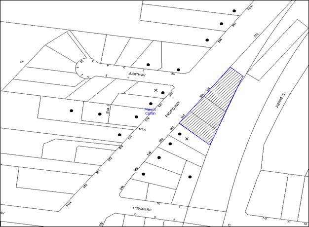
Item 5 PL5/16 Development Application - Five Storey Residential Flat Buildings Comprising 44 Units - 554-558 Pacific Highway, Mount Colah
RECOMMENDATION
THAT Council delegate to the General Manager to assume the concurrence of the Secretary of the Department of Planning and Environment pursuant to Clause 4.6 of the Hornsby Local Environmental Plan 2013 to vary the building height development standard and approve Development Application No. DA/1521/2014 for demolition of existing structures and construction of two, five storey residential flat buildings comprising 44 units at Lot 6 DP 20511, Lot 7 DP 20511, Lot 8 DP 20511, Nos. 554, 556, 558 Pacific Highway, Mount Colah as a deferred commencement pursuant to Section 80(3) of the Environmental Planning and Assessment Act 1979 generally in accordance with the conditions of consent detailed in Schedule 1 of Group Manager’s Report No. PL5/16, subject to final concurrence conditions from Sydney Trains.
Page Number 1
Item 6 PL24/16 Development Application - Extension of an Existing Vehicle Sales Premises - Section 82A Review - 2-10 Central Avenue, Thornleigh
RECOMMENDATION
THAT Council uphold its decision to refuse Development Application No. DA/619/2015 for the extension of an existing vehicle sales premises at SP 35561, Nos. 2-10 Central Avenue Thornleigh, for the reasons detailed in Schedule 1 of Group Manager’s Report No. PL24/16.
Page Number 1
Item 7 PL10/16 Development Application - Subdivision Two Lots Into Eight Lots - Nos. 75-77 Bellamy Street, Pennant Hills
RECOMMENDATION
THAT Development Application No. DA/963/2015 for demolition of existing structures and community title subdivision of two allotments into eight lots at Lot 22 DP 841114, Lot B DP 411312 Nos. 75-77 Bellamy Street, Pennant Hills be approved subject to the conditions of consent detailed in Schedule 1 of Group Manager’s Report No. PL10/16.
Page Number 1
Item 8 PL21/16 Planning Proposal for Property Nos. 2-18 Epping Road, 2-4 Forest Grove and 725 Blaxland Road, Epping
RECOMMENDATION
THAT:
1. Council not proceed with the Planning Proposal and Voluntary Planning Agreement Letter of Offer, available for viewing on Council’s website: hornsby.nsw.gov.au/forest-park-epping (TRIM Reference D06917467), for the following reasons:
1.1 The proposed urban plaza is inconsistent with the adopted strategy for the Epping Town Centre;
1.2 The bulk and scale of the development concept requires substantial review to address the preferred location of the dedication land and to optimise solar access to Forest Park;
1.3 Additional traffic assessment is required to consider the cumulative impact of development; and
1.4 The proposed public facilities and monetary contribution do not provide a public benefit commensurate with the proposed intensity of development.
2. The proponent be invited to resubmit the proposal subject to addressing the issues raised by Council and consideration of the development concept and DCP controls by Council’s Design Excellence Panel.
3. The proponent and submitters be advised of Council’s resolution.
Page Number 1
Item 9 PL20/16 Planning Proposal - Property Nos. 268-278 New Line Road, Dural
RECOMMENDATION
THAT:
1. Council forward the Planning Proposal, available for viewing on Council’s website: hornsby.nsw.gov.au/dural-service-centre (TRIM Reference D06902688) to the DP&E seeking a conditional Gateway Determination that requires the proponent to submit prior to exhibition:
1.1. An updated Economic and Employment Land Assessment that establishes demand for retail and employment floorspace arising from the estimated future population of the South Dural Planning Proposal;
1.2. An updated traffic assessment that considers the future traffic movements arising from the South Dural Planning Proposal; and
1.3. A Voluntary Planning Agreement that secures the provision of traffic facilities as offered by the proponent.
2. The General Manager be authorised to endorse the redrafting of the Planning Proposal into the required format under Council’s cover for Gateway Determination.
3. Write to the proponent advising that Council’s ongoing support for the Planning Proposal is conditional upon the progression of the South Dural Planning Proposal which requires the commitment of the NSW Government to fund its share of costs associated with the upgrade of the State Road Network.
4. Submitters be advised of Council’s resolution.
Page Number 1
Item 10 PL18/16 RFT27/2015 - Brooklyn Improvement Master Plan
RECOMMENDATION
THAT:
1. Council not accept any tender and negotiate with Elton Consulting and McGregor Coxall to arrive at a lump sum tender price.
2. Council decline to invite fresh tenders or seek fresh applications from tenderers or persons expressing interest in the contract for the following reasons:
a) Council has tested the market for the project and further tendering or fresh applications are not likely to produce a better result.
b) Timing constraints do not unduly delay the project.
3. Unsuccessful tenderers be advised of Council’s resolution.
4. Subject to the conclusion of successful negotiations, a further report be prepared for Council’s consideration which includes a recommendation in respect of the acceptance of a tender for the preparation of the Brooklyn Improvement Master Plan.
Infrastructure and Recreation Division
Page Number 1
Item 11 IR8/16 Request to Remove Tree - 132 Beecroft Road, Beecroft
RECOMMENDATION
THAT Council refuse consent to remove one Eucalyptus grandis (Flooded Gum) located at the rear of the property at 132 Beecroft Road, Beecroft.
Page Number 1
Item 12 IR9/16 Request to Remove Tree - 27 Denman Parade, Normanhurst
RECOMMENDATION
THAT Council refuse consent to remove one Eucalyptus saligna (Sydney Blue Gum) located at the rear of the property at 27 Denman Parade, Normanhurst.
Confidential Items
Item 13 CS10/16 Proposed Sale of Council Property at Hornsby
This report should be dealt with in confidential session, under Section 10A (2) (d) of the Local Government Act, 1993. This report contains commercial information of a confidential nature that would, if disclosed (i) prejudice the commercial position of the person who supplied it; or (ii) confer a commercial advantage on a competitor of the council; or (iii) reveal a trade secret.
PUBLIC FORUM – NON AGENDA ITEMS
Questions of Which Notice Has Been Given
Mayor's Notes
Page Number 1
Item 14 MN4/16 Mayor's Notes from 1 to 31 March 2016
Notices of Motion
Page Number 1
Item 15 NOM1/16 Storey Park Community Centre Cafe
COUNCILLOR Tilbury To Move
THAT the Storey Park redevelopment include a 115m2 café in line with the independent Food and Beverage consultant’s advice.
Note from Councillor:
The Storey Park redevelopment will provide a new multipurpose community centre including a modern community hall and children’s playground for a community that will experience significant growth in high density housing over the next few years. An increase in this type of housing stock will result in the demand for high quality public spaces as the community seeks to recreate in areas outside of their homes and to connect with the local community.
Modern community centre design often includes other key attractions on site to encourage the activation of the facility and the precinct. This approach seeks to build social capital, engender a sense of community and build a sense of connection to place. It is particularly important in areas of increased density in order to address social isolation and continue the strong sense of community connectedness that Hornsby Shire is known for.
I consider that the inclusion of a café as part of the Storey Park redevelopment would add to the success of the Centre and Council should support its inclusion. An independent Food and Beverage consultant’s report indicates that such a café would need to be 115m2 to be commercially viable.
Page Number 1
Item 16 NOM2/16 Storey Park Community Centre Redevelopment
COUNCILLOR Hutchence To Move
THAT:
1. Prior to lodging a Development Application for the Storey Park Community Centre, Council embark on a rigorous Expressions of Interest (EOI) market testing process to determine the interest in the operation of a café on the site. The EOI process should include but not be limited to financial criteria as well as the quality and experience of the interested parties.
2. In the event that the EOI process demonstrates that a café at Storey Park is viable, the Development Application for the project is amended to include the café in the project.
Note from Councillor:
There has been community debate regarding the inclusion of a commercially operated café at the new Storey Park Community Centre. Whilst the inclusion of a café would offer an additional service to users of the community centre and park space and new residents in surrounding high density areas, the provision of such a space comes at a significant and ongoing financial risk to Council and ratepayers. This is because the management of the café will largely determine the success of the venture and therefore the financial risk to ratepayers.
The provision of a café on the site is not core Council business, but instead a “nice to have” option if the economics of the project stack up. Therefore the inclusion of a café on the site needs to be based on sound business principles. The café should not operate at a subsidy by ratepayers and it should be considered within the context as an investment that provides an attractive return to Council.
Noting that Council would need to commit hundreds of thousands of ratepayer dollars to the construction of extra café floor space, and then risk ongoing ratepayer dollars on untested rental returns, I consider that it is prudent that a rigorous EOI market testing process be conducted for the operation of the proposed café and the viability of the proponents tested, to enable Council to make an informed decision in respect of the inclusion or otherwise of a café in the Storey Park redevelopment.
SUPPLEMENTARY AGENDA
MATTERS OF URGENCY
QUESTIONS WITHOUT NOTICE
Deputy General Manager's Report No. CS8/16
Corporate Support Division
Date of Meeting: 13/04/2016
1 OPERATIONAL PLAN (INCLUDING BUDGET AND FEES AND CHARGES) FOR 2016/17 - ADOPTION OF DRAFT DOCUMENTS FOR PUBLIC EXHIBITION
EXECUTIVE SUMMARY
· A draft Operational Plan for 2016/17 has recently been developed which includes budget information at the branch and organisational levels, the rates proposed to be charged to ratepayers and the fees to be charged for the domestic waste service. Other fees and charges proposed for 2016/17 are included in a separate document.
· The draft Operational Plan also details proposed capital works over the coming five year period, 2016/17 to 2020/21, which is the end of the 10 year timespan of the infrastructure program tied to a special rate variation approved by the Independent Pricing and Regulatory Tribunal (IPART) in June 2011.
· The draft Operational Plan is based on the 1.8% rate increase approved by IPART for the 2016/17 financial year and provides for a budget surplus of $82K based on a Net Operating and Capital Result after Funding.
|
THAT: 1. Council adopt for public exhibition and make available for public comment from 14 April to 13 May 2016, the draft Operational Plan 2016/17 which includes the draft Budget, Fees and Charges and Rating Structure for 2016/17. 2. Council note that the rating information contained in the draft Operational Plan 2016/17 is in line with the Independent Pricing and Regulatory Tribunal’s rate increase approval for NSW councils (i.e. a 1.8% rate increase for 2016/17). 3. Following the public exhibition period, and before 30 June 2016, a further report be prepared for Council’s consideration which provides details of any submissions received and recommends the adoption of a final Operational Plan 2016/17, including the Budget, Fees and Charges and Rating Structure for that year. |
PURPOSE
The purpose of this Report is to present to Council for adoption the draft Operational Plan 2016/17 (incorporating the Budget, Fees and Charges and Rating Structure for 2016/17) such that the draft documents can be publicly exhibited from Thursday 14 April to Friday 13 May 2016 prior to being reconsidered for final adoption by Council in June 2016.
BACKGROUND
By 30 June in the year following local government elections, all councils are required to develop a 10 year community strategic plan, a four year delivery program and a one year operational plan as well as a resourcing strategy. The purpose is to identify the main priorities and aspirations for the future of the local government area and the resources required to move to that preferred future. Your Community Plan 2013-2023, Council’s 10 year community strategic plan, was adopted on 19 June 2013 together with a Delivery Program for 2013-17 and a 2013/14 Operational Plan. The Office of Local Government requires that the four year delivery program and one year operational plan be reviewed annually. This review process occurred for both the 2014/15 and 2015/16 financial years.
DISCUSSION
Delivery Program 2013-17
The Delivery Program for 2013-17 is Council’s response to the aspirations detailed in Your Community Plan 2013-2023. The Delivery Program describes Council’s commitment to the community during this current term of office and contains the principal activities to be undertaken. Those principal activities are aligned to the services Council carries out, the funding required, and the service delivery indicators to measure the success of those activities. The rolling four year program of principal activities in the Delivery Program 2013-17 has been reviewed and is recommended to remain unchanged.
Draft Operational Plan 2016/17
The Operational Plan for 2016/17 is a subset of the Delivery Program. It spells out the Key Actions that will be undertaken in 2016/17 and includes Council’s detailed annual budget and statement of revenue policy which includes the proposed rates, fees and charges. The draft Operational Plan 2016/17 includes a capital works program which covers the next five years. It is noted that in June 2011, IPART approved a special rate variation (SRV) which was premised on implementation of a ten year infrastructure program from 2011/12 to 2020/21. Therefore, the capital works program completes the 10 year timespan of the SRV infrastructure program.
Research undertaken in the development of Your Community Plan 2013–2023 demonstrated a strong recognition of the good quality of life provided in the Council area which residents want to retain and enhance. In essence, Hornsby Shire is a community that has high expectations for the quality of life and services enjoyed by residents, businesses and visitors. These expectations can best be met by Council if it continues to provide services at the levels provided in the past, including a strong focus on capital works.
Council staff commenced preparation of the 2016/17 Budget in December 2015. To minimise some of the financial constraints and considerations impacting on local government, and to avoid excessive bids for funding which could not be met, the 2016/17 Budget parameters included:
· A general rate increase of 1.8% for 2016/17 – i.e. the percentage increase approved by IPART and advised to Council on 4 December 2015.
· Zero external loan borrowing and the continuation of prudent financial management.
· A nil increase to Divisional expenditure (net of direct labour) for material and contract expenditure - this is despite substantial price increases, particularly for construction materials. Any increase has been required to be offset by productivity improvements, service reductions or increased fees.
· Direct salaries and wages to include provision for the Local Government (State) Award increase. A labour increase of 2.8% for 2016/17 has been allowed for and calculated on 50 pay weeks. The two week reduction from a full year represents organisational savings which occur as a result of the average delay in replacing staff members who retire/resign/etc. and/or productivity improvements that are required.
· The use of Council staff where possible to undertake SRV projects; Section 94 Development Contributions projects; and other funded projects.
· Continuation of increased budget allocations approved for the 2015/16 financial year. This included $200K for tree inspections and removal; $805K towards asset management of community facilities; and $650K towards maintaining Council’s sealed road pavement network at an acceptable standard.
· An allocation of $112.5K towards technical studies and planning for the renewal of the Cherrybrook Station Precinct - refer 10 February 2016 General Meeting - Report No. PL9/16 – Cherrybrook Station Precinct Urban Transformation - Project Plan.
· Any new projects which have been the subject of an appropriate merit evaluation.
The draft Budget for 2016/17 has been developed in line with the above parameters. Those parameters, together with savings achieved over the past few years and the achievement of further productivity measures targeted across the organisation, has initially achieved a cash-funding surplus of $10.162 million. This amount was reduced to $82,000 based on the following allocations:
· $10M towards funding the Section 94 funding gap (of approximately $43M) identified in Council’s 2014-2024 Section 94 Development Contributions Plan. These funds are to be restricted to ensure Council is able to meet demand generated from new development in the future and will be used to provide additional community infrastructure, local services and facilities.
· $42K increase to existing budgets towards bushland trail maintenance and repair.
· $38K increase to existing budgets for fulfilling workplace and safety requirements associated with the Bushcare program.
This is consistent with Council’s goal to maintain prudent management of its finances and to meet a number of significant financial challenges over the next 10 years without the need to raise rates above the rate pegging allowance and/or borrow substantially.
It is noted that the level of capital expenditure included in the draft 2016/17 Operational Plan totals $45.802M and includes projects such as:
· Parks and Sporting Facilities - $22.710M*
· Drainage Improvements - $1.760M
· Local Road Improvements - $3.815M
· Building Improvements - $2.913M
· Bushland and Waterways - $2.136M
· Traffic Facilities - $1.144M
· Hornsby Quarry - $3.3M
· Local Sealed Road Rehabilitation Program - $2.670M
· Foreshore Facilities - $171K
· Aquatic and Leisure Facilities - $437K
· Local Footpath Improvements - $266K
· Fleet Replacement (on a three year/75,000 km cycle) - $1.695M
· Other Capital Items - $2.785M
* Parks and Sporting Facilities - an amount of $22.71 million has been allocated in the 2016/17 financial year to fund projects for additional open space and recreational facilities identified in Council’s 2014-2024 Section 94 Development Contributions Plan. These projects are fully funded from Section 94 contributions previously collected by Council.
Hornsby Quarry Site
Roads and Maritime Services and Council have agreed to use the Hornsby Quarry for the disposal of up to one and a half million cubic metres of NorthConnex tunnel spoil. An investment of $7.33 million each is required by Council, the Commonwealth Government and the NSW Government. This arrangement provides a one-off opportunity to rapidly fill the Quarry with virgin material which will enable the development of high quality parklands for a range of exciting recreation and cultural pursuits on the land by 2021. Council, at its 11 March 2015 General Meeting, agreed to express its support for the project and conditionally agreed to contribute $7.33 million towards the project in staged payments. An amount of $3.3 million has been allocated in the 2016/17 financial year to meet that year’s staged payment requirements.
Fees and Charges
The proposed Fees and Charges for 2016/17 have been reviewed and increased by the CPI or by an amount which has regard to market conditions and the appropriate cost recovery level. Opportunities to recover administrative and overhead costs in respect of business activities have also been investigated and implemented where appropriate. Where applicable, the final price includes GST which does not contribute revenue to Council but is forwarded to the Federal Government.
Rating Structure
Council reviewed its rating structure at the April 2006 Ordinary Meeting when it considered Executive Manager’s Report No. CC20/06. That structure has applied in respect of the calculation of the rates since that time and it is recommended that the same rating structure continue in 2016/17, except for the creation of a sub-category under the Hornsby CBD Business Rate called – “Major Retail Shopping Centre”. Details of the rates types and yields, rating categories, base amounts, minimum rates for business properties, ad valorem amounts and other statutory rating information are set out in the draft Operational Plan document.
The main reason for the introduction of the Major Retail Shopping Centre sub category is to ensure that rates for the major retail shopping centre are not unfairly increased as a result of an above average land valuation, and also to ensure that the rate burden is not unfairly placed on surrounding business ratepayers should a lower than average land valuation apply to property in the sub-category. Without this change, a significantly higher or lower valuation percentage variation compared to surrounding properties may cause an anomaly in the rate levy.
The creation of the sub-category will not raise any additional income for this category above the allowable rate allowance. What will be achieved for this category is the basis for a more equitable distribution of rates into the future. It also ensures that when Council receives future valuations from the Valuer General, the properties contained within this sub-category will continue to pay a similar percentage of the annual rate levy.
The Valuer General supplied Council with new land values for properties across the Shire as at 1 July 2014. These values have been used for the 2015/16 and 2016/17 financial years and will continue to be used for the 2017/18 financial year. The rating information is in line with the 1.8% increase approved by IPART for 2016/17. The base amount for ordinary, residential and farmland rates will increase from $509 in 2015/16 to $519 in 2016/17.
Local Government Reform – Proposals with Ku-ring-gai Council and Parramatta City Council
The draft Operational Plan 2016/17 has been prepared on the basis of Hornsby Shire Council proceeding as a single entity in 2016/17. The information will need to be reviewed if the NSW Government proceeds with the merger proposals affecting the Hornsby local government area.
CONSULTATION
The formal public exhibition period of the Draft Operational Plan 2016/17 is scheduled to occur from Thursday 14 April to Friday 13 May 2016. Comments received during the formal exhibition period will be considered and reported to Council prior to adoption of the final documents in June 2016.
BUDGET
Any budget implications have been included in the Discussion section of this Report.
POLICY
The Delivery Program describes Council’s commitment to the community during this term of office and contains the principal activities to be undertaken aligned to the services Council carries out, the funding required, and the service delivery indicators to measure the success of those activities
CONCLUSION
The Draft Operational Plan 2016/17 (including the Budget, Fees and Charges and Rating Structure) encompass Council’s prudent and financially viable response to the priorities and expected levels of service voiced by the community. Public exhibition of these documents provides an opportunity for the community to give feedback on any proposed action or activity for 2016/17. That feedback will be considered by Council prior to final adoption of the Draft Operational Plan in June 2016.
RESPONSIBLE OFFICER
The officers responsible for the preparation of this Report are the Acting Chief Financial Officer – Duncan Chell and the Manager, Strategy and Communications – Julie Williams, who can be contacted on 9847 6822 and 9847 6790 respectively.
|
Glen Magus Acting Deputy General Manager Corporate Support Division |
Gary Bensley Acting General Manager Office of the General Manager |
|
1.View |
Draft Operational Plan 2016/17 |
|
|
|
2.View |
Draft Fees and Charges 2016/17 |
|
|
File Reference: F2015/00473
Document Number: D06907058
Deputy General Manager's Report No. CS7/16
Corporate Support Division
Date of Meeting: 13/04/2016
2 INVESTMENTS AND BORROWINGS FOR 2015/16 - STATUS FOR PERIOD ENDING 29 FEBRUARY 2016
EXECUTIVE SUMMARY
· This Report provides details of Council’s investment performance for the period ending 29 February 2016 as well as the extent of its borrowings at the end of the same period.
· Council may invest funds that are not, for the time being, required for any other purpose. The investments must be in accordance with relevant legislative requirements and Council’s policies and the Chief Financial Officer must report monthly to Council on the details of funds invested.
· All of Council’s investments have been made in accordance with the Local Government Act, the Local Government (General) Regulation and Council's Investment of Surplus Funds Policy and Investment Strategy.
· In respect of Council’s cash and term deposit investments, the annualised return for the month of February 2016 was 3.00% compared to the benchmark of 2.00%.
· In respect of Council borrowings, the weighted average interest rate payable on loans taken out from June 2006 to February 2016, based on the principal balances outstanding, is 6.02%.
|
THAT the contents of Deputy General Manager’s Report No. CS7/16 be received and noted. |
PURPOSE
The purpose of this Report is to advise Council of funds invested in accordance with Section 625 of the Local Government Act; to provide details as required by Clause 212(1) of the Local Government (General) Regulation and Council's Investment of Surplus Funds Policy; and to advise on the extent of Council’s current borrowings.
BACKGROUND
A report is required to be submitted for Council’s consideration each month detailing Council's investments and borrowings and highlighting the monthly and year to date performance of the investments. Initial investments and reallocation of funds are made, where appropriate, after consultation with Council's financial investment adviser and fund managers.
DISCUSSION
Council may invest funds which are not, for the time being, required for any other purpose. Such investment must be in accordance with relevant legislative requirements and Council Policies, and the Chief Financial Officer must report monthly to Council on the details of the funds invested.
Council’s investment performance for the month ending 29 February 2016 is detailed in the attached document. In summary; the At-Call and Term Deposits achieved an annualised return of 3.00% for February 2016, compared to the benchmark of 2.00%.
In respect of Council borrowings, the weighted average interest rate payable on outstanding loans taken out from June 2006 to February 2016, based on the principal balances outstanding, was 6.02%. The Borrowings Schedule as at 29 February is also attached for Council’s information.
CONSULTATION
Appropriate consultation has occurred with Council's financial investment adviser and fund managers.
BUDGET
In the December Quarter Review, the original budgeted investment income for 2015/16 was revised from $2,418,000 to $3,061,000. Investment income for the period ended 29 February 2016 was $2,266,000 compared to the revised budgeted income of $2,131,000. Approximately 51% of the investment income received by Council relates to externally restricted funds (e.g. Section 94 monies) and is required to be allocated to those funds. All investments have been made in accordance with the Local Government Act, the Local Government (General) Regulation and Council's Investment of Surplus Funds Policy and Investment Strategy.
CONCLUSION
The investment of Council funds and the extent of its borrowings as at 29 February 2016 are detailed in the documents attached to this Report. Council’s consideration of the Report and its attachments ensures that the relevant legislative requirements and Council protocols have been met in respect of those investments.
RESPONSIBLE OFFICER
The officer responsible for the preparation of this Report is the Acting Chief Financial Officer – Duncan Chell, who can be contacted on 9847 6822.
|
Duncan Chell Acting Chief Financial Officer - Financial Services Corporate Support Division |
Glen Magus Acting Deputy General Manager Corporate Support Division |
|
1.View |
HSC Investment Holdings Report - February 2016 |
|
|
|
2.View |
HSC Borrowings Schedule - February 2016 |
|
|
File Reference: F2004/06987-02
Document Number: D06896221
Deputy General Manager's Report No. CS6/16
Corporate Support Division
Date of Meeting: 13/04/2016
3 PECUNIARY INTEREST AND OTHER MATTERS RETURNS - DISCLOSURES BY COUNCILLORS AND DESIGNATED PERSONS
EXECUTIVE SUMMARY
· Section 449 of the Local Government Act (the Act) details the statutory requirements in respect of the lodgement of Disclosure of Pecuniary Interests and Other Matters Return/s by Councillors and Designated Persons.
· Section 450A(2) of the Act requires that Returns lodged under Section 449 are to be tabled at the next available Council meeting.
· In line with Section 450A(2), this Report seeks to table the Return/s recently lodged with the General Manager.
|
THAT Council note the Disclosure of Pecuniary Interests and Other Matters Returns recently lodged with the General Manager have been tabled as required by the Local Government Act. |
PURPOSE
The purpose of this Report is to table the Disclosure of Pecuniary Interests and Other Matters Returns lodged by Councillors/Designated Persons who have left, commenced with, or internally transferred to a relevant position within Council.
BACKGROUND
Section 449(1) of the Act requires a Councillor or Designated Person to complete and lodge with the General Manager a Disclosure of Pecuniary Interests and Other Matters Return within three months after becoming a Councillor or a Designated Person. Section 449(3) requires a Councillor or Designated Person holding that position at 30 June in any year to complete and lodge with the General Manager a Return within three months after that date. Section 449(5) states that nothing prevents a Councillor or Designated Person from lodging more than one Return in any year.
Section 450A(2) of the Act requires that Returns lodged under Section 449 are to be tabled at a meeting of Council. Returns lodged under Sections 449(1) and 449(3) are to be tabled at the first meeting held after the last day for lodgement under those Sections; and Returns lodged for any other reason are to be tabled at the first meeting after their lodgement.
Council's procedures in respect of the disclosing of interests have been developed to cater for the election/appointment/employment/retirement/resignation/etc. of Councillors or Designated Persons. These procedures:
· Require all Councillors and Designated Persons who hold that position at 30 June in any year to submit Returns to the General Manager by 30 September in that year (i.e. they are lodged under S449(3)). These Returns are tabled at Council’s October or November General Meeting for that year.
· Require newly elected Councillors or newly appointed Designated Persons to lodge Returns to the General Manager within three months of their election/appointment (i.e. they are lodged under S449(1)). These Returns are tabled at the next available General Meeting of Council.
· Require those Councillors or Designated Persons who are leaving Council (because of retirement, resignation, etc.) to lodge Returns to the General Manager by their last day with Council. These Returns are tabled at the next available General Meeting of Council.
DISCUSSION
Returns Lodged in Accordance with Sections 449(1) and/or 449(5) of the Act and Council's Procedures
Council last considered the tabling of Disclosure of Pecuniary Interests and Other Matters Returns under Sections 449(1) and (5) of the Act at the General Meeting held on 9 December 2015 (see Deputy General Manager’s Report No. CS47/15). Since that time, two additional Returns have been lodged with the General Manager and are now tabled as required by the Act.
|
Date Lodged |
Councillor/Designated Person (Position) |
Reason for Lodgement |
|
1 March 2016 |
Planning GIS Officer |
New Appointment |
|
9 March 2016 |
Community and Cultural Development Manager |
New Appointment |
BUDGET
There are no budgetary implications associated with this Report.
POLICY
There are no policy implications associated with this Report.
CONCLUSION
Council’s consideration of this Report satisfies the requirements of the Act regarding the lodgement of Disclosure of Pecuniary Interests and Other Matters Return/s by Councillors and Designated Persons.
RESPONSIBLE OFFICER
The officer responsible for the preparation of this Report is the Manager Governance and Customer Service – Robyn Abicair, who can be contacted on 9847 6608.
|
Robyn Abicair Manager - Governance and Customer Service Corporate Support Division |
Glen Magus Acting Deputy General Manager Corporate Support Division |
There are no attachments for this report.
File Reference: F2015/00355
Document Number: D06893824
Group Manager’s Report No. PL25/16
Planning Division
Date of Meeting: 13/04/2016
4 DEVELOPMENT APPLICATION - THREE RESIDENTIAL FLAT BUILDINGS COMPRISING 99 UNITS - 2-8 HAZLEWOOD PLACE, EPPING
EXECUTIVE SUMMARY
|
DA No: |
DA/364/2015 (Lodged 7 April 2015) |
|
Description: |
Demolition of existing structures and construction of three, five storey residential flat buildings comprising 99 units with basement car parking |
|
Property: |
Lots 12, 13, 14 and 15 DP 28934, Nos. 2-8 Hazlewood Place, Epping |
|
Applicant: |
TFM Epping Land Pty Ltd |
|
Owner: |
TFM Epping Land Pty Ltd, Mr R J Douglas and Ms R L De Neve |
|
Estimated Value: |
$19,887,759 |
|
Ward: |
C |
· The application involves demolition of existing structures and the erection of three, five-storey residential flat buildings comprising 99 units with basement car parking.
· The proposal generally complies with the Hornsby Local Environmental Plan 2013, State Environmental Planning Policy No. 65 – Design Quality Residential Flat Building, Residential Flat Design Code and the Hornsby Development Control Plan 2013.
· Four submissions have been received in respect of the application from two residents.
· It is recommended that the application be approved.
|
THAT Development Application No. DA/364/2015 for demolition of existing structures and construction of three, five storey residential flat buildings comprising 99 units with basement car parking at Lots 12, 13, 14 and 15 DP 28934, Nos. 2-8 Hazlewood Place, Epping be approved subject to the conditions of consent detailed in Schedule 1 of Group Manager’s Report No. PL25/16. |
BACKGROUND
The subject land was rezoned from R2 Low Density Residential to R4 High Density Residential under State Environmental Planning Policy Amendment (Epping Town Centre) on 14 March 2014. The rezoning followed the Epping Town Centre Study and the inclusion of Epping in the State Government’s Urban Activation Precincts. The rezoning permits residential flat buildings on the subject land and a maximum building height of 17.5 metres.
On 16 December 2014, a pre-lodgement meeting was held between Council officers and the applicant to discuss the proposal for two, five-storey residential flat buildings for Nos. 2-6 Hazlewood Place, Epping. At the meeting, Council officers raised concern that the proposal would result in the isolation of property No. 8 Hazlewood Place and that the consolidation of the subject site with property No. 8 Hazlewood Place would facilitate the orderly development of land within the precinct. It was also advised that the amalgamation would enable stormwater from the site to be drained to Council’s existing piped drainage system within No. 8X Hazlewood Place.
On 16 December 2014, a pre-lodgement meeting was also held between Council officers and the developer for No. 8 Hazlewood Place. The proposal related to the construction of a five storey residential flat building on the site. At the meeting, Council officers advised that the proposed development at No. 8 Hazlewood Place could not be supported without amalgamating the lot with the adjoining sites at Nos. 2-6 Hazlewood Place, Epping.
On 7 April 2015, DA/364/2015 for construction of two residential flat buildings comprising 81 units at Nos. 2-6 Hazlewood Place was lodged with Council.
On 10 April 2015, DA/387/2015 was lodged for the construction of one residential flat building comprising 18 units at No. 8 Hazlewood Place.
On 26 May 2015, Council wrote to the applicant for DA/364/2015 raising concerns regarding the development including the isolation of No. 8 Hazlewood Place.
Following meetings between the applicant and Council officers, multiple amendments to the design of the proposal were lodged with Council. However, the matters in regard to connection of the stormwater from the site to the Council controlled drainage system and the isolation of No. 8 Hazlewood Place were not resolved.
On 31 October 2015, Council refused DA/387/2015 for No. 8 Hazlewood Place.
On 21 December 2015, a meeting was held between Council officers and the applicant. At the meeting, the applicant advised that No. 8 Hazlewood Place would now be included as part of the development site. A draft plan for an amended proposal on the consolidated site was provided to Council.
Following the meeting, discussions were held between the applicant and Council officers regarding the proposed stormwater drainage system and the design of the development.
Amended plans for a proposal comprising three residential flat buildings with 99 units and two levels of basement car parking at Nos. 2-8 Hazlewood Place was lodged with Council on 19 February 2016 and 16 March 2016. The amended plans are the subject of this report.
The amended plans were re-advertised for 14 days to 30 March 2016.
SITE
The site comprises four irregular shaped allotments, being Nos. 2-8 Hazlewood Place, Epping located on the northern and eastern sides of a roundabout within the road. The amalgamated site has an area of 4489sqm, a curvilinear frontage of 56.5m to Hazlewood Place and falls from the southern side to the northern side with an average grade of 7.5%.
Current improvements on the site include single storey dwelling houses on each parcel with associated outbuildings. A wide nature strip and a roundabout are located on either side of the single lane vehicular carriageway fronting the site.
The site adjoins a Council owned drainage reserve (No. 8X Hazlewood Place) to its west and the “Kent Street Reserve” (No. 54X Kent Street) adjoining the northern boundaries of Nos. 6 and 8 Hazlewood Place. An open drainage channel runs through the reserve. A number of significant trees constituting Blue Gum High Forest (Ecologically Endangered Community) are located within the site, the adjoining eastern properties and Reserve.
On the eastern side, the site adjoins the Rosebank Avenue Heritage Conservation Area which comprises low density dwellings.
The remainder of the precinct is undergoing redevelopment. Two development applications for the construction of 5-storey residential flat buildings on the adjoining sites have been approved or are under assessment by Council as follows:
· On 2 December 2015, the Sydney West Joint Regional Planning Panel approved DA/1629/2014 for the construction of four, five storey residential flat buildings comprising a total of 166 dwellings with basement car parking at Nos. 44-52 Kent Street and Nos. 10-14 Hazlewood Place, Epping. This development would immediately adjoin the drainage reserve (No. 8X) to its west.
· DA/1292/2015 for the construction of three, five storey residential flat buildings comprising 133 units at Nos. 22-34 Cliff Road is currently under assessment. The site is located immediately south of the proposed development.
PROPOSAL
The proposal involves the demolition of existing structures and construction of three, five-storey residential flat buildings comprising 99 units with two levels of basement car parking and associated landscaping works. The buildings would be separated by landscaped open spaces.
The unit mix would comprise the following:
· Tower A: 6 x 1-bedroom, 30 x 2-bedroom and 5 x 3-bedroom units;
· Tower B: 11 x 1-bedroom, 22 x 2-bedroom and 3 x 3-bedroom units; and
· Tower C: 20 x 2 bedroom units and 2 x 3 bedroom units.
The development would be accessed from Hazlewood Place via a driveway located at the south -western corner of the site. An open landscaped pedestrian pathway from Hazlewood Place would provide access to the three buildings internally within the site. A chair lift is proposed to allow disabled access to the pedestrian pathway. A total of 139 car parking spaces including 12 visitor parking spaces, bicycle and motorbike parking spaces are proposed over two basement levels.
Stormwater from the proposed development would drain to the open channel within Kent Street Reserve via the existing pipeline within Council’s reserve to the west of the site. Approval is sought to reconstruct Council’s pipeline within Kent Street Reserve, by lowering its invert level and increasing the size of the pipe in the existing location.
ASSESSMENT
The development application has been assessed having regard to ‘A Plan for Growing Sydney’, the ‘North Subregion (Draft) Subregional Strategy’ and the matters for consideration prescribed under Section 79C of the Environmental Planning and Assessment Act 1979 (the Act). The following issues have been identified for further consideration.
1. STRATEGIC CONTEXT
1.1 A Plan for Growing Sydney and (Draft) North Subregional Strategy
A Plan for Growing Sydney has been prepared by the NSW State Government to guide land use planning decisions for the next 20 years. The Plan sets a strategy for accommodating Sydney’s future population growth and identifies the need to deliver 689,000 new jobs and 664,000 new homes by 2031. The Plan identifies that the most suitable areas for new housing are in locations close to jobs, public transport, community facilities and services.
The NSW Government will use the subregional planning process to define objectives and set goals for job creation, housing supply and choice in each subregion. Hornsby Shire has been grouped with Hunters Hill, Ku-ring-gai, Lane Cove, Manly, Mosman, North Sydney, Pittwater, Ryde, Warringah and Willoughby to form the North Subregion. The Draft North Subregional Strategy will be reviewed and the Government will set housing targets and monitor supply to ensure planning controls are in place to stimulate housing development.
The proposed development would be consistent with ‘A Plan for Growing Sydney’, by providing additional dwellings and would contribute to housing choice in the locality.
2. STATUTORY CONTROLS
Section 79C(1)(a) requires Council to consider “any relevant environmental planning instruments, draft environmental planning instruments, development control plans, planning agreements and regulations”.
2.1 Hornsby Local Environmental Plan 2013
The proposed development has been assessed having regard to the provisions of the Hornsby Local Environmental Plan 2013 (HLEP).
2.1.1 Zoning of Land and Permissibility
The subject land is zoned R4 (High Density Residential) zone under the Hornsby Local Environmental Plan 2013 (HLEP). The objectives of the zone are:
(a) To provide for the housing needs of the community within a high density residential environment.
(b) To provide a variety of housing types within a high density residential environment.
(c) To enable other land uses that provide facilities or services to meet the day to day needs of residents.
The development proposed is a high density residential development and complies with the zone objectives. The proposed development is defined as a “Residential flat building” under the HLEP and is permissible in the zone with Council’s consent.
2.1.2 Height of Buildings
Clause 4.3 of the HLEP provides that the height of a building on any land should not exceed the maximum height shown for the land on the Height of Buildings Map. The maximum permissible height for the subject site is 17.5m. The proposal complies with this provision.
2.1.3 Heritage Conservation
Clause 5.10 of the HLEP sets out heritage conservation provisions for Hornsby Shire.
The property is located in the vicinity of the Rosebank Avenue Heritage Conservation Area (Rosebank HCA), as well as heritage listed houses No.9 and No.10 Rosebank Avenue all of local heritage significance under the provisions of Schedule 5 (Environmental Heritage) of the HLEP. Council’s heritage assessment of the proposal concludes the following:
· The zoning of the site, being R4, permits the construction of a five storey residential development adjoining the Rosebank HCA;
· The primary characteristics of the Conservation Area include its intact Inter-war housing styles, gardens, fences, single storey low scale of buildings, face brick work, original subdivision pattern, consistent setbacks, driveways and landscape elements;
· The Conservation Area has a general visual setting of low density residential housing in a leafy streetscape. The visual setting of the HCA would be altered, given that the five storey buildings would be visible above the existing trees and houses;
· However, the negative visual impact of the high density developments on the HCA is reduced by the articulated design of the buildings, including varied wall lengths, increased setbacks, lightweight balconies, design of windows, landscaping and varied colour palette including face brickwork;
· The proposed rear (eastern) setbacks of the two adjoining buildings enable a number of existing trees to be retained and includes scope for planting additional canopy trees providing a buffer to the HCA; and
· The heritage item at No. 9 Rosebank Avenue adjoins the north eastern corner of the site. The retention of the trees in this corner (Blackbutt and Sydney Blue Gum) of the site and building setback would mitigate impacts of the proposal on the heritage item.
The amended proposal was reviewed and no heritage objections were raised to the design of the proposal, subject to the following recommendations:
· The materials and finishes of the eastern elevation be amended to incorporate further dark toned brickwork and painted rendered finish, for a visually recessive backdrop to the HCA;
· A Dilapidation Report be submitted prior to the issue of the Occupation Certificate, to assess the impact of the development on the Rosebank HCA, in accordance with the requirements of the Hornsby Development Control Plan 2013; and
· The Landscape Plan be amended to include 3 additional evergreen trees (minimum mature growth height 12-18m) along the eastern boundary to screen the development from the Rosebank HCA.
The proposal has been amended by modifying the schedule of materials and finishes in accordance with the above recommendation.
Given the above, the impacts of the proposed development on the heritage values of the Rosebank HCA are assessed as reasonable, subject to additional screen planting along the eastern boundary and the submission of a Dilapidation Report assessing the conditions of the adjoining buildings including the heritage item at No. 9 Rosebank Avenue.
2.1.4 Earthworks
Clause 6.2 of the HLEP states that consent is required for proposed earthworks on site. Before granting consent for earthworks, Council is required to assess the impacts of the works on adjoining properties, drainage patterns and soil stability of the locality. The site adjoins low density residential properties to its east. Accordingly, conditions of consent are recommended regarding submission of dilapidation reports assessing the impact of the excavation on the adjoining residential properties.
2.2 State Environmental Planning Policy No. 55 – Remediation of Land
The application has been assessed against the requirements of State Environmental Planning Policy No. 55. This Policy provides State-wide planning controls requiring that consent must not be granted to the carrying out of any development on land unless the consent authority has considered whether the land is contaminated or requires remediation for the proposed use.
A search of Council’s records and aerial images reveals that the property has been used exclusively for residential purposes with no record of any site contamination. Given this, the site would be suitable for the proposed use and no further assessment in relation to this SEPP is required.
All the existing dwelling houses on the site are constructed with brick. Therefore, there is minimal potential for asbestos on the site. Notwithstanding, considering the age of the dwelling houses, appropriate conditions are included to require all asbestos to be removed from the site (if applicable). Furthermore, taking into account the significant excavation required to accommodate the proposed basement car park, much of the existing soil would be removed from the site.
2.3 State Environmental Planning Policy (Building Sustainability Index – BASIX)
The application has been assessed against the requirements of State Environmental Planning Policy (Building Sustainability Index: BASIX) 2004. The proposal includes a BASIX Certificate for the proposed units and is considered satisfactory.
2.4 State Environmental Planning Policy No. 32 – Urban Consolidation (Redevelopment of Urban Land) (SEPP 32)
The application has been assessed against the requirements of SEPP 32, which requires Council to implement the aims and objectives of this Policy to the fullest extent practicable when considering development applications relating to redevelopment of urban land. The application complies with the objectives of the Policy as it would promote the social and economic welfare of the locality and would result in the orderly and economic use of under-utilised land within the Shire.
2.5 State Environmental Planning Policy No. 65 – Design Quality of Residential Flat Development
SEPP 65 was amended on 19 June 2015 following review of the policy by the Department of Planning and Environment. The amendments replace the Residential Flat Design Guidelines with the Apartment Design Guide which prevails in the event of any inconsistency with a Development Control Plan.
Clause 31 (Transitional provisions for SEPP 65 – Amendment No. 3) states that “If a development application or an application for the modification of a development consent has been made before the notification on the NSW legislation website of the making of State Environmental Planning Policy No. 65 — Design Quality of Residential Flat Development (Amendment No 3) and the application has not been finally determined before the commencement of that amendment, the application must be determined as if the amendment had not commenced.”
Pursuant to the above provision, this amendment would not apply to the subject application and the previous version (Amendment 2) of the SEPP is required to be considered.
2.5.1 Design Principles
The applicant has submitted a “Design Verification Statement” prepared by a qualified Architect stating how the proposed development achieves the design principles of SEPP 65. The design principles of SEPP 65 and the submitted design verification statement are addressed in the following table.
|
Principle |
Compliance |
|
1. CONTEXT |
Yes |
|
Comment: The site is located within a precinct planned for five storey residential flat buildings in close proximity to Epping Railway Station. The proposal responds to the desired future character of the precinct as envisaged by Council for residential flat buildings in landscaped settings with underground car parking whilst respecting the heritage significance of the adjoining Heritage Conservation Area and heritage items. Once the development of the precinct is completed, the proposal would integrate with the surrounding sites and would be in keeping with the desired future urban form. The proposed building would contribute to the identity and future character of the precinct. |
|
|
2. SCALE |
Yes |
|
Comment: The scale of the development is in accordance with the height control and setbacks for the precinct prescribed within the HDCP. The building footprints generally comply with the maximum floorplate of 35m prescribed within the HDCP except Tower A. The development achieves a scale consistent with the desired outcome for well-articulated buildings that are set back to incorporate landscaping, open space and separation between buildings. |
|
|
3. BUILT FORM |
Yes |
|
Comment: The proposed buildings achieve an appropriate built form for the site and its purpose, in terms of building alignments, proportions, and the manipulation of building elements. The buildings would appropriately contribute to the character of the desired future streetscape and include articulation to minimise the perceived scale. The proposed materials and finishes would add to the visual interest of the development. Flat roof forms have been adopted with an increased top storey setback on the external facades to minimise bulk and height of the buildings as required by the HDCP. |
|
|
4. DENSITY |
Yes |
|
Comment: The HLEP does not incorporate floor space ratio requirements for the site. The density of the development is governed by the height of the building and the required setbacks. The proposed density is considered to be sustainable as it responds to the regional context, availability of infrastructure, public transport, community facilities and environmental quality and is acceptable in terms of density. |
|
|
5. RESOURCE, ENERGY AND WATER EFFICIENCY |
Yes |
|
Comment: The applicant has submitted a BASIX Certificate for the proposed development. In achieving the required BASIX targets for sustainable water use, thermal comfort and energy efficiency, the proposed development would achieve efficient use of natural resources, energy and water throughout its full life cycle, including demolition and construction. |
|
|
6. LANDSCAPE |
Yes |
|
Comment: The application includes a landscape concept plan which provides landscaping along the street frontages, side and rear boundaries and includes two 7m x 7m deep soil landscaped areas between the buildings. The proposal has been designed to facilitate the retention of existing trees within the site, the adjoining properties and Kent Street Reserve, wherever possible. Large trees are proposed to be planted along the street frontage in addition to the existing street trees, intercepted by shrubs and hedges which would soften the appearance of the development when viewed from the street. Deep soil areas that incorporate canopy trees would be provided around the building envelope which would enhance the development’s natural environmental performance and provide an appropriate landscaped setting. |
|
|
7. AMENITY |
Yes |
|
Comment: The proposed units are designed with appropriate room dimensions and layout to maximise amenity for future residents. The proposal incorporates good design in terms of achieving natural ventilation, solar access and acoustic privacy. All units incorporate balconies accessible from living areas and privacy has been achieved through appropriate design and orientation of balconies and living areas. Storage areas have been provided within each unit and in the basement levels. The proposal would provide convenient and safe access via lifts connecting the basement and all other levels. |
|
|
8. SAFETY AND SECURITY |
Yes |
|
Comment: The design orientates the balconies and windows of individual apartments towards the street, rear and side boundaries, providing passive surveillance of the public domain and communal open space areas. Both the pedestrian and vehicular entry points are secured and visibly prominent from Hazlewood Place. The proposal includes an assessment of the development against crime prevention controls in the Statement of Environmental Effects (SEE). The SEE has regard to Crime Prevention Through Environmental Design Principles (CPTED) and includes details of surveillance, access control, territorial reinforcement and space management such as artificial lighting in public places; attractive landscaping whilst maintaining clear sight lines; security coded door lock or swipe card entry; physical or symbolic barriers to attract, channel or restrict the movement of people; security controlled access to basement car park; intercom access for pedestrians; and security cameras located at the entrance of the building. Appropriate conditions of consent are recommended to require compliance with the above matters. |
|
|
9. SOCIAL DIMENSIONS AND HOUSING AFFORDABILITY |
Yes |
|
Comment: The proposal incorporates a range of unit sizes to cater for different budgets and housing needs. The development complies with the housing choice requirements of the HDCP by providing a component of adaptable housing and a mix of 1, 2 and 3 bedroom dwellings. The proposal responds to the social context in terms of providing a range of dwelling sizes with good access to social facilities and services as the site is located in close proximity to Epping Railway Station and shops. |
|
|
10. AESTHETICS |
Yes |
|
Comment: The architectural treatment of the buildings incorporate indentations and projections in the exterior walls with balcony projections to articulate the facades. The roof is flat to minimise building height and incorporates eaves which would cast shadows across the top storey wall. The articulation of the buildings, composition of building elements, textures, materials and colours would achieve a built form generally consistent with the design principles contained within the Residential Flat Design Code and the HDCP. |
|
2.6 State Environmental Planning Policy No. 65 – Residential Flat Design Code
SEPP 65 also requires consideration of the Residential Flat Design Code, NSW Planning Department 2002. The Code includes development controls and best practice benchmarks for achieving the design principles of SEPP 65. The following table sets out the proposal’s compliance with the Code:
|
Residential Flat Design Code |
|||
|
Control |
Proposal |
Requirement |
Compliance |
|
Deep Soil Zone |
30% |
25% |
Yes |
|
Communal Open Space |
40% of deep soil |
25-30% |
Yes |
|
Ground Level Private Open Space |
<25m2
Min Dimension <4m |
25m2
Min Dimension 4m |
No
No |
|
Minimum Dwelling Size |
1 br – 50m2 -60m2 2 br – 70m2 -89m2 3 br – 95m2 -102m2 |
1 br – 50m2 2 br – 70m2 3 br – 95m2 |
Yes Yes Yes |
|
Maximum Kitchen Distance |
8m
|
8m |
Yes |
|
Minimum Balcony Depth |
2m |
2m |
Yes |
|
Minimum Ceiling Height |
2.8m |
2.7m |
Yes |
|
Total Storage Area |
1 bed - 6m3 (Min) 2 bed - 8m3 (Min) 3 bed - 10m3 (Min)
50% accessible from the apartments |
1 bed - 6m3 (Min) 2 bed - 8m3 (Min) 3 bed - 10m3 (Min)
50% accessible from the apartments |
Yes |
|
Dual Aspect and Cross Ventilation |
63.6% |
60% |
Yes |
|
Adaptable Housing |
10% |
10% |
Yes |
As detailed in the above table, the proposed development complies with the prescriptive measures within the Residential Flat Design Code (RFDC) other than the area of the ground floor private open space areas and the minimum dimensions. Below is a brief discussion regarding the relevant development controls and best practice guidelines.
2.6.1 Ground Floor Apartments and Private Open Space
The proposal does not comply with the Code’s best practice of 25m² ground level private open space requirement for the ground floor units. Further, the ground floor courtyards do not have a 4m minimum width dimension.
The proposal includes 4m-7m wide landscaped deep soil areas along the front, rear and side setbacks in accordance with the requirements of the HDCP. The provision of 25m2 private open space areas at the ground level would result in encroachment within the prescribed setback areas.
Such encroachments would not comply with the desired outcome for the precinct as envisaged by the HDCP. A built form with common landscaped areas intercepted by shrubs and hedges providing acoustic and visual privacy to the ground floor residents is a preferred design outcome for the site.
Notwithstanding, the proposed ground floor terraces and balconies are considered appropriate for the respective ground floor units in respect to dwelling size, aspect, unit configuration, amenity and comply with the minimum area requirements of the HDCP. Accordingly, the numerical non-compliance is considered minor and is acceptable.
2.6.2 Apartment Layout
The proposed development includes a mix of single aspect and corner units including one, two and three bedroom apartments. The majority of units would be well ventilated and some corner units would be provided with dual aspect balconies. The RFDC requires that not more than 10% of apartments be south facing single aspect units. The proposal complies with this requirement.
As stated in the table, the development includes a varied range of unit sizes. Approximately 80% of the units would comply with the internal areas and unit configurations recommended by the RFDC guidelines. The balance of the units meets the requirements of the Code for affordable housing unit sizes.
With consent conditions, the apartment layouts of the amended proposal are functional and satisfy the RFDC objectives for internal privacy, access to sunlight, natural ventilation and acoustic privacy. It is considered that the apartment layout and mix achieve the intent of the best practice requirements of the RFDC and are acceptable in this regard.
2.6.3 Internal Circulation
The proposed development includes access to all floors via a lift for each building. The internal corridors meet the Code’s requirements for the number of units accessed (up to 8) and design for amenity for Towers B and C. It is noted that 9 units would be access off each floor for Tower A, which does not comply with the Code’s best practice requirements. However, the layout of each floor does not result in long corridors with dead ends or bends. Accordingly, the design of the common circulation space is satisfactory and the minor non-compliance is acceptable.
The ground floor foyer for each residential tower would also provide direct, level access to the communal open space at the centre of the site and also along the northern and eastern sides.
The proposal complies with the requirements of the RFDC with regard to internal circulation.
2.6.4 Acoustic Privacy
The internal layout of the residential units is designed such that noise generating areas would adjoin each other where possible. Storage or circulation zones would act as a buffer between units. Bedroom and service areas such as kitchens, bathrooms and laundries would be grouped together wherever possible. A number of balconies for Towers B and C are orientated towards Kent Street Reserve to enjoy the northern aspect and the views.
The proposal is consistent with the RFDC for acoustic privacy.
2.6.5 Storage
The proposed buildings include resident storage areas for the apartments, accessed from a hall or living room. In addition, storage cages are provided in the basement and common storage areas at the ground level for each unit. A condition is recommended to ensure that each dwelling within the development must have a minimum area for storage of 6m³ for one bedroom units, 8m³ for two bedroom units and 10m³ for three bedroom units, where at least 50% is required to be located within the apartment and provided in addition to bedroom and kitchen cupboards.
In summary, the proposed residential flat buildings have been designed in accordance with the design principles of SEPP 65 and generally comply in respect to the Residential Flat Design Code. It is considered the proposal would achieve good residential amenity and contribute to the desired future character of the precinct.
2.7 State Environmental Planning Policy No. 19 – Bushland in Urban Areas
The application has been assessed against the requirements of State Environmental Planning Policy No. 19. This Policy provides State-wide planning controls requiring that consent must not be granted to the carrying out of any development on land adjoining bushland zoned or reserved for public open space purposes unless it has considered the need to protect and preserve the bushland having regard to the aims of this Policy.
The site adjoins bushland zoned as open space (RE1) named Kent Street Reserve (54X Kent Street, Epping). The bushland accommodates trees that form part of a mapped Blue Gum High Forest (BGHF) Endangered Ecological Community (EEC) listed under the Threatened Species Conservation Act 1995. Whilst the development does not propose any building works within the Reserve and endeavours to preserve the significant trees along the northern boundary by proposing a minimum 4m-6m building setback, the following works would be carried out within the Reserve:
· The development would connect to the existing drainage easement within Council’s reserve at No. 8X Hazlewood Place via an onsite detention tank located on the north-western side to control the discharge of water from the site;
· The existing 300mm pipe extends within the Reserve to discharge into the open drainage channel;
· The invert level of the pipeline within the Reserve is required to be lowered to enable stormwater from the development to drain effectively; and
· The associated works would require trenching within the existing pipe alignment in the Reserve and upgrading the pipe to 450mm diameter as per Council’s requirement.
The applicant has submitted a detailed Arboricultural Impact Assessment Report that identifies the trees to be potentially impacted by the proposed works and recommends measures to protect such trees. The Report concludes that subject to sensitive construction techniques, the trees would not require removal or be adversely impacted upon.
Council’s assessment in this regard concludes that the replacement of the pipeline and lowering of the invert level would result in potential impacts on trees in close proximity to the development area that are remnant to the BGHF EEC. However, it is also acknowledged that the proposed method of drainage would have the least impact on the existing bushland as works are to be restricted to the existing alignment of the pipeline and comply with Council’s Civil Works Specifications.
Alternative proposals to drain the site would require creation of private drainage easements within Council’s Reserve at other locations and would create multiple stormwater outlets which may result in further disturbance of bushland and degradation of the creek. Denial to grant consent to works within Council’s Reserve would restrict orderly and economic development of land within the High Density precinct.
Conditions of consent specify that works within Council managed bushland reserve be carried out under the supervision of a Project Arborist and not result in the removal of any tree.
Subject to the recommended conditions, the proposed works would not have any unreasonable impact on the adjoining bushland zoned as public open space and accordingly, the proposal complies with the aims of SEPP 19.
2.8 Sydney Regional Environmental Plan (Sydney Harbour Catchment) 2005
The application has been assessed against the requirements of Sydney Regional Environmental Plan (Sydney Harbour Catchment) 2005. This Policy provides general planning considerations and strategies to ensure that the catchment, foreshores, waterways and islands of Sydney Harbour are recognised, protected, enhanced and maintained.
Subject to the implementation of installation of sediment and erosion control measures and stormwater management to protect water quality, the proposal would have minimal potential to impact on the Sydney Harbour Catchment.
2.9 Clause 74BA Environmental Planning and Assessment Act, 1979 - Purpose and Status of Development Control Plans
Clause 74BA of the Environmental Planning and Assessment Act, 1979 states that a DCP provision will have no effect if it prevents or unreasonably restricts development that is otherwise permitted and complies with the development standards in relevant Local Environmental Plans and State Environmental Planning Policies.
The principal purpose of a development control plan is to provide guidance on the aims of any environmental planning instrument that applies to the development; facilitate development that is permissible under any such instrument; and achieve the objectives of land zones. The provisions contained in a DCP are not statutory requirements and are for guidance purposes only. Consent authorities have flexibility to consider innovative solutions when assessing development proposals, to assist achieve good planning outcomes.
2.10 Hornsby Development Control Plan 2013
The proposed development has been assessed having regard to the relevant desired outcomes and prescriptive requirements within the Hornsby Development Control Plan 2013 (HDCP).
The following table sets out the proposal’s compliance with the prescriptive requirements of the Plan:
|
Hornsby Development Control Plan 2013 |
|||
|
Control |
Proposal |
Requirement |
Compliance |
|
Site Width |
56.5m |
30m |
Yes |
|
Height |
5 storeys – 17.5m |
5 storeys – 17.5m |
Yes |
|
Maximum Floorplate Dimension |
Tower A – 39m and 25m Tower B – 31m and 25m Tower C– 25m and 23m |
35m 35m 35m |
No Yes Yes |
|
Building Indentation |
4m x 4m |
4m x 4m |
Yes |
|
Height of Basement Above Ground |
Tower A – 1m Tower B - 1.8m Tower C – 1m |
1m (max) |
Yes No Yes |
|
Front Setback (Hazlewood Pl) Tower A
Tower C |
10m 8m (for 8m) < 1/3 frontage 7m (balconies)
10m – 13m 8m (for 9m) < 1/3 frontage 7m (balconies) |
10m 8m (for 8m) < 1/3 frontage 7m (balconies)
10m 8m (for 8.3m) < 1/3 frontage 7m (balconies)
|
Yes Yes
Yes
Yes No
Yes
|
|
Rear Setback (East) Tower A
Tower B |
10m 8m (for 7m) < 1/3 frontage 7m (balconies)
10m 8m (for 8.3m) < 1/3 frontage 7m (balconies) |
10m 8m (for 8m) < 1/3 frontage 7m (balconies)
10m 8m (for 8.3m) < 1/3 frontage 7m (balconies) |
Yes Yes
Yes
Yes Yes
Yes |
|
Side Setback (North) Tower B
Tower C |
6m 4m (for 7m) < 1/3 frontage 4m (balconies)
6m 4m (for 11m) < 1/3 frontage 4m (balconies) |
6m 4m (for 10m) < 1/3 frontage 6m (balconies)
6m 4m (for 8.3m) < 1/3 frontage 6m (balconies) |
Yes Yes
No
Yes No
No |
|
Side Setback (South) Tower A
|
6m 4m (for 13m) < 1/3 frontage 6m (balconies) |
6m 4m (for 13m) < 1/3 frontage 6m (balconies) |
Yes Yes
Yes |
|
Side Setback (West) Tower C
|
4m - 6m 2m (for 7m) < 1/3 frontage 4m (balconies) |
6m 4m (for 8.3m) < 1/3 frontage 6m (balconies) |
No No
No |
|
Top Storey Setback from Ground Floor |
3m – Towers A, B & C <3m above stairs for Tower C |
3m
|
Yes No |
|
Underground Parking Setback |
7m-14m front 7m-rear 4m-side (north) 4m-side (south) 2m – side (west) |
7m-front 7m-rear 4m-side (north) 4m-side (south) 4m –Side (west) |
Yes Yes Yes Yes No |
|
Basement Ramp Setback |
4m |
2m |
Yes |
|
Building Separation |
Tower A and Tower B – 9m Tower B and Tower C - 9m |
9m
9m |
Yes
Yes |
|
Deep Soil Landscaped Areas |
7m-front and rear 4m-side (North) 4m-side (South) 2m – side (West) 7m x 7m between buildings |
7m-front and rear 4m sides
7m x 7m between buildings |
Yes Yes Yes No Yes |
|
Private Open Space with min width 2.5m |
1br units 8 - 14m2 2 br units 11 - 24m2 3 br units 16 - 47m2 |
1br units 10m2 2 br units 12m2 3 br units 16m2 |
No No Yes |
|
Communal Open Space with Minimum Dimensions 4m |
50m2 (min) 25% |
50m2 (min) 25% |
Yes
|
|
Parking |
125 resident spaces 14 visitor spaces 20 bicycle racks 10 visitor bicycle racks 3 motorbike space |
100 resident spaces 14 visitor spaces 20 bicycle racks 10 visitor bicycle racks 3 motorbike space |
Yes Yes Yes Yes Yes |
|
Solar Access |
72.7% |
70% |
Yes |
|
Housing Choice |
1br – units – 17% 2br – units – 72% 3br – units – 11% |
10% of each type (min) |
Yes |
|
Adaptable Units |
10% |
30% |
No |
As detailed in the above table, the proposed development does not comply with a number of prescriptive requirements within the HDCP. The matters of non-compliance are detailed below, as well as a brief discussion on compliance with relevant desired outcomes.
2.10.1 Desired Future Character
The site is included in the Cliff Road, Epping Precinct which was rezoned from Residential A (Low Density) to R4 (High Density Residential) as part of the Epping Urban Activation Plan.
The proposed buildings are in accordance with the key principles for the future character of the precinct for well-articulated five storey residential flat buildings in garden settings with basement car parking and access from local roads.
2.10.2 Site Requirements
The HDCP requires sites to have a minimum frontage of 30m. The site has a curvilinear frontage of 56.5m to Hazlewood Place and complies with this requirement.
As discussed in the ‘Background” section of this report, the initial proposal has been amended by amalgamating with the adjoining property at No. 8 Hazlewood Place. Consequently, the development would not result in isolation of any site.
2.10.3 Height
The proposal complies with the height requirement of 17.5m above natural ground level at any point.
The basement would project up to 1.8m above natural ground level at the north-eastern corner of Tower B (rear). The non-compliance has resulted due to the slope of the land and the requirement to maintain a level access to the three residential towers at the ground level. The overall building height at the non-compliant section is within the 17.5m height limit and does not incorporate any additional levels. Being located at the rear, this non-compliance would be imperceptible from the public domain and is considered acceptable.
The basement under Tower A and Tower C would not protrude beyond 1m above the natural ground level.
2.10.4 Setbacks
As noted in the above table, the proposal complies with majority of the building setback controls. The non-compliances are discussed below.
Hazlewood Place Setback
Greater than 1/3 of the building length for Tower C would encroach within the nominated 8m – 10m setback along this frontage. The encroachment is acceptable for the following reasons:
· The site has a curved frontage and the buildings generally follow the shape of the site. Further stepping of the buildings to comply with the setbacks would result in irregular unit layouts and compromise the amenity for the future occupants and would not result in a better design outcome for the site;
· The non-compliance is minor and would be imperceptible from the public domain, given the overall scale of the development;
· The proposed setbacks would have no adverse impact on the privacy or amenity of adjoining properties; and
· Generous landscaping with canopy trees intercepted by shrubs and hedges is proposed along this boundary to screen the development.
It is considered that the proposal complies with the intent of the prescriptive measures which is to provide for landscaping, open space and separation between buildings and the proposal is acceptable in this regard.
Rear Setback
The proposed buildings comply with the required setbacks to the rear (eastern boundary) that adjoins the Rosebank Avenue Heritage Conservation Area. Additionally privacy screens and obscure glazing to balcony balustrades have also been proposed to provide additional privacy to the adjoining residential developments within the low density zone.
Northern Side Setback
It is noted that the balconies for Towers B and C would have a setback of 4m from the northern boundary. A minor section of Tower C would encroach within the prescribed 4m-6m setback.
Given that the site adjoins the Kent Street Reserve on this side, the balcony encroachments from Towers B and C would not have any adverse impact on the privacy of any adjoining residences and is acceptable. The façade of Tower C is well articulated along this elevation to avoid any adverse visual impact due to the additional encroachment.
The proposed setback to the Reserve is consistent with the 4m side setback approved under DA/1629/2014, for the adjoining development of the western side. Notwithstanding the non-compliance the development would incorporate a 4m wide deep soil zone along the northern boundary. The north-facing living areas of units within Towers B and C front on to the bushland reserve wherever possible, to ensure that the amenity and outlook offered by the reserve are maximised. The proposal is assessed as satisfactory in this regard.
Western Side Setback
Tower C is proposed to be setback 2m-4m from the boundary. The applicant submits that the site adjoins a 3.8m wide reserve on this side and therefore, the resultant setback from the boundary of the adjoining property (Nos. 10-14 Hazlewood Place) would be in excess of 6m.
The approved eastern side setback for the development on the adjoining property varies between 2.5m-7m. Given the location of Council’s reserve in between the two properties, the resultant separation between the two buildings would vary between 9.7m to 13.7m (up to the fourth storey). This would not comply with the building separation requirements prescribed by the RFDC. The matter is discussed in Section 2.10.5 of this report.
Top Storey Setbacks
The HDCP requires 5 storey residential flat buildings to incorporate a 3m additional setback for the top storey on all elevations. The majority of the development complies with the top storey setback requirement except for that section of Tower C that incorporates the fire stairs. The fire stairs would not project above the finished ground level and the residential flat building has a setback of 10m from the front boundary. The setback variation is minor and would not be visible in the streetscape.
2.10.5 Built Form and Separation
Built form is discussed below in terms of separation, floor-plates and articulation.
Building Separation
The RFDC and HDCP require a building separation of 12m between unscreened habitable areas or balconies increasing to 18m from the fifth level, for two residential buildings on adjoining sites. Accordingly, all proposed developments are required to provide half of the building separation, as setbacks from boundaries. Further, a 9m separation between buildings on the same site is allowed, where no unscreened habitable areas face each other.
The southern façade of Tower A and western façade of Tower C would potentially adjoin residential flat buildings in the future. The compliance with building separation requirements along these boundaries are discussed below.
Southern Side (Tower A)
As discussed in the “Site” section of this report, DA/1292/2015 for the construction of three residential flat buildings comprising 133 units with basement carpark has been lodged with Council at Nos. 22-34 Cliff Road. The proposed units would directly front the southern façade of Tower A in the future. An assessment of the relevant facades reveals that the following:
· The section of Tower A with a 4m setback includes living areas of units 13, 22, 31. However, these rooms would not front the habitable rooms of any future units on the adjoining southern property. Accordingly, the setbacks are acceptable;
· At the top level, the living rooms for units 38 and 39 of Tower A, with a setback of 7m from the boundary, would comply with the building separation requirement of 18m due to the proposed setbacks of the adjoining development;
· The balcony of Unit 14, at the ground level, has a setback of 4m from the southern boundary and would directly front two proposed balconies of the adjoining development. A condition of consent recommends the installation of a 1.5m high obscure glass balustrade along the southern façade to alleviate any adverse privacy impacts due to such an encroachment;
· The bedrooms for units 6, 12, 21 and 30 would encroach within the prescribed 12m separation requirements and would directly front habitable rooms of the proposed development to the south. Accordingly, conditions of consent recommend addition of privacy louvres to the windows of the affected rooms within these units.
Western Side (Tower C)
The western façade of Tower C would directly front the easternmost façade of the development approved under DA/1629/2014. It is noted that the living areas/balconies of Units 6, 11 and 16 would encroach within the prescribed 12m building separation requirement. Accordingly, a condition is recommended to require installation of privacy louvres on the western façade of this building to alleviate any adverse privacy impacts on the future occupants.
The top level of the building would comply with the required building separation requirements.
Internal Separation
A minimum 9m separation is maintained between the buildings within the site. Highlight windows, and additional privacy screens to balconies have been included to sections of the buildings where unscreened habitable areas of two buildings face each other, internally within the site.
Subject to recommended conditions of consent, the proposal is acceptable with regard to building separation.
Floor-Plates
Whilst the majority of the floor plate dimensions comply with the requirements of the HDCP, proposed Tower A would have a maximum floor-plate dimension of 39m along the east-west axis, which exceeds the requirements of the HDCP. The non-compliance is supported for the following reasons:
· The site is irregular in shape with a length of 66m along the southern boundary, which is substantially longer than other sites that accommodate a compliant building envelope with a 35m floor plate dimension. The depth of the site is approximately 56m at the centre. Given the attributes of the site, it is unreasonable to achieve compliance with the 35m floor plate dimension for the facades of all towers.
· Proposed Tower A maintains the required 8m-10m setback to the east and west. Further reduction in the building footprint would compromise development on this site and is not warranted.
· The 39m building length would not front the street. The façades would be visible from the adjoining site to the south and internally.
· In lieu of the non-compliant floor plates, the facades have been highly articulated by projecting balconies, wall offsets and corner windows. A 4m x 4m indentation is proposed on each facade that exceeds 25m in length and the individual buildings appear as two pavilions. The indent on the southern side of Tower A includes further steps to be 7m wide.
· The façade design responds appropriately to the constraints of the site, achieves the pavilion effect and is considered a reasonable design outcome for the site.
All other floorplates (Towers B and C) would be well within the required 35m dimension. Three distinct built forms with a wide entry plaza fronting Hazlewood Place are proposed. Once the precinct is redeveloped and the adjoining buildings are constructed, the non-compliance would be minor compared to the overall scale of the surrounding developments and would not be perceived from the public domain.
Articulation
The articulation of the building facades has been achieved in the following ways:
· The facades have been divided into vertical ‘panels’.
· The inclusion of wrap around balconies, vertical and horizontal blade elements, stepped levels of the building, flat roof and large proportion of openings at the topmost storey.
· The buildings would incorporate a varied use of finishes including face brick, acrylic render paint finishes, timber screens and a dark toned colour palette with lightweight balconies.
The design of the floor-plates, the proposed indentations and the articulation of the facades has been addressed as satisfactory.
2.10.6 Landscaping
The landscaping provisions of the HDCP prescribe that a 7m wide landscaped area is to be provided at the front and a 4m wide landscaped area provided along the side boundaries. The design of the basement generally achieves 7m wide landscaped setbacks along the street frontage/rear and 4m wide landscaped areas to the sides, except the western boundary.
The reduced width of the deep soil area to the west is acceptable as the development adjoins a reserve on this side which would act as a buffer between the subject site and the adjoining development to the west. The development generally complies with the intent of the prescriptive measure “Landscaping” which requires high density developments to be located within a landscaped setting.
The HDCP requires that a 7m x 7m deep soil pocket be proposed between two buildings. The proposal complies with this requirement and proposes two deep soil pockets on the northern and eastern sides of the site.
The submitted landscaped plan identifies a central paved plaza between Tower A and B leading to a BBQ area on the eastern side. This area would act as the primary communal open space area in the future. The street frontage/ the rear and the sides include deep soil planting with a variety of medium to large sized native trees and shrubs to provide privacy and screen and peripheral landscaping.
Subject to recommended conditions the proposal is satisfactory with regard to landscaping.
2.10.7 Open Space
The proposed private open space areas generally comply with the prescriptive area requirements, include a range of layouts with access off living areas and would provide for a range of outdoor activities. However, a number of one and two bedroom units would not comply with the minimum open space areas prescribed by the HDCP. The balcony depth for a number of units would also be less than 2.5m.
In this regard, Council has recently endorsed draft amendments to the HDCP for public exhibition. The major amendments relate to design of five storey residential flat buildings and refinement of building envelope controls for the Epping Town Centre. In accordance with the Apartment Design Guidelines, the draft amendments include the following minimum requirements for private open space areas to units:
· 1 br unit – 8sqm;
· 2 br unit – 10sqm;
· 3 br unit – 12sqm; and
· Minimum depth – 2m.
The proposal includes private open space areas in accordance with the draft HDCP amendments. Given this, it is considered that the proposed areas comply with the desired outcome as envisaged by the HDCP and the non-compliances are acceptable.
The proposed communal open space area would be located between two buildings and at the rear. The areas comply with the prescriptive area requirements and would provide for larger gatherings between the buildings. The entrance plaza would provide direct access to the common area.
Screen planting between the ground level courtyards and the communal open space would minimise adverse impacts on the amenity of the residents. It is considered the proposed open space provision would provide for a range of outdoor activities and encourage active living.
2.10.8 Privacy and Security
The proposed development is appropriately designed for privacy with all of the units having an external outlook. The proposal is generally consistent with the separation requirements of the HDCP with conditions requiring screens where appropriate. The development would not compromise the privacy of future occupants or adjoining neighbours.
The proposal comprises safe, clear and direct pedestrian entrances from Hazlewood Place. Passive surveillance is achieved by the orientation of private open space and living room windows of units to the streets, rear and communal open spaces on the site.
2.10.9 Sunlight and Ventilation
The HDCP requires that at least 70% of dwellings should receive 2 or more hours of sunlight to the living room windows and private open space. The applicant has submitted solar access diagrams and a Solar Access analysis demonstrating solar access for individual units.
The application demonstrates that 72% of the units would receive direct solar access between 9am and 3pm, during Winter Solstice. Accordingly, the proposal is assessed as satisfactory in this regard.
2.10.10 Housing Choice
The proposed development includes a mix of one, two and three bedroom units including adaptable units complying with the prescriptive measures of the HDCP.
In accordance with the requirements within the draft HDCP amendments the proposal includes 10% adaptable housing. The applicant has submitted a statement confirming that an additional 20% of the proposed dwellings are Universal Design housing designed in accordance with the Liveable Housing Guidelines (2012) silver level design.
Level and barrier free access is provided to all levels of the development and at the ground level. A chair lift has been proposed at the entrance to allow disabled access on site.
The proposal is assessed as satisfactory in this regard.
2.10.11 Vehicular Access and Parking
The proposed basement car park would be built over two levels and is accessed via a 6.1m wide driveway from Hazlewood Place. Council’s traffic assessment raises no objections to the proposed driveway access.
Parking provision within the basement levels is greater than the minimum number of car spaces prescribed by the HDCP. The basement level includes storage areas for residents, bicycle/motor cycle parking areas, visitor’s parking spaces and ten accessible car spaces.
Subject to recommended conditions, the proposal is considered satisfactory in respect to the HDCP requirements for vehicle access and parking.
2.10.12 Waste Management
The proposal includes a waste management plan with details of waste management during the demolition phase and the construction phase of building works. The site will require 9 x 660 litre garbage bins serviced two times per week, 21 x 240 litre recycling bins serviced weekly and 3 x 660 litre paper/cardboard bin. A further 15 x 240 litre recycling bins are required for each residential level on the collection days. These bins are to be stored at the basement at all other times.
An accessible garbage room with 2 x 240 litre garbage bins and a recycling bin has been proposed at each residential level for Tower A and B. Tower C would incorporate 1 x 240 litre garbage bin and a recycling bin at each residential level. The 240 litre bins would be decanted into 660 litre bins at regular intervals and stored in the garbage room proposed to be located at the upper basement level. The bin room is sufficient to accommodate the required number of bins for servicing. A bulky waste storage area (8 sqm) is also proposed within the basement.
A separate bin collection area is proposed on the southern boundary of the site adjoining the driveway. The waste collection vehicle (being a Small Rigid Vehicle) would reverse on to the driveway, collect the waste at regular intervals and egress the site in a forward direction. Conditions of consent recommend the use of motorised bin trolleys to cart the bins from the basement to the collection area.
Subject to conditions of consent, the proposed development is assessed as satisfactory with regard to on-going waste management operations on-site and service vehicle access.
2.10.13 Heritage
The matter is discussed in Section 2.1.3 of this report.
2.10.14 Cliff Road, Epping Precinct
The strategy for redevelopment of this precinct is to incorporate five-storey residential flat buildings in garden settings with parking in basements and access off local roads. The development responds appropriately to the site constraints, endeavours to preserve the significant trees along the periphery of the site and within the bushland, maintains pedestrian access to Kent Street reserve via No. 8X Hazlewood Place and would provide broad setbacks along the street frontage. The proposed landscaped setting and the built form would be consistent with the desired outcome for the Cliff Road, Epping Precinct.
2.11 Section 94 Contributions Plans
Hornsby Shire Council Section 94 Contributions Plan 2012-2021 applies to the development as it would result in 99 residential dwellings in lieu of the 4 existing residences. Accordingly, the requirement for a monetary Section 94 contribution is recommended as a condition of consent.
3. ENVIRONMENTAL IMPACTS
Section 79C(1)(b) of the Act requires Council to consider “the likely impacts of that development, including environmental impacts on both the natural and built environments, and social and economic impacts in the locality”.
3.1 Natural Environment
3.1.1 Tree and Vegetation Preservation
The site and neighbouring properties contain a mix of locally indigenous, native and exotic tree species. The site adjoins the Kent Street Reserve to its north. A large number of trees located along the periphery of the site, the adjoining properties and within the reserve form part of a mapped Blue Gum High Forest (BGHF) Endangered Ecological Community (EEC) listed under the Threatened Species Conservation Act 1995. The site also is adjacent to the Rosebank Avenue Heritage Conservation Area. All tree species regardless of location, size or provenance are protected within the HCA.
The impact of the proposal on the adjoining bushland has been discussed in Section 2.7 of this report.
The applicant submitted an Arboricultural Impact Assessment Report which identifies 32 trees on, or adjacent to the proposed development site, including street trees along the frontage and within the reserve. A number of identified trees including the existing trees at the north-eastern corner of the site, along the eastern boundary of the site and within the bushland Reserve are remnant to the BGHF EEC and have been assessed as significant (tree Nos. 2, 3, 4, 10, 11, 12, 13, 14, 16 and 17).
The proposal would not result in the removal of any significant trees. The development footprint would require the removal of numerous shrubs and trees that are exempt species and three trees listed in the Arboricultural Impact Assessment Report. One street tree would also require removal to facilitate vehicular access on to the site. No objections are raised in regard to the proposed removal of the trees.
The proposed development has been sufficiently setback to retain the 28 peripheral trees (including street trees) thus maintaining the existing tree canopy. The Arboricultural Impact Assessment Report recommends sensitive construction techniques for works proposed within the tree protection zones of significant remnant trees at the north-eastern corner of the site (tree Nos. 12, 13), adjoining the driveway (tree No. 6) and within the drainage reserve (tree No. 28).
A landscape plan has been submitted with the application that includes replacement planting with a range of locally native plant species with a mix of small, medium and large canopy trees (47 in total), shrub layers and ground covers.
Subject to conditions requiring retention of the significant trees and on-going maintenance of the landscaped areas, the development would not have a significant impact upon threatened species, populations and endangered ecological communities listed under the Threatened Species Conservation Act 1995 and would achieve a landscape setting and would be acceptable with respect to the natural environment.
3.1.2 Stormwater Management
The post-development stormwater would connect to the existing pipeline within the drainage easement at No. 8X Hazlewood Place via an onsite detention tank located on the north-western side to control the discharge of water from the site.
The stormwater concept plan incorporates a water quality treatment system by proposing stormwater filters. The details of the system and the associated MUSIC model have been assessed as satisfactory subject to the implementation of recommended conditions of consent.
3.2 Built Environment
3.2.1 Built Form
The buildings would be located within a precinct identified with a future character of five storey residential flat buildings in a garden setting with underground car parking. The built form of the proposal would be consistent with the desired future character of the precinct and would respect the heritage values of the Rosebank Avenue Heritage Conservation Area, adjoining the eastern boundary.
3.2.2 Traffic
The development has frontage to Hazlewood Place, which is a local road with a 50km/hour speed limit and unrestricted kerbside parking availability. Hazlewood Place connects to Cliff Road to the south and then to Carlingford Road.
The applicant has submitted a Traffic Assessment Report estimating traffic generation of the proposed development using Roads and Maritime Services (RMS) traffic generation rates. The report concludes that the proposed development would result in a net increase of 15 vehicle trips in the AM peak hour traffic and 10.9 vehicle trips in the PM peak hour traffic. The projected increase in traffic activities is minimal when compared to the maximum number of vehicles that can be accommodated by the local road network.
Although this additional traffic may appear to be negligible when compared with the traffic volumes on the adjacent road network for this development alone, the cumulative traffic impacts of all sites earmarked for redevelopment in the precinct would be significant. The cumulative impact has been considered in the strategic transport model for Epping Town Centre Urban Activation Precinct. The State Government has committed funding to address regional traffic growth.
A condition of consent requires the submission of a ‘Construction Traffic Management Plan’ for review and approval by Council prior to the issue of the Construction Certificate, to mitigate any adverse impact on the locality during construction of the development.
3.3 Social Impacts
The residential development would improve housing choice in the locality by providing a range of house hold types. The location of the development is in close proximity to the Epping Railway station, commercial, recreational, health and education facilities for future residents.
3.4 Economic Impacts
The proposal would have a minor positive impact on the local economy in conjunction with other new low density residential development in the locality by generating an increase in demand for local services.
4. SITE SUITABILITY
Section 79C(1)(c) of the Act requires Council to consider “the suitability of the site for the development”.
The subject site has not been identified as bushfire prone or flood prone land. The site is considered to be capable of accommodating the proposed development. The scale of the proposed development is consistent with the capability of the site and is considered acceptable.
5. PUBLIC PARTICIPATION
Section 79C(1)(d) of the Act requires Council to consider “any submissions made in accordance with this Act”.
5.1 Community Consultation
The proposed development was placed on public exhibition and was notified to adjoining and nearby landowners between 22 April 2015 and 6 May 2015 in accordance with the Notification and Exhibition requirements of the HDCP. During this period, Council received two submissions. Following submission of the amended plans, the application was renotified between 16 March 2016 and 30 March 2016. During this period, Council received two submissions. The map below illustrates the location of those nearby landowners who made a submission.
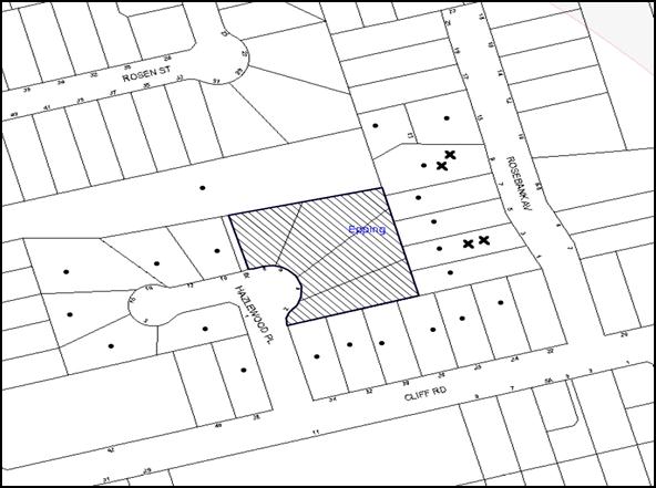
|
NOTIFICATION PLAN |
|
||
|
• PROPERTIES NOTIFIED
|
X SUBMISSIONS RECEIVED |
PROPERTY SUBJECT OF DEVELOPMENT |
|
The submissions objected to the development, generally on the following grounds:
· Construction works would result in unacceptable impact on significant trees along the eastern boundary of the site;
· The building footprint would have a negative impact on the remnant Blue Gum High Forest within the Kent Street Reserve and the creek due to the additional pipeline;
· The development would result in unacceptable traffic impact on local roads;
· The five storey developments are not compatible with the character of the Rosebank Avenue Heritage Conservation Area and the heritage listed house at No. 9 Rosebank Avenue;
· The proposed development would have unacceptable impact on the privacy of the occupants at No. 9 Rosebank Avenue;
· The proposed excavation works are major and would have unacceptable impacts on the existing low density dwellings on the eastern side, especially to the structure of No. 9 Rosebank Avenue;
· The development would generate unacceptable noise;
· The construction works would cause disruption in the locality;
· The development proposes an additional pipeline connecting to the creek. The additional stormwater flow would result in flooding of No. 9 Rosebank Avenue. The existing pipeline through Council’s reserve should be retained;
· The existing tree at the north-eastern corner of the site (Tree No. 13) would be adversely impacted upon due to the encroachment of the building footprint within the tree protection zone;
· The security of the occupants of the low density areas would be adversely impacted upon due to the proposed five-storey residential flat buildings; and
· The landscaping at the corner of Kent Street and Cliff Road is not satisfactory.
The merits of the matters raised in community submissions have been addressed in the body of the report with the exception of the following:
5.1.1 Privacy
The submission raises concerns regarding impact of the development on the privacy of No. 9 Rosebank Avenue. No. 9 Rosebank Avenue is located at the north eastern corner of the site, being screened by two existing large trees that are proposed to be retained. The proposal does not include any balconies at this corner. Highlight windows are proposed to the bedrooms at this corner to avoid overlooking opportunities. The raised terrace to units B-12 and B-13 at the ground floor of Tower B would front the Kent Street Reserve and be effectively screened by the existing vegetation. Additionally, the eastern façades of Towers A and B incorporate moveable privacy screens and obscure glazing to the balustrades of all balconies. Conditions of consent recommend the addition of three evergreen trees on the eastern boundary to further alleviate adverse privacy impacts.
The remaining balconies on the northern side would directly front dense bushland within the reserve.
Accordingly, it is not considered that the development would result in unreasonable privacy impact on the occupants of No. 9 Rosebank Avenue.
5.1.2 Disruption During Construction Works
A Construction Traffic Management Plan is required to be submitted to Council prior to the issue of the Construction Certificate. The document would address the impact of the development on the locality during construction works.
Conditions of consent are recommended to ensure that dust suppression methods and noise control measures are undertaken during construction works. Disposal of any asbestos on site would be undertaken in accordance with recommended conditions of consent and WorkCover requirements.
5.1.3 Landscaping on Kent Street
This is not a matter for consideration under this development application as the site does not front Kent Street or Cliff Road.
5.1.4 Noise
The proposal is for a residential development which is not classified as a noise generating development. It is anticipated that the potential noise generation would occur during construction works on the site. Conditions of consent stipulate construction hours and construction methods to mitigate unreasonable noise impacts on the neighbourhood.
Subject to recommended conditions of consent, the development is assessed as satisfactory with regard to noise.
5.2 Public Agencies
The development application was referred to the following Agencies for comment:
5.2.1 NSW Police Force
The application was referred to NSW Police Force for comments and no objections have been raised subject to conditions of consent.
6. THE PUBLIC INTEREST
Section 79C(1)(e) of the Act requires Council to consider “the public interest”.
The public interest is an overarching requirement, which includes the consideration of the matters discussed in this report. Implicit to the public interest is the achievement of future built outcomes adequately responding to and respecting the future desired outcomes expressed in environmental planning instruments and development control plans.
The application is considered to have satisfactorily addressed Council’s and relevant agencies’ criteria and would provide a development outcome that, on balance, would result in a positive impact for the community. Accordingly, it is considered that the approval of the proposed development would be in the public interest.
CONCLUSION
The application seeks approval for the demolition of the existing structures and the construction of three five-storey residential flat buildings comprising 99 units with two levels of basement car parking. The proposal also includes drainage works by upgrading an existing pipe within Kent Street reserve adjoining the northern boundary of the site.
The proposed development is assessed as satisfactory in respect to the Hornsby Local Environmental Plan 2013, design principles under SEPP 65 and the best practice guidelines of the Residential Flat Design Code. The proposed development generally complies with the prescriptive measures of the HDCP and would result in a built form which contributes positively to the built environment and desired future character of the Cliff Road, Epping Precinct.
Approval of the proposal is recommended.
Note: At the time of the completion of this planning report, no persons have made a Political Donations Disclosure Statement pursuant to Section 147 of the Environmental Planning and Assessment Act 1979 in respect of the subject planning application.
RESPONSIBLE OFFICER
The officer responsible for the preparation of this Report is the Manager – Development Assessments – Rodney Pickles, who can be contacted on 9847 6731.
|
Rod Pickles Manager - Development Assessment Planning Division |
James Farrington Group Manager Planning Division |
|
1.View |
Locality Map |
|
|
|
2.View |
Floor Plans |
|
|
|
3.View |
Elevations and Sections |
|
|
|
4.View |
Shadow Diagrams |
|
|
|
5.View |
Landscape Plan |
|
|
|
6.View |
Stormwater Plan |
|
|
|
7.View |
Photomontage |
|
|
File Reference: DA/364/2015
Document Number: D06899354
SCHEDULE 1
GENERAL CONDITIONS
The conditions of consent within this notice of determination have been applied to ensure that the use of the land and/or building is carried out in such a manner that is consistent with the aims and objectives of the relevant legislation, planning instruments and council policies affecting the land and does not disrupt the amenity of the neighbourhood or impact upon the environment.
Note: For the purpose of this consent, the term ‘applicant’ means any person who has the authority to act on or the benefit of the development consent.
Note: For the purpose of this consent, any reference to an Act, Regulation, Australian Standard or publication by a public authority shall be taken to mean the gazetted Act or Regulation, or adopted Australian Standard or publication as in force on the date that the application for a construction certificate is made.
1. Approved Plans and Supporting Documentation
The development must be carried out in accordance with the plans and documentation listed below and endorsed with Council’s stamp, except where amended by Council and/or other conditions of this consent:
|
Plan No. |
Plan Title |
Drawn by |
Dated |
|
E.04 Issue E |
Basement 2 |
Zhinar Architects |
22/03/2016 |
|
E.05 Issue E |
Basement 1 |
Zhinar Architects |
22/03/2016 |
|
E.06 Issue E |
Lower Ground Floor |
Zhinar Architects |
22/03/2016 |
|
E.07 Issue E |
Upper Ground |
Zhinar Architects |
22/03/2016 |
|
E.08 Issue E |
Level 1 |
Zhinar Architects |
22/03/2016 |
|
E.09 Issue E |
Level 2 |
Zhinar Architects |
22/03/2016 |
|
E.10 Issue E |
Level 3 |
Zhinar Architects |
22/03/2016 |
|
E.11 Issue E |
Level 4 |
Zhinar Architects |
22/03/2016 |
|
E.12 Issue E |
Roof Plan |
Zhinar Architects |
22/03/2016 |
|
E 13.1, E 13.2, E 13.3, E 13.4, E 13.5, E 13.6, E 13.7 Issue E |
Block A Lower Ground, Upper Ground, Level 1, Level 2, Level 3, Level 4 and Roof plan |
Zhinar Architects |
22/03/2016 |
|
E 13.8, E 13.9, E 13.10, E 13.11, E 13.12, E 13.13 Issue E |
Block B + C Lower Ground, Upper Ground, Level 1, Level 2, Level 3 and Roof plan |
Zhinar Architects |
22/03/2016 |
|
E.14, E.15, E.16, E.17 Issue E |
Section 1, Section 2, Section 3 and Section 4 |
Zhinar Architects |
22/03/2016 |
|
E.18 Issue E |
Elevations North and South |
Zhinar Architects |
22/03/2016 |
|
E.19 Issue E |
Elevations East and West |
Zhinar Architects |
22/03/2016 |
|
E.20 Issue E |
Elevations Street and Internal |
Zhinar Architects |
22/03/2016 |
|
E.21 Issue E |
Elevations Internal |
Zhinar Architects |
22/03/2016 |
|
D1 - A |
Details, Notes and Legend |
Quantum Engineers |
18/02/2016 |
|
D2 - A |
Basement level 2 Plan |
Quantum Engineers |
18/02/2016 |
|
D3 - A |
Basement level 1 Plan |
Quantum Engineers |
18/02/2016 |
|
D4 - A |
Site/Ground Floor Plan |
Quantum Engineers |
18/02/2016 |
|
D5 - A |
Stormwater Details |
Quantum Engineers |
18/02/2016 |
|
D6 - A |
WSUD/OSD Calculations |
Quantum Engineers |
18/02/2016 |
|
D7 - A |
WSUD details and Calculations |
Quantum Engineers |
18/02/2016 |
|
D10 - A |
Sediment Control Plan |
Quantum Engineers |
18/02/2016 |
|
D11 - A |
Sediment Control Details |
Quantum Engineers |
18/02/2016 |
|
Sheets 1 Issue A |
Landscape Concept Plan |
Paul Scrivener landscape Architecture |
17/02/2016 |
|
Sheets 2 Issue A |
Landscape Details |
Paul Scrivener landscape Architecture |
17/02/2016 |
|
Sheets 3 Issue A |
Landscape Calculations/Tree Protection Plan |
Paul Scrivener landscape Architecture |
17/02/2016 |
|
Document Title |
Prepared by |
Dated |
|
E.01 Issue E Cover Sheet |
Zhinar Architects |
22/03/2016 |
|
Site Analysis E.02 Issue E |
Zhinar Architects |
22/03/2016 |
|
Urban Context E.03 Issue E |
Zhinar Architects |
22/03/2016 |
|
Shadow Study E.22 Issue E |
Zhinar Architects |
22/03/2016 |
|
Solar Study 1 E.23 Issue E |
Zhinar Architects |
22/03/2016 |
|
Solar Study 2 E.24 Issue E |
Zhinar Architects |
22/03/2016 |
|
Material Schedule 1 E.25 Issue E |
Zhinar Architects |
22/03/2016 |
|
Material Schedule 2 E.26 Issue E |
Zhinar Architects |
22/03/2016 |
|
Photomontage E.27 Issue E |
Zhinar Architects |
22/03/2016 |
|
Tree Protection Zone - Ground E.28 Issue E |
Zhinar Architects |
22/03/2016 |
|
Basement 1 TPZ E.29 Issue E |
Zhinar Architects |
22/03/2016 |
|
Survey Plan Sheets 1 and 2 Issue E |
SDG Land Development Solutions |
15/12/2015 |
|
Arboricultural Impact Assessment Report(Annexure Easement to Council reserve) |
Redgum Horticultural |
19/02/2016 |
|
Arboricultural Impact Assessment Report |
Redgum Horticultural |
2/02/2016 |
|
Statement of Environmental Effects |
Caladines Town Planning |
February 2016 |
|
Access Compliance Assessment Report |
Certified Building Specialists |
17/02/2016 |
|
Liveable housing Design Compliance Certificate |
Certified Building Specialists |
11/03/2016 |
|
BASIX Certificate 613261M _ 02 |
Newpeake |
19/02/2016 |
|
Waste Management Plan 8480 |
Brilliant A Projects Pty Ltd |
11/02/2016 |
|
Traffic and Parking Assessment Report |
Varga Traffic Planning Pty Ltd |
18/02/2016 |
|
SEPP 65 Design Verification Statement Issue C |
Zhinar Architects |
March 2016 |
2. Removal of Existing Trees
a) This development consent permits the removal of trees numbered 5, 7, 8 and 18 as identified on plan number Tree Protection Zone Ground E.28 Issue E prepared by Zhinar Architects, dated 22/03/2016.
b) The removal of any other trees requires separate approval in accordance with the Tree and Vegetation Chapter 1B.6 Hornsby Development Control Plan 2013 (HDCP).
c) The removal of any trees from public land requires separate approval by Council in accordance with Part 1B.6 Tree and Vegetation Preservation of the Hornsby Development Control Plan 2013 (HDCP), unless specified in any condition of this consent.
3. Amendment of Plans
a) To comply with Council’s requirements the following approved plans are to be amended to be in accordance with the approved plans E.05 Issue E and E.06 Issue E dated 22/03/2016:
i) Sheets 1, 2 and 3 Issue A, prepared by Paul Scrivener Landscape Architecture dated 17/02/2016; and
ii) D3 –A and D4 –A prepared by Quantum Engineers dated 8/02/2016.
b) Sheet 1 Issue A Landscape Concept Plan be amended to include the following:
i) Three additional evergreen trees along the eastern boundary (rear) of the site; and
ii) The proposed species Sapium seriferum (Chinese Tallowood) is to be substituted by a locally occurring native canopy trees that will reach mature heights of at least 10-12m.
Note: Suitable plant species are listed in Council’s “Indigenous Plants for the Bushland Shire” publication.
c) These amended plans must be submitted with the application for the Construction Certificate.
4. Construction Certificate
a) A Construction Certificate is required to be approved by Council or a Private Certifying Authority prior to the commencement of any works under this consent.
b) A separate Construction Certificate must be obtained from Council for all works within the public road reserve under S138 of the Roads Act.
c) A separate Construction Certificate must be obtained from Council for all works within drainage easements vested in Council.
d) The Construction Certificate plans must not be inconsistent with the Development Consent plans.
5. Section 94 Development Contributions
a) In accordance with Section 80A(1) of the Environmental Planning and Assessment Act, 1979 and the Hornsby Shire Council Section 94 Development Contributions Plan 2014-2024, the following monetary contributions must be paid to Council to cater for the increased demand for community infrastructure resulting from the development:
|
Description |
Contribution (4) |
|
Roads |
$45,594.45 |
|
Open Space and Recreation |
$989,358.10 |
|
Community Facilities |
$396,480.90 |
|
Plan Preparation and Administration |
$3,084.20 |
|
TOTAL |
$1,434,517.65 |
being for 17 x 1-br, 72 x 2-br and 10 x 3-br units with a credit of four existing residences.
b) The value of this contribution is current as at 15 March 2016. If the contribution is not paid within the financial quarter that this condition was generated, the contribution payable will be adjusted in accordance with the provisions of the Hornsby Shire Council Section 94 Development Contributions Plan and the amount payable will be calculated at the time of payment in the following manner:
$CPY = $CDC x CPIPY
CPIDC
Where:
$CPY is the amount of the contribution at the date of Payment
$CDC is the amount of the contribution as set out in this Development Consent
CPIPY is the latest release of the Consumer Price Index (Sydney – All Groups) at the date of Payment as published by the ABS.
CPIDC is the Consumer Price Index (Sydney – All Groups) for the financial quarter at the date applicable in this Development Consent Condition.
c) The monetary contribution must be paid to Council:
i) prior to the issue of the Subdivision Certificate where the development is for subdivision; or
ii) prior to the issue of the first Construction Certificate where the development is for building work; or
iii) prior to issue of the Subdivision Certificate or first Construction Certificate, whichever occurs first, where the development involves both subdivision and building work; or
iv) prior to the works commencing where the development does not require a Construction Certificate or Subdivision Certificate.
Note: It is the professional responsibility of the Principal Certifying Authority to ensure that the monetary contributions have been paid to Council in accordance with the above timeframes.
Council’s Development Contributions Plan may be viewed at www.hornsby.nsw.gov.au or a copy may be inspected at Council’s Administration Centre during normal business hours.
6. Project Arborist
A Project Arborist is to be appointed in accordance with AS 4970-2009 (1.4.4) to provide monitoring and certification throughout the development process. The details of the appointed Arborist are to be provided to Council and the PCA prior to the issue of the construction certificate.
REQUIREMENTS PRIOR TO THE ISSUE OF A CONSTRUCTION CERTIFICATE
7. Building Code of Australia
All approved building work must be carried out in accordance with the relevant requirements of the Building Code of Australia.
8. Contract of Insurance (Residential Building Work)
Where residential building work for which the Home Building Act, 1989 requires there to be a contract of insurance in force in accordance with Part 6 of that Act, this contract of insurance must be in force before any building work authorised to be carried out by the consent commences.
9. Notification of Home Building Act, 1989 Requirements
Residential building work within the meaning of the Home Building Act 1989 must not be carried out unless the principal certifying authority for the development to which the work relates (not being Council) has given Council written notice of the following information:
a) In the case of work for which a principal contractor is required to be appointed:
i) The name and licence number of the principal contractor; and
ii) The name of the insurer by which the work is insured under Part 6 of that Act.
b) In the case of work to be done by an owner-builder:
i) The name of the owner-builder; and
ii) If the owner-builder is required to hold an owner-builder’s permit under that Act, the number of the owner-builder’s permit.
Note: If arrangements for doing the residential building work are changed while the work is in progress so that the information notified becomes out of date, further work must not be carried out unless the principal certifying authority for the development to which the work relates (not being Council) has given Council written notification of the updated information.
10. Utility Services
The applicant must submit written evidence of the following service provider requirements:
a) Ausgrid (formerly Energy Australia) – a letter of consent demonstrating that satisfactory arrangements have been made to service the proposed development.
b) Telstra – a letter of consent demonstrating that satisfactory arrangements have been made to service the proposed development.
11. Sydney Water – Approval
This application must be submitted to Sydney Water for approval to determine whether the development would affect any Sydney Water infrastructure, and whether further requirements are to be met.
Building plan approvals can be obtained online via Sydney Water Tap inTM through www.sydneywater.com.au under the Building and Development tab.
12. Dilapidation Report
A ‘Dilapidation Report’ is to be prepared by a ‘chartered structural engineer’ detailing the structural condition of all adjoining properties.
a) To record the structural condition of all properties adjoining the eastern boundary of the approved development (Nos 1, 3, 5, 7, and 9 Rosebank Avenue), a dilapidation report must be prepared by a suitably qualified structural engineer for inclusion with the application of the Construction Certificate.
13. Traffic Control Plan
A Traffic Control Plan (TCP) must be prepared by a qualified traffic controller in accordance with the Roads & Traffic Authority’s Traffic Control at Worksites Manual 1998 and Australian Standard 1742.3 for all work on a public road. The Traffic Management Plan shall be submitted and approved by Council’s Manager Traffic and Road Safety prior to the issue of a construction certificate. The TCP must detail the following:
a) Arrangements for public notification of the works;
b) Temporary construction signage;
c) Permanent post-construction signage;
d) Vehicle movement plans;
e) Traffic management plans; and
f) Pedestrian and cyclist access/safety.
14. Identification of Survey Marks
A registered surveyor must identify all survey marks in the vicinity of the proposed development. Any survey marks required to be removed or displaced as a result of the proposed development shall be undertaken by a registered surveyor in accordance with Section 24 (1) of the Surveying and Spatial Information Act 2002 and following the Surveyor General’s Directions No.11 – "Preservation of Survey Infrastructure".
15. Stormwater Drainage
The stormwater drainage system for the development must be designed in accordance with Council’s Civil Works – Design and Construction Specification 2005 and the following requirements:
a) Connected to an existing Council piped drainage system;
i) The connection to Council’s drainage pit or pipeline must be inspected by a Council Engineer in the Planning Division. Prior to the connection, an application must be made to Council and all fees paid.
Note: An inspection booking can be made by calling Council on 9847 6787.
ii) Prior to the issue of an Occupation Certificate a Compliance Certificate must be obtained from the Council for the connection to Council’s drainage system.
b) Council’s drainage system be piped to contain the 20 year Average Recurrence Interval storm event with an overland flow provided above it; and
c) The WSUD (Water Saving Urban Design) requirements must be incorporated in accordance with the engineering report and plans prepared by Quantum Engineers dated 18/02/2016 to achieve the water quality targets specified in the report and the Hornsby Development Control plan 2013.
d) Details are to be submitted with the construction certificate plans.
16. On Site Stormwater Detention
An on-site stormwater detention system must be designed by a chartered civil engineer and constructed in accordance with the following requirements:
a) Have a capacity of not less than 42 cubic metres, and a maximum discharge (when full) of 76 litres per second;
b) Have a surcharge/inspection grate located directly above the outlet; and
c) Discharge from the detention system must be controlled via 1 metre length of pipe, not less than 50 millimetres diameter or via a stainless plate with sharply drilled orifice bolted over the face of the outlet discharging into a larger diameter pipe capable of carrying the design flow to an approved Council system.
17. Stormwater Discharge
The stormwater discharge system must be designed in accordance with Hornsby Council’s Civil Works – Design and Construction Specification 2005 and the following requirements:
a) A standard junction pit with a dimension of 1500mm square must be designed within Council’s Drainage Reserve Lot 17 DP 28934 (No. 8X Hazlewood Place) to allow discharging the stormwater from the development;
b) A 450mm diameter reinforced concrete pipe at minimum of 1% slope must be designed to replace the existing pipeline between the northern end of Council’s Drainage Reserve at Lot 17 DP 28934 (No. 8X Hazlewood Place) to the open drainage channel within Kent Street reserve (No. 54X Kent Street);
c) A standard concrete headwall must be designed to replace the existing headwall;
d) All headwall outlets must incorporate flow velocity reduction controls (i.e. bedded boulders and small stones) to minimise erosive and scouring impacts to the watercourse; and
e) These energy dissipater controls must be landscaped to accommodate outlet sheet flow (forced jump).
f) The head wall design and stream bed and bank scour protection works must be in accordance with Australian Standard AS3500.3:2003 and NSW Office of Water best practice guidelines for in-stream works.
Note: A separate Construction Certificate is required to be issued by Hornsby Shire Council for these works. The headwall design should be approved by Council’s Natural Resources Team.
18. Internal Driveway/Vehicular Areas
The driveway and parking areas on site must be designed in accordance with Australian Standards 2890.1, 2890.2, 3727 and the following requirements:
a) Design levels at the front boundary be obtained from Council, if a private accredited certifier is engaged to obtain a construction certificate for these works via separate application to Council’s Infrastructure Division for crossing levels;
b) Design levels at the front boundary be obtained from Council;
c) The driveway be a rigid pavement;
d) The driveway grade must not exceed 25 percent and transitions for changes in grade must not exceed 8 percent per plan metre;
e) A common turning area to service the proposed development in accordance with Australian Standards AS 2890.1 to ensure vehicles can enter and leave the site in a forward direction. A right of access shall be created over the turning area to ensure access is maintained at all times;
f) Construction of pedestrian access designed to help prevent slip and fall shall be designed and constructed with the future access driveway. Pedestrian grades steeper than 12.5% shall be provided with surface texturing, brushing or cleats to satisfy Class V: R11 ramps in accordance with AS 4586-2004 Clause 5.2; and
g) Longitudinal sections along both sides of the access driveway shall be submitted to the principal certifying authority for assessment with the Construction Certificate. The maximum grade shall not exceed 1 in 4 (25%) with the maximum changes of grade of 1 in 8 (12.5%) for summit grades and 1 in 6.7 (15%) for sag grades. Any transition grades shall have a minimum length of 2 metres. The longitudinal sections shall incorporate the design levels obtained by Council.
19. Footpath
A concrete footpath 80mm thick 1.2m wide must be designed across the full frontage of the subject site in accordance Council’s Civil Works Design and Construction Specification 2005 and the following requirements:
a) Pouring of the concrete footpath to the full frontage of the subject site;
b) The land adjoining the footpath to be fully turfed;
c) Any public utility adjustments to be carried out at the cost of the applicant and to the requirements of the relevant public authority; and
d) Detailed engineering plans are to be submitted to Council for approval.
20. Road Works
All road works approved under this consent must be designed in accordance with Council’s Civil Works Design and Construction Specification 2005 and the following requirements:
a) The road pavement to be reconstructed across the frontage of the subject site together with drainage and kerb and guttering;
b) The submission of a compaction certificate from a geotechnical engineer for any fill within road reserves, and all road sub-grade and road pavement materials;
c) Council’s standard 150mm integral kerb and gutter to be removed and reconstructed across the full street frontage of the subject site; and
d) Adjustment of Council’s kerb inlet drainage pits to suit new kerb and gutter work.
Note: Pursuant to Section 138 Roads Act 1993, a separate Construction Certificate Application shall be made to Hornsby Council’s Planning Division for consideration and approval prior to commencement of these Road Works. Council’s fees for construction certificate assessment and compliance inspections are to be paid with lodgement of the Application at Council.
21. Vehicular Crossing
A separate application under the Local Government Act, 1993 and the Roads Act 1993 must be submitted to Council for the installation of a new vehicular crossing and the removal of the redundant crossing. The vehicular crossing must be designed in accordance with Council’s Civil Works Design 2005 and the following requirements:
a) Design levels at the front boundary must be obtained from Council for the design on the internal driveway;
b) Any redundant crossings must be replaced with integral kerb and gutter; and
c) The footway area must be restored by turfing.
Note: An application for a vehicular crossing can only be made to one of Council’s Authorised Vehicular Crossing Contractors. You are advised to contact Council on 02 9847 6940 to obtain a list of contractors.
22. Construction Traffic Management Plan
In order to enable unencumbered movement of traffic in the public road during construction works, a Construction Management Plan, including a Traffic Management Plan and scaled construction plans prepared by a suitably Chartered and Qualified Chartered Civil Engineer and Qualified Worksite Traffic Controller shall be prepared and submitted to Hornsby Shire Council for approval according to the following requirements:
a) A copy of the plans shall be submitted for consideration and written approval by Hornsby Shire Council prior to the release of the Construction Certificate.
b) The plans shall detail the order of construction works and arrangement of all construction machines and vehicles being used at the same time during all stages.
c) The CTMP plans shall be in accordance with the approved Development Application plans and the Development Consent conditions.
d) In order to prevent injury, accident and loss of property, no building materials, work sheds, vehicles, machines or the like shall be allowed to remain in the road reserve area without the written consent of Hornsby Shire Council.
e) The Plan shall be generally in compliance with the requirements of the Road and Traffic Authority’s “Traffic Control at Worksites Manual 1998” and detailing:-
i) Public notification of proposed works;
ii) Long term signage requirements;
iii) Short term (during actual works) signage;
iv) Vehicle Movement Plans, where applicable;
v) Traffic Management Plans;
vi) Pedestrian and Cyclist access and safety;
f) The plans shall indicate traffic controls including those used during non-working hours and shall provide pedestrian access and two-way traffic in the public road to be facilitated at all times.
g) The plans shall include the proposed truck routes to and from the site including details of the frequency of truck movements at the different stages of the development. The plan shall also include details of parking arrangements for all employees and contractors.
h) The Applicant and all employees of contractors on the site must obey any direction or notice from the Prescribed Certifying Authority or Hornsby Shire Council in order to ensure the above.
i) If there is a requirement to obtain a Work Zone, partial Road Closure or Crane Permit an application to Hornsby Shire Council is to be made prior to the issue the Construction Certificate.
23. Construction Management Plan
A Construction Management Plan (CMP), prepared by a suitably qualified consultant, must be submitted for approval by Hornsby Shire Council. The CMP must be include, but not be limited, details of the following:
a) Noise attenuation measures be implemented along the eastern boundary of the site including a hoarding height not less than 3m from the existing ground level;
b) During excavation works, rock removal must be undertaken by sawing instead of rock hammering, wherever practicable;
c) The construction works must be undertaken in accordance with the “Interim Construction Noise Guidelines – 2009” published by DECCW and achieve compliance with the relevant noise levels; and
d) The delivery times and vehicular movements related to demolition, excavation and construction works must be restricted to the construction hours only.
24. Construction Environment Management Plan
To ensure appropriate measures are in place regarding environmental site management during construction works within the Kent Street reserve (54X Kent Street), a Construction Environment Management Plan (CEMP) must be prepared and submitted to Hornsby Shire Council’s Natural Resources Unit for written approval. The CEMP must include (but not be limited to) the following requirements:
a) Safe methods of access to and from the Council’s reserve during construction;
b) Details of proposed fencing, hoarding and lighting;
c) Method of loading and unloading excavation machines, building materials;
d) Storage location and details of construction materials, excavated and waste materials;
e) Methods to prevent material being tracked off the site onto surrounding roadways;
f) Erosion and sediment control measures;
g) Tree protection measures as per conditions of this development consent and the submitted Arboricultural Impact Assessment Report prepared by Redgum Horticultural dated 19 February 2016; and
h) A statement confirming that the site management measures set out in the report would remain in place and be maintained throughout the period of building works and until the site has been stabilised/revegetated with locally native Blue Gum High Forest plants in consultation with Hornsby Shire Council’s Natural Resources Unit.
25. Adaptable Units/Letter Boxes/Storage
The following details must be provided with the Construction Certificate plans.
a) The development is required to provide 11 units designed as adaptable housing pursuant to the requirements of 1C.2.2 of the Hornsby Development Control Plan 2013. In this regard, eleven (11) car parking spaces are to be designed for people with a disability and allocated to 11 adaptable units;
b) A minimum of 20% of the units, being 20 units are to be designed in accordance with the Liveable Housing Guidelines (2012) silver level design;
c) The letter boxes must be located as shown on the approved plan E.06 Issue E;
d) A chair lift is to be provided at the front entrance as shown on the approved plan E.06 Issue E;
e) The details of front fences must be in accordance with Dwg No. E.15 issue E and E.20 Issue E; and
f) Each dwelling within the development must have a minimum area for storage (not including kitchen and bedroom cupboards) for 6m3 for one bedroom units, 8m3 for two bedroom units and 10m3 for three bedroom units, where 50% is required to be located within the apartment and accessible from either the hall or living area. Individual storage cages must be provided at the basement level and be allocated to the individual units.
26. Waste Management Details
The following waste management details must be provided with the Construction Certificate Plans:
a) Storage space must be provided for all equipment required for the operation of the waste management system, including a bin lifter(s) and motorised bin carting equipment;
b) A bulky waste storage area of at least 8sqm must be provided at the basement level;
c) Sufficient vertical clearance must be provided at the Basement level 1 to operate the bin lifter in the bin room;
d) The first 4m of the temporary bin standing area (calculated from the front boundary) is to be at the same level and slope as the driveway. There must be no raised median, 300 mm high kerb, retaining wall, step or any other barrier between the driveway and the bin holding area;
e) The driveway gradient must not exceed 1:20 for the first 4m of the temporary bin standing area (calculated from the front boundary);
f) The waste facilities on each residential level for Tower C must be accessible by persons with a disability (a garbage bin and recycling bin in a cupboard), must have internal dimensions of no less than 1.5 m wide by 0.9 m deep, and double doors of width no less than 1.4m.
g) The waste facilities on each residential level for Tower A and B must be accessible by persons with a disability (a garbage bin and recycling bin in a cupboard), must have internal dimensions of no less than 2.1 m wide by 0.9 m deep, and double doors of width no less than 2m.
Note: Internal dimensions do not include wall thickness, door thickness, ventilation ducting etc., which must be added.
h) A Waste Management Plan Section One – Demolition Stage and Section Three – Construction Stage, covering the scope of this project and including the following details, is required to be submitted to Council:
i) An estimate of the types and volumes of waste and recyclables to be generated;
ii) A site plan showing sorting and storage areas for demolition and construction waste and the vehicle access to these areas;
iii) How excavation, demolition and construction waste materials will be reused or recycled and where residual wastes will be disposed; and
iv) The total percentage (by weight) of demolition and construction waste that will be reused or recycled.
REQUIREMENTS PRIOR TO THE COMMENCEMENT OF ANY WORKS
27. Construction Traffic Management Plan
A document signed by the Principle Building Contractor is to be submitted to Hornsby Council to confirm the following:
a) The specified travel routes in the approved Construction Traffic Management Plan are to be complied with; and
b) The details of the truck routes are will be provided to the excavation and concrete contractors.
28. Erection of Construction Sign
a) A sign must be erected in a prominent position on any site on which any approved work is being carried out:
i) Showing the name, address and telephone number of the principal certifying authority for the work;
ii) Showing the name of the principal contractor (if any) for any demolition or building work and a telephone number on which that person may be contacted outside working hours; and
iii) Stating that unauthorised entry to the work site is prohibited.
b) The sign is to be maintained while the approved work is being carried out and must be removed when the work has been completed.
29. Protection of Adjoining Areas
A temporary hoarding, fence or awning must be erected between the work site and adjoining lands before the works begin and must be kept in place until after the completion of the works if the works:
a) Could cause a danger, obstruction or inconvenience to pedestrian or vehicular traffic;
b) Could cause damage to adjoining lands by falling objects; and/or
c) Involve the enclosure of a public place or part of a public place.
Note: Notwithstanding the above, Council’s separate written approval is required prior to the erection of any structure or other obstruction on public land.
30. Pre-Construction Environmental Report
a) A pre-construction environmental report is to be prepared by a qualified and experienced independent bush regeneration consultant (supported by photographs) documenting any existing damage to public areas in the vicinity of the development site, within Council’s reserve at 54X Kent Street and the drainage reserve at No. 8X Hazlewood Place.
b) This report must be submitted to Hornsby Shire Council, at least five (5) working days prior to the commencement of works for written approval by Council’s Natural Resources Unit.
c) No works are to commence within the reserve prior to receipt of approval by Hornsby Shire Council.
Note: It is the responsibility of the person acting on this consent to submit the relevant information to Council within the required timeframe. In the event that the pre-construction dilapidation report is not submitted within five (5) working days prior to commencement of the works and the public area sustains damage, then the person acting on this consent may be held liable.
31. Toilet Facilities
a) To provide a safe and hygienic workplace, toilet facilities must be available or be installed at the works site before works begin and must be maintained until the works are completed at a ratio of one toilet for every 20 persons employed at the site.
b) Each toilet must:
i) be a standard flushing toilet connected to a public sewer; or
ii) be a temporary chemical closet approved under the Local Government Act 1993; or
iii) have an on-site effluent disposal system approved under the Local Government Act 1993.
32. Erosion and Sediment Control
To protect the water quality of the downstream environment, erosion and sediment control measures must be provided and maintained throughout the construction period in accordance with the manual ‘Soils and Construction 2004 (Bluebook)’, the approved plans, Council specifications and to the satisfaction of the principal certifying authority. The erosion and sediment control devices must remain in place until the site has been stabilised and revegetated.
Note: On the spot penalties may be issued for any non-compliance with this requirement without any further notification or warning.
33. Tree Protection Barriers
a) To safeguard the natural environment during the approved development works, tree protection fencing (ground, trunk and crown) must be installed around trees identified to be retained on the site in Tree Protection Zone Ground E.28 Issue E prepared by Zhinar Architects dated 22/03/2016, in accordance with AS 4970-2009 (Clause 4.5) and the recommendations of the submitted Arboricultural Impact Assessment Report prepared by Redgum Horticultural dated 2/02/2016;
b) To safeguard the natural environment during the approved development works, tree protection fencing (ground, trunk and crown) must be installed around tree Nos. 26, 30, 31, 33, 34, 35 & 36 within the adjoining reserve identified in Appendices E and F ( (Tree Protection Plan) of the Arboricultural Impact Assessment Report prepared by Redgum Horticultural dated 19/02/2016, in accordance with AS 4970-2009 (Clause 4.5) and the recommendations of the report; and
c) The tree protection fencing must be installed under the supervision of a Project Arborist.
Note: The site and the adjoining reserve are comprised of Blue Gum High Forest which is listed as a ‘Critically Endangered Ecological Community’ under the ‘Threatened Species Conservation Act 1995’. The Act prohibits the disturbance to threatened species, endangered populations and endangered ecological communities, or their habitat, without the approval of the NSW ‘Office of Environment and Heritage’ where such activities are not authorised by development consent under the ‘Environmental Planning and Assessment Act 1979’.
Actions such as tree removal, understorey slashing or mowing, removal of dead trees within this vegetation would likely impact upon this endangered ecological community. Such action would qualify as illegally picking or disturbing the habitat and could render any person who carried out such action as LIABLE FOR PROSECUTION.
34. Root Mapping
a) The presence, size and depth of the root system within 500mm of the approved works within the Tree Protection Zone of the trees numbered 26, 30, 31, 33, 34, 35 & 36 must be determined using non-destructive exploratory techniques;
b) The Root Mapping must be carried out under the direction and supervision of the Project Arborist in accordance with AS 4970-2009 (section 3.3.4);
c) The root mapping must occur outside the Structural Root Zone of the above trees in accordance with AS 4970; and
d) A report must be submitted by the Project Arborist to Council and the Principal Certifying Authority detailing the results of the root mapping, showing the location of any identified roots and the location of the proposed works.
REQUIREMENTS DURING CONSTRUCTION
35. Construction Work Hours
All work on site (including demolition and earth works) must only occur between 7am and 5pm Monday to Saturday (unless otherwise approved in writing by Council due to extenuating circumstances). No work is to be undertaken on Sundays or public holidays.
36. Demolition
To protect the surrounding environment, all demolition work must be carried out in accordance with “Australian Standard 2601-2001 – The Demolition of Structures” and the following requirements:
a) Demolition material must be disposed of to an authorised recycling and/or waste disposal site and/or in accordance with an approved waste management plan;
b) Demolition works, where asbestos material is being removed, must be undertaken by a contractor that holds an appropriate licence issued by WorkCover NSW in accordance with Chapter 10 of the Occupational Health and Safety Regulation 2001 and Clause 29 of the Protection of the Environment Operations (Waste) Regulation 2005; and
c) On construction sites where any building contain asbestos material, a standard commercially manufactured sign containing the words ‘DANGER ASBESTOS REMOVAL IN PROGRESS’ and measuring not less than 400mm x 300mm must be displayed in a prominent position visible from the street.
37. Environmental Management
The site must be managed in accordance with the publication ‘Managing Urban Stormwater – Landcom (March 2004) and the Protection of the Environment Operations Act 1997 by way of implementing appropriate measures to prevent sediment run-off, excessive dust, noise or odour emanating from the site during the construction of the development.
38. Street Sweeping
To protect the surrounding environment, street sweeping must be undertaken following sediment tracking from the site along the Hazlewood Place frontage during works and until the site is established.
The street cleaning services must undertake a street ‘scrub and dry’ method of service and not a dry sweeping service that may cause sediment tracking to spread or cause a dust nuisance.
39. Council Property
To ensure that the public reserve is kept in a clean, tidy and safe condition during construction works, no building materials, waste, machinery or related matter is to be stored on the road/footpath/nature strip in front of the site, within No. 8X Hazlewood Place or within Kent Street reserve at No. 54X Kent Street.
40. Landfill
Landfill must be constructed in accordance with Council’s ‘Construction Specification 2005’ and the following requirements:
a) All fill material imported to the site is to wholly consist of Virgin Excavated Natural Material (VENM) as defined in Schedule 1 of the Protection of the Environment Operations Act, 1997 or a material approved under the Department of Environment and Climate Change’s general resource recovery exemption.
b) A compaction certificate is to be obtained from a suitably qualified geotechnical engineer verifying that the specified compaction requirements have been met.
c) A compaction certificate must be provided by a geotechnical engineer certifying any fill within road reserves, and all road sub-grade and road pavement materials.
d) The compaction certificates must be included with the application for an occupation certificate.
41. Excavated Material
All excavated material removed from the site must be classified by a suitably qualified person in accordance with the Department of Environment, Climate Change and Water NSW Waste Classification Guidelines prior to disposal to an approved waste management facility and be reported to the principal certifying authority prior to the issue of an Occupation Certificate.
42. Survey Report – Finished Floor Level
The following reports must be prepared by a registered surveyor and submitted to the principal certifying authority:
a) Prior to the pouring of concrete at each level of the building certifying that:
i) The building, retaining walls and the like have been correctly positioned on the site;
ii) The finished floor level(s) are in accordance with the approved plans;
iii) The height of the topmost level of the building including lift overruns and the roof overhang is a maximum of 17.5m above the natural ground level at that point.
b) Confirming that the waste collection vehicle standing area complies with AS2890.1 – 2004 and AS20890.2 – 2002 for small rigid vehicles (SRV).
43. Waste Management
Waste management during the demolition and construction phase of the development must be undertaken in accordance with the approved Waste Management Plan. Additionally written records of the following items must be maintained during the removal of any waste from the site and such information submitted to the Principal Certifying Authority within fourteen days of the date of completion of the works:
a) The identity of the person removing the waste.
b) The waste carrier vehicle registration.
c) Date and time of waste collection.
d) A description of the waste (type of waste and estimated quantity).
e) Details of the site to which the waste is to be taken.
f) The corresponding tip docket/receipt from the site to which the waste is transferred (noting date and time of delivery, description (type and quantity) of waste).
g) Whether the waste is expected to be reused, recycled or go to landfill.
Note: In accordance with the Protection of the Environment Operations Act 1997, the definition of waste includes any unwanted substance, regardless of whether it is reused, recycled or disposed to landfill.
44. Traffic Control Plan and Construction Management Plan Compliance
The development must be carried out in accordance with the following approved documents:
a) Traffic Control Plan (TCP);
b) Construction Traffic Management Plan (CTMP) including the truck access routes and parking of construction vehicles;
c) Construction Management Plan (CMP); and
d) Construction Environmental Management Plan (CEMP).
45. Protection of Bushland
a) To prevent the spread of weeds and fungal pathogens such as Cinnamon Fungus (Phytophthora cinnamomi) and Chytrid Fungus (Batrachochytrium dendrobatidis), all machinery shall be cleaned of soil and debris before entering the subject site for construction works.
46. Works Near Trees
a) To protect trees to be retained, all required tree protection measures within the site, the adjoining properties and the Kent Street reserve are to be maintained in good condition for the duration of the construction period.
b) Approved works within the nominated Tree Protection Zones must be carried out in accordance with the following requirements:
i) All works must be approved by the Project Arborist.
ii) Root/ground protection/root pruning outside the structure root zone of a tree and underground services installation must be provided in accordance with AS 4970-2009 (Clause 4.5.4 and clause 4.5.5);
iii) The Structural Root Zone of any tree required to be retained must remain intact;
iv) Activities within the Tree Protection Zone must comply with AS 4970-2009 (Clause 4.2); and
v) Machinery other than hand held must not enter or carry out works on public land.
c) The Project Arborist must assess the conditions of the trees during works within the tree protection zones, make recommendations (if required) and carry out remedial actions if the following conditions are evident:
i) A general decline in health and vigour;
ii) Damaged, crushed or dying roots;
iii) Excessive (>10%) loss or dieback of roots, branches and foliage;
iv) Mechanical damage or bruising of bark and timber of roots, trunks and branches;
v) Yellowing of foliage or thinning of canopy uncharacteristic of the species;
vi) An increase in the amount of deadwood not associated with normal growth;
vii) Inappropriate increase in the development of epicormic growth and/or the presence of sucker growth on the trunk; and
viii) Branch drop, torn branches and stripped bark not associated with natural climate conditions.
d) A certificate must be submitted to the principal certifying authority by the Project Arborist detailing the method(s) used to preserve these tree(s) during the course of construction.
Note: Except as provided above, the applicant is to ensure that no excavation, filling or stockpiling of building materials, parking of vehicles or plant, disposal of cement slurry, waste water or other contaminants occurs within 4 metres of any tree to be retained.
REQUIREMENTS PRIOR TO THE ISSUE OF AN OCCUPATION CERTIFICATE
Note: For the purpose of this consent, a reference to ‘occupation certificate’ shall not be taken to mean an ‘interim occupation certificate’ unless otherwise stated.
47. Fulfilment of BASIX Commitments
The applicant must demonstrate the fulfilment of BASIX commitments pertaining to the development.
48. Sydney Water – s73 Certificate
An s73 Certificate must be obtained from Sydney Water and submitted to the PCA.
Note: Sydney Water requires that s73 applications are to be made through an authorised Sydney Water Servicing Coordinator. Refer to www.sydneywater.com.au or telephone 13 20 92 for assistance.
49. Certification of WSUD Facilities
a) A certificate from a Civil Engineer is to be obtained stating that the WSUD facilities have been constructed and will meet the water quality targets as specified in the Hornsby Shire Development Control Plan 2013.
b) The registered owner/ owners’ corporation must enter into a minimum five (5) year maintenance contract with a reputable and experienced cleaning contractor for the maintenance of the Enviropod and Stormfilters. A copy of this signed and endorsed maintenance contract(s) must be submitted to Council’s Natural Resources Team.
50. Damage to Council Assets
To protect public property and infrastructure any damage caused to Council’s assets as a result of the construction or demolition of the development must be rectified by the applicant in accordance with Council’s Civil Works Specifications.
The public reserve must not sustain any damage or be at risk of damage as a result of the works associated with this consent.
Note: This consent does not give right of access to the site via Council’s park or reserve. Should such access be required, separate written approval is to be obtained from Council.
51. Final Environmental Report
a) A final report is to be prepared by a qualified and experienced bush regeneration consultant assessing the condition of the public assets, the trees and the bushland within No. 54X Kent Street and No. 8X Hazlewood Place;
b) The report must confirm that all construction works have been undertaken as per the approved CEMP and that no adverse impacts have occurred to the creek, the riparian vegetation and the trees within the bushland;
c) The report is to be submitted for written approval by Council’s Natural Resources Unit.
52. Car Parking and Vehicular Areas
All vehicular areas within the site and the car parking must be constructed in accordance with Australian Standard AS 2890.1 – 2004 – Off Street Car Parking and Australian Standard 2890.2 - 2002 – Off Street Commercial and the following requirements:
a) The driveway to be designed in accordance with Condition 18 of this development consent;
b) All parking areas and driveways are to be sealed to an all-weather standard, line marked and signposted;
c) Residential parking spaces are to be secure spaces with access controlled by card or numeric pad;
d) Fourteen (14) visitors’ spaces are to be provided at the basement level. Visitors are to be able to access the basement car park by an audio/visual intercom system located at the top of the ramped driveway;
e) Thirty bicycle spaces (resident and visitor) are to be provided in the basement car park. Bicycle parking spaces are to be designed in accordance with AS 2890.3-1993;
f) Three motorcycle parking spaces is to be provided within the basement car park, designed in accordance with AS 2890.5-1993;
g) All parking for people with disabilities is to comply with AS/NZS 2890.6:2009 Off-street parking for people with disabilities; and
h) The location of the driveway must maintain sight lines for the pedestrians.
53. Creation of Easements
The following matter(s) must be nominated on the plan of subdivision under s88B of the Conveyancing Act, 1919:
a) The creation of an appropriate "Positive Covenant" and "Restriction as to User" over the constructed on-site detention/retention, WSUD system and outlet works, within the development site in favour of Council in accordance with Council’s prescribed wording. The positions of the on-site detention system and water quality treatment system are to be clearly indicated on the plan of title.
b) To register the positive covenant and the restriction on the use of land, “works-as-executed” details of the on-site-detention system and water quality treatment system must be submitted verifying that the required storage and discharge rates and water quality treatment measures have been constructed in accordance with the design requirements. The details must show the invert levels of the on- site system together with pipe sizes and grades and details of water quality treatment measures. Any variations to the approved plans must be shown in red on the “works-as-executed” plan and supported by calculations.
Note: Council must be nominated as the authority to release, vary or modify any easement, restriction or covenant.
54. Completion of Landscaping
A certificate must be submitted to the PCA by a practicing landscape architect, horticulturalist or person with similar qualifications and experience certifying that all required landscaping works within the site have been satisfactorily completed in accordance with the approved landscape plans listed in Condition 1 of this development consent and the following requirements:
a) The planted street trees are to be located 1000mm long and min 600mm wide mulched plant beds, have three hardwood stakes with a minimum 200 litre pot size;
b) The street trees are to be located to ensure safe sight lines for drivers of vehicles egressing the site;
c) All replacement tree planting within the site must be native to Hornsby Shire and must reach a mature height greater than 9 metres;
d) The replacement tree(s) must be maintained until they reach the height of 3 metres;
e) All tree stock must meet the specifications outlined in ‘Specifying Trees’ (Ross Clark, NATSPEC Books);
f) Planting methods must meet professional (best practice) industry standards;
g) On slab planter boxes including the ground cover above the on-site detention tank and the paved areas along the north-western boundary of the site must include waterproofing, subsoil drainage (proprietary drainage cell, 50mm sand and filter fabric) automatic irrigation, minimum 300mm planting soil for grasses and ground covers, 500mm planting soil for shrubs and minimum 1000mm planting soil for trees and palms and 75mm mulch to ensure sustainable landscape is achieved.
Note: Advice on suitable species for landscaping can be obtained from Council’s planting guide ‘Indigenous Plants for the Bushland Shire’, available at www.hornsby.nsw.gov.au.
Note: Applicants are advised to pre-order plant material required in pot sizes 45 litre or larger to ensure Nurseries have stock available at the time of install.
55. Retaining Walls
All required retaining walls must be constructed as part of the development.
56. Boundary Fencing
Fencing must be erected along all property boundaries in accordance with the following requirements:
a) Front fence to be in accordance with the approved dwg Nos. E.15 and E.20 Issue E;
b) Fencing along the eastern and southern boundary behind the front building alignment, to a height of 1.8 metres;
c) Fencing along the northern boundary to be a 1.5m high steel black powder-coated palisade style fence as per the approved Landscape Concept Plan Issue A dated 17/02/2016;
d) Fencing along the western boundary, adjoining No. 8X Hazlewood Place, to be a 1.5m high steel black powder-coated palisade style fence in accordance with the approved dwg. No. E.06 Issue E; and
e) The palisade fencing along the northern and western boundaries should be in accordance with the following specifications:
i) A tubular steel fence along the southern boundary, consisting of top and bottom rails (38 x 25 x 1.6mm square hollow section in accordance with AS 1163 Structural Steel Hollow Sections) and vertical tubular balusters (19mm round at 100mm centres); and
ii) Posts are to be 50 x 50mm SHS, 1.9mm thickness with larger end post for each straight run.
Note: Alternative fencing may be erected along the northern, eastern and southern boundaries subject to the written consent of the adjoining property owner(s).
57. Installation of Privacy Devices
To establish and maintain a reasonable level of privacy for the adjoining premises, the following devices are to be installed:
a) A 1.5m high obscure glass balustrade be provided to the balcony for unit A-14;
b) Vertical privacy louvres be added to along the entire length of the western elevation of windows to the living areas of units 6, 11 and 16 in Tower C;
c) 2m high privacy screen on the western elevation of the balconies to units 6, 11 and 16 in Tower C;
d) Obscure glazing be used for balconies on the eastern façade of Tower A and Tower B; and
e) Vertical privacy louvres be added to the south facing bedrooms for units 6, 12, 21 and 30 in Tower A.
58. External Lighting
a) To protect the amenity of adjacent premises, all external lighting must be designed and installed in accordance with Australian Standard AS 4282 – Control of the Obtrusive Effects of Outdoor Lighting.
b) Certification of compliance with this Standard must be obtained from a suitably qualified person and submitted to the PCA with the application for the Construction Certificate.
59. Garbage Collection Easement
For the purpose of waste collection, an easement entitling Council, its servants and agents and persons authorised by it, to enter upon the subject land and to operate thereon, vehicles and other equipment for the purposes of garbage collection must be granted to Council by the owner of the land.
Note: The easement must be in a form prescribed by Council and must include covenants to the effect that parties will not be liable for any damage caused to the subject land or any part thereof or to any property located therein or thereon by reason of the operation thereon of any vehicle or other equipment used in connection with the collection of garbage and to the effect that the owner for the time being of the subject land shall indemnify the Council, its servants, agents and persons authorised by it to collect garbage against liability in respect of any such claims made by any person whomsoever.
60. Waste Management
The following waste management requirements must be complied with:
a) The bin storage room at the basement level must include water or a hose for cleaning, graded floors with drainage to sewer, robust doors, sealed and impervious surface, adequate lighting and ventilation, and must be lockable. The waste facility rooms/cupboards at each residential level must include sealed and impervious surface, adequate lighting and ventilation.
b) A report must be prepared by an appropriately qualified person, certifying the following:
i) A comparison of the estimated quantities of each waste type against the actual quantities of each waste type.
Note: Explanations of any deviations to the approved Waste Management Plan is required to be included in this report.
ii) That at least 60% of the waste generated during the demolition and construction phase of the development was reused or recycled.
Note: If the 60% diversion from landfill cannot be achieved in the Construction Stage, the Report is to include the reasons why this occurred and certify that appropriate work practices were employed to implement the approved Waste Management Plan. The Report must be based on documentary evidence such as tipping dockets/receipts from recycling depots, transfer stations and landfills, audits of procedures etc. which are to be attached to the report.
iii) All waste was taken to site(s) that were lawfully permitted to accept that waste.
c) Each unit must be provided with an indoor waste/recycling cupboard for the interim storage of waste with two separate 20 litre containers for general waste and recyclable materials.
d) Space must be provided for either individual compost containers for each unit or a communal compost container;
Note: The location of the compost containers should have regard for potential amenity impacts.
e) A bulky waste storage area of at least 8m2 is to be identified and marked with paint and signage.
f) The bin carting routes must be devoid of any steps.
Note: Ramps between different levels are acceptable.
g) The bin holding area must be screened from the front by appropriate landscaping up to a height of 1.5m;
h) Prior to an Occupation Certificate being issued or the use commencing, whichever is earlier, the Principal Certifying Authority must obtain Council’s approval of the waste and recycling management facilities provided in the development and ensure arrangements are in place for domestic waste collection by Council.
i) Motorised bin carting equipment must be provided to assist the site caretaker in the safe transfer of bins between the basement and ground levels.
j) Motorised bin lifting equipment must be provided to assist the site caretaker in the safe decanting of the 240L garbage bins into the 660L garbage bins.
Note: Examples of motorised bin carting equipment include bin tug, electric bin trolley and forklift.
k) The waste facilities (a garbage bin and recycling bin in a cupboard) on each residential level must be accessible by persons with a disability while comfortably housing one or two (as required) 240 L garbage bin/s and one 240 L recycling bin.
Note: 240L recycling and garbage bins are 600mm wide by 750mm deep; allow for ease around the bin – 75mm is recommended.
61. Unit Numbering
All units are to be numbered consecutively commencing at No.1. The strata plan lot number is to coincide with the unit number, e.g. Unit 1 = Lot 1. The allocated of unit numbering must be authorised by Council prior to the numbering of each units in the development.
62. Works as Executed Plan
A works-as-executed plan(s) must be prepared by a registered surveyor and submitted to Council for completed road pavement, kerb and gutter, public drainage systems, driveways, on-site detention system, stormwater discharge system into the public reserve and the water quality treatment system. The plan(s) must be accompanied by a certificate from a registered surveyor certifying that all pipelines and associated structures lie wholly within any relevant easements.
63. Consolidation of Allotments
All allotments the subject of this consent must be consolidated into one allotment.
Note: The applicant is recommended to submit the plan of subdivision to consolidate allotments to the NSW Department of Lands at least 4-6 weeks prior to seeking an occupation certificate.
64. Preservation of Survey Marks
A certificate by a Registered Surveyor must be submitted to the Principal Certifying Authority, certifying that there has been no removal, damage, destruction, displacement or defacing of the existing survey marks in the vicinity of the proposed development or otherwise the re-establishment of damaged, removed or displaced survey marks has been undertaken in accordance with the Surveyor General’s Direction No.11 – “Preservation of Survey Infrastructure”.
65. Construction of Engineering Works
All engineering works including but not be limited to the stormwater works, on-site detention system, water quality treatment system, pipeline works within Council’s reserve, construction of retaining walls and road works identified in this consent are to be completed and a Compliance Certificate issued prior to the release of the Occupation Certificate.
66. Final Certification – Tree Protection
Following the final inspection and the completion of any remedial works, the project Arborist must submit to the Principal Certifying Authority documentation stating that the completed works have been carried out in compliance with the approved plans conditions of development consent and specifications for tree protection as above and AS 4970-2009.
67. Provision for National Broadband Network (NBN)
Provision must be made for fibre ready passive infrastructure (pits and pipes) generally in accordance with NBN Co's pit and pipe installation guidelines to service the proposed development. A certificate from NBN Co or Telstra must be submitted to the PCA that the fibre optic cabling provided for the development complies with MDU Building Design Guides for Development.
68. Safety and Security
This site must include the following elements:
a) An intercom system must be installed at gate locations to ensure screening of persons entering the units;
b) The entry doors to the pedestrian foyer is to be constructed of safety rated glass to enable residents a clear line of site before entering or exiting the residential apartments;
c) Lighting is to be provided to pathways, building foyer entries, driveways and common external spaces;
d) Security gate access is to be provided to the car parking areas allowing residents-only access to private car spaces;
e) CCTV cameras must be installed at the entry and exit point and the around the mailbox;
f) The communal open spaces within the site must be illuminated with high luminance by motion sensor lighting;
g) The driveway and basement car parking must be illuminated with low luminance at all times;
h) Security deadlocks are to be provided to each apartment door; and
i) Peep holes are to be provided to individual apartment doors to promote resident safety.
OPERATIONAL CONDITIONS
69. Noise
All noise generated by the proposed development must be attenuated to prevent levels of noise being emitted to adjacent premises which possess tonal, beating and similar characteristics or which exceeds background noise levels by more than 5dB(A).
70. Fire Safety Statement - Annual
On at least one occasion in every 12 month period following the date of the first ‘Fire Safety Certificate’ issued for the property, the owner must provide Council with an annual ‘Fire Safety Certificate’ to each essential service installed in the building.
71. WSUD Maintenance
The development must, at all times, maintain the approved water quality treatment system to achieve the following minimum pollutant removal targets for the entire site in perpetuity:
|
Required percentage reductions in post development average annual load of pollutants |
|
|
Pollutant Type |
Performance Target Reduction Loads |
|
Gross Pollutants |
90% reduction in the post development mean annual load of total gross pollutants |
|
Total Suspended Solids |
80% reduction in the post development mean annual load of total suspended solids |
|
Total Phosphorous |
60% reduction in the post development mean annual load of total phosphorous |
72. Landscape Establishment
The landscape works must be maintained into the future to ensure the establishment and successful growth of plant material to meet the intent of the landscape design. This must include but not limited to watering, weeding, replacement of failed plant material and promoting the growth of plants through standard industry practices.
73. Car Parking/Sight lines and Deliveries
All car parking must be operated in accordance with Australian Standard AS 2890.1 – 2004 – Off Street Car Parking and Australian Standard 2890.2 - 2002 – Off Street Commercial and the following requirements:
a) All parking areas and driveways are to be sealed to an all-weather standard, line marked and signposted at all times.
b) Car parking, loading and manoeuvring areas to be used solely for nominated purposes.
c) Vehicles awaiting loading, unloading or servicing shall be parked on site and not on adjacent or nearby public roads;
d) All vehicular entry on to the site and egress from the site shall be made in a forward direction;
e) Minimum sight lines for pedestrian safety are to be provided at the driveway; and
f) Any proposed landscaping and/or fencing must not restrict sight distance to pedestrians and cyclists travelling along the footpath.
74. Waste Management
The waste management on site must be in accordance with the following requirements:
a) A site caretaker must be employed and be responsible for moving bins where and when necessary, washing bins and maintaining waste storage areas, ensuring the chute system and related devices are maintained in effective and efficient working order, managing the communal composting area, managing the bulky item storage area, arranging the prompt removal of dumped rubbish, and ensuring cars do not park in the loading bay and that all residents are informed of the use of the waste management system.
b) The approved on-going waste management practise for the site must not be amended without consent from Council.
- END OF CONDITIONS –
ADVISORY NOTES
The following information is provided for your assistance to ensure compliance with the Environmental Planning and Assessment Act, 1979, Environmental Planning and Assessment Regulation 2000, other relevant legislation and Council’s policies and specifications. This information does not form part of the conditions of development consent pursuant to Section 80a of the Act.
Environmental Planning and Assessment Act 1979 Requirements
The Environmental Planning and Assessment Act 1979 require:
· The issue of a construction certificate prior to the commencement of any works. Enquiries can be made to Council’s Customer Services Branch on 9847 6760.
· A principal certifying authority to be nominated and Council notified of that appointment prior to the commencement of any works.
· Council to be given at least two days written notice prior to the commencement of any works.
· Mandatory inspections of nominated stages of the construction inspected.
· An occupation certificate to be issued before occupying any building or commencing the use of the land.
Long Service Levy
In accordance with Section 34 of the Building and Construction Industry Long Service Payments Act 1986, a ‘Long Service Levy’ must be paid to the Long Service Payments Corporation or Hornsby Council.
Note: The rate of the Long Service Levy is 0.35% of the total cost of the work.
Note: Hornsby Council requires the payment of the Long Service Levy prior to the issue of a construction certificate.
Tree and Vegetation Preservation
In accordance with Clause 5.9 of the Hornsby Local Environmental Plan 2013 a person must not ringbark, cut down, top, lop, remove, injure or wilfully destroy any tree or other vegetation protected under the Hornsby Development Control Plan 2013 without the authority conferred by development consent or a permit granted by Council.
Notes: A tree is defined as a long lived, woody perennial plant with one or relatively few main stems with the potential to grow to a height greater than three metres (3M). (HDCP 1B.6.1.c).
Tree protection measures and distances are determined using the Australian Standard AS 4970:2009, “Protection of Trees on Development Sites”.
Fines may be imposed for non-compliance with both the Hornsby Local Environmental Plan 2013 and the Hornsby Development Control Plan 2013.
Disability Discrimination Act
The applicant’s attention is drawn to the existence of the Disability Discrimination Act. A construction certificate is required to be obtained for the proposed building/s, which will provide consideration under the Building Code of Australia, however, the development may not comply with the requirements of the Disability Discrimination Act. This is the sole responsibility of the applicant.
Covenants
The land upon which the subject building is to be constructed may be affected by restrictive covenants. Council issues this approval without enquiry as to whether any restrictive covenant affecting the land would be breached by the construction of the building, the subject of this consent. Applicants must rely on their own enquiries as to whether or not the building breaches any such covenant.
Dial Before You Dig
Prior to commencing any works, the applicant is encouraged to contact Dial Before You Dig on 1100 or www.dialbeforeyoudig.com.au for free information on potential underground pipes and cables within the vicinity of the development site.
Telecommunications Act 1997 (Commonwealth)
If you are aware of any works or proposed works which may affect or impact on Telstra’s assets in any way, you are required to contact: Telstra’s Network Integrity Team on Phone Number 1800810443.
Asbestos Warning
Should asbestos or asbestos products be encountered during demolition or construction works, you are advised to seek advice and information prior to disturbing this material. It is recommended that a contractor holding an asbestos-handling permit (issued by WorkCover NSW) be engaged to manage the proper handling of this material. Further information regarding the safe handling and removal of asbestos can be found at:
Alternatively, telephone the WorkCover Asbestos and Demolition Team on 8260 5885.
Group Manager’s Report No. PL5/16
Planning Division
Date of Meeting: 13/04/2016
5 DEVELOPMENT APPLICATION - FIVE STOREY RESIDENTIAL FLAT BUILDINGS COMPRISING 44 UNITS - 554-558 PACIFIC HIGHWAY, MOUNT COLAH
EXECUTIVE SUMMARY
|
DA No: |
DA/1521/2014 (Lodged on 5 December 2014) |
|
Description: |
Demolition of existing structures and construction of two, five storey residential flat buildings comprising 44 units |
|
Property: |
Lots 6 - 8 DP 20511, Nos. 554 - 558 Pacific Highway, Mount Colah |
|
Applicant: |
MacKenzie Architects International |
|
Owner: |
R J Chalmers and Co Pty Ltd |
|
Estimated Value: |
$10,552,044 |
|
Ward: |
A |
· The proposal generally complies with the Hornsby Local Environmental Plan 2013, State Environmental Planning Policy No. 65, and is generally in accordance with the Residential Flat Design Code and the Hornsby Development Control Plan 2013. The applicant has made a submission in accordance with Clause 4.6 ‘Exceptions to development standards’ of the HLEP to vary the Building Height development standard. The submission is considered well founded and is supported.
· Two submissions have been received in respect of the application.
· The application involves relocation of a Council stormwater easement and pipe. Amended stormwater plans for the easement were received in March 2016 and require concurrence from Sydney Trains. Sydney Trains advised that it supports the amended stormwater concept plan in principle, subject to more detailed modelling. Although this matter is expected to be resolved shortly, since Sydney Trains is a concurrence authority, this matter cannot be conditioned.
· Therefore, to avoid unnecessary delays in determining the application, it is recommended that Council delegate to the General Manager to approve the application as a deferred commencement consent, subject to final concurrence conditions from Sydney Trains.
|
THAT Council delegate to the General Manager to assume the concurrence of the Secretary of the Department of Planning and Environment pursuant to Clause 4.6 of the Hornsby Local Environmental Plan 2013 to vary the building height development standard and approve Development Application No. DA/1521/2014 for demolition of existing structures and construction of two, five storey residential flat buildings comprising 44 units at Lot 6 DP 20511, Lot 7 DP 20511, Lot 8 DP 20511, Nos. 554, 556, 558 Pacific Highway, Mount Colah as a deferred commencement pursuant to Section 80(3) of the Environmental Planning and Assessment Act 1979 generally in accordance with the conditions of consent detailed in Schedule 1 of Group Manager’s Report No. PL5/16, subject to final concurrence conditions from Sydney Trains. |
BACKGROUND
The subject land was rezoned from Residential A (Low Density) to R4 (High Density Residential) on 2 September 2011 as part of Council’s Housing Strategy.
The application was submitted on 5 December 2014.
On 12 January 2015, Sydney Trains stopped the clock on the assessment to require the applicant provide more detailed survey and geotechnical information.
On 4 March 2015, Council officers had a meeting with the applicant and advised of concerns with the proposal in relation to building design, setbacks, stormwater drainage, waste vehicle access and driveway design.
From March to August 2015, the applicant addressed the building design issues raised by Council.
On 20 August 2015, the applicant formally lodged amended architectural plans for assessment.
On 19 November 2015, the applicant lodged amended stormwater plans. These plans did not modify the relocated drainage easement as requested by Council in March 2015. The applicant advised that Sydney Trains would not support Council’s preferred alignment of Council’s stormwater pipe.
In December 2015, Council wrote to Sydney Trains to confirm its position on the alignment of Council’s stormwater pipe. Sydney Trains advised Council that the alternative scheme suggested by Council was a possibility.
A meeting was held between Council’s engineers and the applicant’s engineers to discuss the realignment of the drainage pipe and the clarification provided by Sydney Trains. The Engineers agreed to a solution involving straightening of the pipe, that does not require work on Railcorp’s land.
On 7 March 2016, the applicant submitted amended stormwater plans to address the issues raised by Council.
On 29 March 2016, Railcorp advised that is supports the amended stormwater concept plan in principle, but requires further technical information on hydraulic modelling.
SITE
The site comprises three allotments, Nos. 554 to 558 Pacific Highway Mount Colah. The site is an irregular, narrow shaped parcel of land of 2,554m2 with a 86m frontage to the Pacific Highway.
The site contains one dwelling house on the southern portion of the site and vacant land to the north. The vacant land previously accommodated a Service Station that was removed and the land remediated. The site experiences a fall from west to east, away from the Pacific Highway frontage towards the rail corridor at the rear, with an average grade of 10%. The site contains eight trees comprising a mix of exotic and native species, none of which are assessed as significant.
The site forms part of the ‘Pacific Highway Mount Colah Precinct’ within the Hornsby Development Control Plan 2013.
The adjacent land to the south is approved to be redeveloped for three 5 storey residential flat buildings pursuant to DA/1096/2013, and is subject to an undetermined Section 96 application for a redesign. The adjacent land to the east is the railway corridor and Mount Colah train station platform.
The site is located within walking distance of Mount Colah Train Station.
PROPOSAL
The proposal is for the demolition of existing structures and construction of two, five storey residential flat buildings comprising 44 units and two levels of basement car park accommodating 50 car parking spaces. The most northern building comprises 5 residential storeys above an elevated basement to facilitate access for Council’s waste vehicles to the basement from the Pacific Highway. The driveway is located in the narrow northern portion of the site as the deeper southerly portion of the site is subject to stormwater overland flow.
The proposed units include 15 x 1 bedroom, 24 x 2 bedroom and 5 x 3 bedroom units.
Landscaped areas are proposed along the property boundaries. A garbage collection room is proposed in the basement.
ASSESSMENT
The development application has been assessed having regard to ‘A Plan for Growing Sydney’, the ‘North Subregion (Draft) Subregional Strategy’ and the matters for consideration prescribed under Section 79C of the Environmental Planning and Assessment Act 1979 (the Act). The following issues have been identified for further consideration.
1. STRATEGIC CONTEXT
1.1 A Plan for Growing Sydney and (Draft) North Subregional Strategy
A Plan for Growing Sydney has been prepared by the NSW State Government to guide land use planning decisions for the next 20 years. The Plan sets a strategy for accommodating Sydney’s future population growth and identifies the need to deliver 689,000 new jobs and 664,000 new homes by 2031. The Plan identifies that the most suitable areas for new housing are in locations close to jobs, public transport, community facilities and services.
The NSW Government will use the subregional planning process to define objectives and set goals for job creation, housing supply and choice in each subregion. Hornsby Shire has been grouped with Hunters Hill, Ku-ring-gai, Lane Cove, Manly, Mosman, North Sydney, Pittwater, Ryde, Warringah and Willoughby to form the North Subregion. The Draft North Subregional Strategy will be reviewed and the Government will set housing targets and monitor supply to ensure planning controls are in place to stimulate housing development.
The proposed development would be consistent with ‘A Plan for Growing Sydney’, by providing additional dwellings and would contribute to housing choice in the locality.
2. STATUTORY CONTROLS
Section 79C(1)(a) requires Council to consider “any relevant environmental planning instruments, draft environmental planning instruments, development control plans, planning agreements and regulations”.
2.1 Hornsby Local Environmental Plan 2013
The proposed development has been assessed having regard to the provisions of the Hornsby Local Environmental Plan 2013 (HLEP).
2.1.1 Zoning of Land and Permissibility
The subject land is zoned R4 (High Density Residential) under the HLEP. The objectives of the R4 zone are:
(a) To provide for the housing needs of the community within a high density residential environment.
(b) To promote a variety of housing types within a high density residential environment.
(c) To enable other land uses that provide facilities or services to meet the day to day needs of residents.
The proposed development is defined as a “Residential flat building” under the HLEP, complies with the zone objectives and is permissible in the zone with Council’s consent.
2.1.2 Height of Buildings
Clause 4.3 of the HLEP provides that the height of a building on any land should not exceed the maximum height shown for the land on the Height of Buildings Map. The maximum permissible height for the subject site is 17.5m. The proposal does not comply with this provision as discussed in Section 2.1.3 below.
2.1.3 Exceptions to Development Standards
The application has been assessed against the requirements of Clause 4.6 of the HLEP. This clause provides flexibility in the application of development standards in circumstances where strict compliance with those standards would, in any particular case, be unreasonable or unnecessary or tender to hinder the attainment of the objectives of the zone.
The proposal exceeds the Height of Buildings development standard.
The objective of the Height of Buildings control is to permit a height of building that is appropriate for the site constraints, development potential and infrastructure capacity of the locality.
The applicant has made a submission in support of a variation to the development standard in accordance with Clause 4.6 of the HLEP. The development application seeks to vary the development standard by up to 260mm on the northern building. The applicant states the proposed variation is consistent with the objectives of the control and is justified as follows:
· The northern building is a 4 to 5 storey building;
· The non-compliance is unique to the site because of the constrained lot shape and topography;
· The variation to the height control would not unreasonably impact upon the amenity of adjoining neighbours and does not block or interrupt any important view corridors or vistas;
· It is consistent with the objectives of the R4 High Density Residential zone and State planning policies; and
· Compliance is unreasonable and unnecessary in the circumstances of this case.
State Government Guidelines on varying development standards recommend considering the provisions of Clause 4.6 of the LEP and the ‘five part test’ established by the Land and Environment Court as follows:
1. the objectives of the standard are achieved notwithstanding noncompliance with the standard;
2. the underlying objective or purpose of the standard is not relevant to the development and therefore compliance is unnecessary;
3. the underlying object of purpose would be defeated or thwarted if compliance was required and therefore compliance is unreasonable;
4. the development standard has been virtually abandoned or destroyed by the council’s own actions in granting consents departing from the standard and hence compliance with the standard is unnecessary and unreasonable;
5. the compliance with development standard is unreasonable or inappropriate due to existing use of land and current environmental character of the particular parcel of land. That is, the particular parcel of land should not have been included in the zone.
The applicant’s submission to vary the Building Height development standard is considered well founded for the following reasons:
· The proposal does not exceed the maximum 5 storey residential height control under the Hornsby Development Control Plan 2013;
· The site contains particular constraints including the lot shape, topography, stormwater overland flow path and frontage to a State road that are unique to the subject site;
· The height standard is exceeded as a result of the requirement to achieve a five storey residential development with appropriate basement access for Council’s garbage truck from the narrowest and highest point of the site given the lot shape and overland flooding;
· The development satisfies Part 1 of the test as the objective of the Building Height standard to limit the scale of development is achieved notwithstanding non-compliance with the development standard;
· The proposal would not set an unacceptable precedent for the precinct, taking into account that the excess height is a result of a flooding constraint and driveway access limitations; and
· Notwithstanding the building height non-compliance, the application is a reasonable outcome for the site and achieves the aims of the HLEP and Hornsby DCP.
Based on this assessment, it is considered that compliance with the development standard would be unreasonable and unnecessary in the circumstances of the case. Accordingly, the Clause 4.6 submission is supported in relation to the northern building which is 4 to 5 residential storeys above a basement.
2.1.4 Heritage Conservation
Clause 5.10 of the HLEP sets out heritage conservation provisions for Hornsby Shire. The site does not include a heritage item and is not located in a heritage conservation area. Accordingly, no further assessment regarding heritage is necessary.
2.1.5 Earthworks
Clause 6.2 of the HLEP states that consent is required for proposed earthworks on site. Before granting consent for earthworks, Council is required to assess the impacts of the works on adjoining properties, drainage patterns and soil stability of the locality.
Council’s assessment of the proposed works and excavation concludes that the impact of the proposed work is acceptable. The application was referred to Sydney Trains which has provided recommended conditions regarding the impact of earthworks on the safety of the railway corridor.
2.2 State Environmental Planning Policy No. 55 - Remediation of Land
The application has been assessed against the requirements of State Environmental Planning Policy No. 55 (SEPP 55). This Policy provides State-wide planning controls requiring that consent must not be granted to the carrying out of any development on land unless the consent authority has considered whether the land is contaminated or requires remediation for the proposed use.
A site validation report for the former Ampol service station was undertaken in July 2004, and submitted with the subject development application. The site formerly consisted of six underground storage tanks, a service station building, workshop and canopy over the pump island. Between January and May 2004 an environmental consultant validated the site including collection of soil samples from the walls and floors of the excavations created in the removal of the underground storage tanks. The laboratory results indicate that concentration of hydrocarbons were below the limits of reporting and therefore below the NSW EPA residential landuse criteria.
There is one dwelling house on the land to the south. Appropriate conditions are included to require all asbestos to be removed from the site appropriately. Furthermore, taking into account the significant excavation required to accommodate the proposed basement car park, much of the existing soil would be removed from the site in any event.
2.3 State Environmental Planning Policy (Building Sustainability Index – BASIX)
The application has been assessed against the requirements of State Environmental Planning Policy (Building Sustainability Index: BASIX) 2004. The proposal includes a BASIX Certificate for the proposed units and is considered to be satisfactory.
2.4 State Environmental Planning Policy No. 32 – Urban Consolidation (Redevelopment of Urban Land) (SEPP 32)
The application has been assessed against the requirements of SEPP 32, which requires Council to implement the aims and objectives of this Policy to the fullest extent practicable when considering development applications relating to redevelopment of urban land. The application complies with the objectives of the Policy as it would promote the social and economic welfare of the locality and would result in the orderly and economic use of under-utilised land within the Shire.
2.5 State Environmental Planning Policy (Infrastructure) 2007
The application has been assessed against the requirements of State Environmental Planning Policy (Infrastructure) 2007. This Policy contains State-wide planning controls for developments adjoining busy roads and railways. The development has a frontage to a classified road corridor (Pacific Highway). The following matters are required to be considered pursuant to the SEPP.
2.5.1 Development with Frontage to a Classified Road
The proposal has been assessed against the requirements of Clause 101 as the site has frontage to the Pacific Highway.
The objective of this Clause is:
(a) to ensure that new development does not compromise the effective and ongoing operation and function of classified roads, and
(b) to prevent or reduce the potential impact of traffic noise and vehicle emission on development adjacent to classified roads.
The compliance of the proposal with the objectives of this Clause is discussed below.
2.5.1.1 Traffic Generation
A Traffic and Parking Impact Assessment submitted with the proposal estimates the traffic generation from the existing site and proposed development using RMS traffic generation rates. The net traffic generation is estimated to be 8 vehicle trips per hour in the AM and PM peak hours, which is negligible when compared with the traffic volumes on the adjacent road network. The application was referred to the RMS which has not raised concerns with the proposal, subject to recommended conditions of consent.
The development is not classified as a Traffic Generating Development in accordance with Clause 104 and Schedule 3 of SEPP (Infrastructure) as it would not result in more than 75 dwellings fronting a classified road.
2.5.1.2 Vehicle Emissions
The proposed development would have frontage to a State Road and the impact of vehicle emissions on sensitive land uses is required to be considered. The previous use of the site includes a dwelling house that is impacted upon by vehicle emission and airborne dust particles due to the current traffic flow. The rezoning of the land to R4 High Density Residential by the Department of Planning and Environment has been the subject of consultation with the RMS that has not raised concern with regard to air quality in this area. The proposed development includes setbacks, landscaping, deep soil zones generally in accordance with the requirements of the HDCP which would ameliorate the impacts of noise and emissions.
2.5.1.3 Traffic Noise
SEPP Infrastructure requires an acoustic assessment where a development fronts a road with an annual average daily traffic volume of more than 40,000 vehicles. Although the traffic volume on the Pacific Highway is well below this threshold, a Noise Assessment report was submitted with the application addressing railway noise and traffic noise. The assessment concludes that to achieve the indoor design sounds levels to habitable rooms, the windows and doors must be closed and quiet mechanical or natural ventilation systems should be provided to all habitable spaces. The BASIX assessment proposes air conditioning to the units, however the location of air conditioning plant has not been identified on the architectural plans. The recommended consent conditions require detailed acoustic review at the Construction Certificate stage. Consent conditions limit the location of air conditioning plant to the floor of balconies, with adjacent glass balustrades to be obscure glazing, to minimise their visual impact.
2.6 State Environmental Planning Policy No. 65 – Design Quality of Residential Flat Development
The Policy provides for design principles to improve the design quality of residential flat development and for consistency in planning controls across the State.
2.6.1 State Environmental Planning Policy No. 65 – Design Quality of Residential Flat Development Amendment 3
SEPP 65 was amended on 19 June 2015 following review of the policy by the Department of Planning and Environment. The amendments replace the Residential Flat Design Guidelines with the Apartment Design Guide which prevails in the event of any inconsistency with a Development Control Plan.
Clause 31 (Transitional provisions for SEPP 65 – Amendment No. 3) states that “If a development application or an application for the modification of a development consent has been made before the notification on the NSW legislation website of the making of State Environmental Planning Policy No 65—Design Quality of Residential Flat Development (Amendment No 3) and the application has not been finally determined before the commencement of that amendment, the application must be determined as if the amendment had not commenced.”
Pursuant to the above provision, this amendment would not apply to the subject application and the previous version (Amendment 2) of the SEPP is required to be considered.
2.6.2 Design Principles
The applicant has submitted a “Design Verification Statement” prepared by a qualified Architect stating how the proposed development achieves the design principles of SEPP 65. The design principles of SEPP 65 and the submitted design verification statement are addressed in the following table.
|
Principle |
Compliance |
|
1. CONTEXT |
Yes |
|
Comment: The site is located within a precinct planned for five storey residential flat buildings in close proximity to Mount Colah Railway Station. The proposal responds to the desired future character of the precinct as envisaged by Council for residential flat buildings in landscaped settings with underground car parking. Once the development of the precinct is completed, the proposal would integrate with the surrounding sites and would be in keeping with the future urban form. The proposed building would contribute to the identity and future character of the precinct. |
|
|
2. SCALE |
Yes |
|
Comment: The scale of the development is generally in accordance with the height control and setbacks for the precinct prescribed within the Hornsby DCP. The building footprints also comply with the maximum floorplate of 35m prescribed within the DCP. The development achieves a scale consistent with the desired outcome for well-articulated buildings that are set back to incorporate landscaping, open space and separation between buildings. |
|
|
3. BUILT FORM |
Yes |
|
Comment: The proposed buildings achieve an appropriate built form for the site and its purpose, in terms of building alignments, proportions, and the manipulation of building elements. The buildings would appropriately contribute to the character of the desired future streetscape and include articulation to minimise the perceived scale. The proposed materials and finishes would add to the visual interest of the development. Flat roof forms have been adopted with an increased top storey setback on the external facades to minimise bulk and height of the buildings as required by the Hornsby DCP. |
|
|
4. DENSITY |
Yes |
|
Comment: The HLEP does not incorporate floor space ratio requirements for the site. The density of the development is governed by the height of the building and the required setbacks. The proposed density is considered to be sustainable as it responds to the regional context, availability of infrastructure, public transport, community facilities and environmental quality and is acceptable in terms of density. |
|
|
5. RESOURCE, ENERGY AND WATER EFFICIENCY |
Yes |
|
Comment: The applicant has submitted a BASIX Certificate for the proposed development. In achieving the required BASIX targets for sustainable water use, thermal comfort and energy efficiency, the proposed development would achieve efficient use of natural resources, energy and water throughout its full life cycle, including demolition and construction. |
|
|
6. LANDSCAPE |
Yes |
|
Comment: The application includes a landscape concept plan which provides landscaping along the street frontages, side and rear boundaries. Large trees are proposed along the street frontages intercepted by shrubs and hedges which would soften the appearance of the development when viewed from the streets. Deep soil areas that incorporate canopy trees are provided around the building envelopes which would enhance the development’s natural environmental performance and provide an appropriate landscaped setting. |
|
|
7. AMENITY |
Yes |
|
Comment: The proposed units are designed with appropriate room dimensions and layout to maximise amenity for future residents. The proposal incorporates good design in terms of achieving natural ventilation, solar access and acoustic privacy. All units incorporate balconies accessible from living areas and privacy has been achieved through appropriate design and orientation of balconies and living areas. Storage areas have been provided within each unit and in the basement levels. The proposal would provide convenient and safe access via a central lift connecting the basement and all other levels. |
|
|
8. SAFETY AND SECURITY |
Yes |
|
Comment: The design orientates the balconies and windows of individual apartments towards the street, rear and side boundaries, providing passive surveillance of the public domain and communal open space areas. Both the pedestrian and vehicular entry points are secured and visibly prominent from the Pacific Highway. The proposal includes an assessment of the development against crime prevention controls in the Statement of Environmental Effects (SEE). The SEE has regard to Crime Prevention Through Environmental Design Principles (CPTED) and includes details of surveillance, access control, territorial reinforcement and space management such as artificial lighting in public places; attractive landscaping whilst maintaining clear sight lines; security coded door lock or swipe card entry; physical or symbolic barriers to attract, channel or restrict the movement of people; security controlled access to basement car park; intercom access for pedestrians; and security cameras located at the entrance of the buildings. Appropriate conditions of consent are recommended to require compliance with the above matters. |
|
|
9. SOCIAL DIMENSIONS AND HOUSING AFFORDABILITY |
Yes |
|
Comment: The proposal incorporates a range of unit sizes to cater for different budgets and housing needs. The development complies with the housing choice requirements of the Hornsby DCP by providing a component of adaptable housing and a mix of 1, 2 and 3 bedroom dwellings. The proposal responds to the social context in terms of providing a range of dwelling sizes with good access to social facilities and services as the site is located in close proximity to Mount Colah Railway Station. |
|
|
10. AESTHETICS |
Yes |
|
Comment: The architectural treatment of the buildings incorporate indentations and projections in the exterior walls with balcony projections to articulate the facades. The roof of each building is flat to minimise building height and they incorporate eaves which would cast shadows across the top storey wall. The articulation of the buildings, composition of building elements, textures, materials and colours would achieve a built form generally consistent with the design principles contained within the Residential Flat Design Code and the Hornsby DCP. |
|
2.7 State Environmental Planning Policy No. 65 – Residential Flat Design Code
SEPP 65 also requires consideration of the Residential Flat Design Code, NSW Planning Department 2002. The Code includes development controls and best practice benchmarks for achieving the design principles of SEPP 65. The following table sets out the proposal’s compliance with the Code:
|
Residential Flat Design Code |
|||
|
Control |
Proposal |
Requirement |
Compliance |
|
Deep Soil Zone |
42% |
25% |
Yes |
|
Communal Open Space |
>30% |
25-30% |
Yes |
|
Ground Level Private Open Space |
12m2-40m2
Min Dimension 2.5m |
25m2
Min Dimension 4m |
No
No |
|
Minimum Dwelling Size |
1 br – 51m2 -67m2 2 br – 75m2 -86m2 3 br – 96m2 -105m2 |
1 br – 50m2 2 br – 70m2 3 br – 95m2 |
Yes Yes Yes |
|
Maximum Kitchen Distance |
8.5m (8/44 units) |
8m |
No |
|
Minimum Balcony Depth |
2.2m |
2m |
Yes |
|
Minimum Ceiling Height |
2.7m |
2.7m |
Yes |
|
Total Storage Area |
1 bed – 6-9m3 2 bed – 8-14m3 3 bed – 11-19m3
|
1 bed - 6m3 (Min) 2 bed - 8m3 (Min) 3 bed - 10m3 (Min) 50% accessible from the apartments |
Yes |
|
Dual Aspect and Cross Ventilation |
63% |
60% |
Yes |
|
Adaptable Housing |
34% (15/44 units) |
10% |
Yes |
As detailed in the above table, the proposed development complies with the prescriptive measures within the Residential Flat Design Code (RFDC) other than ground level private open space and unit depth. Below is a brief discussion regarding the relevant development controls and best practice guidelines.
2.7.1 Ground Floor Apartments and Private Open Space
The proposal does not comply with the Code’s best practice for the 4 metre minimum width dimension for the ground level private open space of a number of units. The non-compliance is in response to the requirement of the HDCP for a 7m common landscaped area fronting the Pacific Highway, a deep soil zone at the rear of the site adjacent to the railway corridor and the overland flow path to the south. Notwithstanding, the proposed ground floor terraces and balconies are considered appropriate for the respective ground floor units in respect to dwelling size, aspect, unit configuration and amenity. The numerical non-compliance is considered minor and is acceptable.
2.7.2 Apartment Layout
The proposed development includes a mix of single aspect, corner and cross-over units including one, two and three bedroom apartments. The majority of units would be well ventilated and some corner units would be provided with dual aspect balconies. The RFDC requires that not more than 10% of apartments be south facing, single aspect units. The proposal complies with this requirement.
As stated in the table, the development includes a varied range of unit sizes. Eight units are more than 8 metres in depth from the back wall of the kitchen to a window. The variation is on 2 units per floor in the southern building and is a minor variation that is a result of the irregular allotment shape. Moving the back wall of the kitchen forward by 500mm would result in a smaller living area that would detract from the amenity of the units.
With consent conditions, the apartment layouts of the amended proposal are functional and satisfy the RFDC objectives for internal privacy, access to sunlight, natural ventilation and acoustic privacy. It is considered that the apartment layout and mix achieve the intent of the best practice requirements of the RFDC and are acceptable in this regard.
2.7.3 Internal Circulation
The proposed development includes access to all floors via a lift. The internal corridors meet the Code’s requirements for the number of units accessed (up to 7) and design for amenity. Access to the communal open space at the front and centre of the site is to be provided. The proposal complies with the requirements of the RFDC with regard to internal circulation.
2.7.4 Acoustic Privacy
The internal layout of the residential units is designed such that noise generating areas would adjoin each other wherever possible. Storage or circulation zones would act as a buffer between units. Bedroom and service areas such as kitchens, bathrooms and laundries would be grouped together wherever possible. The application is accompanied by an acoustic report that provides recommendations for mitigation measures to the buildings to limit noise intrusion from the adjacent railway line and highway. The proposal is consistent with the RFDC for acoustic privacy.
2.7.5 Storage
The proposed building includes resident storage areas for the apartments, accessed from a hall or living room. In addition, storage cages are provided in the basement for each unit. A condition is recommended to ensure that each dwelling within the development must have a minimum area for storage of 6m³ for one bedroom units, 8m³ for two bedroom units and 10m³ for three bedroom units, where at least 50% is required to be located within the apartment and provided in addition to bedroom and kitchen cupboards.
In summary, the proposed residential flat buildings have been designed in accordance with the design principles of SEPP 65 and generally comply in respect to the Residential Flat Design Code. It is considered the proposal would achieve good residential amenity and contribute to the desired future character of the precinct.
2.8 Sydney Regional Environmental Plan No. 20 – Hawkesbury – Nepean River
The site is located within the catchment of the Hawkesbury Nepean River. Part 2 of this Plan contains general planning considerations and strategies requiring Council to consider the impacts of development on water quality, aquaculture, recreation and tourism.
Subject to the implementation of sediment and erosion control measures and stormwater management to protect water quality, the proposal would comply with the requirements of the Policy.
2.9 Clause 74BA Environmental Planning and Assessment Act, 1979 - Purpose and Status of Development Control Plans
Clause 74BA of the Environmental Planning and Assessment Act, 1979 states that a DCP provision will have no effect if it prevents or unreasonably restricts development that is otherwise permitted and complies with the development standards in relevant Local Environmental Plans and State Environmental Planning Policies.
The principal purpose of a development control plan is to provide guidance on the aims of any environmental planning instrument that applies to the development; facilitate development that is permissible under any such instrument; and achieve the objectives of land zones. The provisions contained in a DCP are not statutory requirements and are for guidance purposes only. Consent authorities have flexibility to consider innovative solutions when assessing development proposals, to assist achieve good planning outcomes.
2.10 Hornsby Development Control Plan 2013
The proposed development has been assessed having regard to the relevant desired outcomes and prescriptive requirements within the Hornsby Development Control Plan 2013 (HDCP). The following table sets out the proposal’s compliance with the prescriptive requirements of the Plan:
|
Hornsby Development Control Plan 2013 |
|||
|
Control |
Proposal |
Requirement |
Compliance |
|
Site Width |
86.26m |
30m |
Yes |
|
Height |
5 storeys – 17.8m |
5 storeys – 17.5m |
No |
|
Lowest Residential Floor Above Ground |
1.5m – Nth building 2m – Sth building |
1.5m (max) |
Yes No |
|
Maximum Floorplate Dimension |
35m |
35m |
Yes |
|
Building Indentation |
4m x 4m |
4m x 4m |
Yes |
|
Height of Basement Above Ground |
2m |
1m (max) |
No |
|
Front Setback (Pacific Hwy) North building
South building |
10m 8m for 1/3 7m
10m 8m for 1/3 7m |
10m 8m for 1/3 7m (balconies)
10m 8m for 1/3 7m (balconies) |
Yes Yes Yes
Yes Yes Yes |
|
Rear Setback (railway) NB: Applying the side setbacks North building
South building
|
6m 4-6m (17m2)
6m 8m for 1/3 (16m2) |
6m 4m for 1/3 (20m2)
6m 4m for 1/3 (23m2) |
Yes Yes
Yes Yes |
|
Side Setback (north) |
7.8m 0m at 4m |
6m 4m for 1/3 |
Yes Yes |
|
Side Setback (south) |
6m 4m for 1/3 |
6m 4m for 1/3 |
Yes Yes |
|
Top Storey Setback from Ground Floor North building South building |
0-3m Mostly 3m |
3m 3m |
No Yes |
|
Underground Parking Setback |
5.5m to 7m-front 4m to 6m -rear 24m-side (north) 6m-side (south) |
7m-front 7m-rear 4m-side 4m-side |
No No Yes Yes |
|
Basement Ramp Setback |
2m |
2m |
Yes |
|
Deep Soil Landscaped Areas |
5.5m to 7m-front 4m to 6m -rear 2m to 8m-(north) 4m-side (south) |
7m-front 7m-rear 4m-side 4m-side |
No No Yes Yes |
|
Private Open Space |
1br units >10m2 2 br units >12m2 3 br units >12m2 |
1br units 10m2 2 br units 12m2 3 br units 16m2 |
Yes Yes No |
|
Communal Open Space with Minimum Dimensions 4m |
>40% |
25% |
Yes |
|
Parking |
42 resident spaces 7 visitor spaces 9 bicycle racks 5 visitor bicycle racks 2 motorbike space |
43 resident spaces 6 visitor spaces 9 bicycle racks 5 visitor bicycle racks 1 Motorbike space |
No Yes Yes Yes Yes |
|
Solar Access |
70.4% |
70% |
Yes |
|
Housing Choice |
15 x 1 br units - 34% 24 x 2 br units - 55% 5 x 3 br units - 11% |
10% of each type (min) |
Yes |
|
Adaptable Units |
34% |
30% |
Yes |
As detailed in the above table, the proposed development does not comply with a number of prescriptive requirements within the HDCP. The matters of non-compliance are detailed below, as well as a brief discussion on compliance with relevant desired outcomes.
2.10.1 Desired Future Character
The two, five storey residential flat buildings would be sited within the Pacific Highway Mount Colah precinct. The proposal is in accordance with the required key principles for the precinct which prescribes well-articulated five storey residential flat buildings in garden settings with basement car parking.
2.10.2 Site Requirements
The HDCP requires sites to have a minimum frontage of 30 metres. The subject site complies with this requirement. The development does not result in the isolation of any adjoining properties, with an approved 5 storey residential flat development (DA/1096/2013) adjoining the site’s southern side boundary.
2.10.3 Height
The proposed northern building marginally exceeds the 17.5 metre maximum building height for five storey development. The finished floor of the ground level is required to be elevated above natural ground to provide adequate head room for a Council waste vehicle to utilise the driveway ramp under the building to access the basement. As previously discussed at 2.1.3 of this report, the height exceedance is a result of a flooding constraint, topography and driveway access limitations to the site.
2.10.4 Setbacks
As noted in the table above, the proposal generally complies with the front and side setback controls, with some minor incursions that are discussed below. The setback of the development to the railway corridor does not comply with the rear setback controls. Taking into account the significant site constraints, the side setback controls have been applied to this rear boundary interface as application of the rear setback requirements would largely sterilise opportunity for development. The compliance of the proposal with the setback prescriptive measures within the HDCP is discussed below.
Pacific Highway
The building setbacks to the Pacific Highway generally comply with the HDCP, with the exception of a courtyard projection in the south western corner and a partial basement projection below ground. The courtyard at Unit 01 projects to a 6m setback, rather than a 7m setback. The landscape plan indicates planting to a 7m setback which is required as a condition of consent. The waste vehicle turning area and adjacent waste collection area in the basement project forward to a 5.5m setback to the Highway to provide for adequate servicing for the development. This non-compliance is supported taking into account the narrow dimensions of the lot, the location of the encroachment below ground, and the need to adequately service the site.
Rear Setback (railway corridor)
The subject site is an irregular triangular shape that has required a reduction in the rear setback to facilitate orderly and economic development on the site. The application has applied the side setback controls to the rear boundary interface with the railway corridor. This is the most suitable location to vary the setback provisions taking into account the need to maintain a consistent streetscape setback to the Pacific Highway and adequate separation between buildings. Reducing the rear setback still achieves extensive deep soil landscaping around the site, achieving the outcome of buildings in a landscaped setting. Furthermore, the ‘side’ setback controls to the railway corridor have applied to other 5 storey developments in the Mount Colah precinct to the south of Cowan Road. Therefore, the proposed rear setback is supported taking into account the site constraints, the limited development potential achieved, the limited external impacts of the proposal, and the compatibility of the setback with the wider precinct.
Top Storey Setback
The southern building’s top storey setback predominately complies with the 3m control. The northern building is partly setback, but does not comply with the 3m setback control. This is a result of the site being constrained, with the northern building only providing 2 to 3 units per floor. The extent of the non-compliance at the northern building is described below.
Along the Pacific Highway western frontage, the northern building has a 1 to 3m setback for 66% of the façade, and has a nil setback adjacent to the 4x4 metre indentation and a nil setback adjacent to the Unit 44 living room.
Along the southern (side) façade the top storey is predominately setback 3m.
Along the northern (side) façade the top storey is setback 1m at Unit 44.
Along the eastern (rear) façade the northern building has a 1 to 3m setback for 38% of the façade that is mostly located near Unit 43. There is a nil setback from the centre of the building towards the northern end. The non-complying element is located in the northern portion of the building where it is predominately 4 residential storeys above a basement driveway.
The proposed top storey setback to the northern building is supported taking into account the unique site circumstances, the limited external impacts of the proposal, and the inclusion of articulation in the rear façade.
2.10.5 Built Form and Separation
The proposed buildings are limited in width and depth, the maximum floor plate dimension being 35m. A 4x4 metre recess is provided in each of the long facades, with the exception of the northern building’s eastern façade.
The facades are divided into 8m - 12m wide vertical panels by including indentations in the alignment of the external walls and the inclusion of balconies that project forward of the walls. The façade treatment, size and placement of windows, vertical panels, indentations and setback variations contribute to minimising the bulk and scale of the buildings. The proposed facades include a mix of contrasting materials, finishes and fenestration that contribute to the building articulation. The proposed built form meets the desired outcome within the HDCP for development of a scale and bulk which enhances the streetscape character.
The HDCP floorplate controls requires two buildings to be erected on this site, rather than one building. The two buildings are predominately separated by 9 metres, with a limited area where the separation reduces to 7 metres. The inclusion of this non-compliant separation facilitates the improved articulation of the internal walls. Windows and walls in the opposing elevations have been located to eliminate privacy conflicts. The non complying separation is supported taking into account the constrained nature of the site and the generous setbacks provided to the northern and southern side boundaries.
The RFDC and HDCP require that a 12m separation should be provided between unscreened habitable areas/balconies of two adjoining buildings. Accordingly, half of the building separation requirement (6m setback) should be provided at the side and rear boundaries to achieve the objective. As noted in the table above, the proposal generally complies with the building setback controls required by the HDCP. Within the side setbacks, the HDCP permits buildings to be setback at 4m for a portion of the façade. Where the southern building is setback at 4m, the application has included a blank wall on that elevation to provide adequate privacy to the adjacent site.
2.10.6 Landscaping
The design of the basement generally achieves the prescribed landscape setbacks along the boundaries, with the exception of the rear setback, where the side setback controls have been applied.
Landscaping along the Pacific Highway frontage and railway corridor interface would include canopy trees intercepted by hedges and shrubs. The landscaping would include planting of locally indigenous trees in suitable locations that would contribute to the streetscape setting and the local tree canopy.
A communal open space area with associated paving and seating areas is located between the two buildings. This would provide a communal space that is readily accessed by the residents with access to sunlight. The constrained nature of the site means that a deep soil area with a minimum dimension of 7m x 7m is unable to be provided between the buildings due to the narrow basement. However, as the site is long and narrow, there is an extensive landscape setting along the frontage that incorporates canopy trees, complying with the objective of the planning controls to provide for 5 storey buildings in a landscaped setting.
Subject to recommended conditions, the proposal is assessed as satisfactory in this regard.
2.10.7 Open Space
The proposed private open space areas for all dwellings generally comply with the prescriptive area requirements within the HDCP. The balconies include a range of layouts with access off living areas and the proposed areas are suitable for a range of outdoor activities.
Four of the 3-bed units located in the south-eastern corner of the southern building (Unit 6 and above) have an area of 12m2 rather than 16m2 as required by the HDCP. The units on this corner could be amended to comply with the larger area of 16m2 by providing a 1m wide wrap around to the southern boundary. However, this is not proposed to be required as the rear balconies are to be screened in accordance with Railcorp’s requirements, therefore a larger balcony here would add to the building bulk. Furthermore, the amended Apartment Design Guide (ADG) permits 3-bed units to have 12m2 balconies.
2.10.8 Privacy and Security
The site is located at the interface with an approved 5 storey residential apartment building to the south (DA/1096/2013). The proposal responds appropriately to the site context and incorporates appropriate privacy measures such as setbacks, landscaping, screens and high windows wherever appropriate.
2.10.9 Sunlight and Ventilation
The proposed development complies with the Hornsby DCP prescriptive measure for at least 70% of dwellings to receive 2 or more hours of sunlight to living room windows and private open space. The proposal complies with the requirement for at least 60% of dwellings to have dual aspect and natural cross ventilation.
2.10.10 Housing Choice
The proposed buildings include a mix of one, two and three bedroom units range in size and style. The proposed housing mix complies with the Hornsby DCP requirement for at least 10% of each dwelling type and 30% adaptable units.
2.10.11 Vehicular Access and Parking
Vehicle access to the proposed basement car park is via a driveway off the Pacific Highway. The driveway narrows to a single lane width to go under the building due to the constrained nature of the site. A signalised priority system for vehicles entering the site is required as a condition of consent. The total parking provision within the basement is in accordance with the minimum number of car spaces prescribed by the HDCP. The parking allocation to residents and visitors is addressed via a condition of consent to ensure compliance with the HDCP. The driveway width, ramp gradients and aisle widths comply with the Australian Standards. The basement level includes storage areas for residents and bicycle/motor cycle parking areas.
Subject to recommended conditions, the proposal is considered satisfactory in respect to the HDCP requirements for vehicle access and parking.
2.10.12 Waste Management
The proposal includes a waste management plan with details of waste management during the demolition phase and the construction phase of building works. The northern and southern buildings both have garbage chutes to waste collection areas located in the basement. A recycling bin is able to be stored on each residential floor. The waste facility room on each residential level is wide enough, however they will not be deep enough to be accessible by persons with a disability once the chute and recycling bin are installed inside. To resolve this issue, either the waste facilities would need to be increased to minimum dimensions 1.6 m x 2.6 m or the room could be converted to a cupboard (minimum dimensions 1.6 m x 1.0 m) with double doors (that are wide enough and positioned such that a 600 mm wide recycling bin can easily fit through). This is addressed as a consent condition.
A common garbage collection room is provided in the basement, adjacent to the waste vehicle parking area to facilitate waste collection. A site caretaker is to transfer the recycling bins from the floors to the bin storage room in the basement. A common bulky waste storage area is to be provided as a condition of consent.
2.11 Section 94 Contributions Plans
Hornsby Shire Council Section 94 Contributions Plan 2012-2021 applies to the development as it would result in an additional 44 residential units in lieu of the 3 existing lots. Accordingly, the requirement for a monetary Section 94 contribution is recommended as a condition of consent.
3. ENVIRONMENTAL IMPACTS
Section 79C(1)(b) of the Act requires Council to consider “the likely impacts of that development, including environmental impacts on both the natural and built environments, and social and economic impacts in the locality”.
3.1 Natural Environment
3.1.1 Tree and Vegetation Preservation
The proposed development would necessitate the removal of 5 non-indigenous and 3 trees indigenous from the site. None of the trees are assessed as significant. The three indigenous trees are located adjacent to the driveway and in the building footprint and are unable to be retained as part of the redevelopment. In accordance with Councils Green offsets code and Hornsby Development Control Plan, any indigenous tree to be removed from site must be replaced with a tree of like habit and indigenous to Hornsby Shire. In this regard, the landscaping plan submitted with the application proposes to plant 38 new trees.
3.1.2 Stormwater Management
An existing Council stormwater easement and pipe traverse the site, from west to east, draining the Pacific Highway towards a table drain and culvert in the railway corridor. The location of the easement is required to be relocated to facilitate redevelopment in accordance with the planning controls.
The drainage easement is subject to flooding from stormwater overland flow. The plans propose to construct retaining walls between the southern elevation of the building and the side boundary to deflect overland flow around the subject property. The applicant submitted a long section through the overland flow path that indicates the water level is generally 0.2m to 0.3m above the finished surface levels in a 1% storm event.
A detailed stormwater management plan has been prepared, which addresses the quality and quantity of water travelling through the site. In relation to water quantity, the application proposes to construct on-site stormwater detention (OSD) tanks. The engineering assessment of the application has found the measures proposed to be satisfactory, subject to appropriate consent conditions. In relation to water quality, the application proposes to install additional detention facilities and eight enviropods.
The original stormwater drainage scheme submitted in December 2014 involved relocating a Council drainage easement and pipe so that it snaked around the building involving numerous bends and pits. The proposed system then discharged into an existing Council pit in the middle of the rear boundary. Railcorp raised no concerns with this stormwater drainage scheme and provided conditions of concurrence. However, in March 2015 Council raised concerns that this scheme would result in Council being responsible for an efficient system that would require ongoing maintenance and it was not supported. Council requested that the easement be reconfigured into a straight line adjacent to the southern side boundary, and thereafter discharge into a stormwater pit in the rail corridor in close proximity to the southern boundary.
On 19 November 2015, the applicant lodged amended stormwater plans. These plans did not modify the relocated drainage easement as requested by Council in March 2015. The applicant advised that Sydney Trains would not support Council’s preferred alignment of Council’s stormwater pipe.
In December 2015, Council wrote to Sydney Trains to confirm its position on the alignment of Council’s stormwater pipe. Sydney Trains advised Council that the alternative scheme suggested by Council was a possibility.
A meeting was held between Council’s engineers and the applicant’s engineers to discuss the realignment of the drainage pipe and the clarification provided by Sydney Trains. The engineers agreed to a solution involving straightening of the pipe, that does not require work on Railcorp’s land.
The applicant amended the plans in March 2016 to propose a drainage easement that was straight and parallel to the southern side boundary. This involves the stormwater discharging at the rear of the site into a stormwater energy dissipater, with water thereafter flowing into a table drain and culvert in the railway corridor.
The amended stormwater plans were referred to Sydney Trains for its concurrence pursuant to SEPP (Infrastructure). Sydney Trains has advised that it has no concerns with this drainage solution subject to the receipt of more detailed hydrologic modelling. At the time of writing this report, the applicant was preparing additional information in response to the request from Sydney Trains. After this documentation is reviewed then amended concurrence conditions are expected from Sydney Trains.
3.2 Built Environment
3.2.1 Built Form
The site forms part of the Mount Colah area rezoned for five storey residential flat development. The future built form envisaged by Council is provided for in Council’s planning controls as discussed in Section 2.10. The proposed development is consistent with the built form envisaged for the area.
3.2.2 Traffic
The Traffic and Parking Assessment submitted with the application estimates the proposed development would generate an additional 8 vehicles trips per hour in the AM and PM peak hours. The additional traffic generated by the proposal is acceptable in respect to impact on the efficiency of the adjacent road network. Peak hour traffic generation would appear to be negligible when compared with the traffic volumes on the adjacent road network. Furthermore, the former service station on the site would have generated a significant level of traffic that would have exceeded the traffic generating potential of the proposed residential flat building.
The applicant initially proposed for Council’s waste vehicles to service the site by entering the proposed driveway, and then driving along the frontage of the site, and exiting to the Highway on an oblique angle. Council’s traffic safety assessment raised concerns with this scheme as it would be unsafe for pedestrians utilising the footpath to the train station. As a result, amendments were made to the plans by the applicant to provide for Council’s waste vehicle to enter the basement. The amended access arrangements are supported.
3.3 Social Impacts
The residential development would improve housing choice in the locality by providing a range of house hold types. This is consistent with Council’s Housing Strategy which identifies the need to provide a mix of housing options to meet future demographic needs in Hornsby Shire.
The location of the development is in close proximity to Mount Colah Railway station, recreational, health and education facilities for future residents.
3.4 Economic Impacts
The proposal would have a minor positive impact on the local economy in conjunction with other new residential development in the locality by generating an increase in demand for local services.
4. SITE SUITABILITY
Section 79C(1)(c) of the Act requires Council to consider “the suitability of the site for the development”.
The subject site is partly bushfire prone and subject to stormwater overland flow. The scale of the proposed development is consistent with the capability of the site and is considered acceptable.
4.1 Flooding
Part of the land the subject of the development is identified as being affected by flooding by the 100 ARI overland flow. The applicant proposes an engineering solution to address this matter, which is detailed in Section 3.1.2 above. Suitable conditions to address the stormwater management of the site are recommended within the conditions of consent.
4.2 Bushfire Risk
The land is identified as being subject to bushfire risk. The applicant submitted a bushfire report that concludes that the highest Bushfire Attack Level to the proposed building was determined to be BAL 12.5, which is a relatively low fire risk that is ordinarily not required to be referred to the RFS for comment. It should be noted that this bushfire design modelling did not factor in the reduced risk with the presence of the elevated train lines which would be expected to reduce radiant heat levels further. The report concludes that the development is able to comply with the requirements of Planning for Bushfire Protection.
5. PUBLIC PARTICIPATION
Section 79C(1)(d) of the Act requires Council to consider “any submissions made in accordance with this Act”.
5.1 Community Consultation
The proposed development was placed on public exhibition and was notified to adjoining and nearby landowners between 8 January and 22 January 2015 in accordance with the Notification and Exhibition requirements of the HDCP. During this period, Council received one submission. Amended plans were submitted in August 2015 and renotified between 31 August 2015 and 14 September 2015. During this period, Council received no submissions. An amended stormwater management plan was received in March 2016, which was referred to the adjoining land owner to the south for comment, who then provided a submission. The map below illustrates the location of those nearby landowners who made a submission that are in close proximity to the development site.
|
NOTIFICATION PLAN |
|
||
|
• PROPERTIES NOTIFIED
|
X SUBMISSIONS RECEIVED |
PROPERTY SUBJECT OF DEVELOPMENT |
|
One submission raised the following concerns and made the following observations:
· Construction Traffic Impacts on Judith Avenue;
· When is the Mount Colah Train Station to be upgraded to support the increased population; and
· Additional land should be rezoned for 5 storeys to the west of the Highway.
The adjoining landowner to the south (DA/1096/2013) raised no concerns with the amended stormwater management plan, but requested that the proposed pipe along the southern boundary include an inlet pit before the headwall for their development to connect into.
The merits of the matters raised in community submissions have been addressed in the body of the report with the exception of the following:
5.1.1 Construction Traffic
The submission raises concerns that vehicles are currently using Judith Avenue to undertake U turns when travelling along the Highway, and this would be worse with construction vehicles. The submission requests a no ‘U’ turn sign on the Pacific Highway. Pursuant to the Road Act, the Pacific Highway is under the control of the RMS and any traffic management measures require RMS approval. The recommended consent conditions require the applicant to submit a Construction Traffic Management Plan to Council for approval, which would include construction vehicle routes.
5.1.2 Mount Colah Train Station
Railcorp is responsible for rail infrastructure. Council has not been notified by RailCorp of any proposal for significant upgrading work to the train station.
5.1.3 Extension of 5 Storey Precinct
A request to rezone land in the vicinity of the subject development application site is not a relevant matter for consideration in determining the current development application.
The original Housing Strategy exhibited in 2009 included two precincts in Mount Colah, known as the Mount Colah Commercial Centre precinct (between Northumberland Avenue and Judith Avenue) and the Pacific Highway precinct (bounded by Pacific Highway and the railway line). After exhibition and a review of submissions, Council exhibited an amended Housing Strategy in 2010 and put forward a third precinct in Mount Colah for consideration, known as the Judith Avenue precinct (between Judith Avenue and Amaroo Avenue (excluding the Church). After the second exhibition and a review of submissions, Council resolved to delete the Judith Avenue precinct from the Housing Strategy, due to community opposition and traffic issues. The final Housing Strategy adopted by Council and sent to the State Government for rezoning included only the Mount Colah Commercial Centre precinct and the Pacific Highway precinct in Mount Colah. The Housing Strategy rezonings were finalised by the State Government in September 2011 and included the rezoning of the Pacific Highway, Mount Colah precinct. However, the rezoning of the Mount Colah Commercial Centre precinct was deferred by the Department of Planning and Environment in accordance with a submission from the Rural Fire Service.
There are no current plans to rezone the Judith Avenue precinct.
5.1.4 Stormwater Management Design
The approved 5 storey residential flat development to the south (DA/1096/2013) includes a deferred commencement condition that requires an easement to drain water to be created over Lot 6 DP 20511 (544 Pacific Highway Mount Colah) which is part of the subject DA site. To date, this deferred commencement condition has not been satisfied as the adjoining land owner (DA/1521/2014) has been resolving the relocation of the Council’s stormwater drainage easement.
The relocation of the stormwater drainage easement proposed by this application (DA/1521/2014) does not impede DA/1096/2013 in satisfying its deferred commencement condition. The precise location of the inlet pit required to capture the stormwater from DA/1096/2013, is more appropriately addressed as part of the undetermined Section 96 application to modify DA/1096/2013/B and the existing deferred commencement condition.
5.2 Public Agencies
The development application was referred to the following Agencies for comment:
5.2.1 Roads and Maritime Services
The application was referred to the Roads and Maritime Services (RMS) for concurrence under the Roads Act. No objections have been raised on traffic safety grounds subject to recommended conditions. The conditions are included within Schedule 1 of this report.
5.2.2 Railcorp
The application was referred to Railcorp for concurrence under SEPP (Infrastructure).
As previously detailed at 3.1.2 of this report, there have been ongoing concerns about the relocation of a Council drainage easement and pipe required to facilitate the development.
The original stormwater scheme was referred to Railcorp in December 2014. Sydney Trains raised no concerns with the proposal and provided conditions of concurrence. In March 2015 Council raised concerns that the realigned Council drainage easement scheme would result in Council being responsible for an efficient system that would require ongoing maintenance.
On 7 March 2016, the applicant submitted amended stormwater plans to address the issues raised by Council. On 29 March 2016, Sydney Trains advised that is supports the amended stormwater concept plan in principle, but requires further technical information on hydraulic modelling. It is recommended that the Council delegate to the General Manager to approve the application as a deferred commencement consent, generally in accordance with the conditions of consent detailed in Schedule 1, subject to final concurrence conditions from Sydney Trains.
5.2.3 Rural Fire Service
The application was referred to the RFS for advice regarding bush fire protection for the application in accordance with Section 79BA of the 'Environmental Planning and Assessment Act 1979'. It is not integrated development. The RFS advised on 11 September 2015 that is not in a position to properly assess the application on the basis of the information provided as a bushfire report had not been prepared. The applicant subsequently provided a Bushfire report that concluded that the development is able to comply with the requirements of Planning for Bushfire Protection, as required by Section 79BA.
The Bushfire report was referred to the RFS on 22 October 2015. To date, the RFS has not provided a response to the bushfire report. Consent conditions require that the development comply with the Bushfire Report and Planning for Bush Fire Protection.
6. THE PUBLIC INTEREST
Section 79C(1)(e) of the Act requires Council to consider “the public interest”.
The public interest is an overarching requirement, which includes the consideration of the matters discussed in this report. Implicit to the public interest is the achievement of future built outcomes adequately responding to and respecting the future desired outcomes expressed in environmental planning instruments and development control plans.
The application is considered to have satisfactorily addressed Council’s and relevant agencies’ criteria and would provide a development outcome that, on balance, would result in a positive impact for the community. Accordingly, it is considered that the approval of the proposed development would be in the public interest.
CONCLUSION
The application seeks approval for the demolition of existing structures and construction of two, five storey residential flat buildings comprising a total of 44 units and basement car parking.
The proposed development is generally in accordance with the development controls for the ‘Pacific Highway Mount Colah Precinct’ of the HDCP and would contribute to the future desired five storey residential character of the precinct. The proposal complies with the design principles of SEPP 65 and the Residential Flat Design Code.
The proposal exceeds the 17.5m building height development standard by 0.3m. The variation is a result of the particular site constraints including the irregular lot shape, topography, stormwater overland flow path and frontage to a State road. The submission is considered well founded and is supported.
The proposal would result in a development that would be in keeping with the desired future character of the precinct. The application involves the relocation of a Council stormwater easement and pipe. Amended stormwater plans for this easement were recently received in March 2016 and require concurrence from Sydney Trains.
It is recommended that the Council delegate to the General Manager to approve the application as a deferred commencement consent, subject to final concurrence conditions from Sydney Trains.
Note: At the time of the completion of this planning report, no persons have made a Political Donations Disclosure Statement pursuant to Section 147 of the Environmental Planning and Assessment Act 1979 in respect of the subject planning application.
RESPONSIBLE OFFICER
The officer responsible for the preparation of this Report is the Manager – Development Assessments – Rodney Pickles, who can be contacted on 9847 6731.
|
Rod Pickles Manager - Development Assessment Planning Division |
James Farrington Group Manager Planning Division |
|
1.View |
Locality Map |
|
|
|
2.View |
Site Plan |
|
|
|
3.View |
Landscape Plan |
|
|
|
4.View |
Floor Plans |
|
|
|
5.View |
Elevations and Sections |
|
|
|
6.View |
Stormwater Easement Relocation Plan |
|
|
|
7.View |
Shadow Diagram |
|
|
File Reference: DA/1521/2014
Document Number: D06846777
SCHEDULE 1
GENERAL CONDITIONS
The conditions of consent within this notice of determination have been applied to ensure that the use of the land and/or building is carried out in such a manner that is consistent with the aims and objectives of the relevant legislation, planning instruments and council policies affecting the land and does not disrupt the amenity of the neighbourhood or impact upon the environment.
Note: For the purpose of this consent, the term ‘applicant’ means any person who has the authority to act on or the benefit of the development consent.
Note: For the purpose of this consent, any reference to an Act, Regulation, Australian Standard or publication by a public authority shall be taken to mean the gazetted Act or Regulation, or adopted Australian Standard or publication as in force on the date that the application for a construction certificate is made.
1. Deferred Commencement
Pursuant to Section 80(3) of the Environmental Planning and Assessment Act 1979, this consent does not operate until the following information is submitted to Council:
a) Approval/certification from Sydney Trains of the following items:
i) Final Geotechnical and Structural report/drawings. The Geotechnical Report must be based on actual borehole testing conducting on the site closest to the rail corridor, and in accordance with (but limited to) the recommendations detailed in the Preliminary Geotechnical Report prepared by Martens Consulting Engineers (Ref: P1504601JR01V01) dated February 2015 . The Final Structural drawings/report shall also include wall design calculations based on the detailed geotechnical report, a footing layout plan showing type of footing, founding depths, socket lengths and founding materials, a revised deflection assessment, and the spacing and details of the proposed props.
ii) Final Construction methodology with construction details pertaining to structural support during excavation.
iii) Final cross sectional drawings showing ground surface, rail tracks, sub soil profile, proposed basement excavation and structural design of sub ground support adjacent to the Rail Corridor. All measurements are to be verified by a Registered Surveyor.
iv) Detailed Survey Plan showing the relationship of the proposed developed with respect to Sydney Trains land and infrastructure.
v) A derailment risk assessment study in accordance with Australian Standard AS5100 and Asset Standards Authority standard T HR CI 12080 ST.
vi) If required by Sydney Trains following the review of the Geotechnical and Structural documentation, a numerical analysis which assesses the potential movements of the shoring walls based on the proposed excavation methodology and bracing systems to ensure the predicted displacements will not pose adverse impact on the surrounding rail infrastructure. This analysis is to confirm and also demonstrate the movements of the proposed shoring walls and basement excavation would not have significant impacts on the adjacent railway tracks.
vii) Detailed stormwater drainage details regarding any run-off into the rail corridor, especially run-off that by-passes the OSD.
viii) Due to the presence of Sydney Trains high voltage power lines adjacent to the subject site, documentation detailing the following items is to be submitted:
a. blow-out design and calculations
b. compliance with AS 7000.
c. compliance with ISSC 20, Guideline for the management of activities within Electrical Easements and Close to electrical Infrastructure.
d. compliance with SMS-06-GD-0268 – Working around electrical equipment.
e. compliance with relevant Transport for NSW Asset Standards Authority standards/guidelines.
f. construction management plan detailing as to the unloading of building material and equipment and method of construction in close proximity to power lines.
Should it be deemed by Sydney Trains that the proposal cannot be constructed safely and in compliance with the items in listed in the Condition above the applicant will be required to amend the development proposal. Any conditions issued as part of Sydney Trains approval/certification of the above documents will also form part of the consent conditions that the Applicant is required to comply with.
Such information must be submitted within 24 months of the date of this notice.
Upon Council’s written satisfaction of the above information, the following conditions of development consent apply:
2. Approved Plans and Supporting Documentation
The development must be carried out in accordance with the plans and documentation listed below and endorsed with Council’s stamp, except where amended by Council and/or other conditions of this consent:
|
Plan No. |
Drawn by |
Dated |
|
17385 Site Survey |
Norton Survey Partners |
17-7-14 |
|
Cover Sheet Issue G |
MacKenzie Architects |
23-3-2016 |
|
A100 Issue E Site Plan |
MacKenzie Architects |
18-8-2015 |
|
A101 Issue F Basement |
MacKenzie Architects |
15-10-2015 |
|
A102 Issue E Plans – Ground Floor |
MacKenzie Architects |
18-8-2015 |
|
A103 Issue E Plans – First & Second Floor |
MacKenzie Architects |
18-8-2015 |
|
A104 Issue E Plans – Third & Fourth Floor |
MacKenzie Architects |
18-8-2015 |
|
B200 Issue E Sections 01 |
MacKenzie Architects |
18-8-2015 |
|
C300 Issue E Elevations 01 |
MacKenzie Architects |
18-8-2015 |
|
D401 Issue A Demolition & Soil and Water Mgmt Plan |
MacKenzie Architects |
2-12-2014 |
|
D402 Issue A Sample Board |
MacKenzie Architects |
2-12-2014 |
|
LDPA 15- 201/1 Issue C Landscape Plan |
Conzept Landscape Architects |
18.08.2015 |
|
LDPA 15- 201/2 Issue A Landscape Details |
Conzept Landscape Architects |
3.12.2014 |
|
HW1 Issue 2 Stormwater Mgmt Plan Cover Sheet and Notes |
ACOR Consultants |
21.3.2016 |
|
HW2 Issue 2 Stormwater Mgmt Plan Site Plan Sheet 1 |
ACOR Consultants |
21.3.2016 |
|
HW3 Issue 2 Stormwater Mgmt Plan Site Plan Sheet 2 |
ACOR Consultants |
21.3.2016 |
|
HW4 Issue 2 Stormwater Mgmt Plan Site Plan Sheet 3 |
ACOR Consultants |
21.3.2016 |
|
HW5 Issue 2 Stormwater Mgmt Plan Site Plan Sheet 4 |
ACOR Consultants |
21.3.2016 |
|
HW6 Issue 2 Stormwater Mgmt Plan Basement 01 |
ACOR Consultants |
21.3.2016 |
|
HW7 Issue 2 Stormwater Mgmt Plan Basement 02 |
ACOR Consultants |
21.3.2016 |
|
HW8 Issue 2 Stormwater Mgmt Plan Details Sheet (No.1) |
ACOR Consultants |
21.3.2016 |
|
HW9 Issue 2 Stormwater Mgmt Plan Details Sheet (No.2) |
ACOR Consultants |
21.3.2016 |
|
HW12 Issue 2 Stormwater Mgmt Plan Long Section Through Overland Flow Path |
ACOR Consultants |
21.3.2016 |
|
Detail and Level of Survey of Railway Corridor |
SDG |
9.2.15 |
|
S0101 Structural Design Site Plan |
Jones Nicholson |
Feb 2015 |
|
S0111 Structural Design Site Sections Sheet 1 |
Jones Nicholson |
Feb 2015 |
|
S0121 Structural Design Site Sections Sheet 2 |
Jones Nicholson |
Feb 2015 |
|
S0131 Structural Design Pile Sequence |
Jones Nicholson |
Feb 2015 |
|
Document Title |
Prepared by |
Dated |
|
Basix Certificate 595075M_2 |
Greenview Consulting |
24-3-2016 |
|
Acoustic Noise and Vibration near Railway Lines and Traffic Noise Assessment 2014-513 |
Acoustic Noise & Vibration Solutions |
17-11-2014 |
|
Arboricultural Impact Assessment |
Advanced Treescape Consulting |
25.11.2014 |
|
Preliminary Geotechnical Assessment |
Martens Consulting Engineers |
February 2015 |
|
Access Report |
Obvius Access Disability Consultants |
28.11.2014 |
|
Interactions with Railcorp Property |
Jones Nicholson Consulting Engineers |
20.2.2015 |
|
Site Validation Report |
Urban Environmental Consultants |
19.07.2004 |
|
Bushfire Hazard Assessment Report |
Building Code & Bushfire Hazard Solutions |
8.10.2015 |
|
100yr ARI Overland Flow Report |
ACOR Consultants |
2.10.2014 |
|
Stormwater Quality Report |
ACOR Consultants |
21.3.2016 |
3. Amendment of Plans
a) To comply with Councils requirement in terms of landscape setting, waste management, balcony design and car parking, the approved plans are to be amended as follows:
i) A minimum 1m wide deep soil area is required between the southern side boundary fence and the stormwater easement to accommodate the growth of trees and shrubs shown on the approved landscape plan.
ii) The private courtyard at Unit 01 is to be setback 7m from the Pacific Highway frontage.
iii) 43 residential car parking spaces and 6 visitor car parking spaces are to be provided in the basement.
iv) The waste facility on each residential level of each building is to be amended to be either:
a. Increased in internal dimensions to no less than 1600 mm wide by 2600 mm deep; or
b. Converted to a cupboard with internal dimensions of no less than 1600 mm wide by 1000 mm deep, with outward opening double doors of total width 1600 mm and positioned such that a 600 mm wide recycling bin will easily pass through.
v) The eastern elevations of the buildings are to be amended so that the balconies, and roof terraces facing and located within 20 metres of the rail corridor are enclosed by providing 1m high glass louver screening (maximum 80 mm opening) on top of the 1m high balustrade.
b) These amended plans must be submitted with the application for the Construction Certificate.
4. Removal of Existing Trees
a) This development consent permits the removal of trees on the site identified within the Arborist report provided by Advanced Treescape Consulting number 1 – 8.
b) The removal of any other trees requires separate approval in accordance with the Tree and Vegetation Chapter 1B.6 Hornsby Development Control Plan (HDCP).
5. Construction Certificate
a) A Construction Certificate is required to be approved by Council or a Private Certifying Authority prior to the commencement of any works under this consent.
b) A separate Construction Certificate must be obtained from Council for all works within the public road reserve under S138 of the Roads Act.
c) A separate Construction Certificate must be obtained from Council for all works within drainage easements vested in Council.
d) The Construction Certificate plans must not be inconsistent with the Development Consent plans.
6. Completion of Diversion of Council Stormwater Pipe
The diversion of Council stormwater pipe line shall be completed prior to proceeding with building works.
7. Section 94 Development Contributions
a) In accordance with Section 80A(1) of the Environmental Planning and Assessment Act, 1979 and the Hornsby Shire Council Section 94 Development Contributions Plan 2014-2024, the following monetary contributions must be paid to Council to cater for the increased demand for community infrastructure resulting from the development:
|
Description |
Contribution (4) |
|
Roads |
$19,022.95 |
|
Open Space and Recreation |
$388,305.65 |
|
Community Facilities |
$161,594.80 |
|
Plan Preparation and Administration |
$1,175.35 |
|
TOTAL |
$570,098.75 |
being for 15 x 1 bed units, 24 x 2 bed units, 5 x 3 bed units and credit for 3 existing lots.
b) The value of this contribution is current as at 29 March 2016. If the contribution is not paid within the financial quarter that this condition was generated, the contribution payable will be adjusted in accordance with the provisions of the Hornsby Shire Council Section 94 Development Contributions Plan and the amount payable will be calculated at the time of payment in the following manner:
$CPY = $CDC x CPIPY
CPIDC
Where:
$CPY is the amount of the contribution at the date of Payment
$CDC is the amount of the contribution as set out in this Development Consent
CPIPY is the latest release of the Consumer Price Index (Sydney – All Groups) at the date of Payment as published by the ABS.
CPIDC is the Consumer Price Index (Sydney – All Groups) for the financial quarter at the date applicable in this Development Consent Condition.
c) The monetary contribution must be paid to Council:
i) prior to the issue of the Subdivision Certificate where the development is for subdivision; or
ii) prior to the issue of the first Construction Certificate where the development is for building work; or
iii) prior to issue of the Subdivision Certificate or first Construction Certificate, whichever occurs first, where the development involves both subdivision and building work; or
iv) prior to the works commencing where the development does not require a Construction Certificate or Subdivision Certificate.
Note: It is the professional responsibility of the Principal Certifying Authority to ensure that the monetary contributions have been paid to Council in accordance with the above timeframes.
Council’s Development Contributions Plan may be viewed at www.hornsby.nsw.gov.au or a copy may be inspected at Council’s Administration Centre during normal business hours.
REQUIREMENTS PRIOR TO THE ISSUE OF A CONSTRUCTION CERTIFICATE
8. Building Code of Australia
All approved building work must be carried out in accordance with the relevant requirements of the Building Code of Australia.
9. Contract of Insurance (Residential Building Work)
Where residential building work for which the Home Building Act, 1989 requires there to be a contract of insurance in force in accordance with Part 6 of that Act, this contract of insurance must be in force before any building work authorised to be carried out by the consent commences.
10. Notification of Home Building Act, 1989 Requirements
Residential building work within the meaning of the Home Building Act 1989 must not be carried out unless the principal certifying authority for the development to which the work relates (not being Council) has given Council written notice of the following information:
a) In the case of work for which a principal contractor is required to be appointed:
i) The name and licence number of the principal contractor; and
ii) The name of the insurer by which the work is insured under Part 6 of that Act.
b) In the case of work to be done by an owner-builder:
i) The name of the owner-builder; and
ii) If the owner-builder is required to hold an owner-builder’s permit under that Act, the number of the owner-builder’s permit.
Note: If arrangements for doing the residential building work are changed while the work is in progress so that the information notified becomes out of date, further work must not be carried out unless the principal certifying authority for the development to which the work relates (not being Council) has given Council written notification of the updated information.
11. Utility Services
The applicant must submit written evidence of the following service provider requirements:
a) Ausgrid (formerly Energy Australia) – a letter of consent demonstrating that satisfactory arrangements have been made to service the proposed development.
b) Telstra – a letter of consent demonstrating that satisfactory arrangements have been made to service the proposed development.
12. Design and Construction - Bushfire Attack Category
New construction must comply with the current Australian Standard AS3959 ‘Construction of Buildings in Bush Fire-prone Areas’ Section 5 (BAL 12.5) and Section A3.7 Addendum Appendix 3 of Planning for Bushfire Protection and the requirements of the Bushfire Hazard Assessment Report by Building Code & Bushfire Hazard Solutions dated October 2015.
13. Pedestrian Access Management Plan
A Pedestrian Access Management Plan (PAMP) detailing how pedestrian movements will be changed and managed during various stages of development, particularly during any partial or total closure of footpaths. Council will review the PAMP, agree any modifications with the proponent and enforce the PAMP during construction.
14. Construction Traffic Management Plan
In order to enable unencumbered movement of traffic in the public road during construction works, a Construction Management Plan, including a Traffic Management Plan and scaled construction plans prepared by a suitably Chartered and Qualified Chartered Civil Engineer and Qualified Worksite Traffic Controller shall be prepared and submitted to Hornsby Shire Council for approval according to the following requirements:-
a) A copy of the plans shall be submitted for consideration and written approval by Hornsby Shire Council prior to the release of the Construction Certificate.
b) The plans shall detail the order of construction works and arrangement of all construction machines and vehicles being used at the same time during all stages.
c) The CTMP plans shall be in accordance with the approved Development Application plans and the Development Consent conditions.
d) In order to prevent injury, accident and loss of property, no building materials, work sheds, vehicles, machines or the like shall be allowed to remain in the road reserve area without the written consent of Hornsby Shire Council.
e) The Plan shall be generally in compliance with the requirements of the Road and Traffic Authority’s “Traffic Control at Worksites Manual 1998” and detailing:-
i) Public notification of proposed works;
ii) Long term signage requirements;
iii) Short term (during actual works) signage;
iv) Vehicle Movement Plans, where applicable;
v) Traffic Management Plans;
vi) Pedestrian and Cyclist access and safety;
f) The plans shall indicate traffic controls including those used during non-working hours and shall provide pedestrian access and two-way traffic in the public road to be facilitated at all times.
g) The plans shall include the proposed truck routes to and from the site including details of the frequency of truck movements at the different stages of the development. The plan shall also include details of parking arrangements for all employees and contractors.
h) The Applicant and all employees of contractors on the site must obey any direction or notice from the Prescribed Certifying Authority or Hornsby Shire Council in order to ensure the above.
i) If there is a requirement to obtain a Work Zone, partial Road Closure or Crane Permit an application to Hornsby Shire Council is to be made prior to the issue the Construction Certificate
15. Driveway Signalisation Details
Details of the proposed method of signalising the driveway ramp is to be submitted to Council for approval prior to the issue of a Construction Certificate. This is to include details of:
a) The location and type of signals; and
b) A priority system for cars entering the site from the Pacific Highway, to avoid queuing onto the public road;
16. Letterboxes
The details of letter boxes and meter enclosures must be provided with the Construction Certificate Plans. The letter boxes and meter enclosures must be provided with a minimum setback of 2 metres from all boundaries and must be suitably screened.
17. Accessible Units
The development is required to provide 15 units designed as adaptable housing pursuant to the requirements of 1C.2.2 of the Hornsby Development Control Plan. In this regard, 5 car parking spaces are to be designed for people with a disability and allocated to 5 adaptable units. The details of all adaptable units must be provided with the Construction Certificate plans.
Each dwelling within the development must have a minimum area for storage (not including kitchen and bedroom cupboards) of 6m³ for one bedroom units, 8m³ for two bedroom units and 10m³ for three bedroom units, where at least 50% is required to be located within the apartment and accessible from either the hall or living area except as otherwise indicated on the approved plans. Details must be submitted with the Construction Certificate plans.
19. Acoustic Report
The approved Acoustic Report by Acoustic Noise & Vibration Solutions dated 17 December 2014 is to be updated to reflect the approved plans (as amended). The mitigation measures proposed within the report are to be applied to the development to ensure achievement of the noise goals prescribed in Clause 87 and Clause 102 of SEPP Infrastructure, being that the following LAeq levels are not exceeded:
a) In any bedroom in the building – 35bD(A) at any time between 10pm and 7am.
b) Anywhere else in the building (other than a garage, kitchen, bathroom or hallway) – 40bD(A) at any time.
20. Identification of Survey Marks
A registered surveyor must identify all survey marks in the vicinity of the proposed development. Any survey marks required to be removed or displaced as a result of the proposed development shall be undertaken by a registered surveyor in accordance with Section 24 (1) of the Surveying and Spatial Information Act 2002 and following the Surveyor General’s Directions No.11 – "Preservation of Survey Infrastructure".
21. Waste Management Details
The following waste management requirements must be complied with:
a) The approved on-going waste management system must not be amended without the written consent of Council.
b) There must be a bulky waste storage area of no less than 8 m2 at the basement level.
c) Each garbage chute must be fitted with volume handling equipment to automatically change the bin under the chute when it becomes full, thus providing bin capacity for at least 3 days garbage generation under the chute. No compaction is permitted.
Note: A 3x660L bin linear is acceptable for the Southern Tower. A 2x660L bin linear or diverter or 3x660L bin linear is acceptable for the Northern Tower. The chute system supplier must be consulted for linear space requirements.
d) The access way (including ramp, vehicle turning area, loading bay and site entry/exit) to be used by waste collection vehicles, must be designed in compliance with Australian Standard AS2890.2-2002 Parking Facilities Part 2: Off-street Commercial Vehicle Facilities for small rigid vehicles.
Note: AS2890.2-2002 includes a maximum gradient of 1:6.5 for forward travel and a minimum vertical clearance of 3.5 m.
e) The waste facilities on each residential level (a garbage chute and recycling bin in a small room or cupboard) must be accessible by persons with a disability while comfortably housing the garbage chute and one 240 L recycling bin.
Note: A 240 L recycling bin is 600 mm wide by 750 mm deep; allow for ease around the bin – 75 mm is recommended). The door must be wide enough and positioned such that the bin can fit through. The chute system supplier must be consulted for chute space requirements.
f) A Waste Management Plan Section One – Demolition Stage and Section Three – Construction Stage, covering the scope of this project and including the following details, is required to be submitted to Council:
i) An estimate of the types and volumes of waste and recyclables to be generated;
ii) A site plan showing sorting and storage areas for demolition and construction waste and the vehicle access to these areas;
iii) How excavation, demolition and construction waste materials will be reused or recycled and where residual wastes will be disposed;
iv) The total percentage (by weight) of demolition and construction waste that will be reused or recycled.
22. Certification of Traffic Engineer
Prior to the issue of a Construction Certificate, a Certificate from an appropriate qualified Traffic Engineer is to be submitted to the Principal Certifying Authority (PCA) certifying that the parking modules, loading areas and garbage collection areas comply with AS 2890.1, AS 2890.2 and the approved Development Consent plans and conditions
23. Diversion of Council Stormwater Pipe, Overland Flowpath, Flood Proofing.
a) The diversion of the Council stormwater line and construction of the overland flowpath shall be carried out in accordance Council’s Civil works Specifications and plans by ACOR Consultants (CC) Pty Ltd, Project No G0140484, Drawings Nos HW1 to HW8, Issue 1, dated December 2014. A construction certificate application is to be submitted to Council. Redundant stormwater pipeline shall be removed at applicant’s cost. The application is be submitted with revised overland flowpath study with blockage factor of 100% for stormwater pipe size up to 750mm in diameter ( the present submission assumes 50% contrary to Civil Works Specifications).
b) All diversion works within the Pacific Highway are to be approved by RMS. Approved stamped plan from authority shall be submitted with a construction certificate application to Council.
c) Stormwater discharge to Sydney Railway reserve is to be approved by the authority. Approved stamped plan from the authority shall be submitted with a construction certificate application to Council.
d) The height of any wall containing the overland flow shall be a minimum 0.5m above the 100 year ARI flow level and flood proofed in accordance with Floodplain Development manual of New South Wales Government.
e) No structure is to be erected within the overland flowpath or drainage easement running through the property to impede flow.
f) Fences across overland flowpath shall be swimming pool type or hinged at 0.5m above the 100 ARI overland flow level.
Note: Council is the only authority that can approve Council stormwater network works.
24. Stormwater Drainage
The stormwater drainage system for the development must be designed for an average recurrence interval (ARI) of 20 years and be gravity drained via an on-site detention and water quality treatment facility in accordance with the following requirements:
a) Discharge to Council stormwater pipe..
b) Be designed by a Chartered Professional Civil/ Hydraulic Engineer of the Institution of Engineers, Australia
25. On Site Stormwater Detention
An on-site stormwater detention system must be designed by a chartered civil engineer and constructed in accordance with the following requirements:
a) Storage capacity to accommodate volume from up to 20 years ARI (average recurrence interval) storms and a maximum discharge (when full) limited to 5 years pre development rate.
b) Have a surcharge/inspection grate located directly above the outlet. Discharge from the detention system to be controlled via 1 metre length of pipe, not less than 50 millimetres diameter or via a stainless plate with sharply drilled orifice bolted over the face of the outlet discharging into a larger diameter pipe capable of carrying the design flow to an approved Council system.
c) Where above ground system is proposed and the average depth is greater than 0.3 metres, a ‘pool type’ safety fence and warning signs to be installed
d) Not be constructed in a location that would impact upon the visual or recreational amenity of residents.
e) Detail calculations are to be shown in construction certificate plan.
f) An overflow/escape path shall be incorporated in the design.
26. Water Quality/Bio Retention System
a) Stormwater discharging from the development site is to be treated to achieve the quality specified in Council’s Development Control Plan 2012 (table 1C.1.2(b) Urban Stormwater Quality Targets). MUSIC model and Hornsby Shire Council Music- link report are to be submitted for Council’s endorsement prior to issue of a construction certificate. . Council’s parameters are to be used in the model.
b) Prior to occupation of the premises, a Chartered Civil/Hydraulic Engineer of the Institution of Engineers, Australia is to certify that works have been completed in accordance with the approved construction plan and the measures will achieve the targets specified in the condition.
27. Vehicular Crossing
A separate application under the Local Government Act, 1993 and the Roads Act 1993 must be submitted to Council for the installation of a new vehicular crossing and the removal of the redundant crossing. The vehicular crossing must be constructed in accordance with Council’s Civil Works Design 2005 and the following requirements
a) Design levels at the front boundary must be obtained from Council for the design on the internal driveway;
b) Any redundant crossings must be replaced with integral kerb and gutter;
c) The footway area must be restored by turfing;
d) Approval must be obtained from all relevant utility providers that all necessary conduits be provided and protected under the crossing
e) Concurrence and approval of the RMS is required prior to approval of any construction certificate for all works within Pacific Highway. Approved stamped plans are to be submitted with the application.
Note: An application for a vehicular crossing can only be made to one of Council’s Authorised Vehicular Crossing Contractors. You are advised to contact Council on 02 9847 6940 to obtain a list of contractors.
28. Internal Driveway/Vehicular Areas
The driveway and parking areas on site must be designed, constructed and a Construction Certificate issued in accordance with Australian Standards 2890.1, 2890.2, 3727 and the following requirements:
a) Design levels at the front boundary shall be obtained from Council if a private accredited certifier is engaged to obtain a construction certificate for these works.
b) The driveway be a rigid pavement.
c) Conduit for utility services including electricity, water, gas and telephone be provided. All existing overhead assets including electricity and telecommunications cabling shall be relocated underground at no cost to Council. A certificate from an appropriately licensed contractor shall be submitted to the principal certifying authority certifying that the service conduits have been installed in accordance with the relevant utility provider and Australian Standards.
d) Longitudinal sections along both sides of the access driveway shall be submitted to the principal certifying authority in accordance with the relevant sections of AS 2890.1. The maximum grade shall not exceed 1 in 4 (25%) with the maximum changes of grade of 1 in 8 (12.5%) for summit grades and 1 in 6.7 (15%) for sag grades. Any transition grades shall have a minimum length of 2 metres. The longitudinal sections shall incorporate the design levels obtained by Council.
29. Road Works
All road works approved under this consent must be designed in accordance with Council’s Civil Works Design and Construction Specification 2005 and the following requirements:
a) Existing kerb and gutter and the footpath along Pacific Highway shall be removed and newly constructed to the requirements of RMS.
b) The existing road pavement to be saw cut a minimum of 300 mm from the existing edge of the bitumen and reconstructed.
c) The submission of a compaction certificate from a geotechnical engineer for any fill within road reserves, and all road sub-grade and road pavement materials.
d) No work is to commence within the road reserve until approval under Section 138 of the Roads Act is obtained from Hornsby Shire Council. In this regard a construction certificate application is to be submitted to Council.
e) Concurrence and approval of the RMS is required prior to approval of any construction certificate for all works within Pacific Highway. Approved stamped plan from RMS is to be submitted to Council for issue of the construction certificate for works within Pacific Highway reserve.
f) Necessary Road Occupancy Permit is to be obtained from the authority to carry out the works.
REQUIREMENTS PRIOR TO THE COMMENCEMENT OF ANY WORKS
30. Erection of Construction Sign
a) A sign must be erected in a prominent position on any site on which any approved work is being carried out:
i) Showing the name, address and telephone number of the principal certifying authority for the work;
ii) Showing the name of the principal contractor (if any) for any demolition or building work and a telephone number on which that person may be contacted outside working hours; and
iii) Stating that unauthorised entry to the work site is prohibited.
b) The sign is to be maintained while the approved work is being carried out and must be removed when the work has been completed.
31. Protection of Adjoining Areas
A temporary hoarding, fence or awning must be erected between the work site and adjoining lands before the works begin and must be kept in place until after the completion of the works if the works:
a) Could cause a danger, obstruction or inconvenience to pedestrian or vehicular traffic;
b) Could cause damage to adjoining lands by falling objects; and/or
c) Involve the enclosure of a public place or part of a public place.
Note: Notwithstanding the above, Council’s separate written approval is required prior to the erection of any structure or other obstruction on public land.
32. Toilet Facilities
a) To provide a safe and hygienic workplace, toilet facilities must be available or be installed at the works site before works begin and must be maintained until the works are completed at a ratio of one toilet for every 20 persons employed at the site.
b) Each toilet must:
i) be a standard flushing toilet connected to a public sewer; or
ii) be a temporary chemical closet approved under the Local Government Act 1993; or
iii) have an on-site effluent disposal system approved under the Local Government Act 1993.
33. Erosion and Sediment Control
To protect the water quality of the downstream environment, erosion and sediment control measures must be provided and maintained throughout the construction period in accordance with the manual ‘Soils and Construction 2004 (Bluebook)’, the approved plans, Council specifications and to the satisfaction of the principal certifying authority. The erosion and sediment control devices must remain in place until the site has been stabilised and revegetated.
Note: On the spot penalties may be issued for any non-compliance with this requirement without any further notification or warning.
34. Bushfire Management – Protection Zones
At the commencement of building works the entire property must be managed as an Inner Protection Area (IPA) as outlined within Section 4.1.3 and Appendix 5 of “Planning for Bush Fire Protection 2006” and the NSW Rural Fire Service’s document “Standards for asset protection zones” and in accordance with the following requirements:
a) The property around the building to the property boundary, must be maintained as an ‘Inner Asset Protection Zone’ in accordance with the following:
i) Minimise fine fuel at ground level;
ii) Retain vegetation that does not provide a continuous path to building/s for the transfer of fire;
iii) Retain shrubs and trees that do not form a continuous canopy and vegetation planted/cleared into clumps rather than continuous rows;
iv) Do not plant vegetation that retains dead material or deposits excessive quantities of ground fuel;
v) Prune or remove shrubs and trees so they do not touch or overhang the building/s; and
vi) Maintain vegetation at a sufficient setback from the building/s so plants will not ignite the building/s by direct flame contact or radiant heat emission.
Note: Further information concerning planning for bush fire protection can be found at: www.rfs.nsw.gov.au.
REQUIREMENTS DURING DEMOLITION AND CONSTRUCTION
35. Construction Work Hours
All work on site (including demolition and earth works) must only occur between 7am and 5pm Monday to Saturday (unless otherwise approved in writing by Council due to extenuating circumstances). No work is to be undertaken on Sundays or public holidays.
All construction vehicles associated with the proposed development are to be contained on site or in a Local Traffic Committee (LTC) approved “Work Zone”.
37. Demolition
To protect the surrounding environment, all demolition work must be carried out in accordance with “Australian Standard 2601-2001 – The Demolition of Structures” and the following requirements:
a) Demolition material must be disposed of to an authorised recycling and/or waste disposal site and/or in accordance with an approved waste management plan;
b) Demolition works, where asbestos material is being removed, must be undertaken by a contractor that holds an appropriate licence issued by WorkCover NSW in accordance with Chapter 10 of the Occupational Health and Safety Regulation 2001 and Clause 29 of the Protection of the Environment Operations (Waste) Regulation 2005 ;and
c) On construction sites where any building contain asbestos material, a standard commercially manufactured sign containing the words ‘DANGER ASBESTOS REMOVAL IN PROGRESS’ and measuring not less than 400mm x 300mm must be displayed in a prominent position visible from the street.
38. Excavated Material
All excavated material removed from the site must be classified by a suitably qualified person in accordance with the Department of Environment, Climate Change and Water NSW Waste Classification Guidelines prior to disposal to an approved waste management facility and be reported to the principal certifying authority prior to the issue of an Occupation Certificate.
39. Environmental Management
The site must be managed in accordance with the publication ‘Managing Urban Stormwater – Landcom (March 2004) and the Protection of the Environment Operations Act 1997 by way of implementing appropriate measures. To prevent sediment run-off, excessive dust, noise or odour emanating from the site during the construction of the development.
40. Disturbance of Existing Site
During construction works, the existing ground levels of open space areas and natural landscape features, including natural rock-outcrops, vegetation, soil and watercourses must not be altered unless otherwise nominated on the approved plans.
41. Council Property
To ensure that the public reserve is kept in a clean, tidy and safe condition during construction works, no building materials, waste, machinery or related matter is to be stored on the road or footpath.
Note: This consent does not give right of access to the site via Council’s park or reserve. Should such access be required, separate written approval is to be obtained from Council.
42. Traffic Control Plan Compliance
The development must be carried out in accordance with the submitted Traffic Control Plan (TCP).
43. Landfill
Landfill must be constructed in accordance with Council’s ‘Construction Specification 2005’ and the following requirements:
a) All fill material imported to the site is to wholly consist of Virgin Excavated Natural Material (VENM) as defined in Schedule 1 of the Protection of the Environment Operations Act, 1997 or a material approved under the Department of Environment and Climate Change’s general resource recovery exemption.
b) A compaction certificate is to be obtained from a suitably qualified geotechnical engineer verifying that the specified compaction requirements have been met.
c) This compaction certificate must be included with the application for an occupation certificate.
44. Survey Report
A report(s) must be prepared by a registered surveyor and submitted to the principal certifying authority:
a) Prior to the pouring of concrete at each level of the building certifying that:
i) The building, retaining walls and the like have been correctly positioned on the site; and
ii) The finished floor level(s) are in accordance with the approved plans.
b) Confirming that the waste collection vehicle turning area complies with AS2890.1 – 2004 and AS20890.2 – 2002 for small rigid vehicles (SRV).
45. Waste Management
Waste management during the demolition and construction phase of the development must be undertaken in accordance with the approved Waste Management Plan. Additionally written record of the following items must be maintained during the removal of any waste from the site and such information submitted to the Principal Certifying Authority within fourteen days of the date of completion of the works;
a) The identity of the person removing the waste.
b) The waste carrier vehicle registration.
c) Date and time of waste collection.
d) A description of the waste (type of waste and estimated quantity).
e) Details of the site to which the waste is to be taken.
f) The corresponding tip docket/receipt from the site to which the waste is transferred (noting date and time of delivery, description (type and quantity) of waste).
g) Whether the waste is expected to be reused, recycled or go to landfill.
Note: In accordance with the Protection of the Environment Operations Act 1997, the definition of waste includes any unwanted substance, regardless of whether it is reused, recycled or disposed to landfill.
REQUIREMENTS PRIOR TO THE ISSUE OF AN OCCUPATION CERTIFICATE
Note: For the purpose of this consent, a reference to ‘occupation certificate’ shall not be taken to mean an ‘interim occupation certificate’ unless otherwise stated.
46. Fulfilment of BASIX Commitments
The applicant must demonstrate the fulfilment of BASIX commitments pertaining to the development.
47. Sydney Water – s73 Certificate
An s73 Certificate must be obtained from Sydney Water and submitted to the PCA..
Note: Sydney Water requires that s73 applications are to be made through an authorised Sydney Water Servicing Coordinator. Refer to www.sydneywater.com.au or telephone 13 20 92 for assistance.
48. Certification of WSUD Facilities
Prior to the issue of an Occupation Certificate a certificate from a Civil Engineer is to be obtained stating that the WSUD facilities have been constructed and will meet the water quality targets as specified in the Hornsby Shire Councils DCP.
49. Damage to Council Assets
To protect public property and infrastructure, any damage caused to Council’s assets as a result of the construction or demolition of the development must be rectified by the applicant in accordance with Council’s Civil Works Specifications. Rectification works must be undertaken prior to the issue of an Occupation Certificate, or sooner, as directed by Council.
50. Completion of Landscaping
A certificate must be submitted to the PCA by a practicing landscape architect, horticulturalist or person with similar qualifications and experience certifying that all required landscaping works have been satisfactorily completed in accordance with the approved landscape plans.
Note: Applicants are advised to pre-order plant material in pot sizes 45 litre or larger to ensure nurseries have stock available at the time of install.
51. Planter Boxes / On Slab Planting
On slab planter boxes must include waterproofing, subsoil drainage (proprietary drainage cell, 50mm sand and filter fabric) automatic irrigation, minimum 500mm planting soil for shrubs and minimum 1000mm planting soil for trees and palms and 75mm mulch to ensure sustainable landscape is achieved.
52. Planting – Public Verge
Street tree plantings of 5 x Angophora costata (Sydney Red Gum) is required to the front verge, 100 litre pot size, in mulched beds with staking and ties for a period of establishment.
53. Retaining Walls
All required retaining walls must be constructed as part of the development.
54. Installation of Air Conditioner
a) To protect the amenity of adjacent properties, the condenser unit for the air conditioner must be sited a minimum of 3 metres from the property boundary of any adjoining residential premises.
b) Alternatively, a certificate must be submitted to the PCA by a suitably qualified person confirming that the unit has been tested for heating and cooling on the highest settings and that the noise levels generated do not exceed 5 dB(A) above background noise levels when tested at the property boundary between 8 pm and 10 pm.
55. Safety and Security
a) Ground floor windows must be fitted with window locks that can be locked with a key. Sliding patio doors on the ground floor are to have keyed patio bolts.
b) A graffiti management plan must be incorporated into the maintenance plan for the development for graffiti to be removed within a forty-eight hour period.
c) The basement car park entry must be secured by security gates/roller shutters and controlled by secure access located at the top of the driveway. The access control is to include an audio/visual intercom system to allow visitor access to the parking area.
d) In order to prevent vehicle tail-gating on entry the timing of the security door closing is to be a maximum of 10 seconds. Signage is to be erected instructing drivers to wait until the roller door fully closes prior to proceeding.
e) Lighting of pedestrian pathways throughout the development must comply with Australia and New Zealand Lighting Standard 1158.1 – Pedestrian.
f) Front fencing to be designed to allow casual surveillance at the frontage.
g) The courtyards in the front setback to the Pacific Highway are to be fenced with a 1.8m high open palisade style fence for security.
h) The entry foyer door is to be a security door with access being restricted to an intercom, code or card lock system. The front foyer door and access door including fire doors should be self-closing and not easily propped open by residents.
i) Access to the private resident areas is to be controlled by way of either keypad or swipe card (fob). This would involve the lift having a fob control for access for residents to access the garage and level on which they reside.
j) Fire exit doors to the development must be fitted with single cylinder locksets (Australia and New Zealand Standard – Lock Sets) to restrict unauthorized access to the development.
k) The street number of the building is to be readily identifiable.
l) Quality mail box doors and non-tamper proof locks must be fitted to mail boxes.
m) The bicycle racks are to have secure locking loops bolted into the concrete flooring.
n) Storage cages are to be constructed of quality steel mesh, welded to a sturdy metal frame and provided with a total of 3 hinges and 3 locking points. A secure locking loop bolted into the concrete floor is also required to be provided to enable use of padlocks.
o) The internal portions of the basement are to be illuminated in accordance with the AS1158.1, AS1680 and AS2890.1.
p) The ceiling of each basement level shall be painted white or a like colour to increase visibility and reflective light throughout each basement level.
q) Landscape vegetation located within the common circulation areas and at the street frontage is to be routinely maintained to ensure that vegetation does not obstruct sight lines from the street frontage.
r) Each pedestrian entry and associated common areas are to be sufficiently illuminated during the evenings to facilitate lines of sight from common areas and private open space areas to the secured entry door.
s) CCTV is to be installed in the locations deemed most at risk (car park, storage area, front foyer, entry doors, lifts and mail box areas).
56. Boundary Fencing
The exact location, design and costing for the erection of boundary fencing are to be the subject of negotiation and agreement in accordance with the relevant requirements of the Dividing Fences Act, 1991. Fencing must be erected along all property boundaries behind the front building alignment to a height of 1.8 metres.
Fencing along the eastern rear boundary to the railway corridor is to be solid with a height of 2.4m and constructed of climb resistant materials and surfaces. Along the eastern side the fencing is to be constructed of graffiti resistance materials and coatings.
Note: Alternative fencing may be erected subject to the written consent of the adjoining property owner(s). The NSW Police has recommended the fencing required along the eastern boundary to the railway corridor as any fencing that is not of a climb resistant material and height provides easy access and exit points for offenders to the railway corridor.
57. External Lighting
a) To protect the amenity of adjacent premises, all external lighting must be designed and installed in accordance with Australian Standard AS 4282 – Control of the Obtrusive Effects of Outdoor Lighting.
b) Certification of compliance with this Standard must be obtained from a suitably qualified person and submitted to the PCA with the application for the Construction Certificate.
58. Garbage Collection Easement
For the purpose of waste collection, an easement entitling Council, its servants and agents and persons authorised by it, to enter upon the subject land and to operate thereon, vehicles and other equipment for the purposes of garbage collection must be granted to Council by the owner of the land.
Note: The easement must be in a form prescribed by Council and must include covenants to the effect that parties will not be liable for any damage caused to the subject land or any part thereof or to any property located therein or thereon by reason of the operation thereon of any vehicle or other equipment used in connection with the collection of garbage and to the effect that the owner for the time being of the subject land shall indemnify the Council, its servants, agents and persons authorised by it to collect garbage against liability in respect of any such claims made by any person whomsoever.
59. Waste Management Details
The following waste management requirements must be complied with:
a) Prior to an Occupation Certificate being issued or the use commencing, whichever is earlier, the Principal Certifying Authority must obtain Council’s approval of the waste and recycling management facilities provided in the development and ensure arrangements are in place for domestic waste collection by Council.
Note: Waste and recycling management facilities includes everything required for on-going waste management on the site. For example the garbage chute system, volume handling equipment, bin lifter, motorised bin trolley or similar, recycling bin storage on each residential level, bin storage areas, bulky waste storage area, bin collection area, waste collection vehicle access, doors wide enough to fit the bin through, etc.
b) The residential bin storage room and chute service rooms at the basement level must include water or a hose for cleaning, graded floors with drainage to sewer, a robust door, sealed and impervious surface, adequate lighting and ventilation, and must be lockable. The waste facility rooms/cupboards at each residential level must include sealed and impervious surface, adequate lighting and ventilation.
c) A report must be prepared by an appropriately qualified person, certifying the following:
i) A comparison of the estimated quantities of each waste type against the actual quantities of each waste type.
Note: Explanations of any deviations to the approved Waste Management Plan is required to be included in this report.
ii) That at least 60% of the waste generated during the demolition and construction phase of the development was reused or recycled.
Note: If the 60% diversion from landfill cannot be achieved in the Construction Stage, the Report is to include the reasons why this occurred and certify that appropriate work practices were employed to implement the approved Waste Management Plan. The Report must be based on documentary evidence such as tipping dockets/receipts from recycling depots, transfer stations and landfills, audits of procedures etc. which are to be attached to the report.
iii) All waste was taken to site(s) that were lawfully permitted to accept that waste.
d) Each unit must be provided with an indoor waste/recycling cupboard for the interim storage of a minimum one day’s waste generation with separate containers for general waste and recyclable materials.
e) Space must be provided for either individual compost containers for each unit or a communal compost container.
Note: The location of the compost containers should have regard for potential amenity impacts.
f) The bin carting routes must be devoid of any steps.
Note: Ramps between different levels are acceptable.
g) Access to the volume handling equipment by unauthorised persons (including residents, visitors etc.) must be prevented.
Note: Caging of the volume handling equipment or a separate lockable room is acceptable.
h) Site security measures implemented on the property, including electronic gates, must not prevent access to the collection point(s) by waste removal services.
i) “No parking” signs must be erected to prohibit parking in the waste collection loading bay.
j) A survey of the finished access way (including ramp, waste collection vehicle turning area, loading bay and site entry/exit) to be used by SRV waste collection vehicle, must be carried out by a registered surveyor and submitted to the principal certifying authority. Written confirmation must be submitted to the Principal certifying authority from a qualified Traffic Engineer, that this survey confirms the finished access way within the waste collection vehicle turning path was designed and constructed in compliance with Australian Standard AS2890.2-2002 Parking Facilities Part 2: Off-street Commercial Vehicle Facilities for heavy rigid vehicles.
Note: Encroachments of the vehicle turning path and low speed manoeuvring clearance (300 mm both sides) into parking spaces cannot be tolerated.
k) The 3.5 metre clearance height within the waste collection vehicle travel path must not be reduced by ducting, lights, pipes or anything else.
60. Unit Numbering
The allocation of unit numbering must be authorised by Council prior to the numbering of each unit in the development.
61. Works as Executed Plan
A Works-as-executed plan(s) must be prepared by a registered surveyor and submitted to Council for completed kerb & gutter, footpath, diverted stormwater pipeline, overland flow path, driveway, on-site detention and water quality treatment systems. The plan(s) must be accompanied by a certificate from a registered surveyor certifying that all pipelines and associated structures lie wholly within any relevant easements.
62. Creation of Easements
The following matter(s) must be nominated on the plan of subdivision under s88B of the Conveyancing Act, 1919:
a) A drainage easement 3 metres wide over the diverted Council stormwater line favour of Council and in accordance with the terms set out in Memorandum B5341305V filed with the NSW Department of Lands;
b) A restriction over the pipeline and the flow path for a 100 year average recurrence interval storm. The "Restriction on the Use of Land" over the affected lots is to prohibit the alteration of the final floodway shape and the erection of any structures, including fencing, in the floodway without the written permission of Council. The terms of this restriction must be obtained from Council;
c) The creation of an appropriate "Positive Covenant" and "Restriction as to User" over the constructed on-site detention/retention and water quality treatment systems and outlet works, within the lots in favour of Council in accordance with Council’s prescribed wording. The position of the systems are to be clearly indicated on the title;
d) To register the positive covenant and the restriction on the use of land, “works-as-executed” details of the on-site-detention system and water quality treatment system must be submitted verifying that the required storage and discharge rates and water quality treatment measures have been constructed in accordance with the design requirements. The details must show the invert levels of the on- site system together with pipe sizes and grades and details of water quality treatment measures. Any variations to the approved plans must be shown in red on the “works-as-executed” plan and supported by calculations
63. Consolidation of Allotments
All allotments the subject of this consent must be consolidated into one allotment.
Note: The applicant is recommended to submit the plan of subdivision to consolidate allotments to the NSW Department of Lands at least 4-6 weeks prior to seeking an occupation certificate.
64. Preservation of Survey Marks
A certificate by a Registered Surveyor must be submitted to the Principal Certifying Authority, certifying that there has been no removal, damage, destruction, displacement or defacing of the existing survey marks in the vicinity of the proposed development or otherwise the re-establishment of damaged, removed or displaced survey marks has been undertaken in accordance with the Surveyor General’s Direction No.11 – “Preservation of Survey Infrastructure”.
65. Construction of Engineering Works
All engineering works identified in this consent are to be completed and a Compliance Certificate issued prior to the release of the Occupation Certificate or Subdivision Certificate
66. Certification – Acoustic Engineer
An Acoustic Engineer must submit to the Principal Certifying Authority documentation stating that the completed works have been carried out in compliance with the approved plans and the relevant conditions of consent including Condition 19 and 54.
OPERATIONAL CONDITIONS
67. Ongoing Car Parking Requirements
All car parking must be constructed and operated in accordance with Australian Standard AS/NZS 2890.1:2004 – Off Street Car Parking and Australian Standard AS 2890.2:2002 – Off Street Commercial Vehicle Facilities and the following requirements:
a) All parking areas and driveways are to be sealed to an all-weather standard, line marked and signposted;
b) Car parking, loading and manoeuvring areas to be solely for nominated purposes;
c) Vehicles awaiting loading, unloading or servicing shall be parked on site and not on adjacent or nearby public roads;
d) All vehicular entry to the site and egress from the site shall be made in a forward direction;
e) Any proposed landscaping and/or fencing must not restrict sight distance to pedestrians and cyclists travelling along the footpath;
f) 43 residential car parking spaces and 6 visitor car parking spaces are to be provided in the basement;
g) Residential parking spaces are to be secure spaces with access controlled by card or numeric pad;
h) Visitors must be able to access the visitor parking spaces in the basement car park at all times;
i) All parking for people with disabilities is to comply with Australian Standard AS/NZS 2890.6:2009 – Off Street Parking for People with Disabilities;
j) Bicycle parking spaces are to be designed in accordance with Australian Standard AS 2890.3:1993 – Bicycle Parking Facilities;
k) Motorcycle parking spaces are to be designed in accordance with Australian Standard AS 2890.1:2004
l) Access for garbage vehicles is to satisfy the requirements of Council’s Waste Management Branch.
68. Bushfire Protection Zones
The required bushfire protection zone(s) around the buildings must be maintained in perpetuity.
69. Landscaping in Bushfire Prone Areas
Landscaping must comply with the principles of Appendix 5 of Planning for Bush Fire Protection 2006 and the following requirements:
a) Courtyards/pathways/grassed areas/mowed lawns/ or ground cover plantings being provided in close proximity to the building.
b) Restrict planting in the immediate vicinity of the building which may, over time, and if not properly maintained, come in contact with the building.
c) Maximum tree cover should be less than 30%, and maximum shrub cover less than 20%.
d) Planting should not provide a continuous canopy to the building (i.e. trees or shrubs should be isolated or located in small clusters).
e) When considering landscape species, consideration should be given to estimated size of the plant at maturity.
f) Avoid species with rough fibrous bark, or which retain/shed bark in long strips or retain dead material in their canopies.
g) Use smooth bark species of trees species which generally do not carry a fire up the bark into the crown.
h) Avoid planting of deciduous species that may increase fuel at surface/ ground level (i.e. leaf litter).
i) Avoid climbing species to walls and pergolas.
j) Locate combustible materials such as woodchips/mulch, flammable fuel stores away from the building.
k) Locate combustible structures such as garden sheds, pergolas and materials such as timber garden furniture away from the building.
l) Use of low flammability vegetation species.
70. Waste Management
The waste management on site must be in accordance with the following requirements:
a) A site caretaker must be employed and be responsible for moving bins where and when necessary, washing bins and maintaining waste storage areas, ensuring the chute system and related devices are maintained in effective and efficient working order, managing the communal composting area, managing the bulky item storage area, arranging the prompt removal of dumped rubbish, ensuring the loading bay is kept clear of parked cars, and ensuring all residents are informed of the use of the waste management system. The site caretaker must be employed for a sufficient number of hours each week to allow all waste management responsibilities to be carried out to a satisfactory standard.
b) The approved on-going waste management practise for the site must not be amended without consent from Council.
71. Landscape Establishment
The landscape works must be maintained into the future to ensure the establishment and successful growth of plant material to meet the intent of the landscape design. This must include but not limited to watering, weeding, replacement of failed plant material and promoting the growth of plants through standard industry practices.
CONDITIONS OF CONCURRENCE - RMS
The following conditions of consent are from the nominated State Agency pursuant to Section 79B of the Environmental Planning and Assessment Act 1979 and must be complied with to the satisfaction of that Agency.
72. Use of the Pacific Highway
Roads and Maritime has no approved proposal that requires any part of the subject property for road purposes.
All buildings or structures, together with any improvements integral to the future use of the site are to be within the freehold property (unlimited in height or depth) along the Highway boundary.
73. Crossings
The redundant gutter crossings shall be removed and replaced with kerb and gutter to match existing.
74. Road Works
The design and construction of the kerb and widened gutter crossing on the Pacific Highway shall be in accordance Roads and Maritime requirements. Details of these requirements should be obtained from Roads and Maritime Services, Manager Developer Works State-wide Delivery, Parramatta (Ph: 8849 2138).
Detailed design plans of the proposed gutter crossing are to be submitted to Roads and Maritime for approval prior to the issue of a Construction Certificate and commencement of any road works.
A plan checking fee (amount to be advised) and lodgement of a performance bond may be required from the applicant prior to the release of the approved road design plans by Roads and Maritime.
75. Construction Zone Restrictions
All demolition and construction vehicles are to be contained wholly within the site and vehicles must enter the site before stopping. A construction zone will not be permitted on Pacific Highway.
76. Parking and Access Design
The layout of the proposed car parking areas associated with the subject development (including, driveways, grades turn paths, sight distance requirements in relation to landscaping and/or fencing aisle widths aisle lengths, and parking bay dimensions) should be in accordance with AS 2890.1-2004, AS2890.6-2009and AS 2890.2-2002 for heavy vehicle usage and AS2890.6-2009 for disabled parking.
77. Stormwater Design
Should there be changes to the Roads and Maritime drainage system then design plans and hydraulic calculations of any changes to the stormwater drainage system are to be submitted to Roads and Maritime for approval, prior to the commencement of any works.
Details should be forwarded to:
The Sydney Asset Management
Roads and Maritime Services
PO Box 973
Parramatta CBD 2124.
A plan checking fee will be payable and a performance bond may be required before Roads and Maritime approval is issued. With regard to the Civil Works requirement please contact the Roads and Maritime Project Engineer, External Works Ph: 8849 2114 or Fax 8849 2766.
78. Excavation and Support
The developer is to submit design drawings and documents relation to the excavation of the site and support structures to Rods and Maritime for assessment, in accordance with Technical Direction GTD2012/001.
The developer is to submit all documentation at least six (6) weeks prior to commencement of construction and is to meet the full cost of the assessment by Roads and Maritime.
The report and any enquiries should be forwarded to:
Project Engineer, External Works
Sydney Asset Management
Roads and Maritime Services
PO Box 973
Parramatta CBD 2124.
Telephone 8849-2114
Fax: 8849 2766
If it is necessary to excavate below the level of the base of the footings of the adjoining roadways, the persons acting on the consent shall ensure that the owner/s of the roadway is/are given at least seven (7) days’ notice of the intention to excavate below the base of the footings. The notice is to include complete details of the work.
CONDITIONS OF CONCURRENCE - RAILCORP
The following conditions of consent are from the nominated State Agency pursuant to Section 79B of the Environmental Planning and Assessment Act 1979 and must be complied with to the satisfaction of that Agency.
79. Railcorp Requirements
B1. Prior to the issuing of an Occupation Certificate the Applicant is to submit as-built drawings to Sydney Trains and Council. The as-built drawings are to be endorsed by a Registered Surveyor confirming that there has been no encroachment into Sydney Trains property or easements, unless agreed to be these authorities.
The Principal Certifying Authority is not to issue the final Occupation Certificate until written confirmation has been received from Sydney Trains confirming that this condition has been satisfied.
B2. Prior to the issue of a Construction Certificate the Applicant must hold current public liability insurance cover for a sum to be determined by Sydney Trains. This insurance shall not contain any exclusion in relation to works on or near the rail corridor, rail infrastructure. The Applicant is to contact Sydney Trains Rail Corridor Management Group to obtain the level of insurance required for this particular proposal. Prior to issuing the Construction Certificate the Principal Certifying Authority must witness written proof of this insurance in conjunction with Sydney Trains written advice to the Applicant on the level of insurance required.
B3. Prior to the issue of a Construction Certificate the Applicant is to contact Sydney Trains Rail Corridor Management Group to determine the need for the lodgement of a Bond or Bank Guarantee for the duration of the works. The Bond/Bank Guarantee shall be for the sum determined by Sydney Trains. Prior to issuing the Construction Certificate the Principal Certifying Authority must witness written advice from Sydney Trains confirming the lodgement of this Bond/Bank Guarantee.
B4. The Applicant is to obtain Sydney Trains endorsement prior to the installation of any hoarding or scaffolding facing the common boundary with the rail corridor.
B5. Unless advised by Sydney Trains in writing, all excavation, shoring and piling works within 25m of the rail corridor are to be supervised by a geotechnical engineer experienced with such excavation projects.
B6. No rock anchors/bolts are to be installed into RailCorp's property.
B7. Unless advised by Sydney Trains in writing, the effect of construction induced settlement due to groundwater drawdown (potentially leading to track settlement) is to be avoided at all times.
B8. The following items are to be submitted to Sydney Trains for review and endorsement prior to the issuing of a Construction Certificate:
· Machinery to be used during excavation/construction.
· Track/vibration monitoring plan detailing the proposed method of track monitoring during excavation and construction phases.
· Groundwater monitoring plan, if required.
· If required by Sydney Trains, a rail safety plan including instrumentation and the monitoring regime.
The Principal Certifying Authority is not to issue the Construction Certificate until it has received written confirmation from Sydney Trains that this condition has been complied with.
B9. No work is permitted within the rail corridor, or rail easements, at any time unless prior approval or an Agreement has been entered into with Sydney Trains.
B10. Drainage shall not be discharged within the rail corridor.
B11. There is a need to ensure that the roots and foliage of trees being planted beside the rail corridor do not have an impact on the rail corridor. The development’s landscaping and planting plan should be submitted to Sydney Trains for review.
B12. Prior to the commencement of works appropriate fencing is to be in place along the rail corridor to prevent unauthorised access to the rail corridor during construction. Details of the type of fencing and the method of erection of any new fencing are to be to Sydney Trains satisfaction prior to the fencing work being undertaken.
B13. The development shall have appropriate fencing fit for the future usage of the development site to prevent unauthorised access to the rail corridor by future occupants of the development. Prior to issuing of an Occupation Certificate the Applicant shall liaise with Sydney Trains regarding the adequacy of any existing fencing along the rail corridor boundary. Details of the type of new fencing to be installed and the method of erection are to be to Sydney Train’s satisfaction prior to the fencing work being undertaken.
B14. Sydney Trains or Transport for NSW (TfNSW), and persons authorised by those entities for the purpose of this condition, are entitled to inspect the site of the development and all structures to enable it to consider whether those structures have been or are being constructed and maintained in accordance with the approved plans and these conditions of consent, on giving reasonable notice to the principal contractor for the development or the owner or occupier of the part of the site to which access is sought.
B15. The Applicant must provide a plan of how future maintenance of the development (including the wall on the boundary) along the rail corridor is to be undertaken. The maintenance plan is to be submitted to Sydney Trains prior to the issuing of a Construction Certificate. The Principal Certifying Authority is not to issue a Construction Certificate until written confirmation has been received from Sydney Trains advising that the maintenance plan has been prepared to its satisfaction.
B16. Prior to the commencement of works, prior to the issue of the Occupation Certificate, or at any time during the excavation and construction period deemed necessary by Sydney Trains, a joint inspection of the rail infrastructure and property in the vicinity of the project is to be carried out by representatives from Sydney Trains and the Applicant. These dilapidation surveys will establish the extent of any existing damage and enable any deterioration during construction to be observed. The submission of a detailed dilapidation report will be required unless otherwise notified by Sydney Trains.
B17. Prior to the commencement of works, the Applicant shall peg-out the common boundary with the rail corridor and/or rail easement to ensure that there is no encroachment. This work is to be undertaken by a registered surveyor.
B18. An acoustic assessment is to be submitted to Council prior to the issue of a construction certificate demonstrating how the proposed development will comply with the Department of Planning’s document titled “Development Near Rail Corridors and Busy Roads- Interim Guidelines”.
B19. Prior to the issue of a Construction Certificate the Applicant is to engage an Electrolysis Expert to prepare a report on the Electrolysis Risk to the development from stray currents. The Applicant must incorporate in the development all the measures recommended in the report to control that risk. A copy of the report is to be provided to the Principal Certifying Authority with the application for a Construction Certificate.
B20. Given the possible likelihood of objects being dropped or thrown onto the rail corridor from balconies, windows and other external features (e.g. roof terraces and external fire escapes) that are within 20m and face the rail corridor, the Applicant shall provide Sydney Trains for endorsement details of the measures to be installed (e.g. awning windows, louvres, enclosed balconies, window restrictors etc.) which prevent the throwing of objects onto the rail corridor. These measures are to comply with Sydney Trains' requirements. The Principal Certifying Authority is not to issue the Construction Certificate until it has confirmed that these measures are to be installed and have been indicated on the Construction Drawings.
B21. The design, installation and use of lights, signs and reflective materials, whether permanent or temporary, which are (or from which reflected light might be) visible from the rail corridor must limit glare and reflectivity to the satisfaction of Sydney Trains.
The Principal Certifying Authority is not to issue the Construction Certificate until written confirmation has been received from Sydney Trains confirming that this condition has been satisfied.
B22. Prior to the issue of a Construction Certificate a Risk Assessment/Management Plan and detailed Safe Work Method Statements (SWMS) for the proposed works are to be submitted to Sydney Trains for review and comment on the impacts on rail corridor. The Principal Certifying Authority is not to issue the Construction Certificate until written confirmation has been received from Sydney Trains confirming that this condition has been satisfied.
B23. No metal ladders, tapes and plant/machinery, or conductive material are to be used within 6 horizontal metres of any live electrical equipment. This applies to the train pantographs and 1500V catenary, contact and pull-off wires of the adjacent tracks, and to any high voltage aerial supplies within or adjacent to the rail corridor.
B24. Prior to the issuing of a Construction Certificate the Applicant is to submit to Sydney Trains a plan showing all craneage and other aerial operations for the development and must comply with all Sydney Trains requirements. If required by Sydney Trains, the Applicant must amend the plan showing all craneage and other aerial operations to comply with all Sydney Trains requirements. The Principal Certifying Authority is not to issue the Construction Certificate until written confirmation has been received from the Sydney Trains confirming that this condition has been satisfied.
B25. Copies of any certificates, drawings, approvals/certification or documents endorsed by, given to or issued by Sydney Trains must be submitted to Council for its records prior to the issuing of a Construction Certificate.
- END OF CONDITIONS -
ADVISORY NOTES
The following information is provided for your assistance to ensure compliance with the Environmental Planning and Assessment Act, 1979, Environmental Planning and Assessment Regulation 2000, other relevant legislation and Council’s policies and specifications. This information does not form part of the conditions of development consent pursuant to Section 80a of the Act.
Environmental Planning and Assessment Act 1979 Requirements
The Environmental Planning and Assessment Act 1979 requires:
· The issue of a construction certificate prior to the commencement of any works. Enquiries can be made to Council’s Customer Services Branch on 9847 6760.
· A principal certifying authority to be nominated and Council notified of that appointment prior to the commencement of any works.
· Council to be given at least two days written notice prior to the commencement of any works.
· Mandatory inspections of nominated stages of the construction inspected.
· An occupation certificate to be issued before occupying any building or commencing the use of the land.
Long Service Levy
In accordance with Section 34 of the Building and Construction Industry Long Service Payments Act 1986, a ‘Long Service Levy’ must be paid to the Long Service Payments Corporation or Hornsby Council.
Note: The rate of the Long Service Levy is 0.35% of the total cost of the work.
Note: Hornsby Council requires the payment of the Long Service Levy prior to the issue of a construction certificate.
Tree and Vegetation Preservation
In accordance with Clause 5.9 of the Hornsby Local Environmental Plan 2013 a person must not ringbark, cut down, top, lop, remove, injure or wilfully destroy any tree or other vegetation protected under the Hornsby Development Control Plan 2013 without the authority conferred by a development consent or a permit granted by Council.
Notes: A tree is defined as a long lived, woody perennial plant with one or relatively few main stems with the potential to grow to a height greater than three metres (3M). (HDCP 1B.6.1.c).
Tree protection measures and distances are determined using the Australian Standard AS 4970:2009, “Protection of Trees on Development Sites”.
Fines may be imposed for non-compliance with both the Hornsby Local Environmental Plan 2013 and the Hornsby Development Control Plan 2013.
Disability Discrimination Act
The applicant’s attention is drawn to the existence of the Disability Discrimination Act. A construction certificate is required to be obtained for the proposed building/s, which will provide consideration under the Building Code of Australia, however, the development may not comply with the requirements of the Disability Discrimination Act. This is the sole responsibility of the applicant.
Covenants
The land upon which the subject building is to be constructed may be affected by restrictive covenants. Council issues this approval without enquiry as to whether any restrictive covenant affecting the land would be breached by the construction of the building, the subject of this consent. Applicants must rely on their own enquiries as to whether or not the building breaches any such covenant.
Dial Before You Dig
Prior to commencing any works, the applicant is encouraged to contact Dial Before You Dig on 1100 or www.dialbeforeyoudig.com.au for free information on potential underground pipes and cables within the vicinity of the development site.
Telecommunications Act 1997 (Commonwealth)
If you are aware of any works or proposed works which may affect or impact on Telstra’s assets in any way, you are required to contact: Telstra’s Network Integrity Team on Phone Number 1800810443.
Asbestos Warning
Should asbestos or asbestos products be encountered during demolition or construction works, you are advised to seek advice and information prior to disturbing this material. It is recommended that a contractor holding an asbestos-handling permit (issued by WorkCover NSW)be engaged to manage the proper handling of this material. Further information regarding the safe handling and removal of asbestos can be found at:
Alternatively, telephone the WorkCover Asbestos and Demolition Team on 8260 5885.
Rain Water Tank
It is recommended that water collected within any rainwater tank as part of the development be limited to non-potable uses. NSW Health recommends that the use of rainwater tanks for drinking purposes not occur where a reticulated potable water supply is available.
Security
The CPTED advice from the Police advise that clear signage should be used to instruct visitors or contractors as to conditions of entry onto the property. This includes a sign advising the location is enclosed lands and no trespassing is permitted to unauthorised areas. This signage is necessary in the event of a trespass incident.
Group Manager’s Report No. PL24/16
Planning Division
Date of Meeting: 13/04/2016
6 DEVELOPMENT APPLICATION - EXTENSION OF AN EXISTING VEHICLE SALES PREMISES - SECTION 82A REVIEW - 2-10 CENTRAL AVENUE, THORNLEIGH
EXECUTIVE SUMMARY
|
DA No: |
DA/619/2015 (Section 82A Review lodged 8 February 2016) |
|
Description: |
Section 82A review of the determination of DA/619/2015 for the extension of an existing vehicle sales premises |
|
Property: |
SP 35561, Nos. 2-10 Central Avenue, Thornleigh |
|
Applicant: |
Tallevine Pty Ltd |
|
Owner: |
Owners Corporation – SP 35561 |
|
Estimated Value: |
$50,000 |
|
Ward: |
C |
· On 14 October 2015, Council refused DA/619/2015 for an extension to an existing vehicle sales or hire premises.
· On 8 February 2016, the applicant submitted a Section 82A application to review the determination of DA/619/2015 by Council. The application is required to be determined by 14 April 2016.
· The proposal does not comply with the requirements of Hornsby Development Control Plan 2013 in relation to the prescribed Setbacks and Landscaping.
· No submissions have been received in respect of the application.
· It is recommended that Council uphold its original decision to refuse the development application.
|
THAT Council uphold its decision to refuse Development Application No. DA/619/2015 for the extension of an existing vehicle sales premises at SP 35561, Nos. 2-10 Central Avenue Thornleigh, for the reasons detailed in Schedule 1 of Group Manager’s Report No. PL24/16. |
BACKGROUND
On 16 February 2010, DA/1068/2009 was approved for the removal of an existing awning and change of use of an existing service station to a motor showroom at Nos. 240 – 242 Pennant Hills Road.
On 14 March 2011, DA/52/2011 for alterations and additions to an existing building and extension of an existing motor showroom at Nos. 240 – 242 Pennant Hills Road was refused for the following reasons:
· Proposal did not demonstrate that the site had the environmental capacity to support the development;
· No stormwater drainage plan or sediment and erosion control plans were submitted;
· The proposal did not comply with the setbacks, vehicle access and parking and landscaping elements of the HLEP 1994; and
· The proposal would have had adverse impacts on trees on the site.
On 23 December 2014, DA1239/2014 for extension of a vehicle sales premise at Nos. 2- 10 Central Avenue, Thornleigh was refused for the following reasons:
· The proposal failed to demonstrate the adequate disposal of stormwater from the development;
· The proposal did not comply with the setbacks, vehicle access and parking and landscaping elements of Hornsby Development Control Plan 2013; and
· There is insufficient space to manoeuvre within the site and enter and exit in a forward direction.
On 29 May 2015, DA/619/2015 was lodged for an extension to a vehicle sales or hire premises at Nos. 2- 10 Central Avenue, Thornleigh. The proposal was accompanied by an amended traffic report, stormwater management plan and arborist report. The proposal was refused by Council on 14 October 2015 for the following reasons:
1. Pursuant to the provisions of Section 79C(1)(a)(iii) of the Environmental Planning and Assessment Act 1979, the proposal does not comply with the ‘Stormwater Management’ controls of the Part 1 General section of the Hornsby Development Control Plan 2013, as the applicant has failed to demonstrate the adequate disposal of stormwater from the development.
2. Pursuant to the provisions of Environmental Planning and Assessment Regulations 2000 insufficient information has been provided to demonstrate that owner’s consent has been granted for the development.
3. Pursuant to the provisions of Section 79C(1)(a)(iii) of the Environmental Planning and Assessment Act, 1979, the proposal does not comply with the minimum 10 metre setback requirement for Thornleigh, as shown in figure 4.2 (i) required under the Part 4 Business section, of the Hornsby Development Control Plan 2013.
4. Pursuant to the provisions of Section 79C(1)(a)(iii) of the Environmental Planning and Assessment Act, 1979, the proposal does not comply with the ‘Landscaping’ controls of Part 4 – Business of the Hornsby Development Control Plan 2013, as the proposed development would remove landscaping within the approved building setback of the site which would not complement the appearance of the buildings.
5. Pursuant to the provisions of Section 79C(1)(b) of the Environmental Planning and Assessment Act 1979, the application failed to demonstrate the following:
a) Sufficient visitor/customer parking spaces provided on site.
b) Car parking spaces designed in accordance with AS 2890.1 with sufficient space to manoeuvre within the site and enter and exit in a forward direction.
6. In accordance with Section 79C(1)(c) of the Environmental Planning and Assessment Act 1979, it is considered that the site is not suitable for the proposed development.
7. Pursuant to Section 79C (1)(b) and (e) of the Environmental Planning and Assessment Act 1979, approval of the development would set an undesirable precedent for further inappropriate development and would not be in the public interest.
On 8 February 2016, the applicant lodged a Section 82A application to review Council’s determination. The application is the subject of this report.
SITE
The site has a total area of 7,374m2 and is located at Nos. 2 - 10 Central Avenue, Thornleigh known as SP 35561. The irregular shaped site has dual frontages to Pennant Hills Road (98m) on the eastern side and Central Avenue (120m) on the western side. A portion of the allotment fronts Parkes Avenue.
The existing improvements on the site comprise two-storey commercial buildings divided internally into separate business uses, with basement and ground floor car parks.
An approximately 10m wide landscape strip is located between the ground floor car park and Pennant Hills Road. The strip has a considerable fall towards the building and forms the development area of the site. The landscape strip accommodates eight mature trees.
The surrounding developments constitute a mix of single and two storey commercial buildings and motor showrooms.
A motor vehicle showroom located on Nos. 240 - 242 Pennant Hills Road (Lot 14 DP 263565), immediately adjoins the site to the west. Currently vehicular access to Nos. 240 - 242 Pennant Hills Road is gained via a wide crossing fronting Parkes Street. This allotment is occupied by an existing single storey building which is being used as a motor showroom. The existing building has a floor area of 280m2 and includes a large display area, amenities and glazed doors. There is an awning over the existing driveway and a pole sign located on the south eastern corner of the site.
McDonalds restaurant adjoins the site immediately to the north followed by Bunnings warehouse.
PROPOSAL
The proposed development seeks to expand the vehicle display section of the existing motor showroom at Nos. 240 - 242 Pennant Hills Road by proposing to display 25 additional motor vehicles for sale within the landscaping strip of Nos. 2-10 Central Avenue, that fronts Pennant Hills Road.
The submitted plans indicate a 2.89m wide driveway providing direct access to the site from the open car display area at Nos. 240 - 242 Pennant Hills Road. The majority of the vehicles proposed to be displayed would be stack parked. The existing trees in the central area would be retained.
The Statement of Environmental Effects indicates that the owner and operator of Nos. 240 - 242 Pennant Hills Road would enter into a lease agreement with the owners of the subject site. No plan detailing the agreed location of the lease area has been provided.
The development would require the filling and levelling of the landscape strip up to a depth of 3m to enable the construction of the car spaces and the driveway. Post development stormwater is proposed to be connected to the existing stormwater system via an on-site detention system adjoining the existing concrete carpark area.
ASSESSMENT
The development application has been assessed having regard to ‘A Plan for Growing Sydney’, the ‘North Subregion (Draft) Subregional Strategy’ and the matters for consideration prescribed under Section 79C of the Environmental Planning and Assessment Act 1979 (the Act). The following issues have been identified for further consideration.
1. STRATEGIC CONTEXT
1.1 A Plan for Growing Sydney and (Draft) North Subregional Strategy
A Plan for Growing Sydney has been prepared by the NSW State Government to guide land use planning decisions for the next 20 years. The Plan sets a strategy for accommodating Sydney’s future population growth and identifies the need to deliver 689,000 new jobs and 664,000 new homes by 2031. The Plan identifies that the most suitable areas for new housing are in locations close to jobs, public transport, community facilities and services.
The NSW Government will use the subregional planning process to define objectives and set goals for job creation, housing supply and choice in each subregion. Hornsby Shire has been grouped with Hunters Hill, Ku-ring-gai, Lane Cove, Manly, Mosman, North Sydney, Pittwater, Ryde, Warringah and Willoughby to form the North Subregion. The Draft North Subregional Strategy will be reviewed and the Government will set housing targets and monitor supply to ensure planning controls are in place to stimulate housing development.
The proposed development would not be inconsistent with ‘A Plan for Growing Sydney’, as the vehicle sales premise extension would provide an expanded business servicing a growing population.
2. STATUTORY CONTROLS
Section 79C(1)(a) requires Council to consider “any relevant environmental planning instruments, draft environmental planning instruments, development control plans, planning agreements and regulations”.
2.1 Section 82A - Environmental Planning and Assessment Act, 1979
The application for review of Council’s refusal of DA/619/2015 is made pursuant to Section 82A of the Act. In accordance with the provisions under Section 82A, the applicant may make amendments to the development. Council is to notify the application and take into consideration any submissions in carrying out the review.
The application includes the same plan as previously considered by Council with the following additional documentation:
· A plan identifying the connection between Nos. 240 – 242 Pennant Hills Road and the subject site;
· A plan of stormwater management with an on-site detention system;
· A letter from the lawyers acting on behalf of the owner’s corporation for SP 35561; and
· Copies of minutes of the Strata meeting and a further letter.
The notification and assessment of the application are in accordance with the above documentation and Section 82A of the Act. The grounds for refusal of the application are considered having regard to the additional information submitted by the applicant in the following sections of this report.
2.2 Environmental Planning and Assessment Regulations 2000 – Owner’s Consent
Reason No.2 for refusal of DA/619/2015 states:
2. Pursuant to the provisions of Environmental Planning and Assessment Regulations 2000 insufficient information has been provided to demonstrate that owner’s consent has been granted for the development.
Clause 49 of the Regulations states that a development application may be made by the owner of the land to which the development application relates, or by any other person, with the consent in writing of the owner of that land.
The section 82A review application includes the same Owners Corporation consent that was included with the original application. The consent with the signature of the owner’s corporation is dated 2011 and relates to DA/52/2011.
A further letter was submitted to Council on 3 March 2016 by the lawyer acting on behalf of the Owners Corporation - SP 35561 stating that no objections are raised to the lodgement of the development application. The letter also includes the following:
“In order for the Owners Corporation to provide consent to the use and occupation of part of the common property, the adjoining owner would need to submit a proposal for a lease or licence and any such proposal would be required to be put to the Owners Corporation and voted upon in a general meeting.
As the Owners Corporation have no control over how individual lot owners will vote in a general meeting and further as no firm proposal such as lease terms have been submitted to the scheme, the Owners Corporation are unable to determine whether consent to the development would even be given.”
Additionally, the following documents have been submitted:
· Forms and documents from recent strata meetings;
· A letter from the Principal of L J Hooker Thornleigh stating that majority of the owners of Strata Plan No. 35561 have granted consent to the lodgement of the development application; and
· Minutes of the annual general meeting (AGM) of the Owners – SP 35561 held on 28 January 2016.
Comment: “The consent in writing of the owner” within the meaning of Clause 49 of the Regulation should include:
1. A resolution of the Owners – Strata Plan No. 35561, which specifically consents to the lodgement of the DA;
2. A letter from the Owners – Strata Plan No. 35561 confirming the granting of consent to the lodgement of the development application in accordance with the resolution; and
3. The above letter to be under the common seal of the Proprietors of the Strata Plan No. 35561.
Whilst the submitted documentation includes the minutes of the AGM with a resolution that the Owners Corporation engage a legal firm to draft a letter of owner’s consent, a signed/sealed letter of authorisation has not been provided. In the absence of an instrument of authorisation by the Owners – Strata Plan 35561, the letter from the acting lawyer does not satisfy the requirement of Clause 49 of the Regulations. Further, the statement from the lawyer does not clearly indicate whether owner’s consent has been granted.
In the absence of a document with the agreed lease, the proposal fails to demonstrate that the subject development area is the same as that consented to by the Owners Corporation.
The letter from the Principal of L J Hooker Thornleigh is not considered satisfactory as no document of authorisation from the Owners – SP 35561 has been included.
Council has received advice from its solicitor concurring with the above position regarding owner’s consent.
Accordingly, the application does not address the reason for refusal No. 2 satisfactorily.
2.3 Hornsby Local Environmental Plan 2013
The proposed development has been assessed having regard to the provisions of the Hornsby Local Environmental Plan 2013 (HLEP).
2.3.1 Zoning of Land and Permissibility
The subject land is zoned – B6 (Enterprise Corridor) under the HLEP. The objectives of the B6 zone are:
(a) To promote businesses along main roads and to encourage a mix of compatible uses.
(b) To provide a range of employment uses (including business, office, retail and light industrial uses).
(c) To maintain the economic strength of centres by limiting retailing activity.
(d) To provide for residential uses, but only as part of a mixed use development.
The proposed development is defined as a ‘vehicle sales or hire premises’ and is permissible in the zone with Council’s consent.
2.3.2 Heritage Conservation
Clause 5.10 of the HLEP sets out heritage conservation provisions for Hornsby Shire. The site does not include a heritage item and is not located in a heritage conservation area. Accordingly, no further assessment regarding heritage is necessary.
2.3.3 Earthworks
Clause 6.2 of the HLEP states that consent is required for proposed earthworks on site. Before granting consent for earthworks, Council is required to assess the impacts of the works on adjoining properties, drainage patterns and soil stability of the locality.
Council’s assessment of the proposed works concludes that the proposed development would not result in substantial earthworks. The existing landscaped area is required to be filled to construct the hardstand car spaces and the driveway. Currently, this area accommodates large openings for the basement ventilation. The proposal includes details of alternative basement ventilation for the existing car park and is assessed as satisfactory in this regard.
Given the above, it is considered that there would not be an unacceptable impact on the adjoining property as a result of the proposal and the associated earthworks or landform modification.
2.4 State Environmental Planning Policy (2007) Infrastructure
The proposal would be located on a site that fronts Pennant Hills Road. Accordingly, State Environmental Planning Policy (2007) Infrastructure (SEPP Infrastructure) applies to the proposal.
Schedule 3 SEPP Infrastructure sets out provisions in relation to traffic generating developments and requires that such developments be referred to the NSW Roads and Maritime Services for concurrence. The proposal does not trigger the size or capacity of the development requirements indicated in Schedule 3 of the SEPP. Accordingly, no further assessment in this regard is necessary.
The objectives of Clause 101 of the SEPP Infrastructure are:
(a) to ensure that new development does not compromise the effective and ongoing operation and function of classified roads, and
(b) to prevent or reduce the potential impact of traffic noise and vehicle emission on development adjacent to classified roads.
The development is of a type that is not sensitive to traffic noise or vehicle emissions, from the adjacent classified road. It is also noted that there would be no access to the property from Pennant Hills Road. Notwithstanding, the original proposal was referred to the Roads and Maritime Services (RMS) for comments, whereby no objections were raised.
However, it should be noted that, pursuant to the approval of DA/1068/2009 for the motor showroom at Nos. 240 - 242 Pennant Hills Road, RMS imposed a condition requiring existing vehicular crossings along the Pennant Hills Road frontage of the site to be removed and kerb and gutter re-instated and the road pavement restored. Access from Parkes Street was required to be limited to left in/left out and condition No. 28 of Development Consent No. DA/1068/2009, required the construction of a concrete median, extending along Parkes Street for a distance of 13 metres from the ‘Stop’ line to ensure that vehicles do not queue to turn right into the driveway. These works required by the RMS have not been completed. This issue is being followed up as a separate compliance matter by Council.
In the absence of the median, the display of further cars on the adjoining site and access via the same driveway would likely increase the queuing of vehicles to turn right on to the driveway from Parkes Street and therefore, affect the ongoing operation of Pennant Hills Road.
2.5 Sydney Regional Environmental Plan No. 20 – Hawkesbury – Nepean River
The site is located within the catchment of the Hawkesbury Nepean River. Part 2 of this Plan contains general planning considerations and strategies requiring Council to consider the impacts of development on water quality, aquaculture, recreation and tourism.
Subject to the implementation of sediment and erosion control measures and stormwater management to protect water quality, the proposal would comply with the requirements of the Policy.
2.6 Clause 74BA Environmental Planning and Assessment Act, 1979 - Purpose and Status of Development Control Plans
Clause 74BA of the Environmental Planning and Assessment Act, 1979 states that a DCP provision will have no effect if it prevents or unreasonably restricts development that is otherwise permitted and complies with the development standards in relevant Local Environmental Plans and State Environmental Planning Policies.
The principal purpose of a development control plan is to provide guidance on the aims of any environmental planning instrument that applies to the development; facilitate development that is permissible under any such instrument; and achieve the objectives of land zones. The provisions contained in a DCP are not statutory requirements and are for guidance purposes only. Consent authorities have flexibility to consider innovative solutions when assessing development proposals, to assist achieve good planning outcomes.
2.7 Hornsby Development Control Plan 2013
The proposed development has been assessed having regard to the relevant desired outcomes and prescriptive requirements within the Hornsby Development Control Plan 2013 (HDCP). The proposal does not comply with a number of the controls including setbacks and landscaping requirements within Parts 1 and 4 of HDCP as discussed below.
2.7.1 Setbacks
Figure 4.2 (i) of the HDCP prescribes a 10 metre setback for development fronting Pennant Hills Road and Central Avenue. Reason No.3 for refusal of DA/619/2015 states:
3. Pursuant to the provisions of Section 79C(1)(a)(iii) of the Environmental Planning and Assessment Act, 1979, the proposal does not comply with the minimum 10 metre setback requirement for Thornleigh, as shown in figure 4.2 (i) required under the Part 4 Business section, of the Hornsby Development Control Plan 2013.
In response to the above reason for refusal, the applicant has provided the following argument:
· It is clearly the case that the proposed development would complement the streetscape in that it would be an addition to the existing motor showroom development on the adjoining land which would provide a “pedestrian friendly” scale in the primary setback area and would maintain the amenity of adjoining land uses.
· A site inspection of the area the subject of the 10m setback reveals that there is significant non-compliance with the 10m setback control, not least of which relates to the Bunnings Warehouse development which fronts Pennant Hills Road were a significant and unbroken structure of approximately 60m in length sits within the 10m setback area.
· The most effective and prominent landscape feature of the site, being the significant trees, would be retained and maintained as part of the proposed development. In addition, a significant landscape regime would be established on the site to ensure that quality landscaping remains in the streetscape.
Council’s assessment in this regard concludes the following:
· Section 4.2.2 – Setbacks of the HDCP has the desired outcome that “setbacks complement the streetscape and establish a “pedestrian friendly” scale for primary and secondary retail frontages” and that setbacks “maintain the amenity of adjoining land uses”.
· The site currently maintains a varying front setback to the car park of between 8.3 and 14.3 metres, in the form of a landscaping strip with several mature trees.
· The proposal would add a large concrete area displaying 25 vehicles with a front setback of 1 metre to Pennant Hills Road. Development within the front setback of the site, combined with the removal of the existing grassed landscaping would impact upon the amenity of the subject site and adjoining developments.
· On 23 October 1992, Development Application No. 385/1992 was approved for a bulky retail store (now Bunnings warehouse). The building complied with the setback requirements of the relevant planning controls at the time (Development Control Plan No. 16, dated 15 January 1992), being an 8m setback from Pennant Hills Road. The development also incorporates landscaping and planting within this 8m setback.
· The subject proposal, if approved, would result in a 1m setback which is a far greater encroachment than the existing Bunnings building. This is not considered a valid justification for a 9m encroachment into the required 10m landscaped area.
· The existing landscaped front setback is consistent with adjoining developments to the north along Pennant Hills Road. The proposal is considered unacceptable and would set a precedent for further encroachments into the front setback for adjoining properties.
Given the above, the amended application does not satisfactorily address Reason No. 3 for refusal of the original application.
2.7.2 Landscaping
Section 4.2.4 (Landscaping) of the HDCP requires “development that contributes to the attractive streetscapes by providing shade along pedestrian frontages and screen planting along boundaries” and “development that preserves significant trees that add to the environmental character of the commercial centre”. Council’s assessment of the original proposal was that the development is unsatisfactory with regard to “Landscaping”. Reason for refusal No. 4 states that:
4. Pursuant to the provisions of Section 79C(1)(a)(iii) of the Environmental Planning and Assessment Act, 1979, the proposal does not comply with the ‘Landscaping’ controls of Part 4 – Business of the Hornsby Development Control Plan 2013, as the proposed development would remove landscaping within the approved building setback of the site which would not complement the appearance of the buildings.
In response to the above reason for refusal with regard to lack of landscaping on the site, the applicant argues that the proposal retains the significant landscape features within the site namely, the large existing trees that form the dominant aspect of the existing landscaping. The proposed development would thus provide for a quality landscaped area at the street frontage of the site.
Council’s assessment in this regard concludes the following:
· The prescriptive measures of the landscaping element prescribes that “landscaping should be included in building setback areas to complement the appearance of the building”.
· The existing landscaping within the front setback consists of eight non-locally occurring mature trees and smaller shrubs and ground covers.
· The application proposes the retention of the eight trees, with the 25 display spaces to be constructed of 25mm AC10 asphalt concrete amongst the retained trees. A suspended slab driveway would be constructed from Nos. 240 - 242 Pennant Hills Road to provide vehicular access to manoeuvre the vehicles into the display spaces.
· A landscape plan prepared by John Lock and Associates proposes measures for tree protection. Notwithstanding, the construction for the proposal would require extensive engineering works to bring the existing sloping ground level of between RL 167.79 to RL170.88 to a level surface area. The earthworks and construction proposed within the front setback would remove more than 50% of the existing landscaped area and would reduce the landscaped character of the site and wider commercial centre. The removal of the landscaping and development within the required 10 metres would set an undesirable precedence for future development and expansion within the front setback of sites along Pennant Hills Road.
· The proposal does not meet the prescriptive measures or desired outcomes of the landscaping element of the HDCP and would be unacceptable.
The proposal is assessed as unsatisfactory with regard to Landscaping and does not adequately address Reason for Refusal No. 4.
2.7.3 Transport and Parking
Access
The site has three entry access points from Central Avenue, providing vehicular access to three levels of the car park and one exit access point to Parkes Street. The proposal would utilise the access to No. 240 - 242 Pennant Hills Road via Parkes Street. The original application did not include details of the proposed connection of the subject site with the adjoining motor showroom. Further, Council assessed the proposed driveway and manoeuvring areas as unsatisfactory and consequently Reason for refusal No. 5(b) stated the following:
5. Pursuant to the provisions of Section 79C(1)(b) of the Environmental Planning and Assessment Act 1979, the application failed to demonstrate the following:
b) Car parking spaces designed in accordance with AS 2890.1 with sufficient space to manoeuvre within the site and enter and exit in a forward direction.
The additional documentation submitted with the Section 82A review application shows a 2.89m wide driveway providing access to the site off the eastern side of Nos. 240 - 242 Pennant Hills Road. In response to the above reason for refusal, the applicant has argued the following:
· All display vehicles are to be driven by the staff. The geometric parking layout shows 18 angle spaces and 7 stacked spaces. The display area is typical of all car display areas and does not need to comply with the standards in AS 2890.1.
· Display vehicles are to be driven in from Parkes Street and driven out to Parkes Street in a forward direction. Vehicles in the extended display area are to be reversed by a staff member to the adjoining display area to the south where the car can be turned to drive forward to exit to Parkes Street.
Council’s engineering assessment of the additional documentation concerning driveway access and car spaces and concludes that the above argument is acceptable. Given that the development area is to be utilised as an open show room area similar to other motor showrooms, AS2890/1 would not strictly apply.
Accordingly, the application addresses the reason for refusal No. 5b) satisfactorily.
Traffic/Loading and Unloading Facilities
As noted above, DA/1068/2009 approved the existing motor showroom at Nos. 240 – 242 Pennant Hills Road. The planning report stated the following with regard to delivery of vehicles:
Delivery of Vehicles
The applicant advised that all vehicles would be driven to the site. The vehicles would be initially transported by tilt truck to No. 252 Pennant Hills Road, where they would be detailed and serviced, then driven individually to the site. Council’s engineer raised no concerns in regard to this arrangement and recommended a condition be imposed requiring vehicles to be driven to the site only.
In accordance with the above, Condition No. 11 of the development consent requires that “All deliveries of vehicles by car transporters must be made to 252 Pennant Hills Road, Thornleigh.”
The current application does not propose the delivery of any display vehicles to the site, consistent with the practises of the existing motor showroom. Vehicles would be delivered to Nos. 252 - 256 Pennant Hills Road (a separate property) and then driven to Nos. 240 - 242 Pennant Hills Road via Parkes Street and through to the subject site. It is noted that Nos. 252 - 256 Pennant Hills Road has existing development consents regarding use as a car sales and display yard.
Whilst a substantial addition to the existing motor showroom is proposed (25 additional vehicles), the method of deliveries of vehicles to the site is dependent on the joint ownership of the subject site and No. 252 - 256 Pennant Hills Road. A change of ownership of No. 252 Pennant Hills Road may adversely impact on the delivery/loading and unloading of vehicles on the site as no alternative method of vehicle loading and unloading is feasible on the premise.
The proposal also does not include an assessment of whether the increase in the display of cars on this site would result in an increase of car deliveries to No. 252 Pennant Hills Road and whether that site has the capacity to accommodate additional vehicles.
Car Parking
Section 1C.2.1 – Transport and Parking of the HDCP has a parking requirement of one space per 150m2 of site area, plus six spaces per service bay. No service bays are proposed as part of the application. Council’s original assessment of the proposal concluded the following with regard to car parking requirements:
· Nos. 240 - 242 Pennant Hills Road has a site area of 764.3m2. The portion of the site at Nos. 2-10 Central Avenue proposed to be used for the development would be approximately 800m2. This would result in a total site area of 1,564.30m2 requiring 11 spaces.
· There are 5 visitor spaces existing on Nos. 240 - 242 Pennant Hills Road. However, the proposal involves deletion of two of these spaces to provide vehicle access to the proposed display area. This would result in a deficit of 8 spaces for the site.
Accordingly, Reason for refusal No. 5a) stated the following:
5. Pursuant to the provisions of Section 79C(1)(b) of the Environmental Planning and Assessment Act 1979, the application failed to demonstrate the following:
a) Sufficient visitor/customer parking spaces provided on site.
The additional documentation includes an addendum to the Traffic Report by Lyle Marshall and Associates Pty Ltd which states the following:
· The staff salesman would drive a display vehicle to and from work each day;
· A survey conducted on the site demonstrates that a maximum of three customers parked on the site;
· The owner of No. 242 and 252 Pennant Hills Road has indicated that the majority of the customers make enquiries via phone or email;
· The total number of display vehicles on the site would increase from 21 to 46. Therefore the number of customers arriving by car on the busiest day may increase from 5 to 10, and the maximum number arriving at one time may increase from 2 to 3. However, customers prefer not to park on site and this is expected to continue. The 3 visitor car spaces are unlikely to be fully occupied and additional spaces are not required.
Council’s assessment with regard to the above concludes that five additional car spaces would be required for a display area of 800sqm.
A review of aerial photos of the designated visitor parking area at different times of the year reveals that at least six display vehicles are parked at all times in these spaces. This is possibly the reason for customers not parking within the site which has approved visitor’s spaces. Additionally, the review also reveals that display vehicles occupy the designated disabled parking space.
Given the above and the history of usage of the site, a further increase in the number of display vehicles without any additional visitor/customer parking facility is not supported.
Therefore, the application does not address Reason No. 5a) satisfactorily.
3. ENVIRONMENTAL IMPACTS
Section 79C(1)(b) of the Act requires Council to consider “the likely impacts of that development, including environmental impacts on both the natural and built environments, and social and economic impacts in the locality”.
3.1 Natural Environment
3.1.1 Tree and Vegetation Preservation
The application is accompanied by an Arborist Report prepared by Redgum Horticultural dated 11 November 2013. The report identifies eight trees numbered 1 – 8 all Corymbia maculate. The report concludes that subject to sensitive construction techniques there would be minimal impact on the health of the trees.
Council’s tree assessment of the proposal does not raise any objections in this regard.
3.1.2 Stormwater Management
Section 1C.1.2 – stormwater management, of the HDCP requires “water management systems that minimise the effects of flooding and maintains natural environmental flows”. The initial proposal did not demonstrate that stormwater could be drained effectively. The reason for refusal No. 1 stated the following:
1. Pursuant to the provisions of Section 79C(1)(a)(iii) of the Environmental Planning and Assessment Act 1979, the proposal does not comply with the ‘Stormwater Management’ controls of the Part 1 General section of the Hornsby Development Control Plan 2013, as the applicant has failed to demonstrate the adequate disposal of stormwater from the development.
In response to the above reason for refusal, the applicant has submitted a detailed stormwater management report and a plan for the on-site detention system. Stormwater is proposed to drain to the existing pipe running parallel along the edge of the carpark. Council’s assessment of the stormwater management plan concludes that the proposed system is appropriate. Accordingly, it is considered that the proposal addresses Reason for refusal No. 1.
3.2 Built Environment
3.2.1 Built Form
The proposal would result in the deletion of the landscaping strip adjoining Pennant Hills Road to facilitate additional parking spaces for the display of vehicles. This would have a detrimental impact on the desired built form for the precinct which should include a 10m landscaped area fronting the road.
Given the above, the proposal would not have a positive impact on the built environment of the locality.
3.2.2 Traffic
The application is accompanied by a Traffic report prepared by Lyle Marshall & Associates. The report and plans submitted do not demonstrate that vehicles can manoeuvre within the site and park within the designated areas. Swept paths in accordance with AS 2890.1 have not been provided in relation to the proposal. In this regard, it should be noted that manoeuvring of vehicles within the 3m setback area is not permitted. The statement of environmental effects does not satisfactorily address the non-compliance with AS 2890.1.
3.3 Economic and Social Impacts
The proposal may have a minor positive impact on the local economy.
4. SITE SUITABILITY
Section 79C(1)(c) of the Act requires Council to consider “the suitability of the site for the development”.
Reason for refusal No. 6 states the following:
6. In accordance with Section 79C(1)(c) of the Environmental Planning and Assessment Act 1979, it is considered that the site is not suitable for the proposed development.
The additional information submitted in response to above reason does not adequately demonstrate that the site is suitable for the extension to the existing display area within No. 240 Pennant Hills Road. The proposed development is not considered consistent with the capability of the site due to the following reasons:
· The proposed location would delete the landscaped setting of the existing development on the site;
· The development would have a detrimental impact on the streetscape contrary to the desired future character of the area as envisaged by Council in HDCP 2013; and
· The additional display area would require five additional visitors spaces that have not been provided.
5. PUBLIC PARTICIPATION
Section 79C(1)(d) of the Act requires Council to consider “any submissions made in accordance with this Act”.
5.1 Community Consultation
The Section 82A review application was placed on public exhibition and was notified to adjoining and nearby landowners between 18 February 2016 to 3 March 2016 in accordance with the Notification and Exhibition requirements of the HDCP. Council did not receive any submissions during this period. The map below illustrates the location of those nearby landowners that were notified and are in close proximity to the development site.
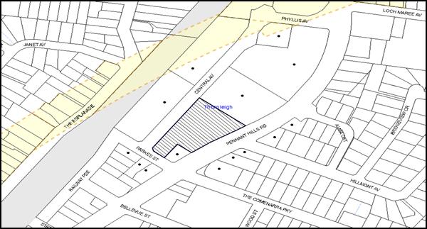
|
NOTIFICATION PLAN |
|
||
|
• PROPERTIES NOTIFIED
|
X SUBMISSIONS RECEIVED |
PROPERTY SUBJECT OF DEVELOPMENT |
|
5.2 Public Agencies
The development application was referred to the Roads and Maritime Services for comment who did not raise any objections to the development.
6. THE PUBLIC INTEREST
Section 79C(1)(e) of the Act requires Council to consider “the public interest”.
The additional documentation submitted with the application has not satisfactorily addressed Council’s criteria and reason for refusal No. 7. As discussed in this report, the development would not provide a development outcome that would result in a positive impact for the community. Accordingly, it is considered that the approval of the proposed development would not be in the public interest.
CONCLUSION
The application is for the review of Council’s determination to refuse DA/619/2015 for the extension of a vehicle sales premise pursuant to Section 82A of the Environmental Planning and Assessment Act 1979. The development proposes the extension of an existing vehicle display area within the adjoining site to display 25 additional vehicles within the landscape strip in front of an existing commercial development.
The additional information submitted with the current application does not meet the desired outcomes of Council’s planning controls and is not considered satisfactory having regard to the matters for consideration under Section 79C of the Environmental Planning and Assessment Act 1979.
In relation to the circumstances of the case, it is recommended that Council uphold its original decision to refuse the development application.
Note: At the time of the completion of this planning report, no persons have made a Political Donations Disclosure Statement pursuant to Section 147 of the Environmental Planning and Assessment Act 1979 in respect of the subject planning application.
RESPONSIBLE OFFICER
The officer responsible for the preparation of this Report is the Manager – Development Assessments – Rodney Pickles, who can be contacted on 9847 6731.
|
Rod Pickles Manager - Development Assessment Planning Division |
James Farrington Group Manager Planning Division |
|
1.View |
Locality Map |
|
|
|
2.View |
Angle Parking Layout Plan |
|
|
|
3.View |
Proposed Car Parking Layout |
|
|
File Reference: DA/619/2015
Document Number: D06895065
SCHEDULE 1
REASONS FOR REFUSAL
1. Pursuant to the provisions of Environmental Planning and Assessment Regulations 2000 insufficient information has been provided to demonstrate that owner’s consent has been granted for the development.
2. Pursuant to the provisions of Section 79C(1)(a)(iii) of the Environmental Planning and Assessment Act, 1979, the proposal does not comply with the minimum 10 metre setback requirement for Thornleigh, as shown in figure 4.2 (i) under Part 4 Business section, of the Hornsby Development Control Plan 2013.
3. Pursuant to the provisions of Section 79C(1)(a)(iii) of the Environmental Planning and Assessment Act, 1979, the proposal does not comply with the ‘Landscaping’ controls of Part 4 – Business of the Hornsby Development Control Plan 2013, as the proposed development would remove landscaping within the approved building setback of the site which would not complement the appearance of the buildings.
4. Pursuant to the provisions of Section 79C(1)(b) of the Environmental Planning and Assessment Act 1979, the application does not demonstrate that sufficient visitor/customer parking spaces provided on site.
5. In accordance with Section 79C(1)(c) of the Environmental Planning and Assessment Act 1979, the site is not suitable for the proposed development for the following reasons:
a) The proposed location would remove the landscaped setting of the existing development on the site;
b) The development would have a detrimental impact on the streetscape contrary to the desired future character of the area as envisaged by Council in Hornsby Development Control Plan 2013; and
c) The additional display area would require five additional visitors car parking spaces that have not been provided.
6. Pursuant to Section 79C (1)(b) and (e) of the Environmental Planning and Assessment Act 1979, approval of the development would set an undesirable precedent for further inappropriate development and would not be in the public interest.
- END OF REASONS FOR REFUSAL -
Group Manager’s Report No. PL10/16
Planning Division
Date of Meeting: 13/04/2016
7 DEVELOPMENT APPLICATION - SUBDIVISION TWO LOTS INTO EIGHT LOTS - NOS. 75-77 BELLAMY STREET, PENNANT HILLS
EXECUTIVE SUMMARY
|
DA No: |
DA/963/2015 (Lodged 5 August 2015) |
|
Description: |
Subdivision of two allotments into eight lots – Community Title Development |
|
Property: |
Lot 22 DP 841114, Lot B DP 411312, Nos. 75-77 Bellamy Street, Pennant Hills |
|
Applicant: |
Icepine Pty Ltd |
|
Owner: |
Icepine Pty Ltd |
|
Estimated Value: |
$400,000 |
|
Ward: |
C |
· The application involves demolition of existing structures and community title subdivision of two allotments into eight lots.
· The proposal generally complies with Hornsby Shire Local Environmental Plan 2013 and would meet the desired outcomes of Hornsby Development Control Plan 2013. The site is partially within a bushfire prone area. NSW Rural Fire Service approval for a bushfire safety authority has been granted for the proposed subdivision.
· 11 submissions have been received in respect of the application.
· A Red Sticker has been placed on the application requiring that it be determined at a Council meeting.
· It is recommended that the application be approved.
|
THAT Development Application No. DA/963/2015 for demolition of existing structures and community title subdivision of two allotments into eight lots at Lot 22 DP 841114, Lot B DP 411312 Nos. 75-77 Bellamy Street, Pennant Hills be approved subject to the conditions of consent detailed in Schedule 1 of Group Manager’s Report No. PL10/16. |
BACKGROUND
On 19 May 1999, Council refused DA/358/1998 for subdivision of three allotments into eight. The proposed subdivision included No. 12 Jackson Crescent and the subject land. The appeal against Council’s refusal of the application was dismissed in the Land and Environment Court on grounds of unsatisfactory lot layout (Proceedings No. 10897 of 1998).
On 2 April 2003, Council refused DA/1083/2002 for demolition of two existing dwellings and erection of a multi-unit housing development comprising eight dwellings and community title subdivision of the subject land. Council refused the application generally on grounds that the proposed dwelling density did not meet the objectives of a low density residential environment.
On 17 September 2014, the applicant attended a Pre DA Meeting (PL/112/2014) for the proposed subdivision of two allotments into eight community title lots. At the meeting the applicant was requested to address lot design, landscape screening of adjoining properties, accessway design, flood design and integrated development requirements.
SITE
The site is located on the western side of Bellamy Street, 90 metres north of the intersection with Stevens Street.
The irregular shaped site has an area of 4,398m2 and comprises two existing battle-axe lots with a combined 11.4m wide x 50m long handle off the western side of Bellamy Street. The site includes two existing dwelling houses with a shared driveway. The house at No. 77 Bellamy Street is derelict. The houses include extensive paved areas. A minor watercourse flows south to north under the driveway via a concrete bridge and through the frontage of adjoining properties fronting Bellamy Street. The watercourse is a tributary of Berowra Creek.
The site benefits from easements over adjoining property No. 73 Bellamy Street for services. A Sydney Water sewer main crosses the shared driveway following the line of the watercourse.
The site has an average fall of 13% to the eastern boundary. The site has a north easterly aspect. The topography is sloping with exposed ground sandstone areas and an uneven eroded gully area in the northern part of the site. The eastern boundary adjoins four dwelling houses with frontage to Bellamy Street. The eastern boundary is unfenced. The adjoining dwelling houses are sited below the level of the subject site and include retaining walls along the boundary which are screened by the existing vegetation on the site.
The northern boundary adjoins an older style dwelling house on a battle-axe lot off Bellamy Street and two dwelling houses fronting Jackson Crescent. The western boundary adjoins four dwelling houses on battle-axe lots off Thorn Street. The southern boundary adjoins three dwelling houses with frontage to Bellamy Street and includes a battle-axe lot.
The Bellamy Street frontage includes remnant trees identified as Blackbutt Gully Forest. The site includes a number of significant trees. The majority of the trees on the site are non-indigenous. The vegetation on No. 77 Bellamy Street is overgrown with bamboo and other noxious weeds.
The north east corner of the site is partly within a bushfire prone area. The bushfire threat is from bushland within Berowra Valley National Park north-east of the site.
The surrounding properties mainly comprise single and two storey dwelling houses on relatively large lots with substantial trees developed since the 1960s and more recent dwelling houses on battle-axe lots. A duplex cluster housing development comprising 12 public housing dwellings is located opposite the site at Nos. 88-94 Bellamy Street.
The site is located 890m north-west of Pennant Hills Railway Station.
PROPOSAL
The proposal is for demolition of existing structures and community title subdivision of two allotments into eight lots including seven residential lots and a community lot which comprises the accessway. The proposed lots are detailed as follows:
Lot 1 (Community Lot) has an area of 769m2 and comprises the proposed accessway which includes the proposed driveway, turning area, associated landscaping, retaining walls, stormwater drainage infrastructure, driveway culvert and waste bin storage facility. The lot includes four trees identified as significant to be retained at the Bellamy Street frontage (Tree No. 1 – White-Mahogany Eucalyptus acmenoides, Tree No. 2 – Deodar-Cedar Cedrus deodara, Tree No. 3 – Smooth-barked-Apple Angphora costata and Tree No. 6 – Turpentine-Syncarpia glomulifera).
Lot 2 is an irregular shaped lot with an area of 507m2. The lot has a width of 12m and reduces to 8.2m over the irregular part of the lot comprising an area of 91.2m2 at the lot frontage. The lot has an average gradient of 14% to the accessway (Lot 1). The proposed lot includes an indicative building envelope of 214.5m2, setback 5.5m from the proposed accessway. The accessway includes a turning head at the lot frontage. The lot includes Tree No. 17 located on the southern boundary and Tree No. 18 on the adjoining land which are identified as significant trees (Turpentine – Syncarpia glomulifera) to be retained.
Lot 3 is irregular in shape at the lot frontage, has an area of 501.5m2 and a width of 12m. The lot includes an indicative building envelope of 241m2, setback 8m from the frontage. The lot has an average fall of 12% to the accessway (Lot 1).
Lot 4 is regular in shape with an area of 517m2 and a width of 12m. The lot includes an indicative building envelope of 276.5m2, setback 8m from the frontage. The lot has an average fall of 10% to the accesway (Lot 1). The lot includes Tree No. 50 identified as significant (Turpentine – Syncarpia glomulifera) located near the rear boundary to be retained.
Lot 5 is regular in shape with an area of 517.5m2 and a width of 12m. The lot includes an indicative building envelope of 279.5m2, setback 7.7m from the frontage. The lot has an average fall of 12% to the accessway (Lot 1).
Lot 6 is a battle-axe lot with an area of 501.5m2 excluding the 1.5m x 6m handle and has a width of 12m. The lot has an average fall of 12% to the eastern boundary. The lot shares a driveway and right of access with proposed Lot 7 along the eastern boundary. The lot includes an indicative building envelope of 272m2, setback 7m from the right of access.
Lot 7 is a battle-axe lot with an area of 513.5m2 excluding the 2m x 18.2m handle and has a width of 11.9m. The lot has an average fall of 13% to the eastern boundary. The lot shares a driveway and right of access with proposed Lot 6. The accessway is across an eroded gully area. The lot includes an indicative building envelope of 260m2.
Lot 8 is an irregular triangular shaped lot with an area of 503m2 and a maximum width of 30.4m, reducing to a frontage of 4.8m to the accessway. The lot has an average gradient of 20% to the eastern boundary and includes an eroded gully area. The lot includes an indicative building envelope of 211m2.
ASSESSMENT
The development application has been assessed having regard to ‘A Plan for Growing Sydney’, the ‘North Subregion (Draft) Subregional Strategy’ and the matters for consideration prescribed under Section 79C of the Environmental Planning and Assessment Act 1979 (the Act). The following issues have been identified for further consideration.
1. STRATEGIC CONTEXT
1.1 A Plan for Growing Sydney and (Draft) North Subregional Strategy
A Plan for Growing Sydney has been prepared by the NSW State Government to guide land use planning decisions for the next 20 years. The Plan sets a strategy for accommodating Sydney’s future population growth and identifies the need to deliver 689,000 new jobs and 664,000 new homes by 2031. The Plan identifies that the most suitable areas for new housing are in locations close to jobs, public transport, community facilities and services.
The NSW Government will use the subregional planning process to define objectives and set goals for job creation, housing supply and choice in each subregion. Hornsby Shire has been grouped with Hunters Hill, Ku-ring-gai, Lane Cove, Manly, Mosman, North Sydney, Pittwater, Ryde, Warringah and Willoughby to form the North Subregion. The Draft North Subregional Strategy will be reviewed and the Government will set housing targets and monitor supply to ensure planning controls are in place to stimulate housing development.
The proposed development would be consistent with ‘A Plan for Growing Sydney’, by providing additional residential allotments and would contribute to future housing supply in the locality.
2. STATUTORY CONTROLS
Section 79C(1)(a) requires Council to consider “any relevant environmental planning instruments, draft environmental planning instruments, development control plans, planning agreements and regulations”.
2.1 Hornsby Local Environmental Plan 2013
The proposed development has been assessed having regard to the provisions of the Hornsby Local Environmental Plan 2013 (HLEP).
2.1.1 Zoning of Land and Permissibility
The subject land is zoned R2 Low Density Residential under the HLEP. The objectives of the R2 zone are:
(a) To provide for the housing needs of the community within a low density residential environment.
(b) To enable other land uses that provide facilities or services to meet the day to day needs of residents.
The proposed subdivision is permissible in the zone with Council’s consent pursuant to Clause 4.1 of the HLEP.
2.1.2 Minimum Subdivision Lot Size
Clause 4.1 of the HLEP provides that the size of any lot resulting from the subdivision of land, excluding the area of the access handle, must not be less than the minimum size shown on the Lot Size Map. The minimum lot size for the subject site is 500m2. The proposed subdivision complies with this requirement.
2.1.3 Heritage Conservation
Clause 5.10 of the HLEP sets out heritage conservation provisions for Hornsby Shire. The site does not include a heritage item and is not located in a heritage conservation area. Accordingly, no further assessment regarding heritage is necessary.
2.1.4 Earthworks
Clause 6.2 of the HLEP states that consent is required for proposed earthworks on site. Before granting consent for earthworks, Council is required to assess the impacts of the works on adjoining properties, drainage patterns and soil stability of the locality.
The construction of the proposed accessway would require earthworks and landform modification.
Council’s assessment of the proposed earthworks and land modification concludes that subject to recommended conditions for soil and water management and retaining walls, the proposal would not impact on adjoining properties, drainage patterns or soil stability.
2.2 State Environmental Planning Policy No. 32 – Urban Consolidation (Redevelopment of Urban Land) (SEPP 32)
The application has been assessed against the requirements of SEPP 32, which requires Council to implement the aims and objectives of this Policy to the fullest extent practicable when considering development applications relating to redevelopment of urban land. The application complies with the objectives of the Policy as it would promote the social and economic welfare of the locality and would result in the orderly and economic use of under-utilised land within the Shire.
2.3 State Environmental Planning Policy No. 55 – Remediation of Land
State Environmental Planning Policy No. 55 (SEPP 55) requires that consent must not be granted to the carrying out of any development on land unless it has considered whether the land is contaminated or requires remediation for the proposed use.
The site has been used for residential purposes and is unlikely to be contaminated. Further assessment in this regard is not warranted.
2.4 Sydney Regional Environmental Plan No. 20 – Hawkesbury – Nepean River
The site is located within the catchment of the Hawkesbury Nepean River. Part 2 of this Plan contains general planning considerations and strategies requiring Council to consider the impacts of development on water quality, aquaculture, recreation and tourism.
Subject to the implementation of sediment and erosion control measures and stormwater management to protect water quality, the proposal would comply with the requirements of the Policy.
2.5 Rural Fires Act 1997
The proposed subdivision is integrated development subject to approval of the NSW Rural Fire Service for the issue of a Bush Fire Safety Authority pursuant to Section 100B of the Rural Fires Act 1997.
The NSW Rural Fire Service has raised no objections and has issued a Bush Fire Safety Authority for the proposed subdivision subject to conditions including asset protection zones, water and utilities, and access.
2.6 Water Management Act 2000
The site is traversed by a watercourse tributary of Berowra Creek. Pursuant to Clause 91 of the Act, a ‘controlled activity’ permit from the Department of Primary Industries – Water (DPI - Water) is required for development within 40m of a watercourse.
The watercourse forms part of the local stormwater drainage system in this location.
DPI - Water advised Council the watercourse through the site is considered a drainage channel and there is no requirement for a ‘controlled activity’ permit for the proposed development.
2.7 Clause 74BA Environmental Planning and Assessment Act, 1979 - Purpose and Status of Development Control Plans
Clause 74BA of the Environmental Planning and Assessment Act, 1979 states that a DCP provision will have no effect if it prevents or unreasonably restricts development that is otherwise permitted and complies with the development standards in relevant Local Environmental Plans and State Environmental Planning Policies.
The principal purpose of a development control plan is to provide guidance on the aims of any environmental planning instrument that applies to the development; facilitate development that is permissible under any such instrument; and achieve the objectives of land zones. The provisions contained in a DCP are not statutory requirements and are for guidance purposes only. Consent authorities have flexibility to consider innovative solutions when assessing development proposals, to assist achieve good planning outcomes.
2.8 Hornsby Development Control Plan 2013
The proposed subdivision has been assessed having regard to the relevant desired outcomes and prescriptive requirements within the Hornsby Development Control Plan 2013 (HDCP). The following table sets out the proposal’s compliance with the prescriptive requirements of the Plan:
|
Hornsby Development Control Plan 2013 |
|||
|
Control |
Proposal |
Requirement |
Compliance |
|
Lot Size (Allotment sizes excluding the access handle) |
Lot 2 – 507m2 Lot 3 – 501.5m2 Lot 4 – 517m2 Lot 5 – 517.4m2 Lot 6 – 501.5m2 Lot 7 – 513.5m2 Lot 8 – 503m2 |
500m2 (min) |
Yes |
|
Accessway Width |
7.81m (min) |
6.65m (min) |
Yes |
|
Indicative Building Envelope |
211m2 – 276.5m2 |
200m2 |
Yes |
As detailed in the above table, the proposed subdivision complies with prescriptive requirements within the HDCP. The following is a brief discussion on compliance with relevant desired outcomes.
2.8.1 General Provisions
The HDCP includes the following desired outcomes.
a. Subdivision design that provides usable allotments that relate to site conditions.
b. Subdivision design that provides for the retention of significant landscape features and respects site constraints including: significant trees, remnant bushland, steep topography, watercourses, riparian land and stormwater overland flow paths, and bushfire hazard asset protection zones.
c. Subdivision design that provides for all necessary services and facilities, including any required extension or amplification to Council infrastructure.
The proposed subdivision layout and lot design have regard to the sloping topography and the north easterly aspect of the site, would provide useable areas for a range of low density housing types, retain significant trees and provide for bushfire protection.
The proposal includes replacement of the existing bridge over the watercourse with a culvert with design capacity for a 1 in 100 year storm. The proposed lots, including the accessway, would be flood free.
2.8.2 Residential Lands Subdivision
The HDCP includes the following desired outcomes:
a. Subdivision design should maintain appropriately shaped lots to accommodate a dwelling and associated development that is compatible with a low density residential environment.
b. Subdivision design should provide setbacks to developable areas that will: complement the streetscape, provide for landscaping, protect landscape features, and provide separation between existing and future dwellings.
The proposed lots are appropriately shaped to conform to the configuration of the site and the proposed accessway. Proposed lots 2, 3, 4, 5, 6 and 8 comply with the 12m minimum lot width prescriptive measure and would accommodate a 200m2 indicative building envelope clear of required setbacks to boundaries and trees to be retained. Proposed Lot 7 has a width of 11.92m. The non-compliance with the minimum width is acceptable with regard to the minor variation and location on the northern boundary with existing larger adjoining properties. The proposed indicative building envelopes would enable the provision of private open space and on-site car parking in accordance with the HDCP prescriptive measures.
2.8.3 Accessway Design
The HDCP includes the following desired outcomes:
a. To ensure access along private accessways to all new lots is simple, safe and direct.
b. Driveway should not be visually intrusive to the existing streetscape.
c. To limit the number of driveway crossings and additional dwellings with direct access to main roads to limit the cumulative impacts on traffic flows and safety.
The proposed accessway would be located over the existing handles of the two battleaxe lots and would extend along the eastern boundary of the site. The extended accessway involves cut and fill to provide a uniform level increasing from RL155.5m to RL157.0m at the rear of No. 79 and No. 81A Bellamy Street respectively. The two adjoining properties include retaining walls along their rear boundaries at RL 155m. The two existing dwellings are setback > 3.0m and < 7.5m from the boundary.
The proposed driveway is setback 2.0m to 3.5m from the eastern boundary. The proposed landscaping within the setback area would provide adequate screening of the driveway in relation to adjoining residents. Where the driveway is more than 0.5m above ground level, a guard rail is required in accordance with AS2890.1.
The proposed accessway is in accordance with the HDCP requirement for a minimum width of 6.65m for the proposed seven residential lots. The proposed driveway width reduces to 4m for proposed lots 3, 4, 5, 6 and 7. The 4m driveway width is in accordance with the NSW Rural Fire Service requirements in Planning for Bushfire Protection Guidelines 2006. A condition is recommended for the landscaping to be maintained in accordance with the submitted landscape plan.
The proposed accessway includes a common turning area and passing bays in compliance with the HDCP accessway design requirements. The proposed accessway would retain the existing driveway crossing and trees at the street frontage. In this regard, the proposal would maintain the existing streetscape.
The proposed subdivision includes a waste bin storage facility on the northern side of the accessway near the frontage. The storage facility is designed for Council’s waste collection vehicle to reverse onto the driveway for waste collection and forward out. The proposed driveway enables vehicles to pass when a collection vehicle is standing on the driveway.
The proposed accessway meets the HDCP desired outcome for accessway design subject to recommended conditions.
2.8.4 Stormwater Management
A natural watercourse traverses the access handles of the site and forms part of Council’s stormwater drainage system.
The site experiences overland flows from neighbouring properties along the western boundary in the direction of the watercourse. Appropriate conditions are recommended for intercepting and diverting these stormwater water flows to the watercourse.
The proposal includes the upgrading of the existing culvert for the 1 in 100 year storm and for construction of on-site stormwater detention within the proposed driveway. Appropriate conditions are recommended to ensure the post development stormwater flows remain the same as pre-development.
The recommended conditions require the proposed stormwater drainage line on the lower side of the driveway to be relocated within the driveway to improve utility design and landscaping.
Subject to recommended conditions the proposed subdivision would meet the HDCP desired outcomes for stormwater management.
2.9 Section 94 Contributions Plans
Hornsby Shire Council Section 94 Contributions Plan 2012-2021 applies to the development as it would result in an additional five residential lots in lieu of the two existing residences. Accordingly, the requirement for a monetary Section 94 contribution is recommended as a condition of consent.
3. ENVIRONMENTAL IMPACTS
Section 79C(1)(b) of the Act requires Council to consider “the likely impacts of that development, including environmental impacts on both the natural and built environments, and social and economic impacts in the locality”.
3.1 Natural Environment
3.1.1 Tree and Vegetation Preservation
The site includes 13 trees of which Trees No. 1 – Eucalyptus acmeniodes (White Mahogany), Tree No. 2 – Cedrus deodara (Deodar Cedar), Tree No. 3 – Angophora costata (Smooth-barked Apple), Trees Nos. 17, 18 and 50 – Syncarpia glomulifera (Turpentine), are identified as significant trees and are proposed to be retained.
Tree No. 8 – Syzygium paniculatum (Magenta Lilly Pilly) and Trees Nos. 56 and 58 – Pittosporum undulatum (Sweet Pittosporum) would be removed. Magenta Lilly Pilly is listed as endangered under Schedule 1 of the Threatened Species Conservation Act 1995. The tree however, is a horticultural planting in an area that does not include habit for Syzygium paniculatum. Trees Nos. 56 and 58 (Sweet Pittosporum) are locally indigenous but are considered an invasive species and would not warrant protection. The proposed removal of Trees Nos. 8, 56 and 58 is therefore acceptable.
The remaining vegetation on the site primarily consists of non-indigenous tree species and noxious weeds species. Appropriate conditions are recommended for the removal of noxious weeds on the site.
A condition is recommended for the submitted landscaping plan to be amended to include locally indigenous plant species.
3.1.2 Natural Watercourse
The proposed subdivision includes upgrading of the existing watercourse culvert across the accessway. A condition is recommended for the area to be rehabilitated with riparian vegetation to stabilise the banks of the watercourse.
3.2 Built Environment
3.2.1 Built Form
Proposed lots 2 to 7 would form a regular pattern for future dwelling houses and provide appropriate spatial arrangement in relation to neighbouring houses with uniform front, rear and side setbacks. Proposed lot 8 is an irregular shaped lot occupying the north eastern triangular shaped part of the site. A dwelling house could be designed for the lot with regard to building separation and privacy.
3.2.2 Traffic
The proposed subdivision would generate 33 daily vehicle trips in accordance with the Roads and Maritime Services Technical Direction – Guide To Traffic Generating Developments dated August 2013 which estimates 6.66 daily trips per dwelling.
Council’s engineering assessment of the traffic impacts of the development concludes the proposed traffic generation is acceptable in respect to the capacity of the local road network.
3.3 Social Impacts
The proposed subdivision would provide opportunity for additional dwelling houses in a locality well provided with public infrastructure, transport and community facilities and would be of positive social impact.
3.4 Economic Impacts
The proposal would have a minor positive impact on the local economy in conjunction with other new low density residential development in the locality by generating an increase in demand for local services.
4. SITE SUITABILITY
Section 79C(1)(c) of the Act requires Council to consider “the suitability of the site for the development”.
4.1 Flooding
The existing and proposed accessway is subject to the 1 in 100 year flood level of a minor watercourse drainage system. The proposal includes upgrading of the accessway with a new culvert designed for a 1 in 100 year storm, thus providing flood free access.
The proposed stormwater drainage works include on-site stormwater detention to ensure pre-development flows are maintained. In this regard, the proposal would not increase the flood risk of downstream properties.
4.2 Bushfire Risk
The land is partly within a bushfire prone area being in the vicinity of Berowra Valley National Park north of the site.
The NSW Rural Fire Service recommends appropriate conditions for bushfire protection.
5. PUBLIC PARTICIPATION
Section 79C(1)(d) of the Act requires Council to consider “any submissions made in accordance with this Act”.
5.1 Community Consultation
The proposed development was placed on public exhibition and was notified to adjoining and nearby landowners between 19 August and 19 September 2015 in accordance with the Notification and Exhibition requirements of the HDCP. During this period, Council received 11 submissions. The map below illustrates the location of those nearby landowners who made a submission that are in close proximity to the development site.
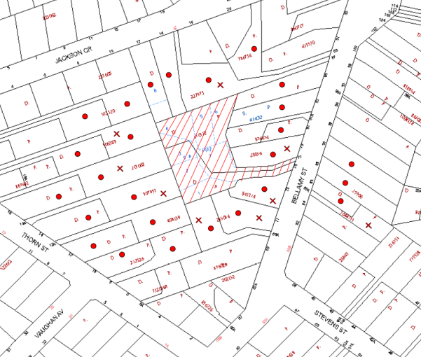
|
NOTIFICATION PLAN |
|
||
|
• PROPERTIES NOTIFIED
|
X SUBMISSIONS RECEIVED |
PROPERTY SUBJECT OF DEVELOPMENT |
|
|
TWO SUBMISSIONS RECEIVED OUT OF MAP RANGE |
|||
Eleven submissions objected to the development. The matters raised by the objectors are discussed as follows:
5.1.1 Traffic Impact on Road Safety
The increase in traffic was raised as a concern for the operation of the intersection of Stevens Street and Bellamy Street and for road safety.
The proposed traffic generation involving 33 daily vehicle trips would not detract from the operation of the local road network and is acceptable in respect to road safety.
The proposed waste collection operation would involve the waste truck reversing onto the driveway for collection from the proposed waste facility at the frontage. The proposed driveway is sufficiently wide to enable vehicles to pass when the waste truck is standing on the driveway.
5.1.2 Dwelling Density and Residential Amenity
The number of proposed lots and potential loss of privacy and solar access resulting from future two storey dwelling houses was raised as a concern.
The proposed lots are generally of uniform shape and size and would enable future dwellings to be designed for solar access and privacy. A maximum building height of 8.5m (two storey) is permissible in accordance with the HLEP.
5.1.3 Stormwater Drainage and Flooding
The impact of stormwater drainage flows through the site from adjacent properties fronting Thorn Street was raised as a concern regarding the need for easements and impacts of flooding.
The proposed stormwater drainage system is subject to a recommended condition for drainage control measures along the western boundary of the site to divert sheet flow from neighbouring properties to the natural watercourse.
The existing drainage line across the driveway is to be upgraded for a new culvert with capacity for the 1 in 100 year storm event. The proposed subdivision would not increase the flooding risk for downstream properties.
5.1.4 Loss of Trees
The loss of existing trees on the site in particular Tree No. 3 – Angophora costata (Smooth-barked Apple) and Tree No. 8 – Syzgium paniculatum (Magenta Lilly Pilly) was raised as a concern.
The proposed waste bin storage facility has been relocated to the northern side of the driveway to retain the locally indigenous Tree No. 3.
The proposed driveway is within the structural root zone of Tree No. 8 located at the frontage of proposed Lot 3. The proposed removal of Tree No. 8 is acceptable as discussed in Section 3.1.1.
The design of the proposed driveway has been amended to increase the area of landscaping. The proposed landscaping would provide adequate screening of the driveway for neighbouring residents and replace dense vegetation along the boundary of the site.
5.1.5 Visual and Acoustic Amenity
The impact of the proposal on visual quality and the acoustic environment was raised as a concern.
The proposal would not impact on the existing streetscape which would be maintained. The proposal would retain the majority of the locally indigenous trees on the site.
The proposed accessway is in close proximity to the existing dwelling houses. The submitted landscape plan includes a 2.5m-3.0m wide landscaping strip along the accessway which would provide effective screening of the driveway. A condition is recommended for fencing of the boundaries of the site which together with landscaping would mitigate noise impacts from the operation of the driveway.
5.2 Public Agencies
The development application is ‘integrated development’ subject to approval of the NSW Rural Fire Service for a Bushfire Safety Authority.
The Rural Fire Service granted its approval for a Bushfire Safety Authority subject to conditions for the subdivision to be designed in accordance with Planning for Bushfire Protection Guidelines 2006 criteria for accessway design and asset protection.
6. THE PUBLIC INTEREST
Section 79C(1)(e) of the Act requires Council to consider “the public interest”.
The public interest is an overarching requirement, which includes the consideration of the matters discussed in this report. Implicit to the public interest is the achievement of future built outcomes adequately responding to and respecting the future desired outcomes expressed in environmental planning instruments and development control plans.
The application is considered to have satisfactorily addressed Council’s and relevant agencies’ criteria and would provide a development outcome that, on balance, would result in a positive impact for the community. Accordingly, it is considered that the approval of the proposed development would be in the public interest.
CONCLUSION
The proposal is for demolition of existing structures and subdivision of two allotments into eight community title lots.
The proposed subdivision complies with Hornsby Local Environmental Plan 2013 and generally meets the prescriptive measures of the Hornsby Development Control Plan 2013 for residential subdivision, accessway design, tree preservation, stormwater management and waste management.
The proposed subdivision includes an area of bushfire prone land. The NSW Rural Fire Service would grant a Bushfire Safety Authority for the proposal subject to recommended conditions.
Eleven submissions were received in response to notification of the application.
The application is recommended for approval.
RESPONSIBLE OFFICER
The officer responsible for the preparation of this Report is the Manager – Development Assessments – Rodney Pickles, who can be contacted on 9847 6731.
|
Rod Pickles Manager - Development Assessment Planning Division |
James Farrington Group Manager Planning Division |
|
1.View |
Locality Plan |
|
|
|
2.View |
Subdivision Plan |
|
|
|
3.View |
Landscape Plan |
|
|
|
4.View |
Accessway Design Plans |
|
|
File Reference: DA/963/2015
Document Number: D06860191
SCHEDULE 1
GENERAL CONDITIONS
The conditions of consent within this notice of determination have been applied to ensure that the use of the land and/or building is carried out in such a manner that is consistent with the aims and objectives of the relevant legislation, planning instruments and council policies affecting the land and does not disrupt the amenity of the neighbourhood or impact upon the environment.
Note: For the purpose of this consent, the term ‘applicant’ means any person who has the authority to act on or the benefit of the development consent.
Note: For the purpose of this consent, any reference to an Act, Regulation, Australian Standard or publication by a public authority shall be taken to mean the gazetted Act or Regulation, or adopted Australian Standard or publication as in force on the date that the application for a construction certificate is made.
1. Approved Plans and Supporting Documentation
The development must be carried out in accordance with the plans and documentation listed below and endorsed with Council’s stamp, except where amended by Council and/or other conditions of this consent:
|
Plan No. |
Plan Title |
Drawn by |
Dated |
|
12848_DET_C |
Plan Showing Detail and Levels & Proposed Subdivision |
Survey Plus |
27.05.2015 |
|
1 of 2 Revision B |
Landscape Plan |
Stylish Gardens |
15/2/16 |
|
2 of 2 Revision B |
Plant Schedule & Specifications |
Stylish Gardens |
15/2/16 |
|
1676 – Cover Sheet 01 of 04 Rev C |
Access Driveway Concept design |
Storm Consulting |
12.02.16 |
|
1676 – P02 Sheet 02 of 04 Rev C |
Access Driveway Concept Design |
Storm Consulting |
12.02.16 |
|
1676 – D03 Sheet 03 of 04 Rev C |
Access Driveway Concept Design |
Storm Consulting |
12.02.16 |
|
1676 – P04 Sheet 04 of 04 Rev C |
Access Driveway Concept Design |
Storm Consulting |
12.02.16 |
|
Document Title |
Prepared by |
Dated |
|
Arboricultural Impact Assessment |
Australis Tree Management |
21 July 2015 |
|
Bushfire Hazard Assessment Report |
Building Code & Bushfire Hazard Solutions Pty Limited |
20 July 2015 |
|
Stormwater OSD and Flood Design |
Storm Consulting |
10 July 2015 |
|
Waste Management Plan |
SurveyPlus |
March 2016 |
2. Removal of Existing Trees
a) This development consent permits the removal of trees numbered 8, 56 and 58 as identified on plan number Figure 2 Site Map within the Arboricultural Impact Assessment prepared by Australis Tree Management, dated 21 July 2015.
b) The removal of any other trees requires separate approval in accordance with the Tree and Vegetation Chapter 1B.6 Hornsby Development Control Plan (HDCP).
3. Amendment of Plans
a) To comply with Councils requirement in terms of Section 1C.2.9 of HDCP, the approved plans are to be amended as follows:
i) The landscape plan is to be amended to include plantings of locally indigenous plants species including six Syncarpia glomulifera (Turpentine). Refer: http://www.hornsby.nsw.gov.au/media/documents/environment-and-waste/bushland-and-biodiversity/gardening-with-natives/Create-a-Native-Garden-Southern-Suburbs.pdf
ii) The landscape plan is to be amended to address Condition No. 12 d).
b) The amended plans must be submitted with the application for the Construction Certificate.
4. Construction Certificate
a) A Construction Certificate is required to be approved by Council or a Private Certifying Authority prior to the commencement of any works under this consent.
b) A separate Construction Certificate must be obtained from Council for all works within the public road reserve under S138 of the Roads Act.
c) A separate Construction Certificate must be obtained from Council for all works within drainage easements vested in Council.
d) The Construction Certificate plans must not be inconsistent with the Development Consent plans.
5. Section 94 Development Contributions
a) In accordance with Section 80A(1) of the Environmental Planning and Assessment Act, 1979 and the Hornsby Shire Council Section 94 Development Contributions Plan 2014-2024, the following monetary contributions must be paid to Council to cater for the increased demand for community infrastructure resulting from the development:
|
Description |
Contribution (4) |
|
Roads |
$11,683.25 |
|
Open Space and Recreation |
$57,867.10 |
|
Community Facilities |
$30,316.70 |
|
Plan Preparation and Administration |
$132.96 |
|
TOTAL |
$100,000.00 |
being for 7 residential lots and including a credit for two existing lots.
b) The value of this contribution is current as at 10 March 2016. If the contribution is not paid within the financial quarter that this condition was generated, the contribution payable will be adjusted in accordance with the provisions of the Hornsby Shire Council Section 94 Development Contributions Plan and the amount payable will be calculated at the time of payment in the following manner:
$CPY = $CDC x CPIPY
CPIDC
Where:
$CPY is the amount of the contribution at the date of Payment
$CDC is the amount of the contribution as set out in this Development Consent
CPIPY is the latest release of the Consumer Price Index (Sydney – All Groups) at the date of Payment as published by the ABS.
CPIDC is the Consumer Price Index (Sydney – All Groups) for the financial quarter at the date applicable in this Development Consent Condition.
c) The monetary contribution must be paid to Council:
i) prior to the issue of the Subdivision Certificate where the development is for subdivision; or
ii) prior to the issue of the first Construction Certificate where the development is for building work; or
iii) prior to issue of the Subdivision Certificate or first Construction Certificate, whichever occurs first, where the development involves both subdivision and building work; or
iv) prior to the works commencing where the development does not require a Construction Certificate or Subdivision Certificate.
Note: It is the professional responsibility of the Principal Certifying Authority to ensure that the monetary contributions have been paid to Council in accordance with the above timeframes.
Council’s Development Contributions Plan may be viewed at www.hornsby.nsw.gov.au or a copy may be inspected at Council’s Administration Centre during normal business hours.
REQUIREMENTS PRIOR TO THE ISSUE OF A CONSTRUCTION CERTIFICATE
6. Building Code of Australia
All approved building work must be carried out in accordance with the relevant requirements of the Building Code of Australia.
7. Utility Services
The applicant must submit written evidence of the following service provider requirements:
a) Ausgrid (formerly Energy Australia) – a letter of consent demonstrating that satisfactory arrangements have been made to service the proposed development.
b) Telstra - a letter of consent demonstrating that satisfactory arrangements have been made to service the proposed development.
8. Dilapidation Report
a) A ‘Dilapidation Report’ is to be prepared by a ‘chartered structural engineer’ detailing the structural condition of adjoining properties Nos. 73, 79, 81A and 83 Bellamy Street, Pennant Hills.
b) To record the structural condition of all properties adjoining the approved development, a dilapidation report must be prepared by a suitably qualified structural engineer for inclusion with the application of the Construction Certificate.
9. Identification of Survey Marks
A registered surveyor must identify all survey marks in the vicinity of the proposed development. Any survey marks required to be removed or displaced as a result of the proposed development shall be undertaken by a registered surveyor in accordance with Section 24 (1) of the Surveying and Spatial Information Act 2002 and following the Surveyor General’s Directions No.11 – "Preservation of Survey Infrastructure".
10. Stormwater Drainage
The stormwater drainage system for the development must be designed in accordance with Council’s Civil Works – Design and Construction Specification 2005 and the following requirements:
a) In order to protect against nuisance flooding, an interception swale and piped drainage system to catch the design 100 year average recurrence interval (ARI) overland storm flow from upstream catchments shall be designed and approved for construction. The swale/piped drainage system shall be designed and constructed along the western boundary of the subject site, and drained via gravity in a piped system to the natural watercourse crossing the sites’ access handles separately from the proposed internal drainage system;
b) The hydrologic and hydraulic analysis and construction detail for the interception swale and piped drainage system shall be submitted with construction plans;
c) An inter-allotment stormwater drainage system to service all proposed lots in the subdivision with pits being cast in situ or pre-cast concrete pits being used. The internal interallotment drainage system shall be connected to the proposed on-site detention (OSD) system;
d) The OSD system shall be designed and proposed for construction at a level to permit the connection of proposed Lot 8’s roofed areas at least, to drain via gravity to the system;
e) The proposed internal driveway pavement shall provide crossfall, kerbing and a piped drainage system capable of draining the 20 year ARI to the proposed connection point at the natural watercourse. Additional details are provided in condition No. 13.
11. On Site Stormwater Detention
An on-site stormwater detention system must be designed by a chartered civil engineer and constructed in accordance with Council’s OSD Specification and the following requirements:-
a) Have a capacity of not less than 55 cubic metres, and a maximum discharge (when full) of 40 litres per second;
b) Have a surcharge/inspection grate located directly above the control orifice ;
c) Subsequent to the control orifice, have a separate overflow chamber to permit surcharge weir flows to be drained by the internal piped drainage system;
d) Discharge from the detention system must be controlled via 1 metre length of pipe, not less than 50 millimetres diameter or via a stainless plate with sharply drilled orifice bolted over the face of the outlet discharging into a larger diameter pipe capable of carrying the design flow to an approved Council system;
e) Not be constructed in a location that would impact upon the visual or recreational amenity of residents.
12. Natural Watercourse Driveway and Drainage System
The stormwater drainage system for the development must be designed in accordance with Council’s Civil Works – Design and Construction Specification 2005 and the following requirements:
a) The existing structure shall be demolished and the proposed culvert or bridge and abutments shall be designed by a Chartered Civil or Structural Engineer;
b) The driveway shall provide for vehicle and pedestrian safety with provision of structural car barriers and hand railing. Details to be included on the plans;
c) The proposed bridge or culvert over the natural watercourse shall have a flowing-full capacity of at least the 100 year average recurrence interval (ARI) design storm flow from the upstream catchment with the following requirements:
i) the design storm top water level in the culvert must permit freeboard of at least 0.5m to the soffit level of the bridge beam or culvert;
ii) The width of the culvert or distance between bridge abutments must ensure no constriction or backwater effect for the design storm flow;
d) Rehabilitation of disturbed areas with a landscaping plan containing suitable riparian species as per requirements of ‘Guidelines for Controlled Activities - Vegetation Management Plans’. Refer to http://www.water.nsw.gov.au/water-management/law-and-policy/key-policies;
e) Construction Plans shall be submitted for consideration and approval with the following information:
i) A catchment plan, including sub-catchments from adjoining streets;
ii) Run off calculations (Hydrological and Hydraulic) according to Australian Rainfall and Run off 1987, as well as all electronic files for any computer generated modelling of the flow path;
iii) A detailed site plan including topography of existing and post development levels, showing how the design flow is conveyed in the natural watercourse, as well as;
iv) A site contour plan of the area affected by the 100 year ARI storm flow path.
13. Internal Driveways/Vehicular Areas
The driveway and parking areas on site must be designed, constructed and a Construction Certificate issued in accordance with Australian Standards 2890.1, 2890.2, 3727 and the following requirements:
a) Design levels at the front boundary shall be obtained from Council via a separate application to Hornsby Council’s Crossings Engineer for Crossing Levels;
b) The driveways be rigid pavements. All shared driveways are to be designed and constructed;
c) For cars, the driveway grade must not exceed 25 percent and transitions for changes in grade must not exceed 8 percent per plan metre;
d) For waste truck access, driveway grade and transitions shall comply with AS 2890.2;
e) The driveway pavement be a minimum 3 metres wide (where single width), 0.15 metres thick reinforced concrete with SL72 steel reinforcing fabric and a 0.15 metre sub-base.
f) Driveway set out shall also comply with the Rural Fire Service guidelines “Planning for Bushfire Protection”;
g) The pavement have a kerb to one side at least, a one-way cross fall with a minimum gradient of 2 percent and kerb inlets and pits provided on grade and at low points;
h) Retaining walls required to support the carriageway, car barrier and handrail protection and the compaction of all fill batters to be in accordance with the requirements of a chartered structural engineer;
i) Conduit for utility services including electricity, water, gas and telephone be provided on plans. Construction plans shall provide base preparation and concrete slab jointing details;
j) A common turning area to service the proposed subdivision in accordance with Australian Standards AS 2890.1 to ensure vehicles can enter and leave the site in a forward direction. A right of access shall be created over the turning area to ensure access is maintained at all times;
k) Construction of pedestrian access designed to help prevent slip and fall shall be designed and constructed with the future access driveway. Pedestrian grades steeper than 12.5% shall be provided with surface texturing, brushing or cleats to satisfy Class V: R11 ramps in accordance with AS 4586-2004 Clause 5.2.
14. Vehicular Crossing
A separate application under the Local Government Act, 1993 and the Roads Act 1993 must be submitted to Council for the installation of a new vehicular crossing and the removal of the redundant crossing. The vehicular crossing must be constructed in accordance with Council’s Civil Works Design 2005 and the following requirements:-
a) Design levels at the front boundary must be obtained from Council for the design on the internal driveway;
b) Any redundant crossings must be replaced with integral kerb and gutter.
Note: An application for a vehicular crossing can only be made to one of Council’s Authorised Vehicular Crossing Contractors, or be the subject of a Construction Certificate to Hornsby Shire Council as the Roads Authority. You are advised to contact Council on 02 9847 6940 to obtain a list of contractors.
15. Traffic Control Plan
A Traffic Control Plan (TCP) must be prepared by a qualified traffic controller in accordance with the Roads & Traffic Authority’s Traffic Control at Worksites Manual 1998 and Australian Standard 1742.3 for all work on a public road. The Traffic Management Plan shall be submitted and approved by Council’s Manager Traffic and Road Safety prior to the issue of a construction certificate. The TCP must detail the following:
a) Arrangements for public notification of the works;
b) Temporary construction signage;
c) Permanent post-construction signage;
d) Vehicle movement plans;
e) Traffic management plans; and
f) Pedestrian and cyclist access/safety.
16. Waste Management Details
The following waste management requirements must be complied with:
a) From no greater than 6m from the Boundary Street boundary, the driveway pavement must be no less than 6.5m wide for no less than 18 m.
Note: Bins are to be placed along the northern side of this 18 m long section of driveway for servicing by the side loader heavy rigid waste collection vehicle, which is to reverse in and forward out of the driveway.
b) The section of the driveway to be used by waste collection vehicles, must be designed in compliance with Australian Standard AS2890.2-2002 Parking Facilities Part 2: Off-street Commercial Vehicle Facilities for heavy rigid vehicles.
c) A Waste Management Plan Section One – Demolition Stage and Section Three – Construction Stage, covering the scope of this project and including the following details, is required to be submitted to Council:
i) An estimate of the types and volumes of waste and recyclables to be generated;
ii) A site plan showing sorting and storage areas for demolition and construction waste and the vehicle access to these areas;
iii) How excavation, demolition and construction waste materials will be reused or recycled and where residual wastes will be disposed;
iv) The total percentage (by weight) of demolition and construction waste that will be reused or recycled.
d) Prior to the issue of a Construction Certificate, a Certificate from an appropriate qualified Traffic Engineer is to be submitted to the Principal Certifying Authority (PCA) certifying that the drive way entry complies with AS 2890.2 for heavy rigid vehicles and the approved Development Consent plans and conditions.
17. Acoustic Barrier
The car barrier required along the eastern side of the driveway is to be designed to form a 1.8m high acoustic barrier.
REQUIREMENTS PRIOR TO THE COMMENCEMENT OF ANY WORKS
18. Erection of Construction Sign
a) A sign must be erected in a prominent position on any site on which any approved work is being carried out:
i) Showing the name, address and telephone number of the principal certifying authority for the work;
ii) Showing the name of the principal contractor (if any) for any demolition or building work and a telephone number on which that person may be contacted outside working hours; and
iii) Stating that unauthorised entry to the work site is prohibited.
b) The sign is to be maintained while the approved work is being carried out and must be removed when the work has been completed.
19. Protection of Adjoining Areas
A temporary hoarding, fence or awning must be erected between the work site and adjoining lands before the works begin and must be kept in place until after the completion of the works if the works:
a) Could cause a danger, obstruction or inconvenience to pedestrian or vehicular traffic;
b) Could cause damage to adjoining lands by falling objects; and/or
c) Involve the enclosure of a public place or part of a public place.
Note: Notwithstanding the above, Council’s separate written approval is required prior to the erection of any structure or other obstruction on public land.
20. Toilet Facilities
a) To provide a safe and hygienic workplace, toilet facilities must be available or be installed at the works site before works begin and must be maintained until the works are completed at a ratio of one toilet for every 20 persons employed at the site.
b) Each toilet must:
i) be a standard flushing toilet connected to a public sewer; or
ii) be a temporary chemical closet approved under the Local Government Act 1993; or
iii) have an on-site effluent disposal system approved under the Local Government Act 1993.
21. Erosion and Sediment Control
To protect the water quality of the downstream environment, erosion and sediment control measures must be provided and maintained throughout the construction period in accordance with the manual ‘Soils and Construction 2004 (Bluebook)’, the approved plans, Council specifications and to the satisfaction of the principal certifying authority. The erosion and sediment control devices must remain in place until the site has been stabilised and revegetated.
Note: On the spot penalties may be issued for any non-compliance with this requirement without any further notification or warning.
REQUIREMENTS DURING CONSTRUCTION
22. Construction Work Hours
All works on site, including demolition and earth works, must only occur between 7am and 5pm Monday to Saturday.
No work is to be undertaken on Sundays or public holidays.
23. Demolition
To protect the surrounding environment, all demolition work must be carried out in accordance with “Australian Standard 2601-2001 – The Demolition of Structures” and the following requirements:
a) Demolition material must be disposed of to an authorised recycling and/or waste disposal site and/or in accordance with an approved waste management plan;
b) Demolition works, where asbestos material is being removed, must be undertaken by a contractor that holds an appropriate licence issued by WorkCover NSW in accordance with Chapter 10 of the Occupational Health and Safety Regulation 2001 and Clause 29 of the Protection of the Environment Operations (Waste) Regulation 2005 ;and
c) On construction sites where any building contain asbestos material, a standard commercially manufactured sign containing the words ‘DANGER ASBESTOS REMOVAL IN PROGRESS’ and measuring not less than 400mm x 300mm must be displayed in a prominent position visible from the street.
24. Environmental Management
The site must be managed in accordance with the publication ‘Managing Urban Stormwater – Landcom (March 2004) and the Protection of the Environment Operations Act 1997 by way of implementing appropriate measures. To prevent sediment run-off, excessive dust, noise or odour emanating from the site during the construction of the development.
25. Street Sweeping
To protect the surrounding environment, street sweeping must be undertaken following sediment tracking from the site along Bellamy Street (vicinity Nos. 73, 75 & 77) during works and until the site is established.
The street cleaning services must undertake a street ‘scrub and dry’ method of service and not a dry sweeping service that may cause sediment tracking to spread or cause a dust nuisance.
26. Works Near Trees
a) All required tree protection measures must be monitored by the appointed project Arborist to ensure that they are maintained in good condition for the duration of the construction period. In addition:
i) The project Arborist must supervise and record all works, including driveways and retaining walls and the like, on the subject or adjoining properties within the Tree Protection Zones of any trees required to be retained.
ii) The project Arborist must record the method(s) used to preserve tree(s) all trees to be retained.
b) The project Arborist must assess the condition of tree(s) within the growing environment and make recommendations for maintaining tree health/condition and if necessary carry out remedial action to ensure the health and vigour of the tree(s). The project Arborist must record the method(s) used to preserve the tree(s).
c) Driveway construction near trees to be retained to meet the following requirements:
i) Tree Protection fencing must only be adjusted in accordance with Appendix E - Tree Protection Plan to facilitate the installation of the driveway.
ii) The driveway must be built on existing grade.
iii) A certificate from the project Arborist must be submitted to the principal certifying authority detailing the method(s) used to preserve the trees.
d) Excavation to facilitate the construction of the proposed driveway or any other associated works within the Tree Protection Zone of specified trees T1, T2, T3, T4, T6, T17, T18, T49.1 and T50, must be carried out by hand excavation ONLY.
e) Where tree roots of specified trees Nos. T1, T2, T3, T4, T6, T17, T18, T49.1 and T50 are required to be severed for the purposes of this consent, all pruning must be undertaken as specified in Australian Standard AS 4970-2009 Sections 3.3.4, 4.5.4 and 4.5.5. In addition:
i) Tree roots severed during excavation must be cut cleanly by hand by a qualified and experienced Arborist or horticulturalist with minimum qualifications of Horticultural Certificate or Tree Surgery Certificate (AQF 3).
ii) A certificate must be submitted by the project Arborist to the principal certifying authority detailing the methods used to preserve the trees e.g. application of nutrients/root development stimulants (seasol).
f) Should the excavation of any underground services (i.e. drainage/sewer/stormwater) be approved within the tree protection zones, excavation by hand ONLY shall be undertaken in accordance with section 4e.
g) Grading or regrading within the tree protection zones, must be undertaken ONLY if at all, after consultation with the Project Arborist.
h) The filling or stockpiling of building materials, the parking of vehicles or plant, the disposal of cement slurry, waste water or other contaminants must be located outside the tree protection zones of any tree to be retained as prescribed in the conditions of this consent or the prescriptive measures of Part 1B.6.1 Tree Preservation of the Hornsby Development Control Plan 2013.
27. Landfill
Landfill must be constructed in accordance with Council’s ‘Construction Specification 2005’ and the following requirements:
a) All fill material imported to the site is to wholly consist of Virgin Excavated Natural Material (VENM) as defined in Schedule 1 of the Protection of the Environment Operations Act, 1997 or a material approved under the Department of Environment and Climate Change’s general resource recovery exemption.
b) A compaction certificate is to be obtained from a suitably qualified geotechnical engineer verifying that the specified compaction requirements have been met.
c) This compaction certificate must be included with the application for an occupation certificate.
28. Excavated Material
All excavated material removed from the site must be classified by a suitably qualified person in accordance with the Department of Environment, Climate Change and Water NSW Waste Classification Guidelines prior to disposal to an approved waste management facility and be reported to the principal certifying authority prior to the issue of an Occupation Certificate.
29. Waste Management
a) All work must be carried out in accordance with the approved waste management plan.
b) Stockpiling, cutting and sanding must be performed a minimum of 10 metres from the shoreline and screened by sediment fencing.
30. Council Property
To ensure that the public reserve is kept in a clean, tidy and safe condition during construction works, no building materials, waste, machinery or related matter is to be stored on the road or footpath.
Note: This consent does not give right of access to the site via Council’s park or reserve. Should such access be required, separate written approval is to be obtained from Council.
31. Waste Management Details
Waste management during the demolition and construction phase of the development must be undertaken in accordance with the approved Waste Management Plan. Additionally written records of the following items must be maintained during the removal of any waste from the site and such information submitted to the Principal Certifying Authority within fourteen days of the date of completion of the works:
a) The identity of the person removing the waste.
b) The waste carrier vehicle registration.
c) Date and time of waste collection.
d) A description of the waste (type of waste and estimated quantity).
e) Details of the site to which the waste is to be taken.
f) The corresponding tip docket/receipt from the site to which the waste is transferred (noting date and time of delivery, description (type and quantity) of waste).
g) Whether the waste is expected to be reused, recycled or go to landfill.
Note: In accordance with the Protection of the Environment Operations Act 1997, the definition of waste includes any unwanted substance, regardless of whether it is reused, recycled or disposed to landfill.
REQUIREMENTS PRIOR TO THE ISSUE OF A SUBDIVISION CERTIFICATE
Note: For the purpose of this consent, a reference to ‘occupation certificate’ shall not be taken to mean an ‘interim occupation certificate’ unless otherwise stated.
32. Sydney Water – s73 Certificate
An s73 Certificate must be obtained from Sydney Water and submitted to the PCA..
Note: Sydney Water requires that s73 applications are to be made through an authorised Sydney Water Servicing Coordinator. Refer to www.sydneywater.com.au or telephone 13 20 92 for assistance.
33. Damage to Council Assets
To protect public property and infrastructure, any damage caused to Council’s assets as a result of the construction or demolition of the development must be rectified by the applicant in accordance with Council’s Civil Works Specifications. Rectification works must be undertaken prior to the issue of an Occupation Certificate, or sooner, as directed by Council.
34. Works as Executed Plan
A works-as-executed plan(s) must be prepared by a registered surveyor and submitted to Council for completed structures, road pavements, kerb & gutter, drainage systems, services and service conduit, driveways and on-site detention systems. The details must show the invert levels of the drainage system together with pipe sizes and grades. Any variations to the approved plans must be shown in red on the “works-as-executed” plan and supported by calculations.
35. Creation of Easements
The following matter(s) must be nominated on the plan of subdivision under s88B of the Conveyancing Act, 1919:
a) Rights of Access and Easements for Services over the access corridors;
b) An inter-allotment drainage easement(s) over each of the burdened lots;
c) Provision for Registered Proprietors of all lots to be jointly and severally responsible for maintenance of the proposed internal driveway and drainage systems. Terms must be obtained from Hornsby Council;
d) A drainage easement seven metres wide (refer to requirements of Council’s Design Specification 2005) over the access handle in favour of Hornsby Council and in accordance with the terms set out in Memorandum B5341305V filed with the NSW Department of Lands;
e) A Restriction benefitting Hornsby Council over the flow path and pipeline - referred to in Condition titled “Stormwater Drainage” - designed to convey the 100 year average recurrence interval storm to the natural watercourse. The terms of this restriction must be obtained from Council;
f) The creation of an appropriate "Positive Covenant" and "Restriction as to User" over the constructed on-site detention/retention systems and outlet works, within the lots in favour of Council in accordance with Council’s prescribed wording. The position of the on-site detention tank is to be clearly indicated on the title;
g) An easement for letterboxes shall be created over the driveway handle benefiting each lot. The 88b instrument shall be worded to reflect the obligations and responsibilities of the benefiting and burdening parties.
Note: Council must be nominated as the authority to release, vary or modify any easement, restriction or covenant.
36. Waste Management Details
The following waste management requirements must be complied with:
a) A report must be prepared by an appropriately qualified person, certifying the following:
i) A comparison of the estimated quantities of each waste type against the actual quantities of each waste type.
Note: Explanations of any deviations to the approved Waste Management Plan is required to be included in this report.
ii) That at least 60% of the waste generated during the demolition and construction phase of the development was reused or recycled.
Note: If the 60% diversion from landfill cannot be achieved in the Construction Stage, the Report is to include the reasons why this occurred and certify that appropriate work practices were employed to implement the approved Waste Management Plan. The Report must be based on documentary evidence such as tipping dockets/receipts from recycling depots, transfer stations and landfills, audits of procedures etc. which are to be attached to the report.
iii) All waste was taken to site(s) that were lawfully permitted to accept that waste.
b) A survey of the finished drive way (including gradient, site entry/exit) to be used by HRV waste collection vehicle, must be carried out by a registered surveyor and submitted to the principal certifying authority. Written confirmation must be submitted to the Principal certifying authority from a qualified Traffic Engineer, that this survey confirms the finished drive way within the waste collection vehicle travel path was designed and constructed in compliance with Australian Standard AS2890.2-2002 Parking Facilities Part 2: Off-street Commercial Vehicle Facilities for heavy rigid vehicles.
37. Arborist Certification
Where works have been undertaken within the Tree Protection Zone of a tree to be retained the project Arborist must assess the condition of tree(s) and the growing environment and make recommendations for, and carry out remedial actions where necessary.
Following the final inspection and the completion of any remedial works, the project Arborist must submit to the Principal Certifying Authority documentation stating that the completed works have been carried out in compliance with the approved plans and specifications for tree protection as above and AS 4970-2009.
38. Completion of Landscaping
A certificate must be submitted to the PCA by a practicing landscape architect, horticulturalist or person with similar qualifications and experience certifying that all required landscaping works have been satisfactorily completed in accordance with the approved landscape plans.
Note: Advice on suitable species for landscaping can be obtained from Council’s planting guide ‘Indigenous Plants for the Bushland Shire’, available at www.hornsby.nsw.gov.au.
39. Retaining Walls
All required retaining walls must be constructed as part of the development.
40. Boundary Fencing
The exact location, design and costing for the erection of boundary fencing are to be the subject of negotiation and agreement in accordance with the relevant requirements of the Dividing Fences Act, 1991.
Fencing must be erected along all property boundaries of the site behind the front building alignment to a height of 1.8 metres.
Note: Alternative fencing may be erected subject to the written consent of the adjoining property owner(s).
41. Allotment Numbering
The allocation of allotment numbering must be authorised by Council prior to the numbering of each allotment in the development.
42. Demolition of Structures
All structures on the site shall be demolished prior to the release of the subdivision certificate.
43. Preservation of Survey Marks
A certificate by a Registered Surveyor must be submitted to the Principal Certifying Authority, certifying that there has been no removal, damage, destruction, displacement or defacing of the existing survey marks in the vicinity of the proposed development or otherwise the re-establishment of damaged, removed or displaced survey marks has been undertaken in accordance with the Surveyor General’s Direction No.11 – “Preservation of Survey Infrastructure”.
44. Provision for National Broadband Network (NBN)
Provision must be made for fibre ready passive infrastructure (pits and pipes) generally in accordance with NBN Co's pit and pipe installation guidelines to service the proposed development. A certificate from NBN Co or Telstra must be submitted to the PCA that the fibre optic cabling provided for the development complies with MDU Building Design Guides for Development.
45. Noxious and Environmental Weed Removal
To ensure the appropriate control of weeds on the property, the applicant must ensure the following:
a) All noxious weeds including Large-leaf Privet (Ligustrum lucidum), Small-leaf Privet (Ligustrum sinense) and Ochna (Ochna serrulata) are to be removed and suppressed using recognised weed control techniques including the ‘cut and paint’ technique. The noxious weed Rhizomatous bamboo (Phyllostachys spp.) must be wholly removed including the above ground vegetative matter and all below ground rhizomes.
b) All environmental weeds including Tree of Heaven (Ailanthus altissima) are to be removed and suppressed using recognised weed control techniques including the ‘cut and paint’ technique.
Note: Further information on weed control techniques can be provided by the Sydney Weeds Committees available at: http://sydneyweeds.org.au/ and The NSW Department of Primary Industries at: http://www.dpi.nsw.gov.au/agriculture/pests-weeds/weeds
OPERATIONAL CONDITIONS
46. Waste Management
The waste management on site must be in accordance with the following requirements:
a) Bin must be placed at the waste collection area along the driveway no earlier than the day before the collection day and must be removed no later than the day after the collection day.
47. Landscape Establishment
The landscape works must be maintained into the future in accordance with the approved landscape plan and to ensure the establishment and successful growth of plant material to meet the intent of the landscape design. This must include but not be limited to watering, weeding, replacement of failed plant material and promoting the growth of plants through standard industry practices.
GENERAL TERMS OF APPROVAL – NSW RURAL FIRE SERVICE
The following conditions of consent are General Terms of Approval from the nominated State Agency pursuant to Section 91A of the Environmental Planning and Assessment Act 1979 and must be complied with to the satisfaction of that Agency.
48. Bush Fire Protection
a) The development proposal is to comply with the subdivision layout identified on the drawing prepared by Surveyplus numbered 12848_DET_C, dated 27 May 2015.
b) At the issue of subdivision certificate and in perpetuity the entire property shall be managed as an inner protection area (IPA) as outlined within section 4.1.3 and appendix 5 of ‘Planning for Bush Fire Protection 2006’ and the NSW Rural Fire Service’s document ‘Standards for asset protection zones’.
c) Property access roads for community title developments shall comply with sections 4.1.3(2) and 4.2.7 of ‘Planning for Bush Fire Protection 2006’.
- END OF CONDITIONS -
ADVISORY NOTES
The following information is provided for your assistance to ensure compliance with the Environmental Planning and Assessment Act, 1979, Environmental Planning and Assessment Regulation 2000, other relevant legislation and Council’s policies and specifications. This information does not form part of the conditions of development consent pursuant to Section 80a of the Act.
Environmental Planning and Assessment Act 1979 Requirements
The Environmental Planning and Assessment Act 1979 requires:
· The issue of a construction certificate prior to the commencement of any works. Enquiries can be made to Council’s Customer Services Branch on 9847 6760.
· A principal certifying authority to be nominated and Council notified of that appointment prior to the commencement of any works.
· Council to be given at least two days written notice prior to the commencement of any works.
· Mandatory inspections of nominated stages of the construction inspected.
· An occupation certificate to be issued before occupying any building or commencing the use of the land.
Works within Public Roads
All internal vehicular accessways and drainage invert levels must match existing levels in the public domain. Before preparing construction plans for these works, please acquire information through detail surveys and a separate Application for Crossing Levels to Council’s Crossing Engineer in the Infrastructure and Recreation Division. You are advised to contact the Crossing Engineer by telephone on 9847 6760 for additional details.
Subdivision Certificate Requirements
A subdivision certificate application is required to be lodged with Council containing the following information:
· A certificate by a Registered Surveyor certifying that all structures within the subject land comply with the development consent in regard to the setbacks from the new boundaries.
· A certificate by a Registered Surveyor certifying that all services, drainage lines or access are located wholly within the property boundaries. Where services encroach over the new boundaries, easements are to be created.
Note: Council will not issue a subdivision certificate until all conditions of the development consent have been completed.
Fees and Charges – Subdivision
All fees payable to Council as part of any construction, compliance or subdivision certificate or inspection associated with the development (including the registration of privately issued certificates) are required to be paid in full prior to the issue of the subdivision certificate. Any additional Council inspections beyond the scope of any compliance certificate required to verify compliance with the terms of this consent will be charged at the individual inspection rate nominated in Council's Fees and Charges Schedule.
Tree and Vegetation Preservation
In accordance with Clause 5.9 of the Hornsby Local Environmental Plan 2013 a person must not ringbark, cut down, top, lop, remove, injure or wilfully destroy any tree or other vegetation protected under the Hornsby Development Control Plan 2013 without the authority conferred by a development consent or a permit granted by Council.
Notes: A tree is defined as a long lived, woody perennial plant with one or relatively few main stems with the potential to grow to a height greater than 3 metres.
Tree protection measures and distances are determined using the Australian Standard AS 4970:2009, “Protection of Trees on Development Sites”.
Fines may be imposed for non-compliance with both the Hornsby Local Environmental Plan 2013 and the Hornsby Development Control Plan 2013.
Dial Before You Dig
Prior to commencing any works, the applicant is encouraged to contact Dial Before You Dig on 1100 or www.dialbeforeyoudig.com.au for free information on potential underground pipes and cables within the vicinity of the development site.
Asbestos Warning
Should asbestos or asbestos products be encountered during demolition or construction works, you are advised to seek advice and information prior to disturbing this material. It is recommended that a contractor holding an asbestos-handling permit (issued by WorkCover NSW) be engaged to manage the proper handling of this material. Further information regarding the safe handling and removal of asbestos can be found at:
Alternatively, telephone the WorkCover Asbestos and Demolition Team on 8260 5885.
Telecommunications Act 1997 (Commonwealth)
If you are aware of any works or proposed works which may affect or impact on Telstra’s assets in any way, you are required to contact: Telstra’s Network Integrity Team on Phone Number 1800810443.
House Numbering
House numbering can only be authorised by Council. Before proceeding to number each premise in the development, the allocation of numbers is required to be obtained from Council's Planning Division prior to the issue of a Subdivision Certificate. The authorised numbers are required to comply with Council’s Property Numbering Policy and be displayed in a clear manner at or near the main entrance to each premise.
Group Manager's Report No. PL21/16
Planning Division
Date of Meeting: 13/04/2016
8 PLANNING PROPOSAL FOR PROPERTY NOS. 2-18 EPPING ROAD, 2-4 FOREST GROVE AND 725 BLAXLAND ROAD, EPPING
EXECUTIVE SUMMARY
· On 9 December 2015, JBA Planning on behalf of the Austino Property Group submitted the ‘Forest Park’ Planning Proposal and a Voluntary Planning Agreement (VPA) Letter of Offer for property Nos. 2-18 Epping Road, 2-4 Forest Grove and 725 Blaxland Road, Epping.
· The Proposal seeks to reconfigure the existing zoning and increase the building height and density to facilitate dedication of public open space in the form of an urban plaza, tiered gardens, open space embellishment and a monetary contribution towards a swimming pool or like facility in a location to be decided by Council.
· Ninety five submissions have been received in response to the preliminary non-statutory exhibition of the proposal that raise concern in relation to impacts on Forest Park, building height, traffic impact and value of the VPA. Submissions from Roads and Maritime Services and Parramatta City Council (PCC) do not support the proposal in its current form.
· It is recommended that Council not proceed with the Planning Proposal to Gateway Determination.
|
THAT: 1. Council not proceed with the Planning Proposal and Voluntary Planning Agreement Letter of Offer, available for viewing on Council’s website: hornsby.nsw.gov.au/forest-park-epping (TRIM Reference D06917467), for the following reasons: 1.1 The proposed urban plaza is inconsistent with the adopted strategy for the Epping Town Centre; 1.2 The bulk and scale of the development concept requires substantial review to address the preferred location of the dedication land and to optimise solar access to Forest Park; 1.3 Additional traffic assessment is required to consider the cumulative impact of development; and 1.4 The proposed public facilities and monetary contribution do not provide a public benefit commensurate with the proposed intensity of development. 2. The proponent be invited to resubmit the proposal subject to addressing the issues raised by Council and consideration of the development concept and DCP controls by Council’s Design Excellence Panel. 3. The proponent and submitters be advised of Council’s resolution. |
PURPOSE
The purpose of this report is to present a proponent initiated Planning Proposal submitted by JBA Planning on behalf of the Austino Property Group on 9 December 2015, for property Nos. 2-18 Epping Road, 2-4 Forest Grove and 725 Blaxland Road, Epping. The proposal is also supported by a Voluntary Planning Agreement Letter of Offer.
The Planning Proposal and Voluntary Planning Agreement Letter of Offer can be viewed at http://www.hornsby.nsw.gov.au/forest-park-epping (TRIM Reference. D06917467).
BACKGROUND
On 19 August 2015, Councillors were briefed by representatives of Austino Property Development regarding a development concept and proposed voluntary planning agreement (VPA). The presentation outlined two development scenarios based on the transference of floorspace from the former bowling club land as follows:
· Base Case: Existing development potential of the site assuming that 725 Blaxland Road could be rezoned and developed to 8 storeys consistent with adjoining land; and
· Preferred Masterplan: Transfer of base case floorspace onto a reconfigured site to accommodate the dedication of 6,665sqm of open space equivalent to the area of 725 Blaxland Road. The proposal also included additional floorspace that would be contingent upon the developer entering into a VPA that would include profit share / value uplift from the rezoning and provision of works in kind as an offset to Section 94 contributions.
Arising from the briefing, Councillors requested a further presentation from staff based on specialist assessment of the submitted concept plans. To support this outcome, advice was sought from Council’s solicitor and urban design panel.
A further briefing was held on 28 October 2015, where Councillors agreed that, in principle, the proposal had merit subject to the proponent addressing the following issues:
· Building setbacks to the dedication land should be reviewed to clearly separate private and public open space;
· Further shadow analysis to identify the impact on Forest Park with options to limit impact;
· The VPA profit share should be based on a 70% share of value, per sqm of additional GFA using recent sales evidence in Epping;
· The VPA should remove reference to providing a pool facility on the site and instead provide a monetary contribution; and
· Proposed embellishments would not provide value to Council and should be provided at the developers risk with no opportunity to offset Section 94 contributions.
A letter detailing the above matters was issued to the proponent on 9 November 2015 and enclosed the independent legal and urban design advice. In response, a meeting was held with the proponent’s consultants (JBA Planning and PTW Architects) on 24 November 2015 where amended concept plans were presented to justify built to boundary setbacks to the dedication land based on an updated proposal to provide ground floor retail uses. The amended plans also provided detail with respect to public domain embellishment, overshadowing and design responses to the topography of the site.
The amended plans were subsequently reviewed by Council officers and two members of Council’s urban design panel. On 9 December 2015, Council officers wrote to JBA Planning to provide the following feedback on the amended concept plans:
· The proposal to introduce another plaza (in addition to the proposed Town Square at the Epping Library site) with associated ground floor commercial / retail uses within adjacent buildings is unlikely to be supported;
· Ownership and ongoing maintenance of the proposed urban plaza by Council would not represent value for money; and
· The proposed open space should be relocated to address Forest Grove and embellished with soft landscaping and have a minimum dimension of 40m.
Notwithstanding receipt of the above feedback, the Planning Proposal was lodged on 9 December 2015.
On 22 December 2015, a letter was issued to the proponent advising of the Section 23A Circular and Guidelines issued by the Chief Executive of the Office of Local Government. The guidelines set out what councils can do during consideration of merger proposals which were announced on 18 December 2015. In relation to Hornsby, the merger proposal involves that part of the LGA south of the M2, including Epping, to become part of Parramatta City Council.
In response to Council’s letter, the proponent submitted legal advice from their solicitor dated 13 January 2016, advising that:
· The VPA is likely to be a contract or undertaking involving the receipt of an amount greater than $250,000 as described by the guidelines;
· The guidelines indicate that Council should not enter into such a contract or undertaking during the merger proposal period; and
· The guidelines do not preclude Council from dealing with or determining the planning proposal as council is still required to exercise its regulatory functions.
On the grounds that the proposed VPA would not be entered into until a final decision concerning the Planning Proposal, it is appropriate that Council consider whether to progress the matter to Gateway. Accordingly, preliminary notification of the Planning Proposal was notified from 13 January 2016 to 12 February 2016. Copies of the proposal were also provided to Parramatta City Council for comment due to the merger proposal.
SITE
The site has an area of 20,060sqm and is comprised of 12 lots under the control of the proponent with the exception of No. 18 Epping Road.
Existing land uses include single detached dwellings at property Nos. 6-18 Epping Road and Nos. 2-4 Forest Grove, a residential flat building at property No. 4 Epping Road and a mechanic’s workshop at property No. 2 Epping Road. Property No. 725 Blaxland Road was for many years used as the Epping Bowling Club and is currently the Epping to Thornleigh Third Track works depot.
The Epping Road and Forest Grove properties within the site are zoned R4 - High Density Residential and permit development up to 17.5m (5 storeys) for property Nos.16-18 Epping Road and Nos. 2-4 Forest Grove and 26.5m (8 storeys) for property Nos. 2-14 Epping Road in accordance with Hornsby Local Environmental Plan 2013 (HLEP). No maximum building height applies to No. 725 Blaxland Road which is zoned RE1 Public Recreation. Lots addressing Epping Road are also reserved for acquisition by Roads and Maritime Services for road widening purposes as shown on the Land Reservation Acquisition Map of the HLEP.
Land to the immediate east of the subject site is zoned R4 - High Density Residential and has a 17.5m (5 storey) maximum building height. Forest Park, to the south, is heritage listed and zoned RE1 Public Recreation. Land to the north of the site at the corner of Langston Place and Epping Road is zoned B2 – Local Centre and has a maximum building height of 72m (22 storeys). Property Nos. 7, 7A, 17 and 19 Epping Road, also to the north of the site are zoned R4 - High Density Residential. A maximum building height of 26.5m (15 storeys) applies to property Nos. 7 and 7A Epping and a 17.5m (5 storey) maximum building height applies to property Nos. 17-19 Epping Road.
PROPOSAL
The proposal is comprised of three parts being the Planning Proposal, Development Concept and Voluntary Planning Agreement Letter of Offer as summarised below.
The Planning Proposal seeks to:
· Reconfigure the R4 High Density Residential and RE1 Public Recreation zones across the site to enable an open space connection from the Epping Town Centre to the site. The proposal seeks to provide an equivalent area of open space (6,665sqm) as currently identified by the HLEP for the site.
· Amend the existing 8 and 5 storey building height limits to permit, with development consent, residential flat buildings with buildings heights ranging from 22, 20, 18, 8 and 5 storeys;
· Permit 1,384sqm of retail premises at the ground level and underground car parking and vehicle access ancillary to the development under the proposed area to be zoned RE1 Public Open Space.
The Development Concept seeks to:
· Transfer potential floorspace from No. 725 Blaxland Road (assuming it was not reserved for public recreation) and locate on the reconfigured area zoned R4 High Density Residential;
· Seek additional floor space in addition to that currently permissible or transferred from No. 725 Blaxland Road on the basis of providing a public benefit;
· Provide a development consisting of approximately 654 units within a setting that comprises a publicly accessible urban plaza and pedestrian connection to Forest Park with associated embellishment works; and
· Provide active uses on the ground floor, addressing the proposed urban plaza with uses such as shops and cafes and other service related uses.
The proponent advises that a site specific development control plan would be provided should the Planning Proposal progress to the Gateway stage.
The Voluntary Planning Agreement Letter of Offer seeks to:
· Dedicate 6,665sqm of land for open space (the area of property No. 725 Blaxland Road) in the form of an urban plaza at no monetary cost to Council;
· Provide a monetary contribution for the purpose of a swimming pool or like facility at a location decided by Council;
· Embellish the 6,665sqm of the open space incorporating an urban plaza of 2,280sqm and tiered gardens 1,181sqm;
· Maintain and conserve the open space land at no cost to Council for a period of five years; and
· Embellish Forest Park.
The VPA would not exclude the application of Section 94. Therefore, development contributions in accordance with Council’s adopted plan would be required as a future condition of development consent. Monies would be directed towards works identified in the adopted plan.
According to the proponent, the VPA would commence following the amendment of the HLEP and approval of a site specific DCP for the site. The proposed facilities would be provided in conjunction with future development consents with specific details to be negotiated during the assessment of the Planning Proposal, post Gateway. The proposal excludes property No.18 Epping Road.
DISCUSSION
This report considers the strategic context of the Planning Proposal in relation to state and local planning policies and the potential impacts of the Proposal. Details of the preliminary consultation submissions received are also summarised.
1. STRATEGIC CONTEXT
The following State and local planning policies are relevant to the Proposal as discussed below.
1.1 A Plan for Growing Sydney Metropolitan Plan
A Plan for Growing Sydney has been prepared by the NSW State Government to guide land use planning decisions for the next 20 years. The Plan sets a strategy for accommodating Sydney’s future population growth and identifies the need to deliver 689,000 new jobs and 664,000 new homes by 2031. The Plan identifies that the most suitable areas for new housing are in locations close to jobs, public transport, community facilities and services.
The site is located within the Priority Precinct of the Epping Town Centre which was rezoned by the Department of Planning and Environment in March 2014. Although the proposal would facilitate additional housing supply, the proposed building height and density is inconsistent with the Epping Town Centre Study and Priority Precinct Plan which identified the site as a transition zone to the proposed Forest Grove Precinct and other and other low rise developments adjoining Forest Park.
1.2 Draft North Subregional Strategy
The draft Northern Subregional Strategy 2009 was prepared to implement an earlier version of the Metropolitan Strategy published in 2005. A new District Plan will be prepared as part of implementing A Plan for Growing Sydney.
The NSW Government will use the district planning process to define objectives and set goals for job creation, housing supply and choice in each district. The Greater Sydney Commission has been established as a dedicated new body which will drive the implementation of the Regional Plan across Sydney’s six districts.
District Plans will address:
· A vision for housing and employment growth in the North District, consistent with A Plan for Growing Sydney;
· The distribution of housing and employment at the Local Government Area level;
· The goals, directions and actions contained within A Plan for Growing Sydney; and
· The infrastructure required to support housing and employment growth within the North District.
Hornsby Shire has been grouped with Hunters Hill, Ku-ring-gai, Lane Cove, Manly, Mosman, North Sydney, Pittwater, Ryde, Warringah and Willoughby to form the new North District. A Plan for Growing Sydney identifies the priorities for the North District as including:
· Identify and protect strategically important industrial-zoned land; and
· Work with councils to identify suitable locations for housing and employment growth coordinated with infrastructure delivery (urban renewal) and train services, including around ‘Priority Precincts’, established and new centres, and along key public transport and corridors including the North West Rail Link, the Western Line, the Cumberland Line, the Carlingford Line, the Bankstown Line and Sydney Rapid Transit.
The release of the new North District Plan, which will give form and clarity to the above matters, is likely to be released by the State Government in early 2017. The new District Plan is likely to identify new housing targets requiring Council to prepare a revised housing strategy to demonstrate how housing opportunities will be facilitated. However, as detailed in Sections 1.5 and 1.6 of this report, Council has already prepared a plan for Epping based on detailed studies and the provision of supporting infrastructure. Additional housing provision in the Epping Town Centre is outside the scope of dwelling targets identified in Council’s current Housing Strategy.
1.3 Section 117 Local Planning Directions
Section 117 of the EP&A Act allows the Minister for Planning and Environment to give directions to Council regarding principles, aims, objectives or policies to be achieved in the preparation of draft local environmental plans. The Direction that is most relevant to this Proposal is Direction 3.1 Residential Zones. The Objectives of this Direction are:
· to encourage a variety and choice of housing types to provide for existing and future housing needs;
· to make efficient use of existing infrastructure and services and ensure that new housing has appropriate access to infrastructure and services; and
· to minimise the impact of residential development on the environment and resource lands.
As detailed in Section 1.6 of this report, planning for the Epping Town Centre was based on the provision of traffic infrastructure to support the growth in local and regional traffic. Confirmation is required concerning the capacity of local and regional traffic infrastructure to support the proposal arising from development yield greater than forecast by the Epping Town Centre Study and other development proposals within the Parramatta part of the Epping Town Centre.
1.4 Hornsby Community and Cultural Facilities Strategic Plan 2015
The Hornsby Shire Community and Cultural Facilities Strategic Plan 2015 provides clear strategic direction for the future planning and management of Hornsby Shire Council’s community and cultural facilities over a 10 year timeframe. Key outcomes identified for Epping include the provision of a combined Epping library and Community Centre on the site of the current Epping Library at Pembroke Street adjacent to a plaza/town square and cultural hub/civic place.
Consistent with this Plan, Expressions of Interest for the mixed use redevelopment of No. 10 Pembroke Street, including the provision of a town square and co-located public library was advertised by Council in 2015. Consideration of expressions received has been put on hold pending the outcome of the merger proposal with Parramatta City Council.
The Planning Proposal includes open space in the form of an urban plaza adjacent to tower buildings that front Epping Road on the western portion of the site. The proposal does not include or reference the proposed Town Square or Community Hub planned for Pembroke Street.
In addition, a Development Application has been submitted for land on the corner of Epping Road and Langston Place (DA234/2016) which does not make provision for a pedestrian bridge or reference its provision within the Statement of Environmental Effects.
Therefore, the proposal is inconsistent with the Community and Cultural Facilities Strategic Plan on the following grounds:
· The operation and maintenance of a plaza space in addition to Pembroke Street Town Square would not represent effective use of Council resources; and
· The location of the proposed plaza space would be disconnected from the primary pedestrian thoroughfares of the centre with no feasible means of providing an integrated connection without the cooperation of future developers on the northern side of Epping Road.
Although the provision of a pedestrian overbridge may improve connectivity of the proposed plaza to the remainder of the centre, the proposal makes no provision for this connection and the commercial prospects of supporting an urban plaza in the proposed location are not supported by the proposal.
1.5 Hornsby Housing Strategy
Council has a proven track record of responding to the implementation of State Government urban consolidation objectives, and is well placed to meet its share of dwelling obligations under the framework within A Plan for Growing Sydney and any resulting District Plan.
Table 1 below identifies the strategies Council has put in place to assist achievement of residential targets within Hornsby Shire. The 2009 draft North Subregional Strategy set a target for Hornsby LGA to achieve an additional 11,000 dwellings by 2031. This is the most recent State Government target for the Hornsby LGA.
In response, the Hornsby Shire Housing Strategy 2011, combined with existing and future housing capacity, provides opportunity for 8,695 dwellings. The Epping Urban Activation precinct (UAP), finalised on 14 March 2014, provides opportunity for 2,900 dwellings. In addition, there are now opportunities for an additional 1,000 dwellings within the Hornsby West Side precinct since the finalisation of the Planning Proposal in December 2014.
The adopted strategies provide an opportunity for a total of 12,595 dwellings within Hornsby Shire, which are expected to be completed over the next 20 years.
Table 1 - Council Adopted Strategies
|
Adopted Strategy |
Approximate Number of Dwellings |
|
Existing Capacity (Including Housing Strategy Initiatives) |
8,695 |
|
Epping UAP |
2,900 |
|
Hornsby West Side |
1,000 |
|
TOTAL |
12,595 |
In addition, Council is currently investigating potential rezoning in the South Dural area and in Cherrybrook as part of the North West Rail Link Station Precinct. Table 2 below shows the potential number of dwellings which may be achieved for each project.
Table 2 – Future Potential Strategies
|
Adopted Strategy |
Approximate Number of Dwellings |
|
South Dural |
3,000 |
|
Cherrybrook Station Precinct |
2,000 |
|
TOTAL |
5,000 |
Other projects on Council’s Strategic Planning Program that may result in increased residential opportunities include the Pennant Hills Masterplan Review and Opportunities for Villa / Townhouse Development.
Collectively the adopted strategies and potential future strategies will provide opportunities for additional housing in the order of 17,595 dwellings. This shows that Council, irrespective of this Planning Proposal, is implementing housing policy to meet adopted dwelling targets, and is well placed to respond to any higher housing targets that might be set under the new North District Plan.
1.6 Epping Town Centre
In October 2012, the Epping Town Centre was endorsed as an Urban Activation Precinct and a Structure Plan was developed to establish a vision, preferred land uses, built form and a public domain strategy. The site of the planning proposal was identified for mid-rise medium density housing and open space as a transition between the Epping Town Centre Core and surrounding lower density development.
In March 2014, State Environmental Planning Policy (Epping Town Centre) (the SEPP) amended land zonings, floor space ratios and maximum building heights in the Hornsby and Parramatta local environmental plans to provide for approximately 3,750 new dwellings and a revitalised commercial core in Epping.
Traffic infrastructure to support future growth is identified by Council’s 2011 Epping Town Centre Study. In 2012, the NSW Government committed to providing funding through the Housing Acceleration Fund, to support additional growth in the Epping Precinct and to address short term regional traffic growth by funding the following upgrades:
· Epping Road/Essex Street intersection;
· Epping Road/Blaxland Road intersection;
· Carriageway widening – Epping Road;
· Carlingford Road/Beecroft Road intersection; and
· Pedestrian/cycle footbridges over the rail line.
The RMS is progressing the above works with the exception of widening the railway overpass which may require duplication of the bridge at significant cost.
Notwithstanding the above traffic upgrades, residential densities arising from approved developments are exceeding original estimates applied in the 2011 Study. This is due in part to high take-up rates and increased density associated with State Environmental Planning Policy (SEPP) 65 – Design Quality of Residential Apartment Development. Although the strategy for the Epping Town Centre has been successful in meeting Council’s housing obligations, updated traffic modelling is required to determine whether additional density may be accommodated by existing and proposed traffic facilities.
1.7 Hornsby Local Environmental Plan 2013
The following elements of the proposal are relevant to the HLEP with respect to Council’s existing open space strategy and proposed additional uses.
1.7.1 Land Reservation Map
Property No.725 Blaxland Road is identified for acquisition by Council on the Land Reservation Acquisition Map of the HLEP. Acquisition of the land is controlled by the Land Acquisition (Just Terms Compensation) Act 1991. Council does not have a strategy to acquire the land and no provision is made within the Hornsby Shire Council Section 94 Development Contributions Plan 2014-2024 or Long Term Financial Plan to fund the acquisition.
In the absence of the offer to dedicate the open space at no monetary cost, Council would be required to pay market value for the land. Market value is addressed by S55(a) of the Just Terms Act as the land’s most advantageous use, commonly called its highest and best use. On the grounds that the adjoining land is zoned R4 and permits development up to 5 and 8 storeys, it is reasonable that the valuation of 725 Blaxland Road would be based on the highest and best use of the adjoining land.
Property No.725 Blaxland Road is currently used as a works depot. However, its size and location indicate that it may be capable of residential development if not purchased for open space. The site was purchased by Austino in 2014 for $13 million ($1,817/sqm) and the Proposal’s Economic Impact Assessment indicates that it is now valued at $5,050sqm or $33.3 million.
In the absence of the land dedication offer, the expansion of forest park would be unlikely to represent value for money when compared with alternative open space options within the locality. Therefore, should Council be supportive of accepting additional open space in this location, it should be on the basis of providing open space that is publicly accessible and suitable for passive recreation.
1.7.2 Additional Permitted Uses
To proposal to permit, with development consent, additional permitted uses for retail premises, parking and basement vehicle access is required by the proposal due to the R4 High Density Zoning and proposed RE1 Private Recreation zoning of the urban plaza. This approach is not supported on the following grounds:
· Demand for, and impact of the proposed retail floorspace is not addressed by the Economic Impact Assessment and is inconsistent with current strategy of encouraging retail uses with the town centre core;
· Ground floor shops would be inconsistent with the objective of providing passive recreation space, generating a public versus private land use conflict;
· Future retail tenancies would demand a high level of open space maintenance above which would reasonably be provided by Council; and
· Access to basement levels below the proposed open space area for private parking would confer an additional private benefit to the land owner that is not addressed in the proposal.
The preferred approach is to separate public and private land uses so that future open space land is not burdened by basement parking or commercial uses which are primarily for the benefit of the development.
1.7.3 Hornsby Development Control Plan
Under the current R4 zoning, development of the site would be assessed having regard to Part 1 General and Part 3 Residential of the Hornsby Development Control Plan 2013 (HDCP). The relevant controls include transport and parking rates, building setbacks, floor plates, landscaping and building separation and Key Development Principles Diagrams for the Epping Road/Forest Grove Precinct.
The proposed Development Concept is inconsistent with the building design requirements of Part 3 Residential, and would require site specific development controls to provide an assessment framework for future development applications should the proposal proceed. The proponent suggests this step would be appropriate following the issue of a Gateway Determination.
To assist the preparation of site specific DCP controls, it is recommended that Council’s Design Excellence Panel be utilised to peer review any submitted controls. This outcome would assist with addressing design and solar access concerns as discussed in this report.
2. ENVIRONMENTAL EVALUATION
The following environmental impacts are relevant to the Proposal as discussed below.
2.1 Urban Design
The Development Concept has been review by members of Council’s Design Excellence Panel who advise that:
· the proposal does not recognise the critical interface between private and public open space;
· the proposal overstates the amount of public open space that could be dedicated to Council due to the requirement for internal setbacks to open space;
· the scale of development at the northern western corner of 22 storeys competes in scale with the commercial core and is out of proportion with other R4 zoned land; and
· shadow impacts would adversely impact on the environmental amenity of Forest Park and proposed additional open space.
The proposal to permit ground floor retail uses in the plaza space to address setback requirements is not supported. The dedication of central public open space area requires significant ramps and terracing and has the potential to generate significant land use conflict in relation to retail uses, public access and needs of private residents.
The preferred outcome is for public open space to be embellished with soft landscaping and relocated to address Forest Grove with a minimum dimension of 40m. This space would service a wider catchment, improve the walkable qualities of the space and provide a more cost effective long term open space solution for Council. Whilst this outcome may reduce the overall area of open space dedicated to Council, benefits would include improved public access, reduced maintenance costs to Council and greater visual relief from the intersection of Forest Grove and Epping Road.
The proposed setbacks to Epping and Blaxland Road are generally supported. However, the interface with Forest Park is of concern. The proposal to provide a 1m setback when combined with the significant grade change is likely to result in the interpretation of the space as private land. Opportunities to provide an improved interface with Forest Park should be further explored such as providing a local road or widened pedestrian connection between Forest Grove and Blaxland Road.
2.2 Overshadowing of Forest Park
The proponent’s shadow analysis indicates that all open space associated with the proposal would achieve an average of 55% sunlight access across each hourly interval between 9am and 3pm. The proponent identifies that this outcome exceeds Council’s requirement of 2 hours of sunlight between 9am and 3pm to at least 50% of the area.
Notwithstanding this outcome, it is unclear how the impact relates to the current use of Forest Park and preferred outcome in relation to its future embellishment. As the proposal has the potential to compromise Forest Park’s value to the community as a recreation space, additional investigation is required to confirm that:
· shadow modelling accurately reflects the topography and proposed built form;
· solar access is provided to areas of greatest value in relation to opportunities for passive recreation; and
· shadow modelling is updated to reflect the recommended open space location on Forest Grove.
Upon submission of the above information, it would be appropriate that the shadow model be provided to Council for independent verification of results.
2.3 Traffic Impact
The Traffic Impact Assessment lodged in support of the proposal is based on the original 2011 Halcrow Traffic model that was prepared to inform the Epping Town Centre Study. The model has been updated to reflect recent traffic works undertaken by the RMS to upgrade Epping Road between Essex Street and Blaxland Road with an additional westbound traffic lane. As part of the update, the model also applies future and end state traffic flows within the Epping Town Centre as endorsed by the RMS.
The model assessed the following intersections:
· Epping Road and Blaxland Road
· Epping Road and Essex Street
· Epping Road and Forest Grove
· Maida Road and Forest Grove
· Essex Street and Maida Road
· Blaxland Road and Maida Road.
In relation to the above intersections, the model identifies that future development of the site would result in local street intersections operating with satisfactory performance. However, the Epping Road intersections at Blaxland Road and Essex Street would operate at an unsatisfactory level of service. The intersection of Blaxland Road and Maida Street would also operate at unsatisfactory levels of service. The report attributes this impact on traffic growth arising from development within the Town Centre Core and concludes that the proposed development, by its self, would not contribute to the traffic stress that would be experienced at some intersections in the future.
Whilst the assessment methodology is generally sound, the model uses local development yield assumptions applied in the 2011 Epping Town Centre Study Traffic Model. As discussed in Section 1.6 of this report, approved development applications are achieving greater yield than originally forecast. Further to this, two preliminary planning proposals are current under assessment by Parramatta City Council for sites within Rawson Street for development up to 40 storeys.
Therefore, it is recommended that traffic modelling to support the proposal be updated to reflect future case traffic conditions arising from updated development forecasts.
2.4 Contamination
The Proposal’s Preliminary Contamination Assessment concludes that there is risk of high widespread mostly hydrocarbon soil and groundwater contamination in parts of the site. It identifies that the site can be made suitable for the proposed development provided a Stage 2 Environmental Site Assessment and Remediation Action Plan (RAP) for the site is prepared as part of its development.
The recommendations of the Contamination Assessment are considered appropriate and would be required as part of a future development application should the proposal proceed.
3. Voluntary PLanning Agreement
Section 93F of the Environmental Planning and Assessment Act 1979 (EP&A Act) provides that planning agreements are a voluntary agreement or arrangement between a planning authority and a person who has sought a change to an environmental planning instrument under which the developer is required to dedicate land, pay a monetary contribution or provide any other material public benefit to be used for or applied towards a public purpose. There does not need to be a direct connection between a monetary contribution and the development to which the agreement applies.
In relation to the letter of offer, the proposal identifies a monetary contribution for the purpose of a swimming pool. The Economic Impact Assessment that supports the proposal, identifies the value of the monetary contribution to be $10 million. Whilst the officer is absent of any detail regarding the calculation of the contribution, Council has been previously advised that the monetary contribution is based on a 1/3 share of net profit per apartment arising from the additional floorspace.
The concept of value capture is based on the premise that the additional floor space sought by the proponent has market value. If the option of securing additional floor space via a planning proposal was not available to the proponent, they would need to acquire land elsewhere at full market value.
Council’s research of value capture proposals in Sydney indicates that the most transparent method of establishing value uplift is to value floorspace on a sqm basis. In addition, the share of value capture ranges from 50% to 70%. Therefore, it is recommended that Council decline the offer and invite the submission of an updated offer that provides for:
· The calculation of monetary contributions based on a value capture method that values the additional GFA being sought on a sqm basis using a 70% share of value uplift in favour of Council;
· Potential floorspace of No. 725 Blaxland Road should be excluded from the base case scenario for the purpose of establishing value uplift associated with the Concept Plan however amended;
· An amended offer should be supported by a valuation report that establishes an average value per sqm of GFA using relevant and recent sales data within the Epping Activation Precinct;
· The developer to pay Council’s legal costs and disbursements incurred in relation to the drafting, negotiation, execution and registration (if applicable) of the planning agreement; and
· The inclusion of No. 18 Epping Road to provide for the preferred location of the open space dedication.
The absence of a methodology for the calculation of the monetary contribution is a significant omission and may limit the opportunity to negotiate an alternate amount should the proposal proceed to Gateway. Therefore, it is appropriate that the offer be amended to include the above method to assist in future negotiation. The final value of the monetary contribution would depend on the final approved development and would be payable prior to the commencement of construction.
4. Community Benefit
The community benefit test is an important element of determining whether a spot rezoning has merit. Relevant matters for consideration of a spot rezoning include whether a local environmental plan accurately reflects the strategic direction and changing circumstances of an area, the length of time that has elapsed since the community was consulted about the planning controls applying to the land, and whether the planning controls are too prescriptive to facilitate a sensible development. The test also considers whether there is a demonstrable public interest in considering an alternative proposal to the existing planning scheme, which was not considered by Council or the community when the scheme was adopted.
In the case of this Proposal, there is a strong argument to amend the HLEP on the following grounds:
· The Epping Town Centre Study and Priority Precinct Structure Plan did not anticipate the amalgamation of 2ha land holding;
· The market valuation of No. 725 Blaxland Road does not provide value for money in comparison with alternative open space options within the locality; and
· The site is well located with respect to access to public transport, services, employment and open space.
However, as discussed in this report, the proposal is seeking additional floorspace than would otherwise be permissible on the basis of providing a public benefit. The public benefit of the proposed open space area and monetary contribution is undervalued on the basis that the open space would primarily service a private purpose and the value share proposal appears to significantly undervalue the additional floorspace sought.
Should the proposal be amended as recommended by this report, it is considered that the proposal would be capable of providing a public benefit.
5. CONSULTATION
The outcomes of the preliminary notification undertaken by Council and further statutory requirements for the Proposal should it proceed to Gateway Determination, are detailed below.
5.1 Preliminary Notification
The Planning Proposal was informally exhibited between 13 January 2016 and 12 February 2016, and included a notice on Council’s website and in the Northern District Times. Letters were sent to adjoining property owners and relevant public authorities. Copies of the Planning Proposal were made available for inspection at Council’s Administration Building and Epping Library.
Parramatta City Council was also invited to comment on the Planning Proposal as the site forms part of the merger proposal, for that part of the Hornsby LGA south of the M2, to become part of Parramatta City Council.
5.2 Public Submissions
A total of 95 submissions were received including 51 objections, 43 in support and 1 neutral. The majority of the submissions in support were emailed, did not include the address of the sender and are of questionable provenance with only 2 identifying themselves as a resident of Epping. Most supported the increase in the number of dwellings to assist housing supply and affordability and expressed support for high rise towers in Epping. Others noted that the community benefit in the form of open space, the proposed plaza and a pool would be a positive outcome.
Of the 51 objections, 32 were from identified Epping residents/Community Groups. Concerns primarily related to:
· adverse impacts on the heritage and amenity values of Forest Park;
· the scale and character of the proposed high-rise tower building form;
· overshadowing, loss of public open space and decreased amenity and enjoyment;
· additional floorspace is not commensurate with the proposed public benefits;
· preference to retain and refurbish existing Dense Park Public Pool;
· impact of additional traffic generation on the local road network;
· impact of increased density on the amenity and services of the area and recently approved mid-rise developments along Epping Road;
· appropriateness of proceeding with the proposal given the pending Council amalgamations that may transfer the site to Parramatta City Council; and
· The need for more dwellings given that housing targets are being met.
Comment: As outlined in this report, the above issues have been addressed and would be require further assessment should the proposal proceed.
5.3 18 Epping Road
The owner of property No.18 Epping Road raises concern that the proposal would render their land an isolated site and should be included within the amalgamate site. The owner has provided Council with correspondence concerning an attempt to settle on the purchase of the site which appears to have stalled on valuation concerns.
Comment: The proponent’s plans identify that 18 Epping Road would be capable of development as a separate allotment for 8 storey development which is an increase of 2 storeys above the existing LEP requirement. As discussed in this report, the preferred location of the dedication land is on the corner of Epping Road and Forest Grove. This outcome would require the incorporation of 18 Epping Road into the amalgamated site which is a private matter to be resolved by the respective land owners.
5.4 Roads and Maritime Services
Roads and Maritime Services (RMS) raises concern that there will be significant peak hour delays and queues in the locality by 2026. To address this concern, the RMS requests that the following aspects of the proposal be amended or supported by a site-specific DCP:
· Restrict total residential parking numbers to that required to service currently permissible development potential (e.g. 327 units);
· Restrict vehicle access to Forest Grove;
· Specify pedestrian connectivity/access points to Epping Road and the proposed pedestrian bridge;
· Prohibit Child-Care Centres on land fronting a classified Road (Epping Road); and
· Include the road-widening boundary on the front of the site.
The RMS does not support the proposal to permit retail premises as an additional permitted use above the current HLEP floor area restrictions for Neighbourhood Shops in the R4 Zone. The RMS also requires, should Council support a recommendation for a Gateway Determination, that the exhibited proposal include detailed network modelling results for key intersections.
Comment: The request to limit parking numbers would be inconsistent with Council’s adopted parking rates and the NSW Governments Apartment Design Guideline. A more appropriate approach would be for the proponent to undertake more extensive traffic modelling of the Epping Town Centre that accounts for the cumulative impacts of recently approved developments and other planning proposals within the Parramatta LGA part of the Epping Town Centre. Should additional local traffic infrastructure be required, funding of these works should be identified and committed to by the NSW Government or the proponent.
With respect to vehicle access and pedestrian access, these matters would be appropriately addressed within a site specific DCP and updated traffic model. Council’s HDCP already provides requirements in relation to child care centres which are a mandated permitted use within the R4 High Density Residential zone in accordance with the Standard Instrument Order.
5.5 Transport for NSW
Transport for NSW advises it has no significant comment on the Proposal at this stage and would formally comment should the proposal proceed to Gateway Determination.
Comment: Should Council support the progression of the Gateway Determination, it would standard practice for the Department to require consultation with Transport for NSW prior to exhibition.
5.6 Parramatta City Council
On 14 March 2016, Parramatta City Council (PCC) considered at its General Meeting, Report No. 10.3 on the Austino Forest Park Planning Proposal and the associated VPA Letter of Offer. PCC resolved that:
1. That Council adopt the submission provided at Attachment 1 on the Planning Proposal for Epping and Blaxland Roads, Epping and forward to Hornsby Shire Council for their consideration; and
2. That in relation to recommendation (a), that in its section 56(1) letter to the DP&E – which attaches the planning proposal seeking a Gateway determination – that Hornsby Shire Council request that the applicant undertake further traffic assessment which considers the a Joint Traffic Study prepared by Aecom and Oakstand as well as the Roads and Maritime Services’ comments on that Study.
In summary, the submission identifies a number of planning principles that require further analysis and potential amendment to the concept proposal. It is recommended that before the planning proposal is progressed, the following should be addressed:
· Limiting the overshadowing on Forest Park;
· Addressing the sloping down of the gradient towards Forest Park;
· Minimising the cumulative bulk and scale impacts;
· A preferred efficiency for the residential gross floor area (GFA);
· A design excellence process;
· A proposed pedestrian link between Blaxland Road and Forest Grove on the northern edge of Forest Park; and
· Redirection of the proposed community benefits to other facilities such as improvements to Forest Park.
The planning report prepared by PCC officers provides a detailed investigation of the above issues and requests a second opportunity to comment on the proposal should it progress to exhibition stage.
Comment: The issues raised by PCC are consistent with issues raised in this report and support the need for the proponent to re-visit the development concept.
In relation to design excellence, future development of the proposal would be required to address and satisfy Council’s Design Excellence clause within the HLEP. Whilst Council does not run design competitions, a Design Excellence Panel has been appointed to assist with strategic and development assessment. Members of the Panel have commented on the proposal as detailed within this report and it is recommended that panel be further utilised to review future DCP controls for the site. Finally, the redirection of the proposed community benefits offered by the proponent would be a matter for PCC to consider should the merger proposal proceed.
5.7 Formal Consultation
“A guide to preparing local environmental plans” has been prepared by the DP&E to assist councils in preparing planning proposals and LEPs. Should Council resolve to proceed with the Planning Proposal, and Gateway Authorisation is issued by the DP&E, consultation would be undertaken in accordance with the Gateway Determination requirements.
6. statutory considerations
The preparation of a Planning Proposal is the first step in the process of requesting changes to a planning instrument. Should Council resolve to proceed with the Proposal to Gateway Determination, the DP&E would confirm the technical studies required and relevant parts of the Planning Proposal to be updated or amended prior to public exhibition.
BUDGET
There are no budgetary implications associated with this Report
POLICY
There are no policy implications associated with this Report.
CONCLUSION
The Planning Proposal, Development Concept and supporting letter of offer to enter into a voluntary planning agreement was informally exhibited from 13 January 2016 to 13 February 2016. A total of 95 submissions were received which raise concern in relation to the scale and character of the proposed high-rise tower building form and adverse impact on the heritage and amenity values of Forest Park. Pubic authority submissions raise concern in relation traffic impact and Parramatta City Council submits that the proposal should be amended.
Based on the assessment contained within this report, it is recommended that Council not proceed with the Planning Proposal in its current form. Whilst the proposal to reconfigure land uses and dedicate public open space to support increased development density has merit, the proposal in its current form does not provide a community benefit in relation to the form and function of the proposed open space, potential impact on Forest Park and method of calculating the proposed monetary contribution which is based on the concept of value capture.
As the concept of transferring floorspace and dedication of open space has merit and warrants further consideration, it is also recommended that the proponent be invited to resubmit the proposal subject to addressing the issues discussed in this report and consideration of the development concept and DCP controls by Council’s Design Excellence Panel.
RESPONSIBLE OFFICER
The officer responsible for the preparation of this Report is the Manager, Strategic Planning Branch – Fletcher Rayner, who can be contacted on 9847 6744.
|
Fletcher Rayner Manager - Strategic Planning Planning Division |
James Farrington Group Manager Planning Division |
|
1.View |
Link to Planning Proposal and Voluntary Planning Agreement Letter of Offer |
|
|
File Reference: PP/9/2015
Document Number: D06892277
Group Manager's Report No. PL20/16
Planning Division
Date of Meeting: 13/04/2016
9 PLANNING PROPOSAL - PROPERTY NOS. 268-278 NEW LINE ROAD, DURAL
EXECUTIVE SUMMARY
· Planning Proposal for property Nos. 268-278 New Line Road, Dural has been submitted by Restifa and Partners Pty Ltd on behalf of the land owners. The Planning Proposal seeks to rezone the subject properties from IN2 Light Industrial to B2 Local Centre, to support a retail development. The Planning Proposal was informally exhibited from 13 July 2015 for two full working weeks. Council received 12 submissions from 11 submitters.
· GLN Planning has undertaken an independent review of the Planning Proposal and recommends that Council not proceed with the Planning Proposal at this time, as the Proposal has not demonstrated an existing need for an additional supermarket. The need for, and location of, additional retail floorspace would be more appropriately considered in conjunction with the South Dural Planning Proposal.
· Notwithstanding the findings of the independent review, it is recommended that the Planning Proposal proceed to Gateway Determination on the grounds that a concurrent planning proposal provides further opportunity to consider the suitability of the subject site.
|
THAT: 1. Council forward the Planning Proposal, available for viewing on Council’s website: hornsby.nsw.gov.au/dural-service-centre (TRIM Reference D06902688) to the DP&E seeking a conditional Gateway Determination that requires the proponent to submit prior to exhibition: 1.1. An updated Economic and Employment Land Assessment that establishes demand for retail and employment floorspace arising from the estimated future population of the South Dural Planning Proposal; 1.2. An updated traffic assessment that considers the future traffic movements arising from the South Dural Planning Proposal; and 1.3. A Voluntary Planning Agreement that secures the provision of traffic facilities as offered by the proponent. 2. The General Manager be authorised to endorse the redrafting of the Planning Proposal into the required format under Council’s cover for Gateway Determination. 3. Write to the proponent advising that Council’s ongoing support for the Planning Proposal is conditional upon the progression of the South Dural Planning Proposal which requires the commitment of the NSW Government to fund its share of costs associated with the upgrade of the State Road Network. 4. Submitters be advised of Council’s resolution. |
PURPOSE
The purpose of this Report is to:
· Present a Planning Proposal for of property Nos. 268 – 270, and Nos. 272 – 274 New Line Road, Dural (copy attached) submitted by Restifa and Partners Pty Ltd, on behalf of the owners of the land, Abilas Holdings Pty Ltd and True Items Pty Ltd. The proponent also recommends inclusion of adjoining land within the Dural Service Centre (i.e. property Nos. 276-278 New Line Road) in the Proposal. This Report cites the subject property as Nos. 268- 278;
· Summarise the findings of an independent review undertaken by GLN Planning; The independent review of the Planning Proposal can be viewed at: hornsby.nsw.gov.au/dural-service-centre (TRIM Reference D06902688): and
· Outline options to proceed or not based on the findings of the GLN Planning review having regard to the status of the South Dural Planning Proposal.
BACKGROUND
Since 2006, the area known as the Dural Service Centre (DSC) has been the subject of a number of investigations by Council to rezone land, permit additional land uses and/or modify the development standards that apply to the land. These investigations include the Ku-Ring-Gai and Hornsby Subregional Employment Study prepared by SGS Economic and Planning. With respect to the DSC, the Study made the following recommendations:
· Broaden the range of permissible uses to include local level retail and professional services;
· Discourage uses that draw on the wider catchment and generate significant trips; and
· Apply the IN2 General Industrial Zone with a limited area of B2 Local Centre Zone to introduce some local centre uses.
The recommendations have since informed the land use strategy and development standards for the DSC in the Hornsby Local Environmental Plan 2013 (HLEP) and Hornsby Development Control Plan 2013.
Since the Plans were made in 2013, Council has received a Gateway Determination to undertake technical studies to determine the feasibility of the future urban release of the South Dural Precinct (directly opposite the DSC), based on a Planning Proposal submitted by the South Dural Residents and Ratepayers Association.
In February 2015, Restifa and Partners Pty Ltd sought Council’s advice on a concept proposal for redevelopment of properties Nos. 268-270, and Nos. 272-274 New Line Road, Dural. The proposal outlined options to increase the range of commercial uses permitted on the site, including:
· An extension of the current Local Business B2 Local Centre zoning within the DSC to include property Nos. 276-278 New Line Road, Dural; or
· The insertion of ‘retail premises’ as a permissible use within the existing IN2 Light Industrial zoning by way of a Clause 2.5 and Schedule 1 amendment of the HLEP 2013.
The proponent was subsequently advised that should they wish to proceed with a planning proposal, the proposal should address the following:
· The permissibility should be controlled by land use zoning only. This is consistent with guidance from the Department of Planning and Environment (DP&E) which indicates that Schedule 1 amendments should only be used in exceptional circumstances;
· The economic implications should evaluate the previous reports prepared by SGS Economics and Planning and also address forecast growth outlined with the Hills Shire Council’s Centres Direction, including the recent expansion of the Round Corner Town Centre to include property Nos.488-494 Old Northern Road; and
· The potential of existing B2 Local Centre zoned land to accommodate future floor space demand should be provided including evidence of discussion with Hills Bus concerning the future of its Depot at property Nos. 282-284 New Line Road, Dural.
On 25 June 2015, a Planning Proposal was submitted for Council’s evaluation. The Proposal seeks to rezone properties Nos. 268-278 New Line Road, Dural from IN2 Light Industrial to B2 Local Centre to support a wider range of commercial uses, including a full size supermarket, specialty retail, offices and a medical centre, with the provision for 834 car parking spaces. No amendment is proposed to the existing building height (10.5m) and floor space ratio (0.7:1) that apply to the site.
The Proposal would be supported by new traffic facilities including a signalised intersection and widening of New Line Road to provide a four lane carriageway along the entire frontage of the site. The proponent has also offered a community centre or childcare facility as part of the Proposal that would be secured via a Voluntary Planning Agreement.
DISCUSSION
This Report presents the findings of the independent evaluation of the Planning Proposal and submissions received in response to the preliminary notification of the Proposal. The evaluation by GLN Planning is provided as Attachment 1 to this Report.
1. Independent Review
Consistent with the evaluation of recent proposals, GLN Planning was engaged by Council to undertake an independent review of the Proposal and coordinate specialist peer review of the submitted technical studies. SGS Economics and Planning and Cardno contributed to the economic and traffic components of the review. This approach enables the resources of the Strategic Planning Branch to be directed towards progression of the Strategic Planning Program adopted by Council.
The independent evaluation recommends that the Proposal should not proceed at this time, on the following grounds:
· The Dural Service Centre is an identified small village within Council’s commercial centres hierarchy, and should be the preferred location for small and medium scale commercial/retail uses that serve the local community. The Centre’s developable area should therefore reflect its role in the centres hierarchy, and should not result in development competing with other centres.
· Council’s 2008 Employment Study and 2009 Dural Service Centre Study indicated that there is no underlying demand for additional floor area beyond that provided within the existing zonings of HLEP 2013.
· Based on the findings of a peer review of the proponent’s economic assessment, there appears to be little justification to change the current planning settings to enable a supermarket development on the subject site.
· Given the availability of other potential sites including Round Corner, Dural, the need for and location of additional retail uses should be considered as part of the South Dural Planning Proposal. This would ensure that the additional demand for retail floor space is based on a development concept and yield assessment that has been publicly exhibited and peer reviewed by Council.
· The submitted traffic assessment does not provide sufficient detail to adequately test the assumptions and findings. Further details if submitted would likely overcome the issues raised in the peer review.
GLN Planning has also identified that the Proposal is inconsistent with Part 5 – Industrial of Council’s Development Control Plan which provides for the site to be accessed via a service lane. Implementation of the service lane appears compromised by recently approved development. Should the Proposal proceed, an amendment to the HDCP would be required to update the access requirements for the locality and introduce site specific controls to ensure the orderly development of the site.
GLN also recommend that it would be inappropriate to leave the provision of traffic facilities proposed by the applicant to the development application stage. These facilities would be more appropriately secured via a Voluntary Planning Agreement in consultation with Roads and Maritime Services as a Gateway Condition.
In summary, whilst GLN concludes that insufficient evidence has been provided to support a full line supermarket based on the existing population of the trade area, demand would be generated by the South Dural Planning Proposal.
2. Consultation
The Planning Proposal was informally exhibited from 13 July 2015 for two full working weeks. The notification does not fulfil the requirements of the Environmental Planning and Assessment Act (EP&A Act) for public exhibition but rather sought feedback from the local community to assist Council in deciding whether to support progression of the Planning Proposal to Gateway Determination.
The exhibition included placement of the Planning Proposal on Council’s website and at the Council Administration Centre and Hornsby Shire Library. The exhibition was advertised in the Hills News and Hornsby Advocate and letters were sent to property owners within and adjoining the site. A total of 12 submissions were received from 11 submitters. Ten submissions objected to the Proposal.
Issues raised in submissions from public authorities and the community, are outlined below:
2.1 Public Authority Submissions
a) The Hills Shire Council
Concern is raised in relation to the findings of the Economic Assessment report regarding the trade area and impact on the Round Corner Town Centre. The Hills Council considers that the trade area is too large and includes areas already serviced by other existing local retail centres.
Concern is also raised that the Proposal would be a rival retail centre, which would generate significant additional employment in an out of centre location, in direct competition with the Round Corner Town Centre. The submission cites the recommendations of the Ku-ring-gai and Hornsby Subregional Employment Study (2008), which identifies the Dural Service Centre to have a light industry function with some additional local service functions, and that other uses drawing on a wide catchment that would generate significant trips should be discouraged.
The submission raises concern that any retail expansion of the Dural Service Centre would also have an adverse impact on the economic success and future revitalisation of Round Corner, Dural. The town centre which provides two full line supermarkets and specialty stores, functions as a retail anchor for the locality, which has the potential to evolve into a more attractive and vibrant centre. The Hills Shire Council is investigating ways to manage traffic to improve its functionality and servicing role for the surrounding area.
Comment: As outlined within this report, the Proposal has not demonstrated that there is existing unmet demand for further land to be rezoned to accommodate a supermarket within the Dural Service Centre. However, should the South Dural Planning Proposal Proceed, there would be additional demand for retail floorspace.
The expansion of the Dural Service Centre to accommodate additional retail floor space would not impact upon the future revitalisation of the Round Corner Town Centre as the existing renewal strategy is not reliant on population growth from the South Dural Precinct. The Hill’s Centres Direction, identifies demand for approximately 70 additional speciality shops within the North Sector, which includes the Round Corner Town Centre.
Therefore, should South Dural proceed, any future retail floorspace would be in addition to existing unmet demand within the Hills Shire. As Round Corner is fully developed, the feasibility of amalgamating and redeveloping existing fragmented land holdings would be impacted by the availability of underdeveloped land within the locality. Should the South Dural Precinct be released, it would be appropriate to consider locations both within the precinct and the Dural Service Centre so that local retail and employment uses are appropriately integrated.
b) Sydney Water
The submission advises that existing water and waste water connections are available for the site should the Proposal proceed.
Comment: The requirement to make satisfactory arrangements with Sydney Water would be a requirement of a future development application should the Proposal proceed.
c) NSW Roads and Maritime Services
Concern is raised that the proposed signalised T intersection on New Line Road would be inconsistent with Council’s access control and service lane requirements for the Dural Service Centre. This access arrangement was implemented to limit access points onto New Line Road to maintain the efficiency of the arterial road. The RMS would require additional detail on the layout of the proposed intersection to determine whether it can be accommodated within the existing road reserve, or whether land acquisition would be required by third parties.
The RMS advises that the proposal to widen New Line Road along the frontage of the site is not included on the current government works program. Funding for the works would be subject to consideration of the project’s benefits and costs relative to competing projects.
The RMS suggests that a future commercial centre should be located and serviced by local roads rather than direct access to an arterial road, which would physically separate the proposed supermarket and specialty stores from the South Dural catchment, if the urban release area proceeds. Notwithstanding, the Proposal would require upgrades to New Line Road which would require a financial contribution / agreement with the Council and RMS to be resolved prior to any rezoning.
Comment: GLN has identified that the ability to implement the Dural Service Lane appears compromised in relation to recent development approvals and recommends that Council amend the HDCP to identify an alternate arrangement. With respect to local road access, the opportunity to locate a future centre within the South Dural Precinct would be considered during the Precinct Planning Process. Preliminary discussion with the proponent suggests that suitable sites for a new centre would be constrained by topography and native vegetation, and any future site would likely seek arterial road access to provide convenient access to local residents and passing trade.
In relation to the upgrade of New Line Road and the Government’s works program, the priority of this work would be addressed as part of the South Dural Planning Proposal. As resolved by Council, at its meeting on 9 December 2015, ongoing support for the South Dural Planning Proposal is conditional upon securing the commitment of the NSW Government, to fund its share of costs associated with the upgrade of the State Road Network.
2.2 Community Submissions
In summary, community submissions raised the following concerns:
· Progression of the Proposal before the South Dural Precinct Plan is finalised would be premature;
· Sufficient B2 Local Centre zoned land is available in the Dural Service Centre;
· Impact of the Proposal upon the adjoining industrial unit development at property Nos. 276- 278 New Line Road, Dural;
· Local traffic congestion, car parking, access issues during peak periods, and funding of improvements;
· Retail uses are already permitted and inconsistent with hierarchy of centres, which would result in adverse economic impacts upon existing centres with supermarket anchors;
· The Proposal does not provide adequate connections to create a well located retail area within the locality;
· The potential impact on the Environmental Management Zone on the eastern portion of the site; and
· Inaccurate description of bush fire prone land upon the site.
A submission was received from an owner of one of the units within Nos. 268-278 New Line Road, Dural which supports the proposal without specifying reasons.
Comment: The issues raised by the community in the preliminary notification period identify that there is concern about the potential local impacts of the Planning Proposal, including traffic generation, impact upon the natural environment, the viability of existing light industrial uses, and the availability of existing B2 Local Centre zoned land for the purpose of supermarkets. As determined by GLN’s independent review, the Proposal has not established that unmet demand exists to support the rezoning of the subject site. Accordingly, the above community issues and impacts would be more appropriately considered and addressed in parallel with the South Dural Planning Proposal, as recommended by this Report.
2.3 Options to Determine the Planning Proposal
The Economic Assessment submitted by the Proponent assessed the demand for retail development based on the existing population only. As identified by GLN Planning, the future release of South Dural is likely to demand additional retail floorspace which could be considered within an updated Economic Assessment.
Therefore, considering that additional retail demand would be generated by the South Dural Precinct, Council has the following options:
Option 1: Not proceed with the Planning Proposal
Technical studies for the South Dural Precinct are currently under preparation by the South Dural Control Group and likely to be submitted for exhibition and review mid-year. Relevant studies include the preparation of an Economic Assessment that would identify future demand for additional retail and employment floorspace arising from the estimated future population of the Precinct.
Although the South Dural Planning Proposal may identify the need for additional retail floor space, there is no requirement that this plan make provision for its supply. For example, it could be argued that any unmet demand for additional retail floorspace could be absorbed within the Round Corner Town Centre or existing B2 zoned area of the Dural Service Centre consistent with the retail hierarchy of the local area.
Should Council wish to proceed with this option, an appropriate resolution would be:
1. Council not proceed with the Dural Service Centre Planning Proposal attached to Group Manager’s Report No. PL20/60 to expand the B2 Local Centre, for the following reasons:
1.1 The Proposal has not demonstrated that there is existing unmet demand for further land to be rezoned to accommodate a supermarket within the Dural Service Centre;
1.2 There are existing suitably zoned lands within the Dural Service Centre and Round Corner Town Centre that may be developed / redeveloped for supermarket purposes.
2. The proponent and submitters be advised of Council’s resolution.
Option 2: Progress the Planning Proposal to conditional Gateway Determination
Although it is appropriate that the South Dural Planning Proposal addresses the need for additional retail floorspace, the amount of floorspace and preferred location is yet to be identified. As the South Dural Planning Proposal is based on a defined study area, any proposal to rezone land external to the precinct would require a new resolution of Council and an updated Gateway Determination which may delay the process.
Therefore, preparation of a concurrent Planning Proposal provides further opportunity to consider the suitability of the subject site to accommodate retail demand arising from the future retail needs of the South Dural Precinct.
Should Council wish to proceed with this outcome, an appropriate resolution as recommended by this report would be:
1. Council forward the Planning Proposal attached to Group Manager’s Report No. PL20/16 to the Department of Planning and Environment seeking a conditional Gateway Determination that requires the proponent prior to public exhibition to submit:
1.1. An updated Economic and Employment Land Assessment that establishes demand for retail and employment floorspace arising from the estimated future population of the South Dural Planning Proposal;
1.2. An updated traffic assessment that considers the future traffic movements arising from the South Dural Planning Proposal; and
1.3. A Voluntary Planning Agreement that secures the provision of traffic facilities as offered by the proponent.
2. The General Manager be authorised to endorse the redrafting of the attached Planning Proposal into the required format under Council’s cover for Gateway Determination.
3. Write to the proponent advising that Council’s ongoing support for the Planning Proposal is conditional upon securing the commitment of the NSW Government to funding its share of costs associated with the upgrade of the State Road Network in relation to the South Dural Planning Proposal.
4. Submitters be advised of Council’s resolution.
In summary, GLN’s review of the Planning Proposal concludes that the report has not demonstrated that there is existing unmet demand for further land to be rezoned to accommodate a supermarket within the Dural Service Centre. However, demand for a supermarket and speciality retail would be generated should the South Dural Planning Proposal Proceed. Given the existing retail hierarchy of the locality, it could be argued that future retail floorspace be located within the Round Corner Town Centre or the northern frame of the Dural Service Centre, which is already zoned to support this use. However, these areas are already developed and require significant land amalgamation to provide the required land area for a retail centre.
Alternatively, it is appropriate that the future role of the Dural Service Centre be reviewed to ensure that economic growth associated with the potential future release of South Dural may be located within the Hornsby LGA. Accordingly, Option 2 to seek a condition Gateway Determination is recommended.
2.4 Formal Consultation
“A guide to preparing local environmental plans” has been prepared by the DP&E to assist councils in preparing planning proposals and LEPs. Should Council resolve to proceed with the Planning Proposal, and Gateway Authorisation is issued by the DP&E, consultation would be undertaken in accordance with the Gateway Determination requirements.
STATUTORY CONSIDERATIONS
The preparation of a Planning Proposal is the first step in the process of requesting changes to a planning instrument. Should Council resolve to proceed with the Proposal to Gateway Determination, the DP&E would confirm the technical studies required and relevant parts of the Planning Proposal would be updated, amended and embellished prior to exhibition.
Should Council resolve to support the Proposal, a Planning Proposal would need to be prepared under Council’s cover that would include the following amendments to Council’s HLEP 2013:
· Rezone the subject site from IN2 Industrial to B2 Local Centre;
· Retain the existing Height of Building and Floor Space Ratio Control; and
· Amend the Additional Permitted Use Map to align Area 5 with the amend IN2 Light Industrial and B2 Local Centre zone boundary.
As the attached Planning Proposal requires redrafting into Council’s format, it is recommended that the General Manager be delegated authority to authorise the issuing of a planning proposal under Council’s cover.
As part of the Gateway Authorisation process, Section 23 of the EP&A Act allows the Minister and the Director-General to delegate functions to a Council and/or an officer or employee of a Council. When submitting a planning proposal, Council is required to identify whether it wishes to Exercise Delegation (the Authorisation). Authorisation delegates the following plan making powers to Council:
· to make and determine not to make an LEP;
· to defer inclusion of certain matters; and
· to identify which matters must be considered and which stages of the plan making process must be carried out again.
At its meeting on 12 December 2012, Council resolved to formally accept the plan making delegations and delegate the plan making functions to the General Manager. Acknowledgement of Council’s resolution was received from the DP&E on 3 March 2013.
On the grounds that the Planning Proposal is consistent with the types of draft LEPs to be routinely delegated by the DP&E, it is recommended that Council exercise the Authorisation in this instance.
BUDGET
There are no budgetary implications associated with this Report.
POLICY
There are no policy implications associated with this Report.
CONCLUSION
This Report presents an owner initiated Planning Proposal for property Nos. 268 – 278 New Line Road, Dural. The Planning Proposal seeks to rezone the subject properties from IN2 Light Industrial to B2 Local Centre to support a wider range of commercial uses, including a full size supermarket, specialty retail, offices and a medical centre and to undertake traffic upgrades to support the Proposal. Preliminary exhibition of the Proposal resulted in 12 submissions, of which 10 objected to the Proposal.
An independent review of the Planning Proposal by GLN Planning recommends that that Council not proceed with the Planning Proposal at this time, as the need for and location of additional retail floorspace would be more appropriately considered in conjunction with the South Dural Planning Proposal. As outlined within this report, the future location of a retail centre to meet the future needs of residents should not be limited to the study area of the South Dural Planning Proposal.
Accordingly, it is recommended that Council forward the Planning Proposal to the Department of Planning and Environment and seek a conditional Gateway Determination that prior to public exhibition, the proponent prepare an updated Economic and Traffic Assessment based on the future needs of the South Dural Precinct and submit a Voluntary Planning Agreement to secure the provision of traffic facilities required to support the Proposal.
RESPONSIBLE OFFICER
The officer responsible for the preparation of this Report is the Manager, Strategic Planning – Fletcher Rayner, who can be contacted on 9847 6744.
|
Fletcher Rayner Manager - Strategic Planning Planning Division |
James Farrington Group Manager Planning Division |
|
1.View |
Link to Planning Proposal |
|
|
File Reference: PP/6/2015
Document Number: D06887734
Group Manager's Report No. PL18/16
Planning Division
Date of Meeting: 13/04/2016
10 RFT27/2015 - BROOKLYN IMPROVEMENT MASTER PLAN
EXECUTIVE SUMMARY
· At its meeting on 12 August 2015, Council considered Group Manager’s Report PL33/15 concerning the Brooklyn Improvement Master Plan and resolved (in part) to proceed to invite Tenders for a specialist consultant to develop a draft Master Plan.
· Council advertised the tender No. RFT 27/2015 in November 2015, with submissions closing on 17 December 2015.
· A review panel was established to evaluate the 11 submitted tenders. Tenders were evaluated against weighted criteria including: past performance and experience, skills, task methodology, approach, delivery and contingency plans and value for money.
· Councillors were briefed by the first four ranked tender response consultants on 2 March 2016.
· It is recommended that Council not accept any tender and that negotiations be entered into with Elton Consulting and McGregor Coxall.
|
THAT: 1. Council not accept any tender and negotiate with Elton Consulting and McGregor Coxall to arrive at a lump sum tender price. 2. Council decline to invite fresh tenders or seek fresh applications from tenderers or persons expressing interest in the contract for the following reasons: a) Council has tested the market for the project and further tendering or fresh applications are not likely to produce a better result. b) Timing constraints do not unduly delay the project. 3. Unsuccessful tenderers be advised of Council’s resolution. 4. Subject to the conclusion of successful negotiations, a further report be prepared for Council’s consideration which includes a recommendation in respect of the acceptance of a tender for the preparation of the Brooklyn Improvement Master Plan. |
PURPOSE
The purpose of this report is to provide a recommendation for the acceptance of a preferred supplier in respect of Tender No. RFT 27/2015 – Draft Brooklyn Improvement Master Plan. The tender consists of consultation plan and community consultation, specialist studies and analysis, developing Master Plan documents and informing and participating in Project Control Group and Community and Agency Reference group meetings.
BACKGROUND
At its meeting on 12 August 2015, Council considered Group Manager’s Report No. PL33/15 that outlined the project brief for a Brooklyn Improvement Masterplan and resolved that:
1. Council authorise the General Manager to finalise tender specifications and proceed to tender for a consultant to develop a Masterplan for Brooklyn as outlined in Group Manager’s Report PL64/15.
2. Council allocate funds to the Strategic Planning Branch Annual Operating Budget at the next quarterly budget review to cover the costs of the project.
3. Council endorse the establishment of a Brooklyn Masterplan Project Control Group comprising Council officers, the lead consultant, Mayor Russell and Councillors Anisse, Gallagher and Tilbury.
4. Council endorse the establishment of a Community Reference Group and an Agency Reference Group with membership to be sought by expressions of interest.
5. A further report be prepared for Council’s consideration about Masterplan tenders received and submissions for membership on the Community Reference Group and Agency Reference Group.
6. Council’s website be updated to include a project page for the Brooklyn Improvement Masterplan where status updates may be posted including meeting notes of the Project Control Group, Agency and Community Reference Groups.
In accordance with resolution Nos. 1 and 5, Council developed a project brief to prepare a draft Brooklyn Improvement Master Plan and proceeded to Tender. Resolution Nos. 3, 4 and 6 were the subject of Group Manager’s Report No. PL93/15 on 9 December 2015 concerning the Brooklyn Improvement Master Plan Community and Agency Reference Groups.
DISCUSSION
A public tender notice (RFT27/2015) for the Draft Brooklyn Improvement Master Plan was advertised on 24 and 26 November 2015 with submissions closing on 17 December 2015.
The objective of the tender was to determine a suitable contractor to undertake the tasks required in the tender brief to a high standard and deliver a draft Master Plan for Brooklyn to be used to inform planning and public works strategies.
The request for tender No. RFT27/2015 is a lump sum tender. A summary of tender submissions along with full evaluation details are in TRIM F2015/00382. Excepting this report, the summary and details of the tenders received are to be treated as commercial in confidence in accordance with the Local Government Act 1993.
Eleven tender submissions were received prior to the tender closing time. One late tender was received. The late tender documentation was returned in full and the submitter advised by letter that as the tender was not received by the closing time, Council was unable to consider it according to Local Government Regulation 2005, under Part 7 Tendering, Clause 117(2) of the Regulation – A council must not consider a tender that is not submitted to the council by the deadline for the closing of tenders.
Tenders were received (on time) from the following companies:
· City Plan Services
· Elton Consulting
· GM Urban Design and Architecture
· Group GSA
· JBA Planning
· McGregor Coxall
· Mode Design Corp
· M R Cagney Pty Ltd
· Peter Andrews and Associates
· LFA Pacific
· Tract Consulting.
An initial evaluation was undertaken to establish compliance with the mandatory tender criteria and four tenders were eliminated from further evaluation. Two were eliminated for being non-conforming. A further two were eliminated as it was considered that they had not sufficiently demonstrated direct experience with master-planning, had not supplied sufficient detailed information or had not allocated sufficient project hours to warrant further evaluation.
Tender Evaluation
As part of the evaluation process, weighted and non-weighted evaluation criteria were developed and scored by the Tender Evaluation Panel. The criteria included:
· Past performance and experience – evidence that tenderers have satisfactorily completed projects similar in nature and that they are competent to carry out the works;
· Skills, qualifications and experience of the members of the Project Team, including specialist sub-contractors to carry out the works required;
· Task Methodology – evidence that the consultant has scoped and programmed the work required for specific tasks in detail and that they would be applying industry best practice standards;
· Approach – evidence that the consultant’s project program and Quality Assurance procedures would result in the project being undertaken in an orderly, coordinated and methodical manner; and
· Delivery and contingency plans to undertake tasks and meet project milestones in the event of unforeseen circumstances.
A complete copy of the ‘Tender supplier evaluation and selection weighted criteria’ spread sheet and a memo are provided in Confidential Attachments No.1 and 2. The attachments should be dealt with in confidential session, under S10A(2)(d) of the Local Government Act, 1993 as they contain commercial information of a confidential nature that would if disclosed, (i) prejudice the commercial position of the person who supplied it, or (ii) confer a commercial advantage on a competitor of the Council, or (iii) reveal a trade secret.
To assist the Councillors in considering the recommendations of the tender report, the first four (non-price) ranked consultants presented their Tender submissions and introduced key project personnel at a briefing to Councillors on 2 March 2016. Twenty minutes was allocated for each presentation followed by ten minutes for questions. The Councillors noted the high quality of the tender submissions and thanked the consultants for their attendance.
Options
As per Part 7, Division 4, Clause 178 of the Local Government (General) Regulation 2005 (Acceptance of tenders), the following standards apply:
1. After considering the tenders submitted for a proposed contract, the council must either:
(a) accept the tender that, having regard to all the circumstances, appears to it to be the most advantageous, or
(b) decline to accept any of the tenders.
2. A council must ensure that every contract it enters into as a result of a tender accepted by the council is with the successful tenderer and in accordance with the tender (modified by any variation under clause 176). However, if the successful tender was made by the council (as provided for in section 55 (2A) of the Act), the council is not required to enter into any contract in order to carry out the requirements of the proposed contract.
3. A council that decides not to accept any of the tenders for a proposed contract or receives no tenders for the proposed contract must, by resolution, do one of the following:
(a) postpone or cancel the proposal for the contract,
(b) invite, in accordance with clause 167, 168 or 169, fresh tenders based on the same or different details,
(c) invite, in accordance with clause 168, fresh applications from persons interested in tendering for the proposed contract,
(d) invite, in accordance with clause 169, fresh applications from persons interested in tendering for contracts of the same kind as the proposed contract,
(e) enter into negotiations with any person (whether or not the person was a tenderer) with a view to entering into a contract in relation to the subject matter of the tender,
(f) carry out the requirements of the proposed contract itself.
4. If a council resolves to enter into negotiations as referred to in subclause (3) (e), the resolution must state the following:
(a) the council’s reasons for declining to invite fresh tenders or applications as referred to in subclause (3) (b)–(d),
(b) the council’s reasons for determining to enter into negotiations with the person or persons referred to in subclause (3) (e).
From the results of the evaluation, it is recommended that Council not accept any tender and that negotiations be entered into with Elton Consulting and McGregor Coxall.
BUDGET
Sufficient funds are available from the Strategic Planning Annual Operating Budget to fund the Brooklyn Improvement Master Plan over the 2015/16 and 2016/17 financial years.
POLICY
There are no policy implications associated with this Report
CONCLUSION
In August 2015, Council resolved to proceed to develop a Master Plan for Brooklyn. In November 2015 tenders were sought from suitable contractors to develop and deliver the draft Master Plan. From the results of the evaluation, it is recommended that Council not accept any tender and that negotiations be entered into with Elton Consulting and McGregor Coxall.
RESPONSIBLE OFFICER
The officer responsible for the preparation of this Report is the Manager, Strategic Planning – Fletcher Rayner, who can be contacted on 9847 6744.
|
Fletcher Rayner Manager - Strategic Planning Planning Division |
James Farrington Group Manager Planning Division |
|
1.View |
RFT27/2015 - Tender Evaluation Report - This attachment should be dealt with in confidential session, under Section 10A (2) (c) (d) of the Local Government Act, 1993. This report contains information that would, if disclosed, confer a commercial advantage on a person with whom the council is conducting (or proposes to conduct) business; AND contains commercial information of a confidential nature that would, if disclosed (i) prejudice the commercial position of the person who supplied it; or (ii) confer a commercial advantage on a competitor of the council; or (iii) reveal a trade secret. |
|
|
|
2.View |
Confidential Memo - This attachment should be dealt with in confidential session, under Section 10A (2) (c) (d) of the Local Government Act, 1993. This report contains information that would, if disclosed, confer a commercial advantage on a person with whom the council is conducting (or proposes to conduct) business; AND contains commercial information of a confidential nature that would, if disclosed (i) prejudice the commercial position of the person who supplied it; or (ii) confer a commercial advantage on a competitor of the council; or (iii) reveal a trade secret. |
|
|
File Reference: F2015/00382
Document Number: D06882299
Deputy General Manager's Report No. IR8/16
Infrastructure and Recreation Division
Date of Meeting: 13/04/2016
11 REQUEST TO REMOVE TREE - 132 BEECROFT ROAD, BEECROFT
EXECUTIVE SUMMARY
· The owner of 132 Beecroft Road, Beecroft has sought Council approval to remove one Eucalyptus grandis (Flooded Gum) at the rear of the property located in a heritage conservation area.
· There have been two previous applications to remove the Flooded Gum dating back to 2012. These applications were refused and the property owner has appealed these decisions.
· The owner has now lodged another appeal (TA/574/2014/A); however no supporting information, such as reports that demonstrate changes in tree health, were provided with this application to support approval for the tree being removed.
· In the last four years there have been two broken branches which have occurred in adverse weather conditions.
· There is no history of limb failure in normal growing conditions.
· The tree is located approximately 15 metres from the dwelling with no branch overhang.
· This Report recommends that Council refuse consent to remove one Eucalyptus grandis (Flooded Gum) tree located at the rear of the property at 132 Beecroft Road, Beecroft.
|
THAT Council refuse consent to remove one Eucalyptus grandis (Flooded Gum) located at the rear of the property at 132 Beecroft Road, Beecroft. |
PURPOSE
The purpose of this Report is to provide Council with the information required to consider an application by the owner of 132 Beecroft Road, Beecroft to remove one Eucalyptus grandis (Flooded Gum), located in the rear yard of the property.
BACKGROUND
Previous applications seeking removal of the subject tree have been submitted - (TA/334/2012 and TA/574/2014) - in relation to safety and damage to property concerns after branch failures in storm events.
The resulting inspections undertaken by Council officers noted the Flooded Gum to be in good health and condition and the branch failures were small and did not affect overall tree biomechanics. The applications were refused on the basis that the tree was assessed as healthy and insufficient information had been provided to grant consent for removal of the tree. However, Council did authorise pruning works to assist in managing the tree.
For the most recent appeal (TA/574/2014/A) Council’s Tree Management Officer recorded observations indicating the tree was considered to be of good health, vitality and structure, requiring only minor canopy maintenance as a result of storm damage. These observations were consistent with original application assessments and accordingly the application for removal was refused with approval for only minor canopy works authorised to remove the damaged limbs.
The limb failures that initiated the tree permit applications occurred several years apart and as a result are not considered to be pattern failures, rather uncontrollable events during storms.
As the Flooded Gum is located approximately 15 metres away from the dwelling with no branch overhanging the house the risk to property was considered minimal by Council officers (Attachment 1).
All tree assessments were made by visual external inspections. Internal, underground or aerial investigations were not undertaken.
DISCUSSION
Tree Details
Species: Eucalyptus grandis
Common Name: Flooded Gum
Height: 18m
Age: Early - Mature
Council officers have assessed the Flooded Gum to be of good health and worthy of preservation and that there is currently insufficient evidence to justify removal. The Council inspections indicated that the only works required was in the form of pruning for removal of the storm damaged branches.
It is to be expected that in some storm events branch or limb failures may occur, and currently the tree has not been losing branches consistent with pattern branch failure (i.e. every three to six months with sizes increasing). The branches that did fail were not large (being between 40-70mm in diameter) and the structural integrity of the tree is not considered to be compromised.
Council’s guidelines allow a tree to be removed in the case of safety concerns if there are signs that the tree is diseased, dying or dangerous. None of these signs were evident.
Photographs taken of the trees have been included for Council’s information as Attachment 2.
Concerns Regarding Safety
The resident is concerned the tree is unsafe. For trees in the urban environment arborists are able to undertake risk assessments by following industry accepted risk assessment criteria. Council’s tree officers have applied these criteria in their assessments and determined the risk rating to be within an acceptable range.
Concerns for Suitability of Retention of One Eucalyptus grandis (Flooded Gum)
The requests to remove the tree was motivated by branches which failed in adverse weather conditions, however it would be generally accepted that people take shelter during adverse weather events.
The tree is located away from the house with no branch overhang; there is also sufficient clear space on the property to park vehicles away from the tree. There is currently, no evidence to suggest that this tree has lost branches during normal weather conditions.
The recent inspection by Council officers provides observations of an early-mature tree, with good habit, health and conditions, condition with no structural defects which are dysfunctional warranting the tree’s removal. The tree does have a wound on the trunk but is successfully compartmentalising this which supports the view that the tree is in good vigour and vitality. Taking these factors into consideration the tree would be assessed with a medium to long term retention value, with high environmental and landscape significance.
These observations are consistent across the different Council officer inspections further supporting the Flooded Gum tree’s suitability to be retained.
BUDGET
There are no budgetary implications associated with this Report.
POLICY
The recommendation contained within the report is consistent with Council’s Tree Preservation Measures (HDCP) that provides protection to trees that are located in Heritage Conservation Areas such as the Eucalyptus grandis (Flooded Gum) and only permits removal of a tree in the case of safety concerns if there are signs that the tree is diseased, dying or dangerous.
CONCLUSION
Inspections have found the tree to be healthy and there is lack of evidence to suggest branch loss is a recurring pattern in normal growing conditions. The loss of branches in adverse weather conditions occurs to both private and public trees on occasion (i.e. once or twice in four years), this is considered insufficient reason to remove a tree and would be considered a risk averse approach. Consideration should be given to the fact the tree is located away from the house and there is no branch overhang; thus the risk to person or property is significantly reduced and can be managed effectively with regular monitoring and removal of deadwood build up when it occurs.
Overall Council’s Tree Management Officers are of the view that the tree is worthy of retention and it is therefore recommended that Council refuse the application for consent to the Eucalyptus grandis (Flooded Gum) located at the rear of 132 Beecroft Road, Beecroft.
RESPONSIBLE OFFICER
The officer responsible for the preparation of this Report is the Manager, Parks and Recreation – David Sheils, who can be contacted on 9847 6792.
|
Robert Stephens Deputy General Manager Infrastructure and Recreation Division |
|
|
1.View |
Attachment 1 - Tree Location Map - 132 Beecroft Road, Beecroft |
|
|
|
2.View |
Attachment 2 - Tree Photos - 132 Beecroft Road, Beecroft |
|
|
File Reference: TA/574/2014
Document Number: D06894423
Deputy General Manager's Report No. IR9/16
Infrastructure and Recreation Division
Date of Meeting: 13/04/2016
12 REQUEST TO REMOVE TREE - 27 DENMAN PARADE, NORMANHURST
eXECUTIVE SUMMARY
· The owners of 27 Denman Parade, Normanhurst have sought Council approval for the removal of one Eucalyptus saligna (Sydney Blue Gum) located at the rear of the property.
· An initial application (TA/508/2015) for three trees, one Eucalyptus saligna (Sydney Blue Gum), one Eucalyptus resinifera (Red Mahogany) and one Eucalyptus pilularis (Blackbutt) was submitted in September 2015. The trees applied for under this application are all species characteristic of Blue Gum High Forest (BGHF) and are in a mapped Endangered Ecological Community area.
· Approval was provided for the removal of the Red Mahogany and the Blackbutt however, the Sydney Blue Gum was not approved to be removed.
· The owner did not supply sufficient supporting evidence in the initial applications to demonstrate the Sydney Blue Gum should be removed due to structural defects, decline, disease or movement in the ground.
· The owner requested a review of Council’s refusal for the Sydney Blue Gum (TA/508/2015/B), supported by an Arborist’s report (Attachment 1). The owner’s Arborist report identified concerns regarding the tree moving in the ground with an increasing lean and damage caused to a timber fence.
· Due to differing opinions between Council officers and the applicant’s arborist regarding the health and stability of the Sydney Blue Gum, Council sought an independent assessment from a suitability qualified Arborist (Attachment 2).
· The tree is located approximately five metres from the nearest dwelling.
· This Report concludes the subject tree is healthy and recommends it be retained.
|
THAT Council refuse consent to remove one Eucalyptus saligna (Sydney Blue Gum) located at the rear of the property at 27 Denman Parade, Normanhurst. |
PURPOSE
The purpose of this Report is to provide Council with the information required to consider an application by the owner of 27 Denham Parade, Normanhurst to remove one Eucalyptus saligna (Sydney Blue Gum), located in the rear yard of the property.
BACKGROUND
Council has received a tree application (TA/508/2015) and an appeal (TA/508/2015/A) in relation to concerns of the Sydney Blue Gum tree moving in the ground with an increasing lean and damaging the fence. The species is characteristic of Blue Gum High Forest (BGHF) and is in a mapped Endangered Ecological Community area.
The resulting inspections undertaken by Council officers noted the Sydney Blue Gum to be in good health and condition. The applications were refused on the basis that insufficient information had been provided to grant consent for removal of the tree. However, Council did authorise pruning works to assist in managing the tree.
In February 2016 the owner contacted Council in writing requesting further review (TA/508/2015/B) of the tree and supplied an Arborist report which includes images of the tree (Attachment 1). The Arborist report held a differing view to the Council officer’s observations.
As a result Council engaged an independent Arborist to inspect the tree and provide a report that assessed the health and potential risk posed by the Sydney Blue Gum (Attachment 2).
All tree assessments were made by visual external inspections. Internal, underground or aerial investigations were not undertaken.
DISCUSSION
Tree Details
Species: Eucalyptus saligna
Common Name: Sydney Blue Gum
Height: 18m
Age: Mature
The owner’s Arborist has diagnosed the Sydney Blue Gum to be in an advance state of decline (dying). This assessment is in conflict with the opinion of Council officers and Council’s external Arborist who all conclude the tree to be in good condition.
If a tree is in an advanced state of decline the following physical characteristics would be observed -: a thinning or sparse foliage (50% or greater); little or no new growth, large amounts of deadwood material (ranging from 30-250mm diameter); dead or dying epicormic growth along the branches or trunk typical of a tree in decline/stressed and reduced cankering wound wood.
Council officer inspections found the subject tree with a canopy of leaves with new growth in the canopy, little tip dieback or dead stubs, no limb loss, active wound wood developing (old pruning) and no epicormic growth which would be considered typical of most trees in urban environments (Attachment 3).
The owner has suggested the tree has moved in the ground which has caused it to be on a lean. No supporting evidence (i.e. images of changes in growth or trees position) was provided with the earlier applications (TA/508/2015 and TA/508/2015/A) to demonstrate this claim.
The owner’s Arborist report submitted with the second appeal (TA/508/201ae5/B) suggests the tree root system has been impacted by development which occurred approximately 30 years ago. The report does not provide any evidence to validate the damage caused to the tree’s root system; rather an opinion that this has occurred sometime in the past.
Council inspections did not identify evidence to confirm the tree was basally unstable (i.e. socketing, soil heaving or subsidence), and no changes to the soil profile around the tree were documented (Attachment 3).
Concerns Regarding Safety
The resident is concerned the tree is unsafe. The applicant’s Arborist has concluded that the tree poses an unacceptable risk.
For trees in the urban environment arborists are able to undertake risk assessments by following industry accepted risk assessment criteria. Council’s tree officers have applied these criteria in their assessments and determined the risk rating to be acceptable.
Council’s external Arborist has applied two methods to determine risks associated with this tree. The results of these methods categorise the risk as being ‘low’ and ‘acceptable’.
Concerns for Suitability of Retention of One Eucalyptus saligna (Sydney Blue Gum)
The subject tree is a locally indigenous remnant representative of the Blue Gum High Forest an Endangered Ecological Community (EEC). The tree is located on land mapped as EEC and is well within the Biodiversity Buffer on the Hornsby Local Environmental Plan (HLEP) Biodiversity Map.
At this time the tree can be retained with minimal remedial works i.e. deadwood removal. The current timber fence is damaged and can be replaced to accommodate the tree. This would allow the tree to be retained as well as securing the property.
BUDGET
There are no budgetary implications associated with this Report.
POLICY
The recommendation contained within the Report is consistent with Council’s Tree Preservation Measures (HDCP) that provides protection to trees that are indigenous to Hornsby Shire such as the Eucalyptus saligna (Sydney Blue Gum) and only permits removal of a tree in the case of safety concerns if there are signs that the tree is diseased, dying or dangerous.
CONCLUSION
Council inspections have found the tree to be healthy with no justifiable reason for removal.
Council’s independent Arborist formed the following conclusion:
“The tree a semi-mature and healthy specimen that forms part of a stand of Sydney Blue Gums located at the rear of the property. The tree is in good condition; the appearance of the canopy is good. There is no history of branch failure or any other visual indicator that would warrant any further diagnostic testing or aerial inspections.
The risk posed by the tree was assessed in the field using the ISA TRAQ method and scored a low-risk rating. To better benchmark the risk posed from the tree, the risk of harm was later calculated using the QTRA system. The risk of harm was calculated to by less than 1 in 1,000,000 (million), broadly acceptable.
The dividing fence is in poor condition and should be replaced. Tree sensitive construction is required while removing and replacing the fence. Future growth of the trunk should be taken into account when designing the new fence. A Eucalyptus saligna of this age and size could increase in diameter by more than one centimetre each growing season.
Unless any sudden or major changes are observed in the condition of the tree or gaps, appear between the soil and trunk of the tree, or, soil appears to be depressed on the leeward side of the tree, then the tree does not need to be re-assessed for at least three years.
There is no reason to believe that the tree is at imminent risk of failure or decline and, therefore, can be retained.”
Council officers and the external Arborist conclude that the tree is worthy of retention and therefore it is recommended that Council refuse the application for consent to the Eucalyptus saligna (Sydney Blue Gum) tree located at the rear of 27 Denman Parade, Normanhurst.
RESPONSIBLE OFFICEr
The officer responsible for the preparation of this Report is the Manager, Parks and Recreation – David Sheils, who can be contacted on 9847 6792.
|
Robert Stephens Deputy General Manager Infrastructure and Recreation Division |
|
|
1.View |
Attachment 1 - Owner's Arborist Report |
|
|
|
2.View |
Attachment 2 - Council's Independent Arborist Report |
|
|
|
3.View |
Attachment 3 - Tree Photos - 27 Denman Parade Normanhurst |
|
|
File Reference: TA/508/2015
Document Number: D06901547
Mayor's Note No. MN4/16
Date of Meeting: 13/04/2016
14 MAYOR'S NOTES FROM 1 TO 31 MARCH 2016
Note: These are the functions that the Mayor, or his representative, has attended in addition to the normal Council Meetings, Workshops, Mayoral Interviews and other Council Committee Meetings.
Friday 4 March 2016 – The Mayor attended the Asquith Boys High School Clean Up celebrating 25 years of Schools Clean Up Day at the School.
Saturday 5 March 2016 – The Mayor attended 1st Cherrybrook Scout Group’s ‘Movies under the Stars’ at Cherrybrook.
Saturday 5 March 2016 – On behalf of the Mayor, Councillor Singh attended the 2016 Global Organisation of People of Indian Origin (GOPIO) Young Achievers Award Night at Roselea Community Centre, Carlingford.
Tuesday 8 March 2016 – The Mayor attended the Hornsby Ku-ring-gai Women’s Shelter Inaugural International Women’s Day Breakfast at St Ives Shopping Village.
Tuesday 8 March 2016 – On behalf of the Mayor, Councillor Browne attended the Westleigh Progress Association Meeting at Thornleigh West Public School.
Friday 11 March 2016 – The Mayor attended the Asquith Girls’ High School International Women’s Day Breakfast at the School.
Saturday 12 March 2016 – The Mayor attended Hornsby North Public School Autumn Fair at the School.
Saturday 12 March 2016 – The Mayor officially opened the new Tennis Shelters outside Courts 3 and 4 at Westleigh Tennis Club.
Tuesday 15 March 2016 – The Mayor hosted three Citizenship Ceremonies in the Council Chambers.
Wednesday 16 March 2016 – On behalf of the Mayor, Deputy Mayor Councillor Hutchence attended the official reopening of Lober House at ARV Castle Hill.
Saturday 19 March 2016 – On behalf of the Mayor, Councillor Singh attended the Harmony Day High Tea Fundraising Event organised by Rabia Rasul, student at Mount St Benedict College, at Careflight Operations Base Westmead.
Saturday 19 March 2016 – On behalf of the Mayor, Deputy Mayor Councillor Hutchence attended the Pennant Hills Senior AFL Club Season Launch at Pennant Hills Bowling Club.
Tuesday 22 March 2016 – The Mayor attended the Iranian Senior Women’s Association Norooz and Harmony Day Celebrations at Pennant Hills Baptist Church.
Document Number: D06912631
Notice of Motion No. NOM1/16
Date of Meeting: 13/04/2016
15 STOREY PARK COMMUNITY CENTRE CAFE
|
THAT the Storey Park redevelopment include a 115m2 café in line with the independent Food and Beverage consultant’s advice. Note from Councillor: The Storey Park redevelopment will provide a new multipurpose community centre including a modern community hall and children’s playground for a community that will experience significant growth in high density housing over the next few years. An increase in this type of housing stock will result in the demand for high quality public spaces as the community seeks to recreate in areas outside of their homes and to connect with the local community. Modern community centre design often includes other key attractions on site to encourage the activation of the facility and the precinct. This approach seeks to build social capital, engender a sense of community and build a sense of connection to place. It is particularly important in areas of increased density in order to address social isolation and continue the strong sense of community connectedness that Hornsby Shire is known for. I consider that the inclusion of a café as part of the Storey Park redevelopment would add to the success of the Centre and Council should support its inclusion. An independent Food and Beverage consultant’s report indicates that such a café would need to be 115m2 to be commercially viable. |
There are no attachments for this report.
File Reference: F2015/00187
Document Number: D06917694
Notice of Motion No. NOM2/16
Date of Meeting: 13/04/2016
16 STOREY PARK COMMUNITY CENTRE REDEVELOPMENT
|
THAT: 1. Prior to lodging a Development Application for the Storey Park Community Centre, Council embark on a rigorous Expressions of Interest (EOI) market testing process to determine the interest in the operation of a café on the site. The EOI process should include but not be limited to financial criteria as well as the quality and experience of the interested parties. 2. In the event that the EOI process demonstrates that a café at Storey Park is viable, the Development Application for the project is amended to include the café in the project. Note from Councillor: There has been community debate regarding the inclusion of a commercially operated café at the new Storey Park Community Centre. Whilst the inclusion of a café would offer an additional service to users of the community centre and park space and new residents in surrounding high density areas, the provision of such a space comes at a significant and ongoing financial risk to Council and ratepayers. This is because the management of the café will largely determine the success of the venture and therefore the financial risk to ratepayers. The provision of a café on the site is not core Council business, but instead a “nice to have” option if the economics of the project stack up. Therefore the inclusion of a café on the site needs to be based on sound business principles. The café should not operate at a subsidy by ratepayers and it should be considered within the context as an investment that provides an attractive return to Council. Noting that Council would need to commit hundreds of thousands of ratepayer dollars to the construction of extra café floor space, and then risk ongoing ratepayer dollars on untested rental returns, I consider that it is prudent that a rigorous EOI market testing process be conducted for the operation of the proposed café and the viability of the proponents tested, to enable Council to make an informed decision in respect of the inclusion or otherwise of a café in the Storey Park redevelopment. |
There are no attachments for this report.
File Reference: F2015/00187
Document Number: D06918034