
Hornsby Shire Council Table of Contents
Page 2
AGENDA AND SUMMARY OF RECOMMENDATIONS
Rescission Motions
Mayoral Minutes
ITEMS PASSED BY EXCEPTION / CALL FOR SPEAKERS ON AGENDA ITEMS
GENERAL BUSINESS
Office of the General Manager
Nil
Corporate Support Division
Item 1 CS14/16 Local Government NSW - Election of Board of Directors - Nomination of Council's Voting Delegates................................................................................................................... 1
Item 2 CS13/16 Investments and Borrowings for 2015/16 - Status for Period Ending 31 March 2016 4
Item 3 CS9/16 Pecuniary Interest and Other Matters Returns - Disclosures by Councillors and Designated Persons..................................................................................................................... 7
Item 4 CS12/16 Delivery Program 2013-17 including Operational Plan (Budget) for 2015/16 - March 2016 Quarter Review.......................................................................................................... 10
Environment and Human Services Division
Item 5 EH5/16 Catchments Remediation Rate (CRR) Program Expenditure Review 31 December 2015 - Progress Report....................................................................................................... 14
Item 6 EH6/16 Adoption of the Draft Hornsby Ku-ring-gai Bush Fire Risk Management Plan ... 17
Planning Division
Item 7 PL26/16 Development Application - Additions to an Existing Educational Establishment - 9-15 Quarry Road, Dural................................................................................................... 21
Item 8 PL27/16 Development Application - Subdivision Involving the Realignment of the Boundaries of Three Allotments - 7, 7A and 9-15 Quarry Road, Dural................................................. 44
Item 9 PL28/16 Development Application - Residential Flat Building Comprising 26 Units - 31-35 Heath Street, Asquith.......................................................................................................... 61
Item 10 PL30/16 Development Application - Place of Worship and Caretaker's Accommodation - 70 Norfolk Road, North Epping.................................................................................................. 99
Item 11 PL11/16 Development Application - Two Storey Dwelling House and Detached Secondary Dwelling - 41A Cardinal Avenue, Beecroft................................................................................. 118
Item 12 PL29/16 Development Application - Torrens Title Subdivision of 1 Allotment into 3 Lots - 88 Malton Road, Beecroft....................................................................................................... 146
Item 13 PL36/16 Section 96(2) Application - Modification to 3 Residential Flat Buildings - 544 - 552 Pacific Highway and 1-1A Cowan Road, Mount Colah........................................................... 189
Item 14 PL34/16 Reporting Variations to Development Standards.......................................... 217
Item 15 PL12/16 Report on Submissions - Draft Voluntary Planning Agreement - 2 Arrionga Place, Hornsby.............................................................................................................................. 220
Item 16 PL33/16 Strategic Planning Program 2016/17............................................................ 224
Item 17 PL35/16 RFT27/2015 - Brooklyn Improvement Master Plan......................................... 230
Infrastructure and Recreation Division
Item 18 IR6/16 Tender T24/15 - West Epping Park - Civil and Landscaping Works................... 234
Item 19 IR11/16 Tender RFT6/2016 - Waitara Park - Construction of Tennis Courts and Flood Structure 240
Item 20 IR12/16 Deferred Matter - Request to Remove Tree - 132 Beecroft Road, Beecroft..... 244
PUBLIC FORUM – NON AGENDA ITEMS
Questions of Which Notice Has Been Given
Mayor's Notes
Item 21 MN5/16 Mayor's Notes from 1 to 30 April 2016......................................................... 248
Notices of Motion
Item 22 NOM3/16 Community Infrastructure Serving Beecroft and Cheltenham........................ 250
SUPPLEMENTARY AGENDA
MATTERS OF URGENCY
QUESTIONS WITHOUT NOTICE
Hornsby Shire Council Agenda and Summary of Recommendations
Page 3
AGENDA AND SUMMARY OF RECOMMENDATIONS
PRESENT
NATIONAL ANTHEM
OPENING PRAYER/S
Father Robert Borg, from Our Lady of the Rosary Cathedral, Waitara, will open the meeting in prayer.
Acknowledgement of RELIGIOUS DIVERSITY
Statement by the Chairperson:
"We recognise our Shire's rich cultural and religious diversity and we acknowledge and pay respect to the beliefs of all members of our community, regardless of creed or faith."
ABORIGINAL RECOGNITION
Statement by the Chairperson:
"We acknowledge we are on the traditional lands of the Darug and Guringai Peoples. We pay our respects to elders past and present."
AUDIO RECORDING OF COUNCIL MEETING
Statement by the Chairperson:
"I advise all present that tonight's meeting is being audio recorded for the purposes of providing a record of public comment at the meeting, supporting the democratic process, broadening knowledge and participation in community affairs, and demonstrating Council’s commitment to openness and accountability. The recordings of the non-confidential parts of the meeting will be made available on Council’s website once the Minutes have been finalised. All speakers are requested to ensure their comments are relevant to the issue at hand and to refrain from making personal comments or criticisms. No other persons are permitted to record the Meeting, unless specifically authorised by Council to do so."
APOLOGIES / LEAVE OF ABSENCE
political donations disclosure
Statement by the Chairperson:
“In accordance with Section 147 of the Environmental Planning and Assessment Act 1979, any person or organisation who has made a relevant planning application or a submission in respect of a relevant planning application which is on tonight’s agenda, and who has made a reportable political donation or gift to a Councillor or employee of the Council, must make a Political Donations Disclosure Statement.
If a Councillor or employee has received a reportable political donation or gift from a person or organisation who has made a relevant planning application or a submission in respect of a relevant planning application which is on tonight’s agenda, they must declare a non-pecuniary conflict of interests to the meeting, disclose the nature of the interest and manage the conflict of interests in accordance with Council’s Code of Conduct.”
declarations of interest
Clause 52 of Council’s Code of Meeting Practice (Section 451 of the Local Government Act, 1993) requires that a councillor or a member of a Council committee who has a pecuniary interest in a matter which is before the Council or committee and who is present at a meeting of the Council or committee at which the matter is being considered must disclose the nature of the interest to the meeting as soon as practicable. The disclosure is also to be submitted in writing (on the form titled “Declaration of Interest”).
The Councillor or member of a Council committee must not be present at, or in sight of, the meeting of the Council or committee:
(a) at any time during which the matter is being considered or discussed by the Council or committee.
(b) at any time during which the Council or committee is voting on any question in relation to the matter.
Clause 51A of Council’s Code of Meeting Practice provides that a Councillor, Council officer, or a member of a Council committee who has a non pecuniary interest in any matter with which the Council is concerned and who is present at a meeting of the Council or committee at which the matter is being considered must disclose the nature of the interest to the meeting as soon as practicable. The disclosure is also to be submitted in writing (on the form titled “Declaration of Interest”).
If the non-pecuniary interest is significant, the Councillor must:
a) remove the source of conflict, by relinquishing or divesting the interest that creates the conflict, or reallocating the conflicting duties to another Council official.
OR
b) have no involvement in the matter by absenting themself from and not taking part in any debate or voting on the issue as if the provisions of Section 451(2) of the Act apply.
If the non-pecuniary interest is less than significant, the Councillor must provide an explanation of why they consider that the interest does not require further action in the circumstances.
confirmation of minutes
THAT the Minutes of the General Meeting held on 13 April, 2016 be confirmed; a copy having been distributed to all Councillors.
Petitions
presentations
Rescission Motions
Mayoral Minutes
ITEMS PASSED BY EXCEPTION / CALL FOR SPEAKERS ON AGENDA ITEMS
Note:
Persons wishing to address Council on matters which are on the Agenda are permitted to speak, prior to the item being discussed, and their names will be recorded in the Minutes in respect of that particular item.
Persons wishing to address Council on non agenda matters, are permitted to speak after all items on the agenda in respect of which there is a speaker from the public have been finalised by Council. Their names will be recorded in the Minutes under the heading "Public Forum for Non Agenda Items".
GENERAL BUSINESS
· Items for which there is a Public Forum Speaker
· Public Forum for non agenda items
· Balance of General Business items
Office of the General Manager
Nil
Corporate Support Division
Page Number 1
Item 1 CS14/16 Local Government NSW - Election of Board of Directors - Nomination of Council's Voting Delegates
RECOMMENDATION
THAT Council nominate nine voting delegates for the Local Government and Shires Association of New South Wales – Election of Board of Directors (to be conducted by postal ballot) and advise Local Government NSW of those voting delegates by 12:00 noon on Thursday 2 June 2016.
Page Number 4
Item 2 CS13/16 Investments and Borrowings for 2015/16 - Status for Period Ending 31 March 2016
RECOMMENDATION
THAT the contents of Deputy General Manager’s Report No. CS13/16 be received and noted.
Page Number 7
Item 3 CS9/16 Pecuniary Interest and Other Matters Returns - Disclosures by Councillors and Designated Persons
RECOMMENDATION
THAT Council note the Disclosure of Pecuniary Interests and Other Matters Returns recently lodged with the General Manager have been tabled as required by the Local Government Act.
Page Number 10
Item 4 CS12/16 Delivery Program 2013-17 including Operational Plan (Budget) for 2015/16 - March 2016 Quarter Review
RECOMMENDATION
THAT the March 2016 Quarter Review of the 2013-17 Delivery Program and the Operational Plan (Budget) for 2015/16 be received and noted.
Environment and Human Services Division
Page Number 14
Item 5 EH5/16 Catchments Remediation Rate (CRR) Program Expenditure Review 31 December 2015 - Progress Report
RECOMMENDATION
THAT the contents of Group Manager’s Report No. EH5/16 be received and noted.
Page Number 17
Item 6 EH6/16 Adoption of the Draft Hornsby Ku-ring-gai Bush Fire Risk Management Plan
RECOMMENDATION
THAT the Draft Hornsby Ku-ring-gai Bush Fire Risk Management Plan be endorsed by Council.
Planning Division
Page Number 21
Item 7 PL26/16 Development Application - Additions to an Existing Educational Establishment - 9-15 Quarry Road, Dural
RECOMMENDATION
THAT Development Application No. DA/1497/2015 for additions to an existing senior school building within Pacific Hills Christian School at Lot 1 DP 107960, Nos. 9 - 15 Quarry Road, Dural be approved subject to the conditions of consent detailed in Schedule 1 of Group Manager’s Report No. PL26/16.
Page Number 44
Item 8 PL27/16 Development Application - Subdivision Involving the Realignment of the Boundaries of Three Allotments - 7, 7A and 9-15 Quarry Road, Dural
RECOMMENDATION
THAT Development Application No. DA/1467/2015 for subdivision involving the realignment of the boundaries of three allotments at Lot 1 DP 1087871, Lot 1 DP 1087927 and Lot 1 DP 1087960, Nos. 7, 7A and Nos. 9-15 Quarry Road, Dural be approved subject to the conditions of consent detailed in Schedule 1 of Group Manager’s Report No. PL27/16.
Page Number 61
Item 9 PL28/16 Development Application - Residential Flat Building Comprising 26 Units - 31-35 Heath Street, Asquith
RECOMMENDATION
THAT Development Application No. DA/570/2015 for demolition of existing dwellings and the construction of residential flat building comprising 26 units and basement car parking at Lots 12, 13 and 14 DP 8797, Nos. 31-35 Heath Street, Asquith be approved subject to the conditions of consent detailed in Schedule 1 of Group Manager’s Report No. PL28/16.
Page Number 99
Item 10 PL30/16 Development Application - Place of Worship and Caretaker's Accommodation - 70 Norfolk Road, North Epping
RECOMMENDATION
THAT Development Application No. DA/1279/2015 for alterations to an existing heritage listed dwelling house and change of use to a church and a caretaker’s dwelling at Lot 1 DP 540890, No. 70 Norfolk Road, North Epping be refused for the reasons detailed in Schedule 1 of Group Manager’s Report No. PL30/16.
Page Number 118
Item 11 PL11/16 Development Application - Two Storey Dwelling House and Detached Secondary Dwelling - 41A Cardinal Avenue, Beecroft
RECOMMENDATION
THAT Council assume the concurrence of the Secretary of the Department of Planning and Environment pursuant to Clause 4.6 of the Hornsby Local Environmental Plan 2013 and approve Development Application No. DA/1550/2015 for the construction of a two storey dwelling house and detached secondary dwelling at Lot 21, DP 1213782, 41A Cardinal Avenue Beecroft, subject to the conditions of consent detailed in Schedule 1 of Group Manager’s Report No. PL11/16.
Page Number 146
Item 12 PL29/16 Development Application - Torrens Title Subdivision of 1 Allotment into 3 Lots - 88 Malton Road, Beecroft
RECOMMENDATION
THAT Development Application No. DA/320/2015 for Torrens Title subdivision of one allotment into three lots at Lot 41 DP 714483, No. 88 Malton Road, Beecroft be approved as a deferred commencement pursuant to Section 80(3) of the Environmental Planning and Assessment Act 1979 subject to the conditions of consent detailed in Schedule 1 of Group Manager’s Report No. PL29/16.
Page Number 189
Item 13 PL36/16 Section 96(2) Application - Modification to 3 Residential Flat Buildings - 544 - 552 Pacific Highway and 1-1A Cowan Road, Mount Colah
RECOMMENDATION
THAT Council delegate authority to the General Manager to approve the modification pursuant to Section 96(2) of the Environmental Planning and Assessment Act 1979. DA/1096/2013 for the erection of 3x5 storey residential flat buildings containing 94 units with basement parking for 110 cars at Nos. 544-552 Pacific Highway and Nos. 1 and 1A Cowan Road, Mount Colah in accordance with the conditions of consent detailed in Schedule 1 of Group Manager’s report PL36/16, subject to final concurrence conditions from Sydney trains.
Page Number 217
Item 14 PL34/16 Reporting Variations to Development Standards
RECOMMENDATION
THAT the contents of Group Manager’s Report No. PL34/16 be received and noted.
Page Number 220
Item 15 PL12/16 Report on Submissions - Draft Voluntary Planning Agreement - 2 Arrionga Place, Hornsby
RECOMMENDATION
THAT:
1. Council adopt and execute the Voluntary Planning Agreement attached to Group Manager’s Report No. PL12/16 to offset the loss of native Blackbutt Gully Forest (BGF) from the development at property No. 2 Arrionga Place, Hornsby by accepting a monetary contribution of $21,945 from the developer, and rehabilitate and regenerate bushland on Council owned land.
2. The Mayor and General Manager be authorised to sign the Agreement on behalf of Council.
Page Number 224
Item 16 PL33/16 Strategic Planning Program 2016/17
RECOMMENDATION
THAT the 2016/2017 Strategic Planning Program attached to Group Manager’s Report No. PL33/16 be adopted.
Page Number 230
Item 17 PL35/16 RFT27/2015 - Brooklyn Improvement Master Plan
RECOMMENDATION
THAT:
1. Council accept the tender from McGregor Coxall for Tender No. RFT27/2015 – Brooklyn Improvement Master Plan.
2. Elton Consulting be advised of Council’s resolution regarding tender RFT27/2015 and thanked for its commitment to the project and the high quality of its Tender submission.
3. Council renew its subscription to the Future Cities Collaborative to January 2017.
4. Members of the Brooklyn Master Plan Community Reference Group and Agency Reference group be advised of Council’s resolution.
Infrastructure and Recreation Division
Page Number 234
Item 18 IR6/16 Tender T24/15 - West Epping Park - Civil and Landscaping Works
RECOMMENDATION
THAT:
1. Council accept the tender of Haslin Constructions Pty Ltd in relation to RFT24/2015 – Construction of West Epping Park Civil and Landscape Works in accordance with the evaluation report attached to Deputy General Manager’s Report No. IR6/16.
2. The price be made public upon the formal acceptance of the tender.
3. Council acknowledges the strong public benefit in proceeding with this project at this time as it prevents possible lengthy delays and potential cost increases should the project be put on hold.
Page Number 240
Item 19 IR11/16 Tender RFT6/2016 - Waitara Park - Construction of Tennis Courts and Flood Structure
RECOMMENDATION
THAT:
1. Council decline to accept any of the tenders due to both tenders containing significant non‑conformances, particularly with respect to the project programming.
2. Council decline to invite fresh tenders or seek fresh applications from tenderers or persons expressing interest in the contract as Council has tested the market for the project and further tendering or fresh applications are not likely to produce a better result.
3. The Acting General Manager be delegated authority to commence negotiations with Court Craft Australia Pty Ltd with a view to reaching an acceptable outcome for the project following further consideration of the program, construction methodology, court surfacing, lighting and financial considerations.
4. Subject to the conclusion of successful negotiations with Court Craft Australia Pty Ltd, the Acting General Manager be delegated authority to enter into a contract for the construction of the Waitara Tennis Courts and Flood Structure.
5. If negotiations with Court Craft Australia Pty Ltd are unsuccessful then Council enter into negotiations with Glascott Landscape and Civil Pty Ltd and the outcome of these negotiations be reported back to Council.
Page Number 244
Item 20 IR12/16 Deferred Matter - Request to Remove Tree - 132 Beecroft Road, Beecroft
RECOMMENDATION
THAT Council refuse consent to remove one Eucalyptus grandis (Flooded Gum) located at the rear of the property at 132 Beecroft Road, Beecroft.
PUBLIC FORUM – NON AGENDA ITEMS
Questions of Which Notice Has Been Given
Mayor's Notes
Page Number 248
Item 21 MN5/16 Mayor's Notes from 1 to 30 April 2016
Notices of Motion
Page Number 250
Item 22 NOM3/16 Community Infrastructure Serving Beecroft and Cheltenham
COUNCILLOR Tilbury To Move
That Council, in finalising its 2016/17 Operational Plan, consider allocating a portion of the proceeds from the sale of 179 Beecroft Road, Cheltenham to fund in priority order the full delivery of the Beecroft Station Gardens upgrade, improvements to the Beecroft Community Centre and the construction of new footpaths within Beecroft and Cheltenham on the basis that these projects are:
a. Listed in the current and 2016/17 Operational Plans or are required by the community to address an identified shortfall.
b. Can be funded from the proceeds of the sale of 179 Beecroft Road, Cheltenham.
c. The expenditure is consistent with the Section 23A Guidelines provided by the Office of Local Government’s document titled Council Decision Making During Merger Proposal Periods.
d. Do not represent a significant and ongoing financial commitment on the NSW State Government’s proposal for a new Hornsby – Ku-ring-gai Council.
Note from Councillor:
Following the sale of 179 Beecroft Road, Cheltenham Council resolved that the proceeds raised from the sale be used to fund community and cultural facilities used by the Beecroft and Cheltenham communities.
Council subsequently conducted a survey to determine community opinion in respect of infrastructure needs that indicated the top five projects in order of community preference are:
· The purchase of bushland at 79-87 Malton Road, Beecroft
· Beecroft Station Park
· Local road and footpath improvements
· Beecroft community centre
· Various open space improvements.
With respect to the suggestion that Council seek to purchase 79-87 Malton Road, I do not consider that it is necessary for Council to purchase this land. I note that a significant portion of the 79-87 Malton Road site is proposed to be dedicated to Council in the event that the Land and Environment Court upholds the applicants appeal, and that this area would connect to other public open space already owned by Council in the Byles Creek Valley forming a natural corridor. Further, I am not aware that the land is being offered for sale and even if it were, the funds available from the sale of 179 Beecroft Road are likely to be insufficient to purchase the land.
The community have indicated that community infrastructure such as improvements to Beecroft Station Park, bringing forward local footpath improvements and works to the Beecroft Community Centre are important local issues. For example I have only recently received specific feedback through the Beecroft Cheltenham Civic Trust regarding a number of streets lacking basic community infrastructure such as a footpath.
Having regard to the locally identified needs and Council’s commitment to the Beecroft and Cheltenham communities to apply the sale proceeds to community infrastructure, I consider that it would be appropriate for Council to consider allocating a portion of these funds to deliver important local infrastructure back to these communities, when it finalises the 2016/17 Operational Plan in June 2016.
I understand that footpath works, upgrades to Beecroft Station Gardens and the Beecroft Community Centre would all be able to be undertaken in the 2016/17 financial year.
SUPPLEMENTARY AGENDA
MATTERS OF URGENCY
QUESTIONS WITHOUT NOTICE
Deputy General Manager's Report No. CS14/16
Corporate Support Division
Date of Meeting: 11/05/2016
1 LOCAL GOVERNMENT NSW - ELECTION OF BOARD OF DIRECTORS - NOMINATION OF COUNCIL'S VOTING DELEGATES
EXECUTIVE SUMMARY
· The election of the Board of Directors of the Local Government and Shires Associations was held at the October 2015 Local Government NSW Annual Conference. The election was declared on 16 October 2015.
· On 29 March 2016, the Federal Court of Australia made an order declaring the election of 13 persons on the Board of Directors void and each such person not to have been elected. It is noted that elections for the positions of President and Treasurer were unaffected and there was no impact on the election of three other director positions on the Board.
· The Fair Work Commission has directed the Australian Electoral Commission to conduct a fresh election for the affected positions and in accordance with the Court’s orders the election will be by secret postal ballot.
· Local Government NSW has advised Council that it is entitled to nine voting delegates for the election of the 13 positions to the Board. Council is required to nominate the voting delegates and advise LGNSW by no later than 12:00 noon on Thursday 2 June 2016.
|
THAT Council nominate nine voting delegates for the Local Government and Shires Association of New South Wales – Election of Board of Directors (to be conducted by postal ballot) and advise Local Government NSW of those voting delegates by 12:00 noon on Thursday 2 June 2016. |
PURPOSE
The purpose of this Report is to determine Councils voting delegates for the Local Government and Shires Association of New South Wales (the Association) – Election of Board of Directors.
BACKGROUND
At the 2015 Annual LGNSW Conference held at Rosehill Gardens on 12 October 2015, the biennial election for offices of the Association was conducted.
The Association asked the Australian Electoral Commission to seek an Election Inquiry immediately after the Board election because an error caused a voting irregularity, whereby some voting delegates (from Hawkesbury City Council) were wrongly included on one roll of voters (Rural/Regional) rather than another (Metropolitan/Urban). The error had the potential to affect the result of the ballot for Vice Presidents and Directors, where the outcome was close and the incorrect assignation of the Hawkesbury City Council delegates may have been critical. The error did not affect the ballot for the offices of President or Treasurer as all delegates voted for those positions.
On 5 February 2016, the Electoral Commissioner made the application that an Election Inquiry be conducted and a Federal Court inquiry was held on 29 March 2016.
The Court found that:
· There is no dispute that an error occurred in the conduct of the election for positions of Vice Presidents and Directors.
· The error has been identified and so has the inadvertence which caused it.
· The error had the capacity to affect the outcome of elections for almost all of the positions of Vice Presidents and Directors as the winning margins were less than the potential for a difference in votes from the correct electors. Therefore, each of the elections for the affected positions (i.e. both Vice Presidents, the Second to Seventh elected Directors Rural/Regional and the Third to Seventh elected Directors Metropolitan/Urban) should be declared void.
· The election of the first elected Director Rural/Regional and the first two elected Directors Metropolitan/Urban could not have been affected by the irregularity and those elections were not declared void.
In the Court’s view a postal ballot would be the appropriate solution and such postal ballot should be conducted at the cost of the Commonwealth. It considered that the irregularity arising from the conduct of the 2015 ballot should be remedied as soon as reasonably practicable, noting that a postal ballot could be completed by the end of June 2016, leaving the office holders with a substantial period of office until the next scheduled election at the Local Government Annual Conference in 2017.
DISCUSSION
As a result of the Court’s decision, the Fair Work Commission has directed the Australian Electoral Commission to conduct a fresh election for the affected positions, and in accordance with the Court’s orders the election will be by secret postal ballot. The vacant positions are:
· Vice President (Metropolitan/Urban council)
· Vice President (Regional/Rural council)
· Five Directors (Metropolitan/Urban council)
· Six Directors (Regional/Rural council)
The only candidates eligible for these positions are those who stood for the positions in the 2015 election. A nomination for election may be withdrawn by a candidate, provided that notice of withdrawal in writing is received by the Returning Officer no later than seven days before the holding of the ballot.
LGNSW has advised that, in accordance with rule 23 of the Association’s Rules, Hornsby Shire Council is entitled to nine voting delegates. Nominations of the voting delegates are to include the full name and postal address (including street address or PO Box number, suburb, state and postcode) for each voting delegate, and indicate whether the address for each voting delegate is a workplace address, by no later than by 12:00 noon on Thursday 2 June 2016.
BUDGET
There are no budgetary implications associated with this Report.
POLICY
There are no policy implications associated with this Report.
CONCLUSION
As a postal ballot will be conducted for the positions of Vice President (Metropolitan/Urban council), Vice President (Regional/Rural council), five Directors (Metropolitan/Urban council), six Directors (Regional/Rural council) of the Board of the Local Government and Shires Association, Council needs to nominate its allocated nine voting delegates by Thursday 2 June 2016.
RESPONSIBLE OFFICER
The officer responsible for the preparation of this Report is the Manager Governance and Customer Service – Robyn Abicair, who can be contacted on 9847 6608.
|
Robyn Abicair Manager - Governance and Customer Service Corporate Support Division |
Glen Magus Acting Deputy General Manager Corporate Support Division |
|
1.View |
LGNSW Letter to Members - Election of Board of Directors |
|
|
|
2.View |
Federal Court Ruling - Election of Board of Directors |
|
|
File Reference: F2015/00290
Document Number: D06930415
Deputy General Manager's Report No. CS13/16
Corporate Support Division
Date of Meeting: 11/05/2016
2 INVESTMENTS AND BORROWINGS FOR 2015/16 - STATUS FOR PERIOD ENDING 31 MARCH 2016
EXECUTIVE SUMMARY
· This Report provides details of Council’s investment performance for the period ending 31 March 2016 as well as the extent of its borrowings at the end of the same period.
· Council may invest funds that are not, for the time being, required for any other purpose. The investments must be in accordance with relevant legislative requirements and Council’s policies and the Chief Financial Officer must report monthly to Council on the details of funds invested.
· All of Council’s investments have been made in accordance with the Local Government Act, the Local Government (General) Regulation and Council's Investment of Surplus Funds Policy and Investment Strategy.
· In respect of Council’s cash and term deposit investments, the annualised return for the month of March 2016 was 3.03% compared to the benchmark of 2.00%.
· In respect of Council borrowings, the weighted average interest rate payable on loans taken out from June 2006 to March 2016, based on the principal balances outstanding, is 5.94%.
|
THAT the contents of Deputy General Manager’s Report No. CS13/16 be received and noted. |
PURPOSE
The purpose of this Report is to advise Council of funds invested in accordance with Section 625 of the Local Government Act; to provide details as required by Clause 212(1) of the Local Government (General) Regulation and Council's Investment of Surplus Funds Policy; and to advise on the extent of Council’s current borrowings.
BACKGROUND
A report is required to be submitted for Council’s consideration each month detailing Council's investments and borrowings and highlighting the monthly and year to date performance of the investments. Initial investments and reallocation of funds are made, where appropriate, after consultation with Council's financial investment adviser and fund managers.
DISCUSSION
Council may invest funds which are not, for the time being, required for any other purpose. Such investment must be in accordance with relevant legislative requirements and Council Policies, and the Chief Financial Officer must report monthly to Council on the details of the funds invested.
Council’s investment performance for the month ending 31 March 2016 is detailed in the attached document. In summary; the At-Call and Term Deposits achieved an annualised return of 3.03% for March 2016, compared to the benchmark of 2.00%.
In respect of Council borrowings, the weighted average interest rate payable on outstanding loans taken out from June 2006 to March 2016, based on the principal balances outstanding, was 5.94%. The Borrowings Schedule as at 31 March is also attached for Council’s information.
CONSULTATION
Appropriate consultation has occurred with Council's financial investment adviser and fund managers.
BUDGET
In the December Quarter Review, the original budgeted investment income for 2015/16 was revised from $2,418,000 to $3,061,000. Investment income for the period ended 31 March 2016 was $2,614,000 compared to the revised budgeted income of $2,363,000. Approximately 51% of the investment income received by Council relates to externally restricted funds (e.g. Section 94 monies) and is required to be allocated to those funds. All investments have been made in accordance with the Local Government Act, the Local Government (General) Regulation and Council's Investment of Surplus Funds Policy and Investment Strategy.
CONCLUSION
The investment of Council funds and the extent of its borrowings as at 31 March 2016 are detailed in the documents attached to this Report. Council’s consideration of the Report and its attachments ensures that the relevant legislative requirements and Council protocols have been met in respect of those investments.
RESPONSIBLE OFFICER
The officer responsible for the preparation of this Report is the Acting Chief Financial Officer – Duncan Chell, who can be contacted on 9847 6822.
|
Duncan Chell Acting Chief Financial Officer - Financial Services Corporate Support Division |
Glen Magus Acting Deputy General Manager Corporate Support Division |
|
1.View |
HSC Investment Holdings Report - March 2016 |
|
|
|
2.View |
HSC Borrowings Schedule - March 2016 |
|
|
File Reference: F2004/06987-02
Document Number: D06922710
Deputy General Manager's Report No. CS9/16
Corporate Support Division
Date of Meeting: 11/05/2016
3 PECUNIARY INTEREST AND OTHER MATTERS RETURNS - DISCLOSURES BY COUNCILLORS AND DESIGNATED PERSONS
EXECUTIVE SUMMARY
· Section 449 of the Local Government Act (the Act) details the statutory requirements in respect of the lodgement of Disclosure of Pecuniary Interests and Other Matters Return/s by Councillors and Designated Persons.
· Section 450A(2) of the Act requires that Returns lodged under Section 449 are to be tabled at the next available Council meeting.
· In line with Section 450A(2), this Report seeks to table the Return/s recently lodged with the General Manager.
|
THAT Council note the Disclosure of Pecuniary Interests and Other Matters Returns recently lodged with the General Manager have been tabled as required by the Local Government Act. |
PURPOSE
The purpose of this Report is to table the Disclosure of Pecuniary Interests and Other Matters Returns lodged by Councillors/Designated Persons who have left, commenced with, or internally transferred to a relevant position within Council.
BACKGROUND
Section 449(1) of the Act requires a Councillor or Designated Person to complete and lodge with the General Manager a Disclosure of Pecuniary Interests and Other Matters Return within three months after becoming a Councillor or a Designated Person. Section 449(3) requires a Councillor or Designated Person holding that position at 30 June in any year to complete and lodge with the General Manager a Return within three months after that date. Section 449(5) states that nothing prevents a Councillor or Designated Person from lodging more than one Return in any year.
Section 450A(2) of the Act requires that Returns lodged under Section 449 are to be tabled at a meeting of Council. Returns lodged under Sections 449(1) and 449(3) are to be tabled at the first meeting held after the last day for lodgement under those Sections; and Returns lodged for any other reason are to be tabled at the first meeting after their lodgement.
Council's procedures in respect of the disclosing of interests have been developed to cater for the election/appointment/employment/retirement/resignation/etc of Councillors or Designated Persons. These procedures:
· Require all Councillors and Designated Persons who hold that position at 30 June in any year to submit Returns to the General Manager by 30 September in that year (i.e. they are lodged under S449(3)). These Returns are tabled at Council’s October or November General Meeting for that year.
· Require newly elected Councillors or newly appointed Designated Persons to lodge Returns to the General Manager within three months of their election/appointment (i.e. they are lodged under S449(1)). These Returns are tabled at the next available General Meeting of Council.
· Require those Councillors or Designated Persons who are leaving Council (because of retirement, resignation, etc) to lodge Returns to the General Manager by their last day with Council. These Returns are tabled at the next available General Meeting of Council.
DISCUSSION
Returns Lodged in Accordance with Sections 449(1) and/or 449(5) of the Act and Council's Procedures
Council last considered the tabling of Disclosure of Pecuniary Interests and Other Matters Returns under Sections 449(1) and (5) of the Act at the General Meeting held on 13 April 2016 (see Deputy General Manager’s Report No. CS6/16). Since that time, four additional Returns have been lodged with the General Manager and are now tabled as required by the Act.
|
Date Lodged |
Councillor/Designated Person (Position) |
Reason for Lodgement |
|
18 March 2016 |
Environmental Compliance Officer |
Resignation |
|
21 March 2016 |
Procurement Manager |
Resignation |
|
28 April 2016 |
Town Planner |
Resignation |
|
29 April 2016 |
Environmental Compliance Officer |
New Employee |
BUDGET
There are no budgetary implications associated with this Report.
POLICY
There are no policy implications associated with this Report.
CONCLUSION
Council’s consideration of this Report satisfies the requirements of the Act regarding the lodgement of Disclosure of Pecuniary Interests and Other Matters Return/s by Councillors and Designated Persons.
RESPONSIBLE OFFICER
The officer responsible for the preparation of this Report is the Manager Governance and Customer Service – Robyn Abicair, who can be contacted on 9847 6608.
|
Robyn Abicair Manager - Governance and Customer Service Corporate Support Division |
Glen Magus Acting Deputy General Manager Corporate Support Division |
There are no attachments for this report.
File Reference: F2015/00355
Document Number: D06909813
Deputy General Manager's Report No. CS12/16
Corporate Support Division
Date of Meeting: 11/05/2016
4 DELIVERY PROGRAM 2013-17 INCLUDING OPERATIONAL PLAN (BUDGET) FOR 2015/16 - MARCH 2016 QUARTER REVIEW
EXECUTIVE SUMMARY
· Accountable organisations like Council review their budget and operational performance at least each quarter. In this regard, the March 2016 Quarter Review of the 2013-17 Delivery Program including the 2015/16 Operational Plan and Budget is attached.
· The 2015/16 Original Budget forecast a surplus at 30 June 2016 of $236K. The December 2015 Review increased the forecast surplus to $585K. This March 2016 Review recommends negative changes of $322K which reduce the surplus forecast at 30 June 2016 to $264K.
· Progress against the adopted Delivery Program 2013-17 and the operational performance of the organisation has been in line with the service delivery standards adopted by Council.
|
THAT the March 2016 Quarter Review of the 2013-17 Delivery Program and the Operational Plan (Budget) for 2015/16 be received and noted. |
PURPOSE
The purpose of this Report is to present for Council’s consideration the March 2016 Quarter Review of the Delivery Program 2013-17 and the 2015/16 Operational Plan.
BACKGROUND
On 19 June 2013, Council adopted its four year Delivery Program 2013-17. The annual Operational Plan and Fees and Charges for 2015/16 were adopted by Council on 10 June 2015. The Delivery Program and Operational Plan set out the manner in which Council intends to deliver services and measure performance.
In line with Office of Local Government requirements, a Quarterly Budget Review Statement (QBRS) must be submitted for Council’s consideration at the end of each quarter. The Statement must be based on key financial indicators and the estimate of income and expenditure set out in Council’s Operational Plan for the relevant year.
DISCUSSION
Operational Comment
Operational performance for the third quarter of 2015/16 has been satisfactory. The highlights achieved during the quarter include:
· The completion of a synthetic playing field, perimeter fencing and new floodlighting at Pennant Hills No. 3 at a cost of $1.3M
· The public exhibition of the draft Operational Plan for 2016/17. The document outlines key actions, services and over $45M of capital projects proposed to be undertaken in 2016/17.
Other highlights are contained in Attachment 1.
Budget Comment
This Review includes the third quarter results for 2015/16, comparing actual expenditure and income for the third quarter against the Budget. The Net Operating and Capital result after internal funding movements showed a positive variance of $919K as compared to the March 2015 Quarter Budget. This positive variance is largely the result of timing differences associated with project related works and the initial phasing of the 2015/16 Budget.
The 2015/16 Original Budget forecast a surplus at 30 June 2015 of $236K. The September 2015 Review resulted in no change to the Original budget whilst the December 2015 Review increased the forecast surplus to $585K. The March 2016 Review recommends negative changes of $322K which reduce the surplus forecast at 30 June 2016 to $264K.
The predicted budget result at 30 June 2016 is satisfactory in maintaining Council’s existing liquidity levels.
Significant changes in the March 2016 Quarter Review include:
· $120K – Acid etching of Hornsby Mall to improve surface grip.
· $80K – Replacement of the synthetic grass area in Hornsby Mall.
· $73K – Construction of a boat ramp at Parsley Bay.
· $26K – Construction of a Niche Wall at Brooklyn Cemetery that allows for the internment of ashes.
· $12.5K – Upgrade of the Clubhouse adjoining the Netball Courts at Berowra.
· $10K – Upgrade of the softball nets located at Hayes Park.
Other major budget adjustments include:
· The reallocation of internal restricted asset funds towards the remediation of Hornsby Quarry.
· The allocation of $2.4M from the proceeds of property sales to the internal restricted asset for debt retirement and future capital projects.
· A reduction of $300K in the workers compensation insurance premium.
The construction of the Galston Aquatic Centre program pool was completed in November 2015. The successful tender bid for the operation of this Centre included the original scheduled completion of the program pool 12 months earlier, and therefore learn to swim classes in the program pool have commenced later than expected. The impact of this delay has partly contributed towards the Centre not being able to meet revenue forecasts. The positive net budget result at the Hornsby Aquatic Centre is currently being used to offset below revenue forecasts at the Galston Aquatic Centre.
The June 2016 Quarterly Budget Review will provide more financial detail in respect to final year results on Aquatic Centres when compared to tender budgets. A detailed revenue analysis is currently being performed on learn to swim classes at the Galston Aquatic Centre which will be reported at the June 2016 Quarterly Budget Review.
BUDGET
This Report provides the March 2016 Quarter Review of the 2015/16 Operational Plan (Budget), which, if adopted, forecasts a surplus at 30 June 2016 of $264K.
POLICY
There are no policy implications associated with this Report.
CONCLUSION
Council’s consideration of this Report ensures that relevant statutory requirements have been met. The March 2016 Quarter Review demonstrates that Council remains in a strong position to deliver local services and facilities in a financially responsible manner.
RESPONSIBLE OFFICER
The officers responsible for preparation of this Report are Julie Williams – Manager, Strategy and Communications and Duncan Chell – Acting Chief Financial Officer. They can be contacted on 9847 6790 and 9847 6822 respectively.
|
Glen Magus Acting Deputy General Manager Corporate Support Division |
Gary Bensley Acting General Manager Office of the General Manager |
|
1.View |
Quarterly Review - March 2016 |
|
|
|
2.View |
Quarterly Budget Review Statement - March 2016 |
|
|
File Reference: F2014/00562
Document Number: D06917525
Group Manager's Report No. EH5/16
Environment and Human Services Division
Date of Meeting: 11/05/2016
5 CATCHMENTS REMEDIATION RATE (CRR) PROGRAM EXPENDITURE REVIEW 31 DECEMBER 2015 - PROGRESS REPORT
EXECUTIVE SUMMARY
· Catchments Remediation Rate Program (‘CRR’) expenditure for the six months to 31 December 2015 has been reviewed by the independent CRR Expenditure Review Panel (‘the Panel’) and is considered to be reasonable and acceptable.
· CRR income for the six months to 31 December 2015 was $2,017,000. In addition, a balance of $1,029,000 has been carried forward from the 2014/15 financial year.
· During the six months to 31 December 2015, $1,374,000 was spent on a range of capital and non-capital items including the construction of a large end-of-pipe biofilter, gross pollutant traps, streetscape raingardens and creek bank stabilisation works.
· A cost summary of expenditure for the first half of 2015/16 and the CRR Expenditure Review Panel's report are provided in Attachments 1-3 of Group Manager’s Report No. EH5/16.
· Additional capital works have been identified for delivery that will be funded by the balance carried forward from the 2014/15 financial year.
|
THAT the contents of Group Manager’s Report No. EH5/16 be received and noted. |
PURPOSE
The purpose of this Report is to inform Council about the expenditure of CRR funds for the first two quarters of 2015/16 financial year and to table the comments of the external CRR Expenditure Review Panel.
BACKGROUND
Council’s CRR Expenditure Review Panel was established in 1997 to provide public accountability and transparency to CRR expenditure and it continues to perform this function.
The Panel is comprised of five community members and two Councillors and meets bi-annually to review CRR expenditure.
DISCUSSION
Catchments Remediation Program Capital Works
For the six months to 31 December 2015, $550,000 has been spent on:
· Completion of a stormwater harvesting system, including biofiltration, in Dural
· One end-of-pipe biofilter in Cheltenham
· Creek bank stabilisation at Terrys Creek, Epping
· Streetscape raingardens on Berowra Waters Road
· Two trash racks in Thornleigh and Pennant Hills
Non-Capital Expenditure
$824,000 was spent in non-capital expenditure during the first two quarters of 2015/16 that supported various Council operations that contributed to improving water quality Shire-wide including:
· Pro-active maintenance of all stormwater improvement devices
· Water quality monitoring and research
· Street sweeping
· Riparian restoration works
· Community education and project support, e.g. Streamwatch and Bushcare
· Emergency response to spills
· Salaries, wages, overheads and associated administrative costs for project management.
CRR Expenditure Review Panel
On 11 April 2016, the CRR Expenditure Review Panel met to discuss expenditure for the first two quarters of the 2015/16 financial year. The Panel noted that it had sighted and discussed the financial details of the CRR expenditure and considered all reports presented by council officers as acceptable and accountable.
The Panel discussed the 2015/16 capital works program undertaken to date and noted that six large projects had been completed. The Panel also acknowledged the revised budget and supported the scheduled additional expenditure against the balance that had been carried forward from the 2014/15 financial year. The Panel’s report is included as Attachment 1.
BUDGET
The relevant budget and incurred expenditure for the CRR is shown in Attachments 2 and 3.
POLICY
There are no policy implications arising as a result of this Report.
CONCLUSION
During the first two quarters of 2015/16, $1,374,000 in CRR funds was spent on a range of capital and non-capital projects designed to improve water quality across the Shire. Additional capital works have been identified for delivery that will be funded by the balance carried forward from the 2014/15 financial year.
RESPONSIBLE OFFICER
The officer responsible for the preparation of this Report is the Acting Manager Natural Resources – Peter Coad, who can be contacted on 9847 6766.
|
Peter Coad Acting Manager Natural Resources Environment and Human Services Division |
Stephen Fedorow Group Manager Environment and Human Services Division |
|
1.View |
CRR Balance 1st and 2nd Quarter 2015/16 |
|
|
|
2.View |
CRR Summary of Total Expenditure 1st and 2nd Quarter 2015/16 |
|
|
|
3.View |
CRR Expenditure Review Committee Meeting Minutes |
|
|
File Reference: F2005/00829-03
Document Number: D06925742
Group Manager's Report No. EH6/16
Environment and Human Services Division
Date of Meeting: 11/05/2016
6 ADOPTION OF THE DRAFT HORNSBY KU-RING-GAI BUSH FIRE RISK MANAGEMENT PLAN
EXECUTIVE SUMMARY
· A Draft Hornsby Ku-ring-gai Bush Fire Risk Management Plan (‘the Draft Plan’) has been prepared by the Hornsby Ku-ring-gai Bush Fire Risk Management Committee under Section 52 of the Rural Fires Act 1997.
· The Draft Plan holistically describes bushfire protection methods for recognised bushfire prone assets in the district and determines scheduled bushfire management work plans for a five year period for all public land managers.
· The Draft Plan was placed on public exhibition from 24 February to 5 April 2016. The exhibition included a range of public meetings, BBQ’s, static displays, and via a dedicated website.
· Generally submissions received during the exhibition period sought to have additional actions undertaken including hazard reductions, more treatments of public bushland and additional community education.
· Following public consultation, the Draft Plan was forwarded to the Hornsby Ku-ring-gai Bush Fire Management Committee for its consideration and endorsement. The Committee endorsed the Draft Plan subject to a number of amendments to reflect community submissions. The Draft Plan is currently being updated to reflect these changes and will be made available at the Hornsby Ku-ring-gai Bush Fire Management Committee website – www.hkbfmc.org.
· Endorsement by the Committee was also contingent upon subsequent endorsement by both Hornsby and Ku-ring-gai Councils. Once endorsed by both Councils, the Draft Plan will be forwarded to the NSW Bush Fire Coordinating Committee for approval.
|
THAT the Draft Hornsby Ku-ring-gai Bush Fire Risk Management Plan be endorsed by Council. |
PURPOSE
The purpose of the report is for Council to endorse the Draft Hornsby Ku-ring-gai Bush Fire Risk Management Plan.
DISCUSSION
Hornsby Council is an active member of the Hornsby Ku-ring-gai Bush Fire Management Committee (BFMC) which is required to prepare a Bush Fire Risk Management Plan for the Hornsby and Ku-ring-gai local government areas under Section 52 of the Rural Fires Act 1997.
Hornsby Shire Council is represented on the BFMC by the Mayor and Peter Coad, Acting Manager Natural Resources. Other organisations represented on the BFMC include the NSW Rural Fire Service, NSW Fire and Rescue, Ku-ring-gai Council, NSW National Parks and Wildlife Service, NSW Department of Primary Industries - Lands, NSW Police Force, NSW Ambulance Service, Energy providers such as Energy Australia and the Nature Conservation Council of NSW.
The Draft Bush Fire Risk Management Plan (which can be found at www.hkbfmc.org ) is a strategic document that identifies the level of bush fire risk for a community, strategies to mitigate the risk and public agencies that are responsible for implementing the strategies.
The Draft Plan has been prepared in accordance with the NSW Bush Fire Coordinating Committee Policy (1/2008): ‘Bush Fire Risk Management’ its associated guidelines, documentation and processes and uses map based information to locate assets, rate bush fire risk and document risk treatments. Each plan is valid for five years. Works previously described in the 2009 plan were carried forward pending completion of the current review.
Council was provided with details on the implications of this Draft Bush Fire Risk Management Plan at an informal briefing session conducted by the NSW Rural Fire Service at Hornsby Shire Council on 17 February 2016. At this briefing it was acknowledged that additional risk areas identified with the update of bush fire prone mapping have been incorporated into this version of the Draft Plan.
The Draft Plan was placed on public exhibition for a period of six weeks from 24 February to 5 April 2016. Five community information barbeques were held throughout the two local government areas. The objective was to incorporate community knowledge and concerns into the Plan’s formulation. In general, respondents wanted more actions undertaken including hazard reductions, more treatment of public bushland and additional community education.
Following public consultation the Draft Plan was forwarded to the Hornsby Ku-ring-gai Bush Fire Management Committee for its consideration and endorsement. The Committee endorsed the Draft Plan subject to a number of amendments to reflect community submissions. The Draft Plan is being updated to reflect these changes and will be made available at the Hornsby Ku-ring-gai Bush Fire Management Committee website – www.hkbfmc.org.
Endorsement by the committee was also contingent upon subsequent endorsement by both Hornsby and Ku-ring-gai Councils. Once endorsed by both Councils, the Draft Plan will then be forwarded to the NSW Bush Fire Coordinating Committee for approval.
CONSULTATION
In addition to Hornsby Council, the following agencies were involved in the preparation of the Draft Plan:
· NSW Rural Fire Service
· Ku-ring-gai Council
· NSW National Parks and Wildlife Service
· Department of Primary Industries - Lands
· Fire and Rescue NSW
· RailCorp
· Transgrid
· NSW Police Force
The broader community was also given the opportunity to comment through a six week public consultation period with notifications being placed in local papers and on agency web sites, as well as five public meetings being held.
Special interest groups such as RFS volunteers, bushcare volunteers, sporting groups and managers of special fire protection facilities, such as nursing homes, were also invited to comment on the Draft Plan.
BUDGET
There are no budgetary implications for the approval of the Draft Hornsby Ku-ring-gai Bush Fire Risk Management Plan as the implementation of the works contained included in the Draft Plan can be met within existing budget allocations.
POLICY
There are no policy implications associated with this Report. However, preparation and implementation of the Plan allows Council to meets its statutory obligation under the NSW Rural Fires Act 1997.
CONCLUSION
The Draft Hornsby Ku-ring-gai Bush Fire Risk Management Plan prepared by the Hornsby Ku-ring-gai Bush Fire Risk Management Committee is a review of the plan completed in 2009 and describes the level of bush fire risk to the community and details associated mitigation works for public land managers over a five year period.
The public exhibition and consultation has been completed and the Draft Plan has been endorsed by the Hornsby Ku-ring-gai Bush Fire Management Committee. Following endorsement by Hornsby and Ku-ring-gai Councils, the Draft Plan will then go to the NSW Bush Fire Coordinating Committee for approval.
RESPONSIBLE OFFICER
The officer responsible for the preparation of this Report is the Acting Manager Natural Resources – Peter Coad who can be contacted on 9847 6766.
|
Peter Coad Acting Manager Natural Resources Environment and Human Services Division |
Stephen Fedorow Group Manager Environment and Human Services Division |
There are no attachments for this report.
File Reference: F2004/06591
Document Number: D06925803
Group Manager’s Report No. PL26/16
Planning Division
Date of Meeting: 11/05/2016
7 DEVELOPMENT APPLICATION - ADDITIONS TO AN EXISTING EDUCATIONAL ESTABLISHMENT - 9-15 QUARRY ROAD, DURAL
EXECUTIVE SUMMARY
|
DA No: |
DA/1497/2015 (Lodged on 13 November 2015) |
|
Description: |
Construction of a three storey addition to an existing senior school building, Pacific Hills Christian School |
|
Property: |
Lot 1 DP 107960, Nos. 9-15 Quarry Road, Dural |
|
Applicant: |
Pacific Hills Christian Education Ltd |
|
Owner: |
Pacific Hills Christian Education Ltd |
|
Estimated Value: |
$2,267,000 |
|
Ward: |
A |
· The application involves construction of a three storey addition to an existing senior school building.
· The proposal generally complies with the Hornsby Local Environmental Plan 2013 (HLEP) and Hornsby Development Control Plan 2013 (HDCP).
· Nineteen submissions have been received in respect of the application.
· A Red Sticker has been placed on the application requiring that it be determined at a Council meeting.
· It is recommended that the application be approved.
|
THAT Development Application No. DA/1497/2015 for additions to an existing senior school building within Pacific Hills Christian School at Lot 1 DP 107960, Nos. 9 - 15 Quarry Road, Dural be approved subject to the conditions of consent detailed in Schedule 1 of Group Manager’s Report No. PL26/16. |
BACKGROUND
The school has been in operation since 1983 at Nos. 9-15 Quarry Road, Dural. There have been numerous development applications relating to alterations and additions to the school as follows:
On 23 March 1982, DA/137/1982 was approved for the establishment of a school for 400 students.
On 26 October 1994, DA/219/1994 was approved for a four stage expansion of the school (stage 1 - 826 students, stage 2 - 980 students, stage 3 – 1190 students and stage 4 - 360 students), including church services and sporting events.
On 18 December 2002, DA/1520/2002 was approved for demolition of an existing building/attached garage, removal of two shade structures and construction of new permanent junior school accommodation. A condition 3B of consent limits student enrolments as follows: 1324 students for Year 2003, 1350 students for Year 2004 and a maximum of 1360 students thereafter.
A pre-lodgement meeting (PL/119/2015) was held on 21 October 2015 for additions to the senior school building on the subject site.
A separate development application (DA/1467/2015) has been lodged for subdivision involving a boundary adjustment of three allotments at Nos. 7, 7A and 9-15 Quarry Road, Dural. Consideration of this application has been undertaken in Group Manager’s Report PL27/16 which is on the Agenda for consideration by Council at its meeting on 11 May 2016.
SITE
The site comprises an irregular shaped allotment with an area of 9.029ha and is located on northern side of Quarry Road, Dural. An educational establishment (Pacific Hills Christian School) exists on the subject site comprising of a variety of permanent and temporary buildings including a multi-purpose centre, administration buildings, classrooms and subject senior school building. In addition to these structures there are recreational facilities comprising basketball courts, playing fields and cricket practice areas.
The site also contains a dam and a macro pond for the purposes of managing the quality and quantity of stormwater runoff from the site.
The surrounding locality is predominately semi-rural in character, comprising of rural residential developments and agricultural. Dural Business Centre is located approximately 400m west of the subject site.
There is a 38 metre fall towards the northern boundary of the site.
Remnant native bushland is located towards the northern part of the site. Tunks Creek traverses the north-west boundary of the site.
The subject site is located within bushfire prone land.
PROPOSAL
The application proposes construction of a three storey addition to the existing senior school building towards the centre of the subject site.
The addition would be located to the immediate north of the existing senior school building and connect to the senior school by the existing veranda/balcony.
The proposed addition would comprise of:
· 2 x research labs and a general learning area on the lower ground floor;
· A fitness centre and general learning area, toilets, change room and storage facilities on the ground floor; and
· Four general learning areas on the first floor.
The application does not propose to increase existing student numbers. The application states that the proposed works are in response to the demand for improved senior school facilities and accommodation arising from overcrowding of the existing facilities. The application further states that no changes are proposed to the existing access and parking arrangement on the site, as a result of the proposed works.
To enable the site to be accessed by emergency services, a portion of an existing internal road to the northeast of the senior school building would be required to be realigned. The proposed realignment would result in the removal of two trees from the site. As a result of the building extension and the relocation of the internal access road, the existing retaining wall adjacent to the east perimeter of the senior school building would need to be extended.
ASSESSMENT
The development application has been assessed having regard to ‘A Plan for Growing Sydney’, the ‘North Subregion (Draft) Subregional Strategy’ and the matters for consideration prescribed under Section 79C of the Environmental Planning and Assessment Act 1979 (the Act). The following issues have been identified for further consideration.
1. STRATEGIC CONTEXT
1.1 A Plan for Growing Sydney and (Draft) North Subregional Strategy
A Plan for Growing Sydney has been prepared by the NSW State Government to guide land use planning decisions for the next 20 years. The Plan sets a strategy for accommodating Sydney’s future population growth and identifies the need to deliver 689,000 new jobs and 664,000 new homes by 2031. The Plan identifies that the most suitable areas for new housing are in locations close to jobs, public transport, community facilities and services.
The NSW Government will use the subregional planning process to define objectives and set goals for job creation, housing supply and choice in each subregion. Hornsby Shire has been grouped with Hunters Hill, Ku-ring-gai, Lane Cove, Manly, Mosman, North Sydney, Pittwater, Ryde, Warringah and Willoughby to form the North Subregion. The Draft North Subregional Strategy will be reviewed and the Government will set housing targets and monitor supply to ensure planning controls are in place to stimulate housing development.
The proposed development would be consistent with ‘A Plan for Growing Sydney’, by providing improved school facilities to support a growing population.
2. STATUTORY CONTROLS
Section 79C(1)(a) requires Council to consider “any relevant environmental planning instruments, draft environmental planning instruments, development control plans, planning agreements and regulations”.
2.1 Hornsby Local Environmental Plan 2013
The proposed development has been assessed having regard to the provisions of the Hornsby Local Environmental Plan 2013 (HLEP).
2.1.1 Zoning of Land and Permissibility
The subject site is zoned part RU2 Rural Landscape and part E3 Environmental Management under the HLEP. The objectives of the RU2 Rural Landscape zone are:
· To encourage sustainable primary industry production by maintaining and enhancing the natural resource base;
· To maintain the rural landscape character of the land;
· To provide for a range of compatible land uses, including extensive agriculture;
· To encourage land uses that support primary industry, including low-scale and low-intensity tourist and visitor accommodation and the provision of farm produce direct to the public;
· To ensure that development does not unreasonably increase the demand for public infrastructure, service or facilities.
The objectives of the E3 Environmental Management zone are:
· To protect, manage and restore areas with special ecological, scientific, cultural or aesthetic values.
· To provide for a limited range of development that does not have an adverse effect on those values;
· To protect the natural environment of steep lands and floodplains within the catchment of the Hawkesbury River.
The proposed development is defined as an educational establishment. Educational establishments are permissible in the RU2 zone with Council’s consent and prohibited in E3 zone. The proposed development would be wholly located within RU2 zone.
The proposed school addition would not be inconsistent with the objectives of the RU2 zone.
2.1.2 Height of Buildings
Clause 4.3 of the HLEP provides that the height of a building on any land should not exceed the maximum height shown for the land on the Height of Buildings Map. The maximum permissible height for the subject site is 10.5m. The proposal complies with this provision.
2.1.3 Heritage Conservation
Clause 5.10 of the HLEP sets out heritage conservation provisions for Hornsby Shire. The site does not include a heritage item and is not located in a heritage conservation area. Accordingly, no further assessment regarding heritage is necessary.
2.2 State Environmental Planning Policy (Infrastructure) 2007
Division 3 of Part 2 of State Environmental Planning Policy Infrastructure 2007 (ISEPP) applies to educational establishments in ‘prescribed zones’ in the Standard Instrument or zones in existing Local Environmental Plans equivalent to those zones. The provisions of the ISEPP prevail over any inconsistency between other environmental planning instruments including the HLEP. Specifically, the ISEPP includes the following provisions:
· Educational establishments are a permissible land use in the RU2 Rural Landscape zone.
· An educational establishment may be used, with consent, for any community purpose, whether or not it is commercial use; and
· Certain types of non-government school development is complying development, subject to certain standards being met. This includes development for the purposes of a library, administration building, classrooms and cafeteria, child care facilities for students or staff and car parks.
The development does not meet the complying development criteria as the site is situated within bushfire prone land. Therefore, a development application has been submitted to Council for determination. Should the land not be bushfire prone, the proposal would have been capable of being undertaken as complying development without the approval of Council.
2.3 State Environmental Planning Policy No. 44 – Koala Habitat
State Environmental Planning Policy No. 44 (SEPP 44) applies to land that has an area of over 1ha. The subject site has an area of 9.029ha and Council is required to consider whether the land is a potential core koala habitat.
The site has long been developed for school purposes and is largely cleared with some remnant native forest trees located at the northern part of the site. The development areas of the site do not contain any potential habitat for koalas and no further assessment is required under the provisions of SEPP 44.
2.4 State Environmental Planning Policy No. 55 – Remediation of Land
The application has been assessed against the requirements of State Environmental Planning Policy No. 55 (SEPP 55). This Policy provides state-wide planning controls requiring that consent must not be granted to the carrying out of any development on land unless it has considered whether the land is contaminated or requires remediation for the proposed use.
The applicant has submitted a detailed site investigation report prepared by Douglas Partners dated March 2016. The report is based on a review of historical photographs, land titles, previous land uses, search of NSW Office of Water groundwater database, walkover survey and review of geology, topography and soil maps. The report concludes that there is no evidence of contamination and therefore, no remedial works is required. Council’s environmental assessment concurs with the findings of the report and raises no objections to the proposal subject to conditions.
2.5 Section 100B – Rural Fires Act 1997
The site comprises bushfire prone land and the development is ‘integrated development’ subject to approval of the NSW Rural Fire Service for the issue of a Bushfire Safety Authority.
The NSW Rural Fire Service has granted its General Terms of Approval which are included in Schedule 1 of this report.
2.6 Sydney Regional Environmental Plan No. 20 – Hawkesbury – Nepean River
The site is located within the catchment of the Hawkesbury Nepean River. Part 2 of this Plan contains general planning considerations and strategies requiring Council to consider the impacts of development on water quality, aquaculture, recreation and tourism.
Subject to the implementation of sediment and erosion control measures and stormwater management to protect water quality, the proposal would comply with the requirements of the Policy.
2.7 Clause 74BA Environmental Planning and Assessment Act, 1979 - Purpose and Status of Development Control Plans
Clause 74BA of the Environmental Planning and Assessment Act, 1979 states that a DCP provision will have no effect if it prevents or unreasonably restricts development that is otherwise permitted and complies with the development standards in relevant Local Environmental Plans and State Environmental Planning Policies.
The principal purpose of a development control plan is to provide guidance on the aims of any environmental planning instrument that applies to the development; facilitate development that is permissible under any such instrument; and achieve the objectives of land zones. The provisions contained in a DCP are not statutory requirements and are for guidance purposes only. Consent authorities have flexibility to consider innovative solutions when assessing development proposals, to assist achieve good planning outcomes.
2.8 Hornsby Development Control Plan 2013
The proposed development has been assessed having regard to the relevant desired outcomes and prescriptive requirements within the Hornsby Development Control Plan 2013 (HDCP). The following table sets out the proposal’s compliance with the prescriptive requirements of the Plan:
|
Hornsby Development Control Plan 2013 |
|||
|
Control |
Proposal |
Requirement |
Compliance |
|
Site Area |
9.029ha |
N/A |
N/A |
|
Height |
3 storeys 10.2m |
2 storeys 10.5m |
No Yes |
|
Setbacks - Front - Side (east) - Side (west) - Rear |
No change 110m No change 174m |
15m 10m 10m 15m |
N/A Yes N/A Yes |
As detailed in the above table, the proposed development does not comply with the height prescriptive requirement for maximum number of storeys within the HDCP. The matter of non-compliance is detailed below, as well as a brief discussion on compliance with relevant desired outcomes.
2.8.1 Scale
The development proposes a 3 storey building which does not meet the maximum 2 storey requirement in the HDCP. Notwithstanding, the proposed development complies with the maximum building height of 10.5m and would be a similar scale to the existing buildings on the site which are 3 storeys in height. The proposal would not have an adverse impact on the amenity of the surrounding properties or streetscape as the works would be located towards the centre of the site.
The proposal meets the desired outcome of the scale provision within the HDCP.
2.8.2 Design
The proposed extension would be constructed of materials and finishes to complement the existing school buildings. The design of the building extension is appropriately articulated to create visual interest and avoid large blank walls.
2.8.3 Effluent Disposal
Council has received one submission raising concerns with respect to the capacity of the onsite sewage management system. The proposed development would direct all the effluent to the existing onsite management system servicing the site. Council’s assessment concludes that the existing system has sufficient capacity for the anticipated increase in load. Subject to conditions, the proposal is considered acceptable.
2.9 Section 94 Contributions Plans
Hornsby Shire Council Section 94A Contributions Plan 2012 – 2021 applies to the development as the estimated costs of works is greater than $100,000. Should the application be approved, an appropriate condition of consent is recommended requiring the payment of a contribution in accordance with the Plan.
3. ENVIRONMENTAL IMPACTS
Section 79C(1)(b) of the Act requires Council to consider “the likely impacts of that development, including environmental impacts on both the natural and built environments, and social and economic impacts in the locality”.
3.1 Natural Environment
3.1.1 Tree and Vegetation Preservation
To enable the site to be accessed by emergency services, a portion of an existing internal road to the northeast of senior school building would be required to be realigned. The proposed realignment would necessitate the removal of two trees within the site. The two trees (Nos. 1 and 2) to be removed are identified as ‘Eucalyptus microcorys’ and are not significant in accordance with the Tree and Vegetation provisions of the HDCP.
The application is supported by an Arboricultural Impact Assessment prepared by Allied Tree Consultancy, dated 30 October 2015. The report notes that the trees to be removed are not indigenous to the area.
Council’s assessment of the proposal included a detailed examination of the existing trees on site and concludes that trees (Nos. 1 and 2) are exempt from the tree preservation requirement of the HDCP..
It is considered that the removal of the trees is acceptable in the circumstances of the case due to their low retention value. Subject to conditions the proposal is considered acceptable.
3.1.2 Stormwater Management
Stormwater from the proposed development would drain to the existing dam located within the site. As part of the works, the down pipes and gutters of the senior school would be upgraded for the 1 in 100 ARI. Subject to conditions, the proposal is considered acceptable.
3.2 Built Environment
3.2.1 Built Form
The proposed development would be situated within the centre of the school site. It would not be visible from the adjoining properties or the streetscape. Accordingly, it is considered that the proposal would not have a negative impact upon the built form in the locality.
3.2.2 Traffic
Council received 12 submissions raising concerns with respect to traffic. The development does not propose an increase in student numbers or change in parking arrangement on the site. Accordingly, it is considered that no traffic impact would be generated from the proposed development.
3.3 Social Impacts
The proposed development would improve educational facilities in the locality and have a positive social impact.
3.4 Economic Impacts
The proposal would not impact on the local economy.
4. SITE SUITABILITY
Section 79C(1)(c) of the Act requires Council to consider “the suitability of the site for the development”.
4.1 Bushfire Risk
The land is identified as being subject to bushfire risk from the bushland on site and the neighbouring properties. Council has received 13 submissions raising concerns with respect to bushfire emergency issues, access for fire brigade and water supply for bushfire. The application was referred to the NSW Rural Fire Service. The NSW Rural Fire Service raised no objection to the proposal subject to conditions including asset protection zones, provision of water and utilities, access for emergency services and buildings to be designed and constructed in accordance with the Australian Standard AS3959-2009. Subject to these conditions, the proposal is considered satisfactory.
5. PUBLIC PARTICIPATION
Section 79C(1)(d) of the Act requires Council to consider “any submissions made in accordance with this Act”.
5.1 Community Consultation
The proposed development was placed on public exhibition and was notified to adjoining and nearby landowners between 12 January 2016 and 14 February 2016 in accordance with the Notification and Exhibition requirements of the HDCP. During this period, Council received 19 submissions. The map below illustrates the location of those nearby landowners who made a submission that are in close proximity to the development site.
|
NOTIFICATION PLAN |
|
||
|
• PROPERTIES NOTIFIED
|
X SUBMISSIONS RECEIVED |
PROPERTY SUBJECT OF DEVELOPMENT |
|
|
17 SUBMISSIONS RECEIVED OUT OF MAP RANGE |
|||
Nineteen submissions objected to the development, generally on the grounds that the development would result in:
· Unacceptable traffic/congestion;
· Increase in student numbers;
· Concerns with draft Masterplan;
· Bushfire emergency;
· Water supply for bushfire;
· Not compatible with rural zone objectives;
· Insufficient for sewage capacity;
· Safety – pedestrian/vehicle;
· Access for Fire Brigade;
· Minimum lot size
· School’s consumption of water and electricity;
· Request an agreement to be made that school pays half of any capital cost before consent granted;
· Request that school to fund the cost of road widening;
· Insufficient access for other registered local businesses;
· Request that Council install and monitor sufficient no stopping signs/no standing signs;
· Notification;
· Building height;
· Unacceptable light impact;
· Unacceptable noise impact; and
· Inadequate parking.
The merits of the matters raised in community submissions have been addressed in the body of the report with the exception of the following:
5.1.1 Concerns with the Draft Masterplan and Increase in Student Numbers
Council has received nine submissions raising concerns with the draft Masterplan (that has been submitted with the application for information purposes only) and increase in student numbers. The application does not include the Masterplan as part of the proposal. Any proposal for a Masterplan for the site would require a separate Development Application and the matters raised would be assessed as part of that application. Furthermore, the application does not propose to increase student numbers. Any proposal to increase student numbers would require a separate application and would be assessed in accordance with the requirements of relevant planning policies. A condition of consent is recommended to confirm this application does not permit an increase in student numbers.
5.1.2 Safety Issues – Pedestrian/Vehicles
Seven submissions raise concerns with respect to pedestrian and vehicle safety. The application is for additions to the existing senior school building. The applicant has submitted a construction traffic management plan demonstrating the management of vehicles during construction. All construction work and movement of construction vehicles is conditioned to be undertaken in accordance with relevant Australian Standards.
Furthermore submissions also raised safety concerns with respect to the increase in pedestrian/vehicle movement from the proposed addition to the senior school building. The proposal would not increase the number of children or parking, accordingly there would not be an increase in pedestrian/vehicle movement. Therefore, it is considered that no additional safety issues would be created by the proposed development.
5.1.3 School’s Consumption of Water and Electricity
One submission raises concerns that support of this application would result in an increase in the school’s consumption of water and electricity. Conditions of consent are recommended to ensure that utility services including, water sewer and electricity are available to meet the school’s needs.
5.1.4 Insufficient Access for Other Registered Local Businesses
Council has received one submission raising concerns with respect to insufficient access for other registered local businesses. The proposed development is wholly within the site and no works proposed outside of the site therefore, it is considered that it would not restrict access to any other local business.
5.1.5 Notification
Council has received one submission raising concerns that the “development application was not notified to all the residents affected by this proposal”. The development application was notified extensively including notification in the local newspaper in accordance with Council’s notification policy within HDCP.
5.1.6 Unacceptable Light Impact
One submission raises concerns with potential light impact from the proposed development. The proposed development is an extension of an existing senior building at the centre of the site, approximately 100m from a side boundary. The building would comprise of chemistry labs, physic labs, general learning area, fitness area, change rooms and store rooms. It is considered that the location of the building and the use would not create light impact to the adjoining properties.
5.1.7 Unacceptable Noise Impact
One submission raises concerns with potential noise impact from the proposed development. The proposed development is an extension of an existing senior building at the centre of the site, approximately 100m from a side boundary. The building would comprise of chemistry labs, physic labs, general learning area, fitness area, change rooms and store rooms. It is considered that the location of the building and the use would not create an adverse noise impact.
5.1.8 Inadequate Car Parking
Council has received three submissions raising concerns that there is inadequate car parking available for the school. The application does not propose an increase in student numbers and therefore, the existing car parking arrangement is considered adequate.
Additional to the concerns raised above, Council has received the following requests:
5.1.9 Request an Agreement to be made that School Pays Half of any Capital Cost Before Consent Granted
Council has received one submission requesting agreement be made that the School pay half of any capital cost before consent granted. It is unclear what capital cost the submission is referring to. Notwithstanding, the current application would not generate the demand for additional works to the surrounding road network as the proposal would provide improved facilities for existing student numbers.
5.1.10 Request that School to Fund the Cost of Road Widening
Two submissions request that the School fund the cost of road widening. The application is for the addition of a building with no increase in student numbers. Given that there is no increase in traffic is anticipated it would be unreasonable for Council to request for such requirement under this application.
5.1.11 Request that Council Install and Monitor Sufficient ‘No Stopping’ Signs/ ‘No Standing’ Signs
One submission has been received by Council requesting the installation and monitoring of sufficient ‘No stopping’ and ‘No standing’ signs along Quarry Road near the school. Such request cannot be imposed under this application as the situation with the street parking is an existing matter. However, this matter has been referred to the Local Traffic Committee for consideration. Council’s traffic officers are also continuing discussions with school representatives concerning traffic and parking management issues and strategies.
5.1.12 Request for a Footpath/Pedestrian Access
Council has received two submissions requesting a footpath and pedestrian access along Quarry Road. The application is for addition of a school building and no increase in student numbers is proposed. It would be unreasonable for Council to request for such requirement under this application.
5.2 Public Agencies
The development application is Integrated Development under the Act. Accordingly, the application was referred to the NSW Rural Fire Service for comment. The NSW Rural Fire Service has issued General Terms of Approval with conditions.
6. THE PUBLIC INTEREST
Section 79C(1)(e) of the Act requires Council to consider “the public interest”.
The public interest is an overarching requirement, which includes the consideration of the matters discussed in this report. Implicit to the public interest is the achievement of future built outcomes adequately responding to and respecting the future desired outcomes expressed in environmental planning instruments and development control plans.
The application is considered to have satisfactorily addressed Council’s and relevant agencies’ criteria and would provide a development outcome that, on balance, would result in a positive impact for the community. Accordingly, it is considered that approval of the proposed development would be in the public interest.
CONCLUSION
The proposed development is for construction of a three storey addition to an existing senior school building.
The proposed development is considered satisfactory in maintaining the character of the locality and the existing educational establishment on site and in this regard, would not establish an undesirable precedent.
The proposed development is considered acceptable with regard to the provisions of the relevant environmental planning instruments applicable to the site and the Hornsby Development Control Plan.
The application is recommended for approval.
Note: At the time of the completion of this planning report, no persons have made a Political Donations Disclosure Statement pursuant to Section 147 of the Environmental Planning and Assessment Act 1979 in respect of the subject planning application.
RESPONSIBLE OFFICER
The officer responsible for the preparation of this Report is the Manager – Development Assessments – Rodney Pickles, who can be contacted on 9847 6731.
|
Rod Pickles Manager - Development Assessment Planning Division |
James Farrington Group Manager Planning Division |
|
1.View |
Locality Plan |
|
|
|
2.View |
Site Plan |
|
|
|
3.View |
Floor Plans |
|
|
|
4.View |
Elevations and Sections |
|
|
|
5.View |
Roof Plan |
|
|
File Reference: DA/1497/2015
Document Number: D06909778
SCHEDULE 1
GENERAL CONDITIONS
The conditions of consent within this notice of determination have been applied to ensure that the use of the land and/or building is carried out in such a manner that is consistent with the aims and objectives of the relevant legislation, planning instruments and Council policies affecting the land and does not disrupt the amenity of the neighbourhood or impact upon the environment.
Note: For the purpose of this consent, the term ‘applicant’ means any person who has the authority to act on or the benefit of the development consent.
Note: For the purpose of this consent, any reference to an Act, Regulation, Australian Standard or publication by a public authority shall be taken to mean the gazetted Act or Regulation, or adopted Australian Standard or publication as in force on the date that the application for a construction certificate is made.
1. Approved Plans and Supporting Documentation
The development must be carried out in accordance with the plans and documentation listed below and endorsed with Council’s stamp, except where amended by Council and/or other conditions of this consent:
|
Plan No./Title |
Drawn by |
Dated |
|
Job No. 1770.14 – Dwg No. A01 – Site Plan - A |
Stanton Dahl Architects |
12.11.15 |
|
Job No. 1770.14 – Dwg No. A02 – lower floor plan - A |
Stanton Dahl Architects |
12.11.15 |
|
Job No. 1770.14 – Dwg No. A03 – ground floor plan - A |
Stanton Dahl Architects |
12.11.15 |
|
Job No. 1770.14 – Dwg No. A04 – level 1 floor plan - A |
Stanton Dahl Architects |
12.11.15 |
|
Job No. 1770.14 – Dwg No. A05 – roof plan - A |
Stanton Dahl Architects |
12.11.15 |
|
Job No. 1770.14 – Dwg No. A06 – elevations - A |
Stanton Dahl Architects |
12.11.15 |
|
Job No. 1770.14 – Dwg No. A07 – sections - A |
Stanton Dahl Architects |
12.11.15 |
|
215093-DAH01 – Rev A – Stormwater Drainage System – Master Site Plan |
Niven Donnelly & Partners Pty Ltd |
12.11.15 |
|
215093-DAH02 – Rev A - Stormwater Drainage System – Lower Floor Plan |
Niven Donnelly & Partners Pty Ltd |
12.11.15 |
|
215093-DAH03 – Rev A - Stormwater Drainage System – Ground Floor Plan |
Niven Donnelly & Partners Pty Ltd |
12.11.15 |
|
215093-DAH04 – Rev A - Stormwater Drainage System – First Floor Plan |
Niven Donnelly & Partners Pty Ltd |
12.11.15 |
|
215093-DAH05 – Rev A - Stormwater Drainage System – Roof Plan |
Niven Donnelly & Partners Pty Ltd |
12.11.15 |
|
215093-DAH06 – Rev A - Stormwater Drainage System – Sediment & Erosion Control Plan & Detail |
Niven Donnelly & Partners Pty Ltd |
12.11.15 |
|
Document Title |
Prepared by |
Dated |
|
Bushfire Hazard Assessment Report – Reference no: 160314 |
Building Code & Bushfire Hazard Solutions Pty Limited |
3 November 2015 |
|
Arboricultural Impact Assessment – Reference No: D2633 |
Allied Tree Consultancy |
30 October 2015 |
|
Waste Management Plan |
Pacific Hill Christian School |
11.11.15 |
|
Construction Management Plan |
Cash McInnes Projects Pty Ltd |
February 2016 |
2. Appointment of a Project Arborist
a) A project Arborist (AQF Level 5) must be appointed to provide monitoring and certification throughout the development process.
b) Details of the appointed project Arborist must be submitted to the PCA and Council for registration with the approved Construction Certificate.
3. Removal of Existing Trees
a) This development consent permits the removal of two trees numbered 1 and 2 as identified in the Arboricultural Impact Assessment prepared by Allied Tree Consultancy dated 30 October 2015.
b) The removal of any other trees requires separate approval in accordance with the Tree and Vegetation Chapter 1B.6 Hornsby Development Control Plan (HDCP).
4. Construction Certificate
a) A Construction Certificate is required to be approved by Council or a Private Certifying Authority prior to the commencement of any works under this consent.
b) A separate Construction Certificate must be obtained from Council for all works within the public road reserve under S138 of the Roads Act.
c) A separate Construction Certificate must be obtained from Council for all works within drainage easements vested in Council.
d) The Construction Certificate plans must not be inconsistent with the Development Consent plans.
5. Section 94A Development Contributions
a) In accordance with Section 80A(1) of the Environmental Planning and Assessment Act, 1979 and the Hornsby Shire Council Section 94A Development Contributions Plan 2014-2024, $22,670.00 must be paid to Council to cater for the increased demand for community infrastructure resulting from the development, based on development costs of $2,267,000.
b) The value of this contribution is current as at 11 April 2016. If this contribution is not paid within the financial quarter that this condition was generated, the contribution payable will be adjusted in accordance with the provisions of the Hornsby Shire Council Section 94 Development Contributions Plan and the amount payable will be calculated at the time of payment in the following manner:
|
$CPY = |
$CDC x CPIPY |
|
CPIDC |
Where:
$CPY is the amount of the contribution at the date of Payment
$CDC is the amount of the contribution as set out in this Development Consent
CPIPY is the latest release of the Consumer Price Index (Sydney – All Groups) at the date of Payment as published by the ABS.
CPIDC is the Consumer Price Index (Sydney – All Groups) for the financial quarter at the date applicable in this Development Consent Condition.
c) The monetary contributions must be paid to Council:
i) prior to the issue of the Subdivision Certificate where the development is for subdivision; or
ii) prior to the issue of the first Construction Certificate where the development is for building work; or
iii) prior to issue of the Subdivision Certificate or first Construction Certificate, whichever occurs first, where the development involves both subdivision and building work; or
iv) prior to the works commencing where the development does not require a Construction Certificate or Subdivision Certificate.
Note: It is the professional responsibility of the Principal Certifying Authority to ensure that the monetary contributions have been paid to Council in accordance with the above timeframes.
Council’s S94A Development Contributions Plan may be viewed at www.hornsby.nsw.gov.au or a copy may be inspected at Council’s Administration Centre during normal business hours.
REQUIREMENTS PRIOR TO THE ISSUE OF A CONSTRUCTION CERTIFICATE
6. Building Code of Australia
All approved building work must be carried out in accordance with the relevant requirements of the Building Code of Australia.
7. Stormwater Drainage
The stormwater drainage system for the development must be designed for an average recurrence interval (ARI) of 20 years and be gravity drained in accordance with the following requirements:
a) Connected to the existing dam located within the site.
8. Sydney Water – s73 Certificate
An s73 Certificate must be obtained from Sydney Water.
Note: Sydney Water requires that s73 applications are to be made through an authorised Sydney Water Servicing Coordinator. Refer to www.sydneywater.com.au or telephone 13 20 92 for assistance.
REQUIREMENTS PRIOR TO THE COMMENCEMENT OF ANY WORKS
9. Erection of Construction Sign
a) A sign must be erected in a prominent position on any site on which any approved work is being carried out:
i) Showing the name, address and telephone number of the principal certifying authority for the work;
ii) Showing the name of the principal contractor (if any) for any demolition or building work and a telephone number on which that person may be contacted outside working hours; and
iii) Stating that unauthorised entry to the work site is prohibited.
b) The sign is to be maintained while the approved work is being carried out and must be removed when the work has been completed.
10. Toilet Facilities
a) To provide a safe and hygienic workplace, toilet facilities must be available or be installed at the works site before works begin and must be maintained until the works are completed at a ratio of one toilet for every 20 persons employed at the site.
b) Each toilet must:
i) be a standard flushing toilet connected to a public sewer; or
ii) be a temporary chemical closet approved under the Local Government Act 1993; or
iii) have an on-site effluent disposal system approved under the Local Government Act 1993.
11. Tree Protection Requirements
a) Installation of tree protection:
i) All trees retained on site must have trunk protection and tree protection measures installed in accordance with the Australian Standard ‘Protection of Trees on Development Sites (AS 4970-2009).
ii) Tree protection fencing must be erected around trees numbered 3-5 as specified in table 1 indicating tree protection zones in the Arboricultural Impact Assessment prepared by Allied Tree Consultancy dated 30 October 2015.
b) All Tree protection Zones must have a layer of wood-chip mulch installed prior to works commencing and must be maintained throughout the period of construction at a depth of 150mm-300mm using material that complies with Australian Standard AS 4454.
12. Erosion and Sediment Control
To protect the water quality of the downstream environment, erosion and sediment control measures must be provided and maintained throughout the construction period in accordance with the manual ‘Soils and Construction 2004 (Bluebook)’, the approved plans, Council specifications and to the satisfaction of the principal certifying authority. The erosion and sediment control devices must remain in place until the site has been stabilised and revegetated.
Note: On the spot penalties may be issued for any non-compliance with this requirement without any further notification or warning.
REQUIREMENTS DURING CONSTRUCTION
13. Construction Work Hours
All works on site, including demolition and earth works, must only occur between 7am and 5pm Monday to Saturday.
No work is to be undertaken on Sundays or public holidays.
14. Demolition
To protect the surrounding environment, all demolition work must be carried out in accordance with “Australian Standard 2601-2001 – The Demolition of Structures” and the following requirements:
a) Demolition material must be disposed of to an authorised recycling and/or waste disposal site and/or in accordance with an approved waste management plan;
b) Demolition works, where asbestos material is being removed, must be undertaken by a contractor that holds an appropriate licence issued by WorkCover NSW in accordance with Chapter 10 of the Occupational Health and Safety Regulation 2001 and Clause 29 of the Protection of the Environment Operations (Waste) Regulation 2005 ;and
c) On construction sites where any building contain asbestos material, a standard commercially manufactured sign containing the words ‘DANGER ASBESTOS REMOVAL IN PROGRESS’ and measuring not less than 400mm x 300mm must be displayed in a prominent position visible from the street.
15. Construction Management Traffic Plan Compliance
The development must be carried out in accordance with the submitted Construction Traffic Management Plan prepared by Cash McInnes Projects Pty Ltd dated February 2016.
16. Works Near Trees
a) The project Arborist must monitor trees numbered 3-5 and record where necessary remedial actions for maintaining tree health/conditions were required.
b) The appointed project Arborist must monitor and record all required tree protection measures to ensure they are maintained in good condition for the duration of a construction period.
17. Works within Tree Protection Zones
a) All root pruning must be recorded and undertaken as specified in Australian Standard AS 4970-2009 Sections 3.3.4, 4.5.4 and 4.5.5
b) New foundation/footing must provide a 100mm clearance above soil and be of sensitive construction techniques such as screw pilings or piers, cantilevered or suspended slab design.
c) Any necessary excavation must be undertaken by sensitive methods such as pneumatic or by hand as prescribe in AS 4970-2007 Sections 4.5.5.
d) Existing grade must be retained within the TPZ of all trees being retained.
e) The installation of all services which entre or transects a designed TPZ must utilise sensitive methods of installation such as directional drilling or in manually excavated trenches.
f) The filing or stockpiling of building materials, the parking of vehicles or plant, the disposal of cement slurry, waste water or other contaminants must be located outside the tree protection zones as prescribed in the conditions of this consent or the prescribed measures of Part 1B.6.1 Tree Preservation of the Hornsby Development Control Plan 2013 of any tree to be retained.
18. Council Property
To ensure that the public reserve is kept in a clean, tidy and safe condition during construction works, no building materials, waste, machinery or related matter is to be stored on the road or footpath.
19. Disturbance of Existing Site
During construction works, the existing ground levels of open space areas and natural landscape features, (including natural rock-outcrops, vegetation, soil and watercourses) must not be altered unless otherwise nominated on the approved plans.
20. Asbestos and Soil Contamination
Should the presence of asbestos or soil contamination, not recognised during the application process be identified during works, the applicant must immediately notify the principle certifying authority and Council.
21. Environmental Management
The site must be managed in accordance with the publication ‘Managing Urban Stormwater – Landcom (March 2004) and the Protection of the Environment Operations Act 1997 by way of implementing appropriate measures. To prevent sediment run-off, excessive dust, noise or odour emanating from the site during the construction of the development.
22. Street Sweeping
To protect the surrounding environment, Street sweeping must be undertaken following sediment tracking from the site along Quarry Lane and Quarry Road during works and until the site is established.
The street cleaning services must undertake a street ‘scrub and dry’ method of service and not a dry sweeping service that may cause sediment tracking to spread or cause a dust nuisance.
23. Landfill
Landfill must be constructed in accordance with Council’s ‘Construction Specification 2005’ and the following requirements:
a) All fill material imported to the site is to wholly consist of Virgin Excavated Natural Material (VENM) as defined in Schedule 1 of the Protection of the Environment Operations Act, 1997 or a material approved under the Department of Environment and Climate Change’s general resource recovery exemption.
24. Excavated Material
All excavated material removed from the site must be classified by a suitably qualified person in accordance with the Department of Environment, Climate Change and Water NSW Waste Classification Guidelines prior to disposal to an approved waste management facility and be reported to the principal certifying authority prior to the issue of an Occupation Certificate.
25. Wastewater to Existing System
All wastewater generated within the approved development must be directed to the existing onsite sewage management system servicing the site.
26. Survey Report
A report(s) must be prepared by a registered surveyor and submitted to the principal certifying authority;
a) Prior to the pouring of concrete at each level of the building certifying that:
i) The building, retaining walls and the like have been correctly positioned on the site; and
ii) The finished floor level(s) are in accordance with the approved plans.
REQUIREMENTS PRIOR TO THE ISSUE OF AN OCCUPATION CERTIFICATE
Note: For the purpose of this consent, a reference to ‘occupation certificate’ shall not be taken to mean an ‘interim occupation certificate’ unless otherwise stated.
27. Damage to Council Assets
Any damage caused to Council’s assets including the removal, damage, destruction, displacement or defacing of the existing survey marks as a result of the construction of the development must be rectified in accordance with Council’s Civil Works Specifications. Council’s Restoration Supervision must be notified for a formwork inspection prior to pouring concrete.
28. Final Certification Arborist
The Project Arborist must submit to the principle certifying authority a certificate that all the completed works have been carried out in compliance with the approved plans and specifications for tree protection. Certification must include a statement of overall site attendance, the condition of the retained trees, details of any deviations from the approved tree protection measures and their impacts on trees. Copies of monitoring documentation may be required.
29. Retaining Walls
All required retaining walls must be constructed as part of the development.
OPERATIONAL CONDITIONS
30. Student Numbers and Car Parking Arrangement
The development approved under this consent does not involve an increase in student numbers or change in car parking arrangement, without Council’s separate written consent.
GENERAL TERMS OF APPROVAL – NSW RURAL FIRE SERVICE
The following conditions of consent are General Terms of Approval from the nominated State Agency pursuant to Section 91A of the Environmental Planning and Assessment Act 1979 and must be complied with to the satisfaction of that Agency.
31. Bushfire Management – Protection Zones
a) At the commencement of building works the entire property must be managed as an Inner Protection Area (IPA) as outlined within section 4.1.3 and Appendix 5 of ‘Planning for Bush Fire Protection 2006’ and the NSW Rural Fire Service’s document ‘Standards for asset protection zones’ and in accordance with the following requirements:
i) 29 metres to the northwest;
ii) 90 metres to the north;
iii) 100 metres to the northwest, and
iv) To the site boundaries in all other directions.
b) Prior to the occupation of the proposed addition, a vegetation management plan must be prepared and implemented which provides for the removal of all tree species and shrubs within the macro pond to the north-west of the proposed addition. This must be maintained thereafter in perpetuity.
32. Water and Utilities
Changes to the provision of water, electricity and gas on the site must comply with section 4.1.3 of ‘Planning for Bush Fire Protection 2006’.
33. Access
Alterations to the internal roads must be undertaken in compliance with section 4.2.7 of ‘Planning for Bush Fire Protection 2006’.
34. Design and Construction
The proposed addition must comply with Section 3 and Section 6 (BAL 19) Australian Standard AS3959-2009 ‘Construction of buildings in bush fire-prone area’ and section A3.7 Addendum Appendix 3 of ‘Planning for Bush Fire Protection’ 2006’.
- END OF CONDITIONS -
ADVISORY NOTES
The following information is provided for your assistance to ensure compliance with the Environmental Planning and Assessment Act 1979, Environmental Planning and Assessment Regulation 2000, other relevant legislation and Council’s policies and specifications. This information does not form part of the conditions of development consent pursuant to Section 80A of the Act.
Environmental Planning and Assessment Act 1979 Requirements
The Environmental Planning and Assessment Act 1979 requires:
· The issue of a construction certificate prior to the commencement of any works. Enquiries can be made to Council’s Customer Services Branch on 9847 6760;
· a principal certifying authority to be nominated and Council notified of that appointment prior to the commencement of any works;
· Council to be given at least two days written notice prior to the commencement of any works;
· mandatory inspections of nominated stages of the construction inspected; and
· an occupation certificate to be issued before occupying any building or commencing the use of the land.
Long Service Levy
In accordance with Section 34 of the Building and Construction Industry Long Service Payments Act 1986, a ‘Long Service Levy’ must be paid to the Long Service Payments Corporation or Hornsby Council.
Note: The rate of the Long Service Levy is 0.35% of the total cost of the work.
Note: Hornsby Council requires the payment of the Long Service Levy prior to the issue of a construction certificate.
Tree and Vegetation Preservation
In accordance with Clause 5.9 of the Hornsby Local Environmental Plan 2013 a person must not ringbark, cut down, top, lop, remove, injure or wilfully destroy any tree or other vegetation protected under the Hornsby Development Control Plan 2013 without the authority conferred by a development consent or a permit granted by Council.
Notes: A tree is defined as a long lived, woody perennial plant with one or relatively few main stems with the potential to grow to a height greater than three metres (3M). (HDCP 1B.6.1.c).
Tree protection measures and distances are determined using the Australian Standard AS 4970:2009, “Protection of Trees on Development Sites”.
Fines may be imposed for non-compliance with both the Hornsby Local Environmental Plan 2013 and the Hornsby Development Control Plan 2013.
Dial Before You Dig
Prior to commencing any works, the applicant is encouraged to contact Dial Before You Dig on 1100 or www.dialbeforeyoudig.com.au for free information on potential underground pipes and cables within the vicinity of the development site.
Asbestos Warning
Should asbestos or asbestos products be encountered during demolition or construction works, you are advised to seek advice and information prior to disturbing this material. It is recommended that a contractor holding an asbestos-handling permit (issued by WorkCover NSW) be engaged to manage the proper handling of this material. Further information regarding the safe handling and removal of asbestos can be found at:
Alternatively, telephone the WorkCover Asbestos and Demolition Team on 8260 5885.
Group Manager’s Report No. PL27/16
Planning Division
Date of Meeting: 11/05/2016
8 DEVELOPMENT APPLICATION - SUBDIVISION INVOLVING THE REALIGNMENT OF THE BOUNDARIES OF THREE ALLOTMENTS - 7, 7A AND 9-15 QUARRY ROAD, DURAL
EXECUTIVE SUMMARY
|
DA No: |
DA/1467/2015 (Lodged on 9 November 2015) |
|
Description: |
Subdivision involving the realignment of the boundaries of three allotments. |
|
Property: |
Lot 1 DP 1087871, Lot 1 DP 1087927 and Lot 1 DP 1087960, Nos. 7, 7A and Nos. 9-15 Quarry Road, Dural. |
|
Applicant: |
DFP Planning Unit Trust |
|
Owner: |
Mrs Josephine Campo, Mr Mario Anthony Campo, Mr John Alfred Campo Pacific Hills Christian Education Ltd |
|
Estimated Value: |
Nil |
|
Ward: |
A |
· The application involves a subdivision involving the realignment of the boundaries of three allotments. No additional lots are proposed to be created.
· The proposal generally complies with the Hornsby Local Environmental Plan 2013 (HLEP) and Hornsby Development Control Plan 2013 (HDCP).
· Eighteen submissions have been received in respect of the application.
· A Red Sticker has been placed on the application requiring that it be determined at a Council meeting.
· It is recommended that the application be approved.
|
THAT Development Application No. DA/1467/2015 for subdivision involving the realignment of the boundaries of three allotments at Lot 1 DP 1087871, Lot 1 DP 1087927 and Lot 1 DP 1087960, Nos. 7, 7A and Nos. 9-15 Quarry Road, Dural be approved subject to the conditions of consent detailed in Schedule 1 of Group Manager’s Report No. PL27/16. |
BACKGROUND
The school has been in operation since 1983 at Nos. 9 - 15 Quarry Road, Dural. There have been numerous development applications relating to alterations and additions to the school. Some of the relevant Development Applications include:
On 23 March 1982, DA/137/1982 was approved for the established of a school for 400 students.
On 26 October 1994, DA/219/1994 was approved for a four stage expansion of the school (stage 1 - 826 students, stage 2 - 980 students, stage 3 - 1190 students and stage 4 – 1360 students), including church services and sporting events.
On 18 December 2002, DA/1520/2002 was approved for demolition of existing building/attached garage, removal of two shade structures and construction of new permanent junior school accommodation. Condition 3B of the consent limits student enrolments as follows: 1324 students for Year 2003, 1350 students for Year 2004 and a maximum of 1360 students thereafter.
A separate development application (DA/1497/2015) has been lodged for additions to the senior building within the existing school. Consideration of the application has been undertaken in Group Manager’s Report PL26/16 which is also included on the Agenda to be considered by Council at its meeting on 11 May 2016.
SITE
The site comprises of three allotments as follows:
Lot 1 DP1087927 (No. 7 Quarry Road) has an area of 1.09ha;
Lot 1 DP1087871 (No. 7A Quarry Road) has an area of 0.994ha; and
Lot 1 DP1087960 (Nos. 9 - 15 Quarry Road) has an area of 9.029ha.
The subject site is located on the northern side of Quarry Road, Dural.
An educational establishment (Pacific Hills Christian School) exists at Nos. 9-15 Quarry Road and comprises of a variety of permanent and temporary buildings including a multi-purpose centre, administration buildings, classrooms, a senior science building, sports fields and associated structures. There is a dam and a macro pond within the site.
The properties at No. 7 and 7A Quarry Road contain detached single storey dwelling houses located at the front of the sites. No. 7A Quarry Road contains a portion of an established garden to the rear of the dwelling that spans over the adjoining site to the west know as No. 5 Quarry Road, Dural.
The surrounding locality is predominately semi-rural in character, comprising of rural residential developments and agricultural land uses. Dural business centre is located approximately 400m west of the subject site.
There is a 38 metre fall towards the northern boundary of the site
Remnant native bushland is located towards the northern part of the site. Tunks Creek traverses the north-west boundary of the site.
The subject site is located within bushfire prone land.
PROPOSAL
The application proposes a boundary adjustment of the existing three lots (Nos. 7, 7A and 9-15 Quarry Road, Dural) by excising the rear portion of Nos. 7 and 7A Quarry Road and consolidating it with Nos. 9 - 15. Quarry Road. The resultant lots would be:
|
Property Address |
Proposed Lot No. |
Area |
|
7 Quarry Road |
Lot 30 |
5,065m2 |
|
7A Quarry Road |
Lot 31 |
5,112m2 |
|
9-15 Quarry Road |
Lot 32 |
10.1ha |
The application states that the purpose of the boundary adjustment is to provide additional space to allow for the future expansion of the Pacific Hills Christian School without hindering future development of Nos. 7 and 7A Quarry Road. The expansion of the Pacific Hills Christian School would be subject to a future Development Application.
The application does not propose any works on the subject sites. Furthermore, the application does not propose to increase the student numbers at the School. No change to the function and operation of the School is proposed as part of this application.
ASSESSMENT
The development application has been assessed having regard to ‘A Plan for Growing Sydney’, the ‘North Subregion (Draft) Subregional Strategy’ and the matters for consideration prescribed under Section 79C of the Environmental Planning and Assessment Act 1979 (the Act). The following issues have been identified for further consideration.
1. STRATEGIC CONTEXT
1.1 A Plan for Growing Sydney and (Draft) North Subregional Strategy
A Plan for Growing Sydney has been prepared by the NSW State Government to guide land use planning decisions for the next 20 years. The Plan sets a strategy for accommodating Sydney’s future population growth and identifies the need to deliver 689,000 new jobs and 664,000 new homes by 2031. The Plan identifies that the most suitable areas for new housing are in locations close to jobs, public transport, community facilities and services.
The NSW Government will use the subregional planning process to define objectives and set goals for job creation, housing supply and choice in each subregion. Hornsby Shire has been grouped with Hunters Hill, Ku-ring-gai, Lane Cove, Manly, Mosman, North Sydney, Pittwater, Ryde, Warringah and Willoughby to form the North Subregion. The Draft North Subregional Strategy will be reviewed and the Government will set housing targets and monitor supply to ensure planning controls are in place to stimulate housing development.
The proposed development would be consistent with ‘A Plan for Growing Sydney’, by providing additional space for school facilities to support a growing population. The provision of additional facilities would be the subject of a future development application.
2. STATUTORY CONTROLS
Section 79C(1)(a) requires Council to consider “any relevant environmental planning instruments, draft environmental planning instruments, development control plans, planning agreements and regulations”.
2.1 Hornsby Local Environmental Plan 2013
The proposed development has been assessed having regard to the provisions of the Hornsby Local Environmental Plan 2013 (HLEP).
2.1.1 Zoning of Land and Permissibility
The subject properties are zoned Part RU2 Rural Landscape and part E3 Environmental Management under the HLEP. The objectives of the RU2 Rural Landscape zone are:
· To encourage sustainable primary industry production by maintaining and enhancing the natural resource base;
· To maintain the rural landscape character of the land;
· To provide for a range of compatible land uses, including extensive agriculture;
· To encourage land uses that support primary industry, including low-scale and low-intensity tourist and visitor accommodation and the provision of farm produce direct to the public;
· To ensure that development does not unreasonably increase the demand for public infrastructure, service or facilities.
The objectives of the E3 Environmental Management zone are:
· To protect, manage and restore areas with special ecological, scientific, cultural or aesthetic values.
· To provide for a limited range of development that does not have an adverse effect on those values;
· To protect the natural environment of steep lands and floodplains within the catchment of the Hawkesbury River.
The proposed development is defined as “subdivision” under the HLEP and is permissible in the zone with Council’s consent. The proposed subdivision would not be inconsistent with the zone objectives.
2.1.2 Minimum Subdivision Lot Size
Clause 4.1 of the HLEP prescribes that the minimum area per allotment is not to be less than the minimum size shown on the Lot Size Map, namely, 5,000m2 for No. 7 and 7A Quarry Road and 2ha for Nos. 9 - 15 Quarry Road. Proposed Lots 30 and 31 would comply with the minimum lot area requirement of 5,000m2 and proposed Lot 31 would comply with the minimum lot area requirement of 2ha.
2.1.3 Height of Buildings
Clause 4.3 of the HLEP provides that the height of a building on any land should not exceed the maximum height shown for the land on the Height of Buildings Map. The maximum permissible height for the subject site is 10.5m. The proposal does not involve any new buildings on the subject site.
2.1.4 Heritage Conservation
Clause 5.10 of the HLEP sets out heritage conservation provisions for Hornsby Shire. The site does not include a heritage item and is not located in a heritage conservation area. Accordingly, no further assessment regarding heritage is necessary.
2.2 State Environmental Planning Policy No. 55 – Remediation of Land
The application has been assessed against the requirements of State Environmental Planning Policy No. 55 (SEPP 55). This Policy provides State-wide planning controls requiring that consent must not be granted to the carrying out of any development on land unless it has considered whether the land is contaminated or requires remediation for the proposed use.
The applicant has submitted a detailed site investigation report prepared by Douglas Partners dated March 2016. The report is based on a review of historical photographs, land titles, previous land uses, search of NSW Office of Water groundwater database, walkover survey and review of geology, topography and soil maps. The report concludes that there is no evidence of contamination and therefore, no remedial works are required. Council’s environmental assessment concurs with the findings of the report and raises no objections to the proposal subject to conditions.
2.3 Section 100B – Rural Fires Act 1997
The proposed lots are located within a bushfire prone area and the development is ‘integrated development’ subject to approval of the NSW Rural Fire Service for the issue of a Bushfire Safety Authority.
The NSW Rural Fire Service has granted approval, with no specific conditions.
2.4 Sydney Regional Environmental Plan No. 20 – Hawkesbury – Nepean River
The site is located within the catchment of the Hawkesbury Nepean River. Part 2 of this Plan contains general planning considerations and strategies requiring Council to consider the impacts of development on water quality, aquaculture, recreation and tourism.
The proposed subdivision does not require any works and therefore, would not adversely impact on the Hawkesbury Nepean River.
2.5 Clause 74BA Environmental Planning and Assessment Act, 1979 - Purpose and Status of Development Control Plans
Clause 74BA of the Environmental Planning and Assessment Act, 1979 states that a DCP provision will have no effect if it prevents or unreasonably restricts development that is otherwise permitted and complies with the development standards in relevant Local Environmental Plans and State Environmental Planning Policies.
The principal purpose of a development control plan is to provide guidance on the aims of any environmental planning instrument that applies to the development; facilitate development that is permissible under any such instrument; and achieve the objectives of land zones. The provisions contained in a DCP are not statutory requirements and are for guidance purposes only. Consent authorities have flexibility to consider innovative solutions when assessing development proposals, to assist achieve good planning outcomes.
2.6 Hornsby Development Control Plan 2013
The proposed development has been assessed having regard to the relevant desired outcomes and prescriptive requirements within the Hornsby Development Control Plan 2013 (HDCP). The following table sets out the proposal’s compliance with the prescriptive requirements of the Plan:
|
Hornsby Development Control Plan 2013 – Part 2 Rural and Part 6 Subdivision |
|||
|
Control |
Proposal |
Requirement |
Compliance |
|
Density |
|||
|
Proposed Allotment Size: - Lot 30 - Lot 31 - Lot 32 |
5,065m2 5,112m2 10.1ha |
5,000m2 5,000m2 2ha |
Yes Yes Yes |
|
Lot 30 |
|||
|
Private Open Space - Minimum dimension |
24m2 3m |
24m2 3m |
Yes Yes |
|
Setbacks - Front - Side - Side - Rear |
No change No change No change 15m |
15m 10m 10m 15m |
Yes Yes Yes Yes |
|
Car parking |
2 spaces |
2 spaces |
Yes |
|
Lot 31 |
|||
|
Private Open Space - Minimum dimension |
24m2 3m |
24m2 3m |
Yes Yes |
|
Setbacks - Front - Side - Side - Rear |
No change No change No change 60m |
15m 10m 10m 15m |
Yes Yes Yes Yes |
|
Car parking |
2 spaces |
2 spaces |
Yes |
|
Lot 32 (School) |
|||
|
Setbacks - Front - Side - Side - Rear |
No change No change No change No change |
15m 10m 10m 15m |
Yes Yes Yes Yes |
As detailed in the above table, the proposed development generally complies with the prescriptive requirements within the HDCP. A brief discussion on compliance with relevant performance requirements and Part 1C General Controls is provided below.
2.6.1 Subdivision Design
The proposed boundary adjustment would maintain two regular shaped allotments (Nos. 7 and 7A Quarry Road) fronting the road that are capable of continued use for rural residential purposes. The allotments would retain adequate area to accommodate the existing dwellings with associated landscaping and open space areas.
The expansion of the school would be undertaken as a separate application. However, a draft masterplan has been submitted which demonstrates how the land to be consolidated in the existing school might be used. The draft masterplan shows the potential to use the land for an early learning centre and Hope school with associated car parking. The draft masterplan demonstrates, in principle, that the land is capable of accommodating the proposed uses with appropriate landscaped setbacks. However, environmental evaluation of any expansion of the school would require the submission of detailed supporting studies and information for evaluation and assessment and community consultation.
2.6.2 Drainage Control
The proposed boundary adjustment would not impact on the current system of drainage. Subject to conditions, the proposal is considered acceptable.
2.6.3 Effluent Disposal
Council has received one submission raising concerns with respect to onsite sewage management system. The proposed lots would direct all the effluent to the existing onsite sewage management system servicing each lot. Subject to conditions, the proposal is considered acceptable.
2.7 Section 94 Contributions Plans
Hornsby Shire Council Section 94 Contributions Plan 2012-2021 does not apply to the development as it would not result in any additional lots. Accordingly, the requirement for a monetary Section 94 contribution is not recommended.
3. ENVIRONMENTAL IMPACTS
Section 79C(1)(b) of the Act requires Council to consider “the likely impacts of that development, including environmental impacts on both the natural and built environments, and social and economic impacts in the locality”.
3.1 Natural Environment
3.1.1 Tree and Vegetation Preservation
The proposed development would not necessitate the removal of any trees from the subject site. Accordingly, the proposed development would not have any impact on the natural environment.
3.1.2 Stormwater Management
The proposed development would not have impact on the current stormwater management system.
3.2 Built Environment
3.2.1 Built Form
The proposed boundary adjustment retains the existing buildings, outbuildings and driveways. The proposed subdivision layout provides opportunity for future expansion of the Pacific Hills Christian School, which would be subject to a future development application.
3.2.2 Traffic
Council received 13 submissions raising concerns with traffic on Quarry Road and the surrounding roads. The proposal is for a boundary adjustment of three allotments and would not create any additional allotments. The application does not propose any works on the site and does not propose to increase student numbers. Accordingly, no additional traffic would be generated from the proposal. The traffic implications of the expansion of school facilitates onto the land would require detailed evaluation as part of a future development application.
3.3 Social Impacts
The proposed development would not result in a negative social impact. The proposal would provide additional lands for the school. However, the future use and development of the land would be the subject of a future development application.
3.4 Economic Impacts
The proposal would have a neutral economic impact as no additional development is proposed. However, the proposal would facilitate a future positive economic impact by enabling an expansion of school facilitates subject to future approvals.
4. SITE SUITABILITY
Section 79C(1)(c) of the Act requires Council to consider “the suitability of the site for the development”.
4.1 Bushfire Risk
The land is identified as being subject to bushfire risk from bushland on site and the neighbouring properties. Council has received 11 submissions raising concerns with respect to bushfire emergency issues, access for fire brigade and water supply for bushfire. The application was referred to the NSW Rural Fire Service. The NSW Rural Fire Service considered the matters raised and has issued general terms of approval with no specific conditions.
5. PUBLIC PARTICIPATION
Section 79C(1)(d) of the Act requires Council to consider “any submissions made in accordance with this Act”.
5.1 Community Consultation
The proposed development was placed on public exhibition and was notified to adjoining and nearby landowners between 11 January 2016 and 13 February 2016 in accordance with the Notification and Exhibition requirements of the HDCP. During this period, Council received 18 submissions. The map below illustrates the location of those nearby landowners who made a submission that are in close proximity to the development site.
|
NOTIFICATION PLAN |
|
||
|
• PROPERTIES NOTIFIED
|
X SUBMISSIONS RECEIVED |
PROPERTY SUBJECT OF DEVELOPMENT |
|
|
16 SUBMISSIONS RECEIVED OUT OF MAP RANGE |
|||
Seventeen submissions objected to the development, generally on the grounds that the development would result in:
· Unacceptable traffic/congestion;
· Bushfire emergency issues;
· Water supply for bushfire;
· Concerns with the draft Masterplan;
· Increase in student numbers;
· Does not meet rural zone objectives;
· Sewage capacity;
· Safety – pedestrian/vehicle;
· Access for Fire Brigade;
· Minimum lot size;
· School’s consumption of water and electricity;
· Notification;
· Insufficient access for other registered local businesses;
· Request an agreement to be made that the School pays half of any capital costs before consent granted;
· Request that School fund the cost of road widening;
· Request that Council install and monitor sufficient ‘No stopping’ signs/’No standing’ signs;
· Request to widen the road; and
· Request for a footpath/pedestrian access.
One submission was received in support of the development and made the following observations:
· The development would provide an increase in much needed services in the locality.
The merits of the matters raised in community submissions have been addressed in the body of the report with the exception of the following:
5.1.1 Concerns with the Draft Masterplan and Increase in Student Numbers
Council has received nine submissions raising concerns with the draft Masterplan (that has been submitted with the application for information purpose only) and increase in student numbers. The application does not include the Masterplan. Any Masterplan for the site would require a separate Development Application and the matters raised would be assessed as part of that application. Furthermore, the application does not propose to increase student numbers. Any proposal to increase student numbers would require a separate application and would be assessed in accordance with the requirements of the relevant planning policies. A condition of consent is recommended to confirm that this application does not permit an increase in student numbers.
5.1.2 Zone Objective
Council has received three submissions raising concerns that the proposal would not meet the zone objective. The subject sites are zoned Part RU2 Rural Landscape and part E3 Environmental Management under the HLEP. As discussed under Section 2.1.1 of the report, the proposed boundary adjustment would not be inconsistent with the zone objectives.
5.1.3 Minimum Lot Size
Council has received two submissions raising concerns with respect to the proposal does not comply with the minimum lot size requirement. As discussed under Section 2.1.2 of the report, the minimum area per allotment is not to be less than the minimum size shown on the Lot Size Map, namely, 5,000m2 for Nos. 7 and 7A Quarry Road and 2hectares for Nos. 9-15 Quarry Road. The proposed lots comply with these requirements.
Furthermore, the use of RU2 Rural Lands for educational establishments is consistent with the permissibility provisions of the State Government’s State Environmental Planning Policy (Infrastructure) 2007.
5.1.4 Safety Issues – Pedestrian/Vehicles
Six submissions have been received raising concerns with respect to pedestrian and vehicle safety. This application is for a boundary adjustment and does not involve construction of any new structures. In this regard, the proposed development would not create any additional safety issues. Current issues with regard, to pedestrian and traffic safety cannot be addressed as part of this application.
Notwithstanding that the current application does not increase student numbers, during the assessment of the current application, Council officers have met with representatives from the School and residents to discuss concerns regarding traffic generation.
Specifically, it is noted that “no stopping” restrictions were provided on the northern (School) side of Quarry Road as cars were either parking on the landscaped verge or parking on the road, restricting access. When the parking restrictions were installed, the intention was to retain parking on the southern side to cater for overflow parking from the School car park. Due to the lack of a defined kerb line/shoulder, some parents do not park their vehicles properly. Removing an extensive area of parking, as suggested by residents, is not necessary and would be hard to justify given the parking congestion within the School car park. Accordingly, Council will provide the School with an information package for distribution to parents explaining the issue and showing how to park legally and safely along Quarry Road. This matter will also be considered further by the Local Traffic Committee.
Furthermore, in discussion with School representatives it was acknowledged that any future proposal for an expansion to the School would require the preparation of a comprehensive traffic management plan. Any management plan should address traffic congestion in the locality and consider options including, but not limited to, the following:
· road widening;
· additional left turn lane into the School;
· car sharing schemes;
· staggering school start and end times;
· before and after school care;
· incentive schemes for pupils to use bus services; and
· purchase of a bus by the School to shuttle students from remote pick up locations.
It is anticipated the above issues will be considered in any future application for expansion by the School.
5.1.5 School’s Consumption of Water and Electricity
One submission has been received by Council raising concerns that the support of this application would result in an increase in school’s consumption of water and electricity. Concerns regarding the school’s consumption of water and electricity are not relevant to a subdivision boundary adjustment. Therefore, this concern cannot be addressed under this application.
Conditions of consent are recommended to ensure that utility services are available to the lots.
5.1.6 Notification
Council has received one submission raising concerns that the “development application was not notified to all the residents affected by this proposal”. The development application was notified extensively including notification in the local newspapers in accordance with Council’s notification policy within the HDCP.
5.1.7 Insufficient Access for Other Registered Local Businesses
Council has received one submission raising concerns with respect to insufficient access for other registered local businesses. The application is for boundary adjustment and would not restrict access to any other local business.
Additionally to the concerns raised above, Council has received the following requests:
5.1.8 Request an Agreement to be made that School Pays Half of any Capital Costs Before Consent Granted
Council has received one submission requesting an agreement be made that the School pay half of any capital costs before consent granted. It is unclear what capital cost the submission is referring to. Notwithstanding, it is not a matter to be considered for the current application as no additional works or facilitates are proposed to be provided under the application.
5.1.9 Request that School to Fund the Cost of Road Widening
Two submissions have been received requesting that the School fund the cost of road widening. The application is for boundary adjustment only and it would be unreasonable for Council to request such a requirement under this application given that no increase in traffic is anticipated.
5.1.10 Request that Council Install and Monitor Sufficient ‘No Stopping’ Signs/ ‘No Standing’ Signs
One submission has been received requesting the installation and monitoring of ‘No stopping’ and ‘No standing’ signs along Quarry Road near the school. Such request cannot be imposed under this application as the situation with the off street parking is an existing matter. This matter has been referred to the Local Traffic Committee for further consideration.
5.1.11 Request for a Footpath/Pedestrian Access
Council has received two submissions requesting a footpath and pedestrian access. The application is only for boundary adjustment and no increase in student numbers is proposed. It would be unreasonable for Council to request for such requirement under this application.
5.2 Public Agencies
The development application is Integrated Development under the Act. Accordingly, the application was referred to the NSW Rural Fire Service for comment. The NSW Rural Fire Service has issued general terms of approval with no specific conditions.
6. THE PUBLIC INTEREST
Section 79C(1)(e) of the Act requires Council to consider “the public interest”.
The public interest is an overarching requirement, which includes the consideration of the matters discussed in this report. Implicit to the public interest is the achievement of future built outcomes adequately responding to and respecting the future desired outcomes expressed in environmental planning instruments and development control plans.
The application is considered to have satisfactorily addressed Council’s and relevant agencies’ criteria and would provide a development outcome that, on balance, would result in a positive impact for the community. Accordingly, it is considered that the approval of the proposed development would be in the public interest.
CONCLUSION
The proposed development is for subdivision involving the realignment of the boundaries of three allotments.
The proposed subdivision is considered satisfactory in maintaining the rural residential character of the locality and the pattern of subdivision and in this regard, would not establish an undesirable precedent.
The proposed subdivision is considered acceptable with regard to the provisions of the relevant environmental planning instruments applicable to the site and the Hornsby Development Control Plan.
The application is recommended for approval.
Note: At the time of the completion of this planning report, no persons have made a Political Donations Disclosure Statement pursuant to Section 147 of the Environmental Planning and Assessment Act 1979 in respect of the subject planning application.
RESPONSIBLE OFFICER
The officer responsible for the preparation of this Report is the Manager – Development Assessments – Rodney Pickles, who can be contacted on 9847 6731.
|
Rod Pickles Manager - Development Assessment Planning Division |
James Farrington Group Manager Planning Division |
|
1.View |
Locality Map |
|
|
|
2.View |
Subdivision Plan |
|
|
File Reference: DA/1467/2015
Document Number: D06909816
SCHEDULE 1
GENERAL CONDITIONS
The conditions of consent within this notice of determination have been applied to ensure that the use of the land and/or building is carried out in such a manner that is consistent with the aims and objectives of the relevant legislation, planning instruments and Council policies affecting the land and does not disrupt the amenity of the neighbourhood or impact upon the environment.
Note: For the purpose of this consent, the term ‘applicant’ means any person who has the authority to act on or the benefit of the development consent.
Note: For the purpose of this consent, any reference to an Act, Regulation, Australian Standard or publication by a public authority shall be taken to mean the gazetted Act or Regulation, or adopted Australian Standard or publication as in force on the date that the application for a construction certificate is made.
1. Approved Plans and Supporting Documentation
The development must be carried out in accordance with the plans and documentation listed below and endorsed with Council’s stamp, except where amended by Council and/or other conditions of this consent:
|
Plan No/Title |
Drawn by |
Dated |
|
Ref 8042_SUB_B – Plan of proposed subdivision |
Surveyplus |
6.11.15 |
|
Document Title |
Prepared by |
Dated |
|
Detailed Site Investigation for Contamination |
Douglas Partners |
March 2016 |
|
Bushfire Hazard Assessment Report – Ref: 160314 |
Building Code & Bushfire Hazard Solution Pty Limited |
14.12.15 |
2. Asbestos and Soil Contamination
Should the presence of asbestos or soil contamination, not recognised during the application process be identified during works, the applicant must immediately notify the principle certifying authority and Council.
REQUIREMENTS PRIOR TO THE ISSUE OF SUBDIVISION CERTIFICATE
Note: For the purpose of this consent, a reference to ‘occupation certificate’ shall not be taken to mean an ‘interim occupation certificate’ unless otherwise stated.
3. Utility Services
The applicant must submit written evidence of the following service provider requirements:
a) Ausgrid (formerly Energy Australia) – a letter of consent demonstrating that satisfactory arrangements have been made to service the proposed development.
b) Telstra – a letter of consent demonstrating that satisfactory arrangements have been made to service the proposed development.
4. Sydney Water – s73 Certificate
An s73 Certificate must be obtained from Sydney Water.
Note: Sydney Water requires that s73 applications are to be made through an authorised Sydney Water Servicing Coordinator. Refer to www.sydneywater.com.au or telephone 13 20 92 for assistance.
5. Damage to Council Assets
To protect public property and infrastructure, any damage caused to Council’s assets as a result of the construction or demolition of the development must be rectified by the applicant in accordance with Council’s Civil Works Specifications.
6. Preservation of Survey Marks
A certificate by a Registered Surveyor must be submitted to the Principal Certifying Authority, certifying that there has been no removal, damage, destruction, displacement or defacing of the existing survey marks in the vicinity of the proposed development or otherwise the re-establishment of damaged, removed or displaced survey marks has been undertaken in accordance with the Surveyor General’s Direction No.11 – “Preservation of Survey Infrastructure”.
7. Wastewater of Existing Systems – Proposed Lots 30 and 31
All wastewater generated within proposed Lots 30 and 31 must be directed to the existing onsite sewage management system servicing each site. The effluent disposal area for Lot 30 and 31 is to be positioned within each lot and comply with guideline buffer distances.
8. Demolition of Existing Structures
Any structure that traverses the proposed allotment boundary/ies must be demolished prior to the release of the subdivision certificate.
OPERATIONAL CONDITIONS
9. Student Numbers of the School
No increase in student numbers to the school is granted under this consent.
- END OF CONDITIONS -
ADVISORY NOTES
The following information is provided for your assistance to ensure compliance with the Environmental Planning and Assessment Act 1979 Environmental Planning and Assessment Regulation 2000, other relevant legislation and Council’s policies and specifications. This information does not form part of the conditions of development consent pursuant to Section 80A of the Act.
Environmental Planning and Assessment Act 1979 Requirements
The Environmental Planning and Assessment Act 1979 requires:
· The issue of a construction certificate prior to the commencement of any works. Enquiries can be made to Council’s Customer Services Branch on 9847 6760;
· a principal certifying authority to be nominated and Council notified of that appointment prior to the commencement of any works;
· Council to be given at least two days written notice prior to the commencement of any works;
· mandatory inspections of nominated stages of the construction inspected; and
· an occupation certificate to be issued before occupying any building or commencing the use of the land.
Subdivision Certificate Requirements
A subdivision certificate application is required to be lodged with Council containing the following information:
· A surveyor’s certificate certifying that all structures within the subject land comply with the development consent in regard to the setbacks from the new boundaries.
· A surveyor’s certificate certifying that all services, drainage lines or access are located wholly within the property boundaries. Where services encroach over the new boundaries, easements are to be created.
· Certification that the requirements of relevant utility authorities have been met.
· A surveyor’s certificate certifying finished ground levels are in accordance with the approved plans.
Note: Council will not issue a subdivision certificate until all conditions of the development consent have been completed.
Fees and Charges – Subdivision
All fees payable to Council as part of any construction, compliance or subdivision certificate or inspection associated with the development (including the registration of privately issued certificates) are required to be paid in full prior to the issue of the subdivision certificate. Any additional Council inspections beyond the scope of any compliance certificate required to verify compliance with the terms of this consent will be charged at the individual inspection rate nominated in Council's Fees and Charges Schedule.
Tree and Vegetation Preservation
In accordance with Clause 5.9 of the Hornsby Local Environmental Plan 2013 a person must not ringbark, cut down, top, lop, remove, injure or wilfully destroy any tree or other vegetation protected under the Hornsby Development Control Plan 2013 without the authority conferred by a development consent or a permit granted by Council.
Notes: A tree is defined as a long lived, woody perennial plant with one or relatively few main stems with the potential to grow to a height greater than three metres (3M). (HDCP 1B.6.1.c).
Tree protection measures and distances are determined using the Australian Standard AS 4970:2009, “Protection of Trees on Development Sites”.
Fines may be imposed for non-compliance with both the Hornsby Local Environmental Plan 2013 and the Hornsby Development Control Plan 2013.
Dial Before You Dig
Prior to commencing any works, the applicant is encouraged to contact Dial Before You Dig on 1100 or www.dialbeforeyoudig.com.au for free information on potential underground pipes and cables within the vicinity of the development site.
Asbestos Warning
Should asbestos or asbestos products be encountered during demolition or construction works, you are advised to seek advice and information prior to disturbing this material. It is recommended that a contractor holding an asbestos-handling permit (issued by WorkCover NSW) be engaged to manage the proper handling of this material. Further information regarding the safe handling and removal of asbestos can be found at:
Alternatively, telephone the WorkCover Asbestos and Demolition Team on 8260 5885.
Group Manager’s Report No. PL28/16
Planning Division
Date of Meeting: 11/05/2016
9 DEVELOPMENT APPLICATION - RESIDENTIAL FLAT BUILDING COMPRISING 26 UNITS - 31-35 HEATH STREET, ASQUITH
EXECUTIVE SUMMARY
|
DA No: |
DA/570/2015 (Lodged on 20 May 2015) |
|
Description: |
Demolition of existing dwellings and construction of residential flat building comprising 26 units and basement car parking. |
|
Property: |
Lots 12, 13 and 14 DP 8797, Nos. 31 – 35 Heath Street, Asquith |
|
Applicant: |
MacKenzie Architects International |
|
Owner: |
Mr Andrew Gerrard Jackson, Mrs Alice Ann Lehane, Ms Julie Sussan Plunkett, Mrs Susan Margaret Ryan |
|
Estimated Value: |
$8,450,000 |
|
Ward: |
A |
· The application proposes demolition of existing dwellings and construction of residential flat building comprising 26 units and basement car parking.
· The proposal generally complies with the Hornsby Local Environmental Plan 2013 and Hornsby Development Control Plan 2013.
· Four submissions have been received in respect of the application.
· It is recommended that the application be approved.
|
THAT Development Application No. DA/570/2015 for demolition of existing dwellings and the construction of residential flat building comprising 26 units and basement car parking at Lots 12, 13 and 14 DP 8797, Nos. 31-35 Heath Street, Asquith be approved subject to the conditions of consent detailed in Schedule 1 of Group Manager’s Report No. PL28/16. |
BACKGROUND
On 22 April 2015, a pre-lodgement meeting (PL/50/2015) was held at Council and advice was provided for the erection of residential flat buildings.
The development application initially lodged proposed 28 units. Council’s preliminary assessment raised concerns with the proposal regarding setbacks and privacy. Accordingly, the applicant submitted amended plans on 18 January 2016 addressing these concerns and reduced the number of units to 26.
SITE
The site has a consolidated area of 2,130m2 with a frontage of 47.69m to Heath Street and a secondary street frontage of 43.23m to Haldane Street. The site falls 2% from the rear north western to south eastern side.
The site comprises three regular shaped allotments located on the western corner of Heath Street, Haldane Street and Oliver Street. Existing improvements on the site include three dwelling houses and ancillary development.
A variety of exotic and native trees are located throughout the site. A number of significant trees are located on the adjoining property and the nature strip including Melaleuca spp. and Syncarpia glomulifera.
Asquith Railway Station is located approximately 300m to the north of the site. The immediate area surrounding the subject site is mainly characterised by medium density and low density residential developments.
The property is located in the vicinity of a heritage listed item namely ‘House’ at No. 121 Sherbrook Road (item No. 32), Asquith, under the provisions of Schedule 5 (Environmental Heritage) of the Hornsby Local Environmental Plan 2013 (HLEP).
PROPOSAL
The application proposes the demolition of three existing residential dwellings and associated structures, and the construction of a residential flat building comprising 26 units and basement car parking.
The overall unit mix would consist of 10 x 1 bedroom, 13 x 2 bedroom and 3 x 3 bedroom units.
The development would be accessed from Heath Street via a driveway located on the south eastern boundary of the site. A total of 25 resident and 7 visitor car parking spaces are proposed within the basement.
The application proposes the removal of 12 trees on site.
ASSESSMENT
The development application has been assessed having regard to ‘A Plan for Growing Sydney’, the ‘North Subregion (Draft) Subregional Strategy’ and the matters for consideration prescribed under Section 79C of the Environmental Planning and Assessment Act 1979 (the Act). The following issues have been identified for further consideration.
1. STRATEGIC CONTEXT
1.1 A Plan for Growing Sydney and (Draft) North Subregional Strategy
A Plan for Growing Sydney has been prepared by the NSW State Government to guide land use planning decisions for the next 20 years. The Plan sets a strategy for accommodating Sydney’s future population growth and identifies the need to deliver 689,000 new jobs and 664,000 new homes by 2031. The Plan identifies that the most suitable areas for new housing are in locations close to jobs, public transport, community facilities and services.
The NSW Government will use the subregional planning process to define objectives and set goals for job creation, housing supply and choice in each subregion. Hornsby Shire has been grouped with Hunters Hill, Ku-ring-gai, Lane Cove, Manly, Mosman, North Sydney, Pittwater, Ryde, Warringah and Willoughby to form the North Subregion. The Draft North Subregional Strategy will be reviewed and the Government will set housing targets and monitor supply to ensure planning controls are in place to stimulate housing development.
The proposed development would be consistent with ‘A Plan for Growing Sydney’, by providing 23 additional dwellings and would contribute to housing choice in the locality.
2. STATUTORY CONTROLS
Section 79C(1)(a) requires Council to consider “any relevant environmental planning instruments, draft environmental planning instruments, development control plans, planning agreements and regulations”.
2.1 Hornsby Local Environmental Plan 2013
The proposed development has been assessed having regard to the provisions of the Hornsby Local Environmental Plan 2013 (HLEP).
2.1.1 Zoning of Land and Permissibility
The subject land is zoned R3 Medium Density Residential under the HLEP. The objectives of the zone are:
· To provide for the housing needs of the community within a medium density residential environment.
· To provide a variety of housing types within a medium density residential environment.
· To enable other land uses that provide facilities or services to meet the day to day needs of residents.
The proposed development is defined as ‘residential flat building’ and is permissible in the zone with Council’s consent. The proposed development is consistent with the zone objectives.
2.1.2 Height of Buildings
Clause 4.3 of the HLEP provides that the height of a building on any land should not exceed the maximum height shown for the land on the Height of Buildings Map. The maximum permissible height for the subject site is 10.5m. The proposal complies with this provision.
2.1.3 Heritage Conservation
Clause 5.10 of the HLEP sets out heritage conservation provisions for Hornsby Shire. The site does not include a heritage item and is not located in a heritage conservation area. The proposal is within the vicinity of a heritage listed item namely ‘House’ of local significance at No. 121 Sherbrook Road, Asquith under HLEP. The site is over 75m east of the item. As such, the proposal would pose minimal impacts to the heritage significance of the item. Accordingly, no further assessment regarding heritage is required.
2.1.4 Earthworks
Clause 6.2 of the HLEP states that consent is required for earthworks. Before granting consent for earthworks, Council is required to assess the impacts of the works on adjoining properties, drainage patterns and soil stability of the locality.
Council’s assessment of the proposed works and excavation concludes that the proposal is satisfactory subject to conditions regarding submission of a dilapidation report assessing the impact of the excavation on the adjoining properties.
2.2 State Environmental Planning Policy No. 55 – Remediation of Land
State environmental Planning Policy No. 55 (SEPP 55) requires that consent must be granted to the carrying out of any development on land unless it has considered whether the land is contaminated or requires remediation for the proposed use.
The subject site has a history of being used for residential purpose. However, the site adjoins the main Northern Railway line. It is unlikely that the site would be contaminated. If any contamination that may be present within the proposed basement, this area is expected to be excavated and disposed offsite. Council’s environmental assessment raises no objections to the proposal subject to conditions including that the excavated material removed from the site must be classified in accordance with the Department of Environment, Climate Change and Water NSW Waste Classification Guidelines prior to disposal.
Subject to appropriate conditions, the proposal is considered acceptable.
2.3 State Environmental Planning Policy (Building Sustainability Index – BASIX) 2004
The application has been assessed against the requirements of State Environmental Planning Policy (Building Sustainability Index – BASIX) 2004. The proposal includes a BASIX Certificate for the proposed units and is considered to be satisfactory.
2.4 State Environmental Planning Policy No. 32 – Urban Consolidated (Redevelopment of Urban Land)
The application has been assessed against the requirements of SEPP 32, which requires Council to implement the aims and objectives of this Policy to the fullest extent practical when considering development applications relating to redevelopment of urban land. The application complies with the objectives of the Policy as it would promote the social and economic welfare of the locality and would result in the orderly and economic use of under-utilised land within the Shire.
2.5 State Environmental Planning Policy No. 65 – Design Quality of Residential Flat Development
The State Environmental Planning Policy No. 65 – Design Quality of Residential Flat Development (SEPP 65) and the Residential Design Flat Code (Apartment Design Guide) apply to residential flat buildings, shop top housing and the residential component of mixed use developments that are three or more storeys and that have four or more dwellings.
The proposed residential flat building is two storeys in height, therefore SEPP 65 would not be applicable and not further assessment is required.
2.6 State Environmental Planning Policy (Infrastructure) 2007
The application has been assessed against the requirements of State Environmental Planning Policy Infrastructure 2007 (ISEPP). This policy contains State-wide planning controls for developments adjoining busy roads and railways. The development is located immediately adjacent to an existing rail corridor. The following matters are required to be considered pursuant to the ISEPP.
2.6.1 Development in Rail Corridors
The development is located immediately adjoining the Northern Rail Corridor and would require excavation within 25 metres (measured horizontally) of the corridor. Therefore, the development requires concurrence of Sydney Trains under Clause 85 and 86 of ISEPP.
Sydney Trains assessed the application in accordance with the requirements of Clause 86(4) of the ISEPP and has granted its concurrence to the development proposed. Sydney Trains’ concurrence includes operational conditions. Subject to these conditions, the proposal is considered acceptable.
2.6.2 Impact of Rail Noise
Assessment of the impacts of rail noise on residential use is required pursuant to Clause 87 of ISEPP, where a development is on land in, or adjacent to, a rail corridor.
The applicant has submitted an Acoustic Assessment report. The report provides details of construction techniques and measures to attenuate rail noise and vibration. The report concludes that the development would not exceed the specified noise criteria and LAeq levels within Clause 89 of the ISEPP subject to adherence to the recommendations for upgrading of window glazing, upgrading of external walls and roofs, and mechanical ventilation.
The development proposal has been amended since the acoustic assessment report was prepared. Accordingly, a condition of consent has been recommended that the Acoustic Assessment report be revised reflecting the changes to the proposal. Council’s assessment in this regard concludes that the proposed noise mitigation measures are satisfactory subject to a condition to revise the acoustic report.
2.7 Sydney Regional Environmental Plan No. 20 – Hawkesbury – Nepean River
The site is located within the catchment of the Hawkesbury Nepean River. Part 2 of this Plan contains general planning considerations and strategies requiring Council to consider the impacts of development on water quality, aquaculture, recreation and tourism.
Subject to the implementation of sediment and erosion control measures and stormwater management to protect water quality, the proposal would comply with the requirements of the Policy.
2.8 Clause 74BA Environmental Planning and Assessment Act, 1979 - Purpose and Status of Development Control Plans
Clause 74BA of the Environmental Planning and Assessment Act, 1979 states that a DCP provision will have no effect if it prevents or unreasonably restricts development that is otherwise permitted and complies with the development standards in relevant Local Environmental Plans and State Environmental Planning Policies.
The principal purpose of a development control plan is to provide guidance on the aims of any environmental planning instrument that applies to the development; facilitate development that is permissible under any such instrument; and achieve the objectives of land zones. The provisions contained in a DCP are not statutory requirements and are for guidance purposes only. Consent authorities have flexibility to consider innovative solutions when assessing development proposals, to assist achieve good planning outcomes.
2.9 Hornsby Development Control Plan 2013
The proposed development has been assessed having regard to the relevant desired outcomes and prescriptive requirements within the Hornsby Development Control Plan 2013 (HDCP). The following table sets out the proposal’s compliance with the prescriptive requirements of the Plan:
|
Hornsby Development Control Plan 2013 |
|||
|
Control |
Proposal |
Requirement |
Compliance |
|
Site Width |
46m |
30m |
Yes |
|
Height |
2 storeys + Attic – 10.25m |
2 storeys + Attic – 10.5m |
Yes Yes |
|
Roof Pitch |
<25 degrees |
25 degrees (max) |
Yes |
|
Lowest Residential Floor Above Ground |
0m |
1.5m (max) |
Yes |
|
Maximum Floorplate Dimension |
35m |
35m |
Yes |
|
Height of Basement Above Ground |
1m |
1m (max) |
Yes |
|
Dormer Windows Max. Width Min. Separation |
1.5m-2m 2m |
2m 2m |
Yes Yes |
|
Front Setback (Heath Street)
Balconies |
7.6m
6m |
7.6m
6m |
Yes
Yes |
|
Rear Setback |
3-6m |
6m |
No |
|
North-eastern Side (Secondary - Haldane Street) |
6m 3m>1/3 frontage |
6m 3m<1/3 frontage |
Yes No |
|
Side Setback (south-western) |
6m 3m <1/3 frontage |
6m 3m <1/3 frontage |
Yes Yes |
|
Underground Parking Setback |
7m-front 6m-rear 4.5m-secondary (north-eastern) 6m-side (south-western) |
6m-front 4m-rear 3m-secondary (north-eastern) 3m-side (south-western) |
Yes Yes Yes
Yes |
|
Basement Ramp Setback |
2m |
2m (min) |
Yes |
|
Deep Soil Landscaped Areas |
7m-front 6m-rear 4.5m-secondary (north-eastern) 6m-side (south-western) |
6m-front 4m-rear 3m-secondary (north-eastern) 3m-side (south-western) |
Yes Yes Yes Yes |
|
Private Open Space Min Width 4m |
1 br units – 10m2 (min) 2 br units – 12m2(min)
3 br units – 16m2(min) <2.5m |
10m2
12m2 16m2
Min 2.5m wide |
Yes
Yes Yes
Yes |
|
Communal Open Space with Minimum Dimensions 4m |
50m2 >4m |
50m2 >4m |
Yes Yes |
|
Parking |
25 resident spaces
7 visitor spaces 6 bicycle tracks 6 visitor bicycle racks 1 motorbike space |
25 resident spaces 4 visitor spaces 6 bicycle tracks 3 visitor bicycle racks 1 motorbike space |
Yes
Yes Yes Yes
Yes |
|
Solar Access |
69.2% |
70% |
No |
|
Housing Choice |
50% - 2br 38.5% - 1br 11.5% - 3br |
10% of each type (min) |
Yes |
|
Adaptable Units |
30% |
30% |
Yes |
As detailed in the above table, the proposed development generally complies with the prescriptive requirements within the HDCP other than minor non-compliances with setbacks and solar access. The matters of non-compliance are detailed below, as well as a brief discussion on compliance with relevant desired outcomes.
2.9.1 Desired Future Character
The proposed development is in accordance with the desired future character of the area for well-articulated two-storey residential flat buildings in garden settings with basement car parking, pitched roofs with wide eaves and additional floor area within the roof space.
The proposal complies with the desired future character for the area.
2.9.2 Site Requirements
The HDCP requires sites to have a minimum frontage of 30m. The subject site has a frontage of 46m to Heath Street and 43m on Haldane Street, which complies with the requirement.
The HDCP also requires the following:
‘Where a development proposal results in an adjoining site within the precinct with no street frontage or a primary street frontage of less than 30m, proponents should demonstrate that orderly and economic development of the site can be achieved under this DCP.
Where a property is likely to be isolated by a proposed development and it cannot be demonstrated that the site can be developed to its full potential, applicants should provide documentary evidence that genuine and reasonable attempt has been made to purchase an isolated site based on a fair market value.’
Approval of the proposed development would result in No. 29 Heath Street having a primary street frontage of less than the required 30 metres minimum frontage requirement under the HDCP.
Council wrote to the adjacent site owner at No. 29 Heath Street to confirm their position regarding site amalgamation with No. 31-35 Heath Street. The owner of No. 29 Heath Street provided a written response to Council acknowledging that an option to purchase the property was offered with no specific terms and on an 18 month contract. The owner submits that an 18 month option is not fair or reasonable and the terms are not for a guaranteed sale, only the option to purchase. The owner further states that the offer of $1,200,000 is based on the current market and not the market price at 18 months, therefore they believe that they would be worse off due to the other expenses such as moving costs, transaction and legal cost and improvements already made to the property. The owner acknowledges that if the development at Nos. 31 - 35 proceeds, their property at No. 29 will become isolated.
In accordance with the provisions of HDCP, it is acknowledged that the applicant sought to negotiate with the owners of No. 29 Heath Street by making genuine and reasonable attempts to acquire the site. An offer of $1,200,000 was made to the adjoining owner. Details of the attempts made to acquire No. 29 were submitted with the application. These attempts to acquire No. 29 were unsuccessful.
Council engaged an independent valuer to provide advice on whether a reasonable offer was made for the property at No. 29 Heath Street. The independent valuation report considered that the amount of $1,200,000 offered to the owner of No. 29 Heath Street in May 2015 to be reasonable.
The adjoining site at No. 29 Heath Street has an 18.2 metre wide site frontage and a total site area of 700m2. The applicant has submitted a concept plan demonstrating that No. 29 Heath Street can be redeveloped for three multi dwellings.
Council officers have also held a formal meeting on 14 September 2015 with the owners’ of No. 29 Heath Street and their real estate agent to discuss the isolation of their site. At that meeting, staff advised the owners’ of the independent valuation report and the planning implications of not amalgamating development sites.
Based on the above, the applicant has made reasonable attempts to acquire the adjoining site in accordance with the Land and Environment Court principles and the adjoining site is assessed as being capable of being development. The proposal is considered to be acceptable in respect to the HDCP prescriptive measures for site requirements.
2.9.3 Height
2.9.3.1 Building Height
Council received three submissions raising concerns with the building height and requesting the building height be reduced. The proposed building complies with the 10.5 metre maximum height limit. The basement would have a maximum projection of 1 metre above natural ground level which complies with the requirement.
2.9.3.2 Roof Design
The development incorporates pitched roofs with wide eaves extending to the front and rear of each unit. The roof pitches would be less than 25 degrees, in accordance with the requirements of the HDCP. The attic level is partially within the roof space. The centre part of the attic level is not within the roof space however, it would not visible from the streetscape or the adjoining properties. With respect to this, the minor non-compliance does not add bulk to the building. Dormer windows at the attic level on all the elevations provide additional articulation in the roof and in particular, within the front elevation of the building.
The design of the roof is generally in accordance with Council’s requirements and does not contribute to unnecessary bulk and scale of the building. Accordingly, the proposed development is satisfactory in respect to the two storey built form with attics.
2.9.4 Setbacks and Separation
The development proposes a rear setback of 3 to 6 metres, which does not comply with the minimum setback of 6 metres. Units Nos. 14, 15 and 16 would encroach into the rear setback. These units would not create amenity impact to the adjoining properties as they would adjoin a rail corridor. The encroachment results from the need to maintain a greater setback to the isolated site on the southern side boundary. The applicant proposes tree planting along the rear boundary to reduce any visual impact of the rail corridor to the future residents of the units.
The first floor balconies on the secondary street would encroach within the 3m boundary setback. The HDCP allows upper level light weight balconies to encroach to a minimum setback of 4.5 metres to the side boundary if there is no resulting detrimental impact on visual and acoustic privacy or overshadowing. Given that the secondary street setback is a public road, it is considered that the balcony encroachment would not have a detrimental impact on the adjoining properties or the streetscape. The proposed development meets the desired outcome within the HDCP and is considered acceptable.
Council received three submissions from the owner of the adjoining site at No. 29 Heath Street raising concerns with respect to building setbacks to the southern side boundary of the site and associated privacy and solar access impacts. To address these concerns, the applicant submitted amended plans to increase the southern side setback to 6 metres and orientated the balconies to the front and rear of the site in compliance with the HDCP.
The amended building design would alleviate overlooking opportunities and maintain amenity to the current and future dwellings. The proposal complies with the intent of the ‘Building separation’ control and would result in a reasonable design outcome for the site.
2.9.5 Built Form
The proposed building would have a maximum floor plate dimension of 35m. The facades are divided into 8m-12m wide vertical panels by including indentations in the alignment of the external walls and the inclusion of balconies that project forward of the walls. The façade treatment, size and placement of windows, wrap-around balconies, vertical panels, indentations and setback variations contribute to minimising the bulk and scale of the building. The proposed facades include a mix of contrasting materials, finishes and fenestration that contribute to the building articulation.
The proposed built form meets the desired outcome within the HDCP for development of a scale and bulk which enhances the streetscape character.
2.9.6 Landscaping
The landscaping provisions of the HDCP prescribe that a 7m wide landscaped area is to be provided at the front and a 4m wide landscaped area provided along the side boundaries. The proposed development complies with these requirements.
Large and medium canopy trees are proposed with the deep soil zone at the rear boundary acting as a buffer between the proposed building and railway line.
Council received one submission raising concerns with respect to the landscaping treatment on the southern side of the property boundary. The submitted landscape plan proposes medium canopy trees along the southern side boundary, which would provide an appropriate transition between the proposed building and a future multi dwelling development on the adjoining allotment.
Landscaping along Heath Street and Haldane street include canopy trees, shrubs, hedges and groundcover. The landscaping would include planting of locally indigenous trees in suitable locations that would contribute to the streetscape setting and the local tree canopy.
Subject to recommended conditions, the proposal is assessed as satisfactory in this regard.
2.9.7 Open Space
The proposed communal open space areas comply with the prescriptive area of at least 50 square metres with a minimum dimension of 4 metres. The communal areas have been provided at the front of the site. The northern facing principle communal open spaces would receive more than 2 hours of sunlight between 9am to 3pm during mid-winter and would be accessible from the foyer via an entry door centrally located on the eastern side of the building.
All units would achieve the prescriptive open space area requirements of 10 square metres for 1 bedroom units, 12 square metres for 2 bedroom units and 16 square metres for 3 bedroom units with the minimum 2.5m dimension width. The open space areas of units would be provided with direct access from the living areas.
It is considered that the proposed private and communal open space areas achieve the desired outcome for active recreation areas with privacy and access to sunlight.
2.9.8 Privacy and Security
Council received two submissions raising concerns with respect to privacy impacts to the adjoining property at No. 29 Heath Street. The proposed development is appropriately designed for privacy with the required setback of 6 metres from the side boundary and the majority of units having an orientation towards the front and rear boundaries. The provision of balcony screens are recommended to be provided along the southern side of the first floor balconies of units 14 and 26 to prevent overlooking of the adjoining property at No. 29 health Street. Accordingly, it is considered that the proposed development would not have adverse privacy impact on the adjoining property.
In terms of security, the proposal comprises a safe, clear and direct pedestrian entrance to the foyer of the building from Heath Street. Passive surveillance is achieved by the orientation of private open space and living room windows of units to the street, rear and communal open spaces on the site.
2.9.9 Sunlight and Ventilation
The prescriptive measure of the HDCP requires at least 70% of the dwellings (19 out of 26) to receive 3 or more hours of sunlight to living room windows and private open space between 9am and 3pm on 22 June. The applicant submitted a detailed solar access analysis indicating that 18 out of 26 units (69.2%) would receive 3 hours of direct solar access to living room windows and private open space. A minor variation to solar access is considered acceptable given the required orientation of units to maintain privacy to the isolated site. The site would receive extended hours for solar access to the east and west where there are no adjoining buildings.
Council received 3 submissions from the owner of No. 29 Heath Street raising concerns with respect to solar access impact. The applicant has submitted solar access diagrams indicating that on 22 June, 50 percent of the required principle private open space (24m2) on an adjoining property would receive 3 hours of unobstructed sunlight access between 9am and 3pm as required in the HDCP.
The proposal meets the prescriptive measures of the sunlight and ventilation and is considered acceptable.
2.9.10 Housing Choice
The proposal involves the erection of a two storey residential flat building comprising 26 units. The proposed building includes a mix of one, two and three bedroom units that range in size and style. The proposal is for 10 x 1 bedroom, 13 x 2 bedroom and 3 x 3 bedroom units. Some of the units include studies.
The proposed unit mix complies with the HDCP requirement for at least 10% of each dwelling type. Adaptable dwellings are able to comply with the 30% required by the HDCP.
2.9.11 Vehicular Access and Parking
Vehicle access to the proposed basement car park is via a 6m wide driveway off Heath Street. The parking provision within the basement is in accordance with the minimum number of car spaces prescribed by the HDCP. The driveway width, ramp gradients and aisle widths are assessed as satisfactory. The basement level includes storage areas for residents and bicycle/motor cycle parking areas.
Subject to recommended conditions, the proposal is considered satisfactory in respect to the HDCP requirements for vehicle access and parking.
2.9.12 Waste Management
The proposal includes a waste management plan with details of waste management during the demolition phase and the construction phase of building works.
A common garbage bin bay and bulky waste storage area is proposed to be located on the eastern boundary close to the street frontage. A pedestrian walkway connects the building to a garbage bin area. The site would be serviced by heavy ridge waste collection vehicles which would collect from the street.
Subject to conditions of consent, the proposed development is assessed as satisfactory with regard to on-going waste management operations on site and service vehicles access.
2.9.13 Heritage
As discussed in Section 2.1.3, the proposal is satisfactory on heritage grounds.
2.10 Section 94 Contributions Plans
Hornsby Shire Council Section 94 Contributions Plan 2012-2021 applies to the development as it would result in an additional 23 residential dwellings in lieu of the 3 existing residences. Accordingly, the requirement for a monetary Section 94 contribution is recommended as a condition of consent.
3. ENVIRONMENTAL IMPACTS
Section 79C(1)(b) of the Act requires Council to consider “the likely impacts of that development, including environmental impacts on both the natural and built environments, and social and economic impacts in the locality”.
3.1 Natural Environment
3.1.1 Tree and Vegetation Preservation
The proposed development would necessitate the removal of 12 trees from the site. None of these trees to be removed are identified as ‘significant trees’ in accordance with the Tree and Vegetation provisions of the HDCP. The application is supported by an Arboriculture Impact Assessment report prepared by Advanced Tree Consulting that assesses existing trees as exotic and exempt from Council’s Tree Preservation Order.
Council’s assessment of the proposal included a detailed examination of the existing trees on site. It is considered that the removal of the trees is acceptable due to their low retention value.
Two trees located on the site have been identified as worthy of protection (trees T68 and T14). Three trees on the adjoining site are also required to be protected (trees T1, T2 and T3).
The submitted landscape plan includes planting of trees incorporating a variety of groundcovers and low and tall shrubs. Subject to recommendation conditions for additional canopy tree planting, the submitted landscaping plan would increase the local tree canopy and contribute to the natural environment.
3.1.2 Stormwater Management
Council has received one submission raising concerns with potential drainage issues from the subject site to the adjoining property at No. 29 Heath Street. The development proposes to connect to Council’s drainage system located in Heath Street via a below ground on-site detention (OSD) system to control discharge of water from the site. Council’s engineering assessment concludes that the OSD system and the drainage system is satisfactory, subject to recommended conditions.
3.2 Built Environment
3.2.1 Built Form
One submission within the surrounding area raises concerns that the proposed development would be out of character. The built form responds to density provision, the existing streetscape and design provisions within the HDCP. The proportions, alignments and articulation provide an appropriate scale relationship between properties and create streetscape interest. The proposed external finishes would provide a variety in built form and blend with the existing developments in the street.
The proposal is acceptable in terms of its density scale and future built form anticipated in the R3 medium density zone.
3.2.2 Traffic
One submission raises concerns with respect to unacceptable traffic from the proposed development. The applicant provided a Traffic and Parking Assessment Report (TPAR) prepared by Terraffic Pty Ltd dated 13 May 2015. The TPAR estimates traffic generation of the existing site and proposed development using RMS data. The net traffic generation is estimated to be 12 vehicle trips in the am/pm peak hours which would not have any noticeable or unacceptable effect on the road network serving the site in terms of road network capacity or traffic-related environmental effect.
Council’s traffic assessment of the development concludes that traffic generation is not considered an issue for the proposed development. The proposal is considered acceptable subject to conditions.
3.3 Social Impacts
The residential development would improve housing choice in the locality by providing a range of house hold types. This is consistent with Council’s Housing Strategy which identifies the need to provide a mix of housing options to meet future demographic needs in Hornsby Shire.
3.4 Economic Impacts
The proposal would have a minor positive impact on the local economy in conjunction with other new medium density residential development in the locality by generating an increase in demand for local services.
4. SITE SUITABILITY
Section 79C(1)(c) of the Act requires Council to consider “the suitability of the site for the development”.
The subject site has not been identified as bushfire prone or flood prone land. The site is considered to be capable of accommodating the proposed development. The scale of the proposed development is consistent with the capability of the site and is considered acceptable.
5. PUBLIC PARTICIPATION
Section 79C(1)(d) of the Act requires Council to consider “any submissions made in accordance with this Act”.
5.1 Community Consultation
The proposed development was placed on public exhibition and was notified to adjoining and nearby landowners between 4 June 2015 and 18 June 2015, and 28 January 2016 and 12 February 2016 in accordance with the Notification and Exhibition requirements of the HDCP. During these periods, Council received four submissions. The map below illustrates the location of those nearby landowners who made a submission that are in close proximity to the development site.
|
NOTIFICATION PLAN |
|
||
|
• PROPERTIES NOTIFIED
|
X SUBMISSIONS RECEIVED |
PROPERTY SUBJECT OF DEVELOPMENT |
|
|
ONE SUBMISSIONS RECEIVED OUT OF MAP RANGE |
|||
Four submissions objected to the development, generally on the grounds that the development would result in:
· Unacceptable traffic on local streets;
· Development that is excessive in bulk and scale;
· Unacceptable overshadowing of adjoining properties;
· Building height;
· Setbacks/building separation;
· Privacy impact;
· Construction fencing;
· Drainage;
· Out of character;
· Landscaping;
· Location of the site office and site toilet relocated to the far north corner, away from No. 29 Heath Street;
· Future Development of No. 29 Heath Street and its feasibility; and
· Request that the isolated site should be exempt from 30m frontage requirement for future development.
The merits of the matters raised in community submissions have been addressed in the body of the report with the exception of the following:
5.1.1 Construction Fencing
One submission has been received questioning if a construction fence would be installed during construction works. A condition of consent has been recommended that a construction fence be installed along all boundaries prior to any works commencing on the site.
5.1.2 Location of the Site Office and Site Toilet
Council has received one submission requesting that the location of the site office and site toilet be placed away from the boundary of No. 29 Heath Street. A condition of consent has been recommended with respect to this request.
5.1.3 Development of No. 29 Heath Street and its Feasibility
Council has received one submission questioning the development potential of No. 29 Heath Street and the feasibility of the concept plan submitted by the applicant. The applicant has submitted a concept plan demonstrating that No. 29 Heath Street can be redeveloped for three multi dwellings. The submitted concept plan is indicative only. A full feasibility study would need to be carried out by the applicant for the site at No. 29 Heath Street to determine the maximum potential for the site.
5.1.4 Request that the Isolated Site should be Exempt from 30m Frontage Requirement for Future Development
It is acknowledged that should Council approve the subject application, property No. 29 Heath Street would be an isolated site with a street frontage less than 30 metres. Medium density housing would still be a permissible form of development on the site. Any future development application for development of the isolated site would be assessed on its merits.
5.2 Public Agencies
The development application was referred to the following Agencies for comment:
5.2.1 RailCorp
The application was referred to Sydney Trains under Clause 85 and 86 of ISEPP. Sydney Trains granted its concurrence to the development proposal subject to conditions.
6. THE PUBLIC INTEREST
Section 79C(1)(e) of the Act requires Council to consider “the public interest”.
The public interest is an overarching requirement, which includes the consideration of the matters discussed in this report. Implicit to the public interest is the achievement of future built outcomes adequately responding to and respecting the future desired outcomes expressed in environmental planning instruments and development control plans.
The application is considered to have satisfactorily addressed Council’s and relevant agencies’ criteria and would provide a development outcome that, on balance, would result in a positive impact for the community. Accordingly, it is considered that the approval of the proposed development would be in the public interest.
CONCLUSION
The application seeks approval for the demolition of existing dwellings and the construction of residential flat building comprising of 26 units and basement car parking.
The proposed development is generally in accordance with the development controls for the Asquith Precinct of the HDCP and would contribute to the future desired residential character of the precinct, subject to recommended conditions of consent.
The application is recommended for approval.
Note: At the time of the completion of this planning report, no persons have made a Political Donations Disclosure Statement pursuant to Section 147 of the Environmental Planning and Assessment Act 1979 in respect of the subject planning application.
RESPONSIBLE OFFICER
The officer responsible for the preparation of this Report is the Manager – Development Assessments – Rodney Pickles, who can be contacted on 9847 6731.
|
Rod Pickles Manager - Development Assessment Planning Division |
James Farrington Group Manager Planning Division |
|
1.View |
Locality Map |
|
|
|
2.View |
Floor Plans |
|
|
|
3.View |
Elevation Plan |
|
|
|
4.View |
Site / Roof Plan |
|
|
|
5.View |
Concept Plans |
|
|
|
6.View |
Shadow Plan |
|
|
|
7.View |
Landscape Plans |
|
|
File Reference: DA/570/2015
Document Number: D06909841
SCHEDULE 1
GENERAL CONDITIONS
The conditions of consent within this notice of determination have been applied to ensure that the use of the land and/or building is carried out in such a manner that is consistent with the aims and objectives of the relevant legislation, planning instruments and Council policies affecting the land and does not disrupt the amenity of the neighbourhood or impact upon the environment.
Note: For the purpose of this consent, the term ‘applicant’ means any person who has the authority to act on or the benefit of the development consent.
Note: For the purpose of this consent, any reference to an Act, Regulation, Australian Standard or publication by a public authority shall be taken to mean the gazetted Act or Regulation, or adopted Australian Standard or publication as in force on the date that the application for a construction certificate is made.
1. Approved Plans and Supporting Documentation
The development must be carried out in accordance with the plans and documentation listed below and endorsed with Council’s stamp, except where amended by Council and/or other conditions of this consent:
|
Plan No./Title |
Drawn by |
Dated |
|
Project No. 15/05 – DA-Cover + Site – Rev C |
Mackenzie Architects International |
09.12.2015 |
|
Project No. 15/05 – Dwg No. 100 - Floor Plans – Basement + Ground – Rev C |
Mackenzie Architects International |
09.12.2015 |
|
Project No. 15/05 – Dwg No. 101 – Floor Plans – First + Attic – Rev C |
Mackenzie Architects International |
09.12.2015 |
|
Project No. 15/05 – Dwg No. A200 – Elevations – Elevations + sections – Rev C |
Mackenzie Architects International |
09.12.2015 |
|
LPDA 15 – 416/1 – Landscape Plan – Issue E |
Conzept Landscape Architects |
30.03.2016 |
|
LPDA 15 – 416/2 – Landscape Details – Issue A |
Conzept Landscape Architects |
12.05.2015 |
|
Job No. 150287, Dwg No. APP C – Basement Stormwater Drainage Plan - Rev A |
Australian Consulting Engineers |
18.12.2015 |
|
Job No. 150287, Dwg No. D00 – Cover Sheet, Legend & Drawing Schedule – Rev B |
Australian Consulting Engineers |
02.03.2016 |
|
Job No. 150287, Dwg No. D01 – Basement Stormwater Drainage Plan – Rev D |
Australian Consulting Engineers |
02.03.2016 |
|
Job No. 150287, Dwg No. D02 – Ground Floor Stormwater Drainage Plan – Rev E |
Australian Consulting Engineers |
02.03.2016 |
|
Job No. 150287, Dwg No. Do5 – Site Stormwater Drainage Details Page 1 – Rev E |
Australian Consulting Engineers |
02.03.2016 |
|
Job No. 150287, Dwg No. D06 – Site Stormwater Drainage Details Page 2 – Rev B |
Australian Consulting Engineers |
02.03.2016 |
|
Job No. 150287, Dwg No. D07 – Longitudinal Section Pipeline Extension – Rev A |
Australian Consulting Engineers |
02.03.2016 |
|
Job No. 150287, Dwg No. D10, Erosion and Sediment Control Plan & Details – Rev B |
Australian Consulting Engineers |
02.03.2016 |
|
Document Title/Plan No. |
Prepared by |
Dated |
|
Arboricultural Impact Assessment |
Advanced Treescape Consulting |
15.05.2015 |
|
Traffic and Parking Assessment Report – Ref 15207 |
Terraffic Pty Ltd |
14.01.2016 |
|
Traffic and Rail Noise Assessment – Ref: 2015-199 |
Acoustic Noise and Vibration Solutions P/L |
7.05.2015 |
|
Feasibility Study to 29 Heath Street – Drawing No. A401, A402 & A403, – Revision C (3 sheets) |
Mackenzine Architects |
09.12.2015 |
|
Preliminary Geotechnical Assessment (Ref: P1504751JR01V02) |
Martens Consulting Engineers |
October 2015 |
|
Railcorp engineering submission Plan – Drawing No. 1995-S900 – Issue D |
HKMA Engineers |
31.03.16 |
|
Railcorp engineering submission Plan – Details – Drawing No. 1995-S901 – Issue C |
HKMA Engineers |
31.03.16 |
2. Removal of Existing Trees
a) This development consent permits the removal of trees numbered T4, T5, T7, T8, T9, T10, T11, T12, T13, T15, T16 and T17 as identified on Arboricultural Impact Assessment prepared by Advanced Tree Consulting dated 15 May 2015.
b) The removal of any other trees requires separate approval in accordance with the Tree and Vegetation Chapter 1B.6 Hornsby Development Control Plan (HDCP).
3. Amendment of Plan
a) To minimise loss of privacy to the adjoining property at No. 29 Heath Street, a 1.5 high solid screen must be erected along the southern side of the balconies of units 14 and 16.
b) These amended plans must be submitted with the application for the Construction Certificate.
4. Project Arborist
a) A Project Arborist is to be appointed in accordance with AS 4970-2009 (1.4.4) to provide monitoring and certification throughout the development process.
b) Details of the Project Arborist are to be submitted to Council and the Principal Certifying Authority (PCA) prior to the issue of a Construction Certificate.
5. Construction Certificate
a) A Construction Certificate is required to be approved by Council or a Private Certifying Authority prior to the commencement of any works under this consent.
b) A separate Construction Certificate must be obtained from Council for all works within the public road reserve under S138 of the Roads Act.
c) A separate Construction Certificate must be obtained from Council for all works within drainage easements vested in Council.
d) The Construction Certificate plans must not be inconsistent with the Development Consent plans.
6. Section 94 Development Contributions
a) In accordance with Section 80A(1) of the Environmental Planning and Assessment Act, 1979 and the Hornsby Shire Council Section 94 Development Contributions Plan 2014-2024, the following monetary contributions must be paid to Council to cater for the increased demand for community infrastructure resulting from the development:
|
Description |
Contribution (4) |
|
Roads |
$8,379.40 |
|
Open Space and Recreation |
$206,724.35 |
|
Community Facilities |
$91,118.90 |
|
Plan Preparation and Administration |
$610.60 |
|
TOTAL |
$306,833.25 |
being for 23 additional dwellings and 3 credit dwellings.
b) The value of this contribution is current as at 18 April 2016. If the contribution is not paid within the financial quarter that this condition was generated, the contribution payable will be adjusted in accordance with the provisions of the Hornsby Shire Council Section 94 Development Contributions Plan and the amount payable will be calculated at the time of payment in the following manner:
$CPY = $CDC x CPIPY
CPIDC
Where:
$CPY is the amount of the contribution at the date of Payment
$CDC is the amount of the contribution as set out in this Development Consent
CPIPY is the latest release of the Consumer Price Index (Sydney – All Groups) at the date of Payment as published by the ABS.
CPIDC is the Consumer Price Index (Sydney – All Groups) for the financial quarter at the date applicable in this Development Consent Condition.
c) The monetary contribution must be paid to Council:
i) prior to the issue of the Subdivision Certificate where the development is for subdivision; or
ii) prior to the issue of the first Construction Certificate where the development is for building work; or
iii) prior to issue of the Subdivision Certificate or first Construction Certificate, whichever occurs first, where the development involves both subdivision and building work; or
iv) prior to the works commencing where the development does not require a Construction Certificate or Subdivision Certificate.
Note: It is the professional responsibility of the Principal Certifying Authority to ensure that the monetary contributions have been paid to Council in accordance with the above timeframes.
Council’s Development Contributions Plan may be viewed at www.hornsby.nsw.gov.au or a copy may be inspected at Council’s Administration Centre during normal business hours.
REQUIREMENTS PRIOR TO THE ISSUE OF A CONSTRUCTION CERTIFICATE
7. Building Code of Australia
All approved building work must be carried out in accordance with the relevant requirements of the Building Code of Australia.
8. Contract of Insurance (Residential Building Work)
Where residential building work for which the Home Building Act 1989 requires there to be a contract of insurance in force in accordance with Part 6 of that Act, this contract of insurance must be in force before any building work authorised to be carried out by the consent commences.
9. Notification of Home Building Act 1989 Requirements
Residential building work within the meaning of the Home Building Act 1989 must not be carried out unless the principal certifying authority for the development to which the work relates (not being Council) has given Council written notice of the following information:
a) In the case of work for which a principal contractor is required to be appointed:
i) The name and licence number of the principal contractor; and
ii) The name of the insurer by which the work is insured under Part 6 of that Act.
b) In the case of work to be done by an owner-builder:
i) The name of the owner-builder; and
ii) If the owner-builder is required to hold an owner-builder’s permit under that Act, the number of the owner-builder’s permit.
Note: If arrangements for doing the residential building work are changed while the work is in progress so that the information notified becomes out of date, further work must not be carried out unless the principal certifying authority for the development to which the work relates (not being Council) has given Council written notification of the updated information.
10. Waste Management Details
The following waste management requirements must be complied with:
a) A Waste Management Plan Section One – Demolition Stage and Section Three – Construction Stage, covering the scope of this project and including the following details, is required to be submitted to Council:
i) An estimate of the types and volumes of waste and recyclables to be generated;
ii) A site plan showing sorting and storage areas for demolition and construction waste and the vehicle access of these areas;
iii) How excavation, demolition and construction waste materials will be reused or recycled and where residual wastes will be disposed;
iv) The total percentage (by weight) of demolition and construction waste that will be reused or recycled.
11. Construction Traffic
All construction vehicles associated with the proposed developments are to be contained on site or in an approved “Work Zone”.
12. Dilapidation Report
A ‘Dilapidation Report’ is to be prepared by a ‘chartered structural engineer’ detailing the structural condition of No. 29 Heath Street, Asquith.
13. Identification of Survey Marks
A registered surveyor must identify all survey marks in the vicinity of the proposed development. Any survey marks required to be removed or displaced as a result of the proposed development must be undertaken by a registered surveyor in accordance with Section 24 (1) of the Surveying and Spatial Information Act 2002 and following the Surveyor General’s Directions No. 11 – “Preservation of Survey Infrastructure”.
14. Stormwater Drainage
The stormwater drainage system for the development must be designed in accordance with Council’s Civil Works – Design and Construction Specification 2005 and the following requirements:
a) Connected directly to Council’s street drainage system. Council’s street drainage system is to be extended from the existing drainage point in Heath Street to the development site generally in accordance with plans prepared by Australian Consulting Engineers Job No. 150287.
b) Council’s drainage system be piped to contain the 20 year Average Recurrence Interval storm event and be located under the kerb line.
c) No work is to be commenced on the road reserve until such time as a written approval is obtained from Hornsby Shire Council under the Roads Act.
15. On-Site Stormwater Detention
An on-site stormwater detention system must be designed by a chartered civil engineer and constructed in accordance with the following requirements:
a) Have a capacity of not less than 30 cubic metres, and a maximum discharge (when full) of 46 litres per second;
b) Have a surcharge/inspection grate located directly above the outlet;
c) Discharge from the detention system must be controlled via 1 metre length of pipe, not less than 50 millimetres diameter or via a stainless plate with sharply drilled orifice bolted over the face of the outlet discharging into a large diameter pipe capable of carrying the design flow to an approved Council system;
d) Not be constructed in a location that would impact upon the visual or recreational amenity of residents.
16. Internal Driveway/Vehicular Areas
The driveway and parking areas on site must be designed, constructed and a Construction Certificate issued in accordance with Australian Standards 2890.1, 2890.2, 3727 and the following requirements:
a) Design levels at the front boundary shall be obtained from Council if a private accredited certifier is engaged to obtain a construction certificate for these works.
b) The driveway be a rigid pavement.
Note: An application for a vehicular crossing can only be made to one of Council’s Authorised Vehicular Crossing Contractors. You are advised to contact Council on 02 9847 6940 to obtain a list of contractors.
17. Footpath
The existing footpath across the full frontage of the subject site is to be removed and reconstructed in accordance to Council’s Civil Works Design and Construction Specification 2005 and the following requirements:
a) The existing footpath being removed;
b) Pouring of the concrete footpath to the full frontage of the subject site;
c) The land adjoining the footpath to be fully turfed; and
d) Any public utility adjustments to be carried out at the cost of the applicant and to the requirements of the relevant public authority. Engineering plans are to be approved Council in accordance with the Roads Act prior to the construction of the footpath.
18. Sydney Water – Approval
This application must be submitted to Sydney Water for approval to determine whether the development would affect any Sydney Water infrastructure, and whether further requirements are to be met.
Building plan approvals can be obtained online via Sydney Water Tap inTM through www.sydneywater.com.au under the Building and Development tab.
19. Noise – Rail Corridor
a) The acoustic report - ‘Traffic and Rail Noise Assessment’ prepared by Acoustic Noise and Vibration Solutions P/L dated 7 May 2015 is to be revised as per the amended plans (Project No. 15/05 - Revision C).
b) The development must be carried out in accordance with the recommendations contained within the revised acoustic report and the requirements of the Department of Planning’s Development Near Rail Corridors and Busy Roads – Interim Guideline and RailCorp’s Interim Guidelines for Applicants.
Note: The Department of Planning’s document is available at www.planning.nsw.gov.au (development assessments). The RailCorp document is available at www.railcorp.nsw.gov.au/publications.
REQUIREMENTS PRIOR TO THE COMMENCEMENT OF ANY WORKS
20. Erection of Construction Sign
a) A sign must be erected in a prominent position on any site on which any approved work is being carried out:
i) Showing the name, address and telephone number of the principal certifying authority for the work;
ii) Showing the name of the principal contractor (if any) for any demolition or building work and a telephone number on which that person may be contacted outside working hours; and
iii) Stating that unauthorised entry to the work site is prohibited.
b) The sign is to be maintained while the approved work is being carried out and must be removed when the work has been completed.
21. Toilet Facilities
a) To provide a safe and hygienic workplace, toilet facilities must be available or be installed at the works site before works begin and must be maintained until the works are completed at a ratio of one toilet for every 20 persons employed at the site.
b) Each toilet must:
i) be a standard flushing toilet connected to a public sewer; or
ii) be a temporary chemical closet approved under the Local Government Act 1993; or
iii) have an on-site effluent disposal system approved under the Local Government Act 1993.
iv) be located not closer than 10metres from the side property boundary of No. 29 Heath Street.
22. Tree Protection Requirements
a) Appointment of a Project Arborist
i) The installation and maintenance of tree protection fencing must be in accordance with Australian Standard AS 4970-2009 (1.4.4).
ii) The project arborist must monitor the integrity of the tree protection methods, recording any modifications or alterations to the tree protection zone fencing for the duration of the construction period.
iii) A Project Arborist must submit to the PCA a certification/statement confirming that all tree protection measures have been installed in accordance with this consent and the specific requirements of Australian Standard “Protection of Trees on Development Sites” (AS 4970-2009).
b) Tree Protection Barriers
i) All trees retained on site must have trunk protection and tree protection zone fencing installed in accordance with the Australian Standard AS 4970-2009.
ii) Tree protection zone fencing must be installed prior to the commencement of any works on the site.
c) Tree Protection Zone (TPZ) Fencing
i) Tree protection fencing must be erected around trees numbered 1, 2, 3, 6, and 14 in accordance with HDCP. The fencing must be retained at the following setbacks:
|
HDCP Section 1B.6.1(i) |
TPZ |
|
Trees with a diameter at breast height greater than 800mm |
9m |
|
Trees with a diameter at breast height between 400mm & 800mm |
7m |
|
Trees with a diameter at breast height less than 400mm |
4m |
d) Protection Fencing Requirements
i) The tree protection fencing must be continuous and constructed of either 1.8 metre high cyclone chainmesh fence or star pickets spaced at 2 metre intervals, connected by a continuous high visibility barrier/hazard mesh at a height of 1 metre.
ii) Once erected, the tree protection fencing must not be removed or altered without the prior approval of project arborist.
e) Tree Trunk Protection Requirements
i) To avoid injury or damage, trees numbered 6 and 14 must have their trunks protected by 2 metre lengths of 75mm x 25mm hardwood timbers spaced at 80mm and secured around the trunk with galvanised wire (not fixed or nailed to the tree in any way).
f) Tree Ground Protection
i) All tree Protection Zones must have a layer of wood-chip mulch installed prior to works commencing and must be maintained throughout the period of construction at a depth of 150mm-300mm using material that complies with Australian Standard AS 4454.
23. Erosion and Sediment Control
To protect the water quality of the downstream environment, erosion and sediment control measures must be provided and maintained throughout the construction period in accordance with the manual ‘Soils and Construction 2004 (Bluebook)’, the approved plans, Council specifications and to the satisfaction of the principal certifying authority. The erosion and sediment control devices must remain in place until the site has been stabilised and revegetated.
Note: On the spot penalties may be issued for any non-compliance with this requirement without any further notification or warning.
REQUIREMENTS DURING CONSTRUCTION
24. Construction Work Hours
All works on site, including demolition and earth works, must only occur between 7am and 5pm Monday to Saturday.
No work is to be undertaken on Sundays or public holidays.
25. Demolition
To protect the surrounding environment, all demolition work must be carried out in accordance with “Australian Standard 2601-2001 – The Demolition of Structures” and the following requirements:
a) Demolition material must be disposed of to an authorised recycling and/or waste disposal site and/or in accordance with an approved waste management plan;
b) Demolition works, where asbestos material is being removed, must be undertaken by a contractor that holds an appropriate licence issued by WorkCover NSW in accordance with Chapter 10 of the Occupational Health and Safety Regulation 2001 and Clause 29 of the Protection of the Environment Operations (Waste) Regulation 2005 ;and
c) On construction sites where any building contain asbestos material, a standard commercially manufactured sign containing the words ‘DANGER ASBESTOS REMOVAL IN PROGRESS’ and measuring not less than 400mm x 300mm must be displayed in a prominent position visible from the street.
26. Construction Traffic Control Plan Compliance
The development must be carried out in accordance with the Construction traffic Control Plan (CTMP) prepared by Terraffic Pty Ltd and dated 14 January 2016.
27. Maintenance of Public Footpaths
Public footpaths must be maintained for the duration of works to ensure they are free of trip hazards, displacements, breaks or debris to enable pedestrian to travel along the footpath safety.
28. Environmental Management
The site must be managed in accordance with the publication ‘Managing Urban Stormwater – Landcom (March 2004) and the Protection of the Environment Operations Act 1997 by way of implementing appropriate measures. To prevent sediment run-off, excessive dust, noise or odour emanating from the site during the construction of the development.
29. Street Sweeping
Street sweeping must be undertaken following sediment tracking from the site along Heath Street, Asquith during works and until the site is established.
The street cleaning services must undertake a street ‘scrub and dry’ method of service and not a dry sweeping service that may cause sediment tracking to spread or cause a dust nuisance.
30. Landfill
Landfill must be constructed in accordance with Council’s ‘Construction Specification 2005’ and the following requirements:
a) All fill material imported to the site is to wholly consist of Virgin Excavated Natural Material (VENM) as defined in Schedule 1 of the Protection of the Environment Operations Act, 1997 or a material approved under the Department of Environment and Climate Change’s general resource recovery exemption.
31. Excavated Material
All excavated material removed from the site must be classified by a suitably qualified person in accordance with the Department of Environment, Climate Change and Water NSW Waste Classification Guidelines prior to disposal to an approved waste management facility and be reported to the principal certifying authority.
32. Noise
All noise generated by the proposed development must be attenuated to prevent levels of noise being emitted to adjacent premises which possess tonal, beating and similar characteristics or which exceeds background noise levels by more than 5dB(A).
33. Waste Management Details
Waste management during the demolition and construction phase of the development must be undertaken in accordance with the approved Waste Management Plan. Additionally written records of the following items must be maintained during the removal of any waste from the site and such information submitted to the Principle Certifying Authority within fourteen days of the date of completion of the works:
a) The identity of the person removing the waste;
b) The waste carrier vehicle registration;
c) Date and time of waste collection;
d) A description of the waste (type of waste and estimated quality);
e) Details of the site to which the waste is to be taken;
f) The correspondence tip dock/receipt from the site to which the waste is transferred (noting date and time of delivery, description (type and quality of waste); and
g) Whether the waste is expected to be reused, recycled or go to landfill.
Note: In accordance with the Protection of the Environment Operations Act 1997, the definition of waste includes any unwanted substance, regardless of whether it is reused, recycled or disposed to landfill.
34. Works Near Trees
a) Maintenance and Monitoring of Tree Protection
i) All required tree protection measures must be monitored by the appointed project arborist to ensure that they are maintained in good condition for the duration of the construction period.
b) Drilling/Boring to Install Underground Services
i) The installation of any services within the nominated tree protection zone of any tree to be retained must utilise the trust boring method.
ii) Thrust boring must be carried out so that ‘top of pipe’ is minimum 600mm depth beneath existing ground level.
c) The filing or stockpiling of building material, the parking of vehicles or plant, the disposal of cement slurry, waste or other contaminants must be located outside the tree protection zones as prescribed in the conditions of this consent or the prescriptive measures of Part 1B.6.1 Tree Preservation of the HDCP of any tree to be retained.
35. Council Property
To ensure that the public reserve is kept in a clean, tidy and safe condition during construction works, no building materials, waste, machinery or related matter is to be stored on the road or footpath.
36. Disturbance of Existing Site
During construction works, the existing ground levels of open space areas and natural landscape features, (including natural rock-outcrops, vegetation, soil and watercourses) must not be altered unless otherwise nominated on the approved plans.
37. Survey Report
A report(s) must be prepared by a registered surveyor and submitted to the principal certifying authority;
a) Prior to the pouring of concrete at each level of the building certifying that:
i) The building, retaining walls and the like have been correctly positioned on the site; and
ii) The finished floor level(s) are in accordance with the approved plans.
b) Confirming that the waste collection vehicle turning area complies with AS2890.1 – 2004 and AS20890.2 – 2002 for small rigid vehicles (SRV).
REQUIREMENTS PRIOR TO THE ISSUE OF AN OCCUPATION CERTIFICATE
Note: For the purpose of this consent, a reference to ‘occupation certificate’ shall not be taken to mean an ‘interim occupation certificate’ unless otherwise stated.
38. Fulfilment of BASIX Commitments
The applicant must demonstrate the fulfilment of BASIX commitments pertaining to the development.
39. Waste Management Details
The following waste management requirements must be complied with:
a) Prior to an Occupation Certificate being issued or the use commencing, whichever is earlier, the Principle Certifying Authority must obtain Council’s approval of the waste and recycling management facilities provided in the development and ensure arrangements are in place for domestic waste collection by Council
Note: Waste and recycling management facilities includes everything required for on-going waste management on the site. For example the bin storage areas, bulky waste storage area, bin collection area, waste collection vehicle access, etc.
b) The garbage rooms at the ground level must include water or a hose for cleaning, graded floors with drainage to sewer, a robust door, sealed and impervious surface, adequate lightening and ventilation.
c) A report must be prepared by an appropriately qualified person, certifying the following:
i) A comparison of the estimated quantities of each waste type against the actual quantities of each waste type.
Note: Explanations of any deviations to the approved Waste management Plan is required to be included in this report.
ii) That at least 60% of the waste generated during the demolition and construction phase of the development was reused or recycled.
Note: if the 60% diversion from landfill cannot be achieved in the Construction Stage, the report is to include the reasons why this occurred and certify that appropriate work practices were employed to implement the approved Waste Management Plan. The report must be based on documentary evidence such as tipping dockets/receipts from recycling depots, transfer stations and landfills, audits of procedures etc. which are to be attached to the report.
iii) All waste was taken to site(s) that were lawfully permitted to accept that waste.
d) Each unit must be provided with an indoor waste/recycling cupboard for the interim storage of a minimum one day’s waste generation with separate containers for general waste and recyclable materials;
e) Space must be provided for either individual compost contains for each unit or a communal compost container;
Note: the location of the compost containers should have regard for potential amenity impacts.
f) The bin carting routes must be devoid of any steps; and
Note: Ramps between different levels are acceptable.
g) The bin carting route between the bin holding bay/collection area and the truck parking position must be smooth, hard surface with gradient no steeper than 1:20 (5%).
40. Water Saving Urban Design
A Water Saving Urban Design (WSUD) is to be constructed generally in accordance with the engineering report and plans prepared by Australian Consulting Engineers Job No. 15087. The water Quality Targets as detailed within the report and Hornsby Development Control Plan are to be achieved in the design and supported by a MUSIC model.
41. Water Tank
A water tank with a minimum capacity of 3000L is to be designed and constructed generally in accordance with plans prepared by Australian Consulting Engineers Job No. 150287. The water tank is to be connected to all toilets, washing machine and external taps.
42. Certificate of WSUD Facilities
Prior to the issue of an Occupation Certificate, a certificate from a Civil Engineer is to be obtained stating that the WSUD facilities have been constructed and will meet the water quality targets as specified in the Hornsby Development control Plan.
43. Damage to Council Assets
To protect public property and infrastructure, any damage caused to Council’s assets as a result of the construction or demolition of the development must be rectified by the applicant in accordance with Council’s Civil Works Specifications. Rectification works must be undertaken prior to the issue of an Occupation Certificate, or sooner, as directed by Council.
44. Boundary Fencing
Fencing must be erected along all property boundaries behind the front building alignment to a height of 1.8 metres.
Note: Alternative fencing may be erected subject to the written consent of the adjoining property owner(s).
45. Creation of Easements
The following matter(s) must be nominated on the plan of subdivision under s88B of the Conveyancing Act, 1919:
a) The creation of an appropriate "Positive Covenant" and "Restriction as to User" over the constructed on-site detention/retention systems and WAUD facilities, within the lots in favour of Council in accordance with Council’s prescribed wording. The position of the on-site detention system is to be clearly indicated on the title;
b) To register the OSD and WSUD easement, the restriction on the use of land “works-as-executed” details of the on-site-detention system and WSUD facility must be submitted verifying that the required storage and discharge rates have been constructed in accordance with the design requirements. The details must show the invert levels of the on site system together with pipe sizes and grades. Any variations to the approved plans must be shown in red on the “works-as-executed” plan and supported by calculations;
Note: Council must be nominated as the authority to release, vary or modify any easement, restriction or covenant.
46. Works as Executed Plan
A works-as-executed plan(s) must be prepared by a registered surveyor and submitted to Council for completed road pavement, kerb & gutter, public drainage systems, driveways and on-site detention system. The plan(s) must be accompanied by a certificate from a registered surveyor certifying that all pipelines and associated structures lie wholly within any relevant easements.
47. Preservation of Survey Marks
A certificate by a Registered Surveyor must be submitted to the Principal Certifying Authority, certifying that there has been no removal, damage, destruction, displacement or defacing of the existing survey marks in the vicinity of the proposed development or otherwise the re-establishment of damaged, removed or displaced survey marks has been undertaken in accordance with the Surveyor General’s Direction No.11 – “Preservation of Survey Infrastructure”.
48. Construction of Engineering Works
All engineering works within the road reserve of heath Street identified in this consent are to be completed and a Compliance Certificate issued by Council prior to the release of the Occupation Certificate or Subdivision Certificate
49. Planter Boxes/On Slab Planting
On slab planter boxes must include waterproofing, subsoil drainage (proprietary drainage cell, 50mm sand and filter fabric) automatic irrigation, minimum 500mm planting soil for shrubs and minimum 1000mm planting soil for trees and palms and 75mm mulch.
50. Deep Soil Landscaped Areas
The courtyards of units 1, 2 and 3 are to be landscaped with turf or planting within 3m of the rear boundary.
51. Completion of Landscaping
A certificate must be provided by a practicing landscape architect, horticulturalist or person with similar qualifications and experience certifying that all required landscaping works have been satisfactorily completed in accordance with the approved landscape plans.
Note: Applicants are advised to pre-order plant material required in pot sizes 45 litre or larger to ensure nurseries have stock available at the time of install.
52. Retaining Walls
All required retaining walls must be constructed as part of the development.
OPERATIONAL CONDITIONS
53. Waste Management
The waste management on site must be in accordance with the following requirements:
a) A site caretaker must be employed and be responsible for washing bins and maintaining waste storage areas, managing the communal composting area, managing the bulky item storage area, arranging the prompt removal of dumped rubbish, and ensuring all residents are informed of the use of the waste management system. The site caretaker must be employed for a sufficient number of hours each week to allow all waste management responsibilities to be carried out to a satisfactory standard.
54. Car Parking
All car parking must be constructed and operated in accordance with Australian Standard AS/NZS 2890.1:2004 – Off-street car parking and Australian Standard AS 2890.2:2002 – Off-street commercial vehicle facilities:
a) All parking areas and driveways are to be sealed to an all-weather standard, line marked and signposted;
b) Car parking, loading and manoeuvring areas to be used solely for nominated purpose;
c) Vehicles awaiting loading, unloading or servicing must be parked on site and not on adjacent or nearby public roads; and
d) All vehicles entry on to the site and egress from the site must be made in a forward direction.
55. Landscape Establishment
The landscape works must be maintained into the future to ensure the established and successful growth of plant material to meet the intent of the landscape design. This must include but not be limited to watering, weeding, replacement of failed plant material and promoting the growth of plants through standard industry practices.
CONDITIONS OF CONCURRENCE – SYDNEY TRAINS
The following conditions of consent are from the nominated State Agency pursuant to Section 79b of the Environmental Planning and Assessment Act 1979 and must be complied with to the satisfaction of that Agency.
56. All excavation and construction works are to be undertaken in accordance with the details, methodology, advice, undertakings and recommendations detailed in the following documents, unless amendments are required by Sydney trains as part of the review and approval/certification of the documentation listed in condition 56:
a) Preliminary Geotechnical Assessment prepared by Martens Consulting Engineers (Ref: P1504751JR01V02) dated October 2015.
b) RailCorp Engineering Submission Plan - Drawing No. 1995-S900 Issue D, dated 31/03/16, prepared by HKMA Engineers.
c) RailCorp Engineering Submission Plan - Details - Drawing No. 1995-S901 Issue C, dated 31/03/16, prepared by HKMA Engineers.
The Principal Certifying Authority is not to issue the Construction Certificate until written confirmation has been received from Sydney Trains confirming that the documentation listed in this condition have not be superseded with the approval/certification of documentation in Condition 52. Should Sydney Trains advise that any of the documentation listed in this condition have not been superseded, then the measures detailed in those specific documents are to be incorporated into the construction drawings and specifications prior to the issuing of the Construction Certificate. Prior to the commencement of works the Principal Certifying Authority is to provide verification to Sydney Trains that this condition has been complied with.
57. The applicant shall prepare and provide to Sydney Trains for approval/certification the following items:
a) Additional information to be provided regarding the existing concrete retaining wall foundations. The depth, extent, founding, footing arrangement, etc. need to be positively confirmed. This information is required to determine as to whether the works will have any impact on the stability of the wall. The Applicant is to contact the Sydney Trains Plan Room to obtain any relevant documentation on this retaining wall.
b) The supporting structural elements of the proposed development are located within 10m of the centreline of the nearest railway track and will need to comply with the requirements of AS5100 for redundancy and collision loads.
c) A Structural Report will be required for the design of the shoring system. This report must contain (as a minimum) an outline of the site constraints, the design approach, assumed design criteria, structural analysis (summary at least) and design outcomes (summary at least).
d) If required by Sydney Trains following the review of the above documents, Monitoring Plan.
Any conditions issued as part of Sydney Trains approval/certification of any of the above documents will also form part of the consent conditions that the Applicant is required to comply with. The Principal Certifying Authority is not to issue the Construction Certificate until written confirmation has been received from Sydney Trains confirming which of the documentation listed in this condition are to now apply and supersede the documentation in Condition A1. The measures detailed in the documents approved/certified by Sydney Trains under this Condition are to be incorporated into the construction drawings and specifications prior to the issuing of the Construction Certificate. Prior to the commencement of works the Principal Certifying Authority is to provide verification to Sydney Trains that this condition has been complied with.
58. All piling and excavation works with 25m of the rail corridor are to be supervised by a geotechnical engineer experience with such excavation projects.
59. No rock anchors/bolts are to be installed into RailCorp property or easements.
60. Prior to the commencement of works the Applicant shall peg-out the common property boundary with RailCorp’s land. This work is to be undertaken by a registered surveyor.
61. The Applicant is to submit to Council, for its records, copies of any certificates, drawings or approvals given to or issued by Sydney Trains.
62. During all stages of the development extreme care shall be taken to prevent any form of pollution entering the railway corridor. Any form of pollution that arises as a consequence of the development activities shall remain the full responsibility of the Applicant.
63. Drainage from the development must be adequately disposed of/managed and not allowed to be discharged into the corridor unless prior approval has been obtained from Sydney Trains.
64. Sydney Trains are entitled to inspect the site of the approved development and all structures to enable it to consider whether those structures on that site have been or are being constructed and maintained in accordance with these conditions of consent, on giving reasonable notice to the principal contractor for the approved development or the owner or occupier of the part of the site to which access is sought.
65. Prior to the commencement of works, on the completion of works, or at any time during the works period deemed necessary by Sydney Trains, a joint inspection of the rail infrastructure and property in the vicinity of the project is to be carried out by representatives from the requesting Agency and the Applicant. These dilapidation surveys will establish the extent of any existing damage and enable any deterioration during construction to be observed. The submission of a detailed dilapidation report will be required unless otherwise notified by Sydney Trains.
66. An acoustic assessment is to be submitted to Council prior to the issue of a construction certificate demonstrating how the proposed development will comply with the Department of Planning’s document titled “Development Near Rail Corridors and Busy Roads- Interim Guidelines”.
67. Prior to the issue of a Construction Certificate the Applicant is to engage an Electrolysis Expert to prepare a report on the Electrolysis Risk to the development from stray currents. The Applicant must incorporate in the development all the measures recommended in the report to control that risk. A copy of the report is to be provided to the Principal Certifying Authority with the application for a Construction Certificate.
68. Given the possible likelihood of objects being dropped or thrown onto the rail corridor from balconies, windows and other external features (eg roof terraces and external fire escapes) that are within 20m and face the rail corridor, the Applicant is required to install measures (eg awning windows, louvres, enclosed balconies, window restrictors etc) which prevent the throwing of objects onto the rail corridor. These measures are to comply with Sydney Trains requirements. The Principle Certifying Authority is not to issue the Construction Certificate until it has confirmed that these measures are to be installed and have been indicated on the Construction Drawings.
69. The design, installation and use of lights, signs and reflective materials, whether permanent or temporary, which are (or from which reflected light might be) visible from the rail corridor must limit glare and reflectivity to the satisfaction of the light rail operator. The Principle Certifying Authority is not to issue the Construction Certificate until written confirmation has been received from Sydney Trains confirming that this condition has been satisfied.
70. Prior to the issue of a Construction Certificate a Risk Assessment, Rail Safety Management Plan, and detailed Safe Work Method Statements (SWMS) for the proposed works are to be submitted to Sydney Trains for review and comment on the impacts on rail. The Principal Certifying Authority shall not issue the Construction Certificate until written confirmation has been received from Sydney Trains confirming that this condition has been satisfied.
71. Prior to the commencement of works appropriate fencing is to be in place along the rail corridor to prevent unauthorised access to the rail corridor during construction. Details of the type of fencing and the method of erection are to be to the satisfaction of Sydney Trains prior to the fencing work being undertaken.
72. The development shall have appropriate fencing fit for the future usage of the development site to prevent unauthorised access to the rail corridor by future occupants of the development. Prior to the issuing of an Occupation Certificate the Applicant shall liaise with Sydney Trains regarding the adequacy of any existing fencing along the rail corridor boundary. Details of the type of new fencing to be installed and the method of erection are to be to the satisfaction of Sydney Trains prior to the fencing work being undertaken.
73. Prior to the issuing of a Construction Certificate the Applicant is to submit to Sydney Trains a plan showing all craneage and other aerial operations for the development and must comply with all Sydney Trains requirements. The Principal Certifying Authority shall not issue the Construction Certificate until written confirmation has been received from Sydney Trains confirming that this condition has been satisfied.
74. Prior to the issue of a Construction Certificate the Applicant is to submit to Sydney Trains the demolition, excavation and construction methodology and staging for review and endorsement. The Principle Certifying Authority is not to issue the Construction Certificate until written confirmation has been received from Sydney Trains confirming that this condition has been satisfied.
75. No metal ladders, tapes and plant/machinery, or conductive material are to be used within 6 horizontal metres of any live electrical equipment. This applies to the train pantographs and catenary, contact and pull-off wires of the adjacent tracks, and to any aerial power supplies within or adjacent to the rail corridor.
76. Prior to the undertaking of works or the issuing of a Construction Certificate (whichever occurs first), the Applicant must hold current public liability insurance cover for a sum to be determined by Sydney Trains. This insurance shall not contain any exclusion in relation to works on or near the rail corridor, rail infrastructure. The Applicant is to contact Sydney Trains Rail Corridor Management Group to obtain the level of insurance required for this particular proposal. Prior to issuing the Construction Certificate the Principal Certifying Authority must witness written proof of this insurance in conjunction with Sydney Trains written advice to the Applicant on the level of insurance required.
77. Prior to the undertaking of works or the issuing of a Construction Certificate (whichever occurs first), the Applicant is to contact Sydney Trains Rail Corridor Management Group to determine the need for the lodgement of a Bond or Bank Guarantee for the duration of the entire works. The Bond/Bank Guarantee shall be for the sum determined by Sydney Trains. Prior to the issuing of the Construction Certificate the Principal Certifying Authority must witness written advice from Sydney Trains confirming the lodgement of this Bond/Bank Guarantee.
78. Prior to the issuing of an Occupation Certificate the Applicant is to submit the as-built drawings to Sydney Trains and Council. The as-built drawings are to be endorsed by a Registered Surveyor confirming that there has been no encroachment into Sydney Trains property or easement. The Principal Certifying Authority is not to issue the Occupation Certificate until written confirmation has been received from Sydney Trains confirming that this condition has been satisfied.
79. The Applicant must provide a plan of how future maintenance of the development facing the rail corridor is to be undertaken. The maintenance plan is to be submitted to Sydney Trains prior to the issuing of the Occupancy Certificate. The Principle Certifying Authority is not to issue an Occupation Certificate until written confirmation has been received from Sydney Trains advising that the maintenance plan has been prepared to its satisfaction.
80. No scaffolding is to be used facing the rail corridor unless prior written approval has been obtained from Sydney Trains. To obtain approval the proponent will be required to submit details of the scaffolding, the means of erecting and securing this scaffolding, the material to be used, and the type of screening to be installed to prevent objects falling onto the rail corridor. Unless agreed to by Sydney Trains in writing, scaffolding shall not be erected without isolation and protection panels.
81. No work is permitted within the rail corridor, or its easements, at any time unless prior approval or an Agreement has been entered into with Sydney Trains. Where the Applicant proposes to enter the rail corridor, the Principal Certifying Authority shall not issue a Construction Certificate until written confirmation has been received from Sydney Trains confirming that its approval has been granted.
82. There is a need to ensure that the roots and foliage of trees being planted beside the rail corridor do not have an impact on the rail corridor. The development landscaping and planting plan should be submitted to Sydney Trains for review.
- END OF CONDITIONS -
ADVISORY NOTES
The following information is provided for your assistance to ensure compliance with the Environmental Planning and Assessment Act 1979, Environmental Planning and Assessment Regulation 2000, other relevant legislation and Council’s policies and specifications. This information does not form part of the conditions of development consent pursuant to Section 80A of the Act.
Environmental Planning and Assessment Act 1979 Requirements
The Environmental Planning and Assessment Act 1979 requires:
· The issue of a construction certificate prior to the commencement of any works. Enquiries can be made to Council’s Customer Services Branch on 9847 6760;
· a principal certifying authority to be nominated and Council notified of that appointment prior to the commencement of any works;
· Council to be given at least two days written notice prior to the commencement of any works;
· mandatory inspections of nominated stages of the construction inspected; and
· an occupation certificate to be issued before occupying any building or commencing the use of the land.
Long Service Levy
In accordance with Section 34 of the Building and Construction Industry Long Service Payments Act 1986, a ‘Long Service Levy’ must be paid to the Long Service Payments Corporation or Hornsby Council.
Note: The rate of the Long Service Levy is 0.35% of the total cost of the work.
Note: Hornsby Council requires the payment of the Long Service Levy prior to the issue of a construction certificate.
Tree and Vegetation Preservation
In accordance with Clause 5.9 of the Hornsby Local Environmental Plan 2013 a person must not ringbark, cut down, top, lop, remove, injure or wilfully destroy any tree or other vegetation protected under the Hornsby Development Control Plan 2013 without the authority conferred by a development consent or a permit granted by Council.
Notes: A tree is defined as a long lived, woody perennial plant with one or relatively few main stems with the potential to grow to a height greater than three metres (3M). (HDCP 1B.6.1.c).
Tree protection measures and distances are determined using the Australian Standard AS 4970:2009, “Protection of Trees on Development Sites”.
Fines may be imposed for non-compliance with both the Hornsby Local Environmental Plan 2013 and the Hornsby Development Control Plan 2013.
Dial Before You Dig
Prior to commencing any works, the applicant is encouraged to contact Dial Before You Dig on 1100 or www.dialbeforeyoudig.com.au for free information on potential underground pipes and cables within the vicinity of the development site.
Asbestos Warning
Should asbestos or asbestos products be encountered during demolition or construction works, you are advised to seek advice and information prior to disturbing this material. It is recommended that a contractor holding an asbestos-handling permit (issued by WorkCover NSW) be engaged to manage the proper handling of this material. Further information regarding the safe handling and removal of asbestos can be found at:
Alternatively, telephone the WorkCover Asbestos and Demolition Team on 8260 5885.
Group Manager’s Report No. PL30/16
Planning Division
Date of Meeting: 11/05/2016
10 DEVELOPMENT APPLICATION - PLACE OF WORSHIP AND CARETAKER'S ACCOMMODATION - 70 NORFOLK ROAD, NORTH EPPING
EXECUTIVE SUMMARY
|
DA No: |
DA/1279/2015 (Lodged on 2 October 2015) |
|
Description: |
Alterations to an existing heritage listed dwelling house, adaptive reuse as a place of worship and a caretaker’s accommodation with at grade carpark |
|
Property: |
Lot 1 DP 540890, No. 70 Norfolk Road, North Epping |
|
Applicant: |
Mr Stephen James Pridham |
|
Owner: |
Mr Ian Peter Shirtliff, Mr Mark Samuel Bartlett, Mr Louis Clive Wallace |
|
Estimated Value: |
$350,000 |
|
Ward: |
C |
· The application involves alterations to a heritage listed dwelling house and adaptive reuse as a meeting hall for the Epping Gospel Trust, caretaker’s accommodation and carpark.
· The proposal is a permissible use under Hornsby Local Environmental Plan 2013. The proposal does not comply with the NSW Industrial Noise Policy, Council’s Guidelines for Noise and Vibration, NSW EPA Guidelines – Dealing with Neighbourhood Noise and “Noise and Vibration” section of the Hornsby Development Control Plan 2013 due to the proposed operating hours on Sunday.
· 211 submissions have been received in respect of the application.
· A Red Sticker has been placed on the application requiring that it be determined at a Council meeting.
· It is recommended that the application be refused.
|
THAT Development Application No. DA/1279/2015 for alterations to an existing heritage listed dwelling house and change of use to a church and a caretaker’s dwelling at Lot 1 DP 540890, No. 70 Norfolk Road, North Epping be refused for the reasons detailed in Schedule 1 of Group Manager’s Report No. PL30/16. |
BACKGROUND
On 2 February 1967, Council approved certificate of consent No. 846/1967 for the construction of a building and use as place of worship at No. 23 Forest Grove, Epping. The Epping Gospel Trust was located on this property until recently and accommodated up to 50 attendees. The property has now been approved for redevelopment as a five storey residential flat building requiring relocation of the church.
The subject allotment was created in 1970 pursuant to the subdivision of DP 507638 and accommodates a federation bungalow that was built circa 1915.
On 11 February 2015, a pre-lodgement meeting was held between the applicant and Council officers to discuss the proposal to use the existing building at No. 70 Norfolk Road, North Epping as a place of worship by the Epping Gospel Trust.
The application was lodged with Council on 2 October 2015 for proposed alterations to the heritage listed dwelling house on the site, addition of a separate church prayer hall and at grade parking within the front yard. The initial proposal sought approval for up to 70 attendees.
The application was notified until 4 December 2015. During this period, Council received 151 submissions raising concerns regarding the proposed use and design.
Following an assessment of the proposal, Council raised concerns regarding the impact of car parking on trees, the retention of the peripheral trees and acoustic impacts due to the proposed operating hours. A letter was sent to the applicant on 3 December 2015 requesting amendments.
In January 2016, a meeting was held between Council’s assessment officer, heritage planner and the applicant regarding possible amendments to the proposal to address the concerns raised by submitters and Council.
On 22 March 2016, amended plans were submitted deleting the additional prayer hall, proposing minor extensions to the heritage item and reducing the number of attendees’ car spaces on the site.
The amended plans were notified between 30 March 2016 and 20 April 2016. During this period Council received 59 submissions objecting to the proposal and one submission of support.
The amended proposal is the subject of this report.
SiTE
The subject site is located on the eastern side of Norfolk Road and has a total area of 1609sqm with a frontage of 30.4m to the road. The site is generally flat with a gentle diagonal cross fall of 1.6% from the north-eastern corner (rear) to the south-western corner (front).
Current improvements on the site include a single storey federation style brick dwelling with tiled roof. A brick carport and a workshop are located on the northern side of the dwelling house. A swimming pool is located behind the carport within the rear yard at the north-eastern corner.
The dwelling includes a lounge area, dining and family areas, three bedrooms, two toilets and a laundry. A covered walkway runs along the entire length of the eastern (rear) and part of the northern façade. The covered walkway acts as a semi outdoor area and encloses the grassed private open space to the southern side of the in-ground pool.
The existing dwelling is set back 25m from the front boundary intercepted by an extensive front landscaped garden. A gravel driveway currently provides vehicular access to the dwelling house and the carport.
A number of large existing trees are located along the front and northern boundary of the site effectively screening the dwelling house from the street. A dense hedge at the north-eastern corner screens the site from the adjoining properties.
The property is listed as a heritage item (No.612 - house) of local significance under the provisions of Schedule 5 (Environmental Heritage) of the Hornsby Local Environmental Plan 2013.
The surrounding developments include one and two storey, low density dwelling houses. The battleaxe handle for No. 68A Norfolk Road adjoins the southern boundary of the site. The site boundary steps back at the rear to accommodate the garage and turning area for No. 68A. The dwelling house itself is setback 1m from the rear boundary of the site and is screened by the existing hedge.
The driveway to No. 70A Norfolk Road adjoins the northern boundary of the site. The adjoining dwelling house on the northern side (No. 72) is set back approximately 10m from the carport.
PROPOSAL
The amended proposal seeks approval for the following:
· Internal alterations to the existing dwelling house;
· Adaptive reuse of the dwelling house as a meeting hall for the Epping Gospel Trust, associated facilities and caretaker’s accommodation;
· Addition of a detached unisex disabled toilet on the northern side of the laundry;
· Reuse of the existing swimming pool as an on-site detention/rainwater retention tank;
· Provision of eight car parking spaces along the southern boundary;
· Reuse of the two existing spaces within the carport to provide a total of 10 car spaces within the site including one disabled space;
· Formalisation and extension to the existing gravel driveway to provide two-way vehicular access from Norfolk Road; and
· Stormwater drainage works incorporating stormwater collection from the building and the car parking area to the street drainage system via a collection pit.
Details of the Alterations
The internal alteration works involve the following:
· Remove the existing spiral staircase and re-use the bedroom in front as a library with a restored fireplace;
· Addition of a new door to the library from the entrance hallway and removal of the existing door providing direct access to the family area;
· Remove an internal wall within the family room and demolish the existing kitchen;
· Use the family and kitchen area as the meeting hall for the Epping Gospel Trust;
· The area would facilitate a congregation of a maximum of 40 persons;
· Use the bedroom at the rear as the caretaker’s room;
· Provision of a kitchenette within the existing dining room;
· Reuse the bedroom on the northern side as a store;
· Relocation of two columns within the walkway; and
· Removal of the existing bay window on the eastern facade of the meeting hall, minor alteration to the type of door and addition of a disabled ramp with railings to provide access from the toilet to the meeting hall.
Details of Use
|
Day |
Time |
Service |
Maximum Attendees |
Frequency of Use |
|
Sunday |
5:45am – 7:15am |
Sacrament |
40 |
Weekly |
|
Monday |
6:15pm – 7:30pm |
Prayer |
40 |
Weekly |
|
Tuesday- Saturday |
No service |
|
|
|
ASSESSMENT
The development application has been assessed having regard to ‘A Plan for Growing Sydney’, the ‘North Subregion (Draft) Subregional Strategy’ and the matters for consideration prescribed under Section 79C of the Environmental Planning and Assessment Act 1979 (the Act). The following issues have been identified for further consideration.
1. STRATEGIC CONTEXT
1.1 A Plan for Growing Sydney and (Draft) North Subregional Strategy
A Plan for Growing Sydney has been prepared by the NSW State Government to guide land use planning decisions for the next 20 years. The Plan sets a strategy for accommodating Sydney’s future population growth and identifies the need to deliver 689,000 new jobs and 664,000 new homes by 2031. The Plan identifies that the most suitable areas for new housing are in locations close to jobs, public transport, community facilities and services.
The NSW Government will use the subregional planning process to define objectives and set goals for job creation, housing supply and choice in each subregion. Hornsby Shire has been grouped with Hunters Hill, Ku-ring-gai, Lane Cove, Manly, Mosman, North Sydney, Pittwater, Ryde, Warringah and Willoughby to form the North Subregion. The Draft North Subregional Strategy will be reviewed and the Government will set housing targets and monitor supply to ensure planning controls are in place to stimulate housing development.
The proposed development would be consistent with ‘A Plan for Growing Sydney’, by providing additional services to support a growing population.
2. STATUTORY CONTROLS
Section 79C(1)(a) requires Council to consider “any relevant environmental planning instruments, draft environmental planning instruments, development control plans, planning agreements and regulations”.
2.1 Hornsby Local Environmental Plan 2013
The proposed development has been assessed having regard to the provisions of the Hornsby Local Environmental Plan 2013 (HLEP).
2.1.1 Zoning of Land and Permissibility
The subject land is zoned R2 (Low Density Residential) under the HLEP. The objectives of the R2 zone are:
· To provide for the housing needs of the community within a low density residential environment.
· To enable other land uses that provide facilities or services to meet the day to day needs of residents.
The proposed development is defined as “Place of public worship” and is permissible in the zone with Council’s consent.
2.1.2 Height of Buildings
Clause 4.3 of the HLEP provides that the height of a building on any land should not exceed the maximum height shown for the land on the Height of Buildings Map. The maximum permissible height for the subject site is 8.5m. The existing dwelling has a maximum height of 7.2m and complies with this requirement. The proposal does not change the height of the existing single storey building.
2.1.3 Heritage Conservation
Clause 5.10 of the HLEP sets out heritage conservation provisions for Hornsby Shire. The property is listed as a heritage item (No.612 - house) of local significance under the provisions of Schedule 5 (Environmental Heritage) of the HLEP. The existing dwelling house at No.70 Norfolk Road is a single storey Federation house in good condition, set in a large well planted garden and built circa 1915. The rear section of the house has been altered previously.
The property is also located within the vicinity of No.80 Norfolk Road (829 – house) and 66X Norfolk Rd (611 - Park) that are listed as heritage items of local significance under the provisions of Schedule 5 (Environmental Heritage) of the HLEP.
As discussed in the ‘Background’ section of this report, the proposal was amended by deleting the single storey prayer hall at the rear and proposing internal works within the heritage listed dwelling house. The amended proposal involves internal alterations to the dwelling house and modifications to the front garden for the carpark. The application is supported by a Heritage Impact Statement. Details of Council’s assessment of the proposal in this regard are provided below.
2.1.3.1 New Work
The proposed new works involve a free standing unisex toilet structure at the rear of the existing building. This addition is small scale and light weight in appearance with a skillion roof. The proposed structure is sympathetic to the style of the existing building.
The bay window at the rear is proposed to be removed and replaced with new glass doors, with an access ramp under the existing rear verandah. This work is located within a previously altered area (bay window). The original line of the verandah and rear of the house would still be visible. No heritage objections are raised regarding the proposed works.
2.1.3.2 Internal Changes
The Heritage Impact Statement (HIS) advises that the removal of the spiral staircase in the library would enable the original proportions of the room to be reinstated. In addition, a new door is to be built from the existing hallway into the northern front room (‘library’). The reinstatement of this room as a formal room is in keeping with the significance of the house. This internal change is considered to have minimal impact on the overall understanding of the heritage item as a residence.
A new kitchen is proposed in the existing dining room located on the southern side of the dwelling. Subject to new services/fittings being sympathetically located, no objections are raised to the relocation of the kitchen. It is noted that the existing fireplace in the dining room is retained and the kitchen relocation would be reversible.
The proposed removal of the internal hallway wall to create the internal prayer hall space, results in a change to the original floor plan. The submitted HIS states that “The removal of the internal wall separating the dining room from the passage and the kitchen removes some of the existing context of this federation bungalow. As such it is proposed to mark on the floor of the prayer hall the original wall locations so that there is a constant reminder of the historical context of the original homestead.”
Further information provided by the applicant includes details of ceiling witness marks to be left at the original location of the wall and the retention of the existing cornice with dummy infill.
Council’s assessment in this regard concludes that this change would be acceptable if the location of the original wall is interpreted, is reversible and does not result in structural alterations to the building. In this regard, the proposed retention of the uppermost part of the wall, including cornices attached to the ceiling on both sides and the marking of the floor is considered acceptable. Should the application be approved, conditions of consent would be recommended requiring the retention of nib walls and submission of a letter from a structural engineer certifying that the removal of the wall has not resulted in structural alterations to the dwelling house.
Conditions of consent would also be recommended requiring the submission of photographic records of all affected external and internal spaces to enable future reinstatement and interpretation of the original detail of the heritage item.
2.1.3.3 Materials and Finishes
Should the application be approved, conditions of consent would be recommended to ensure that the materials and finishes for the proposed toilet block are sympathetic to the style of the heritage item.
2.1.3.4 Garages/Driveway
The existing northern open carport is retained for parking. The existing brown gravel driveway is retained and extended within the front of the house to accommodate visitor car parking. Whilst there is some loss to the grassed area, this impact is considered minimal and reversible. The use of ‘Turf pave’ with grass on top assists in reducing the impact of the additional car parking and driveway areas. The proposed modifications are assessed as satisfactory.
2.1.3.5 Garden/Tree Removal
The majority of the trees and hedges/shrubs on the front, side and rear boundaries would be retained. However, a Flame Tree and a Bird of Paradise plant (in poor health), located within the front setback, are proposed to be removed. Additionally, a medium Camphor laurel tree would also require removal due to the proposed driveway works. The large Camphor laurel trees dominate the front garden and streetscape, as such the removal of the Flame tree, a Bird of Paradise plant and one Camphor laurel would not have an adverse impact on the setting of the item. Tree protection measures are proposed for the trees being retained. The proposal is supported in this regard.
2.1.3.6 Development in the Vicinity
The proposed works to the site would have no adverse impacts on the significance of the heritage items in the vicinity due to location and physical separation.
2.1.3.7 Adaptive Reuse
The use of the site as a place of worship is mainly confined within the existing dwelling house. The proposed adaptive reuse of the house is sympathetic and would have no adverse impact on the significance of the item.
Overall, the proposed additions and use of the site would have minimal impact on the heritage significance of the heritage item and are also reversible.
2.1.4 Earthworks
Clause 6.2 of the HLEP states that consent is required for proposed earthworks on site. The proposal does not involve major earthworks on the site and is assessed as satisfactory in this regard.
2.2 State Environmental Planning Policy No. 55 – Remediation of Land
The application has been assessed against the requirements of State Environmental Planning Policy No. 55 (SEPP 55). This Policy provides State-wide planning controls requiring that consent must not be granted to the carrying out of any development on land unless the consent authority has considered whether the land is contaminated or requires remediation for the proposed use.
A search of Council’s records and aerial images reveals that the property has been used exclusively for residential purposes with no record of any site contamination. The existing dwelling house on the site is constructed with brick. Therefore, potential for asbestos contamination is minimal. Notwithstanding, considering the age of the dwelling house, appropriate conditions would be recommended to require all asbestos to be removed from the site (if applicable), should the application be approved.
2.3 Sydney Regional Environmental Plan (Sydney Harbour Catchment) 2005
The application has been assessed against the requirements of Sydney Regional Environmental Plan (Sydney Harbour Catchment) 2005. This Policy provides general planning considerations and strategies to ensure that the catchment, foreshores, waterways and islands of Sydney Harbour are recognised, protected, enhanced and maintained.
Subject to the implementation of installation of sediment and erosion control measures and stormwater management to protect water quality, the proposal would have minimal potential to impact on the Sydney Harbour Catchment. Should the application be approved, appropriate conditions would be recommended in this regard.
2.4 Clause 74BA Environmental Planning and Assessment Act, 1979 - Purpose and Status of Development Control Plans
Clause 74BA of the Environmental Planning and Assessment Act, 1979 states that a DCP provision will have no effect if it prevents or unreasonably restricts development that is otherwise permitted and complies with the development standards in relevant Local Environmental Plans and State Environmental Planning Policies.
The principal purpose of a development control plan is to provide guidance on the aims of any environmental planning instrument that applies to the development; facilitate development that is permissible under any such instrument; and achieve the objectives of land zones. The provisions contained in a DCP are not statutory requirements and are for guidance purposes only. Consent authorities have flexibility to consider innovative solutions when assessing development proposals, to assist achieve good planning outcomes.
2.5 Hornsby Development Control Plan 2013
The proposed development has been assessed having regard to the relevant desired outcomes and prescriptive requirements within the Hornsby Development Control Plan 2013 (HDCP). The following table sets out the proposal’s compliance with the prescriptive requirements of the Plan:
|
Hornsby Development Control Plan 2013 – Part 7 |
|||
|
Control |
Proposal |
Requirement |
Compliance |
|
Site Width |
34.4m |
50m (maximum) |
Yes |
|
Height |
1 storey – 7.2m |
2 storeys – 8.5m |
Yes |
|
Setbacks |
Unchanged as existing |
N/A |
N/A |
|
Site Coverage |
20% |
30% max |
Yes |
|
Landscaped Area |
41.2% |
45% |
No |
|
Parking |
9 spaces – church 1 space – caretaker |
9 spaces (@1/ 5 seats + 1/dwelling) |
Yes |
As detailed in the above table, the proposed development complies with the prescriptive requirements within the HDCP other than landscaped area. A brief discussion on compliance of the proposal with relevant desired outcomes is discussed below.
2.5.1 Site Requirements
The HDCP encourages community uses such as places of worship to be located on sites that have a maximum frontage of 50m, are readily accessible to users, promote the health and safety of the future occupants of the facility and minimise potential land use conflicts. Sites within walking distance of 400m to a public transport facility or other community facilities are considered as preferred locations for establishment of a place of worship.
The site is located on Norfolk Road in the immediate vicinity of Epping Oval and associated community facilities. The site is not located on a battleaxe allotment or in a portion of a street ending in a cul-de-sac and is considered appropriate for use as a place of worship.
The site is within walking distance (1.4km) to Epping Railway Station and a bus stop is located to the south of the site fronting Epping oval.
2.5.2 Scale
The proposed alterations are internal and would not change the single storey scale of the existing building. The development proposal is of a scale, density and intensity that is compatible with the low density residential character of the surrounding locality.
2.5.3 Setbacks
The existing building is setback 25m from the front boundary, complementing the streetscape by a landscaped garden with large trees. The building is setback 9.4m from the northern boundary, 3.5m – 11.5m from the rear boundary and 2.5m to the southern (side) boundary that adjoins a garage.
The proposal would retain the existing setbacks and the landscaped garden in the front. The grassed rear yard and the existing hedges along the north-eastern corner would also be retained. The proposal is assessed as satisfactory with regard to setbacks.
2.5.4 Landscaping
As noted in the above table, the site would include 41.2% of deep soil landscaped area excluding the paved areas and carpark. Given that the site is to be used for a non-residential purpose that requires car parking, the non-compliance is considered to be minor and acceptable. As such 664sqm of grassed and landscaped area is proposed, which is considered sufficient to suit the use.
The proposed carpark on the southern side would be laid on the pavers known as “Turf Pave”. A document submitted with the application certifies the suitability of turf pave as a car park area and deep soil. The site would include over 45% of deep soil landscaping, should this area be included. Given that the proposed use would only require car parking two days every week, this is considered satisfactory.
The proposal maintains the existing landscaped setting of the site, the landscape screen to the front yard and the setbacks to the existing building and is assessed as satisfactory.
2.5.5 Privacy and Security
The proposed use would be confined within the existing building to reduce potential privacy impacts on the adjoining neighbouring properties. The building does not directly adjoin any residential development, except at the rear. Existing hedges and fences along the boundaries provide satisfactory level of privacy to the residents of the adjoining developments.
The proposed use is low key and would be restricted to within the existing dwelling house. Accordingly, no concerns are raised with regards to privacy.
2.5.6 Vehicular Access and Parking
Vehicular access to the site is via the 4.04m wide existing driveway off Norfolk Road. A new parking area with 8 spaces is proposed along the southern boundary. The driveway widens within the site to provide access to the existing carport along the northern boundary of the site. Council’s engineering assessment with regard to width of the driveway, turning areas and parking spaces concludes that the proposal is satisfactory.
2.5.7 Acoustics
The proposal has been considered having regard to the “Noise and Vibration” requirements of the HDCP which requires that developments be managed to minimise noise impacts on the neighbouring properties.
The proposal does not comply with the requirements of the HDCP, given that the proposed use would commence at 5:45am on every Sunday. The proposal is recommended for refusal due to unacceptable operating hours and noise amenity impacts.
The matter is discussed in detail in Section 3.2.2 of this report.
2.6 Section 94 Contributions Plans
Hornsby Shire Council Section 94A Contributions Plan 2012 – 2021 would not apply to the proposed development as it is for the sole purpose of the adaptive reuse of an item of environmental heritage.
3. ENVIRONMENTAL IMPACTS
Section 79C(1)(b) of the Act requires Council to consider “the likely impacts of that development, including environmental impacts on both the natural and built environments, and social and economic impacts in the locality”.
3.1 Natural Environment
3.1.1 Tree and Vegetation Preservation
The proposed development would necessitate the removal of three trees from the site, located within the front setback, to facilitate the extension of the driveway.
The trees proposed to be removed are not identified as significant and no objections are raised to their removal. The application is supported by an Arborist Report that proposes appropriate measures to protect the trees to be retained.
Subject to the implementation of recommended conditions regarding tree protection, the proposal would not have any adverse impact on the natural environment of the locality.
3.1.2 Stormwater Management
The proposal involves the conversion of the existing swimming pool to an on-site detention tank and to drain the site to the Council controlled drainage system within Norfolk Road via this tank. Council’s engineering assessment in this regard concludes that the proposal is satisfactory subject to recommended conditions, should consent be granted.
3.2 Built Environment
3.2.1 Built Form
As discussed in the previous sections of this report, the proposal does not alter the built form and external appearance of the existing heritage item. Consequently, the proposal would not have any adverse visual impact on the locality.
3.2.2 Noise
The proposal seeks approval for the following operating hours:
|
Day |
Time |
Service |
Maximum attendees |
Frequency of use |
|
Sunday |
5:45am – 7:15am |
Sacrament |
40 |
Weekly |
|
Monday |
6:15pm – 7:30pm |
Prayer |
40 |
Weekly |
|
Tuesday- Saturday |
No service |
|
|
|
A Noise Assessment Report supporting the proposed operating hours has been submitted with the application. The report provides an assessment of the potential noise impacts of the use and the carpark on the nearby residential uses. The report states that the noise potentially generated by the site would mainly consist of:
· Noise from the use of the facility;
· Noise emissions from the use of the carpark;
· Additional traffic on surrounding streets; and
· Noise emissions from the mechanical plant servicing the development.
The sensitive noise receivers surrounding the development are identified to be the two dwelling houses at No. 68A and No. 72 Norfolk Road. The report provides a table detailing the measured background noise levels on Sunday at 5:30am and in the evenings until 7:45pm. The noise emission levels from the proposed use and the carpark are predicted having regard to the NSW Industrial Noise Policy (INP), (Intrusiveness and Amenity Criteria) and based on the following assumptions:
· The internal noise level within the room up to 75dB(A)Leq;
· The entry door and the doors to the main hall are closed during services;
· There is up to 10 car movement (maximum capacity) per 15 minutes;
· Cars are assumed to have a sound power level of 84dB(A)Leq when manoeuvring; and
· Recommended acoustic treatments are adhered to.
The report concludes that the predicted noise emissions levels due to the proposed use and the car movements within the parking area are well below (4dB to 5dB) the intrusiveness and amenity noise emissions goals at all nearby developments.
A sleep disturbance assessment in relation to car movements, between 5:30am and 7am has been included, based on the following assumptions:
· Cars stop at carpark and door closed;
· The typical door close noise levels SEL 71dB(A) @ 5m distance (noise data obtained from other developments);
· Cars start at carpark. The typical car start noise levels are SEL 67dB(A) @ 5m distance (noise data obtained from other developments); and
· Recommended acoustic treatments are adhered to.
The report concludes that the noise emanating from the carpark use between 10pm and 7am would be compliant with the noise emission goals at all nearby developments.
The submitted report also includes an assessment of the increase in traffic noise on Norfolk Road in front of the development based on the additional vehicular trips (maximum 20) predicted by the Traffic Report and concludes that the predicted noise levels would comply with the relevant criteria. Cars are assumed to have a sound power level of 94dB(A) when driving at an approximate speed of 40km/hour.
The report states that Intermittent Noise (as defined by the INP) would not apply to the proposed church operations and activities.
Additionally the report includes the following recommendations:
· A 1.8m high solid fence should be installed along the northern site boundary adjacent to the carpark. These barriers can be made by fibre cement, timber or the like;
· All doors and windows shall remain closed during operation except when people use doors to enter and exit the development before and after the meetings/ceremonies;
· Windows/doors shall be installed and consist of minimum 4mm float glass with a minimum STC of 27; and
· No amplified music is allowed within the site.
The applicant also submits that the proposed use was on-going at No.23 Forest Grove, Epping which was also a low density area previously. The hours of operation were the same as proposed. No noise complaints have been received due to the use. The current proposal is based on an on-going use in a similar locality.
Council’s assessment of the submitted Acoustic Report concludes the following:
· The site is located in a low density residential area with three adjoining dwelling houses in close proximity;
· The proposed use would trigger car movements within the site as early as 5:30am on a Sunday to access the carpark;
· To comply with the noise criteria, the submitted Noise Assessment Report relies on a maximum of 40 people attending the site in 10 vehicle movements;
· The Traffic Report assumes that 3.9 people would be travelling in each car to the venue and therefore, only 10 spaces would be needed;
· The above assumptions are considered unreasonable at 5:45am in the morning as the proposal does not indicate any methods of restricting the numbers to 40, the number of cars to 10 or managing noise generation within the carpark;
· Should car parking overflow on to the street, noise disturbance to neighbours is likely to occur;
· The activity would be restricted to the room within the dwelling house, however, noise generated by parishioners entering and exiting the building before and after the use cannot be controlled;
· Intermittent Noise is defined by the INP as follows:
“…the level suddenly drops to that of the background noise several times during the assessment period, with a noticeable change in noise level of at least 5 dB.”
It is considered that the Intermittent Noise is subjectively assessed and would apply to the proposed development given the car movements within the parking area, parishioners getting in and out of the cars and doors closing. The submitted report does not take Intermittent Noise into account;
· Certificate of Consent No. 846/1967 granted consent for the construction of a building and use as place of worship at No. 23 Forest Grove. Whilst the consent does not include any specific conditions, the documents submitted with the development application indicate that the proposal sought approval for the congregation of 50 people on site on Sundays between 9am and 3pm, Monday evenings between 7pm and 8:30pm and Thursday/Friday between 7pm and 9pm. Accordingly, Council did not grant consent to use the site at 5:45am on Sunday. Despite the applicant’s argument that noise complaints have not been received, Council is unable to verify the earlier morning use of the site.
Norfolk Road is not a classified road and does not attract truck or vehicle movements at all times during weekends. The proposed use is located in a quiet residential area. Based on similar acoustic assessment reports and results regarding car movements within the industrial or commercial areas adjoining low density residential areas, it is considered that the movement of 40 people and a minimum of 10 cars within the premises at 5:45am in the morning would generate sleep disturbance to the neighbouring properties and detract from the residential amenity of the area, despite the numerical compliance with the Intrusiveness and Amenity Criterion demonstrated in the Acoustic report.
Both the entry and exit time (being 5:45am and 7:15am) coincide with the night time period (until 8:00 am Sundays) pursuant to the NSW Industrial Noise Policy, Hornsby Shire Council Policy and Guidelines for Noise and Vibration and NSW EPA Guidelines – Dealing with Neighbourhood Noise. Council’s Policy specifically requires churches to commence operation after 8:00am on Sundays to reduce noise impacts on the surrounding neighbourhood, except on specific religious occasions.
Section 1C.2.5 Noise and Vibration of the HDCP requires that “Development be designed and managed to minimise noise and vibration impacts on the occupants of residential dwellings and other noise sensitive land uses.”
The HDCP states that in addition to physical noise mitigation measures, noise impact management measures should be used to further limit potential noise impacts on sensitive landuses such as:
· Scheduled times to undertake noise generating activities and/or use of noise generating machinery, and
· Reasonable hours of operation including delivery hours.
An appropriate management mechanism cannot be developed for a mass congregation relating to a place of worship to restrict noise generated within the premises, in accordance with the above requirement. Accordingly, the proposed operating hours of the premises are not considered acceptable due to the potential noise and amenity impacts on the neighbouring properties.
Council has raised concerns in regard to the operating hours and requested that the operation of the church commence after 8am on Sunday. However, the applicant has not agreed to the amended hours. Accordingly, refusal of the application is recommended due to the adverse noise and amenity impacts of the proposed hours of use.
3.2.3 Traffic
The proposed development would front Norfolk Road that has a carriageway consisting of two traffic lanes, two dedicated cycle lanes and two parking lanes on both sides. A pedestrian refuge is provided just south of the site near the entrance to Epping Oval.
The proposed development is supported by a Traffic and Parking Assessment. The report estimates that the proposed development would generate a maximum of 10 vehicle trips to, and from, the site during services.
Council’s engineering assessment of the traffic impacts concludes that the above volume of traffic is relatively minor and Norfolk Road would continue to operate at an acceptable ‘Level of Service B’ as defined by Austroads.
The submitted Traffic Report has surveyed vehicle occupancy at six places of worship and found the average equivalent vehicle occupancy of 3.9 parishioners per vehicle. It is noted that equivalent vehicle occupancy takes into account other modes of transport such as walking and cycling. Considering the above vehicle occupancy rate, the proposed on-site parking of 10 spaces is considered to be acceptable for the congregation of 40 people.
However, given that the place of worship would operate at 5:45am in the morning, it is likely that the vehicle occupancy rate would be much less and that the number of cars accessing the premises would be greater than 10 at that time of the day. Notwithstanding, there would be negligible traffic flow on Norfolk Road during the early hours of morning on Sunday. Therefore, the additional cars would have minimal impact on the overall traffic network of the locality during the proposed operating hours on Sunday.
Subject to the maximum number of parishioners to be limited to 40, the proposed development would not have any negative impact on the on-going operation of Norfolk Road and would not reduce the safety of the road.
The application is assessed as satisfactory in this regard.
3.3 Social Impacts
The proposal would have a positive social impact by providing an additional service to support the community. However, the proposed hours of operation would have a negative social impact on the locality.
3.4 Economic Impacts
The proposal would not have a negative economic impact on the locality.
4. SITE SUITABILITY
Section 79C(1)(c) of the Act requires Council to consider “the suitability of the site for the development”.
The subject site has not been identified as bushfire prone or flood prone land. The site is considered to be capable of accommodating the proposed development.
The scale of the proposed development is consistent with the capability of the site. However, the proposed hours of operation of the church would result in an adverse impact on the amenity of the neighbouring properties, such that the site is not considered to be suitable for the development in its current form.
5. PUBLIC PARTICIPATION
Section 79C(1)(d) of the Act requires Council to consider “any submissions made in accordance with this Act”.
5.1 Community Consultation
The proposed development was placed on public exhibition and was notified to adjoining and nearby landowners between 21/10/2015 and 4/12/2015 in accordance with the Notification and Exhibition requirements of the HDCP. During this period, Council received 151 individual submissions objecting to the development from residents of 133 properties and a petition signed by 9 residents.
The amended plans were renotified between 30/03/2016 and 20/04/2016. During this period, Council received a further 58 submissions objecting to the development from residents of 47 properties, one submission from Mr. Damien Tudehope, MP and one submission supporting the development (from a member of the Epping Gospel Trust).
The map below illustrates the location of the nearby landowners who made a submission.
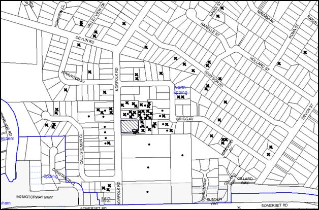
|
NOTIFICATION PLAN |
|
||
|
• PROPERTIES NOTIFIED
|
X SUBMISSIONS RECEIVED |
PROPERTY SUBJECT OF DEVELOPMENT |
|
|
87 submissions without address 44 submissions out of map range |
|||
211 submissions objected to the development, generally on the following grounds:
· The development would result in unacceptable traffic on Norfolk Road;
· Parking overflow on to Epping Oval due to the congregation;
· Unacceptable noise from activities at the place of worship and amplified music;
· The site is not suitable for the use;
· The proposed hours of commencement, being at 5:45am on a Sunday would adversely impact on the neighbouring properties due to noise;
· The proposed place of worship would be located near a pedestrian crossing and would reduce the safety of the users of the road;
· The development would have an adverse impact on the heritage listed dwelling house;
· The number of people proposed to congregate at the venue is unacceptable;
· The users have not consulted with the community prior to lodgement of the application;
· The modification to the front garden to accommodate the carpark would have adverse visual impact on the streetscape;
· The potential removal of the existing hedges would result in adverse privacy impacts on neighbouring properties;
· The proposal is an overdevelopment for the site;
· Significant trees would be removed due to the location of the car park;
· Installation of a 1.8m high fence along the southern boundary would destroy the existing hedges;
· The development has lesser setbacks than what is prescribed in the Hornsby Development Control Plan 2013;
· The proposal would devalue surrounding properties;
· The development would adversely impact upon the evacuation procedures along Norfolk Road in case of an emergency;
· The plans include incorrect property numbering;
· Information regarding the applicant has been withheld;
· Incorrect Heritage Impact Statement has been submitted;
· The proposed excavation works would destroy the front garden;
· The structural integrity of the prayer hall cannot be guaranteed as it would be built over an in-ground pool;
· The boundary fences should be replaced;
· The use of the building as a caretaker’s residence is unclear;
· Details of the use of the prayer hall have not been provided;
· Turf pavers are not suitable for car parking;
· The proposed acoustic fence is out of character with the locality;
· There is no mechanism of ensuring that only 40 people would attend the congregation in 10 cars at all times;
· Stormwater cannot be discharged on to the street as Norfolk Road does not have a drainage system.
The submission in support of the development states that the use has continued within another residential area for the past 40 years without any noise complaints. Therefore, it would have no impact on the amenity of the neighbouring properties.
The merits of the matters raised in community submissions have been addressed in the body of the report except the following:
5.1.1 Incorrect information
The errors in the submitted reports have been corrected. The amended information is assessed as satisfactory.
5.1.2 Emergency evacuation
The site does not constitute bushfire prone land. The use would only be conducted on the site for a few hours, two days a week. It would not have any impact on the emergency evacuation procedures for Norfolk Road (if any).
5.1.3 Structure of the prayer hall
The prayer has been deleted. Therefore, the objection is not relevant.
5.2 Public Agencies
The development application was not referred to any Public Agencies for comment.
6. THE PUBLIC INTEREST
Section 79C(1)(e) of the Act requires Council to consider “the public interest”.
The public interest is an overarching requirement, which includes the consideration of the matters discussed in this report. Implicit to the public interest is the achievement of future built outcomes adequately responding to and respecting the future desired outcomes expressed in environmental planning instruments and development control plans.
The application is not considered to have satisfactorily addressed Council’s criteria with regard to the acoustic impacts on the adjoining developments. Therefore it would not provide a development outcome that, on balance, would result in a positive impact for the community. Accordingly, it is considered that the approval of the proposed development would not be in the public interest.
CONCLUSION
The proposal seeks approval for internal alterations and adaptive reuse of a heritage listed dwelling as a place of worship for 40 people and a caretaker’s residence. The proposal also involves the construction of an at grade carpark within the front garden to accommodate 10 cars on site.
The proposal is consistent with the provisions of Hornsby Local Environmental Plan 2013 and the Hornsby Development Control Plan 2013 having regard to the proposed alterations to the heritage item and the use. However, the proposed operating hours (being 5:45am to 7:15am on a Sunday) do not comply with the NSW Industrial Noise Policy, Hornsby Shire Council Policy and Guidelines for Noise and Vibration, NSW EPA Guidelines – Dealing with Neighbourhood Noise and Section 1C.2.5 of the Hornsby Development Control Plan 2013.
It is considered that the proposed use would be conducted at a time that would have adverse impacts on the amenity of the surrounding residences and the locality.
Having regard to the above, the site is not considered to be suitable for the development in its current form and refusal of the application is recommended.
Note: At the time of the completion of this planning report, no persons have made a Political Donations Disclosure Statement pursuant to Section 147 of the Environmental Planning and Assessment Act 1979 in respect of the subject planning application.
RESPONSIBLE OFFICER
The officer responsible for the preparation of this Report is the Manager – Development Assessments – Rodney Pickles, who can be contacted on 9847 6731.
|
Rod Pickles Manager - Development Assessment Planning Division |
James Farrington Group Manager Planning Division |
|
1.View |
Locality Map |
|
|
|
2.View |
Existing Site and Floor Plan |
|
|
|
3.View |
Proposed Site and Floor Plan |
|
|
|
4.View |
Detailed Floor Plan |
|
|
|
5.View |
Elevation Plan |
|
|
|
6.View |
Landscape Plan |
|
|
File Reference: DA/1279/2015
Document Number: D06912307
SCHEDULE 1
REASONS FOR REFUSAL
1. Pursuant to the provisions of Section 79C(1)(a)(iii) of the Environmental Planning and Assessment Act, 1979, the proposal does not comply with the ‘Section 1C.2.5 – Noise and Vibration’ controls of the Hornsby Development Control Plan 2013, as the proposed development would result in noise and vibration impacts on the occupants of residential dwellings in the neighbourhood due to the proposed operating hours on Sundays.
2. In accordance with Section 79C(1)(b) of the Environmental Planning and Assessment Act 1979, the site would have an adverse impact on the built environment of the locality as both the entry and exit time (being 5:45am and 7:15am) coincide with the night time period (until 8:00 am Sundays) pursuant to the NSW Industrial Noise Policy, Hornsby Shire Council Policy and Guidelines for Noise and Vibration and NSW EPA Guidelines – Dealing with Neighbourhood Noise. No management system has been proposed to restrict the noise relating to a congregation of 40 people at 5:45am on Sundays.
3. Pursuant to Section 79C (1)(e) of the Environmental Planning and Assessment Act 1979, approval of the development would set an undesirable precedent for further inappropriate development and would not be in the public interest.
- END OF REASONS FOR REFUSAL -
Group Manager’s Report No. PL11/16
Planning Division
Date of Meeting: 11/05/2016
11 DEVELOPMENT APPLICATION - TWO STOREY DWELLING HOUSE AND DETACHED SECONDARY DWELLING - 41A CARDINAL AVENUE, BEECROFT
EXECUTIVE SUMMARY
|
DA No: |
DA/1550/2015 (Lodged 27 November 2015) |
|
Description: |
Construction of a two storey dwelling house and detached secondary dwelling on a vacant allotment. |
|
Property: |
Lot 21, DP1213782, No. 41A Cardinal Avenue, Beecroft. |
|
Applicant: |
Wincrest Group Pty Ltd |
|
Owner: |
Ms Yifei Xu |
|
Estimated Value: |
$550,000 |
|
Ward: |
C |
· The application is for the construction of a two storey dwelling house and a detached secondary dwelling on a vacant allotment.
· The applicant has made a submission in accordance with Clause 4.6 ‘Exceptions to Development Standards’ of the Hornsby Local Environmental Plan (HLEP) 2013 to vary the 8.5 metre height development standard. The submission is considered well founded and is supported.
· Four submissions have been received objecting to the application including one submission from the Beecroft Cheltenham Civic Trust Inc.
· A Red Sticker has been placed on the application requiring that it be determined at a Council meeting.
· It is recommended that the application be approved.
|
THAT Council assume the concurrence of the Secretary of the Department of Planning and Environment pursuant to Clause 4.6 of the Hornsby Local Environmental Plan 2013 and approve Development Application No. DA/1550/2015 for the construction of a two storey dwelling house and detached secondary dwelling at Lot 21, DP 1213782, 41A Cardinal Avenue Beecroft, subject to the conditions of consent detailed in Schedule 1 of Group Manager’s Report No. PL11/16. |
BACKGROUND
On 2 June 2010, Council approved a development application DA/723/2009 for the subdivision of one lot into two lots and the construction of a dwelling house on Lot 2, DP 584894, No. 41 Cardinal Avenue, Beecroft. The dwelling house would be constructed on the newly created lot identified as No. 41A Cardinal Avenue, Beecroft at a maximum height of 8 metres. Seven trees would be retained.
On 2 September 2011, Council approved a Section 96(1A) application to stage the construction of the development. The first stage of the application for the subdivision of the lot was finalised and a Subdivision Certificate issued on 25 August 2015. The construction of the dwelling house approved under DA/723/2009 (Stage 2), has not commenced.
Development Application No. DA/1550/2015 was lodged on 27 November 2015 and during the exhibition period, four submissions were received raising concerns with respect to tree protection, drainage and the percentage of landscaped area. Council’s preliminary assessment of the proposal noted that the dwelling, at a proposed height of 9.3 metres, did not meet Council’s maximum 8.5 metre height requirement under the HLEP 2013 and HDCP 2013.
At Council’s request, amended plans were submitted on 31 March 2016. The amended plans showed that approximately 2.2% of the roof from street view reached a maximum height of 9.5 metres.
On 8 April 2016, a Clause 4.6 variation to the height standard was submitted to Council.
SITE
The site has an area of 680m2 and is located on the western side of Cardinal Avenue Beecroft. The site is a rectangular shaped allotment with a frontage of 18.3 metres to Cardinal Avenue and a depth of 36.9 metres. The site slopes moderately towards Cardinal Avenue with an average fall of 6 metres.
The site is burdened by a 2 metre wide right of access and drainage easement that runs along the southern portion of the site providing access and services to the battle-axe property at the rear. The site is currently vacant.
The site and adjoining properties, contains a number of individually significant trees including a group of trees, which are part of the Sydney Blue Gum High Forest. The site is also locaqted in a mapped Endangered Ecological Community (EEC).
The site is located within the North West Rail link corridor which passes under the subject site.
The surrounding development is typified by an eclectic blend of one and two storey dwelling houses of disparate style and age surrounded by well-established landscaped areas.
PROPOSAL
The application proposes the construction of a dwelling house and secondary dwelling.
The primary dwelling would comprise the following:
Lower Ground Floor Level:
Two car garage
Ground Floor Level:
Family and dining area, kitchen, lounge room, study, laundry and an alfresco area attached to the western elevation.
First Floor Level:
Four bedrooms, bathroom, ensuite a living area and a balcony attached to the eastern elevation.
The secondary dwelling would comprise a living, kitchen and dining area, two bedrooms and a bathroom.
The application proposes the removal of three trees from the site.
ASSESSMENT
The development application has been assessed having regard to ‘A Plan for Growing Sydney’, the ‘North Subregion (Draft) Subregional Strategy’ and the matters for consideration prescribed under Section 79C of the Environmental Planning and Assessment Act 1979 (the Act). The following issues have been identified for further consideration.
1. STRATEGIC CONTEXT
1.1 A Plan for Growing Sydney and (Draft) North Subregional Strategy
A Plan for Growing Sydney has been prepared by the NSW State Government to guide land use planning decisions for the next 20 years. The Plan sets a strategy for accommodating Sydney’s future population growth and identifies the need to deliver 689,000 new jobs and 664,000 new homes by 2031. The Plan identifies that the most suitable areas for new housing are in locations close to jobs, public transport, community facilities and services.
The NSW Government will use the subregional planning process to define objectives and set goals for job creation, housing supply and choice in each subregion. Hornsby Shire has been grouped with Hunters Hill, Ku-ring-gai, Lane Cove, Manly, Mosman, North Sydney, Pittwater, Ryde, Warringah and Willoughby to form the North Subregion. The Draft North Subregional Strategy will be reviewed and the Government will set housing targets and monitor supply to ensure planning controls are in place to stimulate housing development.
The proposed development would be consistent with ‘A Plan for Growing Sydney’, by providing additional dwellings and would contribute to housing choice in the locality.
2. STATUTORY CONTROLS
Section 79C(1)(a) requires Council to consider “any relevant environmental planning instruments, draft environmental planning instruments, development control plans, planning agreements and regulations”.
2.1 Hornsby Local Environmental Plan 2013
The proposed development has been assessed having regard to the provisions of the Hornsby Local Environmental Plan 2013 (HLEP).
2.1.1 Zoning of Land and Permissibility
The subject land is zoned R2 Low Density Residential under the HLEP. The objectives of the zone are:
· To provide for the housing needs of the community within a low density residential environment.
· To enable other land uses that provide facilities or services to meet the day to day needs of residents.
The proposed development is defined as “dwelling” and “secondary dwelling”. A “dwelling” is permissible in the R2 zone with Council’s consent and “secondary dwelling” is permissible in the R2 Zone pursuant to the provisions of the State Environmental Planning Policy (Affordable Rental Housing) 2009.
2.1.2 Height of Buildings
Clause 4.3 of the HLEP provides that the height of a building on any land should not exceed the maximum height shown for the land on the Height of Buildings Map. The maximum permissible height for the subject site is 8.5 metres. The proposal does not comply with this provision and a Clause 4.6 Exception to the development standard has been submitted.
2.1.3 Exceptions to Development Standards
Clause 4.6 of the HLEP provides flexibility in the application of development standards in circumstances where strict compliance with those standards would, in any particular case, be unreasonable or unnecessary or tend to hinder the attainment of the objectives of the zone.
The proposal exceeds the maximum permissible height of 8.5 metres as prescribed in Clause 4.3 of the HLEP and the height of buildings map.
The applicant has made a submission in support of a variation to the development standard in accordance with Clause 4.6 of the HLEP. The development application seeks to vary the development standard by 1 metre or by 11.7%. The applicant states the proposed variation is considered to be consistent with the objectives of the control and is justified as follows:
· The proposed development would be consistent with the zone objectives of R2 Low Density Residential by providing low density type residential accommodation to meet the needs of the community. The development would result in a dwelling and secondary dwelling with ancillary facilities.
· The proposed development would be consistent with the objectives of the height standard prescribed in Clause 4.3(1)(a) of the HLEP. The site has a natural fall of 8.2 metres to the street which results in a small portion of the roof at the front of the dwelling to exceed 8.5 metres. To maintain the integrity of the design and achieve good amenity for the internal habitable areas, the design allows for a floor to ceiling height of 2.45 metres.
State Government Guidelines on varying development standards recommend considering the provisions of Clause 4.6 of the LEP and the ‘five part test’ established by the Land and Environment Court as follows:
1. the objectives of the standard are achieved notwithstanding noncompliance with the standard;
2. the underlying objective or purpose of the standard is not relevant to the development and therefore compliance is unnecessary;
3. the underlying object of purpose would be defeated or thwarted if compliance was required and therefore compliance is unreasonable;
4. the development standard has been virtually abandoned or destroyed by the council’s own actions in granting consents departing from the standard and hence compliance with the standard is unnecessary and unreasonable;
5. the compliance with development standard is unreasonable or inappropriate due to existing use of land and current environmental character of the particular parcel of land. That is, the particular parcel of land should not have been included in the zone.
The applicant’s submission to vary the 8.5 metres height development standard is considered well founded for the following reasons:
· The proposal is consistent with the objectives of Clause 4.3 of the HLEP height standard;
· The site is affected by a considerable slope which influences compliance with the building height, therefore, the variation to the height is not unreasonable;
· The purpose of the standard would be defeated if compliance was required as this would alter the amenity of the design and require disruption to the natural ground in the form of extensive excavation;
· Compliance with the development standard for the building height has been accepted by Council in granting consent for past developments requesting a variation to the height. The submission to Council dated 7 April 2016 by Urbanesque Planning gives a detailed description of recent Land Environmental Court judgements where Clause 4.6 variations have been accepted based on unique circumstances. The decision of a recent LEC case in January 2015, Four2Five vs Ashfield Council noted that it is the consent authorities’ obligation to be satisfied that the applicant’s written request is adequate and compliance with the standard is unreasonable in the circumstance and that there are additional environmental planning grounds that warrant the exceedance of the standard.
· A more recent LEC decision in Micaul Holdings Pty Limited v Randwick City Council (2015) approved a residential flat building with a 55% exceedance to the maximum height requirement due to the steep topography of the site and the fact that is was flood affected.
· The dwelling house approved under DA/723/2009 required a cut of 2 metres to accommodate a basement garage level plus two-storey dwelling whilst also retaining 3 native trees to the rear of the approved dwelling. The approved cut of 2 metres allowed the dwelling to comply with Council’s maximum height requirement of 8.5 metres. The dwelling approved under DA/723/3009 was approved at approximately 8 metres in height.
· The variation to the development standard in terms of the overall height proposed under DA/1550/2015 is considered to be reasonable with respect to the natural ground levels and would be a better environmental outcome given that the extent of excavation would only be 1.2 metres.
· Compliance with the height standard would require greater depth of excavation and result in a detrimental environmental outcome for the site that is characterised by unique topography which slopes significantly to the street.
· In light of the previous LEC decision which accepted Clause 4.6 of variations of greater than 10%, the variation of 1 metre (2.2% of the main roof area that exceeds the 8.5 metre maximum) in this instance is considered to be minor and acceptable.
Accordingly, the Clause 4.6 submission is supported.
2.1.4 Heritage Conservation
Clause 5.10 of the HLEP sets out heritage conservation provisions for Hornsby Shire.
The site is not a heritage item, is not in the vicinity of a heritage listed item and is not located in a heritage conservation area. Whilst Cardinal Avenue is identified as having street trees of heritage significance, these would not be impacted by the development.
The development would have acceptable heritage impacts.
2.1.5 Earthworks
Clause 6.2 of the HLEP states that consent is required for proposed earthworks on site. Before granting consent for earthworks, Council is required to assess the impacts of the works on adjoining properties, drainage patterns and soil stability of the locality.
The proposal would include a maximum of 1.2 metres of excavation to accommodate the primary dwelling. Council’s assessment of the proposed works and excavation concludes that the excavation would be minimal. The excavated material would be used as fill for the garage and rear alfresco area. There would be minimal detrimental impact on the environment, neighbours or features of the surrounding land.
2.2 State Environmental Planning Policy (Affordable Rental Housing) 2009
State Environmental Planning Policy (Affordable Rental Housing) 2009 (SEPP ARH) was introduced by the NSW State Government to increase the supply and diversity of affordable rental and social housing in NSW. It covers housing types including villas, townhouses and apartments which contain an affordable rental housing component, along with secondary dwellings (also known as granny flats), new generation boarding houses, group homes, social housing and supportive accommodation.
Division 2 of the Policy outlines the standards for Secondary Dwellings. Clause 18 of the policy defines a “secondary dwelling” to be a self-contained dwelling that:
a) is established in conjunction with another dwelling (the principal dwelling), and
b) is on the same lot of land (not being an individual lot in a strata plan or community title scheme) as the principal dwelling, and
c) is located within, or is attached to, or is separate from, the principal dwelling.
The proposed secondary dwelling would be established in conjunction with the proposed principal dwelling on the site and satisfies the above definition.
Clause 20 of the Policy outlines the zones in which secondary dwellings are permissible. The site is located within the R2 Low Density Residential zone, which is listed in the Policy as a zone where secondary dwellings are permissible. Therefore, the proposal is permissible within the R2 land use zone.
The following table sets out the proposal’s compliance with the development standards as prescribed for secondary dwellings under Clause 22 and Schedule 1 of SEPP ARH:
|
State Environmental Planning Policy (Affordable Rental Housing) 2009 |
|||
|
Standard |
Proposal |
Requirement |
Complies |
|
Site Area |
680m2 |
450m2 |
Yes |
|
No. of Dwellings |
2 |
2 (Max) |
Yes |
|
Floor Area - Principal Dwelling - Secondary Dwelling - Total |
258m2 56m2 314m2 |
60m2 430m2 |
Yes Yes |
|
Parking - Principal Dwelling - Secondary Dwelling |
2 0 |
2 No additional parking required |
Yes Yes |
|
Site Cover (all development) |
35% |
50% |
Yes |
|
Setbacks (for Complying Development) |
|||
|
Side (northern boundary) |
1m |
0.9m |
Yes |
|
Side (southern boundary) |
7.8m |
0.9m |
Yes |
|
Rear (western boundary) |
2.9m |
3m |
Yes |
|
Height |
4m |
8.5m |
Yes |
|
Private Open Space |
>24m2 and minimum 4 metre wide |
24m² and 4m wide |
Yes |
|
Landscaped Area Total |
43% |
35% |
Yes |
As indicated in the above table, the proposed secondary dwelling complies with the development standards under the SEPP ARH. The approval for the secondary dwelling alone had the potential to be sought under Schedule 1 of the SEPP ARH as ‘complying development’. However, the removal of significant trees on site requires further assessment against Part 1B.6 Tree and Vegetation Preservation of the HDCP 2013 which would not comply with development standards of schedule 1.
2.3 Sydney Regional Environmental Plan (Sydney Harbour Catchment) 2005
The application has been assessed against the requirements of Sydney Regional Environmental Plan (Sydney Harbour Catchment) 2005. This Policy provides general planning considerations and strategies to ensure that the catchment, foreshores, waterways and islands of Sydney Harbour are recognised, protected, enhanced and maintained.
Subject to the implementation of installation of sediment and erosion control measures and stormwater management to protect water quality, the proposal would have minimal potential to impact on the Sydney Harbour Catchment.
2.4 State Environmental Planning Policy (Infrastructure) 2007
The application has been assessed against the requirements of State Environmental Planning Policy (Infrastructure) 2007 as the proposal is within the North West rail link corridor.
Clause 103 requires the consent authority to consider the impact of excavation within proposed rail corridor. As the excavation works proposed are less than 3 metres below ground level the application was not notified to RailCorp.
2.5 SEPP (Exempt and Complying Development) – NSW Housing Code
The application has been assessed against the requirements of State Environmental Planning Policy (Exempt and Complying Development Codes) 2008 – NSW Housing Code. The Policy provides exempt and complying development codes that have State-wide application. The Policy also identifies types of development that are of minimal environmental impact that may be carried out without the need for development consent and types of complying development (including dwelling houses) that may be carried out in accordance with a complying development certificate.
The proposed dwelling house may not be approved as complying development, as the propped dwelling exceeds the maximum height requirement of 8.5 metres and proposes the removal of 5 trees at the rear of the site. The site is also mapped in an area identified as Endangered Ecological Community (EEC).
The proposal complies with the requirements of the NSW Housing Code in all other aspects including maximum floor area, setbacks, private open space, landscaping and car parking and access.
2.6 SEPP (Building Sustainability Index: BASIX) 2004
In accordance with the State Environmental Planning Policy (Building Sustainability Index: BASIX) 2004, a BASIX certificate is required for new dwellings. A BASIX certificate for the proposed principal dwelling and the secondary dwelling was submitted with the application. A condition has been recommended for the proposal to satisfy the BASIX commitments pertaining to the development.
2.7 Clause 74BA Environmental Planning and Assessment Act, 1979 - Purpose and Status of Development Control Plans
Clause 74BA of the Environmental Planning and Assessment Act, 1979 states that a DCP provision will have no effect if it prevents or unreasonably restricts development that is otherwise permitted and complies with the development standards in relevant Local Environmental Plans and State Environmental Planning Policies.
The principal purpose of a development control plan is to provide guidance on the aims of any environmental planning instrument that applies to the development; facilitate development that is permissible under any such instrument; and achieve the objectives of land zones. The provisions contained in a DCP are not statutory requirements and are for guidance purposes only. Consent authorities have flexibility to consider innovative solutions when assessing development proposals, to assist achieve good planning outcomes.
2.8 Hornsby Development Control Plan 2013
The proposed development has been assessed having regard to the relevant desired outcomes and prescriptive requirements within the Hornsby Development Control Plan 2013 (HDCP). The following table sets out the proposal’s compliance with the prescriptive requirements of the Plan:
|
HDCP – Part 3.1 Dwelling Houses |
||||
|
Control |
Approved DA/723/2009 |
Proposal |
Requirement |
Complies |
|
Site Area |
680m2 |
680m2 |
N/A |
N/A |
|
Building Height |
8m |
9.5m |
8.5m |
No |
|
No. storeys |
2 storey + subfloor garage |
2 storey + subfloor garage |
max. 2 + attic |
Yes |
|
Site Coverage - Total |
15% |
35% |
50% |
Yes |
|
Floor Area |
FSR 0.35:1 |
Sub Floor – 34 m2 Ground Floor – 111 m2 First Floor – 13 m2 Total – 258m2 |
380m2 |
Yes |
|
Setbacks |
|
|
|
|
|
- Front (eastern boundary) |
6.2m |
6.3m |
6m |
Yes |
|
- Side (northern boundary) |
|
|
|
|
|
Ground floor |
1m |
1.57m |
900mm |
Yes |
|
First floor |
1m |
1.57m |
1.5m |
Yes |
|
- Side (southern boundary) |
|
|
|
|
|
Ground floor |
8m |
7.4m |
900mm |
Yes |
|
First floor |
8m |
7.4m |
1.5m |
Yes |
|
- Rear (western boundary) |
|
|
|
|
|
Ground floor |
18m |
14m |
3m |
Yes |
|
First floor |
18m |
17m |
8m |
Yes |
|
Landscaped Area (% of lot size) |
74% |
43% |
30% |
Yes |
|
Private Open Space (principal dwelling) |
||||
|
- minimum area |
270m2 |
Alfresco - 18m2 Landscaped area – 60m2 |
24m2 |
Yes – justified below |
|
- minimum dimension |
>3m |
3m |
3m |
Yes |
|
Car Parking |
2 spaces |
2 spaces |
2 spaces |
Yes |
As detailed in the above table, the proposal complies with the prescriptive requirements of Parts 1 and 3 of the HDCP. A discussion on compliance with the relevant desired outcomes and issues raised in submissions are outlined below.
2.8.1 Scale
The desired outcome of Part 3.1.1 Scale of the HDCP is to encourage “development with a height, bulk and scale that is compatible with a low density residential environment.”
The 9.5 metre building height of the proposal is a variation of 1 metre to the 8.5 metre prescriptive measure of Part 3.1.1 Scale. As discussed in section 2.1.3 of this report, the variation to the height requirement in this instance would have negligible environmental and amenity impacts and is considered acceptable.
Additionally, the proposed two storey dwelling-house and sub-floor garage would be consistent with the surrounding two-storey development in the local area and the loss of sunlight and privacy in relation to adjoining properties would be within reasonable limits. These impacts are discussed in more detail under the headings “Privacy” and “Solar Access.”
2.8.2 Landscaping
One objection has been received raising concerns regarding the calculated landscaped area shown on the plans.
Council’s assessment has determined that the landscaped area would be 43% of the site which complies with the 30% prescriptive measure of Part 3.1.3 Landscaping of the HDCP.
Submissions raise concerns regarding the removal of three significant trees which were approved to be retained in the previous development application (DA/723/2009) and insufficient compensation for the loss of these trees. Council’s assessment report of DA/723/2009 stated that:
“The proposal includes the retention of the two large Sydney Blue Gums (Eucalyptus saligna) located within the Council’s reserve at the front of the site that form part of the Blue Gum High Forest Critically Endangered Ecological Community under the Threatened Species Conservation Act 1995.
The proposal involves the retention of two large Spotted Gums (Corymbia maculata) and one introduced native Tallowwood. The proposed location of the dwelling and efforts to restrict the size of the building footprint ensures these trees would not be significantly impacted upon providing the applicant adheres to the conditions of consent during construction.”
Subsequent to this, condition No.2 of DA/723/2009 stated:
“2. Removal of Existing Trees
This development consent only permits the removal of trees numbered T4, T10, T11, T12, T13, T14, T15 and T16 as identified within the Schedule of Surveyed Trees prepared by Urban Forestry Australia on 25 September 2008 and the associated Tree Location Plan. The removal of any other trees requires separate approval under Council’s Tree Preservation Order.”
Since the adoption of the Hornsby Development Control Plan (HDCP) in 2013, the tree species Spotted Gum and Tallowwood have been deleted from Council’s Tree Preservation Order (TPO) and are not listed as indigenous under Part 1B.6.1 Tree and Vegetation Preservation of the HDCP. Council’s assessment notes that whilst these trees are large and healthy, they are exempt under Council’s TPO and can be removed without Council consent.
Consent is recommended for the removal of these trees together with two non-indigenous trees (Ulmus and Camellia) in the north-west corner of the site.
To compensate for the loss of these trees, a condition is recommended requiring the planting of three replacement trees selected from Table in Part 1B.6(b) Tree Species Indigenous to Hornsby Shire, including species indicative of the mapped Blue Gum High Forest.
A further condition is recommended to protect a jacaranda (numbered “T6” on the Tree Site Plan) on the adjoining property by providing tree protection fencing.
The proposal meets the desired outcomes of Part 3.1.3 Landscaping of the HDCP and is considered acceptable.
2.8.3 Open Space
The desired outcome of Part 3.1.4 Open Space of the HDCP element is to encourage “private open space that functions as an extension to the dwelling house.”
The prescriptive measures of Part 3.1.4 Open Space states that “a dwelling-house should be provided with private open space that incorporates a principal open space area in accordance with Table 3.1.4(a)” of the HDCP.
The alfresco attached to the rear of the dwelling is 18m2 in area and there is approximately 60m2 of soft landscaped area that would also be used as private open space for the primary dwelling and secondary dwelling. The applicant has not delineated the private open space for the secondary dwelling; therefore it would be shared between the two occupants.
The proposal meets the desired outcomes and prescriptive measure of Part 3.1.4 Open Space and is considered acceptable.
2.8.4 Privacy
The desired outcome of Part 3.1.6 Privacy of the HDCP is to encourage “development that is designed to provide reasonable privacy to adjacent properties.”
The first floor of the proposal includes a living area which does not comply with the prescriptive measures of Part 3.1.6 Privacy which states that “living and entertaining areas of dwelling houses should be located on the ground floor only and orientated towards the private open space of the dwelling house and not the side boundaries.”
This room is served by a window (identified as “W14” on the first floor plan) located on the southern side elevation which has a setback of approximately 8 metres from the adjoining property boundary of No. 39 Cardinal Avenue, Beecroft. To reduce any privacy impacts, the window is proposed to have a sill height of 1.5 metres above the finished floor level. As a consequence, the development would have negligible adverse privacy impacts and is considered acceptable.
The other window serving the first floor living room would be orientated to the front of the dwelling-house and overlook the front yard and driveway of the adjoining properties only. The remaining first floor windows serve non-active rooms in accordance with the prescriptive measures of Part 3.1.6 Privacy.
The proposal meets the desired outcomes of Part 3.1.6 Privacy of the HDCP and is considered acceptable.
The prescriptive measures of Part 3.1.6 Privacy states that a “deck, balcony, terrace or the like should be located within 600 mm of existing ground level where possible to minimise potential visual and acoustic privacy conflicts.”
The alfresco area attached to the western side (rear) of the primary dwelling would be located at ground level and orientated towards to rear private open space and secondary dwelling.
2.8.5 Sunlight Access
The desired outcomes of Part 3.1.5 Sunlight Access of the HDCP are to encourage “dwelling houses designed to provide solar access to open space areas” and “development designed to provide reasonable sunlight to adjacent properties.”
The prescriptive measures of Part 3.1.5 Sunlight Access state that on “22 June, 50% of the required principal private open space should receive 3 hours of unobstructed sunlight between 9am and 3pm.” The prescriptive measures also state that on “22 June, 50% of the required principal open space of an adjoining property should receive 3 hours of unobstructed sunlight between 9am and 3pm.”
The submitted 9am shadow plans indicate that the principal private open space of the dwelling and the private open space of the adjoining property would receive at least 3 hours of unobstructed sunlight between 9am and 3pm on 22 June.
The proposal meets the desired outcomes of Part 3.1.5 Sunlight Access and is considered acceptable.
2.9 Section 94 Contributions Plans
Hornsby Shire Council Section 94 Contributions Plan 2012-2021 applies to the development as the proposal would result in an additional dwelling in the form of the secondary dwelling. Accordingly, the requirement for a monetary Section 94 contribution for the secondary dwelling is recommended as a condition of consent.
3. ENVIRONMENTAL IMPACTS
Section 79C(1)(b) of the Act requires Council to consider “the likely impacts of that development, including environmental impacts on both the natural and built environments, and social and economic impacts in the locality”.
3.1 Natural Environment
3.1.1 Tree and Vegetation Preservation
Two submissions object to the removal of 3 large trees at the rear of the site. A total of 5 trees are proposed to be removed to accommodate the proposed secondary dwelling. This matter has been addressed in section 2.5.2 of this report and Council’s tree assessment concludes that the removal of the 5 trees is acceptable as exempt development as the trees are not indigenous to Hornsby Shire. Nonetheless a condition is recommended in the consent permitting their removal.
3.1.2 Stormwater Management
One submission raises concern with respect to stormwater run-off and flooding generated by the development.
Council’s engineer assessment recommends appropriate conditions with respect to stormwater drainage to be designed and constructed for an average recurrence internal of 20 years and be connected to Council’s street drainage system. It is noted that the fall of the site towards the street is preferable and allows the site to be gravity drained. The proposed dwelling is to be connected to the street drainage system via an on-site detention (OSD) system as recommended by conditions in the consent at schedule 1.
3.1.3 EEC Vegetation
Council’s environmental assessment notes that the trees proposed for removal are not locally indigenous species, however, these trees provide inter-canopy connectivity to the adjacent Blue Gum High Forest trees. Conditions have been recommended in the consent for the requiring compensatory planting as part of a Landscape Plan to be provided prior to the issue of the Construction Certificate.
Subject to the applicant complying with the consent conditions, it is unlikely that the proposal will have a significant impact upon the threatened species, populations and endangered ecological communities listed under the Threatened Species Conservation Act 1995.
3.2 Built Environment
3.2.1 Built Form
The proposal would result in adequate separation between the proposed dwelling, secondary dwelling and surrounding properties. The proposed height and design of the primary dwelling is considered acceptable as addressed in Section 2.1.3 of this report. The proposal is acceptable in terms of its impact on the built environment.
3.3 Social Impacts
The proposal would provide a positive social outcome by providing housing choice in the locality.
3.4 Economic Impacts
The proposal would have a minor positive impact on the local economy in conjunction with other new low density residential development in the locality by generating an increase in demand for local services.
4. SITE SUITABILITY
Section 79C(1)(c) of the Act requires Council to consider “the suitability of the site for the development”.
The subject site has not been identified as bushfire prone or flood prone land. The site is considered to be capable of accommodating the proposed development. The scale of the proposed development is consistent with the capability of the site and is considered acceptable.
5. PUBLIC PARTICIPATION
Section 79C(1)(d) of the Act requires Council to consider “any submissions made in accordance with this Act”.
5.1 Community Consultation
The proposed development was placed on public exhibition and was notified to adjoining and nearby landowners between 27 November 2015 and 20 January 2016 in accordance with the Notification and Exhibition requirements of the HDCP. During this period, Council received four submissions. The map below illustrates the location of those nearby landowners who made a submission that are in close proximity to the development site.
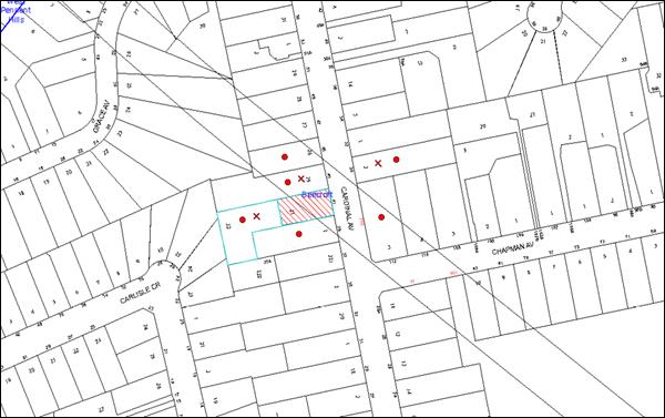
|
NOTIFICATION PLAN |
|
||
|
• PROPERTIES NOTIFIED
|
X SUBMISSIONS RECEIVED |
PROPERTY SUBJECT OF DEVELOPMENT |
|
Four submissions objected to the development, generally on the grounds that the development would result in:
· Unacceptable environmental loss and insufficient compensation for the removal of 3 significant trees;
· Detrimental drainage and flooding impacts;
· Miscalculated landscaped area and non-compliance with the minimum landscaped area prescriptive measure of the HDCP; and
· Insufficient information in the Statement of Environmental Effects and incorrect property address on the architectural plans.
The merits of the matters raised in community submissions have been addressed in the body of the report with the exception of the following:
· Whether the proposed removal of the significant trees is permitted given the previous consent No.DA723/2009 stated they would be retained subject to another approval. This caused neighbours at 41 Cardinal Avenue, who previously owned the site at 41A Cardinal Avenue, to undersell this block of land.
· Loss of trees which would have detrimental impact on the wildlife and ecosystems.
· De-value surrounding properties and inhibit them to be subdivided.
In addressing these additional concerns, it is noted that:
· The 3 large trees (two spotted gums and one tallowwood) are no longer protected under Councils TPO and can be removed despite previously being listed as indigenous species under the TPO prior to 2013.
· Council’s flora and fauna assessment is that there would be not detrimental impacts on wildlife habitats as a result of the removal of the trees.
· The proposed development would not lead to any devaluation of properties or have any impact on future subdivisions of neighbouring properties.
6. THE PUBLIC INTEREST
Section 79C(1)(e) of the Act requires Council to consider “the public interest”.
The public interest is an overarching requirement, which includes the consideration of the matters discussed in this report. Implicit to the public interest is the achievement of future built outcomes adequately responding to and respecting the future desired outcomes expressed in environmental planning instruments and development control plans.
The application is considered to have satisfactorily addressed Council’s and relevant agencies’ criteria and would provide a development outcome that, on balance, would result in a positive impact for the community. Accordingly, it is considered that the approval of the proposed development would be in the public interest.
CONCLUSION
The application proposes the construction of a dwelling house and detached secondary dwelling.
The development generally meets the desired outcomes of Council’s planning controls and is satisfactory having regard to the matters for consideration under Section 79C of the Environmental Planning and Assessment Act 1979.
Conditions are recommended to minimise disruption to residential amenity.
Having regard to the circumstances of the case, approval of the application is recommended.
Note: At the time of the completion of this planning report, no persons have made a Political Donations Disclosure Statement pursuant to Section 147 of the Environmental Planning and Assessment Act 1979 in respect of the subject planning application.
RESPONSIBLE OFFICER
The officer responsible for the preparation of this Report is the Manager – Development Assessments – Rodney Pickles, who can be contacted on 9847 6731.
|
Rod Pickles Manager - Development Assessment Planning Division |
James Farrington Group Manager Planning Division |
|
1.View |
Locality Map |
|
|
|
2.View |
Floor Plans |
|
|
|
3.View |
Site Plan |
|
|
|
4.View |
Site Analysis Plan |
|
|
|
5.View |
Elevations and Sections |
|
|
|
6.View |
Sediment Control Plan |
|
|
|
7.View |
Roof Perspective Plan |
|
|
File Reference: DA/1550/2015
Document Number: D06861387
SCHEDULE 1
GENERAL CONDITIONS
The conditions of consent within this notice of determination have been applied to ensure that the use of the land and/or building is carried out in such a manner that is consistent with the aims and objectives of the relevant legislation, planning instruments and council policies affecting the land and does not disrupt the amenity of the neighbourhood or impact upon the environment.
Note: For the purpose of this consent, the term ‘applicant’ means any person who has the authority to act on or the benefit of the development consent.
Note: For the purpose of this consent, any reference to an Act, Regulation, Australian Standard or publication by a public authority shall be taken to mean the gazetted Act or Regulation, or adopted Australian Standard or publication as in force on the date that the application for a construction certificate is made.
1. Approved Plans and Supporting Documentation
The development must be carried out in accordance with the plans and documentation listed below and endorsed with Council’s stamp, except where amended by Council and/or other conditions of this consent:
|
Plan No. |
Drawn by |
Dated |
|
Site Plan Sheet No.1, Rev E |
Wincrest Homes |
30/03/2016 |
|
Garage Plan Sheet No.2, Rev E |
Wincrest Homes |
30/03/2016 |
|
Ground Floor Plan Sheet No.3, Rev E |
Wincrest Homes |
30/03/2016 |
|
First Floor Plan Sheet No.4, Rev E |
Wincrest Homes |
30/03/2016 |
|
Elevations Sheet No.5, Rev E |
Wincrest Homes |
30/03/2016 |
|
Elevations Sheet No.6, Rev E |
Wincrest Homes |
30/03/2016 |
|
Section/Schedule Sheet No.7, Rev E |
Wincrest Homes |
30/03/2016 |
|
Secondary Dwelling Plan and Elevations Sheet No.14, Rev D |
Wincrest Homes |
18/03/2016 |
|
Secondary Dwelling Plan and Elevations Sheet No.14, Rev D |
Wincrest Homes |
18/03/2016 |
|
Sediment Control Plan Sheet No.17, Rev D |
Wincrest Homes |
18/03/2016 |
|
Site Analysis Plan Sheet No.18, Rev D |
Wincrest Homes |
18/03/2016 |
|
Roof Plan 3D Perspective sheet No.24, Rev E |
Wincrest Homes |
30/03/2016 |
|
Document title |
Prepared by |
Dated |
|
BASIX Certificate No.677430M_02 |
Therman Performance |
28/03/2016 |
|
Site Survey Plan |
Hornsby Council |
14/03/2016 |
2. Removal of Existing Trees
a) This development consent permits the removal of tree(s) numbered 3, 4, 5, 7, & 8 as identified on the Site Survey Plan prepared by Hornsby Council, dated 14-03-16.
b) The removal of any other trees from the site requires separate approval by Council in accordance with Part 1B.6 Tree and Vegetation Preservation of the Hornsby Development Control Plan, 2013 (HDCP).
3. Construction Certificate
a) A Construction Certificate is required to be approved by Council or a Private Certifying Authority prior to the commencement of any works under this consent.
b) The Construction Certificate plans must not be inconsistent with the Development Consent plans.
4. Section 94 Development Contributions
a) In accordance with Section 80A(1) of the Environmental Planning and Assessment Act, 1979 and the Hornsby Shire Council Section 94 Development Contributions Plan 2014-2024, the following monetary contributions must be paid to Council to cater for the increased demand for community infrastructure resulting from the development:
|
Description |
Contribution (4) |
|
Roads |
$1,031.75 |
|
Open Space and Recreation |
$6,820.00 |
|
Community Facilities |
$2,621.80 |
|
Plan Preparation and Administration |
$22.00 |
|
TOTAL |
$10,495.55 |
being for a secondary dwelling.
b) The value of this contribution is current as at 19 April 2016. If the contribution is not paid within the financial quarter that this condition was generated, the contribution payable will be adjusted in accordance with the provisions of the Hornsby Shire Council Section 94 Development Contributions Plan and the amount payable will be calculated at the time of payment in the following manner:
|
$CPY = |
$CDC x CPIPY |
|
CPIDC |
Where:
$CPY is the amount of the contribution at the date of Payment
$CDC is the amount of the contribution as set out in this Development Consent
CPIPY is the latest release of the Consumer Price Index (Sydney – All Groups) at the date of Payment as published by the ABS.
CPIDC is the Consumer Price Index (Sydney – All Groups) for the financial quarter at the date applicable in this Development Consent Condition.
c) The monetary contribution must be paid to Council:
i) prior to the issue of the Subdivision Certificate where the development is for subdivision; or
ii) prior to the issue of the first Construction Certificate where the development is for building work; or
iii) prior to issue of the Subdivision Certificate or first Construction Certificate, whichever occurs first, where the development involves both subdivision and building work; or
iv) prior to the works commencing where the development does not require a Construction Certificate or Subdivision Certificate.
Note: It is the professional responsibility of the Principal Certifying Authority to ensure that the monetary contributions have been paid to Council in accordance with the above timeframes.
Council’s Development Contributions Plan may be viewed at www.hornsby.nsw.gov.au or a copy may be inspected at Council’s Administration Centre during normal business hours.
REQUIREMENTS PRIOR TO THE ISSUE OF A CONSTRUCTION CERTIFICATE
5. Building Code of Australia
All approved building work must be carried out in accordance with the relevant requirements of the Building Code of Australia.
6. Contract of Insurance (Residential Building Work)
Where residential building work for which the Home Building Act 1989 requires there to be a contract of insurance in force in accordance with Part 6 of that Act, this contract of insurance must be in force before any building work authorised to be carried out by the consent commences.
7. Notification of Home Building Act 1989 Requirements
Residential building work within the meaning of the Home Building Act 1989 must not be carried out unless the principal certifying authority for the development to which the work relates (not being Council) has given Council written notice of the following information:
a) In the case of work for which a principal contractor is required to be appointed:
i) The name and licence number of the principal contractor; and
ii) The name of the insurer by which the work is insured under Part 6 of that Act.
b) In the case of work to be done by an owner-builder:
i) The name of the owner-builder; and
ii) If the owner-builder is required to hold an owner-builder’s permit under that Act, the number of the owner-builder’s permit.
Note: If arrangements for doing the residential building work are changed while the work is in progress so that the information notified becomes out of date, further work must not be carried out unless the principal certifying authority for the development to which the work relates (not being Council) has given Council written notification of the updated information.
8. Sydney Water – Approval
This application must be submitted to Sydney Water for approval to determine whether the development would affect any Sydney Water infrastructure, and whether further requirements are to be met.
Building plan approvals can be obtained online via Sydney Water Tap inTM through www.sydneywater.com.au under the Building and Development tab.
9. Stormwater Drainage – Dwellings
The stormwater drainage system for the development must be designed for an average recurrence interval (ARI) of 20 years and be gravity drained in accordance with the following requirements:
a) Connected directly to Council’s street drainage system.
10. On-Site Stormwater Detention
An on-site stormwater detention system must be designed by a chartered civil engineer and constructed in accordance with the following requirements:
a) Have a capacity of not less than 5 cubic metres, and a maximum discharge (when full) of 8 litres per second;
b) Have a surcharge/inspection grate located directly above the outlet;
c) Discharge from the detention system must be controlled via 1 metre length of pipe, not less than 50 millimetres diameter or via a stainless plate with sharply drilled orifice bolted over the face of the outlet discharging into a larger diameter pipe capable of carrying the design flow to an approved Council system;
d) Where above ground and the average depth is greater than 0.3 metres, a ‘pool type’ safety fence and warning signs must be installed; and
e) Not be constructed in a location that would impact upon the visual or recreational amenity of residents.
11. Internal Driveway/Vehicular Areas
The driveway and parking areas on site must be designed, constructed and a Construction Certificate issued in accordance with Australian Standards 2890.1, 3727 and the following requirements:
a) Design levels at the front boundary shall be obtained from Council if a private accredited certifier is engaged to obtain a construction certificate for these works.
b) Design levels at the front boundary be obtained from Council.
c) The driveway be a rigid pavement.
d) The driveway grade must not exceed 25 percent and changes in grade must not exceed 8 percent.
e) The driveway pavement be a minimum 3 metres wide, 0.15 metres thick reinforced concrete with F72 steel reinforcing fabric and a 0.15 metre sub-base.
f) Longitudinal sections along both sides of the access driveway shall be submitted to the principal certifying authority in accordance with the relevant sections of AS 2890.1. The maximum grade shall not exceed 1 in 4 (25%) with the maximum changes of grade of 1 in 8 (12.5%) for summit grades and 1 in 6.7 (15%) for sag grades. Any transition grades shall have a minimum length of 2 metres. The longitudinal sections shall incorporate the design levels obtained by Council.
The restriction on the land “D” and “E” must be considered when designing the driveway as there are no alterations in land profile allowed.
12. Vehicular Crossing
If the existing driveway crossing is damaged during the construction of dwellings, a separate application under the Local Government Act, 1993 and the Roads Act 1993 must be submitted to Council for the installation of a new vehicular crossing and the removal of the redundant crossing. The vehicular crossing must be constructed in accordance with Council’s Civil Works Design 2005 and the following requirements:
a) Design levels at the front boundary must be obtained from Council for the design on the internal driveway;
b) Any redundant crossings must be replaced with integral kerb and gutter;
c) The footway area must be restored by turfing.
Note: An application for a vehicular crossing can only be made to one of Council’s Authorised Vehicular Crossing Contractors. You are advised to contact Council on 02 9847 6940 to obtain a list of contractors.
13. Tree Protection Zone Fencing (TPZ)
a) Tree protection fencing must be erected in accordance with section 1B.6.1.i of Councils DCP around tree numbered 6. The fencing must be retained at these designated setbacks:
|
HDCP Section 1B.6.1 (i). |
TRZ |
|
Trees with a diameter at breast height greater than 800mm |
9m |
|
Trees with a diameter at breast height between 400mm & 800mm |
7m |
|
Trees with a diameter at breast height less than 400mm |
4m |
14. Protection Fencing Requirements (required for add-ons/additions)
a) The tree protective fencing must be continuous and constructed of either 1.8 metre high cyclone chainmesh fence or (small developments add-ons additions) star pickets spaced at 2 metre intervals, connected by a continuous high-visibility barrier/hazard mesh at a height of 1 metre.
b) Once erected, the tree protective fencing must not be removed or altered.
15. Tree Ground Protection
All Tree Protection Zones must have a layer of wood-chip mulch installed prior to works commencing and must be maintained throughout the period of construction at a depth of 150mm – 300mm using material that complies with Australian Standard AS 4454.
16. Tree Protection Certification
A certificate from the Site Supervisor must be submitted to the Principal Certifying Authority stating compliance with the Tree Protection requirements of this consent.
17. Landscape Plan
The Applicant shall submit a detailed Landscape Plan that has been prepared by a qualified Landscape Architect or Designer, for approval by Council’s Natural Resources Unit prior to the release of the Construction Certificate.
The Landscape Plan shall incorporate the following:
a) Delineate and label all retained vegetation on the plan.
b) Show the planting of one Sydney Turpentine (Syncarpia glomulifera) minimum pot size of 25 litres, 6 (six) shrubs and 20 groundcovers all belonging to the Blue Gum High Forest vegetation community. These native plantings shall be placed on the Cardinal Road side of the dwelling.
c) Use plants purchased from a recognised native plant nursery. Proof of purchase must be retained and included as part of final sign off prior to release of Occupation Certificate.
d) Use shrubs and groundcovers that are tubestock, or were possible larger, and grown from locally genetic stock.
e) Protect all tree saplings will be protected with tree guards and that all trees that die must be replaced within one calendar month.
f) Use species that will not become invasive to the surrounding bushland.
g) Use mulch around the base of all retained indigenous trees with areas with indigenous groundcover plantings
h) Use plants that require minimal maintenance in the form of fertiliser application and watering
i) Incorporate best water management practices such as the installation of rainwater tanks and re-use of water on site
REQUIREMENTS PRIOR TO THE COMMENCEMENT OF ANY WORKS
18. Erection of Construction Sign
a) A sign must be erected in a prominent position on any site on which any approved work is being carried out:
i) Showing the name, address and telephone number of the principal certifying authority for the work;
ii) Showing the name of the principal contractor (if any) for any demolition or building work and a telephone number on which that person may be contacted outside working hours; and
iii) Stating that unauthorised entry to the work site is prohibited.
b) The sign is to be maintained while the approved work is being carried out and must be removed when the work has been completed.
19. Protection of Adjoining Areas
A temporary hoarding, fence or awning must be erected between the work site and adjoining lands before the works begin and must be kept in place until after the completion of the works if the works:
a) Could cause a danger, obstruction or inconvenience to pedestrian or vehicular traffic;
b) Could cause damage to adjoining lands by falling objects; and/or
c) Involve the enclosure of a public place or part of a public place.
Note: Notwithstanding the above, Council’s separate written approval is required prior to the erection of any structure or other obstruction on public land.
20. Toilet Facilities
a) To provide a safe and hygienic workplace, toilet facilities must be available or be installed at the works site before works begin and must be maintained until the works are completed at a ratio of one toilet for every 20 persons employed at the site.
b) Each toilet must:
i) be a standard flushing toilet connected to a public sewer; or
ii) be a temporary chemical closet approved under the Local Government Act 1993; or
iii) have an on-site effluent disposal system approved under the Local Government Act 1993.
21. Erosion and Sediment Control
To protect the water quality of the downstream environment, erosion and sediment control measures must be provided and maintained throughout the construction period in accordance with the manual ‘Soils and Construction 2004 (Bluebook)’, the approved plans, Council specifications and to the satisfaction of the principal certifying authority. The erosion and sediment control devices must remain in place until the site has been stabilised and revegetated.
Note: On the spot penalties may be issued for any non-compliance with this requirement without any further notification or warning.
REQUIREMENTS DURING CONSTRUCTION
22. Construction Work Hours
All works on site, including demolition and earth works, must only occur between 7am and 5pm Monday to Saturday.
No work is to be undertaken on Sundays or public holidays.
23. Environmental Management
The site must be managed in accordance with the publication ‘Managing Urban Stormwater – Landcom (March 2004) and the Protection of the Environment Operations Act 1997 by way of implementing appropriate measures. To prevent sediment run-off, excessive dust, noise or odour emanating from the site during the construction of the development.
24. Works Near Trees
a) Maintenance and Monitoring of Tree Protection
All required tree protection measures must be monitored by the appointed project arborist or site supervisor to ensure that they are maintained in good condition for the duration of the construction period.
b) Building Materials and Site Waste
The filling or stockpiling of building materials, the parking of vehicles or plant, the disposal of cement slurry, waste water or other contaminants must be located outside the tree protection zones as prescribed in the conditions of this consent or the prescriptive measures of Part 1B.6.1 Tree Preservation of the Hornsby Development Control Plan, 2013, of any tree to be retained.
25. Council Property
To ensure that the public reserve is kept in a clean, tidy and safe condition during construction works, no building materials, waste, machinery or related matter is to be stored on the road or footpath.
26. Disturbance of Existing Site
During construction works, the existing ground levels of open space areas and natural landscape features, (including natural rock-outcrops, vegetation, soil and watercourses) must not be altered unless otherwise nominated on the approved plans.
27. Landfill
Landfill must be constructed in accordance with Council’s ‘Construction Specification 2005’ and the following requirements:
a) All fill material imported to the site is to wholly consist of Virgin Excavated Natural Material (VENM) as defined in Schedule 1 of the Protection of the Environment Operations Act, 1997 or a material approved under the Department of Environment and Climate Change’s general resource recovery exemption.
b) A compaction certificate is to be obtained from a suitably qualified geotechnical engineer verifying that the specified compaction requirements have been met.
c) This compaction certificate must be included with the application for an occupation certificate.
28. Excavated Material
All excavated material removed from the site must be classified by a suitably qualified person in accordance with the Department of Environment, Climate Change and Water NSW Waste Classification Guidelines prior to disposal to an approved waste management facility and be reported to the principal certifying authority prior to the issue of an Occupation Certificate.
29. Survey Report
A report(s) must be prepared by a registered surveyor and submitted to the principal certifying authority;
a) Prior to the pouring of concrete at each level of the building certifying that:
i) The building, retaining walls and the like have been correctly positioned on the site; and
ii) The finished floor level(s) are in accordance with the approved plans.
REQUIREMENTS PRIOR TO THE ISSUE OF AN OCCUPATION CERTIFICATE
Note: For the purpose of this consent, a reference to ‘occupation certificate’ shall not be taken to mean an ‘interim occupation certificate’ unless otherwise stated.
30. Fulfilment of BASIX Commitments
The applicant must demonstrate the fulfilment of BASIX commitments pertaining to the development.
31. Damage to Council Assets
To protect public property and infrastructure any damage caused to Council’s assets as a result of the construction or demolition of the development must be rectified by the applicant in accordance with Council’s Civil Works Specifications.
32. Works as Executed Plan
A works-as-executed plan(s) must be prepared by a registered surveyor and submitted to Council for completed road pavement, kerb and gutter, public drainage systems, driveways and on-site detention system. The plan(s) must be accompanied by a certificate from a registered surveyor certifying that all pipelines and associated structures lie wholly within any relevant easements.
33. Creation of Easements
The following matter(s) must be nominated on the plan of subdivision under s88B of the Conveyancing Act, 1919:
a) The creation of an appropriate "Positive Covenant" and "Restriction as to User" over the constructed on-site detention/retention systems and outlet works, within the lots in favour of Council in accordance with Council’s prescribed wording. The position of the on-site detention system is to be clearly indicated on the title;
b) To register the OSD easement, the restriction on the use of land “works-as-executed” details of the on-site-detention system must be submitted verifying that the required storage and discharge rates have been constructed in accordance with the design requirements. The details must show the invert levels of the on-site system together with pipe sizes and grades. Any variations to the approved plans must be shown in red on the “works-as-executed” plan and supported by calculations;
Note: Council must be nominated as the authority to release, vary or modify any easement, restriction or covenant.
34. Retaining Walls
All required retaining walls must be constructed as part of the development.
35. Maintain Canopy Cover
a) Three (3) replacement tree/s must be planted within the property.
b) Trees must be selected from HDCP Table 1B.6(b) Tree Species Indigenous to Hornsby Shire and must include species indicative of the mapped Blue Gum High Forest.
c) Replacement trees must attain a height greater than 10m.
d) Planting locations must be at a distance greater than four metres (4m) from the foundation walls of a dwelling or in-ground pool
e) The pot size is to be a minimum 25 litres and the tree/s must be naturally propagated not a cutting, a hybrid or grafted.
f) All plant stock should meet the specifications outlined in ‘Specifying Trees’ (Ross Clark, NATSPEC Books) and planting methods must be current, professional (best practice) industry standard.
g) Plantings that fail to survive or do not exhibit normal health and vigour growth characteristics for their species prior to reaching a height greater than three metres (3m), must be replaced.
36. Completion of Landscaping
A certificate must be provided by a practicing landscape architect, horticulturalist or person with similar qualifications and experience certifying that all required landscaping works have been satisfactorily completed in accordance with the approved landscape plans. The certification must be provided to Council’s Natural Resources Unit for approval prior to the issue of the Occupation Certificate.
37. Certification
A certificate from a suitably qualified and experienced horticulturalist must be submitted to the principal certifying authority stating compliance with the relevant conditions of this consent.
38. Final Certification
A certificate from the Site Supervisor must be submitted with the application for the occupation certificate to the principal certifying authority stating compliance with the relevant conditions of this consent.
39. Construction of Engineering Works
All engineering works identified in this consent are to be completed and a Compliance Certificate issued prior to the release of the Occupation Certificate.
- END OF CONDITIONS -
ADVISORY NOTES
The following information is provided for your assistance to ensure compliance with the Environmental Planning and Assessment Act 1979, Environmental Planning and Assessment Regulation 2000, other relevant legislation and Council’s policies and specifications. This information does not form part of the conditions of development consent pursuant to Section 80A of the Act.
Environmental Planning and Assessment Act 1979 Requirements
The Environmental Planning and Assessment Act 1979 requires:
· The issue of a construction certificate prior to the commencement of any works. Enquiries can be made to Council’s Customer Services Branch on 9847 6760;
· a principal certifying authority to be nominated and Council notified of that appointment prior to the commencement of any works;
· Council to be given at least two days written notice prior to the commencement of any works;
· mandatory inspections of nominated stages of the construction inspected; and
· an occupation certificate to be issued before occupying any building or commencing the use of the land.
Long Service Levy
In accordance with Section 34 of the Building and Construction Industry Long Service Payments Act 1986, a ‘Long Service Levy’ must be paid to the Long Service Payments Corporation or Hornsby Council.
Note: The rate of the Long Service Levy is 0.35% of the total cost of the work.
Note: Hornsby Council requires the payment of the Long Service Levy prior to the issue of a construction certificate.
Tree and Vegetation Preservation
In accordance with Clause 5.9 of the Hornsby Local Environmental Plan 2013 a person must not ringbark, cut down, top, lop, remove, injure or wilfully destroy any tree or other vegetation protected under the Hornsby Development Control Plan 2013 without the authority conferred by a development consent or a permit granted by Council.
Notes: A tree is defined as a long lived, woody perennial plant with one or relatively few main stems with the potential to grow to a height greater than three metres (3M). (HDCP 1B.6.1.c).
Tree protection measures and distances are determined using the Australian Standard AS 4970:2009, “Protection of Trees on Development Sites”.
Fines may be imposed for non-compliance with both the Hornsby Local Environmental Plan 2013 and the Hornsby Development Control Plan 2013.
Dial Before You Dig
Prior to commencing any works, the applicant is encouraged to contact Dial Before You Dig on 1100 or www.dialbeforeyoudig.com.au for free information on potential underground pipes and cables within the vicinity of the development site.
Asbestos Warning
Should asbestos or asbestos products be encountered during demolition or construction works, you are advised to seek advice and information prior to disturbing this material. It is recommended that a contractor holding an asbestos-handling permit (issued by WorkCover NSW) be engaged to manage the proper handling of this material. Further information regarding the safe handling and removal of asbestos can be found at:
Alternatively, telephone the WorkCover Asbestos and Demolition Team on 8260 5885.
Group Manager’s Report No. PL29/16
Planning Division
Date of Meeting: 11/05/2016
12 DEVELOPMENT APPLICATION - TORRENS TITLE SUBDIVISION OF 1 ALLOTMENT INTO 3 LOTS - 88 MALTON ROAD, BEECROFT
EXECUTIVE SUMMARY
|
DA No: |
DA/320/2015 (Lodged on 24 March 2015) |
|
Description: |
Torrens title subdivision of one allotment into three lots |
|
Property: |
Lot 41 DP 714483, No. 88 Malton Road, Beecroft |
|
Applicant: |
P S Graham and Associates |
|
Owner: |
Mr M and Mrs S Oboodi-Mehr |
|
Estimated Value: |
Nil |
|
Ward: |
C |
· The application involves the Torrens Title subdivision of one lot into three lots.
· The proposal complies with the minimum lot size of 600m2 in the Hornsby Local Environmental Plan 2013 and generally complies the requirement of the Hornsby Development Control Plan 2013.
· 39 submissions have been received in respect of the application.
· A Red Sticker has been placed on the application requiring that it be determined at a Council meeting.
· It is recommended that the application be approved as a deferred commencement consent, requiring the submission of further details on vegetation management and civil design.
|
THAT Development Application No. DA/320/2015 for Torrens Title subdivision of one allotment into three lots at Lot 41 DP 714483, No. 88 Malton Road, Beecroft be approved as a deferred commencement pursuant to Section 80(3) of the Environmental Planning and Assessment Act 1979 subject to the conditions of consent detailed in Schedule 1 of Group Manager’s Report No. PL29/16. |
BACKGROUND
On 15 April 2014, Council refused development application DA/924/2013 for the erection of a dwelling house on the subject property, primarily on the grounds that the dwelling house should be sited elsewhere on the site to facilitate the retention of a large Sydney Red Gum. The grounds for refusal were identified as follows:
1. The proposal is unsatisfactory in respect to Section 79C(1)(a)(i) of the Environmental Planning and Assessment Act, 1979 as the development does not comply with Clause 2 aims and objectives of the plan of the Hornsby Shire Local Environmental Plan 1994 which aims to protect and enhance the environmental qualities of the area.
2. The proposal is unsatisfactory in respect to Section 79C(1)(a)(iii) of the Environmental Planning and Assessment Act, 1979 as the development does not meet the objectives of the Design and Environmental Protection elements of the Dwelling House Development Control Plan.
3. The proposal is unsatisfactory in respect to Section 79C(1)(a)(iii) of the Environmental Planning and Assessment Act, 1979 as the development would have a detrimental impact on the significance of the Beecroft/Cheltenham Heritage Conservation Area and does not meet the objectives of the Heritage Development Control Plan.
4. The proposal is unsatisfactory in respect to Section 79C(1)(e) of the Environmental Planning and Assessment Act, 1979 as the detrimental impact on the natural environment is not in the public interest.
On 24 June 2014, the Land and Environment Court approved DA/924/2013 as a deferred commencement consent, requiring the preparation of an Integrated Vegetation and Fire Management Plan and a Landscape Plan to be submitted to Council for approval.
On 1 August 2014, the State Government adopted the 10/50 Vegetation Clearing Code of Practice for New South Wales (the 10/50 Code). The laws allow people in a designated 10/50 vegetation clearing entitlement area to clear trees on their property within 10 metres of a dwelling house without seeking approval. This Code prevailed over Council’s tree preservation controls, DA consent conditions and Heritage Conservation Area affectations. The subject site was within a designated 10/50 vegetation clearing entitlement area.
On 15 September 2014, the deferred commencement conditions for DA/924/2013 were satisfied and the consent became operational.
In October 2014, the applicant removed a number of large trees on the site under the 10/50 Vegetation Clearing Code of Practice.
On 24 March 2015, the subject development application for the subdivision of one allotment into three lots was submitted to Council.
From July to October 2015, additional information was provided by the applicant, including a Flora and Fauna report, Geotechnical report, and concept plans for future dwellings on the rear two lots.
On 4 September 2015, the State Government amended the 10/50 Vegetation Clearing Code, to permit DA consent conditions and Heritage Conservation Area affectations to prevail over the 10/50 clearing code. Accordingly, the site is no longer within a designated 10/50 vegetation clearing entitlement area.
From 14 October to 13 November 2015, the development application was renotified to neighbouring property owners and previous objectors.
On 15 February 2016, additional information was provided by the applicant including, minor modifications to the stormwater concept plan, a long section of part of the driveway, and amended concept plans for future dwellings on the rear two lots.
SITE
The site has an area of 3,767m² and is located on the south-western side of Malton Road, Beecroft. The land is an irregular shape with a frontage of 20.125m to Malton Road, depth of 124.695m and rear boundary width of 40.92m. The site benefits from an unformed 3.5m wide right of carriageway over the south-eastern boundary of the adjoining lot at No. 90 Malton Road.
The front portion of the site adjacent to Malton Road, where the existing dwelling house is located, has a gentle gradient falling to the rear of 2%, and a natural cross fall from west to east of 10%. The rear portion of the site comprises rocky outcrops and benches, with an average gradient to the rear of 28%, with localised steeper sections including a 2m to 3m high rock escarpment. There is a natural cross fall from west to east in the rear of the site in the order of 15%.
The site is identified as being located on bushfire prone land, is within the Beecroft/Cheltenham Heritage Conservation Area and is within the vicinity of street trees and bushland located on Malton Road which are listed as heritage items of local significance under the provisions of Schedule 5 of the HLEP 2013.
The site is mapped as containing remnant trees from the Blackbutt Gully Forest. A small area adjacent to the rear boundary is identified as being prone to flooding associated with the overland flow path of a natural watercourse which traverses across the adjoining properties to the south. In addition, a Sydney Water sewer main is located in proximity to the rear boundary.
The surrounding development is characterised by low density residential development. The existing subdivision pattern on the southern side of Malton Road comprises large residential lots accessed via driveways and battle axe handles to Malton Road.
PROPOSAL
The proposal is for the Torrens title subdivision of one allotment into three lots comprising the following:
Lot 1 946m2 (to accommodate an existing two storey dwelling house)
Lot 2 1186m2 (excluding the proposed right of way)
Lot 3 1303m2 (excluding the proposed right of way)
Access to Lot 1 would be via an existing driveway crossing to Malton Road. Access to Lots 2 and 3 would be via a right of way of 4m width (and variable) to be constructed adjacent to the site’s eastern side boundary.
The plan includes a 40.92m long by 20m wide restricted development area adjoining the site’s rear southern boundary.
Stormwater runoff from the new driveway would drain to the rear of the site, and would be collected in a pipe to run overland in an easement on Lot 3, thereafter dispersing into a level spreader system in the rear of the site.
ASSESSMENT
The development application has been assessed having regard to ‘A Plan for Growing Sydney’, the ‘North Subregion (Draft) Subregional Strategy’ and the matters for consideration prescribed under Section 79C of the Environmental Planning and Assessment Act 1979 (the Act). The following issues have been identified for further consideration.
1. STRATEGIC CONTEXT
1.1 A Plan for Growing Sydney and (Draft) North Subregional Strategy
A Plan for Growing Sydney has been prepared by the NSW State Government to guide land use planning decisions for the next 20 years. The Plan sets a strategy for accommodating Sydney’s future population growth and identifies the need to deliver 689,000 new jobs and 664,000 new homes by 2031. The Plan identifies that the most suitable areas for new housing are in locations close to jobs, public transport, community facilities and services.
The NSW Government will use the subregional planning process to define objectives and set goals for job creation, housing supply and choice in each subregion. Hornsby Shire has been grouped with Hunters Hill, Ku-ring-gai, Lane Cove, Manly, Mosman, North Sydney, Pittwater, Ryde, Warringah and Willoughby to form the North Subregion. The Draft North Subregional Strategy will be reviewed and the Government will set housing targets and monitor supply to ensure planning controls are in place to stimulate housing development.
The proposed development would be consistent with ‘A Plan for Growing Sydney’, by providing additional residential lots and would facilitate to future housing supply in the locality.
2. STATUTORY CONTROLS
Section 79C(1)(a) requires Council to consider “any relevant environmental planning instruments, draft environmental planning instruments, development control plans, planning agreements and regulations”.
2.1 Hornsby Local Environmental Plan 2013
The proposed development has been assessed having regard to the provisions of the Hornsby Local Environmental Plan 2013 (HLEP).
2.1.1 Zoning of Land and Permissibility
The subject land is zoned R2 Low Density Residential under the HLEP 2013. The objectives of the R2 Low Density Residential zone are:
· To provide for the housing needs of the community within a low density residential environment.
· To enable other land uses that provide facilities or services to meet the day to day needs of residents.
The proposed development is defined as “subdivision” and is permissible in the zone with Council’s consent.
2.1.2 Minimum Lot Size
Clause 4.1 of the HLEP provides that the subdivision lot size should not be less than the minimum areas shown for the land on the Lot Size Map. The minimum lot size for the subject site is 600m2, excluding the access handle. The proposed lots have an area of 946m2 (Lot 1), 1186m2 (Lot 2) and 1303m2 (Lot 3), excluding the proposed right of way, which complies with this control.
2.1.3 Heritage Conservation
Clause 5.10 of the HLEP sets out heritage conservation provisions for Hornsby Shire.
The property is located within the Beecroft/Cheltenham Heritage Conservation Area under the provisions of Schedule 5 (Environmental Heritage) of the Hornsby Local Environmental Plan 2013 (HLEP). The property is located in the immediate vicinity of the heritage listed street trees in Malton Road (Item 114) of local heritage significance under the provisions of Schedule 5 (Environmental Heritage) of the HLEP.
The heritage assessment concludes that the proposed subdivision has minimal impact on the heritage significance of the Conservation Area and the adjacent heritage item, subject to modifications to the plans. The heritage assessment recommends that the plans be modified to ensure the retention of the listed street tree and ensure the extent of the crossing area is kept to a minimum. This is addressed in more detail at 2.5.4 of this report.
2.1.4 Earthworks
Clause 6.2 of the HLEP states that consent is required for proposed earthworks on site. Before granting consent for earthworks, Council is required to assess the impacts of the works on adjoining properties, drainage patterns and soil stability of the locality.
The earthworks proposed as part of this application are limited to minor earthworks to facilitate the construction of a driveway along the eastern side boundary and the construction of a stormwater drainage system. Council’s assessment of the proposed works and excavation concludes that the works are unlikely to have a detrimental effect on, drainage patterns and soil stability in the locality of the development, subject to recommended consent conditions.
Concerns were raised by a neighbouring resident regarding the impact of a future dwelling house on the stability of the adjoining property. This matter is addressed at 4.3 of the report under site suitability.
2.1.5 Flood Planning
Clause 6.3 of the HLEP states that development consent is require for land at or below the flood planning level. The subject land is not identified as “Flood Planning Area” on the Flood Planning Map. However, as the rear of the land adjoins a creek, part of the land is subject to stormwater overland flows.
Submissions raised concerns that a flood study was not provided with the application.
The indicative building envelopes on Lots 2 and 3 are located on land that is setback 40m from the creek and elevated 13m to 15m above the creek. The development retains the riparian vegetation corridor and includes stormwater management measures so that stormwater runoff will not significantly impact on the environment. Council’s engineering assessment of the proposal concludes the building envelopes for proposed Lots 2 and 3 would not be flood affected.
2.1.6 Terrestrial Biodiversity
Clause 6.4 of the HLEP applies to land identified as “Biodiversity” on the Terrestrial Biodiversity Map. This clause does not apply to the application as none of the subject site is mapped as “Biodiversity”. An assessment of the site’s flora and fauna is provided at 3.1 of this report.
2.2 State Environmental Planning Policy No. 55 – Remediation of Land
State Environmental Planning Policy No. 55 (SEPP 55) requires that consent must not be granted to the carrying out of any development on land unless it has considered whether the land is contaminated or requires remediation for the proposed use.
The geotechnical report submitted by the applicant indicates that fill has been placed to form a flat garage platform located over the north-eastern portion of the site and the fill is expected to be 1m to 2m deep. The applicant’s geotechnical report advises that in the absence of any formal records regarding the specification, placement or compaction of the fill, it may be regarded as uncontrolled. This matter has been referred to the Strategic Planning team so an appropriate annotation can be placed on any future 149 Certificate. The management or removal of this fill is to be addressed as part of any future application for a dwelling house.
2.3 Sydney Regional Environmental Plan (Sydney Harbour Catchment) 2005
The application has been assessed against the requirements of Sydney Regional Environmental Plan (Sydney Harbour Catchment) 2005. This Policy provides general planning considerations and strategies to ensure that the catchment, foreshores, waterways and islands of Sydney Harbour are recognised, protected, enhanced and maintained.
Subject to the implementation of installation of sediment and erosion control measures and stormwater management to protect water quality, the proposal would have minimal potential to impact on the Sydney Harbour Catchment.
2.4 Clause 74BA Environmental Planning and Assessment Act, 1979 - Purpose and Status of Development Control Plans
Clause 74BA of the Environmental Planning and Assessment Act, 1979 states that a DCP provision will have no effect if it prevents or unreasonably restricts development that is otherwise permitted and complies with the development standards in relevant Local Environmental Plans and State Environmental Planning Policies.
The principal purpose of a development control plan is to provide guidance on the aims of any environmental planning instrument that applies to the development; facilitate development that is permissible under any such instrument; and achieve the objectives of land zones. The provisions contained in a DCP are not statutory requirements and are for guidance purposes only. Consent authorities have flexibility to consider innovative solutions when assessing development proposals, to assist achieve good planning outcomes.
2.5 Hornsby Development Control Plan 2013
The proposed development has been assessed having regard to the relevant desired outcomes and prescriptive requirements within the Hornsby Development Control Plan 2013 (HDCP). The following table sets out the proposal’s compliance with the prescriptive requirements of the Plan:
|
Hornsby Development Control Plan 2013 – Part 6 – Subdivision |
|||
|
Control |
Proposal |
Requirement |
Complies |
|
Site Area |
3,767m2 |
N/A |
N/A |
|
Lot Area Lot 1 Lot 2 Lot 3 |
946m2 1186m2 (ex access handle) 1303m2 (ex access handle) |
600m2 600m2 600m2 |
Yes Yes Yes |
|
Lot Width (building line) Lot 1 Lot 2 Lot 3 |
16m 19.5m 20.5m |
15m 15m 15m |
Yes Yes Yes |
|
Access-way Design Width Cut and Fill |
4.0m 1.12m |
3.5m 1m max |
Yes No (Minor) |
|
Lot 1 - Existing Dwelling |
|||
|
Control |
Proposal |
Requirement |
Complies |
|
Site Area |
946m2 |
600m2 |
Yes |
|
Floor Area of Existing Dwelling |
370m2 |
430m² (Max) |
Yes |
|
Setbacks |
|
|
|
|
- Front |
Unchanged |
7.6m+ |
Yes |
|
- Side (West) |
Unchanged |
0.9m |
Yes |
|
- Side (East) |
1m |
0.9m |
Yes |
|
- Rear |
15m+ |
8m |
Yes |
|
Site Coverage |
25% |
Max. 40% |
Yes |
|
Landscaping (soil area 1.5m wide) |
48% |
40% |
Yes |
|
Private Open Space |
>24m2 |
24m2 |
Yes |
|
Car Parking |
2 spaces |
2 spaces |
Yes |
|
Lot 2 – Proposed Building Envelope |
|||
|
Site Area |
1369m2 1186m2 (ex access handle) |
600m2 |
Yes |
|
Building Envelope |
200m2 |
200m2 |
Yes |
|
Concept Plans Scale Max height Storeys Height Ground Floor |
8.5m 1 Storey + attic 3m above ngl |
8.5m 2 Storeys 1.5m above ngl |
Yes Yes No |
|
Concept Plan Setbacks |
|
|
|
|
- Front (Battle-axe) |
4.5m |
0.9m |
Yes |
|
- Side (West) |
1m |
1.5m |
No |
|
- Side (East) |
1.2m
|
1.5m
|
No |
|
- Rear |
41m |
8m |
Yes |
|
Landscaped Area (% of lot size) |
63% |
40% |
Yes |
|
Private Open Space |
>24m2 |
24m2 |
Yes |
|
Car Parking |
2 spaces |
2 spaces |
Yes |
|
Lot 3 – Proposed Building Envelope |
|||
|
Site Area |
1452m2 1303m2 (ex access handle) |
600m2 |
Yes |
|
Building Envelope |
200m2 |
200m2 |
Yes |
|
Concept Plans Scale Max height Storeys Height Ground Floor |
7.5m 2 Storeys 2.7m above ngl |
8.5m 2 Storeys 1.5m above ngl |
Yes Yes No |
|
Concept Plan Setbacks |
|
|
|
|
- Front (Battle-axe) |
1m |
0.9m |
Yes |
|
- Side (West) |
2.5m |
1.5m |
Yes |
|
- Side (East) |
7m
|
1.5m
|
Yes |
|
- Rear |
40m |
8m |
Yes |
|
Landscaped Area (% of lot size) |
77% |
40% |
Yes |
|
Private Open Space |
>24m2 |
24m2 |
Yes |
|
Car Parking |
2 spaces |
2 spaces |
Yes |
As detailed in the above table, the proposed development generally complies with the prescriptive measures within the HDCP, with the exception of the elevated ground floor in the concept plans for Lots 2 and 3. A brief discussion on compliance with relevant performance requirements is provided below.
2.5.1 General Provisions
The HDCP includes the following desired outcomes:
a. Subdivision design that provides usable allotments that relate to site conditions.
b. Subdivision design that provides for the retention of significant landscape features and respects site constraints including: significant trees, remnant bushland, steep topography, watercourses, riparian land and stormwater overland flow paths, and bushfire hazard asset protection zones.
c. Subdivision design that provides for all necessary services and facilities, including any required extension or amplification to Council infrastructure.
The subdivision layout and lot design is consistent with the existing subdivision pattern in the locality.
The proposed driveway works are to limit the impact on the significant street tree adjacent to the site in Malton Road. The proposed stormwater absorption area is to be setback from the restricted development area, to provide a buffer to and protect the bushland area adjacent to the rear boundary.
Discussion regarding impacts on trees and bushland is provided at 3.1.1 of this report.
The application was referred to the NSW Rural Fire Service that has indicated that the subdivision application is supported. The consent conditions require the land to be maintained as an inner protection area, with the exception of the restricted development area at the rear of the site. Discussion on bushfire management issues is provided at 4.2 of this report.
2.5.2 Residential Lands Subdivision
The HDCP includes the following desired outcomes:
a. Subdivision design should maintain appropriately shaped lots to accommodate a dwelling and associated development that is compatible with a low density residential environment.
b. Subdivision design should provide setbacks to developable areas that will: complement the streetscape, provide for landscaping, protect landscape features, and provide separation between existing and future dwellings.
The size of the proposed lots is in excess of the minimum prescribed in the HLEP. The proposed lots are appropriately shaped to conform to the configuration of the site and the proposed accessway. Proposed lots comply with the minimum lot width prescriptive measure and can accommodate a 200m2 indicative building envelope clear of required setbacks to boundaries and trees to be retained.
2.5.3 Vehicular Access and Parking
The HDCP includes the following desired outcomes:
a. To ensure access along private accessways to all new lots is simple, safe and direct.
b. Driveways should not be visually intrusive to the existing streetscape.
c. To limit the number of driveway crossings and additional dwellings with direct access to main roads to limit the cumulative impacts on traffic flows and safety.
The proposed 4m wide accessway to Lots 2 and 3 is in accordance with the HDCP requirement for a minimum width of 3.5m. The driveway width is in accordance with the NSW Rural Fire Service requirements in Planning for Bushfire Protection Guidelines 2006 that require a 4m wide unencumbered carriageway. The long section of the driveway applies to the work in the site only, not to the upgrade required to the vehicle crossing. The plan submitted indicates a cut in the order of 0.5m to 1m to achieve the appropriate levels. As a result, there will be a 0.5m to 1m difference between the existing level at the rear of the dwelling on Lot 1 (RL97m) and proposed finished level of the new accessway (RL95.84m). Retaining walls would be required to facilitate the construction of the new accessway. The recommended consent conditions require retaining walls be constructed in Lot 1 to comply with the RFS requirements.
The proposed accessway includes a common turning area in accordance with the HDCP accessway design requirements. The DCP requires a passing bay with a minimum width of 5.5m to be provided every 40m. The subdivision plans provide for a passing bay adjacent to the front boundary.
The existing vehicular crossing from the site to Malton Road is bitumen sealed and is being impacted by tree roots from a Street Tree (T70). Furthermore, the existing crossing does not comply with the RFS conditions requiring the driveway to accommodate a 15 tonne vehicle, nor the Council’s standard conditions requiring a high quality crossing where is it is servicing more than 1 property. The applicant was requested to provide plans demonstrating how the crossing to Malton Road was to be upgraded, taking into account the fixed level of Malton Road and the existing driveway to the house constructed under DA/924/2013. The applicant has advised that the crossing could be constructed on piers. Taking into account the site’s topography, the provision of a piered driveway crossing would likely have the following environmental impacts:
· Excavation at the interface of the crossing to Malton Road, to match the level of 200mm concrete to the Malton Road carriageway. This would be in the tree protection zone and structural root zone of Tree T70;
· An elevated driveway slab in the footpath area. For the slab to clear the roots of Tree T70, the surface level of the crossing could be in the order of 300mm above existing ground levels;
· Modifications and possible elevation of the existing driveway crossing to the dwelling on Lot 1, to match the elevated piered crossing;
· Visual impact on the streetscape of Malton Road and the Heritage Conservation Area from the construction of elevated concrete slabs; and
· Piered crossings on public land are generally not supported due to the ongoing constraint created when maintaining and upgrading services in the road reserve, and trip hazards for pedestrians.
Therefore, the driveway crossing suggested by the applicant is not supported. An alternative scheme as indicated in Attachment 9 would involve the relocation of the driveway further to the west, that would have less impact on the street trees in Malton Road and the streetscape. A deferred commencement condition is recommended to redesign the crossing and require details to be submitted to Council for approval. This may result in a minor reduction in the area of Lot 1 to accommodate the redesigned crossing.
2.5.4 Heritage
The heritage assessment concludes that the proposed subdivision has minimal impact on the heritage significance of the Conservation Area and the adjacent heritage item, subject to modifications to the plans, as detailed below.
Subdivision Pattern
The proposed subdivision creates rectangular shaped allotments with access to Malton Road via a shared access handle. The front allotment is consistent in appearance with similar allotments fronting Malton Road to the east and west. The proposed rear (battle-axe) allotments are similar to the existing battle-axe subdivisions to the east and west of the subject site (such as No’s 86, 84, 82, 78A, 76 and 92A, 94 Malton Road). The rear allotments would not be visible from Malton Road due to the housing located to the north of the allotments. The proposed subdivision pattern is considered to be typical and consistent with the later infill subdivision pattern of the Conservation Area.
New Allotments
The new allotments are of a size and dimension that would enable a new dwelling to be built with minimal impact on the streetscape or Conservation Area. The front allotment has an approved dwelling under construction. The building envelopes for the rear allotments shown on the subdivision plan are consistent with existing orientation of buildings and setbacks.
Landscape Character
A number of trees are proposed to be removed as part of the subdivision proposal at the rear and around the building envelopes for future development. The loss of these trees would reduce the canopy cover and immediate landscape character of the subject site. However, the proposal includes a restricted development area (E) at the rear of the site where a group of remnant forest trees are to be retained, which would continue to contribute to the landscaped area.
Development in the Vicinity of Heritage Items
The proposal involves widening of the driveway crossing to the site which would adversely impact the streetscape and a heritage listed street tree in the vicinity crossing. The streetscape adjacent the site has a treed bushland character and contains un-kerbed verges with native forest species. The property is approximately 20 metres wide and two wide driveway crossings are proposed. The impact of the large amount of driveway/crossing area to be constructed and potential street tree removal would negatively impact the treed and vegetated character of the eastern end of Malton Road. To reduce this impact the proposed crossing should be amended so that the listed street tree is retained and the amount of crossing area is the minimum necessary. In addition, the street should remain un-kerbed and the material should be bitumen or a similar dark recessive colour.
As previously discussed, a deferred commencement condition is recommended to redesign the crossing and require details to be submitted to Council for approval.
2.5.5 Stormwater Management
A natural watercourse is located to the south of the site and forms part of Council’s stormwater drainage system.
The proposal includes a restricted development area 20m wide adjacent to the rear boundary that provides for the protection of the riparian corridor and a setback to any stormwater overland flows. Appropriate conditions are recommended to ensure the post development stormwater flows remain the same as pre-development through the provision of on-site stormwater detention tanks.
The proposal involves a stormwater pipe from the new turning area, traversing the property to the south between the building envelopes on Lots 2 and 3, and then connecting into a stormwater dispersion system between the building envelopes and the restricted development area. The plans propose to lay the stormwater pipe on grade, with loose rocks to be placed over it. It is noted that there is a rock embankment between Lots 2 and 3. The stormwater pipe would need to be located between the rock boulders, rather than over an embankment. Council has requested a plan that shows the precise location of the pipe laid between the rocks. This plan has not been provided to date. This matter is to be addressed as a deferred commencement condition, to ensure that the drainage easement is suitably located to minimise impact on the building envelopes on Lots 2 and 3.
Submissions raised concerns that a water quality study was not provided with the application. The proposed subdivision works involve a 370m2 access road, and a possible cumulative roof area of 480m2 on Lots 2 and 3 in the future. The Hornsby DCP requires a water quality study (WSUD) for development that increases the impermeable area by more than 2,000m2. The proposed works are below this threshold, and on site stormwater detention (OSD) will be required.
Subject to recommended conditions the proposed subdivision would meet the HDCP desired outcomes for stormwater management.
2.5.6 Future Development of Lots 2 and 3
The rear portion of the site that accommodates Lots 2 and 3 comprises rocky outcrops and benches, with an average gradient to the rear of 28%, with localised steeper sections including a 2m to 3m high rock escarpment. Taking into account the site’s topography, the applicant submitted concept plans for each lot to demonstrate that Lots 2 and 3 are capable of accommodating a dwelling house at the northern portion of the site.
Lot 2 Concept Plan
On Lot 2, the concept plan demonstrates that a single storey + attic building could be located on the site, on land between RL92 and RL95, with a maximum building height of 8.5m. The concept plans show minimal cut, and as a result the finished floor plan of the building is up to 3m above existing ground levels at the rear. While there is a large substructure area, if geotechnical constraints permit, this area could be used as a partial floor or storage area, and the overall height of the building would still comply with the HDCP height controls of 2 storeys and 8.5m. While the roof form proposed on the concept plans is bulky, and the side setbacks could be increased, the concept plans have not been submitted for determination and detailed building design matters would be addressed as part of a future development application.
Submissions from the neighbouring property to the west raise concerns that a building in this location would impact on their privacy and a loss of sunlight to their living areas, verandah and pool. The building envelope is sited adjacent to the pool and verandah at No.86A Malton Road. A fence could be erected and building could be designed with high sills, non-habitable rooms and the like along this interface that would minimise privacy conflict. In relation to overshadowing, the northern boundary of the subject site faces north-east. Therefore, in mid-winter, overshadowing from the building on Lot 2 over No.86A would only occur very early in the morning, and disappear from about 10.30am.
Lot 3 Concept Plan
On Lot 3, the concept plan demonstrates that a two storey split level building could be located on the site, on land between RL89 and RL93, with a maximum building height of 7m. The concept plans show minimal cut, and as a result the finished floor plan of the building is up to 2.5m above existing ground levels at the centre rear of the building, stepping down to a subfloor of 1.6m on either side of the footprint. An indicative single storey car parking area is also up to 2.5m above existing ground levels. While this does not comply with the HDCP that limits the height of the first floor to 1.5m above existing ground level, the plans could be modified to achieve greater compliance. The concept plans have not been submitted for determination and detailed building design matters would be addressed as part of a separate development application.
Submissions from the neighbouring properties to the east raise concerns that a building in this location would impact on their privacy and a loss of sunlight. Submissions were also concerned that the dwelling at 92A Malton Road was not shown on the plans. Amended plans show the location of the dwelling at 92A setback 8m from the common boundary. The building envelope is sited with a 4.3m setback to the eastern boundary, and the concept plan increases that setback to 7m. To address privacy, the building could be designed with strategically located high sills and with a primary outlook directed to the south towards the bushland on the site. Overshadowing onto No.92A is unlikely to reach the existing dwelling house and the new building on Lot 3 could be designed to provide 3 hours of sunlight to the principle open space area from 11am to 2pm. The property at No.94 Malton Road is located to the south of the envelope on Lot 3 and would experience overshadowing from 12 noon onwards over the western boundary. The dwelling at No.94 has living areas and principle private open space areas on the eastern side of the building.
In summary, the concept plans demonstrate how dwellings could be constructed on the two lots that complywith the maximum height control of 2 storeys and 8.5m, whilst requiring minimal cut and fill. The site facilitates dwellings that have pier foundations into rock to limit landform modification and respond to the site’s geotechnical constraints. The buildings can be designed to address privacy concerns and provide a primary outlook from the living areas towards the rear of the lot, rather than towards the side boundaries. The buildings on Lots 2 and 3 are also able to be designed to achieve the sunlight access requirements in the Hornsby DCP.
2.6 Section 94 Contributions Plans
Hornsby Shire Council Section 94 Contributions Plan 2012-2021 applies to the development as it would result in an additional 2 residential lots. Accordingly, the requirement for a monetary Section 94 contribution is recommended as a condition of consent.
3. ENVIRONMENTAL IMPACTS
Section 79C(1)(b) of the Act requires Council to consider “the likely impacts of that development, including environmental impacts on both the natural and built environments, and social and economic impacts in the locality”.
3.1 Natural Environment
3.1.1 Flora and Fauna
The applicant submitted a Flora and Fauna assessment that assess the likelihood of significant impacts on threatened species and ecological communities. The site contains and adjoins significant areas of remnant Blackbutt Gully Forest, a locally significant ecological community.
The Flora and Fauna assessment found that the treed areas of the subject site offer the greatest value as habitat for native terrestrial fauna. The tree canopy provides potential nesting sites for common native birds. The bushland at the rear of the subject site is part of a local corridor that would assist the movement of local fauna. Adjoining lands to the south and west would retain connective forest vegetation with large patches to the north and east connecting with the Lane Cove National Park. No threatened plant species and populations were detected or are likely to occur on the subject site.
Nineteen fauna species (3 reptile, 13 bird and 3 mammal species) were recorded on the subject site.
One threatened fauna species, the Powerful Owl was recorded by a Song Meter in the forested corridor at the rear of the site. Although it is not known if the Powerful Owl was on, or adjacent to, the subject site at the time, the treed areas of the site do provide potential foraging habitat for the species. There are no significant tree hollows within or near the indicative building envelopes that could potentially be used as roosting and breeding habitat and shelter for bats, hollow dependent birds (e.g. owls) or arboreal mammals.
The assessment included a Seven Part Test of Significance for the following species: Gang-gang Cockatoo, Powerful Owl and a number of Threatened Bat Species. The assessment found that there is not likely to be any significant impact on these species and a Species Impact Statement is not required. There is not likely to be a significant impact on threatened species and ecological communities, subject to appropriate consent conditions.
The impact of the proposed works on Trees and Vegetation is discussed further below:
Driveway Works
It is proposed to construct the new vehicular crossing within the Tree Protection Zone (TPZ) of the large remnant Blackbutt (T70) located on the nature strip. As previously discussed at 2.5.3 of this report, the consent conditions require the crossing to be relocated away from Tree 70.
The applicant’s survey plan indicates that existing Trees T61 (Camellia), 51(Ornamental) and 52 (17m Red Gum) are required to be removed to facilitate the construction of the driveway. These trees appear to have been already removed after the introduction of the RFS 10/50 Code.
Stormwater Works
The proposed stormwater absorption/ outlet spreaders are within close proximity to undisturbed bushland in the southern portion of the property. The arboricultural and ecological assessment has identified that these devices do not appear to be located in the best position in relation to the site or in relation to the nearby bushland and trees. It is recommended the devices be relocated at distances greater than 30m from the southern property boundary. There is an existing, low natural ledge within this zone, below the large rocks, either side of which the stormwater absorption/outlet spreaders can be constructed.
To protect natural bushland and trees at the rear of the property, it is recommended that the area between 20m and 30m of the southern property boundary is to be managed and revegetated with locally indigenous species which include canopy and mid-storey trees and shrubs and ground-covers indicative of Blackbutt Gully Forest, at recognised best practice spacings. The 10m wide strip is to be managed so that it meets the requirements of Planning for Bushfire Protection (PBP 2006) and the vegetation provides a clear buffer strip between the developed area and the natural bushland and trees above the creek. This is required to be addressed as a condition of consent.
Asset Protection Zone
The recommended consent conditions from the NSW Rural Fire Service require that the entire site be managed as an Inner Protection Area (IPA), except for the restricted zone (20m wide) at the rear of the property.
A bushfire report was considered by the RFS for the dwelling house pursuant to DA/924/2013. That report also indicated a 20m wide restricted development area adjacent to the rear boundary. The consent condition required by the RFS for the dwelling house pursuant to DA/924/2013 states:
‘23. Asset Protection Zones
At the commencement of building works the entire property, except for the restricted development zone at the rear of the property, shall be managed as an inner protection area (IPA) as outlined within section 4.1.3 and Appendix 5 of ‘Planning for Bush Fire Protection 2006’ and the NSW Rural Fire Service's document ‘Standards for asset protection zones’.
Therefore, the Inner Protection Area requirements for the existing dwelling house approval and the current subdivision application are the same. Therefore, there is no need to remove vegetation on the site to implement the IPA for the subdivision. Furthermore, the applicant’s bushfire consultant confirmes that “the land between the ‘restricted development zone’ and the future dwellings contains scattered trees with a partially maintained understorey. In order to satisfy the Asset Protection Zone prescriptions there will be no need to remove additional trees however some minor underscrubbing may be necessary.”
Building Envelopes
The building envelopes are indicated on, or in close proximity to, five (5) indigenous trees and one exotic tree identified on the applicant’s survey plan. On Lot 2 the trees include Tree 46 (Banana Clump) and Tree 33 (17m Blackbutt). On Lot 3 this comprises Tree 37 (16m Red Blood wood), Tree 38 (6m Banksia), Tree 40 (10m Banksia) and Tree 42 (7m Pittosporum). See Attachment 8. A site inspection also found a number of additional small trees in proximity to the building envelope on Lot 3 that are not identified on the survey plan.
Submissions raise concerns that the building envelopes on the subdivision plan do not exactly match the dwellings shown on the concept plan, therefore the bushfire assessment is not correct. There are no dwellings proposed as part of this application. The RFS has determined that a building on the site could achieve a BAL29. If the subdivision is approved, any proposal for a dwelling house on the site would need to be submitted to Council for approval as the site is within a Heritage Conservation Area. This would be accompanied by a bushfire assessment to provide recommendations on the bushfire level of construction (BAL) required. Any future dwelling is not limited to a BAL29 setback or the exact location of the building envelope shown on the plan of subdivision.
Some submissions raise concerns that the canopy trees located between the building envelope and the restricted development area would be at risk of being removed, although most are shown as able to be retained with the envelopes depicted. While the applicant’s arborist report has proposed the removal of many trees on the site under the 10/50 rules, the legislation has subsequently been amended and this no longer applies. The recommended consent conditions do not approve the removal of these trees.
The likely removal of 5 indigenous trees to facilitate the proposed subdivision should be offset in accordance with the Council’s Green Offsets Code (2013). The Green Offsets Code identifies that the land at the rear of the site meets ‘support for core’ category. This action involves works to create new habitat in areas that are adjacent to existing habitat or in areas where there is a sound ecological reason to create habitat.
The submitted Vegetation Management Plan and Landscape Plan (forming part of the Appendix A and C of the Flora and Fauna Report prepared by Ambrose Ecological Services) refers to the previous Court approved development for a single dwelling (LAEC Proceedings No. 1153 of 2014) not the subdivision currently under assessment. This is recommended to be updated as a deferred commencement condition.
Cumulative Loss of Trees
The on-going removal of trees within the site has degraded the natural forest environment. The ‘Plan of proposed subdivision REF No. S155079 dated: 26/02/2014 prepared by P.S Graham and Associates’ shows the presence of trees that no longer exist on the site. Many of these trees were removed using the RFS 10/50 Code.
A number of submissions raise concerns about the loss of vegetation. This subdivision application cannot require the reinstatement of trees lawfully removed under the RFS 10/50 Code or require that their loss be mitigated using Council’s Green Offsets Code (2013). The recommendation to extend the restricted development area as indicated in the discussion under Stormwater Works above, assists in achieving off-set planting for the additional 5 trees to be removed.
Some submissions argue that the land to the rear of the existing dwelling should be converted to bushland to compensate for the loss of Tree 60, a large Angophora Costata (Smooth Barked Apple) approved to be removed by the Land and Environment Court for the dwelling house under DA/924/2013. The removal of Tree 60 should be offset in accordance with the Council’s Green Offsets Code. The applicable off-set multiplier is 4 to 1. The most appropriate location to offset the loss of Tree 60 is on Lot 1. The recommended consent conditions require two canopy trees to be located in the front setback, and two canopy trees to be located in the rear setback.
3.2 Built Environment
3.2.1 Built Form
The extent of works required as part of the subdivision application is limited to civil works including driveway and stormwater drainage works. As previously discussed, the recommended consent conditions require that these works be modified to minimise impacts on the Malton Road streetscape, the vegetation to be retained on the site, and retaining walls be located outside of the 4m carriageway.
The plan of subdivision also indicates a concrete block wall to the rear of Lot 1 and the land to be battered and landscaped. There are no details of the concrete block wall along the rear boundary indicating its height or materials, however there is a need for some retaining along this boundary since the turning head has a cut of 1m. The consent conditions amend the plans in red to make it clear the location of, and levels of, the retaining wall adjacent to the turning head with a maximum height of RL95.3m to reflect the existing level here, with the top of the batter being RL97.1m as indicated on the plan of subdivision which is the same height as the land to the north of the pool that has been demolished.
3.2.2 Landscaping
The extent of works required as part of the subdivision application is limited to civil works including driveway and stormwater drainage works. Conditions require that these works be modified to minimise impacts on the Malton Road streetscape.
3.3 Social Impacts
The residential subdivision would improve housing supply in the locality. This is consistent with Council’s Housing Strategy which identifies the need to provide a mix of housing options to meet future demographic needs in Hornsby Shire.
3.4 Economic Impacts
The proposal would have a minor positive impact on the local economy in conjunction with other new low density residential development in the locality by generating an increase in demand for local services.
4. SITE SUITABILITY
Section 79C(1)(c) of the Act requires Council to consider “the suitability of the site for the development”.
4.1 Flooding
The rear of the site is adjacent to a watercourse that traverses the adjoining residential lots to the south. The indicative building envelopes for the subdivision are located on land that is elevated 13m to 15m above the creek, and therefore would not be impacted by the 1:100 year flood level.
4.2 Bushfire Risk
The land is identified as being subject to bushfire risk. The applicant submitted a Bushfire Protection Assessment Report that was referred to the Rural Fire Service (RFS) for a Bushfire Safety Authority approval. The RFS has provided its approval to the proposed subdivision, subject to consent conditions, as discussed below.
Separation between the Bushfire Hazard and the Building Envelopes
The site is impacted by the 100m wide buffer zone to Category 1 Bushfire Prone Vegetation located on the vacant land to the north and from the bushland corridor to the south-west. Planning for Bushfire Protection (PfBP) controls for residential subdivision require asset protection zones (APZ) to be achievable that keep radiant heat levels at buildings at or below 29kW/m2 (BAL 29).
A number of submissions raise concerns that the subdivision should not proceed as the setback provided between the bushfire hazard and building envelopes does not comply with Planning for Bushfire Protection, taking into account the site’s topography.
There appears to be a misunderstanding regarding the relevance of the site’s topography for the purpose of interpreting PfBP. The effective slope to be considered in PfBP for the purposes of the APZ refers to the slope under the classified vegetation (bushfire hazard) in relation to the building, not the slope between the classified vegetation and the building.
Council officers noted during the assessment process that the applicant’s bushfire report included an obsolete bushfire map identifying the location of the Category 1 Bushfire Prone Vegetation and buffer area. The current Bushfire Map was certified in May 2014 and extends the mapped bushfire hazard to immediately adjoin the western side boundary of the site. Council requested that the RFS confirm its advice, taking into account this information. The RFS confirmed that it is satisfied with the proposal and provided an updated Bushfire Safety Authority approval in November 2015.
Inner Protection Zone Landscaping
The bushfire safety authority conditions by the RFS require that for inner protection areas (IPA) on slopes greater than 18 degrees (33%), the property shall be landscaped or managed with suitable access being provided to the IPA to ensure the ongoing maintenance of the area.
For Lot 1, the subdivision plan indicates that the landscaped area to the rear of the existing dwelling is to be battered. The consent conditions prescribe the maximum batter gradient to ensure compliance with the RFS conditions.
For Lot 2, the IPA land to the rear of the building envelope has a gradient in excess of 33%, while the majority of the IPA land to the rear of the building envelope on Lot 3 has a gradient of 33% or less. The consent conditions require a landscape plan to be submitted as a deferred commencement condition detailing the landscaping and access to be undertaken to ensure the ongoing maintenance of the area, such as the provision of stairs. Landform modification including terracing is not to be provided within the tree protection zone of trees located outside of the building envelopes.
Driveway Design
The bushfire safety authority conditions by the RFS require that the access handle to Lots 2 and 3 have a minimum carriageway width of 4m, a maximum gradient of 15 degrees (28%), and a road surface capacity for 15 tonnes.
The RFS further clarified that the minimum carriageway refers to an unobstructed 4m wide access. In this instance where the proposed boundary width of the access-handle is 4m, this is adequate provided that there are no obstructions along the driveway, such as landscaping or kerbs and gutters. If kerbs and gutters are proposed, rolled kerbs and gutters and a grass verge is not considered an obstruction.
The applicant submitted a long section of the driveway to provide certainty as to the finished levels of the turning head. The earthworks to construct the driveway on-site would involve a cut in the order of 0.5m, retaining of an existing landscaped area to the rear of the dwelling house on Lot 1 of up to 2m, and cut and fill of the vehicle turning head of -1.12 m and +0.45m. The maximum gradient of the driveway at the rear is shown in the long-section as 16.3%. The recommended consent conditions require that the driveway be designed so that any above ground retaining walls required to support the new driveway be constructed on Lot 1 to ensure that the driveway is designed as an unobstructed 4m wide carriageway in accordance with the RFS Bushfire Safety Authority.
Fire Hydrant
The furthest part of the building envelopes on Lots 2 and 3 is located 100 metres from the nearest part of the public access road. The applicant’s bushfire assessment report therefore recommended that the reticulated water main should be extended from the street in Malton Road to provide a new hydrant located to comply with the hose line length specification in AS2419.1-2005. The proposed plan of subdivision shows a hydrant in the road reserve in the middle of a driveway crossing. The recommended consent conditions require the location of a fire hydrant to be relocated so that it does not obstruct the driveway crossing.
Malton Road carriageway width
Some submissions raise concerns that the subdivision should not proceed because PfBP requires new public roads to be 8m wide. The submissions claim that the RFS is not aware that Malton Road is too narrow and the application should be refused. The applicant’s bushfire report forwarded to the RFS advised that “at the location of the development site the road is narrow and only permits single lane access.” Therefore the RFS are aware that Malton Road is narrow and has provided a Bushfire Safety Authority for the development.
4.3 Land Stability
The Hornsby DCP requires that sloping sites with a gradient in excess of 20 percent require certification from a geotechnical engineer as to the stability of the slope in regard to the proposed development.
A preliminary geotechnical assessment for the subdivision was prepared by JK Geotechnics dated 27 August 2015. This postdates an earlier report by JK Geotechnics dated 22 October 2014 regarding the potential impact of removal of 2 trees on slope stability under the RFS 10/50 rule.
The August 2015 assessment involved a walkover survey of the site as a basis for preliminary comments and recommendations on site stability. The report advised that:
· The future buildings on Lots 2 and 3 are likely to be built over the upper cliff face. The proposed footing locations will need to be carefully assessed by a geotechnical engineer to assess the stability of the various impacted cliff faces and colluvial soil slopes and floaters. The inspections will assist in determining the need for rock face and/or floater stabilisation measures such as underpins, rock bolt, reinforced shotcrete and/or removal of the feature.
· If any excavations are proposed near the western boundary they need to be carefully completed including temporary shoring to prevent damage to the neighbouring wall (at No.86A Malton Road). During excavation of bedrock, continuous vibration monitoring of the neighbouring buildings and structures will be required to limit the risk of vibration damage to the neighbouring buildings.
· The stormwater absorption system should include a perforated surface spreader pipe with a T connection to reduce the potential for concentration erosion and the discharge point and an adjacent sandstone rubble energy dissipater. This is now proposed in an amended stormwater management plan.
In addition to the above, submissions to the application raise concerns that further tree removal would impact on slope stability, including the stability of the dwelling foundations at 86A Malton Road. The neighbours have advised that part of their building is founded on floaters. In this regard JK Geotechnics has advised the following:
· Any slope instability following tree removal on the moderately steep slopes would be of a localised nature, and would generally manifest as slow moving creep movements. Any remaining soil would need to be retained.
· Decomposition over time of relic tree roots would have the potential to cause localised settlement of the soil profile above the tree roots. The geotechnical engineers advised that from their site inspection it appears that the neighbouring building has been founded on sandstone bedrock so this mechanism would only have the potential to impact paved surfaces or landscape structures.
In accordance with good hillside construction practice, cutting and filling for any future dwelling house should be minimised. This matter would be addressed as part of any future dwelling house application.
A submission also raises concerns that the existing retaining wall on 90 Malton Road, that is in close proximity to the proposed right of way, does not have the capacity to accommodate 15 tonne vehicles as required by the RFS. The consent conditions require that the driveway be designed by an engineer to accommodate a 15 tonne vehicle.
5. PUBLIC PARTICIPATION
Section 79C(1)(d) of the Act requires Council to consider “any submissions made in accordance with this Act”.
5.1 Community Consultation
The proposed development was placed on public exhibition and was notified to adjoining and nearby landowners between 7 April 2015 and 8 May 2015 in accordance with the Notification and Exhibition requirements of the HDCP. During this period, Council received 24 submissions. Additional documentation was submitted and the application was renotified to nearby landowners and submitters between 14 October 2015 to 13 November 2015. During this period, Council received 15 submissions. The map below illustrates the location of those nearby landowners who made a submission that are in close proximity to the development site.
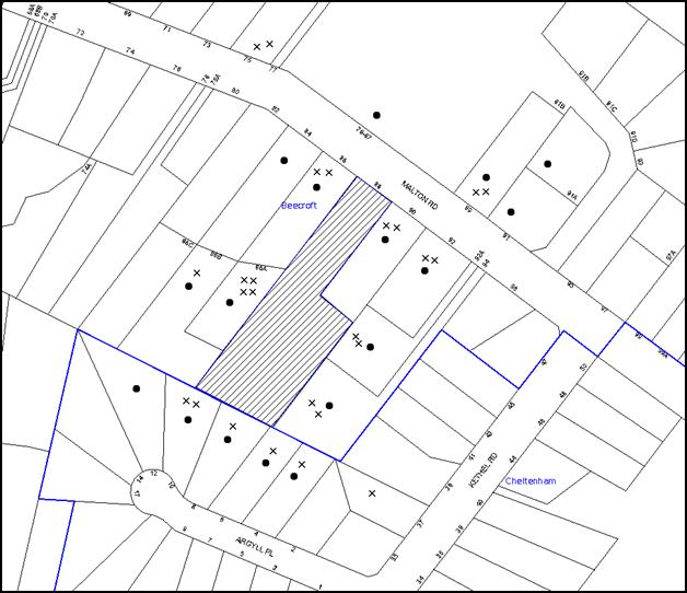
|
NOTIFICATION PLAN |
|
||
|
• PROPERTIES NOTIFIED
|
X SUBMISSIONS RECEIVED |
PROPERTY SUBJECT OF DEVELOPMENT |
|
|
14 SUBMISSIONS RECEIVED OUT OF MAP RANGE |
|||
39 submissions objected to the development, generally on the grounds that the development would result in:
· Cumulative loss of significant trees and bushland. Numerous trees are threatened by the indicative building envelopes and the 10/50 laws. Arborist report proposes to remove trees on neighbour’s land. Building envelopes should be setback from neighbours trees;
· The land behind Lot 1 should be rehabilitated to its natural state to offset the Loss of Tree 60 as required by DA/924/2013;
· The bushland in the restricted development area being compromised;
· Soil erosion and land slip;
· Structural damage to neighbouring properties;
· Noise during construction;
· Disturbance from the use of an existing right-of way on Lot 90 Malton Road during construction;
· An increase in traffic on local streets;
· An increase in stormwater runoff and flood levels in the creek to the rear;
· Increased bushfire risk as Malton Road is too narrow;
· Future dwelling houses that do not comply with Council’s planning controls;
· Privacy impacts from the loss of vegetation and erection of new dwellings;
· Overlooking into the pool at 86A Malton Road from the open space to the rear of Lot 1;
· Runoff and sediment pollution to the riparian corridor and flow on impacts to vulnerable frogs in Lane Cove National Park;
· Loss of biodiversity and reduced habitat for threatened species;
· Existing compliance issues predict that future unauthorised activities would occur if this subdivision is approved;
· No further development should be considered until the applicant is prosecuted for the removal of trees on the site and damage to neighbours trees along the western boundary;
· Malton Road is not suited to any construction vehicles;
· There should be no development below RL92 or over the ridge line as occurred with 86C Malton Road, in order to protect the natural environment;
· The removal of street tree T70 and impact on the Heritage Conservation Area;
· No visitor parking;
· Overshadowing and noise from future dwellings;
· Fences should be erected along the side boundaries prior to any subdivision;
· Inadequate Soil and Water Management Plan;
· A flood study and water quality study should be prepared;
· Devaluation of resident’s homes.
The merits of the matters raised in community submissions have been addressed in the body of the report with the exception of the following:
5.1.1 The Subdivision is Inconsistent with Conditions of Consent for the Dwelling
Submissions comment that the application is inconsistent with the existing conditions of consent for the dwelling house that requires environmental rehabilitation, as approved by the Land and Environment Court for DA/924/2013. It is contended that any approval granted by Council to this subdivision application cannot be undertaken without also requiring an amended DA consent for DA/924/2013.
There are no conditions imposed on the development consent granted to DA/924/2013 that directly prohibits the subdivision of the site.
Condition 13 of the operational conditions of the consent granted to DA/924/2013 requires landscaping to the site to comply with the amended landscape plan referred to in the deferred commencement condition and Planning for Bushfire Protection. If it was considered that the landscaping in the approved landscape plan could no longer be carried out if the land was subdivided (and buildings subsequently erected in the areas of the building envelopes) it would be possible for a condition of consent to be imposed on the grant of development consent to the subdivision under section 80A(1)(b) of the EP&A Act that required modification of the consent granted to DA/924/2013 by removing or amending condition 13. The modification does not require an application under section 96 of the EP&A Act to be made nor require the modified development to be substantially the same as the original approved development. In that regard, Council may utilise the power in section 80A(1)(b) to impose a condition on a development consent to require the modification of a consent granted under the Act in relation to the land to which the development application relates. The recommended conditions of consent require the landscape plan referred to Condition 13 of DA/924/2013 to be modified to be consistent with the landscape plan to be approved by Council as a deferred commencement condition for the subdivision application DA/320/2015. This is included in the recommended conditions of consent.
5.1.2 There should be no development over the ridge line as occurred with 86C Malton Road
Submissions received contend that there should be no development below RL92 or below the ridge line. A number of submissions contended that there should only be one new lot at the rear, and the building envelope setback from side boundaries and setback from any rock outcrop.
The HDCP controls at 1C.1.4 advise that development should be sited on the area of land presenting the least topographical constraints and away from ridge lines. The rock escarpment that separates the flatter benched areas on the site is not a ridge line. The proposal is consistent with the HDCP that requires development to be sited on land presenting the least topographical constraints.
When the two lot subdivision to create 86C Malton Road was approved via DA/2152/1999 over 16 years ago, a consent condition required a restricted development area (RDA) at the rear of the block. This RDA adjoined the rear boundary for a depth of 24m (western side boundary) to 36m (eastern side boundary). This is similar to the 30m deep RDA recommended as a consent condition for this application. Therefore, the extent of the bushland corridor at the rear of the site would be similar to 86C Malton Road.
5.1.3 Trees adjacent to Building Envelopes would be removed in the future
Submissions raise concern that the requirement for an Asset Protection Zone (APZ) would preclude the retention of any mature tree in close proximity to the proposed building envelope. The Asset Protection Zone requirements for vegetation management include that a canopy should not overhang within 2m to 5m of a dwelling. This could be achieved by crown lifting, thinning such as removing smaller secondary branches, and selective pruning to prevent direct flame contact between trees and assets. The requirement for an APZ does not require all trees within 10m of a building to be completely removed.
A submission contends that if Council is of a mind to approve the DA, the applicant should be required to enter into a Biodiversity Agreement under Part 3 of the Threatened Species Conservation (Biodiversity Banking) Regulation 2008 to protect vegetation from clearing under the 10/50 rule. The RFS 10/50 provisions no longer apply to Heritage Conservation Areas. Therefore, it is not necessary to enter into any other agreement.
5.1.4 Future Buildings should be restricted to single storey
A submission contends that Prescriptive measure 9.3.6(a) of the DCP requires that the predominately single storey scale of development in the Beecroft-Cheltenham Heritage Conservation Area should be retained. Therefore, it was requested that if Council is minded to approve the DA, a covenant should be imposed restricting any future dwellings at the rear to one storey (4.5m) in height. The development in the immediate vicinity of the subject site is typically sloping land with rock outcrops and contains a mix of single and two storey built forms. A two storey building is consistent with the existing built form in the locality. Therefore, such a restriction on the title is not supported.
5.1.5 Boundary Fence
The site’s western and eastern side boundaries do not have a solid boundary fence. The neighbours raise concerns about impacts on their privacy. The consent conditions require the applicant to construct a boundary fence. A solid 1.8m boundary fence is to extend to the southern extent of the building envelopes depicted on the plan of subdivision.
5.1.6 Construction Phase Impacts
The neighbours raise concerns about noise and disturbance from the use of an existing right-of-way during construction. Consent conditions are recommended in relation to hours of construction and environmental management during the construction phase.
5.1.7 Impacts on Property Values
Submissions comment that the additional dwellings and removal of trees would diminish the economic value of all residents’ homes. Residents advise that when they purchased their properties they expected the land to remain as bushland because of the very large trees on the site and Heritage Conservation Area status. Most of the very large trees in the vicinity of the proposed building envelopes on Lots 2 and 3 were removed under the RFS 10/50 laws. This subdivision application cannot require the reinstatement of trees lawfully removed under the RFS 10/50 Code or require that their loss be mitigated on site using Council’s Green Offsets Code (2013). The proposed subdivision pattern and building envelope setbacks to the riparian corridor are consistent with existing development in the locality. The development is generally consistent with the applicable planning controls.
5.2 Public Agencies
The development application was referred to the following Agencies for comment:
5.2.1 Rural Fire Service
The proposal was referred to the Rural Fire Service (RFS) as Integrated Development under the Rural Fires Act. The RFS has provided a Bushfire Safety Authority including conditions of consent.
5.2.2 Office of Water
The proposal was referred to the NSW Office of Water as Integrated Development under the Water Management Act. The Office of Water has advised that an approval is not required and has not provided any conditions of consent.
6. THE PUBLIC INTEREST
Section 79C(1)(e) of the Act requires Council to consider “the public interest”.
The public interest is an overarching requirement, which includes the consideration of the matters discussed in this report. Implicit to the public interest is the achievement of future built outcomes adequately responding to and respecting the future desired outcomes expressed in environmental planning instruments and development control plans.
The application is considered to have satisfactorily addressed Council’s and relevant agencies’ criteria and would provide a development outcome that, on balance, would result in a positive impact for the community. Accordingly, it is considered that the approval of the proposed development would be in the public interest.
CONCLUSION
The application seeks approval for the subdivision of one lot into three lots.
The proposed development is generally in accordance with the development controls in the Hornsby Development Control Plan and would contribute to residential housing supply in the locality.
There are a number of modifications required to the application to ensure that the impact on the locality is acceptable. This includes modifications to the vehicle crossing, an extension of the restricted development area, protection of tree groups, relocation of the stormwater drainage outlet and replacement canopy tree planting. A number of these modifications are required to be detailed and approved by Council as a deferred commencement condition of consent.
It is recommended that the Council approve the application as a deferred commencement consent.
Note: At the time of the completion of this planning report, no persons have made a Political Donations Disclosure Statement pursuant to Section 147 of the Environmental Planning and Assessment Act 1979 in respect of the subject planning application.
RESPONSIBLE OFFICER
The officer responsible for the preparation of this Report is the Manager – Development Assessments – Rodney Pickles, who can be contacted on 9847 6731.
|
Rod Pickles Manager - Development Assessment Planning Division |
James Farrington Group Manager Planning Division |
|
1.View |
Locality Map |
|
|
|
2.View |
Survey Plan Tree Numbers |
|
|
|
3.View |
Subdivision Plan |
|
|
|
4.View |
Driveway Long Section Plan |
|
|
|
5.View |
Stormwater Management Plan |
|
|
|
6.View |
Landscape Plan |
|
|
|
7.View |
Concept Plans for Lots 2 and 3 |
|
|
|
8.View |
Tree Impacted and Protected Plan |
|
|
|
9.View |
Amended Crossing Concept Plan |
|
|
|
10.View |
Amended Landscape Plan |
|
|
File Reference: DA/320/2015
Document Number: D06911862
SCHEDULE 1
GENERAL CONDITIONS
The conditions of consent within this notice of determination have been applied to ensure that the use of the land and/or building is carried out in such a manner that is consistent with the aims and objectives of the relevant legislation, planning instruments and council policies affecting the land and does not disrupt the amenity of the neighbourhood or impact upon the environment.
Note: For the purpose of this consent, the term ‘applicant’ means any person who has the authority to act on or the benefit of the development consent.
Note: For the purpose of this consent, any reference to an Act, Regulation, Australian Standard or publication by a public authority shall be taken to mean the gazetted Act or Regulation, or adopted Australian Standard or publication as in force on the date that the application for a construction certificate is made.
1. Deferred Commencement
Pursuant to Section 80(3) of the Environmental Planning and Assessment Act 1979, this consent does not operate until the following information is submitted to Council:
a) An amended plan of subdivision and driveway long section is to be submitted to Council for approval that modifies the crossing to Malton Road to facilitate the retention of Tree 70. This is to be generally consistent with the concept plan annotated in red on the Plan of Subdivision by P S Graham dated 20 January 2016.
b) A detail survey is to be provided to locate the stormwater pipe between lots 2 and 3 so that the stormwater pipe is located between the rock boulders, rather than over an embankment. This is to be submitted to Council for approval to ensure is it suitably located to minimise incursions into the building envelopes on Lots 2 and 3. The subdivision plan is then to be updated to reflect the modified drainage easement.
c) An Integrated Vegetation and Fire Management Plan is to be submitted to Council for approval, prepared for the retained bushland at the rear of the site. The Plan must include, but not be limited to the following strategies to manage, maintain and conserve the bushland including:
i) On-going weed control and suppression using bush regeneration methods. Weed control must be undertaken using a qualified and experienced bush regeneration contractor;
ii) Habitat protection for fauna; and
iii) The restoration of all disturbed areas using bush regeneration techniques.
iv) Strategies for management of the Asset Protection Zones in a manner that has the least impact on the natural environment and maintains indigenous vegetation for the benefit of the corridor function. This has to be undertaken in consultation with a Bushfire Management Consultant.
v) Revegetation works in disturbed and modified areas using a diversity of locally indigenous species. Include details of appropriate planting density, source of planting stock, species to be planted, site preparation works, mulching, watering of plants and maintenance of revegetation area.
vi) Management and maintenance of approved stormwater drainage areas.
vii) Erosion, sediment and stormwater runoff controls including the management of impacts of run-off from all impervious surfaces including pavement areas.
viii) Erection of appropriate signage to protect the Restricted Development Area bushland and details of bushland management requirements for future residents.
ix) Appropriate map of the site.
x) Schedule of works including timeframes and responsibilities for management actions.
xi) Details of site monitoring including the submission of annual reports to Council of bushland management and restoration.
xii) Details of qualifications and experience of company preparing the plan.
xiii) The lifetime of the Plan shall be a minimum of 5 years.
d) A Landscape Plan is to be submitted to Council for approval. The Plan must include, but not be limited to the following:
i) Provision of a plan showing the retention of remnant trees
ii) The location, height and materials of all new retaining walls that is generally consistent with the concept plan annotated in red on the Landscape Plan by P.S. Graham dated 20 January 2016.
iii) The planting of native trees/shrubs/ground covers in the Restricted Development Area.
iv) Pedestrian access routes and stairs that provide for access over Lots 2 and 3 for residents to maintain the Inner Protection Area.
v) Landscaping to the area of the demolished pool including re-grassing and planting of native vegetation.
vi) The plant species are to be chosen are to comprise of local Blackbutt Gully Forest (Smith & Smith 2008). The location of the plantings must take into account the required Tree Protection Zone of mature specimens of these trees and should be ideally placed in groups.
vii) All plants must be obtained from a local recognised native nursery and be of local provenance. This include at least 5 compensatory tree plantings in the Restricted Development Area.
Such information must be submitted within 24 months of the date of this notice.
Upon Council’s written satisfaction of the above information, the following conditions of development consent apply:
2. Approved Plans and Supporting Documentation
The development must be carried out in accordance with the plans and documentation listed below and endorsed with Council’s stamp, except where amended by Council and/or other conditions of this consent:
|
Plan No. |
Plan Title |
Drawn by |
Dated |
|
S15079 |
Detail Survey |
P S Graham |
30.4.2013 |
|
S15079-A |
Revised Plan of Subdivision |
P S Graham |
20.1.2016 |
|
S15079-A |
Long Sections |
P S Graham |
20.1.2016 |
|
16001 Dwg 2 Issue E |
Stormwater Management Plan |
Chrisp Consulting |
03.2.2016 |
|
S15079-A |
Landscape Plan for Lot 1 |
P S Graham |
20.1.2016 |
|
Document Title |
Prepared by |
Dated |
|
Arborist Impact Assessment |
McArdle Arboricultural |
02.4.2015 |
|
Flora and Fauna Assessment |
Ambrose Ecological Services |
08.3.2015 |
|
Preliminary Geotechnical Report |
JK Geotechnics |
27.08.2015 |
|
Bushfire Protection Assessment Report |
Australian Bushfire Protection Planners |
10.3.2015 |
3. Removal of Existing Trees
a) This development consent permits the removal of trees numbered 51, 52 and 61 as identified on the Detail Survey Plan prepared by P S Graham dated 30.4.2013.
b) The removal of any other trees requires separate approval in accordance with the Tree and Vegetation Chapter 1B.6 Hornsby Development Control Plan (HDCP).
4. Amendment of Plans
a) To comply with Councils requirement to protect the street trees in Malton Road, the approved plans are to be amended as follows:
i) The vehicle crossover is to be relocated in accordance with the plan approved pursuant to Condition No.1.
b) To comply with Councils requirement to manage the location, height and materials of all retaining walls on the property, the approved plans are to be amended as follows:
i) The retaining walls on Lot 1 are to be modified in accordance with the plan approved pursuant to Condition No.1.
c) To comply with Councils requirement to minimise impacts on the bushland at the rear of the site, the approved plans are to be amended as follows:
i) The stormwater outlet spreaders and any associated works are to be located 35m or greater from the southern property boundary and outside the Structural Root Zone (AS 4970) of any retained tree.
ii) The area between 20m and 30m of the southern property boundary is to be managed and revegetated with locally indigenous species which include canopy and mid-storey trees and shrubs and ground-covers indicative of Blackbutt Gully Forest, at recognised, best practice spacings. The 10m wide strip is to be managed so that it meets the requirements of Planning for Bushfire Protection (PBP 2006) and Standards for Asset Protection Zones and the vegetation provides a clear buffer strip between the developed area and the natural bushland and trees within 20m of the creek.
iii) An updated plan indicating trees present on the site
d) These amended plans must be submitted with the application for the Construction Certificate.
5. Revocation or Modification of Existing Consent
Pursuant to Section 80A(1)(b) of the EP&A Act, the applicant is required to give notice to Council pursuant to Clause 97 of the EP&A Regulation to amend Condition No.13 of DA/924/2013 to replace the approved landscape plan with the landscape plan to be approved by Council pursuant to deferred commencement Condition 1(d) of DA/320/2015.
6. Construction Certificate
a) A Construction Certificate is required to be approved by Council or a Private Certifying Authority prior to the commencement of any works under this consent.
b) A separate Construction Certificate must be obtained from Council for all works within the public road reserve under S138 of the Roads Act.
c) A separate Construction Certificate must be obtained from Council for all works within drainage easements vested in Council.
d) The Construction Certificate plans must not be inconsistent with the Development Consent plans.
7. Section 94 Development Contributions
a) In accordance with Section 80A(1) of the Environmental Planning and Assessment Act, 1979 and the Hornsby Shire Council Section 94 Development Contributions Plan 2014-2024, the following monetary contributions must be paid to Council to cater for the increased demand for community infrastructure resulting from the development:
|
Description |
Contribution (4) |
|
Roads |
$3,989.50 |
|
Open Space and Recreation |
$25,950.60 |
|
Community Facilities |
$9,976.20 |
|
Plan Preparation and Administration |
$83.70 |
|
TOTAL |
$40,000.00 |
being for 2 additional lots.
b) The value of this contribution is current as at 20 April 2016. If the contribution is not paid within the financial quarter that this condition was generated, the contribution payable will be adjusted in accordance with the provisions of the Hornsby Shire Council Section 94 Development Contributions Plan and the amount payable will be calculated at the time of payment in the following manner:
$CPY = $CDC x CPIPY
CPIDC
Where:
$CPY is the amount of the contribution at the date of Payment
$CDC is the amount of the contribution as set out in this Development Consent
CPIPY is the latest release of the Consumer Price Index (Sydney – All Groups) at the date of Payment as published by the ABS.
CPIDC is the Consumer Price Index (Sydney – All Groups) for the financial quarter at the date applicable in this Development Consent Condition.
c) The monetary contribution must be paid to Council:
i) prior to the issue of the Subdivision Certificate where the development is for subdivision; or
ii) prior to the issue of the first Construction Certificate where the development is for building work; or
iii) prior to issue of the Subdivision Certificate or first Construction Certificate, whichever occurs first, where the development involves both subdivision and building work; or
iv) prior to the works commencing where the development does not require a Construction Certificate or Subdivision Certificate.
Note: It is the professional responsibility of the Principal Certifying Authority to ensure that the monetary contributions have been paid to Council in accordance with the above timeframes.
Council’s Development Contributions Plan may be viewed at www.hornsby.nsw.gov.au or a copy may be inspected at Council’s Administration Centre during normal business hours.
REQUIREMENTS PRIOR TO THE ISSUE OF A CONSTRUCTION CERTIFICATE
8. Vehicular Crossing
A separate application under the Local Government Act, 1993 and the Roads Act 1993 must be submitted to Council for the installation of a new vehicular crossing and the removal of the redundant crossing. The vehicular crossing must be constructed in accordance with Council’s Civil Works Design 2005 and the following requirements:
a) Design levels at the front boundary must be obtained from Council for the design on the internal driveway;
b) Any redundant crossings must be replaced;
c) Approval must be obtained from all relevant utility providers that all necessary conduits be provided and protected under the crossing.
Note: An application for a vehicular crossing can only be made to one of Council’s Authorised Vehicular Crossing Contractors. You are advised to contact Council on 02 9847 6940 to obtain a list of contractors.
9. Driveway crossing materials and design
In addition to any other driveway design requirements required under this consent, in order to minimise the impact of the crossing on the Heritage Conservation Area, the street should remain un-kerbed and the driveway crossing should be a dark recessive colour similar to bitumen.
10. Internal Driveway/Vehicular Areas
The driveway and parking areas on site must be designed, in accordance with Australian Standards 2890.1, 2890.2, 3727 and the following requirements:
a) A passing bay of 5.5m width and 6m length is to be constructed at the inter section with Malton Road.
b) A turning head is to be provided at the end of the driveway (at boundaries of Lot 2 and 3).
c) Design levels at the front boundary must be obtained from Council
d) The driveway be a rigid pavement and accommodate a 15 tonne loading.
e) The driveway pavement be a minimum 3 metres wide, 0.15 metres thick reinforced concrete with F72 steel reinforcing fabric and a 0.15 metre sub-base.
f) The pavement have a kerb to one side and a one-way cross fall with a minimum gradient of 2 percent and a lintel and pit provided at the low point.
g) Retaining walls required to support the carriageway and the compaction of all fill batters must be to be in accordance with the requirements of a chartered structural engineer and supported by a report from a chartered geotechnical engineer of the Institution of Engineers, Australia.
h) The provision of safety rails where there is a level difference more than 0.3 metres and a 1:4 batter cannot be achieved.
i) Planting of a grass verge along both sides of the length of the driveway.
j) In accordance with the approved plans, a minimum of 2 car spaces shall be provided for proposed Lot 1.
k) Conduit for utility services including electricity, water, gas and telephone be provided. All existing overhead assets including electricity and telecommunications cabling shall be relocated underground at no cost to Council. A certificate from an appropriately licensed contractor shall be submitted to the principal certifying authority certifying that the service conduits have been installed in accordance with the relevant utility provider and Australian Standards.
l) A common turning area to service the proposed subdivision in accordance with Australian Standards AS 2890.1 to ensure vehicles can enter and leave the site in a forward direction. A right of access shall be created over the turning area to ensure access is maintained at all times.
m) Construction of pedestrian access designed to help prevent slip and fall shall be designed and constructed with the future access driveway. Pedestrian grades steeper than 12.5% shall be provided with surface texturing, brushing or cleats to satisfy Class V: R11 ramps in accordance with AS 4586-2004 Clause 5.2.
n) Longitudinal sections along both sides of the access driveway shall be submitted to the principal certifying authority in accordance with the relevant sections of AS 2890.1. The maximum grade shall not exceed 1 in 4 (25%) with the maximum changes of grade of 1 in 8 (12.5%) for summit grades and 1 in 6.7 (15%) for sag grades. Any transition grades shall have a minimum length of 2 metres. The longitudinal sections shall incorporate the design levels obtained by Council. The design is also to comply with the requirements of the Rural Fire Service in Condition No.45.
11. Stormwater Drainage – Land Adjoining Bushland and Creek
a) In addition to any other stormwater drainage requirements required under this consent, an on site infiltration/dispersion system must be designed and constructed in accordance with Council’s Civil Works Specification for Lots 2 and 3 and sized to cater for a minimum volume of 5 cubic metres for nominated lots and for runoff from the new driveway.
b) The stormwater drainage system for the development must be designed for an average recurrence interval (ARI) of 20 years
c) The on-site stormwater system must disperse flow over the site so as not to discharge water in a concentrated manner into the bushland on the site.
d) The stormwater drainage system must be designed by a qualified civil engineer.
12. Fire Hydrant Location
The reticulated water main should be extended from the street in Malton Road to provide a new hydrant located to comply with AS2419.1-2005. The proposed plan of subdivision is to be amended to show a hydrant that does not obstruct the driveway crossing. A qualified bushfire consultant is to certify that the hydrant complies with AS2419.1. The hydrant is also to be sited to avoid impacts on street trees and comply with AS4970.
13. Dilapidation Report
A ‘Dilapidation Report’ is to be prepared by a ‘chartered structural engineer’ detailing the structural condition of the following adjoining properties:
a) No. 90 Malton Road
b) No. 86A Malton Road
14. Appointment of a Project Arborist
A Project Arborist is to be appointed in accordance with AS 4970-2009 (1.4.4) to provide monitoring and certification throughout the development process. Details of the Project Arborist are to be submitted to Council and the PCA prior to the issue of a Construction Certificate.
15. Engineering Details for work near trees
Engineering details for all work must be provided to Council and the PCA showing the construction techniques to be implemented to protect trees on the site and in the road reserve in accordance with AS4970. The engineering details must form part of the Construction Certificate documentation.
16. Root Mapping
a) Where excavation or construction work is proposed within the Tree Protection Zone (TPZ) tree 70 the presence, size and depth of the root system must be determined using non-destructive exploratory techniques.
b) The works must be carried out under the direction and supervision of the Project Arborist in accordance with AS 4970-2009 (Clause 3.3.4).
c) The root mapping must occur at a distance greater than 4.5m from the edge of the trunk of the tree T70.
d) A report must be submitted by the Project Arborist to Council and the Principal Certifying Authority detailing the results of the root mapping, showing the location of any identified roots and the location and proposed construction techniques for the structure and any associated services.
e) Details of the methods proposed to protect the tree during the construction period must be provided as part of the certification for this development.
REQUIREMENTS PRIOR TO THE COMMENCEMENT OF ANY WORKS
17. Erection of Construction Sign
a) A sign must be erected in a prominent position on any site on which any approved work is being carried out:
i) Showing the name, address and telephone number of the principal certifying authority for the work;
ii) Showing the name of the principal contractor (if any) for any demolition or building work and a telephone number on which that person may be contacted outside working hours; and
iii) Stating that unauthorised entry to the work site is prohibited.
b) The sign is to be maintained while the approved work is being carried out and must be removed when the work has been completed.
18. Toilet Facilities
a) To provide a safe and hygienic workplace, toilet facilities must be available or be installed at the works site before works begin and must be maintained until the works are completed at a ratio of one toilet for every 20 persons employed at the site.
b) Each toilet must:
i) be a standard flushing toilet connected to a public sewer; or
ii) be a temporary chemical closet approved under the Local Government Act 1993; or
iii) have an on-site effluent disposal system approved under the Local Government Act 1993.
19. Erosion and Sediment Control
To protect the water quality of the downstream environment, erosion and sediment control measures must be provided and maintained throughout the construction period in accordance with the manual ‘Soils and Construction 2004 (Bluebook)’, the approved plans, Council specifications and to the satisfaction of the principal certifying authority. The erosion and sediment control devices must remain in place until the site has been stabilised and revegetated.
Note: On the spot penalties may be issued for any non-compliance with this requirement without any further notification or warning.
20. Tree Protection
The Project Arborist must oversee the installation and provide certification for all tree protection measures as specified in this consent and in accordance with Australian Standard AS 4970-2009 (1.4.4).
21. Tree Protection Zones (TPZ)
a) Tree protection fencing must be installed around tree numbered 70, 47, 44, 42, 40, 67, 68 and 69 as identified on the Overall Site Plan and Proposed Access Road, prepared by Chris Consulting, dated 09-01-16 (Drawing No. 002, Issue E) at the distances determined by AS 4970-2009 (Clause 3.2).
b) Tree Protective Fencing must be installed in accordance with AS 4970-2009 (Clauses 4.3 and 4.4).
c) Where tree protection fencing cannot be located at the perimeter of the Tree Protection Zone, fencing may be positioned to the edge of the Structural Root Zone and appropriate ground and crown protection must be provided in accordance with AS 4970-2009 (Clause 4.5) under the direction of the project arborist.
d) Maintenance of the Tree Protection Zones must be carried out in accordance with AS 4970-2009 (Clause 4.6) for the duration of this consent.
e) Permanent marking of the Restricted Development Area to ensure construction stockpiles and machinery remains outside of this area as per Condition No. 35.
22. Tree Protection Certification
Certification must be provided (prior to any other work) by the Project Arborist to the Principal Certifying Authority stating that all required tree protection measures have been installed in accordance with AS 4970-2009 (Clauses 5.3.2 and 5.4.2).
REQUIREMENTS DURING CONSTRUCTION
23. Construction Work Hours
All works on site, including demolition and earth works, must only occur between 7am and 5pm Monday to Saturday.
No work is to be undertaken on Sundays or public holidays.
24. Environmental Management
The site must be managed in accordance with the publication ‘Managing Urban Stormwater – Landcom (March 2004) and the Protection of the Environment Operations Act 1997 by way of implementing appropriate measures to prevent sediment run-off, excessive dust, noise or odour emanating from the site during the construction of the development.
25. Council Property
To ensure that the public reserve is kept in a clean, tidy and safe condition during construction works, no building materials, waste, machinery or related matter is to be stored on the road or footpath.
26. Disturbance of Existing Site
During construction works, the existing ground levels of open space areas and natural landscape features, including natural rock-outcrops, vegetation, soil and watercourses must not be altered unless otherwise nominated on the approved plans.
27. Landfill
Landfill must be constructed in accordance with Council’s ‘Construction Specification 2005’ and the following requirements:
a) All fill material imported to the site is to wholly consist of Virgin Excavated Natural Material (VENM) as defined in Schedule 1 of the Protection of the Environment Operations Act, 1997 or a material approved under the Department of Environment and Climate Change’s general resource recovery exemption.
b) A compaction certificate is to be obtained from a suitably qualified geotechnical engineer verifying that the specified compaction requirements have been met.
c) This compaction certificate must be included with the application for an occupation certificate.
28. Excavated Material
All excavated material removed from the site must be classified by a suitably qualified person in accordance with the Department of Environment, Climate Change and Water NSW Waste Classification Guidelines prior to disposal to an approved waste management facility and be reported to the principal certifying authority prior to the issue of an Occupation Certificate.
29. Excavation of Rock
Any rock excavation required for the subdivision works such as the installation of the driveway is to be undertaken by rock sawing rather than rock breaking and in accordance with the requirements of a Geotechnical Engineer.
30. Works near Trees
a) All Tree Protection Zones must be monitored and maintained by the Project Arborist in accordance with AS 4970-2009 (Clause 5.4.3)
b) All work in Tree Protection Zones must be approved by the Project Arborist.
c) Root/ground protection must be provided in accordance with AS 4970-2009 (Clause 4.5.4).
d) Underground services must be installed in accordance with AS 4970-2009 (Clause 4.5.5).
e) The Structural Root Zone of any tree required to be retained must remain intact
f) Root pruning outside a trees Structural Root Zone must be carried out in accordance with AS 4970-2009 (Clauses 4.5.4 and 4.5.5).
g) Activities within the Tree Protection Zone must comply with AS 4970-2009 (Clause 4.2).
h) Where works have been undertaken within the Tree Protection Zone of a tree the Project Arborist must assess the condition of tree(s) and make recommendations for, and carry out remedial actions where there is evidence of:
i) A general decline in health and vigour
ii) Damaged, crushed or dying roots
iii) Excessive (>10%) loss or dieback of roots, branches and foliage
iv) Mechanical damage or bruising of bark and timber of roots, trunks and branches
v) Yellowing of foliage of thinning of canopy uncharacteristic of the species
vi) An increase in the amount of deadwood not associated with normal growth.
vii) Inappropriate increase in the development of epicormic growth and/or the presence of sucker growth on the trunk
viii) Branch drop, torn branches and stripped bark not associated with natural climate conditions
ix) The naturestrip is to be remediated (all non-locally indigenous grasses and weeds removed) and revegetated with locally indigenous species which include canopy and mid-storey trees and shrubs and ground-covers in indicative of Blackbutt Gully Forest, at recognised best practice spacing. A restoration plan showing the proposed naturestrip remediation and restoration is to be provided to Council and the PCA for approval prior to commencement of any works.
REQUIREMENTS PRIOR TO THE ISSUE OF A SUBDIVISION CERTIFICATE
Note: For the purpose of this consent, a reference to ‘occupation certificate’ shall not be taken to mean an ‘interim occupation certificate’ unless otherwise stated.
31. Damage to Council Assets
To protect public property and infrastructure, any damage caused to Council’s assets as a result of the construction or demolition of the development must be rectified by the applicant in accordance with Council’s Civil Works Specifications. Rectification works must be undertaken prior to the issue of an Occupation Certificate, or sooner, as directed by Council.
32. Utility Services
The applicant must submit written evidence of the following service provider requirements:
a) Ausgrid (formerly Energy Australia) – a letter of consent demonstrating that satisfactory arrangements have been made to service the proposed development.
b) Sydney Water – an s73 Certificate must be obtained from Sydney Water.
33. Creation of Easements
The following matter(s) must be nominated on the plan of subdivision under s88B of the Conveyancing Act, 1919:
a) A right of access and easement for services over the access corridor;
b) An inter-allotment drainage easement(s) over each of the burdened lots;
c) The creation of a “Positive Covenant” over the proposed Lots 2 and 3 requiring that any future development is to provide an on-site detention system with a provision to disperse stormwater in a manner that will not cause erosion of soil. The on-site detention system is to have a storage capacity of 5 cubic metres and a maximum discharge of 8 litres per second into Council’s drainage system.
d) An easement for letterboxes shall be created to ensure all lots have a suitable letter box location on-site adjacent to the front boundary. The 88b instrument shall be worded to reflect the obligations and responsibilities of the benefiting and burdening parties.
Note: Council must be nominated as the authority to release, vary or modify any easement, restriction or covenant.
34. Restriction as to User – Protection of Land from Future Development
To inform current and future owners that the areas of native vegetation and habitat on the site are to be protected from future development, a Restriction as to User must be created under Section 88B of the Conveyancing Act, 1919 identifying the area of the site shown on the approved plans is that restricted from future development. The restriction is to identify that:
a) A Restricted Development Area for the width of Lots 2 and 3 and a depth of 20m is to be created adjacent to the rear boundary. This area is to be maintained as bushland and restricted from disturbance of any kind.
b) A Restricted Development Area for the width of Lots 2 and 3 and a depth of 10m, adjacent to the RDA identified at (1) above. This area is to be restricted from future building works and maintained as an Inner Protection Area containing remnant native trees and revegetated as identified in Condition 4(c)(ii).
c) The RDA restriction must specify that:
i) The area is to be managed in accordance with an Integrated Vegetation and Fire Management Plan approved by Council.
ii) The area is clearly marked and identified onsite in perpetuity.
iii) Machinery other than hand held must remain outside the RDA
iv) All natural landscape features such as natural rock outcrops, native vegetation (trees, shrubs and groundcovers), soil and watercourses are to remain undisturbed, except only where affected by necessary works detailed on an approved plan with Council’s written consent.
v) Hard stand or paved private open space areas must be limited to land outside the ‘Restricted Development Area’.
Note: The wording of the Restriction as to User must be to Council’s satisfaction and Council must be nominated as the authority to release, vary or modify the Restriction.
35. Bushland Restoration
To ensure the regeneration of bushland, the applicant must ensure the following:
a) All environmental and noxious weeds must be removed and suppressed using recognised bush regeneration methods in accordance with ‘Recovering bushland on the Cumberland Plain: Best practice guidelines for the management and restoration of bushland – Department of Conservation 2005’.
b) The erection of a physical barrier that extends a minimum 20mm below ground surface and 80mm above ground surface along the edge of all turf areas, to prevent the spread of exotic grasses or weeds into the bushland area.
c) The planting of locally indigenous trees a minimum of 4 metres from the building envelope and protected with tree guards as depicted in the approved Vegetation Management Plan and Landscape Plan.
d) The erection of a post and wire (or similar) fence around the bushland area nominated on the approved plans to physically keep machinery and equipment away from sensitive area of the site.
e) Certification by an ecologist or similarly qualified and experienced person that the bushland has been adequately protected and regenerated in accordance with the requirements of this consent.
Note: Advice on appropriate bush regeneration methods and the removal of noxious and environmental weeds can be obtained from Council’s Bushland and Biodiversity Management Team on 9847 6542.
36. Maintain Canopy Cover
Green Offset Replacement Planting
a) To offset the loss of trees on Lot 1, four (4) canopy trees must be planted on Lot 1.
b) The replacement planting must be species selected from Council’s booklet ‘Indigenous Plants for the Bushland Shire’ indicative of Blackbutt Gully Forest Vegetation Community and must include canopy trees with a mature growth height of 12 metres or greater.
Location and Size of Plantings
c) Tree plantings must be located 4 metres or greater from the foundation walls of the approved development.
d) Two trees are to be planted in the front setback of Lot 1 and two trees are to be planted in the rear yard of Lot 1.
e) The pot size of the replacement tree(s) must be a minimum 25 litres.
f) The replacement tree(s) must be maintained until they reach the height of 3 metres.
g) Planting methods must meet professional (best practice) industry standards
37. Boundary Fencing
The exact location, design and costing for the erection of boundary fencing are to be the subject of negotiation and agreement in accordance with the relevant requirements of the Dividing Fences Act, 1991.
Fencing must be erected along all property boundaries behind the front building alignment to a height of 1.8 metres, to at least the southern extent of the indicative building envelopes on Lots 2 and 3.
Note: Alternative fencing may be erected subject to the written consent of the adjoining property owner(s).
38. Arborist Certification
Following the final inspection and the completion of any remedial tree works, the Project Arborist must submit to the Principal Certifying Authority documentation stating that the completed works have been carried out in compliance with the approved plans and the relevant conditions of consent. All certificates and documentation relating to the protection of trees must be included in the Final Certification.
39. Completion of Landscaping
A certificate must be submitted to the PCA by a practicing landscape architect, horticulturalist or person with similar qualifications and experience certifying that all required landscaping works have been satisfactorily completed in accordance with the approved landscape plans.
Note: Advice on suitable species for landscaping can be obtained from Council’s planting guide ‘Indigenous Plants for the Bushland Shire’, available at www.hornsby.nsw.gov.au.
OPERATIONAL CONDITIONS
40. Vegetation Management Plan Compliance
The development must be carried out in accordance with the Vegetation Management Plan approved at Condition No.1.
GENERAL TERMS OF APPROVAL – RURAL FIRE SERVICE
The following conditions of consent are General Terms of Approval from the nominated State Agency pursuant to Section 91A of the Environmental Planning and Assessment Act 1979 and must be complied with to the satisfaction of that Agency.
41. At the issue of Subdivision Certificate and in perpetuity, the entire property (except for the 'Restricted Development Area' as identified on the submitted subdivision plan) shall be managed as an inner protection area (IPA) as outlined within section 4.1.3 and Appendix 5 of 'Planning for Bush Fire Protection 2006' and the NSW Rural Fire Service's document 'Standards for asset protection zones'.
42. For inner protection areas (IPA) on slopes greater than 18 degrees, the property shall be landscaped or managed (e.g. terracing) with suitable access being provided to the IPA to ensure the ongoing maintenance of the area
43. Water, electricity and gas are to comply with section 4.1.3 of 'Planning for Bush Fire Protection 2006'
44. The proposed access-handle for Lot(s) 2 and 3 shall comply with the following requirements of section 4.1.3 (2) - Property Access of 'Planning for Bush Fire Protection 2006'.
a) the capacity of road surfaces are capable of carrying a load of 15 tonnes.
b) A minimum carriageway width of 4 metres.
c) A minimum vertical clearance of 4 metres to any overhanging obstruction, including tree branches.
d) curves have a minimum inner radius of six metres and are minimal in number to allow for rapid access and egress.
e) The crossfall is not to exceed 10 degrees.
f) Maximum grades for sealed roads do not exceed 15 degrees and not more than 10 degrees for unsealed roads.
Note: The RFS clarified that the minimum carriageway refers to an unobstructed 4m wide access. In this instance where the proposed boundary width of the access-handle is 4m, this is adequate provided that there are no obstructions along the driveway, such as landscaping or kerbs and gutters. If kerbs and gutters are proposed, rolled kerbs and gutters and a grass verge is not considered an obstruction.
45. Landscaping within the inner protection area (IPA) is to comply with the principles of Appendix 5 of 'Planning for Bush Fire Protection 2006'.
- END OF CONDITIONS -
ADVISORY NOTES
The following information is provided for your assistance to ensure compliance with the Environmental Planning and Assessment Act, 1979, Environmental Planning and Assessment Regulation 2000, other relevant legislation and Council’s policies and specifications. This information does not form part of the conditions of development consent pursuant to Section 80a of the Act.
Environmental Planning and Assessment Act 1979 Requirements
The Environmental Planning and Assessment Act 1979 requires:
· The issue of a construction certificate prior to the commencement of any works. Enquiries can be made to Council’s Customer Services Branch on 9847 6760.
· A principal certifying authority to be nominated and Council notified of that appointment prior to the commencement of any works.
· Council to be given at least two days written notice prior to the commencement of any works.
· Mandatory inspections of nominated stages of the construction inspected.
· An occupation certificate to be issued before occupying any building or commencing the use of the land.
Long Service Levy
In accordance with Section 34 of the Building and Construction Industry Long Service Payments Act 1986, a ‘Long Service Levy’ must be paid to the Long Service Payments Corporation or Hornsby Council.
Note: The rate of the Long Service Levy is 0.35% of the total cost of the work.
Note: Hornsby Council requires the payment of the Long Service Levy prior to the issue of a construction certificate.
Tree and Vegetation Preservation
In accordance with Clause 5.9 of the Hornsby Local Environmental Plan 2013 a person must not ringbark, cut down, top, lop, remove, injure or wilfully destroy any tree or other vegetation protected under the Hornsby Development Control Plan 2013 without the authority conferred by a development consent or a permit granted by Council.
Notes: A tree is defined as a long lived, woody perennial plant with one or relatively few main stems with the potential to grow to a height greater than three metres (3M). (HDCP 1B.6.1.c).
Tree protection measures and distances are determined using the Australian Standard AS 4970:2009, “Protection of Trees on Development Sites”.
Fines may be imposed for non-compliance with both the Hornsby Local Environmental Plan 2013 and the Hornsby Development Control Plan 2013.
Covenants
The land upon which the subject building is to be constructed may be affected by restrictive covenants. Council issues this approval without enquiry as to whether any restrictive covenant affecting the land would be breached by the construction of the building, the subject of this consent. Applicants must rely on their own enquiries as to whether or not the building breaches any such covenant.
Subdivision Certificate Requirements
A subdivision certificate application is required to be lodged with Council containing the following information:
· A surveyor’s certificate certifying that all structures within the subject land comply with the development consent in regard to the setbacks from the new boundaries.
· A surveyor’s certificate certifying that all services, drainage lines or access are located wholly within the property boundaries. Where services encroach over the new boundaries, easements are to be created.
· Certification that the requirements of relevant utility authorities have been met.
· A surveyor’s certificate certifying finished ground levels are in accordance with the approved plans.
Note: Council will not issue a subdivision certificate until all conditions of the development consent have been completed.
Fees and Charges – Subdivision
All fees payable to Council as part of any construction, compliance or subdivision certificate or inspection associated with the development (including the registration of privately issued certificates) are required to be paid in full prior to the issue of the subdivision certificate. Any additional Council inspections beyond the scope of any compliance certificate required to verify compliance with the terms of this consent will be charged at the individual inspection rate nominated in Council's Fees and Charges Schedule.
Dial Before You Dig
Prior to commencing any works, the applicant is encouraged to contact Dial Before You Dig on 1100 or www.dialbeforeyoudig.com.au for free information on potential underground pipes and cables within the vicinity of the development site.
Telecommunications Act 1997 (Commonwealth)
If you are aware of any works or proposed works which may affect or impact on Telstra’s assets in any way, you are required to contact: Telstra’s Network Integrity Team on Phone Number 1800810443.
Group Manager’s Report No. PL36/16
Planning Division
Date of Meeting: 11/05/2016
13 SECTION 96(2) APPLICATION - MODIFICATION TO 3 RESIDENTIAL FLAT BUILDINGS - 544 - 552 PACIFIC HIGHWAY AND 1-1A COWAN ROAD, MOUNT COLAH
EXECUTIVE SUMMARY
|
DA No: |
DA/1096/2013/B (Lodged on 17 September 2015) |
|
Description: |
Section 96(2) application to modify 3 x five storey residential flat buildings comprising 94 Units with basement car parking |
|
Property: |
Nos. 544 - 552 Pacific Highway and Nos. 1 and 1A Cowan Road, Mount Colah being Lots 21 and 22 DP 1044911, Lots 1, 3 and 4 DP 20511, Lots A and B DP 372148 |
|
Applicant: |
Skyworks Group |
|
Owner: |
Killara NSW Developments |
|
Estimated Value: |
$19.74 million |
|
Ward: |
A |
· The application involves modification of the existing development consent for of 3 x 5 storey residential flat buildings including an increase from 90 units to 94 units.
· The proposal is generally consistent with State Environmental Planning Policy No. 65 – Design Quality Residential Flat Development and Hornsby Development Control Plan 2013.
· Two submissions have been received in respect of the application.
· An independent consultant assessment report has been prepared by Don Fox Planning and is attached for consideration.
· The stormwater management system is similar to that approved on the site, however, final comments from Sydney Trains on the stormwater system are outstanding. To avoid delays in determining the application, it is recommended that Council delegate to the General Manager to approve the application, subject to concurrence from Sydney Trains.
|
THAT Council delegate authority to the General Manager to approve the modification pursuant to Section 96(2) of the Environmental Planning and Assessment Act 1979. DA/1096/2013 for the erection of 3x5 storey residential flat buildings containing 94 units with basement parking for 110 cars at Nos. 544-552 Pacific Highway and Nos. 1 and 1A Cowan Road, Mount Colah in accordance with the conditions of consent detailed in Schedule 1 of Group Manager’s report PL36/16, subject to final concurrence conditions from Sydney trains. |
ASSESSMENT
The application proposes to modify an approved 5 storey residential flat development, comprising 3 buildings and 90 Units with 122 basement car parking spaces.
The modified proposal involves the addition of mezzanine levels to nine of the units and increasing the number of units from 90 to 94 units. This results in changes to the unit configurations, mix and building footprint. Alterations to the building profile and floor levels are also proposed.
Basement 2 will be removed and Basement 1 will be extended to provide 93 car parking spaces. In addition, 17 car parking spaces will be provided in a part basement at the same level as the ground floor units, providing for a total of 110 parking spaces. Vehicular access from Cowan Road will be retained.
It is proposed to drain stormwater to an OSD tank located within the northern setback as per the original approval and then to Council’s infrastructure within the northern adjoining Lot 6 DP 20511 (554 Pacific Highway) via an easement. This infrastructure then discharges to the Sydney Trains land to the east. The need for an easement is subject to a deferred commencement condition on the original development consent. This is similar to the existing approved solution for the site.
The adjoining site is subject to DA/1521/2014 and was reported to the Council meeting on 13 April 2016. The application involves relocation of a Council stormwater easement and pipe. Amended stormwater plans for the easement were received in March 2016 and require concurrence from Sydney Trains. Sydney Trains advised that it supports the amended stormwater concept plan in principle, subject to more detailed modelling. Therefore, to avoid unnecessary delays in determining the application, Council resolved to delegate to the General Manager to approve the application subject to final concurrence conditions from Sydney Trains. The stormwater issue on DA/1096/2013/B is interrelated to the stormwater issue for DA/1521/2014.
The development application has been referred to an independent town planning consultant. The report by DFP is attached to this report for consideration and recommends that the application be approved.
CONCLUSION
Council has referred the application to an independent planning consultancy to carry out an assessment of the application and to consider the public submissions. The assessment concludes that the application should be approved.
Council has not received final comments and conditions from Railcorp for this application regarding stormwater discharge. It is recommended that Council resolve to delegate to the General Manager to approve the application subject to final concurrence conditions from Sydney Trains.
Note: At the time of the completion of this planning report, no persons have made a Political Donations Disclosure Statement pursuant to Section 147 of the Environmental Planning and Assessment Act 1979 in respect of the subject planning application.
RESPONSIBLE OFFICER
The officer responsible for the preparation of this Report is the Manager – Development Assessments – Rodney Pickles, who can be contacted on 9847 6731.
|
Rod Pickles Manager - Development Assessment Planning Division |
James Farrington Group Manager Planning Division |
|
1.View |
Locality Map |
|
|
|
2.View |
Consultant's Report |
|
|
|
3.View |
Floor Plans - Part 1 |
|
|
|
4.View |
Floor Plans - Part 2 |
|
|
|
5.View |
Floor Plans - Part 3 |
|
|
|
6.View |
Floor Plans - Part 4 |
|
|
|
7.View |
Elevations and Sections - Part 1 |
|
|
|
8.View |
Elevations and Sections - Part 2 |
|
|
|
9.View |
Elevations and Sections Part 3 |
|
|
|
10.View |
Elevations and Sections - Part 4 |
|
|
|
11.View |
Stormwater Plan |
|
|
|
12.View |
Landscape Plan |
|
|
|
13.View |
Shadow Plans - Part 1 |
|
|
|
14.View |
Shadow Plans - Part 2 |
|
|
File Reference: DA/1096/2013/B
Document Number: D06932147
SCHEDULE 1
|
Date of 1st modification: |
19 October 2015 |
|
Details of 1ST modification: |
Section 96(1A) modification to extend time period for submission of deferred commencement information |
|
Conditions Added: |
Nil |
|
Conditions Deleted: |
Nil |
|
Conditions Modified: |
1 |
|
Date of this modification: |
11 May 2016 |
|
Details of this modification: |
Section 96(2) modification to implement design changes and provide for 3 x 5‑storey residential flat buildings comprising 94 units with common basement parking for 110 cars |
|
Conditions Added: |
4A, 4B, 19A, 28A, 28B |
|
Conditions Deleted: |
3(c), 3(d), 3(f), 3(g), 44(b), 44(c), 46 |
|
Conditions Modified: |
2, 3(a), 3(b), 3(e), 4, 6, 10, 11, 19, 28, 33, 34, 35(g)(iv), 43, 52, 53(f) |
|
Amend Description of Development |
Erection of 3 x 5-storey residential flat buildings containing 94 units with basement parking |
GENERAL CONDITIONS
The conditions of consent within this notice of determination have been applied to ensure that the use of the land and/or building is carried out in such a manner that is consistent with the aims and objectives of the relevant legislation, planning instruments and council policies affecting the land and does not disrupt the amenity of the neighbourhood or impact upon the environment.
Note: For the purpose of this consent, the term ‘applicant’ means any person who has the authority to act on or the benefit of the development consent.
Note: For the purpose of this consent, any reference to an Act, Regulation, Australian Standard or publication by a public authority shall be taken to mean the gazetted Act or Regulation, or adopted Australian Standard or publication as in force on the date that the application for a construction certificate is made.
1. Deferred Commencement
Pursuant to Section 80(3) of the Environmental Planning and Assessment Act 1979, this consent does not operate until the following information is submitted to Council:
a) An Easement to Drain Water is to be created over Lot 6 DP 20511 (554 Pacific Highway Mount Colah).
Such information shall be submitted within 18 months of the date of this notice.
Upon Council’s written satisfaction of the above information, the following conditions of development consent will apply:
2. Approved Plans and Supporting Documentation
The development must be carried out in accordance with the plans and documentation listed below and endorsed with Council’s stamp, except where amended by Council and/or other conditions of this consent:
|
Plan No. |
Drawn by |
Dated |
|
A-S96-200 Rev C Basement 01 |
PSEC Project Services |
16/3/16 |
|
A-S96-201 Rev C Ground Floor |
PSEC Project Services |
16/3/16 |
|
A-S96-202 Rev C Level 1 |
PSEC Project Services |
16/3/16 |
|
A-S96-203 Rev C Levels 2-3 |
PSEC Project Services |
16/3/16 |
|
A-S96-204 Rev C Level 4 |
PSEC Project Services |
16/3/16 |
|
A-S96-205 Rev C Mezzanine |
PSEC Project Services |
16/3/16 |
|
A-S96-206 Rev C Roof Plan |
PSEC Project Services |
16/3/16 |
|
A-S96-301 Rev B Section (Long Section and Building A) |
PSEC Project Services |
13/3/16 |
|
A-S96-301 Rev B Section (Buildings B and C) |
PSEC Project Services |
13/3/16 |
|
A-S96-401 Building A – North and South Elevation |
PSEC Project Services |
13/3/16 |
|
A-S96-402 Building A – East and West Elevation |
PSEC Project Services |
13/3/16 |
|
A-S96-403 Building B – North and South Elevation |
PSEC Project Services |
13/3/16 |
|
A-S96-404 Building B – East and West Elevation |
PSEC Project Services |
13/3/16 |
|
A-S96-405 Building C – North and South Elevation |
PSEC Project Services |
13/3/16 |
|
A-S96-406 Building C – East & West Elevation |
PSEC Project Services |
13/3/16 |
|
13138 S96 1-2 Rev C Landscape Concept Plan |
Vision Dynamics |
16/3/16 |
|
13138 S96 2-2 Rev C Landscape Concept Plan |
Vision Dynamics |
16/3/16 |
|
D01 Rev C Basement Stormwater Drainage Plan Sheet 1 |
Smart Engineering Solutions |
24/2/16 |
|
D02 Rev C Basement Stormwater Drainage Plan Sheet 2 |
Smart Engineering Solutions |
24/2/16 |
|
D03 Rev C Basement Stormwater Drainage Details |
Smart Engineering Solutions |
19/1/16 |
|
D04 Rev C Ground Floor/Site Stormwater Drainage Plan Sheet 1 |
Smart Engineering Solutions |
8/3/16 |
|
D05 Rev C Ground Floor/Site Stormwater Drainage Plan Sheet 2 |
Smart Engineering Solutions |
8/3/16 |
|
D06 Rev C Stormwater Drainage Details |
Smart Engineering Solutions |
8/3/16 |
|
D07 Rev A Erosion and Sediment Control Plan and Details |
Smart Engineering Solutions |
9/9/15 |
|
Document No. |
Prepared by |
Dated |
|
BASIX Certificate No. 507959M_04 |
Building Sustainability Assessments |
16 March 2016 |
|
BASIX Assessor Certificate and Stamped Plans – Certificate No. 14912221 |
Building Sustainability Assessments |
16 March 2016 |
|
Tree Assessment Report Ref A16031 |
Travers Bushfire and Ecology |
18 March 2016 |
|
Preliminary Geotechnical Assessment |
Martens Consulting |
Feb 2014 |
|
Railcorp Impact Assessment (supplementary geotechnical advice |
Martens Consulting Engineers |
30.7.14 |
|
Statement of Compliance Access for People with a Disability |
Accessible Building Solutions |
7/9/15 |
|
Traffic and Parking Report |
Terraffic |
8/9/15 |
|
Travers Bushfire and Ecology |
Travers bushfire and ecology |
Sep 2013 |
|
DA Acoustic Report |
Acoustic Logic |
8.10.13 |
Amended plans are required as follows:
a) Reduce the width of the paved terrace at Unit C101 and C106 to achieve a minimum 4m wide deep soil planting in the Cowan Road boundary setback. Unit C101 is to have a balcony with a minimum area of 8m2.
c) Deleted
d) Deleted
e) The east elevation of Block C is to be amended so that the balconies and ground level terraces are either:
i) reduced to be no closer than 20m to the eastern boundary adjoining the rail corridor; or
ii) enclosed by a 2m high glass wall/ balustrade along the eastern elevation of all ground level terraces and enclosed by a 1m high glass louver screen (maximum 80 mm opening) on top of a 1m high balustrade along the eastern elevation of the upper level balconies.
f) Deleted
g) Deleted.
4. Removal of Existing Trees
a) This development consent permits the removal of tree(s) numbered 3, 4, 7, 8, 9,12, 13, 16, 17, 18, 19, 20, 21, 22, 23, 28, 29, 30, 31, 32, 43, 44, 45, 46 & 47 as identified in the Report (Appendix 1, Tree Assessment Table) prepared by Travers, Bushfire & Ecology, dated March 2016.
Note: The removal of any other trees from the site requires separate approval by Council in accordance with Part 1B.6 Tree and Vegetation Preservation of the Hornsby Development Control Plan, 2013 (HDCP).
4A. Project Arborist
a) A Project Arborist is to be appointed in accordance with AS 4970-2009 (1.4.4) to provide monitoring and certification throughout the development process.
b) Details of the Project Arborist are to be submitted to Council and the PCA prior to the issue of a Construction Certificate.
4B. Pruning Works
a) The pruning of trees located onsite must be carried out in accordance with the Hornsby Development Control Plan 2013 (HDCP), Tree and Vegetation Preservation Chapter 1B.6, Clause (m).
Note: The pruning of protected trees outside the above parameters requires separate approval from Council in accordance with HDCP 1B.6.
5. Construction Certificate
A Construction Certificate is required to be approved by Council or a Private Certifying Authority prior to the commencement of any works under this consent.
REQUIREMENTS PRIOR TO THE ISSUE OF A CONSTRUCTION CERTIFICATE
6. Section 94 Development Contributions
a) In accordance with Section 80A(1) of the Environmental Planning and Assessment Act 1979 and the Hornsby Shire Council Section 94 Development Contributions Plan 2012-2021, the following monetary contributions shall be paid to Council to cater for the increased demand for community infrastructure resulting from the development:
|
Description |
Contribution (4) |
|
Roads |
$40,096.00 |
|
Open Space and Recreation |
$882,221.40 |
|
Community Facilities |
$367,895.55 |
|
Plan Preparation and Administration |
$2,665.70 |
|
TOTAL |
$1,292,878.65 |
being for 17 x 1 bed, 67 x 2 bed and 10 x 3 bed units including a credit for 7 existing lots.
b) The value of this contribution is current as at 19 April 2016. If the contributions are not paid within the financial quarter that this condition was generated, the contributions payable will be adjusted in accordance with the provisions of the Hornsby Shire Council Section 94 Development Contributions Plan and the amount payable will be calculated at the time of payment in the following manner:
|
$CPY = |
$CDC x CPIPY |
|
CPIDC |
Where:
$CPY is the amount of the contribution at the date of Payment
$CDC is the amount of the contribution as set out in this Development Consent
CPIPY is the latest release of the Consumer Price Index (Sydney – All Groups) at the date of Payment as published by the ABS.
CPIDC is the Consumer Price Index (Sydney – All Groups) for the financial quarter at the date applicable in this Development Consent Condition.
c) The monetary contributions shall be paid to Council:
i) prior to the issue of the Subdivision Certificate where the development is for subdivision; or
ii) prior to the issue of the first Construction Certificate where the development is for building work; or
iii) prior to issue of the Subdivision Certificate or first Construction Certificate, whichever occurs first, where the development involves both subdivision and building work; or
iv) prior to the works commencing where the development does not require a Construction Certificate or Subdivision Certificate.
Note: It is the professional responsibility of the Principal Certifying Authority to ensure that the monetary contributions have been paid to Council in accordance with the above timeframes.
Council’s Development Contributions Plan may be viewed at www.hornsby.nsw.gov.au or a copy may be inspected at Council’s Administration Centre during normal business hours.
7. Building Code of Australia
All building work must be carried out in accordance with the relevant requirements of the Building Code of Australia.
8. Contract of Insurance (Residential Building Work)
In the case of residential building work for which the Home Building Act 1989 requires there to be a contract of insurance in force in accordance with Part 6 of that Act, that such a contract of insurance is in force before any building work authorised to be carried out by the consent commences.
9. Water/Electricity Utility Services
The applicant must submit written evidence of the following service provider requirements:
a) Ausgrid (formerly Energy Australia) – a letter of consent demonstrating that satisfactory arrangements have been made to service the proposed development.
b) Sydney Water – the submission of a ‘Notice of Requirements’ under s73 of the Sydney Water Act 1994.
Note: Sydney Water requires that s73 applications are to be made through an authorised Sydney Water Servicing Coordinator. Refer to www.sydneywater.com.au or telephone 13 20 92 for assistance.
10. Accessible Units
The development is required to provide 28 units designed as adaptable housing pursuant to the requirements of 1C.2.2 of the Hornsby Development Control Plan. In this regard, ten (10) car parking spaces are to be designed for people with a disability and allocated to ten (10) adaptable units. The details of all adaptable units must be provided with the Construction Certificate plans.
The following waste management requirements must be complied with:
a) The approved on-going waste management system must not be amended without the written consent of Council.
b) The waste facilities on each residential level (a garbage chute and recycling bin in cupboards) must be accessible by persons with a disability while comfortably housing the garbage chute and 240 L recycling bin.
Note: A 240 L recycling bin is 600 mm wide by 750 mm deep; allow for ease around the bin – 75 mm is recommended). The chute system supplier must be consulted for chute space requirements.
c) A bulky waste storage area of at least 8 square metres must be provided at the basement level.
d) Each garbage chute system must include volume handling equipment (at least a 2x660L linear or similar, with no compaction) to automatically change the bin under the chute when it becomes full.
e) Both door openings to the bin collection/garbage room are to be no less than 1600 mm wide.
f) A Waste Management Plan Section One – Demolition Stage and Section Three – Construction Stage, covering the scope of this project and including the following details, is required to be submitted to Council:
i) An estimate of the types and volumes of waste and recyclables to be generated;
ii) A site plan showing sorting and storage areas for demolition and construction waste and the vehicle access to these areas;
iii) How excavation, demolition and construction waste materials will be reused or recycled and where residual wastes will be disposed;
iv) The total percentage (by weight) of demolition and construction waste that will be reused or recycled.
12. Dilapidation Report
A ‘Dilapidation Report’ is to be prepared by a ‘chartered structural engineer’ detailing the structural condition of the adjoining properties.
13. Noise – Rail Corridor
The development must be carried out in accordance with the recommendations contained within the acoustic report submitted with the development application, titled, prepared by Acoustic Logic and dated 8/10/2013 and the requirements of the Department of Planning’s Development Near Rail Corridors and Busy Roads – Interim Guideline and RailCorp’s Interim Guidelines for Applicants.
Note: The Department of Planning’s document is available at www.planning.nsw.gov.au (development assessments). The RailCorp document is available at www.railcorp.nsw.gov.au/publications.
14. Traffic Control Plan
A Traffic Control Plan (TCP) must be prepared by a qualified traffic controller in accordance with the Roads & Traffic Authority’s Traffic Control at Worksites Manual 1998 and Australian Standard 1742.3 for all work on a public road and be submitted to Council. The TCP must detail the following:
a) Arrangements for public notification of the works.
b) Temporary construction signage.
c) Permanent post-construction signage.
d) Vehicle movement plans detailing construction vehicle routes, number of trucks, hours of operation, access arrangements and traffic control.
e) Traffic management plans.
f) Pedestrian and cyclist access/safety.
REQUIREMENTS PRIOR TO THE COMMENCEMENT OF ANY WORKS
15. Erection of Construction Sign
A sign must be erected in a prominent position on any site on which building work, subdivision work or demolition work is being carried out:
a) Showing the name, address and telephone number of the principal certifying authority for the work;
b) Showing the name of the principal contractor (if any) for any demolition or building work and a telephone number on which that person may be contacted outside working hours; and
c) Stating that unauthorised entry to the work site is prohibited.
Note: Any such sign is to be maintained while the building work, subdivision work or demolition work is being carried out, but must be removed when the work has been completed.
16. Protection of Adjoining Areas
A temporary hoarding, fence or awning must be erected between the work site and adjoining lands before the works begin and must be kept in place until after the completion of the works if the works:
a) Could cause a danger, obstruction or inconvenience to pedestrian or vehicular traffic.
b) Could cause damage to adjoining lands by falling objects.
c) Involve the enclosure of a public place or part of a public place.
Note: Notwithstanding the above, Council’s separate written approval is required prior to the erection of any structure or other obstruction on public land.
17. Toilet Facilities
Toilet facilities must be available or provided at the works site before works begin and must be maintained until the works are completed at a ratio of one toilet for every 20 persons employed at the site. Each toilet must:
a) be a standard flushing toilet connected to a public sewer; or
b) be a temporary chemical closet approved under the Local Government Act 1993; or
c) have an on-site effluent disposal system approved under the Local Government Act 1993.
18. Erosion and Sediment Control
Erosion and sediment control measures must be provided and maintained throughout the construction period in accordance with the manual ‘Soils and Construction 2004 (Bluebook)’, the approved plans, Council specifications and to the satisfaction of the principal certifying authority. The erosion and sediment control devices must remain in place until the site has been stabilised and revegetated.
Note: On the spot penalties up to $1,500 may be issued for any non-compliance with this requirement without any further notification or warning.
19. Tree Protection
a) The Project Arborist must oversee the installation and provide certification for all tree protection measures as specified in this consent and in accordance with Australian Standard AS 4970-2009 (1.4.4).
b) Tree protection fencing must be installed onsite around trees numbered 1, 2, 5, 6, 9, 10, 11, 14, 15 24, 25, 26, 27 & 33-42 as identified in the Report prepared by Travers, Bushfire & Ecology, dated March 2016, at the distances specified in Appendix 1, Tree Assessment Table.
c) Tree Protective Fencing must be installed in accordance with AS 4970-2009 (Clauses 4.3 and 4.4).
d) Where tree protection fencing cannot be located at the perimeter of the Tree Protection Zone, appropriate ground, trunk and crown protection must be provided in accordance with AS 4970-2009 (Clause 4.5) under the direction of the project arborist.
e) Maintenance of the Tree Protection Zones must be carried out in accordance with AS 4970-2009 (Clause 4.6) for the duration of this consent.
19A. Tree Protection Certification
Certification must be provided by the Project Arborist to the Principal Certifying Authority stating that all required tree protection measures have been installed in accordance with AS 4970-2009 (Clauses 5.3.2 & 5.4.2).
REQUIREMENTS DURING CONSTRUCTION
All work on site (including demolition and earth works) must only occur between 7am and 5pm Monday to Saturday. No work is to be undertaken on Sundays or public holidays.
All demolition work must be carried out in accordance with “Australian Standard 2601-2001 – The Demolition of Structures” and the following requirements:
a) Demolition material must be disposed of to an authorised recycling and/or waste disposal site and/or in accordance with an approved waste management plan;
b) Demolition works, where asbestos material is being removed, must be undertaken by a contractor that holds an appropriate licence issued by WorkCover NSW in accordance with Chapter 10 of the Occupational Health and Safety Regulation 2001 and Clause 29 of the Protection of the Environment Operations (Waste) Regulation 2005 ;and
c) On construction sites where buildings contain asbestos material, a standard commercially manufactured sign containing the words ‘DANGER ASBESTOS REMOVAL IN PROGRESS’ measuring not less than 400mm x 300mm must be erected in a prominent position visible from the street.
22. Environmental Management
The site must be managed in accordance with the publication ‘Managing Urban Stormwater – Landcom (March 2004) and the Protection of the Environment Operations Act 1997 by way of implementing appropriate measures to prevent sediment run-off, excessive dust, noise or odour emanating from the site during the construction of the development.
23. Council Property
During construction works, no building materials, waste, machinery or related matter is to be stored on the road or footpath. The public reserve must be kept in a clean, tidy and safe condition at all times.
24. Disturbance of Existing Site
During construction works, the existing ground levels of open space areas and natural landscape features, (including natural rock-outcrops, vegetation, soil and watercourses) must not be altered unless otherwise nominated on the approved plans.
25. Landfill
Landfill must be constructed in accordance with Council’s ‘Construction Specification 2005’ and the following requirements:
a) All fill material imported to the site is to wholly consist of Virgin Excavated Natural Material (VENM) as defined in Schedule 1 of the Protection of the Environment Operations Act 1997 or a material approved under the Department of Environment and Climate Change’s general resource recovery exemption.
b) A compaction certificate is to be obtained from a geotechnical engineer verifying that the specified compaction requirements have been met.
All excavated material removed from the site must be classified in accordance with the Department of Environment, Climate Change and Water NSW Waste Classification Guidelines prior to disposal to an approved waste management facility and reported to the principal certifying authority.
27. Survey Report – Finished Floor Level
A report(s) must be prepared by a registered surveyor and submitted to the principal certifying authority prior to the pouring of concrete at each level of the building certifying that:
a) The building, retaining walls and the like have been correctly positioned on the site; and
b) The finished floor level(s) are in accordance with the approved plans.
28. Work Near Trees
a) Maintaining All Tree Protection Zones must be monitored and maintained by the Project Arborist in accordance with AS 4970-2009 (Clause 5.4.3)
b) Where works have been undertaken within the Tree Protection Zone of a tree the Project Arborist must assess the condition of tree(s) and make recommendations for, and carry out remedial actions where there is evidence of:
c) A general decline in health and vigour
d) Damaged, crushed or dying roots
e) Excessive (>10%) loss or dieback of roots, branches and foliage
f) Mechanical damage or bruising of bark and timber of roots, trunks and branches
g) Yellowing of foliage of thinning of canopy uncharacteristic of the species
h) An increase in the amount of deadwood not associated with normal growth
i) Inappropriate increase in the development of epicormic growth and/or the presence of sucker growth on the trunk
j) Branch drop, torn branches and stripped bark not associated with natural climate conditions
28A. Works within Tree Protection Zones
a) All works must be approved by the Project Arborist.
b) Root/ground protection must be provided in accordance with AS 4970-2009 (Clause 4.5.4).
c) Underground services must be installed in accordance with AS 4970-2009 (Clause 4.5.5).
d) The Structural Root Zone of any tree required to be retained must remain intact and undisturbed.
e) Root pruning outside a trees Structural Root Zone must be carried out in accordance with AS 4970-2009 (Clauses 4.5.4 and 4.5.5).
f) Activities within the Tree Protection Zone must comply with AS 4970-2009 (Clause 4.2).
28B. Certification
The Project Arborist must submit to the principal certifying authority a certificate that all the completed works have been carried out in compliance with the approved plans and specifications for tree protection. Certification must include a statement of overall site attendance, the condition of the retained trees, details of any deviations from the approved tree protection measures and their impacts on trees. Copies of monitoring documentation may be required.
29. Waste Management Details
Waste management during the demolition and construction phase of the development must be undertaken in accordance with the approved Waste Management Plan. Additionally written record of the following items must be maintained during the removal of any waste from the site and such information submitted to the Principal Certifying Authority within fourteen days of the date of completion of the works;
a) The identity of the person removing the waste.
b) The waste carrier vehicle registration.
c) Date and time of waste collection.
d) A description of the waste (type of waste and estimated quantity).
e) Details of the site to which the waste is to be taken.
f) The corresponding tip docket/receipt from the site to which the waste is transferred (noting date and time of delivery, description (type and quantity) of waste).
g) Whether the waste is expected to be reused, recycled or go to landfill.
Note: In accordance with the Protection of the Environment Operations Act 1997, the definition of waste includes any unwanted substance, regardless of whether it is reused, recycled or disposed to landfill.
30. Construction Vehicles
All construction vehicles associated with the proposed development are to be contained on site as no construction zones will be permitted on Pacific Highway or Cowan Road in the vicinity of the site.
REQUIREMENTS PRIOR TO THE ISSUE OF AN OCCUPATION CERTIFICATE
Note: For the purpose of this consent, a reference to ‘occupation certificate’ shall not be taken to mean an ‘interim occupation certificate’ unless otherwise stated.
31. Fulfilment of BASIX Commitments
The applicant must demonstrate the fulfilment of BASIX commitments pertaining to the development.
32. Sydney Water – s73 Certificate
An s73 Certificate must be obtained from Sydney Water.
The stormwater drainage system for the development must be designed and constructed in accordance with Council’s Civil Works – Design and Construction Specification 2005 and the following requirements:
a) Connected to the existing piped drainage system within No 554 Pacific Highway
b) A Construction Certificate is to be issued for these works
34. On-Site Stormwater Detention
An on-site stormwater detention system must be designed by a chartered civil engineer and constructed in accordance with the following requirements:
a) OSD 1 is to have a capacity of not less than 42.8m3 cubic metres, and a maximum discharge (when full) of 70.6 litres per second, OSD 2 is to have a capacity of not less than 43.7m3 and a maximum discharge of 56.8 litres per second;
b) Have a surcharge/inspection grate located directly above the outlet;
c) Discharge from the detention system must be controlled via 1 metre length of pipe, not less than 50 millimetres diameter or via a stainless plate with sharply drilled orifice bolted over the face of the outlet discharging into a larger diameter pipe capable of carrying the design flow to an approved Council system;
d) Not be constructed in a location that would impact upon the visual or recreational amenity of residents.
e) A Construction Certificate is to be issued for these works
35. Internal Driveway/Vehicular Areas
The driveway and parking areas on site must be designed in accordance with Australian Standards 2890.1, 2890.2, 3727, Hornsby Shire Councils Civil Works Specification and the following requirements:
a) Design levels at the front boundary must be obtained from Council;
b) The driveway must be a rigid pavement;
c) All parking areas and driveways are to be sealed to an all weather standard, line marked and signposted;
d) Car parking, loading and manoeuvring areas to be used solely for nominated purposes;
e) Vehicles awaiting loading, unloading or servicing shall be parked on site and not on adjacent or nearby public roads;
f) All vehicular entry on to the site and egress from the site shall be made in a forward direction.
g) Parking in the basement is to be allocated to the units in accordance with the following minimum parking rates:
i) 1 bed units - 0.75 car spaces/ unit (average)
ii) 2 bed units – 1 car space/ unit
iii) 3 bed units – 1.5 car spaces/ unit (average)
iv) Visitors – 14 car spaces and 4 motorcycle spaces
36. Footpath
A concrete footpath must be constructed along the full frontage of the subject site in the Pacific Highway and Cowan Road in accordance Council’s Civil Works Design and Construction Specification 2005 and the following requirements:
a) The existing footpath being removed
b) The consent of Hornsby Shire Council under Section 138 of the Roads Act is to be obtained prior to any works occurring.
c) The land adjoining the footpath to be fully turfed.
d) Any public utility adjustments to be carried out at the cost of the applicant and to the requirements of the relevant public authority.
37. Road Works
All road works approved under this consent must be constructed in accordance with Council’s Civil Works Design and Construction Specification 2005 and the following requirements:
a) The existing kerb and gutter (including the kerb return) in Cowan Road is to be removed and a new kerb and gutter (including kerb return) is to be constructed. The new kerb and gutter is to be located centrally within the road reserve and is to provide for an 11m width between the face of kerbs.
b) A half road cul de sac is to be constructed at the Eastern end of Cowan Road adjacent to the railway corridor. The cul de sac shall be 15m in diameter. The construction shall include half road construction within the cul de sac bulb. All road pavements shall be designed and constructed in accordance with Councils Civil Works Specification.
c) The existing road pavement to be saw cut a minimum of 300 mm from the existing edge of the bitumen and reconstructed.
d) The submission of a compaction certificate from a geotechnical engineer for any fill within road reserves, and all road sub-grade and road pavement materials.
e) No work is to commence within the road reserve until approval under Section 138 of the Roads Act is obtained from Hornsby Shire Council.
38. Damage to Council Assets
Any damage caused to Council’s assets as a result of the construction of the development must be rectified in accordance with Council’s Civil Works Specifications. Council’s Restorations Supervision must be notified for a formwork inspection prior to pouring concrete.
The following matter(s) must be nominated on the plan of subdivision under s88B or s88E of the Conveyancing Act 1919:
a) The creation of an appropriate "Positive Covenant" and "Restriction as to User" over the constructed on-site detention/retention systems and outlet works, within the lots in favour of Council in accordance with Council’s prescribed wording. The position of the on-site detention system is to be clearly indicated on the title.
b) To register the OSD easement, the restriction on the use of land “works-as-executed” details of the on-site-detention system must be submitted verifying that the required storage and discharge rates have been constructed in accordance with the design requirements. The details must show the invert levels of the on site system together with pipe sizes and grades. Any variations to the approved plans must be shown in red on the “works-as-executed” plan and supported by calculations. The “work as executed” plans are to be supported by an engineer’s certificate certifying that the OSD system has been constructed to function hydraulically in accordance with the requirements of this consent.
Note: Council must be nominated as the authority to release, vary or modify any easement, restriction or covenant.
40. Works as Executed Plan
A works-as-executed plan(s) must be prepared by a registered surveyor and submitted to Council for completed road pavement, kerb & gutter, public drainage systems, driveways and on-site detention system.
41. Consolidation of Allotments
All allotments the subject of this consent must be consolidated into one allotment prior to the issue of the Occupation Certificate.
Note: The applicant is recommended to submit the plan of subdivision to consolidate allotments to the NSW Department of Lands at least 4-6 weeks prior to seeking an occupation certificate.
42. Garbage Collection Easement
For the purpose of waste collection, an easement entitling Council, its servants and agents and persons authorised by it to enter upon the subject land and to operate thereon, vehicles and other equipment for the purposes of garbage collection must be granted to Council by the owner of the land.
Note: The easement must be in a form prescribed by Council and must include covenants to the effect that parties will not be liable for any damage caused to the subject land or any part thereof or to any property located therein or thereon by reason of the operation thereon of any vehicle or other equipment used in connection with the collection of garbage and to the effect that the owner for the time being of the subject land shall indemnify the Council, its servants, agents and persons authorised by it to collect garbage against liability in respect of any such claims made by any person whomsoever.
43. Waste Management Details
The following waste management requirements must be complied with:
a) The chute service rooms and bin collection room at the basement level must include water or a hose for cleaning, graded floors with drainage to sewer, a robust door, sealed and impervious surface, adequate lighting and ventilation, and must be lockable. The waste facilities (garbage chute in cupboard and recycling bin in cupboard) at each residential level must include sealed and impervious surface, adequate lighting and ventilation.
b) A report must be prepared by an appropriately qualified person, certifying the following:
i) A comparison of the estimated quantities of each waste type against the actual quantities of each waste type. Note: Explanations of any deviations to the approved Waste Management Plan is required to be included in this report
ii) That at least 60% of the waste generated during the demolition and construction phase of the development was reused or recycled. Note: If the 60% diversion from landfill cannot be achieved in the Construction Stage, the Report is to include the reasons why this occurred and certify that appropriate work practices were employed to implement the approved Waste Management Plan. The Report must be based on documentary evidence such as tipping dockets/receipts from recycling depots, transfer stations and landfills, audits of procedures etc. which are to be attached to the report.
iii) All waste was taken to site(s) that were lawfully permitted to accept that waste.
c) A survey of the finished access way (including ramp, waste collection vehicle turning area, loading bay and site entry/exit) to be used by SRV waste collection vehicle, must be carried out by a registered surveyor and submitted to the principal certifying authority. Written confirmation must be submitted to the Principal certifying authority from a qualified Traffic Engineer, that this survey confirms the finished access way within the waste collection vehicle turning path was designed and constructed in compliance with Australian Standard AS2890.2-2002 Parking Facilities Part 2: Off-street Commercial Vehicle Facilities for small rigid vehicles.
Note: Encroachments of the small rigid vehicle turning path and low speed manoeuvring clearance (300 mm both sides) into parking spaces cannot be tolerated.
d) Each unit must be provided with an indoor waste/recycling cupboard for the interim storage of a minimum one day’s waste generation with separate containers for general waste and recyclable materials.
e) Space must be provided for either individual compost containers for each unit or a communal compost container;
Note: The location of the compost containers should have regard for potential amenity impacts.
f) The bin carting routes must be devoid of any steps.
Note: Ramps between different levels are acceptable.
g) Access to the waste volume handling equipment by unauthorised persons (including residents and waste collectors) must be prevented.
Note: A lockable room or caging of the volume handling equipment is acceptable.
h) “No Parking” signs must be installed to prevent cars parking in the loading bay.
i) The 3.5 metre clearance height within the waste collection vehicle travel path must not be reduced by ducting, lights, pipes or anything else.
j) Site security measures implemented on the property, including electronic gates, must not prevent access to the waste collection point by waste removal services.
k) A motorised bin cart, trolley or similar equipment must be provided to enable the site caretaker to safely cart the 660 L bins and 240 L bins between the chute service rooms and the waste collection room.
l) On each residential level, there is to be a “Recycling” sign on the door to the cupboard housing the recycling bin, and a “Garbage” sign on the door to the cupboard housing the garbage chute.
m) Prior to an Occupation Certificate being issued or the use commencing, whichever is earlier, the Principal Certifying Authority must obtain Council’s approval of the waste and recycling management facilities provided in the development and ensure arrangements are in place for domestic waste collection by Council.
Note: Waste and recycling management facilities includes everything required for on-going waste management on the site. For example the garbage chute system, volume handling equipment, bin lifter, motorised bin trolley or similar, recycling bin storage on each residential level, bin storage areas, bulky waste storage area, bin collection area, waste collection vehicle access, doors wide enough to fit the bin through, etc.
44. Landscaping
The following matter(s) must be incorporated in the approved landscaping:
a) Planter Boxes/ On Slab Planting
On slab planter boxes must include waterproofing, subsoil drainage (proprietary drainage cell, 50mm sand and filter fabric) automatic irrigation, minimum 500mm planting soil for shrubs and minimum 1000mm soil for trees and palms and 75mm mulch to ensure sustainable landscape is achieved.
b) Deleted
c) Deleted
d) Fencing
Fences to the primary and secondary frontages (along the Pacific Highway and Cowan Road) are to retain visual transparency (not lapped / solid) and be 1.2 metres in height. A gate is to be used to screen the substation that is compatible with the fencing installed along the property boundary.
e) Tree Planting Along Railway Corridor
The tree planting to the rear of Building A is to be relocated to be setback 2.5 metres from the railway corridor boundary to minimise the potential for the new tree canopy to encroach over the boundary.
45. Completion of Landscaping
A certificate must be provided by a practicing landscape architect, horticulturalist or person with similar qualifications and experience certifying that all required landscaping works have been satisfactorily completed in accordance with the approved landscape plans.
Note: Advice on suitable species for landscaping can be obtained from Council’s planting guide ‘Indigenous Plants for the Bushland Shire’, available at www.hornsby.nsw.gov.au.
46. Deleted
47. Storage
Each dwelling within the development must be provided and allocated a minimum area for storage (not including bedroom and kitchen cupboards) of 6m³ for one bedroom units, 8m³ for two bedroom units and 10m³ for three bedroom units, where 50% is required to be located within the apartment and accessible from either the hall or living area and the balance provided in the basement.
48. Installation of Air Conditioner
To protect the amenity of adjacent properties, the condenser unit for the air conditioner must be sited a minimum of 3 metres from the property boundary of any adjoining residential premises unless a certificate has been prepared by a suitably qualified person confirming that the unit has been tested for heating and cooling on the highest settings and that the noise levels generated do not exceed 5 dB(A) above background noise levels when tested at the property boundary between 8 pm and 10 pm.
All external lighting must be designed and installed in accordance with Australian Standard AS 4282 – Control of the Obtrusive Effects of Outdoor Lighting. Certification of compliance with the Standard must be obtained from a suitably qualified person.
This site must include the following elements:
a) An intercom system must be installed at any gate locations to ensure screening of persons entering the units.
b) The entry doors to pedestrian foyers are to be constructed of safety rated glass to enable residents a clear line of site before entering or exiting the residential apartments.
c) Lighting is to be provided to pathways, building foyer entries, driveways and common external spaces.
d) Security gate access is to be provided to the car parking areas allowing residents only access to private car spaces.
e) The communal open space, must be illuminated with high luminance by motion sensor lighting.
f) The driveway and basement car parking must be illuminated with low luminance at all times.
g) Security deadlocks are to be provided to each apartment door.
h) Peep holes are to be provided to individual apartment doors to promote resident safety.
OPERATIONAL CONDITIONS
51. Landscape Establishment
The landscape works must be maintained into the future to ensure the establishment and successful growth of plant material to meet the intent of the landscape design. This must include but not limited to watering, weeding, replacement of failed plant material and promoting the growth of plants through standard industry practices.
52. Waste Management
The waste management on site must be in accordance with the following requirements:
a) A site caretaker must be employed and be responsible for moving bins where and when necessary, washing bins and maintaining waste storage areas, ensuring the chute system and related devices are maintained in effective and efficient working order, managing the communal composting area, managing the bulky item storage area, arranging the prompt removal of dumped rubbish, and ensuring cars do not park in the loading bay and that all residents are informed of the use of the waste management system. The site caretaker must be employed for a sufficient number of hours each week to allow all waste management responsibilities to be carried out to a satisfactory standard.
53. Car Park
The operation of the basement car park must be in accordance with the following requirements:
a) Any proposed landscaping and/or fencing must not restrict sight distance to pedestrians and cyclists travelling along the footpath.
b) Residential parking spaces are to be secure spaces with access controlled by card or numeric pad.
c) Visitors must be able to access the visitor parking spaces in the basement car park at all times.
d) All parking for people with disabilities is to comply with AS/NZS 2890.6:2009 Off-street parking for people with disabilities.
e) Bicycle parking spaces are to be designed in accordance with AS 2890.3-1993 Bicycle parking facilities
f) Four (4) motorcycle parking spaces are to be provided and are to be designed in accordance with AS 2890.5-1993.
54. Noise
All noise generated by the proposed development must be attenuated to prevent levels of noise being emitted to adjacent premises which possess tonal, beating and similar characteristics or which exceeds background noise levels by more than 5dB(A).
55. Fire Safety Statement - Annual
On at least one occasion in every 12 month period following the date of the first ‘Fire Safety Certificate’ issued for the property, the owner must provide Council with an annual ‘Fire Safety Certificate’ to each essential service installed in the building.
CONDITIONS OF CONCURRENCE - SYDNEY TRAINS
The following conditions of consent are from the nominated State Agency pursuant to Section 79B of the Environmental Planning and Assessment Act 1979 and must be complied with to the satisfaction of that Agency.
A1. Prior to the issuing of a Construction Certificate, the Applicant shall submit the following documentation to Sydney Trains for review and endorsement:
· Revised Geotechnical Report to be undertaken following the demolition of structures on the site. This revised report is to be based on new boreholes at a number of locations closest to the rail corridor boundary. The revised report is to also include information rock strength and ground profiles.
· Revised Structural Drawings based on the Revised Geotechnical Report.
· Revised plans and section drawings showing above ground structures such as light poles, overhead wiring structures and the proposed building superstructures shown. The relative distances between the building superstructure and rail assets should be reviewed to assess compliance to the following requirements from RailCorp Standard ESC 380 – External Developments.
o Clause 5.7, Minimum clearances to overhead transmission lines in accordance with RailCorp's electrical engineering standards.
o Clause 5.11, Structures shall comply with derailment protection requirements as per AS5100-Bridge design. The alignment of boundary wall suggests that derailment requirements were not considered.
· Revised impact assessment that quantifies (e.g. via a numerical assessment) the associated impacts of the development on the rail corridor, track and infrastructure. This revised assessment is to be based on the revised geotechnical report.
· Revised monitoring plan. (It is recommended that the trial monitoring should include monitoring excavation of medium to high strength rock at the base of the excavation. The monitoring results should be forwarded to Sydney Trains for assessment of additional monitoring requirements, prior to bulk excavation).
· Machinery to be used during excavation/construction.
The Principle Certifying Authority is not to issue the Construction Certificate until it has received written confirmation from Sydney Trains that this condition has been complied with.
A2. All piling and excavation works with 25m of the rail corridor are to be supervised by a geotechnical engineer experience with such excavation projects.
A3. No rock anchors/bolts are to be installed into Sydney Trains property or easements.
A4. Prior to the commencement of works, the Applicant shall peg-out the common boundary with Sydney Trains property and/or easement to ensure that there is no encroachment. This work is to be undertaken by a registered surveyor.
A5. If required by Sydney Trains, prior to the commencement of works, the Applicant shall identify via survey or services search rail services along the rail corridor and undertake an assessment of the excavation induced impact on these services.
A6. Prior to the commencement of works, and following the dilapidations survey of the retaining wall, the Applicant is to submit to Sydney Trains a final track/ground/retaining wall movement Monitoring Plan for endorsement. Works shall not commence until Sydney Trains has issued its written endorsement to the Monitoring Plan. The monitoring plan is to be in place until the end of construction works. Monitoring results are to be assessed by a geotechnical consultant and submitted to Sydney Trains for review on a two weekly basis during excavation and monthly during construction phases.
A7. Prior to the commencement of works and prior to the issue of the Occupation Certificate, a joint inspection of the rail infrastructure and property in the vicinity of the project (including Sydney Trains retaining wall) is to be carried out by representatives from Sydney Trains and the Applicant. These dilapidation surveys will establish the extent of any existing damage and enable any deterioration during construction to be observed. The submission of a detailed dilapidation report will be required unless otherwise notified by Sydney Trains. In relation to the brick retaining wall the dilapidation survey is to be undertaken twice weekly and on completion of works in addition to the above requirements. Any new cracking is not acceptable and any widening of any existing cracking must not exceed 2mm.
A8. An acoustic assessment is to be submitted to Council prior to the issue of a construction certificate demonstrating how the proposed development will comply with the Department of Planning’s document titled “Development Near Rail Corridors and Busy Roads- Interim Guidelines”.
A9. Prior to the issue of a Construction Certificate the Applicant is to engage an Electrolysis Expert to prepare a report on the Electrolysis Risk to the development from stray currents. The Applicant must incorporate in the development all the measures recommended in the report to control that risk. A copy of the report is to be provided to the Principle Certifying Authority with the application for a Construction Certificate.
A10. The design, installation and use of lights, signs and reflective materials, whether permanent or temporary, which are (or from which reflected light might be) visible from the rail corridor must limit glare and reflectivity to the satisfaction of Sydney Trains.
The Principle Certifying Authority shall not issue the Construction Certificate until written confirmation has been received from Sydney Trains confirming that this condition has been satisfied.
A11. Given the possible likelihood of objects being dropped or thrown onto the rail corridor from balconies, windows and other external features (e.g. roof terraces and external fire escapes) that face and are within 20m of the rail corridor, the Applicant is required to install measures (e.g. awning windows, louvres, enclosed balconies etc) which prevent the throwing of objects onto the rail corridor. The Principle Certifying Authority shall not issue the Construction Certificate until written confirmation has been received from Sydney Trains confirming that this condition has been satisfied and that the endorsed measures have been indicated on the Construction Drawings.
A12. Prior to the issue of a Construction Certificate a Risk Assessment, Rail Safety Management Plan, and detailed Safe Work Method Statements (SWMS) for the proposed works are to be submitted to Sydney Trains for review and comment on the impacts on rail corridor (these documents should also assess the impact on Sydney Trains 33kV cable within Grosvenor Street). The Principle Certifying Authority shall not issue the Construction Certificate until written confirmation has been received from Sydney Trains confirming that this condition has been satisfied.
A13. No metal ladders, tapes and plant/machinery, or conductive material are to be used within 6 horizontal metres of any live electrical equipment. This applies to the train pantographs and 1500V catenary, contact and pull-off wires of the adjacent tracks, and to any high voltage aerial supplies within or adjacent to the rail corridor.
A14. The Applicant is to obtain Sydney Trains endorsement prior to the installation of any hoarding or scaffolding facing the common boundary with the rail corridor.
A15. Prior to the issuing of a Construction Certificate the Applicant is to submit to Sydney Trains a plan showing all craneage and other aerial operations for the development and must comply with all Sydney Trains requirements. The Principle Certifying Authority shall not issue the Construction Certificate until written confirmation has been received from Sydney Trains confirming that this condition has been satisfied.
A16. The development must be designed and constructed so that supporting elements comply with the redundancy requirements or the minimum collision loads specified in Australian Standard AS5100. Prior to the issue of a Construction Certificate the Applicant is to provide Sydney Trains with a report from a qualified structural engineer demonstrating that the structural design of the development satisfies the requirements of AS5100. The Principle Certifying Authority shall not issue the Construction Certificate until it has received written confirmation from Sydney Trains that it has received this report and the Principle Certifying Authority has also confirmed that the measures recommended in engineers report have been indicated on the Construction Drawings.
A17. If required by Sydney Trains, prior to the issue of a Construction Certificate the Applicant must hold current public liability insurance cover for a sum to be determined by Sydney Trains. This insurance shall not contain any exclusion in relation to works on or near the rail corridor, rail infrastructure. The Applicant is to contact Sydney Trains Rail Corridor Management Group to obtain the level of insurance required for this particular proposal. Prior to issuing the Construction Certificate the Principle Certifying Authority must witness written proof from Sydney Trains the level of insurance required, and if insurance is required, that this insurance is in place.
A18. Prior to the commencement of works the Applicant shall obtain Sydney Trains advice regarding the adequacy of the existing fencing along the rail corridor to prevent access to the rail corridor during these works. Should Sydney Trains determine that fencing needs to be augmented in order to comply with this requirement then this shall be undertaken in accordance with the Sydney Trains requirements.
A19. Prior to the issuing of an Occupation Certificate the Applicant shall obtain Sydney Trains advice regarding the appropriateness and adequacy of the fencing for the intended use of the site in order to prevent access to the rail corridor. Should the fencing need to be augmented or replaced in order to comply with this requirement then this shall be undertaken in accordance with Sydney Trains requirements.
A20. Rainwater from the roof must not be projected and/or falling into the rail corridor and must be piped down the face of the building which faces the rail corridor.
A21. There is a need to ensure that the roots and foliage of trees being planted beside the rail corridor do not have an impact on the rail corridor. The development’s landscaping and planting plan should be submitted to Sydney Trains for review.
A22. The proponent must provide a plan of how future maintenance of the development facing the rail corridor is to be undertaken. The maintenance plan is to be submitted to Sydney Trains prior to the issuing of the Occupancy Certificate. The Principle Certifying Authority shall not issue an Occupation Certificate until written confirmation has been received from Sydney Trains advising that the maintenance plan has been prepared to its satisfaction.
A23. Drainage shall be installed in accordance with Drawing No. C13180 – SW2, Revision D dated 25/07/2014 prepared by CAM Consulting.
A24. Prior to the issuing of an Occupation Certificate the Applicant is to submit the as-built drawings to Sydney Trains and Council. The as-built drawings are to be endorsed by a Registered Surveyor confirming that there has been no encroachment into Sydney Trains property or easement. The Principle Certifying Authority is not to issue the Occupation Certificate until written confirmation has been received from Sydney Trains confirming that this condition has been satisfied.
- END OF CONDITIONS -
ADVISORY NOTES
The following information is provided for your assistance to ensure compliance with the Environmental Planning and Assessment Act, 1979, Environmental Planning and Assessment Regulation 2000, other relevant legislation and Council’s policies and specifications. This information does not form part of the conditions of development consent pursuant to Section 80a of the Act.
Environmental Planning and Assessment Act 1979 Requirements
The Environmental Planning and Assessment Act 1979 requires:
· The issue of a construction certificate prior to the commencement of any works. Enquiries can be made to Council’s Customer Services Branch on 9847 6760.
· A principal certifying authority to be nominated and Council notified of that appointment prior to the commencement of any works.
· Council to be given at least two days written notice prior to the commencement of any works.
· Mandatory inspections of nominated stages of the construction inspected.
· An occupation certificate to be issued before occupying any building or commencing the use of the land.
Long Service Levy
In accordance with Section 34 of the Building and Construction Industry Long Service Payments Act 1986, a ‘Long Service Levy’ must be paid to the Long Service Payments Corporation or Hornsby Council.
Note: The rate of the Long Service Levy is 0.35% of the total cost of the work.
Note: Hornsby Council requires the payment of the Long Service Levy prior to the issue of a construction certificate.
Tree and Vegetation Preservation
In accordance with Clause 5.9 of the Hornsby Local Environmental Plan 2013 a person must not ringbark, cut down, top, lop, remove, injure or wilfully destroy any tree or other vegetation protected under the Hornsby Development Control Plan 2013 without the authority conferred by a development consent or a permit granted by Council.
Notes: A tree is defined as a long lived, woody perennial plant with one or relatively few main stems with the potential to grow to a height greater than three metres (3M). (HDCP 1B.6.1.c).
Tree protection measures and distances are determined using the Australian Standard AS 4970:2009, “Protection of Trees on Development Sites”.
Fines may be imposed for non-compliance with both the Hornsby Local Environmental Plan 2013 and the Hornsby Development Control Plan 2013.
Disability Discrimination Act
The applicant’s attention is drawn to the existence of the Disability Discrimination Act. A construction certificate is required to be obtained for the proposed building/s, which will provide consideration under the Building Code of Australia, however, the development may not comply with the requirements of the Disability Discrimination Act. This is the sole responsibility of the applicant.
Dial Before You Dig
Prior to commencing any works, the applicant is encouraged to contact Dial Before You Dig on 1100 or www.dialbeforeyoudig.com.au for free information on potential underground pipes and cables within the vicinity of the development site.
Telecommunications Act 1997 (Commonwealth)
If you are aware of any works or proposed works which may affect or impact on Telstra’s assets in any way, you are required to contact: Telstra’s Network Integrity Team on Phone Number 1800810443.
Asbestos Warning
Should asbestos or asbestos products be encountered during demolition or construction works, you are advised to seek advice and information prior to disturbing this material. It is recommended that a contractor holding an asbestos-handling permit (issued by WorkCover NSW) be engaged to manage the proper handling of this material. Further information regarding the safe handling and removal of asbestos can be found at:
Alternatively, telephone the WorkCover Asbestos and Demolition Team on 8260 5885.
House Numbering
House numbering can only be authorised by Council. Before proceeding to number each premise in the development, the allocation of numbers is required to be obtained from Council's Planning Division prior to the issue of a Subdivision Certificate. The authorised numbers are required to comply with Council’s Property Numbering Policy and be displayed in a clear manner at or near the main entrance to each premise.
Group Manager's Report No. PL34/16
Planning Division
Date of Meeting: 11/05/2016
14 REPORTING VARIATIONS TO DEVELOPMENT STANDARDS
EXECUTIVE SUMMARY
· In accordance with Department of Planning and Environment’s Planning Circular PS 08‑14, Council is required to report variations to development standards for development applications approved under delegated authority, which relied upon State Environmental Planning Policy No. 1 – Development Standards (SEPP 1) or Clause 4.6 of the Hornsby Local Environmental Plan - 2013 (HLEP).
· Council’s consideration of this report ensures Council’s obligation to monitor variations to development standards is complied with.
|
THAT the contents of Group Manager’s Report No. PL34/16 be received and noted. |
PURPOSE
The purpose of this report is to advise Council of determined development applications under delegated authority involving a SEPP 1 or Clause 4.6 variation to a development standard for the period 1 January 2016 to 31 March 2016.
DISCUSSION
Department of Planning and Environment’s Circular B1, issued in March 1989, requested that councils monitor the use of the Secretary’s assumed concurrence under SEPP 1 on a quarterly basis. This reporting requirement remains effective.
Monitoring of variations to development standards is important to provide the Department and councils with an overview of the manner in which established development standards are being varied and whether the assumed concurrence is being used as intended. This enables Council and the Department to determine whether development standards are appropriate, or whether changes are required.
The Department issued Circular PS 08–014 on 14 November 2008. The purpose of the Circular was to remind councils of their responsibilities to monitor the use of the Secretary’s assumed concurrence under SEPP 1. Councils were reminded of the need to keep accurate records of the use of SEPP 1 and to report on a quarterly basis.
The Circular also provides that councils are required to adopt the following four measures:
1. Establish a register of development applications determined with variations in standards under SEPP 1.
2. Require all development applications where there has been a variation greater than 10% in standards under SEPP 1 to be determined by full council (rather than General Manager or nominated staff member).
3. Provide a report to Council on the development applications determined where there had been a variation in standards under SEPP 1.
4. Make the register of development applications determined with variations in standards under SEPP 1 available to the public on the council’s website.
In accordance with Point 3 of Department Circular, attached is a list of development applications determined between1 January 2016 to 31 March 2016.
A copy of the attachment to this report is also reproduced on Council’s website.
BUDGET
There are no budget implications.
POLICY
This report addresses Council’s reporting obligations for development applications determined where there has been a variation in standards under SEPP 1. Under the HLEP 2013, the application of the provisions of SEPP 1 has been replaced by Clause 4.6 (exceptions to development standards). The Department of Planning and Environment has advised that the current reporting practice for variation to development standards continues to apply for applications involving a submission pursuant to Clause 4.6 of the HLEP 2013.
CONCLUSION
Council is required to monitor the manner in which development standards are being varied. This assists in determining whether changes are required to relevant standards. This report provides advice to Council on standards varied under delegated authority which relied upon SEPP 1 or Clause 4.6 of the HLEP during the reporting period from1 January 2016 to 31 March 2016.
RESPONSIBLE OFFICER
The officer responsible for the preparation of this report is the Group Manager Planning Division – James Farrington, who can be contacted on 9847 6750.
|
James Farrington Group Manager Planning Division |
|
|
1.View |
SEPP 1 Returns Quarter - 1 January 2016 to 31 March 2016 |
|
|
File Reference: F2004/07599
Document Number: D06927835
Group Manager's Report No. PL12/16
Planning Division
Date of Meeting: 11/05/2016
15 REPORT ON SUBMISSIONS - DRAFT VOLUNTARY PLANNING AGREEMENT - 2 ARRIONGA PLACE, HORNSBY
EXECUTIVE SUMMARY
· At its meeting on 11 November 2015, Council considered Group Manager’s Report PL88/15 regarding a draft Voluntary Planning Agreement (“Agreement”) for property No. 2 Arrionga Place, Hornsby and resolved to exhibit the Agreement.
· The Agreement relates to Development Application DA/1480/2014 which was approved on 11 November 2015 subject to a deferred commencement condition requiring the finalisation of the Agreement for the payment of a monetary contribution to offset the loss of bushland to facilitate the proposed subdivision.
· The Agreement was placed on public exhibition from 10 December 2015 to 22 January 2016 with no submissions received.
· During the exhibition period, the draft Agreement was reviewed by Council’s solicitor who recommended amendments to the draft Agreement which was re-exhibited from 10 March 2016 until 8 April 2016. No submissions were received.
· It is recommended that Council adopt and execute the Voluntary Planning Agreement, to offset the loss of native Blackbutt Gully Forest under Council’s Green Offset Code.
|
THAT: 1. Council adopt and execute the Voluntary Planning Agreement attached to Group Manager’s Report No. PL12/16 to offset the loss of native Blackbutt Gully Forest (BGF) from the development at property No. 2 Arrionga Place, Hornsby by accepting a monetary contribution of $21,945 from the developer, and rehabilitate and regenerate bushland on Council owned land. 2. The Mayor and General Manager be authorised to sign the Agreement on behalf of Council. |
PURPOSE
The purpose of this Report is to review submissions received in response to the exhibition of the draft Voluntary Planning Agreement and to recommend that Council adopt and execute the Agreement.
BACKGROUND
On 17 November 2014, the applicant lodged Development Application DA/1480/2014 proposing the Torrens Title subdivision of property No. 2 Arrionga Place, Hornsby into two lots. The original plans were considered inconsistent with the Hornsby Shire Council Biodiversity Conservation Strategy 2006.
As a consequence of the concerns raised in regard to the proposal, the applicant amended the scheme and sought to enter into a Voluntary Planning Agreement with Council to offset the loss of twelve (12) individually significant trees on the site. The Development Application was assessed by an independent planning consultant who recommended approval subject to a deferred commencement condition for the adoption of the Voluntary Planning Agreement.
On 19 August 2015, the applicant submitted a draft Voluntary Planning Agreement pursuant to Section 93I(3) of the Environmental Planning and Assessment Act 1979 (“the Act”). The draft Agreement proposes the voluntary contribution of $21,945 toward the replacement of 525 square metres of native vegetation and remnant trees under Council’s Green Offset Code, for which Council would be responsible to provide an area of 2,625 square metres within one of its bushland reserves for the re-vegetation, restoration and enhancement of other native vegetation and remnant trees. This would be within one of the 278 Council owned or operated natural areas guided by the Biodiversity Conservation Strategy.
At its meeting on 11 November 2015, Council considered Group Manager’s Report No. PL88/15 concerning the draft Agreement and resolved that:
1. The draft Voluntary Planning Agreement attached to Group Manager’s Report No. PL88/15 be exhibited for 28 days in accordance with the Environmental Planning and Assessment Act 1979.
2. Following the exhibition, a report on submissions be presented to Council.
Council also resolved at the same meeting to approve DA/1480/2014 for the subject property with a deferred commencement condition that the applicant prepare and enter into a Voluntary Planning Agreement with Hornsby Shire Council to offset the loss of native Blackbutt Gully Forest (BGF) under Council’s Green Offset Code (2012).
In accordance with Council’s resolution, the draft Voluntary Planning Agreement was placed on public exhibition from 10 December 2015 to 22 January 2016.
DISCUSSION
This report discusses the exhibition of the draft Voluntary Planning Agreement, peer review by Council’s solicitor and submissions received during the exhibition period.
1. Peer Review
In accordance with normal practice, the draft Agreement was referred to Council’s panel solicitor (Marsdens Law Group) to ensure consistency with the requirements of the Environmental Planning and Assessment Act 1979 (“the Act”) and Environmental Planning and Assessment Regulation 2000 (“the Regulation”).
The review resulted in the following amendments:
· An additional Clause indicating that the Agreement applies to the relevant development required under the Act;
· An additional Clause indicating that the Agreement does not exclude the application of s94, 94A or s94E of the Act to the development;
· Amendment of Clause 11 (Enforcement) to clarify that Council may refuse to issue a Subdivision Certificate if the monetary contribution is not paid; and
· Amendment of the Explanatory Note to contain all of the matters required under the Act and Regulations.
On the grounds that amendments are not minor and are required to ensure the draft Agreement is compliant with the requirements of the Act and Regulation, Council’s solicitor recommended that the draft Agreement be re-exhibited as discussed below.
2. Exhibition and Review of Submissions
In accordance with Section 25D (Public notice of planning agreements) of the Regulation, the draft Agreement was exhibited from 10 December 2015 to 22 January 2016. Advertisements were placed in the local newspaper, Council’s website and letters were sent to adjoining property owners. The draft Agreement was also displayed at Council’s Administration Centre.
Following the recommendation of Council’s solicitor, the amended draft Agreement was re-exhibited from 10 March 2016 to 8 April 2016.
No submissions were received during either of the two the exhibition periods.
BUDGET
There are no budgetary implications associated with this Report.
POLICY
There are no policy implications associated with this Report.
CONCLUSION
The draft Agreement was exhibited from 10 December 2015 to 22 January 2016, and upon legal review and amendment by Council’s Solicitor, was re-exhibited from 10 March 2016 to 8 April 2016. No submissions were received in response to either exhibition.
The draft Agreement is consistent with Council’s Green Offset Code which provides an offset for the loss of native Blackbutt Gully Forest as proposed by DA/1480/2014 which was approved on 11 November 2015 with a deferred commencement condition. Accordingly, it is recommended that Council adopt and execute the draft Agreement with the Mayor and General Manager authorised to sign the draft Agreement on behalf of Council.
RESPONSIBLE OFFICER
The officer responsible for the preparation of this Report is the Manager, Strategic Planning – Fletcher Rayner, who can be contacted on 9847 6744.
|
Fletcher Rayner Manager - Strategic Planning Planning Division |
James Farrington Group Manager Planning Division |
|
1.View |
Amended Draft Voluntary Planning Agreement - 2 Arrionga Place, Hornsby |
|
|
|
2.View |
Amended Explanatory Note - Draft Voluntary Planning Agreement - 2 Arrionga Place, Hornsby |
|
|
File Reference: DA/1480/2014
Document Number: D06869215
Group Manager's Report No. PL33/16
Planning Division
Date of Meeting: 11/05/2016
16 STRATEGIC PLANNING PROGRAM 2016/17
EXECUTIVE SUMMARY
· At its meeting on 11 March 2015, Council adopted the current Strategic Planning Program. The majority of projects scheduled to be completed under the Program by 2015 have been completed, or are nearing completion.
· An annual review of the Program is required to ensure it is consistent with Council’s strategic planning priorities. An amended Strategic Planning Program is attached for Council’s consideration.
|
THAT the 2016/2017 Strategic Planning Program attached to Group Manager’s Report No. PL33/16 be adopted. |
PURPOSE
The purpose of this report is to review the Strategic Planning Program and seek endorsement of a revised Program for 2016.
BACKGROUND
The Strategic Planning Branch within the Planning Division of Council is responsible for strategic planning initiatives in accordance with the Strategic Planning Program. The Program is adopted by Council and sets out the major projects of the Branch.
At its meeting on 11 March 2015, Council considered Group Manager’s Report No. PL19/15 on the Strategic Planning Program and resolved that the current Program be adopted. A summary of the projects under the Program is attached (Attachment 1).
This report enables Council to determine the priorities for strategic planning over the current Council term. The Program is reviewed annually to enable Council to reconsider priorities as issues evolve and to provide Council with an update on the achievements over the preceding year.
DISCUSSION
The remainder of this report considers the current Strategic Planning Program, other projects and a revised Program.
2015 Strategic Planning Program
The current Strategic Planning Program is divided into the following sections:
|
Project Category |
Matters for Completion in 2015 |
|
Planning Proposals |
Five Planning Proposals, including: · Design Excellence · 2-4 Epping Road, Epping · 42-54 Pacific Highway, Waitara · Comprehensive LEP Amendment No.1 · South Dural Land Release |
|
Development Control Plans |
Draft Hornsby Development Control Plan – Housekeeping Amendment No.1 |
|
Contributions Plans |
Amendment to the Section 94 Contributions Plan 2012 – 2021 concerning updated development and infrastructure projects for the Epping Town Centre and Hornsby West Side Precincts. |
|
Studies |
Brooklyn Community Survey Cherrybrook Station Precinct Planning Hornsby East Side Floorspace Review Opportunities for Town House and Villa Development |
|
Miscellaneous |
The Program includes four miscellaneous projects. These projects include the review of the Heritage Committee Panel members and Constitution, implementation of the Electronic Housing Code, participation on the Future Cities Program and preparation of a Memorandum of Understanding for the Epping Town Centre with Parramatta City Council. Annual projects such as Heritage Events to coincide with the Bushland Festival and the Metropolitan Development Program are also on the Program. |
The following projects under the current Program have been completed:
· Design Excellence - Planning Proposal
· 2-4 Epping Road, Epping - Planning Proposal
· 42-54 Pacific Highway, Waitara - Planning Proposal
· Epping and Hornsby S94 Contributions Plan
· Brooklyn Master Plan Community Survey
· Heritage Committee Panel Members / Constitution review
· Electronic Housing Code
· Hornsby East Side Floorspace Review
· Memorandum of Understanding with Parramatta Council for Epping Town Centre
The following projects have been exhibited, adopted for exhibition, or have been prepared for endorsement for exhibition:
· Comprehensive Housekeeping LEP Amendment No.1
· Comprehensive Housekeeping DCP Amendment No.1
· South Dural Planning Proposal
The other projects are in various states of preparation, exhibition or finalisation as summarised in Attachment 1.
Projects outside the Strategic Planning Program
The Strategic Planning Branch has also undertaken a number of projects outside the Strategic Planning Program, including:
· Proponent lodged Planning Proposal for 64-72 Pacific Highway, Waitara
· Proponent lodged Planning Proposal for 100-120 Pacific Highway, Waitara
· Proponent lodged Planning Proposal for 7-9 Alexandria Parade, Waitara
· Proponent lodged Planning Proposal for 12 Schofield Parade, Pennant Hills
· Proponent lodged Planning Proposal for 268-278 New Line Road, Dural
· Proponent lodged Planning Proposal for 2-18 Epping Road, 2-4 Forest Grove and 725 Blaxland Road, Epping
· Council initiated Planning Proposal for 10 Pembroke Street, Epping
· Voluntary Planning Agreement for 2 Arrionga Place, Hornsby
Other Projects
A number of projects have arisen as a result of Council resolutions, Councillor strategic planning workshops, consideration of development applications, State Government initiatives and recommendations of planning studies. These projects should be incorporated into the Strategic Planning Program and include:
· At its meeting on 13 May 2015, Council considered Group Manager’s Report No. PL/34/15 and resolved (in part) to consider the feasibility and impact of residential development as part of the Waitara Employment Floorspace Review and the priority of the review be determined following the finalisation of the North Subregional Plan.
· At its meeting on 14 October 2015, Council considered Group Manager’s Report No. PL75/15 and resolved (in part) to review the setback controls for the Thornleigh Commercial Centre as part of the Thornleigh Employment Floorspace Review.
· At its meeting on 12 August 2015, Council considered Group Manager’s Report No. PL33/15 in relation to Brooklyn and resolved to finalise tender specifications and proceed to tender for a consultant to develop a Masterplan for Brooklyn.
· At its meeting on 9 December 2015, Council considered Group Manager’s Report No. PL97/15 in relation to the South Dural Planning Proposal and resolved (in part) to endorse the formation of a control group to prepare and submit a comprehensive Precinct Plan, enter into a funding agreement and to authorise the Acting General Manager to finalise tender specifications and proceed to tender for a consultant to peer review submitted information.
· The Greater Sydney Commission (GSC) was formally established in January 2016 and is responsible for LEP plan making and Planning Panels. The GSC is also responsible for the finalising District Plans to guide the development of Sydney’s six districts with public exhibition to commence before 27 January 2017. The Strategic Planning Branch will have a role in attending workshops, reviewing making a submission on the North District Plan when released for comment.
The timing of the above projects will be required to be determined having regard to the priority of other projects.
Revised Strategic Planning Program
A Revised Strategic Planning Program (Attachment 2) has been prepared on the basis of this report and is consistent with the outcome of the Councillors briefing held on 6 April 2016. At the briefing, Councillors were advised of the available resources to undertake new projects and priorities with respect to existing and new projects.
It is recommended that the program remain largely unchanged with the exception of adjustments of the timeframe to undertake the review of Opportunities for Town House and Villa Development, Cherrybrook Station Precinct Planning and Heritage Review Stage 6.
The Cherrybrook Station Precinct Planning and South Dural Planning Proposal projects will also require the preparation of development controls and amendments to Council’s Section 94 Contribution Plan. Therefore, these projects have been included as sub projects as detailed in the revised Strategic Planning Program below:
|
Project Category |
Matters for Completion in 2016/2017 |
|
Planning Proposals |
· 10 Pembroke Street, Epping · 12 Schofields Parade, Pennant Hills · Comprehensive LEP Amendment No.1 · Comprehensive LEP Amendment No.2 · Rural Lands · South Dural Land Release · 268 - 278 New Line Road, Dural · Landcom Sites · Hornsby Quarry Land Filling |
|
Development Control Plans |
· HDCP – Housekeeping Amendment No.1 · South Dural Land Release Development Control Plan · Cherrybrook Station Precinct Development Control Plan |
|
Contributions Plans |
· South Dural Land Release Section 94 Contributions Plan · Cherrybrook Station Precinct Section 94 Contributions Plan |
|
Studies |
· Hornsby East Side Floorspace Review · Pennant Hills Master Plan Community Survey · Opportunities for Town House and Villa Development · Brooklyn Improvement Master Plan · Cherrybrook Station Precinct Planning · Affordable Housing Discussion Paper · Waitara and Thornleigh Employment Floorspace Review · Heritage Review Stage 6 |
|
Miscellaneous |
The Program includes four miscellaneous projects. These projects include participation in workshops for the preparation of the North District Plan, participation on the Future Cities Program and annual projects such as Heritage Awards and the Metropolitan Development Program are also on the program. |
Strategic Planning Branch Resources
The Strategic Planning Branch is comprised of a Manager, five Town Planners, a GIS officer, two Administrative Assistants and a Section 149 Certificate Coordinator. In addition to providing strategic planning services to Council, the Branch is also responsible for heritage conservation, production of Section 149 (zoning) certificates, cartography and some aspects of the geographic and land information systems.
BUDGET
The Strategic Planning Program requires financial resources for staff in the Strategic Planning Branch and for consultancy fees. The recommended Program has been designed in accordance with the typical Strategic Planning Branch budget allocation, including salaries and consultant expenditure. The Program is considered in the preparation of Annual Operating Plans and does not commit to expenditure over that typically provided in the budget. The financial implications of the individual projects are also reviewed and reported to Council as a component of the project.
The consultant budget for the Strategic Planning Branch remains unchanged at $100,000 for the next financial year.
CONCLUSION
At its meeting on 11 March 2015, Council adopted the current Strategic Planning Program. The majority of projects scheduled to be completed under the Program by December 2015 have been completed or are nearing completion.
An annual review of the Program is required to ensure it is consistent with Council’s strategic planning priorities. An amended strategic planning Program is attached for Council’s consideration.
RESPONSIBLE OFFICER
The officer responsible for the preparation of this Report is the Manager, Strategic Planning – Fletcher Rayner, who can be contacted on 9847 6744.
|
Fletcher Rayner Manager - Strategic Planning Planning Division |
James Farrington Group Manager Planning Division |
|
1.View |
Attachment 1 - Summary of Projects 2016-2017 |
|
|
|
2.View |
Attachment 2 - Strategic Planning Program 2016-2017 |
|
|
File Reference: F2004/10086
Document Number: D06927528
Group Manager's Report No. PL35/16
Planning Division
Date of Meeting: 11/05/2016
17 RFT27/2015 - BROOKLYN IMPROVEMENT MASTER PLAN
EXECUTIVE SUMMARY
· At its meeting on 13 April 2016, Council considered Group Manager’s Report No. PL18/16 concerning RFT27/2015 - Tenders to develop the Brooklyn Improvement Master Plan.
· Council resolved not to accept any tender and negotiate with Elton Consulting and McGregor Coxall to arrive at a lump sum tender price with a further report in respect of the acceptance of a tender to be prepared for Council’s consideration.
· Negotiations have been undertaken to ensure the scope, methodology and allocation of resources is appropriate to provide value for money and to achieve the requirements of the brief.
· Following a non-price and value for money evaluation of the revised fee proposals, it is considered that the submission from McGregor Coxall is the most advantageous.
· Council’s subscription to the Future Cities Collaborative has expired and renewal has been invited. Renewal would enable Professor Blakely to continue to participate on the Project Control Group for the Brooklyn Master Plan project.
· It is recommended that the tender submission received from McGregor Coxall be accepted for RFT27/2015 and that Council renew its subscription to the Future Cities Collaborative.
|
THAT: 1. Council accept the tender from McGregor Coxall for Tender No. RFT27/2015 – Brooklyn Improvement Master Plan. 2. Elton Consulting be advised of Council’s resolution regarding tender RFT27/2015 and thanked for its commitment to the project and the high quality of its Tender submission. 3. Council renew its subscription to the Future Cities Collaborative to January 2017. 4. Members of the Brooklyn Master Plan Community Reference Group and Agency Reference group be advised of Council’s resolution. |
PURPOSE
The purpose of this report is to provide a recommendation for the acceptance of Request for Tender No. RFT27/2016 – Brooklyn Improvement Master Plan following negotiations with Tenderers Elton Consulting and McGregor Coxall and to seek Council’s agreement to renew its subscription to the Future Cities Collaborative.
BACKGROUND
In August 2015, Council resolved to proceed to develop a Master Plan for Brooklyn. In November 2015, tenders were sought from suitable contractors to develop and deliver the draft Master Plan (RFT27/2015). At its meeting on 13 April 2016, Council considered Group Manager’s Report No. PL18/16 concerning the evaluation of tenders received and resolved that:
1. Council not accept any tender and negotiate with Elton Consulting and McGregor Coxall to arrive at a lump sum tender price.
2. Council decline to invite fresh tenders or seek fresh applications from tenderers or persons expressing interest in the contract for the following reasons:
a) Council has tested the market for the project and further tendering or fresh applications are not likely to produce a better result.
b) Timing constraints do not unduly delay the project.”
Following Council’s resolution, Tender Negotiation Plans for Elton Consulting and McGregor Coxall seeking detailed cost task breakdowns and revised lump sum tender prices were developed and forwarded to each consultant on 15 April 2016.
DISCUSSION
This report discusses the outcome of tender negotiations with Elton Consulting and McGregor Coxall and benefit of renewing Council’s membership to the Future Cities Collaborative.
RFT 27/2015
In response to the issuing of Tender Negotiations Plans, revised fee proposals were received from both companies on 26 April 2016.
A complete copy of the Tender Negotiation Evaluation Report is provided as a Confidential Attachment. The attachment should be dealt with in confidential session, under S10A(2)(d) of the Local Government Act, 1993 as it contains commercial information of a confidential nature that would if disclosed, (i) prejudice the commercial position of the person who supplied it, or (ii) confer a commercial advantage on a competitor of the Council, or (iii) reveal a trade secret.
Following a non-price and value for money evaluation of each consultant’s response to their Tender Negotiation Plan by the Manager, Strategic Planning Branch and the Brooklyn Master plan project manager, it is considered that the submission from McGregor Coxall is the most advantageous to Council.
Future Cities Collaborative
At its meeting on 10 December 2014, Council resolved to subscribe to the Future Cities Collaborative the United States Studies Centre, University of Sydney for a period of 12 months. The Collaborative provides Council with access to independent high-level advice and input regarding town centre, planning strategy, place making and public domain projects.
In November 2015, Council invited the Future Cities Collaborative to participate in the Brooklyn Improvement Master Plan project to provide guidance, peer review of recommended outputs and attendance at key Project Control Group and Community Reference Group meetings. The Collaborative nominated Professor Edward Blakely of the United States Study Centre as its representative.
In March 2016, the Future Cities Collaborative invited Council to renew its subscription.
The ongoing involvement of the Collaborative and Professor Edward Blakely in the Brooklyn Master Plan will provide a level of independent overview and professional advice about processes and outcomes that will value-add to the project. Accordingly, it would be appropriate for Council to renew its subscription to January 2017 which would align with the anticipated duration of the Brooklyn Master Plan project.
BUDGET
Sufficient funds are available from the Strategic Planning Annual Operating Budget to fund the Brooklyn Improvement Master Plan over the 2015/16 and 2016/17 financial years and to fund the subscription of the Future Cities Collaborative of the United States Studies Centre to 30 January 2017.
POLICY
There are no policy implications associated with this Report.
CONCLUSION
At its meeting on 13 April 2016, Council resolved not to accept tenders for RFT27/2015 - Brooklyn Improvement Master Plan and negotiate with Elton Consulting and McGregor Coxall. Tender negotiations were undertaken and revised fee proposals from both companies have been evaluated on non-price and value for money criteria. It is considered that the revised fee proposal from McGregor Coxall is the most advantageous to Council and is recommended.
Council subscribes to the Future Cities Collaborative of the United States Studies Centre. Council’s subscription to the Future Cities Collaborative has expired and renewal to January 2017 is required to continue their involvement in the Brooklyn Master Plan and to facilitate participation in other programs / events held by the Collaborative.
It is recommended that the tender submission received from McGregor Coxall be accepted for RFT27/2015 and that Council renew its subscription to the Future Cities Collaborative.
RESPONSIBLE OFFICER
The officer responsible for the preparation of this Report is the Manager, Strategic Planning – Fletcher Rayner, who can be contacted on 9847 6744.
|
Fletcher Rayner Manager - Strategic Planning Planning Division |
James Farrington Group Manager Planning Division |
|
1.View |
RFT27/2015 - Brooklyn Master Plan - Tender Negotiations Report - This attachment should be dealt with in confidential session, under Section 10A (2) (c) (d) of the Local Government Act, 1993. This report contains information that would, if disclosed, confer a commercial advantage on a person with whom the council is conducting (or proposes to conduct) business; AND contains commercial information of a confidential nature that would, if disclosed (i) prejudice the commercial position of the person who supplied it; or (ii) confer a commercial advantage on a competitor of the council; or (iii) reveal a trade secret. |
|
|
File Reference: F2015/00382
Document Number: D06930191
Deputy General Manager's Report No. IR6/16
Infrastructure and Recreation Division
Date of Meeting: 11/05/2016
18 TENDER T24/15 - WEST EPPING PARK - CIVIL AND LANDSCAPING WORKS
EXECUTIVE SUMMARY
· Requests for Tender (RFT) 24/15 have been called in accordance with the Local Government Act in order to select a suitably qualified and experienced contractor for the construction of West Epping Park Civil and Landscape Works.
· Council’s Tender Evaluation Panel has identified Haslin Constructions Pty Ltd as the highest scoring and most suitable contractor for the construction of West Epping Park Civil and Landscape Works.
· Council commenced the tender procurement process prior to the December 2015 announcement of proposed local government boundary changes which, if implemented, would see the project site transferred to Parramatta City Council.
· Officers from Hornsby Shire Council and Parramatta City Council (PCC) have been meeting to understand the details of the project and support is provided by PCC to proceed with the project.
|
THAT: 1. Council accept the tender of Haslin Constructions Pty Ltd in relation to RFT24/2015 – Construction of West Epping Park Civil and Landscape Works in accordance with the evaluation report attached to Deputy General Manager’s Report No. IR6/16. 2. The price be made public upon the formal acceptance of the tender. 3. Council acknowledges the strong public benefit in proceeding with this project at this time as it prevents possible lengthy delays and potential cost increases should the project be put on hold. |
PURPOSE
The purpose of this Report is to provide a recommendation for RFT 24/2015 – Construction of West Epping Park Civil and Landscape Works.
BACKGROUND
West Epping Park is located in the suburb of Epping and is bordered by West Epping Public School to the south and residential properties on the north, east and western sides.
In June 2014, an agreement between the Department of Planning and Hornsby Shire Council identified $2.5 million in funding to undertake public domain improvements that will support the Epping Town Centre Urban Activation Precinct (UAP). As part of the UAP an additional 3,650 dwellings will be provided and generate an increased demand for public infrastructure including community facilities and open recreation space. As part of this funding agreement, Council undertook to:
· Prepare and adopt a Plan of Management that included a new Masterplan for West Epping Park, and
· Design, project management and construct sportsground improvements at West Epping Park including major earthworks, synthetic surfacing to the sportsground, and car park construction.
In December 2014 Council adopted a Plan of Management for West Epping Park, which included an Indicative Masterplan for the site. The main objectives and targets of the plan were to:
· Encourage, promote and facilitate recreational pursuits in the community involving organised and informal sporting activities and games, and
· Promote encourage and provide for the use of the land, to meet the current and future needs of the local community and wider public.
Work has proceeded since this time to develop the Masterplan further and to prepare detailed landscape and engineering plans in readiness for calling tenders in November 2015.
DISCUSSION
RFT24/2015 was called to select a contractor for the Construction of West Epping Park Civil and Landscape Works. A summary of all submissions together with full evaluation details have been placed on file (Trim Folder F2015/00323). Excepting this report, the summary and details of the RFT’s received are to be treated as confidential in accordance with the Local Government Act.
Ten RFT submissions were received from the following eight tenderers (noting that conforming and alternate tenders were received from Haslin and Landscape Solutions):
· Glascott Landscape & Civil Pty Ltd (Glascott)
· Haslin Constructions Pty Ltd (Haslin)
· Landscape Solutions Australia Pty Ltd (Landscape Solutions)
· Menai Civil Contractors Pty Ltd (Menai Civil)
· North Shore Paving Co. Pty Ltd (North Shore Paving)
· Scape Constructions Pty Ltd (Scape)
· Statewide Civil Pty Ltd (Statewide)
· VS Flemming Contracting Pty Ltd (Flemming).
The following criteria have been used for the evaluation of the RFT’s:
· Skills, Qualifications and Experience of the Project Team: The level of skills, qualifications and experience of proposed staff, contractors and sub-contractors.
· Past Performance and Experience: Engagement in works similar to proposed works (type, size and value).
· Project Program and Resource Detailing: Project program meets the requirements of the tender and resources detailed.
· Construction Methodology: Construction methodology is realistic and practical and proposes to deliver the project in a reasonable time.
· Quality Assurance Systems: Satisfactory Quality Assurance system.
· Work Health and Safety Systems: Evidence of a comprehensive WH&S Policy and documented management system and/or evidence of certification to AS/NZS ISO 4801:2001.
· Sustainability: Evidence of a comprehensive environmental management system and/or evidence of certification to AS/NZS ISO 14001:2004.
· Financial Capability: Financial documents as requested have been submitted.
· Insurances.
These criteria were assessed on information provided with each submission or additional information provided by the organisation and interviews held on 15 February 2016.
The attached Confidential Memo provides a summary of the evaluation (Attachment 1). Full details of the Tender evaluation are also on file.
Council Amalgamation Declaration
During the period in which tenders were called the NSW Government (on 18 December 2015) announced 35 merger proposals across the State including that the Hornsby Shire Council area, north of where the M2 Motorway crosses the Shire, be merged with Ku-ring-gai Council (the Hornsby/Ku-ring-gai proposal) and the area south of the M2 Motorway become part of Parramatta City Council (the expanded Parramatta proposal).
West Epping Park which is the subject of this tender is located within the area now proposed to be excised and transferred to Parramatta City Council.
Advice provided by the NSW Office of Local Government (OLG) indicates that the possible merger proposals may take effect as early as July 2016. If this tender is to be accepted by Council in May 2016, the construction program would see the project completed in the first quarter of 2017.
The detailed timing and transition arrangements for merged local government areas are yet to be clarified by the OLG; however, the OLG has provided a document titled “Council Decision Making during Merger Proposal Periods”. This guideline document provides details regarding Council exercising a range of functions including financial expenditure and entry into contracts. It is also noted this document has been drafted within the context of Council mergers, however, does not specifically address circumstances such as Epping where Council areas are to be excised.
The following table outlines the comments provided by the OLG regarding financial management and entry into contracts and undertakings together with our response regarding the West Epping Park tender project.
In summary it is clear Council is in a position to proceed with the project and accept the Report’s recommendation to appoint a tenderer.
|
Financial Management |
Comments |
|
During a merger proposal period, councils should only expend monies in accordance with the detailed budget adopted for the purposes of implementing their Operational Plans for the relevant year. |
The West Epping Project is identified in the 2015/16 Operational Plan. |
|
There should be clear and compelling grounds for any expenditure outside of a council’s adopted budget. Expenditure outside of the adopted budget should be approved by the council at a meeting that is open to the public. |
The expenditure required to complete this project have been fully collected within Council’s S94 Contributions for Open Space and a STET Grant. |
|
The council’s resolution approving the expenditure should disclose the reasons why the expenditure is required and warranted. |
This is provided in Council’s Resolution. |
|
Should such expenditure be outside of a council’s adopted budget and be of an amount equal to or greater than $250,000 or 1% of the council’s revenue from rates in the preceding financial year (whichever is the larger), then such a variation shall be advertised and public comments invited. |
Not applicable to this tender. |
|
Councils the subject of merger proposals should not make decisions that will impose a significant and/or ongoing financial commitment on a new council. |
Council currently has ‘cash in hand’ for the necessary funding required to deliver the West Epping Park tender. These funds have been collected through the UAP grant and S94 Contributions linked to development within the Epping area. |
|
Entry into Contracts and Undertakings |
Comments |
|
Councils the subject of merger proposals should not enter into a contract or undertaking involving the expenditure or receipt by the council of an amount equal to or greater than $250,000 or 1% of the council’s revenue from rates in the preceding financial year (whichever is the larger), unless: · the contract or undertaking is being entered into as a result of a decision made or procurement process commenced prior to the start of the merger proposal period; or · entry into the contract or undertaking is reasonably necessary for the purposes of: · meeting the council’s ongoing service delivery commitments to its community; or · to implement an action previously approved under a council’s Delivery Program or the Operational Plan for the relevant year. |
Funding revenue for the tendered project is not sourced from rate revenue.
The tender process for West Epping Park commenced prior to the merger proposal announcement.
Entering into a contract to construct West Epping Park would be consistent with an action approved under Council’s Operational Plan. |
Consultation with Parramatta City Council
Within the last month officers from Hornsby and Parramatta City Councils have been meeting to discuss aspects of the West Epping Park Project. These meetings have been focussed upon:
· Ensuring the project scope and details are understood
· Identifying potential issues associated with the boundary changes together with measures that can be introduced to overcome these concerns.
It has also been agreed that in this circumstance an external project manager be engaged to deliver the project with the support of a Project Control Group (PCG). The PCG would contain representatives from both Councils and would have the benefits of:
· Retaining Hornsby’s expertise and experience in this project; and
· Ensuring a smooth transition of the project to the potential new owner PCC regardless of when or if the boundary change occurs.
Attachment 2 contains correspondence received from Parramatta City Council which provides in‑principle concurrence to the delivery of the project.
BUDGET
Council has been successful in gaining Grant Funding of $2.13 million excluding GST from the State Government from the Urban Activation Precinct Program for the development of recreation facilities at West Epping Park. To date approximately $450,000 excluding GST has been spent on the project, leaving $1.68 million available for this project.
Council has identified funding towards embellishment of West Epping Park in the adopted S94 Contributions Plan (2014-2024). The funds to be expended at the park have been collected from development in the Epping area, south of the M2 corridor.
POLICY
There are no policy implications associated with this Report.
CONCLUSION
The Tender Evaluation Panel has recommended that Council accept the alternate tender from Haslin Constructions Pty Ltd for RFT24/2015 - Construction West Epping Park Civil and Landscape Works.
With funding support through the Epping UAP Project, Council and the local Epping community have been working for a number of years towards this project. Council has secured the necessary funding specifically for the project and commenced the tender process prior to the now proposed Local Government boundary changes.
Therefore in the interest of delivering community benefits as planned and preventing project delay, it is recommended that the project proceed.
To assist with the delivery of the project, a Project Control Group shall be formed with officers from Hornsby and Parramatta City Councils to oversee the project and assist in project ‘handover’ should the proposed boundary changes occur during the construction process.
RESPONSIBLE OFFICER
The officer responsible for the preparation of this Report is the Manager, Parks and Recreation – David Sheils, who can be contacted on 9847 6792.
|
Robert Stephens Deputy General Manager Infrastructure and Recreation Division |
|
|
1.View |
Attachment 1 - Confidential Memo RFT24/15 - This attachment should be dealt with in confidential session, under Section 10A (2) (d) of the Local Government Act, 1993. This report contains commercial information of a confidential nature that would, if disclosed (i) prejudice the commercial position of the person who supplied it; or (ii) confer a commercial advantage on a competitor of the council; or (iii) reveal a trade secret. |
|
|
|
2.View |
Attachment 2 - Advice from Parramatta City Council |
|
|
|
3.View |
Attachment 3 - Tender Evaluation Report - RFT 24/2015 - This attachment should be dealt with in confidential session, under Section 10A (2) (d) of the Local Government Act, 1993. This report contains commercial information of a confidential nature that would, if disclosed (i) prejudice the commercial position of the person who supplied it; or (ii) confer a commercial advantage on a competitor of the council; or (iii) reveal a trade secret. |
|
|
File Reference: F2015/00323
Document Number: D06882922
Deputy General Manager's Report No. IR11/16
Infrastructure and Recreation Division
Date of Meeting: 11/05/2016
19 TENDER RFT6/2016 - WAITARA PARK - CONSTRUCTION OF TENNIS COURTS AND FLOOD STRUCTURE
EXECUTIVE SUMMARY
· Requests for Tender RFT6/2016 have been called in accordance with the Local Government Act in order to select a suitably qualified and experienced contractor for the construction of Waitara Park Tennis Courts and Flood Structure.
· Council’s Tender Evaluation Panel has reviewed two tender submissions received and finds that both tenders have significant non-conformances and recommends that Council not accept either tender.
· Negotiations are required to address a number of issues including the project program, construction methodology, court surfacing and lighting.
· It is recommended that negotiations be entered into in the first instance with Court Craft Pty Ltd for the construction of the tennis courts and flood structure. If negotiations are unsuccessful then Council will enter into negotiations with Glascott Landscape and Civil Pty Ltd.
|
THAT: 1. Council decline to accept any of the tenders due to both tenders containing significant non‑conformances, particularly with respect to the project programming. 2. Council decline to invite fresh tenders or seek fresh applications from tenderers or persons expressing interest in the contract as Council has tested the market for the project and further tendering or fresh applications are not likely to produce a better result. 3. The Acting General Manager be delegated authority to commence negotiations with Court Craft Australia Pty Ltd with a view to reaching an acceptable outcome for the project following further consideration of the program, construction methodology, court surfacing, lighting and financial considerations. 4. Subject to the conclusion of successful negotiations with Court Craft Australia Pty Ltd, the Acting General Manager be delegated authority to enter into a contract for the construction of the Waitara Tennis Courts and Flood Structure. 5. If negotiations with Court Craft Australia Pty Ltd are unsuccessful then Council enter into negotiations with Glascott Landscape and Civil Pty Ltd and the outcome of these negotiations be reported back to Council. |
PURPOSE
The purpose of this Report is to provide a recommendation for RFT6/2016 – Waitara Tennis Courts and Flood Structure.
BACKGROUND
At the 9 September 2015 General Meeting, Council adopted a Plan of Management for Waitara Park following consideration of Deputy General Manager’s Report No. IR28/15.
The Plan of Management includes a Masterplan for the redevelopment of substantial portions of Waitara Park, including the southern portion where there are currently tennis courts and the lands occupied by the former Hornsby Bowling Club at the northern end of the Park. This site is currently occupied by the Hornsby PCYC.
The Waitara Park Plan of Management and Masterplan incorporate the development of:
· A new PCYC indoor recreation centre and an associated outdoor plaza area in the southern portion of the park. Works for this facility are programmed to commence late May/early June 2016.
· New tennis courts and playground area and a major on-site detention basin on Crown Land in the northern portion of the park; and
· Formalising car parking on Park Avenue and other incidental improvements to Waitara Park.
Crown Lands support the transfer of the management of Crown Reserve 1036828 which contains the former bowling club to Council. It also supported the terms of a replacement agreement with Kim Warwick Tennis Academy (KWTA) to operate tennis courts on the Crown Land.
Council has subsequently entered into formal agreements with PCYC (NSW) and KWTA committing to the construction of new tennis courts on Crown Reserve 1036828.
Upon completion the tennis courts which are the subject of this tender, the site will be licenced to KWTA.
DISCUSSION
RFT6/2016 was called to select a contractor for the Construction of Waitara Park Tennis Courts and Flood Structure. A summary of all submissions together with full evaluation details have been placed on file (Trim Folder F2016/00032). Excepting this report, the summary and details of the RFT’s received are to be treated as confidential in accordance with the Local Government Act.
Two RFT submissions were received from the following two tenderers:
· Glascott Landscape & Civil Pty Ltd (Glascott)
· Court Craft (Australia) Pty Ltd (Court Craft).
The following criteria have been used for the evaluation of the RFT’s:
· Past Performance and Experience: engagement in works similar to proposed works (type, size and value)
· Organisational Structure and Experience of the Project Team including Key Sub-Contractors: experience of personnel and adequacy of resources
· Project Program and Resource Detailing: project program meets the requirements of the tender and resources detailed
· Construction Methodology: construction methodology is realistic and practical and proposes to deliver the project in a reasonable time
· Quality Assurance Systems: satisfactory quality assurance system
· Work Health and Safety Systems: evidence of a comprehensive WH&S policy and documented management system and/or evidence of certification to AS/NZS ISO 4801:2001.
· Sustainability: evidence of a comprehensive environmental management system and/or evidence of certification to AS/NZS ISO 14001:2004.
· Financial Capability: financial documents as requested have been submitted.
· Insurances.
The evaluation panel also considered:
· The lump sum price and rates contained in the bill of quantities including the supply of labour and plant
· Any tender qualifications; and
· Conformance of the tenders to the specification and tender requirements.
The criteria, price and conformance of the tenders were assessed on information provided with each submission or additional information provided by the tenderers and at interviews held on 11 April 2016.
The tender prices received were both within the pre-tender budget estimate for the project. It was found by the Tender Evaluation Panel that both tenders included a significant non-conformance with respect to the project programming. The panel also found that other aspects of the tender submissions, including construction methodology, court surfacing, lighting and financial considerations/price could be improved by direct negotiation with the tenderer.
The attached Confidential Memo provides a summary of the evaluation. Full details of the Tender evaluation are also on file.
BUDGET
Council has identified funding towards embellishment of Waitara Park in the adopted S94 Contributions Plan (2014 - 2024). Section 94 funds are currently available to complete these works.
POLICY
There are no policy implications associated with this Report.
CONCLUSION
The Tender Evaluation Panel has recommended that Council not accept either of the tenders received from Glascott or Court Craft for RFT 6/2016 - Construction of Waitara Park Tennis Courts and Flood Detention Structure.
The reason for this is that both tenders were found to have a significant non-conformance with the requirements of the tender documents.
It is considered that it would be advantageous to Council to enter into negotiations with Court Craft Australia Pty Ltd and it is recommended that Council delegate the Acting General Manager to negotiate with Court Craft Australia Pty Ltd for improvements to the program, construction methodology, court surfacing, lighting and financial considerations.
RESPONSIBLE OFFICER
The officer responsible for the preparation of this Report is the Manager, Parks and Recreation – David Sheils, who can be contacted on 9847 6792.
|
Robert Stephens Deputy General Manager Infrastructure and Recreation Division |
|
|
1.View |
Attachment 1 - Confidential Memo - Tender RFT6/2016 - Waitara Park - Construction of Tennis Courts and Flood Structure - This attachment should be dealt with in confidential session, under Section 10A (2) (d) of the Local Government Act, 1993. This report contains commercial information of a confidential nature that would, if disclosed (i) prejudice the commercial position of the person who supplied it; or (ii) confer a commercial advantage on a competitor of the council; or (iii) reveal a trade secret. |
|
|
|
2.View |
Attachment 2 - Tender Evaluation Report RFT 6/2016 - This attachment should be dealt with in confidential session, under Section 10A (2) (d) of the Local Government Act, 1993. This report contains commercial information of a confidential nature that would, if disclosed (i) prejudice the commercial position of the person who supplied it; or (ii) confer a commercial advantage on a competitor of the council; or (iii) reveal a trade secret. |
|
|
File Reference: F2016/00032
Document Number: D06920278
Deputy General Manager's Report No. IR12/16
Infrastructure and Recreation Division
Date of Meeting: 11/05/2016
20 DEFERRED MATTER - REQUEST TO REMOVE TREE - 132 BEECROFT ROAD, BEECROFT
EXECUTIVE SUMMARY
· At its meeting on 13 April 2016, Council considered Deputy General Managers Report No. IR8/16 regarding a request from the owner of 132 Beecroft Road, Beecroft to remove one Eucalyptus grandis (Flooded Gum) at the rear of the property located in a heritage conservation area. Council resolved to defer consideration of the Report to allow the applicant to attend the Meeting and address Council about the matter.
· A letter has been forwarded to the applicant notifying of Council’s resolution regarding this matter.
· There have been two previous applications to remove the Flooded Gum dating back to 2012. These applications were refused and the property owner has appealed these decisions.
· The owner has now lodged another appeal (TA/574/2014/A); however no supporting information, such as reports that demonstrate changes in tree health, were provided with this application to support approval for the tree being removed.
· In the last four years there have been two broken branches which have occurred in adverse weather conditions.
· There is no history of limb failure in normal growing conditions.
· The tree is located approximately 15 metres from the dwelling with no branch overhang.
· This Report recommends that Council refuse consent to remove one Eucalyptus grandis (Flooded Gum) tree located at the rear of the property at 132 Beecroft Road, Beecroft.
|
THAT Council refuse consent to remove one Eucalyptus grandis (Flooded Gum) located at the rear of the property at 132 Beecroft Road, Beecroft. |
PURPOSE
The purpose of this Report is to provide Council with the information required to consider an application by the owner of 132 Beecroft Road, Beecroft to remove one Eucalyptus grandis (Flooded Gum), and to provide the applicant with the opportunity to address Council regarding this matter.
BACKGROUND
At its meeting on 13 April 2016, Council considered Deputy General Managers Report No. IR8/16 regarding on the request by the owner of 132 Beecroft Road, Beecroft to remove one Eucalyptus grandis (Flooded Gum), located in the rear yard of the property. Council resolved:
“THAT consideration of Deputy General Manager’s Report No. IR8/16 – Request to Remove Tree – 132 Beecroft Road, Beecroft - be deferred until the 11 May 2016 General Meeting to allow the applicant to attend the Meeting and address Council about the matter.”
This Report presents the information required to consider the application to remove the Flooded Gum tree.
Previous applications seeking removal of the subject tree have been submitted - (TA/334/2012 and TA/574/2014) - in relation to safety and damage to property concerns after branch failures in storm events.
The resulting inspections undertaken by Council officers noted the Flooded Gum to be in good health and condition and the branch failures were small and did not affect overall tree biomechanics. The applications were refused on the basis that the tree was assessed as healthy and insufficient information had been provided to grant consent for removal of the tree. However, Council did authorise pruning works to assist in managing the tree.
For the most recent appeal (TA/574/2014/A) Council’s Tree Management Officer recorded observations indicating the tree was considered to be of good health, vitality and structure, requiring only minor canopy maintenance as a result of storm damage. These observations were consistent with original application assessments and accordingly the application for removal was refused with approval for only minor canopy works authorised to remove the damaged limbs.
The limb failures that initiated the tree permit applications occurred several years apart and as a result are not considered to be pattern failures, rather uncontrollable events during storms.
As the Flooded Gum is located approximately 15 metres away from the dwelling with no branch overhanging the house the risk to property was considered minimal by Council officers (Attachment 1).
All tree assessments were made by visual external inspections. Internal, underground or aerial investigations were not undertaken.
DISCUSSION
Tree Details
Species: Eucalyptus grandis
Common Name: Flooded Gum
Height: 18m
Age: Early - Mature
Council officers have assessed the Flooded Gum to be of good health and worthy of preservation and that there is currently insufficient evidence to justify removal. The Council inspections indicated that the only works required was in the form of pruning for removal of the storm damaged branches.
It is to be expected that in some storm events branch or limb failures may occur, and currently the tree has not been losing branches consistent with pattern branch failure (i.e. every three to six months with sizes increasing). The branches that did fail were not large (being between 40-70mm in diameter) and the structural integrity of the tree is not considered to be compromised.
Council’s guidelines allow a tree to be removed in the case of safety concerns if there are signs that the tree is diseased, dying or dangerous. None of these signs were evident.
Photographs taken of the trees have been included for Council’s information as Attachment 2.
Concerns Regarding Safety
The resident is concerned the tree is unsafe. For trees in the urban environment arborists are able to undertake risk assessments by following industry accepted risk assessment criteria. Council’s tree officers have applied these criteria in their assessments and determined the risk rating to be within an acceptable range.
Concerns for Suitability of Retention of One Eucalyptus grandis (Flooded Gum)
The requests to remove the tree was motivated by branches which failed in adverse weather conditions, however it would be generally accepted that people take shelter during adverse weather events.
The tree is located away from the house with no branch overhang; there is also sufficient clear space on the property to park vehicles away from the tree. There is currently, no evidence to suggest that this tree has lost branches during normal weather conditions.
The recent inspection by Council officers provides observations of an early-mature tree, with good habit, health and conditions, condition with no structural defects which are dysfunctional warranting the tree’s removal. The tree does have a wound on the trunk but is successfully compartmentalising this which supports the view that the tree is in good vigour and vitality. Taking these factors into consideration the tree would be assessed with a medium to long term retention value, with high environmental and landscape significance.
These observations are consistent across the different Council officer inspections further supporting the Flooded Gum tree’s suitability to be retained.
BUDGET
There are no budgetary implications associated with this Report.
POLICY
The recommendation contained within the report is consistent with Council’s Tree Preservation Measures (HDCP) that provides protection to trees that are located in Heritage Conservation Areas such as the Eucalyptus grandis (Flooded Gum) and only permits removal of a tree in the case of safety concerns if there are signs that the tree is diseased, dying or dangerous.
CONCLUSION
Inspections have found the tree to be healthy and there is lack of evidence to suggest branch loss is a recurring pattern in normal growing conditions. The loss of branches in adverse weather conditions occurs to both private and public trees on occasion (i.e. once or twice in four years), this is considered insufficient reason to remove a tree and would be considered a risk averse approach. Consideration should be given to the fact the tree is located away from the house and there is no branch overhang; thus the risk to person or property is significantly reduced and can be managed effectively with regular monitoring and removal of deadwood build up when it occurs.
Overall Council’s Tree Management Officers are of the view that the tree is worthy of retention and it is therefore recommended that Council refuse the application for consent to remove the Eucalyptus grandis (Flooded Gum) located at the rear of 132 Beecroft Road, Beecroft.
RESPONSIBLE OFFICER
The officer responsible for the preparation of this Report is the Manager, Parks and Recreation – David Sheils, who can be contacted on 9847 6792.
|
Robert Stephens Deputy General Manager Infrastructure and Recreation Division |
|
|
1.View |
Attachment 1 - Deputy General Manager's Report IR8/16 with Attachments - Request to Remove Tree - 132 Beecroft Road, Beecroft |
|
|
File Reference: TA/574/2014
Document Number: D06937332
Mayor's Note No. MN5/16
Date of Meeting: 11/05/2016
21 MAYOR'S NOTES FROM 1 TO 30 APRIL 2016
Note: These are the functions that the Mayor, or his representative, has attended in addition to the normal Council Meetings, Workshops, Mayoral Interviews and other Council Committee Meetings.
Friday 1 April 2016 – The Mayor hosted the Mayor’s Seniors Week Concert at Hornsby RSL Club.
Saturday 2 April 2016 – The Mayor attended Kuring-gai Netball Association’s first day of the season at Canoon Road Courts, South Turramurra.
Saturday 2 April 2016 – The Mayor attended Pennant Hills Soccer Club’s first home game for the season and celebration of the completion of the synthetic sports field at Pennant Hills Oval No. 3.
Sunday 3 April 2016 – The Mayor attended the Teddy Bears Picnic hosted by the Friends of Lisgar Gardens Volunteer Group at Lisgar Gardens, Hornsby.
Tuesday 5 April 2016 – The Mayor hosted three Citizenship Ceremonies in the Council Chambers.
Wednesday 6 April 2016 – The Mayor attended the Wisemans Ferry Sunshine Group Seniors Week Festival Morning Tea at Wisemans Ferry.
Friday 8 April 2016 – The Mayor attended Waitara Public School’s ANZAC Service at the School.
Friday 8 April 2016 – On behalf of the Mayor, Councillor Singh attended the Loreto Normanhurst Music Festival at the State Sports Centre, Homebush.
Friday 8 April 2016 – The Mayor attended the Opening Night of Hornsby Musical Society’s “Guys and Dolls” at Hornsby RSL Club.
Sunday 10 April 2016 – On behalf of the Mayor, Councillor Singh attended the Hornsby Indian Seniors Group’s 10th Anniversary Celebrations at Epping.
Sunday 10 April 2016 – The Mayor attended the Brooklyn RSL Sub-Branch Centenary of ANZAC Commemoration Service at Brooklyn Park.
Sunday 17 April 2016 – The Mayor attended the Hornsby RSL Sub-Branch ANZAC Community Commemoration March in Hornsby.
Sunday 17 April 2016 – The Mayor attended the Hills District RSL Sub-Branch ANZAC Day Commemoration Service at Galston Cenotaph.
Wednesday 20 April 2016 – On behalf of the Mayor, Councillor Browne attended the Lakes of Cherrybrook Village ANZAC Service at Cherrybrook.
Wednesday 20 April 2016 – The Mayor attended the Celebration of the Solemn Feast Mass of St George at the St George Maronite Catholic Church, Thornleigh.
Thursday 21 April 2016 – The Mayor attended the “Know Your Neighbour – Celebrating Diversity” Forum at Normanhurst Uniting Church.
Friday 22 April 2016 – The Mayor attended Rowland Village ANZAC Day Service at Galston.
Monday 25 April 2016 – The Mayor attended the Hornsby RSL Sub-Branch ANZAC Day Dawn Service at Hornsby Cenotaph.
Monday 25 April 2016 – The Mayor attended the Berowra Sub-Branch ANZAC Day March and Service at Berowra.
Monday 25 April 2016 – The Mayor attended the Glenorie RSL Sub-Branch ANZAC Day Service at Glenorie.
Monday 25 April 2016 – On behalf of the Mayor, Councillor Hutchence attended the Lions Club of Beecroft-Cheltenham ANZAC Day March at Beecroft.
Tuesday 26 April 2016 - The Mayor hosted three Citizenship Ceremonies in the Council Chambers.
Thursday 28 April 2016 – The Mayor attended the opening of Pennant Hills Day Surgery’s New Operating Theatre Complex at Pennant Hills.
Friday 29 April 2016 – On behalf of the Mayor, Councillor Tilbury attended the Asquith Girls High School ANZAC Day Assembly at the School.
Friday 29 April 2016 – The Mayor attended the Galston High School ANZAC Day Ceremony at the School.
Saturday 30 April 2016 – On behalf of the Mayor, Councillor Hutchence attended the Glenorie District Cricket Club Senior Presentation Day at Glenorie RSL Club.
File Reference: F2004/07053
Document Number: D06937006
Notice of Motion No. NOM3/16
Date of Meeting: 11/05/2016
22 COMMUNITY INFRASTRUCTURE SERVING BEECROFT AND CHELTENHAM
|
That Council, in finalising its 2016/17 Operational Plan, consider allocating a portion of the proceeds from the sale of 179 Beecroft Road, Cheltenham to fund in priority order the full delivery of the Beecroft Station Gardens upgrade, improvements to the Beecroft Community Centre and the construction of new footpaths within Beecroft and Cheltenham on the basis that these projects are: a. Listed in the current and 2016/17 Operational Plans or are required by the community to address an identified shortfall. b. Can be funded from the proceeds of the sale of 179 Beecroft Road, Cheltenham. c. The expenditure is consistent with the Section 23A Guidelines provided by the Office of Local Government’s document titled Council Decision Making During Merger Proposal Periods. d. Do not represent a significant and ongoing financial commitment on the NSW State Government’s proposal for a new Hornsby – Ku-ring-gai Council.
Note from Councillor: Following the sale of 179 Beecroft Road, Cheltenham Council resolved that the proceeds raised from the sale be used to fund community and cultural facilities used by the Beecroft and Cheltenham communities. Council subsequently conducted a survey to determine community opinion in respect of infrastructure needs that indicated the top five projects in order of community preference are: · The purchase of bushland at 79-87 Malton Road, Beecroft · Beecroft Station Park · Local road and footpath improvements · Beecroft community centre · Various open space improvements. With respect to the suggestion that Council seek to purchase 79-87 Malton Road, I do not consider that it is necessary for Council to purchase this land. I note that a significant portion of the 79-87 Malton Road site is proposed to be dedicated to Council in the event that the Land and Environment Court upholds the applicants appeal, and that this area would connect to other public open space already owned by Council in the Byles Creek Valley forming a natural corridor. Further, I am not aware that the land is being offered for sale and even if it were, the funds available from the sale of 179 Beecroft Road are likely to be insufficient to purchase the land. The community have indicated that community infrastructure such as improvements to Beecroft Station Park, bringing forward local footpath improvements and works to the Beecroft Community Centre are important local issues. For example I have only recently received specific feedback through the Beecroft Cheltenham Civic Trust regarding a number of streets lacking basic community infrastructure such as a footpath. Having regard to the locally identified needs and Council’s commitment to the Beecroft and Cheltenham communities to apply the sale proceeds to community infrastructure, I consider that it would be appropriate for Council to consider allocating a portion of these funds to deliver important local infrastructure back to these communities, when it finalises the 2016/17 Operational Plan in June 2016. I understand that footpath works, upgrades to Beecroft Station Gardens and the Beecroft Community Centre would all be able to be undertaken in the 2016/17 financial year. |
There are no attachments for this report.
File Reference: F2011/00854
Document Number: D06942187
