
Hornsby Shire Council Table of Contents
Page 1
AGENDA AND SUMMARY OF RECOMMENDATIONS
Rescission Motions
Mayoral Minutes
ITEMS PASSED BY EXCEPTION / CALL FOR SPEAKERS ON AGENDA ITEMS
GENERAL BUSINESS
Office of the General Manager
Nil
Corporate Support Division
Item 1 CS15/16 Investments and Borrowings for 2015/16 - Status For Period Ending 30 April 2016 1
Item 2 CS16/16 Adoption of 2016/17 Operational Plan Incorporating the Budget, Fees and Charges and Rating Structure for 2016/17........................................................................................ 4
Item 3 CS17/16 Local Government Remuneration Tribunal - 2016 Report and Determination - Mayor and Councillor Fees - 2016/17 Financial Year..................................................................... 16
Item 4 CS18/16 Outstanding Council Resolutions - Period Until 29 February 2016................... 20
Item 5 CS19/16 Debts To Be Written Off - 2015/16 Financial Year.......................................... 23
Item 6 CS20/16 Northern Sydney Regional Organisation of Councils - Amendment of Constitution 26
Environment and Human Services Division
Item 7 EH7/16 Tender RFT1/2016 - Mattress Recycling.......................................................... 30
Planning Division
Item 8 PL38/16 Development Application - Section 96(2) Modification to Approved Residential Flat Buildings Comprising 80 Units - 301-303 Peats Ferry Road, Asquith and 2-4 Lodge Street, Hornsby ................................................................................................................................ 34
Item 9 PL39/16 Development Application - Section 96(2) Modification to Approved Residential Flat Buildings Comprising 69 Units - 305 and 307 Peats Ferry Road, Asquith and 9 Bell Street and 4 Lodge Street, Hornsby.............................................................................................. 73
Item 10 PL40/16 Development Application - Five Storey Residential Flat Building Comprising 41 units - 36 - 40 Lords Avenue, Asquith........................................................................................ 114
Item 11 PL46/16 Further Report - Development Application - Dwelling House - 77 Malton Road, Beecroft 160
Item 12 PL49/16 Further Report - Development Application - Residential Flat Building Comprising 26 Units - 31-35 Heath Street, Asquith...................................................................................... 192
Item 13 PL48/16 Pennant Hills Town Centre Master Plan Survey............................................. 230
Item 14 PL47/16 Report on Submissions - Rural Lands Planning Proposal and Hornsby Development Control Plan Amendments....................................................................................... 235
Item 15 PL32/16 Deferred Matter - Housekeeping Amendments to Hornsby Development Control Plan 2013.............................................................................................................................. 244
Item 16 PL43/16 RFT3/2016 - South Dural Tender.................................................................. 249
Infrastructure and Recreation Division
Item 17 IR13/16 Tender T9/2016 Asphalt Works; Patching and Minor Works............................ 254
Item 18 IR14/16 Request to Remove Tree - 27A Cardinal Avenue, Beecroft............................. 258
Item 19 IR19/16 Deferred Matter - Request to Remove Tree - 27 Denman Parade Normanhurst 262
PUBLIC FORUM – NON AGENDA ITEMS
Questions of Which Notice Has Been Given
Mayor's Notes
Item 20 MN6/16 Mayor's Notes from 1 to 31 May 2016.......................................................... 267
Notices of Motion
Item 21 NOM4/16 Abandoned Shopping Trolleys.................................................................. 268
Item 22 NOM5/16 Recognition of Mary Kirby........................................................................ 269
SUPPLEMENTARY AGENDA
MATTERS OF URGENCY
QUESTIONS WITHOUT NOTICE
Hornsby Shire Council Agenda and Summary of Recommendations
Page 1
AGENDA AND SUMMARY OF RECOMMENDATIONS
PRESENT
NATIONAL ANTHEM
OPENING PRAYER/S
Reverend Jonathon Shanks, from Hornsby Baptist Church will open the meeting in prayer.
Acknowledgement of RELIGIOUS DIVERSITY
Statement by the Chairperson:
"We recognise our Shire's rich cultural and religious diversity and we acknowledge and pay respect to the beliefs of all members of our community, regardless of creed or faith."
ABORIGINAL RECOGNITION
Statement by the Chairperson:
"We acknowledge we are on the traditional lands of the Darug and Guringai Peoples. We pay our respects to elders past and present."
AUDIO RECORDING OF COUNCIL MEETING
Statement by the Chairperson:
"I advise all present that tonight's meeting is being audio recorded for the purposes of providing a record of public comment at the meeting, supporting the democratic process, broadening knowledge and participation in community affairs, and demonstrating Council’s commitment to openness and accountability. The recordings of the non-confidential parts of the meeting will be made available on Council’s website once the Minutes have been finalised. All speakers are requested to ensure their comments are relevant to the issue at hand and to refrain from making personal comments or criticisms. No other persons are permitted to record the Meeting, unless specifically authorised by Council to do so."
APOLOGIES / LEAVE OF ABSENCE
political donations disclosure
Statement by the Chairperson:
“In accordance with Section 147 of the Environmental Planning and Assessment Act 1979, any person or organisation who has made a relevant planning application or a submission in respect of a relevant planning application which is on tonight’s agenda, and who has made a reportable political donation or gift to a Councillor or employee of the Council, must make a Political Donations Disclosure Statement.
If a Councillor or employee has received a reportable political donation or gift from a person or organisation who has made a relevant planning application or a submission in respect of a relevant planning application which is on tonight’s agenda, they must declare a non-pecuniary conflict of interests to the meeting, disclose the nature of the interest and manage the conflict of interests in accordance with Council’s Code of Conduct.”
declarations of interest
Clause 52 of Council’s Code of Meeting Practice (Section 451 of the Local Government Act, 1993) requires that a councillor or a member of a Council committee who has a pecuniary interest in a matter which is before the Council or committee and who is present at a meeting of the Council or committee at which the matter is being considered must disclose the nature of the interest to the meeting as soon as practicable. The disclosure is also to be submitted in writing (on the form titled “Declaration of Interest”).
The Councillor or member of a Council committee must not be present at, or in sight of, the meeting of the Council or committee:
(a) at any time during which the matter is being considered or discussed by the Council or committee.
(b) at any time during which the Council or committee is voting on any question in relation to the matter.
Clause 51A of Council’s Code of Meeting Practice provides that a Councillor, Council officer, or a member of a Council committee who has a non pecuniary interest in any matter with which the Council is concerned and who is present at a meeting of the Council or committee at which the matter is being considered must disclose the nature of the interest to the meeting as soon as practicable. The disclosure is also to be submitted in writing (on the form titled “Declaration of Interest”).
If the non-pecuniary interest is significant, the Councillor must:
a) remove the source of conflict, by relinquishing or divesting the interest that creates the conflict, or reallocating the conflicting duties to another Council official.
OR
b) have no involvement in the matter by absenting themself from and not taking part in any debate or voting on the issue as if the provisions of Section 451(2) of the Act apply.
If the non-pecuniary interest is less than significant, the Councillor must provide an explanation of why they consider that the interest does not require further action in the circumstances.
confirmation of minutes
THAT the Minutes of the General Meeting held on 11 May, 2016 and the Minutes of the Workshop Meeting held on 1 June, 2016 be confirmed; a copy having been distributed to all Councillors.
Petitions
presentations
Rescission Motions
Mayoral Minutes
ITEMS PASSED BY EXCEPTION / CALL FOR SPEAKERS ON AGENDA ITEMS
Note:
Persons wishing to address Council on matters which are on the Agenda are permitted to speak, prior to the item being discussed, and their names will be recorded in the Minutes in respect of that particular item.
Persons wishing to address Council on non agenda matters, are permitted to speak after all items on the agenda in respect of which there is a speaker from the public have been finalised by Council. Their names will be recorded in the Minutes under the heading "Public Forum for Non Agenda Items".
GENERAL BUSINESS
· Items for which there is a Public Forum Speaker
· Public Forum for non agenda items
· Balance of General Business items
Office of the General Manager
Nil
Corporate Support Division
Page Number 1
Item 1 CS15/16 Investments and Borrowings for 2015/16 - status for period ending 30 April 2016
RECOMMENDATION
THAT the contents of Deputy General Manager’s Report No. CS15/16 be received and noted.
Page Number 4
Item 2 CS16/16 Adoption of 2016/17 Operational Plan incorporating the Budget, Fees and Charges and Rating Structure for 2016/17
RECOMMENDATION
THAT:
1. Subject to incorporation of the amendments detailed in Tables 1A and 1B and the Budget section of Acting Deputy General Manager’s Report No. CS16/16, Council adopt the 2016/17 Operational Plan incorporating the Budget, Fees and Charges and Rating Structure for 2016/17.
2. Council make and levy the 2016/17 Ordinary Rates in accordance with Table 2 of Acting Deputy General Manager’s Report No. CS16/16.
3. Council make and levy the 2016/17 Catchments Remediation Rate on all rateable land in the Shire in accordance with Table 3 of Acting Deputy General Manager’s Report No. CS16/16.
Page Number 16
Item 3 CS17/16 Local Government Remuneration Tribunal - 2016 Report and Determination - Mayor and Councillor Fees - 2016/17 Financial Year
RECOMMENDATION
THAT:
1. As a consequence of the 2016 Report and Determination of the Local Government Remuneration Tribunal, Council note that it remains in the Metropolitan Centre Category of NSW councils for the period 1 July 2016 to 30 June 2017.
2. In accordance with Section 248 of the Local Government Act, and having considered the 2016 Report and Determination of the Local Government Remuneration Tribunal, an annual fee of $23,950 be paid to each Councillor for the period 1 July 2016 to 30 June 2017.
3. In accordance with Section 249 of the Local Government Act, and having considered the 2016 Report and Determination of the Local Government Remuneration Tribunal, an additional annual fee of $63,640 be paid to the Mayor for the period 1 July 2016 to 30 June 2017.
Page Number 20
Item 4 CS18/16 Outstanding Council Resolutions - Period Until 29 February 2016
RECOMMENDATION
THAT the contents of Deputy General Manager’s Report No. CS18/16 be received and noted.
Page Number 23
Item 5 CS19/16 Debts To Be Written Off - 2015/16 Financial Year
RECOMMENDATION
THAT for 2015/16, and in accordance with Clause 213 of the Local Government (General) Regulation, Council:
1. Write off debts considered bad totalling $49,714 (as detailed in Schedule A attached to Acting Deputy General Manager’s Report No. CS19/16).
2. Note debts considered bad totalling $2,269 which will be written off under the General Manager’s delegated authority (as detailed in Schedule B attached to Deputy General Manager’s Report No. CS19/16).
Page Number 26
Item 6 CS20/16 Northern Sydney Regional Organisation of Councils - Amendment of Constitution
RECOMMENDATION
THAT
1. Council endorse the proposed amendment to the Constitution of the Northern Sydney Regional Organisation of Councils (NSROC) and delegate authority to the Mayor and Councillor Tilbury (or alternates Councillor Browne, Councillor Anisse or Councillor Hutchence) to vote in favour of the proposed amendment at the NSROC Extraordinary Board meeting scheduled for 9 June 2016.
2. Should the amended NSROC Constitution be adopted at the NSROC Board Meeting, Steve Russell and Nathan Tilbury be nominated as alternative representatives on the NSROC Board for the period until the next local government election if Hornsby Shire Council is dissolved, amalgamated or otherwise ceases to exist.
Environment and Human Services Division
Page Number 30
Item 7 EH7/16 Tender RFT1/2016 - Mattress Recycling
RECOMMENDATION
THAT Council reject all tenders for the collection of mattresses.
Planning Division
Page Number 34
Item 8 PL38/16 Development Application - Section 96(2) Modification to Approved Residential Flat Buildings Comprising 80 Units - 301-303 Peats Ferry Road, Asquith and 2-4 Lodge Street, Hornsby
RECOMMENDATION
THAT pursuant to Section 96(2) of the Environmental Planning and Assessment Act 1979, Development Application No. DA/251/2015 for demolition of existing structures and construction of two x five storey residential flat buildings and basement car parking and subdivision of No. 4 Lodge St into two lots at Lot A and B DP 349047, Lot 1 and 2 DP 840373 and Lot 1 DP385418, Nos. 301-303 Peats Ferry Road, Asquith and 2, 2A and 4 Lodge Street, Hornsby be amended as detailed in Schedule 1 of Group Manager’s Report No. PL38/16.
Page Number 73
Item 9 PL39/16 Development Application - Section 96(2) Modification to Approved Residential Flat Buildings Comprising 69 Units - 305 and 307 Peats Ferry Road, Asquith and 9 Bell Street and 4 Lodge Street, Hornsby
RECOMMENDATION
THAT pursuant to Section 96(2) of the Environmental Planning and Assessment Act 1979, Development Application No. DA/214/2015/A for demolition of existing structures and construction of two x five storey residential flat buildings and basement car parking and subdivision of 4 Lodge St into two lots at Lot A DP 340410 and Lot 4 DP 136071305, Nos. 305-307 Peats Ferry Road, Asquith and No. 9 Bell Street and No. 4 Lodge Street, Hornsby be amended as detailed in Schedule 1 of Group Manager’s Report No. PL39/16.
Page Number 114
Item 10 PL40/16 Development Application - Five storey residential flat building comprising 41 units - 36 - 40 Lords Avenue, Asquith
RECOMMENDATION
THAT Development Application No. DA/1671/2015 for demolition of existing structures and the erection of a five storey residential flat building comprising 41 units with basement car parking at Lots 1, 2 and 3 DP 21699, Nos. 36 – 40 Lords Avenue, Asquith be approved subject to the conditions of consent detailed in Schedule 1 of Group Manager’s Report No. PL40/16.
Page Number 160
Item 11 PL46/16 Further Report - Development Application - Dwelling House - 77 Malton Road, Beecroft
RECOMMENDATION
THAT Development Application No. DA/920/2015 for the construction of a two storey dwelling house at Lot 2 DP 883724, No. 77 Malton Road, Beecroft be approved as a deferred commencement consent pursuant to Section 80(3) of the Environmental Planning and Assessment Act 1979 subject to the conditions of consent detailed in Schedule 1 of Group Manager’s Report No. PL46/16.
Page Number 192
Item 12 PL49/16 Further Report - Development Application - Residential Flat Building Comprising 26 Units - 31-35 Heath Street, Asquith
RECOMMENDATION
THAT Development Application No. DA/570/2015 for demolition of existing dwellings and the construction of residential flat building comprising 26 units and basement car parking at Lots 12, 13 and 14 DP 8797, Nos. 31-35 Heath Street, Asquith be approved subject to the conditions of consent detailed in Schedule 1 of Group Manager’s Report No. PL49/16.
Page Number 230
Item 13 PL48/16 Pennant Hills Town Centre Master Plan Survey
RECOMMENDATION
THAT :
1. A community survey be undertaken in accordance with the consultation strategy outlined in Group Manager’s Report No. PL48/16 for the purpose of identifying and establishing the vision, principles and key outcomes that should guide a future review of the Pennant Hills Town Centre Master Plan.
2. The Acting General Manager be authorised to approve any consultation material and/or additional consultation techniques recommended by Council’s community consultation specialist to engage with the community.
3. Council accept receipt of written submissions in addition to feedback provided in the survey.
4. Any responses to the survey and written submissions received be evaluated and a report prepared for Council’s consideration.
Page Number 235
Item 14 PL47/16 Report on Submissions - Rural Lands Planning Proposal And Hornsby Development Control Plan Amendments
RECOMMENDATION
THAT:
1. Council forward the Rural Lands Planning Proposal (Document No. D06952041) to the Minister for Planning and Environment for making pursuant to Section 59 of the Environmental Planning and Assessment Act 1979.
2. Council endorse the Hornsby Development Control Plan 2013 amendments (Document No. D06952051).
3. Council defer consideration of whether to progress investigation of any further options for review of allotment sizes until the release of the North District Plan by the Greater Sydney Commission which may identify key directions for development, including a rural resource lands strategy and housing targets.
4. Submitters be advised of Council’s decision.
Page Number 244
Item 15 PL32/16 Deferred Matter - Housekeeping Amendments to Hornsby Development Control Plan 2013
RECOMMENDATION
THAT:
1. Council re-exhibit draft housekeeping amendments to the Hornsby Development Control Plan 2013 (Document No. D06935504) as amended.
2. Parramatta City Council be consulted on the proposed amendments to the Hornsby Development Control Plan as they relate to those parts of the Plan which continue to apply to land south of the M2 motorway.
3. Following the exhibition, a report on submissions be presented to Council.
Page Number 249
Item 16 PL43/16 RFT3/2016 - South Dural Tender
RECOMMENDATION
THAT:
1. Council not accept any tenders and negotiate with GLN Planning to arrive at a lump sum tender price.
2. Subject to the Evaluation Panel being satisfied with the outcome of the negotiations, Council accept the tender from GLN Planning for Tender No. RFT3/2016 – Provision of Consultant Services – South Dural Planning Proposal.
3. Council decline to invite fresh tenders or seek fresh applications from tenderers or persons expressing interest in the contract for the following reasons:
a) Council has tested the market for the project and further tendering or fresh applications are not likely to produce a better result.
b) Timing constraints do not unduly delay the project.
4. Unsuccessful tenderers be advised of Council’s resolution.
Infrastructure and Recreation Division
Page Number 254
Item 17 IR13/16 Tender T9/2016 Asphalt Works; Patching and Minor Works
RECOMMENDATION
THAT Council accept the tender of Kizan Pty Ltd. trading as A & J Paving for Tender T9/2016: Asphalt Works; Patching and Minor Works.
Page Number 258
Item 18 IR14/16 Request to Remove Tree - 27A Cardinal Avenue, Beecroft
RECOMMENDATION
THAT Council refuse consent to remove one Eucalyptus saligna (Sydney Blue Gum) located at the front of the property at 27A Cardinal Avenue, Beecroft.
Page Number 262
Item 19 IR19/16 Deferred Matter - Request to Remove Tree - 27 Denman Parade Normanhurst
RECOMMENDATION
THAT Council:
1. Refuse consent to remove one Eucalyptus saligna (Sydney Blue Gum) located adjacent to the rear of the property at 27 Denman Parade, Normanhurst.
2. In respect of the original determination for TA/508/2015 impose the conditions detailed in Schedule 1 of the Deputy General Manager’s Report No. 15/16 in accordance with the agreement reached with the applicant.
PUBLIC FORUM – NON AGENDA ITEMS
Questions of Which Notice Has Been Given
Mayor's Notes
Page Number 267
Item 20 MN6/16 Mayor's Notes from 1 to 31 May 2016
Notices of Motion
Page Number 268
Item 21 NOM4/16 Abandoned Shopping Trolleys
COUNCILLOR Tilbury To Move
That Council work with local retailers and Westfield to investigate ways to reduce the number of abandoned shopping trolleys left on streets surrounding our shopping centres. This should include analysis of effective solutions that have been implemented in other areas.
Note from Councillor:
Abandoned shopping trolleys are an increasing problem littering the streets around our shopping centres specifically Hornsby and Asquith. This has been a recognised issue for over a decade and I have recently been contacted by numerous residents seeking to have something done about this problem.
Whilst the supermarkets employ trolley collection contractors, in reality this is only belatedly treating the symptom and not the cause. Residents are still confronted by trolleys left on their streets and impeding their footpaths on a daily basis.
A greater focus needs to be placed on preventing the trolleys from leaving the shopping centres themselves. Technological solutions such as coin deposits and wheel locks exist and have been implemented in other areas across Sydney with good effect and there is no reason why they cannot be applied in supermarkets across Hornsby and Asquith.
Page Number 269
Item 22 NOM5/16 Recognition of Mary Kirby
COUNCILLOR Gallagher To Move
That Council recognises the first woman Councillor elected to Hornsby Shire Council, Mrs Mary Kirby of Mt Colah, by the placement of a small commemorative plaque in the park grounds of the Mt Colah Community Centre.
Note from Councillor:
Mary Kirby was the first woman Councillor elected to Hornsby Shire Council, standing in the 1956 election and serving for one term of Council. Mary decided not to contest the 1959 election.
Mary resided in Mt Colah and was an advocate for the building of the CWA restroom in Hornsby Park and tried to get the Council to add a rate for the building of a Shire Library. Another issue that she fought hard for was the compulsory installation of septic tanks in new houses that were built in the Shire. She would later say that builders would say to Council “here’s my Mary Kirby”, an application to install a septic tank.
Given her role as Hornsby’s first woman Councillor, I believe that it would be appropriate for Council to recognise Mary’s contribution through the placement of a small commemorative plaque in the grounds of the Mt Colah Community Centre and Scout Hall at 6x Pierre Close, Mt Colah.
SUPPLEMENTARY AGENDA
MATTERS OF URGENCY
QUESTIONS WITHOUT NOTICE
Deputy General Manager's Report No. CS15/16
Corporate Support Division
Date of Meeting: 8/06/2016
1 INVESTMENTS AND BORROWINGS FOR 2015/16 - STATUS FOR PERIOD ENDING 30 APRIL 2016
EXECUTIVE SUMMARY
· This Report provides details of Council’s investment performance for the period ending 30 April 2016 as well as the extent of its borrowings at the end of the same period.
· Council may invest funds that are not, for the time being, required for any other purpose. The investments must be in accordance with relevant legislative requirements and Council’s policies and the Chief Financial Officer must report monthly to Council on the details of funds invested.
· All of Council’s investments have been made in accordance with the Local Government Act, the Local Government (General) Regulation and Council's Investment of Surplus Funds Policy and Investment Strategy.
· In respect of Council’s cash and term deposit investments, the annualised return for the month of April 2016 was 3.03% compared to the benchmark of 2.00%.
|
THAT the contents of Deputy General Manager’s Report No. CS15/16 be received and noted. |
PURPOSE
The purpose of this Report is to advise Council of funds invested in accordance with Section 625 of the Local Government Act; to provide details as required by Clause 212(1) of the Local Government (General) Regulation and Council's Investment of Surplus Funds Policy; and to advise on the extent of Council’s current borrowings.
BACKGROUND
A report is required to be submitted for Council’s consideration each month detailing Council's investments and borrowings and highlighting the monthly and year to date performance of the investments. Initial investments and reallocation of funds are made, where appropriate, after consultation with Council's financial investment adviser and fund managers.
DISCUSSION
Council may invest funds which are not, for the time being, required for any other purpose. Such investment must be in accordance with relevant legislative requirements and Council Policies, and the Chief Financial Officer must report monthly to Council on the details of the funds invested.
Council’s investment performance for the month ending 30 April 2016 is detailed in the attached document. In summary; the At-Call and Term Deposits achieved an annualised return of 3.03% for April 2016, compared to the benchmark of 2.00%.
In respect of Council borrowings, the weighted average interest rate payable on outstanding loans taken out from June 2006 to April 2016, based on the principal balances outstanding, was 5.94%. The Borrowings Schedule as at 30 April 2016 is also attached for Council’s information.
CONSULTATION
Appropriate consultation has occurred with Council's financial investment adviser and fund managers.
BUDGET
In the December Quarter Review, the original budgeted investment income for 2015/16 was revised from $2,418,000 to $3,061,000. Investment income for the period ended 30 April 2016 was $2,950,000 compared to the revised budgeted income of $2,596,000. Approximately 55% of the investment income received by Council relates to externally restricted funds (e.g. Section 94 monies) and is required to be allocated to those funds. All investments have been made in accordance with the Local Government Act, the Local Government (General) Regulation and Council's Investment of Surplus Funds Policy and Investment Strategy.
CONCLUSION
The investment of Council funds and the extent of its borrowings as at 30 April 2016 are detailed in the documents attached to this Report. Council’s consideration of the Report and its attachments ensures that the relevant legislative requirements and Council protocols have been met in respect of those investments.
RESPONSIBLE OFFICER
The officer responsible for the preparation of this Report is the Acting Chief Financial Officer – Duncan Chell, who can be contacted on 9847 6822.
.
|
Duncan Chell Acting Chief Financial Officer - Financial Services Corporate Support Division |
Glen Magus Acting Deputy General Manager Corporate Support Division |
|
1.View |
HSC Investment Holdings Report - April 2016 |
|
|
|
2.View |
HSC Borrowings Schedule - April 2016 |
|
|
File Reference: F2004/06987-02
Document Number: D06944677
Deputy General Manager's Report No. CS16/16
Corporate Support Division
Date of Meeting: 8/06/2016
2 ADOPTION OF 2016/17 OPERATIONAL PLAN INCORPORATING THE BUDGET, FEES AND CHARGES AND RATING STRUCTURE FOR 2016/17
EXECUTIVE SUMMARY
· Council adopted the draft 2016/17 Operational Plan for the purpose of public exhibition at its 13 April 2016 General Meeting. The draft Plan included the Budget, Fees and Charges and Rating Structure for 2016/17.
· The draft documents were publicly exhibited from 14 April until 13 May 2016 and submissions invited. Six submissions were received and they are summarised in Table 1A of this Report. Table 1B of the Report contains a summary of administrative changes proposed by internal Divisions of Council.
· Following a review of all submissions by appropriate Council staff, no material changes to the publicly exhibited documents are recommended.
· During exhibition the NSW Government proclaimed that the area south of the M2 Motorway would become part of the City of Parramatta Council. This boundary adjustment has a material impact on transferring annual surpluses to address the Section 94 funding gap.
· Once adopted, the final 2016/17 Operational Plan (including the Budget and Fees and Charges for 2016/17) will be distributed electronically and in hard copy to Councillors, staff and interested persons.
|
THAT: 1. Subject to incorporation of the amendments detailed in Tables 1A and 1B and the Budget section of Acting Deputy General Manager’s Report No. CS16/16, Council adopt the 2016/17 Operational Plan incorporating the Budget, Fees and Charges and Rating Structure for 2016/17. 2. Council make and levy the 2016/17 Ordinary Rates in accordance with Table 2 of Acting Deputy General Manager’s Report No. CS16/16. 3. Council make and levy the 2016/17 Catchments Remediation Rate on all rateable land in the Shire in accordance with Table 3 of Acting Deputy General Manager’s Report No. CS16/16. |
PURPOSE
The purpose of this Report is to provide Council with information and recommendations regarding the submissions received in respect of the public exhibition of the draft 2016/17 Operational Plan, which includes the Budget, Fees and Charges and Rating Structure for 2016/17.
BACKGROUND
By 30 June in the year following local government elections, all councils are required to develop a 10 year community strategic plan, a four year delivery program and a one year operational plan as well as a resourcing strategy aligned to an integrated planning framework. The purpose is to identify the main priorities and aspirations for the future of the council area and the resources required to move to that preferred future.
Your Community Plan 2013-2023, which is Hornsby Shire Council’s 10 year Community Strategic Plan, was adopted on 19 June 2013 together with a Delivery Program for 2013-17 and a 2013/14 Operational Plan. The rolling four year program of major projects in the Delivery Program 2013-17 has been reviewed and no changes are proposed.
At the General Meeting held on 13 April 2016, Council considered the Acting Deputy General Manager’s Report No. CS8/16 and it was resolved that:
1. Council adopt for public exhibition and make available for public comment from 14 April to 13 May 2016, the draft Operational Plan 2016/17 which includes the draft Budget, Fees and Charges and Rating Structure for 2016/17.
2. Council note that the rating information contained in the draft Operational Plan 2016/17 is in line with the Independent Pricing and Regulatory Tribunal’s rate increase approval for NSW councils (i.e. a 1.8% rate increase for 2016/17).
3. Following the public exhibition period, and before 30 June 2016, a further report be prepared for Council’s consideration which provides details of any submissions received and recommends the adoption of a final Operational Plan 2016/17, including the Budget, Fees and Charges and Rating Structure for that year.
DISCUSSION
Consultation on the Documents
During the exhibition period from 14 April to 13 May 2016, copies of the draft Operational Plan including Budget, Fees and Charges and Rating Structure for 2016/17 were on display at Council’s reception areas and five libraries and were available electronically on Council’s website. Advertisements advising of the availability of the documents were placed in the Council Column of four local newspapers and were contained in the May monthly enewsletter sent to 30,000 people.
Submissions
A total of six submissions were received during the formal exhibition period of the draft Plan. None of the submissions are considered to have any material impact on the Plan. Of the submissions:
· one relates to Key Actions within the Draft Operational Plan
· two relate to footpaths
· one relates to the fees and charges
· two relate to the proposed additional rating sub category under the Hornsby CBD Business Rate “Major Regional Shopping Centre”.
The submissions are summarised in Table 1A below, with staff comments/recommendations in italics.
Table 1A
|
No. |
Name |
About |
Summary of Issues |
Staff recommendation |
|
1 |
Peter Dickson |
Cycleways, Roads, Footpaths, Sustainability, Development |
1. Cycleways |
Noted Council is currently working with the Pennant Hills
District Civic Trust and Transport for NSW to finalise a funding submission
which will provide a cycle link connecting Pennant Hills with Epping along
local roads parallel to the rail corridor. This project may be delivered as
soon as 2016/2017, but is awaiting funding confirmation from the State
Government. |
|
2. Footpaths |
Not supported (c) Construction of new footpaths is based on a priority system and available funding. The forward Local Footpath Improvement Program is outlined in the Operational Plan. Currently Council has funds set aside for maintenance of footpaths for safety reasons. The strategy for maintenance of footpaths damaged by tree roots is to work around the area without damaging the tree and its root system. Sometimes this treatment involves application of asphaltic concrete to reconstruct/repair the footpath to minimise cost of future inspection/ maintenance. (d) Council has no control over the management of supermarket trolleys however does have the ability to impound offending trolleys. Unfortunately, the cost of employing extra staff to impound the trolleys sizably outweighs the impounding fee. Council's Waste Management Branch does at times engage in public education in an attempt to alleviate the problem. |
|||
|
3. Roads |
Not supported The traffic signals at Edgeworth David Avenue and
Balmoral Street were funded by the National Blackspot Program. As well as
addressing a serious crash location, the new traffic signals improve
pedestrian access between the residential areas currently under redevelopment
to the south of Edgeworth David Avenue, and the local shops to the north. The RMS is responsible for speed limits. In mid 2015 Council requested RMS review the speed limits on Edgeworth David Avenue, Myra Street and Ingram Road. Council is waiting for confirmation as to when this will occur. |
|||
|
4. Sustainability |
Not supported The Environmental Sustainability Team works collaboratively with other areas of Council to ensure sustainability measures are taken into consideration and integrated into corporate policies, strategies and actions within the Operational Plan. Specific sustainability measures to be implemented in the coming years are also outlined in the Natural Resources Branch Strategy, Sustainable Energy Action Plan, Sustainable Total Water Cycle Management Strategy and Climate Change Adaptation Strategic Plan. |
|||
|
5. Development |
Not supported |
|||
|
2 |
Keith Whitelock |
Run down condition of paved footpath area between College Crescent and Hornsby Station |
Keen to see Council invest money from new apartment blocks on upgrading paved areas in this vicinity with new contemporary look. |
Noted |
|
3 |
Kara Dubois |
Would like a footpath in Nancy Place, Galston |
What is the best way to apply for a footpath? |
Noted Nancy Place, Galston has not previously been requested. It has now been added and its priority score would most likely make it a candidate for inclusion in Council's next four year rolling program. Priority of all projects is reviewed annually. |
|
4 |
June Tyrrell |
Galston Community Centre - fee structure and increases |
Requesting separate hiring fees for Hall 1 and Hall 2, minus kitchens and meeting room as they do not use them, and annual fee increases are pricing small groups out of the Centre. |
Not supported The request has been raised on a number of occasions and the Volunteer Management Committee that runs the Centre has had lengthy discussions. Although this hirer does not use the kitchens and meeting rooms, her activities prevent any other hirer using the kitchens. Also, the air-conditioning controls for the facility are in the kitchen pantry. Cost increase $1 per hour from 2015/16 to 2016/17. |
|
5 |
Sceptre Group (Westfield) |
Proposed additional rating Business sub category for Hornsby CBD |
• Council provided no explanation or justification. |
Not supported |
|
6 |
Shopping Centre Council of Australia |
Proposed additional rating Business sub category for Hornsby CBD |
Objects to the proposal as disproportionate rate increase on a small number of properties with no appropriate justification or related safeguards. Will be raising the issue with IPART in their Review of Local Government Rating System. |
Not supported Analysis of the Business CBD category resulted in a major retail shopping site paying rates less than 10 years ago compared to surrounding businesses that had increased on average by 41% over the same period. The new sub-category has been created to ensure that the rate burden is distributed on an equitable basis. |
There were also three fees identified by a staff member during the exhibition period which will no longer be applicable. Details are summarised in Table 1B below.
Table 1B
|
No. |
Division |
Summary of Issues |
Recommendation |
|
1b |
Infrastructure and Recreation Division |
p47 - Planning and Building Fees and Charges - three items referencing provision of CD for specifications under 'Subdivision Certificate, Roads and Drainage' no longer applicable as will be available on website free of charge |
Remove items : ‘5. MISCELLANEOUS ITEMS (1), (2) and (3)’ on p 47 and renumber those remaining below |
During the exhibition period, there were further minor changes suggested by Council staff to improve clarity of the information contained in the documents, and those changes have been incorporated in the final versions of the documents.
Rates Structure
The rates structure included in the draft 2016/17 Operational Plan was based on the general increase determined by IPART i.e. a 1.8% increase to apply to the Ordinary and Catchments Remediation Rates. The Ordinary and Catchments Remediation Rates tables (Tables 2 and 3 below) have been updated to take into account adjustments due to recategorisation of properties and supplementary rates since exhibition. This has affected the ‘Rate in the $ (based on land value)’, ‘% of Total Rate’, ‘Yield $’ columns and the overall totals, increasing the total rates levied to $74,312,488. The boundary change relating to the area south of the M2 will reduce the total rates levied by a material amount (see discussion in Council Amalgamation section below).
Additionally, as reported to Council on 13 April 2016 in Deputy General Manager’s Report No. CS8/16 the 16/17 rates structure saw the creation of a sub-category under the Hornsby CBD Business Rate called – “Major Retail Shopping Centre”. The main reason for the introduction of this sub category is to ensure that rates for the major retail shopping centre are not unfairly increased as a result of an above average land valuation, and also to ensure that the rate burden is not unfairly placed on surrounding business ratepayers should a lower than average land valuation apply to property in the sub-category. The creation of the sub-category has not increased the total rates levied by Council in the 2016/17 financial year.
Two submissions have been received in respect of the creation of the new sub-category.
Table 2 – Ordinary Rates
|
Category |
Rate in the $ (based on land value) |
Minimum Rate $ |
Base Amount ($) |
Base Amount (%) |
% of Total Rate |
Yield ($) |
|
Residential |
0.122090 |
|
$519 |
46% |
87.71% |
62,078,098 |
|
Farmland |
0.121239 |
|
$519 |
29% |
0.79% |
559,135 |
|
Business |
0.446813 |
$548 |
|
|
6.83% |
4,834,037 |
|
Business (Hornsby CBD) |
0.888277 |
$548 |
|
|
3.19% |
2,257,644 |
|
Business (Shopping Centre) |
1.301390 |
|
|
|
1.48% |
1,047,619 |
|
Total |
|
|
|
|
100% |
70,776,533 |
Table 3 – Catchments Remediation Rate
(NB. There are no minimum or base amounts in respect of this rate)
|
Category |
Rate in the $ (based on land value) |
Yield ($) |
|
Residential |
0.011391 |
3,101,377 |
|
Farmland |
0.008493 |
27,934 |
|
Business |
0.023613 |
241,513 |
|
Business (Hornsby CBD) |
0.044362 |
112,750 |
|
Business (Shopping Centre) |
0.065070 |
52,381 |
|
Total |
|
3,535,955 |
Total Rates Levied $74,312,488
Rate Reductions for Eligible Pensioners
Eligible pensioners across NSW are entitled to a $250 reduction in the ordinary rates and domestic waste management services. Details regarding the pensioner rebate are available in the Rating Information section of the Operational Plan 2016/17.
The $250 rebate may require consideration in the future due to the Commonwealth Government’s removal of support for pensioner rebates as part of its 2014/15 budget. To date the NSW State Government has covered the funding shortfall due to the removal of Commonwealth funding, but this is not guaranteed in the future.
CONSULTATION
Council engaged its community in discussing a preferred future for the Shire which resulted in Council’s first Community Strategic Plan being adopted in 2010. The 2016/17 Operational Plan (including the Budget and Fees and Charges) responds to the Community Strategic Plan and has been prepared after detailed discussions with relevant staff, consideration by Council and public exhibition of draft proposals. Councillors were provided with a briefing on the contents of the draft documents on 16 March 2016. Draft documents were placed on public exhibition from 14 April to 13 May 2016. Regular hirers of Council’s facilities were advised of the proposed fee increases for 2016/17.
BUDGET
Consistent with Council’s goal to maintain prudent financial management and to allocate financial surpluses towards key strategic matters, the publicly displayed draft 2016/17 Annual Budget included an estimated surplus of $82,000 after allowing for a transfer of $10 million towards funding a Section 94 funding gap identified in Council’s 2012-2021 Section 94 Development Contributions Plan. The boundary change relating to the area south of the M2 Motorway means this transfer will now not be possible (see discussion in Council Amalgamation section below).
The estimated surplus of $82,000 remains, and has been achieved without the need to undertake external loan borrowing. Over the past five years, considerable savings have been made by not providing for any increase in non-salary related operating budgets, i.e. no increases in the costs associated with plant, materials, etc. Any increases in these areas have needed to be met by efficiency and other gains across Council in those years.
While on display the proposed construction of the new Berowra Rural Fire Brigade station within the Hornsby Kuring-Gai District has been given a high priority by the NSW Rural Fire Service (NSW RFS). Council has agreed in ‘principle’ to forward fund this project and seek reimbursement from the NSW RFS for construction of costs over a number of years. The capital funding for this project has been set aside against Council’s internally restricted asset funds. These internally restricted asset funds will be restored upon reimbursement from the NSW RFS.
Council Amalgamation Declaration
During the period in which the Operational Plan was prepared, the NSW Government (on 18 December 2015) announced 35 merger proposals across the State including that the Hornsby Shire Council area, north of where the M2 Motorway crosses the Shire, be merged with Ku-ring-gai Council (the Hornsby/Ku-ring-gai proposal) and the area south of the M2 Motorway become part of Parramatta City Council (the expanded Parramatta proposal).
On 12 May 2016 the Minister for Local Government proclaimed the creation of 19 new Councils across NSW. This included the creation of the City of Parramatta Council (City of Parramatta and Cumberland Proclamation 2016) and confirmed the transfer of the Hornsby Shire Council area south of the M2 Motorway to the new City of Parramatta Council effective from 12 May 2016. The likely financial impact of this on the Annual Budget was previously reported to Council on 10 February 2016 in Acting General Manager’s Report No. GM2/16.
As a consequence of this boundary adjustment with the City of Parramatta Council, the ability to transfer $10 million towards the Section 94 funding gap identified in Council’s 2012-2021 Section 94 Development Contributions Plan will not be possible. Total rate income levied by Council in the 16/17 financial year is also estimated to decrease by $9.7m.
Although the amalgamation of Hornsby and Ku-ring-gai Council was not one of the 19 newly created Councils, the Minister indicated his in-principle support for the merger of Hornsby and Ku-ring-gai to proceed. A proclamation for a new Hornsby/Ku-ring-gai Council by the NSW State Government would be likely to set a future date by which a new Operational Plan and Annual Budget must be adopted which will also include up to date revenue and expenditure estimates on the loss of the area south of the M2 Motorway.
POLICY
The four year Delivery Program is Council’s principal instruction to the organisation and the underlying annual Operational Plans allocate resources and contain the detail on what will be done to implement the Delivery Program.
CONCLUSION
The 2016/17 Operational Plan including the Budget and Fees and Charges for that year encompass the priorities and expected levels of service voiced by the community. Council will respond by providing services in a prudent and financially viable manner. Once adopted, the 2016/17 Operational Plan (including the Budget and Fees and Charges for 2016/17) will be distributed electronically and in hard copy to Councillors, staff and interested persons.
RESPONSIBLE OFFICER
The officers responsible for the preparation of this Report are the Acting Chief Financial Officer – Duncan Chell and the Manager Strategy and Communications – Julie Williams, who can be contacted on 9847 6822 and 9847 6790 respectively.
|
Glen Magus Acting Deputy General Manager Corporate Support Division |
Gary Bensley Acting General Manager Office of the General Manager |
There are no attachments for this report.
File Reference: F2015/00473
Document Number: D06945486
Deputy General Manager's Report No. CS17/16
Corporate Support Division
Date of Meeting: 8/06/2016
3 LOCAL GOVERNMENT REMUNERATION TRIBUNAL - 2016 REPORT AND DETERMINATION - MAYOR AND COUNCILLOR FEES - 2016/17 FINANCIAL YEAR
EXECUTIVE SUMMARY
· Sections 248(2) and 249(3) of the Local Government Act provide respectively for Council to once each year fix the annual fee payable to Councillors and the additional annual fee payable to the Mayor.
· The annual fees must be fixed in accordance with the relevant annual determination of the Local Government Remuneration Tribunal.
· Based on the Tribunal’s 2016 Report and Determination, it is recommended that Council approve a 2.5% increase in Councillor and Mayoral fees for 2016/17.
· Acceptance of such recommendation would result in each Councillor receiving an annual fee of $23,950 and the Mayor receiving an additional annual fee of $63,640 for the 2016/17 financial year.
· Sufficient funds have been allocated in the 2016/17 Budget to cover a 2.5% increase in the fees payable to Councillors and the Mayor.
|
THAT: 1. As a consequence of the 2016 Report and Determination of the Local Government Remuneration Tribunal, Council note that it remains in the Metropolitan Centre Category of NSW councils for the period 1 July 2016 to 30 June 2017. 2. In accordance with Section 248 of the Local Government Act, and having considered the 2016 Report and Determination of the Local Government Remuneration Tribunal, an annual fee of $23,950 be paid to each Councillor for the period 1 July 2016 to 30 June 2017. 3. In accordance with Section 249 of the Local Government Act, and having considered the 2016 Report and Determination of the Local Government Remuneration Tribunal, an additional annual fee of $63,640 be paid to the Mayor for the period 1 July 2016 to 30 June 2017. |
PURPOSE
The purpose of this Report is to provide Council with the 2016 Report and Determination of the Local Government Remuneration Tribunal such that Council can determine the amount of the fee payable to each Councillor, and the additional fee payable to the Mayor, for the 2016/17 financial year.
BACKGROUND
The Local Government Remuneration Tribunal is established under Chapter 9, Part 2, Division 4 of the Local Government Act. In this regard, Section 239 of the Act states:
(1) The Remuneration Tribunal must, at least once every 3 years:
(a) determine categories for councils and mayoral offices, and
(b) place each council and mayoral office into one of the categories it has determined.
(2) The determination of categories by the Remuneration Tribunal is for the purpose of enabling the Remuneration Tribunal to determine the maximum and minimum amounts of fees to be paid to mayors and councillors in each of the categories so determined.
Section 241 of the Act states:
The Remuneration Tribunal must, not later than 1 May in each year, determine, in each of the categories determined under section 239, the maximum and minimum amounts of fees to be paid during the following year to councillors (other than mayors) and mayors.
The Tribunal has completed its 2016 Report and Determination recommending the fees payable to councillors and mayors for the 2016/17 financial year – see copy attached.
DISCUSSION
As it was not expected that a decision on, or implementation of structural or legislative reforms to local government would be finalised prior to the Tribunal making its determination on or before 30 April 2016, and given the limitations placed on the Tribunal in respect of determining increases in fees, mayors were advised by the Tribunal on 20 January 2016 that general submissions from individual councils were not required for the 2016 review. The Tribunal did, however, seek a submission from Local Government NSW (LGNSW) and subsequently met with the President and Chief Executive of LGNSW. A copy of LGNSW’s submission to the Tribunal is attached.
In its 2016 Report, the Tribunal is of the view that significant changes to the structure of councils realised through merger proposals, which are expected to be finalised in mid 2016, should prompt a revision of the criteria for determining categories and fees. At this point in time, however, it decided that Hornsby should remain in the Metropolitan Centre category of NSW councils along with Bankstown, Campbelltown, Fairfield, Gosford, The Hills, Hurstville, Lake Macquarie, Liverpool, North Sydney, Randwick, Ryde, Sutherland, Warringah, Willoughby and Wyong Councils.
The Tribunal also noted that the Government’s Fit for the Future Progress Report – Stronger Councils, Stronger Communities identified a number of strategies to strengthen local leadership including a review of councillor remuneration during 2016. However, currently the public sector wages policy, which the Tribunal must take into account when determining the increase in fees to apply, provides for a cap on increases of 2.5%.
Having considered the Government’s wages policy, a number of key economic indicators including the Consumer Price Index and Wage Price Index, as well as the requirements of relevant legislation and the views of the Tribunal’s assessors, the Tribunal has determined that an increase of 2.5% in fees payable to councillors and mayors is appropriate for the 2016/17 financial year. The Tribunal has noted that such increase is the maximum increase that it was authorised by the NSW Government to determine.
Impact on Council
The fees determined by the Tribunal as being applicable to the Metropolitan Centre category of councils are:
|
Councillor |
Mayor |
|
Annual Fee Minimum - Maximum |
Additional Fee Minimum - Maximum |
|
$12,830 - $23,950 |
$27,260 - $63,640 |
In June 2015, when Council determined the fees payable to Councillors and the Mayor for the 2015/16 financial year, it resolved to pay fees at the maximum level which applied to Metropolitan Centre councils.
Fit for the Future Considerations
In considering this Report, it should be noted that the potential amalgamation of Hornsby and Ku-ring-gai Councils would most probably result in no councillors being retained as an elected body. However, if the amalgamation goes ahead, the NSW Government has commented that the skills and experience of former mayors and councillors will be an asset to any newly formed council and as such many may be selected by administrators of merged councils to sit on local committees in order to provide assistance during the transition stage. In this regard, the Government has indicated that mayors and councillors who are selected by administrators to be on these committees will continue to be paid at the same level. Accordingly, it is appropriate for a decision to be made regarding the fees to be paid to the Mayor and Councillors for 2016/17 even if an amalgamation is progressed.
BUDGET
Sufficient funds have been allocated in the 2016/17 Budget to cover a 2.5% increase in the fees payable to Councillors and the Mayor.
POLICY
There are no policy implications associated with this Report.
CONCLUSION
It is considered appropriate that the maximum fee for the Metropolitan Centre category continue to be paid to Hornsby Shire Councillors and the Mayor for the period 1 July 2016 to 30 June 2017. This would result in each Councillor receiving an annual fee of $23,950 and the Mayor receiving an additional annual fee of $63,640 for the 2016/17 financial year.
RESPONSIBLE OFFICER
The officer responsible for the preparation of this Report is the Manager, Governance and Customer Service – Robyn Abicair, who can be contacted on 9847 6608.
|
Robyn Abicair Manager - Governance and Customer Service Corporate Support Division |
Glen Magus Acting Deputy General Manager Corporate Support Division |
|
1.View |
LGNSW Submission to The Local Government Remuneration Tribunal |
|
|
|
2.View |
Local Government Remuneration Tribunal Annual Report |
|
|
File Reference: F2004/09552
Document Number: D06948252
Deputy General Manager's Report No. CS18/16
Corporate Support Division
Date of Meeting: 8/06/2016
4 OUTSTANDING COUNCIL RESOLUTIONS - PERIOD UNTIL 29 FEBRUARY 2016
EXECUTIVE SUMMARY
· Clause 32A of the Code of Meeting Practice deals with the implementation of Council resolutions.
· The Clause requires that a quarterly report be prepared for Council’s consideration detailing resolutions which have not been substantially implemented within two months of being adopted as well as any impediments to their finalisation.
· In accordance with the Code, each Division has carried out a review of any resolutions adopted by Council up until the end of February 2016 which have not been substantially implemented.
· Council should consider the comments provided in the attachment to this Report in respect of each of the outstanding resolutions and determine if any further action is required.
|
THAT the contents of Deputy General Manager’s Report No. CS18/16 be received and noted. |
PURPOSE
The purpose of this Report is to comply with Council’s Code of Meeting Practice and provide details in respect of resolutions adopted by Council up until the end of February 2016 which have not been substantially implemented.
BACKGROUND
Clause 32A of the Code of Meeting Practice deals with the implementation of Council resolutions and requires that a quarterly report be prepared detailing resolutions which have not been substantially implemented within two months of being adopted as well as any impediments to their finalisation. The reports are generally submitted for Council’s consideration at the General Meetings in March, June, September and December each year.
DISCUSSION
In accordance with the Code of Meeting Practice, each Division has carried out a review of any resolutions adopted by Council up until the end of February 2016 which have not been substantially implemented. This has resulted in the attached table being prepared which shows a list of outstanding resolutions per Division. Details are provided about the:
· Report Number and Name
· Outstanding Resolution
· Latest Status
· Comment
In preparing Outstanding Council Resolutions reports, Divisional Managers give special consideration to any long outstanding resolutions and, where such resolutions exist, provide comments about whether further action may be unlikely or impractical. In these cases, Council may wish to determine whether or not the item should be removed from further reporting in the Outstanding Council Resolutions report.
BUDGET
Any budgetary implications are included in the relevant report or in the “Latest Status” column of the attached spreadsheet.
POLICY
The preparation of this Report meets the requirements of Clause 32A of the Code of Meeting Practice.
CONCLUSION
Council should consider the comments provided in the attachment in respect of each of the outstanding resolutions and, if necessary, determine if any further action is required.
RESPONSIBLE OFFICER
The officer responsible for the preparation of this Report is the Manager Governance and Customer Service – Robyn Abicair, who can be contacted on 9847 6608.
|
Robyn Abicair Manager - Governance and Customer Service Corporate Support Division |
Glen Magus Acting Deputy General Manager Corporate Support Division |
|
1.View |
Outstanding Council Resolutions for Period Ending 29 February 2016 |
|
|
File Reference: F2005/00112
Document Number: D06948312
Deputy General Manager's Report No. CS19/16
Corporate Support Division
Date of Meeting: 8/06/2016
5 DEBTS TO BE WRITTEN OFF - 2015/16 FINANCIAL YEAR
EXECUTIVE SUMMARY
· The Financial Services Branch is responsible for assessing Council’s outstanding debtors on a regular basis to determine those debts which are bad, doubtful or recoverable.
· For 2015/16, it is recommended that Council write off debts considered bad totalling $49,714 (see Schedule A); and note debts considered bad totalling $2,269 (see Schedule B) which will be written off under the General Manager's delegated authority.
· Council’s consideration of this Report ensures that the relevant legislative requirements and Council protocols have been met in respect of those debts to be written off.
· The write-off of debts for 2015/16 will be met from a $12,000 budget allocated for this purpose, plus the reallocation of minor savings in Divisional budgets across the organisation.
|
THAT for 2015/16, and in accordance with Clause 213 of the Local Government (General) Regulation, Council: 1. Write off debts considered bad totalling $49,714 (as detailed in Schedule A attached to Acting Deputy General Manager’s Report No. CS19/16). 2. Note debts considered bad totalling $2,269 which will be written off under the General Manager’s delegated authority (as detailed in Schedule B attached to Deputy General Manager’s Report No. CS19/16). |
PURPOSE
The purpose of this Report is to seek Council approval, in accordance with Clause 213 of the Local Government (General) Regulation, to write off debts considered bad for the 2015/16 financial year.
BACKGROUND
Each year, the Financial Services Branch assesses the status of outstanding debtors to determine those debts which are bad, doubtful or recoverable. Debts considered bad are either recommended for write off by the General Manager under delegated authority or submitted to Council for approval to write off. (N.B. Doubtful debts are provided for in the financial records in contrast to bad debts which are written off)
DISCUSSION
The writing off of debts by Council is undertaken in accordance with Clause 213 of the Local Government (General) Regulation. At the Ordinary Meeting held on 10 July 1996, Council resolved that the General Manager be delegated authority to write off individual debts up to $1,000 which are considered irrecoverable. Debts over $1,000 may only be written off by resolution of Council. The amount of bad debts written off by Council in accordance with Clause 213 of the Regulation over the last three financial years has been:
2012/13 $75,430
2013/14 $7,477
2014/15 $2,379
For 2015/16, it is recommended that Council write off debts considered bad totalling $49,714 (see details in Schedule A); and note debts considered bad totalling $2,269 which will be written off under the General Manager's delegated authority (see details in Schedule B). It should be noted that even if a debt is written off, Council is not prevented from taking future legal proceedings to recover the debt.
The level of debt to be written off in the 2015/16 financial year has increased when compared to prior years. This is attributable to irrecoverable commercial rent where businesses have failed whilst renting Council properties. A number of initiatives have been introduced by the Property Services team to better mitigate against the risk of unpaid commercial rent.
CONSULTATION
This Report has been prepared in consultation with Council’s debt collection agency – Recoveries and Reconstruction (Australia) Pty Ltd; Council’s Operations Accounting Manager and other relevant Council staff.
BUDGET
The 2015/16 budget for bad debts written off is $12,000. This will be supplemented with the reallocation of minor savings in Divisional budgets across the organisation in order to write off the debts.
POLICY
There are no policy implications associated with this Report.
CONCLUSION
The write-off of bad debts for the 2015/16 financial year is detailed in the documents attached to this Report. Council’s consideration of the Report and its attachments ensures that the relevant legislative requirements and Council protocols have been met in respect of those debts to be written off.
RESPONSIBLE OFFICER
The officer responsible for the preparation of this Report is the Acting Chief Financial Officer – Duncan Chell, who can be contacted on 9847 6822.
|
Duncan Chell Acting Chief Financial Officer - Financial Services Corporate Support Division |
Glen Magus Acting Deputy General Manager Corporate Support Division |
|
1.View |
Schedule A |
|
|
|
2.View |
Schedule B |
|
|
File Reference: F2004/06978-02
Document Number: D06949121
Deputy General Manager's Report No. CS20/16
Corporate Support Division
Date of Meeting: 8/06/2016
6 NORTHERN SYDNEY REGIONAL ORGANISATION OF COUNCILS - AMENDMENT OF CONSTITUTION
EXECUTIVE SUMMARY
· The Northern Sydney Regional Organisation of Councils (NSROC) has been considering options for its ongoing operations in the context of the local government reform process.
· After reviewing various possibilities and taking into account legal advice, the NSROC Board formed the view that it would like to provide for the continued operation of the NSROC Board throughout council transition periods. As such, the Board resolved to amend its Constitution by providing for council representation on the Board if and when councils are dissolved as a result of the reform process.
· The proposed amendments to the Constitution will allow councils which are in place prior to dissolution to nominate representatives to occupy the Board during a transition period until new council elections are held. In this regard, the Board has recommended that each member council support the proposed amendments to the Constitution and also nominate representatives for the Board in the event that NSROC councils are dissolved.
· Based on the outcome of the most recent NSROC Board meeting, it is proposed that Council support the proposed amendments to the NSROC Constitution. In this regard, it is recommended that Council’s current delegates to NSROC i.e. Mayor Russell and Councillor Tilbury (or Councillor Tilbury’s alternates if required) be delegated authority to vote in favour of the change to the Constitution at the Extraordinary NSROC Board meeting scheduled for 9 June 2016. Further, if Hornsby Shire Council is dissolved as part of the local government reform process, that Steve Russell and Nathan Tilbury be nominated as Council’s representatives on the NSROC Board until the next local government election.
|
THAT 1. Council endorse the proposed amendment to the Constitution of the Northern Sydney Regional Organisation of Councils (NSROC) and delegate authority to the Mayor and Councillor Tilbury (or alternates Councillor Browne, Councillor Anisse or Councillor Hutchence) to vote in favour of the proposed amendment at the NSROC Extraordinary Board meeting scheduled for 9 June 2016. 2. Should the amended NSROC Constitution be adopted at the NSROC Board Meeting, Steve Russell and Nathan Tilbury be nominated as alternative representatives on the NSROC Board for the period until the next local government election if Hornsby Shire Council is dissolved, amalgamated or otherwise ceases to exist. |
PURPOSE
The purpose of this Report is to determine whether Council is supportive of proposed changes to NSROC’s Constitution in respect of who will represent Council on the NSROC Board in a period where the Council is not constituted by elected Councillors, and if so, to nominate two Councillors who would become alternative delegates to the NSROC Board up until the next local government election if Hornsby Shire Council is dissolved, amalgamated or otherwise ceases to exist.
BACKGROUND
NSROC consists of seven member councils, all of whom are subject to the Government’s Fit for the Future amalgamation process. The NSROC Board comprises two representatives from each member Council, being the Mayor and one Councillor.
In April 2016, NSROC General Managers considered the potential impact to NSROC and its Board if Mayors and Councillors from the member councils are not available to populate the Board due to actions associated with council amalgamations. The NSROC Board subsequently met and considered various options at its February and May 2016 meetings, and formed the view that it would be preferable to enable continued operation of NSROC throughout council transition periods. In this regard, the Board has recommended that each member council support a change to the NSROC Constitution that would allow councils which are in place prior to dissolution to nominate representatives to populate the Board during a transition period until new council elections are held.
DISCUSSION
The NSROC Constitution currently requires that its Board consist of two delegates from each member council, who must be the Mayor and a Councillor. As a consequence of actions emanating from the NSW Government’s Fit for the Future process, NSROC obtained legal advice on the future operation of NSROC in the context of council amalgamations and how the organisation could operate if member councils were removed and no representatives of member councils were available to hold Board positions. The legal advice, in part and in summary, is that:
· the likely effect of proclamations to amalgamate councils would be to transfer the membership in NSROC of each of the current councils to the new councils;
· until new council elections are held there would be no delegates to sit on the Board. The effect of this would be that there would be no Board for that period of time as the NSROC Constitution specifically nominates mayors and a councillor from each member council as member representatives who form the Board;
· provided suitable delegations are in place, the association (NSROC) could continue to operate without Board supervision under a budget approved by the Board before proclamations, through such delegations, and with the benefit of oversight by the General Managers Advisory Committee. However, no decisions requiring Board approval could be made.
Assuming that no special carry-over clause for Regional Organisations of Councils (ROC’s) appears in any proclamations to remove its member councils (noting that there have been no such clauses in the proclamations to date), and no action is taken to wind-up the association, the operation of NSROC up until the time elections for the new councils are held could be achieved by one of the following three options:
1. Amending the Constitution such that current member councils’ councillors could populate the Board in 2016/17.
2. Operating NSROC without a Board
3. Having council administrators form the Board
It is noted that continued operation until the new council elections under any of these three options would not breach the Associations Incorporation Act 2009.
After considering various potential actions proposed in the legal advice, the NSROC Board resolved to amend its Constitution so that the Board could be populated by council delegates (i.e. named individuals). The Board further recommended that two councillors each from current member councils fill NSROC Board positions until council elections are held. This would allow for continuity in the management of collaboration amongst councils and a platform for delivery of the approved business plan. The draft Constitutional amendments (copy attached) would enable current member councils to nominate current councillors as ongoing delegates during the time the new council is in administration until new elections are held. Ongoing representation would then be resolved by the new member council.
Implementation of option 1 above, as recommended by the NSROC Board, requires that:
· Member councils form a view on the recommended constitutional amendments and give authority to their delegates to take that view to a meeting of NSROC (the association);
· A meeting of the NSROC Board is called with at least 21 days’ notice to consider the proposed amendments to the Constitution as a special resolution;
· In line with the Associations Incorporation Act 2009, the special resolution must be supported by at least three-quarters of the votes cast by members of NSROC who are entitled to vote on the resolution under the NSROC’s Constitution. The NSROC Constitution currently states that each delegate or bona fide alternative delegate is entitled to vote, in person only. A further clause of the Constitution states that in these circumstances the majority of member councils must be represented by at least one delegate.
The effect of the above is that for the special resolution to pass at least four of the seven member Councils would need to have duly authorised delegates at the meeting and that three-quarters of those present and entitled to vote support the resolution. For example, if all 14 delegates were present, this would mean that 11 supporting votes would be required.
Once passed, the amended Constitution would need to be approved by the regulator of incorporated associations (the Commissioner for Fair Trading) before coming into effect. No impediment to such is anticipated.
_________________________
In preparing this Report and proposed actions, Council officers have been cognisant of the resolution emanating from Council’s consideration of Mayoral Minute MM9/15 of the 14 October 2015 General Meeting. This Mayoral Minute called for a review of council’s membership of Local Government NSW (LGNSW) and the NSROC. It is noted that no action has yet been taken in this regard as it was considered prudent to await outcomes of the local government reform process to determine if these ROC’s (or associations) will continue to be relevant for newly formed councils. As such, it is appropriate that Council proceed to consider the amendment of the NSROC Constitution as outlined in this Report and determine a position in respect of the proposed amendments and Board representation.
CONSULTATION
The preparation of this Report had regard to information provided from the Executive Director of NSROC.
BUDGET
There are no budgetary implications associated with this Report.
POLICY
There are no policy implications associated with this Report.
CONCLUSION
The NSROC Board is recommending that Council support insertion of transitional provisions into its Constitution which enables two representatives (named individuals) from each of the (current) member Councils to sit on the Board until the next local government elections if the current councils are dissolved, amalgamated or otherwise cease to exist. While continued operation of NSROC is not precluded if these amendments to the Constitution are not made, the recommended option by the NSROC Board would allow for continuity of current councils’ representatives during the interim period of councils operating under administration.
RESPONSIBLE OFFICER
The officer responsible for the preparation of this Report is the Manager, Governance and Customer Service Branch – Robyn Abicair - who can be contacted on 9847 6608.
|
Glen Magus Acting Deputy General Manager Corporate Support Division |
Gary Bensley Acting General Manager Office of the General Manager |
|
1.View |
NSROC Amended Constitution (Amendments Shown In Red) |
|
|
File Reference: F2004/07189-02
Document Number: D06952563
Group Manager's Report No. EH7/16
Environment and Human Services Division
Date of Meeting: 8/06/2016
7 TENDER RFT1/2016 - MATTRESS RECYCLING
EXECUTIVE SUMMARY
· Request for Tender RFT1/2016 was for the provision of a trial mattress recycling program that aimed to collect data from the current scheduled bulky waste clean-up services provided across Hornsby Shire.
· The tender was called on 1 March 2016 with a total of two tenders received. One tender was assessed as non-conforming and was not considered any further. The remaining tender was assessed as having the capacity to deliver a mattress recycling service on a trial basis.
· The merits of the mattress recycling trial progressing at this time were reassessed in light of the transfer of suburbs south of the M2 motorway to the City of Parramatta and the NSW Governments in-principle support for a merger of Hornsby and Ku-ring-gai.
· It is recommended that Council reject all tenders and does not proceed with a mattress recycling study at this point in time.
· The proposed trial was to be funded from the EPA’s “Better Waste Recycle More” funding allocated to council. The EPA have provided support for Council to reallocate the grant funds to other litter projects within the Shire.
|
THAT Council reject all tenders for the collection of mattresses. |
PURPOSE
The purpose of this Report is to provide a recommendation for the rejection of tender RFT1/2016: Mattress Recycling.
BACKGROUND
In 2015 Council submitted a number of applications to the EPA under its “Better Waste and Recycle More Fund” aimed at advancing domestic waste and recycling programs in Local government. One of the applications accepted by the EPA was for a trial mattress recycling study associated with Council’s bulky waste collection.
Mattresses are currently collected as part of the bulky waste collection and taken to landfill for disposal. Separately collecting and reprocessing mattresses would result in landfill space savings but potentially at extra cost.
The mattress recycling study was for a one year trial program that would collect mattresses placed out in the scheduled bulky waste clean-up service. The service was to be performed alongside the current bulky waste collection service however would not be advertised to residents as a separate service. The study would provide data on the number of mattresses being placed out for collection as part of the bulky waste collection and enable an assessment of the merits and costs of providing such a service on an ongoing basis.
DISCUSSION
The Tender No. RFT1/2016 is a Schedule of Rates tender. A summary, together with full evaluation details are in Folder F2016/00074. Excepting this report, the summary and details of the tenders received are to be treated as confidential in accordance with the Local Government Act 1993.
A public tender notice was issued on Tenderlink in March 2016.
Two (2) tenders were received for Tender No. RFT1/2016 from the following companies.
· Great Lakes Community Resources.
· TIC (Mattress Recycling) Pty Ltd.
The tender submitted by Great Lakes Community Resources was considered to be non-conforming and therefore was not assessed further.
Tender Evaluation
As part of the evaluation process price and non-price criteria were developed and scored by the evaluation panel.
The criteria included:
· Price
· Capacity and experience
· Staff
· Work Health and Safety
· Insurance coverage
The results of the evaluation indicate that the sole conforming tenderer, TIC (Mattress Recycling) Pty Ltd has the capacity to deliver a mattress recycling service on a trial basis.
Since the grant application was submitted and tenders were called, the NSW Government has progressed its Local Government Reform program and areas of Hornsby Shire Council south of the M2 motorway now form part of the City of Parramatta.
In addition, the NSW Government has also provided its in-principle support for the proposed Hornsby and Ku-ring-gai merger. Ku-ring-gai council has a different bulky waste collection system from Hornsby Council that would make the administration of such a short term collection trial more complicated and not viable.
It is considered that it would be more appropriate to revisit this project once all boundaries of the Shire are resolved and with consideration to the different bulky waste collection arrangements between the Councils.
As such, it is recommended that Council rejects all tenders and does not proceed with a mattress recycling study at this point in time.
BUDGET
There are no budgetary implications associated with this Report. Staff have held discussions with the EPA as the granting body, and the EPA have approved the reallocation of the funds to other litter projects within the Shire.
POLICY
There are no policy implications associated with this Report.
CONCLUSION
Tender No.RFT1/2016 was called as part of a proposed mattress recycling study to be funded by the EPA’s Better Waste and Recycle More Fund. Since receiving the funds and calling tenders, significant changes have occurred to the Hornsby Shire Council boundaries with areas south of the M2 motorway transferred to the City of Parramatta. The NSW Government has also provided its in‑principle support for the proposed Hornsby and Ku-ring-gai merger.
As such, it is considered that it would be more appropriate to revisit this project once all boundaries of the Shire are resolved and with consideration to the differing bulky waste collection arrangements in place for Hornsby and Ku-ring-gai.
Accordingly, it is recommended that Council rejects all tenders and does not proceed with a mattress recycling study at this point in time.
The EPA have provided support for Council to reallocate the grant funds to other litter projects within the Shire.
RESPONSIBLE OFFICER
The officer responsible for the preparation of this Report is the Manager, Waste Management Services Branch – Narelle Bowly, who can be contacted on 9847 4869.
|
Narelle Bowly Manager - Waste Management Environment and Human Services Division |
Stephen Fedorow Group Manager Environment and Human Services Division |
|
1.View |
Confidential Tender Assessment Report - This attachment should be dealt with in confidential session, under Section 10A (2) (d) of the Local Government Act, 1993. This report contains commercial information of a confidential nature that would, if disclosed (i) prejudice the commercial position of the person who supplied it; or (ii) confer a commercial advantage on a competitor of the council; or (iii) reveal a trade secret. |
|
|
File Reference: F2016/00074
Document Number: D06949589
Group Manager’s Report No. PL38/16
Planning Division
Date of Meeting: 8/06/2016
8 DEVELOPMENT APPLICATION - SECTION 96(2) MODIFICATION TO APPROVED RESIDENTIAL FLAT BUILDINGS COMPRISING 80 UNITS - 301-303 PEATS FERRY ROAD, ASQUITH AND 2-4 LODGE STREET, HORNSBY
EXECUTIVE SUMMARY
|
DA No: |
DA/215/2015/A (Lodged on 23 December 2015) |
|
Description: |
Section 96(2) application to modify two x five storey residential flat buildings by increasing the number of units from 80 to 82, alterations to the unit mix and minor design changes. |
|
Property: |
Lot A and B DP 349047, Lot 1 and 2 DP 840373 and Lot 1 DP385418, Nos. 301-303 Peats Ferry Road, Asquith and 2, 2A and 4 Lodge Street, Hornsby |
|
Applicant: |
Asquith Property Developments Pty Ltd |
|
Owner: |
Mr Robert John Reynolds, Mrs Kathleen Jessie Reynolds, Mr Jing Gao, Ms Jiayi Tan, Mr Tou Liu and Ms Hongjun Song |
|
Estimated Value: |
$17,200,000 |
· The application involves a Section 96(2) modification to two x five storey residential flat buildings by increasing the number of units from 80 to 82, alterations to the unit mix and minor design changes.
· The proposed modification is substantially the same development as approved pursuant to Section 96(2) of the Environmental Planning and Assessment Act 1979 and is generally in compliance with State Environmental Planning Policy No. 65, Apartment Design Guide and Hornsby Development Control Plan 2013.
· One submission has been received in respect of the application.
· It is recommended that the application be approved.
|
THAT pursuant to Section 96(2) of the Environmental Planning and Assessment Act 1979, Development Application No. DA/251/2015 for demolition of existing structures and construction of two x five storey residential flat buildings and basement car parking and subdivision of No. 4 Lodge St into two lots at Lot A and B DP 349047, Lot 1 and 2 DP 840373 and Lot 1 DP385418, Nos. 301-303 Peats Ferry Road, Asquith and 2, 2A and 4 Lodge Street, Hornsby be amended as detailed in Schedule 1 of Group Manager’s Report No. PL38/16. |
BACKGROUND
On 12 August 2015, Council approved DA/215/2015 for the demolition of existing structures and construction of two x five storey residential flat buildings comprising 80 units and basement car parking and subdivision of 4 Lodge Street into two lots.
On 11 November 2015, DA/1474/2015 was submitted with Council proposing the construction of a joint basement carpark to service the approved five storey development under DA/215/2015 and an approved five storey development on the eastern adjoining property under DA/214/2015. The eastern adjoining property comprises Nos. 305-307 Peats Ferry Road, 9 Bell Street and 4 Lodge Street, and is subject to an approval for two x five storey residential flat buildings comprising 69 units.
On 23 December 2015, a Section 96(2) application was lodged to modify DA/215/2015 by increasing the number of units from 80 to 82, alterations to the unit mix and minor design changes. This application is the subject of this report.
On 2 May 2016, a meeting was held between Council officers and the applicant to discuss matters relating to the applications lodged with Council on the site and the eastern adjoining property. With respect to DA/215/2015/A which is the subject of this report, Council requested amended plans demonstrating additional privacy measures to improve privacy between balconies and adjoining units.
On 4 May 2016, the applicant submitted amended plans to address these privacy concerns.
On 12 May 2016, DA/1474/2015 was approved under delegated authority for the construction of a joint basement carpark to service the approved residential flat buildings approved under DA/215/2015 and DA/214/2015.
SITE
The site comprises five lots (Lot A and B DP 349047, Nos. 301 - 303 Peats Ferry Road, Asquith and Lot 1 and 2 DP 840373, 2 and 2A Lodge Street, Hornsby) and a portion of Lot 1 DP385418, No. 4 Lodge Street, Hornsby. The site has a combined area of 3,390m² and is located on the northern side of Peats Ferry Road on the corner of Lodge Street. The site contains three street frontages of 35m to Peats Ferry Road, 100.955m to Lodge Street and 33m to Bell Street. The site experiences a gentle slope to the south western corner of the site with an average grade of 3%. A drainage easement and restriction as to user for on-site detention is located on the Lodge Street frontage of Nos. 2A and 4 Lodge Street.
Existing improvements on the allotments include a dwelling house on each lot and associated structures including vehicular access driveways from Peats Ferry Road, Lodge Street and Bell Street. The site and adjoining properties contain exotic and native (exempt) tree species.
The site forms part of the ‘Hyacinth Street, Asquith’ precinct rezoned for medium-high density residential development in accordance with Council’s Housing Strategy in September 2011. The precinct is bounded by Lodge Street, Pacific Highway, Hyacinth Street and Bouvardia Street.
The surrounding developments include single and two storey residential dwelling houses. The site adjoins the R2 – Low Density zone to the north on Bell Street. A five storey residential development has recently been constructed on the southern side of Peats Ferry Road at Nos. 422-426 Peats Ferry Road. The site is opposite the Asquith Bowling Club on Lodge Street in close proximity to Asquith Boys High School to the south east. The adjacent eastern site, comprising Nos. 305-307 Peats Ferry Road, 9 Bell Street and 4 Lodge Street, has been approved under DA/214/2015 for 2 x five storey residential flat buildings comprising 69 units. This adjacent eastern site is subject to a Section 96(2) application also included on the business paper for consideration by Council.
The site is located in close proximity to Asquith Railway Station and Asquith Commercial Centre.
APPROVED DEVELOPMENT
The development was approved for the demolition of existing structures and the erection of two x five storey residential flat buildings comprising 80 units and basement car parking and subdivision of No. 4 Lodge Street into two lots.
The approved unit mix comprises 31 x 1 bedroom units, 41 x 2 bedroom units and 8 x 3 bedroom units. Each building was approved with access via 2 lifts in each building. The approved buildings comprise balconies fronting Lodge Street, Peats Ferry Road, Bell Street and the eastern setback.
Vehicular access to the development would be centrally located via Lodge Street. A total of 95 car spaces, comprising 12 visitor parking spaces were approved over two basement levels. Pedestrian access to the two buildings would also be provided from Lodge Street, with pedestrian paths providing linkages though the site to foyers and communal open space areas.
The development would drain to Peats Ferry Road with a below ground detention tank proposed over the south western corner of the upper basement (B1).
Three trees within the Council reserve were approved for removal to accommodate the vehicular access from Lodge Street. A landscape plan was approved showing the removal of exempt tree species within the site and planting of canopy trees and shrubs to achieve a landscape setting.
The subdivision of 4 Lodge Street into two lots formed part of the approval. This subdivision is necessary to create a regular shaped allotment to accommodate the approved development. A deferred commencement condition was applied requiring the registration of the allotment within 12 months of the date of the consent. The deferred commencement condition has not been satisfied.
The modification
The Section 96 application seeks to modify the approved development by increasing the total number of units from 80 to 82 units, alterations to the unit mix and minor design changes.
The modified unit mix is proposed as follows:
· 35 x 1 bedroom (increased by four units)
· 39 x 2 bedroom (decreased by two units)
· 8 x 3 bedroom (unchanged)
The proposal comprises additional mezzanine space at the topmost storey to provide for the two additional units. One of the additional units would be provided within Building 1 (adjoining Peats Ferry Road and Lodge St) with the second additional unit proposed in Building 2 (adjoining Bell St and Lodge St). The proposal would result in all of the units on the fifth floor including mezzanines. The modification is confined to design changes on Level 5 and the mezzanine level only. There are no proposed changes to the lower levels, basement car parking or landscaping under this application.
The application also proposes to modify condition No. 1 to allow for an additional 12 months to satisfy the deferred commencement condition due to unforsceen delays.
ASSESSMENT
The development application has been assessed having regard to ‘A Plan for Growing Sydney’, the ‘North Subregion (Draft) Subregional Strategy’ and the matters for consideration prescribed under Section 79C of the Environmental Planning and Assessment Act 1979 (the Act). The following issues have been identified for further consideration.
1. STRATEGIC CONTEXT
1.1 A Plan for Growing Sydney and (Draft) North Subregional Strategy
A Plan for Growing Sydney has been prepared by the NSW State Government to guide land use planning decisions for the next 20 years. The Plan sets a strategy for accommodating Sydney’s future population growth and identifies the need to deliver 689,000 new jobs and 664,000 new homes by 2031. The Plan identifies that the most suitable areas for new housing are in locations close to jobs, public transport, community facilities and services.
The NSW Government will use the subregional planning process to define objectives and set goals for job creation, housing supply and choice in each subregion. Hornsby Shire has been grouped with Hunters Hill, Ku-ring-gai, Lane Cove, Manly, Mosman, North Sydney, Pittwater, Ryde, Warringah and Willoughby to form the North Subregion. The Draft North Subregional Strategy will be reviewed and the Government will set housing targets and monitor supply to ensure planning controls are in place to stimulate housing development.
The proposed development would be consistent with ‘A Plan for Growing Sydney’, by providing additional dwellings and would contribute to housing choice in the locality. The modification would result in an additional two dwellings.
2. STATUTORY CONTROLS
Section 79C(1)(a) requires Council to consider “any relevant environmental planning instruments, draft environmental planning instruments, development control plans, planning agreements and regulations”.
2.1 Environmental Planning and Assessment Act 1979 – Section 96(2)
Pursuant to Section 96(2) of the Environmental Planning and Assessment Act 1979, Council may consider an application to amend development consent provided that, inter alia:
a) it is satisfied that the development to which the consent as modified relates is substantially the same development, and
b) it has consulted with the relevant Minister, public authority or approval body (within the meaning of Division 5) in respect of a condition imposed as a requirement of a concurrence to the consent or in accordance with the general terms of an approval proposed to be granted by the approval body and that Minister, authority or body has not, within 21 days after being consulted, objected to the modification of that consent, and
c) it has notified the application in accordance with the regulations, and
d) it has considered any submissions made concerning the proposed modification within the period prescribed by the regulations.
With regard to Section 96(2)(a), the modified proposal would remain a two x five storey residential flat building development comprising 82 units over two basement levels. The proposed layout, unit mix and the two additional units proposed would be located within the overall building envelope and would not significantly alter the built form. In this regard, it is considered that the modified application is substantially the same as the development originally approved.
With regard to Section 96(2)(b), the modified proposal did not require referral to any external agencies.
In accordance with Section 96(2)(c) and (d), adjoining owners were notified of the application and one submission has been received. The matters raised in the community submission are discussed in the body of this report.
2.2 Hornsby Local Environmental Plan 2013
The proposed development has been assessed having regard to the provisions of the Hornsby Local Environmental Plan 2013 (HLEP).
2.2.1 Zoning of Land and Permissibility
The subject land is zoned R4 (High Density) Residential - under the HLEP. The objectives of the R4 zone are:
(a) To provide for the housing needs of the community within a high density residential environment.
(b) To promote a variety of housing types within a high density residential environment.
(c) To enable other land uses that provide facilities or services to meet the day to day needs of residents.
The proposed development is defined as ‘residential flat building’ under the HLEP and is permissible in the zone with Council’s consent.
2.2.2 Height of Buildings
Clause 4.3 of the HLEP provides that the height of a building on any land should not exceed the maximum height shown for the land on the Height of Buildings Map. The maximum permissible height for the subject site is 17.5m. The proposed modification complies with this provision.
2.2.3 Heritage Conservation
Clause 5.10 of the HLEP sets out heritage conservation provisions for Hornsby Shire. The site does not include a heritage item and is not located in a heritage conservation area. The proposal is located within the vicinity of a heritage listed item of local significance at No. 31 Lodge Street and Nos. 269, 384 and 394 Peats Ferry Road, Hornsby. The heritage listed items are within land zoned R2 Low Density Residential and the site is over 320m south of No. 31 Lodge Street and over 220m north east of the items at Peats Ferry Road.
The original proposal was considered to have minimal impact on the nearby heritage items and was assessed as satisfactory on heritage grounds. The proposed modification would not significantly alter the perceived bulk, scale and built form of the development when viewed from surrounding areas. The proposed modification would not have an unreasonable impact on nearby heritage items and is acceptable with respect to Council’s heritage provisions.
2.2.4 Earthworks
Clause 6.2 of the HLEP states that consent is required for proposed earthworks on site. Before granting consent for earthworks, Council is required to assess the impacts of the works on adjoining properties, drainage patterns and soil stability of the locality.
The matter was assessed at the time of the original application. The modified proposal does not include any further excavation and therefore, no further assessment is necessary.
2.3 State Environmental Planning Policy No. 55 – Remediation of Land
State Environmental Planning Policy No. 55 (SEPP 55) requires that consent must not be granted to the carrying out of any development on land unless it has considered whether the land is contaminated or requires remediation for the proposed use.
This matter was assessed under the original application. The proposed modification would not alter the compliance of the development with SEPP 55.
2.4 State Environmental Planning Policy (Building Sustainability Index – BASIX) 2004
The application has been assessed against the requirements of State Environmental Planning Policy (Building Sustainability Index – BASIX) 2004. The modified proposal includes an amended BASIX certificate for the proposed 82 units and is considered to be satisfactory.
2.5 State Environmental Planning Policy No. 32 – Urban Consolidation (Redevelopment of Urban Land)
The modified development would not alter the compliance of the original proposal with regard to SEPP 32.
2.6 State Environmental Planning Policy (Infrastructure) 2007
The proposed modification has been assessed against the requirements of State Environmental Planning Policy (Infrastructure) 2007. This Policy contains State-wide planning controls for developments adjoining rail corridors and busy roads. The development is located immediately adjacent to a classified road corridor (Peats Ferry Road). The following matters are required to be considered pursuant to the SEPP.
2.6.1 Development with Frontage to a Classified Road
The site has frontage to Peats Ferry Road which is a classified road and therefore, Clause 101 of the SEPP (Infrastructure) applies. The original application was referred to Roads and Maritime Services (RMS) who raised no objections subject to conditions. The modified proposal involves no change to the parking and access arrangements to the site. A traffic and parking assessment submitted with the application confirms that the modified proposal would not increase traffic demands of the development as the number of bedrooms remains unchanged, despite there being an additional two units proposed. This matter discussed is further detail in Section 3.2.2 of this report.
Council’s traffic assessment concludes that the modified proposal would not adversely impact on the effective and ongoing operation of Peats Ferry Road and is acceptable with respect to this clause.
2.6.2 Impact of Road Noise
Assessment of the impact of road noise on a residential use is required pursuant to Clause 102 of SEPP Infrastructure where a development fronts a road with an annual average daily traffic volume of more than 40,000 vehicles. The average daily traffic volume on Peats Ferry Road in the vicinity of the site does not exceed 40,000 vehicles and therefore, this clause does not apply to the proposal.
Notwithstanding, a condition was applied to the original consent for an acoustic report to be provided, detailing construction techniques and measures to attenuate road noise and vibration to achieve the acceptable noise levels outlined in Clause 102 of the SEPP. The modified proposal is acceptable subject to the fulfilment of this condition.
2.6.3 Traffic Generating Developments
In accordance with Clause 104 and Schedule 3 of SEPP (Infrastructure), developments with more than 75 dwellings fronting a classified road is a Traffic Generating Development and requires concurrence from the RMS. Concurrence from the RMS was provided in the original application. The traffic and parking assessment submitted with the application confirms that the modified proposal would not increase traffic demands of the development. No objections were raised to the proposal in Council’s traffic assessment and the original conditions applied by the RMS are relevant to the modification.
2.7 State Environmental Planning Policy No. 65 – Design Quality of Residential Flat Development
The Policy provides for design principles to improve the design quality of residential flat development and for consistency in planning controls across the State.
SEPP 65 was amended on 19 June 2015 following review of the policy by the Department of Planning and Environment. The amendments replace the Residential Flat Design Guidelines with the Apartment Design Guide which prevails in the event of any inconsistency with a Development Control Plan.
Clause 31 (Transitional provisions for SEPP 65 – Amendment No. 3) states that “If a development application or an application for the modification of a development consent has been made after the notification on the NSW legislation website of the making of State Environmental Planning Policy No 65—Design Quality of Residential Flat Development (Amendment No 3) and the application has not been finally determined before the commencement of that amendment, the application must be determined under this Policy as amended by that amendment.”
Pursuant to the above provision, this amendment is required to be applied to the subject application as it modifies an approved development and was lodged on 23 December 2015.
The design principles of SEPP 65 are addressed in the following table.
|
Principle |
Compliance |
|
1. CONTEXT AND NEIGHBOURHOOD CHARACTER |
Yes |
|
Comment: This matter was assessed in detail under the original application. The modified development maintains the use of the land as residential flat buildings. The proposed modification maintains the desired future character of the precinct as envisaged by Council for residential flat buildings in landscaped settings with underground car parking. The proposal is considered to respond suitably to the ‘context and neighbourhood character’ principle of SEPP 65. |
|
|
2. BUILT FORM AND SCALE |
Yes |
|
Comment: The scale of the modified proposal is in accordance with the height control and setbacks for the precinct prescribed within the Hornsby DCP. Flat roof forms have been adopted with an increased top storey setback on the external facades to minimise bulk and height of the building. The development achieves a scale consistent with the desired outcome for well-articulated buildings that are set back to incorporate landscaping, open space and separation between buildings. |
|
|
3. DENSITY |
Yes |
|
Comment: The proposed modification is considered to be sustainable as it responds to the regional context, availability of infrastructure, public transport, community facilities and environmental quality and is acceptable in terms of density. |
|
|
4. SUSTAINABILITY |
Yes |
|
Comment: The applicant has submitted a BASIX Certificate for the amended development. In achieving the required BASIX targets for sustainable water use, thermal comfort and energy efficiency, the proposed development would achieve efficient use of natural resources, energy and water throughout its full life cycle, including demolition and construction. |
|
|
5. LANDSCAPE |
Yes |
|
Comment: The modified proposal does not alter the street level planting as previously approved. Accordingly, the application satisfies the intent of the ‘Landscape’ principle of SEPP 65. |
|
|
6. AMENITY |
Yes |
|
Comment: The proposed units are designed with appropriate room dimensions and layout to maximise amenity for future residents. The proposal incorporates good design in terms of achieving natural ventilation, solar access and acoustic privacy. All units incorporate balconies accessible from living areas and privacy has been achieved through appropriate design and orientation of balconies and living areas. Storage areas have been provided within each unit and in the basement levels. The proposal would provide convenient and safe access via lifts connecting the basement and all other levels. |
|
|
7. SAFETY |
Yes |
|
Comment: The modified proposal would not alter the compliance of the original proposal with regard to “safety and security”. |
|
|
8. HOUSING DIVERSITY AND SOCIAL INTERACTION |
Yes |
|
Comment: The modified proposal incorporates a range of unit sizes to cater for different budgets, demographics and housing needs. The proposal responds to the social context in terms of providing a range of dwelling sizes with good access to social facilities and services as the site is located in close proximity to Asquith Railway Station and shops. |
|
|
9. AESTHETICS |
Yes |
|
Comment: The proposed modification would not alter the approved architectural treatments, materials and finishes. The modified proposal maintains a flat roof to minimise building height and incorporates eaves which would cast shadows across the top storey wall. The articulation of the building, composition of building elements, textures, materials and colours would achieve a built form generally consistent with the design principles contained within the Apartment Design Guideline and the Hornsby DCP. |
|
2.8 State Environmental Planning Policy No. 65 – Apartment Design Guide
Amendment No. 3 of the SEPP 65 also requires consideration of the Apartment Design Guide, NSW Department of Planning and Environment 2015. The Guide includes development controls and best practice benchmarks for achieving the design principles of SEPP 65. The following table sets out the proposal’s compliance with the Guide:
|
SEPP 65 - Apartment Design Guide |
|||
|
Control |
Proposal |
Requirement |
Compliance |
|
Deep Soil Zone |
As approved |
7% of site area |
N/A |
|
Communal Open Space |
As approved |
25% |
N/A |
|
Ground Level Private Open Space |
As approved |
15m2 Min Depth of 3m |
N/A |
|
Solar Access (Living rooms and private open space areas) |
2 hours for 70% of units |
2 hours for 70% of units |
Yes |
|
Natural Cross Ventilation |
55/82 units - 67% |
60% |
Yes |
|
Minimum Dwelling Size |
1 br – 50m2 -65m2 2 br – 70m2 -84m2 3 br – 95m2 - 100m2 |
1 br – 50m2 2 br – 70m2 3 br – 90m2 (+5m2 for extra bathroom) |
Yes Yes Yes Yes |
|
Habitable room depth from a window for open plan layout (for amended units) |
8m |
8m from a window (max) |
Yes |
|
Minimum ceiling and storey height |
2.7m (min) 2.4m 3.1m |
2.7m(habitable rooms) 2.4m (mezzanine) 3.1m floor to floor |
Yes Yes Yes |
|
Minimum Balcony Size (minimum depth 2m – 2.4m)
|
1 bed >10m² 2 bed > 12m² 3 bed >16m² |
1 bed 8m² 2 bed 10m² 3 bed 12m² |
Yes Yes Yes |
|
Maximum Number of Units on a Single Level |
<8 units |
8 units off a circulation core |
Yes |
|
Total Storage Area |
1 bed - 6m3 (Min) 2 bed - 8m3 (Min) 3 bed - 10m3 (Min)
50% accessible from the apartments |
1 bed - 6m3 (Min) 2 bed - 8m3 (Min) 3 bed - 10m3 (Min)
50% accessible from the apartments |
Yes Yes Yes
Yes |
As detailed in the above table, the modified proposal generally complies with the prescriptive measures within the Apartment Design Guide (ADG). Below is a brief discussion regarding the relevant development controls and best practice guidelines.
2.8.1 Apartment Size and Layout
The amended residential flat building incorporates a mix of single aspect and corner units comprising of one, two and three bedroom apartments. The majority of apartments would be well ventilated with some corner units provided with dual aspect balconies.
The proposed layout of all units consist of open plan living/dining rooms that have a minimum width of 3.6m for one bedroom units, and a minimum width of 4m for two and three bedroom units and all window areas in habitable rooms are greater than 10%. This complies with the requirements of the ADG. As the majority of units have also been designed for adequate cross ventilation, it is considered that these layouts are well designed and functional with generous unit sizes for a majority of units.
The ADG also prescribes that master bedrooms have a minimum size of 10m² with a minimum dimension of 3m excluding wardrobes and all other bedrooms to have a minimum size of 9m² with a minimum dimension of 2.8m. The proposed bedroom sizes comply with these requirements. Conditions of consent are recommended to ensure that the wardrobes are sized as per the requirements of the ADG.
2.8.1 Height / Setbacks / Landscaping
The modified proposal would retain the height, setbacks, landscaping and security measures as approved under DA/215/2015. The application is assessed as satisfactory in this regard.
2.8.2 Storage
Storage areas are provided at the basement levels and additional storage areas are also provided within the apartments. To ensure that the storage provided is proportional to the size of the apartment, a condition was applied to the original consent for each dwelling within the development to have a minimum storage area of 6m³ for one bedroom units, 8m³ for two bedroom units and 10m³ for three bedroom units, where at least 50% is required to be located within the apartment and provided in addition to storage in kitchens, bathrooms and bedrooms. The condition would be applicable to the amended proposal.
2.9 Sydney Regional Environmental Plan No. 20 – Hawkesbury – Nepean River
The site is located within the catchment of the Hawkesbury Nepean River. Part 2 of this Plan contains general planning considerations and strategies requiring Council to consider the impacts of development on water quality, aquaculture, recreation and tourism.
Subject to the implementation of sediment and erosion control measures and stormwater management to protect water quality, the amended proposal would comply with the requirements of the Policy.
2.10 Clause 74BA Environmental Planning and Assessment Act, 1979 - Purpose and Status of Development Control Plans
Clause 74BA of the Environmental Planning and Assessment Act, 1979 states that a DCP provision will have no effect if it prevents or unreasonably restricts development that is otherwise permitted and complies with the development standards in relevant Local Environmental Plans and State Environmental Planning Policies.
The principal purpose of a development control plan is to provide guidance on the aims of any environmental planning instrument that applies to the development; facilitate development that is permissible under any such instrument; and achieve the objectives of land zones. The provisions contained in a DCP are not statutory requirements and are for guidance purposes only. Consent authorities have flexibility to consider innovative solutions when assessing development proposals, to assist achieve good planning outcomes.
2.11 Hornsby Development Control Plan 2013
The modified proposal has been assessed having regard to the relevant desired outcomes and prescriptive requirements within the Hornsby Development Control Plan 2013 (HDCP). The following table sets out the proposal’s compliance with the relevant prescriptive requirements of the Plan:
|
Hornsby Development Control Plan 2013 |
|||
|
Control |
Proposal |
Requirement |
Compliance |
|
Height |
5 storeys + Mezzanine – 17.5m |
5 storeys + Mezzanine – 17.5m |
Yes |
|
Lowest Residential Floor Above Ground |
As approved |
N/A |
N/A |
|
Maximum Floorplate Dimension |
As approved |
N/A
|
N/A |
|
Building Indentation |
Buildings 1 & 2 4m x 4m for eastern elevations 8m x (3m to 4m) for western elevations |
4m x 4m
4m x 4m |
Yes
Unchanged
|
|
Height of Basement Above Ground |
As approved |
N/A |
N/A |
|
Front Setback (Peats Ferry Road) |
As approved |
N/A |
N/A |
|
Rear Setback (Bell Street) |
As approved |
N/A |
N/A |
|
Side Setback (Lodge Street) |
As approved |
N/A |
N/A |
|
Side Setback (East) |
Building 1 6m 4m for length of 11.5m
Building 2 6m 4m for length of 11.5m
|
6m 4m < 1/3 frontage (13m for Building 1)
6m 4m < 1/3 frontage (12.6m Building 2) |
Yes - unchanged |
|
Top Storey Setback from Ground Floor |
3m additional provided except for minor negligible encroachments |
3m |
Yes |
|
Underground Parking Setback |
As approved |
N/A |
N/A |
|
Basement Ramp Setback |
As approved |
N/A |
N/A |
|
Deep Soil Landscaped Areas |
As approved |
N/A |
N/A |
|
Private Open Space |
1br units – 10m² 2br units – 12m² 3br units –16m² |
1br units – 10m² 2br units – 12m² 3br units – 16m² |
Yes Yes Yes
|
|
Communal Open Space with Minimum Dimensions 4m |
As approved |
N/A |
N/A |
|
Parking (site within 800m of railway station) |
83 resident spaces 12 visitor spaces 17 bicycle racks 9 visitor bicycle racks 2 motorbike spaces |
78 resident spaces 12 visitor spaces 16 bicycle racks 8 visitor bicycle 2 motorbike spaces |
Yes Yes Yes Yes Yes |
|
Solar Access |
70% |
70% |
Yes |
|
Housing Choice |
1 BR – 35/82 = 42%
2BR – 39/80 = 47%
3BR – 8/82 = 9.7% |
10% of each type
10% of each type
10% of each type |
Yes
Yes
No |
|
Adaptable Units |
25/82 = 30% |
30% |
Yes |
As detailed in the above table, the proposed development generally complies with the prescriptive requirements within the HDCP, apart from unit mix. The matters of non-compliance are detailed below, as well as a brief discussion on compliance with relevant desired outcomes.
2.11.1 Built Form and Separation
The proposal involves design changes to incorporate two additional units on the fifth floor of the development. One additional unit would be provided within building 1 (adjoining Peats Ferry Road and Lodge St) with the second additional unit proposed in Building 2 (adjoining Bell St and Lodge St).
The modified proposal includes an increase in the mezzanine floor area, resulting in all units on the fifth floor being afforded a mezzanine. Whilst the modification results in additional building mass in the form of a mezzanine, the additions are confined to the eastern sides of Building 1 and 2 and would not be easily visible from Peats Ferry Road, Lodge St or Bell Street. The mezzanine additions comply with the maximum 17.5 metre building height requirement and maintain sufficient articulation and indentations in the built form to achieve the appearance of two separate building pavilions.
The modified proposal would not alter the setbacks of the development from Peats Ferry Road, Lodge Street and Bell Street or the eastern boundary and would maintain compliance with the building separation requirements of the HDCP.
2.11.2 Privacy
The proposed modification involves the reconfiguration of the top floor units, including changes to window placement and balconies. Concerns were raised in Council’s assessment that balconies adjoin windows of adjoining units which would result in privacy conflicts. Amended plans were submitted to Council on 4 May 2016 to address this issue to include additional screens to improve privacy between units. To further improve privacy, conditions have been recommended for solid walls between balconies of U151 and U251 and U351 and U451. The modified proposal would achieve a reasonable level of privacy in accordance with the provisions of Part 3.4.9 of the HDCP.
2.11.3 Housing Choice
Part 3.4.11 of the HDCP prescribes that developments should include a mix of 1, 2 and 3 bedroom dwellings, with a minimum of 10% of each dwelling type being provided. As detailed in the compliance table, 9.7% (8/82) units would be three bedrooms. The proposal maintains more than 10% unit mix for 1 and 2 bedrooms and would provide an appropriate variety of unit sizes. The minor non-compliance (0.3%) with the number of three bedroom units does not warrant refusal of the application.
2.11.4 Vehicular Access and Parking
The application does not propose any change to the number of car spaces or the vehicular access arrangements within the site. The original development generated a demand for 89 car spaces, based on 80 units comprising 31 x 1 bedroom units, 41 x 2 bedroom units and 8 x 3 bedroom units. The approved basement carpark included the provision of 95 car spaces, which amounts to 6 extra spaces than required by the HDCP. The proposed modification seeks to increase the number of units to 82, with changes to the unit mix to 35 x 1 bedroom units, 39 x 2 bedroom units and 8 x 3 bedroom units. The modified proposal creates a demand for 90 car spaces, comprising 78 resident and 12 visitor spaces. The modified proposal maintains 95 car spaces within the basement and complies with the parking rates prescribed under the HDCP.
2.12 Section 94 Contributions Plans
Hornsby Shire Council Section 94 Contributions Plan 2012-2021 applied to the original development as approval was granted for 80 units in lieu of the 5 existing residences. The modified proposal would result in an additional two units and changes to the unit mix. Accordingly, the condition for a monetary Section 94 contribution is recommended to be amended accordingly.
3. ENVIRONMENTAL IMPACTS
Section 79C(1)(b) of the Act requires Council to consider “the likely impacts of that development, including environmental impacts on both the natural and built environments, and social and economic impacts in the locality”.
3.1 Natural Environment
3.1.1 Tree and Vegetation Preservation
The matter was discussed in detail within the assessment of the original application. The modified proposal does not change the impact of the development on the natural environment and no further assessment in this regard is necessary.
3.1.2 Stormwater Management
The proposed modification would not alter the approved method of stormwater disposal from the site.
3.2 Built Environment
3.2.1 Built Form
The modified proposal would not significantly alter the built form of the development when viewed from Peats Ferry Road, Lodge Street and Bells Street, or adjoining properties. The proposal maintains compliance with the 17.5 metre height requirement and provides for a development that is consistent with the desired future character of the precinct.
3.2.2 Traffic
One submission has been received raising concerns with respect to increased traffic.
A traffic and parking assessment was submitted with the modified proposal having regard to the RMS Guide to Traffic Generating Development Updated Traffic Surveys – Technical Direction 04a dated August 2013. Despite there being changes to the unit mix and an increase of two units under the modified proposal, the report notes that both the approved development and the proposed modification include a total of 137 bedrooms. Given this, the traffic and parking assessment states that modified proposal would not result in any additional traffic impacts from that previously accepted by Council and the RMS.
The approved and modified proposal would produce a net traffic generation of 11 vehicles during the AM peak hours and 7 vehicles during the PM peak hours which is considered to be negligible when compared with the traffic volumes on the adjacent road network for the proposed development. In this regard, the traffic volume on Peats Ferry Road is currently in the order of 1000 vehicles per hour two way in peak hours. In the vicinity of the development site, Peats Ferry Road has one travel lane per direction. In terms of carriageway capacity, this equates to 1,800 vehicles per hour per lane. Based on the observed traffic flows, the estimated degree of congestion of Peats Ferry Road has been established to be less than 27% of nominal capacity.
In the assessment of the original application, Council’s engineering assessment of the traffic impacts of the development concluded that the proposal is satisfactory. The proposed modification would not alter the traffic impacts of the approved development and is therefore acceptable.
3.3 Social Impacts
The modified proposal would improve housing choice in the locality by providing a range of household types. This is consistent with Council’s Housing Strategy which identifies the need to provide a mix of housing options to meet future demographic needs in Hornsby Shire.
3.4 Economic Impacts
This modified proposal would achieve a positive economic impact on the locality via employment generation during construction and minor increase in demand for local services.
4. SITE SUITABILITY
Section 79C(1)(c) of the Act requires Council to consider “the suitability of the site for the development”.
The matter has been assessed in within the assessment of the original development application. No further assessment is necessary.
5. PUBLIC PARTICIPATION
Section 79C(1)(d) of the Act requires Council to consider “any submissions made in accordance with this Act”.
5.1 Community Consultation
The proposed development was placed on public exhibition and was notified to adjoining and nearby landowners between 12 January 2016 and 27 January 2016 in accordance with the Notification and Exhibition requirements of the HDCP. During this period, Council received one submission. The map below illustrates the location of those nearby landowners who were notified of the development.
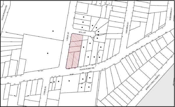
|
NOTIFICATION PLAN |
|
||
|
• PROPERTIES NOTIFIED
|
X SUBMISSIONS RECEIVED |
PROPERTY SUBJECT OF DEVELOPMENT |
|
|
ONE SUBMISSIONS RECEIVED OUT OF MAP RANGE |
|||
One submission objected to the development, generally on the grounds that the development would result in unacceptable traffic on local streets. The merits of the matters raised in community submissions have been addressed in the body of the report.
5.2 Public Agencies
The modified application was not required to be referred to any public agencies.
6. THE PUBLIC INTEREST
Section 79C(1)(e) of the Act requires Council to consider “the public interest”.
The public interest is an overarching requirement, which includes the consideration of the matters discussed in this report. Implicit to the public interest is the achievement of future built outcomes adequately responding to and respecting the future desired outcomes expressed in environmental planning instruments and development control plans.
The application is considered to have satisfactorily addressed Council’s and relevant agencies’ criteria and would provide a development outcome that, on balance, would result in a positive impact for the community. Accordingly, it is considered that the approval of the proposed modification would be in the public interest.
CONCLUSION
The application proposes to modify the approved residential flat building by increasing the number of units from 80 to 82, changes to the unit mix and minor design changes. The application also seeks consent to permit an additional 12 months to satisfy the deferred commencement condition for the subdivision of No. 4 Lodge Street.
The proposal is consistent with Section 96(2) of the Environmental Planning and Assessment Act 1979 and is substantially the same development as originally approved.
The modified proposal is assessed as satisfactory having regard to matters for consideration pursuant to Section 79C of the Environmental Planning and Assessment Act 1979.
One submission was received during the notification period. The matters raised in the submission have been addressed in the body of this report.
Having regard to the circumstances of the case, approval of the modification is recommended.
Note: At the time of the completion of this planning report, no persons have made a Political Donations Disclosure Statement pursuant to Section 147 of the Environmental Planning and Assessment Act 1979 in respect of the subject planning application.
RESPONSIBLE OFFICER
The officer responsible for the preparation of this Report is the Manager – Development Assessments – Rodney Pickles, who can be contacted on 9847 6731.
|
Rod Pickles Manager - Development Assessment Planning Division |
James Farrington Group Manager Planning Division |
|
1.View |
Locality Map |
|
|
|
2.View |
Floor Plan Levels 4 and 5 |
|
|
|
3.View |
Attic and Roof Plan |
|
|
|
4.View |
Elevations |
|
|
File Reference: DA/215/2015/A
Document Number: D06938024
Schedule 1
|
Date of this modification: |
08/06/2016 |
|
Details of this modification: |
Section 96(2) to increase the number of units from 80 to 82, alterations to the units mix and minor design changes. |
|
Conditions Added: |
None |
|
Conditions Deleted: |
None |
|
Conditions Modified: |
1, 2, 3, 8 and 17 |
SCHEDULE 1
GENERAL CONDITIONS
The conditions of consent within this notice of determination have been applied to ensure that the use of the land and/or building is carried out in such a manner that is consistent with the aims and objectives of the relevant legislation, planning instruments and council policies affecting the land and does not disrupt the amenity of the neighbourhood or impact upon the environment.
Note: For the purpose of this consent, the term ‘applicant’ means any person who has the authority to act on or the benefit of the development consent.
Note: For the purpose of this consent, any reference to an Act, Regulation, Australian Standard or publication by a public authority shall be taken to mean the gazetted Act or Regulation, or adopted Australian Standard or publication as in force on the date that the application for a construction certificate is made.
1. Deferred Commencement
Pursuant to Section 80(3) of the Environmental Planning and Assessment Act 1979, this consent does not operate until the following information is submitted to Council:
a) A registered plan of subdivision from the NSW Department of Lands creating a new lot from Lot 1 DP385418 to form part of the development.
Such information shall be submitted within 24 months of the date of this notice.
Upon Council’s written satisfaction of the above information, the following conditions of development consent will apply:
2. Approved Plans and Supporting Documentation
The development must be carried out in accordance with the plans and documentation listed below and endorsed with Council’s stamp, except where amended by Council and/or other conditions of this consent:
|
Plan No. |
Plan Title |
Drawn by |
Dated |
|
Ref 17387 |
Survey Plan |
Norton Survey Partners |
24/10/10 |
|
Ref 17387 |
Plan showing existing and proposed lot layouts |
Norton Survey Partners |
27/1/15 |
|
A30 - B |
Plan B2 & B1 |
Mijollo International |
3/6/15 |
|
A32-E |
Plans L1 to L3 |
Mijollo International |
10/7/15 |
|
A35-G |
Plans L4 & L5 |
Mijollo International |
2/5/2016 |
|
A37-E |
Plans Attic & Roof |
Mijollo International |
10/12/15 |
|
A401-P1 |
North, East, South & West Elevations |
Mijollo International |
9/12/2016 |
|
A501-C |
Section A-A + Internal Elevations |
Mijollo International |
13/6/15 |
|
A615-A |
Shadow diagrams |
Mijollo International |
6/2/15 |
|
LPDA15-286/1-E |
Landscape Plan |
Conzept Landscape Architects |
20/7/15 |
|
LPDA15-286/2-B |
Landscape plan (level 4 & 5) |
Conzept Landscape Architects |
9/2/15 |
|
LPDA15-286/3-A |
Landscape Details |
Conzept Landscape Architects |
4/2/15 |
|
|
DA/215/2015 – Tree Location Plan |
Modified by Tree Management Team (Hornsby Shire Council) |
7/5/15 |
|
14051-C201 Rev P1 |
Erosion & Sediment Control Plan |
TDL Engineering Consultants |
14/1/15 |
|
14051-C101 Rev P1 |
Stormwater Management Plan Level 1 Layout |
TDL Engineering Consultants |
14/1/15 |
|
|
Site Access – SRV Swept Path Analysis |
Ason Group |
11/6/15 |
|
Document Title |
Prepared by |
Dated |
|
Statement of Environmental Effects |
Caladines Town Planning P/L |
Feb 2015 |
|
Statement of Environmental Effects – S96(2) |
Caladines Town Planning P/L |
December 2015 |
|
Waste Management Plan |
Ben Hewlett |
25/2/15 |
|
Music Model – Stormwater pollutant targets |
Unnamed |
Submitted 4/6/15 |
|
Traffic & Parking Report |
Ason Group |
11/2/15 |
|
SEPP 65 Certification |
Matthew Cumming (Mijollo International P/L) |
24/2/15 |
|
Accessibility Report |
Abe Consulting |
10/2/15 |
|
Basix Assessment Report No. ES20141124_00 |
ESD Synergy P/L |
21/12/15 |
|
Basix Certificate No. 607598M_03 |
ESD Synergy P/L |
21/12/15 |
|
Cost Summary Report |
QS1 P/L |
2/2/15 |
|
1410-A Materials Schedule |
Mijollo International P/L |
6/2/15 |
3. Amendment of Plans
The approved plans are to be amended as follows:
a) To ensure future occupants within the development maintain an appropriate level of privacy, all south facing windows opposing habitable spaces on south western corner units in Building 2 are to be installed with privacy screens.
b) All letterboxes are to be located at least 2m from all property boundaries.
c) To improve privacy between units, the following measures are to be implemented which have been indicated in red on the approved plans:
i) A solid wall to divide the balconies of U151 and U251; and
ii) A solid wall to divide the balconies of U351 and U451.
4. Removal of Existing Trees
This development consent permits the removal of trees numbered 1, 2 and 3 as identified on plan named Site Tree Location Plan prepared by Council’s Tree Management Team, dated 7 May 2015. The removal of any other trees requires separate approval in accordance with the Tree and Vegetation Chapter 1B.6 Hornsby Development Control Plan (HDCP).
5. Acoustic Report
An acoustic report is to be provided prior to the issue of a construction certificate demonstrating that appropriate measures will be taken to ensure that the following LAeq levels are not exceeded:
a) In any bedroom in the building – 35dB(A) at any time between 10pm and 7am,
b) Anywhere else in the building (other than a garage, kitchen, bathroom or hallway) 40dB(A) at any time.
The report is to provide details of construction techniques and measure to attenuate road noise and vibration. The development must not exceed the specified noise criteria and LAeq levels within Clause 102 of the SEPP (Infrastructure).
6. Driveway Longitudinal Sections
Longitudinal sections along both sides of the access driveway shall be submitted to the principal certifying authority in accordance with the relevant sections of AS 2890.1 and the following requirements:
a) The maximum grade shall not exceed 1 in 4 (25%) with the maximum changes of grade of 1 in 8 (12.5%) for summit grades and 1 in 6.7 (15%) for sag grades. Any transition grades shall have a minimum length of 2 metres. The longitudinal sections shall incorporate the design levels obtained by Council.
Note: A construction certificate shall be obtained prior to the commencement of these works and are to be completed prior to the issue of an occupation certificate.
7. Construction Certificate
a) A Construction Certificate is required to be approved by Council or a Private Certifying Authority prior to the commencement of any works under this consent.
b) The Construction Certificate plans must not be inconsistent with the Development Consent plans.
8. Section 94 Development Contributions
a) In accordance with Section 80A(1) of the Environmental Planning and Assessment Act 1979 and the Hornsby Shire Council Section 94 Development Contributions Plan 2012-2021, the following monetary contributions shall be paid to Council to cater for the increased demand for community infrastructure resulting from the development:
|
Description |
Contribution (4) |
|
Roads |
$94,100.46 |
|
Open Space and Recreation |
$888,052.92 |
|
Community Facilities |
$125,025.76 |
|
Plan Preparation and Administration |
$3,699.72 |
|
TOTAL |
$1,110,878.86 |
being for 35 x 1 bedroom units, 39 x 2 bedroom units, 8 x 3 bedroom units and including a credit for five existing dwelling houses.
b) The value of this contribution is current as at 16 July 2015. If the contributions are not paid within the financial quarter that this condition was generated, the contributions payable will be adjusted in accordance with the provisions of the Hornsby Shire Council Section 94 Development Contributions Plan and the amount payable will be calculated at the time of payment in the following manner:
$CPY = $CDC x CPIPY
CPIDC
Where:
$CPY is the amount of the contribution at the date of Payment
$CDC is the amount of the contribution as set out in this Development Consent
CPIPY is the latest release of the Consumer Price Index (Sydney – All Groups) at the date of Payment as published by the ABS.
CPIDC is the Consumer Price Index (Sydney – All Groups) for the financial quarter at the date applicable in this Development Consent Condition.
c) The monetary contributions shall be paid to Council:
i) prior to the issue of the Subdivision Certificate where the development is for subdivision; or
ii) prior to the issue of the first Construction Certificate where the development is for building work; or
iii) prior to issue of the Subdivision Certificate or first Construction Certificate, whichever occurs first, where the development involves both subdivision and building work; or
iv) prior to the works commencing where the development does not require a Construction Certificate or Subdivision Certificate.
It is the professional responsibility of the Principal Certifying Authority to ensure that the monetary contributions have been paid to Council in accordance with the above timeframes.
Council’s Development Contributions Plan may be viewed at www.hornsby.nsw.gov.au or a copy may be inspected at Council’s Administration Centre during normal business hours.
REQUIREMENTS PRIOR TO THE ISSUE OF A CONSTRUCTION CERTIFICATE
9. Building Code of Australia
All building work must be carried out in accordance with the relevant requirements of the Building Code of Australia.
10. Contract of Insurance (Residential Building Work)
In the case of residential building work for which the Home Building Act 1989 requires there to be a contract of insurance in force in accordance with Part 6 of that Act, that such a contract of insurance is in force before any building work authorised to be carried out by the consent commences.
11. Notification of Home Building Act, 1989 Requirements
Residential building work within the meaning of the Home Building Act 1989 must not be carried out unless the principal certifying authority for the development to which the work relates (not being Council) has given Council written notice of the following information:
a) In the case of work for which a principal contractor is required to be appointed:
i) The name and licence number of the principal contractor; and
ii) The name of the insurer by which the work is insured under Part 6 of that Act.
b) In the case of work to be done by an owner-builder:
i) The name of the owner-builder; and
ii) If the owner-builder is required to hold an owner-builder’s permit under that Act, the number of the owner-builder’s permit.
Note: If arrangements for doing the residential building work are changed while the work is in progress so that the information notified becomes out of date, further work must not be carried out unless the principal certifying authority for the development to which the work relates (not being Council) has given Council written notification of the updated information.
12. Utility Services
The applicant must submit written evidence of the following service provider requirements:
a) Ausgrid (formerly Energy Australia) – a letter of consent demonstrating that satisfactory arrangements have been made to service the proposed development.
b) Telstra – a letter of consent demonstrating that satisfactory arrangements have been made to service the proposed development.
13. Sydney Water – Quick Check
This application must be submitted to a Sydney Water ‘Quick Check Agent’ or ‘Customer Centre’ for approval to determine whether the development would affect any Sydney Water infrastructure, and whether further requirements are to be met.
Note: Refer to www.sydneywater.com.au or telephone 13 20 92 for assistance.
14. Dilapidation Report
A ‘Dilapidation Report’ is to be prepared by a ‘chartered structural engineer’ detailing the structural condition of the adjoining property at No. 305 Peats Ferry Road, Asquith.
15. Traffic Control Plan
A Traffic Control Plan (TCP) must be prepared by a qualified traffic controller in accordance with the Roads and Traffic Authority’s Traffic Control at Worksites Manual 1998 and Australian Standard 1742.3 for all work on a public road. The Traffic Management Plan shall be submitted and approved by Council’s Manager Traffic and Road Safety prior to the issue of a construction certificate. The TCP must detail the following:
a) Arrangements for public notification of the works;
b) Temporary construction signage;
c) Permanent post-construction signage;
d) Vehicle movement plans;
e) Traffic management plans;
f) Pedestrian and cyclist access/safety.
The TCP is to be submitted to Council for approval prior to the issue of the construction certificate.
16. Construction Management Plan
A Construction Management Plan (CMP), prepared by a suitably qualified consultant, must be submitted for approval by Council. The CMP must be include, but not be limited, details of the following:
a) Noise attenuation measures are to be implemented along the Bell Street property boundary of the site including a hoarding height not less than 3m from the existing ground level.
b) During excavation works, rock removal must be undertaken by sawing instead of rock hammering, wherever practicable;
c) The construction works must be undertaken in accordance with the “Interim Construction Noise Guidelines – 2009” published by DECCW and achieve compliance with the relevant noise levels; and
d) The delivery times and vehicular movements related to demolition, excavation and construction works must be restricted to the construction hours only.
17. Adaptable Units and Letterboxes
a) The details of the fit-outs of all accessible and adaptable units must be provided with the Construction Certificate Plans.
b) All letterboxes are to be located at least 2m from all property boundaries. Details must be provided with the Construction Certificate Plans.
18. Construction Vehicles
All construction vehicles associated with the proposed development are to be contained on site or in an approved “Work Zone”. Construction zones will not be permitted on Lodge Street, Bell Street or Peats Ferry Road.
19. Construction Traffic Management Plan
A Construction Traffic Management Plan (CTMP) detailing construction vehicle routes, number of trucks, hours of operation, access arrangements and traffic control should be submitted to Council prior to the issue of a Construction Certificate. Council will review the CTMP, agree to any modifications with the proponent and enforce the CTMP during construction.
20. Pedestrian Access Management Plan
A Pedestrian Access Management Plan (PAMP) detailing how pedestrian movements will be changed and managed during various stages of development, particularly during any partial or total closure of footpaths on Peats Ferry Road and Lodge Street. Council will review the PAMP, agree to any modifications with the proponent and enforce the PAMP during construction.
21. Preservation of Survey Infrastructure
Prior to the issue of a construction certificate, a registered surveyor shall identify all survey marks in the vicinity of the proposed development. Any survey marks required to be removed or displaced as a result of the proposed development shall be undertaken by a registered surveyor in accordance with Section 24(1) of the Surveying and Spatial Information Act 2002 and following the Surveyor General’s Directions No. 11 – “Preservation of Survey Infrastructure”.
22. Water Quality/Bio Retention System
Stormwater discharging from the development site is to be treated to achieve the quality specified in the HDCP 2013 (table 1C.1.2(b) Urban Stormwater Quality Targets). Details are to be provided with the construction certificate. A Chartered Civil/Hydraulic Engineer of the Institution of Engineers, Australia is to certify that works have been completed in accordance with the approved construction plan and the measures will achieve the targets specified in the condition.
23. Waste Management
The following waste management requirements must be complied with:
a) The approved on-going waste management system must not be amended without the written consent of Council.
b) The Volume handling equipment (2 x 660L bin linear), to automatically change the bin under the chute when it becomes full, must not be fitted with a compactor.
24. Acoustic Report
The Construction Certificate plans must demonstrate compliance with the recommendations in the submitted Acoustic Report (required as per condition No. 5) including materials of construction and glazing details.
25. Stormwater Drainage
The stormwater drainage system for the development must be designed and constructed for an average recurrence interval of 20 years and be gravity drained in accordance with the following requirements:
a) Connected directly to an existing Council drainage system/street gutter via an on-site detention and water quality treatment system. Capacity of the street gutter is to be verified prior to discharging to the gutter.
b) Be designed by a Chartered Professional Engineer/Civil Engineer of the Institution of Engineers, Australia
c) A construction certificate application is to be submitted to Council for discharging stormwater to Council pit/drainage line.
d) The stormwater system with on-site detention and water quality treatment facilities is to be constructed in accordance with Drainage Nos. 14051-C101-C104 Revision P1 dated 14.01.15 prepared by TDL Engineering Consulting Pty Ltd (Council Document No. D04948248).
26. On-Site Stormwater Detention
An on-site stormwater detention system must be designed by a chartered civil engineer and constructed in accordance with the following requirements:
a) Storage capacity to accommodate volume from up to 20 years ARI (average recurrence interval) and a maximum discharge (when full) limited to 5 years pre development rate.
b) Have a surcharge/inspection grate located directly above the outlet.
c) Discharge from the detention system to be controlled via 1 metre length of pipe, not less than 50 millimetres diameter or via a stainless plate with sharply drilled orifice bolted over the face of the outlet discharging into a larger diameter pipe capable of carrying the design flow to an approved Council system.
d) Where above ground and the average depth is greater than 0.3 metres, a ‘pool type’ safety fence and warning signs to be installed.
e) Not be constructed in a location that would impact upon the visual or recreational amenity of residents.
f) Detail calculations are to be shown in construction certificate plan.
27. Vehicular Crossing
A separate application under the Local Government Act 1993 and the Roads Act 1993 must be submitted to Council for the installation of a new vehicular crossing and the removal of the redundant crossing. The vehicular crossing must be constructed in accordance with Council’s Civil Works Design 2005 and the following requirements:
a) Any redundant crossings must be replaced with integral kerb and gutter;
b) The footway area must be restored by turfing;
c) Approval must be obtained from all relevant utility providers that all necessary conduits be provided and protected under the crossing.
Note: An application for a vehicular crossing can only be made to one of Council’s Authorised Vehicular Crossing Contractors. You are advised to contact Council on 02 9847 6940 to obtain a list of contractors.
28. Internal Driveway/Vehicular Areas
The driveway and parking areas on site must be designed in accordance with Australian Standards 2890.1, 2890.2, 3727 and the following requirements:
a) Design levels at the front boundary must be obtained from Council;
b) The driveway must be a rigid pavement.
29. Road Works
All road works approved under this consent must be constructed in accordance with Council’s Civil Works Design and Construction Specification 2005 and the following requirements:
a) A concrete footpath along Bell and Lodge Streets are to be constructed. Old sections of the footpath along Peats Ferry Road are to be replaced.
b) The kerb and gutter fronting Bell Street and 31m along Lodge Street (from the intersection of Lodge and Bell Streets) are to be constructed. The existing road pavement is to be saw cut a minimum of 300 mm from the existing edge of the bitumen and reconstructed.
c) A construction certificate is to be submitted to Council for approval.
Note: Council is the only authority to approve works within Council roads.
REQUIREMENTS PRIOR TO THE COMMENCEMENT OF ANY WORKS
30. Erection of Construction Sign
A sign must be erected in a prominent position on any site on which building work, subdivision work or demolition work is being carried out:
a) Showing the name, address and telephone number of the principal certifying authority for the work;
b) Showing the name of the principal contractor (if any) for any demolition or building work and a telephone number on which that person may be contacted outside working hours; and
c) Stating that unauthorised entry to the work site is prohibited.
Note: Any such sign is to be maintained while the building work, subdivision work or demolition work is being carried out, but must be removed when the work has been completed.
31. Protection of Adjoining Areas
A temporary hoarding, fence or awning must be erected between the work site and adjoining lands before the works begin and must be kept in place until after the completion of the works if the works:
a) Could cause a danger, obstruction or inconvenience to pedestrian or vehicular traffic.
b) Could cause damage to adjoining lands by falling objects.
c) Involve the enclosure of a public place or part of a public place.
Note: Notwithstanding the above, Council’s separate written approval is required prior to the erection of any structure or other obstruction on public land.
32. Toilet Facilities
Toilet facilities must be available or provided at the works site before works begin and must be maintained until the works are completed at a ratio of one toilet for every 20 persons employed at the site. Each toilet must:
a) be a standard flushing toilet connected to a public sewer; or
b) be a temporary chemical closet approved under the Local Government Act 1993; or
c) have an on-site effluent disposal system approved under the Local Government Act 1993.
33. Erosion and Sediment Control
Erosion and sediment control measures must be provided and maintained throughout the construction period in accordance with the manual ‘Soils and Construction 2004 (Bluebook)’, the approved plans, Council specifications and to the satisfaction of the principal certifying authority. The erosion and sediment control devices must remain in place until the site has been stabilised and revegetated.
Note: On the spot penalties may be issued for any non-compliance with this requirement without any further notification or warning.
REQUIREMENTS DURING CONSTRUCTION
34. Construction Work Hours
All work on site (including demolition and earth works) must only occur between 7am and 5pm Monday to Saturday (unless otherwise approved by Council due to extenuating circumstances). No work is to be undertaken on Sundays or public holidays. No excavation or rock sawing/breaking is to occur on Saturdays.
35. Demolition
All demolition work must be carried out in accordance with “Australian Standard 2601-2001 – The Demolition of Structures” and the following requirements
a) Demolition material must be disposed of to an authorised recycling and/or waste disposal site and/or in accordance with an approved waste management plan;
b) Demolition works, where asbestos material is being removed, must be undertaken by a contractor that holds an appropriate licence issued by WorkCover NSW in accordance with Chapter 10 of the Occupational Health and Safety Regulation 2001 and Clause 29 of the Protection of the Environment Operations (Waste) Regulation 2005 ;and
c) On construction sites where buildings contain asbestos material, a standard commercially manufactured sign containing the words ‘DANGER ASBESTOS REMOVAL IN PROGRESS’ measuring not less than 400mm x 300mm must be erected in a prominent position visible from the street.
36. Environmental Management
The site must be managed in accordance with the publication ‘Managing Urban Stormwater – Landcom (March 2004) and the Protection of the Environment Operations Act 1997 by way of implementing appropriate measures to prevent sediment run-off, excessive dust, noise or odour emanating from the site during the construction of the development.
37. Street Sweeping
Street sweeping must be undertaken following sediment tracking from the site along Peats Ferry Road and Lodge Street during works and until the site is established.
The street cleaning services must undertake a street ‘scrub and dry’ method of service and not a dry sweeping service that may cause sediment tracking to spread or cause a dust nuisance.
38. Council Property
During construction works, no building materials, waste, machinery or related matter is to be stored on the road or footpath. The public reserve must be kept in a clean, tidy and safe condition at all times.
39. Landfill
Landfill must be constructed in accordance with Council’s ‘Construction Specification 2005’ and the following requirements:
a) All fill material imported to the site is to wholly consist of Virgin Excavated Natural Material (VENM) as defined in Schedule 1 of the Protection of the Environment Operations Act 1997 or a material approved under the Department of Environment and Climate Change’s general resource recovery exemption.
b) A compaction certificate is to be obtained from a geotechnical engineer verifying that the specified compaction requirements have been met.
40. Excavated Material
All excavated material removed from the site must be classified in accordance with the Department of Environment, Climate Change and Water NSW Waste Classification Guidelines prior to disposal to an approved waste management facility and reported to the principal certifying authority.
41. Survey Report
A report(s) must be prepared by a registered surveyor and submitted to the principal certifying authority;
a) Prior to the pouring of concrete at each level of the building certifying that:
i) The building, retaining walls and the like have been correctly positioned on the site; and
ii) The finished floor level(s) are in accordance with the approved plans.
b) Confirming that the waste collection vehicle turning area complies with AS2890.1 – 2004 and AS20890.2 – 2002 for small rigid vehicles (SRV).
42. Waste Management
Waste management during the demolition and construction phase of the development must be undertaken in accordance with the approved Waste management Plan. Additionally written records of the following items must be maintained during the removal of any waste from the site and such information submitted to the Principle Certifying Authority within fourteen days of the date of completion of the works:
a) The identity of the person removing the waste.
b) The waste carrier vehicle registration.
c) Date and time of waste collection.
d) A description of the waste (type of waste and estimated quantity).
e) Details of the site to which the waste is to be taken.
f) The corresponding tip docket/receipt from the site to which the waste is transferred (noting date and time of delivery, description (type and quantity) of waste.
g) Whether the waste is expected to be reused, recycled or go to landfill.
Note: In accordance with the Protection of the Environment Operations Act 1997, the definition of waste includes any unwanted substance, regardless of whether it is reused, recycled or disposed to landfill.
43. Traffic Control Plan Compliance
The development must be carried out in accordance with the submitted Traffic Control Plan (TCP).
44. Disturbance of Existing Site
During construction works, the existing ground levels of open space areas and natural landscape features, (including natural rock-outcrops, vegetation, soil and watercourses) must not be altered unless otherwise nominated on the approved plans.
45. Construction Noise Management
The construction works must be undertaken in accordance with the “Interim Construction Noise Guidelines – 2009” published by NSW Environmental Protection Authority.
46. Contamination During Construction Works
Should the presence of asbestos or soil contamination, not recognised during the application process be identified during demolition, the applicant must immediately notify the Principal Certifying Authority and Council.
47. Construction Vehicle Access
All construction vehicles associated with the proposed development are to access the site from Lodge Street only. No construction vehicle access is permitted on Bell Street or Peats Ferry Road.
REQUIREMENTS PRIOR TO THE ISSUE OF AN OCCUPATION CERTIFICATE
Note: For the purpose of this consent, a reference to ‘occupation certificate’ shall not be taken to mean an ‘interim occupation certificate’ unless otherwise stated.
48. Fulfilment of BASIX Commitments
The applicant must demonstrate the fulfilment of BASIX commitments pertaining to the development.
49. Sydney Water – s73 Certificate
An s73 Certificate must be obtained from Sydney Water.
Note: Sydney Water requires that s73 applications are to be made through an authorised Sydney Water Servicing Coordinator. Refer to www.sydneywater.com.au or telephone 13 20 92 for assistance.
50. Works as Executed Plan
A works-as-executed plan(s) must be prepared by a registered surveyor and submitted to Council for completed road pavement, kerb and gutter, drainage systems, with water quality measures, driveways and on-site detention system.
51. Damage to Council Assets
Any damage caused to Council’s assets as a result of the construction or demolition of the development must be rectified in accordance with Council’s Civil Works Specifications. Council’s Restorations Supervision must be notified for a formwork inspection prior to pouring concrete.
52. Creation of Easements
The following matter(s) must be nominated on the plan of subdivision under s88B of the Conveyancing Act 1919:
a) The creation of an appropriate "Positive Covenant" and "Restriction as to User" over the constructed on-site detention and bio retention system and outlet works within the lots in favour of Council in accordance with Council’s prescribed wording. The position of the on-site detention and bio retention systems are to be clearly indicated on the title.
b) To register the positive covenant and the restriction on the use of land, “works as executed” details of the on-site detention and bio retention system must be submitted verifying that the required storage and discharge rates will be achieved and water quality control measures have been constructed in accordance with the design requirements. The details must show the invert levels of the on-site system together with pipe sizes and grades and details of the bio retention system. Any variations to the approved plans must be shown in red on the “works-as-executed” plan and supported by calculations.
Note: Council must be nominated as the authority to release, vary or modify any easement, restriction or covenant.
53. Consolidation of Allotments
All allotments the subject of this consent must be consolidated into one allotment.
Note: The applicant is recommended to submit the plan of subdivision to consolidate allotments to the NSW Department of Lands at least 4-6 weeks prior to seeking an occupation certificate.
54. Certificate of Preservation Survey Marks
A certificate by a Registered Surveyor shall be submitted to the Principal Certifying Authority, certifying that there has been no removal, damage, destruction, displacement or defacing of the existing survey marks in the vicinity of the proposed development or otherwise the reestablishment of damaged, removed or displaced survey marks has been undertaken in accordance with the Surveyor General’s Direction No. 11 – “Preservation of Survey Infrastructure”.
55. Garbage Collection Easement
For the purpose of waste collection, an easement entitling Council, its servants and agents and persons authorised by it to enter upon the subject land and to operate thereon, vehicles and other equipment for the purposes of garbage collection must be granted to Council by the owner of the land.
Note: The easement must be in a form prescribed by Council and must include covenants to the effect that parties will not be liable for any damage caused to the subject land or any part thereof or to any property located therein or thereon by reason of the operation thereon of any vehicle or other equipment used in connection with the collection of garbage and to the effect that the owner for the time being of the subject land shall indemnify the Council, its servants, agents and persons authorised by it to collect garbage against liability in respect of any such claims made by any person whomsoever.
56. Waste Management Details
The following waste management requirements must be complied with:
a) Prior to an Occupation Certificate being issued or the use commencing, whichever is earlier, the Principal Certifying Authority must obtain Council’s approval of the waste and recycling management facilities provided in the development and ensure arrangements are in place for domestic waste collection by Council.
Note: Waste and recycling management facilities includes everything required for on-going waste management on the site. For example the garbage chute system, volume handling equipment, bin lifter, motorised bin trolley or similar, recycling bin storage on each residential level, bin storage areas, bulky waste storage area, bin collection area, waste collection vehicle access etc.
b) The garbage rooms at the basement level must include water or a hose for cleaning, graded floors with drainage to sewer, a robust door, sealed and impervious surface, adequate lighting and ventilation, and must be lockable. The waste facility at each residential level must include sealed and impervious surface, adequate lighting and ventilation.
c) A report must be prepared by an appropriately qualified person, certifying the following:
i) A comparison of the estimated quantities of each waste type against the actual quantities of each waste type.
Note: Explanations of any deviations to the approved Waste Management Plan is required to be included in this report.
ii) That at least 60% of the waste generated during the demolition and construction phase of the development was reused or recycled.
Note: If the 60% diversion from landfill cannot be achieved in the Construction Stage, the Report is to include the reasons why this occurred and certify that appropriate work practices were employed to implement the approved Waste Management Plan. The Report must be based on documentary evidence such as tipping dockets/receipts from recycling depots, transfer stations and landfills, audits of procedures etc. which are to be attached to the report.
iii) All waste was taken to site(s) that were lawfully permitted to accept that waste.
d) Each unit must be provided with an indoor waste/recycling cupboard for the interim storage of a minimum one day’s waste generation with separate containers for general waste and recyclable materials.
e) Space must be provided for either individual compost containers for each unit or a communal compost container.
Note: The location of the compost containers should have regard for potential amenity impacts.
f) The bin carting routes must be devoid of any steps.
Note: Ramps between different levels are acceptable.
g) Access to the automatic waste volume handling equipment by authorised persons (including residents and waste collectors) must be prevented.
Note: Caging of the automatic volume handling equipment is acceptable.
57. Planter Boxes/ On Slab Planting
On slab planter boxes must include waterproofing, subsoil drainage (proprietary drainage cell, 50mm sand and filter fabric) automatic irrigation, minimum 500mm planting soil for shrubs and minimum 1000mm planting soil for trees and palms and 75mm mulch.
58. Planting to Peats Ferry Road Setback
Tree planting to the Peats Ferry Road landscape setback area must include:
a) 1 x Angophora costata or Syncarpia glomulifera, installed at minimum 25 litre pot size.
59. Completing of Landscaping
A certificate must be provided by a practicing landscape architect, horticulturalist or person with similar qualifications and experience certifying that all required landscaping works have been satisfactorily completed in accordance with the approved landscape plans.
Note: Applicants are advised to pre-order plant material required in pot sizes 45 litre or larger to ensure nurseries have stock available at the time of install.
60. Location of Plantings
Tree plantings for low density must be located 4m or greater than from foundation walls of a dwelling or in-ground pool. The pot size must be a minimum 25L.
All replacement trees must be maintained until they reach the height of 3m. Trees must be native to Hornsby Shire and reach a mature height greater than 9m.
All plant stock must meet the specifications outlined in ‘Specifying Trees’ (Ross Clark, NATSPEC Books) and that the planting methods are current, professional (best practice) industry standards at the time of planting.
61. Final Certification
a) A certificate from suitably qualified and experienced Horticulturalist must be submitted to the Principal Certifying Authority stating compliance with the provided conditions of this consent.
b) A certificate from a suitably qualified and experienced Acoustic Consultant must be submitted to the Principal Certifying Authority stating compliance with the provided conditions of this consent.
62. Boundary Fencing
Fencing must be erected along all property boundaries behind the front building alignment to a height of 1.8 metres.
Note: Alternative fencing may be erected subject to the written consent of the adjoining property owner(s).
63. Provision for National Broadband Network (NBN)
Provision must be made for fibre ready passive infrastructure (pits and pipes) generally in accordance with NBN Co's pit and pipe installation guidelines to service the proposed development. A certificate from NBN Co or Telstra must be submitted to the PCA that the fibre optic cabling provided for the development complies with MDU Building Design Guides for Development.
64. External Lighting
All external lighting must be designed and installed in accordance with Australian Standard AS 4282 – Control of the Obtrusive Effects of Outdoor Lighting. Certification of compliance with the Standard must be obtained from a suitably qualified person.
65. Unit Numbering
The allocation of unit numbering must be authorised by Council prior to the numbering of each unit in the development.
66. Construction of a Safe Environment
Prior to the issue of an Occupation Certificate, the site must include the following elements:
a) An intercom system be installed at gate locations to ensure screening of persons entering the units;
b) The entryway to the site be illuminated in high luminance at all times;
c) The communal open space areas are to be illuminated with high luminance by motion sensor lighting;
d) The service areas of the ground floor and the garbage room at the basement be illuminated with low luminance at all times;
e) The driveway and the basement car park is to be illuminated with low luminance at all times;
f) Robust materials which cannot be forced or breached with minimised maintenance requirements are to be used for construction work in the common areas;
g) Effective signage be provided to guide visitors to the main areas and parking areas;
h) A street sign be prominently displayed in front of the site in accordance with Order No. 8, Section 124 Local Government Act 1993;
i) The communal area must include a clear sign to restrict access for non-residents;
j) Unit numbers, entry and exit signs must be legible and clear;
k) Fire exit doors to be fitted with single cylinder locksets (Australia New Zealand Standard – Locksets);
l) The entry doors to the pedestrian foyers are to be constructed of safety rated glass to enable residents a clear line of site before entering or exiting the residential apartments;
m) Security deadlocks are to be provided to each apartment door; and
n) Peep holes are to be provided to individual apartment doors to promote resident safety.
o) Residential parking spaces are to be secure spaces with access controlled by card or numeric pad.
OPERATIONAL CONDITIONS
67. Waste Management
The waste management on site must be in accordance with the following requirements:
a) A site caretaker must be employed and be responsible for moving bins where and when necessary, washing bins and maintaining waste storage areas, ensuring the chute systems and related devices are maintained in effective and efficient working order, managing the communal composting area, managing the bulky item storage area, arranging the prompt removal of dumped rubbish, and ensuring all residents are informed of the use of the waste management system. The site caretaker must be employed for a sufficient number of hours each week to allow all waste management responsibilities to be carried out to a satisfactory standard.
68. Car Parking
All car parking must be constructed and operated in accordance with Australian Standard AS/NZS 2890.1:2004 – Off-street car parking and Australian Standard AS 2890.2:2002 – Off-street commercial vehicle facilities.
a) All parking areas and driveways are to be sealed to an all-weather standard, line marked and signposted;
b) Car parking, loading and manoeuvring areas to be used solely for nominated purposes;
c) Vehicles awaiting loading, unloading or servicing shall be parked on site and not on adjacent or nearby public roads;
d) All vehicular entry on to the site and egress from the site shall be made in a forward direction.
69. Sight Distance to Pedestrians and Cyclists
Any proposed landscaping and/or fencing must not restrict sight distance to pedestrians and cyclists travelling along the footpath.
70. Residential Parking Spaces
Residential parking spaces are to be secure spaces with access controlled by card or numeric pad.
71. Visitors Access
Visitors must be able to access the visitor parking spaces in the basement car park at all times.
72. Parking for People with Disabilities
All parking for people with disabilities is to comply with AS/NZS 2890.6:2009 Off-street parking for people with disabilities.
73. Bicycle Parking Spaces
Bicycle parking spaces are to be designed in accordance with AS 2890.3-1993 Bicycle parking facilities.
74. Motorcycle Parking Spaces
Motorcycle parking spaces are to be designed in accordance with AS 2890.5-1993.
75. Landscape Establishment
The landscape works must be maintained into the future to ensure the establishment and successful growth of plant material to meet the intent of the landscape design. This must include but not be limited to watering, weeding, replacement of failed plant material and promoting the growth of plants through standard industry practices.
76. Noise
All noise generated by the proposed development must be attenuated to prevent levels of noise being emitted to adjacent premises which possess tonal, beating and similar characteristics or which exceeds background noise levels by more than 5dB(A).
77. Fire Safety Statement - Annual
On at least one occasion in every 12 month period following the date of the first ‘Fire Safety Certificate’ issued for the property, the owner must provide Council with an annual ‘Fire Safety Certificate’ to each essential service installed in the building.
CONDITIONS OF CONCURRENCE – ROADS & MARITIME SERVICE
The following conditions of consent are from the nominated State Agency pursuant to Section 79B of the Environmental Planning and Assessment Act 1979 and must be complied with to the satisfaction of that Agency.
75. All redundant driveways on Peats Ferry Road should be removed and replaced with kerb and gutter to Council’s satisfaction.
76. A Construction Traffic Management Plan detailing construction vehicle routes, number of trucks, hours of operation, access arrangements and traffic control should be submitted to Council prior to the issue of a construction certificate.
77. The swept path of the longest vehicle (to service the site) entering and exiting the subject site, as well as manoeuvrability through the site, shall be in accordance with AUSTROADS. In this regard, a plan shall be submitted to Council for approval, which shows that the proposed development complies with this requirement.
78. The layout of the proposed car parking areas associated with the subject development (including driveways, grades, turn paths, sight distance requirements, aisle widths, aisle lengths, and parking bay dimensions) should be in accordance with AS2890.1-2004, AS2890.6-2009 and AS2890.2-2002 for heavy vehicle usage.
79. Any proposed landscaping and/or fencing must not restrict sight distance to pedestrians and cyclists travelling along the footpath.
- END OF CONDITIONS -
ADVISORY NOTES
The following information is provided for your assistance to ensure compliance with the Environmental Planning and Assessment Act, 1979, Environmental Planning and Assessment Regulation 2000, other relevant legislation and Council’s policies and specifications. This information does not form part of the conditions of development consent pursuant to Section 80a of the Act.
Environmental Planning and Assessment Act 1979 Requirements
The Environmental Planning and Assessment Act 1979 requires:
· The issue of a construction certificate prior to the commencement of any works. Enquiries can be made to Council’s Customer Services Branch on 9847 6760.
· A principal certifying authority to be nominated and Council notified of that appointment prior to the commencement of any works.
· Council to be given at least two days written notice prior to the commencement of any works.
· Mandatory inspections of nominated stages of the construction inspected.
· An occupation certificate to be issued before occupying any building or commencing the use of the land.
Long Service Levy
In accordance with Section 34 of the Building and Construction Industry Long Service Payments Act 1986, a ‘Long Service Levy’ must be paid to the Long Service Payments Corporation or Hornsby Council.
Note: The rate of the Long Service Levy is 0.35% of the total cost of the work.
Note: Hornsby Council requires the payment of the Long Service Levy prior to the issue of a construction certificate.
Tree and Vegetation Preservation
In accordance with Clause 5.9 of the Hornsby Local Environmental Plan 2013 a person must not ringbark, cut down, top, lop, remove, injure or wilfully destroy any tree or other vegetation protected under the Hornsby Development Control Plan 2013 without the authority conferred by a development consent or a permit granted by Council.
Notes: A tree is defined as a long lived, woody perennial plant with one or relatively few main stems with the potential to grow to a height greater than three metres (3M). (HDCP 1B.6.1.c).
Tree protection measures and distances are determined using the Australian Standard AS 4970:2009, “Protection of Trees on Development Sites”.
Fines may be imposed for non-compliance with both the Hornsby Local Environmental Plan 2013 and the Hornsby Development Control Plan 2013.
Disability Discrimination Act
The applicant’s attention is drawn to the existence of the Disability Discrimination Act. A construction certificate is required to be obtained for the proposed building/s, which will provide consideration under the Building Code of Australia, however, the development may not comply with the requirements of the Disability Discrimination Act. This is the sole responsibility of the applicant.
Dial Before You Dig
Prior to commencing any works, the applicant is encouraged to contact Dial Before You Dig on 1100 or www.dialbeforeyoudig.com.au for free information on potential underground pipes and cables within the vicinity of the development site.
Telecommunications Act 1997 (Commonwealth)
If you are aware of any works or proposed works which may affect or impact on Telstra’s assets in any way, you are required to contact: Telstra’s Network Integrity Team on Phone Number 1800810443.
Asbestos Warning
Should asbestos or asbestos products be encountered during demolition or construction works, you are advised to seek advice and information prior to disturbing this material. It is recommended that a contractor holding an asbestos-handling permit (issued by WorkCover NSW) be engaged to manage the proper handling of this material. Further information regarding the safe handling and removal of asbestos can be found at:
Alternatively, telephone the WorkCover Asbestos and Demolition Team on 8260 5885.
House Numbering
House numbering can only be authorised by Council. Before proceeding to number each premise in the development, the allocation of numbers is required to be obtained from Council's Planning Division prior to the issue of a Subdivision Certificate. The authorised numbers are required to comply with Council’s Property Numbering Policy and be displayed in a clear manner at or near the main entrance to each premise.
Group Manager’s Report No. PL39/16
Planning Division
Date of Meeting: 8/06/2016
9 DEVELOPMENT APPLICATION - SECTION 96(2) MODIFICATION TO APPROVED RESIDENTIAL FLAT BUILDINGS COMPRISING 69 UNITS - 305 AND 307 PEATS FERRY ROAD, ASQUITH AND 9 BELL STREET AND 4 LODGE STREET, HORNSBY
EXECUTIVE SUMMARY
|
DA No: |
DA/214/2015/A (Lodged on 23 December 2015) |
|
Description: |
Section 96(2) application to modify two x five storey residential flat buildings by increasing the number of units from 69 to 70, alterations to the unit mix and minor design changes |
|
Property: |
Lot A DP 340410 and Lot 4 DP 136071305, Nos. 305-307 Peats Ferry Road, Asquith and No. 9 Bell Street and No. 4 Lodge Street, Hornsby |
|
Applicant: |
Asquith Property Developments Pty Ltd |
|
Owner: |
Ms Jennifer Catherine Garlick, Mr Stan S Stokes, Mr Edward John Zealand Black, Mrs Barbara Jean Black, Mr Tuo Liu and Ms Hongjun Song |
|
Estimated Value: |
$14,740,000 |
· The application involves a Section 96(2) modification to two x five storey residential flat buildings by increasing the number of units from 69 to 70, alterations to the unit mix and minor design changes.
· The proposed modification is substantially the same development as approved pursuant to Section 96(2) of the Environmental Planning and Assessment Act 1979 and is generally in compliance with State Environmental Planning Policy No. 65, Apartment Design Guide and Hornsby Development Control Plan 2013.
· One submission has been received in respect of the application.
· It is recommended that the application be approved.
|
THAT pursuant to Section 96(2) of the Environmental Planning and Assessment Act 1979, Development Application No. DA/214/2015/A for demolition of existing structures and construction of two x five storey residential flat buildings and basement car parking and subdivision of 4 Lodge St into two lots at Lot A DP 340410 and Lot 4 DP 136071305, Nos. 305-307 Peats Ferry Road, Asquith and No. 9 Bell Street and No. 4 Lodge Street, Hornsby be amended as detailed in Schedule 1 of Group Manager’s Report No. PL39/16. |
BACKGROUND
On 12 August 2015, Council approved DA/214/2015 for the demolition of existing structures and construction of two x five storey residential flat buildings comprising 69 units and basement car parking and subdivision of 4 Lodge Street into two lots.
On 11 November 2015, DA/1474/2015 was submitted to Council proposing the construction of a joint basement carpark to service the approved five storey development under DA/214/2015 and an approved five storey development on the western adjoining property under DA/215/2015. The western adjoining property comprises Nos. 301-303 Peats Ferry Road and 2, 2A and 4 Lodge Street, and is subject to an approval for two x five storey residential flat buildings comprising 80 units.
On 23 December 2015, a Section 96(2) application was lodged to modify DA/214/2015 by increasing the number of units from 69 to 70, alterations to the unit mix and minor design changes. This application is the subject of this report.
On 2 May 2016, a meeting was held between Council officers and the applicant to discuss matters relating to the applications lodged with Council on the site and the western adjoining property. With respect to DA/214/2015/A which is the subject of this report, Council requested amended plans demonstrating additional privacy measures to improve privacy between balconies and adjoining units.
On 4 May 2016, the applicant submitted amended plans to address these privacy concerns.
On 12 May 2016, DA/1474/2015 was approved under delegated authority for the construction of a joint basement carpark to service the approved residential flat buildings approved under DA/215/2015 and DA/214/2015.
SITE
The site comprises four irregular lots (Lot A DP 340410, Lot 4 DP 136071, Nos. 305-307 Peats Ferry Road, Asquith and Lot 2 DP 385418, No. 9 Bell Street) and a portion of Lot 1 DP385418 No. 4 Lodge Street, Hornsby. The site has a combined area of approximately 2,894m² and is located on the northern side of Peats Ferry Road and contains dual street frontages of 35.5m to Peats Ferry Road and 27m to Bell Street. The site experiences a gentle slope to Peats Ferry Road with an average grade of 3%.
Existing improvements on the allotments include a dwelling house on each lot and associated structures. Vehicular access is via driveways from Peats Ferry Road and Bell Street. The site, including adjoining properties, contains exotic and native (exempt) tree species.
The site forms part of the ‘Hyacinth Street, Asquith’ precinct rezoned for medium-high density residential development in accordance with Council’s Housing Strategy in September 2011. The precinct is bounded by Lodge Street, Pacific Highway, Hyacinth Street and Bouvardia Street.
The surrounding developments include single and two storey residential dwelling houses. The site adjoins the R2 – Low Density zone to the north on Bell Street. The adjoining eastern property was approved for five storey development on 3 September 2014 under DA/370/2014 and construction works on this development have commenced. A five storey residential development has been constructed on the southern side of Peats Ferry Road at Nos. 422 - 426 Peats Ferry Road. The site is opposite the Asquith Boys High School to the south of Peats Ferry Road. The adjacent western site has been approved for two x five storey residential flat buildings under DA/215/2015 and is also subject to a Section 96(2) application on the business paper for consideration by Council
The site is located in close proximity to Asquith Railway Station and Asquith Commercial Centre.
THE APPROVED DEVELOPMENT
The development was approved for the demolition of existing structures and the erection of two x five storey residential flat buildings comprising 69 units and basement car parking and subdivision of No. 4 Lodge Street into two lots.
The approved unit mix comprises 25 x 1 bedroom units, 37 x 2 bedroom units and 7 x 3 bedroom units. Building 1 would have frontage to Peats Ferry Road and Building 2 is located to the rear of the site adjoining Bell Street. The buildings would include balconies fronting Peats Ferry Road, Bell Street and the eastern and western side setbacks.
Vehicular access to the development would be via Peats Ferry Road, along the western property boundary. Pedestrian access would be via Peats Ferry Road for Building 1 with a pedestrian path would provide a linkage to Building 2. In addition, a separate pedestrian access for Building 2 would be via Bell Street.
A total of 86 car spaces were approved over two basement levels.
The site would drain to Peats Ferry Road with a below ground onsite detention system proposed under the driveway.
The subdivision of 4 Lodge Street into two lots formed part of the approval. The subdivision is necessary to create a regular shaped allotment to accommodate the approved development. A deferred commencement condition was applied requiring the registration of the allotment within 12 months of the date of the consent. The deferred commencement condition has not been satisfied.
PROPOSAL
The Section 96 application seeks to modify the approved development by increasing the total number of units from 69 to 70 units, alterations to the unit mix and minor design changes.
The modified unit mix is proposed as follows:
· 27 x 1 bedroom (increased by two units)
· 36 x 2 bedroom (decreased by one unit)
· 7 x 3 bedroom (unchanged)
The modifications relate to Level 5 and the mezzanine floor within Building 2, located at the rear of the site adjoining Bell Street. There are no proposed changes to the approved layout of Building 1 which fronts Peats Ferry Road.
To achieve the modified yield and mix, some of the larger units have been reduced in size, whilst each of the units on the fifth level are now proposed with mezzanines.
There are no proposed changes to the lower levels, basement car parking or landscaping under this application.
The application also proposes to modify condition No. 1 to allow for an additional 12 months to satisfy the deferred commencement condition due to unforeseen delays.
ASSESSMENT
The development application has been assessed having regard to ‘A Plan for Growing Sydney’, the ‘North Subregion (Draft) Subregional Strategy’ and the matters for consideration prescribed under Section 79C of the Environmental Planning and Assessment Act 1979 (the Act). The following issues have been identified for further consideration.
1. STRATEGIC CONTEXT
1.1 A Plan for Growing Sydney and (Draft) North Subregional Strategy
A Plan for Growing Sydney has been prepared by the NSW State Government to guide land use planning decisions for the next 20 years. The Plan sets a strategy for accommodating Sydney’s future population growth and identifies the need to deliver 689,000 new jobs and 664,000 new homes by 2031. The Plan identifies that the most suitable areas for new housing are in locations close to jobs, public transport, community facilities and services.
The NSW Government will use the subregional planning process to define objectives and set goals for job creation, housing supply and choice in each subregion. Hornsby Shire has been grouped with Hunters Hill, Ku-ring-gai, Lane Cove, Manly, Mosman, North Sydney, Pittwater, Ryde, Warringah and Willoughby to form the North Subregion. The Draft North Subregional Strategy will be reviewed and the Government will set housing targets and monitor supply to ensure planning controls are in place to stimulate housing development.
The proposed development would be consistent with ‘A Plan for Growing Sydney’, by providing additional dwellings and would contribute to housing choice in the locality. The modified proposal would provide an additional dwelling.
2. STATUTORY CONTROLS
Section 79C(1)(a) requires Council to consider “any relevant environmental planning instruments, draft environmental planning instruments, development control plans, planning agreements and regulations”.
2.1 Environmental Planning and Assessment Act 1979 – Section 96(2)
Pursuant to Section 96(2) of the Environmental Planning and Assessment Act 1979, Council may consider an application to amend development consent provided that, inter alia:
a) it is satisfied that the development to which the consent as modified relates is substantially the same development, and
b) it has consulted with the relevant Minister, public authority or approval body (within the meaning of Division 5) in respect of a condition imposed as a requirement of a concurrence to the consent or in accordance with the general terms of an approval proposed to be granted by the approval body and that Minister, authority or body has not, within 21 days after being consulted, objected to the modification of that consent, and
c) it has notified the application in accordance with the regulations, and
d) it has considered any submissions made concerning the proposed modification within the period prescribed by the regulations.
With regard to Section 96(2)(a), the modified proposal would remain a two x five storey residential flat building development comprising 70 units with parking over two basement levels. The proposed layout, unit mix and the additional unit proposed would be located within the overall building envelope and would not significantly alter the built form. In this regard, it is considered that the modified application is substantially the same as the development originally approved.
With regard to Section 96(2)(b), the modified proposal did not require referral to any external agencies.
In accordance with Section 96(2)(c) and (d), adjoining owners were notified of the application and one submission has been received. The matters raised in the community submission are discussed in the body of this report.
2.2 Hornsby Local Environmental Plan 2013
The proposed development has been assessed having regard to the provisions of the Hornsby Local Environmental Plan 2013 (HLEP).
2.2.1 Zoning of Land and Permissibility
The subject land is zoned - insert zone name - under the HLEP. The objectives of the zone are:
(a) To provide for the housing needs of the community within a high density residential environment.
(b) To promote a variety of housing types within a high density residential environment.
(c) To enable other land uses that provide facilities or services to meet the day to day needs of residents.
The proposed development is defined as ‘residential flat building’ under the HLEP and is permissible in the zone with Council’s consent.
2.2.2 Height of Buildings
Clause 4.3 of the HLEP provides that the height of a building on any land should not exceed the maximum height shown for the land on the Height of Buildings Map. The maximum permissible height for the subject site is 17.5m. The proposed modification complies with this provision.
2.2.3 Heritage Conservation
Clause 5.10 of the HLEP sets out heritage conservation provisions for Hornsby Shire. The site does not include a heritage item and is not located in a heritage conservation area. The proposal is located within the vicinity of a heritage listed item of local significance at No. 31 Lodge Street and Nos. 269, 384 and 394 Peats Ferry Road, Hornsby. The heritage listed items are within land zoned R2 Low Density Residential and the site is over 320m south of No. 31 Lodge Street and over 220m north east of the items at Peats Ferry Road.
The original proposal was considered to have minimal impact on the nearby heritage items and was assessed as satisfactory on heritage grounds. The proposed modification would not significantly alter the perceived bulk, scale and built form of the development when viewed from surrounding areas. The proposed modification would not have an unreasonable impact on nearby heritage items and is acceptable with respect to Council’s heritage provisions.
2.2.4 Earthworks
Clause 6.2 of the HLEP states that consent is required for proposed earthworks on site. Before granting consent for earthworks, Council is required to assess the impacts of the works on adjoining properties, drainage patterns and soil stability of the locality.
The matter was assessed at the time of the original application. The modified proposal does not include any further excavation and therefore, no further assessment is necessary.
2.3 State Environmental Planning Policy No. State Environmental Planning Policy No. 55 – Remediation of Land
State Environmental Planning Policy No. 55 (SEPP 55) requires that consent must not be granted to the carrying out of any development on land unless it has considered whether the land is contaminated or requires remediation for the proposed use.
This matter was assessed under the original application. The proposed modification would not alter the compliance if the development with SEPP 55.
2.4 State Environmental Planning Policy (Building Sustainability Index – BASIX) 2004
The application has been assessed against the requirements of State Environmental Planning Policy (Building Sustainability Index – BASIX) 2004. The modified proposal includes an amended BASIX certificate for the proposed 70 units and is considered to be satisfactory.
2.5 State Environmental Planning Policy No. 32 – Urban Consolidation (Redevelopment of Urban Land)
The modified development would not alter the compliance of the original proposal with regard to SEPP 32.
2.6 State Environmental Planning Policy (Infrastructure) 2007
The proposed modification has been assessed against the requirements of State Environmental Planning Policy (Infrastructure) 2007. This Policy contains State-wide planning controls for developments adjoining rail corridors and busy roads. The development is located immediately adjacent to a classified road corridor (Peats Ferry Road). The following matters are required to be considered pursuant to the SEPP.
2.6.1 Development with Frontage to a Classified Road
The site has frontage to Peats Ferry Road which is a classified road and therefore, Clause 101 of the SEPP (Infrastructure) applies. The original application was referred to Roads and Maritime Services (RMS) who raised no objections subject to conditions. The modified proposal involves no change to the parking and access arrangements to the site. A traffic and parking assessment submitted with the application confirms that the modified proposal would not increase traffic demands of the development as the number of bedrooms remains unchanged, despite there being an additional unit proposed. This matter discussed is further detail in Section 3.2.2 of this report.
Council’s traffic assessment concludes that the modified proposal would not adversely impact on the effective and ongoing operation of Peats Ferry Road and is acceptable with respect to this clause.
2.6.2 Impact of Road Noise
Assessment of the impact of road noise on a residential use is required pursuant to Clause 102 of SEPP Infrastructure where a development fronts a road with an annual average daily traffic volume of more than 40,000 vehicles. The average daily traffic volume on Peats Ferry Road in the vicinity of the site does not exceed 40,000 vehicles and therefore, this clause does not apply to the proposal.
Notwithstanding, a condition was applied to the original consent for an acoustic report to be provided, detailing construction techniques and measures to attenuate road noise and vibration to achieve the acceptable noise levels outlined in Clause 102 of the SEPP. The modified proposal is acceptable subject to the fulfilment of this condition.
2.6.3 Traffic Generating Developments
In accordance with Clause 104 and Schedule 3 of SEPP (Infrastructure), developments with more than 75 dwellings fronting a classified road is a Traffic Generating Development and requires concurrence from the RMS. The modified proposal is for 70 units and is not classified as a traffic generating development.
2.7 State Environmental Planning Policy No. 65 – Design Quality of Residential Flat Development
The Policy provides for design principles to improve the design quality of residential flat development and for consistency in planning controls across the State.
SEPP 65 was amended on 19 June 2015 following review of the policy by the Department of Planning and Environment. The amendments replace the Residential Flat Design Guidelines with the Apartment Design Guide which prevails in the event of any inconsistency with a Development Control Plan.
Clause 31 (Transitional provisions for SEPP 65 – Amendment No. 3) states that “If a development application or an application for the modification of a development consent has been made after the notification on the NSW legislation website of the making of State Environmental Planning Policy No 65—Design Quality of Residential Flat Development (Amendment No 3) and the application has not been finally determined before the commencement of that amendment, the application must be determined under this Policy as amended by that amendment.”
Pursuant to the above provision, this amendment is required to be applied to the subject application as it modifies an approved development and was lodged on 23 December 2015.
The design principles of SEPP 65 are addressed in the following table.
|
Principle |
Compliance |
|
1. CONTEXT AND NEIGHBOURHOOD CHARACTER |
Yes |
|
Comment: This matter was assessed in detail under the original application. The modified development maintains the use of the land as residential flat buildings. The proposed modification maintains the desired future character of the precinct as envisaged by Council for residential flat buildings in landscaped settings with underground car parking. The proposal is considered to respond suitably to the ‘context and neighbourhood character’ principle of SEPP 65. |
|
|
2. BUILT FORM AND SCALE |
Yes |
|
Comment: The scale of the modified proposal is in accordance with the height control and setbacks for the precinct prescribed within the Hornsby DCP. Flat roof forms have been adopted with an increased top storey setback on the external facades to minimise bulk and height of the building. The development achieves a scale consistent with the desired outcome for well-articulated buildings that are set back to incorporate landscaping, open space and separation between buildings. |
|
|
3. DENSITY |
Yes |
|
Comment: The proposed modification is considered to be sustainable as it responds to the regional context, availability of infrastructure, public transport, community facilities and environmental quality and is acceptable in terms of density. |
|
|
4. SUSTAINABILITY |
Yes |
|
Comment: The applicant has submitted a BASIX Certificate for the amended development. In achieving the required BASIX targets for sustainable water use, thermal comfort and energy efficiency, the proposed development would achieve efficient use of natural resources, energy and water throughout its full life cycle, including demolition and construction. |
|
|
5. LANDSCAPE |
Yes |
|
Comment: The modified proposal does not alter the street level planting as previously approved. Accordingly, the application satisfies the intent of the ‘Landscape’ principle of SEPP 65. |
|
|
6. AMENITY |
Yes |
|
Comment: The proposed units are designed with appropriate room dimensions and layout to maximise amenity for future residents. The proposal incorporates good design in terms of achieving natural ventilation, solar access and acoustic privacy. All units incorporate balconies accessible from living areas and privacy has been achieved through appropriate design and orientation of balconies and living areas. Storage areas have been provided within each unit and in the basement levels. The proposal would provide convenient and safe access via lifts connecting the basement and all other levels. |
|
|
7. SAFETY |
Yes |
|
Comment: The modified proposal would not alter the compliance of the original proposal with regard to “safety and security”. |
|
|
8. HOUSING DIVERSITY AND SOCIAL INTERACTION |
Yes |
|
Comment: The modified proposal incorporates a range of unit sizes to cater for different budgets, demographics and housing needs. The proposal responds to the social context in terms of providing a range of dwelling sizes with good access to social facilities and services as the site is located in close proximity to Asquith Railway Station and shops. |
|
|
9. AESTHETICS |
Yes |
|
Comment: The proposed modification would not alter the approved architectural treatments, materials and finishes. The modified proposal maintains a flat roof to minimise building height and incorporates eaves which would cast shadows across the top storey wall. The articulation of the building, composition of building elements, textures, materials and colours would achieve a built form generally consistent with the design principles contained within the Apartment Design Guideline and the Hornsby DCP. |
|
2.8 State Environmental Planning Policy No. 65 – Apartment Design Guide
Amendment No. 3 of the SEPP 65 also requires consideration of the Apartment Design Guide, NSW Department of Planning and Environment 2015. The Guide includes development controls and best practice benchmarks for achieving the design principles of SEPP 65. The following table sets out the proposal’s compliance with the Guide:
|
SEPP 65 - Apartment Design Guide |
|||
|
Control |
Proposal |
Requirement |
Compliance |
|
Deep Soil Zone |
As approved |
7% of site area |
N/A |
|
Communal Open Space |
As approved |
25% |
N/A |
|
Ground Level Private Open Space |
As approved |
15m2 Min Depth of 3m |
N/A |
|
Solar Access (Living rooms and private open space areas) |
2 hours for 70% of units |
2 hours for 70% of units |
Yes |
|
Natural Cross Ventilation |
47/70 units - 67% |
60% |
Yes |
|
Minimum Dwelling Size |
1 br – 50m2 -56m2 2 br – 70m2 -92m2 3 br – 96m2 - 102m2 |
1 br – 50m2 2 br – 70m2 3 br – 90m2 (+5m2 for extra bathroom) |
Yes Yes Yes Yes |
|
Habitable room depth from a window for open plan layout (for amended units) |
8m |
8m from a window (max) |
Yes |
|
Minimum ceiling and storey height |
2.7m (min) 2.4m 3.1m |
2.7m(habitable rooms) 2.4m (mezzanine) 3.1m floor to floor |
Yes Yes Yes |
|
Minimum Balcony Size (minimum depth 2m – 2.4m)
|
1 bed >10m² 2 bed > 12m² 3 bed >14m² |
1 bed 8m² 2 bed 10m² 3 bed 12m² |
Yes Yes Yes |
|
Maximum Number of Units on a Single Level |
<8 units |
8 units off a circulation core |
Yes |
|
Total Storage Area |
1 bed - 6m3 (Min) 2 bed - 8m3 (Min) 3 bed - 10m3 (Min)
50% accessible from the apartments |
1 bed - 6m3 (Min) 2 bed - 8m3 (Min) 3 bed - 10m3 (Min)
50% accessible from the apartments |
Yes Yes Yes
Yes |
As detailed in the above table, the modified proposal generally complies with the prescriptive measures within the Apartment Design Guide (ADG). Below is a brief discussion regarding the relevant development controls and best practice guidelines.
2.8.1 Apartment Size Layout
The amended residential flat building incorporates a mix of single aspect and corner units comprising of one, two and three bedroom apartments. The majority of apartments would be well ventilated with some corner units provided with dual aspect balconies.
The proposed layout of all units consist of open plan living/dining rooms that have a minimum width of 3.6m for one bedroom units, and a minimum width of 4m for two and three bedroom units and all window areas in habitable rooms are greater than 10%. This complies with the requirements of the ADG. As the majority of units have also been designed for adequate cross ventilation, it is considered that these layouts are well designed and functional with generous unit sizes for a majority of units.
The ADG also prescribes that master bedrooms have a minimum size of 10m² with a minimum dimension of 3m excluding wardrobes and all other bedrooms to have a minimum size of 9m² with a minimum dimension of 2.8m. The proposed bedroom sizes comply with these requirements. Conditions of consent are recommended to ensure that the wardrobes are sized as per the requirements of the ADG.
2.8.2 Height / Setbacks / Landscaping
The modified proposal would retain the height, setbacks, landscaping and security measures as approved under DA/214/2015. The application is assessed as satisfactory in this regard.
2.8.3 Storage
Storage areas are provided at the basement levels and additional storage areas are also provided within the apartments. To ensure that the storage provided is proportional to the size of the apartment, a condition was applied to the original consent for each dwelling within the development to have a minimum storage area of 6m³ for one bedroom units, 8m³ for two bedroom units and 10m³ for three bedroom units, where at least 50% is required to be located within the apartment and provided in addition to storage in kitchens, bathrooms and bedrooms. The condition would be applicable to the amended proposal.
2.9 Sydney Regional Environmental Plan No. 20 – Hawkesbury – Nepean River
The site is located within the catchment of the Hawkesbury Nepean River. Part 2 of this Plan contains general planning considerations and strategies requiring Council to consider the impacts of development on water quality, aquaculture, recreation and tourism.
Subject to the implementation of sediment and erosion control measures and stormwater management to protect water quality, the proposal would comply with the requirements of the Policy.
2.10 Clause 74BA Environmental Planning and Assessment Act, 1979 - Purpose and Status of Development Control Plans
Clause 74BA of the Environmental Planning and Assessment Act, 1979 states that a DCP provision will have no effect if it prevents or unreasonably restricts development that is otherwise permitted and complies with the development standards in relevant Local Environmental Plans and State Environmental Planning Policies.
The principal purpose of a development control plan is to provide guidance on the aims of any environmental planning instrument that applies to the development; facilitate development that is permissible under any such instrument; and achieve the objectives of land zones. The provisions contained in a DCP are not statutory requirements and are for guidance purposes only. Consent authorities have flexibility to consider innovative solutions when assessing development proposals, to assist achieve good planning outcomes.
2.11 Hornsby Development Control Plan 2013
The proposed development has been assessed having regard to the relevant desired outcomes and prescriptive requirements within the Hornsby Development Control Plan 2013 (HDCP). The following table sets out the proposal’s compliance with the relevant prescriptive requirements of the Plan:
|
Hornsby Development Control Plan 2013 |
|||
|
Control |
Proposal |
Requirement |
Compliance |
|
Height |
5 storeys + Mezzanine – 17.5m |
5 storeys + Mezzanine – 17.5m |
Yes |
|
Lowest Residential Floor Above Ground |
As approved |
N/A |
N/A |
|
Maximum Floorplate Dimension |
As approved |
N/A
|
N/A |
|
Building Indentation |
7.5m x (3m to 4m) (West elevation Building 2) 4m x 4m (for east elevation Building |
4m x 4m
4m x 4m |
Unchanged
Unchanged
|
|
Height of Basement Above Ground |
As approved |
N/A |
N/A |
|
Front Setback (Peats Ferry Road) |
As approved |
N/A |
N/A |
|
Front Setback (Bell Street) |
As approved |
N/A |
N/A |
|
Western Side Setback |
As approved |
N/A |
N/A |
|
Eastern Side Setback |
Building 1 6m 4m for 8m building length
Building 2 2.5m - 6m 4m for 12m building length |
6m 4m < 1/3 frontage (13m for Building 1)
6m 4m < 1/3 frontage (12.6m Building 2) |
Yes – Unchanged
Yes - Unchanged |
|
Top Storey Setback from Ground Floor |
3m additional provided except for minor negligible encroachments |
3m |
Yes - Unchanged |
|
Underground Parking Setback |
As approved |
N/A |
N/A |
|
Basement Ramp Setback |
As approved |
N/A |
N/A |
|
Deep Soil Landscaped Areas |
As approved |
N/A |
N/A |
|
Private Open Space |
1br units – 10m² 2br units – 12m² 3br units –12m² |
1br units – 10m² 2br units – 12m² 3br units – 16m² |
Yes Yes No |
|
Communal Open Space with Minimum Dimensions 4m |
As approved |
N/A |
N/A |
|
Parking (site within 800m of railway station) |
75 resident spaces 11 visitor spaces 16 bicycle tracks 8 visitor bicycle racks 2 motorbike spaces |
69 resident spaces 11 visitor spaces 15 bicycle tracks 8 visitor bicycle 2 motorbike space |
Yes Yes Yes Yes Yes |
|
Solar Access |
70% |
70% |
Yes |
|
Housing Choice |
1BR – 27/70 = 39%
2BR – 36/70 = 51%
3BR – 7/70 = 10% |
10% of each type
10% of each type
10% of each type |
Yes
Yes
Yes |
|
Adaptable Units |
22/70 = 31% |
30% |
Yes |
As detailed in the above table, the proposed development generally complies with the prescriptive requirements within the HDCP. The matters of non-compliance are detailed below, as well as a brief discussion on compliance with relevant desired outcomes.
2.11.1 Built Form and Separation
The proposal involves design changes to incorporate one additional unit on the fifth floor of Building 2. Building 2 is the rear of the two approved building with frontage to Bell Street.
The modified proposal includes an increase in the mezzanine floor area, resulting in all units on the fifth floor of Building 2 being afforded a mezzanine. Whilst the modification results in additional building mass in the form of a mezzanine, the additions are confined to the eastern sides of Building 1 and would not be easily visible from Peats Ferry Road or Bell Street. The mezzanine additions comply with the maximum 17.5 metre building height requirement and maintain sufficient articulation and indentations in the built form to achieve the appearance of two separate building pavilions.
The modified proposal would not alter the setbacks of the development from Peats Ferry Road, Bell Street or the adjoining properties and would not alter the development’s compliance with the building separation requirements of the HDCP.
2.11.2 Privacy
The proposed modification involves the reconfiguration of the top floor units within Building 2, including minor changes to window placement and balconies. Concerns were raised in Council’s assessment that balconies adjoin windows of adjoining units which would result in privacy conflicts. Amended plans were submitted to Council on 4 May 2016 to address this issue to include additional screens to improve privacy between units. To further improve privacy, conditions have been recommended for a solid wall between balconies of U251 and U353. The modified proposal would achieve a reasonable level of privacy in accordance with the provisions of Part 3.4.9 of the HDCP.
Concerns were raised in a community submission regarding the privacy impacts of the development for nearby dwelling-houses. This matter was addressed in the original application. The proposed modification would not result in any significant design changes to the orientation and setback of balconies and is assessed as acceptable in terms of privacy impacts.
A request was made in a community submission for high fencing and planting of vegetation to improve privacy between the development and dwelling houses on Bell Street. This matter was considered under the original application. The approved landscape plan includes 1.8m high lapped and capped timber fencing, canopy trees and shrubs along all boundaries that would provide a buffer between the development and nearby residences.
2.11.3 Private Open Space
The principal private open space areas of U251 and U353 are 12 square metres in area which does not satisfy the prescriptive requirements of the HDCP that prescribes a minimum 16 square of open space for 3 bedroom units. Whilst the balconies do not satisfy the minimum area control, the balconies are regular in shape and have a depth of 2.5 metres, enabling the balconies to function as useable outdoor space. Furthermore, the balcony sizes satisfy the prescriptive requirements of the Apartment Design Guide that requires 12 square metres of open space for 3 bedroom units. The minor matter of non-compliance would not adversely impact on the amenity of the units and does not warrant refusal of the application.
2.11.4 Vehicular Access and Parking
The application does not propose any change to the number of car spaces or the vehicular access arrangements within the site. The original development generated a demand for 80 car spaces, based on 69 units comprising 25 x 1 bedroom units, 37 x 2 bedroom units and 7 x 3 bedroom units. The approved basement carpark included the provision of 86 car spaces, which amounts to 6 extra spaces than required by the HDCP.
The proposed modification is for one additional unit, with changes to the unit mix to 27 x 1 bedroom units, 36 x 2 bedroom units and 7 x 3 bedroom units. The modified proposal creates a demand for 78 car spaces, comprising 10 visitor spaces. The modified proposal maintains 86 car spaces within the basement and therefore complies with the parking rates prescribed under the HDCP.
2.12 Section 94 Contributions Plans
Hornsby Shire Council Section 94 Contributions Plan 2012-2021 applied to the original development as approval was granted for 69 units in lieu of the three existing residences. The modified proposal would result in an additional unit and changes to the unit mix. Accordingly, the condition for a monetary Section 94 contribution is recommended to be amended accordingly.
3. ENVIRONMENTAL IMPACTS
Section 79C(1)(b) of the Act requires Council to consider “the likely impacts of that development, including environmental impacts on both the natural and built environments, and social and economic impacts in the locality”.
3.1 Natural Environment
3.1.1 Tree and Vegetation Preservation
Concerns were raised in a community submission that the development would necessitate the removal of established trees on the site. The objector requested that provision be made for re-planting of canopy trees at the rear of the site to improve the interface with the low density residential area. Exotic tree species which are exempt under Council’s Tree Preservation Order would be removed to accommodate the development. The Landscape Plan approved under the original development includes planting of canopy trees along all street frontages to create a landscape setting.
The modified proposal does not change the impact of the development on existing vegetation and no change is proposed to the approved landscape plan. No further consideration in this regard is required.
3.1.2 Stormwater Management
The proposed modification would not alter the approved method of stormwater disposal from the site.
3.2 Built Environment
3.2.1 Built Form
The modified proposal would not significantly alter the built form of the development when viewed from Peats Ferry Road, Bell Street, or adjoining properties. The proposal maintains compliance with the 17.5 metre height requirement and provides for a development that is consistent with the desired future character of the precinct.
3.2.2 Traffic
A traffic and parking assessment was submitted with the modified proposal having regard to the RMS Guide to Traffic Generating Development Updated Traffic Surveys – Technical Direction 04a dated August 2013. Despite there being changes to the unit mix and an increase of one unit under the modified proposal, the report notes that both the approved development and the proposed modification include a total of 120 bedrooms. Given this, the traffic and parking assessment states that modified proposal would not result in any additional traffic impacts from that previously accepted by Council and the RMS.
The approved and modified proposal would produce a net traffic generation of 11 vehicles during the AM peak hours and 8 vehicles during the PM peak hours which is considered to be negligible when compared with the traffic volumes on the adjacent road network. In this regard, the traffic volume on Peats Ferry Road is currently in the order of 1000 vehicles per hour two way in peak hours. In the vicinity of the development site, Peats Ferry Road has one travel lane per direction. In terms of carriageway capacity, this equates to 1,800 vehicles per hour per lane. Based on the observed traffic flows, the estimated degree of congestion of Peats Ferry Road has been established to be less than 27% of nominal capacity.
In the assessment of the original application, Council’s engineering assessment of the traffic impacts of the development concluded that the proposal is satisfactory. The proposed modification would not alter the traffic impacts of the approved development and is therefore acceptable.
3.3 Social Impacts
The modified proposal would improve housing choice in the locality by providing a range of household types. This is consistent with Council’s Housing Strategy which identifies the need to provide a mix of housing options to meet future demographic needs in Hornsby Shire.
3.4 Economic Impacts
This modified proposal would achieve a positive economic impact on the locality via employment generation during construction and minor increase in demand for local services.
4. SITE SUITABILITY
Section 79C(1)(c) of the Act requires Council to consider “the suitability of the site for the development”.
The matter has been assessed in within the assessment of the original development application. No further assessment is necessary.
5. PUBLIC PARTICIPATION
Section 79C(1)(d) of the Act requires Council to consider “any submissions made in accordance with this Act”.
5.1 Community Consultation
The proposed development was placed on public exhibition and was notified to adjoining and nearby landowners between 19 January 2016 and 4 February 2016 in accordance with the Notification and Exhibition requirements of the HDCP. During this period, Council received one submission. The map below illustrates the location of those nearby landowners who made a submission that are in close proximity to the development site.
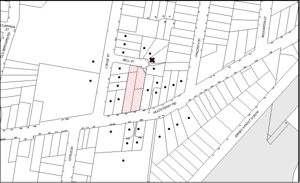
|
NOTIFICATION PLAN |
|
||
|
• PROPERTIES NOTIFIED
|
X SUBMISSIONS RECEIVED |
PROPERTY SUBJECT OF DEVELOPMENT |
|
One submission objected to the development, generally on the ground that the development would result in:
· Unacceptable impact on established trees;
· Safety issues for nearby residents if the site is not secured with fencing;
· Safety issues for nearby residents as a result of demotion of houses containing asbestos;
· Safety issues for adjoining residents as a result of construction vehicles using Bell Street;
· Privacy impacts on adjoining dwelling houses;
· An inappropriate development outcome as a result of zoning that permits a five storey development adjoining land zone for low density residential; and
· Traffic and amenity impacts on nearby residents resulting from vehicular and pedestrian access from Lodge Street or Bell Street.
Additional requests include:
· Council to provide alternate housing for nearby residents during demolition and construction;
· Planting of canopy trees to provide a buffer between the development and existing dwellings on Bell Street; and
· High fencing on Bell Street frontage to improve privacy.
The merits of the matters raised in community submissions have been addressed in the body of the report with the exception of the following:
5.1.2 Construction Fencing
The submission raises concern regarding the measures in place to secure the site during construction to prevent children from entering the site.
Construction sites are required to be secured with fencing in accordance with Work Cover requirements. A condition was applied to the original consent requiring fencing to be erected around the development site prior to the commencement of works. In the instance where the site is not secured in accordance with WorkCover requirements, this can be reported to the Principal Certifying Authority, Work Cover or Council for investigation.
5.1.2 Construction Vehicles Using Bell Street
The submission raises concern regarding the potential for construction vehicles using Bell Street. A condition was applied to the original consent requiring the preparation of a Construction Traffic Management Plan (CTMP), which is to detail construction vehicle routes, number of trucks, hours of operation, access arrangements and traffic control measures. Council will review the CTMP, advise of any necessary modifications to the applicant and enforce the CTMP during construction. It is unlikely that Council would permit construction vehicles to use Bell Street due to load limit restrictions.
5.1.3 Asbestos Removal
The submission raises concern regarding the demolition of houses containing asbestos and the safety implications for nearby residents. It was requested in the submission that Council provide alternate housing during the demolition phase to address this concern.
Council applied a standard condition to the original consent requiring that all demotion work is to be carried out in accordance with Australian Standard 2601 – 2002 – The Demolition of Structures and that where asbestos material is being removed, must be undertaken by a contractor that holds an appropriate licence issued by WorkCover NSW in accordance with Chapter 10 of the Occupational Health and Safety Regulation 2001 and Clause 29 of the Protection of the Environment Operations (Waste) Regulation 2005. In addition, a standard commercial manufactured sign warning of asbestos removal is required to be erected in a prominent position visible from the street. It is not within Council’s role or capacity to provide alternate housing during construction.
The submission queries the expected time frame for demolition works. There are no Council controls or conditions that limit time permitted to carry out demolition or construction works. However, previous experience with other 5 storey developments indicates that construction takes approximately 12 months with demolition of existing structures completed within a few weeks.
5.1.4 Pedestrian and Vehicular Access
A community submission raises concern that vehicular or pedestrian access to the building from Lodge Street or Bell Street would have adverse traffic and amenity impacts for nearby residences. The original development was approved with vehicular access from Peats Ferry Road. Pedestrian entrances and paths were approved from Peats Ferry Road and Bell Street. The current application does not propose to alter the approved access arrangements and therefore no further consideration is required for this assessment.
5.1.5 Waste Management
Waste collection was approved at basement level from Peats Ferry Road. The current application does not propose to alter the approved waste collection arrangements.
5.1.6 Lighting
The community submission raises concern with respect to bright lighting within the development that could impact on the amenity of nearby dwelling-houses. A condition was applied to the original consent requiring external lighting to be designed and installed in accordance with Australian Standard AS 4282 – Control of the Obtrusive Effects of Outdoor Lighting.
5.1.7 Zoning
The subject site was rezoned from Residential A (Low Density) to Residential C (Medium-High Density) on 2 September 2011 as part of Council’s Housing Strategy. The appropriateness of the development for the site was considered in the original application.
5.2 Public Agencies
The development application was not required to be referred to any public agencies.
6. THE PUBLIC INTEREST
Section 79C(1)(e) of the Act requires Council to consider “the public interest”.
The public interest is an overarching requirement, which includes the consideration of the matters discussed in this report. Implicit to the public interest is the achievement of future built outcomes adequately responding to and respecting the future desired outcomes expressed in environmental planning instruments and development control plans.
The application is considered to have satisfactorily addressed Council’s and relevant agencies’ criteria and would provide a development outcome that, on balance, would result in a positive impact for the community. Accordingly, it is considered that the approval of the proposed development would be in the public interest.
CONCLUSION
The application proposes to modify the approved residential flat building by increasing the number of units from 69 to 70, changes to the unit mix and minor design changes. The application also seeks consent to permit an additional 12 months to satisfy the deferred commencement condition for the subdivision of No. 4 Lodge Street.
The proposal is consistent with Section 96(2) of the Environmental Planning and Assessment Act 1979 and is substantially the same development as originally approved.
The modified proposal is assessed as satisfactory having regard to matters for consideration pursuant to Section 79C of the Environmental Planning and Assessment Act 1979.
One submission was received during the notification period. The matters raised in the submission have been addressed in the body of this report.
Having regard to the circumstances of the case, approval of the modification is recommended.
Note: At the time of the completion of this planning report, no persons have made a Political Donations Disclosure Statement pursuant to Section 147 of the Environmental Planning and Assessment Act 1979 in respect of the subject planning application.
RESPONSIBLE OFFICER
The officer responsible for the preparation of this Report is the Manager – Development Assessments – Rodney Pickles, who can be contacted on 9847 6731.
|
Rod Pickles Manager - Development Assessment Planning Division |
James Farrington Group Manager Planning Division |
|
1.View |
Locality Map |
|
|
|
2.View |
Floor Plan - Level 4 and 5 |
|
|
|
3.View |
Floor Plan - Attic and Roof |
|
|
|
4.View |
Elevation Plan |
|
|
File Reference: DA/214/2015/A
Document Number: D06938037
Schedule 1
|
Date of this modification: |
8 June 2016 |
|
Details of this modification: |
Section 96(2) to increase the number of units from 69 to 70, alterations to the units mix and minor design changes. |
|
Conditions Added: |
None |
|
Conditions Deleted: |
None |
|
Conditions Modified: |
1, 2, 3 and 6 |
SCHEDULE 1
GENERAL CONDITIONS
The conditions of consent within this notice of determination have been applied to ensure that the use of the land and/or building is carried out in such a manner that is consistent with the aims and objectives of the relevant legislation, planning instruments and council policies affecting the land and does not disrupt the amenity of the neighbourhood or impact upon the environment.
Note: For the purpose of this consent, the term ‘applicant’ means any person who has the authority to act on or the benefit of the development consent.
Note: For the purpose of this consent, any reference to an Act, Regulation, Australian Standard or publication by a public authority shall be taken to mean the gazetted Act or Regulation, or adopted Australian Standard or publication as in force on the date that the application for a construction certificate is made.
1. Deferred Commencement
Pursuant to Section 80(3) of the Environmental Planning and Assessment Act 1979, this consent does not operate until the following information is submitted to Council:
a) A registered plan of subdivision from the NSW Department of Lands creating a new lot from Lot 1 DP385418 to form part of the development.
Such information shall be submitted within 24 months of the date of this notice.
Upon Council’s written satisfaction of the above information, the following conditions of development consent will apply:
2. Approved Plans and Supporting Documentation
The development must be carried out in accordance with the plans and documentation listed below and endorsed with Council’s stamp, except where amended by Council and/or other conditions of this consent:
|
Plan No. |
Plan Title |
Drawn by |
Dated |
|
Ref 17387 |
Survey Plan |
Norton Survey Partners |
24/10/10 |
|
Ref 17387 |
Plan showing existing and proposed lot layouts |
Norton Survey Partners |
27/1/15 |
|
A50 - C |
Plan B2 & B1 |
Mijollo International |
1/7/15 |
|
A52- C |
Plans L1 to L3 |
Mijollo International |
1/7/15 |
|
A55- F |
Plans L4 & L5 |
Mijollo International |
2/5/16 |
|
A57- D |
Plans Attic & Roof |
Mijollo International |
10/12/15 |
|
A401- E |
North, East, South & West Elevations |
Mijollo International |
22/12/15 |
|
A501- C |
Section A-A + Internal Elevations |
Mijollo International |
13/6/15 |
|
A611- A |
Shadow diagrams |
Mijollo International |
6/2/15 |
|
|
Solar Access for Eastern and Western Facades |
Mijollo International |
Received on 2 7/15 |
|
LPDA15-287/1 E |
Landscape Plan |
Conzept Landscape Architects
|
20/7/15 |
|
LPDA15-287/2 A |
Landscape plan (level 4 & 5) |
Conzept Landscape Architects |
9/9/14 |
|
LPDA15-287/3 A |
Landscape Details |
Conzept Landscape Architects |
9/2/15 |
|
14051-C201 Rev P1 |
Erosion & Sediment Control Plan |
TDL Engineering Consultants |
14/1/15 |
|
14051-C101- 104 Rev P1 |
Stormwater Management Plan Level 1 Layout |
TDL Engineering Consultants |
14/1/15 |
|
Document Title |
Prepared by |
Dated |
|
Statement of Environmental Effects |
Caladines Town Planning P/L |
Feb 2015 |
|
Statement of Environmental Effects – Section 96(2) |
Caladines Town Planning P/L |
December 2015 |
|
Waste Management Plan |
Ben Hewlett |
25/2/15 |
|
Music Model – Stormwater pollutant targets |
Unnamed |
Submitted 4/6/15 |
|
Traffic & Parking Report |
Ason Group |
11/2/15 |
|
SEPP 65 Certification |
Matthew Cumming (Mijollo International P/L) |
24/2/15 |
|
Accessibility Report |
Abe Consulting |
10/2/15 |
|
Basix Assessment Report No. ES20141125_00 |
ESD Synergy P/L |
21/12/15 |
|
Basix Certificate No. 607563M_03 |
ESD Synergy P/L |
21/12/15 |
|
Cost Summary Report |
QS1 P/L |
2/2/15 |
|
1410-A Materials Schedule |
Mijollo International P/L |
6/2/15 |
3. Amendment of Plans
The approved plans are to be amended as follows:
a) To ensure that future occupants within the proposed development maintain an appropriate level of privacy, all south facing windows opposing habitable spaces on south western corner units in Building 2 are to be installed with privacy screens.
b) To improve privacy between units, a solid wall to divide the balconies of U251 and U353 is required.
4. Acoustic Report
An acoustic report is to be provided prior to the issue of a construction certificate demonstrating that appropriate measures will be taken to ensure that the following LAeq levels are not exceeded:
a) In any bedroom in the building – 35dB(A) at any time between 10pm and 7am,
b) Anywhere else in the building (other than a garage, kitchen, bathroom or hallway) 40dB(A) at any time.
The report is to provide details of construction techniques and measure to attenuate road noise and vibration. The development must not exceed the specified noise criteria and LAeq levels within Clause 102 of the SEPP (Infrastructure).
5. Construction Certificate
a) A Construction Certificate is required to be approved by Council or a Private Certifying Authority prior to the commencement of any works under this consent.
b) The Construction Certificate plans must not be inconsistent with the Development Consent plans.
6. Section 94 Development Contributions
a) In accordance with Section 80A(1) of the Environmental Planning and Assessment Act 1979 and the Hornsby Shire Council Section 94 Development Contributions Plan 2012-2021, the following monetary contributions shall be paid to Council to cater for the increased demand for community infrastructure resulting from the development:
|
Description |
Contribution (4) |
|
Roads |
$83,220.82 |
|
Open Space and Recreation |
$794,795.05 |
|
Community Facilities |
$111,422.82 |
|
Plan Preparation and Administration |
$3,318.18 |
|
TOTAL |
$992,756.87 |
being for 27 x 1 bedroom units, 36 x 2 bedroom units and 7 x 3 bedroom units and including a credit for three existing dwelling houses.
b) The value of this contribution is current as at 22 July 2015 If the contributions are not paid within the financial quarter that this condition was generated, the contributions payable will be adjusted in accordance with the provisions of the Hornsby Shire Council Section 94 Development Contributions Plan and the amount payable will be calculated at the time of payment in the following manner:
$CPY = $CDC x CPIPY
CPIDC
Where:
$CPY is the amount of the contribution at the date of Payment
$CDC is the amount of the contribution as set out in this Development Consent
CPIPY is the latest release of the Consumer Price Index (Sydney – All Groups) at the date of Payment as published by the ABS.
CPIDC is the Consumer Price Index (Sydney – All Groups) for the financial quarter at the date applicable in this Development Consent Condition.
c) The monetary contributions shall be paid to Council:
i) prior to the issue of the Subdivision Certificate where the development is for subdivision; or
ii) prior to the issue of the first Construction Certificate where the development is for building work; or
iii) prior to issue of the Subdivision Certificate or first Construction Certificate, whichever occurs first, where the development involves both subdivision and building work; or
iv) prior to the works commencing where the development does not require a Construction Certificate or Subdivision Certificate.
It is the professional responsibility of the Principal Certifying Authority to ensure that the monetary contributions have been paid to Council in accordance with the above timeframes.
Council’s Development Contributions Plan may be viewed at www.hornsby.nsw.gov.au or a copy may be inspected at Council’s Administration Centre during normal business hours.
REQUIREMENTS PRIOR TO THE ISSUE OF A CONSTRUCTION CERTIFICATE
7. Building Code of Australia
All building work must be carried out in accordance with the relevant requirements of the Building Code of Australia.
8. Contract of Insurance (Residential Building Work)
In the case of residential building work for which the Home Building Act 1989 requires there to be a contract of insurance in force in accordance with Part 6 of that Act, that such a contract of insurance is in force before any building work authorised to be carried out by the consent commences.
9. Notification of Home Building Act, 1989 Requirements
Residential building work within the meaning of the Home Building Act 1989 must not be carried out unless the principal certifying authority for the development to which the work relates (not being Council) has given Council written notice of the following information:
a) In the case of work for which a principal contractor is required to be appointed:
i) The name and licence number of the principal contractor; and
ii) The name of the insurer by which the work is insured under Part 6 of that Act.
b) In the case of work to be done by an owner-builder:
i) The name of the owner-builder; and
ii) If the owner-builder is required to hold an owner-builder’s permit under that Act, the number of the owner-builder’s permit.
Note: If arrangements for doing the residential building work are changed while the work is in progress so that the information notified becomes out of date, further work must not be carried out unless the principal certifying authority for the development to which the work relates (not being Council) has given Council written notification of the updated information.
10. Utility Services
The applicant must submit written evidence of the following service provider requirements:
a) Ausgrid (formerly Energy Australia) – a letter of consent demonstrating that satisfactory arrangements have been made to service the proposed development.
b) Telstra - a letter of consent demonstrating that satisfactory arrangements have been made to service the proposed development.
11. Sydney Water – Quick Check
This application must be submitted to a Sydney Water ‘Quick Check Agent’ or ‘Customer Centre’ for approval to determine whether the development would affect any Sydney Water infrastructure, and whether further requirements are to be met.
Note: Refer to www.sydneywater.com.au or telephone 13 20 92 for assistance.
12. Dilapidation Report
A ‘Dilapidation Report’ is to be prepared by a ‘chartered structural engineer’ detailing the structural condition of all adjoining properties including Nos. 303 and 309 Peats Ferry Road and Nos 2 2A Lodge Street.
13. Traffic Control Plan
A Traffic Control Plan (TCP) must be prepared by a qualified traffic controller in accordance with the Roads & Traffic Authority’s Traffic Control at Worksites Manual 1998 and Australian Standard 1742.3 for all work on a public road. The Traffic Management Plan shall be submitted and approved by Council’s Manager Traffic and Road Safety prior to the issue of a construction certificate. The TCP must detail the following:
a) Arrangements for public notification of the works;
b) Temporary construction signage;
c) Permanent post-construction signage;
d) Vehicle movement plans;
e) Traffic management plans;
f) Pedestrian and cyclist access/safety.
The TCP is to be submitted to Council for approval prior to the issue of the construction certificate.
14. Construction Management Plan
A Construction Management Plan (CMP), prepared by a suitably qualified consultant, must be submitted for approval by Council. The CMP must be include, but not be limited, details of the following:
a) Noise attenuation measures be implemented along the eastern boundary of the site including a hoarding height not less than 3m from the existing ground level;
b) During excavation works, rock removal must be undertaken by sawing instead of rock hammering, wherever practicable;
c) The construction works must be undertaken in accordance with the “Interim Construction Noise Guidelines – 2009” published by DECCW and achieve compliance with the relevant noise levels; and
d) The delivery times and vehicular movements related to demolition, excavation and construction works must be restricted to the construction hours only.
15. Adaptable Units
The details of the fit-outs of all accessible and adaptable units must be provided with the Construction Certificate Plans.
16. Construction Vehicles
All construction vehicles associated with the proposed development are to be contained on site or in an approved “Work Zone”. Construction zones will not be permitted on Bell Street.
17. Construction Traffic Management Plan
A Construction Traffic Management Plan (CTMP) detailing construction vehicle routes, number of trucks, hours of operation, access arrangements and traffic control should be submitted to Council prior to the issue of a Construction Certificate. Council will review the CTMP, agree to any modifications with the proponent and enforce the CTMP during construction.
18. Pedestrian Access Management Plan
A Pedestrian Access Management Plan (PAMP) detailing how pedestrian movements will be changed and managed during various stages of development, particularly during any partial or total closure of footpaths on Peats Ferry Road and Bell Street. Council will review the PAMP, agree to any modifications with the proponent and enforce the PAMP during construction.
19. Preservation of Survey Infrastructure
Prior to the issue of a construction certificate, a registered surveyor shall identify all survey marks in the vicinity of the proposed development. Any survey marks required to be removed or displaced as a result of the proposed development shall be undertaken by a registered surveyor in accordance with Section 24(1) of the Surveying and Spatial Information Act 2002 and following the Surveyor General’s Directions No. 11 – “Preservation of Survey Infrastructure”.
20. Waste Management
The following waste management requirements must be complied with:
a) The approved on-going waste management system must not be amended without the written consent of Council.
b) The access way (including ramp, vehicle turning area, loading bay and site entry/exit) to be used by waste collection vehicles, must be designed in compliance with Australian Standard AS2890.2-2002 Parking Facilities Part 2:Off-Street Commercial Vehicle Facilities for small rigid vehicles.
c) Storage space must be provided for motorised bin carting equipment
d) The doors to the recycling and garbage collection rooms are to be approximately 3m side roller doors.
21. Waste Management Details
Waste management during the demolition and construction phase of the development must be undertaken in accordance with the approved Waste Management Plan. Additionally written records of the following items must be maintained during the removal of any waste from the site and such information submitted to the Principal Certifying Authority within fourteen days of the date of completion of the works:
a) The identity of the person removing the waste.
b) The waste carrier vehicle registration.
c) Date and time of waste collection.
d) A description of the waste (type of waste and estimated quantity).
e) Details of the site to which the waste is to be taken.
f) The corresponding tip docket/receipt from the site to which the waste is transferred (noting date and time of delivery, description (type and quantity) of waste).
g) Whether the waste is expected to be reused, recycled or got to landfill.
Note: In accordance with the Protection of the Environment Operations Act 1997, the definition of waste includes any unwanted substance, regardless of whether it is reused, recycled or disposed to landfill.
22. Acoustic Report
The Construction Certificate plans must demonstrate compliance with the recommendations in the submitted Acoustic Report (required as per condition No. 4) including materials of construction and glazing details.
23. Driveway Longitudinal Sections
Longitudinal sections along both sides of the access driveway shall be submitted to the principal certifying authority in accordance with the relevant sections of AS 2890.1 and the following requirements:
a) The maximum grade shall not exceed 1 in 4 (25%) with the maximum changes of grade of 1 in 8 (12.5%) for summit grades and 1 in 6.7 (15%) for sag grades. Any transition grades shall have a minimum length of 2 metres. The longitudinal sections shall incorporate the design levels obtained by Council.
Note: A construction certificate shall be obtained prior to the commencement of these works and are to be completed prior to the issue of an occupation certificate.
24. Stormwater Drainage – Dwellings
The stormwater drainage system for the development must be designed and constructed for an average recurrence interval of 20 years and be gravity drained in accordance with the following requirements:
a) Connected directly to an existing Council drainage system/street gutter via an on-site detention and water quality treatment system. Capacity of the street gutter is to be verified prior to discharging to the gutter.
b) Be designed by a Chartered Professional Engineer/Civil Engineer of the Institution of Engineers, Australia
c) A construction certificate application is to be submitted to Council for discharging stormwater to Council pit. All works are to be carried out in accordance with Council’s Civil Works Specifications 2005.
d) The stormwater system with on-site detention and water quality treatment facilities is to be constructed in accordance with Drainage Nos. 14051-C101-C104 Revision P1 dated 14.01.15 prepared by TLD Engineering Consulting Pty Ltd (Council Document No. D04948248).
25. On-Site Stormwater Detention
An on-site stormwater detention system must be designed by a chartered civil engineer and constructed in accordance with the following requirements:
a) Storage capacity to accommodate volume from up to 20 years ARI (average recurrence interval) and a maximum discharge (when full) limited to 5 years pre development rate.
b) Have a surcharge/inspection grate located directly above the outlet.
c) Discharge from the detention system to be controlled via 1 metre length of pipe, not less than 50 millimetres diameter or via a stainless plate with sharply drilled orifice bolted over the face of the outlet discharging into a larger diameter pipe capable of carrying the design flow to an approved Council system.
d) Where above ground and the average depth is greater than 0.3 metres, a ‘pool type’ safety fence and warning signs to be installed.
e) Not be constructed in a location that would impact upon the visual or recreational amenity of residents.
f) Detail calculations are to be shown in construction certificate plan.
26. Water Quality/Bio Retention System
Stormwater discharging from the development site is to be treated to achieve the quality specified in the HDCP 2013 (table 1C.1.2(b) Urban Stormwater Quality Targets). A Chartered Civil/Hydraulic Engineer of the Institution of Engineers, Australia is to certify that works have been completed in accordance with the approved construction plan and the measures will achieve the targets specified in the condition.
27. Vehicular Crossing
A separate application under the Local Government Act 1993 and the Roads Act 1993 must be submitted to Council for the installation of a new vehicular crossing and the removal of the redundant crossing. The vehicular crossing must be constructed in accordance with Council’s Civil Works Design 2005 and the following requirements:
a) Any redundant crossings must be replaced with integral kerb and gutter;
b) The footway area must be restored by turfing;
c) Approval must be obtained from all relevant utility providers that all necessary conduits be provided and protected under the crossing.
Note: An application for a vehicular crossing can only be made to one of Council’s Authorised Vehicular Crossing Contractors. You are advised to contact Council on 02 9847 6940 to obtain a list of contractors.
28. Internal Driveway/Vehicular Areas
The driveway and parking areas on site must be designed in accordance with Australian Standards 2890.1, 2890.2, 3727 and the following requirements:
a) Design levels at the front boundary must be obtained from Council;
b) The driveway must be a rigid pavement.
29. Road Works
All road works approved under this consent must be constructed in accordance with Council’s Civil Works Design and Construction Specification 2005 and the following requirements:
a) A concrete footpath along Bell and Lodge Streets are to be constructed. Old sections of the footpath along Peats Ferry Road are to be replaced.
b) The kerb and gutter fronting Bell Street and 31m along Lodge Street (from the intersection of Lodge and Bell Streets) are to be constructed. The existing road pavement is to be saw cut a minimum of 300 mm from the existing edge of the bitumen and reconstructed.
c) A construction certificate is to be submitted to Council for approval.
Note: Council is the only authority to approve works within Council roads.
REQUIREMENTS PRIOR TO THE COMMENCEMENT OF ANY WORKS
30. Erection of Construction Sign
A sign must be erected in a prominent position on any site on which building work, subdivision work or demolition work is being carried out:
a) Showing the name, address and telephone number of the principal certifying authority for the work;
b) Showing the name of the principal contractor (if any) for any demolition or building work and a telephone number on which that person may be contacted outside working hours; and
c) Stating that unauthorised entry to the work site is prohibited.
Note: Any such sign is to be maintained while the building work, subdivision work or demolition work is being carried out, but must be removed when the work has been completed.
31. Protection of Adjoining Areas
A temporary hoarding, fence or awning must be erected between the work site and adjoining lands before the works begin and must be kept in place until after the completion of the works if the works:
a) Could cause a danger, obstruction or inconvenience to pedestrian or vehicular traffic.
b) Could cause damage to adjoining lands by falling objects.
c) Involve the enclosure of a public place or part of a public place.
Note: Notwithstanding the above, Council’s separate written approval is required prior to the erection of any structure or other obstruction on public land.
32. Toilet Facilities
Toilet facilities must be available or provided at the works site before works begin and must be maintained until the works are completed at a ratio of one toilet for every 20 persons employed at the site. Each toilet must:
a) be a standard flushing toilet connected to a public sewer; or
b) be a temporary chemical closet approved under the Local Government Act 1993; or
c) have an on-site effluent disposal system approved under the Local Government Act 1993.
33. Erosion and Sediment Control
Erosion and sediment control measures must be provided and maintained throughout the construction period in accordance with the manual ‘Soils and Construction 2004 (Bluebook)’, the approved plans, Council specifications and to the satisfaction of the principal certifying authority. The erosion and sediment control devices must remain in place until the site has been stabilised and revegetated.
Note: On the spot penalties may be issued for any non-compliance with this requirement without any further notification or warning.
REQUIREMENTS DURING CONSTRUCTION
34. Construction Work Hours
All work on site (including demolition and earth works) must only occur between 7am and 5pm Monday to Saturday (unless otherwise approved by Council due to extenuating circumstances). No work is to be undertaken on Sundays or public holidays. No excavation or rock sawing/breaking is to occur on Saturdays.
35. Demolition
All demolition work must be carried out in accordance with “Australian Standard 2601-2001 – The Demolition of Structures” and the following requirements
a) Demolition material must be disposed of to an authorised recycling and/or waste disposal site and/or in accordance with an approved waste management plan;
b) Demolition works, where asbestos material is being removed, must be undertaken by a contractor that holds an appropriate licence issued by WorkCover NSW in accordance with Chapter 10 of the Occupational Health and Safety Regulation 2001 and Clause 29 of the Protection of the Environment Operations (Waste) Regulation 2005 ;and
c) On construction sites where buildings contain asbestos material, a standard commercially manufactured sign containing the words ‘DANGER ASBESTOS REMOVAL IN PROGRESS’ measuring not less than 400mm x 300mm must be erected in a prominent position visible from the street.
36. Environmental Management
The site must be managed in accordance with the publication ‘Managing Urban Stormwater – Landcom (March 2004) and the Protection of the Environment Operations Act 1997 by way of implementing appropriate measures to prevent sediment run-off, excessive dust, noise or odour emanating from the site during the construction of the development.
37. Street Sweeping
Street sweeping must be undertaken following sediment tracking from the site along Peats Ferry Road and Bell Street during works and until the site is established.
The street cleaning services must undertake a street ‘scrub and dry’ method of service and not a dry sweeping service that may cause sediment tracking to spread or cause a dust nuisance.
38. Council Property
During construction works, no building materials, waste, machinery or related matter is to be stored on the road or footpath. The public reserve must be kept in a clean, tidy and safe condition at all times.
39. Landfill
Landfill must be constructed in accordance with Council’s ‘Construction Specification 2005’ and the following requirements:
a) All fill material imported to the site is to wholly consist of Virgin Excavated Natural Material (VENM) as defined in Schedule 1 of the Protection of the Environment Operations Act 1997 or a material approved under the Department of Environment and Climate Change’s general resource recovery exemption.
b) A compaction certificate is to be obtained from a geotechnical engineer verifying that the specified compaction requirements have been met.
40. Excavated Material
All excavated material removed from the site must be classified in accordance with the Department of Environment, Climate Change and Water NSW Waste Classification Guidelines prior to disposal to an approved waste management facility and reported to the principal certifying authority.
41. Survey Report
A report(s) must be prepared by a registered surveyor and submitted to the principal certifying authority;
a) Prior to the pouring of concrete at each level of the building certifying that:
i) The building, retaining walls and the like have been correctly positioned on the site; and
ii) The finished floor level(s) are in accordance with the approved plans.
b) The waste collection vehicle turning area complies with AS2890.1 – 2004 and AS20890.2 – 2002 for small rigid vehicles (SRV).
42. Waste Management
Waste management during the demolition and construction phase of the development must be undertaken in accordance with the approved Waste management Plan. Additionally written records of the following items must be maintained during the removal of any waste from the site and such information submitted to the Principle Certifying Authority within fourteen days of the date of completion of the works:
a) The identity of the person removing the waste.
b) The waste carrier vehicle registration.
c) Date and time of waste collection.
d) A description of the waste (type of waste and estimated quantity).
e) Details of the site to which the waste is to be taken.
f) The corresponding tip docket/receipt from the site to which the waste is transferred (noting date and time of delivery, description (type and quantity) of waste.
g) Whether the waste is expected to be reused, recycled or go to landfill.
Note: In accordance with the Protection of the Environment Operations Act 1997, the definition of waste includes any unwanted substance, regardless of whether it is reused, recycled or disposed to landfill.
43. Traffic Control Plan Compliance
The development must be carried out in accordance with the submitted Traffic Control Plan (TCP).
44. Disturbance of Existing Site
During construction works, the existing ground levels of open space areas and natural landscape features, (including natural rock-outcrops, vegetation, soil and watercourses) must not be altered unless otherwise nominated on the approved plans.
45. Construction Noise Management
The construction works must be undertaken in accordance with the “Interim Construction Noise Guidelines – 2009” published by NSW Environmental Protection Authority.
46. Contamination During Construction Works
Should the presence of asbestos or soil contamination, not recognised during the application process be identified during demolition, the applicant must immediately notify the Principal Certifying Authority and Council.
47. Construction Vehicle Access
All construction vehicles associated with the proposed development are to access the site from Peats Ferry Road only. No construction vehicle access is permitted on Bell Street.
48. Work Zone
All construction vehicles associated with the proposed development are to be contained on site or in a Local Traffic Committee (LTC) approved “Work Zone”.
REQUIREMENTS PRIOR TO THE ISSUE OF AN OCCUPATION CERTIFICATE
Note: For the purpose of this consent, a reference to ‘occupation certificate’ shall not be taken to mean an ‘interim occupation certificate’ unless otherwise stated.
49. Fulfilment of BASIX Commitments
The applicant must demonstrate the fulfilment of BASIX commitments pertaining to the development.
50. Sydney Water – s73 Certificate
An s73 Certificate must be obtained from Sydney Water.
Note: Sydney Water requires that s73 applications are to be made through an authorised Sydney Water Servicing Coordinator. Refer to www.sydneywater.com.au or telephone 13 20 92 for assistance.
51. Works as Executed Plan
A works-as-executed plan(s) must be prepared by a registered surveyor and submitted to Council for completed road pavement, kerb & gutter, drainage systems, with water quality measures, driveways and on-site detention system.
52. Damage to Council Assets
Any damage caused to Council’s assets as a result of the construction or demolition of the development must be rectified in accordance with Council’s Civil Works Specifications. Council’s Restorations Supervision must be notified for a formwork inspection prior to pouring concrete.
53. Creation of Easements
The following matter(s) must be nominated on the plan of subdivision under s88B of the Conveyancing Act 1919:
a) The creation of an appropriate "Positive Covenant" and "Restriction as to User" over the constructed on-site detention and bio retention system and outlet works within the lots in favour of Council in accordance with Council’s prescribed wording. The position of the on-site detention and bio retention systems are to be clearly indicated on the title.
b) To register the positive covenant and the restriction on the use of land, “works as executed” details of the on-site detention and bio retention system must be submitted verifying that the required storage and discharge rates will be achieved and water quality control measures have been constructed in accordance with the design requirements. The details must show the invert levels of the on-site system together with pipe sizes and grades and details of the bio retention system. Any variations to the approved plans must be shown in red on the “works-as-executed” plan and supported by calculations.
Note: Council must be nominated as the authority to release, vary or modify any easement, restriction or covenant.
54. Consolidation of Allotments
All allotments the subject of this consent must be consolidated into one allotment.
Note: The applicant is recommended to submit the plan of subdivision to consolidate allotments to the NSW Department of Lands at least 4-6 weeks prior to seeking an occupation certificate.
55. Certificate of Preservation Survey Marks
A certificate by a Registered Surveyor shall be submitted to the Principal Certifying Authority, certifying that there has been no removal, damage, destruction, displacement or defacing of the existing survey marks in the vicinity of the proposed development or otherwise the reestablishment of damaged, removed or displaced survey marks has been undertaken in accordance with the Surveyor General’s Direction No. 11 – “Preservation of Survey Infrastructure”.
56. Garbage Collection Easement
For the purpose of waste collection, an easement entitling Council, its servants and agents and persons authorised by it to enter upon the subject land and to operate thereon, vehicles and other equipment for the purposes of garbage collection must be granted to Council by the owner of the land.
Note: The easement must be in a form prescribed by Council and must include covenants to the effect that parties will not be liable for any damage caused to the subject land or any part thereof or to any property located therein or thereon by reason of the operation thereon of any vehicle or other equipment used in connection with the collection of garbage and to the effect that the owner for the time being of the subject land shall indemnify the Council, its servants, agents and persons authorised by it to collect garbage against liability in respect of any such claims made by any person whomsoever.
57. Waste Management Details
The following waste management requirements must be complied with:
a) Prior to an Occupation Certificate being issued or the use commencing, whichever is earlier, the Principal Certifying Authority must obtain Council’s approval of the waste and recycling management facilities provided in the development and ensure arrangements are in place for domestic waste collection by Council.
Note: Waste and recycling management facilities includes everything required for on-going waste management on the site. For example the garbage chute system, volume handling equipment, bin lifter, motorised bin trolley or similar, recycling bin storage on each residential level, bin storage areas, bulky waste storage area, bin collection area, waste collection vehicle access etc.
b) The garbage rooms at the basement level must include water or a hose for cleaning, graded floors with drainage to sewer, a robust door, sealed and impervious surface, adequate lighting and ventilation, and must be lockable. The waste facility at each residential level must include sealed and impervious surface, adequate lighting and ventilation.
c) A report must be prepared by an appropriately qualified person, certifying the following:
i) A comparison of the estimated quantities of each waste type against the actual quantities of each waste type.
Note: Explanations of any deviations to the approved Waste Management Plan is required to be included in this report.
ii) That at least 60% of the waste generated during the demolition and construction phase of the development was reused or recycled.
Note: If the 60% diversion from landfill cannot be achieved in the Construction Stage, the Report is to include the reasons why this occurred and certify that appropriate work practices were employed to implement the approved Waste Management Plan. The Report must be based on documentary evidence such as tipping dockets/receipts from recycling depots, transfer stations and landfills, audits of procedures etc. which are to be attached to the report.
iii) All waste was taken to site(s) that were lawfully permitted to accept that waste.
d) Each unit must be provided with an indoor waste/recycling cupboard for the interim storage of a minimum one day’s waste generation with separate containers for general waste and recyclable materials.
e) Space must be provided for either individual compost containers for each unit or a communal compost container;
Note: The location of the compost containers should have regard for potential amenity impacts.
f) The bin carting routes must be devoid of any steps.
Note: Ramps between different levels are acceptable.
g) A survey of the finished access way (including ramp, waste collection, vehicle turning area, loading bay and site entry/exit) to be used by SRV waste collection vehicle, must be carried out by a registered surveyor and submitted to the principal certifying authority. Written confirmation must be submitted to the Principal certifying authority from a qualified Traffic Engineer, that this survey confirms the finished access way within the waste collection vehicle turning path was designed and constructed in compliance with Australian Standard AS2890.2-2002 Parking Facilities Part 2:Off-street Commercial Vehicle Facilities for small rigid vehicles.
h) The 3.5 metre clearance height within the waste collection vehicle travel path must not be reduced by ducting, lights, pipes or anything else.
i) Site security measures implemented on the property, including electronic gates, must not prevent access to the collection point by waste removal services.
j) Access to the automatic waste volume handling equipment by authorised persons (including residents and waste collectors) must be prevented.
Note: Caging of the automatic volume handling equipment is acceptable.
k) The 2 x 660L bin liner fitted to each garbage chute to automatically change the bin under the chute when it becomes full must not include compaction.
58. Planter Boxes/ On Slab Planting
On slab planter boxes must include waterproofing, subsoil drainage (proprietary drainage cell, 50mm sand and filter fabric) automatic irrigation, minimum 500mm planting soil for shrubs and minimum 1000mm planting soil for trees and palms and 75mm mulch.
59. Planting to Peats Ferry Road Setback
Tree planting to the Peats Ferry Road landscape setback area must include:
a) 1 x Angophora costata or Syncarpia glomulifera, installed at minimum 25 litre pot size.
60. Completing of Landscaping
A certificate must be provided by a practicing landscape architect, horticulturalist or person with similar qualifications and experience certifying that all required landscaping works have been satisfactorily completed in accordance with the approved landscape plans.
Note: Applicants are advised to pre-order plant material required in pot sizes 45 litre or larger to ensure nurseries have stock available at the time of install.
61. Location of Plantings
Tree plantings for low density must be located 4m or greater than from foundation walls of a dwelling or in-ground pool. The pot size must be a minimum 25L.
All replacement trees must be maintained until they reach the height of 3m. Trees must be native to Hornsby Shire and reach a mature height greater than 9m.
All plant stock must meet the specifications outlined in ‘Specifying Trees’ (Ross Clark, NATSPEC Books) and that the planting methods are current, professional (best practice) industry standards at the time of planting.
62. Final Certification
A certificate from suitably qualified Acoustic consultant must be submitted to the Principal Certifying Authority stating compliance with the provided conditions of this consent.
63. Boundary Fencing
Fencing must be erected along all property boundaries behind the front building alignment to a height of 1.8 metres.
Note: Alternative fencing may be erected subject to the written consent of the adjoining property owner(s).
64. External Lighting
All external lighting must be designed and installed in accordance with Australian Standard AS 4282 – Control of the Obtrusive Effects of Outdoor Lighting. Certification of compliance with the Standard must be obtained from a suitably qualified person.
65. Provision for National Broadband Network (NBN)
Provision must be made for fibre ready passive infrastructure (pits and pipes) generally in accordance with NBN Co's pit and pipe installation guidelines to service the proposed development. A certificate from NBN Co or Telstra must be submitted to the PCA that the fibre optic cabling provided for the development complies with MDU Building Design Guides for Development.
66. Unit Numbering
The allocation of unit numbering must be authorised by Council prior to the numbering of each unit in the development.
67. Construction of a Safe Environment
Prior to the issue of an Occupation Certificate, the site must include the following elements:
a) An intercom system be installed at gate locations to ensure screening of persons entering the units;
b) The entryway to the site be illuminated in high luminance at all times;
c) The communal open space areas are to be illuminated with high luminance by motion sensor lighting;
d) The service areas of the ground floor and the garbage room at the basement be illuminated with low luminance at all times;
e) The driveway and the basement car park is to be illuminated with low luminance at all times;
f) Robust materials which cannot be forced or breached with minimised maintenance requirements are to be used for construction work in the common areas;
g) Effective signage be provided to guide visitors to the main areas and parking areas;
h) A street sign be prominently displayed in front of the site in accordance with Order No. 8, Section 124 Local Government Act 1993;
i) The communal area must include a clear sign to restrict access for non-residents;
j) Unit numbers, entry and exit signs must be legible and clear;
k) Fire exit doors to be fitted with single cylinder locksets (Australia New Zealand Standard – Locksets);
l) The entry doors to the pedestrian foyers are to be constructed of safety rated glass to enable residents a clear line of site before entering or exiting the residential apartments;
m) Security deadlocks are to be provided to each apartment door; and
n) Peep holes are to be provided to individual apartment doors to promote resident safety.
o) Residential parking spaces are to be secure spaces with access controlled by card or numeric pad.
OPERATIONAL CONDITIONS
68. Waste Management
The waste management on site must be in accordance with the following requirements:
a) A site caretaker must be employed and be responsible for moving bins where and when necessary, washing bins and maintaining waste storage areas, ensuring the chute systems and related devices are maintained in effective and efficient working order, managing the communal composting area, managing the bulky item storage area, arranging the prompt removal of dumped rubbish, and ensuring all residents are informed of the use of the waste management system. The site caretaker must be employed for a sufficient number of hours each week to allow all waste management responsibilities to be carried out to a satisfactory standard.
69. Car Parking
All car parking must be constructed and operated in accordance with Australian Standard AS/NZS 2890.1:2004 – Off-street car parking and Australian Standard AS 2890.2:2002 – Off-street commercial vehicle facilities.
a) All parking areas and driveways are to be sealed to an all-weather standard, line marked and signposted;
b) Car parking, loading and manoeuvring areas to be used solely for nominated purposes;
c) Vehicles awaiting loading, unloading or servicing shall be parked on site and not on adjacent or nearby public roads;
d) All vehicular entry on to the site and egress from the site shall be made in a forward direction.
70. Sight Distance to Pedestrians and Cyclists
Any proposed landscaping and/or fencing must not restrict sight distance to pedestrians and cyclists travelling along the footpath.
71. Residential Parking Spaces
Residential parking spaces are to be secure spaces with access controlled by card or numeric pad.
72. Visitors Access
Visitors must be able to access the visitor parking spaces in the basement car park at all times.
73. Parking for People with Disabilities
All parking for people with disabilities is to comply with AS/NZS 2890.6:2009 Off-street parking for people with disabilities. In particular note that clearance height 2500 min. is to be maintained from entry to parking space. Refer to Figure 2.7 of AS/NZS 2890.6:2009.
74. Bicycle Parking Spaces
Bicycle parking spaces are to be designed in accordance with AS 2890.3-1993 Bicycle parking facilities.
75. Motorcycle Parking Spaces
Motorcycle parking spaces are to be designed in accordance with AS 2890.5-1993.
76. Access for Garbage Vehicles
Access for garbage vehicles is to satisfy the requirements of Council’s Waste Management Branch.
77. Landscape Establishment
The landscape works must be maintained into the future to ensure the establishment and successful growth of plant material to meet the intent of the landscape design. This must include but not be limited to watering, weeding, replacement of failed plant material and promoting the growth of plants through standard industry practices.
78. Noise
All noise generated by the proposed development must be attenuated to prevent levels of noise being emitted to adjacent premises which possess tonal, beating and similar characteristics or which exceeds background noise levels by more than 5dB(A).
79. Fire Safety Statement - Annual
On at least one occasion in every 12 month period following the date of the first ‘Fire Safety Certificate’ issued for the property, the owner must provide Council with an annual ‘Fire Safety Certificate’ to each essential service installed in the building.
CONDITIONS OF CONCURRENCE – ROADS & MARITIME SERVICE
The following conditions of consent are from the nominated State Agency pursuant to Section 79B of the Environmental Planning and Assessment Act 1979 and must be complied with to the satisfaction of that Agency.
80. All redundant driveways on Peats Ferry Road should be removed and replaced with kerb and gutter to Council’s satisfaction.
81. A Constriction Traffic Management Plan detailing construction vehicle routes, number of trucks, hours of operation, access arrangements and traffic control should be submitted to Council prior to the issue of a construction certificate.
82. The swept path of the longest vehicle (to service the site) entering and exiting the subject site, as well as manoeuvrability through the site, shall be in accordance with AUSTROADS. IN this regard, a plan shall be submitted to Council for approval, which shows that the proposed development complies with this requirement.
83. The layout of the proposed car parking areas associated with the subject development (including driveways, grades, turn paths, sight distance requirements, aisle widths, aisle lengths, and parking bay dimensions) should be in accordance with AS2890.1-2004, AS2890.6-2009 and AS2890.2-2002 for heavy vehicle usage.
84. Any proposed landscaping and/or fencing must not restrict sight distance to pedestrians and cyclists travelling along the footpath.
- END OF CONDITIONS –
ADVISORY NOTES
The following information is provided for your assistance to ensure compliance with the Environmental Planning and Assessment Act, 1979, Environmental Planning and Assessment Regulation 2000, other relevant legislation and Council’s policies and specifications. This information does not form part of the conditions of development consent pursuant to Section 80a of the Act.
Environmental Planning and Assessment Act 1979 Requirements
The Environmental Planning and Assessment Act 1979 requires:
· The issue of a construction certificate prior to the commencement of any works. Enquiries can be made to Council’s Customer Services Branch on 9847 6760.
· A principal certifying authority to be nominated and Council notified of that appointment prior to the commencement of any works.
· Council to be given at least two days written notice prior to the commencement of any works.
· Mandatory inspections of nominated stages of the construction inspected.
· An occupation certificate to be issued before occupying any building or commencing the use of the land.
Long Service Levy
In accordance with Section 34 of the Building and Construction Industry Long Service Payments Act 1986, a ‘Long Service Levy’ must be paid to the Long Service Payments Corporation or Hornsby Council.
Note: The rate of the Long Service Levy is 0.35% of the total cost of the work.
Note: Hornsby Council requires the payment of the Long Service Levy prior to the issue of a construction certificate.
Tree and Vegetation Preservation
In accordance with Clause 5.9 of the Hornsby Local Environmental Plan 2013 a person must not ringbark, cut down, top, lop, remove, injure or wilfully destroy any tree or other vegetation protected under the Hornsby Development Control Plan 2013 without the authority conferred by a development consent or a permit granted by Council.
Notes: A tree is defined as a long lived, woody perennial plant with one or relatively few main stems with the potential to grow to a height greater than three metres (3M). (HDCP 1B.6.1.c).
Tree protection measures and distances are determined using the Australian Standard AS 4970:2009, “Protection of Trees on Development Sites”.
Fines may be imposed for non-compliance with both the Hornsby Local Environmental Plan 2013 and the Hornsby Development Control Plan 2013.
Disability Discrimination Act
The applicant’s attention is drawn to the existence of the Disability Discrimination Act. A construction certificate is required to be obtained for the proposed building/s, which will provide consideration under the Building Code of Australia, however, the development may not comply with the requirements of the Disability Discrimination Act. This is the sole responsibility of the applicant.
Dial Before You Dig
Prior to commencing any works, the applicant is encouraged to contact Dial Before You Dig on 1100 or www.dialbeforeyoudig.com.au for free information on potential underground pipes and cables within the vicinity of the development site.
Telecommunications Act 1997 (Commonwealth)
If you are aware of any works or proposed works which may affect or impact on Telstra’s assets in any way, you are required to contact: Telstra’s Network Integrity Team on Phone Number 1800810443.
Asbestos Warning
Should asbestos or asbestos products be encountered during demolition or construction works, you are advised to seek advice and information prior to disturbing this material. It is recommended that a contractor holding an asbestos-handling permit (issued by WorkCover NSW)be engaged to manage the proper handling of this material. Further information regarding the safe handling and removal of asbestos can be found at:
Alternatively, telephone the WorkCover Asbestos and Demolition Team on 8260 5885.
House Numbering
House numbering can only be authorised by Council. Before proceeding to number each premise in the development, the allocation of numbers is required to be obtained from Council's Planning Division prior to the issue of a Subdivision Certificate. The authorised numbers are required to comply with Council’s Property Numbering Policy and be displayed in a clear manner at or near the main entrance to each premise.
Group Manager’s Report No. PL40/16
Planning Division
Date of Meeting: 8/06/2016
10 DEVELOPMENT APPLICATION - FIVE STOREY RESIDENTIAL FLAT BUILDING COMPRISING 41 UNITS - 36 - 40 LORDS AVENUE, ASQUITH
EXECUTIVE SUMMARY
|
DA No: |
DA/1671/2015 (Lodged on 22 December 2015) |
|
Description: |
Demolition of existing structures and erection of a five storey residential flat building comprising 41 units with basement car parking. |
|
Property: |
Lots 1, 2 and 3 DP 21699, Nos. 36 – 40 Lords Avenue, Asquith |
|
Applicant: |
Gelder Architects |
|
Owner: |
Kahlefeldt Securities Pty Ltd |
|
Estimated Value: |
$9,617,858 |
· The application involves demolition of existing structures and the erection of a five storey residential flat building with mezzanines comprising 41 units with basement car parking.
· The proposal generally complies with the Hornsby Local Environmental Plan 2013, State Environmental Planning Policy No. 65 – Design Quality of Residential Flat Development, Apartment Design Guidelines and the Hornsby Development Control Plan 2013.
· Two submissions have been received in respect of the application.
· It is recommended that the application be approved.
|
THAT Development Application No. DA/1671/2015 for demolition of existing structures and the erection of a five storey residential flat building comprising 41 units with basement car parking at Lots 1, 2 and 3 DP 21699, Nos. 36 – 40 Lords Avenue, Asquith be approved subject to the conditions of consent detailed in Schedule 1 of Group Manager’s Report No. PL40/16. |
BACKGROUND
The subject land was rezoned from Residential A (Low Density) to R4 (High Density Residential) on 2 September 2011 as part of Council’s Housing Strategy.
The subject application was lodged with Council on 22 December 2015 proposing construction of a five storey residential flat building comprising 45 units over two levels of basement carpark.
Following the initial assessment of the application, Council sent a letter to the applicant on 15 January 2016, raising concerns regarding the design of the development, the proposed setbacks and the likely impact on trees.
A meeting was held between Council Officers and the applicant on 27 January 2016 to discuss the concerns. Consequently, amended plans were lodged on 13 April 2016 that proposed to reduce the number of units to 41, proposed setbacks to the rear and the sides that are compliant with Council’s controls and retained significant trees at the rear of the site. The amended plans satisfactorily address Council’s concerns.
SITE
The corner site comprises three allotments, Nos. 36, 38 and 40 Lords Avenue located on the eastern side of the road at its intersection with an unformed section of Mittabah Road. The site is irregular in shape, has an area of 2232.1m2 with a 46.27m frontage to Lords Avenue and 43.09m frontage to Mittabah Road. The site has a slope of 5.6% from the north-eastern (rear) corner to the south-western corner (Mittabah Road).
Existing improvements on the site include three dwelling-houses with associated garages and carports. Vehicular access to the site is via existing driveways from Lords Avenue.
The site and adjoining properties contain a large number of trees including locally native and exotic species. Significant groups of trees are located to the rear of the site and on the adjoining property to the east.
The section of Mittabah Road fronting the site is an informal road at a lower level than the Pacific Highway with a grass verge separating the two roads and a narrow access from Lords Avenue. Currently, No. 437 and No. 439 Pacific Highway are accessed from this road.
The site is located in close proximity to Asquith Railway Station and the Asquith Commercial Centre. The surrounding developments include low density single and two storey residential dwellings on the western side of Lords Avenue and the adjoining properties. The site and the adjoining allotments located between Lords Avenue and Pacific Highway form part of a redevelopment precinct zoned for five storey development and are undergoing transition. The following development applications, relating to properties in the near vicinity of the site, have been approved or, are under assessment:
· DA/956/2014 for construction of a five storey residential flat buildings comprising 34 units with 2 levels of basement car parking at Nos. 433 - 437 Pacific Highway (southern side of Mittabah Road) was approved by Council on 9 December 2015. The development proposes vehicular access off Mittabah Road.
· DA/727/2015 for construction of a five storey residential flat buildings comprising 26 units with 2 levels of basement car parking at Nos. 443 - 445 Pacific Highway (rear of the site) is currently under assessment.
· DA/1114/2013 for construction of a five storey residential flat building comprising 25 units with 2 levels of basement car parking at Nos. 439 – 441 Pacific Highway (rear of the site) was approved by Council on 10 February 2016.
· DA/1221/2014 for construction of a five storey residential flat building comprising 25 units with 2 levels of basement car parking at Nos. 42 - 44 Lords Avenue (northern side) was approved by Council on 14 October 2015.
PROPOSAL
The proposal involves the demolition of existing structures and construction of a five storey residential flat building comprising 41 units with 2 levels of basement car parking.
The unit mix would comprise 5 x 1 bedroom, 30 x 2 bedroom and 6 x 3 bedroom units. The units would be accessed via a lift centrally located in the building and would include balconies fronting the street, rear and side property boundaries.
The development would be accessed from Lords Avenue via a centrally located driveway entrance. A separate pedestrian entry centrally located at the front of the property would provide access to all levels of the building via a landscaped pathway from the street. A total of 61 car parking spaces, including 8 visitors’ parking spaces, 4 accessible spaces, 1 accessible visitor’s parking space, bicycle and motorbike parking spaces are proposed in two basement levels.
ASSESSMENT
The development application has been assessed having regard to ‘A Plan for Growing Sydney’, the ‘North Subregion (Draft) Subregional Strategy’ and the matters for consideration prescribed under Section 79C of the Environmental Planning and Assessment Act 1979 (the Act). The following issues have been identified for further consideration.
1. STRATEGIC CONTEXT
1.1 A Plan for Growing Sydney and (Draft) North Subregional Strategy
A Plan for Growing Sydney has been prepared by the NSW State Government to guide land use planning decisions for the next 20 years. The Plan sets a strategy for accommodating Sydney’s future population growth and identifies the need to deliver 689,000 new jobs and 664,000 new homes by 2031. The Plan identifies that the most suitable areas for new housing are in locations close to jobs, public transport, community facilities and services.
The NSW Government will use the subregional planning process to define objectives and set goals for job creation, housing supply and choice in each subregion. Hornsby Shire has been grouped with Hunters Hill, Ku-ring-gai, Lane Cove, Manly, Mosman, North Sydney, Pittwater, Ryde, Warringah and Willoughby to form the North Subregion. The Draft North Subregional Strategy will be reviewed and the Government will set housing targets and monitor supply to ensure planning controls are in place to stimulate housing development.
The proposed development would be consistent with ‘A Plan for Growing Sydney’, by providing 38 additional dwellings and would contribute to housing choice in the locality.
2. STATUTORY CONTROLS
Section 79C(1)(a) requires Council to consider “any relevant environmental planning instruments, draft environmental planning instruments, development control plans, planning agreements and regulations”.
2.1 Hornsby Local Environmental Plan 2013
The proposed development has been assessed having regard to the provisions of the Hornsby Local Environmental Plan 2013 (HLEP).
2.1.1 Zoning of Land and Permissibility
The subject land is zoned R4 (High Density Residential) zone under the Hornsby Local Environmental Plan 2013 (HLEP). The objectives of the zone are:
(a) To provide for the housing needs of the community within a high density residential environment.
(b) To provide a variety of housing types within a high density residential environment.
(c) To enable other land uses that provide facilities or services to meet the day to day needs of residents.
The development proposed is a high density residential development and complies with the zone objectives. The proposed development is defined as a “residential flat building” under the HLEP and is permissible in the zone with Council’s consent.
2.1.2 Height of Buildings
Clause 4.3 of the HLEP provides that the height of a building on any land should not exceed the maximum height shown for the land on the Height of Buildings Map. The maximum permissible height for the subject site is 17.5m. The proposal complies with this provision.
2.1.3 Heritage Conservation
Clause 5.10 of the HLEP sets out heritage conservation provisions for Hornsby Shire. The site does not include a heritage item, is not located in a heritage conservation area or within the vicinity of a heritage item. Accordingly, no further assessment in this regard is necessary.
2.1.4 Earthworks
Clause 6.2 of the HLEP states that consent is required for proposed earthworks on site. Before granting consent for earthworks, Council is required to assess the impacts of the works on adjoining properties, drainage patterns and soil stability of the locality.
The application is supported by a Geotechnical Report which recommends the following with regard to earthworks:
· Procedures to be following during rock hammering;
· Dilapidation survey of surrounding buildings and structures;
· Continuous quantitative vibration monitoring during rock excavation;
· Progressive geotechnical inspections of cut rock faces;
· Monitoring of groundwater seepage into bulk excavation;
· Geotechnical inspection of initial footing excavation;
· Proof-testing of anchors, if appropriate; and
· Proof-rolling of soil subgrade.
Accordingly, conditions of consent are recommended regarding submission of dilapidation reports assessing the impact of the excavation on the adjoining residential properties and compliance with the above recommendations.
2.2 State Environmental Planning Policy No. 55 – Remediation of Land
The application has been assessed against the requirements of State Environmental Planning Policy No. 55. This Policy provides State-wide planning controls requiring that consent must not be granted to the carrying out of any development on land unless it has considered whether the land is contaminated or requires remediation for the proposed use.
A search of Council’s records and aerial images reveals that the property has been used exclusively for residential purposes with no record of any site contamination. Given this, the site would be suitable for the proposed use and no further assessment in relation to this SEPP is required.
The existing dwelling houses are constructed of brick with metal roof. Notwithstanding, appropriate conditions are included requiring that all asbestos (if any) be removed from the site. Furthermore, taking into account the significant excavation required to accommodate the proposed basement car park, much of the existing soil would be removed from the site.
2.3 State Environmental Planning Policy (Building Sustainability Index – BASIX)
The application has been assessed against the requirements of State Environmental Planning Policy (Building Sustainability Index: BASIX) 2004. The proposal includes a BASIX Certificate for the proposed units and is considered to be satisfactory.
2.4 State Environmental Planning Policy No. 32 – Urban Consolidation (Redevelopment of Urban Land) (SEPP 32)
The application has been assessed against the requirements of SEPP 32, which requires Council to implement the aims and objectives of this Policy to the fullest extent practicable when considering development applications relating to redevelopment of urban land. The application complies with the objectives of the Policy as it would promote the social and economic welfare of the locality and would result in the orderly and economic use of under-utilised land within the Shire.
2.5 State Environmental Planning Policy No. 65 – Design Quality of Residential Flat Development
The Policy provides for design principles to improve the design quality of residential flat development and for consistency in planning controls across the State.
SEPP 65 was amended on 19 June 2015, following review of the Policy by the Department of Planning and Environment. The amendments replace the Residential Flat Design Guidelines with the Apartment Design Guide which prevails in the event of any inconsistency with a Development Control Plan.
Given that the development application was lodged on 22 December 2015, the provisions of the amended SEPP 65 apply.
|
Principle |
Compliance |
|
1. CONTEXT AND NEIGHBOURHOOD CHARACTER |
Yes |
|
Comment: The site is located within a precinct planned for five storey residential flat buildings in close proximity to Asquith Railway Station. The proposal responds to the desired future character of the precinct as envisaged by Council for residential flat buildings in landscaped settings with underground car parking. Once the development of the precinct is completed, the proposal would integrate with the surrounding sites and would be in keeping with the future urban form. The proposed building would respond and contribute to the identity and future character of the precinct and its context. |
|
|
2. BUILT FORM AND SCALE |
Yes |
|
Comment: The scale, bulk and height of the development is appropriate for the desired future character of five storey development within the precinct. The proposed building generally complies with the height, setbacks and maximum floor-plate dimensions prescribed within the HDCP. The development achieves a scale consistent with the desired outcome for well-articulated buildings that are set back to incorporate landscaping, open space and separation between buildings. The proposal incorporates high quality facades with a balanced composition of varied building elements including a defined base, middle and top of the building and achieves an appropriate built form for the site and its purpose, in terms of building alignments, proportions, and the manipulation of building elements. Flat roof forms have been adopted with an increased top storey setback on the external facades to minimise bulk and height of the building as required by the HDCP. |
|
|
3. DENSITY |
Yes |
|
Comment: The HLEP does not incorporate floor space ratio requirements for the site. The density of the development is governed by the height of the building and the required setbacks. The proposed density is considered to be sustainable as it responds to the regional context, availability of infrastructure, public transport, community facilities and environmental quality and is acceptable in terms of density. |
|
|
4. SUSTAINABILITY |
Yes |
|
Comment: The application includes good sustainable design including the use of natural cross ventilation and sunlight for amenity, liveability of residents. The applicant has submitted a BASIX Certificate for the proposed development. In achieving the required BASIX targets for sustainable water use, thermal comfort and energy efficiency, the proposed development would achieve efficient use of natural resources, energy and water throughout its full life cycle, including demolition and construction. |
|
|
5. LANDSCAPE |
Yes |
|
Comment: The application includes a landscape concept plan which provides landscaping along the street frontages, side and rear boundaries. The proposal has been designed to facilitate the retention of significant trees located at the rear of the site. Large trees are proposed along the street frontages intercepted by shrubs and hedges which would soften the appearance of the development when viewed from the streets. Deep soil areas that incorporate canopy trees are provided around the building envelope which would enhance the development’s natural environmental performance and provide an appropriate landscaped setting. |
|
|
6. AMENITY |
Yes |
|
Comment: The proposed units are designed with appropriate room dimensions and layout to maximise amenity for future residents. The proposal incorporates good design in terms of achieving natural ventilation, solar access and acoustic privacy. All units incorporate balconies accessible from living areas and privacy has been achieved through appropriate design and orientation of balconies and living areas. Storage areas have been provided within each unit and in the basement levels. The proposal would provide convenient and safe access via a central lift connecting the basement and all other levels. |
|
|
7. SAFETY |
Yes |
|
Comment: The design orientates the balconies and windows of individual apartments towards the street, rear and side boundaries, providing passive surveillance of the public domain and communal open space areas. Both the pedestrian and vehicular entry points are secured and visibly prominent from Lords Avenue. The proposal includes a Crime Risk Assessment Report that has regard to Crime Prevention Through Environmental Design Principles (CPTED) and includes details of surveillance, access control, territorial reinforcement and space management such as artificial lighting in public places; attractive landscaping whilst maintaining clear sight lines; security coded door lock or swipe card entry; physical or symbolic barriers to attract, channel or restrict the movement of people; security controlled access to basement car park; intercom access for pedestrians and security cameras located at the entrance of the building. Appropriate conditions of consent are recommended to require compliance with the above matters. |
|
|
8. HOUSING DIVERSITY AND SOCIAL INTERACTION |
Yes |
|
Comment: The proposal incorporates a range of unit sizes to cater for different budgets and housing needs. The development complies with the housing choice requirements of the HDCP by providing a component of adaptable housing and a mix of 1, 2 and 3 bedroom dwellings. The proposal responds to the social context in terms of providing a range of dwelling sizes with good access to social facilities and services as the site is located in close proximity to Asquith railway station and shops. The communal open space at the rear with seating arrangements and lawn areas provide opportunities for social interaction amongst residents. |
|
|
9. AESTHETICS |
Yes |
|
Comment: The architectural treatment of the building incorporates indentations and projections in the exterior walls with balcony projections to articulate the facades. The roof is flat to minimise building height and incorporates eaves which would cast shadows across the top storey wall. The articulation of the building, composition of building elements, textures, materials and colours would achieve a built form generally consistent with the design principles contained within the Apartment Design Guide and the HDCP. |
|
2.6 State Environmental Planning Policy No. 65 – Apartment Design Guide
Amendment No. 3 of the SEPP 65 also requires consideration of the Apartment Design Guide, NSW Department of Planning and Environment 2015. The Guide includes development controls and best practice benchmarks for achieving the design principles of SEPP 65. The following table sets out the proposal’s compliance with the Guide:
|
Apartment Design Guide |
|||
|
Control |
Proposal |
Requirement |
Compliance |
|
Deep Soil Zone |
36.9% |
7% of site area |
Yes |
|
Communal Open Space |
26% |
25% |
Yes |
|
Ground Level Private Open Space |
12m2 - 15m2 <Min Depth of 3m |
15m2 Min Depth of 3m |
No No |
|
Solar Access (Living rooms and private open space areas) |
70.7% (29/41) |
2 hours for 70% of units |
Yes |
|
No Solar Access allowable for units |
9.7% (4/41) |
15% of units (max) |
Yes |
|
Natural Cross Ventilation |
65.8% (27/41) |
60% |
Yes |
|
Minimum Dwelling Size |
1 br – 55m2 - 66m2 2 br – 75m2 - 94m2 3 br – 97m2- 113m2 |
1 br – 50m2 2 br – 70m2 3 br – 90m2 + 5m2 for additional bathrooms |
Yes Yes Yes Yes |
|
Habitable room depth from a window for open plan layout |
6m to 8m |
8m from a window (max) |
Yes |
|
Minimum Ceiling Height |
2.8m (min) |
2.7m (habitable rooms) 2.4m (non-habitable rooms) |
Yes |
|
Minimum Balcony Size (minimum depth 2m – 2.4m) |
1 bedroom 13 -19m² 2 bedroom 10 - 29m² 3 bedroom 28 - 91m² |
1 bedroom 8m² 2 bedroom 10m² 3 bedroom 12m² |
Yes Yes Yes |
|
Maximum Number of Units on a Single Level |
9 units |
8 units off a circulation core |
No |
|
Total Storage Area |
1 bed - 6m3 (Min) 2 bed - 8m3 (Min) 3 bed - 10m3 (Min)
50% accessible from the apartments |
1 bed - 6m3 (Min) 2 bed - 8m3 (Min) 3 bed - 10m3 (Min)
50% accessible from the apartments |
Yes Yes Yes
Yes |
As detailed in the above table, the proposed development generally complies with the prescriptive measures within the Apartment Design Guide (ADG) other than the minimum area and dimensions of the ground floor private open space areas and the number of units accessed off one corridor. Below is a brief discussion regarding the relevant development controls and best practice guidelines.
2.6.1 Ground Floor Apartments and Private Open Space
The proposal does not comply with the best practice guidelines within the ADG for 15sqm minimum area for one unit (Unit 1) and 3 metre minimum width dimension to the ground level private open space of a number of units. The non-compliance is in response to the requirement of the Hornsby Development Control Plan 2013 (HDCP), for common landscaped areas along the roads, the side and rear setbacks to provide a landscape setting for the developments within the precinct. Notwithstanding, the numerical non-compliances are minor and the proposed ground floor terraces and balconies are considered appropriate for the respective ground floor units in respect to dwelling size, aspect, unit configuration and amenity.
The proposal is assessed as satisfactory in this regard and the non-compliance is acceptable.
2.6.2 Solar Access
As stated in the table, more than 70% of the units would receive two hours of direct solar access between 9am and 3pm during Winter Solstice. The application is acceptable in this regard.
The proposal also complies with the requirement for at least 60% of dwellings to have dual aspect and natural cross ventilation.
2.6.3 Apartment Size and Layout
The proposed residential flat building incorporates a mix of single aspect and corner units comprising of one, two and three bedroom apartments. The majority of apartments would be well ventilated with some corner units provided with dual aspect balconies.
The proposed layout of all units consist of open plan living/dining rooms that have a minimum width of 3.6m for one bedroom units and a minimum width of 4m for two and three bedroom units and all window areas in habitable rooms are greater than 10% in compliance with the ADG. It is noted that a few of the bedrooms include a window that is not visible from all sections of the room which does not strictly comply with the provisions of the ADG. However, these windows are either connected to a small balcony or have a minimum width of 1.6m. Given the width of the openings and the connection to the balcony, the windows would provide adequate light to the habitable rooms. As the majority of units have also been designed for adequate cross ventilation, it is considered that this non-compliance does not warrant refusal of the application.
The ADG also prescribes that master bedrooms have a minimum size of 10m² with a minimum dimension of 3m excluding wardrobes and all other bedrooms to have a minimum size of 9m² with a minimum dimension of 2.8m. The proposed bedroom sizes comply with these requirements. Conditions of consent are recommended to ensure that the wardrobes are sized in accordance with the requirements of the ADG.
The proposed outdoor living areas comply with the minimum dimensions required by the ADG on all floors and are readily accessible from the primary living areas.
2.6.4 Visual Privacy
The ADG requires a building separation of 12m between habitable rooms and balconies increasing to 18m from the fifth level, for residential flat buildings on adjoining sites to maintain “Visual Privacy”. Accordingly, all proposed developments are required to provide half of the building separation, as setbacks from boundaries.
The northern and eastern facades of the building would adjoin five storey developments in the future. Two development applications, being DA/1221/2014 and DA/1114/2013, have been approved on the northern and eastern sites respectively. The compliance of the proposal with the building separation requirements is discussed below:
Eastern boundary
The development complies with the building separation requirements along the eastern boundary by proposing a minimum boundary setback of 7m for balconies and 8m for habitable areas up to the fourth level. The building steps back at the fifth level to provide a minimum 9m setback rom the eastern (rear) boundary.
Northern boundary
It is noted that sections of the northern façade would be setback 4m from the boundary and include two windows to a bedroom and a kitchen at each level. The windows are proposed to be highlight to alleviate adverse privacy impacts. However, this does not strictly comply with the ADG requirements regarding “Visual Privacy”. The proposed non-compliance is accepted due to the following reasons:
· The building has been articulated in accordance with the requirements of the HDCP which allows 1/3 of the building length to encroach and have a 4m setback from the side boundary.
· An assessment of the window locations for the southern façade of the approved building on the adjoining site to the north (DA/1221/2014) reveals that there are no windows directly facing the proposed windows (under DA/1671/2015) at 4m setback from the boundary.
· The ADG design guidelines under “Visual Privacy” state that the windows should not directly face each other to avoid overlooking. The proposal complies with this requirement.
Accordingly, it is considered that the proposed design of the two adjoining buildings would achieve the building separation of 12m from windows of habitable areas up to the fourth level.
It is also noted that the ground level courtyards for units 2, 3 and 4 (north facing units) would have a setback of 4m from the northern boundary. Continuous planter boxes are proposed along the northern elevation of these terraces and courtyards to alleviate overlooking opportunities. Given the proposed privacy measures, the proposal is acceptable in this regard.
2.6.5 Internal Circulation
The proposed development includes access to all floors via a lift. The internal corridors meet the Guide’s requirements with regard to ventilation at each level. Non-compliance is noted with regard to the number of units accessed from a single level. However, the development achieves compliance with the design guidelines by proposing a foyer area, articulating the corridor, avoiding dead ends and proposing solar access. The ADG states that subject to achieving compliance with the design guidance, a single level corridor can provide access to up to 12 units. The development complies with the provisions as it provides access to a maximum of 9 units per floor.
The proposal is acceptable in this regard.
2.6.6 Acoustic Privacy
The internal layout of the residential units is designed such that noise generating areas would adjoin each other wherever possible. Storage or circulation zones would act as a buffer between units. Bedroom and service areas such as kitchens, bathrooms and laundries would be grouped together wherever possible. The proposal is consistent with the ADG in regard to acoustic privacy.
2.6.7 Storage
The proposed residential flat building includes storage areas within the apartments, accessed from either circulation or living areas and within the basement levels complying with the ADG requirements. To ensure that the storage provided is proportional to the size of the apartment, a condition is recommended that each dwelling within the development has a minimum storage area of 6m³ for one bedroom units, 8m³ for two bedroom units and 10m³ for three bedroom units, where at least 50% is required to be located within the apartment and provided in addition to storage in kitchens, bathrooms and bedrooms.
2.6.8 Facades
The proposed residential flat building incorporates high quality facades with a balanced composition of varied building elements including a defined base, middle and top of the building. The facades are well composed with horizontal and vertical elements with varied textures that provide visual interest along the street while respecting the character of the local area. The proposal is consistent with the ADG with regard to facades.
2.7 Sydney Regional Environmental Plan No. 20 – Hawkesbury – Nepean River
The site is located within the catchment of the Hawkesbury Nepean River. Part 2 of this Plan contains general planning considerations and strategies requiring Council to consider the impacts of development on water quality, aquaculture, recreation and tourism.
Subject to the implementation of sediment and erosion control measures and stormwater management to protect water quality, the proposal would comply with the requirements of the Policy.
2.8 Clause 74BA Environmental Planning and Assessment Act, 1979 - Purpose and Status of Development Control Plans
Clause 74BA of the Environmental Planning and Assessment Act, 1979 states that a DCP provision will have no effect if it prevents or unreasonably restricts development that is otherwise permitted and complies with the development standards in relevant Local Environmental Plans and State Environmental Planning Policies.
The principal purpose of a development control plan is to provide guidance on the aims of any environmental planning instrument that applies to the development; facilitate development that is permissible under any such instrument; and achieve the objectives of land zones. The provisions contained in a DCP are not statutory requirements and are for guidance purposes only. Consent authorities have flexibility to consider innovative solutions when assessing development proposals, to assist achieve good planning outcomes.
2.9 Hornsby Development Control Plan 2013
The proposed development has been assessed having regard to the relevant desired outcomes and prescriptive requirements within the Hornsby Development Control Plan 2013 (HDCP). The following table sets out the proposal’s compliance with the prescriptive requirements of the Plan:
|
Hornsby Development Control Plan 2013 |
|||
|
Control |
Proposal |
Requirement |
Compliance |
|
Site Width |
30.85m – Lords Avenue 42m – Mittabah Road |
30m |
Yes |
|
Height |
5 storeys including mezzanine – 17.5m |
5 storeys – 17.5m |
Yes |
|
Maximum Floorplate Dimension |
38m (N/S) 25 - 29m ( E/W) |
35m 35m |
No Yes |
|
Building Indentation |
4m x 4m |
4m x 4m |
Yes |
|
Height of Basement Above Ground |
1m – 1.8m |
1m (max) |
No |
|
Front Setback (Lords Avenue) |
10m 8m (for 9.5m) < 1/3 frontage 7m (balconies) |
10m 8m (for 12.6m) < 1/3 frontage 7m (balconies) |
Yes Yes
Yes |
|
Side Setback (Mittabah Road) |
6m 4m (for 11.85m) < 1/3 frontage 4m (balconies) |
6m 4m (for 9.6m) < 1/3 frontage 4m (balconies) |
Yes No
Yes |
|
Rear |
10m 8m (for 11.6m) < 1/3 frontage 7m (balconies) |
10m 8m(for 12.6m) < 1/3 of frontage 7m (balconies) |
Yes Yes
Yes |
|
Side Setback (North) |
6m 4m (for 8m) < 1/3 frontage 6m (balconies) |
6m 4m (for 8.3m) < 1/3 frontage 6m (balconies) |
Yes Yes
Yes |
|
Top Storey Setback from Ground Floor |
3m |
3m |
Yes |
|
Underground Parking Setback |
7m-Lords Avenue 7m-rear 4m-Mittabah Road 4m-side (north) |
7m-front 7m-rear 4m-side 4m-side |
Yes Yes Yes Yes |
|
Basement Ramp Setback |
15m |
2m |
Yes |
|
Deep Soil Landscaped Areas |
7m- Lords Avenue 7m - rear 4m - Mittabah Road 4m-side (north) |
7m-front 7m - rear 4m side |
Yes Yes Yes |
|
Communal Open Space with Minimum Dimensions 4m |
50m2 (min) 36.9% |
50m2 (min) 25% |
Yes Yes |
|
Parking |
53 resident spaces 8 visitor spaces 12 bicycle racks 4 visitor bicycle racks 1 motorbike space |
43 resident spaces 6 visitor spaces 8 bicycle racks 4 visitor bicycle racks 1 motorbike space |
Yes Yes Yes Yes Yes |
|
Housing Choice |
1br – 12.2% 2br – 73.2% 3br– 14.6% |
10% of each type (min) |
Yes |
|
Adaptable Units |
34% (14/41) |
30% |
Yes |
As detailed in the above table, the proposed development generally complies with the prescriptive requirements within the HDCP except the floorplate dimension, height of the basement and setback encroachment to Mittabah Road. The matters of non-compliance are detailed below, as well as a brief discussion on compliance with relevant desired outcomes.
2.9.1 Desired Future Character
The site is included in the Lords Avenue, Asquith precinct which was rezoned from Residential A (Low Density) to R4 (High Density Residential) as part of Council’s Housing Strategy.
The proposed building is in accordance with the key principles for the precinct for well-articulated five storey residential flat buildings in garden settings with basement car parking.
2.9.2 Site Requirements
The HDCP requires sites to have a minimum frontage of 30 metres. The subject site complies with this requirement. The development would not result in isolation of any site.
2.9.3 Height
It is noted that a minor section of the ground floor at the south-eastern corner, would be 1.8m above the natural ground level at that point. The site has an average fall of 5.9% from the rear (NW corner) to the front (SW corner). The development maintains a consistent finished floor level of RL 171.00 for the ground floor. This has resulted in the elevation of the ground floor at the south-eastern corner (unit 8) and excavation of up to 1.8m at the north-western corner (unit 4).
The non-compliance is minor and would not impact on the streetscape of Mittabah Road. Accordingly, it is acceptable.
The proposed excavation at the north-eastern corner would not result in adverse impact on the amenity or the outlook of the ground floor units.
2.9.4 Setbacks
As noted in the table above, the proposal generally complies with most of the building setback controls except the side setback to the south. The front setback requirements have been applied to the Lords Avenue frontage and the side setback requirements have been applied to the Mittabah Road frontage. This would ensure that the buildings along the Lords Avenue maintain consistent setbacks to the road reserve. The building also incorporates a 3m additional setback for the top storey on all elevations.
The HDCP requires buildings to have a minimum 6m setback to the side boundaries. A setback of 4m is allowed for a maximum of 1/3 of the building length. The proposal does not comply with this provision as more than 1/3 of the building length (11.85m) would have a setback of 4m from the Mittabah Road frontage. The non-compliance is acceptable due to the following reasons:
· Only 7.2m of the actual building length (less than 1/3 of the overall length) encroaches within the allowable 4m setback from the southern boundary. The additional length (4.65m) is due to a balcony at the south-western corner on each level. The balcony is proposed to be lightweight with transparent balustrades that would not add to the overall bulk of the building as perceived from the Mittabah Road frontage;
· The setback from Mittabah Road is consistent with that approved under DA/1114/2013 (adjoining eastern site) and DA/956/2014 (opposite side of Mittabah Road). The proposed setback to the Mittabah Road reserve would have no adverse impact on the privacy or amenity of the development on the southern side of the road reserve. Generous landscaping with canopy trees intercepted by shrubs and hedges is proposed along the boundary to screen the development.
It is considered that the proposal complies with the intent of the prescriptive measures of the HDCP which is to provide for landscaping, open space and separation between buildings.
2.9.5 Built Form and Separation
Built form is discussed below in terms of separation, floor-plates and articulation.
Building Separation
The matter is discussed in Section 2.6.4 of this report.
Floor-Plates
The proposed building would have a maximum floor-plate of 38m fronting Lords Avenue and the rear boundary, which does not comply with the requirements of the HDCP. The non-compliance is acceptable for the following reasons:
· The non-compliance is minor when compared to the overall scale of the development. Strict compliance with the HDCP prescriptive measures would not achieve a superior design outcome for the site;
· The building envelope follows the shape of the site and proposes appropriate setbacks on the northern and southern sides;
· The site includes three allotments with an overall frontage of 46.27m to Lords Avenue. Therefore, the additional building length appropriately responds to the context of the site and the frontage;
· To reduce the visual impact, the façade is highly articulated including a 4m x 4m indent;
· The building is well articulated along this elevation by projecting balconies, wall offsets and corner windows; and
· The building design achieves the pavilion effect and is considered a reasonable design outcome for the site.
Once the precinct is redeveloped and the adjoining buildings on the northern side are constructed, the non-compliance would not be perceived from the public domain. Accordingly, the non-compliance is acceptable.
Articulation
The articulation of the building facades has been achieved in the following ways:
· The facades have been divided into vertical ‘panels’;
· The inclusion of lightweight balconies, vertical and horizontal blade elements, stepped levels of the building, flat roof and large proportion of openings at the topmost storey; and
· The building would incorporate a varied use of finishes including pre-fabricated fibre cement panels, acrylic render paint finishes and a dark toned colour palette.
The design of the floor-plate, the proposed indentations and the articulation of the facades are in accordance with the “Design” element of the HDCP.
2.9.6 Landscaping
The landscaping provisions of the HDCP prescribe that a 7m wide landscaped area is to be provided at the front and a 4m wide landscaped area provided along the side boundaries. The design of the basement generally achieves the prescribed setbacks along the two street frontages, the rear and the northern boundaries.
The proposal retains large and significant trees located on the adjoining eastern property and within the rear setback. The submitted landscape plan proposes medium to large sized native trees (25 in total) intercepted by hedges and shrubs along the Mittabah Road frontage, northern and rear boundaries. A communal open space area with associated paving and seating areas is located within the north-eastern (rear) setback area. This would provide a communal space that is readily accessed and used by the residents. It is noted that a paved play area is proposed at the rear, constructed of crushed granite with brick edging. A condition of consent recommends that this area be replaced by lawn to maintain peripheral deep soil zone as required by HDCP.
The development results in suitable deep soil landscaped areas along the periphery of the site with proposed canopy trees, intercepted by shrubs, hedges and ground covers. The proposal is assessed as satisfactory with regard to basement carpark setbacks and landscaping, subject to recommended conditions of consent.
2.9.7 Open Space
The proposed private open space areas generally comply with the prescriptive area requirements of the ADG, include a range of layouts with access off living areas and would provide for a range of outdoor activities.
The proposed communal open space area, located at the rear of the site, complies with the prescriptive area requirements of the HDCP. Direct access to the communal open space is proposed off the ground level foyer. The proposal is assessed as satisfactory in this regard.
2.9.8 Privacy and Security
The proposed development is appropriately designed for privacy with all of the units having an external outlook. The proposal is generally consistent with the separation requirements of the HDCP on all sides with provisions for screens where appropriate. As a result, the development would not compromise the privacy of future occupants or adjoining neighbours.
In terms of security, the proposal has been designed to provide safe, clear and direct pedestrian entrances from Lords Avenue and Mittabah Road. Passive surveillance is achieved by the orientation of private open space and living room windows of units being oriented to the street and side boundaries.
2.9.9 Housing Choice
As stated in the above table, the proposed development includes a mix of one, two and three bedroom units including adaptable units complying with the prescriptive measures of the HDCP.
2.9.10 Vehicular Access and Parking
The proposed basement car park is over two levels and is accessed via a 6m wide driveway from Lords Avenue.
Parking provision within the basement levels is in excess of the minimum number of car spaces prescribed by the HDCP. The basement level includes storage areas for residents, bicycle/motor cycle parking areas, visitors; parking spaces and four accessible car spaces.
Subject to recommended conditions, the proposal is considered satisfactory in respect to the HDCP requirements for vehicle access and parking.
2.9.11 Waste Management
The proposal includes a waste management plan with details of waste management during the demolition phase and the construction phase of building works. The site will require 4 x 660 litre garbage bins serviced two times per week, 10 x 240 litre recycling bins serviced weekly and 1 x 660 litre paper/cardboard bin. The site will need an additional 1 x 660 litre garbage bin under the chute and 5 x 240 litre recycling bins to swap over on each floor.
Waste facility at each residential level would include garbage chute and a recycling bin. A garbage room is proposed at the upper basement level. The size of the garbage room is sufficient to store the required number of bins.
A separate ground level bin storage and collection area is proposed on the northern side of the driveway. A site caretaker would cart the bins up the ramp to the collection area. A motorised trolley storage area and bin-lifter have been provided in the basement for this purpose. The waste collection vehicle (being a Small Rigid Vehicle) would reverse on to the truck standing area and egress in a forward direction. The collection area is sufficiently separated and screened from the ground floor units and would not result in adverse amenity impacts due to noise and odour. The truck would only utilise the driveway area twice weekly and would not restrict useability of the access way by the residents of the building.
The development does not provide for an 8m2 bulky waste storage area within the site. Conditions of consent recommend that this area be provided at the upper basement level. There is sufficient space within the basement to accommodate the bulky waste storage area.
Subject to conditions of consent, the proposed development is assessed as satisfactory with regard to on-going waste management operations on site and service vehicle access.
2.9.12 Lords Avenue, Asquith Precinct
The strategy for redevelopment of this precinct is to incorporate five storey residential flat buildings in garden settings with parking in basements.
The development proposes access from Lords Avenue and includes a five storey residential flat building with satisfactory landscaped setbacks. The development would provide for a landscaped setting and a built-form that is consistent with the desired future outcome for the Lords Avenue, Asquith Precinct.
2.10 Section 94 Contributions Plans
Hornsby Shire Council Section 94 Contributions Plan 2012-2021 applies to the development as it would result in an additional 38 residential dwellings in lieu of the 3 existing residences. Accordingly, the requirement for a monetary Section 94 contribution is recommended as a condition of consent.
3. ENVIRONMENTAL IMPACTS
Section 79C(1)(b) of the Act requires Council to consider “the likely impacts of that development, including environmental impacts on both the natural and built environments, and social and economic impacts in the locality”.
3.1 Natural Environment
3.1.1 Tree and Vegetation Preservation
The subject site and adjoining properties accommodate tree species that are consistent with Blue Gum High Forest or Sydney Turpentine Iron Bark Forest, listed as Critically Endangered Ecological Communities (EEC). Additionally, four trees (T10, T23, T24 and T26) are considered to be individually significant trees. T23, T24 and T26 are located on the adjoining eastern property.
The application is supported by a Arboricultural Impact Statement prepared by Bradshaw Tree Services. The design of the building retains significant trees at the rear of the site. The basement has been redesigned to minimise impacts on the tree protection zone of tree Nos. 10 and 26, located at the south-eastern corner. The Arboricultural Impact Statement states that the proposed basement would result in moderate incursion within the tree protection zone for tree Nos. 8, 10, 11, 12 and 25, located along the eastern boundary. However, the report concludes that such encroachments would not have any adverse impact on the long term health and vitality of the trees.
Notwithstanding, the proposal would necessitate the removal of thirteen trees including one street tree, to enable construction of the building and the basement. None of the trees proposed to be removed are assessed as significant.
It is noted that DA/1114/2013 granted approval for the removal of the T23 and T24 and required retention of T26. However, given that the trees are located within neighbouring properties, this consent requires implementation of measures to protect T23, T24 and T26.
A landscape plan has been submitted with the application that includes replacement planting with a range of large and medium canopy trees with a mix of small and medium shrub layers and ground covers.
Council’s assessment of the proposal included a detailed examination of the existing trees on site. No objections are raised regarding the removal of the thirteen trees on site. Additional conditions recommend planting of five trees along the street frontage of Lords Avenue.
Subject to conditions requiring the on-going maintenance of the landscaped areas, the development would achieve a landscape setting and would be acceptable with respect to the natural environment.
3.1.2 Stormwater Management
The development would connect to the existing drainage system within Mittabah Road via an onsite detention tank located under the driveway to control the discharge of water from the site.
The stormwater concept plan incorporates a water quality treatment system within the on-site detention tank (precast concrete treatment chamber - Humeceptor). The details of the system and the associated MUSIC model, prepared by an accredited person, have been submitted and assessed as satisfactory by Council, subject to the implementation of recommended conditions of consent.
3.2 Built Environment
3.2.1 Built Form
The building would be located within a precinct identified with a future character of five storey residential flat buildings in a garden setting with underground car parking. The built form of the proposal would be consistent with the desired future character of the precinct.
3.2.2 Traffic
The site has a frontage to Lords Avenue, which is a local road. The site is also located in close proximity to the Pacific Highway. A Traffic and Parking Impact Assessment submitted with the proposal estimates the traffic generation from the existing site and proposed development using RMS (Roads and Maritime Services) TDT 2013/04. The net traffic generation is estimated to be a maximum of 6 vehicle trips per hour (vtph) in the AM and PM peak hours which is negligible when compared with the traffic volumes on the adjacent road network.
Although this additional traffic may appear to be negligible when compared with the traffic volumes on the adjacent road network for this development alone, the cumulative traffic impacts of all sites earmarked for redevelopment in the precinct would be significant. The cumulative impact has been considered in the strategic transport model for Council’s Housing Strategy. A Traffic Management Improvement Plan is included in the HDCP relating to the Asquith precincts. This includes the extension of Wattle Street to Amor Street, construction of a new roundabout at the junction of Wattle Street, Amor Street and Lords Avenue and restriction of left in, left out movements from Amor Street to Pacific Highway. These improvements have been included in the Works Schedule in Council’s Section 94 Development Contribution Plan 2012 – 2021 for implementation. These works would provide for the increase in traffic in the area and ease of traffic flow within the existing network.
3.3 Social Impacts
The residential development would improve housing choice in the locality by providing a range of house hold types. This is consistent with Council’s Housing Strategy which identifies the need to provide a mix of housing options to meet future demographic needs in Hornsby Shire.
The location of the development is in close proximity to Asquith Railway station allowing direct access to commercial centres, recreational, health and education facilities for future residents.
3.4 Economic Impacts
The proposal would have a minor positive impact on the local economy in conjunction with other new low density residential development in the locality by generating an increase in demand for local services.
4. SITE SUITABILITY
Section 79C(1)(c) of the Act requires Council to consider “the suitability of the site for the development”.
4.1 Flooding
The subject site is not identified as flood prone land. However, the adjoining Mittabah Road reserve is currently utilised as a drainage reserve. There currently exists a main drainage trunk line flowing east adjacent the site within Mittabah Road reserve area on the southern side of the site.
Given the proximity of the site to the drainage reserve, the application is supported by a Flood report which includes a detailed catchment analysis and overland flow path identification. The report concludes that the proposed ground level and the driveway entrance, being at RL 171.00 and RL 170.38, are approximately 1390mm (ground) and 860mm (driveway) above the predicted 100-year flood level and the freeboard requirement of 500mm. The driveway entrance is located away from the predicted overland flow flood extent. There is no anticipated increase in overland flood levels as a result of the proposed development.
Council’s engineering assessment in this regard concurs with the above conclusion.
The site is considered to be capable of accommodating the proposed development. The scale of the proposed development is consistent with the capability of the site and is considered acceptable.
5. PUBLIC PARTICIPATION
Section 79C(1)(d) of the Act requires Council to consider “any submissions made in accordance with this Act”.
5.1 Community Consultation
The proposed development was placed on public exhibition and was notified to adjoining and nearby landowners between 21/01/2016 and 04/02/2016 in accordance with the Notification and Exhibition requirements of the HDCP. During this period, Council received two submissions. The amended plans were renotified between 18/04/2016 and 29/04/2016. During this period, Council received no submissions. The map below illustrates the location of those nearby landowners who made a submission that are in close proximity to the development site.
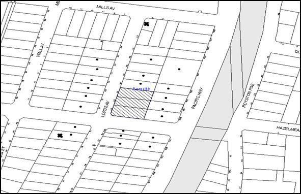
|
NOTIFICATION PLAN |
|
||
|
• PROPERTIES NOTIFIED
|
X SUBMISSIONS RECEIVED |
PROPERTY SUBJECT OF DEVELOPMENT |
|
Two submissions objected to the development on the following grounds:
· The development would adversely impact upon evacuation of residents in the area during bushfires due to the close proximity of the site to bushfire prone land;
· The development would result in unacceptable traffic impact on Lords Avenue;
· The childcare on Lords Avenue would be closed due to the rezoning of the street;
· The proposed and similar adjoining developments would have a detrimental impact on the natural and built environment of Lords Avenue;
One submission supported also made the following observations:
· The details of drainage pipe size within the Mittabah Road reserve have not been provided. Accordingly, the suitability of the stormwater management plan cannot be assessed;
· The number of units should be reduced to 38;
· The train services should be improved to accommodate additional units; and
· The proposed colour scheme should include light green and blue rather than the proposed dark toned colour palette.
The merits of the matters raised in community submissions have been addressed in the body of the report with the exception of the following:
5.1.1 Detrimental Impact on the locality
The proposed development is located within a high density precinct. The suitability of the locality for high density residential development was considered by Council and the Department of Planning during the rezoning of the precinct. Weight must be given to the applicable zoning of the land in the resolution of a dispute as to the appropriate development of any site.
The proposal includes in excess of the parking requirements prescribed by RMS and Hornsby Council. As discussed in this report, the proposal would not have an unreasonable impact on the natural and built environment of the locality, subject to conditions of consent requiring management of traffic and noise during construction works.
5.1.2 Inadequacy of infrastructure
Concerns are raised that existing infrastructure including train services and bushfire evacuation routes are inadequate to cater for an increased population as a result of the additional units. In addition, concerns were raised that additional units would increase on-street parking and traffic congestion.
The suitability of the locality for high density residential development was considered by Council and the Department of Planning during the rezoning of the precinct. Weight must be given to the applicable zoning of the land in the resolution of a dispute as to the appropriate development of any site.
5.1.3 Evacuation during bushfire
The site itself does not constitute bushfire prone land and therefore, this objection is not considered relevant to this development application.
5.1.4 Stormwater
Council’s assessment of the stormwater plans conclude that the existing drainage infrastructure is capable of accommodating the development, given that the stormwater flow would be controlled by the on-site detention system.
It is noted that DA/956/2014 approved roadworks within Mittabah Road which includes upgrading the drainage system. As such, the Mittabah Road drainage pipeline would up, should the development consent be acted upon. Therefore, no further concerns are raised in this regard.
5.1.5 Reduction in the number of units
As discussed in this report, the proposed development generally complies with the prescriptive measures within the HDCP and the ADG. The proposal has been redesigned to reduce the number of units to 41. The amended proposal is assessed as satisfactory with regard to the number of units, considering the size and context of the site.
5.1.6 Colour Scheme
The building would incorporate a varied use of finishes including pre-fabricated fibre cement panels, acrylic render paint finishes and a dark toned colour palette as required by the HDCP. The proposed colour scheme is consistent with the desired future character of the area.
5.2 Public Agencies
The development application was not referred to any Public Agencies for comment.
6. THE PUBLIC INTEREST
Section 79C(1)(e) of the Act requires Council to consider “the public interest”.
The public interest is an overarching requirement, which includes the consideration of the matters discussed in this report. Implicit to the public interest is the achievement of future built outcomes adequately responding to and respecting the future desired outcomes expressed in environmental planning instruments and development control plans.
The application is considered to have satisfactorily addressed Council’s criteria and would provide a development outcome that, on balance, would result in a positive impact for the community. Accordingly, it is considered that the approval of the proposed development would be in the public interest.
CONCLUSION
The application proposes demolition of existing structures and construction of a five storey residential flat buildings comprising 41 units and basement carpark.
The proposed development is designed in accordance with the Key Principles of ‘Lords Avenue, Asquith precinct of the HDCP and would contribute to the future desired five storey residential character of the precinct. The proposal complies with the design principles of SEPP 65 and the Apartment Design Guide.
The proposal would result in a development that would be in keeping with the desired future character of the precinct. Approval of the application is recommended.
Note: At the time of the completion of this planning report, no persons have made a Political Donations Disclosure Statement pursuant to Section 147 of the Environmental Planning and Assessment Act 1979 in respect of the subject planning application.
RESPONSIBLE OFFICER
The officer responsible for the preparation of this Report is the Manager – Development Assessments – Rodney Pickles, who can be contacted on 9847 6731.
|
Rod Pickles Manager - Development Assessment Planning Division |
James Farrington Group Manager Planning Division |
|
1.View |
Locality Map |
|
|
|
2.View |
Landscape Plan |
|
|
|
3.View |
Floor Plans - Part 1 |
|
|
|
4.View |
Floor Plans - Part 2 |
|
|
|
5.View |
Elevations and Sections |
|
|
|
6.View |
Shadow Plan |
|
|
|
7.View |
Photomontage |
|
|
File Reference: DA/1671/2015
Document Number: D06938776
SCHEDULE 1
GENERAL CONDITIONS
The conditions of consent within this notice of determination have been applied to ensure that the use of the land and/or building is carried out in such a manner that is consistent with the aims and objectives of the relevant legislation, planning instruments and council policies affecting the land and does not disrupt the amenity of the neighbourhood or impact upon the environment.
Note: For the purpose of this consent, the term ‘applicant’ means any person who has the authority to act on or the benefit of the development consent.
Note: For the purpose of this consent, any reference to an Act, Regulation, Australian Standard or publication by a public authority shall be taken to mean the gazetted Act or Regulation, or adopted Australian Standard or publication as in force on the date that the application for a construction certificate is made.
1. Approved Plans and Supporting Documentation
The development must be carried out in accordance with the plans and documentation listed below and endorsed with Council’s stamp, except where amended by Council and/or other conditions of this consent:
|
Plan No. |
Issue |
Plan Title |
Drawn by |
Dated |
|
DA02 |
E |
Second Basement Floor Plan |
Gelder |
12/04/2016 |
|
DA03 |
E |
First Basement Floor Plan |
Gelder |
12/04/2016 |
|
DA04 |
F |
Ground Floor Plan |
Gelder |
3/05/2016 |
|
DA05 |
E |
First Floor Plan |
Gelder |
12/04/2016 |
|
DA06 |
E |
Second Floor Plan |
Gelder |
12/04/2016 |
|
DA07 |
E |
Third Floor Plan |
Gelder |
12/04/2016 |
|
DA08 |
E |
Fourth Floor Plan |
Gelder |
12/04/2016 |
|
DA09 |
E |
Loft Plan |
Gelder |
12/04/2016 |
|
DA10 |
E |
Elevations 1 |
Gelder |
12/04/2016 |
|
DA11 |
E |
Elevations 2 |
Gelder |
12/04/2016 |
|
DA12 |
E |
Section A |
Gelder |
12/04/2016 |
|
SW1 |
A |
Concept Basement drainage Plan |
E2 Civil and Structural Design |
13/04/2016 |
|
SW2 |
B |
Concept Roof drainage Plan |
E2 Civil and Structural Design |
13/04/2016 |
|
SW3 |
A |
General notes and details |
E2 Civil and Structural Design |
13/04/2016 |
|
L01 |
A |
Ground floor landscape plan |
Jane Britt Design |
8/05/2016 |
|
L02 |
A |
Landscape tree canopy plan |
Jane Britt Design |
8/05/2016 |
|
L03 |
A |
Specifications and Details |
Jane Britt Design |
8/05/2016 |
|
Document Title |
Prepared by |
Dated |
|
DA01 – E Site Analysis Plan |
Gelder |
12/04/2016 |
|
DA13 - E June shadow diagrams |
Gelder |
12/04/2016 |
|
DA14 – E Coloured elevations |
Gelder |
12/04/2016 |
|
Solar Study Issue A |
Gelder |
May 2016 |
|
512532M_03 BASIX Certificate |
Building Sustainability Assessments |
10/05/2016 |
|
Assessor Certificate Number 14912056 |
Building Sustainability Assessments |
10/05/2016 |
|
Crime Risk Assessment Report |
Gelder |
December 2015 |
|
Design Verification Statement |
Gelder |
02/05/2016 |
|
Schedule of Finishes E08 - 03 |
Gelder |
Received on 6 January 2016 |
|
Overland Flow Report |
Northern Beaches Consulting Engineers |
13/11/013 |
|
Geotechnical Investigation Report |
J K Geotechnics |
14/12/2015 |
|
Statement of Environmental Effects |
Greg Boston |
November 2013 |
|
Survey plan |
Summit Geomatic |
19/12/2013 |
|
Assessment of Traffic and Parking Implications Rev B |
Transport and Traffic Planning Associates |
December 2015 |
|
Waste Management Plan |
Gelder |
Received on 6 January 2016 |
|
Access and Adaptability Assessment Report |
Access Mobility Solutions |
21/12/2015 |
|
Arboricultural Impact Statement |
Bradshaw Tree Services |
September 2013 |
2. Removal of Existing Trees
a) This development consent permits the removal of trees numbered 2, 3, 4, 5, 6, 7, 9, 13, 14, 15, 16, 17 and 19 as identified on plan number L02 A Landscape tree canopy plan prepared by JaneBritt Design, dated 8/05/2016.
b) The removal of any other trees requires separate approval in accordance with the Tree and Vegetation Chapter 1B.6 Hornsby Development Control Plan (HDCP).
3. Amendment of Plans
a) To comply with Councils requirements the submitted “Access and Adaptability Assessment Report” must be amended to include the approved plans listed in condition 1 of this development consent.
b) The approved landscape Plan L01 – A prepared by JaneBritt Design, dated 8/05/2016 should be amended by replacing the paving, “crushed granite with brick edging” within the communal open space at the rear, by turf to maintain peripheral deep soil zones.
c) These amended plans must be submitted with the application for the Construction Certificate.
4. Construction Certificate
a) A Construction Certificate is required to be approved by Council or a Private Certifying Authority prior to the commencement of any works under this consent.
b) A separate Construction Certificate must be obtained from Council for all works within the public road reserve under S138 of the Roads Act.
c) The Construction Certificate plans must not be inconsistent with the Development Consent plans.
5. Section 94 Development Contributions
a) In accordance with Section 80A(1) of the Environmental Planning and Assessment Act, 1979 and the Hornsby Shire Council Section 94 Development Contributions Plan 2014-2024, the following monetary contributions must be paid to Council to cater for the increased demand for community infrastructure resulting from the development:
|
Description |
Contribution (4) |
|
Roads |
$16,533.10 |
|
Open Space and Recreation |
$402,526.00 |
|
Community Facilities |
$166,390.85 |
|
Plan Preparation and Administration |
$1,241.95 |
|
TOTAL |
$586,691.90 |
being for 41 units including 5 x 1 bedroom, 30 x 2 bedroom and 6 x 3 bedroom units with a credit of 3 existing dwellings.
b) The value of this contribution is current as at 3 May 2016. If the contribution is not paid within the financial quarter that this condition was generated, the contribution payable will be adjusted in accordance with the provisions of the Hornsby Shire Council Section 94 Development Contributions Plan and the amount payable will be calculated at the time of payment in the following manner:
$CPY = $CDC x CPIPY
CPIDC
Where:
$CPY is the amount of the contribution at the date of Payment
$CDC is the amount of the contribution as set out in this Development Consent
CPIPY is the latest release of the Consumer Price Index (Sydney – All Groups) at the date of Payment as published by the ABS.
CPIDC is the Consumer Price Index (Sydney – All Groups) for the financial quarter at the date applicable in this Development Consent Condition.
c) The monetary contribution must be paid to Council:
i) prior to the issue of the Subdivision Certificate where the development is for subdivision; or
ii) prior to the issue of the first Construction Certificate where the development is for building work; or
iii) prior to issue of the Subdivision Certificate or first Construction Certificate, whichever occurs first, where the development involves both subdivision and building work; or
iv) prior to the works commencing where the development does not require a Construction Certificate or Subdivision Certificate.
Note: It is the professional responsibility of the Principal Certifying Authority to ensure that the monetary contributions have been paid to Council in accordance with the above timeframes.
Council’s Development Contributions Plan may be viewed at www.hornsby.nsw.gov.au or a copy may be inspected at Council’s Administration Centre during normal business hours.
6. Project Arborist
A Project Arborist is to be appointed in accordance with AS 4970-2009 (1.4.4) to provide monitoring and certification throughout the development process. The details of the appointed Arborist are to be provided to Council and the PCA prior to the issue of the construction certificate.
REQUIREMENTS PRIOR TO THE ISSUE OF A CONSTRUCTION CERTIFICATE
7. Building Code of Australia
All approved building work must be carried out in accordance with the relevant requirements of the Building Code of Australia.
8. Contract of Insurance (Residential Building Work)
Where residential building work for which the Home Building Act, 1989 requires there to be a contract of insurance in force in accordance with Part 6 of that Act, this contract of insurance must be in force before any building work authorised to be carried out by the consent commences.
9. Notification of Home Building Act, 1989 Requirements
Residential building work within the meaning of the Home Building Act 1989 must not be carried out unless the principal certifying authority for the development to which the work relates (not being Council) has given Council written notice of the following information:
a) In the case of work for which a principal contractor is required to be appointed:
i) The name and licence number of the principal contractor; and
ii) The name of the insurer by which the work is insured under Part 6 of that Act.
b) In the case of work to be done by an owner-builder:
i) The name of the owner-builder; and
ii) If the owner-builder is required to hold an owner-builder’s permit under that Act, the number of the owner-builder’s permit.
Note: If arrangements for doing the residential building work are changed while the work is in progress so that the information notified becomes out of date, further work must not be carried out unless the principal certifying authority for the development to which the work relates (not being Council) has given Council written notification of the updated information.
10. Utility Services
The applicant must submit written evidence of the following service provider requirements:
a) Ausgrid (formerly Energy Australia) – a letter of consent demonstrating that satisfactory arrangements have been made to service the proposed development.
b) Telstra - a letter of consent demonstrating that satisfactory arrangements have been made to service the proposed development.
11. Sydney Water – Approval
This application must be submitted to Sydney Water for approval to determine whether the development would affect any Sydney Water infrastructure, and whether further requirements are to be met.
Note: Building plan approvals can be obtained online via Sydney Water Tap inTM through www.sydneywater.com.au under the Building and Development tab.
12. Dilapidation Report
a) A ‘Dilapidation Report’ is to be prepared by a ‘chartered structural engineer’ detailing the structural condition of adjoining properties at No. 42 Lords Avenue, No. 439 Pacific Highway, No. 441 Pacific Highway and No. 443 Pacific Highway, Asquith.
b) To record the structural condition of all properties adjoining the approved development, a dilapidation report must be prepared by a suitably qualified structural engineer for inclusion with the application of the Construction Certificate.
13. Traffic Control Plan
A Traffic Control Plan (TCP) must be prepared by a qualified traffic controller in accordance with the Roads & Traffic Authority’s Traffic Control at Worksites Manual 1998 and Australian Standard 1742.3 for all work on a public road. The Traffic Management Plan shall be submitted and approved by Council’s Manager Traffic and Road Safety prior to the issue of a construction certificate. The TCP must detail the following:
a) Arrangements for public notification of the works;
b) Temporary construction signage;
c) Permanent post-construction signage;
d) Vehicle movement plans;
e) Traffic management plans; and
f) Pedestrian and cyclist access/safety.
14. Identification of Survey Marks
A registered surveyor must identify all survey marks in the vicinity of the proposed development. Any survey marks required to be removed or displaced as a result of the proposed development shall be undertaken by a registered surveyor in accordance with Section 24 (1) of the Surveying and Spatial Information Act 2002 and following the Surveyor General’s Directions No.11 – "Preservation of Survey Infrastructure".
15. Stormwater Drainage
The stormwater drainage system for the development must be designed in accordance with Council’s Civil Works – Design and Construction Specification 2005 and the following requirements:
a) Connected directly to Council’s street drainage system.
16. On Site Stormwater Detention
An on-site stormwater detention system must be designed by a chartered civil engineer and constructed in accordance with the following requirements:
a) Have a capacity of not less than 27 cubic metres, and a maximum discharge (when full) of 48 litres per second;
b) Have a surcharge/inspection grate located directly above the outlet;
c) Discharge from the detention system must be controlled via 1 metre length of pipe, not less than 50 millimetres diameter or via a stainless plate with sharply drilled orifice bolted over the face of the outlet discharging into a larger diameter pipe capable of carrying the design flow to an approved Council system;
d) Not be constructed in a location that would impact upon the visual or recreational amenity of residents.
17. Vehicular Crossing
A separate application under the Local Government Act, 1993 and the Roads Act 1993 must be submitted to Council for the installation of a new vehicular crossing and the removal of the redundant crossing. The vehicular crossing must be constructed in accordance with Council’s Civil Works Design 2005 and the following requirements:
a) Design levels at the front boundary must be obtained from Council for the design on the internal driveway;
b) Any redundant crossings must be replaced with integral kerb and gutter;
Note: An application for a vehicular crossing can only be made to one of Council’s Authorised Vehicular Crossing Contractors. You are advised to contact Council on 02 9847 6940 to obtain a list of contractors.
18. Road Works
All road works approved under this consent must be designed in accordance with Council’s Civil Works Design and Construction Specification 2005 and the following requirements:
a) The existing kerb, gutter and footpath are to be removed and reconstructed across the full frontage of the site in Lords Avenue.
b) The design shall incorporate the design on the stormwater drainage pipeline from the development site to the drainage pit in Mittabah Road.
c) The existing road pavement to be saw-cut a minimum of 300 mm from the existing edge of the bitumen and reconstructed.
19. Footpath
A concrete footpath must be designed across the full frontage of the subject site in accordance Council’s Civil Works Design and Construction Specification 2005 and the following requirements:
a) The existing footpath being removed.
b) The land adjoining the footpath to be fully turfed.
c) Any public utility adjustments to be carried out at the cost of the applicant and to the requirements of the relevant public authority.
20. Internal Driveway/Vehicular Areas
The driveway and parking areas on site must be designed and a Construction Certificate issued in accordance with Australian Standards 2890.1, 2890.2, 3727 and the following requirements:
a) Design levels at the front boundary shall be obtained from Council if a private accredited certifier is engaged to obtain a construction certificate for these works; and
b) The driveway be a rigid pavement.
21. Construction Traffic Management Plan
In order to enable unencumbered movement of traffic in the public road during construction works, a Construction Management Plan, including a Traffic Management Plan and scaled construction plans prepared by a suitably Chartered and Qualified Chartered Civil Engineer and Qualified Worksite Traffic Controller shall be prepared and submitted to Hornsby Shire Council for approval according to the following requirements:-
a) A copy of the plans shall be submitted for consideration and written approval by Hornsby Shire Council prior to the release of the Construction Certificate.
b) The plans shall detail the order of construction works and arrangement of all construction machines and vehicles being used at the same time during all stages.
c) The CTMP plans shall be in accordance with the approved Development Application plans and the Development Consent conditions.
d) In order to prevent injury, accident and loss of property, no building materials, work sheds, vehicles, machines or the like shall be allowed to remain in the road reserve area without the written consent of Hornsby Shire Council.
e) The Plan shall be generally in compliance with the requirements of the Road and Traffic Authority’s “Traffic Control at Worksites Manual 1998” and detailing:-
i) Public notification of proposed works;
ii) Long term signage requirements;
iii) Short term (during actual works) signage;
iv) Vehicle Movement Plans, where applicable;
v) Traffic Management Plans;
vi) Pedestrian and Cyclist access and safety;
f) The plans shall indicate traffic controls including those used during non-working hours and shall provide pedestrian access and two-way traffic in the public road to be facilitated at all times.
g) The plans shall include the proposed truck routes to and from the site including details of the frequency of truck movements at the different stages of the development. The plan shall also include details of parking arrangements for all employees and contractors.
h) The Applicant and all employees of contractors on the site must obey any direction or notice from the Prescribed Certifying Authority or Hornsby Shire Council in order to ensure the above.
i) If there is a requirement to obtain a Work Zone, partial Road Closure or Crane Permit an application to Hornsby Shire Council is to be made prior to the issue the Construction Certificate.
22. Adaptable Units/Letter Boxes/Storage
The following details must be provided with the Construction Certificate plans.
a) The development is required to provide 14 units designed as adaptable housing pursuant to the requirements of 1C.2.2 of the Hornsby Development Control Plan 2013. In this regard, four (4) car parking spaces are to be designed for people with a disability and allocated to 4 accessible units;
b) The letter boxes must be located as shown on the approved plan DA04 Issue F;
c) The details of front fences must be in accordance with DA10 Issue E and DA11 Issue E;
d) The ground level bin collection area/bin holding area must have minimum internal dimensions no less than 3.2m by 5.2m; and
e) Each dwelling within the development must have a minimum area for storage (not including kitchen and bedroom cupboards) for 6m3 for one bedroom units, 8m3 for two bedroom units and 10m3 for three bedroom units, where 50% is required to be located within the apartment and accessible from either the hall or living area.
23. Waste Management Details
The following waste management details must be provided with the Construction Certificate Plans:
a) Storage space must be provided for all equipment required for the operation of the waste management system, including a bin lifter(s) and motorised bin carting equipment;
b) The garbage chute system must be fitted with either a 3x660 litre bin linear or 4x660 litre bin carousel (with no compaction) to automatically change the bin under the chute when it becomes full;
c) A bulky waste storage area of at least 8m2 must be provided at the basement level;
d) The waste facilities on each residential level (a garbage chute and recycling bin in a room) must be accessible by persons with a disability while comfortably accommodating the chute and the 240 litre recycling bin;
Note: Internal dimensions do not include wall thickness, door thickness, ventilation ducting etc., which must be added.
e) The first 6m of driveway must have a gradient no steeper than 1:20;
f) A Waste Management Plan Section One – Demolition Stage and Section Three – Construction Stage, covering the scope of this project and including the following details, is required to be submitted to Council:
i) An estimate of the types and volumes of waste and recyclables to be generated;
ii) A site plan showing sorting and storage areas for demolition and construction waste and the vehicle access to these areas;
iii) How excavation, demolition and construction waste materials will be reused or recycled and where residual wastes will be disposed; and
iv) The total percentage (by weight) of demolition and construction waste that will be reused or recycled.
REQUIREMENTS PRIOR TO THE COMMENCEMENT OF ANY WORKS
24. Erection of Construction Sign
a) A sign must be erected in a prominent position on any site on which any approved work is being carried out:
i) Showing the name, address and telephone number of the principal certifying authority for the work;
ii) Showing the name of the principal contractor (if any) for any demolition or building work and a telephone number on which that person may be contacted outside working hours; and
iii) Stating that unauthorised entry to the work site is prohibited.
b) The sign is to be maintained while the approved work is being carried out and must be removed when the work has been completed.
25. Protection of Adjoining Areas
A temporary hoarding, fence or awning must be erected between the work site and adjoining lands before the works begin and must be kept in place until after the completion of the works if the works:
a) Could cause a danger, obstruction or inconvenience to pedestrian or vehicular traffic;
b) Could cause damage to adjoining lands by falling objects; and/or
c) Involve the enclosure of a public place or part of a public place.
Note: Notwithstanding the above, Council’s separate written approval is required prior to the erection of any structure or other obstruction on public land.
26. Toilet Facilities
a) To provide a safe and hygienic workplace, toilet facilities must be available or be installed at the works site before works begin and must be maintained until the works are completed at a ratio of one toilet for every 20 persons employed at the site.
b) Each toilet must:
i) be a standard flushing toilet connected to a public sewer; or
ii) be a temporary chemical closet approved under the Local Government Act 1993; or
iii) have an on-site effluent disposal system approved under the Local Government Act 1993.
27. Erosion and Sediment Control
To protect the water quality of the downstream environment, erosion and sediment control measures must be provided and maintained throughout the construction period in accordance with the manual ‘Soils and Construction 2004 (Bluebook)’, the approved plans, Council specifications and to the satisfaction of the principal certifying authority. The erosion and sediment control devices must remain in place until the site has been stabilised and revegetated.
Note: On the spot penalties may be issued for any non-compliance with this requirement without any further notification or warning.
28. Tree Protection Barriers
a) To safeguard the natural environment during the approved development works, tree protection fencing must be erected around tree Nos. 1, 8, 10, 11, 12, 18, 20, 21, 23, 24, 25 and 26 identified in L02 A Landscape tree canopy plan prepared by JaneBritt Design, dated 8/05/2016, at nominated setbacks listed in the Arboricultural Impact Statement prepared by Bradshaw Tree Services dated September 2013.
b) All trees proposed to be retained on site must have tree protection measures for the ground, trunk and canopy installed in accordance with the Australian Standard ‘Protection of Trees on Development Sites (AS 4970-2009) and the Arboricultural Impact Statement prepared by Bradshaw Tree Services dated September 2013.
c) All Tree Protection Zones must have a layer of wood-chip mulch installed prior to works commencing and must be maintained throughout the period of construction at a depth of 150mm – 300mm using material that complies with Australian Standard AS 4454.
d) A certificate from the Project Arborist must be submitted to the Principal Certifying Authority and Council stating compliance with the relevant tree protection conditions of this consent.
29. Construction Work Zone
A “Construction Work Zone” within Mittabah Road is to be approved by Hornsby Council. The construction vehicles are to park within the site or within the approved work zone only.
REQUIREMENTS DURING CONSTRUCTION
30. Construction Work Hours
All work on site (including demolition and earth works) must only occur between 7am and 5pm Monday to Saturday (unless otherwise approved in writing by Council due to extenuating circumstances). No work is to be undertaken on Sundays or public holidays.
31. Demolition
To protect the surrounding environment, all demolition work must be carried out in accordance with “Australian Standard 2601-2001 – The Demolition of Structures” and the following requirements:
a) Demolition material must be disposed of to an authorised recycling and/or waste disposal site and/or in accordance with an approved waste management plan;
b) Demolition works, where asbestos material is being removed, must be undertaken by a contractor that holds an appropriate licence issued by WorkCover NSW in accordance with Chapter 10 of the Occupational Health and Safety Regulation 2001 and Clause 29 of the Protection of the Environment Operations (Waste) Regulation 2005 ;and
c) On construction sites where any building contain asbestos material, a standard commercially manufactured sign containing the words ‘DANGER ASBESTOS REMOVAL IN PROGRESS’ and measuring not less than 400mm x 300mm must be displayed in a prominent position visible from the street.
32. Environmental Management
The site must be managed in accordance with the publication ‘Managing Urban Stormwater – Landcom (March 2004) and the Protection of the Environment Operations Act 1997 by way of implementing appropriate measures. To prevent sediment run-off, excessive dust, noise or odour emanating from the site during the construction of the development.
33. Street Sweeping
To protect the surrounding environment, Street sweeping must be undertaken following sediment tracking from the site along Lords Avenue during works and until the site is established.
The street cleaning services must undertake a street ‘scrub and dry’ method of service and not a dry sweeping service that may cause sediment tracking to spread or cause a dust nuisance.
34. Works Near Trees
a) To protect trees to be retained, all required tree protection measures are to be maintained in good condition for the duration of the construction period.
b) Any scaffolding must be erected outside the tree protection zone of all trees to be retained on site in accordance with Section 4.5.6 of AS4970 – 2009.
c) Approved works within the nominated Tree Protection Zones of tree Nos. 8, 10, 11, 12 and 25 must be carried out in accordance with the methods listed in the Arboricultural Impact Statement prepared by Bradshaw Tree Services dated September 2013 and the following requirements:
i) All works must be approved by the Project Arborist.
ii) Root/ground protection/root pruning outside the structure root zone of a tree and underground services installation must be provided in accordance with AS 4970-2009 (Clause 4.5.4 and clause 4.5.5);
iii) The Structural Root Zone of any tree required to be retained must remain intact;
iv) Activities within the Tree Protection Zone must comply with AS 4970-2009 (Clause 4.2); and
v) Installation of services must be undertaken using sensitive methods such as directional drilling or in manually excavated trenches;
vi) Machinery other than hand held must not enter or carry out works on public land.
d) The Project Arborist must monitor and record any necessary remedial actions for maintaining tree health and condition required for trees numbered 1, 8, 10, 11, 12, 18, 20, 21, 23, 24, 25 and 26 as identified on L02 A prepared by Jane Britt Design dated 8/05/2016.
e) The appointed Project Arborist must monitor and record all changes or modifications required regarding tree protection measures for the period of construction.
f) A certificate must be submitted to the principal certifying authority by the Project Arborist detailing the method(s) used to preserve these tree(s) during the course of construction.
Note: Except as provided above, the applicant is to ensure that no excavation, filling or stockpiling of building materials, parking of vehicles or plant, disposal of cement slurry, waste water or other contaminants occurs within 4 metres of any tree to be retained.
35. Council Property
To ensure that the public reserve is kept in a clean, tidy and safe condition during construction works, no building materials, waste, machinery or related matter is to be stored on the road/footpath/nature strip in front of the site including the grass verge within the Mittabah Road reserve.
36. Landfill
Landfill must be constructed in accordance with Council’s ‘Construction Specification 2005’ and the following requirements:
a) All fill material imported to the site is to wholly consist of Virgin Excavated Natural Material (VENM) as defined in Schedule 1 of the Protection of the Environment Operations Act, 1997 or a material approved under the Department of Environment and Climate Change’s general resource recovery exemption.
b) A compaction certificate is to be obtained from a suitably qualified geotechnical engineer verifying that the specified compaction requirements have been met.
c) A compaction certificate must be provided by a geotechnical engineer certifying any fill within road reserves, and all road sub-grade and road pavement materials.
d) The compaction certificates must be included with the application for an occupation certificate.
37. Excavated Material
All excavated material removed from the site must be classified by a suitably qualified person in accordance with the Department of Environment, Climate Change and Water NSW Waste Classification Guidelines prior to disposal to an approved waste management facility and be reported to the principal certifying authority prior to the issue of an Occupation Certificate.
38. Survey Report – Finished Floor Level
The following reports must be prepared by a registered surveyor and submitted to the principal certifying authority:
a) Prior to the pouring of concrete at each level of the building certifying that:
i) The building, retaining walls and the like have been correctly positioned on the site;
ii) The finished floor level(s) are in accordance with the approved plans;
iii) The height of the topmost level of the building including lift overruns and the roof overhang is a maximum of 17.5m above the natural ground level at that point.
b) Confirming that the waste collection vehicle standing area complies with AS2890.1 – 2004 and AS20890.2 – 2002 for small rigid vehicles (SRV).
39. Waste Management
Waste management during the demolition and construction phase of the development must be undertaken in accordance with the approved Waste Management Plan. Additionally written records of the following items must be maintained during the removal of any waste from the site and such information submitted to the Principal Certifying Authority within fourteen days of the date of completion of the works:
a) The identity of the person removing the waste.
b) The waste carrier vehicle registration.
c) Date and time of waste collection.
d) A description of the waste (type of waste and estimated quantity).
e) Details of the site to which the waste is to be taken.
f) The corresponding tip docket/receipt from the site to which the waste is transferred (noting date and time of delivery, description (type and quantity) of waste).
g) Whether the waste is expected to be reused, recycled or go to landfill.
Note: In accordance with the Protection of the Environment Operations Act 1997, the definition of waste includes any unwanted substance, regardless of whether it is reused, recycled or disposed to landfill.
40. Compliance during Construction works
The development must be carried out in accordance with the following approved documents:
a) Traffic Control Plan (TCP);
b) Construction Traffic Management Plan (CTMP); and
c) The recommendations within the Geotechnical Investigation Report prepared by J K Geotechnics dated 14/12/2015.
41. Maintenance of public footpaths
Public footpaths must be maintained for the duration of works to ensure they are free of trip hazards, displacements, breaks or debris to enable pedestrians to travel along the footpath safely.
REQUIREMENTS PRIOR TO THE ISSUE OF AN OCCUPATION OR SUBDIVISION CERTIFICATE
Note: For the purpose of this consent, a reference to ‘occupation certificate’ shall not be taken to mean an ‘interim occupation certificate’ unless otherwise stated.
42. Fulfilment of BASIX Commitments
The applicant must demonstrate the fulfilment of BASIX commitments pertaining to the development.
43. Sydney Water – s73 Certificate
A s73 Certificate must be obtained from Sydney Water and submitted to the PCA.
Note: Sydney Water requires that s73 applications are to be made through an authorised Sydney Water Servicing Coordinator. Refer to www.sydneywater.com.au or telephone 13 20 92 for assistance.
44. Certification of WSUD Facilities
A certificate from a Civil Engineer is to be obtained stating that the WSUD facilities have been constructed and will meet the water quality targets as specified in the Hornsby Shire Development Control Plan 2013.
45. Damage to Council Assets
To protect public property and infrastructure any damage caused to Council’s assets as a result of the construction or demolition of the development must be rectified by the applicant in accordance with Council’s Civil Works Specifications.
The public reserve must not sustain any damage or be at risk of damage as a result of the works associated with this consent.
Note: This consent does not give right of access to the site via Council’s park or reserve. Should such access be required, separate written approval is to be obtained from Council.
46. Car Parking and Vehicular Areas
All vehicular areas within the site and the car parking must be constructed in accordance with Australian Standard AS 2890.1 – 2004 – Off Street Car Parking and Australian Standard 2890.2 - 2002 – Off Street Commercial and the following requirements:
a) The driveway to be designed in accordance with Condition 20 of this development consent;
b) All parking areas and driveways are to be sealed to an all-weather standard, line marked and signposted;
c) Residential parking spaces are to be secure spaces with access controlled by card or numeric pad;
d) Eight (8) visitors’ spaces are to be provided at the basement level. Visitors are to be able to access the basement car park by an audio/visual intercom system located at the top of the ramped driveway;
e) Sixteen bicycle spaces (resident and visitor) are to be provided in the basement car park. Bicycle parking spaces are to be designed in accordance with AS 2890.3-1993;
f) One motorcycle parking space is to be provided within the basement car park, designed in accordance with AS 2890.5-1993;
g) All parking for people with disabilities is to comply with AS/NZS 2890.6:2009 Off-street parking for people with disabilities; and
h) The location of the driveway must maintain sight lines for the pedestrians.
47. Creation of Easements
The following matter(s) must be nominated on the plan of subdivision under s88B of the Conveyancing Act, 1919:
a) The creation of an appropriate "Positive Covenant" and "Restriction as to User" over the constructed on-site detention/retention, WSUD system and outlet works, within the development site in favour of Council in accordance with Council’s prescribed wording. The positions of the on-site detention system and water quality treatment system are to be clearly indicated on the plan of title.
b) To register the positive covenant and the restriction on the use of land, “works-as-executed” details of the on-site-detention system and water quality treatment system must be submitted verifying that the required storage and discharge rates and water quality treatment measures have been constructed in accordance with the design requirements. The details must show the invert levels of the on- site system together with pipe sizes and grades and details of water quality treatment measures. Any variations to the approved plans must be shown in red on the “works-as-executed” plan and supported by calculations.
Note: Council must be nominated as the authority to release, vary or modify any easement, restriction or covenant.
48. Works as Executed Plan
A works-as-executed plan(s) must be prepared by a registered surveyor and submitted to Council for completed road pavement, kerb & gutter, public drainage systems, driveways and on-site detention system.
49. Preservation of Survey Marks
A certificate by a Registered Surveyor must be submitted to the Principal Certifying Authority, certifying that there has been no removal, damage, destruction, displacement or defacing of the existing survey marks in the vicinity of the proposed development or otherwise the re-establishment of damaged, removed or displaced survey marks has been undertaken in accordance with the Surveyor General’s Direction No.11 – “Preservation of Survey Infrastructure”.
50. Construction of engineering works.
All engineering works identified in this consent including stormwater works, retaining walls, driveway works, roadworks and the like are to be completed and a Compliance Certificate issued prior to the release of the Occupation Certificate.
51. Consolidation of Allotments
All allotments the subject of this consent must be consolidated into one allotment.
Note: The applicant is recommended to submit the plan of subdivision to consolidate allotments to the NSW Department of Lands at least 4-6 weeks prior to seeking an occupation certificate.
52. Provision for National Broadband Network (NBN)
Provision must be made for fibre ready passive infrastructure (pits and pipes) generally in accordance with NBN Co's pit and pipe installation guidelines to service the proposed development. A certificate from NBN Co or Telstra must be submitted to the PCA that the fibre optic cabling provided for the development complies with MDU Building Design Guides for Development.
53. Completion of Landscaping
A certificate must be submitted to the PCA by a practicing landscape architect, horticulturalist or person with similar qualifications and experience certifying that all required landscaping works have been satisfactorily completed in accordance with the approved landscape plans and the following requirement:
a) Planting of 5 x Tristaniopsis laurina (Watergum) along the Lords Avenue frontage of the site;
b) The planted street trees are to be located 1000mm long and min 600mm wide mulched plant beds, have three hardwood stakes with a minimum 200 litre pot size during plant establishment;
c) The street trees are to be located to ensure safe sight lines for drivers of vehicles egressing the site;
d) All replacement tree planting within the site must be native to Hornsby Shire and must reach a mature height greater than 9 metres;
e) The replacement tree(s) must be maintained until they reach the height of 3 metres;
f) All tree stock must meet the specifications outlined in ‘Specifying Trees’ (Ross Clark, NATSPEC Books);
g) Planting methods must meet professional (best practice) industry standards;
h) On slab planter boxes including the ground cover above the on-site detention tank and the paved areas along the north-western boundary of the site must include waterproofing, subsoil drainage (proprietary drainage cell, 50mm sand and filter fabric) automatic irrigation, minimum 300mm planting soil for grasses and ground covers, 500mm planting soil for shrubs and minimum 1000mm planting soil for trees and palms and 75mm mulch to ensure sustainable landscape is achieved.
Note: Advice on suitable species for landscaping can be obtained from Council’s planting guide ‘Indigenous Plants for the Bushland Shire’, available at www.hornsby.nsw.gov.au.
Note: Applicants are advised to pre-order plant material required in pot sizes 45 litre or larger to ensure Nurseries have stock available at the time of install.
54. Retaining Walls
All required retaining walls must be constructed as part of the development.
55. Boundary Fencing
Fencing must be erected along all property boundaries in accordance with the following requirements:
a) Front fence to be in accordance with the approved dwg Nos. DA10 Issue E and DA11 Issue E; and
b) Fencing along the eastern and northern boundaries behind the front building alignment, to a height of 1.8 metres.
Note: Alternative fencing may be erected along the northern, eastern and southern boundaries subject to the written consent of the adjoining property owner(s).
56. External Lighting
a) To protect the amenity of adjacent premises, all external lighting must be designed and installed in accordance with Australian Standard AS 4282 – Control of the Obtrusive Effects of Outdoor Lighting.
b) Certification of compliance with this Standard must be obtained from a suitably qualified person and submitted to the PCA with the application for the Construction Certificate.
57. Garbage Collection Easement
For the purpose of waste collection, an easement entitling Council, its servants and agents and persons authorised by it, to enter upon the subject land and to operate thereon, vehicles and other equipment for the purposes of garbage collection must be granted to Council by the owner of the land.
Note: The easement must be in a form prescribed by Council and must include covenants to the effect that parties will not be liable for any damage caused to the subject land or any part thereof or to any property located therein or thereon by reason of the operation thereon of any vehicle or other equipment used in connection with the collection of garbage and to the effect that the owner for the time being of the subject land shall indemnify the Council, its servants, agents and persons authorised by it to collect garbage against liability in respect of any such claims made by any person whomsoever.
58. Waste Management
The following waste management requirements must be complied with:
a) The bin storage room at the basement level must include water or a hose for cleaning, graded floors with drainage to sewer, robust doors, sealed and impervious surface, adequate lighting and ventilation, and must be lockable. The waste room at each residential level must include sealed and impervious surface, adequate lighting and ventilation and robust doors.
b) A report must be prepared by an appropriately qualified person, certifying the following:
i) A comparison of the estimated quantities of each waste type against the actual quantities of each waste type.
Note: Explanations of any deviations to the approved Waste Management Plan is required to be included in this report.
ii) That at least 60% of the waste generated during the demolition and construction phase of the development was reused or recycled.
Note: If the 60% diversion from landfill cannot be achieved in the Construction Stage, the Report is to include the reasons why this occurred and certify that appropriate work practices were employed to implement the approved Waste Management Plan. The Report must be based on documentary evidence such as tipping dockets/receipts from recycling depots, transfer stations and landfills, audits of procedures etc. which are to be attached to the report.
iii) All waste was taken to site(s) that were lawfully permitted to accept that waste.
c) Each unit must be provided with an indoor waste/recycling cupboard for the interim storage of waste with two separate 20 litre containers for general waste and recyclable materials.
d) Space must be provided for either individual compost containers for each unit or a communal compost container;
Note: The location of the compost containers should have regard for potential amenity impacts.
e) A bulky waste storage area of at least 8m2 is to be identified and marked with paint and signage.
f) The bin carting routes must be devoid of any steps.
Note: Ramps between different levels are acceptable.
g) The bin holding area must be screened from the front by appropriate landscaping up to a height of 1.5m as per the approved plans;
h) Prior to an Occupation Certificate being issued or the use commencing, whichever is earlier, the Principal Certifying Authority must obtain Council’s approval of the waste and recycling management facilities provided in the development and ensure arrangements are in place for domestic waste collection by Council.
i) Motorised bin carting equipment must be provided to assist the site caretaker in the safe transfer of 240 litre and 660 litre garbage bin between the basement and ground levels.
j) The waste facilities (a garbage bin and recycling bin in a cupboard) on each residential level must be accessible by persons with a disability while comfortably housing the garbage chute and one 240 L recycling bin.
Note: 240L recycling bins are 600mm wide by 750mm deep; allow for ease around the bin – 75mm is recommended.
k) The first 6 m of driveway must have a gradient no steeper than 1:20.
l) The ground level bin collection area/bin holding area is to have internal dimensions no less than 3.2 m by 5.2 m.
59. Unit Numbering
All units are to be numbered consecutively commencing at No.1. The strata plan lot number is to coincide with the unit number, e.g. Unit 1 = Lot 1. The allocated of unit numbering must be authorised by Council prior to the numbering of each units in the development.
60. Final Certification – Tree Protection
Following the final inspection and the completion of any remedial works, the project Arborist must submit to the Principal Certifying Authority documentation stating that the completed works have been carried out in compliance with the approved plans conditions of development consent and specifications for tree protection as above and AS 4970-2009.
61. Safety and Security
This site must include the following elements:
a) An intercom system must be installed at gate locations to ensure screening of persons entering the units;
b) The entry doors to the pedestrian foyer is to be constructed of safety rated glass to enable residents a clear line of site before entering or exiting the residential apartments;
c) Lighting is to be provided to pathways, building foyer entries, driveways and common external spaces;
d) Security gate access is to be provided to the car parking areas allowing residents-only access to private car spaces;
e) CCTV cameras must be installed at the entry and exit point and the around the mailbox;
f) The communal open spaces within the site must be illuminated with high luminance by motion sensor lighting;
g) The driveway and basement car parking must be illuminated with low luminance at all times;
h) Security deadlocks are to be provided to each apartment door; and
i) Peep holes are to be provided to individual apartment doors to promote resident safety.
OPERATIONAL CONDITIONS
62. Noise
All noise generated by the proposed development must be attenuated to prevent levels of noise being emitted to adjacent premises which possess tonal, beating and similar characteristics or which exceeds background noise levels by more than 5dB(A).
63. Fire Safety Statement - Annual
On at least one occasion in every 12 month period following the date of the first ‘Fire Safety Certificate’ issued for the property, the owner must provide Council with an annual ‘Fire Safety Certificate’ to each essential service installed in the building.
64. Landscape Establishment
The landscape works must be maintained into the future to ensure the establishment and successful growth of plant material to meet the intent of the landscape design. This must include but not limited to watering, weeding, replacement of failed plant material and promoting the growth of plants through standard industry practices.
65. Car Parking/Sight lines and Deliveries
All car parking must be operated in accordance with Australian Standard AS 2890.1 – 2004 – Off Street Car Parking and Australian Standard 2890.2 - 2002 – Off Street Commercial and the following requirements:
a) All parking areas and driveways are to be sealed to an all-weather standard, line marked and signposted at all times.
b) Car parking, loading and manoeuvring areas to be used solely for nominated purposes.
c) Vehicles awaiting loading, unloading or servicing shall be parked on site and not on adjacent or nearby public roads;
d) All vehicular entry on to the site and egress from the site shall be made in a forward direction;
e) Minimum sight lines for pedestrian safety are to be provided at the driveway; and
f) Any proposed landscaping and/or fencing must not restrict sight distance to pedestrians and cyclists travelling along the footpath.
66. Waste Management
The waste management on site must be in accordance with the following requirements:
a) A site caretaker must be employed and be responsible for moving bins where and when necessary, washing bins and maintaining waste storage areas, ensuring the chute system and related devices are maintained in effective and efficient working order, managing the communal composting area, managing the bulky item storage area, arranging the prompt removal of dumped rubbish, and ensuring cars do not park in the loading bay and that all residents are informed of the use of the waste management system.
b) The approved on-going waste management practise for the site must not be amended without consent from Council.
- END OF CONDITIONS -
ADVISORY NOTES
The following information is provided for your assistance to ensure compliance with the Environmental Planning and Assessment Act, 1979, Environmental Planning and Assessment Regulation 2000, other relevant legislation and Council’s policies and specifications. This information does not form part of the conditions of development consent pursuant to Section 80a of the Act.
Environmental Planning and Assessment Act 1979 Requirements
The Environmental Planning and Assessment Act 1979 require:
· The issue of a construction certificate prior to the commencement of any works. Enquiries can be made to Council’s Customer Services Branch on 9847 6760.
· A principal certifying authority to be nominated and Council notified of that appointment prior to the commencement of any works.
· Council to be given at least two days written notice prior to the commencement of any works.
· Mandatory inspections of nominated stages of the construction inspected.
· An occupation certificate to be issued before occupying any building or commencing the use of the land.
Long Service Levy
In accordance with Section 34 of the Building and Construction Industry Long Service Payments Act 1986, a ‘Long Service Levy’ must be paid to the Long Service Payments Corporation or Hornsby Council.
Note: The rate of the Long Service Levy is 0.35% of the total cost of the work.
Note: Hornsby Council requires the payment of the Long Service Levy prior to the issue of a construction certificate.
Tree and Vegetation Preservation
In accordance with Clause 5.9 of the Hornsby Local Environmental Plan 2013 a person must not ringbark, cut down, top, lop, remove, injure or wilfully destroy any tree or other vegetation protected under the Hornsby Development Control Plan 2013 without the authority conferred by development consent or a permit granted by Council.
Notes: A tree is defined as a long lived, woody perennial plant with one or relatively few main stems with the potential to grow to a height greater than three metres (3M). (HDCP 1B.6.1.c).
Tree protection measures and distances are determined using the Australian Standard AS 4970:2009, “Protection of Trees on Development Sites”.
Fines may be imposed for non-compliance with both the Hornsby Local Environmental Plan 2013 and the Hornsby Development Control Plan 2013.
Disability Discrimination Act
The applicant’s attention is drawn to the existence of the Disability Discrimination Act. A construction certificate is required to be obtained for the proposed building/s, which will provide consideration under the Building Code of Australia, however, the development may not comply with the requirements of the Disability Discrimination Act. This is the sole responsibility of the applicant.
Covenants
The land upon which the subject building is to be constructed may be affected by restrictive covenants. Council issues this approval without enquiry as to whether any restrictive covenant affecting the land would be breached by the construction of the building, the subject of this consent. Applicants must rely on their own enquiries as to whether or not the building breaches any such covenant.
Dial Before You Dig
Prior to commencing any works, the applicant is encouraged to contact Dial Before You Dig on 1100 or www.dialbeforeyoudig.com.au for free information on potential underground pipes and cables within the vicinity of the development site.
Telecommunications Act 1997 (Commonwealth)
If you are aware of any works or proposed works which may affect or impact on Telstra’s assets in any way, you are required to contact: Telstra’s Network Integrity Team on Phone Number 1800810443.
Asbestos Warning
Should asbestos or asbestos products be encountered during demolition or construction works, you are advised to seek advice and information prior to disturbing this material. It is recommended that a contractor holding an asbestos-handling permit (issued by WorkCover NSW) be engaged to manage the proper handling of this material. Further information regarding the safe handling and removal of asbestos can be found at:
Alternatively, telephone the WorkCover Asbestos and Demolition Team on 8260 5885.
Group Manager’s Report No. PL46/16
Planning Division
Date of Meeting: 8/06/2016
11 FURTHER REPORT - DEVELOPMENT APPLICATION - DWELLING HOUSE - 77 MALTON ROAD, BEECROFT
EXECUTIVE SUMMARY
|
DA No: |
DA/920/2015 (Lodged on 27 July 2015) |
|
Description: |
Erection of a dwelling house on a vacant allotment |
|
Property: |
Lot 2 DP 883724, No. 77 Malton Road, Beecroft |
|
Applicant: |
Mrs Natallya Watchreslavovna Horrigan and Mr Gregory David Horrigan |
|
Owner: |
Mrs Natallya Watchreslavovna Horrigan |
|
Estimated Value: |
$550,000 |
· The application is for the construction of a two storey dwelling house on a vacant allotment.
· On 9 March 2016, Council resolved to defer the application to engage P and J Smith Ecological Consultants to undertake an independent ecological assessment of the proposed development and to conduct an onsite meeting to discuss the implications of the application including opportunities to formalise public access over the rear of the site to create a linkage with the Byles Creek Walking track. The applicant has confirmed they are not prepared to formalise public access over the track.
· The proposal generally complies with the Hornsby Local Environmental Plan (HLEP) 2013 and the Hornsby Development Control Plan (HDCP) 2013.
· Thirteen submissions have been received in respect of the application.
· It is recommended that the application be approved as a deferred commencement to enable the preparation of an Integrated Vegetation and Fire Management Plan and a Construction Management Plan.
|
THAT Development Application No. DA/920/2015 for the construction of a two storey dwelling house at Lot 2 DP 883724, No. 77 Malton Road, Beecroft be approved as a deferred commencement consent pursuant to Section 80(3) of the Environmental Planning and Assessment Act 1979 subject to the conditions of consent detailed in Schedule 1 of Group Manager’s Report No. PL46/16. |
BACKGROUND
Three pre-lodgement meetings were held with Council seeking advice on the following proposals:
· PL/3/2014 for a two lot subdivision and the erection of a dwelling house on each allotment;
· PL/4/2014 for the erection of a dwelling house that would be accessed via an easement that benefits the subject Lot over the adjacent property at Nos. 79 - 87 Malton Road; and
· PL/3/2015 for the erection of a dwelling house that would be accessed via an existing access handle from Malton Road along the south-eastern side boundary.
· On 9 March 2016, Council considered Group Manager’s Report No. PL/17/16 which recommended that the proposal be approved as a deferred commencement. Council resolved that the matter be deferred to enable:
1. Council to engage Dr Peter Smith of P and J Smith Ecological Consultants to undertake an independent ecological assessment of the proposed development at No. 77 Malton Road, Beecroft.
2. An onsite meeting to be arranged by the Group Manager Planning for available Councillors and Council officers to discuss the implications of the Development Application including opportunities to formalise public access over the rear of the site to create a linkage with the Byles Creek Walking track.
· In accordance with Council’s resolution, on 4 April 2016, Council received an independent ecological assessment report prepared by Dr Peter Smith of P and J Smith Ecological Consultants for the proposed development. The recommendation of the assessment are addressed in this report.
· On 11 April 2016, Council received a letter of reply from the applicant in regards to the recommendations of the independent ecological assessment report.
· In accordance with Council’s resolution, on 6 May 2016, an onsite meeting was held to discuss the application. The meeting was attended by available Councillors, Planning Division officers and the applicant. Discussion included consideration of the following:
o The recommendations of the independent ecological assessment report by Dr Peter Smith.
o Opportunities to formalise public access over the rear of the site to create a linkage with the Byles Creek Walking track.
At the conclusion of the meeting, it was noted that the application would be reported back to Council at its meeting on 8 June 2016 for Council’s consideration.
SITE
The vacant, 6,898m2 battle-axe site is located on the north-east side of Malton Road, Beecroft and experiences a fall of 30 metres from street level towards the rear, north-eastern boundary.
The site is bushfire prone land.
The site is flood prone land as Byles Creek, a tributary of the Lane Cove River, drains through the rear, north-eastern boundary of the site.
The site supports the growth of locally significant Blackbutt Gully Forest bushland which contains potential habitat for threatened species including the Gang-gang Cockatoo and Powerful Owl.
The site is located within the Beecroft/Cheltenham Heritage Conservation Area and is in the vicinity of heritage items namely street trees along Malton Road, which are listed in Schedule 5 of the Hornsby Local Environmental Plan 2013 (HLEP).
PROPOSAL
The application proposes the construction of a two storey dwelling house to be built in two modules with a detached garage and entertainment area above, connected by a covered breezeway and a 4 metre wide, 60 metre long driveway accessed from Malton Road.
The ground floor of the dwelling house module would comprise a guest room, rumpus room, bathroom and laundry.
The first floor would include 3 bedrooms, living room, kitchen, study, bathroom, ensuite and a walk-in-robe.
The ground floor of the garage module would comprise 3 car parking spaces and the first floor would include an entertainment room with a bathroom and external deck.
To establish the building envelope, driveway and asset protection zone, the proposal would require the removal of 77 trees.
The application also proposes associated landscaping works including replacement tree planting, a pathway, stone retaining wall and screen planting.
ASSESSMENT
The development application has been assessed having regard to ‘A Plan for Growing Sydney’, the ‘North Subregion (Draft) Subregional Strategy’ and the matters for consideration prescribed under Section 79C of the Environmental Planning and Assessment Act 1979 (the Act). The following issues have been identified for further consideration.
1. STRATEGIC CONTEXT
1.1 A Plan for Growing Sydney and (Draft) North Subregional Strategy
A Plan for Growing Sydney has been prepared by the NSW State Government to guide land use planning decisions for the next 20 years. The Plan sets a strategy for accommodating Sydney’s future population growth and identifies the need to deliver 689,000 new jobs and 664,000 new homes by 2031. The Plan identifies that the most suitable areas for new housing are in locations close to jobs, public transport, community facilities and services.
The NSW Government will use the subregional planning process to define objectives and set goals for job creation, housing supply and choice in each subregion. Hornsby Shire has been grouped with Hunters Hill, Ku-ring-gai, Lane Cove, Manly, Mosman, North Sydney, Pittwater, Ryde, Warringah and Willoughby to form the North Subregion. The Draft North Subregional Strategy will be reviewed and the Government will set housing targets and monitor supply to ensure planning controls are in place to stimulate housing development.
The proposed development would be consistent with ‘A Plan for Growing Sydney’, by providing an additional dwelling contributing towards Council’s housing target.
2. STATUTORY CONTROLS
Section 79C(1)(a) requires Council to consider “any relevant environmental planning instruments, draft environmental planning instruments, development control plans, planning agreements and regulations”.
2.1 Hornsby Local Environmental Plan 2013
The subject land is zoned R2 (Low Density-Residential) under the Hornsby Local Environmental Plan 2013 (HLEP). The objectives of the R2 zone are:
(a) To provide for the housing needs of the community within a low density residential environment; and
(b) To enable other land uses that provide facilities or services to meet the day to day needs of residents.
The proposed development is defined as a “dwelling house” under the HLEP and is permissible in the zone with Council’s consent.
2.1.1 Height of Buildings
Clause 4.3 of the HLEP provides that the height of a building on any land is not to exceed the maximum height shown for the land on the Height of Buildings Map. The maximum permissible height for the site is 8.5 metres. The 8.3 metre height of the proposal complies with this provision.
2.1.2 Heritage Conservation
Clause 5.10 of the HLEP sets out heritage conservation provisions for Hornsby Shire. The site is located within the Beecroft/Cheltenham Heritage Conservation Area and is in the vicinity of the heritage listed street trees along Malton Road.
Given the steep topography of the site, the maximum roof pitch of the dwelling would be approximately 14 metres below street level which would not visible within the Malton Road streetscape. In addition, the dwelling is located approximately 76 metres from Malton Road and is situated on a battle-axe allotment. As a consequence, the design, materials and siting of the proposed dwelling would have no detrimental impacts on the heritage qualities of the heritage listed street trees in the streetscape or the heritage conservation area.
The classification of the proposed development as BAL 40 restricts the available design and building materials that can be used. The proposed dwelling would complement the surrounding development in terms of bulk, scale, height, roof form, materials and finishes. Accordingly, the proposal is consistent with the heritage provisions of the LEP.
The proposal meets the desired outcome of Part 9.3.1 General Design Provisions of the HDCP and is considered acceptable.
2.2 State Environmental Planning Policy (Exempt and Complying Development Codes) 2008 – NSW Housing Code
The application has been assessed against the requirements of State Environmental Planning Policy (Exempt and Complying Development Codes) 2008 – NSW Housing Code. The Policy provides exempt and complying development codes that have State-wide application. The Policy also identifies types of development that are of minimal environmental impact that may be carried out without the need for development consent and types of complying development (including dwelling houses) that may be carried out in accordance with a complying development certificate.
The proposed dwelling house may not be approved as complying development, as the subject site is mapped within an area listed under the Threatened Species Conservation Act, 1995 and proposes the removal of 79 trees. The site is bush fire prone with a Bushfire Attack Level (BAL-40). This rating precludes the application from being assessed as complying development. The site is also located within a heritage conservation area.
The proposal complies with the requirements of the NSW Housing Code in all other aspects including maximum dwelling size, height, setbacks, private open space, landscaping and car parking.
2.3 Sydney Regional Environmental Plan (Sydney Harbour Catchment) 2005
The application has been assessed against the requirements of Sydney Regional Environmental Plan (Sydney Harbour Catchment) 2005. This Policy provides general planning considerations and strategies to ensure that the catchment, foreshores, waterways and islands of Sydney Harbour are recognised, protected, enhanced and maintained.
Subject to the implementation of installation of sediment and erosion control measures and stormwater management to protect water quality, the proposal would have minimal potential to impact on the Sydney Harbour Catchment.
2.4 State Environmental Planning Policy (Building Sustainability Index – BASIX) 2004
The application has been assessed against the requirements of State Environmental Planning Policy (Building Sustainability Index: BASIX) 2004.
BASIX Certificate No. 645033S has been submitted for the dwelling house in compliance with the requirements of the SEPP.
2.5 Clause 74BA Environmental Planning and Assessment Act, 1979 - Purpose and Status of Development Control Plans
On 1 March 2013, the Environmental Planning and Assessment Act, 1979 was amended so that a DCP provision will have no effect if it has the practical effect of “preventing or unreasonably restricting development” that is otherwise permitted and complies with the development standards set out in relevant Local Environmental Plans and State Environmental Planning Policies.
The principal purpose of a development control plan is to provide guidance on the aims of any environmental planning instrument that applies to the development; facilitating development that is permissible under any such instrument and achieving the objectives of land zones under any such instrument. The provisions of a development control plan made for that purpose are not statutory requirements.
2.6 Hornsby Development Control Plan
The proposed development has been assessed having regard to the relevant desired outcomes and prescriptive requirements within the Hornsby Development Control Plan 2013 (HDCP). The following table sets out the proposal’s compliance with the prescriptive requirements of the Plan:
|
Hornsby Development Control Plan |
|||||
|
Control |
Proposal |
Requirement |
Complies |
||
|
Scale |
|||||
|
Site Area |
6,898m2 |
N/A |
N/A |
||
|
Height |
8.3m |
8.5m |
Yes |
||
|
Site coverage |
5% |
30% |
Yes |
||
|
Floor Area Floor Area of outbuilding |
343m² 82m2 |
430m2 100m2 |
Yes Yes |
||
|
Setbacks Ground Floor |
|||||
|
Front (Battle-axe) |
19.9m |
1.5m |
Yes |
||
|
Side (Eastern) |
36.7m |
0.9m |
Yes |
||
|
Side (Western) |
23.1m |
0.9m |
Yes |
||
|
Rear |
36.5m |
3m |
Yes |
||
|
Setbacks First Floor |
|||||
|
Side (Eastern) |
36.7m |
1.5m |
Yes |
||
|
Side (Western) |
23.1m |
1.5m |
Yes |
||
|
Rear |
36.5m |
8m |
Yes |
||
|
Landscaping |
80% |
45% |
Yes |
||
|
Open Space |
|||||
|
Minimum principal private open space area |
>24m2 |
24m2 |
Yes |
||
|
Minimum width of principal private open space |
>3m |
3m |
Yes |
||
|
Sunlight Access |
|||||
|
On 22 June, 50% of required principal private open space area should receive 3 hours of unobstructed sunlight access between 9am and 3pm |
Yes |
||||
|
On 22 June, 50% of required principal private open space on any adjoining property should receive 3 hours of unobstructed sunlight access between 9am and 3pm |
Yes |
||||
|
Vehicle Access and Parking |
3 spaces |
2 spaces |
Yes |
||
As detailed in the above table, the proposed development generally complies with the prescriptive measures within Part 3 Residential of the HDCP. A brief discussion on compliance with relevant performance requirements and Part 1C General Controls is provided below.
2.6.1 Scale
The desired outcome of Part 3.1.1 Scale of the HDCP is to encourage “development with a height, bulk and scale that is compatible with a low density residential environment.”
The 8.3 metre building height of the proposal complies with the 8.5 metre prescriptive measure.
The 343m2 maximum floor area of the proposal complies with the 430m2 prescriptive measure in relation to the 6,898m2 allotment size.
The 5% site coverage of the proposal complies with the 30% prescriptive measure.
The proposal complies with the prescriptive measures of Part 3.1.1 Scale of the HDCP and is considered acceptable.
2.6.2 Vehicle Access and Parking
The desired outcome of the Vehicle Access and Parking is to encourage “development that provides sufficient and convenient parking for residents with vehicular access that is simple, safe and direct.”
An objection raises concerns about the gradient of the driveway and the vehicle turning area.
An assessment of the proposed turning area to allow for the safe exit of a motor vehicle from the property in a forward direction and the driveway design has determined that the proposed driveway meets Council’s driveway and parking specifications. Conditions are recommended in schedule 1 that the driveway be constructed in accordance with the Australian Standards 2890.1, 3727 for driveways and parking areas.
The proposal meets the desired outcomes of Part 3.1.7 Vehicle Access and Parking of the HDCP and is considered acceptable.
2.6.3 Design
The desired outcomes of Part 3.1.8 Design Details of the HDCP is to encourage “Development compatible with a low density residential environment that complements the zone objectives”.
Objections have been received raising concerns that the removal of trees would result in a loss of views.
Sections 3.1.8(g) and (h) of the HDCP outline the prescriptive measures for view sharing.
In assessing this objection, it is noted that there is no significant or iconic view from adjacent properties that would be impacted by the development or removal of trees.
Views of the surrounding residential area are characterised by glimpses of dwelling houses and outbuildings of varying designs and heights, interspersed with well-established trees and landscaped areas.
The proposal meets the desired outcomes of Part 3.1.8 Design Details of the HDCP and is considered acceptable.
2.6.4 Earthworks and Slope
The desired outcomes of Part 1C.1.4 Earthworks and Slope of the HDCP are to encourage “development that is designed to respect the natural landform characteristics and protects the stability of land”.
The application was supported by a Geotechnical report prepared by White geotechnical group dated 27 August 2014 which concludes that the soil profile for the site is suitable for accommodating the proposed driveway, garage and dwelling.
The site experiences an overall fall of 30 metres from the front Malton Road boundary to the rear, north-eastern corner.
Given the significant physical constraint of the site, a condition is recommended requiring certification from a suitability qualified geotechnical engineer with respect to the suitability of the design of the proposal, based on the slope of the land.
The proposal meets the desired outcome of Part 1C.1.4 Earthworks and Slope of the HDCP and is considered acceptable.
2.6.5 Bushfire Risk
The site is located on bush fire prone land, with a calculated Bush Fire Attack Level (BAL 40). As a consequence, the application was referred to the Rural Fire Service (RFS) for comment.
The application was supported by a bushfire hazard assessment report prepared by Building Code and Bushfire Hazard Solutions Pty Ltd, Dated 9 June 2015.
The classification of the proposed development as BAL 40 restricts the available design, building materials and construction techniques available, limiting the architectural design input for the proposed dwelling house.
Furthermore, to prevent direct flame contact with the dwelling, the bushfire report recommends the establishment of an inner bushfire Asset Protection Zone (APZ), restricting vegetation and canopy cover and recommending future landscaping to comply with Planning for Bushfire Protection 2006.
The RFS has raised no objections to the proposal, subject to conditions.
2.6.6 Stormwater Management
The stormwater generated by the development is proposed to be connected to a 5,000 litre rainwater tank with any overflow to be disposed of via a trench spread evenly over the site.
Councils engineering assessment concludes that the stormwater system is satisfactory subject to conditions recommended in Schedule 1. The proposed drainage system would not result in any additional stormwater flows onto the adjoining properties.
2.6.7 Hornsby Shire Council Section 94A Development Contributions Plan 2012 – 2021
As the proposed cost of works is calculated to be over $100,000, Section 94A Contributions are to be levied and included in the conditions of consent.
3. ENVIRONMENTAL IMPACTS
Section 79C(1)(b) of the Act requires Council to consider “the likely impacts of that development, including environmental impacts on both the natural and built environments, and social and economic impacts in the locality”.
3.1 Natural Environment
3.1.1 Biodiversity
Clause 6.4(3) of the HLEP states that before determining a development application the consent authority must consider whether the development is likely to have:
· Any adverse impact on the condition, ecological value and significance of the fauna and flora on the land, and
· Any adverse impact on the importance of the vegetation on the land to the habitat and survival of native fauna, and
· Any potential to fragment, disturb or diminish the biodiversity structure, function and composition of the land, and
· Any adverse impact on the habitat elements providing connectivity on the land, and
· Any appropriate measures proposed to avoid, minimise or mitigate the impacts of the development.
The desired outcomes of Part 1C.1.1 Biodiversity of the HDCP encourages “development that provides for the conservation of biodiversity including threatened species and populations, endangered ecological communities, remnant indigenous trees, regionally and locally significant vegetation” and “development that maintains habitat for native wildlife and wildlife corridors to provide for the movement of fauna species.”
The application was supported by a biodiversity report prepared by ACS Environmental dated July 2015 and an Aboricultural Impact Assessment Report prepared by Jack Williams, dated 24 July 2015.
· On 4 April 2016, Council received an independent ecological assessment report prepared by Dr Peter Smith of P and J Smith Ecological Consultants for the proposed development. The report outlines recommendations for the conservation of the site.
In evaluating the submitted reports prepared by Council’s independent ecologist and the applicant’s ecologist, the following specific issues were raised:
Bushfire Inner Protection Area Issues
Dr Smith concludes that the development should be redesigned to reduce its high level of environmental impact which involves clearing of approximately 62% of the native bushland with 38% retained.
In response to Dr Smith’s recommendations that the development should be redesigned to reduce its high level of impact, the applicant has provided the following response:
“The establishment of the Asset Protection Zone will require removal of a significant number of trees to create a break in the upper and middle storey canopies, but more than 50 trees, with their existing ground cover and patches of understorey will remain within the APZ.
Approximately 32% of trees will be left intact and 33% of trees will be part of the APZ resulting in a remaining 35% of trees that will be cleared or modified for the dwelling and landscaping.”
Having considered Dr Smith’s independent ecologist assessment report and the applicant’s response to the issues raised, it is concluded that due to natural restrictions on the site including the 11 metre steep embankment adjoining the front, southern boundary, the dwelling has been located to avoid large amounts of excavation and to provide a level platform for the dwelling. To reduce the size of the APZ, the proposed dwelling would have to be significantly reduced in size which would not be practical for the applicant’s future needs, given the relative modest 343m2 size of the dwelling and garage.
Whilst 35% (2276m2) of trees on the site would be removed due to the dwelling footprint and driveway, 32% (2207m2) would be retained and a further 33% (2276m2) would be managed bushland which requires the understorey and canopies to be thinned which would not result in the entirety of trees within the APZ to be removed. It is also noted that the construction of a single dwelling house on the large (6,898m2) site is a relatively low intensity of development in comparison to other forms of development permissible on the land including subdivision.
In conclusion, it is considered that the proposed dwelling house is of a reasonable size given the 6898m2 size of the land, is restricted in location due to the slope of the land and meets Council’s expectations that this site be developed for a residential single dwelling.
Threatened Leptospermum deanei
On 31 March 2016, Dr Smith conducted a targeted survey at No. 77 Malton Road during the plant’s flowering season looking for the threatened plant species Leptospermum deanei.
The ecological assessment concludes that the threatened Leptospermum deanei plant species does not occur on the site and that instead a hybrid plant species is growing on the site which is a combination of the Leptospermum deanei and L. trinervium. This species is consistent with the targeted surveys conducted on the adjoining property Nos. 79 - 87 Malton Road. The report recommends that the proposed vegetation management plan for the site should include measures to conserve the hybrid plant species.
The applicant’s ecologist has provided additional information including targeted surveys of the Leptospermum deanei plant. Vegetative samples at No. 77 Malton Road were collected and analysed during the plants flowering season. It was concluded that using known botanical identification features, the Leptospermum occurring on-site was considered to be the common Leptospermum trinervium, not the threatened Leptospermum deanei.
The hybrid species is not protected under any Commonwealth or threatened species legislation and attempts to retain the hybrid species would require significant relocation and redesign of the proposed dwelling which is already heavily constrained due to its natural slope, rock face and dense vegetation. Accordingly, it would be an unreasonable requirement for the hybrid plant species to be included within the proposed vegetation management plan as it is not a protected species under Commonwealth or threatened species legislation.
Threatened Genoplesium baueri
On 31 March 2016, Dr Smith conducted a targeted survey at No. 77 Malton Road during the plant’s flowering season looking for the threatened plant species Genoplesium baueri.
The independent ecological assessment concludes that the threatened Genoplesium baueri plant species does not occur on the site and is unlikely to be impacted by the proposed development.
The applicant’s ecologist also provided additional information including habitat and likelihood of occurrence assessment of this threatened species. The applicant’s ecologist has advised that the previous record of Genoplesium baueri recorded within the locality (10km radius of the site based upon the Bionet database) was recorded over 30 years ago (Peter Smith pers. comm).
Council’s assessment concurs that it is unlikely the proposal would have a significant impact upon the local population of this species.
Gang-gang Cockatoo
The reduction in the number, condition and species of trees proposed for removal as part of the revised Asset Protection Zone inspection has minimised the potential impacts of the development on this species. Potential habitat for this species (in the form of hollow-bearing trees) will be retained as part of the Inner Protection Area.
In summary, through the use of targeted surveys, plant identification techniques, retaining mature hollow bearing trees and multiple site visits by both Council officers and the applicant’s ecologist, it is unlikely that the proposal would have a significant impact upon threatened species, populations and endangered ecological communities listed under the Threatened Species Conservation Act, 1995.
In addition, Dr Smith recommends that a further two hollow bearing trees be retained, namely tree No.52 and 136 as they contain hollows which may be suitable as nest sites for the Gang-gang Cockatoo. A condition is recommended that these trees be retained.
Green Offsets Policy
The report by Dr Smith recommends that an offset should be imposed in accordance with Council’s Green Offset Policy due to the loss of native vegetation resulting from the proposed development.
In reviewing Dr Smith’s recommendations that an offset be applied for this development, it is noted that the proposal would not warrant the implementation of a Green Offset as the proposal does not increase the density of the site given the proposal is for a single dwelling on a 6898m2 residential zoned allotment and the Applicant’s landscape plan provides for replanting of 29 indigenous trees on the site.
Riparian zone
Dr Smith recommends that a 30 metre wide vegetated riparian buffer be retained between Byles Creek and the asset protection zone rather than the proposed 12 – 15 metre wide buffer.
The Hornsby Shire Development Control Plan 2013 recommends that a vegetated buffer that protects the environmental integrity of the core riparian zone should be a minimum width of 10 metres, with which the development complies.
The applicant has also advised that the implementation of a 30 metre riparian zone would consume the majority of the site as the dwelling is setback 36.5 metres from the rear boundary and has been positioned in its location due to the slope of the land and natural rock outcrops on the front, southern boundary.
Conclusion
Subject to a deferred commencement condition requiring the preparation of an Integrated Vegetation and Fire Management Plan and Construction Environmental Management Plan listing the trees to be retained, the provision of plantings and outlining the measures for protection of the undeveloped areas of the site in relation to flora and fauna and bushfire, the application meets the desired outcomes of Part 1C.1.1 Biodiversity of the HDCP and the objectives of Clause 6.4 Terrestrial Biodiversity of the HLEP.
3.1.2 Tree and Vegetation Preservation
Section 1B.6.1 and 2 of the HDCP outline the measures for the consideration of tree removal and vegetation work.
The application was supported by an Aboricultural Impact Assessment Report prepared by Jack Williams, dated 24 July 2015.
The application proposes the removal of 77 trees for the construction of the dwelling house, garage and driveway and the establishment of the asset protection zone required by the RFS. Of the trees to be removed, 68 trees are considered native with 40 trees to be removed for bushfire reasons and 14 trees within the building footprint. The remaining native trees to be removed are either dead or in poor condition.
Council’s assessment of the Arboricultural Impact Assessment report has determined that the removal of 77 trees as part of the development can be supported, subject to the remaining trees on the site being protected during the construction phase and compliance with the submitted landscape plan which specifies that 29 trees indigenous to Hornsby Shire will be planted in front of the building line to provide a vegetative privacy screen to adjoining properties to the south of the site. The availability for further replacement tree planting to offset the removal of the 77 trees is restricted by the large asset protection zone required by the NSW Rural Fire Service bushfire management objectives.
Conditions are recommended in Schedule 1 that require the implementation of appropriate tree sensitive construction techniques, the appointment of an Arborist and Ecologist to oversee tree removal and construction works and to carry out remedial action to ensure the health and protection of trees to be retained.
Subject to conditions, the proposal, on balance has an acceptable impact on the natural environment and achieves an outcome that retains a number of significant trees whilst facilitating the provision of additional housing consistent with the objectives of the residential zone. The proposal meets the desired outcomes of Section 1B.6.1 and 2 Tree and Vegetation Preservation of the HDCP and is considered acceptable.
3.1.3 Property Acquisition
An objection suggests that Council should acquire the subject property, as it is used for a walking track and to retain the significant bushland and wildlife corridor or create an easement for access to allow the public to use the walking track.
In regards to Council acquiring the subject property, the submitted Statement of Environmental Effects prepared by the owners concludes the following:
“There has been ample opportunity for the land to be acquired for public ownership prior to our purchase last year:
· The review of the 1988 subdivision proposal noted that given the land’s zoning, purchase of the land was the only way to prevent development.
· The remnant land was split in 1999 with half acquired for open space, and the remainder passed to the Public Trustee in 2008.
· The Trustee wrote to Hornsby Council in 2010 about the potential use of the land (the council replied it is suitable for building a single dwelling house).
· The subject land was offered for sale as a ‘development opportunity’ in early 2013 with a prominent sign on Malton Road. Later the land was offered for sale in conjunction with the vacant block to the west making a parcel over 1 hectare.”
The applicant proposes the construction of a single occupancy dwelling house on a vacant parcel of land in the low density residential zone. It would be unreasonable for Council to delay consideration of this application to search for options to take this land out of private ownership. The proposal that Council should acquire this parcel of land is not for assessment under the heads of consideration listed in Section 79C of the Environmental Planning and Assessment Act, 1979.
3.1.4 Byles Creek Walking Track
An objection suggests that the northern 10 metres of the site be dedicated as open space or public access be retained and protected by an easement as it is used for an informal walking track.
The existing informal walking track along Byles Creek traverses through the subject property at the rear of the site and follows the creek’s southern bank.
The walking track follows Byles Creek and is located on public land with the exception of the subject property and Nos .79 - 87 Malton Road and ends at Malton Road.
The adjoining property Nos. 79-87 Malton Road, currently under an appeal in the Land and Environmental Court for the refusal of DA/94/2013 (subdivision of 1 lot into 5 lots), proposes to dedicate open space to Council which includes dedicating land adjoining the creek’s southern bank for public access.
· On 6 May 2016, an onsite meeting was conducted between Councillor’s, Council staff and the applicant to discuss opportunities to formalise public access over the rear of the site to create a linkage with the Byles Creek Walking track.
The applicant advised at the meeting and in a subsequent letter that they are not prepared to formalise the walking track by the creation of an easement or right of way as a condition of consent. However, the applicant has stated that they would be willing to discuss providing public access to the land currently being traversed by the informal walking track along Byles Creek when Council plans to formalise the track.
In summary, Council’s Section 94 Plan has identified the area for a formal walking track in the future, however, there are currently no draft plans for the walking track to be provided on the subject site. Accordingly, the applicant’s position not to dedicate land for the walking track is not inconsistent with any plan of Council and does not warrant refusal of the application.
3.2 Built Environment
Due to the 6,898m2 size of the site and comparatively minor 343m2 footprint of the dwelling house, which represents 5% of the site coverage for the site, the proposed development would have minimal impact on the character, privacy and amenity of the surrounding built environment and would be consistent with the established character of the area of detached dwelling houses on landscaped allotments.
3.3 Social and Economic Impacts
The proposal would have a minimal impact on the local economy and the local community. The dwelling house would provide a single residential occupancy which would generate a marginal increase in demand for local services.
4. SITE SUITABILITY
Section 79C(1)(c) of the Act requires Council to consider “the suitability of the site for the development”.
The site is capable of accommodating the proposed development. The scale of the proposed development is consistent with the capability of the site and is considered acceptable.
4.1 Flooding
The desired outcomes of Part 1C.1.3 Watercourses of the HDCP states that “Watercourses such as creeks and rivers are to be retained and enhanced to promote the improvement and protection of the environment” and “native riparian vegetation areas are to be retained and enhanced and degraded riparian areas are rehabilitated.”
The site is mapped as flood prone land as the overland flowpath of Byles Creek, a tributary of the Lane Cove River, drains through the rear, north-eastern boundary of the site.
As the finished floor level of the dwelling house would be 5.7 metres above the level of the creek and approximately 28 metres from the edge of the creek, no detrimental flooding impacts are anticipated.
The proposal meets the desired outcomes of Part 1C.1.3 Watercourses of the HDCP and is considered acceptable.
5. PUBLIC PARTICIPATION
Section 79C(1)(d) of the Act requires Council to consider “any submissions made in accordance with this Act”.
5.1 Community Consultation
The proposed development was placed on public exhibition and was notified to adjoining and nearby landowners between 3 August and 17 August 2015 in accordance with the notification requirements of the HDCP. During this period, Council received ten submissions. Three submissions were received after the notification period.
The map below illustrates the location of those nearby landowners who made a submission.
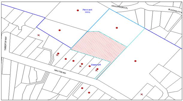
|
NOTIFICATION PLAN |
|
||
|
• PROPERTIES NOTIFIED
|
X SUBMISSIONS RECEIVED |
PROPERTY SUBJECT OF DEVELOPMENT |
|
|
6 SUBMISSIONS RECEIVED OUT OF MAP RANGE |
|||
The submissions object to the development, generally on the following grounds:
· Habitat loss;
· Vegetation removal;
· Property acquisition;
· Parking;
· Devaluation of adjoining properties;
· Noise;
· Proximity to power lines;
· Bushfire requirements;
· Driveway design;
· View loss; and
· Excessive size of the dwelling.
The merits of the matters raised in community submissions have been addressed in the body of the report with the exception of the following:
5.1.1 Property Values
An objection raises concerns that approval of the development would have detrimental effects on property values in the area.
It should be noted that an assessment of this impact is not a matter for consideration under Section 79C of the Environmental Planning and Assessment Act, 1979.
5.1.2 Parking
The desired outcome of Part 3.1.7 Vehicle Access and Parking of the HDCP 2013 is to encourage development “that provides sufficient and convenient parking for residents with vehicle access that is simple, safe and direct”.
An objection raises concerns that the development would place additional pressure on parking in Malton Road and raises concerns about the width of the driveway.
The proposed driveway width of 3 metres meets Council’s standards for vehicular access to a single dwelling house. The proposed dwelling would provide 3 car spaces behind the building line, which complies with the minimum requirement for 2 spaces required under Part 1C.2.1(C) On Site Car Parking of the HDCP. Furthermore, given the 20 metre slope from Malton Road to the dwelling house and that that the dwelling is located more than 100 metres away from Malton Road, it is not expected that future residents or visitors would use Malton Road as their primary car parking.
The proposal meets the desired outcome of Part 3.1.7 Vehicle Access and Parking of the HDCP and is considered acceptable.
5.1.3 Noise
An objection raises concerns that the development would create unacceptable noise impacts.
As the application is for a single occupancy dwelling house in a low density residential zone, it is anticipated that the proposal would not give rise to excessive or offensive noise.
To address noise issues that may arise during the construction phase, a condition is recommended to limit the hours of use of noise generating machinery to comply with the relevant requirements of the Protection of the Environment Operations Act, 1997.
5.1.4 Power Lines
An objection raises concerns about the development being in close proximity to power lines.
A check of the plans has confirmed that the proposed dwelling would be located clear of any power lines.
6. THE PUBLIC INTEREST
Section 79C(1)(e) of the Act requires Council to consider “the public interest”.
The public interest is an overarching requirement, which includes the consideration of the matters discussed in this report. Implicit to the public interest is the achievement of future built outcomes adequately responding to and respecting the future desired outcomes expressed in environmental planning instruments and development control plans.
The application is considered to have satisfactorily addressed Council’s and relevant agencies’ criteria and would provide a development outcome that, on balance, would result in a positive impact for the community. Accordingly, it is considered that the approval of the proposed dwelling house would be in the public interest.
CONCLUSION
The application proposes a two storey dwelling house.
The development is considered to be an appropriate use of the land, notwithstanding the significant physical and environmental constraints.
The proposed development generally meets the desired outcomes of Council’s planning controls and is satisfactory having regard to the matters for consideration under Section 79C of the Environmental Planning and Assessment Act 1979.
Council received ten submissions during the public notification period. The matters raised have been addressed in the body of the report and where appropriate and relevant, conditions are recommended to minimise disruption to residential amenity.
Having regard to the circumstances of the case, approval of the application is recommended as a deferred commencement, noting that documentation with respect to an Integrated Vegetation and Fire Management Plan is required on environmental grounds as a pre-requisite to the issue of a construction certificate.
Note: At the time of the completion of this planning report, no persons have made a Political Donations Disclosure Statement pursuant to Section 147 of the Environmental Planning and Assessment Act, 1979 in respect of the subject planning application.
RESPONSIBLE OFFICER
The officer responsible for the preparation of this Report is the Manager – Development Assessments – Rodney Pickles, who can be contacted on 9847 6731.
|
Rod Pickles Manager - Development Assessment Planning Division |
James Farrington Group Manager Planning Division |
|
1.View |
Locality Map |
|
|
|
2.View |
Site Plans |
|
|
|
3.View |
Landscape Plan |
|
|
|
4.View |
Floor Plans |
|
|
|
5.View |
Elevations |
|
|
|
6.View |
Shadow Diagram |
|
|
|
7.View |
Driveway Plans |
|
|
|
8.View |
Stormwater Plans |
|
|
File Reference: DA/920/2015
Document Number: D06949132
SCHEDULE 1
GENERAL CONDITIONS
The conditions of consent within this notice of determination have been applied to ensure that the use of the land and/or building is carried out in such a manner that is consistent with the aims and objectives of the relevant legislation, planning instruments and Council policies affecting the land and does not disrupt the amenity of the neighbourhood or impact upon the environment.
Note: For the purpose of this consent, the term ‘applicant’ means any person who has the authority to act on or the benefit of the development consent.
Note: For the purpose of this consent, any reference to an Act, Regulation, Australian Standard or publication by a public authority shall be taken to mean the gazetted Act or Regulation, or adopted Australian Standard or publication as in force on the date that the application for a construction certificate is made.
1. Deferred Commencement
Pursuant to Section 80(3) of the Environmental Planning and Assessment Act 1979, this consent does not operate until the following information is submitted to Council:
a) Integrated Vegetation and Fire Management Plan
An Integrated Vegetation and Fire Management Plan must be prepared for the native vegetation (Blackbutt Gully Forest) surrounding the site and along Byles Creek. This Plan must address the management of the Asset Protection Zone for a minimum of 18 months commencing from the issue of the Construction Certificate. The Plan must include, but not be limited to the following:
i) Strategies to manage, maintain and conserve the bushland including:
a. On-going weed control and suppression using bush regeneration methods;
b. Habitat protection including hollow-bearing tree retention; and
c. The restoration of all disturbed areas using bush regeneration techniques.
ii) Strategies for management of the Asset Protection Zones in a manner that has the least impact on the natural environment and maintains indigenous vegetation for the benefit of the Byles Creek corridor function. This must be undertaken in consultation with the approved bushfire consultant report.
iii) Hand Removal of Bushfire Fuel:
a. Any clearing for bushfire protection within the approved Asset Protection Zones must be undertaken using manual methods including manual removal of dead timber, raking and removal of leaf litter (fine fuel), manual slashing of understorey vegetation such as a hand held brushcutter and other methods that ensure minimal environmental damage and erosion whilst maintaining the vegetation at a low fuel reduced state.
b. Indigenous vegetation including trees and shrubs must be retained in partially thinned scattered clumps to ensure the vegetation is non-continuous.
c. Underscrubbing is to retain 15 centimetres of groundcover vegetation (including grass and herbaceous species) and all vegetation greater than three metres in height is to be otherwise retained.
d. No removal of native vegetation is to occur within 10 metres of a natural watercourse.
e. Clearing is not permitted in bushland outside the asset protection zone.
f. No mulch or garden waste is to be deposited in bushland.
iv) Management of overhanging trees close to residential and open space areas.
v) Schedule of works including timeframes and responsibilities for management actions.
vi) Erosion, sediment and stormwater runoff controls including the management of impacts of run-off from all impervious surfaces including pavement areas. Management and maintenance of approved storm water drainage areas.
vii) Appropriate aerial map of the site including a weed map.
viii) Details of qualifications and experience of company preparing the plan which must be prepared by a qualified and experienced bush regeneration company/ bushfire consultant and which must be submitted to Council’s Natural Resources Unit for approval.
Note: Such information is to be submitted within 12 months of the date of this notice.
b) Construction Environmental Management Plan
The applicant is to prepare a Construction Environmental Management Plan which must be submitted to Council for approval. The plan must include the following:
i) Scaled survey plan of the site showing the development footprint in relation to the remnant trees and other bushland proposed for retention;
ii) Location of protective fencing (1.8m high cyclone mesh) installed around bushland areas proposed for retention and to be clearly delineated from building works areas;
iii) Location of tree protection fences for specific trees approved for retention;
iv) Location of temporary and permanent trenches required for installation of services;
v) Location and specification of sediment and erosion control fencing to prevent degradation of Byles Creek occurring immediately down-slope of the building site (in accordance with Council’s Blue Book – Sustainable Water Best Practices);
vi) Location of soil, mulch, waste and building material stock piles;
vii) Location of dedicated construction vehicle parking areas;
viii) Specifications of approved cut and fill;
ix) Location of road-base only within the approved development foot print (i.e. driveway);
x) Notation describing ‘that no mulch is to be applied within remnant bushland areas’;
xi) Phytophthora management protocols;
xii) A qualified arborist (AQF5 level) must supervise the severance of any roots greater than 40mm;
xiii) Notations describing that an ecologist must be on site during tree clearing works to ensure fauna is relocated. Prior to the approved removal of hollow bearing trees the applicant is to carry out the following actions to prevent harm to native wildlife;
xiv) Provide environmental inductions to other civil works and building contractors working on the site.
Note: Such information must be submitted within 12 months of the date of this notice.
Note: Upon Council’s written satisfaction of the above information, the following conditions of development consent will apply:
2. Approved Plans and Supporting Documentation
The development must be carried out in accordance with the plans and documentation listed below and endorsed with Council’s stamp, except where amended by Council and/or other conditions of this consent:
|
Plan No. |
Drawn by |
Dated |
|
Site plan, Dwg No. DA.01 |
LT + Associates |
4.6.2015 |
|
Floor plans, Dwg No. DA.02 &03 |
LT + Associates |
4.6.2015 |
|
Elevations & Sections, Dwg No. DA.04 & 5 |
LT + Associates |
4.6.2015 |
|
Site management & Shadow diagrams, Dwg No. DA.06 |
LT + Associates |
4.6.2015 |
|
Tree location plan, Dwg No. DA.07 |
LT + Associates |
4.6.2015 |
|
Landscape design, Dwg No.1 |
Jessica Nockolds |
15/7/2015 |
|
Driveway plan, Project No. 1843M, Sheet 1-3 |
Nitma Consulting |
2.07.2015 |
|
Drainage plan, Project No. 1843M, Sheet 1-2 |
Nitma Consulting |
2.07.2015 |
|
Supporting Document title |
Prepared by |
Dated |
|
Arboricultural Impact Assessment Report, Ref 15/07/24/MRB |
Jack Williams |
24 July 2015 |
|
Biodiversity report |
ACS Environmental |
July 2015 |
|
Bushfire Hazard Assessment Report, Ref No. 141079 |
Building Code and Bushfire Hazard Solutions Pty Ltd |
9 June 2015 |
3. Removal of Existing Trees
a) This development consent permits the removal of seventy seven (77) trees numbered 1, 2 ,4, 11, 23, 24, 25, 35, 38, 39, 40, 41, 42, 43, 44, 45 ,46, 47, 48, 49, 53, 54, 55, 56, 62, 63, 64, 65, 66, 73, 75, 76, 77, 78, 79, 80, 81, 82, 84, 85, 97, 98, 99, 100, 101, 102, 105, 106, 107, 108, 109, 110, 114, 115, 116, 118, 119, 120, 121, 122, 123, 124, 125, 126, 127, 132, 133, 134, 135, 137, 140, 143, 145, 150, 152, 156, & 158 as identified in the Arboricultural Impact Assessment (AIA), prepared by Jack Williams, dated 24-07-15.
b) Trees 52 and 136 should be retained as they contain hollows that may be suitable for the Gang-gang Cockatoo.
c) The removal of any other trees requires separate approval in accordance with the Tree and Vegetation Chapter 1B.6 Hornsby Development Control Plan (HDCP).
4. Geotechnical Certification
Certification from a suitably qualified geotechnical engineer as to the stability of the slope in regard to the proposed design must be submitted to the principal certifying authority with the application for a construction certificate.
5. Section 94A Development Contributions
a) In accordance with Section 80A(1) of the Environmental Planning and Assessment Act, 1979 and the Hornsby Shire Council Section 94A Development Contributions Plan 2014-2024, $5,516.50 must be paid to Council to cater for the increased demand for community infrastructure resulting from the development, based on development costs of $550,000.
b) The value of this contribution is current as at 21 December 2015. If this contribution is not paid within the financial quarter that this condition was generated, the contribution payable will be adjusted in accordance with the provisions of the Hornsby Shire Council Section 94 Development Contributions Plan and the amount payable will be calculated at the time of payment in the following manner:
$CPY = $CDC x CPIPY
CPIDC
Where:
$CPY is the amount of the contribution at the date of Payment
$CDC is the amount of the contribution as set out in this Development Consent
CPIPY is the latest release of the Consumer Price Index (Sydney – All Groups) at the date of Payment as published by the ABS.
CPIDC is the Consumer Price Index (Sydney – All Groups) for the financial quarter at the date applicable in this Development Consent Condition.
c) The monetary contributions must be paid to Council:
i) prior to the issue of the Subdivision Certificate where the development is for subdivision; or
ii) prior to the issue of the first Construction Certificate where the development is for building work; or
iii) prior to issue of the Subdivision Certificate or first Construction Certificate, whichever occurs first, where the development involves both subdivision and building work; or
iv) prior to the works commencing where the development does not require a Construction Certificate or Subdivision Certificate.
Note: It is the professional responsibility of the Principal Certifying Authority to ensure that the monetary contributions have been paid to Council in accordance with the above timeframes.
Council’s S94A Development Contributions Plan may be viewed at www.hornsby.nsw.gov.au or a copy may be inspected at Council’s Administration Centre during normal business hours.
6. Construction Certificate
a) A Construction Certificate is required to be approved by Council or a Private Certifying Authority prior to the commencement of any works under this consent.
b) The Construction Certificate plans must not be inconsistent with the Development Consent plans.
REQUIREMENTS PRIOR TO THE ISSUE OF A CONSTRUCTION CERTIFICATE
7. Building Code of Australia
All approved building work must be carried out in accordance with the relevant requirements of the Building Code of Australia.
8. Contract of Insurance (Residential Building Work)
Where residential building work for which the Home Building Act 1989 requires there to be a contract of insurance in force in accordance with Part 6 of that Act, this contract of insurance must be in force before any building work authorised to be carried out by the consent commences.
9. Notification of Home Building Act 1989 Requirements
Residential building work within the meaning of the Home Building Act 1989 must not be carried out unless the principal certifying authority for the development to which the work relates (not being Council) has given Council written notice of the following information:
a) In the case of work for which a principal contractor is required to be appointed:
i) The name and licence number of the principal contractor; and
ii) The name of the insurer by which the work is insured under Part 6 of that Act.
b) In the case of work to be done by an owner-builder:
i) The name of the owner-builder; and
ii) If the owner-builder is required to hold an owner-builder’s permit under that Act, the number of the owner-builder’s permit.
Note: If arrangements for doing the residential building work are changed while the work is in progress so that the information notified becomes out of date, further work must not be carried out unless the principal certifying authority for the development to which the work relates (not being Council) has given Council written notification of the updated information.
10. Sydney Water – Approval
This application must be submitted to Sydney Water for approval to determine whether the development would affect any Sydney Water infrastructure, and whether further requirements are to be met.
Note: Building plan approvals can be obtained online via Sydney Water Tap inTM through www.sydneywater.com.au under the Building and Development tab.
11. Design and Construction - Bushfire Attack Category
a) New construction must comply with Sections 3 and 8 (BAL 40) Australian Standard AS3959-2009 'Construction of buildings in bush fire-prone areas' and section A3.7 Addendum Appendix 3 of 'Planning for Bush Fire Protection'.
b) The development proposal is to comply with the layout/site plan identified on the drawing prepared by LT+ Associates, Project number: 15LTA138, Drawing: DA. 01, dated 20/09/2015.
c) Property access roads must comply with section 4.1.3 (2) of 'Planning for Bush Fire Protection 2006'.
d) Water, electricity and gas are to comply with section 4.1.3 of 'Planning for Bush Fire Protection 2006'.
e) In recognition that the furthest part of the proposed dwelling for Lot 2, DP883724 is more than 70 metres from a fire hydrant, a 10, 000 litre fire-fighting water supply is required and a minimum of 3kW (5hp) petrol or diesel powered pump with a 19mm hose or hoses capable of reaching the entire perimeter of the dwelling and the following requirements:
i) The tank or tanks must be made of metal or concrete;
ii) The water supply must, where practical, be positioned no closer than 10 metres and no further than 20 metres from the dwelling;
iii) Adequate access to within 6 metres of a connection point to the dedicated water supply for a Category 1 bushfire tanker must also be provided;
iv) A 65mm Storz fitting and metal ball valve must be installed to the tank for connection to local fire service appliances; and
v) The gate or ball valve, pipes and tank penetration are to be adequate for a full 50mm inner diameter water flow through the Storz fitting.
f) Landscaping to the site is to comply with the principles of Appendix 5 of 'Planning for Bush Fire Protection 2006'.
REQUIREMENTS PRIOR TO THE COMMENCEMENT OF ANY WORKS
12. Project Arborist
a) A Project Arborist is to be appointed in accordance with AS 4970-2009 (1.4.4) to provide monitoring and certification throughout the development process.
b) Details of the Project Arborist are to be submitted to Council and the PCA prior to the issue of a Construction Certificate.
13. Project Ecologist, Bush Regeneration Consultant
a) The name and contact details of the consultants engaged to oversee the implementation of the Integrated Vegetation and Bushfire Management Plan and the Construction Environmental Management Plan are to be submitted to Council and the PCA.
14. Tree Protection Requirements
a) The name and contact details are to submitted to Council of a Project Arborist engaged to oversee the installation of all tree protection measures as specified in this consent and in accordance with Australian Standard AS 4970-2009 (1.4.4) and supervise the construction works with respect to ensuring that all trees required to be retained and protected.
b) The Project Arborist must have a level 5 AQF accreditation and be a member of the Tree Contractors of Australia or similar professional body.
15. Tree Protection Zone Fencing (TPZ)
a) Tree protection fencing must be installed around trees numbered 68, 72, 83, 111, and 117 at the distances determined by AS 4970-2009 Section 3.
b) Where tree protection fencing cannot be located at the perimeter of the Tree Protection Zone, appropriate ground and crown protection must be provided in accordance with AS 4970-2009 Section 4.5 under the direction of the project arborist
c) Tree Protective Fencing must be installed in accordance with AS 4970-2009 Section 4.3 and 4.4
d) Maintenance of the Tree Protection Zones must be carried out in accordance with AS 4970-2009 Section 4.6 for the duration of this consent.
16. Tree Trunk Protection
Trees numbered 3, 56, 117 and 142 must have their trunks protected in accordance with AS 4970-2009 Section 4.5.
17. Tree Protection Certification
Certification must be provided by the Project Arborist to the Principal Certifying Authority stating that all required tree protection measures have been installed in accordance with AS 4970-2009 Section 5.3.2.
18. Marked Boundary of Asset Protection Zone
a) To ensure that the Asset Protection Zone requiring treatment is clearly defined as an area separate to retained trees and other native vegetation, the boundary of the Asset Protection Zone for bushfire protection must be marked with permanent metal stakes to prevent fuel reduction activities and vegetation clearing from encroaching into native bushland and the riparian zone.
b) The engaged bushfire consultant must confirm the locations of the APZ as specified within the Integrated Bushfire and Vegetation Management Plan.
19. Erection of Construction Sign
a) A sign must be erected in a prominent position on any site on which any approved work is being carried out:
i) Showing the name, address and telephone number of the principal certifying authority for the work;
ii) Showing the name of the principal contractor (if any) for any demolition or building work and a telephone number on which that person may be contacted outside working hours; and
iii) Stating that unauthorised entry to the work site is prohibited.
b) The sign is to be maintained while the approved work is being carried out and must be removed when the work has been completed.
20. Toilet Facilities
To provide a safe and hygienic workplace, toilet facilities must be available or be installed at the works site before works begin and must be maintained until the works are completed at a ratio of one toilet for every 20 persons employed at the site.
21. Erosion and Sediment Control
a) To protect the water quality of the downstream environment, erosion and sediment control measures must be provided and maintained throughout the construction period in accordance with the manual ‘Soils and Construction 2004 (Bluebook)’, the approved plans, Council specifications and to the satisfaction of the principal certifying authority.
b) The erosion and sediment control devices must remain in place until the site has been stabilised and revegetated.
Note: On the spot penalties may be issued for any non-compliance with this requirement without any further notification or warning.
22. Bushfire Management – Protection Zones
At the commencement of building works and in perpetuity, the land surrounding the proposed dwelling house must be managed as follows:
a) North-East for a minimum distance of 24 metres as an Inner Protection Area;
b) South-East for a minimum distance of 24 metres as an Inner Protection Area;
d) South-West for a minimum distance of 19 metres as an Inner Protection Area; and
e) North-West for a minimum distance of 19 metres as an Inner Protection Area.
Note: Requirements for an Inner Protection Area are outlined within section 4.1.3 and Appendix 5 of “Planning for Bush Fire Protection 2006” and the NSW Rural Fire Service’s document “Standards for asset protection zones”.
REQUIREMENTS DURING CONSTRUCTION
23. Construction Work Hours
All works on site, including earth works, must only occur between 7am and 5pm Monday to Saturday. No work is to be undertaken on Sundays or public holidays.
24. Project Arborist
a) The Project Arborist as required to be appointed by this consent, must be present on the site whenever trees are being removed as permitted under this consent and during excavation works within 10 metres of any tree required to be retained to ensure:
b) All pruning is undertaken as specified in the Australian Standard ‘Pruning of Amenity Trees’ (AS 4373-2007); and
c) Protection of trees on development sites as specified in Australian Standard AS 4970-2009.
25. Maintenance and Monitoring of Tree protection
All Tree Protection Zones must be monitored by the Project Arborist in accordance with AS 4970-2009 Section 5.4
26. Works within Tree Protection Zones
a) All works must be approved by the Project Arborist.
b) Root/ground protection must be provided in accordance with AS 4970-2009 Section 4.5.4
c) Underground services must be installed in accordance with AS 4970-2009 Section 4.5.5.
d) All scaffolding must be installed in accordance with AS 4970-2009 Section 4.5.6.
e) The Structural Root Zone of any tree required to be retained must remain intact
f) Root pruning outside a trees Structural Root Zone must be carried out in accordance with AS 4970-2009 Sections 3.3.4, 4.5.4 and 4.5.5.
g) Activities within the Tree Protection Zone must comply with AS 4970-2009 Section 4.2.
h) Where works have been undertaken within the Tree Protection Zone of a tree, the project Arborist must assess the condition of the tree(s) and the growing environment and make recommendations for, and carry out remedial actions where necessary.
27. Bushland and Watercourse Protection Prior and During Construction
a) All works must comply with the approved Construction Environment Management Plan and Integrated Bushfire and Vegetation Management Plan.
b) A qualified and experienced bushfire consultant must tag the trees approved for removal as part of the Asset Protection Zone. Bushland protection and sediment control fencing type and location (as specified in the Construction Environment Management Plan) must be maintained and remain in place during the entire period of the construction works.
28. Removal of Hollow Bearing Trees
Prior to the approved removal of hollow bearing trees, the Project Ecologist is to carry out the following actions to prevent harm to native wildlife:
a) Capture wildlife from the hollows with traps set at a minimum one or two nights prior to tree removal;
b) Any wildlife captured must be relocated locally into a nesting box;
c) Arrange for a Wildlife Carers Organisation to be present on site during tree felling to assist in the event of fauna injury due to the presence of tree hollows that provide habitat for native fauna;
d) Ensure the trees are removed in sections by a qualified Tree Surgeon just prior to dusk when roosting animals would be alert and likely to disperse ‘naturally’ from the site;.
e) Ensure that trees are knocked several times (with a hammer etc.) to alert any roosting animals of the possibility of danger.
f) Ensure that all tree hollows are be examined prior to and immediately after their removal to ensure roosting animals are free from danger.
Note: Information Note: WIRES (Wildlife Rescue) volunteers can be contacted on (02) 8977 3333 or Wildlife Services Sydney Metropolitan volunteers can be contacted on (02) 9413 4300. Information on animal nesting boxes can be gained from WIRES, Kalkari Information Centre in Ku-Ring-Gai Chase National Park, or Birds Australia web site – www.birdsaustralia.com.au
29. Environmental Management
The site must be managed in accordance with the publication ‘Managing Urban Stormwater – Landcom (March 2004) and the Protection of the Environment Operations Act 1997 by way of implementing appropriate measures, to prevent sediment run-off, excessive dust, noise or odour emanating from the site during the construction of the development.
30. Landfill
Any landfill imported to the site must be in accordance with Council’s ‘Construction Specification 2005’.
a) All fill material imported to the site is to wholly consist of Virgin Excavated Natural Material (VENM) as defined in Schedule 1 of the Protection of the Environment Operations Act, 1997 or a material approved under the Department of Environment and Climate Change’s general resource recovery exemption.
31. Council Property
To ensure that the public reserve is kept in a clean, tidy and safe condition during construction works, no building materials, waste, machinery or related matter is to be stored on the road or footpath.
Note: This consent does not give right of access to the site via Council’s park or reserve. Should such access be required, separate written approval is to be obtained from Council.
32. Disturbance of Existing Site
During construction works, the existing ground levels of open space areas and natural landscape features, (including natural rock-outcrops, vegetation, soil and watercourses) must not be altered unless otherwise nominated on the approved plans.
33. Survey Report
A report(s) must be prepared by a registered surveyor and submitted to the principal certifying authority;
a) Prior to the pouring of concrete at each level of the building certifying that:
i) The building, retaining walls and the like have been correctly positioned on the site; and
ii) The finished floor level(s) are in accordance with the approved plans.
REQUIREMENTS PRIOR TO THE ISSUE OF AN OCCUPATION CERTIFICATE
Note: For the purpose of this consent, a reference to ‘occupation certificate’ shall not be taken to mean an ‘interim occupation certificate’ unless otherwise stated.
34. Fulfilment of BASIX Commitments
The applicant must demonstrate the fulfilment of BASIX commitments pertaining to the development.
35. Planting
a) Replacement planting must be completed in accordance with the approved landscape plan.
b) A certificate from a suitably qualified and experienced Horticulturalist must be provided to the Principal Certifying Authority stating the above requirement has been met, that all plant stock meet the specifications outlined in ‘Specifying Trees’ (Ross Clark, NATSPEC Books) and that the planting methods are current, professional (best practice) industry standards at the time of planting.
36. Weed Control and APZ Establishment and Maintenance
To ensure that exotic weeds and lawn do not become invasive in the bushland on the site, all works must comply with the approved Construction Environment Management Plan AND Integrated Bushfire and Vegetation Management Plan.
37. Project Arborist – Final Certification
Following the final inspection and the completion of any remedial works, the Project Arborist must submit to Council and the Principal Certifying Authority documentation stating that the completed works have been carried out in compliance with the approved plans and the relevant conditions of consent.
38. Certification of Integrated Bushfire and Vegetation Management Plan
Certification by the project ecologist, bush regeneration consultant must be submitted to Council and to the Principal Certifying Authority documentation confirming that works have been completed on site in accordance with the Integrated Bushfire and Vegetation Management Plan prior to issue of the Occupation Certificate.
39. Internal Driveway/Vehicular Areas
The driveway and parking areas on site must be designed, constructed and a Construction Certificate issued in accordance with Australian Standards 2890.1, 3727 and the following requirements:-
a) Design levels at the front boundary shall be obtained from Council via separate application to Council for Crossing Levels;
b) The Crossing Levels are to be used to design the driveway long-section;
c) The driveway be a rigid pavement;
d) The driveway grade must not exceed 25 percent and transitions for changes in grade must not exceed 8 percent per plan metre;
e) The pavement have a kerb to one side and a one-way cross fall with a minimum gradient of 2 percent and kerb inlet pits provided on grade and in low points, as strip drainage systems are susceptible to frequent blockage;
f) Retaining walls required to support the carriageway and the compaction of all fill batters to be in accordance with the requirements of a chartered structural engineer;
g) The provision of safety rails where there is a level difference more than 0.3 metres and a 1:4 batter cannot be achieved;
h) The bend in the proposed driveway must provide for design and construction of a drainage system to permit upstream property sheet flows to bypass the internal drainage system and level distribution of flows downstream;
i) Conduit for utility services including electricity, water, gas and telephone must be provided.
j) Any/all existing overhead assets including electricity and telecommunications cabling must be relocated underground;
k) A turning area to service the proposed dwelling –house in accordance with Australian Standards AS 2890.1, to ensure vehicles can enter and leave the site in a forward direction;
l) Construction of pedestrian access must be designed and constructed to prevent slip and fall with the future access driveway; and
m) Pedestrian grades steeper than 12.5% must be provided with surface texturing, brushing or cleats to satisfy Class V: R11 ramps in accordance with AS 4586-2004 Clause 5.2.
40. Stormwater Drainage
The stormwater drainage system for the development must be designed for an average recurrence interval (ARI) of 20 years and be gravity drained in accordance with the following requirements:
a) The overflow from the rainwater tank and collected surface water must be disposed of in accordance with Council’s design specification “On Site Absorption System” and the following requirements:-
i) The trench must be located a minimum of 5 metres from any downstream properties and 1 metre from the side boundaries;
ii) The trench or trenches must be laid on contour;
iii) The stormwater drainage system must be designed by a qualified hydraulic engineer; and
iv) Overland flow from the trench must be spread evenly over the site so as not to discharge water in a concentrated manner onto adjoining land.
41. Vehicular Crossing
a) A separate application under the Local Government Act, 1993 and the Roads Act, 1993 must be submitted to Council for the installation of a new vehicular crossing and the removal of the redundant crossing.
b) The vehicular crossing must be constructed in accordance with Council’s Civil Works Design 2005 and the following requirements:
i) Design levels at the front boundary must be obtained from Council for the design on the internal driveway; and
ii) The footway area must be restored.
Note: An application for a vehicular crossing can only be made to one of Council’s Authorised Vehicular Crossing Contractors. You are advised to contact Council on 02 9847 6940 to obtain a list of contractors.
42. Damage to Council Assets
To protect public property and infrastructure any damage caused to Council’s assets as a result of the construction or demolition of the development must be rectified by the applicant in accordance with Council’s Civil Works Specifications.
43. Retaining Walls
All required retaining walls must be constructed as part of the development.
- END OF CONDITIONS -
ADVISORY NOTES
The following information is provided for your assistance to ensure compliance with the Environmental Planning and Assessment Act 1979, Environmental Planning and Assessment Regulation 2000, other relevant legislation and Council’s policies and specifications. This information does not form part of the conditions of development consent pursuant to Section 80A of the Act.
Environmental Planning and Assessment Act 1979 Requirements
The Environmental Planning and Assessment Act 1979 requires:
· The issue of a construction certificate prior to the commencement of any works. Enquiries can be made to Council’s Customer Services Branch on 9847 6760;
· a principal certifying authority to be nominated and Council notified of that appointment prior to the commencement of any works;
· Council to be given at least two days written notice prior to the commencement of any works;
· mandatory inspections of nominated stages of the construction inspected; and
· an occupation certificate to be issued before occupying any building or commencing the use of the land.
Long Service Levy
In accordance with Section 34 of the Building and Construction Industry Long Service Payments Act 1986, a ‘Long Service Levy’ must be paid to the Long Service Payments Corporation or Hornsby Council.
Note: The rate of the Long Service Levy is 0.35% of the total cost of the work.
Note: Hornsby Council requires the payment of the Long Service Levy prior to the issue of a construction certificate.
Tree and Vegetation Preservation
In accordance with Clause 5.9 of the Hornsby Local Environmental Plan 2013 a person must not ringbark, cut down, top, lop, remove, injure or wilfully destroy any tree or other vegetation protected under the Hornsby Development Control Plan 2013 without the authority conferred by a development consent or a permit granted by Council.
Notes: A tree is defined as a long lived, woody perennial plant with one or relatively few main stems with the potential to grow to a height greater than three metres (3M). (HDCP 1B.6.1.c).
Tree protection measures and distances are determined using the Australian Standard AS 4970:2009, “Protection of Trees on Development Sites”.
Fines may be imposed for non-compliance with both the Hornsby Local Environmental Plan 2013 and the Hornsby Development Control Plan 2013.
Dial Before You Dig
Prior to commencing any works, the applicant is encouraged to contact Dial Before You Dig on 1100 or www.dialbeforeyoudig.com.au for free information on potential underground pipes and cables within the vicinity of the development site.
Asbestos Warning
Should asbestos or asbestos products be encountered during demolition or construction works, you are advised to seek advice and information prior to disturbing this material. It is recommended that a contractor holding an asbestos-handling permit (issued by WorkCover NSW) be engaged to manage the proper handling of this material. Further information regarding the safe handling and removal of asbestos can be found at:
Alternatively, telephone the WorkCover Asbestos and Demolition Team on 8260 5885.
Telecommunications Act 1997 (Commonwealth)
If you are aware of any works or proposed works which may affect or impact on Telstra’s assets in any way, you are required to contact: Telstra’s Network Integrity Team on Phone Number 1800810443.
Group Manager’s Report No. PL49/16
Planning Division
Date of Meeting: 8/06/2016
12 FURTHER REPORT - DEVELOPMENT APPLICATION - RESIDENTIAL FLAT BUILDING COMPRISING 26 UNITS - 31-35 HEATH STREET, ASQUITH
EXECUTIVE SUMMARY
|
DA No: |
DA/570/2015 (Lodged on 20 May 2015) |
|
Description: |
Demolition of existing dwellings and construction of residential flat building comprising 26 units and basement car parking. |
|
Property: |
Lots 12, 13 and 14 DP 8797, Nos. 31 – 35 Heath Street, Asquith |
|
Applicant: |
MacKenzie Architects International |
|
Owner: |
Mr Andrew Gerrard Jackson, Mrs Alice Ann Lehane, Ms Julie Sussan Plunkett, Mrs Susan Margaret Ryan |
|
Estimated Value: |
$8,450,000 |
· The application proposes demolition of existing dwellings and construction of residential flat building comprising 26 units and basement car parking.
· At its meeting on 11 May 2016, Council deferred the matter to facilitate discussion regarding opportunities for lot consolidation with the adjoining property. The adjacent property owner has subsequently confirmed that amalgamation will not proceed.
· The proposal generally complies with the Hornsby Local Environmental Plan 2013 and Hornsby Development Control Plan 2013.
· Four submissions have been received in respect of the application.
· It is recommended that the application be approved.
|
THAT Development Application No. DA/570/2015 for demolition of existing dwellings and the construction of residential flat building comprising 26 units and basement car parking at Lots 12, 13 and 14 DP 8797, Nos. 31-35 Heath Street, Asquith be approved subject to the conditions of consent detailed in Schedule 1 of Group Manager’s Report No. PL49/16. |
BACKGROUND
On 22 April 2015, a pre-lodgement meeting (PL/50/2015) was held at Council and advice was provided for the erection of residential flat buildings.
The development application initially lodged proposed 28 units. Council’s preliminary assessment raised concerns with the proposal regarding setbacks and privacy. Accordingly, the applicant submitted amended plans on 18 January 2016 addressing these concerns and reduced the number of units to 26.
At its meeting on 11 May 2016, Council considered Group Manager’s Report No. PL28/16 and resolved that the application be deferred for one month to facilitate discussions between the applicant and the owners of No. 29 Heath Street regarding opportunities for a consolidated development of the properties.
On 17 May 2016, Council wrote to both the applicant and the owners of No. 29 Heath Street advising them of the Council resolution and requesting they confirm their position on the matter.
The applicant discussed the matter with the owners of No. 29 Heath Street and confirmed that the owners “were not interested in selling, and as a matter of fact they enjoyed living where they are and are happy to stay despite the DA being approved and redeveloped and they have no further objection to the proposal”.
The owners of No. 29 Heath Street have also confirmed that discussions have occurred and they conclude that “amalgamation of the properties will not happen and would be happy for this application to be bought before the Council again in the next meeting”. Accordingly, the matter is referred back to Council for determination.
SITE
The site has a consolidated area of 2,130m2 with a frontage of 47.69m to Heath Street and a secondary street frontage of 43.23m to Haldane Street. The site falls 2% from the rear north western to south eastern side.
The site comprises three regular shaped allotments located on the western corner of Heath Street, Haldane Street and Oliver Street. Existing improvements on the site include three dwelling houses and ancillary development.
A variety of exotic and native trees are located throughout the site. A number of significant trees are located on the adjoining property and the nature strip including Melaleuca spp. and Syncarpia glomulifera.
Asquith Railway Station is located approximately 300m to the north of the site. The immediate area surrounding the subject site is mainly characterised by medium density and low density residential developments.
The property is located in the vicinity of a heritage listed item namely ‘House’ at No. 121 Sherbrook Road (item No. 32), Asquith, under the provisions of Schedule 5 (Environmental Heritage) of the Hornsby Local Environmental Plan 2013 (HLEP).
PROPOSAL
The application proposes the demolition of three existing residential dwellings and associated structures, and the construction of a residential flat building comprising 26 units and basement car parking.
The overall unit mix would consist of 10 x 1 bedroom, 13 x 2 bedroom and 3 x 3 bedroom units.
The development would be accessed from Heath Street via a driveway located on the south eastern boundary of the site. A total of 25 resident and 7 visitor car parking spaces are proposed within the basement.
The application proposes the removal of 12 trees on site.
ASSESSMENT
The development application has been assessed having regard to ‘A Plan for Growing Sydney’, the ‘North Subregion (Draft) Subregional Strategy’ and the matters for consideration prescribed under Section 79C of the Environmental Planning and Assessment Act 1979 (the Act). The following issues have been identified for further consideration.
1. STRATEGIC CONTEXT
1.1 A Plan for Growing Sydney and (Draft) North Subregional Strategy
A Plan for Growing Sydney has been prepared by the NSW State Government to guide land use planning decisions for the next 20 years. The Plan sets a strategy for accommodating Sydney’s future population growth and identifies the need to deliver 689,000 new jobs and 664,000 new homes by 2031. The Plan identifies that the most suitable areas for new housing are in locations close to jobs, public transport, community facilities and services.
The NSW Government will use the subregional planning process to define objectives and set goals for job creation, housing supply and choice in each subregion. Hornsby Shire has been grouped with Hunters Hill, Ku-ring-gai, Lane Cove, Manly, Mosman, North Sydney, Pittwater, Ryde, Warringah and Willoughby to form the North Subregion. The Draft North Subregional Strategy will be reviewed and the Government will set housing targets and monitor supply to ensure planning controls are in place to stimulate housing development.
The proposed development would be consistent with ‘A Plan for Growing Sydney’, by providing 23 additional dwellings and would contribute to housing choice in the locality.
2. STATUTORY CONTROLS
Section 79C(1)(a) requires Council to consider “any relevant environmental planning instruments, draft environmental planning instruments, development control plans, planning agreements and regulations”.
2.1 Hornsby Local Environmental Plan 2013
The proposed development has been assessed having regard to the provisions of the Hornsby Local Environmental Plan 2013 (HLEP).
2.1.1 Zoning of Land and Permissibility
The subject land is zoned R3 Medium Density Residential under the HLEP. The objectives of the zone are:
· To provide for the housing needs of the community within a medium density residential environment.
· To provide a variety of housing types within a medium density residential environment.
· To enable other land uses that provide facilities or services to meet the day to day needs of residents.
The proposed development is defined as ‘residential flat building’ and is permissible in the zone with Council’s consent. The proposed development is consistent with the zone objectives.
2.1.2 Height of Buildings
Clause 4.3 of the HLEP provides that the height of a building on any land should not exceed the maximum height shown for the land on the Height of Buildings Map. The maximum permissible height for the subject site is 10.5m. The proposal complies with this provision.
2.1.3 Heritage Conservation
Clause 5.10 of the HLEP sets out heritage conservation provisions for Hornsby Shire. The site does not include a heritage item and is not located in a heritage conservation area. The proposal is within the vicinity of a heritage listed item namely ‘House’ of local significance at No. 121 Sherbrook Road, Asquith under HLEP. The site is over 75m east of the item. As such, the proposal would pose minimal impacts to the heritage significance of the item. Accordingly, no further assessment regarding heritage is required.
2.1.4 Earthworks
Clause 6.2 of the HLEP states that consent is required for earthworks. Before granting consent for earthworks, Council is required to assess the impacts of the works on adjoining properties, drainage patterns and soil stability of the locality.
Council’s assessment of the proposed works and excavation concludes that the proposal is satisfactory subject to conditions regarding submission of a dilapidation report assessing the impact of the excavation on the adjoining properties.
2.2 State Environmental Planning Policy No. 55 – Remediation of Land
State environmental Planning Policy No. 55 (SEPP 55) requires that consent must be granted to the carrying out of any development on land unless it has considered whether the land is contaminated or requires remediation for the proposed use.
The subject site has a history of being used for residential purpose. However, the site adjoins the main Northern Railway line. It is unlikely that the site would be contaminated. If any contamination that may be present within the proposed basement, this area is expected to be excavated and disposed offsite. Council’s environmental assessment raises no objections to the proposal subject to conditions including that the excavated material removed from the site must be classified in accordance with the Department of Environment, Climate Change and Water NSW Waste Classification Guidelines prior to disposal.
Subject to appropriate conditions, the proposal is considered acceptable.
2.3 State Environmental Planning Policy (Building Sustainability Index – BASIX) 2004
The application has been assessed against the requirements of State Environmental Planning Policy (Building Sustainability Index – BASIX) 2004. The proposal includes a BASIX Certificate for the proposed units and is considered to be satisfactory.
2.4 State Environmental Planning Policy No. 32 – Urban Consolidated (Redevelopment of Urban Land)
The application has been assessed against the requirements of SEPP 32, which requires Council to implement the aims and objectives of this Policy to the fullest extent practical when considering development applications relating to redevelopment of urban land. The application complies with the objectives of the Policy as it would promote the social and economic welfare of the locality and would result in the orderly and economic use of under-utilised land within the Shire.
2.5 State Environmental Planning Policy No. 65 – Design Quality of Residential Flat Development
The State Environmental Planning Policy No. 65 – Design Quality of Residential Flat Development (SEPP 65) and the Residential Design Flat Code (Apartment Design Guide) apply to residential flat buildings, shop top housing and the residential component of mixed use developments that are three or more storeys and that have four or more dwellings.
The proposed residential flat building is two storeys in height, therefore SEPP 65 would not be applicable and not further assessment is required.
2.6 State Environmental Planning Policy (Infrastructure) 2007
The application has been assessed against the requirements of State Environmental Planning Policy Infrastructure 2007 (ISEPP). This policy contains State-wide planning controls for developments adjoining busy roads and railways. The development is located immediately adjacent to an existing rail corridor. The following matters are required to be considered pursuant to the ISEPP.
2.6.1 Development in Rail Corridors
The development is located immediately adjoining the Northern Rail Corridor and would require excavation within 25 metres (measured horizontally) of the corridor. Therefore, the development requires concurrence of Sydney Trains under Clause 85 and 86 of ISEPP.
Sydney Trains assessed the application in accordance with the requirements of Clause 86(4) of the ISEPP and has granted its concurrence to the development proposed. Sydney Trains’ concurrence includes operational conditions. Subject to these conditions, the proposal is considered acceptable.
2.6.2 Impact of Rail Noise
Assessment of the impacts of rail noise on residential use is required pursuant to Clause 87 of ISEPP, where a development is on land in, or adjacent to, a rail corridor.
The applicant has submitted an Acoustic Assessment report. The report provides details of construction techniques and measures to attenuate rail noise and vibration. The report concludes that the development would not exceed the specified noise criteria and LAeq levels within Clause 89 of the ISEPP subject to adherence to the recommendations for upgrading of window glazing, upgrading of external walls and roofs, and mechanical ventilation.
The development proposal has been amended since the acoustic assessment report was prepared. Accordingly, a condition of consent has been recommended that the Acoustic Assessment report be revised reflecting the changes to the proposal. Council’s assessment in this regard concludes that the proposed noise mitigation measures are satisfactory subject to a condition to revise the acoustic report.
2.7 Sydney Regional Environmental Plan No. 20 – Hawkesbury – Nepean River
The site is located within the catchment of the Hawkesbury Nepean River. Part 2 of this Plan contains general planning considerations and strategies requiring Council to consider the impacts of development on water quality, aquaculture, recreation and tourism.
Subject to the implementation of sediment and erosion control measures and stormwater management to protect water quality, the proposal would comply with the requirements of the Policy.
2.8 Clause 74BA Environmental Planning and Assessment Act, 1979 - Purpose and Status of Development Control Plans
Clause 74BA of the Environmental Planning and Assessment Act, 1979 states that a DCP provision will have no effect if it prevents or unreasonably restricts development that is otherwise permitted and complies with the development standards in relevant Local Environmental Plans and State Environmental Planning Policies.
The principal purpose of a development control plan is to provide guidance on the aims of any environmental planning instrument that applies to the development; facilitate development that is permissible under any such instrument; and achieve the objectives of land zones. The provisions contained in a DCP are not statutory requirements and are for guidance purposes only. Consent authorities have flexibility to consider innovative solutions when assessing development proposals, to assist achieve good planning outcomes.
2.9 Hornsby Development Control Plan 2013
The proposed development has been assessed having regard to the relevant desired outcomes and prescriptive requirements within the Hornsby Development Control Plan 2013 (HDCP). The following table sets out the proposal’s compliance with the prescriptive requirements of the Plan:
|
Hornsby Development Control Plan 2013 |
|||
|
Control |
Proposal |
Requirement |
Compliance |
|
Site Width |
46m |
30m |
Yes |
|
Height |
2 storeys + Attic – 10.25m |
2 storeys + Attic – 10.5m |
Yes Yes |
|
Roof Pitch |
<25 degrees |
25 degrees (max) |
Yes |
|
Lowest Residential Floor Above Ground |
0m |
1.5m (max) |
Yes |
|
Maximum Floorplate Dimension |
35m |
35m |
Yes |
|
Height of Basement Above Ground |
1m |
1m (max) |
Yes |
|
Dormer Windows Max. Width Min. Separation |
1.5m-2m 2m |
2m 2m |
Yes Yes |
|
Front Setback (Heath Street)
Balconies |
7.6m
6m |
7.6m
6m |
Yes
Yes |
|
Rear Setback |
3-6m |
6m |
No |
|
North-eastern Side (Secondary - Haldane Street) |
6m 3m>1/3 frontage |
6m 3m<1/3 frontage |
Yes No |
|
Side Setback (south-western) |
6m 3m <1/3 frontage |
6m 3m <1/3 frontage |
Yes Yes |
|
Underground Parking Setback |
7m-front 6m-rear 4.5m-secondary (north-eastern) 6m-side (south-western) |
6m-front 4m-rear 3m-secondary (north-eastern) 3m-side (south-western) |
Yes Yes Yes
Yes |
|
Basement Ramp Setback |
2m |
2m (min) |
Yes |
|
Deep Soil Landscaped Areas |
7m-front 6m-rear 4.5m-secondary (north-eastern) 6m-side (south-western) |
6m-front 4m-rear 3m-secondary (north-eastern) 3m-side (south-western) |
Yes Yes Yes Yes |
|
Private Open Space Min Width 4m |
1 br units – 10m2 (min) 2 br units – 12m2(min)
3 br units – 16m2(min) <2.5m |
10m2
12m2 16m2
Min 2.5m wide |
Yes
Yes Yes
Yes |
|
Communal Open Space with Minimum Dimensions 4m |
50m2 >4m |
50m2 >4m |
Yes Yes |
|
Parking |
25 resident spaces
7 visitor spaces 6 bicycle tracks 6 visitor bicycle racks 1 motorbike space |
25 resident spaces 4 visitor spaces 6 bicycle tracks 3 visitor bicycle racks 1 motorbike space |
Yes
Yes Yes Yes
Yes |
|
Solar Access |
69.2% |
70% |
No |
|
Housing Choice |
50% - 2br 38.5% - 1br 11.5% - 3br |
10% of each type (min) |
Yes |
|
Adaptable Units |
30% |
30% |
Yes |
As detailed in the above table, the proposed development generally complies with the prescriptive requirements within the HDCP other than minor non-compliances with setbacks and solar access. The matters of non-compliance are detailed below, as well as a brief discussion on compliance with relevant desired outcomes.
2.9.1 Desired Future Character
The proposed development is in accordance with the desired future character of the area for well-articulated two-storey residential flat buildings in garden settings with basement car parking, pitched roofs with wide eaves and additional floor area within the roof space.
The proposal complies with the desired future character for the area.
2.9.2 Site Requirements
The HDCP requires sites to have a minimum frontage of 30m. The subject site has a frontage of 46m to Heath Street and 43m on Haldane Street, which complies with the requirement.
The HDCP also requires the following:
‘Where a development proposal results in an adjoining site within the precinct with no street frontage or a primary street frontage of less than 30m, proponents should demonstrate that orderly and economic development of the site can be achieved under this DCP.
Where a property is likely to be isolated by a proposed development and it cannot be demonstrated that the site can be developed to its full potential, applicants should provide documentary evidence that genuine and reasonable attempt has been made to purchase an isolated site based on a fair market value.’
Approval of the proposed development would result in No. 29 Heath Street having a primary street frontage of less than the required 30 metres minimum frontage requirement under the HDCP.
Council wrote to the adjacent site owner at No. 29 Heath Street to confirm their position regarding site amalgamation with No. 31-35 Heath Street. The owner of No. 29 Heath Street provided a written response to Council acknowledging that an option to purchase the property was offered with no specific terms and on an 18 month contract. The owner submits that an 18 month option is not fair or reasonable and the terms are not for a guaranteed sale, only the option to purchase. The owner further states that the offer of $1,200,000 is based on the current market and not the market price at 18 months, therefore they believe that they would be worse off due to the other expenses such as moving costs, transaction and legal cost and improvements already made to the property. The owner acknowledges that if the development at Nos. 31 - 35 proceeds, their property at No. 29 will become isolated.
In accordance with the provisions of HDCP, it is acknowledged that the applicant sought to negotiate with the owners of No. 29 Heath Street by making genuine and reasonable attempts to acquire the site. An offer of $1,200,000 was made to the adjoining owner. Details of the attempts made to acquire No. 29 were submitted with the application. These attempts to acquire No. 29 were unsuccessful.
Council engaged an independent valuer to provide advice on whether a reasonable offer was made for the property at No. 29 Heath Street. The independent valuation report considered that the amount of $1,200,000 offered to the owner of No. 29 Heath Street in May 2015 to be reasonable.
The adjoining site at No. 29 Heath Street has an 18.2 metre wide site frontage and a total site area of 700m2. The applicant has submitted a concept plan demonstrating that No. 29 Heath Street can be redeveloped for three multi dwellings.
Council officers have also held a formal meeting on 14 September 2015 with the owners’ of No. 29 Heath Street and their real estate agent to discuss the isolation of their site. At that meeting, staff advised the owners’ of the independent valuation report and the planning implications of not amalgamating development sites.
Based on the above, the applicant has made reasonable attempts to acquire the adjoining site in accordance with the Land and Environment Court principles and the adjoining site is assessed as being capable of being development.
At its meeting on 11 May 2016, Council deferred the application for one month to facilitate discussions between the applicant and the owners of No. 29 Heath Street regarding opportunities for a consolidated development of the properties.
The applicant has confirmed they have discussed the matter with the owners of No. 29 Heath Street and the owners are not interested in selling. The owners of No. 29 Heath Street have also confirmed that discussions have occurred and that amalgamation of the properties will not happen and are happy for the application to be bought before the Council for determination.
2.9.3 Height
2.9.3.1 Building Height
Council received three submissions raising concerns with the building height and requesting the building height be reduced. The proposed building complies with the 10.5 metre maximum height limit. The basement would have a maximum projection of 1 metre above natural ground level which complies with the requirement.
2.9.3.2 Roof Design
The development incorporates pitched roofs with wide eaves extending to the front and rear of each unit. The roof pitches would be less than 25 degrees, in accordance with the requirements of the HDCP. The attic level is partially within the roof space. The centre part of the attic level is not within the roof space however, it would not visible from the streetscape or the adjoining properties. With respect to this, the minor non-compliance does not add bulk to the building. Dormer windows at the attic level on all the elevations provide additional articulation in the roof and in particular, within the front elevation of the building.
The design of the roof is generally in accordance with Council’s requirements and does not contribute to unnecessary bulk and scale of the building. Accordingly, the proposed development is satisfactory in respect to the two storey built form with attics.
2.9.4 Setbacks and Separation
The development proposes a rear setback of 3 to 6 metres, which does not comply with the minimum setback of 6 metres. Units Nos. 14, 15 and 16 would encroach into the rear setback. These units would not create amenity impact to the adjoining properties as they would adjoin a rail corridor. The encroachment results from the need to maintain a greater setback to the isolated site on the southern side boundary. The applicant proposes tree planting along the rear boundary to reduce any visual impact of the rail corridor to the future residents of the units.
The first floor balconies on the secondary street would encroach within the 3m boundary setback. The HDCP allows upper level light weight balconies to encroach to a minimum setback of 4.5 metres to the side boundary if there is no resulting detrimental impact on visual and acoustic privacy or overshadowing. Given that the secondary street setback is a public road, it is considered that the balcony encroachment would not have a detrimental impact on the adjoining properties or the streetscape. The proposed development meets the desired outcome within the HDCP and is considered acceptable.
Council received three submissions from the owner of the adjoining site at No. 29 Heath Street raising concerns with respect to building setbacks to the southern side boundary of the site and associated privacy and solar access impacts. To address these concerns, the applicant submitted amended plans to increase the southern side setback to 6 metres and orientated the balconies to the front and rear of the site in compliance with the HDCP.
The amended building design would alleviate overlooking opportunities and maintain amenity to the current and future dwellings. The proposal complies with the intent of the ‘Building separation’ control and would result in a reasonable design outcome for the site.
2.9.5 Built Form
The proposed building would have a maximum floor plate dimension of 35m. The facades are divided into 8m-12m wide vertical panels by including indentations in the alignment of the external walls and the inclusion of balconies that project forward of the walls. The façade treatment, size and placement of windows, wrap-around balconies, vertical panels, indentations and setback variations contribute to minimising the bulk and scale of the building. The proposed facades include a mix of contrasting materials, finishes and fenestration that contribute to the building articulation.
The proposed built form meets the desired outcome within the HDCP for development of a scale and bulk which enhances the streetscape character.
2.9.6 Landscaping
The landscaping provisions of the HDCP prescribe that a 7m wide landscaped area is to be provided at the front and a 4m wide landscaped area provided along the side boundaries. The proposed development complies with these requirements.
Large and medium canopy trees are proposed with the deep soil zone at the rear boundary acting as a buffer between the proposed building and railway line.
Council received one submission raising concerns with respect to the landscaping treatment on the southern side of the property boundary. The submitted landscape plan proposes medium canopy trees along the southern side boundary, which would provide an appropriate transition between the proposed building and a future multi dwelling development on the adjoining allotment.
Landscaping along Heath Street and Haldane street include canopy trees, shrubs, hedges and groundcover. The landscaping would include planting of locally indigenous trees in suitable locations that would contribute to the streetscape setting and the local tree canopy.
Subject to recommended conditions, the proposal is assessed as satisfactory in this regard.
2.9.7 Open Space
The proposed communal open space areas comply with the prescriptive area of at least 50 square metres with a minimum dimension of 4 metres. The communal areas have been provided at the front of the site. The northern facing principle communal open spaces would receive more than 2 hours of sunlight between 9am to 3pm during mid-winter and would be accessible from the foyer via an entry door centrally located on the eastern side of the building.
All units would achieve the prescriptive open space area requirements of 10 square metres for 1 bedroom units, 12 square metres for 2 bedroom units and 16 square metres for 3 bedroom units with the minimum 2.5m dimension width. The open space areas of units would be provided with direct access from the living areas.
It is considered that the proposed private and communal open space areas achieve the desired outcome for active recreation areas with privacy and access to sunlight.
2.9.8 Privacy and Security
Council received two submissions raising concerns with respect to privacy impacts to the adjoining property at No. 29 Heath Street. The proposed development is appropriately designed for privacy with the required setback of 6 metres from the side boundary and the majority of units having an orientation towards the front and rear boundaries. The provision of balcony screens are recommended to be provided along the southern side of the first floor balconies of units 14 and 26 to prevent overlooking of the adjoining property at No. 29 health Street. Accordingly, it is considered that the proposed development would not have adverse privacy impact on the adjoining property.
In terms of security, the proposal comprises a safe, clear and direct pedestrian entrance to the foyer of the building from Heath Street. Passive surveillance is achieved by the orientation of private open space and living room windows of units to the street, rear and communal open spaces on the site.
2.9.9 Sunlight and Ventilation
The prescriptive measure of the HDCP requires at least 70% of the dwellings (19 out of 26) to receive 3 or more hours of sunlight to living room windows and private open space between 9am and 3pm on 22 June. The applicant submitted a detailed solar access analysis indicating that 18 out of 26 units (69.2%) would receive 3 hours of direct solar access to living room windows and private open space. A minor variation to solar access is considered acceptable given the required orientation of units to maintain privacy to the isolated site. The site would receive extended hours for solar access to the east and west where there are no adjoining buildings.
Council received 3 submissions from the owner of No. 29 Heath Street raising concerns with respect to solar access impact. The applicant has submitted solar access diagrams indicating that on 22 June, 50 percent of the required principle private open space (24m2) on an adjoining property would receive 3 hours of unobstructed sunlight access between 9am and 3pm as required in the HDCP.
The proposal meets the prescriptive measures of the sunlight and ventilation and is considered acceptable.
2.9.10 Housing Choice
The proposal involves the erection of a two storey residential flat building comprising 26 units. The proposed building includes a mix of one, two and three bedroom units that range in size and style. The proposal is for 10 x 1 bedroom, 13 x 2 bedroom and 3 x 3 bedroom units. Some of the units include studies.
The proposed unit mix complies with the HDCP requirement for at least 10% of each dwelling type. Adaptable dwellings are able to comply with the 30% required by the HDCP.
2.9.11 Vehicular Access and Parking
Vehicle access to the proposed basement car park is via a 6m wide driveway off Heath Street. The parking provision within the basement is in accordance with the minimum number of car spaces prescribed by the HDCP. The driveway width, ramp gradients and aisle widths are assessed as satisfactory. The basement level includes storage areas for residents and bicycle/motor cycle parking areas.
Subject to recommended conditions, the proposal is considered satisfactory in respect to the HDCP requirements for vehicle access and parking.
2.9.12 Waste Management
The proposal includes a waste management plan with details of waste management during the demolition phase and the construction phase of building works.
A common garbage bin bay and bulky waste storage area is proposed to be located on the eastern boundary close to the street frontage. A pedestrian walkway connects the building to a garbage bin area. The site would be serviced by heavy ridge waste collection vehicles which would collect from the street.
Subject to conditions of consent, the proposed development is assessed as satisfactory with regard to on-going waste management operations on site and service vehicles access.
2.9.13 Heritage
As discussed in Section 2.1.3, the proposal is satisfactory on heritage grounds.
2.10 Section 94 Contributions Plans
Hornsby Shire Council Section 94 Contributions Plan 2012-2021 applies to the development as it would result in an additional 23 residential dwellings in lieu of the 3 existing residences. Accordingly, the requirement for a monetary Section 94 contribution is recommended as a condition of consent.
3. ENVIRONMENTAL IMPACTS
Section 79C(1)(b) of the Act requires Council to consider “the likely impacts of that development, including environmental impacts on both the natural and built environments, and social and economic impacts in the locality”.
3.1 Natural Environment
3.1.1 Tree and Vegetation Preservation
The proposed development would necessitate the removal of 12 trees from the site. None of these trees to be removed are identified as ‘significant trees’ in accordance with the Tree and Vegetation provisions of the HDCP. The application is supported by an Arboriculture Impact Assessment report prepared by Advanced Tree Consulting that assesses existing trees as exotic and exempt from Council’s Tree Preservation Order.
Council’s assessment of the proposal included a detailed examination of the existing trees on site. It is considered that the removal of the trees is acceptable due to their low retention value.
Two trees located on the site have been identified as worthy of protection (trees T68 and T14). Three trees on the adjoining site are also required to be protected (trees T1, T2 and T3).
The submitted landscape plan includes planting of trees incorporating a variety of groundcovers and low and tall shrubs. Subject to recommendation conditions for additional canopy tree planting, the submitted landscaping plan would increase the local tree canopy and contribute to the natural environment.
3.1.2 Stormwater Management
Council has received one submission raising concerns with potential drainage issues from the subject site to the adjoining property at No. 29 Heath Street. The development proposes to connect to Council’s drainage system located in Heath Street via a below ground on-site detention (OSD) system to control discharge of water from the site. Council’s engineering assessment concludes that the OSD system and the drainage system is satisfactory, subject to recommended conditions.
3.2 Built Environment
3.2.1 Built Form
One submission within the surrounding area raises concerns that the proposed development would be out of character. The built form responds to density provision, the existing streetscape and design provisions within the HDCP. The proportions, alignments and articulation provide an appropriate scale relationship between properties and create streetscape interest. The proposed external finishes would provide a variety in built form and blend with the existing developments in the street.
The proposal is acceptable in terms of its density scale and future built form anticipated in the R3 medium density zone.
3.2.2 Traffic
One submission raises concerns with respect to unacceptable traffic from the proposed development. The applicant provided a Traffic and Parking Assessment Report (TPAR) prepared by Terraffic Pty Ltd dated 13 May 2015. The TPAR estimates traffic generation of the existing site and proposed development using RMS data. The net traffic generation is estimated to be 12 vehicle trips in the am/pm peak hours which would not have any noticeable or unacceptable effect on the road network serving the site in terms of road network capacity or traffic-related environmental effect.
Council’s traffic assessment of the development concludes that traffic generation is not considered an issue for the proposed development. The proposal is considered acceptable subject to conditions.
3.3 Social Impacts
The residential development would improve housing choice in the locality by providing a range of house hold types. This is consistent with Council’s Housing Strategy which identifies the need to provide a mix of housing options to meet future demographic needs in Hornsby Shire.
3.4 Economic Impacts
The proposal would have a minor positive impact on the local economy in conjunction with other new medium density residential development in the locality by generating an increase in demand for local services.
4. SITE SUITABILITY
Section 79C(1)(c) of the Act requires Council to consider “the suitability of the site for the development”.
The subject site has not been identified as bushfire prone or flood prone land. The site is considered to be capable of accommodating the proposed development. The scale of the proposed development is consistent with the capability of the site and is considered acceptable.
5. PUBLIC PARTICIPATION
Section 79C(1)(d) of the Act requires Council to consider “any submissions made in accordance with this Act”.
5.1 Community Consultation
The proposed development was placed on public exhibition and was notified to adjoining and nearby landowners between 4 June 2015 and 18 June 2015, and 28 January 2016 and 12 February 2016 in accordance with the Notification and Exhibition requirements of the HDCP. During these periods, Council received four submissions. The map below illustrates the location of those nearby landowners who made a submission that are in close proximity to the development site.
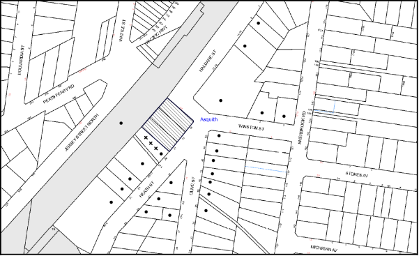
|
NOTIFICATION PLAN |
|
||
|
• PROPERTIES NOTIFIED
|
X SUBMISSIONS RECEIVED |
PROPERTY SUBJECT OF DEVELOPMENT |
|
|
ONE SUBMISSIONS RECEIVED OUT OF MAP RANGE |
|||
Four submissions objected to the development, generally on the grounds that the development would result in:
· Unacceptable traffic on local streets;
· Development that is excessive in bulk and scale;
· Unacceptable overshadowing of adjoining properties;
· Building height;
· Setbacks/building separation;
· Privacy impact;
· Construction fencing;
· Drainage;
· Out of character;
· Landscaping;
· Location of the site office and site toilet relocated to the far north corner, away from No. 29 Heath Street;
· Future Development of No. 29 Heath Street and its feasibility; and
· Request that the isolated site should be exempt from 30m frontage requirement for future development.
The merits of the matters raised in community submissions have been addressed in the body of the report with the exception of the following:
5.1.1 Construction Fencing
One submission has been received questioning if a construction fence would be installed during construction works. A condition of consent has been recommended that a construction fence be installed along all boundaries prior to any works commencing on the site.
5.1.2 Location of the Site Office and Site Toilet
Council has received one submission requesting that the location of the site office and site toilet be placed away from the boundary of No. 29 Heath Street. A condition of consent has been recommended with respect to this request.
5.1.3 Development of No. 29 Heath Street and its Feasibility
Council has received one submission questioning the development potential of No. 29 Heath Street and the feasibility of the concept plan submitted by the applicant. The applicant has submitted a concept plan demonstrating that No. 29 Heath Street can be redeveloped for three multi dwellings. The submitted concept plan is indicative only. A full feasibility study would need to be carried out by the applicant for the site at No. 29 Heath Street to determine the maximum potential for the site.
5.1.4 Request that the Isolated Site should be Exempt from 30m Frontage Requirement for Future Development
It is acknowledged that should Council approve the subject application, property No. 29 Heath Street would be an isolated site with a street frontage less than 30 metres. Medium density housing would still be a permissible form of development on the site. Any future development application for development of the isolated site would be assessed on its merits.
5.2 Public Agencies
The development application was referred to the following Agencies for comment:
5.2.1 RailCorp
The application was referred to Sydney Trains under Clause 85 and 86 of ISEPP. Sydney Trains granted its concurrence to the development proposal subject to conditions.
6. THE PUBLIC INTEREST
Section 79C(1)(e) of the Act requires Council to consider “the public interest”.
The public interest is an overarching requirement, which includes the consideration of the matters discussed in this report. Implicit to the public interest is the achievement of future built outcomes adequately responding to and respecting the future desired outcomes expressed in environmental planning instruments and development control plans.
The application is considered to have satisfactorily addressed Council’s and relevant agencies’ criteria and would provide a development outcome that, on balance, would result in a positive impact for the community. Accordingly, it is considered that the approval of the proposed development would be in the public interest.
CONCLUSION
The application seeks approval for the demolition of existing dwellings and the construction of residential flat building comprising of 26 units and basement car parking.
The proposed development is generally in accordance with the development controls for the Asquith Precinct of the HDCP and would contribute to the future desired residential character of the precinct, subject to recommended conditions of consent.
The application is recommended for approval.
Note: At the time of the completion of this planning report, no persons have made a Political Donations Disclosure Statement pursuant to Section 147 of the Environmental Planning and Assessment Act 1979 in respect of the subject planning application.
RESPONSIBLE OFFICER
The officer responsible for the preparation of this Report is the Manager – Development Assessments – Rodney Pickles, who can be contacted on 9847 6731.
|
Rod Pickles Manager - Development Assessment Planning Division |
James Farrington Group Manager Planning Division |
|
1.View |
Locality Map |
|
|
|
2.View |
Floor Plans |
|
|
|
3.View |
Elevation Plan |
|
|
|
4.View |
Site / Roof Plan |
|
|
|
5.View |
Concept Plans |
|
|
|
6.View |
Shadow Plan |
|
|
|
7.View |
Landscape Plans |
|
|
File Reference: DA/570/2015
Document Number: D06954193
SCHEDULE 1
GENERAL CONDITIONS
The conditions of consent within this notice of determination have been applied to ensure that the use of the land and/or building is carried out in such a manner that is consistent with the aims and objectives of the relevant legislation, planning instruments and Council policies affecting the land and does not disrupt the amenity of the neighbourhood or impact upon the environment.
Note: For the purpose of this consent, the term ‘applicant’ means any person who has the authority to act on or the benefit of the development consent.
Note: For the purpose of this consent, any reference to an Act, Regulation, Australian Standard or publication by a public authority shall be taken to mean the gazetted Act or Regulation, or adopted Australian Standard or publication as in force on the date that the application for a construction certificate is made.
1. Approved Plans and Supporting Documentation
The development must be carried out in accordance with the plans and documentation listed below and endorsed with Council’s stamp, except where amended by Council and/or other conditions of this consent:
|
Plan No./Title |
Drawn by |
Dated |
|
Project No. 15/05 – DA-Cover + Site – Rev C |
Mackenzie Architects International |
09.12.2015 |
|
Project No. 15/05 – Dwg No. 100 - Floor Plans – Basement + Ground – Rev C |
Mackenzie Architects International |
09.12.2015 |
|
Project No. 15/05 – Dwg No. 101 – Floor Plans – First + Attic – Rev C |
Mackenzie Architects International |
09.12.2015 |
|
Project No. 15/05 – Dwg No. A200 – Elevations – Elevations + sections – Rev C |
Mackenzie Architects International |
09.12.2015 |
|
LPDA 15 – 416/1 – Landscape Plan – Issue E |
Conzept Landscape Architects |
30.03.2016 |
|
LPDA 15 – 416/2 – Landscape Details – Issue A |
Conzept Landscape Architects |
12.05.2015 |
|
Job No. 150287, Dwg No. APP C – Basement Stormwater Drainage Plan - Rev A |
Australian Consulting Engineers |
18.12.2015 |
|
Job No. 150287, Dwg No. D00 – Cover Sheet, Legend & Drawing Schedule – Rev B |
Australian Consulting Engineers |
02.03.2016 |
|
Job No. 150287, Dwg No. D01 – Basement Stormwater Drainage Plan – Rev D |
Australian Consulting Engineers |
02.03.2016 |
|
Job No. 150287, Dwg No. D02 – Ground Floor Stormwater Drainage Plan – Rev E |
Australian Consulting Engineers |
02.03.2016 |
|
Job No. 150287, Dwg No. Do5 – Site Stormwater Drainage Details Page 1 – Rev E |
Australian Consulting Engineers |
02.03.2016 |
|
Job No. 150287, Dwg No. D06 – Site Stormwater Drainage Details Page 2 – Rev B |
Australian Consulting Engineers |
02.03.2016 |
|
Job No. 150287, Dwg No. D07 – Longitudinal Section Pipeline Extension – Rev A |
Australian Consulting Engineers |
02.03.2016 |
|
Job No. 150287, Dwg No. D10, Erosion and Sediment Control Plan & Details – Rev B |
Australian Consulting Engineers |
02.03.2016 |
|
Document Title/Plan No. |
Prepared by |
Dated |
|
Arboricultural Impact Assessment |
Advanced Treescape Consulting |
15.05.2015 |
|
Traffic and Parking Assessment Report – Ref 15207 |
Terraffic Pty Ltd |
14.01.2016 |
|
Traffic and Rail Noise Assessment – Ref: 2015-199 |
Acoustic Noise and Vibration Solutions P/L |
7.05.2015 |
|
Feasibility Study to 29 Heath Street – Drawing No. A401, A402 & A403, – Revision C (3 sheets) |
Mackenzine Architects |
09.12.2015 |
|
Preliminary Geotechnical Assessment (Ref: P1504751JR01V02) |
Martens Consulting Engineers |
October 2015 |
|
Railcorp engineering submission Plan – Drawing No. 1995-S900 – Issue D |
HKMA Engineers |
31.03.16 |
|
Railcorp engineering submission Plan – Details – Drawing No. 1995-S901 – Issue C |
HKMA Engineers |
31.03.16 |
2. Removal of Existing Trees
a) This development consent permits the removal of trees numbered T4, T5, T7, T8, T9, T10, T11, T12, T13, T15, T16 and T17 as identified on Arboricultural Impact Assessment prepared by Advanced Tree Consulting dated 15 May 2015.
b) The removal of any other trees requires separate approval in accordance with the Tree and Vegetation Chapter 1B.6 Hornsby Development Control Plan (HDCP).
3. Amendment of Plan
a) To minimise loss of privacy to the adjoining property at No. 29 Heath Street, a 1.5 high solid screen must be erected along the southern side of the balconies of units 14 and 16.
b) These amended plans must be submitted with the application for the Construction Certificate.
4. Project Arborist
a) A Project Arborist is to be appointed in accordance with AS 4970-2009 (1.4.4) to provide monitoring and certification throughout the development process.
b) Details of the Project Arborist are to be submitted to Council and the Principal Certifying Authority (PCA) prior to the issue of a Construction Certificate.
5. Construction Certificate
a) A Construction Certificate is required to be approved by Council or a Private Certifying Authority prior to the commencement of any works under this consent.
b) A separate Construction Certificate must be obtained from Council for all works within the public road reserve under S138 of the Roads Act.
c) A separate Construction Certificate must be obtained from Council for all works within drainage easements vested in Council.
d) The Construction Certificate plans must not be inconsistent with the Development Consent plans.
6. Section 94 Development Contributions
a) In accordance with Section 80A(1) of the Environmental Planning and Assessment Act, 1979 and the Hornsby Shire Council Section 94 Development Contributions Plan 2014-2024, the following monetary contributions must be paid to Council to cater for the increased demand for community infrastructure resulting from the development:
|
Description |
Contribution (4) |
|
Roads |
$8,379.40 |
|
Open Space and Recreation |
$206,724.35 |
|
Community Facilities |
$91,118.90 |
|
Plan Preparation and Administration |
$610.60 |
|
TOTAL |
$306,833.25 |
being for 23 additional dwellings and 3 credit dwellings.
b) The value of this contribution is current as at 18 April 2016. If the contribution is not paid within the financial quarter that this condition was generated, the contribution payable will be adjusted in accordance with the provisions of the Hornsby Shire Council Section 94 Development Contributions Plan and the amount payable will be calculated at the time of payment in the following manner:
$CPY = $CDC x CPIPY
CPIDC
Where:
$CPY is the amount of the contribution at the date of Payment
$CDC is the amount of the contribution as set out in this Development Consent
CPIPY is the latest release of the Consumer Price Index (Sydney – All Groups) at the date of Payment as published by the ABS.
CPIDC is the Consumer Price Index (Sydney – All Groups) for the financial quarter at the date applicable in this Development Consent Condition.
c) The monetary contribution must be paid to Council:
i) prior to the issue of the Subdivision Certificate where the development is for subdivision; or
ii) prior to the issue of the first Construction Certificate where the development is for building work; or
iii) prior to issue of the Subdivision Certificate or first Construction Certificate, whichever occurs first, where the development involves both subdivision and building work; or
iv) prior to the works commencing where the development does not require a Construction Certificate or Subdivision Certificate.
Note: It is the professional responsibility of the Principal Certifying Authority to ensure that the monetary contributions have been paid to Council in accordance with the above timeframes.
Council’s Development Contributions Plan may be viewed at www.hornsby.nsw.gov.au or a copy may be inspected at Council’s Administration Centre during normal business hours.
REQUIREMENTS PRIOR TO THE ISSUE OF A CONSTRUCTION CERTIFICATE
7. Building Code of Australia
All approved building work must be carried out in accordance with the relevant requirements of the Building Code of Australia.
8. Contract of Insurance (Residential Building Work)
Where residential building work for which the Home Building Act 1989 requires there to be a contract of insurance in force in accordance with Part 6 of that Act, this contract of insurance must be in force before any building work authorised to be carried out by the consent commences.
9. Notification of Home Building Act 1989 Requirements
Residential building work within the meaning of the Home Building Act 1989 must not be carried out unless the principal certifying authority for the development to which the work relates (not being Council) has given Council written notice of the following information:
a) In the case of work for which a principal contractor is required to be appointed:
i) The name and licence number of the principal contractor; and
ii) The name of the insurer by which the work is insured under Part 6 of that Act.
b) In the case of work to be done by an owner-builder:
i) The name of the owner-builder; and
ii) If the owner-builder is required to hold an owner-builder’s permit under that Act, the number of the owner-builder’s permit.
Note: If arrangements for doing the residential building work are changed while the work is in progress so that the information notified becomes out of date, further work must not be carried out unless the principal certifying authority for the development to which the work relates (not being Council) has given Council written notification of the updated information.
10. Waste Management Details
The following waste management requirements must be complied with:
a) A Waste Management Plan Section One – Demolition Stage and Section Three – Construction Stage, covering the scope of this project and including the following details, is required to be submitted to Council:
i) An estimate of the types and volumes of waste and recyclables to be generated;
ii) A site plan showing sorting and storage areas for demolition and construction waste and the vehicle access of these areas;
iii) How excavation, demolition and construction waste materials will be reused or recycled and where residual wastes will be disposed;
iv) The total percentage (by weight) of demolition and construction waste that will be reused or recycled.
11. Construction Traffic
All construction vehicles associated with the proposed developments are to be contained on site or in an approved “Work Zone”.
12. Dilapidation Report
A ‘Dilapidation Report’ is to be prepared by a ‘chartered structural engineer’ detailing the structural condition of No. 29 Heath Street, Asquith.
13. Identification of Survey Marks
A registered surveyor must identify all survey marks in the vicinity of the proposed development. Any survey marks required to be removed or displaced as a result of the proposed development must be undertaken by a registered surveyor in accordance with Section 24 (1) of the Surveying and Spatial Information Act 2002 and following the Surveyor General’s Directions No. 11 – “Preservation of Survey Infrastructure”.
14. Stormwater Drainage
The stormwater drainage system for the development must be designed in accordance with Council’s Civil Works – Design and Construction Specification 2005 and the following requirements:
a) Connected directly to Council’s street drainage system. Council’s street drainage system is to be extended from the existing drainage point in Heath Street to the development site generally in accordance with plans prepared by Australian Consulting Engineers Job No. 150287.
b) Council’s drainage system be piped to contain the 20 year Average Recurrence Interval storm event and be located under the kerb line.
c) No work is to be commenced on the road reserve until such time as a written approval is obtained from Hornsby Shire Council under the Roads Act.
15. On-Site Stormwater Detention
An on-site stormwater detention system must be designed by a chartered civil engineer and constructed in accordance with the following requirements:
a) Have a capacity of not less than 30 cubic metres, and a maximum discharge (when full) of 46 litres per second;
b) Have a surcharge/inspection grate located directly above the outlet;
c) Discharge from the detention system must be controlled via 1 metre length of pipe, not less than 50 millimetres diameter or via a stainless plate with sharply drilled orifice bolted over the face of the outlet discharging into a large diameter pipe capable of carrying the design flow to an approved Council system;
d) Not be constructed in a location that would impact upon the visual or recreational amenity of residents.
16. Internal Driveway/Vehicular Areas
The driveway and parking areas on site must be designed, constructed and a Construction Certificate issued in accordance with Australian Standards 2890.1, 2890.2, 3727 and the following requirements:
a) Design levels at the front boundary shall be obtained from Council if a private accredited certifier is engaged to obtain a construction certificate for these works.
b) The driveway be a rigid pavement.
Note: An application for a vehicular crossing can only be made to one of Council’s Authorised Vehicular Crossing Contractors. You are advised to contact Council on 02 9847 6940 to obtain a list of contractors.
17. Footpath
The existing footpath across the full frontage of the subject site along Heath Street is to be removed and a new footpath constructed along the full frontages of the site to both Heath and Haldane Streets in accordance to Council’s Civil Works Design and Construction Specification 2005 and the following requirements:
a) The existing footpath being removed;
b) Pouring of the concrete footpath to the full frontage of the subject site on both street frontages;
c) The land adjoining the footpath to be fully turfed; and
d) Any public utility adjustments to be carried out at the cost of the applicant and to the requirements of the relevant public authority. Engineering plans are to be approved Council in accordance with the Roads Act prior to the construction of the footpath.
18. Sydney Water – Approval
This application must be submitted to Sydney Water for approval to determine whether the development would affect any Sydney Water infrastructure, and whether further requirements are to be met.
Building plan approvals can be obtained online via Sydney Water Tap inTM through www.sydneywater.com.au under the Building and Development tab.
19. Noise – Rail Corridor
a) The acoustic report - ‘Traffic and Rail Noise Assessment’ prepared by Acoustic Noise and Vibration Solutions P/L dated 7 May 2015 is to be revised as per the amended plans (Project No. 15/05 - Revision C).
b) The development must be carried out in accordance with the recommendations contained within the revised acoustic report and the requirements of the Department of Planning’s Development Near Rail Corridors and Busy Roads – Interim Guideline and RailCorp’s Interim Guidelines for Applicants.
Note: The Department of Planning’s document is available at www.planning.nsw.gov.au (development assessments). The RailCorp document is available at www.railcorp.nsw.gov.au/publications.
REQUIREMENTS PRIOR TO THE COMMENCEMENT OF ANY WORKS
20. Erection of Construction Sign
a) A sign must be erected in a prominent position on any site on which any approved work is being carried out:
i) Showing the name, address and telephone number of the principal certifying authority for the work;
ii) Showing the name of the principal contractor (if any) for any demolition or building work and a telephone number on which that person may be contacted outside working hours; and
iii) Stating that unauthorised entry to the work site is prohibited.
b) The sign is to be maintained while the approved work is being carried out and must be removed when the work has been completed.
21. Toilet Facilities
a) To provide a safe and hygienic workplace, toilet facilities must be available or be installed at the works site before works begin and must be maintained until the works are completed at a ratio of one toilet for every 20 persons employed at the site.
b) Each toilet must:
i) be a standard flushing toilet connected to a public sewer; or
ii) be a temporary chemical closet approved under the Local Government Act 1993; or
iii) have an on-site effluent disposal system approved under the Local Government Act 1993.
iv) be located not closer than 10metres from the side property boundary of No. 29 Heath Street.
22. Tree Protection Requirements
a) Appointment of a Project Arborist
i) The installation and maintenance of tree protection fencing must be in accordance with Australian Standard AS 4970-2009 (1.4.4).
ii) The project arborist must monitor the integrity of the tree protection methods, recording any modifications or alterations to the tree protection zone fencing for the duration of the construction period.
iii) A Project Arborist must submit to the PCA a certification/statement confirming that all tree protection measures have been installed in accordance with this consent and the specific requirements of Australian Standard “Protection of Trees on Development Sites” (AS 4970-2009).
b) Tree Protection Barriers
i) All trees retained on site must have trunk protection and tree protection zone fencing installed in accordance with the Australian Standard AS 4970-2009.
ii) Tree protection zone fencing must be installed prior to the commencement of any works on the site.
c) Tree Protection Zone (TPZ) Fencing
i) Tree protection fencing must be erected around trees numbered 1, 2, 3, 6, and 14 in accordance with HDCP. The fencing must be retained at the following setbacks:
|
HDCP Section 1B.6.1(i) |
TPZ |
|
Trees with a diameter at breast height greater than 800mm |
9m |
|
Trees with a diameter at breast height between 400mm & 800mm |
7m |
|
Trees with a diameter at breast height less than 400mm |
4m |
d) Protection Fencing Requirements
i) The tree protection fencing must be continuous and constructed of either 1.8 metre high cyclone chainmesh fence or star pickets spaced at 2 metre intervals, connected by a continuous high visibility barrier/hazard mesh at a height of 1 metre.
ii) Once erected, the tree protection fencing must not be removed or altered without the prior approval of project arborist.
e) Tree Trunk Protection Requirements
i) To avoid injury or damage, trees numbered 6 and 14 must have their trunks protected by 2 metre lengths of 75mm x 25mm hardwood timbers spaced at 80mm and secured around the trunk with galvanised wire (not fixed or nailed to the tree in any way).
f) Tree Ground Protection
i) All tree Protection Zones must have a layer of wood-chip mulch installed prior to works commencing and must be maintained throughout the period of construction at a depth of 150mm-300mm using material that complies with Australian Standard AS 4454.
23. Erosion and Sediment Control
To protect the water quality of the downstream environment, erosion and sediment control measures must be provided and maintained throughout the construction period in accordance with the manual ‘Soils and Construction 2004 (Bluebook)’, the approved plans, Council specifications and to the satisfaction of the principal certifying authority. The erosion and sediment control devices must remain in place until the site has been stabilised and revegetated.
Note: On the spot penalties may be issued for any non-compliance with this requirement without any further notification or warning.
REQUIREMENTS DURING CONSTRUCTION
24. Construction Work Hours
All works on site, including demolition and earth works, must only occur between 7am and 5pm Monday to Saturday.
No work is to be undertaken on Sundays or public holidays.
25. Demolition
To protect the surrounding environment, all demolition work must be carried out in accordance with “Australian Standard 2601-2001 – The Demolition of Structures” and the following requirements:
a) Demolition material must be disposed of to an authorised recycling and/or waste disposal site and/or in accordance with an approved waste management plan;
b) Demolition works, where asbestos material is being removed, must be undertaken by a contractor that holds an appropriate licence issued by WorkCover NSW in accordance with Chapter 10 of the Occupational Health and Safety Regulation 2001 and Clause 29 of the Protection of the Environment Operations (Waste) Regulation 2005 ;and
c) On construction sites where any building contain asbestos material, a standard commercially manufactured sign containing the words ‘DANGER ASBESTOS REMOVAL IN PROGRESS’ and measuring not less than 400mm x 300mm must be displayed in a prominent position visible from the street.
26. Construction Traffic Control Plan Compliance
The development must be carried out in accordance with the Construction traffic Control Plan (CTMP) prepared by Terraffic Pty Ltd and dated 14 January 2016.
27. Maintenance of Public Footpaths
Public footpaths must be maintained for the duration of works to ensure they are free of trip hazards, displacements, breaks or debris to enable pedestrian to travel along the footpath safety.
28. Environmental Management
The site must be managed in accordance with the publication ‘Managing Urban Stormwater – Landcom (March 2004) and the Protection of the Environment Operations Act 1997 by way of implementing appropriate measures. To prevent sediment run-off, excessive dust, noise or odour emanating from the site during the construction of the development.
29. Street Sweeping
Street sweeping must be undertaken following sediment tracking from the site along Heath Street, Asquith during works and until the site is established.
The street cleaning services must undertake a street ‘scrub and dry’ method of service and not a dry sweeping service that may cause sediment tracking to spread or cause a dust nuisance.
30. Landfill
Landfill must be constructed in accordance with Council’s ‘Construction Specification 2005’ and the following requirements:
a) All fill material imported to the site is to wholly consist of Virgin Excavated Natural Material (VENM) as defined in Schedule 1 of the Protection of the Environment Operations Act, 1997 or a material approved under the Department of Environment and Climate Change’s general resource recovery exemption.
31. Excavated Material
All excavated material removed from the site must be classified by a suitably qualified person in accordance with the Department of Environment, Climate Change and Water NSW Waste Classification Guidelines prior to disposal to an approved waste management facility and be reported to the principal certifying authority.
32. Noise
All noise generated by the proposed development must be attenuated to prevent levels of noise being emitted to adjacent premises which possess tonal, beating and similar characteristics or which exceeds background noise levels by more than 5dB(A).
33. Waste Management Details
Waste management during the demolition and construction phase of the development must be undertaken in accordance with the approved Waste Management Plan. Additionally written records of the following items must be maintained during the removal of any waste from the site and such information submitted to the Principle Certifying Authority within fourteen days of the date of completion of the works:
a) The identity of the person removing the waste;
b) The waste carrier vehicle registration;
c) Date and time of waste collection;
d) A description of the waste (type of waste and estimated quality);
e) Details of the site to which the waste is to be taken;
f) The correspondence tip dock/receipt from the site to which the waste is transferred (noting date and time of delivery, description (type and quality of waste); and
g) Whether the waste is expected to be reused, recycled or go to landfill.
Note: In accordance with the Protection of the Environment Operations Act 1997, the definition of waste includes any unwanted substance, regardless of whether it is reused, recycled or disposed to landfill.
34. Works Near Trees
a) Maintenance and Monitoring of Tree Protection
i) All required tree protection measures must be monitored by the appointed project arborist to ensure that they are maintained in good condition for the duration of the construction period.
b) Drilling/Boring to Install Underground Services
i) The installation of any services within the nominated tree protection zone of any tree to be retained must utilise the trust boring method.
ii) Thrust boring must be carried out so that ‘top of pipe’ is minimum 600mm depth beneath existing ground level.
c) The filing or stockpiling of building material, the parking of vehicles or plant, the disposal of cement slurry, waste or other contaminants must be located outside the tree protection zones as prescribed in the conditions of this consent or the prescriptive measures of Part 1B.6.1 Tree Preservation of the HDCP of any tree to be retained.
35. Council Property
To ensure that the public reserve is kept in a clean, tidy and safe condition during construction works, no building materials, waste, machinery or related matter is to be stored on the road or footpath.
36. Disturbance of Existing Site
During construction works, the existing ground levels of open space areas and natural landscape features, (including natural rock-outcrops, vegetation, soil and watercourses) must not be altered unless otherwise nominated on the approved plans.
37. Survey Report
A report(s) must be prepared by a registered surveyor and submitted to the principal certifying authority;
a) Prior to the pouring of concrete at each level of the building certifying that:
i) The building, retaining walls and the like have been correctly positioned on the site; and
ii) The finished floor level(s) are in accordance with the approved plans.
b) Confirming that the waste collection vehicle turning area complies with AS2890.1 – 2004 and AS20890.2 – 2002 for small rigid vehicles (SRV).
REQUIREMENTS PRIOR TO THE ISSUE OF AN OCCUPATION CERTIFICATE
Note: For the purpose of this consent, a reference to ‘occupation certificate’ shall not be taken to mean an ‘interim occupation certificate’ unless otherwise stated.
38. Fulfilment of BASIX Commitments
The applicant must demonstrate the fulfilment of BASIX commitments pertaining to the development.
39. Waste Management Details
The following waste management requirements must be complied with:
a) Prior to an Occupation Certificate being issued or the use commencing, whichever is earlier, the Principle Certifying Authority must obtain Council’s approval of the waste and recycling management facilities provided in the development and ensure arrangements are in place for domestic waste collection by Council
Note: Waste and recycling management facilities includes everything required for on-going waste management on the site. For example the bin storage areas, bulky waste storage area, bin collection area, waste collection vehicle access, etc.
b) The garbage rooms at the ground level must include water or a hose for cleaning, graded floors with drainage to sewer, a robust door, sealed and impervious surface, adequate lightening and ventilation.
c) A report must be prepared by an appropriately qualified person, certifying the following:
i) A comparison of the estimated quantities of each waste type against the actual quantities of each waste type.
Note: Explanations of any deviations to the approved Waste management Plan is required to be included in this report.
ii) That at least 60% of the waste generated during the demolition and construction phase of the development was reused or recycled.
Note: if the 60% diversion from landfill cannot be achieved in the Construction Stage, the report is to include the reasons why this occurred and certify that appropriate work practices were employed to implement the approved Waste Management Plan. The report must be based on documentary evidence such as tipping dockets/receipts from recycling depots, transfer stations and landfills, audits of procedures etc. which are to be attached to the report.
iii) All waste was taken to site(s) that were lawfully permitted to accept that waste.
d) Each unit must be provided with an indoor waste/recycling cupboard for the interim storage of a minimum one day’s waste generation with separate containers for general waste and recyclable materials;
e) Space must be provided for either individual compost contains for each unit or a communal compost container;
Note: the location of the compost containers should have regard for potential amenity impacts.
f) The bin carting routes must be devoid of any steps; and
Note: Ramps between different levels are acceptable.
g) The bin carting route between the bin holding bay/collection area and the truck parking position must be smooth, hard surface with gradient no steeper than 1:20 (5%).
40. Water Saving Urban Design
A Water Saving Urban Design (WSUD) is to be constructed generally in accordance with the engineering report and plans prepared by Australian Consulting Engineers Job No. 15087. The water Quality Targets as detailed within the report and Hornsby Development Control Plan are to be achieved in the design and supported by a MUSIC model.
41. Water Tank
A water tank with a minimum capacity of 3000L is to be designed and constructed generally in accordance with plans prepared by Australian Consulting Engineers Job No. 150287. The water tank is to be connected to all toilets, washing machine and external taps.
42. Certificate of WSUD Facilities
Prior to the issue of an Occupation Certificate, a certificate from a Civil Engineer is to be obtained stating that the WSUD facilities have been constructed and will meet the water quality targets as specified in the Hornsby Development control Plan.
43. Damage to Council Assets
To protect public property and infrastructure, any damage caused to Council’s assets as a result of the construction or demolition of the development must be rectified by the applicant in accordance with Council’s Civil Works Specifications. Rectification works must be undertaken prior to the issue of an Occupation Certificate, or sooner, as directed by Council.
44. Boundary Fencing
Fencing must be erected along all property boundaries behind the front building alignment to a height of 1.8 metres.
Note: Alternative fencing may be erected subject to the written consent of the adjoining property owner(s).
45. Creation of Easements
The following matter(s) must be nominated on the plan of subdivision under s88B of the Conveyancing Act, 1919:
a) The creation of an appropriate "Positive Covenant" and "Restriction as to User" over the constructed on-site detention/retention systems and WAUD facilities, within the lots in favour of Council in accordance with Council’s prescribed wording. The position of the on-site detention system is to be clearly indicated on the title;
b) To register the OSD and WSUD easement, the restriction on the use of land “works-as-executed” details of the on-site-detention system and WSUD facility must be submitted verifying that the required storage and discharge rates have been constructed in accordance with the design requirements. The details must show the invert levels of the on site system together with pipe sizes and grades. Any variations to the approved plans must be shown in red on the “works-as-executed” plan and supported by calculations;
Note: Council must be nominated as the authority to release, vary or modify any easement, restriction or covenant.
46. Works as Executed Plan
A works-as-executed plan(s) must be prepared by a registered surveyor and submitted to Council for completed road pavement, kerb & gutter, public drainage systems, driveways and on-site detention system. The plan(s) must be accompanied by a certificate from a registered surveyor certifying that all pipelines and associated structures lie wholly within any relevant easements.
47. Preservation of Survey Marks
A certificate by a Registered Surveyor must be submitted to the Principal Certifying Authority, certifying that there has been no removal, damage, destruction, displacement or defacing of the existing survey marks in the vicinity of the proposed development or otherwise the re-establishment of damaged, removed or displaced survey marks has been undertaken in accordance with the Surveyor General’s Direction No.11 – “Preservation of Survey Infrastructure”.
48. Construction of Engineering Works
All engineering works within the road reserve of heath Street identified in this consent are to be completed and a Compliance Certificate issued by Council prior to the release of the Occupation Certificate or Subdivision Certificate
49. Planter Boxes/On Slab Planting
On slab planter boxes must include waterproofing, subsoil drainage (proprietary drainage cell, 50mm sand and filter fabric) automatic irrigation, minimum 500mm planting soil for shrubs and minimum 1000mm planting soil for trees and palms and 75mm mulch.
50. Deep Soil Landscaped Areas
The courtyards of units 1, 2 and 3 are to be landscaped with turf or planting within 3m of the rear boundary.
51. Completion of Landscaping
A certificate must be provided by a practicing landscape architect, horticulturalist or person with similar qualifications and experience certifying that all required landscaping works have been satisfactorily completed in accordance with the approved landscape plans.
Note: Applicants are advised to pre-order plant material required in pot sizes 45 litre or larger to ensure nurseries have stock available at the time of install.
52. Retaining Walls
All required retaining walls must be constructed as part of the development.
OPERATIONAL CONDITIONS
53. Waste Management
The waste management on site must be in accordance with the following requirements:
a) A site caretaker must be employed and be responsible for washing bins and maintaining waste storage areas, managing the communal composting area, managing the bulky item storage area, arranging the prompt removal of dumped rubbish, and ensuring all residents are informed of the use of the waste management system. The site caretaker must be employed for a sufficient number of hours each week to allow all waste management responsibilities to be carried out to a satisfactory standard.
54. Car Parking
All car parking must be constructed and operated in accordance with Australian Standard AS/NZS 2890.1:2004 – Off-street car parking and Australian Standard AS 2890.2:2002 – Off-street commercial vehicle facilities:
a) All parking areas and driveways are to be sealed to an all-weather standard, line marked and signposted;
b) Car parking, loading and manoeuvring areas to be used solely for nominated purpose;
c) Vehicles awaiting loading, unloading or servicing must be parked on site and not on adjacent or nearby public roads; and
d) All vehicles entry on to the site and egress from the site must be made in a forward direction.
55. Landscape Establishment
The landscape works must be maintained into the future to ensure the established and successful growth of plant material to meet the intent of the landscape design. This must include but not be limited to watering, weeding, replacement of failed plant material and promoting the growth of plants through standard industry practices.
CONDITIONS OF CONCURRENCE – SYDNEY TRAINS
The following conditions of consent are from the nominated State Agency pursuant to Section 79b of the Environmental Planning and Assessment Act 1979 and must be complied with to the satisfaction of that Agency.
56. All excavation and construction works are to be undertaken in accordance with the details, methodology, advice, undertakings and recommendations detailed in the following documents, unless amendments are required by Sydney trains as part of the review and approval/certification of the documentation listed in condition 56:
a) Preliminary Geotechnical Assessment prepared by Martens Consulting Engineers (Ref: P1504751JR01V02) dated October 2015.
b) RailCorp Engineering Submission Plan - Drawing No. 1995-S900 Issue D, dated 31/03/16, prepared by HKMA Engineers.
c) RailCorp Engineering Submission Plan - Details - Drawing No. 1995-S901 Issue C, dated 31/03/16, prepared by HKMA Engineers.
The Principal Certifying Authority is not to issue the Construction Certificate until written confirmation has been received from Sydney Trains confirming that the documentation listed in this condition have not be superseded with the approval/certification of documentation in Condition 52. Should Sydney Trains advise that any of the documentation listed in this condition have not been superseded, then the measures detailed in those specific documents are to be incorporated into the construction drawings and specifications prior to the issuing of the Construction Certificate. Prior to the commencement of works the Principal Certifying Authority is to provide verification to Sydney Trains that this condition has been complied with.
57. The applicant shall prepare and provide to Sydney Trains for approval/certification the following items:
a) Additional information to be provided regarding the existing concrete retaining wall foundations. The depth, extent, founding, footing arrangement, etc. need to be positively confirmed. This information is required to determine as to whether the works will have any impact on the stability of the wall. The Applicant is to contact the Sydney Trains Plan Room to obtain any relevant documentation on this retaining wall.
b) The supporting structural elements of the proposed development are located within 10m of the centreline of the nearest railway track and will need to comply with the requirements of AS5100 for redundancy and collision loads.
c) A Structural Report will be required for the design of the shoring system. This report must contain (as a minimum) an outline of the site constraints, the design approach, assumed design criteria, structural analysis (summary at least) and design outcomes (summary at least).
d) If required by Sydney Trains following the review of the above documents, Monitoring Plan.
Any conditions issued as part of Sydney Trains approval/certification of any of the above documents will also form part of the consent conditions that the Applicant is required to comply with. The Principal Certifying Authority is not to issue the Construction Certificate until written confirmation has been received from Sydney Trains confirming which of the documentation listed in this condition are to now apply and supersede the documentation in Condition A1. The measures detailed in the documents approved/certified by Sydney Trains under this Condition are to be incorporated into the construction drawings and specifications prior to the issuing of the Construction Certificate. Prior to the commencement of works the Principal Certifying Authority is to provide verification to Sydney Trains that this condition has been complied with.
58. All piling and excavation works with 25m of the rail corridor are to be supervised by a geotechnical engineer experience with such excavation projects.
59. No rock anchors/bolts are to be installed into RailCorp property or easements.
60. Prior to the commencement of works the Applicant shall peg-out the common property boundary with RailCorp’s land. This work is to be undertaken by a registered surveyor.
61. The Applicant is to submit to Council, for its records, copies of any certificates, drawings or approvals given to or issued by Sydney Trains.
62. During all stages of the development extreme care shall be taken to prevent any form of pollution entering the railway corridor. Any form of pollution that arises as a consequence of the development activities shall remain the full responsibility of the Applicant.
63. Drainage from the development must be adequately disposed of/managed and not allowed to be discharged into the corridor unless prior approval has been obtained from Sydney Trains.
64. Sydney Trains are entitled to inspect the site of the approved development and all structures to enable it to consider whether those structures on that site have been or are being constructed and maintained in accordance with these conditions of consent, on giving reasonable notice to the principal contractor for the approved development or the owner or occupier of the part of the site to which access is sought.
65. Prior to the commencement of works, on the completion of works, or at any time during the works period deemed necessary by Sydney Trains, a joint inspection of the rail infrastructure and property in the vicinity of the project is to be carried out by representatives from the requesting Agency and the Applicant. These dilapidation surveys will establish the extent of any existing damage and enable any deterioration during construction to be observed. The submission of a detailed dilapidation report will be required unless otherwise notified by Sydney Trains.
66. An acoustic assessment is to be submitted to Council prior to the issue of a construction certificate demonstrating how the proposed development will comply with the Department of Planning’s document titled “Development Near Rail Corridors and Busy Roads- Interim Guidelines”.
67. Prior to the issue of a Construction Certificate the Applicant is to engage an Electrolysis Expert to prepare a report on the Electrolysis Risk to the development from stray currents. The Applicant must incorporate in the development all the measures recommended in the report to control that risk. A copy of the report is to be provided to the Principal Certifying Authority with the application for a Construction Certificate.
68. Given the possible likelihood of objects being dropped or thrown onto the rail corridor from balconies, windows and other external features (eg roof terraces and external fire escapes) that are within 20m and face the rail corridor, the Applicant is required to install measures (eg awning windows, louvres, enclosed balconies, window restrictors etc) which prevent the throwing of objects onto the rail corridor. These measures are to comply with Sydney Trains requirements. The Principle Certifying Authority is not to issue the Construction Certificate until it has confirmed that these measures are to be installed and have been indicated on the Construction Drawings.
69. The design, installation and use of lights, signs and reflective materials, whether permanent or temporary, which are (or from which reflected light might be) visible from the rail corridor must limit glare and reflectivity to the satisfaction of the light rail operator. The Principle Certifying Authority is not to issue the Construction Certificate until written confirmation has been received from Sydney Trains confirming that this condition has been satisfied.
70. Prior to the issue of a Construction Certificate a Risk Assessment, Rail Safety Management Plan, and detailed Safe Work Method Statements (SWMS) for the proposed works are to be submitted to Sydney Trains for review and comment on the impacts on rail. The Principal Certifying Authority shall not issue the Construction Certificate until written confirmation has been received from Sydney Trains confirming that this condition has been satisfied.
71. Prior to the commencement of works appropriate fencing is to be in place along the rail corridor to prevent unauthorised access to the rail corridor during construction. Details of the type of fencing and the method of erection are to be to the satisfaction of Sydney Trains prior to the fencing work being undertaken.
72. The development shall have appropriate fencing fit for the future usage of the development site to prevent unauthorised access to the rail corridor by future occupants of the development. Prior to the issuing of an Occupation Certificate the Applicant shall liaise with Sydney Trains regarding the adequacy of any existing fencing along the rail corridor boundary. Details of the type of new fencing to be installed and the method of erection are to be to the satisfaction of Sydney Trains prior to the fencing work being undertaken.
73. Prior to the issuing of a Construction Certificate the Applicant is to submit to Sydney Trains a plan showing all craneage and other aerial operations for the development and must comply with all Sydney Trains requirements. The Principal Certifying Authority shall not issue the Construction Certificate until written confirmation has been received from Sydney Trains confirming that this condition has been satisfied.
74. Prior to the issue of a Construction Certificate the Applicant is to submit to Sydney Trains the demolition, excavation and construction methodology and staging for review and endorsement. The Principle Certifying Authority is not to issue the Construction Certificate until written confirmation has been received from Sydney Trains confirming that this condition has been satisfied.
75. No metal ladders, tapes and plant/machinery, or conductive material are to be used within 6 horizontal metres of any live electrical equipment. This applies to the train pantographs and catenary, contact and pull-off wires of the adjacent tracks, and to any aerial power supplies within or adjacent to the rail corridor.
76. Prior to the undertaking of works or the issuing of a Construction Certificate (whichever occurs first), the Applicant must hold current public liability insurance cover for a sum to be determined by Sydney Trains. This insurance shall not contain any exclusion in relation to works on or near the rail corridor, rail infrastructure. The Applicant is to contact Sydney Trains Rail Corridor Management Group to obtain the level of insurance required for this particular proposal. Prior to issuing the Construction Certificate the Principal Certifying Authority must witness written proof of this insurance in conjunction with Sydney Trains written advice to the Applicant on the level of insurance required.
77. Prior to the undertaking of works or the issuing of a Construction Certificate (whichever occurs first), the Applicant is to contact Sydney Trains Rail Corridor Management Group to determine the need for the lodgement of a Bond or Bank Guarantee for the duration of the entire works. The Bond/Bank Guarantee shall be for the sum determined by Sydney Trains. Prior to the issuing of the Construction Certificate the Principal Certifying Authority must witness written advice from Sydney Trains confirming the lodgement of this Bond/Bank Guarantee.
78. Prior to the issuing of an Occupation Certificate the Applicant is to submit the as-built drawings to Sydney Trains and Council. The as-built drawings are to be endorsed by a Registered Surveyor confirming that there has been no encroachment into Sydney Trains property or easement. The Principal Certifying Authority is not to issue the Occupation Certificate until written confirmation has been received from Sydney Trains confirming that this condition has been satisfied.
79. The Applicant must provide a plan of how future maintenance of the development facing the rail corridor is to be undertaken. The maintenance plan is to be submitted to Sydney Trains prior to the issuing of the Occupancy Certificate. The Principle Certifying Authority is not to issue an Occupation Certificate until written confirmation has been received from Sydney Trains advising that the maintenance plan has been prepared to its satisfaction.
80. No scaffolding is to be used facing the rail corridor unless prior written approval has been obtained from Sydney Trains. To obtain approval the proponent will be required to submit details of the scaffolding, the means of erecting and securing this scaffolding, the material to be used, and the type of screening to be installed to prevent objects falling onto the rail corridor. Unless agreed to by Sydney Trains in writing, scaffolding shall not be erected without isolation and protection panels.
81. No work is permitted within the rail corridor, or its easements, at any time unless prior approval or an Agreement has been entered into with Sydney Trains. Where the Applicant proposes to enter the rail corridor, the Principal Certifying Authority shall not issue a Construction Certificate until written confirmation has been received from Sydney Trains confirming that its approval has been granted.
82. There is a need to ensure that the roots and foliage of trees being planted beside the rail corridor do not have an impact on the rail corridor. The development landscaping and planting plan should be submitted to Sydney Trains for review.
- END OF CONDITIONS -
ADVISORY NOTES
The following information is provided for your assistance to ensure compliance with the Environmental Planning and Assessment Act 1979, Environmental Planning and Assessment Regulation 2000, other relevant legislation and Council’s policies and specifications. This information does not form part of the conditions of development consent pursuant to Section 80A of the Act.
Environmental Planning and Assessment Act 1979 Requirements
The Environmental Planning and Assessment Act 1979 requires:
· The issue of a construction certificate prior to the commencement of any works. Enquiries can be made to Council’s Customer Services Branch on 9847 6760;
· a principal certifying authority to be nominated and Council notified of that appointment prior to the commencement of any works;
· Council to be given at least two days written notice prior to the commencement of any works;
· mandatory inspections of nominated stages of the construction inspected; and
· an occupation certificate to be issued before occupying any building or commencing the use of the land.
Long Service Levy
In accordance with Section 34 of the Building and Construction Industry Long Service Payments Act 1986, a ‘Long Service Levy’ must be paid to the Long Service Payments Corporation or Hornsby Council.
Note: The rate of the Long Service Levy is 0.35% of the total cost of the work.
Note: Hornsby Council requires the payment of the Long Service Levy prior to the issue of a construction certificate.
Tree and Vegetation Preservation
In accordance with Clause 5.9 of the Hornsby Local Environmental Plan 2013 a person must not ringbark, cut down, top, lop, remove, injure or wilfully destroy any tree or other vegetation protected under the Hornsby Development Control Plan 2013 without the authority conferred by a development consent or a permit granted by Council.
Notes: A tree is defined as a long lived, woody perennial plant with one or relatively few main stems with the potential to grow to a height greater than three metres (3M). (HDCP 1B.6.1.c).
Tree protection measures and distances are determined using the Australian Standard AS 4970:2009, “Protection of Trees on Development Sites”.
Fines may be imposed for non-compliance with both the Hornsby Local Environmental Plan 2013 and the Hornsby Development Control Plan 2013.
Dial Before You Dig
Prior to commencing any works, the applicant is encouraged to contact Dial Before You Dig on 1100 or www.dialbeforeyoudig.com.au for free information on potential underground pipes and cables within the vicinity of the development site.
Asbestos Warning
Should asbestos or asbestos products be encountered during demolition or construction works, you are advised to seek advice and information prior to disturbing this material. It is recommended that a contractor holding an asbestos-handling permit (issued by WorkCover NSW) be engaged to manage the proper handling of this material. Further information regarding the safe handling and removal of asbestos can be found at:
Alternatively, telephone the WorkCover Asbestos and Demolition Team on 8260 5885.
Group Manager's Report No. PL48/16
Planning Division
Date of Meeting: 8/06/2016
13 PENNANT HILLS TOWN CENTRE MASTER PLAN SURVEY
EXECUTIVE SUMMARY
· In 2006, a Master Plan project undertaken for the Pennant Hills Town Centre identified the need for a more comprehensive study of the Centre following the release of State Government subregional targets to guide the plan.
· The 2016 Strategic Planning Program includes a project to undertake a Pennant Hills Community Survey prior to commencing a review of the Pennant Hills Master Plan in 2017.
· It is recommended that an on-line and pedestrian-intercept survey be undertaken to identify and establish the vision, principles and key outcomes that should guide the future review of the Pennant Hills Town Centre Master Plan.
· It is recommended that ratepayers (residential and commercial) in Pennant Hills and Thornleigh suburbs, business tenants in the Pennant Hills and Thornleigh Town Centres, community progress groups and peak time visitors be invited to participate in the survey. Do
|
THAT : 1. A community survey be undertaken in accordance with the consultation strategy outlined in Group Manager’s Report No. PL48/16 for the purpose of identifying and establishing the vision, principles and key outcomes that should guide a future review of the Pennant Hills Town Centre Master Plan. 2. The Acting General Manager be authorised to approve any consultation material and/or additional consultation techniques recommended by Council’s community consultation specialist to engage with the community. 3. Council accept receipt of written submissions in addition to feedback provided in the survey. 4. Any responses to the survey and written submissions received be evaluated and a report prepared for Council’s consideration. |
PURPOSE
On 18 May 2016, Councillors were briefed on the progress, consultation method and draft content of a stakeholder online survey, to establish the vision, principles and key outcomes that should guide a future review of the Pennant Hills Town Centre Master Plan.
At the briefing, it was agreed that a report would be progressed to the next Council meeting seeking a resolution to proceed with the consultation.
Accordingly, the purpose of this Report is to seek endorsement to undertake a stakeholder online survey and pedestrian-intercept survey as the consultation methodology for this project.
BACKGROUND
Pennant Hills Town Centre is clustered around the Pennant Hills Railway Station. The land comprises four precincts including the civic precinct (zoned RE1 Public Recreation), service precinct (zoned B6 Enterprise Corridor), retail precinct (zoned B2 Local Centre) and office precinct (zoned B5 Business Development).
The Centre serves the local population of Pennant Hills and surrounding suburbs, providing neighbourhood shops, food services, professional services, commercial offices, a district library facility, and transport services, being strategically located on the Northern Railway Line, and arterial Cumberland Highway.
State and Regional Context
The draft North Subregional Strategy 2007 of the Sydney Metropolitan Strategy 2006 identifies Pennant Hills as a Village Centre, defined by a strip of shops and surrounding residential area within 5 to 10 minute walk containing a small supermarket, hairdresser, take-away food shops, servicing between 2,100 and 5,500 dwellings.
The Greater Sydney Commission has recently been created as a dedicated new body which will drive the implementation of the 2014 Metropolitan Strategy ‘A Plan for Growing Sydney’ across Sydney’s six subregions. Hornsby Shire is located within the North District, and the Strategy identifies Pennant Hills as being located within an Urban Renewal Corridor that is strategically located beside the Northern Railway Line.
The North District Plan when made is likely to address:
· A vision for housing and employment growth in the subregion, consistent with A Plan for Growing Sydney;
· The distribution of housing and employment at the Local Government Area level;
· The goals, directions and actions contained within A Plan for Growing Sydney; and
· The infrastructure required to support housing and employment growth within the subregion.
The Greater Sydney Commission was established in January 2016 and is responsible for preparing the North District Plan, with public exhibition to commence before January 2017.
Local Planning Context
Pennant Hills has been the subject of previous planning studies including the Pennant Hills Commercial Study 1993 and the Commercial Centres Study 2006, outlined below.
1. Pennant Hills Commercial Centre Study 1993
Planning controls for the Pennant Hills Town Centre in the Hornsby Development Control Plan 2013 and Hornby Local Environmental Plan 2013 were informed by the 1993 Pennant Hills Commercial Centre Study and associated Strategy Plan. The Plan provided a framework that sought to create an integrated centre with improved vitality, seeking to reduce traffic conflicts, reorientate the focus of the Centre away from Pennant Hills Road, to pedestrianise Hillcrest Road and Warne Street, to integrate community services, to provide more pedestrian spaces, opportunities for shop top-housing and enhance the Centre’s landscaping.
The implementation of the Plan delivered a number of achievements for the Centre, including the formation of Wollundry Park as a key public open space, improvements to and expansion of Pennant Hills Library, as well as pedestrian and street calming improvements to Hillcrest Road.
2. The Commercial Centres Study 2006
In 2006, Council commenced a project to prepare master plans for specific major commercial centres as part of the Employment Lands Review, including the commercial centres of Pennant Hills, Carlingford and Berowra, and were undertaken in consultation with land owners, public authorities, business groups and community groups.
The intent of the master plans was to demonstrate how housing and urban renewal could be achieved within the commercial centres to stimulate vitality and to address preferred uses, the provision of shop-top housing, strategies for car parking, principles for pedestrian amenity and vehicular access, and considerations for the urban design and streetscape of the Centres.
At the time, community feedback indicated that the scope of the study should be expanded to include a comprehensive review of economic, traffic and parking, environmental, social and culture, and urban design. Council subsequently resolved not to proceed with the master plan until the release of the Subregional Plan and supported the need for a more comprehensive review.
DISCUSSION
Based on recent urban renewal projects in Hornsby, Epping and expansion of employment centres in Macquarie Park and Norwest Business Park, the feasibility of redeveloping land within Pennant Hills based on Council’s current strategy is in decline. The character and identity of the centre needs renewal with issues surrounding traffic and parking, night time economy, outdoor dining areas, public domain improvements and the creation of a focal point to be addressed.
Consistent with Council’s previous position, the commencement of a community survey prior to the release of the North District Plan is appropriate to ensure that Council’s future planning response is reflective of the community’s aspirations and vision for the Pennant Hills Town Centre. The key drivers that will assist with a future review of planning strategy for the centre include:
· the completion of the Pennant Hills Railway Station upgrade as part of the North Freight Line extension project;
· the Metropolitan Strategy for Sydney identifies Pennant Hills Road Corridor for urban renewal;
· the NorthConnex tunnel, anticipated to be completed in 2019, will remove heavy vehicles and regional traffic from Pennant Hills Road in an underground tunnel;
· recent developer interest over various sites in the Town Centre; and
· scheduled upgrade to the Pennant Hills Library to a Multi-Purpose District Hub.
Further to the above, the future North District Plan is likely to identify the second tranche of dwelling and employment targets for Hornsby and provide actions for addressing future growth along the Pennant Hills Road Corridor. Therefore, consideration should also be given to the inclusion of the Thornleigh Town Centre within the review given Council’s existing commitment to review existing floorspace controls within this centre.
In recognition of the strategic importance of the Pennant Hills Town Centre at the State and local level, it is appropriate that Council commence the process of planning for the future of the centre in consultation with the community. This process would assist to establish the vision, principles and key outcomes that should guide the future review of the Pennant Hills Town Centre Master Plan. Similar to other strategic projects commenced for the rural lands and Brooklyn, it is proposed that this process be commenced by undertaking a community survey, with the scope to identify:
· existing strengths of the Town Centre to be retained and enhanced;
· the broader community’s vision, principles and key outcomes for the Town Centre to underpin the master planning process, including the size of study area, future land use and density and solutions to key issues experienced by the Centre; and
· Council improvements and priorities for the Town Centre in the short and long term.
The above matters provide for a wide range of issues to be addressed. Initial consultation via survey would confirm their relevance and whether additional matters warrant consideration.
CONSULTATION STRATEGY
The Miller Group has been engaged as specialist consultants to assist the design of a stakeholder online survey and a pedestrian intercept survey, and to assist with the evaluation of survey responses. The surveys will seek feedback on community and visitor attitudes and priorities to revitalisation constraints and opportunities for Pennant Hills Town Centre.
It is recommended that ratepayers (residential and commercial) in Pennant Hills and Thornleigh suburbs, business tenants in the Pennant Hills and Thornleigh Town Centres, community progress groups and peak time visitors be invited to participate in the survey.
It is proposed that the survey be run using an on-line platform (Survey Monkey) that can be accessed from home, mobile devices or from Council’s libraries. Visitors would be surveyed through face to face street intercepts and a limited number of hard copies would be made available for invited respondents who may not have computer access. Appropriate measures and control will be applied to preserve the integrity of the process.
The surveys would be facilitated of a four week period during the second quarter of the 2016/2017 financial year and the results would be reported to a Council meeting in 2017. Subject to Council endorsement, it is likely that the survey results would inform a tender brief for the future review of the Pennant Hills Town Centre Master Plan.
BUDGET
As a scheduled project on the Strategic Planning Program, sufficient funds are available to cover project costs associated with the community survey within the 2015/2016 financial year budget.
POLICY
There are no policy implications associated with this Report.
CONCLUSION
The Strategic Planning Program includes a project for a community survey to inform a planning response in the Pennant Hills Town Centre. As the first step in the process, it is recommended that Council undertake an internet based survey of all ratepayers (residential and commercial) in Pennant Hills and Thornleigh suburbs, business tenants in the Pennant Hills and Thornleigh Town Centres, community progress groups and peak time visitors to identify the future vision, principles and key outcomes that should guide future planning. Given the current drivers for change, the survey results would assist in preparing a future brief for the comprehensive review of the Master Plan.
RESPONSIBLE OFFICER
The officer responsible for the preparation of this Report is the Manager, Strategic Planning – Fletcher Rayner - who can be contacted on 9847 6744.
|
James Farrington Group Manager Planning Division |
Fletcher Rayner Manager - Strategic Planning Planning Division |
There are no attachments for this report.
File Reference: F2015/00414
Document Number: D06953430
Group Manager's Report No. PL47/16
Planning Division
Date of Meeting: 8/06/2016
14 REPORT ON SUBMISSIONS - RURAL LANDS PLANNING PROPOSAL AND HORNSBY DEVELOPMENT CONTROL PLAN AMENDMENTS
EXECUTIVE SUMMARY
· The Rural Lands Planning Proposal and draft Hornsby Development Control Plan 2013 (HDCP) amendments propose to introduce the opportunity on rural zoned land for larger secondary dwellings, attached dual occupancies, larger roadside stalls and revised split zone lot controls that include environmental protection zoned land for the purposes of calculating lot size.
· The draft Plans were exhibited for community comment between 8 March 2016 and 8 April 2016. Forty five submissions were received of which the majority generally support the draft Plans. Some submissions raise concern in relation to traffic, infrastructure and loss of agricultural land. No changes are proposed to the draft Plans as a result of the issues identified in submissions.
· It is recommended that Council forward the Planning Proposal to the Minister for Planning and Environment for its making and endorse the HDCP amendments which will come into effect upon a notice being placed in the local newspaper.
|
THAT: 1. Council forward the Rural Lands Planning Proposal (Document No. D06952041) to the Minister for Planning and Environment for making pursuant to Section 59 of the Environmental Planning and Assessment Act 1979. 2. Council endorse the Hornsby Development Control Plan 2013 amendments (Document No. D06952051). 3. Council defer consideration of whether to progress investigation of any further options for review of allotment sizes until the release of the North District Plan by the Greater Sydney Commission which may identify key directions for development, including a rural resource lands strategy and housing targets. 4. Submitters be advised of Council’s decision. |
PURPOSE
The purpose of this report is to review submissions received in response to the exhibition of the Rural Lands Planning Proposal and Hornsby Development Control Plan (HDCP) amendments and present Government Agency advice in relation to rural allotment sizes.
BACKGROUND
In June 2014, Council commenced a review of rural planning controls by undertaking a survey to identify the community’s vision for, and attitudes to introduction of a number of development opportunities in, the rural areas of the Shire. The results of the Rural Lands Planning Issues Survey were presented to Council at its meeting in November 2014. Of note, the Survey identified support for the introduction of a number of the development opportunities.
At its meeting on 9 September 2015, Council considered Group Manager’s Report No. PL 71/15 in relation to a Planning Proposal and amendments to the HDCP that seek to introduce new development opportunities in the rural lands consistent with the findings of the Rural Lands Planning Issues Survey. The draft Plans propose to:
· increase the maximum permissible size of secondary dwellings to 33% of the size of the principal dwelling;
· introduce dual occupancy up to 200sqm as a permitted land use on rural zoned lots equal to, or greater than, the prevailing minimum lot size;
· increase the permissible maximum size of roadside stalls to 40sqm; and
· amend the planning controls so that subdivision is permitted on split zone lots where each new lot has a total area that complies with the prevailing minimum rural zone lot size and includes a component of rural zoned land equal to, or greater than, 20% of the lot size for that land.
Council resolved that:
A. 1. Council endorse progression of the Rural Lands Planning Proposal attached to Group Manager’s Report No. PL71/15 and forward the Proposal to the Department of Planning and Environment seeking a Gateway Determination.
2. Council defer consideration of whether to progress investigation of any further options for review of allotment sizes until the release of the North Subregional Strategy which may identify key directions for development, including a rural resource lands strategy and housing targets.
3. In accordance with delegated plan making powers, Council exercise Authorisation to prepare and make the Planning Proposal following receipt of Gateway Authorisation and the Acting General Manager be given delegation to endorse the exhibition material.
4. Should the Minister determine under Section 56(2) of the Environmental Planning and Assessment Act 1979 that the Planning Proposal may proceed without significant amendment, Council publicly exhibit the Proposal in accordance with the Gateway Determination.
5. Council endorse the draft Hornsby Development Control Plan 2013 amendments attached to Group Manager’s Report No. PL71/15 for exhibition concurrently with the Planning Proposal.
6. Following exhibition, a report on submissions be presented to Council.
B. Council write to Sydney Water to request an update on the take up of connections to the Galston and Glenorie Wastewater Scheme and estimate of likely future capacity of the Scheme to accommodate growth to assist Council consider any future options for a review of allotment sizes.
In September 2015, Gateway Approval was sought from the Department of Planning and Environment (DP&E) for public exhibition of the Rural Lands Planning Proposal. Gateway Determination was subsequently received and the Planning Proposal was exhibited concurrently with draft HDCP amendments for community comment in March and April 2016. Advice was also sought and received from Sydney Water and the DP&E in relation to the review of rural allotment sizes and Galston and Glenorie Waste Water Scheme.
In May 2016, a Councillor briefing was held to review submissions received in response to the exhibition of the Planning Proposal and present the Government Agency advice. It was agreed that a report on submissions would be presented to Council for its consideration.
DISCUSSION
This report presents a summary of submissions received in response to the exhibition of the Rural Lands Planning Proposal and HDCP Amendments and provides Government Agency advice received regarding a review of rural allotment sizes.
1. Public Exhibition
The Planning Proposal was exhibited concurrently with draft HDCP amendments in accordance with the Gateway Determination and Council’s endorsed consultation strategy for a period of 32 days between 8 March 2016 and 8 April 2016.
The public exhibition involved placement of a notice in local newspapers and on Council’s website to identify the purpose of the draft Plans and the location of hard copies of the exhibition material.
A total of 3,815 letters were sent to affected property owners, survey respondents, community groups and public authorities seeking feedback on the draft Plans.
Copies of the draft Plans were displayed in hard copy at Council’s Administration Centre and Council libraries, and an electronic version was available under both the ‘On Exhibition’ and ‘Rural Planning’ webpages on Council’s website. The draft Plans can still be viewed on Council’s website: Hornsby.nsw.gov.au/ruralplanning
2. Public Submissions
A total of 45 submissions were received in response to the exhibition of the draft Plans and comprise:
· 13 submissions in support of, or providing no objections to, the draft Plans;
· 21 submissions providing no objections, but suggesting change, to the draft Plans; and
· 11 submissions objecting, or expressing concern, to the draft Plans.
The submissions are summarised and addressed below.
2.1. Larger Secondary Dwellings
A total of seventeen submissions commented on the proposal to increase the size of secondary dwellings up to 33% of the size of the principal dwelling. Fifteen of the submissions generally support the proposal but comment that the secondary dwelling size should be:
· expressed in square metres rather than as a percentage (2 submissions);
· increased in size or not be limited (14 submissions); and
· based on a total floor space area of the dwellings and allotment size (2 submissions).
Two of the submissions generally object to the proposal and comment that it would lead to increased traffic and pressure on local infrastructure and services.
Comment: The Hornsby Local Environmental Plan 2013 (HLEP) is based on the NSW Government’s Standard Instrument which includes a number of mandatory provisions. Clause 5.4 Controls relating to miscellaneous permissible uses is a mandatory provision and only permits Council to nominate some of the development standards for the listed land uses. This includes the size of secondary dwellings expressed as a percentage of the principal dwelling. The 60sqm size limitation is mandated, cannot be changed and acts a minimum default standard. Also, Council cannot introduce any additional requirements such as basing the maximum secondary dwelling size on existing allotment size.
Council is seeking to promote a 3 bedroom, 2 bathroom, 1 living area and 2 car space dwelling (i.e. 165sqm) which would provide housing for extended families or rental accommodation that aligns with market demand for housing and would be consistent with the rural character of the area. A 165sqm floor space is the approximate average Australian dwelling size in circa 1985. A dwelling of this era still has good life expectancy and could be retained as the secondary dwelling. When expressed as a percentage, it was determined that a secondary dwelling up to 33% of the total floor area of the principal dwelling would be an appropriate size restriction considering the size of new dwelling houses which are common in the rural areas (i.e. 500sqm) and to maintain the primacy of the principal dwelling. A 33% size limit is also consistent with the average maximum size of secondary dwellings in all 22 Greater Sydney Metropolitan and adjoining Regional Council LGAs which contain rural lands.
Permitting larger secondary dwellings in the rural lands would not increase dwelling yields above that currently available. However, as the change would facilitate larger rental accommodation that caters for family needs and likely market demands, the change may result in increased take up rates. Further, with larger dwellings permitted, there may be an increase in occupancy rates. Notwithstanding, the social benefit of providing larger secondary dwellings and therefore more affordable housing outweighs any negative impacts associated with placing increased pressure on local infrastructure and services.
Recommendation: No changes be made to the planning controls for larger secondary dwellings as a result of the issues identified in submissions.
2.2. Attached Dual Occupancy
A total of six submissions that comment on the proposal to introduce attached dual occupancies up to 200sqm. Four of the submissions generally support the proposal but comment that attached dual occupancies be:
· increased in size or not be limited (4 submissions); and
· based on a total floor space area of the dwellings and allotment size (1 submission).
Two of the submissions generally object to the proposal and comment that it would lead to increased traffic and pressure on local infrastructure and services.
Comment: Attached dual occupancies are proposed in certain rural zones where the lot complies with the minimum prevailing lot size to compliment the strategy of permitting secondary dwellings. Their inclusion as a permitted land use provides an alternate housing form to that of a secondary dwelling as it facilitates the opportunity for a second dwelling up to 200sqm irrespective of the size of the principal dwelling.
A 200sqm floor space limit is considered appropriate as it is the same size as the minimum required building envelope in an urban area of Hornsby Shire and generally equates to a standard 3 bedroom, 2 bathroom, 2 living and 2 car space dwelling. It is only slightly larger than the likely size of a secondary dwelling as discussed above.
Permitting attached dual occupancies in the rural lands would not increase dwelling yields above that currently available. However, similar to that of secondary dwellings, as the change would facilitate rental accommodation that caters for family needs and likely market demands, the change may result in increased take up rates. Further, with larger dwellings permitted, there may be an increase in occupancy rates. Notwithstanding, the social benefit of providing attached dual occupancies and therefore more affordable housing outweighs any negative impacts associated with placing increased pressure on local infrastructure and services.
Recommendation: No changes be made to the planning controls for attached dual occupancies as a result of the issues identified in submissions.
2.3. Larger Roadside Stalls
A total of four submissions comment on the proposal to increase the size of roadside stalls up to 40sqm. The submissions generally object to the proposal and comment that larger roadside stalls:
· would not improve economic return for the property (1 submission);
· do not sell local produce and compete with shops (2 submissions); and
· would be an eyesore and danger to motorists as cars access/egress stalls (1 submission).
Comment: Larger roadside stalls are proposed to promote agriculture and tourism in Hornsby Shire. They may improve economic return for the property by providing direct marketing of agricultural produce and craft goods made on the property. The 40sqm size restriction would be equivalent to a double garage which would still maintain character. The size restriction would be slightly larger than the average size restriction applied in other Greater Metropolitan Sydney LGAs with rural zoned lands but considerably smaller than the 75sqm limit applied in The Hills, Hawkesbury and Wollondilly LGAs.
Roadside stalls require development approval and therefore, would be considered on their merits having regard to compliance with Council policy and other relevant planning matters, including ensuring that they are not inconsistent with the rural character or result in a danger to motorists. The issue of roadside stalls selling produce purchased in other Sydney markets is a compliance rather than permissibility matter.
Recommendation: No changes be made to the planning controls for larger roadside stalls as a result of the issues identified in submissions.
2.4. Split Zone Lot Controls
A total of ten submissions that comment on the proposal to revise the split zone lot controls to include environmental protection zoned land for the purposes of calculating lot size. Three of the submissions appear to misinterpret the proposal thinking that it means the wholesale subdivision of rural lands. One of the submissions is in support of the proposal and comments that it would provide greater flexibility in subdivision layout and opportunities for rural production.
Six of the submissions generally object to the proposal and comment that it would:
· result in a loss of agricultural land and impact on sensitive environments (6 submissions); and
· lead to increased traffic and pressure on local infrastructure and services (4 submissions).
Comment: The revised split zone lot controls maintain lots with a total area equal to, or greater than, the existing minimum rural lot sizes. The requirement to include a component of rural zoned land equal to, or greater than, 20% of the minimum lot size would result in at least 2 hectares of rural zoned land (which could support viable agricultural undertakings) for 10 hectare lots and at least 0.4 hectares of rural zoned land (which could support rural/residential living) for 2 hectare lots. The revised split zone lot controls would not result in a loss of agricultural land and would promote more flexibility in subdivision layout which reduces the burden for any one property owner in managing environmentally sensitive land.
It is estimated that the revised method of calculating land area for split zone lots would only result in an increase in development potential of approximately 100 additional lots. The planning proposal only seeks to restore the development potential removed from the rural lands in 1985 when an Environmental Protection zone was applied to steep lands as part of an amendment to the then governing Hornsby Planning Scheme Ordinance 1977. Accordingly, the increased traffic and pressure on local infrastructure and services associated with the increased lot yield would be minimal.
Recommendation: No changes be made to the planning controls for split zone lots as a result of the issues identified in submissions.
2.5. Review of Rural Allotment Sizes
A total of seven submissions were received in relation to reducing rural allotment sizes and comment that Council should introduce:
· Small or large lot residential subdivision in the rural lands (3 submissions); and
· Rural cluster subdivision in the rural lands (4 submissions).
Comment: The issue of reducing rural lot sizes is outside the scope of the Rural Lands Planning Proposal and draft HDCP amendments. Consideration of whether to introduce any or all of the remaining development opportunities identified in the Rural Lands Planning Issues Survey, including small or large lot residential subdivision and rural cluster subdivision would require a separate planning study and resolution of Council to proceed as detailed in Part 2 of this report.
Recommendation: No changes be made as a result of the issues identified in submissions that are outside the scope of the proposal.
2.6. Consolidation of Waterfront Land into Public Ownership
One submission requests that Council introduce planning mechanisms to encourage consolidation of waterfront land into public ownership to maintain or improve water quality in the Hawkesbury/Nepean River catchment.
Comment: The issue of introducing planning mechanisms to encourage consolidation of waterfront land into public ownership is outside the scope of the Rural Lands Planning Proposal and draft HDCP amendments. Notwithstanding, the only planning mechanisms that can be used to encourage consolidation of waterfront land into public ownership are that of reserving land for acquisition under the HLEP. This places cost obligations on Council or other relevant State Government Agencies for acquiring and managing the reserved land.
Recommendation: No changes be made as a result of the issues identified in submissions that are outside the scope of the proposal.
2.7. Promotion of Agriculture in the Rural Lands
One submission requests that Council policy and protocols be drafted to favour existing residents over newcomers in case of complaints about agricultural undertakings.
Comment: The issue of drafting Council policy and protocols to favour existing residents over newcomers in case of complaints about agricultural undertakings is outside the scope of progression of the Rural Lands Planning Proposal and draft HDCP amendments. Notwithstanding, Council is required to consider the core objectives of the rural zones “to encourage sustainable primary industry” when assessing development applications for any permitted land use within rural zoned lands, including dwelling houses. Council also includes advice in Section 149 Planning Certificates for all rural zoned properties and those immediately adjacent that “residents should be aware that activities with legitimate rural and agricultural practices may affect their amenity”. Section 149 Planning Certificates are a mandatory requirement in contracts of sale.
Recommendation: No changes be made as a result of the issues identified in submissions that are outside the scope of progression of the proposal.
3. Review of Rural Allotment Sizes
Council at its meeting on 9 September 2015 resolved to defer consideration of whether to progress a review of rural allotment sizes pending the receipt of advice from key Government Agencies in relation to the key planning directions for development in the North District and capacity of the Galston and Glenorie Wastewater Scheme.
3.1. Key Planning Directions for Development in the North District
The Sydney Metropolitan Regional Plan – A Plan for Growing Sydney was released in December 2014 and identifies 664,000 new dwellings will be required to accommodate the 1.6 million additional population expected by 2031. There are six districts and Hornsby Shire has been proposed to be amalgamated into one of 4 LGAs located in the North District which will be expected to contribute to providing its share of the housing target. The Regional Plan identifies that the Government will develop a framework for the identification of new Growth Centres that considers a range of maters, including the sustainability of Sydney’s agricultural and resource sectors. The Regional Plan also identifies that the Government will prepare a strategic framework for the Metropolitan Rural Area to enhance and protect its broad range of environmental, economic and social assets.
It was previously anticipated that the Department of Planning and Environment (DP&E) would release the North District Plan by the end of 2015. Since then, the Greater Sydney Commission has been established to deliver the actions identified in the Regional Plan. Six districts, including the North District, were proclaimed on 27 January 2016 and the State Government legislate that draft District Plans will be required to be placed on exhibition within 1 year of the proclamation date.
Feedback has been received from the DP&E on its position concerning whether it would consider a planning proposal for a reduction of the minimum lot size for rural lands and expansion of Galston Village to School and Johnson Roads prior to the finalisation of the North District Plan or Framework for the Metropolitan Rural Area. In February 2016, the Department provided advice (copy attached), providing that:
· It may be premature to progress an investigation into a reduction of rural allotment sizes in the vicinity of rural villages; and
· Should Council wish to proceed, evidence based analysis would be required to establish the demand for smaller lots, and potential impact on future housing opportunities.
Based on the Department’s feedback, Council’s current resolution to defer consideration of whether to progress any further options for review of rural allotment sizes until the release of the North District Plan remains appropriate. Should Council wish to proceed with the evidence based approach, additional resources would be required to supplement funds allocated to existing projects on the adopted Strategic Planning Program.
3.2. Capacity of the Galston and Glenorie Wastewater Scheme
On 1 July 2015, Sydney Water started construction of the Galston and Glenorie Wastewater Scheme. The Wastewater Scheme is designed to service the Galston and Glenorie villages and provide capacity for limited infill development or growth (i.e. 60 lots (10%) of the 625 eligible properties within the subsidised service area (SSA) of the scheme). It was not designed to cater for additional development whether these are located within or outside the villages.
Feedback has been received from Sydney Water on the take up of connections to the Wastewater Scheme and estimate of likely future capacity of the Scheme to accommodate growth. In November 2015, Sydney Water provided advice (copy attached). In summary, Sydney Water advises that it will consider connections from outside the SSA of the scheme after 30 June 2016 and that connections for these properties depend on the available capacity of the wastewater system based on the number of connections made.
Since November 2015, the Department of Education and Council have signed an agreement with Sydney Water to financially contribute to the Wastewater Scheme for Galston High School and the Galston Aquatic Centre to connect. The High School and Aquatic Centre are outside the eligible properties within the SSA. Based on this agreement, Sydney Water now advises that there is limited remaining capacity based on the number of properties within the SSA connected to the scheme, which have commenced the connection process or which have enquired as to the opportunity of connecting infill development to date.
Based on Sydney Water’s feedback, Council’s current resolution to defer consideration of whether to progress any further options for review of rural allotment sizes until the release of the North District Plan remains appropriate. Should Council wish to proceed with the evidence based approach, additional resources would be required to supplement funds allocated to existing projects on the adopted Strategic Planning Program.
CONSULTATION
The Rural Lands Planning Proposal and draft HDCP amendments were exhibited concurrently between 8 March 2016 and 8 April 2016 in accordance with the Gateway Determination and Council’s endorsed consultation strategy. Forty five submissions were received in response to the exhibition and have been considered in this report.
STATUTORY CONSIDERATIONS
The Planning Proposal has been prepared and exhibited in accordance with the Gateway Determination. Should Council resolve to endorse the Planning Proposal, Council should forward the Plan to the Minister for Planning and Environment for making pursuant to Section 59 of the Environmental Planning and Assessment (EP&A) Act 1979.
BUDGET
There are no budgetary implications associated with this Report.
POLICY
Part 3 of the EP&A Regulation 2000 applies to the making of DCPs. The Regulations require that after giving due consideration to any submission concerning a draft DCP received in response to its exhibition, Council must give public notice of its decision in a local newspaper within 28 days of the decision being made. The draft HDCP amendments will come into effect after the making of the Rural Lands Planning Proposal on the date a public notice is placed in a local newspaper.
CONCLUSION
The draft Rural Lands Planning Proposal and draft HDCP amendments propose the opportunity on rural zoned land for larger secondary dwellings, attached dual occupancies, larger roadside stalls and revised split zone lot controls that include environmental protection zoned land for the purposes of calculating lot size.
The draft Plans were exhibited for community comment between 8 March 2016 and 8 April 2016. Forty five submissions were received of which the majority generally support the draft Plans. Some submissions raise concerns in relation to traffic, infrastructure and loss of agricultural land. As detailed within this report, no changes are proposed to the draft Plans as a result of the issues identified in submissions.
It is recommended that Council forward the Planning Proposal to the Minister for Planning and Environment for its making and endorse the HDCP amendments. The HDCP amendments will come into effect after the making of the Planning Proposal and upon a notice being placed in the local newspaper.
RESPONSIBLE OFFICER
The officer responsible for this report is the Manager, Strategic Planning – Fletcher Rayner, who can be contacted on 9847 6744.
|
Fletcher Rayner Manager - Strategic Planning Planning Division |
James Farrington Group Manager Planning Division |
|
1.View |
Department of Planning and Environment Advice Letter |
|
|
|
2.View |
Sydney Water Advice Letter |
|
|
File Reference: F2015/00359
Document Number: D06951939
Group Manager's Report No. PL32/16
Planning Division
Date of Meeting: 8/06/2016
15 DEFERRED MATTER - HOUSEKEEPING AMENDMENTS TO HORNSBY DEVELOPMENT CONTROL PLAN 2013
EXECUTIVE SUMMARY
· At its meeting on 9 March 2016, Council considered Group Manager’s Report No.PL7/16 regarding submissions received during the exhibition of the draft housekeeping amendments to the Hornsby Development Control Plan 2013. Council resolved to defer consideration of the Report to allow for an Informal Briefing of Councillors on the matters raised in a late submission.
· This Report addresses the requirement to re-exhibit the draft housekeeping amendments to satisfy the operational requirements of the Local Government (City of Parramatta and Cumberland) Proclamation 2016 which commenced on 12 May 2016. This report also addresses the late submission in relation to balcony setback encroachments for medium density development and addresses building articulation on side walls of high rise developments within the Epping Town Centre and Hornsby West Side precincts.
· It is recommended that Council re-exhibit the draft housekeeping amendments to the Hornsby Development Control Plan 2013 and include further amendments relating to strengthening side setback requirements for two storey residential flat buildings, urban design controls for the Hornsby West Side and Epping Town Centre and minor administrative improvements.
|
THAT: 1. Council re-exhibit draft housekeeping amendments to the Hornsby Development Control Plan 2013 (Document No. D06935504) as amended. 2. Parramatta City Council be consulted on the proposed amendments to the Hornsby Development Control Plan as they relate to those parts of the Plan which continue to apply to land south of the M2 motorway. 3. Following the exhibition, a report on submissions be presented to Council. |
PURPOSE
This Report addresses a late submission on the draft housekeeping amendments to the Hornsby DCP and outlines a further amendment in response urban design issues arising in recent high rise development applications within the Epping Town Centre and Hornsby West Precinct.
This Report also addresses the impact of the boundary alteration with Parramatta City Council in accordance with the Local Government (City of Parramatta and Cumberland) Proclamation 2016 that commenced on 12 May 2016 and recommends that Council re-exhibit the draft housekeeping amendments to facilitate consultation with Parramatta City Council.
BACKGROUND
At its meeting on 9 March 2016, Council considered Group Manager’s Report No. PL7/16 (Attachment 2), on submissions in response to the exhibition of the draft housekeeping amendments and additional proposed amendments.
Due to a late submission that raised concern regarding a proposed amendment to balcony setback encroachments for medium density dwellings, Council resolved:
“THAT consideration of Group Manager’s Report No. PL7/16 be deferred to allow for an Informal Briefing of Councillors to be held.”
Accordingly, a Councillor briefing was held on 30 March 2016 to discuss the submission. A meeting with the submission author was subsequently held on 19 April 2016 which resulted in a further submission as discussed in this report.
discussion
This section discusses the late submission in relation to balcony setbacks for medium density development and recommended DCP amendments to address the potential for blank walls in high rise developments.
The operational requirements of the Local Government (City of Parramatta and Cumberland) Proclamation 2016 in relation to the consultation requirements for amendments to Development Control Plans are also discussed.
1. Medium Density (Two Storey) Balcony Setbacks
On 9 March 2016, a late submission was received from a developer in relation to the setback of upper level balconies for medium density dwellings. The concern relates to Clause (f) of Part 3.2.4 Setbacks of the HDCP, which allows upper level balconies to encroach into the side boundary to 4.5 metres. The submission advises that should Council require a 6 metre setback, it would result in recessed balconies which would compromise solar access to buildings and reduce development floorspace and feasibility.
Following a meeting with the submission author on 19 April 2016, a further submission was received outlining alternate setback controls that would enable:
· Reduced side setbacks to 3m for units with front to rear orientation; and
· Maintain the setback for side facing balconies to 6m.
This approach would inverse Council’s current controls and result in buildings with an ‘H’ shaped floorplate. According to the submission author, this would suit narrow and deep lots where front to rear and side facing units are required.
Comment: Council has received a number of development applications which propose the development of two storey plus attic residential flat buildings within the R3 Medium Density Residential zone. These developments, which are currently under assessment, propose balconies setback 4.5 metres from the side boundary and are of a scale more akin to three storey residential flat buildings which would attract greater side setbacks in accordance with SEPP 65 Apartment Design Guide (ADG).
The intent of the balcony encroachment provisions is to allow, on merit, an encroachment for light weight verandahs or pergolas where there is minimal impact on adjoining residential amenity. However, recent proposals have applied the encroachment provision as a minimum setback, resulting in developments of greater bulk and scale due to the excessive length of side facing balconies, absence of articulation and substantial floor space within the roof level.
The alternate setback controls proposed by the submission author would accentuate the scale and bulk of two storey residential flat buildings due to reduced setbacks permitted up to 60% of the side elevation and tall roof forms that could extend over the full depth of the building, enabling over scaled gable roof ends.
To ensure that appropriate building scale and amenity is provided in future development, a member of Council’s Design Excellence Panel has reviewed the submission and recommends that the exhibited amendments proceed with further amendments to clarify the intent of the controls.
Recommendation: That Council proceed with the exhibited amendment to Figure 3.2(J) Setbacks of residential flat buildings to remove upper level balcony encroachment to within 4.5m of the side setback.
To further strengthen the setback controls and address the issue of over scaled roofs, the following additional amendments are recommended to Part 3.2 Medium Density:
· Amend the statement of Desired Future Character to re-enforce the requirement that development demonstrate reasonable compatibility with the existing character of the locality in relation to built form, landscaping, parking and building services.
· Remove all permitted encroachments to the side setback other than ground level light weight verandahs and pergolas;
· Introduce new controls for buildings with a large attic level or mezzanine level to promote a lightweight design character and an articulated gable roof design; and
· Amend the building separation control so that buildings should be separated by a minimum of 6m.
2. Additional Amendment – Blank Walls
Application of SEPP 65 – Apartment Design Guideline (ADG) building separation controls for high rise development in the Epping Town Centre and Hornsby West Side may result in developers proposing blank side walls.
Comment: In relation to development of nine storeys and above, the ADG provides the following minimum separation distances:
· 24m between habitable rooms / balconies;
· 18m between habitable rooms and non-habitable rooms; and
· 12m between non-habitable rooms.
In addition, the ADG provides that no building separation is necessary where buildings include blank walls. Whilst this outcome would be suitable at the podium level, it is not appropriate that tower elements present as a blank wall with zero side setback. To support the objective of promoting tower elements with slender proportions, it is proposed that tower levels include building activation of all facades above the podium level.
Recommendation: Amend Clause 4.5.13 Design Details (Hornsby Town Centre) and Clause 4.6.6 Design Details (Epping Town Centre) to include a new clause that requires building articulation and activation of all building facades, above podium level.
STATUTORY CONSIDERATIONS
The NSW Premier Mike Baird and the Minister for Local Government Paul Toole announced 19 new councils in NSW commencing 12 May 2016. The announcement included the merger of Parramatta City Council with parts of The Hills Shire, Auburn City, Holroyd Council and Hornsby Shire Councils. For Hornsby, the merger area consists of all land south of the M2 motorway.
The supporting proclamation entitled Local Government (City of Parramatta and Cumberland) Proclamation 2016 sets out various transitional arrangements including requirements for development control plans and contributions plans as set out below:
22 Development control plans and contributions plans
1) A development control plan or contributions plan that applied to a former area immediately before the amalgamation day continues to apply to that part of the area of the new council that consists of the former area.
2) This clause ceases to have effect when the development control plan or contributions plan is repealed.
3) To avoid doubt, nothing in this clause prevents the new council or an altered council from amending a development control plan or contributions plan.
4) A new council or altered council is to consult with the other council before amending the development control plan or contributions plan.
As the housekeeping DCP amendments relate to land that now forms part of the Parramatta LGA Council, Section 22 (4) of the proclamation now requires Council to consult with Parramatta City Council before amending the Hornsby DCP.
As the housekeeping DCP amendments have already been exhibited, and further amendments are proposed as discussed above, it is appropriate that the HDCP be re-exhibited to facilitate the opportunity for consultation with Parramatta City Council.
CONSULTATION
The housekeeping HDCP amendments were exhibited between 25 November 2015 and 15 January 2016.
To satisfy the requirements of the merger proclamation, it is recommended that the HDCP be re-exhibited as amended in accordance with Clause 18 of the Environmental Planning and Assessment Regulation (2000) for 28 days. Exhibition would involve a newspaper advertisement, notification on Council’s website, displays at Council’s Administration Building and Hornsby Library, and a letter to affected land owners within the Hornsby West Side precinct.
Parramatta Council would also be consulted and would be responsible for the notification of land owners within the Epping Town Centre and Housing Strategy Precincts south of the M2 Motorway.
A copy of the HDCP as amended is available to view on Council’s website at http://www.hornsby.nsw.gov.au, under the drop-down menus of ‘My Property’/ Building and Development / Hornsby Development Control Plan (D06935658).
BUDGET
There are no budgetary implications associated with this Report.
POLICY
There are no policy implications associated with this Report.
CONCLUSION
At its meeting on 9 March 2016, Council considered Group Manager’s Report No. PL7/16 regarding submissions received during the exhibition of the draft housekeeping amendments to the Hornsby Development Control Plan 2013. Council resolved to defer consideration of the Report to allow for an Informal Briefing of Councillors on the matters raised in a late submission.
This Report addresses the issues raised in the late submission and recommends further amendments to Part 3.2 Medium Density Housing to ensure that two storey residential flat buildings are of an appropriate scale, consistent with the design approach in other sections of the HDCP. This report also proposes a further amendment in response to recent development applications proposing blank wall facades for high rise development.
Given the Proclamation that has resulted in the boundary alteration for lands south of the M2 motorway, it is appropriate that Council re-exhibit the draft HDCP with amendments.
RESPONSIBLE OFFICER
The officer responsible for the preparation of this Report is the Manager Strategic Planning Branch – Fletcher Rayner, who can be contacted on 9847 6744.
|
Fletcher Rayner Manager - Strategic Planning Planning Division |
James Farrington Group Manager Planning Division |
There are no attachments for this report.
File Reference: F2013/00513#04
Document Number: D06917348
Group Manager's Report No. PL43/16
Planning Division
Date of Meeting: 8/06/2016
16 RFT3/2016 - SOUTH DURAL TENDER
EXECUTIVE SUMMARY
· At its meeting on 9 December 2015, Council considered Group Manager’s Report PL97/15 concerning the South Dural Planning Proposal and resolved (in part) to proceed to invite Tenders for a consultant to peer review technical studies and indicative layout plan.
· Council advertised Tender No. RFT 3/2016 in March 2016, with submissions closing on 20 April 2016.
· A review panel was established to evaluate the 7 submitted Tenders. Tenders were evaluated against weighted criteria including: past performance and experience, skills, task methodology and approach, delivery and contingency plans and value for money.
· It is recommended that Council not accept any tender and that negotiations be entered into with GLN Planning.
|
THAT: 1. Council not accept any tenders and negotiate with GLN Planning to arrive at a lump sum tender price. 2. Subject to the Evaluation Panel being satisfied with the outcome of the negotiations, Council accept the tender from GLN Planning for Tender No. RFT3/2016 – Provision of Consultant Services – South Dural Planning Proposal. 3. Council decline to invite fresh tenders or seek fresh applications from tenderers or persons expressing interest in the contract for the following reasons: a) Council has tested the market for the project and further tendering or fresh applications are not likely to produce a better result. b) Timing constraints do not unduly delay the project. 4. Unsuccessful tenderers be advised of Council’s resolution. |
PURPOSE
The purpose of this report is to provide a recommendation for the acceptance of a preferred supplier in respect of Tender No. RFT 23/2016 – Provision of Consultant Services – South Dural Planning Proposal.
BACKGROUND
At its meeting on 9 December 2015, Council considered Group Manager’s Report PL97/15 concerning a proposal by Statewide Property Ventures (“the proponent”) to prepare an updated Business Plan concurrently with the preparation of a Precinct Plan and associated technical studies investigating the release of South Dural for urban purposes. The Report also outlined a Funding Agreement submitted by the proponent to facilitate the progression of the Gateway Determination. Council resolved to:
1. Authorise the Acting General Manager to execute the Funding Agreement attached to Group Manager’s Report No. PL97/15 to secure the cost of Council resources throughout the Planning Proposal process.
2. Endorse the formation of a Control Group to prepare and submit to Council the necessary technical studies, precinct plan, business plan and infrastructure strategy for review by Council.
3. Write to the Department of Planning and Environment to request an extension of the Gateway Determination for a further 24 months.
4. Write to the proponent advising that Council’s ongoing support for the Planning Proposal is conditional upon securing the commitment of the NSW Government to funding its share of costs associated with the upgrade of State Road Network and other supporting infrastructure to support the Planning Proposal.
5. Authorise the Acting General Manager to finalise tender specifications and proceed to tender for a consultant to peer review submitted information.
In accordance with resolution No. 1, a Funding Agreement was executed between Council and the proponent to facilitate the progression of the Gateway Determination.
A letter was sent to the Department of Planning and Environment (DP&E) on 17 December 2015, in accordance with resolution No. 2 requesting an extension of time for completion of the South Dural Planning Proposal. On 16 February 2016, Council received an alteration of the Gateway Determination from the DP&E permitting a 24 month extension. The timeframe for completing the Local Environmental Plan is 14 March 2018.
In accordance with resolution No. 5, Council developed a project brief to peer review the South Dural Planning Proposal and associated technical studies and plans and proceeded to Tender.
DISCUSSION
A public tender notice (RFT3/2016) for the Provision of Consultant Services – South Dural Planning Proposal was advertised in the weeks beginning 21 March and 4 April 2016 with submissions closing on 20 April 2016.
Council invited tenders to:
· Peer review the technical studies and plans to determine whether the proposed rezoning is consistent with the requirements of the Gateway Determination and demonstrates best practice with respect to urban, environmental and infrastructure outcomes;
· Make amendments to the Planning Proposal, Indicative Layout Plan, draft development control plan and GIS mapping layers as a result of the review and public submissions; and
· Prepare a local Section 94 Development Contributions Plan for the area to levy monetary contributions for services and facilities which would be required by the new population.
The Request For Tender No. RFT6/2016 is a lump sum tender. Excepting this report, the summary and details of the tenders received are to be treated as commercial in confidence in accordance with the Local Government Act 1993.
Seven tender submissions were received prior to the tender closing time. Tenders were received from the following companies:
· Calibre Consulting Pty Ltd
· Conybeare Morrison International Pty Ltd
· GLN Planning
· Monteath and Powys Pty Ltd
· TPG Town Planning and Urban Design
· The Trustee for LFA Pacific Unit Trust
· Tract Consultants Pty Ltd
An initial evaluation was undertaken to establish compliance with the mandatory tender criteria and one tender was eliminated from further evaluation, as it was considered that it had not sufficiently demonstrated adequate allocation of resources to warrant further evaluation.
Tender Evaluation
As part of the evaluation process, weighted and non-weighted evaluation criteria were developed and scored by the Tender Evaluation Panel. The criteria included:
· Past performance and experience – evidence that tenderers have satisfactorily completed projects similar in nature and that they are competent to carry out the works;
· Skills, qualifications and experience of the members of the Project Team, including specialist sub-contractors to carry out the works required;
· Task Methodology and Approach – evidence that the consultant has scoped and programmed the work required for specific tasks in detail and would be able to undertake the project in an orderly, coordinated and methodical manner, using best practice where appropriate;
· All costs associated with the provision of the contract; and
· Delivery and contingency plans to undertake tasks and meet project milestones in the event of unforeseen circumstances.
A complete copy of the ‘Tender supplier evaluation and selection weighted criteria’ spread sheet is provided in Confidential Attachment No.1. The attachment should be dealt with in confidential session, under S10A(2)(d) of the Local Government Act, 1993 as it contains commercial information of a confidential nature that would if disclosed, (i) prejudice the commercial position of the person who supplied it, or (ii) confer a commercial advantage on a competitor of the Council, or (iii) reveal a trade secret.
Options
As per Part 7, Division 4, Clause 178 of the Local Government (General) Regulation 2005 (Acceptance of tenders), the following standards apply:
1. After considering the tenders submitted for a proposed contract, the council must either:
(a) accept the tender that, having regard to all the circumstances, appears to it to be the most advantageous, or
(b) decline to accept any of the tenders.
2. A council must ensure that every contract it enters into as a result of a tender accepted by the council is with the successful tenderer and in accordance with the tender (modified by any variation under clause 176). However, if the successful tender was made by the council (as provided for in section 55 (2A) of the Act), the council is not required to enter into any contract in order to carry out the requirements of the proposed contract.
3. A council that decides not to accept any of the tenders for a proposed contract or receives no tenders for the proposed contract must, by resolution, do one of the following:
(a) postpone or cancel the proposal for the contract,
(b) invite, in accordance with clause 167, 168 or 169, fresh tenders based on the same or different details,
(c) invite, in accordance with clause 168, fresh applications from persons interested in tendering for the proposed contract,
(d) invite, in accordance with clause 169, fresh applications from persons interested in tendering for contracts of the same kind as the proposed contract,
(e) enter into negotiations with any person (whether or not the person was a tenderer) with a view to entering into a contract in relation to the subject matter of the tender,
(f) carry out the requirements of the proposed contract itself.
4. If a council resolves to enter into negotiations as referred to in subclause (3) (e), the resolution must state the following:
(a) the council’s reasons for declining to invite fresh tenders or applications as referred to in subclause (3) (b)–(d),
(b) the council’s reasons for determining to enter into negotiations with the person or persons referred to in subclause (3) (e).
From the results of the evaluation, it is recommended that Council not accept any tender and that negotiations be entered into with GLN Planning.
BUDGET
The funding agreement with Statewide Property Ventures Pty Ltd provides for funding of costs incurred by Council in reviewing the studies and other matters required in relation to the Planning Proposal.
POLICY
There are no policy implications associated with this Report.
CONCLUSION
In December 2015, Council resolved to execute a Funding Agreement to facilitate the progression of the Gateway Determination for the South Dural Planning Proposal and proceed to Tender for a consultant to peer review submitted information. In March 2016, tenders were sought from suitable contractors to assist with the peer review of the Planning Proposal and associated Technical Studies and Plans. From the results of the evaluation, it is recommended that Council not accept any tenders and negotiations be entered into with GLN Planning.
RESPONSIBLE OFFICER
The officer responsible for the preparation of this Report is the Manager, Strategic Planning – Fletcher Rayner, who can be contacted on 9847 6744.
|
Fletcher Rayner Manager - Strategic Planning Planning Division |
James Farrington Group Manager Planning Division |
|
1.View |
RFT3/2016 South Dural Tender Evaluation Report - This attachment should be dealt with in confidential session, under Section 10A (2) (g) of the Local Government Act, 1993. This report contains advice concerning litigation, or advice that would otherwise be privileged from production in legal proceedings on the ground of legal professional privilege. |
|
|
File Reference: F2015/00488
Document Number: D06944349
Deputy General Manager's Report No. IR13/16
Infrastructure and Recreation Division
Date of Meeting: 8/06/2016
17 TENDER T9/2016 ASPHALT WORKS; PATCHING AND MINOR WORKS
EXECUTIVE SUMMARY
· The proposed contract for “Asphalt Works; Patching and Minor Works” is required to service Council’s needs for maintenance and restoration of road pavements and road shoulders including minor works such as vehicular crossings and footpaths.
· Council does not have the specialist personnel and equipment required to carry out these works and therefore open tenders have recently been called in accordance with the Local Government Act.
· The proposed contract will be for 12 months duration with an option to extend the contract for a further 12 month period. Kizan Pty Ltd. trading as A & J paving has been recommended for acceptance for this tender.
|
THAT Council accept the tender of Kizan Pty Ltd. trading as A & J Paving for Tender T9/2016: Asphalt Works; Patching and Minor Works. |
PURPOSE
The purpose of this Report is to provide a recommendation for the acceptance of Tender No. T9/2016: Asphalt Works; Patching and Minor Works.
BACKGROUND
Asphalt patching and minor asphalt works is a specialised service and currently the works are being carried out by Kizan Pty Ltd. and Roadworx Surfacing Pty Ltd. The term of current contracts expires soon and the purpose of this tender is to renew the contract through a public tender process. Council tenders for these works every two years to ensure competitive pricing.
DISCUSSION
Tender No. T9/2016 is a Schedule of Rates tender. A summary, together with full evaluation details are in Folder F2016/00070. Excepting this report, the summary and details of the tenders received are to be treated as confidential in accordance with the Local Government Act.
The objective of the tender is to determine a suitable contractor who will provide Council value for money for asphalt patching and minor asphalt works.
A public tender notice was advertised in the Sydney Morning Herald, relevant local newspapers together with Tenderlink. The tender was issued in April 2016 with a closing date of 28 April 2016.
Eight (8) tenders were received for Tender No. T9/2016 from the following companies.
· Accurate Asphalt and Road Repairs Pty Ltd.
· Bernipave Pty Ltd.
· Kizan Pty Ltd. trading as A & J Paving
· North Shore Paving Co. Pty Ltd.
· Roadlink Asphalt Pty Ltd.
· Roadworx Surfacing Pty Ltd.
· State Civil Pty Ltd.
· Stateline Asphalt Pty Ltd.
Tender Evaluation
As part of the evaluation process weighted and non-weighted evaluation criteria were developed and scored by the evaluation panel.
The criteria included:
· Cost of the Works
· Past performance and experience in similar types of works
· Plant and equipment resources
· Labour and subcontractor resources
· Material types and supply sources
· Traffic control systems
· Quality assurance systems
· Work health and safety systems
· Sustainability
The tendered Schedule of Rates submissions were evaluated by applying them to estimated annual quantities for the main items of work that would normally be expected for the proposed contract. The other criteria were assessed based on information submitted with the tender, information gained from the tenderer’s nominated referees and past performance with Hornsby Shire Council where applicable.
The results of the evaluation indicate that the tender from Kizan Pty Ltd. trading as A & J Paving is the most advantageous tender.
The total estimated work under this contract is in the order of $500,000 per annum. The attached Confidential Memo provides the evaluated value for a period of 12 months and a summary of the evaluation. Full details of the tender evaluation are on folder F2016/00070.
BUDGET
There are no budgetary implications associated with this Report.
POLICY
There are no policy implications associated with this Report.
CONCLUSION
Based on the evaluation, the tender from Kizan Pty Ltd. trading as A & J Paving was found the most advantageous to Council. It is recommended that this tender be accepted for Asphalt Works; Patching and Minor Works.
RESPONSIBLE OFFICER
The officer responsible for the preparation of this Report is the Manager Design and Construction – Mr Rob Rajca, who can be contacted on 9847 6675.
|
Robert Stephens Deputy General Manager Infrastructure and Recreation Division |
|
|
1.View |
Confidential Memo Dated 12 May 2016 - This attachment should be dealt with in confidential session, under Section 10A (2) (d) of the Local Government Act, 1993. This report contains commercial information of a confidential nature that would, if disclosed (i) prejudice the commercial position of the person who supplied it; or (ii) confer a commercial advantage on a competitor of the council; or (iii) reveal a trade secret. |
|
|
|
2.View |
Evaluation Report - This attachment should be dealt with in confidential session, under Section 10A (2) (d) of the Local Government Act, 1993. This report contains commercial information of a confidential nature that would, if disclosed (i) prejudice the commercial position of the person who supplied it; or (ii) confer a commercial advantage on a competitor of the council; or (iii) reveal a trade secret. |
|
|
File Reference: F2016/00070
Document Number: D06950300
Deputy General Manager's Report No. IR14/16
Infrastructure and Recreation Division
Date of Meeting: 8/06/2016
18 REQUEST TO REMOVE TREE - 27A CARDINAL AVENUE, BEECROFT
EXECUTIVE SUMMARY
· The owner of 27A Cardinal Avenue, Beecroft has sought Council approval to remove one Eucalyptus saligna (Sydney Blue Gum) at the front of the property located in a heritage conservation area.
· The tree is located approximately 3.4 - 4 metres from the dwelling with minor branch overhang (approximately 2 metres) of the dwelling.
· The site was subject to local resident concerns in 2004 when the creation of the allotment was proposed and was subsequently approved by the NSW Land and Environment Court. As part of the approval a positive covenant was applied to the site that identified a permissible building footprint aimed at the retention of exiting trees.
· Development approval was issued for a dwelling on the new allotment which included conditions for a number of trees to be retained including the Sydney Blue Gum.
· There has been one previous application (TA/745/2013) where the owner sought approval to remove the tree based on concerns about its proximity to the house and dropping of branches. Whilst the request for removal was declined, approval was granted for the removal of deadwood and a limb that extended over the house. The property owner did not appeal this decision and undertook the works as approved.
· The recent application (TA/113/2016) raised concerns regarding two dead branch failures (one in 2015 and one in 2016) which caused minor property damage and grazed the arm of a person. The application did not contain additional supporting information, such as reports that demonstrate changes in tree health or significant structural defects; and as a result the application was refused.
· The owner was advised of the tree application appeal process and has requested the matter be considered at a General Meeting of Council.
· This Report recommends that Council refuse consent to remove one Eucalyptus saligna (Sydney Blue Gum) located at the front of the property at 27A Cardinal Avenue, Beecroft as the tree retains good habit, health and condition with no structural defects.
|
THAT Council refuse consent to remove one Eucalyptus saligna (Sydney Blue Gum) located at the front of the property at 27A Cardinal Avenue, Beecroft. |
PURPOSE
The purpose of this Report is to provide Council with the information required to consider an application by the owner of 27A Cardinal Avenue, Beecroft to remove one Eucalyptus saligna (Sydney Blue Gum), located in the front yard of the property.
BACKGROUND
Lot 1, 27A Cardinal Avenue was created as part of a contentious subdivision with many residents objecting to the proposal. In 2004 Council refused a Development Application for the subdivision of 27 Cardinal Avenue, Beecroft. The reasons for refusal included concerns regarding tree protection and retention.
The subdivision proposal was subsequently determined by the Land and Environment Court and was approved with a positive covenant that identified a permissible building footprint that ensured retention of exiting trees.
Development approval was issued for a new dwelling on Lot 1 (DA/1536/2006) which conditioned a number of trees to be retained and protected including the Sydney Blue Gum. At the completion of the development the tree was successfully retained and has since remained in fair - good condition.
The owner of the original development sold the property to the current owner in December 2012.
Two Tree Applications seeking removal of the subject tree have since been submitted, TA/745/2013 and TA/113/2016, based on concerns raised by the new owner regarding the tree’s proximity to the house, safety and property damage as a result of branch failures.
DISCUSSION
Tree Details
Species: Eucalyptus saligna
Common Name: Sydney Blue Gum
Height: 20m
Age: Mature
Recent inspections undertaken by two Council arborists noted the Sydney Blue Gum to be in good health and condition. There was no evidence of structural defects or symptoms of disease within the tree indicating a potential for failure or instability. The most recent application was refused on the basis that the tree was assessed as healthy and insufficient information had been provided to grant consent for removal of the tree. All tree assessments were made by visual external inspections. Internal, underground or aerial investigations were not undertaken.
Discussions with the resident indicated both dead and live branch loss, however no evidence (i.e. images) was supplied to Council to support the claim of live branch loss; only images of broken tiles (Attachment 1).
Observations also did not identify evidence of recent live limb loss of a size that would support removing the tree (i.e. >100mm diameter). As result there was no requirement for canopy maintenance.
It is to be expected that occasional small branches (<50mm diameter) may break off or fail as a result of bird browsing or during storm events and currently there has been no evidence provided in the applications or identified in the site inspections to support the claim of live branch loss. The evidence supplied does clearly indicate damage has occurred to two roof tiles, typically this type of damage is associated with dead branch failures. In instances where live tissue is associated the size of the material is usually greater than 70mm in diameter. The resident has stated the material was 30 ‑ 40mm in diameter.
However, if the Sydney Blue Gum did have branch loss as the resident states, the number and frequency are not consistent with pattern branch failure (i.e. every three to six months with sizes increasing). The branches are not considered to be large (>70mm diameter) and the structural integrity of the tree is not considered to be compromised based on Council arborist inspections.
Photographs taken of the tree at the time of inspection have been included for Council’s information as Attachment 2. A site view is also included as Attachment 3.
Concerns Regarding Safety
The resident is concerned the tree is unsafe. For trees in the urban environment arborists are able to undertake risk assessments by following industry accepted risk assessment criteria. Council’s arborists have applied these criteria in their assessments and determined the risk rating to be within an acceptable range.
The requests to remove the tree were motivated by branches (30 - 40mm diameter) which failed in normal conditions based on the information provided from the resident, however consideration must be given to the fact that branches of this size can be damaged by possum activity, bird browsing and storm events and can remain attached for some time before they eventually separate from the tree.
The recent inspection by Council arborists provides observations of a mature tree located 3.4 ‑ 4 metres from the house, with good habit, health, condition and no structural defects which are dysfunctional warranting the tree’s removal. Taking these factors into consideration the tree would be assessed with a medium to long term retention value, with high environmental and landscape significance.
These observations and conclusions are consistent across the different Council arborist inspections further supporting the Sydney Blue Gum tree’s suitability to be retained.
BUDGET
There are no budgetary implications associated with this Report.
POLICY
The recommendation contained within the Report is consistent with Council’s Tree Preservation Measures contained within the Hornsby Development Control Plan (HDCP) that provides protection to trees that are located in Heritage Conservation Areas such as the Eucalyptus saligna (Sydney Blue Gum). HDCP permits removal of a tree only in the case of safety concerns if there are signs that the tree is diseased, dying or dangerous.
CONCLUSION
Inspections have found the tree to be healthy and there is a lack of evidence to suggest branch loss is a recurring pattern in normal growing conditions. The loss of branches in adverse weather conditions occurs to both private and public trees on occasion (i.e. once or twice in four years). This is considered insufficient reason to remove a tree.
Overall Council’s Tree Management Officers are of the view that the tree is worthy of retention and it is therefore recommended that Council refuse the application for consent to the Eucalyptus saligna (Sydney Blue Gum) located at the front of 27A Cardinal Avenue, Beecroft. This refusal is also consistent with the approval for the creation of the allotment and dwelling which specified the tree’s retention.
RESPONSIBLE OFFICER
The officer responsible for the preparation of this Report is the Manager, Parks and Recreation – David Sheils, who can be contacted on 9847 6792.
|
Robert Stephens Deputy General Manager Infrastructure and Recreation Division |
|
|
1.View |
Attachment 1 - Request - Review of Tree Application Decision - 27A Cardinal Avenue Beecroft |
|
|
|
2.View |
Attachment 2 - Tree Photos - 27A Cardinal Avenue Beecroft |
|
|
|
3.View |
Attachment 3 - Tree Location Map - 27A Cardinal Avenue Beecroft |
|
|
File Reference: TA/113/2016
Document Number: D06950540
Deputy General Manager's Report No. IR19/16
Infrastructure and Recreation Division
Date of Meeting: 8/06/2016
19 DEFERRED MATTER - REQUEST TO REMOVE TREE - 27 DENMAN PARADE NORMANHURST
EXECUTIVE SUMMARY
· In September 2015, the owners of 27 Denman Parade, Normanhurst sought approval (TA/508/2015) for three trees to be removed - one Eucalyptus saligna (Sydney Blue Gum), one Eucalyptus resinifera (Red Mahogany) and one Eucalyptus pilularis (Blackbutt). Approval was provided for the removal of the Red Mahogany and the Blackbutt however, the Sydney Blue Gum was not approved to be removed.
· The owner requested a review of Council’s refusal for the Sydney Blue Gum (TA/508/2015/B), supported by an Arborist’s report.
· At its meeting on 13 April 2016, Council considered Deputy General Manager’s Report No. IR9/16 regarding an appeal from the applicant seeking approval to remove the Sydney Blue Gum. Council resolved to defer consideration of the Report to allow for an onsite meeting involving the applicant, available Councillors, any appropriate Council officers and/or consultant arborists to allow a better understanding of the impacts and health of the tree and opportunities for revegetation should approval be granted at a future time.
· A site meeting was conducted on 25 May 2016 with the relevant parties and consensus was reached regarding the retention of the tree and actions aimed at monitoring the tree’s health together with providing replacement plantings. The matters agreed at the site meeting are reflected in the conditions of consent.
|
THAT Council: 1. Refuse consent to remove one Eucalyptus saligna (Sydney Blue Gum) located adjacent to the rear of the property at 27 Denman Parade, Normanhurst. 2. In respect of the original determination for TA/508/2015 impose the conditions detailed in Schedule 1 of the Deputy General Manager’s Report No. 15/16 in accordance with the agreement reached with the applicant. |
PURPOSE
The purpose of this Report is to provide Council with the information required to consider an application by the owner of 27 Denham Parade, Normanhurst to remove one Eucalyptus saligna (Sydney Blue Gum), located in the rear yard of the property.
BACKGROUND
In September 2015, the owners of 27 Denman Parade, Normanhurst sought approval (TA/508/2015) for three trees to be removed being one Eucalyptus saligna (Sydney Blue Gum), one Eucalyptus resinifera (Red Mahogany) and one Eucalyptus pilularis (Blackbutt). Approval was provided for the removal of the Red Mahogany and the Blackbutt however, the Sydney Blue Gum was not approved to be removed. Conditions were imposed for two replacement trees to be provided.
The owner requested a review of Council’s refusal for the Sydney Blue Gum (TA/508/2015/B), supported by an Arborist’s report.
At its meeting on 13 April 2016, Council considered Deputy General Managers Report No. IR9/16 (Attachment 1) regarding the request to remove one Eucalyptus saligna (Sydney Blue Gum), located in the rear yard of the property. Council resolved:
“THAT consideration of Deputy General Manager’s Report No. IR9/16 – Request to Remove Tree – 27 Denman Parade, Normanhurst - be deferred to allow for an onsite meeting involving the applicant, available Councillors, any appropriate Council officers and/or consultant arborists to allow a better understanding of the impacts and health of the tree and opportunities for revegetation should approval be granted at a future time.”
This Report presents the outcome of the site meeting that was conducted 25 May 2016, with the following in attendance:
· The adjoining property owner (the applicant)
· The Strata Manager for the property (the subject tree is located on Strata common property)
· Councillors Browne and Gallagher
· Council tree management staff
· Arborists appearing on behalf of the applicant and Council
At the onsite meeting the following agreement was reached:
· The subject Sydney Blue Gum be retained with:
o Annual assessments over the next five years to monitor its condition
o Photographs taken on site to record its current condition and provide a benchmark for future inspections
o Council to supply to the applicant a marked up photograph illustrating approved branches to be removed
o General crown maintenance (e.g. removal of deadwood) including adjoining trees
o Council to supply three Eucalyptus saligna from its Community Nursery as replacements for two trees approved to be removed under Tree Permit TA/508/2015 and as a potential replacement for the subject Sydney Blue Gum should it be required to be removed in future years. These trees are to be planted within the vicinity of the previous two trees approved to be removed.
CONSULTATION
In the preparation of this Report there was consultation with the adjoining property owner, the Strata Manager and relevant arborists.
BUDGET
There are no budgetary implications associated with this Report.
POLICY
The recommendation contained within the report is consistent with Council’s Tree Preservation Measures (Hornsby Development Control Plan) that provides protection to trees.
CONCLUSION
Arborists on behalf of Council and the applicant agreed that the Sydney Blue Gum could be safely retained and it would be appropriate that its health be monitored over a period no less than five years. To assist in mitigating the applicant’s concerns, conditions have been provided which allow the Sydney Blue Gum to be pruned to provide clearances to the adjoining building together with the removal of deadwood.
RESPONSIBLE OFFICER
The officer responsible for the preparation of this Report is the Manager, Parks and Recreation – David Sheils - who can be contacted on 9847 6792.
|
Robert Stephens Deputy General Manager Infrastructure and Recreation Division |
|
|
1.View |
Attachment - Copy of Deputy General Manager's Report No. IR9/16 - Request to Remove Tree - 27 Denman Parade Normanhurst |
|
|
File Reference: TA/508/2015
Document Number: D06962578
SCHEDULE 1
GENERAL CONDITIONS
The conditions of consent within this notice of determination have been applied to ensure that all tree works are carried out in such a manner that is consistent with the aims and objectives of the relevant legislation, planning instruments and council policies.
Approval is granted for:
1. The removal of one Eucalyptus resinifera (Red Mahogany) and one Eucalyptus pilularis (Blackbutt) as sought in TA/508/2015.
2. Minor canopy modification for the Eucalyptus saligna (Sydney Blue Gum) to provide clearance to the adjoining building. This includes removal of dead tips. (See Photograph 1 which identifies the branch for modification and some of the deadwood to be removed).
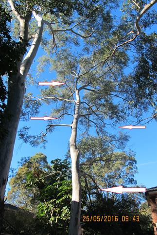
3. General crown maintenance for all the trees on the site being retained as it relates to crown cleaning in the Australian Standard for the Pruning of Amenity Trees AS4373-2007.
Conditions
· Three Sydney Blue Gums are to be planted within the vicinity of the two trees approved to be removed. Note: Council to supply three Eucalyptus saligna grown at the Pennant Hills Community Nursery
· All tree work must be carried out in accordance with the Australian Standard ‘Pruning of Amenity Trees’ (AS 4373-2007). Equipment that will wound the bark and conductive tissues shall not be used on, or in sections of a tree to be retained, (i.e.: spurs, spikes, hooks, chained platforms lowering systems or any other tools that will penetrate or severely bruise bark and conductive tissue).
Mayor's Note No. MN6/16
Date of Meeting: 8/06/2016
20 MAYOR'S NOTES FROM 1 TO 31 MAY 2016
Note: These are the functions that the Mayor, or his representative, has attended in addition to the normal Council Meetings, Workshops, Mayoral Interviews and other Council Committee Meetings.
Thursday 5 May 2016 – On behalf of the Mayor, Councillor Browne attended St Leo’s Catholic College Mass to Celebrate the Feast of Blessed Edmund Rice at The Light of Christ Centre, Wahroonga.
Tuesday 10 May 2016 – The Mayor attended Studio ARTES Celebration of New Beginnings at Magpies Waitara.
Saturday 14 May 2016 – The Mayor attended the Beecroft Rugby Club Festival of Rugby at Headen Park, Thornleigh.
Saturday 14 May 2016 – The Mayor attended the Berowra Waters Rural Fire Brigade 60th Anniversary Dinner at The Waterview Restaurant, Westside Berowra Waters.
Tuesday 17 May 2016 – The Mayor hosted three Citizenship Ceremonies in the Council Chambers.
Thursday 19 May 2016 – The Mayor attended the Australian Community Inspired Association Inc.’s Biggest Morning Tea at Cherrybrook Community and Cultural Centre.
Friday 20 May 2016 – On behalf of the Mayor, the Deputy Mayor Councillor Hutchence attended the Contemplate Exhibition at Wallarobba Arts and Cultural Centre.
Monday 23 May 2016 – The Mayor attended the Official Launch of the new Hindi and Korean Library Collections and Biggest Morning Tea at Hornsby Library.
Wednesday 25 May 2016 – The Mayor attended the Turning of the Sod at Catholic Healthcare’s McQuoin Park Development, Waitara.
Wednesday 25 May 2016 – The Mayor attended the Ceremonial “Breaking of the Soil” for the new PCYC Hornsby/Ku-ring-gai Indoor Recreation Centre at Mark Taylor Oval, Hornsby.
Friday 27 May 2016 – The Mayor attended Children’s Voices for Reconciliation, part of the Guringai Festival in Florence Street Mall, Hornsby.
Sunday 29 May 2016 – On behalf of the Mayor, the Deputy Mayor Councillor Hutchence attended a Mass to Celebrate 100 Years Since Our Lady Help of Christians, Epping was founded at the Church.
Monday 30 May 2016 – On behalf of the Mayor, the Deputy Mayor Councillor Hutchence attended the Epping to Thornleigh Third Track (ETTT) Project Unveiling of Community Artwork at Beecroft Station.
File Reference: F2004/07053
Document Number: D06963630
Notice of Motion No. NOM4/16
Date of Meeting: 8/06/2016
21 ABANDONED SHOPPING TROLLEYS
|
That Council work with local retailers and Westfield to investigate ways to reduce the number of abandoned shopping trolleys left on streets surrounding our shopping centres. This should include analysis of effective solutions that have been implemented in other areas.
Note from Councillor: Abandoned shopping trolleys are an increasing problem littering the streets around our shopping centres specifically Hornsby and Asquith. This has been a recognised issue for over a decade and I have recently been contacted by numerous residents seeking to have something done about this problem. Whilst the supermarkets employ trolley collection contractors, in reality this is only belatedly treating the symptom and not the cause. Residents are still confronted by trolleys left on their streets and impeding their footpaths on a daily basis. A greater focus needs to be placed on preventing the trolleys from leaving the shopping centres themselves. Technological solutions such as coin deposits and wheel locks exist and have been implemented in other areas across Sydney with good effect and there is no reason why they cannot be applied in supermarkets across Hornsby and Asquith. |
There are no attachments for this report.
File Reference: F2004/08769
Document Number: D06963150
Notice of Motion No. NOM5/16
Date of Meeting: 8/06/2016
22 RECOGNITION OF MARY KIRBY
|
COUNCILLOR Gallagher To Move That Council recognises the first woman Councillor elected to Hornsby Shire Council, Mrs Mary Kirby of Mt Colah, by the placement of a small commemorative plaque in the park grounds of the Mt Colah Community Centre.
Note from Councillor: Mary Kirby was the first woman Councillor elected to Hornsby Shire Council, standing in the 1956 election and serving for one term of Council. Mary decided not to contest the 1959 election. Mary resided in Mt Colah and was an advocate for the building of the CWA restroom in Hornsby Park and tried to get the Council to add a rate for the building of a Shire Library. Another issue that she fought hard for was the compulsory installation of septic tanks in new houses that were built in the Shire. She would later say that builders would say to Council “here’s my Mary Kirby”, an application to install a septic tank. Given her role as Hornsby’s first woman Councillor, I believe that it would be appropriate for Council to recognise Mary’s contribution through the placement of a small commemorative plaque in the grounds of the Mt Colah Community Centre and Scout Hall at 6x Pierre Close, Mt Colah. |
There are no attachments for this report.
File Reference: F2004/06410-03
Document Number: D06963289
